Wekiva River Aquatic Preserve Management Plan
202
Wekiva River Aquatic Preserve Management Plan Wekiva River Aquatic Preserve 8300 West State Road 46 • Sanford, FL 32771 407.330.6727 • www.dep.state.fl.us/coastal/sites/wekiva Florida Department of Environmental Protection Florida Coastal Office 3900 Commonwealth Blvd., MS #235, Tallahassee, FL 32399 www.aquaticpreserves.org
-
Upload
khangminh22 -
Category
Documents
-
view
0 -
download
0
Transcript of Wekiva River Aquatic Preserve Management Plan

Wekiva River Aquatic PreserveManagement PlanWekiva River Aquatic Preserve8300 West State Road 46 • Sanford, FL 32771407.330.6727 • www.dep.state.fl.us/coastal/sites/wekiva
Florida Department of Environmental Protection Florida Coastal Office3900 Commonwealth Blvd., MS #235, Tallahassee, FL 32399 www.aquaticpreserves.org


Limpkin searching for snails on Rock Springs Run.
Cover photograph / Kayaking on the Wekiva River is
year-round entertainment, fall 2010.
This publication funded in part through a grant agreement from the Florida
Department of Environmental Protection, Florida Coastal Management Program by a grant provided by the Office of Ocean and Coastal Resource Management under the
Coastal Zone Management Act of 1972, as amended, National Oceanic and Atmospheric Administration Award No. NA11NOS4190073-
CM227 and NA12NOS4190093-CM317. The views, statements, finding, conclusions, and recommendations expressed herein are those of the author(s) and do not necessarily
reflect the views of the State of Florida, National Oceanic and Atmospheric Administration,
or any of its sub-agencies.
October 2014
Wekiva River Aquatic PreserveManagement Plan
Wekiva River Aquatic Preserve8300 West State Road 46 • Sanford, FL 32771407.330.6727 • www.dep.state.fl.us/coastal/sites/wekiva
Florida Department of Environmental Protection Florida Coastal Office3900 Commonwealth Blvd., MS #235, Tallahassee, FL 32399 www.aquaticpreserves.org


Reflections on the Middle St. Johns River, part of the Wekiva River Aquatic Preserve during the Christmas Bird Count, winter 2011.
Mission StatementThe mission of the Florida Coastal Office in relation to Florida’s 41 aquatic preserves, three National Estuarine Research Reserves, National Marine Sanctuary and Coral Reef Conservation Program is conserving and restoring Florida’s coastal and aquatic resources for the benefit of people and the environment.
The four long-term goals of the Florida Coastal Office’s Aquatic Preserve Program are to:
1. Protect and enhance the ecological integrity of the aquatic preserves;
2. Restore areas to their natural condition;
3. Encourage sustainable use and foster active stewardship by engaging local communities in the protection of aquatic preserves; and
4. Improve management effectiveness through a process based on sound science, consistent evaluation, and continual reassessment.


Executive Summary
Wekiva River Aquatic Preserve Management Plan
Lead Agency: Florida Department of Environmental Protection’s (DEP) Florida Coastal Office (FCO)
Common Name of Property: Wekiva River Aquatic Preserve
Location: Lake, Orange, Seminole, and Volusia counties, Florida
Acreage Total: 5,669.7 acres
Acreage Breakdown for FCO Management Units According to Florida Natural Areas Inventory (FNAI) Natural Community Types
FNAI Natural Communities Acreage according to GIS
Floodplain Swamp 684.3
Hydric Hammock 1,399.9
Bottomland Forest 133.9
Floodplain Marsh 90.4
Slough Marsh 293.8
Blackwater Stream 1,444.7
Spring Run Stream 103.9
River Floodplain Lakes 838.3
Aquatic & Terrestrial Cave Unknown
Other Natural Upland 535.1
Other Wetland 109.9
Other Urban 34.4
Ruderal 1.0
Total Acreage: 5,669.7 (This number may not match the “Acreage Total” above due to GIS numbers.)
Management Agency: DEP’s FCO
Unique Features: The Wekiva River and Middle St. Johns River systems are resources of historic, environmental and economic significance. Their basins and springsheds are of irreplaceable value to the quality of life and well-being of the people of the State of Florida. In addition to the aquatic preserve designation, the Wekiva and its tributaries have been designated a National Wild and Scenic River, an Outstanding Florida Waterway (OFW), a Florida Scenic and Wild River, a State Canoe Trail, and Regionally Significant. The Middle St. Johns River is designated an American Heritage River, an OFW, and portions of the system are a Florida Manatee Sanctuary. The Wekiva River is a spring-fed system that derives a majority of its base flow from numerous springs whose source of water is the Floridan Aquifer, while the St. Johns River, part of a 310 mile system, is one of the few rivers in the northern hemisphere that flows north. The aquatic preserve is the heart of the Wekiva-Ocala ecological corridor which contains more than 75,000 acres of conservation lands with 35 identified spring groups, home to thousands of plant and animal species and green space for the visitors and residents of central Florida.
Archaeological/ Historical Sites:
Within the confines of the Wekiva River Aquatic Preserve, the Division of Historical Resources Master Site File has identified forty-three Archaeological/Historical sites, two historical bridges and one site listed in the National Register of Historic Places (Twin Mounds Archaeological District). Numerous other cultural and historical sites are in the immediate vicinity of aquatic preserve boundaries.
Management Needs
Ecosystem Science: Natural resource protection within the preserve requires a comprehensive understanding of the ecological functions, resource locations, and extent as well as unique species-specific interactions associated with each resource. Understanding the effects of nutrient enrichment on the key components of the system through in-house and cooperative research and monitoring efforts is a critical role for our ecosystem science program. Working toward ensuring implementation of strategies to significantly reduce nutrient inputs to the systems over the next five to ten years will be crucial in sustaining the biological and ecological integrity of the river systems for future generations.

Wekiva River Aquatic Preserve Management Plan (continued)
Resource Management: Nutrient enrichment, sand deposition, introduction of exotic or non-native plant and animal species, stormwater runoff, recreational impacts and other human-related activities have resulted in cumulative negative impacts to the aquatic preserve. Maintenance, restoration and attention to a variety of complex issues at various locations are required on a daily basis. In addition, several components of the aquatic preserve have been verified as impaired through the joint U.S. Environmental Protection Agency and DEP Total Maximum Daily Load (TMDL) program. A Basin Management Action Plan (BMAP) has been developed for the upper portion of the aquatic preserve on the St. Johns River, and another is underway for the Wekiva River System. These BMAPs will provide a variety of strategies to reduce nutrient inputs to the system. Water quantity has also been a concern as potential declines in spring flow have been predicted. Minimum Flows and Levels (MFL) have been established for water bodies within the preserve. Continued participation in the TMDL and MFL efforts combined with resource management and education goals outlined within for the aquatic preserve will help improve water quality and maintain water quantity in the Wekiva and St. Johns River systems.
Education & Outreach: Education and Outreach activities for the aquatic preserve include programs presented at workshops and symposiums and to a variety of audiences including community groups, schools, citizen support groups, garden clubs, master gardeners and numerous agency committees. Education topics include general resource management, exotic plant issues and more formal programs. Other projects include river clean-ups and participation at several key local festival and outdoor venues. The Wekiva Promise Initiative includes a 40-page magazine that informs readers about the land and water resources of the Wekiva Basin. The mission of the initiative is to raise awareness of the ecological value of the riverine system and encourage personal stewardship through individual actions. Kiosks and signage at all access points that describe the resources of the aquatic preserve and promote stewardship of those resources are needed throughout the aquatic preserve and would further advance our education program.
Public Use: Within the aquatic preserve, there are multiple boat ramps and access points for launching motorized and non-motorized watercraft. The aquatic preserve supports eight marinas, fifteen boat launches, and five sites with paddling-only access. Areas within close proximity to launch sites are generally the most heavily used and require a higher amount of education and management of potential human-created damage and litter. Recreational activities in aquatic preserve waters provide significant economic input to the region and maintenance of good water quality, habitat and aesthetics is crucial to maintaining and supporting these freshwater systems for their ecological and economic values. More detailed recreational use and economic studies are needed. There are no locations on the Little Wekiva River that provide access to the aquatic preserve. Partnerships with stakeholders interested in locating funding for suitable access points on the Little Wekiva will continue. A sanitary facility at one popular launch site on the St. Johns River is needed to alleviate impacts of improper use of the floodplain wetland habitat.
Public Involvement:
Public support is vital to the success of government conservation programs. The goal is to foster understanding of the problems facing these economically valuable and diverse ecosystems and to explain the steps needed to adequately manage important riverine habitats. The Wekiva River Aquatic Preserve formed an advisory committee group consisting of a variety of stakeholders to provide guidance during management plan development. The aquatic preserve also held two Formal Public Meetings, one for citizens nearer the middle St. Johns River and one for citizens nearer the Wekiva River, to solicit public comment on the draft plan. Aquatic preserve staff also participates on a regular basis with several local citizen support groups, working groups and civic organizations.
FCO/Trustees ApprovalFCO Approval: May 28, 2014
October 17, 2014 Trustees approval date: October 27, 2015
ARC approval date:Comments:

Acronym List
Abreviation Meaning Abreviation MeaningADA Americans with Disabilities Act MACTEC Engineering firm name – now merged
with AMECAHR American Heritage River MFL Minimum Flows and LevelsAMC Wekiva River System Advisory Management
CommitteeMGD Million Gallons per Day
APRICOT A Prototype Realistic Innovative Community of Today
MOA Memorandum of Agreement
AQD Aquatic Debris NERR National Estuarine Research ReserveBIPM DEP Bureau of Invasive Plant Management NOAA National Oceanic and Atmospheric
AdministrationBMAP Basin Management Action Plan NPS National Park Service
BMAPWG Wekiva Basin Management Action Plan Working Group
NRC National Academy of Sciences National Research Council
BMP Best Management Practices OFW Outstanding Florida WaterBSA Blue Spring Alliance OOCEA Orlando Orange County Expressway
AuthorityBSIWG Blue Spring Interagency Working Group OPS Other Personal Services
BSSP Blue Spring State Park OSTDS Onsite Treatment and Disposal SystemsCFFTRG Central Florida Freshwater Turtle Research
GroupPLACE Park Land Acquisition for Conservation and
Environmental Protection CommitteeCFS Cubic feet per second PLRG Pollutant Load Reduction GoalsCH Cultural and Historical Resources PPM Parts per million
CSO Citizen Support Organization PRTF Pollution Recovery Trust FundCUP Consumptive Use Permit RCSCS Rotary Club of Seminole County SouthDEP Florida Department of Environmental
ProtectionRHPZ Riparian Habitat Protection Zone
DNR Florida Department of Natural Resources RSRSR Rock Springs Run State ReserveDRI Development of Regional Impact RU Recreational Use
EAG Environmental Advisory Group SAV Submerged Aquatic VegetationECFRPC East Central Florida Regional Planning
CouncilSCAT Shoreline Cleanup Assessment Team
EPA Environmental Protection Agency SCI Stream Condition IndexERP Environmental Resource Permit SERV Seminole County Environmental
Restoration VolunteersF.A.C. Florida Administrative Code SJRA St. Johns River AllianceF.A.W. Florida Administrative Weekly SJRWMD St. Johns River Water Management District
FCO Florida Coastal Office SSF Seminole State ForestFDACS Florida Department of Agriculture and
Consumer ServicesSTM Save the Manatee Club
FDOH Florida Department of Health TMDL Total Maximum Daily LoadFDOT Florida Department of Transportation Trustees Board of Trustees of the Internal
Improvement Trust FundFFS Florida Forest Service USACE U.S. Army Corps of Engineers
FNAI Florida Natural Areas Inventory USGS U.S. Geological SurveyFOWR Friends of the Wekiva River USFWS U.S. Fish and Wildlife Service
FPS Florida Park Service USJRBP Upper St. Johns River Basin ProjectF.S. Florida Statutes WAVA Wekiva Aquifer Vulnerability AssessmentFTE Full Time Equivalent WBEWG Wekiva Basin Ecosystem Working Group
FWC Florida Fish and Wildlife Conservation Commission
WH Wildlife and Habitat
FY Fiscal Year WPPA Wekiva Parkway and Protection ActGIS Geographic Information System WQL Water Quality
GPS Global Positioning System WQN Water QuantityHAZWOPER Hazardous Waste & Emergency Response WRP Act Wekiva River Protection Act
HP Hurricane Preparedness WRP Area Wekiva River Protection AreaIPMS FWC Invasive Plant Management Section WSA Wekiva Study AreaIWR Impaired Waters Rule WSIS Water Supply Impact StudyJPA Joint Planning Agreement WSMP Wekiva Wild and Scenic River System
Comprehensive Management PlanLCWA Lake County Water Authority WSSP Wekiwa Springs State Park
LWRPSP Lower Wekiva River Preserve State Park

AcknowledgementsThe aquatic preserve team of writers (Deborah Shelley, Gary Raulerson, and Barbara Howell) wishes to thank numerous people for their assistance in the production of this management plan. Foremost among those are Penny Isom and Earl Pearson from the Tallahassee FCO office and Shannon Rininger, who came to our office specifically to work on this project. Comments from the public and the advisory com-mittee, and local, regional, and state agency staff were very useful during finalizing the plan. This plan relied heavily on several other recent management plans produced in the region, including those for the Wekiva Basin State Parks, the Wekiva Wild and Scenic River System, and Seminole State Forest.
Photo Credits
• Howell, Barbara – Inside cover page, 15• Oros, Virginia – 94 • Raulerson, Gary – Cover page, 1, 3, 5, 11, 20, 23, 30, 32, 62, 83, 91, 97, 99• Shelley, Deborah – 43, 65, 67, 69, 86• USGS - 68

Table of Contents Part One / Basis for Management Chapter 1 / Introduction ........................................................................................................................ 1
1.1 / Management Plan Purpose and Scope ...................................................................................... 21.2 / Public Involvement ...................................................................................................................... 3
Chapter 2 / The Florida Department of Environmental Protection’s Florida Coastal Office.......... 52.1 / Introduction .................................................................................................................................. 52.2 / Management Authority ................................................................................................................ 62.3 / Statutory Authority ....................................................................................................................... 82.4 / Administrative Rules .................................................................................................................... 8
Chapter 3 / The Wekiva River Aquatic Preserve ............................................................................... 113.1 / Historical Background ............................................................................................................ 113.2 / General Description ............................................................................................................... 133.3 / Resource Description ............................................................................................................. 183.4 / Values ..................................................................................................................................... 373.5 / Adjacent Public Lands and Designated Resources ............................................................. 393.6 / Surrounding Land Use ........................................................................................................... 41
Part Two / Management Programs and Issues
Chapter 4 / The Florida Coastal Office’s Management Programs .................................................. 434.1 / The Ecosystem Science Management Program ...................................................................... 43
Water Quality .................................................................................................................................. 44Water Quantity ................................................................................................................................ 47Biology ............................................................................................................................................ 48Mapping .......................................................................................................................................... 50Ecosystem Science Coordination at Wekiva River Aquatic Preserve ........................................... 50
4.2 / The Resource Management Program ....................................................................................... 51Major Program Policy Directives .................................................................................................... 53Land Acquisition ............................................................................................................................. 55Significant State Legislation ........................................................................................................... 56Project Review and Regional Coordination ................................................................................... 58The Wekiva Wild and Scenic River System Program .................................................................... 59Water Quality .................................................................................................................................. 59Water Quantity ................................................................................................................................ 61Alternative Water Supply ................................................................................................................ 62Biology ............................................................................................................................................ 63Removal of Illegal Structures ......................................................................................................... 67Archaeological and Cultural Resources ........................................................................................ 68Emergency Response .................................................................................................................... 69Partners and Stakeholders ............................................................................................................. 70
4.3 / The Education and Outreach Management Program ............................................................... 76Background of Education and Outreach at Wekiva River Aquatic Preserve ................................. 76Current Status of Education and Outreach Wekiva River Aquatic Preserve ................................. 77
4.4 / The Public Use Management Program ..................................................................................... 78Background of Public Use at Wekiva River Aquatic Preserve ....................................................... 78Current Status of Public Use at Wekiva River Aquatic Preserve ................................................... 79

Chapter 5 / Issues ................................................................................................................................ 835.1 / Introduction to Issue-Based Management ................................................................................ 835.2 / Issue One: Water Quality ........................................................................................................... 845.3 / Issue Two: Water Quantity ......................................................................................................... 875.4 / Issue Three: Recreational Use .................................................................................................. 885.5 / Issue Four: Aquatic Debris ........................................................................................................ 895.6 / Issue Five: Wildlife and Habitat ................................................................................................. 915.7 / Issue Six: Cultural and Historical Resources ............................................................................ 935.8 / Issue Seven: Emergency Preparedness ................................................................................... 95
Part Three / Additional Plans Chapter 6 / Administrative Plan .......................................................................................................... 97 Chapter 7 / Facilities Plan ................................................................................................................... 99
List of Maps
Map 1 / Wekiva River Aquatic Preserve............................................................................................... 2Map 2 / Florida Coastal Office system ................................................................................................ 7Map 3 / Springsheds of Wekiva River Aquatic Preserve ................................................................... 13Map 4 / Watershed of Wekiva River Aquatic Preserve ...................................................................... 15Map 5 / Wekiva River Protection Area and Wekiva Study Area ........................................................ 16Map 6 / Geomorphology of Wekiva River Aquatic Preserve ............................................................. 19Map 7 / Soils of Wekiva River Aquatic Preserve................................................................................ 20Map 8 / Natural communities near Wekiva River Aquatic Preserve .................................................. 26Map 9 / Manatee zones of Wekiva River Aquatic Preserve ............................................................... 35Map 10 / Wekiva Wild and Scenic River boundary ........................................................................... 38Map 11 / Conservation lands near Wekiva River Aquatic Preserve .................................................. 40Map 12 / Land use near Wekiva River Aquatic Preserve .................................................................. 41Map 13 / Wekiva Aquifer Vulnerability Assessment zones ............................................................... 44Map 14 / Water quality monitoring points of Wekiva River Aquatic Preserve ................................... 60Map 15 / Public access points of Wekiva River Aquatic Preserve .................................................... 81
List of Tables
Table 1 / Rivers of Wekiva River Aquatic Preserve ............................................................................ 12Table 2 / Spring groups associated with Wekiva River Aquatic Preserve......................................... 14Table 3 / Managed public lands in the Wekiva River Aquatic Preserve watersheds & springsheds ......17Table 4 / Total Maximum Daily Loads for phosphorus for Wekiva River system .............................. 25Table 5 / Total Maximum Daily Loads for nitrates for Wekiva River system ...................................... 25Table 6 / Summary of natural communities on Wekiva River Aquatic Preserve ............................... 32Table 7 / Archaeological and historical resources of Wekiva River Aquatic Preserve ...................... 36Table 8 / Nitrate loading to the Wekiva basin .................................................................................... 45Table 9 / Timeline of conservation milestones for Wekiva River Aquatic Preserve........................... 52
List of Figures
Figure 1 / State management structure .............................................................................................. 6Figure 2 / Temperature data for the Wekiva River Aquatic Preserve ................................................ 23Figure 3 / Rainfall data for the Wekiva River Aquatic Preserve ......................................................... 23

List of Appendices
Appendix A / Legal Documents ........................................................................................................ 104A.1 / Aquatic Preserve Resolution ................................................................................................... 104 Wekiva River Protection and Wekiva Parkway and Protection Act .............................................. 105 Wekiva Wild and Scenic River Act ............................................................................................... 119A.2 / Florida Statutes ....................................................................................................................... 122A.3 / Florida Administrative Code .................................................................................................... 122
Appendix B / Resource Data ............................................................................................................. 123B.1 / Glossary of Terms ................................................................................................................... 123B.2/ References ............................................................................................................................... 124B.3/ Species Lists ............................................................................................................................ 128
Native Species List ....................................................................................................................... 128Invasive Non-native Species List .................................................................................................. 147Problem Species List .................................................................................................................... 148
Appendix C / Public Involvement ..................................................................................................... 149C.1 / Advisory Committee ................................................................................................................ 149
List of Members and their Affiliations ........................................................................................... 149Florida Administrative Weekly Posting ........................................................................................ 150Meeting Summary ........................................................................................................................ 152
C.2 / Formal Public Meetings .......................................................................................................... 154Florida Administrative Weekly Posting ......................................................................................... 154Advertisement Flyers and Newspaper Announcements ............................................................. 156Summary of the Formal Public Meetings ..................................................................................... 161
Appendix D / Goals, Objectives and Strategies Tables .................................................................. 164D.1 / Current Goals, Objectives and Strategies Table ..................................................................... 164D.2 / Budget Summary Table .......................................................................................................... 177D.3 / Major Accomplishments Since the Approval of the Previous Plan ........................................ 178
Appendix E / Other Requirements .................................................................................................... 180E.1 / Acquisition and Restoration Council Management Plan Compliance Checklist ................... 180E.2 / Management Procedures for Archaeological and Historical Sites and Properties
on State-Owned or Controlled Lands .......................................................................................... 186


�
Anhinga sunning on a snag in the Middle St. Johns River portion of the Wekiva River Aquatic Preserve, summer 20��.
Part One
Basis for ManagementChapter One
IntroductionThe Florida aquatic preserves are administered on behalf of the state by the Florida Department of Environmental Protection’s (DEP) Florida Coastal Office (FCO) as part of a network that includes 41 aquatic preserves, 3 National Estuarine Research Reserves (NERRs), a National Marine Sanctuary, the Coral Reef Conservation Program and the Florida Oceans and Coastal Council. This provides for a system of significant protections to ensure that our most popular and ecologically important underwater ecosystems are cared for in perpetuity. Each of these special places is managed with strategies based on local resources, issues and conditions.
Our expansive coastline and wealth of aquatic resources have defined Florida as a subtropical oasis, attracting millions of residents and visitors, and the businesses that serve them. Florida’s submerged lands play important roles in maintaining good water quality, hosting a diversity of wildlife and habitats (including economically and ecologically valuable nursery areas), and supporting a treasured quality of life for all. In the 1960s, it became apparent that the ecosystems that had attracted so many people to Florida could not support rapid growth without science-based resource protection and management. To this end, state legislators provided extra protection for certain exceptional aquatic areas by designating them as aquatic preserves.
Title to submerged lands not conveyed to private landowners is held by the Board of Trustees of the Internal Improvement Trust Fund (the Trustees). The Governor and Cabinet, sitting as the Trustees, act as guardians for the people of the State of Florida (§253.03, Florida Statutes [F.S.]) and regulate the

2
use of these public lands. Through statute, the Trustees have the authority to adopt rules related to the management of sovereignty submerged lands (Florida Aquatic Preserve Act of 1975, §258.36, F.S.). A higher layer of protection is afforded to aquatic preserves including areas of sovereignty lands that have been “set aside forever as aquatic preserves or sanctuaries for the benefit of future generations” due to “exceptional biological, aesthetic, and scientific value” (Florida Aquatic Preserve Act of 1975, §258.36, F.S.).
�.� / Management Plan Purpose and Scope
With increasing development, recreation and economic pressures, our aquatic resources have the potential to be significantly impacted, either directly or indirectly. These potential impacts to resources
can reduce the health and viability of the ecosystems that contain them, requiring active management to ensure the long-term health of the entire network. Effective management plans for the aquatic preserves are essential to address this goal and each site’s own set of unique challenges. The purpose of these plans is to incorporate, evaluate and prioritize all relevant information about the site into a cohesive management strategy, allowing for appropriate access to the managed areas while
$+42
$+15
$+46A
UV44
UV46
UV15A
UV572
£¤17
£¤92
§̈¦4
Gulf of Mexico
AtlanticO
cean
VolusiaCounty
SeminoleCounty
LakeCounty
OrangeCounty
0 2 41Miles ±
Wekiva River Aquatic PreserveMiddle St. Johns ReachWekiva River
August 2012
LakeMonroe
Lake Mary
Sanford
Orange City
DeLand
Apopka Longwood Winter Springs
UV44
Wek
ivaRive
r
LittleW
ekivaRiver
Blackwater Creek
St. Johns
River
LakeBeresford
Map � / Wekiva River Aquatic Preserve
protecting the long-term health of the ecosystems and their resources.
The mandate for developing aquatic preserve management plans is outlined in Section 18-20.013 and Subsection 18-18.013(2) of the Florida Administrative Code (F.A.C.). Management plan development and review begins with the collection of resource information from historical data, research and monitoring, and includes input from individual FCO managers and staff, area stakeholders, and members of the general public. The statistical data, public comment, and cooperating agency information is then used to identify management issues and threats affecting the present and future integrity of the site, its boundaries, and adjacent areas. This information is used in the development and review of the management plan, which is examined for consistency with the statutory authority and intent of the Aquatic Preserve Program. Each management plan is evaluated periodically and revised as necessary to allow for strategic improvements. Intended to be used
by site managers and other agencies or private groups involved with maintaining the natural integrity of these resources, the plan includes scientific information about the existing conditions of the site and the management strategies developed to respond to those conditions.

�
To aid in the analysis and development of the management strategies for the site plans, four comprehensive management programs are identified. In each of these management programs, relevant information about the specific sites is described in an effort to create a comprehensive management plan. It is expected that the specific needs or issues are unique and vary at each location, but the four management programs will remain constant. These management programs are:
• Ecosystem Science• Resource Management• Education and Outreach• Public Use
In addition, unique local and regional issues are identified, and goals, objectives and strategies are established to address these issues. Finally, the program and facility needs required to meet these goals are identified. These components are all key elements in an effective management program and for achieving the mission of the sites.
This is the first update to the management plan for the Wekiva River Aquatic Preserve that was approved on August 25, 1987. Nineteen miles of the middle St. Johns River and twenty miles of backwater tributaries were added to the Wekiva River Aquatic Preserve in June 1985. The name of the aquatic preserve was not changed to reflect this significant addition. Resource management topics related to the St. Johns River were discussed within the 1987 management plan. The Wekiva River section of the aquatic preserve (including portions of Rock Springs Run, Wekiwa Springs Run, the Little Wekiva River, and Black Water Creek) contains approximately 24 “river miles” while the St. Johns River and its backwater areas contain approximately 39 “river miles” (Map 1). In addition, the Wekiva River is a major tributary of the St. Johns River. It is often a difficult task to describe the St. Johns River as part of the Wekiva River Aquatic Preserve to the general public and during project review. The aquatic preserve name should be changed to Wekiva – Middle St. Johns Aquatic Preserve to more accurately describe the geographic boundaries of the aquatic preserve and decrease confusion by the public, governmental agencies and others.
�.2 / Public Involvement
FCO recognizes the importance of stakeholder participation and encourages their involvement in the management plan development process. FCO is also committed to meeting the requirements of the Sunshine Law (§286.011, F.S.):
• Meetings of public boards or commissions must be open to the public;• Reasonable notice of such meetings must be given; and• Minutes of the meetings must be recorded.
Several key steps are taken during management plan development. First, staff compose a draft plan after gathering information on current and historic uses, resources, cultural and historic sites, and other relevant information regarding the aquatic preserve and surrounding area. Staff then organize an advisory committee comprised of key stakeholders and conduct, in conjunction with the advisory committee, public meetings to engage the stakeholders for feedback on the draft plan and the development of the final draft of the management plan. An additional public meeting is held when the plan is reviewed by the Acquisition and Restoration Council for approval. For additional information about the advisory committee and the public meetings refer to Appendix C - Public Involvement.


�
Fall on the Wekiva River with maples in full color and a suite of emergent marsh vegetation, fall 2010.
Chapter Two
The Florida Department of Environmental Protection’s Florida Coastal Office
2.1 / Introduction
The Florida Department of Environmental Protection (DEP) protects, conserves and manages Florida’s natural resources and enforces the state’s environmental laws. DEP is the lead agency in state govern-ment for environmental management and stewardship and commands one of the broadest charges of all the state agencies, protecting Florida’s air, water and land. DEP is divided into three primary areas: Regu-latory Programs, Land and Recreation, and Water Policy and Ecosystem Restoration (Figure 1). Florida’s environmental priorities include restoring America’s Everglades; improving air quality; restoring and pro-tecting the water quality in our springs, lakes, rivers and coastal waters; conserving environmentally-sensi-tive lands; and providing citizens and visitors with recreational opportunities, now and in the future.
The Florida Coastal Office (FCO) is the unit within DEP that manages more than four million acres of submerged lands and select coastal uplands. This includes 41 aquatic preserves, 3 National Estuarine Research Reserves (NERRs), the Florida Keys National Marine Sanctuary and the Coral Reef Conservation Program (Map 2). The three NERRs, the Florida Keys National Marine Sanctuary and the Coral Reef Conservation Program are managed in cooperation with the National Oceanic and Atmospheric Administration (NOAA).
FCO manages sites in Florida for the conservation and protection of natural and historical resources and resource-based public use that is compatible with the conservation and protection of these lands. FCO is a strong supporter of the NERR system and its approach to coastal ecosystem management. The State of Florida has three designated NERR sites, each encompassing at least one aquatic

�
preserve within its boundaries. Rookery Bay NERR includes Rookery Bay Aquatic Preserve and Cape Romano - Ten Thousand Islands Aquatic Preserve; Apalachicola NERR includes Apalachicola Bay Aquatic Preserve; and Guana Tolomato Matanzas NERR includes Guana River Marsh Aquatic Preserve and Pellicer Creek Aquatic Preserve. These aquatic preserves provide discrete areas designated for additional protection beyond that of the surrounding NERR and may afford a foundation for additional protective zoning in the future.
Each of the Florida NERR managers serves as a regional manager overseeing multiple other aquatic preserves in their region. This management structure advances FCO’s ability to manage its sites as part of the larger statewide system.
2.2 / Management Authority
Established by law, aquatic preserves are submerged lands of exceptional beauty that are to be maintained in their natural or existing conditions. The intent was to forever set aside submerged lands with exceptional biological, aesthetic, and scientific values as sanctuaries, called aquatic preserves, for the benefit of future generations.
The laws supporting aquatic preserve management are the direct result of the public’s awareness of and interest in protecting Florida’s aquatic environment. The extensive dredge and fill activities that occurred in the late 1960s spawned this widespread public concern. In 1966, the Board of Trustees of the Internal Improvement Trust Fund (the Trustees) created the first aquatic preserve, Estero Bay, in Lee County.
In 1967, the Florida Legislature passed the Randall Act (Chapter 67-393, Laws of Florida), which established procedures regulating previously unrestricted dredge and fill activities on state-owned submerged lands. That same year, the Legislature provided the statutory authority (§253.03, Florida Statutes [F.S.]) for the Trustees to exercise proprietary control over state-owned lands. Also in 1967, government focus on protecting Florida’s productive water bodies from degradation due to development led the Trustees to establish a moratorium on the sale of submerged lands to private interests. An Interagency Advisory
Committee was created to develop strategies for the protection and management of state-owned submerged lands.
In 1968, the Florida Constitution was revised to declare in Article II, Section 7, the state’s policy of conserving and protecting natural resources and areas of scenic beauty. That constitutional provision also established the authority for the Legislature to enact measures for the abatement of air and water pollution. Later that same year, the Interagency Advisory Committee issued a report recommending the establishment of 26 aquatic preserves.
The Trustees acted on this recommendation in 1969 by establishing 16 aquatic preserves and adopting a resolution for a statewide system of such preserves. In 1975 the state Legislature passed the Florida Aquatic Preserve Act of 1975 (Act) that was enacted as Chapter 75-172, Laws of Florida, and later became Chapter 258, Part II, F.S. This Act codified the already existing aquatic preserves and established standards and criteria for activities within those preserves. Additional aquatic preserves were individually adopted at subsequent times up through 1989.
In 1980, the Trustees adopted the first aquatic preserve rule, Chapter 18-18, Florida Administrative Code (F.A.C.), for the administration of the Biscayne Bay Aquatic Preserve. All other aquatic preserves
Figure 1 / State structure for managing Aquatic Preserves.
FLORIDA DEPARTMENT OF ENVIRONMENTAL PROTECTION
SECRETARY
Deputy SecretaryLand & Recreation
Deputy SecretaryRegulatory Programs
Deputy SecretaryWater Policy & Eco Restoration
Air ResourceManagement
Waste Management
RegulatoryDistricts
Water Resource Management
Cabinet Affairs
State Lands
Florida Geological
Survey
Recreation& Parks
EnvironmentalAssessment &
Restoration
Ecosystems
WaterPolicy
Water
ManagementDistricts
Outer ContinentalShelf
Aquatic Preserves
Coral ReefConservation Program
Florida Coastal
Management Program
Florida Keys National Marine Sanctuary
Natural Resource
Damage Assessment
National EstuarineResearch Reserve
Florida Oceans &Coastal Council
Florida Coastal Office

�
are administered under Chapter 18-20, F.A.C., which was originally adopted in 1981. These rules apply standards and criteria for activities in the aquatic preserves, such as dredging, filling, building docks and other structures that are stricter than those of Chapter 18-21, F.A.C., which apply to all sovereignty lands in the state.
This plan is in compliance with the Conceptual State Lands Management Plan, adopted March 17, 1981 by the Board of Trustees of the Internal Improvement Trust Fund and represents balanced public utilization, specific agency statutory authority, and other legislative or executive constraints. The Conceptual State Lands Management Plan also provides essential guidance concerning the management of sovereignty lands and aquatic preserves and their important resources, including unique natural features, seagrasses, endangered species, and archaeological and historical resources.
Through delegation of authority from the Trustees, the DEP and FCO have proprietary authority to manage the sovereignty lands, the water column, spoil islands (which are merely deposits of sovereignty lands), and some of the natural islands and select coastal uplands to which the Trustees hold title.
Enforcement of state statutes and rules relating to criminal violations and non-criminal infractions rests with the Florida Fish and Wildlife Conservation Commission Marine Patrol, DEP law enforcement, and local law enforcement agencies. Enforcement of administrative remedies rests with FCO, the DEP Districts, and Water Management Districts.
Polk
Collier
Marion
Lake
Levy
Osceola
Taylor
Bay
Miami-Dade
Palm Beach
Hendry
Volusia
Broward
Dixie
Leon
Walton
ClayGulf
Orange
Lee
Liberty
Pasco
Alachua
Jackson
Highlands
Brevard
Glades
Baker
Citrus
Okaloosa
Hardee
Santa Rosa
Duval
MartinDeSoto
Madison
Hillsborough
Monroe
Sumter
Nassau
Wakulla
Putnam
Flagler
Calhoun
Suwannee
Holmes
St. Lucie
Lafayette
Hamilton
Charlotte
Gadsden
Franklin
Hernando
Union
Seminole
Manatee
Columbia
Escambia
Jefferson
Sarasota
Okeechobee
St. Johns
Washington
Gilchrist
Indian River
Bradford
Pinellas
Coupon Bight
Lignumvitae Key
Biscayne Bay
Biscayne Bay -Cape Florida
to MonroeCounty Line
Cape Romano -Ten Thousand Islands
Rookery Bay
Estero Bay
PineIslandSound
MatlachaPass
Cape Haze
Lemon Bay
Gasparilla Sound -Charlotte Harbor
LoxahatcheeRiver - LakeWorth Creek
Jensen Beachto Jupiter Inlet
Indian River -Vero Beach
to Fort Pierce
Indian River -Malabar to
Vero Beach
Banana River
North Fork,St. Lucie
MosquitoLagoon
TomokaMarsh
Pellicer Creek
Guana River Marsh
Nassau River -St. Johns
River Marshes
Fort Clinch
Terra Ceia
CockroachBay
WekivaRiver
OklawahaRiver
RainbowSprings
PinellasCounty
Boca CiegaBay
St. MartinsMarsh
Big BendSeagrasses
AlligatorHarbor
LakeJackson
ApalachicolaBay
St.Joseph
Bay
St. Andrews
RockyBayou
Yellow RiverMarsh
Fort Pickens
Gulf of Mexico
Atlantic Ocean
GeorgiaAlabama
0 50 100 15025Miles
±Aquatic PreservesSt. Joseph Bay State Buffer PreserveNational Estuarine Research ReservesFlorida Keys National Marine SanctuaryCoral Reef Conservation Program
Rookery Bay
Guana - Tolomato - Matanzas
Apalachicola
May 2013
Map 2 / Florida Coastal Office system

�
2.3 / Statutory Authority
The fundamental laws providing management authority for the aquatic preserves are contained in Chapters 258 and 253, F.S. These statutes establish the proprietary role of the Governor and Cabinet, sitting as the Board of Trustees of the Internal Improvement Trust Fund, as Trustees over all sovereignty lands. In addition, these statutes empower the Trustees to adopt and enforce rules and regulations for managing all sovereignty lands, including aquatic preserves. The Florida Aquatic Preserve Act was enacted by the Florida Legislature in 1975 and is codified in Chapter 258, F.S.
The legislative intent for establishing aquatic preserves is stated in Section 258.36, F.S.: “It is the intent of the Legislature that the state-owned submerged lands in areas which have exceptional biological, aesthetic, and scientific value, as hereinafter described, be set aside forever as aquatic preserves or sanctuaries for the benefit of future generations.” This statement, along with the other applicable laws, provides a foundation for the management of aquatic preserves. Management will emphasize the preservation of natural conditions and will include lands that are specifically authorized for inclusion as part of an aquatic preserve.
Management responsibilities for aquatic preserves may be fulfilled directly by the Trustees or by staff of the DEP through delegation of authority. Other governmental bodies may also participate in the management of aquatic preserves under appropriate instruments of authority issued by the Trustees. FCO staff serves as the primary managers who implement provisions of the management plans and rules applicable to the aquatic preserves. FCO does not “regulate” the lands per se; rather, that is done primarily by the DEP Districts (in addition to the Water Management Districts) which grant regulatory permits. The Florida Department of Agriculture and Consumer Services through delegated authority from the Trustees, may issue proprietary authorizations for marine aquaculture within the aquatic preserves and regulates all aquaculture activities as authorized by Chapter 597, Florida Aquaculture Policy Act, F.S. Staff evaluates proposed uses or activities in the aquatic preserve and assesses the possible impacts on the natural resources. Project reviews are primarily evaluated in accordance with the criteria in the Act, Chapter 18-20, F.A.C., and this management plan.
FCO staff comments, along with comments of other agencies and the public are submitted to the appropriate permitting staff for consideration in their issuance of any delegated authorizations in aquatic preserves or in developing recommendations to be presented to the Trustees. This mechanism provides a basis for the Trustees to evaluate public interest and the merits of any project while also considering potential environmental impacts to the aquatic preserves. Any activity located on sovereignty lands requires a letter of consent, a lease, an easement, or other approval from the Trustees.
Many provisions of the Florida Statutes that empower non-FCO programs within DEP or other agencies may be important to the management of FCO sites. For example, Chapter 403, F.S., authorizes rules concerning the designation of “Outstanding Florida Waters” (OFWs), a program that provides aquatic preserves with additional regulatory protection. Chapter 379, F.S., regulates saltwater fisheries, and provides enforcement authority and powers for law enforcement officers. Additionally, it provides similar powers relating to wildlife conservation and management. The sheer number of statutes that affect aquatic preserve management prevents an exhaustive list of all such laws from being provided here.
2.4 / Administrative Rules
Chapters 18-18, 18-20 and 18-21, F.A.C., are the three administrative rules directly applicable to the uses allowed in aquatic preserves specifically and sovereignty lands generally. These rules are intended to be cumulative, meaning that Chapter 18-21, F.A.C., should be read together with Chapter 18-18, F.A.C., or Chapter 18-20, F.A.C., to determine what activities are permissible within an aquatic preserve. If Chapter 18-18, F.A.C., or Chapter 18-20, F.A.C., are silent on an issue, Chapter 18-21, F.A.C., will control; if a conflict is perceived between the rules, the stricter standards of Chapter 18-18, F.A.C., or Chapter 18-20, F.A.C., supersede those of Chapter 18-21, F.A.C. Because Chapter 18-21, F.A.C. concerns all sovereignty lands, it is logical to discuss its provisions first.
Originally codified in 1982, Chapter 18-21, F.A.C., is meant “to aid in fulfilling the trust and fiduciary responsibilities of the Board of Trustees of the Internal Improvement Trust Fund for the administration, management and disposition of sovereignty lands; to insure maximum benefit and use of sovereignty lands for all the citizens of Florida; to manage, protect and enhance sovereignty lands so that the public may continue to enjoy traditional uses including, but not limited to, navigation, fishing and swimming; to manage and provide maximum protection for all sovereignty lands, especially those important to public drinking water supply, shellfish harvesting, public recreation, and fish and wildlife propagation and management; to insure that all public and private activities on sovereignty lands which generate

�
revenues or exclude traditional public uses provide just compensation for such privileges; and to aid in the implementation of the State Lands Management Plan.”
To that end, Chapter 18-21, F.A.C., contains provisions on general management policies, forms of authorization for activities on sovereignty lands, and fees applicable for those activities. “Activity,” in the context of the rule, includes “construction of docks, piers, boat ramps, boardwalks, mooring pilings, dredging of channels, filling, removal of logs, sand, silt, clay, gravel or shell, and the removal or planting of vegetation” (Rule 18-21.003, F.A.C.). To be authorized on sovereignty lands, activities must be not contrary to the public interest (Rule 18-21.004, F.A.C.).
Chapter 18-21, F.A.C., also sets policies on aquaculture, geophysical testing (using gravity, shock wave and other geological techniques to obtain data on oil, gas or other mineral resources), and special events related to boat shows and boat displays. Of particular importance to FCO site management, it additionally addresses spoil islands, preventing their development in most cases.
Chapters 18-18 and 18-20, F.A.C., apply standards and criteria for activities in the aquatic preserves that are stricter than those of Chapter 18-21, F.A.C. Chapter 18-18, F.A.C., is specific to the Biscayne Bay Aquatic Preserve and is more extensively described in that site’s management plan. Chapter 18-20, F.A.C., is applicable to all other aquatic preserves. It further restricts the type of activities for which authorizations may be granted for use of sovereignty lands and requires that structures that are authorized be limited to those necessary to conduct water dependent activities. Moreover, for certain activities to be authorized, “it must be demonstrated that no other reasonable alternative exists which would allow the proposed activity to be constructed or undertaken outside the preserve” (Paragraph 18-20.004(1)(g), F.A.C.).
Chapter 18-20, F.A.C., expands on the definition of “public interest” by outlining a balancing test that is to be used to determine whether benefits exceed costs in the evaluation of requests for sale, lease, or transfer of interest of sovereignty lands within an aquatic preserve. The rule also provides for the analysis of the cumulative impacts of a request in the context of prior, existing, and pending uses within the aquatic preserve, including both direct and indirect effects.
Chapter 18-20, F.A.C., directs management plans and resource inventories to be developed for every aquatic preserve. Further, the rule provides provisions specific to certain aquatic preserves and indicates the means by which the Trustees can establish new or expand existing aquatic preserves.
As with statutes, aquatic preserve management relies on the application of many other DEP and outside agency rules. Perhaps most notably, Chapter 62-302, F.A.C., concerns the classification of surface waters, including criteria for OFW, a designation that provides for the state’s highest level of protection for water quality. All aquatic preserves contain OFW designations. No activity may be permitted within an OFW that degrades ambient water quality unless the activity is determined to be in the public interest. Once again, the list of other administrative rules that do not directly address FCO’s responsibilities but do affect FCO sites is so long as to be impractical to create within the context of this management plan.


11
Winter on the Middle St. Johns River, part of the Wekiva River Aquatic Preserve, winter 2010.
Chapter Three
The Wekiva River Aquatic Preserve
3.1 / Historical Background
The Wekiva – Middle St. Johns area provided abundant natural resources for prehistoric communities. The spring runs, river, hardwood hammocks and dense forests offered food, water, shelter and breeding sites for many forms of wildlife and provided excellent plant and animal foods for human inhabitants (Milanich & Fairbanks, 1980). Existing evidence of early human inhabitants in the region are discussed in the section on cultural resources.
Early human inhabitation in central Florida strongly correlated with the dominant geographic feature, the St. Johns River and its associated tributaries and lakes. About 12,000 B.C., the peoples of the Paleo-Indian period characteristically led a nomadic existence based on hunting, with small groups continually moving from water source to water source. Remains of Pleistocene megafauna, which are now extinct, and large herd animals which have since migrated to more northern latitudes, have been found in the Wekiva River in association with the distinctive fluted projectile points made by the Paleo-Indians (Dickenson & Wayne, 1985).
Later Paleo-Indians (circa 6500 B.C.) began to develop a more sedentary culture of fishing, gathering and hunting smaller game animals, most likely in response to climatic changes, extinction of some animal species, increased competition for dietary resources, and other social changes.
The peoples of the Archaic period (6000 B.C. - 1000 B.C.) were more dependent on the exploitation of a variety of seasonal resources. Hardwood nuts and native plants assumed greater importance in their diet, but fish, birds, mammals, and reptiles were also harvested. Freshwater snails also appeared to be first exploited during this time period. Seasonal excursions to the coastal strands where oysters were harvested in large numbers were also characteristic.
The increasingly sedentary life of the Mount Taylor peoples (late Archaic, 4000 B.C. - 2000 B.C.) is indicated by village sites along the St. Johns River. During the St. Johns cultural period (500 B.C. - A.D. 1565) horticultural practices and population increases led to an increasingly complex social organization (Milanich & Fairbanks, 1980).

12
The Timucuan Indians occupied areas along the St. Johns River when Europeans first ventured into Florida. Cultural changes related to Hernando de Soto’s 1539-1540 Florida expedition marked the beginning of the decline of Florida’s native Indian populations. During the next 150 years, the Timucuans were subjected to enforced migration or forced onto Spanish missions and ranches where many succumbed to European diseases. Other tribes, fleeing invasions of their homelands in southwest and southern Georgia, merged their cultures with that of the Timucuans. By 1763, when St. Augustine fell into British control, the Timucuan population was decimated and for the remaining few, much of their original cultural pattern had been altered (Milanich & Fairbanks, 1980). In the early 1800s Seminole Indians frequented the headwaters of the Wekiva to hunt; they also used the river as a route to the St. Johns River (Shofner, 1982).
John Bartram, renowned British botanist, visited Volusia Blue Spring in 1774. He reported the water tasted “disagreeable” but was impressed by the flow (Bartram, 1791/1928). During the mid-1800s soldiers, settlers, and winter visitors began to populate the Wekiva – Middle St. Johns area. Several forts, including Fort Florida near DeBary, and Camp Monroe on present-day Sanford, were built in anticipation of trouble with the Indian tribes. The region became the hub of Florida’s burgeoning citrus industry, remaining so until the freezes of 1894-1895. The St. Johns River was a focal point for commerce although this role was reduced after the railroad came through in the 1880s. Due to the rumored curative power of the region’s springs and the warm winter temperatures, central Florida became a resort area, with celebrities such as Babe Ruth and Al Capone visiting the Mt. Plymouth Hotel in the 1920s prior to the Great Depression. Central Florida’s position as a vacation destination was fully reinforced in 1965 when Walt Disney announced that Walt Disney World would be built. This resulted in a development boom for the region that continued until 2007 except for the short recession experienced by the entire United States in the late 1970s. The 2007-2009 recession resulted in significant loss of property value and relatively high unemployment in the state of Florida. This recession also resulted in at least a temporarily reduced pace of development for central Florida. Agriculture (including cattle, timber and landscape horticulture) is still an important economic component for central Florida, as are industries catering to the nearby Kennedy Space Center. However, with the end of the space shuttle program in 2011, there is some uncertainty regarding future economic impacts related to the space industry.
Major development and growth throughout the watershed also created environmental pressures that were increasingly recognized by local residents. Several policies and public actions occurred in response to citizen initiatives related to environmental issues. The Wekiva River Aquatic Preserve was created by the State Legislature on June 22, 1975, and included the Wekiva River and portions of the
Little Wekiva River, Rock Springs Run, and Black Water Creek (Table 1). The Friends of the Wekiva River, Inc., was chartered in 1982 to protect and restore the Wekiva River basin as well as educate residents and policy makers regarding its importance to the region. Nineteen miles of the Middle St. Johns River between Interstate 4 and State Road 44 (including Lake Beresford and several oxbows and dead-end channels) were added to the Wekiva River Aquatic Preserve in June 1985. In 1988, the Legislature passed the Wekiva River Protection Act, which became a model for watershed policy management in the state and country. In 2000, the Wekiva River gained federal status as a congressionally-designated National Wild and Scenic River.
In 2004, the Wekiva Parkway and Protection Act provided for additional environmental oversight within the framework of designing the final portion of a limited-access beltway around the greater Orlando area. If adopted, this management plan proposes a name change from the Wekiva River Aquatic Preserve to the Wekiva – Middle St. Johns Aquatic Preserve to more accurately reflect the aquatic preserve’s geographic scope.
The waterways of the Wekiva River Aquatic Preserve and the designated reach of the Middle St. Johns River are accessible to the public at state, county and federal parks and forests as well as through the use of private canoe and kayak liveries, marinas, and boat ramps. The proximity of the aquatic preserve
Name Total Length Length in Aquatic Preserve
Wekiva River 15.2 15.2
Rock Springs Run 8.7 0.9
Black Water Creek 17.9 3.4
Little Wekiva River 15 3.8
Wekiwa Spring Run 0.8 0.7
St. Johns River 310 19.1
St. Johns River backwaters 20.2
Blue Spring Run 0.3 0.3
Total 63.6 miles
Lake Beresford 795 acres
Table 1 / Rivers of Wekiva River Aquatic Preserve.

13
to the highly-developed Orlando region provides easy access to pristine waters for local residents and tourists seeking respite from their higher-paced activities.
Natural land preservation began as early as 1927 with the donation of 245 acres surrounding Rock Springs, now known as Kelly Park. Additional conservation lands totaling more than 70,000 acres were purchased under a series of state initiatives, including the Environmentally Endangered Lands, Conservation and Recreation Lands, Save Our Rivers, Preservation 2000, and Florida Forever programs. Lands were also purchased after mandate by the Wekiva River Protection Act and the Wekiva Parkway and Protection Act.
3.2 / General Description
3.2.1 / International/National/State/Regional Significance
The resources of the aquatic preserve are exceptional. Located between Orlando and the Ocala National Forest, the aquatic preserve’s waterways and surrounding conservation lands protect thousands of acres of Florida. International guests are increasingly exploring the aquatic preserve in addition to visiting theme parks and beaches. A variety of freshwater springs (and numerous vents and seeps) emerge from deep within the limestone labyrinth that underlies central Florida, forming the aquatic preserve’s creeks and rivers that wind for miles through forested floodplains and swamps, where wildlife lives and humans recreate (Map 3).
Wekiwa Spring, at the southern end of the preserve, is famous for its clear, cool water, enjoyed by swimmers, snorkelers, canoeists, and kayakers, who explore the spring run as it flows to the Wekiva River. The Wekiva River begins at the confluence of Wekiwa Spring Run and Rock Springs Run; its fifteen-mile northerly course alternates between wide, sunny stretches of slow-moving water and narrow, shady passages of swiftly-moving current. The Little Wekiva River, Black Water Creek and 34 spring groups (Table 2) contribute their waters to the Wekiva as it winds its way north to the St. Johns River.
The Middle St. Johns reach of the aquatic preserve includes the 795-acre Lake Beresford, Volusia Blue Spring, and Hontoon Island, the site of ancient Timucuan middens. Pristine water, natural beauty, abundant wildlife and archaeological intrigue all contribute their interesting and unique characteristics to the aquatic preserve.
Approximately 64 miles of waterways (rivers, creeks, oxbows, and former river channels) and another 850 acres of open water (primarily in Lake Beresford) comprise the Wekiva River Aquatic Preserve and the designated reach of the Middle St. Johns River (Table 1). Waters of the aquatic preserve, however,
!
!!!!!
!
!
!
!!
!
!
!
!!
!
!
!
!
!!
!
!
!
!
!
!!!
!
!
!!!!
!
!!!!
!
! !!!
!
!
!
!!!
VolusiaCounty
SeminoleCounty
LakeCounty
OrangeCounty
0 4 82Miles ±
Wekiva River Aquatic Preserve! Springs of Wekiva River Aquatic Preserve
Wekiva and Volusia Blue Springsheds
May 2013
Marion County
Wekiva
Wekiva
Wekiva
Volusia Blue
Map 3 / Springsheds of Wekiva River Aquatic Preserve.

14
are affected by a much larger area. The Wekiva River’s overlapping 238 square mile springshed (Map 3) and 380 square mile watershed (Map 4) influence the aquatic preserve by supplying water, nutrients, and pollutants. Development within the watershed and springshed is highly diverse, ranging from near-pristine natural areas in the Ocala National Forest to fully developed residential and commercial communities of northern Orlando. The waters that flow into Lake Norris are made up of wetland, streams and canals that originate at and south of Lake Dorr, located in the Ocala National Forest. The Middle St. Johns reach is affected by upstream flows from Lake Monroe and waters emanating from sources 50 miles upstream.
Name CountyReceiving Water Body
Spring Flow (cfs)
Nitrate + nitrite, total, mg/L as N
Orthophosphate, total, mg/L as P
Mag. Mean Mean Count Mean Count
Blue Volusia St. Johns River 1 154.43 0.47 82 0.07 74
Wekiwa Orange Wekiva River 2 66.68 1.21 108 0.14 66
Rock Orange Rock Springs Run 2 57.58 1.41 100 0.08 62
Seminole 1-4 Lake Seminole Creek 2 35.2 1.33 9 0.08 1
Sanlando Seminole Little Wekiva River 2 19.65 0.62 53 0.18 33
Messant Lake Black Water Creek 2 14.7 0.51 2 0.04 5
Starbuck Seminole Little Wekiva River 2 13.78 0.41 54 0.15 32
Nova Seminole Wekiva River 3 8.52 0.12 1 0.10 2
Island Seminole Wekiva River 3 8.29 0.24 6 0.11 17
Palm Seminole Little Wekiva River 3 6.61 0.68 53 0.12 32
Miami Seminole Wekiva River 3 5.13 0.16 53 0.11 29
Witherington Orange Wekiva River 3 4.70 0.38 9 na na
Pegasus 1-2 Seminole Wekiva River 3 2.80 0.54 1 0.22 1
Blackwater & Minor 1-4 Lake Black Water Creek 3 1.40 na na na na
Helene Lake Sulphur Run 4 1.27 na na na na
Sulphur (Orange) Orange Rock Springs Run 4 0.74 na na 0.03 1
Camp La No Che Lake Lake Norris 4 0.7 na na na na
Palm Lake Black Water Creek 4 0.68 0.01 1 0.03 1
Droty Lake Seminole Creek 4 0.65 0.03 1 0.08 1
Moccasin Lake Black Water Creek 4 0.29 0.01 1 na na
Snail A-D Lake Seminole Creek 5 0.26 0.02 3 na na
Barrel Seep Orange Wekiva River 4 0.25 0.05 4 na na
Markee and Minor 1 Lake Sulphur Run 4 0.24 0.02 1 0.06 1
Boulder and Minor 1 Lake Sulphur Run 5 0.23 na na na na
Sharks Tooth Lake Sulphur Run 5 0.18 0.15 5 0.06 4
Blue Algae Boil Lake Sulphur Run 5 0.14 0.03 1 0.05 1
Green Algae Boil Lake Sulphur Run 5 0.14 na na 0.07 2
Ginger Ale 1-2 Seminole Little Wekiva River 5 0.11 na na 0.04 1
Blueberry Lake Black Water Creek 5 0.07 0.03 1 na na
Cedar Springs Lake Sulphur Run 5 0.03 0.03 1 0.05 1
Harden Seminole Wekiva River na na na na na na
Sirena 1-2 Lake Sulphur Run na na na na na na
Tram 1-3 Orange Rock Springs Run na na na na na na
Trickle Lake Sulphur Run na na na na na na
Uncle Baird Lake Sulphur Run na na na na na na
Number of Spring Systems: 35 Total Flow: 405.45 Table 2 / Spring groups associated with the Wekiva River Aquatic Preserve. Data is inclusive through 2010 and was retrieved from the SJRWMD springs website.

15
The Volusia Blue Spring watershed is 84 square miles and the springshed contributing to Volusia Blue Spring is 130 square miles (Shoemaker, O’Reilly, Sepúlveda, Williams, Motz, & Sun, 2004). Approximately 80 percent of the western bank of the St. Johns River is protected as conservation lands, and about 50 percent of the eastern bank is buffered by conservation lands. Conservation lands on the St. Johns River were acquired by many of the same programs mentioned above and also included Volusia County initiatives.
As described previously, the Wekiva system has been designated and given special protection and attention at both the state (as an aquatic preserve) and federal (as a Wild and Scenic River) levels. In recognition of its ecological, historic, economic and cultural significance, the entire length of the St. Johns River was officially designated an American Heritage River by President William J. Clinton on July 30, 1998. The Wekiva River was declared a Resource of Regional Significance by the East Central Florida Regional Planning Council. Waters of the designated Middle St. Johns reach of the aquatic preserve are included within the Lower and Middle St. Johns Surface Water Improvement and Management areas as designated by the St. Johns River Water Management District (SJRWMD). Aquatic preserves are also typically designated as Outstanding Florida Waters (OFW) as defined by the state of Florida. Shortly after its designation as an aquatic preserve, the Middle St. Johns was considered for OFW status. Due to water quality concerns, the reach of the St. Johns from its confluence with the Wekiva River south to Interstate 4 was not included in the OFW designation. Some of the principles described in the guiding documents for OFW designations have also been incorporated into many of the region’s county and city comprehensive plans.
The St. Johns River is one of the few rivers in the northern hemisphere that flows north for its entire length of 310 miles. The headwaters originate approximately 50 miles southeast of Orlando in Brevard County and the river empties into the Atlantic Ocean near Jacksonville, Florida. The 35 spring groups that flow into the Wekiva River Aquatic Preserve and the designated reach of the Middle St. Johns River (Table 2) have a total average daily flow of 405 cubic feet per second (cfs). Volusia Blue Spring at Blue Spring State Park, the only first magnitude spring within the aquatic preserve, is a documented winter home to the federally protected West Indian manatee (Trichechus manatus). Much of the St. Johns River within the aquatic preserve boundary and the lower portion of the Wekiva River are designated as slow speed zones due to the regular presence of manatees.
0 10 205Miles
±
Wekiva River Aquatic PreserveMiddle and Upper St. JohnsRiver Drainage Basin
May 2013
Lake
Volusia
Orange
Seminole
Flagler
Brevard
Osceola
Polk
IndianRiver
St. Lucie
Marion
Putnam
OkeechobeeHighlandsHardee
Map 4 / Watershed of Wekiva River Aquatic Preserve.

16
VolusiaCounty
SeminoleCounty
LakeCounty
OrangeCounty
0 4 82Miles±
Wekiva River Aquatic PreserveWekiva Protection AreaWekiva Study Area
May 2013
LakeMonroe
LakeMary
Orlando
OrangeCity
DeLand
ApopkaLongwood
Ocoee
Eustis
MountDora
WinterGarden
LakeApopka
Map 5 / Wekiva River Protection Area and Wekiva River Study Area.
Water clarity varies greatly throughout the system, from crystal clear near the springs to tannic brown in downstream reaches. The shallower portions of the streams and rivers support large expanses of eelgrass and other freshwater submerged aquatic vegetation that provide habitat for a suite of aquatic animals.
The direct impact of the surrounding watersheds and springsheds requires that cooperative projects and investigations with local, state and federal agencies on water quality issues occur on a regular basis. The aquatic preserve team works on numerous overarching issues that are aimed at improving existing and long term water quality, water quantity and habitat values for the Wekiva and St. Johns rivers.
3.2.2 / Location/Boundaries
The Wekiva River Aquatic Preserve and the designated reach of the Middle St. Johns River are located in central Florida, approximately twenty miles north of downtown Orlando, and span four counties: Lake, Orange, Seminole and Volusia. Numerous cities and towns, including Apopka, Altamonte Springs, DeBary, DeLand, Mt. Plymouth, Orange City, Orlando, Sanford, and Sorrento are partly or completely located within the watershed or springshed. The aquatic preserve includes all the sovereign submerged lands in Wekiwa Spring Run, the final one mile reach of Rock Spring Run, the entire Wekiva River (from its beginning at the confluence of Rock Springs Run and Wekiwa Spring Run to where it joins the St. Johns River), the lower three miles of Black Water Creek, the lower four mile reach of the Little Wekiva River, and 19 miles of the St. Johns River flowing downstream (north) from the Interstate 4 bridge near Sanford to the State Road 44 bridge near DeLand. The aquatic preserve designation also includes Lake Beresford and several backwater sloughs connected to the St. Johns River. In total, over 64 miles of rivers, streams, and sloughs as well as the 795-acre Lake Beresford are included within the aquatic preserve boundaries.
Watersheds and springsheds are described as those areas that contribute water as well as helpful and harmful nutrients and pollutants to the aquatic preserve
through overland runoff (in the case of the watershed) and seepage into the aquifer (in the case of the springshed). A complex myriad of watersheds, springsheds, protection areas, study areas, ecological regions, political boundaries and other designations affect the aquatic preserve (Map 4). The Wekiva River Protection Area was created by the Wekiva River Protection Act (Chapter 369.301, F.S.) and the

17
Wekiva Study Area was officially defined within the Executive Order that led to the Wekiva Parkway and Protection Act (Chapter 369, F.S.).
Although the watersheds and the springsheds for the Wekiva River Aquatic Preserve and the designated reach of the Middle St. Johns River are much larger than the aquatic preserve boundary, many land holdings immediately adjacent to the rivers and their tributaries are in public ownership (Table 3). Wekiwa Spring Run is contained entirely within Wekiwa Springs State Park, beginning at the spring head and ending at the confluence with Rock Springs Run. Rock Springs Run begins at Orange County’s Kelly Park and is primarily bordered by Wekiwa Springs State Park and Rock Springs Run State Reserve. Approximately two miles of the Wekiva River downstream of State Road 46 borders Seminole State
Managing Organization Acreage
Florida Department of Environmental Protection 51,083
Florida Coastal Office 5,670
Wekiva River Aquatic Preserve 5,670
Florida Division of Recreation and Parks 45,413
Blue Spring State Park 2,643
Hontoon Island State Park 1,648
Lower Wekiva River Preserve State Park 17,405
Neighborhood Lakes 1,500
Pine Plantation 344
Rock Springs Run State Reserve 14,150
Wekiwa Springs State Park 7,723
Florida Department of Agriculture and Consumer Services / Florida Forest Service 27,200
Seminole State Forest 27,200
St. Johns River Water Management District 6,802
Lake Norris Conservation Area (with LCWA) 3,660
Wekiva River Buffer Conservation Area 3,142
Lake County Water Authority (LCWA) 784
Bear Track Preserve 185
Lake Tracy Preserve 445
Wolfbranch Sink 154
Lake County 789
Ellis Acres Reserve/Akron Meadows 417
Mt. Plymouth Lakes 184
Northeast Scrub Preserve 60
South Pine Lakes Reserve 128
Orange County 669
Camp Joy 34
Kelly Park 346
Lake Lucie Conservation Area 166
Orange County Pine Plantation Park 40
Sandhill Preserve 83
Seminole County 1,700
Black Bear Wilderness Area 1,600
Wilson’s Landing Park 100
Volusia County 354
Lake Beresford Park 354
City of Apopka 40
Apopka Blue Sink 40
TOTAL 89,421
Table 3 / Managed public lands in the Wekiva River Aquatic Preserve watersheds and springsheds.

18
Forest, and the final six miles of the Wekiva River are within Lower Wekiva River Preserve State Park. The St. Johns River reach of the aquatic preserve is bordered by seven miles of Lower Wekiva River Preserve State Park, four miles of Blue Spring State Park (plus the southern shoreline of Lake Beresford), and three miles of Hontoon Island State Park. The Black Bear Wilderness Area in Seminole County, approximately one mile northwest of Interstate 4, borders about three miles of the Middle St. Johns River in the aquatic preserve.
Several boat ramps, canoe/kayak launches and liveries, and marinas are located within or near the aquatic preserve. Available recreation rentals at private and public concessions range from canoes and kayaks, to 8 to 10 passenger pontoon boats, to 40-foot houseboats. Water-based opportunities range from one hour or more paddling to one or more weeks boating on the St. Johns.
The aquatic preserve office is located approximately one mile east of the Wekiva River on State Road 46 at the southern end of the Lower Wekiva River Preserve State Park.
3.3 / Resource Description
3.3.1 / Surrounding Population Data and Future Projected Changes
Central Florida has followed a “boom and bust” cycle similar to the rest of the state, with periods of prosperity and major population increases followed by downturns with much slower growth. However, the region has grown tremendously since the first Europeans settled here. Central Florida’s growth over the past century has been driven largely by tourism and related industries. The 1830 United States census estimated that 733 settlers and slaves lived in Mosquito County, which included all of central Florida (Dietrich, 1978). In 1900, approximately 22,000 people lived in what is now known as the Orlando Metropolitan Area (including most of the aquatic preserve basins and springsheds) in Lake, Orange, Osceola and Seminole counties. About 2.2 million people were living in the Orlando Metropolitan Area in 2010. In 2009 it was the third most populous metropolitan area in Florida and the twenty-seventh most populous in the United States. One estimate for the regions’ 2060 population is projected at approximately 4.8 million people, more than double its current size (Zwick & Carr, 2006).
The region experienced intensive development during the past forty years. Future regional planning includes completion of a beltway around Orlando through the Wekiva Basin as well as high-speed and commuter rail systems along the Interstate 4 corridor. Planners project that central Florida will be almost entirely built out by 2060 (Zwick & Carr, 2006). Pressures on aquatic ecosystems from an increase in the human population generally include loss of habitat, change in hydrologic regime, and a general increase in pollution in water bodies. The Wekiva Parkway and Protection Act of 2004 provides guidance to better balance needs for development with those of the natural systems within the basin. While projects such as the Wekiva Parkway are anticipated to provide economic incentives during the current economic downturn, especially within the Wekiva springshed, it will be important for resource managers and community leaders to be continually diligent in working to assure that proposed and future developments do not further negatively affect the water quality, water quantity, and ecosystem connectivity of the Wekiva and Middle St. Johns systems. These issues are discussed elsewhere within the management plan.
3.3.2 / Topography and Geomorphology
The sciences of topography and geomorphology study the relief of the earth’s surface and the position of its natural and man-made features. Florida has very little topographical variation because of its relatively recent rise from the sea and lack of significant tectonic deformation (Bryan, Scott, & Means, 2008). The rise and fall of sea level, however, has shaped and reshaped peninsular Florida by alternately depositing and scouring sediments resulting in a succession of generally north to south parallel dunes and valleys. The Wekiva River, with an average gradient drop of 1.6 feet per mile is much steeper than the Middle St. Johns River (with a 0.1 feet per mile gradient drop in the area). The region is characterized by ridges and depressions that parallel the present coastline, reflecting ancient changes in the marine shoreline (Map 6). Elevations within the watershed range from about 99 feet above sea level down to near sea level. The St. Johns is a classically meandering river, with sediment deposition and erosion creating dead-end oxbow canals and cutoffs as it moves within the river valley.
According to the physiographic classification system developed by Brooks (1981), the watershed of the Wekiva River Aquatic Preserve and the designated reach of the Middle St. Johns River is contained within the Central Lake District. Portions of this area are described as being the most effective recharge area for the Floridan Aquifer due to uplifted limestone (such as the Hawthorne formation) laying unconformably below surficial sands.

19
Several subdivisions of the Central Lake District are represented in the watershed. The waterways for the Wekiva River, the Little Wekiva River, Black Water Creek, and the Middle St. Johns River reach of the aquatic preserve are located within the St. Johns Offset subdivision. This ancient portion of the St. Johns River valley is partially filled with Pleistocene estuarine deposits, with Eocene limestone very near the soil surface. The area is characterized by flatwoods on the Pleistocene terraces and river swamp forests in the flood plains. The Crescent City-DeLand Ridge subdivision contains the eastern watershed boundary for the Middle St. Johns portion of the aquatic preserve. This area has numerous sand hills with summits usually between 80 and 100 feet in elevation. The eastern portion of the Wekiva River watershed is within the Casselberry-Oviedo-Geneva-Chuluota Hills subdivision. The thick residual sand soils are generally considered Plio-Pleistocene. The isolated hills of the area are usually less than 95 feet in elevation and are separated by terraced flatwoods and river swamps. The southeastern end of the watershed is located on the Orlando Promontory subdivision, characterized by low relief, many lakes, and elevations generally between 100 and 120 feet. The forests here are dominated by longleaf pine and turkey oaks. The Apopka Hills subdivision includes the southwestern portion of the Wekiva River watershed. These residual sand hills are generally less than 150 feet in elevation and have a relatively high silt and clay content. The northwestern portion of the Wekiva watershed is on the Mount Dora Ridge subdivision, a linear belt of high (up to 185 feet in elevation) residual sand hills developed from weathered and eroded Upper Miocene age coarse clastics. The Ocala Scrub subdivision, primarily a paleo-sand dune field with prevalent sand pines, contains the northern boundaries of the aquatic preserve watershed. The hills of this region are generally lower than 85 feet in elevation.
Like other areas within Florida, human inhabitants altered the lands in and around the aquatic preserve to suit their needs and wants. Many of the highest points near the river and creeks contain archaeological artifacts. Indian middens, created by the piling of shells and other detritus, have been used for hundreds and thousands of years as homes, campsites, and refuges from high water. To improve navigation, shortcuts dredged through riverbanks bypassed several bends in the St. Johns River. In the early 1900s, timber companies cut artificial channels in several places between dead end oxbows and the main stem of the St. Johns River to improve transport. Small railroad beds (tram trails) and canals were created for logging activities by dredging within the floodplain. In the 1950s and 1960s, land for homes and businesses throughout the area were raised to reduce flooding impacts. Homesite development of various parcels along the shoreline of the St. Johns, Lake Beresford and small portions of the Wekiva River and its tributaries were hardened by bulkheads to reduce local erosion for property owners. The St. Johns is occasionally dredged to maintain sufficient depths for larger vessels. Changes such as these have often had unintended consequences for the riverine resource, including the undercutting of channels and bank erosion.
0 4 82Miles
±Wekiva River Aquatic Preserve
Lowlands, Gaps and ValleysPlainsRidgesUplands
May 2013 St. JohnsRiver Offset
DeLand Ridge
Mount Dora Ridge
MountDoraRidge
OrlandoRidge
CrescentCity Ridge
Marion Upland
Central Valley
Eastern Valley
Eastern Valley
Osceola Plain
Map 6 / Geomorphology of Wekiva River Aquatic Preserve.

20
3.3.3 / Geology
Geology is the science of the history of the earth and its life, especially as recorded in rock. The bedrock forming what is now Florida separated from Africa and joined the North American continent in the Triassic period (250 to 200 million years ago) during the breakup of one large continent known as Pangaea. More recent geological eras have resulted in deposition of fossils and sediments. All exposed rock in
Florida is the result of sediments (fragments of rocks, minerals, fossils, or organic particles) “glued” together by a variety of natural cements (such as calcium carbonate) in water percolating through the sediments. The soils within the Wekiva River Aquatic Preserve and the designated reach of the Middle St. Johns River are primarily shelly sand and clay (Map 7). The surrounding watersheds include soils dominated by clayey sand, medium fine sand and silt, and shelly sand and clay. According to Scott (2001), exposed sediments and lithography within the region are generally from fairly recent geological epochs (Holocene, Pleistocene, and Pliocene; less than five million years ago). Most of the watershed, and the defined springshed for the Wekiva River, with the exception of the floodplain, is considered a high recharge area for the Floridan Aquifer (Cichon, Baker, Wood, & Arthur, 2005). The Hawthorn Coosawhatchie karst formations (from the Miocene epoch 24 to 5 million years ago) visible at the boils of Blue, Wekiwa and Rock Springs are three of the only locations where the Floridan Aquifer comes to the surface in central Florida. These limestone formations, primarily composed of invertebrate fossils, are ideal locations to learn about Florida’s geological past. Karst lakes and solution sinkholes, common throughout the region, are a result of slowly dissolving limestone that create gently rolling landscapes (Bryan et al., 2008).
VolusiaCounty
SeminoleCounty
LakeCounty
OrangeCounty
0 2 41Miles
±
SoilsArentsBluff and Manatee soils, frequently floodedBluff sandy clay loamEauGallie fine sandEmeralda and Holopaw fine sands, frequently floodedEverglades muck, depressionalGator muckImmokalee sandManatee, Floridana, and Holopaw soils, frequently floodedMyakka fine sandNittaw muck, occasionally floodedNittaw, Okeelanta, and Basinger soils, frequently floodedPlacid fine sand, depressionalPompano fine sand, occasionally floodedSwampTerra Ceia muckOther Soil Types (less than 5 acres)Water
May 2012
Map 7 / Soils of Wekiva River Aquatic Preserve.
3.3.4 / Hydrology and Watershed
The watershed for the Wekiva River, defined as any land contributing runoff to the Wekiva or its tributaries (naturally or through man-made stormwater systems), is shown in Map 3, and constitutes approximately 376 square miles. The watershed for the aquatic preserve portion of the St. Johns River is more complex, since anything upstream of Interstate 4 could be included. However, for our purposes the watershed will be defined as land containing a water body that contributes to the St. Johns (directly or via a tributary) within the aquatic preserve boundaries. The influence of the St. Johns River upstream (south) of Interstate 4, however, must be considered for a number of resource management issues affecting the aquatic preserve.
The Wekiva River Aquatic Preserve and the designated reach of the Middle St. Johns River are highly influenced by and recognizable for the many springs that occur here. Florida has more than 700 identified springs, and 35 identified spring groups have been found within the Wekiva and Middle St.
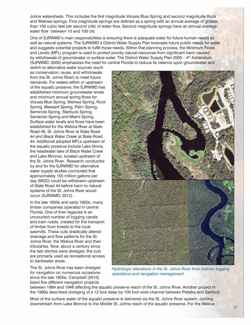
21
Johns watersheds. This includes the first magnitude Volusia Blue Spring and second magnitude Rock and Wekiwa springs. First magnitude springs are defined as a spring with an annual average of greater than 100 cubic feet per second (cfs) of water flow. Second magnitude springs have an annual average water flow between 10 and 100 cfs.
One of SJRWMD’s main responsibilities is ensuring there is adequate water for future human needs as well as natural systems. The SJRWMD’s District Water Supply Plan forecasts future public needs for water and suggests potential projects to fulfill those needs. Within that planning process, the Minimum Flows and Levels (MFL) program is used to protect priority natural resources from significant harm caused by withdrawals of groundwater or surface water. The District Water Supply Plan 2005 – 4th Addendum (SJRWMD, 2009) emphasizes the need for central Florida to reduce its reliance upon groundwater and switch to alternative water sources (such as conservation, reuse, and withdrawals from the St. Johns River) to meet future demands. For waters within or upstream of the aquatic preserve, the SJRWMD has established minimum groundwater levels and minimum annual spring flows for Volusia Blue Spring, Wekiwa Spring, Rock Spring, Messant Spring, Palm Spring, Seminole Spring, Starbuck Spring, Sanlando Spring and Miami Spring. Surface water levels and flows have been established for the Wekiva River at State Road 46, St. Johns River at State Road 44 and Black Water Creek at State Road 44. Additional adopted MFLs upstream of the aquatic preserve include Lake Norris, the headwater lake of Black Water Creek and Lake Monroe, located upstream of the St. Johns River.. Research conducted by and for the SJRWMD for alternative water supply studies concluded that approximately 155 million gallons per day (MGD) could be withdrawn upstream of State Road 44 before harm to natural systems of the St. Johns River would occur (SJRWMD, 2012).
In the late 1800s and early 1900s, many timber companies operated in central Florida. One of their legacies is an uncounted number of logging canals and tram roads, created for the transport of timber from forests to the local sawmills. These cuts drastically altered drainage and flow patterns for the St. Johns River, the Wekiva River and their tributaries. Now, about a century since the last ditches were dredged, the cuts are primarily used as recreational access to backwater areas.
The St. Johns River has been dredged for navigation on numerous occasions since the late 1800s. Campbell (2010) listed five different navigation projects between 1884 and 1946 affecting the aquatic preserve reach of the St. Johns River. Another project in the 1990s described dredging of a 12 foot deep by 100 foot wide channel between Palatka and Sanford.
Most of the surface water of the aquatic preserve is delivered via the St. Johns River system, coming downstream from Lake Monroe to the Middle St. Johns reach of the aquatic preserve. For the Wekiva
Hydrologic alterations in the St. Johns River from historic logging operations and navigation management.
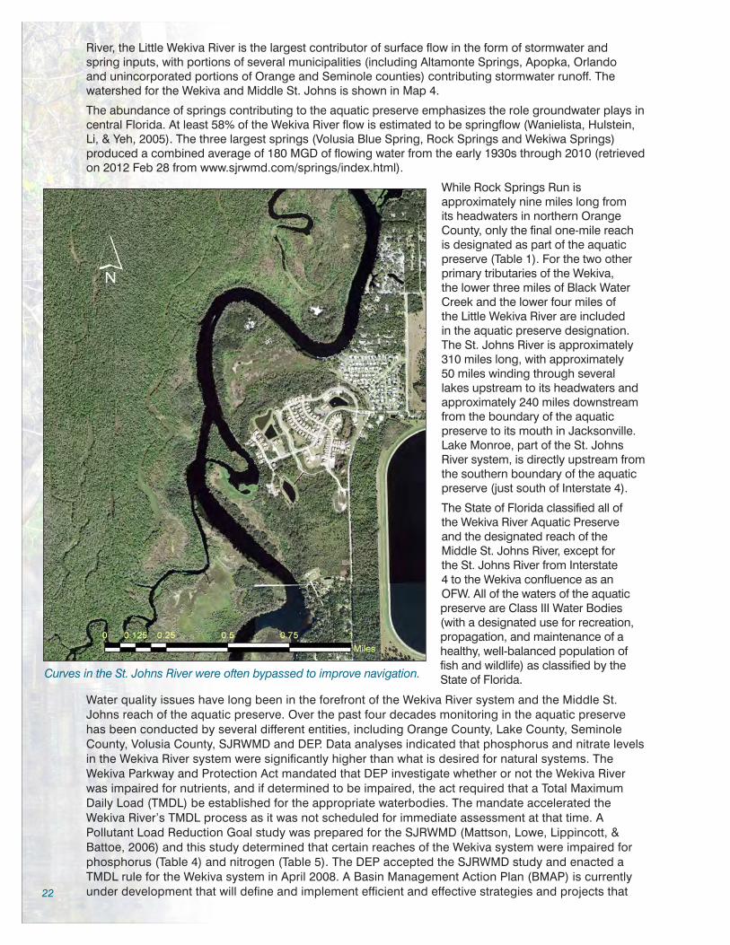
22
River, the Little Wekiva River is the largest contributor of surface flow in the form of stormwater and spring inputs, with portions of several municipalities (including Altamonte Springs, Apopka, Orlando and unincorporated portions of Orange and Seminole counties) contributing stormwater runoff. The watershed for the Wekiva and Middle St. Johns is shown in Map 4.
The abundance of springs contributing to the aquatic preserve emphasizes the role groundwater plays in central Florida. At least 58% of the Wekiva River flow is estimated to be springflow (Wanielista, Hulstein, Li, & Yeh, 2005). The three largest springs (Volusia Blue Spring, Rock Springs and Wekiwa Springs) produced a combined average of 180 MGD of flowing water from the early 1930s through 2010 (retrieved on 2012 Feb 28 from www.sjrwmd.com/springs/index.html).
While Rock Springs Run is approximately nine miles long from its headwaters in northern Orange County, only the final one-mile reach is designated as part of the aquatic preserve (Table 1). For the two other primary tributaries of the Wekiva, the lower three miles of Black Water Creek and the lower four miles of the Little Wekiva River are included in the aquatic preserve designation. The St. Johns River is approximately 310 miles long, with approximately 50 miles winding through several lakes upstream to its headwaters and approximately 240 miles downstream from the boundary of the aquatic preserve to its mouth in Jacksonville. Lake Monroe, part of the St. Johns
Curves in the St. Johns River were often bypassed to improve navigation.
River system, is directly upstream from the southern boundary of the aquatic preserve (just south of Interstate 4).
The State of Florida classified all of the Wekiva River Aquatic Preserve and the designated reach of the Middle St. Johns River, except for the St. Johns River from Interstate 4 to the Wekiva confluence as an OFW. All of the waters of the aquatic preserve are Class III Water Bodies (with a designated use for recreation, propagation, and maintenance of a healthy, well-balanced population of fish and wildlife) as classified by the State of Florida.
Water quality issues have long been in the forefront of the Wekiva River system and the Middle St. Johns reach of the aquatic preserve. Over the past four decades monitoring in the aquatic preserve has been conducted by several different entities, including Orange County, Lake County, Seminole County, Volusia County, SJRWMD and DEP. Data analyses indicated that phosphorus and nitrate levels in the Wekiva River system were significantly higher than what is desired for natural systems. The Wekiva Parkway and Protection Act mandated that DEP investigate whether or not the Wekiva River was impaired for nutrients, and if determined to be impaired, the act required that a Total Maximum Daily Load (TMDL) be established for the appropriate waterbodies. The mandate accelerated the Wekiva River’s TMDL process as it was not scheduled for immediate assessment at that time. A Pollutant Load Reduction Goal study was prepared for the SJRWMD (Mattson, Lowe, Lippincott, & Battoe, 2006) and this study determined that certain reaches of the Wekiva system were impaired for phosphorus (Table 4) and nitrogen (Table 5). The DEP accepted the SJRWMD study and enacted a TMDL rule for the Wekiva system in April 2008. A Basin Management Action Plan (BMAP) is currently under development that will define and implement efficient and effective strategies and projects that

23
would decrease nutrients inputs to the system. The BMAP administrators coordinate the efforts of the various local jurisdictions that contribute nutrients to the system.
The Floridan Aquifer is the primary source of drinking water in central Florida, but it is regarded as approaching capacity for withdrawals. According to the SJRWMD, in 2005 there were 21 major consumptive water use (well) permits in the Wekiva Basin south of State Road 46 (SJRWMD, 2008). Between 1995 and 2005, the withdrawals of these major permittees increased from 69.3 to 80.4 MGD. There was a noticeable increase in the middle of this period (attributed to a drought) with a maximum use of 100.7 MGD in 2000. To prevent significant harm to water resources and ecology in the region, the SJRWMD has established three Minimum Flows and Levels (MFLs) within the aquatic preserve:• Wekiva River at the State Road 46 Bridge (Rao, 2008)• Middle St. Johns River at State Road 44 Bridge (Mace, 2006)• Volusia Blue Spring (Rouhani, Sucsy, Hall, Osburn, & Wild, 2007)
Other established MFLs in waterbodies that flow into the aquatic preserve include:• Lake Norris, the headwater lake of Black Water Creek (Slater, 2013); • Lake Monroe, upstream of the St. Johns River (Mace, 2007).
The Wekiva River MFL is specific to the Wekiva Basin while the Middle St. Johns River at State Road 44 Bridge MFL is relevant to all of the watersheds upstream of that point, including the Wekiva River, Lake Monroe, Lake Jesup, Lake Harney and many other water bodies.
Temperature Data • Wekiva River Aquatic Preserve
85
80
75
70
65
60
55
50
Tem
per
atu
re (
Fah
ren
hei
t)
Sanford-Orlando
Orlando Int’l Airport
Jan Feb Mar Apr May Jun Jul Aug Sep Oct Nov Dec
Deland
Figure 2 / Temperature data for the Wekiva River Aquatic Preserve.
Rainfall Data • Wekiva River Aquatic Preserve
9.0
8.0
7.0
6.0
5.0
4.0
3.0
2.0
1.0
0.0
Rai
nfa
ll (I
nch
es)
Sanford-Orlando
Orlando Int’l Airport
Jan Feb Mar Apr May Jun Jul Aug Sep Oct Nov Dec
Deland
Figure 3 / Rainfall data for the Wekiva River Aquatic Preserve.
3.3.5 / Climate
The aquatic preserve’s climate can be described as subtropical. Average annual rainfall is approximately 52 inches and average temperatures range from 58 o F in January to 81 o F in August. Differences occur between the northern and southern ends of the aquatic preserve, with slightly higher temperatures (Figure 2) and lower rainfall (Figure 3) in the southern areas as compared to the northern areas (National Climatic Data Center, 2014). Over seventy percent of the region’s rainfall occurs during the six-month hurricane season (June 1 through November 30). High rainfall events result in a rapid rise of spring flow. Central Florida experienced 4 major storms during the busy hurricane year of 2004, and although winds were not at hurricane force by the time the storms arrived, relatively high winds combined with large rainfall events resulted in tremendous challenges for the region. A significant number of trees fell into the rivers of the aquatic preserve and debris from several houses and docks were deposited into Lake Beresford after a tornado went through the area in 2007. The aquatic preserve assisted in hurricane and tornado cleanup efforts, including contracting for debris removal in Lake Beresford.
3.3.6 / Natural Communities
The natural community classification system used in this plan was developed by the Florida Natural Areas Inventory (FNAI) and the Florida Department of Natural Resources (DNR), now the DEP. The community types are defined by a variety of factors, such as vegetation structure and composition, hydrology, fire regime, topography and soil type. The community types are named for the most characteristic biological or physical feature (FNAI & DNR, 1990). FNAI also assigns Global (G) and State (S) ranks to each natural community and species tracked by FNAI. These ranks reflect the status of the

24
natural community or species worldwide (G) and in Florida (S). Lower numbers reflect a higher degree of imperilment (e.g., G1 represents the most imperiled natural communities worldwide, S1 represents the most imperiled natural communities in Florida).
The Wekiva River Aquatic Preserve and the designated reach of the Middle St. Johns River consist primarily of nine different communities as described in the FNAI Community Classification System (Map 8). Communities associated with the aquatic preserve are all considered to be in good condition, especially considering the extent of urban development adjacent to the preserve and within the basin. Of the natural communities found within the Wekiva River Aquatic Preserve and the designated reach of the Middle St. Johns River, four are ranked by FNAI as S1 or S2, Critically Imperiled or Imperiled in Florida, respectively. The blackwater streams and aquatic caves of the aquatic preserve appear to be in good condition due to their relatively inaccessible nature. The aquatic caves could be affected by increased nutrients delivered through the karst springshed, although further research is needed to determine levels at which damage could occur or has occurred. Excepting for elevated nutrients and filamentous algae, most spring run streams within the aquatic preserve are generally in good condition and are protected as state sovereign lands. River floodplain lakes, occurring on the St. Johns River, can locally be affected by stormwater runoff but generally have good water quality and support healthy bird and fish populations. An additional three communities (bottomland forest, floodplain marsh, and slough marsh) are ranked as S3, Very Rare or Local throughout Range in Florida. The most common natural communities within the Wekiva River Aquatic Preserve and the designated reach of the Middle St. Johns River are types of lakes, streams and waterways, and mixed wetland hardwoods. At least sixteen different habitat types are documented within the preserve by FNAI. Ruderal and developed areas are also present.
Data used to produce a map delineating the major natural community types found on the Wekiva River Aquatic Preserve and the designated reach of the Middle St. Johns River were developed by the FNAI using multiple sources that include, but were not limited to: SJRWMD, Florida Land Use Cover and Forms Classifications System, digital ortho-photographs, black and white aerial photographs (1:25,000 scale), and FNAI data on Element Occurrences, Potential Natural Areas and Areas of Conservation Interest. These data are not always based on comprehensive or site-specific field surveys, and no additional fieldwork was conducted for purposes of producing this map. The descriptions of the natural community types found within the Wekiva River Aquatic Preserve and the designated reach of the Middle St. Johns River have been adapted from the Guide to the Natural Communities of Florida: 2010 Edition (FNAI, 2010).
Spring-run Stream (synonyms - calcareous stream, spring, or creek) – There are 35 identified spring groups within the aquatic preserve (including the first magnitude Volusia Blue Spring) and its watershed (including the second magnitude Rock Springs and Wekiwa Spring)(Table 2). Spring-run streams are perennial water courses that derive most, if not all, of their water from artesian openings in the underground aquifer. Waters issuing from the aquifer are generally clear, circumneutral to slightly alkaline (pH=7.0-8.2), and perennially cool (66-75°F). These conditions saturate the water with minerals, allow light to penetrate deeply, and reduce the limiting effects of environmental fluctuations, all of which are conducive for plant growth. Thus, spring-run streams are among the most productive aquatic habitats. Typical plants in the aquatic preserve include eelgrass (Vallisneria americana, also known as tapegrass), annual wild rice (Zizania aquatica), bulltongue arrowhead (Sagittaria lancifolia), southern naiad (Najas quadalupensis), and pondweed (Potamogeton spp.). Typical animals include mollusks, stoneflies, mayflies, caddisflies, simuliids, chironomids, American alligator (Alligator mississippiensis), peninsula cooter (Pseudemys peninsularis), loggerhead musk turtle (Sternotherus minor), rainbow snake (Farancia erytrogramma), brown water snake (Nerodia taxispilota), Florida water snake (N. fasciata pictiventris), and many fishes. Volusia Blue Spring and its run are widely recognized as an important winter ground for the federally endangered West Indian manatee due to the constant temperature of the spring water (73oF) and proximity to the St. Johns River. A disjunct population of the bluenose shiner (Pternotropis welaka), a fish listed as a state species of special concern, had previously been observed only occasionally in the Wekiva River (Gilbert, 1992; Warren, Holt, Cichra, & VanGenechten, 2000), but recent surveys appear to indicate the species is more abundant than initially thought (Travis Tuten, Florida Fish and Wildlife Conservation Commission [FWC], personal communication, August 14, 2012).
Spring-run streams generally have sand bottoms or exposed limestone along their central channel. Calcareous silts may form thick deposits in quiet shallow zones, while leaf drift and other debris collect around fallen trees and quiet basins. The latter, along with limestone outcrops and rock debris, form important aquatic habitats for many small aquatic organisms. When undisturbed, submerged aquatic vegetation covers most of the spring-run stream bottom and provides shelter and an abundant food source for the extensive web of life.

25
The water emanating from the aquifer is generally clear because of the filtering and absorbing actions of the soils and aquifer limestones through which the water percolates and flows. When the water is deep, it may appear bluish because of light-refraction characteristics that are similar to those which cause the sky to be blue on clear days. If the water sources for the aquifer are substantially influenced by nearby swamps or flatwoods, the spring-run may temporarily become darkened with tannins and other dissolved organics during or following periods of heavy rains. When extensive underground cavities connect the spring caverns with nearby sinks, the spring-run may become turbid with suspended particulates during and following heavy rains and floods. Conversely during periods of low rainfall, the aquifer can become supersaturated with calcium, carbonates, and other ions. These chemicals readily precipitate when the water reaches the surface, causing the spring head or boil to appear milky. Human activities affect flow rates by withdrawing water from the aquifer through deep wells. When withdrawal is substantial within the recharge area, spring flow can be reduced or, in some cases, cease entirely. Normal flow rates may return when excessive withdrawals are eliminated.
Human activity can also substantially affect the quality of spring waters. Agricultural, residential, and industrial pollutants may readily leach through soils, especially when they are improperly applied or disposed. If polluted groundwater infiltrates the deep aquifer feeding a spring-run stream, recovery may not be possible. Excessive applications of herbicides to control aquatic plant growth are also detrimental, because their use often induces eutrophication of the stream.
Other human-related impacts to spring-run streams include the trampling and destruction of aquatic vegetation by overuse or misuse, and the introduction and proliferation of exotic plants and animals. Both of these impacts have proved very difficult to control. The number of visitors using local publicly-owned springs is controlled by the managing entity. In most spring-fed swimming areas, native vegetation is absent and new vegetation is not likely to recruit due to high use. Lack of vegetation in swimming areas is likely to persist because of the limited number of publicly-owned springs and the continued desires of the population to enjoy the clean, cool, aesthetic qualities and unique recreational opportunities that springs provide. Exotic species are often severely detrimental to native species, and they may also disrupt recreational activities. Maintaining the delicate balance between recreation and preservation is an ongoing challenge for resource managers.
The three spring-run streams in the aquatic preserve (Wekiwa Spring Run, Rock Springs Run, and Volusia Blue Spring Run) have natural resource issues that are discussed elsewhere in this plan, including water quality impairments, alterations in spring flow, and exotic plants and fishes.
LOCATION TOTAL PHOSPHORUS
Existing Concentrations
mg/l
Target Concentrations
Percent Reduction
Rock Springs 0.08 0.06 23%
Rock Springs Run 0.15 0.06 58%
Wekiwa Spring 0.18 0.06 64%
Upper Wekiva River 0.16 0.06 61%
Downstream Wekiva River 0.15 0.06 57%
Little Wekiva River 0.29 0.06 78%
Black Water Creek 0.10 0.06 36%
Table 4 / Total Maximum Daily Loads for phosphorus for Wekiva River system.
LOCATION NITRATE
Existing Concentrations
mg/l
Target Concentrations
Percent Reduction
Rock Springs 1.50 0.28 81%
Rock Springs Run 0.77 0.28 63%
Wekiwa Spring 1.34 0.28 79%
Upper Wekiva River 0.88 0.28 68%
Downstream Wekiva River 0.54 0.28 47%
Little Wekiva River 0.70 0.28 59%
Black Water Creek 0.59 0.28 52% Table 5 / Total Maximum Daily Loads for nitrates for Wekiva River system.
Floodplain Swamp (synonyms - southern floodplain forest, cypress swamp forests) – Floodplain swamp is a closed-canopy forest of hydrophytic trees occurring on frequently or permanently flooded hydric soils adjacent to stream and river channels and in depressions and oxbows within floodplains. It ranges from narrow strips of cypress along primary and secondary streams to expansive stands along large rivers to tidally influenced freshwater swamps near river mouths. Often, floodplain swamps immediately border the stream or river channel. In many cases, however, floodplain swamps are isolated from the main channel

26
by riverbank levees and restricted to oxbows, overflow channels, old stream beds, and expansive flats commonly called backswamps.
The floodplain swamps of the Wekiva and St. Johns rivers can be extensive, ranging up to three miles in width. Soils are variable mixtures of alluvial and organic materials, sometimes with layers of sand in the subsoil. Inundation is seasonal and usually prolonged, restricting the growth of most shrubs and herbs and leaving most of the ground surface open or thinly mantled with leaf litter. Trees are often buttressed, and the understory and groundcover are sparse. The canopy is sometimes a pure stand of bald cypress (Taxodium distichum), but more commonly bald cypress shares dominance with swamp tupelo (Nyssa
sylvatica var. biflora). The “knees” arising from the root systems of both cypress and tupelo are common features in floodplain swamp. Other canopy trees capable of withstanding frequent inundation may be present but rarely dominant, including water hickory (Carya aquatica), red maple (Acer rubrum), green ash (Fraxinus pennsylvanica), American elm (Ulmus americana) and swamp laurel oak (Quercus laurifolia). Along the Wekiva River, however, these other floodplain hardwoods have dominated as second growth likely because most of the cypress trees were logged out during in the late 1800s and early 1900s. The faster growing hickory, maple and ash out-competed the slower growing cypress, although a few large remnant cypress trees can be found along the Wekiva and Rock Springs Run, and within the interior portions of the state parks and forest, preserves and reserve. Pond cypress (T. ascendens) is sometimes present in backswamps and depressions of the more hydrologically isolated areas of the floodplain. Floodplain swamp can often occur within a complex mixture of communities including alluvial forest, bottomland forest, and baygall. This produces a variable assemblage of canopy and subcanopy species, with less flood tolerant trees and shrubs found on small hummocks and ridges within the swamp. Shrubs and smaller trees such as Carolina ash (F. caroliniana), planer tree (Planera aquatica), Virginia willow (Itea virginica), common
buttonbush (Cephalanthus occidentalis), cabbage palm (Sabal palmetto) and dahoon holly (Ilex cassine) may be present. A groundcover of flood tolerant ferns and herbs are found in some floodplain swamps, including lizard’s tail (Saururus cernuus), false nettle (Boehmeria cylindrica), creeping primrosewillow (Ludwigia repens), savannah panicum (Phanopyrum gymnocarpon), royal fern (Osmunda regalis) and string lily (Crinum americanum). Swamps with stagnant water typically have floating aquatics such as duckweeds (Lemna spp.). Eastern poison ivy (Toxicodendron radicans) is a frequent vine. This species
VolusiaCounty
SeminoleCounty
LakeCounty
OrangeCounty
0 2 41Miles
±
Natural Land CoverBlackwater StreamBottomland ForestCypressDepression MarshFloating/Emergent Aquatic VegetationFloodplain MarshFloodplain SwampFreshwater MarshesHydric HammockMesic FlatwoodsMixed Hardwood-ConiferousMixed Scrub-Shrub WetlandMixed Wetland HardwoodsNatural Lakes & PondsNatural Rivers & StreamsOther Wetland Forested MixedRiver Floodplain Lake/Swamp LakeShell MoundSloughSpring Run StreamWet FlatwoodsOther Natural Communities(less than 2 acres)
Not a Natural Community
May 2012
LakeMonroe
Map 8 / Natural communities near Wekiva River Aquatic Preserve.

27
list is developed in part from Leitman, Sohm and Franklin (1982) and Darst, Light and Lewis (2002). The federally endangered wood stork (Mycteria americana) and state listed limpkin (Aramus guarauna) both nest in floodplain swamp trees of the aquatic preserve.
Hydric Hammock – (synonyms - southern floodplain forest, swamp forests, hardwood forests, wetland hardwood hammocks) - Hydric hammock is an evergreen hardwood and/or palm forest with a variable understory typically dominated by palms and ferns occurring on moist soils, often with limestone very near the surface. Hydric hammock occurs on low, flat, wet sites where limestone may be near the surface and soil moisture is kept high mainly by rainfall accumulation on poorly drained soils. Periodic flooding from rivers, seepage, and spring discharge may also contribute to hydric conditions. Soils are variable, usually somewhat acidic to slightly alkaline with little organic matter, and in all cases, alkaline materials are available in the substrate. Deeper soils over limestone (Aripeka series) and deep sands with calcium carbonate nodules and shell fragments underlie many hammocks in peninsular Florida. These substrates are conducive for the growth of calciphiles characteristic of hydric hammock (red cedar, rattan vine, etc.). Hydric hammock is inundated only for short periods following heavy rains. The normal hydroperiod is seldom over 60 days per year. Fire may be rare or occasional depending on several factors including how often the surrounding community burns and hammock size.
While species composition varies, the community generally has a closed canopy of oaks and palms, an open understory, and a sparse to a moderate groundcover of grasses and ferns. The canopy is dominated by swamp laurel oak and/or live oak (Quercus virginiana) with varying amounts of cabbage palm, American elm, sweetbay (Magnolia virginiana), red cedar (Juniperus virginiana), red maple, sugarberry (Celtis laevigata), sweetgum (Liquidambar styraciflua), and water oak (Q. nigra). Cabbage palm is a common to dominant component of hydric hammock throughout most of Florida. Loblolly pine (Pinus taeda) may be frequent in some areas, but slash pine (P. elliottii) is less frequently encountered. In addition to saplings of canopy species, the understory may contain a number of small trees and shrubs. American hornbeam (Carpinus caroliniana) is often frequent, and various other woody species may be present including swamp dogwood (Cornus foemina), small-leaf viburnum (Viburnum obovatum), common persimmon (Diospyros virginiana), swamp bay (Persea palustris), wax myrtle (Myrica cerifera), dwarf palmetto (Sabal minor), American beautyberry (Callicarpa americana) and needle palm (Rhapidophyllum hystrix). Swamp dogwood is a common understory species found along the waterways of the aquatic preserve. Vines may be frequent and diverse; common species are eastern poison ivy, peppervine (Ampelopsis arborea), rattan vine (Berchemia scandens), trumpet creeper (Campsis radicans), climbing hydrangea (Decumaria barbara), yellow jessamine (Gelsemium sempervirens), greenbriers (Smilax spp.), summer grape (Vitis aestivalis), and muscadine (Vitis rotundifolia). Herb cover, when present includes mostly graminoids and ferns with the following species commonly encountered: sedges (Carex spp.), shiny woodoats (Chasmanthium nitidum), Carolina scalystem (Elytraria caroliniensis), woodsgrass (Oplismenus hirtellus), maiden ferns (Thelypteris spp.), cinnamon fern (Osmunda cinnamomea), royal fern, toothed midsorus fern (Blechnum serrulatum), netted chain fern (Woodwardia areolata), Virginia chain fern (W. virginica), golden polypody (Phlebodium aureum), air-plants (Tillandsia spp.), shoestring fern (Vittaria lineata) and wild coffee (Psychotria nervosa) (species list developed in part from Vince, Humphrey & Simons (1989)).
Species composition is mainly influenced by flooding patterns. In saturated and frequently flooded environments, hydrophytic trees such as swamp tupelo become more abundant. Frequency and depth of inundation have a pronounced effect on oak canopy composition as well, with saturated soils supporting more swamp laurel oak, and areas of infrequent flooding supporting more live oak. Increased salinity is a factor often limiting certain species. Rises in terrain as well as ecotones to mesic hammock and upland hardwood forest induce a greater cover of upland species, specifically southern magnolia (Magnolia grandiflora), pignut hickory (Carya glabra) and saw palmetto (Serenoa repens). Wekiwa Springs State Park contains Florida’s largest known population of star anise (Illicium parviflorum), a state endangered species. Star anise occurs throughout the hydric hammock/floodplain swamp communities along Rock Springs Run (DEP, 2005).
Aquatic Cave – (synonym - spring rise) - Aquatic caves are characterized as cavities below the surface of the ground in karst areas of the state. A cave system may contain portions classified as terrestrial caves and portions classified as aquatic caves. Aquatic caves are known to occur in the Wekiva Basin and St. Johns basins, and vary from shallow pools highly susceptible to disturbance, to more stable, totally submerged systems. The limestone aquifers that underlie the entire state of Florida could be considered vast aquatic cave communities. Two geologic processes are predominantly responsible for the development of caves: phreatic and vadose. Phreatic processes occur below the aquifer’s surface where ground water is confined and subjected to hydrostatic pressure. Vadose processes occur at the top of or above the aquifer, where air enters the passageways and water flows freely under the influence

28
of gravity. In both processes, the dissolution and corrosion of limestone play active roles in enlarging cave passageways. These forces differ primarily in the slopes of the passageways which result. Phreatic passageways are generally circular or elliptic, while vadose passageways are more triangular with the broad base of the triangle at the bottom. All limestone caves begin development under phreatic conditions in the aquifer. As water tables drop, vadose conditions eventually replace phreatic conditions. If the water table then rises, another reversal of processes occurs. Because water tables have fluctuated substantially with fluctuating sea levels during the Pleistocene and other geologic epochs, most caves in Florida exhibit both phreatic and vadose characteristics.
Cave waters are generally clear, with deep water appearing bluish. The water may become stained brown from tannins leached from decaying plant matter nearby and carried in with rainwater. The water may also become milky white if fine limestone mud from the bottom of the aquatic cave is suspended in the water column following disturbance. A bottom substrate of organic silts can also muddy the water with suspended particles. Waters are typically circumneutral to alkaline with a high mineral content (particularly calcium bicarbonate and magnesium) and with constant temperature. Flowing water within aquatic caves generally has a lower pH, is often undersaturated with respect to carbonates, and has a relatively richer fauna. Contrastingly, pools that are fed by seepage or dripping water are generally characterized by a high pH, high concentration of dissolved carbonates, low content of organic matter suitable for food, and a sparse fauna. Cave water characteristics may also vary seasonally because of fluvial inputs from interconnected surface streams, or because of detrital pulses and other surface inputs during periods of substantial aquifer recharge. In general, however, aquatic caves are very stable environments with relatively constant physical and chemical characteristics.
Subterranean natural communities differ from most other natural communities in that living plants are not dominant elements due to a lack of light (and photosynthetic processes). Subterranean natural communities faunas are adapted to very stable environments and have a limited ability to survive even minor environmental perturbations. Animals inhabiting subterranean natural communities are generally divided into three groups according to their cave adaptations: trogloxenes, troglophiles, and troglobites. Trogloxenes spend much of their time in caves, but they must periodically return to the surface to feed or breed. Troglophiles may regularly live in caves, but their conspecifics also inhabit surface communities with moist microhabitats. Troglobites are obligatory cave dwellers with special adaptations to complete
Winter on the Middle St. Johns River, part of the Wekiva River Aquatic Preserve, winter 2010.

29
their life cycles in complete darkness. Even though they never leave their cave environments, troglobites and troglophiles depend on outside energy sources, such as detritus that washes in through sinkholes and other cave entrances. Fecal materials derived from trogloxenes which feed outside the cave are also important nutrients for troglobites. Without these energy subsidies, the troglobitic elements could not exist.
The unique environment within spring boils (such as very low oxygen or high chloride content) provides habitat for animals generally not found elsewhere. Several endemic snails and crayfish have specific adaptations allowing them to survive under these unique conditions. Two snails, the Wekiwa hydrobe (Aphaostracon monas) and Wekiwa siltsnail (Cincinnatia wekiwae) are endemic to the Wekiwa system springs. The Blue Spring hydrobe (Aphaostracon asthenesis) and pygmy siltsnail (Floridobia parva) only occur in Volusia Blue Spring. The Orlando cave crayfish (Procambarus acherontis) is only found in sites associated with spring cave systems of the lower Wekiva River basin (Hobbs, 1942; Franz & Morris, 1994). Other species occasionally use the boils as refuge, and Florida softshell turtles (Apalone ferox) are occasionally found in the crevices running into the boils.
Alterations in or around cave entrances will often upset detrital input levels and may also induce significant changes in air circulation patterns and the cave microclimate. Aquatic caves are threatened by pollution of ground and surface waters from agricultural, industrial, and residential sources, as well as by disturbances from divers. The unique troglobitic species generally have very low population levels and can be severely impacted by overcollection or by changes in nutrient input levels that result from surface manipulations or hydrological alterations. Special precautions and management procedures such as exclusionary devices should be used to protect these unique, fragile communities from deleterious activities.
Bottomland Forest – (synonyms - southern floodplain forest, wetland forested mixed) - Bottomland forest is a deciduous, or mixed deciduous/evergreen, closed-canopy forest on terraces and levees within riverine floodplains and in shallow depressions. Found in situations intermediate between swamps (which are flooded most of the time) and uplands, the canopy may be quite diverse with both deciduous and evergreen hydrophytic to mesophytic trees. Dominant species include sweetgum, loblolly pine, sweetbay, swamp laurel oak, water oak, live oak, and sugarberry. More flood tolerant species that are often present include American elm and red maple, as well as occasional swamp tupelo and bald cypress. Evergreen bay species such as loblolly bay (Gordonia lasianthus), and sweetbay are often mixed in the canopy and understory in acidic or seepage systems. Smaller trees and shrubs often include American hornbeam, swamp dogwood, dahoon holly, dwarf palmetto, swamp bay, wax myrtle and highbush blueberry (Vaccinium corymbosum). The understory is either dense shrubs with little ground cover, or open, with few shrubs and a groundcover of ferns, herbs, and grasses. In the drier forests of this type, American holly (Ilex opaca), and sparkleberry (Vaccinium arboreum) may be frequent. Ground cover is also variable in composition and abundance, often with species overlap between herbs suited to either mesic or hydric conditions. Characteristic species include witchgrasses (Dichanthelium spp.), slender woodoats (Chasmanthium laxum), and sedges. Species lists are based in part on Leitman et al. (1982), Light and Darst (1993), and Darst and Light (2008). Very similar to floodplain swamps, wood storks (federally endangered) and limpkins (state listed species) have been observed nesting in bottomland forests in the aquatic preserve.
Situations where bottomland forest occurs include several distinct ecological settings in Florida: along rivers and tributaries, on higher terraces and levees in floodplains, and in somewhat isolated depressions that do not flood frequently. Bottomland forests along smaller streams are prone to periodic flooding attributable to localized rainfall that increases seepage and runoff from surrounding uplands. In floodplains along larger rivers and tributaries, bottomland forests on higher terraces, ridges, and levees are subject to short seasonal floods due to either high relief or quickly drained sandy soils or both. Soils are a mixture of sand, clay, and organic materials. The water table in these forests is high in blackwater or spring-fed floodplains and relatively low in alluvial floodplains (during dry periods). Inundation occurs only during higher floods, regardless of the stream type.
Floodplain Marsh (synonyms - river marsh, freshwater marsh) - Floodplain marsh is a wetland community occurring in river floodplains and dominated by herbaceous vegetation and/or shrubs. Sand cordgrass (Spartina bakeri), sawgrass (Cladium jamaicense) and maidencane (Panicum hemitomon) are common dominants, but various other herbs may be found distributed along a hydrologic gradient. Broadleaf emergents and floating plants, particularly bulltongue arrowhead (Sagittaria lancifolia), bladderworts (Utricularia spp.), pickerelweed (Pontederia cordata), yellow pondlily (Nuphar lutea) occupy the deepest, most frequently flooded sites, and mixed herbaceous stands are found in the somewhat higher portions of the marsh. In wetter sites, coastalplain willow (Salix caroliniana) or common buttonbush may form shrub thickets. The highest part of the marsh is often a drier, wet prairie-like zone with a large diversity of grasses and forbs. While the progression from high to low marsh occurs generally from the upland edge

30
to the river edge, these vegetation patches may also be scattered throughout the marsh, which provides a diversity of habitats beneficial to wildlife. Additional herbs can include bulrushes (Scirpus spp.), common reed (Phragmites australis), tickseeds (Coreopsis spp.), primrosewillows (Ludwigia spp.), flatsedges (Cyperus spp.), manyflower marshpennywort (Hydrocotyle umbellata), rushes (Juncus spp.), beaksedges (Rhynchospora spp.), spadeleaf (Centella asiatica), swamp rosemallow (Hibiscus grandiflorus), saltmarsh morning glory (Ipomoea sagittata), cattails (Typha spp.), southern cutgrass (Leersia hexandra) and climbing hempvine (Mikania scandens). Other than occasional thickets, woody vegetation is generally sparse, although some marshes can be dominated by common buttonbush, coastalplain willow and/or wax myrtle. Occasionally, cabbage palm and other flood tolerant trees are widely scattered in floodplain marsh, becoming more concentrated in the ecotone to adjacent hydric hammocks. Several listed wading birds, including limpkin, little blue heron (Egretta caerulea), snowy egret (E. thula), tricolored heron (E. tricolor) and white ibis (Eudocimus albus) forage within floodplain marshes.
Floodplain marshes are found along rivers and streams from just below the headwaters to the freshwater portions of tidally influenced river mouths. They also occur in river overflow channels and lakes with both input and output of river flow. Floodplain marshes are directly influenced by river flooding on an annual or semi-annual basis where most of the marsh is inundated from approximately 120 to 350 days per year. Soils are typically sand or a thin to thick organic layer over sand and may be saturated for most of the year. Floodplain marsh may burn periodically depending on dominant vegetation. Aquatic preserve staff provided boat support and coordinated with the Florida Park Service (FPS) in past years during prescribed burns on the marshes between the Wekiva and St. Johns rivers.
Slough Marsh – (synonyms - emergent aquatic vegetation, grasslands of prairie type, freshwater marshes) - Slough marsh is a primarily herbaceous community growing in a narrow to broad shallow channel with intermittently flowing water in flat sandy landscapes. Grasses, sedges, and emergent herbs dominate the mainly treeless landscape. Vegetation is found in zones based on length of hydroperiod and depth of flooding. Frequently flooded areas of slough marsh are often dominated by species such as bulltongue arrowhead, pickerelweed, alligatorflag (Thalia geniculata), maidencane, sawgrass and cattails. Drier marsh zones with less peat accumulation often are dominated by sand cordgrass, beaksedges, especially narrowfruit horned beaksedge (Rhynchospora inundata). Other common herbs include rushes, spikerushes (Eleocharis spp.), pipeworts (Eriocaulon decangulare), and clustered bushmint (Hyptis alata). This species list is based, in part, on McPherson and McCoy (1974), Bridges (1998), and Florida Natural Areas Inventory (2005). Patches of coastalplain willow, common buttonbush and wax myrtle are often scattered in deeper pockets of peat. Florida sandhill cranes (Grus canadensis pratensis), often nest in the sloughs formed by oxbows within the St. Johns River portion of the aquatic preserve.
Drought conditions can entirely dry out the marsh and associated sloughs, allowing other herbs to temporarily gain dominance. These include dogfennel (Eupatorium capillifolium), sugarcane plumegrass (Saccharum giganteum), bluestems (Andropogon spp.), yellow bristlegrass (Setaria parviflora), camphorweed (Pluchea spp.), Nuttall’s thistle (Cirsium nuttallii) and smartweeds (Polygonum spp.).
Slough marsh is found in situations that are frequently flooded with slow moving water from upstream sources and local rainfall. They are found in areas of very flat topography, particularly the dry prairie regions of south-central Florida, where freshwater marshes may form linear drainageways that provide a conduit for moving water. Slough marshes may be shallow or slightly deeper with a slough in the center. They are situated on sand or a layer of accumulated peat over sand and are inundated at least during the late summer and early fall.
Blackwater Stream – (synonyms - blackwater river, blackwater creek) – Blackwater streams are perennial or intermittent seasonal watercourses originating deep in sandy lowlands where extensive wetlands with organic soils function as reservoirs, collecting rainfall and discharging it slowly to the stream. The tea-colored waters of blackwater streams are laden with tannins, particulates, and dissolved organic matter and iron derived from drainage through swamps and marshes. They generally are acidic (pH = 4.0 - 6.0), but may become circumneutral or slightly alkaline during low-flow stages when influenced by alkaline groundwater. Water temperatures may fluctuate substantially and are generally correlated with seasonal fluctuations in air temperature. The dark-colored water reduces light penetration and, thus, inhibits photosynthesis and the growth of submerged aquatic plants. Emergent and floating aquatic vegetation may occur along shallower and slower moving sections, but their presence is often reduced because of typically steep banks and considerable seasonal fluctuations in water level. Typical plants include goldenclub (Orontium aquaticum), smartweed, sedges, and grasses (Poaceae). Typical animals include longnose gar (Lepisosteus osseus), gizzard shad (Dorosoma cepedianum), threadfin shad (D. petenense), chain pickerel (Esox niger), ironcolor shiner (Notropis chalybaeus), lake chubsucker (Erimyzon sucetta), channel catfish (Ictalurus punctatus), golden topminnow (Fundulus chrysotus), eastern mosquitofish

31
(Gambusia holbrooki), redbreast sunfish (Lepomis auritus), dollar sunfish (L. marginatus), redear sunfish (L. microlophus), spotted sunfish (L.punctatus), black crappie (Pomoxis nigromaculatus), swamp darter (Etheostoma fusiforme), blackbanded darter (Percina nigrofasciata), pig frog (Rana grylio), American alligator, common snapping turtle (Chelydra serpentina), Florida snapping turtle (Chelydra serpentina osceola), peninsula cooter, common musk turtle (Sternotherus odoratus), Florida softshell turtle, Florida water snake, West Indian manatee and North American river otter (Lutra canadensis).
Relict marine sediment deposits and high chloride concentrations from springs result in a relative “saltiness” of water in the aquatic preserve, and several saltwater fish species, including white mullet (Mugil cephalus), American shad (Alosa sapidissima) and striped bass (Morone saxatilis) have breeding populations in the region. Mullet are frequently observed jumping as they travel in the Wekiva River. The Atlantic needlefish (Strongylura marina) has been caught on numerous occasions, especially near Katie’s Landing, north of State Road 46 (Warren et al., 2000). Blue crab (Callinectes sapidus) are occasionally observed on the Wekiva River by private citizens and during fisheries research (Gary Warren, FWC, 1997). The southern stingray (Dasyatis americana) also occurs in the St. Johns River (Warren et al., 2000).
Blackwater streams have sandy bottoms overlain by organics and frequently underlain by limestone. Limestone outcrops may also occur. Blackwater streams generally lack the continuous extensive floodplains and natural levees of alluvial streams. Instead, they typically have high, steep banks alternating with floodplain swamps. High banks confine water movement except during major floods. The absence of significant quantities of suspended sediments reduces their ability to construct natural levees.
Blackwater streams are the most widely distributed and numerous riverine systems in the southeast coastal plain. Very few, however, have escaped major disturbances and alteration. Clearcutting of adjacent forested lands is one of the more devastating alterations for this community. Additionally, the limited buffering capacity of blackwater streams intensifies the detrimental impacts of agricultural and industrial effluents. Due to its remote location, most of the upstream reaches of Black Water Creek are near pristine and are difficult to traverse due to numerous fallen trees and submerged obstacles. The lower reach of Black Water Creek, within Seminole State Forest and Lower Wekiva River Preserve State Park, is more easily, and more frequently, navigated.
Winter on the Middle St. Johns River, part of the Wekiva River Aquatic Preserve, winter 2010.
River Floodplain Lake and Swamp Lake – (synonyms – oxbow lake, blackwater lake) – Swamp lakes and river floodplain lakes are shallow open water zones, with or without floating and submerged aquatic plants that are surrounded by basin swamp or floodplain swamp. They are generally permanent water bodies, although water levels often fluctuate substantially and they may become completely dry during

32
extreme droughts. Typically, they are lentic water bodies occurring in confined basins or depressions. However, during floods or following heavy rains, they may exhibit decidedly lotic characteristics, flowing with the flood water or overflowing their banks into lower topographic areas. Some may even exhibit a slow perennial sheet flow, but water movement is generally so slow that lentic conditions prevail.
Except for the fringe of hydrophytic trees, shrubs and scattered emergents, plants may be absent altogether, or they may almost completely cover the water surface. When present, typical plants include yellow waterlily (Nymphaea mexicana), spatter-dock (Nuphar lutea), duckweed (Lemna spp.), water spangles (Salvinia minima), marshpennywort (Hydrocotyle spp.), coontail (Ceratophyllum demersum) and bladderwort. Several exotic plants also often occur, including water lettuce (Pistia stratiotes), water hyacinth (Eichhornia crassipes), alligator weed (Alternanthera philoxeroides), parrotfeather watermilfoil (Myriophyllum aquaticum) and hydrilla (Hydrilla verticillata). Scattered emergent plants such as lizard’s tail, pickerelweed, slender spikerush (Eleocharis tenuis) and goldenclub may also occur, but the community will more appropriately be called depression marsh or floodplain marsh if emergents dominate the water body.
Typical animals include Florida gar (Lepisosteus platyrhincus), bowfin (Amia calva), chain pickerel, golden shiner (Notemigonus crysoleucas), tailfin shiner (Notropis maculatus), lake chubsucker, brown bullhead (Ameiurus nebulosus), tadpole madtom (Noturus gyrinus), pirate perch (Aphredoderus sayanus), golden topminnow, western mosquitofish (Gambusia affinis), bluegill (Lepomis macrochirus), largemouth bass (Micropterus salmoides), swamp darter, two-toed amphiuma (Amphiuma means), sirens (Siren spp.), Florida cricket frog (Acris gryllus dorsalis), bullfrog (Rana catesbeiana), pig frog, Florida leopard frog (R. utricularia), American alligator, Florida snapping turtle, yellow-bellied slider (Trachemys scripta scripta), common musk turtle, Florida softshell turtle, mud snake (Farancia abacura), banded water snake (Nerodia fasciata), brown water snake, cottonmouth (Agkistrodon piscivorus), great blue heron (Ardea herodias), great egret (Ardea alba), snowy egret, little blue heron, green heron (Butorides virescens), white Ibis, wood stork, belted kingfisher (Megaceryle alcyon), and North American river otter. The state listed least tern (Sterna antillarum) is occasionally observed foraging on Lake Beresford and was also observed in the St. Johns River near it confluence with the Wekiva River.
The substrates of swamp lakes and river floodplain lakes are variable and may be composed primarily of peats, sands, alluvial clays, or any combination of these. Swamp lakes characteristically have highly colored, acidic, soft water with moderate mineral content, while river floodplain lakes characteristically have colored, alkaline or slightly acidic, hard or moderately hard water with high mineral content (sulfate, chloride, calcium, magnesium). Both types are generally mesotrophic to eutrophic (i.e., have moderate to high nutrient levels and primary productivity), although they sometimes exhibit partial oligotrophic characteristics, with low nutrient levels and primary productivity, because their darkly stained, acidic waters and surrounding tree canopy limit their productivity.
FNAI Natural Community Type # Acres% of Area
Federal Rank State Rank Comments
Floodplain Swamp 684.3 12.1 G4 S4
Hydric Hammock 1399.9 24.7 G4 S4
Bottomland Forest 133.9 2.4 G4 S3
Floodplain Marsh 90.4 1.6 G3 S3
Slough Marsh 293.8 5.2 G3 S3
Blackwater Stream 1444.7 25.5 G4 S2
Spring Run Stream 103.9 1.8 G2 S2
River Floodplain Lakes 838.3 14.8 G4 S2
Aquatic and Terrestrial Cave Unknown Unknown G3 S2
Other Natural Upland 535.1 9.4 Hontoon Island
Other Wetland 109.9 1.9 Mixed scrub-shrub
Other Urban 34.4 0.6Residential, industrial, and transportation
Ruderal 1.0 0.0
Table 6 / Summary of natural communities on Wekiva River Aquatic Preserve. (See page 24 for an explanation of the ranking system.)

33
Swamp lakes may have originated from one or more of the following geological processes: (1) solution of the underlying limestone and subsequent collapse of the surface to form a depression; (2) lowering of sea levels to isolate ancient coastal features, such as lagoons or dune swales; or (3) isolation of ancient river systems within relatively confined basins. River floodplain lakes generally originate along former stream channels as oxbows that have been isolated when new channels cut across a meander loop in the river, or along erosion scours formed by the tremendous forces of floodstage waters. Swamp lakes and river floodplain lakes are important breeding areas for many terrestrial and semi-aquatic amphibians. They are frequently very important feeding areas for many wading birds, ducks, and reptiles. They are also important nursery grounds and habitats for several species of fish. Swamp lakes and floodplain lakes are extremely vulnerable to hydrological manipulations which lower the water levels and hasten successional processes. They are also vulnerable to land clearing and timber harvest operations within the surrounding swamps or adjacent uplands. Upland activities commonly increase sedimentation, while activities within the swamp may increase insolation levels, alter nutrient levels and, in the case of floodplain lakes, increase the effects of flood scouring. Several swamp lakes and floodplain lakes occur near the western banks of the St. Johns River.
3.3.7 / Species
Native Species
Central Florida is within a climatic transition zone between temperate and sub-tropical, resulting in an area of relatively high biodiversity, with occurrences of plant and animal species associated with both zones. The natural communities described within the previous section provide habitat for a wide range of animals, including birds, mammals, reptiles, insects, fish, and shellfish. More than 850 species have been identified in the Wekiva River Aquatic Preserve and the designated reach of the Middle St. Johns River, and are listed in Appendix B.3. More than 175 bird species have been observed within the aquatic preserve during surveys conducted by aquatic preserve staff since 1987. Many species of birds nest or roost in the swamps along the waterways, including great blue heron, great egret, black-crowned night heron (Nycticorax nycticorax), pileated woodpecker (Dryocopus pileatus) and wood duck (Aix sponsa). Warren et al. (2000) reported collecting 40 fish species and 268 invertebrate species (representing 39 major taxonomic groups) during a study in 1997. Interestingly, species generally associated with saltwater environments, such as white mullet and blue crab are observed in these systems. Such species are able to persist due to high chloride concentrations from ancient salt deposits upwelling in the springs. Toth, Rohrer and Munch (1989) described a wedge of connate water (relict sea water) in the lower Wekiva River located several miles upstream of the confluence with the St. Johns River. This wedge contains high chloride concentrations that affect water quality in the wells and water supply of local residents as well as the river itself.
Listed Species
Nineteen species found in the aquatic preserve basin are listed by the state or federal government as in danger (or possible danger) of going extinct. Habitat loss and destruction is considered to be the principle factor leading to the listing of endangered species, threatened species, and species of special concern. Listed species are given special consideration within any management actions taken for the aquatic preserve. Refer to Appendix B.3 for a list of reported/known listed species.
West Indian manatee, a federally endangered species, use Volusia Blue Spring as wintering grounds, and the St. Johns River from Lake Beresford to just below the Wekiva River is a FWC designated slow speed zone from October 15 to April 15 due to the large population of manatees in the region. The lower one-mile reach of the Wekiva River is also designated a slow speed zone for protection of manatees (Map 9).
Several listed bird species are regular resident of the aquatic preserve waters. Wood storks, a federally endangered species, nest in the aquatic preserve and are regularly seen along the various waterways. Limpkins, a state species of special concern, are considered an indicator species for the region due to their dependence on freshwater snails as a food source. Research conducted by the aquatic preserve indicated that the local population was relatively stable between 1992 and 2005. The Florida sandhill crane, listed as threatened by the FWC, is a common sight and nesting bird in the aquatic preserve. Several wading birds listed as state species of special concern, including little blue heron, snowy egret, tricolored heron and white ibis nest and are frequently observed within the waters of the aquatic preserve.
Several plants native to the aquatic preserve are endangered, threatened, or described as commercially exploited. These include the threatened cardinal flower (Lobelia cardinalis), a perennial with bright red rosettes of flower found on the banks of rivers and streams, and the endangered hand fern

34
(Ophioglossum palmatum), occasionally observed growing in the base of cabbage palm leaves. The Okeechobee gourd (Cucurbita okeechobeensis), a federally endangered vine with yellow, bell-shaped flowers, was recently observed in the floodplain of the Middle St. Johns reach of the aquatic preserve (Kelli Gladding, personal communication, September 8, 2011).
The bluenose shiner is of particular interest as both a state species of special concern and a disjunct population within the St. Johns River system (McLane, 1955; Hoehn, 1998; Warren et al., 2000). It is more commonly seen in the western panhandle of Florida and several southeastern states. It is thought that the entire population in the St. Johns River upper tributaries is in decline, possibly due to habitat loss and exploitation for the aquarium trade (Hipes, Jackson, NeSmith, Printiss, & Brandt, 2001). Approximately 20 individuals were observed during the 2012 Wekiva River Bioblitz in Rock Springs Run and on the Wekiva River (Travis Tuten, personal communication, May 30, 2012).
Black bears are an uncommon but delightful sight. This one was taking a swim in the St. Johns River near the Black Bear Wilderness Area.
Invasive Non-native Species
Florida’s relatively benign climate encourages a large number of non-native plants to grow. Of the 1,200 or so naturalized exotic plants in Florida, over 140 are considered invasive pests (or potentially invasive pests) that have the capability of interfering with natural habitats. Several invasive aquatic plants, including hydrilla, water hyacinch, wild taro (Colocasia esculenta), para grass (Urochloa mutica), green hygro (Hygrophila polysperma) and Mexican petunia (Ruellia brittoniana) have become established within the aquatic preserve. Herbicides and hand removal are used to control the plants, depending upon several factors, including location, water flow, plant species, and plant characteristics. For example, the newly introduced green hygro has primarily been found in the Little Wekiva and there is currently no approved removal or control methodology for this species in flowing water. Therefore, hand removal is needed for this species. However, care must be taken to prevent the escape of plant fragments, since relatively small dislodged pieces of this plant can become established and infest areas farther downstream. Considerable efforts by several agencies (including DEP, FWC, SJRWMD and U.S. Army Corps of Engineers) have resulted in successful control of both hydrilla and wild taro (primarily through the use of controlled herbicides) in targeted areas of the aquatic preserve. Appendix B.3 includes a comprehensive list of known exotic invasive plants.

35
There is some dispute within the botanical community as to whether water lettuce is native or exotic, but it was recorded in the St. Johns River by William Bartram in the late 1700s, and now, as then, can form “large communities, or floating islands” (Bartram, 1928) that can interfere with navigation. The FWC characterizes water lettuce as an invasive exotic and manages it as a nuisance species.
Several exotic freshwater fish, including blue tilapia (Oreochromis aureus) and armored catfish (Pterygoplichthys disjunctivus) have established populations in the Wekiva and Middle St. Johns Rivers. While both are consumed in the region (and the armored catfish are popular for bow-hunters), they may also interfere with native populations of fish. There is concern that the numerous burrows created by the armored catfish may cause erosion in Volusia Blue Spring run, one of the most important West Indian manatee wintering grounds.
The Muscovy duck (Cairina moschata), a native of Central and South America, also inhabits the aquatic preserve basin. The Muscovy duck is known to interfere with the successful nesting of native waterfowl, but it is not known to what extent this occurs within the aquatic preserve. It appears to reside at several local private homes, possibly due to feeding by residents.
At least three species of non-native turtles have been identified within the aquatic preserve: red-eared slider (Trachemys scripta elegans), northern red-bellied cooter (Pseudemys rubriventris) and false map turtle (Graptemys pseudogeographica). All three have been captured during the Central Florida Turtle Research Group study conducted at Wekiwa and Volusia Blue Springs. It is probable that these turtles were unwanted pets released into the wild, although it is likely that the red-eared slider is the only species with a breeding population in the area. Interactions between these species, native turtles and the surrounding ecosystem are not well understood.
VolusiaCounty
SeminoleCounty
LakeCounty
0 2 41Miles
±
Wekiva River Aquatic PreserveManatee Protection Zones
25 mph (all year)30 mph (all year) during daylight hours; 25 mph(all year) at night)Motorboats prohibited (Oct 15 - Apr 15); Idlespeed (Apr 16 - Sep 30)Slow speed (all year)Slow speed (all year) within 50' shoreline bufferSlow speed (all year) within 300' shoreline bufferSlow speed (all year) within 1000' shoreline bufferSlow speed (all year) within 3000' shoreline bufferSlow speed (all year); 25 mph (all year) in marked channelSlow speed (Oct 15 - Apr 15); Slow speed outside ofmarked channel, 25 mph inside marked channel (Apr16 - Oct 14)
August 2012 LakeMonroe
Map 9 / Manatee zones of Wekiva River Aquatic Preserve.
Problem Species
Cattail is a native plant that can overrun stretches of local rivers. Cattail is able to out-compete other emergent aquatic vegetation in areas where excessive nutrients are present. Refer to Appendix B.3 - Species Lists for a list of reported/known problem species.
3.3.8 / Archaeological and Historical Resources
Archaeological evidence indicates that people have lived in the Wekiva and Middle St. Johns Basins for over 10,000 years. The characteristic mounds and middens, typically the only high ground in the otherwise flat floodplain, were ancient home sites, burial grounds, or areas where food was processed. Middens, the most visible remnants of these early inhabitants, are generally characterized by close proximity to water and most in the region consist of more than 70% snail shells. While a few are publically promoted for cultural and education purposes, most traces of ancient human habitation in the Wekiva River Aquatic Preserve and designated reach of the Middle St. Johns River remain hidden in the forests, remain hidden in the forests, wetlands and banks of the rivers and their tributaries.

36
Site ID Site Name Site Type CultureLA02127 Wekiva Ferryboat Subsurface features are present 19th century American, 1821-1899LA02957 Seaboard Coast Line RR Grade Linear Resource 19th century American, 1821-1899LA03584 Florida State Road 46 Linear Resource Other (1927 - 1959)OR00451 Wekiva 4 Prehistoric shell middenOR00452 Rollins Island/Wekiva 5/Shell Island Campsite (prehistoric) St. Johns, 700 B.C.-A.D. 1500OR00453 Wekiva 6 (EW 9)/EW #9/DNR Cabin 7 Campsite (prehistoric) St. Johns, 700 B.C.-A.D. 1500OR00455 Rock Springs Run 6 (EW 11) Prehistoric shell middenOR00456 Wekiva Spring 2 (EW 12) Prehistoric midden(s)OR00457 Wekiva 7 (PB 1) Campsite (prehistoric) St. Johns I, 700 B.C.-A.D. 800OR00459 Twin Mounds Archeological District National Register of Historic Places Orange, St. Johns I, St. Johns IIOR02226 Cypress Stump Midden Campsite (prehistoric) St. Johns, 700 B.C.-A.D. 1500OR02227 Pennel’s Cabin Campsite (prehistoric) St. Johns, 700 B.C.-A.D. 1500OR02228 Pappy’s Cabin Campsite (prehistoric) St. Johns, 700 B.C.-A.D. 1500OR03230 Twin Mounds Archeological District National Register of Historic Places SorrentoSE00074 Wekiva 2 Prehistoric midden(s) St. Johns I, 700 B.C.-A.D. 800SE00075 Wekiva 3 Prehistoric shell middenSE00077 Lake Monroe Historical Bridge St. Johns RiverSE00083 DNR Mound Campsite (prehistoric) PrehistoricSE00564 Plantation Indian Midden Mound Prehistoric midden(s) St. Johns, 700 B.C.-A.D. 1500SE00577 Orange Tree Campsite (prehistoric) PrehistoricSE01777 Wekiva Riverside Site Specialized site for procurement
of raw materialsArchaic, 8500 B.C.-1000 B.C.
SE02138 CSX Railroad Linear Resource American, 1821-presentSE02682 Black Bear Canal Linear Resource 20th century American,
1900-presentVO8312 Hontoon Hammock Campsite (prehistoric) Archaic, 8500 B.C.-1000 B.C.VO8313 Dredge Artifact scatter-low density
( < 2 per sq meter)St. Johns, 700 B.C.-A.D. 1500
VO8314 South Hontoon Midden Habitation (prehistoric) Middle ArchaicVO8315 Saw Palmetto Artifact scatter-low density
( < 2 per sq meter)St. Johns, 700 B.C.-A.D. 1500
VO00035 Thursby Midden Prehistoric shell midden PrehistoricVO00037 Midden A Lake Beresford Campsite (prehistoric) Prehistoric with potteryVO00040 Palmetto Shell Midden Cave/Sink-subterranean-terrestrial Prehistoric with potteryVO00042 Blue Springs Midden A Habitation (prehistoric) St. Johns, 700 B.C.-A.D. 1500VO00043 Blue Springs Midden B Prehistoric burial(s) Mt. TaylorVO00045 Barkers Landing Midden Land-terrestrial Prehistoric with potteryVO00050 Mound Near Fort Florida Habitation (prehistoric) 20th century American,
1900-presentVO00051 Thrashers Shell Pit Habitation (prehistoric) Prehistoric lacking potteryVO00144 Goodacres Midden Habitation (prehistoric) 20th century American,
1900-presentVO00182 Hontoon Island/Hontoon Island Mound A Prehistoric mound(s)VO00183 Hontoon Island/Hontoon Island Mound B Prehistoric mound(s)VO00202 Hontoon Island/Hontoon Island Midden Prehistoric burial(s) 19th century American, 1821-1899VO00214 Northern Midden Hontoon Creek Inundated land site Mt. TaylorVO00215 Middle Midden Hontoon Creek Campsite (prehistoric) Late ArchaicVO00216 Southern Midden Hontoon Creek Campsite (prehistoric) Late ArchaicVO00238 Marker 55, Hontoon Island Habitation (prehistoric) St. Johns IIaVO02594 Paradise Indigo Vats Specialized site for procurement
of raw materials20th century American, 1900-present
VO02600 Thursby Midden/Hontoon Landing Parking Prehistoric burial(s) Mt. TaylorVO03448 Stark Midden Campsite (prehistoric) St. Johns, 700 B.C.-A.D. 1500VO04368 Richert HomesteadVO07167 FPL Sanford Plant Unit 3 Discharge Canal Canal 20th century American,
1900-presentVO07174 Lake Monroe Historical Bridge St. Johns RiverVO07236 Atlantic & Western Railway Grade Linear Resource 19th century American, 1821-1899VO07641 Jacksonville, Tampa, & Key West Railroad Linear Resource 19th century American,
1821-presentVO07493 Indian Mound Trail Campsite (prehistoric) IndeterminateVO07494 East Hontoon Campsite (prehistoric) Mt. Taylor
Table 7 / Archaeological and historical resources of Wekiva River Aquatic Preserve.

37
As of August 2012, the Florida Master Site Index listed 43 archaeological sites, two historical bridges, and one National Register of Historic Site within the aquatic preserve boundary (Table 7). Additionally, over seventy other sites are registered within the adjacent multi-agency conservation buffers surrounding the aquatic preserve. It is recognized that additional middens remain undiscovered while many others were destroyed when they were excavated for building materials.
Two highly significant archaeological and historical areas are found on the Middle St. Johns designated reach of the aquatic preserve. Hontoon Island State Park, located in the middle of the river near the northern end of the aquatic preserve, contains multiple well-studied middens and is famous for a 12-foot owl totem found in the mud at the bottom of the river during excavation for a marina in 1955. The original totem is currently on display in Jacksonville in the visitor center of the Fort Caroline National Memorial at the Timucuan Ecological and Historic Preserve. A replica is located at the north end of Hontoon Island State Park. Blue Spring State Park is home to the Louis P. Thursby House (VO005162), a National Historic Site, and also includes several middens and mounds.
On the Wekiva River, Twin Mounds (OR00457 & OR00459), Katie’s Landing (SE01177), and Shell Island (OR00452) are well known sites. Twin Mounds’ first Master Site report was filed by Marilyn Stewart, a professor of archaeology at Rollins College, in 1982. It was followed with an update in 1990 by Brent Weisman and Christine Newman as part of a Conservation and Recreational Lands Archaeological Survey. Twin Mounds was subsequently chosen as a test excavation site. The week-long study resulted in Twin Mounds being added to the National Register of Historic Places in 1992 as “Twin Mounds Archeological District.” According to Weisman’s An Overview of the Prehistory of the Wekiva River Basin, the Orange, St. Johns I and St. Johns II cultural periods are represented with St. John Plain pottery comprising 90% of all fragments found. Viviparus spp. snails were consistently “the greatest single contributor to biomass. This site is located in Rock Springs Run State Reserve and is managed by the FPS. Although the smaller midden (OR00457) is at the river’s edge and some artifacts have been found underwater, the mounds are not visible from the river and are not easily accessed by land or water. Signage visible from the landward access identifies the mounds as protected sites. Another small midden (OR02228 Pappy’s Cabin) is located on an island in the Wekiva River immediately east of Twin Mounds. A squatter cabin built on that site in the early 1960s was removed by aquatic preserve staff in the 1990s, and the site replanted with native vegetation. The site is hidden by heavy vegetation.
Katie’s Landing (SE01177) is a large midden on the east bank one mile north of State Road 46. Previously a popular canoe livery and campground, it was purchased by the state in 2003 and is currently included in Lower Wekiva River Preserve State Park managed by the FPS. An undetermined number of artifacts were removed from the midden by private citizens. An assessment was done in 2003 (Cockrell) and the sensitive midden areas of the property were covered.
Shell Island (also known as Rollins Island/Wekiva 5/OR00452) is located approximately one mile downstream of the confluence of Wekiwa Springs Run and Rock Springs Run. In 1923, when the decades’ long logging operations were well underway in the Wekiva basin, the Wilson Cypress Company built a cabin on Shell Island which provided basic shelter for their loggers. The island was loaned and eventually sold to Rollins College. Of the many islands in the Wekiva River, Shell Island is one of only a few islands in private ownership that are not considered sovereign submerged lands. Rollins College records indicate the college used the island on weekends for several decades (1920s-1940s) to introduce students to the Florida wilderness. In 1973, Professor James McLeod led a team of students who collected artifacts for the Rollins College archives. The collection includes human and animal bone, a bone pin, one shell bead, fiber tempered pottery (plain and incised), St. Johns plain pottery, St. Johns check stamped pottery and numerous other items. Subsequent visits by Marilyn Stewart, Brent Weisman, and Christine Newman are recorded in Florida Master Site Index reports.
Several other middens located within close proximity to canoe liveries are utilized by paddlers, but these sites are minimally disturbed.
3.4 / Values
The Wekiva River and Middle St. Johns River systems are resources of historic, environmental and economic significance. Their basins and springsheds are of irreplaceable value to the quality of life and well-being of the people of the State of Florida. In addition to the aquatic preserve designation, the Wekiva and Its tributaries have been designated an OFW, a National Wild and Scenic River (Map

38
10), a Florida Scenic and Wild River, a State Canoe Trail, and Regionally Significant by the East Central Florida Regional Planning Council. The Middle St. Johns is designated an OFW, an American Heritage River and portions of the system are a Florida Manatee Sanctuary. The Wekiva River is a spring-fed system that derives a majority of its base flow from numerous springs whose source of water is the Floridan Aquifer, while the St. Johns, part of a 310 mile system, is one of the few rivers in the northern hemisphere that flows north.
The Wekiva River Aquatic Preserve and the designated reach of the Middle St. Johns River were designated because of their significant biological value. Due to the karst environments and latitude straddling two climatic zones, the aquatic preserve supports a unique combination of temperate and subtropical aquatic species. The aquatic preserve’s waters provide foraging, resting and breeding habitat for 17 listed species including the endangered West Indian manatee, the bluenose shiner (a state species of special concern), and birds including the endangered wood stork and other listed birds such
as the limpkin, snowy egret, little blue heron, tricolored heron, least tern and sandhill crane (FWC, 2013). The Okeechobee gourd, an endangered floodplain vine, has been reported from the St. Johns River reach of the aquatic preserve and five other listed plant species are also found in the aquatic preserve.
The aquatic preserve provides a substantial and direct contribution to the economy with jobs, sales tax, and other revenue generated by a variety outdoor recreation activities and local restaurants. The aquatic preserve is economically important to local ecotourism, water sport companies, and commercial and recreational anglers who all rely on good water quality. The Wekiva River Aquatic Preserve and the designated reach of the Middle St. Johns River provide numerous opportunities for a variety of popular resource-based recreation activities. Several on-the water restaurants are popular destinations located in close proximity to large population centers. The aesthetic value of the river and associated floodplain coupled with the abundance of fish and wildlife, with many species often easily observable, set the stage for such activities as birdwatching, photography, painting and paddling. Boating and fishing are common activities, especially near public access points, and canoe and kayak stopovers provide access to public hiking trails along the river.
Pontoon boat rentals provide for longer forays into the aquatic preserve. The aquatic preserve is known for its spectacular scenery, typical of old Florida with heavily forested floodplain trees, overhanging moss, and an overall primordial ambiance.
The aquatic preserve and its watershed are critical to avian and aquatic biology and ecology, geology, hydrology, and restoration science. More than 1,560 species were identified by scientists in seven
0 1 20.5Miles
±
Wekiva River Aquatic PreserveWekiva Wild & Scenic River
May 2012
Map 10 / Wekiva Wild and Scenic River boundary.

39
disciplines during the two-week Wekiva Basin Bioblitz in May 2012. Researchers from various state agencies, local colleges and universities, and private entities have studied or are currently studying a variety of topics such as age of water, floodplain characteristics, karst features, invertebrate communities, dye-trace, channel morphology, vegetative cover studies in spring-fed rivers, isopods and amphipods from aquatic caves, the Florida Springs’ Initiative-water quality and biological monitoring in Wekiwa Springs State Park, flora, fauna, and numerous other research topics.
The unique characteristics of the Wekiva River Aquatic Preserve and the designated reach of the Middle St. Johns River contribute to a sense of place that defines this central Florida region. For more than forty years, active citizen groups and individuals have supported the acquisition of over 75,000 acres of public lands adjacent to the preserve for the protection of water quality within the preserves and to maintain the diverse ecosystems that surround the aquatic preserve.
3.5 / Adjacent Public Lands and Designated Resources
Approximately 77,000 acres within the Wekiva and Middle St. Johns River basins are managed by state and local agencies (Table 3, Map 11). Activities impacting the water resources within these public lands are coordinated with aquatic preserve staff.
Wekiwa Springs State Park (WSSP) contains Wekiwa Springs and Wekiwa Spring Run and borders most of Rock Springs Run, two of the primary tributaries to the Wekiva River. The Markham Woods Parcel (an outparcel of the WSSP) is on the east side of the Wekiva River about one mile south of State Road 46. The management philosophy for the 7,723-acre WSSP is directed towards balancing the preservation of natural conditions and providing a variety of recreational opportunities (including swimming, paddling, camping and hiking).
The southern portion of the 14,150-acre Rock Springs Run State Reserve is bounded on the west by Rock Springs Run and on the east by the Wekiva River. Rock Springs Run State Reserve is managed through a Multiple Agency Management Lease granting various management responsibilities to FPS and FWC. The Florida Forest Service periodically provides management assistance. Activities include passive recreational activities (including paddling, hiking, and horseback riding) as well as hunting during permitted seasons.
The Lower Wekiva River Preserve State Park (LWRPSP) borders both shores of the final five miles of the Wekiva River and the west shore of the designated Middle St. Johns River reach of the aquatic preserve for about six miles in Lake County. LWRPSP also includes the Black Water Creek portion of the aquatic preserve. Preservation and enhancement of natural conditions is the priority within this 17,405-acre park. LWRPSP includes several miles of hiking trails and a canoe and kayak launch at the Katie’s Landing parcel.
Kelly Park (managed by Orange County) contains the second magnitude Rock Springs and approximately 0.6 miles of the upper reach of Rock Spring Run. Swimming, tubing, hiking, and camping are popular activities at this 245-acre park. It was donated to Orange County in 1927 for conservation purposes by a prominent physician, Dr. Howard A. Kelly.
Seminole State Forest (SSF) borders the Wekiva River for approximately two miles north of State Road 46. SSF also includes nine miles of Black Water Creek just upstream of the aquatic preserve. The 27,200-acre SSF works to implement multiple-use management principles, including ecosystem management, recreational use, and sound timber practices.
Blue Spring State Park contains the first magnitude Volusia Blue Spring and Blue Spring Run, and is bounded on the west by the St. Johns River reach of the aquatic preserve. Manatee use of Blue Spring as a winter refuge has increased in recent years, with record numbers observed during the 2011-2012 winter. Activities in the 2,644-acre park include swimming, manatee observation, hiking, paddling, scuba diving, boat tours, and historical education and preservation at the Thursby House.
Hontoon Island State Park is surrounded by waters of the St. Johns River reach of the aquatic preserve, including Lake Beresford, Hontoon Dead River, and Snake Creek. The 1,648-acre Hontoon Island State Park is accessible by private boat, canoe or a park ferry. Historical interpretation of Native American culture including the Hontoon Owl Totem, as well as camping, boating and hiking are popular activities. The park’s primary use is for public outdoor recreation and conservation.
Lake Beresford Park, on the eastern shore of Lake Beresford (the largest lake in the aquatic preserve), is owned and managed by Volusia County. The 210-acre parcel was acquired in 1991 with assistance from

40
a Florida Communities Trust grant, and includes a two mile multi-use trail that connects to an existing portion of the planned Spring-to-Spring Trail that will stretch 26 miles from Gemini Springs Park (Volusia County) to DeLeon Springs State Park.
Seminole County manages Black Bear Wilderness Area on the western bank of the St. Johns River in Seminole County a few miles downstream of Interstate 4. The 1650-acre property contains a trail system that traverses a hydric hammock. The trail is also located on an historic levee that leads to the St. Johns River.
The River City Nature Park is a 100-acre property owned and managed by the City of DeBary on the east bank of the St. Johns River opposite the Black Bear Wilderness Area. The city plans to create a passive waterfront park including family picnic shelters, a fishing pier, and interpretive nature trails.
VolusiaCounty
SeminoleCounty
LakeCounty
OrangeCounty
0 4 82Miles ±
Wekiva River Aquatic PreserveConservation Lands
Ocala National ForestSeminole State ForestLake Woodruff National Wildlife Refuge
State ParksSJRWMDConservation EasementLocalPrivate
May 2013
LakeMonroe
LakeApopka
LakeJessup
Lake ApopkaRestoration Area
Wekiwa SpringsState Park
Rock Springs RunState Reserve
Lower WekivaRiver Preserve
State Park
Lake NorrisConservation Area
Ocala National Forest
SeminoleStateForest
BlueSpringStatePark
HontoonIslandStatePark
Lake WoodruffNational Wildlife Refuge
Black BearWilderness Area
Map 11 / Conservation lands near Wekiva River Aquatic Preserve.
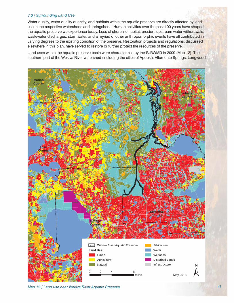
41
3.6 / Surrounding Land Use
Water quality, water quality quantity, and habitats within the aquatic preserve are directly affected by land use in the respective watersheds and springsheds. Human activities over the past 100 years have shaped the aquatic preserve we experience today. Loss of shoreline habitat, erosion, upstream water withdrawals, wastewater discharges, stormwater, and a myriad of other anthropomorphic events have all contributed in varying degrees to the existing condition of the preserve. Restoration projects and regulations, discussed elsewhere in this plan, have served to restore or further protect the resources of the preserve.
Land uses within the aquatic preserve basin were characterized by the SJRWMD in 2009 (Map 12). The southern part of the Wekiva River watershed (including the cities of Apopka, Altamonte Springs, Longwood,
VolusiaCounty
SeminoleCounty
LakeCounty
OrangeCounty
0 4 82Miles ±
Wekiva River Aquatic Preserve
Land UseUrbanAgricultureNatural
SilvicultureWaterWetlandsDisturbed LandsInfrastructure
May 2013
MarionCounty
Map 12 / Land use near Wekiva River Aquatic Preserve.

42
and Orlando) is highly urbanized. The northwestern portion of the Wekiva Basin contains a significant amount of agricultural lands. The Blue Spring springshed and watershed (including DeBary, DeLand and Deltona) are also a highly urbanized mix of residential and commercial. Natural areas are located in a corridor to the west of the St. Johns and Wekiva Rivers connecting to the Ocala National Forest.
Development estimates for the Wekiva basin project urbanization of the entire springshed and watershed (over 75% of the area) with the exception of public lands within 50 years. Some local municipalities have been aggressive in annexation of rural lands and zoning changes that increase development capabilities and tax base. There are over 65,000 residential septic systems spread throughout the Wekiva basin and springshed, many on lots of less than half acre in size.
The Wekiva River and its tributaries within the aquatic preserve are surrounded by lands in public ownership (by either the state or local governments). Approximately four miles of the 19 miles of shoreline on the Wekiva and Little Wekiva Rivers in the aquatic preserve are in private ownership, primarily in residential lots of one to 10 acres. New development on the Wekiva River must conform to requirements of the SJRWMD Riparian Habitat Protection Zone (40C-41, F.A.C.), which provides for buffers that protect the natural and water resources of the Wekiva River System.
Conservation lands border the west bank of the Middle St. Johns for a significant distance, approximately 15 miles of the 20 miles of the aquatic preserve, while there are less conservation lands (about five miles) bordering the eastern banks of this reach of the aquatic preserve. About 15 miles of shoreline along the eastern bank of the St. Johns River in the aquatic preserve is privately owned, as well as approximately one-half of the six miles of shoreline of Lake Beresford, most of which is residential. Other shoreline landowners include water-related businesses such as marinas with boat storage facilities and /or restaurants. Several small subdivisions and mobile home parks are located along the St. Johns River, often with bulkheads, small private marinas and boat launches.

43
Great egret wading through freshwater marsh of the Middle St. Johns River portion of the Wekiva River Aquatic Preserve, summer 2012.
Part Two
Management Programs and Issues
Chapter Four
The Florida Coastal Office’s Management Programs 4.1 / The Ecosystem Science Program at the Wekiva River Aquatic Preserve
The Ecosystem Science Management Program supports science-based management by providing resource mapping, modeling, monitoring, research and scientific oversight. The primary focus of this program is to support an integrated approach (research, education and stewardship) for adaptive management of each site’s unique natural and cultural resources. Florida Coastal Office (FCO) ensures that, when applicable, consistent techniques are used across sites to strengthen the State of Florida’s ability to assess the relative condition of freshwater and coastal resources. This enables decision-makers to more effectively prioritize restoration and resource protection goals. In addition, by using the scientific method to create baseline conditions of aquatic habitats, the Ecosystem Science Management Program allows for objective analyses of the changes occurring in the state’s natural and cultural resources.
Information about the Wekiva River Aquatic Preserve, including the designated reach of the St. Johns River, is available from a variety of sources. Because of the extensive area included in the aquatic preserve, data collection in the Wekiva River and St. Johns River has been a cooperative effort, through pooling of available resources, crossing multiple jurisdictions and sharing responsibilities and results. Agencies, institutions and individuals have conducted research, collected water samples, and investigated a variety of topics over a range of time periods. This reflects both the diverse nature of those interested in the system as well as the need to use many funding sources for more complete environmental investigations. The large body of work that characterizes the aquatic preserve is derived from established background data that has been and will continue to be used for trend analysis on many different fronts. Data should be regularly and consistently analyzed to aid management decisions and to determine information gaps.

44
4.1.1 / Water Quality
Water Quality Background
The various sections of the aquatic preserve exhibit different water quality conditions. Aquatic preserve characteristics range from the near-pristine but tannin-laden Black Water Creek to the crystal clear waters of Blue Spring, Wekiwa Spring, and Rock Springs runs to the slower moving waters of the St. Johns River with numerous spring inputs, tributaries and dead-end oxbows and the 795-acre Lake Beresford.
In the Wekiva Basin, local citizens first raised concerns about water quality and water quantity issues in the early 1980s. Citizen concern led to an investigation of the cause of proliferation of exotic plants in the Little Wekiva River (Canfield & Hoyer, 1988). This concern also led to the formation of the Friends of the Wekiva River (FOWR), who continued in partnership with other citizen groups, committees, agencies and the aquatic preserve to bring about additional research to better understand the system and regulations to better protect those resources.
Because of the extensive area and diverse nature of the aquatic preserve – springs, spring runs, blackwater streams, miles of riverine habitats located in four counties, combined with the upstream riverine systems that contribute to and are an integral part of the aquatic preserve – it would be extremely difficult for any one entity to perform the physical labor required to collect water quality data on this diverse system. While much historic data exists, recent and current water quality investigations for the Wekiva River and its tributaries have been coordinated by the St. Johns River Water Management District (SJRWMD) and the Florida Department of Environmental Protection (DEP) in cooperation with the surrounding counties and municipalities for the Pollutant Load Reduction Goals (PLRG) and Total Maximum Daily Loads (TMDL) programs. Water quality investigations for the St. Johns River have been conducted by Volusia County, the SJRWMD and DEP. Aquatic preserve staff will continue to partner with all entities that contribute to the water quality knowledge base of the aquatic preserve, continue to identify gaps in the knowledge base, continue to use the knowledge base to identify issues that need attention within the aquatic preserve, and continue to encourage and participate in additional research in the aquatic preserve.
Wekiwa Spring and Rock Springs were designated as impaired for nitrogen and phosphorous through the TMDL process (Gao, 2008) after
VolusiaCounty
SeminoleCountyLake
County
OrangeCounty
0 4 82Miles
±Wekiva River Aquatic Preserve
Wekiva Aquifer Vulnerability Assessment (WAVA) ZonesPrimary Protection ZoneSecondary Protection ZoneTertiary Protection ZoneOutside of WAVA / Waterbodies
May 2013
Map 13 / Wekiva Aquifer Vulnerability Assessment (WAVA) zones.
a PLRG investigation was concluded (Mattson et al., 2006). The TMDL called for reductions in nitrogen ranging from 47 to 81 percent and reductions in phosphorus ranging from 23 to 78 percent. Strategies to reduce nutrients will be identified in the Wekiva Basin Management Action Plan, anticipated for adoption in winter 2012. Other water quality investigations conducted by various agencies (DEP, 2003; Mattson et

45
al., 2006) indicate that there is a wide variation of water quality parameters, especially when comparing spring runs to blackwater areas. These differences are generally attributable to the geological features and amount of urbanization for each section.
Elevated nutrients (primarily nitrogen and phosphorus) have detrimental effects on riverine systems and typically manifest as a proliferation of nuisance algae, exotic and nuisance vegetation, and decreased submerged aquatic vegetation. Several factors contribute to the growth of both submerged aquatic vegetation and algae. Mattson (2009) and others state that increased nitrogen is strongly linked to algal blooms and macroinvertebrate population changes. The filamentous algae Lyngbya wollei is the dominant nuisance algae in the Wekiva River, while unicellar algae blooms are common during summer months in the slower moving St. Johns River. Light has been suggested as a limiting factor within the Little Wekiva system. Canfield and Hoyer (1988) concluded that submerged areas at locations with thick canopy cover (shaded by trees) typically had less vegetative or algal growth when compared to nearby areas with higher exposure to sunlight.
The Wekiva Aquifer Vulnerability Assessment (WAVA) (Cichon et al., 2005) study identified areas within the Wekiva basin that would be more or less susceptible to groundwater pollution based on a variety of factors including soils, karst terrain, and topography (Map 13). The information was collated in a layered Geographical Information Systems (GIS) format and categorized in groups of higher and lower probabilities for contamination by water-borne pollutants (nutrients and heavy metals). The largest area of concern was about three miles north-northeast of Lake Apopka and west of Rock Springs Run. Primary, Secondary, and Tertiary Protection Zones within the Wekiva Study Area were established by DEP as a result of this study. Wastewater discharge regulations more protective of the Primary and Secondary Protection Zones were adopted in 2006 (62-600.550, Florida Statutes [F.S.]). A series of underground dye trace investigations conducted by the Cambrian Foundation in the Primary Protection Zone demonstrated the interconnectedness of Apopka Blue Sink and Rock Springs through the underground karst environment (Giannotti, 2011).
To be able to decrease pollutants entering a water body, it is necessary to understand the sources of those pollutants. A 2010 study produced for the SJRWMD and DEP (MACTEC, 2010) determined that the top contributors of nitrogen to the Wekiva River were fertilizer from agriculture and Onsite Treatment and Disposal Systems (OSTDS, or septic systems) with each estimated to account for 26% of the nitrate reaching the Wekiva River system. Residential fertilizer and treated sewage contributed 15% and 12%, respectively, of the nitrate in the Wekiva River system (Table 8). Companion studies contributed to a greater understanding of individual components of nitrate loading. A University of Central Florida project addressed residential fertilizer practices (Souto, Collins, Barr, Milch, Reed, & Ritner, 2009), reporting a wide range of application rates and knowledge of those rates based on homeowner demographics. A Florida Department of Health study (Roeder, 2008) concluded that nitrogen removal rates were not efficient for high application processes such as fertilization or OSTDS, in the Wekiva Study Area. Ongoing studies by the Florida Department of Health and others should contribute to continued refinement of the information used to determine nitrogen allocations.
Source Nitrate Loading to the Wekiva Basin
Septic Tanks 26%
Agricultural Fertilizer 26%
Residential Fertilizer 15%
Sewer 12%
Livestock 6%
Natural or Unattributed 6%
Other Fertilizer 5%
Golf Course Fertilizer 2%
Atmospheric 2%
Table 8 / Nitrate loading to the Wekiva basin. (Source MACTEC, 2010)
Personal Care Products
Personal care products and a variety of pharmaceutical chemicals have been detected in a number of water bodies across the United States, including the Little Econlockhatchee River, an urbanized tributary to the St. Johns River approximately 37 miles upstream of the aquatic preserve (Ramirez et al., 2009). These types of chemicals cause disease or genetic alterations in fish and amphibian species. In most cases it is believed that the chemicals were delivered through wastewater systems. Unfortunately, current wastewater treatment technology (both municipal and OSTDS) does not generally include processes that can remove these chemicals. To date, personal care products and other pharmaceuticals have not been comprehensively surveyed within the aquatic preserve or its tributaries. Also, little is known about the behavior of these chemicals in karst soils, where high connectivity of water is seen both above and below ground. Work currently being performed by the Environmental Protection Agency (EPA) and others may inform decisions here, although more work and coordination may need to be focused on this issue.

46
Dieldrin in Groundwater
Locally, the cities of DeLand and Longwood have reported relatively high levels of dieldrin in potable and irrigation wells (DEP, 2012). This chemical is likely a legacy of pesticide use in the 1970s, but may cause issues within surrounding ecosystems, especially in the local karst limestone environment. Investigations are ongoing to determine sources of the pollution and whether some sort of control is possible. Aquatic preserve staff will monitor this ongoing work to determine if the contamination is affecting Blue Spring or the St. Johns River.
Springs and Spring Runs
There are over 35 identified spring groups within the aquatic preserve springshed and watershed. Springs are generally categorized by magnitude of flow, with first magnitude springs being the largest. Blue Spring in Volusia County is the only first magnitude spring in the system, and there are six second magnitude springs, including Wekiwa and Rock springs (Table 2). Blue Spring is also one of the most important cold-weather refuges for the endangered West Indian Manatee (Trichechus manatus) in the state. Blue Spring was found to have good but degrading water quality during a 2006 SJRWMD study (Winkler & Ceric, 2006). Statewide, reference springs have nitrate levels below 0.06 mg/L, while the overall median nitrate is 0.58 mg/L, a level often considered capable of altering algal communities in springs (DEP, 2008). Levels at or above the median nitrate concentration can lead to overgrowth of both algae and other nuisance aquatic plants. Blue, Rock, and Wekiwa springs all had mean nitrate levels greater than 0.5 mg/L from 2000 to 2006 (DEP, 2008). Dissolved oxygen levels in water emerging from springs is naturally low, but oxygen from the air rapidly mixes into the water downstream, increasing oxygen concentration to levels generally considered protective for biological processes (Wetland Solutions, 2008a).
Mattson, Lehmensiek, and Lowe (2007) noted that increased nitrogen levels in spring waters may not only contribute to algal blooms but that levels of nitrate seen in both the Wekiva River and Rock Springs Run exceeded chronic toxicity levels for the lower caddisfly (an aquatic insect). A large amount of algae in the water is often considered a sign of high nutrients (a condition called eutrophication), often resulting from additional inputs from human sources (such as stormwater runoff and wastewater). Wetland Solutions, Inc. (2008b) determined that several ecosystem-level processes, including primary productivity, net productivity, ecological efficiency, and community respiration in Wekiwa Springs Run and Rock Springs Run are altered relative to three springs (Alexander Spring Creek, Juniper Creek and Silver Glen Springs) thought to be less impacted by eutrophication. Additionally, algae biomass was generally greatest in the headwaters and decreased downstream for both Wekiwa Springs Run and Rock Springs Run (Mattson et al., 2006). Aquatic preserve staff collected algae biomass monthly from 13 stations throughout the Wekiva Basin from July 1998 through July 2000. Stations that were in slow moving water and were in closer proximity to wastewater discharges had the highest biomass with dry weight ranging from 14 to 549 g/m2 while stations in the downstream reach of the Wekiva River had less algae biomass with dry weight ranging from 0 to 129 g/m2. Algae biomass decreased greatly in the slow moving systems (Cove Lake and Lower Bay Lake) after storm events, indicating that significant algae biomass was likely flushed out to downstream areas.
Wekiva River
In the 1970s, data from the United States Geological Survey (USGS) and Orange County data indicated that water quality was fairly good in the Wekiva River and Wekiwa Spring Run. Increased urbanization over the past several decades added stressors that increased nutrients (especially nitrogen) to levels that required attention. A Statewide Stream Bioassessment Program study (DEP, 2000) reported that nitrate concentrations of 1.2 mg/L and 1.1 mg/L at stations in the Wekiva River and Rock Springs Run respectively, were greater than 95 percent of the streams and rivers in Florida. The same study scored the Wekiva River and Rock Springs Run as good to excellent for habitat and macroinvertebrate stream conditions. Total phosphorous levels are currently higher than expected (0.12 to 0.14 mg/L) which may be attributed to natural sources of phosphorus in the rock layers underlying the river basin. Other studies have demonstrated that increased nutrient loading can result in an increase in Lyngbya spp. and other undesirable algae (Komarek, 2003; Bronmark & Hansson, 1998). In response to issues related to increased nutrient levels, a target reduction to 0.28 mg/L nitrate and 0.065 mg/L total phosphorous has been established for the Wekiva River under the TMDL program.
Middle St. Johns River
Data from the Middle St. Johns River in the 1970s and 1980s, provided by a variety of sources, indicated that the waterway had good water quality. In the early 1980s, water flowing out of Lake Monroe (the southern boundary of the aquatic preserve) had total phosphorus values averaging 0.23 parts per million

47
(ppm) and total nitrogen values of 2.1 ppm, concentrations considered protective of the resource in this riverine system (Florida Department of Natural Resources, 1987). Recent, DEP studies (DEP, 2003; DEP, 2008) placed Lake Beresford and nearby portions of the Middle St. Johns River in the impaired category for the Trophic State Index, which is an integrator of several water quality parameters, including nutrients (nitrogen and/or phosphorus), Secchi depth (a measure of water clarity), and chlorophyll a. In August 2012, a BMAP was adopted for the Middle St. Johns River Basin for Lake Harney, Lake Monroe, Middle St. Johns River, and Smith Canal, which includes as its downstream-most section the (aquatic preserve designated) St. Johns River from Lake Monroe to the confluence with the Wekiva River. Other parts of the Wekiva River Aquatic Preserve, which includes parts of the St. Johns River, may be subject to future TMDLs based on DEP’s schedule for their development.
Little Wekiva River
Water quality issues in the Little Wekiva attributed to sewage plant discharge were recognized in the late 1970s and early 1980s. Data gathered by the Orange County Pollution Control Department (1977) was used to create stronger wastewater and wetland regulations. This data also indicated that springflow entering the system downstream of the wastewater treatment plants diluted pollutants and nutrients. Additional studies conducted during the middle to late 1980s indicated improved water quality in Little Wekiva sub-basin due to wastewater treatment plant upgrades, the removal of several smaller package plants and the opening of the City of Altamonte’s Regional Wastewater Treatment facility. Canfield and Hoyer (1988) reported that stormwater runoff became a more significant problem after heavy rainfall and during high flows.
Rock Springs Run
The USGS has measured flow and temperatures at the Rock Springs Run spring head since 1931, and added other parameters in 1959. Additionally, Orange County has conducted water quality sampling at Rock Springs Run since 1972. At that time, turbidity, color, organic nitrogen, ammonia, and dissolved oxygen had low concentrations while total phosphorus, nitrate/nitrate and conductivity were slightly higher than natural levels. More recently, studies and analyses by the SJRWMD concluded that abundant periphyton and harmful algae were related to increased levels of phosphorus and nitrogen compounds (Mattson et al., 2006). In 2008 Rock Springs Run was listed as impaired for nutrients under the TMDL program (Gao, 2008).
Black Water Creek
With water contributions from the Ocala National Forest and most of its length in public lands, Black Water Creek is the least developed tributary of the Wekiva River. There are 35 identified spring groups along Black Water Creek and its tributaries, the largest being the second magnitude Seminole Spring (Table 2). It is consistently given Stream Condition Index (SCI) ratings of “Excellent” for the richness and diversity of the invertebrate population (DEP, 2003; David Scharr, personal communication, February 1, 2012). Although it is not listed as impaired under the TMDL program, Black Water Creek is required to have a reduction in total nitrogen and total phosphorus of 52% and 36%, respectively, under the Wekiva River TMDL (Gao, 2008).
4.1.2 / Water Quantity
As with water quality, water quantity is a complex issue of hydrological interactions spanning two large springsheds in several counties, and several designated Minimum Flows and Levels (MFLs). Recent investigations by the Florida Geological Survey have found an inverse relationship between spring flow and chloride concentration in several Florida springs (Copeland, Doran, White & Upchurch, 2011). The aquatic preserve has advocated for strong water quantity protection strategies, worked to influence decision makers, promoted hydrologic studies, conservation strategies and education programs, and will continue to partner with other stakeholders in working to ensure water quantity issues associated with the aquatic preserve are addressed.
A water budget study for the Wekiva River (Wanielista et al., 2005) estimated that in 2001-2002, 58% of the water flowing from the Wekiva River into the St. Johns came from the springs within the system and that springflow was decreasing from the early 1970s through 2001. Increases in stormwater runoff due to additional impervious surfaces, however, resulted in the flow at State Road 46 being relatively similar throughout the study period. Additionally, stage data analyses indicate that the Wekiva River near the State Road 46 gage does not have a stable channel, resulting in different stages for the same magnitude of discharges (Rao, 2008).

48
The State of Florida, through the water management districts, is responsible for ensuring that human water consumption does not substantially harm natural ecosystems. In our region, the SJRWMD has this responsibility and has developed criteria and thresholds within the MFL program. The MFL designates the minimum hydrologic/hydraulic conditions that must be maintained in rivers, lakes, springs and wetlands to prevent significant harm to the ecology or water resources of the area that may result from permitted water withdrawals (Section 373.042, F.S.). The St. Johns River at State Road 44 MFL incorporated field data from several sites located within the Wekiva River Aquatic Preserve, including the lower Wekiva River, North Emanuel Bend on the St. Johns River, and Pine Island on the St. Johns River. Additionally, the MFL for the Wekiva River at State Road 46 also included an MFL for Black Water Creek at State Road 44, as well as minimum flow regimes for eight springs in the Wekiva basin. Other adopted MFLs in close proximity to the Wekiva River Aquatic Preserve include Lake Monroe, six river miles upstream from the confluence of the Wekiva and St. Johns rivers, Lake Norris, the primary water source for Black Water Creek and Blue Spring. Additionally, in 2012 the SJRWMD concluded a four-year study (the Water Supply Impact Study [WSIS]) analyzing the potential withdrawal of 155 million gallons per day (MGD) of water from the St. Johns River as an alternative to future withdrawals from the Floridan Aquifer (SJRWMD, 2012). This peer-reviewed study concluded that the water withdrawals would not cause significant harm to the environment, although concerns still exist within the environmental community (Spear, 2012). These studies have provided a great amount of scientific information (including water quality, water quantity, biological, and ecological components) about the Middle St. Johns and Wekiva River that may not have been otherwise obtained. The aquatic preserve program is cognizant of the need to protect springs and wetlands associated with the aquatic preserve, as well as protecting water resources of the St. Johns River.
4.1.3 / Biology
Birds
For many people, birds are the most visible sign of any ecosystem and play an important role in enjoyment of the outdoor experience. Since the establishment of the aquatic preserve, staff and volunteers have conducted bird surveys to assess population and species trends. More than 175 species of birds have been observed in the aquatic preserve (Appendix B.3). Observations of other wildlife (turtles, manatees, etc.) and Global Positioning System (GPS) coordinates for species of interest (including limpkins, sandhill cranes, bald eagles, manatees, and wading bird nesting colonies) have also been recorded. Bird surveys have been conducted on a regular basis since 1999, rotating through various portions of the aquatic preserve. These surveys represent one of the most comprehensive long term data sets for avian species monitoring in the Wekiva River. A survey of osprey nesting activity in the St. Johns River was conducted in 1992. Surveys have identified where species of interest, typically listed species and rare species, (bald eagle, limpkin, wood stork and others) are seen and nest. This information can help us understand home ranges (where the birds live and travel), population trends and nesting habits. Currently, bird surveys are periodically conducted using staff and volunteers.
Limpkins, often observed wading among aquatic plants, are considered an indicator species for the Wekiva River. Designated by the Florida Fish and Wildlife Conservation Commission (FWC) as a species of special concern (Gruver & Murphy, 2011), limpkins feed on apple snails, a freshwater snail that thrives only in good quality water. Community volunteers from local Audubon chapters and the Central Florida Zoo assisted a staff biologist with monthly bird surveys of the Wekiva and its tributaries. Surveys from 1992, 2002 and 2005 indicate that the limpkin population is stable in the Wekiva Basin.
The native Florida apple snail (Pomacea paludosa) is a primary food source for limpkins. There is concern, however, about the impact of displacement of the Florida apple snail by an invasive exotic, the island apple snail (P. insularum). For the past several years, the island apple snail was erroneously identified as the channeled apple snail (P. canaliculata), but recent taxonomic investigations have documented only one confirmed site in north Florida for the channeled apple snail (FWC, n.d.). The island apple snail is well established in Lake Brantley, which has an intermittent hydrologic connection to the Wekiva River. Lake Brantley is approximately two miles from the Wekiva River. The island apple snail has not yet been reported in the aquatic preserve. Anecdotal information indicates that limpkins also feed on the island apple snail. Island apple snails are known pests elsewhere and feed on eelgrass. Further studies are needed to understand the distribution and ecological impacts of this invasive snail.
Central Florida Turtle Research
In 1999, a biology professor and students from Penn State University began studying peninsula cooters and Florida red-bellied cooters in central Florida rivers. The work continues and has expanded to include

49
all turtle species and is one of the largest and longest-running studies of its kind in the United States. The study measures longevity, growth patterns, home ranges, ratio of males to females, and population parameters such as biomass, density and survivability. From 1999 through 2011, over 6,700 turtles from Wekiwa Spring Run and 750 turtles from Blue Spring Run have been captured, measured and released. About half of the turtles captured represented recaptures. The data demonstrated that Wekiwa Springs has one of the largest populations of freshwater turtles in Florida and was used to guide rulemaking by the FWC which prohibited the harvest of protected turtle species (and similar looking turtles) and limited take of all other freshwater turtles to one turtle per person per day.
Fish
Fish surveys are periodically conducted on various sections of the aquatic preserve to ascertain current population dynamics. A comparison of two studies from the Wekiva System conducted approximately 10 years apart (1985-1987 and 1997) indicated a relatively stable fishery population in the Wekiva (Canfield & Hoyer, 1988; Warren et al., 2000). One bluenose shiner, a state species of special concern, was collected in the Wekiva River during the 1997 survey (Warren et al., 2000) along with 39 other fish species. Bluegill and largemouth bass dominated the sportfishing (centrarchid) populations during fisheries surveys conducted by the FWC from 2005 to 2007 in the Middle St. Johns River (Holder & Lundy, 2006; Holder & Lundy, 2007). Additionally, American shad are sampled annually in the region to aid in assessments of spawning recovery efforts (Holder & Lundy, 2007). During the April 2012 Wekiva BioBlitz, FWC fisheries researchers (Travis Tuten, personal communication, May 30, 2012) collected 40 species in the Wekiva River and Rock Springs Run, including numerous bluenose shiners. The survey team indicated the bluenose shiner was “abundant” in the habitats where they collected. Bluenose shiners are known to school during mating season (Johnston & Knight, 1999) which may account for the higher number of individuals. Warren et al. (2000) utilized throw traps while the 2012 survey used electrofishing, which may also account for the variation in results.
Manatees
Blue Spring is recognized as one of the most important manatee refuges in the state. Except for the coldest times of the year, manatees are regularly observed in most of the St. Johns portion of the aquatic preserve and occasionally swim the 16 miles upstream to Wekiwa Springs. Manatees often feed well outside of the Blue Spring sanctuary in winter. They have also been observed well north of the sanctuary during the bird surveys conducted by aquatic preserve staff. The St. Johns River immediately north and south of the Blue Spring Run mouth is a year-round designated Manatee Protection Zone. The Manatee Protection Zone is expanded from October 15 until April 15 when the population is more concentrated around Blue Spring Run. Rangers at Blue Spring State Park (BSSP) have recorded manatee activity in Blue Spring Run since the early 1970s. Individuals observed for a given year are identified by their prop scar pattern and the pattern is recorded on a data sheet. The number of manatees reported at Blue Spring Run ranged from 11 to 400 individuals from 1970-1971 to 2011-2012, respectively (Wayne Hartley, personal communication, August 17, 2012). The Save the Manatee Club (STM) is very active within Blue Spring and the aquatic preserve and was instrumental in obtaining Manatee Protection Zones for the St. Johns River in the late 1990s. Aquatic preserve staff reviewed and commented on initial Protection Zone proposals, attended numerous meetings, and supported the Manatee Protection Plan. The STM is also responsible for many other activities that educate the public and help protect Florida’s manatee.
Endemic Spring Species
The Orlando cave crayfish, Wekiwa Springs hydrobe and Wekiwa siltsnail are endemic to the Wekiva Basin and described as critically imperiled in Florida by FNAI due to limited distribution and unknown population status and trends. The Blue Springs hydrobe and Blue Springs siltsnail, currently studied by Bethune-Cookman University faculty and students are exclusive to Volusia Blue Spring.
Aquatic Vegetation
Plants are a vital component of the food web and a key determining factor in the health of an ecosystem. The condition of submerged aquatic vegetation (SAV) is considered to be an important indicator of wetland ecosystem health. Aquatic preserve staff informally monitored the condition of SAV biannually for over 15 years as part of the FWC Invasive Plant Management Section (FWC IPMS) exotic plant assessment. Numerous prop scars were observed to fill in with SAV several years after the illegal cabins were removed, reflected a decrease in boat traffic. Aquatic preserve staff began initial work to map SAV in 2006 but because of the time and expense, the SJRWMD was lobbied for assistance. Contractors used ground-truthing and aerial photography analysis to assess SAV. Dial Cordy and Associates, Inc. (2007) reported that SAV covered approximately 118 acres of submerged bottom surveyed in the Wekiva River (47% of the total available space) but less than 5 acres in Rock Springs Run (8% of submerged

50
bottom). Annual SAV surveys on the Wekiva River, Wekiwa Spring Run and Rock Springs Run recently began (Mattson, Lehmensiek, Greenwater Laboratories, Inc., & Dial Cordy and Associates, Inc, 2010). Four native species have been observed at significant coverages – spikerush, southern naiad, eelgrass, and horned pondweed (Potamogeton spp.). Very little change was observed in transect data from 2010 to 2011 (Mattson, 2011). Data from future surveys will be compared to this work to determine changes in underwater species composition and distribution. The FWC IPMS also periodically estimate acreage of eelgrass. Emergent aquatic vegetation is monitored by FWC and aquatic preserve staff during semi-annual exotic plant surveys.
Benthic Macroinvertebrates
Benthic macroinvertebrates, generally defined as invertebrates that are retained by a net with a mesh size between 0.2 and 0.5 mm, are important organisms that can provide insights into a suite of environmental conditions, such as water quality, water flow, habitat, and contaminants (Rosenberg & Resh, 1993). During an MFL investigation, Warren et al. (2000) identified several “keystone” indicator species dependant on specific flow characteristic that should be monitored in the Wekiva River on a regular basis. Changes in population or habitat dynamics might occur for these species if flow characteristics change. Several different agencies, including Orange County, Seminole County, DEP and the SJRWMD have conducted periodic or occasional surveys for macroinvertebrates within the aquatic preserve (SJRWMD, 2012). These surveys, with few exceptions, generally have indicated that the macroinvertebrate community in the waters of the aquatic preserve is relatively healthy.
Exotic and Invasive Species
Exotic species (both plants and animals) have negative effects upon the aquatic preserve and surrounding areas. Studies should be conducted for newly established species in nearby lakes which have a hydrologic connection to the Wekiva River, such as the island apple snail, which may compete with the native Florida apple snail. Green hygro, an exotic submerged plant, has become established in the Little Wekiva and was observed for the first time in the Wekiva River in 2011. Additionally, expanded and more intensive survey and mapping efforts of current infestations should occur to better implement management programs. For several years green hygro was confined to the upper reach of the Little Wekiva River but in 2011 numerous small patches were observed farther downstream. Several small patches were observed attached to snags at the confluence of the Wekiva River and two patches were observed in the Wekiva River.
4.1.4 / Mapping
The increased availability of Global Positioning Systems (GPS) and Geographic Information Systems (GIS) have made it much easier to use mapping information within multiple research projects. As previously described, SAV surveys and investigations of the aquifer vulnerability have greatly benefited from improved mapping technology. Aquatic preserve staff produce maps for educational and recreational purposes, boundary analysis, compliance and permit review, Manatee Protection Zones, and for numerous other special projects. Maps are produced using ArcGIS software. Aquatic preserve staff are assisted by the DEP Central District GIS Coordinator who has created a series of maps that are used extensively for aquatic preserve education and outreach programs. Maps used for education purposes depict the aquatic preserve boundary, springsheds, drainage basins, aquifer vulnerability areas, locations of springs, the Wekiva Wild and Scenic River system, floodplains, uplands, public lands and numerous other topics. Maps are also used extensively in the field for a variety of resource management projects.
4.1.5 / Ecosystem Science Coordination at Wekiva River Aquatic Preserve
Effective resource management requires knowledge of the location, condition, extent and biology of the resources in need of protection. The Wekiva River Aquatic Preserve’s Ecosystem Science Management Program builds on the large body of research and data and multiple restoration projects that have been and continue to be conducted by the aquatic preserve and other partners in the Wekiva and St. Johns basins. The program integrates a diverse variety of subjects, including systems ecology, species biology, and water quality and quantity into the daily resource management activities conducted in the aquatic preserve. Knowledge gained through the Ecosystem Science Management Program is also strongly integrated into the Wekiva River Aquatic Preserve Education and Outreach Program. The Ecosystem Science goals for the aquatic preserve include 1) continuation of partnerships that capture resource data necessary to understand and manage the system; 2) data analysis and interpretation; 3) facilitation

51
of information exchange between as wide an audience as possible including individuals collecting data within the aquatic preserve, user groups, and the general public; and 4) provide a plain language explanation for a variety of complex topics to promote a clear understanding of those topics.
A continued strong monitoring program should be the baseline from which comparisons are made. Ongoing monitoring on several fronts (including water quality, hydrology, birds, fish, turtles, invertebrates, aquatic vegetation, and exotic and invasive species) provide a body of information that can be combined to provide a good snapshot of existing conditions and evaluated for positive or negative system changes. Trend analyses of all data from these monitoring projects should be conducted on a regular basis and summarized in one report to help identify potential changes (natural and otherwise) in the system.
Although a tremendous body of research exists for the Wekiva and Middle St. Johns Rivers, ecological interactions are often difficult for the general public to understand. These complex interactions (including nutrient enrichment, urbanization, exotic species encroachment, and climate change) are also difficult to predict and manage, and a degree of uncertainty is inherent in these processes. Understanding and using existing work that may have answered simpler questions can help create a much easier path to a solution. For example, combining work from the WAVA and MACTEC projects in concert with what is known about stormwater runoff and recharge areas should enable staff to determine the areas in which agricultural Best Management Practices (BMP) should be applied first, or which neighborhoods should rate priority attention for OSTDS improvements or central sewer hookup.
To improve and restore the aquatic ecosystems, the integration of projects and project coordination should continue. These projects would build on existing information gained specifically for the Wekiva and Middle St. Johns rivers and would utilize relevant outside sources as well. Existing, new and emerging issues should be included within the same framework to ensure that critical issues are addressed appropriately and promptly.
The Wekiva Basin Ecosystem Working Group (WBEWG) provides an opportunity to continue interagency cooperation and stakeholder participation, and also to bring together information on research gathered from the diverse sources around the Wekiva Basin. Aquatic preserve staff propose to reconvene the WBEWG at more regular intervals to help improve coordination among researchers and improve understanding of the varied research currently conducted within the system. A representative set of the scientists and project managers working on the diverse array of projects within the Wekiva and Middle St. Johns River system will be brought together on a regularly recurring basis (every two to four months) to discuss current projects, recent results, and collaborative efforts. A Research Advisory Group/Technical Advisory Group should hold a series of meetings, initially within two years, to present/discuss ongoing research and projects. Analysis of how existing research integrates with existing management plans could also be addressed (to detail progress and gaps). This process would help determine additional research and/or technical projects needed to answer current, changing, or expanding questions regarding the system and could also address critical issues. The information obtained would be provided to decision makers (WBEWG, upper-level administrators, elected officials, and others with budget-making authority) to be used as a tool to help guide funding to most appropriate projects, especially those that cross political boundaries. The group would also work toward ensuring technical information is exchanged between researchers and that technical information is made available in a plain language format for wide distribution to residents, visitors, and individuals who use the rivers.
“It is our modern society's responsibility to see that Florida's springs are
preserved in their natural beauty and ecological health for future generations.”
(Scott et al., 2004)
4.2 / The Resource Management Program at the Wekiva River Aquatic Preserve
The Resource Management Program addresses how FCO manages the Wekiva River Aquatic Preserve, including the designated reach of the Middle St. Johns River, and its resources. The primary concept of the aquatic preserve’s resource management projects and activities are guided by FCO’s mission statement: “Conserving and restoring Florida’s coastal and aquatic resources for the benefit of people and the environment.” FCO’s sites accomplish resource management by physically conducting management activities on the resources for which they have direct management responsibility, and by influencing the activities of others within and adjacent to their managed areas and within their watershed. Watershed and adjacent area management activities, and the resultant changes in environmental conditions, affect the condition and management of the resources within their boundaries. FCO managed areas are

52
Timeline of Milestone Events in Wekiva River Basin 1927 to 20121927 Kelly Park (including Rock Springs) donated to Orange County
1965 Wekiwa Springs State Park Land acquired
1975 Aquatic Preserve Act Establishment of the Wekiva River Aquatic Preserve
1976 Lower Wekiva River Preserve State Park land acquired St. Johns River federally designated as critical manatee habitat
1978 Florida Manatee Sanctuary Act established Florida as a refuge and sanctuary for manatees and provided the authority for the initiation of protective measures, carried out since that time through Chapter 68C-22, F.A.C.
1982 A portion of the Wekiva River designated as a Florida Scenic and Wild River Segment
1983 Rock Springs Run State Reserve land acquired
1985 Middle St. Johns River added to aquatic preserve (39 miles and Lake Beresford)
1987 Adoption of Wekiva River Aquatic Preserve Management Plan
Wekiva River Task Force established Wekiva River Protection Act passed Wekiva River designated as an Outstanding Florida Water Wekiva River Buffer Conservation Area established (ongoing) SJRWMD
Late 1980s
Project APRICOT (A Prototype Realistic Innovative Community of Today) initiated by the City of Altamonte Springs; included the Altamonte Regional Wastewater Treatment Facility
1990 Seminole State Forest (Carter Tract) land acquired
1996 Congress authorizes study of the Wekiva River, Rock Springs Runs, Black Water Creek, and Seminole Creek for possible inclusion in the National Wild and Scenic River System Harper Ranch property acquired by SJRWMD to form the Lake Norris Conservation Area
1997 Fisch parcel acquired by SJRWMD (managed as part of Seminole State Forest)
1998 St. Johns River designated an American Heritage River
2000 Congress designates the Wekiva River, Rock Springs Run, and Black Water Creek as a National Wild and Scenic River System
2002 Wekiva River Basin Task Force established Lake Norris property acquired by SJRWMD and added to Lake Norris Conservation Area
2003 Wekiva River Basin Task Force Final Report submitted to state legislature Wekiva River Basin Coordinating Committee established More than 2,400 acres added to Seminole State Forest
2004 Wekiva River Basin Coordinating Committee Final Report submitted to state legislature Wekiva Parkway and Protection Act (WPPA) passed
2005 Wekiva Wild and Scenic River System Advisory Management Committee appointed by National Park Service Manatee Protection Plan approved for Volusia County including portions of the Middle St. Johns River
2006 Pollution Load Reduction Goal process was completed and determined that nitrate and phosphorus levels in the Wekiva River and Rock Springs Run need to be reduced
2004 to
2008
Implementation of WPPA legislated activities Wekiva River Basin Commission formed as required by the WPPA Wekiva Mitigation Bank established Neighborhood Lakes property purchased by OOCEA, BTIITF, SJRWMD, Lake County and Orange County
2008 Total Maximum Daily Loads (TMDL) for nitrate and total phosphorus adopted by DEP June 3, 2008.
2009 TMDL established for Middle St. Johns River upstream of Wekiva River, including a portion of the aquatic preserve
2010 Total conservation lands acquired to date -- approximately 70,000 acres
2012 Wekiva Wild and Scenic River Management Plan adopted BMAP established for Middle St. Johns River upstream of Wekiva River, including a portion of the aquatic preserve
Partially adapted from Wekiva Wild and Scenic River Draft Management Plan
Table 9 / Timeline of conservation milestones for Wekiva River Aquatic Preserve.

53
especially sensitive to upstream activities affecting water quality and quantity. FCO works to ensure that the most effective and efficient techniques used in management activities are used consistently within our sites, throughout our program, and when possible, throughout the state. The strongly integrated Ecosystem Science, Education and Outreach, and Public Use Programs provide guidance and support to the Resource Management Program. These programs work together to provide direction to the various agencies that manage adjacent properties, our partners and our stakeholders. The Wekiva River Aquatic Preserve, including the designated reach of the Middle St. Johns River, also collaborates with these groups by reviewing various protected area management plans. The sound science provided by the Ecosystem Science Program is critical in the development of effective management projects and decisions. The nature and condition of natural and cultural resources within the Wekiva River Aquatic Preserve, including the designated reach of the Middle St. Johns River, are diverse.
The history of resource management activities in the aquatic preserve is strongly integrated with ecosystem science. In addition to focusing on specific resource management needs, the resource management program also focused on integrating three overarching ecosystem management components into the Wekiva and St. Johns Basin resource management program: 1) protecting and improving water quality; 2) maintaining water quantity flowing to the springs and rivers; and 3) maintaining an ecological landscape connection to the Ocala National Forest that benefits wide ranging species such as the Florida black bear (Ursus americanus floridanus). A timeline of conservation milestones is provided in Table 9. Many of the overarching protection strategies focused on the Wekiva Basin, due to the prolific development that was rapidly altering the landscape surrounding this area of the aquatic preserve. Acquisition of several large key parcels provided a measure of protection for water resources while also providing for protection of wildlife habitat and expanding the landscape linkages in the Wekiva-Ocala wildlife corridor. Land acquisitions that occurred over the past forty years were cost effective in offsetting some impacts to the aquatic preserve. Given the cost of restoration projects, land acquisition as a preventative strategy was considered less expensive than restoration, and in many cases it prevented degradation of the resource. Numerous recreational opportunities were provided through land acquisition. Degraded resources also represent a loss of beneficial biological and hydrological function, loss of aesthetics and in many cases, loss of recreational use.
4.2.1 / Major Program Policy Directives
Many of the principles of ecosystem-based management described by Grumbine (1994) are integrated into the aquatic preserve resource management program. Principles include:•Emphasizing the protection of ecosystem structure, function and key processes;• Focusing on a specific ecosystem and the range of activities affecting it;•Accounting for the interconnectedness within systems;• Integrating ecological, social, and economic and institutional perspectives; and•Using monitoring and analytical tools to detect and understand natural and human related changes
to ecological processes.
The Wekiva River Aquatic Preserve Management Plan adopted in 1987 included a number of management policy issues that were discussed either generally or definitively. This section highlights those major policy areas that comprised the basic impetus of the aquatic preserve management effort. Many of the Policy Directives are applicable today and are provided here. Adoption of these policies will provide additional staff direction for implementing the day-to-day aquatic preserve management program. Major Program Policy Directives adopted in the 1987 management plan (Florida Department of Natural Resources, DNR, 1987) are:•Manage all submerged lands within the aquatic preserve to ensure the maintenance of
essentially natural conditions to ensure the propagation of fish and wildlife, and public recreation opportunities;
• Prohibit the disturbance of archaeological and historical sites within the aquatic preserve, unless prior authorization has been obtained from the Trustees and Division of Historical Resources, and such disturbance is part of an approved research design or authorized project;
•Develop a resource inventory and map natural habitat types within the aquatic preserve, with an emphasis on those habitat types of highest quality, including threatened and-or endangered species habitat, and species of special concern;
• Protect and, where possible, enhance threatened and endangered species habitats and species of special concern habitats within the aquatic preserve;
•Prohibit development activities within the aquatic preserve that adversely impact upon grassbeds and other valuable submerged habitat, unless a prior determination has been made by the Board

54
of overriding public importance with no reasonable alternatives, and adequate mitigation measures are included;
• Prohibit the removal of natural shoreline vegetation within the aquatic preserve, except when necessitated by the pursuit of legally authorized projects and local protection ordinances;
• Provide research and educational opportunities for scientists and other interested researchers within the framework of a planned research program in the aquatic preserve;
•Acquire, where feasible, privately owned submerged lands located within the boundaries of the aquatic preserve pursuant to the authorities contained in Section 253.02(4), F.S.;
• Prohibit the drilling of oil and gas wells, the mining of minerals, and dredging for the primary purpose of obtaining upland fill within the aquatic preserve;
• Prohibit non-water dependent uses of submerged lands within the aquatic preserve except in those cases where the Board has determined that the project is overwhelmingly in the public interest and no reasonable alternatives exist;
• Prohibit storage of toxic, radioactive, or other hazardous materials within the aquatic preserve;• Prohibit those mosquito control practices within the aquatic preserve that would result in habitat
modification or manipulation (i.e. diking, ditching) unless there are no reasonable alternatives and failure to conduct such practices would result in a threat to public health;
• Limit pesticide and biocide use within the aquatic preserve to those that are approved by the EPA for wetland and aquatic application;
• Prohibit the construction of any deep water ports within the aquatic preserve boundaries;•Encourage public utilization of the aquatic preserve, consistent with the continued maintenance of its
natural values and functions;•Develop a well coordinated aquatic preserve management mechanism that recognizes and utilizes
local government programs and authorities;•Require, through the efforts of DEP and the SJRWMD, the maintenance or restoration of the naturally
high water quality of the aquatic preserve, and ensure the natural seasonal flow fluctuations of water into the river;
•Apply the management criteria contained in the adopted Wekiva River Aquatic Preserve Management Plan to all subsequent legislative additions of land to the aquatic preserve;
•Encourage the assistance of federal, state, and local government agencies in implementing the aquatic preserve management plans, especially in the areas of protection of natural and cultural resources and the enforcement of applicable resource laws and ordinances;
• Prohibit marinas in Class 1 or 2 Resource Protection Areas; and• Identify and document any problems caused by fishing activities and report them to the Florida Fish
and Wildlife Conservation Commission.
Other Management Policies and Plans
Resource management activities that occurred in the Wekiva River system were included in the Wekiva River Ecosystem Management Area chapter of the 1994 document Toward Ecosystem Management (DEP, 1994) coauthored by the aquatic preserve manager. The document promoted ecosystem management and highlighted strategies ongoing in the Wekiva Basin at the time. The Wekiva Basin was considered a model for other aquatic and upland conservation areas because local resource managers had a history of incorporating holistic or ecosystem management strategies as part of their overall resource management philosophy. The report discussed land acquisition, improvements to water quality and stormwater systems that occurred through regulation, partnerships and stakeholders, and highlighted several broad issues that collectively covered a variety of problems and challenges. Numerous strategies were provided that would further the protection of the Wekiva River system. The report called for PLRGs to be established for the Wekiva River Basin and the Little Wekiva sub-basin. Most, but not all, of the action items called for in the plan were implemented. A PLRG study was completed in 2006 and subsequent TMDL were established in 2008.
The Wekiva River Basin Interagency Strategic Plan (DEP, 1996) promoted ecosystem management as the preferred approach for resource management of public lands in the Wekiva Basin, including the Wekiva River. For the purposes of the Interagency Strategic plan, ecosystem management was defined as “management designed to sustain, and where necessary, restore the structure, composition, function and diversity of natural systems in the Basin.” The plan incorporated strategies for issues related to the Wekiva Basin’s native ecosystems, cultural resources and recreational uses and discussed topics such as land development, wastewater pollutants, stormwater discharges, aquifer withdrawals, and hydrology. The plan also recognized that research and education needs represented a vital part of the overall strategy. The aquatic preserve manager served as a member of the Wekiva River Basin Management Plan Advisory Group that prepared the plan. Many of the strategies in the plan were implemented.

55
Dramatic changes in the landscape due to rapid and prolific development occurred in areas adjacent to the aquatic preserve from the 1970s until the recession of 2005. In the late 1980s, alterations to surrounding landscapes, numerous Consumptive Use Permits (CUPs), and projected declines in spring flows prompted concerned citizens, aquatic preserve staff and others to focus attention on the Wekiva River watershed. Issues included water quality, water quantity and habitat protection for wildlife including many listed species associated with the aquatic preserve and surrounding lands. As a result of this concern, Governor Martinez issued Executive Order No. 88-26, forming the Wekiva River Task Force that ultimately resulted in landmark legislation, the 1988 Wekiva River Protection Act (WRP Act) (Ch. 369.301-369.309, F.S.). Aquatic preserve staff assisted the Task Force by providing technical guidance, reviewing documents, and coordinating field trips.
Aerial photos showing the change in development in the upper Wekiva River basin from 1957 to 2004.
4.2.2 / Land Acquisition
Because of the rapid development that continued to occur between the late 1970s and 2005, early conservation efforts focused on land acquisition, while still bringing attention to water quality and quantity issues and solutions. The WRP Act and associated legislation (Ch. 373.415, F.S.) set the stage for accelerated land acquisition in the Wekiva Basin. The WRP Act directed the Department of Natural Resources (now DEP) to give high priority to purchase of Conservation and Recreation Lands (now Florida Forever) in the Wekiva Basin. Aquatic preserve staff contributed to the Wekiva Basin land acquisition efforts by preparing the ecological assessment for the initial Seminole State Forest (SSF) acquisition (6,500 acres) in the late 1980s, and submitting boundary amendments for Rock Springs Run State Reserve (RSRSR), the Neighborhood Lakes parcel (1,506 acres) and SSF North–end parcels (5,600 acres). The aquatic preserve manager participated on the Orange County Green Park Land Acquisition for Conservation and Environmental Protection Committee (PLACE). Information was presented to the committee on numerous undeveloped acres in the Wekiva springs shed for potential acquisition. Subsequently, 286 acres were acquired and are now part of Orange County’s Sandhill Preserve, Lake Luce Conservation Area and other county parks. In total, aquatic preserve staff worked on projects that resulted in the acquisition of more than 15,000 acres of conservation lands in the Wekiva Basin and springshed.
Land acquisition has benefited the Wekiva River system by offsetting development pressure, reducing potential stormwater runoff and consumptive use of water, and helping to expand and maintain the ecological connection to the Ocala National Forest. The west bank of the St. Johns River provides another important ecological landscape connection to the Ocala National Forest and Lake Woodruff National Wildlife Refuge. Aquatic preserve staff participated in the 2012 Florida Wildlife Corridor Expedition presentation at BSSP that focused on the St. Johns River as a major ecological corridor. A documentary film about the importance of this corridor is scheduled to air in 2013. Aquatic preserve

56
staff also supported the acquisition of properties that expanded the boundaries of Lower Wekiva River Preserve State Park (LWRPSP) along on the west bank of the St. Johns River in Lake County and the acquisition of Lake Beresford Park in Volusia County.
Acquisition of conservation lands continues to be a critical component of resource protection in the Wekiva Basin and St. Johns basins and springsheds. Aquatic preserve staff participate in the continuing effort to protect water resources and complete the ecological corridor by identifying important parcels that represent gaps in the Wekiva Ocala Connector Florida Forever acquisition boundary. This includes partnering with the Wild and Scenic Advisory Management Committee and other interested stakeholders to identify funding sources for critical parcels, providing information on the parcels, preparing boundary amendments if needed and educating others on the ecological value and need to complete the Wekiva Ocala Connector.
4.2.3 / Significant State Legislation
The Wekiva River Protection Act
In addition to directing state agencies to give high priority to acquiring conservation lands in the Wekiva Basin, the 1988 WRP Act defined the Wekiva River Protection Area (WRP Area), a 186 square mile area in which additional protective measures were directed. The St. Johns River Water Management District was required to establish special protective zones and regulations to protect streams and adjoining wetlands associated with the WRP Area. The WRP Act required that local governments (Lake, Orange and Seminole counties) amend their Comprehensive Plans and Land Development Regulations to ensure that the goals, policies, objectives and associated regulations were protective of the WRP Area. The characteristic open space, low density and low intensity of existing development and rural character of much of the Wekiva Basin was considered to be protective of the system. The WRP Act also required local counties, through the comprehensive plan process, to protect the “rural” character of land within the WRP Area. Unfortunately, rural character was not specifically defined in the Act and was subsequently broadly and subjectively interpreted. Close proximity to the Interstate 4 corridor and other development pressures led Seminole County to interpret rural character as one unit per acre. Seminole County established one dwelling unit per net buildable acre, consistent with the county’s Suburban Estates future land use designation, as the predominant land use within the WRP Area. In 1999, the county entered into an agreement with the Florida Department of Community Affairs (now the Florida Department of Economic Opportunity) supporting one dwelling unit per net buildable acre as the final development form, in the aggregate, within the WRP Area. Lake County developed a series of land use categories that ranged from 1 unit per 5 acres to 1 unit per 40 acres, but also included an involved process for Transfer of Development Rights that included sending and receiving areas, and a rating process whereby somewhat higher densities could be achieved. Orange County’s Comprehensive Plan maintained rural densities within the WRP Area, but as time passed, most of the parcels within the WRP Area in Orange County were annexed into the City of Apopka which resulted in more intense zoning. Hundreds of acres within the Wekiva springshed, the boundary of which has only recently been defined, were not included in the WRP Area boundary. Research indicates that previous land use practices within portions of the springshed in west Orange County may have contributed to elevated nutrients in Wekiwa Springs and Rock Springs, so as land uses change it is important to work toward ensuring new land uses minimize their impact on nutrient input to the springshed. A Joint Planning Agreement (JPA) between the City of Apopka and Orange County was adopted in October 2004. The JPA emphasized utilization of open space (up to 50%) in exchange for greater intensity of use.
The SJRWMD established the Wekiva River Hydrological Basin Criteria [40C-41 Florida Administrative Code (F.A.C.)] which included criteria that required stormwater retention systems to provide for additional retention storage, established a Water Quality Protection Zone, and established a Riparian Habitat Protection Zone (RHPZ). For activities to occur with the RHPZ, an applicant must provide reasonable assurance that the construction or alteration of a system will not adversely affect the abundance, food sources, or habitat of aquatic or wetland dependant species.
Wekiva Parkway and Protection Act
The 2004 Wekiva Parkway and Protection Act (WPPA) (Ch. 369.314-369.324, F.S.) provides guiding principles for the development of the Wekiva Parkway, a limited-access roadway that will complete the Orlando beltway and connect Apopka to Sanford.
In the initial stages of development of the Orlando Beltway Project (in the late 1980s), the Orlando Orange County Expressway Authority (OOCEA) established and coordinated an Environmental Advisory

57
Group (EAG). The purpose of the EAG was to review and comment on various segments of the Orlando Beltway, propose modifications to offset or eliminate impacts to natural resources, and promote a spirit of cooperation that could offset costly legal actions. The aquatic preserve manager served on the EAG for many years. In early 2000, additional concerns related to issues associated with the portion of the beltway that would traverse the Wekiva Basin prompted several citizen groups to form the Wekiva Coalition. The coalition began work on a report titled Blueprint for Action (Wekiva Coalition, 2002) which detailed specific strategies that should occur if a beltway traversed the Wekiva Basin. The Coalition called for another Wekiva Task Force to address the roadway issue. The Wekiva Basin Area Task force was created by Governor Bush in 2002 by Executive Order 2002-259. The Task Force was charged with making recommendations for the most appropriate location for an expressway that would traverse the Wekiva Basin, cause the least disruption, and provide the greatest protection to the Wekiva Basin ecosystem. The Blueprint for Action was the foundation for many of the strategies described in the Task Force report. The Governor appointed the Wekiva River Basin Coordinating Committee (Committee) in July 2003 by Executive Order 2003-112. The Committee was appointed to build upon the recommendations of the Task Force through a cooperative, coordinated effort by local governments, state and regional agencies, and affected interests charged with protecting the Wekiva Basin. The 17 recommendations detailed in the Committee’s final report (Wekiva River Basin Coordinating Committee, 2004) were referenced in the WPPA:
“It is the intent of the Legislature that the recommendations of the Wekiva River Basin Coordinating Committee as stated in its final report dated March 16, 2004, be taken and implemented as a whole to achieve the objective of improving and assuring protection of surface water and groundwater resources.”
In concert with the Committee’s recommendations, the WPPA provided guiding principles for the development of the Wekiva Parkway. The WPPA identified four parcels located in the vicinity of the proposed parkway that were to be protected by acquisition or conservation easement. To ensure greater protection of water resources, the WPPA designated a larger Wekiva Study Area (WSA) that included much of the groundwater contributing area to the west and south of the original WRP Area. Requirements for structures to enhance wildlife movement and habitat connectivity, and other design criteria as recommended in the Coordinating Committee’s Final Report, were referenced in the WPPA. The WSA is approximately 481 square miles.
The following description of the numerous studies and rulemaking initiatives required by the WPPA was recently adopted as part of the Wekiva Wild and Scenic River System Comprehensive Management Plan (Wekiva River System Advisory Management Committee, 2012):
“The Act called for numerous actions and studies on the part of local governments and state agencies. These activities are overseen by the Wekiva River Basin Commission, which was created as part of the legislation. Pursuant to the Wekiva Parkway and Protection Act, local government responsibilities included the adoption of comprehensive plan policies and land development regulations to optimize open space and promote a pattern of development protective of recharge areas, karst features, and natural habitat. Strategies identified in the Act to accomplish this included clustering, greenway plans, land acquisition, conservation easements, low density development, and best management practices. The Act also encouraged local governments to coordinate water supply plans, reuse plans, wastewater treatment, and the replacement of conventional septic systems with performance-based technology where necessary. In addition, the 2004 legislation required the FDEP and the Department of Health (FDOH) to initiate rule-making to implement stricter standards that reduce nitrate loading from wastewater treatment plants and individual onsite systems. (Stricter standards have been implemented by the FDEP to reduce nutrient loading from wastewater treatment plans; however, additional studies are being pursued by the FDOH to further assess the contribution of nutrient loading from septic systems.) The Act also called upon the St Johns River Water Management District to pursue rule-making that expands the applicability of protective recharge criteria within the Wekiva Study Area, combine certain consumptive use and environmental resource permitting processes, and consider reducing the volume threshold for consumptive use permits. (The St. Johns River Water Management District amended its rule for lawn and landscape irrigation to require more water conserving measures below the 100,000 gallon per day threshold, pursuant to 40C-2.042, F.A.C. This applies to the Wekiva area and throughout the district.”
The WPPA also directed the SJRWMD to advance the development of a PLRG for the WSA. The PLRG study (Mattson et al., 2006) determined various water bodies in the Wekiva Basin were impaired for nitrate and phosphorus. DEP subsequently adopted a TMDL for the Wekiva River and Rock Springs Run (Gao, 2008). Existing nutrient levels and proposed reduction targets are presented in tables 4 and 5. A Wekiva Basin Management Action Plan (BMAP) is currently in progress and adoption is anticipated

58
in late 2012. The aquatic preserve manager is a member of the BMAP Working Group charged with reviewing and recommending strategies to reduce nutrient levels to the system. Over the past 10 years, the SJRWMD and DEP have conducted numerous studies within the Wekiva Basin and Study Area assessing hydrology, aquifer vulnerability, effects of nutrients, and nutrient sourcing sites. Additional protective criteria applicable to the Wekiva Basin and Study Area have also been adopted.
During various Wekiva Parkway mitigation discussions, the Florida Department of Transportation (FDOT) and OOCEA committed to bridging approximately 1,700 feet of the floodplain wetlands adjacent to the Wekiva River and provide a pedestrian trail/bridge crossing over the Wekiva River adjacent to the Wekiva Parkway. The bridge trail crossing the Wekiva River at State Road 46 will facilitate a connection for the Seminole Wekiva (Recreation) Trail and a proposed recreational trail in Lake County. There has been considerable debate about a second trail crossing the Wekiva River approximately 1.5 miles south of State Road 46 at the site of former railroad grade. An unpaved remnant rail road grade is still in place on the Seminole County (east) side of the Wekiva River. The unpaved grassy area is used as part of the Seminole Wekiva Trail and terminates at the Wekiva River. On the west side of the river in Lake County, all fill associated with the railroad grade was removed in 1995. The area was restored with native vegetation as mitigation for the Southern Connector of the Orlando Beltway as provided for in the Central Florida Beltway Act (Section 338.520, F.S, enacted in 1990). The general consensus at numerous Wekiva Trail Working Group meetings indicated that a second crossing is unnecessary and would require disturbing the mitigation site, but several supporters are interested in pursuing the second crossing option. From an aquatic preserve perspective, the State Road 46 trail crossing represents a reasonable alternative and negates the need for an additional disturbance to the aquatic preserve. The mitigation site is also located within the Wekiva River RHPZ. Concerns have also been expressed regarding the impact of a second crossing to the scenic attributes of the Wekiva Wild and Scenic River. Aquatic preserve staff will continue to participate in Trail Working Group meetings to discuss various options.
The four parcels proposed in the WPPA for acquisition or conservation easement to offset impacts of the Wekiva Parkway totaled 9,430 acres:
• Neighborhood Lakes – 1,587 acres;• Pine Plantation – approximately 700 acres;• New Garden Coal – 1,643 acres; and• Seminole Woods – approximately 5,500 acres.
To date, about 3,500 acres of the 9,430 acres proposed have been acquired or included in a mitigation bank. The Seminole Woods tract does not have a willing seller at this time. The parkway legislation acquisition efforts, combined with Orange County Green PLACE acquisitions, and other state land acquisitions have protected a portion of the high recharge area in the Wekiva springshed.
As construction of the Wekiva Parkway moves forward, it is critical to uphold the tenets of the WPPA and the guiding principles included in the Wekiva River Basin Coordinating Committee Final Report (Wekiva River Basin Coordinating Committee, 2004). A study conducted for the OOCEA indicated that 75 percent of all new residential development and 80 percent of all new commercial development was located within one mile of the existing expressway (Center for Urban Transportation Research, 1997). A Development of Regional Impact (DRI) has already been approved for the parkway interchange at Kelly Park Road. DEP comments on the DRI advised that the proposed density and intensity of the project was too high for parcels located in a portion of the Wekiva Springshed that was designated by the WAVA as highly vulnerable. Other concerns related to availability of water, cumulative impacts, and lack of substantial open space as required by the Apopka Orange County JPA were also expressed.
Agencies, counties, cities, and all Wekiva River stakeholders must continue to work to ensure that all land use changes that follow the development of the Wekiva Parkway do not further impact the resources of the Wekiva Basin and springshed.
4.2.4 / Project Review and Regional Coordination
Activities within or adjacent to the aquatic preserve can impact the aquatic preserve. A significant percentage of the aquatic preserve staff time is spent reviewing and commenting on projects that could impact the preserve. Aquatic preserve comments are advisory in nature, typically reference aquatic preserve rules, and provide resource-based knowledge about site-specific conditions related to the subject project. Aquatic preserve staff comments provide information on how a proposed project might impact the preserve and how the project might be improved so that impacts to the preserve could be minimized or eliminated. Comments have been submitted on a variety of topics such as Developments

59
of Regional Impact, Planned Unit Developments, Consumptive Use Permits and county and city Comprehensive Plans. Other projects aquatic preserve staff is asked to advise or comment on include, but are not limited to, riverine restoration projects, commercial proposals, regional trail planning, environmental education projects, single family and multi-family docks, proposed marinas or marina expansions, Evaluation and Review-based Amendments, and public utility projects (gas lines, electric line expansions).
Comments are typically submitted to a variety of entities including the East Central Florida Regional Planning Council, the former Department of Community Affairs, DEP Central District, the SJRWMD, local governments, DEP’s Office of Intergovernmental Coordination, and other entities as required. Aquatic preserve staff members also comment and prepare data reports on a variety of special projects as requested by FCO Central Office staff. Special project requests often have a varying amount of research time, a short turn-around time and require re-prioritization of on-going tasks.
Aquatic preserve staff also provide comments to DEP Central District on Environmental Resource Permits (ERPs) for lease or construction activities on sovereign submerged lands within the preserve. Comments and suggestions for permits that are required to meet public interest are also provided. Information gained from collaborative Ecosystem Science projects (e.g. mapping, monitoring) helps aquatic preserve staff identify beneficial public interest projects that can be recommended to DEP or SJRWMD regulatory offices.
The aquatic preserve team also serves on a number of committees for various entities, both public and private, including the Wekiva Wild and Scenic River System Advisory Management Committee, DEP BMAP Working Group, and the FOWR as technical advisors. Team members also participate with the Blue Spring Working Group (BSWG) and the Blue Spring Interagency Working Group (BSIWG).
4.2.5 / The Wekiva Wild and Scenic River System Program
The Wekiva River together with Wekiwa Springs Run, Rock Springs Run and Black Water Creek were designated by the United States Congress as a National Wild and Scenic River in October 2000. The aquatic preserve supported the Wild and Scenic designation, assisted in the development of the pre-designation study (National Park Service, 1999), serves as an appointed member of the Wekiva River System Advisory Management Committee (AMC), provided significant input during the development of the Wekiva Wild and Scenic River System Comprehensive Management Plan (WSMP), serves on numerous subcommittees (including management plan development, signage, and projects) and administrates, supports, and supervises the activities of the River Ambassador position funded by the AMC. As a member of the AMC, the aquatic preserve manager was able to secure funding for projects that benefit the resources of the Wekiva Basin including the Wekiva Riverfest, the Wekiva Promise Initiative, freshwater turtle research, and four canoes dedicated to the Wild and Scenic program.
The WSMP was adopted with broad support from all stakeholders, including DEP, in May 2012. The goals and objectives outlined in the WSMP are closely aligned with the aquatic preserve program and many of the actions items identified for the goals and objectives represent ongoing projects undertaken by the aquatic preserve program. Unlike most rivers in the National Wild and Scenic River System that are managed exclusively by either a federal or state agency, the Wekiva River System is considered a Partnership Wild and Scenic River. This means that the Outstandingly Remarkable Values of the Wild and Scenic River system are jointly managed by a consortium of local stakeholder groups, referred to as the AMC, with oversight and coordination provided by the National Park Service (NPS).
Aquatic preserve staff will continue to serve on the AMC and various subcommittees, continue to administrate, support and supervise the Wild and Scenic River Ambassador position, continue to coordinate and work toward implementation of applicable goals, objectives, and action items identified in WSMP, and continue to promote the attributes of the Wekiva Wild and Scenic River system program.
4.2.6 / Water Quality
Water quality improvements in Lake Monroe, which flows directly into the southernmost section of the designated reach of the St. Johns River, were mandated by the EPA in the early 1980s. Water quality regulations for the Wekiva and St. Johns Rivers required improvements to wastewater treatment facilities that did not provide adequate treatment and also required reductions in the amount of discharge to the receiving waterbodies.
The Little Wekiva River Erosion Control Program, coordinated by the SJRWMD, included the development of a master plan that identified a series of erosion control countermeasures (16 total

60
project sites) within the urban stretches of the Little Wekiva River (upstream of the aquatic preserve boundary) to reduce the transport of sediments, and to reduce and sometimes mitigate, the incisions that had occurred in various areas of the stream bed. The final project within this program, started in 1998 following Tropical Storm Gordon, was completed in the spring of 2012. Installation of gabions, stormwater retention ponds and shoreline vegetation at various locations helped to manage stormwater flows and reduced pollutants entering the river. The aquatic preserve manager participated on the Little Wekiva River Restoration Committee.
Numerous entities collect water quality samples in the St. Johns and Wekiva river systems. Many of the stations are outside the boundary of the aquatic preserve because of the size of the aquatic preserve basin and various sub-basins. Sampling stations include springs sampling locations, surface water monitoring stations, and surface water biological monitoring stations (Map 14). In August 2012, a BMAP was adopted for the Middle St. Johns River Basin for Lake Harney, Lake Monroe, Middle St. Johns River, and Smith Canal, which includes as its downstream-most section the (aquatic
preserve designated) St. Johns River from Lake Monroe to the confluence with the Wekiva River. Other parts of the Wekiva River Aquatic Preserve, which includes parts of the St. Johns River, may be subject to future TMDLs based on DEP’s schedule for their development. A comprehensive assemblage of water quality sampling sites and water quality data for the Wekiva River is currently (2012) being compiled by facilitators of the BMAP process. Eleven entities are currently sampling surface water and groundwater sites throughout the Wekiva Basin and sub-basins. The BMAP Working Group is also looking for gaps in the monitoring process or monitoring locations. Recommendations will be provided in the final BMAP report, expected in fall 2012. The aquatic preserve maintains historic and recent water quality records for various locations, and keeps current on recent water quality trends through communication with monitoring entities, the BMAP process, and by reviewing current water quality reports. The most significant factors affecting water quality in the aquatic preserve system are elevated nutrients, specifically nitrate and phosphorus. Aquatic preserve staff
!
!!
!
!
!
!
!
!
! !
!
!
!
!
!
!
!
!!
!
!
!
!
!
!
!!
!
!
!
!
!
!
!
!
!
!
!
!
!
!
!!!
!
!
!
!
!
!
!
!
!
!
!
!
!!
!
!
!!
!
!
!
!
!
!
!
!
!
!
!
!
!
!
!
!
!
!
!
!!
!
!
!
!
!
!
!
!
!
!
!
!
!
!
!
!
!
!
!
!
!
!
!!
!
!
!
!
!
!
!
!
!
!
!
!
!
!
!
!
!
!
!
!
!
!
!
!
!
!
!
!
!
!
!
!
!
!
!
!
!
!
!
LakeCounty
OrangeCounty
0 2 41Miles ±
Wekiva River Aquatic Preserve! STORET Stations
June 2013
LakeMonroe
VolusiaCounty
SeminoleCounty
Map 14 / Water quality monitoring points of Wekiva River Aquatic Preserve.

61
are encouraged that the PLRG study was completed (originally called for in Toward Ecosystem Management, DEP, 1994), a TMDL has been adopted, and the BMAP process is underway. Staff will continue to partner with interested stakeholders and the public to promote strategies that will result in reduced nutrients to the Wekiva River Aquatic Preserve..
It is anticipated that adoption of the Wekiva BMAP and implementation of strategies identified in the plan will result in improvement of nutrient removal efficiencies from each of these sources. It will take a concerted effort over an extended period of time with full participation from all stakeholders to bring about the reduction in nutrients required in the TMDL process. Aquatic preserve staff will continue to partner with stakeholders and promote implementation of the BMAP strategies for the Wekiva and Middle St. Johns River basins..
4.2.7 / Water Quantity
Given the many springs that are found in the Wekiva and St. Johns Basins, water quantity issues continue to be a priority concern for the aquatic preserve. Subsection 373.042(2), F.S. authorizes the SJRWMD to establish MFLs to protect and conserve Florida’s water resources.
The SJRWMD Governing Board adopts MFLs as necessary to prevent significant harm to the water resources or ecology of an area resulting from permitted water withdrawals. These MFLs define how often and for how long high, intermediate and low water flows and/or levels should occur to prevent significant harm. Two to five MFLs are typically defined for each system from the following list:
•Minimum infrequent high;•Minimum frequent high;•Minimum average;•Minimum frequent low; and •Minimum infrequent low.
The SJRWMD establishes MFLs to define sustainable water use while protecting the water resources from significant harm caused by permitted water withdrawals. MFLs are water flows and levels for surface water and groundwater designed to ensure that water withdrawals will not cause significant harm to the water resource or the ecology of the area. The MFL program provides technical support to the SJRWMD’s regional water supply planning process (section 373.0361, F.S.), permitting criteria for the CUP program (Chapter 40C-2, F.A.C.), and the environmental resource permitting program. These MFLs identify a range of water flows and/or levels above which water might be permitted for consumptive use.
In addition, MFLs protect non-consumptive uses of water, including recreation in and on the water, fish and wildlife habitats and the passage of fish and estuarine resources. Transfer of detrital material, maintenance of freshwater storage and supply, aesthetic and scenic attributes, filtration and absorption of nutrients and other pollutants, sediment loads, water quality, and navigation are also dependent upon sufficient water flow and levels.
Within the Wekiva River Aquatic Preserve, the SJRWMD has established minimum groundwater levels and flows for the following springs: Blue (Rouhani, Sucsy, Hall, Osburn, and Wild, 2007); Messant, Palm, Rock, Sanlando, Seminole, Starbuck, Miami and Wekiwa (Hupalo, Neubauer, Keenan, Clapp, and Lowe, 1994). Surface water levels and flows have been established for the Wekiva River at State Road 46 and Black Water Creek at State Road 44 (Hupalo et al., 1994), and the St. Johns River at State Road 44 (Mace, 2006). Additional adopted MFLs near the Wekiva River Aquatic Preserve include Lake Norris (Slater, 2013), the headwater lake of Black Water Creek, and Lake Monroe (Mace, 2007), located upstream from the Wekiva River Aquatic Preserve on the St. Johns River (SJRWMD, 2007).
The SJRWMD is facilitating a process to develop prevention/recovery strategies for water bodies within the District where MFLs are currently not being met or are projected not to be met by 2030. The SJRWMD and stakeholders are working collaboratively to develop long-term comprehensive strategies to achieve the MFLs. Waterbodies associated with the aquatic preserve that are currently identified in the prevention/recovery program are Lake Prevatt in Wekiwa Springs State Park, Lake Sylvan, Lake Brantley and Blue Spring. The MFL Prevention/Recovery Approach Timeline anticipates strategies to be finalized by 2013 and implemented by 2014. The aquatic preserve is a stakeholder with this process, attends prevention/recovery meetings, reviews documents, and assists SJRWMD staff as needed.
The SJRWMD is currently working on MFL re-evaluation for entire Wekiva basin. Since 2007, Wekiva basin MFL field work has occurred in three locations along Black Water Creek, one location on the
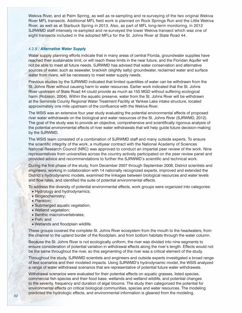
62
Wekiva River, and at Palm Spring, as well as re-sampling and re-surveying of the two original Wekiva River MFL transects. Additional MFL field work is planned on Rock Springs Run and the Little Wekiva River, as well as at Starbuck Spring in 2013. Also, as part of MFL long-term monitoring, in 2012 SJRWMD staff intensely re-sampled and re-surveyed the lower Wekiva transect which was one of eight transects included in the adopted MFLs for the St. Johns River at State Road 44.
4.2.8 / Alternative Water Supply
Water supply planning efforts indicate that in many areas of central Florida, groundwater supplies have reached their sustainable limit, or will reach these limits in the near future, and the Floridan Aquifer will not be able to meet all future needs. SJRWMD has advised that water conservation and alternative sources of water, such as seawater, brackish (slightly salty) groundwater, reclaimed water and surface water from rivers, will be necessary to meet water supply needs.
Previous studies by the SJRWMD indicated that limited quantities of water can be withdrawn from the St. Johns River without causing harm to water resources. Earlier work indicated that the St. Johns River upstream of State Road 44 could provide as much as 155 MGD without suffering ecological harm (Robison, 2004). Within the aquatic preserve, water from the St. Johns River will be withdrawn at the Seminole County Regional Water Treatment Facility at Yankee Lake intake structure, located approximately one mile upstream of the confluence with the Wekiva River.
The WSIS was an extensive four year study evaluating the potential environmental effects of proposed river water withdrawals on the biological and water resources of the St. Johns River (SJRWMD, 2012). The goal of the study was to provide an objective, comprehensive and scientifically rigorous analysis of the potential environmental effects of river water withdrawals that will help guide future decision-making by the SJRWMD.
The WSIS team consisted of a combination of SJRWMD staff and many outside experts. To ensure the scientific integrity of the work, a multiyear contract with the National Academy of Sciences National Research Council (NRC) was approved to conduct an impartial peer review of the work. Nine representatives from universities across the country actively participated on the peer review panel and provided advice and recommendations to further the SJRWMD’s scientific and technical work.
During the first phase of the study, from December 2007 through September 2008, District scientists and engineers, working in collaboration with 14 nationally recognized experts, improved and extended the District’s hydrodynamic models, examined the linkages between biological resources and water levels and flow rates, and identified the suite of potential environmental effects.
To address the diversity of potential environmental effects, work groups were organized into categories:•Hydrology and hydrodynamics;•Biogeochemistry;•Plankton;•Submerged aquatic vegetation;•Wetland vegetation;•Benthic macroinvertebrates;•Fish; and•Wetlands and floodplain wildlife.
These groups covered the complete St. Johns River ecosystem from the mouth to the headwaters, from the channel to the upland border of the floodplain, and from bottom habitats through the water column.
Because the St. Johns River is not ecologically uniform, the river was divided into nine segments to ensure consideration of potential variation in withdrawal effects along the river’s length. Effects would not be the same throughout the river, so this segmenting of the river was a critical element of the study.
Throughout the study, SJRWMD scientists and engineers and outside experts investigated a broad range of test scenarios and their modeled impacts. Using SJRWMD’s hydrodynamic model, the WSIS analyzed a range of water withdrawal scenarios that are representative of potential future water withdrawals.
Withdrawal scenarios were evaluated for their potential effects on aquatic grasses, listed species, commercial fish species and their food base, wetlands and wetland wildlife, and potential changes to the severity, frequency and duration of algal blooms. The study then categorized the potential for environmental effects on critical biological communities, species and water resources. The modeling predicted the hydrologic effects, and environmental information is gleaned from the modeling.
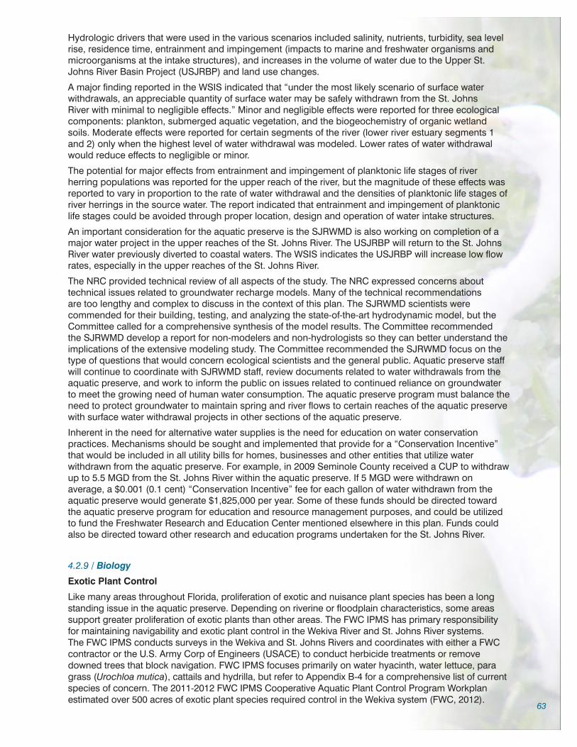
63
Hydrologic drivers that were used in the various scenarios included salinity, nutrients, turbidity, sea level rise, residence time, entrainment and impingement (impacts to marine and freshwater organisms and microorganisms at the intake structures), and increases in the volume of water due to the Upper St. Johns River Basin Project (USJRBP) and land use changes.
A major finding reported in the WSIS indicated that “under the most likely scenario of surface water withdrawals, an appreciable quantity of surface water may be safely withdrawn from the St. Johns River with minimal to negligible effects.” Minor and negligible effects were reported for three ecological components: plankton, submerged aquatic vegetation, and the biogeochemistry of organic wetland soils. Moderate effects were reported for certain segments of the river (lower river estuary segments 1 and 2) only when the highest level of water withdrawal was modeled. Lower rates of water withdrawal would reduce effects to negligible or minor.
The potential for major effects from entrainment and impingement of planktonic life stages of river herring populations was reported for the upper reach of the river, but the magnitude of these effects was reported to vary in proportion to the rate of water withdrawal and the densities of planktonic life stages of river herrings in the source water. The report indicated that entrainment and impingement of planktonic life stages could be avoided through proper location, design and operation of water intake structures.
An important consideration for the aquatic preserve is the SJRWMD is also working on completion of a major water project in the upper reaches of the St. Johns River. The USJRBP will return to the St. Johns River water previously diverted to coastal waters. The WSIS indicates the USJRBP will increase low flow rates, especially in the upper reaches of the St. Johns River.
The NRC provided technical review of all aspects of the study. The NRC expressed concerns about technical issues related to groundwater recharge models. Many of the technical recommendations are too lengthy and complex to discuss in the context of this plan. The SJRWMD scientists were commended for their building, testing, and analyzing the state-of-the-art hydrodynamic model, but the Committee called for a comprehensive synthesis of the model results. The Committee recommended the SJRWMD develop a report for non-modelers and non-hydrologists so they can better understand the implications of the extensive modeling study. The Committee recommended the SJRWMD focus on the type of questions that would concern ecological scientists and the general public. Aquatic preserve staff will continue to coordinate with SJRWMD staff, review documents related to water withdrawals from the aquatic preserve, and work to inform the public on issues related to continued reliance on groundwater to meet the growing need of human water consumption. The aquatic preserve program must balance the need to protect groundwater to maintain spring and river flows to certain reaches of the aquatic preserve with surface water withdrawal projects in other sections of the aquatic preserve.
Inherent in the need for alternative water supplies is the need for education on water conservation practices. Mechanisms should be sought and implemented that provide for a “Conservation Incentive” that would be included in all utility bills for homes, businesses and other entities that utilize water withdrawn from the aquatic preserve. For example, in 2009 Seminole County received a CUP to withdraw up to 5.5 MGD from the St. Johns River within the aquatic preserve. If 5 MGD were withdrawn on average, a $0.001 (0.1 cent) “Conservation Incentive” fee for each gallon of water withdrawn from the aquatic preserve would generate $1,825,000 per year. Some of these funds should be directed toward the aquatic preserve program for education and resource management purposes, and could be utilized to fund the Freshwater Research and Education Center mentioned elsewhere in this plan. Funds could also be directed toward other research and education programs undertaken for the St. Johns River.
4.2.9 / Biology
Exotic Plant Control
Like many areas throughout Florida, proliferation of exotic and nuisance plant species has been a long standing issue in the aquatic preserve. Depending on riverine or floodplain characteristics, some areas support greater proliferation of exotic plants than other areas. The FWC IPMS has primary responsibility for maintaining navigability and exotic plant control in the Wekiva River and St. Johns River systems. The FWC IPMS conducts surveys in the Wekiva and St. Johns Rivers and coordinates with either a FWC contractor or the U.S. Army Corp of Engineers (USACE) to conduct herbicide treatments or remove downed trees that block navigation. FWC IPMS focuses primarily on water hyacinth, water lettuce, para grass (Urochloa mutica), cattails and hydrilla, but refer to Appendix B-4 for a comprehensive list of current species of concern. The 2011-2012 FWC IPMS Cooperative Aquatic Plant Control Program Workplan estimated over 500 acres of exotic plant species required control in the Wekiva system (FWC, 2012).

64
To date, hydrilla infestations have been confined to the Wekiwa Lagoon and spring run. One small patch of hydrilla was observed in the Wekiva River just upstream of Shell Island in 2006 but was aggressively treated, removed and monitored, and no other instances of hydrilla have been observed in the Wekiva River. Aquatic preserve staff assist FWC IPMS staff during their semi-annual surveys in the Wekiva River and occasionally on the St. Johns River. The aquatic preserve typically provides canoe or boat support for FWC IPMS staff during Wekiva River surveys.
In the early 1990s, wild taro was a dominant plant in certain reaches of Rock Springs Run and the little Wekiva River. Herbicides available at the time were not as efficient as those we have today, so early treatments of wild taro typically required two or three applications, timed several weeks apart. Floating plants could not be treated because the first treatment would kill only the leaf and stem, leaving the corm (potato-like root) to float downstream and infest other areas. The aquatic preserve manager secured an $80,000 grant from the Pollution Recovery Trust Fund for herbicide treatments and for hand removal of floating wild taro plants from Rock Springs Run and the Wekiva River. An eight-person team removed floating plants throughout Rock Springs Run and the Wekiva River during the mid 1990s. Floating plants were hand removed, taken to dumpsters and disposed of at an approved upland disposal site. Eradication and control was aggressively pursued and within a year the population of wild taro was substantially reduced. As more efficient herbicide became available, it was easier to eradicate or control wild taro. One aquatic preserve staff member maintained an aquatic applicator license and treated wild taro periodically for several years. Initially, the DEP Bureau of Invasive Plant Management (now FWC IPMS) did not treat wild taro, but after several years of lobbying by aquatic preserve staff, limited treatments of wild taro started. Several years of subsequent freezing winter temperatures also increased die-backs of wild taro. FWC IPMS currently controls wild taro in the Wekiva system.
Wild taro, para grass, hydrilla and several other exotic species have plagued the Little Wekiva River for over two decades. Aquatic preserve staff spent considerable time treating a variety of exotic species on the Little Wekiva River using herbicide and hand removal. In the 1990s, the aquatic preserve manager served as project manager for two mechanical harvesting projects, one in the Little Wekiva River and the other in the Wekiva River just upstream (south) of the State Road 46 bridge. The Little Wekiva project was conducted primarily to open up a reach of the Little Wekiva River north and south of the Springs Landing bridge that was choked with exotic vegetation. The amount of vegetation precluded use of the river for canoeing. The harvester spent several weeks removing a variety of exotics from the river and opening up a channel for canoeists. This reach of the river occasionally becomes blocked but FWC maintains navigability. A mechanical harvester removed approximately 5 acres of para grass and other exotics from the Wekiva River in 2003.
Aquatic preserve staff assisted a homeowners association with removal of hydrilla in a spring boil and run of the Little Wekiva River to reduce biomass and prevent fragments from floating downstream and infesting waters in the aquatic preserve, but other upstream infestations were too pervasive for the aquatic preserves limited staff.
Due to reorganization of staff and duties, the aquatic preserve no longer has a staff member with an aquatic herbicide license. The aquatic preserve maintains a permit from FWC IPMS for hand and mechanical removal of certain species. Due to limited staffing, we are currently focusing on green hygro, a high priority species in the Little Wekiva River. The aquatic preserve is coordinating with FWC IPMS for potential herbicide applications on submerged green hygro. Herbicide application on submerged vegetation in the Little Wekiva River is challenging and limited due to frequent high water flow velocities. Green hygro is also removed manually. Manual removal presents its own set of challenges, since one of the primary ways exotics recruit to new areas is from small plant fragments that float downstream to new locations. During removal events staff are diligent in ensuring all possible pieces of floating plant material are collected. Floating plants are collected using a series of nets placed perpendicular to the flow, dip nets manipulated by individuals located at the removal site and additional seine nets act as a final catchment area. In 2011-2012, the aquatic preserve guided two Eagle Scout projects and several volunteer events removing green hygro on the Little Wekiva River.
Cattail Removal and Restoration
Between 1998 and 2005, aquatic preserve staff documented a significant increase in cattail on the west shoreline of the Wekiva River immediately downstream of the State Road 46 bridge. The stand had expanded from 3 to 22 acres, covered a length of about 1.1 miles, and a maximum width of 400 feet. During this time frame, cattail stands in other reaches of the Wekiva River were also monitored but these did not expand. The stand continued to increase in size and covered, stretched over an areas of approximately one mile. If it continued to expand, it could block navigation and threaten recreational

65
use for both paddlers and motorboats. Additionally, Warren et al. (2000) reported that there was low biological diversity in the stand when compared to other areas of the Wekiva River. The cattail expansion appeared to be associated with a slight elevation in substrate that built up on this stretch of the river. The elevated substrate may have accrued due to a combination of:•Hurricane or other storm events;•Erosion associated with the reconstruction of the State Road 46 bridge;•Sand eroded from the banks of the bridge; and/or •An annual detrital mass created
by the existing cattail.
Initial herbicide treatments were hindered due to difficulty of accessing the interior of the cattail stand. A two-acre mechanical removal project eliminated root biomass but was found not to be cost effective relative to herbicide treatment. Diligent coordination between the aquatic preserve, FWC IPMS, and a contractor using herbicide treatments over a two-year period (2007-2009) resulted in the reduction of the cattail stand, return of open water, and recruitment of beneficial native species to approximately 15 acres of the site. During a spring 2012 public event, canoeists and kayakers were able to circumnavigate an island that had been blocked by cattail for over 10 years. Aquatic preserve and FWC IPMS staff continue to regularly monitor and treat the area as needed as part of a system-wide effort to contain exotic and nuisance species.
Hydrilla
Periodic infestations of hydrilla have occurred in the six-acre Wekiwa Lagoon for at least 30 years. Hydrilla is also present in Wekiwa Springs Run for approximately a quarter mile downstream. Prior to 2000, hydrilla treatments were conducted by the USACE. Responsibility for hydrilla control was then transferred to DEP Bureau of Invasive Plant Management (now FWC IPMS).
Hydrilla is difficult to control due to the persistence of tubers (reproductive structures) in the substrate. Infestations occur every two to three years, despite control efforts. In flowing water, treatments are not as efficient as they are in lakes which allow for more herbicide residence time.
In 1995, after observing the rapid proliferation of hydrilla in Wakulla Spring and the extent of the infestation throughout the Wakulla Spring Run, the Wekiva River Aquatic Preserve manager believed more aggressive actions should be taken to prevent infestation of downstream areas in the Wekiva River. Funding was obtained to purchase 500 feet of 10 foot depth turbidity barrier. The barriers were used to
(Top) Exotics on the Little Wekiva River encroached on recreational use. (Bottom) Removal of exotics re-opened the Little Wekiva River to use by paddlers.
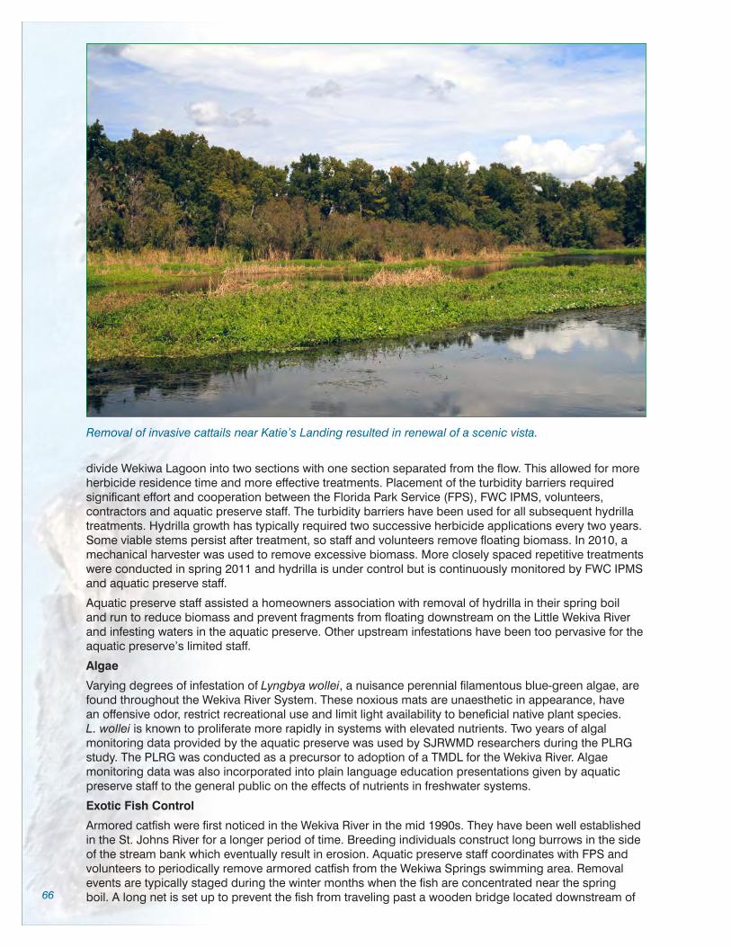
66
divide Wekiwa Lagoon into two sections with one section separated from the flow. This allowed for more herbicide residence time and more effective treatments. Placement of the turbidity barriers required significant effort and cooperation between the Florida Park Service (FPS), FWC IPMS, volunteers, contractors and aquatic preserve staff. The turbidity barriers have been used for all subsequent hydrilla treatments. Hydrilla growth has typically required two successive herbicide applications every two years. Some viable stems persist after treatment, so staff and volunteers remove floating biomass. In 2010, a mechanical harvester was used to remove excessive biomass. More closely spaced repetitive treatments were conducted in spring 2011 and hydrilla is under control but is continuously monitored by FWC IPMS and aquatic preserve staff.
Aquatic preserve staff assisted a homeowners association with removal of hydrilla in their spring boil and run to reduce biomass and prevent fragments from floating downstream on the Little Wekiva River and infesting waters in the aquatic preserve. Other upstream infestations have been too pervasive for the aquatic preserve’s limited staff.
Algae
Varying degrees of infestation of Lyngbya wollei, a nuisance perennial filamentous blue-green algae, are found throughout the Wekiva River System. These noxious mats are unaesthetic in appearance, have an offensive odor, restrict recreational use and limit light availability to beneficial native plant species. L. wollei is known to proliferate more rapidly in systems with elevated nutrients. Two years of algal monitoring data provided by the aquatic preserve was used by SJRWMD researchers during the PLRG study. The PLRG was conducted as a precursor to adoption of a TMDL for the Wekiva River. Algae monitoring data was also incorporated into plain language education presentations given by aquatic preserve staff to the general public on the effects of nutrients in freshwater systems.
Exotic Fish Control
Armored catfish were first noticed in the Wekiva River in the mid 1990s. They have been well established in the St. Johns River for a longer period of time. Breeding individuals construct long burrows in the side of the stream bank which eventually result in erosion. Aquatic preserve staff coordinates with FPS and volunteers to periodically remove armored catfish from the Wekiwa Springs swimming area. Removal events are typically staged during the winter months when the fish are concentrated near the spring boil. A long net is set up to prevent the fish from traveling past a wooden bridge located downstream of
Removal of invasive cattails near Katie’s Landing resulted in renewal of a scenic vista.

67
the boil. The slow moving fish are gigged as they swim into the net. Other species of concern include spotted tilapia (Tiliapia mariae), radiated ptero (Pterygoplichthys multiradiatus), and brown hoplo (Hoplosternum littorale). More research is needed on the effects of these species in the aquatic preserve.
Freshwater Turtle Research Support
In 2009 the aquatic preserve manager secured funding from the FOWR that allowed the Central Florida Freshwater Turtle Research Group (CFFTRG) to use Passive Integrated Transponder tags as an additional means of identifying recaptured turtles. Over the past five years, the aquatic preserve has sought and secured nearly $12,000 from sources including FOWR, the Wekiva Wild and Scenic AMC and private donations to benefit freshwater turtle research in the Wekiva system. Aquatic preserve staff provided significant logistical support during the turtle sampling events. The work on Wekiwa Spring Run has been used to guide rulemaking regarding turtle hunting in Florida. The CFFTRG occasionally engages in the removal of exotic species from the spring runs, such as the red-eared slider and armored catfish.
Hydrilla was mechanically removed from Wekiwa Lagoon after treatment with herbicide. Water flow is slowed by the turbidity barrier to improve the effectiveness of herbicide treatments.
4.2.10 / Removal of Illegal Structures
Numerous makeshift cabins were built by hunters, fishermen or other river users during the 1960s and early 1970s when the adjacent uplands were in private ownership. At the time, the Wekiva River was a remote area accessed primarily by unpaved roads. Occupants bought and sold use of the cabins. Over time, many of the structures became dilapidated. Citizen groups removed many of the deteriorated and abandoned structures and debris during river clean-ups, but in the late 1980s thirty-six structures remained. The remaining structures ranged in size from 200 square feet to over 2,000 square feet and preempted use of the islands by the public. Lengthy court proceedings ensued with ownership of the islands by the State of Florida as sovereign lands definitively determined by the courts. Aquatic preserve staff, assisted by numerous agencies and volunteers removed thirty-six illegal squatter cabins from

68
islands in the Wekiva River from 1990 to 1992. The Orange and Seminole County Health Departments and the State Fire Marshal provided reports on illegal waste disposal (typically 55 gallon drums), illegal wells, and fire hazards. The DNR and Attorney General provided direction to aquatic preserve staff for removal of the structures, including signage posted to each structure which advised occupants the structures were on state-owned lands and would be removed. Occupants were given 90 days to remove personal belongings. A $120,000 grant from the Pollution Recovery Trust Fund was secured by the aquatic preserve and used to hire a four-person demolition crew, purchase boats, motors and trailers and other equipment used to remove the structures. The FPS participated in the effort by providing additional staff, a dump truck and other support over the two year removal period. Volunteers
also participated during special clean-up events. Over 200 tons of lumber, drywall, sinks, mattresses, commodes, 55-gallon drums, glass, furniture and other materials associated with the cabins were hauled off the islands. Lake County Board of County Commissioners participated by waiving landfill fees. Many of the islands were replanted with native trees and shrubs while others were left for natural recruitment. With the assistance of aquatic preserve staff, more than 20 wells associated with the cabins were capped by SJRWMD contractors. Removal of the cabins and restoration of the islands led the way for the Wekiva River to be designated as a Wild and Scenic River. Traveling on the river today, it is impossible for visitors to discern where the cabins once stood.
Water flow through sections of the Wekiwa lagoon would be slowed with turbidity barriers to improve exotic plant herbicide treatments.
4.2.11 / Archaeological and Cultural Resources
The Wekiva and St. Johns Rivers contain numerous cultural sites. Many sites, unfortunately, were vandalized prior to public ownership, and some continue to be degraded. Reports of disturbance to the sites on the St. Johns River date as far back as the late 1800s (Moore & Mitchem, 1999). Heavy vegetation provides a measure of protection for many sites that are hidden from public view. Aquatic preserve staff conduct periodic inspections of sites that are visible and accessible to the public and coordinate these surveys with the FPS Archaeological Resource Manager to conduct joint inspections.
Shell Island is an important archaeological midden on the Wekiva River owned by Rollins College. It is one of the few islands in the Wekiva River that is privately owned. Rollins College has a long history of bringing students to the island for educational purposes and an outdoor experience. Rollins College allows limited use of the island through a permitting process. Unfortunately, the integrity of the midden has been severely compromised by the wear and tear of unauthorized day use and overnight campers, most of whom do not know the island’s significance. Vandals repeatedly tear down posted “No Trespassing” and informational signs. Trespassers cause erosion, light campfires, damage trees and deposit litter and human waste on the site.
Over the years, aquatic preserve staff and other volunteers have conducted numerous clean-ups on Shell Island. In 2006, Rollins College entered into a Memorandum of Agreement (MOA) with DEP Law Enforcement. The MOA authorized DEP law enforcement to patrol and enforce trespass violations on Shell Island. Several citations and occasional arrests have occurred, but the issue is pervasive. In recent years, damage to the site has increased. Vandals continue to cause damage to the site by using tree spikes to install rope swings, littering, and cutting trees for camp fires. In 2010, after several meetings and field trips to the site, the aquatic preserve initiated a Shell Island Protection Campaign. Rollins College donated $1,500 to the initiative which is administrated by FOWR. Funds were used to purchase a pole saw to remove rope swings and supplies for signage. Because expensive metal signs were

69
frequently removed by vandals, laminated signs are used. In addition to “No Trespassing” signs, educational information describing the value of the site is also posted.
An ongoing law enforcement presence is needed to deter illegal activity and also to cite trespassers. To date, procedural difficulties have prevented more frequent off-duty patrols to the site. Occasional law enforcement patrols have resulted in several trespass cases. A portion of the $1,500 Rollins College donation has been set aside to hire off-duty law enforcement officers to enhance patrols of Shell Island. It is anticipated that the transition of DEP Law Enforcement to FWC will facilitate a process whereby officers are available for off duty hire in the Wekiva River. The AMC also approved funding for off-duty patrols on the Wekiva River to provide a presence which acts as a deterrent to illegal activity.
Aquatic preserve staff will continue to partner with Rollins College, patrol the site, conduct clean-ups, post signage, and pursue hiring off duty law enforcement to patrol the site and the Wekiva River. Aquatic preserve staff will continue periodic inspections of other middens and culturally significant sites.
4.2.12 / Emergency Response
Post Hurricane, Tropical Storm Clean-up
Post hurricane and tropical storm clean-up involves assisting the FWC IPMS contractor with removal of fallen trees along the various reaches of the aquatic preserve. In 2007, aquatic preserve staff led clean-up efforts on Lake Beresford after a tornado destroyed numerous houses and docks in the area. Uplifted debris from home sites, docks, and other structures was deposited
(Top) – Thirty-six illegal squatter cabins were removed from the Wekiva and Little Wekiva rivers in the early 1990s. (Bottom) – Today it is nearly impossible to see where the cabins stood approximately twenty years ago.

70
in Lake Beresford where it became a navigation hazard. Aquatic preserve staff posted caution signs at every launch site within five miles of Lake Beresford warning boaters that submerged debris was present in the water. Aquatic preserve staff coordinated the clean-up effort which required hiring contractors with special equipment to retrieve visible debris from the water and also drag portions of the lake for submerged hazards. The clean-up effort took over six months.
Hazardous Spills
Although a crude oil spill is unlikely within the waters of the aquatic preserve, there are scenarios for hazardous spills. These include bridge accidents as well as shipping accidents or spills. Aquatic preserve staff assisted with the 2010 East Coast Assessment that was a result of the Deepwater Horizon Oil Spill. Experience gained from this incident will prove valuable in the event of a hazardous spill on the Wekiva or Middle St. Johns Rivers. Staff attended Shoreline Cleanup Assessment Team (SCAT) and Hazardous Waste and Emergency Response (HAZWOPER) training during 2010. The primary goal of the SCAT teams is to provide cleanup information to the Operations Section to help them make informed decisions relative to cleanup of oiled shoreline in any area of concern. The SCAT process allows for a systematic survey of the beach face or inland marsh area both pre- and post-oiling. The HAZWOPER course is designed to train general site workers engaged in hazardous substance removal or other activities which expose or potentially expose workers to hazardous substances and health hazards.
Aquatic preserve staff should take advantage of regional educational opportunities for appropriate emergency response and evaluation training.
4.2.13 / Partners and Stakeholders
Numerous federal, state and local partners coordinate with the aquatic preserve program for a variety of activities or work on issues related to the aquatic preserve. Portions of the following descriptions of partnering agencies were excerpted and adapted from the Wekiva Wild and Scenic River Comprehensive Management Plan adopted May 2012.
Federal Agencies and Programs
National Park Service
The National Park Service (NPS) has oversight of Partnership Wild and Scenic Rivers to help communities preserve and manage their own river-related resources by bringing together state, county, and community interests to preserve the Outstandingly Remarkable Values for which the rivers were designated. Specifically the NPS allocates funds for managing the Wekiva Wild and Scenic River and all other partnership rivers throughout the country. In addition, the NPS is responsible for reviewing any and all federally-assisted water resources projects, pursuant to Section 7 of the Wild and Scenic Rivers Act, that could affect a Wild and Scenic River, particularly its free-flow condition and its Outstandingly Remarkable Values. A NPS Designated Federal Officer is assigned to the Wekiva Wild and Scenic River. Designated Federal Officer duties include coordinating Wekiva Wild and Scenic Advisory Management Committee meetings, preparing meeting agendas and minutes, coordinating NPS funding for the Wekiva Wild and Scenic River, coordinating preparation and implementation of the WSMP, and working with the AMC to implement the goals, objectives and action items outlined in the adopted WSMP.
U.S. Army Corps of Engineers
The U.S. Army Corps of Engineers (USACE) is charged with regulating waters of the United States. By definition these waters include coastal and navigable inland waters, lakes, rivers and streams; other intrastate lakes, rivers and streams (including intermittent streams); and mudflats, sandflats, wetlands, sloughs, wet meadows, and certain impoundments. The USACE’s aquatic plant control program maintains navigability within the designated 20 mile reach of the St. Johns River and in the Wekiva River from its confluence with the St. Johns River upstream to the southern boundary of LWRPSP (where FWC IPMS takes responsibility). The USACE treats species such as water hyacinth, water lettuce, hydrilla and others which are on the Florida Exotic Plant Pest Council Category I and Category II invasive species lists. Category I species are defined as invasive plants that have impacted native plant communities by outcompeting native species, altering community structure or function or hybridizing with native species. Those on the Category II list have not yet had this type of impact, but their numbers are increasing and they may be approaching Category I status. The USACE treats a number of these species as part of their Environmental Stewardship, Operations and Maintenance projects and in cooperation with other state and federal agencies.

71
The USACE participates on the BSIWG and maintains a moratorium on herbicide application in the vicinity of BSSP from October 1 to March 31 for maintenance of an adequate natural food supply for the overwintering manatee population.
U.S. Fish and Wildlife Service
The U.S. Fish and Wildlife Service (USFWS) must be consulted if a federally protected species may be impacted by an activity within its jurisdiction. USFWS staff prepare an independent biological opinion, and an activity may not be authorized unless it is determined that the project is not likely to jeopardize the continued existence of the species or result in the destruction of the habitat of the species.
U.S. Coast Guard
The U.S. Coast Guard is responsible for maintaining aids to navigation on the St. Johns River.
Legislatively Designated Committees
Wekiva River Basin Commission
The Wekiva River Basin Commission (Commission) was created as part of the 2004 WPPA. The Commission was charged with insuring the 17 recommendations detailed in the final report produced by the Wekiva River Basin Coordinating Committee are implemented. The 17 recommendations included numerous actions and studies to be undertaken by local governments and state agencies. The Commission is comprised of representatives from local governments and state and regional agencies. The Commission has met regularly since 2005 and should continue to meet until the completion of the Wekiva Parkway and the full implementation of the 17 recommendations.
State and Local Agencies
Counties and Cities
The four counties (Lake, Orange, Seminole and Volusia) and several cities surrounding the aquatic preserve participate on a number of committees and working groups that benefit the Wekiva and Middle St. Johns Rivers (as described in this section). Additionally, three counties and several municipalities (in coordination with DEP and SJRWMD) will be responsible for the implementation of a variety of strategies identified through the BMAP process. Strategies will aid in reducing nutrients to the aquatic preserve to meet nutrient reduction goals described in TMDL documents.
East Central Florida Regional Planning Council
The East Central Florida Regional Planning Council (ECFRPC) was established in 1962 as an area-wide association of local governments serving the six counties of Brevard, Lake, Orange, Osceola, Seminole, and Volusia. The 31 Council members represent the counties, the League of Cities in each county and gubernatorial appointees. The ECFRPC provides a forum where members and leaders can discuss complex regional issues and set regional goals and objectives. The ECFRPC hosted the 1988 Wekiva River Task Force meetings that were the precursor to the WRPA. They currently coordinate Wekiva Parkway Commission meetings (the committee that oversees implementation of the WPPA).
Florida Department of Environmental Protection
All of the water bodies within the aquatic preserve are waters of the state of Florida. DEP has programs regulating drinking water facilities, wastewater discharges (domestic and industrial), landfills (solid waste), facilities generating hazardous waste, and operations creating air discharges. Dredging, filling and/or construction activities in wetlands associated with private, single-family residences, domestic or industrial wastewater facilities, or landfills also are regulated by DEP. In addition, DEP sets water quality standards for the different categories of surface waters in the state. These standards are found in Chapter 62-302, F.A.C.
In addition to its regulatory programs, DEP has acquired several protective conservation easements in the aquatic preserve basins.
Florida Department of Health
The Florida Department of Health (FDOH) administers several programs to promote public health in coordination with county health departments, including but not limited to those related to disease control, family health care services, and sanitation. Pursuant to the Wekiva Parkway and Protection Act, the FDOH in coordination with DEP is charged with evaluating standards for the onsite treatment and disposal systems (septic systems) to achieve nitrogen reductions protective of groundwater quality

72
with the Wekiva Study Area. Pursuant to the Act, the FDOH is authorized to adopt rules as appropriate to reduce nutrient loads, considering measures such as the use of more stringent level of wastewater treatment and establishment of a program for septic tank inspection and maintenance. At the direction of the Florida Legislature, additional studies are being pursued by FDOH to further assess the contribution of septic systems to nutrient loading.
Florida Division of Recreation and Parks (Florida Park Service)
Under DEP, the Florida Division of Recreation and Parks (known as the Florida Park Service) operates five state parks adjacent to the aquatic preserve. The FPS mission is to provide resource-based recreation while preserving, interpreting, and restoring natural and cultural resources. There are a variety of distinct natural community types in both uplands and wetlands categories within the boundaries of the adjacent state parks. A number of imperiled species inhabit these communities and significant work has been done to protect known habitat. In managing these species and their habitats, FPS staff use various tools and techniques, ranging from prescribed fire to active exotic species removal. Several historic and cultural sites have been located, cataloged, and protected in FPS-managed parks, including an old cemetery, the Thursby House and numerous middens located throughout the parks and along the river system.
Florida Fish and Wildlife Conservation Commission
FWC manages the state’s fish and wildlife resources, including more than 575 species of terrestrial wildlife and 700 species of saltwater and freshwater fish. Among its several functions, FWC issues licenses for hunting and fishing, administers permit programs for incidental take and relocation, regulates captive breeding and possession of wildlife, and performs law enforcement. FWC biologists are engaged in various activities relating to wildlife and habitat conservation, including research, management, and education. In addition, the FWC IPMS is the lead agency for aquatic plant management in Florida. The FWC IPMS is responsible for controlling invasive exotic plant species and maintaining navigability in the Little Wekiva River, Black Water Creek, Rock Springs Run, the Wekiva River from its confluence with Rock Springs Run downstream to the southern boundary of LWRPSP (where USACE takes responsibility), and within the St. Johns River.
Florida Forest Service
The Florida Forest Service (FFS) manages Seminole State Forest, which includes more than 27,000 acres of state land in east Lake County. These lands provide essential landscape connectivity in the Wekivabasin, extending north of RSRSR to the Ocala National Forest. Although title to most of SSF is held by the state of Florida, 2,939 acres surrounding portions of Black Water Creek are owned by the SJRWMD.
Seminole State Forest is managed by the FFS with the goal of protecting and maintaining the native biological diversity of the many ecosystems that comprise the state forest, while integrating public use of the resources. Multiple-use management promotes recreation, timber, protection of wildlife including designated species, environmental education, and other values that benefit Florida residents and visitors. Land management activities generally contribute to preserving the natural ecosystem around much of Black Water Creek. Hunting is allowed by permit from FWC within parts of SSF designated as wildlife management areas. Boating on Black Water Creek is also managed through a permit system.
Lake County Water Authority
The Lake County Water Authority (LCWA) is a special agency created by the Florida Legislature in 1953 for the following purposes: (1) controlling and conserving the freshwater resources of Lake County; (2) fostering and improving the tourist business in the county by improvements to streams, lakes and canals in the county; (3) providing recreational facilities for the tourists, citizens and taxpayers of the county by a more efficient use of the streams, lakes and canals in the county; (4) improving the fish and aquatic wildlife of the county by improving the streams, lakes and canals in the county; and (5) protecting the freshwater resources of Lake County through assisting local governments in the treating of stormwater runoff by conserving freshwater to improve the streams, lakes and canals in the county. As part of this effort, the LCWA manages nearly 800 acres that it acquired for conservation in the Wekiva basin, including Lake Tracy Preserve, Wolfbranch Sink Preserve, and Bear Track Preserve. The LCWA also works cooperatively with the SJRWMD to manage and provide recreational access to Lake Norris Conservation Area.
St. Johns River Water Management District
The aquatic preserve is entirely within the jurisdictional boundaries of the SJRWMD, which oversees numerous activities to ensure the sustainable use and protection of water resources. The SJRWMD is responsible for management of over 10,000 acres within the aquatic preserve basin, has acquired

73
protective conservation easements over various privately-owned parcels and shares title with Orange County and Lake County to parcels acquired for conservation near the Wekiva Parkway.
The SJRWMD has two primary regulatory programs, the CUP and the ERP. Part II of Chapter 373, F.S., authorizes the Water Management Districts to require permits for the consumptive use of groundwater and surface water. Part IV of Chapter 373, F.S., authorizes the Water Management Districts and FDEP to require ERPs for the construction and operation of surface water management systems (a term encompassing most land development activities) whether in uplands or wetlands. Additionally, where any regulated activity is located in, on, or over wetlands or other surface waters, the ERP applicant must establish that the activity is not contrary to the public interest, or, if within an Outstanding Florida Water, that the activity will be clearly in the public interest (Section 373.414, F.S.).
The SJRWMD has adopted special ERP basin criteria for the Wekiva River Hydrologic Basin in Chapter 40C-41, F.A.C. A permit applicant proposing a project in this basin must meet the criteria in both chapters 40C-4 and 40C-41, F.A.C. The SJRWMD maintains an Operational Agreement (executed in 2007) with DEP whereby the SJRWMD processes applications for single family docks within the RHPZ in the Wekiva River system within the aquatic preserve and areas outside the aquatic preserve boundary. The SJRWMD also handles compliance issues within the RHPZ.
ections 373.042 and 373.0421 (F.S.) authorize the water management districts to establish MFLs of surface waters and ground waters. These MFLs are implemented through the CUP and ERP programs. The district has established minimum groundwater levels and minimum annual spring flows for Blue Spring (SJRWMD, 2007), Messant Spring, Palm Spring, Rock Spring, Sanlando Spring, Seminole Spring, Starbuck Spring, Miami Spring, and Wekiwa Spring (Hupalo et al., 1994). Surface water levels and flows have been established for the Wekiva River, and Black Water Creek (Hupalo et al., 1994), and the St. Johns River at State Road 44 (Mace, 2006). Section 373.709 (F.S.), in Part VII of Chapter 373 requires the water management districts to develop regional water supply plans to ensure that existing and future water demands are met and water resources and related natural systems are sustained.
The Surface Water Improvement and Management (SWIM) Act of 1987 was passed by the Florida Legislature and directed the state’s water management districts to “develop plans and programs for the improvement and management of surface waters” (Section 373.451, F.S.). The SJRWMD has developed SWIM plans for the Middle St. Johns River Basin, which includes the Wekiva River, and the Lower St. Johns River Basin. Utilizing state or district funding, projects addressing restoration and water quality improvement have been completed, and others are underway within the SJRWMD SWIM Program. Additionally, water supply planning has been supported by the SJRWMD and funding for stakeholders’ approved projects has been provided periodically over the recent past.
Working Groups
Aquatic preserve staff coordinates with the following working groups on a regular basis by attending meetings and participating in group activities and programs.
Blue Spring Interagency Working Group
The Blue Spring Interagency Working Group (BSIWG) was formed in 1982 to address issues relating to aquatic herbicide applications and maintenance of an adequate natural food supply for the endangered manatee. The BSIWG is coordinated by the regional biologist within the FWC IPMS. Initially a moratorium was developed for herbicide applications within the middle St. Johns River, and the moratorium is now supported by a yearly Aquatic Plant Management Plan for St. Johns River, Blue Springs Region (BSIWG, 2011) prepared by the BSIWG. The management plan was established through meetings and discussions between representatives of DEP (FPS and the aquatic preserve), USFWS, FWC, Volusia County, SJRWMD and the USACE. The agencies represented provided scientifically based information to help develop the plan which represents a consensus approach to serve the navigational and recreational needs of the public while protecting manatees and manatee habitat to the greatest degree possible. The plan will continue to be modified as knowledge grows and river conditions change. It represents a cooperative effort among the above agencies but does not limit or diminish the management or regulatory responsibilities of these agencies. Participants meet at least once every year, to coordinate aquatic plant management operations. Aquatic preserve staff participate on the BSIWG and support the provisions of the management plan.
Blue Spring Alliance
The Blue Spring Working Group (BSWG) was established in 2007 as part of DEP’s Springs Initiative to assist with sharing of information and interagency coordination for issues related to Volusia Blue Spring

74
and to expand cooperation between interested citizens, scientists, regulatory agencies, governments, utilities and the business community. The BSWG was successful in bringing together a diverse group of stakeholders interested in topics related to Volusia Blue Spring and the middle St. Johns River, including water quality, water quantity, the manatee population, springshed and other resource management issues. The FWC and DEP supported the Blue Spring Working Group in their quarterly public forums held from 2007-2011. The Walter Boardman Foundation provided financial support to continue services of professional staffing and facilitation for the Working Group in 2011-2012. In order to secure sustainable funding for the Blue Spring Working Group, a Steering Committee comprised of representatives from Volusia County, municipalities in the springshed (Orange City, DeLand, Deltona, Lake Helen and DeBary), SJRWMD, DEP, University of Florida Cooperative Extension Service and the West Volusia Audubon Society was formed and the group was renamed the Blue Spring Alliance.
St. Johns River Alliance
The St. Johns River Alliance (SJRA) advocates for the St. Johns River and is a 501(c)3 entity made up of representatives of 12 river county governments, governmental agencies and river stakeholders.
The SJRA was formed as a result of the river being designated by President Bill Clinton as one of 14 American Heritage Rivers nationwide. The SJRA was also instrumental in having the St. Johns River designated as a national Great Water in April 2012. The Great Waters designation insures that the St. Johns River will be represented in Washington D.C. and that the SJRA will be a participant in national watershed policy discussions and funding proposals.
SJRA goals include:• Seeking state and federal funds for river restoration and helping communities meet total maximum
daily load requirements;• Creating jobs and small businesses through eco-tourism initiatives;• Creating a consortium of universities to further river research.
The Florida Legislature created the St. Johns River license plate in 2011 with the SJRA responsible for expending funds raised by license plate sales. Fifty percent of the revenue raised by the license plate will be available for river communities through a competitive grant program.
Wekiva Basin Ecosystem Working Group
The Wekiva Basin Ecosystem Working Group (WBEWG) formed in 1992. The group consists of state and local resource managers, various state and local regulatory staff, water quality monitoring staff, citizen support groups, vendors, user groups, and a variety of other interested stakeholders. For many years the WBEWG served as a clearinghouse for sharing information across a variety of topics and for interagency communication and cooperation. The WBEWG was coordinated by several different entities over the years including a FPS manager, DEP Ecosystem Management staff, and DEP Central District staff. The group is currently coordinated by the aquatic preserve manager. Meetings were originally held quarterly, but as other committees emerged (especially the AMC) with attendance by many of the same stakeholders, the WBEWG began to meet less frequently. Meetings are now convened as the need arises, typically once a year. Plans to reconvene the WBEWG with emphases as a clearing house for basin research projects are under consideration.
Wekiva Basin Management Action Plan Working Group
Wekiva Basin Management Action Plan Working Group (BMAPWG) stakeholders were appointed by DEP as required for the implementation of TMDL for the Wekiva River (Gao, 2008). The BMAPWG is responsible for the development and implementation of a Basin Management Action Plan BMAP). The goal of the BMAP is to provide strategies that will result in the reduction of nutrients to the Wekiva River and Rock Springs Run. Implementation of the strategies will depend heavily on the active participation of all stakeholders, including the SJRWMD, local governments, businesses, and other identified stakeholders. Interested stakeholders and appointees, including the aquatic preserve manager, meet on a regular basis to discuss nutrient source identification, existing water quality sampling programs conservation programs, and strategies that will result in nutrient reductions.
Wekiva Wild and Scenic River System Advisory Management Committee
The Wekiva River System Advisory Management Committee (AMC) oversees implementation and refines strategies that will achieve the goals and objectives of the Wekiva Wild and Scenic River Management Plan. It is composed of representatives of public agencies, local governments, and non-profit organizations. Several members of this committee have been resource managers and active stewards of the Wekiva basin for many years. Functions of the AMC include refinement and prioritization of projects described within the WRSMP and the pursuit of funding to implement strategies identified in the plan.

75
The AMC has provided funding for several projects that benefit research and education programs in the Wekiva Basin including a full-time River Ambassador position, freshwater turtle research, the Wekiva Promise magazine, the Wekiva River Festival, a cave dive event at Wekiwa Springs, products to promote recycling, and litter bags for canoes.
Non-Governmental Organizations
Friends of the Wekiva River, Inc.
The Friends of the Wekiva River (FOWR), a non-profit citizen action group, was formally incorporated in 1982 with the following objectives:• To promote and protect the aesthetic and recreational values of the Wekiva River system;• To protect the integrity of the Wekiva River Basin;• To work toward restoration and continuation of the river and its tributaries; and• To carry out educational activities to the same end.
For over thirty years, the FOWR have been active and influential in a large number of issues central to the Wekiva Basin. The FOWR lobby for resource protection legislation, publish documents describing resource management issues and threats and advocate for protection of Wekiva River basin resources. FOWR also partnered with other citizen groups for the designation of the Wekiva River as a Federal Wild and Scenic River and administrates funding provided by the NPS for management of the Wekiva Wild and Scenic River System. FOWR has been active on numerous committees including the Wekiva Coalition, the AMC, Wekiva River Basin Working Group, Partnership for Wild and Scenic Rivers Committee, Expressway Authority Environmental Advisory Group and the Orange County Green PLACE Committee. In 2007, FOWR initiated Wekiva Riverfest, a week-long event that attracted more than 2,000 participants to Wekiva Springs State Park for education, art, music, canoe races and pontoon boat rides on the river. FOWR also initiated the first Wekiva Invitational Plein Air Paint Out that included over thirty artists, provided for the integration of art and the environment, and resulted in many new paintings depicting scenes found throughout the Wekiva Basin. Numerous other activities are conducted by FOWR including participation at festivals, lobbying for land acquisition, and coordination of the Wekiva Christmas bird count. FOWR’s most recent accomplishment was a successful Wekiva Basin Bioblitz which brought together over 100 researchers and biologists in seven disciplines. More than 1560 species (aquatic, wetland, and upland) were identified during the one-week BioBlitz. The event brought much attention to the importance of Wekiva Basin resources.
The aquatic preserve is an active partner with the FOWR on a variety of projects, including coordinating regular cleanups, assisting with coordination during the FOWR annual Riverfest celebration, special events such as the BioBlitz, field trips, and exotic plant removal projects. The aquatic preserve manager acts as one of several technical advisors to the FOWR Board of Directors.
St. Johns Riverkeeper
The St. Johns Riverkeeper is a non-profit organization that often plays an advocacy or educational role in issues affecting the St. Johns River. Their mission is to work on behalf of the community for clean and healthy waters in the St. Johns River, its tributaries and its wetlands, through citizen-based advocacy. The organization was formed in 2000 when a group of concerned citizens formed an advocacy group, a “waterkeeper” organization similar to the one formed two decades earlier on the Hudson River in New York (St. Johns Riverkeeper, 2010). The St. Johns Riverkeeper advocates for the interests of the St. Johns and the public’s right to clean water and a healthy river. Since its inception, the St. Johns Riverkeeper has worked to return the river to a healthy state, to increase the public’s awareness of the importance of the St. Johns River, and to stimulate more people to take ownership of this tremendous resource. Projects have included protecting hundreds of acres of wetlands that form the headwaters of Julington and Pottsburg creeks from being destroyed, securing more protective nutrient standards for the St. Johns, coalescing a statewide movement against removing millions of gallons of water from the river, and developing quality education resources and programs for citizens throughout the watershed.
The Nature Conservancy
The Nature Conservancy has been involved in numerous initiatives within the Wekiva Basin. The Nature Conservancy assisted with early land acquisition efforts, and over the years advocated for legislation affecting growth management, wildlife habitat, and the protection of water resources within both the basin and springshed. During formative stages of the Wekiva Parkway, The Nature Conservancy reviewed numerous conceptual designs and alignments for the project, and coordinated with various environmental organizations and individuals in support of improvements to minimize habitat

76
fragmentation and provide for the safe passage of wildlife. Most recently, The Nature Conservancy led a successful fund-raising campaign to acquire Hollywood Pines, a 600-acre parcel located in the Florida Forever Wekiva-Ocala Corridor. The Nature Conservancy serves as a member of the Wekiva Wild and Scenic River AMC.
4.3 / The Education and Outreach Management Program
The Education and Outreach Management Program components are essential management tools used to increase public awareness and promote informed stewardship by local communities. Education programs include on and off-site education and training activities. These activities include: field studies for students and teachers; the development and distribution of media; the distribution of information at local events; the recruitment and management of volunteers; and, training workshops for local citizens and decision-makers. The design and implementation of education programs incorporates the strategic targeting of select audiences. These audiences include all ages and walks of life; however, each represents key stakeholders and decision-makers. These efforts by the Education and Outreach Program allow the preserve to build and maintain relationships and convey knowledge to the community; invaluable components to successful management.
4.3.1 / Background of Education and Outreach at Wekiva River Aquatic Preserve
The education and outreach program for the aquatic preserve has included presentations on various topics such as the aquatic preserve program, the watershed and springshed, exotic plant control, resource management activities and other aquatic related issues. Programs have been presented at workshops and symposiums and to a variety of audiences including community groups, schools, citizen support groups, garden clubs, master gardeners and numerous agency committees. Education and outreach activities have included river clean-ups and participation at festivals such as Kelly Park Days at Rock Springs, the Manatee Festival near BSSP, and other similar outdoor venues.
Since 2007, aquatic preserve staff have actively participated in Wekiva Riverfest, hosted by the FOWR. In addition to educational displays, aquatic preserve staff developed the Wekiva Scenic Investigation, an interactive environmental treasure hunt for participants at Wekiva Riverfest, coordinated pontoon boat river tours for the festival, and coordinated a springs cave dive event with members of the Cambrian Foundation. The dive event included live video and audio feed that showed divers exploring inside the Wekiwa spring vent and allowed real-time question and answer sessions between the divers and the audience. Aquatic preserve staff also coordinated festival exhibitors and prepared and conducted a participant survey.
Other projects have included field trips for various agency and stakeholder committees, the design and production of aquatic preserve brochures, posters showcasing research and management in the Wekiva Basin (such as limpkin and freshwater turtles surveys), as well as educational articles for various public outlets. An on-going series of interpretive hikes, “Woods to Water - Making the Connection” was designed and implemented in 2009 and continued through the 2010-2011 season. A narrative slide show “Clean Water - Who Needs It?” was also written, compiled and, in part, photographed by the aquatic preserve education coordinator. This presentation was well-received by high school and college classes as well as adult audiences.
A “Wekiva Case Study” was developed for the University of Florida’s Natural Areas Training Academy. The program, taught by the aquatic preserve manager, was incorporated into the course Working Across Boundaries to Protect Ecosystems, one of five courses required for the University’s Certificate in Natural Areas Management. The case study included a slide presentation, panel discussion and field trip around the Wekiva Basin. During the field trip, participants learned firsthand about the various issues and potential solutions associated with resource management in the basin including nutrient enrichment at springs, roadway wildlife mortality, exotic plant proliferation, and political actions.
The Wekiva Promise Initiative is a program that was initiated by the aquatic preserve manager and was produced in partnership with the Rotary Club of Seminole County South (RCSCS). The program includes a 40-page color magazine The Promise to the Wekiva (RCSCS, 2011). The magazine informs readers about the land and water resources of the Wekiva Basin. Article topics included stewardship, the aquatic preserve, state and county parks, the Wild and Scenic River, turtles, birds, native vegetation, water quality and other environmental issues. The Wekiva Promise mission is to raise awareness of the ecological value of the Wekiva River Basin and encourage personal stewardship through individual actions. The magazine asks that individuals make a promise to protect the river by:

77
•Using less fertilizer, no fertilizer or slow release fertilizer on lawns;•Having their septic tank inspected and, if necessary, pumped out every five years;• Planting native or drought tolerant trees shrubs and ground cover;•Using pesticides and herbicides only when absolutely necessary; and•Writing a letter to local government officials to let them know they support protecting the Wekiva
River Basin.
The aquatic preserve manager served as chair of several Wekiva Promise Initiative subcommittees which developed the articles that were included in the magazine, solicited authors to write the articles, developed a centerfold map, served as technical editor for the magazine, and raised over $9,000 from various grant entities to support printing of the magazine. Aquatic preserve staff wrote several articles included in the magazine and assisted with editing many of the articles. Currently the partnership is working to produce an educational curriculum for use in Seminole County middle schools. One middle school used the magazine for their “read time.” Staff also incorporate information on the Wekiva Promise Initiative into general resource management PowerPoint presentations.
4.3.2 / Current Status of Education and Outreach at Wekiva River Aquatic Preserve
The education coordinator organized and conducted the Woods to Water and Clean Water - Who Needs It? programs, developed brochures, posters, informational fliers, recruited volunteers, coordinated bird surveys and clean-ups for the Wekiva and St. Johns rivers, and Tomoka Marsh Aquatic Preserve. The position was eliminated in June 2011.
The NPS, through its designation of the Wekiva River as a Wild and Scenic River, has provided grant funds to staff one full-time position for a Wekiva River Ambassador. The Wekiva River Ambassador is conducting education programs related to springs and river resources. Much of the information included in education and outreach projects conducted for the aquatic preserve will be retooled to emphasize the Wild and Scenic designation and implemented through Wekiva River Ambassador activities if the position continues to be funded. The Wekiva River Ambassador, however, cannot work on issues related to the St. Johns River because that section of the aquatic preserve is outside the Wekiva Wild and Scenic River boundaries.
The Wekiva River Ambassador educates river users about riverine resources and the Wekiva Wild and Scenic River System, promotes good will and environmental stewardship when interacting with canoers and kayakers during regular river patrols, develops brochures and identification flyers on plants and animals found in the Wekiva River Basin, participates in river clean-ups, assists with turtle research, conducts birds surveys and removes exotic plants. The Wekiva River Ambassador serves as a liaison between the aquatic preserve and the Wekiva Wilderness Trust (the Citizen Support Organization for Wekiwa Springs State Park) and attends monthly meetings and participates in projects initiated by this and other citizen support groups.
The Wekiva Wild Scenic River Ambassador developed an education program utilizing Enviroscape and Envision models. The Enviroscape Watershed/Nonpoint Source model tracks pollution from point and nonpoint sources. It is used for teaching children and adults about water pollution and how it gets into our rivers, streams and lakes. The Envision Environmental Education Groundwater Model demonstrates the interaction of ground and surface water, artesian wells and springs, groundwater contamination of lakes, rivers and springs, and how malfunctioning septic systems and leaking underground storage tanks contaminate our groundwater and surface waters. The models were first used by the Wekiva River Ambassador at the Wekiva Nature Camp sponsored by the Florida Federation of Garden Clubs, at Wekiwa Spring State Park during summer 2012. The interactive models will also be used at festivals, schools, Wekiwa Springs State Park, and other appropriate venues.
Aquatic preserve staff are currently working with volunteers and state agencies on an electronic format location-based application that will describe a paddling trail on Black Water Creek (in SSF and LWRPSP). The application could be expanded for use in the entire basin. The final product may include recreational, ecological, and cultural information in a compact format that would also provide links to information about numerous additional resources.
A proposal supporting a Wekiva Loop Trail and an associated education program was submitted to the AMC. The program involves coordinating with Lake, Orange and Seminole Counties to complete a trail that circumnavigates the Wekiva Basin and promote the Wekiva Loop trail as a destination. The purpose of the loop trail is to formally promote the attributes of the Wekiva Basin and use trail rest stops as opportunities to provide educational kiosks that inform about the basins resources and stewardship of those resources.

78
Portions of trails around the Wekiva Basin are already complete (such as the Seminole-Wekiva Trail) and other portions are planned, but a concerted effort to promote and designate a Wekiva Loop Trail is proposed. The aquatic preserve supports a crossing at State Road 46 and the Wekiva River for this effort.
Aquatic preserve staff regularly participate in and often take an active leadership role in volunteer events throughout the area. A volunteer database and distribution list is maintained to document the amount of assistance the community provides in management of the aquatic preserve. Volunteer events include river clean-ups, assistance with bird surveys, exotic plant removal and participation at festivals.
The aquatic preserve staff answer questions from local media outlets (newspaper, television, etc.) regarding technical and management questions related to issues impacting the St. Johns and Wekiva River systems. Highlights in 2011-2012 included articles in the Apopka Chief describing duties of two team members, coverage of public events such as the Wekiva Wild and Scenic River management plan celebration and the Friends of the Wekiva River Bioblitz, and coverage of resource management activities in the St. Johns River.
4.4 / The Public Use Management Program
The Public Use Management Program addresses the delivery and management of public use opportunities at the preserve. The components of this program focus on providing the public recreational opportunities within the site’s boundaries which are compatible with resource management objectives. The goal for public access management in FCO managed areas is to “promote and manage public use of our preserves and reserves that supports the research, education, and stewardship mission of FCO.”
While access by the general public has always been a priority, the conservation of FCO’s sites is the primary management concern for FCO. It is essential for staff to analyze existing public uses and define management strategies that balance these activities where compatible in a manner that protects natural, cultural and aesthetic resources. This requires gathering existing information on use, needs, and opportunities, as well as a thorough consideration of the existing and potential impacts to critical upland, wetland and submerged habitats. This includes the coordination of visitor program planning with social science research. One of FCO’s critical management challenges during the next 10 years is balancing anticipated increases in public use with the need to ensure preservation of site resources. This section explains the history and current status of our Public Use efforts.
“Any visit to the state of Florida would be incomplete without
experiencing a spring” (Bryan et al., 2008).
4.4.1 / Background of Public Use at Wekiva River Aquatic Preserve
Public Access
The Wekiva River Aquatic Preserve, including the designated reach of the St. Johns River, has long provided significant recreational opportunities for the central Florida population as well as for the many visitors that come here every year. Numerous private and public canoe and boat launch sites, marinas, private
campgrounds, and several small restaurants operate in the preserve, some for over 50 years.
During the past 20 years, numerous changes have occurred with public and private access points to the preserve. Two Wekiva River access parcels were purchased for use as public conservation and recreation areas. Wilson’s Landing, a 100-acre park owned by Seminole County and acquired in 2004, is located on the south side of State Road 46. Katie’s Landing, a six-acre former privately owned and operated campground and canoe livery on the Wekiva River one mile north of State Road 46, was purchased by the State of Florida in partnership with Seminole County in 2001. Both landings remain open as parks with canoe and kayak launch sites. Wekiva River Haven, a former private fish camp with a boat launch, closed in 2008. It currently supports several private residences and is located two miles north of State Road 46. A landmark restaurant (Wekiva Marina Restaurant) on the Wekiva River was destroyed by fire in 1999, changed hands several times, and currently operates as a canoe and kayak livery and small marina with beer and wine sales.
No new marinas have been permitted in the aquatic preserve for over 25 years. The original aquatic preserve management plan included a policy directive to “Prohibit marinas in Class 1 or 2 Resource Protection Areas.” One new marina proposed in the St. Johns River section of the aquatic preserve in 2007 was challenged through administrative hearing and was scaled back to only multi-slip docks for residents.
Prior to acquisition by the State of Florida, a livery service run from Katie’s Landing provided canoe trips on the Little Wekiva River. Participants were transported by van to a private launch site on the Little

79
Wekiva River then canoed three miles downstream in the Little Wekiva to its confluence with the Wekiva River, then paddled an additional five miles to Katie Landing. The closing of Katie’s Landing as a canoe livery resulted in little or no access to the Little Wekiva River. Aquatic preserve staff continue to research and support acquisition of access points on the Little Wekiva River.
During the summer months, public use is high on Rock Springs Run, the Wekiva and St. Johns rivers on weekends, with moderate use during the weekdays. On the Wekiva River, reaches in close proximity to canoe liveries are crowded, with outlying areas less populated. Motor boat traffic decreased significantly on the Wekiva River in 1992 after 36 illegal cabins were removed. Cabin occupants and their visitors frequently ran motor boats up and down the river daily, and more often on weekends. The larger St. Johns River typically has moderately steady motor boat traffic throughout the year, with more traffic on the weekends. During several winter months, there is little traffic on the Wekiva and only moderate traffic on the St. Johns River. Black Water Creek and the Little Wekiva River typically have low use throughout the year.
Consumptive Use
Recreational fishing is popular throughout the aquatic preserve. Species of interest include largemouth bass, multiple species of sunfish, and occasionally shad on the Middle St. Johns River. Although mullet are seen in the Wekiva River, it is unknown at this time if they are an important recreational resource. The St. Johns River supports a small commercial eel fishery. Bow and arrow hunting for exotic fish (e.g., armored catfish) occurs within the aquatic preserve because the clarity of the water provides the ability to readily identify appropriate target species.
Non-consumptive Use
Canoes and kayaks are extremely popular on the Wekiva River and its tributaries and recently, stand-up paddling is occurring more frequently. Motorized vessels are not allowed on either Wekiwa or Rock Springs Run with few exceptions: research and management efforts and homeowners with shallow draft vessels on the upper reach of Rock Springs Run. Several liveries provide paddling opportunities in the aquatic preserve from locations directly on the water. Additionally, several local guides provide guided tours by appointment. Competitive sculling (by clubs and local schools) occurs on the St. Johns River between Blue Spring and Lake Beresford and on Lake Beresford.
In addition to public boat ramps, several boating opportunities are available in the aquatic preserve for privately owned craft. Many of the marinas on the Middle St. Johns River also offer boat rentals of various sizes, from small fishing craft for day trips to houseboats for longer trips. There are several eco-tours available on large pontoon boats as well as a dinner cruise from the Sanford Marina. Airboats are prohibited on the Wekiva River System (including Black Water Creek, the Little Wekiva River, Rock Springs Run and Wekiwa Spring Run) except for activities by government officials or their agents on official government business (Chapter 369.309, F.S.).
Swimming and snorkeling are available at several springs in or adjacent to the aquatic preserve as well as at private concessionaire locations. There are both primitive and full-service campsites along the Wekiva and Middle St. Johns rivers and their tributaries.
Wildlife Observation
Manatee observation is a popular activity at BSSP during the fall and winter months. Manatee Protection Zone “No Wake” areas are extended in the St. Johns River near the mouth of Blue Spring Run from October 15 to April 15. This lengthened no-wake zone in the St. Johns River upstream and downstream of Blue Spring creates an opportunity for visitors to safely paddle around Hontoon Island.
Bird watching is popular in the aquatic preserve with many opportunities to see numerous species of wading birds, raptors, ducks, and a variety of other species. Freshwater turtle observations are popular, especially for children. Turtles are easily observed in popular canoe areas. Alligator, otter, and black bear sightings are not as common, but are memorable when observed. Visitors also come to experience and enjoy the subtropical wildlife habitat. The ambiance provided by the unique combination of flora and fauna provides a memorable outdoor experience which contributes to the popularity of the aquatic preserve.
4.4.2 / Current Status of Public Use at Wekiva River Aquatic Preserve
The Wekiva River Aquatic Preserve, including the designated reach of the St. Johns River, continues to balance sustainable use of the aquatic preserve while working to minimize adverse user impacts to the natural resources. The success of government conservation programs is proportional to public

80
support of those programs, and public support is often derived from public use. Many users need to understand how their daily activities impact preserve resources or other user groups. Therefore, many of the identified future needs within the Public Use Management Program overlap with that of the Education and Outreach Management Program.
Aquatic preserve staff are active partners with the Wekiva Wild and Scenic AMC and have identified a number of public use issues that are outlined in the Goals, Objectives and Action items in the WSMP. Many of the action items identified in the WSMP are aquatic preserve issues for the Wekiva River as well as for the St. Johns River and will be addressed as funding and staffing allow.
Public Access
Within the aquatic preserve, there are multiple boat ramps and access points for launching motorized and non-motorized watercraft (Map 15). There are eight marinas within the aquatic preserve boundaries, including one with a large dry storage facility, and fifteen publicly accessible boat launches in or directly adjacent to the aquatic preserve. Four of the boat ramps and two of the paddle launches do not charge for access or entrance. All of the launch sites can be used for canoes and kayaks. There are five sites in the aquatic preserve with paddling-only access, two of which (Katie’s Landing and Wilson’s Landing) have been renovated since 2010. King’s Landing on Rock Springs Run, although approximately seven miles upstream of the aquatic preserve, is an important access point for the aquatic preserve. Areas within close proximity to launch sites are generally the most heavily used and require a higher amount of education and management of potential human-created damage and litter. There are no public access points on the Little Wekiva River that provide access to the aquatic preserve.
In partnership with the AMC and the River Ambassador, the aquatic preserve is currently developing a survey that will assess recreational access and use patterns within the aquatic preserve and the designated Wild and Scenic river segments. Analysis of the results will enable resource managers to better understand current uses and potential needs and assist with planning for future uses.
Non-consumptive Use
The most popular non-consumptive use of the aquatic preserve is boating either by canoe, kayak or motor boat. Aquatic preserve staff will continue to promote low impact recreational opportunities to help prevent damage to natural resources within the aquatic preserve.
Shell Island, a short paddle downstream from the confluence of the Wekiwa and Rock Spring Runs, is an important archaeological site owned by Rollins College. Several issues are associated with the unauthorized overuse of the island. Compaction of soil and erosion from foot traffic constantly exposes layers of midden material. Trees used for rope swings are damaged by both installation of the rope swing (with visible tree spike wounds) and use of the tree to access the rope swing. Tree spike wounds typically accelerate tree disease and when combined with pressure from overuse, will likely result in eventual uprooting of the tree, and exposure of a significant amount of midden material. The rope swing is also a physical danger to the users. Hospitalization after jumping into the relatively shallow water has been reported over the past decades. Picnickers on the island often leave behind litter and use an unprotected fire area. Aquatic preserve staff will continue to partner with Rollins College through the Shell Island Protection Initiative and will continue to assess other management strategies for Shell Island. The aquatic preserve, in conjunction with other partners, is considering constructing floating platforms to provide alternative recreational opportunities to alleviate the recreational impacts to Shell Island and other sensitive locations.
Sanitary Facilities
One local park, Lake Monroe Wayside Park (Seminole County), currently lacks sanitary facilities but supports a very active boat ramp. Another, Highbanks Road Boat Ramp in Volusia County, currently has a semi-permanent sanitary facility, although full facilities exist at the adjacent marina. Pending available resources, upgrading both of these to full restroom facilities would improve sanitary conditions and remove public health concerns at these locations in the aquatic preserve. Aquatic preserve staff have discussed sanitary facilities at Wayside Park with several local and state agencies but lack of funding has been a significant issue. Staff will continue to explore funding opportunities and partnerships for installation of sanitary facilities at these locations.
Personal Watercraft
Personal watercraft are more prevalent in the Middle St. Johns River than the Wekiva River. Personal watercraft use on the Wekiva River is primarily limited to individuals traveling upstream from the St. Johns River and by private individuals who moor their personal watercraft at their home sites on the Wekiva River. At the present time on the Wekiva River, only one vendor allows personal watercraft to launch from their boat ramp. There are several launch sites for personal watercraft on the Middle St. Johns River. In

81
the past, more frequent user conflicts were reported on the Wekiva River, especially on the more sinuous lower reach where faster-traveling personal watercraft operators cannot see canoes, kayaks or fisherman traveling in the opposite direction or moored. In recent years, personal watercraft activity on the Wekiva River appears to have been less frequent.
!
!
!
!
!!
!
!!
!!!!
!!
!
!!
!
$+42
$+15
$+46A
UV44
UV46
UV15A
UV572
£¤17
£¤92
§̈¦4
HighbanksMarina
WekivaFalls
Katie'sLanding
King'sLanding
0 2 41Miles
±
Wekiva River Aquatic Preserve
! Public Access Points
November 2012
LakeMonroe
Blue SpringState Park
TropicalResort & Marina
Wekiwa SpringsState Park
BoatTree
WekivaIsland
French Landing
Hontoon Island parking
Holly Bluff MarinaHontoon LandingHontoon Island
State Park
Ed Stone Park
Pier FortyFour Marina
WaysidePark
Lake Monroe Park
Wilson'sLanding
Map 15 / Public access points of Wekiva River Aquatic Preserve.
Other Issues
For several years, local residents and visitors have been attaching small ornamental bird houses to trees along the banks of backwaters of the St. Johns River near DeBary, primarily in the canal near Channel Marker 92. The flimsy bird houses readily decompose and fall into the water. The birdhouse materials, especially the monofilament line used to secure them, have the potential to harm wildlife and damage boat propellers. Additionally, the paint, nails, styrofoam, various ropes and lines (monofilament line, nylon ropes, chains) and other materials used in construction become litter that winds up in the river. If the rope, line or chain used to hang the birdhouse stays in place, it can constrict growth of the tree to which it is attached and contribute to tree disease. Aquatic preserve staff remove birdhouses from the canals and post temporary signs advising visitors about the harm decomposing materials can cause to wildlife and that placing structures is illegal. An educational plan to inform businesses and citizens about the issues surrounding these birdhouses will be prepared and implemented.
Occasional scarring of eelgrass beds from motorboats is observed in the Wekiva River. Prop scarring is generally limited to the main channel of the river in very shallow areas. Aquatic preserve staff will work with local boaters and vendors to raise awareness of the issue.
Interpretation
The name change proposed as part of this management plan update from Wekiva River Aquatic Preserve to Wekiva – Middle St. Johns Aquatic Preserve will help considerably in bringing attention to the Middle St. Johns as a significant component of the aquatic preserve. Funding opportunities will be sought to provide uniform signage at all public boat ramps and other access points throughout the preserve. Minimal signage could be constructed, but additional informative educational kiosks should be utilized that provide more information about the aquatic preserve. Kiosk information should highlight recreation opportunities and include GIS maps that depict the preserve boundary, key natural resources, public access points throughout the preserve, and statutes and codes that will facilitate enforcement by law enforcement officers. Funding opportunities will be investigated to provide kiosks at appropriate access locations throughout the aquatic preserve.

82
The aquatic preserve is working with several partners to create a new paddle trail brochure for the Wekiva Wild and Scenic River. The aquatic preserve is also partnering with FFS and volunteers to develop a paddling trail for Black Water Creek. These projects should be extended to the Middle St. Johns River and incorporate additional information about existing marinas and other eco-tour opportunities using recent advances in handheld technology to provide information to users.
In 2011, the aquatic preserve obtained funding for a Wekiva River Ambassador position from the AMC. One primary duty of the Wekiva River Ambassador is to educate the public on the value of the Wekiva Wild and Scenic River. This position, currently funded through mid-2013, is supervised by the aquatic preserve manager. The ambassador has been working to maintain an on-the-water educational and outreach presence, conducting regular patrols, assisting with resource management related activities, coordinating activities related to a Recreational Assessment study, and giving presentations to schools and civic organizations on relevant environmental issues.
Most of the entities responsible for public access, including private vendors within and near the aquatic preserve are supportive of educational opportunities. They are often willing partners who offer space for signs, kiosks or presentations, and access for aquatic preserve staff to the water for resource management or education activities. Ongoing outreach activities should be continued to increase awareness about local and regional issues as well as promoting stewardship to positively impact those issues.

83
Chapter Five
Issues
5.1 / Introduction to Issue-Based Management
The hallmark of Florida’s Aquatic Preserve Program is that each site’s natural resource management efforts are in direct response to, and designed for unique local and regional issues. When issues are addressed by an aquatic preserve it allows for an integrated approach by the staff using principles of the Ecosystem Science, Resource Management, Education and Outreach, and Public Use Programs. This complete treatment of issues provides a mechanism through which the goals, objectives and strategies associated with an issue have a greater chance of being met. For instance, an aquatic preserve may address declines in water clarity by monitoring levels of turbidity and chlorophyll (Ecosystem Science - research), planting eroded shorelines with marsh vegetation (Resource Management - habitat restoration), creating a display or program on preventing water quality degradation (Education and Outreach), and offering training to municipal officials on retrofitting stormwater facilities to increase levels of treatment (Education and Outreach).
Issue-based management is a means through which any number of partners may become involved with an aquatic preserve in addressing an issue. Because most aquatic preserves are endowed with very few staff, partnering is a necessity, and by bringing issues into a broad public consciousness partners who wish to be involved are able to do so. Involving partners in issue-based management ensures that a particular issue receives attention from a wide variety of perspectives.
This section will explore issues that impact the management of Wekiva River Aquatic Preserve (including the designated reach of the St. Johns River) directly, or are of significant local or regional importance that the aquatic preserve’s participation in them may prove beneficial. While an issue may be the same from preserve to preserve, the goals, objectives and strategies employed to address the issue will likely vary depending on the ecological and socioeconomic conditions present within and around a particular aquatic preserve’s boundary. In this management plan, Wekiva River Aquatic Preserve including the designated reach of the Middle St. Johns River will characterize each of its issues and delineate the unique goals, objectives and strategies that will set the framework for meeting the challenges presented by the issues.
Fishing on the backwater of the Middle St. Johns River, part of the Wekiva River Aquatic Preserve, winter 2010.

84
Each issue will have goals, objectives, strategies and performance measures associated with it. Goals are broad statements of what the organization plans to do and/or enable in the future. They should address identified needs and advance the mission of the organization. Objectives are a specific statement of expected results that contribute to the associated goal, and strategies are the general means by which the associated objectives will be met. Performance measures are metrics to gauge the successful advancement of established goals. Accomplishment of any strategy is in part based on staffing and funding availability, including the procurement of outside grants. Appendix D contains budget tables for the goals, objectives and strategies associated with each issue.
5.2 / Issue One: Water Quality
As previously discussed, water quality is one of the primary issues of importance for the Wekiva River Aquatic Preserve including the designated reach of the Middle St. Johns River. Without adequate safeguards, historical land uses or changes in land use often lead to degradation of water quality through increased nutrients. The Wekiva and Middle St. Johns rivers have experienced changes in water quality that have negatively impacted the natural habitats and wildlife as well as decreased the enjoyment by the public on the water.
Water Quality (WQL) Goal: Protect areas with good water quality and where necessary, improve water quality to maximize utility for natural resource and public needs.
WQL Objective 1: Continue to coordinate and collaborate with the various entities that collect water quality data within the aquatic preserve to inform managers and the general public about water quality conditions. Staff maintains a fair amount of historic water quality data but additional data on historic water quality in the aquatic preserve exists with the Florida Department of Environmental Protection (DEP), St. Johns River Water Management District (SJRWMD), local counties and other entities. Coordinate with SJRWMD, DEP and other entities to locate and review all available data, and create a historical context for present day water quality values and trends.
WQL Integrated Strategy 1.1: (Ecosystem Science). Continue to retrieve and collate water quality data from various agencies involved in collection within the basins.WQL Integrated Strategy 1.2: (Ecosystem Science). Continue to coordinate through the Basin Management Action Plan (BMAP) process and other means to identify gaps in water quality data and work with responsible agencies to increase sampling in areas that require additional sampling. WQL Integrated Strategy 1.3: (Education and Outreach). Prepare a yearly report on water quality (using DEP plain language requirements) for use in education programs to the general public. WQL Integrated Strategy 1.4: (Ecosystem Science). Produce summaries using water quality data to allow staff and managers to better understand water quality conditions and how these conditions may be affecting the natural resources within the aquatic preserve. Continue to keep updated on ongoing research and regulations related to existing Total Daily Maximum Loads (TMDLs). WQL Objective 1 Performance Measure: Produce a user-friendly guide for the general public (hard copy or electronic) that explains current and past water quality trends.
WQL Objective 2: Protect springs, surface waters, wetlands, karst features, and high recharge areas within the aquatic preserve basin and springshed through land acquisition and the purchase of conservation easements.
WQL Integrated Strategy 2.1: (Resource Management). Create a prioritized acquisition inventory of potential areas of significance to the aquatic preserve system, including high recharge areas and areas of aquifer vulnerability in the aquatic preserve springsheds that may not be in proximity to the river itself (with special emphasis on high recharge areas and areas of aquifer vulnerability that also have habitat value). Coordinate with partners who share similar goals such as The Nature Conservancy and the Wekiva Wild and Scenic Advisory Management Committee. WQL Integrated Strategy 2.2: (Resource Management). Investigate/pursue additional funding mechanisms at the federal, state and local level for the protection of conservation lands within the aquatic preserve basin and springshed, including but not limited to appropriation of special funding for key acquisitions and easements, expansion of local government acquisition and easements programs, and the creation and strengthening of partnerships with private conservation organizations. Coordinate with partners as mentioned above. WQL Objective 2 Performance Measure: Create a current database on public lands in the aquatic preserve basin and then update regularly to reflect recent acquisitions and targets for acquisition.
WQL Objective 3: Investigate and, if feasible, employ invertebrate sampling data as a tool in aquatic preserve management decisions. DEP’s Central District annually samples Rock Springs Run and

85
occasionally other reaches using the Stream Condition Index (SCI) approach. Such an index, if applied intensively and long-term within the aquatic preserve, will be a useful tool in tracking an important integrator of water quality components.
WQL Integrated Strategy 3.1: (Ecosystem Science). Investigate the availability, suitability and adequacy of existing data and its usefulness in assessing benthic habitat health.WQL Integrated Strategy 3.2: (Ecosystem Science). Acquire additional data sets from agencies and universities and evaluate its suitability for determining habitat change and health.WQL Integrated Strategy 3.3: (Ecosystem Science). Promote, support and seek additional funding for invertebrate surveys and data analyses, as needed.WQL Objective 3 Performance Measure: Make an informed definitive decision on pursuing additional SCI research.
WQL Objective 4: Evaluate and, where feasible, support the improvement and effectiveness of stormwater treatment techniques, regulations and enforcement currently in place.
WQL Integrated Strategy 4.1: (Resource Management). Review and evaluate the effectiveness of local and regional stormwater efforts and plans in the aquatic preserve basin and springshed. WQL Integrated Strategy 4.2: (Resource Management). Identify, prioritize, and as feasible support the implementation of the most effective stormwater treatment measures in both new and retrofit projects (public and private) to meet existing requirements and/or provide innovative treatment approaches for nutrient removal. WQL Objective 4 Performance Measure: Information on Best Management Practices (BMPs) for stormwater management are included in formal presentations.
WQL Objective 5: In conjunction with SJRWMD, continue to monitor the condition of and any changes to submerged aquatic vegetation (SAV) beds, particularly eelgrass beds, which are a distinctive component of the aquatic preserve and indicative of a healthy riverine system.
WQL Integrated Strategy 5.1: (Ecosystem Science). Coordinate with SJRWMD to determine current and optimal status for eelgrass beds within the aquatic preserve. Based on this determination, map areas in which the condition is degraded. WQL Integrated Strategy 5.2: (Resource Management). Assess and determine whether water quality improvements or management changes would improve the condition of eelgrass beds. WQL Integrated Strategy 5.3: (Resource Management). If needed, establish a restoration program for eelgrass beds to reestablish the optimal condition, with a goal for time of completion.WQL Objective 5 Performance Measure: Prepare a bi-annual report on SAV status.
WQL Objective 6: Support research and monitoring efforts pertaining to algal growth, particularly filamentous algae, which can indicate the presence of increased nutrients within the aquatic preserve.
WQL Integrated Strategy 6.1: (Ecosystem Science). Promote and support research programs that contribute to the knowledge base of the effects of algae, especially filamentous algae, in the Wekiva River and Rock Springs Run. WQL Integrated Strategy 6.2: (Ecosystem Science). Repeat the 1995-1997 algae study conducted by aquatic preserve staff. Solicit university interns and volunteers to assist with the research. WQL Objective 6 Performance Measure: Produce an annual report on algal research and monitoring results.
WQL Objective 7: Support implementation of the TMDLs/BMAP program, whose goal is to reduce nutrient loads in degraded water bodies throughout the state.
WQL Integrated Strategy 7.1: (Resource Management). Review the future TMDL evaluations and provide input on TMDL development prior to approval of any revised TMDLs with the potential to impact the resources of the aquatic preserve. WQL Integrated Strategy 7.2: (Ecosystem Science). Support research and the evaluation of new information regarding groundwater and surface water nutrient impacts in the aquatic preserve basin and springshed; and ensure that all information is appropriately used in any future decisions and actions. WQL Objective 7 Performance Measure: Continue to participate as a member of the BMAP Working Group. Attend meetings, review and comment on BMAP documents. Continue to keep informed about the TMDL and BMAP process and progress.
WQL Objective 8: Increase understanding of and, where necessary, protection of sinkholes and other karst features that can be a direct conduit for nutrients and pollutants into the aquifer, including but not limited to adjacent land use, setbacks, buffers and discharges. The Florida Geological Survey has

86
characterized the vulnerability of much of central Florida in relation to groundwater contamination. This information should inform decisions on land acquisition and development requirements.
WQL Integrated Strategy 8.1: (Ecosystem Science). Educate and inform the public about regulations for protection of groundwater quality in the aquatic preserve system based on aquifer vulnerability assessments conducted by Florida Geological Survey and others, and coordinate with all stakeholders to evaluate whether protection and enforcement resources are sufficient in these areas. WQL Integrated Strategy 8.2: (Resource Management). Support existing protection efforts and make recommendations for additional protective strategies based on findings.WQL Objective 8 Performance Measure: List of land use and land use changes in priority vulnerable karst areas that may need enhanced protection.
WQL Objective 9: Improvement of quality of water from onsite sewage treatment and disposal systems (septic systems) that is delivered to aquatic preserve springshed and watershed. Approximately 26 percent of the nitrate coming into the Wekiva River system is attributed to septic systems (MACTEC, 2010). Technological advances in localized sewage treatment are occurring at a rapid pace and should be used where feasible to decrease this source of pollution.
WQL Integrated Strategy 9.1: (Resource Management). Coordinate with various agencies to review and update the inventory of properties on septic systems that are within the aquatic preserve watershed and springshed. Collaborate with the Florida Department of Health and local counties to determine age of systems, and known problems or complaints, if any, regarding these systems. WQL Integrated Strategy 9.2: (Resource Management). Prioritize for improvement (either through upgrades, replacements, or connection to central sewer facilities) those areas adjacent to the aquatic preserve or in particularly vulnerable karst areas with high potential for springs contamination. Collaborate with local governments to implement projects under existing municipal planning protocols.WQL Integrated Strategy 9.3: (Education and Outreach). Encourage the development of incentive-based programs to offer landowners to retrofit, replace or connect to central sewer facilities, where appropriate.WQL Integrated Strategy 9.4: (Education and Outreach). In consultation with the county health departments, continue to promote the Wekiva Promise Initiative that encourages the periodic pump-out of existing septic systems. WQL Objective 9 Performance Measure: Report on conversions to sewer systems, upgrades to best available technologies and estimated improvements in maintenance.
WQL Objective 10: Approximately 26 percent of the nitrate coming into the Wekiva River system is attributed to agricultural fertilizer and another 15 percent is attributed to residential fertilizer (MACTEC,
Kayaker on the Middle St. Johns River portion of the Wekiva River Aquatic Preserve, summer 2012.

87
2010). Increase educational efforts, agricultural BMP research and implementation and, where necessary, support improvements to regulation and enforcement relating to water quality impacts of reclaimed water, irrigation and landscaping practices, and the use of fertilizers to limit nutrient loading within the aquatic preserve basin and springshed. Although not identical, similar water quality issues impact the Middle St. Johns River and Blue Spring and will be addressed as well.
WQL Integrated Strategy 10.1: (Education and Outreach). Continue to support the Wekiva Promise Initiative, an education program that addresses residential fertilizer use and promotes personal stewardship in protecting the Wekiva River basin and springshed. Apply the Wekiva Promise education and stewardship concepts to the Blue Spring springshed. Support local government educational efforts and ordinances on proper fertilizer use.WQL Integrated Strategy 10.2: (Resource Management). Support implementation and enforcement of the Florida Department of Agriculture and Consumer Services (FDACS) Urban Turf Fertilizer Rule (Rule 5E-1.003(2) Florida Administrative Code - Labeling Requirements for Urban Turf Fertilizers) and appropriate nutrient limitation recommendations of the Urban Fertilizer Task Force. WQL Integrated Strategy 10.3: (Education and Outreach). Work with state agencies and local governments to establish incentive programs to reduce turf grass area and promote landscaping that does not require the use of fertilizers. WQL Integrated Strategy 10.4: (Education and Outreach). Promote education regarding the nutrient concentrations and fertilizer effect in reclaimed water and reduction of fertilizer application when reclaimed water is used for irrigation.WQL Integrated Strategy 10.5: (Ecosystem Science). If determined as necessary, support research and education regarding the impacts of land application of reclaimed water from wastewater treatment plants (advanced and conventional) on shallow groundwater and the Floridan Aquifer to determine if additional treatment is required. WQL Integrated Strategy 10.6: (Education and Outreach). Support efforts to educate and implement agricultural BMPs, with priorities in highly vulnerable aquifer areas of aquatic preserve springsheds.WQL Objective 10 Performance Measure: Produce an educational brochure and incorporate information on homeowner BMPs for fertilizer application and irrigation into formal presentations.
5.3 / Issue Two: Water Quantity
Several spring groups associated with the aquatic preserve have either experienced decreased flows in the past several decades or are projected to decrease in flow during the next several decades. Increased impervious surfaces due to development have resulted in dramatic changes in water delivery regimes (including timing, amounts, and flashiness) for both stormwater and groundwater. Restoration of a more natural hydroperiod would likely reduce scouring, flooding, and be beneficial for native species.
Water Quantity (WQN) Goal: Protect flow regimes of the Wekiva River and Middle St. Johns River systems. Support ongoing initiatives by SJRWMD, counties, municipalities and others working to better understand and mitigate decreased flow conditions.
WQN Objective 1: Support planned efforts to evaluate and update existing Minimum Flows and Levels (MFLs) with the potential to impact the aquatic preserve.
WQN Integrated Strategy 1.1: (Resource Management). Collaborate with interested stakeholders to review and comment on issues that may arise related to the existing MFLs, proposed MFLs and the SJRWMD’s MFL Priority List and Schedule. WQN Integrated Strategy 1.2: (Resource Management). Pursue the adoption of new MFLs or the revision of existing MFLs as appropriate based on the above integrated strategy.WQN Objective 1 Performance Measure: Comments sent to SJRWMD regarding proposed MFLs and updates to existing MFLs.
WQN Objective 2: Work with state, regional and local governments to evaluate and, as appropriate, strengthen programs to conserve water within the Wekiva and Blue Spring basins and springsheds.
WQN Integrated Strategy 2.1: (Resource Management). Identify opportunities for improving efficiency and water conservation, such as limiting turf grass, requiring Florida-friendly landscaping, use of dry retention, preserving non-irrigated open space to reduce water consumption and promote aquifer recharge, and use of water-efficient fixtures/appliances for new construction.WQN Integrated Strategy 2.2: (Education and Outreach). Work with agencies and local governments to establish incentive programs to reduce turf grass area, promote landscaping that does not require intense irrigation and promote other means of water conservation.

88
WQN Integrated Strategy 2.3: (Resource Management). Request information on the results of BMP compliance surveys from FDACS.WQN Objective 2 Performance Measure: Incorporate information on water efficiency and conservation options into existing presentations.WQN Objective 3: Work with local governments, agencies, and the private sector to encourage a more water-conscious form of development within the aquatic preserve basins and springsheds. WQN Integrated Strategy 3.1: (Education and Outreach). Promote Low Impact Development workshops, such as those offered by the Program on Resource Efficient Communities (University of Florida); arrange for workshops to be offered in the area. WQN Integrated Strategy 3.2: (Education and Outreach). Coordinate with local governments, agencies, and the private sector to encourage a more water-conscious form of development.WQN Integrated Strategy 3.3: (Resource Management). Within existing municipal frameworks, work with partners to establish a conservation incentive fee for withdrawals from aquatic preserve waters to be used for regional environmental education and water conservation programs.WQN Objective 3 Performance Measure: Give a regional presentation on Low Impact Development.
5.4 / Issue Three: Recreational Use
The Wekiva and Middle St. Johns rivers are important destinations for many types of outdoor recreation, including paddling, swimming, fishing, boating and bird watching. High quality recreational experiences are dependent upon high quality natural resources. Damage to natural resources can occur from uninformed or careless recreational activities.
Recreational Use (RU) Goal: Enhance the public experience in aquatic preserve waters by providing a variety of education opportunities related to the aquatic preserve’s natural and cultural attributes and the significance and importance of minimizing damage to the resource from recreational use.
RU Objective 1: Expand current partnerships with private businesses and concessionaires who operate on the river systems to encourage activities that are protective of the rivers natural resources. Encourage vendors to provide guidelines to their patrons that promote stewardship such as “Pack it in, Pack it out” and “Leave No Trace” strategies. The vendors, including boat rental locations, canoe and kayak liveries, and others that depend upon the aquatic preserve waters for their livelihood understand its importance but can have difficulties relaying information about conservation and resource protection to their customers. Providing consistent and relevant information to local businesses so they can in turn inform their customers, can help improve everyone’s experience on the water.
RU Integrated Strategy 1.1: (Education and Outreach). Provide information on “Pack it in, Pack it out” and “Leave No Trace” as needed to help concessionaires educate their customers about proper and sustainable use of the river systems and encourage personal stewardship. RU Integrated Strategy 1.2: (Education and Outreach). Provide information for public distribution that includes the location of resting, picnic and camping facilities, appropriate put-in and pull-out areas, information on natural resources, how to plan river trips and river etiquette. RU Integrated Strategy 1.3: (Education and Outreach). Work with private businesses and concessionaires to improve operational practices, including but not limited to shoreline protection, wake control and litter.RU Integrated Strategy 1.4: (Education and Outreach). Assess the need to train private businesses and concessionaires about river stewardship and develop a program if needed.RU Objective 1 Performance Measure: Increased promotion of stewardship at vendor locations accessing the aquatic preserve, along with decreased litter and decreased incidents of damage to natural resources.
RU Objective 2: Continue coordination with the Wekiva Wild and Scenic Advisory Management Committee for conducting a Recreation Assessment to determine who is currently using the river, potential use changes, determining level of use, and what uses and levels of use are compatible with each river segment. A more definitive overall picture of recreational use of the aquatic preserve is needed to address if the experience of the river users is significantly altered by overcrowding, or if the resources are significantly damaged by overuse in any particular area. The Recreational Assessment can be expanded to the St. Johns River if funding and staff allow.
RU Integrated Strategy 2.1: (Ecosystem Science). Conduct a survey of current users of the waters of the aquatic preserve (including those accessing the aquatic preserve outside of its boundaries).RU Integrated Strategy 2.2: (Ecosystem Science). Support and seek funding for an economic analysis of the aquatic preserve that includes current users of the aquatic preserve, trends in current

89
and potential use, and the fiscal contribution of the aquatic preserve to the local economy.RU Integrated Strategy 2.3: (Ecosystem Science). Coordinate with all stakeholders to assess what types of use and what level of use (including amount, speeds, size of watercraft, etc.) are appropriate for various segments of the river system.RU Integrated Strategy 2.4: (Resource Management). Use results of economic analysis to promote and support the aquatic preserve.RU Objective 2 Performance Measure: Produce a report on the Recreation Assessment within the aquatic preserve.
RU Objective 3: Address the potential for additional access points, especially on the Little Wekiva River. River access points are developed and managed by a variety of entities which include state and county parks and homeowner associations. It is important that the aquatic preserve work with these partners to ensure that resource protection is an important consideration in accommodating access. Additionally, public safety should be a priority of any newly planned access point.
RU Integrated Strategy 3.1: (Resource Management). Using information gained during the Recreational Assessment, assess the current types of recreation and levels of visitor experience, including where any access points or recreation sites should be created or removed.RU Integrated Strategy 3.2: (Resource Management). Determine if additional facilities should be provided to support the conclusions of the Recreation Assessment including: public access areas (including canoe/kayak put-in/takeout), camping areas, picnic areas, parking, restrooms and boat rentals.RU Integrated Strategy 3.3: (Resource Management). Seek funding and sponsorship opportunities for proposed facilities, if any.
RU Objective 3 Performance Measure: Improved access points within and near the aquatic preserve.
RU Objective 4: Ensure that the new road bridge proposed for the Wekiva Parkway, as well as any related construction, is designed to limit its ecological, visual, and auditory intrusion on the Wekiva River.
RU Integrated Strategy 4.1: (Resource Management). Coordinate closely throughout the process with the agencies responsible for designing and building the bridge, including but not limited to the Florida Department of Transportation; coordinate with the Wekiva River Basin Commission, the Wekiva Coalition, and the Wekiva Wild and Scenic Advisory Management Committee.RU Objective 4 Performance Measure: Through staffs’ engagement in the process, to the extent possible, an environmentally sensitive and aesthetically pleasing bridge is constructed as part of the Wekiva Parkway.
5.5 / Issue Four: Aquatic Debris
Aquatic debris presents a real and chronic threat to wildlife and public safety. Entanglement, ingestion and toxins are issues related to debris of various materials. Additionally, the presence of debris detracts from the aesthetic value of natural landscapes.
Aquatic Debris (AD) Goal: Reduce the amount of debris in the aquatic preserve.
AD Objective 1: Control debris at the sources. In certain areas, much debris is generated by sources outside the aquatic preserve. Some of the most detrimental material is from local, definable and preventable sources. The popularity of the region among fishermen increases the likelihood that monofilament line, lead weights and other fishing-related debris will occur in aquatic preserve waters. Existing and potential increased use of the aquatic preserve increases the likelihood that plastic bottles, cans and other debris will enter the aquatic preserve.
AD Integrated Strategy 1.1: (Resource Management). Guarantee that access points to the aquatic preserve (boat launches, fishing piers, etc.) have regularly maintained monofilament line depositories.AD Integrated Strategy 1.2: (Resource Management). Encourage local parks, marinas and other facilities to equip trash receptacles with lids.AD Integrated Strategy 1.3: (Education and Outreach). Ensure that, whenever possible, public access points to the aquatic preserve include signage on the threats and prevention of debris, including promoting “Leave No Trace” and “Pack it in, Pack it Out” ethics.AD Objective 1 Performance Measure: Debris is reduced by being retained in receptacles at aquatic preserve access points.AD Objective 2: Remove debris that has made it into the aquatic preserve. Continue coordination with individuals, local groups and vendors to remove litter from the aquatic preserve. AD Integrated Strategy 2.1: (Education and Outreach). Recruit volunteers to help with cleanup events conducted by aquatic preserve staff and other organizations.

90
AD Integrated Strategy 2.2: (Education and Outreach). Continue work with local vendors, non-government organizations, other government staff and volunteers to achieve cleanups of all accessible shorelines and to establish a maintenance schedule.AD Objective 2 Performance Measure: Debris is cleaned from shorelines along the aquatic preserve on a regular basis.
AD Objective 3: Reduce or eliminate further placement of birdhouses in logging canals adjacent to St. Johns River portion of aquatic preserve. For several years, local and seasonal residents have been placing birdhouses in one or more former logging canals near Blue Spring State Park. Birdhouses exposed to the elements typically degrade and fall into the water quickly. The remaining materials can pose both boating hazards as well as dangers for a variety of wildlife within the aquatic preserve.
AD Integrated Strategy 3.1: (Resource Management). Regularly inspect logging canals near Blue Spring State Park for birdhouses. Remove any birdhouses or other structures placed in the canals.AD Integrated Strategy 3.2: (Education and Outreach). Conduct an educational program (including presentations, brochures, and fliers as needed) to provide information regarding problems associated with continued placement of the birdhouses in the canals. Suggest alternative locations for birdhouses (local restaurants, community center, etc.).AD Objective 3 Performance Measure: The occurrence of birdhouses in canals is decreased.AD Objective 4: Continue to encourage and strengthen partnerships with existing groups that monitor, control, and remove litter along and within the aquatic preserve. AD Integrated Strategy 4.1: (Resource Management). Continue to assess the effectiveness of current
litter collection efforts while promoting river stewardship practices.AD Integrated Strategy 4.2: (Education and Outreach). Continue to partner with Adopt-a-River programs, such as the Seminole County Environmental Restoration Volunteers (SERV) and Volusia County Volunteer St. Johns River Cleanup.AD Objective 4 Performance Measure: The amount of litter in the aquatic preserve is decreased.
Birdhouses disintegrate rapidly, fall into the water and create hazards for wildlife and boating.

91
5.6 / Issue Five: Wildlife and Habitat
The natural systems surrounding and within the aquatic preserve are well preserved considering their close proximity to the highly urbanized Orlando Metropolitan Area. Considerable efforts in both time and funding have been expended to acquire connected landscapes and improve or restore natural habitats in those areas. However, some locations within the aquatic preserve, especially along the Little Wekiva River, still require habitat restoration and exotic species encroachment continues to occur. Research and monitoring should be regularly conducted to understand current ecosystem functions.
Wildlife and Habitat (WH) Goal: Increase native habitat and decrease invasive and exotic species within the aquatic preserve.
Objective 1: Understand aquatic vegetation dynamics including interactions between native and exotic/invasive species and restore native species where feasible. Wild taro, Mexican petunia, hydrilla, green hygro, water hyacinth and other exotic and invasive plants often overgrow and outcompete native shoreline and submerged vegetation. This often results in less stable shoreline sediments and reduced food and shelter for native species.
WH Integrated Strategy 1.1: (Ecosystem Science). Continue to map emergent and submerged aquatic vegetation at key locations at least on an annual basis including exotic and invasive plants.WH Integrated Strategy 1.2: (Ecosystem Science). Continue to coordinate with Florida Fish and Wildlife Conservation Commission (FWC) Invasive Plant Management Section (IPMS) to control exotic plants, and, where appropriate, replant with suitable native vegetation. Continue to participate and assist FWC IPMS during exotic surveys and utilize survey information to better understand interactions between native and exotic vegetation and investigate methods to offset future invasions.WH Integrated Strategy 1.3: (Resource Management). Continue to encourage and assist in the removal of shoreline exotics and revegetate with appropriate native species on public land.WH Integrated Strategy 1.4: (Education and Outreach). Encourage homeowners to remove exotic species and to replace them with native shoreline species.WH Integrated Strategy 1.5: (Education and Outreach). Where appropriate, use volunteers to assist in exotic plant species removal.WH Objective 1 Performance Measure: Efforts will result in increased native vegetation and decreased exotic and invasive plant species.
Spring on the Wekiva River with eelgrass and a suite of submerged and emergent marsh vegetation, spring 2011.

92
WH Objective 2: Assess and address impacts from non-native fauna. While there is an apparent threat to native flora and fauna by invasive exotic species, the extent of this threat is often not well understood. In some case, conflicting information exists for some species (such as use of island apple snails by limpkins and kites). While some exotic infestations may increase exponentially, others may be more aggressive initially, but may diminish if native populations begin to serve as predators. By understanding patterns and limitations of exotic recruitment, aquatic preserve staff may be able to curtail massive infestations of some natural substrates.
WH Integrated Strategy 2.1: (Ecosystem Science). Establish long-term monitoring sites for armored catfish, brown hoplo and other exotic and invasive fish species. These sites should be established according to a robust experimental design, and they should be checked periodically for known and anticipated invasive species and for increases in apparent environmental controls on these species.WH Integrated Strategy 2.2: (Ecosystem Science). Support research on the impacts of island and golden apple snails on aquatic habitats, native apple snail populations and limpkin populations.WH Integrated Strategy 2.3: (Resource Management). Continue to coordinate with the Florida Park Service and FWC to remove exotic fish. Survey for potential infestation of island apple snails and egg clusters during regular exotic plant surveys and other patrols. Remove any exotic snails or egg clusters if observed. WH Integrated Strategy 2.4: (Education and Outreach). Create a program to help the public recognize and report potentially damaging exotic and invasive species.WH Objective 2 Performance Measure: Efforts will result in decreased exotic and invasive plant species.
WH Objective 3: Where possible, provide technical, logistical, and other assistance to facilitate restoration projects by external partners, including the abandoned bridge on south end of Rock Springs Run State Reserve.
WH Integrated Strategy 3.1: (Ecosystem Science). Identify and map areas within the aquatic preserve that require restoration activities.WH Integrated Strategy 3.2: (Resource Management). Define the type and scope of restoration that best matches the habitat(s) and degradation.WH Integrated Strategy 3.3: (Resource Management). Ensure that restoration areas are identified by signage, and contact information is provided on site.WH Integrated Strategy 3.4: (Ecosystem Science). Encourage long-term monitoring of restoration projects.WH Objective 3 Performance Measure: Five percent of degraded habitat is restored annually.
WH Objective 4: Reduce unauthorized shoreline alteration. Shoreline alteration poses threats to the ecosystem function, as well as the aesthetics of the aquatic preserve. Maintenance of a vegetated upland margin and a shallow submerged margin is important to fisheries resources, water quality and minimizing wildlife disturbance. Illegal shoreline development often takes the form of unauthorized dock construction, dredge and fill for boat access or upland expansion. Perhaps even more pervasive is the unauthorized cutting of trees to improve views of, and access to, the water.
WH Integrated Strategy 4.1: (Ecosystem Science). Produce baseline shore data for areas with a history and/or likelihood of unauthorized alteration to more easily hold violators accountable.WH Integrated Strategy 4.2: (Ecosystem Science). Conduct annual visual surveys of shorelines with a history and/or likelihood of unauthorized alteration. Utilize digital photography or video to maintain database of historical conditions.WH Integrated Strategy 4.3: (Education and Outreach). Provide educational literature, workshops and other means of informing the public on the importance of natural shorelines and the prevention of shoreline alteration.WH Integrated Strategy 4.4: (Education and Outreach). Include a shoreline protection message in presentations routinely conducted for local organizations.WH Integrated Strategy 4.5: (Resource Management). Attend meetings with regulatory staff to better enable timely action to address individual cases of illegal shoreline degradation.WH Objective 4 Performance Measure: Reduction of unauthorized shoreline alterations.
WH Objective 5: Coordinate with FWC to create a management plan for the bluenose shiner, a small freshwater fish with a disjunct population found in the Wekiva River system, listed as a State Species of Special Concern.
WH Integrated Strategy 5.1: (Ecosystem Science). Secure funding and contract with fishery scientists to establish the baseline of the bluenose shiner population within the Wekiva River system and to develop a monitoring protocol.

93
WH Integrated Strategy 5.2: (Ecosystem Science). Secure funding to implement a monitoring program to track bluenose shiner population trends.WH Integrated Strategy 5.3: (Resource Management). Where deemed necessary, conduct appropriate habitat restoration projects to improve stability of the bluenose shiner population.WH Objective 5 Performance Measure: A bluenose shiner management plan, developed in cooperation with FWC, that increases the understanding of the bluenose shiner and requirements for a stable population.WH Objective 5 Performance Measure: A Wildlife Management Strategy will be developed, in conjunction with FWC, as staff and funding are available, to address imperiled fish species and associated management prescriptions for their habitats; based on site-specific occurrence, population and sustainability data.
Objective WH 6: Improve understanding of bird populations (migratory and year-round residents) that use the aquatic preserve.
WH Integrated Strategy 6.1: (Ecosystem Science). Continue regular bird surveys using aquatic preserve staff and volunteers.WH Integrated Strategy 6.2: (Resource Management). Reinstate quarterly contracted bird survey as funding becomes available.WH Integrated Strategy 6.3: (Ecosystem Science). Consult with statisticians and ornithologists for appropriate analysis of bird survey data to assess population trends.WH Integrated Strategy 6.4: (Education and Outreach). Identify significant rookery sites, with special emphasis on endangered species such as the wood stork, and conduct appropriate educational outreach programs and resource management activities to protect those sites.WH Objective 6 Performance Measure: Regular reports will be given on bird population trends in the aquatic preserve.WH Objective 6 Performance Measure: A Wildlife Management Strategy will be developed, in conjunction with FWC, as staff and funding are available, to address imperiled wading bird species and associated management prescriptions for their habitats; based on site-specific occurrence, population and sustainability data.
5.7 / Issue Six: Cultural and Historical Resources
The waterways of the aquatic preserve have been used for thousands of years by humans for multiple purposes. Some current recreational uses conflict with several important archaeological sites, resulting in degradation (through looting, erosion, or other damage) to the existing cultural resources.
Cultural and Historical Resources (CH) Goal: Reduce impacts of current recreational activities on cultural resources, improve educational opportunities for appropriate sites, and restore degraded sites where feasible.
CH Objective 1: Continue periodic monitoring of known historic sites and identify current or potential issues. CH Integrated Strategy 1.1: (Ecosystem Science). Work with state Division of Historical Resources and others to continuously update existing information on cultural and historic resources.CH Integrated Strategy 1.2: (Resource Management). Identify possible conflicts with recreation and habitat management and identify restoration opportunities. CH Integrated Strategy 1.3: (Education and Outreach). Utilize existing or design forms, protocols, and training for volunteers to assist in monitoring historical resource sites.CH Integrated Strategy 1.4: (Education and Outreach). Recruit and train local volunteers to monitor historical sites.CH Integrated Strategy 1.5: (Resource Management). Use resources from the Florida Bureau of Archaeological Research, such as the Stewardship Volunteer Program and Sitewatch Program.CH Objective 1 Performance Measure: Well-maintained database usable by resource professionals to increase understanding and protection of known and newly-discovered historical and cultural resources will be created.
CH Objective 2: Provide staff training in historical and cultural resource identification and protection. Any available training is useful in equipping aquatic preserve staff to identify and protect submerged cultural and historical resources.
CH Integrated Strategy 2.1: (Resource Management). Assess staff roles and availability within each agency.

94
CH Integrated Strategy 2.2: (Resource Management). Assign one person as the Cultural Resources Coordinator, specifying the percent of their time that is devoted to monitoring sites and implementing protection and management strategiesCH Integrated Strategy 2.3: (Resource Management). Work with the state Division of Historical Resources, to train staff in recognizing significant aspects of cultural sites. CH Objective 2 Performance Measure: One staff member will be designated as Cultural Resources Coordinator. Staff will be trained using Florida Division of Historical Resources’ standards to identify and assess sites on a better than cursory level, resulting in additional protection of cultural sites.
CH Objective 3: Expand the existing Shell Island Protection Initiative by coordinating with Rollins College (property owner) and other partners (such as the Division of Historical Resources) to create a management plan for Shell Island, a significantly degraded archaeological site regularly accessed by unauthorized day-users.
CH Integrated Strategy 3.1: (Resource Management). Create a management team and identify Rollins College’s plans for the site, including both restoration and educational opportunities.CH Integrated Strategy 3.2: (Resource Management and Education and Outreach). Work with partners to plan, permit, fund and create any needed restoration and education projects deemed necessary to improve and protect resources at Shell Island.CH Objective 3 Performance Measure: Produce a management plan for Shell Island which results in better protection and restoration of Shell Island archaeological resources.
CH Objective 4: Work with the appropriate law enforcement divisions to target high priority sites for regular patrol and enforcement of state cultural resources protection laws to deter vandalism and looting. Frequently patrolled sites receive less vandalism.
CH Integrated Strategy 4.1: (Resource Management). Implement regular communication between resource managers and local law enforcement.CH Integrated Strategy 4.2: (Resource Management). Ensure that a list of law enforcement contact information is readily available to agency staff.CH Integrated Strategy 4.3: (Resource Management). Familiarize law enforcement personnel with high priority sites.CH Integrated Strategy 4.4: (Resource Management). Provide training that is available from the Florida Bureau of Archaeological Research to key law enforcement personnel, if needed.
Turtles sunning on the lower Wekiva River, part of the Wekiva River Aquatic Preserve, winter 2011.
95
CH Objective 4 Performance Measure: Increased patrols of high priority or at-risk archaeological sites results in decreased resource damage.
CH Objective 5: Establish site-specific strategies to protect high priority cultural resources from vandalism and looting in accordance with Best Management Practices.
CH Integrated Strategy 5.1: (Resource Management). Implement the Best Management Practices Guide to Protecting Archaeological Sites (Florida Bureau of Archaeological Research), such as the use of native groundcover and natural barriers for camouflage to stabilize and protect, at a minimum, high priority sites.CH Integrated Strategy 5.2: (Resource Management). As soon as vandalism or looting is discovered at a site, prevent further disturbance by immediately reporting the damage and repairing as necessary according to Florida Division of Historical Resources criteria.CH Integrated Strategy 5.3: (Resource Management). Seek input from archaeological professionals to design and implement site-specific criteria to prevent vandalism and looting.CH Integrated Strategy 5.4: (Resource Management). Coordinate with the Florida Division of Historical Resources before conducting any ground-disturbing activities.CH Objective 5 Performance Measure: Degradation of important historical and cultural sites will be reduced.
CH Objective 6: Foster an understanding among the public of the significance of the historic and cultural resources of the aquatic preserve.
CH Integrated Strategy 6.1: (Education and Outreach). Ensure that a consistent message is used on signs at access points to the river system.CH Integrated Strategy 6.2: (Education and Outreach). Ensure that historic and cultural resource protection is addressed in river use guidelines.CH Integrated Strategy 6.3: (Education and Outreach). Develop fact sheets on the historic and cultural resources in the Wekiva, Blue Spring and St. Johns basins.CH Integrated Strategy 6.4: (Education and Outreach). Include key messages that should be delivered at every education and public relations opportunity.CH Objective 6 Performance Measure: Education about cultural and historic resources is included in educational materials.
5.8 / Issue Seven: Hurricane and Emergency Preparedness
Although the Wekiva River Aquatic Preserve is inland, hurricanes, tropical storms and other events can significantly impact the watershed. The aquatic preserve has prepared a detailed hurricane plan for office preparation, protection, and recovery, and this plan is updated annually.
Hurricane and Emergency Preparedness (HP) Goal: To the extent feasible, be prepared for hurricanes, tropical storms, or other events.
HP Objective 1: Continue to keep the aquatic preserve’s hurricane preparedness plan up to date.
HP Integrated Strategy 1.1: (Resource Management). Revise aquatic preserve’s hurricane plan annually.HP Integrated Strategy 1.2: (Resource Management). Ensure that equipment needed for hurricane preparation is properly available, maintained and stored.HP Integrated Strategy 1.3: (Education and Outreach). Provide information (Clean Marina BMPs) to local facilities whose hurricane preparations may prevent spills and other hurricane-related impacts.HP Integrated Strategy 1.4: (Education and Outreach). Create a program to inform homeowners and homeowner associations about steps they should take to protect their property (such as docks, boats and kayaks) on the shorelines of the aquatic preserve prior to storm events.HP Objective 1 Performance Measure: The hurricane plan for the aquatic preserve is revised annually.
HP Objective 2: Keep current on Hazardous Waste and Emergency Response (HAZWOPER) and other emergency response training; keep current on Shoreline Cleanup Assessment Team (SCAT) and other resource assessment strategies.
HP Integrated Strategy 2.1: (Resource Management). Attend appropriate HAZWOPER, SCAT, and other resource assessment training.HP Objective 2 Performance Measure: Staff are trained in appropriate methods for emergency response and resource assessment.


9797
Prothonotary warbler on the backwaters of the Middle St. Johns River portion of the Wekiva River Aquatic Preserve, summer 2011.
Part Three
Additional Plans Chapter Six
Administrative Plan
The Wekiva River Aquatic Preserve and designated reach of the Middle St. Johns River consists of 5,670 acres including nearly 64 miles of river and the 795-acre Lake Beresford. The aquatic preserve covers sections of four central Florida counties: Lake, Orange, Seminole and Volusia. These counties range in character from rural (Lake County) to highly developed (Orange County).
The program is currently implemented by the aquatic preserve manager and two Full Time Equivalent (FTE) positions. Daily and monthly administrative tasks such as purchasing, budget reconciliation, and scheduled reports are performed by an Environmental Specialist who also conducts resource management activities. Over four fiscal years (2008-2012), the aquatic preserve budget has been reduced by almost half and two personnel have been laid off. The small staffing level requires that all team members perform a variety of tasks to ensure priority resource management and administrative tasks are addressed. In addition, the manager and staff have resource management responsibilities for Tomoka Marsh Aquatic Preserve in Volusia and Flagler counties.
An Other Personal Services (OPS) “River Ambassador” position has been created by a grant funded by the National Park Service Wekiva Wild and Scenic River program. As the goals of the Wekiva Wild and Scenic River program are consistent with the Florida Coastal Office’s (FCO’s) mission, the aquatic

9898
preserve is contributing in-kind services by providing supervision, training, office space, vehicles, boats, equipment, and grant management to support the Wekiva Wild and Scenic River program. The funding is granted on a yearly basis as approved by the Wekiva Wild and Scenic River Advisory Management Committee.
Aquatic preserve managers typically submit their proposed work plans annually for the upcoming fiscal year to the senior management team for approval with budgets based on projected plans. Requests for replacement vehicles, boats and staffing are also submitted yearly.
Projected Staffing Needs
Over the past ten years, the challenges confronting the health and well-being of the aquatic preserve and surrounding ecosystems have increased. Adequate staff is an important component to addressing and managing the complex resource issues associated with the aquatic preserve. In recent years, administrative tasks have become more complex, often require specific training, and often require meticulous attention to detail to avoid time consuming errors. Administrative duties are currently performed by an Environmental Specialist (ES) I with assistance by the aquatic preserve manager or other ES staff as needed. Preventative maintenance of equipment and routine building maintenance tasks are currently performed by all staff and can take significant time away from their regular duties addressing resource management issues. Staff members continue to work toward increasing efficiency, streamlining tasks, improving cooperation with other agencies, and recruiting additional volunteers. On a daily basis, aquatic preserve staff must address a myriad of complex interrelated issues and at times respond to special project requests from senior management. The workload is frequently such that staff can only address high priority resource management issues while other relatively important issues may not be addressed in a timely manner. Successful implementation of the strategies outlined in this management plan depends on funding and staffing factors over the next 10 years. To adequately address short term management of the aquatic preserve, the following staffing needs have been identified.
Education Coordinator (FTE): Full time position dedicated to public outreach and environmental education. The position would include but not be limited to coordinating and developing curriculum programming for the aquatic preserve and activities such as clean-up events, representation at festivals and volunteer exotic vegetation removal projects. Staff may be designated as the cultural resources coordinator. Plain language interpretation of complex issues and promotion of stewardship through education programs are two of the most important strategies for long term protection of the preserves resources. An FTE Education Specialist is needed to address priority education topics for the Wekiva River and Tomoka Marsh aquatic preserves.
Maintenance Specialist (OPS): Part-time maintenance personnel are needed to perform more frequent preventative maintenance of buildings (pressure washing of and debris removal from roofs and decks, mowing grounds and other grounds maintenance, minor carpentry work, janitorial service for the restrooms and floors), and to assist with preventative maintenance of vehicles and vessels. Maintenance staff could also assist with clearing fallen trees after storm events as needed throughout the river system. Maintenance duties could also be performed by seasonal volunteers (camp hosts). The aquatic preserve manager will coordinate with the Florida Park Service, who also administers camp host programs, to find suitable camp hosts to assist the aquatic preserve.
Administrative Assistant (OPS): Part-time position charged with a variety of administrative duties including but not limited to; purchasing and bookkeeping, coordinating and facilitating guests, assist with reports, answering the phone, working with the Citizen Support Organization (CSO), and coordinating with other DEP entities, and other state and federal partners. This position would allow the ESI currently performing these tasks to focus on priority resource management issues.
Volunteer Coordinator (FTE): The programs implemented by the aquatic preserve staff are often enhanced by volunteer participation. Greater involvement and more regular participation in a variety of activities by volunteers could increase efficiencies in different projects, including clean ups, exotic plant removal and wildlife surveys. A full time position is needed to organize, train, and track volunteer activities due to the intensive time involved.

9999
Wekiva Middle St. Johns Aquatic Preserve offices.
Chapter Seven
Facilities PlanThe offices for the Wekiva River Aquatic Preserve and designated reach of the Middle St. Johns River are located within Lower Wekiva River Preserve State Park. The park is under the Florida Park Service and managed as a unit of the Wekiva River Basin State Parks. Office components include a 2006 1,344 square foot modular office building and a 1974 1,344 square foot converted doublewide mobile home. Boat storage facilities include an open seven-bay pole barn (used for boat and trailer storage) and a new (2012) 10 foot by 14 foot prefabricated enclosed storage shed.
The 2006 building has office space for the aquatic preserve manager and two Full Time Equivalent (FTE) employees, a central meeting area, copier room, computer service closet, and an Americans with Disabilities Act (ADA) compliant restroom. Outdoor space includes an ADA ramp, a wrap-around boardwalk, a deck and walkway with two large picnic tables and a walkway connecting to the covered porch of the 1974 building. The 1974 building currently provides office space for the grant-funded Other Personal Services (OPS) Wekiva Wild and Scenic River Ambassador and a temporary grant-funded OPS Environmental Specialist assigned to assist with revisions to the management plan. The building also houses reference, educational, display and presentation materials as well as providing storage for documents that must be kept on a records retention schedule.
Maintenance for both buildings and the boat shed includes pressure washing of roofs (approximately 4,500 square feet of roofing) and decks (approximately 1,800 square feet) in addition to regular maintenance. Repairs to the 2006 office anticipated for Fiscal Year (FY) 2012-2013 include sealing leaks and vents and repair of water-damaged wood around all entrance doors. The almost forty-year-old 1974 building has exceeded its life expectancy and should be replaced. To improve working conditions until a replacement

100100
building is procured, the 1974 building is in need of new air conditioning ductwork, repairs to some areas of the walls and plywood flooring, and also requires new carpet or other floor covering throughout. Repairs to the seven bay boat storage area completed in 2012 include a new metal roofing and replacement of rotted rafters. The 20+ year-old storage shed adjacent to the boat storage area was also replaced. Repairs to the non-functioning boat yard water lines are anticipated for FY 2012-2013. Lighting for the boat storage area, either hard wired or solar powered, is also needed and is anticipated for FY 2012-2013.
Major repairs to the facilities are performed by outside contractors. Minor but necessary repairs and maintenance (that could often avert the need for major repairs) require a knowledgeable and skilled maintenance person. Janitorial services have been performed by aquatic preserve staff since the budget cuts of FY 2008-2009. Opportunities to use camp hosts to perform regular maintenance duties and janitorial services will be investigated.
Due to the nature of the aquatic preserve’s mission to protect Florida’s coastal and aquatic resources, relocation of its facilities to a direct river access site within the next 10 years is under consideration. Staff continue discussions with local property owners at several locations. To better serve the needs of basin researchers and the public, a Freshwater Research Center with an education component is envisioned at a direct river access location. Most research centers in Florida focus on coastal issues and saltwater fisheries. The Florida Department of Environmental Protection’s (DEP) Florida Coastal Office has significant experience administrating and supporting research centers, so guidance and models are readily available. A concerted funding effort between all partners will be necessary to achieve the goal of a Freshwater Research Center. For any new buildings, an effort should be made to utilize green construction components, including highly energy- and water-efficient components and green roofs. The existing 2006 building, ADA ramp and decking was designed such that it can be dismantled and relocated when an appropriate site is identified and acquired.
Vehicles
• 2001 Chevrolet Blazer two wheel drive (125,000 miles)
Used for travel to meetings, hauling display materials and equipment for public events such as festivals, Wild and Scenic River Ambassador support, and to transport volunteers;
Acquired used from DEP Law Enforcement.
• 2005 Chevrolet Silverado four wheel drive hybrid three quarter cab pick-up (95,600 miles)
Used for, travel to presentations, boat towing, transporting equipment and volunteers and as support for the Wild and Scenic River Ambassador program and river activities;
Acquired new.
• 2008 Ford F150 four wheel drive hybrid crew cab pick-up (23,200 miles)
Used for long-distance boat-towing, equipment hauling, travel to meetings and workshops, and to transport volunteers;
Acquired new.
Vessels
• 1995 21’ SeaArk with 2001 50 horsepower four-stroke Mercury motor;
Used for navigating within two aquatic preserves, volunteer transport for resource management activities, and hauling equipment;
Boat is in good condition; motor will need replacing within six years.
• 2007 16’ Alumacraft with 2008 20 horsepower four-stroke Yamaha motor;
Used for shallow-water navigation and primary boat for Wild and Scenic River Ambassador;
Boat and motor are in good condition.
• 1983 16’ Gheenoe with 2008 15 horsepower four-stroke Yamaha motor;
Used for very shallow-water work;
Motor is in fair condition;
Hull is old; rarely used; vessel is currently being considered for surplus.
• 2012 17’8” Carolina Skiff with 2012 60 horsepower four-stroke Mercury motor;
Used for shallow-water navigation;

101101
• Four (4) 17’ canoes and trailer;
Acquired for use by the Wild and Scenic River Ambassador through Friends of the Wekiva River and Wild and Scenic River Program in 2012;
Canoes purchased used (approximately 10 years old);
Six-slot canoe/kayak trailer purchased new in 2012.
• 1990 16’ Carolina skiff with 1999 30 horsepower four-stroke Mercury motor;
Hull is non-operational and should be scrapped;
Motor needs some repairs (oil change, carburetor clean, water pump impeller, gear oil);
Needs new battery;
Trailer is in good condition and was just re-wired.
The office is surrounded by large oak trees and would benefit from several vehicle bays to protect vehicles from tree limbs. Over the past few years, several dead trees and overhanging limbs within close proximity to buildings, parking areas and boat storage have been removed. Each year, or as the need arises, staff assess if additional dead trees or limbs require trimming or removal. Staff coordinates with the Florida Park Service for this activity.
Aquatic preserve staff updates the Hurricane and Emergency Preparedness Plan annually. Upon the occasion of a catastrophic event, all facilities, vehicles and vessels are secured, removed or attended to according to the plan.
Future Needs
Land Acquisition – A suitable direct river access location to house the aquatic preserve office and boat storage complex is desired. Provide for a site and building for a Freshwater Research Center as well.
Office Building – Replace the 1974 converted double wide with two two-story single wide modular offices to provide space for education and research activities. Anticipating relocation to a direct river access location which may be within the Wekiva River’s designated Riparian Habitat Protection Zone, a two-story structure will minimize the structure’s footprint and the required stormwater retention. Several local vendors provide two-story modular structures.
Acquire three covered bays to protect state vehicles from tree limbs and excessive heat. This will be coordinated with the Florida Park Service for necessary approvals.
Camp Host Site - Coordinate with the Florida Park Service to develop a suitable camp host site for the aquatic preserve program. Site development may include providing electric, water and sewer services.
Vehicles
• Within the next year, the Chevy Blazer (125,000 miles) should be replaced with a four wheel drive vehicle with heavy duty towing capacity.
• Within the next five years, the 2005 Chevrolet four wheel drive hybrid pick-up (95,600 miles) should be replaced.


103
List of Appendices
Appendix A / Legal Documents ...........................................................................................................................104A.1 / Aquatic Preserve Resolution......................................................................................................................104 Wekiva River Protection and Wekiva Parkway and Protection Act ................................................................105 Wekiva Wild and Scenic River Act ..................................................................................................................119A.2 / Florida Statutes ..........................................................................................................................................122A.3 / Florida Administrative Code ......................................................................................................................122
Appendix B / Resource Data ................................................................................................................................123B.1 / Glossary of Terms ......................................................................................................................................123B.2/ References ..................................................................................................................................................124B.3/ Species Lists ...............................................................................................................................................128
Native Species List .........................................................................................................................................128Invasive Non-native Species List ....................................................................................................................147Problem Species List ......................................................................................................................................148
Appendix C / Public Involvement ........................................................................................................................149C.1 / Advisory Committee ..................................................................................................................................149
List of Members and their Affiliations .............................................................................................................149Florida Administrative Weekly Posting ..........................................................................................................150Meeting Summary ..........................................................................................................................................152
C.2 / Formal Public Meetings .............................................................................................................................154Florida Administrative Weekly Posting ...........................................................................................................154Advertisement Flyers and Newspaper Announcements................................................................................156Summary of the Formal Public Meetings .......................................................................................................161
Appendix D / Goals, Objectives and Strategies Tables .....................................................................................164D.1 / Current Goals, Objectives and Strategies Table .......................................................................................164D.2 / Budget Summary Table .............................................................................................................................177D.3 / Major Accomplishments Since the Approval of the Previous Plan ...........................................................178
Appendix E / Other Requirements .......................................................................................................................180E.1 / Acquisition and Restoration Council Management Plan Compliance Checklist ......................................180E.2 / Management Procedures for Archaeological and Historical Sites and Properties
on State-Owned or Controlled Lands ............................................................................................................186
104
Appendix A
Legal Documents
A.1 / Aquatic Preserve Resolution
WHEREAS, the State of Florida, by virtue of its sovereignty, is the owner of the beds of all navigable waters, salt and fresh, lying within its territory, with certain minor exceptions, and is also the owner of certain other lands derived from various sources; and
WHEREAS, title to these sovereignty and certain other lands has been vested by the Florida Legislature in the State of Florida Board of Trustees of the Internal Improvement Trust Fund, to be held, protected and managed for the long range benefit of the people of Florida; and
WHEREAS, the State of Florida Board of Trustees of the Internal Improvement Trust Fund, as a part of its overall management program for Florida’s state-owned lands, does desire to insure the perpetual protection, preservation and public enjoyment of certain specific areas of exceptional quality and value by setting aside forever these certain areas as aquatic preserves or sanctuaries; and
WHEREAS, the ad hoc Florida Inter-Agency Advisory Committee on Submerged Land Management has selected through careful study and deliberation a number of specific areas of state—owned land having exceptional biological, aesthetic and scientific value, and has recommended to the State of Florida Board of Trustees of the Internal Improvement Trust Fund that these selected areas be officially recognized and established as the initial elements of a statewide system of aquatic preserves for Florida;
NOW, THEREFORE, BE IT RESOLVED by the State of Florida Board of Trustees of the Internal Improvement Trust Fund:
THAT it does hereby establish a statewide system of aquatic preserves as a means of protecting and preserving in perpetuity certain specially selected areas of state-owned land: and
THAT specifically described, individual areas of state-owned land may from time to time be established as aquatic preserves and included in the statewide system of aquatic preserves by separate resolution of the State of Florida Board of Trustees of the Internal Improvement Trust Fund; and
THAT the statewide system of aquatic preserves and all individual aquatic preserves established thereunder shall be administered and managed, either by the said State of Florida Board of Trustees of the Internal Improvement Trust Fund or its designee as may be specifically provided for in the establishing resolution for each individual aquatic preserve, in accordance with the following management policies and criteria:
(1) An aquatic preserve is intended to set aside an exceptional area of state-owned land and its associated waters for preservation essentially in their natural or existing condition by reasonable regulation of all human activity which might have an effect on the area.
(2) An aquatic preserve shall include only lands or water bottoms owned by the State of Florida, and such private lands or water bottoms as may be specifically authorized for inclusion by appropriate instrument from the owner. Any included lands or water bottoms to which a private ownership claim might subsequently be proved shall upon adjudication of private ownership be automatically excluded from the preserve, although such exclusion shall not preclude the State from attempting to negotiate an arrangement with the owner by which such lands or water bottoms might be again included within the preserve.
(3) No alteration of physical conditions within an aquatic preserve shall be permitted except: (a) minimum dredging and spoiling for authorized public navigation projects, or (b) other approved activity designed to enhance the quality or utility of the preserve itself. It is inherent in the concept of the aquatic preserve that, other than as contemplated above, there be: no dredging and filling to create land, no drilling of oil wells or excavation for shell or minerals, and no erection of structures on stilts or otherwise unless associated with authorized activity, within the confines of a preserve - to the extent these activities can be lawfully prevented.
(4) Specifically, there shall be no bulkhead lines set within an aquatic preserve. When the boundary of a preserve is intended to be the line of mean high water along a particular shoreline, any bulkhead line subsequently set for that shoreline will also be at the line of mean high water.
(5) All human activity within an aquatic preserve shall be subject to reasonable rules and regulations promulgated and enforced by the State of Florida Board of Trustees of the Internal Improvement Trust Fund and/or any other specifically designated managing agency Such rules and regulations shall not interfere unduly with lawful and traditional public uses of the area, such as fishing (both sport and commercial), hunting, boating, swimming and the like.
(6) Neither the establishment nor the management of an aquatic preserve shall infringe upon the lawful and traditional riparian rights o private property owners adjacent to a preserve. In furtherance of these

105
rights, reasonable improvement for ingress and egress, mosquito control, shore protection and similar purposes may be permitted by the State of Florida Board of Trustees of the Internal Improvement Trust Fund and other jurisdictional agencies, after review and formal concurrence by any specifically designated managing agency for the preserve in question.(7) Other uses of an aquatic preserve, or human activity within a preserve, although not originally contemplated, may be permitted by the State of Florida Board of Trustees of the Internal improvement Trust Fund and other jurisdictional agencies, but only after a formal finding of compatibility made by the said Trustees on the advice of any specifically designated managing agency for the preserve in question.
IN TESTIMONY WHEREOF, the Trustees for and on behalf of the State of Florida Board of Trustees of the Internal Improvement Trust Fund have hereunto subscribed their names and have caused the official seal of said State of Florida Board of Trustees of the Internal Improvement Trust Fund to be hereunto affixed, in the City of Tallahassee, Florida, on this the 24th day of November A. D. 1969.
CLAUDE R. KIRK, JR, Governor TOM ADAMS, Secretary of State
EARL FAIRCLOTH, Attorney General FRED O. DICKINSON, JR., Comptroller
BROWARD WILLIAMS, Treasurer FLOYD T. CHRISTIAN, Commissioner of Education
DOYLE CONNER, Commissioner of Agriculture
As and Constituting the State of Florida Board of Trustees of the Internal Improvement Trust Fund
A.1.1 / Wekiva River Protection and Wekiva Parkway and Protection Act
TITLE XXVIII
NATURAL RESOURCES; CONSERVATION, RECLAMATION, AND USE
CHAPTER 369
CONSERVATION
PART I
AQUATIC PLANT CONTROL (ss. 369.20-369.255)
PART II
WEKIVA RIVER PROTECTION (ss. 369.301-369.309)
PART III
WEKIVA PARKWAY AND PROTECTION ACT (ss. 369.314-369.324)
PART I
AQUATIC PLANT CONTROL
369.20 Florida Aquatic Weed Control Act.
369.22 Aquatic plant management.
369.25 Aquatic plants; definitions; permits; powers of department; penalties.
369.251 Invasive nonnative plants; prohibitions; study; removal; rules.
369.252 Invasive plant control on public lands.
369.255 Green utility ordinances for funding greenspace management and exotic plant control.
1369.20 Florida Aquatic Weed Control Act.--
(1) This act shall be known as the “Florida Aquatic Weed Control Act.”
(2) The Fish and Wildlife Conservation Commission shall direct the control, eradication, and regulation of noxious aquatic weeds and direct the research and planning related to these activities, as provided in this section, so as to protect human health, safety, and recreation and, to the greatest degree practicable, prevent injury to plant and animal life and property.
(3) It shall be the duty of the commission to guide and coordinate the activities of all public bodies, authorities, agencies, and special districts charged with the control or eradication of aquatic weeds and plants. It may delegate all or part of such functions to any appropriate state agency, special district, unit of local or county government, commission, authority, or other public body.
(4) The commission shall also promote, develop, and support research activities directed toward the more effective and efficient control of aquatic plants. In the furtherance of this purpose, the commission is authorized to:
(a) Accept donations and grants of funds and services from both public and private sources;
(b) Contract or enter into agreements with public or private agencies or corporations for research and development of aquatic plant control methods or for the performance of aquatic plant control activities;

106
(c) Construct, acquire, operate, and maintain facilities and equipment; and
(d) Enter upon, or authorize the entry upon, private property for purposes of making surveys and examinations and to engage in aquatic plant control activities; and such entry shall not be deemed a trespass.
(5) The commission may disburse funds to any special district or other local authority charged with the responsibility of controlling or eradicating aquatic plants, upon:
(a) Approval by the commission of the control techniques to be used by the district or authority; and
(b) Review and approval of the program of the district or authority by the commission.
(6) The commission shall adopt rules pursuant to ss. 120.536(1) and 120.54 to implement provisions of this section conferring powers or duties upon it and perform any other acts necessary for the proper administration, enforcement, or interpretation of this section, including creating general permits and exemptions and adopting rules and forms governing reports.
(7) No person or public agency shall control, eradicate, remove, or otherwise alter any aquatic weeds or plants in waters of the state unless a permit for such activity has been issued by the commission unless the activity or waters are expressly exempted by commission rule. The commission shall develop standards by rule which shall address, at a minimum, chemical, biological, and mechanical control activities; an evaluation of the benefits of such activities to the public; specific criteria recognizing the differences between natural and artificially created waters; and the different amount and quality of littoral vegetation on various waters. Applications for a permit to engage in aquatic plant control activities, including applications to engage in control activities on sovereign submerged lands, shall be made to the commission. In reviewing such applications, the commission shall consider the criteria set forth in subsection (2) and, in accordance with applicable rules, take final agency action on permit applications for the use of aquatic plant control activities on sovereign submerged lands.
(8) As an exemption to all permitting requirements in this section and ss. 369.22 and 369.25, in all freshwater bodies, except aquatic preserves designated under chapter 258 and Outstanding Florida Waters designated under chapter 403, a riparian owner may physically or mechanically remove herbaceous aquatic plants and semiwoody herbaceous plants, such as shrub species and willow, within an area delimited by up to 50 percent of the property owner’s frontage or 50 feet, whichever is less, and by a sufficient length waterward from, and perpendicular to, the riparian owner’s shoreline to create a corridor to allow access for a boat or swimmer to reach open water. All unvegetated areas shall be cumulatively considered when determining the width of the exempt corridor. Physical or mechanical removal does not include the use of any chemicals or any activity that requires a permit pursuant to part IV of chapter 373.
(9) A permit issued pursuant to this section for the application of herbicides to waters in the state for the control of aquatic plants, algae, or invasive exotic plants is exempt from the requirement to obtain a water pollution operation permit pursuant to s. 403.088.
(10) Notwithstanding s. 369.25, the commission may collect aquatic plants to be used for habitat enhancement, research, education, and for other purposes as necessary to implement the provisions of this section.
(11) The commission may quarantine or confiscate noxious aquatic plant material incidentally adhering to a boat or boat trailer.
(12) The commission may conduct a public information program, including, but not limited to, erection of road signs, in order to inform the public and interested parties of this section and its associated rules and of the dangers of noxious aquatic plant introductions.
(13) The commission has the power to enforce this section in the same manner and to the same extent as provided in ss. 379.501-379.504.
(14) Activities that are exempt from permitting pursuant to s. 403.813(1)(r) are granted a mixing zone for turbidity for a distance not to exceed 150 meters downstream in flowing streams or 150 meters in radius in other water bodies as measured from the cutterhead, return flow discharge, or other points of generation of turbidity.
History.--ss. 1, 2, ch. 70-203; s. 3, ch. 80-129; s. 32, ch. 85-81; s. 1, ch. 89-151; s. 187, ch. 94-356; s. 2, ch. 96-238; s. 2, ch. 97-22; s. 75, ch. 98-200; s. 91, ch. 99-245; s. 6, ch. 2008-150; s. 30, ch. 2009-86.
1Note.--Section 2, ch. 2009-65, and s. 49, ch. 2009-86, provide that “[t]he statutory powers, duties, and functions related to ss. 369.20, 369.22, and 369.252, Florida Statutes, which were transferred by chapter 2008-150, Laws of Florida, and all records, personnel, and property; unexpended balances of appropriations, allocations, and other funds; administrative authority; administrative rules; pending issues; and existing contracts of the Bureau of Invasive Plant Management in the Department of Environmental Protection are transferred by a type two transfer, pursuant to s. 20.06(2), Florida Statutes, to the Fish and Wildlife Conservation Commission. All actions taken pursuant to chapter 2008-150, Laws of Florida, and the interagency agreement executed pursuant thereto are ratified.”
Note.--Former s. 372.925.
1369.22 Aquatic plant management.--
(1) This section shall be known as the “Florida Aquatic Plant Management Act.”

107
(2) For the purpose of this section, the following words and phrases shall have the following meanings:
(a) “Commission” means the Fish and Wildlife Conservation Commission.
(b) “Aquatic plant” is any plant growing in, or closely associated with, the aquatic environment and includes “floating,” “emersed,” “submersed,” and “ditch bank” species.
(c) A “maintenance program” is a method for the management of aquatic plants in which control techniques are utilized in a coordinated manner as determined by the commission.
(d) An “eradication program” is a method for the management of aquatic plants in which control techniques are utilized in a coordinated manner in an attempt to kill all the aquatic plants on a permanent basis in a given geographical area.
(e) A “complaint spray program” is a method for the management of aquatic plants in which weeds are allowed to grow unhindered to a given level of undesirability, at which point eradication techniques are applied in an effort to restore the area in question to a relatively low level of infestation.
(f) “Waters” means rivers, streams, lakes, navigable waters and associated tributaries, canals, meandered lakes, enclosed water systems, and any other bodies of water.
(g) “Districts” means the six water management districts created by law and named, respectively, the Northwest Florida Water Management District, the Suwannee River Water Management District, the St. Johns River Water Management District, the Southwest Florida Water Management District, the Central and Southern Florida Flood Control District, and the Ridge and Lower Gulf Coast Water Management District; and on July 1, 1975, shall mean the five water management districts created by chapter 73-190, Laws of Florida, and named, respectively, the Northwest Florida Water Management District, the Suwannee River Water Management District, the St. Johns River Water Management District, the Southwest Florida Water Management District, and the South Florida Water Management District.
(3) The Legislature recognizes that the uncontrolled growth of aquatic plants in the waters of Florida poses a variety of environmental, health, safety, and economic problems. The Legislature acknowledges the responsibility of the state to cope with the uncontrolled and seemingly never-ending growth of aquatic plants in the waters throughout Florida. It is, therefore, the intent of the Legislature that the state policy for the management of aquatic plants in waters of state responsibility be carried out under the general supervision and control of the commission. It is the intent of the Legislature that the management of aquatic plants be carried out primarily by means of maintenance programs, rather than eradication or complaint spray programs, for the purpose of achieving more effective management at a lower long-range cost. It is also the intent of the Legislature that the commission guide, review, approve, and coordinate all aquatic plant management programs within each of the water management districts as defined in paragraph (2)(g). It is the intent of the Legislature to account for the costs of aquatic plant management programs by watershed for comparison purposes.
(4) The commission shall supervise and direct all management programs for aquatic plants, as provided in this section, so as to protect human health, safety, and recreation and, to the greatest degree practicable, prevent injury to plant, fish, and animal life and to property.
(5) When state funds are involved, or when waters of state responsibility are involved, it is the duty of the commission to guide, review, approve, and coordinate the activities of all public bodies, authorities, state agencies, units of local or county government, commissions, districts, and special districts engaged in operations to manage or eradicate aquatic plants. The commission may delegate all or part of such functions to any appropriate state agency, special district, unit of local or county government, commission, authority, or other public body. However, special attention shall be given to the keeping of accounting and cost data in order to prepare the annual fiscal report required in subsection (7).
(6) The commission may disburse funds to any district, special district, or other local authority for the purpose of operating a program for managing aquatic plants in the waters of state responsibility upon:
(a) Approval by the commission of the management techniques to be used by the district or authority; and
(b) Review and approval of the program of the district or authority by the commission.
(7) The commission shall prepare an annual report on the status of the aquatic plant management program which shall be posted on the commission’s Internet website.
(8) The commission shall have the authority to cooperate with the United States and to enter into such cooperative agreements or commitments as the commission may determine necessary to carry out the control or eradication of water hyacinths, alligator weed, and other noxious aquatic plant growths from the waters of the state and to enter into contracts with the United States obligating the state to indemnify and save harmless the United States from any and all claims and liability arising out of the initiation and prosecution of any project undertaken under this section. However, any claim or claims required to be paid under this section shall be paid from money appropriated to the aquatic plant management program.
(9) The commission may delegate various aquatic plant management functions to any appropriate state agency, special district, unit of local or county government, commission, authority, or other public body. The recipient of such

108
delegation shall, in accepting commitments to engage in aquatic plant management activities, be subject to the rules of the commission. In addition, the recipient shall render technical and other assistance to the commission in order to carry out most effectively the purposes of s. 369.20.
(10) The commission is directed to use biological agents for the management of aquatic plants when determined to be appropriate by the commission.
(11) The commission shall adopt rules pursuant to ss. 120.536(1) and 120.54 to implement the provisions of this section conferring powers or duties upon it and perform any other acts necessary for the proper administration, enforcement, or interpretation of this section, including adopting rules and forms governing reports.
(12) No person or public agency shall control, eradicate, remove, or otherwise alter any aquatic plants in waters of the state unless a permit for such activity has been issued by the commission, or unless the activity or waters are expressly exempted by commission rule. The commission shall develop standards by rule which shall address, at a minimum, chemical, biological, and mechanical control activities; an evaluation of the benefits of such activities to the public; specific criteria recognizing the differences between natural and artificially created waters; and the different amount and quality of littoral vegetation on various waters. Applications for a permit to engage in aquatic plant management activities, including applications to engage in management activities on sovereign submerged lands, shall be made to the commission. In reviewing such applications, the commission shall consider the criteria set forth in subsection (4) and, in accordance with applicable rules, shall take final agency action on permit applications for the use of aquatic plant activities on sovereign submerged lands.
(13) The commission has the power to enforce this section in the same manner and to the same extent as provided in ss. 379.501-379.504.
(14) Activities that are exempt from permitting pursuant to s. 403.813(1)(r) are granted a mixing zone for turbidity for a distance not to exceed 150 meters downstream in flowing streams or 150 meters in radius in other water bodies as measured from the cutterhead, return flow discharge, or other points of generation of turbidity.
History.--ss. 1, 2, ch. 74-65; s. 4, ch. 80-129; s. 33, ch. 83-218; s. 16, ch. 84-254; s. 2, ch. 89-151; s. 188, ch. 94-356; s. 76, ch. 98-200; s. 92, ch. 99-245; s. 7, ch. 2008-150; s. 31, ch. 2009-86.
1Note.--Section 2, ch. 2009-65, and s. 49, ch. 2009-86, provide that “[t]he statutory powers, duties, and functions related to ss. 369.20, 369.22, and 369.252, Florida Statutes, which were transferred by chapter 2008-150, Laws of Florida, and all records, personnel, and property; unexpended balances of appropriations, allocations, and other funds; administrative authority; administrative rules; pending issues; and existing contracts of the Bureau of Invasive Plant Management in the Department of Environmental Protection are transferred by a type two transfer, pursuant to s. 20.06(2), Florida Statutes, to the Fish and Wildlife Conservation Commission. All actions taken pursuant to chapter 2008-150, Laws of Florida, and the interagency agreement executed pursuant thereto are ratified.”
Note.--Former s. 372.932.
369.25 Aquatic plants; definitions; permits; powers of department; penalties.--
(1) As used in this section, the term:
(a) “Aquatic plant” means any plant, including a floating, emersed, submersed, or ditch bank species, growing in, or closely associated with, an aquatic environment and includes any part or seed of such plant.
(b) “Department” means the Department of Agriculture and Consumer Services.
(c) “Nonnursery cultivation” means the tending of aquatic plant species for harvest in the natural environment.
(d) “Noxious aquatic plant” means any part, including, but not limited to, seeds or reproductive parts, of an aquatic plant which has the potential to hinder the growth of beneficial plants, interfere with irrigation or navigation, or adversely affect the public welfare or the natural resources of this state.
(e) “Person” includes a natural person, a public or private corporation, a governmental entity, or any other kind of entity.
(2) No person shall engage in any business involving the importation, transportation, cultivation, collection, sale, or possession of any aquatic plant species without a permit issued by the department. No person shall import, transport, cultivate, collect, sell, or possess any noxious aquatic plant listed on the prohibited aquatic plant list established by the department without a permit issued by the department. No permit shall be issued until the department determines that the proposed activity poses no threat or danger to the waters, wildlife, natural resources, or environment of the state.
(3) The department has the following powers:
(a) To make such rules governing the importation, transportation, nonnursery cultivation, collection, and possession of aquatic plants as may be necessary for the eradication, control, or prevention of the dissemination of noxious aquatic plants that are not inconsistent with rules of the Fish and Wildlife Conservation Commission.
(b) To establish by rule lists of aquatic plant species regulated under this section, including those exempted from such regulation, provided the Fish and Wildlife Conservation Commission approves such lists prior to the lists becoming effective.

109
(c) To evaluate an aquatic plant species through research or other means to determine whether such species poses a threat or danger to the waters, wildlife, natural resources, or environment of the state.
(d) To declare a quarantine against aquatic plants, including the vats, pools, or other containers or bodies of water in which such plants are growing, to prevent the dissemination of any noxious aquatic plant.
(e) To make rules governing the application for, issuance of, suspension of, and revocation of permits under this section.
(f) To enter into cooperative agreements with any person as necessary or desirable to carry out and enforce the provisions of this section.
(g) To purchase all necessary supplies, material, facilities, and equipment and accept all grants and donations useful in the implementation and enforcement of the provisions of this section.
(h) To enter upon and inspect any facility or place where aquatic plants are cultivated, held, packaged, shipped, stored, or sold, or any vehicle of conveyance of aquatic plants, to ascertain whether the provisions of this section and department regulations are being complied with, and to seize and destroy, without compensation, any aquatic plants imported, transported, cultivated, collected, or otherwise possessed in violation of this section or department regulations.
(i) To adopt rules requiring the revegetation of a site on sovereignty lands where excessive collection has occurred.
(j) To enforce this section and s. 369.251 in the same manner and to the same extent as provided in s. 581.211.
(4) The department shall adopt rules that limit the sanctions available for violations under this act to quarantine and confiscation:
(a) If the prohibited activity apparently results from natural dispersion; or
(b) If a small amount of noxious aquatic plant material incidentally adheres to a boat or boat trailer operated by a person who is not involved in any phase of the aquatic plant business and if that person is not knowingly violating this act.
(5)(a) Any person who violates the provisions of this section commits a misdemeanor of the second degree, punishable as provided in s. 775.082 or s. 775.083.
(b) All law enforcement officers of the state and its agencies with power to make arrests for violations of state law shall enforce the provisions of this section.
History.--s. 1, ch. 69-158; ss. 14, 26, 35, ch. 69-106; s. 4, ch. 70-203; s. 1, ch. 70-439; s. 350, ch. 71-136; s. 2, ch. 71-137; s. 140, ch. 77-104; s. 1, ch. 77-174; s. 23, ch. 78-95; s. 1, ch. 84-120; s. 1, ch. 92-147; s. 189, ch. 94-356; s. 93, ch. 99-245; s. 1, ch. 2000-146; s. 1, ch. 2001-258; s. 8, ch. 2008-150; s. 32, ch. 2009-86.
Note.--Former s. 403.271.
369.251 Invasive nonnative plants; prohibitions; study; removal; rules.--
(1) A person may not sell, transport, collect, cultivate, or possess any plant, including any part or seed, of the species Melaleuca quinquenervia, Schinus terebinthifolius, Casuarina equisetifolia, Casuarina glauca, or Mimosa pigra without a permit from the Department of Agriculture and Consumer Services. Any person who violates this section commits a misdemeanor of the second degree, punishable by fine only, as provided in s. 775.083.
(2) The department, in coordination with the Fish and Wildlife Conservation Commission, shall study methods of control of plants of the species Melaleuca quinquenervia, Schinus terebinthifolius, Casuarina equisetifolia, Casuarina glauca, and Mimosa pigra. The South Florida Water Management District shall undertake programs to remove such plants from conservation area I, conservation area II, and conservation area III of the district.
(3) The department has authority to adopt rules pursuant to ss. 120.536(1) and 120.54 to implement the provisions of this section. Possession or transportation resulting from natural dispersion, mulching operations, control and disposal, or use in herbaria or other educational or research institutions, or for other reasons determined by the department to be consistent with this section and where there is neither the danger of, nor intent to, further disperse any plant species prohibited by this section, is not subject to the permit or penalty provisions of this section.
History.--s. 1, ch. 90-313; s. 190, ch. 94-356; s. 77, ch. 98-200; s. 9, ch. 2008-150.
1369.252 Invasive plant control on public lands.--The Fish and Wildlife Conservation Commission shall establish a program to:
(1) Achieve eradication or maintenance control of invasive exotic plants on public lands when the scientific data indicate that they are detrimental to the state’s natural environment or when the Commissioner of Agriculture finds that such plants or specific populations thereof are a threat to the agricultural productivity of the state;
(2) Assist state and local government agencies in the development and implementation of coordinated management plans for the eradication or maintenance control of invasive exotic plant species on public lands;
(3) Contract, or enter into agreements, with entities in the State University System or other governmental or private sector entities for research concerning control agents; production and growth of biological control agents; and development of workable methods for the eradication or maintenance control of invasive exotic plants on public lands; and

110
(4) Use funds in the Invasive Plant Control Trust Fund as authorized by the Legislature for carrying out activities under this section on public lands. A minimum of 20 percent of the amount credited to the Invasive Plant Control Trust Fund pursuant to s. 201.15(6) shall be used for the purpose of controlling nonnative, upland, invasive plant species on public lands.
History.--s. 3, ch. 96-238; s. 1, ch. 97-38; s. 21, ch. 99-205; s. 30, ch. 99-247; s. 4, ch. 99-312; s. 62, ch. 2000-152; s. 10, ch. 2008-150.
1Note.--Section 2, ch. 2009-65, and s. 49, ch. 2009-86, provide that “[t]he statutory powers, duties, and functions related to ss. 369.20, 369.22, and 369.252, Florida Statutes, which were transferred by chapter 2008-150, Laws of Florida, and all records, personnel, and property; unexpended balances of appropriations, allocations, and other funds; administrative authority; administrative rules; pending issues; and existing contracts of the Bureau of Invasive Plant Management in the Department of Environmental Protection are transferred by a type two transfer, pursuant to s. 20.06(2), Florida Statutes, to the Fish and Wildlife Conservation Commission. All actions taken pursuant to chapter 2008-150, Laws of Florida, and the interagency agreement executed pursuant thereto are ratified.”
369.255 Green utility ordinances for funding greenspace management and exotic plant control.--
(1) LEGISLATIVE FINDING.--The Legislature finds that the proper management of greenspace areas, including, without limitation, the urban forest, greenways, private and public forest preserves, wetlands, and aquatic zones, is essential to the state’s environment and economy and to the health and safety of its residents and visitors. The Legislature also finds that the limitation and control of nonindigenous plants and tree replacement and maintenance are vital to achieving the natural systems and recreational lands goals and policies of the state pursuant to s. 187.201(9), the State Comprehensive Plan. It is the intent of this section to enable local governments to establish a mechanism to provide dedicated funding for the aforementioned activities, when deemed necessary by a county or municipality.
(2) In addition to any other funding mechanisms legally available to counties and municipalities to control invasive, nonindigenous aquatic or upland plants and manage urban forest resources, a county or municipality may create one or more green utilities or adopt fees sufficient to plan, restore, and manage urban forest resources, greenways, forest preserves, wetlands, and other aquatic zones and create a stewardship grant program for private natural areas. Counties or municipalities may create, alone or in cooperation with other counties or municipalities pursuant to the Florida Interlocal Cooperation Act of 1969, s. 163.01, one or more greenspace management districts to fund the planning, management, operation, and administration of a greenspace management program. The fees shall be collected on a voluntary basis as set forth by the county or municipality and calculated to generate sufficient funds to plan, manage, operate, and administer a greenspace management program. Private natural areas assessed according to s. 193.501 would qualify for stewardship grants.
(3) This section shall only apply to counties with a population of 500,000 or more and municipalities with a population of 200,000 or more.
(4) Nothing in this section shall authorize counties or municipalities to require any nongovernmental entity to collect the fee described in subsection (2) on their behalf.
History.--s. 12, ch. 97-164; s. 10, ch. 2001-275; s. 33, ch. 2004-5; s. 75, ch. 2008-4.
PART II
WEKIVA RIVER PROTECTION
369.301 Short title.
369.303 Definitions.
369.305 Review of local comprehensive plans, land development regulations, Wekiva River development permits, and amendments.
369.307 Developments of regional impact in the Wekiva River Protection Area; land acquisition.
369.309 Airboats prohibited; exceptions; penalties.
369.301 Short title.--This part may be cited as the “Wekiva River Protection Act.”
History.--s. 1, ch. 88-121; s. 26, ch. 88-393.
369.303 Definitions.--As used in this part:
(1) “Council” means the East Central Florida Regional Planning Council.
(2) “Counties” means Orange, Seminole, and Lake Counties.
(3) “Department” means the Department of Community Affairs.
(4) “Development of regional impact” means a development which is subject to the review procedures established by s. 380.06 or s. 380.065, and s. 380.07.
(5) “Land development regulation” means a regulation covered by the definition in s. 163.3164(23) and any of the types of regulations described in s. 163.3202.

111
(6) “Local comprehensive plan” means a comprehensive plan adopted pursuant to ss. 163.3164-163.3215.
(7) “Revised comprehensive plan” means a comprehensive plan prepared pursuant to ss. 163.3164-163.3215 which has been revised pursuant to chapters 85-55, 86-191, and 87-338, Laws of Florida, and subsequent laws amending said sections.
(8) “Wekiva River development permit” means any zoning permit, subdivision approval, rezoning, special exception, variance, site plan approval, or other official action of local government having the effect of permitting the development of land in the Wekiva River Protection Area. “Wekiva River development permit” shall not include a building permit, certificate of occupancy, or other permit relating to the compliance of a development with applicable electrical, plumbing, or other building codes.
(9) “Wekiva River Protection Area” means the lands within: Township 18 south range 28 east; Township 18 south range 29 east; Township 19 south range 28 east, less those lands lying west of a line formed by County Road 437, State Road 46, and County Road 435; Township 19 south range 29 east; Township 20 south range 28 east, less all lands lying west of County Road 435; and Township 20 south range 29 east, less all those lands east of Markham Woods Road.
(10) “Wekiva River System” means the Wekiva River, the Little Wekiva River, Black Water Creek, Rock Springs Run, Sulphur Run, and Seminole Creek.
History.--s. 1, ch. 88-121; s. 26, ch. 88-393; s. 46, ch. 91-221; s. 4, ch. 93-206.
369.305 Review of local comprehensive plans, land development regulations, Wekiva River development permits, and amendments.--
(1) It is the intent of the Legislature that comprehensive plans and land development regulations of Orange, Lake, and Seminole Counties be revised to protect the Wekiva River Protection Area prior to the due dates established in ss. 163.3167(2) and 163.3202 and chapter 9J-12, Florida Administrative Code. It is also the intent of the Legislature that the counties emphasize this important state resource in their planning and regulation efforts. Therefore, each county shall, by April 1, 1989, review and amend those portions of its local comprehensive plan and its land development regulations applicable to the Wekiva River Protection Area, and, if necessary, adopt additional land development regulations which are applicable to the Wekiva River Protection Area to meet the following criteria:
(a) Each county’s local comprehensive plan shall contain goals, policies, and objectives which result in the protection of the:
1. Water quantity, water quality, and hydrology of the Wekiva River System;
2. Wetlands associated with the Wekiva River System;
3. Aquatic and wetland-dependent wildlife species associated with the Wekiva River System;
4. Habitat within the Wekiva River Protection Area of species designated pursuant to rules 39-27.003, 39-27.004, and 39-27.005, Florida Administrative Code; and
5. Native vegetation within the Wekiva River Protection Area.
(b) The various land uses and densities and intensities of development permitted by the local comprehensive plan shall protect the resources enumerated in paragraph (a) and the rural character of the Wekiva River Protection Area. The plan shall also include:
1. Provisions to ensure the preservation of sufficient habitat for feeding, nesting, roosting, and resting so as to maintain viable populations of species designated pursuant to rules 39-27.003, 39-27.004, and 39-27.005, Florida Administrative Code, within the Wekiva River Protection Area.
2. Restrictions on the clearing of native vegetation within the 100-year flood plain.
3. Prohibition of development that is not low-density residential in nature, unless that development has less impacts on natural resources than low-density residential development.
4. Provisions for setbacks along the Wekiva River for areas that do not fall within the protection zones established pursuant to s. 373.415.
5. Restrictions on intensity of development adjacent to publicly owned lands to prevent adverse impacts to such lands.
6. Restrictions on filling and alteration of wetlands in the Wekiva River Protection Area.
7. Provisions encouraging clustering of residential development when it promotes protection of environmentally sensitive areas, and ensuring that residential development in the aggregate shall be of a rural density and character.
(c) The local comprehensive plan shall require that the density or intensity of development permitted on parcels of property adjacent to the Wekiva River System be concentrated on those portions of the parcels which are the farthest from the surface waters and wetlands of the Wekiva River System.
(d) The local comprehensive plan shall require that parcels of land adjacent to the surface waters and watercourses of the Wekiva River System not be subdivided so as to interfere with the implementation of protection zones as established pursuant to s. 373.415, any applicable setbacks from the surface waters in the Wekiva River System which are established by local governments, or the policy established in paragraph (c) of concentrating

112
development in the Wekiva River Protection Area as far from the surface waters and wetlands of the Wekiva River System as practicable.
(e) The local land development regulations shall implement the provisions of paragraphs (a), (b), (c), and (d) and shall also include restrictions on the location of septic tanks and drainfields in the 100-year flood plain and discharges of stormwater to the Wekiva River System.
(2) Each county shall, within 10 days of adopting any necessary amendments to its local comprehensive plan and land development regulations or new land development regulations pursuant to subsection (1), submit them to the department, which shall, within 90 days, review the amendments and any new land development regulations and make a determination.
(3) If the department determines that the local comprehensive plan and land development regulations as amended or supplemented comply with the provisions of subsection (1), the department shall petition the Governor and Cabinet to confirm its determination. If the department determines that the amendments and any new land development regulations that a county has adopted do not meet the criteria established in subsection (1), or the department receives no amendments or new land development regulations and determines that the county’s existing local comprehensive plan and land development regulations do not comply with the provisions of subsection (1), the department shall petition the Governor and Cabinet to order the county to adopt such amendments to its local comprehensive plan or land development regulations or such new land development regulations as it deems necessary to meet the criteria in subsection (1). A determination or petition made by the department pursuant to this subsection shall not be final agency action.
(4) The Governor and Cabinet, sitting as the Land and Water Adjudicatory Commission, shall render an order on the petition. Any local government comprehensive plan amendments directly related to the requirements of this subsection and subsections (1), (2), and (3) may be initiated by a local planning agency and considered by the local governing body without regard to statutory or local ordinance limitations on the frequency of consideration of amendments to local comprehensive plans.
(5) During the period of time between the effective date of this act and the due date of a county’s revised local government comprehensive plan as established by s. 163.3167(2) and chapter 9J-12, Florida Administrative Code, any local comprehensive plan amendment or amendment to a land development regulation, adopted or issued by a county, which applies to the Wekiva River Protection Area, or any Wekiva River development permit adopted by a county, solely within protection zones established pursuant to s. 373.415, shall be sent to the department within 10 days after its adoption or issuance by the local governing body but shall not become effective until certified by the department as being in compliance with purposes described in subsection (1). The department shall make its decision on certification within 60 days after receipt of the amendment or development permit solely within protection zones established pursuant to s. 373.415. The department’s decision on certification shall be final agency action. This subsection shall not apply to any amendments or new land development regulations adopted pursuant to subsections (1)-(4) or to any development order approving, approving with conditions, or denying a development of regional impact.
(6) In its review of revised comprehensive plans after the due dates described in subsection (5), and in its review of comprehensive plan amendments after those due dates, the department shall review the local comprehensive plans, and any amendments, which are applicable to portions of the Wekiva River Protection Area for compliance with the provisions of subsection (1) in addition to its review of local comprehensive plans and amendments for compliance as defined in s. 163.3184; and all the procedures and penalties described in s. 163.3184 shall be applicable to this review.
(7) The department may adopt reasonable rules and orders to implement the provisions of this section.
History.--s. 1, ch. 88-121; s. 26, ch. 88-393; s. 14, ch. 95-146.
369.307 Developments of regional impact in the Wekiva River Protection Area; land acquisition.--
(1) Notwithstanding the provisions of s. 380.06(15), the counties shall consider and issue the development permits applicable to a proposed development of regional impact which is located partially or wholly within the Wekiva River Protection Area at the same time as the development order approving, approving with conditions, or denying a development of regional impact.
(2) Notwithstanding the provisions of s. 380.0651 or any other provisions of chapter 380, the numerical standards and guidelines provided in chapter 28-24, Florida Administrative Code, shall be reduced by 50 percent as applied to proposed developments entirely or partially located within the Wekiva River Protection Area.
(3) The Wekiva River Protection Area is hereby declared to be a natural resource of state and regional importance. The East Central Florida Regional Planning Council shall adopt policies as part of its strategic regional policy plan and regional issues list which will protect the water quantity, water quality, hydrology, wetlands, aquatic and wetland-dependent wildlife species, habitat of species designated pursuant to rules 39-27.003, 39-27.004, and 39-27.005, Florida Administrative Code, and native vegetation in the Wekiva River Protection Area. The council shall also cooperate with the department in the department’s implementation of the provisions of s. 369.305.
(4) The provisions of s. 369.305 of this act shall be inapplicable to developments of regional impact in the Wekiva River Protection Area if an application for development approval was filed prior to June 1, 1988, and in the event that a development order is issued pursuant to such application on or before April 1, 1989.
113
(5) The Department of Environmental Protection is directed to proceed to negotiate for acquisition of conservation and recreation lands projects within the Wekiva River Protection Area provided that such projects have been deemed qualified under statutory and rule criteria for purchase and have been placed on the priority list for acquisition by the advisory council created in s. 259.035 or its successor.
History.--s. 1, ch. 88-121; s. 26, ch. 88-393; s. 14, ch. 89-116; s. 191, ch. 94-356; s. 10, ch. 95-149; s. 31, ch. 99-247.
369.309 Airboats prohibited; exceptions; penalties.--
(1) The operation of an airboat on the Wekiva River System shall be prohibited. For the purposes of this section, an airboat is any boat, sled, skiff, or swamp vessel that is pushed, pulled, or propelled by air power generated by a nondetachable motor of more than 10 horsepower.
(2) The provisions of this section shall not apply in the case of an emergency or to any employee of a municipal, county, state, or federal agency or their agents on official government business.
(3) Persons convicted for violation of this section shall be guilty of a misdemeanor of the second degree, punishable as provided in s. 775.082 or s. 775.083.
History.--s. 1, ch. 90-81.
PART III
WEKIVA PARKWAY AND PROTECTION ACT
369.314 Short title.
369.315 Intent.
369.316 Wekiva Study Area.
369.317 Wekiva Parkway.
369.318 Studies.
369.319 Master stormwater management plan.
369.320 Wastewater facility plan.
369.321 Comprehensive plan amendments.
369.322 Coordination of land use and water supply within the Wekiva Study Area.
369.323 Compliance.
369.324 Wekiva River Basin Commission.
369.314 Short title.--This act may be cited as the “Wekiva Parkway Protection Act.”
History.--s. 1, ch. 2004-384.
369.315 Intent.--
(1) The Legislature finds that, in general, Florida springs whether found in urban or rural settings, public parks, or private lands, are threatened by actual and potential flow reductions and declining water quality. As a result of climate patterns and population changes, over the past 30 years, many of Florida’s springs have begun to exhibit signals of distress, including increasing nutrient loading and lowered water flow. The groundwater that feeds springs is recharged by seepage from the surface and through direct conduits such as sinkholes.
(2) The Legislature further finds that springs and groundwater once damaged by overuse can be restored through good stewardship, including effective planning strategies and best management practices to preserve and protect the spring and its springshed. Prudent land use planning decisions can protect and improve quality and quantity, as well as upland resources of a springshed. Managing land use types and their allowable densities and intensities of development, followed by specific site planning to further minimize impacts, rank as an important goal.
(3) It is the intent of the Legislature that the recommendations of the Wekiva River Basin Coordinating Committee as stated in its final report dated March 16, 2004, be taken and implemented as a whole to achieve the objective of improving and assuring protection of surface water and groundwater resources. Coordination of comprehensive plans and the Regional Water Supply Plan is important for protection of water resources and to promote the continuity of effective planning and development.
(4) It is not the intent of the Legislature to place an undue burden on local governments within the Wekiva Study Area. Any required Wekiva Study Area comprehensive plan amendments may be adopted in conjunction with other amendments not required by this part.
History.--s. 1, ch. 2004-384.
369.316 Wekiva Study Area.--The Wekiva Study Area is defined to include the following land: Begin at the northwest corner of Section 6, Township 18 South, Range 28 East, Lake County, Florida, said corner lying on the north line of Township 18 South; thence Easterly along said north line of Township 18 South to the northeast corner of Section 5, Township 18 South, Range 29 East; thence Southerly along the east line of said Section 5 to the northeast corner of

114
Section 8, Township 18 South, Range 29 East; thence Southerly along the east line of said Section 8 to the northeast corner of Section 17, Township 18 South, Range 29 East; thence Southerly along the east line of said Section 17 to the northeast corner of Section 20, Township 18 South, Range 29 East; thence Southerly along the east line of said Section 20 to the northeast corner of Section 29, Township 18 South, Range 29 East; thence Southerly along the east line of said Section 29 to the northeast corner of Section 32, Township 18 South, Range 29 East; thence Southerly along the east line of said Section 32 to the southeast corner thereof, said corner lying on the south line of Township 18 South; thence Easterly along the south line of said Township 18 South to an intersection with the east line of Range 29 East; thence Southerly along the east line of said Range 29 East to the southeast corner of Section 24, Township 21 South, Range 29 East; thence Westerly along the south line of said Section 24 to the southeast corner of Section 23, Township 21 South, Range 29 East; thence Westerly along the south line of said Section 23, to an intersection with the centerline of Interstate Highway No. 4; thence generally Southerly along the centerline of Interstate Highway No. 4 to an intersection with the south line of Section 13, Township 22 South, Range 29 East; thence Westerly along the south line of said Section 13 to the southeast corner of Section 14, Township 22 South, Range 29 East; thence Westerly along the south line of said Section 14 to the southeast corner of Section 15, Township 22 South, Range 29 East; thence Westerly along the south line of said Section 15 to the northeast corner of Section 21, Township 22 South, Range 29 East; thence Southerly along the east line of said Section 21 to an intersection with the centerline of State Road No. 50; thence Westerly along the centerline of said State Road No. 50 to the northeast corner of Section 30, Township 22 South, Range 28 East; thence Southerly along the east line of said Section 30 to the northeast corner of Section 31, Township 22 South, Range 28 East; thence Southerly along the east line of said Section 31 to the southeast corner thereof, said corner lying on the south line of Township 22 South; thence Westerly along said south line of Township 22 South to the northeast corner of Section 2, Township 23 South, Range 27 East; thence Southerly along the east line of said Section 2 to the northeast corner of Section 11, Township 23 South, Range 27 East; thence Southerly along the east line of said Section 11 to the southeast corner thereof; thence Westerly along the south line of said Section 11 to the southeast corner of Section 10, Township 23 South, Range 27 East; thence Westerly along the south line of said Section 10 to the southeast corner of Section 9, Township 23 South, Range 27 East; thence Westerly along the south line of said Section 9 to the southeast corner of Section 8, Township 23 South, Range 27 East; thence Westerly along the south line of said Section 8 to the southeast corner of Section 7, Township 23 South, Range 27 East; thence Westerly along the south line of said Section 7 to the southwest corner thereof, said corner lying on the line of demarcation between Orange County and Lake County; thence generally Northerly and along said county line to the northeast corner of Section 12, Township 20 South, Range 26 East, said corner lying on the east line of Range 26 East; thence generally Northerly and along said east line of Range 26 East to the southeast corner of Section 24, Township 19 South, Range 26 East; thence Westerly along the south line of said Section 24 to the southeast corner of Section 23, Township 19 South, Range 26 East; thence Westerly along the south line of said Section 23 to the southwest corner thereof; thence Northerly along the west line of said Section 23 to the southwest corner of Section 14, Township 19 South, Range 26 East; thence Northerly along the west line of said Section 14 to the southwest corner of Section 11, Township 19 South, Range 26 East; thence generally Northeasterly to the southwest corner of Section 1, Township 19 South, Range 26 East; thence generally Northeasterly to the southwest corner of Section 31, Township 18 South, Range 27 East; thence generally Northeasterly to the southwest corner of Section 29, Township 18 South, Range 27 East; thence generally Northeasterly to the northwest corner of Section 28, Township 18 South, Range 27 East; thence Easterly along the north line of said Section 28 to the northwest corner of Section 27, Township 18 South, Range 27 East; thence Easterly along the north line of said Section 27 to the northwest corner of Section 26, Township 18 South, Range 27 East; thence Easterly along the north line of said Section 26 to the northwest corner of Section 25, Township 18 South, Range 27 East; thence Easterly along the north line of said Section 25 to an intersection with the west line of Range 28 East; thence Northerly along the west line of said Range 28 East, to the northwest corner of Section 6, Township 18 South, Range 28 East, and the Point of Beginning.
History.--s. 1, ch. 2004-384.
369.317 Wekiva Parkway.--
(1) The “Wekiva Parkway” means any limited access highway or expressway constructed between State Road 429 and Interstate 4 specifically incorporating the corridor alignment recommended by Recommendation 2 of the Wekiva River Basin Area Task Force final report dated January 15, 2003, and the recommendations of the SR 429 Working Group that were adopted January 16, 2004.
(2) The Wekiva Parkway and related transportation facilities shall follow the design criteria contained in the recommendations of the Wekiva River Basin Area Task Force adopted by reference by the Wekiva River Basin Coordinating Committee in its final report of March 16, 2004, and the recommendations of the Wekiva Coordinating Committee contained in its final report of March 16, 2004, subject to reasonable environmental, economic, and engineering considerations.
(3) With the exception of the road commonly referred to as the Apopka Bypass, the construction of any other limited-access highway or expressway that is identified by the Final Recommendations of the State Road 429 Working Group adopted January 16, 2004, within the Wekiva Study Area shall adhere to transportation and conservation principles identified within the Final Report of the Wekiva River Basin Coordinating Committee dated March 16, 2004. If any other limited-access highway or expressway is considered within the Wekiva Study Area, then such a project shall adhere to the extent practicable with transportation and conservation principles identified within the Final Report of the Wekiva River Basin Coordinating Committee dated March 16, 2004.

115
(4) Access to properties adjacent to SR 46 shall be maintained through appropriate neighborhood streets or frontage roads integrated into the parkway design.
(5) In Seminole County, the Seminole County Expressway Authority, the Department of Transportation, and the Florida Turnpike Enterprise shall locate the precise corridor and interchanges for the Wekiva Parkway consistent with the legislative intent expressed in this act and other provisions of this act.
(6) The Orlando-Orange County Expressway Authority is hereby granted the authority to act as a third-party acquisition agent, pursuant to s. 259.041 on behalf of the Board of Trustees or chapter 373 on behalf of the governing board of the St. Johns River Water Management District, for the acquisition of all necessary lands, property and all interests in property identified herein, including fee simple or less-than-fee simple interests. The lands subject to this authority are identified in paragraph 10.a., State of Florida, Office of the Governor, Executive Order 03-112 of July 1, 2003, and in Recommendation 16 of the Wekiva Basin Area Task Force created by Executive Order 2002-259, such lands otherwise known as Neighborhood Lakes, a 1,587+/- acre parcel located in Orange and Lake Counties within Sections 27, 28, 33, and 34 of Township 19 South, Range 28 East, and Sections 3, 4, 5, and 9 of Township 20 South, Range 28 East; Seminole Woods/Swamp, a 5,353+/- acre parcel located in Lake County within Section 37, Township 19 South, Range 28 East; New Garden Coal; a 1,605+/- acre parcel in Lake County within Sections 23, 25, 26, 35, and 36, Township 19 South, Range 28 East; Pine Plantation, a 617+/- acre tract consisting of eight individual parcels within the Apopka City limits. The Department of Transportation, the Department of Environmental Protection, the St. Johns River Water Management District, and other land acquisition entities shall participate and cooperate in providing information and support to the third-party acquisition agent. The land acquisition process authorized by this paragraph shall begin no later than December 31, 2004. Acquisition of the properties identified as Neighborhood Lakes, Pine Plantation, and New Garden Coal, or approval as a mitigation bank shall be concluded no later than December 31, 2010. Department of Transportation and Orlando-Orange County Expressway Authority funds expended to purchase an interest in those lands identified in this subsection shall be eligible as environmental mitigation for road construction related impacts in the Wekiva Study Area.
(a) Acquisition of the land described in this section is required to provide right of way for the Wekiva Parkway, a limited access roadway linking State Road 429 to Interstate 4, an essential component in meeting regional transportation needs to provide regional connectivity, improve safety, accommodate projected population and economic growth, and satisfy critical transportation requirements caused by increased traffic volume growth and travel demands.
(b) Acquisition of the lands described in this section is also required to protect the surface water and groundwater resources of Lake, Orange, and Seminole counties, otherwise known as the Wekiva Study Area, including recharge within the springshed that provides for the Wekiva River system. Protection of this area is crucial to the long term viability of the Wekiva River and springs and the central Florida region’s water supply. Acquisition of the lands described in this section is also necessary to alleviate pressure from growth and development affecting the surface and groundwater resources within the recharge area.
(c) Lands acquired pursuant to this section that are needed for transportation facilities for the Wekiva Parkway shall be determined not necessary for conservation purposes pursuant to ss. 253.034(6) and 373.089(5) and shall be transferred to or retained by the Orlando-Orange County Expressway Authority or the Department of Transportation upon reimbursement of the full purchase price and acquisition costs.
(7) The Department of Transportation, the Department of Environmental Protection, the St. Johns River Water Management District, Orlando-Orange County Expressway Authority, and other land acquisition entities shall cooperate and establish funding responsibilities and partnerships by agreement to the extent funds are available to the various entities. Properties acquired with Florida Forever funds shall be in accordance with s. 259.041 or chapter 373. The Orlando-Orange County Expressway Authority shall acquire land in accordance with this section of law to the extent funds are available from the various funding partners, but shall not be required nor assumed to fund the land acquisition beyond the agreement and funding provided by the various land acquisition entities.
(8) The Department of Environmental Protection and the St. Johns River Water Management District shall give the highest priority to the acquisition of the lands described and identified in subsection (6) for Florida Forever purchases.
History.--s. 1, ch. 2004-384.
369.318 Studies.--
(1) The Department of Environmental Protection shall study the efficacy and applicability of water quality and wastewater treatment standards needed to achieve nitrogen reductions protective of surface and groundwater quality within the Wekiva Study Area and report to the Governor and the Department of Community Affairs. The Department of Environmental Protection may adopt rules to implement the specific recommendations set forth in sections C.2. and C.4. of its report entitled “A Strategy for Water Quality Protection: Wastewater Treatment in the Wekiva Study Area,” dated December 2004, in order to achieve nitrogen reductions protective of surface and groundwater quality in the Wekiva Study Area and implement Recommendation 8 of the Wekiva River Basin Coordinating Committee’s final report dated March 16, 2004. The rules shall provide an opportunity for relief from such specific recommendations upon affirmative demonstration by the permittee or permit applicant, based on water quality data, physical circumstances, or other credible information, that the discharge of treated wastewater is

116
protective of surface water and groundwater quality with respect to nitrate nitrogen as set forth in section C.1. of the referenced December 2004 report.
(2) The Department of Health, in coordination with the Department of Environmental Protection, shall study the efficacy and applicability of onsite disposal system standards needed to achieve nitrogen reductions protective of groundwater quality within the Wekiva Study Area including publicly owned lands and report to the Governor and the Department of Community Affairs no later than December 1, 2004. Based on the December 2004 report, the Department of Health shall, if appropriate, by March 1, 2005, initiate rulemaking to achieve nitrogen reductions protective of water quality or recommend legislation for any additional statutory authority needed to implement the report recommendations. The study shall consider:
(a) For new developments within the Wekiva Study Area and any existing development within the Wekiva River Protection Area using onsite disposal systems, a more stringent level of wastewater treatment, including, but not limited to, the use of multiple tanks to combine aerobic and anaerobic treatment to reduce the level of nitrates.
(b) The implementation of a septic tank maintenance and inspection program which includes upgrading certain onsite disposal systems permitted prior to 1982 to meet minimum Department of Health standards; replacement of failing systems and systems not meeting current standards; and providing funding mechanisms for supporting a septic tank inspection and maintenance program.
(3) The St. Johns River Water Management District shall initiate rulemaking to:
(a) Amend the recharge criteria in rule 40C-41.063(3), Florida Administrative Code, to apply to all recharge lands within the Wekiva Study Area.
(b) Adopt a consolidated environmental resources permit/consumptive use permit for projects that require both an environmental resource permit and a consumptive use permit that involve irrigation of urban landscape, golf course, or recreational areas.
(4) By March 1, 2005, the St. Johns River Water Management District in conjunction with the Department of Environmental Protection, shall initiate rulemaking to amend the recharge criteria in rule 40C-41.063(3), Florida Administrative Code, to provide that the postdevelopment recharge volume conditions within the Wekiva Study Area approximate predevelopment recharge volume conditions. The district shall study and undertake this rulemaking to accomplish this standard on a development-specific basis. The rule shall permit the utilization of existing permitted municipal master stormwater systems with adequate capacity to meet the new standards in lieu of onsite retention and shall provide applicants with the ability to submit appropriate geotechnical information demonstrating that a specific site is not within a most effective recharge area of the Wekiva springshed.
(5) The St. Johns River Water Management District shall complete an assessment of the significance of water uses below the current consumptive use permit thresholds in the Wekiva Study Area to determine if rulemaking should be initiated to lower consumptive use permit thresholds.
(6) The St. Johns River Water Management District shall conduct an analysis of the impact of redevelopment projects in the Wekiva River basin upon aquifer recharge and shall consider whether to adopt a rule amendment to require those redevelopment projects exceeding a specified threshold to meet the Wekiva Basin recharge criteria. The effect of redevelopment upon aquifer recharge shall be analyzed, and then the costs of regulation shall be analyzed.
(7) By December 1, 2007, the St. Johns River Water Management District shall update the minimum flows and levels standards for Rock Springs and Wekiva Springs. Further, the district shall revise the consumptive use permit thresholds in the Wekiva Study Area to address proposed water withdrawals above 50,000 gallons per day. Revisions to the consumptive use thresholds shall provide for a general permit, if possible, and include a transition period that allows continued access to water supply for users that were not previously subject to the permitting process.
(8) By December 1, 2005, the St. Johns River Water Management District shall establish pollution load reduction goals for the Wekiva Study Area to assist the Department of Environmental Protection in adopting total maximum daily loads for impaired waters within the Wekiva Study Area by December 1, 2006.
(9) The Department of Agriculture and Consumer Services shall be the lead agency in coordinating the reduction of agricultural nonpoint sources of pollution. The Department of Agriculture and Consumer Services shall study, and if necessary, initiate rulemaking to implement new or revised best management practices for improving and protecting water bodies, including those basins with impaired water bodies addressed by the Total Maximum Daily Loads Program.
History.--s. 1, ch. 2004-384; s. 1, ch. 2005-106.
369.319 Master stormwater management plan.--Each local government within the Wekiva Study Area shall develop a master stormwater management plan that: assesses existing problems and deficiencies in the community; identifies projects to meet long-range needs; establishes priorities to address existing deficiencies; establishes measures to address redevelopment; establishes a schedule to complete needed improvements; evaluates the feasibility of stormwater reuse; and includes requirements for inspection and maintenance of facilities. The plan shall also identify a funding source, such as a stormwater utility fee, to fund implementation of the plan and maintenance program. In addition, the local government shall establish a water reuse and irrigation program that allows for reuse of stormwater on a site basis for development over a size threshold to be determined by the local government or on
117
a jurisdiction-wide basis to minimize pumpage of groundwater for nonpotable usage. For those local governments located partially within the Wekiva Study Area, this section applies only to that portion located within the Wekiva Study Area.
History.--s. 1, ch. 2004-384; s. 2, ch. 2005-106.
369.320 Wastewater facility plan.--
(1) Local governments within the Wekiva Study Area shall develop a wastewater facility plan for joint planning areas and utility service areas where central wastewater systems are not readily available. The facility plan shall include: the delineation of areas within the utility service area that are to be served by central facilities within 5 years; a financially feasible schedule of improvements; an infrastructure work plan to build the facilities needed to implement the facility plan, including those needed to meet enhanced treatment standards adopted by the Department of Environmental Protection; and a phase-out of existing onsite septic tank systems where central facilities are available. The term available shall be interpreted consistent with the definition of s. 381.0065(2)(a). The facility plan shall also include a long-range component addressing service of the joint planning area or utility service area. In addition, local governments shall establish a water reuse program that allows for reuse of reclaimed water on a site-by-site basis for development over a size threshold to be determined by the local government or on a jurisdiction-wide basis to minimize pumpage of groundwater for nonpotable usage.
(2) Local governments shall update their wastewater facility plans required in subsection (1) where the Total Maximum Daily Loads Program requires reductions in point source pollutants for a basin or as required by legislation for enhanced treatment standards.
(3) For those local governments located partially within the Wekiva Study Area, this section applies only to that portion located within the Wekiva Study Area.
History.--s. 1, ch. 2004-384; s. 3, ch. 2005-106.
369.321 Comprehensive plan amendments.--Except as otherwise expressly provided, by January 1, 2006, each local government within the Wekiva Study Area shall amend its local government comprehensive plan to include the following:
(1) Within 1 year after the establishment of the interchange locations, local governments hosting an interchange on the Wekiva Parkway shall adopt an interchange land use plan into their comprehensive plans. Each interchange land use plan shall address: appropriate land uses and compatible development; secondary road access; access management; right-of-way protection; vegetation protection and water conserving landscaping; and the height and appearance of structures and signage. Local governments within which the Wekiva Parkway is planned shall amend their local government comprehensive plan to include the Wekiva Parkway. Interchanges located on Interstate 4 are exempt from this subsection.
(2) Local governments shall amend the appropriate elements of the comprehensive plan, including the capital improvements element, to ensure implementation of the master stormwater management plan.
(3) Local governments shall amend their comprehensive plans to establish land use strategies that optimize open space and promote a pattern of development on a jurisdiction-wide basis that protects the most effective recharge areas, karst features, and sensitive natural habitats including Longleaf Pine, Sand Hill, Sand Pine, and Xeric Oak Scrub. Such strategies shall recognize property rights and the varying circumstances within the Wekiva Study Area, including rural and urban land use patterns. Local comprehensive plans shall map, using best available data from the St. Johns River Water Management District and the Fish and Wildlife Conservation Commission, recharge areas and sensitive upland habitats for this purpose. Local governments shall have flexibility to achieve this objective through comprehensive plan strategies that may include, but are not limited to:
(a) Coordinated greenway plans;
(b) Dedication of conservation easements;
(c) Land acquisition;
(d) Clustering of development;
(e) Density credits and density incentives which result in permanent protection of open space; and
(f) Low to very low density development.
(4) By December 1, 2006, an up-to-date 10-year water supply facility work plan for building potable water facilities necessary to serve existing and new development and for which the local government is responsible as required by s. 163.3177(6)(c).
(5) Comprehensive plans and comprehensive plan amendments adopted by the local governments to implement this section shall be reviewed by the Department of Community Affairs pursuant to s. 163.3184, and shall be exempt from the provisions of s. 163.3187(1).
(6) Implementing land development regulations shall be adopted no later than January 1, 2007.
(7) During the period prior to the adoption of the comprehensive plan amendments required by this act, any local comprehensive plan amendment adopted by a city or county that applies to land located within the Wekiva Study

118
Area shall protect surface and groundwater resources and be reviewed by the Department of Community Affairs, pursuant to chapter 163 and chapter 9J-5, Florida Administrative Code, using best available data, including the information presented to the Wekiva River Basin Coordinating Committee.
History.--s. 1, ch. 2004-384; s. 4, ch. 2005-106.
369.322 Coordination of land use and water supply within the Wekiva Study Area.--
(1) In their review of local government comprehensive plan amendments for property located within the Wekiva Study Area pursuant to s. 163.3184, the Department of Community Affairs and the St. Johns River Water Management District shall assure that amendments that increase development potential demonstrate that adequate potable water consumptive use permit capacity is available.
(2) Local governments located within the Wekiva Study Area shall coordinate with the St. Johns River Water Management District and other public and private utilities, on a countywide or multicounty basis, to implement cooperative solutions for development of alternative water sources necessary to supplement groundwater supplies consistent with the St. Johns River Water Management District Regional Water Supply Plan.
(3) In recognition of the need to balance resource protection, existing infrastructure and improvements planned or committed as part of approved development, consistent with existing municipal or county comprehensive plans and economic development opportunities, planned community development initiatives that assure protection of surface and groundwater resources while promoting compact, ecologically and economically sustainable growth should be encouraged. Small area studies, sector plans, or similar planning tools should support these community development initiatives. In addition, the Department of Community Affairs may make available best practice guides that demonstrate how to balance resource protection and economic development opportunities.
History.--s. 1, ch. 2004-384.
369.323 Compliance.--Comprehensive plans and plan amendments adopted by the local governments within the Wekiva Study Area to implement this act shall be reviewed for compliance by the Department of Community Affairs.
History.--s. 1, ch. 2004-384.
369.324 Wekiva River Basin Commission.--
(1) The Wekiva River Basin Commission is created to monitor and ensure the implementation of the recommendations of the Wekiva River Basin Coordinating Committee for the Wekiva Study Area. The East Central Florida Regional Planning Council shall provide staff support to the commission with funding assistance from the Department of Community Affairs. The commission shall be comprised of a total of 19 members appointed by the Governor, 9 of whom shall be voting members and 10 shall be ad hoc nonvoting members. The voting members shall include:
(a) One member of each of the Boards of County Commissioners for Lake, Orange, and Seminole Counties.
(b) One municipal elected official to serve as a representative of the municipalities located within the Wekiva Study Area of Lake County.
(c) One municipal elected official to serve as a representative of the municipalities located within the Wekiva Study Area of Orange County.
(d) One municipal elected official to serve as a representative of the municipalities located within the Wekiva Study Area of Seminole County.
(e) One citizen representing an environmental or conservation organization, one citizen representing a local property owner, a land developer, or an agricultural entity, and one at-large citizen who shall serve as chair of the council.
(f) The ad hoc nonvoting members shall include one representative from each of the following entities:
1. St. Johns River Management District.
2. Department of Community Affairs.
3. Department of Environmental Protection.
4. Department of Health.
5. Department of Agriculture and Consumer Services.
6. Fish and Wildlife Conservation Commission.
7. Department of Transportation.
8. MetroPlan Orlando.
9. Orlando-Orange County Expressway Authority.
10. Seminole County Expressway Authority.
(2) Voting members shall serve 3-year, staggered terms, and shall serve without compensation but shall serve at the expense of the entity they represent.
(3) Meetings of the commission shall be held in Lake, Orange, or Seminole county at the call of the chair, but shall meet at least twice a year.

119
(4) To assist the commission in its mission, the East Central Florida Regional Planning Council, in coordination with the applicable regional and state agencies, shall serve as a clearinghouse of baseline or specialized studies through modeling and simulation, including collecting and disseminating data on the demographics, economics, and the environment of the Wekiva Study Area including the changing conditions of the Wekiva River surface and groundwater basin and associated influence on the Wekiva River and the Wekiva Springs.
(5) The commission shall report annually, no later than December 31 of each year, to the Governor, the President of the Senate, the Speaker of the House of Representatives, and the Department of Community Affairs on implementation progress.
History.--s. 1, ch. 2004-384; s. 1, ch. 2005-4; s. 5, ch. 2005-106.
A.1.2 / Wekiva Wild and Scenic River Act
WEKIVA WILD AND SCENIC RIVER ACT OF 2000
Public Law 106-299
106th Congress
An Act
To amend the Wild and Scenic Rivers Act to designate the Wekiva River and its tributaries of Wekiwa Springs Run, Rock Springs Run, and Black Water Creek in the State of Florida as components of the national wild and scenic rivers system.
Be it enacted by the Senate and House of Representatives of the United States of America in Congress assembled,
SECTION 1. SHORT TITLE.
This Act may be cited as the ``Wekiva Wild and Scenic River Act of 2000’’.
SEC. 2. FINDINGS.
The Congress finds the following:
(1) Public Law 104-311 (110 Stat. 3818) amended section 5 of the Wild and Scenic Rivers Act (16 U.S.C. 1276) to require the study of the Wekiva River and its tributaries of Rock Springs Run and Seminole Creek for potential inclusion in the national wild and scenic rivers system.
(2) The study determined that the Wekiva River, Wekiwa Springs Run, Rock Springs Run, and Black Water Creek are eligible for inclusion in the national wild and scenic rivers system.
(3) The State of Florida has demonstrated its commitment to protecting these rivers and streams by the enactment of the Wekiva River Protection Act (Florida Statute chapter 369), by the establishment of a riparian wildlife protection zone and water quality protection zone by the St. Johns River Water Management District, and by the acquisition of lands adjacent to these rivers and streams for conservation purposes.
(4) The Florida counties of Lake, Seminole, and Orange have demonstrated their commitment to protect these rivers and streams in their comprehensive land use plans and land development regulations.
(5) The desire for designation of these rivers and streams as components of the national wild and scenic rivers system has been demonstrated through strong public support, State and local agency support, and the endorsement of designation by the Wekiva River Basin Ecosystem Working Group, which represents a broad cross section of State and local agencies, landowners, environmentalists, nonprofit organizations, and recreational users.
(6) The entire lengths of the Wekiva River, Rock Springs Run, and Black Water Creek are held in public ownership or conservation easements or are defined as waters of the State of Florida.
SEC. 3. DESIGNATION OF WEKIVA RIVER AND TRIBUTARIES, FLORIDA, AS COMPONENTS OF NATIONAL WILD AND SCENIC RIVERS SYSTEM.
Section 3(a) of the Wild and Scenic Rivers Act (16 U.S.C. 1274(a)) is amended by adding at the end the following new paragraph:
`` (161) WEKIVA RIVER, WEKIWA SPRINGS RUN, ROCK SPRINGS RUN, AND BLACK WATER CREEK, FLORIDA.--The 41.6-mile segments referred to in this paragraph, to be administered by the Secretary of the Interior:
`` (A) WEKIVA RIVER AND WEKIWA SPRINGS RUN.--The 14.9 miles of the Wekiva River, along Wekiwa Springs Run from its confluence with the St. Johns River to Wekiwa Springs, to be administered in the following classifications:
`` (i) From the confluence with the St. Johns River to the southern boundary of the Lower Wekiva River State Preserve, approximately 4.4 miles, as a wild river.
`` (ii) From the southern boundary of the Lower Wekiva River State Preserve to the northern boundary of Rock Springs State Reserve at the Wekiva River, approximately 3.4 miles, as a recreational river.
`` (iii) From the northern boundary of Rock Springs State Reserve at the Wekiva River to the southern boundary of Rock Springs State Reserve at the Wekiva River, approximately 5.9 miles, as a wild river.

120
`` (iv) From the southern boundary of Rock Springs State Reserve at the Wekiva River upstream along Wekiwa Springs Run to Wekiwa Springs, approximately 1.2 miles, as a recreational river.
`` (B) ROCK SPRINGS RUN.--The 8.8 miles from the confluence of Rock Springs Run with the Wekiwa Springs Run forming the Wekiva River to its headwaters at Rock Springs, to be administered in the following classifications:
`` (i) From the confluence with Wekiwa Springs Run to the western boundary of Rock Springs Run State Reserve at Rock Springs Run, approximately 6.9 miles, as a wild river.
`` (ii) From the western boundary of Rock Springs Run State Reserve at Rock Springs Run to Rock Springs, approximately 1.9 miles, as a recreational river.
`` (C) BLACK WATER CREEK.--The 17.9 miles from the confluence of Black Water Creek with the Wekiva River to outflow from Lake Norris, to be administered in the following classifications:
`` (i) From the confluence with the Wekiva River to approximately .25 mile downstream of the Seminole State Forest road crossing, approximately 4.1 miles, as a wild river.
`` (ii) From approximately .25 mile downstream of the Seminole State Forest road to approximately .25 mile upstream of the Seminole State Forest road crossing, approximately .5 mile, as a scenic river.
`` (iii) From approximately .25 mile upstream of the Seminole State Forest road crossing to approximately .25 mile downstream of the old railroad grade crossing (approximately River Mile 9), approximately 4.4 miles, as a wild river.
`` (iv) From approximately .25 mile downstream of the old railroad grade crossing (approximately River Mile 9), upstream to the boundary of Seminole State Forest (approximately River Mile 10.6), approximately 1.6 miles, as a scenic river.
`` (v) From the boundary of Seminole State Forest (approximately River Mile 10.6) to approximately .25 mile downstream of the State Road 44 crossing, approximately .9 mile, as a wild river.
`` (vi) From approximately .25 mile downstream of State Road 44 to approximately .25 mile upstream of the State Road 44A crossing, approximately .6 mile, as a recreational river.
`` (vii) From approximately .25 mile upstream of the State Road 44A crossing to approximately .25 mile downstream of the Lake Norris Road crossing, approximately 4.7 miles, as a wild river.
`` (viii) From approximately .25 mile downstream of the Lake Norris Road crossing to the outflow from Lake Norris, approximately 1.1 miles, as a recreational river.’’.
SEC. 4. SPECIAL REQUIREMENTS APPLICABLE TO WEKIVA RIVER AND TRIBUTARIES.
(a) Definitions.--In this section and section 5:
(1) WEKIVA RIVER SYSTEM.--The term ``Wekiva River system’’ means the segments of the Wekiva River, Wekiwa Springs Run, Rock Springs Run, and Black Water Creek in the State of Florida designated as components of the national wild and scenic rivers system by paragraph (161) of section 3(a) of the Wild and Scenic Rivers Act (16 U.S.C. 1274(a)), as added by this Act.
(2) COMMITTEE.--The term ``Committee’’ means the Wekiva River System Advisory Management Committee established pursuant to section 5.
(3) COMPREHENSIVE MANAGEMENT PLAN.--The terms ``comprehensive management plan’’ and ``plan’’ mean the comprehensive management plan to be developed pursuant to section 3(d) of the Wild and Scenic Rivers Act (16 U.S.C. 1274(d)).
(4) SECRETARY.--The term ``Secretary’’ means the Secretary of the Interior.
(b) COOPERATIVE AGREEMENTS.--
(1) USE AUTHORIZED.--In order to provide for the long-term protection, preservation, and enhancement of the Wekiva River system, the Secretary shall offer to enter into cooperative agreements pursuant to sections 10(e) and 11(b)(1) of the Wild and Scenic Rivers Act (16 U.S.C. 1281(e), 1282(b)(1)) with the State of Florida, appropriate local political jurisdictions of the State, namely the counties of Lake, Orange, and Seminole, and appropriate local planning and environmental organizations.
(2) EFFECT OF AGREEMENT.--Administration by the Secretary of the Wekiva River system through the use of cooperative agreements shall not constitute National Park Service administration of the Wekiva River system for purposes of section 10(c) of such Act (10 U.S.C. 1281(c)) and shall not cause the Wekiva River system to be considered as being a unit of the National Park System. Publicly owned lands within the boundaries of the Wekiva River system shall continue to be managed by the agency having jurisdiction over the lands, in accordance with the statutory authority and mission of the agency.
(c) COMPLIANCE REVIEW.--After completion of the comprehensive management plan, the Secretary shall biennially review compliance with the plan and shall promptly report to the Committee on Resources of the House of Representatives and the Committee on Energy and Natural Resources of the Senate any deviation from the plan that could result in any diminution of the values for which the Wekiva River system was designated as a component of the national wild and scenic rivers system.
(d) TECHNICAL ASSISTANCE AND OTHER SUPPORT.--The Secretary may provide technical assistance, staff support, and funding to assist in the development and implementation of the comprehensive management plan.

121
(e) Limitation on Federal Support.--Nothing in this section shall be construed to authorize funding for land acquisition, facility development, or operations.
SEC. 5. WEKIVA RIVER SYSTEM ADVISORY MANAGEMENT COMMITTEE.
(a) ESTABLISHMENT.--The Secretary shall establish an advisory committee, to be known as the Wekiva River System Advisory Management Committee, to assist in the development of the comprehensive management plan for the Wekiva River system.
(b) MEMBERSHIP.--The Committee shall be composed of a representative of each of the following agencies
and organizations:
(1) The Department of the Interior, represented by the Director of the National Park Service or the Director’s designee.
(2) The East Central Florida Regional Planning Council.
(3) The Florida Department of Environmental Protection, Division of Recreation and Parks.
(4) The Florida Department of Environmental Protection, Wekiva River Aquatic Preserve.
(5) The Florida Department of Agriculture and Consumer Services, Division of Forestry, Seminole State Forest.
(6) The Florida Audubon Society.
(7) The nonprofit organization known as the Friends of the Wekiva.
(8) The Lake County Water Authority.
(9) The Lake County Planning Department.
(10) The Orange County Parks and Recreation Department, Kelly Park.
(11) The Seminole County Planning Department.
(12) The St. Johns River Water Management District.
(13) The Florida Fish and Wildlife Conservation Commission.
(14) The City of Altamonte Springs.
(15) The City of Longwood.
(16) The City of Apopka.
(17) The Florida Farm Bureau Federation.
(18) The Florida Forestry Association.
(c) ADDITIONAL MEMBERS.--Other interested parties may be added to the Committee by request to the Secretary and unanimous consent of the existing members.
(d) APPOINTMENT.--Representatives and alternates to the Committee shall be appointed as follows:
(1) State agency representatives, by the head of the agency.
(2) County representatives, by the Boards of County Commissioners.
(3) Water management district, by the Governing Board.
(4) Department of the Interior representative, by the Southeast Regional Director, National Park Service.
(5) East Central Florida Regional Planning Council, by Governing Board.
(6) Other organizations, by the Southeast Regional Director, National Park Service.
(e) ROLE OF COMMITTEE.--The Committee shall assist in the development of the comprehensive management plan for the Wekiva River system and provide advice to the Secretary in carrying out the management responsibilities of the Secretary under this Act. The Committee shall have an advisory role only, it will not have regulatory or land acquisition authority.
(f) VOTING AND COMMITTEE PROCEDURES.--Each member agency, agency division, or organization referred to in subsection (b) shall have one vote and provide one member and one alternate. Committee decisions and actions will be made with consent of three-fourths of all voting members. Additional necessary Committee procedures shall be developed as part of the comprehensive management plan.
SEC. 6. AUTHORIZATION OF APPROPRIATIONS.
There are authorized to be appropriated such sums as may be necessary to carry out this Act and paragraph (161) of section 3(a) of the Wild and Scenic Rivers Act (16 U.S.C. 1274(a)), as added by this Act.
Approved October 13, 2000.

122
A.2 / Florida Statutes
Florida Statutes, Chapter 253: State Landshttp://www.leg.state.fl.us/Statutes/index.cfm?App_mode=Display_Statute&URL=0200-0299/0253/0253.html
Florida Statutes, Chapter 258: State Parks and Preserveshttp://www.leg.state.fl.us/Statutes/index.cfm?App_mode=Display_Statute&URL=0200-0299/0258/0258.html
Part II (Aquatic Preserves):http://www.leg.state.fl.us/Statutes/index.cfm?App_mode=Display_Statute&Search_String=&URL=0200-0299/0258/0258PARTIIContentsIndex.html
Florida Statutes, Chapter 259: Land Acquisitions for Conservation or Recreationhttp://www.leg.state.fl.us/Statutes/index.cfm?App_mode=Display_Statute&URL=0200-0299/0259/0259.html
Florida Statutes, Chapter 379: Fish and Wildlife Conservationhttp://www.leg.state.fl.us/statutes/index.cfm?App_mode=Display_Statute&URL=0300-0399/0379/0379.html
Florida Statutes, Chapter 403: Environmental Control(Statute authorizing DEP to create Outstanding Florida Waters is at 403.061(27))http://www.leg.state.fl.us/Statutes/index.cfm?App_mode=Display_Statute&URL=0400-0499/0403/0403.html
Florida Statutes, Chapter 597: Aquaculturehttp://www.leg.state.fl.us/Statutes/index.cfm?App_mode=Display_Statute&URL=0500-0599/0597/0597.html
A.3 / Florida Administrative Code (F.A.C.)
All rules can be found according to Florida Administrative Code, Capter 18-18: Biscayne Bay Aquatic Preservehttp://www.dep.state.fl.us/legal/Rules/shared/18-18.pdf
Florida Administrative Code, Chapter 18-20: Florida Aquatic Preserveshttp://www.dep.state.fl.us/legal/Rules/shared/18-20.pdf
Florida Administrative Code, Chapter 18-21: Sovereignty Submerged Lands Managementhttp://www.dep.state.fl.us/legal/Rules/shared/18-21.pdf
Florida Administrative Code, Chapter 18-23: State Buffer Preserveshttp://www.dep.state.fl.us/legal/Rules/shared/18-23.pdf
Florida Administrative Code, Chapter 62-302: Surface Water Quality Standards(Rule designating Outstanding Florida Waters is at 62-302.700)http://www.dep.state.fl.us/legal/Rules/shared/62-302/62-302.pdf
123
B.1 / Glossary of Terms
References to these definitions can be found at the end of this list and in Appendix B.2.
anaerobic - growing or occurring in the absence of molecular oxygen. (Lincoln et al., 2003)
aquaculture - the cultivation of aquatic organisms. (Lincoln et al., 2003)
diversity - a measure of the number of species and their relative abundance in a community. (Lincoln et al., 2003)
drainage basin (catchment) - the area from which a surface watercourse or a groundwater system derives its water; watershed. (Allaby, 2005)
easement - a right that one may have in another’s land. (Neufeldt & Sparks, 1990)
ecosystem - a community of organisms and their physical environment interacting as an ecological unit. (Lincoln et al., 2003)
emergent - an aquatic plant having most of the vegetative parts above water; a tree which reaches above the level of the surrounding canopy. (Lincoln et al., 2003)
endangered species - an animal or plant species in danger of extinction throughout all or a significant portion of its range. (U.S. Fish and Wildlife Service [FWS], 2005)
endemic - native to, and restricted to, a particular geographical region. (Lincoln et al., 2003)
extinction - the disappearance of a species from a given habitat. (Lincoln et al., 2003)
fauna - the animal life of a given region, habitat or geological stratum. (Lincoln et al., 2003)
flashiness - the magnitude of flood peaks relative to wet-season base flow or the rate of storm flow recession. (Burges, Booth, Karr, & Schauman, 1999)
flora - the plant life of a given region, habitat or geological stratum. (Lincoln et al., 2003)
geographic information system (GIS) - computer system supporting the collection, storage, manipulation and query of spatially referred data, typically including an interface for displaying geographical maps. (Lincoln et al., 2003)
hydric - pertaining to water; wet. (Lincoln et al., 2003)
listed species - a species, subspecies, or distinct population segment that has been added to the Federal list of endangered and threatened wildlife and plants. (FWS, 2005)
mandate - an order or command; the will of constituents expressed to their representative, legislature, etc. (Neufeldt & Sparks, 1990)
mesic - pertaining to conditions of moderate moisture or water supply; used of organisms occupying moist habitats. (Lincoln et al., 2003)
periphyton – the community of attached organisms on submerged surfaces, which may include microscopic algae such as diatoms, green algae, blue-green algae, euglenophytes, as well as filamentous macrophytic algae. (Mattson et al. 2006)
population - all individuals of one or more species within a prescribed area. A group of organisms of one species, occupying a defined area and usually isolated to some degree from other similar groups. (Lincoln et al., 2003)
ruderal - pertaining to or living amongst rubbish or debris, or inhabiting disturbed sites. (Lincoln et al., 2003) (FNAI describes ruderal as areas impacted by development measures such as roadways, drainage ditches, navigational channels or are considered hydrological alterations.)
runoff - part of precipitation that is not held in the soil but drains freely away. (Lincoln et al., 2003)
salinity - a measure of the total concentration of dissolved salts in seawater. (Lincoln et al., 2003)
species - a group of organisms, minerals or other entities formally recognized as distinct from other groups; the basic unit of biological classification. (Lincoln et al., 2003)
species of concern - an informal term referring to a species that might be in need of conservation action. This may range from a need for periodic monitoring of populations and threats to the species and its habitat, to the necessity for listing as threatened or endangered. Such species receive no legal protection and use of the term does not necessarily imply that a species will eventually be proposed for listing. “Imperiled species” is another general term for listed as well as unlisted species that are declining. (FWS, 2005)
spring group - a collection of individual spring vents and seeps that lie within a discrete spring recharge basin (or springshed). The individual vents and seeps of onshore spring groups almost always share a common spring run, or a tributary to the run. (Scott et al., 2004)
Appendix B
Resource Data

124
stakeholder - any person or organization who has an interest in the actions discussed or is affected by the resulting outcomes of a project or action. (FWS, 2005)
Stream Condition Index (SCI) – rapid bioassessment concept using invertebrates as biological indicators for characterizing water quality in streams and lakes. (DEP, 2007)
threatened species - an animal or plant species likely to become endangered within the foreseeable future throughout all or a significant portion of its range. (FWS, 2005)
turbid - cloudy; opaque with suspended matter. (Lincoln et al., 2003)
upland - land elevated above other land. (Neufeldt & Sparks, 1990)
vegetation - plant life or cover in an area; also used as a general term for plant life. (Lincoln et al., 2003)
water column - the vertical column of water in a sea or lake extending from the surface to the bottom. (Lincoln et al., 2003)
watershed - an elevated boundary area separating tributaries draining in to different river systems; drainage basin. (Lincoln et al., 2003)
wetland - an area of low lying land, submerged or inundated periodically by fresh or saline water. (Lincoln et al., 2003)
wildlife - any undomesticated organisms; wild animals. (Allaby, 2005)
xeric - having very little moisture; tolerating or adapted to dry conditions. (Lincoln et al., 2003)
B.2 / References
Allaby, M. (Ed.). (2005). Oxford dictionary of ecology (3rd ed.). Oxford, UK: Oxford University Press.
Bronmark, C. & Hansson, L. A. (1998). The biology of lakes and ponds. Oxford University Press, New York, NY. 216 pp.
Bartram, W. (1791/1928). The Travels of William Bartram. Introduction by Mark Van Doren. New York: Dover Publications.
Blue Spring Interagency Working Group. (2011). Winter 2011-2012 Aquatic Plant Management Plan for the St. Johns River, Blue Spring Region. DeBary, FL.
Bridges, E.L. (1998). Vegetation mapping and natural community types of Kissimmee Prairie State Preserve. Kissimmee Prairie State Preserve unit management plan. Florida Department of Environmental Protection.
Brooks, H. K. (1981). Physiographic divisions of Florida: map and guide. Gainesville, FL: Cooperative Extension Service, Institute of Food and Agricultural Sciences, University of Florida.
Burges, S.J., Booth, D.B., Karr, J.R., Schauman, S. (1999). 1999 Progress report: Urban stream rehabilitation in the Pacific Northwest: Physical, biological, and social considerations. Report to the US Environmental Protection Agency, EPA Grant Number R825284. Seattle, WA: University of Washington.
Bryan, J.R., Scott, T.M., & Means, G.H. (2008). Roadside Geology of Florida. Missoula, Montana: Mountain Press Publishing Company.
Campbell, D. (2010). History of Dredging in the St. Johns River: 1892 to 2010. Presentation to the 2010 St. Johns River Summit. Accessed from http://www.stjohnsriveralliance.com/index.php?option=com_content&view=article&id=32&Itemid=39 on February 21, 2012.
Canfield, D.E., Jr. & Hoyer, M.V. (1988). The nutrient assimilation capacity of the Little Wekiva River. Final Report. Gainesville, FL: University of Florida.
Center for Urban Transportation Research. (1997). Economic and Mobility impacts of the Orlando Orange County Expressway Authority. Tampa, FL: University of South Florida.
Cichon, J.R., Baker, A.E., Wood, A.R., & Arthur, J.D. (2005). Wekiva Aquifer Vulnerability Assessment (Report of Investigation 104). Tallahassee, FL: Florida Geological Survey.
Chang, N.-B., Wanielista, M., Daranpob, A., Hossain, F., Xuan, Z., Miao, J., & Debusk, S. (2011). On-Site Sewage Treatment and Disposal Systems Evaluation for Nutrient Removal. University of Central Florida, DEP Project # WM 928.
Copeland, R., Doran, N.A., White, A.J. & Upchurch, Sam B. (2011). Regional and statewide trends in Florida’s spring and well groundwater quality (1991-2003). Florida Geological Survey Bulletin No. 69 (Revised). Tallahassee, FL.
Darst, M.R. & Light, H.M. (2008). Drier forest composition associated with hydrologic change in the Apalachicola River floodplain, Florida. Scientific Investigations Report 2008-5062. Reston, Virginia: United States Geological Survey. Available at: http://pubs.usgs.gov/sir/2008/5062/
Darst, M.R., Light, H.M., & Lewis, L.P. (2002). Ground-cover vegetation in wetland forests of the lower Suwannee River floodplain, Florida, and potential impacts of flow reductions. Water-Resources Investigations Report 02-4027. Tallahassee, FL: United States Geological Survey.
125
Dial Cordy and Associates, Inc. (2008). Submerged Aquatic Vegetation Communities in Selected Springs and Spring Runs in the Middle St. Johns River Basin. Report submitted to the St. Johns River Water Management District, Palatka, FL.
Dickenson, M.F. & Wayne, L.B. (1985). Cultural resource assessment for the City of Sanford proposed 201 wastewater effluent disposal facility plan site 1. Prepared by Water and Air Research, Inc. Gainesville, FL.
Dietrich, T.S. (1978). The Urbanization of Florida’s Population: An Historical Perspective of County Growth 1830-1970. Florida State University. Tallahassee, FL.
Florida Department of Agriculture and Consumer Services. (2010). Notes on Florida’s endangered and threatened plants, 5th edition. Florida Department of Agriculture and Consumer Services, Division of Plant Industry. Gainesville, FL.
Florida Department of Environmental Protection. (1994). Toward Ecosystem Management in Florida. Tallahassee, FL.
Florida Department of Environmental Protection. (1996). Wekiva River Interagency Strategic Plan. Tallahassee, FL.
Florida Department of Environmental Protection. (2000). Ecological assessment of the Wekiva River: Seminole, Lake & Orange Counties. Tallahassee, FL.
Florida Department of Environmental Protection. (2003). Basin Status Report: Middle St. Johns. Tallahassee, FL.
Florida Department of Environmental Protection. (2005). Wekiva River Basin State Parks: Multi-Unit Management Plan. Tallahassee, FL.
Florida Department of Environmental Protection. (2007). Sampling and Use of the Stream Condition Index (SCI) for Assessing Flowing Waters: A Primer. Tallahassee, FL.
Florida Department of Environmental Protection. (2008). Integrated Water Quality Assessment for Florida: 2008 305(b) Report and 303(d) List Update. Tallahassee, FL.
Florida Department of Environmental Protection. (2012). DeLand Ground Water Investigation, DeLand, Volusia County, Florida, Site Investigation Report Number 2012-03. Tallahassee, FL.
Florida Department of Natural Resources. (1987). Wekiva River Aquatic Preserve Management Plan. Bureau of Land and Aquatic Resource Management. Tallahassee, FL.
Florida Natural Areas Inventory & Florida Department of Natural Resources. (1990). Guide to the Natural Communities of Florida. Tallahassee, FL.
Florida Natural Areas Inventory. (2005). Historic natural communities at Okaloacoochee Slough State Forest. Unpublished report to the Florida Department of Agriculture and Consumer Services, Division of Forestry. Florida Natural Areas Inventory, Tallahassee, FL.
Florida Natural Areas Inventory. (2010). Guide to the natural communities of Florida: 2010 edition. Florida Natural Areas Inventory, Tallahassee, FL.
Franz, R., Bauer, J., & Morris, T. (1994). Review of biologically-significant caves and their faunas in Florida and South Georgia. Brimleyana. 20: 1-109.
Florida Fish and Wildlife Conservation Commission. (2013). Florida’s endangered and threatened species, updated January 2013. Florida Fish and Wildlife Conservation Commission. Tallahassee, FL.
Florida Fish and Wildlife Conservation Commission. (2013). Myfwc.com/media/215871/Imperiled_ListedSpeciesRule
Chapter 68A-27 Rules Related to Endangered and Threatened Species.
Florida Fish and Wildlife Conservation Commission. (2012). FY 2011-2012 Cooperative Aquatic Plant Control Program Workplan. Eustis, FL.
Florida Fish and Wildlife Conservation Commission. (n.d.). Non-native Applesnails in Florida. Eustis, FL.
Gao, X. (2008). TMDL Report: Nutrient TMDLs for the Wekiva River (WBIDs 2956, 2956A, and 2956C) and Rock Springs Run (WBID 2967). Florida Department of Environmental Protection. Tallahassee, FL.
Giannotti, A. (2011). Window into our aquifer. Pages 22-23 in D.R. Shelley, editor. Promise to the Wekiva. Rotary Club of Seminole County South. Longwood, FL.
Gilbert, C.R. (1992). Species account: Bluenose Shiner. Pages 188-193 in C.R. Gilbert, editor. Rare and Endangered Biota of Florida. Volume 2, Fishes. University Press of Florida, Gainesville, FL.
Grumbine, R.E. (1994). What is ecosystem management? Conservation Biology 8(1), 27-38.
Gruver, B.J. & Murphy, C. (2011). Florida’s Endangered and Threatened Species. Florida Fish and Wildlife Conservation Commission. Tallahassee, FL.
Hobbs, Jr., H. H. (1942). The Crayfishes of Florida. University of Florida Biological Science Series Vol. 3 (No. 2).
Hoehn, T. S. (1998). Rare and imperiled fish species of Florida: a watershed perspective. Tallahassee, FL: Office of Environmental Services, Florida Game and Fresh Water Fish Commission.

126
Hipes, D., Jackson, D. R., NeSmith, K., Printiss, D., & Brandt, K. (2001). Field Guide to the Rare Animals of Florida. Tallahassee, FL. Florida Natural Areas Inventory.
Holder, J., Hyle, R., & Lundy, E. (2006). Annual performance report, Fiscal year 2005-2006, Lower St. Johns River Resource Development. DeLeon Springs, FL: Florida Fish and Wildlife Conservation Commission, Fish and Wildlife Research Institute, DeLeon Springs Freshwater Fisheries Field Lab.
Holder, J., Hyle, R., & Lundy, E. (2007). Annual performance report, Fiscal year 2005-2006, Freshwater fisheries research resource assessment. DeLeon Springs, FL: Florida Fish and Wildlife Conservation Commission, Fish and Wildlife Research Institute, DeLeon Springs Freshwater Fisheries Field Lab.
Hupalo, R.B., Neubauer, C.P., Keenan, L.W., Clapp, D.A. and Lowe, E.F. (1994). Establishment of Minimum Flows and Levels for the Wekiva System. Technical Publication SJ94-1. Palatka, FL: St. Johns River Water Management District.
Johnston, C.E., & Knight, C.L. (1999). Life-history traits of the Bluenose Shiner, Pteronotropis welaka (Cypriniformes: Cyprinidae). Copeia, 1999(1), 200-205.
Komarek, J. (2003). Coccoid and colonial cyanobacteria. Pp. 59-116 IN: J. D. Wehr and R. G. Sheath (eds.), Freshwater Algae of North America. Ecology and Classification. New York, NY: Academic Press.
Leitman, H.M., Sohm, J.E., & Franklin, M.A. (1982). Wetland hydrology and tree distribution of the Apalachicola River flood plain, Florida. 2196-A. Alexandria. Virginia: United States Geological Survey Water Supply.
Light, H.M., & Darst, M.R. (1993). Hydrology, vegetation, and soils of four north Florida river flood plains with an evaluation of state and federal wetland determinations. Water Resources Investigation Report 93-4033. Tallahassee, FL: United States Geological Survey.
Lincoln, R. J., Boxshall, G. A., & Clark, P. F. (2003). A dictionary of ecology, evolution and systematics. New York: Cambridge University Press.
McLane, W. M. (1955). The Fishes of the St. Johns River System. Ph.D. Dissertation. Unpublished doctoral dissertation, University of Florida, Gainesville, FL.
McPherson, B.F. & McCoy, H.J. (1974). Physiographic map of the Okaloacoochee Slough in Collier County, Florida. Open-File Report FL-74022. Miami, FL: United States Geologic Survey.
Mace, J.W. 2007. Minimum Levels Determination: Lake Monroe in Volusia and Seminole Counties, Florida. Technical Publication SJ2007-2. Palatka, FL: St. Johns River Water Management District.
MACTEC. (2007). Phase I Report: Wekiva River Basin Nitrate Sourcing Study. Prepared for: SJRWMD and DEP. MACTEC Project No. 6063060079.
MACTEC. (2010). Final Report: Wekiva River Basin Nitrate Sourcing Study. Prepared for: SJRWMD and DEP. MACTEC Project No. 6063090160A.
Martinez, C.J. & Clark, M.W. (2009). Using Reclaimed Water for Landscape Irrigation. UF IFAS Publication AE449. Gainesville, FL.
Mattson, R.A. (2009). Relationships between benthic algae and benthic macroinvertebrate communities in Florida spring-run streams. Professional Paper SJ2009-PP1. Palatka, FL, St. Johns River Water Management District.
Mattson, R.A. (2011). Monitoring Submerged Aquatic Vegetation and Macroalgae in the Wekiva River and Rock Springs Run: Annual Report 2011 to Florida Department of Environmental Protection to satisfy permit 02161113. St. Johns River Water Management District, Palatka, FL.
Mattson, R.A., Lowe, E.F., Lippincott, C.L. & Battoe, L. (2006). Wekiva River and Rock Springs Run pollutant load reduction goals (Report to the Department of Environmental Protection). St. Johns River Water Management District, Palatka, FL.
Mattson, R.A., Lehmensiek, M. and Lowe, E.F. (2007). Nitrate toxicity in Florida springs and spring-run streams: a review of the literature and its implications. St. Johns River Water Management District, Palatka, FL.
Mattson, R.A., Lehmensiek, M., Greenwater Laboratories, Inc., & Dial Cordy and Associates, Inc. (2010). Mapping and Monitoring of Submerged Aquatic Vegetation in Spring Run Streams of the Middle St. Johns River and Lake George Basins. Report to the St. Johns River Water Management District. Palatka, FL.
Milanich, J.T., & Fairbanks, C.H. (1980). Florida Archaeology. New York: Academic Press.
Moore, C.B., & Mitchem, J.M. (1999). The East Florida Expeditions of Clarence Bloomfield Moore. Tuscaloosa, Alabama: University of Alabama Press.
Muller, J. W., Hardin, E. D., Jackson, D. R., Gatewood, S. E., & Caire, N. (1989). Summary report on the vascular plants, animals and plant communities endemic to Florida (Technical Report No. 7). Tallahassee: Florida Game and Fresh Water Fish Commission, Nongame Wildlife Program.
National Park Service. (1999). Wekiva River, Rock Spring Run, and Seminole Creek Wild and Scenic River Study. U.S. Department of Interior, National Park Service, Southeast Support Office, Sarasota, FL.

127
Neufeldt, V., & Sparks, A. N. (1990). Webster’s new world dictionary (3rd Ed.). Cleveland, OH: Webster’s New World Dictionaries.
National Climatic Data Center. (2014). Data Tools: 1981-2010 Normals from http://www.ncdc.noaa.gov/cdo-web/datatools/normals (April 7, 2014)
Orange County Pollution Control Department. (1977). Wekiva Basin Report.
Ramirez, A.J, Brain, R.A., Usenko, S., Mottaleb, M.A., Donnell, J.G., Stahl, L.L. & Chambliss, C.K. (2009). Occurrence of pharmaceuticals and personal care products (PPCPs) in fish: Results of a national pilot study in the U.S. Environmental Toxicology and Chemistry 2009, 28(12):2587-2597.
Rao, D. 2008. An evaluation of minimum flows and level for the Wekiva River at the State Road 46 Bridge, Florida, using the 1935-2004 USGS streamflow data. St. Johns River Water Management District Special Publication SJ2008-SP3. Palatka, FL.
Robison, C.P. (2004). Middle St. Johns River Minimum Flows and Levels Hydrologic Methods Report. Technical Publication SJ2004-2. Palatka, FL: St. Johns River Water Management District.
Roeder, E. (2008). Revised Estimates of Nitrogen Inputs and Nitrogen Loads in the Wekiva Study Area. Florida Department of Health. Tallahassee, FL.
Rosenberg, D. M., & Resh, V. H. (1993). Freshwater Biomonitoring and Benthic Macroinvertebrates. Chapman and Hall, New York, NY.
Rotary Club of Seminole County South. (2011). The Promise to the Wekiva. D.R. Shelley, ed. Longwood, FL.
Rouhani, S., P. Sucsy, G. Hall, W. Osburn, and M. Wild. (2007). Analysis of Blue Spring Discharge Data to Determine a Minimum Flow Regime. Special Publication SJ2007-SP17. Palatka, FL: St. Johns River Water Management District.
Schmidt, W. (1997). Geomorphology and Physiography of Florida. Pp. 1-12 in A.F. Randazzo & D.S. Jones, eds. The Geology of Florida. Gainesville, Florida: The University Press of Florida.
Scott, T.M. (2001). Text to Accompany the Geologic Map of Florida (Open File Report 80). Tallahassee, FL: Florida Geological Survey.
Scott, T.M., Means, G.H., Meegan, R.P., Means, R.C., Upchurch, S.B., Copeland, R.E., & Willet, A. (2004). Springs of Florida. Florida Geological Survey Bulletin No. 66. Tallahassee, FL.
Shoemaker, W.B., O’Reilly, A.M., Sepúlveda, N., Williams, S.A., Motz, L.H., & Sun, Q. (2004). Comparison of Estimated Areas Contributing Recharge to Selected Springs in North-Central Florida by Using Multiple Ground-Water Flow Models. U.S. Geological Survey Open-File Report 03-448. Tallahassee, FL.
Shofner, J.H. (1982). History of Apopka and Northwest Orange County. Tallahassee: Rose Printing Co.
Slater, J.B. (2013). Draft Minimum levels Reevaluation: Lake Norris, Lake County, Florida. Draft version April 15,
2013. St. Johns River Water Management District, Palatka, Florida.
Southeastern Geological Society Ad Hoc Committee on Florida Hydrostratigraphic Unit Definition. (1986). Hydrogeological units of Florida: Florida Geological Survey Special Publication 28. Tallahassee, FL.
SJRWMD. (2006). Minimum Levels Determination: St. Johns River at State Road 44 Near Deland, Volusia County. St. Johns River Water Management District Technical Publication 2006-5. Palatka, FL.
SJRWMD. (2007). 2007 Minimum flow determination Blue Spring, Volusia County: The relationship between groundwater discharge and winter refuge for manatee, Draft 7. St. Johns River Water Management District , Palatka, Florida.
SJRWMD. (2008). An Evaluation of Minimum Flows and Levels for the Wekiva River at the State Road 46 Bridge, Florida, Using the 1935–2004 USGS Streamflow Data. St. Johns River Water Management District Special Publication SJ2008-SP3. Palatka, FL.
SJRWMD. (2009). St. Johns River Water Management District District Water Supply Plan, 2005, Fourth Addendum, May 12, 2009. St. Johns River Water Management District Technical Publication SJ2006-2D. Palatka, FL.
SJRWMD. (2012). The St. Johns River Water Supply Impact Study. http://www.sjrwmd.com/surfacewaterwithdrawals/impacts.html (accessed May 29, 2012). Palatka, FL.
Souto, L, Collins, M., Barr, D., Milch, G., Reed, J., & Ritner, M.D. (2009). Wekiva Residential Fertilizer Practices. Orlando, FL: University of Central Florida.
Spear, K. (2012). Study: St. Johns River can handle pumping without harm. Orlando Sentinel, February 15, 2012, p. A9.
St. Johns Riverkeeper. (2010). For the River…For 10 Years. Jacksonville, FL.
Toth, D.J. (2003). Water quality and isotope concentrations from selected springs in the St. Johns River Water Management District – Part 2. St. Johns River Water Management District Technical Publication SJ2003-1. Palatka, FL.

128
Toth, D., Rohrer, K.P., & Munch, D.A. (1989). Water quality assessment of the Floridan aquifer in the Wekiva River Basin of Orange, Lake, and Seminole counties. St. Johns River Water Management District Technical Publication SJ89-5. Palatka, FL.
U.S. Fish and Wildlife Service, Endangered Species Program. (2005). Endangered species glossary. Retrieved November 1, 2007 from http://www.fws.gov/endangered/glossary.html.
U.S. Fish and Wildlife Service, Endangered Species Program. (2014). Endangered species list. Retrieved April 7, 2014 from http://www.fws.gov/endangered/
Vince, S.W., Humphrey, S.R., & Simons, R.W. (1989). The ecology of hydric hammocks: a community profile. 85(7.26). Biological Report. United States Fish and Wildlife Service, Washington, DC.
Wanielista, M., Hulstein, E., Li, Y., & Yeh, G.T. (2005). 2005 Wekiva Area Water Budget. University of Central Florida in association with Florida Department of Transportation, Contract # BD521/RPWO #1.
Warren, G.L., Holt, D.A., Cichra, C.E., & VanGenechten, D. (2000). Fish and Aquatic Invertebrate Communities of the Wekiva and Little Wekiva Rivers: A Baseline Evaluation in the Context of Florida’s Minimum Flows and Levels Statutes (Special Publication SJ2000-SP4). St. Johns River Water Management District, Palatka, FL.
Wekiva Coalition. (2002). A Blueprint for Action. Longwood, Florida.
Wekiva River Basin Coordinating Committee. (2004). Wekiva River Basin Coordinating Committee Final Report. Florida Department of Community Affairs. Tallahassee, FL.
Wekiva River System Advisory Management Committee. (2012). Wekiva Wild and Scenic River System
Comprehensive Management Plan. National Park Service. Florida Field Office, Sarasota, FL.
Wetland Solutions, Inc. (2008a). Pollutant Load Reduction Goal (PLRG) Analysis for the Wekiva River and Rock Springs Run, Florida, 2006-2007. St. Johns River Water Management District Special Publication SJ2008-SP5. Palatka, FL.
Wetland Solutions, Inc. (2008b). Final Report: Human Use and Ecological Water Resource Values Assessments of Rock and Wekiwa Springs (Orange County, Florida), Minimum Flows and Levels. St. Johns River Water Management District Special Publication SJ2008-SP2. Palatka, FL.
Winkler, S., & Ceric, A. (2006). 2004 status and trends in water quality at selected sites in the St. Johns River Water Management District. Palatka, FL. St. Johns River Water Management District. Technical Publication SJ2006-6.
Zwick, P.D., & Carr, M.H. (2006). Florida 2060: A Population Distribution Scenario for the State of Florida. Geoplan Center at the University of Florida, Gainesville, FL.
B.3 / Species List
B.3.1 / Native Species List
Common Name Species Name Status (FDACS, 2010; FWC, 2013)
Legend: FT = Federally and State-Designated Threatened • FE = Federally and State-Designated EndangeredST = State-Designated Threatened • SE = State-Designated Endangered • SSC = State Species of Special Concern(S/A) = listed due to similarity of appearance • CE= commercially exploitedBacteria (Kingdom Bacteria)Cyanobactera (Phylum Cyanobacteria)Filamentous blue-green algae Lyngbya wollei
Plants (Kingdom Plantae)Algae (Division Charophyta, Class Charophyceae)Stonewort; muskgrass Chara spp.Stonewort Nitella spp.
Mosses (Division Bryophyta, Class Bryopsida)Moss Amblystegium ripariumMoss Amblystegium serpensMoss Anomodon attenuatus Moss Atrichium augustatum Moss Brachythecium acuminatum Moss Calymperes erosum Moss Calymperes nashii

129
Common Name Species Name Status (FDACS, 2010; FWC, 2013)
Legend: FT = Federally and State-Designated Threatened • FE = Federally and State-Designated EndangeredST = State-Designated Threatened • SE = State-Designated Endangered • SSC = State Species of Special Concern(S/A) = listed due to similarity of appearance • CE= commercially exploitedMoss Campylopus surinamensis Moss Clasmatodon parvulus Moss Climacium americanum Moss Cryphaea filiformis Moss Cryphaea glomerata Moss Cryphaea nervosa Moss Cyclodictyon varians Moss Dicranum condensatum Moss Entodon cladorrhizans Moss Entodon macropodus Moss Entodon seductrix Moss Eurhynchium hians Moss Fissidens donnellii Moss Fissidens garberi Moss Fissidens osmundoides Moss Forsstroemia trichomitria Moss Isopterygium tenerum Moss Leucobryum albidum Moss Leucobryum glaucum Moss Leucodon julaceus Moss Macromitrium richardii Moss Meteoropsis patula Moss Mnium cuspida Moss Neckeropsis disticha Moss Neckeropsis undulata Moss Octoblepharum albidum Moss Papillaria nigrescens Moss Rhizogonium spiniforme Moss Rhyncostegium serrulatum Moss Schwetschkeopsis fabronia Moss Sematophyllum adnatum Moss Sematophyllum caespitosum Moss Sematophyllum demissum
Moss Spagnum spp. Moss Syrrhopodon incompletus Moss Syrrhopodon parasiticus Moss Syrrhopodon texanus Moss Thelia hirtella Moss Thuidium delicatulum Moss Thuidium minutulum
Liverworts (Division Hepaticophyta, Class Heapticopsida)Liverworts Aneura pinguis Liverworts Aneura multifida Liverworts Aneura palmata Liverworts Aphanolejeunea contractiloba Liverworts Cephalozia lunulifolia Liverworts Ceratolejeunea rubiginosa Liverworts Cololejeunea cardiocarpa Liverworts Cololejeunea minutissima Liverworts Cololejeunea ornata

130
Common Name Species Name Status (FDACS, 2010; FWC, 2013)
Legend: FT = Federally and State-Designated Threatened • FE = Federally and State-Designated EndangeredST = State-Designated Threatened • SE = State-Designated Endangered • SSC = State Species of Special Concern(S/A) = listed due to similarity of appearance • CE= commercially exploitedLiverworts Cololejeunea subcristata Liverworts Crossotolejeunea bermudiana Liverworts Euosmolejeunea clausa Liverworts Euosmolejeunea myriantha Liverworts Euosmolejeunea polyantha Liverworts Euosmolejeunea rigidula Liverworts Frullania brittoniae Liverworts Frullania cobrensis Liverworts Frullania eboracensis Liverworts Frullania inflata Liverworts Frullania kunzei Liverworts Frullania obcordata Liverworts Frullania riojanirensis Liverworts Frullania riparia Liverworts Frullania sabaliana Liverworts Frullania squarrosa Liverworts Harpalejeunea Liverworts Lejeunea autoica Liverworts Lejeunea bermudiana Liverworts Lejeunea cardotii Liverworts Lejeunea cladogyna Liverworts Lejeunea flava Liverworts Lejeunea laetevirens Liverworts Lejeunea ulicina Liverworts Leucolejeunea conchifolia Liverworts Leucolejeunea unciloba Liverworts Lophocolea apalachicola Liverworts Mastigolejeunea auriculata Liverworts Metzgeria furcata Liverworts Odontoschizma prostratum Liverworts Pallavicinia lyellii Liverworts Phioceros laevis Liverworts Plagiochila dubia Liverworts Plagiochila floridana Liverworts Plagiochila invisa Liverworts Plagiochila ludoviciana Liverworts Radula australis Liverworts Radula complanata Liverworts Radula floridana Liverworts Radula obconica Liverworts Rectolejeunea brittoniae Liverworts Rectolejeunea phyllobola Liverworts Riccardia multifida Liverworts Taxilejeunea obtusangula
Hornwort (Division Anthocerotophyta, Class Anthocerotopsida)Hornwort Phaeoceros laevis
Cycads (Division Cycadophyta, Class Cycadopsida)Florida arrowroot; coontie Zamia pumila

131
Common Name Species Name Status (FDACS, 2010; FWC, 2013)
Legend: FT = Federally and State-Designated Threatened • FE = Federally and State-Designated EndangeredST = State-Designated Threatened • SE = State-Designated Endangered • SSC = State Species of Special Concern(S/A) = listed due to similarity of appearance • CE= commercially exploitedFerns (Division Pteridophyta)Fern-like Plants (Class Psilopsida)Whisk-fern Psilotum nudum
Ferns (Class Pteridophyta)Giant leather fern Acrostichum danaeifolium Carolina mosquito fern Azolla caroliniana Toothed midsorus fern; swamp fern Blechnum serrulatum Southern grape-fern Botrychium biternatum Sword fern; wild Boston fern Nephrolepis exaltata Cinnamon fern Osmunda cinnamomea CERoyal fern Osmunda regalis CEGolden polypody Phlebodium aureum Resurrection fern Pleopeltis polypodioides var.
michauxiana Comb polypody Polypodium ptilodon SEDowny maiden fern Thelypteris dentata Hottentot fern; Willdenow’s fern Thelypteris interrupta Widespread maiden fern Thelypteris kunthii Marsh fern Thelypteris palustris Shoestring fern Vittaria lineata Netted chain fern Woodwardia areolata Virginia chain fern Woodwardia virginica Southern wood fern Dryopteris ludoviciana
Conifers (Division Conferophyta, Class Pinopsida)Loblolly pine Pinus taeda Slash pine Pinus elliottiiLongleaf pine Pinus palustrisBald cypress Taxodium distichum
Flowering Plants (Division Magnoliophyta)Grass-like Flowering Plants (Class Liliopsida)Jack-in-the-pulpit Arisaema triphyllum Switchcane Arundinaria gigantea Bandana-of-the-Everglades Canna flaccida Bromelike sedge Carex bromoides Chapman’s sedge Carex chapmannii Long’s sedge Carex longii Shiny woodoats Chasmanthium nitidum Jamaica swamp sawgrass Cladium jamaicense Swamp leather-flower Clematis crispa Dayflower Commelina diffusa Whitemouth dayflower Commelina erecta Spring coralroot Corallorhiza wisteriana Jointed flatsedge Cyperus articulatus Variable witchgrass Dichanthelium commutatum Rosette grass Dichanthelium ensifolium var.
ensifolium Openflower witchgrass Dichanthelium laxiflorum Hemlock witchgrass Dichanthelium portoricense Spikerush Eleocharis spp.

132
Common Name Species Name Status (FDACS, 2010; FWC, 2013)
Legend: FT = Federally and State-Designated Threatened • FE = Federally and State-Designated EndangeredST = State-Designated Threatened • SE = State-Designated Endangered • SSC = State Species of Special Concern(S/A) = listed due to similarity of appearance • CE= commercially exploitedFlorida butterfly orchid Encyclia tampensis Green-fly orchid Epidendrum conopseum Wild coco Eulophia alta Toothpetal false reinorchid Habenaria floribunda Longhorn false reinorchid Habenaria quinqueseta Waterspider false reinorchid Habenaria repens Coastalplain spiderlily Hymenocallis crassifolia Common yellow stargrass Hypoxis curtissii Yellow stargrass Hypoxis spp. Clustered bushmint; musky mint Hyptis alata Dixie iris; prairie iris Iris hexagona Virginia iris Iris virginica Southern cutgrass; clubhead cutgrass Leersia hexandra Duckweed Lemna spp. Southern naiad Najas quadalupensisWoodsgrass; basketgrass Oplismenus hirtellus Goldenclub; neverwet Orontium aquaticum Maidencane Panicum hemitomon Egyptian paspalidium Paspalidium geminatum Green arrow arum Peltandra virginica Savannah panicum Phanopyrum gymnocarpon Pickerelweed Pontederia cordata Needle palm Rhapidophyllum hystrix Shortbristle horned beaksedge Rhynchospora corniculata Narrowfruit horned beaksedge Rhynchospora inundata Millet beaksedge Rhynchospora miliacea Fragrant beaksedge Rhynchospora odorata Dwarf palmetto; bluestem palm Sabal minor Cabbage palm Sabal palmetto Sugarcane plumegrass Saccharum giganteum Bulltongue arrowhead Sagittaria lancifolia Broadleaf arrowhead Sagittaria latifolia Giant bulrush; California bulrush Scirpus californicus Littlehead nutrush Scleria oligantha Saw palmetto Serenoa repens Yellow bristlegrass; yellow foxtail Setaria parviflora Laurel greenbrier Smilax laurifolia Jackson vine; lanceleaf greenbrier Smilax smallii Bartram’s airplant Tillandsia bartramii Eastern gamagrass Tripsacum dactyloides Southern cattail Typha domingensis Tapegrass; American eelgrass Vallisneria americana Annual wild rice; Indian rice Zizania aquatica
Woody Flowering Plants (Class Magnoliopsida)Red maple Acer rubrum Red buckeye Aesculus pavia Florida hobblebush; pipestem Agarista populifolia Bastard indigobush Amorpha fruticosa Peppervine Ampelopsis arborea Groundnut Apios americana Virginia snakeroot Aristolochia serpentaria

133
Common Name Species Name Status (FDACS, 2010; FWC, 2013)
Legend: FT = Federally and State-Designated Threatened • FE = Federally and State-Designated EndangeredST = State-Designated Threatened • SE = State-Designated Endangered • SSC = State Species of Special Concern(S/A) = listed due to similarity of appearance • CE= commercially exploitedSmallflower pawpaw Asimina parviflora Climbing aster Aster carolinianus Elliott’s aster Aster elliottii Groundsel tree; sea myrtle Baccharis halimifolia Alabama supplejack; rattan vine Berchemia scandens Crossvine Bignonia capreolata False nettle; bog hemp Boehmeria cylindrica American hornbeam; bluebeech Carpinus caroliniana Water hickory Carya aquatica Pignut hickory Carya glabra Spadeleaf Centella asiatica Common buttonbush Cephalanthus occidentalis Spotted water hemlock Cicuta maculata Nuttall’s thistle Cirsium nuttallii Tread-softly; finger-rot Cnidoscolus stimulosus Blue mistflower Conoclinium coelestinum Swamp dogwood; stiff dogwood Cornus foemina May haw; may hawthorn Crataegus aestivalis Rabbitbells Crotalaria rotundifolia Okeechobee gourd; Indian pumpkin Cucurbita okeechobeensis FELeafless swallowwort Cynanchum scoparium Cowitch vine; climbing hydrangea Decumaria barbara Carolina ponysfoot Dichondra carolinensisVirginia buttonweed Diodia virginiana Oblongleaf twinflower Dyschoriste oblongifolia Carolina elephantsfoot Elephantopus carolinianus American burnweed; fireweed Erechtites hieracifolia American strawberrybush Euonymus americanus Yankeeweed Eupatorium compositifolium Queen-of-the-meadow; joepyeweed Eupatorium fistulosum Carolina ash; water ash; pop ash Fraxinus carolinianus Green ash; pumpkin ash Fraxinus pennsylvanica Hairy bedstraw Galium pilosum Stiff marsh bedstraw Galium tinctorium Yellow jessamine Gelsemium sempervirens Loblolly bay Gordonia lasianthus Manyflower marshpennywort Hydrocotyle umbellata Sandweed; peelbark St. John’s-wort Hypericum fasciculatum Dahoon holly Ilex cassine American holly Ilex opaca var. opaca Yellow anisetree Illicium parviflorum Virginia willow; Virginia sweetspire Itea virginica Virginia saltmarsh mallow Kosteletzkya virginica Coastal doghobble Leucothoe axillaris Sweetgum Liquidambar styraciflua Tuliptree; yellow poplar Liriodendron tulipifera Cardinal flower Lobelia cardinalis STBay lobelia Lobelia feayana Glade lobelia Lobelia glandulosa Downy lobelia Lobelia puberula Coral honeysuckle Lonicera sempervirens Anglestem primrose willow Ludwigia leptocarpa
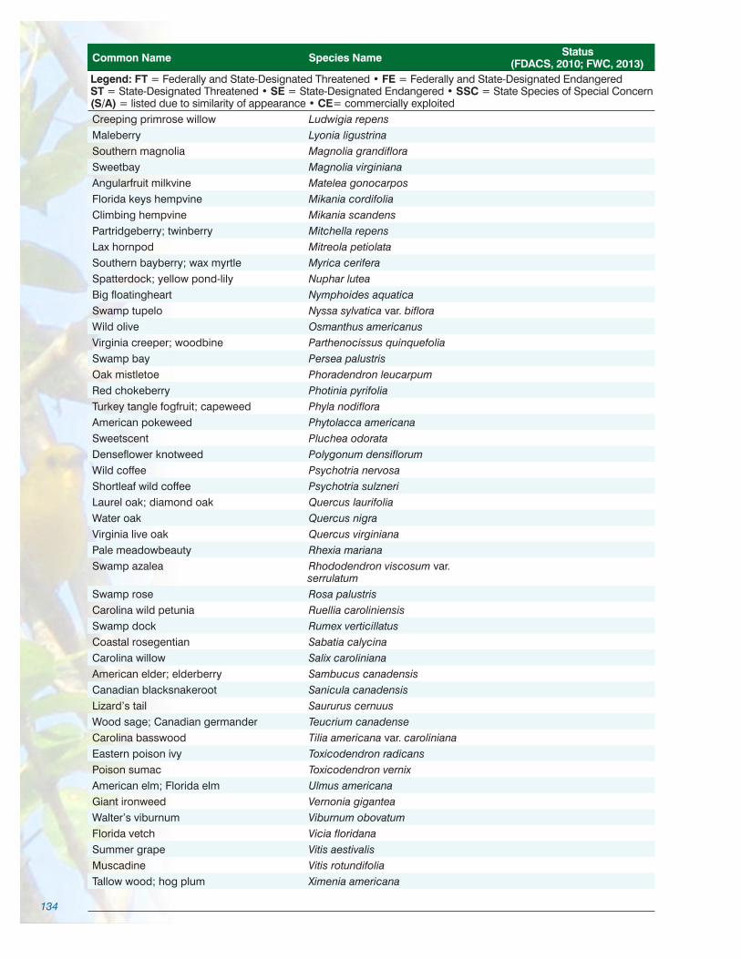
134
Common Name Species Name Status (FDACS, 2010; FWC, 2013)
Legend: FT = Federally and State-Designated Threatened • FE = Federally and State-Designated EndangeredST = State-Designated Threatened • SE = State-Designated Endangered • SSC = State Species of Special Concern(S/A) = listed due to similarity of appearance • CE= commercially exploitedCreeping primrose willow Ludwigia repens Maleberry Lyonia ligustrina Southern magnolia Magnolia grandiflora Sweetbay Magnolia virginiana Angularfruit milkvine Matelea gonocarpos Florida keys hempvine Mikania cordifolia Climbing hempvine Mikania scandens Partridgeberry; twinberry Mitchella repens Lax hornpod Mitreola petiolata Southern bayberry; wax myrtle Myrica cerifera Spatterdock; yellow pond-lily Nuphar lutea Big floatingheart Nymphoides aquatica Swamp tupelo Nyssa sylvatica var. biflora Wild olive Osmanthus americanus Virginia creeper; woodbine Parthenocissus quinquefolia Swamp bay Persea palustris Oak mistletoe Phoradendron leucarpum Red chokeberry Photinia pyrifolia Turkey tangle fogfruit; capeweed Phyla nodiflora American pokeweed Phytolacca americana Sweetscent Pluchea odorata Denseflower knotweed Polygonum densiflorum Wild coffee Psychotria nervosa Shortleaf wild coffee Psychotria sulzneri Laurel oak; diamond oak Quercus laurifolia Water oak Quercus nigra Virginia live oak Quercus virginiana Pale meadowbeauty Rhexia mariana Swamp azalea Rhododendron viscosum var.
serrulatum Swamp rose Rosa palustris Carolina wild petunia Ruellia caroliniensis Swamp dock Rumex verticillatus Coastal rosegentian Sabatia calycina Carolina willow Salix caroliniana American elder; elderberry Sambucus canadensis Canadian blacksnakeroot Sanicula canadensis Lizard’s tail Saururus cernuus Wood sage; Canadian germander Teucrium canadense Carolina basswood Tilia americana var. caroliniana Eastern poison ivy Toxicodendron radicans Poison sumac Toxicodendron vernix American elm; Florida elm Ulmus americana Giant ironweed Vernonia gigantea Walter’s viburnum Viburnum obovatum Florida vetch Vicia floridana Summer grape Vitis aestivalis Muscadine Vitis rotundifolia Tallow wood; hog plum Ximenia americana
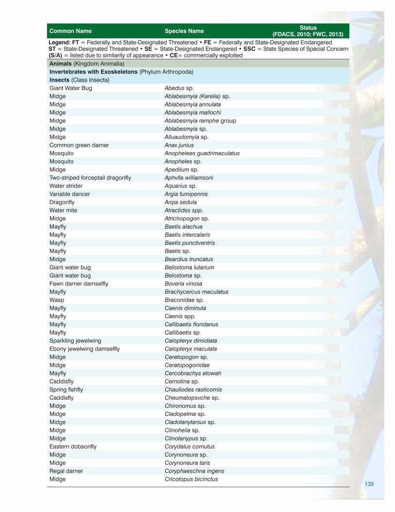
135
Common Name Species Name Status (FDACS, 2010; FWC, 2013)
Legend: FT = Federally and State-Designated Threatened • FE = Federally and State-Designated EndangeredST = State-Designated Threatened • SE = State-Designated Endangered • SSC = State Species of Special Concern(S/A) = listed due to similarity of appearance • CE= commercially exploitedAnimals (Kingdom Animalia)Invertebrates with Exoskeletons (Phylum Arthropoda)Insects (Class Insecta)Giant Water Bug Abedus sp.Midge Ablabesmyia (Karelia) sp. Midge Ablabesmyia annulata Midge Ablabesmyia mallochi Midge Ablabesmyia ramphe group Midge Ablabesmyia sp. Midge Alluaudomyia sp.Common green darner Anax juniusMosquito Anophelees guadrimaculatusMosquito Anopheles sp.Midge Apedilum sp. Two-striped forceptail dragonfly Aphvlla williamsoni Water strider Aquarius sp. Variable dancer Argia fumipennis Dragonfly Arqia sedula Water mite Atractides spp.Midge Atrichopogon sp. Mayfly Baetis alachua Mayfly Baetis intercalaris Mayfly Baetis punctiventris Mayfly Baetis sp.Midge Beardius truncatus Giant water bug Belostoma lutarium Giant water bug Belostoma sp. Fawn darner damselfly Boveria vinosaMayfly Brachycercus maculatus Wasp Braconidae sp.Mayfly Caenis diminuta Mayfly Caenis spp.Mayfly Callibaetis floridanus Mayfly Callibaetis sp. Sparkling jewelwing Calopteryx dimidiata Ebony jewelwing damselfly Calopteryx maculata Midge Ceratopogon sp. Midge CeratopogonidaeMayfly Cercobrachys etowahCaddisfly Cernotina sp.Spring fishfly Chauliodes rasticornisCaddisfly Cheumatopsvche sp.Midge Chironomus sp. Midge Cladopelma sp. Midge Cladotanytarsus sp.Midge Clinohelia sp. Midge Clinotanypus sp. Eastern dobsonfly Corydalus cornutusMidge Corynoneura sp. Midge Corynoneura taris Regal darner Coryphaeschna ingensMidge Cricotopus bicinctus

136
Common Name Species Name Status (FDACS, 2010; FWC, 2013)
Legend: FT = Federally and State-Designated Threatened • FE = Federally and State-Designated EndangeredST = State-Designated Threatened • SE = State-Designated Endangered • SSC = State Species of Special Concern(S/A) = listed due to similarity of appearance • CE= commercially exploitedMidge Cryptochironomus sp. Midge Cryptotendipes sp. Moth Cybister sp. Beetle Cyphon sp.Midge Daseyhelia sp. Midge Demicryptochironomus sp. Midge Dicrotendipes neomodestus Midge Dicrotendipes spp.Whirligig beetle Dineutus discolor Whirligig beetle Dineutus serrulatus Whirligig beetle Dineutus angustus Whirligig beetle Dineutus assimilus or nigrior Whirligig beetle Dineutus sp. Spinyleg dragonfly Dromogomphus sp. Black-shouldered spinyleg Dromogomphus spinosus Beetle Dubiraphia vittata Purple bluet dragonfly Enallagma coecum Pale bluet dragonfly Enallagma pallidum Florida bluet dragonfly Enallagma pollutum Blackwater bluet dragonfly Enallagma weewa Blue damselfly Enallgma civileMidge Endotribelos hesperiumMoth Eopararqyractis sp. Prince baskettail Epitheca princeps Baskettail dragonfly Epitheca sp.Midge Epoicocladius flavens Eastern pondhawk Erythemis simplicicollis Blue dragonlet Erythrodiplax connata minusculaMidge Fissimentum sp. Midge Fittkauimvia serta Midge Forcipimyia sp. Midge Glyptotendipes sp. Midge Goeldichironomus amazonicus Midge Goeldichironomus sp. Cypress clubtail Gomphus minutus Clubtail dragonfly Gomphus sp. Whirligig beetle Gyrinus elevatusWhirligig beetle Gyrinus sp. Beetle Haliplus sp. Midge Harnischia complex Crane fly Helius sp.Aquatic dance fly Hemerodromia spp.Dragonfly Hetaerina sp. Smoky rubyspot dragonfly Hetaerina titia Mayfly Hexagenia limbataMayfly Hexagenia spp.Beetle Hydrochus sp. 3 (Epler) FT(S/A)Beetle Hydrovatus pustulatusCaddisfly Hydropsvche sp.Microcaddisfly Hydroptila spp.Water mite Hygrobates spp.Citrine forktail damselfly Ischnura hastada

137
Common Name Species Name Status (FDACS, 2010; FWC, 2013)
Legend: FT = Federally and State-Designated Threatened • FE = Federally and State-Designated EndangeredST = State-Designated Threatened • SE = State-Designated Endangered • SSC = State Species of Special Concern(S/A) = listed due to similarity of appearance • CE= commercially exploitedDamselfly Ischnura polita Fragile forktail Ischnura posita Forktail damselfly Ischnura sp. Mayfly Labiobaetis ephippiatus Mayfly Labiobaetis sp. Midge Labrundinia becki Midge Labrundinia iohannseni Midge Labrundinia pilosella Midge Labrundinia sp. Midge Larsia decolorata Midge Larsia indistincta Midge Larsia sp. Water mite Lebertia spp.Silverfish Lepisma saccharinaCrane fly Limonia sp.Caddisfly Lype diversaStream mayfly Maccaffertium exiguum Midge Mallochohelia sp. Caddisfly Mavatrichia avamaWater strider Merragata brunnea Water strider Merragata sp. Water treader Mesovelia amoena Water treader Mesovelia mulsantiWater treader Mesovelia sp. Water strider Metrobates sp. Greater hyacinth glider Miathyria marcella
Microcanthia floridanaElmid beetle Microcylloepus pusillus Midge Microtendipes pedellus Water strider Microvelia sp.Midge Monopelopia boliekae Midge Nanocladius balticus Midge Nanocladius sp. Cyrano dragonfly Nasiaeschna pentacanthaMoth Neargyractis slossonalis Caddisfly Nectopsyche candidaCaddisfly Nectopsyche excruisitaCaddisfly Nectopsyche exquisita Caddisfly Nectopsyche pavidaCaddisfly Nectopsyche sp.Caddisfly Neotrichia spp.Caddisfly Neureclipsis crepuscalarisCaddisfly Neureclipsis spp.Midge NigrohalteraleMidge Nilotanypus fimbriatus Midge Nilothauma sp.Soldier fly Notiphila sp.Caddisfly Nyctiophylax spp.Crane fly Odontomyia sp.Caddisfly Oecetis inconspicua complexCaddisfly Oecetis nocturnaCaddisfly Oecetis persimilis

138
Common Name Species Name Status (FDACS, 2010; FWC, 2013)
Legend: FT = Federally and State-Designated Threatened • FE = Federally and State-Designated EndangeredST = State-Designated Threatened • SE = State-Designated Endangered • SSC = State Species of Special Concern(S/A) = listed due to similarity of appearance • CE= commercially exploitedCaddisfly Oecetis spp.Caddisfly Orthotrichia sp.Caddisfly Oxyethira spp.Midge Pagastiella sp.Midge Parachironomus sp. Midge Paracladopelma sp.Midge Paralauterborniella sp.Midge Paramerina sp. Caddisfly Paranyctiophylax sp.Moth Parapovnx sp. Midge Paratanytarsus sp.Midge Paratendipes subeoualis Creeping water bug Pelocoris femoratusCreeping water bug Pelocoris sp.Beetle Peltodytes floridensis Beetle Peltodytes dietrichi Beetle Peltodytes oppositusBeetle Peltodytes sp. Midge Pentaneura inconspicua Eastern amberwing Perithemis tenera Moth Petrophila drumalisMoth Petrophila sp. Midge Phaenopsectra spp.Love bug Plecia nearcticaCaddisfly Polycentropus cinereusCaddisfly Polycentropus sp.Midge Polypedilum convictum group Midge Polypedilum fallax group Midge Polypedilum halterale Midge Polypedilum scalaenum Midge Polypedilum tritum Midge Polypedilum fallax Midge Polypedilum flavum Midge Polypedilum illinoense Midge Polypedilum scalaenum group Midge Polypedilum sp. A (Epler)Midge Polypedilum tricronus Midge Probezzia sp. Midge Procladius sp. Mayfly Procloeon hobbsi Mayfly Procloeon sp. Mayfly Procloeon viridoculareMidge Pseudochironomus spp. Mayfly Pseudocloeon spp.Water scorpion Ranatra bueniWater scorpion Ranatra nigraMidge Rheocricotopus robacki Midge Rheotanytarsus exiguus grp. Midge Rheotanytarsus pellucidus Midge Rheotanytarsus sp.Wasp Scelionidae

139
Common Name Species Name Status (FDACS, 2010; FWC, 2013)
Legend: FT = Federally and State-Designated Threatened • FE = Federally and State-Designated EndangeredST = State-Designated Threatened • SE = State-Designated Endangered • SSC = State Species of Special Concern(S/A) = listed due to similarity of appearance • CE= commercially exploitedAlderfly Sialis sp.Midge Sphaeromias sp.Midge Stempellina sp.Midge Stempellinella fimbriata Mayfly Stenacron interpunctatum Mayfly Stenacron spp.Beetle Stenelmis hungerfordi Beetle Stenelmis crenata Beetle Stenelmis musgraveiBeetle Stenelmis spp.Midge Stenochironomus spp.Mayfly Stenonema exiauumMidge Stilocladius sp.Russet-tipped clubtail Stylurus plagiatusClubtail dragonfly Stylurus sp. Moth Synclita sp.Striped horse fly Tabanus lineolaMosquito Tanvtarsus sp. Midge Tanytarsus limneticaMidge Tanytarsus spp.Duckweed firetail Telebasis byersi Midge Thienemanniella spp.Crane fly Tipula abdominalisWater strider Trepobates sp.Caddisfly Triaenodes furcellusCaddisfly Triaenodes ignitusCaddisfly Triaenodes spp.Midge Tribelos fuscicorneMidge Tribelos fuscicornis Midge Tribelos sp. Giant water bug Trichocorixa sexcintaMayfly Tricorythodes albilineatus Beetle Tropisternis sp.Dance fly Uranotaenia sp.Midge Xestochironomus xenolabisMidge Zavreliella marmorata
Amphipods (Class Amphipoda)Hobbs cave amphipod Crangonyx hobbsi
Crustaceans (Subphylum Crustacea)Florida cave isopod Caecidotea hobbsi Isopod Caecidotea spp.Blue crab Callinectes sapidusIsopod Cassidinidea ovalisIsopod Cyathura politaShrimp Gammarus sp.Amphipod crustacean Hyalella azteca Isopod Lirceus spp. Eastern grass shrimp Palaemonetes paludosusOrlando cave crayfish Procambarus acherontis

140
Common Name Species Name Status (FDACS, 2010; FWC, 2013)
Legend: FT = Federally and State-Designated Threatened • FE = Federally and State-Designated EndangeredST = State-Designated Threatened • SE = State-Designated Endangered • SSC = State Species of Special Concern(S/A) = listed due to similarity of appearance • CE= commercially exploitedCrayfish Procambarus fallaxCrayfish Procambarus geodytesOpossum shrimp Taphromysis bowmani
Molluscs (Phylum Mollusca)Snails (Class Gastropoda)Pennisula amnicola Amnicola dalli ssp. Blue Spring hydrobe Aphaostracon asthenesWekiwa hydrobe Aphaostracon monasBlue Spring hydrobe Aphaostracon pachvnotus Blue Spring siltsnail Cincinnatia parvaWekiwa siltsnail Cincinnatia wekiwaeRasp elimia Elimia floridensis complexRam’s horn snail Gyraulus parvusRam’s horn snail Hebetancylus excentricus Freshwater limpet Laevapex fuscus Freshwater limpet Laevapex peninsulaeCockscomb hydrobe Littoridinops sp. Fawn melania Melanoides turricula Keeled bugle sprite Micomenetus dilatatus avusPenny sprite Micomenetus floridensisAlligator siltsnail Notogillia wetherbvi Freshwater snail Physa spp.Freshwater snail Physella cubensis cubensis Freshwater snail Physella heterostropha pomilaFreshwater snail Planorbella durviFreshwater snail Planorbella scalarisFlorida apple snail Pomacea paludosaAmerican ribbed fluke snail Pseudosuccinea columella Armored siltsnail Spilochlamys gravisSiltsnail Spilochlamys sp. Gastropod Tryonia aequicostataRiver snail Viviparus creorcrianusBanded mystery snail Viviparus georgianus
Mussels (Class Bivalvia)Mussel Corbicula manilensis Mussel Elliptio spp. Mussel Melanoides turriculusFreshwater pea mussel Pisidium compressumIridescent liliput mussel Toxoplasma paulusFreshwater mussel Uniomerus carolinianaFlorida rainbow mussel Villosa amygdala
Chordates (Phylum Chordata)Cartilagenous Fish (Class Chondrichthyes)Atlantic stingray Dasyatis sabina
Bony Fish (Class Osteichthys)Hickory shad Alosa mediocrisAmerican shad Alosa sapidissimaSnail bullhead Ameiurus brunneus

141
Common Name Species Name Status (FDACS, 2010; FWC, 2013)
Legend: FT = Federally and State-Designated Threatened • FE = Federally and State-Designated EndangeredST = State-Designated Threatened • SE = State-Designated Endangered • SSC = State Species of Special Concern(S/A) = listed due to similarity of appearance • CE= commercially exploitedWhite catfish Ameiurus catusYellow bullhead Ameiurus natalisBrown bullhead Ameiurus nebulosusBowfin Amia calvaAmerican eel Anguilla rostrataPirate perch Aphredoderus sayanusGizzard shad Dorosoma cepedianumThreadfin shad Dorosoma petenenseOkefenokee pygmy sunfish Elassoma OkefenokeeLadyfish Elops saurusBluespotted sunfish Enneacanthus gloriosusLake chubsucker Erimyzon sucettaChain pickerel Esox nigerBrown darter Etheostoma edwiniSwamp darter Etheostoma fusiformeGolden topminnow Fundulus chrysotusSeminole killifish Fundulus seminolisWestern mosquitofish Gambusia affinisEastern mosquitofish Gambusia holbrookiLeast killifish Heterandria formosaBlue catfish Ictalurus furcatusChannel catfish Ictalurus punctatusFlagfish Jordanella floridaeBrook silverside Labidesthes sicculusSpotted gar Lepisosteus oculatusLongnose gar Lepisosteus osseusFlorida gar Lepisosteus platyrhincusRedbreast sunfish Lepomis auritusWarmouth Lepomis gulosusBluegill Lepomis macrochirusDollar sunfish Lepomis marginatusLongear sunfish Lepomis megalotisRedear sunfish Lepomis microlophusSpotted sunfish Lepomis punctatusBluefin killifish Lucania goodeiRainwater killifish Lucania parvaTarpon Megalops atlanticusInland silverside Menidia beryllinaLargemouth bass Micropterus salmoidesStriped mullet Mugil cephalusWhite mullet Mugil cyremaGolden shiner Notemigonus crysoleucasIroncolor shiner Notropis chalybaeusTailfin shiner Notropis maculatusCoastal shiner Notropis petersoniTadpole madtom Noturus gyrinusSpeckled madtom Noturus leptacanthusPugnose minnow Opsopoeodus emiliaeBlackbanded darter Percina nigrofasciataSea lamprey Petromyzon marinusSailfin molly Poecilia latipinnaBlack crappie Pomoxis nigromaculatus

142
Common Name Species Name Status (FDACS, 2010; FWC, 2013)
Legend: FT = Federally and State-Designated Threatened • FE = Federally and State-Designated EndangeredST = State-Designated Threatened • SE = State-Designated Endangered • SSC = State Species of Special Concern(S/A) = listed due to similarity of appearance • CE= commercially exploitedSailfin shiner Pteronotropis hypselopterusMetallic shiner Pteronotropis metallicusBluenose shiner Pteronotropis welaka SSCAtlantic needlefish Strongylura marinaHogchoker Trinectes maculatus
Amphibians (Class Amphibia)Florida cricket frog Acris gryllus dorsalisTwo-toed amphiuma Amphiuma meansDwarf salamander Eurycea quadridigitataGreen treefrog Hyla cinerea Squirrel treefrog Hyla squirellaStriped newt Notophthalmus perstriatusPeninsula newt Notophthalmus viridescens
piaropicolaSoutheastern slimy salamander Plethodon grobmaniSouthern spring peeper Pseudacris cruciferFlorida chorus frog Pseudacris nigrita verrucosaBullfrog Rana catesbeianaBronze frog Rana clamitansPig frog Rana grylioRiver frog Rana heckscheriFlorida leopard frog Rana utriculariaLesser siren Siren intermdiaGreater siren Siren lacertina
Reptiles (Class Reptilia)Florida cottonmouth Agkistrodon piscivorus conantiAmerican alligator Alligator mississippiensis FT(S/A)Green anole Anolis carolinensis carolinensisFlorida softshell Apalone ferox Florida snapping turtle Chelydra serpentinaSouthern black racer Coluber constrictor priapusFlorida chicken turtle Deirochelys reticularia chryseaSouthern ringneck snake Diadophis punctatus punctatusCorn snake Elaphe guttata guttataYellow rat snake Elaphe obsoleta quadrivittataEastern mud snake Farancia abacura abacuraRainbow snake Farancia erytrogramma erytrogrammaStriped mud turtle Kinosternon bauriFlorida mud turtle Kinosternon subrubrum steindachneriCommon kingsnake Lampropeltis getulaEastern kingsnake Lampropeltis getula getulaEastern coral snake Micrurus fulvius fulviusMississippi green water snake Nerodia cyclopion Banded water snake Nerodia fasciata fasciata Florida green water snake Nerodia floridana Florida water snake Nerodia fasciata pictiventrisBrown water snake Nerodia taxispilotaRough green snake Opheodrys aestivusPeninsula cooter Pseudemys floridana peninsularisFlorida cooter Pseudemys floridana floridana

143
Common Name Species Name Status (FDACS, 2010; FWC, 2013)
Legend: FT = Federally and State-Designated Threatened • FE = Federally and State-Designated EndangeredST = State-Designated Threatened • SE = State-Designated Endangered • SSC = State Species of Special Concern(S/A) = listed due to similarity of appearance • CE= commercially exploitedFlorida redbelly turtle Pseudemys nelsoniNorth Florida swamp snake Seminatrix pygaea pygaeaLoggerhead musk turtle Sternotherus minor minorCommon musk turtle Sternotherus odoratusPeninsula ribbon snake Thamnophis sauritus sackeniEastern garter snake Thamnophis sirtalis sirtalis
Birds (Class Aves)Cooper’s hawk Accipiter cooperiiSharp-shinned hawk Accipiter striatusSpotted sandpiper Actitis maculariaRed-winged blackbird Agelaius phoeniceusWood duck Aix sponsaRoseate spoonbill Ajaia ajaja SSCBlue-winged teal Anas discorsMottled duck Anas fulvigulaMallard Anas platyrhynchosAnhinga Anhinga anhingaLimpkin Aramus guarauna SSCRuby-throated hummingbird Archilochus colubrisGreat egret Ardea albaGreat blue heron Ardea herodiasCedar waxwing Bombycilla cedrorumAmerican bittern Botaurus lentiginosusCattle egret Bubulcus ibisShort-tailed hawk Buteo brachyurusRed-tailed hawk Buteo jamaicensisRough-legged hawk Buteo lagopusRed-shouldered hawk Buteo lineatusBroad-winged hawk Buteo platypterusGreen heron Butorides striatusLeast sandpiper Calidris minutillaChuck-will’s-widow Caprimulgus carolinensisWhip-poor-will Caprimulgus vociferusCrested caracara Caracara cheriwayWilson’s warbler Cardellina pusillaNorthern cardinal Cardinalis cardinalisAmerican goldfinch Carduelis tristisTurkey vulture Cathartes auraVeery Catharus fuscescensHermit thrush Catharus guttatusSwainson’s thrush Catharus ustulatusBrown creeper Certhia americanaBelted kingfisher Ceryle alcyonChimney swift Chaetura pelagicaKilldeer Charadrius vociferusCommon nighthawk Chordeiles minorNorthern harrier Circus cyaneusMarsh wren Cistothorus palustrisSedge wren Cistothorus platensisYellow-billed cuckoo Coccyzus americanusNorthern flicker Colaptes auratus

144
Common Name Species Name Status (FDACS, 2010; FWC, 2013)
Legend: FT = Federally and State-Designated Threatened • FE = Federally and State-Designated EndangeredST = State-Designated Threatened • SE = State-Designated Endangered • SSC = State Species of Special Concern(S/A) = listed due to similarity of appearance • CE= commercially exploitedNorthern bobwhite Colinus virginianusRock pigeon Columba liviaCommon ground-dove Columbina passerinaEastern wood-pewee Contopus virensBlack vulture Coragyps atratusAmerican crow Corvus brachyrhynchosFish crow Corvus ossifragusBlue jay Cyanocitta cristataBlack-bellied whistling-duck Dendrocygna autumnalisFulvous whistling-duck Dendrocygna bicolorPileated woodpecker Dryocopus pileatusGray catbird Dumetella carolinensisLittle blue heron Egretta caerulea SSCReddish egret Egretta rufescens SSCSnowy egret Egretta thula SSCTricolored heron Egretta tricolor SSCSwallow-tailed kite Elanoides forficatusAcadian flycatcher Empidonax virescensWhite ibis Eudocimus albus SSCMerlin Falco columbariusPeregrine falcon Falco peregrinusSoutheastern American kestrel Falco sparverius STAmerican coot Fulica americanaWilson’s snipe Gallinago delicataCommon gallinule Gallinula chloropusCommon loon Gavia immerCommon yellowthroat Geothlypis trichasSandhill crane Grus canadensisFlorida sandhill crane Grus canadensis pratensis STBlue grosbeak Guiraca caeruleaBald eagle Haliaeetus leucocephalusWorm-eating warbler Helmitheros vermivorusBarn swallow Hirundo rusticaBaltimore oriole Icterus galbulaOrchard oriole Icterus spuriusLeast bittern Ixobrychus exilisLoggerhead shrike Lanius ludovicianusLaughing gull Larus atricillaRing-billed gull Larus delawarensisBonaparte’s gull Larus philadelphiaHooded merganser Lophodytes cucullatusRed-bellied woodpecker Melanerpes carolinusRed-headed woodpecker Melanerpes erythrocephalusWild turkey Meleagris gallopavoSwamp sparrow Melospiza georgianaSong sparrow Melospiza melodiaNorthern mockingbird Mimus polyglottosBlack-and-white warbler Mniotilta variaBrown-headed cowbird Molothrus aterWood stork Mycteria americana FEGreat crested flycatcher Myiarchus crinitusYellow-crowned night-heron Nyctanassa violaceus

145
Common Name Species Name Status (FDACS, 2010; FWC, 2013)
Legend: FT = Federally and State-Designated Threatened • FE = Federally and State-Designated EndangeredST = State-Designated Threatened • SE = State-Designated Endangered • SSC = State Species of Special Concern(S/A) = listed due to similarity of appearance • CE= commercially exploitedBlack-crowned night-heron Nycticorax nycticoraxKentucky warbler Oporornis formosusEastern screech-owl Otus asioOsprey Pandion haliaetusNorthern parula Parula americanaTufted titmouse Parus bicolorCarolina chickadee Parus carolinensisSavannah sparrow Passerculus sandwichensisPainted bunting Passerina cirisIndigo bunting Passerina cyaneaBrown pelican Pelecanus occidentalis SSCDouble-crested cormorant Phalacrocorax auritusRose-breasted grosbeak Pheucticus ludovicianusDowny woodpecker Picoides pubescensHairy woodpecker Picoides villosusEastern towhee Pipilo erythrophthalmusSummer tanager Piranga rubraGlossy ibis Plegadis falcinellusHorned grebe Podiceps auritusPied-billed grebe Podilymbus podicepsBlue-gray gnatcatcher Polioptila caeruleaPurple gallinule Porphyrula martinicaSora Porzana carolinaPurple martin Progne subisProthonotary warbler Protonotaria citreaVermilion flycatcher Pyrocephalus rubinusBoat-tailed grackle Quiscalus majorCommon grackle Quiscalus quisculaKing rail Rallus elegansVirginia rail Rallus limicolaRuby-crowned kinglet Regulus calendulaGolden-crowned kinglet Regulus satrapaBank swallow Riparia ripariaEastern phoebe Sayornis phoebeOvenbird Seiurus aurocapillusLouisiana waterthrush Seiurus motacillaNorthern waterthrush Seiurus noveboracensisBlack-throated blue warbler Setophaga caerulescensYellow-rumped warbler Setophaga coronataPrairie warbler Setophaga discolorYellow-throated warbler Setophaga dominicaMagnolia warbler Setophaga magnoliaPalm warbler Setophaga palmarumChestnut-sided warbler Setophaga pensylvanicaYellow warbler Setophaga petechiaPine warbler Setophaga pinusAmerican redstart Setophaga ruticillaBlackpoll warbler Setophaga striataCape May warbler Setophaga tigrinaBlack-throated green warbler Setophaga virensEastern bluebird Sialia sialisRed-breasted nuthatch Sitta canadensis

146
Common Name Species Name Status (FDACS, 2010; FWC, 2013)
Legend: FT = Federally and State-Designated Threatened • FE = Federally and State-Designated EndangeredST = State-Designated Threatened • SE = State-Designated Endangered • SSC = State Species of Special Concern(S/A) = listed due to similarity of appearance • CE= commercially exploitedYellow-bellied sapsucker Sphyrapicus variusNorthern rough-winged swallow Stelgidopteryx serripennisLeast tern Sterna antillarum STCaspian tern Sterna caspiaForster’s tern Sterna forsteriRoyal tern Sterna maximaBarred owl Strix variaEastern meadowlark Sturnella magnaEuropean starling Sturnus vulgarisTree swallow Tachycineta bicolorCarolina wren Thryothorus ludovicianusBrown thrasher Toxostoma rufumLesser yellowlegs Tringa flavipesGreater yellowlegs Tringa melanoleucaSolitary sandpiper Tringa solitariaHouse wren Troglodytes aedonAmerican robin Turdus migratoriusGray kingbird Tyrannus dominicensisEastern kingbird Tyrannus tyrannusOrange-crowned warbler Vermivora celataTennessee warbler Vermivora peregrinaYellow-throated vireo Vireo flavifronsWhite-eyed vireo Vireo griseusRed-eyed vireo Vireo olivaceusPhiladelphia vireo Vireo philadelphicusBlue-headed Vireo Vireo solitariusHooded warbler Wilsonia citrinaMourning dove Zenaida macrouraWhite-throated sparrow Zonotrichia albicollis
Mammals (Class Mammalia)Virginia opossum Didelphis virginianaBig brown bat Eptesicus fuscusRiver otter Lutra canadensisRound-tailed muskrat Neofiber alleniWhite-tailed deer Odocoileus virginianusMarsh rice rat Oryzomys palustrisEastern pipistrelle Pipistrellus subflavus Raccoon Procyon lotorMarsh rabbit Sylvilagus palustrisFlorida manatee Trichechus manatus latirostris FEFlorida black bear Ursus americanus floridanus

147
B.3.2 / Invasive Non-native Species List
Common Name Species Name FLEPPC* Category (Plants) Invasive Status (Others)
PlantsAlligatorweed Alternanthera philoxeroides IICoral ardisia Ardisia crenata IBamboo Bambusa spp. Wax begonia; club begonia Begonia cucullata IICamphor tree Cinnamomum camphora IWild taro; dasheen; coco yam Colocasia esculenta IAir potato Dioscorea bulbifera ICommon water-hyacinth Eichhornia crassipes IGolden pothos Epipremnum pinnatum IIWhite gingerlily Hedychium coronarium Green hygro Hygrophila polysperma IHydrilla Hydrilla verticillata IPeruvian primrose willow Ludwigia peruviens IMarianna maiden fern Macrothelypteris torresiana Chinaberry Melia azederach IIParrot feather Myriophyllum aquaticum IIWatercress Nasturtium spp.Tuberous sword fern Nephrolepis cordifolia ITorpedo grass Panicum repens IVaseygrass Paspalum urvillei Elephant grass; napier grass Pennisetum purpureum IWater-lettuce Pistia stratiotes IEuropean watercress Rorippa nasturtium-aquaticum Chinese tallow tree Sapium sebiferum ICreeping oxeye Sphagneticola trilobata IIPara grass Urochloa mutica IArrowleaf elephant ear Xanthosoma sagittifolium II
BirdsMuscovy duck Cairina moschata
MammalsWild pig Sus scrofa
AmphibiansGreenhouse frog Eleutherodactylus planirostris
FishesBrown hoplo Hopolosternum littoraleBlue tilapia Oreochromis aureusArmored catfish Pterygoglichthys disjunctivusRadiated ptero Pterygoplichthys multiradiatus
Mollusks and CrustaceansAsian clam Corbicula flumineaMussel Planorbella duryi ssp.Island apple snail Pomacea insularum
ReptilesFalse map turtle Graptemys pseudogeographicaRed-eared slider Trachemys scripta elegans
*Florida Exotic Pest Plant Council (FLEPPC) categorizes invasive exotic plants as Category I (plants that are altering native plant communities by displacing native species, changing community structures or ecological functions, or hybridizing with natives) or Category II (plants that have increased in abundance or frequency but have not yet altered Florida plant communities to the extent shown by Category I species).

148
B.3.3 / Problem Species List
Common Name Species Name
Plants
Cuban bulrush Scirpus cubensis
Southern cattail Typha domingensis
Mammals
Raccoon Procyon lotor

149
Appendix C
Public Involvement
C.1 / Wekiva River Preserve Advisory Committee
The following appendices contain information about who serves on the Advisory Committee, when meetings were held, copies of the public advertisements for those meetings, and summaries of each meeting.
C.1.1 / List of Members and Their Affiliations
Wekiva River Aquatic Preserve, including the designated reach of the St. Johns RiverManagement Plan Advisory Committee, 2012
The Honorable Patricia NortheyVolusia County Council, District 5Chair of the St. Johns River [email protected] ; 386-740-5247
Nancy PrineChair Wekiva Wild and Scenic River AMCTechnical Committee Chair, Friends of the Wekiva River, [email protected] ; 407-898-9200
Jaime Dubek-RacineDesignated Federal Officer, Wekiva Wild and Scenic [email protected]
Mary BrabhamSenior Project Manager, Basin Projects, SJRWMDWekiva Wild and Scenic River AMC [email protected] ; 407-659-4829
Warren PoplinManager, Wekiva Basin State ParksWekiva Wild and Scenic River AMC [email protected] ; 407-884-2006
Robert RundleManager, Blue Springs State [email protected] ; 386-775-3663
Gregg WelsteadDirector, Dept. Conservation & Compliance, Lake County Wekiva Wild and Scenic River AMC [email protected] ; 352-343-9639
Peggy BelflowerLake Soil & Water Conservation District, ChairLake County Property Owner (St. Johns River)[email protected] ; 352-253-1646
Beth JacksonEnvironmental Program Supervisor, Green PLACE Program, Orange CountyWekiva Wild and Scenic River AMC member; SJR Alliance alternate (for Mayor Teresa Jacobs)[email protected] ; 407-836-1481
Kim Ornberg, P.E., Division ManagerSeminole County Surface Water Quality Program 407-665-2417 [email protected]
Deborah ShelleyManager for the Wekiva River Aquatic Preserve, including the designated reach of the St. Johns [email protected] ; 407-330-6727
Team for the Wekiva River Aquatic Preserve, including the designated 20 miles of the SJR:
Barbara Howell, Environmental Specialist Gary Raulerson, Environmental SpecialistShannon Rininger, Environmental Specialist

150
C.1.2 / Florida Administrative Weekly Posting
Florida Administrative Weekly Volume 38, Number 34, August 24, 2012
3522 Section VI - Notices of Meetings, Workshops and Public Hearings
Forms); Rule 12D-16.002, F.A.C. (Index to Forms); Rule12D-17.004, F.A.C. (Taxing Authority’s Certification ofCompliance; Notification by Department); Rule 12D-17.005,F.A.C. (Taxing Authorities in Violation of Section 200.065,Florida Statutes); Rule 12D-17.006, F.A.C. (Notification ofNoncompliance; Withholding and Escrow of State RevenueSharing Funds); and Rule 12D-18.012, F.A.C. (Tax CollectorNon-Ad Valorem Assessment Roll Reports).A copy of the agenda may be obtained by contacting: JaniceForrester, Senior Revenue Administrator, Property TaxOversight Program, Department of Revenue, P. O. Box 3000,Tallahassee, Florida 32315-3000, (850)617-8886, email:[email protected] UNDER THE AMERICANS WITH DISABILITIESACT: Pursuant to the provisions of the Americans withDisabilities Act, any person requiring special accommodationsto participate in this workshop/meeting is asked to advise theagency at least 48 hours before the workshop/meeting bycontacting: Janice Forrester, (850)617-8886 or email:[email protected]. If you are hearing or speech impaired,please contact the agency using the Florida Relay Service,1(800)955-8771 (TDD) or 1(800)955-8770 (Voice).
DEPARTMENT OF TRANSPORTATION
The Florida Department of Transportation, District 2announces a public meeting to which all persons are invited.DATE AND TIME: September 6, 2012, 4:30 p.m. – 6:30 p.m.PLACE: Nassau County Commission Chambers, 96135Nassau Place, Yulee, FL 32097GENERAL SUBJECT MATTER TO BE CONSIDERED:This hearing is being held to afford interested persons theopportunity to express their views concerning the location,conceptual design and social, economic and environmentaleffects of Financial Project ID Number: 426031-2, otherwiseknown as the Chester Road widening project in NassauCounty. The proposed improvements will provide a new fourlane divided roadway from SR 200 (A1A) to Green Pine Road,a distance of approximately 2.6 miles. Improvements will alsoinclude bicycle lanes and sidewalks. Public participation is solicited without regard to race, color,sex, age, national origin, disability or family status. A copy of the agenda may be obtained by contacting: Mr. BillHenderson, District Planning and Environmental Manager,Florida Department of Transportation, District 2, 1109 SouthMarion Avenue, MS #2007, Lake City, Florida 32025-5874.Pursuant to the provisions of the Americans with DisabilitiesAct, any person requiring special accommodations toparticipate in this workshop/meeting is asked to advise theagency at least 7 days before the workshop/meeting bycontacting: Mr. Bill Henderson, District Planning andEnvironmental Manager, Florida Department ofTransportation, District 2, 1109 South Marion Avenue, MS
#2007, Lake City, Florida 32025-5874, (386)961-7873 or1(800)749-2967, ext. 7873. If you are hearing or speechimpaired, please contact the agency using the Florida RelayService, 1(800)955-8771 (TDD) or 1(800)955-8770 (Voice).
BOARD OF TRUSTEES OF INTERNAL IMPROVEMENT TRUST FUND
The Florida Department of Environmental Protection,Office of Coastal and Aquatic Managed Areas announces apublic meeting to which all persons are invited.DATE AND TIME: Monday, October 1, 2012, 6:00 p.m. –7:30 p.m.PLACE: Markham Woods Church, 505 Markham Woods Rd.,Longwood, FL 32779GENERAL SUBJECT MATTER TO BE CONSIDERED: Thepurpose is to receive public comment on the draft for theWekiva River Aquatic Preserve Management Plan, whichincludes 20 miles of the St. Johns River designated as part ofthe aquatic preserve. A copy of the draft plan will be available for viewing startingSeptember 4, 2012 at www.dep.state.fl.us/coastal/. The WekivaRiver Aquatic Preserve Advisory Committee will beparticipating.A copy of the agenda may be obtained by contacting: AquaticPreserve Manager, Deborah Shelley, by e-mail:[email protected], by phone: (407)330-6727 orby mail: 8300 West State Road 46, Sanford, FL 32771.Pursuant to the provisions of the Americans with DisabilitiesAct, any person requiring special accommodations toparticipate in this workshop/meeting is asked to advise theagency at least 5 days before the workshop/meeting bycontacting: Deborah Shelley, (407)330-6727. If you arehearing or speech impaired, please contact the agency using theFlorida Relay Service, 1(800)955-8771 (TDD) or1(800)955-8770 (Voice).
The Florida Department of Environmental Protection,Office of Coastal and Aquatic Managed Areas announces apublic meeting to which all persons are invited.DATE AND TIME: Tuesday, October 2, 2012, 6:00 p.m. –7:30p.m.PLACE: Volusia County Administration Building, 123 W.Indiana Ave., Deland, FL 32720GENERAL SUBJECT MATTER TO BE CONSIDERED: Thepurpose is to receive public comment on the draft for theWekiva River Aquatic Preserve Management Plan, whichincludes 20 miles of the St. Johns River designated as part ofthe aquatic preserve. A copy of the draft plan will be available for viewing startingSeptember 4, 2012 at www.dep.state.fl.us/coastal. The WekivaRiver Aquatic Preserve Advisory Committee will beparticipating.

151
Florida Administrative Weekly Volume 38, Number 34, August 24, 2012
Section VI - Notices of Meetings, Workshops and Public Hearings 3523
A copy of the agenda may be obtained by contacting: AquaticPreserve Manager, Deborah Shelley, by e-mail:[email protected], by phone: (407)330-6727 orby mail: 8300 West State Road 46, Sanford, FL 32771.Pursuant to the provisions of the Americans with DisabilitiesAct, any person requiring special accommodations toparticipate in this workshop/meeting is asked to advise theagency at least 5 days before the workshop/meeting bycontacting: Deborah Shelley, (407)330-6727. If you arehearing or speech impaired, please contact the agency using theFlorida Relay Service, 1(800)955-8771 (TDD) or1(800)955-8770 (Voice).
The Florida Department of Environmental Protection,Office of Coastal and Aquatic Managed Areas announces apublic meeting to which all persons are invited.DATE AND TIME: Wednesday, October 3, 2012, 9:00 a.m. –2:00 p.m.PLACE: Markham Woods Church, 505 Markham Woods Rd.,Longwood, FL 32779GENERAL SUBJECT MATTER TO BE CONSIDERED: Thepurpose is for the members of the Wekiva River AquaticPreserve Advisory Committee to discuss the revision of thedraft Wekiva River Aquatic Preserve Management Plan, whichincludes 20 miles of the St. Johns River designated as part ofthe aquatic preserve.A copy of the agenda may be obtained by contacting: AquaticPreserve Manager, Deborah Shelley, by e-mail:[email protected], by phone: (407)330-6727 orby mail: 8300 West State Road 46, Sanford, FL 32771.Pursuant to the provisions of the Americans with DisabilitiesAct, any person requiring special accommodations toparticipate in this workshop/meeting is asked to advise theagency at least 5 days before the workshop/meeting bycontacting: Deborah Shelley, (407)330-6727. If you arehearing or speech impaired, please contact the agency using theFlorida Relay Service, 1(800)955-8771 (TDD) or1(800)955-8770 (Voice).
FLORIDA PAROLE COMMISSION
The Florida Parole Commission announces a public meetingto which all persons are invited.DATES AND TIME: Wednesday, September 12, 2012;September 19, 2012; September 26, 2012, 8:30 a.m. (NOTE: Ifnot completed, meeting will continue on Thursday, September13, 2012; September 20, 2012; and September 27, 2012, 8:30a.m.)PLACE: Florida Parole Commission, 4070 Esplanade Way,Tallahassee, FL 32399-2450
GENERAL SUBJECT MATTER TO BE CONSIDERED:Regularly scheduled meeting for all Parole, ConditionalRelease, Conditional Medical Release, Addiction Recovery,Control Release and all other Commission business.A copy of the agenda may be obtained by contacting: FloridaParole Commission, (850)488-1293.Pursuant to the provisions of the Americans with DisabilitiesAct, any person requiring special accommodations toparticipate in this workshop/meeting is asked to advise theagency at least 5 days before the workshop/meeting bycontacting: Florida Parole Commission, [email protected]. Ifyou are hearing or speech impaired, please contact the agencyusing the Florida Relay Service, 1(800)955-8771 (TDD) or1(800)955-8770 (Voice).If any person decides to appeal any decision made by theBoard with respect to any matter considered at this meeting orhearing, he/she will need to ensure that a verbatim record ofthe proceeding is made, which record includes the testimonyand evidence from which the appeal is to be issued.
PUBLIC SERVICE COMMISSION
The Florida Public Service Commission announces a publicmeeting to which all persons are invited.DATE AND TIME: September 5, 2012, 6:30 p.m.PLACE: Harbor Hills Country Club, First Floor, 6538 LakeGriffin Road, Lady Lake, FL 32159GENERAL SUBJECT MATTER TO BE CONSIDERED:Docket No.: 120158-SU – Application for approval of transfer,and original certificate for an existing wastewater system,requesting initial rates and charges in Lake County by HarborWaterworks, Inc.The purpose of this customer meeting is to give customers andother interested persons an opportunity to offer commentsregarding the quality of service the utility provides, theproposed initial rates and charges, and to ask questions andcomment on other issues. One or more of the Commissionersof the Florida Public Service Commission may attend andparticipate in this meeting. For questions, contact: CommissionStaff, Michael Lawson, (850)413-6076.Pursuant to the provisions of the Americans with DisabilitiesAct, any person requiring special accommodations toparticipate in this workshop/meeting is asked to advise theagency at least 5 days before the workshop/meeting bycontacting: Office of Commission Clerk, 2540 Shumard OakBoulevard, Tallahassee, Florida 32399-0850. If you are hearingor speech impaired, please contact the agency using the FloridaRelay Service, 1(800)955-8771 (TDD) or 1(800)955-8770(Voice).For more information, you may contact: Michael Lawson,(850)413-6076.
152
C.1.3 / Meeting Summary
Wekiva River Aquatic Preserve Management Plan Advisory Committee Meeting, October 3, 2012
Markham Woods Church, 505 Markham Woods Road, Longwood, Florida
Advisory committee members present: Peggy Belflower (local private property owner), Mary Brabham (St. Johns River Water Management District), Beth Jackson (Orange County Environmental Protection Division), Pat Northey (Volusia County Council, District 5 Representative), Kim Ornberg (Seminole County Surface Water Quality Program), Warren Poplin (Wekiva Basin State Park), Nancy Prine (Friends of Wekiva River), Robert Rundle (Blue Springs State Park), Deborah Shelley (Wekiva River Aquatic Preserve Manager), Gregg Welstead (Lake County Department of Conservation and Compliance).
Staff and visitors present: Alice Berkley, Barbara Howell, Penny Isom, Mark Middlebrook, Earl Pearson, Gary Raulerson, Shannon Rininger, Andrea Samson, Virginia Oros.
Advisory committee comments on Wekiva – Middle St. Johns Aquatic Preserve draft management plan
Issues section
Water Quality (Issue 1)• B. Jackson (Orange Co.)
- Objective 10 - recognize FDACS previous work- Remove “responsible” from objective language and “intense” from strategy WQL 10.3
• M. Brabham (SJRWMD) - Discuss/refer to SJR BMAP and TMDL• B. Rundle (FPS)
- Parcel Seminole Woods with unwilling seller?- Was owner approached about conservation easement?
• General consensus – restate need for willing seller
N. Prine (Wild & Scenic) – remove qualifiers from strategies, just state what needs to be done
Water Quantity (Issue 2)• M. Brabham (SJRWMD) – more specifics in writing
- include SJR and Blue Spring• B. Rundle (FPS) – Blue Spring has most/all of same issues as Wekiva system but not studied as well• P. Belflower (Lake Co. S&W)
- clarify between aquatic preserve and WR/MSJ…- is any other utility partnering with Seminole County on withdrawals?- DeLand water plant just south of SR 44 (Comm. Northey received clarification later??)
• G. Welstead (Lake County) – clarify system vs. individual parts• K. Ornberg (Seminole County) – public water consumption (and projections for need) decreasing from conservation efforts combined with economic situation
B. Rundle (FPS) – acronyms in front?
Recreational Use (Issue 3)• B. Jackson (Orange Co.)
- Glatting/Jackson (now AECOM) did Palm Beach study- Carrying capacity (including potential ecological and recreational experience impacts) was original intent of study, including uplands, etc., and morphed into access survey
• W. Poplin (FPS) – 280,000 people want to go swimming despite major efforts of park staff to promote other recreation in the park such as hike, explore other portions of state park
K. Ornberg (Seminole County) – Does a considerable amount of educational outreach which is part of NPDES permit requirements
• Have had PSA’s produced on local (government?) channels
N. Prine – excited about looking at entire basin (again) and that the working group between different agencies is meeting again.
• Need a statement about cooperativeness of partners
P. Belflower (Lake Co. S&W) – Little Wekiva headwaters cleaned (late 1990’s?)• Wekiva Island – hearing comments about conflicts between swimmers/canoes/pontoon boats…• Is there possibility of a HP limitation (noted that current Wekiva Island owners try to maintain <25 hp)• Speed issues especially on tributaries/backwaters

153
Wildlife & Habitat (Issue 5)• Overview from public comments – homeowners association and plant vendors outreach regarding exotics• Why is Bluenose only species mentioned?• W. Poplin (FPS) – any thought to management zones for different river sections?• P. Belflower (Lake Co. S&W) – clarification on snails (native v. exotic)• Include something on Rhesus monkeys
Aquatic Debris (Issue 4)• B. Rundle (FPS)
- birdhouses compared to flash mob (one => many)- monofilament receptacles used regularly- have had manatees die from monofilament ingestion
• W. Poplin (FPS) – educate HOA’s regarding hurricane prep for docks?- Status of Acuera dock?
Cultural and Historical (Issue 6)• P. Belflower (Lake Co. S&W) – handed in corrections to site on her property• B. Rundle (FPS) – continue work with Rollins on Shell Island
- Signage that is semi-vandalproof, includes education and legal information• W. Poplin (FPS) – recommend ARC training for aquatic preserve staff, taught by DEP Division of Historical Resources
P. Belflower (Lake Co. S&W) – supported needs (staff, vehicles, equipment) described in Chapters 6/7.
P. Belflower pg 37 Indian Mound Trail Site V007493, Site name Tall Palm Landing. Culture 8000-2000B.C. early to late archaic with pottery Mayaca, Sante Fe, and others.
Hurricane Preparedness (Issue 7)• W. Poplin (FPS) – is there a need for description of process for lost people, other emergencies? HOA’s should maybe have a pan if they have river access with vessels.• D. Shelley (CAMA) – expand on process, include oil spills…?
B. Jackson (Orange County) – should establish timelines (short, medium, long-term) for various projects (P. Isom advised this is one of next steps after current meetings and before finalization of plan)
• Comment on format – may be helpful to re-arrange to have each issue with its particular background (E. Pearson advised there had been discussion back and forth and current format was established a few years ago at discretion of former CAMA director)
Name Change (Issue 8)• Consensus – good idea, needed but should be careful because would require entire aquatic preserve legislation to be re-opened
Public Interest• Composting toilet – does need maintenance• Tram road removal• Escrow account to build up funds for larger projects• Bird house education
B. Jackson (Orange County)• Table 3 – missing data on lands purchased by Orange Co, Lake Co., state• 4.1.1 – Orange County provides water quality and invertebrate data• Try to reduce redundancy where possible
N. Prine (Wild & Scenic) – ensure consistency regarding “spring” and “spring system”
B. Rundle (FPS) – group is no longer “Blue Spring Working Group” but rather “Blue Spring Alliance”
W. Poplin• Regarding staffing needs
- Have we considered creating a host site (permanent campsite for volunteer)- Tie-in to our septic- Volunteer could work on facilities projects
• ADA for building – probably need parking slab – big enough for van

154
C.2 / Formal Public Meetings
The following appendices contain information about the Formal Public Meetings which were held in order to obtain input from the public about the Wekiva River Aquatic Preserve Draft Management Plan. There are copies of the public advertisements for those meetings, a list of attendees, a summary of the meetings, and a copy of the written comments received.
C.2.1 / Florida Administrative Weekly Postings
Florida Administrative Weekly Volume 38, Number 34, August 24, 2012
3522 Section VI - Notices of Meetings, Workshops and Public Hearings
Forms); Rule 12D-16.002, F.A.C. (Index to Forms); Rule12D-17.004, F.A.C. (Taxing Authority’s Certification ofCompliance; Notification by Department); Rule 12D-17.005,F.A.C. (Taxing Authorities in Violation of Section 200.065,Florida Statutes); Rule 12D-17.006, F.A.C. (Notification ofNoncompliance; Withholding and Escrow of State RevenueSharing Funds); and Rule 12D-18.012, F.A.C. (Tax CollectorNon-Ad Valorem Assessment Roll Reports).A copy of the agenda may be obtained by contacting: JaniceForrester, Senior Revenue Administrator, Property TaxOversight Program, Department of Revenue, P. O. Box 3000,Tallahassee, Florida 32315-3000, (850)617-8886, email:[email protected] UNDER THE AMERICANS WITH DISABILITIESACT: Pursuant to the provisions of the Americans withDisabilities Act, any person requiring special accommodationsto participate in this workshop/meeting is asked to advise theagency at least 48 hours before the workshop/meeting bycontacting: Janice Forrester, (850)617-8886 or email:[email protected]. If you are hearing or speech impaired,please contact the agency using the Florida Relay Service,1(800)955-8771 (TDD) or 1(800)955-8770 (Voice).
DEPARTMENT OF TRANSPORTATION
The Florida Department of Transportation, District 2announces a public meeting to which all persons are invited.DATE AND TIME: September 6, 2012, 4:30 p.m. – 6:30 p.m.PLACE: Nassau County Commission Chambers, 96135Nassau Place, Yulee, FL 32097GENERAL SUBJECT MATTER TO BE CONSIDERED:This hearing is being held to afford interested persons theopportunity to express their views concerning the location,conceptual design and social, economic and environmentaleffects of Financial Project ID Number: 426031-2, otherwiseknown as the Chester Road widening project in NassauCounty. The proposed improvements will provide a new fourlane divided roadway from SR 200 (A1A) to Green Pine Road,a distance of approximately 2.6 miles. Improvements will alsoinclude bicycle lanes and sidewalks. Public participation is solicited without regard to race, color,sex, age, national origin, disability or family status. A copy of the agenda may be obtained by contacting: Mr. BillHenderson, District Planning and Environmental Manager,Florida Department of Transportation, District 2, 1109 SouthMarion Avenue, MS #2007, Lake City, Florida 32025-5874.Pursuant to the provisions of the Americans with DisabilitiesAct, any person requiring special accommodations toparticipate in this workshop/meeting is asked to advise theagency at least 7 days before the workshop/meeting bycontacting: Mr. Bill Henderson, District Planning andEnvironmental Manager, Florida Department ofTransportation, District 2, 1109 South Marion Avenue, MS
#2007, Lake City, Florida 32025-5874, (386)961-7873 or1(800)749-2967, ext. 7873. If you are hearing or speechimpaired, please contact the agency using the Florida RelayService, 1(800)955-8771 (TDD) or 1(800)955-8770 (Voice).
BOARD OF TRUSTEES OF INTERNAL IMPROVEMENT TRUST FUND
The Florida Department of Environmental Protection,Office of Coastal and Aquatic Managed Areas announces apublic meeting to which all persons are invited.DATE AND TIME: Monday, October 1, 2012, 6:00 p.m. –7:30 p.m.PLACE: Markham Woods Church, 505 Markham Woods Rd.,Longwood, FL 32779GENERAL SUBJECT MATTER TO BE CONSIDERED: Thepurpose is to receive public comment on the draft for theWekiva River Aquatic Preserve Management Plan, whichincludes 20 miles of the St. Johns River designated as part ofthe aquatic preserve. A copy of the draft plan will be available for viewing startingSeptember 4, 2012 at www.dep.state.fl.us/coastal/. The WekivaRiver Aquatic Preserve Advisory Committee will beparticipating.A copy of the agenda may be obtained by contacting: AquaticPreserve Manager, Deborah Shelley, by e-mail:[email protected], by phone: (407)330-6727 orby mail: 8300 West State Road 46, Sanford, FL 32771.Pursuant to the provisions of the Americans with DisabilitiesAct, any person requiring special accommodations toparticipate in this workshop/meeting is asked to advise theagency at least 5 days before the workshop/meeting bycontacting: Deborah Shelley, (407)330-6727. If you arehearing or speech impaired, please contact the agency using theFlorida Relay Service, 1(800)955-8771 (TDD) or1(800)955-8770 (Voice).
The Florida Department of Environmental Protection,Office of Coastal and Aquatic Managed Areas announces apublic meeting to which all persons are invited.DATE AND TIME: Tuesday, October 2, 2012, 6:00 p.m. –7:30p.m.PLACE: Volusia County Administration Building, 123 W.Indiana Ave., Deland, FL 32720GENERAL SUBJECT MATTER TO BE CONSIDERED: Thepurpose is to receive public comment on the draft for theWekiva River Aquatic Preserve Management Plan, whichincludes 20 miles of the St. Johns River designated as part ofthe aquatic preserve. A copy of the draft plan will be available for viewing startingSeptember 4, 2012 at www.dep.state.fl.us/coastal. The WekivaRiver Aquatic Preserve Advisory Committee will beparticipating.

155
Florida Administrative Weekly Volume 38, Number 34, August 24, 2012
Section VI - Notices of Meetings, Workshops and Public Hearings 3523
A copy of the agenda may be obtained by contacting: AquaticPreserve Manager, Deborah Shelley, by e-mail:[email protected], by phone: (407)330-6727 orby mail: 8300 West State Road 46, Sanford, FL 32771.Pursuant to the provisions of the Americans with DisabilitiesAct, any person requiring special accommodations toparticipate in this workshop/meeting is asked to advise theagency at least 5 days before the workshop/meeting bycontacting: Deborah Shelley, (407)330-6727. If you arehearing or speech impaired, please contact the agency using theFlorida Relay Service, 1(800)955-8771 (TDD) or1(800)955-8770 (Voice).
The Florida Department of Environmental Protection,Office of Coastal and Aquatic Managed Areas announces apublic meeting to which all persons are invited.DATE AND TIME: Wednesday, October 3, 2012, 9:00 a.m. –2:00 p.m.PLACE: Markham Woods Church, 505 Markham Woods Rd.,Longwood, FL 32779GENERAL SUBJECT MATTER TO BE CONSIDERED: Thepurpose is for the members of the Wekiva River AquaticPreserve Advisory Committee to discuss the revision of thedraft Wekiva River Aquatic Preserve Management Plan, whichincludes 20 miles of the St. Johns River designated as part ofthe aquatic preserve.A copy of the agenda may be obtained by contacting: AquaticPreserve Manager, Deborah Shelley, by e-mail:[email protected], by phone: (407)330-6727 orby mail: 8300 West State Road 46, Sanford, FL 32771.Pursuant to the provisions of the Americans with DisabilitiesAct, any person requiring special accommodations toparticipate in this workshop/meeting is asked to advise theagency at least 5 days before the workshop/meeting bycontacting: Deborah Shelley, (407)330-6727. If you arehearing or speech impaired, please contact the agency using theFlorida Relay Service, 1(800)955-8771 (TDD) or1(800)955-8770 (Voice).
FLORIDA PAROLE COMMISSION
The Florida Parole Commission announces a public meetingto which all persons are invited.DATES AND TIME: Wednesday, September 12, 2012;September 19, 2012; September 26, 2012, 8:30 a.m. (NOTE: Ifnot completed, meeting will continue on Thursday, September13, 2012; September 20, 2012; and September 27, 2012, 8:30a.m.)PLACE: Florida Parole Commission, 4070 Esplanade Way,Tallahassee, FL 32399-2450
GENERAL SUBJECT MATTER TO BE CONSIDERED:Regularly scheduled meeting for all Parole, ConditionalRelease, Conditional Medical Release, Addiction Recovery,Control Release and all other Commission business.A copy of the agenda may be obtained by contacting: FloridaParole Commission, (850)488-1293.Pursuant to the provisions of the Americans with DisabilitiesAct, any person requiring special accommodations toparticipate in this workshop/meeting is asked to advise theagency at least 5 days before the workshop/meeting bycontacting: Florida Parole Commission, [email protected]. Ifyou are hearing or speech impaired, please contact the agencyusing the Florida Relay Service, 1(800)955-8771 (TDD) or1(800)955-8770 (Voice).If any person decides to appeal any decision made by theBoard with respect to any matter considered at this meeting orhearing, he/she will need to ensure that a verbatim record ofthe proceeding is made, which record includes the testimonyand evidence from which the appeal is to be issued.
PUBLIC SERVICE COMMISSION
The Florida Public Service Commission announces a publicmeeting to which all persons are invited.DATE AND TIME: September 5, 2012, 6:30 p.m.PLACE: Harbor Hills Country Club, First Floor, 6538 LakeGriffin Road, Lady Lake, FL 32159GENERAL SUBJECT MATTER TO BE CONSIDERED:Docket No.: 120158-SU – Application for approval of transfer,and original certificate for an existing wastewater system,requesting initial rates and charges in Lake County by HarborWaterworks, Inc.The purpose of this customer meeting is to give customers andother interested persons an opportunity to offer commentsregarding the quality of service the utility provides, theproposed initial rates and charges, and to ask questions andcomment on other issues. One or more of the Commissionersof the Florida Public Service Commission may attend andparticipate in this meeting. For questions, contact: CommissionStaff, Michael Lawson, (850)413-6076.Pursuant to the provisions of the Americans with DisabilitiesAct, any person requiring special accommodations toparticipate in this workshop/meeting is asked to advise theagency at least 5 days before the workshop/meeting bycontacting: Office of Commission Clerk, 2540 Shumard OakBoulevard, Tallahassee, Florida 32399-0850. If you are hearingor speech impaired, please contact the agency using the FloridaRelay Service, 1(800)955-8771 (TDD) or 1(800)955-8770(Voice).For more information, you may contact: Michael Lawson,(850)413-6076.

156
C.2.2 / Advertisement Flyers and Newspaper Announcements
Wekiva River Aquatic PreserveManagement Plan
Public Meetings
Monday, October 1, 2012 6:00 pm - 7:30 pm Markham Woods Church 505 Markham Woods Road Longwood, FL 32779
Tuesday, October 2, 2012 6:00 pm - 7:30 pm Volusia County Admin. Building 123 West Indiana Avenue DeLand, FL 32720
Florida Department of Environmental Protection • Office of Coastal & Aquatic Managed Areas
The Florida Department of Environmental Protection’s Office of Coastal and Aquatic Managed Areas (CAMA) is responsible for the management of Florida’s 41 aquatic preserves, 3 National Estuarine Research Reserves, a National Marine Sanctuary, and the Coral Reef Conservation Program. These protected areas comprise more than 4 million acres of the most valuable submerged lands and select coastal uplands in Florida. CAMA is updating these management plans, and is currently seeking input on the draft Wekiva River Aquatic Preserve management plan, which includes 20 miles of the St. Johns River.Meeting objectives:
Review purpose and process for revising the Wekiva River Aquatic Preserve 1.management plan.Present current draft plan with a focus on issues, goals, objectives and strategies.2.Receive input on the draft management plan.3.
The information from the meeting will be compiled and used by CAMA in the revision of the draft management plan.
Please contact Deborah Shelley, (407) 330-6727 / [email protected] or visit our website at www.dep.state.fl.us/coastal/sites/wekiva/ for more information. Written comments are welcome and can be submitted by fax: (850) 245-2110, Attn: Wekiva; or email [email protected] on or before October 16, 2012.
Pursuant to the provisions of the Americans with Disabilities Act, any person requiring special accommodations to participate in this workshop/meeting is asked to advise the agency at least 5 days before the workshop/meeting by contacting Deborah Shelley at (407) 330-6727 or [email protected]. If you are hearing or speech impaired, please contact the agency using the Florida Relay Service, (800) 955-8771 (TDD) or (800) 955-8770 (Voice).
This publication funded in part through a grant agreement from the Florida Department of Environmental Protection, Florida Coastal Management Program by a grant provided by the Office of Ocean and Coastal Resource Management under the Coastal Zone Management Act of 1972, as amended, National Oceanic and Atmospheric Administration (NOAA) Award No. NA11NOS4190073-CM227. The views, statements, finding, conclusions, and recommendations expressed herein are those of the author(s) and do not necessarily reflect the views of the State of Florida, NOAA, or any of its subagencies. August 2012.
The draft plan can be found at:www.dep.state.fl.us/coastal/sites/wekiva/

157

158

159

160

161
C.2.3 / Summary of the Formal Public Meetings
Wekiva River Aquatic Preserve Management Plan Public Meeting, October 1, 2012 Markham Woods Church, 505 Markham Woods Road, Longwood, Florida
Public and advisory committee members present: Quentin Beitel, Kensey Bryant, James Coffin, Andy Dubois, Pete Dunkelberg, Ken Jones, Catherine Hanson, Weegie Henry, Carl Reiche, Russ Moncrief, Katie Moncrief, Bob Levy, Nathalie Visscher, Dan Peterson, Mario Perath, Warren Poplin, Gregg Welstead, Don Epps, Nancy Prine, Deede Sharpe, John Parker, Rod Olsson.
Staff present: Barbara Howell, Penny Isom, Virginia Oros, Earl Pearson, Gary Raulerson, Shannon Rininger, Deborah Shelley.
After introductions and Wekiva River Aquatic Preserve Manager, Deborah Shelley, gave a presentation, public comments were accepted at each of the eight issue stations and the public interest station. Below is a summary of the comments received.
Issue 1 & 2 Water Quality and Water Quantity
• Sucralose testing in wastewater/surface water-LB • Surrogate on Santa Fe to identify human sources-LB • Escrow account to save money for septic inspection/pump-LB • Mactec study revisit-PT • Seniors remembering when Spring was blue-R • Performance Based System issue with existing technology-AJ • Reports of incorrect operation-AJ • Not performing to required standards-AJ • PBS is very specific to defined system-AJ • Nitrate reducing/BAT-AJ • Issues with MACTEC report should revisit and restudy-AJ • Working group on issues-DD • Stormwater treatment to decrease fertilizer impacts and agriculture/CAFO-PT • Water quality important to return springs to original color-Russell • Consistency in sampling, flows and water quantity-JP • Interagency cooperation and coordination-JP • Dry/wet season year information-JP • Make easier access to MACTEC reports-Dan • Septic tank legislation needs to be based on best science- AD • Money to spring shed protection-NP • Search for money to assist homeowners in OSTDS upgrade-NP • Increase understanding of algae drivers-NP • Use solutions from outside region-NP • Will of the public very important- NP • Concerns about methodologies used in Mactec report. DOH 2007 recommended no action taken on task without conclusion study of septic loadings, effluent testing after drainfield source of nitrogen percentage. Septics versus fertilizer and agriculture.-PT
• Written comments provided to Deborah Shelley prior to meeting. Summary only tonight.-AS, representing homeowners in Seminole, Orange and Lake Counties.
Issue 3 Recreational Use
• Present information in a manner the public can easily understand. Plain language- CR & MP • Let public know what is allowed-CR & MP • We need additional access points all over the river system especially on the Little Wekiva- NP • Outreach, outreach, outreach- NV • Make the Wild and Scenic Rivers system, containing part of the aquatic preserve boundaries part of the Blueway trails- LB
• We need the Overstreet bridge removed /raised to facilitate recreational use on the Little Wekiva- Katie and Russ • Modify dam on Little Wekiva north of tennis courts and south of 434 so canoes can get through-Katie and Russ • Remove barrier north of 434 bridge on Little Wekiva-Katie and Russ • Determine proper level of use before additional access and determine how many people do we want at the new access points-John P.
• It would be easier to educate vendors if we were the vendors-Clark • South of 434 before tennis courts on Little Wekiva River there is a rock wall obstructing canoes built by Altamonte Springs-Russ

162
Issue 4 Aquatic Debris
• Does debris include natural?-Carl • Train public to care about using trash receptacles- Weegie • Create a volunteer coordinator that works between organizations. A volunteer organization coordinator- Maria • Determine who is putting up the birdhouses • Need emphasis at the Springs/picnic area to put garbage in cans. Added signs and volunteers and ranger presentations and police especially on the weekends- Russell
• More beer cans on the river than any others. Invite dive groups to clean up. Heaviest concentration at Wekiva Marina/ Island
• Too much trash in river that comes from off site. Catch it before it gets there- LP • Continue to support W&S plan (bottles and bags at canoe liveries)-BJ • Cooperate with Keep Seminole Beautiful-K
Issue 5 Wildlife & Habitat
• Coordinate better timing with manatee food supply and aquatic plant management-LB • Removal of python on Little Wekiva River- Katie • Fertilizer use-education HOA’s and agriculture use of fertilizers-P T • Ban the sale of exotic species, Ruellia- Weegie • Explain how you are going to achieve this goal of removing invasive species, the process and impacts-MP • Connecting volunteers to the needs-Weegie, MP, Carl • There is a concern that the bluenose shiner is the only focus species-NP
Issue 6 Cultural &Historical Resources
• Increase volunteer base and educate them, good volunteer incentives to educate their friends-Carl & Weegie • On line, games for kids, come up with a story for a game. JR archaeologists, virtual prizes- Maria • Online enviroscape-Weegie • Display artifacts locally at WSSP in new Nature Center-John • Booklet development, a historical and cultural guide to river-Deede 10/1/2012 • Revegetate with natives, but clear so can be accessed from the river-Katie • Alternative places to stop structures or docks that are better than the midden, except not too close to the vendors- Nancy &Katie • Rollins should secure it and pay for it and determine to what extent the public has access-Dan • Involve the students-Gail • Kiosk at WSSP says no Timucuans at the park-Russell
Issue 7 Hurricane Preparedness
• Take down trees before tropical storms-Jim & Maria • Trees screen wind and debris-Pam • Don’t lose the floodplain- Pete • Preparing a region for hurricane preparedness to protect a river could be tough- Carla & Maria • Nature doesn’t prepare for hurricanes in wilderness areas. We should not pay for those areas unless it’s for protection of human life and property-Dan
Issue 8 Name Change
• The primary objective is to make the public aware of the scope of the aquatic preserve initiative-Bob, Jerry, Gail • Was not aware that the St. Johns was part of the aquatic preserve- GW • Just change it, do it and get it over with- NP • Investigate the difference between Wekiva and Wekiwa. Many myths about spelling. To incorporate the name Wekiwa into name if study is correct-Russell
• Just do it, a very simple thing to do-Katie • The name change would be fine-Pam • Wekiva basin possibly be a better, more encompassing to the entire area. We should not leave it the way it is. The name change would be fine-Clark
• Doesn’t encompass the current area of influence. Did not know SJR was part of WRAP-John • Likes the name change- NV • Sounds like a relatively simple bill, most people would not know either area-Dan • Just drop the Wekiva and call it the Middle St. Johns Aquatic Preserve or call it the Middle St. Johns River Wekiva Aquatic Preserve-Carl Public Interest
• Stormwater drain labels • Reconnect oxbows • Remove some logs to restore flow • Clear debris for navigation • Donation of land for buffer • Conservation easement • Restoration • Contract and Publish archaeological study of Wekiva River and springs-Deede

163
Wekiva River Aquatic Preserve Management Plan Public Meeting, October 2, 2012 Volusia County Administration Building, 123 W. Indiana Ave., DeLand, Florida
Public and advisory committee members present: Peggy Belflower, Dan Keis, Barbara McClure, Robert Rundle, Mark Schulder, Frieda Shoemake, Georgia Zern.
Staff present: Barbara Howell, Penny Isom, Virginia Oros, Earl Pearson, Gary Raulerson, Shannon Rininger, Deborah Shelley.
After introductions and Wekiva River Aquatic Preserve Manager, Deborah Shelley, gave a presentation, public comments were accepted at each of the eight issue stations and the public interest station. Below is a summary of the comments received.
Issue 1 & 2 Water Quality and Water Quantity
• Supports TMDL at BSSP-Bob • DeLand increased rate to create an incentive to conserve water-Mark • Concerned about what the management district would do if it falls below minimum flow-Frieda • Concerned about how we would help the manatee if the cold water from the river gets into the spring run-Frieda
Issue 3 Recreational Use
• Concern for wildlife corridors in respect to the beltway-Georgia • Clarification on the number of lanes on each span of bridge as she lives in the area-Georgia • Access to Blackwater Creek limited, has seen plans of opening up some areas so one would not to have to portage- Mark
Issue 4 Aquatic Debris
• Volusia county manages over 130 monofilament line bins-Georgia • Questioned whether there was a derelict crab trap concern on the SJR –Georgia • Retention ponds to capture litter-Mark
Issue 5 Wildlife & Habitat
• Include aquatic invertebrates in objectives- Gary • Public awareness at boat ramps regarding spread of invasives- Georgia
Issue 6 Cultural & Historical Resources
• Familiar with Shell Island- Peggy • Tough issue; disheartening road builders using shell from middens- Mark • Making them publicly known, people might keep an eye on them-Mark • On Rollins College Shell Island people would be trespassing-Mark • MOA with FWC and Rollins- Officer Kees • Believes the best thing to do is to educate and the people will police themselves-Mark •Would not advertise specific sites, try to educate in general in conjunctions with kids-Georgia
Issue 7 Hurricane Preparedness
• High water storm events cause concern can’t see channel and becomes navigational hazard-Georgia
Issue 8 Name Change
• Makes sense- 2 people agreed • Seems reasonable- 3 people agreed
Public Interest
• Replanting eel grass in BSSP-Bob R. • Marinas should install, pay for and empty monofilament line bins-Georgia • Have a preparedness plan such as a oil spill plan-Georgia • Fund a bilge sock-Georgia

164
Appendix D
Goals, Objectives, and Strategies Table
D.1 / Current Goals, Objectives and Strategies Table
The following table provides a cost estimate for conducting the management activities identified in this plan. The data is organized by year and Management Program with subtotals for each program and year. The following represents the actual budgetary needs for managing the resources of the aquatic preserve. This budget was developed using data from the Florida Coastal Office (FCO) and other cooperating entities, and is based on actual costs for management activities, equipment purchases and maintenance, and for development of fixed capital facilities. The budget below exceeds the funds FCO has been receiving through the state appropriations process, but is consistent with the direction necessary to achieve the goals and objectives identified in the Goals, Objectives and Strategies Table in Appendix D.1. Budget categories identified correlate with the FCO Management Program areas.
Goals, Objectives & Integrated Strategies
Management Program
Implementation Date (Planned)
Length of Initiative
Est. Tot.Cost Estimated Yearly Cost 13-23 13-14 14-15 15-16 16-17 17-18 18-19 19-20 20-21 21-22 22-23
Issue 1: Water Quality (WQL)
Water Quality Goal: Protect areas with good water quality and where necessary, improve water quality to maximize utility for natural resource and public needs.
WQL Objective 1: Continue to coordinate/collaborate with entities that collect water quality data within the aquatic preserve to inform others about water quality conditions.
WQL Integrated Strategy 1.1: Continue to retrieve and collate water quality data.
Ecosystem Science
Ongoing Ongoing $14,000 $1,400 $1,400 $1,400 $1,400 $1,400 $1,400 $1,400 $1,400 $1,400 $1,400
WQL Integrated Strategy 1.2: Continue to coordinate to identify gaps in water quality data and increase sampling in areas that require additional sampling.
Ecosystem Science
Ongoing Ongoing $18,000 $1,800 $1,800 $1,800 $1,800 $1,800 $1,800 $1,800 $1,800 $1,800 $1,800
WQL Integrated Strategy 1.3: Prepare a yearly plain language report on water quality for use in education programs.
Education and Outreach
2013-2014 Ongoing $36,500 $3,650 $3,650 $3,650 $3,650 $3,650 $3,650 $3,650 $3,650 $3,650 $3,650
WQL Integrated Strategy 1.4: Produce summaries using water quality data.
Ecosystem Science
2013-2014 Ongoing $14,000 $1,400 $1,400 $1,400 $1,400 $1,400 $1,400 $1,400 $1,400 $1,400 $1,400
WQL Objective 2: Protect springs, surface waters, wetlands, karst features, and high recharge areas within the aquatic preserve basin and springshed through land acquisition and the purchase of conservation easements.
WQL Integrated Strategy 2.1: Create a prioritized acquisition inventory of potential areas of significance to the aquatic preserve system.
Resource Management
2013-2015 One year $3,300 $0 $0 $3,300 $0 $0 $0 $0 $0 $0 $0
WQL Integrated Strategy 2.2: Investigate/pursue additional funding mechanisms for the protection of conservation lands within the aquatic preserve basin and springshed.
Resource Management
1990-1991 One year $1,100 $0 $0 $0 $1,100 $0 $0 $0 $0 $0 $0

165
Goals, Objectives & Integrated Strategies
Management Program
Implementation Date (Planned)
Length of Initiative
Est. Tot.Cost Estimated Yearly Cost 13-23 13-14 14-15 15-16 16-17 17-18 18-19 19-20 20-21 21-22 22-23
WQL Objective 3: Investigate and, if feasible, employ invertebrate sampling data as a tool in aquatic preserve management decisions.WQL Integrated Strategy 3.1: Investigate existing data and its usefulness in assessing benthic habitat health.
Ecosystem Science
2015-2016 One year $1,800 $0 $0 $1,800 $0 $0 $0 $0 $0 $0 $0
WQL Integrated Strategy 3.2: Acquire additional data sets and evaluateits suitability for determining habitat change and health.
Ecosystem Science
2015-2016 One year $1,800 $0 $0 $1,800 $0 $0 $0 $0 $0 $0 $0
WQL Integrated Strategy 3.3. Promote, support and seek additional funding for invertebrate surveys and data analyses.
Ecosystem Science
2013-2014 Ongoing $10,600 $1,060 $1,060 $1,060 $1,060 $1,060 $1,060 $1,060 $1,060 $1,060 $1,060
WQL Objective 4: Evaluate and, where feasible, support the improvement and effectiveness of stormwater treatment techniques, regulations and enforcement currently in place. WQL Integrated Strategy 4.1: Review and evaluate the effectiveness of stormwater efforts and plans.
Resource Management
2014-2014 One year $4,600 $0 $4,600 $0 $0 $0 $0 $0 $0 $0 $0
WQL Integrated Strategy 4.2: Identify, prioritize, and as feasible support the implementation of stormwater treatment measures.
Resource Management
2015-2016 One year $1,300 $0 $0 $1,300 $0 $0 $0 $0 $0 $0 $0
WQL Objective 5: In conjunction with SJRWMD, continue to monitor the condition of and any changes to SAV beds. WQL Integrated Strategy 5.1: Coordinate to determine current and optimal status for eelgrass beds.
Ecosystem Science
2013-2014 Ongoing $27,500 $2,750 $2,750 $2,750 $2,750 $2,750 $2,750 $2,750 $2,750 $2,750 $2,750
WQL Integrated Strategy 5.2: Assess and determine whether water quality improvements or management changes would improve the condition of eelgrass beds.
Resource Management
2013-2014 Ongoing $10,000 $1,000 $1,000 $1,000 $1,000 $1,000 $1,000 $1,000 $1,000 $1,000 $1,000
WQL Integrated Strategy 5.3: If needed, establish a restoration program for eelgrass beds.
Resource Management
2016-2017 One year $4,800 $0 $0 $0 $4,800 $0 $0 $0 $0 $0 $0
Objective 6: Support research and monitoring efforts pertaining to algal growth, particularly filamentous algae. WQL Integrated Strategy 6.1: Promote and support research programs pertaining to the effects of algae, especially filamentous algae.
Ecosystem Science
1995-1996 Ongoing $13,000 $1,300 $1,300 $1,300 $1,300 $1,300 $1,300 $1,300 $1,300 $1,300 $1,300
WQL Integrated Strategy 6.2: Repeat the 1995-1997 algae study.
Ecosystem Science
2013-2014 One year $17,300 $17,300 $0 $0 $0 $0 $0 $0 $0 $0 $0

166
Goals, Objectives & Integrated Strategies
Management Program
Implementation Date (Planned)
Length of Initiative
Est. Tot.Cost Estimated Yearly Cost 13-23 13-14 14-15 15-16 16-17 17-18 18-19 19-20 20-21 21-22 22-23
WQL Objective 7: Support implementation of the TMDLs/BMAP program.
WQL Integrated Strategy 7.1: Review the future TMDL evaluations and provide input on TMDL development prior to approval of any revised TMDLs.
Resource Management
2000-2001 Ongoing $11,000 $1,100 $1,100 $1,100 $1,100 $1,100 $1,100 $1,100 $1,100 $1,100 $1,100
WQL Integrated Strategy 7.2: Support research and the evaluation of new information regarding groundwater and surface water nutrient impacts.
Ecosystem Science
1990-1991 Ongoing $12,000 $1,200 $1,200 $1,200 $1,200 $1,200 $1,200 $1,200 $1,200 $1,200 $1,200
WQL Objective 8: Increase understanding of and, where necessary, protection of sinkholes and other karst features that can be a direct conduit for nutrients and pollutants into the aquifer.
WQL Integrated Strategy 8.1: Educate and inform the public about regulations for protection of groundwater quality.
Ecosystem Science
1990-1991 Ongoing $12,000 $1,200 $1,200 $1,200 $1,200 $1,200 $1,200 $1,200 $1,200 $1,200 $1,200
WQL Integrated Strategy 8.2: Support existing protection efforts and make recommendations for additional protective strategies based on findings.
Resource Management
1990-1991 Ongoing $12,000 $1,200 $1,200 $1,200 $1,200 $1,200 $1,200 $1,200 $1,200 $1,200 $1,200
WQL Objective 9: Improvement of quality of water from onsite sewage treatment and disposal systems (septic systems) that is delivered to aquatic preserve springshed and watershed.
WQL Integrated Strategy 9.1: Coordinate to review and update the inventory of properties on septic systems that are within the aquatic preserve watershed and springshed.
Resource Management
2014-2015 One year $2,100 $0 $2,100 $0 $0 $0 $0 $0 $0 $0 $0
WQL Integrated Strategy 9.2: Prioritize for improvement those areas with high potential for springs contamination.
Resource Management
2015-2016 One year $4,200 $0 $0 $4,200 $0 $0 $0 $0 $0 $0 $0
WQL Integrated Strategy 9.3: Encourage the development of incentive-based programs to offer landowners to retrofit, replace or connect to central sewer facilities.
Education and Outreach
2013-2014 Ongoing $5,000 $500 $500 $500 $500 $500 $500 $500 $500 $500 $500
WQL Integrated Strategy 9.4: In consultation with the county health departments, continue to promote the Wekiva Promise Initiative.
Education and Outreach
2008-2009 Ongoing $6,000 $600 $600 $600 $600 $600 $600 $600 $600 $600 $600

167
Goals, Objectives & Integrated Strategies
Management Program
Implementation Date (Planned)
Length of Initiative
Est. Tot.Cost Estimated Yearly Cost 13-23 13-14 14-15 15-16 16-17 17-18 18-19 19-20 20-21 21-22 22-23
WQL Objective 10: Increase educational efforts, agricultural BMP research and implementation, and where necessary, support improvements to regulation and enforcement relating to water quality impacts of reclaimed water, irrigation and landscaping practices, and the use of fertilizers to limit nutrient loading.
WQL Integrated Strategy 10.1: Continue to support the Wekiva Promise Initiative.
Education and Outreach
2008-2009 Ongoing $53,000 $5,300 $5,300 $5,300 $5,300 $5,300 $5,300 $5,300 $5,300 $5,300 $5,300
WQL Integrated Strategy 10.2: Support implementation and enforcement of the Urban Turf Fertilizer Rule and appropriate nutrient limitation recommendations of the Urban Fertilizer Task Force.
Resource Management
2011-2012 Ongoing $3,000 $300 $300 $300 $300 $300 $300 $300 $300 $300 $300
WQL Integrated Strategy 10.3: Work to establish incentive programs to reduce turf grass area and promote landscaping that does not require the use of fertilizers.
Education and Outreach
2000-2001 Ongoing $12,000 $1,200 $1,200 $1,200 $1,200 $1,200 $1,200 $1,200 $1,200 $1,200 $1,200
WQL Integrated Strategy 10.4: Promote education regarding the nutrient concentrations and fertilizer effect in reclaimed water.
Education and Outreach
2013-2014 Ongoing $25,000 $2,500 $2,500 $2,500 $2,500 $2,500 $2,500 $2,500 $2,500 $2,500 $2,500
WQL Integrated Strategy 10.5: If determined as necessary, support research and education regarding the impacts of land application of reclaimed water to determine if additional treatment is required.
Ecosystem Science
2011-2012 Ongoing $12,000 $1,200 $1,200 $1,200 $1,200 $1,200 $1,200 $1,200 $1,200 $1,200 $1,200
WQL Integrated Strategy 10.6: Support efforts to educate and implement agricultural BMPs.
Education and Outreach
2000-2001 Ongoing $24,000 $2,400 $2,400 $2,400 $2,400 $2,400 $2,400 $2,400 $2,400 $2,400 $2,400
Issue 2: Water Quantity
Goal: Protect flow regimes of the Wekiva River and Middle St. Johns River systems.
WQN Objective 1: Support planned efforts to evaluate and update existing Minimum Flows and Levels.
WQN Integrated Strategy 1.1: Collaborate to review and comment on issues that may arise related to MFLs.
Resource Management
1990-1991 Ongoing $25,000 $2,500 $2,500 $2,500 $2,500 $2,500 $2,500 $2,500 $2,500 $2,500 $2,500
WQN Integrated Strategy 1.2: Pursue the adoption of new MFLs or the revision of existing MFLs as appropriate.
Resource Management
1990-1991 Ongoing $12,000 $1,200 $1,200 $1,200 $1,200 $1,200 $1,200 $1,200 $1,200 $1,200 $1,200

168
Goals, Objectives & Integrated Strategies
Management Program
Implementation Date (Planned)
Length of Initiative
Est. Tot.Cost Estimated Yearly Cost 13-23 13-14 14-15 15-16 16-17 17-18 18-19 19-20 20-21 21-22 22-23
WQN Objective 2: Work to evaluate and, as appropriate, strengthen programs to conserve water.
WQN Integrated Strategy 2.1: Identify opportunities for improving efficiency and water conservation.
Resource Management
2000-2001 Ongoing $25,000 $2,500 $2,500 $2,500 $2,500 $2,500 $2,500 $2,500 $2,500 $2,500 $2,500
WQN Integrated Strategy 2.2: Work to establish incentive programs to promote water conservation.
Education and Outreach
2000-2001 Ongoing $26,000 $2,600 $2,600 $2,600 $2,600 $2,600 $2,600 $2,600 $2,600 $2,600 $2,600
WQN Integrated Strategy 2.3: Request information on the results of BMP compliance surveys from FDACS.
Resource Management
2013-2014 Ongoing $26,000 $2,600 $2,600 $2,600 $2,600 $2,600 $2,600 $2,600 $2,600 $2,600 $2,600
WQN Objective 3: Work to encourage a more water-conscious form of development.
WQN Integrated Strategy 3.1: Promote Low Impact Development workshops.
Education and Outreach
2013-2014 Ongoing $20,000 $2,000 $2,000 $2,000 $2,000 $2,000 $2,000 $2,000 $2,000 $2,000 $2,000
WQN Integrated Strategy 3.2: Coordinate to encourage a more water-conscious form of development.
Education and Outreach
2000-2001 Ongoing $24,500 $2,450 $2,450 $2,450 $2,450 $2,450 $2,450 $2,450 $2,450 $2,450 $2,450
WQN Integrated Strategy 3.3: Within existing municipal frameworks, work with partners to establish a conservation incentive fee for withdrawals from aquatic preserve waters.
Resource Management
2014-2015 Two years $6,400 $0 $3,200 $3,200 $0 $0 $0 $0 $0 $0 $0
Issue Three: Recreational Use
Recreational Use (RU) Goal: Enhance the public experience in aquatic preserve waters by providing educational opportunities.
RU Objective 1: Expand current partnerships to encourage activities that are protective of the rivers natural resources.
RU Integrated Strategy 1.1: Provide information on proper and sustainable use of the river systems and encourage personal stewardship.
Education and Outreach
2015-2016 One year $5,000 $0 $0 $5,000 $0 $0 $0 $0 $0 $0 $0
RU Integrated Strategy 1.2: Provide information for public distribution that includes locations of interest to river users, information on natural resources, how to plan river trips and river etiquette.
Education and Outreach
2014-2015 Ongoing $21,000 $0 $7,000 $0 $0 $7,000 $0 $0 $7,000 $0 $0
RU Integrated Strategy 1.3: Work with private businesses and concessionaires to improve operational practices.
Education and Outreach
2014-2015 Ongoing $29,000 $0 $5,800 $0 $5,800 $0 $5,800 $0 $5,800 $0 $5,800

169
Goals, Objectives & Integrated Strategies
Management Program
Implementation Date (Planned)
Length of Initiative
Est. Tot.Cost Estimated Yearly Cost 13-23 13-14 14-15 15-16 16-17 17-18 18-19 19-20 20-21 21-22 22-23
RU Integrated Strategy 1.4: Assess the need to train private businesses and concessionaires about river stewardship and develop a program if needed.
Education and Outreach
2015-2016 One year $2,500 $0 $0 $2,500 $0 $0 $0 $0 $0 $0 $0
RU Objective 2: Continue coordination for conducting a Recreation Assessment.
RU Integrated Strategy 2.1: Conduct a survey of current users of the aquatic preserve.
Ecosystem Science
2013-2014 One year $3,100 $3,100 $0 $0 $0 $0 $0 $0 $0 $0 $0
RU Integrated Strategy 2.2: Support and seek funding for an economic analysis of the aquatic preserve.
Ecosystem Science
2014-2015 Ongoing $12,000 $1,200 $1,200 $1,200 $1,200 $1,200 $1,200 $1,200 $1,200 $1,200 $1,200
RU Integrated Strategy 2.3: Coordinate to assess what types of use and what level of use are appropriate for various segments of the river system.
Ecosystem Science
2013-2014 One year $1,200 $0 $1,200 $0 $0 $0 $0 $0 $0 $0 $0
RU Integrated Strategy 2.4: Use results of economic analysis to promote and support the aquatic preserve.
Resource Management
2015-2016 Two years $2,400 $0 $0 $1,200 $1,200 $0 $0 $0 $0 $0 $0
RU Objective 3: Address the potential for additional access points.
RU Integrated Strategy 3.1: Using information gained during the Recreational Assessment, assess the current types of recreation and levels of visitor experience.
Resource Management
2014-2015 One year $4,400 $0 $4,400 $0 $0 $0 $0 $0 $0 $0 $0
RU Integrated Strategy 3.2: Determine if additional facilities should be provided to support the conclusions of the Recreation Assessment.
Resource Management
2015-2016 One year $500 $0 $0 $500 $0 $0 $0 $0 $0 $0 $0
RU Integrated Strategy 3.3: Seek funding and sponsorship opportunities for proposed facilities, if any.
Resource Management
2015-2016 One year $2,000 $0 $0 $2,000 $0 $0 $0 $0 $0 $0 $0
RU Objective 4 : Ensure that the new road bridge proposed for the Wekiva Parkway, as well as any related construction, is designed to limit its intrusion on the Wekiva River.
RU Integrated Strategy 4.1: Coordinate closely with the agencies responsible for designing and building the bridge.
Resource Management
2002-2003 Ongoing $12,000 $1,200 $1,200 $1,200 $1,200 $1,200 $1,200 $1,200 $1,200 $1,200 $1,200

170
Goals, Objectives & Integrated Strategies
Management Program
Implementation Date (Planned)
Length of Initiative
Est. Tot.Cost Estimated Yearly Cost 13-23 13-14 14-15 15-16 16-17 17-18 18-19 19-20 20-21 21-22 22-23
Issue Four: Aquatic DebrisAquatic Debris (AD) Goal: Reduce the amount of debris in the aquatic preserve.AD Objective 1: Control debris at the sources.AD Integrated Strategy 1.1: Guarantee that access points have regularly maintained monofilament line depositories.
Resource Management
1990-1991 Ongoing $3,500 $350 $350 $350 $350 $350 $350 $350 $350 $350 $350
AD Integrated Strategy 1.2: Encourage local parks, marinas and other facilities to equip trash receptacles with lids.
Resource Management
1990-1991 Ongoing $3,500 $350 $350 $350 $350 $350 $350 $350 $350 $350 $350
AD Integrated Strategy 1.3: Ensure that, whenever possible, public access points include signage on debris.
Education and Outreach
2015-2016 One year $16,200 $0 $0 $16,200 $0 $0 $0 $0 $0 $0 $0
AD Objective 2: Remove debris that has made it into the aquatic preserve.AD Integrated Strategy 2.1: Recruit volunteers to help with cleanup events.
Education and Outreach
1990-1991 Ongoing $29,000 $2,900 $2,900 $2,900 $2,900 $2,900 $2,900 $2,900 $2,900 $2,900 $2,900
AD Integrated Strategy 2.2: Continue work to achieve cleanups of all accessible shorelines and to establish a maintenance schedule.
Education and Outreach
1990-1991 Ongoing $8,000 $800 $800 $800 $800 $800 $800 $800 $800 $800 $800
AD Objective 3: Reduce or eliminate further placement of birdhouses in logging canals adjacent to St. Johns River portion of aquatic preserve.AD Integrated Strategy 3.1: Regularly inspectand remove birdhouses or other structures placed in the canals.
Resource Management
2010-2011 Ongoing $31,400 $3,140 $3,140 $3,140 $3,140 $3,140 $3,140 $3,140 $3,140 $3,140 $3,140
AD Integrated Strategy 3.2: Conduct an educational program regarding problems associated with continued placement of the birdhouses in the canals.
Education and Outreach
2013-2014 Ongoing $4,500 $1,800 $300 $300 $300 $300 $300 $300 $300 $300 $300
AD Objective 4: Continue partnerships with existing groups that monitor, control, and remove litter along and within the aquatic preserve. AD Integrated Strategy 4.1: Continue to assess the effectiveness of current litter collection efforts while promoting river stewardship practices.
Resource Management
1990-1991 Ongoing $4,000 $400 $400 $400 $400 $400 $400 $400 $400 $400 $400
AD Integrated Strategy 4.2: Continue to partner with Adopt-a-River programs.
Education and Outreach
2000-2001 Ongoing $4,000 $400 $400 $400 $400 $400 $400 $400 $400 $400 $400

171
Goals, Objectives & Integrated Strategies
Management Program
Implementation Date (Planned)
Length of Initiative
Est. Tot.Cost Estimated Yearly Cost 13-23 13-14 14-15 15-16 16-17 17-18 18-19 19-20 20-21 21-22 22-23
Issue Five: Wildlife and HabitatWildlife and Habitat (WH) Goal: Increase native habitat and decrease invasive and exotic species within the aquatic preserve.Objective 1: Understand aquatic vegetation dynamics including interactions between native and exotic/invasive species and restore native species where feasible.WH Integrated Strategy 1.1: Continue to map aquatic vegetation at key locations.
Ecosystem Science
2006-2007 Ongoing $43,900 $4,390 $4,390 $4,390 $4,390 $4,390 $4,390 $4,390 $4,390 $4,390 $4,390
WH Integrated Strategy 1.2: Continue to coordinate with FWC IPMS to control exotic plants, and, where appropriate, replant with suitable native vegetation.
Ecosystem Science
1990-1991 Ongoing $56,400 $5,640 $5,640 $5,640 $5,640 $5,640 $5,640 $5,640 $5,640 $5,640 $5,640
WH Integrated Strategy 1.3: Continue to encourage and assist in the removal of shoreline exotics and revegetate with appropriate native species on public land.
Resource Management
1990-1991 Ongoing $5,500 $550 $550 $550 $550 $550 $550 $550 $550 $550 $550
WH Integrated Strategy 1.4: Encourage homeowners to remove exotic species and to replace them with native shoreline species.
Education and Outreach
1990-1991 Ongoing $21,000 $2,100 $2,100 $2,100 $2,100 $2,100 $2,100 $2,100 $2,100 $2,100 $2,100
WH Integrated Strategy 1.5: Where appropriate, use volunteers to assist in exotic plant species removal.
Education and Outreach
1990-1991 Ongoing $53,000 $5,300 $5,300 $5,300 $5,300 $5,300 $5,300 $5,300 $5,300 $5,300 $5,300
WH Objective 2: Assess and address impacts from non-native fauna.WH Integrated Strategy 2.1: Establish long-term monitoring sites for exotic and invasive fish species.
Ecosystem Science
2015-2016 Ongoing $49,920 $0 $0 $12,480 $0 $12,480 $0 $12,480 $0 $12,480 $0
WH Integrated Strategy 2.2: Support research on the impacts of island and golden apple snails on aquatic habitats, native apple snail populations and limpkin populations.
Ecosystem Science
2013-2014 Ongoing $8,000 $800 $800 $800 $800 $800 $800 $800 $800 $800 $800
WH Integrated Strategy 2.3: Continue to coordinate with the Florida Park Service and FWC to remove exotic fish.
Resource Management
2004-2005 Ongoing $17,000 $1,700 $1,700 $1,700 $1,700 $1,700 $1,700 $1,700 $1,700 $1,700 $1,700
WH Integrated Strategy 2.4: Create a program to help the public recognize and report potentially damaging exotic and invasive species.
Education and Outreach
1990-1991 Ongoing $7,300 $2,800 $500 $500 $500 $500 $500 $500 $500 $500 $500

172
Goals, Objectives & Integrated Strategies
Management Program
Implementation Date (Planned)
Length of Initiative
Est. Tot.Cost Estimated Yearly Cost 13-23 13-14 14-15 15-16 16-17 17-18 18-19 19-20 20-21 21-22 22-23
WH Objective 3: Where possible, provide technical, logistical, and other assistance to facilitate restoration projects by external partners.
WH Integrated Strategy 3.1: Identify and map areas within the aquatic preserve that require restoration activities.
Ecosystem Science
2013-2014 Ongoing $6,900 $2,400 $500 $500 $500 $500 $500 $500 $500 $500 $500
WH Integrated Strategy 3.2: Define the type and scope of restoration that best matches the habitat(s) and degradation.
Resource Management
2014-2015 One year $1,820 $0 $1,820 $0 $0 $0 $0 $0 $0 $0 $0
WH Integrated Strategy 3.3: Ensure that restoration areas are identified by signage, and contact information is provided on site.
Resource Management
2014-2015 Ongoing $5,000 $500 $500 $500 $500 $500 $500 $500 $500 $500 $500
WH Integrated Strategy 3.4: Encourage long-term monitoring of restoration projects.
Ecosystem Science
2014-2015 Ongoing $6,000 $600 $600 $600 $600 $600 $600 $600 $600 $600 $600
WH Objective 4: Reduce unauthorized shoreline alteration.
WH Integrated Strategy 4.1: Produce baseline shore data for areas with a history and/or likelihood of unauthorized alteration.
Ecosystem Science
2014-2015 One year $2,340 $2,340 $0 $0 $0 $0 $0 $0 $0 $0 $0
WH Integrated Strategy 4.2: Conduct annual visual surveys of shorelines with a history and/or likelihood of unauthorized alteration.
Ecosystem Science
2014-2015 Ongoing $21,060 $0 $2,340 $2,340 $2,340 $2,340 $2,340 $2,340 $2,340 $2,340 $2,340
WH Integrated Strategy 4.3: Inform the public on the importance of natural shorelines and the prevention of shoreline alteration.
Education and Outreach
1990-1991 Ongoing $12,000 $1,200 $1,200 $1,200 $1,200 $1,200 $1,200 $1,200 $1,200 $1,200 $1,200
WH Integrated Strategy 4.4: Include a shoreline protection message in presentations.
Education and Outreach
1990-1991 Ongoing $1,500 $150 $150 $150 $150 $150 $150 $150 $150 $150 $150
WH Integrated Strategy 4.5: Attend meetings with regulatory staff to better enable timely action to address individual cases of illegal shoreline degradation.
Resource Management
1990-1991 Ongoing $3,000 $300 $300 $300 $300 $300 $300 $300 $300 $300 $300

173
Goals, Objectives & Integrated Strategies
Management Program
Implementation Date (Planned)
Length of Initiative
Est. Tot.Cost Estimated Yearly Cost 13-23 13-14 14-15 15-16 16-17 17-18 18-19 19-20 20-21 21-22 22-23
WH Objective 5: Coordinate with FWC to create a management plan for the bluenose shiner.
WH Integrated Strategy 5.1: Establish the baseline of the bluenose shiner population within the Wekiva River system and develop a monitoring protocol.
Ecosystem Science
2014-2015 One year $40,000 $0 $40,000 $0 $0 $0 $0 $0 $0 $0 $0
WH Integrated Strategy 5.2: Secure funding to implement a monitoring program to track bluenose shiner population trends.
Ecosystem Science
2015-2016 Ongoing $16,000 $0 $0 $4,000 $0 $4,000 $0 $4,000 $0 $4,000 $0
WH Integrated Strategy 5.3: Where deemed necessary, conduct appropriate habitat restoration projects to improve stability of the bluenose shiner population.
Resource Management
2013-2014 Ongoing $10,000 $1,000 $1,000 $1,000 $1,000 $1,000 $1,000 $1,000 $1,000 $1,000 $1,000
Objective WH 6: Improve understanding of bird populations that use the aquatic preserve.
WH Integrated Strategy 6.1: Continue regular bird surveys.
Ecosystem Science
1995-1996 Ongoing $92,200 $9,220 $9,220 $9,220 $9,220 $9,220 $9,220 $9,220 $9,220 $9,220 $9,220
WH Integrated Strategy 6.2: Reinstate quarterly contracted bird survey.
Resource Management
1995-1996 Ongoing $35,400 $3,540 $3,540 $3,540 $3,540 $3,540 $3,540 $3,540 $3,540 $3,540 $3,540
WH Integrated Strategy 6.3: Consult for appropriate analysis of bird survey data to assess population trends.
Ecosystem Science
2013-2014 Ongoing $12,800 $2,000 $1,200 $1,200 $1,200 $1,200 $1,200 $1,200 $1,200 $1,200 $1,200
WH Integrated Strategy 6.4: Identify significant rookery sites and protect those sites.
Education and Outreach
2013-2014 Ongoing $23,300 $2,330 $2,330 $2,330 $2,330 $2,330 $2,330 $2,330 $2,330 $2,330 $2,330
Issue Six: Cultural and Historical Resources
Cultural and Historical Resources (CH) Goal: Reduce impacts of current recreational activities on cultural resources, improve educational opportunities for appropriate sites, and restore degraded sites where feasible.
CH Objective 1: Continue periodic monitoring of known historic sites and identify current or potential issues.
CH Integrated Strategy 1.1: Work to continuously update existing information on cultural and historic resources.
Ecosystem Science
2000-2001 Ongoing $12,000 $1,200 $1,200 $1,200 $1,200 $1,200 $1,200 $1,200 $1,200 $1,200 $1,200

174
Goals, Objectives & Integrated Strategies
Management Program
Implementation Date (Planned)
Length of Initiative
Est. Tot.Cost Estimated Yearly Cost 13-23 13-14 14-15 15-16 16-17 17-18 18-19 19-20 20-21 21-22 22-23
CH Integrated Strategy 1.2: Identify possible conflicts with recreation and habitat management and identify restoration opportunities.
Resource Management
2000-2001 Ongoing $12,000 $1,200 $1,200 $1,200 $1,200 $1,200 $1,200 $1,200 $1,200 $1,200 $1,200
CH Integrated Strategy 1.3: Utilize existing or design forms, protocols, and training for volunteers to assist in monitoring historical resource sites.
Education and Outreach
2013-2014 Ongoing $11,000 $1,100 $1,100 $1,100 $1,100 $1,100 $1,100 $1,100 $1,100 $1,100 $1,100
CH Integrated Strategy 1.4: Recruit and train local volunteers to monitor historical sites.
Education and Outreach
2013-2014 Ongoing $8,100 $1,800 $700 $700 $700 $700 $700 $700 $700 $700 $700
CH Integrated Strategy 1.5: Use resources from the Florida Bureau of Archaeological Research.
Resource Management
2014-2015 Ongoing $2,250 $0 $250 $250 $250 $250 $250 $250 $250 $250 $250
CH Objective 2: Provide staff training in historical and cultural resource identification and protection.CH Integrated Strategy 2.1: Assess staff roles and availability within each agency.
Resource Management
2013-2014 Ongoing $10,000 $2,000 $0 $2,000 $0 $2,000 $0 $2,000 $0 $2,000 $0
CH Integrated Strategy 2.2: Assign one person as a Cultural Resources Coordinator.
Resource Management
2000-2001 Ongoing $10,000 $1,000 $1,000 $1,000 $1,000 $1,000 $1,000 $1,000 $1,000 $1,000 $1,000
CH Integrated Strategy 2.3: Work to train staff in recognizing significant aspects of cultural sites.
Resource Management
2013-2014 Ongoing $15,000 $1,500 $1,500 $1,500 $1,500 $1,500 $1,500 $1,500 $1,500 $1,500 $1,500
CH Objective 3: Expand the existing Shell Island Protection Initiative to create a management plan for Shell Island.CH Integrated Strategy 3.1: Create a management team and identify Rollins College’s plans for the site.
Resource Management
2010-2011 Ongoing $2,500 $250 $250 $250 $250 $250 $250 $250 $250 $250 $250
CH Integrated Strategy 3.2: Work to improve and protect resources at Shell Island.
Resource Management
and Education
and Outreach
2010-2011 Ongoing $5,000 $500 $500 $500 $500 $500 $500 $500 $500 $500 $500
CH Objective 4: Work with law enforcement to deter vandalism and looting.CH Integrated Strategy 4.1: Implement regular communication between resource managers and local law enforcement.
Resource Management
1990-1991 Ongoing $8,000 $800 $800 $800 $800 $800 $800 $800 $800 $800 $800

175
Goals, Objectives & Integrated Strategies
Management Program
Implementation Date (Planned)
Length of Initiative
Est. Tot.Cost Estimated Yearly Cost 13-23 13-14 14-15 15-16 16-17 17-18 18-19 19-20 20-21 21-22 22-23
CH Integrated Strategy 4.2: Ensure that a list of law enforcement contact information is readily available.
Resource Management
1990-1991 Ongoing $2,000 $200 $200 $200 $200 $200 $200 $200 $200 $200 $200
CH Integrated Strategy 4.3: Familiarize law enforcement personnel with high priority sites.
Resource Management
1990-1991 Ongoing $2,000 $200 $200 $200 $200 $200 $200 $200 $200 $200 $200
CH Integrated Strategy 4.4: Provide training to key law enforcement personnel.
Resource Management
2013-2014 Ongoing $2,500 $250 $250 $250 $250 $250 $250 $250 $250 $250 $250
CH Objective 5: Establish site-specific strategies to protect high priority cultural resources.
CH Integrated Strategy 5.1: Implement the Best Management Practices Guide to Protecting Archaeological Sites to stabilize and protect high priority sites.
Resource Management
2013-2014 Ongoing $13,400 $1,340 $1,340 $1,340 $1,340 $1,340 $1,340 $1,340 $1,340 $1,340 $1,340
CH Integrated Strategy 5.2: Prevent further disturbance by immediately reporting damage and repairing as necessary.
Resource Management
1990-1991 Ongoing $2,500 $250 $250 $250 $250 $250 $250 $250 $250 $250 $250
CH Integrated Strategy 5.3: Seek input from archaeological professionals to design and implement site-specific criteria to prevent vandalism and looting.
Resource Management
2013-2014 Ongoing $2,500 $250 $250 $250 $250 $250 $250 $250 $250 $250 $250
CH Integrated Strategy 5.4: Coordinate with the Division of Historical Resources before conducting any ground-disturbing activities.
Resource Management
1990-1991 Ongoing $1,250 $125 $125 $125 $125 $125 $125 $125 $125 $125 $125
CH Objective 6: Foster an understanding among the public of the significance of the historic and cultural resources of the aquatic preserve.
CH Integrated Strategy 6.1: Ensure that a consistent message is used on signs at access points to the river system.
Education and Outreach
2014-2015 One year $2,200 $0 $2,200 $0 $0 $0 $0 $0 $0 $0 $0
CH Integrated Strategy 6.2: Ensure that historic and cultural resource protection is addressed in river use guidelines.
Education and Outreach
1990-1991 Ongoing $5,000 $500 $500 $500 $500 $500 $500 $500 $500 $500 $500

176
Goals, Objectives & Integrated Strategies
Management Program
Implementation Date (Planned)
Length of Initiative
Est. Tot.Cost Estimated Yearly Cost 13-23 13-14 14-15 15-16 16-17 17-18 18-19 19-20 20-21 21-22 22-23
CH Integrated Strategy 6.3: Develop fact sheets on the historic and cultural resources in the Wekiva, Blue Spring and St. Johns basins.
Education and Outreach
2013-2014 Ongoing $7,200 $1,800 $0 $0 $1,800 $0 $0 $1,800 $0 $0 $1,800
CH Integrated Strategy 6.4: Include key messages that should be delivered at every education and public relations opportunity.
Education and Outreach
1990-1991 Ongoing $2,000 $200 $200 $200 $200 $200 $200 $200 $200 $200 $200
Issue Seven: Hurricane and Emergency Preparedness
Hurricane and Emergency Preparedness (HP) Goal: To the extent feasible, be prepared for hurricanes, tropical storms, or other events.
HP Objective 1: Continue to keep the aquatic preserve’s hurricane preparedness plan up to date.
HP Integrated Strategy 1.1: Revise aquatic preserve’s hurricane plan annually.
Resource Management
1990-1991 Ongoing $1,000 $100 $100 $100 $100 $100 $100 $100 $100 $100 $100
HP Integrated Strategy 1.2: Ensure that equipment needed for hurricane preparation is properly available, maintained and stored.
Resource Management
1990-1991 Ongoing $1,000 $100 $100 $100 $100 $100 $100 $100 $100 $100 $100
HP Integrated Strategy 1.3: Provide information to local facilities whose hurricane preparations may prevent spills and other hurricane-related impacts.
Education and Outreach
2013-2014 Ongoing $12,000 $2,000 $1,000 $2,000 $1,000 $2,000 $0 $2,000 $0 $2,000 $0
HP Integrated Strategy 1.4: Create a program about steps to protect property on the shorelines of the aquatic preserve prior to storm events.
Education and Outreach
2013-2014 Ongoing $8,450 $1,250 $800 $800 $800 $800 $800 $800 $800 $800 $800
HP Objective 2: Keep current on emergency response training and resource assessment strategies.
HP Integrated Strategy 2.1: Attend appropriate training.
Resource Management
2009-2010 Ongoing $10,250 $900 $1,150 $900 $1,150 $900 $1,150 $900 $1,150 $900 $1,150
$1,459,440 $151,525 $191,095 $181,005 $133,475 $145,005 $123,575 $139,805 $130,575 $138,005 $125,375
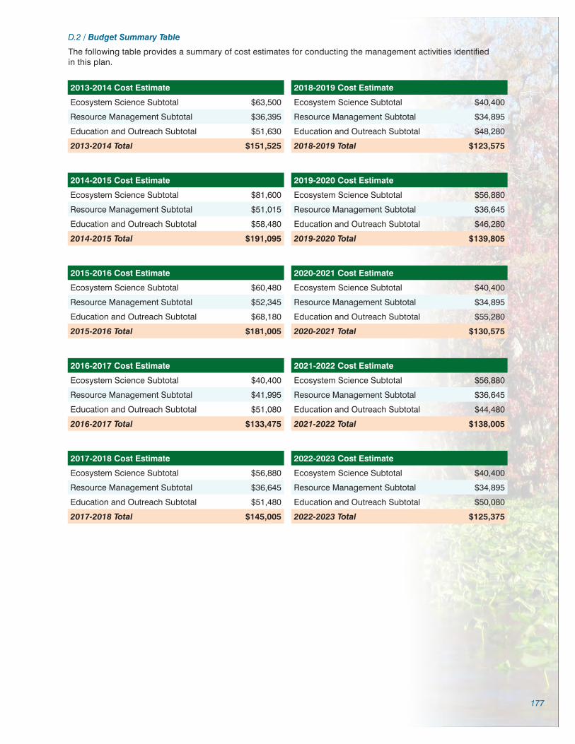
177
D.2 / Budget Summary Table
The following table provides a summary of cost estimates for conducting the management activities identified in this plan.
2013-2014 Cost Estimate
Ecosystem Science Subtotal $63,500
Resource Management Subtotal $36,395
Education and Outreach Subtotal $51,630
2013-2014 Total $151,525
2014-2015 Cost Estimate
Ecosystem Science Subtotal $81,600
Resource Management Subtotal $51,015
Education and Outreach Subtotal $58,480
2014-2015 Total $191,095
2015-2016 Cost Estimate
Ecosystem Science Subtotal $60,480
Resource Management Subtotal $52,345
Education and Outreach Subtotal $68,180
2015-2016 Total $181,005
2016-2017 Cost Estimate
Ecosystem Science Subtotal $40,400
Resource Management Subtotal $41,995
Education and Outreach Subtotal $51,080
2016-2017 Total $133,475
2017-2018 Cost Estimate
Ecosystem Science Subtotal $56,880
Resource Management Subtotal $36,645
Education and Outreach Subtotal $51,480
2017-2018 Total $145,005
2018-2019 Cost Estimate
Ecosystem Science Subtotal $40,400
Resource Management Subtotal $34,895
Education and Outreach Subtotal $48,280
2018-2019 Total $123,575
2019-2020 Cost Estimate
Ecosystem Science Subtotal $56,880
Resource Management Subtotal $36,645
Education and Outreach Subtotal $46,280
2019-2020 Total $139,805
2020-2021 Cost Estimate
Ecosystem Science Subtotal $40,400
Resource Management Subtotal $34,895
Education and Outreach Subtotal $55,280
2020-2021 Total $130,575
2021-2022 Cost Estimate
Ecosystem Science Subtotal $56,880
Resource Management Subtotal $36,645
Education and Outreach Subtotal $44,480
2021-2022 Total $138,005
2022-2023 Cost Estimate
Ecosystem Science Subtotal $40,400
Resource Management Subtotal $34,895
Education and Outreach Subtotal $50,080
2022-2023 Total $125,375

178
D.3 / Major Accomplishments Since the Approval of the Previous Plan
Wekiva River Aquatic Preserve, including the designated reach of the St. Johns River Resource Management: 1987 to Present
Land Acquisition/Identification – Identified gaps in conservation lands and submitted more than 9,400 acres for acquisition through the Wekiva Ocala Greenway Florida Forever and precursor acquisition programs of which 95 percent of lands submitted were acquired. Also worked on proposals covering more than 11,000 acres of conservation lands of which more than 60 percent were acquired.
Thirty-six Squatter Cabins - Removed from Wekiva River middens and islands. Obtained and managed $120,000 grant to cover costs of removing the illegal structures and restoration of the islands. Removal of the structures paved the way for the Wekiva Wild and Scenic River designation.
VIP River Tours - Conducted interpretive river tours for numerous elected or appointed officials including state senators and representatives, Florida Department of Environmental Protection Secretaries, Water Management District board members, county commissioners, and city officials. Also provided river tours for presidents of state-wide and local citizen groups.
Wekiva Promise Initiative – Initiated and developed in partnership with South Seminole Rotary. This public education and awareness program includes a 44-page color magazine and one-hour DVD that provides information about the value and importance of our local natural resources. A goal of the Promise Initiative is to encourage personal stewardship of our aquatic resources. Residents and visitors can “take the promise” by agreeing to use less, slow release or no fertilizer; have their septic tank inspected and if needed pumped out every five years; plant native or drought tolerant trees, shrubs, and ground cover; use pesticides and herbicides only when absolutely necessary; and write a letter to their local government official to let them know they support the protection of the Wekiva Basin. The 44-page magazine includes articles about the aquatic preserve, state and local parks, Florida Friendly landscaping, nutrient issues and stewardship.
Algae Survey - Conducted a one-year survey documenting the presence and biomass of the filamentous algae Lyngbya wollei at thirteen stations throughout the Wekiva Basin. Data contributed to the resource knowledge base of the basin and was used by St. Johns River Water Management District scientists during the Pollution Load Reduction Goal assessment for the Wekiva Basin.
Exotic and Nuisance Plant and Animal Removal - Worked on eradication and control of eight exotic or nuisance species. Obtained and managed $140,000 grant to remove elephant ear and cattails from the aquatic preserve. Maintained long term interagency cooperation and assistance to the Florida Fish and Wildlife Conservation Commission Invasive Plant Management section on more than 25 miles of waterway. Secured and served as project manager for $44,000 cattail mitigation project in the Wekiva River.
Environmental Education Programs – Developed and presented numerous elementary to college-level education programs such as Woods to Water, Wekiva ECO (Education Curriculum Outreach), Wekiva Scenic Investigation, Water Quality 101 and the Wekiva Case Study. Obtained over $2,400 to purchase Enviroscape landscape model and Envision groundwater model used in education programs.
Educational Events and Outreach – Participated in and co-organized numerous festivals and environmental education events such as Wekiva Riverfest, Blue Spring Festival, Manatee Festival, Wekiva Plein Air Paint Out, Fall Owl Festival, and Bioblitz. Developed and organized a live-feed, large-screen video event showing divers exploring Wekiwa Spring.
Multimedia Education Materials – Developed and presented numerous Powerpoint presentations about the aquatic preserve resources and challenges. Developed laminated identification sheets for ecotourism depicting birds, plants, fish and other attributes frequently encountered in the aquatic preserve. Provided text, photos, technical information and editing for the Wekiva Wild and Scenic River Paddle Guide. Coordinated installation of a seven-minute Springs/Water Resource Protection DVD that played for one year at all Division of Motor Vehicle branches throughout Seminole County. Developed and distributed education and display materials including brochures, maps, posters, postcards.
Turtle Research – Participated in and provided support for over seven years in Wekiva River Freshwater Turtle Research. Solicited and secured more than $10,000 for Passive Integrated Transponder tags and supplies for the research. Solicited and secured more than two hundred volunteers to assist with the surveys.
Wekiva Wild and Scenic River System Management Plan – Supplied technical information for and reviewed, commented and edited on the management plan that was adopted in 2007. Served on numerous committees such as Project Review, Website, Paddle Guide, and Sustainability.
Wekiva Wild and Scenic River System River Ambassador - Obtained and managed more than $132,000 to support a position for the Wekiva Wild and Scenic River program. The River Ambassador conducts education programs, trains volunteers, seeks out funding opportunities and applies for grants, secures funds for researchers and promotes and educates stakeholders about the Wekiva Wild and Scenic River System.
Resource Management Surveys – Initiated and participated in numerous surveys including a fifteen-year survey of Wekiva River birds, a two-year survey of St. Johns River birds and annually participated in Audubon Christmas bird counts and monitoring for wood stork rookeries. Participated in submerged aquatic vegetation mapping, Wekiva Bioblitz, fisheries and invertebrate sampling and assisted other researchers with algae sampling.
Publications – Participated on committees that produced the publications Towards Ecosystem Management, Wekiva Basin Interagency Management Plan, Blueprint for Action, Aquatic Preserve Overview and the Promise to the Wekiva magazine. Served as technical advisor for the script of the one-hour film documentary Wekiva: Legacy or Loss.

179
Committees and Technical Support – Appointed to or served on more than 20 resource management committees and subcommittees including the Wekiva Wild and Scenic Advisory Management Committee, Wekiva Basin Management Action Plan Working Group, Wekiva Parkway Environmental Advisory Committee, Wekiwa Spring and Blue Spring Minimum Flows and Levels, Friends of the Wekiva River Technical Committee, Little Wekiva River Technical Committee, Wekiva Trail Working Group, Wekiva Promise Committee, Wekiva Coalition, Orange County Green Place, Blue Spring Working Group, Wekiva Ecosystem Working Group (served as Chair), Wekiva Resource Council and several Land Management Review committees for Blue Spring and Hontoon Island.
River Clean-ups - Organized and conducted numerous clean-ups on the Little Wekiva River, Wekiva River, St. Johns River, and Black Water Creek that resulted in thousands of pounds of trash being removed from the aquatic preserve. Coordinated with citizen groups and agencies such as Seminole Environmental and Restoration Volunteers, Lake County Water Authority, Keep Seminole Beautiful and university and college environmental clubs to obtain thousands of volunteers that participated in the clean-ups.
Eagle Scout Projects – Solicited for and obtained Eagle Scouts to construct more than 1,800 square feet of decking and ADA access ramp for the aquatic preserve office, a butterfly garden and exotic plant Hygrophila removal.
Project and Permit Review - Reviewed numerous permits including Developments of Regional Impact, Conditional Use Permits, Consumptive Use Permits, Wekiva Parkway, Planned Unit Developments, county comprehensive plans, dock and marina permits, completed survey of docks in the aquatic preserve; completed several public interest projects totaling more than $7,500.
Archaeological Site Management – Monitored archaeological sites within the aquatic preserve and identified and registered unrecorded sites. Assisted visiting archaeologists, professors and college-level students with transportation, interpretation, information and grant writing related to Wekiva Middle St. Johns cultural sites. Assisted Rollins College, owners of an important 8,000 year old midden, with resource management issues. Initiated the Shell Island Protection Campaign and secured $1,500 for supplies to protect the midden site.
Volunteer Training and Coordination – Solicited and trained volunteers to conduct educational programs using the Enviroscape and Envison landscape and groundwater models. Obtained certification for “Training the Trainer” for DEP canoe/kayak certification. Presented the program to numerous volunteers and trainers. Trained volunteers in scientific methods to conduct research and assist with resource management.

180
Appendix E
Other Requirements
E.1 / Acquisition and Restoration Council Management Plan Compliance Checklist
Land Management Plan Compliance ChecklistRequired for State-owned conservation lands over 160 acres
Item # Requirement Statute/Rule Pg#/App
Section A: Acquisition Information Items
1. The common name of the property. 18-2.018 & 18-2.021
Ex. Sum.
2. The land acquisition program, if any, under which the property was acquired.
18-2.018 & 18-2.021
p. 2
3. Degree of title interest held by the Board, including reservations and encumbrances such as leases.
18-2.021 p. 2, 6-8
4. The legal description and acreage of the property. 18-2.018 & 18-2.021
Ex. Sum & p. 16-18
5. A map showing the approximate location and boundaries of the property, and the location of any structures or improvements to the property.
18-2.018 & 18-2.021
p. 2
6. An assessment as to whether the property, or any portion, should be declared surplus. Provide Information regarding assessment and analysis in the plan, and provide corresponding map.
18-2.021 N/A
7. Identification of other parcels of land within or immediately adjacent to the property that should be purchased because they are essential to management of the property. Please clearly indicate parcels on a map.
18-2.021 p. 55-56
8. Identification of adjacent land uses that conflict with the planned use of the property, if any.
18-2.021 p. 41-42
9. A statement of the purpose for which the lands were acquired, the projected use or uses as defined in 253.034 and the statutory authority for such use or uses.
259.032(10) p. 6-8
10. Proximity of property to other significant State, local or federal land or water resources.
18-2.021 p. 13-18, 20-23, 39-41
Section B: Use Items
11. The designated single use or multiple use management for the property, including use by other managing entities.
18-2.018 & 18-2.021
p. 78-82
12. A description of past and existing uses, including any unauthorized uses of the property.
18-2.018 & 18-2.021
p. 78-82
13. A description of alternative or multiple uses of the property considered by the lessee and a statement detailing why such uses were not adopted.
18-2.018 N/A
14. A description of the management responsibilities of each entity involved in the property’s management and how such responsibilities will be coordinated.
18-2.018 p. 6-8, 70-76
15. Include a provision that requires that the managing agency consult with the Division of Historical Resources, Department of State before taking actions that may adversely affect archeological or historical resources.
18-2.021 App. E
16. Analysis/description of other managing agencies and private land managers, if any, which could facilitate the restoration or management of the land.
18-2.021 p. 51-55
17. A determination of the public uses and public access that would be consistent with the purposes for which the lands were acquired.
259.032(10) p. 78-82
18 A finding regarding whether each planned use complies with the 1981 State Lands Management Plan, particularly whether such uses represent “balanced public utilization,” specific agency statutory authority and any other legislative or executive directives that constrain the use of such property.
18-2.021 p. 7
19. Letter of compliance from the local government stating that the LMP is in compliance with the Local Government Comprehensive Plan.
BOT requirement
App. E
20. An assessment of the impact of planned uses on the renewable and non-renewable resources of the property, including soil and water resources, and a detailed description of the specific actions that will be taken to protect, enhance and conserve these resources and to compensate/mitigate damage caused by such uses, including a description of how the manager plans to control and prevent soil erosion and soil or water contamination.
18-2.018 & 18-2.021
p. 20-23, 44-82

181
Land Management Plan Compliance ChecklistRequired for State-owned conservation lands over 160 acres
Item # Requirement Statute/Rule Pg#/App
21. *For managed areas larger than 1,000 acres, an analysis of the multiple-use potential of the property which shall include the potential of the property to generate revenues to enhance the management of the property provided that no lease, easement, or license for such revenue-generating use shall be entered into if the granting of such lease, easement or license would adversely affect the tax exemption of the interest on any revenue bonds issued to fund the acquisition of the affected lands from gross income for federal income tax purposes, pursuant to Internal Revenue Service regulations.
18-2.021 & 253.036
N/A
22. If the lead managing agency determines that timber resource management is not in conflict with the primary management objectives of the managed area, a component or section, prepared by a qualified professional forester, that assesses the feasibility of managing timber resources pursuant to section 253.036, F.S.
18-021 N/A
23. A statement regarding incompatible use in reference to Ch. 253.034(10). 253.034(10) p. 78-82
*The following taken from 253.034(10) is not a land management plan requirement; however, it should be considered when developing a land management plan: The following additional uses of conservation lands acquired pursuant to the Florida Forever program and other state-funded conservation land purchase programs shall be authorized, upon a finding by the Board of Trustees, if they meet the criteria specified in paragraphs (a)-(e): water resource development projects, water supply development projects, storm-water management projects, linear facilities and sustainable agriculture and forestry. Such additional uses are authorized where: (a) Not inconsistent with the management plan for such lands; (b) Compatible with the natural ecosystem and resource values of such lands; (c) The proposed use is appropriately located on such lands and where due consideration is given to the use of other available lands; (d) The using entity reasonably compensates the titleholder for such use based upon an appropriate measure of value; and (e) The use is consistent with the public interest.
Section C: Public Involvement Items
24. A statement concerning the extent of public involvement and local government participation in the development of the plan, if any.
18-2.021 App. C
25. The management prospectus required pursuant to paragraph (9)(d) shall be available to the public for a period of 30 days prior to the public hearing.
259.032(10) N/A
26. LMPs and LMP updates for parcels over 160 acres shall be developed with input from an advisory group who must conduct at least one public hearing within the county in which the parcel or project is located. Include the advisory group members and their affiliations, as well as the date and location of the advisory group meeting.
259.032(10) App. C
27. Summary of comments and concerns expressed by the advisory group for parcels over 160 acres
18-2.021 App. C
28. During plan development, at least one public hearing shall be held in each affected county. Notice of such public hearing shall be posted on the parcel or project designated for management, advertised in a paper of general circulation, and announced at a scheduled meeting of the local governing body before the actual public hearing. Include a copy of each County’s advertisements and announcements (meeting minutes will suffice to indicate an announcement) in the management plan.
253.034(5) & 259.032(10)
App. C
29. The manager shall consider the findings and recommendations of the land management review team in finalizing the required 10-year update of its management plan. Include manager’s replies to the team’s findings and recommendations.
N/A
30. Summary of comments and concerns expressed by the management review team, if required by Section 259.036, F.S.
18-2.021 N/A
31. If manager is not in agreement with the management review team’s findings and recommendations in finalizing the required 10-year update of its management plan, the managing agency should explain why they disagree with the findings or recommendations.
N/A
Section D: Natural Resources
32. Location and description of known and reasonably identifiable renewable and non-renewable resources of the property regarding soil types. Use brief descriptions and include USDA maps when available.
18-2.021 p. 17-21, Map 6 (p.21)
33. Insert FNAI based natural community maps when available. ARC consensus Map 8 (p. 26)
34. Location and description of known and reasonably identifiable renewable and non-renewable resources of the property regarding outstanding native landscapes containing relatively unaltered flora, fauna and geological conditions.
18-2.021 Ex Sum

182
Land Management Plan Compliance ChecklistRequired for State-owned conservation lands over 160 acres
Item # Requirement Statute/Rule Pg#/App
35. Location and description of known and reasonably identifiable renewable and non-renewable resources of the property regarding unique natural features and/or resources including but not limited to virgin timber stands, scenic vistas, natural rivers and streams, coral reefs, natural springs, caverns and large sinkholes.
18-2.018 & 18-2.021
p.13-15, 24-33
36. Location and description of known and reasonably identifiable renewable and non-renewable resources of the property regarding beaches and dunes.
18-2.021 N/A
37. Location and description of known and reasonably identifiable renewable and non-renewable resources of the property regarding mineral resources, such as oil, gas and phosphate, etc.
18-2.018 & 18-2.021
App. A.1
38. Location and description of known and reasonably identifiable renewable and non-renewable resources of the property regarding fish and wildlife, both game and non-game, and their habitat.
18-2.018 & 18-2.021
p. 24-36, App. B.4
39. Location and description of known and reasonably identifiable renewable and non-renewable resources of the property regarding State and Federally listed endangered or threatened species and their habitat.
18-2.021 p. 24-35, App. B.4
40. The identification or resources on the property that are listed in the Natural Areas Inventory. Include letter from FNAI or consultant where appropriate.
18-2.021 p. 24-35, App. B.4
41. Specific description of how the managing agency plans to identify, locate, protect and preserve or otherwise use fragile, nonrenewable natural and cultural resources.
259.032(10) p. 36-38
42. Habitat Restoration and Improvement 259.032(10) & 253.034(5)
42-A. Describe management needs, problems and a desired outcome and the key management activities necessary to achieve the enhancement, protection and preservation of restored habitats and enhance the natural, historical and archeological resources and their values for which the lands were acquired.
259.032(10) & 253.034(5)
p. 24-35 & 83-95
42-B. Provide a detailed description of both short (2-year planning period) and long-term (10-year planning period) management goals, and a priority schedule based on the purposes for which the lands were acquired and include a timeline for completion.
259.032(10) & 253.034(5)
App. D.1
42-C. The associated measurable objectives to achieve the goals. 259.032(10) & 253.034(5)
App. D.1
42-D. The related activities that are to be performed to meet the land management objectives and their associated measures. Include fire management plans - they can be in plan body or an appendix.
259.032(10) & 253.034(5)
App. D.1
42-E. A detailed expense and manpower budget in order to provide a management tool that facilitates development of performance measures, including recommendations for cost-effective methods of accomplishing those activities.
259.032(10) & 253.034(5)
App. D.1
43. ***Quantitative data description of the land regarding an inventory of forest and other natural resources and associated acreage. See footnote.
253.034(5) Ex Sum
44. Sustainable Forest Management, including implementation of prescribed fire management
18-2.021, 253.034(5)
& 259.032(10)
44-A. Management needs, problems and a desired outcome (see requirement for # 42-A).
18-2.021, 253.034(5)
& 259.032(10)
N/A
44-B. Detailed description of both short and long-term management goals (see requirement for # 42-B).
18-2.021, 253.034(5)
& 259.032(10)
N/A
44-C. Measurable objectives (see requirement for #42-C). 18-2.021, 253.034(5)
& 259.032(10)
N/A
44-D. Related activities (see requirement for #42-D). 18-2.021, 253.034(5)
& 259.032(10)
N/A
44-E. Budgets (see requirement for #42-E). 18-2.021, 253.034(5)
& 259.032(10)
N/A

183
Land Management Plan Compliance ChecklistRequired for State-owned conservation lands over 160 acres
Item # Requirement Statute/Rule Pg#/App
Imperiled species, habitat maintenance, enhancement, restoration or population restoration
259.032(10) & 253.034(5)
45-A. Management needs, problems and a desired outcome (see requirement for # 42-A).
259.032(10) & 253.034(5)
p. 24-35 & 83-95
45-B. Detailed description of both short and long-term management goals (see requirement for # 42-B).
259.032(10) & 253.034(5)
App. D.1
45-C. Measurable objectives (see requirement for #42-C). 259.032(10) & 253.034(5)
App. D.1
45-D. Related activities (see requirement for #42-D). 259.032(10) & 253.034(5)
App. D.1
45-E. Budgets (see requirement for #42-E). 259.032(10) & 253.034(5)
App. D.1
46. ***Quantitative data description of the land regarding an inventory of exotic and invasive plants and associated acreage. See footnote.
253.034(5) p. 35-36
47. Place the Arthropod Control Plan in an appendix. If one does not exist, provide a statement as to what arrangement exists between the local mosquito control district and the management unit.
BOT requirement via lease language
N/A (No BOT lease)
Exotic and invasive species maintenance and control 259.032(10) & 253.034(5)
48-A. Management needs, problems and a desired outcome (see requirement for # 42-A).
259.032(10) & 253.034(5)
p. 35-36
48-B. Detailed description of both short and long-term management goals (see requirement for # 42-B).
259.032(10) & 253.034(5)
App. D.1
48-C. Measurable objectives (see requirement for #42-C). 259.032(10) & 253.034(5)
App. D.1
48-D. Related activities (see requirement for #42-D). 259.032(10) & 253.034(5)
App. D.1
48-E. Budgets (see requirement for #42-E). 259.032(10) & 253.034(5)
App. D.1
Section E: Water Resources
49. A statement as to whether the property is within and/or adjacent to an aquatic preserve or a designated area of critical state concern or an area under study for such designation. If yes, provide a list of the appropriate managing agencies that have been notified of the proposed plan.
18-2.018 & 18-2.021
p. 1-2
50. Location and description of known and reasonably identifiable renewable and non-renewable resources of the property regarding water resources, including water classification for each water body and the identification of any such water body that is designated as an Outstanding Florida Water under Rule 62-302.700, F.A.C.
18-2.021 p. 1-2, 20-23
51. Location and description of known and reasonably identifiable renewable and non-renewable resources of the property regarding swamps, marshes and other wetlands.
18-2.021 p. 25-33
52. ***Quantitative description of the land regarding an inventory of hydrological features and associated acreage. See footnote.
253.034(5) Ex. Summ
53. Hydrological Preservation and Restoration 259.032(10) & 253.034(5)
53-A. Management needs, problems and a desired outcome (see requirement for # 42-A).
259.032(10) & 253.034(5)
App. D.1
53-B. Detailed description of both short and long-term management goals (see requirement for # 42-B).
259.032(10) & 253.034(5)
App. D.1
53-C. Measurable objectives (see requirement for #42-C). 259.032(10) & 253.034(5)
App. D.1
53-D. Related activities (see requirement for #42-D). 259.032(10) & 253.034(5)
App. D.1
53-E. Budgets (see requirement for #42-E). 259.032(10) & 253.034(5)
App. D.1

184
Land Management Plan Compliance ChecklistRequired for State-owned conservation lands over 160 acres
Item # Requirement Statute/Rule Pg#/App
Section F: Historical, Archaeological and Cultural Resources
54. **Location and description of known and reasonably identifiable renewable and non-renewable resources of the property regarding archeological and historical resources. Include maps of all cultural resources except Native American sites, unless such sites are major points of interest that are open to public visitation.
18-2.018, 18-2.021
& per DHR’s request
Ex. Sum, p. 36-39
55. ***Quantitative data description of the land regarding an inventory of significant land, cultural or historical features and associated acreage.
253.034(5) Ex. Sum, p. 36-39
56. A description of actions the agency plans to take to locate and identify unknown resources such as surveys of unknown archeological and historical resources.
18-2.021 App. D.1
57. Cultural and Historical Resources 259.032(10) & 253.034(5)
57-A. Management needs, problems and a desired outcome (see requirement for # 42-A).
259.032(10) & 253.034(5)
App. D.1
57-B. Detailed description of both short and long-term management goals (see requirement for # 42-B).
259.032(10) & 253.034(5)
App. D.1
57-C. Measurable objectives (see requirement for #42-C). 259.032(10) & 253.034(5)
App. D.1
57-D. Related activities (see requirement for #42-D). 259.032(10) & 253.034(5)
App. D.1
57-E. Budgets (see requirement for #42-E). 259.032(10) & 253.034(5)
App. D.1
**While maps of Native American sites should not be included in the body of the management plan, the DSL urges each managing agency to provide such information to the Division of Historical Resources for inclusion in their
proprietary database. This information should be available for access to new managers to assist them in developing, implementing and coordinating their management activities.
Section G: Facilities (Infrastructure, Access, Recreation)
58. ***Quantitative data description of the land regarding an inventory of infrastructure and associated acreage. See footnote.
253.034(5) p. 99-101
59. Capital Facilities and Infrastructure 259.032(10) & 253.034(5)
59-A. Management needs, problems and a desired outcome (see requirement for # 42-A).
259.032(10) & 253.034(5)
p. 99-101, App. D.1
59-B. Detailed description of both short and long-term management goals (see requirement for # 42-B).
259.032(10) & 253.034(5)
App. D.1
59-C. Measurable objectives (see requirement for #42-C). 259.032(10) & 253.034(5)
App. D.1
59-D. Related activities (see requirement for #42-D). 259.032(10) & 253.034(5)
App. D.1
59-E. Budgets (see requirement for #42-E). 259.032(10) & 253.034(5)
App. D.1
60. *** Quantitative data description of the land regarding an inventory of recreational facilities and associated acreage.
253.034(5) p. 78-82, 99-101, App. D.1
61. Public Access and Recreational Opportunities 259.032(10) & 253.034(5)
61-A. Management needs, problems and a desired outcome (see requirement for # 42-A).
259.032(10) & 253.034(5)
App. D.1
61-B. Detailed description of both short and long-term management goals (see requirement for # 42-B).
259.032(10) & 253.034(5)
App. D.1
61-C. Measurable objectives (see requirement for #42-C). 259.032(10) & 253.034(5)
App. D.1
61-D. Related activities (see requirement for #42-D). 259.032(10) & 253.034(5)
App. D.1
61-E. Budgets (see requirement for #42-E). 259.032(10) & 253.034(5)
App. D.1

185
Land Management Plan Compliance ChecklistRequired for State-owned conservation lands over 160 acres
Item # Requirement Statute/Rule Pg#/App
Section H: Other/ Managing Agency Tools
62. Place this LMP Compliance Checklist at the front of the plan. ARC and managing
agency consensus
Front & App. E.1
63. Place the Executive Summary at the front of the LMP. Include a physical description of the land.
ARC and 253.034(5)
Ex. Sum
64. If this LMP is a 10-year update, note the accomplishments since the drafting of the last LMP set forth in an organized (categories or bullets) format.
ARC consensus App. D.3
65. Key management activities necessary to achieve the desired outcomes regarding other appropriate resource management.
259.032(10) Ch 5 (p. 83-95)
66. Summary budget for the scheduled land management activities of the LMP including any potential fees anticipated from public or private entities for projects to offset adverse impacts to imperiled species or such habitat, which fees shall be used to restore, manage, enhance, repopulate, or acquire imperiled species habitat for lands that have or are anticipated to have imperiled species or such habitat onsite. The summary budget shall be prepared in such a manner that it facilitates computing an aggregate of land management costs for all state-managed lands using the categories described in s. 259.037(3) which are resource management, administration, support, capital improvements, recreation visitor services, law enforcement activities.
253.034(5) App. D.1
67. Cost estimate for conducting other management activities which would enhance the natural resource value or public recreation value for which the lands were acquired, include recommendations for cost-effective methods in accomplishing those activities.
259.032(10) App. D.1
68. A statement of gross income generated, net income and expenses. 18-2.018 N/A
*** = The referenced inventories shall be of such detail that objective measures and benchmarks can be established for each tract of land and monitored during the lifetime of the plan. All quantitative data collected shall be aggregated,
standardized, collected, and presented in an electronic format to allow for uniform management reporting and analysis. The information collected by the DEP pursuant to s. 253.0325(2) shall be available to the land manager and
his or her assignee.

186
E.2 / Management Procedures for Archaeological and Historical Sites and Properties on State-Owned or Controlled Lands (revised March 2013)
These procedures apply to state agencies, local governments, and non-profits that manage state-owned properties.
A. General Discussion
Historic resources are both archaeological sites and historic structures. Per Chapter 267, Florida Statutes, ‘Historic property’ or ‘historic resource’ means any prehistoric district, site, building, object, or other real or personal prop-erty of historical, architectural, or archaeological value, and folklife resources. These properties or resources may include, but are not limited to, monuments, memorials, Indian habitations, ceremonial sites, abandoned settlements, sunken or abandoned ships, engineering works, treasure trove, artifacts, or other objects with intrinsic historical or archaeological value, or any part thereof, relating to the history, government, and culture of the state.”
B. Agency Responsibilities
Per State Policy relative to historic properties, state agencies of the executive branch must allow the Division of His-torical Resources (Division) the opportunity to comment on any undertakings, whether these undertakings directly involve the state agency, i.e., land management responsibilities, or the state agency has indirect jurisdiction, i.e. permitting authority, grants, etc. No state funds should be expended on the undertaking until the Division has the opportunity to review and comment on the project, permit, grant, etc.
State agencies shall preserve the historic resources which are owned or controlled by the agency.
Regarding proposed demolition or substantial alterations of historic properties, consultation with the Division must occur, and alternatives to demolition must be considered.
State agencies must consult with Division to establish a program to location, inventory and evaluate all historic prop-erties under ownership or controlled by the agency.
C. Statutory Authority
Statutory Authority and more in depth information can be found at: http://www.flheritage.com/preservation/compli-ance/guidelines.cfm
D. Management Implementation
Even though the Division sits on the Acquisition and Restoration Council and approves land management plans, these plans are conceptual. Specific information regarding individual projects must be submitted to the Division for review and recommendations.
Managers of state lands must coordinate any land clearing or ground disturbing activities with the Division to allow for review and comment on the proposed project. Recommendations may include, but are not limited to: approval of the project as submitted, cultural resource assessment survey by a qualified professional archaeologist, modifica-tions to the proposed project to avoid or mitigate potential adverse effects.
Projects such as additions, exterior alteration, or related new construction regarding historic structures must also be submitted to the Division of Historical Resources for review and comment by the Division’s architects. Projects involving structures fifty years of age or older, must be submitted to this agency for a significance determination. In rare cases, structures under fifty years of age may be deemed historically significant. These must be evaluated on a case by case basis.
Adverse impacts to significant sites, either archaeological sites or historic buildings, must be avoided. Furthermore, managers of state property should make preparations for locating and evaluating historic resources, both archaeo-logical sites and historic structures.
E. Minimum Review Documentation Requirements
In order to have a proposed project reviewed by the Division, certain information must be submitted for comments and recommendations. The minimum review documentation requirements can be found at: http://www.flheritage.com/preservation/compliance/docs/minimum_review_documentation_requirements.pdf .
Questions relating to the treatment of archaeological and historic resources on state lands should be directed to:
Deena S. WoodwardDivision of Historical ResourcesBureau of Historic PreservationCompliance and Review SectionR. A. Gray Building500 South Bronough StreetTallahassee, FL 32399-0250Phone: (850) 245-6425Toll Free: (800) 847-7278Fax: (850) 245-6435


Wekiva River Aquatic PreserveManagement Plan
Wekiva River Aquatic Preserve8300 West State Road 46 • Sanford, FL 32771407.330.6727 • www.dep.state.fl.us/coastal/sites/wekiva
Florida Department of Environmental Protection Florida Coastal Office3900 Commonwealth Blvd., MS #235 Tallahassee, FL 32399 • www.aquaticpreserves.org