water - MDPI
13
Water 2014, 6, 2849-2861; doi:10.3390/w6102849 water ISSN 2073-4441 www.mdpi.com/journal/water Article Identifying Seasonal Groundwater Recharge Using Environmental Stable Isotopes Hsin-Fu Yeh, Hung-I Lin, Cheng-Haw Lee *, Kuo-Chin Hsu and Chi-Shin Wu Department of Resources Engineering, National Cheng Kung University, Tainan 701, Taiwan; E-Mails: [email protected] (H.-F.Y.); [email protected] (H.-I.L.); [email protected] (K.-C.H.); [email protected] (C.-S.W.) * Author to whom correspondence should be addressed; E-Mail: [email protected]; Tel.: +886-6-275-7575 (ext. 62833); Fax: +886-6-238-0421. External Editors: Trevor Elliot and Luc Lambs Received: 24 March 2014; in revised form: 12 September 2014 / Accepted: 19 September 2014 / Published: 26 September 2014 Abstract: In this study, the stable isotope values of oxygen and hydrogen were used to identify the seasonal contribution ratios of precipitation to groundwater recharge in the Hualien River basin of eastern Taiwan. The differences and correlations of isotopes in various water bodies were examined to evaluate the groundwater recharge sources for the Hualian River basin and the interrelations between groundwater and surface water. Proportions of recharge sources were calculated based on the results of the mass balance analysis of the isotope composition of hydrogen and oxygen in the basin. Mountain river water accounted for 83% and plain rainfall accounted for 17% of the groundwater recharge in the Huanlian River basin. Using the mean d-values, a comparison of d-values of precipitation and groundwater indicates the groundwater consists of 75.5% wet seasonal sources and 24.5% dry seasonal sources, representing a distinct seasonal variation of groundwater recharge in the study area. Comparisons between hydrogen and oxygen isotopes in rainwater showed that differences in the amount of rainfall resulted in depleted oxygen and hydrogen isotopes for precipitation in wet seasons as compared to dry seasons. The river water contained more depleted hydrogen and oxygen isotopes than was the case for precipitation, implying that the river water mainly came from the upstream catchment. In addition, the hydrogen and oxygen isotopes in the groundwater slightly deviated from the hydrogen and oxygen isotopic meteoric water line in Huanlian. Therefore, the OPEN ACCESS
-
Upload
khangminh22 -
Category
Documents
-
view
4 -
download
0
Transcript of water - MDPI

Water 2014, 6, 2849-2861; doi:10.3390/w6102849
water ISSN 2073-4441
www.mdpi.com/journal/water
Article
Identifying Seasonal Groundwater Recharge Using Environmental Stable Isotopes
Hsin-Fu Yeh, Hung-I Lin, Cheng-Haw Lee *, Kuo-Chin Hsu and Chi-Shin Wu
Department of Resources Engineering, National Cheng Kung University, Tainan 701, Taiwan;
E-Mails: [email protected] (H.-F.Y.); [email protected] (H.-I.L.);
[email protected] (K.-C.H.); [email protected] (C.-S.W.)
* Author to whom correspondence should be addressed; E-Mail: [email protected];
Tel.: +886-6-275-7575 (ext. 62833); Fax: +886-6-238-0421.
External Editors: Trevor Elliot and Luc Lambs
Received: 24 March 2014; in revised form: 12 September 2014 / Accepted: 19 September 2014 /
Published: 26 September 2014
Abstract: In this study, the stable isotope values of oxygen and hydrogen were used to
identify the seasonal contribution ratios of precipitation to groundwater recharge in the
Hualien River basin of eastern Taiwan. The differences and correlations of isotopes in
various water bodies were examined to evaluate the groundwater recharge sources for
the Hualian River basin and the interrelations between groundwater and surface water.
Proportions of recharge sources were calculated based on the results of the mass balance
analysis of the isotope composition of hydrogen and oxygen in the basin. Mountain
river water accounted for 83% and plain rainfall accounted for 17% of the groundwater
recharge in the Huanlian River basin. Using the mean d-values, a comparison of d-values
of precipitation and groundwater indicates the groundwater consists of 75.5% wet seasonal
sources and 24.5% dry seasonal sources, representing a distinct seasonal variation of
groundwater recharge in the study area. Comparisons between hydrogen and oxygen isotopes
in rainwater showed that differences in the amount of rainfall resulted in depleted oxygen
and hydrogen isotopes for precipitation in wet seasons as compared to dry seasons.
The river water contained more depleted hydrogen and oxygen isotopes than was the case
for precipitation, implying that the river water mainly came from the upstream catchment.
In addition, the hydrogen and oxygen isotopes in the groundwater slightly deviated
from the hydrogen and oxygen isotopic meteoric water line in Huanlian. Therefore, the
OPEN ACCESS

Water 2014, 6 2850
groundwater in this basin might be a mixture of river water and precipitation, resulting in
the effect of the river water recharge being greater than that of rainfall infiltration.
Keywords: stable isotopes; groundwater recharge; Hualien River basin
1. Introduction
Oxygen and hydrogen isotopes of water are widely used as tracers to understand hydrogeological
processes such as precipitation, groundwater recharge, groundwater-surface water interactions, and basin
hydrology [1–6]. A comparison of the oxygen and hydrogen isotopic compositions of precipitation and
groundwater provides an excellent tool for evaluating the recharge mechanism [7–11]. Determining the
sources of groundwater recharge is important for the effective management of groundwater resources.
In hydrology, fractionation of δ18O and δD is driven by kinetic processes during evaporation and
condensation [12]. In the process of oceanic water evaporation becoming inland rainfall, a sequence of
isotope fractionations causes variations in the composition of the isotope values of oxygen and hydrogen
in continental meteoric water. Since this fractionation process is based on the equilibrium processes
of the isotopes of evaporation and condensation, there is a specific relationship that governs the
distributions of isotope values of oxygen and hydrogen in rainfall.
The empirical equation was found by Craig [13] when he used a linear regression method to analyze
the composition of the isotopes of oxygen and hydrogen in samples of precipitation, snow water, and
river water from all over the world. His finding is known as the Global Meteoric Water Line (GMWL):
δD = 8 δ18O + 10 (1)
A later study by the IAEA (International Atomic Energy Agency), water samples from rainfall
stations were collected globally showing a similar result [12,14]:
δD = (8.17 ± 0.08) δ18O + (10.56 ± 0.64) (2)
Most of the precipitation in the world follows this relationship. However, some specific areas that
have different evaporation and condensation conditions (e.g., temperature and humidity), or that have a
unique terrain environment, create their own special local meteoric water line with a different slope
and intercept [12,15]. In the meteoric water line of oxygen and hydrogen isotopes, the slope represents
the ratio of the temperature relationship between δD and δ18O when condensation occurs; the value of
the intercept is based on the evaporative conditions in the water source region.
The intercept is also called deuterium excess or d-excess (d = δD − 8δ18O) [14]. The intercepts in
most places around the world are about 10‰. However, areas may have different slopes and intercepts
due to different rainfall evaporation conditions or source evaporation conditions in various air
mass sources. For example, North America: δD = 7.95 δ18O + 6.03 [12]; Tropical Island area:
δD = 6.17 δ18O + 3.97 [12]; Japan: δD = 8 δ18O + 17.5 [16]. Generally speaking, if evaporation is faster,
or if rainfall evaporation occurs, intercepts are higher. Some studies have used d-excess to identify the
air mass source of meteoric water and to define the seasonal recharge of groundwater [4,5,7,17].

Water 2014, 6 2851
Taiwan is located in the West Pacific Ocean monsoon climate area. The air mass of the Northeast
monsoon prevalent in winter originates from the Antarctic Continent. The air mass of the Southwest
monsoon prevalent in summer originates from the equator in the Pacific Ocean and from the North
Pacific Ocean tropical marine air mass. Rainfall in Taiwan is related to these three air masses. The
summer rainfall in Taiwan is mostly typhoon cloudbursts and afternoon rainfall caused by thermal
convection. Due to the effects of the Central Mountain Range, Northern Taiwan faces the Northeast
monsoon [18]. During the winter, southward cold fronts bring plentiful water vapor from the East
China Sea which results in rainfall. Although Eastern Taiwan is to the east of the Central Mountain
Range, rainfall is low because the Northeast monsoon moves parallel to the coast. In addition, Western
Taiwan, protected by the Central Mountain Range, is not obviously affected by the Northeast monsoon,
causing winter drought [18].
The purpose of this study is to use oxygen and hydrogen isotopes as natural tracers to identify the
possible sources of groundwater and the seasonal variations in groundwater recharge in the eastern
Taiwan Huanlian River basin. The results provide useful information about hydrological processes,
such as the interaction of precipitation, river water, and groundwater.
2. Study Area
The Huanlian River is located in the Huatung Valley in Hualian County, Eastern Taiwan. To the
north, this river connects with the Taroko River system basin; to the west, it is adjacent to the
Chuoshui River; to the south, it is next to the Xiuguluan River basin; and to the east, it is next to the
Fengping River system basin (Figure 1). The Hualian River originates from Bazi Mountain, which is a
sub-range of the Dan Mountain. The main stream is approximately 57.28 km long, with a basin area of
1507 km2 and an annual runoff of 3813 million m3. The Hualian River basin water resources are
primarily used for agriculture irrigation, followed by domestic and industrial water use. Despite the
rich amount of surface water offered by the Huanlian River, the surface runoff during wet and dry
seasons fluctuates significantly. Each year’s high-flow period starts from May to October, which
accounts for 70% of the runoff of the entire year. After October, the flow declines significantly, and
the driest period occurs in February and March. From November to April of the following year, the
runoff in the drought period accounts for approximately 30% of the annual runoff.
The main stream of the Huanlian River exits the valley from Dafong Mountain and enters the plains
areas. It flows along Huatung Valley from southwest to northeast. The primary sub-ranges include the
Guangfu River, the Maan River, the Wanli River, the Shoufeng River, and the Mugua River. These
rivers run into the ocean near Hualian Mountain, at the north of the Coastal Range. The hydrogeology of
the Hualian River basin can be divided into three areas based on location: the Central Mountain Range,
Huatung Valley, and the Coastal Range. Depending on the terrain, Hualian can be divided into two
sections, Hualian Plain and Huatung Valley Plain. Hualian Plain is located to the north of Huatung
Valley. Good gravel aquifers can be found at depths of 80–90 m underground. The width of the Huatung
Valley’s shallow gravel layer tends to become thinner from the top to the bottom of the alluvial fan,
whereas the deeper layer is characterized by coarse sands and occasional mud layers. With respect to
geological characteristics, Huatung Valley is located at the line of collision between the Eurasian Plate
and the Philippine Sea Plate. The two sides of the valley are delimited by upthrust with high angles.

Water 2014, 6 2852
Hualian River is abundant in runoff and high in sediment transport capacity. Most surface water is
utilized for agricultural purposes, whereas domestic and industrial water rely on the copious amount
of available groundwater. To understand the use of water resources in this basin, the fundamental
characteristics and recharge sources of the groundwater need to be analyzed. Based on the effective
fractional porosity volume in the alluvium, it can be determined that the groundwater reserve in
the Hualian River basin is approximately 5 billion m3, 370 million m3 of which can be exploited
per year [19]. Based on water balance, the river infiltration recharge for the whole region is
1.45 billion m3 [20]. A report published by the Taiwan Water Resource Agency [21] shows a simulation
of the hydraulic characteristics of regional groundwater using the MODFLOW model in the
Groundwater Modeling System (GMS). According to the results of the groundwater budget in the
Hualian River basin, 27% of the infiltration is direct rainfall, 18% of the recharge is the lateral flow of
boundary, and 55% of the groundwater recharge comes from river water.
Figure 1. The location of the study region. Precipitation sampling sites (circles), river water
(squares), and groundwater (triangles) samples are shown.
3. Sampling and Analytical Method
Precipitation, river water, and groundwater samples were collected for oxygen and hydrogen isotopic
analyses from 2003 to 2012. Sampling was carried out during both wet and dry periods. Sampling
Water 2014, 6 2853
procedures for precipitation were in accordance with IAEA guidelines [22]; in short, the procedures
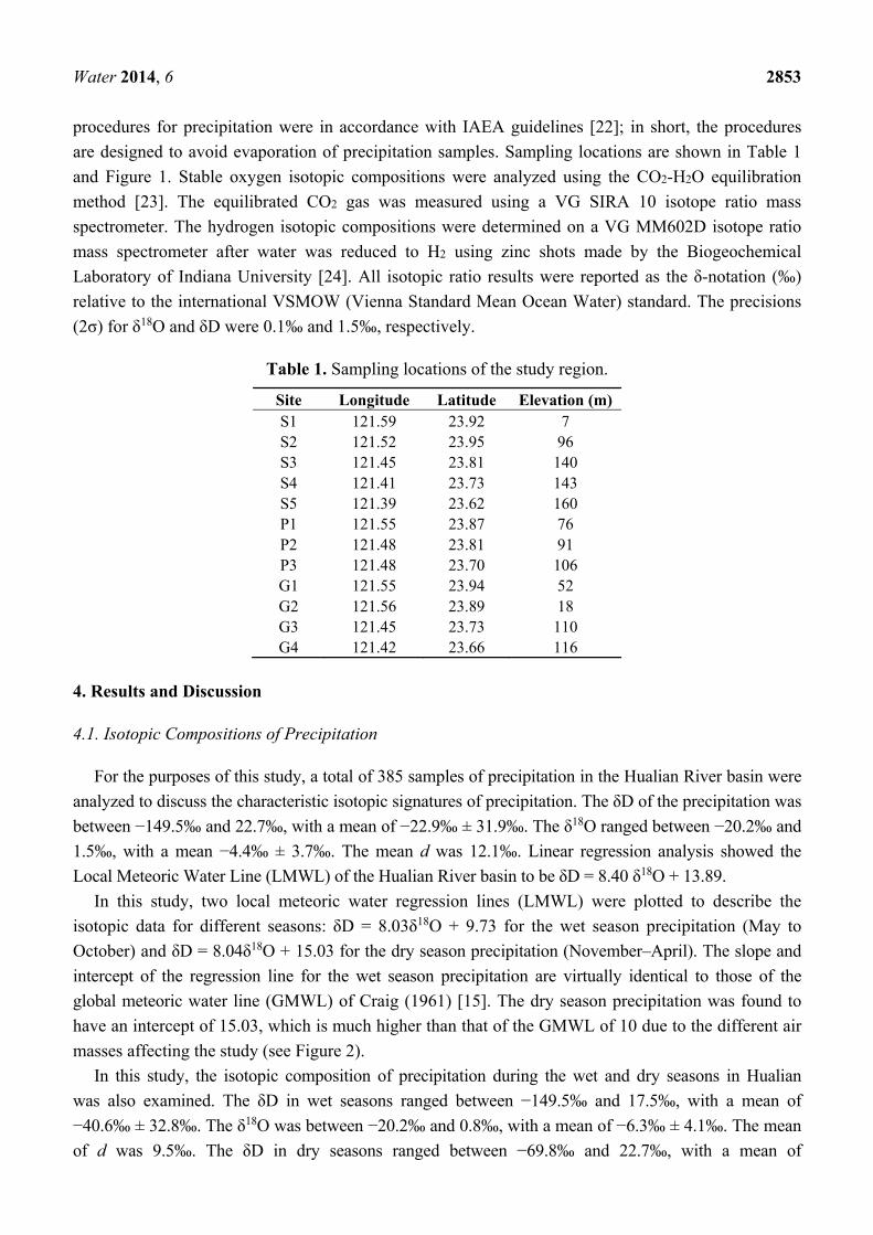
are designed to avoid evaporation of precipitation samples. Sampling locations are shown in Table 1
and Figure 1. Stable oxygen isotopic compositions were analyzed using the CO2-H2O equilibration
method [23]. The equilibrated CO2 gas was measured using a VG SIRA 10 isotope ratio mass
spectrometer. The hydrogen isotopic compositions were determined on a VG MM602D isotope ratio
mass spectrometer after water was reduced to H2 using zinc shots made by the Biogeochemical
Laboratory of Indiana University [24]. All isotopic ratio results were reported as the δ-notation (‰)
relative to the international VSMOW (Vienna Standard Mean Ocean Water) standard. The precisions
(2σ) for δ18O and δD were 0.1‰ and 1.5‰, respectively.
Table 1. Sampling locations of the study region.
Site Longitude Latitude Elevation (m) S1 121.59 23.92 7 S2 121.52 23.95 96 S3 121.45 23.81 140 S4 121.41 23.73 143 S5 121.39 23.62 160 P1 121.55 23.87 76 P2 121.48 23.81 91 P3 121.48 23.70 106 G1 121.55 23.94 52 G2 121.56 23.89 18 G3 121.45 23.73 110 G4 121.42 23.66 116
4. Results and Discussion
4.1. Isotopic Compositions of Precipitation
For the purposes of this study, a total of 385 samples of precipitation in the Hualian River basin were
analyzed to discuss the characteristic isotopic signatures of precipitation. The δD of the precipitation was
between −149.5‰ and 22.7‰, with a mean of −22.9‰ ± 31.9‰. The δ18O ranged between −20.2‰ and
1.5‰, with a mean −4.4‰ ± 3.7‰. The mean d was 12.1‰. Linear regression analysis showed the
Local Meteoric Water Line (LMWL) of the Hualian River basin to be δD = 8.40 δ18O + 13.89.
In this study, two local meteoric water regression lines (LMWL) were plotted to describe the
isotopic data for different seasons: δD = 8.03δ18O + 9.73 for the wet season precipitation (May to
October) and δD = 8.04δ18O + 15.03 for the dry season precipitation (November–April). The slope and
intercept of the regression line for the wet season precipitation are virtually identical to those of the
global meteoric water line (GMWL) of Craig (1961) [15]. The dry season precipitation was found to
have an intercept of 15.03, which is much higher than that of the GMWL of 10 due to the different air
masses affecting the study (see Figure 2).
In this study, the isotopic composition of precipitation during the wet and dry seasons in Hualian
was also examined. The δD in wet seasons ranged between −149.5‰ and 17.5‰, with a mean of
−40.6‰ ± 32.8‰. The δ18O was between −20.2‰ and 0.8‰, with a mean of −6.3‰ ± 4.1‰. The mean
of d was 9.5‰. The δD in dry seasons ranged between −69.8‰ and 22.7‰, with a mean of

Water 2014, 6 2854
−3.7‰ ± 16.1‰. The δ18O was between −9.6‰ and 1.5‰, with a mean of −2.3‰ ± 1.9‰. The mean of
d was 14.7‰. More depleted composition of hydrogen and oxygen isotopes was found in the summer
wet seasons than the dry seasons. This feature has been commonly observed in other regions of
Taiwan [18,25–27]. In Taiwan, the composition of hydrogen isotopes, compared to the rainfall of the
Northeast monsoon in winters, is depleted in the rainfall of the Southwest monsoon in summers. As for
the effects of temperature, higher temperature may have enriched the signatures of hydrogen and
oxygen isotopes in precipitation. In seasons with great rainfall, the rainfall amount effect [12] caused
by the rain out of heavy precipitation amounts over a relatively short time duration, the hydrogen and
oxygen isotopes in precipitation are significantly depleted. Thus, rainfall also has an effect on isotopes.
Temperature and rainfall amount exert opposite effects on the fractionation of hydrogen and oxygen
isotopes. Moreover, the isotopes in the Hualian River basin are depleted more in wet seasons than is the
case in dry seasons. The signatures of hydrogen and oxygen isotopes can be explained by the mutual
influence of rainfall amount and temperature, with the former have a stronger effect than the latter.
During rainy seasons in the summer, rainfall is often heavier with a greater amount of rainfall during a
specific period of time and so a higher precipitation rate, despite higher temperatures. Consequently,
the composition of the hydrogen and oxygen isotopes at this time is depleted relative to δ18O and δD.
Yurtsever and Gat (1981) [28] have pointed out generally that the temperature effect is normally
pronounced in high-latitude continental regions, whereas the amount effect is pronounced in tropical
regions. It is well known that the hydrogen and oxygen heavy isotope contents of precipitation decrease
with increasing altitude. In this study, precipitation sites are located in the lowest area of the basin.
Therefore, in this study it is difficult to discuss the range of altitude effect in the basin. Precipitation sites
may not adequately represent the average precipitation in the basin. If the altitude effect is large,
groundwater can also derive from precipitation in the mountainous area with depleted isotopic
compositions similar to streams.
Figure 2. Plot of δD vs. δ18O for precipitation samples. LMWL represents the local meteoric
water line.

Water 2014, 6 2855
4.2. Isotopic Compositions of River Water
The δD of the river water in the Hualian River basin was between −70.0‰ and −46.2‰, with a mean
of −61.3‰ ± 5.9‰. The δ18O ranged between −10.3‰ and −7.8‰, with a mean of −9.1‰ ± 0.6‰
(Figure 3). The comparison of hydrogen and oxygen isotope compositions between rainwater and river
water demonstrated that the composition of the hydrogen and oxygen isotopes from river water matched
that of the local meteoric water across the Hualian River basin. This indicated that rainfall is the primary
source of the river water. Furthermore, the composition of the hydrogen and oxygen isotopes from the
river water was more depleted as compared to that of the precipitation in the valley, indicating that the
river water is composed of rainfall in the upstream catchment. Therefore, the precipitation in the valley
had smaller effects on the river water. In wet seasons, the hydrogen and oxygen isotopes exhibited a
depleted composition compared to that of dry seasons, a similar phenomenon to the rainwater. Thus, the
composition of the rainwater was influenced by the season. In short, it can be concluded that the water
recharge of the Hualian River basin is significantly affected by seasonal rainfall. Also, as mentioned,
the hydrogen and oxygen isotope composition of the rainfall brought by the Southwest monsoon in the
summer is more depleted than that brought by the Northeast monsoon in the winter.
Figure 3. Plot of δD vs. δ18O for river water samples. The LMWL is established as
δD = 8.40 δ18O + 13.89 for local precipitation.
-12 -10 -8 -6
-80
-60
-40
-12 -11 -10 -9 -8 -7 -6
-90
-80
-70
-60
-50
-40
-30
-12 -10 -8 -6
-90
-80
-70
-60
-50
-40
-30
-12 -10 -8 -6
-80
-60
-40
-12 -10 -8 -6δ18O (0/00)
-80
-60
-40
δD (0 /0
0)
Stable isotopic composition of river waterLMWLDry seasonWet season
In this study, the signatures of hydrogen and oxygen isotopes for river water in the main stream and
tributaries of the Hualian River (the Mugua River, the Shoufeng River, the Maan River, and the Wanli
River) were also compared during dry and wet seasons. The results are illustrated in Figure 4. As shown
in the figure, significant differences were observed in the hydrogen and oxygen isotope signatures in the
mainstream and tributaries of the Hualian River. In wet seasons, streams leak water into the groundwater
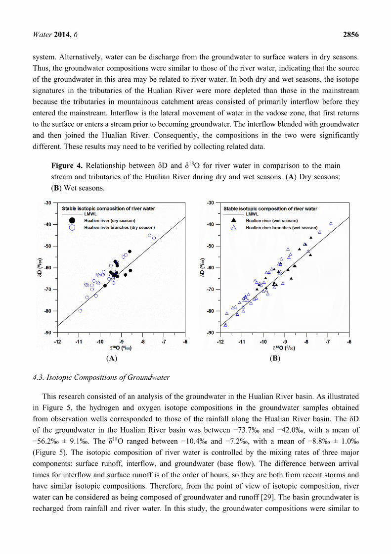
Water 2014, 6 2856
system. Alternatively, water can be discharge from the groundwater to surface waters in dry seasons.
Thus, the groundwater compositions were similar to those of the river water, indicating that the source
of the groundwater in this area may be related to river water. In both dry and wet seasons, the isotope
signatures in the tributaries of the Hualian River were more depleted than those in the mainstream
because the tributaries in mountainous catchment areas consisted of primarily interflow before they
entered the mainstream. Interflow is the lateral movement of water in the vadose zone, that first returns
to the surface or enters a stream prior to becoming groundwater. The interflow blended with groundwater
and then joined the Hualian River. Consequently, the compositions in the two were significantly
different. These results may need to be verified by collecting related data.
Figure 4. Relationship between δD and δ18O for river water in comparison to the main
stream and tributaries of the Hualian River during dry and wet seasons. (A) Dry seasons;
(B) Wet seasons.
(A) (B)
4.3. Isotopic Compositions of Groundwater
This research consisted of an analysis of the groundwater in the Hualian River basin. As illustrated
in Figure 5, the hydrogen and oxygen isotope compositions in the groundwater samples obtained
from observation wells corresponded to those of the rainfall along the Hualian River basin. The δD
of the groundwater in the Hualian River basin was between −73.7‰ and −42.0‰, with a mean of
−56.2‰ ± 9.1‰. The δ18O ranged between −10.4‰ and −7.2‰, with a mean of −8.8‰ ± 1.0‰
(Figure 5). The isotopic composition of river water is controlled by the mixing rates of three major
components: surface runoff, interflow, and groundwater (base flow). The difference between arrival
times for interflow and surface runoff is of the order of hours, so they are both from recent storms and
have similar isotopic compositions. Therefore, from the point of view of isotopic composition, river
water can be considered as being composed of groundwater and runoff [29]. The basin groundwater is
recharged from rainfall and river water. In this study, the groundwater compositions were similar to

Water 2014, 6 2857
those of the river water, indicating that the source of the groundwater in this area may be related to
river water. The primary groundwater source may be river water rather than simply rainfall recharge.
In addition, the hydrogen and oxygen isotopes in the groundwater near the Hualian River slightly
deviated from the hydrogen and oxygen isotopic local meteoric water line in Hualian. Therefore, the
groundwater might be a mixture of river water and rainwater, which explains why the effect of the
river water recharge was greater than the rainfall infiltration.
Figure 5. Plot of δD vs. δ18O of groundwater samples.
-14 -12 -10 -8 -6
-90
-80
-70
-60
-50
-40
-30
-14 -12 -10 -8 -6
-80
-60
-40
-14 -12 -10 -8 -6δ18O (0/00)
-80
-60
-40
δD (0 /0
0)
Stable isotopic composition of groundwaterLMWLDry seasonWet season
4.4. Mass Balance Analysis
The basin groundwater is recharged from rain that falls on the basin and from the tributaries of the
Hualian River (the Mugua River, the Shoufeng River, the Maan River, and the Wanli River) drained
from mountain watersheds (Figure 1). According to the depth of the well screens (80–90 m below
ground) and hydro-geological profiles, groundwater from the four wells (G1, G2, G3, and G4) can be
classified as shallow groundwater. The meteoric δ18O-δD signature is important for understanding the
groundwater recharge. The isotopic composition of groundwater equals the average weighted values of
recharge sources, such as the annual composition of precipitation and river water. Therefore, deviations
of the groundwater isotopic ratio from that of precipitation are expected. The transfer function from
precipitation to groundwater must be understood for groundwater provenance studies. The transfer
function also provides basic information about the mechanisms of recharge [2]. In this study, the mean
value of oxygen isotopic compositions of groundwater for the Huanlian River basin was −9.65‰
(ranging from −9.32‰ to −10.65‰). The mean values of oxygen isotopic compositions of dry and wet
seasons for the Huanlian River basin were −4.18‰ and −6.46‰, respectively. The ratio of precipitation
for dry and wet seasons was 0.19:0.81 from 2000 to 2012 (according to the Central Weather Bureau).

Water 2014, 6 2858
The weighted average δ18O of precipitation was −6.02‰ in the Huanlian River basin. The values of
oxygen isotopic compositions of river water for the dry and wet seasons were −10.20‰ and −10.42‰,
respectively. The ratio of stream flow for the dry and wet seasons was 0.14:0.86 from 1980 to 2011
(according to the Water Resources Agency). The river water weighted average value for δ18O was
−10.39‰ in the Huanlian River (see Table 2).
Table 2. Precipitation and river water weighted average δD, δ18O and d-excess and their
standard error.
Weighted Average: Precipitation River Water
Dry Season Wet Season Dry Season Wet Season
Ratio 0.19 0.81 0.14 0.86 n (used for average) 185 200 41 64
δD (‰) −3.7 ± 16.1 −40.6 ± 32.8 −62.9 ± 6.5 −66.2 ± 10.6 δ18O (‰) −2.3 ± 1.9 −6.3 ± 4.1 −9.6 ± 0.7 −9.8 ± 1.2
d-excess (‰) 14.7 ± 5.6 −9.5 ± 4.6 13.5 ± 3.2 12.1 ± 3.5
In basin water budget studies, it is important to assess the proportion of the precipitation and river
water from the mountain that actually recharges the groundwater. The stable isotopic composition of
groundwater is determined by oxygen and hydrogen isotopic compositions and recharge percentages of
concerned sources. Using mass balance analysis for the oxygen and hydrogen isotopic compositions,
the groundwater recharge percentages of every recharge source can be evaluated. In this study, mixing
between two distinct recharge sources can be quantified by a simple linear algebraic equation:
A B A B
A B
A B A B
C(V V ) AV BV
V VC A B A(1 X) BX
V V V V
+ = +
= + = − ++ +
(3)
where A is the precipitation stable isotope value of the basin; B is the river water stable isotope value
of the mountain watershed; C is the groundwater stable isotope value of the basin; VA is the amount of
precipitation; VB is the amount of river water; X is the recharge proportion of river water; and (1–X) is
the recharge proportion of precipitation.
Based on stable isotopic characteristics, the results show that 83% of the groundwater in the Huanlian
River basin is derived from river water from the mountain watershed, and 17% is from the rain that falls
on the basin. This indicates that the basin groundwater is mainly recharged from the river water from the
mountain watershed, primarily due to the abundant precipitation in the mountain area. Using the mean
d-value, the relative contributions of the wet and dry seasonal sources to the groundwater recharge can
be calculated using a mass-balance equation:
dgroundwater = X dwet season + (1 − X) ddry season (4)
where X and (1 − X) are the fractions of wet and dry seasonal sources, respectively. Based on their
d-values, the groundwater sources are composed of an average of approximately 75.8% wet seasonal
sources and 24.2% dry seasonal sources.

Water 2014, 6 2859
5. Conclusions
The present study examined the stable isotopic composition of precipitation, river water, and
groundwater in the Hualian River basin. Mountain river water accounted for 83%, and plain rainfall
accounted for 17% of the groundwater recharge in the Huanlian River basin. Comparisons between
hydrogen and oxygen isotopes in precipitation showed that differences in the amount of rainfall resulted
in depleted oxygen and hydrogen isotopes for precipitation in wet seasons as compared to dry seasons.
River water contained more depleted hydrogen and oxygen isotopes than precipitation did, implying
that the river water mainly came from the upstream catchment. Using a mass balance equation, a
comparison of d-values of precipitation and groundwater indicated the groundwater consists of 75.5%
wet seasonal sources and 24.5% dry seasonal sources, representing a distinct seasonal variation of
groundwater recharge in the study area.
Acknowledgments
This study was financially supported by funds from the National Science Council (NSC), Taiwan,
under grant NSC 101-2221-E-006-196-MY2 and the Central Geological Survey of Taiwan under grant
102-5226904000-01-02. We would also like to thank Chung-Ho Wang of the Institute of Earth Sciences
at the Academia Sinica for help with analyzing the water samples. Special thanks go to the two
anonymous reviewers and the editors for their critical reviews and helpful comments.
Author Contributions
Hsin-Fu Yeh conceived the subject of the article, literature review and contributed to the writing of
the paper; Hung-I Lin participated in the composition of the manuscript in the method, results and
conclusion sections; Cheng-Haw Lee and Kuo-Chin Hsu provided expertise on groundwater-surface
water interactions and hydrogeology in study area; Chi-Shin Wu participated in data processing,
elaborated the statistical analysis, and figures.
Conflicts of Interest
The authors declare no conflict of interest.
References
1. Gat, J.R. Oxygen and hydrogen isotopes in the hydrologic cycle. Ann. Rev. Earth Planet Sci.
1996, 24, 225–262. 2. Clark, I.D.; Fritz, P. Environmental Isotopes in Hydrology; Lewis Publishers: New York, NY,
USA, 1997. 3. Vandenschrick, G.; van Wesemael, B.; Frot, E.; Pulido-Bosch, A.; Molina, L.; Stiévenard, M.;
Souchez, R. Using stable isotope analysis (δD and δ18O) to characterise the regional hydrology of
the Sierra de Gador, south east Spain. J. Hydrol. 2002, 265, 43–55.

Water 2014, 6 2860
4. Deshpande, R.D.; Bhattacharya, S.K.; Jani, R.A.; Gupta, S.K. Distribution of oxygen and hydrogen
isotopes in shallow groundwaters from Southern India: Influence of a dual monsoon system.
J. Hydrol. 2003, 271, 226–239. 5. Gibson, J.J.; Edwards, T.W.D.; Birks, S.J.; St Amour, N.A.; Buhay, W.M.; McEachern, P.;
Wolfe, B.B.; Peters, D.L. Progress in isotope tracer hydrology in Canada. Hydrol. Process. 2005,
19, 303–327. 6. Gammons, C.H.; Poulson, S.R.; Pellicori, D.A.; Reed, P.J.; Roesler, A.J.; Petrescu, E.M.
The hydrogen and oxygen isotopic composition of precipitation, evaporated mine water, and river
water in Montana, USA. J. Hydrol. 2006, 328, 319–330. 7. Blasch, K.W.; Bryson, J.R. Distinguishing sources of ground water recharge by using δ2H and
δ18O. Ground Water 2007, 45, 294–308. 8. Li, F.; Pan, G.; Tang, C.; Zhang, Q.; Yu, J. Recharge source and hydrogeochemical evolution
of shallow groundwater in a complex alluvial fan system, southwest of North China Plain.
Environ. Geol. 2008, 55, 1109–1122. 9. Heilweil, V.M.; Solomon, D.K.; Gingerich, S.B.; Verstraeten, I.M. Oxygen, hydrogen, and helium
isotopes for investigating groundwater systems of the Cape Verde Islands, West Africa.
Hydrogeol. J. 2009, 17, 1157–1174. 10. Yin, L.; Hou, G.; Su, X.; Wang, D.; Dong, J.; Hao, Y.; Wang, X. Isotopes (δD and δ18O) in
precipitation, groundwater and surface water in the Ordos Plateau, China: Implications with
respect to groundwater recharge and circulation. Hydrogeol. J. 2011, 19, 429–443. 11. Singh, M.; Kumar, S.; Kumar, B.; Singh, S.; Singh, I.B. Investigation on the hydrodynamics of
Ganga Alluvial Plain using environmental isotopes: A case study of the Gomati River Basin,
northern India. Hydrogeol. J. 2013, 21, 687–700. 12. Dansgaard, W. Stable isotopes in precipitation. Tellus 1964, 16, 436–468. 13. Craig, H. Isotopic variations in meteoric waters. Science 1961, 133, 1702–1703. 14. Gat, J.R. The isotopes of hydrogen and oxygen in precipitation. In Handbook of Environmental
Isotope Geochemistry; Fritz, P., Fontes, J.C., Eds.; Springer: Berlin, Germany, 1980; pp. 21–47. 15. Darling, W.G.; Armannsson, H. Stable isotopic aspects of fluid flow in the Krafla, Namafijall and
Theistareykir geothermal systems of northeast Iceland. Chem. Geol. 1989, 76, 197–213. 16. Sakai, H.; Matsubaya, O. Stable isotopic studies of Japanese geothermal system. Geothermics
1977, 5, 97–124. 17. Lee, K.S.; Wenner, D.B.; Lee, I. Using H- and O-isotopic data for estimating the relative
contributions of rainy and dry season precipitation to groundwater: Example from Cheju Island,
Korea. J. Hydrol. 1999, 222, 65–74. 18. Peng, T.R.; Wang, C.H.; Huang, C.C.; Fei, L.Y.; Chen, C.T.A.; Hwong, J.L. Stable isotopic
characteristic of Taiwan’s precipitation: A case study of western Pacific monsoon region.
Earth Planet Sci. Lett. 2010, 289, 357–366. 19. Water Resource Agency (WRA). Investigation of Water Resource in Hualien; Ministry of
Economic Affairs: Taipei, Taiwan, 1997; p. 265.
20. Water Resource Agency (WRA). Investigation of Groundwater Resource in Hualien Alluvial
Valley; Ministry of Economic Affairs: Taipei, Taiwan, 2005; p. 395.

Water 2014, 6 2861
21. Water Resource Agency (WRA). Conjunctive Utilization of Surface Water with Groundwater for
Hualien Area; Ministry of Economic Affairs: Taipei, Taiwan, 2010; p. 525. 22. International Atomic Energy Agency (IAEA). Guidebook on Nuclear Techniques in Hydrology;
IAEA Technical Reports Series No. 91; IAEA: Vienna, Austria, 1983; p. 439. 23. Epstein, S.; Mayeda, T. Variation of 18O content of waters from natural sources. Geochim.
Cosmochim. Acta 1953, 4, 213–224. 24. Coleman, M.L.; Shepherd, T.J.; Durham, J.J.; Rouse, J.E.; Moore, G.R. Reduction of water with
zinc for hydrogen isotope analysis. Anal. Chem. 1982, 54, 993–995. 25. Wang, C.H.; Peng, T.R. Hydrogen and oxygen isotopic compositions of Taipei precipitation:
1990–1998. West. Pac. Earth Sci. 2001, 1, 429–442. 26. Peng, T.R.; Wang, C.H.; Lai, T.C.; Ho, S.K. Using hydrogen, oxygen, and tritium isotopes to
identify hydrological factors contributing to landslides in a mountainous area, central Taiwan.
Environ. Geol. 2007, 52, 1617–1629. 27. Yeh, H.F.; Lee, C.H.; Hsu, K.C. Oxygen and hydrogen isotopes for the characteristics of
groundwater recharge: A case study from the Chih-Pen Creek basin, Taiwan. Environ. Earth Sci.
2011, 62, 393–402. 28. Yurtesever, Y.; Gat, J.R. Atmospheric waters. In Stable Isotope Hydrology: Deuterium and
Oxygen-18 in the Water Cycle; IAEA Technical Report Series No. 210; Gat, J.R., Gonfiantini, R.,
Eds.; International Atomic Energy Agency: Vienna, Austria, 1981; pp. 103–142. 29. Lu, H.Y.; Peng, T.R.; Liu, T.K.; Wang, C.H.; Huang, C.C. Study of stable isotopes for highly
deformed aquifers in the Hsinchu-Miaoli area, Taiwan. Environ. Geol. 2006, 50, 885–898.
© 2014 by the authors; licensee MDPI, Basel, Switzerland. This article is an open access article
distributed under the terms and conditions of the Creative Commons Attribution license
(http://creativecommons.org/licenses/by/4.0/).