volume xxv - URARA - Utah Rock Art Research Association
132
-
Upload
khangminh22 -
Category
Documents
-
view
0 -
download
0
Transcript of volume xxv - URARA - Utah Rock Art Research Association


UTAH ROCK ART
VOLUME XXV
Papers from the Twenty-fifth Annual Symposium
Price, Utah
October 7 through 10, 2005
and
VOLUME XXVI
Papers from the Twenty-sixth Annual Symposium
Vernal, Utah
October 6 through 9, 2006
2008
Utah Rock Art Research Association
Salt Lake City, Utah


i
UTAH ROCK ART
VOLUME XXV
Papers Presented at the Twenty-Fifth Annual Symposium
of the Utah Rock Art Research Association (URARA)
Price, Utah
October 7–10, 2005
Edited by Anne McConnell and Elaine Holmes
Cover and Graphics by Anne Carter
Published 2008 by the Utah Rock Art Research Association
Copyright 2008 by the Utah Rock Art Research Association, Salt Lake City, Utah.
All rights reserved. No part of this publication may be reproduced in any form or by
any means without permission in writing from the author and the publisher.
Printed in the United States of America.

ii

iii
CONTENTS
Steven J. Manning The Importance of the Rock Art in
Nine Mile Canyon, Utah XXV-1
Ray T. Matheny & Nine Mile Canyon Rock Art and
Deanne G. Matheny Communal Hunting XXV-41
Nina Bowen Rock Art Styles of the Great Salt
Lake/Utah Lake Area XXV-61
Ben Everitt The Music Panel, Grand Gulch XXV-67
Speakers at the Twenty-Fifth Annual Symposium of the Utah
Rock Art Research Association in Price, Utah, October
7–10, 2005 XXV-71

iv
S. J. Manning

Manning: The Importance of the Rock Art in Nine Mile Canyon, Utah
XXV-1
The Twenty-fifth Annual Symposium of the
Utah Rock Art Research Association was held
in Price, Utah, because of the threat to the rock
art of nearby Nine Mile Canyon. Everyone
attending the symposium was encouraged to take
this opportunity to visit Nine Mile Canyon and
see for themselves the adverse impacts that are
occurring to the rock art in the canyon. Because
of this situation, I am going to focus this paper on
why the rock art in Nine Mile Canyon is
important. This paper is divided into three parts.
The first part is a brief discussion about the natural
gas explorations and extraction activities that are
impacting the rock art in Nine Mile Canyon. The
second part is a discussion of previous research
in Nine Mile Canyon for those who are not
familiar with this topic and as a foundation for
the information that is presented in the third
part. The third part presents examples that demon-
strate some of the reasons why the images in Nine
Mile Canyon are important and why they should
be preserved. This discussion cannot include all
that is known about the importance of the rock
art, it would require a book to do that, but these
examples should be sufficient. In this paper I
wish to emphasize the importance an individual
panel can have and show how much information
can be obtained from just one panel, and what
images in these panels tell us about people who
came to Nine Mile Canyon hundreds, and even
thousands, of years ago.
PART I
THE THREAT TO THE ROCK ART OF
NINE MILE CANYON
Oil and principally natural gas extractions on
the West Tavaputs Plateau and the adjacent
southern rim of the Uintah Basin threatens to
Steven J. Manning
THE IMPORTANCE OF THE ROCK ART IN
NINE MILE CANYON, UTAH
harm and has harmed the important prehistoric
images that exist in Nine Mile Canyon. Dust
created by commercial vehicles traveling on the
dirt roads is being deposited on petroglyphs and
pictographs making it difficult in some in-
stances to even see the images. Numerous con-
struction trucks, tankers with large trailers, large
gravel trucks hauling road base, drilling rigs,
water tankers, and other large commercial vehicles
travel up and down the unimproved dirt road in
the canyon 24 hours a day. Currently about 40
commercial trips are made every day over the
road in Nine Mile Canyon, which was never
designed for 80,000-pound vehicles.
[Note 2008: The number of vehicle trips is
expected to reach 2,853,370 over the 33-year
life of the project (WTP DEIS, Section 2.2.10),
which, for 168 new wells, would be 575 trips a
day. This figure represents only part of the
development of the natural gas and oil re-
sources because this number of vehicle trips is
only from one major natural gas company—Bill
Barrett Corporation—and several small
companies. Even this number is only an es-
timate. Actual vehicle trips will certainly exceed
this number; just as the actual number of ve-
hicle trips today is almost double Bill Barrett
Corporation’s previous estimate.]
As these semi-trucks and trailers travel over the
dirt road, great clouds of dust fill the canyon. The
dust settles on the vegetation and the rock art
that lines the canyon walls. The numerous
petroglyphs and pictographs that were created
hundreds and even thousands of years ago are now
becoming obscured by this dust (Figure 1). When
it rains, the dust turns to mud, which flows
down over the images impacting them even more
(Figure 2).

Utah Rock Art, Volume XXV, 2008
XXV-2
The use of corrosive magnesium chloride and
other chemicals which have recently been applied
to the roads in an effort to control the dust, also
ends up on the pictographs and petroglyphs as the
extremely heavy trucks eventually break up parts
of the dirt road and churn it to powder. Pollution
from diesel exhaust and compressor stations fouls
the air and adversely affects the rock art.
Vibrations from the heavy trucks are also
loosening the rocks on which the rock art was
placed, hastening the image’s total destruction.
Figure 3 shows part of a cliff face that once
contained pictographs that is now lying on the
road.
In the fall of 2004, the National Trust for Historic
Places designated Nine Mile Canyon as one of
the “Eleven Most Endangered Historic Places in
America.” The Carbon County Commission, the
State of Utah, and the Bureau of Land
Management have all failed to take any
substantive preventive measures to protect the
prehistoric rock art of Nine Mile Canyon. Their
primary failure is that they did not require all
commercial vehicles to use an alternative route
past the town of Sunnyside, bypassing Nine Mile
Canyon entirely.
Figure 1. Left: Oct. 2000. Right: Oct. 2005. Sometime after this picture was taken, the dust was removed
from this and the Great Hunt panel, apparently with a pressure washer, by persons unknown.
Figure 2. Petroglyph panel showing the effects of
road dust and rainwater, Oct. 2005.
Figure 3. Part of a large newly fallen section of a
cliff face on the Nine Mile Canyon road, Oct. 2005.
A pictograph panel is now missing on the cliff face
above. The bright red-orange paint is to alert
drivers of the now hazardous rock.

Manning: The Importance of the Rock Art in Nine Mile Canyon, Utah
XXV-3
PART II
PREVIOUS RESEARCH
The following is a brief summary of what
researchers have understood about the rock art in
Nine Mile Canyon and in Utah. This summary
provides a description of how the prehistoric
images in Nine Mile Canyon have been studied
by researchers, as well as what has been
understood about the origins, cultural affiliations,
styles, areal distributions, currently defined
classifications, etc. of these images. This summary
will also briefly review how various systems of
classification were developed and demonstrate the
variety of types of rock art present in Nine Mile
Canyon. It will also provide relevant introductory
information for the discussions in Part III. The
developments in rock art research are arranged in
order of occurrence.
Garrick Mallery
Almost certainly, the earliest attempt at
investigating the rock art in Utah was by Garrick
Mallery in 1882 and 1889 (published in 1886 and
1893 respectively). In the late 1800s, little was
known about Utah rock art outside of Utah
(Mallery 1886:116–121). The situation in Utah
was entirely different. Members of the Church of
Jesus Christ of Latter-Day Saints (Mormons) had
settled next to the Great Salt Lake in 1847. Two
years later colonization efforts were commenced
that led to small settlements throughout much of
what would later become the western United
States. The people who settled the Price area were
soon acquainted with the rock art in Nine Mile
Canyon.
In about 1888, the ancient inhabitants of Utah and
the southwestern region of the United States were
known as Moki Indians. Mallery’s work not only
represents the early stages of categorization, but
also the determination of cultural affiliation and
the distribution and meaning of rock art. Mallery
attempted to correlate comparable images from
various regions to show a consistency in the
meaning of the images and therefore establish a
cultural continuity. He determined that various
types of rock art located in Utah were comparable
to that which existed in surrounding regions and
he concluded that it was also created by the same
cultures and that it had interrelated meaning.
Julian H. Steward
Julian Steward in 1929 described a style of
petroglyphs that he identified in the western
United States, i.e., from eastern California to the
Rocky Mountains of Utah (Steward 1929:220).
This area, called the Great Basin, is west of Nine
Mile Canyon, which is situated on the Colorado
Plateau east of the Wasatch Mountain range.
Steward noted that the images found in the Great
Basin consist principally of curvilinear design
elements, such as meanders and wavy grid
patterns, which often filled the entire surface of a
boulder. Steward named these images the Great
Basin Curvilinear Style. The style also includes
circles, chains of circles, spoked wheels, hand and
footprints, animal tracks, mountain sheep, simple
human stick figures, along with “abstracts that
defy description.” Mallery was also aware of
this type of image (Mallery 1893: plates I–XI)
but he did not suggest a name for them. Steward
attributed these panels to the Desert Archaic
Culture. In Utah and Nevada, they apparently
continued to be created into the Formative Period
with the addition of small Fremont anthro-
pomorphs. These images extend farther eastward
than Steward realized.
Albert Reagan
In about 1930, Albert Reagan, a schoolteacher
with the U. S. Indian Field Service who was
teaching in Ouray, Utah, became interested in the
rock art in Nine Mile Canyon and in the Uintah
Basin of northeastern Utah. He published several
papers in which he classified the rock art in the
Ashley and Dry Fork Valleys into a kind of
cultural-history scheme (Reagan 1931, 1933a).

Utah Rock Art, Volume XXV, 2008
XXV-4
His categories were Basketmaker, The Earth-
Lodge Pueblo People, People of the Round or
Circular-Bodied Drawings, and The People of the
Head-Hunting Square-Shouldered Drawing Era.
Up to Reagan’s time the differences between the
archaeology and rock art of eastern Utah and the
surrounding areas were still little known, so
Reagan believed, as did others, that Utah was a
fringe area of the Anasazi from the Four Corners
region of Arizona, New Mexico, Colorado, and
Utah. At that time, Utah was considered by
archaeologists to be part of the “Northern
Periphery” of the Anasazi.
Reagan’s initial paper was followed by a number
of others over a period of several years (principally
1931–1935) in which he expanded his thesis.
Reagan believed that the first occupants of Utah
were Basketmakers and that they were confined
largely to the Ashley-Dry Fork Canyon and to
Nine Mile Canyon (1933a:3). The panels where
“Puebloan” elements superimposed “Basket-
maker” elements were evidence to Reagan that
the Puebloan people of the “Willard-Beaver
Culture” of western Utah migrated into the area.
Later occupation by Pueblo people resulted in the
creation of the panels in Hill Creek Canyon where
“…men carrying the image of the horned snake,
kachina scenes, and women with whorled hair as
Hopi virgins wear their hair at the present time”
(1933a:6). Reagan also described panels in Nine
Mile Canyon purportedly depicting Puebloan
ceremonial scenes with masked participants
(1935:707–708), Puebloan horned or plumed
serpents (1933b), and Puebloan domesticated
turkeys (1933a:6).
Reagan believed that the fourth and last group to
migrate into the region were the Head Hunters,
who appeared to be an amalgamation of peoples,
including some of the Shoshonean family, more
or less allied with the ancient peoples from which
the present Ute-Chemehuevi people descended
(1933a:7).
Most of Reagan’s explanations for the cultural
affiliation and interpretation of rock art in Nine
Mile Canyon have been superseded by later
research; and although he used names for var-
ious types of rock art images in Nine Mile Canyon
that have not stood the test of time, the temporal
sequence that he proposed for the various images
is surprisingly accurate. Reagan’s papers are also
still valuable because they contain photographs
and descriptions of rock art and archaeological
features that no longer exist or are badly
vandalized.
Noel Morss
Also in 1931 a report was published by Noel
Morss, an archaeologist from Harvard University,
that changed archaeologists’ views of the
prehistoric cultures in Utah. Morss identified the
rock art in Utah as being unique from that of the
general Southwest and determined that it was
characteristic of a distinctive culture, which he
named the Fremont, after the Fremont River
drainage in central Utah where he was excavating
sites.
Morss notes that the rock art of the Fremont region
is,“among its most interesting antiquities” and at
the same time concluded that the images
“…present some of the most difficult problems”
(1931:34). Morss believed that the images could
be associated with the materials that he excavated;
however, variations from what he considered
normal always seemed to lead to great
uncertainties. Morss noted that “…studies in style,
subject matter, and superimposition do little to
clear up the confusion” (1931:34).
In 1929, Morss made a “…hasty trip as far as Nine
Mile Canyon, well up on the Green River, where
evidences of the same culture, or something very
like it were found.” The principal area visited by
Morss in Nine Mile Canyon was centered on a
large cave at the Rasmussen Ranch. The now well-
known and heavily visited site is called
Rasmussen Cave. Morss concludes from his

Manning: The Importance of the Rock Art in Nine Mile Canyon, Utah
XXV-5
observations in the cave that, “It seems probable
that the painted groups at least are the product of
a culture similar to, if not indistinguishable from,
that of the Fremont valley…” (1931:40). Morss
also stated that: “The Fremont anthropomorphs
seem to have been developed from Basketmaker
prototypes and indicate the personification of
supernatural beings in forms similar to those now
familiar in the Southwest” (Morss 1931:42).
Morss’s understanding of the distinctive nature
of Utah rock art was undoubtedly influenced by
his visit to Nine Mile Canyon.
David S. Gebhard and Harold A. Chan
In 1950, Gebhard and Chan described a distinctive
type of rock art located in western Wyoming. At
that time, it was recognized as existing in the area
around Dinwoody Canyon and Dinwoody Lake.
It therefore became known as Dinwoody Style
rock art. The Dinwoody Style plays a major part
in the importance of the rock art in Nine Mile
Canyon, so it will be described here in some detail.
As described by Gebhard and Chan (1950), the
images exhibit an emphasis on extraordinarily
abstract and supernatural anthropomorphic
forms. They commonly appear in outline form
with complex, sometimes elaborate, body
decorations consisting of patterns of horizontal
and/or vertical lines and geometric designs. The
anthropomorphs frequently are associated with
wavy lines, groups of circles, and dot patterns.
Occasionally, abstract forms exist that resemble
the form of a body, but no (or few) arms, legs, or
heads appear. Although these images generally
resemble humans, some appear to represent birds
because of the presence of what appear to be wings
and claw feet. These particular images appear owl-
like. Another characteristic feature of the images
is that they have short stubby arms and legs and
the heads sit directly on the shoulders of a
generally rectangular body with rounded corners.
The images range in size from six inches to six
feet (0.15 to 1.8 m). Animal figures also occur.
The outlined figures are generally larger than the
solidly pecked figures where they appear together.
Gebhard and Chan (1950:221) classified these
images into four classes and four subclasses based
on superimpositions, weathering, and/or
differences in style, which they note are “from a
realistic primitive to a more complex advanced
style.”
In 1969, Gebhard discussed these images in more
detail. During the interim between publications,
Gebhard and others found additional examples
and extended the distribution of the style to
include the Wind River Mountains, the southern
Big Horn Basin, and the Boysen Basin. Gebhard
also revised the previous style classifications into
three general styles, which he defined as the Early
Hunting Style (Style 1), the Interior Line Style
(Style 2), and the Plains or Late Hunting Style
(Style 3). Gebhard stated that the Interior Line
Style “…is the predominant style at Dinwoody
and gives the area its distinctive quality” (Gebhard
1969:16).
Gebhard, noting that images from other parts of
the west also contained anthropomorphs with
rectangular bodies decorated with interior lines,
was of the opinion that this demonstrated a
commonality, i.e., all of these images were in some
way related. He also noted the existence of
remarkably similar images occurring in a panel
in Dry Fork canyon in northern Utah and two
panels near the Utah-Wyoming state line near
Flaming Gorge that, “… exhibit classic examples
of the Wyoming Interior Line figures” (Gebhard
1969:20). Based upon the existence of these
figures, Gebhard noted that it was entirely possible
that the Interior Line Style extended southward
into northern Utah and Colorado.
Beverly Childers in 1984, while studying the
Dinwoody type petroglyphs in Fremont County,
Wyoming, created four subclasses of Gebhard’s
Interior Line Style. These were Linear Winged
Anthropomorphic Figures, Major Anthropomorph
Figures, Abstract Designs, and Representational
Figures. She found that Abstract Designs virtually
always accompany Representational Figures, and

Utah Rock Art, Volume XXV, 2008
XXV-6
in many cases are physically connected to them
(Childers 1984:8). Analyzing the levels of
repatination, amount of lichen growth covering
the images, and differences in style she found
that the oldest figures appear to be the Linear
Winged Anthropomorphic Figures, followed by
the Major Anthropomorph Figures, then by the
Representational Figures.
James D. Keyser and Michael A. Klassen
Two archaeologists from northwestern Wyoming,
James D. Keyser and Michael A. Klassen, rede-
fined Plains Indian rock art in 2001. They classi-
fied the rock art of the Northern Great Plains into
traditions. They define a tradition as a descriptive
organizational division based on traits shared by
a group of images. Each of their 11 traditions
consists of a set of related styles for which a
temporal, spatial, and cultural continu-ity can be
established (Keyser and Klassen 2001:13–15).
Keyser and Klassen disagree with several of
Gebhard’s conclusions. For example, they state:
“The characteristic interior body designs have led
some authors to group these petroglyphs into a
more widespread Interior Line Style that occurs
across much of the southwestern United States.
The Dinwoody tradition itself is restricted to a
small area of western Wyoming that includes the
Wind River Valley and adjacent southern Bighorn
Basin” (Keyser and Klassen 2001:107, italics
added). Keyser and Klassen further state: “One
of the most important characteristics of the
Dinwoody tradition rock art is its restricted
geographic range—a fact noted by every scholar
who has studied it (Francis 1994; Wellmann
1979a; Gebhard 1969; Keyser 1990; Loendorf
1993)” (2001:121). They also note that
“Dinwoody tradition motifs are found almost
exclusively in the Wind River and Bighorn
Basins. So notable is their absence to the east of
the Bighorn River that Francis has proposed that
the river was a prehistoric territorial boundary”
(Keyser and Klassen 2001:121–122). Keyser and
Klassen (2001:122) do however note that: “A few
sites with similar, although somewhat simpler
motifs occur to the south of the Wind River Basin.
…several others occur in the Green River drainage
of southwestern Wyoming and northeastern
Utah (Gebhard 1969 and Cole 1990).” The images
referred to by Gebhard and Cole are similar to
Dinwoody tradition figures, but they do not have
the same comparative detail in the form and
features of the images, as do the images in Nine
Mile Canyon.
Keyser and Klassen are also of the opinion that
the Dinwoody tradition is likely the best-dated
rock art in North America. They state that five
major dating techniques, including superposition,
differential weathering, dated archaeological
deposits, portrayal of dateable objects, and rock
varnish dating have established a date starting
at 1000 B.C. and ending at A.D. 1775 for the
Dinwoody tradition.
Some of Keyser and Klassen’s conclusions
regarding the Dinwoody tradition are incorrect
because they are based on incomplete information.
Their search for Dinwoody tradition images
would benefit from a search for these images
beyond “a small area of western Wyoming.”
Dinwoody images are found in Nine Mile Canyon,
as described below; moreover, the rock art in Utah
has been dated at least as accurately as the
Dinwoody tradition.
Robert E. Heizer and Martin A. Baumhoff
In 1962, Heizer and Baumhoff published the
results of a three-year study on the rock art of
Nevada and eastern California. They built upon
the work of Julian Steward and identified five
main rock art styles. These are: (1) Great Basin
Pecked, (2) Great Basin Painted, (3) Great Basin
Scratched, (4) Puebloan Painted, and (5) Pit and
Groove (1962:197). Of these, the Great Basin
Pecked Style is likely the most significant here
because, unknown to Heizer and Baumhoff, it
extends eastward far into Utah. This style was
further divided by Heizer and Baumhoff into two

Manning: The Importance of the Rock Art in Nine Mile Canyon, Utah
XXV-7
sub-style categories: the Great Basin
Representational Style and the Great Basin
Abstract Style. The Great Basin Abstract Style
was further subdivided by Heizer and Baumhoff
into the Great Basin Curvilinear Abstract and the
Great Basin Rectilinear Abstract Styles. The
definitive elements of the Great Basin Rectilinear
Abstract Style are dots, rectangular grids, bird
tracks, rakes, and crosshatches, while those of the
Great Basin Curvilinear Abstract are circles,
concentric circles, chains of circles, sun disks,
curvilinear meanders, stars or astral, and snakes.
Heizer and Baumhoff suggested that these two
styles date at least from about 1000 B.C. to about
A.D. 1500 with the Great Basin Curvilinear
Abstract appearing earlier (1962:233).
Christy G. Turner II
In 1963, following the archaeological salvage
operations of the Glen Canyon Dam, a report was
published by Christy Turner in which he classified
the rock art in the Glen Canyon Region into
categories that he called “style horizons.” This
was, and still is, arguably the most important study
of Utah rock art. While some of Turner’s
categories have to some extent been refined,
renamed, and reordered by others, it is the only
comprehensive work categorizing rock art that
takes into account artifact association, image type,
pottery and petroglyph association, method of
manufacture, repatination, superimposition, and
geological context.
To conduct a study of this type today would be
difficult or likely impossible. Turner was fortunate
to work in a region that, at the time, had received
sparse historic human visitation; artifacts were
actually still present at every site. Today nearly
all of the surface artifacts have been removed, or
are in the process of being removed by the public.
This is not only true in southern Utah, but at nearly
all archaeological sites in the entire western
United States, even though Federal and state laws
prohibit the removal of all prehistoric artifacts
without a permit.
Turner’s work is exceptionally important because
what occurred in Glen Canyon during the past
8,000 years, or longer, also occurred adjacent to
Glen Canyon. Thus, Turner’s classification of rock
art can be applied to a much larger region. For
example, in the Fremont area north of Glen
Canyon where Nine Mile Canyon is located,
similar changes over time and general
characteristics also occur in the rock art there. This
indicates that Turner’s findings are indicative of
a broad cultural manifestation that occurred over
a very large area. It should be noted that a cultural
classification scheme comparable to that
developed for the Anasazi realm, i.e. the Pecos
Classification, has not been developed for the
Fremont area, so Turner’s cultural periods, which
are based on Anasazi Basketmaker and Pueblo
periods, cannot be (or have not yet been) directly
applied to corresponding periods in the Fremont
culture.
Turner described his style horizons as follows:
Style 1 was the most recent, and it dated from
1850 to the present. It was made by Navajo,
Paiute, and Anglo-Americans. It principally
depicts cowboys (both on and off horses), horses
with saddles, mules, cattle, sheep, goats, rabbits,
eagles, and the names, dates, likenesses, and
initials of people who have lived in or passed
through the area. Style 1 also includes imitations
of existing prehistoric elements. These are
generally easy to distinguish because of their fresh
appearance. Historic repecking of prehistoric
designs was also noted. Turner also observed that:
“The Navajo-Paiute pecking technique is an
outline form with the enclosed area seldom pecked
out. Dints are shallow and broad, seldom placed
equidistantly, and appear to have been done with
a metal tool” (Turner 1963:5). This description
could just as easily be applied to some Ute rock
art in eastern Utah.
Style 2 dates from 1300 to the present, and it was
created by the Hopi. Hopi potsherds were found
at some of the sites. The images were produced
by shallow dinting and incising, which is similar

Utah Rock Art, Volume XXV, 2008
XXV-8
to images located around Hopi Villages. The
images generally consist of identifiable Kachina
figures, crosshatched sandals, clan symbols,
sheep, and poorly executed anthropomorphs.
Style 3 was created during the period from roughly
A.D. 1200 to 1300. Turner concluded that it was
created by the Kayenta and Mesa Verde Anasazi
in the late P-III period. The pecking appears to
have been done with a sharp stone hit directly
against the rock surface resulting in a generally
poorly executed outline form with broad irregular-
edged lines. Images include sheep, broad-bellied
lizard-men with occasional ear pendants, an
occasional broad-lined stick figure, concentric
circles, and negative designs. Turner noted that
“The horns of the sheep tend to stem from the
neck region rather than from the head and the
sheep often have the nasal region extending and
drooping like the snout of an elephant. Naturalistic
designs are poorly done, but the negative designs
are often the most striking of a specific panel”
(Turner 1963:6). Turner further notes that the
images are generally not naturalistic and always
fall short of the quality of the earlier Style 4
figures. “Elaboration of elements does not
characterize this style horizon. Rather, its
complexion is a retrogression from the plasticity
and peerless extensibility of Style 4. Designs can
thus be recognized by hammerstone pecking
technique, paucity of element variation, and
position of the sheep’s horns” (Turner 1963:6).
Style 4 was believed by Turner to have been
produced in the P-II/P-III period or about A.D.
1050–1250 by the Kayenta Anasazi along with
Mesa Verde Anasazi influence. This style was
considered by Turner to be the most widespread
and most well executed in the area, and it was
consistently associated with P-II/P-III pottery.
Turner noted that dints are shallow to deep and
are generally spaced equidistantly and the pecking
technique was usually a well-controlled
hammerstone and chisel method. Incising is rare.
The figures are both solid pecked and outlined
forms.
Turner notes that the subject matter is so variable,
compared to the other four styles, and the pecking
technique so well executed, that this style is easily
recognized. Turner stated that the Style 4
diagnostic designs are birds, flute players, hunt-
ing scenes, anthropomorphs with enlarged
appendages and genitals, bird-bodied open
mouthed cloven-hoofed sheep, concentric circles,
watch spring scrolls, and triangular-bodied
elaborately head-dressed anthropomorphs. Other
images cataloged by Turner in Style 4 are listed
in Figure 4. These same elements can be found in
Fremont rock art in the same period.
Abstract (non–representational) designs
bird tracks
bird-bodied sheep
bow-and-arrow carrying anthropomorphs
complex blanket or pottery designs
concentric circles
dotted-center sunbursts
extremely large-handed anthropomorphs
extensive non-representational design motifs
flat-bellied lizards
flute players
game-playing anthropomorphs
hat-topped anthropomorphs
humped-back anthropomorphs or snails
hunting shafts
hunting scenes
large-footed birds
large-footed sheep
left and right handprints and foot prints
lizard-men
long-necked birds
masks
notched toe sandal designs
paired sandals
possible birth scenes
reclining flute players
rectangular frames
sheep
sheep hoof prints
shields
simple blank designs
snakes
solid triangular anthropomorphs
watch-spring scrolls
Figure 4. A partial inventory of elements listed by
Turner as appearing in Style 4 (Turner 1963:6–7).

Manning: The Importance of the Rock Art in Nine Mile Canyon, Utah
XXV-9
Turner also describes an unusual image found in
the region. These are the “triangular-bodied
anthropomorphs wearing a bird-bodied
headdress.” Turner notes that these figures appear
at sites with Mesa Verde ceramics along with the
above designs. Other differences at these sites led
Turner to conclude that these images: “…may be
considered to represent a Mesa Verde division of
Style 4” (Turner 1963:7).
Style 5 was classified by Turner as the oldest rock
art in Glen Canyon. It often had no ceramic
association, being created prior the advent of
pottery. The degree of obliteration and re-
patination of Style 5 petroglyphs suggested to
Turner that they were twice as old as Style 4.
Turner indicates that Style 5 consists almost
exclusively of rectilinear outline forms,
occasionally filled within the outline with paral-
lel or vertical lines or with combinations of the
two. Triangular forms are rare; instead, there is
an emphasis on rectilinear shapes. Many of the
figures were created with deeply incised, broad
straight lines. Dints are the deepest of the five
styles. They are relatively well placed. Solid
pecked areas are very rare, as are narrow lines.
Turner describes the anthropomorphs of Style 5
as sometimes having very large elongated bodies
that are also occasionally filled with the horizontal
and/or vertical line pattern. Arms and legs are
minor features, usually being a single line. The
heads often have elaborate headdresses.
Anthropomorphs occasionally hold hunting
shafts, and there is an emphasis on sheep. These
sheep also often have exceptionally large
rectangular bodies with head, tail, and legs
disproportionately small and with the same
interior lines.
These images in Style 5 were originally thought
by Turner to be made by people living before A.D.
1050 and to include the Archaic (Desert Culture)
and the Anasazi—both Basketmaker and P-1
Pueblo. Turner modified this in 1970. Following
additional geological and archaeological findings
Turner extended the beginning of rock art in Glen
Canyon to 4,000 to 8,000 B.P. Evidence for this
was: (1) the similarity of Style 5 to the split twig
figurines (dated at that time to 4,000 B.P.), (2)
occupation in the Glen Canyon dated to 8000
B.P. and (3) the apparent occurrence of Style 5
throughout most of western North America.
Turner notes that the Glen Canyon Style 5
petroglyphs are “… the best candidates for the
earliest rock art in the New World” (1971:469–
471). Turner also states that Style 5 could likely
be usefully subdivided, which was an insightful
and accurate observation.
Polly Schaafsma
In 1971, the Peabody Museum of Archaeology
and Ethnology at Harvard University published a
monograph by Polly Schaafsma wherein she
classified the rock art of Utah into a number of
artistic styles. She accomplished this by using a
collection of photographs and drawings
accumulated by the late Donald Scott of the
Peabody Museum (Schaafsma 1994[1971]:xvii–
xix). Schaafsma’s work is centered nearly
exclusively on the Fremont rock art of Utah, since
that was apparently Mr. Scott’s main interest, or
at least one of them. Unlike Turner, Schaafsma’s
data did not come from personally visiting the
sites. Therefore, information on patination levels,
construction techniques, associated dateable
artifacts, site context, geology, etc., were not
available. She notes that even “the scales of the
figures were unknown” (Schaafsma 1994 reprint
preface). Schaafsma’s study, then, was one
conducted principally on the basis of the artistic
qualities of the images. While the data available
to Turner was missing, her study is no less
important than Turner’s work.
Schaafsma’s classification structure was de-
veloped by first sorting the numerous photographs
and drawings from all over Utah according to their
“general appearance and on the basis of an
intuitive evaluation of the elements present” along
with the “aesthetic qualities.” In addition to these

Utah Rock Art, Volume XXV, 2008
XXV-10
features, she tabulated the frequency of occur-
rence of the various elements. Then, noting the
existence of patterns in the rock art, she grouped
the photographs according to geographic
distributions. Schaafsma found that they nearly
corresponded to Ambler’s Uintah Fremont and
Northern and Southern San Rafael designations
(Ambler 1966:273, Figure 51). The styles that
Schaafsma defined, which are applicable to Nine
Mile Canyon, are as follows:
Classic Vernal Style (Uintah Fremont). The area
in which this style principally occurs is the
Uintah Basin in Northeastern Utah and north-
western Colorado. Schaafsma rightly considers
that this style “embraces the most advanced
expression of Fremont petroglyphic art”
(1994[1971]:8). She notes that the panels contain
many grand human figures with broad shoulders.
These anthropomorphs have large trapezoidal
bodies with simple large, round, rectangular, or
bucket heads. Many of them have outlined bodies.
Hands are often missing. Feet are often
exaggerated. The images often exhibit elaborate
decorative detail. Heads have facial designs and
headdresses and the ears have pendants. The
figures often have ornate necklaces. Schaafsma
also notes, “Small anthropomorphic figures,
quadrupeds, and abstract designs are often found
in the panels with the large dominating
anthropomorph” (Schaafsma 1994[1971]:8).
Northern San Rafael Style. South of the Uintah
Basin is a region Schaafsma refers to as the San
Rafael. Schaafsma defined the existence of two
styles in this region. These are the Northern San
Rafael Style (which includes all of Nine Mile
Canyon) and the Southern San Rafael Style. The
Northern San Rafael Style area includes the
southern and northern drainages of the Book
Cliffs, Roan Cliffs, and the Tavaputs Plateau from
Price, Utah, to Grand Junction, Colorado.
Schaafsma (1994[1971]:28) states that the
element and attribute data of sites in this area
“exhibit a stylistic phase of Fremont rock art
which is internally consistent and distinct” from
areas around it. She notes that the area lacks the
large well-executed, highly-decorated anthro-
pomorphs. Instead of the “pleasing visual
patterns” present in the Classic Vernal Style, both
large and small panels are “crowded and busy,
with a wealth of small solidly pecked figures that
are carelessly executed and ill defined”
(1994[1971]:29). Schaafsma also notes that the
area contains a greater percentage of paintings
than the Uintah Basin.
Southern San Rafael Style. Schaafsma’s
Southern San Rafael Style zone virtually covers
all of southwestern Utah, with the exception of
the southeast corner and the area southwest of the
Kaiparowits Plateau. Schaafsma notes that the
sites in this region are widely scattered and show
a high degree of variability. She observed that the
panels lack the stylistic unity found to the north,
a fact that she attributes to the rugged terrain of
the region. Schaafsma discusses sites in this region
on a panel-by-panel basis.
Some of the distinctive features of this region, as
indicated by Schaafsma, are the diagonal line
drawn through the torso of anthropomorphs and
the absence of dot patterns and round hair bobs
or earrings. Schaafsma also notes that one of the
factors that make this region distinctive is the
presence of Anasazi characteristics—such as
“rows of hand holding figures, flute players, and
animal tracks” (1994[1971]:53). It is obvious
from Schaafsma’s discussion of this area that,
unfortunately, Scott’s files were sorely lacking
in information about the wealth and diversity of
rock art sites from this region.
Barrier Canyon Anthropomorphic Style.
Schaafsma observed that “…Within the San
Rafael Fremont region there is a group of rock
paintings in which life-size paintings are
dominant, but which are stylistically distinct
from the Fremont tradition described above.”
(Schaafsma 1994[1971]:65) She named these
paintings the Barrier Canyon Anthropomorphic
Style after the tributary where the largest number

Manning: The Importance of the Rock Art in Nine Mile Canyon, Utah
XXV-11
of known panels was located. Schaafsma
described these images as follows: “The dominant
motif in these paintings is the long dark form of
the human torso” (Ibid:69). “These highly
abstracted and mummy-like anthropomorphs
which seem to hover against the cliff walls
determine the overall aesthetic impact of the
Barrier Canyon Style, not only because of their
repeated occurrence in each site, but also because
of their great size in comparison with the few
other elements occurring with them which are
often tiny adjuncts to the major anthropomorph
theme” (Ibid:69). Schaafsma notes that the
decorative detail is distinctive: “The torso may
be intricate and textile like. Heads occasionally
have crowns of white dots or short lines” (Ibid:69).
Birds often accompany the large anthropo-
morphic figures. Citing what Schaafsma believed
to be Fremont images superimposed over Barrier
Canyon Style images, she concluded that they
were Archaic in origin (Ibid:135)
San Juan Anthropomorphic Style. In 1980,
Schaafsma defined an additional style in
southeastern Utah. This was the San Juan
Anthropomorphic Style. The diagnostic feature
of this style, Schaafsma notes, is the “large, broad-
shouldered anthropomorph figure depicted in
rows, in pairs or scattered across a cliff face”
(1980:109). The anthropomorphs are often
elaborately decorated with ornate headdresses,
necklaces of various types, belts, etc. Arms and
hands with fingers, and legs with feet and toes
usually hang straight down at the sides. The bodies
are usually trapezoidal.
Chihuahuan Polychrome Abstract Style. Also
in 1980, Schaafsma added another style to the
repertoire of Utah rock art. She defined a
Chihuahuan Polychrome Abstract Style.
Schaafsma found these images distributed in
caves and rockshelters in the Chihuahuan desert
of southern New Mexico and in Eastern Utah.
Noting the similarity of these images in design
inventory to the Great Basin Abstract Style
petroglyphs, she attributed the images to the
Western Archaic (Desert Culture). This is
reinforced by a site in Grand Gulch where the
Polychrome Abstract images are high out of reach
on the back wall of a tall and deep rockshelter,
while Anasazi Basketmaker images are beneath
them. The Chihuahuan Polychrome Abstract Style
is composed principally of rows of short parallel
lines (which sometimes descend from a horizontal
line), zigzags, circles, circles with a single
descending line, concentric circles, dot patterns,
and wavy lines. Despite the presence of a major
Chihuahuan Polychrome Abstract Style just 60
miles south of Nine Mile Canyon, no examples
of this style have been found to this date in Nine
Mile Canyon.
William G. Buckles
In 1971, William G. Buckles defined two styles
of rock art in western Colorado that were
attributable to the Ute Indians. These styles are
the Early Historic Ute, which date from the time
the Utes acquired the horse (about 1640 to 1830),
and the Late Historic Ute (1830 to 1880) when
the Utes were removed from the region and settled
in the Ute Indian Reservation in northeastern
Utah. Buckles (1971) noted that Ute rock art
contains both pictographs and petroglyphs, with
solid pecking predominating; although stipple
pecked, grooved, and lightly abraded techniques
exist. Most often the pictographs are painted in
red pigment, however yellow, orange, and black
are also used.
It is well known that the early Utes were nomadic
and are described as living in loosely organized
family groups, called bands. The people lived in
wickiups and tepees. At one time, they occupied
nearly all of Utah and Colorado, and the northern
portions of Arizona and New Mexico (Pettit
1990). Following the acquisition of the horse, they
ranged even farther. This subsistence pattern
probably accounts for the variability in Ute rock
art. Variability in artistic talents and abilities is
probably more obvious in Ute rock art than in any
other style. A particular Ute “artist” in

Utah Rock Art, Volume XXV, 2008
XXV-12
southeastern Utah imitated and elaborated Fre-
mont rock art to such an extent that researchers
still call it Fremont rock art, despite the fact that
the panels have no repatination.
Nine Mile Canyon was at one time part of the
Ute Indian Reservation, so it would be expected
to contain many panels of Ute manufacture, which
it does. Hill and Willow Creeks, on the opposite
side of the Colorado River, along with other
nearby drainages, also contain many Ute rock art
panels.
Much of historic Ute rock art is easily
recognizable because it depicts historic objects
such as horses (both with and without riders),
tepees, guns, trains, automobiles, period
costumes—especially hats, etc. What constitutes
prehistoric Ute rock is a different story. There are
several conflicting theories about the Fremont/Ute
period. Some researchers are of the opinion that
Fremont groups were ancestral to the Numic-
speaking Ute, Shoshone, and Southern Paiute who
occupied the area at the time of Euro-American
contact. A critical change in climate is believed
responsible for forcing the Fremont back into a
strict hunter/gathering way of life causing them
to lose their Fremont cultural identity. The
majority opinion is that there is no evidence of
cultural continuity between the Fremont and the
Numic-speakers. It is believed that Numic
expansion into Utah took place around A.D. 1000
into what was basically an area entirely void of
people. What constitutes Proto-historic Ute rock
art, if any, is currently a never-ending debate. The
rock art in Nine Mile Canyon may well hold the
answer to this question.
Sally Cole
In 1987 and in 1990 Sally Cole defined additional
style complexes in eastern Colorado. She notes
the existence of an “Archaic Abstract Style” in
eastern Colorado that is similar to those defined
by Steward (1929) and Heizer and Baumhoff
(1962).
Cole refined Schaafsma’s Southern San Rafael
Style and defined a style in southeastern Utah that
she calls the Abajo-La Sal Style (Cole 1987:132–
156; 1990:152–164). She dates this style as
occurring between the Basketmaker II to early
Pueblo I periods (Cole 1987:133). Cole describes
the style as exhibiting “…forms and themes which
are clearly similar to those of the Barrier Canyon
Style and the San Juan Anthropomorphic Style”
(1987:132). She notes, “There are, as well, some
notable similarities to Basketmaker III–Pueblo
I rock art of the San Juan…” and, “Additional
complexity is provided by forms and themes of
the Uncompahgre Style…” Cole states that the
Abajo-La Sal Style rock art features broad
shouldered triangular or trapezoidal anthro-
pomorphs (Cole 1987:133). “Overall, Abajo-La
Sal Style rock art is distinctive and reflects the
cultural complexity and distinctiveness of the
La Sal Anasazi…” (1987:133).
Cole (1990:96–108) also adds annotations on the
Interior Line Style from western Wyoming. Her
additions of image types into this style
classification are more generous than other
researchers. She also extends the distribution
southward along the Green River past Nine Mile
Canyon (1990:97). Cole, citing charcoal dates
from a partly buried figure in the Legend Rock
area (Walker and Francis 1989), proposes that
the style dates from pre-A.D. 1 to at least 1000
(1990:100–108).
Steven J. Manning
In 2003, I defined a type of image based not on
artistic style but on form, attributes, and method
of manufacture (Manning 2004). These images
are anthropomorphs that were created with
fugitive pigments. The figures were made first by
applying pigments to vertical stone surfaces,
usually cliff faces or rockshelter interiors. Distinct
features were then created by pecking or abrading
away the pigment. When the pigment eroded, only
the pecked or abraded features remained. These
pecked features usually consist of facial features,

Manning: The Importance of the Rock Art in Nine Mile Canyon, Utah
XXV-13
necklaces, bracelets, beltlines, hair ornamentation,
etc., all of which vary from simple to ornate. An
often-present feature is a large, single-pendant
necklace. Sometimes the figure has an abraded
line or area outlining it. This is presumably an
effort to create a distinct edge to the figure by
scraping away some of the uneven or excessive
pigment.
These anthropomorphs exist throughout all of
eastern Utah and western Colorado, and extend
southward into northern Arizona and New
Mexico. They occur in both the Anasazi and
Fremont Culture areas. They are present, or
constitute a major constituent, in Schaafsma’s
Classic Vernal Style, Northern and Southern San
Rafael Styles, the San Juan Anthropomorphic
Style, and Cole’s Abajo-La Sal Style.
In some situations, the original form of the figure
can be determined. First, a few of the figures
remain that were covered with mud. The mud has
weathered away revealing the original pigment.
Second, the figures were created in caves and the
original pigment remains; these were usually
created using charcoal. Third, a silhouette of the
original pigment remains because the rate of
repatination was altered by the pigment. Fourth,
other images with the same features were created
with pigments that were not fugitive. In addition,
the initial simple pecking and abrasions changed
over time and increased to a point where the
anthropomorphs with the same pecked or abraded
features were nearly completely outlined with
pecking so that their form is almost completely
revealed.
A developmental sequence was established
through superimposition, variation in repatination
levels, and increasing size and complexity, and
shown to occur relatively consistently throughout
all of the large area in which the images exist.
This indicated that the people living in the entire
region were in contact with each other and that
they shared the meaning, function, nuances of
construction and, most importantly, they
participated in the consistent changes of the
images over time—at least for a period. The
images apparently came into existence at the end
of the Archaic period and ceased to be made at
the time the Fremont culture ended.
These discoveries are significant because they
show that the ideology from which the images
originated crosscuts the lines of cultural and style
demarcations that researchers have defined; and
again most importantly, a constant change occurs
over time throughout the entire area. These images
show that there was a major ideological feature
that existed in both the Fremont and Anasazi
cultures whose existence has never before been
determined. Apparently, these cultures may not
have been as different ideologically as had been
defined, at least during a period of their existence.
In 1997 and 2001, I described and defined the
existence of Barrier Canyon Style petroglyphs
(Manning 1997, 2001), which did not appear in
Donald Scott’s photographs. The discovery of
petroglyphs provided the opportunity to use
repatination levels to determine a relative date for
the style. To this date, no Barrier Canyon Style
petroglyphs have been located that have the same
high degree of repatination as Turner’s Glen
Canyon Style 5 petroglyphs (see Part I), which
indicates that Barrier Canyon Style is younger
than Turner’s Glen Canyon Style 5.
SUMMATION
This brief summary provides a glimpse of how
rock art research has progressed since 1882 and
the part that Nine Mile Canyon has played in this
activity. This also shows that the rock art in Nine
Mile Canyon has always been considered valuable
and that it has played a significant part in defining
the prehistoric cultures that have inhabited Utah
and the surrounding area. In the following section,
I will attempt to add important information about
the rock art of Nine Mile Canyon that has not been
considered before. The emphasis is on examples
of rock art found in the canyon that are important

Utah Rock Art, Volume XXV, 2008
XXV-14
because they demonstrate that people living in
distant areas, where different cultures existed,
came to Nine Mile Canyon.
Typically, archaeologists do not discuss
prehistoric cultures in Utah on the level of an
individual person, or for that matter on a small
number or group of people. This is because there
is little, if any, archaeological data that
differentiates one individual from another. There
are no unique identifying marks on a projectile
point to identify the individual who created it. A
Rose Springs point in Nevada has the same form
as a Rose Springs point in Utah. Rock art is
different. Different people possess different levels
of artistic skill and experience, and this is reflected
in the images they create—much like differences
in handwriting. People living in different cultural
areas possess different ideas about their life,
religion, and the world around them, so the images
they create are different. Additionally, each
individual person was apparently allowed some
degree of freedom to express in rock art the
ideology that existed at that particular time and
place among the distinct group of people with
which the person lived. Furthermore, the ideology
from which the images sprang into existence
appears to have been continually changing,
resulting in modifications or variations occurring
in panels of rock art. All of these changes
occurring over time, space, and an individual’s
experience and personality explains why, with tens
of thousands of rock art panels in Utah, no two
are exactly alike; in fact, with only a very few
exceptions, no two are even close to being alike.
With sufficient data, it is possible to trace the
locations where an individual person or small
group of people lived while they were creating
rock art specific to their time and place.
LIMITATIONS ON STYLE DEFINITIONS
In the past, the rock art in Utah, including that in
Nine Mile Canyon, has been studied principally
by classifying it into artistic styles. This
categorization has been done in an attempt to
determine the image’s cultural affiliation and date
of construction (Manning 1993). Most of the rock
art in Nine Mile Canyon has been classified into
one or more of these organizational schemes, but
only in a broadly generalized way. There are rock
art panels in Nine Mile Canyon that do not fit
into any classificatory scheme, and images that
argue against any local cultural affiliation.
It should be noted that while the stylistic
classification method is most commonly used
to categorize rock art, as demonstrated above, it
is not without problems and limitations. Some of
these are: first, stylistic identification and
classification is not a perfect analytical system. It
is for the most part an intuitive taxonomy, as it
has been applied to this date. Disagreement,
therefore, exists among researchers, not only
concerning the conclusions reached from the data,
but the initial definition and classification of the
images themselves. One researcher’s Archaic
image is another researcher’s Fremont image, and
one researcher’s Fremont image is another
researcher’s Ute image. This has created a nearly
bewildering assemblage of images in various
researcher’s style categories. Second, the
researchers are disadvantaged by a lack of data
concerning their subject. Schaafsma, for example,
only had available photographs and drawings
collected by other people and Turner was working
only in the Glen Canyon area. Considering that
tens of thousands of rock art panels exist in Utah
alone, styles have been identified from only a
miniscule percentage of the existing sites. Some
definitions of styles have been created by
describing elements in only a few panels, and then
a later and wider sampling has shown those
particular elements are not at all a common feature
of that style, and certainly not a defining feature
of it. Third, not all rock art in Utah has been
classified into one of these stylistic categories.
Some rock art panels defy all classifications.
Fourth, and the most important limitation of all,
is that while stylistic categorization may help

Manning: The Importance of the Rock Art in Nine Mile Canyon, Utah
XXV-15
determine temporal and areal distributions and
cultural affiliations, it does little to determine the
purpose, meaning, or function of the individual
images.
NUMBER OF SITES IN NINE MILE
CANYON
Some controversy exists about the number of
recorded rock art sites in Nine Mile Canyon.
Numbers range from 500 to several thousand and
even to 10,000 sites. I would like to clear up this
confusion. As of October 1, 2006, there were 663
recorded archaeological sites in Nine Mile Canyon
that contain rock art. Compare this to the 8,510
archaeological sites that contain rock art that have
been recorded in all of Utah. Nine Mile Canyon
contains one of the highest densities of rock art
sites in Utah—663 sites in one canyon.
It is important to note that stating the number of
sites or panels does little to describe the amount
of rock art in Nine Mile Canyon. Some recorded
sites consist of only one small image. Other sites
consist of 10 to 20 panels, some of which contain
as many as 30 figures. Consistency in recording
has also been a problem. One group of surveyors
recorded rock art sites by defining a site as one or
more panels until no other prehistoric evidences
were found within a distance of 50 m (more-or-
less the standard of separating archaeological
sites), while another group has recorded nearly
every panel as a site, with some being as close as
5 m. In addition, less than 10 percent of the land
area has been surveyed, and most of the surveys
have been done within 50 to 100 m of the floor of
the canyon. The higher steep rugged canyon walls
have not been surveyed, which means that less
than one percent of the rock faces in Nine Mile
Canyon have been searched for rock art. This
variation and paucity of information makes
conclusions regarding rock art density tenuous at
best. One statement, however, is accurate, and it
is: There is a lot of rock art in Nine Mile Canyon.
PART III
EXAMPLES OF SOME IMPORTANT
IMAGES IN NINE MILE CANYON
The following is a discussion of a few of the panels
in Nine Mile Canyon that have particular
significance, as discussed in Part II. These panels,
and the images that they contain, help us
understand what happened in the past in Nine Mile
Canyon. They provide significant information on
who lived in the canyon over the last 6,000 years,
what these people were like, how they lived, and
more accurate information on when they lived.
These images will, someday, also help us to
understand why the descendants of the people who
created the prehistoric images are no longer living
in the canyon. Not only does the rock art of Nine
Mile Canyon provide important information
concerning the prehistory of Nine Mile Canyon
itself, it also provides important information
concerning the prehistory of Utah and even the
prehistory of the western United States, as will
be shown below.
The emphasis in this discussion is on images and
panels in Nine Mile Canyon that provide
information about the movement of people in
prehistoric societies across the land in which they
lived. The images in Nine Mile Canyon have the
potential to determine if prehistoric people from
other regions visited Nine Mile Canyon. They also
provide information on when they visited and if
they interacted with the inhabitants who occupied
the area at that time. The images also might be
able to provide information concerning the degree
to which the visitors interacted with the local
inhabitants and if this interaction influenced the
ethnicities or beliefs of the people living there, or
if there was anyone living there at all. An example
of this type of influential interaction is the
observation that Plains Indian characteristics in
rock art increase in density from the southwest to
the northeast across northeastern Utah.

Utah Rock Art, Volume XXV, 2008
XXV-16
The people living in Nine Mile Canyon developed
their own unique types of rock art. The existence
of a few of these unique images outside of Nine
Mile Canyon suggests that people who lived in
Nine Mile also traveled outside of the canyon.
Studies of the images in Nine Mile Canyon may
also assist researchers in other regions by
providing important information to assist them in
placing these images into a cultural, temporal, and
spatial context. The examples described in the
following discussion are not exhaustive because
of space limitations. The images are ordered by
the period of time in which they occur.
PALEO-INDIAN PERIOD
The oldest rock art in Nine Mile Canyon would
likely be from the Paleo-Indian period
(approximately 11500 B.C. to 6000 B.C.), since
this is the oldest period of occupation currently
demonstrated to exist in Utah. However, as of this
date, no rock art suspected to have been created
in this period has been located in Nine Mile
Canyon. However, since a panel from the late
Paleo-Indian or early Archaic period has been
found in nearby Range Creek Canyon south of
Nine Mile Canyon by the author (Manning 2002),
the potential exists that a Paleo-Indian image
might exist in Nine Mile Canyon.
ARCHAIC PERIOD
The next oldest rock art in Nine Mile Canyon
would be an Archaic style (or type) such as
Turner’s Glen Canyon Style 5 (Schaafsma’s Glen
Canyon Linear) or Steward’s Great Basin
Curvilinear Style (Heizer and Baumhoff’s Great
Basin Abstract Style), see Part II. Note that the
Archaic period ranges from about 6000 B.C. to
about 500 B.C. Turner’s Glen Canyon Style 5
appears to be concentrated south of Nine Mile
Canyon in the Four Corners region (particularly
in Utah and Arizona), and the Great Basin Abstract
Style is, of course, abundant in the Great Basin
west of Nine Mile Canyon. These Archaic styles
are present in contiguous areas north, west, and
south of Nine Mile Canyon, but in the canyon,
they are rare. I have found that the density of the
Glen Canyon Style 5 images decreases rapidly
from San Juan River in southeastern Utah
northward toward Nine Mile Canyon. The Great
Basin Curvilinear Style is considered by most
scholars to terminate at the crest of the Wasatch
Mountain Range that forms the eastern border of
the Great Basin. It is suspected, therefore, that
these types of Archaic rock art would be present
in Nine Mile Canyon, but that the panels would
be very limited in number. This is exactly the
situation.
Glen Canyon Style 5
Only one clearly distinguishable image of
Turner’s Glen Canyon Style 5 has been located
in Nine Mile Canyon to this date. There are
probably more in the canyon. This image is a
heavily repatinated and weathered quadruped
that is located at site 42Dc169. It is shown in
Figure 5. The image is at the top of the photograph.
Because of its age, much of the image has,
unfortunately, been lost to exfoliation and erosion.
Only the back half of the body currently exists,
along with two back legs, which are slanted
backward at an angle. The front of the animal,
including the torso, head, and front legs, has been
lost due to spalling; however, there appears to be
a small part of the top of the horn still present
above the large spall and the natural horizontal
banded inclusion in the sandstone. The vertical
and horizontal lines on the interior of the body
that are one of the defining characteristics of Glen
Canyon Style 5 quadrupeds are still intact and
reasonably visible. Turner, and many others
following him, noted that this pattern is similar
to Archaic split-twig figurines found in southern
Utah and Northern Arizona that are radiocarbon
dated to greater than 4,000 years ago (Turner
1971:469, see also Jett 1991). Notice the level of
repatination on the image and in the spalled areas.
This quadruped may be as old as 4,000 to 6,000
years.

Manning: The Importance of the Rock Art in Nine Mile Canyon, Utah
XXV-17
The significance of this panel is further augmented
by two additional images from other time periods.
Each was created by people from a different
culture. Below the center of the Archaic Glen
Canyon Style 5 quadruped is an anthropomorph.
This image has a lesser degree of repatination than
the Glen Canyon Style 5 image and a lesser degree
of weathering. Notice that the level of repatination
on this image is about the same as in the spalled
area where the front of the Glen Canyon Style 5
quadruped was lost. This image was created by
the Fremont culture because it is similar in style
(and form) and it has the same degree of
repatination as many other Fremont images in the
rest of Nine Mile Canyon and beyond. The
anthropomorph is probably about 800 to 1,500
years old.
The brightest image in the photograph was likely
created by historic Ute Indians. The vertical
narrow scar in the panel appears to have been
created by a metal hatchet. This is not the only
panel in the region that contains hatchet marks.
The same mark has appeared in other panels in
the Book Cliffs in the last ten years. The animal
with the long curving tail, which probably
represents a dog, may have been created with the
corner of the hatchet. Similar animals, also with
little or no repatination, are found in Ute panels
at a few other sites in Nine Mile Canyon—they
are, however, not quite as roughly formed as is
this image. The image was probably created
recently.
Since the recent creation exposed the native color
of the sandstone, it enables us to envision what
the other images looked like when they were
originally created. It also makes it possible to see
the amount of repatination and the degree of
weathering of the other images.
The primary significance of this panel is that it
demonstrates the presence in Nine Mile Canyon
of early Archaic people, who apparently traveled
north from the San Juan River/Little Colorado
River region of southern Utah and Northern
Arizona. The origin and development of this type
of image occurred in the San Juan/Little Colorado
River area because the images are most abundant
and varied in this location. The density of the Glen
Canyon Style 5 images decreases in proportion
to the distance northward from this region. This
panel is one of the farthest north Glen Canyon
Style 5 images known to exist. Without this image,
it would likely never have been recognized that
Archaic people came to Nine Mile Canyon from
the San Juan/Little Colorado River region. If the
person or people who created it traveled from the
area with the highest density of these images, they
would have traveled over 300 miles. This
demonstrates the importance of just one image.
Great Basin Curvilinear Style
At least three boulders in Nine Mile Canyon
conform to the definition of Steward’s and Heizer
and Baumhoff’s Great Basin Curvilinear Style.
Figure 5. A Panel from Nine Mile Canyon
showing a Glen Canyon Style 5 quadruped
(top of picture).

Utah Rock Art, Volume XXV, 2008
XXV-18
As seen in Figures 6 and 7, the images consist
almost entirely of curvilinear design elements,
such as meandering lines, spirals, and circles that
fill the entire surface of a boulder. Notice that the
boulders do not contain any anthropomorphs or
zoomorphs, which are features in nearly all
Fremont panels in Nine Mile Canyon. The boulder
pictured in Figure 7 also has images on the
opposite side.
It can be argued that proving the existence of
Archaic Great Basin Curvilinear Style panels in
Nine Mile Canyon is problematic. The uncertainty
exists because the types of images that define the
Great Basin Curvilinear Style, i.e., meandering
lines, circles, etc., are occasionally found in
Fremont panels in Nine Mile Canyon, and even
in some Ute panels. So it might be argued that
even if Archaic Great Basin Curvilinear Style
panels were found in Nine Mile Canyon, it is
doubtful that it could be shown that they are
actually Great Basin Curvilinear Style because
they could be a few of the Fremont elements that
happened to be placed alone; unless of course,
repatination levels and superposition indicated
otherwise.
Negating this argument is the observation that the
Great Basin Curvilinear Style, unlike the Fremont
panels, fill the entire surface of a boulder, or most
of the surface, which is a defining characteristic
of that Great Basin Style. Additionally, Fremont
panels, wherever they are found, display an
emphasis on anthropomorphs and mountain
sheep, not on Great Basin types of abstract images
and wavy and meandering lines. Furthermore, in
Nine Mile Canyon the Fremont seem to have
ignored boulders when creating their images. In
the Great Basin, boulders seem to be nearly the
preferred medium. It is apparent then, that these
few panels in Nine Mile Canyon are definitely
Great Basin Curvilinear Style panels. This
suggests that a few people from the Great Basin
traveled eastward as far as Nine Mile Canyon, a
distance of at least 100 miles, which is not that
far, except that the Great Basin is on the other
side of the Wasatch Mountain Range, which
would significantly increase the difficulty of
reaching Nine Mile Canyon. This again
demonstrates the importance of just one panel.
Chihuahuan Polychrome Abstract Style
Panels of Schaafsma’s Chihuahuan Polychrome
Abstract Style have not yet been found in Nine
Mile Canyon. The farthest northward that these
panels have been found as of this date is near
Green River, Utah. Since Nine Mile Canyon is
roughly 70 miles from the site, it is reasonable to
expect that an image of this style might be
discovered in Nine Mile Canyon.
Figure 7. A Great Basin Curvilinear Style panel in
Nine Mile Canyon. Lichens cover some of the
figures.
Figure 6. A Great Basin Curvilinear Style panel in
Nine Mile Canyon.

Manning: The Importance of the Rock Art in Nine Mile Canyon, Utah
XXV-19
THE FORMATIVE PERIOD
The Dinwoody Tradition
A type (or style or tradition) of rock art which
may date to the Formative Period, or the time
when agriculture was first adopted, was identified
by Gebhard and Chan (1950) and defined as the
Dinwoody tradition by Keyser and Klassen
(2001:107–124) (see Part II). The rock art in Nine
Mile Canyon demonstrates that images from the
Dinwoody tradition exist in areas outside of the
small area of Wyoming that includes the Wind
River Valley and southern Bighorn Basin, which
was suggested as the limiting boundaries by
Gebhard and Chan and others. At least two panels
exist in Nine Mile Canyon that are conclusively
from the Dinwoody tradition.
The first site consists of a panel with five sections,
each on an adjacent vertical section of a blocky
cliff face. Figure 8 shows the right side of the
panel. Compare the panel in Figure 8 with the
panel shown in Figure 9, which is located
northwest of Thermopolis, Wyoming, some 400
automobile miles north of Nine Mile Canyon. This
panel is located at 48HO4, which is known as
Legend Rock.
The most remarkable and obvious feature of the
two panels is that they both contain a prominent
anthropomorph that has nearly identical fea-
tures. They are so similar that they could have
been created by the same person. Additionally,
not only are the large anthropomorphs nearly
identical, so is the context of the panel, which is
discussed below. Furthermore, the features of
these panels are unlike those in any other panel
found in Nine Mile Canyon to this date.
At both locations, the largest anthropomorph’s
bodies are rectangular and the opposing sides of
the torso are both curved, seemingly depicting the
body as if the person was doing some type of
dance. The heads are an extension of the body—
no neck is illustrated. This particular feature is
especially not a characteristic of Fremont images.
Both figures have a row of short vertical lines on
top of their heads. At the top of both faces, there
is a similar-shaped rectangular unpecked area. The
arms of both images have rounded elbows and
the arms extend outward from the sides of the
body. Both hands and upper arms are in an
upraised position. Fingers and toes are long and
spindly and are spread wide. Both anthro-
pomorphs may have had similar feet; however,
since the image’s feet are missing in the Legend
Rock panel, this is unknown. The feet on the Nine
Mile Canyon image are common in the Dinwoody
area, so it is possible that they were the same.
Figure 9. A Dinwoody tradition panel from the
Legend Rock Site,Wyoming, see also Hendry
(1983:67).
Figure 8. Panel located in Nine Mile Canyon, Utah.
The largest anthropomorph is a Dinwoody type
figure. There is another one on the right.

Utah Rock Art, Volume XXV, 2008
XXV-20
There is one small detail that has some particular
significance. This small detail is easily overlooked
and it appears that no one has previously
mentioned it, including Keyser and Klassen
(2001). . The right arms of both figures have an
upward curve going from the shoulder to the
elbow. This detail was significant enough to the
person (or persons) who created these images that
it was a required part of the image, and thus an
important part of the creator’s ideology. So, it was
depicted on both images, even though they are
400 miles apart. This seemingly insignificant (to
us), yet identical detail is one of the characteristics
that conclusively identifies this as a Dinwoody
image.
There are actually two large Dinwoody type
anthropomorphs in Figure 8. The second one is
less noticeable. It is at the far right side of the
panel and it is smaller than the prominent figure.
It is sandwiched between a crack and the inside
edge of the rock. The figure is not readily evident
because it is mostly eroded and covered with
lichens. The feet and the right hand are the most
visible features of this image. The body is nearly
the same as the other anthropomorph, as are other
details such as the vertical lines on top of the head.
The facial features are mostly eroded and obscured
with lichens. This figure also has its arms upraised
at right angles.
Another feature that the Nine Mile Canyon panel
has in common with the Dinwoody tradition
images are wavy lines. Keiser and Klassen
describe wavy lines as a defining feature of
Dinwoody tradition images (2001:107). To the left
of the anthropomorph in the Nine Mile Canyon
panel is a wavy line that partly surrounds a small
abstract image.
Keyser and Klassen (2001:118) also note that one
of the common features of the Dinwoody tradition
images “…is seen in figures with a hand, foot, or
body terminating in a major crack.” Notice that
the left hand of the anthropomorph on the right
side of Figure 8 terminates in the major crack
formed by the right-angle intersection of the
blocks of the cliff.
The two sections to the left of the Nine Mile
Canyon panel discussed above are shown in
Figure 10. In this part of the panel, there are two
narrow anthropomorphs. The one on the left is a
tall narrow image with feet that have long narrow
lines descending below them—a characteristic of
Dinwoody tradition figures. On both sides of the
body below the head are short horizontal lines.
The second anthropomorph is in the lower center
of the panel. These images are found in the
Dinwoody tradition. Two similar anthropomorphs
with elongated figures are in the Dinwoody panel
shown in Figure 9. There are also other elongated
Dinwoody tradition images at Legend Rock a
short distance upstream from the panel shown in
Figure 9 (Hendry 1983:67).
Further evidence that Dinwoody tradition panels
exist in Nine Mile Canyon is demonstrated by
another panel that is shown in Figure 11. The
elements in this panel are also found in the
Dinwoody tradition; compare with Figure 9.
Notice the presence of small anthropomorphs in
Figure 10. A section in the center of the panel
contains two images common in the Dinwoody
tradition. They are the figures that have long
narrow bodies with what appear to be long toes.
Fremont Mountain sheep and the horizontal row of
dots are superimposed over the Dinwoody images,
but they have the same level of repatination and
lichen growth.

Manning: The Importance of the Rock Art in Nine Mile Canyon, Utah
XXV-21
relationship to the two large figures in both panels
and that there is a small anthropomorph with horns
and an outlined body with extended arms in both
panels. The fringe at the bottom of one of the large
figures is a characteristic of many Dinwoody
anthropomorphs. The small anthropomorph on the
lower right has its hand ending in a crack, or did
until the small area spalled off the rock surface.
Notice also the existence and emphasis on wavy
lines in the panel. In addition, there is one single
isolated footprint in both the panel in Nine Mile
Canyon and the Dinwoody panel in Wyoming.
From these comparisons, it is evident that the
panels at these two sites in Nine Mile Canyon
contain images nearly identical in figure type and
composition to the Dinwoody tradition panels. It
would not be expected that the images in Nine
Mile Canyon would be precisely identical to those
in the Dinwoody area because they were made at
different dates because of the time it took people
to travel the distance between the panels. It is
remarkable that the two large anthropomorphs in
the different panels are so similar given that they
are so far apart. It is difficult to imagine how a
person could remember exactly what they had
created many miles away and perhaps some years
earlier, or later.
While it can be argued that the existence of nearly
identical images located hundreds of miles apart
in a completely different cultural area
demonstrates that the images were created by the
same person or a small group of people, the
argument is not especially convincing because
there is the possibility that the existence is just a
coincidence. While the argument may be weak
when considering one simple image, it is
significantly more valid when the panel has
complex imagery and many elements in common.
This analogy can be taken a step farther. If two
panels in widely separated areas share not only
common complex elements, but also share
common compositional arrangements or the
consistent grouping of common elements, the
possibility of them sharing a common origin is
increased even more. It is evident that not only
are the individual elements stylistically the same
in the Nine Mile Canyon and Dinwoody panels,
so are the compositional arrangements.
It is important that the compositional arrange-
ments be considered because it is believed that
the meaning and function of the images in a panel
are determined by the individual elements and
their composition or context. Since these two
panels share many common features in the same
context, the panel in Nine Mile Canyon must also
share similar meanings with the panels in the
Dinwoody tradition area. If it could be proven that
both panels have the same meaning, and that they
functioned in the same manner, it would certainly
add definitive evidence that the panel in Nine Mile
Canyon was created by a person, or people, from
the Dinwoody area of Wyoming, and that someone
from Nine Mile Canyon did not just go up to the
Dinwoody area, view a panel and try to duplicate
it back in Nine Mile Canyon. A hypothesis that
explains the meaning of the images has been
formulated and it is in the process of being tested.
Information on the outcome will be given as the
research progresses. As of this date, it appears that
both panels have the same function and likely the
same meaning.
Figure 11. A second site in Nine Mile Canyon
containing characteristics of the Dinwoody
tradition. The two parallel lines in the left of the
panel continue around the corner of the rock and
connect with an image similar to the two large
figures.

Utah Rock Art, Volume XXV, 2008
XXV-22
The high density of the Dinwoody tradition panels
in central northwestern Wyoming (greater than
200) and the low density in the Nine Mile Canyon
area (only two?) indicate that the images in Nine
Mile Canyon were made by people from the
Dinwoody tradition area. Note that the relative
density of images in these two areas also suggests
that this visitation was a rare event. There is also
no evidence of the development of the Dinwoody
tradition figures in Nine Mile Canyon or anywhere
in Utah, so they did not originate in Utah. Since
there are only two panels, and they are located
close together, it appears that the number of
visitors was small and the duration of the visit
was short. If a large group of people came to Nine
Mile Canyon, there would probably be more
panels in the canyon, because in the Dinwoody
area these panels are as frequent as are Fremont
panels in Nine Mile Canyon.
It appears then, that a person or a small group of
people traveled from the Legend Rock area west
of Thermopolis, Wyoming, to Nine Mile Canyon,
Utah. This realization leads to two questions: why
was this person, or a small group of people, from
northeastern Wyoming in Nine Mile Canyon, and
was there something that attracted them from so
far away?
One small panel that I found on the north side of
the Wind River Mountain range near Dubois,
Wyoming, has interesting implications in this
respect. The site is located on private property,
and it is situated on the back wall of a low rock
shelter containing a lot of black ashy soil. One of
the images is unlike any others I have seen in
northwestern Wyoming to this date. It has Fremont
characteristics (Figure 12). It is not constructed
in the typical carefully executed artistic method
that the Fremont employed. The lines that form
the head are not straight. It is as if someone from
the Dinwoody area who had seen Fremont figures
tried to copy them or incorporate them into their
rock art. The image has the typical trapezoidal or
inverted bucket head of Schaafsma’s Classic
vernal anthropomorphs that I have seen nowhere
else in northwestern Wyoming. It has unerringly
the same facial features as numerous Classic
Vernal Style anthropomorphs along with what
appears to be the distinctive large pendant
necklace. The body and the arms, however, are
like many of the Dinwoody images (Francis and
Loendorf 2002). (There is another similar, but
smaller figure to the right of this image [Childers
1984:Figure 8j.]) Could these images be the
creation of the person, or one of the people, who
had visited Nine Mile Canyon, or was it done by
someone that came back with the visitors? The
figure does not seem to have a happy face; notice
the pecked areas below the eyes. There must be
an interesting story behind this image.
Several images in the Nine Mile Canyon panel
shown in Figure 8 have not been discussed. In
addition to the Dinwoody images, there are also
two well-executed and characteristic Fremont
anthropomorphs in the panel. They are difficult
to see because of the lichens. The figures are
located between the two Dinwoody tradition
images. One of the Fremont anthropomorph’s
arms is superimposed over the Dinwoody image.
In addition, the left side of the panel (Figure 10)
Figure 12. Anthropomorph with both Fremont and
Dinwoody tradition characteristics that is
located on the north side of the Wind River
Mountains in northwestern Wyoming.

Manning: The Importance of the Rock Art in Nine Mile Canyon, Utah
XXV-23
contains mountain sheep and a row of dots that
are indicative of the Fremont culture. In this panel,
the mountain sheep and the horizontal rows of
dots are also superimposed over the Dinwoody
tradition image. It is evident that the Dinwoody
tradition images were created first. The panel at
the second site (Figure 11) also appears to contain
Fremont images, which are the pattern of dots.
Similar dot patterns are common throughout Nine
Mile Canyon. The dots appear to have been placed
to avoid the Dinwoody images, indicating that in
this panel the Dinwoody images were also created
before the Fremont images.
The exact period of time that elapsed between the
creation of the Dinwoody images and the
overlapping Fremont images is difficult to
determine. It appears from the similar repatination
levels, weathering, and lichen growth, that it was
not very long—certainly not hundreds of years—
perhaps only a few years.
When did the creators of the Dinwoody tradition
images arrive in Nine Mile Canyon? Keiser and
Klassen found that Dinwoody images are
superimposed over what they believe are Archaic
images and are in turn superimposed by late
historic period images. Keiser and Klassen
indicate that the Dinwoody tradition dates from
1000 B.C. to A.D. 1700 (2001:118–121). This is
an extremely broad time span in terms of the
Fremont Culture, which existed from about A.D.
250 to A.D. 1250. Clearly, these dates overlap.
The images in Nine Mile Canyon may define more
closely the time span for the specific images of
Keyser and Klassen’s Dinwoody tradition, at least
those of the type found in Nine Mile Canyon. If
the people from Dinwoody visited Nine Mile
Canyon only once, the images they created
provide a “snapshot in time.” If this date can
be narrowed, this “snapshot” can date both groups
of panels.
Radiocarbon dates from Fremont structural sites
in Nine Mile Canyon cluster at about A.D. 900 to
1100 (Spangler and Spangler 2003). If the
Dinwoody people were in Nine Mile Canyon at
that time or perhaps somewhat earlier, which the
superimposition and apparently the levels of
repatination seem to confirm, then the particular
Dinwoody tradition images of which these are
examples, date to that period. Given the
differences in the Dinwoody tradition images over
time, it appears that following the creation of the
panels in Nine Mile Canyon the Dinwoody
tradition continued to evolve in their own area to
create panels that are characteristic of the late
Dinwoody tradition.
The presence of these Dinwoody tradition panels
in Nine Mine Canyon provides another example
of why the rock art in Nine Mile Canyon is
significant and important. These panels provide
information about human behavior. The
Dinwoody tradition panels in Nine Mile Canyon
show conclusively that a person or small group
of people who lived in what some researchers
consider a circumscribed area, were not restricted
nor confined to that area. The person, or persons,
were capable of leaving the Dinwoody region and
they had the ability to travel the significant
distance to Nine Mile Canyon where they created
these images. In other words, people were free to
move outside their normal habitat and were able
to place their images indicative of their unique
ideology, seemingly unhindered, on cliff faces in
Nine Mile Canyon. It was, however, apparently
not very long before the Fremont Indians created
images on the same rock, which opens up an
entirely new discussion about why Fremont
images were placed in the same panel as the
Dinwoody tradition images. The ability to
determine the exact location where a specific
prehistoric person or a small group of people lived
or even visited is one of the major advantages that
rock art has over other archaeological evidences.
It should be noted that the Dinwoody tradition
images in Nine Mile Canyon are important to
people living today. In Wyoming, the Dinwoody
tradition images are considered as being part of

Utah Rock Art, Volume XXV, 2008
XXV-24
the heritage of the Shoshone Indians. Thus, the
Shoshone people have an interest in the images
in Nine Mile Canyon.
In 1997, I placed a picture of the Dinwoody tra-
dition anthropomorph in Figure 8 on the title
page of Volume 17 of Utah Rock Art. This was
done to see if anyone would recognize the signifi-
cance of this image being in Utah. It has now been
eight years. No one has ever commented about it.
Anasazi Basketmaker
The Basketmaker II–III period of the Anasazi
Culture existed in the southwest from about 100
B.C. to A.D. 700 (Plog 1979). During this period,
the Basketmaker people created a unique style of
rock art. In Nine Mile Canyon there are several
panels attributable to Basketmaker people. One
of these is shown in Figures 13 and 14 (see also
Spangler and Spangler 2003:177). The largest
figure is characteristic of Basketmaker
anthropomorphs and it apparently exists
everywhere the Basketmaker people lived. Turner
(1963, Figure 15) included several of these images
in his Glen Canyon Style 4 horizon (shown here
as Figure 15). The degree of repatination of the
panel shown in Figures 13 and 14 is greater than
the representative Fremont panels in Nine Mile
Canyon, which indicates that the images predate
the Fremont.
It is evident that the characteristics of the two
anthropomorphs are nearly identical, except for
the unpecked area in the body of the
anthropomorph found in Glen Canyon.
Basketmaker anthropomorphs of this type in all
areas of occupation occasionally have an
unpecked area in the chest. (A similar image with
an unpecked area in the chest was found in Range
Creek [Castleton 1978:107, Manning 2002],
which is south of Nine Mile Canyon. It too was
more repatinated than nearby Fremont images.)
Notice that both figures have elongated triangular
bodies, thin lines for arms and legs and the heads
are small and attached to the body with long thin
Figure 14. Detail of a
Basketmaker anthro-
pomorph from Nine Mile
Canyon.
Figure 13. Basketmaker panel in Nine Mile Canyon.
Figure 15. Sketch of an anthropomorph
from Glen Canyon, NA7166, after
Turner (1963:50, Figure 14) Style 4.

Manning: The Importance of the Rock Art in Nine Mile Canyon, Utah
XXV-25
lines. In both panels, a long thin line goes beneath
both figures. There may have been a feature above
the figure’s head in the Glen Canyon panel but it
is in the area of an eroded horizontal crack and it
is indistinct.
The density of these types of images is highest
north of the San Juan River (in the southeast
corner of Utah) in and around San Juan County,
Utah, and it decreases quickly north of the
Colorado River. From this distribution, it is
apparent that a person or a small group of people
living in southeastern Utah during the
Basketmaker period traveled to Nine Mile
Canyon, which would not be too difficult, since
it is about 100 miles from the high concentration
of the Basketmaker images around Moab, Utah.
Fugitive Pigment Basketmaker
Anthropomorphs
There is additional evidence that suggests that
during the Basketmaker period an individual or a
small group of people may have extended their
stay in Nine Mile Canyon. This evidence comes
from fugitive pigment anthropomorphs
discovered by the author during an archaeological
survey in southeastern Utah east of Canyonlands
National Park (Manning 1983). In Indian Creek,
there are two places where similar images were
placed on opposite sides of the canyon (Figure
16). At that time, I categorized these images as
abstract, not being aware that they were
anthropomorphs that were originally created with
fugitive pigments. After pigment was applied to
form the body of these anthropomorphs, features
were created by pecking and/or abrading away
the pigment, which also removed the surface of
the rock. Once the fugitive pigment weathered
away, the only visible traces of the images
remaining are the pecked-out features. The most
notable characteristic of these images is the large
pendant on the chest of the figures. As with other
Basketmaker images in San Juan County, Utah,
three lines were painted on the face of some of
the figures.
In Nine Mile Canyon, I discovered another set of
similar images that were also positioned directly
across the canyon from each other (Manning
2004:97–100, Figures 47 and 48). The distance
between Indian Creek and Nine Mile Canyon is
about 125 miles. These images are shown in
Figures 17 and 18. Both of these panels feature
anthropomorphs with the same large pendant
Figure 16. Fugitive pigment anthropomorphs on
opposite sides of Indian Creek.
Figure 17. Fugitive pigment anthropomorph on the
north side of Nine Mile Canyon.

Utah Rock Art, Volume XXV, 2008
XXV-26
necklace as those in Indian Creek. There are a
few additional similar fugitive pigment images
adjacent to Figure 17 that are not illustrated here.
Unlike the panels in Indian Creek, the images in
Nine Mile Canyon have been modified; for
example, the “arms” on the anthropomorph in
Figure 17 were added later, as were the diagonal
lines on the pendant necklace of the second
anthropomorph. Other features, some of them
lightly pecked, were also added later.
One of the significant features of these images is
that they provide conclusive evidence that a
specific type of image was intentionally placed
in a specific location, which, incidentally, again
indicates that the creation of these images was
not just a random act and that the images were
not just random doodles. The specific placement
indicates that the images possess an established
meaning and function. If there were many of these
images in Nine Mile Canyon, then it could easily
be a coincidence that two would be across the
canyon from each other, but as in Indian Creek
these are the only panels, so it is not a coincidence
that they were placed across from each other—it
was intentional.
The rarity of the images in this position also
suggests that the ideology that was responsible
for their existence was invented by only one
person or a small group. If this ideology was
something that was commonly known to many
people there would be many situations where the
images were on opposite sides of a canyon, but
there are not, so the pattern is unique to a very
small part of the population.
Since there are two examples in Indian Creek and
only one in Nine Mile Canyon the distribution
suggests that the origin of the ideology was in
Indian Creek, which further suggests that one
individual or a small group of people from
Indian Creek visited or resided for a time in Nine
Mile Canyon. This is too small a number to be
conclusive. There are, however, several con-
siderations that support this conclusion. The first
is that there are several instances in San Juan
County where similar images exist, but they are
not in locations across a canyon from each other.
The farthest south is near the Utah-Arizona Border
near Bluff, Utah, in a canyon that drains into the
San Juan River where there are several groups of
similar images. Second, is that near Moab there
is another panel with a similar image on one side
of a canyon and there could have been a second
panel on the other side, but it is an area with a
broken rocky cliff so if there was another image,
it has broken off the cliff. The larger number of
similar images in the south increases the density
to the point where it is logical to assume that the
origin was south of Nine Mile Canyon. It is
apparently significant that all of these images,
from the San Juan River to Nine Mile Canyon,
follow a somewhat narrow route from north to
south along the Colorado-Green River corridor.
The placement of these images across the canyon
from each other seems to suggest that the images
might have functioned as a boundary marker. This,
of course, is speculative; however, if this were
the situation, it would suggest that the people who
made the images had intended to remain in Nine
Mile Canyon, or were already living there, and
Figure 18. Fugitive pigment anthropomorph on the
south side of Nine Mile Canyon.

Manning: The Importance of the Rock Art in Nine Mile Canyon, Utah
XXV-27
may have been staking a claim to the canyon or
to a portion of the canyon. The later modifications
and additions to the panels in Nine Mile Canyon
suggest that they were not alone in the canyon.
Barrier Canyon Style
No panels of Schaafsma’s Barrier Canyon Style
have been found to this date in Nine Mile Canyon.
Schaafsma suggests that a pictograph panel in
Sheep Canyon, a tributary of Nine Mile canyon,
contains four anthropomorphs that have both
characteristics of this style and Fremont figures
(1971:79–82).
Classic Vernal Style (Uintah Fremont)
The principal images and defining characteristics
of Schaafsma’s Classic Vernal Style are almost
entirely lacking in Nine Mile Canyon, which is
extremely unusual given that Classic Vernal Style
images are found only 50 miles to the northeast—
only few days walking distance. The paucity of
these images is another mystery of Nine Mile
Canyon. One of the few and perhaps the best
example located to date of the large, highly-
decorated anthropomorphs that are the hallmark
of the Classic Vernal Style, is the fugitive pigment
image shown in Figure 19.
The left side and lower part of the panel have been
completely obliterated by erosion. The panel is
located where rainwater water now flows down
over much of it. A sketch of what remains of this
image is illustrated in Figure 20. Other features
may exist, but they are extremely difficult to see.
The image clearly exhibits the characteristic
anthropomorphic features of the Classic Vernal
Style. These are: a tapered body, facial features
including tear streaks, a multi-faceted necklace,
a small breastplate, and a round feature held in
the figure’s left hand. There is also a row of short
vertical marks on top of the head that contain
remnants of red pigment. The red pigment may
have been added later because several other
images in Nine Mile Canyon have red pigment
over pecked marks. Remnants of chalk also are
on the image. This must have once been an
impressive image. The process of first painting
the anthropomorph then pecking away the
pigment to create features would have created a
highly contrasting three-dimensional image.
Figure 19. A Classic Vernal Style anthropomorph
that is rare in Nine Mile Canyon.
Figure 20. A sketch of the pecked and abraded
features of the Classic Vernal Style anthropomorph
shown in Figure 19.

Utah Rock Art, Volume XXV, 2008
XXV-28
Northern San Rafael Style
Schaafsma’s Northern San Rafael Style was
defined principally from sites in Nine Mile
Canyon, so it is expected that the Fremont rock
art in Nine Mile Canyon would be classified as
the Northern San Rafael Style, and so it is.
Schaafsma describes the Northern San Rafael
Style panel designers as being less interested in
the creation of pleasing visual patterns than were,
for example, the authors of the Fremont Classic
Vernal Style (Schaafsma 1971:29). Instead, she
indicates that the panels are crowded and busy
with a lot of small solidly-pecked images. This is
demonstrated by the panel in Figure 21. Notice
the characteristic dot patterns.
Schaafsma also felt that in addition to the overall
feeling of the panels, there is a marked difference
in the types of images in the Northern San Rafael
Style of Nine Mile Canyon when compared to
sites in surrounding areas, particularly those in
the Uintah Basin of northern Utah (the Classic
Vernal Style) discussed above. In the photographs
that Schaafsma used in her study, she notes that
abstract elements make up 39 percent of the
images in the Northern San Rafael Style panels;
anthropomorphic figures constitute 20 percent;
quadrupeds 34 percent and other respective
elements seven percent. The Classic Vernal Style
in the Uintah Basin in comparison contains:
abstract elements 24 percent; anthropomorphic
figures 54 percent; quadrupeds 19 percent, and
others three percent. There are, therefore, almost
three times as many anthropomorphs in the
Classic Vernal Style as there are in the Northern
San Rafael Style in Nine Mile Canyon and there
are nearly twice as many quadrupeds in the
Northern San Rafael Style as there are in the
nearby Classic Vernal Style in the Uintah Basin.
This is a significant difference.
Another significant feature of the images in Nine
Mile Canyon and which Schaafsma did not note,
was that the period when the images were created
corresponds to the time that Turner’s Glen Canyon
Style 4 was being constructed, which was A.D.
1050–1250 (Turner 1971) (see Part II). Turner
noted that in Glen Canyon during this period, there
was a great increase in the diversity of images.
This increase apparently occurred over much of
Utah and perhaps most of the southwest as well.
The increase in diversity in the rock art in Nine
Mile Canyon validates Schaafsma’s time period
proposal for the creation of the Northern San
Rafael Style.
Figure 21. A typical Fremont Northern San Rafael Style panel. A horizontal slice of
this panel is currently featured on Utah automobile license plates.

Manning: The Importance of the Rock Art in Nine Mile Canyon, Utah
XXV-29
It should be noted that Schaafsma’s Northern San
Rafael Style should only be applied to some of
the rock art in Nine Mile Canyon, not to all of it.
The rock art does not lend itself to a simple all-
inclusive classification, such as the Northern San
Rafael Style. Nine Mile Canyon rock art created
during the Fremont period is much like the
Fremont Culture itself—it is diverse. Nine Mile
Canyon was occupied for many hundreds of years,
during which time numerous people, for numerous
reasons, created numerous images on the cliff
surfaces. Some of the images were created by
visitors from outside the region, some came into
existence from outside influences, and some were
developed locally, and they all changed over time.
(Some researchers are of the opinion that Nine
Mile Canyon may be the source of much of the
Fremont rock art. This has yet to be proven.) The
result is a great variation in image forms and
contexts. The rock art is far too complex for one
all-inclusive category.
Warrior Images
Several panels in Nine Mile Canyon appear to
show human figures involved in combat. Some
people refer to these as warriors. All of the images
of this type found to this date are always small,
note the scale (bottom right) in Figure 22.
Interestingly, while images showing combat
appear sparingly throughout most of the canyon,
there is a concentration in one area, which is called
Warrior Ridge. In this location, there are nearly
100 individual images portrayed in a position of
conflict, i.e., holding spears, clubs, bows with
arrows, and/or shields and facing what appears to
be an opponent. These images are portrayed
attacking one or more similarly armed persons.
Notice that the largest images in the panel shown
in Figure 22 are mountain sheep. This appears to
suggest that mountain sheep may have played a
significant role in the conflict, since in historic
Numic imagery the larger the image, the more
important it is.
On the right side of the panel there is an unusual
depiction of shields. Seven or eight figures are
holding a shield that is depicted in profile view.
Figures in profile view are extremely rare in
Fremont rock art. It is not until after about the
1450s that profile views become common in rock
art in the southwest, so this is unusual. This feature
seems to suggest that the images date near the
end of the Fremont Culture. Several of the combat
scenes show both spears and bows and arrows
Figure 22. A panel including many scenes apparently involving combat.
Scale in lower right is five inches.

Utah Rock Art, Volume XXV, 2008
XXV-30
being used (Figure 23), indicating that this panel
dates to a later period than the introduction of the
bow and arrow, which is about A.D. 500.
Figure 24, which is not at Warrior Ridge (see also
Spangler and Spangler 2003:98) may also reveal
something of the nature of the combat. (Notice
the vandalism to this panel.) The two larger figures
on the right have headdresses that have two
vertical curving lines on top of their heads. The
central figure in the small group of three, who
seems to be fending off two attackers, also has a
similar feature; however, the two attackers have
only one curving line on top of their heads. This
suggests that the conflict depicted here was
symbolized by a difference that is represented by
these features. Other panels, but not all, have
similar differences in headdresses. The curving
vertical lines on the heads may represent feathers,
as photographs of Utes and other Indians of
western America show long feathers in identical
positions (Callaway et al. 1986:343).
Because of the existence of profile views in the
panels, one of the most interesting questions
concerning these small warrior figures that hold
shields is their cultural affiliation. Are they
Fremont or Ute? The relative size of the shields
may hold a clue. At some point in time before the
arrival of the horse, the Ute used large shields that
covered much of their torso. One account by an
early visitor to the west said that the Ute Indians
in western Colorado were feared more by the
Indians than any other tribe. The Ute Indians
would form a circle holding large buffalo hide
shields on the outside. Inside the circle would be
other Utes with bows and arrows. When these
moving fortresses would attack an Indian village
without warning, they would always be victorious.
Large buffalo hide shields have been dated to
between A.D. 1420 to 1640 (Bauman 2002). The
Figure 23. This combat scene shows both spears and bows and arrows being used.
Figure 24. In this apparent combat scene, the
figures have different headdresses.

Manning: The Importance of the Rock Art in Nine Mile Canyon, Utah
XXV-31
presence of large shields depicted in rock art in
the Uintah Basin confirms their use in prehistoric
times.
Theoretically, when the Utes acquired the horse,
they found that large shields were unwieldy on a
horse; they required two hands to hold them. Their
use was abandoned in favor of small shields,
which could be held in one hand and easily moved
to protect both horse and rider from arrows.
Following this idea, the depiction of small shields
in panels in Nine Mile Canyon, like those shown
above, suggests that they were created by the Ute
following the adoption of the horse; however,
horses are not illustrated in the panels in Nine Mile
Canyon that also depict figures holding small
shields engaged in conflict. This suggests that
despite the reasoning above, small
shields might have been known and
used in Nine Mile Canyon before the
arrival of the horse. Thus, these panels
do not provide a definitive answer for
the problem of cultural affiliation. The
panels could be late Fremont or Ute.
Fugitive Pigment
Anthropomorphs
Adjacent to the main dirt road in Nine
Mile Canyon, and covered with a
coating of fine dust and streaked mud,
is another important panel. Figure 25
is a photograph of the panel and
Figure 26 is a sketch of the panel
(see also Schaafsma 1994[1971]:
Figure 31). The panel consists of four
anthropomorphs in a horizontal row
along with a smaller anthropo-
morph in profile view that is partly
superimposed over a mountain sheep.
There are also two circles, a horned
serpent(?), a quadruped, a footprint,
and other abstract images. The small
footprint on the left side appears to
be older than any of the other images
and it may not be a part of the newer
Figure 25. A panel in Nine Mile Canyon with anthropomorphic
characteristics indicative of other regions of Utah. The lower
part has been lost to exfoliation.
Figure 26. Sketch of the panel shown above.
panel. The bottom of the panel has exfoliated from
the cliff surface. Names and initials have been
added, apparently in axle grease or paint, and they
have left stains in the panel and below it. Note
the P in the body of the second anthropomorph
from the right side. The few images on the far left
side of the panel are eroded and the sketch
approximates what is there.
Three of the largest anthropomorphs in the panel
are fugitive pigment anthropomorphs. They were
created by first painting them, then features and
outlining were adding by pecking. Each of the
four large anthropomorphs is entirely different
from the others and each has distinctive attributes.
These attributes are found in different areas
surrounding Nine Mile Canyon.

Utah Rock Art, Volume XXV, 2008
XXV-32
The third anthropomorph from the right has a
headdress or a feature on its head that is found in
the Uintah Basin of northeastern Utah and
northwestern Colorado. I have found that it is
concentrated almost exclusively in this area.
Photographs of this feature have been published
in nearly every book about Utah rock art (Pratt
1972, Uintah Basin, Utah; Cole 1990:Figure 74,
Browns Park, Colorado; Castleton 1978:Figure
2.38, Steinaker Reservoir, Vernal, Utah; Muench
1995:49, Dry Fork, Utah; Manning 2003:Figure
9, Lucerne Valley, Manila; etc.). Both Castleton
(1978:Figure 2.9) and Schaafsma (1971:Figure 8)
identify this feature as one of the Classic Vernal
Style headdress. It is evident that the headdress is
indicative of anthropomorphs in the Uintah Basin
area. This anthropomorph is also wearing a large
pendant necklace and a covering of some type
over or on its shoulders. There is also a U shaped
feature, with both ends ending in a Y, on its chest.
To the right of this figure is an anthropomorph
that, like the adjacent image, is wearing a pendant
necklace. This figure’s shoulders are hunched up.
This feature is almost entirely absent in the Uintah
Basin. It is, however, frequently found in central
Utah in the Capitol Reef, Sevier River areas, for
example see Castleton (1978:Figure 4.26, Fish
Creek Cove) and Schaafsma (1971:Figure 44,
Fremont River, Fruita, Utah—her Southern San
Rafael Style area). There are also a few images
around Moab. Schaafsma states; “Hunched
shoulders…are characteristic of Fremont
representations in this district” [i.e., the Fremont
River District] (1971:46). Hunched shoulders are
also a characteristic found on some of the Barrier
Canyon Style images in this same area. The
pecked areas on each side of the head, which
presumably represent hair ties, or earrings
(Schaafsma 1971:41) are also found in this area.
Schaafsma notes that these features “…are found
on many southern San Rafael anthropomorphs”
(1971:41). This image also has a feature described
by Schaafsma (1971:49) as a depiction of a low
curved chin. She also notes: “This method of chin
representation occurs sporadically among
Fremont figures in the Southern San Rafael Zone”
(1971:49). It is therefore evident that the features
comprising this anthropomorph are indicative of
images located in central Utah.
The anthropomorph on the far right only has a
row of pecked areas on top of its head and a few
random pecked dots on its face. The painted facial
features were lost when the fugitive pigments
eroded, so there are no facial attributes to associate
it with a specific area. Beneath the body is a
trapezoidal pecked area that appears to represent
a kilt or skirt. A similar feature appears in Figure
17, and to a lesser extent in Figure 18, which are
Basketmaker images in Nine Mile Canyon. I have
seen anthropomorphs with bodies that are outlined
and filled with stipple pecking in Indian Creek,
where the Basketmaker images with pendant
necklaces were also found. The features
comprising this anthropomorph seem to be
indicative of anthropomorphs in the southeastern
corner of Utah.
The far left anthropomorph is an intriguing image.
It appears to be an anthropomorph with a body
and head that are entirely pecked; however, it
might be part of a larger figure, or it might be
superimposed over another image. Notice that on
the left and right sides of the image are the same
outlined inner body and lower arms as on the two
figures on the right side, as if this represents the
torso and upper arms of an anthropomorph. This
second image appears to be a fugitive pigment
anthropomorph. There also seems to be an extra
line on each side of the head as if another
headdress was behind this image. Because the
panel is so badly covered in dust and mud it is not
possible to determine if the fully pecked images
are superimposed over a fugitive pigment
anthropomorph or not.
The solid pecked anthropomorph has a unique
head shape that is different from all the other
images. I have seen this shape of head in other

Manning: The Importance of the Rock Art in Nine Mile Canyon, Utah
XXV-33
locations; however, at this time, I have not been
able to attribute it to only one specific region—
more data is needed. Another intriguing feature
are the arms and hands. The arms are short and
stubby and the fingers are spread wide. The arms
and hands of this figure are identical to those
shown in Figure 12, which is in the Wind River
Mountains of Wyoming. Notice that both images
have four fingers. It is unlikely that the occurrence
of this image in both panels is a coincidence. This
section of the panel seems to suggest that a
representation of a Dinwoody tradition image has
been superimposed over another fugitive pigment
anthropomorph. It is not clear what this would
indicate.
The two figures in the center both have large
pendant necklaces. They are also present on all
of the anthropomorphs in the panels in Indian
Creek that were on opposite sides of the canyon
(Figure 16) and on figures on the opposite side of
Nine Mile Canyon (Figure 17 and 18). Clearly,
these large pendants have social, religious, or
political importance. I have seen this feature in
other panels that are associated with important
events and it seems apparent that the large pendant
is a symbol of status, position, authority, or power
(Manning 1992).
Notice that the three fugitive pigment anthro-
pomorphs do not have hands. Actually, they all
have hands; the hands were lost when the fugitive
pigment eroded. This is a common feature of
fugitive pigment anthropomorphs in the Vernal
area (Manning 2004). The position of the image’s
arms in this panel in Nine Mile Canyon indicates
that the figures’ hands are overlapping, thus they
appear to be holding hands.
What could be represented by human beings
holding hands? I suggest that if figures
confronting each other with clubs, spears, and
bows-and-arrows (Figures 22, 23, and 24) indicate
conflict, then figures holding hands would
represent the opposite attribute. People holding
hands or touching each other in this fashion
certainly does not seem to represent adversarial
contact. Holding hands could certainly represent
some agreement, like the resolution of a conflict
to bring peace. Peace treaties have been almost a
consistent feature of American civilization in the
past 240 years; it may have been a feature of their
civilization as well.
The meanings of the other images in the panel
are not well understood. There are no conclusive
explanations for two other significant images—
the horned serpent and the anthropomorph behind
it. Perhaps a more significant question is, what
part did the anthropomorph with arms and hands,
that are a characteristic feature of images in
northeastern Wyoming, play in the acts depicted
in this panel? Was this image added when people
from the Dinwoody area came to Nine Mile
Canyon or did the people from the Dinwoody play
an active role in whatever was depicted in the
panel? More information is needed to answer
these and other questions.
Nearly all of the anthropomorphs in this panel,
then, have attributes that associate them with
specific areas in the broad region of Nine Mile
Canyon. It appears evident that these attributes
represent cultural features unique to each of these
various areas respectively and thus functioned as
symbols for the people living in these areas. These
cultural features/symbols could represent social,
political, or religious divisions or some other
division unknown to us.
This panel is important, then, because it indicates
that Fremont societies in Utah over 800 years ago
differentiated themselves because of differences
in cultural features. It is important to note that
they possessed the knowledge to create symbols
that were capable of representing the people
occupying different areas. This is also significant
because these divisions are not being imposed by
archaeologists based on lists of cultural traits, like
ceramics and projectile points (Madsen 1989:17–

Utah Rock Art, Volume XXV, 2008
XXV-34
27), but the differences were imposed by the
Fremont people themselves.
The panel also suggests that certain individuals
or organizations had authority to make decisions
for the body of the people. Not only did these
social, political, or religious organizations exist,
but they also functioned, and they apparently
functioned to the extent that representatives from
outlying areas could meet to resolve conflicts.
How important, for example, would a peace
agreement have been for all the inhabitants of
eastern Utah? Could this panel be a declaration
of peace for a large region of Fremont people?
Another question is: Why was this panel located
in Nine Mile Canyon? Is it because Nine Mile
Canyon is situated midway between the Uintah
Basin and central Utah, i.e., perhaps in the center
of the apparent conflict? It appears to be
significant that this panel is located directly across
the canyon from Warrior Ridge—the location of
nearly all of the scenes of warring conflict in Nine
Mile Canyon.
The Fremont apparently did not have a written
language so they have no writing or signatures
on a piece of paper to mark the existence of any
wide-scale agreement or resolution. Could this
panel in Nine Mile Canyon be the symbolic
equivalent of one of our important written
documents, or even the “written document” itself?
The last time I was in Washington D.C., I waited
in line for almost an hour so I could stand for five
seconds in front of a thick U.V.-absorbing glass
and steel case in a concrete building protected by
armed guards to look at a piece of paper containing
written words and signatures. It was the
Declaration of Independence. If the panel in Nine
Mile Canyon were a correspondingly significant
declaration of agreement or resolution for a large
region of people, would these people have come
to Nine Mile Canyon to look at this important
record? So how do we care for it? We write our
names and initials over it and cover it with dirt.
Late Pueblo
The late Pueblo IV period existed from about A.D.
1300 to 1500 when the Spanish arrived in the
Southwest. This was the period following the
abandonment or great lessening of the population
throughout all of the southwest in general. It is
the period when cultural evidences of the Fremont
and Anasazi are principally absent in Utah. Likely,
somewhere in Nine Mile Canyon there are
evidences of these people, because panels in the
Uintah Basin show that Pueblo IV people were
there around A.D. 1500 and apparently they
entered into a land uninhabited by the Fremont.
This is evident because they placed their own
unique images directly over Fremont petroglyphs,
apparently with impunity and total disregard for
the Fremont images. Traveling from northern
Arizona and New Mexico they passed by Nine
Mile Canyon. As of this date, no images have been
found that indicate the presence of Pueblo IV
people in Nine Mile Canyon.
HISTORIC PERIOD
Ute
Ute images abound in Nine Mile Canyon. Early
Historic Ute images are evident in the canyon,
which date from the time the Utes acquired the
horse, i.e., about 1640 to 1830 (Forbes 1959).
There are also a few late Historic Ute images
apparently dating from about 1830 to 1880 when
the Utes were removed from the region and
resettled on the Ute Indian Reservation in
northeastern Utah on the east side of the Green
River. These images are unmistakable because of
the presence of included historic images and the
use of metal implements to create the images. Nine
Mile Canyon also contains a few Ute images that
were apparently made in the late 1900s. These
are evident because of the complete absence of
repatination.
Questions about the Ute presence in eastern Utah
have puzzled archaeologists for many years. The

Manning: The Importance of the Rock Art in Nine Mile Canyon, Utah
XXV-35
most frequently asked questions are: Are the Utes
the descendants of the Fremont or did the Utes
come into a land devoid of people? If the Utes
came into Utah when the Fremont were still living
here, did they displace or absorb the Fremont?
Rock art, more than any other evidence of the past,
likely holds the answers to these questions. The
key lies in determining how to distinguish between
late Fremont and early Ute rock art and in
understanding the meaning and use of each. With
this information, it will be possible to determine
if the Ute learned the meaning of the symbols from
the Fremont or if the Ute just copied Fremont
symbols without knowing the meaning of them.
Such a study is in its infancy. The meaning,
purpose, and function of the Anasazi Basketmaker
images that were placed across the canyon from
each other, and the Dinwoody tradition images
with their proposed function provide important
clues to understanding the rock art in Nine Mile
Canyon.
Figure 27. Map of the
locations from which
people of different
cultures came into
Nine Mile Canyon.
CONCLUSION
As discussed here, Nine Mile Canyon contains
images from a large region where various other
cultures existed. People from the Archaic Period
to Ute came into Nine Mile Canyon. People came
from the San Juan River area of southern Utah
and Northern Arizona, from the Dinwoody area
of Wyoming, from the Great Basin, from the Great
Plains, and from the Uintah Basin. Figure 27
illustrates in summary the locations from which
people from different areas came into Nine Mile
Canyon.
The examples described above are not an
exhaustive list. Not discussed here are images
from the eastern side of the Great Plains that also
occur in Nine Mile Canyon. They also appear to
have the same function and meaning in both
locations.

Utah Rock Art, Volume XXV, 2008
XXV-36
As a side note, the consistency in these panels
over such distant regions and different times
shows that rock art is not random meaningless
doodles, as some suggest. The images had a
standardized specific meaning within the confines
of time and culture, and some symbols crosscut
cultures. Rock art is not art at all, but a language
of symbols that played a well-organized,
meaningful, and significant part in the lives of
prehistoric people.
It is important to note that the Dinwoody travelers
apparently ranged farther than Nine Mile Canyon.
On the cover of the book Petroglyphs of Southeast
Colorado and the Oklahoma Panhandle, there is
a photograph of a large prominent Dinwoody
anthropomorph, which is located in southeastern
Colorado (McGlone et al. 1994). Figure 28 is a
sketch of this figure. Portions of the legs are
approximate because they are superimposed by
parts of other figures. This anthropomorph, along
with some others in the panel—several ages are
present—are stylistically and compositionally the
same as those in the Dinwoody area. Note that
the large figure’s body is rectangular and its sides
are uneven. The head sits directly in the body. It
has an unpecked area in its face. Its arms are both
upraised and its fingers are spread wide. Notice
that even the anthropomorph’s left arm has an
upward curve. There are also smaller figures with
outlined bodies in the panel along with other
Dinwoody type characteristics. This site
unquestionably contains Dinwoody tradition
images.
The presence of this panel in southeastern
Colorado raises an interesting question. Were the
images created by people traveling from the
Dinwoody area of Wyoming, or are these images
part of a broader cultural phenomena, such as a
Plains Indians tradition, which has been
mistakenly considered unique to the Dinwoody
tradition? Certainly, additional research needs to
be conducted to answer this question.
The existence of these various images in Nine
Mile Canyon creates many topics for discussion.
The existence of only a very few of the panels/
images in Nine Mile Canyon that are so common
in other areas suggests that the people who
brought them visited only rarely. It is also evident
that various groups of people from Nine Mile
Canyon did not visit far off regions and then return
home to create similar images. The fine details of
the images in Nine Mile Canyon are too precise
to be copies of far-off panels, and it appears
evident in several instances that the meaning of
the images is also consistent, which would be an
improbability if people were just copying panels.
It is obvious that people from various cultures
were in Nine Mile Canyon. What is not obvious
is why they were there. What it is about Nine-
Mile Canyon that drew these people for thousands
of years?
To understand and determine the significance of
rock art in the western United States, Nine Mile
Canyon’s place in the region needs to be
considered, understood, and placed in a known
framework. The people in Nine Mile Canyon did
not operate in a vacuum; they interacted with
others in surrounding areas. They might have been
influenced by people from outside Nine Mile
Canyon, and they might have in turn influenced
Figure 28. An anthropomorph from a Dinwoody
tradition panel in southeastern Colorado.
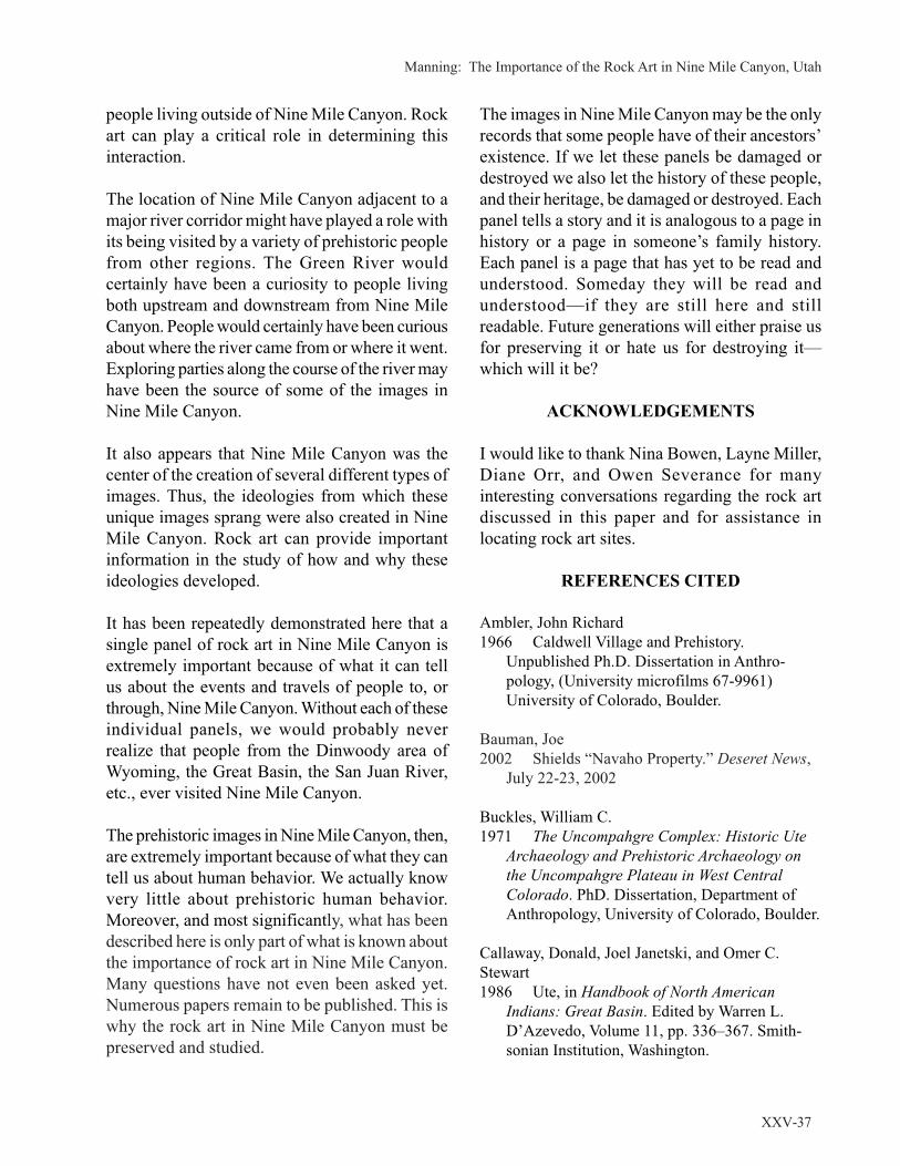
Manning: The Importance of the Rock Art in Nine Mile Canyon, Utah
XXV-37
people living outside of Nine Mile Canyon. Rock
art can play a critical role in determining this
interaction.
The location of Nine Mile Canyon adjacent to a
major river corridor might have played a role with
its being visited by a variety of prehistoric people
from other regions. The Green River would
certainly have been a curiosity to people living
both upstream and downstream from Nine Mile
Canyon. People would certainly have been curious
about where the river came from or where it went.
Exploring parties along the course of the river may
have been the source of some of the images in
Nine Mile Canyon.
It also appears that Nine Mile Canyon was the
center of the creation of several different types of
images. Thus, the ideologies from which these
unique images sprang were also created in Nine
Mile Canyon. Rock art can provide important
information in the study of how and why these
ideologies developed.
It has been repeatedly demonstrated here that a
single panel of rock art in Nine Mile Canyon is
extremely important because of what it can tell
us about the events and travels of people to, or
through, Nine Mile Canyon. Without each of these
individual panels, we would probably never
realize that people from the Dinwoody area of
Wyoming, the Great Basin, the San Juan River,
etc., ever visited Nine Mile Canyon.
The prehistoric images in Nine Mile Canyon, then,
are extremely important because of what they can
tell us about human behavior. We actually know
very little about prehistoric human behavior.
Moreover, and most significantly, what has been
described here is only part of what is known about
the importance of rock art in Nine Mile Canyon.
Many questions have not even been asked yet.
Numerous papers remain to be published. This is
why the rock art in Nine Mile Canyon must be
preserved and studied.
The images in Nine Mile Canyon may be the only
records that some people have of their ancestors’
existence. If we let these panels be damaged or
destroyed we also let the history of these people,
and their heritage, be damaged or destroyed. Each
panel tells a story and it is analogous to a page in
history or a page in someone’s family history.
Each panel is a page that has yet to be read and
understood. Someday they will be read and
understood—if they are still here and still
readable. Future generations will either praise us
for preserving it or hate us for destroying it—
which will it be?
ACKNOWLEDGEMENTS
I would like to thank Nina Bowen, Layne Miller,
Diane Orr, and Owen Severance for many
interesting conversations regarding the rock art
discussed in this paper and for assistance in
locating rock art sites.
REFERENCES CITED
Ambler, John Richard
1966 Caldwell Village and Prehistory.
Unpublished Ph.D. Dissertation in Anthro-
pology, (University microfilms 67-9961)
University of Colorado, Boulder.
Bauman, Joe
2002 Shields “Navaho Property.” Deseret News,
July 22-23, 2002
Buckles, William C.
1971 The Uncompahgre Complex: Historic Ute
Archaeology and Prehistoric Archaeology on
the Uncompahgre Plateau in West Central
Colorado. PhD. Dissertation, Department of
Anthropology, University of Colorado, Boulder.
Callaway, Donald, Joel Janetski, and Omer C.
Stewart
1986 Ute, in Handbook of North American
Indians: Great Basin. Edited by Warren L.
D’Azevedo, Volume 11, pp. 336–367. Smith-
sonian Institution, Washington.

Utah Rock Art, Volume XXV, 2008
XXV-38
Castleton, Kenneth B.
1978 Petroglyphs and Pictographs of Utah,
Volume One: The East and Northeast. Utah
Museum of Natural History, Salt Lake City.
1979 Petroglyphs and Pictographs of Utah,
Volume Two: The South, Central, West and
Northwest. Utah Museum of Natural History,
Salt Lake City.
Childers, Beverly
1984 Petroglyph of the Ring Lake Ranch,
Fremont County, Wyoming. Journal of New
World Archaeology 6(3):1–18.
Cole, Sally D.
1987 An Analysis of the Prehistoric and Historic
Rock Art of West Central Colorado. Bureau of
Land Management, Colorado State Office,
Cultural Resource Series Number 21, Denver.
1990 Legacy on Stone: Rock Art of the Colorado
Plateau and Four Corners Region. Johnson
Publishing, Boulder, Colorado.
Forbes, Jack D.
1959 The Appearance of the Mounted Indians in
Northern Mexico and the Southwest, to 1680.
Southwestern Journal of Anthropology 15(2)
189–212.
Francis Julie E.
1994 An Overview of Wyoming Rock Art. In
Prehistoric Hunters of the High Plains, second
edition, edited by G. C. Frison Academic Press,
San Diego, California.
Francis, Julie E., and Lawrence L. Loendorf
2002 Ancient Visions: Petroglyphs and Picto-
graphs of the Wind River and Bighorn Country,
Wyoming and Montana. University of Utah
Press, Salt Lake City.
Gebhard, David S.
1969 The Rock Art of Dinwoody, Wyoming. The
Art Galleries, University of California, Santa
Barbara.
Gebhard, David S., and Harold A. Chan
1950 The Petroglyphs of Dinwoody, Wyoming.
American Antiquity 15 (3):219–228.
Heizer, Robert E., and Martin A. Baumhoff
1962 Prehistoric Rock Art of Nevada and Eastern
California. University of California Press, Los
Angeles.
Hendry, Mary Helen
1983 Indian Rock Art in Wyoming. Published by
Mary Helen Hendry, Lost Cabin Route, Lysite
Wyoming. Printed by Augstums Printing
Service, Lincoln, Nebraska.
Jett, Stephen C.
1991 Split-twig Figurines, Early Maize and a
Child Burial in East-central Utah. Utah
Archaeology 1(1):23–31.
Keyser, James D., and Michael A. Klassen
1990 Rock Art of North American Northwestern
Plains: An Overview. Bollettino del Centro
Camuno di Studi Preistorici 25/26:99–122
2001 Plains Indian Rock Art. University of
Washington Press, Seattle.
Loendorf, Lawrence L.
1993 Rock Art and the Water Ghost Woman on
the Wind River, Wyoming. Paper presented at
the Twentieth Annual Conference of the
American Rock Art Research Association,
Reno, Nevada
Mallery, Garrick
1886 On the Pictographs of the North American
Indians. Bureau of American Ethnology, 4th
Annual Report [for 1882-83] pp 13–256. U. S.
Government Printing Office, Washington, D.C.
1893 Picture-writing of the American Indians.
Bureau of American Ethnology, 10th Annual
Report [for 1888-89], two volumes, pp 1–822.
U. S. Government Printing Office, Washington,
D.C.
Madsen, David B.
1989 Exploring the Fremont. Utah Museum of
Natural History, University of Utah, Salt Lake
City.
Manning, Steven J.
1983 A Repetitive Symbol in the Rock Art of
Indian Creek. In Utah Rock Art, volume 3, pp.
67–71. Utah Rock Art Research Association,
Salt Lake City, Utah.

Manning: The Importance of the Rock Art in Nine Mile Canyon, Utah
XXV-39
Manning, Steven J. (continued)
1990 Distribution and Cultural Affiliation of
Large Two-Stranded, Pendant Necklaces in the
Rock Art of the Colorado Plateau: A Prelim-
inary Report. In Utah Rock Art Volume 7,
section 12, pp. 1–10. Utah Rock Art Research
Association, Salt Lake City, Utah.
1992 Colorado-Green River: Prehistoric Pathway.
Canyon Legacy: Canyon Country Rock Art,
Number 16. Journal of the Dan O’Laurie
Museum, Moab, Utah.
1993 A Modal Based Classification System for
Rock Art Research: Overcoming Stylistic Myth-
ological Problems. Utah Archaeological
Research Institute. Occasional Papers Number
5. North Salt Lake, Utah.
1997 Barrier Canyon Style Petroglyphs. In Utah
Rock Art, volume 17, pp. 21–39. Utah Rock Art
Research Association, Salt Lake City, Utah.
2001 Barrier Canyon Style Petroglyphs Part II. In
Utah Rock Art, volume 21, pp. 1–32. Utah
Rock Art Research Association, Salt Lake City,
Utah.
2002 Rock Art of Range Creek. Paper presented
at the Twenty-eighth Great Basin Anthropo-
logical Conference, Elko, Nevada.
2004 The Fugitive-Pigment Anthropomorphs of
Eastern Utah: A Shared Cultural Trait Indicating
a Temporal Relationship. In Utah Rock Art,
volume 23, pp. 61–177. Utah Rock Art
Research Association, Salt Lake City, Utah.
McGlone, Bill, Ted Barker, and Phil Leonard
1994 Petroglyphs of Southeast Colorado and the
Oklahoma Panhandle. Mithras, Inc., Kamas,
Utah.
Morss, Noel
1931 The Ancient Culture of the Fremont River
in Utah; Report on the Explorations under the
Claflin-Emerson Fund, 1928-29. Papers of the
Peabody Museum of American Archaeology and
Ethnology, Harvard University, volume 12,
number 3.
Muench, David
1995 Images in Stone. Brown Trout Publishers,
San Francisco, California.
Pettit, Jan
1990 Utes the Mountain People. Johnson Books,
Boulder, Colorado.
Plog Fred
1979 Prehistory: Western Anasazi. In Handbook
of North American Indians: Southwest, Volume
9, pp. 108–130. Edited by Alfonso Ortiz.
William Sturtevant, general editor. Smithsonian
Institution, Washington, D.C.
Pratt, A. Glen.
1972 Rock Art of the Uintah Basin. Uintah Basin
Standard, Roosevelt, Utah.
Reagan, Albert
1931 The pictographs of Ashley and Dry Forks
Valleys in Northeastern Utah. Transactions of
the Kansas Academy of Sciences 34:168–216.
1933a Summary of Archaeological Finds in the
Uintah Basin in Utah, to Date. Proceedings of
the Utah Academy of Science 10:3–10.
1933b Some Notes on the Snake Pictographs of
Nine Mile Canyon, Utah. American Anthro-
pologist 35(3):550–551.
1935 Petroglyphs Show that the Ancients of the
Southwest Wore Masks. American Anthro-
pologist 37(4).
Schaafsma, Polly
1980 Indian Rock Art of the Southwest. School of
American Research, Southwest Indian Series.
University of New Mexico Press, Albuquerque.
1994 [1971] The Rock Art of Utah, A Study from
the Donald Scott Collection. Peabody Museum
of Archaeology and Ethnology; vol. 65.
Harvard University, Cambridge, Massachusetts.
1994 reprint, University of Utah Press.
Spangler, Jerry D., and Donna K. Spangler
2003 Horned Snakes and Axle Grease: A Road-
side Guide to the Archaeology, History and
Rock Art of Nine Mile Canyon. Uintah Pub-
lishing, Salt lake City, Utah.
Steward, Julian H.
1929 Petroglyphs of California and Adjoining
States. University of California Publications in
American Archaeology and Ethnology, vol. 24.

Utah Rock Art, Volume XXV, 2008
XXV-40
Turner, Christy G. III
1963 Petrographs of the Glen Canyon Region.
Museum of Northern Arizona Bulletin 38,
Northern Arizona Society of Science and Art,
Flagstaff.
1971 Revised dating for Early Rock Art of the
Glen Canyon Region. American Antiquity
36(4):469–471.
Walker, Danny N., and Julie E. Francis
1989 Legend Rock Petroglyph site (48HO4),
Wyoming: 1988 Archaeological Investigations.
Report on file at Worland District, Bureau of
Land Management and Office of the State
Archeologist, Wyoming.
Wellmann, Klaus F.
1979 A Survey of North American Rock Art.
Akademische Druck und Verlagsanstalt, Graz,
Austria.
WTP DEIS
2008 West Tavaputs Plateau Natural Gas Full
Field Development Plan, Draft Environmental
Impact Statement. February 2008. Four
volumes, Bureau of Land Management, Price
Field Office, Price, Utah.

Matheny and Matheny: Nine Mile Canyon Rock Art and Communal Hunting
XXV-41
Descriptive analyses are those which utilise
the figurative component of prehistoric art to
directly extract information on prehistoric
social activities, economy, material culture,
ideology and environmental context, which is
often not reflected in other types of
archaeological evidence [Morwood and Smith
1996]
The above quote makes clear the potential use of
rock art as a source of information about ancient
societies and generally reflects our approach.
1
In
this paper we focus on what might be learned
about the societies whose members created the
rock art rather than what may have motivated the
Ray T. Matheny and Deanne G. Matheny
NINE MILE CANYON ROCK ART AND
COMMUNAL HUNTING
ancient artists to create it or what meaning(s) it
may have had for those who created it or who
later viewed it.
Nine Mile Canyon, located in central eastern Utah
(Figure 1), has long been known for its rich and
extensive corpus of rock art. This paper is a
development of certain concepts presented in
two previous papers about Native American
(largely Fremont) rock art found in Nine Mile
Canyon. Those papers focused on the topics of
animal behavior and ancient hunting strategies
as revealed in the rock art (Matheny et al. 1997;
Matheny et al. 2004). Our data come from the
Figure 1. Map showing the
location of Nine Mile Canyon
and the research area.

Utah Rock Art, Volume XXV, 2008
XXV-42
results of a survey of the lower (eastern) portion
of Nine Mile Canyon carried out by the Brigham
Young University (BYU) Field School of
Archaeology under the direction of Ray T.
Matheny from 1989 through 1992 (reported in
Spangler 1993) and survey work carried out with
the Castle Valley Chapter of the Utah Statewide
Archaeological Society beginning in 1989, as well
as the survey of a portion of the canyon published
by Hurst and Louthan (1979), excavations carried
out in Nine Mile Canyon by the BYU Field School
of Archaeology (reported in Thompson 1993),
and, to a lesser degree, archaeological work in
the canyon by other scholars. Although the
inventory of rock art and other archaeological sites
in the canyon is by no means complete, the
surveys carried out thus far have given us some
perspective on the distribution of sites and their
content in a few important areas of the canyon.
2
Rock art depictions in the canyon span a long time
frame (from at least the Archaic Period through
modern times). Although rock art exists at many
levels along the steep rock terraces, particularly
in the mid and lower sections of Nine Mile
Canyon, a number of the more complex
renderings are easily visible from the canyon
bottom, providing an enduring message to all who
pass by them. In this paper, we concentrate on
rock art themes (mainly found in Fremont and Ute/
Numic period rock art) which suggest the repeated
exploitation of local faunal resources by
communal hunting. The rock art renditions of
animals and anthropomorphs communicate
information about an economic system involving
the procurement of animal products which may
reflect connections beyond Nine Mile Canyon.
Evidence from Nine Mile Canyon suggests that
most of the Native American inhabitants who
lived in the canyon and exploited its resources
from the Archaic through the Historic Period were
foragers (also called hunter-gatherers) and at least
some, during the Fremont occupation, were
farmers, although their horticultural activities may
not have been associated with villages or other
residences that were occupied year round. We are
interested in trying to understand the context of
communal hunting as it may have occurred in
Nine Mile Canyon as practiced by foragers and/
or horticulturalists and whether rock art can
provide insights about this.
Hunting is a basic subsistence activity that has
been practiced from the earliest times until today
by societies with all types of sociopolitical
organizations. In looking at communal hunts
3
as
reflected in Nine Mile Canyon rock art, we adopt
Driver’s definition of communal hunting which
includes the following:
(a) Participation by more than two hunters
(usually many more than this).
(b) Active cooperation between hunters such
that they work together, as opposed to
passive cooperation in which hunters
agree not to interfere with each other’s
activities.
(c) A system of hunting that requires all
hunters to participate in a previously
conceived plan [Driver 1990:12].
Driver (1990) notes that it is difficult to document
the presence of communal hunting in the
archaeological record, however, we suggest that
rock art can be helpful in this regard, showing
both the kinds of large game targeted as well as
hunting techniques used to obtain them.
In order for communal hunting to be a worthwhile
economic activity, justifying the expenditure of
the large amount of energy and other resources
necessary to hunt, kill, and butcher the animals
as well as transport the meat and other animal
products, there must be an adequate return of ani-
mal products. To carry out a successful commu-
nal hunt, Driver (1990:13) notes that the target
animals must exhibit certain characteristics, in-
cluding that their location be predictable, that their
behavior dictates particular hunting techniques
and that their physiological conditions makes
hunting them desirable. He also notes that large
mammals have important seasonal variations in
their “habitat, migration, population density, meat

Matheny and Matheny: Nine Mile Canyon Rock Art and Communal Hunting
XXV-43
quality, and social behavior” (Driver 1990:13).
Meat quality is affected by seasonal changes ex-
perienced by animals and is linked to fat content
which plies on both the nutritional value and the
taste of the meat (Speth and Spielmann 1983).
Seasonality, among other factors, can include
migration. Reproductive behavior is often sea-
sonal as well and results in animals being aggre-
gated in greater numbers than at other times and
in peak condition in terms of both meat and hides
or coats. These factors are generally true for larger
mammals living in arctic and temperate regions
where animals are most often aggregated in the
fall. Driver’s review of ethnographic sources
shows abundant data that hunting in higher lati-
tudes during the fall and early winter supplied
animal products for winter storage (Driver
1990:29). While referencing Winterhalder (1981)
that “optimal foraging theory predicts that
clumped, mobile resources are most efficiently
exploited by aggregated foragers,” Driver
(1990:21–28) points out that this does not explain
why communal hunting occurs and he explores
that question using the following hypotheses:
(a) The technology of communal hunting is
more efficient (i.e., produces more meat
per person or more energy per person per
unit of energy expended) than the
individual hunting of aggregated prey,
under certain conditions;
(b) Communal hunting produces a surplus
during times of plenty, which is crucial
for maintenance of human populations in
“lean” periods following communal
hunts; and
(c) Communal hunting decreases search
time, by concentration on dense aggre-
gations of animals, and the decrease in
search time compensates for any loss of
efficiency [Driver 1990:22–23].
Our study is concerned primarily with the hunting
of bighorn sheep (Ovis canadensis and O. c.
nelsoni), simply because they are overwhelmingly
the most frequently depicted animal in the rock
art of Nine Mile Canyon. Other species portrayed
in hunting scenes in the canyon include elk/deer
(usually these appear to be elk), bison, and rarely,
birds. We do consider one example of an elk
hunting scene in this paper. Although bighorn
sheep are abundantly depicted in the rock art of
Nine Mile Canyon and other areas occupied by
Fremont and Ancestral Puebloan groups, their
numbers were so greatly reduced during
settlement by Euro-Americans that perhaps they
do not come quickly to mind as a major game
source. Estimates differ about the number of
bighorn sheep that lived in North America in
earlier times but a recent article gives an estimate
of 1.5 million to 2 million two centuries ago and
notes that only 28,000 remain today (Lomax
2008:22). Based on the criteria discussed above,
bighorn sheep are particularly attractive hunting
targets because they have highly predictable
behavior on an annual basis. Their annual seasonal
cycles include a segregation between ewe and ram
herds for much of the year and the sheep aggregate
in mixed herds of ewes, rams, and lambs born the
previous spring only during the rut in the late fall
or early winter at a time when the fat content of
their meat is high and condition of their hides is
generally at a premium (Geist 1993:125). A recent
study of bighorn sheep in Glacier National Park
using tracking collars which record the
movements of the sheep has changed some former
perspectives on bighorn behavior and confirmed
others (Lomax 2008:22). The highly predictable
nature of the bighorns’ habits was confirmed,
showing that they seldom explore new habitats
and the herd travels on paths used for generations
between their ranges used for purposes such as
lambing, wintering, etc. Such predictability in
behavior must have been a boon to hunters who
understood it well and could predict the sheep’s
location from season to season.
The bighorn sheep were a high-ranked resource
and, in addition to the meat and hides, they
provided those who hunted them with a wealth of
other resources. Bones were used for tools and
bone grease was another important resource. The
horns of the bighorns were used for a number of
tools and weapons, including bows, sickles,
Utah Rock Art, Volume XXV, 2008
XXV-44
dippers and rattles. This brief discussion is merely
illustrative of some of the uses of the bighorns.
4
NINE MILE CANYON ROCK ART
HUNTING SCENES
5
Perhaps the general concept suggested by the rock
art portrayals we have studied is that hunting of
various animals has occurred in Nine Mile Canyon
and its environs for a long period of time and it
was likely carried out in both communal and
individual (one to two individuals) hunts.
6
We
do not suggest, however, that the rock art
depictions portray any actual hunts.
Although bighorn sheep are the most frequently
portrayed animal in Nine Mile Canyon rock art,
by no means are all of these depictions a part of
or related to hunting scenes and this applies to
depictions of other animals as well. Some scenes
show only animals and many of the rock art
portrayals reflect the deep knowledge of the
Native American artists about the ethology of the
animals.
7
Based on the sources of information mentioned
above (surveys of Nine Mile Canyon), Matheny
et al. (2004:162–163) have identified a current
total 163 rock art scenes that depict or suggest
hunting activity, and these include sites associated
with both the Fremont culture and later Ute/Numic
groups, as well as some that may be associated
with the earlier Archaic period. We consider these
scenes as hunting or hunting-related because they
include
…at least two of the following elements:
anthropomorphs (who often wear a single-
element headdress, a pair of bison-like horns
or a headdress with fringed stick-like
elements) bearing weapons (bow and arrow
or atlatl) or with upraised arms, large animals
(typically bighorn sheep and/or elk/deer,
bison or birds (more rarely)) being confronted
by anthropomorphs, nets or enclosures,
Some of these elements are specific to particular
time periods or cultures (e.g. in Nine Mile Canyon,
burden bearers seem to be only associated with
Fremont rock art, but we realize that they have a
much broader distributon culturally and
geographically beyond Nine Mile). In historic
period depictions, horses are often included.
Our analysis of hunting-related sites shows that
they tend to cluster around the mouths of some of
Nine Mile’s tributary canyons. This is discussed
in detail below in regard to Fremont hunting
scenes.
UTE/NUMIC HUNTING AND
COMMUNAL HUNTING SCENES
We will begin our discussion of Nine Mile Canyon
rock art with historic period Ute/Numic hunting
scenes but we should point out that issues exist in
connecting these groups with past geographical
areas and groups. How and if the Utes and other
Numic speakers are related to earlier Fremont
groups is unknown. By about A.D. 1300 the
horticultural, more sedentary lifeway practiced by
many Fremont groups had largely disappeared to
be replaced by a foraging lifeway associated with
those called Numic or Shoshonean speakers. For
some years in the mid to late twentieth century
there was general consensus among scholars
regarding an expansion or migration of Numic-
speakers eastward and northward from the
southwest Great Basin beginning around A.D.
1000, gradually pushing into the eastern Great
Basin and surrounding areas. Now, however, there
is little consensus about this or many other
questions regarding this time period.
8
It is well documented that the Utes were hunters
of mountain sheep but at the time many of the
ethnographic studies were carried out this was no
longer the case because the sheep had experienced
a great demise. Mountain sheep hunting was
largely a memory after the early 1900s; for
example Smith (1974:57), writing about the
dogs, and burden bearer figures [Matheny et
al. 2004:162–163].

Matheny and Matheny: Nine Mile Canyon Rock Art and Communal Hunting
XXV-45
Northern Utes whom she studied in 1936 and
1937, states:
“All bands of Utes hunted mountain sheep,
usually by driving the sheep toward high rocks
where a hunter was waiting. Sometimes
mountain sheep were surrounded by men on
horseback (Unc)
9
.”
Smith (1974:54–57) in discussing communal
hunts of bison, antelope and rabbits mentions that
a “boss” or “chief,” who had knowledge of
hunting and the country, headed the cooperative
hunts. It is possible that the same organizational
process applied to communal bighorn hunts as
well.
Although Smith does not mention specifics as to
how bighorn were butchered and transported, her
description of such regarding deer may apply to
bighorns as well. The deer was butchered by
making a cut under the throat and continued on
through the belly and “When the deer was
skinned, the four legs were tied together and the
carcass was laid on the hide and packed on a
horse” (Smith 1974:53).
Linguist James A. Goss, during an interview about
the Utes and in discussing animals hunted by
them, explained that although buffalo were
important to the Utes, the buffalo hadn’t entered
their ceremonial life and the Utes didn’t consider
it sacred as did the Plains Indians (Goss 2000).
He goes on to note:
Undoubtedly the most important ritual animal
for these hunting people was the big-horn
sheep in the mountains of Colorado and Utah.
But we’ve completely lost that because the
big-horn sheep almost became extinct
between the hunting pressure and the diseases
that domesticated sheep brought in. So people
don’t think about the big-horn sheep, but all
you have to do is look around at all of the
prehistoric pictographs all over Colorado and
Utah and one motif that comes up more often
than elk or deer or buffalo or anything like
that is the big-horn sheep. That was the
spiritual chief, you might say, of the hunted
animals [Goss 2000:44].
Describing fall activities among the Northern
Utes, Clifford Duncan has noted:
Fall was the time when seeds had to be stored,
meat had to be dried, clothing had to be made
and repaired, as did utensils such as pouches
and bags, baskets and water jugs. This was
also the time of the great large-game hunts,
including some for buffalo. Many families
would get together, feasting and preparing for
the hunt. The hunters would ride out to find
and bring back as much meat as they could
carry. When the men returned, there was
another gathering, with gambling, singing,
and courting. These hunts were important
socially [Duncan 2000:170–171].
That the Utes traded mountain sheep skins is
recorded in sources such as that of Rufus B. Sage
(1982:232) who traveled through the west in the
1840s and visited Roubideau’s Fort located on the
Uinta River in the Uinta Basin where he noted
that trade was carried on with the Snake and Utah
(Ute) Indians who lived in the area. He mentions
that beaver, otter, deer, sheep, and elk skins were
traded. He praised the quality of the skins, stating:
“The Utahs and Snake afford some of the largest
and best finished sheep and deer skins I ever
beheld,-a single skin sometimes being amply
sufficient for common sized pantaloons. These
skins are dressed so neatly as frequently to attain
a snowy whiteness, and possess the softness of
velvet” (Sage 1982:232).
10
Sage also noted that the skins were very
abundantly produced, were obtained from the
Native Americans by the traders for a trifling
amount, and, when taken to Santa Fe and other
towns, made a profit for the traders.
There are a number of rock art sites in Nine Mile
Canyon which indicate the presence of Ute/Numic
peoples in the area, reflecting several recognized
styles of Ute rock art. In this article we will focus

Utah Rock Art, Volume XXV, 2008
XXV-46
on two sites which we suggest show communal
hunts. The first site (42DC639) (Figure 2) is found
on the north side of Nine Mile Canyon, not far
from the mouth of North Maxie Canyon and
recorded during the BYU Field School survey. It
was reported by Spangler (1993:226) and
illustrated by Spangler and Spangler (2003:48)
and Spangler (2004:131). This panel is likely an
example of what Cole (1990:225–235) has called
the Early Historic Ute Indian Style (A.D. 1600 to
1830). It is an impressive panel—a hunting scene,
including six mounted anthropomorphs (what is
likely a seventh has broken away leaving only the
front of the quadruped) and at least four bighorn
sheep, as well as a spiral element.
11
The mounted
anthropomorph (hereafter termed “hunter”) and
its horse on the left side of the panel are
substantially larger than the other mounted hunters
and horses and the large hunter wears a headdress
with what appears to be two horns, like those of a
bison. The larger mounted hunter faces the other
mounted hunters and the bighorns. The smaller
mounted hunters surround the bighorns. The
hunting technique portrayed of surrounding
bighorns with horses is the same as that referred
to above which was reported by Smith (1974:57)
and it may be that the larger mounted hunter is a
portrayal of a hunt boss. The Wolfe Ranch hunting
panel, located in Arches National Monument,
depicts a similar scene of mounted hunters and
bighorn sheep but also appears to include at least
one canine (Figure 3)
The second Ute/Numic rock art example from
Nine Mile Canyon that we will discuss is located
on the north side of the canyon, near the mouth of
Daddy Canyon where there is a clustering of rock
art sites of several cultural affiliations, including
some of Ute/Numic affiliation. Site 42Cb808
includes a rock art panel in the Late Historic Ute
Indian Style (A.D. 1830 to 1880), which is a
hunting scene, involving mounted hunters and elk
(Figure 4). Although no weapons are shown, the
animals are clearly being controlled by the hunters
and their horses. This panel depicts four mounted
hunters, at least two of which have tethered
animals in trail that appear to be horses. The
tethered animals may represent pack animals
brought on the hunt to carry meat and other animal
products. All of the hunters and quadrupeds face
left. In the lead is the largest of the mounted
hunters who also has the most developed features
Figure 2. The scene illustrates a mounted Ute/
Numic hunting party surrounding four bighorn
sheep. One horseman appears to carry a shield. The
head of the lone figure may not be accurate as it is
somewhat obscured. Site 42Dc639 Nine Mile
Canyon.
Figure 3. Four mounted Ute/Numic hunters pursue
six bighorn sheep that are being driven by a dog.
Wolfe Ranch, Arches National Monument.
Figure 4. Four mounted Ute/Numic hunters with
spare horses pursue elk in a fall hunt. Site 42Cb808
Nine Mile Canyon.

Matheny and Matheny: Nine Mile Canyon Rock Art and Communal Hunting
XXV-47
including a trailing Plains-style headdress and
feet visible beneath the torso of the horse. This
figure may represent a hunt boss or other hunt
authority figure. Behind the larger mounted hunter
are three quadrupeds which appear to represent
elk with large antlers. Two mounted hunters
appear behind the elk. They also have trailing
headdresses but they are not as detailed as that of
the lead hunter. Another mounted hunter is
depicted below the first elk. Several other
quadrupeds are depicted in the lower area of the
scene but they are difficult to identify. They could
represent other animals in the elk herd, including
females, although one of the quadrupeds appears
to be a horse. Smith’s (1974:54-55) informants
reported hunting elk in the winter and that the
hunters would surround yarded elk, frighten them
and shoot them as they tried to escape.
The two examples above serve to illustrate that
Native Americans, particularly Utes, hunted in
Nine Mile Canyon after acquiring the horse, as
well as earlier, and that the depictions are
consistent with accounts of Ute hunting. Although
we cannot say which Ute/Numic groups or bands
were hunting in the canyon (and that could have
varied over time), groups from the Uintah Basin
and Utah Valley seem to be good possibilities.
Clearly the acquisition of the horse provided an
enhanced range of possibilities for hunting. For
example, the Uintah Utes made buffalo hunting
trips into Wyoming near what is now Rock
Springs and Green River in times of peace with
the Shoshones (Smith 1974:53). That the Utes had
ongoing interest in the area of Nine Mile Canyon
is apparent in the encounter that Byron Cummings
of the University of Utah had with a party of Utes
in the canyon in the summer of 1906 (Willey
1988:4; referenced in Spangler 1995:45). They
insisted that Cummings leave the area
immediately but he managed to stay the night and
left the next morning.
Duncan’s (2000:170–171) discussion of fall
activities quoted above is important in pointing
out not only the significance of communal hunting
for the purposes of gaining meat and other animal
products but also the social context of these hunts
which brought groups together. While encounter
or individual hunting was undoubtedly important
and, in some instances, may have been more
efficient than communal hunting, these larger
hunts could have provided an occasion for groups
to gather and affirm their relationships, which was
likely not a part of individual hunts. The
communal hunts gave some individuals the
opportunity for a temporary leadership role as
hunt boss or chief and others the opportunity to
demonstrate their hunting prowess. This
enhancement of personal prestige was likely
further bolstered by celebrations once a successful
hunting party returned to camp where the
adventures of the hunt would be recounted for the
entire group. Knowledge of the predictability of
the bighorn sheep annual cycle with the
aggregation of animals in conjunction with the
rut in the late fall/early winter would have been
valuable in reducing the risk factors for a
successful hunt.
RECENT PERSPECTIVES ON FREMONT
PREHISTORY
As an introduction to the Fremont communal
hunting scenes, we present a brief background
discussion about Fremont studies which will
necessarily give inadequate attention to many
important topics. A wealth of archaeological
research about what is generally called the
Fremont Culture has been accumulating since the
early twentieth century. The Fremont peoples
inhabited the eastern Great Basin and the northern
Colorado Plateau from about A.D. 400 to 1300.
There has not been a great deal of consensus
among scholars about the Fremont culture or
Fremont complex as some have recently
suggested that it be designated (Madsen and
Simms 1998). Janetski and Talbot (2000a:1) have
summarized the history of shifting perspectives
on the Fremont from the beginnings of research
to current times and note that “if a single
theoretical thread can be traced through this maze
Utah Rock Art, Volume XXV, 2008
XXV-48
of Fremont literature, it is the notion of variability
and an associated concern with definition”
(Ibid:4). Current perspectives tend to focus on the
micro level of behavior which emphasizes
“relationships among individuals and groups of
individuals” (behavioral/economic perspectives)
most often closely identified with subsistence
studies or the macro level of behavior related to
larger scale patterns (Ibid: 6).
12
Janetski and Talbot
suggest that each perspective has its strengths and
that each can be applied productively to different
kinds of questions. Research objectives have
moved away from defining Fremont culture and
from understanding variability in terms of
bounded area models. Madsen (1989:67) has
suggested using the term Fremont as an
“umbrella” which includes diverse human
behavior. Studies focusing on subsistence
strategies have argued that Fremont subsistence
was not limited to horticulture; for example,
Madsen and Simms (1998) propose that there
were a “mosaic” of subsistence behaviors that
included full-time farmers, part-time farmer-
foragers, full-time foragers and that there could
be switching between these options during the
lifetime of individuals as they pursued a variety
of adaptive strategies.
In recent years research has demonstrated the
existence of large, more complex Fremont sites,
in comparison with those studied earlier. A general
understanding about Fremont sites had been that
settlements were small, consisting of several pit
houses and associated structures and work areas.
13
Extensive work at the Five Finger Ridge site
(dating between A.D. 1000–1350), located in
Clear Creek Canyon, resulted in the excavation
of 81 structures (which included 37 pit houses and
one surface house) and 33 activity areas, and it is
clear that many of the households are
contemporaneous during several time periods
(Janetski and Talbot 2000b:251; Talbot and
Janetski 2000:43; Talbot et al 2000:167). Based
on their studies of social organization at the site
Janetski and Talbot (2000:262) report that “a
conservative conclusion here is that polities above
the supra-family level existed in Fremont
society,” and they include Nawthis Village and
Baker Village among other sites that may have
patterns that reflect internal differentiation.
14
Another important recent study by Coltrain and
Leavitt (2002) reported the results of stable
isotope and radiocarbon analysis of skeletal
materials of the Great Salt Lake mortuary
assemblage from the eastern shores of the Great
Salt Lake. These results indicated that “diets
varied within a single time period, over time, and
by sex” . . . “suggesting that between A.D. 400-
1150, populations in the Great Salt Lake Basin
were faced with a fluid subsistence cost/benefit
structure, consistent with the intrusion of summer
moisture into an extensive wetlands bordered by
grasslands suitable for farming” (Ibid: 479). There
is some evidence for possible differential status
in a portion of the male population who had a
diet higher in maize. There is a change at about
A.D. 1150 which sees an end to farming and a
return to eating wild foods which, on the basis of
climate studies, is suggested to have been caused
by a drought or shift in the seasonality of moisture.
How does Nine Mile Canyon fit into the matrix
of Fremont research? Despite its well-known
reputation for archaeological remains, much of
the canyon and its environs remains unknown
archaeologically and there have been few
excavations in the area. Spangler (2000b) has
written an interesting paper which ably addresses
a number of questions generated by archaeological
surveys by the BYU Field School of Archaeology
in lower Nine Mile Canyon, and some of the same
questions could apply to the canyon generally. He
(Ibid:25) suggests that there was a “Tavaputs
adaptation” of Formative peoples after about
A.D. 1000 including the following material
culture correlates:
(1) the construction of energy-expensive
semi subterranean residential ma-
sonry architecture in economically
advantageous locations along stream
terraces,

Matheny and Matheny: Nine Mile Canyon Rock Art and Communal Hunting
XXV-49
(2) the construction of elaborate surface
masonry structures on pinnacles and rock
outcrops hundreds of meters above the
floodplain,
(3) the paucity of significant middens,
implying short-term, perhaps seasonal
occupations,
(4) the construction of large storage struc-
tures that would seem excessive for the
small population suggested by the limited
quantity of residential structures,
(5) the construction of elaborately camou-
flaged and remotely located subterra-
nean storage chambers, which imply
both abandonment and the possibility of
human predation, and
(6) the near absence of a local ceramic
tradition [Spangler 2000b:25].
Spangler is able to assign only a tenuous date for
the Fremont occupation of the lower canyon of
A.D. 1000 to 1300, due to the small amount of
datable material recovered by the surveys and the
same can be said for the middle and upper sections
of the canyon as well. He lists the few available
radiocarbon and tree ring dates from Nine Mile
(Spangler2000b:35, 36). A few of the radio-
carbon dates are earlier than A.D. 1000 but most
are later.
In addition to completing a survey of the lower
end of Nine Mile Canyon from the confluence of
South Franks Canyon with Nine Mile down to
the confluence of Nine Mile with the Green River,
the BYU Field School excavated at sites 42Cb770,
42Dc618, and 42Dc619, which are all stream
terrace sites of the type referred to by Spangler,
For example, Site 42Cb770 included three pit
houses, and an outdoor work area and yielded
three radiocarbon dates including A.D. 1028,
A.D. 1028 and A.D. 1176 – median calibration
(from Spangler 2000b:35, Table 3.1). Site
42Dc619 had been damaged by modern house
construction but still included one partially in-
tact pit house which yielded a date of A.D. 1176
– median calibration (Ibid). Site 42Dc618 differs
from the other two in that it was an outdoor use
area with a few artifacts but no associated
structures. These are the only stream terrace sites
which have been excavated and they are
characterized by shallow midden deposits
containing few artifacts. Like other stream terrace
sites they are located near access to water, arable
land, and piñon-juniper resources.
There are a few other sites in mid-canyon that
were excavated by Gillin (1955). Two of these,
Sky House and Upper Sky House, are pinnacle
sites similar to those described by Spangler for
the lower canyon and the dendrochronological
dates for these sites indicate they may have been
constructed about A.D. 1100 and are of the same
general time period as those from the stream
terrace sites from the lower canyon (Spangler
2000b:29). A number of other habitation sites have
been identified by surveys in various areas of the
canyon but they have not been tested, and other
habitation sites will likely be discovered. Spangler
(Ibid) has proposed a hypothesis to account for
the archaeology of the lower canyon as we now
understand it, and parts of it could be extended to
the other areas in the canyon as well. While future
research may change some portions of the
hypothesis (which is to be expected), it is an
important step to understanding the past in Nine
Mile Canyon.
Although rock art is abundant in Nine Mile
Canyon only a few examples are found in
association with architectural sites.
15
Based on
stylistic grounds, much of the rock art is attributed
to the Fremont but no direct dating of the rock art
itself has been done.
FREMONT COMMUNAL HUNTING
SCENES
Based on our preliminary review of the 163
hunting and hunting-related rock art sites of which
we are currently aware in the area of Nine Mile
Canyon, 103 can be considered as related to
communal hunting. Of those sites 27 have burden
bearer figures (discussed below) and 55 show
weapons (mainly bow and arrow).
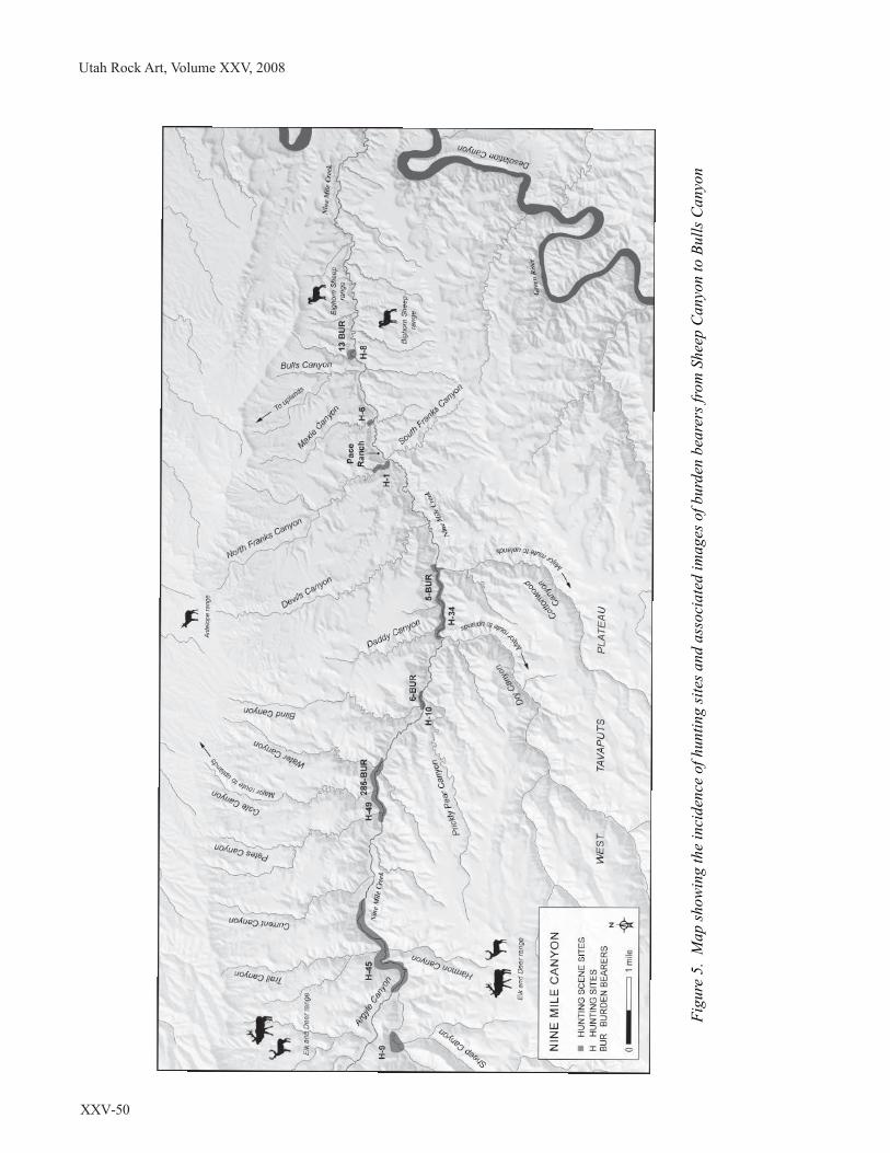
Utah Rock Art, Volume XXV, 2008
XXV-50
Fig
ure 5
. M
ap
sh
ow
in
g th
e in
cid
en
ce o
f h
un
tin
g sites a
nd
a
sso
cia
ted
im
ag
es o
f b
urd
en
b
ea
rers fro
m S
heep
C
an
yo
n to
B
ulls C
an
yo
n

Matheny and Matheny: Nine Mile Canyon Rock Art and Communal Hunting
XXV-51
Analysis of the location of hunting and hunting-
related sites shows that they tend to occur in
clusters at or near the mouths of several side
canyons. In our discussion below of the site
clusters we have included both communal and
individual hunting sites. The map (Figure 5)
showing the location of these clusters reads from
left to right (west to east) as follows:
• nine hunting sites are located near the
mouth of Sheep Canyon;
• from the mouth of Argyle Canyon to
about 1/2 mile east of Trail Canyon
there are 45 hunting sites;
• 49 hunting sites (with a total of 285
burden bearer images) are found at the
mouths of and between Petes, Gate, and
Water Canyons;
• ten hunting sites (with a total of six
burden bearer figures) are found at the
mouths of Blind and Prickly Canyons;
• there are 34 hunting sites (with a total of
five burden bearer figures) at the mouths
Figure 6. The scene represents sheep being driven
by drivers with outstretched arms. Drive lines to
guide the sheep are shown as undulating and zigzag
lines ending with the head of a bighorn. Three of
the hunters are armed with bows and arrows and
are directed by the larger figure. Site 42DC141
Nine Mile Canyon.
Figure 7. Bighorn sheep are being driven by a
horned hunter with arms outstretched towards what
may be an enclosure. The large horned figure may
represent a hunt boss and five burden bearer figures
are present. Site in Nine Mile Canyon.
of and in the areas between Daddy, Dry,
and Cottonwood Canyons;
• one hunting site is found at the mouth of
North Franks Canyon;
• six hunting sites are located at the mouth
of Maxie Canyon; and
• there are eight hunting sites (with a total
of 13 burden bearer figures) at the mouth
of Bulls Canyon.
Many rock art panels have been overdrawn in
recent times or damaged to the extent that it was
not possible to discern the entirety of the panel
even though some elements associated with
hunting scenes are present. It is very likely that
many more hunting depictions exist in unsurveyed
areas.
There is considerable variation among the
portrayals of anthropomorphs in the hunting
scenes. Some are shown awaiting or threatening
animals with atlatls or bow and arrow (Figure 6).
Others stand among the animals or confront them
with raised arms (Figure 7). Another type of
anthropomorph found in hunting scenes and
associated with animals is the burden bearer or
“backpacker” (Figure 8). The authors found that
there were 360 burden bearer images depicted at
bighorn hunting sites, and we have suggested
elsewhere that they were part of a communal
hunting group to transport meat and other animal
products after a successful hunt (Matheny, et al.
2004:178–181). The burden bearers are rendered
in various forms and some may represent those
who had functions other than hunting and carrying

Utah Rock Art, Volume XXV, 2008
XXV-52
animal products from the canyon (Schaafsma
1971:60). Most, however, are found in association
with hunting-related sites.
Analysis of the panels by association with the
animals hunted and the presence of burden bearers
reveals the following: burden bearers are found
in association with 416 bighorn sheep, 11 elk, six
deer, 53 zoomorphs (unidentified or incomplete
drawings), and five bison.
16
If the frequency of
depictions is a guide, it is clear that the main
hunting quest was for the bighorn sheep, however,
elk, deer, and bison also were prized catches.
Burden bearer depictions usually occur in groups
and the groups are often organized with a leader
portrayed larger than burden bearers that follow.
The leader sometimes wields a bow and arrow,
drawn and ready for action while the followers
stand some distance away (Matheny et al.
2004:Fig. 6.25.). This may indicate that hunting
group members played multiple roles; that is, they
were burden bearers at some stages of the hunt
and hunters at another stage. Some burden bearers
accompany an organized hunt where a canine
helps drive the animals toward hunters with bows
and arrows (Figure 9).
The individual features of the burden bearers are
frequently vague, however, in some renditions the
Figure 9. A hunting party is ambushing six bighorn
sheep that are being driven by a dog (last figure
with a long tail). Five bowmen aim arrows at the
sheep and two burden bearers accompany the
hunting party. Site in Nine Mile Canyon.
Figure 8. Seven burden bearers mingle with two
bighorn sheep suggesting the association of their
burdens with the sheep. Site 42Dc1106 Nine Mile
Canyon.
figures wear what appears to be a flat hat, whereas
others appear to show a single element, perhaps a
feather, on the head. Burden bearer bodies also
vary but are generally triangular and some are
shown with striding legs and with feet, while
others are static without legs or arms depicted,
but they all appear to carry a burden on their backs.
There are many other locations in the Fremont
area and the Southwest where burden bearer
images occur but we are unaware of other areas
where they occur in such numbers as they do in
Nine Mile Canyon.
In an earlier paper (Matheny, et al. 2004) we
devoted considerable attention to the hunting
strategies portrayed in Fremont rock art and we
will summarize those which likely apply to
communal hunting. One of the most striking and
best known rock art scenes, showing a surround
or ambush of the sheep, is the so-called
Cottonwood Panel or Great Hunt Panel (42Cb339)
(Figure 10), located in Cottonwood Canyon, a
short distance above its confluence with Nine
Mile. This is what Cole (1990:188) refers to as a
narrative panel where “. . . entire panels appear to
be composed of intentionally grouped and
thematically related elements” and that “. . . some
panels have strong narrative qualities, particularly
those with hunting and fertility scenes.” We have
previously discussed this panel in detail (Matheny

Matheny and Matheny: Nine Mile Canyon Rock Art and Communal Hunting
XXV-53
et al. 1997). It clearly shows a herd of bighorn
sheep who are being confronted by hunters armed
with bows and arrows. The scene reflects a late
fall or early winter hunt because that is the only
time, during the annual rut, when the herd of rams,
ewes, and lambs range together. Rams and ewes
move in separate herds during the rest of the year.
This narrative scene is one of the great treasures
of the Nine Mile area.
Another narrative panel portraying a confrontation
with armed hunters surrounding bighorn sheep is
found in Nine Mile Canyon less than a mile
upstream from the confluence of Nine Mile and
Cottonwood Canyons. The Sheep Hunter’s House
Panel (site 42Cb891) (Figure 11) is somewhat less
complex that the Cottonwood Panel and it shows
five hunters armed with bows and arrows
confronting 17 bighorns. This appears to be
another late fall/early winter scene where rams,
ewes, and lambs are together.
Other strategies such as the winged drive are
shown with drivers moving animals to the
advantage of the armed hunters. There are also
a number of portrayals showing nets assisting
in sequestering animals for a controlled kill
(Figure 12). All of these techniques are well
known in the ethnographic literature from many
areas. The discovery of a net made of juniper from
the Absaroka Mountains in northwest Wyoming
dating to 8860 ± 170 BP believed to have been
used in hunting bighorn sheep reflects the
Figure 10. The Great Hunt or Cottonwood panel is
located in Cottonwood Canyon a short distance
upstream from its confluence with Nine Mile
Canyon. This scene depicts a late fall or early
winter scene of an organized ambush by hunters
armed with bows and arrows. Site 42Cb339
Cottonwood Canyon.
Figure 11. This scene depicts ewes, lambs and
yearlings confronted by five hunters armed with
bows and arrows. Site 42Cb891 Nine Mile Canyon.
Figure 12. This scene shows woven nets that were
used to trap bighorn sheep and other animals
(note the net ends with a bighorn head). Ten net
scenes have been recorded in the research area
and all are associated with bighorn sheep.
Site in Nine Mile Canyon.
antiquity of this hunting strategy for hunting
bighorns (Frison et al. 1986).

Utah Rock Art, Volume XXV, 2008
XXV-54
If we accept the rock art hunting scenes as sources
of information about Fremont hunting
organization and practices, the communal hunts
depicted show the organized, coordinated, and
concerted effort of a number of individuals using
various hunting strategies to kill bighorn sheep.
Often one hunter is portrayed larger than the others
in the scene, which may indicate that he held a
temporary position such as hunt boss or leader.
The number of hunters depicted varies from scene
to scene and the number of burden bearers varies
greatly when they are depicted. Of course, only
representative rather than total numbers of hunters
and burden bearers may have been shown. Such
communal hunts of the sort depicted in the rock
art would have required considerable organization
for gathering and transportation of weapons and
other tools to the hunting site, and feeding the
hunting party during travel if necessary, as well
as butchering and preparing the kill for transport.
DISCUSSION
Having reviewed information about Fremont
communal hunting scenes, we now briefly
consider several of the questions that have
developed from our study of them. The first
question is whether there is any evidence in
addition to the rock art portrayals that bighorns
were hunted in Nine Mile Canyon and its
environs. If people who lived in the canyon were
hunting and presumably eating bighorns, one
would expect to find sheep bones in the middens
at habitation sites. As noted above, however, very
few excavations have been carried out in Nine
Mile Canyon and, in the case of the stream terrace
sites excavated by the BYU field school, the
middens were minimal and produced no faunal
remains (Thompson 1993). Gillin (1955:11, 13,
23) found some faunal remains in three
excavations, including Valley Village (N.M. 17)
House C, Beacon Ridge (N.M. 2), and Sky House
(N.M. 13), but none were identified as bighorn
sheep.
17
Two sites recorded during the USAS
Castle Valley Chapter survey in Nine Mile Canyon
did produce evidence of bighorn sheep hunting.
The first was found at the mouth of Argyle Canyon
where it joins with Nine Mile. Three bighorn
crania from which the horn cores had been
removed were found in the same cache in a rock
crevice with 13 large black chert preforms. Also
nearby was a cache of 43 phragmites canes, some
of which were of a size to be used for arrow shafts.
At another site, in a rock shelter, a cached piece
of bighorn hide was found.
18
Though these
remains have not been dated, they confirm the
practice of hunting bighorn in the canyon.
In addition, habitation sites such as Cottonwood
Village, which fall within the areas where
concentrations of rock art hunting scenes occur,
are still unknown in terms of dating and other
matters, but they offer intriguing possibilities.
A more general and difficult to consider question
is when communal hunting occurred in Nine Mile
Canyon and whether the hunters were foragers,
farmers, or somewhere on the continuum between
those adaptive strategies. It is likely that both
communal and individual hunting took place from
at least Archaic through historic times and was
practiced by those utilizing a variety of
subsistence options. Of course communal hunt-
ing was clearly taking place in historic times as
evidenced by the Ute/Numic hunting scenes but
we are much less sure when communal hunting
may have occurred during Fremont times. The
major impediment to productive consideration of
this question is our very incomplete knowledge
of the history of occupation in Nine Mile Canyon,
which provides us with a very limited perspective.
Given these restrictions, for purposes of this paper
we will utilize the correlates of Spangler’s (2000b)
proposed Tavaputs adaptation and the time period
of A.D. 1000–1300 as a beginning point, although
we realize that Fremont communal hunts such as
those depicted in the rock art could have taken
place before or after this time. Nonetheless, the
best current evidence for Fremont occupation in
Nine Mile Canyon is associated with this time
period.

Matheny and Matheny: Nine Mile Canyon Rock Art and Communal Hunting
XXV-55
Of course it is most tempting to suppose that those
participating in communal hunts were Fremont
peoples living in the canyon contemporaneously
with the hunts and this may have been the case.
The scant evidence we currently have does not
match well with that possibility for the time period
of A.D. 1000–1300, however, given the lack of
faunal remains of bighorns in the excavated sites
as discussed above. Spangler (2000b) suggests for
the lower canyon that there was a fairly small,
perhaps seasonal horticultural population in the
canyon that planted maize in the spring, left a
small group to tend the fields, and then the larger
group which had been gathering other resources
(and perhaps hunting) elsewhere returned in the
fall to harvest the crops before the group moved
on to a winter occupation area. Where the group
went to spend the winter may have depended upon
their affiliations with other Fremont groups and
Spangler has suggested they may have gone to
villages such as Snake Rock, Turner-Look,
Caldwell, or Whiterocks or in Nine Mile Canyon
at Valley Village or Sunstone Village. It is possible
they wintered in other sites in Nine Mile Canyon
or in nearby areas of the Tavaputs Plateau that
have not yet been identified. Spangler has pointed
out the difficulties of trying to understand the
possible affiliations of the Nine Mile groups, in
that the Uinta Basin might appear to be a
reasonable source for a horticultural population
that moved into Nine Mile since the horticultural
sites in the Uinta Basin may have been
depopulated by about A.D. 1000 (Spangler
2000a). The architecture in Nine Mile is not like
that in the Uinta Basin, however, and Uinta Gray
pottery is much less frequently found in Nine Mile
than is Emery Gray. Ties to the San Rafael area
do not appear to be strong either.
Considering Fremont communal hunting in this
context, if the population during the late Fremont
period in Nine Mile was seasonal, highly mobile,
and left the canyon in fall, they may not have been
present for the prime opportunity to hunt bighorn
sheep during the late fall/early winter rut. It seems
likely, however, that they would have been aware
of this valuable resource, if it were available, and
that some of the group could have returned to take
advantage of it.
In considering how large a resource the bighorn
might have represented, we don’t know how many
herds of bighorn sheep might have included Nine
Mile Canyon in their range but, given the large
number of the sheep believed to have lived
throughout the west, there could have been several
herds. The concentration of hunting and burden
bearer rock art sites near the mouth of and between
certain tributaries of Nine Mile Canyon may
indicate general areas where hunting regularly
occurred. Janetski (1997) has written an important
article about the results of his test of resource
intensification models developed in California and
for the American Southwest on data from Fremont
archaeological sites. The results indicated that
“Faunal assemblages from archeological sites
show a slow decline in relative numbers of large
game animals between A.D. 500 and 1300” (Ibid:
1085). Unless the bighorn sheep populations
associated with Nine Mile Canyon were over-
hunted and their numbers greatly reduced, they
should have been an attractive resource for almost
any group. It seems less likely that these sheep
populations would be over-hunted because of their
apparent distance from villages of any size or
those that were populated year round. Also,
communal hunting of bighorn may not have
occurred annually in Nine Mile Canyon.
We have focused on communal hunting of
bighorns that likely occurred in the late fall/early
winter in conjunction with the rut because a
number of the rock art scenes support this scenario
and it makes sense in terms of the condition of
the animals at that time. Certainly, however, the
sheep must have been hunted at other times as
well, particularly by individual hunters.
Following are several possibilities (that are not
mutually exclusive) we consider regarding late
fall/early winter communal hunting:

Utah Rock Art, Volume XXV, 2008
XXV-56
• Fremont groups, who lived in sparsely
populated Nine Mile Canyon sites from spring
through fall, may have returned to hunt sheep
during the late fall/early winter rut. They likely
transported the meat and other products to
their winter habitation sites, wherever those
might have been; however, they also may have
traded some of the meat and other products at
villages. The hunt might have occurred too
late in the year for the hunters to trade
preserved animal products at trade fairs/
festivals of the sort proposed by Janetski
(2002) which may have been scheduled earlier
in the fall. Items obtained from the hunt, such
as hides and items made of horn, could be
prepared over the winter and taken to the next
year’s trade fair/festival.
• Expeditions could have been organized by
villagers to hunt bighorn sheep and other big
game animals. This might have been not only
to provide a supply of meat and other animal
products but could have been linked with the
prestige of successful hunting (Janetski
1997:1085). Given the more complex social
organization and internal differentiation of
some Fremont villages, such as Five Finger
Ridge, sponsoring a successful hunting
expedition could have been a prestige
enhancing activity, especially where big game
populations might have been reduced over
time in the area surrounding the village. The
burden bearer images in a number of rock art
sites associated with hunting in Nine Mile
Canyon could be seen as symbolizing
participation in a recognized wider network
that included hunting and trading.
In this paper we have not considered the important
topic of transport costs regarding communal
hunting of bighorn sheep although there are a
number of important studies that provide models
for transporting resources that are not consumed
where they are found and must be transported to
another location for processing and/or
consumption.
19
There are several reasons why we
have not considered this hunting-related topic.
First, other than the rock art, we have no hunting-
related sites as a starting point, with the probable
exception of the cache site at the mouth of Argyle
Canyon mentioned above which included the
three bighorn crania, preforms, and phragmites
canes. These could represent the remains of a hunt
in that area with cached material left behind for
future retrieval or a future hunt. Even if we knew
where hunts occurred we don’t know where the
meat and other products were being transported
to since we don’t know if Fremont groups were
wintering in Nine Mile Canyon or moved
elsewhere.
As to the possibility of hunts organized by villages
outside of Nine Mile Canyon, we would suggest
that economics in transport was not a focus of
communal hunting. This has been noted in other
areas as well. For example, Knoll (2003) found
that carrying game from high in the Uinta
Mountains (from the area around Deadman Lake)
where bighorn sheep were hunted did not produce
a caloric return rate that was economically
practical. In the case of a village organized hunt,
with hunters sent out to procure bighorns, the
prestige value of the hunt and the possession of
the meat and other products of the hunt may have
been emphasized over the time and effort required
to acquire them. The risks of not finding animals
for the hunt, and the resultant loss of prestige if
the hunters returned home empty handed, may
have been reduced by their knowledge of the
predictability of bighorn behavior. This type of
hunt may have been differentiated in many ways
from individual hunting, particularly if there were
ceremonies or gatherings to celebrate the return
of a successful hunting party. Knoll (2003:31)
notes that likelihood that there was a “prestige
and/or mystical quality associated with the
mountain sheep” and that bighorns meant more
to prehistoric peoples than just “hide, horns, and
meat” (Knoll:2003 referencing Grant 1980:32).
In this paper we have presented information about
communal hunting scenes related to Ute/Numic
and Fremont groups in Nine Mile Canyon. And,
as proposed by Morwood and Smith (1996), we
have also suggested information that we believe
might be extracted from the rock art portrayals

Matheny and Matheny: Nine Mile Canyon Rock Art and Communal Hunting
XXV-57
about various aspects of the lifeways of the
peoples who created them.
END NOTES
1
We recognize both the problems and the value of
this approach as set forth in Morwood and Smith 1996.
2
A primary purpose of these surveys was
documentation in aid of the nomination of Nine
Mile Canyon to the National Register of Historic
Places (NRHP). Both prehistoric and historic sites
were recorded.
3
There are also numerous rock art depictions of
what can be considered individual hunts (those that
include one or two hunters) in Nine Mile Canyon.
4
These uses are discussed more extensively in
Matheny et al. (1997:72-73)
5
While we have chosen to concentrate on hunting
scenes, we should point out that there are many non-
hunting related rock art depictions in Nine Mile
Canyon and its tributaries.
6
The area is still used for deer and elk hunting. It is
said that the last bighorn sheep died in the 1920s but
they have been reintroduced to neighboring areas in
recent years.
7
For a fuller discussion of ethology of the sheep
revealed in these depictions see Matheny et al. 1997,
8
See Spangler 1995, Chapter 13, for an informative
discussion of the issues relating to the “Shoshonean
Stage: dated from about A.D. 1300 to historic times
(A.D. 1640).”
9
The “Unc” parenthetical indicates that this
information was provided by an informant from the
Uncompaghre band.
10
William H. Ashley, who passed through the Uintah
Basin in 1825, also commented on the fine clothing
of the Utes who were dressed in mountain sheep
skin and buffalo robes (Morgan 1964:20).
11
The spiral element is heavily patinated, in contrast
to the anthropomorphs and bighorn sheep which are
not patinated, and is likely much earlier. Other
elements found on the west (left hand) side of the
12
See Janetski and Talbot 2000:2–7, for a discussion
of shifting scholarly perspectives about the Fremont.
13
See Sammons-Lohse 1981 for an example of this
view.
14
See Talbot 2000 for a discussion of other large
Fremont sites, many of which have been largely
destroyed by EuroAmerican settlement. Of particular
interest is the very large site at Paragonah.
15
See Spangler (2004:132–138) for a discussion of
architectural associations with rock art in the lower
canyon.
16
There are also a total of 30 canines and 32 snake-
like elements included in these panels.
17
From an earlier context, a section of worked horn
was found with the “Basketmaker-like” burial in
Rasmussen Cave (Gunnerson 1969:102).
18
The hide was determined to be from a bighorn
sheep based on DNA analysis.
19
See, for example, Jones and Madsen 1989; Madsen
et al. 2000; and Zeanah 2000, for studies which are
related to the Great Basin.
REFERENCES
Cole, Sally J.
1990 Legacy on Stone: Rock Art of the Colorado
Plateau and Four Corners Region. Johnson
Books. Boulder, Colorado.
Coltrain, Joan B., and Steven W. Leavitt
2002 Climate and Diet in Fremont Prehistory:
Economic Variability and Abandonment of
Maize Agriculture in the Great Salt Lake Basin.
American Antiquity 67(3):453–485.
Driver, Jonathan C.
1990 Meat in Due Season: the Timing of
Communal Hunts. In Hunters of the Recent
Past, edited by Leslie B. Davis and Brian O. K.
Reeves, pp. 11–33. Unwin Hyman, London.
Duncan, Clifford
2000 The Northern Utes of Utah. In A History of
Utah’s American Indians, edited by Forrest S.
panel include the name “John,” a group of pecked
dots, and the letter “J.”
Cuch. Utah State Division of Indian Affairs/
Utah State Division of History, Salt Lake City.

Utah Rock Art, Volume XXV, 2008
XXV-58
Frison, George C., R. L. Andrews, J. M. Adovasio,
R. C. Carlisle, and Robert Edgar
1986 A Late Paleoindian Animal Trapping Net
from Northern Wyoming. American Antiquity
51(2):352–361.
Geist, Valerius
1993 Wild Sheep Country. NorthWord Press.
Minocqua, Wisconsin.
Gillin, John P.
1955 Archaeological Investigations in Nine Mile
Canyon, Utah. University of Utah Anthro-
pological Papers, 21.
Goss, J. A.
2000 Traditional Cosmology, Ecology and
Language of the Ute Indians. In Ute Indian Arts
and Culture, edited by William Wroth, pp. 27–
52. Taylor Museum of the Colorado Springs
Fine Arts Center. Colorado Springs, Colorado.
Grant, Campbell
1980 The Desert Bighorn and Aboriginal Man. In
The Desert Bighorn, edited by Gale Monson
and Lowell Sumner, pp. 7–39. University of
Arizona Press, Tucson.
Gunnerson, James H.
1969 The Fremont Culture: A Study in Culture
Dynamics on the Northern Anasazi Frontier,
Including the Report of the Claflin-Emerson
Expedition of the Peabody Museum. Papers of
the Peabody Museum of Archaeology and
Ethnology Vol. 59, No. 2. Cambridge, Mass.
Hurst, Winston, and Bruce D. Louthan
1979 Survey of Rock Art in the Central Portion of
Nine Mile Canyon, Eastern Utah. Department
of Anthropology and Archaeology New Series
No. 4. Brigham Young University, Provo, Utah.
Janetski, Joel C.
1997 Fremont Hunting and Resource Intensifi-
cation in the Eastern Great Basin. Journal of
Archaeological Science 24:1075–1088.
2000 Faunal Remains. Clear Creek Canyon
Archaeological Project: Result and Synthesis.
Museum of Peoples and Cultures Occasional
Janetski, Joel C. (continued)
2002 Trade in Fremont Society: Contexts and
Contrasts. Journal of Anthropological
Archaeology 21:344–370.
Janetski, Joel C., and Richard K. Talbot
2000a Project Overview and Context. Clear Creek
Canyon Archaeological Project: Results and
Synthesis. Museum of Peoples and Cultures
Occasional Papers No. 7, pp. 1–7. Brigham
Young University, Provo, Utah.
2000b Fremont Social and Community Organi-
zation. Clear Creek Canyon Archaeological
Project: Result and Synthesis, Museum of
Peoples and Cultures Occasional Papers No. 7,
pp. 247–262. Brigham Young University,
Provo, Utah.
Jones, Kevin T., and Michael D. Madsen
1989 Calculating the Cost of Resource Trans-
portation: A Great Basin Example. Current
Anthropology 30(4):529–534.
Knoll, Michelle K.
2003 Prehistoric Adaptations in the Eastern Uinta
Mountains, Utah. Unpublished Masters Thesis,
Brigham Young University, Provo, Utah.
Lomax, Becky
2008 Tracking the Bighorns. Smithsonian
38(12):21–24.
Madsen, David B.
1989 Exploring the Fremont. Utah Museum of
Natural History. Salt Lake City.
Madsen, David B. and Steven R. Simms
1998 The Fremont Complex: A Behavioral
Perspective. Journal of World Prehistory,
12(3):255–336.
Madsen, David B., Thomas R. Scott, and Byron
Loosle
2000 Differential Transport Costs and High-
Altitude Occupation Patterns in the Uinta
Mountains, Northeastern Utah. In Inter-
mountain Archaeology, edited by David B.
Madsen and Michael D. Metcalf, pp. 15–24.
Papers No. 7, pp. 67–81. Brigham Young
University, Provo, Utah.
University of Utah Anthropological Papers No.
122. University of Utah Press, Salt Lake City.

Matheny and Matheny: Nine Mile Canyon Rock Art and Communal Hunting
XXV-59
Matheny, Ray T., Thomas S. Smith, and Deanne G.
Matheny
1997 Animal Ethology Reflected in the Rock Art
of Nine Mile Canyon, Utah. Journal of Cali-
fornia and Great Basin Anthropology 19(1):70–
103.
Matheny, Ray T., Deanne G. Matheny, Pamela W.
Miller, and Blaine Miller
2004 Hunting Strategies and Winter Economy of
the Fremont as Revealed in the Rock Art of
Nine Mile Canyon. In New Dimensions in Rock
Art Studies, edited by Ray T. Matheny, pp. 145–
193. Occasional Paper Series No. 9. Museum of
Peoples and Cultures, Brigham Young Uni-
versity, Provo.
Morwood, M. J., and C. E. Smith.
1996 Contemporary Approaches to World Rock
Art. http://www.une.edu.au/archaeology/
WorldRockArt/analysis/php
Morgan, G.
1964 Diary of William H. Ashley: The Inter-
national Struggle for the Fur Trade of the
Missouri, the Rocky Mountains, and the
Columbia, with Explorations Beyond the
Continental Divide, Recorded in the Diaries
and Letters of William H. Ashley and His
Contemporaries. 1822–1838. Old West
Publishing Company. Denver, Colorado.
Sage, Rufus B.
1982 (1857) Rocky Mountain Life. University of
Nebraska Press. Lincoln.
Sammons-Lohse, Dorothy
1981 Households and Communities. In Bull
Creek, by Jesse D. Jennings and Dorothy
Sammons-Lohse, pp. 11–135. Anthropological
Papers No. 105. University of Utah. Salt Lake
City.
Schaafsma, Polly.
1971 The Rock Art of Utah: From the Donald
Scott Collection. Papers of the Peabody
Smith, Anne M.
1974 Ethnography of the Northern Utes. Papers
in Anthropology No. 17. Museum of New
Mexico, Santa Fe.
Spangler, Jerry D.
1993 Site Distribution and Settlement Patterns in
Lower Nine Mile Canyon: The Brigham Young
University Surveys of 1989–91. Unpublished
Masters Thesis, Brigham Young University,
Provo, Utah.
1995 Paradigms and Perspectives: A Class I
Overview of Cultural Resources in the Uinta
Basin and Tavaputs Plateau. Vol. III, Uinta
Research. Salt Lake City, Utah.
2000a Radiocarbon Dates, Acquired Wisdom, and
the Search for Temporal Order in the Uinta
Basin. In Intermountain Archaeology, edited by
David B. Madsen and Michael D. Metcalf, pp.
48–99. University of Utah Anthropological
Papers No. 122. University of Utah Press, Salt
Lake City.
2000b One-Pot Pithouses and Fremont Paradoxes:
Formative Stage Adaptations in the Tavaputs
Plateau Region of Northeastern Utah. In
Intermountain Archaeology, edited by David B.
Madsen and Michael D. Metcalf, pp. 25–38.
University of Utah Anthropological Papers No.
122. University of Utah Press, Salt Lake City.
2004 Categories and Conundrums: The Rock Art
of Lower Nine Mile Canyon. In New Dimen-
sions in Rock Art Studies, edited by Ray T.
Matheny, pp. 119–143. Occasional Paper Series
No. 9. Museum of Peoples and Cultures.
Brigham Young University, Provo, Utah.
Spangler, Jerry D., and Donna K. Spangler
2003 Horned Snakes and Axle Grease. Uinta
Publishing. Salt Lake City, Utah.
Speth, J. D., and K. A. Spielmann.
1983 Energy Source, Protein Metabolism, and
Hunter-Gatherer Subsistence Strategies.
Museum of Archaeology and Ethnology,
Volume 65.
Journal of Anthropological Archaeology 2:1–
31.

Utah Rock Art, Volume XXV, 2008
XXV-60
Talbot, Richard K.
2000 Fremont Settlement Patterns and
Demography. Clear Creek Canyon
Archaeological Project: Results and Synthesis.
Occasional Paper No. 7, pp. 201–230. Brigham
Young University, Provo, Utah.
Talbot, Richard K., and Joel C. Janetski
2000 Use of Space at Five Finger Ridge. Clear
Creek Canyon Archaeological Project: Results
and Synthesis. Occasional Paper No. 7, pp. 9–
46. Brigham Young University, Provo, Utah.
Talbot, Richard K., Lane D. Richens, James D.
Wilde, Joel C. Janetski, and Deborah E. Newman
2000 Excavations at Five Finger Ridge, Clear
Creek Canyon, Central Utah. Occasional
Papers No. 5. Museum of People and Cultures,
Brigham Young University, Provo, Utah .
Thompson, Patricia J.
1993 Excavations in Nine Mile Canyon From
1892–1990: A Study in Cultural Diversity.
Unpublished Masters Thesis, Brigham Young
University, Provo, Utah.
Willey, Gordon R.
1988 Portraits in American Archaeology.
University of New Mexico Press. Albuquerque.
Winterhalder, B.
1981 Optimal Foraging Strategies and Hunter-
Gatherer Research in Anthropology. In Hunter-
Gatherer Foraging Strategies, edited by B.
Winterhalder and E. A. Smith, pp. 13–35.
University of Chicago Press. Chicago, Illinois.
Zeanah, David W.
2000 Transport Costs, Central-Place Foraging,
and Hunter-Gatherer Alpine Land-Use
Strategies. In Intermountain Archaeology,
edited by David B. Madsen and Michael D.
Metcalf, pp. 1–14. University of Utah Anthro-
pological Papers No. 122. University of Utah
Press, Salt Lake City.

Bowen: Rock Art Styles of the Great Salt Lake/Utah Lake Area
XXV-61
Not too long ago, a few researchers were asked
by a company based in Salt Lake City to write as
much as we could find out about the rock art in
the Salt Lake/Provo area. This was done as a part
of a recording project. What we found was that
information, aside from some generalizations,
was lacking. There were some papers that were
published in the 1930s as a part of a sweeping
archaeological recording project taken on and
reported by Steward (1936), and Reagan (1935).
Fortunately their monographs have some
photographs of rock art that was found. It is the
only reference we can find that would allow
us to compare what they photographed versus
what we can find today. Not much research has
been done since then. There is quite a bit that
has been written dealing with the archaeological
work in and near the Great Salt Lake area. It
mostly concerns excavations from caves such
as Danger Cave (Jennings 1957), Black Rock
Cave (Madsen 1983) and Hogup Cave (Aikens
1970) in the Great Salt Lake and Wendover
areas. These sites do not contain rock art.
There was a very good paper published re-
cently in American Indian Rock Art Volume 25
titled Regional Variation in Rock Art Styles in
the Southern Great Basin: A view from the East
Mohave (Christensen et al. 1999). One of the
points that the authors make is that “To more
fully understand these styles, more complete
documentation of rock art sites has to be done to
create a more substantial database for com-
parative studies” (Christensen et al. 1999:77).
This statement made me realize that in order
to compare rock art traditions from all over the
region, researchers need to know more about
the lesser publicized sites that can be found here.
Nina Bowen
ROCK ART STYLES OF THE
GREAT SALT LAKE/UTAH LAKE AREA
Most rock art researchers will have a difficult time
accessing State or BLM documents (IMACS
forms). Many of the site forms before about 1975
do not have pictures attached, which makes doing
research using these site forms nearly impossible.
Practically the only way to conduct this type of
research is going book by book, or finding and
viewing sites independently. I would commend
URARA for their efforts in making this type of
information available to the public.
The main goal in writing this paper is to draw the
interested researcher’s attention to the rock art
styles found in the Great Salt Lake/Utah Lake
area, and specifically to what the author calls the
Great Salt Lake variant of the Great Basin
Representational Style of rock art found only
in this area.
I will begin with the oldest styles of rock art and
work forward to the most recent styles.
C. Melvin Aikens stated that all of the styles of
rock art that can be found in the Great Basin
represent a rock art tradition that spans perhaps
3,000 years (Aikens 1978:5). The Great Salt
Lake/Utah Lake rock art tradition includes
these styles: abstract (a combination of curvi-
linear and rectilinear), representational, and
painted. Pit and groove style does not appear to
be used here, nor is the scratched style. Based on
association with artifacts from other areas, the
abstract style was in use for the longest span
of time, from roughly 1000 B.C. to A.D. 1500.
The representational style was in use from
roughly A.D. 1 to 1500, and the painted style
was in use from A.D. 1000 to 1500 (author’s best
guess).

Utah Rock Art, Volume XXV, 2008
XXV-62
GREAT BASIN ABSTRACT
The Great Basin Abstract style of rock art (Fig-
ure 1) was made by Archaic peoples, and is the
oldest style found in the study area. The style ex-
tends from the Owens Valley east to the Wasatch
Range and Colorado River. This is the core area
of the Western Archaic tradition. What strikes
me is that this style is so universal and abundant.
Predominantly abstract images are made by a
variety of techniques, which include pecking,
scratching, abrading, and painting.
In the Great Salt Lake/Utah Lake area the pecked
line is often wide. It is commonly found on large
boulders, which are mostly covered with peck-
ing, and there is great similarity in the motifs used.
These boulders are usually situated where there
is a commanding view, but this view is not of a
specific landmark or direction.
Individual stones are also used for Great Basin
Abstract Style rock art. These can be as small as
a few inches in diameter. Great Basin Abstract
rock art can be found in the same areas as those
containing later styles of rock art, which indicates
repeated use of the same sites over time.
I would suggest that this type of rock art was used
in the northern Utah area as a way to mark
“ownership” of areas, or rights to use areas, or as
sympathetic magic. There are very few animals
depicted in the Great Basin Abstract rock art of
this area, and the places that contain these boulders
are not likely places that one would use in hunting,
so I don’t believe that this type of rock art was
used as an aid in the hunt. Archaeological records
show that there was an abundance and variety of
animals available in the early Archaic period.
Maybe there was no need to worry about their
availability or picture them on the rocks to make
them appear.
GREAT SALT LAKE VARIANT OF
GREAT BASIN REPRESENTATIONAL
(Figures 2 and 3)
This style of rock art is also very old and falls
stylistically into two categories. The first category
is composed of very detailed and realistic images
of people, animals, tracks, and birds. The second
category is abstract images that are also finely
detailed and different in content from the Great
Basin Abstract Style.
This is the dominant style of rock art found in the
Utah Lake/Great Salt Lake area. In more than
twenty years of research, I have found no other
areas that contain this type of rock art except in
the northern part of Utah. Further research needs
to be done to substantiate this. The rock artists
used this style on boulders and rock outcrops.
Since it is the style that shows the most artistic
form and is also the most portable, it is the most
sought-after rock art for vandals. Much of what
was described by early researchers is no longer
found. It is often found in the same area as the
Great Basin Curvilinear Style, but is not made
on the same rock surfaces. In fact, superimposi-
tion is rare in the entire study area.
Albert Reagan’s account of boulders recorded in
the Utah Lake area in the 1930s describes many
boulders with representations of “dancing” men,
“juggling” men, and flying birds. He describes
some of the men as wearing pendant fox tails.
He also describes:
…typical Basket Maker, both pictographic and
petroglyphic, triangular-shaped drawings of
Figure 1. Great Basin Abstract Style, Scott Spring.

Bowen: Rock Art Styles of the Great Salt Lake/Utah Lake Area
XXV-63
humans often even showing the characteristic
side-locked hair, as the hair was worn by that
people. While along with these drawings, are
drawings of humans in dancing attire which
seem to be just as old, drawings which are
not drawn by the triangular-bodied pattern,
but, instead, depict even strenuous action
[Reagan NDAa].
In Reagan’s day, the Fremont style of rock art
had yet to be identified as such.
He also states in describing the rock art at Lincoln
Beach:
There were many drawings on this point and
on the slopes about it originally, but as noted
above, people have denuded the whole
“promontory” front of most of the surface that
contained drawings and have taken the “rock
writings” to decorate their rock gardens, while
some have also been taken to decorate the path
to the Maeser building on the upper campus
of Brigham Young University, so that only the
poorest and most worn “rock writings” are left
[Reagan NDAb]. (Figure 4)
Since my inventory reflects only what is left
after over 100 years of intensive collecting (which
is still occurring at an alarming rate), it seems only
natural that some of the images described by
Reagan would no longer be found. I cannot find
humans with their hair done in a side-locked
fashion, nor can I find many images of birds,
which he indicates are abundant in his time.
I have begun to wonder if fire has an effect on the
progress of patination, since those boulders that
are more exposed to the frequent fires at Utah
Lake and Stansbury Island seem to also have the
heaviest repatination. This would be a good
research project for someone with the ability to
prove scientifically whether or not fires accelerate
the repatination process.
Because of the repatination of the boulders and a
more carefully executed and therefore earlier
style of glyphs, I believe that many of the
images from this area were made at an early time
in the prehistory of the area.
Figure 2. Great Salt Lake Variant, Great Basin
Representational Style, Stansbury Island.
Figure 3. Great Basin Representational, Utah
Lake, Great Salt Lake Variant.
Figure 4. Boulder on BYU Campus.

Utah Rock Art, Volume XXV, 2008
XXV-64
FREMONT
This type of rock art is not as old, as evidenced
by the noticeably lesser amount of repatina-
tion on the figures. Fremont occupation of this
area in the archaeology dates from about A.D.
300 (Jennings 1978).
Fremont Style rock art in this area is not as
common. This is a northern adaptation of the
classic style, with triangular body shapes, quad-
rupeds, and abstract images being predomi-
nant. The images are not as carefully made as
with the earlier styles, and their placement on
the rock appears to be more random. Fremont
Style rock art is the most common style found on
Stansbury Island in the Great Salt Lake (Figure
5). In many instances, when groups of images are
found together, they seem to depict a story, which
is not a common trait to other styles of rock art in
this area.
Most rock art sites that are attributable to the
Fremont Style have a hunting theme, and can be
found in areas that are favorable for hunting of
game. At Stansbury Island, these sites are sit-
uated near springs. Jameson places a date of
approximately A.D. 1400 for the rock art of
Stansbury Island, based on associated archaeol-
ogy at one site there (Jameson 1958:38).
Near Tremonton, sites are situated on benches
overlooking marshy areas (Figure 6).
One site in the Oquirrh Mountains contains sev-
eral Fremont Style panels. It is not near water
and might preclude solar interactions, but has
been used through time. Glyphs are situated near
hunting blinds and even a present-day shrine.
The Fremont Style is differentiated from the Great
Basin Representational Style by the degree of
repatination, the pecking style, and the subject
matter of the panels. Earlier rock art shows
considerably more repatination and a much
finer style of pecking. The finer detail and artistic
effort in the older glyphs suggest that more time
and effort was used in their execution.
WESTERN UTAH PAINTED STYLE
Campbell Grant (1983) describes the Western
Utah Painted Style of rock art as: “Painting usu-
ally in red. In the Salt Lake area there are typical
Great Basin Curvilinear motifs that are painted.
Style includes Fremont anthropomorphs, often
horned” (Grant 1983:24).
Painted glyphs can often be found inside caves.
In the foothills of the Wasatch Front, painted sites
are found on relatively large outcrops, but the glyphs
Figure 5. Fremont Style, Stansbury Island.
Figure 6. Site near Tremonton with view of
marsh.

Bowen: Rock Art Styles of the Great Salt Lake/Utah Lake Area
XXV-65
themselves tend to be quite small. The painted
images are often badly weathered and faint. These
painted sites do not contain petroglyphs.
The painted tradition is depicted in literature to
be quite old, but in this area it does not appear to
be.
One site near the Jordanelle Dam shows images
in a variety of colors, which is unusual for the
area. It is in a large overhang, and was probably
used for seasonal hunting (Figure 7).
RECENT ROCK ART
Recent attempts at production of rock art seem to
range from making images that replicate the rock
art to brands and names. Some of the figures that
seem to look like rock art images could easily be
cattle brands from the ranchers who have grazed
animals in the area. Names of cowboys who herd
sheep can be found in the Utah Lake area. When
the railroad was built from Fairfield to the west,
the people who worked on the railroad left behind
their signatures and dates in the same area as the
rock art. Stansbury Island used to be a popular
place to have a picnic, especially at Easter time,
according to a woman whose father grazed cows
on the east side of the island. During the Easter
outings, it was common for people to carve their
names on the boulders, with no regard given to
the rock art that was already there (Figure 8).
Vandalism continues to be the major threat to the
rock art of the Great Salt Lake/Utah Lake area.
Unlike many other rock art sites in Utah, these
sites are in close proximity to the most densely
populated part of the state. Utah Lake sites are
near at least eight target-shooting areas. Some of
the rock art sites sit within feet of these target-
shooting areas. Many people end up shooting at
these sites without even knowing they are there,
damaging the glyphs that they contain. Efforts are
underway to encourage these shooters to practice
elsewhere, but there is a great demand for these
practice ranges that are so close to home.
Landowners are not cooperative either, preferring
to take matters into their own hands by using a
variety of signs, as shown in Figure 9.
Figure 7. Western Utah Painted Style, Jordanelle
Dam.
Figure 8. Recent “rock art” created by visitors
to Stansbury Island. Placed over petroglyphs.
Figure 9. Vandalized panel at Utah Lake.

Utah Rock Art, Volume XXV, 2008
XXV-66
CONCLUSION
The rock art of the Great Salt Lake/Utah Lake
area is in many ways like that found through-
out the Great Basin. Great Basin Abstract,
Representational, Fremont, and Western Utah
Painted Style rock art is common here. One unique
style is found, and having found no other refer-
ence for it, I have named it the Great Salt Lake
Variation of Great Basin Representational Style.
Its unique properties include minute detail in
the execution and subject matter, placement on
boulders rather than cliff faces, and total
repatination of panels. It appears that early
researchers called it “Basket-Maker” style, but it
does not fit into that category. By exposing the
public to the rock art of this area, which is
underexposed in the literature, I hope to make
their research into rock art styles easier.
REFERENCES CITED
Aikens, C. Melvin
1970 Hogup Cave. University of Utah Anthro-
pological Papers No. 93. Salt Lake City
1978 Indian Petroglyphs from White Pine
County, Nevada. University of Utah Anthro-
pological Papers No. 99, Salt Lake City.
Christensen, Don D., Jerry Dickey and David Lee
1999 Regional Variation in Rock Art Styles in the
Southern Great Basin: A View from the East
Mojave. In American Indian Rock Art, Vol. 25,
pp. 69–80. American Rock Art Research
Association, Tucson, Arizona.
Grant, Campbell
1983 The Rock Art of the North American
Indians. University Press, Cambridge.
Jameson, Sydney J. S.
1958 Archaeological Notes on Stansbury Island.
University of Utah Anthropological Papers No.
34, Salt Lake City.
Jennings, Jesse E.
1957 Danger Cave. University of Utah Anthro-
pological Papers No. 27, Salt Lake City.
1978 Prehistory of Utah and the Eastern Great
Basin. University of Utah Anthropological
Papers No. 98, Salt Lake City.
Madsen, David B.
1983 Black Rock Cave Revisited. Bureau of Land
Management Cultural Resources Series No. 14.
Salt Lake City, Utah.
Reagan, Albert B.
NDAa Some Notes on Ancient Culture of the
Provo-Salt Lake Region. L.Tom Perry Special
Collections, mss 250 folder 6. Harold B. Lee
Library, Brigham Young University, Provo,
Utah.
NDAb Pictographs and Petroglyphs Examined by
the Archaeological Class in Utah Valley in the
Fall of 1934. L.Tom Perry Special Collections,
Harold B. Lee Library, Brigham Young
University, Provo, Utah.
1935 Archaeological Report of Field Work Done
in Utah in 1934–35. In Utah Academy of
Science, Arts and Letters, Vol. 12, pp. 50–88.
Salt Lake City.
Steward, Julian H.
1936 Pueblo Material Culture in Western Utah.
University of New Mexico Bulletin No. 287,
Anthropological Series, Vol. 1, No. 3.
Albuquerque.

Ben Everitt: The Music Panel, Grand Gulch
XXV-67
Ben Everitt
THE MUSIC PANEL, GRAND GULCH
Figure 1. Ducks and duck-headed anthropomorphs in red and white paint.
Among the rock art panels of Grand Gulch is
an enigmatic little sketch that I have called the
“music panel.” It is obviously not prehistoric, yet
does not fit the pattern of modern graffiti.
SETTING
Grand Gulch is the major drainage of Cedar Mesa.
The overhanging walls of its canyon preserve
many prehistoric ruins, pictographs, and
petroglyphs. It is famous for its impressions of
birds and bird-headed anthropomorphic figures.
The music panel is centrally located on a long
wall known for its rows of ring-necked ducks with
oval bodies and missing or inconspicuous feet
(Figure 1).
HISTORY
The discovery of the archaeological significance
of Grand Gulch is attributed to Charles McLoyd
and C. C. Graham in 1891 (Blackburn and
Williamson, 1996:27). Systematic archaeo-
logical recording and collecting began in the
winter 1893–1894 with an expedition for the
American Museum of Natural History, financed
by the Hyde brothers and led by Richard Wetherill
(Blackburn and Williamson 1996:47). The
Wetherills continued an interest in the Gulch in
the 1890s and 1990s until Richard’s death in 1910.
Subsequently the Gulch remained the domain of
cattlemen and pot-hunters, relatively unknown

Utah Rock Art, Volume XXV, 2008
XXV-68
Figure 2. The music panel.
Figure 3. Sheep hunt panel, Escalante River. The
bisected spiral and deer(?) track are in an
indentation indicating action in another dimension
(or past tense). Then the story line climbs to the
present rock surface and passes beneath the sheep.
to the outside world until completion of State
Highway 95 in the 1970s.
DESCRIPTION
Three Elements
The “music panel” drawing is composed of three
elements: a treble clef, a doublet of 16th notes in
descending scale, and a pair of odd looking
deformed notes (Figure 2). It is carefully and
artistically drawn in black paint, probably a
mixture of cooking grease and charcoal, which
was the standard medium of pioneer painters.
The artist has simply but profoundly expressed
the mystery of the place using some of the
conventions of the ancient artists, including
transformation or shape-changing, to convey the
idea of a spiritual journey to a time beyond present
time.
The Treble Clef
The student of ancient languages will recognize
this glyph as a spiral bisected by a straight line.
Locally this symbol appears to signify a journey:
perhaps a physical journey, spiritual journey, or
migration story (Figure 3). In modern musical
notation the treble clef means the beginning of a
musical journey which will pass through a number
of bars or stanzas and end somewhere else, but it
can also indicate a spiritual journey (Figure 4).
Figure 4. The treble clef sometimes signifies a
spiritual journey.

Ben Everitt: The Music Panel, Grand Gulch
XXV-69
The Notes
The second element is a couplet of sixteenth notes
in descending scale, standard twentieth century
musical notation. I don’t know birds from
barnacles, but this little two-note song can be
heard in many parts of Utah in the spring.
The Transformation
In the third element, the two notes are advancing
from the wall, and are becoming singing birds.
Their legless oval bodies mimic the Anasazi
ducks; their beaks are raised in song.
Note that the three elements of the drawing are
read in a clockwise spiral (an analogy with the
spiral of the treble clef) and thus the painting itself
is a metaphor of transformation. The painting
becomes a window through the hard surface of
the present and the viewer is swept away to the
time of the ancestors—to a canyon of singing
birds, barking dogs, laughing children, the smell
of dew on dusty juniper, and morning light
streaming through the smoke of cooking fires.
WHO WAS THE ARTIST?
Below the music panel are two scrubbed spots. It
may be that the artist signed the work and his or
her name has since been erased. I’ll bet someone
out there knows who he/she was.
CODA
The rock art of Grand Gulch was created and
modified over centuries by generations of people
who lived there or traveled through. Here we see
that additions have continued up to the modern
era. Who decides whether it is appropriate to paint
on the canyon walls? Does one need to be a
certified shaman? And who decides what is art
and what is graffiti?
REFERENCE CITED
Blackburn, Fred M., and Ray A. Williamson
1996 Cowboys and Cave Dwellers. School of
American Research Press, Santa Fe, New
Mexico.

Utah Rock Art, Volume XXV, 2008
XXV-70

XXV-71
Polly Schaafsma Keynote Speaker:
Rock Art and Conflict in the Prehistoric Southwest
Farrel Lytle:
Petroglyph Solar Interactions at Winter and Summer Solstice
Steve Hansen:
The Present and Future of Nine Mile Canyon
Craig Harmon:
Quitchupah Road Update
Donna Turnipseed:
Moab’s Wall Street Rock Art District
Layne Miller:
Temple Wash, Increased Visitation and Vandalism
Kevin Jones:
Range Creek, Where Are We Headed?
Dr. Ray Matheny:
The Fremont and Nine Mile Canyon
Steve Manning:
The Importance of Rock Art in Nine Mile Canyon: A Different Perspective.
Carol Patterson and Clifford Duncan:
Ceremonies and Concepts of Spirit in the Prehistoric Mind: The depiction of ceremonies in
rock paintings
Dave Maxwell:
Water Glyph Update: GIS and GPS technology utilization
Julie Francis:
Rock Art, Social Boundaries, and Ancient History of the Bighorn and Wind River Basins,
Wyoming
Nina Bowen:
Great Salt Lake Area Rock Art Research
Speakers at the Twenty-Fifth Annual Symposium
of the Utah Rock Art Research Association in
Price, Utah, October 7–10, 2005

Utah Rock Art, Volume XXV, 2008
XXV-72
David Sucec:
Mixed Metaphor?—Composite Figures in Barrier Style Rock Art
Rev. Galal Gough:
Springs, Water Basins and Tanks in Relation to Native Americans
Jesse Warner:
How Much Interpretation Is There In The Statement Horns As A Form of Vulvae?
David Urmann:
Climate Records and Climate Change at 1280 A.D.
Ben Everett:
The Music Panel

A. Carter

A. Carter

i
UTAH ROCK ART
VOLUME XXVI
Papers Presented at the Twenty-Sixth Annual Symposium
of the Utah Rock Art Research Association (URARA)
Vernal, Utah
October 6–9, 2006
Edited by Anne McConnell and Elaine Holmes
Cover and Graphics by Anne Carter
Published 2008 by the Utah Rock Art Research Association
Copyright 2008 by the Utah Rock Art Research Association, Salt Lake City, Utah.
All rights reserved. No part of this publication may be reproduced in any form or by
any means without permission in writing from the author and the publisher.
Printed in the United States of America.

ii

iii
CONTENTS
James D. Keyser Two Ute Portraits: Late Rock Art on the
Colorado Plateau XXVI-1
Byron Loosle The Land Between XXVI-9
James Farmer Thunderstorm Iconography and Site
Location in the Barrier Canyon Style XXVI-17
Galal R. Gough Sacred Landscape and Native American
Rock Art XXVI-29
Abstracts of Papers Presented at the Twenty-Sixth Annual
Symposium of the Utah Rock Art Research Association XXVI-43

iv
J. D. Keyser

Keyser: Two Ute Portraits: Late Rock Art on the Colorado Plateau
XXVI-1
True portraiture of real people (as opposed to
recognizable images of specific deities, spirit
figures, or Katchinas, which are relatively
common in several areas
1
) is rare in North
American rock art, except in the latest Biographic
rock art that occurs across the Northwestern
Plains and in the adjacent Colorado Plateau (Cole
1990:244–251; Keyser and Klassen 2001; Keyser
and Poetschat 2005; Schaafsma 1975). In these
Biographic compositions specific humans are
recognizable by a combination of clothing and
facial features drawn with such precision and
detail that it is obvious that many if not all
members of the subject’s group would have
readily been able to identify them. Although such
recognition is often (but not always
2
) lost to the
modern observer—either native or scholar, due
to a combination of factors including relocation
of the artist’s tribal group to a distant reservation
and interruption of cultural histories and traditions
during the reservation period—we know that such
portraits were originally easily recognizable
because similar drawings were used on robes and
in ledgers to indicate specific people and these
were readily identified by persons (other than the
artist) who viewed the art (e.g., Wildschut 1926).
Although some of these ledger art identifications
were aided by the use of name glyphs, many such
portraits were and still are identifiable without
these (McCoy 2003:71; Powell 2002).
Rock art portraits have previously been
recognized at the Joliet site, 24CB402 (Keyser
and Klassen 2001; McCleary 2008), La Barge
Bluffs, 48LN1640 (Keyser and Poetschat 2005),
Mancos Canyon, Colorado (Cole 1990:246–248),
and some Navajo Reservation sites (Schaafsma
1975:51–60). While the earliest of these
depictions clearly derive from artistic traditions
extending back into the Late Prehistoric and early
Historic periods where individuals would have
James D. Keyser
TWO UTE PORTRAITS:
LATE ROCK ART ON THE COLORADO PLATEAU
been identified by the actions they were
undertaking or the specific design of their shield
in combination with other accoutrements
(Keyser 1987; Kaiser and Keyser 2008), they are
qualitatively different in that they have been
personalized and are often presented such that
recognition does not depend solely on these
things, but rather on the combination of them with
facial features. Thus, the top-hat-wearing man in
the dance lineup at La Barge Bluffs or the woman
being presented to this group (Keyser and
Poetschat 2005)
3
or the portraits of several figures
at Joliet (Keyser and Klassen 2001:22, 230, 237,
242; McCleary 2008) approach the quality of
modern portraiture (Figure 1). Clearly these were
influenced by the use of portraiture and
photographs by Euro-American artists and
historians, who began doing portraits as early as
the 1830s–1850s (Catlin 1973; Ewers 1948, 1982;
Taylor 1994:54; Thomas and Ronnefeldt 1976)
and photographs by the late 1850s (Steward 1939;
Figure 1. Portraits in late Historic period
Northwestern Plains rock art. a b, Joliet; c–f, La
Barge Bluffs. Note careful illustration of facial
features in combination with characteristic
weaponry and dress. Women include b, c, and
shortest figure in e.

Utah Rock Art, Volume XXVI, 2008
XXVI-2
Taylor 1994:74, 218–225), so it is almost certain
that such images are very late in the chronological
sequence wherever they occur.
THE PORTRAITS
Two sites on the northern Colorado Plateau
contain portraits almost certainly made by Ute (or
possibly Shoshone) artists in the last decades of
the 1800s. One is a detailed rendering of a warrior
posed carrying a tomahawk and a fringed bag at
Figure 2. Location of rock art portraits in Northwestern
Plains, Colorado Plateau, and Southwest. 1, Craig,
Colorado; 2, McKee Spring, Utah; 3, La Barge Bluffs,
Wyoming; 4, Joliet, Montana; 5, Navajo Reservation, New
Mexico; 6, Mancos Canyon, Colorado.
the McKee Spring site in Dinosaur
National Monument, Utah; the other is
a woman wearing a decorated dress at
the Craig Sandrocks site, 5MF4306, in
northwestern Colorado (Figure 2).
McKee Spring
The McKee Spring warrior is a badly
defaced, lightly scratched petroglyph
drawn low on a south-facing cliff just
above the interpretive trail that runs
between the several groups of
spectacular Fremont style images for
which the site is best known. Near, but
not obviously associated with this
portrait are two simple horses, also
drawn as scratched petroglyphs. The
warrior was originally very clearly
scratched on the dark reddish-brown
sandstone cliff to show intricate detail
of personal costume and accoutrements.
Probably originally scratched with a
metal tool (e.g., knife, awl, nail)—or less
likely a chert flake—someone later
badly defaced the image by abrading
across it with a stone (Figure 3, left). It
is possible that this was done by a later
Indian artist, as a sort of “rubout” done
to denote conquest of an enemy (e.g.,
Keyser and Klassen 2003:12–13), but I
think this is unlikely. Instead, it appears
that some recent twentieth-century
visitor, mistaking this drawing for
historic graffiti, attempted to obliterate
it. Although I have been unable to find any
published photograph of this image, possibly
historic photographic documentation could be
found to indicate whether this abrasion predates
or postdates modern, twentieth-century
development and use of the site.
Using a photograph taken by Bill Lawrence on
the 2006 Utah Rock Art Research Association
(URARA) field trip to McKee Spring, I digitally
removed the abraded marks superimposed on

Keyser: Two Ute Portraits: Late Rock Art on the Colorado Plateau
XXVI-3
the warrior’s portrait to return it to its original
appearance (Figures 3 [inset], 4). I did not lighten
any of the original lines, but I did “extrapolate”
a short section of the central vertical lines of
the warrior’s breastplate and the upper left
circumference of the suspended circular ele-
ment (a shell or metal gorget), both of which had
been entirely obliterated by the abrading.
Likewise, despite the apparent presence of a
“nose” and possibly other crude facial features,
close examination in person and using the digital
photograph showed these to be abraded damage.
It is possible that a few lines removed as abraded
marks (e.g., lines associated with the feathers
attached to the hightop moccasins and a long
scratch to the right of the warrior and above his
elbow) were originally part of the figure, but close
attention to the digital image suggested that these
were, in fact, part of the abraded damage.
The portrait is a front view of a warrior decked
out in some sort of vest, hightop moccasins, and
a breechclout and belt. He wears a standup
forelock pompadour hairdo, commonly worn by
Ute and Shoshone warriors as shown in Historic
photographs (Steward 1939:14, Plates 26–29;
Figure 3. McKee Spring
warrior. Large
photograph shows
position of figure on cliff
and damage caused by
scratches over the
figure. Inset is warrior
image with overlying
scratches removed.
Figure 4. Close up view of McKee Spring warrior
showing details of costume and weaponry.

Utah Rock Art, Volume XXVI, 2008
XXVI-4
Trenholm and Carley 1964). He has two hairlocks,
one each which descend from the right and left
sides of the upswept forelock pompadour and fall
across his cheeks. The thin line on each one just
above the “bloused” central segment indicates that
the hairlock was either tightly wrapped or, more
likely, run through a bone tube. The thin line
pendant below each bloused segment could be
another bone tube or some sort of ribbon streamer.
Similar hairlocks worn in just this fashion are
shown in photographs of Ute men and boys
(Steward 1939:14, Plates 26–27, 31). The hightop
moccasins, with a trailing feather or ribbon of
some sort, are very similar to footgear worn by a
mounted Ute boy in the Uintah Basin (Steward
1939:Plate 30). Around his neck the warrior wears
a segmented choker, probably of dentalium or
short hairpipes, and suspended across his breast
is a hairpipe breastplate with a pendant circular
gorget, probably of shell or metal. Identical regalia
is worn by young Ute warriors in many historic
photographs from the late 1800s (Cole 1990:250;
Steward 1939:Plates 26–29). He also wears a belt
segmented in the same manner as the choker.
The warrior also carries a tomahawk in his right
hand and a narrow, rectangular fringed bag in his
left. The tomahawk is a “Missouri war hatchet”
type (Taylor 2001:24–27) with a large triangular
blade and a fringed triangular tab pendant from
the bottom of its handle. Vertical lines on the
triangular body of the tab suggest that it was
beaded or otherwise decorated in some fashion,
as such tabs frequently were (Barbeau 1960:148,
170, 171; Taylor 1994:77, 200, 2001:8). The
rectangular bag is nearly square and has long
fringe hanging from the bottom. Its front is
decorated with an X design.
This drawing is typical of such portraits
occasionally made by Indian artists in Plains
ledger drawings during the period from 1870 to
1890 (Barbeau 1960:148, 150, 164–172; Berlo
1996:76–77, 2000:36, 60–70; Greene 2006;
Thompson 2000:75). The structure of these—full
front-view portraits with the person clearly
dressed in their finest clothes and usually posed
with a weapon or a pipe—suggests that the artists
were intimately familiar with photographic
portraits, and drew these to serve specifically as
native-drawn portraits of important warriors,
ceremonial leaders, or band headmen. This image
indicates that Ute artists made similar drawings.
Craig Sandrocks
The portrait at Craig Sandrocks (Figure 5) is
located near the eastern end of the site, just above
and to the east (right) of a trail that accesses the
site from a parking lot below. In 2007, while
attending the Colorado Rock Art Association
Figure 5. Woman’s portrait at Craig Sandrocks
site. Note 1935 date that superimposes the figure.
Also note numerous bullet scars.

Keyser: Two Ute Portraits: Late Rock Art on the Colorado Plateau
XXVI-5
meetings in Craig, I traced this image, along
with about a dozen other horses and images
associated with them (e.g., Keyser 2008). When
I first noted this image I suspected it might
possibly be historic graffiti, but Mavis Greer
pointed out that the head was superimposed by a
date of 1935 associated with the initials J B. This
time depth, coupled with the clear “Indian” style
of the drawing, is strong evidence that it, too, is a
late period native portrait. Unfortunately, the
entire figure is badly defaced by a series of seven
large bullet scars and four smaller scars (possibly
22 caliber or buckshot) impacted on the upper
torso. Two of the large bullet scars have nearly
obliterated the face, destroying any facial features
that may once have existed.
The figure wears a woman’s dress, belted at the
waist, and flaring at the bottom. It cannot be
determined if the figure’s short arms (which
simply come to a point without hands indicated)
are intended to represent sleeves or if these are
the person’s arms (as indicated on a portrait at La
Barge Bluffs [Figure 1c]) and the dress is thus
sleeveless. No selvage line occurs above the hem,
so I cannot determine whether this is a cloth or
leather garment. The belt has central vertical
divider that may indicate some sort of buckle.
Covering the bodice is a cluster of more than 40
small shallowly drilled dots, two of which actually
are on the belt. Four small bullet scars may have
effaced a few other of these dots. The dots do not
occur in a regular pattern, in contrast to the more
or less regular patterns of similar dots on portraits
at Joliet and La Barge Bluffs (Keyser and
Poetschat 2005:45, 109; Keyser et al. 2006:60,
62, see also Figure 1b, c). Such dots are used in
other Biographic style portraiture to indicate elk
teeth, brass buttons, beads, or shells, all of which
were commonly used to decorate women’s dresses
(Keyser et al. 2006). In addition to the dots a finely
incised line extends obliquely from the figure’s
left shoulder to just above the waist on her right
side.
4
This line is considerably narrower than those
used to outline the figure, but of the same width
as the vertical line in the belt, and its clear
confinement within the bodice area implies that
it is part of the original figure. It may represent
some sort of sash or other decoration, but no
definite identification is possible.
The figure has short triangular legs that extend
downward from the hem of the dress and end in
solid triangular right pointing feet. Possibly the
solid nature of the feet indicates the figure is
wearing moccasins, but this cannot be verified.
Neither hands nor hair are drawn, and if any facial
features once existed they have been destroyed
by gunshots and graffiti. There is a crude face
drawn near this figure, but the extensive graffiti
in this area of the site precluded the possibility of
determining whether it was associated.
This dress-wearing figure is almost certainly a
woman, though without some sort of identifying
hairstyle or associated knife sheath or awl case
the possibility that it represents a man or a
transvestite cannot be ruled out. In general form
it is quite similar to several women’s portraits
(Figure 1c, e) drawn between A.D. 1868 and 1877
at La Barge Bluffs, about 300 kilometers (200
miles) northwest in the Green River Basin
(Keyser and Poetschat 2005:35). Similarities
include shape of the legs, feet, and arms, use of
drilled dots for decoration, belt and vertical
“buckle” line, and absence of hands—but the
figure at Craig Sandrocks is more than twice as
tall as the largest at La Barge Bluffs. It is also
somewhat similar to a woman’s portrait painted
in Mancos Canyon in far southwestern Colorado
(Cole 1990:248).
The reason that an Indian artist drew this portrait
at Craig Sandrocks cannot be determined. It may
have been part of a couple (if the associated face
was of Indian origin) or it might have represented
a war captive, as do several other women drawn
in rock art (Greer and Keyser 2008; Keyser et al.
2006). On the other hand it may simply be
portraiture, much like that at McKee Spring,
possibly done by a woman artist.

Utah Rock Art, Volume XXVI, 2008
XXVI-6
SUMMARY AND CONCLUSIONS
Both of these figures would fit comfortably in
Cole’s Ute Representational Style, which she
dates to the period between 1880 and 1950 (Cole
1990:244–251). She notes that subject matter in
this art style is strongly associated with themes
of traditional dress and ceremonies. Based on the
known ages of other rock art and ledger art figures,
the type of portraiture represented by these figures
came into vogue about A.D. 1870 and was done
for a few decades, possibly as late as the early
1900s.
The McKee Spring warrior figure is almost
certainly Ute, since every element of dress and
hairstyle can be duplicated in photographs of Ute
men in the last decades of the 1800s, and many of
these photographs specifically show “Uintah
Utes” whose homeland was this very area of
Northeastern Utah (Steward 1939). The Craig
Sandrocks woman’s portrait is another matter. In
general, the dress is too simply drawn to be
identifiable with any tribal group, although the
use of dots to indicate decorative elk teeth,
buttons, or shells resembles Plains art. The
presence of both Utes and northern Shoshones
living in and traveling through this area of
northwestern Colorado during the last decades of
the 1800s makes it possible that an artist from
either tribe was responsible for the figure.
ACKNOWLEDGEMENTS
The Utah Rock Art Research Association paid my
way to the 2006 URARA meeting in Vernal. Bill
Lawrence happily shared his picture of the McKee
Spring warrior, which was taken on the URARA
field trip, and provided the site form for Craig
Sandrocks. The Colorado Rock Art Association
paid my way to their 2007 meeting in Craig where
John and Mavis Greer and Terry and Sharon
Murphy assisted me in finding and recording the
woman’s portrait at the Craig Sandrocks site.
END NOTES
1
On the lower Columbia River spirit figures
including Cannibal Woman, Tsagiglalal,
Swallowing Monster, Spedis Owl and others can
be readily recognized at multiple sites (Keyser et
al. 2008). Across the Southwest numerous Katchinas
and various deities such as Tlaloc can be likewise
recognized (Schaafsma 1975:32–41, 1980:203–
211), and Boyd (2003) has made a strong case for
recognizing Kauyumàri (or a predecessor) in Pecos
rock art.
2
Crow petroglyph portraits of James Cooper and
Clarence Stevens, two World War I doughboys at
the Joliet site, can still be identified (McCleary
2008). The same is true of some of Jack House’s
portraits in the Four Corners region of southern
Colorado (Cole 1990:244–248).
3
In fact, there are several other drawings at this site
that show similar portraiture (Keyser and Poetschat
2005:28, 32–39, 42, 44–46, 51).
4
This identification of left and right is from the
perspective of the front-facing figure, rather than
that of the viewer.
REFERENCES CITED
Barbeau, Marius
1960 Indian Days on the Western Prairies.
National Museum of Canada Bulletin 163.
Berlo, Janet Catherine (editor)
1996 Plains Indian Drawings, 1865-1935. Harry
N. Abrams, New York.
2000 Spirit Beings and Sun Dancers: Black
Hawk’s Vision of the Lakota World. George
Braziller, Inc., New York.
Boyd, Carolyn E.
2003 Rock Art of the Lower Pecos. Texas A&M
University Press, College Station.
Catlin, George
1973 Letters and Notes on the Manners, Cus-
toms, and Conditions of the North American
Indians. Two Volumes. Dover Publications,
Inc., New York. (unabridged republication of
original 1844 publication).

Keyser: Two Ute Portraits: Late Rock Art on the Colorado Plateau
XXVI-7
Cole, Sally
1990 Legacy on Stone. Johnson Books, Boulder,
Colorado.
Ewers, John C.
1948 Gustavus Sohon’s Portraits of Flathead and
Pend d’Oreille Indians, 1854. Smithsonian
Institution Miscellaneous Collections 110(7).
1982 Artists’ Choices. American Indian Art
Magazine 7(2):40–49.
Greene, Candace S.
2006 Arikara Drawings: New Sources of Visual
History. American Indian Art Magazine
31(2):74–85, 99.
Greer, Melissa, and James D. Keyser
2008 Women Among Warriors: Female Figures
in Bear Gulch Rock Art. American Indian Rock
Art 34:89–103.
Kaiser, David A., and James D. Keyser
2008 Symbolic Superimposition: Overlapping
Shield Bearing Warriors at Bear Gulch.
American Indian Rock Art 34:37–59.
Keyser, James D.
1987 A Lexicon for Historic Plains Indian Rock
Art: Increasing Interpretive Potential. Plains
Anthropologist 32:43–71.
2008 Craig Sandrocks: Historic Plains Horse
Petroglyphs in Northwestern Colorado.
Southwestern Lore (In Press).
Keyser, James D., and Michael Klassen
2001 Plains Indian Rock Art. University of
Washington Press, Seattle.
2003 Every Detail Counts: More Additions to
the Plains Biographic Rock Art Lexicon. Plains
Anthropologist, 48:7–20.
Keyser, James D., and George Poetschat
2005 Warrior Art of the Green River Basin:
Biographic Petroglyphs along the Seedskadee.
Oregon Archaeological Society, Publication 15.
Keyser, James D., Linea Sundstrom, and George
Poetschat
2006 Women in War: Gender in Plains Bio-
graphic Rock Art. Plains Anthropologist
51(197):51–70.
McCleary, Timothy
2008 Writing On The Wall: Crow Interpretation
of the Joliet Rock Art Panels. Archaeology In
Montana (In Press).
McCoy, Ronald
2003 “A Shield to Help You through Life:”
Kiowa Shield Designs and Origin Stories
Collected by James Mooney, 1891–1906.
American Indian Art Magazine 28(3):70–81.
Powell, Peter J.
2002 Bearers of the Sacred Thunder Bow:
Part1. American Indian Art Magazine 27(3):62–
71.
Schaafsma, Polly
1975 Rock Art in New Mexico. University of New
Mexico Press, Albuquerque.
1980 Rock Art of the Southwest. University of
New Mexico Press, Albuquerque.
Steward, Julian
1939 Notes on Hillers’ Photographs of the Paiute
and Ute Indians Taken on the Powell Expe-
dition of 1873. Smithsonian Institution
Miscellaneous Collections 98(18).
Taylor, Colin
1994 The Plains Indians. Crescent Books, New
York.
2001 Native American Weapons. University of
Oklahoma Press, Norman.
Thomas, Davis, and Karin Ronnefeldt
1976 People of the First Man: Life Among the
Plains Indians in Their Final Days of Glory. E.
P. Dutton, New York.

Utah Rock Art, Volume XXVI, 2008
XXVI-8
Thompson, Scott M.
2000 I Will Tell of My War Story: A Pictorial
Account of the Nez Perce War. University of
Washington Press, Seattle.
Trenholm, Virginia Cole, and Maurine Carley
1964 The Shoshonis: Sentinels of the Rockies.
University of Oklahoma Press, Norman.
Wildschut, William
1926 A Crow Pictographic Robe. Indian Notes
3(1):28–32. Museum of the American Indian,
Heye Foundation, New York.

Farmer: Thunderstorm Iconography and Site Locations in the Barrier Canyon Style
XXVI-9
Despite an increasing catalog of Barrier Canyon
Style (BCS) sites, and intensified research into
the content and subject matter of Archaic rock art
imagery in recent years, two fundamental
questions regarding the Archaic Barrier Canyon
Style persist: how were site locations determined,
and what do BCS scenes depict? This paper offers
an interpretive approach to BCS iconography that
suggests partial answers to both of these questions.
Investigation of this topic was fueled by a personal
experience at the famous Great Gallery panel in
the Horseshoe Canyon Annex of Canyonlands
National Park in September, 2005. However,
interest in these questions has long driven
scholarly research on BCS and other ancient rock
art sites throughout the Southwest, primarily
because most sites lack clear archaeological
context and direct historic cultural affiliations. In
this regard, the ideas offered in this paper are
presented only as conjectural hypotheses for
further consideration, rather than definitive
conclusions.
In her 2002 Master’s thesis, Kelly Daniels Burrow
of Virginia Commonwealth University discussed
apparent formal similarities between BCS serpent
imagery and historic Puebloan motifs (Burrow
2002). Her observations suggest that some degree
of continuity in artistic meaning may have
persisted into the historic period from the ancient
Archaic past. Indeed, many BCS panels do bear
signs, motifs, and related subjects that can easily
be interpreted through modern Puebloan eyes. A
well-known BCS panel from Seven Mile Canyon
near Moab is a prime example of this process
(Figure 1). This panel depicts two frontal red
anthropomorphs in typical BCS form, the
(viewer’s) left figure smaller than the right one.
The left figure has a serpent floating above its
James Farmer
THUNDERSTORM ICONOGRAPHY AND SITE LOCATIONS
IN THE BARRIER CANYON STYLE
head, and the larger right figure holds a standing,
anthropomorphic bird in its outstretched left
hand. The face of this figure stares at the viewer
with glaring eyes, and a most distinctive feature
of this panel is the green wavy serpent depicted
in the open mouth of this figure (Figure 2).
Serpents are common in BCS art, but the depiction
in the mouth appears to be unique (For a detailed
discussion of the BCS style and its associated
motifs, see Schaafsma [1980:61–72] and [Farmer
2001]). Three parallel lines separate the two
figures, and another vertical wavy serpent ascends
the rock wall immediately to the right of the larger
figure. Above the two figures floats a large
horizontal band with vertical pendant lines.
Figure 2. Detail of
Figure 1. (Photo
by James Farmer,
2008, all rights
reserved)
Figure 1. BCS panel from Seven Mile Canyon near
Moab, Utah. (Photo by James Farmer, 2008, all
rights reserved)

Utah Rock Art, Volume XXVI, 2008
XXVI-10
Several years ago, I was struck by how closely
the imagery of this panel seemed to reflect cer-
tain historic Puebloan rituals, but I initially
dismissed this similarity as mere coincidence. If
one applies a modern Puebloan interpretation to
this scene, then clear similarities are apparent
between this scene and the famous Hopi Snake
Ceremony, a fertility and initiation ceremony
traditionally conducted in August of alternat-
ing years on the Hopi mesas. Hopi priests collect
quantities of snakes and perform dances in which
they often hold the snakes aloft, or carry one in
their mouths (Frigout 1979:572). The Snake
Dance is in part a seasonal prayer for the im-
pending late-summer thunderstorms required for
late season harvest. One of the most ubiquitous
motifs in historic Puebloan iconography
throughout the Southwest is a horizontal band
with vertical pendant lines or dots, such as occurs
in the Seven Mile Canyon panel. This abstracted
motif consistently represents falling rain to
historic Puebloans, and would therefore be
consistent with this reading of the Seven Mile
Canyon scene. Variations of this bar-pendant
motif, sometimes referred to as a “rake” or
“comb,” date well back into ancient Southwest-
ern rock art, and are typically associated with
water or water sources. The motif is not frequent
in BCS panels, but other similar versions are
documented (Figure 3). The idea that BCS panels
predating the historic Puebloan images by 5,000
years or more might in fact reflect the artistic
roots of that much later tradition seemed at first
highly unlikely, yet a reconsideration of many
BCS panels suggests that seasonal rainfall may
actually have played a role in BCS site location
as well as subject matter.
Many BCS panels, including the Seven Mile
Canyon panel, include another artistic “element”
that is often overlooked or dismissed, because
at first glance it would not appear to be part of
the original painted image. I refer to the frequent
large water streaks, stains, and patinated desert
varnish flows that often occur adjacent to or over
BCS figures. Two such large white streaks bracket
the Seven Mile Canyon scene, and other similar
Figure 4. BCS panels with
associated water stains. Left, near
Arches National Park; right, Head
of Sinbad. (Photos by James
Farmer, 2008, all rights reserved)
Figure 3. BCS bar-pendant/dot motif, Range Creek,
Glen Canyon Recreation Area, Utah. (Photo by
James Farmer, 2008, all rights reserved)

Farmer: Thunderstorm Iconography and Site Locations in the Barrier Canyon Style
XXVI-11
occurrences are illustrated in Figure 4. Of course,
one would be hard pressed to find a canyon wall
in the Four Corners region that does not bear
such stains, so their appearance in rock art
panels is not surprising, and we really have no
definitive way to determine with any certainty
whether BCS artists consciously viewed the stains
as compositional or aesthetic elements. Scenes
with overlapping stains, such as the Seven Mile
Canyon panel, were clearly painted prior to the
stain formation, but because these stains occur in
unpredictable fashion, it is difficult to believe
that BCS artists could anticipate their appearance.
On the surface this would all seem coincidental
and a natural symptom of the environment which
BCS artists had to accept. Yet BCS paintings are
some of the most technically sophisticated rock
art images ever produced in the Southwest (I
would argue in the world), and BCS subject
matter, though difficult to interpret with any
precision, does reflect an equally sophisticated
worldview or belief system, populated by an
infinite variety of static and narrative beings,
worldly and supernatural, involved in all manner
of narrative activities. This sophistication is
unparalleled in other rock art traditions from the
region, and more to the point, reflects advanced
skill and expertise on the part of the painters, who
must surely have been highly trained specialists.
The idea, then, that such sophisticated artists
would either not have noticed or cared about the
obvious visual impact of these stains on their
panels, or were somehow incapable of making the
necessary artistic adjustments to avoid the stains
(i.e. a different location for the painting!), has
never felt right. I now believe that, in many
instances, BCS artists intended the water stains
to be understood as an integral symbolic element
of the associated painted scenes. I would suggest
that many BCS sites were selected because they
were locations of dramatic and ephemeral natural
water events, specifically phenomena such as
flash floods, waterfalls, and eroding pour-offs,
which were the products of powerful seasonal
thunderstorms.
In a previous presentation at the 2003 URARA
Symposium, I suggested that two figures that
appear frequently in BCS art, anthropomorphs
with prominent “goggle-eyes” and horned or
crested serpents, are clearly similar to repre-
sentations of divine spirits or “gods” from both
later Puebloan cultures, as well as Mesoamerican
cultures from Mexico, which are dated con-
temporary with BCS rock art and later (Farmer
2001). Similar Mesoamerican Goggle-Eyed
figures are typically identified by their sixteenth
century Aztec name, “Tlaloc,” a fertility and war
god of rain and thunderstorms. Polly Schaafsma
has done extensive work documenting and
interpreting the appearance of this very same
entity in Puebloan culture of the late prehistoric
and early historic period (Schaafsma 1980).
Likewise, the horned serpent of Mesoamerica is
best known as the Aztec god “Quetzalcoatl,” the
feathered serpent associated with warfare, human
sacrifice, and wind. Similar horned serpents
appear in nearly all later Native North American
traditions, including the Zuni “Avanyu” and the
Hopi “Kolowisi,” and are typically associated
with rain, thunder, and (most interestingly)
waterways (Schaafsma 2001). Given the broad
distribution and popularity of both of these figures
in native cultures of the late prehistoric period and
historic period, it does not seem too exaggerated
to suggest that versions of these figures have been
revered by native peoples in the region for a very
long time, as far back as the creators of the BCS
scenes.
On Saturday, September 3, 2005 (Labor Day
weekend), three companions and I, including a
National Park Service ranger, hiked down the
Deadman’s Trail, the southern access trail into the
Horseshoe Canyon Annex. The purpose of my
visit was to photograph the famous Great Gallery
BCS panels. I arrived at the Great Gallery at
about 11a.m. in the morning, on a brilliant,
cloudless, sunny day. The creek bed in this section
of Horseshoe Canyon, well-known to many, was
typically dry and dusty, with virtually no evidence
of ground water. Within two hours, however, by

Utah Rock Art, Volume XXVI, 2008
XXVI-12
Figure 6. The Great Gallery alcove with thunderstorm waterfall, looking south, September 3,
2005. (Photo by James Farmer, 2008, all rights reserved)
Figure 5. The Great Gallery alcove with thunderstorm waterfall, looking north, September 3,
2005. (Photo by James Farmer, 2008, all rights reserved)
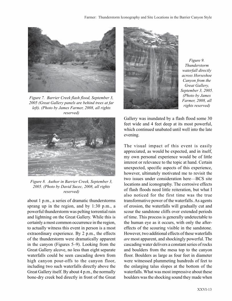
Farmer: Thunderstorm Iconography and Site Locations in the Barrier Canyon Style
XXVI-13
about 1 p.m., a series of dramatic thunderstorms
sprang up in the region, and by 1:30 p.m., a
powerful thunderstorm was pelting torrential rain
and lightning on the Great Gallery. While this is
certainly a most common occurrence in the region,
to actually witness this event in person is a most
extraordinary experience. By 2 p.m., the effects
of the thunderstorm were dramatically apparent
in the canyon (Figures 5–9). Looking from the
Great Gallery alcove, no less than eight separate
waterfalls could be seen cascading down from
high canyon pour-offs to the canyon floor,
including two such waterfalls directly above the
Great Gallery itself. By about 4 p.m., the normally
bone-dry creek bed directly in front of the Great
Gallery was inundated by a flash flood some 30
feet wide and 4 feet deep at its most powerful,
which continued unabated until well into the late
evening.
The visual impact of this event is easily
appreciated, as would be expected, and in itself,
my own personal experience would be of little
interest or relevance to the topic at hand. Certain
unexpected, specific aspects of this experience,
however, ultimately motivated me to revisit the
two issues under consideration here—BCS site
locations and iconography. The corrosive effects
of flash floods need little reiteration, but what I
also noticed for the first time was the true
transformative power of the waterfalls. As agents
of erosion, the waterfalls will gradually cut and
scour the sandstone cliffs over extended periods
of time. This process is generally undetectable to
the human eye as it occurs, with only the after-
effects of the scouring visible in the sandstone.
However, two additional effects of these waterfalls
are most apparent, and shockingly powerful. The
cascading water delivers a constant series of rocks
and boulders from the mesa top to the canyon
floor. Boulders as large as four feet in diameter
were witnessed plummeting hundreds of feet to
the enlarging talus slopes at the bottom of the
waterfalls. What was most impressive about these
boulders was the shocking sound they made when
Figure 9.
Thunderstorm
waterfall directly
across Horseshoe
Canyon from the
Great Gallery,
September 3, 2005.
(Photo by James
Farmer, 2008, all
rights reserved)
Figure 8. Author in Barrier Creek, September 3,
2005. (Photo by David Sucec, 2008, all rights
reserved)
Figure 7. Barrier Creek flash flood, September 3,
2005 (Great Gallery panels are behind trees at far
left). (Photo by James Farmer, 2008, all rights
reserved)

Utah Rock Art, Volume XXVI, 2008
XXVI-14
landing, an incredibly loud, booming thud, as if a
large modern-day explosive had been detonated.
The sound reverberated up and down the canyon,
no doubt audible for hundreds of yards, perhaps
miles, in either direction. At the same time, the
very same water stains discussed above could be
seen forming from lesser pour-offs along the
canyon walls, and although the actual staining
process is difficult to perceive, the paths and
profiles of future stain streaks were clearly
evident. My purpose here is not to simply narrate
a powerful event of nature which is already well
studied and documented. My point is that it seems
inconceivable to me that any ancient archaic
hunter-gatherers witnessing a similar event would
not have been just as astonished as me, and would
have naturally invested the location with divine,
supernatural powers. Indeed, the unavoidable
impression is that one is witnessing (or experi-
encing!) the most profound act of creation within
the canyon environment itself, which technically,
is in fact exactly what is transpiring. Creation and
transformation of the very earth itself apparently
originates from powerful thunderstorms.
Perhaps this then is the genesis of the imagery in
the related BCS panels, and the later rituals, such
as the Snake Dance. Perhaps the BCS panels and
figures were intentionally situated in direct
association with streaks of desert varnish and
calcified deposits because the subject matter of
the panels is the metaphorical perpetuation or
reenactment of the very cosmic event that the
streaks reflect. Reverence for rain gods among
early human societies is commonly associated
with the development of intensive agriculture and
sedentary communities. Cultivated crops require
reliable rain, hence the necessity for divine
guidance and associated rituals to insure such
rain. Lacking intensive agriculture and perma-
nent communities, what purpose would rain
gods have served archaic hunter-gathers? Yet,
archaic BCS imagery is replete with numerous
motifs that seem to reflect high concern for rain,
water, and associated phenomena, including the
goggle-eyed figures, the possible early model for
later rain deities. I would suggest that early
peoples developed a reverence for the creative and
transformative power of thunderstorms and their
aftermath long before the adoption of agriculture,
based not on the economic benefit of rain, but
rather its supernatural, spiritual power.
To this end, one additional motif deserves
consideration. Along with the other related
iconographic elements, arcs typically described
as rainbows occur frequently in BCS panels.
Perhaps the best known example is a large
petroglyph version at the well-known Rochester
Creek panel, but several painted versions occur
in other BCS panels as well. Rainbows and
serpents are the most immediate and apparent
products of rain and thunderstorms, so their
appearance in BCS panels might now be
understood as parts of a cohesive iconographic
program related to thunderstorms and creation.
Instead of a collection of diverse motifs appearing
independently in BCS art simply for their own
sake (serpents, rain clouds, rainbows, goggle-eyed
figures, etc.), the motifs are but individual parts
of a unified symbolic artistic message and
associated belief system. This approach to Barrier
Canyon Style images and iconography seems to
me to more accurately reflect the technical and
formal sophistication apparent in this style.
One of the best BCS panels to see all aspects of
this program in place is the great panel at
Buckhorn Wash. Prominent desert varnish stains
streak the great canyon wall, occasionally directly
intermingling with large BCS figures (Figure 10).
At least two figures appear beneath rainbow arcs,
and several of the anthropomorphs have
outstretched arms consisting not of human
appendages, but rather the bar-pendant rain motif,
as if the figures are to be understood not as mere
humans, but as rain or waterfall makers (Figure
11) or waterfall sprits given human form. Wavy
serpents appear across the panels, adjacent to or
sometimes in the grasp of the “waterfall makers.”
Buckhorn Wash is over 50 miles from the Great
Gallery, and over 100 miles from the Seven Mile

Farmer: Thunderstorm Iconography and Site Locations in the Barrier Canyon Style
XXVI-15
Canyon panel, attesting to the geographic
distribution and frequency of this program in BCS
art.
BCS panel loctions were probably determined by
a number of complex, interrelated reasons. At least
nine different specific reasons have long been
bandied about to explain why BCS artists placed
panels where they did, and each reason is probably
justified to some extent. I offer herein only a
summary of these reasons as an extended analysis
of these reasons is not warranted in this
presentation, and I wish only to consider the issues
in this preentation in relation to site location.
1) Established trails: Most panels occur along
primary trails and access routes (stream
bottoms, etc.), probably serving as archaic
“billboards” and traffic controls.
2) Natural Resources: Many panels probably
served to indicate the location of valuable
natural resources, be they water sources,
game-hunting, or valuable plant life.
3) Meeting or Campsite Locations: Larger,
more complex BCS panels, such as the
Great Gallery and Buckhorn Wash,
probably indicate repeated use of sites over
extended periods of time as preferred
campsites or meeting places for seasonal
ceremonies.
4) Tradition (prior use): The larger, multi-
figure panels may also be the result of
repeated use simply as a preference for
creating new images at sites already
established with previous panels. Like
modern graffiti, once a canyon wall was
initially used as a canvas, the tendency was
probably to reuse that same wall for
additional imagery, adhering to tradition,
rather than seek out an unused surface.
5) Territorial Markers: Some panels may
have designated territorial boundaries of
distinct social groups (bands, families,
clans, etc.) within the greater archaic
cultural matrix.
6) Accessibility: On a practical note, the
accessibility and availability of appropriate
walls and surfaces for panel production
would have influenced the locations.
Boulders or shelves for access, and some
minimal degree of protection from the
elements would be required.
7) Visual Properties (aesthetics): The
dramatic visual power of the panels
juxtaposed against the large, water streaked
canyon walls and deep alcoves no doubt
impressed archaic BCS artists just as much
as modern viewers, and many panels
probably occur where they do simply
because they looked “cool.”
8) Sonic Properties: A substantial amount of
recent scholarship has verified the role that
acoustics may have played in site locations,
particularly the work of Steven Waller on
rock art sites world wide (Scarre and
Lawson 2006). The alcoves and canyon
walls amplify sound and echoes (and
Figure 11. BCS anthropomorphs (waterfall
makers?), Buckhorn Wash, Utah. (Photo by James
Farmer, 2008, all rights reserved)
Figure 10. Buckhorn Wash, Utah. (Photo by James
Farmer, 2008, all rights reserved)

Utah Rock Art, Volume XXVI, 2008
XXVI-16
exploding waterfall boulders!) throughout
the canyons, investing the panel locations
with a heightened spiritual power.
9) Magical or “Sacred” Qualities: Panels
may have been intended to reflect sacred
or supernatural properties invested in the
specific site location, or sacred events
transpiring at the specific sites. This aspect
is related to item #8, the sonic properties,
and is most relevant to the issues in this
presentation.
Each of these reasons has merit, yet ironically,
the issue regarding BCS site location becomes
most intriguing because each of these qualities
can be applied to most of the canyon walls and
alcoves in the region. The nagging question most
often asked about BCS site location is not “why
is the art work here?” but rather “why isn’t there
a BCS panel on this wall?” referring to the infinite
number of perfectly good and available rock
surfaces and alcoves in the region that does not
contain imagery. Visitors and specialists alike are
often perplexed as to why BCS artists did not
exploit seemingly obvious locations for artistic
purposes. The sacred properties of certain sites,
considered herein, in part addresses this very
issue, for the natural phenomena (thunderstorms,
waterfalls, flash floods, etc.) that may have
inspired the specific imagery are time sensitive;
they require the participant/viewer to be in the
proverbial “right place at the right time,” as I was
in 2005. The first eight criteria listed above can
be experienced under any circumstances at any
time, but not number 9, the sacred event; it is
powerful, ephemeral, and supernatural in its
effect.
REFERENCES CITED
Burrow, Kelly Daniels
2002 The Serpent Motif of Barrier Canyon:
Ritual and Symbolism in Ancient American
Rock Art, Master of Arts Thesis, Virginia
Commonwealth University, Richmond,
Virginia.
Farmer, James
2001 Goggle Eyes and Crested Serpents of
Barrier Canyon: Early Mesoamerican Icon-
ography and the Archaic Southwest. In The
Road to Aztlan: Art From a Mythic Homeland,
Los Angeles County Museum of Art, pp. 124–
137. Los Angeles, California.
Frigout, Arlette
1979 Hopi Ceremonial Organization. In Hand-
book of North American Indians, Volume 9,
Southwest, William Sturtevant, gen. ed.,
Alfonso Ortiz, vol. ed., p. 564–576. Smith-
sonian Institution, Washington, D.C.
Scarre, Chris, and Graeme Lawson, eds.
2006 Archaeoacoustics. McDonald Institute
Monographs, McDonald Institute for
Archaeological Research, Cambridge, UK.
Schaafsma, Polly.
1980 Indian Rock Art of the Southwest. Uni-
versity of New Mexico Press. Albuquerque.
2001 Quetzalcoatl and the Horned and Feathered
Serpent of the Southwest. In The Road to
Aztlan: Art From a Mythic Homeland. Los
Angeles County Museum of Art, pp. 138–149.
Los Angeles, California.

Loosle: The Land Between
XXVI-17
PREHISTORY
The South Unit of the Ashley National Forest is
an upland area located between Nine Mile Canyon
and the Uinta Basin, two of the West’s most
famous rock art locales (Figure 1). Although rock
art is sparse in this particular area, abundant
archaeological features help us understand the
people who once lived in the region. The section
has a very diverse range of vegetation ranging
from pinyon-juniper at lower elevations to mixed
Byron Loosle
THE LAND BETWEEN
conifer and sagebrush steppe in its higher reaches.
This corner of the Tavaputs Plateau has deeply
incised canyons trending toward the northeast.
Although there is limited permanent water, an
incredible array of wildlife lives on the unit. For
years, we thought the first people to visit the South
Unit occurred 3,000 to 4,000 years ago. However,
in the summer of 2007, we discovered a series of
late Paleoindian sites (9,000 to 8,000 years old)
at the highest elevations of the unit. Today,
sagebrush steppe with scattered aspen groves
Figure 1. South Unit and Nine Mile Canyon are located in lower left of
map.

Utah Rock Art, Volume XXVI, 2008
XXVI-18
covers this area, although in the past this area was
probably a grassland or tundra with abundant
game, perhaps only seasonally during the summer.
These recently discovered sites may force a
rethinking of how the Colorado Plateau was
occupied during the Paleoindian period.
A small number of projectile points from the
period between 8,000 to 3,000 years ago have also
been found. Archaeologists refer to this era as the
Archaic Period. The people who visited the area
still mostly hunted game. These hunters probably
did not stay long in the area and there may have
been long periods when no one visited the region.
This pattern of occupation changed 2,500 years
ago as more people were in the area. They used
rock shelters as temporary camps; unfortunate-
ly later occupation stirred and mixed the remains
from the first camps. One intact hearth, from
2,400 years ago, indicates they hunted large game
(elk and deer) and ate plants like prickly pear
cactus, grasses, and cheno-ams (a variety of weedy
plants like lambs quarter and goosefoot).
Surprisingly, they also appear to have had maize,
although this is very early for its occurrence.
During the Fremont Period (2,000 to 800 years
ago), the area was heavily populated especially
in the pinyon-juniper zone. People liked the re-
sources and rocks available in this locale. Large
boulders provided shelter and erosional catch
basins collected water for drinking.
Because of its upland location, we hypothesized
the South Unit would display the same Fremont
logistical pattern as the Uinta Mountains. Instead,
the excavated sites to date exhibit a markedly
different occupation pattern. 42Dc1424, the
Anthro Mountain site, is an open site in sagebrush
steppe near aspen groves at 8800 feet in elevation.
Evidence of a prepared clay floor and storage cists
suggest this was a residential site where people
lived for extended periods. A wide array of tools
and a mix of floral and faunal resources recovered
at the site support this notion (Estes and Loosle
2004). The other sites that have been excavated
are all rockshelters with very brief occupations.
Stays were short, maybe just overnight, and the
mix of cheno-ams, pinyon nuts, lagomorphs, and
other game all suggest limited gathering for
immediate consumption. South Unit sites have the
first unequivocal evidence from northeastern Utah
that pinyon nuts were gathered for consumption.
In at least two sites, two kinds of cheno-am seeds
were gathered and processed together (Loosle
2005; Stertz and Loosle 2006). While the Anthro
Mountain site appears to represent a warm season
residential site, the other sites had briefly-
occupied camps. (Residential sites are where
people built more durable structures and lived for
weeks or months. Camps may have only been
occupied overnight or for a few days.) The
presence of maize and Uinta quartzite indicates
the occupants were closely tied to the lowlands.
The gathering of cheno-am and pinyon nuts
suggests the rockshelter sites were occupied in
the fall, like the Uinta Mountain sites, possibly
after the maize harvest in the lowlands. The
majority of Fremont prehistoric sites are in the
eastern end of the South Unit. Adjacent to these
ridges is the early historic route through Gate
Canyon. Perhaps the sites represent a prehistoric
travel route between Nine Mile and the Uinta
Basin.
Ceremonial use is another possibility for visits
to the area. A number of unusual rock outlines or
features along the South Unit’s southern crest
may mark vision quest locations. The spectacular
view from the heights seems like an appropriate
location for this type of activity. Perhaps the
travelers were moving to these locations to
participate in religious activities. During a vision
quest, a support group (usually members of the
individual’s family) would accompany the
person and set up camp near the vision quest
location to wait for the initiate’s return (Clifford
Duncan, personal communication, 1996). The
Anthro Mountain site is in a suitable location for
such an encampment, however, it was a residential
site occupied longer than would be expected for

Loosle: The Land Between
XXVI-19
a vision quest camp. (The rock art on the South
Unit is not particularly helpful in assigning
cultural affiliation.)
Only a few panels have been discovered to date,
over half of which are Ute. The large anthro-
pomorph at 42Dc1245 seems typical Classic
Vernal Style. However, the geometric and
zoomorphic figures at 42Dc2278, another South
Unit rock art panel, do not fit neatly into any
recognized style (Clay Johnson, personal
communication, 2007).
Although physically closer to Nine Mile Canyon,
South Unit sites have dominant ties to the Uinta
Basin. Numerous pieces of Uinta quartzite
groundstone (Figure 2), even metates, and lithic
material from north of the Uintas (Tiger chert
[Figure 3], Sheep Creek quartzite) illustrate this
connection. South Unit Fremont pottery is all
Uinta gray, including a sherd from the Anthro
Mountain site that has identical paste and temper
to a sherd found near Flaming Gorge Dam over
70 km away (Estes and Loosle 2004). Nine Mile
Canyon does not have particularly distinctive
cultural attributes or material culture, except for
architecture and rock art. Because the South Unit
has no architecture and little rock art, it is not clear
how influence from Nine Mile would be manifest
in the South Unit. There is very little data for the
time between the Fremont and the beginning of
the historic era.
HISTORICAL ARCHAEOLOGY
The Ute were the Native American group living
in the area when the Spanish first visited.
However, after extensive research, we have
encountered essentially no historical docu-
mentation the Ute visited the South Unit. The
absence of written documentation necessitates
that we rely on the archaeological evidence that
has been gathered from the area. In spite of the
paucity of historical documents, Ashley per-
sonnel have documented several sites with
diagnostic Ute artifacts (Desert side-notch and
metal arrowheads and Intermountain brown-
ware pottery), Ute style rock art, culturally
modified tree, and brush drivelines. Once we
identified sites that appear to represent Ute
activity, we attempted to understand what
activities and purposes the sites may represent.
Accomplishing this undertaking has turned into
a formidable challenge and is still a work in
progress. One of the difficulties is that there
has been surprisingly little historical
archaeological research on the Ute.
There are a few rock art panels in the South Unit
depicting horses or individuals riding horses.
These figures are so scarce that it is impossible
Figure 3. Tiger chert scraper.
Figure 2. Uinta quartzite two-handed mano.

Utah Rock Art, Volume XXVI, 2008
XXVI-20
to draw any conclusions about typical position,
location, style, setting, or execution. Primarily,
these panels show the Ute were in the area during
the historic period. A Ute style rock art horse near
the corral at 42Dc1609 may imply the purpose
and group responsible for construction of the
feature (Figure 4). Although hunting and gathering
may have been common activities on the South
Unit, the two dominant archaeological site types
we have documented are culturally modified trees
and brush drivelines and corrals. Many cultural
resource specialists are not familiar with these two
features. For instance, a recently developed oil
pad on Indian land destroyed a portion of a
brush drive-line. These two types of features are
often not recognized, even by professional
archaeologists.
Pine Trees
Ponderosa pine has a restricted distribution across
the South Unit and only occurs in a few patchy
locations, generally along canyon bottoms. Yet, a
number of culturally modified Ponderosa pine
trees (CMTs) have been documented in Sowers
and Timber Canyons. There are a few accounts
of pine bark eating in the literature. “Small strips
of the inner bark of the pine were tied into bundles
and later eaten with salt” (Smith 1974:65). Warren
A. Ferris (1983:345) offered an account of Indians
in central Utah, “From the mountains, they bring
the nuts which are found in the cores of the pine,
acorns from the dwarf oaks, as well as the different
kinds of berries, and the inner bark of the pine,
which has a sweet acid taste, not unlike lemon
syrup.” Not just pine, but “sap from quaking
aspen trees was considered a great delicacy by all
Utes. It was usually collected in June” (Smith
1974:66).
Leo Thorne, a Vernal photographer and
collector, asked members of the Ute tribe
about the peeled trees. He was told they were
peeled to get the inner bark and pine gum for
healing purposes. His family generally
referred to the trees as “medicine trees” as a
result and the term is still used in Vernal.
Clifford Duncan, a Ute elder, said in some
areas a medicine man would place the person
against the scarred portion of a tree as part of
a healing or exorcism ritual.
Bertha Cuch, another Ute elder, remembers
her grandmother peeled trees and rolled the
inner bark into balls that she gave the children
as treats. This is similar to an account from a
woman who remembers her grandmother
collecting the sap to use as a sweetener. Ute
elder, Jonas Grant feels the sap was used to
waterproof moccasins. The sap may have also
been used as a glue to help repair moccasin
soles, as a waterproof basket lining (although
I think pinyon was the preferred “pine” for
this use), and in healing [DeVed and Loosle
2001:6].
Ponderosa pine sap was collected in vats attached
to the trees with rawhide. The Ute especially
wanted the light foamy part. The foamy part was
scraped off with knives. This was done in May or
June as the sap began to rise. They would add the
sap to foods as sweetener (Clifford Duncan,
personal communication, 1998), such as
elderberry wine. Another informant said they used
the inner bark as chewing gum.
Ashley crews have only noted cultural scars on
Ponderosa trees (Loosle 2003). The scars on
CMTs are usually rectangular shaped and start a
Figure 4. Horse petroglyph found near a brush
driveline and corral complex at 42Dc1609.

Loosle: The Land Between
XXVI-21
foot or two off the ground and extend for about
four feet (Figure 5). Cat faces, another common
scar, are caused by fires (Figure 6). They are
usually triangular shaped, start at ground level,
and usually fire blackened. Cat faces are caused
by burning material resting against the tree for an
extended period of time. Martorano (1989) cored
40 culturally peeled trees from three different
areas of Colorado and found the majority of trees
were peeled between 1815 and 1875. In contrast
to the Colorado examples, scarring on Ashley trees
before 1900 is rare (DeVed and Loosle 2001:7,
Table 1). This pattern roughly coincides with the
removal of Colorado Utes to the Ouray
Reservation in the Uinta Basin. We suspect the
best explanation for this dating pattern is that the
Ute in southern Colorado commonly stripped the
bark from ponderosa trees. When they were forced
from Colorado in 1882 the practice ceased there,
but began on trees near the reservation in Utah
(DeVed and Loosle 2001). Martorano’s idea that
Ponderosa was a starvation food does not seem
valid in Utah. We would expect many more trees
with large haphazard scars if the peeling was done
for survival. Instead, the peeling seems more
consistent with occasional use as a sealant, glue,
medicine, or sweetener as local Ute informants
have asserted. Martorano (1989) also noted a
tremendous number of scarred trees. Until
recently, many of our CMTs were isolated and
clusters of three to six trees were the maximum
density. However, during a recent prescribed burn
survey in the Yellowstone drainage of the Uinta
Mountains, dozens of scarred trees were noted.
In 2006, Heritage crews documented 16 CMTs in
Sowers Canyon. At Birch Spring (42Dc2279), we
found the first evidence of a camp site associated
with CMTs. DeVed (1998) obtained dates between
1931 and 1961 for the tree scarring at this site.
The surface trash noted corresponds with this
dating (e.g. 1955 trademark on bottle). It would
be insightful to investigate this camp more
rigorously.
The Ute also used pinyon pine pitch for a variety
of things. Most commonly it was as a liner for
water baskets. The pitch for baskets comes from
pinyon trees and was gathered in the spring. The
person would heat up the pitch then throw it in a
basket. They would then put a rock in the basket
and roll the rock around. The rock pushed the pitch
around and helped seal crevices (Clifford Duncan,
personal communication, 1998). Some Ute
informants do not make a clear distinction
Figure 5. Culturally modified tree. Figure 6. Fire scarred, cat face.
Utah Rock Art, Volume XXVI, 2008
XXVI-22
between pinyon and Ponderosa pine, they just
reference pine. Stewart (1942:252) noted that all
Ute bands reported chewing pinyon pine pitch as
gum. Tree scars are very common near the base
of pinyon trees, but these are usually attributed to
porcupines and other animals. Although a few
pinyon trees could be old enough to have 100 to
200 year old scars, we do not know what the
culturally created scars would look like, or where
on the tree they would be located.
Horse Corrals
Sites or features associated with the management
of livestock are common on the South Unit with
three site types the most obvious: camps, corrals,
and drivelines. Camps have an abundance of tin
cans, glass, wire, utensils, coffee pots, and other
items that typically date to the early twentieth
century. The majority of camps are in canyon
bottoms and probably result from Anglo cattle
ranching after 1905 when the Ute Reservation was
opened to homesteading. Brush corrals and
drivelines, however, tend to be on ridge tops and
generally have few associated artifacts. We believe
most of the brush corrals and drivelines are older
and related to Ute horse management. The horse
was a critical part of Ute society in Utah by the
1800s. More about Ute horse culture will be
discussed later.
Corral Sites
Several driveline sites have been recorded by
Ashley Heritage crews. Some of the sites appear
to have been reused with later or reconstructed
corrals and drivelines. This reuse has created a
sometimes bewildering array of features at the
sites. Firewood collecting has further complicated
the deciphering of the arrangement and
organization of the features. 42Dc1609 is the
simplest and most straightforward of the corral
complexes because it contains a single pair of
drivelines and corral. This site layout helps us
understand the organization of the other sites. The
two wing walls were made primarily of juniper
branches and limbs that have been metal ax cut.
Often entire small trees or large uncut branches
were integrated into the walls. The walls were
placed between living trees and incorporated the
living branches into the matrix of the wall (Figure
7). There did not seem to be any pattern to the
arrangement of the branches. Sometimes the limbs
were all laid diagonally in the same direction
between trees and in other spots they formed more
of an X pattern (Figure 8). It appears that the walls
were originally three to four feet in height.
The corral and driveline are at the north end of
Figure 9. The north driveline wall extends for
approximately 275 meters (900 feet). It starts in a
sagebrush opening, but after a few meters enters
the pinyon-juniper woodland. The driveline
generally trends uphill and ends in a saddle
Figure 8. Branches forming an X.
Figure 7. Branches laid against a tree.

Loosle: The Land Between
XXVI-23
between two knolls. The southern wing
wall begins at the base of a short cliff
and trends to the northeast for about 135
meters (440 feet). The wing-walls are
quite close together for the last 60
meters (200 feet). After the horses were
driven into the corral, a portion of the
northern wing wall was taken down and
moved to close off the narrow portion
of the wing walls to contain the horses
in the corral. The narrow portion of the
driveline is about three meters across.
The corral is a circular shaped area, 16
x 15 meters (52 x 49 feet) in size. The
corral walls are much higher and more
substantial than the drivelines. Some of
the walls were still nearly two meters
(6.5 feet) in height when the site was
recorded.
Other sites have a much more confus-ing array of drivelines and corrals (Fig-ure 10). The features have been im-pacted by a modern fence, firewoodcutting, and reuse. The myriad of brushwalls at these sites begs the question,why would drivelines be reconstructedor moved over and over again whenserviceable barriers still existed? Angloinformants told our crew that horseswill only follow a driveline into a traponce. The herd’s old lead mare wouldnot get caught the same way twice(John Barton, personal communication,2006). For corrals to be used more thanonce, the driveline configurations hadto be changed with each use. This prob-ably explains why some sites have mul-tiple drivelines. This practice canclearly be seen at the Allen Corral site(Figure 11). The first drivelines at thesite were oriented to the east. Theselines were tied to the edges of the ridgetop. At some later time, sections of thedrivelines that connected to the corralwere removed and two new drivelines
Figure 9. Corral at 42Dc1609.
Figure 10. Plan map of 42Dc236 showing multple drivelines
and corrals.

Utah Rock Art, Volume XXVI, 2008
XXVI-24
were built into the corral leading from the west.
These drivelines still lead into the corral. These
two later drivelines also tie off to the edges of the
ridge top.
When first documented we assumed the corrals
were for mustang gathering. Additional research
seems to confirm this initial hypothesis. As out-
lined in the subsequent section, Ute informants
have identified these features as horse corrals.
Arkush (1995) has studied numerous game and
mustang drivelines and corrals in the Great Ba-
sin. He (Arkush 1995:13) distinguishes between
pronghorn and mustang features. “Without excep-
tion, mustang traps are much more substantial
than pronghorn traps. The drift fences of mus-
tang traps are usually still standing and are at least
four feet tall; the corrals are relatively small (of-
ten encompassing less than a quarter acre), and
typically are constructed of long, thick wooden
beams.” On the other hand, pronghorn corrals
are very large, 10 to 50 acres in size. Drive-lines
often begin sporadically of light material (i.e.
stacked sagebrush) and only become more sub-
stantial as they draw near the corral.
Figure 11. Allen’s Corral site showing two sets of drivelines.
Ethnic Affiliation of the Corrals
I believe these corrals were built between 1870
and 1905 by the Ute continuing a centuries old
tradition of using brush drivelines and corrals for
a variety of purposes. There is abundant evidence
the Ute built drivelines and corrals in this manner
(Jorgensen 1964:11; Smith 1974:55). In the sum-
mer of 2005, Ashley Heritage crew members
Cristiana Bailey and Gilbert Burkman were taken
to a brush driveline complex on tribal land north
of Roosevelt. Constructed by a Ute informant’s
grandfather, this complex is very similar to the
one at 42Dc1609 described earlier.
Ute elder, Clifford Duncan, accompanied me to
42Dc236 in 1998. Mr. Duncan said in earlier days,
horses were semi-wild and roamed unrestricted.
From time to time, the owner would need a new
saddle horse or wanted to sell or give a horse away
so they would need to gather their livestock to-
gether to select the appropriate ones. His father
would build a trap in a forested area along a trailused by the horses. The wings would start wideand then narrow until they got to the corral. Theopening would be small and designed so the

Loosle: The Land Between
XXVI-25
Figure 12. Corral at Allen homestead patented in
1919, located in Sowers Canyon, 42Dc2276.
horses would not see it and not know they hadentered a corral as they circled around the enclo-sure.
The average size corral was about 15 meters (50
feet) in size. Clifford’s father would place poles
between trees to form the frame of the corral. He
would then place willows upright to form the
fence. They would be about six to eight feet
high. The wings were made of stacked wood,
branches, and other things. Mr. Duncan felt the
corrals and wings we showed him (42Dc236) were
unmistakably a wild horse trap like the one his
father described to him.
Corrals at early Anglo homesteads and ranches
were constructed very differently from the loose
branch construction of the South Unit drivelines.
In addition, Anglo informants mention other fence
construction methods. Anglo-constructed corrals
tend to be more formal and substantial with
multiple poles anchored in the ground and
connecting poles that are either horizontal or
vertical (Figure 12). Preston Nutter and other
cattlemen commonly used “wire net” fencing for
holding corrals, even transporting the material a
considerable distance (over 15 miles) (Barton
1972:31, 33). Barbed wire fences with juniper
poles were also common. William Barton
(1972:25, 31), a local homesteader and cattleman,
only mentions building short “brush fences” to
keep cattle from leaving switchback trails and to
block possible escape routes while cows were
being encouraged to leave snowbound pockets.
These short brush barriers have commonly been
used by Anglos. Clay Johnson (personal
communication, 2007) remembers casual
conversations in the 1960s with Anglos who had
chased wild horses as a largely recreational
pursuit. He was told that at times they constructed
dead wood and brush corrals or wings as part of
their activities. These folks were not “cowboys”
in the strict sense that they worked on ranches or
rounded up livestock for a living, but horse owners
who chased and caught wild horses for fun in a
variety of ways. Johnson noted that private pursuit
of wild horses ended when it was federally
prohibited in the 1960s or early 1970s. In
northeastern Utah, where sedimentary deposits
have created numerous deep canyons with
countless short ledges, short sections of poles and
brush closing off gaps in the ledges to block
livestock are ubiquitous. Ashley Heritage crews
have documented these throughout the Red
Canyon area, especially near Swett Ranch and the
nearby homesteads. They are also common on the
South Unit and in Nine Mile Canyon. These brush
and log constructions only augment natural ledges
and cliffs and rarely exceed 10 meters (35 feet) in
length, unlike the long drivelines described earlier.
There is another type of fence commonly
encountered on the South Unit. One Anglo
informant said they would tie strips of cloth to a
wire that had been strung through the woods. The
fluttering cloth would scare the horses away from
the wire. This technique is still practiced on fields
in the Uinta Basin. Bundles of wire are common
at camp sites on the South Unit and validate the
informant’s comments. We have also noticed lines
of wire still in the trees, most notably several yards
of wire a couple hundred meters (650 feet) south
of 42Dc1609. This wire may correspond to a
nearby incised name, “Bill Hadden 2/15/41.” The
wire on the driveline at 42Dc236 may indicate
reuse of the site by later Anglo cattlemen. Wire
offers a significant advantage over brush

Utah Rock Art, Volume XXVI, 2008
XXVI-26
drivelines. Because drivelines could only be used
once before horses became familiar with their
direction and purpose, wire allowed the rancher
to easily move and rebuild lines. Wire would have
been a significant improvement over the labor
intensive brush drivelines.
The Importance of the Horse
There was also a significant difference between
the Ute and Anglo views of these semi-wild Indian
ponies.
Perhaps the most important single possession
of the Ute was his horse. The Utes had been
for a long time the intermediaries between the
Spaniards to the south and many of the Plains
Indians to the north and east in the distribution
and spread of the horse. As a result they were
raided often by their northern and eastern
neighbors while the Utes, in turn, raided the
Spanish settlements to the south [Lang
1953:8].
A number of cultural practices show the value of
the horse in Ute society. “Adultery was punished
by beating the wife and, according to an old Uintah
informant, the injured husband would shoot the
adulterer’s best horse. But according to several
other informants, if the husband only shot the
adulterer’s horse and ignored the woman, it was
a sign the adulterer could have the woman” (Lang
1953:9). “A deserted wife might ride up to her
former husband and stick her spear (the one she
carried to balance herself with if her saddle
slipped) in her husband’s horse. This gives him
away. Or she might kill the horse belonging to
her successful rival” (Smith 1974:134). One
informant told Smith (1974:140) that a new father
(after a baby’s birth) could not ride his good horses
for 10 days after the baby was born. He had to
ride ones he was not proud of. It was common to
kill horses when individuals died. “A man’s horses
were killed at the graveside. If they saved one
horse, they would cut his tail and mane short and
make him look like a mourner” (Smith 1974:150-
151). Horse racing was a favorite pastime of the
Ute, and ultimately was the principal factor in the
friction at the White River Agency leading to a
revolt which resulted in Nathan Meeker and other
agency employees’ deaths near Meeker, Colorado.
Although important to the Ute, Anglos viewed the
Indian ponies as small and worthless. A Vernal
Express article in 1929 claimed that some of the
horses that the county had paid Earnest Eaton to
destroy were the size of sheep (Vernal Express
1929). Barton (1972:34, 51) had a particular
disdain for the wild horses and shot a number of
them throughout his life. Barton was not the only
rancher that killed wild horses. “We decided to
make a run for a wild band of horses that ranged
around the Avintiquin rim and were a nuisance
on the range because they chased the cattle back
from the springs; pawed the water and made it
muddy so the cattle wouldn’t drink it and those
fifteen head of horses ate about the same amount
of feed as twenty five cattle” (Pope 1972).
Beginning in about 1928, regional newspapers tell
the story of herds and bands of hundreds of wild
horses eliminated by order of the Farm Bureau,
Indian Services, Cattlemen’s Associations, BLM,
and County commissioners because they were a
nuisance. Preston Nutter and Indian agents
brought in stallions in an attempt to improve the
bloodlines of the local horses (Barton 1972:37).
In addition to killing the nuisance animals, Anglo
cowboys rounded them up for whatever reason
they felt they could produce a profit; meat, money,
or rides (John Barton, personal communication,
2006). During the early twentieth century, horse
roundups were very common all over the Basin,
including on Diamond and Blue Mountains, all
along the Green River south, along the Colorado/
Wyoming border north, and on the South Unit. A
US Indian Service permit was issued in February
of 1912 to “trap wild horses.” A notice in local
newspapers in 1932 advertised the government’s
need to purchase remounts for the cavalry. It is
unknown how many local mustangs were
appropriated for the government. In the winter,
weak feral horses were usually gathered
individually by cowboys with well fed horses.

Loosle: The Land Between
XXVI-27
Anglo horse round-ups used a variety of materials
to construct corrals besides the wires and poles
mentioned earlier. In central Nevada, Anglo
cowboys usually used some combination of poles,
wire, sagebrush, natural features, and even a
special canvas and pole corral and driveline to
gather horses (Russell 2006). The absence of
poles, and especially wire, at all of the South Unit
brush drivelines except 42Dc236, argues against
their construction by Anglos. Anglos were
undoubtedly in the area and may have reused some
of these features. However, evidence suggests
these trap complexes were primarily created by
Ute for their horses. Although wild horses still
roam the area, (a heritage crew noted a herd in
Sowers Canyon in 2006) these corral complexes
have not been used for several decades. Indian
herds suffered a dramatic decline in numbers at
the beginning of the twentieth century, so these
drivelines have probably not been used since the
1920s or 1930s.
CONCLUSION
The Ashley National Forest’s South Unit is a re-
mote and rugged part of Utah. However, the re-
mains of the human past on this plateau provide
an incredible window on the past. The South Unit
is located between two of Utah’s most intriguing
and rich cultural areas and may eventually help
us understand the prehistoric land use patterns of
these regions. Although physically closer to Nine
Mile Canyon, the Fremont era residents of the
South Unit appear to be more closely tied to the
Uinta Basin. The later Ute occupation was cen-
tered on livestock management and plant procure-
ment. The corrals, drivelines, and scarred trees
from this period have not been extensively docu-
mented in other locations. This makes the region
a fascinating laboratory for additional research
and discovery.
REFERENCES CITED
Arkush, Brooke S.
1995 The Archaeology of CA-Mno-2122: A
Study of Pre-Contact and Post-Contact Life-
ways Among the Mono Basin Paiute. Univer-
sity of California Anthropological Records No.
31, Berkeley.
Barton, William
1972 Autobiography. Manuscript on file, Ashley
National Forest, Vernal, Utah.
DeVed, Lawrence
1998 Yellowstone Canyon CMTs. Manuscript on
file Ashley National Forest, Vernal, Utah.
DeVed, Lawrence, and Byron Loosle
2001 Photo Essay: Culturally Modified Trees.
Utah Archaeology 14 (1):1–13.
Estes, Mark and Byron Loosle
2004 Anthro Mountain: 42Dc1424. www.fs.fed.
us/r4/ashley/heritage/sitereports/anthro-
mountain.pdf
Ferris, Warren A.
1983 Life in the Rockies. Old West Publishing
Co., Denver, Colorado.
Jorgensen, Joseph Gilbert
1964 The Ethnohistory and Acculturation of the
Northern Ute. Unpublished dissertation,
Department of Anthropology, Indiana Uni-
versity, Bloomington.
Lang, Gottfried O.
1953 A Study in Culture Contact and Culture
Change the Whiterock Utes in Transition.
University of Utah Anthropological Papers No.
15, Salt Lake City.
Loosle, Byron
2003 So Delicious They Ate the Bark Off the
Trees http://www.fs.fed.us/r4/ashley/heritage/
ethnography/so-delicious.pdf

Utah Rock Art, Volume XXVI, 2008
XXVI-28
Loosle, Byron (continued)
2005 42Dc1211. www.fs.fed.us/r4/ashley/
heritage/site-reports/42Dc1211.pdf
Martorano, Marilyn A.
1989 So Hungry They Ate the Bark Off a Tree.
Canyon Legacy 9:9–12.
Pope, Fred
1972 Memoirs of Bill Barton. Manuscript on file,
Ashley National Forest, Vernal, Utah.
Russell, Kat
2006 Horse Traps in Central Nevada: Preliminary
Inventory and Context Development. Poster
presented at Thirtieth Great Basin Anthro-
pological Conference, Las Vegas, Nevada.
Smith, Anne M.
1974 Ethnography of the Northern Utes. Papers
in Anthropology No. 17, Museum of New
Mexico Press, Albuquerque, New Mexico.
Stertz, Derek, and Byron Loosle
2006 42Dc316. www.fs.fed.us/r4/ashley/heritage/
site-reports/42Dc316.pdf
Stewart, Omer C.
1942 Culture Element Distributions: XVIII Ute-
Southern Paiute. Anthropological Records Vol.
6, No. 4, University of California Press,
Berkeley.
Vernal Express
1929 Ernest Eaton Employed by County to
Round up and Destroy Wild Horse. Vernal
Express, August 15, 1929.

Galal R. Gough: Sacred Landscape and Native American Rock Art
XXVI-29
Galal R. Gough
SACRED LANDSCAPE AND NATIVE AMERICAN ROCK ART
Figure 1. Aerial view of Aikens Arch.
Figure 2.
Entrance to
Aikens Arch
illuminated
from above.
A sacred landscape, for the Native American, is
not only a place of spectacular beauty or
compelling uniqueness, but also a place deemed
holy by the people who created the legends and
rock art which reveal how special the site had
become to them. The Smithsonian, in an article
entitled “Below the Rim,” told of how humans
had lived in the Grand Canyon for more than 8,000
years. The last site treated was the “Shaman’s
Gallery,” with a spectacular rock art panel of
humanlike figures which stretches for some sixty
feet. Rock art researcher Polly Schaafsma, who
named the Shaman’s Gallery, believed the
pictographs were painted before 1000 B.C. “The
rock shelter where the artists recorded their
visions, she believes, must have been a sacred
site.” (Roberts, 2006a:65) The impressive canyon
setting of the shelter, and the equally astounding
paintings, certainly elicit a sense of the holy for
those in this present day who visit the site.
This paper, while dealing with a number of
representative sites, will also of necessity point
out that Indian sacred places are endangered.
Those who study these fantastic sites must
inevitably become involved in efforts to protect
them. On January 25, 2006, the front page in the
B Section of the Riverside Press-Enterprise
(2006) in California carried an article about the
call of tribal elders, “To Save Sacred Sites, Unite.”
The subheading read “WORKSHOP: Indians
want to open a dialogue with developers to pro-
tect what they treasure.” All persons interested
in saving the sacred places were invited to share
in the proceedings. “Whether they be Soboba,
Pechanga, San Manuel or Cahuilla, American
Indian Tribes must unite to protect and preserve
historic and culturally important sites.” They
called for all who would to join them, for “We
can’t stop development, but we can be instru-
mental in how they develop.” This paper will seek
to point out efforts or problems in protecting sites
as sacred places are discussed.
When I began a serious investigation of rock art
in 1978, Aikens Arch in the Eastern Mojave was
a site I first became convinced was sacred. Other
sacred sites in what is now the Mojave National
Preserve, like Counsel Rocks, Rock Springs,
Landfair Butte, and Piute Springs, have attributes
treated in my previous papers. One of the most
impressive pictures I have taken of Aikens Arch
was an aerial photo (Figure 1). While guiding a
couple on a flight to see the the intaglios—giant
desert figures—along the Colorado River, we flew
along north of the prehistoric Mojave Trail, and
looking down I saw the remains of the collapsed
lava tube which formed Aikens Arch. When
viewed from the ground level (Figure 2), the
opening is illuminated from above by sunlight.

Utah Rock Art, Volume XXVI, 2008
XXVI-30
Figure 3. Aikens Arch petroglyphs.(Arrow points
to “Sky Coyote.”)
Figure 4. Old Woman site monolith.
Figure 5. Old Woman painted cave.
Inside the arch are pictograph power symbols, and
on the outside, impressive petroglyphs, including
the prominent symbol which Isaac Eastvold
(personal communication, 1978) identified as
“Sky Coyote” (Figure 3). When Ike, associated
in more recent years with preservation efforts on
behalf of the Petroglyph National Monument on
the Albuquerque west bank escarpment, took us
to Aikens Arch, we started near the Plumed
Serpent petroglyph and photographed rock art for
almost a half mile down wash to Aikens Arch.
The Painted Cave is in the Old Woman Moun-
tains, and is described by Little in an essay titled
“The Price of the Sacred” (Little 2001:117–121).
I first visited the site in 1988. The previous year I
had found the Big Wash site in the Old Woman
Mountains, listed in Indian Rock Art of Southern
California by Smith and Turner (1975:139–140),
but I did not go far enough to see the huge
monolith which marks the Painted Cave sacred
site. So the next year I went still further, and knew,
as soon as I saw the monolith (Figure 4), that the
area was very special. On the ridge high to the
west was the rock formation that looked like an
old woman. Clusters of petroglyphs were located
intermittently at the base of the monolith and
around to the southeast. Looking up beyond the
narrow gap east of the monolith, I saw pictographs
on the outer surfaces of a cave (Figure 5). I
climbed up the cliff to the cave, and saw within
the cave awesome concentrations of red
pictographs. There was also a rear entrance, which
I used to climb down more safely from the
Shaman’s Cave. Still thinking the site was on
BLM lands, I took my Annual Rock Art Caravan
there in 1989. Ten years later a Presbyterian
minister, who had accompanied me on hikes to
find rock art in Joshua Tree National Park, invited
me to go back to the Old Woman Mountain site,
as a guest of Chemehuevis from the Twentynine
Palms Band of Mission Indians. We went in their
van, and drove to the site from the eastern side.
They told of their struggle to gain ownership of a
2,500 acre ranch, where the site was located at
the extreme end, and of their plans to build a
Cultural Center near the site, to be staffed by a
Chemehuevi couple.

Galal R. Gough: Sacred Landscape and Native American Rock Art
XXVI-31
Figure 6. Corn Springs palm oasis.
Figure 7. Corn Springs rain fringe.
Figure 8. Shaman’s shelter above Andreas Canyon.
The next sacred site to be treated is Corn Springs,
located along the major prehistoric trail from the
Palo Verde crossing of the Colorado River to the
ocean. Corn Springs is a palm oasis which gave
shade, rest, and refreshing water after a long, hot
expanse of desert (Figure 6). Among the numerous
petroglyphs at Corn Springs is a rain fringe
symbol, with power cross-hatching above the
horizontal bar (Figure 7). Desert springs were
sacred to the Native American desert dwellers.
Corn Springs is threatened, not only by a fire
started by careless campers and by some graffiti,
for which a Site Steward program is now in place,
but also by global warming and drought lowering
the water table to the danger level for palm
survival.
Another sacred site is Andreas Canyon, a side
canyon located in the large Palm Canyon which
is south of present-day Palm Springs. It is part of
the Agua Caliente Indian Reservation. Anthony
Andreas, a tribal member, was asked how long
his family had been in Andreas Canyon. “Since
the beginning of time,” he answered. “They are
the original lineage from that canyon and that
surrounding area” (Dozier 1998:53). Another
Tribal Elder, Katherine Saubel, commented: “And
this land, to us, the Indian people, just doesn’t
mean a piece of land. This is a sacred area. This
was given to us by our Creator, to take care of it,
to live here in harmony with it, and that’s why we
were put here—to protect it” (Dozier 1998:55).
In Andreas Canyon there are bedrock mortars,
smoke darkened rock shelters, and high above, a
Shaman’s Shelter (Figure 8) with red and black
pictographs on the ceiling, a cupule boulder, and
at the east base of the shelter, petroglyphs
including a pipette design. Though David Whitley
gives directions to the site in his rock art guide
(Whitley 1996:94–96), the tribe has since closed
the site to visitation to better preserve the too-
often touched and deteriorating pictographs.
The waterfall from the Rancho Bernardo site
cascades down into a southwest finger of Lake
Hodges (Figure 9). The small creek above creates
a pool, with the pictographs on the surfaces of
rock formations to the north and bedrock mortars

Utah Rock Art, Volume XXVI, 2008
XXVI-32
Figure 9. Rancho Bernardo waterfall.
Figure 10. Rancho Bernardo maze.
Figure 11. Oak Springs Eagle Head.
Figure 12. Climb holes on Eagle Head.
on the flat surfaces to the south. The most dramatic
pictographs are in what is called the Rancho
Bernardo Maze Style (Figure 10), and that
terminology has become descriptive for similar
maze pictographs in the Southern California area.
The Oak Springs Site, in the Reid Valley between
Sage and Anza, has bedrock mortars and faded
red pictographs, which appear to be Girl’s Puberty
Rite symbols, on the boulders up the slope on the
west ridge above the stream. But the dominating
feature, clearly visible from a great distance, is a
large boulder with the appearance of an eagle’s
head, on the ridge above (Figure 11). That the
Eagle Head boulder had ceremonial significance
is indicated by the foot and hand holds carved
into the west side of the boulder (Figure 12).
Remains of an Indian village, with many bedrock
mortars, are located downstream from the Eagle
Head Rock in Reid Valley, but how the boulder
might have figured in ceremony and legacy was
lost long ago.
The Old Penny Ranch site near Perris, south of
Riverside, is located by a spring and has a series
of boulders with red pictographs. But one boulder
towers above the others and “is, perhaps, the best
remaining example of a pictograph relating to the
Luiseno girl’s puberty ceremony. The Indian girls
participated in an elaborate ceremony which
included instruction in being a woman. Ground
paintings served as teaching aids, and the rock

Galal R. Gough: Sacred Landscape and Native American Rock Art
XXVI-33
Figure 13. Luiseno pictograph panel.
Figure 14. Pictograph panel in Painted Cave.
Figure 15. Carrizo Painted Rock site.
paintings made by the girls were reminders of the
ceremony” (Smith and Turner 1975:iv–v). The
pictograph panel (Figure 13) is more complex than
most Girls Puberty rock paintings, but in such
ceremonies each girl chooses her own symbolic
design to commemorate the milestone experience.
The site has been donated and is now called the
Motte Rimrock Preserve, administered through
the University of California Preserve System.
A number of Chumash pictograph sites were
certainly sacred to this California tribe, and merit
our respect and awe. Perhaps the best known site
is Painted Cave, located near San Marcos Pass in
the mountains above Santa Barbara, and it is
protected by metal grates and a gate at the
entrance. Among the pictographs, painted with
red, white, and black pigments, are what appear
to be sun symbols, encircled crosses, red zigzag
snake-like designs enclosed with red and white
parallel lines, and a centipede with surrounding
short legs (Figure 14).
Great sites are also on the Vandenberg Air Force
Base near Lompoc, which raises an issue of
concern for the Chumash people. Access to sacred
ceremonial sites on the Vandenberg Base, the
gated community at Point Conception, and the
lands owned by the Pacific Gas and Electric
Company for the Diablo Canyon Nuclear Power
Plant, is limited and entrance is possible only by
permission, though the security provisions do
protect the rock art from vandalism.
Without such protections, the Carrizo Plain
Painted Rock site further to the northeast suffered
grievous vandalism, beginning almost a century
ago. Nevertheless, the impressive U-shaped
outcrop provided a spectacular setting for a sacred
site (Figure 15). Some archaeologists have
suggested that the formation has the shape of a
vulva, and a number of human figures appear to
be involved in ceremonial dances (Figure 16).
There are rattlesnake and turtle motifs, as well as
human figures in relation to holes or depressions
in the sandstone. Despite the degradation, enough
of the extensive pictographs are still there to

Utah Rock Art, Volume XXVI, 2008
XXVI-34
Figure 16. Red pictograph figure at Carrizo
Painted Rock.
Figure 17. Coso Rain Shaman glyph.
Figure 18. Coso
Shaman panel.
suggest how awesome the site once was. This
site is now protected by the Bureau of Land
Management.
Certainly the Coso Range has a multitude of
sacred rock art sites, which, by virtue of being in
the province of the Naval Air Weapons Station,
are recipients of careful preservation and
protection efforts. My first visit to view the Coso
rock art was in April of 1978 through a Uni-
versity of California at Riverside extension course
taught by Isaac Eastvold, who made arrange-
ments with the Maturango Museum for a two day
tour. We went first to the Darwin Wash site, and
then to the Carricut Lake sites. At Junction Ranch
we photographed house rings, metates, and
adjoining petroglyphs, with bighorn designs
being most common. The next morning we went
to Little Petroglyph Canyon, and spent most of
the day there, taking hundreds of pictures. Among
the thousands of petroglyphs, the most famous is
the Coso Rain Shaman (Figure 17). The ritual
headdress has the topknot quail feathers, and the
cloak has the vertical lines which come down to
end with what appears to be a rain fringe. In other
papers I have pictured Coso medicine bags, a
processional panel and impressive bighorns. But
for me the elaborate human figures, especially the
panel of shaman figures (Figure 18), most typify
Little Petroglyph Canyon.
Black Canyon, Ceremonial Point and Inscription
Canyon, located northwest of Barstow in the
Central Mojave Desert, certainly must be included
in any survey of sacred sites. In 1977 Wilson G.
Turner launched the Black Canyon recording
project, and soon realized he had underestimated
the number of petroglyphs and the time necessary
for his teams to complete the task. After two
seasons they had recorded over four thousand
glyphs, and the final total five years later was over
ten thousand (Turner and Trupe 1983). High up
on the east side of Black Canyon is a petroglyph
of a cougar with padded feet and a lightning bolt
tail, with bullet holes made, fortunately, by a poor
marksman. Inscription Canyon is much smaller,
with fewer petroglyphs, but they are concentrated
and accessible. The patterned body bighorn panels
(Figure 19), to the right of the entrance, are
splendid.

Galal R. Gough: Sacred Landscape and Native American Rock Art
XXVI-35
In the Saline Canyon, made part of Death Valley
National Park when the California Desert
Protection Act was passed, there is a well pre-
served village site along Hunter Creek, though
the related rock art has suffered damage. Several
miles east of the hot springs is Pink Tuff Canyon,
where huge bird glyphs have wing spans of three
and four feet (Figure 20), and the setting is truly
sacred. In Death Valley, Greenwater Canyon has
magnificent petroglyphs, and the Klare Spring
boulder glyphs and the trail glyphs southwest of
Mesquite Springs are well worth while. Marble
Canyon has a sequence of sites, with the
petroglyphs on each side of a dike, with even more
even more farther up canyon, making this
prehistoric trail passage unique. In the main
high walled narrows, there is a shelf far up on
the right. When I took my caravan there in 1992,
only a few dared to climb up on the shelf to
photograph the large rock art panel (Figure 21).
Moving into the tip of Southern Nevada, a
complex of rock art sites attest to the sacredness
of Spirit Mountain—Hiko Springs, Bridge
Canyon, Sacatone Canyon, and to the north, Nap
(Knapp) Canyon. The most accessible, and most
sacred, is Grapevine Canyon, which is the major
site as the Xam Kwatcan Trail draws near to
Avikwaame, the Mojave name for Spirit
Mountain. The trail begins at Pilot Knob, called
Avikwalal, across the Colorado River from Yuma.
There are numerous trail shrines, intaglios, and
dancing circles along the almost 200 mile
pilgrimage trail north to Spirit Mountain. The
bighorn panel at Grapevine Canyon, shown here
in part (Figure 22), is distinctive. Shrines along
Figure 21. High Marble Canyon glyphs.
Figure 19. Patterned body bighorn.
Figure 20. Saline Valley bird glyph.
Figure 22. Grapevine Canyon bighorns.

Utah Rock Art, Volume XXVI, 2008
XXVI-36
the Xam Kwatcan Trail have intaglio repre-
sentations of Kumastamho, the Creation diety, and
powerful figures at Grapevine Canyon (Figure 23)
may also be tributes to Spirit Mountain as the
“Mountain of Creation.”
Grapevine Canyon is also sacred because of a
spring, and rain diety and other rain symbols at
the entrance to the canyon were treated in my
paper on “Springs, Water Basins and Tanks in
Native American Rock Art” (Gough 2005). There
are also rain and spring images at Keyhole Canyon
north of Searchlight, and Brownstone Canyon
west of Las Vegas. There are many rain fringes,
along with water tanks, at Atlatl Rock and Mouse’s
Tank in the Valley of Fire and by the water tanks
at the Whitney-Hartman “Falling Man” site east
of where the Virgin River empties into Lake Mead.
These sites all serve to emphasize how springs
and water sources in desert lands were viewed as
sacred.
Upper Pahranagat Lake is located northeast of Las
Vegas, along Highway 93, the Great Basin
Highway. In the spring of 1978 I was driving to
Caliente, and as we approached the passage
through the lava flows which had formed the dam
to create the lake, I said to my wife, “I bet there
are petroglyphs on those cliffs.” There were, and
I photographed several, including one that I later
found out was the famous “Pahranagat Man”
(Figure 24). Later, exploring that Pahranagat ridge
at the northern end, I saw rock-lined shelter areas
on an elevation, and blanket-like designs, which
could also include rain symbolism (Figure 25).
Many more petroglyph panels were on the basaltic
ridge across open space to the east, with blanket-
like motifs among them. The whole complex
seemed surely to comprise a sacred landscape,
with protection afforded by being in the
Pahranagat National Wildlife Refuge.
Farther north are a number of sites, including
Alamo Paint, Ash Springs, Crystal Wash, and
Petro Village, but especially noteworthy and
sacred is the cluster of sites at White River
Figure 25. Blanket-Like petroglyph.
Figure 23. Grapevine Canyon figure.
Figure 24. The “Pahranagat Man.”

Galal R. Gough: Sacred Landscape and Native American Rock Art
XXVI-37
Narrows. On a dirt side road north of the bend
are amazingly complex panels, with bighorn,
human, rain fringe and abstract designs (Figure
26). A series of cliffs with complex designs, a
fertility site, and a spider glyph site are among
the petroglyphs located south of the bend and east
of Highway 318. Then to the south, west of Hiko,
is another sacred complex of sites leading up to
Mt. Irish. On the hogback cliffs to the left are the
first petroglyph panels, with bighorn sheep and
horned human figures (Figure 27). Another site
follows on the right, and then the main
concentration of petroglyphs with panel after
panel, leads on to another “Pahranagat Man.”
The hike into the Kohta Circus site, located
southwest of Mesquite between the Virgin
Mountains and where the Virgin River empties
into Lake Mead, is a splendid preparation for the
moment when the large, deep sloping arena
appears. The long circus panel is in the gallery on
the left, and the high katsina mask panel is on the
right. The site was named for the 75 foot panel
with so many zoomorphs (Figure 28). Even more
awesome is the high panel, with the finely chiseled
glyphs made dramatic by the dark patinated
surface (Figure 29). Green and Holmes (1999:31–
40), in their paper “Katsinas Come to Kohta
Circus” focused on the cone-shaped headdresses,
and the ceremonies associated with the katsina
Figure 26. White River Narrows glyphs.
Figure 27. Mt. Irish sheep and horned
human figures.
Figure 29. High Katsina mask panel at
Kohta Circus.
Figure 28. Kohta Circus zoomorphs.

Utah Rock Art, Volume XXVI, 2008
XXVI-38
cult. On the way up to the katsina mask panel
are twin crooks, which, as I developed in my paper
on “The Shaman’s Crook in Native American
Rock Art,” are instruments of shamanic power
(Gough 1996:Section 14,1–18). For me, the total
site is awesome, and is certainly a sacred
landscape.
On a field trip led by Boma Johnson, we headed
west of St. George in Southwestern Utah to the
Gunlock site, to sites in Santa Clara Canyon, and
then to the Land’s End site, high over the Santa
Clara River drainage. We parked by the rock-
outlined shelters of a small village site, and walked
to the edge of the overlook. Land’s End seemed a
fitting title, though I heard others call the site
Land’s Hill. The view from the cliffs looking
down on the valley below was majestic (Figure
30). There were petroglyphs by the hundreds at
the top edge of the cliffs, with the bighorn glyphs
being characteristic of the carefully executed skill
so apparent in the rock art. When I took my
caravan there two weeks after Spring Equinox,
light and shadows on a sun-like petroglyph design
suggested that observations at key junctures of
the solar calendar might be profitable. All in all,
Land’s End fits the Sacred Landscape description
extremely well.
Even the approach to Parowan Gap, which for
me was from the west side, signaled sacred
landscape, with an impressive petroglyph panel
on the left adding emphasis. The plaque on the
pedestal in front of the Zipper Glyph confirmed
the sacred with the caption, “God’s Own House.”
While many rock art surfaces clamored for
attention, the “zipper” glyph (Figure 31) was most
compelling. I had made a copy of the interpretive
drawing of this glyph by Nal Morris in his paper
on the “Manifestations of the Fremont Calendar”
(Morris 1996:Section 15,1–20), and held it while
noting his explanation of each glyph mark
culminating with the designation for Summer
Solstice. He also described his discovery of the
summer solstice cairns, pointing in the sunset
direction. He found cairns indicating the sunsets
for the equinoxes and winter solstice as well.
Hundreds of people gather at Parawan Gap for
the Summer Solstice, and watch the sun set in the
V-shaped gap as Nal Morris, who is regularly
invited, explains the importance this sacred site
and the solar interactions had for the prehistoric
peoples.
At the convergence of Rochester Creek and
Muddy Creek, there is a high promontory,
crowned with huge rock formations (Figure 32).
The Rochester Creek site has a number of panels
with rock art, with themes of procreation and life
forms in keeping with the thrust of the huge main
surface dominated by a rainbow. Within the
rainbow in this petroglyphic panel masterpiece
Figure 30. View from Land’s End site.
Figure 31. Parowan Gap zipper glyph.

Galal R. Gough: Sacred Landscape and Native American Rock Art
XXVI-39
are a variety of animals and anthropomorphic
figures, as well as a conception and birthing scene
(Figure 33). The female figure has been created
around a natural womb-like depression in the rock
surface, which emphasizes the life-affirming,
creation-minded panorama of bighorn sheep, deer
with antlers and other zoomorphic creatures in
this complex panel. The scene faces east, and there
are solar calendar interactions. A video
presentation of the site, produced by Chuck and
Charles Bailey, and with Jesse Warner interviewed
on camera, performs an important service by
showing seasonal changes where sunlight,
shadows, and petroglyph images interact (Bailey
and Warner 1999). What appears to be the shadow
of a pregnant woman moving across the panel and
intersecting with the birthing scene is impressive,
and enables those who cannot come often to the
site to sense the awesome majesty of the site.
Outside the rainbow are many other creatures,
including owls and other birds, human figures,
snakes and fantastic creatures, and ferocious ones,
along with what seems to be a time-line or line of
ascent. Thought to be at least 2,000 years old, it
must reflect an elaborate creation mythology with
solar involvements.
Presenters at the Price URARA Symposium in
2005 were invited to participate in a field trip
to Range Creek. Waldo Wilcox had stayed on
the Utah ranch, which his father had home-
steaded, for fifty years, and had protected the
archaeological treasures. Now owned by the state
of Utah, Kevin Jones, the state archaeologist, was
committed to preserving the rich treasure of rock
art, artifacts, high cliff granaries and other
features. I was one of his passengers and as he
drove his pickup up into the high Range Creek
Canyon, he spoke of all he had seen, and he felt
that there was so much more. The cliffs, pinnacles,
and buttresses alone made the canyon sacred
(Figure 34). But then Kevin pointed out the
granaries high up the cliffs, some with nearby rock
art. One upside-down figure suggested that some
may have fallen from those heights. One series
of very large panels had an impressive horned
Figure 32. View of Rochester Creek petroglyph site.
Figure 33. Rochester Creek panel.
Figure 34. Range Creek high cliffs.

Utah Rock Art, Volume XXVI, 2008
XXVI-40
serpent petroglyph. Painted human figures high
up on a cliff face looked out over the valley. I was
particularly impressed by the three human figures
(Figure 35), with the largest wearing a shaman’s
neck medicine pouch. Because all three were
connected, I believe they represented a pro-
gression of shamanic heritage and power in Range
Creek. In the August 2006 issue, National
Geographic carried an article on Range Creek,
describing Waldo Wilcox as “Guardian of a Ghost
World” (Roberts 2006b), and certainly he was the
protector of a sacred landscape.
Nine Mile Canyon, which is located northeast of
Price, Utah, is really a forty-mile-long art gallery,
with many thousands of awesome petroglyphs
and some pictographs as well. My first visit back
in the late nineties was like a spiritual pil-
grimage—going from site to site, with some
panels high above the canyon (Figure 36) and the
panoramic view—convincing me that Nine Mile
Canyon was truly sacred. Then I came a second
time, on October 4, 2006, in the late afternoon,
facing heavy traffic with semis with two tanks
apiece, and workers in company vehicles heading
for home. We parked at the mouth of Big Daddy
Canyon as a semi with tanks passed by, sending
clouds of dust into Rasmussen Cave. When we
visited the cave, the petroglyph boulders at the
floor level were covered with a quarter inch of
dust. The nearby industrial buildings and pump
station were degrading to the sacred landscape of
Nine Mile Canyon, and the results of dust
accumulation, the impact of dust suppressing
magnesium chloride, and the vibration caused by
heavy industrial traffic, threatened the hundreds
of recorded Native American cultural sites.
Because of the late hour, we went on to the
URARA events and meetings at Vernal, in the dust
of a convoy of heavy trucks going north. But we
came back to Nine Mile Canyon on a Field Trip
the following Monday. A room-size boulder had
broken off the cliffs and fallen down to the road
(Figure 37). It had not been there five days before,
and dramatized for us the damage the vibration
Figure 35. Three Shaman figures at Range Creek.
Figure 37. Fallen boulder by road in Nine Mile
Canyon.
Figure 36. Nine Mile Canyon view.

Galal R. Gough: Sacred Landscape and Native American Rock Art
XXVI-41
and pounding from the heavy truck traffic, with
approximately 100 industrial vehicles passing by
in a twenty-four hour period, could do to the
surrounding cliffs and their rock art. Because the
first drilling of some 35 natural gas wells was
north of Cottonwood Canyon, with the industrial
traffic going by the Great Hunt panel, concern
was raised to curtail traffic by this famous panel.
Some heavy traffic still goes by the panel, but the
greater concern is for the whole stretch of Nine
Mile Canyon, if the project of 700 gas wells is
continued, including the additional construction
of industrial facilities and cumulative heavy
traffic, without regard to the archaeology and rock
art of Nine Mile Canyon.
Twice in this paper, I have noted preservation
efforts at sites treated in Sacred Lands in Indian
America (Little 2001). My daughter in Olympia,
Washington, has the Sacred Lands book in her
library. She has many Indian friends, and had gone
to Seattle for a book signing and fund raiser for
the Snoqualmie Tribe. Christopher Peters, of the
Native American Seventh Generation Fund, was
the main speaker. He is quoted in Sacred Lands
in Indian America, as follows: “In the native belief
system sacred places are not sacred because
native people believe they are sacred. They have
sacredness in and of themselves. Even if we all
die off, they will continue to be sacred” (Page
2001:131). When he autographed my daughter’s
book, by the quote above, he wrote: “Keep
Fighting for the Sacred. Christopher.” In
concluding my presentation at the URARA
Symposium, I asked those present to let me be a
cheerleader, and all of us together to shout out
KEEP FIGHTING FOR
THE SACRED!
REFERENCES CITED
Bailey, Chuck, and Jesse Warner
1999 Rochester Creek Petroglyph Site, Bailey
and Associates, Producers. UMRARA.
Dozier, Deborah
1998 The Heart is Fire, The World of the
Cahuilla Indians of Southern California.
Heyday Books, Berkeley, California.
Gough, Galal R.
1996 The Shaman’s Poro (Sacred Crook) in
Native American Rock Art. In Utah Rock Art
XVI. Utah Rock Art Association, Salt Lake City.
2005 Springs, Water Basins and Tanks in Native
American Rock Art. Paper presented at the
Twenty-fourth Annual Symposium of the Utah
Rock Art Research Association, Price, Utah.
Green, Eileen, and Elaine Holmes
1999 Katsinas Come to Kohta Circus. In Utah
Rock Art XIX. Utah Rock Art Research
Association, Salt Lake City.
Little, Charles
2001 The Price of the Sacred. In Sacred Lands in
Indian America. Harry N. Abrams, Publisher,
New York.
Morris, Nal
1996 Manifestations of the Fremont Calendar. In
Utah Rock Art Volume XVI. Utah Rock Art
Research Association, Salt Lake City.
Page, Jake, editor
2001 Sacred Lands in Indian America. Harry N.
Abrams, Publisher, New York.
Riverside Press-Enterprise
2006 To Save Sacred Sites, Unite, by Herbert
Atienza. January 25, 2006, p. B-1, Riverside,
California.

Utah Rock Art, Volume XXVI, 2008
XXVI-42
Roberts, David
2006a Below the Rim, Smithsonian, Volume 37,
No. 3.
2006b Guardian of a Ghost World, National
Geographic, Volume 210, No. 2.
Smith, Gerald A., and Wilson G. Turner
1975 Indian Rock Art in Southern California. San
Bernardino County Museum Association, San
Bernardino, California.
Turner, Wilson G., and Beverley S. Trupe
1983 Petroglyph Study Developing the 1980
Report on The Black Canyon Project of the
Mojave Desert. San Bernardino County
Museum Quarterly 29(1)
Whitley, David S.
1996 A Guide to Rock Art Sites: Southern
California and Southern Nevada. Mountain
Press, Missoula, Montana.
1998 Following the Shaman’s Path, A Walking
Guide to Little Petroglyph Canyon, Coso
Range, California, Maturango Museum
Publication, Ridgecrest, California.

XXVI-43
Abstracts for the Twenty-Sixth Annual
Symposium of the Utah Rock Art Research
Association in Vernal, Utah, October 6–9, 2006
Clifford Duncan is a Tribal Elder of the Northern Ute tribe, author of many articles and publications including:
“A History of Utah’s American Indians” The Northern Utes of Utah.”
Introduction to Ute and Plains Indian Rock Art
“For us, Spirit is there, through the symbols. It is an important part of their world. It is important to know the
environment and how things were to them in their world. With the circle and stone circles, there are many
ways to interpret them. There are higher levels of interpretation of spirit. One must develop an eye to use in
visitations to petroglyph sites, the spiritual eye. Learn how to look at these sights in a spiritual sense.”
Jim Keyser, Oregon Forest Service archeologist, is a well-known Plains Indian rock art expert and author.
Bear Gulch: the Origins of Narrative Art
Bear Gulch in central Montana, studied in 2005, has the largest concentration of shield bearing warriors in
North America, with more than 750 recorded examples. Medicine bundles, feather bustles, wolf headdresses,
and distinctive shield designs associated with these figures all point to a single group having made the art
at this site over a period of 300–400 years just before A.D. 1700. These shield bearing warriors enable us to
study characteristic shield heraldry, weaponry and associated military equipment, and the development of narrative
Biographic art in the few centuries immediately preceding Historic period.
Layne Miller has studied and photographed historic Ute rock art for many years.
Ute Style Rock Art
The Ute Indians inhabited much of the West at one time and left their petroglyphs and pictographs over
much of the Four Corners, including Nine Mile Canyon. Nine Mile is a terrific place to study Ute rock art,
because there are numerous examples left behind and because it can be studied in relation to Fremont examples
and other style in the canyon. Ute rock art can also be used to trace the monumental changes that took place to
the traditional Ute lifestyle of hunting and gathering, once they obtained the horse in the late 1600s and early
1700s.
Byron Loosle Ph.D is the Heritage Program Leader for Ashley National Forest
The No-Man’s Land South of the Uintah Basin
Spaniards, trappers, soldiers, cattleman, Mormons, and Ute Indians all left accounts of their activities in the
Uinta Basin. However, the uplands between the Uinta Basin and Nine Mile Canyon are scarcely mentioned in
any historical records. Yet, on the ground there is a rich archaeological record dating back thousands of years.
Although the Ashley National Forest’s “South Unit” may help unlock crucial understanding of Utah’s prehis-
toric past, this presentation will focus on historical sites like corrals and culturally modified trees that help
understand the more recent history of the area.

Utah Rock Art, Volume XXVI, 2008
XXVI-44
Mark D. Mitchell, Department of Anthropology, University of Colorado
Ute Rock Art in the Arkansas River Basin, Southeastern Colorado
During the eighteenth and nineteenth centuries, various Ute bands roamed across the Southern Rocky Mountains
as well as the neighboring Plains and Plateau regions. Rock imagery created by Ute artists can be found throughout
western Colorado and eastern Utah, where its distinctive style and content distinguish it from earlier abstract
imagery as well as from contemporaneous Ceremonial and Biographic tradition imagery. Recent research
conducted on the Purgatoire River, a major tributary of the Arkansas, has documented rock art elements exhibiting
these same distinctive technological and formal attributes. Superposition sequences and historical data suggest
that these images likely were created during the first half of the nineteenth century.
Nancy Bostick-Ebbert is a free lance writer, song writer and passionate voice for environmental issues.
Our Threatened Cultural Heritage
Nancy Bostick-Ebbert, writer, artist and conservation activist, will offer ideas on how to best protect our
disappearing cultural legacy. A no-nonsense approach that emphasizes the importance ofº education, her solutions
are both simple and practical.
º”If you want another to adopt your beliefs, you must first become someone they wish to emulate...” ~nancy
bostick-ebbert~
James Farmer, Department Chair of the Department of Art History, Virginia Commonwealth University, is a
specialist in the art and architecture of Precolumbian America, the North American Indians and Mexican art of
the twentieth century.
Thunderstorm Iconography and Rock Art Site Locations, or “Don’t Rain on My Anthropology!”
Why many Archaic period rock art panels, such as those in the Barrier Canyon Anthropomorphic Style, were
located where they are remains an open-ended question. This presentation suggests that, in addition to previously
offered theories including accessibility, route marking, territorial boundary, and sound and light qualities, many
BCA sites were located in spots where the effects of seasonal rains and thunderstorms, such as flash floods and
waterfalls, were most dramatically experienced. Certain BCA images reflect motifs similar to later Puebloan
rain motifs, and certain BCA-style figures reflect features such as large, goggle-eyes similar to contemporary
rain deities from neighboring and later ancient American cultures. The implied symbolic reverence for rain and
thunderstorms in a non-agricultural, Archaic hunter-gatherer society contradicts traditional anthropological
assumptions that the importance of rain was directly linked to dependence on agriculture.
David Sucec, Barrier Canyon Style Project, is an art historian, curator and rock art researcher.
Floating Figures: The Holy Ghost In Space And Its Place At The Great Gallery
With more than 80 painted Spirit Figures, the Great Gallery is one of the most impressive prehistoric rock art
sites on the Colorado Plateau and, its central composition, the Holy Ghost Group, unquestionably unique—
even when considered on the global scale. The figures of the Holy Ghost Group appear to represent a three-
dimensional, or cubic, space. There is no question that the composition is three-dimensional but there is some
question whether this unique grouping reflects the work of only one individual.
This presentation will discuss the extraordinary spatial dynamics of the Holy Ghost Group, its execution, and
the suggestion that “visiting artists” may have came to the Great Gallery to make images in the Horseshoe
variant style consistent to the site.

XXVI-45
Eve Ewing and Jesse Warner are Utah Rock Art Researchers, with in-depth field work.
Sheep and Rain I and II
Part I: In the Great Mural Art style of Baja California, Mexico, some images of desert mountain sheep—
(Borregos) and the fauna associated them suggest a place in water hydrology beliefs similar to one known for
the Western Shoshone. Further examples may be found for the Pima and Desert Papago of Arizona. Clearly this
possible association of sheep and rain will be further illuminated in Part II, a discussion of southwestern rock
art.
Alice Tratebas Ph.D. is a BLM archeologist in Laramie, Wyoming.
Rock Art Depictions of Ancient Religious Concepts
Rock art in North America shows links to Eurasian rock art in shared themes that derive from ancient beliefs.
Because religious concepts can have great stability and longevity, we may be able to link concepts in ethnographies
and oral histories to depictions in ancient rock art. One such theme is the emergence of animals from the
underworld to populate the earth, depicted either by oblique placement of animals on the rock face or animals
positioned as if emerging from bedrock cracks. Selection of animals to depict reflects their use as symbols,
rather than indicating which animals were hunted or eaten.
Art Cloutier is a retired National Park Service interpreter. His current interest is researching and interpreting
the Paria Canyon rock art.
Revolving Female in Rock Art
This is a contextual approach for establishing meaning of the “W” frequently used in rock art. Presenter will
begin by describing the celestial context of the constellation, Cassiopeia. Next the Native American appella-
tion, Revolving Female, will be established. There will be many photos of Revolving Female: the supporting
context will be described in detail with many variations in the use of these symbols. Hopefully, the viewer will
find the accumulation of contextual clues sufficiently credible to continue building further on another occasion
when there is more time.
Nowell (Nal) Morris took an early retirement from Unisys Corporation to pursue his interests in positional
astronomy and ancient petroglyphic inscriptions.
Venus Studies at Archeo Sites in Utah, Nevada and Arizona
Nal uses computer simulation models to develop an interactive computer program SHAMOS (Sky & Horizon
Astronomical Model Ordinate Simulator) with companion field techniques. These are used to determine any
functional coupling of the cultural remains to a local site’s solar, lunar, topographical and ecological environment.
The rapid access of this data from the present to ages past reveals how ancient peoples used petroglyphic
inscriptions to help them conceptualize the year and how the seasons fitted into their subsistence patterns. .Nal
has uncovered many interesting sites of calendrical and astronomical significance.
Susan Bradford is a member of the Taos Archaeological Society and Archaeological Society of New Mexico.
The Eyewitnesses: Halley’s Comet, Sun-Grazing Comets, Taurid Debris, and SNRs
Ancient astronomists in my area of study: the Taos/upper Rio Grande area, the Mimbres Valley/Pony Hills area,
and locations in southeast Utah left notations as petroglyphs on basalt and sandstone and as designs on fired
clay concerning and memorializing important celestial happenings they observed aloft: the sky on clay and
stone.

Utah Rock Art, Volume XXVI, 2008
XXVI-46
Dale Gray is a member of the Vernal Archeological Organization.
Video Studies of Uintah Basin Solar Panels
Evelyn Billo and Bob Mark, Rupestrian CyberServices, do extensive rock art recording, research and
documentary photography.
Panoramas of Desert View Watchtower Murals: Grand Canyon National Park
Desert View Watchtower, a three-story building—open in the center—was designed by Mary Jane Colter and
dedicated in 1933. Murals painted by Hopi artists Fred Kabotie and Chester Dennis and Euro-American artist
Fred Geary include rock art and pottery designs. Interpretations of some of the images will be discussed. In
order to photograph the murals to create five panoramas, a special T-shaped rig was built and a laser plumb used
to orient our remote controlled camera in the center of each level. To our knowledge this was the first complete
photographic record of the deteriorating murals.
Reverend Galal Gough has pursued rock art research for many years, contributing many papers to URARA
symposiums.
Sacred Landscape and Native American Rock Art
Everything is sacred, and every site where Native American Rock Art is found has special significance. But
some settings are so scenically unique and spectacular as not only to be enhanced by those peoples who were
drawn to them in the first place, but also to have been hallowed and deemed “sacred” by those people. Such
sites seem to have become places for religious ceremonies or pilgrimage, and often have direct relationships
with Native American creation epics or solar calendars. Some of the most compelling sites in California,
Nevada, Utah, Arizona, New Mexico, and Texas will be investigated in this presentation from the perspective
of “Sacred Landscape.”
Part I: Representative sacred places with Native American rock art in Southern California, Southern Nevada,
and Land’s End, Parawan Gap, Rochester Creek, Range Creek, and Nine Mile Canyon in Utah are treated in
this first installment.
Ben Everitt is a geologist who brings poetry to our final presentation.
Art as a Window to Farther Reality
The goal of the artist is to catch the attention of the viewer and make him see the world with new eyes, view
reality from a different perspective, and perhaps help him glimpse the ultimate reality beneath the surface
of the world we live in. With this theme in mind, I would like to explore a couple of my favorite sites: Flag
Point and Sears Point. At both places artists explore and interpret apparitions which could be considered as
spirits or messengers from another dimension.