Volcanic eruptions with little warning: the case of Volc~A¡n Reventador's Surprise November 3, 2002...
14
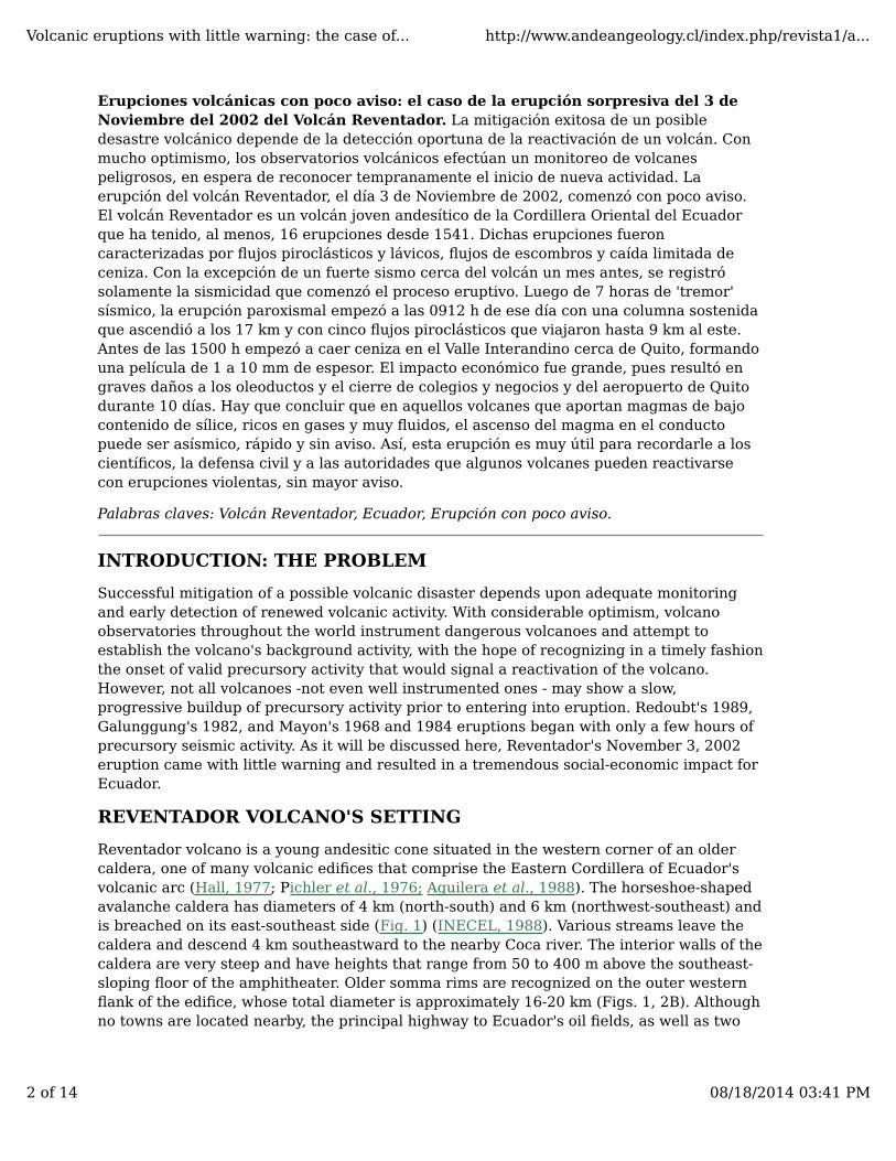
Font Size: Andean Geology, Vol 31, No 2 (2004) HOME ABOUT LOG IN REGISTER SEARCH CURRENT ARCHIVES Home > Vol 31, No 2 (2004) > Hall Revista Geológica de Chile, Vol. 31, No. 2, p. 349-358, 7 Figs., December 2004. ARTICLES Volcanic eruptions with little warning: the case of Volcán Reventador's Surprise November 3, 2002 Eruption, Ecuador Minard Hall 1 , Patricio Ramón 1 , Patricia Mothes 1 , Jean Luc LePennec 2 , Alexander García 3 , Pablo Samaniego 3 , Hugo Yepes 3 1 Instituto Geofísico, Escuela Politécnica Nacional, Quito, Ecuador, [email protected], [email protected], [email protected] 2 Institut de Recherche pour le Développement, [email protected] 3 Instituto Geofísico, Escuela Politécnica Nacional, Quito, Ecuador, [email protected], [email protected], [email protected] ABSTRACT Successful mitigation of a possible volcanic disaster depends upon the early detection of renewed volcanic activity. With considerable optimism, volcano observatories instrument dangerous volcanoes, with the hope of an early recognition of the reactivation of a volcano. Reventador volcano's November 3, 2002 eruption came with little warning and had a tremendous socio-economic impact. Reventador volcano, a young andesitic cone in the Eastern Cordillera of Ecuador, has had, at least, 16 eruptions between 1541 and 2002. These eruptions were characterized by small pyroclastic flows, blocky lava flows, debris flows, and limited ash falls. With the exception of a M=4 earthquake near the volcano one month earlier, only seismic activity related to the eruption onset was registered. Following only 7 hours of seismic tremor, the paroxysmal eruption began at 0912 h on November 3, 2002 with a sustained column that ascended to 17 km and five pyroclastic flows, that traveled as much as 9 km to the east. By mid-afternoon ash falls of 1-10 mm thickness began blanketing the Interandean Valley near Quito. The economic impact was significant, including severe damage to the principal petroleum pipelines, closure of schools, businesses, and Quito's airport for 10 days. It is important to conclude that for those volcanoes that are characterized by low silica, volatile-rich, fluid magmas, magma ascent can be aseismic, rapid, and without much warning. This event should serve as a clear reminder to scientists, civil defense, and authorities of the rapid onset of the eruptions of some volcanoes. Key words: Reventador volcano, Ecuador, Eruption with little warning. RESUMEN Volcanic eruptions with little warning: the case of... http://www.andeangeology.cl/index.php/revista1/a... 1 of 14 08/18/2014 03:41 PM
Transcript of Volcanic eruptions with little warning: the case of Volc~A¡n Reventador's Surprise November 3, 2002...
Font Size:
Andean Geology, Vol 31, No 2 (2004)
HOME ABOUT LOG IN REGISTER SEARCH CURRENT ARCHIVES
Home > Vol 31, No 2 (2004) > Hall
Revista Geológica de Chile, Vol. 31, No. 2, p. 349-358, 7 Figs., December 2004.
ARTICLES
Volcanic eruptions with little warning: the case of VolcánReventador's Surprise November 3, 2002 Eruption, Ecuador
Minard Hall1, Patricio Ramón1, Patricia Mothes1, Jean Luc LePennec2, Alexander
García3, Pablo Samaniego3, Hugo Yepes3
1Instituto Geofísico, Escuela Politécnica Nacional, Quito, Ecuador, [email protected],[email protected], [email protected] de Recherche pour le Développement, [email protected] Geofísico, Escuela Politécnica Nacional, Quito, Ecuador, [email protected],[email protected], [email protected]
ABSTRACT
Successful mitigation of a possible volcanic disaster depends upon the early detection ofrenewed volcanic activity. With considerable optimism, volcano observatories instrumentdangerous volcanoes, with the hope of an early recognition of the reactivation of a volcano.Reventador volcano's November 3, 2002 eruption came with little warning and had atremendous socio-economic impact. Reventador volcano, a young andesitic cone in theEastern Cordillera of Ecuador, has had, at least, 16 eruptions between 1541 and 2002.These eruptions were characterized by small pyroclastic flows, blocky lava flows, debrisflows, and limited ash falls. With the exception of a M=4 earthquake near the volcano onemonth earlier, only seismic activity related to the eruption onset was registered. Followingonly 7 hours of seismic tremor, the paroxysmal eruption began at 0912 h on November 3,2002 with a sustained column that ascended to 17 km and five pyroclastic flows, thattraveled as much as 9 km to the east. By mid-afternoon ash falls of 1-10 mm thicknessbegan blanketing the Interandean Valley near Quito. The economic impact was significant,including severe damage to the principal petroleum pipelines, closure of schools,businesses, and Quito's airport for 10 days. It is important to conclude that for thosevolcanoes that are characterized by low silica, volatile-rich, fluid magmas, magma ascentcan be aseismic, rapid, and without much warning. This event should serve as a clearreminder to scientists, civil defense, and authorities of the rapid onset of the eruptions ofsome volcanoes.
Key words: Reventador volcano, Ecuador, Eruption with little warning.
RESUMEN
Volcanic eruptions with little warning: the case of... http://www.andeangeology.cl/index.php/revista1/a...
1 of 14 08/18/2014 03:41 PM
Erupciones volcánicas con poco aviso: el caso de la erupción sorpresiva del 3 deNoviembre del 2002 del Volcán Reventador. La mitigación exitosa de un posibledesastre volcánico depende de la detección oportuna de la reactivación de un volcán. Conmucho optimismo, los observatorios volcánicos efectúan un monitoreo de volcanespeligrosos, en espera de reconocer tempranamente el inicio de nueva actividad. Laerupción del volcán Reventador, el día 3 de Noviembre de 2002, comenzó con poco aviso.El volcán Reventador es un volcán joven andesítico de la Cordillera Oriental del Ecuadorque ha tenido, al menos, 16 erupciones desde 1541. Dichas erupciones fueroncaracterizadas por flujos piroclásticos y lávicos, flujos de escombros y caída limitada deceniza. Con la excepción de un fuerte sismo cerca del volcán un mes antes, se registrósolamente la sismicidad que comenzó el proceso eruptivo. Luego de 7 horas de 'tremor'sísmico, la erupción paroxismal empezó a las 0912 h de ese día con una columna sostenidaque ascendió a los 17 km y con cinco flujos piroclásticos que viajaron hasta 9 km al este.Antes de las 1500 h empezó a caer ceniza en el Valle Interandino cerca de Quito, formandouna película de 1 a 10 mm de espesor. El impacto económico fue grande, pues resultó engraves daños a los oleoductos y el cierre de colegios y negocios y del aeropuerto de Quitodurante 10 días. Hay que concluir que en aquellos volcanes que aportan magmas de bajocontenido de sílice, ricos en gases y muy fluidos, el ascenso del magma en el conductopuede ser asísmico, rápido y sin aviso. Así, esta erupción es muy útil para recordarle a loscientíficos, la defensa civil y a las autoridades que algunos volcanes pueden reactivarsecon erupciones violentas, sin mayor aviso.
Palabras claves: Volcán Reventador, Ecuador, Erupción con poco aviso.
INTRODUCTION: THE PROBLEM
Successful mitigation of a possible volcanic disaster depends upon adequate monitoringand early detection of renewed volcanic activity. With considerable optimism, volcanoobservatories throughout the world instrument dangerous volcanoes and attempt toestablish the volcano's background activity, with the hope of recognizing in a timely fashionthe onset of valid precursory activity that would signal a reactivation of the volcano.However, not all volcanoes -not even well instrumented ones - may show a slow,progressive buildup of precursory activity prior to entering into eruption. Redoubt's 1989,Galunggung's 1982, and Mayon's 1968 and 1984 eruptions began with only a few hours ofprecursory seismic activity. As it will be discussed here, Reventador's November 3, 2002eruption came with little warning and resulted in a tremendous social-economic impact forEcuador.
REVENTADOR VOLCANO'S SETTING
Reventador volcano is a young andesitic cone situated in the western corner of an oldercaldera, one of many volcanic edifices that comprise the Eastern Cordillera of Ecuador'svolcanic arc (Hall, 1977; Pichler et al., 1976; Aguilera et al., 1988). The horseshoe-shapedavalanche caldera has diameters of 4 km (north-south) and 6 km (northwest-southeast) andis breached on its east-southeast side (Fig. 1) (INECEL, 1988). Various streams leave thecaldera and descend 4 km southeastward to the nearby Coca river. The interior walls of thecaldera are very steep and have heights that range from 50 to 400 m above the southeast-sloping floor of the amphitheater. Older somma rims are recognized on the outer westernflank of the edifice, whose total diameter is approximately 16-20 km (Figs. 1, 2B). Althoughno towns are located nearby, the principal highway to Ecuador's oil fields, as well as two
Volcanic eruptions with little warning: the case of... http://www.andeangeology.cl/index.php/revista1/a...
2 of 14 08/18/2014 03:41 PM
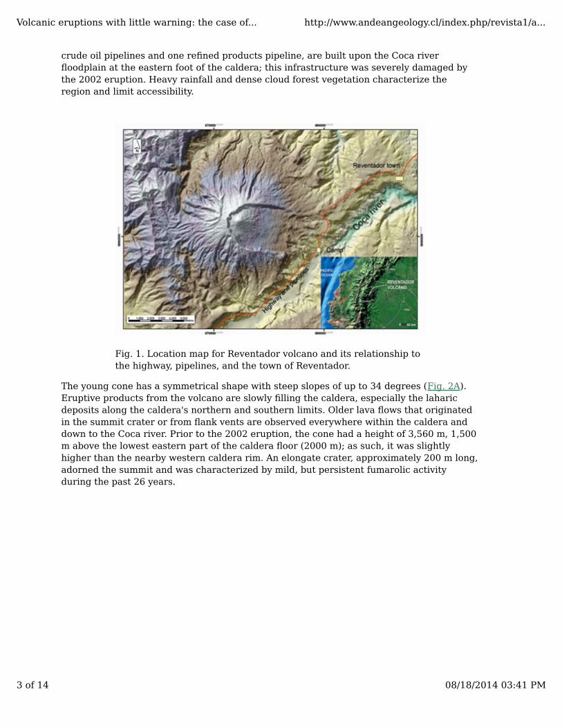
crude oil pipelines and one refined products pipeline, are built upon the Coca riverfloodplain at the eastern foot of the caldera; this infrastructure was severely damaged bythe 2002 eruption. Heavy rainfall and dense cloud forest vegetation characterize theregion and limit accessibility.
Fig. 1. Location map for Reventador volcano and its relationship tothe highway, pipelines, and the town of Reventador.
The young cone has a symmetrical shape with steep slopes of up to 34 degrees (Fig. 2A).Eruptive products from the volcano are slowly filling the caldera, especially the laharicdeposits along the caldera's northern and southern limits. Older lava flows that originatedin the summit crater or from flank vents are observed everywhere within the caldera anddown to the Coca river. Prior to the 2002 eruption, the cone had a height of 3,560 m, 1,500m above the lowest eastern part of the caldera floor (2000 m); as such, it was slightlyhigher than the nearby western caldera rim. An elongate crater, approximately 200 m long,adorned the summit and was characterized by mild, but persistent fumarolic activityduring the past 26 years.
Volcanic eruptions with little warning: the case of... http://www.andeangeology.cl/index.php/revista1/a...
3 of 14 08/18/2014 03:41 PM
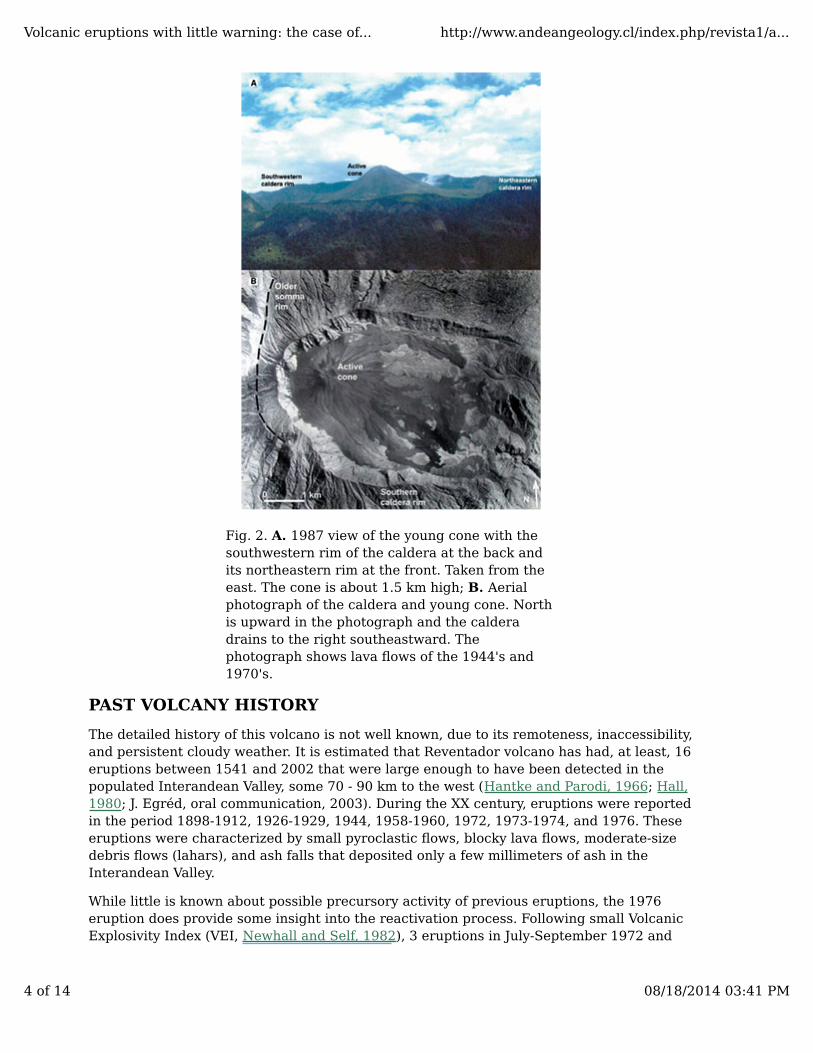
Fig. 2. A. 1987 view of the young cone with thesouthwestern rim of the caldera at the back andits northeastern rim at the front. Taken from theeast. The cone is about 1.5 km high; B. Aerialphotograph of the caldera and young cone. Northis upward in the photograph and the calderadrains to the right southeastward. Thephotograph shows lava flows of the 1944's and1970's.
PAST VOLCANY HISTORY
The detailed history of this volcano is not well known, due to its remoteness, inaccessibility,and persistent cloudy weather. It is estimated that Reventador volcano has had, at least, 16eruptions between 1541 and 2002 that were large enough to have been detected in thepopulated Interandean Valley, some 70 - 90 km to the west (Hantke and Parodi, 1966; Hall,1980; J. Egréd, oral communication, 2003). During the XX century, eruptions were reportedin the period 1898-1912, 1926-1929, 1944, 1958-1960, 1972, 1973-1974, and 1976. Theseeruptions were characterized by small pyroclastic flows, blocky lava flows, moderate-sizedebris flows (lahars), and ash falls that deposited only a few millimeters of ash in theInterandean Valley.
While little is known about possible precursory activity of previous eruptions, the 1976eruption does provide some insight into the reactivation process. Following small VolcanicExplosivity Index (VEI, Newhall and Self, 1982), 3 eruptions in July-September 1972 and
Volcanic eruptions with little warning: the case of... http://www.andeangeology.cl/index.php/revista1/a...
4 of 14 08/18/2014 03:41 PM
November 1973-April 1974, which were characterized by lava flows of 10.5 and 3.8 million
m3 (Hall, 1980), respectively, in addition to moderate ash falls and probable 'nuee ardente'flows, Reventador volcano entered into eruption again in January 1976. This was precededin August 1975 by steam emission lasting several hours that vented from warm springs, 9km distant, which in hindsight suggests that this event was the result of pressurization ofthe local hydrothermal system, probably related to magma intrusion (C. Newhall, oralcommunication, 2004). Beginning in October 1975 a steam column, at least, 1 km high wasobserved issuing continuously from the crater up until the 5 January 1976 eruption. At thattime, the volcano was not monitored and consequently there exists no seismicdocumentation.
The 1976 eruption was accompanied by a high ash column, pyroclastic flows, and two large
lava flows. The lava flows had a total volume of about 20 million m3 and descended thesoutheast side of the cone for about 5 km. Pyroclastic flow activity was observed during thesecond to third week of the eruption, generally small flows that traveled only 2-3 km fromthe crater. Debris flow deposits were seen everywhere. There were no casualties ordamage to the pipelines, as most flows never reached the roadway or the pipelines, 9 kmaway (Fig. 1) (Hall, 1976, unpublished report).
Given the high rainfall and the water-saturated subsoil, it was expected that increasedsteam emission would generally announce impending volcanic activity, once the magmawas approaching the surface; such was the case in late 1975. Prior to the November 2002eruption, the authors anticipated that large-scale steam venting as well as progressiveseismic activity, would be the chief precursory warnings, if this volcano were entering intoeruption.
ERUPTION CHRONOLOGY - 3 TO 21 NOVEMBER 2002
PRECUSORY ACTIVITY
The first clear precursor activity that preceded the eruption was a M=4.1 volcano-tectonic(VT) earthquake that occurred on October 6, 2002 and was accompanied by 9 smaller VTevents. Their epicenters were located on the lower SW flanks of the old edifice and theirhypocenters were placed at depths of 10-11 km. Because this same area is traversed bynumerous regional faults belonging to the active thrust belt that runs along the easternfoot of the Andes, these seismic events were interpreted to be related to that fault system.No other seismic activity was registered in the area prior to 3 November, nor were thereanomalous superficial manifestations. About October 20, a local guide with touristsreached the top of the cone and reported only normal fumarolic activity. In addition noanomalous activity was detected either by local residents or by satellite monitoring duringthis period.
On November 3, 2002 between 0200 and 0300 h (all times are local = EST) a continuouslow amplitude tremor (0.7-1.0 Hz) was detected and continued for many hours. Beginningaround 0300 h a seismic swarm of >100 events began of both VT and hybrid tendencywhich were superimposed upon the ongoing tremor. Workers at a nearby constructioncamp, 8 km east of the crater, were awakened by the earthquakes. At daylight (0530-0600h) they reported a steam column 2-3 km high above the cone. By 0715 h the steam and ashcolumn was high enough to be reported by airplane pilots flying between Quito andGuayaquil (estimated at 3-4 km above the cone). The first NOAA (National Oceanic andAtmospheric Administration) GOES (Geostationary Operational Environmental Satellite)image to detect the eruption cloud occurred at 0745 h; previous images (0715 h) show no
Volcanic eruptions with little warning: the case of... http://www.andeangeology.cl/index.php/revista1/a...
5 of 14 08/18/2014 03:41 PM
unusual cloud formation.
At about 0800 h, witnesses reported that the eruptive column had become more forceful,now reaching 5-6 km above the cone and beginning to drift to the southwest. Photographstaken at 0759 h from the same camp suggest that small 'nuee ardente' flows may havebeen descending the south and east flanks of the cone. Photographs taken at 0803 h fromthe closest town of Reventador, 15 km northeast of the volcano, showed that the eruptioncolumn had reached about 7,300 m above the cone and consisted mainly of steam with onlya limited ash content.Successive explosions and a constant roar were heard at the construction camp, but not atthe town. The 0815 h NOAA GOES image showed the eruption cloud beginning to travel tothe southwest.
PAROXYSMAL STAGE
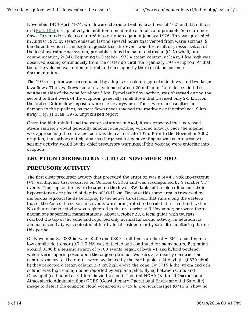
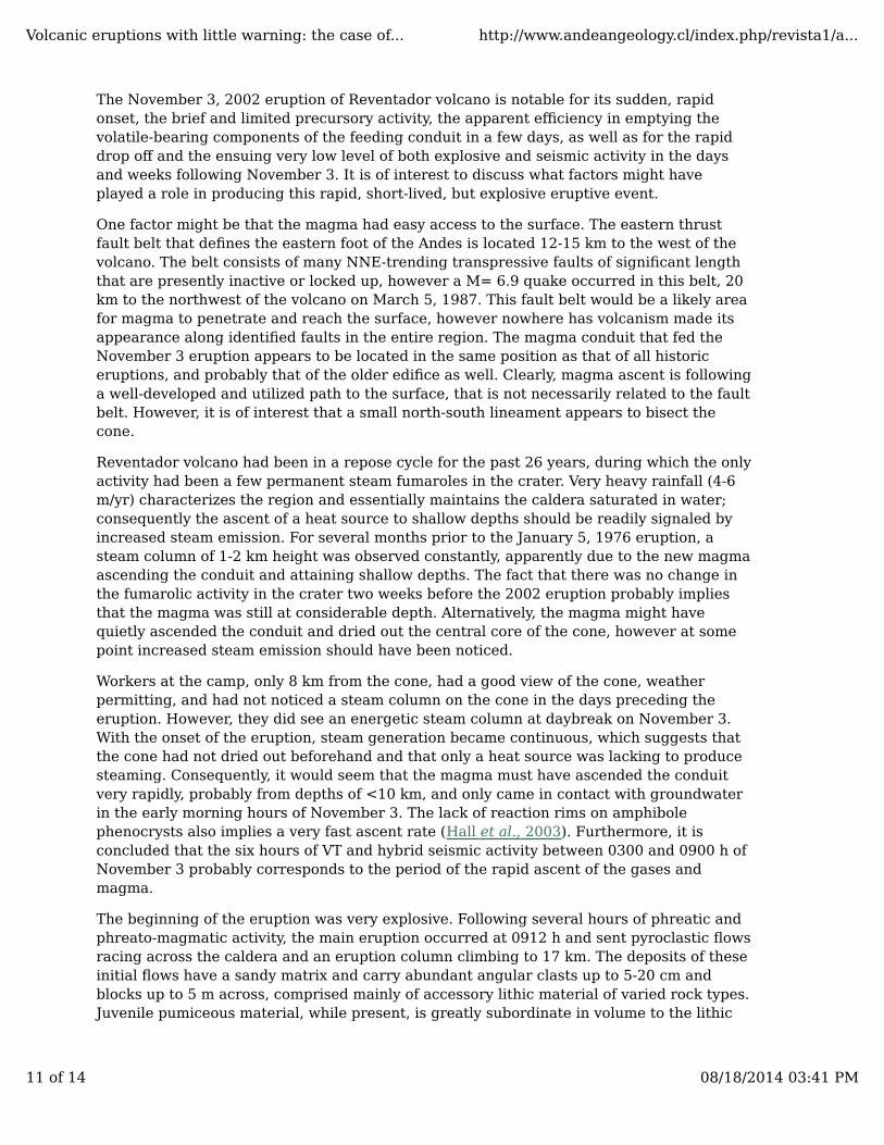
The climactic eruption began at 0912 h and lasted about 45 minutes. It largely destroyedthe summit and crater of the cone, leaving deep notches on the NNW and SSW sides of thesummit where the crater had been. Eyewitnesses reported that more rocks were beingthrown out at this time. During the first minutes of this stage, at least, 5 significantandesitic pyroclastic flows (PF) were produced; their distribution around the cone suggeststhat they originated at the crater or slightly above it. A photographic sequence taken by R.Saca shows pyroclastic flows descending the southern side of the caldera and obliquelyoverriding the 200 to 400 m high southern caldera wall (Fig. 3A, B, C, D)
Fig. 3. Sequential series of photographs of the principal pyroclastic flow takenfrom Reventador town by Roberto Saca. A. Note main eruption column above coneat extreme right of photograph, while ash cloud surge forms a secondary column.
Volcanic eruptions with little warning: the case of... http://www.andeangeology.cl/index.php/revista1/a...
6 of 14 08/18/2014 03:41 PM
Also note that the flow is traveling down the south side of the caldera and up ontoits southern rim; B and D. Sequence continues with pyroclastic flow descendingrapidly into the Coca river valley. Note the rapid dispersion of ash into theatmosphere; C. Photograph of advancing flow taken from the construction camp, 8km from the cone, which bypassed the camp by going to the left. Photographtaken at approximately the same time as photograph B.
The initial pyroclastic flows were pumice-poor, lithic-rich flows that traveled ESE out of thebreached caldera and down steep slopes to reach the Coca river. In doing so, they crossedthe principal oil and gas pipelines, destroying the new, empty oil pipeline and carryingaway small bridges on the main gravel highway leading to the oilfields. Another one meterdiameter pipeline filled with crude oil under pressure did not break, but was displaced~100 m downslope from its path. This was the closest that the pyroclastic flows came tohuman activities. No casualties were reported. One small house and 20 head of cattle were
buried by the pyroclastic flow. These flows covered approximately 12 km2, chiefly in the
caldera, and had a total bulk volume of about 55 million m3.
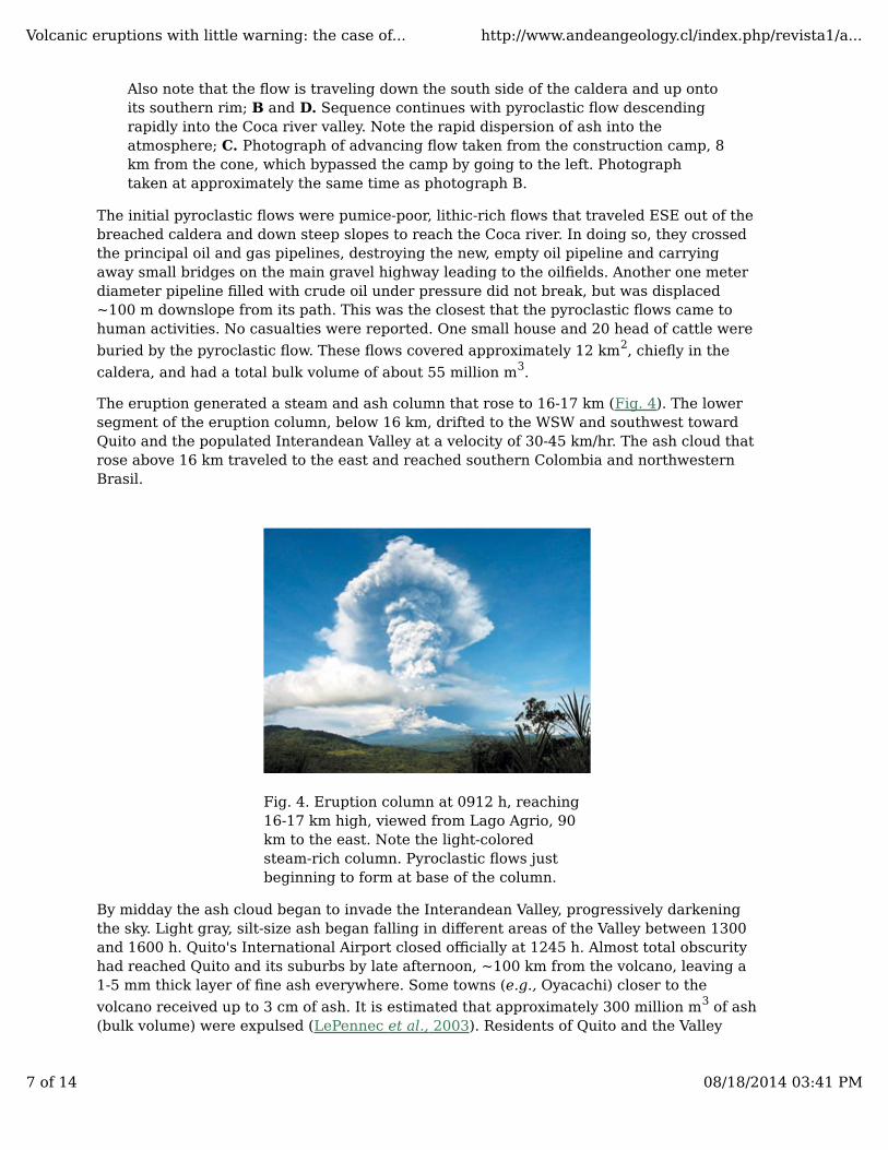
The eruption generated a steam and ash column that rose to 16-17 km (Fig. 4). The lowersegment of the eruption column, below 16 km, drifted to the WSW and southwest towardQuito and the populated Interandean Valley at a velocity of 30-45 km/hr. The ash cloud thatrose above 16 km traveled to the east and reached southern Colombia and northwesternBrasil.
Fig. 4. Eruption column at 0912 h, reaching16-17 km high, viewed from Lago Agrio, 90km to the east. Note the light-coloredsteam-rich column. Pyroclastic flows justbeginning to form at base of the column.
By midday the ash cloud began to invade the Interandean Valley, progressively darkeningthe sky. Light gray, silt-size ash began falling in different areas of the Valley between 1300and 1600 h. Quito's International Airport closed officially at 1245 h. Almost total obscurityhad reached Quito and its suburbs by late afternoon, ~100 km from the volcano, leaving a1-5 mm thick layer of fine ash everywhere. Some towns (e.g., Oyacachi) closer to the
volcano received up to 3 cm of ash. It is estimated that approximately 300 million m3 of ash(bulk volume) were expulsed (LePennec et al., 2003). Residents of Quito and the Valley
Volcanic eruptions with little warning: the case of... http://www.andeangeology.cl/index.php/revista1/a...
7 of 14 08/18/2014 03:41 PM

complained about the strong odor of both SO2 and H2S gas. Several deaths and manyinjuries were attributed to roof cleaning.
SUBSEQUENT ACTIVITY
Other important pulses of the eruption occurred at 1415,1615-1715 h, and 2005-0100 h onNovember 3. On November 4 milder explosions occurred between 1200-1300 h. At 1300 han important explosion took place; IG (Instituto Geofísico) scientists working in the fieldreported seeing, at least, two pyroclastic flows descending the cone and flowing throughthe caldera. Possibly, these explosions generated the numerous pumice-rich pyroclasticflows, some of which were large enough to reach the highway, 9 km away. These flowspostdate and overlie the slightly older lithic-rich pyroclastic flow deposits (Fig. 5). Smallexplosions continued on November 5. Debris flows were generated by frequent rains onNovember 3 and in the following days; they overran and covered parts of the PF depositsand readily reached the Coca River (Mothes et al., 2003). During November 6-7 thevolcano continued to emit ash, gases, and steam, but at reduced levels. Explosionsterminated between November 7-10.
Fig. 5. Photograph taken near the Coca rivershowing the stratigraphic relations of thepumice pyroclastic flow and the underlying10 cm thick ash cloud surge (ACS) layer thatcovers the lithic block-rich initial pyroclasticflow.
The first lava flow surfaced on November 6 which was confirmed by distant photographstaken on that day and later by NOAA thermal images taken at 1900 h on November 7. Theblocky lava flow originated in the newly formed crater, descended the southeast side of thecone, and attained a width of several hundred meters and a thickness of ~15 m. Fromthere, it traveled southeastward down the caldera floor near the southern caldera wall. ANovember 8 overflight by Jorge Anhalzer visually confirmed a 4 km long lava flow,overriding the PF and lahar deposits. By December 3 it had traveled 5 km but wasadvancing at only ~1-3 m/day. In late December, observers at a distance thought that thelava had all but stopped.
Between November 9 and 21 the short eruption column was continuous, but withincreasingly more steam and gas relative to ash. No discrete explosions were heard.
Volcanic eruptions with little warning: the case of... http://www.andeangeology.cl/index.php/revista1/a...
8 of 14 08/18/2014 03:41 PM
Variable debris flow activity occurred, depending upon the intensity of the local rainfall.Occasionally sulfur gases were noted in the Interandean Valley and in Quito.
On November 21 a second blocky lava flow broke out on the lower southeast flank of thecone at ~2,600 m elevation and descended to the ESE. By December 3 it had traveled 2 kmand was accumulating up against the side of the first lava flow. The total volume of both
lava flows is approximately 36 million m3.
By December 3, there was no additional explosive or PF activity. The steam-rich plume wasnow rising to only 1-2 km. The two lava flows continued to move downslope, but only at afew meters/day. Debris flows remained a daily threat to the workers repairing the pipelinesand travelers along the main highway.
In conclusion, this Reventador eruption was a very short-lived, violent event. The total bulkvolume of erupted material (tephra, lava, and pyroclastic flows) was approximately 0.37
km3. Based upon the bulk volume of tephra ejected, the eruption qualifies as a small VEI 4event. It is one of the largest explosive eruptions of an Ecuadorian volcano in the past twocenturies.
SEISMIC ACTIVITY
In April 2002, just months prior to the eruption, the IG had fortuitously installed two newseismic stations (1 Hz, vertical, telemetered) that were located at 15 km to the ENE and at24 km to the southwest of Reventador. After November 3, two additional stations of similarcharacter were installed, one at 7.5 km to the southeast and the other at 8 km to the eastof the crater. Other stations that were also important in monitoring the eruption includethe two Cayambe stations, located ~40 km to the northwest of Reventador volcano, whichdue to their signals were recorded on paper drums, produced the most complete seismicrecord of the precursory activity and the eruption. All of these stations were operatingduring the November 2002 crisis. Most located earthquakes had shallow hypocentersbeneath either the caldera's outer western flanks or under the young cone.
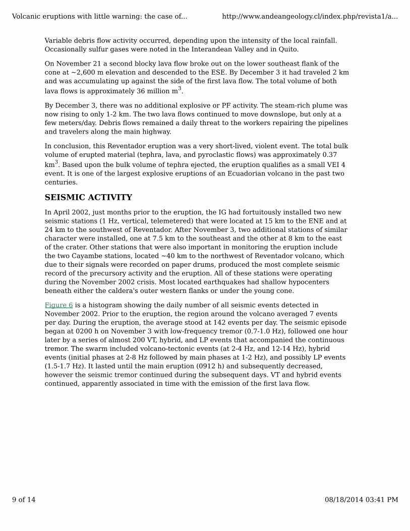
Figure 6 is a histogram showing the daily number of all seismic events detected inNovember 2002. Prior to the eruption, the region around the volcano averaged 7 eventsper day. During the eruption, the average stood at 142 events per day. The seismic episodebegan at 0200 h on November 3 with low-frequency tremor (0.7-1.0 Hz), followed one hourlater by a series of almost 200 VT, hybrid, and LP events that accompanied the continuoustremor. The swarm included volcano-tectonic events (at 2-4 Hz, and 12-14 Hz), hybridevents (initial phases at 2-8 Hz followed by main phases at 1-2 Hz), and possibly LP events(1.5-1.7 Hz). It lasted until the main eruption (0912 h) and subsequently decreased,however the seismic tremor continued during the subsequent days. VT and hybrid eventscontinued, apparently associated in time with the emission of the first lava flow.
Volcanic eruptions with little warning: the case of... http://www.andeangeology.cl/index.php/revista1/a...
9 of 14 08/18/2014 03:41 PM
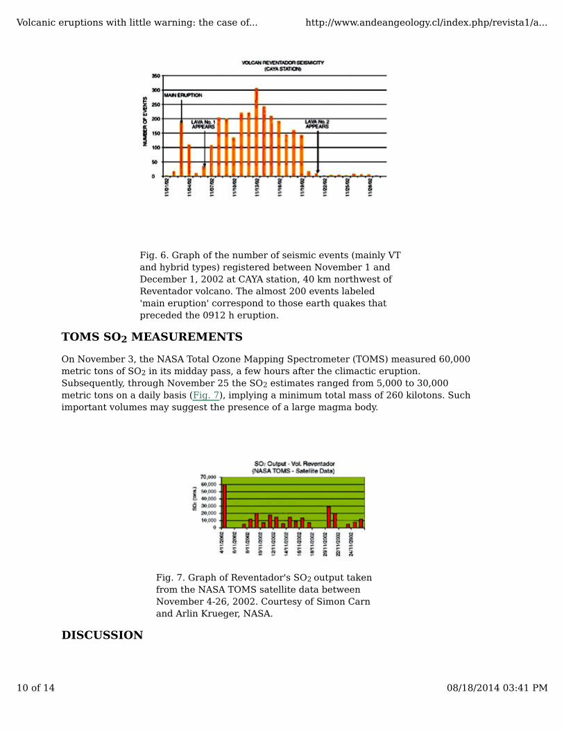
Fig. 6. Graph of the number of seismic events (mainly VTand hybrid types) registered between November 1 andDecember 1, 2002 at CAYA station, 40 km northwest ofReventador volcano. The almost 200 events labeled'main eruption' correspond to those earth quakes thatpreceded the 0912 h eruption.
TOMS SO2 MEASUREMENTS
On November 3, the NASA Total Ozone Mapping Spectrometer (TOMS) measured 60,000metric tons of SO2 in its midday pass, a few hours after the climactic eruption.Subsequently, through November 25 the SO2 estimates ranged from 5,000 to 30,000metric tons on a daily basis (Fig. 7), implying a minimum total mass of 260 kilotons. Suchimportant volumes may suggest the presence of a large magma body.
Fig. 7. Graph of Reventador's SO2 output takenfrom the NASA TOMS satellite data betweenNovember 4-26, 2002. Courtesy of Simon Carnand Arlin Krueger, NASA.
DISCUSSION
Volcanic eruptions with little warning: the case of... http://www.andeangeology.cl/index.php/revista1/a...
10 of 14 08/18/2014 03:41 PM
The November 3, 2002 eruption of Reventador volcano is notable for its sudden, rapidonset, the brief and limited precursory activity, the apparent efficiency in emptying thevolatile-bearing components of the feeding conduit in a few days, as well as for the rapiddrop off and the ensuing very low level of both explosive and seismic activity in the daysand weeks following November 3. It is of interest to discuss what factors might haveplayed a role in producing this rapid, short-lived, but explosive eruptive event.
One factor might be that the magma had easy access to the surface. The eastern thrustfault belt that defines the eastern foot of the Andes is located 12-15 km to the west of thevolcano. The belt consists of many NNE-trending transpressive faults of significant lengththat are presently inactive or locked up, however a M= 6.9 quake occurred in this belt, 20km to the northwest of the volcano on March 5, 1987. This fault belt would be a likely areafor magma to penetrate and reach the surface, however nowhere has volcanism made itsappearance along identified faults in the entire region. The magma conduit that fed theNovember 3 eruption appears to be located in the same position as that of all historiceruptions, and probably that of the older edifice as well. Clearly, magma ascent is followinga well-developed and utilized path to the surface, that is not necessarily related to the faultbelt. However, it is of interest that a small north-south lineament appears to bisect thecone.
Reventador volcano had been in a repose cycle for the past 26 years, during which the onlyactivity had been a few permanent steam fumaroles in the crater. Very heavy rainfall (4-6m/yr) characterizes the region and essentially maintains the caldera saturated in water;consequently the ascent of a heat source to shallow depths should be readily signaled byincreased steam emission. For several months prior to the January 5, 1976 eruption, asteam column of 1-2 km height was observed constantly, apparently due to the new magmaascending the conduit and attaining shallow depths. The fact that there was no change inthe fumarolic activity in the crater two weeks before the 2002 eruption probably impliesthat the magma was still at considerable depth. Alternatively, the magma might havequietly ascended the conduit and dried out the central core of the cone, however at somepoint increased steam emission should have been noticed.
Workers at the camp, only 8 km from the cone, had a good view of the cone, weatherpermitting, and had not noticed a steam column on the cone in the days preceding theeruption. However, they did see an energetic steam column at daybreak on November 3.With the onset of the eruption, steam generation became continuous, which suggests thatthe cone had not dried out beforehand and that only a heat source was lacking to producesteaming. Consequently, it would seem that the magma must have ascended the conduitvery rapidly, probably from depths of <10 km, and only came in contact with groundwaterin the early morning hours of November 3. The lack of reaction rims on amphibolephenocrysts also implies a very fast ascent rate (Hall et al., 2003). Furthermore, it isconcluded that the six hours of VT and hybrid seismic activity between 0300 and 0900 h ofNovember 3 probably corresponds to the period of the rapid ascent of the gases andmagma.
The beginning of the eruption was very explosive. Following several hours of phreatic andphreato-magmatic activity, the main eruption occurred at 0912 h and sent pyroclastic flowsracing across the caldera and an eruption column climbing to 17 km. The deposits of theseinitial flows have a sandy matrix and carry abundant angular clasts up to 5-20 cm andblocks up to 5 m across, comprised mainly of accessory lithic material of varied rock types.Juvenile pumiceous material, while present, is greatly subordinate in volume to the lithic
Volcanic eruptions with little warning: the case of... http://www.andeangeology.cl/index.php/revista1/a...
11 of 14 08/18/2014 03:41 PM
material and is only present as small centimeter-size clasts or as part of the matrix. Given
that the cone's summit lost about 49 million m3 of older material in the initial phase of the0912 h explosion, clearly the abundant lithic portion of the initial pyroclastic flows wasderived from this explosive event. Because vesiculated pumice is not an importantcomponent in these deposits, it is surmised that gas-rich magma had not yet arrived involume in the upper cone.
The violent onset of the eruption was apparently triggered by the sudden depressurizationof a pressurized gas-rich phase of the upper conduit at 0912 h. Undoubtedly, a good sealexisted in the conduit which led to the high pressurization of the early gases, as well aspreventing steam from escaping and giving a warning. Likewise, an accumulated gas phasewould be in agreement with the very high SO2 values that were reported shortly after theeruption. The explosive onset was greatly intensified by steam derived by the magmaticheating of groundwater, as also suggested by the light-colored, apparently steam-rich,eruption column (Fig. 4). Steam as an important component is also suggested by the factthat the ash generated in the early phase of the eruption and that fell over much of theInterandean Valley is very fine-grained and whitish gray in color, suggesting a phreato-magmatic origin. Scoria or vesiculated grains were not observed. The depressurization alsoresulted in the rapid ascent (~1000m/min) to 17 km of the gas-rich eruption column.
The pumice-rich pyroclastic flows are thought to have been generated on November 4,apparently related to the large explosion that occurred at 1300 h. These flows could nothave immediately followed the 0912 h November 3 event, since there had to have been aninterval of time in which the fine-grained ash of the ash cloud surge (ACS) thataccompanied the initial pyroclastic flow (Fig. 3) could have settled out to form theuniformily thick, well-sorted ash layer that is observed everywhere, as well as to have hadtime to compact itself appreciably, probably by rainfall. Photographs taken in the lateafternoon of November 3 show that fine ash was still falling in the caldera. Furthermore,debris flow activity on November 3-4 left numerous lahar deposits upon the basalpyroclastic flow deposits as well as upon the ACS ash layer. The pumice flows invariablyoverlie either the ACS ash layer or the lahar deposits and show no sign of having disturbedthem (Fig. 5). Thus, it would seem that the pumice flows followed the main eruption by aday or so. This, in turn, implies that gas-rich magma was still available in the conduit atleast until November 4, although by November 6 the magma was relatively degassed andforming lava flows.
The brief and limited precursory activity prior to the eruption is baffling. As mentionedearlier, there was no obvious steaming or other visual manifestation of pending activityprior to the eruption. Although the operative seismic net was not ideal, it neverthelessmonitored very well the October 6 seismic swarm, as well as the seismicity of November 3.And yet there was no ramping up of seismic activity in the four weeks prior to the eruption.
Why didn't the ascending magma generate a seismic warning in the days and weeks priorto the sudden eruption? A very fluid magma, a deep source, and a fast ascent of the magmaare all conceivable explanations. Theoretically, magma can move aseismically, especiallywhen it has favorable properties, such as low viscosity, low crystal contents, and abundantvolatiles in solution. That the Reventador volcano magma was relatively fluid and mobile issuggested by the nature of the eruption, despite the fact that the SiO2 contents of the lavasare not low (58-59%) and the percentage of crystals in the glassy matrix is moderate(~20%). The magma source was apparently not so deep, as suggested by the 10-11 kmdeep hypocenters of the October 6 swarm, nor so shallow as to generate steam. Becauseno additional seismicity was detected under the volcano between October 6 and November
Volcanic eruptions with little warning: the case of... http://www.andeangeology.cl/index.php/revista1/a...
12 of 14 08/18/2014 03:41 PM
3, it is thought that the magma was either relatively fluid and flowed aseismically, withoutgeneration of VT or hybrid quakes, or conversely it was quiet and immobile until the final,rapid ascent to the surface was initiated. Previously, it was suggested that the magmaascent rate was rapid and probably preceded by an abundance of volatiles, both ofmagmatic and meteoric origin. In addition, the rapid ascent of the magma would delay therelease of its volatiles until high in the edifice, which would also contribute to theexplosiveness of the November 3 onset.
The short-lived nature of the eruptive event is perhaps due to the fact that most of theex-solved gases had collected in the higher parts of the conduit and were expelled duringthe first days. Subsequently, on November 6 the quiet effusive stage of relatively degassedmagma began, while the final explosive activity was ending. Increasing viscosity of thedegassing magma or closure of the feeding conduit once the gas and magma pressures haddecreased may have also aided in finishing the cycle. Given the frequency of eruptions ofReventador volcano during the XX century, it is clear that magma is readily available atdepth. Consequently, it is not realistic to exclude the possibility of renewed volcanicactivity in the near future.
Finally, it is important to conclude that for those volcanoes that are characterized by lowsilica, gas-rich, fluid magmas, magma ascent can be relatively aseismic, rapid, and givelittle warning. In the case of Reventador volcano, only a telemetered seismic stationoperating directly on the cone might have provided some warning of the impendingeruption.
ACKNOWLEDGMENTS
The authors gratefully acknowledge the help and interest of many colleagues and friends,including J. Anhalzer, Servando de la Cruz and R. Quaas (Universidad Nacional de Mexico),the VDAP (Volcano Disaster Assistance Program) group of the US Geological Survey,USAID (US Agency for International Development) and Alas de Socorro. The comments ofC. Newhall, J. L. Macías, and an anonymous reviewer concerning the original manuscriptareacknowledged.
REFERENCES
Aguilera, E.; Almeida, E.; Balseca, W. 1988. El Reventador: an active volcano in thesub-Andean zone of Ecuador. Rendiconti della Società Italiana di Mineralogia e Petrologia,Vol. 43, p. 853-875. [ Links ]
Hall, M. 1977. El Volcanismo en el Ecuador. Instituto Panamericano de Geografía eHistoria, 120 p. Quito. [ Links ]
Hall, M. 1980. El Reventador, Ecuador: un Volcán activo de los Andes Septentrionales.Revista Politécnica, Vol. 5, No. 2, p. 123-136. [ Links ]
Hall, M.; Mothes, P.; Rivero, D. 2003. Los Flujos Piroclásticos de la Erupción del VolcánReventador, acaecidos el día de 3 de Noviembre de 2002. Jornadas de Geología, EscuelaPolitécnica Nacional, Abstract, p. 72-74. Quito. [ Links ]
Hantke, G.; Parodi, A. 1966. Catalogue of the Active Volcanoes of the World, Part XIX.International Association of Volcanology and Chemistry of the Earth's Interior (IAVCEI), p.73. Rome. [ Links ]
Volcanic eruptions with little warning: the case of... http://www.andeangeology.cl/index.php/revista1/a...
13 of 14 08/18/2014 03:41 PM
INECEL. 1988. Estudio Vulcanológico de El Reventador. 117 p. Quito, Ecuador. [ Links ]
LePennec, J.L.; Hidalgo, S.; Samaniego, P.; Ramos, P.; Yepes, H.; Eissen; J.P. 2003. Magnitudde la Erupción del 3 de Noviembre del 2002 del Volcán Reventador, Ecuador. EscuelaPolitécnica Nacional, Jornadas en Ciencias de la Tierra, Abstract, p. 97-99. Quito. [ Links ]
Mothes, P.; Hall, M.; Ramón, P.; Yepes, H.; García, A.; Enríquez, W.; Ramos, C.; Marcillo, O.;Cárdenas, D.; Jaya, D.; Heredia, E. 2003, Generación de Lahares Secundarios en el VolcánReventador, Noviembre 2002-Marzo 2003. Escuela Politécnica Nacional, Jornadas enCiencias de la Tierra, Abstract, p. 94-96. Quito. [ Links ]
Newhall, C.G.; Self, S. 1982. The volcanic explosivity index (VEI): An estimate of explosivemagnitude for historical volcanism. Journal of Geophysical Research, Vol. 87, p. 1231-1238. [ Links ]
Pichler, H.; Hormann, P.; Braun A. 1976. First Petrologic Data on Lavas of the Volcano ElReventador (Eastern Ecuador). Munstersche Forschungen zur Geologie undPalaeontologie, H. 38/39, p. 129-41. [ Links ]
Manuscript received: January 28, 2004; accepted: August 10, 2004.
© 2011 Servicio Nacional de Geología y Minerí[email protected]
Volcanic eruptions with little warning: the case of... http://www.andeangeology.cl/index.php/revista1/a...
14 of 14 08/18/2014 03:41 PM