Unearthed-3 6 Driffield Terrace, York: vertebrate remains analysis

This article was downloaded by: [University of Calgary]On: 07 January 2013, At: 05:37Publisher: Taylor & FrancisInforma Ltd Registered in England and Wales Registered Number: 1072954 Registered office: Mortimer House,37-41 Mortimer Street, London W1T 3JH, UK
Ichnos: An International Journal for Plant and AnimalTracesPublication details, including instructions for authors and subscription information:http://www.tandfonline.com/loi/gich20
Vertebrate Tracksites in the Middle Jurassic-UpperCretaceous of South TunisiaMichela Contessi a & Federico Fanti a ba Department of Biological, Geological, and Environmental Sciences, Alma Mater Studiorum,Bologna University, Bologna, Italyb Museo Geologico Giovanni Capellini, Alma Mater Studiorum, Università di Bologna,Bologna, ItalyVersion of record first published: 30 Nov 2012.
To cite this article: Michela Contessi & Federico Fanti (2012): Vertebrate Tracksites in the Middle Jurassic-Upper Cretaceousof South Tunisia, Ichnos: An International Journal for Plant and Animal Traces, 19:4, 211-227
To link to this article: http://dx.doi.org/10.1080/10420940.2012.711396
PLEASE SCROLL DOWN FOR ARTICLE
Full terms and conditions of use: http://www.tandfonline.com/page/terms-and-conditions
This article may be used for research, teaching, and private study purposes. Any substantial or systematicreproduction, redistribution, reselling, loan, sub-licensing, systematic supply, or distribution in any form toanyone is expressly forbidden.
The publisher does not give any warranty express or implied or make any representation that the contentswill be complete or accurate or up to date. The accuracy of any instructions, formulae, and drug doses shouldbe independently verified with primary sources. The publisher shall not be liable for any loss, actions, claims,proceedings, demand, or costs or damages whatsoever or howsoever caused arising directly or indirectly inconnection with or arising out of the use of this material.

Ichnos, 19:211–227, 2012Copyright c© Taylor & Francis Group, LLCISSN: 1042-0940 print / 1563-5236 onlineDOI: 10.1080/10420940.2012.711396
Vertebrate Tracksites in the Middle Jurassic-UpperCretaceous of South Tunisia
Michela Contessi1 and Federico Fanti1,2
1Department of Biological, Geological, and Environmental Sciences, Alma Mater Studiorum,Bologna University, Bologna, Italy2Museo Geologico Giovanni Capellini, Alma Mater Studiorum, Universita di Bologna, Bologna, Italy
Four vertebrate tracksites from the Middle Jurassic andUpper Cretaceous in the Tataouine basin of southern Tunisiaare described. Approximately 130 tridactyl footprints distributedover an area of 200 square meters, preserved on Callovian bedsexposed at the Beni Ghedir site, represent the oldest evidence of adinosaur fauna in Tunisia. In addition, three tracksites—Chenini,Ksar Ayaat, and Jebel Boulouha—have been discovered in theCretaceous beds of the upper Continental Intercalaire, previouslyconsidered as a strictly marine depositional sequence. In additionto dinosaur tracks, the Chenini tracksite (late Albian) includespoorly preserved crocodilian tracks, and footprints assigned to apleurodiran turtle have been recovered at the Ksar Ayaat locality(early Cenomanian). The Jebel Boulouha tracksite is dominated bywell-preserved tridactyl tracks referred to small-sized theropods.Depositional settings of each tracksite have been defined onstratigraphic and sedimentologic data, and tracks were ascribed todifferent ichnocoenoses in relation to their paleoenvironments. Thisnew and differentiated track record gives important informationon how the fossil vertebrate fauna changed in southern Tunisiaduring mid-Jurassic to mid-Cretaceous times. These data providea unique and useful census of tetrapod associations along thesouthern margin of the peri-Mediterranean area.
Keywords Ichnology, Paleoecology, Vertebrate tracks, Theropodtracks, Ichnocoenoses, Tunisia
INTRODUCTIONRecent field work conducted in the Tataouine region of
southern Tunisia (Fig. 1) led to the discovery of previouslyunrecognized Middle Jurassic and Upper Cretaceous beddingplanes with footprints attributable to dinosaurs and other small-sized vertebrates. African dinosaur tracks have been previouslyreported from the Jurassic of South Africa, Zimbabwe, Niger,and Morocco (Ellenberger, 1972a, b; Olsen and Galton, 1984;
Address correspondence to Michela Contessi, Department ofBiological, Geological, and Environmental Sciences, Alma MaterStudiorum, Bologna University, Via Zamboni 67, 40126 Bologna, Italy.E-mail: [email protected]
Ait-Kaci Ahmed et al., 2004; Boutakiout et al., 2008; Belvedereet al., 2011; Mudroch et al., 2011; Nouri et al., 2011), whereasthe Cretaceous record is restricted to a few localities inCameroon, Morocco, and Egypt (Ambroggi and De Lapparent,1954; Demathieu and Wycisk, 1990; Jacobs et al., 1996).Despite evidence of rich and diversified terrestrial vertebratefaunas in the Jurassic-Cretaceous deposits of southern Tunisia(De Lapparent, 1951, 1960; Taquet, 1980; Bouaziz et al., 1988;Benton et al., 2000; Russell and Paesler, 2003), this is the firstreport of dinosaur tracks from this region. In this paper wesummarize the stratigraphy and sedimentology from four newichnosites, Late Jurassic to Cretaceous in age, and we providea description of tracks. Finally we discuss the tracks within thecontext of their respective depositional environments.
GEOLOGICAL SETTINGIn southern Tunisia, the Jeffara plain and the Dahar es-
carpment provide excellent exposures of Permian to UpperCretaceous successions that form the bulk of a subsidingregion known as the Tataouine Basin. Permian and Triassicsuccessions consist of tectonically deformed marine beds thatcrop out primarily in the northern part of the basin (Burollet,1956; Busson, 1967; Bouaziz et al., 1987; Bodin et al., 2010).Evaporitic deposits accumulated during the Liassic, whereasmainly shallow-marine and lagoonal carbonates characterize theMiddle Jurassic (Busson, 1967; Peybernes et al., 1985; Bouazizet al., 1987; Chandoul et al., 1993). Limestones of the FoumTataouine Formation have been assigned a Callovian age basedon distinctive ammonites (Pachyerymnoceras), brachiopods(Daghanirhynchia daghaniensis and Bihenithyris barringtoni),and echinoids (Monodiadema cotteaui) (Ben Ismaıl, 1991).
A major hiatus marked by a regional erosive unconformityseparates the carbonate-dominated mid-Jurassic successionsfrom the siliciclastic deposits of the Continental Intercalaire(Kilian, 1931). This siliclastic sequence has been formallydivided into four formations: in ascending order, Bir Miteur,Boulouha, Douiret, and Aın el Guettar (Chenini and Om Diab
211
Dow
nloa
ded
by [
Uni
vers
ity o
f C
alga
ry]
at 0
5:37
07
Janu
ary
2013

212 M. CONTESSI AND F. FANTI
FIG. 1. A. Map of Tunisia showing the study area in the Tataouine region. B. Geological map of the Tataouine region showing the distribution of UpperJurassic–Upper Cretaceous deposits of the Continental Intercalaire. C. Detailed reference map of the Tataouine region showing tracksites discussed in the text andgeological sections of the tracksites and stratigraphic occurrence of track bearing surfaces and fossiliferous beds.
Dow
nloa
ded
by [
Uni
vers
ity o
f C
alga
ry]
at 0
5:37
07
Janu
ary
2013

SOUTH TUNISIA VERTEBRATE TRACKSITES 213
members), which consist of alternating continental to shallowmarine deposits (Busson, 1967; M’Rabet, 1987; Bouaziz et al.,1989; Peybernes et al., 1996; Zarbout et al., 1994; Bentonet al., 2000; Bodin et al., 2010). The lack of unequivocalbiostratigraphic markers has made it difficult to refine theage of this succession, which has tentatively been assigned aKimmeridgian to Albian age (Busson, 1967; Peybernes et al.,1996; Ben Ismaıl, 1991; Ben Youssef, 1999; Bodin et al., 2010).
For more than 50 years, vertebrate remains have beencollected from the ?Aptian-Albian Aın el Guettar Formation:conglomeratic deposits of this interval preserve one of themost diverse Early Cretaceous vertebrate faunas from Africa,consisting of elasmobranchs, actinopterygians, sarcopterygians,turtles, crocodyliforms, pterosaurs, and nonavian dinosaurs (DeLapparent, 1951, 1960; Tabaste, 1963; Taquet, 1980; Bouazizet al., 1988; Ben Ismaıl, 1991; Benton et al., 2000; Baraleand Ouaja, 2001; Buffetaut and Ouaja, 2002; Ouaja, 2003;Russell and Paesler, 2003; Cuny et al., 2004; Ouaja et al., 2004;Anderson et al., 2007; Amiot et al., 2010; Cuny et al., 2010;Fanti et al., 2012).
Lastly, the Upper Cretaceous (Cenomanian and Turonian)is represented by evaporitic and carbonate sedimentation. Thisstratigraphic interval is represented by the Zebbag Formation,which includes the Rhadouane, Kerker, and Gattar members(M’Rabet et al., 1995; Barale and Ouaja, 2001; Ouaja et al.,2004). Such formal members have been dated as late Albian,Cenomanian, and Turonian, respectively, based on the occur-rence of Knemiceras, Neolobites, and Choffaticeras ammoniteassociations (Busson, 1967; Ben Youssef et al., 1985; Razgallahet al., 1994). The basal Rhadouane Member is restricted to thenorthern section of the Tataouine basin and is characterizedby biolaminated mudstone and fossil-rich (gastropods andbivalves) rudstone. The transition to the overlying KerkerMember is marked by a shift from limestone-dominated to marl-dominated beds: basal deposits are characterized by extensive,up to 5-meter-thick evaporitic deposits. Finally, the Gattar Mem-ber consists of a thick succession of dolomitic limestone withminor chert nodules deposited during a regional transgressiveevent during the Turonian (M’Rabet, 1987; Razgallah et al.,1994; Bodin et al., 2010).
MATERIAL AND METHODSThis study is the result of four field seasons undertaken
in the Tataouine region between 2009 and 2011, led by theauthors with the support of the University of Bologna (Italy)with the support of the Office National des Mines (Tunis).GPS data on the tracksite locations are deposited at boththe University of Bologna (Italy) and Office National desMines (Tunis). Tracksites were first documented by standardstratigraphic and sedimentological methods, resulting in adetailed stratigraphic log of the track-bearing locality. Isolatedtracks were photographed on site, whereas for large (>2 squaremeters) track-bearing surfaces a square meter grid was used
to map the tracks. Representative tracks were traced usingtransparent acetate film, and molds of best-preserved footprintswere made using Silical 110 silicon putty. Three molds wereused to generate 3D digital models, from the Ksar Ayaat, JebelBoulouha, and Chenini localities. Fiberglass replicas were alsomade from the molds and deposited at the Museo GeologicoGiovanni Capellini (MGGC) in Bologna, Italy under inventorynumbers MGGC 21845, 21851, and 21856, respectively. Three-dimensional models were acquired using Next Engine HDDesktop 3D scanner with a resolution of 0.4 mm. Image datarendering was carried out using Next Engine Scann Studio HDPro R© (alignment of the scans). 3D modeling was preferredto the classical drawing representation because the formertechnique provides a more objective representation of tracks.Standard track parameters used here include footprint length(FL); footprint width (FW); digit length (L) for digit II, III,and IV (sensu Leonardi, 1987); and interdigital angles (angleof divarication, α) between digits II–III, III–IV, and II–IV(Tables 1 and 2). Measurements on trackways include pace,stride and pace angulation between two steps (sensu Leonardi,1987).
DESCRIPTION OF THE TRACKSITESTracksites described herein occur in the Mesozoic es-
carpment of the Tataouine region (Figs. 1 and 2) and arerepresentative of three different time intervals: Middle Jurassic(Callovian), Early Cretaceous (Aptian-Albian), and Late Creta-ceous (Cenomanian).
Beni Ghedir SiteThe Beni Ghedir valley is located just north of the village
of Ghoumrassene, approximately 20 km northwest of Tataouine(Fig. 1). Middle to Upper Jurassic strata of the Foum TataouineFormation are exposed in the valley and have been the subjectof several litho- and bio-stratigraphic studies (Busson, 1967;Ouaja, 2003, and references therein). The trampled surfaceoccurs on the west flank of the valley on top of a limestonelayer of the Khechem el Miit Member of the Foum TataouineFormation (Fig. 2). Overall, the 200–meter-thick deposit of theKhechem el Miit Member is represented by shallow marinesequences that accumulated during the Callovian (Busson,1967; Ouaja, 2003; Ben Ismaıl, 1991). These tabular depositsinclude alternating nodular limestone beds and yellowish marlsrich in brachiopods, echinoderms, and scattered plant remains.The track-bearing surface also preserves mud cracks and adistinctive texture interpreted to represent ancient microbialmats (Fig. 3A), virtually identical to those observed in moderntidal-flat environments (Fig. 3B). The co-occurrence of dinosaurfootprints and microbial mats within shallow marine andlagoonal environments has been observed in other track-bearinglocalities (Kvale et al., 2001; Marty et al., 2009; Petti et al.,2011) and hypothesized to facilitate the preservation of thetracks avoiding weathering and erosion. The trampled surface
Dow
nloa
ded
by [
Uni
vers
ity o
f C
alga
ry]
at 0
5:37
07
Janu
ary
2013

214 M. CONTESSI AND F. FANTI
TABLE 1Parameters of footprints from Beni Ghedir site: FL, FW, FL/FW, L II, L III, L IV, α II-III, α III-IV and α II-IV, in centimeters and
degrees
Metric data from the Beni Ghedir site
Specimen FL FW FL/FW L II L III L IV α II-III α III-IV α II-IV
BG 1A 25 20.5 1.22 19.7 25 17.7 27 32 58BG 1B 26 18.5 1.41 19.5 26 18 20 38 58BG 2 31 25 1.24 20 31 − 20 24 45BG 3 30 17.5 1.71 21.2 30 21 22 25 49BG 4 34.5 12.3 2.8 26 32 23 21 27 59BG 5 33 21 1.57 23 33 25.5 25 30 55BG 7 31 26 1.19BG 8A 30 16 1.88BG 9B 28 18 1.56BG13A 28 20 1.4 19 28 20 23 31 54BG 15C − 24 17.2 24 −BG 20A 26 18 1.44 21 26 23.5 20 22 42BG 22A 30 22 1.36BG 22B 28.5 18.5 1.54BG 28A 28 18 1.56BG 37A 23 19 1.21 21 23 19 18 28 46BG 60B 31 25 1.24 22 31 24BG 61A 32 18 1.78BG 63A 25 21 1.19BG 78A 23 18 1.28 14.5 23 18.5 23 28 51BG 78B 25.5 17.5 1.46 19 25.5 16BG 81A 28.5 18 1.58 18.5 28.5 18 25 33 58BG 83B 28 19 1.47BG 90A 30 24 1.25 21 30 24.5 19 31 50BG 94A 30 23 1.3 22 30 23 21 24 45BG 97B 25.5 16 1.59 15.5 25.5 14.5 24 28 52BG 104A 31 18.5 1.68 19.5 31 17 19 24 43BG 108A 28 16.6 1.69 27 28 21.5 16 22 38BG 110B 33 22.5 1.47 30 33 26 18 20 38BG 112A 31 25 1.24BG 113A 31 24 1.29BG 114B 28 20 1.4 21 28 17.5 24 27 51BG 115A 25 21 1.19BG 117A 29 21.5 1.35 24 29 20 22 28 50BG 118B 32 20 1.6 24 32 18.5 22 26 48BG 122B 32 22 1.45 23 32 21 25 28 53BG 123B 31 20 1.55 23 31 20.5 23 29 52BG 124A 32 30 1.07BG 126 29.5 19 1.55Mean 29 20.4 1.5 21.3 28.6 20.4 22 28 50
is overlain by fine, horizontally-laminated marls that have beenlargely eroded.
Track DescriptionAs both mud cracks and microbial mats occur on the track-
bearing surface, we interpret the footprints as true tracks (sensu
Lockley, 1991). The preservation of the footprints is poor dueto weathering, thus distinctive morphological features in thetracks are often not preserved. A total of 136 footprints wereidentified on about 200 m2 of exposed surface (Fig. 2). Onlya few trackways, consisting of no more than four successivetracks, were identified.
Dow
nloa
ded
by [
Uni
vers
ity o
f C
alga
ry]
at 0
5:37
07
Janu
ary
2013

SOUTH TUNISIA VERTEBRATE TRACKSITES 215
TABLE 2Parameters of footprints from Jebel Boulouha site: FL, FW, FL/FW, L II, L III, L IV, α II-III, α III-IV and α II-IV, in centimeters
and degrees
Metric data from the Boulouha site
Specimen FL FW FL/FW L II L III L IV α II-III α III-IV α II-IV
BL 1A 23.3 13.5 1.73 15.6 23.5 15.5 20 25 45BL 1B 23 15.5 1.48 16.5 26 26.6 19 23 42BL 1C 19 14.5 1.31 19 14.3BL 2 15 16 0.94 14.2 22.8 16 26 33 59BL 3A 23 14.2 1.62 15.3 23 16 24 31 55BL 3B 22BL 5A 22 13.5 1.63 16.2 22 17.2 28 32 60BL 5B 18.3BL7A 11BL 7B 17.6 15.2 17.6 33BL 8A 22.5 15 1.5 19 22.5 19.3 24BL 8B 22.3 15.2 1.47 20.4 22.3BL 9A 16.6 14.4 1.15 11 16.6 12.3 26 36 62BL 11A 17.1BL 12A 18.3 13.2 1.39 9 18.3 9.2 28 32 59BL 12B 19.7 13.5 1.46 14.1 17.7 15 26 31 57BL 12C 22 22 15.3 35BL 12D 19.2 13.4 1.43 13.2 19.2 13 30 35 65BL 12E 12.2 16.2 11 33BL 12F 21.6 13 1.66 11 21.6 14.8 32BL 12G 20.2 16.6 1.22 13.8 20.2 15.2 30 38 68BL 13A 16.3 14 1.16 19 16.3 18.7 22 23 45BL 13B 19.8 17 1.16 11.8 18.8BL 13D 22.2 13 1.71 11 22.2 12 20BL 14A 11.8 33BL 15 12.5 30 34 64BL 16A 23 13.4 1.72 13.5 23 14 23 27 50BL 16B 23.6 15.4 1.53 19.7 24 30 24 30 54BL 16C 24.2 17 1.42 22 24.2 19 23 28 51BL 17 24 24 19BL 18A 23.5 14.4 1.63 19 23.5 18 23 27 50BL 18B 14 18 18 22 29 51BL 18C 24 15 1.59 15 24 16 28 28 56BL 18D 14 16.2 16.3 50BL 18E 24.5 16.8 24.5BL 18F 22.5 16 1.41 15.5 19.2 13.4 28 37 65BL 18H 21 13.2BL 18I 23.4 13 1.8 16 16.7 19 25 44BL 19A 24 13.8 1.74 16.8 24 17.2 26BL 19B 21.5 21.5 16.5 26BL 19C 23.5 15 1.57 19.8 32.5 18.6 17 21 38BL 20A 23.2 13.5 1.72 15.1 23.2 16.7 21 28 49BL 20B 17.2 12BL 21A 29 15.5 1.87 20 29 20.2 18 24 42BL 21B 21.3 12.5 1.7 13.5 21.3 13.2 23 26 49
(Continued on next page)
Dow
nloa
ded
by [
Uni
vers
ity o
f C
alga
ry]
at 0
5:37
07
Janu
ary
2013
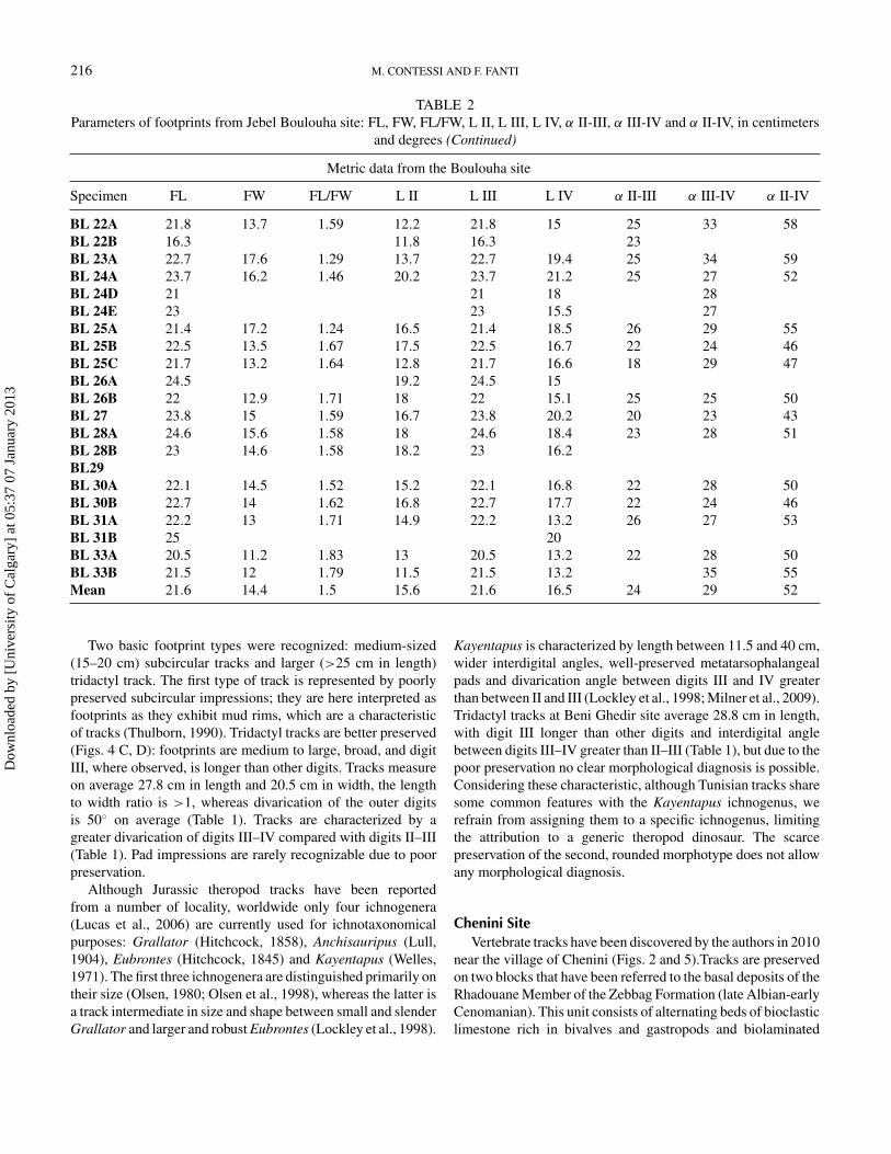
216 M. CONTESSI AND F. FANTI
TABLE 2Parameters of footprints from Jebel Boulouha site: FL, FW, FL/FW, L II, L III, L IV, α II-III, α III-IV and α II-IV, in centimeters
and degrees (Continued)
Metric data from the Boulouha site
Specimen FL FW FL/FW L II L III L IV α II-III α III-IV α II-IV
BL 22A 21.8 13.7 1.59 12.2 21.8 15 25 33 58BL 22B 16.3 11.8 16.3 23BL 23A 22.7 17.6 1.29 13.7 22.7 19.4 25 34 59BL 24A 23.7 16.2 1.46 20.2 23.7 21.2 25 27 52BL 24D 21 21 18 28BL 24E 23 23 15.5 27BL 25A 21.4 17.2 1.24 16.5 21.4 18.5 26 29 55BL 25B 22.5 13.5 1.67 17.5 22.5 16.7 22 24 46BL 25C 21.7 13.2 1.64 12.8 21.7 16.6 18 29 47BL 26A 24.5 19.2 24.5 15BL 26B 22 12.9 1.71 18 22 15.1 25 25 50BL 27 23.8 15 1.59 16.7 23.8 20.2 20 23 43BL 28A 24.6 15.6 1.58 18 24.6 18.4 23 28 51BL 28B 23 14.6 1.58 18.2 23 16.2BL29BL 30A 22.1 14.5 1.52 15.2 22.1 16.8 22 28 50BL 30B 22.7 14 1.62 16.8 22.7 17.7 22 24 46BL 31A 22.2 13 1.71 14.9 22.2 13.2 26 27 53BL 31B 25 20BL 33A 20.5 11.2 1.83 13 20.5 13.2 22 28 50BL 33B 21.5 12 1.79 11.5 21.5 13.2 35 55Mean 21.6 14.4 1.5 15.6 21.6 16.5 24 29 52
Two basic footprint types were recognized: medium-sized(15–20 cm) subcircular tracks and larger (>25 cm in length)tridactyl track. The first type of track is represented by poorlypreserved subcircular impressions; they are here interpreted asfootprints as they exhibit mud rims, which are a characteristicof tracks (Thulborn, 1990). Tridactyl tracks are better preserved(Figs. 4 C, D): footprints are medium to large, broad, and digitIII, where observed, is longer than other digits. Tracks measureon average 27.8 cm in length and 20.5 cm in width, the lengthto width ratio is >1, whereas divarication of the outer digitsis 50◦ on average (Table 1). Tracks are characterized by agreater divarication of digits III–IV compared with digits II–III(Table 1). Pad impressions are rarely recognizable due to poorpreservation.
Although Jurassic theropod tracks have been reportedfrom a number of locality, worldwide only four ichnogenera(Lucas et al., 2006) are currently used for ichnotaxonomicalpurposes: Grallator (Hitchcock, 1858), Anchisauripus (Lull,1904), Eubrontes (Hitchcock, 1845) and Kayentapus (Welles,1971). The first three ichnogenera are distinguished primarily ontheir size (Olsen, 1980; Olsen et al., 1998), whereas the latter isa track intermediate in size and shape between small and slenderGrallator and larger and robust Eubrontes (Lockley et al., 1998).
Kayentapus is characterized by length between 11.5 and 40 cm,wider interdigital angles, well-preserved metatarsophalangealpads and divarication angle between digits III and IV greaterthan between II and III (Lockley et al., 1998; Milner et al., 2009).Tridactyl tracks at Beni Ghedir site average 28.8 cm in length,with digit III longer than other digits and interdigital anglebetween digits III–IV greater than II–III (Table 1), but due to thepoor preservation no clear morphological diagnosis is possible.Considering these characteristic, although Tunisian tracks sharesome common features with the Kayentapus ichnogenus, werefrain from assigning them to a specific ichnogenus, limitingthe attribution to a generic theropod dinosaur. The scarcepreservation of the second, rounded morphotype does not allowany morphological diagnosis.
Chenini SiteVertebrate tracks have been discovered by the authors in 2010
near the village of Chenini (Figs. 2 and 5).Tracks are preservedon two blocks that have been referred to the basal deposits of theRhadouane Member of the Zebbag Formation (late Albian-earlyCenomanian). This unit consists of alternating beds of bioclasticlimestone rich in bivalves and gastropods and biolaminated
Dow
nloa
ded
by [
Uni
vers
ity o
f C
alga
ry]
at 0
5:37
07
Janu
ary
2013

SOUTH TUNISIA VERTEBRATE TRACKSITES 217
FIG. 2. Field map of the track-bearing surface at the Beni Ghedir locality (Callovian). Two basic footprint types were recognized at the site: medium sizedsubcircular tracks and large tridactyl tracks.
Dow
nloa
ded
by [
Uni
vers
ity o
f C
alga
ry]
at 0
5:37
07
Janu
ary
2013

218 M. CONTESSI AND F. FANTI
FIG. 3. Field photographs of the trampled surface at the Beni Ghedir. A. The distinctive texture observed on the track-bearing surface is interpreted as ancientmicrobial mats. B. Virtually identical surface observed in modern environments. Picture courtesy of A.R. Fiorillo, C. Medium-sized tridactyl footprint pertainingto morphotype 2 at Beni Ghedir. D. Outline drawing of footprint in picture C.
mudstone (Bodin et al., 2010). The lowermost limit of theRhadouane Member is not well defined, representing a north-south diachronous transition from the fluvial and subtidaldeposits of the Aın el Guettar Formation to the nearshoreand marine carbonate deposits of the Zebbag Formation.Invertebrate vertical burrows assigned to Diplocraterion (Fig.4B) occur in fine-grained sandstones cropping out a few metersbelow the tracks, indicating a shallow-marine high-energynearshore environment (Seilacher, 2007). The overlying lowangle cross-bedded sandstones are barren of bioturbation andare interpreted as shallow marine deposits, whereas the tracksurface is located on the top of the first of four sandstonelayers with a fining-up trend that passes from sand-dominatedto marl-dominated deposits. Tracks occur on a 50-cm-thickmassive sandstone dominated by quartz pebbles and rare shellfragments. Neither bioturbation nor mudcracks were observedon the track-bearing surface.
Track DescriptionEach of the track-bearing blocks measures approximately
4 square meters with a maximum of 8 tracks preserved. The
original orientation of the loose blocks and the preferentialdirection of the tracks could not be determined. Well-preserveddisplacement mud rims exclude the interpretation of foot-prints as undertracks (Thulborn, 1990). Footprints are poorlypreserved and numerous cracks crossing the tracks make itdifficult to define them accurately. Nevertheless, two trackmorphotypes can be identified (Fig. 4C): relatively smallrounded tracks (averaging 9 cm in diameter) and larger, elongateimpressions (20 cm in length). One well-preserved track ofthe first morphotype preserves five short and slender digitimpressions, each terminating with a clear claw mark. Thesecond morphotype includes tracks with four relatively elongateand slender digits with claw impressions.
Crocodilian pes impressions are usually tetradactyl andmanus impressions pentadactyl (Avanzini et al., 2007). One ofthe most diagnostic characteristics of crocodilian footprints is apronounced heteropody, with manus impression much smallerthan the pes. Normally pes tracks are more deeply impressed,elongate and larger, whereas manus impressions are smallerand more rounded (Kubo, 2008; Milan and Hedegaard, 2010).No dinosaur or chelonian tracks described in the literature
Dow
nloa
ded
by [
Uni
vers
ity o
f C
alga
ry]
at 0
5:37
07
Janu
ary
2013

SOUTH TUNISIA VERTEBRATE TRACKSITES 219
FIG. 4. The Chenini site. A. Arrow indicates the isolated track-bearing block. Dashed line marks the basal deposits of the Rhadouane Member (ZebbagFormation, Albian-Cenomanian). B. Invertebrate vertical burrows assigned to Diplocraterion. C. Field picture of the two track morphotypes identified at Chenini,small rounded track at left, large elongate impression at right. D. 3D model of better-preserved track mold (MGGC 21856) E. outline drawing of MGGC 21856.
Dow
nloa
ded
by [
Uni
vers
ity o
f C
alga
ry]
at 0
5:37
07
Janu
ary
2013

220 M. CONTESSI AND F. FANTI
FIG. 5. The Ksar Ayaat site. A. Field picture; arrow and dashed line indicate the track-bearing layer. B. Tracks occur at the top of a finely laminated carbonaticlayer which overlies intensively bioturbated deposits. C. Elliptical impressions with rare preserved digit impressions occur on a large micritic mudstone slab.D. Outline drawing of the track-bearing slab. E. 3D model of the silicone mold of the better-preserved track (MGGC 21845). F. Outline drawing of the best-preservedtrack (MGGC 21845).
Dow
nloa
ded
by [
Uni
vers
ity o
f C
alga
ry]
at 0
5:37
07
Janu
ary
2013

SOUTH TUNISIA VERTEBRATE TRACKSITES 221
are similar to the ones described here. Thus, based on overallmorphology, number and shape of digits, and relative sizeproportions, we tentatively identify the tracks as manus-pescouple of a generic crocodilian.
Ksar Ayaat SiteThe Ksaar Ayaat locality (Fig. 1) is in the basal deposits
of the Kerker Member (Zebbag Formation, Cenomanian). TheKerker Member is characterized by a basal 4-meter- thickevaporitic interval (primarily gypsum and halite) overlain byan alternation of horizontally laminated marls and biolaminatedmudstones. Kerker deposits include alternating lagoonal andcalcareous, shallow marine sediments with no previouslyreported evidence of subaerial exposure. The trampled surface ispreserved on top of a 40 cm thick dolomitized mudstone locatedstratigraphically a few meters above the evaporitic beds, andsupports episodes of subaerial exposure, possibly in a peritidalor tidal environment. The track-bearing surface contains neitherdistinctive sedimentological features nor bioturbation features,whereas 5 cm below the track surface intense bioturbationcan be observed. This extensive bioturbation (Fig. 5B) can bereferred to feeding traces of crustaceans, such as those foundin soft sediments of shallow marine environments (Seilacher,2007). The lack of microfossils in the sequence, together withthe pervasive dolomitization and evaporitic gypsum, is hereinterpreted as indicative of an arid to semi-arid environment(see also Bodin et al., 2010). Thus, the track-bearing surfacewas likely to have been deposited in a shallow and confinedmarine embayment, where hyper salinity events occasionallyled to the deposition of evaporites.
Track DescriptionA set of 52 circular to elliptical depressions (Fig. 5C, D)
occurs on a large micritic mudstone slab (250 × 180 cm);in addition, several similar, but poorly preserved tracks werefound on smaller unassociated slabs. Overall, tracks have anelliptical or circular edge and only few tracks preserve digitimpressions. Digit and/or claw impressions, when observed,are slightly impressed into the substrate, resulting in a trackmorphology consisting of a round impression with three or fourrounded anterior depressions (digit and/or claw impressions,Figs. 5E, F). Tracks can be clustered in two size classes, thefirst 8 cm and the second 5 cm in diameter, possibly indicatingmanus and pes impressions. Most tracks are relatively deep(about 3 cm) compared with their size, suggesting high watercontent of the substrate. Even if a pattern can be recognized inthe footprint association, there are no distinct trackways (Fig.5D), and consequently the movement direction is unclear.
Tracks left by modern turtles in wet substrate show circular toelliptical depressions and not always evident claw marks: suchtracks have been previously compared with fossil tracks fromthe Upper Jurassic of Spain (Avanzini et al., 2005), and from theUpper Cretaceous of Montana (Fiorillo, 2005). Ichnotaxonomyof turtle tracks is still controversial, and several ichnotaxa are
considered as nomen dubium (Moratalla et al., 1995; Avanziniet al., 2005) with the sole exception of Chelonipus (Ruhlevon Liliestern, 1939) and Emydhipus (Fuentes Vidarte et al.,2003). The latter is characterized by small (L = 1.7 cm)manus impression with four elongated claw marks parallel tothe trackway midline, and plantigrade pes impression (L =1 cm) consisting of four digits with parallel claw marks andshort, rounded sole (Fuentes et al., 2003). Emydhipus differsfrom Chelonipus in having manus impression with evidentparallel ungual traces and different position of manus printsin the trackway (Avanzini et al., 2005). Unfortunately, thepoor preservation of the Tunisian tracks does not allow anydifferentiation between these two ichnogenera.
Nevertheless, the combination of a distinctive subcircularshape, claw mark impressions, and possible manus-pes track-way, supports the attribution of the Tunisian tracks to anundetermined pleurodiran turtle.
Jebel Boulouha SiteThe Jebel Boulouha site is located approximately 12 km to
the southwest of Tataouine (Figs. 2 and 3). It was originallydiscovered by a Tunisian student in 2006; later work by theauthors revealed nearly 100 isolated dinosaur footprints and twotrackways preserved at this site. The in situ track-bearing surfaceis located near the summit of the escarpment, a few meters belowthe basal deposits of the Gattar Member: therefore, all tracks arepreserved in the upper Kerker Member deposits. In addition, anumber of tracks have been recovered on isolated blocks locatedbelow the in situ layer, and referred to the same layer (Fig.6A). The stratigraphic section of the Jebel Boulouha localityindicates an alternation of light-yellow, finely laminated marls,biolaminated mudstone, and wackestone. With the exception oflayers showing a lumachella-fabric (accumulation of shells) andisolated gastropods and bivalves, this stratigraphic unit is barrenof fossils.
The track-bearing surface occurs at the top of a 60-cm-thick,fining-upward sequence of wackestone and finely-laminatedgrainstone capped by a 3-cm-thick stromatolitic lamination.Thin sections of the track surface show shell fragments,extensive dolomitization, birdseye structures and a fenestralfabric, indicative of arid climatic conditions (Petti et al., 2011).As at the Beni Ghedir locality, the track-bearing surface shows adistinctive texture indicative of the presence of ancient microbialmats. Furthermore, invertebrate feeding traces (Planolites sp.)are found on the track-bearing surface as well as in the fillingsediment of some dinosaur tracks (Fig. 6B). Vertebrate tracksare relatively shallow (<1 cm) given their size, suggesting firmor partially consolidated substrate. Sedimentological data, theoccurrence of microbial mats and vertebrate and invertebratetraces are here considered indicative of tidal flat environments.
Track DescriptionThe impressions at the Jebel Boulouha locality comprise
medium-sized tridactyl and bird-like tracks. The site is
Dow
nloa
ded
by [
Uni
vers
ity o
f C
alga
ry]
at 0
5:37
07
Janu
ary
2013

222 M. CONTESSI AND F. FANTI
FIG. 6. A. Field picture of the Jebel Boulouha outcrop, dashed line indicates the track bearing-layer. B. Invertebrate feeding traces (Planolites sp.) are found onthe track-bearing surface. C. Field picture. D. 3D model of the silicone mold of a well-preserved tridactyl footprint referred to a medium-sized theropod (MGGC21851). E. Field picture. F. Simplified drawing of in situ trackways.
Dow
nloa
ded
by [
Uni
vers
ity o
f C
alga
ry]
at 0
5:37
07
Janu
ary
2013

SOUTH TUNISIA VERTEBRATE TRACKSITES 223
FIG. 7. Synthetic chart showing the succession of the Middle Jurassic–Upper Cretaceous vertebrate assemblages in southern Tunisia within a stratigraphic andenvironmental framework.
dominated (95%) by well-preserved tridactyl footprints (Fig.6C, D); a few tracks assigned to the Koreanaornis ichnogenus(Kim, 1969) are being described separately by the authors(Contessi and Fanti, 2012). The presence of bioturbation onthe track-bearing surface and displacement mud rims supportsthe interpretation of the footprints as true tracks (Lockley, 1991).Tracks measure 21.6 cm in length and 14.4 in width (on average),whereas FL/FW ratio is 1.5. Measurements of footprints(Table 2) show little variation, suggesting that tracks are likely tohave been made by individuals of similar size. Digit impressionsare slender, and pad impressions are commonly preserved; digitIII is considerably longer compared with II and IV that are
subequal in length. Occasionally claw marks are preserved.Track density can be up to 7/m2 and no preferential orientationof the tracks was observed. Two trackways, consisting of fourand three impressions, respectively, were found (Figs. 7E, F):the mean pace length is 40 cm, the stride 81 cm and thepace angulation is 12◦. Theropod footprints are commonlydifferentiated from hadrosaur tracks by their long, narrowtoes, that terminate with claw impressions, lower F/W ratio(<1.25) and lower divarication angle between digits II and IV.Cretaceous theropod tracks are well known worldwide, and anumber o different ichnotaxa have been named in relation to theregional skeletal record (Sternberg, 1926; Matsukawa et al.,
Dow
nloa
ded
by [
Uni
vers
ity o
f C
alga
ry]
at 0
5:37
07
Janu
ary
2013

224 M. CONTESSI AND F. FANTI
2006). Unfortunately, no theropod remains, which could becompared with the ichnological record, are known from theUpper Cretaceous of Tunisia. Tunisian tracks resemble thoseof Grallator (Hitchcock, 1858) and Eubrontes (Olsen, 1980).Originally described from Jurassic deposits, these ichnogenerahave been later recognized in the Cretaceous (Li et al., 2011).Grallator is smaller (foot length 5–10 cm) more elongate andless mesaxonic, than large Eubrontes (foot length 25–40 cm)(Hitchcock, 1845). Several authors have attempted to distinguishthese two ichnogenera (Weems, 1992; Olsen et al., 1998; Smithand Farlow, 2003). The most significant aspect differentiatingthese two Grallator and Eubrontes are the relative length ofdigit III in relation to digits II and IV, and the track length as awhole. We refrain from assigning Tunisian tracks to a specificichnogenus as, although footprints are well-preserved, they allare isolated and just a single and short trackway is preserved.Thus, considering size and morphology, the assignation of trackshere described is limited to a generic mid-sized theropod.
DISCUSSIONIn the last 20 years, an increasing number of publications
has dealt with the rich and diverse Lower Cretaceous micro-and macro-vertebrate remains from the Tataouine basin (DeLapparent, 1960; Benton et al., 2000; Ouaja et al., 2004 andreferences therein). To date, fragmentary elements of bonyfish, sharks, turtles, crocodiles, pterosaurs, dinosaurs (sauropodsand theropods), and gymnosperms and angiosperms have beenrecovered from tens of localities along the Jeffara escarpment,but no track localities have been reported until now (Fig. 7). Inparticular, fossil remains are known from the lower DouiretFormation (?Barremian), and the Chenini and Oum Diabmembers of the Aın El Guettar Formation (Aptian-Albian)(Taquet, 1980; Ben Ismaıl, 1991; Ouaja, 2003; Amiot et al.,2010). Therefore, sites described in this study significantlyextend our knowledge of local fossil vertebrate distributionto the Middle Jurassic as well as to the Cenomanian, bothconsidered as times of nearly exclusive marine deposition.
In addition, dinosaur remains have been recovered exclu-sively from high-energy, fluvial conglomeratic deposits referredto large deltaic river complexes hypothesized to extend overall of southern Tunisia and westernmost Libya (Benton et al.,2000; Bodin et al., 2010; Le Loeuff et al., 2010). Therefore, anumber of authors suggested that dinosaur remains primarilyoriginated tens or hundreds of kilometers to the south (Bentonet al., 2000; Russell and Paesler, 2003; Ouaja, 2003). Tracksdescribed herein document that theropod dinosaurs and othersemi-aquatic vertebrates also inhabited coastal environmentssuch as embayment and lagoon characterized by stromatoliticand carbonate deposition in an arid climate.
If we consider the fossil record of southern Tunisia, adecreasing morphometric trend can be recognized in theropodfootprint size from the Middle Jurassic onward. For instance,tridactyl Middle Jurassic tracks at the Beni Ghedir locality
range from 23 to 33 cm in length and are thus referable tomid- to large-sized theropod dinosaurs. Although this is notindicative of a distinct trend, due to the scarcity of informationavailable, these data are consistent with the Middle Jurassic-Lower Cretaceous fossil record, characterized by the remains ofSpinosaurus, Carcharodontosaurus, and abelisaurid theropodscollected in Morocco, Libya, Egypt, and Niger (Stromer, 1936;De Lapparent, 1960; Taquet, 1960; Russell, 1996; Bodin et al.,2010; Le Loeuff et al., 2010) as well as in the Aın El GuettarFormation of Tunisia (De Lapparent, 1960; Benton et al., 2000;Srarfi et al., 2004). On the other hand, Upper Cretaceous tracksare significantly smaller in size, ranging from 16.3 to 24.6 cmin length suggesting smaller individuals; however, no vertebrateremains have been reported to date from the Cenomanian ofTunisia.
Vertebrate tracks presented here have been identified by dis-tinctive morphological features and paleoenvironmental settingreconstructed by combining sedimentological and ichnologi-cal data. Correlating vertebrate ichnological association withspecific depositional and environmental setting to establishtetrapod ichnofacies is still largely debated (Lockley et al.,1994; Hunt and Lucas, 2006, 2007; Lockley, 2007; Santi andNicosia, 2008). Problems in applying ichnofacies to tetrapodichnology are mainly related to the fact that ichnofaciesare independent from temporal frameworks, whereas tetrapodtracks are strictly correlated to faunal evolutions and extinctions.To compensate this issue, Hunt and Lucas (2007) suggest alimit to tetrapod associations by temporal, sedimentological, andenvironmental framework, establishing the concept of tetrapodichnocoenoses as ichnoassociations with reduced geographicand temporal extent related with specific paleoenvironments.Applying the tetrapod ichnocoenosis concept to the Tunisiantrack record the Beni Ghedir site can be referred to the Eubrontesichnocoenosis, dominated by medium to large theropod tracks,typical of lacustrine Jurassic deposits (Lockley et al., 1994). Incontrast, the Ksar Ayaat tracks, characterized by turtle tracksin carbonate-dominated shorelines deposits, are representativeof the Chelonichium ichnocoenosis (Lockley et al., 1998).Lastly, the Jebel Boulouha site is ascribed to the Jindornipes-Koreanaornis ichnocoenosis (Lockley et al., 1994) as it isdominated by theropods with the co-occurrence of shorebirdtracks in an arid environment.
CONCLUSIONSPending further discoveries in the Jurassic and Cretaceous
deposits of the Tataouine Basin, data presented in this studyextend significantly the presence of dinosaurs and other verte-brates in southern Tunisia. In particular, theropod tracks fromMiddle Jurassic (Callovian) beds represent the oldest occurrenceof dinosaurs in Tunisia. On the other hand, Cretaceous (upperAlbian and Cenomanian) tracksites provide evidence of adiverse vertebrate fauna, which included turtles, crocodiles,theropod dinosaurs and birds.
Dow
nloa
ded
by [
Uni
vers
ity o
f C
alga
ry]
at 0
5:37
07
Janu
ary
2013

SOUTH TUNISIA VERTEBRATE TRACKSITES 225
Data presented in this study support a strict relationshipbetween tracks and depositional environments; as such, theconcept of tetrapod ichnocoenoses (Hunt and Lucas, 2007) wasapplied to the Tunisian track record, resulting in diversified trackassemblages that be ascribed to the Eubrontes, Chelonichiumand Jindornipes-Koreanaornis ichnocoenosis.
These discoveries shed new light on the still controversialanalysis of vertebrate distribution in Tunisia during a time thatis crucial for dinosaur diversification across northern Africa.
ACKNOWLEDGMENTSThe authors are grateful to H. Aljane (Office National des
Mines, Tunis, Tunisia), M. Avanzini (Museo Tridentino diScienze Naturali, Italy), A. R. Fiorillo (Museum of Nature& Sciences, Dallas, Texas, USA) and M. Polcyn and T.Adams (Visualization Laboratory at the Southern MethodistUniversity). We also thank A. and G. Bacchetta, F. Scarelli,G. Rivalta and F. Franchi for their support in the field. Thisresearch was conducted in the context of the senior author’sPh.D. (Department of Earth and Geoenvironmental Sciences,University of Bologna, Italy) and was financially supported byFondazione Alma Mater, Prof. Giovanni Gabbianelli, and theMuseo Geologico Giovanni Capellini (Bologna, Italy).
REFERENCESAit-Kaci Ahmed, A., Lingham-Soliar, T., and Broderick, T. J. 2004. Giant
sauropod tracks from the Middle-Late Jurassic of Zimbabwe in closeassociation with theropod tracks. Lethaia, 37: 467–470.
Ambroggi, R. and De Lapparent, A. F. 1954. Les empreintes de pas fossiles duMaestrichtien d’Agadir. Notes et moires du Service de Mines et de la carteGeologique du Maroc, 10: 43–57.
Amiot, R., Buffetaut, E., Lecuyer, C., Wang, X., Boudad, L., Ding, Z., Fourel,F., Hutt, S., Martineau, F., Medeiros, M., Mo, J., Simon, L., Suteethorn,V., Sweetman, S., Tong, H., Zhang, F., and Zhou, Z. 2010. Oxygen isotopeevidence for semi-aquatic habits among spinosaurid theropods. Geology,38: 139–142.
Anderson, P. E., Benton, M. J., Trueman, C. N., Paterson, B. A., and Cuny,G. 2007. Paleoenvironments of the vertebrates on the southern shore ofthe Tethys: The nonmarine Early Cretaceous of Tunisia. Paleogeography,Paleoclimatalogy, Paleoecology, 243: 118–131.
Avanzini, M., Garcia-Ramos, J. C., Lires, J., Menegon, M., Pinuela, L., andFernandez, L. A. 2005. Turtle tracks from the Late Jurassic of Asturias,Spain. Acta Paleontologica Polonica, 50: 743–755.
Avanzini, M., Garcıa-Ramos, J. C., Lires, J., Pinuela, L., and Lockley, M. 2007.Crocodylomorph tracks from the Late Jurassic of Asturias (Spain). Ichnos,14: 143–153.
Barale, G. and Ouaja, M. 2001. Decouverte des nouvelles flores avec desrestes a anites angiospermiennes dans le Cretacee inferieur du Sud Tunisien.Cretaceous Research, 22: 131–143.
Belvedere, M., Dyke, G., Hadri, M., and Ishigaki, S. 2011. The oldest evidencefor birds in Northern Gondwana? Small tridactyl footprints from the MiddleJurassic of Msemrir (Morocco). Gondwana Research, 2: 542–549.
Ben Ismaıl, M. H. 1991. Les bassins mesozoıques (Trias a Aptien) du sud de laTunisie: stratigraphie integree, caracteristiques geophysiques et evolutiongeodynamique. Ph.D. Dissertation, Universite de Tunis I.
Ben Youssef, M. 1999. Stratigraphie Genetique du Cretace de Tunisie. Mi-cropaleontologie, Stratigraphie Sequentielle et Geodynamique des Bassins
de la Marge Sud et Peritethysienne. These des Sciences, Univiversite TunisII, Tunisia, 402 pp.
Ben Youssef, M., Biely, A., Kamoun, Y., and Zouari, M. 1985. L’Albien moyensuperieur a Knemiceras forme la base de la grande transgression cretacee auTebaga de Medenine (Tunisie meridionale). Comptes Rendus de l’Academiedes Sciences, Serie II, Paris, 300: 965–968.
Benton, M. J., Bouaziz, S., Buffettaut, E., Martill, D., Ouaja, M., Soussi, M.,and Trueman, C. 2000. Dinosaurs and other fossil vertebrates from fluvialdeposits in the Lower Cretaceous of southern Tunisia. Palaeogeography,Palaeoclimatology, Palaeoecology, 157: 227–246.
Bodin, S., Petitpierre, L., Wood, J., Elkanouni, I., and Redfern, J. 2010. Timingof early to mid-cretaceous tectonic phases along North Africa: New insightsfrom the Jeffara escarpment (Libya–Tunisia). Journal of African EarthSciences, 58: 489–506.
Bouaziz, S., Mello, J., and Doubinger, J. 1987. Les argiles et evaporites deMhira: nouvelles formations d’age carnien superieur-norien de la Djeffara(Tunisie meridional), analyse palynologique. Notes du Service Geologiques,Tunisie, 54: 25–40.
Bouaziz, S., Donze, P., Ghanmi, M., and Zarbout, M. 1989. La serie a dominantecontinentale (Oxfordien a Cenomanien) de la falaise du Dahar (Sudtunisien); son evolution du Tebaga de Medenine a la frontiere tripolitaine.Geologie Mediterraneenne, 16: 67–76.
Bouaziz, S., Buffetaut, E., Ghanmi, M., Jaeger, J. J., Martin, M., Mazin,J. M., and Tong, H. 1988. Nouvelles decouvertes de vertebre s fossilesdans l’Albien du sud tunisien. Bulletin de la Societe Geologique de France,4: 335–339.
Boutakiout, M., Hadri, M., Nouri, J., Dıaz-Martinez, I., and Perez-Lorente, F.2008. Prospecciones paleoicnologicas en el sinclinal de Iouaridene (AltoAtlas, Marruecos). Cuantificacion de yacimientos y de icnitas. Geogaceta,45: 51–54.
Buffetaut, E. and Ouaja, M. 2002. A new specimen of Spinosaurus (Dinosauria,Theropoda) from the Lower Cretaceous of Tunisia, with remarks on theevolutionary history of the Spinosauridae. Bullettin de la Societe Geologiquede France, 173: 415–421.
Burollet, P. F. 1956. Contribution a l’etude stratigraphique de la Tunisie centrale.Annales des Mines et Geologie, 18: 1–345.
Busson, G. 1967. Le Mesozoıque saharien. 1ere partie: l’Extreme Sud tunisien.In Serie geologique (ed.). Centre des Recherches Zones Arides, C.N.R.S.,Paris, France, 1–194.
Chandoul, H., Burollet, P. F., Ben Ferjani, A., and Memmi, L. 1993. Recueil descoupes types de Tunisie-1- Trias Jurassique. Memoire Enterprise Tunisienned’Activites Petrolieres, Tunis, 95 pp.
Contessi, M., and Fanti, F. 2012. First record of bird tracks in the late Cretaceous(Cenomanian) of Tunisia. Palaios, 27: 455–464.
Cuny, G., Cobbett, A., Meunier, F., and Benton, M. J. 2010. Vertebratemicroremains from the Early Cretaceous of southern Tunisia. Geobios, 43:615–628.
Cuny, G., Ouaja, M., Srarfi, D., Schmitz L., Buffetatu, E., and Benton, M.J. 2004. Fossil sharks from the Early Cretaceous of Tunisia. Revue dePaleobiologie, 9: 127–142.
De Lapparent, A. F. 1951. Decouverte de dinosauriens, associes a une faune dereptiles et de poissons, dans le Cretace inferieur de l’extreme sud tunisien.Comptes Rendus de l’Academie des Sciences, Paris, 232: 1430–1432.
De Lapparent, A. F. 1960. Les dinosauriens du “Continental Intercalaire” duSahara central. Memoires de la Societe Geologique de France, 88: 1–57.
Demathieu, G. R. and Wycisk, P. 1990. Tetrapod trackways from southernEgypt and northern Sudan. Journal of African Earth Science, 10: 435–443.
Ellenberger, P. 1972a. Contribution a la classification des pistes de vertebresdu Trias: les types du Stromberg d’Afrique du Sud (I). Paleovertebrata,Memoire Extraordinaire, Montpellier, 144 pp.
Ellenberger, P. 1972b. Contribution a la classification des pistes de vertebresdu Trias: les types du Stromberg d’Afrique du Sud (II, Les StrombergSuperieur). Paleovertebrata, Memoire Extraordinaire, Montpellier, 141 pp.
Dow
nloa
ded
by [
Uni
vers
ity o
f C
alga
ry]
at 0
5:37
07
Janu
ary
2013

226 M. CONTESSI AND F. FANTI
Fanti, F., Contessi, M., and Franchi, F. 2012. The “Continental Intercalaire” ofsouthern Tunisia: Stratigraphy, paleontology, and paleoecology. Journal ofAfrican Earth Sciences, 73–74: 1–23.
Fiorillo, A. R. 2005. Turtle tracks in the Judith River Formation (UpperCretaceous) of south-central Montana. Palaeontologia Electronica, 8: 1–11.
Fuentes Vidarte, C., Meijede Calvo, M., Meijede Fuentes Calvo, F., and MeijedeFuentes Calvo, M. 2003. Rastro de un tetrapodo de pequeno tamano en elWeald de Cameros (Sierra de Oncala, Soria, Espana) nov. icnogen. nov.icnosp. Emydhipus cameroi. In F. Perez Lorente (eds.). Dinosaurios e otrosreptiles mesozoicos en Espana. Instituto de Estudios Riojanos (Logrono),Ciencias de la Terra, 26: 119–128.
Hitchcock, E. 1845. An attempt to name, classify, and describe the animalsthat made the fossil footmarks of New England. In Proceedings of the 6thAnnual Meeting of the Association of American Geologists and Naturalists,New Haven, CT, 6: 23–25.
Hitchcock, E. 1858. Ichnology of New England: A Report on the Sandstone ofthe Connecticut Valley, Especially its Fossil Footmarks. W. White, Boston,220 pp.
Hunt, A. P. and Lucas, S. G. 2006. Permian tetrapod ichnofacies. In Lucas, S.G.,Cassinis, G. and Schneider, J. (eds.), Non-Marine Permian Biostratigraphyand Biochronology. Geological Society London, Special Publication, 265:137–156.
Hunt, A. P. and Lucas, S. G. 2007. Tetrapod Ichnofacies: A new Paradigm.Ichnos, 14: 59–68.
Jacobs, L. L., Winkler, D. A., and Gomani, E. M. 1996. Cretaceous dinosaurs ofAfrica: examples from Cameroon and Malawi. Memoirs of the QueenslandMuseum, 39, 3: 595–610.
Kilian, C. 1931. Des principaux complexes continentaux du Sahara. ComptesRendus sommaire de la Societe Geologique de France, 9: 109–111.
Kim, B.K. 1969. A study of several sole marks in the Haman Formation. Journalof the Geological Society of Korea 5: 243–258.
Kubo, T. 2008. In quest of the Pteraichnus trackmaker: Comparisons to moderncrocodilians. Acta Palaeontological Polonica, 53: 405–412.
Kvale, E. P., Johnson, G. D., Mickelson, D. L., Keller, K., Furer, L. C., andArcher, A. W. 2001. Middle Jurassic (Bajocian and Bathonian) dinosaurmegatracksites, Bighorn Basin, Wyoming, U.S.A. Palaios, 16: 233–254.
Le Loeuff, J., Metais, E., Dutheil, D. B., Rubino, J. L., Buffetaut, E., Lafont, F.,Cavin, L., Moreau, F., Tong, H., Blanpied, C., and Sbeta, A. 2010. An EarlyCretaceous vertebrate assemblage from the Cabao Formation of NW Libya.Geological Mag, Cambridge University Press, 147: 750–759.
Leonardi, G. 1987. Glossary and Manual of Tetrapod Palaeoichnology.Departamento Nacional da Producao Mineral, Brasilia, Brazil, 75 pp.
Li, R., Lockley, M.G., Matsukawa, M., Wang, K. and Liu, M. 2011. An unusualtheropod track assemblage from the Cretaceous of the Zhucheng area,Shandong Province, China. Cretaceous Research, 32: 422–423.
Lockley, M. 1991. Tracking Dinosaurs: A New Look at an Ancient World.Cambridge University Press, Cambridge, 238 pp.
Lockley, M. G. 2007. A tale of two ichnologies: The different goals andpotentials of invertebrates and vertebrate (tetrapod) ichnotaxonomy andhow they relate to ichnofacies analysis. Ichnos, 14: 39–57.
Lockley, M. G., Hunt, A. P., and Meyer, C. A. 1994. Vertebrate tracks and theichnofacies concept: Implications for palaeoecology and palichnostratigra-phy. In Donovan, S.K. (ed.). The Paleobiology of Trace Fossils. Wiley andSons, New York, 241–268.
Lockley, M. G., Meyer, C. A., and Dos Santos, V. F. 1998. Megalosauripus,and the problematic concept of Megalosaur footprints. Gaia: Revista deGeociencias, Museu Nacional de Historia Natural, 15: 313–337.
Lucas, S.G., Klein, H., Lockley, M.G., Spielmann, J.A., Gierlinski, G.D., Hunt,A.P., and Tanner, L.H. 2006. Triassic-Jurassic stratigraphic distribution ofthe theropod footprint ichnogenus Eubrontes. In Harris, J.D., Spielmann,J.A., Lockley, M.G., Milner, A.R. C., and Kirkland, J.I. (eds.). The Triassic-Jurassic Terrestrial Transition. New Mexico Museum Natural History andScience Bulletin, 37: 12–22.
Lull, R. S. 1904. Fossil footprints of the Jura-Trias of North America. MemorieBoston Society of Natural History, 5: 461–557.
Marty, D., Strasser, A., and Meyer, C. A. 2009. Formation and taphonomy ofhuman footprints in microbial mats of present-day tidal-flat environments:Implications for the study of fossil footprints. Ichnos, 16: 127–142.
Matsukawa, M., Lockley, M. G., and Li, J. 2006. Cretaceous terrestrial biotasof East Asia, with special reference to dinosaur-dominated ichnofaunas:Towards a synthesis. Cretaceous Research, 27(1): 3–21.
Milan, J. and Hedegaard, A. 2010. Interspecific variation in tracks and trackwaysfrom extant crocodylians. In Milaan, J., Lucas, S. J., Lockley, M. J., andSpielmann, J. A. (eds.). Crocodyle Tracks and Traces. New Mexico MuseumNatural History and Science Bulletin, 51: 15–29.
Milner, A. R. C., Harris, J. D., Lockley, M. G., Kirkland, J. I., and Matthews,N. A. 2009. Bird-like anatomy, posture, and behavior revealed by an earlyJurassic theropod dinosaur resting trace. PLoS ONE, 4(3).
Moratalla, J. J., Lockley, M. G., Buscalioni, A. D., Fregenal-Martınez, M.,Melendez, N., Ortega, F., Perez−Moreno, B. P., Perez-Asensio, E., Sanz, J.L., and Schultz, R. 1995. A preliminary note on the first tetrapod trackwaysfrom the lithographic limestones of Las Hoyas (Lower Cretaceous, Cuenca,Spain). Geobios, 28: 777–782.
M’Rabet, A. 1987. Stratigraphie, sedimentation et diagenese carbonatee desseries du Cretace inferieur de Tunisie centrale. Annales des Mines et de laGeologie de Tunisie, 30.
M’Rabet, A., Mejri, F., Burollet, P. F., Memmi, L., and Chandoul, H. 1995.Catalog of type sections in Tunisia, Cretaceous. Entreprise Tunisienned’Activites Petrolieres, Memoir 8.
Mudroch, A., Richter, U., Joger, U., Kosma, R., Ide, O., and Maga, A. 2011.Didactyl tracks of Paravian theropods (Maniraptora) from the ?MiddleJurassic of Africa. PLoS ONE, 6(2): 1–10.
Nouri, J., Dıaz-Martınez, I., and Peerez-Lorente, F. 2011. Tetradactyl footprintsof an unknown affinity theropod dinosaur from the Upper Jurassic ofMorocco. PLoS ONE, 6(12): 1–7.
Ouaja, M. 2003. Etude sedimentologique et paleobotanique du Jurassiquemoyen-Cretace inferieur du bassin de Tataouine (Sud-Est de la Tunisie).Ph.D. Dissertation, Universite Claude-Bernard, Lyon, France, 152 pp.
Ouaja, M., Philippe, M., Barale, G., Ferry, S., and Ben Youssef, M. 2004. Miseen evidence d’une flore oxfordienne dans le Sud-Est de la Tunisie: Interetsstratigraphique et paleoecologique. Geobios, 37: 89–97.
Olsen, P. E. 1980. A comparison of the vertebrate assemblages from the Newarkand Hartford basins (early Mesozoic, Newark Supergroup) of eastern NorthAmerica. In Jacobs, L. L. (ed.). Aspects of Vertebrate History. Museum ofNorthern Arizona Press, Flagstaff, 35–53.
Olsen, P. E. and Galton, P. M. 1984. Review of the reptile and amphibianassemblages from the Stormberg of southern Africa with special emphasis onthe footprints and age of Stormberg. Palaeontologia Africana, 25: 87–110.
Olsen, P. E., Smith, J. B., and McDonald, N. G. 1998. Type material of thespecies of the classic theropod footprint genera Eubrontes, Anchisauripus,and Grallator (Early Jurassic, Hartford and Deerfield basins, Connecticutand Massachusetts, USA. Journal of Vertebrate Paleontology, 18: 586–601.
Petti, F. M., Bernardi, M., Ferretti, P., Tomasoni, R., and Avanzini, M. 2011.Dinosaur tracks in a marginal marine environment: The Coste dell’Angloneichnosite (Early Jurassic, Trento Platform, NE Italy). Italian Journal ofGeoscience, 130: 27–41.
Peybernes, B., Almeras, Y., Ben Youssef, M., Kamoun, F., Mello, J., Rey, J.,and Zargouni, F. 1985. Nouveaux elements de datation dans le Jurassiquedu Sud-Tunisien (Plate-forme saharienne). Comptes Rendus de l’Academiedes Sciences, Paris 300: 113–118.
Peybernes, B., Vila, J. M., Souquet, P., Charriere, A., Ben Youssef, M., Zarbout,M., and Calzada, S. 1996. Trois gisements de brachiopodes dans le Cretaceinferieur tunisien. Batalleria, 6: 45–58.
Razgallah, S., Philip, J., Thomel, G., Zaghbib-Turki, D., Chaabani, F., BenHaj Ali, N., and M’Rabet, A. 1994. La limite Cenomanien–Turonien enTunisie centrale et meridionale: Biostratigraphie et paleoenvironnements.Cretaceous Research, 15: 507–533.
Dow
nloa
ded
by [
Uni
vers
ity o
f C
alga
ry]
at 0
5:37
07
Janu
ary
2013

SOUTH TUNISIA VERTEBRATE TRACKSITES 227
Ruhle v. Lilienstern, H. 1939. Fahrten und Spurenim Chirotheriem−Sandsteinvon Sudthuringen. Fortschritte der Geologie und Palaontologie, 12:293–387.
Russell, D. A. 1996. Isolated dinosaur bones from the Tafilalt, Morocco. Bulletindu Museum National d’Histoire Naturelle, 18: 349–402.
Russell, D. A. and Paesler, M. A. 2003. Environments of mid-CretaceousSaharan sinosaurs. Cretaceous Research, 24: 569–588.
Santi, G. and Nicosia, U. 2008. The ichnofacies concept in vertebrate ichnology.Studi Trentini di Scienze Naturali, Acta Geologica, 83: 223–229.
Seilacher, A. 2007. Trace Fossil Analysis. Springer, Berlin, 226 pp.Smith, J. B. and Farlow, J. O. 2003. Osteometric approaches to trackmaker as-
signment for the Newark Supergroup ichnogenera Grallator, Anchisauripusand Eubrontes. In Letourneau, P. M. and Olsen, P. E. (eds.). The Great RiftValleys of Pangea in Eastern North America, volume 2. Columbia UniversityPress, New York, 273–292.
Srarfi, D., Ouaja, M., Buffetaut, E., Cuny, G., Barale, G., Ferry, S., and Fara,E. 2004. Position stratigraphique des niveaux a vertebres du Mesozoıque duSud-Est de la Tunisie. Notes du Service Geologique de Tunisie, 72: 5–16.
Sternberg, C. M. 1926. Dinosaur tracks from the Edmonton Formation of Al-berta. Canada Museum Bulletins, Geological Series, 44: 85–87.
Stromer, E. 1936. Ergebnisse der Forschungsreisen Prof. E. Stromers inden Wusten Agyptens. VII. Baharije-Kessel und –Stufe mit deren
Fauna und Flora. Eine erganzende Zusammenfassung. Abhandlungen derBayerischen Akademie der Wissenschaften, Mathematisch-naturwissen-schaftliche Abteilung n. f., 33: 1–102.
Tabaste, N. 1963. Etude des restes de poissons du Cretace saharien. MemoiresInstitute Francaise Afrique noir: Melanges ichthyologiques dedies a lamemoire d’A. Valenciennes 1794–1865, 68: 437–485.
Taquet, P. 1960. Sur le gisement de dinosauriens et de crocodiliens deGadoufaoua (Republique du Niger). Comptes rende de l’Academie desSciences, 271: 38–40.
Taquet, P. 1980. Succession et repartition des gisements de vertebres du Cretaceedu Sahara. Memoires de la Societe geologique de France, 139: 185–186.
Thulborn, R. A. 1990. Dinosaur Tracks. Chapman & Hall, London, 384 pp.Weems, R. E. 1992. A reevaluation of the taxonomy of Newark Supergroup
saurischian dinosaur tracks, using extensive statistical data from a recentlyexposed tracksite near Culpeper Virginia. In Sweet, P.C.(ed.). Proceedingsof the 26th Forum on the Geology of Industrial Minerals. Virginia Divisionof Mineral Resources, Charlottesville, Virginia, 113–127.
Welles, S. P. 1971. Dinosaur footprints from the Kayenta Formation of northernArizona. Plateau, 44: 27–38.
Zarbout, M., Souquet, P., and Peybernes, B. 1994. Sequences de depot dans lesenvironnements de transition fluviatile-marin de Cretace inferieur de Dahar(Sud-Tunisien). Strata, 6: 141–142.
Dow
nloa
ded
by [
Uni
vers
ity o
f C
alga
ry]
at 0
5:37
07
Janu
ary
2013
Copyright © 2022 FDOKUMEN