Vegetation Mosaic Around the First Center of Tourism Development in the Uludağ Mountain,...
10
Vegetation Mosaic around the First Center of Tourism Development in the Uludağ Mountain, Bursa-TURKEY* Gürcan GÜLERYÜZ, Hülya ARSLAN Uludağ University, Arts and Science Faculty, Biology Department, 16059 Bursa-TURKEY Mustafa GÖKÇEOĞLU Akdeniz University, Arts and Science Faculty, Biology Department, 07058 Antalya-TURKEY Helmut REHDER Uludağ University, Arts and Science Faculty, Biology Department, 16059 Bursa-TURKEY Received: 20.02.1998 Accepted: 15.05.1998 Tr. J. of Botany 22 (1998) 317-326 © TÜBİTAK 317 Abstract: In this study, the vegetation mosaic is determined by aerial photography and Geographical Information Systems (GIS) techniques around the first center of tourism development in the Uludağ Mountain. The cover of plant communities and vegetation types is calculated in both absolute values (ha) and as percentage (%) of the total research area. Dwarf shrub communities (Vaccinium myrtillus Juniperus communis, Juniperus communis and Astragalus angustifoliis comm.) are dominant with a cover of 53%. There ore some environmental problems caused by misuse of the area. The ruderal formation is dominant on the disturbed lands. It is widespread around the hotels, at roadsides and, especially, the recently made ski track. Key Words: Vegetation types, GIS techniques, Mapping. Uludağ Birinci Turizm Gelişim Merkezinin Vejetasyon Mozaiği Özet: Bu çalışmada, hava fotoğrafları ve Coğrafi Bilgi Sistemleri (CBS) teknikleri kullanılarak Uludağ Birinci Turizm Gelişim Merkezinin vejetasyon mozaiği belirlendi. Bitki toplulukları ve vejetasyon tiplerinin toplam araştırma alanındaki örtülülüğü hem mutlak değer (ha) hem de yüzde (%) olarak hesaplandı. Birinci Turizm Gelişim Merkezi Çevresinde, Vaccinium myrtillus Juniperus communis, Juniperus communis ve Astragalus angustifolius bitki topluluklarının oluşturduğu bodur çalı vejetasyonu %53’lük örtü ile egemendir. Ruderal formasyon bozulmuş alanlarda egemendir ve oteller çevresinde, yol kenarlarında ve özellikle yeni yapılmış kayak pistlerinde geniş olarak yayılış göstermektedir. Anahtar Sözcükler: Vejetasyon Tipleri, CBS, Haritalama Introduction By the end of 1997, 31 National Parks had been established in Turkey. Uludağ National Park one of the first, was founded in 1961 with an area of 11338 ha. Due to its altitude (2543 m) and various geological conditions, Uludağ Mountain is endowed with a rich flora containing numerous endemic species and forming several well-distinguished vegetation types. It is, however, also used as an important winter sport center with hotels and other facilities concentrated at the western slope between 1700 and 2150 m. Environmental problems due to winter sport activities in this area are evident. These problems in the alpine area of the mountain have been discussed previously by Güleryüz (1). The aim of this study to use maps to show the plant communities of the part of the park that includes the hotels and disturbed areas as well as the adjacent original vegetation which had long been influenced only by extensive grazing. For this purpose. large-scale aerial photographs and Gaographical Information Systems (GIS) techniques were used. (*) This study is a part of the research project supported by the Research Fund of Uludağ University and Government Planning Organization (DPT, Project No: 91/24) of Turkish Republic Research Article
Transcript of Vegetation Mosaic Around the First Center of Tourism Development in the Uludağ Mountain,...

Vegetation Mosaic around the First Center of Tourism Development in theUludağ Mountain, Bursa-TURKEY*
Gürcan GÜLERYÜZ, Hülya ARSLANUludağ University, Arts and Science Faculty, Biology Department, 16059 Bursa-TURKEY
Mustafa GÖKÇEOĞLUAkdeniz University, Arts and Science Faculty, Biology Department, 07058 Antalya-TURKEY
Helmut REHDERUludağ University, Arts and Science Faculty, Biology Department, 16059 Bursa-TURKEY
Received: 20.02.1998Accepted: 15.05.1998
Tr. J. of Botany22 (1998) 317-326© TÜBİTAK
317
Abstract: In this study, the vegetation mosaic is determined by aerial photography and Geographical Information Systems (GIS)
techniques around the first center of tourism development in the Uludağ Mountain. The cover of plant communities and vegetation
types is calculated in both absolute values (ha) and as percentage (%) of the total research area. Dwarf shrub communities
(Vaccinium myrtillus Juniperus communis, Juniperus communis and Astragalus angustifoliis comm.) are dominant with a cover of
53%. There ore some environmental problems caused by misuse of the area. The ruderal formation is dominant on the disturbed
lands. It is widespread around the hotels, at roadsides and, especially, the recently made ski track.
Key Words: Vegetation types, GIS techniques, Mapping.
Uludağ Birinci Turizm Gelişim Merkezinin Vejetasyon Mozaiği
Özet: Bu çalışmada, hava fotoğrafları ve Coğrafi Bilgi Sistemleri (CBS) teknikleri kullanılarak Uludağ Birinci Turizm Gelişim
Merkezinin vejetasyon mozaiği belirlendi. Bitki toplulukları ve vejetasyon tiplerinin toplam araştırma alanındaki örtülülüğü hem
mutlak değer (ha) hem de yüzde (%) olarak hesaplandı. Birinci Turizm Gelişim Merkezi Çevresinde, Vaccinium myrtillus Juniperuscommunis, Juniperus communis ve Astragalus angustifolius bitki topluluklarının oluşturduğu bodur çalı vejetasyonu %53’lük örtü ile
egemendir. Ruderal formasyon bozulmuş alanlarda egemendir ve oteller çevresinde, yol kenarlarında ve özellikle yeni yapılmış kayak
pistlerinde geniş olarak yayılış göstermektedir.
Anahtar Sözcükler: Vejetasyon Tipleri, CBS, Haritalama
Introduction
By the end of 1997, 31 National Parks had beenestablished in Turkey. Uludağ National Park one of thefirst, was founded in 1961 with an area of 11338 ha.Due to its altitude (2543 m) and various geologicalconditions, Uludağ Mountain is endowed with a rich floracontaining numerous endemic species and forming severalwell-distinguished vegetation types. It is, however, alsoused as an important winter sport center with hotels andother facilities concentrated at the western slope between1700 and 2150 m. Environmental problems due to
winter sport activities in this area are evident. Theseproblems in the alpine area of the mountain have beendiscussed previously by Güleryüz (1).
The aim of this study to use maps to show the plantcommunities of the part of the park that includes thehotels and disturbed areas as well as the adjacent originalvegetation which had long been influenced only byextensive grazing. For this purpose. large-scale aerialphotographs and Gaographical Information Systems (GIS)techniques were used.
(*) This study is a part of the research project supported by the Research Fund of Uludağ University and Government Planning Organization (DPT, Project
No: 91/24) of Turkish Republic
Research Article

Vegetation Mosaic around the First Center of Tourism Development in the Uludağ Mountain, Bursa-Turkey
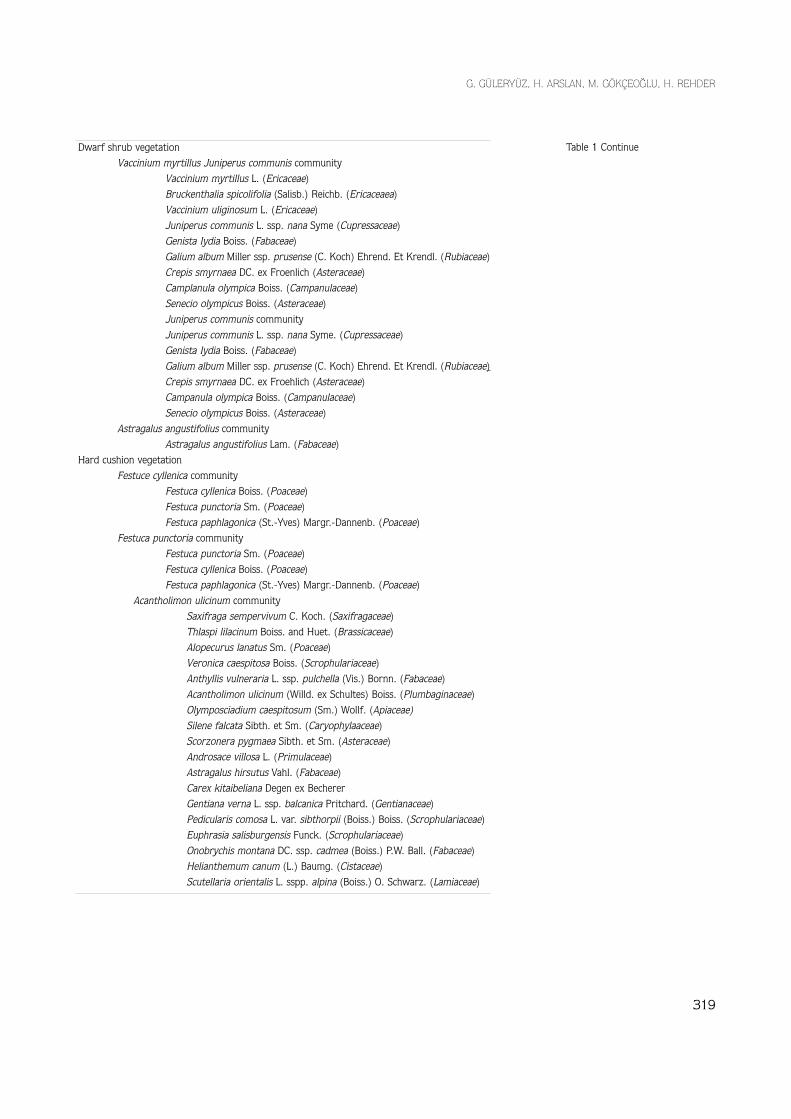
The vegetation types and plant communitiesabove the timberline of Uludağ Mountain: Rehder etal. (2) investigated the vegetation of the upper region ofUludağ Mountain, which also includes the surroundingsthe Winter Sports Center. The vegetation of this regionhas been divided into the three main types: Nardus strictameadows, Juniperus communis dwarf shrub and hardFestuca communities. According to this study, fivevegetation types consisting of fourteen communities aredistributed there: forest (Abies bornmuelleriana- comm.),Dwarf shrub (Vaccinium myrtillus-Juniperus communiscomm., Juniperus communis comm., and Astragalusangustifolius comm.), meadows and mat (Nardus stricta
comm., Agrostis canina comm., Trifolium repens comm.,Plantago atrata comm. and Plantago holosteum comm.),hard cushion (Festuca cyllenica comm., Festuca punctoriacomm. and Acantholimon ulicinum comm.) and ruderal(Verbascum olympicum comm. and Achillea multifidacomm.). The main differential species of the plantcommunities and vegetation types are shown in Table 1.The vegetation mosaic around the Winter Sports Centerin Uludağ Mountains is based on this vegetation study, inwhich details of climate, geology and characteristics ofthe vegetation types are presented. Flora of Turkey andthe East Aegean Islands was referred to for the names oftaxa cited in the text (3).
318
Forest vegetationAbies bornmuelleriana community
Abies bornmeulleriana Mattf (Pinaceae)Poa nemoralis L (Poaceae)Galium rotundifolium L. (Rubiaceae)Fagus orientalis Lipsky (Fagaceae)
Ruderal vegetationVerbascum olympicum Bioss. (Scrophulariaceae)
Urtica dioica L. (Urticaceae)Rumex alpinus L. (Ploygonaceae)
Achillea multifida communityAchillea multifida (DC.) Boiss. (Asteraceae)
Meadow and Mat vegetationNardus stricta community
Nardus stricta L. (Poaceae)Deschampsia caespitosa (L.) P. Beauv. (Poaceae)Ranunculus constantinopolitanus (DC.) d’Urv. (Ranunculaceae)Plantago gentianoides Sm. (Plantaginaceae)Crepis alpestris (Jacq.) Tauusch. (Asteraceae)Potentilla aurea L. (Rosaceae)Festuca rubra L. ssp. pseudorivaluris Margr.-Dannenb. (Poaceae)Carex nigra (L.) Reichard (Cyperaceae)
Agrostis canina communityAgrostis canina L. (Poaceae)
Trifolium repens communityTrifolium repens L. var. orphanideum (Boiss.) Boiss. (Fabaceae)Poa supina Schrader. (Poaceae)Cerastium cerastioides (L.) Britt. (Caryophyllaceae)Tripleurospermum pichleri (Boiss.) Bornm. (Asteraceae)
Plantago atrata communityPlantago atrata Hoppe. (Plantaginaceae)Plantago holosteum Scop. (Plantaginaceae)Alopecurus vaginatus (Wild.) Boiss. (Poaceae)Gnaphalium supinum L. (Asteraceae)
Plantago holosteum communityPlantago holosteum Scop. (Plantaginacaea)Plantago atrata Hoppe. (Plantaginaceae)Alopecurus vaginatus (Willd.) Boiss. (Poaceae)Gnaphalium supinum L. (Asteraceae)
Table 1. Main differential species of theplant communities and vegeta-tion types (based on Rehder etal. (2)
G. GÜLERYÜZ, H. ARSLAN, M. GÖKÇEOĞLU, H. REHDER
319
Dwarf shrub vegetationVaccinium myrtillus Juniperus communis community
Vaccinium myrtillus L. (Ericaceae)Bruckenthalia spicolifolia (Salisb.) Reichb. (Ericaceaea)Vaccinium uliginosum L. (Ericaceae)Juniperus communis L. ssp. nana Syme (Cupressaceae)Genista Iydia Boiss. (Fabaceae)Galium album Miller ssp. prusense (C. Koch) Ehrend. Et Krendl. (Rubiaceae)Crepis smyrnaea DC. ex Froenlich (Asteraceae)Camplanula olympica Boiss. (Campanulaceae)Senecio olympicus Boiss. (Asteraceae)Juniperus communis communityJuniperus communis L. ssp. nana Syme. (Cupressaceae)Genista Iydia Boiss. (Fabaceae)Galium album Miller ssp. prusense (C. Koch) Ehrend. Et Krendl. (Rubiaceae)Crepis smyrnaea DC. ex Froehlich (Asteraceae)Campanula olympica Boiss. (Campanulaceae)Senecio olympicus Boiss. (Asteraceae)
Astragalus angustifolius communityAstragalus angustifolius Lam. (Fabaceae)
Hard cushion vegetationFestuce cyllenica community
Festuca cyllenica Boiss. (Poaceae)Festuca punctoria Sm. (Poaceae)Festuca paphlagonica (St.-Yves) Margr.-Dannenb. (Poaceae)
Festuca punctoria communityFestuca punctoria Sm. (Poaceae)Festuca cyllenica Boiss. (Poaceae)Festuca paphlagonica (St.-Yves) Margr.-Dannenb. (Poaceae)
Acantholimon ulicinum communitySaxifraga sempervivum C. Koch. (Saxifragaceae)Thlaspi lilacinum Boiss. and Huet. (Brassicaceae)Alopecurus lanatus Sm. (Poaceae)Veronica caespitosa Boiss. (Scrophulariaceae)Anthyllis vulneraria L. ssp. pulchella (Vis.) Bornn. (Fabaceae)Acantholimon ulicinum (Willd. ex Schultes) Boiss. (Plumbaginaceae)Olymposciadium caespitosum (Sm.) Wollf. (Apiaceae)Silene falcata Sibth. et Sm. (Caryophylaaceae)Scorzonera pygmaea Sibth. et Sm. (Asteraceae)Androsace villosa L. (Primulaceae)Astragalus hirsutus Vahl. (Fabaceae)Carex kitaibeliana Degen ex BechererGentiana verna L. ssp. balcanica Pritchard. (Gentianaceae)Pedicularis comosa L. var. sibthorpii (Boiss.) Boiss. (Scrophulariaceae)Euphrasia salisburgensis Funck. (Scrophulariaceae)Onobrychis montana DC. ssp. cadmea (Boiss.) P.W. Ball. (Fabaceae)Helianthemum canum (L.) Baumg. (Cistaceae)Scutellaria orientalis L. sspp. alpina (Boiss.) O. Schwarz. (Lamiaceae)
Table 1 Continue

Vegetation Mosaic around the First Center of Tourism Development in the Uludağ Mountain, Bursa-Turkey
Material and Methods
Material
In this study, we used aerial photographs of 1/10 000scale belonging to Uludağ National Park to produce mapsof 1/2500 scale.
Methods
Obtaning and Digitizing of the Aerial Photographs
The General Command of Mapping of the TurkishRequblic took the aerial photographs of 1/10 000 scalefrom spacially equipped planes in August, 1992. Thelongutudinal overlapping of the photographs is 60-90%and the latitudinal overlapping is 30%. Thesephotographs were printed in triplicate in black and whitein the General Command of Mapping laboratories, wherethey were digizited by orthophotography.
Determining of the Plant Communities
Determination of plant species and plant communitiesdistributed the research area were based of the results ofresearch done on the same are by Rehder et al. (2).
Marking of the Plant Communities on the Maps
The maps produced by the General Command ofMapping contained the coverages such as contours,rivers, hill points, rocks, water resources, buildings,under water lines, altitude values (at certain points), plantcommunity boundaries, destroyed areas and roads. Themaps produced from the aerial photographs containabout 25 square km of Uludağ National Park, and thistotal research area was divided into 20 sections of1/2500 scale. The hotels and ski center are included in 4sections of total area (about 6 square km).
Using the above sections of the map, the boundariesof the plant communities were checked by field study inJuly, 1993. Plant communities were marked on the mapswith different symbols, and their boundaries wereconfirmed by this fieldwork.
Analysing and Editing the Results by Computer
The characteristics of the plant species (cover,frequency, density) in the grassland and changes in thecover can be traced using large-scale aerial photographs(4). In our study, areas of 200 square meters and largerwere marked on the maps. This is fairly high resolution.Vegetation and other geographic data were analyzedaccording to GIS techniques (5), which improve theaccuracy and efficiency of environmental assessments,especially the large-scale assessment. This techniqu allowsus to record plant community boundaries, to prepare andedit a feature attribute table (vegetation type, cover, listof species, abundance degree etc.), and to calculate areas
(ha, m2, km2 etc.). In the GIS techniques, the term“coverage” represents the geographical layers of the realworld. Each one of these layers (for example, hydrology,topography, streams, utulities, parcels etc.) is coverage.In our study, the boundaries of plant communities,contours, stream atc. concerned with every section1/2500 scale were transferred to computer fromdigitizer (ALTEKTM). Each one of these coverages wasseparately filed in a computer environment (Hewlett-Packard Workstation Apollo Series 700TM). Featureattribute tables relating to each coverage were createdwith ARC/INFOTM software (ESRI, 1992) and these tableswere related to geographical data. The end mapcompositions of 1/10.000 scale were prepared.
Results and Discussion
Uludağ Winter Sports Center (and the research area)is between altitudes of 1700-2150 m (Figure 1).
A vegetation map of the research area (about 6 km2
or 600 ha) is shown in Figure 2 and 3. The sub-alpineplant communities are prevalent in this area. The coveringof the plant communuties is given in Table 2 in hectaresand as a percentage of the total area. According to thistable, dwarf shrub communities cover the largest part ofthe area. Dwarf shrub vegetation is composed ofVaccinium myrtillus Juniperus communis, Juniperuscommunis and Astragalus angustifolius communities.Astragalus angustifolius comm. is distributed in a narrowarea, whereas the other two plant communities aredistributed in larger areas, neighboring each other.
The meadow and mat formation is composed ofNardus stricta meadow and Plantago holosteum andTrifolium repens mat communities. The communitycovering the largest area within this formation is Nardusstricta comm.
Ruderal vegetation is widespread around the hotelsand ski centers (Fig 2 and 3), indicating massivedisturbances. Taking together the total destroyed anduncovered areas with the ruderal places we get the sumof 71.365 ha (12.057%) for disturbed areas as a whole.
Hard cushion communities, which are typical of alpineregions, are distributed from altitudes of 1750 to 2450m. They are scarce in the mapped area, representedmainly by the Festuca cyllenica comm., whereas Festucapunctoria and Acontholimon ulicinum comm. arewidespread only in the higher sites outside of our map.
With this study, the new formations and deformationscaused by various activities since the 1940’s around thefirst center of tourism development in the Uludağ
320

G. GÜLERYÜZ, H. ARSLAN, M. GÖKÇEOĞLU, H. REHDER
321
N
km
0.00 0.25 0.50
Main Roads
Pathways
Streams
ULUDAĞ UNIVERSITY
ULUB
IO-G
IS
BIOL
OGY BOTANY
Figure 1. Geographical map of the investigation area

Vegetation Mosaic around the First Center of Tourism Development in the Uludağ Mountain, Bursa-Turkey
322
NULUDAG UNIVERSITY
ULUB
IO-G
IS
BIOL
OGY BOTANY
km
0.00 0.25 0.50
Figure 2. Map of plant communities around the First Center of Tourism Development
Abies bornmuellerianaVerbascum olympicumNardus stricta Trifolium repens
Plantago holosteumVaccinium mrytillus-Juniperus communisJuniperus communis
Astragalus angustifoliusFestuca cyllenicaFestuca punctoriaAcantholimon ulicinum
Destroyed area

G. GÜLERYÜZ, H. ARSLAN, M. GÖKÇEOĞLU, H. REHDER
323
0.00 0.25 0.50
kmULUDAG UNIVERSITY
ULUB
IO-G
IS
BIOL
OGY BOTANY
N
Figure 3. Map of vegetation types around the Firstd Center of Tourism Development
Forest-com.– Abies bornmuelleriana
Dwarf shrub-com.– Vaccinium myrtillus-
Juniperus communis– Juniperus communis– Astragalus angustifolius
– Festuca cyllenica– Festuca punctoria– Acantholium ulicinum
Meadow and Mat-com.– Nardus stricta– Trifolium repens– Plantago holosteum
Ruderal-com.– Verbascum olympicum
Destroyed areaHard cushion-com.

Vegetation Mosaic around the First Center of Tourism Development in the Uludağ Mountain, Bursa-Turkey
324
N
SULUB
IO-G
IS
BIOL
OGY BOTANY
km
0.00 0.30 0.60
Main RoadsPathwayUnderground Water Lines
Ski Lift Station ULUDAG UNIVERSITY
Figure 4. Map of the underground water lines and ski lift

G. GÜLERYÜZ, H. ARSLAN, M. GÖKÇEOĞLU, H. REHDER
325
VEGETATION TYPES and COMMUNITIES AREA
ha %
FOREST 141.386 23.885*
-Abies bornmuelleriana comm. 141.386 23.885*
DWARF SHRUB 315.926 53.372
- Vaccinium myrtillus Juniperus communis comm. 152.909 52.832
- Juniperus communis comm. 161.611 27.302
- Astragalus angustifolius comm. 1.406 0.238
MEADOW and MAT 37.763 6.380
- Nardus stricta comm. 33.485 5.657
- Plantago holosteum comm. 4.129 0.698
- Trifolium repens comm. 0.149 0.025
RUDERAL 22.710 3.837
- Verbascum olympicum comm. 22.710 3.837
HARD CUSHION 25.494 4.307
- Festuca cyllenica comm. 19.680 3.325
- Festuca punctoria comm. 5.303 0.896
- Acantholimon ulicinum comm. 0.509 0.086
DESTROYED AREA 48.655 8.220
TOTAL 591.533 100.001
* Percentage of (%) community and/or vegetation type into total area.
Table 2. Area (ha) and percent (%) ofthe vegetation types and plantcommunities within the totalresearch area.
Mountain are exhibited. For example, as of 1993 eachhotel had its own water supply independent of the nearbysprings. In this case, it means that each of them had tobuild its own water network, mainly composed of plasticpipes in the largest part of the area (Fig 4). Furthermore,as shown in Figures 2 and 3, excessive and disorganizedroad building is present in the area. These problems havebeen reported in a previous study (1).
It is possible to form an opinion about vegetationdynamics with the maps presented in Figures 2 and 3. Forexample, it can be seen that the ruderal formation hasdeveloped as a secondary formation after trees (Abiesbornmuelleriana comm.) were cut to build a ski lift at thearea between Fatin Hill and Mandra ski lift station. Asimilar case can be observed for the ski lift between thehotels and Fatin Hill. This area is located within the forest
formation and covered by dwarf shrub formation. Mostprobably, the shrub formation followed the ruderalvegetation growing first after trees were cut there.
In summary, we see a disorganized use of the area forsports indicated by the growing dominance of theVerbascum olympicum community. As a whole, thisdocumentation may offer a base for comparisons ofpresent plant cover with future changes. It appears thatthe changes will continue at an accelerating rate if thecurrent negative human impact on this famous nationalpark continues.
Acknowledgments
We thank Prof. Dr. Kani IŞIK for improvement of theEnglish manuscript.
Vegetation Mosaic around the First Center of Tourism Development in the Uludağ Mountain, Bursa-Turkey
References
1. Güleryüz, G. (1994) Some İnvestigations on Alpine Region of
Uludağ. 1st National Congress on Ecology and Environment, 5-7
October 1993. Atatürk Cultural Center, İzmir Turkey. Journal of
Faculty of Science, Aegean University Supplement 16(1); 918-
826.
2. Rehder, H., Gökçeoğlu, M., Gebauer, G., Güleryüz, G. (1994) Die
Vegetation des Uludağ-Gebirges (Anatolien). Phytocoenologia, 24;
167-192.
3. Davis, P.H. (1965-1985) Flora of Turkey and the East Islands.
Vol. 1-9, University Press Edinburgh.
4. Spelleberg, J.F. (1995). Evaluation and Assessment of
Conservation Biology, Series 4. Series editor F.B. Goldsmith,
Chapman and Hall, London.
5. Tueller, P.T., Lent, P.C., Stager, D.D., Jaeubsen, E.A., Platau, K.A.
(1988). Rangeland Vegetation Changes Measured from
Helicopter-Borne 35 mm Aerial Photography. Photogrammetric
Engineering and Remote Sensing. Vol. 54, No. 5, pp. 609-641.
6. Understanding GIS. (1992) The ARC/INFO Method. Environmental
Systems Research Institute. Inc. Redlands, USA.
326