"Upon the Palisado" and Other Stories of Place from Bruton Heights
150
6/3/2016 "Upon the Palisado" and Other Stories of Place from Bruton Heights | Colonial Williamsburg Digital Library http://research.history.org/DigitalLibrary/View/index.cfm?doc=ResearchReports%5CRR0372.xml 1/150 "Upon the Palisado" and Other Stories of Place from Bruton Heights John Metz,, Jennifer Jones, Dwayne Pickett and David Muraca 1998 Colonial Williamsburg Foundation Library Research Report Series 372 Colonial Williamsburg Foundation Library Williamsburg, Virginia 2000 "Upon the Palisado" and Other Stories of Place from Bruton Heights by John Metz, Jennifer Jones, Dwayne Pickett, and David Muraca Colonial Williamsburg Research Publications Colonial Williamsburg Foundation
Transcript of "Upon the Palisado" and Other Stories of Place from Bruton Heights

6/3/2016 "Upon the Palisado" and Other Stories of Place from Bruton Heights | Colonial Williamsburg Digital Library
http://research.history.org/DigitalLibrary/View/index.cfm?doc=ResearchReports%5CRR0372.xml 1/150
"Upon the Palisado" and Other Stories of Place from BrutonHeights
John Metz,, Jennifer Jones, Dwayne Pickett and David Muraca
1998
Colonial Williamsburg Foundation Library Research Report Series 372 Colonial Williamsburg Foundation Library
Williamsburg, Virginia
2000
"Upon the Palisado" and
Other Stories of Place from Bruton Heights
by John Metz,
Jennifer Jones, Dwayne Pickett,
and David Muraca
Colonial Williamsburg Research Publications Colonial Williamsburg Foundation

6/3/2016 "Upon the Palisado" and Other Stories of Place from Bruton Heights | Colonial Williamsburg Digital Library
http://research.history.org/DigitalLibrary/View/index.cfm?doc=ResearchReports%5CRR0372.xml 2/150
Printed byDietz PressRichmond, Virginia © 1998 by the Colonial Williamsburg Foundation
All rights reserved. No part of this publication may be reproduced, stored in a retrieval system, ortransmitted, in any form or by any means, electronic, mechanical, photocopying, or otherwise, withoutthe prior permission of the Colonial Williamsburg Foundation.
ISBN 0879351896
Printed in the United States of America on acidfree paper
Graphic Design and Layout: Gregory J. BrownMaps and Illustrations: Heather Harvey
i
Preface by David F. MuracaIn 1989, I visited the Bruton Heights campus for the first time. I accompanied Jimmy Knight, the retiredarchitectural draftsman who oversaw the excavation program for the Colonial Williamsburg Foundationduring the 1940s and 50s. At the time, the Foundation was considering acquiring the school with itsassociated thirtythree acres. Jimmy, on hearing this news, sought to acquaint me with thearchaeological potential of the tract. As we walked across the large terrace that contained the school,playground, support buildings, athletic fields, and parking facilities I was struck by the invisibility of thepast. At first glance, the landscape contained only schoolrelated activities. Little had survived that evenhinted at the rich history of this area. But it was there, if you knew where to look.
Jimmy knew where to look. Some forty years earlier, he had observed a large brick foundation in thesidewall of a construction trench. Based on the flecks of oyster shell in the mortar, he determined thatthis foundation represented the remains of a colonialperiod building. Once the sewer line was in place,the trench was backfilled and the area was paved with asphalt for a parking lot. He couldn't exactly

6/3/2016 "Upon the Palisado" and Other Stories of Place from Bruton Heights | Colonial Williamsburg Digital Library
http://research.history.org/DigitalLibrary/View/index.cfm?doc=ResearchReports%5CRR0372.xml 3/150
remember which parking lot covered the foundation, but he assured me this foundation was veryimpressive and worth a look.
As we walked around the back of the school, Jimmy pointed to a linear berm in the woods. This, heexplained, was the Palisade of 1634. I had never heard of this palisade, but did not admit that to Jimmy.Up until this time, my archaeological efforts had centered on excavating the eighteenthcentury town,and I knew little of its predecessor, Middle Plantation. This walk would be my introduction to theseventeenth century, a place that has since captured my heart. The raised berm ran for severalhundred feet, and looked too undisturbed to be very old. As Jimmy and I parted, I hoped my skepticismabout the archaeological potential of Bruton Heights didn't show.
Once it was clear that Colonial Williamsburg was going to acquire the property, we turned away fromromantic, nostalgic remembrances to a more scientific approach. We decided to overlay electronicversions of some of the town's historic maps over a modern map in hopes of predicting the location ofany archaeological remains. While these would only identify post1780 remains, the time of the mapsthat were used, this approach would certainly provide clues to what took place in this area during theeighteenth century. The overlays worked beautifully. Both the Frenchman's Map of 1782 and theDesandrouin's Map of 1781 showed a series of buildings located along the north side of First Street.Now we were cooking. All that was left to do was confirm that the remains of these structures hadsurvived.
In order to confirm the survival of these mappredicted sites, and to identify any other sites, we had toshovel test the entire parcel. One thousand small test holes later, we still had not found Jimmy's brickstructure. At the time, the City of Williamsburg and the Foundation had agreed to let the City use theasphalt lots at Bruton Heights, so no testing of the parking lots took place that year. While there wassome archaeological evidence scattered throughout the tract, the most interesting finds centeredaround First Street where
ii
the maps suggested sites would be found. Unfortunately, this area was not scheduled for development.So, we turned our attention to the areas that were threatened by construction activities, even thoughthey did not seem as interesting as the remains near First Street.
Over the next five years, we explored site after site. First up was an assessment of the ravinescheduled to hold the campus power plant. It contained a nice collection of eighteenthcentury artifactsand at its east end were many seventeenthcentury finds that historical records showed were onceowned by John Page, a major seventeenthcentury landowner. Next we explored the ball field, whichcontained some prehistoric remains and Page's brick and tile kiln. It was not until we opened up mostof the football field in 1993 that we knew we had something special. Not only had the kiln survived, butevidence of kilnrelated activities had survived as well. While we had found John Page's kiln andartifacts generated from Page's house, we still had not found his house.
In 1995, five years of searching had come to an end. By then the conversion of the school into an

6/3/2016 "Upon the Palisado" and Other Stories of Place from Bruton Heights | Colonial Williamsburg Digital Library
http://research.history.org/DigitalLibrary/View/index.cfm?doc=ResearchReports%5CRR0372.xml 4/150
academic campus was well under way. A bulldozer creating an access road just south of the schoolbuilding hit the porch tower of the Page house under the main school parking lot. This discovery wasquickly followed by the uncovering of the kiln's quarry pit remains, the separate kitchen/quarter, and alarge trash deposit related to the kitchen/quarter. The discovery of the Page complex turned BrutonHeights into one of Virginia's most important archaeological sites. This report is the product of the fiveyear search for the Page complex, and the year it took to actually excavate it. Along the way we havegathered an incredible amount of data on how bricks and roofing tiles were made in
Kiln site during the blizzard of 1994.
iii
seventeenthcentury Virginia, we also gained a much better grasp on the distribution of the earliestNative American occupants of Virginia, and have come to better understand the periphery ofeighteenthcentury Williamsburg.
This is not a site report, which are really just reference worksplaces to look up the physical descriptionof a particular post hole or fence line. Instead, this text endeavors to be a narrative that can be readfrom start to finish. Don't get too excited, it still contains extremely detailed descriptions of landtransfers and fence lines. Information thought to be important but distracting from the main text hasbeen separated into independent sections located sporadically throughout this volume. Those lookingfor even more details are welcome to visit the Department of Archaeological Research's electronicarchive.
This report is arranged chronologically, from the earliest visitors to the property around ten thousandyears ago to the end of the eighteenth century. The nineteenth century and, particularly, the twentiethcentury have stories that remain to be told elsewhere. A permanent exhibit about the history of theschool is located in the lobby of the new Bruton Heights school.
I hope you will enjoy this text as much as we enjoyed searching for and excavating the Page complex.
iv
v

6/3/2016 "Upon the Palisado" and Other Stories of Place from Bruton Heights | Colonial Williamsburg Digital Library
http://research.history.org/DigitalLibrary/View/index.cfm?doc=ResearchReports%5CRR0372.xml 5/150
AcknowledgmentsArchaeology projects, particularly those that last seven years, involve an extremely large number ofindividuals. Without the support of each of the following people, the archaeology at Bruton Heightswould not have been nearly as successful. Marley R. Brown III, Director of the Department ofArchaeological Research, provided both theoretical and concrete direction throughout this project. MarkR. Wenger, Carl Lounsbury, William Graham, and Ed Chappell helped guide the architecturalinterpretations. Cathy Hellier conducted the preliminary historical research and is responsible for muchof the Moody subdivision research. Ken Yerby, the Bruton Heights construction manager, wasextremely patient as we continually disrupted his construction deadlines. Kate Meatyard explored therelationship between colonial flowerpots and formal gardens, while Dennis Blanton advised us onprehistoric matters. This volume was skillfully edited by Jane McKinney and Greg Brown. Greg, withthe help of Lucinda Brackman and Tami Carsillo, also formatted this manuscript. Dave Doody andWilliam Graham photographed the Page house. Without the support, both moral and financial, of theBruton Heights Educational Campus project managers Steve Elliott (for the first two years) and BeatrixRumford (for the last five years) this project would have never taken place.
Thanks also goes to the various members of the excavation team. They did a wonderful job ofexcavating and recording the site. Pegeen McLaughlin, Bill Pittman, Kelly Ladd, Linda Novak, andEmily Williams all helped guide the artifactrelated research. Kim Wagner, Christina AdinolfiKiddle,David Brown, and Heather Harvey were responsible for the drafting. In addition, David Brown, KimWagner, Heather Harvey, and Gary Robinson rendered the illustrations. Joanne Bowen and StevenAtkins put in many hours identifying the faunal remains.
Throughout the project, the Page family took considerable interest in the excavations. In particular,Cecil Wray Page, Virginia Page Harrison, and Rocky Page provided extensive support and informationabout past and present members of the Page family.
Finally, we would like to thank the Bruton Heights Educational Campus construction workers whocontinually brought important archaeological evidence to our attention. Their interest and initiativeconsiderably improved the quality of the archaeology at Bruton Heights.
vi
vii
Page
PREFACE i
ACKNOWLEDGMENTS v
LIST OF FIGURES ix
LIST OF TABLES x

6/3/2016 "Upon the Palisado" and Other Stories of Place from Bruton Heights | Colonial Williamsburg Digital Library
http://research.history.org/DigitalLibrary/View/index.cfm?doc=ResearchReports%5CRR0372.xml 6/150
CHAPTER 1: INTRODUCTION 1
Past Investigations 2
CHAPTER 2: BEFORE THE ENGLISH 7
Bruton Heights and the Native American Landscape 7
Evidence of Early Hunters 7
Procurement Camps 11
Site 44WB68 11
Site 44WB70 13
Summary 14
CHAPTER 3: "BETWEEN CIVILIZATION AND SAVAGERY": MIDDLEPLANTATION AND THE PALISADE OF 1634
15
The Powhatan 15
AngloPowhatan Relations 17
"The sonnes of wrath" 18
"Winning the forrest" 19
"Posts pales and railes": The Archaeology of the Palisade 23
Summary 28
CHAPTER 4: JOHN PAGE AND THE GROWTH OF MIDDLE PLANTATION 31
Virginia at MidCentury 31
Origins and Early Career of John Page 31
Building an Estate 33
Archaeological Clues in the Landscape 35
Brick and Tile Manufacture at Bruton Heights 39
Clay Borrow Pit 39
Clay Preparation Areas 40
Pugmills and Water Barrels 40
Irrigation Trench 41
Earthfast Structure 42
SemiPermanent Kiln 43
Social and Economic Implications 45
viii

6/3/2016 "Upon the Palisado" and Other Stories of Place from Bruton Heights | Colonial Williamsburg Digital Library
http://research.history.org/DigitalLibrary/View/index.cfm?doc=ResearchReports%5CRR0372.xml 7/150
CHAPTER 5: THE PAGE ESTATE 53
The Manor House 53
The Outbuilding 63
The Changing Landscape 67
The Page Artifacts 71
Artifacts and Status: The Ravine Assemblage 75
CHAPTER 6: THE EMERGENCE OF WILLIAMSBURG 85
Into the Eighteenth Century 87
Destruction of the Page House 88
Household Artifacts 91
CrossMending Results 93
The End of the Page Years 96
CHAPTER 7: THE MOODY SUBDIVISION 99
The Historical Background 99
The Archaeology of the Moody Subdivision 100
Alexander Craig's Lot 104
James Barrett Southall's Lot 105
The Trash Midden 108
Mystery Feature 109
The Depositional History 112
CHAPTER 8: EPILOGUE 115
REFERENCES CITED 119
ix
Page
1. Bruton Heights School in relation to Williamsburg's Historic Area 1
2. One of a thousand shovel test units 3
3. Location of archaeological sites 4
4. Composite plan of features around Bruton Heights School 5
5. Dalton point 8
6. Assorted projectile points found at Bruton Heights 12

6/3/2016 "Upon the Palisado" and Other Stories of Place from Bruton Heights | Colonial Williamsburg Digital Library
http://research.history.org/DigitalLibrary/View/index.cfm?doc=ResearchReports%5CRR0372.xml 8/150
7. Remains of palisade of 1634 posthole and ditches 24
8. The linear berm of the palisade is visible in this 1927 aerial photograph ofWilliamsburg
25
9. Close up of the palisade remains seen in the 1927 photograph 25
10. Plan view of a section of the palisade 26
11. Crosssection of palisade complex 27
12. Portrait of John Page 32
13. John Page's home site 36
14. Remains of fenceline from the earliest period of Page ownership 37
15. Kiln complex 39
16. Water barrel hole 40
17. Crosssection of water barrel hole 41
18. Unexcavated pugmill 41
19. Plan view of kiln 44
20. Crosssection of kiln fire box 45
21. Woodcut of brickmaking 47
22. Tiles from Bruton Heights kiln 48
23. Artist's reconstruction of the Page house 54
24. Excavated Page house cellar 54
25. Window lead dated "1669" 55
26. Carved and molded bricks 55
27. Michel drawing 56
28. Page's cartouche 57
29. Plan view of Page house cellar 60
30. Outside entrance into cellar 61
31. Newel post and framing support holes for stairs 61
32. Stair tower 62
33. Summer beam supports 62
34. Crosssection of Page cellar 62
35. Drainage sump 63
36. Page outbuilding 64
37. Mapping of the kitchen/quarter 64

6/3/2016 "Upon the Palisado" and Other Stories of Place from Bruton Heights | Colonial Williamsburg Digital Library
http://research.history.org/DigitalLibrary/View/index.cfm?doc=ResearchReports%5CRR0372.xml 9/150
38. Overview of kitchen/quarter 65
39. Billingsley bottle 74
40. Some of the vessels found in the Page cellar 89
41. Bottle seals found in the Page cellar 90
x
42. Stacked wine bottles 90
43. Assorted artifacts found in the Page cellar 92
44. Escutcheon 92
45. Page cellar table glass 92
46. "Spring," by David Teniers 94
47. Anonymous, from Manual of Elementary Education 95
48. Flowerpots from Page cellar 95
49. Spatial distribution of a single flowerpot 96
50. Eighteenthcentury roads associated with the Moody subdivision 101
51. Overview of eighteenthcentury landscape 101
52. Moody subdivision period foundation adjacent to Capitol Landing Road 102
53. Remains of brick structure dating to Moody subdivision period 103
54. Southall fence and ditch 106
55. Southall period ditch 106
56. Eighteenthcentury midden 109
57. Eighteenthcentury midden 110
58. Mystery feature 111
Page
1. Vessel Breakdown by Function and Type 73
2. Page Period Ceramic and Table Glass Vessels 73
3. Vessels found in Cellar 93
1
CHAPTER 1.

6/3/2016 "Upon the Palisado" and Other Stories of Place from Bruton Heights | Colonial Williamsburg Digital Library
http://research.history.org/DigitalLibrary/View/index.cfm?doc=ResearchReports%5CRR0372.xml 10/150
IntroductionIn 1989, the Colonial Williamsburg Foundation acquired the Bruton Heights School (Fig. 1). For the firsttime since 1940, children were absent from the classrooms and halls. Out in the schoolyard workmendismantled the playground equipment to begin the process of restoring the school to its originalappearance. Occasionally, former students and teachers returned to see their school. While sad thatthe Bruton Heights School was no more, they were pleased to hear that the structures would berenovated as part of the Colonial Williamsburg Foundation's new educational campus. These visitorswere surprised, however, to learn that the Bruton Heights School was just the most recentmanifestation of an everchanging cultural landscape. A shovelful of dirt reveals more than pupils' lostpennies, marbles, and pen caps. The archaeological resources on the property document nearly10,000 years of human activity in the remains of temporary campsites, an early fortification, aseventeenthcentury plantation, eighteenthcentury property boundaries, and part of an eighteenthcentury neighborhood. Painstaking historical research and archaeological analysis has resulted in therecovery of a past that has a significant place in the history of the region. So, not only do the buildingscontinue their educational purpose, but the land itself has much to teach us.
Figure 1. Bruton Heights school in relation to Williamsburg's Historic Area,showing the grounds of Bruton Heights prior to the early 1990s renovationand expansion.
2
Environment
The Bruton Heights school campus is located in Williamsburg, Virginia, along the northeast corner ofColonial Williamsburg's Historic Area. The property consists of thirtythree largely undeveloped acres.It is bounded on the south by First Street, on the east by a residential area fronting Capitol LandingRoad, and on the north by the Colonial Parkway. The school campus, which consisted at the time ofacquisition of the main school building, a bus maintenance garage, and the home economics cottage, issituated on a high, level terrace. Ravines sloping gently away from the terrace to the north and westserve as seasonal tributaries for Queens Creek, located approximately one mile to the northwest. Mostof the ravines have become silted in by the runoff from nearly three centuries of cultivation; a ravinewhich extends onto the school property in the southwestern corner of the parcel was completely filled induring the construction of the school.

6/3/2016 "Upon the Palisado" and Other Stories of Place from Bruton Heights | Colonial Williamsburg Digital Library
http://research.history.org/DigitalLibrary/View/index.cfm?doc=ResearchReports%5CRR0372.xml 11/150
The area within the immediate vicinity of the school structures is level and grassy. Plowing associatedwith nineteenth and twentiethcentury farming evened the grade. An aerial photograph of the propertytaken prior to the construction of the school shows a fallow agricultural field. Upon completion of thecampus, the yard east of the main structure was graded further to produce a flat athletic field. Despitethe development of the campus in 1940, much of the property remains wooded. Woodlands border thenorthern and western edges of the parcel. A thick stand of pine was planted along the northern propertyboundary after the school was built. The wooded area to the west is characterized by a mature growthof beech, live oak, yellow poplar, flowering dogwood, and holly. The undergrowth thins out within theforest due to shade from the canopy overhead. Remnants of roads throughout the western end of theparcel attest to twentiethcentury logging activity.
Past Investigations
Evidence of the archaeological potential of the Bruton Heights property surfaced more than fifty yearsago. In the early 1940s, Colonial Williamsburg draftsman James Knight inspected the remains of abuilding uncovered during the installation of a sewer line on school property. He described it as asubstantial brick foundation that he believed dated to colonial times (James Knight, personalcommunication, 1989). Thirty years later, archaeologists with the Virginia Research Center forArchaeology identified two linear mounds (44WB4) that cut across the northern end of the property asthe probable remains of the 1634 palisade (Muraca and Brudvig 1993). It had been constructed acrossthe Peninsula to protect English settlements from Indian attack and to keep livestock from straying.The palisade became obsolete within ten years as the Indians were pushed farther towards the frontier,yet it continued to serve as a landmark in the area throughout the colonial period. Many seventeenthand eighteenthcentury deeds mention the "old Pales near Middle Plantation." The archaeologicalpotential of the property came to the fore once again in 1983 when archaeologists working on theSecond Street Extension Project identified domestic sites associated with the development of theMoody subdivision, a suburb of eighteenth century Williamsburg.
An examination of the historical record of Bruton Heights reveals only a partial picture of the past. Whenit is analyzed in conjunction with the archaeological record, a more comprehensive understanding ofthe past can be achieved. The historical record illuminates land transfers, political evolution, familyheritage, and macroeconomics. Archaeological evidence pertains to material culture, dietary practices,architecture, subsistence, settlement
3
patterns, and microeconomics. Taken together, they establish the social context of the region. Thearchaeological and historical analysis of the thirtythree acre Bruton Heights parcel is part of a largersystematic analysis of the origins and evolution of the colonial capital of Williamsburg.
Shortly after acquiring the property in 1989, the Colonial Williamsburg Foundation initiated acomprehensive plan for an archaeological and historical investigation of the property to determine the

6/3/2016 "Upon the Palisado" and Other Stories of Place from Bruton Heights | Colonial Williamsburg Digital Library
http://research.history.org/DigitalLibrary/View/index.cfm?doc=ResearchReports%5CRR0372.xml 12/150
significance of the Bruton Heights area to the cultural history of the region. Researchers usingdocumentary and cartographic sources developed a systematic strategy for locating archaeologicalsites on the property. Using computerbased mapping, they prepared map overlays of the 1781Desandrouins, 178182 "Frenchman's," and circa 1800 Bucktrout maps, along with a modern mapdrafted in 1964. Preliminary analysis also determined that, apart from the construction of the schoolcomplex in the 1940s, the property was largely unaffected by twentiethcentury development. Thusencouraged about the survival of archaeological resources, archaeologists initially worked to locatesites, establish their boundaries, and determine the integrity of the preserved remains by systematicallyexcavating more than 1000 shovel test units across the property in 1990 (Fig. 2). These revealedseven archaeological sites, including a seventeenthcentury palisade, four eighteenthcentury sites,and two multicomponent sites with prehistoric, seventeenth, and eighteenthcentury elements (Fig. 3).
The fullscale archaeological excavations conducted between July 1992 and August 1996 focused onseveral areas of the campus where significant cultural resources would be impacted by the renovationof the school campus and the construction of new buildings.
Site 44WB70 is located northwest of the Bruton Heights school building. It consists of an eighteenthcentury trash midden and a redeposited seventeenthcentury component associated with the Pagekitchen/quarter.
Figure 2. One of a thousand shovel test units.
Under the athletic field east of the school lay site 44WB68, the remains of a seventeenthcentury brickand roofing tile manufactory. This industrial complex provided building materials for John Page's houseand outbuildings and is unusual because of its medieval, rectangular, updraft kiln design. Furthermore,the remains of the activity areas associated with the brick and tile making enterprise were extremelywell preserved; they are usually difficult to identify and those that survive are often overlooked.Identified remains include post structures, brick and tile making workstations, and a large clay borrowpit that is actually located partially underneath the school.
The third site to be excavated, located west of the main school structure, was excluded during theoriginal survey of the property due to its continued use as part of the bus maintenance facility. This siteis the southern extension of an eighteenthcentury artifact scatter located northwest of the

6/3/2016 "Upon the Palisado" and Other Stories of Place from Bruton Heights | Colonial Williamsburg Digital Library
http://research.history.org/DigitalLibrary/View/index.cfm?doc=ResearchReports%5CRR0372.xml 13/150
4
Figure 3. Location of archaeological sites.
school. The archaeological features identified in this area included two sections of the seventeenthcentury palisade identified in the northeast corner of the property, a lateseventeenthcentury industrialditch, and three mideighteenthcentury fencelines. In addition to these sites, archaeologists examinedthe remains of two seventeenthcentury structures. John Page's house, located just south of theschool, was excavated during the summer of 1995 (Fig. 4). This crossplan brick house was built in1662 and burned around 1730. Associated with this house was a separate brick kitchen/quarter.Partially located underneath the Bruton Heights School building, this structure provided a home toindentured Englishmen and/or enslaved AfricanAmericans as well as a place to prepare food for theplantation.
Prehistoric artifacts were ubiquitous throughout the project, and excavation revealed evidence ofnineteenth and twentiethcentury farming activities. Yet the majority of the features identified at BrutonHeights date to the seventeenth and eighteenth centuries. The remains can be separated into threedistinct periods: the early Middle Plantation period (ca. 16341650), the Page period (16501744), andthe Moody/Southall period (17441798). The archaeological remains at Bruton Heights contribute to ourunderstanding of regional cultural development because they address questions regarding theestablishment of Middle Plantation, the relocation of the colonial capital to Middle Plantation in 1699, andthe development of Williamsburg's periphery during the mideighteenth century. The remains of thepalisade provide evidence of cultural contact and the nature of the AngloPowhatan frontier, as well asof the establishment of Middle Plantation. Similarly, the archaeological remains of John Page'splantation provide a glimpse into a particularly dynamic period of social transition when aspects ofcolonial Virginia society
5

6/3/2016 "Upon the Palisado" and Other Stories of Place from Bruton Heights | Colonial Williamsburg Digital Library
http://research.history.org/DigitalLibrary/View/index.cfm?doc=ResearchReports%5CRR0372.xml 14/150
Figure 4. Composite plan of features around Bruton Heights School.
such as the plantation system, slavery, and a rigid social hierarchy were forming. The Page kiln site isevidence of the changing economic conditions in the Chesapeake during the second half of theseventeenth century and reflects the increasing standard in the quality and scale of Virginiaarchitecture. The remains associated with the Moody subdivision reflect the dynamics of eighteenthcentury population growth in Williamsburg that led to the expansion of the town.
6
7
CHAPTER 2. Before the EnglishLong before the arrival of European colonists Native Americans had modified the land. Theirperceptions and the manner in which they interacted with their surroundings influenced successiveviews of the local landscape. The prehistoric artifacts recovered during the archaeological investigationof Bruton Heights document nearly 9,000 years of human activity on the property. Althoughovershadowed by the great number of historic remains, this prehistoric material provides insight intohow the Bruton Heights property fits into the world of the Native American.
Preliminary excavations led to the identification of two discrete scatters of prehistoric material (see Fig.3). The first was discovered within the limits of the kiln site and the second was found across theterrace and slope northeast of the school building. These sites are defined by the concentration of lithicmaterial and Native American ceramics. Unfortunately, no prehistoric features were discovered inassociation with these artifacts, but the prehistoric remains discovered on the property are importantbecause of their potential to contribute to a more complete understanding of the cultural history of theregion.
Tidewater's Prehistory
Since native Americans first made their way into Southeastern Virginia more than 10,000 years ago,the region has undergone great climatic and environmental change. As a result, groups adapted their

6/3/2016 "Upon the Palisado" and Other Stories of Place from Bruton Heights | Colonial Williamsburg Digital Library
http://research.history.org/DigitalLibrary/View/index.cfm?doc=ResearchReports%5CRR0372.xml 15/150
lifeways to meet the challenges of their environment. Traditionally, scholars have delineated periods ofcultural development in prehistory on the basis of adaptive strategies (Brown et al. 1986; Moodey 1992;Muraca and Hellier 1992). According to this scheme, prehistory in this area is broken down into threebroad categories which are based primarily on technological innovations reflected in the material culture(Hunter and Higgins 1986:27). The PaleoIndian period (95008000 B.C.) marks the arrival of NativeAmericans into Virginia and their adaptation to the Ice Age conditions of the Pleistocene epoch. TheArchaic (80001200 B.C.) period corresponds to the Holocene epoch when climatic and environmentalshifts forced changes in subsistence strategies. Finally, agriculture and increased sedentism arehallmarks of the Woodland period (1200 B.C.1560 A.D.). Each of the three divisions are separated, inturn, into early, middle, and late components.
While most scholars continue to use this traditional scheme there have been efforts to introduce othermethods of looking at the prehistoric past (see Hunter and Higgins 1986). Operating within theestablished chronological framework, new phases have been designed to reflect behavioral trendsinstead of adaptive strategy (Moodey 1992). This behavioral approach departs from the reliance onartifact typologies as a means of defining a chronology and considers a broader range of attributesincluding settlement patterns and subsistence strategies, as well as material culture. It is this newapproach that will be used to trace cultural development within the region.
Phase I — Early Hunters (95006500 B.C.)
The first period (95006500 B.C.) combines the PaleoIndian and the Early Archaic periods which sawthe transition from the tundralike conditions of the Pleistocene epoch to a warmer Holoceneenvironment. During this time, the Ice Age ended and glaciers receded across North America. On theaverage, temperatures were 10 to 15 degrees cooler than they are today. Although glaciation did notreach Virginia, the area experienced climatic warming, a decrease in precipitation, and a sixty to eightymeter rise in the sea level (Gardner 1989).
The transition to a warmer environment had a major impact on the landscape. The southern Tidewateris located on an exposed portion of the continental shelf known as the Atlantic Coastal Plain. TheCoastal Plain was formed 20,000 to 30,000 years ago and lay submerged throughout most of thePleistocene. The decreased precipitation and warmer temperatures associated with the end of the IceAge exposed this land mass, a region characterized by level terrain cut by a dendritic system of smallwaterways. Over time, ravines were formed by the meandering creeks and streams which flow fromfresh water springs and carry storm runoff to the York and James Rivers. Near the major waterways,the ebb and flow of water at the mouths of creeks created expansive mud flats and promoted theformation of saltwater marshes.
Climatic shifts prompted change in the local habitat as well. Hardwood forests covering the area duringthe cooler Pleistocene gave way to oakhemlock forests in the more temperate climate. The shift invegetation continued so that by 6000 years ago the oakhemlock forests were supplanted by oak andpine. Changes in the climate also caused a shift in the animal population. Megafauna such as bison,mammoth, and mastodon declined as modern animal species, including deer, turkey, geese, and

6/3/2016 "Upon the Palisado" and Other Stories of Place from Bruton Heights | Colonial Williamsburg Digital Library
http://research.history.org/DigitalLibrary/View/index.cfm?doc=ResearchReports%5CRR0372.xml 16/150
turtles, began to dominate (Silver 1990:36).
Despite considerable scholarly efforts, anthropologists have only a very general understanding of theEarly Hunter Phase on Virginia's Outer Coastal Plain. For example, all the PaleoIndian artifacts thathave been identified on the Peninsula are isolated projectile point finds from disturbed contexts.Consequently, archaeologists must construct predictive models based on data from modern huntergatherer groups and other PaleoIndian sites in the Southeast. Early Hunter groups were nomadic dueto their reliance on large game for food. Group size and movement depended on the availability andseasonality of large game and other food resources. Bandlevel social organization consisting ofseveral families provided the flexibility needed to efficiently exploit resources within a region (Hunterand Higgins 1986:37). Early Hunter sites included small, shortterm campsites, kill and butcheringsites, and possibly base camps. These sites should probably be associated with Late PleistoceneEarly Holocene landforms in close proximity to game and a water source (Hunter and Higgins 1986:3738).
The PaleoIndian hunter relied upon a surprisingly simple tool kit consisting primarily of finely crafted,bifacially worked points. Experiments in stone tool replication suggest that the fluted biface was anefficient "multipurpose" tool suited for a wide variety of tasks (Hunter and Higgins 1986:3637). Morespecialized tools included scrapers, drills, and gravers. Besides the distinctive fluted bifacial forms,another hallmark of the period is the highquality stone from which tools were fashioned. Early Huntersfavored jasper and chert, which were available from select outcrops located west of the Fall Line nearmodernday Richmond. Initially, the scarcity of these materials may have restricted the range of agroup's movement and contributed to increased competition for resources between Early Hunters(Moodey 1992:7). In time, Indians shifted to locally available stone.
Phase II — Foragers in a New Environment (65002000 B.C.)
The second prehistoric period covers a period (6500 2000 B.C.) which is traditionally known as theMiddle Archaic. During this time, the environment looked more as it does today. Warmer temperaturesand increased annual precipitation combined to promote the growth of deciduous forests. This in turncreated an environment conducive to the development of modern animal species. The NativeAmerican population came to rely on deer, turkeys, and ducks for food and materials. The sea levelstabilized around 2000 years ago, and nearby marshes and mudflats provided Native Americansaccess to shellfish.
Adaptation to new environmental conditions gradually changed the lifestyle of aboriginal groups(Moodey 1992:8). This transition is reflected in a more diverse and specialized tool kit created inresponse to the increase in the variety of food resources. Axes and grinding stones, for example,reflect a growing reliance on plant resources. Tools were produced almost exclusively from locallyavailable stone and reflect the growing importance of new plant and animal resources.
Much of what is known about the chronology, size, function, and settlement pattern of sites dating tothis period comes from deeply stratified sites located in the Inner Coastal Plain and Piedmont regionswest of the Tidewater. These camps contain evidence such as hearths and flaking stations that indicate

6/3/2016 "Upon the Palisado" and Other Stories of Place from Bruton Heights | Colonial Williamsburg Digital Library
http://research.history.org/DigitalLibrary/View/index.cfm?doc=ResearchReports%5CRR0372.xml 17/150
a wide range of activities. Both base camps and procurement sites have been identified.
Procurement sites are typically associated with the exploitation of specific resources. These sitesrepresent hunting, fishing, or gathering forays and usually consist of single artifact finds or smallconcentrations of worked stone. They can be found near wetlands and along the edges of streams andon terraces adjacent to interior waterways. Sites of this type would have been visited seasonally. Sincemany fail to yield diagnostic material, however, procurement sites from this period are often difficult toidentify.
Base camps, on the other hand, were located in areas offering maximum availability of resources.Although these sites tend to be larger and more permanent than procurement sites, they too probablyrepresent seasonal occupation (Mouer 1991:24). Base camps were usually located along interiordrainages or on the edges of inland swamps. Evidence suggests, however, that the preferred locationfor base camps shifted from the interior upland to the river floodplains as the subsistence basechanged (Klein and Klatka 1991:148167). Many of these sites contain evidence of multipleoccupations spaced over thousands of years.
Phase III — Permanent Settlement (2000 B.C.1000 A.D.)
The transition by Native Americans from seasonal hunting and gathering to a more sedentary lifestylebegan almost 4000 years ago. The changes in social systems and settlement patterns were the directresult of the shift from a forestbased economy to a focus on riverine and estuarine environments. As aresult, settlements became more permanent and the population grew. This transition encompassed aseries of distinct cultural episodes traditionally known as the Late Archaic (20001200 B.C.), the EarlyWoodland (1200500 B.C.), and the Middle Woodland (500 B.C.1000 A.D.) periods.
As in the preceding period, base camps and procurement sites are the common site types, althoughbase camps became larger and were occupied for longer periods. The archaeological evidence alsosuggests that while hunting and gathering forays continued, the utilization of the interior decreased withthe growing dependence on estuarine resources and, later, on agriculture (Turner 1992:114). Theincreased reliance on marine resources and agriculture initiated trends within the society that ultimatelyled to the formation of the Powhatan chiefdom.
The material culture from this transitional period offers insight into the growing complexity of aboriginalsociety. The increase in ground stone tools provides evidence for the growing importance of plantmaterials. Mortar and pestles and stone axes allowed the Native American to prepare plant remains foruse. Likewise, the ability to store food became more important as the subsistence base diversified andthe population became more sedentary. Ceramic technology developed in response to this need,beginning with ground steatite vessels and quickly progressing to tempered ceramic vessels. Storagepits also appeared on sites during this phase. Exchange networks advanced to such a degree thatexotic, non local materials and finished products were transported over large areas (Hunter andHiggins 1986:51).
Phase IV — Village Life and the Rise of Agriculture (10001560 A.D.)

6/3/2016 "Upon the Palisado" and Other Stories of Place from Bruton Heights | Colonial Williamsburg Digital Library
http://research.history.org/DigitalLibrary/View/index.cfm?doc=ResearchReports%5CRR0372.xml 18/150
The fourth prehistoric phase, traditionally termed the Late Woodland, began around 1000 A.D. By thistime, Native Americans relied on a mixed subsistence strategy consisting of hunting and gathering, thedomestication of corn, beans, squash, and pumpkins, and the exploitation of marine resources.Subsistence patterns varied with the seasons. Hunting, fishing, and gathering were scheduled aroundplanting and harvesting, prompting groups to establish villages which were occupied for most of theyear. The varied pattern of subsistence and a more sedentary lifestyle made it possible to support alarger population, resulting in increasingly complex social systems. This development culminated inchiefdom level societies like the Powhatan Confederacy.
Settlement patterns characterized by internally dispersed communities consisting of several villages orhamlets distributed over a large area became prevalent during this period. Increasingly a singlecommunity could include hundreds of acres (Turner and Opperman 1993:7277). Camps wereprobably occupied for longer periods, although some may have still been seasonal. Housing in thesecommunities was more substantial than it had been previously, due, in large part, to a more sedentarylifestyle. The remains of oval structures, single burials, ossuaries, and storage pits are indicative ofLate Woodland sites. Palisaded villages appeared later in the period. This development is unique to theLate Woodland period and it underscores the rising sociocultural complexity of Indian society in theTidewater region (Turner 1992:109).
The depiction of the Chesapeake Bay on Spanish maps from the 1520s is the earliest evidence ofEuropean knowledge of the Tidewater region, although there was no significant contact until theestablishment of a shortlived mission by the Spanish in the 1560s. Maps from this period provideinformation concerning sixteenthcentury settlement patterns. English maps dating to the earlyseventeenth century, for example, accurately depict the distribution of Powhatan sites and, in manycases, identify sites by name (Turner and Opperman 1993). These sources reveal an organized senseof space; settlement is concentrated in the Inner Coastal Plain which offered rich agricultural land andeasy access to marine resources.
Written sources provide greater detail about the Native American landscape at the time of contact. Theaccounts of early explorers describe cleared agricultural fields and mature forests free of underbrush(Morgan 1975). Trees were cleared from agricultural fields by stripping off rings of bark and thenallowing the trees to die. Forests, on the other hand, were burned periodically to clear the underbrush toattract game and to facilitate travel between villages. Forests may have been fired as often as twice ayear. This practice of clearing agricultural fields and burning the ground cover within forests resulted inlarge expanses of open grassland throughout the Tidewater region. John Smith observed that "Nearetheir habitations is little small wood or old trees on the ground by reason of their burning them for fire.So that a man may gallop a horse amongst these woods any waie, but where creekes or Rivers shallhinder" (Smith 1612, I:162, in Barbour 1986).
Bruton Heights and the Native American Landscape
Prehistoric material recovered from Bruton Heights, while not abundant, provides a glimpse of the rolethe property played in the local Native American landscape. Bruton Heights is located in the interior of
6/3/2016 "Upon the Palisado" and Other Stories of Place from Bruton Heights | Colonial Williamsburg Digital Library
http://research.history.org/DigitalLibrary/View/index.cfm?doc=ResearchReports%5CRR0372.xml 19/150
the peninsula and was probably forested until the seventeenth century. Its location on an elevatedterrace overlooking two large ravines, its good southern exposure, and its close proximity to at leasttwo fresh water springs attracted Indians. The archaeological evidence from the site spans nearly tenmillennia, suggesting that throughout the prehistoric era it offered an attractive combination ofresources.
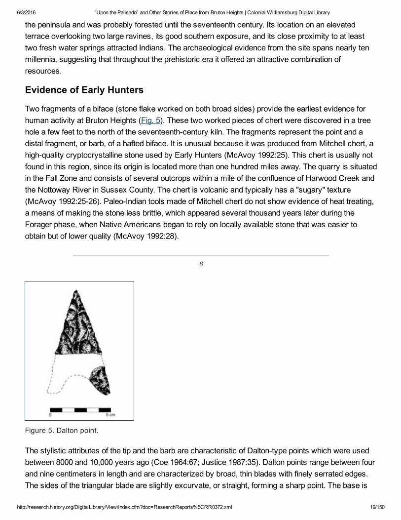
Evidence of Early Hunters
Two fragments of a biface (stone flake worked on both broad sides) provide the earliest evidence forhuman activity at Bruton Heights (Fig. 5). These two worked pieces of chert were discovered in a treehole a few feet to the north of the seventeenthcentury kiln. The fragments represent the point and adistal fragment, or barb, of a hafted biface. It is unusual because it was produced from Mitchell chert, ahighquality cryptocrystalline stone used by Early Hunters (McAvoy 1992:25). This chert is usually notfound in this region, since its origin is located more than one hundred miles away. The quarry is situatedin the Fall Zone and consists of several outcrops within a mile of the confluence of Harwood Creek andthe Nottoway River in Sussex County. The chert is volcanic and typically has a "sugary" texture(McAvoy 1992:2526). PaleoIndian tools made of Mitchell chert do not show evidence of heat treating,a means of making the stone less brittle, which appeared several thousand years later during theForager phase, when Native Americans began to rely on locally available stone that was easier toobtain but of lower quality (McAvoy 1992:28).
8
Figure 5. Dalton point.
The stylistic attributes of the tip and the barb are characteristic of Daltontype points which were usedbetween 8000 and 10,000 years ago (Coe 1964:67; Justice 1987:35). Dalton points range between fourand nine centimeters in length and are characterized by broad, thin blades with finely serrated edges.The sides of the triangular blade are slightly excurvate, or straight, forming a sharp point. The base is

6/3/2016 "Upon the Palisado" and Other Stories of Place from Bruton Heights | Colonial Williamsburg Digital Library
http://research.history.org/DigitalLibrary/View/index.cfm?doc=ResearchReports%5CRR0372.xml 20/150
concave, which gives the impression that it is a stemmed point (Hranicky 1991:22). Dalton points wereproduced through a combination of flaking and grinding before the serrated edge was applied throughpressure flaking (Justice 1987:40). Archaeologist Joffre Coe observed that, despite a clear stylisticconnection between the HardawayDalton points of North Carolina and the wellcrafted Dalton points ofthe Midwest, the "coarse grained stone available in the Piedmont was a definite factor that limited thequality of the product and handicapped the craftsman"(Coe
9
1964:64). Dalton points found in Virginia reflect the similar reduction in quality resulting from the limitedavailability of highgrade lithic material.
The appearance of Dalton points reflects a technological shift from the extremely widespread Clovisdominated tool kit to a more varied tool kit that began to develop at the end of Early Hunter phase (pre6500 B.C.), which consisted of specialized tools designed for specific purposes (Justice 1987:41). Thistransition mirrors change on a more basic level. Pleistocene hunters were nomadic, relying onmigrating herds of bison, mammoth, and other large game. As the Ice Age ended, climatic warmingresulted in drastic changes in the environment as new animal and plant species replaced those typicalof a colder climate, and Native Americans too, were forced to adapt to new conditions. This transitionwas reflected in all aspects of culture including food procurement, site selection, and tool manufacture.
The Dalton point found at Bruton Heights appears to have been broken shortly after it was made. Thestraight sides, well formed point, and finely serrated edges show no evidence of reworking. Tools fromthe Early Hunter period were typically used over and over again for such a long period that when theywere discarded they scarcely resembled the original form of the tool. Blades were reduced throughprogressive episodes of dulling and resharpening, producing "sometimes a drilllike form" (Goodyear1974; Justice 1987:40). The reason for this extensive reuse is probably due to the scarcity of the highquality chert out of which
10
PaleoIndians fashioned tools. It was simpler to recycle old or broken tools than to travel far to obtainnew materials.
Dalton points are rare in Virginia and virtually nonexistent in the eastern part of the state, due, in largepart, to the near absence of highquality stone. While Native Americans often collected stone to beworked at a later time when the need arose, the absence of thinning or retouch flakes in associationwith the Dalton point indicates that it was not manufactured at Bruton Heights. Furthermore, thefragment shows evidence of a pressure break of the type which occurs through use rather thanmanufacture (Dennis Blanton, personal communication, 1994). The point was probably discarded whenit was broken near the midsection of the point, because it could not be reshaped for further use. While itis difficult to say based on an isolated find whether a campsite was located nearby, Early Hunterremains are often associated with landforms in close proximity to game and water, conditions that were

6/3/2016 "Upon the Palisado" and Other Stories of Place from Bruton Heights | Colonial Williamsburg Digital Library
http://research.history.org/DigitalLibrary/View/index.cfm?doc=ResearchReports%5CRR0372.xml 21/150
present at Bruton Heights.
Procurement Camps
In the period following the Ice Age, Native Americans established camps at Bruton Heightsintermittently. It is likely that they were drawn by a fresh water spring, a good hunting spot, or someother feature as they ventured away from base camps near the waterways into the forests in search ofgame and other resources. Typically, light scatters of prehistoric material provide evidence for theserepeated visits. Most represent hunting and gathering camps that were occupied anywhere from singlenight to a period of
11
several days. Two small shortterm, specialpurpose sites were identified at Bruton Heights.
Site 44WB68
The kiln site where the Dalton point was found also exhibited evidence of continued occupation.Prehistoric artifacts were discovered covering an area measuring approximately 197 feet by 131 feet(Muraca and Hellier 1992). The twentysix prehistoric artifacts recovered from this site includeceramics, tools, and the stone byproducts of tool manufacture and maintenance. Although the lightdensity of the scatter suggests only occasional activity, diagnostic artifacts indicate that the area wasvisited repeatedly over a long period of time.
Other than the Dalton point, little evidence remains of the earliest visits. A small LeCroy projectile point(65006000 B.C.) provides evidence for activity dating to the increasingly temperate forager period (Fig.6). Comparing the Dalton and LeCroy points provides an example of how changing conditions arereflected through material culture. The large size of the Dalton point and the exotic material from whichit was made illustrate the efficient and multipurpose nature of PaleoIndian tools. The LeCroy, on theother hand, is much smaller, which suggests specialized use. The size of the LeCroy suggests it wasproduced to hunt smaller game. Furthermore, the material from which it was made, chert, is locallyavailable in the form of river cobbles that erode from streambeds and the slopes of ravines.
12
The majority of the diagnostic artifacts bracket the third and fourth phases of prehistoric culturaldevelopment in the region, when Native American society became increasingly sedentary. Eventhough Indians focused on riverine and estuarine environments, the hunting and gathering forays intothe interior continued to provide meat and other resources. The diagnostic artifacts from this periodinclude two projectile points and twelve ceramic fragments. Ten of the ceramic sherds are graveltempered with cordmarked decoration. The fragments were identified as Popes Creektype, dating tothe period 1200500 B.C. The two remaining pieces of ceramic were tempered with sand, display nodecoration, and date between 500 B.C. and 900 A.D. One of these was recovered from a seventeenth

6/3/2016 "Upon the Palisado" and Other Stories of Place from Bruton Heights | Colonial Williamsburg Digital Library
http://research.history.org/DigitalLibrary/View/index.cfm?doc=ResearchReports%5CRR0372.xml 22/150
century posthole, while the second fragment was discovered in the fill of an historicperiod pit ofunknown function. A quartzite Potts projectile point (0200 A.D.) and a quartzite Peedee point (ca. 1600A.D.) were also recovered (see Fig. 6).
Figure 6. Assorted projectile points found at Bruton Heights.
13
Two pieces of firecracked quartzite, six pieces of quartz debitage, and the remains of an unfinishedtool provide evidence of the activities that took place in the camp (see section on Tool Manufacture).The firecracked rocks suggest that Indians collected stone cobbles from the ravines nearby andheated them as part of the toolmanufacturing process. The debitage may have also resulted from toolmanufacture or resharpening. Two matching fragments of an unfinished tool turned up in aseventeenthcentury ditch. Unfortunately, this projectile point was never fully shaped and cannot beidentified as to type, nor can it be dated. It appears that the tool was broken during production anddiscarded. It was probably redeposited in the ditch after the kiln site was abandoned.
Site 44WB70
A second shortterm procurement camp was identified along the ravine located northwest of theschool. While 44WB68 produced evidence of much earlier occupation, the concentration along theravine appears to have been the site of more intensive activity. Sixty artifacts were recovered from thissite, including a utilized flake, three pieces of eroded ceramic, four flakes worked on two sides, fiftyonepieces of debitage, and five fragments of firecracked rock. An analysis of the diagnostic material fromthe site determined that the camp was the site of repeated occupations during the forager andpermanent settlement periods (6500 B.C.1000 A.D.). All of the prehistoric artifacts associated with thesite were retrieved from historicperiod features, however, suggesting that the features associated with
14
the prehistoric site were destroyed through plowing, landscaping, and erosion.
Two projectile points were recovered from this site. An unfinished (stage four) quartzite biface, identifiedas a possible Guilford (35002500 B.C.), may have been broken before it could be finished and used. A

6/3/2016 "Upon the Palisado" and Other Stories of Place from Bruton Heights | Colonial Williamsburg Digital Library
http://research.history.org/DigitalLibrary/View/index.cfm?doc=ResearchReports%5CRR0372.xml 23/150
quartzite Halifax Sidenotched point dating to roughly the same period (35002500 B.C.), was alsorecovered (see Fig. 6).
The number of diagnostic artifacts increases for the later phase of occupation. Of the three ceramicfragments recovered from the site, two were sandtempered though too eroded for a preciseidentification. The remaining ceramic fragment was tempered with hematite. All three pieces date from500 B.C. to 900 A.D. A quartzite Madison point (8001400 A.D.) also suggests an occupation aroundthe same time. Small triangular points of this type are found throughout the eastern United States.
An unidentifiable hafted biface and a retouched flake, both of quartzite, were the only other stone toolsrepresented in the assemblage. Utilized flakes are large flakes removed from stone cobbles during toolproduction, which are then used as tools themselves. Sharpening, or retouching, provides clearevidence that the flake was used as a cutting tool.
The artifact assemblage from this site also included five pieces of firecracked rock, eighteen pieces ofshatter, twentyeight fragments of debitage, and eight secondary/thinning flakes. The high percentage ofdebitage indicates that Native Americans were drawn to this area by the availability of stone cobbleseroding from the ravine. Based on the existing evidence, it appears that the cobbles were heat treatedand broken apart to provide the raw material for preforms. The absence of small tertiary (finishing)flakes suggests that the tools were not completed at this camp.
Summary
While the Bruton Heights property was never the site of a largescale prehistoric settlement, the dataindicates that Bruton Heights was visited occasionally throughout prehistory as Indians traveledthrough the forests on the Peninsula. The discovery of a Daltontype biface produced from Mitchellchert suggests that Native Americans began to exploit resources located in the area during the earliestphase of Virginia's prehistory, while the discovery of a quartzite Peedee projectile point providesevidence of a Native American presence at Bruton Heights perhaps as late as 1600 A.D. All sites,however, appear to have been shortduration campsites and/or food procurement sites. Sites of thistype were exploited seasonally and may represent shortterm hunting and gathering forays ortemporary encampments.
Tool Manufacture
Some stone fragments, known as debitage, are the byproduct of tool production and maintenance.Archaeologists have identified several types of flakes and fragments which are indicative of thedifferent phases of tool production. Stone was often heated to make it less brittle and easier to work andthus firecracked rock represents the initial stage of preparation. The cobble was then reduced to thedesired size by removing large primary flakes. Next, the tool was shaped by removingsecondary/thinning flakes. Native Americans frequently stopped at this stage and took the crudelyshaped stone forms with them. These "preforms" could be fashioned into specific tools as the needarose. Once the stone implement was finished it was resharpened by removing small flakes of stone

6/3/2016 "Upon the Palisado" and Other Stories of Place from Bruton Heights | Colonial Williamsburg Digital Library
http://research.history.org/DigitalLibrary/View/index.cfm?doc=ResearchReports%5CRR0372.xml 24/150
known as tertiary flakes.
15
CHAPTER 3. "Between Civilization and Savagery": Middle Plantation and the Palisade of 1634The earliest historicperiod occupation of the area was associated with the settlement known as MiddlePlantation. To understand the importance of this settlement it is necessary to provide some backgroundregarding conditions in eastern Virginia in the early to midseventeenth century. The first permanentEnglish settlement in North America was established at Jamestown in 1607 by the Virginia Company ofLondon. Securing this foothold brought the English into contact with an indigenous population whoseculture was vastly different from their own. This pattern of English colonization had been set in Irelandbeginning in the midsixteenth century. Despite a similar heritage and a shared religion, the Englishviewed the Irish as savage, while the Irish looked upon English as invaders. Relations between the twoquickly deteriorated, establishing a violent pattern of rebellion and reprisal. The English approachedVirginia and its indigenous population with the same "religious and cultural imperative" used to justifycolonization in Ireland (Blades 1986:258). Within five years of settlement, the colonists in both landsbecame entrenched behind "the English Pale" (Meinig 1986, I:28).
Hostile relations with the Indians figured prominently among the factors that confined English settlementto the area along the major waterways throughout much of the first thirty years in Virginia. Without theability to expand into the interior, the colony was vulnerable to Spanish aggression. Perhaps moreimportantly, the colony could not grow and prosper without the interior, which promised land for pastureand agriculture.
Middle Plantation represented the first major inland settlement for the colony. It was established by anAct of Assembly in 1632/3 to provide a link between Jamestown and Chiskiack, a settlement locatedacross the Peninsula on the York River. This chain of settlements, it was thought would create a barrieragainst Indian attack by cutting off access from the north and thereby protecting the plantations locatedon the lower Peninsula to the south. The chain of settlements was bolstered by the construction of apalisade beginning near the mouth of College Creek, a tributary of the James, and extending eastwardsix miles across the Peninsula to Queens Creek, a tributary of the York. The palisade was not purely adefensive wall; instead the English used it to strengthen the position of their settlement by expandinginto the interior and laying claim to land where the Powhatan Indians lived. It was an invasive strategydesigned to establish a physical, frontier barrier in order to affirm English ownership of the entirepeninsula.
The Powhatan

6/3/2016 "Upon the Palisado" and Other Stories of Place from Bruton Heights | Colonial Williamsburg Digital Library
http://research.history.org/DigitalLibrary/View/index.cfm?doc=ResearchReports%5CRR0372.xml 25/150
In his account of the colony's earliest days, George Percy recalled seeing Virginia for the first time. Hemarveled at the "faire meaddowes and goodly tall Trees, with such Freshwaters running through thewoods, as I was almost ravished at the first sight thereof" (Percy 1922:281). His description of thenatives as "Savages creeping on all foure, from the Hills like Bears" reflects the attitude of most Englishcolonists towards the indigenous population. This fear and mistrust was mixed with feelings of cultural
16
superiority over a people they believed to be "poore and miserable soules, wrapt up unto death, inalmost invincible ignorance" (de la Ware et al. 1610, in Billings 1975:14).
By the time Jamestown was established, the Peninsula was occupied by an alliance of thirtytwo tribes,usually called the Powhatan Confederacy, under the control of the chief Powhatan. The trade networksthat stretched far across the country, brought exotic goods such as antimony, shell beads, pearls, andcopper, and reflected the complexity of this confederation. Oddly enough, the European presence wasfelt long before widespread contact due to the transmission of European goods via the same routes.The Powhatan may even have been engaged in commerce with other European nations by the time theEnglish arrived in the Chesapeake. In 1610, one of Powhatan's storehouses reportedly held 4000 deerskins destined for the French fur trade far to the north (Bragdon 1986:81).
The Powhatan confederacy developed primarily in the century prior to contact with Europeans (Potter1989:154). Powhatan began to consolidate power during the second half of the sixteenth century afterhe inherited the territories of the lower York River, including the Pamunkey, Mattaponi, Chiskiack,Werowocomoco, Powhatan, Arrohateck, Appamatuck, and Orapaks (Bragdon 1986:78). He conqueredother Virginia Algonquian tribes and made them tributary to the Powhatan. The confederacy was at itsheight in 1607, encompassing most of the area south of the Rappahannock to just below the JamesRiver and as far west as the Fall Line. The Chickhominy were the only Virginian Algonquian group notunder Powhatan's control.
Activities within the community were organized according to season. Powhatan hunters moved upriverduring the winter in search of deer and other game. Often the hunting parties were large, consisting ofas many as three hundred individuals cooperating in hunting and processing (Bragdon 1986:76). Springbrought the responsibility for preparing fields, planting crops, and fishing. Summer activities typicallyconsisted of gathering forays in the uplands for roots, nuts, and berries and along the waterways tocollect shellfish. Crops were harvested in the autumn.
Organization of the landscape was greatly influenced by horticultural practices. William Stracheyobserved that:
Theire habitations or Townes, are for the most parte by the Rivers, or not distant from freshSprings comonly upon the Rice of a hill, that they maie overlooke the River and take everysmale thing into view which sturrs upon the same, their houses are not manie in one towne,and those that are stand dissite and scattered, without forme of a street, far and wide

6/3/2016 "Upon the Palisado" and Other Stories of Place from Bruton Heights | Colonial Williamsburg Digital Library
http://research.history.org/DigitalLibrary/View/index.cfm?doc=ResearchReports%5CRR0372.xml 26/150
asunder(Strachey 1612, in Bragdon 1986:78, emphasis added).
Archaeological and ethnohistorical data suggest that villages probably consisted of kinbasedhousehold clusters scattered throughout a severalhundred acre tract (Turner and Opperman 1993:72).This strategy allowed Indian communities to farm the land efficiently by spreading the population over alarger area to increase the amount of available land for cultivation and to prevent soil exhaustion. ThePowhatan practiced field rotation, including fallow intervals to restore vital nutrients, as well as swiddenagriculture whereby brush fires were set to clear fields and to prepare them for cultivation. Periodicfiring to clear fields and drive game lent a parklike appearance to the overall landscape. Mature treesdotted the landscape and lush grasses took the place of underbrush (Morgan 1975:54).
17
AngloPowhatan Relations
Laying claim to land in North America presented problems the English had not encountered before(Sack 1986:138). Unlike Ireland, North America was a land where the English had little knowledge ofindigenous culture and little sensitivity for the native's concept of the land. Initially, the English believedthey could coexist with Native Americans, sharing "the resources of a rich country," while giving them"the benefits of a better life" (Craven 1970:76). The rationale for the colonization of Virginia, written in1610, stated that "The Principal and Maine endes" of the settlement were:
first to preach and baptize into Christian Religion, and by Propagation of the Gospell, out of theArmes of the Divell, a number of poore and miserable soules, … Secondly, to provide andbuild up for the publike Honour and Safety of our Gratious King and his Estates … a Bulwarkeof defence in a place of advantage against a stranger enemy, … [and] Lastly, the appearanceand assurance of Private commodity to the particular undertakers, by recovering andpossessing to themselves a fruitfull land, whence they may furnish and provide thisKingdome, with all such necessities and defects under which we labour, and are nowenforced to buy" (de la Ware et al. 1610, in Billings 1975:1415).
Both the Powhatan and the English were accustomed to dealing with "foreigners" (Rountree 1993:173).Still, AngloPowhatan relations were threatened from the outset because of differing beliefs and values,including those about religion, roles within society, land, and economic goals. In the colony's firstdecade and a half, the English "suffered under a double dependency that precluded friendly relationswith Indians, crippled local initiative in policy making, and jeopardized their very survival"(Fausz1988:50). The Londonbased governing body of the Virginia Company set goals for the colony that werewholly unrealistic and often counterproductive in establishing peaceful relations with the nativepopulation. They urged colonists to move on to Indian land as well as to convert unwilling NativeAmericans to English religion and culture.
Land was perhaps the greatest source of friction between the two groups, specifically the differing

6/3/2016 "Upon the Palisado" and Other Stories of Place from Bruton Heights | Colonial Williamsburg Digital Library
http://research.history.org/DigitalLibrary/View/index.cfm?doc=ResearchReports%5CRR0372.xml 27/150
perceptions of property ownership and land use. To the Powhatan, the land belonged to the people andthe paramount chief decided who would work where (Rountree 1993:173). The population was smalland the Indians grew just enough to pay their tributes and provide for themselves. Small tracts of landwere used temporarily and then left to go fallow. The English had come from a much more populouscountry where land was seen as a valuable commodity to be bought and sold. Therefore, they did notunderstand Powhatan horticulture as a necessary means of ensuring the productivity of the land somuch as they saw it as abandonment.
The Powhatan, on the other hand, did not understand the English practice of owning land in perpetuity,whether it was used or not (Rountree 1993:173). Because the colonizers had been granted land inVirginia by royal decree, it was difficult for them to coexist with Native Americans on land they believedthey owned. This abstract form of territoriality was "in some respects being posed as a gigantic socialexperiment in the use of space, to affect, organize and control behavior"(Sack 1986:140) . As thecolony turned increasingly towards agriculture, more and more English settlers arrived, pushing inlandand forcing the Indians from land they had once farmed and hunted.
The English initially welcomed the opportunity to ally themselves with the Powhatan. Over time,however, AngloIndian relations degenerated into an empty
18
association based on "fear without love"(Fausz 1988:50) . Tribes living near the English settlementswere the first to tire of losing their goods and their land to the English while enduring sermons on moralredemption (Rountree 1993:179). Hostilities increased as a result of the growing frustration. The Indiansjustified alternating episodes of trade and theft because the English were not "kin," therefore they wereneither "human" nor subject to laws concerning theft (Rountree 1993:179). The English reacted toworsening relations with the Powhatan by establishing friendly relations with outlying tribes, some ofwhich were enemies of the Powhatan (Craven 1970:81).
"The sonnes of wrath"
The First AngloPowhatan War erupted shortly after Lord de la Ware became Governor of the colony in1610. Over time, the English had become more brazen in their efforts to push the Indians from theirland. After the arrival of the new governor, they became even more aggressive. The English looked forany excuse to raid communities and force the Powhatan from their villages. The breaking point camefor the Powhatan when English forces raided the village of Pasbehegh and "committed the doubleatrocity (by Powhatan standards) of killing chiefly persons who were also women and children"(Rountree 1993:183) . Powhatan responded by accusing the English of "comming hither … not fortrade, but to invade [his] people, and possesse [his] Country" (Fausz 1988:51) . The Indians retaliatedwith repeated smallscale raids. The war concluded in 1613 with the English claiming victory. AngloPowhatan relations remained tense as the English continued to encroach on Indian land.
Over the next few years, the colonists "maintained their ethnocentric insularity and concentrated on the

6/3/2016 "Upon the Palisado" and Other Stories of Place from Bruton Heights | Colonial Williamsburg Digital Library
http://research.history.org/DigitalLibrary/View/index.cfm?doc=ResearchReports%5CRR0372.xml 28/150
profitable tobacco fields"(Fausz 1988:51 ). The Powhatan Confederation, however, was in the midst ofchange. By 1613, Powhatan was an old man and his ability to rule the chiefdom had beencompromised.
His brother, Opechancanough, took control and established "commaund over all the people" by 1614,although he did not actually become the paramount chief until the 1620s. He conceded defeat to theEnglish and expressed his desire to reestablish lucrative trade relations, while at the same time heworked to consolidate tribal alliances in a force opposed to the English (Rountree 1993:192193). Thisprocess took years of patient and careful negotiation. Opechancanough convincingly demonstrated hisfriendship towards the English, which lulled them into complacency. He acknowledged the superiority ofChristianity and even went so far as to agree with the English that Powhatan parents should give theirchildren to English families where they could be educated in the European manner (Rountree 1993:185187).
Meanwhile, the English continued the behavior that had initially incited Powhatan wrath. Colonistsbegan to cultivate tobacco in 1614 and their success attracted thousands of hopeful immigrants. Theheadright system, which promised fifty acres of land for each person whose passage to Virginia waspaid, developed in order to facilitate the growing number of immigrants. The newlyarrived colonistsexpanded English settlement up and down the James River as far north as the Fall Line. By 1622, theyhad taken over nearly half of the core area of the Powhatan paramount chiefdom (Rountree 1993:184).
In 1618, the Virginia Company of London decided that the colonial government in Virginia was nottaking the proper measures to make money or anglicize the
19
Indians. Sir Francis Wyatt was named governor and sent with a group of sympathetic councilors toremedy the situation. By appointing men of wealth and status to administer the colony, the companyhoped to "promote the kind of social and political stability that the colony had not known since theregime of Governor Lord De la War"(Fausz 1988:52) .
Opechancanough issued the call for the Indian tribes between the James and York Rivers to strikeagainst the English on March 22, 1622. This uprising devastated the colony and reduced the populationby a quarter in one swift blow. Another twentyfive percent died in the following year from continuedhostilities, famine from the abandonment of farm fields, and sickness (Rountree 1993:190).
A consequence of the uprising was the Second AngloPowhatan War, which was more costly andlasted longer than the previous conflict. The Indians waged a guerrilla campaign of smallscale raidsagainst homesites and larger settlements scattered across the frontier. The war reached its climax in1624 at the Battle of Pumunkey where English forces soundly defeated the Powhatan (Rountree1993:190). Opechancanough had hoped that the initial uprising would reinvigorate the PowhatanConfederacy and reestablish its supremacy. His failure to destroy the entire colony, however, "actuallystrengthened the English foothold in the Bay by encouraging the most aggressive and adaptive of thelocal leaders to seize power and seek revenge free of Company interference"(Fausz 1988:52). The

6/3/2016 "Upon the Palisado" and Other Stories of Place from Bruton Heights | Colonial Williamsburg Digital Library
http://research.history.org/DigitalLibrary/View/index.cfm?doc=ResearchReports%5CRR0372.xml 29/150
burden of recovery fell to Wyatt and the surviving members of his council. Wyatt and George Sandyswere Oxfordeducated men, while Sir George Yeardley and Francis West contributed military expertise(Fausz 1988:53). Together the governor and his council assumed total control of the government andorganized the frightened settlers into an effective fighting force (Fausz 1988:54).
Wyatt's men ignored the call from London for genocide because it was impractical and costly. Instead,they employed the same guerrilla tactics the Indians had used against the settlers. The colonists tookIndian maize and destroyed the remaining crops, while conducting extensive smallscale raids againstvillages. Wyatt wisely urged colonists to concentrate on raising tobacco. Record tobacco harvestswere produced during the 1620s "with captured Powhatan maize keeping them alive, and fear ofPowhatan attacks keeping them in line"(Fausz 1988:55). Wyatt and his council were criticized inEngland for their independent action. One of Wyatt's lieutenants responded to the charges, saying:
[Although] itt is much to be desired, that either good men were commaunders or els thatcommaunders were good men … we are all by nature the sonnes of wrath: servinge … thespirrit that rules in the hartes of the disobedient(Fausz 1988:56).
Despite the uproar over Governor Wyatt's method of mobilizing the colony, its effectiveness wasbeyond dispute. Peace was finally reached in 1632 when the Jamestown government negotiatedseparate treaties with the Chickahominy and the Pamunkey.
"Winning the forrest"
The second Virginia Company charter, issued in 1609, signaled a shift in the colony's agenda fromexploration, exploitation and religious conversion to selfsufficiency and production for the home market(Rountree 1993:180). The new plan presented the Jamestown government with the dilemma ofencouraging settlement of the interior while at the same time protecting colonists from the growingthreat of hostilities with
20
the Indians. The colonists met both challenges by fortifying their settlements.
Early English fortification in Virginia was purely defensive and based on medieval models. Settlementswere enclosed within protective palisades and, often, land within the immediate vicinity of thesettlement was surrounded by a second wall to provide a secure area for crops and grazing in times ofcrisis. The role of fortification in Virginia changed over time, however. The realization of tobacco'seconomic viability in 1614 had attracted record numbers of immigrants and created an insatiabledemand for arable land. After the 1622 Indian uprising, colonists revived an earlier plan to build afortified settlement inland on the JamesYork peninsula. Instead of establishing a presence in thetraditional sense with fortified outposts, the new plan proposed expelling the Indians from the peninsulaand sealing its northern end with a palisade. While the ability to effectively patrol and maintain such alarge fortification might be called into question, there is no doubt that it would send a powerful symbolic

6/3/2016 "Upon the Palisado" and Other Stories of Place from Bruton Heights | Colonial Williamsburg Digital Library
http://research.history.org/DigitalLibrary/View/index.cfm?doc=ResearchReports%5CRR0372.xml 30/150
message that the Peninsula was English land and that the Indians were not welcome. After years offailed plans and false starts, Middle Plantation was established by an Act of Assembly in 1632. Thiscleared the way for the construction of a palisade that upon its completion in 1634 stretched six milesacross the peninsula.
Landscapes dotted with castles and medieval walled cities were familiar to the English. As Englandexpanded beyond its borders to establish colonies beginning in the sixteenth century, the defensive wallwas adapted to serve the needs of a particular region. In Ireland, for example, walls were constructedaround towns while landlords were required to enclose manor houses within smaller protectivepalisades known as "bawns" (Blades 1986:258). In many respects, the experience gained in Irelandguided the efforts to settle Virginia. The first Englishmen to arrive at Jamestown in 1607 wasted littletime in constructing a fort to protect themselves from the unknown (Noìl Hume 1982:27). WilliamStrachey described the town in 1610 as being enclosed "with a Pallizado of Planckes and trongposts,foure feet deepe in the ground, of young oaks"(Purchas 1753, in Noìl Hume 1982:150) .
The settlers took great care to situate early settlements in areas that were difficult to attack and easy todefend. Henrico was established in 1612 as an outpost upriver from Jamestown to broaden the base ofsettlement, which would make the colony less susceptible to Spanish attack. Captain John Smithreported that the "Towne is situated upon a necke of plaine rising land, three parts invironed with themaine River, the necke of land well impaled, makes it like and Ile"(Hamor, in Muraca and Hellier1992:3031). Its isolated and exposed location inland near the Fall Line underscored the need to buildthe settlement within a protective enclosure. Ralph Hamor wrote that Henrico was protected by "palesposts and railes" complete with watch towers, a storehouse, and a church" (Hamor, in Muraca andHellier 1992:38). A second palisade constructed across the neck of land nearly two miles from towncreated another obstacle against attack and provided a safe area to tend crops and graze cattle.Captain Smith described this palisade as being "neere two miles in length from River to River, guardedwith several commanders, with good quantity of Corneground impailed, sufficiently secure to maintainmore than I supose will come this three years" (Hamor, in Muraca and Hellier 1952:3031). Henrico,therefore, was designed to be a fortress which could remain self sufficient even under siege from theIndians or the Spanish.
Deputy Governor Sir Thomas Dale ordered the construction of palisades in other
21
exposed areas. In 1613, he established the settlement of Bermuda Hundred on the cleared site of anAppamattuk Village fronting the James River (Muraca and Hellier 1992:38). A twomile long palisadewas constructed across a neck of land, creating a bottleneck that restricted access to the settlement.Ralph Hamor wrote that this enclosure provided "some eight miles circuit of good ground, for the mostpart champion, and exceeding good Corne ground"(Hamor 1957, in Muraca and Hellier 1992:38). As anadded measure of protection, houses were built every half mile along the line to guard and maintain thewall. A palisade seven and a half feet tall surrounded four hundred acres of Bermuda Hundred (NoìlHume 1982:220). Likewise, Rochedale Hundred was secured with "a crosse pale welnigh foure miles

6/3/2016 "Upon the Palisado" and Other Stories of Place from Bruton Heights | Colonial Williamsburg Digital Library
http://research.history.org/DigitalLibrary/View/index.cfm?doc=ResearchReports%5CRR0372.xml 31/150
long … also planted with houses along the pale, in which our Hogs and cattlell have twentie miles circuitto graze in securely"(Hamor 1957:3031) .
Although settlement continued to spread, it was largely confined to the banks of the major waterways.Access to the water provided greater security and made travel easier, yet Virginia's leaders understoodthat the farm and pasture land needed to support a growing colony lay inland. Sir Thomas Dale firstcommunicated this concern in a letter to the Earl of Salisbury dated 1611. He argued that a fortifiedsettlement on the York River at Chiskiak would allow the English to control the interior of the Peninsula.He also contended that such a move would be an outward sign of English superiority over the Indians(Muraca and Hellier 1992:38). Dale's arguments must not have swayed his superiors for no furtheraction was taken at that time.
In the wake of the uprising of March 22, 1622, colonists embraced the idea of securing control of thePeninsula by establishing a string of settlements stretching from Chiskiack to Jamestown (Muraca andHellier 1992:39). The Governor, Sir Francis Wyatt, described the plan in 1626 when he informed theVirginia Company of his intention to "expell the Salvages to gaine the free range of our country for theencrease of cattle, swine &c which will more than restore us" by settling "the whole Colony (or mostpart thereof) upon the Forrest," which would be protected by a "strong Palisado from Martins Hundredto Cheskiacque"(Wyatt 1626, in Muraca and Hellier 1992:39). Subsequently, William Claiborne ofKecoughtan and Samuel Mathews of Denbigh offered to construct the palisade across the Peninsula,prompting Wyatt to write the Privy Council in London:
We have by experience since the massacre as wee alsoe did then forsee and advertize, thatbeing seated in the course we are in smale bodies, neither is it possible to prevent thesuddaine incursions of the Salvages, nor secure any secure range for cattle … we know of noother course, then to secure the forrest by running a pallizade from Marttin's hundred toKiskyack, which is not above six miles over, and plaecing houses at a convenient distance,with sufficient guard of men to secure the necke whereby wee shall gaine free from possibilityof annoyance by the Salvages, a rich ceramite of ground contayneing little less than 300,000acres of land, which will feed nombers of people, with plentifull range for cattle as may beeable to defend the plantation against any enimy whatsoever(Wyatt 1626, in Patrick 1983:8).
The prospect of enclosing 300,000 acres of land was no longer purely defensive in scope. Instead, theplan reflected an "expansionist mentality" that had not been evident on this scale before in Virginia(Muraca and Hellier 1992:39). Support for Wyatt's plan faded, however, as the Second AngloPowhatanWar continued.
In 1630, Governor John Harvey proposed to secure the area between Archers Hope
22
Creek (now College Creek) on the James River and Queens Creek on the York River. He argued thatthe plan to "plant Chiskiake scituat upon the Pamunkey river very strongly, and to run a pale thence to
6/3/2016 "Upon the Palisado" and Other Stories of Place from Bruton Heights | Colonial Williamsburg Digital Library
http://research.history.org/DigitalLibrary/View/index.cfm?doc=ResearchReports%5CRR0372.xml 32/150
Martin's Hundred" would "add safety, strength, plenty, and increase of cattle to the plantation and greateadvantage from that place to assaile the enemy in his chiefest strength" (Harvey 1630, in Muraca andHellier 1992:40). Harvey called a convention to discuss the matter in October 1629. He reported theresults of this meeting in a letter to Lord Dorchester, dated 29 May 1630:
It was alsoe concluded to proceede in the warr with the Natives, either to roote them out, orforce them to seek peace, to wch end we alsoe agreed the next spring to plant Cheskeyack,a place Scituate upon the Pomondkey, being a river next to us northward, whereby we shallface our greatest enemie Appochankeno [Opechancanough], and disable the Salvages toannoy us, or hinder the free range of our cattell in the forest(Harvey 1630,in Muraca andHellier 1992:39).
Governor Harvey met with his council on October 8, 1630 to lay out the palisade. They decided toentice settlers into the interior "for securing and taking in a tract of land called the forrest" by offering fiftyacres the first year and twentyfive the second year (Muraca and Hellier 1992:40). Land grants wereissued as a means of attracting settlers inland and securing the line of settlement across the Peninsula.An act passed on October 8, 1630, "for the securing and taking in a tract of land called the forrest,"provided fifty acres to anyone willing to settle at Chiskiack, with the understanding that the holdingwould be doubled when the land was actually occupied (Hunter et al. 1983:59). The Assembly initiatedthe process of settling Chiskiack by giving the regional commanders, Captain John West and CaptainJohn Utie, six hundred acres of land each (Muraca and Hellier 1992:40). The establishment ofChiskiack made it possible to secure a strong line of defense between the York and James Rivers.
Efforts to link the York and James River communities with an interior settlement in the middle of thePeninsula began two years later. On June 6, 1632, Dr. John Pott acquired the patents to twelvehundred acres near the head of Archers Hope Creek. There is little doubt that Pott hoped to profit fromspeculating on this land, for he was an ambitious man who was often accused of promoting his ownself interest "by foule and covetous ways"(Morgan 1975:122). In September of the same year, theGeneral Assembly voted to expand the land grant offer of fifty acres to include the entire area betweenArchers Hope Creek and Queens Creek. The plan to erect a palisade was finally passed into law bythe Assembly on February 8, 1633. The "Act for the Seatinge of Middle Plantation" formally establishedthe first interior community and provided for its protection.
Work on the palisade finally began in February 1633/4 when one out of every forty men betweenArchers Hope and Queens Creek was ordered to report to the house of Dr. John Pott at MiddlePlantation on March 1st to begin construction. The palisade must have been raised within a year, for inrecounting his travels through Delaware and Virginia in 1634, Captain Thomas Yong reported thatGovernor Harvey:
hath caused a strong palisade to be builded upon a streight between both rivers and caused tobe built in several places upon the same, and hath placed a suffiecient force of men fordefence of the same, whereby all of the lower part of Virginia have a range for their cattle, nearfortie miles in length and in most places twelve miles broade. The palisado is very neare six

6/3/2016 "Upon the Palisado" and Other Stories of Place from Bruton Heights | Colonial Williamsburg Digital Library
http://research.history.org/DigitalLibrary/View/index.cfm?doc=ResearchReports%5CRR0372.xml 33/150
miles long, bounded in by large Creekes. He hath an intention in this manner to take also in allgrounde between those two Rivers, and
23
so utterly excluded the Indians from thense(Yong 1871, in Muraca and Hellier 1992:41).
The palisade of 1634 probably served its purpose well because there is no other mention of thepalisade across the Peninsula until after 1644 when Opechancanough launched a surprise mass attackon English settlements just as he had on March 22, 1622. Even then, the threat of war must not haveseemed too great because officials had problems getting men to help rebuild the palisade. CaptainRobert Higginson, the commander of Middle Plantation, was forced to seek help from the York CountyCourt to remedy the situation (Muraca and Hellier 1992:41).
"Posts pales and railes": The Archaeology of the Palisade
The palisade of 1634 played a crucial role in redefining the cultural landscape of the Peninsula. TheEnglish and the Powhatan had different views of the landscape. The English believed that constructinga physical barrier across the Peninsula gave them control of the countryside it enclosed. The palisadeserved as a tangible symbol delimiting the frontier.
The term palisade was coined in 1596 to describe a fortified wall constructed of large timbers withsharpened ends; its function was to repel attack and protect those within its walls. One hundred yearslater, the term appears to have taken on a variety of meanings. Noìl Hume rightly points out that it couldmean anything "from a massive fortification of vertical planks (like the walls of Jamestown) or splittrees, to an elaborately ornamental fence" (Noìl Hume 1982:70). Two types of palisade constructionseem to have been used in Virginia during the seventeenth century: a type constructed of posts setclosely together in a trench and the "more sophisticated paled, post and rail variety" (Patrick 1983:10).The type of palisade constructed probably depended upon what was to be enclosed.
Peter Nicholson's Encyclopedia of Architecture from the 1850s describes the trenchset palisade as:
an enclosure of stakes or piles driven into the ground, each six or seven inches square, andnine or ten feet long: three of which are hid underground. They are fixed about six inchesasunder, and braced together by pieces nailed across them near the tops, and secured bythick posts at the distance of every four or five yards(Nicholson, in Patrick 1983:9).
Clearly, the scale of constructing a palisade for protection would have been much greater, yet theconcept was the same. The trenchset palisade appears to have been used to enclose fortified housesites and other small settlements. For example, Clifts Plantation was enclosed with a trenchsetpalisade in 1675 for protection against raids by the Susquehannock Indians (Neiman 1978). In hissurvey of private fortifications during the seventeenth century, Charles Hodges identifies six examples

6/3/2016 "Upon the Palisado" and Other Stories of Place from Bruton Heights | Colonial Williamsburg Digital Library
http://research.history.org/DigitalLibrary/View/index.cfm?doc=ResearchReports%5CRR0372.xml 34/150
of trenchset stockades, including Yeardley's redoubt (44PG64), the Yeardley/Piercey tobacco bawn atFlowerdew Hundred (44PG65), and the Harbor View tobacco bawn (44SK192) (Hodges 1993).
The post, pale and rail wall, on the other hand, appears to have been used to secure larger settlementsand frontier boundaries. William Strachey wrote that the Jamestown fort was built "with a Pallizado ofPlanckes and strong Posts, foure foote deepe in the ground, of yong Oaks. Walnuts, &c."(Strachey, inNoìl Hume 1982:150151). Likewise, Ralph Hamor described the stockade protecting the peninsulawhere the Henrico settlement was established as "pales, posts and railes" (Hamor 1957, in Muracaand Hellier 1992:38). Walls of this
24
type have been identified archaeologically at Wostenholme Towne. This community, settled in 1620,was protected by a stockade of large, tall posts set at ninefoot intervals. Some of the defenses atFlowerdew Hundred also fit this description (Muraca and Hellier 1992:45). Such defenses would havebeen constructed by placing large posts in the holes and connecting them with horizontal rails orstretchers that were pegged, nailed or mortised into the posts. Pales were then nailed or pegged to therails (Patrick 1983:9; Muraca and Hellier 1992:43).
Several clues suggest that the palisade of 1634 ran across the Bruton Heights parcel (Fig. 7). First,John Page's 1683 patent for the parcel of land that included the school property lists "the old trenchwhere the pales stood" as part of the boundary (York County Records, Deeds, Orders, and Wills 1:159160). Thomas Penman's deed for the same parcel of land, dated 1747, lists "ye End of a Ditch" as aboundary (York County Records, Deeds and Bonds 5:219224). The measurements given in the 1747deed match those of the 1683 patent, suggesting that this was the same ditch. Moreover, aerialphotographs taken of the property in 1927 show a linear berm running across the northern end of theproperty on an east/west axis in the area described by the earlier documents (Figs. 8 and 9).
Figure 7. Remains of palisade of 1634 posthole and ditches.
A berm resembling that depicted in the photograph still exists on the Bruton Heights property. The linearfeature is oriented 100° west of north and extends nearly 2500 feet across the northern end of theschool property. By 1978, the berm was identified as the possible remains of the 1634 palisade. Atrench excavated across the feature in 1990 revealed features reminiscent of the post pale and railmethod of palisade construction, but no diagnostic artifacts were recovered from any of the featuresassociated with this earthwork to indicate its period of construction.

6/3/2016 "Upon the Palisado" and Other Stories of Place from Bruton Heights | Colonial Williamsburg Digital Library
http://research.history.org/DigitalLibrary/View/index.cfm?doc=ResearchReports%5CRR0372.xml 35/150
A test unit measuring approximately 15' by 3' was excavated across a wellpreserved section of theberm (Fig. 10). This cut exposed a large, structural posthole on the center of
25
Figure 8. The linear berm of the palisade is visible in this 1927 aerialphotograph of Williamsburg.
Figure 9. Closeup of the palisade remains seen in the 1927 photograph.
26
Figure 10. Plan view of a section of the palisade.
the berm bracketed by two parallel trenches. Both trenches measured 2 feet across and were located 4feet apart. The northern trench was deeper, averaging 1'4" deep while the southern trench was 7" deep.Both trenches included three layers of sandy silt, which suggested that the trenches were left open andeventually silted in.
The berm situated between the two trenches measured almost 3 feet wide and consisted of threedifferent layers of soil. The upper most layer was 6 inches thick and consisted of a tan, redeposited

6/3/2016 "Upon the Palisado" and Other Stories of Place from Bruton Heights | Colonial Williamsburg Digital Library
http://research.history.org/DigitalLibrary/View/index.cfm?doc=ResearchReports%5CRR0372.xml 36/150
sandy silt subsoil. This sealed 8" of gray brown loam. These strata in turn sealed a halfinch gray loamlayer that overlaid subsoil, through which a posthole had been dug. The location of this layer in relationto subsoil indicates that it was the first and earliest stratigraphic formation above subsoil. The hole thatintrudes it, as well as the berm that seals it, are also early stratigraphic events (Muraca and Hellier1992:44).
The posthole first became visible when the uppermost two layers of the berm were excavated andremoved. Rodent and root disturbance appears to have obscured any trace of the posthole in the upperportion of the berm. No mold was detected and no artifacts were recovered from the dark yellowredeposited subsoil fill of the hole.
It is evident from the archaeological evidence that the postholes were dug first. Although only oneposthole was identified, historical sources indicate that military fortifications like the palisade probablyused an interval of 8 to 12 feet between postholes (Patrick 1983:89). The builders placed large posts inthe holes and backfilled them. Horizontal rails were attached to the posts, and pales were nailed orpegged to the rails. Soil was packed from the large northern trench against the front of the wall and thesoil from the southern trench behind the wall (Muraca and Hellier 1992:43).
Further work, conducted in 1994, exposed 58 feet of this boundary feature in two sections thatbracketed the home economics cottage built in 1940 (Fig. 11). The most recent area of investigation islocated 100 feet
27
Figure 11. Crosssection of palisade complex.
west of the 1990 test trench. The newly exposed sections extend along the same orientation as theextant berm located in the northeast corner of the school property. Despite the reduction of the raisedberm to grade level through plowing and landscaping activities, the features are well preserved.
The 10 foot section uncovered in front of the brick cottage reflects the same configuration of featuresnoted during the earlier excavation of the extant berm. Excavation revealed the dark stains of twoparallel ditches, each averaging 32 inches wide and 7 inches deep. The remains of the berm betweenthe ditches had been reduced to grade level and measured 9 feet wide.
Three postholes were also exposed in the center of the berm. The largest one measured 2'6" by 2' and

6/3/2016 "Upon the Palisado" and Other Stories of Place from Bruton Heights | Colonial Williamsburg Digital Library
http://research.history.org/DigitalLibrary/View/index.cfm?doc=ResearchReports%5CRR0372.xml 37/150
extended to a depth of 1'8". It was cut by another posthole, this one containing artifacts deposited after1720. The dark loamy fill removed from the postmold was devoid of artifacts. Excavation revealed thatthe profile of the postmold was somewhat bellshaped, which suggests that the original post had beenremoved by rocking it back and forth to loosen it from the surrounding soil. Orange clay fill around theoriginal post was the last layer in the hole to be removed. This soil did not contain any artifacts, whichindicates that the posthole may date to the first half of the seventeenth century. The third posthole wasa small circular hole measuring 10 inches in diameter. The hole contained evidence of a dark brown,organic postmold that marked the position of the decayed post. The postmold was ringed by yellowishorange clay subsoil on the outside. The small diameter and the even cylindrical sides of the postholesuggest it was dug with an auger, a method that originated in the nineteenth century. This is the remainsof a late nineteenth /early twentiethcentury fenceline.
The ditch and berm complex in front of the cottage dipped slightly to the east, clipping the head of aravine that had become silted in from three hundred years of agricultural runoff. This ravine, whichextends northwest and forms an arm of the Governors
28
Spring Branch feeding Queens Creek to the north, was clearly not avoided when the ditch and bermwere constructed. Rather, the relationship between the palisade and the surrounding topographyindicates that it was built with little regard to the landscape. The palisade cut straight across the terraceinstead of incorporating depressions and ravines into its design in order to increase its effectiveness.
The section of trench exposed behind the brick cottage extends nearly 50 feet to the west of thebuilding. This segment not only revealed the same configuration of features as seen elsewhere on theproperty, it also contained three postholes set at 15 foot intervals. Interpolating for the area behind thecottage, it appears that four posts lie buried under the cottage between the eastern and westernsections of the exposed palisade. The posts averaged 2'6" by 2' by 1'6". The westernmost twopostholes had been disturbed by rodents and intruding roots, and each of the holes had been cut by apost belonging to a post and rail fence that appears to have been constructed along the center bermduring the mideighteenth century. The yellowish orange clay in the bottom of the holes contained noartifacts. This was similar to the fill removed from the posthole in front of the cottage as well as to theone exposed in the trench excavated across the berm in the northeast corner of the property.
The berm and its associated ditches combine to form a boundary feature measuring approximately 9feet wide. The inside trench averaged 3 feet wide and approximately 1 foot deep while the northerntrench was 3'11" across and averaged 1'5" deep. Three silty layers were detected in the trenches,suggesting that they had silted in over time.
Nearly two hundred artifacts were recovered from the north and south ditches of the palisade feature.The material discovered in the ditches dated to the eighteenth century; the mean ceramic date,computed from the artifacts using Stanley South's formula, is 1740 (South 1977). The mean date of1739 computed for the northern ditch is so close to the date of 1742 calculated for the southern ditch

6/3/2016 "Upon the Palisado" and Other Stories of Place from Bruton Heights | Colonial Williamsburg Digital Library
http://research.history.org/DigitalLibrary/View/index.cfm?doc=ResearchReports%5CRR0372.xml 38/150
that it is reasonable to assume that they were open during the same period. The enigmatic result is thatwhile the berm dates to the seventeenth century, its ditches remained open until the mideighteenthcentury.
The stratigraphy of the berm in the northeast corner of the property indicates that the earth used tocreate it came from the trenches and was piled in the area between the ditches (Muraca and Hellier1992:43). Helping to preserve the berm was its later use as a property boundary. Several generationsof fencelines discovered on the berm indicate that this was the case. The earlier holes are free ofartifacts which suggests that they predate the Page site. Artifact concentrations increase in later holes.Moreover, aerial photographs show a fence existed on the berm as late as the 1920s.
Well into the nineteenth century, it was a common practice for property owners to dredge the ditchesalong a fenceline. Ditches surrounding fields, pastures, and orchards had to be cleaned out periodicallyto maintain the effectiveness of the boundary. The ditches not only served as a means to enclosecrops and livestock, but also helped to drain water away from the fence where it could rot the woodenposts. In 1770, prominent Virginia landowner Landon Carter wrote in his diary:
My ditchers have been a full week scowring my ditch round the London orchard which has adouble ditch and a fence upon it
(Carter 1770, I:530).
Dredging ditches was clearly a necessary but time consuming task. The archaeological evidencesuggests that a post and rail
29
fence, with posts on 7 foot centers, was constructed down the center of the berm some time after1720. The posts to this fence intruded all but the easternmost palisade holes.
Summary
The archaeological evidence discovered at Bruton Heights presents a compelling argument for thepalisade of 1634. The combined phases of testing have identified a ditch and berm complex thatextends nearly a quarter mile across the northern end of the Bruton Heights School property. Like thefeature depicted in the Kemp map of 1642, the Bruton Heights palisade runs straight across thelandscape instead of following the topography. Excavation also revealed evidence of the post, pale andrail construction technique described for the Jamestown fortification and at the frontier settlements ofHenrico and Bermuda Hundred. Although this form of military construction has been described as"sophisticated" for the period, one would expect it to be used on something as important as a transpeninsular wall, which was designed both to keep the livestock in and the Indians out (Patrick 1983:9).The size of the features found at Bruton Heights also suggest that the scale of the wall constructedacross the Bruton Heights property was impressive. Postholes spaced at 15 foot intervals measure

6/3/2016 "Upon the Palisado" and Other Stories of Place from Bruton Heights | Colonial Williamsburg Digital Library
http://research.history.org/DigitalLibrary/View/index.cfm?doc=ResearchReports%5CRR0372.xml 39/150
2'6" on a side and extend 1'5" into the ground. This, combined with two ditches measuring 1'6" deep,would have posed a formidable obstacle to anyone trying to cross into English territory on thePeninsula.
The wall constructed across Bruton Heights would have fulfilled the function Thomas Dale, FrancisWyatt, and John Harvey had intended. By creating a formidable barrier, the Bruton Heights palisadewould have become "a functionally effective
30
'symbolic' barrier"(Samson 1992:29) . The importance of the palisade was not its ability to preventIndians from entering so much as it was a signal that they were crossing into English territory.According to Samson:
to struggle up a bank, jump over a ditch, climb over a wall, crawl under a fence, or crashthrough a hedge all involve the individual in unambiguous actions which remove the possibilityof unintentional entry (1992:29).
Over time, the function of the palisade in Virginia shifted from a protective enclosure designed to protecta fledgling colony to a means of taking control of the countryside so that the colony could expand. Thepalisade of 1634 must have served its purpose well. During the 1644 uprising, settlement hadexpanded to such a point that a new palisade had to be constructed. The palisade of 1634 slipped frompublic consciousness after the frontier moved north and west. Land transactions citing this prominentlandmark feature bear witness to its decay. The use of the berm as a convenient location for fencelinesby successive generations shows that it continued to be a presence in the landscape even if itsmetaphoric significance faded as Virginia filled with Englishmen seeking farms.
Other Palisade Trenches?
Several archaeologists have identified portions of what they suspected to be the 1634 palisade. Themost compelling of these sites was identified in 1990, approximately one mile north of the BrutonHeights property. Archaeological testing in this area by EspeyHuston and Associates, Inc. under thedirection of Alain Outlaw revealed a 28' segment of a narrow, linear trench running northeast tosouthwest. The trench was nearly 1'6" wide and contained a number of circular stains representing theremains of rotted posts. The posts, which varied from a half to one foot in diameter, were placed sidebyside in the trench and yellowishorange clay was backfilled around the posts. Excavation of thetrench revealed that it survived to a depth of 2' beneath the plowzone and consisted of vertical sidesand a flat bottom. No artifacts were recovered from the feature (Outlaw et al. 1991).
While trenchset palisades were frequently constructed during the seventeenth century, most appear tohave been built as private enclosures. Evidence of fortified home sites employing this form of palisadeconstruction have been identified at Chiskiack Watch in York County, Harbor View in Suffolk, CliftsPlantation in Westmoreland County, and Flowerdew Hundred in Prince George County (Muraca and

6/3/2016 "Upon the Palisado" and Other Stories of Place from Bruton Heights | Colonial Williamsburg Digital Library
http://research.history.org/DigitalLibrary/View/index.cfm?doc=ResearchReports%5CRR0372.xml 40/150
Hellier 1992; Neiman 1978; Hodges 1994). Furthermore, a test trench excavated to intersect thefeature one hundred feet to the northeast failed to locate the trench (Muraca and Hellier 1992:48). Whilethis could mean that the trenchset palisade followed the topography, it could just as easily mean thatthe trench represented a smaller enclosure for a house or a group of structures. The strongestevidence that the trenchset feature found by Outlaw is not the remains of the 1634 palisade comesfrom the 1642 sketch of Richard Kemp's landholdings showing the palisade extending in a straight lineacross the landscape without regard to the surrounding topography (Muraca and Hellier 1992:48).
31
CHAPTER 4. John Page and the Growth of Middle PlantationThe twenty or so years that followed the construction of the palisade were quiet ones at Bruton Heights.It was not until the 1650s, when John Page moved to York County, that intensive activity on the sitebegan again. Upon his arrival, Page entered into a period of building that ultimately led to a house andoutbuildings that were in many ways unique components of Virginia's landscape. Page's brick manorhouse was constructed in an architectural style that was consistent with his high status in the colony.Moreover, the brick that formed the walls and the tiles that capped the structure conveyed Page'simportance in Virginia. At a time when most Virginians constructed crude, post in the ground structures,Page built a house that reflected his wealthy, English heritage. The tile kiln discovered at Bruton Heightsprovides clues about a seventeenthcentury industry; it also hints at the aspirations of one of Virginia'smost prominent seventeenthcentury inhabitants and about the evolution of Virginia society in thesecond half of the seventeenth century.
Virginia at MidCentury
To fully appreciate Page's creation, it is necessary to put it in historical context. The character of theVirginia colony began to change by the midseventeenth century. The Third AngloPowhatan War(16441646) signaled the end of the Indian threat for Middle Plantation and the lower Peninsula byeffectively pushing the frontier back to the Fall Line near Richmond. The expanse of land which hadbeen coveted for so long was now waiting to be settled and planted. By this time, the colony had fullyembraced tobacco monoculture and Governor Berkeley worked to develop commerce by inviting theDutch to trade finished goods for tobacco. A second generation of colonists eager to profit from tobaccobegan to arrive during the 1630s and 1640s. While the first generation of settlers had cleared the landand had pioneered a tobaccobased economy, the second generation was quick to learn from theirmistakes and improve upon the situation (Middleton 1992:43). The immigrants who arrived at midcentury differed from their counterparts who had come ten or fifteen years earlier in that many camewith money, while others were minor gentry.

6/3/2016 "Upon the Palisado" and Other Stories of Place from Bruton Heights | Colonial Williamsburg Digital Library
http://research.history.org/DigitalLibrary/View/index.cfm?doc=ResearchReports%5CRR0372.xml 41/150
Origins and Early Career of John Page
The Bruton Heights property was acquired in the midseventeenth century by John Page (Fig. 12). Thematerial remains of his estate indicate that he lived in a manner few Virginians could afford. John Pagewas born in England in 1627 and came to Virginia twenty three years later (Page 1972:15). Page sooncame to prominence in Virginia by acquiring land and rising through a series of political offices. As amember of the elite before Bacon's rebellion, John Page was in a position to exert influence, and toreap the rewards of such influence. Almost upon his arrival in the country he held a series of offices oflocal and eventually regional importance. In March 1654/5, he was a member of the House ofBurgesses for York County. On November 12, 1677, he appeared in the records as the "high sherriffeof Yorke
32
Figure 12. Portrait of John Page.
County," a position he held only briefly since less than a year later he was known as the "former sherrifof York Co." (YCR, DOW 6: 21,44). Page was distinguished by the title of "colonel," and he would havebeen responsible for civil and military affairs within York County (Palmer 1875:270; Wright 1940:5253).His fellow York County residents elected him to membership on the Bruton Parish vestry. Rising abovelocal county offices, he achieved an appointment to the Council of State in 1680.
The avenue to such offices was not difficult for men like John Page. To seventeenthcentury colonists,leadership was not democratic. Local and regional leaders in both England and Virginia were chosenfrom among the social elite and little distinction was made between social leadership and politicalleadership. Men of higher status viewed leadership as their exclusive prerogative (Bailyn 1959:91).Nowhere was this tacit assumption about who would lead the locality or the region more fully inevidence than in Virginia's Council of State. By the end of the seventeenth century the Council was themost powerful institution in Virginia, more powerful than the House of Burgesses, and increasinglymore powerful than the Governor. To be a member of the Council one had to be a planter and a man of

6/3/2016 "Upon the Palisado" and Other Stories of Place from Bruton Heights | Colonial Williamsburg Digital Library
http://research.history.org/DigitalLibrary/View/index.cfm?doc=ResearchReports%5CRR0372.xml 42/150
considerable wealth (Wright 1940:54; Greene 1963:2627; Bruce 1910, 2:35861).
When Page was chosen to sit on the Council in 1680, he also acquired the opportunity to add to hisalready wealthy estate. Members of the Council in seventeenthcentury Virginia were able to enjoy awide range of financial perquisites. In addition to the 350 pounds a councilor received in salary, he wasalso eligible for offices such as collector of escheats or secretary of state. The lucrative benefits thatPage received for his government service were considered "the due of anyone who served in an officeas lofty as the council, down to a lesser office in the county"(Wright 1940:55) . As Wright observed,even the smaller offices carried with them considerable privileges for the men lucky enough to landthem. The position of sheriff, for example, entitled a man to collect a wide variety of fees. As "highsherriffe of Yorke County" in 1677, Page was entitled to collect fees, given in pounds of tobacco, fordelivering subpoenas, for making arrests, for sending men to prison or releasing them, or for punishinga man physically according to the law. He also received fees based on judgments on a man's property(Bruce 1910, 1:600). The large number of men enriching themselves at the expense of their neighborscaused many complaints about the distribution of power and its abuse. At the end of the century,James Blair complained that plural office holding and the monopoly of power that lay in the hands of theGovernor and Council were detrimental to the colony (Morgan 1975:2078; Kamman 1966:150; Bruce1910, 2:58891).
33
In his rapid rise within the hierarchy of offices and appointments in colonial Virginia, Page followed apattern common to many men who arrived in Virginia in the years surrounding the Restoration. Pagearrived in York County in 1655, a man from a prosperous English family, who was determined to makehis way in Virginia. He was part of the second permanentlysettled generation of Virginia's elite. Thefirst generation was not necessarily comprised of men of eminence from England. They weredistinguished instead by their ability to carve an existence out of the wilderness. George Menifie,Samuel Mathews, John Utie and others belonged to this group. These men controlled Virginia politics,indeed they ousted a governor, but they did not comprise a selfconscious ruling elite. "Theysucceeded," wrote Bernard Bailyn, "not because of, but despite, whatever gentility they may have had"(Bailyn 1959:9295). But their political and social success was shortlived since not one of these mennor their progeny survived to continue to dominate Virginia government.
Page's generation was different. He and his compatriots founded the family dynasties that woulddominate Virginia in the eighteenth century. These men were not roughhewn frontiersmen but wereusually second sons of respectable English families, who because of primogeniture had found noprospects in English landowning. Nor did they have the capital to establish sugar plantations in theCaribbean. They migrated to Virginia, often because of some earlier investment in the VirginiaCompany, and acquired land and servants enough to grow tobacco. Governor William Berkeleyexemplified this pattern. He was a second son whose arrival in Virginia owed much to his family'searlier investments in the Virginia Company (Bailyn 1959:9899; Greene 1963:2223; Shammas 1979).
Men came to seventeenthcentury Virginia to improve their lot in the world. For men of John Page's

6/3/2016 "Upon the Palisado" and Other Stories of Place from Bruton Heights | Colonial Williamsburg Digital Library
http://research.history.org/DigitalLibrary/View/index.cfm?doc=ResearchReports%5CRR0372.xml 43/150
social rank such success came at the expense of others. They used their connections and prestige tosecure offices and positions that provided opportunities to pad their pockets while growing richer stillthrough the sale of tobacco from their plantations. For Page, and the men he associated with, the apexof this political and social maneuvering was an appointment to the Governor's Council. Membership inthe Council meant a man had reached the highest layer of Virginia society. Those with the socialstanding to sit on the Council controlled both the political and economic life of the colony (Wright1940:5455).
Building an Estate
Still, Virginia did not have a particularly good reputation. To be in Virginia was distinctly inferior to beingin England and inferior even to owning a plantation on the sugar islands. So these colonists used theircapital and family connections to pursue material gains and the growth of their plantations (Shammas1979). As a result, wealthy Virginians turned their attention toward building their estates in an effort toemulate their English countrymen.
Page not only built up his home plantation, he also acquired land throughout the colony. In 1683, JohnPage came into possession of a tract of land in James City County known as Neck of Land. This landhad originally belonged to John's brother Matthew. When Matthew died it was bequeathed to his sonMatthew Page. John Page acquired the land when he paid 140 pounds for buying his nephew out ofslavery in Algiers "& cloathing him att London"(YCR, DOW 9:103). Page also owned land in New KentCounty. In 1672, he had patented more than three thousand acres of land in two parcels.
34
At least part of the land had become a working plantation called Mehixton by the time Page wrote hiswill in 1686/7. At that time Page had servants, slaves, livestock and household goods at Mehixton(Nugent 1977:30; YCR, DOW 9:103).
John Page also owned land at Jamestown. In 1673, Page, listed as a merchant in York County,purchased a threeacre parcel of land from the executors of the Walter Chiles estate (AmblerManuscripts, 24, 1673). The deed lists two structures on the property. The oldest of these was a brickhouse built by Richard Kemp in 1638, while the second, a brick house measuring 37 feet long, wasconstructed near the existing structure by Walter Chiles sometime after 1653. Although it is not knownwhether Kemp's house was habitable when Page purchased the property in 1673, the subsequent deedfor the sale of the property to William Sherwood in 1682 describes it as "ruins" (Ambler Manuscripts1673:34).
John Page's other substantial land holdings were in Middle Plantation. These lands included much ofwhat was to become Williamsburg. His Middle Plantation tract included presentday Duke ofGloucester Street, Nicholson Street, and part of Francis Street. In 1683 he patented three hundred thirtyacres of land in two tracts. One of the tracts, containing two hundred eighty acres, was bounded asfollows:

6/3/2016 "Upon the Palisado" and Other Stories of Place from Bruton Heights | Colonial Williamsburg Digital Library
http://research.history.org/DigitalLibrary/View/index.cfm?doc=ResearchReports%5CRR0372.xml 44/150
… beginning at a meare stone that stands in the Trench where the old pales stood on theNorth Side of the Roade, that leades through the Middle plantacon towards James Citty, andfrom thence Runing East by South one hundred pole to a Marked white oake, thence EastEight degrees South, One hundred seventy two poles to a Corner Red Oake, that Divides thisland from the land of William Dyer, thence North by East Sixty poles to a Corner Red Oake,thence east nine degrees South One hundred thirty three poles and a halfe to meare stone attthe head of this Land, thence North by East sixty two poles to a forked Poplar, thence Westby North One hundred and Eight poles to a marked Hickary in a Valley, thence North WestWesterly one Hundred and Sixty poles to a Corner of a Ditch, where the old pales stood,thence South West five degrees west one hundred poles to an old Poplar Stump, thencealong the old pales trench South West Eight Degrees west one hundred fifty nine poles, to theplace first Specified(Virginia State Land Office, Patent Book 7 (167989) 280).
Page had originally acquired one hundred of these acres in 1655, soon after he arrived in the colony. Atthat time he purchased a tract of land from Colonel George Reade, which included the Bruton HeightsSchool property, with the following boundaries:
All that One hundred Acres of Land being freehold scituate lying & being upon the Pallizadoeof the Middle Plantation in the County of York in Virginia which late was the land of NicholasBrooke Junior and by him granted to Capt. Robert higgenson & by Pattent from Richardbennett Esqr & Governor of Virginia beareing the date ye 13th: of Octobr 1652 Granted toLewis Burrell & Lucy his wife heire to the sd Robt Higginson and by Coll. William Bernard andby the sd Lucy his wife granted & sold unto the sd George Read as by an Indorsement uponthe sd Patten appeareth beareing date the 28th of November 1653. Bounded South East uponthe land of John Broach and Northwest upon the Pallyzadoe (YCR, DOW I:15969).
John Page was a prolific builder and his land near Williamsburg soon contained numerous buildings.Shortly after the founding of Williamsburg, and thirteen years after John Page's death, the colony'sleaders made plans to remove buildings from the middle of Duke of Gloucester Street that nowbelonged to his nephew, also named John Page. On April 27, the burgesses recommended that:
the old house belonging to Mr. John Page standing in the middle of Gloucester Street
35
be pulled downe that the prospect of the Street between the Capitol and the Colledge may becleer and that you take care to pay what you shall judge those houses to be worth(Journal ofthe House of Burgesses, (4) 55).
By May 5, the Burgesses determined to pay the younger John Page three pounds for "the old houseswhich stand on Gloucester Street." They then ordered that:

6/3/2016 "Upon the Palisado" and Other Stories of Place from Bruton Heights | Colonial Williamsburg Digital Library
http://research.history.org/DigitalLibrary/View/index.cfm?doc=ResearchReports%5CRR0372.xml 45/150
Mr. Henry Cary forthwith Sett the laboureres imployed about the building of the Capitol to pulldown the four old Houses and Oven belonging to Mr. John Page which stand on GloucesterStreet And have been appraised and that they lay the Bricks out of the Street on the Lott of theSaid John Page(Journal of the House of Burgesses :4: 69).
The description of the houses as "old" suggests that they were probably built while the elder John Pagewas alive.
Archaeological Clues in the Landscape
During John Page's lifetime, the area that became Williamsburg was still undeveloped. Page chose thebroad elevated terrace at Bruton Heights as the site for his manor house (Fig. 13). This property, whichPage purchased in 1655, was probably covered in grassland with trees surrounding the ravines anddotting the terrain. Botanical remains recovered from kilnrelated features dating to the 1660s includedevidence of tulip polar as well as grasses that are common in meadows and along the edges ofcultivated fields.
A fenceline, identified during the excavation of the Page kiln site east of the extant school building,provides the earliest indication of historicperiod activity on the Bruton Heights property (Fig. 14). Theremains of twelve postholes aligned on a northerly axis marked the location of the fenceposts. Theholes averaged 10 inches on a side and only 5 inches in depth, which shows the toll that plowing andlandscaping took on the remains of this early landscape feature. The 9'6" interval between thepostholes indicates a post and rail fence.
The post and rail fence originated in Europe and saw widespread use throughout the colony by the midseventeenth century. Fences of this type were used to enclose a variety of activity areas includingfields, pastures, orchards, gardens, and domestic yards. Post and rail fences quickly supplanted paledand worm fences because they required less wood and they were less labor intensive to construct(Patrick 1983:2425). Typically, the Virginia post and rail fence was about five feet high and consisted offive rails per eight foot section. Decayresistant woods such as locust, chestnut, cedar, and cypresswere the preferred material for posts while oak, poplar, chestnut and pine were favored for use as rails(Patrick 1983:25).
The early fenceline identified at Bruton Heights appears, given the small size of the holes, to have beenconsiderably less substantial than later fences discovered on the property. Postmolds marking therotted remains of original posts were identified in only two of the twelve holes and artifacts wererecovered from only two holes. These include a small fragment of brick discovered in a posthole nearthe southern end of the line and nine badly degraded fragments of Venetian glass recovered from anadjacent hole to the north. The presence of Venetian glass indicates that this feature stood sometimeduring the midseventeenth century, since the English glass making industry did not begin to supplantItalian glass until the second half of the seventeenth century (Godfrey 1975:135). The near absence ofcultural material indicates that the fenceline is one of the earliest features at Bruton Heights. Further,because one of the postholes was cut

6/3/2016 "Upon the Palisado" and Other Stories of Place from Bruton Heights | Colonial Williamsburg Digital Library
http://research.history.org/DigitalLibrary/View/index.cfm?doc=ResearchReports%5CRR0372.xml 46/150
36
Figure 13. John Page's home site.
by a kilnrelated feature dating to the 1660s, the fence must have predated the brick and roofing tileproduction site. The presence of this early fence suggests that Page may have occupied, or at leastused, the Bruton Heights property prior to the construction of his brick manor house in 1662.
Bruton Heights witnessed a period of significant development in the 1660s that no doubt reflectedPage's rise to a position of power. He established a sophisticated brick and roofing tile kiln of the typeused to supply English manorial estates with construction materials for large projects or multiplestructures. At least seven of the structures that Page built at Middle Plantation were executed in brick.Perhaps more surprising is the archaeological evidence that Page used ceramic peg tiles to cover hisbuildings.
That John Page chose to build in brick when most of his neighbors built less solid structures, and thathe chose to cover his scattered brick buildings with tile, when few people in the colony used tile,suggests that
37
Figure 14. Remains of fenceline from the earliest period of Page ownership.
6/3/2016 "Upon the Palisado" and Other Stories of Place from Bruton Heights | Colonial Williamsburg Digital Library
http://research.history.org/DigitalLibrary/View/index.cfm?doc=ResearchReports%5CRR0372.xml 47/150
he was perhaps emulating a standard of wealth and status familiar to him in England. Architecturalhistorian Dell Upton has noted that brick was "always an exceptional building material in Virginia; its usein any house is a sign of considerable wealth" (Upton 1990:71). The scanty evidence about tiles in theVirginia documents indicates that the use of such material was far preferable to the readily availablepine or cypress shingle. Artisans possessing the ability to produce ceramic roofing tiles appeared inVirginia during the seventeenth century. The author of a 1648 propaganda tract stated that theproduction of tile was a more complex process than the production of brick and that, consequently,colonists found it difficult to acquire tiles for their structures:
That they have lime in abundance made for their houses, store of bricks made, and houseand chimnies built of brick, and some wood high and fair, covered with shingle for tile, yet theyhave none that make them, wanting workmen; in that trade the brick makers have not the artto do it, it shrinketh(Anonymous 1648: 67).
Little had changed by 1705, thirteen years after John Page's death, when Robert Beverley reported thatVirginians had covered their houses mostly in shingles or thin clapboard:
They have Slate enough in some particular parts of the Country and as strong Clay as can bedesired for making of Tile, yet they have very few tiled Houses(Beverley 1705: 290).
In one of the many town acts that called for the rebuilding of Jamestown, slate or tile was the desiredroofing material, presumably because the proximity of the houses created a fire hazard (Hening 1823,II:172). John Page's neighbor, William Byrd, so desired tile as a roofing material that he ordered itimported from England (Byrd 1689, I:111).
38
The ability to successfully produce high quality, affordable roofing tile seems to have eluded domesticpotters until the late eighteenth century. Even then, the results were not always desirable. In Bethabara,North Carolina, Moravian elders complained bitterly about their problems making roofing tiles and thepoor quality of those that were produced. Ultimately, the Brethren decided that "the tilery should not berepaired further since it does not seem possible to get any roof tiles made here. Whereas for themaking of brick we do not need such a costly building" (Auf. Col. 23 November 1780). Doubts about thequality of American tile persisted into the nineteenth century. An advertisement for John ChristianSmith's tilery placed in Charleston, South Carolina's City Gazette and Daily Examiner in 1800 confirmsthese doubts. The ad claims that Smith's tiles exceed the quality of imported tiles, refuting
an opinion entertained by some, that no Tiles could be made in SouthCarolina, nor inAmerica, equal to those imported from Holland or England(Anonymous 1800:34).
John Page's use of this scarce product underscores the extent to which the buildings on his MiddlePlantation land were meant to communicate wealth and status to his neighbors and countrymen.

6/3/2016 "Upon the Palisado" and Other Stories of Place from Bruton Heights | Colonial Williamsburg Digital Library
http://research.history.org/DigitalLibrary/View/index.cfm?doc=ResearchReports%5CRR0372.xml 48/150
Indeed, roofing tile analysis and historical evidence suggests that he may have tiled the building inwhich his son lived after 1679.
In that year, John Page gave 168 acres of land to his son Francis. This land was described as:
All those my three parcells of Land bounding on the old pallizado at Middle Plantation lying andbeing without the forest. That is to say fifty Acres of Land bought of Henry Wyatt the fifteenthof January 1671/2 60 odd acres of land bought of John White 4 Feb. 1673/4 of George Batesthe sixteenth Day of March 1673/4 all wch parcells of Land bound on each other and lyingaltogether as by the Deeds of Sale and assignment of Bates pattent and by the records ofYorke County(YCR,DOW 6:128).
The gift, which included eight slaves, was probably meant to help Francis Page establish his ownhousehold and farm. The timing of the gift may have corresponded with Francis Page's marriage toMary Digges. It is also possible that Francis Page was educated in England, and that the deed of giftcorresponded to his return to the colony. At some point in the next dozen years, Francis Page had adwelling house on the property. His house later became the "usual & accustomed place at middleplantation" for keeping a tavern (YCR,DOW 6:385).
Page's architectural tastes appear ambitious when viewed in the architectural context of the period.While brick architecture remained the ideal in the aspirations for the Virginia colony throughout theseventeenth century, the reality ran counter to the optimism of the recruiting pamphlets. In 1584,Richard Haklyut listed brickmakers and bricklayers among the essential tradesmen needed toestablish a colony in Virginia (Noìl Hume 1963:20). In 1623, it was reported that "There is good store ofearth fitt to make brick in almost every place; And heretofore much Brick hath ben made in the Contrie"(Kingsbury 1935, IV:260). Nonetheless, evidence suggests that poor and wealthy alike constructed atype of post structure which became known as the "Virginia style" house. Labor and capitalintensivetobacco monoculture quickly taught colonists how to "allocate time, energy, and resources to thoseactivities that would contribute soonest to making a living"(Carson et al. 1988:149). The pervasivenessof this building tradition prompted Fraser Neiman to argue that "the paucity of extant seventeenthcentury houses in Virginia underscores the fact that post construction was not only used by Virginiansof all ranks, but employed almost to
39
the exclusion of all other methods"(Neiman 1984:300). Colonists continued to build earthfast structuresafter 1650, even when the number of brickmakers increased. Several of Virginia's royal governors triedto supplant post construction by sponsoring legislation designed to promote the use of brick and roofingtile. One example is the Cohabitation Act of 1662 which stipulated that thirty brick houses should bebuilt at Jamestown and covered with "slate or tile"(Hening 1969, II:172). The statute also specified thatthe brickmakers needed to complete the construction at Jamestown would be recruited fromthroughout the colony.

6/3/2016 "Upon the Palisado" and Other Stories of Place from Bruton Heights | Colonial Williamsburg Digital Library
http://research.history.org/DigitalLibrary/View/index.cfm?doc=ResearchReports%5CRR0372.xml 49/150
Brick and Tile Manufacture at Bruton Heights
The brickyard on the Bruton Heights school property represents a large undertaking for the period. Thearchaeological evidence includes an irrigation trench, three clay tempering areas, possible locations ofpugmills and water barrels, and an earthfast structure, all symmetrically organized around a single kiln(Fig. 15). The placement of the activity areas reflects the different stations involved in the process.Edward Dobson noted that "the arrangement of the several buildings varies with each yard more orless; but the principle on which they are laid out is the same in all cases, viz., to advance towards thekiln at each process, so as to avoid all unnecessary labor"(Dobson 1971, I:59) .
Clay Borrow Pit
The extraction of the clay used to make tiles and bricks at the Page kiln took place on site, where theavailability of the clay helped determine where to place the kiln. Only one large extraction pit wasuncovered during
Figure 15. Kiln complex.
40
this excavation. Part of this irregularlyshaped feature, located just west of the kiln complex, extendsunder the school building. Only partially uncovered, this pit measured in excess of 50 by 37 feet. Thetop of this feature was removed by plowing, but it survived to a depth of from just a few inches in someplaces to 4' in others. After the clay for tile and brick making was removed, the pit was abandoned andslowly silted in. It would have taken several years for the pit to completely fill in, as evidenced both bynumerous waterdeposited layers, and by the manufacture dates of artifacts found in the fill layers. Theearliest layers of this feature contain artifacts, including several shaft and globe wine bottle fragments,that date to sometime after midcentury. The latest surviving layer contained a Charles II farthing dated1672. A few artifacts including several hoes may be remnants of tools that were actually used in thecreation of the pit or brick making nearby.
Clay Preparation Areas
The beginning of the production cycle is represented by three clay tempering areas. Seventeenth andeighteenthcentury sources state that tile makers commonly weathered the clay in close proximity to

6/3/2016 "Upon the Palisado" and Other Stories of Place from Bruton Heights | Colonial Williamsburg Digital Library
http://research.history.org/DigitalLibrary/View/index.cfm?doc=ResearchReports%5CRR0372.xml 50/150
the molding area to reduce the distance clay had to be carried between stations. Dobson's nineteenthcentury treatise on brick and tile manufacture indicates that clay for roofing tiles was then spread inthin, circular pads two inches deep to allow for a more thorough weathering. Two of the clay pads werefound east of the kiln while the other was found seventyfive feet northeast of the kiln. Each featurecontained evidence of plow scarring, which destroyed the integrity of the remains. The clay pad locatedin the northwest corner of the site extended 29' on a northeast/southwest axis. This feature wassectioned lengthwise and the eastern half removed. It measured nearly 10 feet wide and 2 inches deep.A single wrought nail was recovered from this clay pad. The clay feature located sixteen feet southeastof the kiln had experienced the greatest degree of disturbance. Plowing had removed all but three thinstrips of dark brown sandy clay fill from the feature. Despite this, it was determined that the feature hadmeasured at least 15 by 15 feet and averaged 2 inches in depth. A brick fragment, a piece of windowglass, and a piece of case bottle glass were recovered from this feature. The smallest of these featureswas located fourteen feet northeast of the kiln. Evidence of the thin clay anomaly in the eastern sidewallof the project area suggests this smaller feature was a part of the larger clay pad to the south. Thearrangement of the possible pugmill features also indicates that a single, large clay tempering area waslocated in the northwest corner of the brickyard.
Pugmills and Water Barrels
The clay pads were surrounded by fourteen circular soil stains. Five of the features resembled shallowbowls (Figs. 16 and 17), while the remaining nine contained cones of clay in the center. The featureswith conical bases were probably the remains of pugmills (Fig. 18). In his 1830 study of the Englishbrick and tile industry, Dobson states that unlike the clay for bricks, the clay used for tiles was groundin a pugmill (Dobson 1971, I:107). The base of the tub was buried for support while the spindle restedon the cone. Clay was fed into the barrel at the top while blades on the revolving spindle forced the claydown and out through a hole at the base of the tub. Responding to an assertion that manual temperingby treading was superior to pugging, Dobson argues that the pugmill "does its work very thoroughly,and
41
Figure 16. Water barrel hole. Figure 17. Crosssection of water barrel hole.

6/3/2016 "Upon the Palisado" and Other Stories of Place from Bruton Heights | Colonial Williamsburg Digital Library
http://research.history.org/DigitalLibrary/View/index.cfm?doc=ResearchReports%5CRR0372.xml 51/150
Figure 17. Crosssection of water barrel hole.
Figure 18. Unexcavated pugmill.
its use prevents the chance of the tempering being imperfectly performed"(Dobson 1971, I:26).
The remaining five circular features had flat bottoms. They were interspersed among those featureswith conical bases. Mixing clay required a readily accessible source of water, so it is possible thatthese features mark the location of water tubs. Water barrels were placed near the tempering areas forsoaking or malming the clay before it was pugged.
Irrigation Trench
An irrigation trench extended more than 300 feet on a northeast/southwest axis through the project areainto the forested area along the northern boundary of the school parcel. The end of the trench was notfound. Water was essential to all aspects of brick making and trenches were often dug to provide thevarious activity areas with water. In fact, Houghton's guide states that "a well must be dug"(Houghton1683:196) .
42
Near the north end of the trench must have been either a well or a natural spring. The trench slopedslightly to the north, descending 4 feet over 300 feet. In order to get water up this slight slope, the waterlevel in the trench must have exceeded 4 feet.
The irrigation trench terminated at the corner of a possible earthfast structure located in the southwestcorner of the project area. Excavation revealed that the trench conformed to the corner of the structuresuggesting it was dug to deliver water to this area. The fill at the southern end of the trench differed fromfill encountered elsewhere in the feature in that it appeared to have been intentionally filled with brickrubble when the site was abandoned. A chisel, three broad hoes, and a narrow hoe were discovered in

6/3/2016 "Upon the Palisado" and Other Stories of Place from Bruton Heights | Colonial Williamsburg Digital Library
http://research.history.org/DigitalLibrary/View/index.cfm?doc=ResearchReports%5CRR0372.xml 52/150
the irrigation trench. These items were related to brick and tile manufacturing. Hoes were used to mixclay while chisels were often used to separate fused tiles.
A post situated on the eastern side of the trench across from the post structure appears to have beenremoved and filled with rubble at the same time the southern end of the trench was filled. This mayhave been part of a structure for a well hoist to provide water to the structure. Dobson stated that wellhoists were in use in England in the early nineteenth century and may have been used earlier (Dobson1971, II:43).
Earthfast Structure
Evidence discovered in association with the trench suggests that a shed measuring approximately 36by 25 feet was constructed on site. These remains were identified in the southwest corner of the projectarea, approximately forty feet southwest of the kiln. This structure probably served as the molding anddrying shed for the operation. Covered areas were essential to protect the drying bricks and tiles fromthe elements, and buildings of this size were common on English and French brickyards by theseventeenth century. Evidence of several work sheds was uncovered during the excavation of aseventeenthcentury brick and roofing tile kiln in Danbury, Essex (Drury 1975).
Eight postholes define the eastern and northern walls of the structure at Bruton Heights while theremaining two walls are presumed to lie buried beyond the confines of the excavation area. Thepostholes are typical for structural posts in that they are very large and regular, averaging 2'6" by 2'6".Postmolds, set off as dark organic stains in the center of orange clay posthole fill, suggest that theposts themselves measured 7 inches on a side and had been squaredoff and dressed. Two of theholes showed evidence of repair or replacement. The postholes averaged 1'6" in depth. The baseelevation of the holes fell within 1½ " of one another, which suggests that the holes were excavated toseat the framing members of a structure. Scholars experimenting with the construction of the earthset"Virginia house" at Historic St. Mary's City in Maryland discovered that postholes had to be largeenough for the mortiseandtenon joints and excavated to uniform depths to allow the paired traversesor tiebeams to be raised evenly (Kelso 1984:62). The archaeological evidence of earthset housingfrom Kingsmill and Hampton, Virginia, verify this observation (Kelso 1984; Edwards et al. 1988:1).
Based upon the existing evidence, the building appears to have been large, measuring at least 36 by 25feet and consisted of four bays. Four additional posts abutting the northeast corner mark the position ofa small shed measuring five feet on a side. One of the posts was seated next to a main structural post,indicating that the shed was added after the construction of the building. Molds measuring 7 inches indiameter
43
marked the position of the posts in each of the holes. The average surviving depth of the holes is 7inches. Any evidence suggesting the existence of a fireplace or sills for a raised wooden floor waseither plowed away or destroyed when the field was graded to make way for the school's baseball

6/3/2016 "Upon the Palisado" and Other Stories of Place from Bruton Heights | Colonial Williamsburg Digital Library
http://research.history.org/DigitalLibrary/View/index.cfm?doc=ResearchReports%5CRR0372.xml 53/150
diamond. The absence of interior support studs, however, between the major structural posts mightindicate the use of tie beam construction: studs could not have been added after the framing memberswere hoisted into place (Kelso 1984:68).
No temporally diagnostic artifacts were found in association with the structure. The artifacts recoveredfrom the postholes included six nails, two fragments of a domestically produced tobacco pipe, a pieceof glass, and two pieces of furniture hardware. The remains of wooden posts were removed from threeof the holes, although they were too badly deteriorated to allow for accurate identification. This buildingappears to be an early part of the kiln activities and the notable absence of brick and tile fragmentssuggests that the structure was constructed prior to the first firing of the kiln. Moreover, the associationof the building with the irrigation trench suggests that it was constructed as part of the brick and tilemaking enterprise.
SemiPermanent Kiln
The centerpiece of the production site was a rectangular updrafttype kiln with an associated stoking pit(Fig. 19). The firebox and stoking pit are characteristic of a kiln type which appears to have originatedwith the Roman pitkiln (Goldthwaite 1980:177). Kilns of this type remained largely unchanged until theywere supplanted early in the eighteenth century by the Scotch kilns in permanent brick yards and thesitespecific field kilns commonly called clamps.
The firebox measured 12' by 11'6" and was excavated to a depth of 3 feet. The flue openings of theBruton Heights kiln were oriented toward the southwest in order to take advantage of the prevailingwind. This helped to increase the draft and promote more efficient use of fuel (Goldthwaite 1980:182).Three flues extended to the rear wall of the kiln. The vitrified outlines of the channels indicate that thechannels were 3 feet high (Fig. 20). Placing all the intakes at one end of the kiln would result in areduced atmosphere that would not have been able to provide sufficient oxygen for completecombustion. The tiles would have had dark cores and been of poor quality (Zug 1986:223; Davey1961:65). A majority of the tiles from Bruton Heights show evidence of reduced cores.
The three arches at the front of the kiln were constructed of unmortared brick. The arch structure wasthe only permanent part of the kiln; it was not dismantled between firings. The remains of fourpermanent benches were also discovered, the outermost of these being almost completely intact. Thetwo innermost benches extended 10' into the interior. The bricks in the remaining benches wereprobably left behind since their proximity to the hottest part of the kiln would cause them to be overfiredand unsuitable for use in construction.
The walls and the floor of the kiln were unlined, which indicates that the kiln was semipermanent.Evidence of scorching on the floor was greatest near the arched openings and diminished toward theback wall, another indication that a reduced atmosphere existed in the kiln. The lifespan of the BrutonHeights kiln is estimated to be between one and five years (McCarthy and Brooks 1988:4647). Therewas no evidence of repair or relining, and the brick that was encountered in the kiln was friable due tooverfiring.

6/3/2016 "Upon the Palisado" and Other Stories of Place from Bruton Heights | Colonial Williamsburg Digital Library
http://research.history.org/DigitalLibrary/View/index.cfm?doc=ResearchReports%5CRR0372.xml 54/150
44
Figure 19. Plan view of kiln.
45
Figure 20. Crosssection of kiln fire box.
Corbels of green bricks placed in the firebox created the flues and the vented floor. The optimum heightfor an updraft kiln such as the one at Bruton Heights was fourteen feet above the ground surface. Thecapacity of the kiln would have been between 15,000 and 24,000 bricks and tiles per firing.
The kiln's firebox opened into an unlined clay pit known as a stoking pit. This area allowed thebrickmaker access to the firebox during firing. The stoking hole extended 12' south from the opening ofthe kiln. Excavation revealed several layers of ash that protruded 6' 6" into the stoking pit from thearches of the kiln. Multiple layers of ash indicate that the Bruton Heights kiln was fired several timesand that ashes from kiln were raked into the stoking pit to provide a tighter control over the firing

6/3/2016 "Upon the Palisado" and Other Stories of Place from Bruton Heights | Colonial Williamsburg Digital Library
http://research.history.org/DigitalLibrary/View/index.cfm?doc=ResearchReports%5CRR0372.xml 55/150
temperature (Barka 1984:202). The temperature within the kiln was regulated by adjusting the bricks ontop of the structure and by altering the height of the shinlogs at the eyes of the flues.
Social and Economic Implications
The brick and roofing tile manufactory at Bruton Heights is medieval in form and the first generation ofartisans were medieval in style and practice. The desire to profit from tobacco may have encouragedartisans to abandon their craft. Trades did not die completely, however, because continued immigrationthroughout the seventeenth century maintained a population of artisans and craftspeople. A law passedin 1666 urged people to forgo planting and work at their trades, including most building trades. Brickmaking may have developed because brick is an example of a product that could not be shipped ascheaply as it could be produced domestically.
48
The scale of the Bruton Heights brickyard appears to have been similar to brickyards on estates inEngland during the same period. Operations like these employed semipermanent kilns to produce"aesthetically and compositionally superior bricks and tile" for a structure and its dependencies (Wight1972:2728). Estate projects were arranged through a building contractor and an itinerant maker burnedthe bricks and tiles on site for the duration of the project. According to Jane Wight, "it was probablymost common for production to be a temporary affair, of a brickfield that was worked for three or fourseasons, for a big house or for additions to a church"(Wight 1972:35). While these bricks and tiles wereprimarily for estate use, the surplus was often sold within the community (Fig. 22). Still,"it was rare formaterials to be carried more than ten or twelve miles at most"(Wight 1972:32) .
Figure 22. Tiles from Bruton Heights kiln.
Xeroradiographic analysis of the roofing tile from sixteen regional sites produced a similar pattern.Xeroradiography is a form of compositional analysis which employs an xray of the type used inmammography to provide an interior view of the ceramic fabric. Roofing tiles from three sites weresimilar enough in composition to have been produced at Bruton Heights. Not surprisingly, thesecondary deposit of seventeenthcentury domestic material from the Page kitchen/ quarter matchedtile from the kiln located a few hundred yards to the east. The proximity of these two sites makes thisrather obvious. Samples taken from the Nassau Street Ordinary matched those from the BrutonHeights kiln site and domestic assemblage, which suggests that these are the remains of the younger

6/3/2016 "Upon the Palisado" and Other Stories of Place from Bruton Heights | Colonial Williamsburg Digital Library
http://research.history.org/DigitalLibrary/View/index.cfm?doc=ResearchReports%5CRR0372.xml 56/150
Page's dwelling and later tavern. Furthermore, this site also corresponds to the location of the gift ofland John Page bestowed on his son (YCR, DOW 6:128).
More surprisingly tile fragments collected from the eastern end of New Towne on Jamestown Islandalso matched tiles from the Bruton Heights kiln. The tile came from a boundary ditch associated withthe MayHartwell House which was constructed between 1661 and 1662. The house was rebuilt in1676 following Nathaniel Bacon's raid on
50
Jamestown and was abandoned shortly after 1695. Over 1000 fragments of roofing tile were recoveredfrom ditch located southeast of the structure. The proximity of this ditch to a detached kitchen suggestsa possible source of this material. The high quality of the artifacts found in the ditch, however, suggeststhey came from both the kitchen and its associated dwelling. The artifacts in the ditch date between1680 and 1720.
While there is no direct Page connection to this property, John Page did own the Page/ Chiles tractnorthwest of the MayHartwell tract. This might be evidence for the sale of surplus materials to othersor some kind of informal exchange.
Brick became the material of choice in English construction during the seventeenth century. While brickwas incorporated into vernacular architecture for use in foundations and chimneys, formal buildingswere executed entirely in brick. Despite the qualitative change in the standard of building signaled bythe increasing use of brick, the scale of brick construction remained a symbol of high social status. Infact, vernacular buildings of brick, such as small town houses, cottages, and agricultural structurescontinued
51
to be uncommon until the eighteenth century (Wight 1972:3233).
While the Bruton Heights brick and tile making operation was unusual for the period, it reflects thebeginning of a pattern that emerged in Virginia during the third quarter of the seventeenth century. Threekilns have been identified at Jamestown that are similar to the example at Bruton Heights in both formand product. The earliest is Structure 111 which may have been in operation as early as 1625 (Hudson1957:46). This kiln appears to have provided brick for a private structure. Structure 127 dates to circa1650 and appears to have provided brick and peg tile to a privately owned structure. Structure 102 is amuch larger, bricklined kiln which appears to have been built to provide brick and tile for severalbuildings or a public building project. John Cotter argues that this kiln dates to the 1670s or 1680s(Cotter 1958:26).
The growing acceptance of brick in Virginia may be linked to the trend toward greater political stabilityand economic diversification which began to take hold in the second half of the seventeenth century. In

6/3/2016 "Upon the Palisado" and Other Stories of Place from Bruton Heights | Colonial Williamsburg Digital Library
http://research.history.org/DigitalLibrary/View/index.cfm?doc=ResearchReports%5CRR0372.xml 57/150
eastern England, the increase in brick architecture is associated with the growth of sheep farming,weaving and other trades during the fifteenth century (Wight 1972:18). Brick making as part of thelarger construction industry was touted as the "chiefest promoter of trade"; however, capital investmentwas essential for the development of this lengthy and labor intensive pursuit (Wight 1972:18). The entireChesapeake economy was organized around tobacco, cattle, and maize throughout the seventeenthcentury and capital was reinvested first in tobacco. The rise of brick use in Virginia occurred during thesecond half of the century when tobacco prices fell and colonists began to diversify. The Page familycertainly appears to have been economically diverse. John Page's large landholdings suggest that hewas engaged in land speculation, while the mention of a "brick mault house" in the 1692 will of FrancisPage suggests that the Page family deviated from tobacco monoculture and engaged in mixedagriculture prior to 1700.
The Manufacture of Brick and Tile
The brick and tile making process John Page would have known was both expensive and timeconsuming. The cost of rebuilding the middle and lower Middlesex County churches in Virginia between1710 and 1717, for example, was equivalent to half the expenses for the county and court vestry for theprevious decade (Rutman and Rutman 1984:202). Despite the fact that ceramic tiles were an excellentroofing material, the special knowledge required for their manufacture and the lack of artisans whocould produce them represented an added expense that placed them out of reach to all but a wealthyfew. Brick and tile making had also become strictly regulated by the seventeenth century, with highlystandardized processes that were brought to English North America by skilled craftsmen. In London,statutes requiring that slate or roofing tile be used to prevent fire were enacted as early as 1189 (Wight1972:27). Building bylaws passed in London in 1212 suggest that the manufacture of roofing tile waswell established by the thirteenth century (Salzman 1952:140, 223). The importance of roofing tile inEngland correlates with urbanization and the fire hazard which resulted from living in such closequarters.
The Statute of 1477 standardized the manufacturing process and set specifications for flat tiles:
Clay shall be digged and cast up before the first day of November — the same Earth bestirred and turned before the first day of February — and not wrought before the first day ofMarch — and also that the veins called Malm or marle, and Chalk, lying commonly in theground …shall be … severed and cast from the said Earth — Every such plain tile … shallcontain in length ten inches and a half, and in breadth six inches and a quarter of an inch, andin thickness half an inch and half a quarter at the least(Davey 1961:159).
These measures were prompted by decreasing quality and the increasing variability in the size of theproduct which made repairs very difficult. Consumers complained that tiles lasted only four or fiveyears when they should have lasted forty or fifty (Salzman 1952:230). Brick and tile making guilds

6/3/2016 "Upon the Palisado" and Other Stories of Place from Bruton Heights | Colonial Williamsburg Digital Library
http://research.history.org/DigitalLibrary/View/index.cfm?doc=ResearchReports%5CRR0372.xml 58/150
enforced regulations in order to raise and maintain the quality of materials produced. Municipalitieslevied fines against tilemakers for breaking these codes (Salzman 1952:230; Lloyd 1928:50).
Brickmakers began production in the fall by digging enough clay for the following year. Edward Dobson,a nineteenthcentury expert on the industry, observed that "success in attaining the desired enddepends almost entirely on a proper selection of the brick earths and their judicious preparation"(Dobson 1971, I:12). While there was no standardized method of digging clay, English brickmakerspreferred superficial deposits (Cox 1989:3; Davey 1961:158159). Experiments show that the uppertwo feet of clay is the best for brick production (Davey 1961:65). The method of digging variedregionally. In Essex, England, for example, square pits measuring fourteen feet on a side or longnarrow ditches between two and four feet in width were used (Cherry 1991:189). For the sake ofefficiency, brickyards were often located on or near a clay source.
Once it was dug, the clay was taken to the brickyard where it was heaped and allowed to weatherthrough the winter months. Exposure to the weather allowed the rain and frost to leach out destructivesalts and caused the clay to expand and contract, thereby increasing its plasticity. The brick and tilemaking process began in earnest after Christmas. Houghton's construction manual, written in 1668,states that brick and tile making provided work for four men and two boys throughout the productioncycle (Houghton 1683:189). While the brickmaker was the only position that required specializedknowledge of the brick and tile making process, each member of the crew performed specificfunctions. A technical vocabulary defining these individual roles had developed by the seventeenthcentury (Houghton 1683).
First, the clay was tempered. The workman responsible for tempering and mixing the clay was knownas the earthmaker. He removed pebbles and soaked or malmed the clay to remove remaining salts.Edward Dobson noted that
malming "frees [the clay] from stones and hard lumps" to create a homogenous mixture (Dobson 1971,I:24). Once the pebbles and salts were removed, the earthmaker added sand and ash to achieve theproper consistency. Clays were mixed at this stage to produce an even consistency and increaseplasticity. Traditionally, English brickmakers mixed the clay in shallow pits where laborers or animalstread the clay to the proper consistency. Pugmills and horsedriven edge mills appeared in Italianbrickyards by the sixteenth century and in English brickyards in the seventeenth century (Cox 1989:5).The origin of mechanical mills remains unclear due to the fact that brick and tile making were largelytraditional crafts whose methods were passed on orally between generations.
The next stage of the process, soiling, was accomplished by adding a mixture of ashes and streetsweepings called Spanish or breeze to the clay (Cox 1989:4). This practice caused the actual clay toburn while in the kiln. Soiling or breezing, which creates a more efficient firing atmosphere by increasingthe heat with less fuel, appears to have begun in the midseventeenth century when the supply of woodbegan to diminish in England. In 1714, the Company of Brickmakers and Tilers in London stated that

6/3/2016 "Upon the Palisado" and Other Stories of Place from Bruton Heights | Colonial Williamsburg Digital Library
http://research.history.org/DigitalLibrary/View/index.cfm?doc=ResearchReports%5CRR0372.xml 59/150
the practice of adding Spanish began:
about forty years since, occasioned by diging up several fields contigious to the city after thegreat fire which fields having ben much dunged with ashes it was observed the bricks madewith the earth in those fields would be sufficiently burned with one half of the coles commonlyused. Brick and tile making recommenced in March when the clay was turned over andtempered. Pebbles and other large inclusions are removed to prevent the brick from crackingwhen it is dried and burned. Water is added to increase the plasticity of the clay(Cox 1989:4).
Figure 21. Woodcut of brickmaking (from Amman and Sachs 1973).
Once the clay reached the proper consistency, a laborer called a carter loaded clay on a cart and tookit to the molding shed. Then, the molder's assistant, a boy known as the upstriker, took the clay fromthe cart and laid it on the molding table. The molder placed the clay in a mold for roofing tile or brick.Bricks were either slop molded or pallet molded to keep them from sticking to the molds. Slop moldingcould be done by one person who dipped the mold in water from time to time to prevent the clay fromsticking. Pallet molding, on the other hand, involved sanding the mold and normally required both amolder and a upstriker or clot molder who placed the wet clay into the mold (Dobson 1971, I:30). Thedifferences between these methods were often overlooked by brickmakers. In fact, many operationscombined
elements from the two processes depending on the clay's consistency and stickiness. Dobson assertsthat 10,000 bricks per week was a "high average" for a slop molder while a London pallet molder wascapable of turning out 36,000 bricks per week (Dobson 1971, I:30). A more realistic production rate forthe Bruton Heights kiln site comes from a seventeenth century builders guide that indicates that "aman without help will make a thousand [bricks] in a day"(Houghton 1683:188) .
Once this was done, a boy known as an offbearer took the green brick and tile and laid them in rows onflat ground to air dry for 24 hours. The unfired product was watched carefully during this time to ensurethat it did not remain wet or dry out too quickly. Slop molded bricks were "usually dried on flats or dryingfloors" and sand was sprinkled over the green bricks to absorb moisture (Dobson 1971, I:38). After thebricks and tiles were hard and dry enough to handle, the upganger moved them to the drying shed andstacked them to dry for up to three additional weeks. Here, green bricks and tiles had to be protectedfrom gusts of wind so that one side of the product would not dry out faster than the other and crumble.

6/3/2016 "Upon the Palisado" and Other Stories of Place from Bruton Heights | Colonial Williamsburg Digital Library
http://research.history.org/DigitalLibrary/View/index.cfm?doc=ResearchReports%5CRR0372.xml 60/150
The brick making process culminated in the setting and burning of the kiln. The construction andpreparation of a kiln for firing varied little over centuries. Loading the kiln required skilled labor to ensurethat heat was distributed evenly. The molder was often the person who set and burned the kiln (Weldon1990:23). He and his crew stacked green bricks in rows called benches that were three bricks wide. Aspace measuring a finger's width was left between each brick to allow for the circulation of heatthroughout the kiln. Straw was spread across the benches every three courses. Benches alternatedwith channels or flues which held the wood fuel. They were stacked five or six courses high and werecapped with brick corbel arches over the channels.
Kilns were typically stacked to a height of fourteen or fifteen feet. Edward Dobson estimated that anaverage size kiln measuring fifteen by twenty feet could hold up to 40,000 bricks per firing (Dobson1971, I:41). Loads of 20,000 to 30,000 appear to have been more typical (Goldthwaite 1980:179).Common bricks were placed in the bottom to create the arches while the best bricks were placed in themiddle where heat exposure was optimal. Common bricks were also used to encase the middle loadand cover the top of the kiln. The entire structure of green bricks was then enclosed in a shell of firedbricks and plastered over with mud to insulate the kiln. Plugs of green brick called shinlogs were placedat the openings of the flues to allow the brickmaker to monitor the fire in the kiln without getting burned.Shinlogs were also raised and lowered to regulate the intensity of the heat within the kiln and to shift thedistribution of the heat from side to side.
Burning lasted about a week and required constant attention. Twenty or thirty cords of wood wererequired to burn 60,000 bricks (O'Conner 1987:54). Burning the kiln began with a slow fire of about 200°C to dry the bricks and tiles. In the early stages the heat inside of the kiln was controlled by adjustingthe bricks on top of the kiln to open or close airways. The brickmaker watched for the smoke risingfrom the kiln to turn from white to black, which signified that bricks and tiles were thoroughly dry. Thefire was then stoked to between 900° and 1000° C for the duration of the burning (Smith 1985:54). Fromthis point, the intensity and distribution of the flame was controlled by adding fuel and controlling thedraft through the openings at the arches. Upon completion of the firing, the bricks and tiles were allowedto cool for several days before they were removed.
Bricks were fired in clamps and kilns throughout the seventeenth and eighteenth centuries. EdwardDobson described the clamp as "being only employed in burning bricks made with ashes or coal dust"(Dobson 1971, I:38). Nonetheless, the term became more widely used in brick making. Dobsonrecognized this, adding that "It should be observed, however, that the name of clamp is applied also toa pile of bricks arranged for burning in the ordinary way, and covered with a temporary casing of burntbrick to retain heat"(Dobson 1971, I:38) . The difference between a clamp and a kiln lies in thepermanence of the structure. Clamps were temporary kilns constructed of the material they wereproducing. Once firing was complete, the clamp was dismantled, leaving only a footprint of burned soiland perhaps a few brick wasters. Kilns, on the other hand, were permanent structures built of brick orstone and consisted of a distinct firebox and stoking pit.
Clamps were generally site specific in that they were built to provide brick for a single project. Itinerantbrickmakers often fired brick in clamps because they were less labor intensive and expensive to

6/3/2016 "Upon the Palisado" and Other Stories of Place from Bruton Heights | Colonial Williamsburg Digital Library
http://research.history.org/DigitalLibrary/View/index.cfm?doc=ResearchReports%5CRR0372.xml 61/150
construct and burn. The major drawback of this kiln type was the inability to control the firing process.Clamps attained maximum heat almost immediately. Unlike the more permanent kilns, however, thisheat could not be redistributed to other areas of the kiln. Consequently, clampfired material included agreater percentage of under and overburned wasters. Analysis of the brick making industry in Europehas shown that, although inefficient, clamps remained popular in areas where fuel was cheap(Goldthwaite 1980:187).
Dobson defined a kiln as "a chamber in which the green bricks are loosely stacked, with spacesbetween them for the passage of heat"(Dobson 1971, I:38). A common kiln type consisted of a platformover vaulted firing chambers with a walled
area above that was open at the top, "like the Roman pittype kiln" (Goldthwaite 1980:178). A floorconsisting of a latticework of openings was built over the inground firing chambers to allow heat to riseefficiently. Permanent and semipermanent updraft kilns had shorter burning times than clamps due toheavier construction and increased insulation which resulted in higher firing temperatures.
Unlike shortlived clamps, kilns were lined with a highly replaceable material such as underfired brickwhich made them suitable for use on brickyards or for extremely large projects involving many firings.It has been estimated that the lining of a permanent kiln could last five to ten years (McCarthy andBrooks 1988:46). Unlined pittype kilns were considered to be semipermanent. They were built toprovide brick and tile for smaller projects or to manufacture specialty items that required carefullycontrolled firing (Eams 1961:167).
The earliest kilns in England appear to have been sitespecific clamps. These were supplanted bymore permanent kilns and brickyards as demand for brick and tile grew (Cox 1979:17; Crossley1990:284). Eventually, the walled kiln with a subterranean firing chamber evolved into the Scotchtypekiln. Scotch kilns continued to develop during the eighteenth century and survived into the twentiethcentury when large scale commercial yards made smaller operations obsolete. While the permanentkiln developed as the mainstay of the brickyard, clamps supplanted the more permanent kilns in thecountryside in the first years of the eighteenth century since brick making in the hinterlands remained asite specific endeavor practiced by itinerant craftsmen. Brick and tile making remained within the realmof these craftsmen due to the high cost of transportation and the availability of cheaper alternativeselsewhere (Chaloner and Musson 1986:14).
Although bricks and tiles were often fired in the same kiln, the production of roofing tiles required specialattention. Tiles were a more refined product; they had to be very compact to prevent moisture and frostfrom permeating and causing the tile to crumble. The clay had to be finer and tempered more carefullybecause a greater surface area was exposed to the weather. Houghton's manual states that "Tiles aremade of Earth much better than Bricks, inclining to that which Potters use" (Houghton 1693:26). Theclay also had to be stiffer than brick clay (Dobson 1971, I:107). Tiles also required special attention infiring. Bricks were put down first and then tiles were "placed edgewise in parcels of twelve, changing

6/3/2016 "Upon the Palisado" and Other Stories of Place from Bruton Heights | Colonial Williamsburg Digital Library
http://research.history.org/DigitalLibrary/View/index.cfm?doc=ResearchReports%5CRR0372.xml 62/150
their direction each parcel of twelve"(Dobson 1971, I:109110). Tiles were placed in the middle of thefiring platform for optimum exposure to the heat. Dobson states that "the uniformity of heat is thedesideratum in firing" bricks and tiles (Dobson 1971, I:110).
52
53
CHAPTER 5. The Page EstateThe archaeological remains of the Page plantation at Bruton Heights suggest that the landscape JohnPage created was similar to others in Virginia. It included fences, ditches, and discrete activity areasthat reflected the daily routine of a colonial homestead. Nonetheless, the Page estate also possessedelements that would have been recognizable to wellbred contemporaries back in England. John Pagehad the means to build in the manner of the English gentry. Moreover, the different componentscomprising the plantation as well as their layout suggest that Page drew on memories of the highstyleEnglish landscape to order his world in Virginia.
The Manor House
John Page's house was extremely well built, architecturally sophisticated, and spacious, particularlywhen compared to most Virginia houses (Fig. 23). The main section of the house measured 36' 9" by21' 11" and was supplemented by two towers that measured 13' 5" by 13' 11" each. These towers onthe front and back, called porch and stair towers respectively, gave the house a cross plan shape (Fig.24). This layout was well known in England and was reproduced in Virginia, notably in Arthur Allen's1665 home in Surry County, called "Bacon's Castle." It was also an important early house plan in theEnglish colonies of Bermuda and Ireland. There, too, prominent men built solid crossshaped dwellings.
Porch and stair towers not only distinguished the appearance of a house on the exterior but on theinterior as well. Projecting off the house, these towers created a distinctiveness that communicated theowners' prominence. On the interior, towers created extra rooms that made the house more private andalso acted as a barrier against the outside. Use of this style increased toward the end of theseventeenth century in Virginia with forty percent of the probate inventories from the 1680s listingporches or entries (Upton 1980:172). Crossplan houses became outmoded during the second half ofthe eighteenth century as Georgianstyle houses became more popular. The added rooms and centralhallways of these doublepiled houses created even more privacy (Upton 1980).
John Page's house was constructed entirely in brick and, based on the width of the foundation, mighthave stood oneandahalf stories with twostory towers. Matching chimneys probably adorned bothends of the structure. The remnants of wooden steps that led up to the back door were also discovered
1

6/3/2016 "Upon the Palisado" and Other Stories of Place from Bruton Heights | Colonial Williamsburg Digital Library
http://research.history.org/DigitalLibrary/View/index.cfm?doc=ResearchReports%5CRR0372.xml 63/150
behind the stair tower.
The roof was originally covered with ceramic roofing tiles manufactured at Page's brick and tile kiln.The small number of tile fragments retrieved from the cellar fill implies that most if not all of the tileswere replaced during subsequent renovations of the house. If the tile roof was intact when the housewas destroyed, large numbers of tile fragments should be present in the cellar. Not only did tiles wearout but oak pegs, used to
54
Figure 23. Artist's reconstruction of the Page house (drawing by DavidBrown).
Figure 24. Excavated Page house cellar.
55
hold the tiles in place would eventually rot and fail, requiring the replacement of the roof. Page's housestood for approximately seventy years, sufficient time for either the tiles or the pegs to give out.
Evidence from the window leads that held the casement windows together suggests the windows mayhave been replaced as many as three times. The original 1662 windows were replaced sometime in the1670s with leads that were impressed with a date of 1669 (Fig. 25). No dated leads from the original1662 set were recovered, but numerous 1669 leads were found in features that were created while thehouse was standing indicating that some windows were later replaced a third time. No dated leadsassociated with the third set were found during any of the excavations. Possibly natural disaster or civilunrest caused Page to replace windows. Secretary Thomas Ludwell reported that 10,000 homes inVirginia and Maryland had been destroyed by a 1668 hurricane (Morton 1960). In 1676, NathanielBacon's men plundered the homes and estates of prominent men who remained loyal to Governor

6/3/2016 "Upon the Palisado" and Other Stories of Place from Bruton Heights | Colonial Williamsburg Digital Library
http://research.history.org/DigitalLibrary/View/index.cfm?doc=ResearchReports%5CRR0372.xml 64/150
Berkeley. After the rebellion Page attached his name to a list of people seeking compensation forlosses incurred during the uprising. Page's house appears to have avoided extensive damage,however, since he hosted Berkeley before the Governor returned to his devastated Green SpringsPlantation after the rebellion (Washburn 1957b).
No fireplaces were discovered, but evidence indicates they were located at the north and south ends ofthe house at the first floor level. Specially molded hearthfloor bricks, made at the Page kiln, wereunearthed along both the north and south walls of the cellar, suggesting they fell from firstfloorfireplaces (Fig. 26). Mixed in with the molded bricks found at the northern end of the cellar was workedslate, also probably used in the fireplace located on that end of the building.
A rendition of what is possibly the Page house was drawn in 1702 by a Swiss visitor named FrancisLouis Michel, who did a number of drawings around Williamsburg (Fig. 27). Labeled "merchant'shouse," this drawing includes a depiction of a oneandahalf story house with a small porch tower onthe front (Michel 17011704). The owner of the house in 1702, John Page's nephew, also named John,was a merchant, and the house bears a coarse resemblance to what the Page house must havelooked like. Michel also drew the Capitol, Bruton Parish Church, and the Wren Building, all of which arelocated within one mile of the Page house. Clearly he was in the neighborhood.
The elaborations on the outside of the house were also unique. Excavation revealed water table bricksand a number of other
Figure 25. Window lead dated "1669."
Figure 26. Carved and molded bricks.
56

6/3/2016 "Upon the Palisado" and Other Stories of Place from Bruton Heights | Colonial Williamsburg Digital Library
http://research.history.org/DigitalLibrary/View/index.cfm?doc=ResearchReports%5CRR0372.xml 65/150
Figure 27. Michel drawing. The Merchant's house is shown on the top left(from Francis Louis Michel's drawing of Williamsburg, Colonial WilliamsburgFoundation Library).
carved and molded bricks that once adorned the windows, doors, and roof line. The most intriguing findwas a set of five bricks that featured a raised heartshaped symbol and seven characters (Fig. 28). Theletters "P" and "A" and the date 1662 are the initials of John and Alice Page and the date the house wasconstructed. Together these bricks would have formed a diamond shaped shield or cartouche that wasprobably located over the front door. The bricks were carved in basrelief. Paint analysis revealed thebackground was originally painted offwhite while the raised characters were burnt sienna. At a laterdate, when much of the original color had faded, the raised portion was repainted in a rather sloppyfashion with a white leadbased paint (Howlett and Swan 1996). Examples of cartouches with raisedcharacters like this one are almost nonexistent for this time period in English North America. To datethis is the only known example of this type of carved brickwork in the southern colonies. Other housesdo have cartouches but they are etched, not raised. An example of this can be found at BerkeleyPlantation in Charles City County, where the initials of Benjamin and Ann Harrison IV and a heart sitabove the date 1726. Although etched in stone, it is very similar to Page's cartouche.
The brickwork that adorned Page's house is typical of the Artisan Mannerist movement that developedin England during the reign of Charles I (16251649). This style featured very elaborate brickwork whichincluded molding, lugged sills, and curvilinear gables. The techniques used to create such ornatebrickwork became possible in the 1630s when the skills of brickmakers developed to such a degreethat they could
57
2

6/3/2016 "Upon the Palisado" and Other Stories of Place from Bruton Heights | Colonial Williamsburg Digital Library
http://research.history.org/DigitalLibrary/View/index.cfm?doc=ResearchReports%5CRR0372.xml 66/150
Figure 28. Page's cartouche.
construct a house without hiring a mason to do the ornamental parts. This resulted in the increased useof brick in England (Summerson 1953).
The Page house employed a common tworoom floor plan that featured a large hall, entered into fromthe porch tower, and a smaller parlor/chamber that was entered from the hall. The hall served as amultipurpose room where a variety of everyday activities took place. The parlor, on the other hand, wasa more private room where the owners usually slept and displayed their more valuable items. It is alsowhere important visitors would have been entertained. The top floor would have served as sleepingquarters, most likely for children, servants, or slaves. Below the first floor was a full basement (Fig. 29).
The house interior shows that Page's desire for elaborate ornamentation was not relegated to theexterior. Large amounts of plaster from the upper floors indicate that both firstfloor rooms wereplastered. The detail Page put into the rest of his house was also apparent in the cellar, which containedfour unheated rooms: one under each tower and two in the main section. The absence of hearths in thecellar implies that cooking activities took place elsewhere. The foundation walls were principally laid inFlemish bond, characterized by the use of alternating headers and stretchers in the same row, and allthe mortar joints between the bricks were scored or "struck" to give the walls a finished look. Mostcellars in Virginia were neither laid in Flemish bond nor finished. Only one other seventeenthcenturyhouse, Arlington in NorthHampton County, and two eighteenthcentury houses, Battersea and BelleGrove in King George County, are known to have had struck Flemish bond brickwork in their cellars(Edward Chappell 1996, personal communication). Square ceramic paving tiles were used to floor bothtowers, and in the main part of the cellar a very elaborate contoured brick floor was employed thatincorporated bricks placed on their sides with ones that were laid flat. This design performed two mainfunctions. First, the contoured floor served to keep items stored in the cellar dry by funneling water intosumps. Keeping cellars dry in colonial Tidewater required both ingenuity and effort. Second, portions ofthe floor, adjacent to the foundation wall, also served as a low shelf, designed to keep things dry when

6/3/2016 "Upon the Palisado" and Other Stories of Place from Bruton Heights | Colonial Williamsburg Digital Library
http://research.history.org/DigitalLibrary/View/index.cfm?doc=ResearchReports%5CRR0372.xml 67/150
water did find its way into the cellar. The craftsmanship used in constructing the cellar and the elaboratedesign demonstrate that Page was concerned with making both the public and nonpublic areas of hishouse sophisticated.
Cellars are normally used for storage, but in seventeenthcentury England these spaces
58
sometimes served other functions. Among the stored items, which usually included various alcoholicbeverages, men occasionally gathered to drink. Those who could afford it took great care in theappearance and layout of their cellars. In his diaries, Samuel Pepys mentions occasions where he andothers withdrew to the cellar to drink. According to his accounts, an acquaintance "took us into thecellar, where we drank most admirable drink, a health to the King. Here I played on my flageolette, therebeing an excellent echo,"(Pepys, in RugglesBrise 1949:28) . Another entry in March 1663 states:
… we found My Lord with Colonel Strangways and Sir Richard Floyd, Parliamentmen, in thecellar drinking, where we sat with them… (Pepys, in RugglesBrise 1949:28)
This practice seems to have continued into the eighteenth century. A painting by William Hogarth circa1740 entitled "Charity in the Cellar" depicts five men drinking there. By establishing such an ornatespace, Page was no doubt trying to create a cellar appropriate for a prominent English gentleman. It isunclear, whether consuming drink in the cellar was a common practice in Virginia, but his elaborateEnglish basement
59
would have been an ideal place to entertain his peers in such a fashion.
There were two ways to enter the cellar: through an outside entrance known as a cellar cap (Fig. 30)that was located on the back of the house and featured brick steps with wooden nosings, or bydescending a wooden staircase in the stair tower located at the back of the house. Evidence for astaircase on the right side of the tower comes from two holes chopped in the northern wall for framingand a small hole in the tile floor that supported a newel post around which the stairs wound (Fig. 31).The cellar rooms beneath the towers were separated from the rest of the cellar by wooden partitionwalls, with the porch tower wall later being encased in brick. Entry into the main part of the cellar wouldhave been through wooden doors.
Abutting the western wall of the stair tower was a rectangular area of brick incorporated into the tilefloor. This feature aligned with two vertical mortar streaks on that wall suggesting that somethingassociated with the bricks was attached to the wall. On the eastern end of the feature, two small poststhat appear to have been connected by a board might have formed part of a barrier (Fig. 32). Noartifacts associated with this feature were found, thus the function of this

6/3/2016 "Upon the Palisado" and Other Stories of Place from Bruton Heights | Colonial Williamsburg Digital Library
http://research.history.org/DigitalLibrary/View/index.cfm?doc=ResearchReports%5CRR0372.xml 68/150
60
area remains unclear. In the main part of the cellar a narrow trench was discovered that housed awooden partition wall separating the area into two rooms, a large northern room that measured 18' by21' 8" and a smaller one to the south that measured 12' 3" by 18'. Three piers were discovered in theserooms. Two were incorporated into the middle of the northern and southern foundation walls,respectively, and one was freestanding in the small room (Fig. 33). These piers would have held asummer beam used for structural support. There may have been a fourth pier in the larger room, but a3' wide modern pipe trench that cut through the cellar would have removed all evidence of it (Fig. 34).Regardless, no freestanding pier in the large room was located on the same alignment as the pier in thesmall room. This was no doubt due to the location of an outside entrance in that area. A freestandingpier placed at this location would have interfered with the transport of items in and out of the cellar.
As one might expect with a finished cellar in the Tidewater, keeping it dry was a concern. Each of thefour rooms was fitted with its own drainage sump. The tower
61
Figure 29. Plan view of Page house cellar.
Figure 30. Outside entrance into cellar.

6/3/2016 "Upon the Palisado" and Other Stories of Place from Bruton Heights | Colonial Williamsburg Digital Library
http://research.history.org/DigitalLibrary/View/index.cfm?doc=ResearchReports%5CRR0372.xml 69/150
Figure 31. Newel post and framing support holes for stairs.
sumps were shallow and were brick lined, while the two in the main section were deeper with unlinedbottoms. Each room appears to have had different drainage needs (Fig. 35). In the porch tower,concave tiles drained water into a sump. The stair tower, on the other hand, contained no drainage tilesand only a small sump. Since not much was stored in that room, swift drainage was unnecessary. Thecontoured floors in the main part of the cellar were geared towards quickly funneling water along aspecific
62
Figure 32. Stair tower.
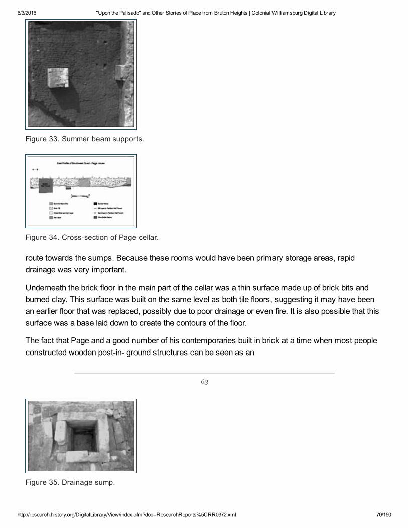
6/3/2016 "Upon the Palisado" and Other Stories of Place from Bruton Heights | Colonial Williamsburg Digital Library
http://research.history.org/DigitalLibrary/View/index.cfm?doc=ResearchReports%5CRR0372.xml 70/150
Figure 33. Summer beam supports.
Figure 34. Crosssection of Page cellar.
route towards the sumps. Because these rooms would have been primary storage areas, rapiddrainage was very important.
Underneath the brick floor in the main part of the cellar was a thin surface made up of brick bits andburned clay. This surface was built on the same level as both tile floors, suggesting it may have beenan earlier floor that was replaced, possibly due to poor drainage or even fire. It is also possible that thissurface was a base laid down to create the contours of the floor.
The fact that Page and a good number of his contemporaries built in brick at a time when most peopleconstructed wooden postin ground structures can be seen as an
63
Figure 35. Drainage sump.

6/3/2016 "Upon the Palisado" and Other Stories of Place from Bruton Heights | Colonial Williamsburg Digital Library
http://research.history.org/DigitalLibrary/View/index.cfm?doc=ResearchReports%5CRR0372.xml 71/150
attempt to change Virginia from a fragile foothold to a settlement that mirrored English society as muchas possible (Billings 1975; Pickett 1996). The increase of brick buildings in England during theseventeenth century was prompted by the lack of timber, new fire laws, and the fashionable nature ofbrick. In Virginia the situation was quite different. The lack of stone, the abundance of wood, and themonetary commitment of tobacco all meant that most colonists did not have the need or capital to buildmore substantial brick homes. It is also possible that men arriving in Virginia in the seventeenth centuryrecognized that they might not live for many years. Impermanent, earthfast dwellings might have beena reflection of the new colonists' belief that their life expectancy in Virginia was short and that legaciesto children were uncertain due to vagaries of remarriage. Postinground structures were still thedominant form of housing in seventeenthcentury Virginia and were used by the upper classes untilthey felt a need to separate themselves from the rest of society. Although brick construction was morecommon in Middle Plantation, the unique and elaborate character of Page's house was an exception inthe harsh and sometimes dangerous world of seventeenthcentury Virginia. The uncertainty of life andthe unstable environment that was reflected in housing was being defied by men like Page who, byintroducing brick structures into their landscape, wanted to recreate a more familiar and stable world.
John Page's Heart Cartouche: An Interpretation
The cartouche found in 1995 displays in raised, carved forms the initials P and A, the date 1662, and aheart. The interpretation of the initials and date is simple: the date indicates the year Page constructedthe house; the P stands for Page and the A stands for Alice, the name of Page's wife. (The initial forPage's first name was never found.) It is likely that the heart is a religious icon representing Page'spiety.
Today the heart symbol carries connotations of romantic love. During John Page's century, however,the heart had a very different meaning. As early as the Middle Ages, the heart motif representedreligious devotion. In European art and architecture, the image frequently was used as a decorativemotif in cathedrals or a symbolic representation in painting for divine love. Martin Luther and JohnCalvin both used hearts in their personal seals. In its broadest connotation the heart representedcentricity, since the heart was considered the center of the human body. This centricity was likened toGod's love for man. Moreover, the heart was considered the center of human reasoning and emotion(Schaffner and Klein 1984:810; ApostolosCappadona 1994:156; Chevalier and Gheerbrant 1969:479).
The heart on the Page cartouche was likely a religious symbol attesting to Page's own piety and

6/3/2016 "Upon the Palisado" and Other Stories of Place from Bruton Heights | Colonial Williamsburg Digital Library
http://research.history.org/DigitalLibrary/View/index.cfm?doc=ResearchReports%5CRR0372.xml 72/150
perhaps to his concept of what it meant to be a colonist in seventeenthcentury Virginia. Like mostindividuals of the seventeenth century, Page was a devout man, even as he also hoped to reap thematerial rewards that his plantations in Virginia might bring him. Just as the New England Puritansbrought religious expectations with them to North America, so too did the Virginia settlers. Differencesin theology and in experiences in England and the colonies certainly shaped the direction of regionalreligious beliefs, but as Darrett Rutman argues, Virginians no less than their Puritan neighbors wouldhave sought some way to "bridge the transcendent," to organize their world around the idea thatsomething lay beyond the material confines of their present (Rutman 1978).
Evidence of Page's religious sentiment is abundant. Page served as a member of the vestry for hisparish. He was a driving force in the building of the first brick church at Bruton Parish, which was builtclose to Page's Middle Plantation home on land that formerly belonged to him. A 1678 document in theYork County records refers to Page as a minister, but he was primarily a planter, merchant, andentrepreneur (YCR, DOW 6:4). Even in his will, he displayed pious concerns. While seventeenthcentury wills routinely included introductory religious remarks, Page's comments seem more thanmerely formulaic:
I surrender my soule into ye hands of God, my Creator, considering that my body beingraised from nothing to what itt is now, is a mutation noe lesse than infinite; steadfastlybelieving after this mortall life ended, that by ye Divine power of God & merrit of my Saviour,Jesus Christ, ye resurrection of my body and everlasting life, my body I remitt to ye Earth, tobe decently buryed, with Christian buriall according to ye reights & ceremonies of ye Churchof England,"(YCR, 9:103104).
Nowhere is John Page's religious devotion more clearly laid out than in the Deed of Gift, a 1687 tractthat was seemingly written by Page as a spiritual and secular guide for his younger son Matthew. Thetract, an elaborate discussion of piety and salvation, was published in 1856 by Bishop William Meadeafter having been passed around by various Page descendants since the end of the Revolutionary War.The eighteenthcentury history of the document was recounted by Matthew Page's great grandson,Governor John Page of Rosewell, in a letter printed at the front of the published volume. According tothe governor, the original manuscript (along with another written by the first John Page) was given byhis father to President William Stith of the College of William and Mary. After Stith's death it fell into thehands of Commissary Robert Dawson. Page wrote: "I saw them in his library in 1757, and knew themto be the books I had seen in my father's closet; and which I knew he had given to Mr. Stith to bepublished, should he think proper." After Dawson's death these two manuscripts disappeared for nearlytwenty years. In 1776, they were brought to the Governor by a Mrs. Hay on behalf of her brother,Matthew Davenport. Mrs. Hay told the Governor that the manuscript had been found in the Geddy shopin Williamsburg. By the 1850s, Bishop Meade was in possession of the manuscript and he arranged tohave it published in 1856 (Meade 1856).
After its publication, the manuscript once more was lost. Richard Channing Moore Page in hisgenealogy of the Page family expressed his certainty that the document was returned by the

6/3/2016 "Upon the Palisado" and Other Stories of Place from Bruton Heights | Colonial Williamsburg Digital Library
http://research.history.org/DigitalLibrary/View/index.cfm?doc=ResearchReports%5CRR0372.xml 73/150
Philadelphia publisher to the Page family, but he could give no definitive location for the manuscript. "Itis highly probable," he wrote in 1893, "that the original MS. is now in possession of the family of Capt.Thomas Jefferson Page, U.S.N., now residing in Florence, Italy." The Department of ArchaeologicalResearch inquired repeatedly about the fate of the manuscript without results.
The problem with the document's questionable provenance is amplified by the tone of the publishedDeed of Gift. The writing in the document contrasts sharply with Page's tone and syntax in his will.Without confirmation of the existence of the original Deed of Gift, the document must be treated withsome skepticism. It is possible that the document that Bishop Meade published was not as old as itwas purported to be or that it was heavily edited before its publication. Despite the problems with itsorigins and its tone, the document bears one passage that is well worth considering in light of thearchaeological investigations.
The Deed of Gift is a long tract on the subject of salvation. In it the author discusses the role of theheart in the secular and religious life of man. "All the faculties of man follow the heart, as servants themistress" So the heart leads, directs, moves the parts of the body and powers of the soul "and themouth speaketh, hand worketh, eye looketh"(Meade 1856:40) . Page brings together both the notion ofthe heart as symbol of centricity in its broadest sense and the idea of the heart as a core religioussymbol. God placed the heart "in the midst of the body, as a general in the midst of his army"(Meade1856: 40) . He also wrote that if "your body be the temple of God, sure your heart is the holy of holies"(Meade 1856: 39) .
The religious imagery of Page's writing is clear. The heart is the center of God's relationship with man.But as an image of centricity, the image of the heart on Page's house speaks to his concepts of what itmeant to live in Virginia in 1662. The heart that adorned the front of that house almost certainlyrepresented the Middle Plantation structure as the physical center of Page's world. That seventeenthcentury Virginians would have considered the heart a symbol of centricity is evidenced by the languagein the 1676 petition by York County residents to move the capital of Virginia to from Jamestown toMiddle Plantation. They justified their request by describing Middle Plantation as the "very Heart andCenter of the Country"(quoted in Goodwin 1940) .
At a time when mortality was high, when families were constantly being broken up by the death ofparents and children, and when men put their capital into the shortterm goals of profits from tobacco,the house with the heart at Middle Plantation suggest a more permanent conception about life inVirginia. Page evidently meant to stay in Virginia and prosper, to make Virginia the center of his worldrather than an extension of it. Page constructed a brick house at a time when most men built far lesspermanent buildings. His house, no doubt built at considerable expense, was not the home of anindividual overwhelmed by the uncertainty of life in the harsh climate of Virginia. In his religiousconvictions and his architecture, Page belies the traditional picture of seventeenthcentury Virginia andsuggests a commitment to and investment in Virginia that historians have traditionally seen asoccurring nearly a quarter of century after Page built his house at Middle Plantation (Morgan 1976;Carson et al. 1977).

6/3/2016 "Upon the Palisado" and Other Stories of Place from Bruton Heights | Colonial Williamsburg Digital Library
http://research.history.org/DigitalLibrary/View/index.cfm?doc=ResearchReports%5CRR0372.xml 74/150
The Outbuilding
While the manor house may have been the focal point of the plantation, it was but part of a greaterwhole. The home existed as the center of a larger domestic landscape that served as a workingenvironment adapted to the particular needs of the household (Miller 1994:66). The domestic landscapethat evolved in the Chesapeake frequently included outbuildings or dependencies to the main structure.Domestic outbuildings found on seventeenthcentury plantations in the Chesapeake include servants'quarters, kitchens, and dairies/butteries (Keeler 1978:79). Other outbuildings include barns,malthouses, stables, and animal shelters. Beginning in the seventeenth century, the increase in thenumber of outbuildings on plantations reflected greater functional specialization (Linebaugh 1995). Inmany respects, the segmentation in architecture and landscape during the late seventeenth centuryreflected the increased segmentation within Virginia society at large.
Given the evidence for growing diversification on the Page plantation, a number of structures wereprobably built to fulfill a variety of functions (Fig. 36). At least seven structures are historicallydocumented. While most of these are referred to generically as old houses, a term that could meananything from a storehouse to a dwelling house, the reference to the destruction of a bread oven in1705 indicates that some of these were built to perform specific functions (Journal of the House ofBurgesses n.d., 4: 55,69). The will of Francis Page dated 1692 also lists a "Mault house" and two brickbarns.
64
Figure 36. Page outbuilding.
The remains of a second brick structure were identified approximately fifty feet northwest of the Pagehouse at Bruton Heights (Fig. 37). The building was discovered in June 1995 by construction workerstrenching along the foundation of the southeastern wing of the extant school building. Shortly thereafter,the entire western end of the building was discovered beneath the floor of an adjacent wing of theschool building. The alley between these wings was mechanically stripped in December 1995 toexpose all but the eastern wall of the structure. The evidence revealed during this investigation showsthat John Page lavished the same attention to architectural detail on support structures as he had onhis manor house.

6/3/2016 "Upon the Palisado" and Other Stories of Place from Bruton Heights | Colonial Williamsburg Digital Library
http://research.history.org/DigitalLibrary/View/index.cfm?doc=ResearchReports%5CRR0372.xml 75/150
Figure 37. Mapping of the kitchen/quarter.
The outbuilding (Fig. 38) was large by seventeenthcentury standards, measuring approximately 50feet long (east/west) by 30 feet (north/south). Excavation uncovered brick foundations that were 1½bricks wide. Unlike the main house, this building lacked a cellar. Instead, the builder dug trenchesaveraging one foot in depth to lay secure foundations for the structure. The excavation of
65
Figure 38. Overview of kitchen/quarter. The foundation walls run diagonallyleft to right; the light stain running top to bottom is a modern concretefoundation.
these trenches revealed that the foundation, executed in English bond, extended at least four coursesbeneath the ground surface. Given the width and the depth of the foundations, the structure may havestood oneandahalf stories. Water table brick, used roofing tiles, and window leads recovered from atrashpit on the northern side of the building indicate that, like the manor house, this building was builtentirely of brick, had casement windows, and possessed a tile roof.
A total of one hundred sixtysix artifacts were recovered during the excavation of the builder's trenches.Not surprisingly, over half (58.6%) of this material was architectural in nature. Nails were most

6/3/2016 "Upon the Palisado" and Other Stories of Place from Bruton Heights | Colonial Williamsburg Digital Library
http://research.history.org/DigitalLibrary/View/index.cfm?doc=ResearchReports%5CRR0372.xml 76/150
abundant with 52 fragments, followed by window glass, unused roofing tile, and unused brick.Undoubtedly this material represents construction waste. Four pieces of slag, a fragment of charcoal,and two iron pieces might also relate to the construction of this building.
Domestic artifacts were also recovered from the builder's trenches. These artifacts included a piece ofbottle glass and a ceramic fragment as well as 24 pieces of animal bone, 14 tobacco pipe fragments,and a piece of flint. The presence of this much material in the builder's trench indicates that the buildingwas constructed after the site had been occupied for a while. In other words, trenches for thefoundations were dug through artifact bearing layers, and this material was redeposited when thebuilder's trenches were backfilled. Virtually all of this material was recovered from the southern side ofthe building facing the manor house, which suggests that the house constructed in 1662 preceded thekitchen. Although none of the artifacts retrieved from the builder's trenches was temporally diagnostic,one pipe bowl could be broadly dated to the period between 1650 and 1680 based on stylistic attributes.But if the kiln located two hundred
66
and twentysix feet to the east provided brick and tile for all of the structures at Bruton Heights, then thekitchen must have been constructed no earlier than 1662 and no later than 1670, given the lifespan ofthe kiln.
The remains of an Hshaped hearth were also identified. The placement of the chimney suggests thatthe building was a twobay structure with a lobby entrance. The western room measured 16 feet(east/west) by 18 feet (north/south) while the eastern room was at least 20 feet (east/west) by 18 feet(north/south). Oddly, the offset position of the chimney indicates that the lobby entrance was on thenorthern side of the building away from the manor house. It is possible that this entrance opened into aworking yard hidden from the view of the main house. Moreover, this configuration might also indicatethat the area immediately behind the house was a more formal space.
Little of the hearth remained due to the robbing of brick and subsequent impact through grading andtrenching associated with the construction of the school. Despite this, the excavation revealed severalimportant clues about the hearth's construction. A shallow builder's trench measuring approximately 2feet across and 2 inches deep was dug and bricks were laid on a thin layer of shell mortar to provide afooting for the hearth. Enough brick remained within the trench to determine that two courses formedthe back (northeast/southwest) wall. An arm of fragmentary brick extended over 3 feet to the east fromthe southern end of the hearth wall. Like the back wall, the southern arm consisted primarily of brokenbits of brick and chunks of mortar, which suggested that the usable bricks had been robbed from thehearth following the demise of the structure. The remaining brick was still contained within a builder'strench measuring 1½ feet wide and less than 1 inch deep. A modern utility trench extending through thekitchen virtually obliterated the entire northern arm to the hearth. Enough of it remained however todetermine that two courses of brick had survived in this area, evidence that an extra course of brickwas needed to fill in a low spot and level the hearth.

6/3/2016 "Upon the Palisado" and Other Stories of Place from Bruton Heights | Colonial Williamsburg Digital Library
http://research.history.org/DigitalLibrary/View/index.cfm?doc=ResearchReports%5CRR0372.xml 77/150
Although no brick was identified on the western side of the hearth, a thin quarterinch spread of shellmortar extending to the west from each end of the back wall suggests that the hearth was originally Hshaped to provide heat to both rooms. Moreover, the clay floor between the linear mortar spreads had adry, flaky texture, suggesting that the soil in this area had been scorched. The clay floor on the easternside of the hearth consisted of a scorched pattern of red, bright orange, and black ashy clays thatextended as much as 1" deep in places. The extensive burning in this area reveals that the hearth wasunpaved and that the fire was built directly upon the clay floor. Likewise, this evidence indicates that thefloors throughout the building were packed clay. Only two wrought iron nails were recovered from thehearthrelated features.
Several clues indicate the specific role that this outbuilding played within the Page plantation. The sizeand layout of the structure suggests that it served as a quarter for servants and/or slaves. Servant'squarters appear in Virginia in greater numbers after 1650. While the warm temperatures and the highhumidity are frequently used to explain the removal of activities such as dairying to separate buildingswithin the Chesapeake homelot, a trend favoring greater privacy and segmentation within society mayexplain why quarters appeared on Virginia plantations by the mid seventeenth century (Neiman 1993;Linebaugh 1995). Moreover, many early outbuildings served as multipurpose buildings that fulfilled avariety of functions. The outbuilding identified at Bruton
67
Heights appears to have served a dual capacity as a workhouse and quarter. While the building waslarge enough to house servants and slaves, artifacts recovered from a trashpit located along thenorthern wall of the building indicates that it also served as a detached kitchen for the main house.While this feature produced the coarsewares and stonewares typically associated with food storageand preparation, more refined tablewares including porcelain and leaded tableglass were alsorecovered.
The Changing Landscape
While the manor house would have been the most visible feature on the Page property, it was but onecomponent of a larger plantation system. The archaeological investigations conducted on the BrutonHeights property between 1989 and 1995 revealed a complex plantation landscape shaped by Pageand his successors between 1662 and 1730. The Page landscape appears to have taken its shape inthe years immediately following the construction of the manor house. Moreover, the evidence suggeststhat this landscape remained dynamic for nearly sixty years. Throughout the second half of theseventeenth century, buildings appeared, fences were moved, and different elements came and went.Despite the fact that much of the Page landscape lies obscured beneath school structures built in the1940s, the various landscape features identified during the investigation shed light into how this earlycolonial plantation functioned as an integrated whole.
Testing revealed that most of the features comprising the Page plantation were arranged along the

6/3/2016 "Upon the Palisado" and Other Stories of Place from Bruton Heights | Colonial Williamsburg Digital Library
http://research.history.org/DigitalLibrary/View/index.cfm?doc=ResearchReports%5CRR0372.xml 78/150
northern side of the manor house, extending the length of the terrace toward the northwest. Thispattern, known as the Lshaped farmstead, became popular in England during the seventeenth century.The Ltype layout developed out of the linear farmstead where the agricultural buildings were lined upbehind the house while a yard was maintained in front. The Lshaped farmstead probably created amore protected farmyard (Harvey 1984:48). The Ltype pattern, in turn, gave way to fully developedcourtyards where parallel ranges of buildings enclosed the farmyard on three or four sides. NigelHarvey argues that the evolution of the English farmyard was motivated by agricultural diversification(Harvey 1984:48). Thus it seems that John Page looked to an English precedent for more than just hisarchitecture.
The archaeological evidence suggests that the Page landscape was initially a linear layout. Shortly afterthe construction of the house in 1662, fences were established on both sides of the house enclosing ayard behind the house. Eight postholes comprising a fence on a northwest/southeast axis wereidentified thirty feet south of the manor house. There was a 6 foot interval between the posts in this lineand each posthole had postmolds averaging 6 inches square. Although only seven nails wererecovered from the four postholes that were excavated, this fenceline is assumed to be early due to thepaucity of artifacts. Three posts that predate the kitchen appear to represent the corresponding fencealong the northern side of the house. The postholes in this line were placed at a 5 foot interval and alonga northwest/southeast axis. Like the postholes of the southern fenceline, the posts of the northern lineproduced few artifacts. A combined total of one bone and nine nails was removed from these features.The western posthole in this line provided the only evidence for a postmold among these features. Thismold measured 6 inches north/south by 4 inches east/west. If extended, this line would pass thirty feetfrom the northern side of the house like the parallel line to the south.
68
Page retained the yard behind the house following the construction of the kitchen in the late 1660s. Theremains of two other fences were also identified within ten feet of the earlier fence that passed along thesouthern side of the house. Due to extensive modern disturbances in this area, only four holes could beassociated with each of these features. Despite this, they reflect the same northwest/ southeastorientation as the house and the other fencelines. Given the close proximity of the three fencelines toone another, they appear to represent a single boundary line that was maintained over an extendedperiod of time. As one fence deteriorated, another was constructed to take its place.
The kitchen was constructed where the fence passed along the northern side of the manor house. Twoof the postholes in the northern line contained more than one fill deposit, which suggests that they werepurposely removed to make way for the outbuilding, with the second filling episode dating to the timethe posts were removed. Like the earlier fence, the kitchen was oriented along a northwest/southeastaxis. The architectural evidence indicates that the dependency opened onto a workyard on the northernside of the building, away from the manor house. The yard was enclosed by a slot fence to the west ofthe door and contained a trashpit. The slot trench extended approximately ten feet northeast of thekitchen and
6/3/2016 "Upon the Palisado" and Other Stories of Place from Bruton Heights | Colonial Williamsburg Digital Library
http://research.history.org/DigitalLibrary/View/index.cfm?doc=ResearchReports%5CRR0372.xml 79/150
69
measured 1 foot wide and 4 inches deep. It contained only a single bone fragment and extendedbeyond the project area to the north. The trashpit located east of the entrance to the outbuildingmeasured at least 15 feet north/south by at least 10 feet east/west but extended beyond the projectarea to the north and under the building to the east. The artifacts recovered from this feature indicatethat it was gradually filled between 1680 and 1715. By placing the entrance and the workyard on thenorthern side of the dependency, John Page may have intended to place work areas out of view inorder to create a more formal courtyard in the enclosed space behind the manor house.
Placing the kitchen along the northern side of the house resulted in an Ltype layout for the plantation.The identification of a borrow pit to the east of the kitchen as well as several fences in the vicinity of thekiln site suggests that the Lshaped layout was maintained over time. A fence was erected to delineateboundaries in the field east of the house after the kiln was demolished. Eighteen holes set at 9 footintervals were identified extending across the field on an axis 10° east of north. The holes averaged 2by 2 feet and 1½ feet deep. Two of the holes had postmolds measuring 4 by 4 inches while five othersshowed evidence of post removal. Artifacts recovered from the fence line generally reflected theproximity of this feature to the earlier kilnrelated features. They consisted primarily of brick, roofing tile,and a paving tile. Very few cultural artifacts were
70
recovered from the postholes. Despite the absence of temporally diagnostic artifacts, this post and railfence has to postdate the kiln because one of its fence holes cuts the abandoned irrigation trench thathad been backfilled after the kiln activity ceased.
A shallow trench extended 90° to the east from the fourth hole on the southern end of the post and railfence. The trench was 48 feet long, 15 inches wide, and 6 inches deep. Although this ditch may haveoriginally been excavated as a drainage ditch, its orientation and direct relationship to the post and railfence suggests that it represents a ditchset or slot fence that was constructed to enclose a smallgarden or other activity area, protecting it from "wind and wildlife"(Patrick 1983:10). This type of fencewas built mainly during the seventeenth century, and examples of slot fences enclosing domestic yardsduring the seventeenth century have been identified at Kingsmill (Kelso 1984), Carter's Grove(Edwards 1994), and at Clifts Plantation (Neiman 1978). William Fitzhugh provides a contemporaryaccount of his property, which in 1686 had:
…a Yeard wherein is most of the aforesaid necessary houses, pallizado'd in with locustPuncheons, which is as good as if it were walled in & more lasting than any of our bricks …
(Fitzhugh, in Patrick 1983:10).
Posts were often added as an extra means of support for the backfilled ditch, although there was noevidence for this at Bruton Heights. An account of an enclosed garden in Maryland dating to 1796

6/3/2016 "Upon the Palisado" and Other Stories of Place from Bruton Heights | Colonial Williamsburg Digital Library
http://research.history.org/DigitalLibrary/View/index.cfm?doc=ResearchReports%5CRR0372.xml 80/150
describes a fence constructed of "197 punches" that appears to have been "supported entirely by therestriction of a backfilled slot"(Patrick 1983:11) .
Shallow ditches extended at right angles from both ends of the trench, indicating that the slot fencecontinued beyond the project area and possibly enclosed a domestic yard to the south. The ditchextension on the western end of fence stretched nearly 8 feet between a panel of the associated postand rail fence. The northern end of the feature abutted a posthole of the post and rail fence. This trenchwas 15 inches deep and filled with orange clay. A postmold discovered at the southern end of thisfeature measured 4 inches square and extended to the bottom of the trench. No artifacts wererecovered from this feature, making it difficult to date. But its orientation with and relationship to the postand rail fence and the slot trench suggests it was related to these structures. This enigmatic trenchmay mark the location of a gate or be evidence of a repair to the fence.
Four substantial postholes were also identified west of the post structure identified near the kiln. Theposts, set at 8 foot intervals, were on the same axis as the northern series of posts in the structure.Despite their large size, the posts probably represent a portion of a fence. The posts measured justover 2 feet on a side and averaged 1½ feet deep, while the base elevations all fell within a 2 inch range.The placement of these posts on the same axis as those comprising the northern wall of the poststructure may indicate that a fence continued up to the corner of this building. Moreover, at least two ofthe posts had been repaired, so this fence had been maintained and repaired over an extended periodof time.
The postholes comprising this fence differed from the earlier features associated with the kiln in thatthey contained a great deal of domestic refuse. Ceramics, bone, tobacco pipes, table glass, and threehundred seventyone pieces of wine bottle suggest that activity southwest of the kiln increaseddramatically between the time the kiln began operation and the time that this fence was erected. Thepredominance of domestic material suggests that this boundary
71
feature postdates the kiln and represents the occupation of the house instead.
Architectural material was also abundant. One hundred ninetynine roofing tiles were recovered fromthe postholes and molds. Roofing tile and brick fragments were even used to shore up the bottom ofposts in two of the holes. Other industrial and architectural debris included slag, nails, nearly twohundred pieces of window glass, and twenty window leads. The concentration of artifacts in thefeatures increased toward the house to the southwest. The large amount of brick, nails, window leadsand glass, and unused roofing tile suggest that the assemblage recovered from the postholes of thisfenceline might be refuse from the construction or renovation of the Page home. Although most of thematerial from the postholes is temporally undiagnostic, window leads marked 1669 indicate that thedebris was deposited during the 1670s. Window leads found in North America typically have a lagtimeof five to seven years. Moreover, the analysis of leads from several sites in St. Mary's City, Maryland,demonstrated that dated leads could often be linked directly to episodes of construction and renovation

6/3/2016 "Upon the Palisado" and Other Stories of Place from Bruton Heights | Colonial Williamsburg Digital Library
http://research.history.org/DigitalLibrary/View/index.cfm?doc=ResearchReports%5CRR0372.xml 81/150
(Hanna 1992, 1993:37). While the window leads recovered from the postholes at the western end of theBruton Heights kiln site were dated 1669, a five to seven year lagtime might actually represent theconstruction, destruction, or renovation of a building sometime between 1674 and 1676. As such, theleads from Bruton Heights could relate to repairs made on the Page plantation following Bacon'sRebellion in 1676. The fact that John Page filed a claim for losses after the rebellion demonstrates thattroops under Nathaniel Bacon plundered the estate of John Page in 1676.
Bacon's Rebellion
John Page's rise to colonywide eminence occurred over a period of several decades. At the time ofBacon's Rebellion Page's status was ambiguous. In many ways he appeared to be among the leadingmen of the colony, yet in the mid1670s, he was not a man in the inner circle of colonial power. Unlikehis Middle Plantation neighbors Thomas Bray and Thomas and Philip Ludwell, Page had not beenelevated to the elite circle of the Green Spring Faction. Instead, in these years, Page is best identifiedas perhaps the most prominent man in York County, a local rather than regional leader.
Despite Page's tenuous hold on colonywide prestige, Nathaniel Bacon clearly regarded him as one ofthe leaders of the colony. In the course of the rebellion Bacon kidnapped several of the "prime menswives" and fled with them to Jamestown. John Page's wife, Alice, was one that Bacon selected for thisquestionable honor. Bacon was "was no sooner arrived at Towne," according to one account:
but by several small partyes of Horse "he fetcheth into his little Leagure, all the prime menswives, whose Husbands were with the Governour," which the next morning he presents to theview of there husbands and ffriends in towne, upon the top of the smalle worke hee had castup in the night, where he caused them to tarey till hee had finished his defence against hisenemies shott, it being the onely place "for those in towne to make a sally at "(Cotton 1676).
As one of the "prime men" of the colony, John Page was also included in Nathaniel Bacon's scathingdenunciation of Berkeley and his councilors. In the "Declaration of the People," Bacon called forBerkeley and his "pernitious Councellors" to surrender themselves to him. Bacon claimed that throughmany specific acts these men had sought only to enrich themselves while letting the rest of Virginiasuffer without adequate towns, promotion of trade, and protection from the Indians (Bacon 1676).
At first, John Page was one of the men in Middle Plantation who signed an oath supporting Bacon. InAugust 1676, along with many other militia heads of the counties and gentlemen planters, Page agreedto support Bacon should Berkeley send troops against him. The colonial leaders joined Bacon becausethey feared that the colony was disintegrating into civil war, a condition which Berkeley seemed unableto prevent. Page
and his countrymen felt it better to join Bacon than be at the mercy of the displaced rabble who madeup his chief supporters (Morgan 1975:26667). At the end of Bacon's Rebellion, Page attached his

6/3/2016 "Upon the Palisado" and Other Stories of Place from Bruton Heights | Colonial Williamsburg Digital Library
http://research.history.org/DigitalLibrary/View/index.cfm?doc=ResearchReports%5CRR0372.xml 82/150
name to another petition, this one a humble supplication for pardon from the governor who hadultimately prevailed. "To the Rt honble Sr William Berkeley Knt Governor & Capt Genrall of Virginia," thepetition began:
Wee who lately were reputed his Maties Justices for Yorke County doe humbly conceive thatit may not be allowable in us to act as justices either in Court of County untill such time as yorHonor shall indempnifie us or any of us by name for administering the oath Nathaniell BaconJunior imposed on the people humbly referring to yor Honor to declare who shall be justices ofthe peace for the sd County Feb the 17th 1676/7 (YCR, DOW 6: 9).
Berkeley gave his pardon to Page and most of the others; Page's career seemed little affected by hisactions during the rebellion. His willingness to sign Bacon's oath in the summer of 1676 did not preventhim from suffering at the hands of the rebels, however. In a list of "worthy persons" who were injuredduring the rebellion, John Page was deemed a "Great Looser" in his estate (C.O. 5/1371, ff. 17178).
In the final decades of the seventeenth century, John Page and his son became increasingly importantin the affairs of the colony. With his appointment to the Council in 1680, John Page moved beyondregional leadership into the upper echelons of colonial government. From 1680 to his death in 1692,Page was among the few most powerful political figures in Virginia. Francis Page also began to take aprominent role in colonial leadership. As the eldest son of a wellborn elite Virginian, the younger Pagefound the route to local and later regional leadership to be open and easy. As his father had, he rose toprominence first within his own county. In 1680, just two years after reaching legal age, he became ajustice for York County. During the following decade he served as sheriff for York County, as achurchwarden of Bruton Parish, and as the county coroner (YCR, DOW 6: 207, 209, 394, 409; McCabe1856). His rise to regional eminence, however, began with his appointment by Governor Effingham tothe position of Clerk of the House of Burgesses in 1688 (Palmer 1875: 20).
The Page Artifacts
Virtually all of the artifacts dating to the Page period of occupation (16621693) were recovered from aborrow pit located thirty feet north of the house, from the trashpit located along the northern wall of thedependency, and from a redeposited midden layer found in a ravine just north of the house. While theborrow pit and the trashpit both saw continuous use throughout the last quarter of the seventeenthcentury and into the eighteenth century, the artifacts recovered from the borrow pit appear to reflect thethird and fourth quarters of the seventeenth century while the artifacts recovered from the trashpit spanonly the fourth quarter of the seventeenth century.
The borrow pit appears to have provided clay for the manufacture of brick and tile during the early1660s. It remained open following the completion of brick and tile making and was gradually filled inover the next forty years or so. Construction activities associated with the conversion of the school intoan educational campus made it impossible to expose the feature entirely. Instead, two areas weresampled. The major excavation centered in an area scheduled to be impacted by school constructionactivities. Excavation of the feature in this area revealed several distinct layers within the pit extending

6/3/2016 "Upon the Palisado" and Other Stories of Place from Bruton Heights | Colonial Williamsburg Digital Library
http://research.history.org/DigitalLibrary/View/index.cfm?doc=ResearchReports%5CRR0372.xml 83/150
to a depth of nearly 4 feet. The uppermost surviving layer was characterized by charcoal and ash.
The earliest context identified within the feature is a silt layer covering the bottom of the pit. Threehundred eight artifacts were recovered from this layer. Bone was the most abundant artifact type (60%)with one hundred sixtyeight pieces of faunal bone and eighteen shell fragments. Kitchenrelatedmaterial represented nineteen percent of the
72
material recovered from this layer with fiftyseven artifacts. They included Portuguese tinenameledware (9 fragments), coarse earthenware (8), clear and colored table glass (4), wine bottle fragments(4), and case bottle fragments (32). Architectural artifacts were also recovered, included two pieces ofroofing tile and one paving tile. Other artifacts of interest include a copperalloy book plate, a woodentoy quoit, a mortising ax, and a polling ax. The high percentage of early artifact types such asPortuguese tinenameled ware and case bottle glass suggests that this is the among the earliest Pageperiod contexts identified at Bruton Heights dating either to the operation of the kiln or to the earlyoccupation of the house.
The upper, more recent layer is ash and charcoal containing over two thousand artifacts. The materialin this layer dates to the fourth quarter of the seventeenth century; several of the recovered itemsindicate that this layer represents destruction debris dating to the time of Bacon's Rebellion. Faunalartifacts account for over half of the material recovered from this layer with one thousand twenty piecesof bone, fiftyseven shell fragments, and two egg shells. Architectural debris was also well represented(657 pieces) with window leads (12), window glass (217), roofing tile (125), and wrought iron nails (284)found in this layer. Ninetyfive kitchenrelated artifacts were found, including seventysix pieces ofceramic and nineteen fragments of glass. Locally manufactured earthenware from the Challis site (14)and Venetian glassware (5) were among the more unusual kitchenrelated items. Three copperalloyupholstery tacks probably came from furnishings on the Page site, while a linen
74
smoother, sixtyone barrel hoops fragments, and an ax may have been used in the daily activities onthe plantation.
Although most of the artifacts recovered from the upper layer of the borrow pit relate to the domestic lifeof a colonial plantation, several items could represent military activity that could be associated withBacon's Rebellion or with the quartering of British troops in Middle Plantation shortly thereafter. Armsrelated items recovered from this layer consist of a musket flint, a pistol flint, and a snaphaunce gunlock. A hand grenade was also identified within this context, as was a spur.
One of the most interesting finds was a complete shaftandglobe wine bottle found near the bottom ofthe pit (Fig. 39). This 1650s bottle contained a seal bearing the name R. Billingsley, a Tudor rose, and afiveturreted castle. The seal may have belonged to Richard Billingsley, a tavern owner in Oxford,

6/3/2016 "Upon the Palisado" and Other Stories of Place from Bruton Heights | Colonial Williamsburg Digital Library
http://research.history.org/DigitalLibrary/View/index.cfm?doc=ResearchReports%5CRR0372.xml 84/150
England. Billingsley's tavern opened around 1640 (Drumbrell 1983:237).
Figure 39. Billingsley bottle.
The trashpit located on the northern side of the outbuilding provided a material record of the later phaseof occupation during the Page period. This phase probably began sometime around 1680 and continueduntil about 1715. The feature measured approximately 15' north/south by 10' east/west. A layer of brickand tile rubble covered the top of the feature. While this material could relate to the destruction of theoutbuilding, it is more likely that it represents an effort to pave over the depression created by thetrashpit after it fell out of use. Excavation revealed the pit to be a shallow bowl that extended to a depthof 4 feet. No layers were distinguished in the dark organic loam. Instead, pockets soil of varying colorsand textures observed throughout the feature indicated that small amounts of material were dumped inperiodically, filling the pit over a long period of time.
A total of two thousand eight hundred eightyfive artifacts were recovered from the trashpit representingninetyfive percent of
75
the material recovered during the excavation of the Page outbuilding. Moreover, the fact that eightythree percent of the material (2406) found in this feature relates to foodways underscores the role ofthis structure as a detached kitchen. This assemblage includes a total of nine hundred ninetyseven(34.5%) kitchenrelated artifacts and one thousand four hundred nine (48.8%) pieces of faunal material.Wine bottle glass was the most abundant kitchenrelated artifact (541 fragments), followed by ceramics(331). The ceramics included two hundred thirteen pieces of delft and ten pieces of porcelainrepresenting sixtysix percent of the recovered ceramics. Stonewares included eleven pieces ofFulham stoneware and a small white saltglazed cup. Over thirty percent of the ceramics werecoarsewares, including Iberian (29), Red Sandy ware (60), and colonoware (10). Less than 1% of thecoarsewares could not be identified according to type. Unlike the Page house site, the assemblagerecovered from the trashpit did not contain any ceramics produced in Yorktown. The absence of thisware type suggests that the kitchen fell out of use or was destroyed prior to 1725.
Surprisingly, one hundred six fragments of leaded table glass were also recovered from the trashpit.The most notable pieces of table glass include three wine glass stems and the graceful handle of acolorless leaded pitcher or ewer. The wine glass stems include a doubleknopped stem dating to thelate seventeenth century, a baluster stem dating between 1680 and 1690, as well as a Silesian stem

6/3/2016 "Upon the Palisado" and Other Stories of Place from Bruton Heights | Colonial Williamsburg Digital Library
http://research.history.org/DigitalLibrary/View/index.cfm?doc=ResearchReports%5CRR0372.xml 85/150
with an elongated teardrop dating to circa 1715. Twentyone pharmaceutical bottle fragments were alsorecovered.
Architectural debris represented the second most common artifact type. Two hundred ninetynine nailsand one spike were recovered, while ninetyone pieces of used roofing tile were found. Eight pieces ofslate and seven pieces of shell mortar were also found. The presence of thirtynine pieces of windowglass indicates that finished windows were fitted on the outbuilding. Three window lead fragments areincluded in this assemblage. One of these is marked .EC.WM., part of the complete mark of.EC.WM.1669. observed on other leads excavated from Bruton Heights.
Fiftythree tobacco pipes were recovered. Fortyone of the tobacco pipes were imported, while onlytwelve were domestically produced. Only two of the pipes were marked or decorated. The bowl of animported tobacco pipe was recovered bearing the heel marks of a B and a Tudor rose. The maker hasnot yet been identified. A complete decorated domestic pipe bowl was also recovered from the trashpit.It exhibited a sunburst design on the front of the bowl and a stylized tobacco plant design on the back,and has a rouletted stem.
A copper alloy pin was the only personal or clothing item recovered from the feature. Armsrelated andfurniture items were equally sparse. Armsrelated artifacts included two pieces of flint and one leadshot. Furniture included a mirror fragment and the copperalloy lid to a fuming pot, a container forsimmering potpourri. Other items related to crafts and activities that would have been conducted in andaround the dependency. Among these were charcoal (18), coal (5), and slag (4). Tools and equipmentincluded a copperalloy harness boss, a tire nail, a hoop, and an ax. Three flowerpot fragments werealso found.
The Page Vessels
Usually time and money constraints force archaeologists to analyze assemblages using only theindividual sherds found on a particular site. The limited nature of this level of analysis precludesdetermining the form and therefore the function of most pottery found on a site. Most sherds are simplytoo small to accurately determine their former vessel type. Occasionally an assemblage warrants amore complex and interesting analysis. This analysis, called a minimum vessel count, begins withputting the broken vessels back together. If enough pieces of an individual vessel can be put backtogether, its former form and function can be determined, resulting in a much richer analysis. The Pagematerial warranted this extra attention. Artifacts from the ravine, the borrow pit, and the kitchen trashpitwere combined to create a minimum vessel count.
At least 92 ceramic and table glass vessels were found. The vessels were used for a variety offunctions, most relating to food preparation, storage, presentation, and consumption. Nonfood relatedactivities that involved ceramics or glass included vessels used to prepare medicines or to removehuman waste from the dwelling. Analysis of the Page vessels revealed both expected and unexpectedresults. The large numbers of tearelated and foodpresentation vessels were not a surprise. A man ofPage's station would be expected to employ fine ceramics and table glass at his table. Page's
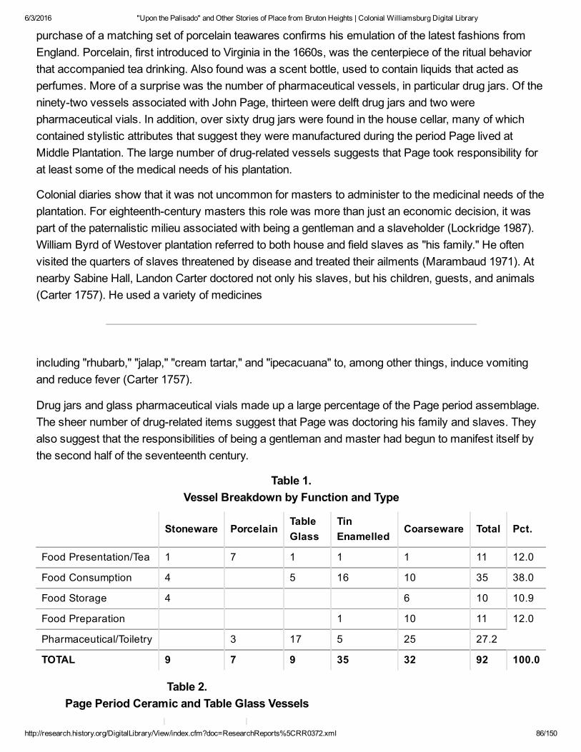
6/3/2016 "Upon the Palisado" and Other Stories of Place from Bruton Heights | Colonial Williamsburg Digital Library
http://research.history.org/DigitalLibrary/View/index.cfm?doc=ResearchReports%5CRR0372.xml 86/150
purchase of a matching set of porcelain teawares confirms his emulation of the latest fashions fromEngland. Porcelain, first introduced to Virginia in the 1660s, was the centerpiece of the ritual behaviorthat accompanied tea drinking. Also found was a scent bottle, used to contain liquids that acted asperfumes. More of a surprise was the number of pharmaceutical vessels, in particular drug jars. Of theninetytwo vessels associated with John Page, thirteen were delft drug jars and two werepharmaceutical vials. In addition, over sixty drug jars were found in the house cellar, many of whichcontained stylistic attributes that suggest they were manufactured during the period Page lived atMiddle Plantation. The large number of drugrelated vessels suggests that Page took responsibility forat least some of the medical needs of his plantation.
Colonial diaries show that it was not uncommon for masters to administer to the medicinal needs of theplantation. For eighteenthcentury masters this role was more than just an economic decision, it waspart of the paternalistic milieu associated with being a gentleman and a slaveholder (Lockridge 1987).William Byrd of Westover plantation referred to both house and field slaves as "his family." He oftenvisited the quarters of slaves threatened by disease and treated their ailments (Marambaud 1971). Atnearby Sabine Hall, Landon Carter doctored not only his slaves, but his children, guests, and animals(Carter 1757). He used a variety of medicines
including "rhubarb," "jalap," "cream tartar," and "ipecacuana" to, among other things, induce vomitingand reduce fever (Carter 1757).
Drug jars and glass pharmaceutical vials made up a large percentage of the Page period assemblage.The sheer number of drugrelated items suggest that Page was doctoring his family and slaves. Theyalso suggest that the responsibilities of being a gentleman and master had begun to manifest itself bythe second half of the seventeenth century.
Table 1. Vessel Breakdown by Function and Type
Stoneware PorcelainTableGlass
TinEnamelled
Coarseware Total Pct.
Food Presentation/Tea 1 7 1 1 1 11 12.0
Food Consumption 4 5 16 10 35 38.0
Food Storage 4 6 10 10.9
Food Preparation 1 10 11 12.0
Pharmaceutical/Toiletry 3 17 5 25 27.2
TOTAL 9 7 9 35 32 92 100.0
Table 2. Page Period Ceramic and Table Glass Vessels

6/3/2016 "Upon the Palisado" and Other Stories of Place from Bruton Heights | Colonial Williamsburg Digital Library
http://research.history.org/DigitalLibrary/View/index.cfm?doc=ResearchReports%5CRR0372.xml 87/150
Coarsewares Majolica English Delft
Cup Plate (2) Drug jar (12)
Tankard Drug jar Chamber pot (4)
Pipkin Plate (7)
Bowl (4) Colonoware Porringer
Storage jar Bowl (9) Baker
Milk pan (14) Hollow Form Bowl (4)
Hollow form (3) Twiffler
Flowerpot (2) Stoneware Punch bowl
Jug Porcelain
Table Glass Bottle Saucer
Stemmed glass (4) Tankard (2) Cup (3)
Pitcher handle Mug (2) Punch bowl (2)
Pharmaceutical phial (2) Storage jar (2) Tea bowl
Scent bottle
Artifacts and Status: The Ravine Assemblage
The artifacts from Bruton Heights reflect the daily lives of John Page, his family, and his servants. Aone percent sample of the ravine located northeast of the school building
76
produced over three thousand five hundred artifacts related to the Page period of occupation. Theartifacts were deposited when the ravine was filled during the construction of the school in 1940. Thereis no question that this material came from the Page site. Window leads from the redeposited artifactassemblage match those recovered from the kiln site, the kitchen, and the dwelling. Likewise, analysisof roofing tiles from the secondary deposit show that they were produced in the kiln two hundred feet tothe east. Two crossmends between the ravine and the kitchen site indicates that the material in theravine originated primarily from the kitchen one hundred thirtytwo feet to the southeast.
Clearly, this outbuilding was seriously impacted during the construction of the school, and the fillremoved from the site was used
77
to fill the adjacent ravine. Despite the fact that these artifacts were removed from their original context,

6/3/2016 "Upon the Palisado" and Other Stories of Place from Bruton Heights | Colonial Williamsburg Digital Library
http://research.history.org/DigitalLibrary/View/index.cfm?doc=ResearchReports%5CRR0372.xml 88/150
they still provide an invaluable material record of activities on the Page property. The artifacts shed lighton such things as foodways, daily life, recreation, and the expression of wealth and status.
Most of the artifacts found in the ravine are architectural in nature. This is partly due to the fact thatwhen the site was disturbed by the construction of the school, the architectural features that wouldnormally remain in situ, such as brick walls, were dislodged and redeposited along with the otherartifacts. The high percentage of architectural material may also be attributed to Page's passion forbrick. Nearly two thousand three hundred (65%) artifacts were architecturally related. This includessome of the more common artifacts such as nails (892 fragments), brick, mortar, and window glass(575). Recovered roofing tile (678) and paving tile (8) indicate that the Page kitchen was just assubstantially constructed as the manor house. Hinges and boxlock parts were also recovered. Fortyone window leads bearing the mark 8EC816698WM8 were found confirming that Page installedimported casement windows. Two fragments of plaster were discovered, including one that still showedevidence of an applied whitewash.
Artifacts also reflect the details of life. For example, three upholstery tacks suggests something aboutthe furniture present on the Page site. Two of these tacks were copper alloy, which was typical for theperiod. The third was iron, however which indicates that the piece of furniture that it adorned may havebeen repaired or domestically produced. Two mirror fragments show that Page indulged in luxuryitems, while an iron buckle is a typical clothing item for the period. Two pieces of flint and eightfragments of casting lead waste are thought to be associated with weapons. Finally, a hoe discoveredin the secondary fill may have been used
78
in the garden or to till tobacco. The hoe is stamped with an "NV" representing, perhaps, the maker'smark or that of the merchant who imported the item and sold it in Virginia (Egloff 1980). Unfortunately,the identity of "NV" remains a mystery.
Tobacco pipes are found on nearly every colonial site. Two hundred and four tobacco pipe fragmentswere included in the secondary deposit. Twentyone of these were domestically produced. The pipesrange from deep red to light buff in color reflecting the local clay from which they were produced. Pipewasters discovered at Flowerdew Hundred add credence to the theory that domestic pipes were locallymanufactured (Deetz 1993:6970). Based upon their resemblance to English pipe forms, manydomestic pipes appear to have been formed in a mold, while others appear to have been hand formedand decorated according to other influences. The domestically produced tobacco pipe phenomenonappears during the 1640s and disappears in the first quarter of the eighteenth century. They are foundthroughout the Chesapeake east of the Fall Line (Deetz 1993:9192). Unfortunately, the bores of locallymanufactured pipes do not reflect the gradual and steady decrease in diameter found in imported pipesover time and thus
79

6/3/2016 "Upon the Palisado" and Other Stories of Place from Bruton Heights | Colonial Williamsburg Digital Library
http://research.history.org/DigitalLibrary/View/index.cfm?doc=ResearchReports%5CRR0372.xml 89/150
cannot be used to date sites. Domestic pipes are often elaborately decorated with inscribed, stamped,stippled, and rouletted designs. The archaeological evidence suggests that once applied, the designswere filled with clay, chalk, or lime to make them stand out against the earthen body of the pipe.Several decorated domestic pipes were found. One bowl fragment appears to mirror a contemporaryEnglish form and displays a rouletted rim over stamped dots. Another bowl fragment that appears lessEnglish in form shows evidence of hand stippled rows and bands. A rouletted and crosshatched stemfragment is a design that is found throughout the region, which suggests local exchange. A large,single, intact bowl was also recovered from the ravine. It was burnished to give it a dull shine, and threerings were inscribed around the opening. Elaborate chevronlike designs suggesting a stylized tobaccoleaf had also been etched down the front and back of the bowl. The bowl was packed with a mix ofwhat appeared to ash and tobacco, an example of the excellent preservation within the ravine despiteredeposition. Domestically produced tobacco pipes account for only ten percent of the
tobacco pipes found at Bruton Heights. The remaining ninety percent were imported.
Only one of the imported bowls recovered from the ravine was marked in any way. It was stamped withan "RT" on the front of the bowl. The mark is attributed to Robert Tippet II of Bristol, who produced pipesfrom 1678 until his death in 1713 (Hurry and Keeler 1991:52, 55; Walker 1977:14931494).
Six hundred and ninetyseven (32%) kitchenrelated artifacts were found in the secondary deposit,including two hundred seventytwo ceramic fragments. The assemblage contained wares that weretypical for the period. Coarsewares (62) were used for food preparation and storage. German andEnglish stonewares (26) were used in table ware such as mugs and tankards as well as for utilitarianpieces such as jars and crocks.
Eight pieces of colonoware were recovered. Colonoware, a locally manufactured ceramic type that wasoriginally attributed to Native American makers (Noìl Hume 1962), has a shelltempered clay andburnished body resembling Woodlandperiod pottery. The presence of colonoware,
81
however, appears to correlate with the presence of slavery in the Chesapeake during the seventeenthand eighteenth centuries. Many scholars now believe that it was primarily made and used by enslavedAfrican Americans (Deetz 1993). The appearance of colonoware after 1650 and continuing into thefourth quarter of the eighteenth century also corresponds to the growing separation of master and slavehouseholds.
The Page assemblage recovered from the ravine produced fine ceramics that would have beendisplayed in the home and placed on more fashionable tables. This includes ten fragments of slipware,most of them adorned with combed or feathered decorations. Ceramics of this type were found in thehomes of all social levels throughout the Chesapeake.

6/3/2016 "Upon the Palisado" and Other Stories of Place from Bruton Heights | Colonial Williamsburg Digital Library
http://research.history.org/DigitalLibrary/View/index.cfm?doc=ResearchReports%5CRR0372.xml 90/150
The two hundred eighteen fragments of delftware account for the greatest percentage of the ceramictypes represented in the secondary deposit. Blue and white delftware, known as Holland China, wasproduced in Holland and England as a cheaper alternative to the Chinese porcelain that was available inlimited quantities throughout much of the seventeenth and eighteenth centuries (Noìl Hume 1982:105107). Despite being an alternative for porcelain, it was popular with consumers of higher ranks. Itappears that John Page chose to spend his money on expensive porcelain as well. Sixteen fragmentsof underglaze blue porcelain were identified among the artifacts.
John Page and his family used a great deal of glassware and glass was the most common kitchenrelated artifact type recovered with nine hundred fiftythree fragments. Some ninety seven percent ofthe recovered glassware represents storage containers including eight hundred nineteen wine bottlefragments and eightyfour case bottle fragments. Case bottles are commonly found on seventeenthcentury sites, but they were quickly replaced by squat wine bottles
82
that appeared at midcentury (Noìl Hume 1982 :62,69).
Two unique wine bottle seals were found. One bears a single "N". While this mark has not beenidentified, the light green glass suggests that it might be a German or Dutch spring water bottle(Pittman, personal communication, 1994). The other bottle seal bears the interligatured anagram JTBYof James and Thomas Bray. While several other examples of this seal were found in the cellar of themansion house, similar wine bottle seals bearing the initials JTBY were recovered from Utopia cottageat Kingsmill and a trashpit near the Bray's Littletown mansion (Kelso 1984:169170). William Kelsodated the anagram on the seals, belonging to James (II) Bray (d. 1725) and Thomas Bray (d. 1751), tothe first quarter of the eighteenth century.
Fine table glass accounts for the remaining three percent of the glassware from the Page period: fourstemmed, nine pieces of leaded table glass, seven fragments of colored container glass and sevenpieces of colorless Venetian table glass. The Venetians held a virtual monopoly on the production offine glassware throughout the first quarter of the seventeenth century. The exquisite nonleadedglassware was so highly valued that skilled Venetian artisans became wealthy. They paid a pricebecause they were virtually exiled to the island of Murano in order to guard trade secrets (Hughes1968:14). The formula for making fine glass was protected by patent in England, which stifled thedevelopment of the trade. The patent was lifted in 1642, opening the way for the ascendancy of Englishglass in the second half of the seventeenth century (Godfrey 1975:114; Haynes 1959:142163). Thepresence of fine glassware in the assemblage suggests that he deviated from the medieval, yeomanpattern of communal living, when people shared bowls and had few utensils. Instead, the glasswareimplies that the English ideal of a genteel society inspired by the Renaissance had begun to reach theChesapeake.
Fine metals are another status indicator on seventeenthcentury sites. The ravine assemblage includedfive pewter fragments and two pieces of German silver. The pewter fragments are too small to allow for

6/3/2016 "Upon the Palisado" and Other Stories of Place from Bruton Heights | Colonial Williamsburg Digital Library
http://research.history.org/DigitalLibrary/View/index.cfm?doc=ResearchReports%5CRR0372.xml 91/150
an identification of their original forms, although they probably came from table pieces that weredisplayed in the home. None of the pieces were marked or decorated. The German silver pieces arealso too small to associate with a particular form or function. These artifacts, however, appear to havebeen cut into bits for curation or reuse.
John Page was rising through the ranks of Virginia society by the time Nathaniel Bacon rebelled againstthe Virginia government in 1675. The material record from Bruton Heights reflects the rise of asegmented society where status was an important concern. This message was symbolicallyexpressed through a variety of artifacts ranging from fine table glass to the roofing tiles that coveredPage's house. Anne Yentsch recognized that "status designators, assumed their most evocativepowers when their nonverbal messages were repetitive, [and] replicated in different channels"(Yentsch1994:133). Measuring status on seventeenthcentury sites is not an easy endeavor. Unlike theeighteenth and nineteenth centuries, price guides or other documents showing the value of goods donot exist for the seventeenth century (McLaughlin 1994:1). The analysis of seventeenthcentury artifactassemblages, therefore, must rely on a multifaceted approach in order to measure the socioeconomic position of the occupants.
Archaeologists have spent a great deal of time trying to identify wealth, class, and status through thematerial record (McLaughlin 1994), based on the hypothesis that wealthy people chose better goodsthan
83
poorer people. Ceramics and tobacco pipes are generally held to reflect quality. Betterqualityceramics, that is, those that were both utilitarian and decorative, include tinenameled wares, blue andgrey Rhenish stoneware, and slipdecorated wares. The lesserquality ceramics consist of plaincoarsewares and brown stonewares, which were used more often for food storage and preparation.High quality ceramic types accounted for seventytwo percent of the Page assemblage. Likewise,ninety percent of the pipes recovered from the ravine were imported, while lowerquality domestic pipesaccounted for only ten percent.
The diversity of architectural elements appears to be indicative of status as well. Sites possessing alarge assortment of architectural elements such as windows and tiles tend to be higher status sites.The Page assemblage produced a high percentage of architectural materials other than nails. Indeed,the low percentage of nails as compared to other architectural remains may reinforce the implication ofhigher status. Brick, roofing tile, and paving tile have long been used as symbols of power because ofthe expense required to produce them. This becomes all the more evident in seventeenthcenturyVirginia where the "Virginia house" with its nailintensive architectural style dominated the landscape.The presence of window glass, window leads, locks, and documentary evidence of multiple brickoutbuildings supports the use of architectural remains as status indicators.
Power and Influence

6/3/2016 "Upon the Palisado" and Other Stories of Place from Bruton Heights | Colonial Williamsburg Digital Library
http://research.history.org/DigitalLibrary/View/index.cfm?doc=ResearchReports%5CRR0372.xml 92/150
The new politics of the last decades of the seventeenth century culminated with the rise andascendancy of the Council over the colony and over outside forces. John Page's rise paralleled thischange in Virginia government. Bacon's Rebellion was a turning point in provincial politics in Virginia.The years following Berkeley's fall from power were marked by emerging factionalism and a transitionin the relationship between colonial leaders and ordinary settlers. John Rainbolt argues that the primarydifference between preRebellion and postRebellion politics was the difference between immigrantleaders and the next generation of Virginiaborn leaders (Rainbolt 1977). Colonial leadership at the timeof William Berkeley was characterized by swindling and cheating to reap profits from such things asquitrents and by the exploitation of ordinary laborers. The leaders, however, were not devoid of concernfor the conditions of poorer men. A general interest in the overall economic health prevailed, and theleadership style of men like Berkeley and the Ludwell brothers can be described as a kind ofbenevolent stewardship or noblesse oblige. The transition took place when the first generation of nativeborn elites emerged in Virginia to take their place in the government of the colony. These men engagedin a more populist style of leadership typified by a direct relationship between themselves and thosethey governed (Rainbolt 1977).
This shift in the character of the population mirrored other transitions in Virginia society. The labor forcein Virginia changed during the second half of the seventeenth century. Depression in tobacco prices,competition from sugar islands, and changing economic conditions in England combined to reduce thenumber of indentured servants willing to come to Virginia (Morgan 1975; Rainbolt 1977). Between 1680and 1700 the number of slaves increased dramatically so that by the turn of the century nearly fifteenpercent of Virginians were African slaves (Morgan 1975: 422). In the aftermath of Bacon's Rebellionwhite elites in Virginia increasingly cast their lots with the ordinary settlers. Everyone in Virginiadepended upon tobacco, and with blacks taking up the lowest rungs of society, white planters no longerexploited other whites through tenancy agreements and rents. Social stability was inadvertentlysecured through slavery and racism as white men counted themselves of the same group. This wasechoed in political relationships as white elites courted their poorer neighbors to retain their place inoffice (Morgan 1975).
The changes that took place in this society were evident in the differences between elite men and theirwealthy sons. Immigrants in the years before Bacon's rebellion were second sons, men who did nothave capital to stay in England or to go to the lucrative sugar plantations. Once in Virginia these Englishimmigrants turned their attention to the acquisition of material goods and the growth of their plantations.It was the men of this generation — of John Page's generation — that first began to build greatplantations and accumulate large amounts of land. The sons of these men faced a different set ofdisquieting circumstances, and they responded in a different way. As historian Carole Shammasargues they felt inferior to nativeborn Englishmen, and lacked the possibility of finding a position inEnglish government or imperial service. Nor did they share their fathers' opportunities for creatingwealth out of the wild colony. So these men, men like John Page's sons Francis and Matthew, turned tobuilding up their colonial institutions. They built a college, they erected towns, and they built far moreelaborate and permanent structures than their fathers had. They aimed for a replication of Englishinstitutions (Shammas 1979).

6/3/2016 "Upon the Palisado" and Other Stories of Place from Bruton Heights | Colonial Williamsburg Digital Library
http://research.history.org/DigitalLibrary/View/index.cfm?doc=ResearchReports%5CRR0372.xml 93/150
By 1690 the Council had reached its apex of power. Men in the Council were recruited from leaders ofthe counties; they controlled not just the political and economic life of the colonies, but often the royallyappointed governors as well. A change also occurred in the House of Burgesses. As the Councilbecame the domain of the wealthiest and most eminent of the Virginia gentry, the House of Burgessesbecame the place where local leaders participated in the governing of the colony. While the elitesolidified their authority over the colony in the last two decades of the century, the House of Burgessesbegan to carve out a more extensive role as a discrete legislative body. This transition would carrythrough into the eighteenth century. But for the final decades of the seventeenth century, the Council ofState was the location of power in Virginia (Greene 1963:2627; Bailyn 1959:102).
John Page was appointed to the Council in 1680. His role in the colony increased as the importance ofthe Council increased. In the final years of his life he was in a position to use the prestige and eminencethat he had acquired in the four decades he had been in Virginia. He became part of the College factionsurrounding James Blair, and although he did not live to see its completion, John Page was tiedintimately both to the successful selection of Middle Plantation as the college site and the ultimatemove of the capital from Jamestown to Williamsburg.
Animal Bones from the Page Site
As men of considerable wealth and privilege, John Page and his son Francis had ample resourcesfrom which they could provide for their households a bounteous diet, prepared in the cuisine of theirchoice. When John Page acquired property in Middle Plantation, he no doubt established, along with hismansion and fields, herds of cattle, pigs, and sheep to provide wool and to feed his household. WhenFrancis was given a plantation by his father in 1679, it was described as "being without the forest"(DOW(6)128) . On these cleared lands were no doubt tobacco and corn fields that were fenced to keeplivestock out, but also to keep cattle, pigs, and sheep in after harvest. There were also apple and peachorchards, the latter of which were kept in large part to feed pigs and calves. From these herds, bothJohn and Francis Page provided for their households.
Archaeological bones that were the remains of past meals are a key source from which archaeologistsare able to determine what colonists ate. From several features at the Page House were found nearly3519 fragments of bones that were once the meals of John and Francis Page and the members of theirhouseholds. While the construction of the Bruton Heights school in 1940 demolished many of thefeatures that would have contained bones, sufficient numbers of them survived that CWF analystshave been able to determine what the Page households consumed. They show that the Pages' dietsclosely resembled the diets of their fellow colonists, but as they differentiated themselves from others inthe architectural style of their home and their possessions, they also differentiated themselves in theirdiet.
Over the past twenty years, the study of archaeological bone (or faunal) remains has shown that afterthe initial years of settlement when colonists nearly starved, everyone came to [rely] upon beef andthen pork, the important staple that was most commonly salted as ham (Bowen 1990, 1996). From asearly as the 1620s and continuing throughout the colonial period, Chesapeake colonists consumed, in

6/3/2016 "Upon the Palisado" and Other Stories of Place from Bruton Heights | Colonial Williamsburg Digital Library
http://research.history.org/DigitalLibrary/View/index.cfm?doc=ResearchReports%5CRR0372.xml 94/150
descending order of the amount each meat contributed to the diet, beef, pork, mutton, domestic fowl,and a variety of wildlife (Miller 1984; Bowen 1992, 1996; ManningSterling 1994).
Documentary evidence supports this archaeological view, as a traveler's account of the meals of theChesapeake gentry demonstrates. According to W.H. Grove in 1732, their were tables set with"commonly 5 dishes or plates, of which Pigg meat and greens is generally one, and Tame fowl another.Beef, mutton, veal and Lamb make another. Pudding, often in the mid[dle], makes the 5th. Venison,Wild fowl, or fish a 4th" (Stiverson and Butler 1977:29). Meals were social statements, where elegantsettings provided an abundant
variety, from which diners made choices.
During the first half of the seventeenth century, wildlife provided up to 40% of meat, but by the lateseventeenth and early eighteenthcenturies, when wildlife resources had been depleted throughdeforestation and the commercial hunting of deer for their skins, the consumption of wildlife decreased(Miller 1984, 1988; Bowen 1990, 1996; ManningSterling 1994). But despite the depleted resources,hunting remained an esteemed sport for the elite, who formed social outings for their friends. The elitealso hired servants and slaves to hunt wildlife for their tables, and to give as social tributes to dignitaries(ManningSterling 1994:4954). The contribution of these wild resources to the diet can be seen in thegraphs of the different categories of meat. The presence of wildlife on the tables, rather than theamount, made the required social statement.
The archaeological bones do show that the presence of relatively large proportions of mutton and lambis possibly a better marker of wealth and social position for seventeenthcentury Chesapeake society,since during this period owing sheep required substantial fenced pasturage. In comparison to everyother faunal assemblage dating to this time period, the Page faunal assemblages contain relativelymore mutton and lamb. Only in tavern assemblages do the amounts of mutton compare with what ispresent in the Page assemblages.
Why is the consumption of mutton a marker of status? Raising sheep was a relatively new endeavor inthe colony. Early on colonists introduced goats, since they could withstand predators better than sheep,and their browsing habits assisted in clearing woodlands But by the last quarter of the seventeenthcentury, when predator populations were down and forests had been leveled to make way for fields,sheep populations began to increase in everlarger numbers (Walsh 1991).
By this time soils had been depleted from raising tobacco and corn, and the quality of tobacco haddecreased, leaving plantation owners to seek a more lucrative venture. Increasingly planters shiftedtheir energy to raising wheat, which unlike corn and tobacco, required plowed fields (Walsh 1991).These fields provided seasonal pasturage for livestock, and those who could afford to do so began toraise sheep (Bowen 1997). A description in 1687 by Durand de Dauphine reflects on the likelihood thatChesapeake planters took advantage of the shift by incorporating cattle, horse, and sheep husbandryinto wheat agriculture:

6/3/2016 "Upon the Palisado" and Other Stories of Place from Bruton Heights | Colonial Williamsburg Digital Library
http://research.history.org/DigitalLibrary/View/index.cfm?doc=ResearchReports%5CRR0372.xml 95/150
As to wheat at M. Wormeley's plantations I saw the cows, horses, & sheep grazing on it. Itwas Christmastime when I was there, & I told him they would spoil it. The servants repliedthat they left the cattle there until the fifteenth of March…
(Chinard 1934:119).
No probate inventory has survived that can help assess the livestock holdings of either John or FrancisPage, but the economic position held by the Pages, and the number of plantations they owned clearlyput them at the forefront of agriculture and animal husbandry. Most commonly during the colonial years,cattle and pigs were allowed to roam within defined areas that included the woodlands, fallow fields,orchards at certain times of the year, and fenced in corn fields after harvest, but since keeping sheeprequired pastures yearround to protect and maintain them, few could keep sheep during thedevelopmental years.
It is clear the Pages had the resources to raise sheep—not only for their wool, but also for lamb. In thekilloff patterns, graphs that show the proportion of animals killed at different ages, there is evidencethat Francis Page had a taste for lamb, when few could afford to raise them. In comparison to thesheep (known to archaeologists as sheep/goat since they are so difficult to distinguish morphologically)slaughter ages from every analyzed assemblage dating the last quarter of the seventeenth century andthe first quarter of the eighteenth century, the Page faunal assemblage contains relatively largeproportions of lamb.
As wealthy men who maintained positions of authority in Virginia, the Pages' consumption of variouscuts of meat and the manner in which they were prepared reflected their position and the highstylecuisine of the times. It differed from the highstyle notions of modernday Americans. Unlike themodern American who generally rejects those portions of carcass that resemble the live animal, highstyle cuisine of the colonial period incorporated not only the meaty cuts from the loins and leg, but alsothe head and feet into formal presentations on tables. Each of the Page assemblages, with only oneexception from an extremely small sample from the midseventeenth century assemblage show thatboth Page households consumed all portions of the carcasses of pigs, cattle, and sheep.
By comparing the percentage of head, body, and feet bones present in the archaeological assemblagewith the percentage of bones present in the complete skeleton, it is possible to observe what parts ofthe body were preferred over others. If the archaeological percentages are close to those in the normalskeleton, one can assume that the Pages consumed the entire animal, but if the proportions differsignificantly, one can assume that to a certain extent they preferred those portions of the animal. It isevident that the meaty portions of the body, including joints, loins, legs, and shoulders, were consumed,but the presence of substantial numbers of feet and head parts indicates that these parts of the animalwere also consumed.
Evidence for how these cuts were prepared comes from manuscript and published cookbooks.Gervase Markham's seventeenthcentury text, Martha Washington's family book or seventeenthcentury receipts, Eliza Smith's and Hannah

6/3/2016 "Upon the Palisado" and Other Stories of Place from Bruton Heights | Colonial Williamsburg Digital Library
http://research.history.org/DigitalLibrary/View/index.cfm?doc=ResearchReports%5CRR0372.xml 96/150
Glasse's published cookbooks, all attest to the cuisine of the elite (Markham 1986; Smith 1983; Glasse1971). They show that all cuts of meat, including legs and joints of lamb, mutton, pork, and beef, werecommonly prepared in various ways. They could be boiled, roasted, stewed, baked, fried, orfricasseed. Also present are receipts for calf's heads, calf's feet, ox cheeks, sheep and ox palates(referred to as "roofes" in Martha Washington's receipts), mutton and veal knuckles, lambstones,cock'scombs, beef and mutton tongues also abound. Unlike our modern meat processing of headsand feet that includes only the meaty portion in luncheon meats and pet food, the colonists included thebony cut of meat in the dish itself, which was served on platters with the lifelikeform prominentlydisplayed on formal tables. Dishes included Martha Washington's "A Calues foot Pie," Eliza Smith's "AFricasee of OxPalates," or Hannah Glasse's "To boil a Lamb's Head." By the early eighteenth century,these cuts from the head and feet portions of the carcass became integral ingredients of the nouvellecuisine known as "Made Dishes," presentations of food that incorporated large quantities of differentmeats, vegetables, spices, and ingredients with thick sauces (Mennell 1985:7682).
The Pages' diet and cuisine was typical of the times, but they differentiated themselves from others bytheir consumption of lamb. As they established their plantations, they allowed their pigs and cattle toroam in defined areas, but they had the resources that led the way in creating an environment in whichsheep could thrive. Theirs was a rich meatbased cuisine that closely reflected their English origins.Only in tavern assemblages dating to the early eighteenthcentury is mutton found in such quantities.The presence of large quantities of mutton and lamb at the Page House indicates the Pages helped toforge trends in agricultural production.
84
85
CHAPTER 6. The Emergence of WilliamsburgAs the major landholder in the emerging capital, John Page's importance cannot be overemphasized.He was intimately involved with the evolution of Middle Plantation and the selection of Williamsburg asthe colonial capital. In 1634, Middle Plantation was a mere outpost; its importance lay in the fact that itwas situated about midway between the James and York rivers. It was the plan to erect a palisadeacross the peninsula as a line of demarcation that raised Middle Plantation to military prominence in thefirst half of the century.
Yet, for the next several decades Middle Plantation was relatively insignificant in size and politicalpower. The palisade quickly fell apart, and with the decline of the Indian threat in the peninsula area,Middle Plantation's military importance declined. However, by the 1670s Middle Plantation became an

6/3/2016 "Upon the Palisado" and Other Stories of Place from Bruton Heights | Colonial Williamsburg Digital Library
http://research.history.org/DigitalLibrary/View/index.cfm?doc=ResearchReports%5CRR0372.xml 97/150
increasingly important location in Virginia. Many of the most important men in the colony lived aroundMiddle Plantation. Governor William Berkeley's "Green Spring Faction" included several MiddlePlantation residents notably Philip Ludwell and Thomas Bray. During Bacon's Rebellion while Baconheld Jamestown, the Governor and Council were forced to meet at Middle Plantation thereby markingthe first time that the settlement had served as the center of colonial government (Tyler 1907:18). In1677, a peace conference between leaders of several Indian tribes and representatives from the colonywas held at the settlement. The emerging elite around Middle Plantation must have been instrumental insending a petition from York County residents in 1677 to the King's commissioners that suggested thatMiddle Plantation might be a better place to rebuild the burned capital than Jamestown:
… And if a Towne be built for the Govnor Councell, Assembly to meet and for the GenerallCourt we humbly propose the Middle Plantation as thought the most fitt Place being theCenter of the Country as alsoe within Land most safe from any fforeigne Enemy by Shippin,any Place upon a River Side being liable to the Battery of their greatt Guns(C.O. 5/1371,ff.17178).
The King's commissioners thought little of this proposition and replied somewhat flippantly that movingthe capital from Jamestown to Middle Plantation was about as likely as moving the capital of Englandfrom London to Middlesex (C.O. 5/1371, ff. 17178). On March 14 the Board of Trade ordered "thatJames Town be speedily rebuilt and be the metropolis of Virginia as the most ancient and convenientplace" (Sainsbury and Fortescue 1896, 1: 341) .
Despite the rebuff, the settlement continued to grow and improve. In 1674 the two parishes of Marstonand Middletown were combined to become Bruton Parish and its vestry decided to build a new brickchurch at Middle Plantation. John Page was at the center of the church project. A vestry member, Pagealso donated money to the project and pledged "to give lande sufficient for the Church and ChurchYard." In 1681, his son Francis Page landed the lucrative task of constructing the building. Othercontributors and vestrymen included Thomas and Philip Ludwell, Robert Beverley, and Daniel Parke(McCabe 1856:59093).
86
The church at Bruton Parish was significant not just for the importance of the men who built it, but alsofor the scale and the grandeur of its construction. According to Dell Upton, the 1683 church at BrutonParish is the first documented Virginia example of a substantial brick structure serving a parish (Upton1986:38). After the turn of the eighteenth century it became more common for the principal church ineach parish to be constructed of brick, but the Bruton Parish church was probably the first of such agrand scale. It is no accident that such a church was built near the houses and fields of some ofseventeenthcentury Virginia's most prominent men (Upton 1986:3839; Edwards and Brown 1992).
By the time the capital was moved to Middle Plantation at the end of the seventeenth century, thesettlement could already boast of another substantial institution, the College of William and Mary. The

6/3/2016 "Upon the Palisado" and Other Stories of Place from Bruton Heights | Colonial Williamsburg Digital Library
http://research.history.org/DigitalLibrary/View/index.cfm?doc=ResearchReports%5CRR0372.xml 98/150
development of a college in the colony was the culmination of an idea that had begun in the early yearsof settlement to erect the school in Henrico county. The Indian uprising of 1622 ended plans for theconstruction of a school, and for the next half century men in the colony concerned themselves with theeconomics of tobacco rather than education in the wilderness. It was only when John Blair arrived inthe colony as the representative of the Bishop of London that plans for a college were revived. ThroughBlair's unrelenting dedication and the force of his personality, the college was finally constructed. In "AnAct ascertaining the place for erecting the College of William and Mary in Virginia," it was decreed thatthe college be built "as neare the church now standing in Middle Plantation old ffields as conveniencewill permit"(Hening 1819:3:122)
As he was in the construction of the church, John Page was central to the founding of the college. Hewas seemingly wellacquainted with James Blair and may even have rallied his Middle Plantationneighbors at Blair's behest. On May 1, 1699, James Blair and Governor Francis Nicholson engineereda meeting of the General Assembly in which five carefullyprimed students of the college were to givespeeches in support of the move of the capital. Blair's support for the move was wellknown. He hadalready written to the Board of Trade that the Governor and General Assembly should meet in aspecific location to conduct the transactions of government. "And if this were the same place where theColledge is," he wrote, "which for health and all other Conveniences is the fittest place in the Country forsuch a town) this would make one good Town at once" (Kammen 1966:15758) .
In the fourth student speech credit was given to the longdead John Page for initiating the idea of acollege at Middle Plantation:
The first Publick consultation about it was at a meeting of some private Gentlemen at JamesCity in the moneth of february 1690. The person that had the cheif honour to be the first movein procuring such a meeting was the Honble Colonell Page; to whom and his family this greatwork has been exceedingly beholding(Anonymous 1699:333337).
When James Blair left for England to secure support for his college from the King, he was empoweredby Francis Nicholson to found the college in the name of, among others, John Page, Esq. of YorkCounty (Palmer and Sainsbury 1875:452).
In 1699 the capital at Jamestown burned again and this time the capital was moved to MiddlePlantation, now renamed Williamsburg. Many reasons were given for the selection of the former MiddlePlantation as the location for the new capital. Some stressed the healthy location of the settlement highon a ridge between two rivers. Others noted that its location in the middle
87
of the Peninsula buffered it from invasion from the sea. Still others pointed to the presence of a churchand a college as the natural place to put the new capital. The 1699 act stated that "the Place commonlycalled and knowne by the Name of ye Middle Plantation hath been found by constant Experience to behealthy and agreeable to the Constitutions of ye Inhabitants of this his Majestyes Colony and

6/3/2016 "Upon the Palisado" and Other Stories of Place from Bruton Heights | Colonial Williamsburg Digital Library
http://research.history.org/DigitalLibrary/View/index.cfm?doc=ResearchReports%5CRR0372.xml 99/150
Dominion." Moreover, the settlements had "the naturall Advantage of a serene and temperate Aire." Theact further noted that Middle Plantation was accessible from both the James and the York Riversthrough navigable creeks.
The official rationale for the moving of the capital from Jamestown to Williamsburg provides anacceptable explanation for the move. Yet many documents suggest that more was at stake. Privateinterests and personal profit may have motivated the move as much as pleasing geography. Men likeJohn Page and his compatriots around Middle Plantation conceivably had much to gain from the moveof the capital seven miles inland. Moreover, that such men were in positions of authority made theexercise of influence easier.
There is little doubt that John Page had much to gain. The move of the capital created a market forPage to sell land. The construction of the church created an opportunity to secure employment for hisbrother Francis. That Virginians must have had something to gain is evidenced by the desire ofresidents of other locations to secure towns and ports for themselves. The Burgesses reserved theright to select the locations of the towns that were frequently proposed in the seventeenthcentury townacts (McIlwaine 1914:129; Riley 1950). Consequently, individual burgesses frequently lobbied for sitesconvenient for them. This was an abuse of power that critics of the colony, such as Henry Hartwell,James Blair, and Edward Chilton, complained about at the end of the century:
…their General Assemblies have made several Attempts to bring the People into Towns,which have prov'd all ineffectual. One Error has generally run through all these Undertakings,viz. That they always appointed too many Towns, which will be still the Fault of them, if theyare contriv'd by a General Assembly; for every Man desiring the Town to be as near as ispossible to his own Door, and the Burgesses setting up every one of them for his own County,they have commonly contriv'd a Town for every County, which might be reasonable enoughhereafter, when the Country comes to be well peopled, but at present is utterly impracticablefor want of People to inhabit them, and Money to build them…
(Hartwell et al. 1940:12).
Another seventeenthcentury writer leveled the same charge against prosperous Virginians. Theminister of the James City County parish in 1684 complained that "for every one being more sollicitousfor a private Interest and Conveniency, than for a publick, they will either be for making Forty Towns atonce, that is, two in every County, or none at all, which is the Countries Ruine"(Clayton 1688:53) .
Into the Eighteenth Century
When John Page died in 1692, the move of the capital was still to come, but his central location inMiddle Plantation and his emergence as one of the most powerful men in the colony by the 1680smeant that he was a driving force in the move. Page left his Middle Plantation estate to his eldest son,Francis. Like his father, Francis Page enjoyed a successful political career. He rose more quicklywithin the ranks of government than his father had, and his future prospects looked even brighter.

6/3/2016 "Upon the Palisado" and Other Stories of Place from Bruton Heights | Colonial Williamsburg Digital Library
http://research.history.org/DigitalLibrary/View/index.cfm?doc=ResearchReports%5CRR0372.xml 100/150
Francis however, died within three months of his father. Although his mother, Alice Lukin Page,continued to
88
live in the house at Bruton Heights until her own death in 1698, Francis left his property, including theBruton Heights estate, to his daughter, Elizabeth, and requested that it be leased until she reached theage of majority. Elizabeth had married her first cousin, John Page, by 1699, and Elizabeth and Johnmay have lived in the house for a short time. Elizabeth died in 1702 at the age of twenty, leaving behindtwo small children, John and Elizabeth. She left the property to her husband John.
In 1705, three years after Elizabeth's death, John II married Mary Mann, the widow of John Pages I'sson, Mathew, and moved to Gloucester County. It was there, shortly after 1721, that Mary's son by herfirst marriage, Mann Page, started to construct an immense manor house called Rosewell. The lastinhabitant of the Middle Plantation house was probably John Page III, the son of John II and Elizabeth.Unfortunately, very little is known about him from the documentary record. He appears to have gone toEngland with his father in 1709 and returned to Virginia some time between 1718 and December 5,1727, when he died. Identified as "late of York County in the Colony of Virginia," he was buried at BrutonParish Church in Williamsburg (YCR, DOW 1728:52324). It is likely that between his return to Virginiaand his death John III stayed at the family house outside Williamsburg.
Destruction of the Page House
Archaeological evidence of the final resident of the house is relatively abundant due to a singlecalamitous event. The Page house burned either shortly before or shortly after the death of John PageIII. If John Page III did live at the house, his tenure was very brief, and he left few clues eitherarchaeological or historical that definitively proves he was there in the late 1720s. If he was residing inthe house at the time it burned, the artifacts retrieved from the cellar would relate to his occupation. If itburned after his death, these items may represent the remnants of his unsettled inventory. There is nodocumentary evidence, but archaeological evidence is predicated most convincingly on the recovery ofcoarseware ceramics made at the Yorktown pottery, postdating 1725, and with the absence of artifactsfirst manufactured after 1730.
Based on the thickness of the ash and charcoal layer in the cellar, the fire appears to have originated inthe fireplace on the south side of the house. Wine bottle glass in the cellar was scorched but notmelted, suggesting it was exposed only briefly to the fire. The most plausible scenario is that the blazewas quickly smothered by the upper floors collapsing down into the cellar, which would haveextinguished most of the fire, leaving only small pockets of smoldering timbers (Stoll, personalcommunication, 1995).
The burning of the house helped preserve a number of artifacts that normally would not have survived.Wooden sills and posts, a piece of burned fabric, probably from a hemp mat with red or green dye, partof a basket that encased a large carboy, wheat seeds, and wine bottle corks were recovered from the

6/3/2016 "Upon the Palisado" and Other Stories of Place from Bruton Heights | Colonial Williamsburg Digital Library
http://research.history.org/DigitalLibrary/View/index.cfm?doc=ResearchReports%5CRR0372.xml 101/150
cellar. The location of artifacts on the cellar floor also helped reveal the use of space in the differentrooms, since these items were found exactly as they were when the house burned.
The stair tower, which housed a wooden staircase on the right side, contained the fewest artifacts.Since this room functioned as an entryway into the cellar, little would have been stored there. Still, aharness that probably hung on the south wall, one Iberian storage jar that sat in the middle of the floor,and a small pile of oyster shells were all that was recovered from this room.
89
The large north room in the main part of the cellar contained twentyone wine bottles and two carboysthat sat on the brick floor. Used primarily for water storage, carboys are large glass bottles that arenormally fitted with basketwork around the outside for protection. The majority of bottles were stored inthe southeast corner of this room adjacent to the wooden partition wall that divided the main cellar intotwo rooms. Also in this area, a concentration of burned wheat was recovered (Fig. 40). Several sacksof this grain would have been stored against the wooden dividing wall. The recovery of a brass keg tapindicates the owners were also storing hogsheads in this room. These large wooden barrels or casksusually contained anywhere from sixtythree to one hundred forty gallons of various liquids, usuallyalcoholic. Their presence in the cellar suggests the residents stored some liquids in bulk andtransferred them to bottles for storage or to small containers for table service.
Over sixty undecorated delft salve pots and some pharmaceutical and case bottles were discoveredalong the northern wall of this room. The small ceramic salve pots would have contained ointments formedicinal purposes (see Fig. 40). A variety of shapes and sizes were found, and some appear to havebeen empty when stored. They were probably stored on a wooden shelf attached to the wall along withthe bottles. Unfortunately, a good portion of this brick wall had been robbed out so no nails used toattach the shelf have survived.
The small southern room in the main part of the cellar was used for wine bottle storage. One hundredtwentyfour bottles were discovered on the floor in this room including seventeen half bottles and eightcarboys. Two of the carboys contained seals bearing the initials R.D. and the date 1713 (Fig. 41). Alongall three foundation walls in this room floor bricks were laid on their sides creating a 2' wide raisedplatform that was used to store many of the bottles.

6/3/2016 "Upon the Palisado" and Other Stories of Place from Bruton Heights | Colonial Williamsburg Digital Library
http://research.history.org/DigitalLibrary/View/index.cfm?doc=ResearchReports%5CRR0372.xml 102/150
Figure 40. Some of the vessels found in the Page cellar.
By the 1720s a common way of storing wine was to place the bottles in brick or wooden bins. Typicallystraw or hay lined these bins with the bottles lying on top or upside down in order to keep the corks wetand sediments from settling. The drawback to this system, however, was that it required considerablespace. The relatively small size of the cellar probably meant that the occupants had to find analternative method for storing their bottles.
Instead of being binned, thirtysix wine bottles were placed upright on the floor against the foundationwall and twentyfour more were stacked, also upright, between the necks of the bottom ones (Fig. 42).Since some of these bottles still contained their corks and the wires used to hold them in place, theymust have been full when the house burned
90
Figure 41. Bottle seals found in the Page cellar.

6/3/2016 "Upon the Palisado" and Other Stories of Place from Bruton Heights | Colonial Williamsburg Digital Library
http://research.history.org/DigitalLibrary/View/index.cfm?doc=ResearchReports%5CRR0372.xml 103/150
Figure 42. Stacked wine bottles.
down. This cache of sixty bottles was enclosed by the foundation wall to the south and a 4' 1¼ " long, 1'high wooden board to the north. That they sat upright suggests a variety of liquids could have beenstored in the bottles. Beer, ale, cider, and certain kinds of wine, do not need to be aged for a long timeand could have been stored in bottles that sat upright (Pittman 1995, personal communication). Nails inthe foundation wall just to the west of the wine bottle cache suggest the presence of a 1'8" wide woodenrack. Artifacts recovered from this area indicate that case bottles, pharmaceutical bottles, and a box ofunused English pipes were stored on the shelves of this rack. Nails in the wall to the east indicate thatwooden shelves were attached to that portion of the wall as well. Given the heavy weight of full bottles,these shelves appear to have contained more bottles that were probably empty.
91
Along with a multitude of wine bottles, an unusual artifact called a scourer was recovered from thesouth room. This small metal tool was used to remove powder residue from the inside of musketbarrels. It would have been threaded onto the end of a ramrod, and when not in use, it would have beenstored in the musketeer's bullet bag. To date, only a few others have been found in Virginia includingone at Wolstenholme Town which dates to the 1620s (Noìl Hume 1982; William Pittman, personalcommunication, 1995).
The room underneath the porch tower contained thirtyfive wine bottles and one large stonewarestorage jar that sat on the tile floor. This area also contained the largest number of ceramics found inthe cellar. Since no nails were present in the walls for shelving, the placement of a small cache of winebottles on the floor, 10 inches from the wall, suggests they abutted a raised storage area. Therefore, theceramics and some wine bottles were probably stored on a low shelf that lined the periphery of theroom. Three large and two small stoneware jars and seventeen earthenware flowerpots of varioussizes were stored in this room.
The Renaissance not only influenced seventeenthcentury architecture in England but gardens as well.Gardens were seen as extensions of the house, and they reshaped the landscape around the homeinto long paths, square planting beds, and in some cases, terraces. For a gentleman it was consideredfashionable to be as knowledgeable about gardens as about architecture. Gardens were not only anextension of the house, but of the parlor, where people could walk and converse among the plantings(Bushman 1992). In Virginia some owners of Renaissanceinfluenced houses also emulated that kindof landscape. Arthur Allen's son, Major Allen, constructed an extensive garden at Bacon's Castle in the

6/3/2016 "Upon the Palisado" and Other Stories of Place from Bruton Heights | Colonial Williamsburg Digital Library
http://research.history.org/DigitalLibrary/View/index.cfm?doc=ResearchReports%5CRR0372.xml 104/150
1680s. The presence of twentyone flowerpots (eighteen from the cellar) suggests an interest ingardening on the part of Page and subsequent residents of the Page house. Plowing of this areathroughout the nineteenth century and construction activities in the twentieth century, however, havedestroyed any garden remnants.
Household Artifacts
During the course of excavations only a small number of householdrelated artifacts were discovered(Fig. 43). Since large amounts of plaster and fireplace bricks fell down into the cellar from the first floor,other items located on that floor should also be present. Vessels found in the cellar are shown in Table3.
One hundred and fiftythree wine bottles, seventeen half bottles, ten carboys, seventeen flowerpots,six ceramic storage jars, and over sixty salve pots were in the cellar at the time of the fire. The lack ofdomestic artifacts such as Chinese porcelain, a popular ware among elites, and the shortage of sets ofwares, needed to entertain, conflicts with the abundance of other artifacts found in the cellar.
Although some items appear to have been removed, the presence of some tea wares indicates theresident was part of the late seventeenth century trend of tea drinking that was becoming fashionableamong the gentry in England. The use of specialized and expensive serving equipment was one of theways individuals communicated their position in society and reinforced social bonds. It was not until thelate eighteenth century that tea drinking became accessible to almost everyone (Emerson 1992).
During the first half of the eighteenth century, people in Virginia were only starting to
92
Figure 43. Assorted artifacts found in the Page cellar (top, left to right:stoneware mug and teapot; middle, left to right: tobacco pipes, white saltglazed cappuchine, wine glass; bottom, left to right: tobacco pipes, fork,spoon, escutcheon).
3

6/3/2016 "Upon the Palisado" and Other Stories of Place from Bruton Heights | Colonial Williamsburg Digital Library
http://research.history.org/DigitalLibrary/View/index.cfm?doc=ResearchReports%5CRR0372.xml 105/150
Figure 44. Escutcheon.
Figure 45. Page cellar table glass.
acquire expensive tea wares. A study of sixtyone probate inventories from York County datingbetween 1732 and 1736 revealed that only eleven listed tearelated items. Of those eleven inventories,seven contained full sets, while four had only partial sets. The inventories of wealthier individualstypically recorded full sets while those of slightly lesser means listed only select pieces. The resident ofthe Page house had at least one teapot, bowl, and cappuchine. Whether or not he had a full set willprobably never be known, but regardless, he was one of the few that had such equipment.
While the Page house was quite fashionable when it was built in 1662, by the 1720s it was lookedincreasingly old fashioned as new Georgian style buildings were
93
constructed in nearby Williamsburg, such as the Governor's Palace. The appearance of sucharchitecture in a planned town was in stark contrast to the Page house, with its outdated cross plan andcasement windows. The Page family seat had moved to Gloucester County by the eighteenth century,where their continuing interest in elegant and expensive architecture could be seen in the constructionof Rosewell, one of the most elaborate houses of the colonial period. Over twenty years had passedsince the property was the Page family seat. By the time the house burned, a number of its outbuildingshad been demolished and much of the land holdings were incorporated into the town of Williamsburg.Another sign of the property's decline was the condition of the cartouche. The reddish brown paint onthe raised characters had faded and was sloppily covered over with white paint (Howlett and Swan1996).
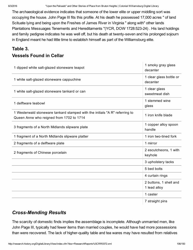
6/3/2016 "Upon the Palisado" and Other Stories of Place from Bruton Heights | Colonial Williamsburg Digital Library
http://research.history.org/DigitalLibrary/View/index.cfm?doc=ResearchReports%5CRR0372.xml 106/150
The archaeological evidence indicates that someone of the lower elite or upper middling sort wasoccupying the house. John Page III fits this profile. At his death he possessed 17,000 acres " of landScituate lying and being upon the Freshes of James River in Virginia " along with" other landsPlantations Messuages Tenements and Hereditaments "(YCR, DOW 1728:52324) . His land holdingsand family pedigree indicates he was well off, but his death at twentyseven and his prolonged sojournin England meant he had little time to establish himself as part of the Williamsburg elite.
Table 3. Vessels Found in Cellar
1 dipped white saltglazed stoneware teapot1 smoky gray glassdecanter
1 white saltglazed stoneware cappuchine1 clear glass bottle ordecanter
1 white saltglazed stoneware tankard or can1 clear glasssweetmeat dish
1 delftware teabowl1 stemmed wineglass
1 Westerwald stoneware tankard stamped with the initials "A R" referring toQueen Anne who reigned from 1702 to 1714
1 iron knife blade
3 fragments of a North Midlands slipware plate1 copper alloy spoonhandle
1 fragment of a North Midlands slipware platter 1 iron twotined fork
2 fragments of a delftware plate 1 mirror
2 fragments of Chinese porcelain2 escutcheons, 1 withkeyhole
3 upholstery tacks
5 bed bolts
4 curtain rings
2 buttons, 1 shell and1 lead alloy
1 caster
7 straight pins
CrossMending Results
The scarcity of domestic finds implies the assemblage is incomplete. Although unmarried men, likeJohn Page III, typically had fewer items than married couples, he would have had more possessionsthan were recovered. The lack of higherquality table and tea wares may have resulted from relatives

6/3/2016 "Upon the Palisado" and Other Stories of Place from Bruton Heights | Colonial Williamsburg Digital Library
http://research.history.org/DigitalLibrary/View/index.cfm?doc=ResearchReports%5CRR0372.xml 107/150
or friends claiming his possessions after his death or, alternatively, from people sifting through theashes after the fire. Evidence of the latter comes from preliminary results of crossmending.
96
Crossmending is the process of reconstructing vessels by using the ceramic fragments found on thesite to reveal relationships between different features or activity areas. When the ceramic sherds fromthis site were crossmended, fragments of flowerpots and stoneware storage jars stored under theporch tower mended with sherds from the stair tower and both rooms in the main section (Fig. 49).Pieces of an Iberian storage jar stored in the stair tower mended to fragments found in the largenorthern room and in the porch tower. Portions of a stoneware teapot were found in all four rooms. All ofthese fragments appear to have been scattered around by someone rummaging through the ashlooking for salvageable items. Other evidence of scavenging comes from the robbed out north wall. A14" wide trench was dug along the entire length of this wall in order to recycle the bricks.
Flowerpots in the Cellar
The eighteen flowerpots found in the cellar of the Page house suggest that the residents were activelyinvolved in the creation and maintenance of gardens. Gardens in early Virginia have been interpretedas "metaphors for improvement, progress, and culture in the minds of many Virginian"(Martin 1991:xix). The planting of gardens relied heavily on British tradition and the exchange and sale of plants betweenEngland and Virginia (Martin 1991; Sarudy 1989; Leighton 1976; Swem 1957).
The cultivation of more formal gardens required the use of ornamental plants, often outside the range ofendemic and indigenous species available to colonial gardeners. A well documented import/export ofplants between England and Virginia developed in the seventeenth century. English naturalists andbotanists collected plants in the colonies for the gardens of England and Europe, and colonial gardenersincluded imported plants in their gardens. The transportation of plants was often risky; plants did notalways reach their intended destination intact. Special boxes were designed to transport botanicalspecimens across the ocean, and trees and shrubs were transported in pots from England andthroughout Virginia (Martin 1991, Leighton 1976, Stephenson 1959, Swem 1957).
Ensuring the delivery of live plants to gardeners required the protection of root systems duringtransportation. Long carriage rides and shipping damaged plants and colonial gardeners were specificin their instructions to English merchants (Fig. 46). A 1717 letter to the company of Perry, Lane andPerry in London from John Custis attests to this concern. Ordering striped holly trees and yew trees forhis new garden he cautioned the merchants to "buy them as near the Water side as you Can, landCarriage will bee apt to shake and loosen them to much; let them bee Carefully put up in pots…"(Stephenson 1959:5) .

6/3/2016 "Upon the Palisado" and Other Stories of Place from Bruton Heights | Colonial Williamsburg Digital Library
http://research.history.org/DigitalLibrary/View/index.cfm?doc=ResearchReports%5CRR0372.xml 108/150
Figure 46. "Spring," by David Teniers.
Earthenware pots such as those found in the Page cellar would have provided the necessary protectionfor shipping plants as they were capable of supporting the root system and maintaining moisture forlong periods of time. The pots were recyclable in a sense, after shipping the pots could be reused inthe garden as containers for small trees and flowers, generally foregrounding specimen plants within alarger garden arrangement. They were necessary items in the creation and maintenance of gardens,and their use has varied little over time.
Coarse earthenware flowerpots are the backbone of gardens today as they were in antiquity. Theymaintain their form and function into the twentieth century with little stylistic variation. Their compositionand undecorated body implies a general function, unlike ornate pots used specifically indoors or asaccents in a formal garden at the borders of parterres in strict geometric positioning (Fig. 47). It wouldappear that smaller pots with one central basal hole and one or more holes for drainage near the bottomwere used for potting, displaying and transplanting herbs and flowers. Larger pots with a central basaldrainage hole, and one or more holes located near the base on the side of the pot, were used fortransporting, planting and nurturing young trees. This function can be documented through timeconsistently, beginning as early as 50 A.D., until the advent of plastic pots for shipping and transplantingin the twentieth century (Jashemski 1990; Huxley 1978; Hill 1577).
The flowerpots found at the Page house share similar characteristics (Fig. 48). All pots have flat
bottoms, drainage holes pierced from the outside, and a simple raised cordon below the rim. They arered, unglazed, and the larger pots contain two or more side drainage holes. Their strong resemblancesuggest the work of one potter (William Pittman, personal communication, 1997). Crossmended, thepots range in height from 7 to 10 inches, with base diameters ranging between 5 to 9 inches, and rimdiameters between 8 and 12 inches. The earthenware pots are sensitive to climatic change, and early

6/3/2016 "Upon the Palisado" and Other Stories of Place from Bruton Heights | Colonial Williamsburg Digital Library
http://research.history.org/DigitalLibrary/View/index.cfm?doc=ResearchReports%5CRR0372.xml 109/150
English garden books suggest indoor storage in the winter months to prevent freezing (Hill 1577). Thepots at the Page house show no signs of exposure to the weather, which suggests that they were takeninto the cellar for storage and remained there.
The remains of coarse earthenware pots similar to those found at the Page site have been foundelsewhere in Williamsburg. Flowerpot fragments of have been found in the Thomas Jones house cellar,Francis Nicholson house cellar, and also at the Custis site, the three sites are somewhatcontemporaneous with the Page house. Jones was a merchant in Williamsburg and the neighbor ofJohn Custis. He was married to the niece of Mark Catesby, and a gardener of some note (Stephenson1959). Governor Francis Nicholson lived for a short time in the vicinity of Custis and Jones. Nicholsonwas responsible for the layout of the town of Williamsburg and is described by Martin as "an urbanplanner with more than a passing interest in gardening and the role gardens could play in the dispositionof a town,"(Martin 1991:30) . The gardens of John Custis are perhaps best known through hiscorrespondence with Quaker botanist Peter Collinson and are well documented in Swem's Brothers ofthe Spade.
Gardens in early Virginia have been interpreted as indices of intent, status, and knowledge (Yentsch1995; KryderReid 1995; Leone 1990, 1989, 1984). They evoke a sense of permanence, and are oftenassociated with brick architecture, the creation of towns, and selfsustaining plantations. The plantingand seasonal maintenance of ornamental gardens reflect a longterm intellectual investment in thetransformation of nature that was culturally held as a marker of stability and success in the wilderness.The flowerpots in the Page cellar are material evidence of an increasing colonial interest in horticulturethat remained reliant on English tradition and trade until the late eighteenth century.
Figure 47. Anonymous, from Manual of Elementary Education.

6/3/2016 "Upon the Palisado" and Other Stories of Place from Bruton Heights | Colonial Williamsburg Digital Library
http://research.history.org/DigitalLibrary/View/index.cfm?doc=ResearchReports%5CRR0372.xml 110/150
Figure 48. Flowerpots from Page cellar.
At this juncture it is impossible to know exactly what sort of garden was adjacent to the Page house.The similar characteristics of flowerpot fragments found on other sites imply that gardening was ashared endeavor and one that depended on interaction with others both economically and socially. Itappears certain that the residents of the Page house belonged to a group of colonists intent on definingthemselves within the larger realm of colonial society through the modification of the natural landscape.
Figure 49. Spatial distribution of a single flowerpot.
The End of the Page Years
After John Page III died, the Bruton Heights estate passed to his sister Elizabeth, now married to DavidBray. Upon the death of Elizabeth Page Bray the land descended to the heirs of Matproperty nearWilliamsburg (Virginia Magazine of History and Biography, 32:3943; Hening 1969, 5:277284).
When Mann (I) died, the construction of Rosewell was not yet complete, and Mann (II) inherited boththe task of completing it, and paying his father's debts which exceeded the value of his slaves andpersonal property. Mann (II) attempted to pay his father's debts, and to cover the costs of educatingand maintaining his younger brothers and sisters from the yearly profits of his father's estate. Themagnitude of Mann (I) Page's debts made this impossible and the substantial legacies that Mann (I)Page had left to
97
his younger children remained mostly unpaid. In order to prevent creditors from bringing suits thatprobably would have resulted in the seizure and sale of the personal property and slaves, Mann (II)Page used his own money to cover expenses. Finally, Mann (II) Page sought an Act of Assembly thatwould enable him to sell various parcels of entailed land in order to pay off his father's debts, pay theyounger children's portions, and repay himself (The Virginia Magazine of History and Biography, 36:3943; Leviner 1987:1316; Hening 5: 277284).

6/3/2016 "Upon the Palisado" and Other Stories of Place from Bruton Heights | Colonial Williamsburg Digital Library
http://research.history.org/DigitalLibrary/View/index.cfm?doc=ResearchReports%5CRR0372.xml 111/150
Included in this act were "seven hundred acres of land, or thereabouts, adjoining the city ofWilliamsburg, in the county of York." The act received the governor's assent on 25 October 1744, andwas sent off to England for which had already occurred, and one half to be paid when Page hadobtained the King's assent to an act of Assembly from the following session. Waller, in turn, could notsell any wood from the property or commit any willful waste on the premises until the assent of the Kinghad been obtained. Waller later testified that this agreement had been first made verbally sometimeduring the October general court preceding the date of the written articles (York County Records, LandCauses (17461769):3536). With the King's approval Mann Page completed the sale of his property in1744.
98
99
CHAPTER 7. The Moody SubdivisionThe social, political, and economic climate of Virginia had changed dramatically by the time Mann (II)Page sold the land that had originally been purchased by John Page (I). Those who had worked sohard to attract the colonial capital to Middle Plantation had succeeded. The changes in Williamsburg asit developed from a scattered community into an urban center brought about a conceptual shift in theway people viewed their landscape.
By the time Matthew Moody acquired the property in 1747, he was in a position to recognize theovercrowded conditions in the city of Williamsburg and take steps to capitalize on the acute need forproperty. He in effect created a subdivision when he began to divide the property and sell the plots in1750. His efforts helped to relieve overcrowding within the city of Williamsburg by allowing artisans andothers of modest means to escape tenancy and yet purchase land close to town. The neighborhooddeveloped over a period of almost twenty years.
The Historical Background
Although the Bruton Heights property had remained in the Page family for nearly one hundred years, itquickly passed through a succession of owners after Mann Page sold it in 1744. Benjamin Waller,being "wearied out with the frequent importunities of William Keith," consented on or about November21, 1743 to sell him "as much of the sd land lying between the road to the Capitol Landing[,] the lands ofJohn Coke, Thomas Cobbs & John Custis Esqr.[,] & the northern bounds of the city" as one hundredninety pounds would purchase at the rate of twentyeight shillings current money per acre. If theconveyance to Waller from Page were not upheld by the King's assent to the act of Assembly, Walleragreed to return Keith's money.
4

6/3/2016 "Upon the Palisado" and Other Stories of Place from Bruton Heights | Colonial Williamsburg Digital Library
http://research.history.org/DigitalLibrary/View/index.cfm?doc=ResearchReports%5CRR0372.xml 112/150
Before the King's assent was obtained, William Keith died heavily in debt. By his will dated March 27,1743/4 and probated May 21, 1744, he bequeathed Waller's land to his son James Keith. A chancerysuit brought by several creditors resulted in the division of this land and the sale of part of it to satisfythe testator's debts. It does not appear that Keith lived on this rural land before his death. He identifiedhimself as a resident of Williamsburg in his will and his estate paid Philip Ludwell for a year's rent (YCR,DOW 19:282; YCR, Land Causes 17461769:42).
The portion of the land upon which Bruton Heights School now stands was sold to Thomas Penmansometime between March 16, 1746/7, when the York County court ordered it sold, and June 15, 1747,when the sheriff reported to the court that he had sold the tract to Penman for eighty nine pounds, tenshillings and four pence halfpenny. The deed, however, was not drawn up until August 13, 1747,probably because the land had not yet been surveyed. James Shields, Surveyor of York County,performed the survey on June 20, 1747; the survey was recorded with the deed.
The day following the execution of Penman's deed of purchase for the property, he in turn sold it toMatthew Moody, ordinary keeper of Williamsburg. Moody came
100
from a tavernkeeping family of long standing in York County, the two branches of which had taverns inYorktown and Williamsburg. Matthew Moody obtained his first ordinary license May 20, 1734 and wasappointed ferry keeper at the Capitol Landing the same day. He operated a tavern at the Landing until atleast 1768 and he continued to live there until his death in June 1775. At his death he owned thirtymortgaged acres that adjoined his lots at the Landing (YCR,DOW 14:400).
When Moody purchased the acreage immediately north of the city from Thomas Penman, the deedconveying the land suggested that some improvement probably had been made to the property, butdoes not say exactly what, let alone where, these improvements were.
Moody began to subdivide this tract April 24, 1750, when he sold an acre bounding on John Coke's citylots and the main road to the Capitol Landing to Thomas Cobbs of York County. Moody continued tosell lots, in a northward sequence along Capitol Landing Road, until July 20, 1761, when he sold the lastof the lots along the road. An act of Assembly providing that Moody's lots along the road leading to theCapitol Landing would be made a part of the city itself "so soon as the same shall be built upon"received the Governor's approval on April 14, 1759 (YCR, DB 5:37071, 606).
Moody began after July 1761 to sell off portions of his land to the west of these lots. The first westerlytract sold shared its southern boundary with the city. On March 15, 1762, Moody agreed with JohnGreenhow for the sale of approximately six and onethird acres for sixtythree pounds, six shillings andeight pence current money. Moody and Greenhow further agreed that two streets four poles wide wouldbe reserved in this tract and that Greenhow would connect the northsouth street to Nicholson Street byextending it through a lot he had recently purchased there.
Moody himself created two streets within his subdivision north of Greenhow (now First) Street (Fig. 50).

6/3/2016 "Upon the Palisado" and Other Stories of Place from Bruton Heights | Colonial Williamsburg Digital Library
http://research.history.org/DigitalLibrary/View/index.cfm?doc=ResearchReports%5CRR0372.xml 113/150
Moody Street extended northward perpendicular from Greenhow Street to Moody's property, althoughthe Bucktrout Map shows it stopping somewhat short of that. The second street was called Bell CraigStreet in Moody's deeds of sale for the neighboring lots, although the Bucktrout Map indicates that itwas called Moody Street as well. Bell Craig Street extended perpendicularly from Moody Street,parallel to Greenhow Street, and emptied onto Capitol Landing Road. Greenhow Street, Moody Street,Bell Craig Street, and the lots along the main road, therefore, enclosed a block of lots that lie within thepresent Bruton Heights property. The remains of Moody Street and Bell Craig Street can be seen onaerial photographs taken prior to the construction of the school (Colonial Williamsburg negatives 53W777, 891455 CN, and 901649 CN). Moody then sold a few lots located on the eastern end of FirstStreet. These lots changed hands at a furious pace.
The Archaeology of the Moody Subdivision
Archaeological evidence for the development of the Moody subdivision was found throughout theBruton Heights parcel (Fig. 51). This evidence was gathered from several phases of archaeologicaltesting in the 1980s and early 1990s that determined that development was confined, in large part, tothose lots along Capitol Landing Road and the series of lots immediately behind. The presence of coaland slag in these areas indicates that the occupants of these sites probably engaged in craftrelatedtrades on these properties. John Shephard, for example, ran his harnessmaking business from hisproperty.
101
Figure 50. Eighteenthcentury roads associated with the Moody subdivision.
Figure 51. Overview of eighteenthcentury landscape.
Eventually, he owned most lots between Capitol Landing Road and Moody Street to the west.

6/3/2016 "Upon the Palisado" and Other Stories of Place from Bruton Heights | Colonial Williamsburg Digital Library
http://research.history.org/DigitalLibrary/View/index.cfm?doc=ResearchReports%5CRR0372.xml 114/150
On September 7, 1779, John Shepard sold three quarters of an acre to Bruton Swillivan of BrutonParish, York County, for two thousand pounds current money. Swillivan paid one thousand two hundredfifty pounds of the purchase money and mortgaged the lot to Shepard on September 27, 1779 to securepayment for an additional thousand pounds within a year. The lot is described in the deed of sale asfollows:
… all that Piece or Parcel of Land containing three fourths of an Acre or Lot and half lying andbeing in the Parish of Bruton and County of York aforesaid in and near the City ofWilliamsburgh and bounded as
102
followeth on the East by the said John Shiphard on the South by John Greenhow on the Westby Moody Street and on the North by Joseph Prentis And all Houses Buildings Yards FencesWaters Water courses Gardens Orchards Ways Profits commodities Hereditaments AndAppurtenances… (York County Records, Deeds and Bonds 17771791:8586,116).
A portion of Shepard's land was tested archaeologically in 1983, as part of a proposed roadimprovement project. This site (44WB28), located at 400 Capitol Landing Road, contained intactarchaeological deposits dating to the late eighteenth/early nineteenth century (Hunter, Samford, andBrown 1983:vi). The lot was probably unimproved at the time it was purchased given the low sale priceof ten pounds. By 1782, however, the Frenchman's Map shows that several structures had beenconstructed along Capitol Landing Road near this site, which extends onto the southeastern corner ofthe Bruton Heights parcel. Testing on the property in 1983 exposed brick foundations, the remains of apossible cellar, postholes, a boundary ditch, and "a high density of important eighteenthcentury andnineteenthcentury artifacts"(Hunter et al. 1983:54). Furthermore, the presence of coal and slagsuggests craftrelated activities (Muraca and Hellier 1992:31).
Figure 52. Moody subdivision period foundation adjacent to Capitol LandingRoad.
Artifacts recovered during the construction of an addition to the home at 400 Capitol Landing Road in1995 confirm the late eighteenth/ early nineteenthcentury attribution for the site. Brick foundations wereexposed once again when the footings for the addition were excavated (Fig. 52). The foundationsappear to relate to the same structure identified during the 1983 excavation. Judging from the

6/3/2016 "Upon the Palisado" and Other Stories of Place from Bruton Heights | Colonial Williamsburg Digital Library
http://research.history.org/DigitalLibrary/View/index.cfm?doc=ResearchReports%5CRR0372.xml 115/150
orientation of these remains, the majority of the structure now lies concealed beneath the addition to thehouse.
The rear extent of the property was defined during archaeological testing conducted on the BrutonHeights property in 1990. This area of the site extends seventy feet into the property and consists of alight scatter of midto late eighteenthcentury artifacts. Spatial analysis of this material
103
indicates that the focus of activity on the site was farther to the east, closer to Capitol Landing Road.
A site associated with the back of the contiguous lot to the north was also identified during the 1990testing. Mathew Moody sold this halfacre lot fronting Capitol Landing Road to James Atherton in 1762.This site (44WB67) extends almost twenty feet into the school property and contains domestic artifactsdating to the eighteenth and nineteenth centuries. While this scatter extends to the north and eastbeyond the boundaries of the school parcel, the major concentration appears to be located to the east(Muraca and Hellier 1992:31). The "Frenchman's Map" (1782) and Desandrouins Map (1781) showstructures along Capitol Landing Road within the vicinity of this site. Discrete concentrations of artifactsidentified within this site suggest the possibility of activity areas or structural remains (Muraca andHellier 1992:31). No features were located during this phase of testing.
Figure 53. Remains of brick structure dating to Moody subdivision period.
Another concentration of artifacts was discovered along First Street approximately three hundred thirtyfeet west of the southeastern corner of the parcel. William Rose purchased this lot in 1762 andeventually sold it to John Shephard in 1774. Testing revealed a moderate to heavy scatter of mideighteenthcentury artifacts and three concentrations of brick rubble, which suggested the presence ofa several structures (Fig. 53). A trashpit was also located. The assemblage recovered from the siteincludes both domestic and craftrelated items (Muraca and Hellier 1992:33). The Desandrouins Map
104
(1781) shows a structure in this area. Historical research indicates that this was a lot borderingGreenhow Street.

6/3/2016 "Upon the Palisado" and Other Stories of Place from Bruton Heights | Colonial Williamsburg Digital Library
http://research.history.org/DigitalLibrary/View/index.cfm?doc=ResearchReports%5CRR0372.xml 116/150
Alexander Craig's Lot
A seemingly isolated fenceline, possibly marking the boundary between the Raleigh Tavern pasture tothe west and the land that Alexander Craig bought from Moody in 1763, was discovered at the westernend of the school property in the vicinity of Craig's 1768 purchase north of Greenhow Street. Craig, aprinter, probably did not improve this acreage since he continued to live in Williamsburg where heowned lots on Duke of Gloucester Street, the Waller Subdivision, and the Johnson Subdivision. Thefollowing advertisement of the sale of his property after his death indicates that the property that he hadpurchased from Moody was used as pasture:
TO be SOLD, on Tuesday the 4th of March, at 4 o'Clock in the Afternoon, to the highestBidders, the Lot and Houses on the main Street in Williamsburg, adjoining the Raleigh Tavern,where Mr. Alexander Craig formerly lived. A House and Part of a Lot in Waller Street, with aLot and Stable some little Distance therefrom. A pasture of six or seven Acres, enclosed,adjoining Mr. Southall's Pasture …
(YCR,DOW 22:32223; Virginia Gazette, 7 February 1777).
Three rectangular postholes marked the location of the earliest fenceline on this lot. Each of the postsmeasured approximately 2 feet by 10 inches. Once the olive brown sandy loam was removed thedepth of the original holes in this series was determined to be between 2 and 7 inches below existinggrade. Evidence of second, smaller holes were found in the southern half of each of these holes. Giventhe fact that none of the interior holes was discovered until the fill from the larger holes was removed, itseems that the larger, shallow holes were dug to remove posts from the deeper holes. It is difficult todate, however, this fenceline since none of the features contained artifacts. It appears that once theposts to the original fence were removed, the posts for the second were put in between the holes of thefirst line. The posts in the second line also showed signs of replacement and lay on 8 to 10' centers.The remains of a wooden post were removed from one hole. This post was identified as pine, andalthough pine was not typically used for fencing, it would have been readily available. A fragment ofdelftware and a piece of American stoneware were found another hole, with the American stonewaredating the filling of the hole, thus the installation of the second fence, to sometime after 1730.
A ditch associated with this boundary line lay two feet east of the postholes and extended 21 feet to thesoutheast before tapering off in the ravine. The ditch averaged 1 foot in width and 6 inches in depth andwas filled with an olivebrown silty loam. The profile of this layer contained dozens of tiny horizontalstriations, indicating that the trench silted in over time. This was a common problem for farmers whohad to "scour" or clean trenches every year.
Not much activity occurred in this part of the property judging from the paucity of artifacts. Artifactsfrom the trench did include several brick fragments, a shell, a nail, and a piece of wine bottle glass. Asherd of white saltglazed stoneware and a piece of creamware were also recovered. The presence ofcreamware suggests that the ditch was not completely silted in before the mid1760s, sincecreamware was not produced until 1762. Seeds from sedge grasses associated with meadows and

6/3/2016 "Upon the Palisado" and Other Stories of Place from Bruton Heights | Colonial Williamsburg Digital Library
http://research.history.org/DigitalLibrary/View/index.cfm?doc=ResearchReports%5CRR0372.xml 117/150
farmland were discovered in soil samples taken from ditch. Seeds of wild raspberry were also found.
Craig's pasture was sold in the late 1770s. The purchaser of the pasture was
105
James Nichols of Williamsburg. The executors deeded him the 4 5/8 acres on April 29, 1779. The deedstates that Nichols had purchased the property at public auction, presumably the one advertised inFebruary 1777, so that the deed appears to have been executed some time after the actual purchase.Nichols was a barber and perukemaker who had moved from London to Petersburg; and then toWilliamsburg by February 1775 when he advertised for a horse that had been stolen from hisWilliamsburg lot. He advertised his house for rent in December 1779 as well as his intention to leavetown to keep the Swan's Point ferry. He was taxed for one lot in Williamsburg from 1782 through 1787.In 1788 his estate was taxed for only one lot. That he was not taxed for his pasture in the MoodySubdivision indicates that he had sold the pasture prior to his leaving. Another possibility is that theproperty never appeared on the tax list because it was never approved and thus never officiallyannexed to the city (YCR, DB 6:17771791, 5758).
James Barrett Southall's Lot
Further evidence of the landscape dynamics that occurred during the Moody period was discoveredtwo hundred fifty feet northeast of the longstanding boundary line (44WB70). How this area was usedduring the eighteenth century is uncertain for Moody clearly did not live there, but he might have rentedout some part of it. He was later using at least part of it for agricultural purposes as a deed dated May29, 1760 indicates. The deed details the sale of thirtyfive acres of this tract, the northwest portion, to Lt.Gov. Francis Fauquier. The bounds of the acreage sold by Moody include the corner of a ditch thatenclosed Moody's cornfield. The complete boundaries are as follows:
Beginning at the Corner of the Land of the said Francis Fauquier on the Capitol Spring branchThence up the said Branch to the said Land formerly Andrew Andersons now belonging to theRaleigh Tavern Thence along a Line of that Land North Sixty Degrees East four Chains to theCorner of a Ditch lately inclosing the said Moody's Cornfield Thence along that Ditch as itMeanders to a Stone marked JP in John Cokes Line Thence along his Line North Forty ninedegrees West Eleven Chains to the Land of the said Francis Fauquier and thence along hisLine South forty one Degrees West twenty one Chains to the Beginning(YCR, Deeds andBonds 5:22427; DB 6:(17551763):24951).
A later deed, dated June 21, 1762, refers to the same general area as Moody's pasture (YCR, DB6(17551763):45556).
Later deeds suggest that this area is in the vicinity of the boundary between Alexander Craig's 1768purchase and the twentyacre parcel that Moody sold to James Barrett Southall a few months later.When Craig sold this property in 1779, his land is described as a "pasture" adjoining a pasture owned

6/3/2016 "Upon the Palisado" and Other Stories of Place from Bruton Heights | Colonial Williamsburg Digital Library
http://research.history.org/DigitalLibrary/View/index.cfm?doc=ResearchReports%5CRR0372.xml 118/150
by James Southall (YCR, Wills and Inventories, 22:32223). In the advertisement of the sale of Craig'sproperty the reference to "Mr. Southall's pasture" could have been either to the "Raleigh Tavernpasture" that Southall had purchased in 1771, or to the tract that Southall had purchased from Moody. Itdoes not seem likely that he lived on the acreage he bought from Moody.
The post and rail fence and ditch associated with the Southall lot were oriented due north (Fig. 54).Eleven postholes set at an 8 foot intervals define the fenceline. All of the holes were very regular,averaging 1 foot by 9 inches in size. The depth of these holes ranged between 6 and 8 inches belowgrade. The posts for this fenceline appear to have been put in place before much activity occurred inthe area because none of the holes contained artifacts. There was no evidence of postmolds in any ofthe postholes and all of the excavated features had very irregular
106
Figure 54. Southall fence and ditch.
Figure 55. Southall period ditch.
bottoms. It appears that the posts were removed before they could rot in place.
The ditch associated with this fence runs the 103 feet length of the open excavation area (Fig. 55). It is2' 2" wide and 4" deep and was filled with a brown silty loam sealing a 1 inch thick layer of silt. Thistrench remained open and filled slowly as eroding soil washed in and settled. Unlike the postholes, thetrench produced a number of artifacts dating to the mideighteenth century. A total of one hundredtwentynine artifacts were recovered from the ditch, consisting mainly of ceramics (22%), storage andtable glassware (18%), and architectural debris (31%). The ceramics included a wide

6/3/2016 "Upon the Palisado" and Other Stories of Place from Bruton Heights | Colonial Williamsburg Digital Library
http://research.history.org/DigitalLibrary/View/index.cfm?doc=ResearchReports%5CRR0372.xml 119/150
107
range of types from delftware to a fragment of an Iberian storage jar. A mean date of 1750.3 wascalculated from the ceramics in this ditch. A flat roofing tile and 6 fragments of window lead probablycame from the seventeenthcentury Page occupation and were redeposited when the area was reusedseveral decades later. Unfortunately, the window lead fragments were too small and degraded to becompared to the marked examples found in the redeposited domestic assemblage and on the kiln site.
Later in the eighteenth century, another northsouth fence was constructed sixty feet east of the fenceand ditch. This post and rail fence consisted of ten posts at an interval of 8 feet over a distance of 73feet. Posts in this line were 1'6" feet square and averaged 9 inches in depth. All of the postholes werefilled with an olive brown sandy clay, while two included post molds averaging 5" on a side. Four of thepostholes had been repaired or replaced. The intruding holes produced the only artifacts associatedwith this fenceline, suggesting that activity in this area increased between the time the fence wasconstructed and the time it was repaired. Over half of the artifacts recovered were architectural innature. Unfortunately, none of the artifacts were dateable.
Other changes occurred after the second postandrail fence was constructed. The ditch that extendsthe length of the original northsouth fence cuts across the top of the seventeenthcentury industrialditch, clearly demonstrating that it postdates this feature. Likewise, the fenceline and ditch cut thecenter berm of the suspected palisade.
The ditches associated with the palisade, however, appear to have been reused later. A fence was builtalong the top of the linear palisade mound, and the adjacent ditches were redug. This type of fencinghad become common by the second half of the eighteenth century. The ditch and berm combinationprevented livestock from escaping under the fence, drained water away from the fence posts, andsaved valuable lumber. In a 1778 letter to George Washington, John Parke Custis commented on theimportance of ditching:
… the expense of keeping this Plantation in culture, from the great Scarsity of Timber, thenumber of roads running through the Land, and the amazing Deal of Ditching necessary toinclose the Fields … (Harbin 1986:275).
Silt and other debris had to be removed from the ditches periodically to maintain the effectiveness ofthe fence. This scouring or ditching was a timeconsuming activity on farms and plantations. In 1770,Landon Carter made an entry into his diary that expressed concern about rebuilding the fence aroundthe meadow and scouring the ditches, "for really I have not time to new ditch it, a work that must bedone this year, god willing" (Carter 1770: I:561).
Nearly two hundred artifacts were recovered from the north and south ditches of the suspectedpalisade. Pageperiod material and eighteenthcentury artifacts were common, with architectural debrisand material related to foodways accounting for seventythree percent of the assemblage. The 86pieces of architectural material includes brick, nails, window glass, and roofing tile that probably relatedto the Page period. While case bottle glass and some of the delftware might date to the seventeenth

6/3/2016 "Upon the Palisado" and Other Stories of Place from Bruton Heights | Colonial Williamsburg Digital Library
http://research.history.org/DigitalLibrary/View/index.cfm?doc=ResearchReports%5CRR0372.xml 120/150
century, most of the 51 pieces of ceramics and glassware date to the mideighteenth century. Themean ceramic date for the artifacts in the palisade ditches was 1740.5. The mean ceramic date alsosuggests that both ditches were open at the same time. The mean date of 1739 computed for thenorthern ditch is so close to the 1742 date calculated for the southern ditch that it is reasonable toassume that they were contemporaneous.
108
The remains of eight postholes exposed along the center of the berm tell a similar story. Four originalposts believed to belong to the palisade of 1634 were identified along the berm. Three of these werediscovered west of the brick cottage while the fourth was found in front of the structure. Originally, hugestructural posts were erected using a 15 foot interval. The posts were connected by rails and paleswere nailed or pegged to the rails. The posts averaged 2'6" by 2' and were approximately 1'6" deep.The original fill in the bottom of the holes was a yellowish orange clay, devoid of artifacts. This alsomatches the description of the fill of the posthole exposed in the trench excavated across the berm inthe northeast corner of the property. The palisade appears to have fallen into disrepair within a decadeof its construction. A new palisade was constructed elsewhere in 1646 and by 1683 the palisade of1634 was described as "the old trench where the pales stood" (YCR,DOW 1:159160).
The archaeological evidence suggests that a post and rail fence was constructed down the center ofthe berm sometime after 1740. The posts to this fence intruded on all but the easternmost palisadeholes. A shorter interval of 7 feet was used for this line, and posts were also placed between thelocation of the original posts. The five eighteenthcentury postholes measure 1'5" by 1'5" and averaged8 inches in depth. The remains of postmolds averaging 7 inches in diameter were identified in three ofthe five holes. One of the holes showed signs of repair or replacement, while in another the postappears to have been removed.
The remains of five modern postholes were also discovered along the center of the berm. Althoughnone of these features were excavated, the regular 8" diameters of the holes and the dark postmoldssurrounded by coronas of bright orange clay are telltale signs of a modern post installed using an auger.This most modern series of posts probably marks the location of the barbedwire fence shown in theaerial photograph taken in 1927.
It is difficult to determine how this land was used in the eighteenth century. Much of the areasurrounding the school garage and home economics cottage had been heavily disturbed during theconstruction of the school and the associated buildings in 1940. As a result, seventeenth andeighteenthcentury layers were disturbed beyond recognition, if not wholly destroyed. Maps do notshow any structures or improvements in this area. Land transactions, however, mention "the saidMoody's cornfield" and later, "Mr. Southall's pasture"(YCR, Deeds and Bonds 5:22427) .
Fortunately, the disturbance from construction was confined to the terrace where the school structuresare situated. A light scatter of eighteenthcentury artifacts was identified on the slope north of thecottage. The artifact scatter was heaviest near the edge of the terrace and extended down the slope

6/3/2016 "Upon the Palisado" and Other Stories of Place from Bruton Heights | Colonial Williamsburg Digital Library
http://research.history.org/DigitalLibrary/View/index.cfm?doc=ResearchReports%5CRR0372.xml 121/150
nearly 50 feet before diminishing. This scatter of debris, known as sheet refuse, accumulates slowly asthe result of continuous activity in the area. It can often indicate the location of activity areas as well asboundaries that have long since disappeared. The concentration of material at the top of the slopeindicates that the focus of activity was on the terrace. Judging from the way the artifacts wereconcentrated near the terrace and tapered off down the slope, the ravine was probably peripheral to theactivities taking place at Bruton Heights. Many of the artifacts on the slope were probably depositedthere through erosion. A silty wash layer was found across the site.
109
The Trash Midden
A large, mid eighteenthcentury trash midden was identified at the head of a siltedin ravine on the slopenorth of the brick cottage. The sheet refuse originated from the terrace to the south, tapered off andended within twenty feet of the midden indicating the midden was deposited near a property boundary.
The midden at Bruton Heights was oriented on a southwest/northeast axis and measuredapproximately 12 feet long (northeast/southwest) by 2 feet wide (Figs. 56 and 57). The average depthof the midden was 8 inches. The artifact concentration was lower at the northeast end of the depositand heaviest at the southwest end, suggesting that some of the material may have washed a
Figure 56. Eighteenthcentury midden.
110

6/3/2016 "Upon the Palisado" and Other Stories of Place from Bruton Heights | Colonial Williamsburg Digital Library
http://research.history.org/DigitalLibrary/View/index.cfm?doc=ResearchReports%5CRR0372.xml 122/150
Figure 57. Eighteenthcentury midden.
111
short distance from where it was originally deposited. The poor preservation of bone from the featureindicates that the deposits remained exposed to the elements long after it had been dumped.
Mystery Feature
Four roughly square holes oriented along the same axis were discovered beneath the midden (Fig. 58).Each of the holes measured approximately 1'4" square and 1'6" deep. The holes appear to be set alonga deliberate interval of 4 feet between the first two holes, 6 feet between the second and third hole, and4 feet between the third and fourth holes. Removing the dark brown loamy fill from the holes revealedthat material from the overlying midden had spilled into each.
Figure 58. Mystery feature.
112
The midden produced a large assemblage of two thousand fiftyone artifacts including over onethousand one hundred pieces of oyster shell, bone, and brick. Some fiftysix pounds of brick and fivebushels of oyster shell were also recovered from this feature. The presence of flat pegtiles dating to the

6/3/2016 "Upon the Palisado" and Other Stories of Place from Bruton Heights | Colonial Williamsburg Digital Library
http://research.history.org/DigitalLibrary/View/index.cfm?doc=ResearchReports%5CRR0372.xml 123/150
Page period suggests that some of this material may have originated from the nearby Page complex.
Nearly 800 fragments of faunal bone survived. Many were severely degraded reflecting the effects oferosion and weathering. Water probably washed small bones down the slope, leaving the largerdomestic livestock remains to weather in the sun.
The Depositional History
Crossmending indicates that the trash midden was probably deposited in a single episode. Over fiftymending relationships were identified within the midden. These include contiguous or abuttingrelationships where pieces fit back together, and noncontiguous mends where pieces are judged tobelong to the same vessel on the basis of physical characteristics. The seventyone
113
ceramic vessels were represented by one hundred fiftyeight artifacts exhibiting a mending ratio of2.2:1. Thirtythree of these were contiguous mends. Of the fiftyeight glass vessels, fortyone werebottles and seventeen were table glass. There were no contiguous mends identified for the fortyonebottles. The bottles are represented by fifty artifacts with a mend ratio of 1.2:1.
Table glass shows the same ration of artifacts to vessels. Twentyone artifacts account for theseventeen glass vessels. Two of the mends were contiguous. Mends located throughout differentsections of the midden show contemporaneity. Likewise, crossmends between the artifacts in themidden and those contained in the postholes beneath it demonstrate the same pattern.
114
The four postholes discovered beneath the midden remain a mystery. Trash recovered from the fourholes demonstrates that the holes were clearly open when the midden was created. Two mendingrelationships identified between the two inner holes makes this apparent. It would not make sense todig four small holes simultaneously for one deposit of trash. The deliberate intervals of 4', 6', and 4'between the posts and the similarity in the size of the holes suggests that they were intended to fulfillsome other purpose than garbage disposal. They may mark the location of a fenceline that wasremoved when the trash was dumped in the ravine. The location of the holes at the head of a ravine onthe side of a slope are problematic to this interpretation, however.
James Southall owned Wetherburn's Tavern when he bought twenty acres from Matthew Moody in1768. His purchase of the Raleigh Tavern in 1771 included the Raleigh Tavern pasture that borderedAlexander Craig's land to the east. It is possible that Southall bought out Alexander Craig's portion ofthe Moody subdivision sometime after 1779 to link his own two pieces of land. The ceramic andpipestem dates correlate with the early part of Southall's ownership. While the pipestems indicate thatthe feature was deposited shortly after Southall purchased the site in 1768, the ceramics from themidden suggest otherwise. The peak range ends in 1770, closer to the time the Raleigh Tavern was

6/3/2016 "Upon the Palisado" and Other Stories of Place from Bruton Heights | Colonial Williamsburg Digital Library
http://research.history.org/DigitalLibrary/View/index.cfm?doc=ResearchReports%5CRR0372.xml 124/150
purchased. Likewise, the artifact assemblage recovered from the feature appears to represent a taverncontext instead of a domestic context. Therefore, the trash midden appears to be associated withSouthall's purchase of the Raleigh Tavern in 1771. Trash deposits often date to turnovers in landownership (Mrozowski 1984). Since, new owners would often throw out what previous occupants leavebehind. The ravine behind Southall's pasture was an ideal spot to dump a large load of garbage fromthe Raleigh Tavern.
Artifacts from the Trash Midden
Ceramics and glassware account for nearly threequarters of the artifacts found in the midden. Most ofthis material dates to the mideighteenth century. Using Stanley South's mean ceramic dating formula(South 1977), a mean date of 1746 was computed. The five hundred eightytwo glass and ceramicartifacts in the assemblage represent one hundred twentynine different vessels. The twentythreedifferent vessel forms reveal the everincreasing elaboration of artifact types that occurred during theeighteenth century. This elaboration of artifact types correlates with the "Georgianization" of English andEnglish colonial society. The international scope of the ceramics, including German stoneware,Chinese porcelain, and a Spanish coarseware vessel, illustrates the growth of a global community thatwas connected, and in many cases held together, by trade. The ware types included drinking vesselsand tea wares, table ware, food preparation and storage vessels, and toiletry and pharmaceuticalvessels. The contents of the assemblage reflect the variety and quantity of bottles, glassware, andceramics typically associated with a tavern assemblage.
Drinking Vessels and Tea Wares
Onequarter of the vessels identified in the Bruton Heights midden were items associated with drinking.Many different types of drinking vessels were used by the mideighteenth century, reflecting theincreasing specialization of functions and the proliferation of consumer goods. The vessel forms andmaterial from which they were made provide a good indication of the functions they fulfilled. Thedrinking vessels found in the midden represent tea wares, mugs and tankards, and tumblers and wineglasses.
Eight tea ware vessels (11% of the total) were identified in the midden assemblage. The passion for teadrinking was supported by a burgeoning trade with China. The China trade greatly influenced the typesof vessels used for tea consumption, which motivated many European pottery manufacturers to mimicEastern styles. The five Chinese porcelain saucers are typical for the period; they display anunderglaze blue decoration. A Chinese porcelain tea bowl was also found in the midden. The cup is aBatavian porcelain, decorated on the exterior with a clay slip that produces a lustrous brown color. Ahandleless bowl, it
reflects the strong Chinese influence on tea wares. Handles on cups were a Western innovation thatsupplanted the bowl forms later in the eighteenth century.

6/3/2016 "Upon the Palisado" and Other Stories of Place from Bruton Heights | Colonial Williamsburg Digital Library
http://research.history.org/DigitalLibrary/View/index.cfm?doc=ResearchReports%5CRR0372.xml 125/150
Tea wares were often imitated in other ceramic types, as a single white saltglazed stoneware saucerfrom the midden demonstrates. White saltglazed stoneware was at the height of its popularity in 1746,and its white body was well suited for imitating porcelain. A fragment of a tortoiseshell tea pot showsthat popular tea wares were subject to the latest fashion. This refined earthenware, named for itsbrown, clouded underglaze decoration, was popular between 1740 and 1775.
Mugs and tankards were common drinking vessels throughout the eighteenth century. Unlike teawares, their role was much less prescribed by social customs. They were produced in pint and quartsizes and used primarily for the consumption of cold beverages such as beer and ale. Nine mugs andtankards were represented in the midden assemblage. All but one of these was stoneware. Theyincluded a Fulham stoneware mug and the remains of a Staffordshire tankard. English brownstoneware mugs and tankards enjoyed a long production period. The production of Fulham stonewarebegan sometime around 1690 and continued until 1775, while Staffordshire stoneware was madebetween 1700 and 1800 (Noël Hume 1969:114). The two Nottingham stoneware tankards identifiedfrom the assemblage were most popular between 1700 and 1750 although they continued to beproduced until 1810. White saltglazed stoneware accounted for onethird of the mugs and tankards,which reflects the fact that it was at the height of its production during the period represented by theassemblage. A single Westerwald mug/tankard found in the assemblage is also common for the periodand demonstrates the continued popularity of German stoneware even as the British pottery industrytook control of the market.
The predominance of refined glassware was perhaps the biggest surprise in the midden assemblage.Fifteen clear leaded glass tumblers and wine glasses represent sixtythree percent of the drinkingvessels identified from the midden. They include nine tumblers and six pieces of stemmed ware. Thetumblers all appeared to be of the same type. The typical straight sides and empontilled bases of theglasses indicate that they were
freeblown. None of the examples was decorated. Tumblers would have been used for the more refinedbeverages such as punches and liquors.
There were three patterns in the six pieces of stemware. Three were undecorated wine glasses. Theexamples from Bruton Heights have the "thick, plain feet" common on the types of wine glasses foundin taverns between 1740 and 1750 (Noìl Hume 1969:192). One glass had an airtwist stem, a type ofdecoration used between 1735 and 1760. Opaquetwist stems saw the height of their popularitybetween 1745 and 1775 (Noìl Hume 1969:190191). Two opaquetwist stems were found in the midden.The thicker coils within these stems indicate that the wine glasses date between 1755 and 1775.
The drinking vessels and tea wares represented in the midden assemblage exhibit a pattern moretypical of that exhibited by tavern assemblages. Tavern assemblages differ from their domesticcounterparts in that they have a higher percentage of drinking vessels and more wine glasses andspecialized forms (Bragdon 1981:35). Drinking vessels and tea ware account for a quarter of the

6/3/2016 "Upon the Palisado" and Other Stories of Place from Bruton Heights | Colonial Williamsburg Digital Library
http://research.history.org/DigitalLibrary/View/index.cfm?doc=ResearchReports%5CRR0372.xml 126/150
vessels from the Bruton Heights midden. The ratio of drinking vessels to tea ware is 3:1, indicating thatdrinking alcoholic beverages was a more common activity than tea drinking. This is similar to theShields Tavern assemblage, where the ratio of drinking vessels to tea ware is 4:1 for the early period(17081738) and 3:1 for the late period (17381751) (Brown et al. 1990:76, 114). The predominance ofrefined glassware over the stoneware mugs and tankards typically associated with taverns mightreflect a difference in the type of fare available in taverns.
Table Wares
Kym Rice observes that "although the emphasis on cuisine was secondary, it was nevertheless animportant part of the customer's tavern experience"(Rice 1983:86). Table ware represents a significantpart of the midden assemblage where it accounted for a quarter of the identified vessels. Bycomparison, it made up twentyfour percent of the Late Tavern period vessels (17381751) at theShields Tavern site. Table wares are divided into flat and hollow forms. Hollow ware is used describeforms such as bowls and tureens. That they were designed to hold "wet dishes" (Brown et al.1990:119).They ranged in size from individual bowls to large serving pieces for the table. Flat ware,
on the other hand, was designed for meat and vegetables. Like hollow ware, flat ware forms includeindividual pieces such as saucers and plates and larger platters for serving an entire table. Flat wareaccounts for sixty percent of the ceramic vessel types in the assemblage while hollow ware representsthirty percent. The table ware from the Bruton Heights midden shows the shift from a medieval patternof communal dining and with its shared soups and stews to a more standardized cuisine characterizedby individual places settings with specialized pieces.
Three hollow ware vessels of indeterminate form and function were included in the middenassemblage. An English delftware vessel and a piece of North Midland slipped hollow ware probablyrepresent small pots, a form found on most colonial tables throughout the eighteenth century. Theywere often made of cheaper ceramics such as delft and slipware. The production of North Midlandslipware, often called Staffordshire slipware, began during the second half of the seventeenth centuryand continued until 1795. An English softpaste porcelain hollow ware vessel was also identified.English porcelain is often described as soft paste porcelain because the paste, or body, is softer thanthat of Chinese porcelain. Not enough of the blue underglaze decoration survived to identify theporcelain. True to form, however, the decoration is transferprinted; the designs on Chinese porcelain isalways hand applied (Noìl Hume 1969:137).
Each of the ten bowls identified in the midden assemblage appears to have been part of an individualplace setting. Two of the bowls were made of Buckley ware. This low quality coarse earthenware wascommon throughout the eighteenth century. It has a blackglazed red clay body that is often heavilyribbed. The three English delftware bowls found in the midden are also common for the period, althoughtheir popularity was waning. In contrast, white saltglazed stoneware, which was introduced in 1720,was at the height of popularity in 1750. Five plain white saltglazed bowls were found at Bruton Heights.

6/3/2016 "Upon the Palisado" and Other Stories of Place from Bruton Heights | Colonial Williamsburg Digital Library
http://research.history.org/DigitalLibrary/View/index.cfm?doc=ResearchReports%5CRR0372.xml 127/150
The remains of two Chinese porcelain bowls were also recovered. Porcelain was still an expensiveitem at midcentury although price and quality would fall during the second half of the eighteenth century(Noìl Hume 1969:256257).
Seventeen individual pieces of flat ware were found in the midden. Delftware vessels include threeplates and one platter. An English stoneware plate was also identified. The presence of five Chineseporcelain plates is somewhat unusual. Porcelain was a luxury item and people tended to hold on to iteven when it was damaged. Whitesalt glazed stoneware accounts for seven plates and one servingplatter. Part of the appeal of white saltglazed stoneware was due both to its greater similarity toporcelain than delft ware, and the molded designs that often appeared on the body of the vessels. Thedesigns were immediately popular and survived in subsequent
ceramic types. Two of the white saltglazed plates had a beadandreel design while another wasmolded and embossed. The same dotdiaperbasketweave pattern embellished the rims of five platesand probably indicates the use of a matching set of dishes, a practice that became increasinglycommon over the course of the eighteenth century.
Food Storage and Preparation Containers
Containers associated with preparation and storage of food accounted for thirtysix percent of thevessels from the Bruton Heights midden and included pans, jugs, jars, and bottles. There were fourvessels found in the midden that were used in food preparation. Three of these were North DevonGraveltemper milk pans, a common item in colonial kitchens. Milk pans were originally associatedwith dairying but soon became used for a variety of purposes (Brown et al. 1990:121). The other foodpreparation coarseware found in the midden was a colonoware bowl, which has come to be recognizedas an AfricanAmerican pottery type (Ferguson 1992; Deetz 1993).
The vessel forms associated with storage included jars and jugs. Jars were used to store a widevariety of foodstuffs ranging from grains, herbs, and fruit to pudding and butter. All but one of the sixstorage jars identified in the assemblage were utilitarian. The utilitarian vessels were a Buckley warejar, one Iberian jar, two of Fulham stoneware, and a Westerwald stoneware piece. Four Westerwaldjugs were also identified. While jugs were used to hold various liquids, Chinese porcelain storage jarwas an exception: this piece was almost certainly decorative.
The majority (30%) of the vessels identified in the midden, however, were bottles. The thirtytwo winebottles represented in the assemblage accounted for sixtyfour percent of the bottle types. One of thebottle necks still had the wire enclosure still in place. The remains of three case bottles were alsorecovered. The straight sides and flat bottom of case bottles were formed by blowing glass into a foursided mold (Noìl Hume 1969:62). Although globular wine bottles began to predominate in trade after1650, case bottles continued to be used in large quantities through the nineteenth century. While thecase bottle may have been easier to pack, ship, and store, the squatter wine bottle was much sturdier

6/3/2016 "Upon the Palisado" and Other Stories of Place from Bruton Heights | Colonial Williamsburg Digital Library
http://research.history.org/DigitalLibrary/View/index.cfm?doc=ResearchReports%5CRR0372.xml 128/150
and broke less often than the case bottle (Noìl Hume 1969:6071). A single colorless lead bottle wasalso identified in the assemblage. This was a probably a finer container or decanter intended for tableuse.
Toiletry and Pharmaceutical Vessels
The midden contained ten vessels that fulfilled pharmaceutical or toiletry functions. The pharmaceuticalvessels included three delftware ointment/salve jars, which are commonly found on sites from theseventeenth and eighteenth centuries. While early delftware ointment and salve jars were decorated ina variety of color combinations, they had been reduced to crude, white vessels by the mideighteenthcentury (Noìl Hume 1969:204205). Three aqua pharmaceutical bottles were also identified as werethree Westerwald stoneware chamber pots. Stoneware chamber pots produced in the Westerwaldregion in Germany were common until the 1760s when the English pottery industry recognized thepotential of the stoneware market (Noìl Hume 1969:149). Toiletry and pharmaceutical items account fora mere eight percent of the vessels identified in the assemblage. This suggests that they played arelatively small
role in the activities represented by the midden assemblage. The early and late tavern assemblagesfrom the Shields Tavern site exhibit a similar proportion of toiletry and pharmaceutical vessels withfourteen and ten percent.
Other Finds
The midden contained very few artifacts that were not related to foodways or architecture. Theassemblage did include eleven tobacco pipe fragments, two of which were marked. The first of these isan imported kaolin pipe bowl marked with a WM sitting astride the heel. A crown sits above each initial.This mark has been attributed to William Manbey of London and dated to circa 17601770 (Oswald1975:6869, 8082, 98; Davey 1981:140141). The other bowl fragment is marked FS and has a crownon either side of the heel. There is another FS inside of a wreath on the back of the bowl. This is themark of Francis Stray of London and dates to circa 17701780 (Oswald 1975:8082). Other notablefinds included a horseshoe and a small crucible produced from fireclay. The crucible, along with thesmall amount of slag and coal, may have originated in a craftrelated context.
115
CHAPTER 8. EpilogueWhen Colonial Williamsburg acquired the Bruton Heights property in 1989, it acquired a significant sitewith evidence of centuries of activity. The site served as a temporary campsite for prehistoric Indians

6/3/2016 "Upon the Palisado" and Other Stories of Place from Bruton Heights | Colonial Williamsburg Digital Library
http://research.history.org/DigitalLibrary/View/index.cfm?doc=ResearchReports%5CRR0372.xml 129/150
as they had moved across the peninsula before the arrival of Europeans. In the first century aftercolonization, the site became the home of a prominent Englishman, John Page, who had constructed atthe site impressive brick structures capped with tiles. In the eighteenth century the site housed avariety of middleclass artisans and craftsman. And for nearly a half century after 1940, the site was aschool for African American high school students.
The Bruton Heights property formed an important part of the cultural landscape long before the arrival ofEnglish colonists in the seventeenth century. Evidence of two shortduration campsites werediscovered on the property. Both locations were characterized by light scatters of prehistoric materialincluding stone tools, ceramics, and stone flakes. Although the artifact density was low, the prehistoricsites at Bruton Heights were identified as procurement sites that were occupied and exploitedseasonally. The sites attracted Native Americans throughout prehistory. Fragments of a biface knappedfrom Mitchell chert suggests Native Americans may have been present on the property as early as10,000 years ago. The pattern of sporadic occupation set at the close of the Ice Age persisted. APeedee projectile point discovered on the property suggests that Native Americans may have beenpresent at Bruton Heights when the first Englishmen appeared in 1607. While the gradual change fromhunting and gathering to agriculture corresponded to the shift in settlement preference from the uplandsto the area along major waterways, Native Americans continued to exploit the forests for food andmaterials. The prehistoric sites identified at Bruton Heights are typical of the interior areas which werevisited intermittently throughout prehistory.
Of all the events which have occurred on the property perhaps the most important are those from theseventeenth century. Throughout the second half of the century the property was defined by itsproximity to a palisade that bisected the peninsula between Archers Hope Creek and Queens Creek.Documentary evidence indicates that the palisade's course across the peninsula passed over the landthat eventually became the Bruton Heights property. John Page's 1683 patent confirms the location ofhis Middle Plantation land adjacent to the decaying posts that were erected forty years earlier.
Evidence of the Palisade of 1634 was not limited to documentary sources. Archaeological testingresulted in the identification and investigation of a section of the palisade nearly a quarter mile longalong the northern boundary of the current school property. Seven hundred feet of the original bermsurvive in the northeast corner of the parcel. A trench excavated in 1992 exposed the berm, the twocorresponding ditches, and a large structural post, which suggested that palisade was a post and railfortification. Seventytwo feet of this early fortification were exposed during the most recent phase ofthe investigation. Analysis confirmed that the palisade was of the post and rail type and
116
that it was built across the property in a straight line with little regard for the topography. Theidentification of postholes from subsequent fencelines explains why the palisade's berm survivedlargely untouched until 1940 when the school was constructed.
Although other possible sections of the 1632 palisade have been identified in the area in recent years,

6/3/2016 "Upon the Palisado" and Other Stories of Place from Bruton Heights | Colonial Williamsburg Digital Library
http://research.history.org/DigitalLibrary/View/index.cfm?doc=ResearchReports%5CRR0372.xml 130/150
there is little doubt that a significant portion of this fortification survives at Bruton Heights. Thedocumentary evidence suggests that the wall crossed the school property while the archaeologicalevidence demonstrates a manner of construction that correlates to largescale fortification techniquesof the early seventeenth century. Moreover, the sheer length of the identified remains, a quarter mile,conforms to the undeviating straight line of the palisade as it is depicted on the Kemp map of 1642.
The presence of the palisade alone would have made the Bruton Heights tract significant. But as theseventeenthcentury plantation of an influential colonist, the site takes on even greater meaning in theevolution of the area. It was from Bruton Heights that John Page exercised his wealth and his influenceby creating an environment that mirrored his status in his colonial world. Documentary evidencerevealed John Page to be an affluent newcomer in 1655 who quickly amassed land in York County andwho later established a second plantation in James City County, and who speculated in land in NewKent County. Page's rapid rise through positions of local and eventually regional authority confirmed hishigh status in the colony. Ultimately Page served on the council as one of a handful of elite men in thecolony.
Archaeology at Bruton Heights revealed John Page's kiln, house, outbuilding, and landscape features.That John Page used tiles to roof his plantation buildings is significant. In seventeenthcentury Virginiamost men built impermanent, earthfast structures. Building in brick was not common when Page beganto construct his house in the 1660s. His choice of bricks for his house and kitchen/ quarter and his useof tiles suggests that he intended his building to convey that he was a man of wealth, status, andperhaps permanence in a world where the environment was brutal, mortality was high, and prospectsfor the less resourceful were greatly diminished.
The presence of a tile kiln at the Bruton Heights tract consequently denotes more than mere craftactivity. It underscores the dynamic cultural change occurring in the Chesapeake during the last threedecades of the seventeenth century. A number of changes in this period of Virginia's history formed thenature of the eighteenth century. Tobacco prices declined, and the Navigation Acts took a greater biteout of the profits on exports from the colony. But at the same time an efficient plantation systemevolved based on the labor of enslaved Africans, that led to the establishment of larger estates. As theirfortunes and their life spans increased, Virginians of John Page's status built larger, more substantialhomes. These men were the founders of Virginia's eighteenthcentury gentry, men born to wealth andpolitical influence who controlled vast amounts of land and slaves. John Page's tile kiln providesevidence of these trends and an important clue to the way those trends affected the region around thefuture Williamsburg.
That Middle Plantation eventually became Williamsburg and the most important settlement in Virginiaowed much to John Page. The efforts of Page and others convinced both the English policy makersand other Virginians that Middle Plantation was important enough to serve as the capital. Page'sinvolvement with the building of the first brick church, his participation in the founding of the college,shortly before his
117

6/3/2016 "Upon the Palisado" and Other Stories of Place from Bruton Heights | Colonial Williamsburg Digital Library
http://research.history.org/DigitalLibrary/View/index.cfm?doc=ResearchReports%5CRR0372.xml 131/150
death, and evidence of his building activity certainly added to the impressive appearance of this inlandvillage. By the 1670s Middle Plantation residents were so confident that they petitioned London to movethe capital. If John Page signed this petition no record survives, but it is not difficult to believe that Pagewould have supported, or perhaps even led such an initiative, particularly one that coincided with hisown building activity. After Bacon's rebellion, royal troops were stationed at Middle Plantation. Again, ifJohn Page had anything to do with the stationing of the troops is not known, but he wasted no timebenefiting from the situation by accepting an appointment to oversee details of provisioning for thetroops.
As significant as John Page and his homesite are, it only suggests a beginning for the interpretation ofWilliamsburg. As one of the highest status householders in the area his wealth and influence weresignificant in establishing the most important landmarks in the Middle Plantation environment,landmarks that conveyed a status that led ultimately to its selection as the capital of the colony. Butwhile John Page helps us establish elite elements of Middle Plantation we still know little about theordinary farmers and residents who called Middle Plantation home during the seventeenth century.Only future archaeological investigations will answer these questions.
John Page died in 1692. His son and heir, Francis Page, died shortly thereafter. By the second quarterof the eighteenth century, the land that had been the home of John Page and the location of hisexceptional buildings had been abandoned by his descendants. Later Pages called the RosewellPlantation in Gloucester County their family seat and the Bruton Heights tract passed into the hands ofother owners. The most notable of these in the eighteenth century was Matthew Moody. A tavernkeeper in Williamsburg, he began to subdivide the lot in the middle of the eighteenth century. Thedevelopment of subdivisions adjacent to Williamsburg relieved the growing population pressure thatprevented many from acquiring lots within the original town boundaries. Beginning in the 1740s, the landof Benjamin Waller on the east side of town and parts of Phillip Johnson's land on the south weresubdivided as lots to those shut out of Williamsburg. Moody's subdivision served the same purpose byattracting people of the middling sort who were unable to afford the highpriced properties that onlyrarely came available within the town boundaries.
Bruton Heights is inextricably tied to the origin of Williamsburg. Without John Page's efforts at selfaggrandizement, Middle Plantation might never have taken on a physical appearance significantenough to convince others of its merit. Middle Plantation always had geography working against it.Throughout the seventeenth century Virginians regarded river locations as economically essential. ThatMiddle Plantation was ultimately selected as the capital in 1699 demonstrates that other factorseventually outweighed the geographic disadvantage of its inland location.
As this report goes to press, Colonial Williamsburg has just opened the old Bruton High School into aresearch complex for historians, archaeologists, architectural historians, librarians and many others tocontinue to study and preserve Williamsburg's rich past. It seems only appropriate that the buildingswhere this work will be done in future years stands on the site of where some of the most significantparts of the area's history once took place.

6/3/2016 "Upon the Palisado" and Other Stories of Place from Bruton Heights | Colonial Williamsburg Digital Library
http://research.history.org/DigitalLibrary/View/index.cfm?doc=ResearchReports%5CRR0372.xml 132/150
1991
1989
1673
1973
n.d.
1699
1780
1899
1994
118
Footnotes
^ 1 The Page house foundation was 18" thick, 3" thinner than the smallest foundation for a twostory brickhouse, Bacon's Castle. Foundation thickness however, is by no means conclusive proof of a building'sheight and is used here only to suggest possible size.
^ 2 Examples of cartouches on chimneys, sides of houses, and over windows have been noted but theymost frequently occur over the front door.
^ 3 Currently only the wine bottles that sat on the cellar floor have been counted.
^ 4 This section is an abridged version of Cathy Hellier's research published in Muraca and Hellier (1992).
119
References CitedAckerman, Eric G.
Economic Means Index: A Measure of Social Status in the Chesapeake, 16901815.Historical Archaeology 25(1):2636.
Adams, William H., and Sarah J. BolingStatus and Ceramics for Planters and Slaves on Three Georgia Coastal Plantations.Historical Archaeology 23(1):6996.
Ambler ManuscriptsManuscripts, No. #24. Foundation Library, Colonial Williamsburg Foundation.
Amman, Jost, and Hans SachsThe Book of Trades (Ständebuch). Originally published in 1568 by SigmundFeyerabendin, Frankfurt am Main. Dover, New York.
AnonymousMinute Books of the Moravians at Bethabara. Originals and transcriptions on file, OldSalem, Salem.Speeches of the Students of the College of William and Mary Delivered May 1, 1699.William & Mary Quarterly 10(1):323337.Auf. Col. The Moravian Day Book. Original on file at Old Salem, Salem. 1800 CityGazette and Daily Examiner. Charleston, South Carolina, September 5, 1800.Microfilm on file Museum of Early Southern Decorative Arts, WinstonSalem.Papers Relating to the Founding of the College. William and Mary Quarterly VII(1st s.,3):15874.
ApostolosCappadona, DianeDictionary of Christian Art. Continuum, New York.
Bacon, Nathaniel

6/3/2016 "Upon the Palisado" and Other Stories of Place from Bruton Heights | Colonial Williamsburg Digital Library
http://research.history.org/DigitalLibrary/View/index.cfm?doc=ResearchReports%5CRR0372.xml 133/150
1676
1959
1986
1984
1991
1783
1705
1975
1986
1986
1994
1990
1992
Declaration of the People. William Blathwayt Papers. Colonial Williamsburg FoundationLibrary, Williamsburg.
Bailyn, BernardPolitics and Social Structure in Virginia. In SeventeenthCentury America: Essays inColonial History, edited by James Morton Smith, pp. 90115. Greenwood Press,Westport, Connecticut.
Barbour, Philip (editor)Travels and Works of Captain John Smith. University of North Carolina Press, ChapelHill.
Barka, Norman F., Edward Ayres, and Christine SheridanThe Poor Potter of Yorktown: A Study of a Colonial Pottery Factory. 3 vols. Preparedunder U.S. National Park Service Contract No. CK200000005. U.S. Department ofthe Interior. National Park Service, Denver Service Center, Denver.
120
Beaudry, Mary C., Lauren J. Cook, and Stephen A. MrozowskiArtifacts and Active Voices: Material Culture as Social Discourse. In The Archaeologyof Inequality, edited by Randall McGuire and Robert Paynter. Basil Blackwell, Ltd.,Oxford.
Bertrand, JeanElieDescriptions des Arts et Metiers, faites ou approuvees par messieurs de l'Academieroyal et des sciences de Paris, avec figures en tailledouce. Imprimerie de la SocieteTypographique, Neuchatel.
Beverley, RobertHistory and Present State of Virginia. Edited by Louis B. Wright. University of NorthCarolina Press, Chapel Hill. Published for the Institute of Early American History andCulture, 1947.
Billings, Warren M. (editor)The Old Dominion in the Seventeenth Century. University of North Carolina Press,Chapel Hill.
Billings, Warren M., John E. Selby, and Thad W. TateColonial Virginia: A History. KTO Press, White Plains, New York.
Blades, Brooke S.English Villages in Londonderry Plantation. Post Medieval Archaeology 20:257269.
Blanton, DennisPersonal communication. Director, William and Mary Center for ArchaeologicalResearch, Williamsburg.
Bowen, JoanneFood for Thought: A Zooarchaeologist's View of Chesapeake Foodways. Paperpresented at the Colonial Williamsburg Foundation's Learning Weekend, "Pease,Porridge, Pot: Foodways at Colonial Williamsburg," Williamsburg, Virginia.Faunal Remains and Urban Household Subsistence in New England. In The Art and

6/3/2016 "Upon the Palisado" and Other Stories of Place from Bruton Heights | Colonial Williamsburg Digital Library
http://research.history.org/DigitalLibrary/View/index.cfm?doc=ResearchReports%5CRR0372.xml 134/150
1996
1997
1981
n.d.
1990
1986
1910
1989
1992
1901
Mystery of Historical Archaeology, edited by Anne Elizabeth Yentsch and Mary C.Beaudry. CRC Press, Boca Raton, Florida.Foodways in the 18thCentury Chesapeake. In The Archaeology of 18thCenturyVirginia, edited by Theodore R. Reinhart. Archaeological Society of Virginia SpecialPublication 35.Landscape, Woodland, and Animal Husbandry: The Ecology of Livestock Raising.Paper presented at the Archaeooogy of the British 16001800, 30th Anniversary JointConference of the Society for Historical Archaeology and the Society for PostMedieval Archeology, Williamsburg, Virginia.
Bragdon, Kathleen JoanOccupational Differences Reflected in Material Culture. Northeast HistoricalArchaeology 10:2739.
121
1986 Section 3, Native American Study Units. In Toward a Resource ProtectionProcess: James City County, York County, City of Poquoson, and City ofWilliamsburg, edited by Marley R. Brown and Kathleen J. Bragdon. Second edition.Office of Excavation, Department of Archaeology, Colonial Williamsburg Foundation,Williamsburg
British Public Record Office, Colonial Office.Microfilm, Virginia Colonial Records Survey, Colonial Williamsburg Foundation Library.
Brown, Gregory J., Thomas F. Higgins III, David F. Muraca, S. Kathleen Pepper, and Roni H. PolkArchaeological Investigations of the Shields Tavern Site, Williamsburg, Virginia.Department of Archaeological Research, Colonial Williamsburg Foundation,Williamsburg.
Brown, Marley R., III, Kathleen J. Bragdon, Gregory J. Brown, Linda K. Derry, Thomas F. Higgins III,Robert R. Hunter Jr., Craig Lukezic, Lisa Royse, Patricia Samford, and Ann Morgan Smart
Toward a Resource Protection Process: James City County, York County, City ofPoquoson, and City of Williamsburg. Second edition. Office of ArchaeologicalExcavation, Department of Archaeology, Colonial Williamsburg Foundation,Williamsburg.
Bruce, Philip AlexanderInstitutional History of Virginia in the Seventeenth Century. 2 vols. G. P. Putnam'sSons, New York.
Burley, David V.Function Meaning and Context: Ambiguities in Ceramic Use by the Hivernet Metis ofthe Northwestern Plains. Historical Archaeology 23(1):97106.
Bushman, Richard L.The Refinement of America: Persons, Houses, Cities. Vintage Books, New York.
Byrd, WilliamThe Writings of Colonel William Byrd of Westover in Virginia. Edited by John SpencerBassett . Doubleday, Page and Company, New York.

6/3/2016 "Upon the Palisado" and Other Stories of Place from Bruton Heights | Colonial Williamsburg Digital Library
http://research.history.org/DigitalLibrary/View/index.cfm?doc=ResearchReports%5CRR0372.xml 135/150
1994
1984
1988
1965
1963
1995
1991
1994
1934
1972
1964
1958
1676
Carr, Lois Green and Lorena WalshChanging Lifestyles and Consumer Behavior in the Colonial Chesapeake. In OfConsuming Interest: The Style of Life in the Eighteenth Century, edited by RonaldHoffman and Cary Carson, pp. 59166. University of Virginia Press, Charlottesville.
Carson, BarbaraLiving Habits in 17thCentury Maryland. Paper presented at Maryland, A Product ofTwo Worlds' Conference, St. Mary's City.
122
Carson, Cary, Norman F. Barka, William M. Kelso, Garry Wheeler Stone, and Dell UptonImpermanent Architecture in the Southern American Colonies. In Material Life inAmerica: 16001860, edited by Robert Blair St. George, pp. 113158. NortheasternUniversity Press, Boston. Originally printed in Winterthur Portfolio 16(2/3):135196.
Carter, LandonThe Diary of Colonel Landon Carter of Sabine Hall, 17521778. Edited by Jack P.Greene. Two volumes. University Press of Virginia, Charlottesville.
Chaloner, W. H., and A. E. MussonIndustry and Technology. Vista Books, London.
Chappell, EdwardPersonal communication. Director, Department of Architectural Research, ColonialWilliamsburg Foundation.
Cherry, JohnPottery and Tile. In English Medievel Industries, edited by John Blair and NigelRamsay, pp. 189210. The Hambledon Press, London.
Chevalier, Jean, and Alain GheerbrantA Dictionary of Symbols. Translated by John BuchananBrown. Blackwell, Cambridge.
Chinard, Gilbert (translator and editor)A Hugenot Exile in Virginia or Voyages of a Frenchman exiled for his Religion with adescription of Virginia & Maryland. Translation of Durand de Dauphine Un Francais inVirginie, The Hague, 1687. The Press of the Pioneers, Inc., New York.
CliftonTaylor, AlecThe Pattern of English Building. Faber and Faber Limited, London.
Coe, Joffre L.Formative Cultures of the Carolina Piedmont. Transactions of the AmericanPhilosophical Society, New Series, 54(5).
Cotter, John L.Archaeological Excavations at Jamestown Colonial National Historical Park andJamestown National Historic Site. Archaeological Research Series Number Four,National Park Service, U.S. Department of the Interior, Washington.
Cotton, Mrs. AnnAn Account of Our Late Troubles in Virginia 1676. In Tracts and Other Papers,compiled by Peter Force, Volume 4, Number IX. Four volumes. Reprinted 1947, Peter

6/3/2016 "Upon the Palisado" and Other Stories of Place from Bruton Heights | Colonial Williamsburg Digital Library
http://research.history.org/DigitalLibrary/View/index.cfm?doc=ResearchReports%5CRR0372.xml 136/150
1979
1970
1982
1990
1961
1993
1971
1979
1993
1981
1975
1975
1983
Smith, Gloucester, Massachusetts.Cox, Alan
Brickmaking: A History and Gazetteer. Bedfordshire County Council, Bedfordshire,England.
123
Craven, Wesley FrankThe Southern Colonies in the Seventeenth Century. Louisiana State University Press,Baton Rouge.
Cressey, Pamela and John Stephens, Steven Shepard, and Barbara MagidThe CorePeriphery Relationship and the Archaeological Record in Alexandria,Virginia. In Archaeology of Urban America: The Search for Pattern and Process, editedby Roy S. Dickens, Jr., pp. 143173. Studies in Historical Archaeology, AcademicPress, New York.
Crossley, DavidPostMedieval Archaeology in Britain. Leicester University Press, Leicester.
Davey, NormanA History of Building Materials. Phoenix House, London.
Deetz, JamesFlowerdew Hundred: The Archaeology of a Virginia Plantation, 16191864. UniversityPress of Virginia, Charlottesville.
Dobson, EdwardA Rudimentary Treatise on the Manufacture of Brick and Tiles. Originally printed 1850,John Weale, London. Reprinted in Journal of Ceramic History 5, edited by FrancisCeloria. George Street Press, Stafford, England.
Douglas, Mary, and Baron IsherwoodThe World of Goods. W.W. Norton and Co., New York.
Driscoll, LesliePersonal communication. Parasitological analyst, Boston University.
Drucker, Lesley M.Socioeconomic Patterning at an Undocumented Late 18thCentury Low Country Site,Spiers Landing, South Carolina. Historical Archaeology 15(2):5868.
Drury, P.J.PostMedieval Brick and Tile Kilns at Runsell Green, Danbury, Essex. PostMedievalArchaeology 9:203212.
Drury, P.J., and G.D. PrattA Late 13th and Early 14thCentury Tile Factory at Danbury, Essex. MedievalArchaeology 19:92164.
Dumbrell, RogerUnderstanding Antique Wine Bottles. Antique Collectors' Club, in association withChristie's Wine Publications.
Eames, Elizabeth S.

6/3/2016 "Upon the Palisado" and Other Stories of Place from Bruton Heights | Colonial Williamsburg Digital Library
http://research.history.org/DigitalLibrary/View/index.cfm?doc=ResearchReports%5CRR0372.xml 137/150
1961
1994
1988
1992
1986
1980
1992
1988
1984
1992
1947
1993
1989
A ThirteenthCentury Tile Kiln Site at North Grange, Meaux, Beverley, Yorkshire.Medieval Archaeology 5:137168.
124
Edwards, Andrew C.Inequality in Early Virginia: A Case Study from Martin's Hundred. Master's thesis,Department of Anthropology, College of William and Mary, Williamsburg.
Edwards, Andrew C., William E. Pittman, Gregory J. Brown, Mary Ellen N. Hodges, Marley R. BrownIII, and Eric E. Voight.
Hampton University Archaeological Project. 2 volumes. Department of ArchaeologicalResearch, Colonial Williamsburg Foundation, Williamsburg.
Edwards, Andrew C. and Marley R. Brown IIIArchaeological Investigation of the Northwest Corner of Bruton Parish's First BrickChurch (Preliminary Report), Williamsburg, Va. Report on file. Department ofArchaeological Research, Colonial Williamsburg Foundation, Williamsburg.
Egan, Geoffrey, Susan D. Hanna, and Barry KnightMarks on Milled Window Leads. PostMedieval Archaeology 20:303309.
Egloff, KeithColonial Plantation Hoes. Research Report Series I. Virginia Research Center forArchaeology, Yorktown.
Emerson, RobinBritish Teapots and Tea Drinking 17001850. Norfolk Museum Service, HMSOPublications, London.
Fausz, J. FrederickMerging and Emerging Worlds. In Colonial Chesapeake Society, edited by Lois GreenCarr, Philip D. Morgan, and Jean B. Russo, pp. 4798. University of North CarolinaPress, Chapel Hill.
Feister, Lois M.Building Materials Indicative of Status Differentiation at the Crown Point Barracks.Historical Archaeology 18(1):103107. Ferguson, Leland.Uncommon Ground: Archaeology and the Early African American, 16501800.Smithsonian Institution Press, Washington, D.C.
Force, PeterTracts and Other Papers, Relating to the Origin, Settlement, and Progress of theColonies in North America. Vol. 1. Peter Smith, New York.
Gardner, Paul S.Personal communication. Paleoethnobotanist.
Gardner, William M.An Examination of Cultural Change in the Late Pleistocene and Early Holocene (Circa9200 to 6800 B.C.). In Paleoindian Research in Virginia: A Synthesis, edited by J. MarkWittkofski and Theodore R. Reinhart, pp. 552. Special Publication No. 19,Archaeological Society of Virginia. Dietz Press, Richmond.

6/3/2016 "Upon the Palisado" and Other Stories of Place from Bruton Heights | Colonial Williamsburg Digital Library
http://research.history.org/DigitalLibrary/View/index.cfm?doc=ResearchReports%5CRR0372.xml 138/150
1971
1975
1975
1980
1940
1974
1963
1977
1986
1993
1986
1950
1919
125
Glasse, HannahThe Art of Cookery Made Plain and Easy. Photographic reproduction of the 1796edition. Archon Books, Hamden, Connecticut.
Glassie, HenryFolk Housing in Middle Virginia: A Structural Analysis of Historical Artifacts. Universityof Tennessee Press, Knoxville. 1982 Passing the Time in Ballymenone: Culture andHistory of an Ulster Community. University of Pennsylvania Press, Philadelphia.
Godfrey, EleanorDevelopment of English Glassmaking. University of North Carolina, Chapel Hill.
Goldthwaite, RichardThe Building of Renaissance Florence: An Economic and Social History. JohnsHopkins University, Baltimore.
Goodwin, RutherfordA Brief & True Report Concerning Williamsburg in Virginia. Colonial WilliamsburgFoundation, Richmond.
Goodyear, Albert C.The Brand Site: A TechnoFunctional Study of a Dalton Site in Northeast Arkansas.Arkansas Archaeological Survey Research Series No. 7. Little Rock.
Greene, JackThe Quest for Power: The Lower Houses of Assembly in the Southern Royal Colonies16891776. University of North Carolina Press, Chapel Hill.
Grim, Ronald E.The Absence of Towns in SeventeenthCentury Virginia: The Emergence of ServiceCenters in York County. Unpublished Ph.D dissertation, University of Maryland.University Microfilms, Ann Arbor.
Hanna, Susan D., Geoff Egan, and Barry KnoughtMarks on Milled Window Leads. PostMedieval Archaeology 20:303309.
Hanna, Susan D.A History of Casement Window Leads and Glazier's Vises. Manuscript, on file with theauthor.
Harbin, Billy J.Letters from John Parke Custis to George and Martha Washington, 17781781. Williamand Mary Quarterly 63(3rd s.,2):267298.
Harrington, J.C.Seventeenth Century Brickmaking and Tilemaking at Jamestown, Virginia. VirginiaMagazine of History and Biography 58(1):1639.
Harrison, FairfaxThe Virginia Carys: An Essay in Genealogy. The De Vinne Press, New York.
126

6/3/2016 "Upon the Palisado" and Other Stories of Place from Bruton Heights | Colonial Williamsburg Digital Library
http://research.history.org/DigitalLibrary/View/index.cfm?doc=ResearchReports%5CRR0372.xml 139/150
1940
1984
1959
1969
1577
1993
1994
1988
1683
1996
1991
1957
1968
1986
Hartwell, Henry, James Blair, and Edward ChiltonThe Present State of Virginia and the College. Edited by Hunter Dickinson Farish.Colonial Williamsburg Foundation, Williamsburg.
Harvey, NigelA History of Farm Building in England and Wales. David and Charles, London.
Haynes, E. BarringtonGlass Through the Ages. Penguin Books, New York.
Hening, William WallerThe Statutes at Large: Being a Collection of all the Laws of Virginia, from the FirstSession of the Legislature, in the Year 1619. 13 vols. University Press of Virginia forthe Jamestown Foundation of the Commonwealth of Virginia, Charlottesville.
Hill, ThomasThe Gardeners Labyrinth. Edited by Richard Mabey. Reprinted 1987, OxfordUniversity Press, Oxford.
Hodges, Charles T.Private Fortifications in Seventeenth Century Virginia: A Study of Six RepresentativeWorks. In The Archaeology of Seventeenth Century Virginia, edited by Theodore R.Reinhart and Dennis J. Pogue, pp. 183221. Dietz Press, Richmond.The Pale in the Seventeenth Century Chesapeake: A Study of Bawns, Forts, andCultural Barriers. Manuscript on file, Department of Archaeological Research, ColonialWilliamsburg Foundation, Williamsburg.
Horn, James P.The Bare Necessities: Standards of Living in England and the Chesapeake, 16501700. Historical Archaeology 22(2):7491.
Houghton, JohnA Collection of Letters for the Improvement of Husbandry and Trade. London.
Howlett, Carey F., and Chris SwanExamination Report on Brick Cartouche, Accession Number 09533AN. Report on file,Department of Conservation, Colonial Williamsburg Foundation, Williamsburg.
Hranicky, Wm JackProjectile Point Typology and Nomenclature for Maryland, Virginia, West Virginia, andNorth/South Carolina. Archaeological Society of Virginia, Special Publication Number26.
Hudson, J. PaulJamestown Artisans and Craftsmen. Antiques 71(1):4755.
Hughes, G. BernardEnglish Glass for the Collector, 16601860. Frederick A. Praeger, New York.
127
Hunter, Robert R., Jr., and Thomas F. Higgins IIISection 2, Prehistoric Study Units. In Toward a Resource Protection Process: JamesCity County. York County, City of Poquoson, and City of Williamsburg, Second edition,

6/3/2016 "Upon the Palisado" and Other Stories of Place from Bruton Heights | Colonial Williamsburg Digital Library
http://research.history.org/DigitalLibrary/View/index.cfm?doc=ResearchReports%5CRR0372.xml 140/150
1983
1991
1978
1990
1989
1987
1966
1978
1984
1935
1991
1942
edited by Marley R. Brown and Kathleen J. Bragdon. Office of Excavation, Departmentof Archaeology, The Colonial Williamsburg Foundation, Williamsburg.
Hunter, Robert R., Jr., Patricia M. Samford, and Marley R. Brown IIIPhase II Archaeological Testing of the Proposed Second Street Extension. YorkCounty and Williamsburg, Virginia. Report on file, Department of ArchaeologicalResearch, Colonial Williamsburg Foundation, Williamsburg.
Hurry, Silas D., and Robert W. KeelerA Descriptive Analysis of the White Clay Tobacco Pipes from the St. John's Site in St.Mary's City, Maryland. In The Archaeology of the Clay Tobacco Pipe XII: ChesapeakeBay, edited by Peter Davey and Dennis J. Pogue, pp. 3771. Liverpool Monographs inArchaeology and Oriental Studies No. 14. BAR International Series 566, Oxford.
Huxley, Anthony J.Illustrated History of Gardening. Paddington Press, New York.
Jashemski, WilhelminaThe Gardens of Pompeii. Caratzas, New York.
Jones, George T., and Robert D. Leonard (editors)Quantifying Diversity in Archaeology. Cambridge University Press, Cambridge.
Justice, Noel D.Stone Age Spear and Arrow Points of the Midcontinental and Eastern United States: AModern Survey and Reference. Indiana University Press, Bloomington.
Kammen, Michael G.Virginia at the Close of the Seventeenth Century. Virginia Magazine of History andBiography 74(2): 14169.
Keeler, Robert WinstonThe Homelot on the Seventeenth Century Chesapeake Tidewater Frontier.Unpublished Ph.D. dissertation, University of Oregon. University Microfilms, AnnArbor.
Kelso, William M.Kingsmill Plantations 16191800: Archaeology of Country Life in Colonial Virginia.Academic Press, Orlando.
Kingsbury, Susan Myra (editor)The Records of the Virginia Company of London. Government Printing Office,Washington, D.C.
128
Klein, Michael J., and Thomas KlatkaLate Archaic and Early Woodland Demography and Settlement Patterns. In LateArchaic and Early Woodland Research in Virginia, edited by Theodore R. Reinhart andMary Ellen Hodges, pp. 139184. Dietz Press, Richmond.
Knight, James M.Archaeological Report: Block 14, Area B2 (17th Century Foundation Under NassauStreet). Manuscript on file, Department of Archaeological Research, Colonial

6/3/2016 "Upon the Palisado" and Other Stories of Place from Bruton Heights | Colonial Williamsburg Digital Library
http://research.history.org/DigitalLibrary/View/index.cfm?doc=ResearchReports%5CRR0372.xml 141/150
1989
1992
1994
1982
1976
1984
1989
1990
1987
1668
1994
1989
Williamsburg Foundation, Williamsburg.Personal communication. Retired draftsman, Department of Restoration, ColonialWilliamsburg Foundation.Personal communication.
KryderReid, Elizabeth'As Is The Gardener, So Is the The Garden': The Archaeology of Landscape as Myth.In Historical Archaeology of the Chesapeake, edited by Paul A. Shackel and BarbaraJ. Little. Smithsonian Press, Washington, D.C.
Lawson, WilliamA New Orchard and Garden. In The English Landscape Garden, edited by John DixonHunt. Garland Publishing, New York. Originally published 1618, London.
Leighton, AnnAmerican Gardens in the Eighteenth Century: "For Use or for Delight." HoughtonMifflin, Boston.
Leone, MarkInterpreting Ideology in Historical Archaeology: Using the Rules of Perspective in theWilliam Paca Garden in Annapolis, Maryland. In Ideology, Power and Prehistory,edited by Daniel Miller and Christopher Tilley, pp. 2535. Cambridge University Press,Cambridge.
Leone, Mark, and Parker PotterIntroduction to The Recovery of Meaning. University Press of America, Lantham.
Leone, Mark, and Paul A. ShackelPlane and Solid Geometry in Colonial Gardens of Annapolis, Maryland. In EarthPatterns: Essays in Landscape Archaeology, edited by William M. Kelso and RachelMost, pp. 153167. University of Virginia Press, Charlottesville.
Leviner, Betty CroweThe Page Family of Rosewell and Mannsfield: A Study in Economic Decline.Unpublished M.A. thesis, Department of History, The College of William and Mary,Williamsburg.
Leybourn, WilliamPlatform Guide Mate for Purchasers, Builders, Measures. Thomas Ratcliffe andThomas Daniel, London.
129
Linebaugh, Donald W.All the Annoyances and Inconveniences of the Country: Environmental Factors in theDevelopment of Outbuildings in the Colonial Chesapeake. Winterthur Portfolio 29(1):118.
Little, Barbara J., and Paul ShackelScales of Historical Anthropology: An Archaeology of Colonial AngloAmerica.Antiquity 63:495509.
Lloyd, Nathaniel

6/3/2016 "Upon the Palisado" and Other Stories of Place from Bruton Heights | Colonial Williamsburg Digital Library
http://research.history.org/DigitalLibrary/View/index.cfm?doc=ResearchReports%5CRR0372.xml 142/150
1928
1987
1990
1992
1856
1988
1991
1925
1994
1994
1971
1986
1991
1986
A History of English Brickwork. Helburn, Inc., New York.Lockridge, Kenneth
The Diary and Life of William Byrd II, 16741744. University of North Carolina Press,Chapel Hill.
Luccketti, NicholasArchaeological Excavations at Bacon's Castle, Surry County, Virginia. In EarthPatterns: Essays in Landscape Archaeology. edited by William M. Kelso and RachelMost, pp. 2342. University Press of Virginia, Charlottesville.
McAvoy, Joseph M.Nottoway River Survey, Part 1: Clovis Settlement Patterns. Dietz Press, Richmond.
McCabe, JohnSketches of Bruton Parish, Williamsburg, Virginia. American Ecclesiastical History.
McCarthy, Michael R., and Catherine M. BrooksMedieval Pottery in Britain, AD 9001600. Leicester University Press, Leicester.
McGuire, Randall, and Robert PaynterThe Archaeology of Inequality. Basil Blackwell, Ltd., Oxford.
McIlwaine, H. R.Executive Journals of the Council of Colonial Virginia. Vol. 1: June 11, 1680 June 22,1699. Virginia State Library, Richmond.
McLaughlin, PegeenExploring Current Approaches to Identifying Status Variability in the 17thCenturyChesapeake. Paper presented at annual meeting of Society for Historical Archaeology,Vancouver.
ManningSterling, EliseGreat Blue Herons and River Otters: The Changing Perceptions of All Things Wild inthe Seventeenth and EighteenthCentury Chesapeake. M.A. thesis in Anthropology,College of William and Mary.
Marambaud, PierreWilliam Byrd of Westover 16741744. University of Virginia Press, Charlottesville.
130
Markham, GervaseThe English Housewife Containing the inward and outward virtues which ought to be ina complete woman. Edited by Michael R. Best. McGillQueen's University Press,Montreal.
Martin, Peter J.The Pleasure Gardens of Virginia: From Jamestown to Jefferson. Princeton UniversityPress, New Jersey.
Meinig, D.W.The Shaping of America: A Geographical Perspective on 500 Years of History, VolumeI; Atlantic America, 14921800. Yale University Press, New Haven.
Mennell, Stephen

6/3/2016 "Upon the Palisado" and Other Stories of Place from Bruton Heights | Colonial Williamsburg Digital Library
http://research.history.org/DigitalLibrary/View/index.cfm?doc=ResearchReports%5CRR0372.xml 143/150
1985
17011704
1992
1991
1984
1988
1994
1992
1991
1975
1960
1991
All Manners of Food: Eating and Taste in England and France from the Middle Ages tothe Present. Basil Blackwell, Ltd., Oxford, England.
Michel, Francis LouisDrawing of Williamsburg. Drawing on file at Foundation Library, Colonial WilliamsburgFoundation, Williamsburg.
Middleton, RichardColonial America: A History, 16071760. Blackwell Press, Cambridge, Massachusetts.
Miller, George L.A Revised Set of CC Index Values for Classification and Economic Scaling of EnglishCeramics from 17871880. Historical Archaeology 25(1):125.
Miller, HenryColonization and Subsistence Change on the 17thCentury Frontier. UnpublishedPh.D. dissertation, Department of Anthropology, Michigan State University, Lansing.University Microfilms, Ann Arbor.An Archaeological Perspective on the Evolution of Diet in the Colonial Chesapeake,16201745. In Colonial Chesapeake Society, edited by Lois Carr, Philip Morgan, andJean Russo, pp. 176199. Published for the Institute of Early American History andCulture, University of North Carolina Press, Chapel Hill.The Country's House Site: An Archaeological Study of a SeventeenthCenturyDomestic Landscape. In Historical Archaeology of the Chesapeake, edited by Paul A.Shackel and Barbara J. Little. Smithsonian Institution Press, Washington, D.C.
Moodey, Meredith C.Phase II Archaeological Investigation of the Locust Grove Tract, Carter's GrovePlantation. Department of Archaeological Research, Colonial Williamsburg Foundation,Williamsburg.
Moore, Nicholas J.Brick. In English Medievel Industries, edited by John Blair and Nigel Ramsay, pp. 211236. Hambledon Press, London.
131
Morgan, Edmund S.American Slavery—American Freedom: The Ordeal of Colonial Virginia. W. W. Norton& Company, New York.
Morton, Richard L.Colonial Virginia, Vol. 1: The Tidewater Period 16071710. University of North CarolinaPress, Chapel Hill.
Mouer, L. DanielConcluding Remarks: Explaining the Formative Transition in Virginia. In Late Archaicand Early Woodland Research in Virginia: A Synthesis, edited by Theodore R. Reinhartand Mary Ellen N. Hodges, pp. 259267. Special Publication of the ArchaeologicalSociety of Virginia No. 23. Dietz Press, Richmond.
Mrozowski, Stephen A.

6/3/2016 "Upon the Palisado" and Other Stories of Place from Bruton Heights | Colonial Williamsburg Digital Library
http://research.history.org/DigitalLibrary/View/index.cfm?doc=ResearchReports%5CRR0372.xml 144/150
1984
n.d.
1993
1992
1984
1993
1726
19611962
1963
19691982
1977
1989
1987
Prospects and Perspectives on an Archaeology of the Household. Man in theNortheast 27:3147.
Muraca, DavidInterim Report on 44JC500. Report on file, Department of Archaeological Research,Colonial Williamsburg Foundation, Williamsburg.
Muraca, David, and Jon BrudvigThe Search for the Palisade of 1634. Quarterly Bulletin of the Archaeological Society ofVirginia 48(3):138150.
Muraca, David, and Cathleene HellierArchaeological Testing at Bruton Heights. Department of Archaeological Research,The Colonial Williamsburg Foundation, Williamsburg, Virginia.
Neiman, Fraser D.Domestic Architecture at the Clifts Plantation: The Social Context of Early VirginiaBuilding. In Common Places: Readings in Vernacular Architecture, edited by DellUpton and Jon Michael Vlach, pp. 292314. University of Georgia Press, Athens.Temporal Patterning in House Plans from the 17th Century Chesapeake. In TheArchaeology of 17thCentury Virginia, edited by Theodore R. Reinhart and Dennis J.Pogue, pp 251284. Archaeological Society of Virginia Special Publication No. 30. DietzPress, Richmond.
Neve, RichardThe City and Country Purchaser and Builder's Dictionary. Second edition. London.
Noìl Hume, IvorThe Glass Wine Bottle in Colonial Virginia. Journal of Glass Studies III:91112.Indian Ware of the Colonial Period. Quarterly Bulletin of the Archaeological Society ofVirginia 17(1):314.Here Lies Virginia. Alfred A. Knopf, New York.
132
A Guide to Artifacts of Colonial America. Alfred A. Knopf, New York.Martin's Hundred. Alfred A. Knopf, New York.
Nugent, Nell MarionCavaliers and Pioneers: Abstracts of Virginia Land Patents and Grants. Dietz Press,Richmond.
O'Brien, Michael J., and Teresita MajewskiWealth and Status in the Upper South Socioeconomic System of NortheasternMissouri. Historical Archaeology 23(2):6095.
O' Conner, Richard P.A History of Brickmaking in the Hudson Valley. Unpublished Ph.D. dissertation,Department of American Civilization, University of Pennsylvania. UniversityMicrofilms, Ann Arbor.
Oswald, Adrian

6/3/2016 "Upon the Palisado" and Other Stories of Place from Bruton Heights | Colonial Williamsburg Digital Library
http://research.history.org/DigitalLibrary/View/index.cfm?doc=ResearchReports%5CRR0372.xml 145/150
1975
1977
1991
1976
1972
1875
1983
1994
1975
1996
1989
1995
1988
Clay Pipes for the Archaeologist. BAR, Oxford.Otto, John Soloman
Artifacts and Status Differences—A Comparison of Ceramics from Planter, Overseer,and Slave Sites on an Antebellum Plantation. In Research Strategies in HistoricalArchaeology, edited by Stanley South, pp. 91118. Academic Press, New York.
Outlaw, Alain, Carol Tyrer, and Charles ThomasArchaeological Investigation of Mechanicsville to Kingsmill, Virginia, Natural GasPipeline. Prepared for Virginia Natural Gas, Norfolk by Espey Huston and Associates,Williamsburg.
Outlaw, Merry Abbit, Beverly A. Bogley, and Alain C. OutlawRich Man, Poor Man: Status Definition in Two 17thCentury Ceramic Assemblagesfrom Kingsmill. Report on file, Department of Archaeological Research, ColonialWilliamsburg Foundation, Williamsburg.
Page, Richard Channing MooreGenealogy of the Page Family in Virginia. C. J. Carrier Company, Harrisonburg.
Palmer, William P.Calendar of Virginia State Papers and Other Manuscripts 16521781. Vol. 1.Richmond.
Patrick, Vanessa E.Partitioning the Landscape: The Fence in EighteenthCentury Virginia. Report on file,Department of Architectural Research, Colonial Williamsburg Foundation,Williamsburg.Personal communication. Research Fellow, Department of Architectural Research,Colonial Williamsburg Foundation, Williamsburg.
133
Percy, GeorgeA Trewe Relacyon (1609). Virginia Magazine of History and Biography 4:259283.
Pickett, Dwayne W.The John Page House Site: An Example of the Increase in Domestic BrickArchitecture in SeventeenCentury Tidewater Virginia. Master's thesis, College ofWilliam and Mary, Williamsburg..
Pittman, William E.Artifact Analysis44HT55. In Hampton University Archaeological Project: A Report onthe Findings, edited by Andrew C. Edwards. Department of Archaeological Research,Colonial Williamsburg Foundation, Williamsburg.Personal communication. Curator of Archaeological Collections, Colonial WilliamsburgFoundation, Williamsburg.
Pogue, DennisClay Tobacco Pipes from Four 17th Century Domestic Sites in the Lower PatuxentRiver Valley of Maryland. In The Archaeology of the Clay Tobacco Pipe, XII.Chesapeake Bay, edited by Peter Davey and Dennis J. Pogue, pp. 310. Liverpool

6/3/2016 "Upon the Palisado" and Other Stories of Place from Bruton Heights | Colonial Williamsburg Digital Library
http://research.history.org/DigitalLibrary/View/index.cfm?doc=ResearchReports%5CRR0372.xml 146/150
1993
1989
1983
1989
1950
1993
1971
1993
1949
1984
1986
1896
1952
Monographs in Archaeology and Oriental Studies No. 14. B.A.R. International Series566.Standards of Living in the 17thCentury Chesapeake: Patterns of Variability AmongArtifact Assemblages. In The Archaeology of 17thCentury Virginia, edited byTheodore R. Reinhart and Dennis J. Pogue, pp. 371399. Archaeological Society ofVirginia. Dietz Press, Richmond, Virginia.
Potter, Stephen R.Early English Effects on Virginia Algonquian Exchange and Tribute in the TidewaterPotomac. In Powhatan's Mantle: Indians in the Colonial Southeast, edited by Peter H.Wood, Gregory A. Waselkov, and M. Thomas Hatley, pp. 151172. University ofNebraska Press, Lincoln.
Rice, KymEarly American Taverns: for the Entertainment of Friends and Strangers. FrauncesTavern Museum, Chicago.
Rice, PrudenceCeramic Diversity, Production, and Use. In Quantifying Diversity in Archaeology,edited by George T. Jones and Robert D. Leonard. Cambridge University Press,Cambridge.
Riley, Edward M.The Town Acts of Colonial Virginia. Journal of Southern History 16(3): 306323.
Rountree, Helen C.The Powhatans and the English: A Case of Multiple Conflicting Agendas. In PowhatanForeign Relations, 15001722, edited by Helen C. Rountree, pp. 173205. University ofVirginia, Charlottesville.
134
Rouse, ParkJames Blair of Virginia. University of North Carolina Press, Chapel Hill.
Rowe, LindaA History of Black Education and Bruton Heights School. Report on file, ResearchDivision, Colonial Williamsburg Foundation, Williamsburg.
RugglesBrise, SheelahSealed Bottles. Country Life LTD, London and Charles Scribner's Sons, New York.
Rutman, Darret B., and Anita H. RutmanA Place in Time: Middlesex County, Virginia, 16501750. W. W. Norton, New York.
Sack, Robert DavidHuman Territoriality: Its Theory and History. Cambridge University Press, Cambridge.
Sainsbury, W. Noel, and J. W. FortescueCalendar of State Papers/Colonial Series. America and the West Indies, 16771680.Vol. 10. London.
Salzman, L.F.Building in England Down to 1540: A Documentary History. Oxford University Press,

6/3/2016 "Upon the Palisado" and Other Stories of Place from Bruton Heights | Colonial Williamsburg Digital Library
http://research.history.org/DigitalLibrary/View/index.cfm?doc=ResearchReports%5CRR0372.xml 147/150
1992
1989
1984
1979
1990
1983
1985
1977
n.d.
1959
1977
1995
1953
London.Samson, Ross
Knowledge, Constraint, and Power in Inaction: The Defenseless Medieval Wall.Historical Archaeology 1992:2644.
Sarudy, Barbara W.A Chesapeake Craftsman's EighteenthCentury Gardens. Journal of Garden History9:103159.
Schaffner, Cynthia, and Susan KleinFolk Hearts: A Celebration of the Heart Motif in American Folk Art. Alfred A. Knopf,New York.
Shammas, CaroleEnglishBorn and Creole Elites in Turn of the Century Virginia. In The Chesapeake inthe Seventeenth Century: Essays on AngloAmerican Society, edited by Thad W. Tateand David L. Ammerman, pp. 274296. W. W. Norton & Company, New York.
Silver, TimothyA New Face on the Countryside: Indians, Colonists, and Slaves in South AtlanticForests, 15001800. Cambridge University Press, Cambridge.
Smith, ElizaThe Compleat Housewife: or, Accomplished Gentlewoman's Companion. Facsimile ofthe sixteenth edition of 1758. Arlon House Publishing, Herts, England.
135
Smith, Terence PaulThe Medieval Brickmaking Industry in England, 14001450. B.A.R. British Series 138.B.A.R., Oxford.
South, Stanley A.Method and Theory in Historical Archaeology. Academic Press, New York.
Steen, CarlA Report on the 19891990 Excavations at Bassett Hall Woods Golf Course Tract.Report on file, Department of Archaeological Research, Colonial WilliamsburgFoundation, Williamsburg, Virginia.
Stephenson, MaryCustis Square Block 4. Report on file, Colonial Williamsburg Foundation Library,Williamsburg.
Stiverson, Gregory A., and Patrick H. Butler III (editors)Virginia in 1732: The Travel of William Hugh Grove. Virginia Magazine of History andBiography 85(1):1844.
Stoll, EricPersonal communication. Fire Investigator, City of Williamsburg Fire Department,Williamsburg.
Summerson, JohnArchitecture in Britain 15301830. Yale University Press, New Haven.

6/3/2016 "Upon the Palisado" and Other Stories of Place from Bruton Heights | Colonial Williamsburg Digital Library
http://research.history.org/DigitalLibrary/View/index.cfm?doc=ResearchReports%5CRR0372.xml 148/150
1957
1992
1993
1907
1980
1986
1990
16891697
1977
1991
1957a
1957b
1990
Swem, Earl GregBrothers of the Spade; Correspondence of Peter Collinson, of London, and JohnCustis, of Williamsburg. American Antiquity Society, Worcester.
Turner, E. RandolphThe Virginia Coastal Plain During the Late Woodland Period. In Middle and LateWoodland Research in Virginia: A Synthesis, edited by Theodore R. Reinhart and MaryEllen N. Hodges, pp. 97136. Archaeological Society of Virginia Special Publication 29.Dietz Press, Richmond.
Turner, E. Randolph, and Antony OppermanArchaeological Manifestations of the Virginia Company Period: A Summary ofSurviving Powhatan and English Settlements in Tidewater Virginia, Circa 16071624. InThe Archaeology of SeventeenthCentury Virginia, edited by Theodore R. Reinhart andDennis J. Pogue, pp. 67104. Archaeological Society of Virginia Special Publication No.30. Dietz Press, Richmond.
Tyler, Lyon G.Williamsburg, The Old Colonial Capitol. Whittlet and Shepperson, Richmond.
Upton, DellEarly Vernacular Architecture in South Eastern Virginia. Ph.D. dissertation, BrownUniversity, Providence, Rhode Island. University Microfilms, Ann Arbor.
136
Holy Things and Profane: Anglican Parish Churches in Colonial Virginia. TheArchitectural History Foundation, MIT Press, Cambridge.Imagining the Early Virginia Landscape. In Earth Patterns: Essays in LandscapeArchaeology, edited by William M. Kelso and Rachel Most, pp. 7186. University ofVirginia, Charlottesville.
Virginia State Land OfficePatent Book 7 (16791689). Originals on file at the Virginia State Library, Richmond.
Walker, Iain C.Clay TobaccoPipes, with Particular Reference to the Bristol Industry. 4 volumes.Parks Canada.
Walsh, LorenaRobert Cole's World: Agriculture and Society in Early Maryland. University of NorthCarolina Press, Chapel Hill.
Washburn, Wilcombe E.Virginia Under Charles I and Cromwell, 16251660. 350th Celebration Corporation,Williamsburg.The Governor and the Rebel: A History of Bacon's Rebellion in Virginia. W. W. Nortonand Company, New York.
Wayne, Lucy B., and Martin F. DickensonFour Men's Ramble: Archaeology in the Wando Neck, Charleston County, SouthCarolina. Prepared for Dunes West Development Corporation, Report on file, Southarc,

6/3/2016 "Upon the Palisado" and Other Stories of Place from Bruton Heights | Colonial Williamsburg Digital Library
http://research.history.org/DigitalLibrary/View/index.cfm?doc=ResearchReports%5CRR0372.xml 149/150
1990
1972
n.d.
1940
1990
1991
1995
16331897
1986
Inc., Gainesville.Weldon, Bill
The Brickmaker's Year. In The Colonial Williamsburg Historic Trades Annual, Volume2, edited by Earl L. Soles, pp. 140. Colonial Williamsburg Foundation, Williamsburg.
Wight, Jane A.Brick Building in England from the Middle Ages to 1550. John Baker, London.
Winder, F. A. (editor)Virginia Manuscripts in the British Public Record Office. Volume 2: Bacon's Rebellion.
Wright, Louis B.The First Gentlemen of Virginia: Intellectual Qualities of the Early Colonial RulingClass. The Huntington Library, San Marino.
Yentsch, Ann ElizabethMinimum Vessel Lists as Evidence of Change in Folk and Courtly Use. HistoricalArchaeology 24(3):2453.
137
The Symbolic Divisions of Pottery: SexRelated Attributes of English and AngloAmerican Household Pots. In The Archaeology of Inequality, edited by Randall H.McGuire and Robert Paynter, Basil Blackwell, Ltd., Oxford.A Chesapeake Family and Their Slaves: A Study in Historical Archaeology.Cambridge University Press, Cambridge.
York County RecordsDeeds, Orders, and Wills, Inventories, Petitions, Land Tax Lists, Claims for Losses,and Plats. Originals at the York County Courthouse, Yorktown, and the Virginia StateLibrary, Richmond.
Zug, Charles Z. IIITurners and Burners: The Folk Potters of North Carolina. University of North Carolina,Chapel Hill.
"UPON THE PALISADO" AND OTHER STORIES OF PLACE FROMBRUTON HEIGHTSIn 1989, the Colonial Williamsburg Foundation directed its Department of Archaeological Research toinvestigate a thirtythree acre tract in anticipation of creating the Bruton Heights School EducationalCenter. What began as a routine preliminary excavation grew more interesting and relevant each monthas archaeologists unearthed Indian campsites, the remnants of the Palisade of 1634 (a wooden barriererected to separate the Powhatan from their English neighbors), a 17thcentury plantation and brick kilnassociated with Middle Plantation (the community that preceded Williamsburg), and a craftsmen's

6/3/2016 "Upon the Palisado" and Other Stories of Place from Bruton Heights | Colonial Williamsburg Digital Library
http://research.history.org/DigitalLibrary/View/index.cfm?doc=ResearchReports%5CRR0372.xml 150/150
neighborhood that was part of the 1760s expansion of Williamsburg. For the next six years, ColonialWilliamsburg's archaeologists, historians, and architectural historians explored these remains in greatdetail, revealing a story of human adaptation, survival, and ambition in Virginia.
This volume presents only an abridged form of the technical information normally found inarchaeological reports, instead concentrating on interpreting the life stories of the Indians and colonistswho helped to create colonial Virginia. Traditional archaeological reports are reference works thatarchaeologists use to share data with their colleagues—in a format that to nonarchaeologists isunreadable. While discussions of soil attributes, posthole measurements, and pottery sherds thatcommonly abound in archaeological reports are included in this text, they are combined with anabsorbing and readable narrative of Bruton Heights' long history and its rediscovery in the late 20thcentury. The result is a hybrid that not only meets the needs of archaeologists, but that can be read andenjoyed by the public as well.
COLONIAL WILLIAMSBURG RESEARCH PUBLICATIONS issue limited editions of small conferenceproceedings, archaeological reports, specialized historical, architectural, and curatorial studies,annotated primary documents, and other historical materials useful to museum planners andinterpreters and to students of early American history. Larger interpretive monographs sponsored bythe Foundation are published by the University Press of Virginia as Colonial Williamsburg Studies inChesapeake History and Culture.
Colonial Williamsburg Research Publications are available fromThe Editor, Research Division Colonial Williamsburg FoundationP.O. Box 1776 Williamsburg, VA 23187
FRONT COVER: Conjectural drawing of the John Page house, by David Brown, University ofMassachusetts, Boston.