Unified Planning Procedures Manual
80
Unified Planning Procedures Manual November 2021
-
Upload
khangminh22 -
Category
Documents
-
view
3 -
download
0
Transcript of Unified Planning Procedures Manual

Unified Planning Procedures ManualNovember 2021
2
Unified Planning Procedures ManualNovember 2021

3

4
Table of Contents
Executive Summary
Section1: Requirements of the Urban Planning and Development Authority
Section 2: Requirements of the Ministry of Works, MunicipalitiesAffairs and Urban Planning Road Planning and Design Directorate
Section 3: Requirements of the Ministry of Works, Municipalities Affairsand Urban Planning Sanitary Engineering Planning & Projects Directorate
Section 4: Requirements of the Ministry of Works, Municipalities Affairsand Urban Planning Agriculture Engineering & Water Resources Directorate Section 5: Requirements of the Electricity and Water AuthorityElectricity Distribution Directorate
Section 6: Requirements of the Electricity and Water AuthorityWater Distribution Directorate Section 7: Requirements of the Electricity and Water AuthorityPlanning and Studies Directorate
Section 8: Requirements of the Telecommunications Regulatory Authority
7
34
41
51
55
62
67
73

5
Executive Summary
The Urban Planning and Development Authority Procedures Manual aims to uni-fy and streamline the approved technical requirements for the services provided by the Authority. The issuance of this Manual has coincided with the launch of the PLANNING system that allows licensed engineering offices in the Kingdom of Bahrain to submit planning applications for individuals andcompanies, inquire about the status of applications, obtain advisory services by governmen agencies concerned with planning services, and pay fees for services.The Manual also facil-itates for applicants to obtain all the information that helps them to prepare the documents and drawings required for submission of applications by displaying all requirements, legislations and documents related to planning services.
The Manual contains the technical requirements of the Urban Planning andDevelopment Authority applications for the following government agencies:
o Ministry of Works, Municipalities Affairs and Urban Planning: • Urban Planning and Development Authority. • Road Planning and Design Directorate. • Sanitary Engineering Planning & Projects Directorate. • Agriculture Engineering & Water Resources Directorate.
o Electricity and Water Authority: • Electricity Distribution Directorate. • Water Distribution Directorate. • Planning and Studies Directorate
o Telecommunications Regulatory Authority.
6
Note:• If the Manual does not cover all topics and requirements, please contact the Customer Services Department on: 17682888 or via e-mail:[email protected]
• This Manual is made in Arabic and English. If any inconsistency or differ ences found between both versions, the Arabic language version shall prevail.
• To view the online version of the Manual, please visit WWW.PLANNING.BH

7
Requirements of the Urban Planning and Development Authority
Section 1

8
Table of Content
1. Definitions
2. Planning Applications
3. Required Documents
4. Laws, Legislations and Resolutions Related to Planning Applications.
5. Technical Requirements and Standards on the Division and Mergingof Lands Intended for Construction and Development.
9
12
13
15
10

9
1- Definitions
Minister: Minister of Urban Planning and Development.
Authority: Urban Planning and Development Authority.
Competent municipality: The municipality of the area where the property is located.
Competent authorities: Government agencies, public authorities and institutions that should be consulted within the limits of their competencies as set forth in the relevant laws and resolutions.
Specialized Consultancy Offices: The offices, institutions or companies approved by the competent authorities and carrying out the functions of urban planning, zoning, engineering, architecture, surveying, etc.
Construction: The process of building, preparation for building, division of land in prepa-ration for the construction of buildings or land reclamation for building or excavation for mining, or any operation above or under the ground or making any fundamental change in the use of buildings, lands or spaces.
Construction Control:(a) Approving, permitting, regulating, limiting or prohibiting construction or any related work, either with or without specified conditions.(b) Setting conditions on the performance of the body responsible for approving, permit-ting, regulating, limiting or prohibiting construction or any related work, either with or without specified conditions.
Regulatory Requirements for Construction: The regulatory requirements for con-struction in the various areas of the Kingdom, issued by a decision of the Cabinet as con-tained in Article (20) of the Building Organization Law promulgated by Legislative Decree No. (13) of 1977 and amendments thereof.
Construction Areas: Areas designated by a Minister’s decision and to which the regula-tory requirements for reconstruction are applied.
Submerged areas/lands: Land which is permanently or partially submerged by water.

10
Right of Way: the space provided between the properties on the opposite sides of the road and overlooking the road, and it includes viewing angles, intersections and spaces reserved for public utilities along the road.
Pedestrians and Services Paths: the space that separates properties or parallel to roads and is used for the passage of pedestrians, services, or both. Motor vehicles are not per-mitted to pass through them.
Zoning: Each division of a plot of land overlooking an approved street into two or more plots within the scope of the areas stipulated in Legislative Decree No. (3) of 1994 on the Division of Lands Intended for Construction and Development and the executive regulations issued by a decision of the Minister with the intention of construction or de-velopment.
Executive Regulations: The Executive Regulations of Legislative Decree No. (3) of 1994 on the Division of Lands Intended for Construction and Development and the executive regulations issued by a decision of the Minister.
Development Projects: multi-use, large-scale urban projects developed by the private sector in accordance with the agreements concluded with the government of the King-dom of Bahrain and according to the specifications and requirements of the authorities concerned with infrastructure services. The general plans and detailed schedules are approved by the Urban Planning Affairs based on similar specialized studies for special nature area projects submitted by the developer.
2- Planning Applications
2.1: Subdivision According to the Approved Classification Examining the division of a plot of land into 5 plots or less without creating any streets in coordination with the relevant authorities in accordance with the Urban Planning Law, the Land Zoning Law, their executive regulations and construction regulatory require-ments.
2.2: Subdivision within the Development ProjectsExamining the division of a plot of land into 5 plots or less without creating any streets within the development projects (such as: Durrat Al Bahrain, Diyar Al Muharraq, Amwaj Islands, etc.) in coordination with the relevant authorities in accordance with the ap-proved general plan for the project, the Urban Planning Law, the Land Zoning Law, their executive regulations and construction regulatory requirements.

11
2.3: Major Division According to the Approved ClassificationExamining the division of a plot of land or plots of lands into more than 5 plots according to the approved classification, with the creation of streets in coordination with the rele-vant authorities in accordance with the Urban Planning Law, the Land Zoning Law, their executive regulations and construction regulatory requirements.
2.4: Major division within Development Projects Examining the division of a plot of land or plots of lands into more than 5 plots within the development projects (such as: Durrat Al Bahrain, Diyar Al Muharraq, Amwaj Islands, etc.) with the creation of streets in coordination with the relevant authorities in accord-ance with the approved general plan for the project, the Urban Planning Law, the Land Zoning Law, their executive regulations and construction regulatory requirements.
2.5: Land MergingExamining the merging of contiguous lands owned by the same owner and bearing the same approved classification according to the approved classification maps.
2.6: Land Merging within Development ProjectsExamining the merging of contiguous lands within development projects (such as: Durrat Al Bahrain, Diyar Al Muharraq, Amwaj Islands etc.), which are owned by the same owner and have the same uses according to the approved plan for the project in coordination with the relevant authorities in accordance with the regulatory requirements for recon-struction, the executive regulations and the approved general plan for the project.
2.7: Major Division with Reclassification/Social Housing ProjectsExamining the division of a plot of land or plots of lands into more than 5 plots within the development projects (such as: Durrat Al Bahrain, Diyar Al Muharraq, Amwaj Islands, etc.) with the creation of streets in coordination with the relevant authorities in accord-ance with the approved general plan for the project, the Urban Planning Law, the Land Zoning Law, their executive regulations and construction regulatory requirements.
2.8: Land Classification/Reclassification:Examining the classification/possibility of reclassification of a plot of land or plots of lands in accordance with the technical and planning studies in coordination with the relevant authorities and obtaining the necessary approvals.

12
3- Required Documents
Copy of the title deed/deeds
Required DocumentsSerial.No
Copy of the smart card from both sides of the owner or a copy of the commercial register for establishments and companies.
A letter requesting the division of the land or lands from the owner or the authorized person to submit the request (if the property belongs to heirs, the letter must be signed by all the heirs).
The proposed division map in (AutoCAD/MicroStation) format.
Copy of the land use table in Excel format, if the land falls within the approved general plan for a development project (such as: Durrat Al Bahrain, Diyar Al Muharraq, Amwaj Islands, ... etc.).
The approval of the developer if the land falls within the approved general plan for a development project (such as: Durrat Al Bahrain, Diyar Al Muharraq, Amwaj Islands, ... etc.)
Copy of the certificate of completion of the reclamation from the area municipality, if the land falls within the submerged areas.
If the applicant is the owner's attorney-in-fact, a copy of the power of attorney certified by the Ministry of Justice and Islamic Affairs and a copy of the attorney-in-fact 's smart card must be submitted.
In case of heirs, applicants shall provide a copy of the Inheritance Quota, a letter signed by all heirs for authorization and copies of the smart card of all quota heirs.
If the applicant is a company, a copy of the commercial registry and a copy of the authorization and the smart card of the authorized person must be provided.
Type of project to be built for classification/reclassification requests within the project areas of a special nature.
A copy of the approval of the Private Education Directorate in case of request for the establishment of a private school/kindergarten.
1
2
3
4
5
6
7
8
9
10
11
12
Land Subdivision
Request
LandMerging Request
Land Zoning/Change of Zoning Request
1- Resolution No (56) of 2009 Issuing the Executive Regulations of Legislative Decree No (3) of 1994
1

13
3.1: CAD drawing standards for UPDA E-SEERVICE APPLICATIONS:
3.1.1: General drawing standards to be followed
• All layers should have elements/entity which are either Closed shape (Polygons) and/or Text. There should be no Lines or Points in the file.

14
• Polygons must not overlap each other.
• A polygon should be drawn as one closed shape (polygon) and not as a set of lines.
• In polygons, avoid the use of shading (hatching).
• Organize Data by CAD layer and use different levels/Layers for all feature as described in following sections.
• The Layer/Level Names mentioned in the following section should be strictly followed. Otherwise the system will NOT accept the uploaded drawing file. The uploaded file should have ONLY the layers described in the table above. Any additional layers or graph-ic elements like frame, legend, logos, arrow etc. should not be used in the file that is to be uploaded through the application.
• The node of the parcel/road labels should be within the polygon (parcel/road) it denotes.
• There should ONE and ONLY ONE text label for a polygon (parcel/road).
• The file that should be uploaded should be in DGN or DWG format(Microstation or Auto CAD)

15
• Following Global Coordinate System should be used:
- Ellipsoid: International 1924- Projection: UTM Zone 39- False Easting: 500,000- False Northing: 0- Central Meridian: 51 Degrees Longitude- Scale Factor: 0.999600- Latitude of Origin: 0- Linear Unit: Meter (1.000000)- Datum: D_Ain_el_Abd_1970
3.2: Subdivision (MAJOR & MINOR) Specifications:
• The CAD file for Subdivision Application Data Upload should have ONLY the following Layers.

16
3.3: Merging Plots Specifications:
• The CAD file for Merging Plot Application Data Upload should have ONLY the following Layers.

17
4- Laws, Legislations and Resolutions Related toPlanning Applications
4.1: Division/Merging of Land Intended for Construction and Development:
4.1.1: Legislative Decree No (2) of 1994 on Urban Planning.4.1.2: Legislative Decree No (3) of 1994 with respect to Division of LandsIntended for Construction and Development. 4.1.3: Resolution No (28) of 2009 Issuing the Regulatory Requirements for Construction in the Various Areas of the Kingdom and amendments thereof. 4.1.4: Resolution No (56) of 2009 Issuing the Executive Regulations of Legislative Decree No (3) of 1994 with respect to Division of Lands Intended for Construction and Development and amendments thereof. 4.1.5: Requirements for waterfront areas.
Note: The Authority has the right to reject any application that does not comply with the relevant laws, regulations and resolutions issued on the division or merging of lands.
4.2: Land Classification/Reclassification:
4.2.1: Legislative Decree No (2) of 1994 on Urban Planning.4.2.2: Legislative Decree No (3) of 1994 with respect to Division of Lands Intended for Construction and Development. 4.2.3: Resolution No (28) of 2009 Issuing the Regulatory Requirements for Constrution in the Various Areas of the Kingdom and amendments thereof. 4.2.4: Legislative Decree No (36) of 2016 on the Adoption of the Strategic Structural Plan for the Kingdom of Bahrain.4.2.5: The Law on the Constructional Organization of Buildings promulgated by Legislative Decree No. (13) of 1977, as amended, and in particular Article (20) thereof.4.2.6: Resolution No (56) of 2009 Issuing the Executive Regulations of Legislative Decree No (3) of 1994 with respect to Division of Lands Intended for Construction and Development and amendments thereof.

18
4.2.7: The Municipalities Law issued by Legislative Decree No. (35) of 2001, the amendments thereof, and the Executive Regulations issued by Resolution No. (16) of 2002, and the amendments thereof.4.2.8: Law No. (6) of 2005 Amending some of the Provisions of the Legislative Decreeson Land Acquisition for the Public Benefit, Buildings Organization, Urban Planning, Division of Land Intended for Construction and Development and Public Road Works.4.2.9: Law No. (39) of 2009 on Land Acquisition for the Public Benefit.4.2.10: Ministerial Order No (76) of 2015 on the Detailed Plan for the Greenbelt area- southern part.
Note: The Authority has the right to reject any application that does not comply with the relevant laws, regulations and resolutions. The following applications shall not be accepted:
1- The land does not overlook one or more streets, according to the title deed.2- The land is located in an unplanned area (UP).3- The land is affected by the building line.4- The land is intertwined with other properties.5- The land is located in the green belt area.6- The land is located in an understudy (US) area and its final plan has not been approved.7- The land is affected by a strategic project.

19
5- Technical Requirements and Standards on the Divsion and Merging of Lands Intended for Construction and Development.
5.1: Streets and Roads:
5.1.1: The width of the streets and roads in the different zoning projects must not be less than what is mentioned in the Executive Regulations and in line with the general and detailed plans for the areas and according to the requirements of the relevant authorities, as follows:
• 25 meters in the “A” investment buildings areas. • The road widths for the manufacturing industrial projects zones “A” and “B” are determined in coordination with the competent authorities. • 20 meters in all construction areas in the Kingdom, except for what is mentioned in clauses (A) and (B) of this article. Street widths may be increased or decreased to a lesser extent supported by technical justifications and after obtaining the approval of the concerned
authorities as needed.
5.1.2: The following criteria must be observed in the various division projects as follows:
• Connecting the streets and roads proposed in the zoning plan to the existing and future road network of the area. • Internal roads must be designed in a manner that discourages high traffic volumes from using them.

20
• Long dead-ends roads that exceed 45 meters in length should be avoided in the plans.Design aspects that contribute to the flow of traffic must be followed.
• Provide adequate visibility angles for suggested street widths and turning angels on dead-end roads in accordance with the standards and requirements of the Road Planning and Design Directorate.

21
• Provide pedestrian paths with a width of 3 meters if block length is more than 244 meters. This does not apply if the depth of the pedestrian path is more than 60 meters.
• Provide 3-meter-wide separation passageways in the case of service areas (mosque, park, power station, etc.) adjacent to residential blocks.

22
• Provide 3-meter-wide separation passageways between the different uses of land, and separating passageways between the lands of the investment buildings shall be provided with a width of 5 meters if there is no separating road.
5.2: Area of plots of lands requested to be divided:
5.2.1: The area of the plots of lands in the proposed division plan in the various regions must not be less than what is mentioned in the executive regulations, as follows:
1. Private Residential Areas “A” (RA): The plot of land is not less than 300 square meters, provided that the length of the smallest side in it is not less than sixteen meters, and the area of the corners is not less than 360 square meters, provided that the length of the smallest side is not less than eighteen meters.

23
2. Private Residential Areas “B” (RB): The plot of land is not less than 300 square meters, provided that the length of the smallest side in it is not less than sixteen me-ters, and the area of the corners is not less than 360 square meters, provided that the length of the smallest side is not less than eighteen meters.
3. Connected Residential Areas: “A” (RHA): The area of the plots of land is not less than 160 square meters, provided that the length of the smallest side is not less than 8 meters, and the area of corners is not less than 180 square meters, provided that the length of the smallest side is not less than 8 Meters.

24
4. Connected Residential Areas: “B” (RHB): The area of the plots of land is not less than 200 square meters, provided that the length of the smallest side is not less than 10 meters, and the area of corners is not less than 200 square meters, provided that the length of the smallest side is not less than 10 Meters.
5. Connected Residential Areas: “C” (RHC): The area of the plots of land is not less than 160 square meters, provided that the length of the smallest side is not less than 8 meters, and the area of corners is not less than 180 square meters, provided that the length of the smallest side is not less than 9 Meters.
6. Connected Building Areas (BR5): The area of the plots of land is not less than 600 square meters, provided that the length of the smallest side is not less than 20 meters, and the area of the corners is not less than 600 square meters, provided that the length of the smallest side is not less than 20 meters.

25
7. Garden Residential Areas (RG): The area of the plots of land is not less than 1500 square meters, provided that the length of the smallest side is not less than 30 meters, and the area of the corners is not less than 1500 square meters, provided that the length of the smallest side is not less than 30 meters.
8. Investment Buildings Areas “A” (BA): The area of the plots of land is not less than 2000 square meters, provided that the length of the smallest side is not less than 35 me-ters, and the area of the corners is not less than 2000 square meters, provided that the length of the smallest side is not less than 40 meters.
9. Investment Buildings Areas “B” (BB): The area of the plots of land is not less than 1500 square meters, provided that the length of the smallest side is not less than 30 me-ters, and the area of the corners is not less than 1800 square meters, provided that the length of the smallest side is not less than 35 meters.

26
10. Investment Buildings Areas “B1” (BB1): The area of the plots of land is not less than 1500 square meters, provided that the length of the smallest side is not less than 30 meters, and the area of the corners is not less than 1800 square meters, provided that the length of the smallest side is not less than 35 meters.
11.Investment Buildings Areas “B2” (BB2): The area of the plots of land is not less than 1500 square meters, provided that the length of the smallest side is not less than 30 meters, and the area of the corners is not less than 1800 square meters, provided that the length of the smallest side is not less than 35 meters.
12. Investment Buildings Areas “C” (BC): The area of the plots of land is not less than 1200 square meters, provided that the length of the smallest side is not less than 30 me-ters, and the area of the corners is not less than 1400 square meters, provided that the length of the smallest side is not less than 35 meters.

27
13. Investment Buildings Areas “D” (BD): The area of the plots of land is not less than 800 square meters, provided that the length of the smallest side is not less than 22 meters, and the area of the corners is not less than 900 square meters, provided that the length of the smallest side is not less than 25 meters.
14. Investment Buildings Areas “H” (BH): The area of the plots of land is not less than 600 square meters, provided that the length of the smallest side is not less than 20 meters, and the area of the corners is not less than 700 square meters, provided that the length of the smallest side is not less than 22 meters.
15. Four-Story Building Areas (B4): The area of the plots of land is not less than 600 square meters, provided that the length of the smallest side is not less than 20 meters, and the area of the corners is not less than 700 square meters, provided that the length of the smallest side is not less than 22 meters.

28
16. Three-Story Building Areas (B3): The area of the plots of land is not less than 450 square meters, provided that the length of the smallest side is not less than 16 meters, and the area of the corners is not less than 500 square meters, provided that the length of the smallest side is not less than 18 meters.
17. Commercial Showroom Areas (COM): The area of plots of land is not less than 1000 square meters, provided that the length of the smallest side is not less than 25 me-ters, and the area of the corners is not less than 1200 square meters, provided that the length of the smallest side is not less than 30 meters.
18. The areas for Industrial Manufacturing Projects areas “A” and “B” are determined in coordination with the competent authorities.
19. Light Industries Areas (LD): The area of the plots of land is not less than 1000 square meters, provided that the length of the smallest side is not less than 25 meters, and the area of the corners is not less than 1200 square meters, provided that the length of the smallest side is not less than 30 meters.

29
20. Workshops and Maintenance Services Areas (WS): The area of the plots of land is not less than 450 square meters, provided that the length of the smallest side is not less than 18 meters, and the area of the corners is not less than 500 square meters, pro-vided that the length of the smallest side is not less than 20 meters.
21. Service Areas (S): The area of the plots of land is not less than 280 square meters, provided that the length of the smallest side is not less than 14 meters, and the area of the corners is not less than 300 square meters, provided that the length of the smallest side is not less than 16 meters.

30
22. Agricultural Areas (AG): The area of the plots of land is not less than 6000 square meters, provided that the length of the smallest side is not less than 50 meters, and the area of the corners is not less than 6000 square meters, provided that the length of the smallest side is not less than 50 meters.
23. The areas of the plots of land for Housing Projects (MOH) are determined accord-ing to what the authority deems fit for each project separately in coordination with thecompetent authorities as needed.
24. The areas of the plots of land for Public Services and Utilities (PS) are determinedaccording to what the authority deems fit for each case separately, according to thetechnical and planning study, and in coordination with the competent authoritiesas needed.
25. The areas of plots of land for Projects of a Special Nature (SP) are determined according to what the authority deems fit for each case separately, according to the technical and planning study. It also requires submitting the matter to the Committee on Projects of a Special Nature.
5.2.2: The minimum land areas and side lengths specified in accordance with Article (13) of the Executive Regulations may be reduced by a maximum of 10%, after conducting the necessary planning and technical studies, and after the ap-proval of the relevant authorities as needed.

31
5.3: The following standards are required for the various divisionprojects:
5.3.1:The division of plots of land with large areas which exceed the prescribed approved areas, should observe the possibility of their division in the future.
5.3.2: It is preferable that engineering standards be followed when preparing zoning plans so that the plots are regular in shape, perpendicular to the street, and have a uniform engineering character.

32
5.3.3: The minimum areas of the plots of land and side lengths listed in the Executive Regulation for the division of land shall be observed when dividing properties containing existing buildings, provided that the regulatory requirements for the construction are met according to their existing status for each plot of land resulting from the division.
5.3.4: It is necessary to adhere to the recesssions of plots of lands in the event of existing facilities in accordance with Resolution No. (28) of 2009 issuing the Regulatory Requirements for Construction in the Various Areas of the Kingdom and amendments thereof. (example: Private Residential Area RA “A”).
5.3.5: Free allocation of land and spaces for roads, squares, gardens, public parks and other public services, from the total area of the division land in accordance with Article (5) of Legilative Decree No. (3) of 1994 on the Division of Land Intended for Construction and Development. For planning considerations, the Auhority may request the allocation of public utilities.

33
5.4: Submerged lands:
5.4.1: If the land proposed for division is located within a submerged area, the applicant shall:
• Apply to the competent municipality to obtain a permit for the reclamation of the road leading to the land in addition to the land owned by the applicant. • After obtaining the reclamation permit, the landowner shall carry out the reclamation work and then notify the competent municipality of the completion of the reclamation of the land which the applicant intends to divide in order to obtain a certificate of completion of the reclamation. • The owner of the property applies to the Survey and Land Registration Bureau to request a land survey certificate valid for construction and development, which enables the applicant to submit a request to divide the land, according to Article 34 of Resolution No. 56 of 2009 issuing the Executive Regulations for Legislative Decree No. 3 of 1994 on the Division of Land Intended for Construction and Development.
Note: The Urban Planning and Development Authority (UPDA) may request the prepara-tion of a hydrodynamic study for the submerged lands to be approved by the UPDA. The division shall be in accordance with the results of the study.
5.5: Requirements for Waterfront Areas:
The requirements and standards of the waterfronts shall be applied to all the lands requested to be zoned and directly overlooking the sea.
5.5.1: Uses:
Open waterfronts and public beaches shall be constructed including parks, green land-scaping, and recreational, sporting and commercial facilities.
Restaurants, cafes, commercial and tourist activities, ports, and the necessary marine facilities shall be permitted, in accordance with the general plan for the development of the waterfront, after obtaining the necessary approvals from the concerned and compe-tent authorities in this regard.

34
5.5.2: Building Percentages:
Table 1: Building Percentages for Waterfront Areas:
5.5.3:Heights:
• The height of the installations and buildings shall not be more than two stories, and a maximum of 10 meters.

35
5.5.4: Recessions:
• The approved line for the reclamation is the front boundary of the property overlooking the waterfront, and the opposite side is the rear boundary. In the absence of an approved reclamation line, the front boundary shall be determined by the General Directorate of Urban Planning. • All constructions and buildings shall recede by no less than 40 meters (forty meters) from the approved building line along the property. • If the depth of the plot of land is less than 50 meters (fifty meters), the matter is submitted to the General Directorate of Urban Planning for study. • Prayer facilities, service facilities, and toilets shall recede by no less than 4 meters (four meters) from commercial facilities, playgrounds, yards, and others. • It is permitted to build a guard room, a room for pumps, stores, and sanitary and service facilities on the back border of the land and on one side only.
5.5.5: Special requirements :
Requirements for Swimming Beaches:
• The width of the beach must not be less than 25 meters (twenty-five meters), starting from the approved building line. Designated areas for sand playgrounds, children’s playgrounds, and surveillance and security sites are permitted in the beach area.

36
• The width of the walkway should not be less than 10 meters (ten meters), starting from the rear boundary of the beach. • Open green spaces shall be designated for beautification with a width of not less than 5 meters (five meters), starting from the rear border of the walkway. • The depth of the outdoor sitting areas should not be more than 10 meters (ten meters).
If the site is not suitable for building a swimming beach, the following isrequired:
• Constructing an open seafront and a public walkway with a minimum width of 15 meters (15 meters), starting from the approved building line. • Open green spaces shall be designated for beautification, children’s playgrounds and gardens with a width of not less than 25 meters (Twenty-five meters), starting from the rear border of the walkway. • The outdoor seating areas shall not be more than 10 m (10 meters) deep, and two meters area on the sides for agriculture, landscaping, and lighting.

37
Table 2: Lands Areas Schedule/ Road Widths of Different Zoning: 2
2- ACCORDING TO THE BY-LAW OF THE LEGISTLATION DECREE NO. (165) OF THE YEAR 2018 BY AMENDING THE DECREE OF THE EXECUTIVE REG-ULATION N0. (3) ON THE DIVISION OF LAND INTENDED FOR CONSTRUCTION AND DEVELOPMENT ACCORDING TO EDICT NO. (56) FOR THE YEAR 2009 & EDICT NO. (165) FOR THE YEAR 2018
38
Requirements of the Ministry of Works, Municipalities Affairs and Urban Planning - Road Planning and Design Directorate
Section 2

39
Table of contents
1. Definitions
2. Technical Requirements and Standards of the Road Planning
and Design Directorate at the Ministry of Works, Municipalities
Affairs and Urban
36
39

40
1- Road Planning and Design Directorate Requirements
1.1: Definitions:
Right of way: the entire space (length and width) designated for public transportation, in addition to providing underground public service lanes, noting that the width is the full distance between the outer boundaries of the right of way.
Design Speed: the speed chosen for the design and the engineering characteristics of the road. It is the highest possible speed for private vehicles to travel safely on the road and in favorable weather conditions and low traffic density, provided that the engineer-ing design characteristics of the road are the conditions controlling the safe speed on the road.
Access Management: Land access process must be managed so that appropriate ac-cess is provided for properties while maintaining a smooth flow of traffic along the sur-rounding road network in terms of capacity, speed and traffic safety. It is worth noting that the location, number and engineering design of the property access adjacent to any street are subject to the engineering standards and requirements and the type of the parallel streets. Providing accessibility shall depend on studying the land/lands to be ac-cessed and the surrounding road network as a single system to achieve the desired goal, which is providing access to the property, and at the same time reduce conflicts between ingress and egress vehicles and the traffic movement of road users, including vehicles and pedestrians.
To allow access the following is required: 1) Studying the classification of the road network according to the main function of each road. As the primary goal of controlled access highways is to transport the highest volume of traffic. While the main function of internal streets is to be able to reach properties instead of transferring traffic. Collector and distributor roads serve both property access and traffic movement.
2) Direct opening to higher-rated streets such as highways and arterial streets shall not be allowed, and restricting direct access to property on them whenever possible while providing access through lower-rated streets.

41
3) Locating signaled intersections to focus on traffic crossing the intersection. Signal-controlled intersections should be designed to facilitate coordination amongst them and the flow of the highest possible volume of traffic.
4) Limiting access to reduce interference with traffic movement. Entry roads and anes should be away from intersections to reduce the likelihood of accidents and the impact on traffic movement and to provide appropriate turning lanes for vehicles through entrances.
5) Using middle islands with one sidewalk and limit access to it to organize access movement to properties and reduce impact on traffic movement.
6) Access control measures should apply to all roads, either the new roads on the network in the planning and design phase , or existing roads.
Motorway: The Motorway is on top of road hierarchy and classified as the highest road category. It is usually multi-lane and designed with the highest engineering standards in order to move traffic freely and at high speed. It includes continuous road shoulders along it, in addition to full access control (only merging lanes are allowed) and multi lev-els intersections.
Arterial Road: An arterial road is the lowest category of highways, and its primary func-tion is to transport traffic among urban areas, making it difficult to allow direct access to it. Intersections in this type of road are either signal-controlled) urban areas) or multi-level (non-urban areas). It usually connects the collector to other arterial streets or highways.Collector Road: a collector road is a low-to-moderate capacity road. It is designed to pro-vide access to residential properties and to support the circulation of traffic in the road network, whether in urban areas (residential, commercial or industrial) or external rural areas. The collector road connects the local roads with the arterials.
Distributor Road: a distributor road has a lower capacity than a collector road. It is mainly designed to facilitate access to residential properties. Thus, together with the collectors, it is considered one of the most important roads in urban areas (residential, commercial or industrial).

42
Local Roads: a local road is at the bottom of road hierarchy and the lowest class of roads it terms of speed and capacity. It is intended for short trips only within the same area. Its primary function is to provide access to the lands surrounding the road.Commercial Roads: a commercial road is designed to provide access to lands and parking lots in the shopping areas and lands within the commercial classification.
Industrial Access Roads: an industrial access road is designed to provide access to lands falling within the industrial classification, whether light or heavy industries of the Minis-try of Industry, Commerce and Tourism.
The Safe Distance between Intersections: It is the safest permitted distance from an engineering point of view between intersections on the same road, so that it does not negatively affect the level of traffic safety for road users nor the flow of traffic on the road network while preserving the traffic engineering characteristics of the road such as the level of service, capacity, speed, travel time, delay, etc.
Dead-End Roads: a dead-end road has a dead end and unconnected or intersects with another street.
An adequate space must be provided to allow cars to turn when there are more than four housing units or the length of the (Cul-de-Sac) or dead-end road is (45 meters) or more.

43
1.2: Right of Way, the Safe Distance between Junctions and Road Access Stand-ards:
Table 3: The widths for right of way differ according to their type. The following table shows standards for road accessibility:

44
1.3: Viewing Angels: Viewing angles must be adhered to when dividing plots of land in the proposed division plan at intersections according to the following table:
Table 4: Viewing Angels

45
Requirements of the Ministry of Works, Municipalities Affairs and Urban Planning - Sanitary Engineering Planning & Projects Directorate
Section 3

46
Table of contents
1. Definitions
2. Technical Requirements and Standards of the Sanitary Engineering
Planning & Projects Directorate at the Ministry of Works,
Municipalities Affairs and Urban
43
43

47
1- Requirements of the Sanitary Engineering Planning & Projects Directorate
1.1: Definitions:
Sewerage Drainage System: facilities and works related to sewage water drain-age and the associated waste materials, including pipe networks, auxiliary devic-es and installations.
Manholes: Usually hermetic manholes are built of regular or reinforced concrete along the lines of the network to monitor their work, repair when necessary and clean them in the event of clogging, and they can be of a square, rectangular or circular shape. Their depth varies according to their location in the network. They must have adequate dimensions to facilitate maintenance work.Pumping or Lift Stations: Facilities including pumps and equipment to pump and transport sewage to treatment sites.
Control Panels: A structure referring to the operations, control and wastewater removal status of pumping stations.
1.2: Areas to which the provisions of the Manual apply:
1.2.1: Areas served by the public sewerage network. 1.2.2: Areas within the sanitation sector projects, for building sewerage networks, whose detailed designs have been completed.
1.3: Areas and plans where the provisions of the Guide do not apply:
1.3.1: Major investment projects, such as Amwaj, Diyar Al Muharraq, Durrat Al Bahrain, Durrat Marina, ...., etc. 1.3.2: Projects of the Ministry of Housing. 1.3.3: Social housing projects. 1.3.4: Areas in the planning stage, as the responsibility for determining the needs of the sanitation sector in these areas rests with the sanitation sector.

48
1.4: Procedures followed to determine the needs of the sanitation sector:
In order to meet the future needs of the sanitation sector, the sector works to re-serve plots of land, in the areas and plans to which the provisions of this Manual apply to build sewerage networks to serve these plans, and the following are the applicable procedures to determine the sizes and locations of the lands.
1.4.1: Site requirements for main stations and control panel: Site requirements for main stations:
• Residential areas should be avoided as much as possible, or if possible, building the station in a place designated for the Service Block. • The station’s location must overlook an open street having a width of at least 6 meters.) If the location is not available on an open street, a special crossing (lane) at the station should be provided not less than 6 meters wide.
Site requirements for control panels:
• Residential areas should be avoided as much as possible, or if possible, the control panel should be placed in designated area for the Service Block. • Placing the control panel on the building’s façade should be avoided. • The location should have access to the public road. • The site of the control panel must have access to the public road having a width of at least 6 meters.) If the location is not available within an access to the public road, and corridor of at least 6 meters wide must be provided. A special crossing (lane) at the station should be provided not less than 6 meters wide.
1.4.2: Protection requirements for stations and control panels:
Protection requirements for main stations:
• A distance (recession) of not less than 3 meters must be maintained between the proposed plot allocated to the main station and other real estates..

49
Protection requirements for control panels:
• A distance (recession) of not less than 1.5 meters must be maintained between the proposed plot allocated the control panel and other real estates.
Table 5: Sizes of plots of lands for control panels:
Control panels shall be provided for all types of stations as they are necessary to control the pumps in the stations.
Table 6: Sizes of plots of lands for main stations:

50
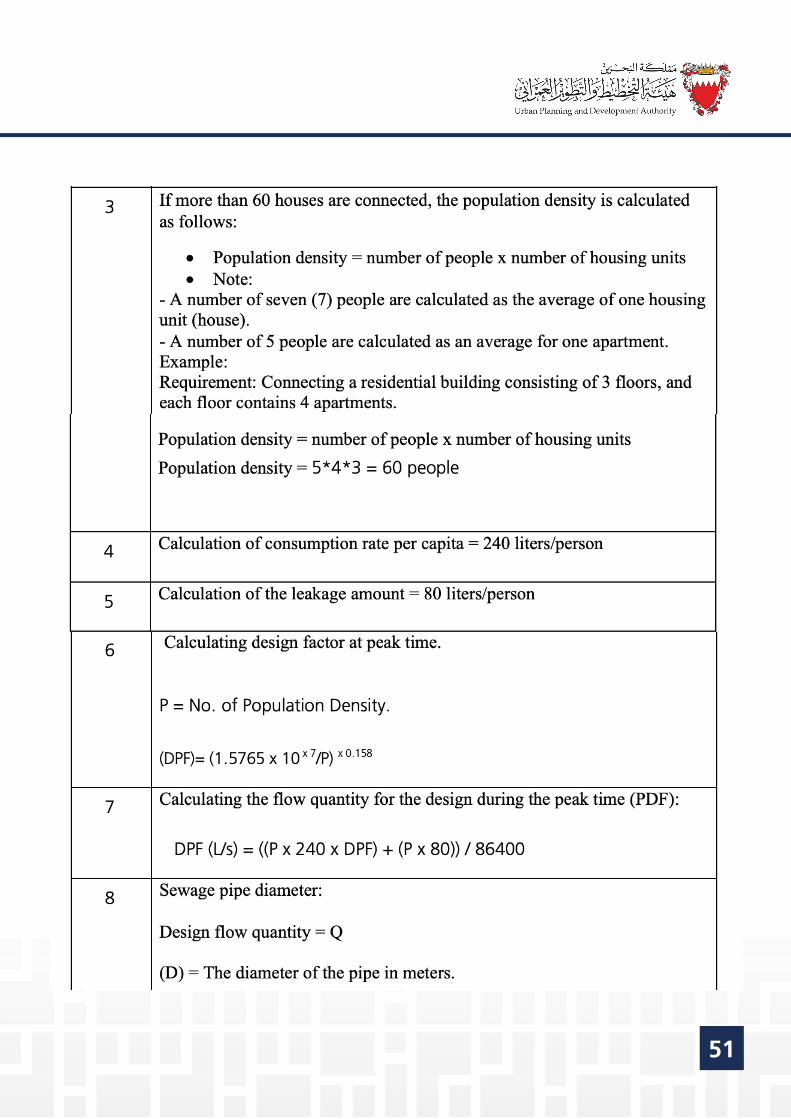
Note: To determine what type of plant is required, the (Peak Flow: PF) is calculated via calculating the volume of daily peak flows as stated in Table 7 below.
1.5: The required information to determine the land sites:
1.5.1: The proposed connection point to the existing sewerage network, which must be obtained from the Sanitary Engineering Planning and Projects Directorate.
1.5.2: Levels of proposed roads to be obtained from the Roads Planning and Design Directorate.
Table 7: Steps of the mechanism for locating land for pumping or lifting stations:
51

52

53

54

55
Requirements of the Agriculture Engineering & Water Resources Directorate
Section 4

56
Table of contents
1. Technical Requirements and Standards of the AgricultureEngineering & Water Resources Directorate at the Ministry of Works,Municipalitie Affairs and Urban
53

57
1- Requirements of the Agriculture Engineering & Water Resources Directorate:
T he request is studied to ascertain that there is an agricultural drainage net-work, treated sewage water network, underground wells, or palm trees within the boundaries of the property or neighboring properties, in addition to the existence of future projects related to the f Agriculture Engineering and Water Resources Directorate.
If there are existing services:
1.1: An application must be submitted to the Agriculture Engineering and Water Resources Directorate with the following documents attached:
1.1.1: Copy of the title deed. 1.1.2: A recent land survey certificate. 1.1.3: Engineering maps issued by a certified engineering office in (AutoCAD & PDF) format. 1.1.4: Applicant’s smart card or passport copy. 1.1.5: A copy of the certified power of attorney for the person acting on behalf of the applicant.
1.2: Requirements for completion of procedures:
1.2.1: In case of groundwater wells, the wells shall be closed under the supervision of the Agriculture Engineering and Water Resources Directorate by one of the contractors approved by the aforementioned Directorate. The applicant shall bear the costs.
1.2.2: If the treated wastewater network is affected, the network must be transferred or canceled under the supervision of the Agriculture Engineering and Water Resources Directorate by one of the contractors approved by the aforementioned Directorate. The applicant shall bear the costs.

58
1.2.3: If the agricultural drainage networks are affected, the network path must be diverted or changed from open to closed network or canceled under the supervision of the Agriculture Engineering and Water Resources Directorate by one of the contractors approved by the aforementioned Directorate. The applicant shall bear the costs.
1.2.4: If there are date palm trees, the applicant must replant them in the places designated for them. The applicant shall bear the costs.
1.2.5: The applicant must provide a new route for the affected existing services within the property itself, in case it is not possible to divert the network route within the services corridor outside the property.
1.3: General Notes:
1.3.1: All affected services to be protected by approved contractor under the spervision of the Agriculture Engineering and Water Resources Directorate.The applicant shall bear the costs.
1.3.2: None of the existing services shall be canceled without the approval of the competent committee, and the Directorate has the right to reject the request.

59
Requirements of the Electricity and Water Authority - Electricity Distribution Directorate
Section 5

60
Table of contents
1. Technical Requirements and Standards of the ElectricityDistribution Directorate, Electricity and Water Authority
57

61
1 - Requirements of the Electricity DistributionDirectorate
1.1: The amount of electricity required:The request shall be studied to calculate the electrical loads required to be con-nected to the divided plots of land according to needs. The required electrical loads are calculated to determine the number of sub or main electricity stations to be allocated according to the following:
(A) Provision of the electrical loads required by the applicant for land division according to Table No. 8.(B) Provision of information for each classification as follows: • The total area of land plots. • The number of plots of land after the division. • The total building area of plots of land. • The width and area of streets within the plan.
If the total electrical loads are more than 12,000 KVA, a main power station must be provided, according to the requirements for providing the main stations mentioned in Table No. 10.
Table 8: Equations required to calculate the amount of electricity required to be connected to the divided plots:

62

63
Table 9: Example of calculating the amount of electricity required for a land subdivision draft:
1.2: Sizes of Electrical Substations:If there is a need to allocate lands for the electrical substations based on the above- mentioned requirements, the measurements of the substations must be adhered to according to the following table:
Table 10: Sizes of Electrical Substations:
64
1.3: If there are existing services:
Sometimes there are connections for electricity within the properties requested to be divided. In this case the service must be disconnected or transferred in coordination with the Electricity Distribution Directorate through one of the contractors approved by the aforementioned Directorate, and the applicant bears the costs, or leaving adequate re-cessions to ensure that services are not affected.
1.4: General Notes:
1.4.1: The sizes and measurements of some substations may be approved despite their irregularity, subject to the approval of the Electricity Distribution Directorate. 1.4.2: The garbage collection sites to not be allocated near to the proposed Substations plots. 1.4.3: Any existing or temporary installations on the sites designated for substations must be removed. 1.4.4: Electricity Substations must face a road or a lane not less than 5 meters wide. 1.4.5: The Electricity Distribution Directorate shall have the right to re-estimate / re-calculate the required electrical load and determine the number of electricity substations required to be supplied in addition to their location. 1.4.6: The substation requirement shall be calculated as per the load allocation per plot. According to the load allocation, the number of services which can be connected per feeder shall be determined vide below table.

65
1.4.7: The location and sizes of substations shall be determined viewing the loading policy and also available corridor. For Road width 12.5m & 15.0m, EDD is assigned 1.0m corridor on both sides of the road. Only 4 LV cables and/or 3 11kV cables shall be proposed in 1.0m corridor.. 1.4.8: The location and sizes of substations shall be determined viewing the maximum length of LV cables (400 V) to the last plot to be supplied should not exceed 300 m. 1.4.9: The total load requirement for the entire project shall be calculated as a summation of load for individual plots. Primary substation requirement shall be as per the Ministerial rule 13/2006.

66
Requirements of the Electricity and Water Authority - Water Distribution Directorate
Section 6

67
Table of contents
1. Technical Requirements and Standards of the Water DistributionDirectorate, Electricity and Water Authority 64
68
1- Requirements of the Water Distribution Directorate
1.1: The amount of water required
The request shall be studied to calculate the water demand required to be delivered to the subdivided plots of the land according to needs. The amount is calculated using one of the two options mentioned below:
A) Provision of the water demand required by the applicant for the whole land subdivi-sion according to Table No. 11..
(B) Based on information for each classification as follows: • The total area of land plots. • The number of plots of land after the division. • The total built-up area of plots of land.
1.2: Allocation of sites for water stations:
The Planning and Studies Directorate shall be consulted internally to ensure the availabil-ity of water resources to be delivered to the divided plots of land. If there are no water sources for transmission and distribution, a plot of land must be allocated within the proposed division according to the measurements and areas mentioned in section seven on the requirements of the Planning and Studies Directorate.
1.3: If there are existing services:
Sometimes there are water connections within the properties requested to be divided. In this case the service must be disconnected or transferred in coordination with the Water Distribution Directorate through one of the contractors approved by the aforementioned Directorate, and the applicant bears the costs.
69
1.4: General Notes:
1.4.1: The standards used in designing water distribution network system must basically comply with the standards and guidelines issued by the Eletricity and Water Authority in the Kingdom of Bahrain (Water Distribution Directorate), which are as follows:
• Measured Term Contract (MTC) issued by the Electricity and Water Authority. • Technical guidelines for internal plumbing systems issued by the Electricity and Water Conservation Directorate at the Electricity and Water Authority.
1.4.2: Water services will be connected after the construction of the new water distribution tank is completed.
1.4.3: All terms and conditions of the Water Distribution Directorate shall apply.
1.4.4 Water Distribution Directorate shall determine the recession required for pipelines close to the proposed land division. .
1.4.5: MoU might be required and to be signed by the landowner /developer and EWA when decided by concerned directorate.
1.4.6: Commitment to the Buildings Internal Water Plumbings along with the Water Meter Fixing Guidance.

70
Table 11: Standard Rates for Water Consumption for various Uses:

71
Section 7
Requirements of the Electricity and Water Authority - Planning and Studies Directorate

72
Table of contents
1. Technical Requirements and Standards of the Planning and StudiesDirectorate, Electricity and Water Authority
69

73
1- Requirements of the Planning and Studies Directorate
1.1: Water Stations:
The request is studied to ensure that the sites of the water stations for forward-ing, storing, and distributing water are available in the detailed plan for the area. If site for a forwarding, storing and distributing station is not available, the allocation of a plot of land within the plan is requested according to the meas-urements and areas mentioned in the attached table below.
Table 12: Water stations measurements:
Water Forwarding Water Forwarding StationsStations
Water Storage, Water Storage, Forwarding and Forwarding and
Distribution StationsDistribution Stations

74
1.2: Water Transmission Corridors: Table 13: Measurements of main corridors for water transmission
1.3: Electricity Transmission Substations availability:The request is studied to ensure the availability of the electricity transmission substations near the detailed plan of the area. If resources to connect the elec-tricity transmission are not available, a plot of land within the plan shall be allo-cated according to the measurements and areas mentioned in the attached table below.
- Water - Water transmission transmission corridors should corridors should be outside the be outside the roads, preferably roads, preferably on the verge.on the verge.
- other services - other services shall not be shall not be share with water share with water transmission transmission corridors. corridors. -water -water transmission transmission corridors shall not corridors shall not be in private lands be in private lands or properties, or properties, and to be at and to be at ground level and ground level and reclaimed to the reclaimed to the final ground level. final ground level.
- The - The requirements of requirements of corridors are to be corridors are to be reviewed based reviewed based on demand on a on demand on a case-by-case.case-by-case.

75
Table 14: Electricity Transmission Substations measurements:
1.4: Electricity transmission corridors :
Table 15: Measurements of main corridors for electric power transmission:
SubstationSubstation
SubstationSubstation
4x2 m (4 m center to 4x2 m (4 m center to center clearancecenter clearance
between corridors)between corridors)
3x2 m (4 m center to 3x2 m (4 m center to center clearancecenter clearance
between corridors)between corridors)
2x2 m (4 m center to 2x2 m (4 m center to center clearancecenter clearance
between corridors)between corridors)
One corridor with a One corridor with a width of 2 mwidth of 2 m
(When needed to(When needed toconnect electricityconnect electricity
transmission substations transmission substations to the existingto the existing
transmission network)transmission network)
- Electricity transmission corridors should - Electricity transmission corridors should be outside the roads, preferably on the be outside the roads, preferably on the sidewalks.sidewalks.
- Other services shall not encroach the- Other services shall not encroach theelectricity transmission corridors. electricity transmission corridors.
-Electricity transmission corridors shall not -Electricity transmission corridors shall not be in private lands or properties, and shall be in private lands or properties, and shall be at ground level and buried to the final be at ground level and buried to the final level. level.
- The need for corridors is reviewed on- The need for corridors is reviewed ondemand on a case-by-case basis.demand on a case-by-case basis.
SubstationSubstation
SubstationSubstation

76
1.5: General Notes:
1.5.1: If there is no Water Station or electricity Primary Substation, the appropriate land must be provided within the zoning plan.
1.5.2: If there is a Water Station or electricity Primary Substation in the detailed plan of the area, but it is not sufficient for the water supply or required electricity loads, the appropriate land must be provided within the zoning plan.
1.5.3: The Planning and Studies Directorate of the Electricity and Water Authority shall decide the required horizontal clearances for existing and future water transmission pipelines and electricity transmission cables near the plan.
1.5.4: The sizes and measurements of some stations may be approved despite their irregularity, subject to the approval of the Planning and Studies Directorate of the Electricity and Water Authority.
1.5.5: Any existing or temporary installations on the sites allocated for the main Water Station and electricity transmission Substation must be removed.
1.5.6: The Planning and Studies Directorate of the Electricity and Water Authority has the right to recalculate the amount of water supply and electricity loads require, to determine the number of main Water Station and electricity transmission Substation to be provided, in addition to specifying their locations.
1.5.7: Provision of corridors required to install Water Transmission Pipelines and to lay electricity and water transmission cables, as shown in (1.1) and (1.2) above.
1.5.8 There may be a need to sign a memorandum of understanding between the developer and the Electricity and Water Authority in order to specify all require ments for the developer and the Electricity and Water Authority.

77
Section 8
Requirements of the TelecommunicationsRegulatory Authority

78
Table of contents
1. Technical Requirements and Standards of the TelecommunicationRegulatory Authority
75

79
1- Requirements of the Telecommunications Regulatory Authority
1.1: If there are existing services:
1. The request is studied to ascertain whether there is an impact on the terrestrial tele-communication services with the proposed zoning, as it can be avoided in the event that those services remain within the proposed roadway in the zoning project.
2. An alternate service corridor of 1 meter width shall be provided to divert existing tele-communications services. If these services are affected, the diversion of telecommunica-tion network is required under the supervision of BNET.
1.2: If there are no existing services:
Communications service corridors of one meter wide shall be provided in the footpath, and if a 1-meter-wide communications service corridor cannot be allocated, the develop-er should coordinate with the Central Planning Office at the Ministry of Works to provide possible solutions - such as the possibility of utilizing parts of adjacent service corridors to set up ground communications rooms - and send them to the Telecommunications Regulatory Authority for review and approval.
1.3: Allocation of sites for telecommunication towers:
The request is studied to ascertain whether the area within the zoning proposal is covered by wireless telecommunication services. If the area is not covered, a site within the plan is allocated to telecommunication towers to be determined by the Telecommunications Regulatory Authority when circulating the zoning proposal to the various service agencies, as attached in the standards for allocat-ing sites to telecommunication towers as follows: • The land should measure 10 x 10 meters. • The land must not be located in the middle of the plot of land. • It is preferable to allocate a land near public services. • It is preferable not to allocate a land on the corner (lands facing two or more streets).
3- Guidelines for In-Building Telecommunications Access Facilities https://www.tra.org.bh/en/category/position-papers-and-guidelines

80
• No land shall be allocated for telecommunications tower within areas of 6-floor buildings or more within the following classifications:
A. Investment Buildings Areas “A” (BA). B. Investment Buildings Areas “B” (BB). C. Investment Buildings Areas “B1” (BB1). D. Investment Buildings Areas “B2” (BB2). E. Investment Buildings Areas “C” (BC). F. Investment Buildings Areas “D” (BD). G. Investment Buildings Areas “H” (BH). H. Green Buildings Areas “A” (GBA). I. Green Buildings Areas “A” (GBA). J. Green Buildings Areas “B” (GBA).
6. Land must not be allocated in subdivision application requests.