U Land use PP2
10
Urban Land Use Planning K e y - E l e m e n t ss Element is a separate identifiable part or component in a large group. Key-elements in urban land-use planning means “These are number of component or parts” in urban land-use scheme and these key-elements can direct guide to the planner in the urban land use planning to use the land in proper manner. Without these key-elements a planner may not be use the proposed land to the needs of the particular settlement and finally it may result inconvenience with ugly appearance. The following are the various key-elements in urban land-use planning; 1. Blocks; 2. Urban Pattern; 3. Building Form; 4. Open Space; 5. Greenery/Green-belt, 6. Roads & Street-network; 7. Pedestrians, 8. Vehicle Access, 9. Street-Scape, 10. Night-Lighting,
Transcript of U Land use PP2

Urba
n Land
Use P
lannin
g K e y - E l e m e
n t ssElement is a separate identifiable part or component in a large group. Key-elements in urban land-use planning means “These are number of component or parts” in urban land-use scheme and these key-elements can direct guide to the planner in the urban land use planning to use the land in proper manner. Without these key-elements a planner may not be use the proposed land to the needs of the particular settlement and finally it may result inconvenience with ugly appearance. The following are the various key-elements in urban land-use planning;
1. Blocks;2. Urban Pattern;3. Building Form;4. Open Space;5. Greenery/Green-belt,6. Roads & Street-network;7. Pedestrians,8. Vehicle Access,9. Street-Scape,10.Night-Lighting,
K e y - E l e m e n t ss
Urba
n Land
Use P
lannin
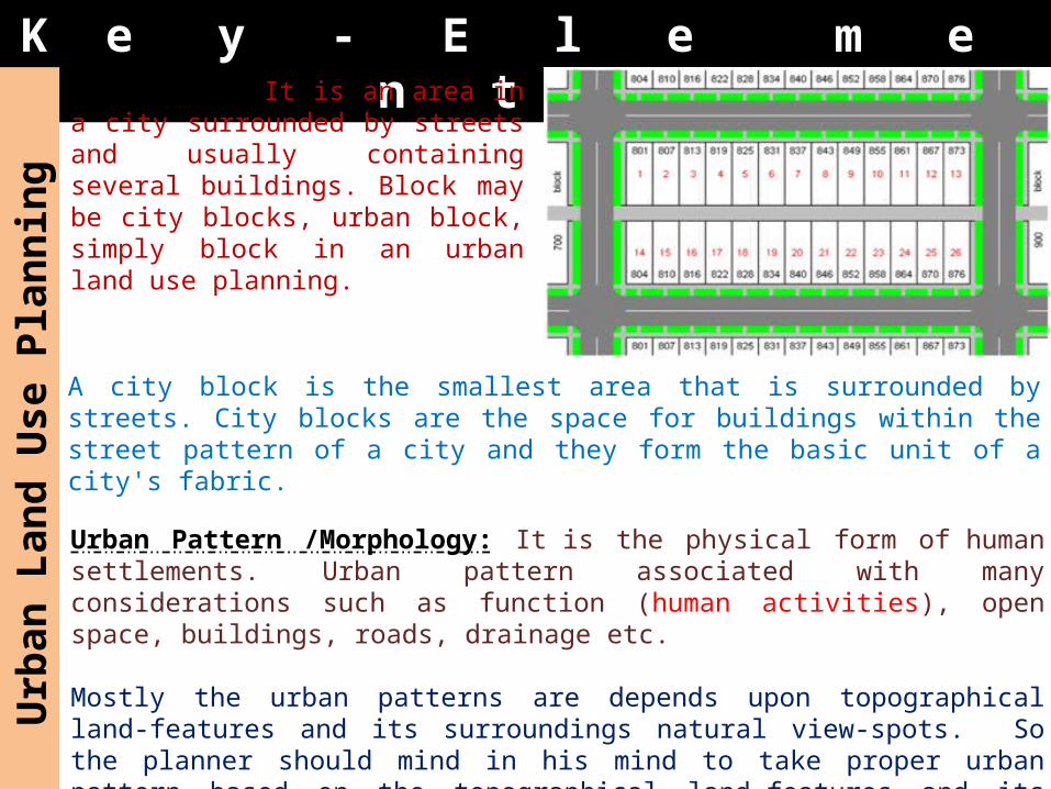
g City Block: It is an area in a city surrounded by streets and usually containing several buildings. Block may be city blocks, urban block, simply block in an urban land use planning.
Urban Pattern /Morphology: It is the physical form of human settlements. Urban pattern associated with many considerations such as function (human activities), open space, buildings, roads, drainage etc.
Mostly the urban patterns are depends upon topographical land-features and its surroundings natural view-spots. So the planner should mind in his mind to take proper urban pattern based on the topographical land-features and its natural surroundings. Based on the topographical land-feature urban pattern is classified in to;
A city block is the smallest area that is surrounded by streets. City blocks are the space for buildings within the street pattern of a city and they form the basic unit of a city's fabric.

K e y - E l e m e n t ss
Urba
n Land
Use P
lannin
g Rectangular Urban Pattern: It is also called as grid-iron
or chequer-board pattern. In this pattern city/urban blocks are cross at right angle. This type of pattern is more suitable for flat or level land without any predominant natural features.
Best examples for this patter : Phildelphia (U.S.A), Jaipur in India, Hawasa in Ethiopia.
Advantages: It grants comfort and
convenience due to its regularity.
The intersections are simple in nature.
It provides economical construction of rectangular blocks in between the roads or streets due to its regularity.
The wastage of land is minimized as there are no irregular land portions to be left out.
Dis-advantages: There are many intersections, so there are more chances of
road accidents. It is not suitable for un-even topography of land; if it
was applied it leads to great inconvenience and dis-comfort.
It is too mathematical and monotonous in nature because of the straight, hence the vistas (long narrow) are open and there is no variety.
There are no short-cuts to reach the central shopping or other business centers.

K e y - E l e m e n t ss
Urba
n Land
Use P
lannin
g Radial Urban Pattern: In this pattern, the ring roads
spring from central civic centers like spokes of a wheel. Such arrangement increase the significance and importance of civic center which may be in the form of palace, market, public office buildings, historical monuments, beauty spots etc. Karlsruhe in Germany is the best example of this urban pattern.
Advantages: It well-comes the utilization
of various road/street patters like ring and radial types.
It results in getting various sizes of trapezoidal blocks.
It increases the significance and importance of civic center like palace, market, public office buildings, historical monuments, beauty spots.
Dis-advantages: It results in more wastage of land in the
design of buildings. It may be un-economical from the
construction point of view.

Urba
n Land
Use P
lannin
g K e y - E l e m e
n t ss Topographical Urban Pattern: This is also called as organic urban pattern. This type of pattern is mostly based on the natural topographical features such as river, lake, sea view, hillock etc. The roads/streets are
absolutely unplanned manner and they formed in irregular manner like cell-structure of vegetable. Even the open spaces are irregular with different curvatures.
Advantages: It utilizes most of the organic patterns. It results in utilizing the beauty of the natural views. It will give verities of land-blocks with different shapes
and sizes. It well-comes the use of different roads and streets with
various widths. It produce the traditional architecture in nature.Dis-advantages: It results in wastage of land in the design of buildings
in a particular part. It may be un-economical from the construction point of
view.

Urba
n Land
Use P
lannin
g K e y - E l e m e
n t ssBuilding Forms: Different building forms are also one of the important key-elements in urban land use planning. Different buildings in both aspects of function (purpose/activity) and category (low/medium/high density) judge the urban pattern as well as amount of land requirements. The buildings are grouped in to various groups in the urban land use planning based on their form in terms of height, volume. Building forms can guide or direct to the planner to use the land in a proper manner.
This gives the urban area a sense of well-planned by proper land use planning. Buildings in the CBD were historically built high rise and they reflecting the need to optimize the land to maximize its value.
For example, the land use planning of an urban area (figure below) has different building and they are grouped in to various groups based on their building form.

Urba
n Land
Use P
lannin
g K e y - E l e m e
n t ssOpen Spaces: It includes squares, parks, play-grounds, green open space and gardens etc.In his natural state, man moved and roamed in open space and he thoroughly enjoyed his association with the nature. During the course of time, man moved to town and due to development and urbanization. Even at this state, he has got the deep rooted desire to remain in contact with soil and it is for this reason that open space in the form of parks, play grounds and urban square should always be provided in a urban planning projects.
Objective of open space: Welfare: – happiness, general
wellbeing; Safety: – freedom from or prevention
of danger, risk or injury; Health:–state of functioning
normally without disease or abnormality;
Pleasure: – An enjoyable sensation or emotion;
Play: – to occupy oneself in amusing or diverting activities Open Space Functions:
Recreational activities; Market activities; Health activities like jogging etc...

K e y - E l e m e n t ss
Urba
n Land
Use P
lannin
g Greenery: It is the provision of vegetation. Greenery plays an important role in proper urban land use planning as well-planned manner and it result as a natural city in a garden.The provision of greenery encourages the natural beauty as well as it controlled various pollutions of air, water and sound, mitigation the urban heat island effect etc.Road-network: “A man is known by the company he keeps”. In a similar way, a city is admired by its road system. A well-arranged layout of a town is spoiled, if it does not having a well-designed road pattern connecting with various parts of the town.
The well-road network of a city result into free flow of traffic with safety.
An irregularly arranged road network result in attract of many evils such as heavy traffic congestion, ugly pattern of the city or urban pattern, ribbon development etc.

K e y - E l e m e n t ss
Urba
n Land
Use P
lannin
g Pedestrian /Pathway: Well-arranged pedestrian networks to allow people to move easily and comfortably within the city. It connects open spaces, points of interest and parks at different levels, allowing you to appreciate the city from different perspectives.
Vehicular Access: It includes car-parking and drop-off points. The location of car parks and drop-off points affect the way vehicles navigate their way around the city and it also influences how pedestrians experience the city. It is important to separate pedestrians from vehicular traffic to avoid causing danger and conflict to pedestrians.

K e y - E l e m e n t ss
Urba
n Land
Use P
lannin
g Streetscape: It an artistic portrayal (visualization of picture, sculpture) of a street and its activities. Streets can make our interaction with our city richer and memorable. The character of the street is contributed by active uses at the street level including signage, lighting, landscaping, pictures, sculptures, building form and street architecture.
Night Lighting: Night lighting extends the life of the city beyond twilight and sunset. It also enhances the character of the proper urban land use and experience of the city at night. Through our Night Lighting urban land use Plan, we encourage building owners in the CBD.