Omnidirectional vision applied to Unmanned Aerial Vehicles (UAVs) attitude and heading estimation
Upload
khangminh22Category
view
1download
0
Citation: Mohsan, S.A.H.; Khan,
M.A.; Noor, F.; Ullah, I.; Alsharif,
M.H. Towards the Unmanned Aerial
Vehicles (UAVs): A Comprehensive
Review. Drones 2022, 6, 147. https://
doi.org/10.3390/drones6060147
Academic Editor: Vishal Sharma
Received: 20 May 2022
Accepted: 10 June 2022
Published: 15 June 2022
Publisher’s Note: MDPI stays neutral
with regard to jurisdictional claims in
published maps and institutional affil-
iations.
Copyright: © 2022 by the authors.
Licensee MDPI, Basel, Switzerland.
This article is an open access article
distributed under the terms and
conditions of the Creative Commons
Attribution (CC BY) license (https://
creativecommons.org/licenses/by/
4.0/).
drones
Review
Towards the Unmanned Aerial Vehicles (UAVs): AComprehensive ReviewSyed Agha Hassnain Mohsan 1 , Muhammad Asghar Khan 2 , Fazal Noor 3 , Insaf Ullah 2
and Mohammed H. Alsharif 4,*
1 Ocean College, Zhejiang University, Zheda Road 1, Zhoushan 316021, China; [email protected] Department of Electrical Engineering, Hamdard Institute of Engineering & Technology, Islamabad 44000, Pakistan;
[email protected] (M.A.K.); [email protected] (I.U.)3 Faculty of Computer and Information Systems, Islamic University of Madinah, Madinah 400411, Saudi Arabia;
[email protected] Department of Electrical Engineering, College of Electronics and Information Engineering, Sejong University,
Seoul 05006, Korea* Correspondence: [email protected]
Abstract: Recently, unmanned aerial vehicles (UAVs), also known as drones, have come in a greatdiversity of several applications such as military, construction, image and video mapping, medical,search and rescue, parcel delivery, hidden area exploration, oil rigs and power line monitoring, preci-sion farming, wireless communication and aerial surveillance. The drone industry has been gettingsignificant attention as a model of manufacturing, service and delivery convergence, introducingsynergy with the coexistence of different emerging domains. UAVs offer implicit peculiarities such asincreased airborne time and payload capabilities, swift mobility, and access to remote and disasterareas. Despite these potential features, including extensive variety of usage, high maneuverability,and cost-efficiency, drones are still limited in terms of battery endurance, flight autonomy and con-strained flight time to perform persistent missions. Other critical concerns are battery endurance andthe weight of drones, which must be kept low. Intuitively it is not suggested to load them with heavybatteries. This study highlights the importance of drones, goals and functionality problems. In thisreview, a comprehensive study on UAVs, swarms, types, classification, charging, and standardizationis presented. In particular, UAV applications, challenges, and security issues are explored in thelight of recent research studies and development. Finally, this review identifies the research gap andpresents future research directions regarding UAVs.
Keywords: UAVs; charging; challenges; security; applications
1. Introduction
Unmanned aerial vehicles (UAVs), also known as drones, have received momentousconsideration in different disciplines of military and civilian services due to their enhancedstability and endurance in several operations. Applications of UAVs are expanding ex-ceptionally due to their advanced use in the internet of things (IoT), 5G and B5G. UAVshave been used in a variety of applications over the last decade, including object detectionand tracking, public security, traffic surveillance, military operations, exploration of hid-den or hazardous areas, indoor or outdoor navigation, atmospheric sensing, post-disasteroperations, healthcare, data sharing, infrastructure management, emergency and crisismanagement, freight transportation, wildfire monitoring and logistics [1].
A UAV is commonly referred as a pilotless aircraft with the capability to fly and stayairborne without requiring any human onboard operator, providing more cost-efficientoperations than equivalent manned systems, and performing cost-efficient critical missionwithout risking human life. UAVs can be remotely piloted, whereby control commandsare provided from a ground base station (BS) through a remote control. The UAVs are
Drones 2022, 6, 147. https://doi.org/10.3390/drones6060147 https://www.mdpi.com/journal/drones
Drones 2022, 6, 147 2 of 27
also capable of performing the control operations onboard through autopilot and differentsensors, including global positioning system (GPS) and inertial measurement units (IMU).
In particular, UAVs have gained significant attention from leading online retailers,including Walmart, DHL, Google, and Amazon [2,3]. Because of the constantly growingpopularity of online shopping, which may have a substantial impact on client purchases,users are increasingly demanding high speed delivery services. As a result, online retailersare looking for ways to improve delivery times. Retailers, on the other hand, face a majorchallenge in offering ecofriendly, cost-effective, and efficient last-mile delivery. UAVs haveemerged as promising solutions in this sector, with quick and innovative designs thatensure last-mile delivery while being environmentally friendly. UAVs can be deployedeasily and quickly, are scalable and flexible, have the self-organization ability, are cost-efficient, and possess high maneuverability. UAVs vary widely in configuration, size, range,weight, engine type and performance characteristics in order to carry several payloadsincluding communication gadgets, navigation equipment, sensors, and cameras. There aredifferent classifications of UAVs according to various parameters such as configuration,engine type, weight, range and size.
However, there are several crucial factors limiting the performance of UAVs. Someof these factors are limited battery endurance, restricted mobility, limited autonomy, andlimited flight time. Limited flight time is due to various factors including sensor accuracy,harsh atmospheric conditions, fixed-wing size and battery endurance. UAVs have severalvulnerabilities that increase the rate of being exposed to malicious attacks. Several studiesare devoted to assess UAVs vulnerabilities, attacks, threats and have suggested viablesolutions to overcome these challenges, such as using high quality devices includingbatteries, wing, geometry, manufacturing materials and motors etc. Some studies havereported optimization algorithms to find shortest route for UAVs to reach their intendeddestination [4,5].
1.1. Scope and Contributions
This review is intended for readers who are inclined to read about UAV technology.This work is a comprehensive review on UAV’s critical existing challenges, security con-cerns, applications and future research directions. This review aims to assist the readers getan overview of the state-of-the-art UAV technology in several aspects. The readers will havea good overview of UAV types, charging, autonomous swarms, and different applicationscenarios. It provides a complete review of anticipated attacks on UAVs. It also investigatesrealistic recommendations to improve UAV architecture to ensure secure communication.Extensive analyses are carried out for various viable solutions to empower the utility ofUAVs in different applications. It provides an assessment of existing challenges, securityissues, and future research directions to develop secure UAV communication.
1.2. Organization of the Paper
We have organized this paper as follows. Section 2 describes the related researchcontributions to UAVs. Section 3 provides basic information about UAVs in differentaspects, such as types, classifications, swarms, flight time, payload, and standardization.Section 4 addresses the UAV’s battery charging. Section 5 is devoted to UAVs for 5G andinternet of things (IoT) technology. Section 6 focuses on different applications of UAVs.Security challenges and solutions are briefly explained in Section 7. Section 8 highlightsfuture research directions. Finally, Section 9 concludes the paper.
2. Related Work
In this section, we highlight various research contributions to enhance the utility ofUAVs in different applications. Several leading companies, including Skycatch, Yuneec,DJI, and Amazon, are focusing on UAVs in terms of load carrying efficiency, parcel delivery,and monitoring etc. “Amazon Prime Air” was initiated by Amazon to deliver packagesof five pound within thirty minutes at a distance of 10 miles [6]. After introducing UAVs,
Drones 2022, 6, 147 3 of 27
the company is ambitious to achieve 50% of zero-impact shipment till 2030. DHL alsostarted its drone “Parcelcopter” to deliver medicine [7]. Later, the DHL Trend ResearchTeam also published a report on new trends, applications, and limitations of UAVs. In 2017,Walmart started drone service and later requested permission from the Federal AviationAdministration (FAA) for commercial delivery drones in 2019 [8]. Similarly, in 2017 UPSstarted a battery powered drone service for home package delivery [9]. In February 2017,a Chinese-made autonomous flying drone taxi named “Ehang 184” was tested in Dubai.It has a top speed of 63 mph and can transport a passenger weighing up to 100 kg aswell as a small luggage [10]. In 2019, Zipline International used UAV medical service todistribute life-saving medicines, blood, and vaccines to 2000 healthcare centers in the southof Ghana [11]. Several countries have started promoting drone research and developmentfor multiple services [12,13].
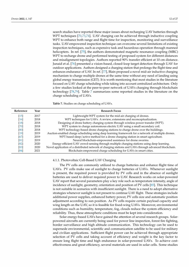
Several research studies have focused on multiple aspects of drones. For instance,authors in ref. [14] have addressed mobile charging feature to increase the battery lifeof drones. Aldhaher et al. [15], proposed a model to decrease the weight of a drone byintegrating a wireless powered receiver. Lu et al. [16] suggested several techniques toenhance the flight time of drones through wired as well as wireless media. Kim et al. [4]proposed a method to decrease drones congestion at the charging station through analgorithm for queuing time and charging time. The authors in [17] proposed a model forlanding and charging of drones on the roof of a building. In this study, the authors have alsoaddressed misalignment losses and possible solutions to overcome them. Rohan et al. [18]proposed a mechanism comprised of multiple transmitters and a single receiver for dronescharging. Similarly, Shin et al. [19] proposed a model for the allocation of time slots to thedrones through an auctioning process. Besides these studies, there are several researchsurveys that highlight different issues and challenges of UAVs, as shown in Table 1.
Table 1. Surveys of UAVs issues and challenges.
Reference Year Research Focus
[20] 2015This study surveys major collision avoidance mechanisms discussed in different publications. Thesemechanisms are based on sensing, detection and collision avoidance. Authors briefly explained variouscharacteristics, benefits and drawbacks.
[21] 2016
This survey addresses the characteristics of UAVs for civil applications over the period 2000 to 2015considering networking and communication aspects. Authors surveyed the data requirements, networkmission parameters and quality of service requirements. Moreover, they elaborated common networkingrequirements including scalability, security, privacy, safety, adaptability and connectivity.
[22] 2017This study discusses open-source flight controllers, which are being used for academic research. It alsointroduces UAV along with required components. This study fully addresses software and hardwareopen-source flight controller platforms.
[23] 2018The study focuses on UAV cellular communication and bridges the gap between 3GPP standardizationstatus quo and the future research. Specifically, it addresses downlink command and control (C&C)channel for aerial users.
[24] 2019
This study presents a comprehensive survey of UAV developments and its integration into cellularnetworks. It highlights consumer UAVs, interferences challenges and mitigative solutions, UAVprototype and testbed activities, regulations, challenges and security issues of UAV-aidedcellular communications.
[25] 2019
This study provides a comprehensive tutorial on applications and advantages of UAVs in wirelesscommunication. It investigates potential challenges and important trade-offs in UAV-assisted wirelessnetworks. It highlights key factors including energy efficiency, channel modeling, performance analysisand 3D deployment. It also describes several mathematical tools and analytical frameworks includinggame theory, transport theory, stochastic geometry, machine learning, and optimization theory.
Drones 2022, 6, 147 4 of 27
Table 1. Cont.
Reference Year Research Focus
[26] 2019This study surveys UAV communication towards 5G/B5G wireless networks. It discussesspace-air-ground integrated networks and associated challenges. It also identifies several open researchproblems and future research directions.
[27] 2019This study presents a comprehensive survey on the integration UAV-enabled wireless networks and of5G mmWave communication. It highlights existing research problems and cutting-edge solutions. Thisstudy also points out open issues and sheds new light on future research directions.
[28] 2020
This article presents a comprehensive study on UAV regulations, potential applications and challenges.Particularly, it addresses challenges including security, energy harvesting techniques, optimal trajectory,collision avoidance, interference mitigation, channel modeling and UAV standardization. Finally, itpresents several problems and future research directions.
[29] 2020
This study focuses on Network Function Virtualization (NFV) andSoftware-Defined Network (SDN) technologies. In addition, it presents an in-depth analysis of use cases,classifications and challenges of UAVs. It also discusses NFV/SDN-assisted UAV systems along withdifferent case studies and issues. Finally, it outlines open research problems, high level insights, andfuture research directions.
[30] 2020 This study is dedicated to the safety of UAVs from three different aspects such as communications,sensors and multiple UAVs.
[31] 2020This survey presents a generic review on several applications of multi-UAV systems. Moreover, itprovides architectural and nomenclature taxonomy. Finally, it discusses UAV challenges andcurrent trends.
[32] 2021
This article carries out a comprehensive survey on green UAV communications for future 6G networks.In particular, it introduces the typical UAVs and their energy consumption models. It also discusses thetypical trends and typical applications of UAVs. Finally, it investigates open research issues and severalpromising techniques.
[33] 2021This study presents general architecture of UAV prototype along with experimental demonstration forUAV energy consumption model and air-to-ground channel models. In the end, it highlights somepromising future directions for UAV prototype and experimental verifications.
[34] 2021This study provides deep learning techniques for vehicle detection from UAV aerial images. It focuseson accuracy enhancement, computation overhead reduction and optimization objective. This study willhelp researchers in the area of traffic surveillance and artificial intelligence.
3. Unmanned Aerial Vehicles (UAVs)
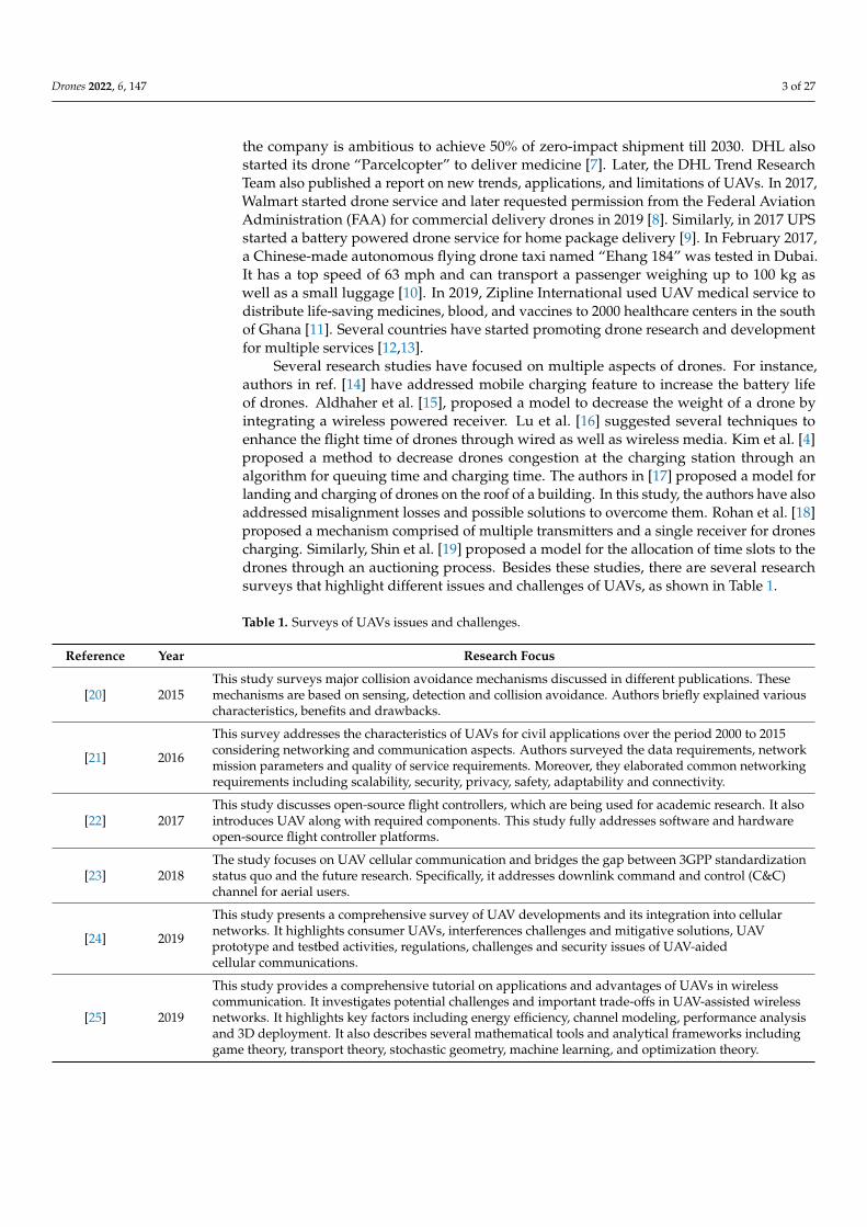
In recent years, UAVs have gained significant attention. Generally, UAVs refer tocontrolled aerial vehicles without carrying a human pilot on them. It can be autonomouslycontrolled and operated through sensors, microprocessors and other electronic gadgets [35].Figure 1 depicts a typical UAV system architecture, showing how UAVs interact withsatellites, ground control systems (GCS), smart phones, and computers via communicationlinks. A human operator is used to control and operate a UAV remotely. UAVs can performautonomous tasks in situations where human intervention is difficult or dangerous [36].
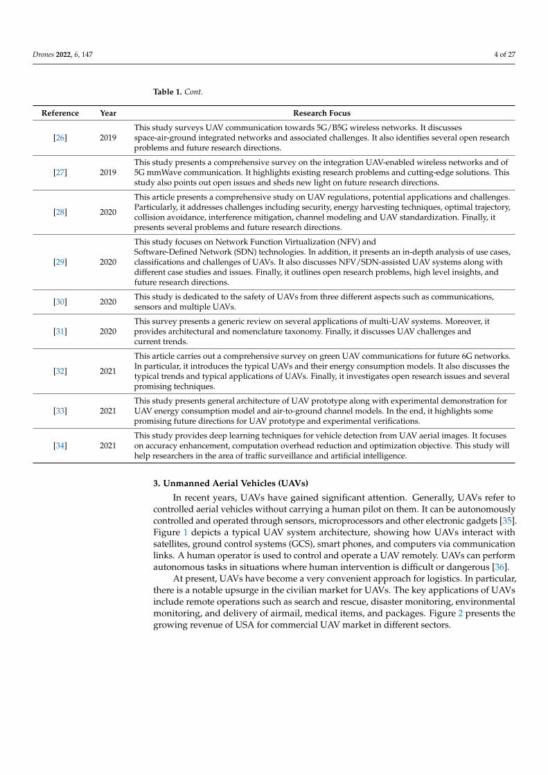
At present, UAVs have become a very convenient approach for logistics. In particular,there is a notable upsurge in the civilian market for UAVs. The key applications of UAVsinclude remote operations such as search and rescue, disaster monitoring, environmentalmonitoring, and delivery of airmail, medical items, and packages. Figure 2 presents thegrowing revenue of USA for commercial UAV market in different sectors.
Drones 2022, 6, 147 5 of 27Drones 2022, 6, x FOR PEER REVIEW 5 of 28
Figure 1. Architecture of UAV system.
At present, UAVs have become a very convenient approach for logistics. In partic-ular, there is a notable upsurge in the civilian market for UAVs. The key applications of UAVs include remote operations such as search and rescue, disaster monitoring, envi-ronmental monitoring, and delivery of airmail, medical items, and packages. Figure 2 presents the growing revenue of USA for commercial UAV market in different sectors.
Figure 2. Commercial UAV market of North America [37].
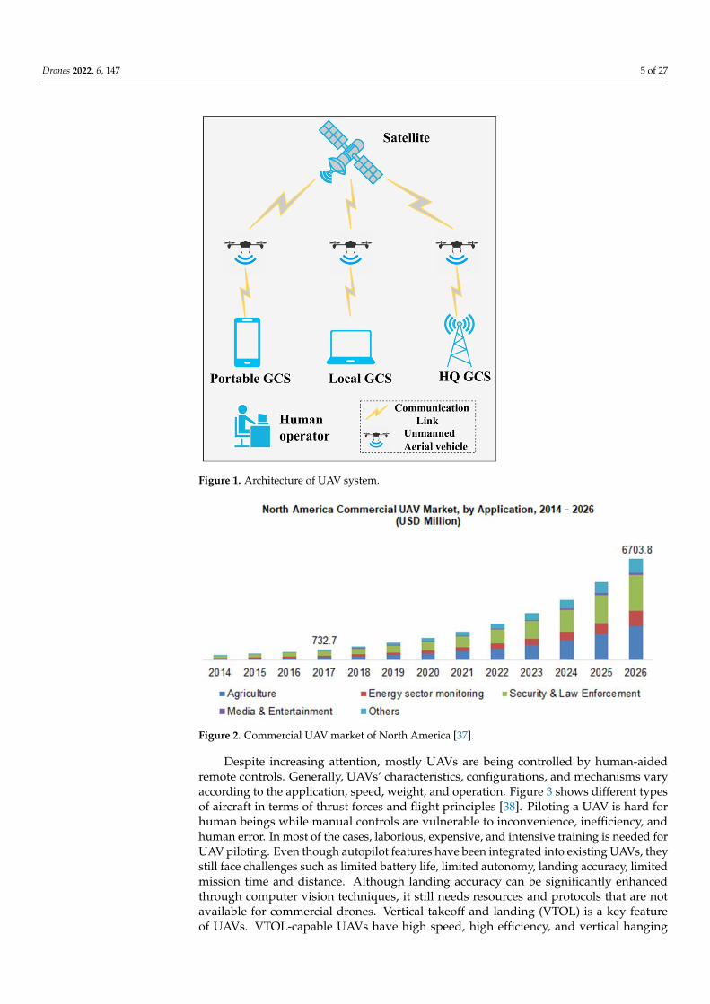
Despite increasing attention, mostly UAVs are being controlled by human-aided remote controls. Generally, UAVs’ characteristics, configurations, and mechanisms vary according to the application, speed, weight, and operation. Figure 3 shows different types of aircraft in terms of thrust forces and flight principles [38]. Piloting a UAV is hard for human beings while manual controls are vulnerable to inconvenience, inefficiency, and human error. In most of the cases, laborious, expensive, and intensive training is
Figure 1. Architecture of UAV system.
Drones 2022, 6, x FOR PEER REVIEW 5 of 28
Figure 1. Architecture of UAV system.
At present, UAVs have become a very convenient approach for logistics. In partic-ular, there is a notable upsurge in the civilian market for UAVs. The key applications of UAVs include remote operations such as search and rescue, disaster monitoring, envi-ronmental monitoring, and delivery of airmail, medical items, and packages. Figure 2 presents the growing revenue of USA for commercial UAV market in different sectors.
Figure 2. Commercial UAV market of North America [37].
Despite increasing attention, mostly UAVs are being controlled by human-aided remote controls. Generally, UAVs’ characteristics, configurations, and mechanisms vary according to the application, speed, weight, and operation. Figure 3 shows different types of aircraft in terms of thrust forces and flight principles [38]. Piloting a UAV is hard for human beings while manual controls are vulnerable to inconvenience, inefficiency, and human error. In most of the cases, laborious, expensive, and intensive training is
Figure 2. Commercial UAV market of North America [37].
Despite increasing attention, mostly UAVs are being controlled by human-aidedremote controls. Generally, UAVs’ characteristics, configurations, and mechanisms varyaccording to the application, speed, weight, and operation. Figure 3 shows different typesof aircraft in terms of thrust forces and flight principles [38]. Piloting a UAV is hard forhuman beings while manual controls are vulnerable to inconvenience, inefficiency, andhuman error. In most of the cases, laborious, expensive, and intensive training is needed forUAV piloting. Even though autopilot features have been integrated into existing UAVs, theystill face challenges such as limited battery life, limited autonomy, landing accuracy, limitedmission time and distance. Although landing accuracy can be significantly enhancedthrough computer vision techniques, it still needs resources and protocols that are notavailable for commercial drones. Vertical takeoff and landing (VTOL) is a key featureof UAVs. VTOL-capable UAVs have high speed, high efficiency, and vertical hanging
Drones 2022, 6, 147 6 of 27
capability in the air. The aircraft under the “Motorized” section on the left side of Figure 3are UAVs with VTOL features.
Drones 2022, 6, x FOR PEER REVIEW 6 of 28
needed for UAV piloting. Even though autopilot features have been integrated into ex-isting UAVs, they still face challenges such as limited battery life, limited autonomy, landing accuracy, limited mission time and distance. Although landing accuracy can be significantly enhanced through computer vision techniques, it still needs resources and protocols that are not available for commercial drones. Vertical takeoff and landing (VTOL) is a key feature of UAVs. VTOL-capable UAVs have high speed, high efficiency, and vertical hanging capability in the air. The aircraft under the “Motorized” section on the left side of Figure 3 are UAVs with VTOL features.
Figure 3. Classification of UAVs [38–43].
3.1. Classification of UAVs UAVs are available with different specifications, equipment, sizes, range, and
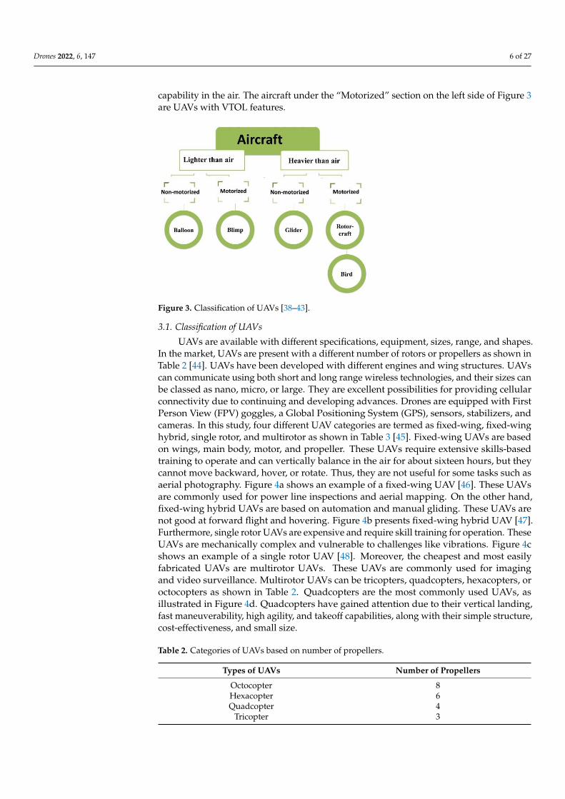
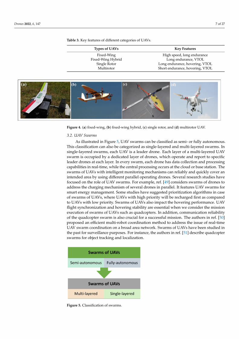
shapes. In the market, UAVs are present with a different number of rotors or propellers as shown in Table 2 [44]. UAVs have been developed with different engines and wing structures. UAVs can communicate using both short and long range wireless technolo-gies, and their sizes can be classed as nano, micro, or large. They are excellent possibilities for providing cellular connectivity due to continuing and developing advances. Drones are equipped with First Person View (FPV) goggles, a Global Positioning System (GPS), sensors, stabilizers, and cameras. In this study, four different UAV categories are termed as fixed-wing, fixed-wing hybrid, single rotor, and multirotor as shown in Table 3 [45]. Fixed-wing UAVs are based on wings, main body, motor, and propeller. These UAVs require extensive skills-based training to operate and can vertically balance in the air for about sixteen hours, but they cannot move backward, hover, or rotate. Thus, they are not useful for some tasks such as aerial photography. Figure 4a shows an example of a fixed-wing UAV [46]. These UAVs are commonly used for power line inspections and aerial mapping. On the other hand, fixed-wing hybrid UAVs are based on automation and manual gliding. These UAVs are not good at forward flight and hovering. Figure 4b presents fixed-wing hybrid UAV [47]. Furthermore, single rotor UAVs are expensive and require skill training for operation. These UAVs are mechanically complex and vulnera-ble to challenges like vibrations. Figure 4c shows an example of a single rotor UAV [48]. Moreover, the cheapest and most easily fabricated UAVs are multirotor UAVs. These UAVs are commonly used for imaging and video surveillance. Multirotor UAVs can be tricopters, quadcopters, hexacopters, or octocopters as shown in Table 2. Quadcopters are the most commonly used UAVs, as illustrated in Figure 4d. Quadcopters have gained attention due to their vertical landing, fast maneuverability, high agility, and takeoff ca-pabilities, along with their simple structure, cost-effectiveness, and small size.
Figure 3. Classification of UAVs [38–43].
3.1. Classification of UAVs
UAVs are available with different specifications, equipment, sizes, range, and shapes.In the market, UAVs are present with a different number of rotors or propellers as shown inTable 2 [44]. UAVs have been developed with different engines and wing structures. UAVscan communicate using both short and long range wireless technologies, and their sizes canbe classed as nano, micro, or large. They are excellent possibilities for providing cellularconnectivity due to continuing and developing advances. Drones are equipped with FirstPerson View (FPV) goggles, a Global Positioning System (GPS), sensors, stabilizers, andcameras. In this study, four different UAV categories are termed as fixed-wing, fixed-winghybrid, single rotor, and multirotor as shown in Table 3 [45]. Fixed-wing UAVs are basedon wings, main body, motor, and propeller. These UAVs require extensive skills-basedtraining to operate and can vertically balance in the air for about sixteen hours, but theycannot move backward, hover, or rotate. Thus, they are not useful for some tasks such asaerial photography. Figure 4a shows an example of a fixed-wing UAV [46]. These UAVsare commonly used for power line inspections and aerial mapping. On the other hand,fixed-wing hybrid UAVs are based on automation and manual gliding. These UAVs arenot good at forward flight and hovering. Figure 4b presents fixed-wing hybrid UAV [47].Furthermore, single rotor UAVs are expensive and require skill training for operation. TheseUAVs are mechanically complex and vulnerable to challenges like vibrations. Figure 4cshows an example of a single rotor UAV [48]. Moreover, the cheapest and most easilyfabricated UAVs are multirotor UAVs. These UAVs are commonly used for imagingand video surveillance. Multirotor UAVs can be tricopters, quadcopters, hexacopters, oroctocopters as shown in Table 2. Quadcopters are the most commonly used UAVs, asillustrated in Figure 4d. Quadcopters have gained attention due to their vertical landing,fast maneuverability, high agility, and takeoff capabilities, along with their simple structure,cost-effectiveness, and small size.
Table 2. Categories of UAVs based on number of propellers.
Types of UAVs Number of Propellers
Octocopter 8Hexacopter 6Quadcopter 4
Tricopter 3
Drones 2022, 6, 147 7 of 27
Table 3. Key features of different categories of UAVs.
Types of UAVs Key Features
Fixed-Wing High speed, long enduranceFixed-Wing Hybrid Long endurance, VTOL
Single Rotor Long endurance, hovering, VTOLMultirotor Short endurance, hovering, VTOL
Drones 2022, 6, x FOR PEER REVIEW 7 of 28
Table 2. Categories of UAVs based on number of propellers.
Types of UAVs Number of Propellers Octocopter 8 Hexacopter 6 Quadcopter 4
Tricopter 3
Table 3. Key features of different categories of UAVs.
Types of UAVs Key Features Fixed-Wing High speed, long endurance
Fixed-Wing Hybrid Long endurance, VTOL Single Rotor Long endurance, hovering, VTOL Multirotor Short endurance, hovering, VTOL
Figure 4. (a) fixed-wing, (b) fixed-wing hybrid, (c) single rotor, and (d) multirotor UAV.
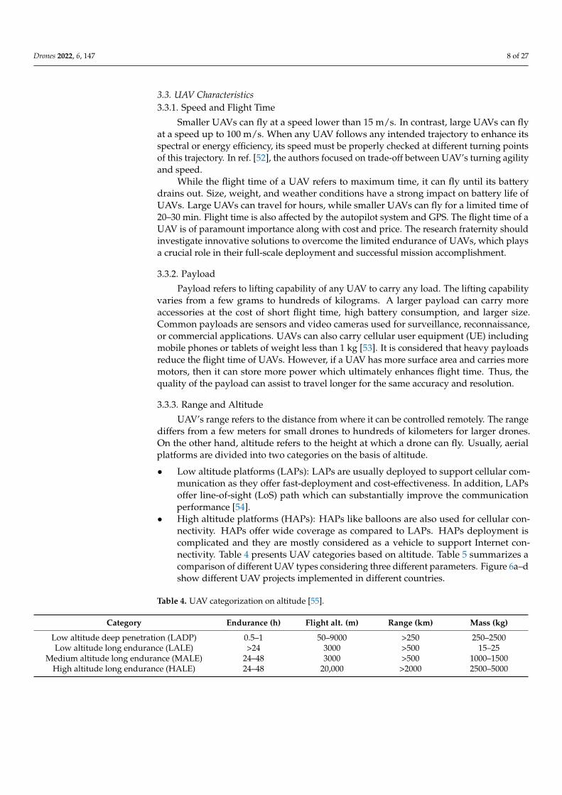
3.2. UAV Swarms As illustrated in Figure 5, UAV swarms can be classified as semi- or fully autono-
mous. This classification can also be categorized as single-layered and multi-layered swarms. In single-layered swarms, each UAV is a leader drone. Each layer of a mul-ti-layered UAV swarm is occupied by a dedicated layer of drones, which operate and report to specific leader drones at each layer. In every swarm, each drone has data col-lection and processing capabilities in real-time, while the central processing occurs at the cloud or base station. The swarms of UAVs with intelligent monitoring mechanisms can reliably and quickly cover an intended area by using different parallel operating drones. Several research studies have focused on the role of UAV swarms. For example, ref. [49] considers swarms of drones to address the charging mechanism of several drones in parallel. It features UAV swarms for smart energy management. Some studies have suggested prioritization algorithms in case of swarms of UAVs, where UAVs with high priority will be recharged first as compared to UAVs with low priority. Swarms of UAVs also impact the hovering performance. UAV flight synchronization and hovering stabil-ity are essential when we consider the mission execution of swarms of UAVs such as quadcopters. In addition, communication reliability of the quadcopter swarm is also crucial for a successful mission. The authors in ref. [50] proposed an efficient multi-robot coordination method to address the issue of real-time UAV swarm coordination on a broad area network. Swarms of UAVs have been studied in the past for surveillance purposes. For instance, the authors in ref. [51] describe quadcopter swarms for object tracking and localization.
Figure 4. (a) fixed-wing, (b) fixed-wing hybrid, (c) single rotor, and (d) multirotor UAV.
3.2. UAV Swarms
As illustrated in Figure 5, UAV swarms can be classified as semi- or fully autonomous.This classification can also be categorized as single-layered and multi-layered swarms. Insingle-layered swarms, each UAV is a leader drone. Each layer of a multi-layered UAVswarm is occupied by a dedicated layer of drones, which operate and report to specificleader drones at each layer. In every swarm, each drone has data collection and processingcapabilities in real-time, while the central processing occurs at the cloud or base station. Theswarms of UAVs with intelligent monitoring mechanisms can reliably and quickly cover anintended area by using different parallel operating drones. Several research studies havefocused on the role of UAV swarms. For example, ref. [49] considers swarms of drones toaddress the charging mechanism of several drones in parallel. It features UAV swarms forsmart energy management. Some studies have suggested prioritization algorithms in caseof swarms of UAVs, where UAVs with high priority will be recharged first as comparedto UAVs with low priority. Swarms of UAVs also impact the hovering performance. UAVflight synchronization and hovering stability are essential when we consider the missionexecution of swarms of UAVs such as quadcopters. In addition, communication reliabilityof the quadcopter swarm is also crucial for a successful mission. The authors in ref. [50]proposed an efficient multi-robot coordination method to address the issue of real-timeUAV swarm coordination on a broad area network. Swarms of UAVs have been studied inthe past for surveillance purposes. For instance, the authors in ref. [51] describe quadcopterswarms for object tracking and localization.
Drones 2022, 6, x FOR PEER REVIEW 8 of 28
Figure 5. Classification of swarms.
3.3. UAV Characteristics 3.3.1. Speed and Flight Time
Smaller UAVs can fly at a speed lower than 15 m/s. In contrast, large UAVs can fly at a speed up to 100 m/s. When any UAV follows any intended trajectory to enhance its spectral or energy efficiency, its speed must be properly checked at different turning points of this trajectory. In ref. [52], the authors focused on trade-off between UAV’s turning agility and speed.
While the flight time of a UAV refers to maximum time, it can fly until its battery drains out. Size, weight, and weather conditions have a strong impact on battery life of UAVs. Large UAVs can travel for hours, while smaller UAVs can fly for a limited time of 20–30 min. Flight time is also affected by the autopilot system and GPS. The flight time of a UAV is of paramount importance along with cost and price. The research fraternity should investigate innovative solutions to overcome the limited endurance of UAVs, which plays a crucial role in their full-scale deployment and successful mission accom-plishment.
3.3.2. Payload Payload refers to lifting capability of any UAV to carry any load. The lifting capa-
bility varies from a few grams to hundreds of kilograms. A larger payload can carry more accessories at the cost of short flight time, high battery consumption, and larger size. Common payloads are sensors and video cameras used for surveillance, reconnaissance, or commercial applications. UAVs can also carry cellular user equipment (UE) including mobile phones or tablets of weight less than 1 kg [53]. It is considered that heavy pay-loads reduce the flight time of UAVs. However, if a UAV has more surface area and car-ries more motors, then it can store more power which ultimately enhances flight time. Thus, the quality of the payload can assist to travel longer for the same accuracy and resolution.
3.3.3. Range and Altitude UAV’s range refers to the distance from where it can be controlled remotely. The
range differs from a few meters for small drones to hundreds of kilometers for larger drones. On the other hand, altitude refers to the height at which a drone can fly. Usually, aerial platforms are divided into two categories on the basis of altitude. Low altitude platforms (LAPs): LAPs are usually deployed to support cellular
communication as they offer fast-deployment and cost-effectiveness. In addition, LAPs offer line-of-sight (LoS) path which can substantially improve the communi-cation performance [54].
High altitude platforms (HAPs): HAPs like balloons are also used for cellular con-nectivity. HAPs offer wide coverage as compared to LAPs. HAPs deployment is complicated and they are mostly considered as a vehicle to support Internet con-
Figure 5. Classification of swarms.
Drones 2022, 6, 147 8 of 27
3.3. UAV Characteristics3.3.1. Speed and Flight Time
Smaller UAVs can fly at a speed lower than 15 m/s. In contrast, large UAVs can flyat a speed up to 100 m/s. When any UAV follows any intended trajectory to enhance itsspectral or energy efficiency, its speed must be properly checked at different turning pointsof this trajectory. In ref. [52], the authors focused on trade-off between UAV’s turning agilityand speed.
While the flight time of a UAV refers to maximum time, it can fly until its batterydrains out. Size, weight, and weather conditions have a strong impact on battery life ofUAVs. Large UAVs can travel for hours, while smaller UAVs can fly for a limited time of20–30 min. Flight time is also affected by the autopilot system and GPS. The flight time of aUAV is of paramount importance along with cost and price. The research fraternity shouldinvestigate innovative solutions to overcome the limited endurance of UAVs, which playsa crucial role in their full-scale deployment and successful mission accomplishment.
3.3.2. Payload
Payload refers to lifting capability of any UAV to carry any load. The lifting capabilityvaries from a few grams to hundreds of kilograms. A larger payload can carry moreaccessories at the cost of short flight time, high battery consumption, and larger size.Common payloads are sensors and video cameras used for surveillance, reconnaissance,or commercial applications. UAVs can also carry cellular user equipment (UE) includingmobile phones or tablets of weight less than 1 kg [53]. It is considered that heavy payloadsreduce the flight time of UAVs. However, if a UAV has more surface area and carries moremotors, then it can store more power which ultimately enhances flight time. Thus, thequality of the payload can assist to travel longer for the same accuracy and resolution.
3.3.3. Range and Altitude
UAV’s range refers to the distance from where it can be controlled remotely. The rangediffers from a few meters for small drones to hundreds of kilometers for larger drones.On the other hand, altitude refers to the height at which a drone can fly. Usually, aerialplatforms are divided into two categories on the basis of altitude.
• Low altitude platforms (LAPs): LAPs are usually deployed to support cellular com-munication as they offer fast-deployment and cost-effectiveness. In addition, LAPsoffer line-of-sight (LoS) path which can substantially improve the communicationperformance [54].
• High altitude platforms (HAPs): HAPs like balloons are also used for cellular con-nectivity. HAPs offer wide coverage as compared to LAPs. HAPs deployment iscomplicated and they are mostly considered as a vehicle to support Internet con-nectivity. Table 4 presents UAV categories based on altitude. Table 5 summarizes acomparison of different UAV types considering three different parameters. Figure 6a–dshow different UAV projects implemented in different countries.
Table 4. UAV categorization on altitude [55].
Category Endurance (h) Flight alt. (m) Range (km) Mass (kg)
Low altitude deep penetration (LADP) 0.5–1 50–9000 >250 250–2500Low altitude long endurance (LALE) >24 3000 >500 15–25
Medium altitude long endurance (MALE) 24–48 3000 >500 1000–1500High altitude long endurance (HALE) 24–48 20,000 >2000 2500–5000

Drones 2022, 6, 147 9 of 27
Drones 2022, 6, x FOR PEER REVIEW 9 of 28
nectivity. Table 4 presents UAV categories based on altitude. Table 5 summarizes a comparison of different UAV types considering three different parameters. Figure 6a–d show different UAV projects implemented in different countries.
Table 4. UAV categorization on altitude [55].
Category Endurance (h) Flight alt. (m) Range (km) Mass (kg) Low altitude deep pen-
etration (LADP) 0.5–1 50–9000 >250 250–2500
Low altitude long en-durance (LALE)
>24 3000 >500 15–25
Medium altitude long endurance (MALE)
24–48 3000 >500 1000–1500
High altitude long en-durance (HALE)
24–48 20,000 >2000 2500–5000
Figure 6. Different examples of UAVs on altitude (a) LADP, (b) LALE, (c) MALE, and (d) HALE [56].
Table 5. Feature-based comparison of UAVs [57].
UAV Type Altitude
(km) Avg. Control Range
(km) Avg. Airspeed
(m/s) Multi-rotor UAVs (DJI Agras MG-1P [58]) 2 3–5 7
Fixed-wing UAVs (AgEagle RX60 [59]) 0.125 2 18.8 Single rotor (Alpha 800 [60]) 3 30 15.2
Fixed-wing-multi-rotor hybrid UAVs (Jump 20 [61]) 4 500–1000 30
3.4. UAV Standardizations 3.4.1. UAVs 3GPP Standardization
In this modern era of technology, UAVs have gained significant attention in LoS and NLoS environments [28,62]. In 2017, the third-generation partnership group (3GPP) conducted several studies and issued Release-15 to acknowledge LTE-empowered UAVs. The main objective of these studies was to focus on UAV traffic requirements, channel modeling techniques for air-to-ground propagation perspectives, reuse of cur-rent cellular networks to enable UAV communication, LTE support and developments required to integrate LTE into UAVs. The 3GPP objectives also include the identification of traffic types for which the existing cellular networks must cater for UAV flight over 300 m from ground. Table 6 summarizes these UAV communication requirements which are classified as: (i) synchronization and radio control; (ii) command & control; and (iii) application data [24].
Figure 6. Different examples of UAVs on altitude (a) LADP, (b) LALE, (c) MALE, and (d) HALE [56].
Table 5. Feature-based comparison of UAVs [57].
UAV Type Altitude(km) Avg. Control Range (km) Avg. Airspeed (m/s)
Multi-rotor UAVs (DJI Agras MG-1P [58]) 2 3–5 7Fixed-wing UAVs (AgEagle RX60 [59]) 0.125 2 18.8
Single rotor (Alpha 800 [60]) 3 30 15.2Fixed-wing-multi-rotor hybrid UAVs (Jump 20 [61]) 4 500–1000 30
3.4. UAV Standardizations3.4.1. UAVs 3GPP Standardization
In this modern era of technology, UAVs have gained significant attention in LoSand NLoS environments [28,62]. In 2017, the third-generation partnership group (3GPP)conducted several studies and issued Release-15 to acknowledge LTE-empowered UAVs.The main objective of these studies was to focus on UAV traffic requirements, channelmodeling techniques for air-to-ground propagation perspectives, reuse of current cellularnetworks to enable UAV communication, LTE support and developments required tointegrate LTE into UAVs. The 3GPP objectives also include the identification of traffictypes for which the existing cellular networks must cater for UAV flight over 300 m fromground. Table 6 summarizes these UAV communication requirements which are classifiedas: (i) synchronization and radio control; (ii) command & control; and (iii) applicationdata [24].
Table 6. UAV communication requirements [24].
Link Data Type Data Rate Critical
DownlinkRadio control (PDCCH)
N/AYes
Synchronization (SSS/PSS) YesCommand and Control (C&C) 60–100 kbps Yes
Uplink Command and Control (C&C) 60–100 kbps YesApplication data Up to 50 Mbps No
3.4.2. UAVs Standardization Outside the 3GPP
Besides 3GPP standardization, there are several other regulatory bodies that definevarious specifications of UAVs to ensure efficient, reliable, and uniform communication.
• In 2015, the Institute of Electrical and Electronics Engineers (IEEE) introduced theDrones Working Group (DWG). The main aim of this group was to develop thetaxonomy for consumer drones with the objective of highlighting security and privacyissues. For this purpose, the DWG establishes methods, systems, requirements, testing,and validation needed for consumer drones to preserve the security and privacy ofthe public and their properties.
• The European Telecommunications Standards Institute (ETSI) aims to identify UAVapplications, use cases, and understanding regarding Internet Protocol (IP) suite
Drones 2022, 6, 147 10 of 27
architecture to be developed and spectrum rules required to facilitate UAVs in currentLTE networks [63].
• The International Telecommunication Union Telecommunication StandardizationSector (ITU-T) defined work item (WI) Y.UAV.arch to support a reliable and functionalarchitecture of UAVs and UAV controllers through IMT-2020 networks [64].
3.5. Unmanned Traffic Management (UTM)
It is envisioned that urban airspace will be congested with several types of autonomousaerial vehicles, consequently leading to complex air traffic management. Existing humancentric, monopolistic and centralized air traffic control systems are not feasible to copewith UAVs congestion and cannot provide immediate legal solutions for autonomousaerial missions [65]. The aforementioned elements became the rationale for dedicatedUTM systems to strategically de-conflict multiple UAV flights in the shared and segregatedproximity. UTM systems are fully autonomous, where controllers can decide trajectories,traffic density and risk calculations. UTM has proven its stature in a wide variety ofhigher-tier applications including surveillance, communication, agriculture, aerial mappingand remote sensing. It has the capability to operate in both LoS and beyond the visualLoS (BVLoS) links. The existing UTM systems operate on very-low-level (VLL) airspacealong with offering BVLoS links. Most UTM systems have similar concepts of operationsand objectives. Various UTM systems are based on federated, distributed and service-oriented architecture [66]. Three levels of connectivity based on ground stations, airbornevehicles and satellites are required for communication in UTM systems. UTM systems offerfollowing potentials features:
• Safe and secure UAV missions,• Flexible operations for several types of UAVs,• Provides real-time monitoring based on integrated sensors,• High level control providing prediction of other piloted UAVs,• A key unifying element of reliance on a more automated and competitive system.• Operates on national and international standardizations.
4. UAV Battery Charging
Drones are currently being used for several applications such as military operations,power lines inspection, forest monitoring, disaster prevention and smart agriculture [57,67,68].Drones carry different types of payloads such as GPS, infrared cameras, batteries andsensors as a delivery vehicle. These drones usually carry high energy batteries e.g., lithiumbatteries that support flight time ranging from 20–40 min [69]. However, range and en-durance are a critical challenge in UAVs due to limited battery capacity. It is not feasible toincrease battery size of UAV as it will increase weight, which is another critical concern. Sev-eral research studies have addressed battery charging of UAVs but still it requires intensiveinvestigations by research fraternity [16]. Jawad et al. [67] suggested three ways to enhanceflying time: (i) drones can be equipped with high battery capacity but it can increase thedrone weight. (ii) The battery swapping can be achieved after the landing of drone. How-ever, it also causes complexity and high cost of swapping system. (iii) Recharging can bedone at the base station of the drone. Charging can be achieved through wired or wirelesspower transfer (WPT) system [70]. Next, we have briefly discussed WPT techniques.
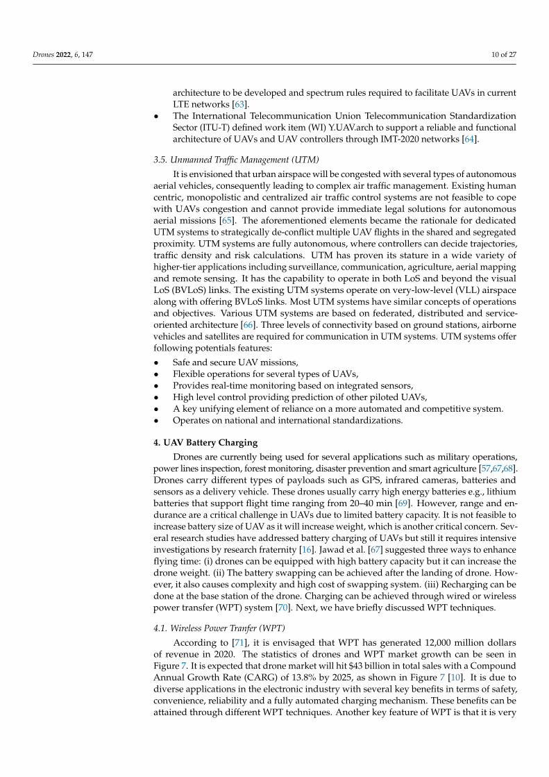
4.1. Wireless Power Tranfer (WPT)
According to [71], it is envisaged that WPT has generated 12,000 million dollarsof revenue in 2020. The statistics of drones and WPT market growth can be seen inFigure 7. It is expected that drone market will hit $43 billion in total sales with a CompoundAnnual Growth Rate (CARG) of 13.8% by 2025, as shown in Figure 7 [10]. It is due todiverse applications in the electronic industry with several key benefits in terms of safety,convenience, reliability and a fully automated charging mechanism. These benefits can beattained through different WPT techniques. Another key feature of WPT is that it is very
Drones 2022, 6, 147 11 of 27
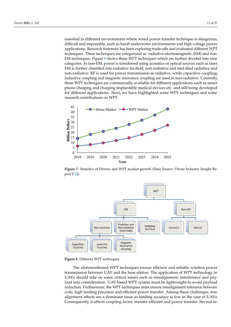
essential in different environments where wired power transfer technique is dangerous,difficult and impossible, such as harsh underwater environments and high voltage powerapplications. Research fraternity has been exploring trade-offs and evaluated different WPTtechniques. These techniques are categorized as: radiative electromagnetic (EM) and non-EM techniques. Figure 8 shows these WPT techniques which are further divided into ninecategories. In non-EM, power is transferred using acoustics or optical sources such as laser.EM is further classified into radiative far-field, non-radiative and mid-filed radiative andnon-radiative. RF is used for power transmission in radiative, while capacitive coupling;inductive coupling and magnetic resonance coupling are used in non-radiative. Currently,these WPT techniques are commercially available for different applications such as smartphone charging and charging implantable medical devices etc. and still being developedfor different applications. Next, we have highlighted some WPT techniques and someresearch contributions on WPT.
Drones 2022, 6, x FOR PEER REVIEW 11 of 28
[57,67,68]. Drones carry different types of payloads such as GPS, infrared cameras, bat-teries and sensors as a delivery vehicle. These drones usually carry high energy batteries e.g., lithium batteries that support flight time ranging from 20–40 min [69]. However, range and endurance are a critical challenge in UAVs due to limited battery capacity. It is not feasible to increase battery size of UAV as it will increase weight, which is another critical concern. Several research studies have addressed battery charging of UAVs but still it requires intensive investigations by research fraternity [16]. Jawad et al. [67] sug-gested three ways to enhance flying time: (i) drones can be equipped with high battery capacity but it can increase the drone weight. (ii) The battery swapping can be achieved after the landing of drone. However, it also causes complexity and high cost of swapping system. (iii) Recharging can be done at the base station of the drone. Charging can be achieved through wired or wireless power transfer (WPT) system [70]. Next, we have briefly discussed WPT techniques.
4.1. Wireless Power Tranfer (WPT) According to [71], it is envisaged that WPT has generated 12,000 million dollars of
revenue in 2020. The statistics of drones and WPT market growth can be seen in Figure 7. It is expected that drone market will hit $43 billion in total sales with a Compound An-nual Growth Rate (CARG) of 13.8% by 2025, as shown in Figure 7 [10]. It is due to diverse applications in the electronic industry with several key benefits in terms of safety, con-venience, reliability and a fully automated charging mechanism. These benefits can be attained through different WPT techniques. Another key feature of WPT is that it is very essential in different environments where wired power transfer technique is dangerous, difficult and impossible, such as harsh underwater environments and high voltage power applications. Research fraternity has been exploring trade-offs and evaluated dif-ferent WPT techniques. These techniques are categorized as: radiative electromagnetic (EM) and non-EM techniques. Figure 8 shows these WPT techniques which are further divided into nine categories. In non-EM, power is transferred using acoustics or optical sources such as laser. EM is further classified into radiative far-field, non-radiative and mid-filed radiative and non-radiative. RF is used for power transmission in radiative, while capacitive coupling; inductive coupling and magnetic resonance coupling are used in non-radiative. Currently, these WPT techniques are commercially available for dif-ferent applications such as smart phone charging and charging implantable medical de-vices etc. and still being developed for different applications. Next, we have highlighted some WPT techniques and some research contributions on WPT.
Figure 7. Statistics of Drones and WPT market growth (Data Source: Drone Industry Insight Report [72]).
Figure 7. Statistics of Drones and WPT market growth (Data Source: Drone Industry Insight Re-port [72]).
Drones 2022, 6, x FOR PEER REVIEW 12 of 28
Figure 8. Different WPT techniques.
The aforementioned WPT techniques ensure efficient and reliable wireless power transmission between UAV and the base station. The application of WPT technology to UAVs should take on some critical issues such as misalignment, interference and pay-load into consideration. UAV-based WPT system must be lightweight to avoid payload reduction. Furthermore, the WPT techniques must ensure misalignment tolerance be-tween coils, high landing precision and efficient power transfer. Among these challeng-es, misalignment affects are a dominant issue as landing accuracy is low in the case of UAVs. Consequently, it affects coupling factor, transfer efficient and power transfer. Several research studies have reported these major issues about recharging UAV batter-ies through WPT techniques [70,73,74]. UAV charging can be achieved through induc-tive coupling WPT to enhance both range and flight time for inspection, monitoring and surveillance tasks. UAV-empowered inspection technique can overcome several limita-tions of existing inspection techniques, such as expensive task and hazardous operation through manned helicopters. In ref. [75], the authors demonstrated magnetic resonance coupling (MRC) WPT to recharge drone and performed testing of proposed system for different distances and misalignment topologies. Authors reported 90% transfer efficient at 10 cm distance. Junaid et al. [76] presented a vision-based, closed-loop target detection through UAV for outdoor applications. Authors designed a charging station that pro-longs the flight time and enhances endurance of UAV. In ref. [77], Blain proposed a nov-el mid-air inductive charging mechanism to charge multiple drones at the same time without any need of landing using global energy transmission (GET). It is worth men-tioning that most studies in the literature focused on UAV charge scheduling while tak-ing into account centralized architecture. Only a few studies looked at the peer-to-peer network of UAVs charging through blockchain technology [78,79]. Table 7 summarizes some reported studies in the literature on the charge scheduling of UAVs.
Table 7. Studies on charge scheduling of UAVs.
Reference Year Research Focus [15] 2017 Lightweight WPT system for the mid-air charging of drones. [16] 2018 WPT techniques for UAVs. A review, extensions and reconceptualization. [18] 2018 Designing of drone battery charging system through wireless power transfer (WPT). [70] 2018 WPT system to charge autonomous electric UAV using a small secondary coil. [80] 2018 WPT technology-based drone charging stations to charge drone over the buildings.
[19] 2019 Auction-enabled charge scheduling using deep learning framework for a network of multiple
drones. [67] 2019 WPT based sleep/active method for a drone charging station in smart agriculture.
Figure 8. Different WPT techniques.
The aforementioned WPT techniques ensure efficient and reliable wireless powertransmission between UAV and the base station. The application of WPT technology toUAVs should take on some critical issues such as misalignment, interference and pay-load into consideration. UAV-based WPT system must be lightweight to avoid payloadreduction. Furthermore, the WPT techniques must ensure misalignment tolerance betweencoils, high landing precision and efficient power transfer. Among these challenges, mis-alignment affects are a dominant issue as landing accuracy is low in the case of UAVs.Consequently, it affects coupling factor, transfer efficient and power transfer. Several re-
Drones 2022, 6, 147 12 of 27
search studies have reported these major issues about recharging UAV batteries throughWPT techniques [70,73,74]. UAV charging can be achieved through inductive couplingWPT to enhance both range and flight time for inspection, monitoring and surveillancetasks. UAV-empowered inspection technique can overcome several limitations of existinginspection techniques, such as expensive task and hazardous operation through mannedhelicopters. In ref. [75], the authors demonstrated magnetic resonance coupling (MRC)WPT to recharge drone and performed testing of proposed system for different distancesand misalignment topologies. Authors reported 90% transfer efficient at 10 cm distance.Junaid et al. [76] presented a vision-based, closed-loop target detection through UAV foroutdoor applications. Authors designed a charging station that prolongs the flight time andenhances endurance of UAV. In ref. [77], Blain proposed a novel mid-air inductive chargingmechanism to charge multiple drones at the same time without any need of landing usingglobal energy transmission (GET). It is worth mentioning that most studies in the literaturefocused on UAV charge scheduling while taking into account centralized architecture. Onlya few studies looked at the peer-to-peer network of UAVs charging through blockchaintechnology [78,79]. Table 7 summarizes some reported studies in the literature on thecharge scheduling of UAVs.
Table 7. Studies on charge scheduling of UAVs.
Reference Year Research Focus
[15] 2017 Lightweight WPT system for the mid-air charging of drones.[16] 2018 WPT techniques for UAVs. A review, extensions and reconceptualization.[18] 2018 Designing of drone battery charging system through wireless power transfer (WPT).[70] 2018 WPT system to charge autonomous electric UAV using a small secondary coil.[80] 2018 WPT technology-based drone charging stations to charge drone over the buildings.[19] 2019 Auction-enabled charge scheduling using deep learning framework for a network of multiple drones.[67] 2019 WPT based sleep/active method for a drone charging station in smart agriculture.[81] 2019 Neural blockchain-empowered assistance for drone swarms.[82] 2020 Energy-efficient UAV crowd-sensing through multiple charging stations using deep learning.[83] 2020 Novel application of a distributed network of charging stations and UAVs through advanced blockchain.[84] 2021 Blockchain-empowered charge scheduling for UAVs in smart cities.
4.1.1. Photovoltaic Cell-Based UAV Charging
The PV cells are commonly utilized to charge batteries and enhance flight time ofUAVs. PV cells make use of sunlight to charge batteries of UAVs. Whenever sunlightis present, the required power is provided by PV cells and in the absence of sunlightbatteries are used to deliver required power to UAV. Research works on solar-poweredUAV report that several parameters play a key role such as temperature intensity, angle ofincidence of sunlight, geometry, orientation and position of PV cells [85]. This techniqueis not suitable in scenarios with insufficient sunlight. There is a need to adopt alternativestrategies whenever sunlight is not present to continue UAV flight. These strategies includeadditional power supplies, enhanced battery power, PV cells size and automatic positionadjustment according to sun position. As PV cells require certain payload capacity andwing length on the UAV, so it is feasible for fixed-wing UAVs. Moreover, environmentalconditions such as humidity, temperature, fog, clouds reduce the system efficiency andreliability. Thus, these atmospheric conditions must be kept into consideration.
Solar energy-based UAVs have gained the attention of several research groups. Solar-powered aircrafts are currently being used for power line inspection, forest fire fighting,border surveillance and high altitude communication. This technology can be used tosupersede environmental, scientific and communication satellite to be used for militaryand civilian applications. Sufficient flight power can be achieved through appropriateselection of PV cells and taking account of efficiency and weight is the key factor toensure long flight time and high endurance in solar-powered UAVs. To achieve cost-effectiveness and great efficiency, several materials are used in solar cells. Some studies
Drones 2022, 6, 147 13 of 27
suggest mono-crystalline silicon PV cells due to affordable cost and high efficiency [86].Furthermore, mono-crystalline silicon PV cells offer high flexibility that supports easyintegration in the UAV wing. Table 8 summarizes a comparison of mono-crystalline siliconPV cells from various manufacturing companies. It is still important to investigate PVcells with novel designs, energy management strategies and manufacturing material toensure high efficiency and high availability [85]. Research fraternity should focus moreon material science developments as low photoelectric efficiency is a major limiting factorin this research domain [87]. Some studies propose an effective approach to optimizesolar-powered UAV flight trajectories in order to gain more solar radiation along with lowconsumption of mechanical energy [88].
Table 8. PV cells comparison [86].
Company PV Cell Dimension (mm) Weight (g/m3) Flexibility Efficiency (%)
Gochermann Solar technology SunPower C60 125 × 125 950–1000 Semi-flex 22.6Gochermann Solar technology SunPower E60 125 × 125 - Semi-flex 23.8
Bsolar TG18.5BR 156 × 156 - - 17.5–18.39Delsolar D6F 156 × 156 - - 18–20
Gochermann Solar technology SunPower A300 125 × 125 - - 20 minIXYS (IXOLAR) KXOB22-12X1 27 × 7 2645 Semi-flex 22
Bosch Solar Energy M3BB 156 × 156 1027 No-flex 18.43SunOWE 156 MM 156 × 156 1027 No-flex 18.2
4.1.2. Charging with Laser Beaming
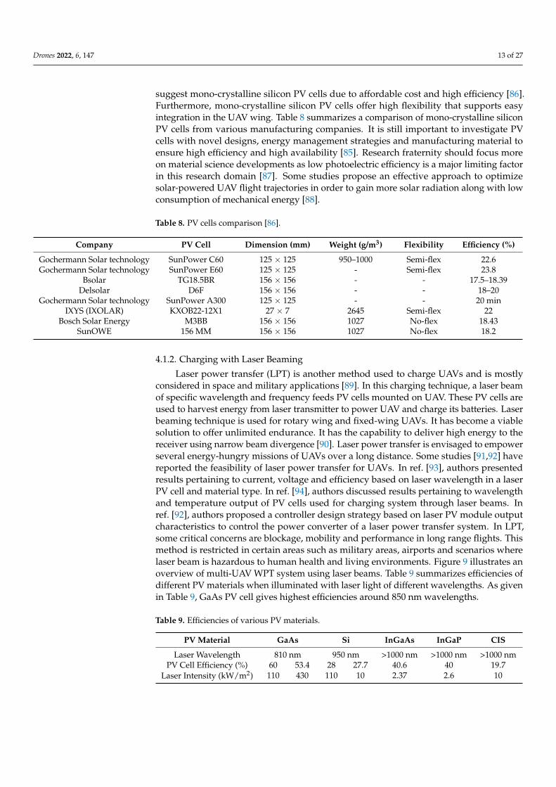
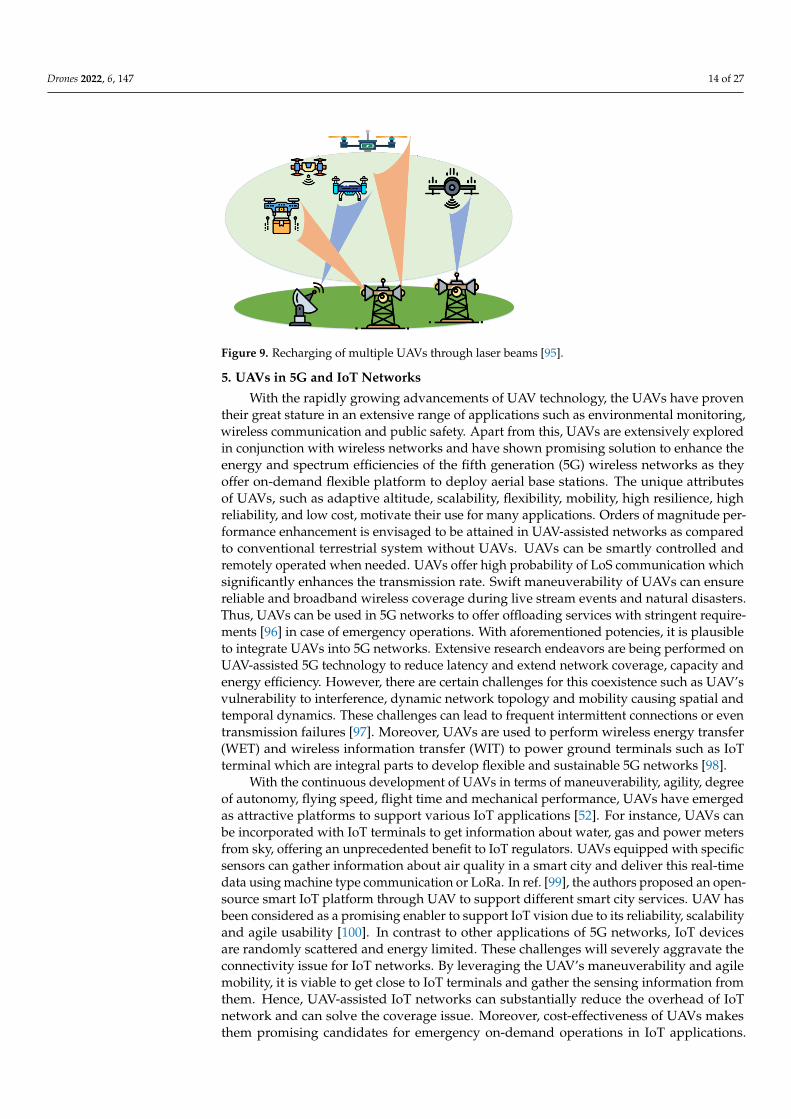
Laser power transfer (LPT) is another method used to charge UAVs and is mostlyconsidered in space and military applications [89]. In this charging technique, a laser beamof specific wavelength and frequency feeds PV cells mounted on UAV. These PV cells areused to harvest energy from laser transmitter to power UAV and charge its batteries. Laserbeaming technique is used for rotary wing and fixed-wing UAVs. It has become a viablesolution to offer unlimited endurance. It has the capability to deliver high energy to thereceiver using narrow beam divergence [90]. Laser power transfer is envisaged to empowerseveral energy-hungry missions of UAVs over a long distance. Some studies [91,92] havereported the feasibility of laser power transfer for UAVs. In ref. [93], authors presentedresults pertaining to current, voltage and efficiency based on laser wavelength in a laserPV cell and material type. In ref. [94], authors discussed results pertaining to wavelengthand temperature output of PV cells used for charging system through laser beams. Inref. [92], authors proposed a controller design strategy based on laser PV module outputcharacteristics to control the power converter of a laser power transfer system. In LPT,some critical concerns are blockage, mobility and performance in long range flights. Thismethod is restricted in certain areas such as military areas, airports and scenarios wherelaser beam is hazardous to human health and living environments. Figure 9 illustrates anoverview of multi-UAV WPT system using laser beams. Table 9 summarizes efficiencies ofdifferent PV materials when illuminated with laser light of different wavelengths. As givenin Table 9, GaAs PV cell gives highest efficiencies around 850 nm wavelengths.
Table 9. Efficiencies of various PV materials.
PV Material GaAs Si InGaAs InGaP CIS
Laser Wavelength 810 nm 950 nm >1000 nm >1000 nm >1000 nmPV Cell Efficiency (%) 60 53.4 28 27.7 40.6 40 19.7
Laser Intensity (kW/m2) 110 430 110 10 2.37 2.6 10
Drones 2022, 6, 147 14 of 27
Drones 2022, 6, x FOR PEER REVIEW 14 of 28
SunOWE 156 MM 156 × 156 1027 No-flex 18.2
4.1.2. Charging with Laser Beaming Laser power transfer (LPT) is another method used to charge UAVs and is mostly
considered in space and military applications [89]. In this charging technique, a laser beam of specific wavelength and frequency feeds PV cells mounted on UAV. These PV cells are used to harvest energy from laser transmitter to power UAV and charge its bat-teries. Laser beaming technique is used for rotary wing and fixed-wing UAVs. It has be-come a viable solution to offer unlimited endurance. It has the capability to deliver high energy to the receiver using narrow beam divergence [90]. Laser power transfer is en-visaged to empower several energy-hungry missions of UAVs over a long distance. Some studies [91,92] have reported the feasibility of laser power transfer for UAVs. In ref. [93], authors presented results pertaining to current, voltage and efficiency based on laser wavelength in a laser PV cell and material type. In ref. [94], authors discussed results pertaining to wavelength and temperature output of PV cells used for charging system through laser beams. In ref. [92], authors proposed a controller design strategy based on laser PV module output characteristics to control the power converter of a laser power transfer system. In LPT, some critical concerns are blockage, mobility and performance in long range flights. This method is restricted in certain areas such as military areas, air-ports and scenarios where laser beam is hazardous to human health and living envi-ronments. Figure 9 illustrates an overview of multi-UAV WPT system using laser beams. Table 9 summarizes efficiencies of different PV materials when illuminated with laser light of different wavelengths. As given in Table 9, GaAs PV cell gives highest efficiencies around 850 nm wavelengths.
Table 9. Efficiencies of various PV materials.
PV Material GaAs Si InGaAs InGaP CIS Laser Wavelength 810 nm 950 nm >1000 nm >1000 nm >1000 nm
PV Cell Efficiency (%) 60 53.4 28 27.7 40.6 40 19.7 Laser Intensity
(kW/m2) 110 430 110 10 2.37 2.6 10
Figure 9. Recharging of multiple UAVs through laser beams [95].
5. UAVs in 5G and IoT Networks With the rapidly growing advancements of UAV technology, the UAVs have proven
their great stature in an extensive range of applications such as environmental monitor-ing, wireless communication and public safety. Apart from this, UAVs are extensively explored in conjunction with wireless networks and have shown promising solution to enhance the energy and spectrum efficiencies of the fifth generation (5G) wireless net-
Figure 9. Recharging of multiple UAVs through laser beams [95].
5. UAVs in 5G and IoT Networks
With the rapidly growing advancements of UAV technology, the UAVs have proventheir great stature in an extensive range of applications such as environmental monitoring,wireless communication and public safety. Apart from this, UAVs are extensively exploredin conjunction with wireless networks and have shown promising solution to enhance theenergy and spectrum efficiencies of the fifth generation (5G) wireless networks as theyoffer on-demand flexible platform to deploy aerial base stations. The unique attributesof UAVs, such as adaptive altitude, scalability, flexibility, mobility, high resilience, highreliability, and low cost, motivate their use for many applications. Orders of magnitude per-formance enhancement is envisaged to be attained in UAV-assisted networks as comparedto conventional terrestrial system without UAVs. UAVs can be smartly controlled andremotely operated when needed. UAVs offer high probability of LoS communication whichsignificantly enhances the transmission rate. Swift maneuverability of UAVs can ensurereliable and broadband wireless coverage during live stream events and natural disasters.Thus, UAVs can be used in 5G networks to offer offloading services with stringent require-ments [96] in case of emergency operations. With aforementioned potencies, it is plausibleto integrate UAVs into 5G networks. Extensive research endeavors are being performed onUAV-assisted 5G technology to reduce latency and extend network coverage, capacity andenergy efficiency. However, there are certain challenges for this coexistence such as UAV’svulnerability to interference, dynamic network topology and mobility causing spatial andtemporal dynamics. These challenges can lead to frequent intermittent connections or eventransmission failures [97]. Moreover, UAVs are used to perform wireless energy transfer(WET) and wireless information transfer (WIT) to power ground terminals such as IoTterminal which are integral parts to develop flexible and sustainable 5G networks [98].
With the continuous development of UAVs in terms of maneuverability, agility, degreeof autonomy, flying speed, flight time and mechanical performance, UAVs have emergedas attractive platforms to support various IoT applications [52]. For instance, UAVs canbe incorporated with IoT terminals to get information about water, gas and power metersfrom sky, offering an unprecedented benefit to IoT regulators. UAVs equipped with specificsensors can gather information about air quality in a smart city and deliver this real-timedata using machine type communication or LoRa. In ref. [99], the authors proposed an open-source smart IoT platform through UAV to support different smart city services. UAV hasbeen considered as a promising enabler to support IoT vision due to its reliability, scalabilityand agile usability [100]. In contrast to other applications of 5G networks, IoT devicesare randomly scattered and energy limited. These challenges will severely aggravate theconnectivity issue for IoT networks. By leveraging the UAV’s maneuverability and agilemobility, it is viable to get close to IoT terminals and gather the sensing information fromthem. Hence, UAV-assisted IoT networks can substantially reduce the overhead of IoTnetwork and can solve the coverage issue. Moreover, cost-effectiveness of UAVs makesthem promising candidates for emergency on-demand operations in IoT applications.

Drones 2022, 6, 147 15 of 27
Despite these appealing advantages, using UAV in an IoT networks still suffers fromseveral challenges of channel modeling, prior information of channel state and energyconstraints of IoT terminals. Any small maneuverability error can significantly affect entiremission of UAV. UAV’s maneuverability limitations have been experimentally analyzedin [52]. For IoT terminals, both total energy constraint and peak transmit power constraintmust be kept into consideration while optimization of the communication strategy asrecharging the battery equipped with IoT devices is hard. Moreover, another criticalconcern is the amount of sensing data which may alter dynamically. Accordingly, thecommunication strategy should support the data sensing status. Practically, both budgettransmission duration constraint and budget power constraint can be incorporated to linkdata sensing condition and communication strategy optimization. A comprehensive studyon UAV related challenges including sky pollution, physical collision, safety, privacy andregulations is presented in [101].
6. UAV Applications Areas
The advancements in the potentials of deployed sensors on UAVs support the creationof a new breed of services and various applications for unmanned operations. In thissection, we have briefly discussed some prominent applications of UAVs.
6.1. Security, Monitoring, and Surveillance
UAVs are playing an integral role in military surveillance missions. Several countrieshave added UAVs in their defense strategic plans. Countries are using these flying roboticsmachines for enemy detection, anti-poaching, border control and maritime monitoring ofcritical sea lanes. Low cost, reliable and versatile UAVs are currently playing a significantcontribution in aerial surveillance, monitoring and survey of any specific area to preventany illegal activity. For instance, surveillance for any threat can be detected through dronesand they can be used to monitor any movement activity in any restricted area. UAV canprovide these services by sensing an automatic alert with minimal manual efforts.
6.2. Disaster Management
In the case of a man-made or natural disaster such as terrorist attacks, tsunami andfloods, UAVs can gain access to disaster truck locations that are hazardous for mannedactivity. These disasters can severely damage telecommunication infrastructure, transporta-tion, power and water utilities. UAVs can help to collect information, necessitate rapidsolutions and navigate debris. Radars, sensors and high quality cameras incorporated inUAVs can assist rescue teams to identify damage and immediately start recovery operationsand send resources such as first aid medical kits and manned helicopters. UAVs can assistin finding timely disaster estimation, providing disaster alerts and help in finding efficientcountermeasures. In case of wildfire, a swarm of drones containing fire extinguishers canmonitor, examine and trace any area without endangering human lives. Thus, UAVs canassist in real-time coverage of large areas without risking the safety and the security of thepersonnel involved. Early warning through UAVs can help to rescue human beings andwildlife at risk.
6.3. Remote Sensing
Currently, amateur drone technology has been used to get high resolution imagerydata of remote areas, islands, mountaintops and coastlines. UAV technology bridgesthe gap between airborne, spaceborne and ground-based remote sensing data. Low costand lightweight characteristics of UAVs support quality observation with high temporaland spatial resolutions. The remote sensing capabilities of UAVs can support in diseasedetection, water quality monitoring, drought monitoring, oil and gas, yield estimates,hydrological modeling, biodiversity conservation, geological disaster survey, terrain sur-vey, forest mapping, and crop monitoring. This technology can also be used for crowdsourced mapping and creation of 3D environmental maps and has become an active part of
Drones 2022, 6, 147 16 of 27
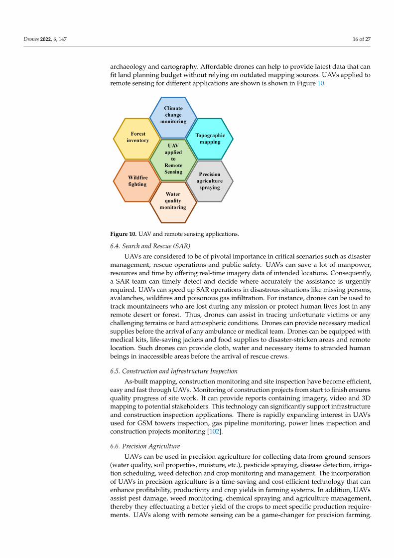
archaeology and cartography. Affordable drones can help to provide latest data that canfit land planning budget without relying on outdated mapping sources. UAVs applied toremote sensing for different applications are shown is shown in Figure 10.
Drones 2022, 6, x FOR PEER REVIEW 17 of 28
Figure 10. UAV and remote sensing applications.
6.4. Search and Rescue (SAR) UAVs are considered to be of pivotal importance in critical scenarios such as disaster
management, rescue operations and public safety. UAVs can save a lot of manpower, resources and time by offering real-time imagery data of intended locations. Conse-quently, a SAR team can timely detect and decide where accurately the assistance is ur-gently required. UAVs can speed up SAR operations in disastrous situations like missing persons, avalanches, wildfires and poisonous gas infiltration. For instance, drones can be used to track mountaineers who are lost during any mission or protect human lives lost in any remote desert or forest. Thus, drones can assist in tracing unfortunate victims or any challenging terrains or hard atmospheric conditions. Drones can provide necessary medical supplies before the arrival of any ambulance or medical team. Drones can be equipped with medical kits, life-saving jackets and food supplies to disaster-stricken ar-eas and remote location. Such drones can provide cloth, water and necessary items to stranded human beings in inaccessible areas before the arrival of rescue crews.
6.5. Construction and Infrastructure Inspection As-built mapping, construction monitoring and site inspection have become effi-
cient, easy and fast through UAVs. Monitoring of construction projects from start to fin-ish ensures quality progress of site work. It can provide reports containing imagery, video and 3D mapping to potential stakeholders. This technology can significantly sup-port infrastructure and construction inspection applications. There is rapidly expanding interest in UAVs used for GSM towers inspection, gas pipeline monitoring, power lines inspection and construction projects monitoring [102].
6.6. Precision Agriculture UAVs can be used in precision agriculture for collecting data from ground sensors
(water quality, soil properties, moisture, etc.), pesticide spraying, disease detection, irri-gation scheduling, weed detection and crop monitoring and management. The incorpo-ration of UAVs in precision agriculture is a time-saving and cost-efficient technology that can enhance profitability, productivity and crop yields in farming systems. In addition, UAVs assist pest damage, weed monitoring, chemical spraying and agriculture man-agement, thereby they effectuating a better yield of the crops to meet specific production requirements. UAVs along with remote sensing can be a game-changer for precision farming. It provides temporal, spatial and spectral resolution, but can also offer mul-ti-angular observation and detailed vegetation height data. UAVs can put a significant
Figure 10. UAV and remote sensing applications.
6.4. Search and Rescue (SAR)
UAVs are considered to be of pivotal importance in critical scenarios such as disastermanagement, rescue operations and public safety. UAVs can save a lot of manpower,resources and time by offering real-time imagery data of intended locations. Consequently,a SAR team can timely detect and decide where accurately the assistance is urgentlyrequired. UAVs can speed up SAR operations in disastrous situations like missing persons,avalanches, wildfires and poisonous gas infiltration. For instance, drones can be used totrack mountaineers who are lost during any mission or protect human lives lost in anyremote desert or forest. Thus, drones can assist in tracing unfortunate victims or anychallenging terrains or hard atmospheric conditions. Drones can provide necessary medicalsupplies before the arrival of any ambulance or medical team. Drones can be equipped withmedical kits, life-saving jackets and food supplies to disaster-stricken areas and remotelocation. Such drones can provide cloth, water and necessary items to stranded humanbeings in inaccessible areas before the arrival of rescue crews.
6.5. Construction and Infrastructure Inspection
As-built mapping, construction monitoring and site inspection have become efficient,easy and fast through UAVs. Monitoring of construction projects from start to finish ensuresquality progress of site work. It can provide reports containing imagery, video and 3Dmapping to potential stakeholders. This technology can significantly support infrastructureand construction inspection applications. There is rapidly expanding interest in UAVsused for GSM towers inspection, gas pipeline monitoring, power lines inspection andconstruction projects monitoring [102].
6.6. Precision Agriculture
UAVs can be used in precision agriculture for collecting data from ground sensors(water quality, soil properties, moisture, etc.), pesticide spraying, disease detection, irriga-tion scheduling, weed detection and crop monitoring and management. The incorporationof UAVs in precision agriculture is a time-saving and cost-efficient technology that canenhance profitability, productivity and crop yields in farming systems. In addition, UAVsassist pest damage, weed monitoring, chemical spraying and agriculture management,thereby they effectuating a better yield of the crops to meet specific production require-ments. UAVs along with remote sensing can be a game-changer for precision farming.
Drones 2022, 6, 147 17 of 27
It provides temporal, spatial and spectral resolution, but can also offer multi-angularobservation and detailed vegetation height data. UAVs can put a significant impact onagriculture industry by performing smart aerial mapping. UAVs equipped with rightsensors and appropriate cameras can monitor health of crops in terms of leaf thickness,foreign contaminants, chlorophyll level and temperature [103]. In ref. [104], WH Maes et al.briefly discussed the progress on remote sensing with UAVs in growth vigor assessment,nutrient status, pathogens and weed detection and drought stress. In the future, imageprocessing techniques can be used to investigate plants diseases and other traits from UAVcaptured high resolution images.
6.7. Real-Time Monitoring of Road Traffic
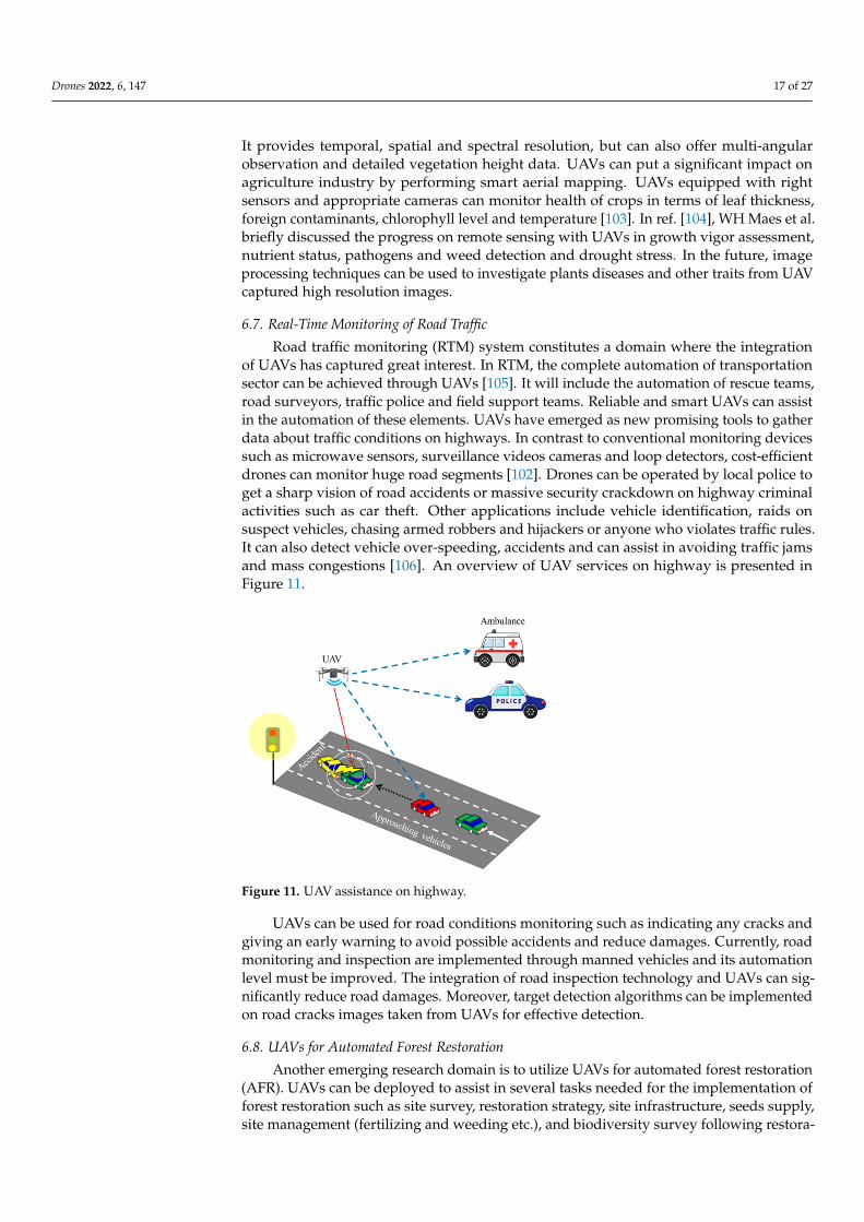
Road traffic monitoring (RTM) system constitutes a domain where the integrationof UAVs has captured great interest. In RTM, the complete automation of transportationsector can be achieved through UAVs [105]. It will include the automation of rescue teams,road surveyors, traffic police and field support teams. Reliable and smart UAVs can assistin the automation of these elements. UAVs have emerged as new promising tools to gatherdata about traffic conditions on highways. In contrast to conventional monitoring devicessuch as microwave sensors, surveillance videos cameras and loop detectors, cost-efficientdrones can monitor huge road segments [102]. Drones can be operated by local police toget a sharp vision of road accidents or massive security crackdown on highway criminalactivities such as car theft. Other applications include vehicle identification, raids onsuspect vehicles, chasing armed robbers and hijackers or anyone who violates traffic rules.It can also detect vehicle over-speeding, accidents and can assist in avoiding traffic jamsand mass congestions [106]. An overview of UAV services on highway is presented inFigure 11.
Drones 2022, 6, x FOR PEER REVIEW 18 of 28
impact on agriculture industry by performing smart aerial mapping. UAVs equipped with right sensors and appropriate cameras can monitor health of crops in terms of leaf thickness, foreign contaminants, chlorophyll level and temperature [103]. In ref. [104], WH Maes et al. briefly discussed the progress on remote sensing with UAVs in growth vigor assessment, nutrient status, pathogens and weed detection and drought stress. In the future, image processing techniques can be used to investigate plants diseases and other traits from UAV captured high resolution images.
6.7. Real-Time Monitoring of Road Traffic Road traffic monitoring (RTM) system constitutes a domain where the integration of
UAVs has captured great interest. In RTM, the complete automation of transportation sector can be achieved through UAVs [105]. It will include the automation of rescue teams, road surveyors, traffic police and field support teams. Reliable and smart UAVs can assist in the automation of these elements. UAVs have emerged as new promising tools to gather data about traffic conditions on highways. In contrast to conventional monitoring devices such as microwave sensors, surveillance videos cameras and loop detectors, cost-efficient drones can monitor huge road segments [102]. Drones can be operated by local police to get a sharp vision of road accidents or massive security crackdown on highway criminal activities such as car theft. Other applications include vehicle identification, raids on suspect vehicles, chasing armed robbers and hijackers or anyone who violates traffic rules. It can also detect vehicle over-speeding, accidents and can assist in avoiding traffic jams and mass congestions [106]. An overview of UAV ser-vices on highway is presented in Figure 11.
Figure 11. UAV assistance on highway.
UAVs can be used for road conditions monitoring such as indicating any cracks and giving an early warning to avoid possible accidents and reduce damages. Currently, road monitoring and inspection are implemented through manned vehicles and its automa-tion level must be improved. The integration of road inspection technology and UAVs can significantly reduce road damages. Moreover, target detection algorithms can be implemented on road cracks images taken from UAVs for effective detection.
6.8. UAVs for Automated Forest Restoration Another emerging research domain is to utilize UAVs for automated forest restora-
tion (AFR). UAVs can be deployed to assist in several tasks needed for the implementa-tion of forest restoration such as site survey, restoration strategy, site infrastructure, seeds supply, site management (fertilizing and weeding etc.), and biodiversity survey follow-ing restoration interventions [107]. Existing available technologies such as positioning
Figure 11. UAV assistance on highway.
UAVs can be used for road conditions monitoring such as indicating any cracks andgiving an early warning to avoid possible accidents and reduce damages. Currently, roadmonitoring and inspection are implemented through manned vehicles and its automationlevel must be improved. The integration of road inspection technology and UAVs can sig-nificantly reduce road damages. Moreover, target detection algorithms can be implementedon road cracks images taken from UAVs for effective detection.
6.8. UAVs for Automated Forest Restoration
Another emerging research domain is to utilize UAVs for automated forest restoration(AFR). UAVs can be deployed to assist in several tasks needed for the implementation offorest restoration such as site survey, restoration strategy, site infrastructure, seeds supply,site management (fertilizing and weeding etc.), and biodiversity survey following restora-
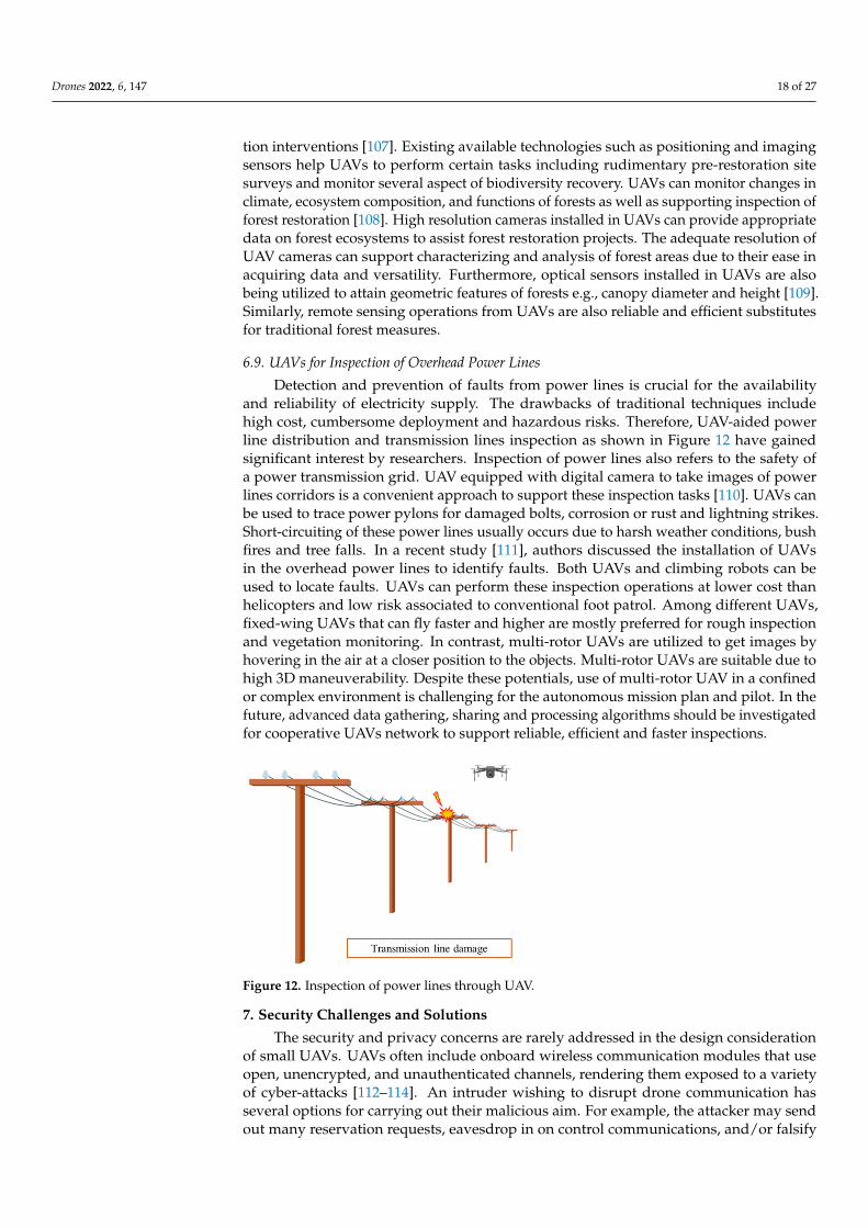
Drones 2022, 6, 147 18 of 27
tion interventions [107]. Existing available technologies such as positioning and imagingsensors help UAVs to perform certain tasks including rudimentary pre-restoration sitesurveys and monitor several aspect of biodiversity recovery. UAVs can monitor changes inclimate, ecosystem composition, and functions of forests as well as supporting inspection offorest restoration [108]. High resolution cameras installed in UAVs can provide appropriatedata on forest ecosystems to assist forest restoration projects. The adequate resolution ofUAV cameras can support characterizing and analysis of forest areas due to their ease inacquiring data and versatility. Furthermore, optical sensors installed in UAVs are alsobeing utilized to attain geometric features of forests e.g., canopy diameter and height [109].Similarly, remote sensing operations from UAVs are also reliable and efficient substitutesfor traditional forest measures.
6.9. UAVs for Inspection of Overhead Power Lines
Detection and prevention of faults from power lines is crucial for the availabilityand reliability of electricity supply. The drawbacks of traditional techniques includehigh cost, cumbersome deployment and hazardous risks. Therefore, UAV-aided powerline distribution and transmission lines inspection as shown in Figure 12 have gainedsignificant interest by researchers. Inspection of power lines also refers to the safety ofa power transmission grid. UAV equipped with digital camera to take images of powerlines corridors is a convenient approach to support these inspection tasks [110]. UAVs canbe used to trace power pylons for damaged bolts, corrosion or rust and lightning strikes.Short-circuiting of these power lines usually occurs due to harsh weather conditions, bushfires and tree falls. In a recent study [111], authors discussed the installation of UAVsin the overhead power lines to identify faults. Both UAVs and climbing robots can beused to locate faults. UAVs can perform these inspection operations at lower cost thanhelicopters and low risk associated to conventional foot patrol. Among different UAVs,fixed-wing UAVs that can fly faster and higher are mostly preferred for rough inspectionand vegetation monitoring. In contrast, multi-rotor UAVs are utilized to get images byhovering in the air at a closer position to the objects. Multi-rotor UAVs are suitable due tohigh 3D maneuverability. Despite these potentials, use of multi-rotor UAV in a confinedor complex environment is challenging for the autonomous mission plan and pilot. In thefuture, advanced data gathering, sharing and processing algorithms should be investigatedfor cooperative UAVs network to support reliable, efficient and faster inspections.
Drones 2022, 6, x FOR PEER REVIEW 19 of 28
and imaging sensors help UAVs to perform certain tasks including rudimentary pre-restoration site surveys and monitor several aspect of biodiversity recovery. UAVs can monitor changes in climate, ecosystem composition, and functions of forests as well as supporting inspection of forest restoration [108]. High resolution cameras installed in UAVs can provide appropriate data on forest ecosystems to assist forest restoration pro-jects. The adequate resolution of UAV cameras can support characterizing and analysis of forest areas due to their ease in acquiring data and versatility. Furthermore, optical sen-sors installed in UAVs are also being utilized to attain geometric features of forests e.g., canopy diameter and height [109]. Similarly, remote sensing operations from UAVs are also reliable and efficient substitutes for traditional forest measures.
6.9. UAVs for Inspection of Overhead Power Lines Detection and prevention of faults from power lines is crucial for the availability and
reliability of electricity supply. The drawbacks of traditional techniques include high cost, cumbersome deployment and hazardous risks. Therefore, UAV-aided power line distribution and transmission lines inspection as shown in Figure 12 have gained signif-icant interest by researchers. Inspection of power lines also refers to the safety of a power transmission grid. UAV equipped with digital camera to take images of power lines cor-ridors is a convenient approach to support these inspection tasks [110]. UAVs can be used to trace power pylons for damaged bolts, corrosion or rust and lightning strikes. Short-circuiting of these power lines usually occurs due to harsh weather conditions, bush fires and tree falls. In a recent study [111], authors discussed the installation of UAVs in the overhead power lines to identify faults. Both UAVs and climbing robots can be used to locate faults. UAVs can perform these inspection operations at lower cost than helicopters and low risk associated to conventional foot patrol. Among different UAVs, fixed-wing UAVs that can fly faster and higher are mostly preferred for rough inspection and vegetation monitoring. In contrast, multi-rotor UAVs are utilized to get images by hovering in the air at a closer position to the objects. Multi-rotor UAVs are suitable due to high 3D maneuverability. Despite these potentials, use of multi-rotor UAV in a confined or complex environment is challenging for the autonomous mission plan and pilot. In the future, advanced data gathering, sharing and processing algorithms should be investi-gated for cooperative UAVs network to support reliable, efficient and faster inspections.
Figure 12. Inspection of power lines through UAV.
7. Security Challenges and Solutions The security and privacy concerns are rarely addressed in the design consideration
of small UAVs. UAVs often include onboard wireless communication modules that use open, unencrypted, and unauthenticated channels, rendering them exposed to a variety of cyber-attacks [112–114]. An intruder wishing to disrupt drone communication has several options for carrying out their malicious aim. For example, the attacker may send out many reservation requests, eavesdrop in on control communications, and/or falsify
Figure 12. Inspection of power lines through UAV.
7. Security Challenges and Solutions
The security and privacy concerns are rarely addressed in the design considerationof small UAVs. UAVs often include onboard wireless communication modules that useopen, unencrypted, and unauthenticated channels, rendering them exposed to a varietyof cyber-attacks [112–114]. An intruder wishing to disrupt drone communication hasseveral options for carrying out their malicious aim. For example, the attacker may sendout many reservation requests, eavesdrop in on control communications, and/or falsify

Drones 2022, 6, 147 19 of 27
data. Hacking of drones is another major concerns of using UAVs for data collectionsand wireless delivery. In military operations, UAVs contain sensitive-information andmay become victim of malicious attacks and data theft. Hackers can usurp control ofUAV for illegal activities including smuggling, invasion of privacy and stealing storedinformation. Liability for UAV includes an enormous risk to individual privacy. UAVs areinstalled with cameras or any device that can capture images or videos; it can violate theprivacy of communities or people. To overcome this issue in USA, Center of Democracyand Technology (CDT) informed Federal Aviation Administration (FAA) to implementcertain rules to ensure privacy. In this regard, Privacy by Design (PbD) was proposed,which offers remedies for security and privacy breaches [115]. PbD rules significantly limitthe privacy intrusion. Additionally, continuous UAVs flights can reveal trade secrets ofconcerned companies and can severely affect their business.
Denial-of-service (DoS) and distributed DoS are the most common attacks on UAVsthat occur due to the absence of proper DoS/DDoS resistant mechanisms. DoS attackscause severe availability challenges as the attacker sends several requests to cause UAVnetwork congestion. DoS attacks are performed by depleting the batteries, overloadingthe processing units and flooding the communication links to cause huge interruptions. InDDoS, UAV systems faces unreachability issues as the attacker can overwhelm it throughtraffic from multiple sources. Moreover, signal spoofing through hijacking can damagethe nature of certain UAVs. GPS Signal spoofing attack can be performed by insertingor passing false data through GPS channels by the miscreant as shown in Figure 13. Inhijacking, the attacker can take complete control of UAV by injecting extra commands.Communication links of UAVs also suffer from session hijacking. These attacks can bemitigated through direction-of-arrival sensing, detection of signal distortion and strongauthentication.
Drones 2022, 6, x FOR PEER REVIEW 20 of 28
data. Hacking of drones is another major concerns of using UAVs for data collections and wireless delivery. In military operations, UAVs contain sensitive-information and may become victim of malicious attacks and data theft. Hackers can usurp control of UAV for illegal activities including smuggling, invasion of privacy and stealing stored infor-mation. Liability for UAV includes an enormous risk to individual privacy. UAVs are installed with cameras or any device that can capture images or videos; it can violate the privacy of communities or people. To overcome this issue in USA, Center of Democracy and Technology (CDT) informed Federal Aviation Administration (FAA) to implement certain rules to ensure privacy. In this regard, Privacy by Design (PbD) was proposed, which offers remedies for security and privacy breaches [115]. PbD rules significantly limit the privacy intrusion. Additionally, continuous UAVs flights can reveal trade se-crets of concerned companies and can severely affect their business.
Denial-of-service (DoS) and distributed DoS are the most common attacks on UAVs that occur due to the absence of proper DoS/DDoS resistant mechanisms. DoS attacks cause severe availability challenges as the attacker sends several requests to cause UAV network congestion. DoS attacks are performed by depleting the batteries, overloading the processing units and flooding the communication links to cause huge interruptions. In DDoS, UAV systems faces unreachability issues as the attacker can overwhelm it through traffic from multiple sources. Moreover, signal spoofing through hijacking can damage the nature of certain UAVs. GPS Signal spoofing attack can be performed by in-serting or passing false data through GPS channels by the miscreant as shown in Figure 13. In hijacking, the attacker can take complete control of UAV by injecting extra com-mands. Communication links of UAVs also suffer from session hijacking. These attacks can be mitigated through direction-of-arrival sensing, detection of signal distortion and strong authentication.
Figure 13. GPS spoofing attack.
Among different security issues, Ground Control System (GCS) attacks are very dangerous as the attacker can steal all the data from UAV by using computer running dedicated software. A compromised GCS enables adversary to send malicious and er-roneous commands. These attacks are usually performed through key loggers, viruses and malwares. Malicious operating commands can be performed to take control of any victim UAV. These attacks compromise the confidentiality of UAVs through different methods such as social, engineering and malware etc. Necessary countermeasures are required to prevent UAV’s data from being leaked to unauthorized processes, entities and users. It can be mitigated by using multiple GCS authentications. Possible GCS threats are shown in Figure 14.
Figure 13. GPS spoofing attack.
Among different security issues, Ground Control System (GCS) attacks are very dan-gerous as the attacker can steal all the data from UAV by using computer running dedicatedsoftware. A compromised GCS enables adversary to send malicious and erroneous com-mands. These attacks are usually performed through key loggers, viruses and malwares.Malicious operating commands can be performed to take control of any victim UAV. Theseattacks compromise the confidentiality of UAVs through different methods such as social,engineering and malware etc. Necessary countermeasures are required to prevent UAV’sdata from being leaked to unauthorized processes, entities and users. It can be mitigatedby using multiple GCS authentications. Possible GCS threats are shown in Figure 14.
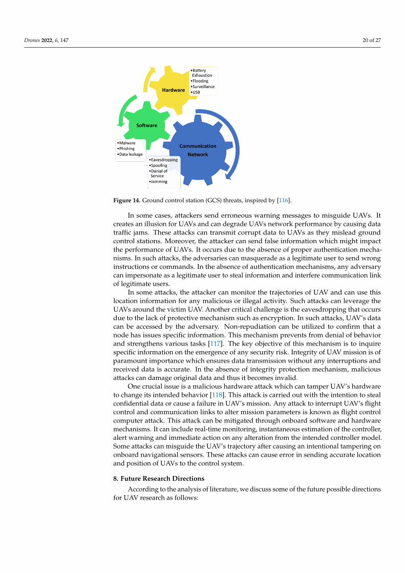
Drones 2022, 6, 147 20 of 27Drones 2022, 6, x FOR PEER REVIEW 21 of 28
Figure 14. Ground control station (GCS) threats, inspired by [116].
In some cases, attackers send erroneous warning messages to misguide UAVs. It creates an illusion for UAVs and can degrade UAVs network performance by causing data traffic jams. These attacks can transmit corrupt data to UAVs as they mislead ground control stations. Moreover, the attacker can send false information which might impact the performance of UAVs. It occurs due to the absence of proper authentication mechanisms. In such attacks, the adversaries can masquerade as a legitimate user to send wrong instructions or commands. In the absence of authentication mechanisms, any ad-versary can impersonate as a legitimate user to steal information and interfere commu-nication link of legitimate users.
In some attacks, the attacker can monitor the trajectories of UAV and can use this location information for any malicious or illegal activity. Such attacks can leverage the UAVs around the victim UAV. Another critical challenge is the eavesdropping that oc-curs due to the lack of protective mechanism such as encryption. In such attacks, UAV’s data can be accessed by the adversary. Non-repudiation can be utilized to confirm that a node has issues specific information. This mechanism prevents from denial of behavior and strengthens various tasks [117]. The key objective of this mechanism is to inquire specific information on the emergence of any security risk. Integrity of UAV mission is of paramount importance which ensures data transmission without any interruptions and received data is accurate. In the absence of integrity protection mechanism, malicious attacks can damage original data and thus it becomes invalid.
One crucial issue is a malicious hardware attack which can tamper UAV’s hardware to change its intended behavior [118]. This attack is carried out with the intention to steal confidential data or cause a failure in UAV’s mission. Any attack to interrupt UAV’s flight control and communication links to alter mission parameters is known as flight control computer attack. This attack can be mitigated through onboard software and hardware mechanisms. It can include real-time monitoring, instantaneous estimation of the controller, alert warning and immediate action on any alteration from the intended controller model. Some attacks can misguide the UAV’s trajectory after causing an in-tentional tampering on onboard navigational sensors. These attacks can cause error in sending accurate location and position of UAVs to the control system.
8. Future Research Directions According to the analysis of literature, we discuss some of the future possible direc-
tions for UAV research as follows:
Figure 14. Ground control station (GCS) threats, inspired by [116].
In some cases, attackers send erroneous warning messages to misguide UAVs. Itcreates an illusion for UAVs and can degrade UAVs network performance by causing datatraffic jams. These attacks can transmit corrupt data to UAVs as they mislead groundcontrol stations. Moreover, the attacker can send false information which might impactthe performance of UAVs. It occurs due to the absence of proper authentication mecha-nisms. In such attacks, the adversaries can masquerade as a legitimate user to send wronginstructions or commands. In the absence of authentication mechanisms, any adversarycan impersonate as a legitimate user to steal information and interfere communication linkof legitimate users.
In some attacks, the attacker can monitor the trajectories of UAV and can use thislocation information for any malicious or illegal activity. Such attacks can leverage theUAVs around the victim UAV. Another critical challenge is the eavesdropping that occursdue to the lack of protective mechanism such as encryption. In such attacks, UAV’s datacan be accessed by the adversary. Non-repudiation can be utilized to confirm that anode has issues specific information. This mechanism prevents from denial of behaviorand strengthens various tasks [117]. The key objective of this mechanism is to inquirespecific information on the emergence of any security risk. Integrity of UAV mission is ofparamount importance which ensures data transmission without any interruptions andreceived data is accurate. In the absence of integrity protection mechanism, maliciousattacks can damage original data and thus it becomes invalid.
One crucial issue is a malicious hardware attack which can tamper UAV’s hardwareto change its intended behavior [118]. This attack is carried out with the intention to stealconfidential data or cause a failure in UAV’s mission. Any attack to interrupt UAV’s flightcontrol and communication links to alter mission parameters is known as flight controlcomputer attack. This attack can be mitigated through onboard software and hardwaremechanisms. It can include real-time monitoring, instantaneous estimation of the controller,alert warning and immediate action on any alteration from the intended controller model.Some attacks can misguide the UAV’s trajectory after causing an intentional tampering ononboard navigational sensors. These attacks can cause error in sending accurate locationand position of UAVs to the control system.
8. Future Research Directions
According to the analysis of literature, we discuss some of the future possible directionsfor UAV research as follows:
Drones 2022, 6, 147 21 of 27
8.1. Machine Learning and Deep Learning Techniques
Machine learning and deep learning techniques play a promising role in differentapplications related to UAVs such as battery scheduling, trajectory planning, tracking,obstacle avoidance and resource allocation. The development of new ML tools and en-hancement of onboard computational power will help to develop novel UAV models thatare smarter, lightweight and smaller to perform any operation without the risk of collision.Using these tools, UAVs can autonomously modify their motion, direction and locationto serve ground users. Moreover, the availability of accurate data can support UAVs insmart control, trajectory planning and vision tasks. By installing different cameras onUAV, several types of images can be captured for further image processing. UAV planning,including trajectory, navigation and manipulation can be performed to find an intendedpath. Similarly, the movement of ground users and load sharing can be obtained for UAVtrajectory planning. Although conventional machine learning methods have been imple-mented in UAVs, but deep learning methods have not been explored due to limited powerresources and processing capabilities. Thus, research fraternity should investigate efficientand low-power deep learning methods in UAVs, especially for SAR operations [119].
8.2. Energy Harvesting Techniques
There is a need to investigate novel material for UAV’s batteries and new energyharvesting solutions to get full potential of UAVs in extended time missions [120]. Batterycharging time and weight are also some future concerns. Thus, there is a need to findlightweight batteries that can significantly enhance UAVs flight time and support longerdistances. Efficient techniques to control battery power consumption for IoT terminals inUAVs should be addressed in future studies.
8.3. Sensing, Navigation and Localization Algorithms
More research towards sensing, navigation and localization is needed. These issuesoccur due to weak GPS systems to obtain the location which can create problems in accurateand timely parcel delivery. Among these, localization has a major role in safe operationsof UAVs. Due to unpredictable and high mobility of UAVs, accurate localization tendsto be problematic within a short time. The accuracy of UAV location is restricted by 3Dmobility and obstacle-based and highly dynamic environment. Generally, GPS is used totrack location, but it can add unnecessary costs and delay due to dense deployment ofUAVs. Therefore, the incorporation of localization systems and low cost sensors must beinvestigated for proficient UAV location.
8.4. Offloading Algorithms
In various operations, multiple tasks should be conducted simultaneously. Thereis an increasing demand of multi-UAVs for such tasks. These tasks are divided amongdeployed UAVs such that each task gets proper focus in a timely manner. Owning tohigh mobility scenarios, commutation-sensitive and time-sensitive UAV applications, cost-efficient task offloading is a critical concern [121]. Researchers should introduce noveltask offloading algorithms in order to reduce the total energy consumption for performingpredefined tasks.
8.5. Mobility Models
UAV networks are vulnerable to high mobility. Frequent topology changes can damageboth cooperation and communication among UAVs [122]. Several mobility models havebeen proposed to overcome mobility challenges but they are insufficient to deal withcommunication issues. These models must be designed considering network requirements.Network coverage is significantly reduced in case of UAV mobility at low speed, results inhigher network delays. However, mobility models with minimal latency are required inemergency scenarios. Furthermore, continuous network connectivity leads to degraded
Drones 2022, 6, 147 22 of 27
network performance. Thus, novel mobility models should be developed for certainapplications and environments to tackle mobility challenges.
8.6. Aerial Blockchain
Blockchain technology, as a decentralized solution, is projected to usher in a new eraof secure and adaptable privacy protection for blockchain-based UAV systems. Aerialblockchain can prevent UAV communication privacy leaks and secure the integrity ofdata acquired by UAVs [123,124]. Furthermore, a block-chain-enabled UAV softwarizationmay be utilized to provide communication services over the UAV network with dynamic,flexible, and on-the-fly decision capabilities [125]. While there have been various studyattempts on blockchain technology in UAV networks, researchers have yet to look intoblock-chain-enabled softwarization for UAV networks.
8.7. Novel Antenna Designs Techniques
Novel antenna designs for UAVs should be designed to ensure high data rate commu-nication. It is suggested to utilize small, aerodynamic antennas for UAVs cruising at higherspeeds. Similarly, directional antennas can be used in smalls sized UAVs to overcomespace and energy limitations. Moreover, tilted–beam circularly polarized antennas arewidespread due to advantage of saving space. By using such antennas, performance isenvisaged to be enhanced in terms of radiation pattern, axial ratio and return losses. WPTtechniques and backscatter antennas can be used to enhance network lifetime. The incor-poration of multiple adaptive antennas can also support communication in highly-mobileUAVs [126].
9. Conclusions
This study investigates recent research developments of UAVs, accomplished byindustrial and academic sectors. We provide comprehensive discussion pertinent to UAVtypes, UAV classifications, UAVs swarms and charging techniques. This study also exploresUAV’s standardizations. Our work reveals growing interest of business bodies, statesauthorities and researchers to harness and use the full potentials of UAV technology.Furthermore, UAVs characteristics such as flight time, speed, range, altitude and payloadare briefly discussed. In this review, a comprehensive study on UAVs applications, potentialchallenges and security issues is presented. In particular, UAVs in 5G technology and IoTnetwork are explored in the light of recent research contributions. In the end, this reviewidentifies the research gap and presents future research directions for UAV technology.
Author Contributions: Conceptualization, S.A.H.M. and M.A.K.; Methodology, M.A.K. and M.H.A.;Software, M.A.K. and F.N.; Validation, M.A.K., F.N. and I.U.; Formal analysis, S.A.H.M. and M.A.K.;Investigation, S.A.H.M. and M.A.K.; Resources, M.A.K. and S.A.H.M.; Data curation, M.A.K. andM.H.A.; Writing—original draft preparation, M.A.K. and S.A.H.M.; Writing—review and editing,M.A.K. and S.A.H.M.; Visualization, S.A.H.M.; Supervision, F.N. All authors have read and agreed tothe published version of the manuscript.
Funding: This research received no external funding.
Conflicts of Interest: The authors declare no conflict of interest.
References1. Hassija, V.; Saxena, V.; Chamola, V. Scheduling drone charging for multi-drone network based on consensus time-stamp and
game theory. Comput. Commun. 2019, 149, 51–61. [CrossRef]2. Yoo, W.; Yu, E.; Jung, J. Drone delivery: Factors affecting the public’s attitude and intention to adopt. Telemat. Inform. 2018, 35,
1687–1700. [CrossRef]3. Macrina, G.; Pugliese, L.D.P.; Guerriero, F.; Laporte, G. Drone-aided routing: A literature review. Transp. Res. Part C Emerg.
Technol. 2020, 120, 102762. [CrossRef]4. Kim, J.; Kim, S.; Jeong, J.; Kim, H.; Park, J.-S.; Kim, T. CBDN: Cloud-Based Drone Navigation for Efficient Battery Charging in
Drone Networks. IEEE Trans. Intell. Transp. Syst. 2018, 20, 4174–4191. [CrossRef]
Drones 2022, 6, 147 23 of 27
5. Zhang, S.; Zhang, H.; Di, B.; Song, L. Cellular UAV-to-X Communications: Design and Optimization for Multi-UAV Networks.IEEE Trans. Wirel. Commun. 2019, 18, 1346–1359. [CrossRef]
6. Amazon Prime AIR. Available online: https://www.amazon.com/Amazon-Prime-Air/b?ie=UTF8&node=8037720011 (accessedon 1 March 2022).
7. Deutshe Post DHL Group. Available online: www.dpdhl.com (accessed on 5 March 2022).8. Wired Shopper. Available online: https://thewiredshopper.com (accessed on 10 March 2022).9. USA Today. Available online: www.usatoday.com (accessed on 14 March 2022).10. EHang AAV. Available online: https://www.ehang.com/ehangaav (accessed on 20 March 2022).11. Khan, M.A.; Alvi, B.A.; Safi, A.; Khan, I.U. Drones for Good in Smart Cities: A Review. In Proceedings of the International
Conference on Electrical, Electronics, Computers, Communication, Mechanical and Computing (EECCMC), Tamil Nadu, India,28–29 January 2018.
12. Shakoor, S.; Kaleem, Z.; Baig, M.I.; Chughtai, O.; Duong, T.Q.; Nguyen, L.D. Role of UAVs in Public Safety Communications:Energy Efficiency Perspective. IEEE Access 2019, 7, 140665–140679. [CrossRef]
13. Noor, F.; Khan, M.; Al-Zahrani, A.; Ullah, I.; Al-Dhlan, K. A Review on Communications Perspective of Flying Ad-Hoc Networks:Key Enabling Wireless Technologies, Applications, Challenges and Open Research Topics. Drones 2020, 4, 65. [CrossRef]
14. Zhang, S.; Qian, Z.; Wu, J.; Kong, F.; Lu, S. Optimizing Itinerary Selection and Charging Association for Mobile Chargers. IEEETrans. Mob. Comput. 2016, 16, 2833–2846. [CrossRef]
15. Aldhaher, S.; Mitcheson, P.D.; Arteaga, J.M.; Kkelis, G.; Yates, D.C. Light-weight wireless power transfer for mid-air chargingof drones. In Proceedings of the 2017 11th European Conference on Antennas and Propagation (EUCAP), Paris, France, 19–24March 2017; pp. 336–340.
16. Lu, M.; Bagheri, M.; James, A.P.; Phung, T. Wireless Charging Techniques for UAVs: A Review, Reconceptualization, andExtension. IEEE Access 2018, 6, 29865–29884. [CrossRef]
17. Raciti, A.; Rizzo, S.A.; Susinni, G. Drone charging stations over the buildings based on a wireless power transfer system. InProceedings of the 2018 IEEE/IAS 54th Industrial and Commercial Power Systems Technical Conference (I & CPS), Niagara Falls,ON, Canada, 7–10 May 2018; pp. 1–6.
18. Rohan, A.; Rabah, M.; Talha, M.; Kim, S.-H. Development of Intelligent Drone Battery Charging System Based on Wireless PowerTransmission Using Hill Climbing Algorithm. Appl. Syst. Innov. 2018, 1, 44. [CrossRef]
19. Shin, M.; Kim, J.; Levorato, M. Auction-Based Charging Scheduling With Deep Learning Framework for Multi-Drone Networks.IEEE Trans. Veh. Technol. 2019, 68, 4235–4248. [CrossRef]
20. Pham, H.; Smolka, S.A.; Stoller, S.D.; Phan, D.; Yang, J. A survey on unmanned aerial vehicle collision avoidance systems. arXiv2015, arXiv:1508.07723.
21. Hayat, S.; Yanmaz, E.; Muzaffar, R. Survey on unmanned aerial vehicle networks for civil applications: A commu-nicationsviewpoint. IEEE Commun. Surv. Tutor. 2016, 18, 2624–2661. [CrossRef]
22. Ebeid, E.; Skriver, M.; Jin, J. A survey on open-source flight control platforms of unmanned aerial vehicle. In Proceedings ofthe 2017 Euromicro Conference on Digital System Design (DSD), Vienna, Austria, 30 August–1 September 2017; pp. 396–402.[CrossRef]
23. Geraci, G.; Garcia-Rodriguez, A.; Giordano, L.G.; Lopez-Perez, D.; Bjornson, E. Understanding UAV Cellular Communications:From Existing Networks to Massive MIMO. IEEE Access 2018, 6, 67853–67865. [CrossRef]
24. Fotouhi, A.; Qiang, H.; Ding, M.; Hassan, M.; Giordano, L.G.; Garcia-Rodriguez, A.; Yuan, J. Survey on UAV Cellular Communi-cations: Practical Aspects, Standardization Advancements, Regulation, and Security Challenges. IEEE Commun. Surv. Tutor. 2019,21, 3417–3442. [CrossRef]
25. Mozaffari, M.; Saad, W.; Bennis, M.; Nam, Y.-H.; Debbah, M. A tutorial on UAVs for wireless networks: Applications, challenges,and open problems. arXiv 2018, arXiv:1803.00680. [CrossRef]
26. Li, B.; Fei, Z.; Zhang, Y. UAV Communications for 5G and Beyond: Recent Advances and Future Trends. IEEE Internet Things J.2018, 6, 2241–2263. [CrossRef]
27. Zhang, L.; Zhao, H.; Hou, S.; Zhao, Z.; Xu, H.; Wu, X.; Wu, Q.; Zhang, R. A Survey on 5G Millimeter Wave Communications forUAV-Assisted Wireless Networks. IEEE Access 2019, 7, 117460–117504. [CrossRef]
28. Ullah, Z.; Al-Turjman, F.; Mostarda, L. Cognition in UAV-Aided 5G and Beyond Communications: A Survey. IEEE Trans. Cogn.Commun. Netw. 2020, 6, 872–891. [CrossRef]
29. Oubbati, O.S.; Atiquzzaman, M.; Ahanger, T.A.; Ibrahim, A. Softwarization of UAV networks: A survey of ap-plications andfuture trends. IEEE Access 2020, 8, 98073–98125. [CrossRef]
30. Zhi, Y.; Fu, Z.; Sun, X.; Yu, J. Security and Privacy Issues of UAV: A Survey. Mob. Netw. Appl. 2019, 25, 95–101. [CrossRef]31. Skorobogatov, G.; Barrado, C.; Salamí, E. Multiple UAV systems: A survey. Unmanned Syst. 2002, 8, 149–169. [CrossRef]32. Jiang, X.; Sheng, M.; Zhao, N.; Xing, C.; Lu, W.; Wang, X. Green UAV communications for 6G: A survey. Chin. J. Aeronaut. 2021,
in press. [CrossRef]33. Song, Q.; Zeng, Y.; Xu, J.; Jin, S. A survey of prototype and experiment for UAV communications. Sci. China Inf. Sci. 2021,
64, 140301. [CrossRef]34. Srivastava, S.; Narayan, S.; Mittal, S. A survey of deep learning techniques for vehicle detection from UAV images. J. Syst. Archit.
2021, 117, 102152. [CrossRef]
Drones 2022, 6, 147 24 of 27
35. Nourmohammadi, A.; Jafari, M.; Zander, T.O. A Survey on Unmanned Aerial Vehicle Remote Control Using Brain–ComputerInterface. IEEE Trans. Hum.-Mach. Syst. 2018, 48, 337–348. [CrossRef]
36. Kanellakis, C.; Nikolakopoulos, G. Survey on Computer Vision for UAVs: Current Developments and Trends. J. Intell. Robot. Syst.2017, 87, 141–168. [CrossRef]
37. Unmanned Airspace. Available online: https://www.polarismarketresearch.com/industry-analysis/commercial-uav-market/request-for-sample (accessed on 25 March 2022).
38. Ucgun, H.; Yuzgec, U.; Bayilmis, C. A review on applications of rotary-wing unmanned aerial vehicle charging stations. Int. J.Adv. Robot. Syst. 2021, 18, 17298814211015863. [CrossRef]
39. Gautam, A.; Sujit, P.B.; Saripalli, S. A survey of autonomous landing techniques for UAVs. In Proceedings of the 2014 InternationalConference on Unmanned Aircraft Systems (ICUAS), Orlando, FL, USA, 27–30 May 2014; pp. 1210–1218.
40. Zhao, X.; Zhou, Z.; Zhu, X. Design of a lift-propulsion VTOL UAV system. In Proceedings of the 2018 IEEE InternationalConference on Mechatronics and Automation (ICMA), Changchun, China, 5–8 August 2018; pp. 1908–1913.
41. Zhang, Q.; Liu, H.H. Robust cooperative formation control of fixed-wing unmanned aerial vehicles. arXiv 2019, arXiv:1905.01028.42. Cai, G.; Lum, K.-Y.; Chen, B.M.; Lee, T.H. A brief overview on miniature fixed-wing unmanned aerial vehicles. In Proceedings of
the IEEE ICCA 2010, Xiamen, China, 9–11 June 2010; IEEE: Piscataway, NJ, USA, 2010; pp. 285–290. [CrossRef]43. Dong, F.; Li, L.; Lu, Z.; Pan, Q.; Zheng, W. Energy-efficiency for fixed-wing UAV-enabled data collection and forwarding. In
Proceedings of the 2019 IEEE International Conference on Communications Workshops (ICC Workshops), Shanghai, China, 20–24May 2019; pp. 1–6.
44. Different Types of Drones. Available online: https://dronepedia.xyz/5-different-types-of-drones/ (accessed on 1 April 2022).45. Tahir, A.; Böling, J.; Haghbayan, M.H.; Toivonen, H.T.; PLoSila, J. Swarms of unmanned aerial vehicles—A survey. J. Ind. Inf.
Integr. 2019, 16, 100106. [CrossRef]46. Mairaj, A.; Baba, A.I.; Javaid, A.Y. Application specific drone simulators: Recent advances and challenges. Simul. Model. Pract.
Theory 2019, 94, 100–117. [CrossRef]47. Gunarathna, J.K.; Munasinghe, R. Development of a quad-rotor fixed-wing hybrid unmanned aerial vehicle. In Proceedings of the
2018 Moratuwa Engineering Research Conference (MERCon), Moratuwa, Sri Lanka, 30 May–1 June 2018; pp. 72–77. [CrossRef]48. Wen, S.; Han, J.; Lan, Y.; Yin, X.; Lu, Y. Influence of wing tip vortex on drift of single rotor plant protection unmanned aerial
vehicle. Nongye Jixie Xuebao/Trans. Chin. Soc. Agric. Mach. 2018, 49, 127–137.49. Lee, D.; Zhou, J.; Lin, W.T. Autonomous battery swapping system for quadcopter. In Proceedings of the 2015 International
Conference on Unmanned Aircraft Systems (ICUAS), Denver, CO, USA, 9–12 June 2015; pp. 118–124.50. De Souza BJ, O.; Endler, M. Coordinating movement within swarms of UAVs through mobile networks. In Proceedings of the
2015 IEEE International Conference on Pervasive Computing and Communication Workshops (PerCom Workshops), St. Louis,MO, USA, 23–27 March 2015; pp. 154–159.
51. Pestana, J.; Sanchez-Lopez, J.L.; de la Puente, P.; Carrio, A.; Campoy, P. A Vision-based Quadrotor Swarm for the participation inthe 2013 International Micro Air Vehicle Competition. In Proceedings of the 2014 International Conference on Unmanned AircraftSystems (ICUAS), Orlando, FL, USA, 27–30 May 2014; pp. 617–622. [CrossRef]
52. Fotouhi, A.; Ding, M.; Hassan, M. Understanding autonomous drone maneuverability for Internet of Things applications.In Proceedings of the 2017 IEEE 18th International Symposium on A World of Wireless, Mobile and Multimedia Networks(WoWMoM), Macau, China, 12–15 June 2017; pp. 1–6. [CrossRef]
53. Al-Hourani, A.; Gomez, K. Modeling cellular-to-UAV path-loss for suburban environments. IEEE Wirel. Commun. Lett. 2017, 7,82–85. [CrossRef]
54. Ding, M.; Wang, P.; Lopez-Perez, D.; Mao, G.; Lin, Z. Performance impact of LoS and NLoS transmissions in dense cellularnetworks. IEEE Trans. Wirel. Commun. 2015, 15, 2365–2380. [CrossRef]
55. Hempe, D. Unmanned aircraft systems in the United States. In Proceedings of the US/Europe International Safety Conference,Washington, DC, USA, 6–8 June 2006.
56. EASA UAS Workshop. Available online: https://www.easa.europa.eu/sites/default/files/dfu/ws_prod-g-doc-Events-2008-February-1-Overview-of-the-UAV-Industry-(UVS).pdf (accessed on 5 April 2022).
57. Yinka-Banjo, C.; Ajayi, O. Sky-Farmers: Applications of unmanned aerial vehicles (UAV) in agriculture. Auton. Veh. 2020, 107–128.[CrossRef]
58. DJI. DJI Agras MG-1P Series. Available online: https://www.dji.com/mg-1p/info#specs (accessed on 10 April 2022).59. AgEagle Aeriel Systems Inc. AgEagle RX-60 Taking Agriculture Intelligence to the Next Level. Available online: https://docs.
wixstatic.com/ugd/89e3c5_e3de865b41b644fbb68adea13706723c.pdf?index=true (accessed on 15 April 2022).60. AlphaUnmmanedSystems. Alpha 800 UAV Helicopter. Available online: https://alphasecurityanddefense.com/alpha-800/
(accessed on 18 April 2022).61. ArcturusUAV. Jump. Available online: https://www.avinc.com/uas/jump-20 (accessed on 20 April 2022).62. 3GPP Standard TS 36.777; Technical Specification Group Radio Access Network; Study on Enhanced LTE Support for Aerial
Vehicles (Release 15). 3GPP Mobile Competence Centre: Sophia Antipolis, France, 2017.63. European Telecommunications Standards Institute. Use Cases and Spectrum Considerations for UAS (Unmanned Aircraft Systems);
Technical Report 103 373; ETSI: Sophia Antipolis, France, 2018; Available online: https://docbox.etsi.org/ERM/ERMJTFEA/70-Drafts/JTFEA32/ERM-TGAERO-32v003.docx (accessed on 20 April 2022).
Drones 2022, 6, 147 25 of 27
64. Telecommunication Standardization Sector of ITU (International Telecommunication Union). Functional Architecture for UnmannedAerial Vehicles and Unmanned Aerial Vehicle Controllers Using IMT-2020 Networks; ITU-T: Geneva, Switzerland, 2017; Availableonline: https://www.itu.int/rec/T-REC-Y.4421-202110-I/en (accessed on 20 April 2022).
65. Decker, C.; Chiambaretto, P. Economic policy choices and trade-offs for Unmanned aircraft systems Traffic Management (UTM):Insights from Europe and the United States. Transp. Res. Part A Policy Pract. 2022, 157, 40–58. [CrossRef]
66. Shrestha, R.; Bajracharya, R.; Kim, S. 6G enabled unmanned aerial vehicle traffic management: A perspective. IEEE Access 2021, 9,91119–91136. [CrossRef]
67. Jawad, A.M.; Jawad, H.M.; Nordin, R.; Gharghan, S.K.; Abdullah, N.F.; Abu-Alshaeer, M.J. Wireless power transfer with magneticresonator coupling and sleep/active strategy for a drone charging station in smart agriculture. IEEE Access 2019, 7, 139839–139851.[CrossRef]
68. Valente, J.; Sanz, D.; Barrientos, A.; Del Cerro, J.; Ribeiro, Á.; Rossi, C. An air-ground wireless sensor network for crop monitoring.Sensors 2011, 11, 6088–6108. [CrossRef]
69. Lee, B.; Kwon, S.; Park, P.; Kim, K. Active power management system for an unmanned aerial vehicle powered by solar cells, afuel cell, and batteries. IEEE Trans. Aerosp. Electron. Syst. 2014, 50, 3167–3177. [CrossRef]
70. Campi, T.; Cruciani, S.; Feliziani, M. Wireless Power Transfer Technology Applied to an Autonomous Electric UAV with a SmallSecondary Coil. Energies 2018, 11, 352. [CrossRef]
71. Wireless Power Transmission: Patent Landscape Analysis. Available online: https://www.wipo.int/edocs/plrdocs/en/lexinnova_plr_wireless_power.pdf (accessed on 23 April 2022).
72. Unmanned Airspace. Available online: https://www.unmannedairspace.info/latest-news-and-information/commercial-uav-market-to-reach-usd15-62-billion-by-2026-polaris-market-research/ (accessed on 5 May 2022).
73. Xu, J.; Zeng, Y.; Zhang, R. UAV-enabled wireless power transfer: Trajectory design and energy optimization. IEEE Trans. Wirel.Commun. 2018, 17, 5092–5106. [CrossRef]
74. Hu, Y.; Yuan, X.; Xu, J.; Schmeink, A. Optimal 1D trajectory design for uav-enabled multiuser wireless power transfer. IEEE Trans.Commun. 2019, 67, 5674–5688. [CrossRef]
75. Campi, T.; Dionisi, F.; Cruciani, S.; De Santis, V.; Feliziani, M.; Maradei, F. Magnetic field levels in drones equipped with wirelesspower transfer technology. In Proceedings of the 2016 Asia-Pacific International Symposium on Electromagnetic Com-patibility(APEMC), Shenzhen, China, 18–21 May 2016; Volume 1, pp. 544–547.
76. Bin Junaid, A.; Konoiko, A.; Zweiri, Y.; Sahinkaya, M.N.; Seneviratne, L. Autonomous wireless self-charging for multi-rotorunmanned aerial vehicles. Energies 2017, 10, 803. [CrossRef]
77. Blain, L. In-Flight Charging Gives Drones Unlimited Autonomous Range. Available online: https://newatlas.com/in-airdrone-charging-unlimited-range/56363 (accessed on 25 April 2022).
78. Rosa, R.V.; Rothenberg, C.E. Blockchain-Based Decentralized Applications for Multiple Administrative Domain Networking.IEEE Commun. Stand. Mag. 2018, 2, 29–37. [CrossRef]
79. Alladi, T.; Chamola, V.; Sikdar, B.; Choo, K.-K.R. Consumer IoT: Security vulnerability case studies and solu-tions. IEEE Consum.Electron. Mag. 2020, 9, 17–25. [CrossRef]
80. Song, C.; Kim, H.; Kim, Y.; Kim, D.; Jeong, S.; Cho, Y.; Lee, S.; Ahn, S.; Kim, J. EMI reduction methods in wireless power transfersystem for drone electrical charger using tightly coupled three-phase resonant magnetic field. IEEE Trans. Ind. Electron. 2018, 65,6839–6849. [CrossRef]
81. Sharma, V.; You, I.; Jayakody, D.N.K.; Reina, D.G.; Choo, K.-K.R. Neural-blockchain-based ultrareliable caching for edge-enabledUAV networks. IEEE Trans. Ind. Inform. 2019, 15, 5723–5736. [CrossRef]
82. Liu, C.H.; Piao, C.; Tang, J. Energy-Efficient UAV crowdsensing with multiple charging stations by deep learning. In Proceedingsof the IEEE INFOCOM 2020-IEEE Conference on Computer Communications, Toronto, ON, Canada, 6–9 July 2020; pp. 199–208.[CrossRef]
83. Hassija, V.; Chamola, V.; Krishna, D.N.G.; Guizani, M. A distributed framework for energy trading between UAVs and chargingstations for critical applications. IEEE Trans. Veh. Technol. 2020, 69, 5391–5402. [CrossRef]
84. Qin, C.; Li, P.; Liu, J.; Liu, J. Blockchain-enabled charging scheduling for unmanned vehicles in smart cities. J. Internet Technol.2021, 22, 327–337.
85. Fazelpour, F.; Vafaeipour, M.; Rahbari, O.; Shirmohammadi, R. Considerable parameters of using PV cells for so-lar-poweredaircrafts. Renew. Sustain. Energy Rev. 2013, 22, 81–91. [CrossRef]
86. Thipyopas, C.; Sripawadkul, V.; Warin, N. Design and development of a small solar-powered UAV for environmental monitoringapplication. In Proceedings of the 2019 IEEE Eurasia Conference on IOT, Communication and Engineering (ECICE), Yunlin,Taiwan, 3–6 October 2019; pp. 316–319. [CrossRef]
87. Wu, J.; Wang, H.; Huang, Y.; Su, Z.; Zhang, M. Energy management strategy for solar-powered UAV long-endurance targettracking. IEEE Trans. Aerosp. Electron. Syst. 2018, 55, 1878–1891. [CrossRef]
88. Gao, X.Z.; Hou, Z.X.; Guo, Z.; Chen, X.Q. Reviews of methods to extract and store energy for solar-powered air-craft. Renew.Sustain. Energy Rev. 2015, 44, 96–108. [CrossRef]
89. Achtelik, M.C.; Stumpf, J.; Gurdan, D.; Doth, K.-M. Design of a flexible high performance quadcopter platform breaking the MAVendurance record with laser power beaming. In Proceedings of the 2011 IEEE/RSJ International Conference on Intelligent Robotsand Systems, San Francisco, CA, USA, 25–30 September 2011; pp. 5166–5172.
Drones 2022, 6, 147 26 of 27
90. Ouyang, J.; Che, Y.; Xu, J.; Wu, K. Throughput maximization for laser-powered UAV wireless communication systems. InProceedings of the 2018 IEEE International Conference on Communications Workshops (ICC Workshops), Kansas City, MO, USA,20–24 May 2018; pp. 1–6.
91. Chen, Q.; Zhang, D.; Zhu, D.; Shi, Q.; Gu, J.; Ai, Y. Design and experiment for realization of laser wireless power transmission forsmall unmanned aerial vehicles. Int. Soc. Opt. Photonics 2015, 9671, 96710N. [CrossRef]
92. Lee, S.; Lim, N.; Choi, W.; Lee, Y.; Baek, J.; Park, J. Study on battery charging converter for MPPT control of laser wireless powertransmission system. Electronics 2020, 9, 1745. [CrossRef]
93. Kim, Y.; Shin, H.B.; Lee, W.H.; Jung, S.H.; Kim, C.Z.; Kim, H.; Lee, Y.T.; Kang, H.K. 1080 nm InGaAs laser power converters grownby MOCVD using InAlGaAs metamorphic buffer layers. Sol. Energy Mater. Sol. Cells 2019, 200, 109984. [CrossRef]
94. Zhang, Q.; Fang, W.; Liu, Q.; Wu, J.; Xia, P.; Yang, L. Distributed laser charging: A wireless power transfer approach. IEEE InternetThings J. 2018, 5, 3853–3864. [CrossRef]
95. Nguyen, M.T.; Nguyen, C.V.; Truong, L.H.; Le, A.M.; Quyen, T.V.; Masaracchia, A.; Teague, K.A. Electromagnetic field based wpttechnologies for UAVs: A comprehensive survey. Electronics 2020, 9, 461. [CrossRef]
96. El Haber, E.; Alameddine, H.A.; Assi, C.; Sharafeddine, S. UAV-aided ultra-reliable low-latency computation offloading in futureIoT networks. IEEE Trans. Commun. 2021, 69, 6838–6851. [CrossRef]
97. Wang, L.; Che, Y.L.; Long, J.; Duan, L.; Wu, K. Multiple access mmWave design for UAV-aided 5G communications. IEEE Wirel.Commun. 2019, 26, 64–71. [CrossRef]
98. Che, Y.; Lai, Y.; Luo, S.; Wu, K.; Duan, L. UAV-aided information and energy transmissions for cognitive and sustainable 5Gnetworks. IEEE Trans. Wirel. Commun. 2020, 20, 1668–1683. [CrossRef]
99. Giyenko, A.; Im Cho, Y. Intelligent UAV in smart cities using IoT. In Proceedings of the 2016 16th International Conference onControl, Automation and Systems (ICCAS), Gyeongju, Korea, 16–19 October 2016; pp. 207–210.
100. Feng, W.; Wang, J.; Chen, Y.; Wang, X.; Ge, N.; Lu, J. UAV-aided MIMO communications for 5G internet of things. IEEE InternetThings J. 2018, 6, 1731–1740. [CrossRef]
101. Motlagh, N.H.; Taleb, T.; Arouk, O. Low-altitude unmanned aerial vehicles-based internet of things services: Comprehensivesurvey and future perspectives. IEEE Internet Things J. 2016, 3, 899–922. [CrossRef]
102. Shakhatreh, H.; Sawalmeh, A.H.; Al-Fuqaha, A.; Dou, Z.; Almaita, E.; Khalil, I.; Othman, N.S.; Khreishah, A.; Guizani, M.Unmanned Aerial Vehicles (UAVs): A survey on civil applications and key research challenges. IEEE Access 2019, 7, 48572–48634.[CrossRef]
103. Reinecke, M.; Prinsloo, T. The influence of drone monitoring on crop health and harvest size. In Proceedings of the 2017 1stInternational Conference on Next Generation Computing Applications (NextComp), Reduit, Mauritius, 19–21 July 2017; pp. 5–10.
104. Maes, W.H.; Steppe, K. Perspectives for remote sensing with unmanned aerial vehicles in precision agriculture. Trends Plant Sci.2019, 24, 152–164. [CrossRef]
105. Menouar, H.; Guvenc, I.; Akkaya, K.; Uluagac, A.S.; Kadri, A.; Tuncer, A. UAV-enabled intelligent transportation systems for thesmart city: Applications and challenges. IEEE Commun. Mag. 2017, 55, 22–28. [CrossRef]
106. Elloumi, M.; Dhaou, R.; Escrig, B.; Idoudi, H.; Saidane, L.A. Monitoring road traffic with a UAV-based system. In Proceedings ofthe 2018 IEEE Wireless Communications and Networking Conference (WCNC), Barcelona, Spain, 15–18 April 2018; pp. 1–6.
107. Tiansawat, P.; Elliott, S. Unmanned Aerial Vehicles for Automated Forest Restoration. Available online: https://www.researchgate.net/profile/Stephen-Elliott-2/publication/350688583_Unmanned_Aerial_Vehicles_for_Automated_Forest_Restoration/links/614b3f56a3df59440ba46d20/Unmanned-Aerial-Vehicles-for-Automated-Forest-Restoration.pdf (accessedon 1 May 2022).
108. De Almeida, D.R.A.; Broadbent, E.N.; Ferreira, M.P.; Meli, P.; Zambrano, A.M.A.; Gorgens, E.B.; Resende, A.F.; de Almeida, C.T.;Amaral, C.H.D.; Corte, A.P.D.; et al. Monitoring restored tropical forest diversity and structure through UAV-borne hyperspectraland lidar fusion. Remote Sens. Environ. 2021, 264, 112582. [CrossRef]
109. Moura, M.; de Oliveira, L.; Sanquetta, C.; Bastos, A.; Mohan, M.; Corte, A. Towards amazon forest restoration: Automaticdetection of species from UAV imagery. Remote Sens. 2021, 13, 2627. [CrossRef]
110. Zhang, Y.; Yuan, X.; Li, W.; Chen, S. Automatic power line inspection using UAV images. Remote Sens. 2017, 9, 824. [CrossRef]111. Foudeh, H.A.; Luk, P.C.-K.; Whidborne, J.F. An advanced unmanned aerial vehicle (UAV) approach via learning-based control for
overhead power line monitoring: A comprehensive review. IEEE Access 2021, 9, 130410–130433. [CrossRef]112. Khan, M.A.; Ullah, I.; Kumar, N.; Oubbati, O.S.; Qureshi, I.M.; Noor, F.; Khanzada, F.U. An efficient and secure certificate-based
access control and key agreement scheme for flying ad-hoc networks. IEEE Trans. Veh. Technol. 2021, 70, 4839–4851. [CrossRef]113. Jiang, B.; Yang, J.; Song, H. Protecting Privacy from Aerial photography: State of the Art, Opportunities, and Challenges. In
Proceedings of the IEEE INFOCOM 2020—IEEE Conference on Computer Communications Workshops (INFOCOM WKSHPS),Toronto, ON, Canada, 6–9 July 2020; pp. 799–804.
114. Krishna, C.G.L.; Murphy, R.R. A review on cybersecurity vulnerabilities for unmanned aerial vehicles. In Proceedings of the 2017IEEE International Symposium on Safety, Security and Rescue Robotics (SSRR), Shanghai, China, 11–13 October 2017; pp. 194–199.[CrossRef]
115. Vattapparamban, E.; Güvenç, I.; Yurekli, A.I.; Akkaya, K.; Uluagaç, S. Drones for smart cities: Issues in cybersecurity, privacy, andpublic safety. In Proceedings of the 2016 International Wireless Communications and Mobile Computing Conference (IWCMC),Paphos, Cyprus, 5–9 September 2016; pp. 216–221.
Drones 2022, 6, 147 27 of 27
116. Mansfield, K.; Eveleigh, T.; Holzer, T.H.; Sarkani, S. Unmanned aerial vehicle smart device ground control station cyber securitythreat model. In Proceedings of the 2013 IEEE International Conference on Technologies for Homeland Security (HST), Waltham,MA, USA, 12–14 November 2013; pp. 722–728. [CrossRef]
117. He, D.; Chan, S.; Guizani, M. Communication security of unmanned aerial vehicles. IEEE Wirel. Commun. 2016, 24, 134–139.[CrossRef]
118. Birnbaum, Z.; Dolgikh, A.; Skormin, V.; O’Brien, E.; Muller, D.; Stracquodaine, C. Unmanned aerial vehicle security usingbehavioral profiling. In Proceedings of the 2015 International Conference on Unmanned Aircraft Systems (ICUAS), Denver, CO,USA, 9–12 June 2015; pp. 1310–1319.
119. Sands, T. Virtual Sensoring of motion using pontryagin’s treatment of hamiltonian systems. Sensors 2021, 21, 4603. [CrossRef][PubMed]
120. Carrio, A.; Sampedro, C.; Rodriguez-Ramos, A.; Campoy, P. A review of deep learning methods and applications for unmannedaerial vehicles. J. Sens. 2017, 2017, 3296874. [CrossRef]
121. Sandberg, A.; Sands, T. Autonomous trajectory generation algorithms for spacecraft slew maneuvers. Aerospace 2022, 9, 135.[CrossRef]
122. Wheeb, A.H.; Nordin, R.; Abu Samah, A.; Alsharif, M.H.; Khan, M.A. Topology-based routing protocols and mobility models forflying ad hoc networks: A contemporary review and future research directions. Drones 2021, 6, 9. [CrossRef]
123. Li, B.; Fei, Z.; Zhang, Y.; Guizani, M. Secure UAV communication networks over 5G. IEEE Wirel. Commun. 2019, 26, 114–120.[CrossRef]
124. Mehta, P.; Gupta, R.; Tanwar, S. Blockchain envisioned UAV networks: Challenges, solutions, and comparisons. Comput. Commun.2020, 151, 518–538. [CrossRef]
125. Kumari, A.; Gupta, R.; Tanwar, S.; Kumar, N. A taxonomy of blockchain-enabled softwarization for secure UAV network. Comput.Commun. 2020, 161, 304–323. [CrossRef]
126. Khan, M.A.; Qureshi, I.M.; Khan, I.U.; Nasim, M.A.; Javed, U.; Khan, M.W. On the performance of flying ad-hoc Network(FANET) with directional antennas. In Proceedings of the 2018 5th International Multi-Topic ICT Conference (IMTIC), Jamshoro,Pakistan, 25–27 April 2018; pp. 1–8.
Copyright © 2022 FDOKUMEN