Toward a Sustainable Future for the Red Sea Coast of Sudan
246
Toward a Sustainable Future for the Red Sea Coast of Sudan Part 2: Socio Economic and Governance Survey
-
Upload
khangminh22 -
Category
Documents
-
view
3 -
download
0
Transcript of Toward a Sustainable Future for the Red Sea Coast of Sudan

1
Toward a Sustainable Future for the Red Sea Coast of Sudan
Part 2: Socio Economic and Governance Survey

2

3
Toward a Sustainable Future for the Red Sea Coast of Sudan
Part 2: Socio Economic and Governance Survey
This program would have not be possible without the generous financial support of the European Commission and IWC Schaffhausen.

44
CREDITSConsortium of partners:The Red Sea State of Sudan and related institutions (HCENR, ICZM Office, Red Sea University)Regional Organization for the Conservation of the Environment of the Red Sea and Gulf of Aden (PERSGA)The United Nations Educational Scientific and Cultural Organisation (UNESCO)Afrikan Parks Conservation (APC)Coastal Oceans Research and Development in the Indian Ocean (CORDIO)The Centre for Environment and Development for the Arab Region and Europe (CEDARE)The Centre for Environment and Development for the Arab Region and Europe (CEDARE)Sudanese Development Initiative - SUDIAMallinson Architects
Editors:Tarik Chekchak
Authors:Mr. Tarik Chekchak, Equipe Cousteau, Director for Sciences & EnvironmentMs. Khulood Tubaishat, PERSGA, Advisor on Policy and Coastal GovernanceDr. Melita Samoilys, CORDIO, Director, Marine BiologistMr. Roy Facey, Equipe Cousteau, External ConsultantMr. Nedal Aloral, Equipe Cousteau, External ConsultantMs. Raphaëlle Martinez, UNESCO Division of Education Strategies and Capacity Building, Education Planning Specialist of the
Section for Education Support StrategiesMr. Ahmed Hanafi Abdel-Magid, Sudia, Consultant, in charge of updating the 2007/8 surveyDr. Rebecca Klaus, Equipe Cousteau, Consultant & Advisor, Marine Biologist and GISDr. Jeremy Kemp, Equipe Cousteau, External Consultant, Marine BiologistMs. Lauren Salm, PERSGA and Equipe Cousteau, UNESCO World Marine Heritage assessmentMr. Daniel Rodary, Equipe Cousteau, External Coordinator of the ICZM Project in Sudan.Dr. Nigel Hussey, Equipe Cousteau, Consultant, ElasmobranchsDr. Steve Kessel, Equipe Cousteau, Consultant, ElasmobranchsDr. Abdel Gadir Dafallah Elhag, Director, Institute of Marine Research, Port Sudan, Sudan
The following people have also provided important information and advice, and their assistance is also acknowledged:
Dr. Taha Bedawi, former Director of the ICZM Office, Port Sudan, SudanMr. Claudio Scarpellini, owner and skipper of the MSY Elegante, WildSea Expedition Dr. Ehab Omer Abdalla, Red Sea University, Faculty of Marine Sciences and Fisheries, Port Sudan, SudanDr. Mohamed Sheikh El Dine, Red Sea University, Faculty of Marine Sciences and Fisheries, Port Sudan, SudanMs. Noémie Stroh, Equipe Cousteau, Project ManagerDr. Huming Yu, Partnerships in Environmental Management for the Seas of East Asia (PEMSEA), Senior Programme Officer Dr. Michael Pido, Partnerships in Environmental Management for the Seas of East Asia (PEMSEA), Director of the Center for
Strategic Policy and Governance at Palawan State University, PhilippinesMr. Holger Anlauf, Equipe Cousteau, Volunteer, Marine BiologistMs. Angela Gall, Equipe Cousteau, Volunteer, Communication and outreachMr. Mehdi Benchellah, Equipe Cousteau, Media advisor Mr. Mohammed Younis, Equipe Cousteau, External Consultant, formerly of the Wildlife Conservation General AdministrationMamdouh Abdallah, Marine Fishery Administration, Red Sea State of Sudan.Ms. Aziza Abdallah, UNDP’s National Capacity Development Officer in Red Sea StatePagoulatos family, owners and managers of the Acropole Hotel, Khartoum, Sudan
Layout & design:Faircom New York
Photographic material by courtesy:The Cousteau Society
PROGR AM DEVELOPED BY EQUIPE COUSTEAU / THE COUSTEAU SOCIET Y (EDS. T. CHEKCHAK & M. MACFARL ANE) (2014) TOWARD A
SUSTAINABLE FUTURE FOR THE RED SEA COAST OF SUDAN. PART 2: SOCIO ECONOMIC AND GOVERNANCE SURVEY. PUBLISHED BY THE
COUSTEAU SOCIET Y, CUSTODIANS OF THE SEA • 4 EAST 27 TH STREET • P.O. BOX 20321 • NEW YORK, NY 10001.

55
ACKNOWLEDGEMENTSEquipe Cousteau would like to thank the national and Red Sea state governmental bodies of Sudan,
expecially the Governor of the Red Sea State of Sudan, The Honorable Mohammed Tahir Aila and the members of its government involved in this project. They shared with us the vision that Integrated Coastal Zone Management is a necessity for the development of the magnificent coast of the Red Sea State of Sudan.
This project would not have been possible without the support of the European Commission and we wish to especially thank Mr Paul Symonds (former Food Security Coordinator, Delegation of The European Commission To Sudan) who was a very responsive and supportive officer in charge of the follow-up of this project, with a clear vision of environmental issues and opportunities for Sudan. We are grateful for the support given by PERSGA (The Regional Organization for the Conservation of the Environment of the Red Sea & Gulf of Aden) and want to especially thank Mrs Khulood Tubaishat (former Advisor for Policy and Coastal Governance, PERSGA). Without her continuous involvement and commitment to the project, and the high level advisory and political support she has provided, in Sudan and internationally, much less would have been achieved. We would like to highlight the role Mr Mohamed Younis Abdeslam, former officer of the Wildlife Administration, and Dr Rebecca Klaus for their continuous commitment to the creation and sustainable management of Sudanese marine protected areas.
We are grateful for the support given by Mr Mustafa El Taïeb, former Director of the Division of Science Analysis and Policies (UNESCO, Natural Sciences Sector), Mr Natarajan Ishwaran, Director of the Division of Ecological and Earth Sciences, Mr Peter Dogse, Man and the Biosphere Programme (UNESCO, Division of Ecological Sciences) and Mr Ibrahim Sidibé, former Head of Office, UNESCO Sudan. We also want to thank Mr Abubaker Mustafa Mohammed Khair, founder and chairman of the Board of Trustees of The Future University, and the former Governor of the Red Sea State His Excellency Mr Hatem El-Wassila, for their early-stage support of this work and for helping to get the support of the highest political authorities in Sudan.
Tarik ChekchakDirector for Sciences & Environment

66

7
IN THE FOOTSTEPS OF JACQUES COUSTEAU…Fifty years ago Jacques Cousteau’s Calypso dropped anchor on the coral reef Sha’ab Rumi off the
coast of Sudan.
It was there that Cousteau designed and built the first underwater village as a place to test the inven-tions he created that would enable people to live and work under the sea.
The brave pioneers on his crew spent a month under water, brilliantly demonstrating the vision of Captain Cousteau.
Their experiences and subsequent contributions to science – including invaluable achievements in training astronauts to work in a weightless environment – have been the subject of numerous scientific publications.
In 2003/2004 the Cousteau Society retraced the Captain's steps with Aquanaut Claude Wesly, who in 1963 at Sha’ab Rumi had lived and slept in the village immersed under the sea, and later had seen images of it in the Captain’s “The World Without Sun” feature, which won an Oscar in 1964.
This was a hugely emotional moment not only for Claude and the entire team, but also for some local Sudanese who recalled childhood memories of the Calypso and its Captain.
Cousteau was always looking to the future and, as I thought of him and of the permanent residents of Sha’ab Rumi, I decided to use the occasion of our return to Sudan to establish a long-term goal of providing these men and women with highly-skilled work that will help them build their future.
We have had boots on the ground since 2003, with dozens of top scientists from around the world producing a highly-detailed study on the Sudanese coast. As part of this effort, we created the UNESCO Cousteau University Chair in Khartoum. Since 2010, we have been developing a system of acoustic and satellite monitoring of sting rays and sharks in the Red Sea manned by Sudanese teams.
Scientific discoveries already have been made on how coral adapts to extreme conditions, and on the hybridization of the species.
The two volumes presented here are available to scientists and policy makers who need to take better care of fragile ecosystems for generations to come. I express my deep gratitude to all those who have helped us achieve this work that extends the path defined by Jacques Cousteau.
Francine CousteauPresidentTeam CousteauThe Cousteau Society
by Francine Cousteau
Foreword

88
TABLE OF CONTENTSCredits .............................................................................................................................................................. 4
Acknowledgements .......................................................................................................................................... 5
Foreword ........................................................................................................................................................... 7
List of Acronyms ............................................................................................................................................... 10
Glossary ............................................................................................................................................................ 12
Executive Summary ......................................................................................................................................... 17
Summary of Key Findings for the ICZM Survey ............................................................................................... 18
Summary of Recommendations from the Sudan ICZM Project (Phase I) ....................................................... 20
1 Introduction .................................................................................................................................................. 251.1 Project Background ........................................................................................................................ 25
1.1.1 An Integrated Coastal Zone Management Project in Sudan ..................................................... 25
1.1.2 The Red Sea State ........................................................................................................................ 26
1.1.3 The Jeddah Convention & Related Protocols .............................................................................. 27
1.1.4 Linking Biodiversity Conservation & Poverty Reduction ......................................................... 28
1.2 Project Goal and Objectives .......................................................................................................... 28
1.2.1 Project Process and Phases ......................................................................................................... 29
1.2.2 Work Packages & Organisational Arrangements ...................................................................... 32
1.2.3 Consortium of Partners .............................................................................................................. 32
1.2.4 Monitoring the ICZM Process ..................................................................................................... 35
1.3 Cousteau in Sudan .......................................................................................................................... 42
1.4 The Challenge of Bridging Conservation and Development Issues ........................................ 46
1.5 Governance in the Red Sea State ................................................................................................. 47
1.6 Socioeconomic Development in Red Sea State ........................................................................... 49
1.6.1 Opportunities for Peace & Prosperity ........................................................................................ 49
1.6.2 Artisanal Fisheries Sector ........................................................................................................... 49
1.7 Historical and Cultural Assets...................................................................................................... 51
1.7.1 A Historical Overview of Northern Sudan ................................................................................. 51
1.7.2 Suakin’s Unique Architecture ..................................................................................................... 52
1.7.3 The Beja Culture .......................................................................................................................... 54
2 Governance and Planning in Red Sea State ................................................................................................ 57
2.1 The New Political Environment of the Red Sea State ................................................................ 57
2.1.1 The Decentralisation Process and Public Participation ............................................................. 57
2.1.2 The Policy-Making Environment ................................................................................................ 60
2.2 Improving Coastal and Ocean Governance ................................................................................ 61
2.2.1 Institutional Arrangements for Environmental Protection ....................................................... 61
2.2.2 Main Stakeholders and Key Players in Environmental Management in RSS ........................... 63
2.2.3 Environmental Governance vs. MDGs in RSS ........................................................................... 65
2.2.4 Legislation and Regulations ....................................................................................................... 68
2.2.5 Private Sector Participation ....................................................................................................... 73
2.2.6 Constraints to the Existing Environmental Management in RSS ............................................. 73
2.2.7 The Red Sea State Master Plan ................................................................................................... 74
2.2.8 Environmental Impact Assessment ............................................................................................ 75
2.3 Education and Sustainability ........................................................................................................ 86
2.3.1 The Current RSS Education System ........................................................................................... 88
2.3.2 RSS Education Sector Planning, Policy and Reform .................................................................. 93

99
2.3.3 Assessment and Opportunities for Environmental/Sustainability Education in RSS ............. 97
2.4. Recommendations .......................................................................................................................... 101
2.4.1 General Recommendations ......................................................................................................... 101
2.4.2 Recommendations for EIA .......................................................................................................... 101
2.4.3 Recommendations for Education ................................................................................................ 102
3 Socio-Economic Development in The Red Sea State .................................................................................. 105
3.1 Overview of Society and Economy of RSS .................................................................................. 105
3.1.1 Demographics and Settlement Distribution .............................................................................. 105
3.1.2 History, Ideology and Culture ..................................................................................................... 108
3.1.3 Settlements and Social Infrastructure ....................................................................................... 110
3.1.4 Health and Education ................................................................................................................. 113
3.1.5 Livelihoods and Economy ............................................................................................................ 115
3.1.6 The Villages of Dungonab Bay-Mukkawwar Island Marine National Park .............................. 120
3.2 Livelihood Opportunities and Sustainable Development ........................................................ 123
3.2.1 Promoting Peace and Security through Sustainable Livelihoods ............................................... 123
3.2.2 Economic Valuation of Sudan's Marine and Coastal Resources ................................................. 125
3.2.3 A Need for Sustainable Fisheries ................................................................................................ 127
3.2.4 Toward Sustainable Tourism in RSS .......................................................................................... 139
3.2.5 Village Environmental Management and Livelihood Opportunities for DMNP Communities ...... 161
3.2.6 Assessing Alternative Livelihood Opportunities for DMNP Communities .............................. 167
3.2.7 Improving Livelihoods in Inland RSS (Sinkat-Arkawit area) .................................................... 180
3.3 Coastal Development and Risk Management ........................................................................... 181
3.3.1 Coastal Development ................................................................................................................. 182
3.3.2 Oil Development: Operations, Management and Issues ........................................................... 194
3.3.3 Ports, Navigation and Maritime Issues in Sudan ...................................................................... 198
3.3.4 Marine and Coastal Pollution ..................................................................................................... 209
3.4 Designing a Socioeconomic Monitoring Programme for RSS .................................................. 215
3.4.1 RSS Socioeconomic Development Plan: 2005-2008 .................................................................. 215
3.4.2 ICZM Socioeconomic Monitoring Programme ........................................................................... 216
3.5 Recommendations ......................................................................................................................... 227
3.5.1 Livelihood Interventions ............................................................................................................ 227
3.5.2 Risk Management ....................................................................................................................... 231
3.5.3 Completion of the Socioeconomic Monitoring Programme ........................................................ 233
4 Gap Analysis and Summary of Recommendations ..................................................................................... 234
4.1 GAP Analysis .................................................................................................................................... 234
4.2 References ......................................................................................................................................... 238

1010
LIST OF ACRONYMSACORD Agency for Cooperation in Research and Development AGRRA Atlantic Gulf Rapid Reef Assessment AIG Alternative Income-Generating ActivitiesAPF African Parks FoundationCBD Convention on Biological DiversityCBO Community-Based OrganisationCBS Central Bureau of StatisticsCEDARE Centre for Environment and Development in the Arab Region and EuropeCLA Coastal Livelihoods AssessmentCORDIO Coastal Oceans Research and Development in the Indian OceanCPA Comprehensive Peace AgreementCPCe Coral Point Count with Excel ExtensionsDMNP Dungonab Bay – Mukkawar Island National ParkEC European Commission EIA Environmental Impact AssessmentEIA-WG Environmental Impact Assessment Working GroupEFA Education for All (UN)EPSSim Education Policy and Strategy Simulation ModelESC Environmental School Club ESPA Eastern Sudan Peace AgreementESSP Education Sector Strategic PlanEWG Education Working Group FAD Fish Aggregating DevicesFAO Food and Agriculture Organisation of the United NationsFMoGE Federal Ministry of General EducationFTI Fast Track Initiative (UN)GAM Global Acute MalnutritionGDP Gross Domestic ProductGER Gross Enrolment Ratio GIS Geographic Information SystemGMP General Management PlanGONU Government of National UnityGoS Government of SudanGPI Gender Parity IndexHCENR Higher Council for Environment and Natural ResourcesHQ Headquarters ICZM Integrated Coastal Zone ManagementICZMO Integrated Coastal Zone Management OfficeIDPs Internally Displaced PeopleIMO International Maritime Organisation INC Interim National Constitution IOC International Oceanographic Commission ISO International Organisation for Standardisation JAM Joint Assessment MissionLBS Land-Based SurveyLPG Liquid Petroleum GasM&E Monitoring and EvaluationMAD Maritime Administration Directorate MDGs Millennium Development GoalsMDTF Multi-Donor Trust Fund
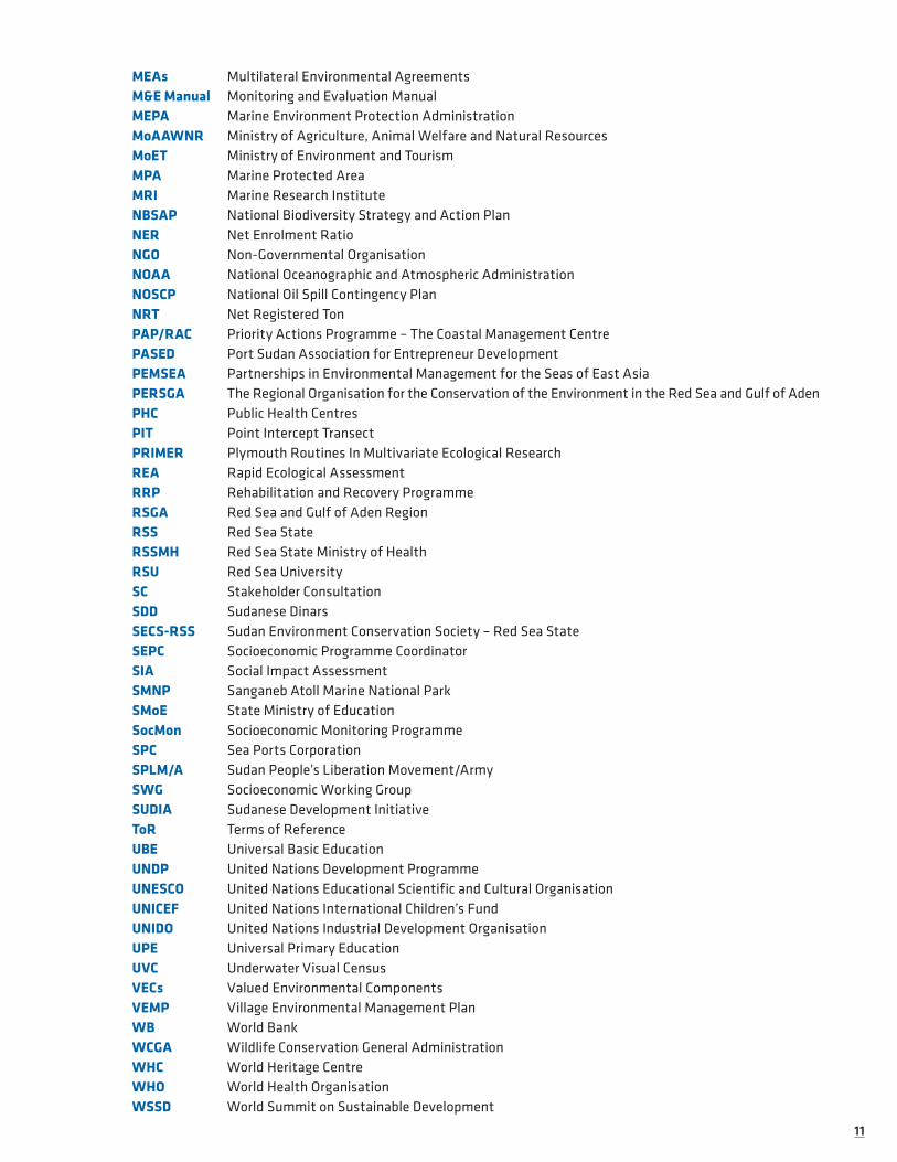
1111
MEAs Multilateral Environmental AgreementsM&E Manual Monitoring and Evaluation ManualMEPA Marine Environment Protection AdministrationMoAAWNR Ministry of Agriculture, Animal Welfare and Natural ResourcesMoET Ministry of Environment and TourismMPA Marine Protected AreaMRI Marine Research InstituteNBSAP National Biodiversity Strategy and Action PlanNER Net Enrolment Ratio NGO Non-Governmental Organisation NOAA National Oceanographic and Atmospheric AdministrationNOSCP National Oil Spill Contingency PlanNRT Net Registered TonPAP/RAC Priority Actions Programme – The Coastal Management Centre PASED Port Sudan Association for Entrepreneur Development PEMSEA Partnerships in Environmental Management for the Seas of East AsiaPERSGA The Regional Organisation for the Conservation of the Environment in the Red Sea and Gulf of AdenPHC Public Health CentresPIT Point Intercept TransectPRIMER Plymouth Routines In Multivariate Ecological ResearchREA Rapid Ecological AssessmentRRP Rehabilitation and Recovery ProgrammeRSGA Red Sea and Gulf of Aden RegionRSS Red Sea StateRSSMH Red Sea State Ministry of HealthRSU Red Sea UniversitySC Stakeholder Consultation SDD Sudanese DinarsSECS-RSS Sudan Environment Conservation Society – Red Sea StateSEPC Socioeconomic Programme CoordinatorSIA Social Impact Assessment SMNP Sanganeb Atoll Marine National ParkSMoE State Ministry of EducationSocMon Socioeconomic Monitoring ProgrammeSPC Sea Ports CorporationSPLM/A Sudan People’s Liberation Movement/ArmySWG Socioeconomic Working GroupSUDIA Sudanese Development InitiativeToR Terms of ReferenceUBE Universal Basic Education UNDP United Nations Development ProgrammeUNESCO United Nations Educational Scientific and Cultural Organisation UNICEF United Nations International Children’s FundUNIDO United Nations Industrial Development OrganisationUPE Universal Primary EducationUVC Underwater Visual CensusVECs Valued Environmental Components VEMP Village Environmental Management PlanWB World BankWCGA Wildlife Conservation General AdministrationWHC World Heritage CentreWHO World Health Organisation WSSD World Summit on Sustainable Development
1212
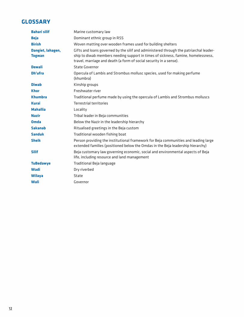
GLOSSARY
Bahari silif Marine customary law
Beja Dominant ethnic group in RSS
Birish Woven matting over wooden frames used for building shelters
Dangiet, lahagen, Togwan
Gifts and loans governed by the silif and administered through the patriarchal leader-ship to diwab members needing support in times of sickness, famine, homelessness, travel, marriage and death (a form of social security in a sense).
Dewali State Governor
Dh’ufra Opercula of Lambis and Strombus mollusc species, used for making perfume (khumbra)
Diwab Kinship groups
Khor Freshwater river
Khumbra Traditional perfume made by using the opercula of Lambis and Strombus molluscs
Kurai Terrestrial territories
Mahallia Locality
Nazir Tribal leader in Beja communities
Omda Below the Nazir in the leadership hierarchy
Sakanab Ritualised greetings in the Beja custom
Sanduk Traditional wooden fishing boat
Sheik Person providing the institutional framework for Beja communities and leading large extended families (positioned below the Omdas in the Beja leadership hierarchy)
Silif Beja customary law governing economic, social and environmental aspects of Beja life, including resource and land management
TuBedawye Traditional Beja language
Wadi Dry riverbed
Wilaya State
Wali Governor

1313
LIST OF TABLESTable 1: Ecological Indicators from the IOC handbook ...................................................................................... 37
Table 2: Governance indicators from the IOC Handbook .................................................................................. 38
Table 3: Socioeconomic indicators from the IOC Handbook ............................................................................. 40
Table 4: Environmental Governance Powers and Responsibilities of Government Levels as set out by the INC.. ............................................................................................................................................................. 58
Table 5: Institutional Arrangements in Environmental Decision-making. ........................................................ 63
Table 6: International Conventions with EIA provisions ................................................................................... 77
Table 7: Suggested Structure of the EMP. ......................................................................................................... 85
Table 8: Estimated population of key RSS localities......................................................................................... 106
Table 9: Age distribution of RSS population ..................................................................................................... 107
Table 10: Household Asset Ownership (%) ....................................................................................................... 110
Table 11: Key Social Infrastructure across Localities (2008) ............................................................................. 111
Table 12: Health facilities in the RSS 2004-2006.............................................................................................. 111
Table 13: Health service personnel in RSS 2004-2006. ..................................................................................... 111
Table 14: Education facilities in the RSS 2004-2006 ........................................................................................ 112
Table 15: Staff and pupil numbers and ratios in RSS 2004-2006 ..................................................................... 112
Table 16: Head of Household Educational Attainment across key Localities 2006 .......................................... 113
Table 17: Rural and Urban Primary School Enrollment and Completion across RSS. ........................................ 114
Table 18: Reported Respiratory and Gastric Conditions and Mortality in RSS Population (2006) ................... 114
Table 19: Child and Caregiver Acute Malnutrition rates in RSS (2006). ............................................................ 115
Table 20: RSS Budget 2005-2007 (Sudanese Dinars) ....................................................................................... 115
Table 21: RSS Per Capita Spending 2002-2006 (‘000’s Sudanese Dinars) ........................................................ 116
Table 22: RSS Distribution of Employment by Sector and Locality in 2007 ..................................................... 116
Table 23: Livestock population of the RSS by type, 2001 ................................................................................. 117
Table 24: Sorghum and millet production figures: Area in (000) fed, production in (000) m.ton and yield kg/fed ........................................................................................................................................................ 117
Table 25: Volume of imports and exports from Port Sudan ............................................................................. 118
Table 26: Questions posed to fishers during the biodiversity survey to obtain qualitative information on current fisheries observed during the survey (October-November 2007) .................................................... 129
Table 27: Fish species seen in Port Sudan market, 4th November 2007, 9:00-10:00 am. Quantities are expressed as follows: Few = less than 5 fish; Several = > 5 < 20; Many = > 20. Note lack of pelagics (Spanish mackerel, tuna etc) – only trevally seen ............................................................................................. 130
Table 28: Summary of information on the hook and line (hand line) fishery obtained from interviews with fishermen (both coral reef and deep water) .............................................................................................. 131
Table 29: Summary of information on the Trochus fishery obtained from interviews with fishermen. .......... 133

1414
Table 30: Summary of information on the sea cucumber fishery obtained from interviews with fishermen ..... 134
Table 31: Species list of sea cucumbers observed at fishing camps; average density counted for each commercial fishery group during the biodiversity survey; fishery value categories assigned during biodiversity survey and interviews, and prices. Densities from biodiversity survey (medium and low value species were combined). 1 SDP = ~ 0.5USD. ............................................................................................... 135
Table 32: Species taken by Egyptian trawlers. Non trawl gear represents catches from fibreglass boats. ......... 136
Table 33: Tourism Figures for RSS – 1987-2000 ................................................................................................ 142
Table 34: Visitor numbers and revenue generated by the Sudanese tourism industry during the 2000-2006 time period. .............................................................................................................................................. 142
Table 35: Number of Hotels and Rooms in Northern Sudanese States in 2006. .............................................. 143
Table 36: Key features of the proposed zone types within DMNP. ................................................................... 155
Table 37: Natural Resources Available to Mohammed Qol (Habitats and Species). ......................................... 162
Table 38: Natural Resource Issues for Mohammed Qol. ................................................................................... 163
Table 39: Natural Resources in Dungonab Village. ............................................................................................ 164
Table 40: Natural Resource Issues for Dungonab Village. ................................................................................ 165
Table 41: Threats to the coastal and marine environment and natural resources in Sudan (Upgraded from PERSGA 2000). ........................................................................................................................................ 189
Table 42: IMO Conventions to which Sudan is a Party (May 2008). .................................................................. 199
Table 43: IMO Convention Accessions in the Region since 2005. ..................................................................... 199
Table 44: Containers Handled at Port Sudan 2003 to 2007. ............................................................................. 201
Table 45: Cargo Tonnage Handled at Port Sudan 2003 to 2007. ....................................................................... 202
Table 46: Ship Calls at Port Sudan and Tonnage/Ship 2003 to 2007. ............................................................... 202
Table 47: Ship Calls at Suakin 2003 to 2007. ..................................................................................................... 203
Table 48: Potential areas for hydrographical surveys in the Sudanese Red Sea. ............................................. 206
Table 49: Guidelines, objectives and policy statements of the RSS Socioeconomic Development Plan. ........ 216
Table 50: Dimensions and indicators for socioeconomic monitoring baseline. ................................................. 220
Table 51: Proposed workplan for development and management of the RSS SocMon database. ................... 225
Table 52: Measuring Progress in the Implementation of ICZM. .......................................................................... 235

1515
LIST OF FIGURESFigure 1: Parties to the Jeddah Convention before the division of Sudan in North and South Sudan .............. 27
Figure 2: The three Phases of the ICZM Project in the Red Sea State of Sudan. ............................................. 30
Figure 3: The recommendations for action issued by the ICZM Survey. ........................................................... 30
Figure 4: Details of the three Phases of the global ICZM project in the Red Sea State of Sudan. ................... 31
Figure 5: Details of the work packages of the ICZM Survey in the Red Sea State of Sudan ............................ 32
Figure 6: Localities and administrative districts of the Red Sea State of Sudan. ............................................ 106
Figure 7: Taxes and fees incurred by the Government for dive boat operations in RSS. .................................. 145
Figure 8: Proposed Zoning designations in DMNP. (For more details please refer to the DMNP Site-Specific Management Plan). .............................................................................................................................. 157
Figure 9: Localisation of the main economic activities and licensed oil fields in the Red Sea State. Block 13 and 15 includes the two Marine Protected Areas of Sudan (Sanganeb and Dungonab Bay National Parks) .................................................................................................................................................. 197
1616
LIST OF PLATESPlate 1: Conshelf II starfish habitat in front of Port Sudan. ............................................................................. 42
Plate 2: Cousteau divers in 1963 swimming in Conshelf II underwater settlement of Shaab Rumi. ................ 43
Plate 3: A Cousteau diver looking inside the Conshelf habitat in 1963. ............................................................ 44
Plate 4: The underwater garage of the submarine Denise (SP150) in 1963 and covered with corals in 2004. ..... 44
Plate 5: Claude Wesly with his famous parot inside the starfish habitat (left) in 1963, and with Diane Cousteau, daughter of Jacques Cousteau, in Shaab Rumi during the 2004 expedition. ................................... 44
Plate 6: Cousteau ship Alcyone in a Marsa in Sudan during the 2004 expedition “Back to the Silent World”. ........ 45
Plate 7: Meeting with the RSS government and stakeholders in the Red Sea Wilaya building. ...................... 47
Plate 8: A fisherman trying to insure his livelihood near Suakin ...................................................................... 51
Plate 9: An aerial view of Suakin during a Cousteau expedition in 1963. .......................................................... 53
Plate 10: The ruins of a military building made of coral stones, Suakin 2007. .................................................. 53
Plate 11: Inside view of a old building of Suakin in 2007.. ................................................................................. 53
Plate 12: A Beja from the Red Sea State in Dungonab area. ............................................................................. 55
Plate 13: Meeting of partners at the Governor’s Office in Port Sudan, during the launch of the ICZM Survey in 2007. ................................................................................................................................................... 85
Plate 14: Stakeholders during a workshop at the Governor’s Office in Port Sudan during the ICZM Survey in 2007. ................................................................................................................................................... 86
Plate 15: A traditional school in Dungonab Marine National Park. .................................................................... 98
Plate 16: Red Sea State's ICZM Office former web site. ................................................................................... 99
Plate 17: Special issues of the Cousteau Magazine. .......................................................................................... 100
Plate 18: Front Cover page of the Port Sudan's ICZM Office booklet. .............................................................. 100
Plate 19: A school in Mohamed Qol, Dungonab National Park. ......................................................................... 122
Plate 20: Fish market in Port Sudan. ................................................................................................................ 123
Plate 21: Fishermen targeting Sea Cucumbers interviewed during the ICZM survey in 2007. ........................... 138
Plate 22: Traditional small fishing boat entering Suakin. ................................................................................. 138
Plate 23: Rubbish dumping from the road construction in 2007 at Khor Shinaab, inside the Dungonab National Park. .................................................................................................................................................... 184

1717
EXECUTIVE SUMMARY
In 2007, more than 50 years after Jacques Cousteau filmed the reefs of Sudan during the making of the movies The Silent World and The World without Sun, Equipe Cousteau gathered a network of partners and a multidisciplinary team to carry out the most comprehensive survey of the Sudanese Red Sea coastal and marine environment ever attempted. This document reports the findings from these surveys, and a baseline information intending to provide Northern Sudan with the possibility of establishing Integrated Coastal Zone Management (ICZM) of its unique and valuable coastal and marine resources.
Sudan has a long history of instability, and during the 48 years since independence, there have been 37 years of war. On July 9, 2011, South Sudan became an independent state following a referendum. Much of both countries, including the Red Sea State of North Sudan, are still in a state of social, economic, political and environmental disorder, and this provides the backdrop to the ICZM survey. The successful Eastern Peace Agreement in 2006 provided an opportunity to begin to address some of the development needs of the Red Sea State by working to conserve Northern Sudan’s rich natural heritage and to ensure that the coastal communities would benefit in a sustainable way. The ICZM Project was designed to help decision makers, coastal entrepreners and managers mitigate future conflicts that may arise over natural resource use, dis-tribution and over-exploitation.
The ICZM survey report is divided into two volumes: the first one focuses on habitats and biodiversity, the second one on the socio-economic situation and governance of the Red Sea State. The current volume reports mainly the results of a month long boat-based survey of the Sudanese marine environment which was com-pleted by a team of experts in December 2007, and the results of a coastal survey which was completed by partners from the Red Sea University in early 2008. The experts who participated in these surveys adopted a combination of methods that included : (i) subtidal diving surveys to assess the status and diversity of benthic communities on the reefs of Sudan and their associated fish and macro-invertebrate communi-ties ; (ii) a rapid fishery survey to identify the commercially fished stocks, the status of these stocks and key environmental issues linked to the exploitation of living resources ; (iii) surveys of shark populations and the establishment of a monitoring programme in association with the local dive operators ; (iv) a rapid assessment method to collect ground-truthing data for use in mapping the spatial distribution of marine habitats ; (v). coastal vegetation surveys and (vi) ground truthing and rapid assessments of coastal habitats. The marine and coastal ground-truthing data were used in combination with satellite-based remote sensing data to create habitat maps illustrating the distribution of coastal and marine biotopes. The current manage-ment status and situation within the marine protected areas of Sudan are presented, and recommendations for improved management of coastal and marine resources are provided.
For completeness, the Executive Summary, introductory materials and the analysis and recommendations for key environmental issues and future interventions that could lead to an efficient integrated approach to the complex coastal systems are presented within both volumes.
Tarik ChekchakDirector for Sciences & Environment

1818
SUMMARY OF KEY FINDINGS FOR THE ICZM SURVEY
Coastal and Marine Habitats and Biodiversity
1. In the fifty years since Cousteau first dived in the Sudanese Red Sea there has been relatively little development along the Red Sea coast. Much of the coastal and marine habitats remain relatively undisturbed.
2. Sudan hosts an extensive and complex network of coral reefs, seagrass beds, mangroves and other shallow marine habitats that support a diversity of marine fauna and flora.
3. The coral reefs exhibit evidence of both resistance and resilience to coral bleaching events in areas around Dungonab Bay and further south around Suakin.
4. Only low numbers of commercially important finfish and invertebrates were observed, indicating severe overfishing of specific groups, including illegal fishing.
5. There are serious concerns about the health of the shark populations in Sudan.
6. Urgent regulation and enforcement are needed in all fisheries.
Socio-economic development
7. Much of the coastal region of Sudan has remained unaffected by the changes taking place in many other countries bordering the Red Sea over the past 50 years.
8. Coastal development is currently limited to a 70 km strip, extending from Port Sudan south to Suakin; damage due to construction within this strip is already quite extensive.
9. The offshore environment and reef complexes remain relatively undisturbed by human pressures other than fishing.
10. Following the peace agreement and the recent discovery of oil and gas reserves, economic transformation may result in a rapid surge in coastal development and associated risks.
11. While the centre for industrial development is likely to remain in Port Sudan and the Suakin area, tourism development activities may extend northwards from Port Sudan and the Dungonab Bay MPA, as well as southwards to the Suakin area.
12. The new coastal road from Port Sudan to Egypt is nearing completion, which increases the accessibility of vast stretches of hitherto relatively undisturbed coast, creating opportunities for development to the north of Port Sudan, with all the associated risks.
13. The Red Sea State has a significant natural resource base but it has yet to benefit fully from these natural and strategic assets and remains one of the poorest regions in Sudan.
14. The root cause of conflict in Sudan’s eastern region is linked to natural resource issues, such as access to natural resources, equity in resource distribution and livelihoods.
15. The Dungonab Bay National Park and Suakin areas are potential pilot sites for livelihood intervention testing. Six sectors have been identified that could be developed for livelihood intervention:
a. offshore fishing;
b. aquaculture;
c. pearl oyster farming;
d. animal husbandry;
e. trading centres; and,
f. sustainable tourism.

1919
Governance and Planning
16. There is potential for enhanced environmental governance in RSS, as exhibited by the willingness of the local government and the community.
17. The promulgation of the environmental law in 2007 and the establishment of the Ministry of Environment and Tourism and the ICZM Office illustrate the significant efforts by the RSS that have been made to establish viable environmental institutions and framework.
18. Environmental issues have not yet been mainstreamed into the planning process within the Red Sea State and there is an urgent need to support this effort.
19. Local authorities have a role to play in environmental management in general, and in Environmental Impact Assessments (EIAs) in particular.
20. Local and international NGOs in RSS have made significant contributions to the protection of the environment, and there is a need to strengthen their participation in all relevant activities.
21. With regard to EIAs, it was evident that MoET currently lacks the necessary and the appropriate institutional framework for establishing an “EIA” system in RSS.
22. Mass tourism has not yet started in Sudan, the relevant authorities will need to regulate the growth of this sector, and focus on promoting “ecotourism” and local community participation.
23. Since the departure of the African Park Foundation, the two Marine Protected Areas (MPA) are no longer managed. This is a major setback, not only for their proper management in general that includes the development of these areas, but also for the ongoing process of UNESCO World Marine Heritage sites nomination.
24. Education levels in the RSS are low (illiteracy averaged 50%) due to inadequate educational infrastructure, the legacy of traditionally discouraging women from pursuing education and the lack of adequate training and remuneration for teachers.
25. Complete educational data compilation is needed so as to build an appropriate RSS education development strategy with the support of UNESCO.
26. The Environmental School Clubs provide a good basis to further developing environmental awareness amongst young people.
27. The possible piloting of UNESCO-MAB’s Teaching Resource Kit for Dryland Countries in selected RSS schools could benefit environmental education efforts in the State.

2020
SUMMARY OF RECOMMENDATIONS FROM THE SUDAN ICZM PROJECT (PHASE I)
Code Description of the action recommended
Coastal and Marine Habitats and Biodiversity of Red Sea State
Hab HABITAT AND BIODIVERSITY
R-Hab-1 Complete geographically comprehensive baseline habitat and biodiversity studies in the following areas: • From Dungonab Bay (at approximately 21°15’N), northwards to the Egyptian border;• From Shubuk (19°N), southwards, as far as possible, in the direction of the Eritrean border;• Remote outer reefs, in the Suakin Archipelago, particularly those within the eastern and
southern parts (also see recommendation R- HAB-4).
R-Hab-2 Develop and implement a National Strategy for the Management of Marine and Coastal Flagship Species.
R-Hab-3 Establish a baseline water quality monitoring programme with sampling stations situated along the coast.
R-Hab-4 Implement a detailed, specifically management-oriented, survey programme of the Suakin area and Shubuk.
R-Hab-5 Implement fisheries management for sustainability.
R-Hab-6 Urgently incorporate basic considerations of sustainable development into coastal development and infrastructure projects and initiatives at both the national and State levels.
R-Hab-7 Support the development of local collaborative management schemes for traditional fisheries, fully involving resource users in decision making (MFA), as well as monitoring and surveillance tasks.
R-Hab-8 Adequately fund the marine Fisheries inspection and data collection services operating out of the Red Sea ports to enable monitoring of catches and offshore fisheries, including foreign vessels.
R-Hab-9 Implement and enforce management restrictions to control the sea cucumber fishery.
GIS GEOGRAPHICAL INFORMATION SYSTEM (GIS): A TOOL FOR ICZM DECISION MAKING
R-GIS-1 Continue to support the development of a GIS to provide the basis for Marine Spatial Planning for the Red Sea State.
R-GIS-2 Establish and train a regional team of GIS specialists.
R-GIS-3 Conduct an assessment of GIS capacity needs and identify appropriate institutional arrangements.
R-GIS-4 Develop a GIS Website and use it for awareness raising.
R-GIS-5 Expand the applied use of remote sensing and GIS to improve decision making in RSS.
(continued)
Note: Same as Part 1 report.

2121
MPA INTERNATIONAL SIGNIFICANCE OF SUDAN’S MARINE PROTECTED AREAS
R-MPA-1 Implement effective management of the two existing globally and nationally important MPAs at Sanganeb and Dungonab.
R-MPA-2 Expand the existing MPA network to meet the recommended 10% protection of all coastal and marine areas by 2020.
R-MPA-3 Implement Next Steps and Way-Forward for World Heritage Status of DMNP and SMNP.
Governance and Planning in Red Sea State
Gov IMPROVING COASTAL AND OCEAN GOVERNANCE
R-Gov-1 Strengthening institutional capacity: in particular, by allocating human and financial resources in order effectively to support government efforts to incorporate basic considerations of ICZM into pertinent sectoral policies and guidelines, related to coastal development and infrastruc-ture projects and initiatives at the national and State levels.
R-Gov-2 Establish and develop mechanisms to monitor and evaluate environmental management and the extent to which the objectives of environmental priorities are efficiently met.
R- Gov-3 Facilitate private sector participation in environmental management functions.
R-Gov-4 Strengthen the established GIS unit in the ICZM office, where data collection and analysis should be organised, to ensure the free flow of information between all involved actors on the governmental and non-governmental levels.
R-Gov-5 Pursue the links between Sudan and its neighbouring countries, as they will be essential. PERSGA and CEDARE will play a key role in ensuring coordination and knowledge transfer with other countries of the Red Sea.
R-Gov-6 Strengthening Institutional Capacity and Participation to conduct rigid ElA (including SIA components).
R-Gov-7 Strengthening the EIA Legal Framework.
R-Gov-8 Promote Environmental Best Practice for Development Projects.
Edu EDUCATION AND SUSTAINABILITY
R-Edu1 Establish collaboration with the other education projects being conducted in RSS (inter alia, the WB-UNICEF and EC initiatives) in order to determine division of responsibilities so as to avoid duplication of efforts and to utilise available resources efficiently.
R-Edu2 UNESCO should be approached to provide the SMoE, EWG and ICZM Office with a methodol-ogy model for partnership mapping, as well as to help coordinate with the EC and UNICEF to explore funding opportunities for future education planning work.
R-Edu3 Establish a longer-term official partnership agreement between RSS SMoE and UNESCO in order to continue capacity-transfer for all stages of the education policy planning process and strategy development phases.
R-Edu4 Participants of the UNESCO workshop conducted as part of the ICZM Survey agreed that more State actors should receive UNESCO training: more training should be conducted and should span a longer time period.
R-Edu5 Complete education data compilation is needed so as to build an appropriate RSS education sector development strategy.
(continued)

2222
R-Edu6 Data gathering should feed a brief education sector analysis which should be drafted for assess-ing the emerging needs of the RSS educational system, and which provides both qualitative and quantitative analysis, as well as consideration for environmental education.
R-Edu7 Pursue working with an existing Beja Education Fund for the Red Sea State to integrate efforts in strengthening the educational system for marginalised and nomadic communities in RSS, and ensuring that the needs of these under-served groups are adequately considered in the RSS Education Strategy.
R-Edu8 Identification of priority needs and development of a project proposal for the strengthening of environmental school clubs in RSS. Such considerations as the installation of solar energy devices in schools should be included.
R-Edu9 Continue discussions with the UNESCO ESD programme to explore the feasibility for harness-ing UNESCO resources and expertise in expanding RSS’s environmental education approach. Similarly, the possible piloting of UNESCO-MAB’s Teaching Resource Kit for Dryland Countries in select RSS schools could benefit environmental education efforts in the State.
R-Edu10 The legal foundations for building a concrete environmental education programme in RSS should be further explored, especially given that the Federal Government acknowledges the need for ESD and environmental education and several avenues exist for application in the education system.
Socio Economic Development in the Red Sea State
Liv LIVELIHOOD OPPORTUNITIES AND SUSTAINABLE DEVELOPMENT
R-Liv-1 Sustainable Fisheries: develop traditional regulation system, zoning, specific protection for overfished species, new opportunities and stronger control.
R-Liv-2 Sustainable Tourism: conduct an urgent assessment and develop investors’ profile.
R-Liv-3 Develop Tools for Livelihoods Intervention: Community fund, technical support and equipment provision.
R-Liv-4 Develop six sectors for livelihood intervention: Offshore fishing, Aquaculture, Pearl Oyster Farming, Animal Husbandry, Trading Centres and Tourism.
R-Liv-5 Strengthen Partnerships for Livelihood Alternatives.
R-Liv-6 Improve Livelihoods in Inland RSS (Sinkat-Arkawit area).
Risk COASTAL DEVELOPMENT AND RISK MANAGEMENT
R-Risk-1 Issue, ratify and enforce the necessary bylaws and regulations, special attention and priority to be given to the monitoring and inspection bylaws, fisheries, EIA, marine environment and coastal protection, air and water protection, etc.
R-Risk-2 Harmonise the international, regional and national legal framework and ensure incorporation of international environmental obligations into national laws and instruments.
Socio DESIGNING A SOCIO-ECONOMIC MONITORING PROGRAMME FOR RSS
R-Socio-1 Implement the follow-up Socio-economic Monitoring work programme designed during the survey.
(continued)

2323
Gen GENERAL RECCOMENDATIONS FOR NEXT PHASE
R-Gen-1 Next phase of the ICZM project should include the establishment of a committee that works to select a comprehensive set of special indicators from the IOC handbook and the European Working Group on indicators and data, to be used for the future, and which helps to monitor any changes on a regular basis.
R-Gen-2 Awareness of the potential risks and long-term environmental cost of unsustainable Develop-ment should be prioritised in all key government offices.
R-Gen-3 Urgently develop conflict resolution skills in Red Sea State decision makers and major stake-holders through workshops and case studies.


25
Credit
1 Introduction
1.1 PROJECT BACKGROUND
1.1.1 An Integrated Coastal Zone Management Project in SudanEquipe Cousteau undertook a commemorative expedition to The Red Sea, known as “Back to Silent World”, in 2004. Following this mission Equipe Cousteau formed a consortium of partner organisations for the devel-opment of an Integrated Coastal and Ocean Management (ICZM) Project in Sudan.
The goal of the ICZM Project was to bridge the need for conservation management of the coastal and marine ecosystems and biodiversity of the Sudanese Red Sea, on one hand, and the needs of the people of the Red Sea State for sustainable development, on the other hand.
Box 1: What is ICZM?
The European Commission defines Integrated Coastal Zone Management as: “A continuous process of administration, the general aim of which is to put into practice sustainable development and conservation in coastal zones and to maintain their biodiversity. To this end, ICZM seeks, through more efficient management, to establish and maintain the best use and sustainable levels of development and activity (use) in the coastal zone, and, over time, to improve the physical status of the coastal environment.”
Coastal zones are among the most productive regions on the planet, as well as supporting a wealth of bio-diversity and providing essential ecosystem services for people living near the coast. Coastal zones harbour complex and diverse ecosystems that provide essential feeding habitats, as well as breeding and nursery grounds for many different marine animals. Coastal zones also provide a wide range of ecosystem goods and services, like commercially important fish, a source of protein and livelihood for coastal communities. Many of the goods and services provided by the coastal zone are naturally renewable if they are managed equitably and if the integrity of the ecosystems is preserved.
Coastlines across the world are subject to increasing pressure due to the expansion of urban areas and coastal development. Beyond the acute problems resulting from the physical removal of coastal habitats and the fragmentation of these ecosystems, lie more chronic stressors such as nutrient enrichment, sedimen-tation, and contamination from ship- and land-based sources that can lead to degradation of the habitats over longer time scales. As coastal populations expand, the pressure on resources increases, which can lead to over-exploitation and a cascade of other impacts on biodiversity and food-webs. Different stakeholder groups may compete for access to and use of resources, resulting in conflicts and inequity.
There is a need to plan and manage coastal development, in order to protect the biodiversity and the integ-rity of ecosystems, and to help maintain equitable access to resources. Historically, the management of the marine environment has taken many forms, often focused on individual sectors, with little consideration of either potential cross-sectoral conflicts, or the cumulative impact of human activities on the marine envi-ronment. The failure of these sectoral approaches has resulted in recognition of the need to shift towards a more holistic integrated ecosystem based approach to managing marine and coastal areas that considers ecological, social, economic, and institutional dimensions.
Box 2: Ecosystem Approach
The Convention on Biological Diversity (CBD) defines the ecosystem approach as “a strategy for integrated man-agement of land, water, and living resources that promotes conservation and sustainable use in an equitable way.”
Preliminary Note: Until the end of the section 1.2, the written material is similar to the same section in the document: Part 1: Coastal and Marine Habitat Survey (Cousteau, 2013).

2626
In the 1990s, the Earth Summit at the United Nations Conference on Environment and Development (UNCED) (Rio de Janeiro, 3-14 June 1992) identified Integrated Coastal Zone Management (ICZM) as a way to solve some of the issues arising in the coastal environment with the aim of achieving sustainable development. Chapter 17 of Agenda 21 and the Jakarta Mandate on Marine and Coastal Biological Diversity of the Convention on Biological Diversity call on countries to implement national plans to protect coastal resources.
The World Summit on Sustainable Development (Johannesburg, South Africa, 26 August-4 Septem-ber, 2002), subsequently highlighted the failure to achieve sustainable development. The WSSD Plan of Implementation (PoI) identified the need to continue to promote Chapter 17 of Agenda 21 and the Jakarta Mandate and the integrated management and sustainable development of coastal areas, including exclusive economic zones. The recognition of the importance of ICZM is backed up by other international instruments including the Convention on Biological Diversity, the Global Programme of Action for the Protection of the Marine Environment from Land-Based Sources (GPA) and the FAO Code of Conduct for Responsible Fishing, which also now all call for signatories to adopt an integrated ecosystem-based approach to the management of coastal and marine resources.
The implementation of ICZM should, in theory, contribute to the conservation of biodiversity and the pro-tection of resources for future generations, both concepts that are fundamental to sustainable development. The development of an ecosystem-based approach to ICZM requires an understanding of the interactions between all aspects of the ecological, social, economic and institutional environment. Ecosystem based approaches take into consideration the biological organisation of a system and the essential processes, functions and interactions between organisms and their environment. Ecosystem based approaches also recognise that the human communities living in that environment, and their organisational arrangements and resource use patterns, are integral components of the ecosystem.
1.1.2 The Red Sea StateSudan has a long history of instability, and during the 48 years since independence there have been 37 years of war that led to the recent independence of Southern Sudan. Much of North Sudan, including the Red Sea State, is still in a state of social, economic, political and environmental disorder, and this provides the backdrop to the ICZM Project.
After 10 years of insurgency, the rebels of East Sudan signed an agreement on 14 October 2006 in which the Federal Sudanese Government offered a power-sharing agreement. This agreement, the Eastern Sudan Peace Agreement (ESPA), was developed as part of the 2005 Comprehensive Peace Agreement (CPA) and is incorporated in Sudan’s 2005 Interim National Constitution (INC). Both these documents currently provide guidance for national governance, and constitute an important step towards achieving civil peace. The peace negotiations presented a unique opportunity to address both human development needs and environmental issues. Of relevance to ICZM is the following ESPA stipulation:
The people of Sudan, including the people of Eastern Sudan, shall have the right to a clean and diverse environment. The State shall not pursue any policy or take any action which may adversely affect the existence of any species or animal or vegetative life, their natural or adopted habitat. Best known practices in efficient utilization of natural resources and environ-mental management shall be adopted’ (ESPA, 2006: Article 19, point 50).
In the pathway defined by the ESPA the development of infrastructures will be supported by the Eastern Sudan Reconstruction and Development Fund (ESRDF, article 23). According to the point 79:
“The Eastern Sudan Reconstruction and Development Fund shall serve as a principal organ in the planning, monitoring and follow up of the reconstruction and development program. The program does not incorporate national development projects that are undertaken by the
national government in Eastern Sudan.”
Over the last three decades, the Red Sea hills have been subject to frequent droughts, causing famine, and this has resulted in impacts on the natural environment in both rural and coastal areas as the demand for scarce resources has increased (e.g. firewood and charcoal, livestock and fishing).

2727
Conflicts can arise from competing uses of natural resources, and planning, cooperation and carefully monitored use can help prevent tension. The ICZM Project represents a flagship initiative that was designed to address the root causes of both poverty and ecological degradation and, accordingly, to link the conser-vation of Sudan’s marine and coastal environment with improving the quality of life for RSS communities.
The ICZM Project also aims to assist North Sudan in fulfilling its obligations under the multilateral environ-mental agreements to which the country is party, including the Convention on Biological Diversity (CBD), the Millennium Development Goals (MDGs) and the World Summit on Sustainable Development Plan of Imple-mentation (WSSD), as well as International Maritime Organisation (IMO) Conventions, RAMSAR, United Nations Convention on Climate Change, among others. It also aims to provide a framework for achieving food security, sustainable livelihoods, poverty alleviation, improvement of sanitation conditions and reduction of vulnerability to natural hazards, whilst preserving ecological integrity and associated long-term human and environmental health. Addressing these international commitments while establishing the new governance structures will require political will, sustained resources, and collective engagement among all stakeholders: not only by the authorities but also by civil society, the international community and the private sector.
Figure 1: Parties to the Jeddah Convention before the division of Sudan in North and South Sudan
1.1.3 The Jeddah Convention & Related ProtocolsThe Red Sea and Gulf of Aden Region is internationally recognised for the variety and value of its coastal and marine environments, as well as its strategic, economic, and social value to the region. The most significant threats to the long-term stability of the marine ecosystem stem from the increasing human population in the coastal zone, and the rapid rise in economic growth, both of which are placing considerable pressure on the environment.
Threats such as marine pollution, depletion of marine resources and overfishing are of a trans-bound-ary nature that necessitates regional cooperation to define their causes, effects and management actions. Hence, The Regional Organization for the Conservation of the Environment of the Red Sea and Gulf of Aden (PERSGA) was established in 1974 in collaboration with the Arab League Educational, Cultural and Scientific Organisation (ALECSO) and with the support of the United Nations Environment Programme (UNEP), as part of the Regional Seas Programmes.

2828
In 1982 PERSGA was underpinned by a legal framework in the form of the Jeddah Convention, formally entitled “Regional Convention for the Conservation of the Red Sea and Gulf of Aden Environment”. The Jed-dah Convention expresses the commitment and political will of the governments in the region to tackle issues linked to the marine and coastal environments of the Red Sea and Gulf Aden through coordinated activities. The provisions of the Jeddah Convention are complemented by those of MARPOL and the Basel Conventions, the Articles of the United Nations Convention on the Law of Seas (1982), whose Article 123 calls for cooperation between coastal countries of an enclosed or a semi-enclosed sea, and coordination regarding the rights and duties concerning marine environmental protection and pollution prevention.
In addition to the Convention, the Conference also produced and signed another important legally binding agreement: the “Action Plan for the Conservation of the Marine Environment and Coastal Areas in the Red Sea and Gulf of Aden”.
While the Jeddah Convention is a legally binding agreement, it does not include specific control measures and actions. Hence, the region has adopted the mechanism of developing protocols to allow countries such as Sudan the opportunity to agree upon a wide range of actions to address specific problems. As marine pollution by oil and other harmful substances is an urgent and important issue in the region, the “Protocol Concerning Regional Cooperation in Combating Pollution by Oil and Other Harmful Substances in Cases of Emer-gency” was signed along with the Jeddah Convention in February 1982.
The Jeddah Convention, the Action Plan and the Protocol entered into force in August 1985. The following countries are part of the Jeddah Convention: Djibouti, Egypt, Jordan, Saudi Arabia, Somalia, Sudan and Yemen.
Until recently, the region remained comparatively unaffected by the changes taking place elsewhere. Rapid development, particularly from oil exploration and extraction, shipping, tourism and industry, have driven an unprecedented economic transformation that has resulted in a surge in coastal development and intro-duced a range of new threats to the natural environment. Thus, in accordance with Article III of the Jeddah Convention, PERSGA formulated two additional protocols (declared in September 1995): Protocol Concerning the Conservation of Biological Diversity and the Establishment of Network of Protected Areas in the Red Sea and Gulf of Aden, and Protocol Concerning the Protection of the Marine Environment from Land-Based Activities in the Red Sea and Gulf of Aden. The two Protocols were signed by the plenipotentiaries in 2005.
1.1.4 Linking Biodiversity Conservation & Poverty ReductionAn agreement was signed in 2004 between Equipe Cousteau and the Governor of the Red Sea State, which was later approved by the Sudanese Minister of Foreign Affairs. In this agreement, Sudan agreed to implement the fundamental principles of sustainable development and ICZM on the whole coast of the Red Sea State allowing for the development of human activities that are carefully controlled and sustainably managed.
Faithful to the principles set forth by Captain Cousteau upon the creation of l’Equipe Cousteau, we accord the highest priority to the development of a more harmonious relationship between man and his environment. The sus-tainable development of these ecosystems is necessarily related to the improvement of the well-being of the coastal populations, which are sometimes extremely poor, like those in Sudan. We have as a constant concern to preserve the great ecological cycles and to ensure that future, and present, generations have access to a planet whose integ-rity is maintained, even restored. Witnesses to the state of our environment through our documentaries, we are equally active participants through our work in the field and the lobbying we undertake. The philosophy expressed by Jacques-Yves Cousteau drives us to toil wherever things can be improved, including in the most troubled zones. Armed with the leverage of the Cousteau name and our vigilance, we engage with all the decision makers desirous of applying concrete measures in the right direction.
Based on this agreement and the support of the new Red Sea State Governor, Equipe Cousteau submit-ted a project proposal concerning the development of an ICZM Plan for the Red Sea State of Sudanto to Mr Louis Michel, European Commissioner for Development and Humanitarian Aid. A positive response led to financial support for the proposal from the European Commission (EC).
1.2 PROJECT GOAL AND OBJECTIVESThe main goal for the ICZM Project was to provide relevant data and information to support the develop-ment of an ICZM plan for the Red Sea State of Sudan. The core phylosophy was to contribute to establish a

2929
multi-sectoral, transparent and effective decision-making framework, which outlines the processes to guide the long-term sustainable use of RSS’s invaluable coastal and marine areas and resources.
The ICZM planning process offers a platform for the coordinated implementation in the RSS of national and international legislation pertaining to marine management, navigation, fisheries, natural resource use and environmental protection.
Recognising that effective environmental management cannot operate in isolation, the ICZM Project places the improvement of community livelihoods and the reduction of poverty at the heart of its action plan. Each general objective outlined in the ICZM Project Document has been linked with specific activities that were pursued as part of this initial Phase, the Survey for the Integrated Coastal and Ocean Management of the Red Sea Coast of Sudan, hereafter referred to as the ICZM Survey.
The ICZM Survey (Phase I) of the ICZM Project, financed mainly by the European Commission, aimed to achieve ground-breaking activities in RSS. There were 9 main objectives for Phase I, as follows:
1. Assess the status and condition of the coastal and marine habitats and biodiversity within selected parts of the coastal zone (650 km, the two marine national parks of Sanganeb and Dungonab);
2. Identify threats to the coastal zone and their current and needed levels of management;
3. Review existing environment and sustainable development legislation, and propose recommendations for the improvement of governance of the Red Sea State coast and the implementation of Integrated Coastal Zone Management;
4. Enhance the capacity of the Red Sea State for sustainable environmental management through estab-lishing an official RSS GIS to help inform future management decision making, and providing training in EIA-SIA and risk management assessment of navigation, ports, maritime issues and the oil industry;
5. Increase understanding of the socio-economic situation, through the preparation of a socio-economic monitoring programme for the Red Sea State, collection and analysis of data; and to recommend oppor-tunities for local populations;
6. Make recommendations for the management of cultural resources, with a specific focus on the protec-tion and rehabilitation of Suakin;
7. Identify the potential for ecotourism along the Red Sea State coastline and improve understanding of cultural assets, through association with a project to rehabiliate the historical coral town of Suakin;
8. Raise awareness, and provide training for reform of the RSS education sector on reef and coastal zone conservation; and
9. Produce a cross-disciplinary assessment of potential coastal resource use, conflicts and conflict resolution.
Furthermore, the ICZM Project has enabled local capacity-building in data collection and programme development, forged key local and international partnerships to help achieve ICZM goals, and contributed to the general (and much-needed) strengthening of scientific literature on the Sudanese coastal zone.
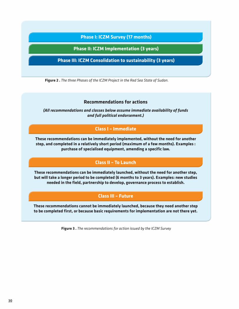
1.2.1 Project Process and PhasesAs stated above, the ICZM Project aims to establish sustainable and integrated coastal and marine manage-ment of the Red Sea coast of Sudan, being entirely included within the Red Sea State of North Sudan. The ICZM Survey (Phase I), was designed to be the first of a three-phase ICZM Project (see Figure 2).
The structure of the work packages and expected outputs of Phase I are set out in Section 1.2.2 below. The main findings from each output (Volumes 1 and 2) are summarised in the recommendations. The rec-ommendations were designed to be as practical as possible, so that they can be used as the basis to guide the development of actions to be implemented in the subsequent Phases. To further facilitate this, each rec-ommendations is assigned to one of three categories, according to how and when they can be implemented (Figure 3).
The three classes of recommendations thus provide the initial outline framework for Phases II and III, which can be built upon and expanded during the next two Phases. Details of these two Phases are sum-marised in Figure 2.
3030
Phase I: ICZM Survey (17 months)
Phase II: ICZM Implementation (3 years)
Phase III: ICZM Consolidation to sustainability (3 years)
Figure 2 . The three Phases of the ICZM Project in the Red Sea State of Sudan.
Recommendations for actions
(All recommendations and classes below assume immediate availability of funds and full political endorsement.)
Class I – Immediate
These recommendations can be immediately implemented, without the need for another step, and completed in a relatively short period (maximum of a few months). Examples :
purchase of specialised equipment, amending a specific law.
Class II – To Launch
These recommendations can be immediately launched, without the need for another step, but will take a longer period to be completed (6 months to 3 years). Examples: new studies
needed in the field, partnership to develop, governance process to establish.
Class III – Future
These recommendations cannot be immediately launched, because they need another step to be completed first, or because basic requirements for implementation are not there yet.
Figure 3 . The recommendations for action issued by the ICZM Survey

3131
Capacity building, including Class II & III actions
Other Class III actions
Capacity buildingLarge scale implementation of
successful Pilot Projects
Phase I: ICZM Survey (17 months)
Project implementation
Recommendations for actions
Evaluation and labelling of processes and results
Gradual phasing out of external support structure towards national self-sustained structures
Class I Class II Class III
Figure 4: Details of the three Phases of the global ICZM project in the Red Sea State of Sudan.
Implementation of Class I ActionsLaunch of additional studies,
pilot projects and other Class II actions
Phase III: ICZM Consolidation to sustainability (3 years)
Phase II: ICZM Implementation (3 years)

3232
1.2.2 Work packages & Organisational ArrangementsPhase I of the ICZM Project was divided into 7 work packages (excluding project management) (see Figure 5). Each work package was designed to cover aspects essential to the ICZM approach, and to provide the foundations for the implementation of ICZM during Phase II. These work packages were undertaken by a group of experts within a consortium of partner organisations, as outlined in section 1.2.3 below.
ICZM Survey
Geographic Information System
Education & Outreach
Governance, Legal Issues
and ICZM
Risk Management
Cultural Aspects
Socio- Economic Aspects
Coastal & Marine
Resources
Figure 5: Details of the work packages of the ICZM Survey in the Red Sea State of Sudan
1.2.3 Consortium of Partners
Phase I of the ICZM Project was supported by a direct grant from the European Commission (EC), which contracted Equipe Cousteau as the sole beneficiary responsible for carrying out the action. Equipe Cousteau gathered a network of partners before initiating the survey, some of which committed further co-financing to the action. The implementation of the project was only possible through the collaborative work of all the partners.
The Higher Council for Environment and Natural Resources (HCENR)
Until 2007 no single Ministry was responsible for the environment in RSS. Instead, a council with a recognisable identity, known as the “Higher Council for Environment and Natural Resources”, was the authority responsible for protecting the environment in the state.
The Higher Council for Environment and Natural Resources (HCENR) was first established in 1995 as an umbrella entity with a major mandate to conserve the environmental resources in RSS. The council was re-established according to the environment law of 2006 by a decree
made by the governor of RSS.
HCENR should continue to perform the key functions which are assigned to it by the 2006 environment law, until the newly established Ministry of Environment and Tourism (MoET) becomes institutionally and technically able to fulfil its responsibility to protect the environment of the RSS.
HCENR has been the channel of communication with the Government of the Red Sea State throughout the project, mostly through the General Secretary of HCENR, who is also the director of the ICZM office established as part of the project.

3333
PERSGA, the Regional Organisation for the Conservation of the Environment of the Red Sea and Gulf of Aden, is an intergovernmental body dedicated to the conservation of the coastal and marine environments found in the: Red Sea, Gulf of Aqaba, Gulf of Suez, Suez Canal, and Gulf of Aden surrounding the Socotra Archipelago as well as nearby waters. PERSGA’s member states include: Djibouti, Egypt, Jordan, the Kingdom of Saudi Arabia, Somalia, Sudan and Yemen.
PERSGA was the main international partner of Equipe Cousteau during the Survey, and focused its assis-tance and work on ICZM policies and governance, as well as on socio-economic aspects, in accordance with the regional Strategic Action Programme for the Red Sea (SAP) which PERSGA implements throughout the whole region.
Website: www.persga.org/
African Parks Foundation (APF)
African Parks Foundation (formerly known as African Parks Conservation) is a private not-for-profit organisation set up to assist in the protection and development of national parks in Africa. It is the first private park management institution in Africa that takes on the actual long-term management responsibility of parks, in public-private partnerships with governments, by combining world class conservation practice with business expertise. Emphasis is placed on the stimulation of responsible tourism and associated private enter-
prise as a mechanism for achieving financial sustainability of the parks, as well as providing a foundation for sustainable economic development and poverty reduction.
In partnership with the Sudan Wildlife General Conservation Administration, APF aims to restore and protect the two Marine National Parks, Dungonab and Sanganeb National Parks, for the long-term benefit of biodiversity and the people living in and around them.
Partnership between Equipe Cousteau and APF began before the Survey was initiated. This association resulted in increasing the geographic coverage of the survey, as the same surveys and studies were pursued inside the parks as in the area covered by the boat-based survey led by Equipe Cousteau. It also enriched socio-economic surveys, as a result of the work pursued by African Parks on alternative livelihoods and village environmental management plans.
APF entered into renegotiations of the agreement with Sudan during the implementation phase of the Survey. The new agreement sought was for a longer term (25 years), which is one of the key bases of the African Parks model in Africa. Negotiations were conducted by African Parks at both the regional (Red Sea State) and the national levels of government. However, the negotiation ran into problems due to differences in interpretation of the new constitution, relating to authority over and administration of national parks, by the Red Sea State government on one hand and by the national Wildlife Conservation General Adminis-tration on the other. The second point of issue was the core matter of what was seen as a request to release sovereignty over a Sudanese territory, to a private business, for a period of 25 years. These and probably other issues resulted in the failure of the negotiations, and the official announcement of the withdrawal of the African Parks Foundation from Sudan, with complete cessation of activities on 11 August 2008.
While the cessation of APF’s involvement in Sudan did not affect the survey, as it happened too late to be even considered during the implementation period (which ended on 31 May 2008) it is, of course, a major setback in several main areas to which the ICZM Project is closely linked. This report provides recommen-dations on these issues which were designed in anticipation of continuing involvement by African Parks Foundation in managing Sudan’s two marine parks. A new management structure is needed to replace Afri-can Parks Foundations in this endeavour, and the recommendations should thus be considered as addressing this new structure.
Website: www.african-parks.org/

3434
The United Nations Educational Scientific and Cultural Organisation (UNESCO)
UNESCO was involved in the project, with experts from the Man and Biosphere programme (MAB) and from the Division of Education Strategies and Capacity Building from UNESCO’s Paris headquarters, as well as experts from the Sudan UNESCO office in Khartoum.
UNESCO participated in and helped organise workshops on education strategy and on strategy for the ICZM. UNESCO was also involved in the project through collaboration with the UNESCO Cousteau Ecotechnie Program (UCEP). UCEP is a university-level programme that applies integrated multi-disciplinary approaches to education, research and policy-making, taking into account ecology, economy, the social sciences and technology. The UCEP chair at the Computer Man College in Khartoum was intended to be closely involved in the development of the Geographic Information System component of the Survey. Part of the GIS system was to be set up in Khartoum, and the Computer Man College was to be involved in train-ing ICZM stakeholders of the Red Sea State (in the ICZM office and elsewhere) in using and integrating GIS for ICZM implementation strategies. This collaboration required a strong partnership between the Red Sea State, the Computer Man College and the Red Sea University. The project management stressed this, and met with all stakeholders at the outset, but it was not possible to establish such a partnership between the Suda-nese entities. The GIS component was thus implemented in the Red Sea State without further development of the collaboration with the Ecotechnie Chair at Computer Man College in Khartoum. It is hoped that this situation will be temporary, and recommendations are made to achieve this very important collaboration in the near future.
Website: www.unesco.org/mab/
Coastal Oceans Research and Development in the Indian Ocean (CORDIO)
CORDIO is a not-for-profit organisation based in Kenya and working in countries of the Indian Ocean, covering Eastern Africa (Kenya, Tanzania, Mozambique, South Africa), South Asia (India, Sri Lanka, Maldives), Southeast Asia (Thailand, Indonesia) and the
Indian Ocean islands (Seychelles, Mauritius, Madagascar, Comoros, Reunion).
CORDIO supports monitoring and research on coral reefs, participatory monitoring of artisanal fisheries (biological, resource and socio-economic), education and awareness-raising, and policy development. Its pri-mary goal is to conserve biodiversity in the context of improved livelihoods and sustainable development of people directly dependent on coastal and marine resources.
CORDIO-East Africa was registered to implement the CORDIO programmes in East Africa, focusing on coral reef health and recovery following mass mortality of corals in 1998, and addressing artisanal fisher-men on coral reefs, since it is the human population group that is most vulnerable to reef degradation.
CORDIO was involved in the project through a CORDIO expert being hired for the project.
Website: www.cordioea.org/
The Centre for Environment and Development for the Arab Region and Europe (CEDARE)
CEDARE was established in 1992 as an international inter-governmental organisation with diplomatic status, based in Cairo, Egypt. CEDARE addresses current and emerging environmental issues in the areas of climate change, coastal zone management, waste management, genetically modified organisms, etc. The programme also focuses on cross-cutting themes, such as public participation (with a focus on women and youth), peace and environment, environmental education, environmental impact assessment, and
the socio-economics of sustainable development.
CEDARE has a wide experience in implementing and using Geographic Information Systems in all the countries of the Red Sea area (among others) and was thus added as a partner to the project following devel-opment of the GIS component between Sudanese partners (see UNESCO-Cousteau Ecotechnie Programme Chair at Computer Man College, in the UNESCO section above). CEDARE experts were contracted to assist with the analysis of satellite images, and to manage the implementation of the GIS component of the project, including training the Sudanese stakeholders.
Website: www.cedare.int/
3535
Mallinson Architects
The British architectural company run by Mr Michael Mallinson is the main international partner of the Ministry of Culture of the Red Sea State and has a long history of involvement in the study, preservation and rehabilitation of the old coral town of Suakin, the historic port town of Sudan which dates back to the 10th century and is on the tentative list of UNESCO’s World Heritage Centre.
Michael Mallinson has been involved in the cultural aspects of the project, focusing on the Suakin cultural management plan, future development, and links with the marine area and marine issues in the vicinity (Ferries, Suakin archipelago, etc.)
Website : www.mallinsonae.com
Founded in 1996, SUDIA (Sudanese Development Initiative) is a pioneering non-gov-ernmental organization working with a broad cross-section of stakeholders for greater stability, development, and good governance in Sudan by reducing violence,
empowering youth and advancing the role of the media and civil society. It is a recent partner and has been charged in 2014 to lead a quick update and review of this report.
Website : www.sudia.org
1.2.4 Monitoring the ICZM ProcessDuring the last 10 years there have been two major iniatives that have attempted to establish monitoring and evaluation programmes to track ICZM’s progress in a quantifiable way.
• European ICZM Indicators and Data Working Group (WG-ID) : The working group was established in 2003 by the European Topic Centre Land Use and Spatial Information (ETC_LUSI). The WG-ID developed two sets of of indicators for Member States and candidate countries:
• Progress Indicators, to measure the progress of implementation of ICZM; and
• Sustainability Indicators, a core set of 27 indicators (composed of 44 measures) to measure sustainable development of the coastal zone.
• IOC-UNESCO : A pilot project was established under the auspices of IOC-UNESCO in 2003 to promote the development and use of indicators for coastal and ocean management in collaboration with the Canadian Department of Fisheries and Oceans, the US National Oceanographic and Atmospheric Administration (NOAA), and the University of Delaware. The aim of the pilot project was to promote an outcome-oriented approach to guide the selection and application of indicators to measure the progress and effectiveness of integrated coastal and ocean management interventions.
The IOC-UNESCO pilot project resulted in a handbook for the monitoring and evaluation of ICZM (UNE-SCO 2006)1 and an associated suite of indicators (Table 1, Table 2 and Table 3). The IOC Handbook is part of a comprehensive toolkit intended for use by coastal and ocean managers, practitioners, evaluators and researchers. The handbook aims to promote an outcome-orientated, accountable and adaptive approach to ICZM and provides a step-by-step guide to help users develop, select and apply common governance, with ecological and socio-economic indicators to measure, evaluate and report on the progress and outcomes of ICZM interventions. It further proposes analytical frameworks and includes processes and lessons learned from previous case studies around the world.
Both sets of indicators were considered for use within the context of this ICZM Project. To assess the initial state of ICZM in RSS, the first set of EU WG-ID Progress Indicators was used to compare ICZM governance of the Red Sea State between 2003, when PERSGA started to implement activities in the Red Sea State, and Phase I of the ICZM Project. A summary of the findings is presented in the concluding section (Gap Analysis).
1 IOC Handbook for Measuring the Progress and Outcomes of Integrated Costal and Ocean Management. IOC Manuals and Guides, 46: ICAM Dossier, 2 Parts UNESCO (2006).

3636
Box 3: What is monitoring?
Monitoring is the process of repeated observation for specified purposes, according to prearranged schedules in space and time and using comparable data collection methods (after Meijers, 1986). Mon-itoring can be used to:
• Assess the ecological state of ecosystems;
• Assess whether regulated performance criteria have been exceeded;
• Detect and assess impacts of human-generated disturbance(s);
• Assess responses to restoration efforts.
In conducting this analysis, it was observed that all 27 indicators recommended by the EU WG-ID are directly or indirectly included in the IOC indicators tables (Table 1, Table 2 and Table 3). In addition, it was found that the IOC-UNESCO Handbook indicators are better adapted to measuring the initial state of ICZM initiatives in developing countries. The indicators presented in the IOC Handbook have been used throughout Volumes 1 and 2. The relevant IOC indicators are indicated in this report following the titles of the specific chapters and sections.
Box 4: What are Indicators?
An indicator as a measure (quantitative or qualitative) of how close we are to acheiving what we set out to acheive (i.e. our objectives). Indicators are quantitative/qualitative statements or measured/observed parameters that can be used to describe existing situations and measure changes or trends over time. Indicators serve 3 main functions: simplification, quantification and communication (Belfiore et al. 2006).
• Indicators must reflect changes at spatial and temporal scales of relevance to management and what needs to be measured ;
• Differing indicators should be used for site level and system level ;
• As well as more obvious environmental indicators, social and governance indicators should also be developed;
• Ecological goals and socio-economic goals are not mutually exclusive; however, but they do need different evaluation crietria/indicators.

3737
Table 1: Ecological Indicators from the IOC Handbook
Goals Objectives Indicators and parameters
Organisation: Con-serve the ecosystem structure – at all levels of biological organization – so as to maintain the biodiversity and natural resilience of the ecosystem
Maintaining biodiversity E1 Biological diversityDiversity of communitiesDiversity of populationsDiversity of speciesGenetic diversity
Maintaining species distri-bution
E2 Distribution of speciesHorizontal distribution (patchiness, aggregation)Vertical distribution (food web/trophic structure)
Maintaining abundance E3 AbundanceBiomass (key populations)Number of individuals (marine mammals)Density (plants, benthic organisms)
Vigour: Conserve the function of each component of the ecosystem so that its role in the food web and its contri-bution to overall productivity are maintained
Maintaining primary pro-duction and reproduction
E4 Production and reproductionPrimary productivity : quantity (biomass) and
qualitySecondary productivityLife history stagesReproductive parametersSpawning survival ratesMean generation time (longevity)
Maintaining trophic inter-actions
E5 Trophic interactionsComplexity of food webKey predator/prey interactionsKeystone speciesSize spectra
Maintaining mortalities below thresholds
E6 MortalityFishing mortalityIncidental mortalities (by-catch)Natural mortality (predation, diseases)
Quality: Conserve the geological, physical and chemi-cal properties of the ecosystem so as to maintain the overall environmental quality
Maintaining species health E7 Species healthSpecies at risk of instinction(Bio)accumulation of toxic componoundsDiseases and abnormalitiesSeafood quality
Maintaining water and sedi-ment quality
E8 Water qualityWater column propertiesOceanographic processes and variability (and
regime shifts)Sedimentation (e.g. Transport of suspended sedi-
ments)Pollutants and contaminantsEutrophication parameters
Maintaining habitat quality E9 Habitat qualityHabitat typesHabitat alterationSea level changeLandscape and bottomscape integritySediment quality (nature/properties of sediments)

3838
Table 2: Governance indicators from the IOC Handbook.
Goals Objectives Indicators and parameters
Ensuring adequate institutional, policy and legal arrangements
Ensuring the coordination and coherence of administra-tive actors and policies
G1 Existence and functioning of a representative coordinating mechanisme for ICZMExistence of a coordination mechanismFunctioning of the coordinating mechanismOutcomes and influence of the coordinating mechanism
Supporting inte-grated manage-ment through adequate legislation and regulations
G2 Existing and adequacy of legislation enabling ICZMExistence of legislation on coastal and marine resourcesAdequacy of the ICZM legislation
Assessing the environmen-tal impacts of policies, plans, programmes and projects
G3 EIA, SEA and CCA procedures for plans, programmes and projects affecting coastal zonesUse of EIA and SEA procedures and modifications to coastal projectsUse of CCA procedures in coastal tourism development
Resolving conflicts over coastal space and resources
G4 Existence and functioning of a conflict resolution mechanismStakeholders and issues at stakeAgreed procedures and mechanisms for conflict resolutionchanges in the proportion of conflicts that are mitigated, resolved, or preventedOverall changes in the number of conflicts
Ensuring adequate management processes and implementation
Managing the coastline through inte-grated plans
G5 Existence, status and coverage of ICZM plansExistence and statut of ICZM plansCharacteristics of ICZM plansExtent (percentage) of coastline covered by ICZM plans
Implementing and enforcing ICZM plans and actions
G6 Active management in areas covered by ICZM plansLevel of implementation of ICZM plans, actions and projects, including infrastructure buildingProcedures, legal tools and monitoring and sanctioning applied for enforcement of ICZM plans/actionsLevel of compliance with ICZM plans
Routinely monitoring, evaluating and adjusting ICZM efforts
G7 Routine monitoring, evaluation and adjustment of ICZM initiativesExistence of an operational monitoring and evaluation system with related indicatorsConsideration of results into ICZM initiativesAdjustments made to ICZM initiatives
Supporting ICZM through sustained administrative structures
G8 Sustained availability and allocation of human, techni-cal and financial ressources for ICZM, including the leverage of additional resourcesStaffBudgetFacilities

3939
Enhancing information, knowledge, awarness and participation
Ensuring that management decisions are better informed from science
G9 Existence, dissemination and application of ICZM-related scientific research and informationExistence of research studies and scientific publicationsCompletion of a diagnostic assesment that identifies root causes of coastal and marine degradation and establishes priority for interventionsExistence and dissemination of a state of the coast reportExistence and functioning of a science advisory bodyExistence and operation of a routine monitoring of the marine environmentInputs from scientific research and diagnostic assesment into ICZM
Ensuring sus-tained support from engaged stakeholders
G10 Level of stakeholder participation in, and satisfaction with, ICZM decision making processesLevel of stakeholder participationLevel of stakeholder satisfaction with the participation and with ICZM outcomes
Ensuring NGOs and Community-based Organization involvement
G11 Existence and activity level of NGOs and CBOs support-ive of ICZMEducational and training programmes incorporating ICZMPeople having completed educational and training pro-grammes in ICZMEmployment of people with education and training in ICZM
Ensuring ade-quate levels of higher eductaion and professional preparation for ICZM
G12 Incorporation of ICZM into educational and training curricula and formation of ICZM cadresEducational and training programmes incorporating ICZMPeople having completed educational and training pro-grammes in ICZMEmployment of people with eduction and training in ICZM
Mainstreaming ICZM into sustainbale development; Economic instruments mainstreaming
Enabling and supporting ICZM through technol-ogy, including environmen-tally-friendly technology
G13 Use of technology, including environmentally friendly technology, to enable and support ICZMAvailability of ICZM-enabling and supporting technology at an acceptable costLevel of use of ICZM-enabling and supporting technology in substitution of counter-ICZM technologyLevel of coordination of ICZM-enabling and supporting technology
Incorporating economic instruments into coastl management policies
G14 Use of economic instruments in support to ICZMAvailability of economic instruments, including environ-mental quality certifications, in conjunction with regula-tory instrumentsLevel of implementation and enforcement of economic instruments
Mainstream-ing coastal and ocean man-agement into sustainable development
G15 Incorporation of ICZM into sustainable development strategyExistence of sustainable development strategy or Agenda 21 incorporating ICZM chapterLevel of implementation of ICZM chapter on sustainable development strategy or Agenda 21

4040
Table 3: Socio-economic indicators from the IOC Handbook.
Goals Objectives Indicators and parameters
A healthy and productive economy
Maximize economic development SE 1 Total economic valueValue of living resourcesValue of non-living ressourcesValue of non-consumptive usesEconomic value-addedValue of exportsManagement and administration costs
SE 2 Direct investmentInvestment by governmentPrivate sectore investementForeign direct investment
Increase employment SE 3 Total employmentNumber employedEmployment payroll valueSame sub-categories as total economic value
Foster economic diversification SE 4 Sectoral diversificationLand based activities dependent on the marine environmentActivities in the ICZM area out to the boundary of the EEZ or the continental shelfNon-living resource exploitationNon-consumptive use
A healthy and productive environment
Minimize habitat destruction and alteration from human pressures
SE 5 Human pressures on habitatsLand use/land cover patterns and compo-sitionPopulation densityExtend of hard-surface areasHigh-impact fishing gear/practicesDumped and dredged material
Reduce the volume of introduction of all types of pollutants
SE 6 Pollutants and introductionsPopulation served by wastwater treatmentVolume, number, and type of point-source dischargesNon-point-source nutrient loadingDischarged sediments and nutrientsVolume of ballast and bilge dischargeLitter and debris
Public health and safety
Protect human life and public pri-vate property
SE 7 Disease and illnessFecal coliform countsDays of beach closureExtent of contaminated speciesExtent of contaminated waterSeafood-transmitted illnesses
SE 8 Weather and disasterEconomic value of loss from marine weather-related eventsLives lost from weather and marine disasters
(continued)

4141
Social cohesion Maintain equitable population dynamics
SE 9 Population dynamicsDegree of public accessResident and total (seasonal) population
SE 10 Marine dependencyEconomic dependencySocial dependency
SE 11 Public accessPhysical accessEconomic access
Cultural integrity Maintain cultural integrity SE 12 Traditional knowledge, innovations and practices/ cultural integrityLinguistic diversityTraditional land and water tenureLands and waters managed or co-managed by indigenous and local communitiesMovement away of indigenous and local communitiesEstablishment and implementation of favourable government policies and pro-grammesAccess to traditional coastal and marine ressource rightsManifestation of traditional knowledge
SE 13 Protection of coastal heritage resourcesNumber and type of coastal heritage resources identified and assessedPercentage of coastal heritage resources that are protectedPercentage of coastal heritage resources that are vulnerable or being damaged be-cause of natural and human factorsUse of cultural heritage resources and most visited sites

4242
1.3 COUSTEAU IN SUDANThe greatest resource of the ocean is not material but the boundless spring of inspiration and well-being we gain from her. Yet we risk poisoning the sea forever just when we are learning
her science, art, and philosophy and how to live in her embrace.
– Jacques Yves Cousteau: from “The World Without Sun”
In 1963, during the filming of “The World Without Sun”, Cousteau launched the Conshelf II experiment off the coast of Sudan, which aimed to test whether or not humans could live underwater for extended periods of time. Although she stopped in Port Sudan during her frequent early trips through the Red Sea, usually to replenish supplies, Calypso only stayed in Sudanese waters during the 1963 Conshelf II experiment. For a ship that had already filled many roles—as a minesweeper, a ferry and now a research vessel-this mission offered still another role: as liaison.
Plate 1 . Conshelf II starfish habitat in front of Port Sudan
It was Dr. George Bond, US Navy, who originally conceived the "saturation" method of diving, whereby a diver would live underwater in gas-filled shelter instead of surfacing repeatedly with necessary time limits and decompression stop. He convinced Jacques Cousteau to try a first experiment, Conshelf I; it proved so successful that Cousteau immediately embarked on a more challenging Conshelf II. While house, hangar, instrument and equipment were being built in Marseilles, Calypso reconnoitered the perfect site for the experiment: the stair step reef of Shaab Rumi, 27 miles north of Port Sudan. Meanwhile, an Italian freighter, the Rosaldo, was chartered to transport the prefabricated components of Conshelf II, and then to serve as support ship. With Rosaldo anchored at the site, it fell to Calypso to shuttle the pieces of the underwater vil-lage to shore at Port Sudan, where they were assembled, then to tow the completed structure back to Shaab Rumi.
Her powerful crane, the Yumbo, was crucial to the safe placement of the Deep Cabin at 27 meters.

4343
Plate 2 . Cousteau divers in 1963 swimming in Conshelf II underwater settlement of Shaab Rumi.
It was during this maneuver that the crew encountered what proved to be the only dodgy moment of the experiment. As the Deep Cabin was being moored to its tiny footprint on a ledge, it slipped and began falling toward the sea floor. Before it could hit bottom, it settled on a sandy shelf at 43 meters. One diver was trapped inside; with his trusty Aqualung, he calmly waited for the rescue party. Outside, as the Cabin stuck in the sand, it pinned another diver, Raymond Coll, to the reef by his air tank and one fin. Coll cut away his diving harness and pulled his foot from the pinioned fin. He took a deep breath of compressed air and started lowly for the surface, nonchalantly acknowledging the rescue diver as he swam past. He arrived safely on the surface, as did the rescuer with the first diver, and work continued.
While Rosaldo hovered over the site, feeding air, food and power to the buildings below and housing the communications center for Conshelf II, Calypso served as quarters for Captain Cousteau and the rest of the crew. Once Conshelf II was underway, Calypso's main task was launching and recovering the submersible SP-350, which Captain Cousteau and the oceanauts used for underwater sorties. She also continued shuttle duties, fetching supplies from Port Sudan, ferrying samples for laboratories and exchanging personnel. Once the experiment was done and the oceanauts safely again on the surface, Calypso returned to liaison duties, shuttling between Shaab Rumi and Port Sudan for the dismantling operation. The ship that, for fifty years, was the heart and soul of Cousteau expeditions, then resumed her steady position as mistress of the seas.
In 1965, near Nice, France, the ultimate stage, Conshelf III, was born. One hundred meters below the surface, a building housed six oceanauts who lived together for three weeks. They would go out each day to work on a mockup oil well, an exercise to evaluate human capabilities.
Conshelf proved that human beings can live under the sea for long periods of time but that, even though they have the physical and psychological capabilities, humans are not made to exist in a world without sun. Nevertheless, these experiments gave rise to the training astronauts undergo today before leaving for a world of billions of suns: Space. Here, too, Cousteau was a precursor.

4444
Plate 3 . A Cousteau diver looking inside the Conshelf habitat in 1963.
Plate 4 . The underwater garage of the submarine Denise (SP150) in 1963 and covered with corals in 2004.
Plate 5 . Claude Wesly with his famous parot inside the starfish habitat (left) in 1963, and with Diane Cousteau, daughter of Jacques Cousteau, in Shaab Rumi during the 2004 expedition.

4545
Early in the year 2004, the Cousteau vessel Alcyone anchored on the atoll of Shaab Rumi, 40 years after Conshelf II, Captain Cousteau’s pioneering experience in undersea living on that very spot. In late 2003-2004, Equipe Cousteau undertook an expedition in the Red Sea supported by UNESCO. The expedition in Sudan provided the opportunity to revisit sites where, 50 years earlier, Cousteau had filmed “The Silent World” (Palme d’Or at the Cannes Film Festival; Oscar in Hollywood) and “World without Sun”, in the Cousteau village at Chab Rumi near Port Sudan. Under the surface, expedition divers discovered an explosion of life and color flourishing in extraordinary seascapes. Later on shore, while visiting Dungonab Bay area, the team was moved by the hospitality of the local Beja people and their poor living condition. Back on board Alcyone, diver Claude Wesly, one of the original Conshelf oceanauts, who revisited the scene for this mission, looked at Francine Cousteau, President of the Cousteau Society and said “What we accomplished in those days is nothing compared to what we still have to do. This magnificent place simply must be protected, and the local people should benefit from this protection!”. Every dive site in Sudan, and every landing confirmed this first impression with a succession of brilliant corals, all in fairly good health, and friendly but very poor people. The quality of the shark and rays population was also impressive. Everywhere else in the world, sharks are highly threatened and their populations are shrinking. But in Sudan, the sharks were seemingly still doing very well and attracted divers from all over the world.
This report is the result of an agreement signed in 2007 between the government of Sudan and the Cousteau Society for the long-term protection of its 750km coastline. This decision sets an internationally important standard in sustainable coastal development because of the quality of the habitats it covers. Discussions began during the expedition and were fulfilled with an agreement signed by Hatem El Wasila, governor of the Red Sea State. By this, the highest national and state authorities have affirmed their willingness to establish conditions that will allow economic development while preserving the RSS’s natural heritage and local cultures. This present survey is an outcome of this commitment.
Plate 6 . Cousteau ship Alcyone in a Marsa in Sudan during the 2004 expedition “Back to the Silent World”.

4646
1.4 THE CHALLENGE OF BRIDGING CONSERVATION AND DEVELOPMENT ISSUES
In the Red Sea Wilaya (“province” in Arabic), the landscape includes more than 750km of coastline, 2720 km² of coral reefs and 937 km² of mangroves. As stated in the biodiversity report (Cousteau, 2013), the marine environment of Sudan is exceptionally rich and still in a fairly good condition. Different kinds of reefs – fringing reefs and atolls- are populated with hard corals, called “reef builders” and soft corals, or alcy-onarians, whose glorious plumes dance at the whim of currents. Coral diversity is among the highest in the world, with more than 313 species identified (compared to 168 species for French Polynesia for example). The superbly clear water makes diving a joy, with visibility extending up to 70 meters! In the Dungonab region, divers can see one of the world’s greatest seasonal aggregations of manta rays, and swim with the largest fish of all, the whale sharks. The mangroves and seagrass meadows shelter populations of dugongs, a species of marine mammal like manatees, classified as “vulnerable” on the IUCN Red List. The beaches and islands are important sites for nesting sea turtles as well as for many birds. The atoll of Sanganeb is part of a national park created in 1990. It boasts a marine habitat of internationally important stature although the means to manage it properly are still lacking.
Sudan is in a position that is nearly unique in the world: it has a wonderful coast that is still lightly impacted by urbanization and unplanned development. The Red Sea State is evolving quickly but still, coast-wide, except for Port Sudan and Suakin, there are no major cities so the marine pollution is still very limited. For now, most investors are waiting and watching, but they stand ready to move as soon as political circum-stances begin to improve and new infrastructures such as roads, energy plants, desalinization plants or new harbors are in the pipelines or being implemented.
As a consequence of the decades of war from which the country has suffered, there is still little infra-structures and the people along the shore live in great poverty in some areas. According to a report by Tango (2005), the annual income per household in rural Red Sea State (RSS) was 125,000 SDD (Sudanese Dinar) (~92 USD per capita), well below the international extreme poverty line. The same report concludes that the socio-economic indicators in Eastern Sudan are characteristic of chronic under-development. They are of course visible improvements since 2005 but it is crucial to stress that in such a context, conservation of natural resources must be linked to poverty alleviation and finding a way to insure sustainable livelihoods to the local populations.
Lately, there are perceptible signs that the Sudanese government is looking at ways to develop its coastal resources and they try their best to do it in a sustainable way. For example the Marine Fishery Adminis-tration Law for the Red Sea State was signed in February 2008 and started to be enforced in 2009, and the clause 29 of the law prohibits the capture of sharks, turtles, dolphins and other endangered species.
The Sudanese are signaling a strong desire to normalize international relations and to open up to foreign investment, including the development of a tourist industry. The task is enormous. The challenge lies in allowing the much anticipated economic development while avoiding the errors that elsewhere have led to the distortion, or even destruction of marine and coastal resources. The need for sustainable development is particularly evident in the framework of activities linked to the tourist industry. It is easy to see how important it is to preserve the coastal areas that are precisely the prime attraction for tourists. Among other business opportunities linked to the extractive use of non renewable natural resources such as mines or gas and oil, some investors are hoping eventually to duplicate in Sudan the tourist boom that has taken place on the Red Sea in Egypt.
Oil resources have been discovered and a modern oil terminal and a new harbor for the export of live-stock have been built at Port Sudan. This is good news, bringing hope in economic terms, but shipping also generates great risks for the environment. According to Vice Admiral Noureddine, M.M. Farah, Chairman of the Marine Environment Protection Society of Sudan (MEPSS), a Sudanese non-governmental organization, there is an average of one collision between ships every seven years in the shipping lane facing Port Sudan. The coral reefs are sometimes poorly marked and also cause accidents as the shipwrecks clogging the area prove.
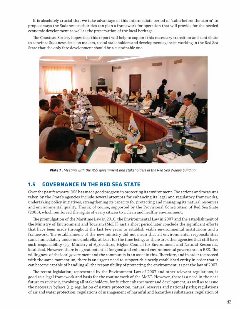
4747
It is absolutely crucial that we take advantage of this intermediate period of "calm before the storm" to propose ways the Sudanese authorities can plan a framework for operation that will provide for the needed economic development as well as the preservation of the local heritage.
The Cousteau Society hopes that this report will help to support this necessary transition and contribute to convince Sudanese decision makers, costal stakeholders and development agencies working in the Red Sea State that the only fare development should be a sustainable one.
Plate 7 . Meeting with the RSS government and stakeholders in the Red Sea Wilaya building.
1.5 GOVERNANCE IN THE RED SEA STATEOver the past few years, RSS has made good progress in protecting its environment. The actions and measures taken by the State's agencies include several attempts for enhancing its legal and regulatory frameworks, undertaking policy initiatives, strengthening its capacity for protecting and managing its natural resources and environmental quality. This is, of course, supported by the Provisional Constitution of Red Sea State (2005), which reinforced the rights of every citizen to a clean and healthy environment.
The promulgation of the Maritime Law in 2010, the Environmental Law in 2007 and the establishment of the Ministry of Environment and Tourism (MoET) just a short period later conclude the significant efforts that have been made throughout the last few years to establish viable environmental institutions and a framework. The establishment of the new ministry did not mean that all environmental responsibilities came immediately under one umbrella, at least for the time being, as there are other agencies that still have such responsibility (e.g. Ministry of Agriculture, Higher Council for Environment and Natural Resources, localities). However, there is a great potential for good and enhanced environmental governance in RSS. The willingness of the local government and the community is an asset in this. Therefore, and in order to proceed with the same momentum, there is an urgent need to support this newly established entity in order that it can become capable of handling all the responsibility of protecting the environment, as per the law of 2007.
The recent legislation, represented by the Environment Law of 2007 and other relevant regulations, is good as a legal framework and basis for the routine work of the MoET. However, there is a need in the near future to review it, involving all stakeholders, for further enhancement and development, as well as to issue the necessary bylaws (e.g. regulation of nature protection, natural reserves and national parks; regulations of air and water protection; regulations of management of harmful and hazardous substances; regulation of

4848
management of solid wastes; regulations for marine environment and coastal protection; and, regulations for charges and wages). Sudanese Maritime Federal Law was approved in 2010 and the Government of Sudan signed the Marpol Convention in February 2014.
The assessment of the institutional structure with regard to environmental management in RSS shows that there is a great and potential role for “Localities” to play in environmental management in general and in Environmental Impact Assessments (EIAs) in particular. These localities are responsible, for instance, for solid waste collection and disposal, pest control, control of water borne diseases, etc.
NGOs in RSS, despite their very limited resources, have been found to play a significant role in the protec-tion of the environment. Such roles have been supported by the provisional constitution, which envisions a central role for NGOs in formulating and implementing environmental policies.
Most of these NGOs work at the state level. Few NGOs could be considered to be local organisations (village/community or base-level organisations) that interact most directly with local people. Very few are involved for instance in cooperatives, interest associations, village institutions, and resource user groups.
The activities of NGOs in RSS, with respect to the environment, generally fall into one of the following two categories: increasing general awareness about the environment or contributing to specific issues (e.g. SECS/ICZM, which is contributing to the conservation of coastal environment in the state through different projects and activities). Similar to SECS in this respect is the Sudanese Red Sea Marine Conservation Society, which was established in 2003; its mandate was updated in 2008 and again in 2010.
However, NGOs are key players in the environmental management framework and, therefore, there is a need to strengthen their participation in all relevant activities. There are several mechanisms whereby MoET could strengthen civil society participation in formulating and implementing environmental policies and strategies in RSS: funding projects and programs to build capacity of these NGOs at the local level; creating networks and associations among NGOs; and, involving civil society in the ministry's activities. Other mea-sures that can help to strengthen civil society include continuing to promote environmental education and ensuring free availability of environmental data.
With regard to Environmental Impact Assessments (EIA), it was clear that MoET currently lacks the nec-essary and appropriate institutional framework for establishing an “EIA” system in the State. Consequently, MoET is urged to prioritise the review of its current structure and consider establishing an EIA Unit and issuing the necessary regulations and bylaws. At the same time it should build the screening, scoping and reviewing capacity of the proposed staff. Parallel to this, it is crucial- as part of the EIA process itself - to educate the communities in their role in EIA (i.e. public participation) so they may take part in the various stages, thus being able to raise their particular concerns, especially socioeconomic ones.
The assessment conducted as part of this survey, indicated that “Environment” is not mainstreamed in the planning process at the State level. MoET needs to adopt the necessary measures and tools to ensure that environmental concerns are considered in such processes. EIA is one such tool that would measure the effect of any developmental proposal on key environmental components and ensure that the necessary and effective mitigation measures are in place as required.
Although it could be said that there is no current mass tourism within the state and, consequently, no significant impact of this activity on the natural resources, particularly marine and coastal resources, the concerned agencies are urged to regulate tourism activities; especially resorts and diving activities. The focus should be on promoting “ecotourism” models and the participation of local communities in such activities.

4949
1.6 SOCIOECONOMIC DEVELOPMENT IN RED SEA STATE
1.6.1 Opportunities for Peace & ProsperityAfter decades of conflicts, Sudan’s people now have high expectations for development opportunities and are eager to improve their livelihoods. Support to and investments in the country are now crucial to meet expectations for growth and poverty eradication.
The Red Sea State is well endowed with natural resources, but its inhabitants are comparatively poor; especially those living in rural and marginal urban areas. According to the census estimations of 2000, its population is about 710,000 people, with an average household size of 5.0 persons, the latter being below the national average. Some 50-60 percent of the population lives in urban areas. Port Sudan is the largest coastal city with a population of about 450,000. Out of the total economically active population, 79 percent are employed. Of those employed, 70.3 percent are living in urban and the rest in rural areas and 33.2 per-cent work in agriculture and fisheries. The Red Sea State is home to a complex ethnic blend of people. The indigenous Beja group is the largest of the tribes in the State.
At present, the natural wealth of the Red Sea is largely underexploited. Natural gas has been found in Tokar and Suakin archipelago, but present exploitation only amounts to 16.1 million cubic feet per day. If well managed, natural gas extraction could provide an opportunity for economic growth. There is no offshore oil exploitation at the moment, but potential offshore oil fields were licensed in 2007. The contribution of fisheries and tourism to the GNP is negligible. The major economic sectors along the Sudanese Red Sea coast are maritime transport and port-related activities. In 1994-95 a total of 920 vessels called at Port Sudan harbour, of which 111 were oil tankers. The loaded crude oil and product tanker traffic leaving the two ter-minals and travelling east to the Indian Ocean remains a considerable risk, due to the navigational hazard presented by the numerous fringing and patch reefs. In 2004, a freight vessel, the MV Irrens, grounded on the reef at the Wingate anchorage area, some 10km east of the Alkheir terminal.
Two shrimp farms have been established; the first one in 2002 close to the Bashier oil port, about 20 km south of Port Sudan and the second one, Al- Khairat Farm, established in 2007 close to Red Sea Resort, about 20 km north of Port Sudan (Mahmoud Abdallah, Marine Fishery Administration Per. Comm.).
A considerable expansion of industrial production in the coastal zone is implemented in Free Zone Area. At present, fisheries and tourism play a minor role at the national level, although subsistence fisheries are locally important. Eastern Sudan Reconstruction and Development Fund (article 23, page 20 of the Eastern Sudan Peace Agreement) has approved the establishment of a shrimp farm south of Suakin for the Red Sea University. It will serve as a research/training centre for the university. The local community will also be involved to work on the farm, and will share the revenue earned from the sale of shrimp.
There are numerous and widely diversified potential tourist attractions. The main activity is SCUBA div-ing and Sudan has several of the best diving sites in the entire Red Sea and even worldwide. In addition, there are beaches and opportunities for a variety of water sports; recreational areas in the Red Sea hills; and a number of historical and archaeological sites, of which the old coral town of Suakin is the most important (refere to Subchapter 2.7.2).
1.6.2 Artisanal Fisheries SectorAbout sixty-five species of bony fishes are currently considered to be of economic importance, in addition
to sharks, rays, shrimps, lobsters, crabs, molluscs and sea cucumber. According to the Fisheries Administra-tion, the estimated Maximum Sustainable Yield (MSY) of fisheries (artisanal & semi industrial) amounts to 10,000 metric tons, while the present annual production declared is only around 2000 metric tons (Mam-douh Abdallah, Marine Fishery Administration, Per. Comm.).
With constantly increasing production costs (for example, for equipment, fuel, ice, boat maintenance and spare parts), the artisanal fisheries sector has largely been restricted to the use of fishing vessels less than 12m in length, limiting the efficiency of artisanal fisheries. There are an estimated 800 boats in Sudan’s marine fisheries, with a crew comprising of 4 to 5 people; the average estimated number of artisanal fish-ermen is 2,400, 80% of whom simply hand-fish with a single hook and line. Previously, access to credit was very limited, but since 2007 the State government, in collaboration with some banks and the Zakat chamber, funded 270 fishing boats by providing engines, ice boxes, and spare parts. Due to the limited reach of the

5050
artisanal fisheries sectors, near shore fisheries have become locally overexploited, with catches of key species decreasing by about 50%, as reported by the Fisheries Administration. In 2010, navigation devices like GPS and Fish Finder were introduced to start the exploitation of new fishing grounds for better management of the fisheries. Five fishing companies, including a semi-public one, are currently operating as fish traders. None has experience in fisheries management and they are unable to assist in sustainably developing the fisheries sector. In some cases, for example in Mohammed Qol, fishing companies have monopolised the fish trading market, benefiting from their no-competition status to the disadvantage of the artisanal fishermen (Mamdouh Abdallah, Marine Fishery Administration, Per. Comm.).
Ornamental fish trade was introduced in 1981 by Afro-Way, a Dutch Compagny, but was not success-ful and stopped rapidly. Then due to market demand the activity started again in 2012 with 6 companies involved (national, mixed and foreigners). During the 2012- 2013 period the export rate of live ornamental fish varied between 10287- 30241 pieces (Mamdouh Abdallah, Marine Fishery Administration, Per. Comm.).
Besides finfish, there is a significant kokian fishery (Giant spider conch or Trochus dentatus). Annual export rates of kokian during the 1991-95 period varied between 306 and 535 metric tons. Sudan is therefore by far the largest producer of Trochus outside the Pacific Ocean and the third largest producer globally. However during the 2001-2013 period export rates varied between 173 and 378 metric tons (Mamdouh Abdallah, Marine Fishery Administration, Per. Comm.). The variability of the fishery probably stems from the lack of fisheries infrastructure along most of the mainland, particularly the lack of ice-making facilities and cold storage. However, catch per unit effort and the total catch landed has fallen recently, and there are strong signs that this is due to over-collection.
Besides finfish, there is a significant kokian fishery (Giant spider conch or Trochus dentatus). Annual export rates of kokian during the 1991-95 period varied between 306 and 535 metric tons. Sudan is therefore by far the largest producer of Trochus outside the Pacific Ocean and the third largest producer globally. However during the 2001-2013 period export rates varied between 173 and 378 metric tons (Mamdouh Abdallah, Marine Fishery Administration, Per. Comm.). The variability of the fishery probably stems from the lack of fisheries infrastructure along most of the mainland, particularly the lack of ice-making facilities and cold storage. However, catch per unit effort and the total catch landed has fallen recently, and there are strong signs that this is due to over-collection.
Exploitation of sea cucumber along the Sudanese coast was initiated in the late 1970s and since then production has been based on two species (Holothuria sp. and Actinopyga sp.). In 1981, 15t of dried sea cucumber was exported. Thereafter, production stopped because of low prices on export markets and diffi-culties in collecting. However, since the 1990s activity rebounded intensively with the use of scuba diving for collection, and the target species increased up to seven to meet the high demand of the Asians markets. During this period the sea cucumber population was reduced, so havesting was banned from 2006 to 2009 to better manage production activity. From 2010 to 2011 a sea cucumber steering committee undertook an experimental fishing study in collaboration with SPCRP and five companies, and in 2012 a commercial program began that restricted scuba diving produced an overall yield of 5t of dried sea cucumber. However by December 31, 2012 the activity was banned for the third time due to marine ecosystem health purposes. However, in the present situation of declining fish and kokian landings, exploitation has resumed and sea cucumber is now over-exploited. Pearl oyster (Pinctada margaritifera) and ornamental seashells (mainly Strombus and Lambia species) are also collected in Sudan, particularly from the fringing reefs inshore. Other invertebrates with commercial potential, particularly from a medical research point of view, include sponges, nudibranch molluscs and ascidians.

5151
Plate 8 . A fisherman trying to insure his livelihood near Suakin
1.7 HISTORICAL AND CULTURAL ASSETS
1.7.1 A Historical Overview of Northern SudanSituated in north-eastern Africa, at the crossroads of the Arabian, Muslim world and the black, African world, Sudan is a country with a rich, eventful past. From Neolithic times to today, different people have traversed and settled the country, often fighting one another; kingdoms have risen and fallen.
In north-eastern Africa, along the Nile River from Aswan to Khartoum, between the Libyan Desert and the Red Sea, the ancient kingdom of Nubia prospered. At the end of the Neolithic period, in the middle of the fifth century BC, people lived between the First and Fourth Cataracts of the river, hunting and fishing and also raising crops. Here the earliest continuous agricultural tradition was established in land that is now dessert. Pottery and ceramics were mastered here several centuries before the famous ancient Egyptian civilization.
Early in the twentieth century, American Egyptologist George Reisner proposed a classification system for Nubian cultures using the letters of the alphabet. The earliest, the A-Group, included the kingships of the fourth millennium BC. These Bronze Age people in Lower (Le. northern) Nubia traded weapons and pottery vessels for precious stones, ivory, wood and perfumes, with Egypt and the Red Sea region. Decorative designs from this period show the importance of sheep and cows as a medium of exchange. All this crumbled around 2,800 BC; the B-Group culture is missing from history and covers the final stage of the A-Group civilization.
Next came the beginning of Egyptian campaigns, which expanded into the region, cataract by cataract. King Menes, of the First Dynasty early in the third millennium BC, was the first to penetrate the region. His successor Djer explored the Second Cataract. The Egyptians were looking for gold mines; the name Nubia stems from the Egyptian word for gold, noub. Commercial colonies were established during the Old Kingdom (around 2670-2195 BC). During the Fifth Dynasty, the C-Group culture took over the area between the First and Second Cataracts and forced the northerners back.
The troubled times that followed the fall of the Old Kingdom kept the Egyptians out of Nubia, which became politically independent. This C-Group culture was marked by high quality ceramics. Egyptian influ-ences remained, especially in burial practices.

5252
The pharaohs of the Twelfth Dynasty (early second millennium BC) colonised Nubia. A military campaign led by Sesostris 1 subjugated the principality of Wawat. Fortresses were built first to protect caravan routes, and the frontier of Egyptian power was extended south of the Third Cataract of the Nile.
The city of Kerma, located on the plains of Dongola, was the foundation of the first true kingdom of Nubia, called Yam in ancient Egypt. It would last more than a thousand years, next door to its more famous neighbour. Archaeologists have uncovered many important objects that bear witness to constant movement of trade with the Red Sea and Egypt passing through the crossroads of central Africa. Kerma remained prosperous until the first pharaohs of the Eighteenth Dynasty (middle of the second millennium BC), who set out to conquer Nubia and pushed the inhabitants of the region further south. Then, only a few centuries later, a new Nubian kingdom centred at Napata near the Fourth Cataract rose to prominence.
Around 800 BC, as the Egyptian culture declined, an independent Nubian kingdom rose to power in the region. The rulers of Nubia expanded into the pharaohs' lands and founded the Twenty-fifth Dynasty, the Kush dynasty. Just 150 years later, the Kush were pushed back again by invading Assyrians. The Kush aban-doned their capital at Napata and fled south, close to the city of Meroë, where a golden age blossomed. A new culture developed with a new religion, new language and new writing. The techniques of its outstanding iron industry spread throughout black Africa. Once again, Nubia's position as a crossroads brought prosperity. Even today, major monumental ruins, inspired by Egyptian art, can be found throughout the region.
The Meroitic Empire ultimately began to decline, and the Abyssinians administered the coup de grâce in 350 AD. The region split into three distinct kingdoms: the Noubades in the north, the Makorites in the middle and the Alodes in the south. During this era, Coptic Christianity spread and churches were built in great number. In the thirteenth century AD, nomadic Arabs invaded the country, bringing Islam with them. In 1820, Muhammad Ali, the khedive of Egypt, conquered Sudan and founded the capital of Khartoum.
In 1881, the colonial British army marched up the Nile, sparking battles in the region. The religious leader Muhammad ibn Abdallah, called the Mahdi (the Messiah) headed a rebellion that led to the fall of Khartoum in 1885. The Mahdi's government ultimately fell after twelve years, overwhelmed by Anglo-Egyptian forces; as a result, the country became a protectorate. Sudan as we know it today dates from that era. In 1956, independence was proclaimed; immediately officials in the South mutinied, refusing to accept the political appointees, unleashing a civil war that lasted more then 50 years.
1.7.2 Suakin’s Unique Architecture Source: Mainly from Mallinson 2007
Suakin is the historic port town of Sudan. First mentioned in the 10th century, it rose to pre-eminence in the 14th century. From 1517 AD it served as the southern most important port of Egypt under the Ottoman Empire. In 1884-1889 it came under siege by the Mahdist Forces under Uthman Digna. The Anglo-Egyptian Garrison defensive walls still encircle El Geif, the mainland town. Suakin was largely abandoned after Port Sudan was built in 1922, 30km further north. It is located nearly opposite Jeddah and many of its architects were Hedjazis, who emulated the Jeddah style. It is similar to other towns along the Red Sea including Massawa (in present day Ethiopia) and Hodeida (in Yemen), in that these cities were designed to capitalise on coastal breezes. The earliest remains on the island date from the mid-fifteenth century when the port of Suakin was under the suzerainty of Egypt.
The buildings are made of coral stone and are whitewashed with lime both inside and outside.
Most of the buildings of Suakin fall into two categories, those before 1860—derived mainly from Jeddah and have a distinct Turkish style, and those which were inspired by the Egyptian style and also utilised by the British. However, some buildings display a mixture of styles, with the Turkish on the bottom and Egyptian style on top, as the houses expanded upwards.
The Turkish houses that still exist are the first storey of the Government headquarters (the second storey was added by the Egyptians): the Beit el Pasha, the house of the Turkish Governor, the house of Shennawi Bey which runs along the central suq, the mid-eighteenth century house of Khorshid, and two mosques of the Hanafi and the Shafi rites. A third Turkish style mosque, the Mageedi Mosque, exists on the mainland.

5353
The city was deserted for the deeper and more accessible Port Sudan, about 40 miles North, between 1902 and 1922. Most of the architecture has deteriorated since the 1930s, either naturally or because the building materials are a source of lime for the mainland. Today, the only remaining inhabitants live on the mainland.
Today, Suakin looks like a city destroyed by bombs. Yet, Suakin still holds treasure for the world at large. Despite the present dilapidated condition of most of the buildings, the former glory of the town is still evident. The city gate and one of the mosques have been restored. An earth defensive wall and several towers have been preserved on the mainland. The harbour is still used by three large ferries to Jeddah (and Mecca) as well as by numerous small fishing vessels. As a unique blend of Africa and Asia, it is the only important relic of its kind on the African Red Sea coast, and few ports can boast a longer or more varied mix of arrivals and departures. What remains of its distinctive architecture, with its stuccoed tracery and carved teak, should be preserved and restored to provide future generations with a window through which the past can be observed and that can form a centre for the enhancement of education and artisanal training.
The Turkish Government agreed to cooperate with the Ministry of Environment and Tourism (MoET) in RSS for the preservation and rehabilitation of the ancient town of Suakin. The International Development Agency of the Turkish Government signed an agreement with the MoET stating that A’arslan Corporation, a Turkish Company, will execute the work. Work began in late 2012 and is still in progress. A British insti-tution, the McDonald Institute, in collaboration with Cambridge University, is doing some archaeological investigation work in the island.
Plate 9 . An aerial view of Suakin during a Cousteau expedition in 1963.
Plate 11 . Inside view of a old building of Suakin in 2007.
Plate 10 . The ruins of a military building made of coral stones, Suakin 2007

5454
1.7.3 The Beja Culture Source : Mainly from Abdel Salam Sidahmed - MRG 1995
Eastern Sudan has been the homeland of the Beja since the days of the pharaohs 4,000 years ago and they are among the country's longest-established peoples. For the four thousand years of their known history they have watched civilisations flourish and decay, with their own lives almost unchanging until very recently. Despite contact with the Egyptians, along with Greeks and Romans, it was the Muslims who finally had a real and last-ing impression on the Beja. They have been referred to as "Blemmyes" in Roman times, as "Bugas" in Axumite inscriptions in Ethiopia, as the "Fuzzy Wuzzy" by Rudyard Kipling, and since medieval times as “Beja”.
Most Beja are nomadic herders of camels and goats, although some have adopted sedentary lifestyles in the towns and cities of eastern Sudan and many Beja tribes still do not speak Arabic. Most of the Beja are regarded as being of Hamitic origin and are sub-divided into three main groups: the Hadendowa, the Amar’ar, and Bisharyyin. There are also groups of Arabic/Semitic origin who gradually adopted the Beja language (To-Bedawei) and culture and have been largely subsumed into the Beja. Another large group, the Beni Amer, who live mostly in Eritrea or around the border town of Kassala, share a common ethnic background with the Beja. Some of the Beni Amer are To-Bedawei speakers while others speak Tigre. Smaller groups in the area include the Helenga of Kassala (supposedly of medieval Arab origin mixed with Beja), Tigre, and other Sudanese tribes, who speak a ‘pidgin’ form of To-Bedawei; and the once powerful tribe of Hamran who reside further south along the basins of the Setit and Atbara rivers. Finally, there are the Rashaidah who migrated in the last century to the Sudan from Arabia and have maintained their distinct identity. Apart from the Rashaidah, all the other tribes and groups may be regarded as part of the ‘Beja confederation’, whilst the Hadendowa, the Bisharyyin and Amar’ar constitute the ‘Beja proper’. Among the three main groups of the ‘Beja proper’ the Hadendowa are perhaps the most numerous and powerful.
The Beja have always rejected authority and they greatly value their nomadic freedom. For the most part they have not changed their lifestyle or practices in the last 1,500 years.
The Beja like to sing and play musical instruments, in particular the rababa, which is similar to a guitar. Since they are renowned camel herders, camels are the most popular subject matter for songs, but many songs also describe the beauty of women or speak about a longing for a special place, such as a village, moun-tain or good grazing lands.
Coffee, or jabana, is very important to the Beja. Drinking coffee involves relaxing with friends and talking. Said one historian, “A Hadendowa [one of the Beja clans] would rather starve than go without coffee.” Their crown of fuzzy hair (tiffa) has characterised the Beja for centuries. Long greased ringlets hang down from the head, which has a fluffed crown of looser hair on top.
Sharia, or Muslim religious law, is of some importance for settled Beja but matters little to the nomads. Salif, customary Beja law, is more important than either Sharia or modern Sudan code law. Salif emphasises the mandate of hospitality and provides for rates and modes of compensation for all manner of physical injury, ranging from one blow through murder.

5555
Plate 12 . A Beja from the Red Sea State in Dungonab area.


57
Linked to following IOC Governance indicators
üG1: Existence and functioning of a representative coordinating mechanism for ICZM
üG2: Existing and adequacy of legislation enabling ICZM
üG3: EIA, SEA and CCA procedures for plans, programmes and projects affecting coastal zone
üG4: Existence and Functioning of a conflict resolution mechanismüG5: Existence, status and coverage of ICZM plans
üG8: Sustained availability and allocation of resources for ICZM, including the leverage of additional resources
üG15: Incorporation of ICZM into sustainable development strategy
2.1 THE NEW POLITICAL ENVIRONMENT OF THE RED SEA STATE‘The new governance context provides a rare opportunity to truly embed the principles of sustainable development and best practices in environmental management into
the governance architecture in Sudan.’ (UNEP, 2007)
2.1.1 The Decentralisation Process and Public Participation Section related to IOC handbook indicator G1, G2, G4 and G15.
Although decentralisation was initiated with Sudan’s Independence in 1956, the process has recently been reinvigorated with the signing of the country’s Comprehensive Peace Agreement (CPA) and Interim National Constitution (INC) in 20052, as well as the Eastern Sudan Peace Agreement (ESPA) in 2006:
‘A federal system of government, with an effective devolution of powers and a clear distri-bution of responsibility between the centre and other levels of government, including local administration, is essential to ensure fair and equitable participation of the citizens of the
Sudan in general and the people of Eastern Sudan in particular.’ (ESPA, 2006).
Article 1, Point 4 of the ESPA (2006) specifically highlights the importance of sustainable development:
‘The political system in the Sudan shall ensure the respect, protection and promotion of human rights and fundamental freedoms for all citizens; good governance, political pluralism, and peaceful transition of power through fair, free and observed elections; and stability and sus-
tainable development.’ (ESPA, Article 1, point 4, 2006).
The ESPA’s objectives included economic, cultural and social development, poverty eradication, investment and job creation. One of its central pillars was wealth sharing, with agreed principles for equitable and fair distribution of financial resources between the central government and the three eastern states (Red Sea, Gadarif and Kassala) (Yasin, 2008).
2 The CPA redefines general governance rules for Sudan, including issues pertaining to environmental governance (UNEP, 2007: 292).
2 GOVERNANCE AND PLANNING IN RED SEA STATE

5858
Such renewed legal momentum, supported by increased Governmental income from Sudan’s grow-ing economy, has helped create a more conducive atmosphere for reformation of obsolete environmental governance mandates and policies. These were inadequate to meaningfully address the spectrum of issues facing RSS and Sudan generally. The reform process also presented an opportunity for ICZM planning to be factored into the early stages of government policy-making under the new system. Table 4 below delineates the powers and responsibilities of the various Government levels in environmental governance, as set out by the Interim National Constitution.
Despite political evolution and updated legal provisions however, increases in Red Sea State authority have been gradual and much decision-making continues to be administered from Khartoum (Babiker & Pantuliano, 2006: 21; Abdel Ati & al. 2011). This is particularly problematic as there is a lack of local level representation (including the Beja community) in Federal decision-making. Without the political will to strengthen governance systems and promote transparency and accountability in planning, budgeting and policy implementation, translating the ESPA’s objectives into concrete gains for the Beja seems to remain difficult (UNDP, 2009). Abdel Ati (2011) mentions for example that under the ESPA the central government should have provided $100m as an initial payment into the Eastern Sudan Reconstruction and Development Fund (ESRDF) in 2007, and then $125m in the following years until 2011, but by the end of 2009 less than 10% had actually been disbursed.
Until 2008, during the ICZM survey, the continuous low autonomy for RSS has been due to a variety of reasons, not least of which is the general reluctance of Khartoum to surrender total control and the lack of fiscal devolution to accompany decentralisation (Babiker & Pantuliano, 2006: 33).
Furthermore, political dynamics in Eastern Sudan had witnessed at that time constant flux with the formation of new political groups, changes in authority (including a new Governor in RSS) and the reorgan-isation of Ministries. Such shifts have therefore challenged the effectiveness of environmental governance in the short-term and have compromised long-term planning.
The same governor has been in charge since 2007, and this as certainly provided a more stable environ-ment for planning and policy improvement. Until 2011 the Wali (Governor) was appointed by the President of the Republic of Sudan, but he is now elected. Working with the federal authorities, he appoints Commis-sioners for the different localities and tries to insure tribal balance, for example between Adendowa in Port Sudan and Beni Amers in Kassala.
Although the provision of water to Port Sudan from the River Nile was one of the top priority develop-mental projects supposed to be financed by the Federal Government, in 2013 the Federal Minister of Dams denied this and stated very clearly that the project is not a priority for his ministry. This situation initiated a tension between the RSS and the Federal Authorities.
Table 4 : Environmental Governance Powers and Responsibilities of Government Levels as set out by the INC.
Schedule (A) National Powers
Section Title
15 National lands and national natural resources
19 Meteorology
23 Intellectual property rights, including patents and copyrigh
25 Signing of international treaties on behalf of the Republic of Sudan
27 National census, national surveys and national statistics
29 International and interstate transport, including roads, airports, waterways, harbours and railway
30 National public utilities
33Nile Water Commission, the management of Nile waters, transboundary waters and dispute arising from the management of interstate waters between northern states and any dispute between northern and southern states.

5959
Schedule (C) Powers of States: regarding environmental governance, most powers — executive and legislative — are at State level.
8 State land and State natural resources
13 The management, lease and utilisation of lands belonging to the State
17 Local works and undertakings
21 The development, conservation and management of State natural resources and State forestry resources
23 Laws in relation to agriculture within the State
27 Pollution control
28 State statistics and State surveys
31 Quarrying regulations
32 Town and rural planning
36 State irrigation and embankments
40 State public utilities
Schedule (D) Concurrent Powers: The National Government, the Government of Southern Sudan and State Governments shall have legislative and executive competencies on any of the matters listed below.
1 Economic and social development in Southern Sudan
3 Tertiary education, education policy and scientific research
4 Health policy
5 Urban development, planning and housing
6 Trade, commerce, industry and industrial development
7 Delivery of public services
12 River transport
13 Disaster preparedness, management and relief, and epidemics control
15 Electricity generation, and water and waste management
17 Environmental management, conservation and protection
19Without prejudice to the national regulation…the initiation, negotiation and conclusion of international and regional agreements for culture, sports, trade, investment, credit, loans, grants and technical assistance with foreign governments and foreign NGOs
23 Pastures, veterinary services and animal and livestock disease control
24 Consumer safety and protection
25 Residual powers, subject to Schedule E
27 Water resources other than interstate waters
31 Human and animal drug quality control
32 Regulation of land tenure, usage and exercise of rights in land
More specifically, the major contributing factors that weaken RSS’s environmental governmental capacity until 2006 can be summarised as follows:
i) limited funding for all phases of policy design and implementation;
ii) insufficient human resources, limited capacities and poor technical support;

6060
iii) unsatisfactory enforcement and monitoring of existing coastal management rules and regulatory frameworks;
iv) poorly defined governance responsibilities, lack of coordination amongst Ministries and changing organisational arrangements;
v) limited knowledge about sustainable practices held by local populations;
vi) lack of clear incentives to pursue sustainability; and,
vii) limited solid data and databases enabling science-based and knowledge-based decision-making.
As identified during a governance assessment mission conducted by PEMSEA (Partnership in Environmental Management for the Seas of East Asia) in April 2008, ICZM is particularly compromised by:
i) inadequate management systems and institutional structures;
ii) absence of an integrated coastal development master plan;
iii) outdated laws, rules and regulations;
iv) limited policies/laws dealing with economic development and sustainable financing; and,
v) weak institutional collaboration (including limited partnership with donor and international agen-cies, and limited civil society intervention).
2.1.2 The Policy-Making Environment
Before 2006, policy-making in RSS has been criticised as being sporadic, poorly-informed, narrow in scope, lacking in stakeholder participation and public consultation, incoherent and unpredictable (Babiker & Pantu-liano, 2006: 29). Most policy implementation documents have not been developed through dedicated planning or fore-thought, based on quantitative or qualitative data and the lack of monitoring and evaluation means the effectiveness and impacts of policies are rarely assessed (ibid).
Decentralisation is deemed a pre-requisite for participatory local development, particularly as it creates the legal framework allowing states and localities to democratically elect legislative bodies and to institution-alise participation in policy-making processes (Babiker & Pantuliano, 2006: 33). Participation in governance of the RSS environment (from locality and village level to the central government) is important for effective expansion of ICZM in Sudan, as it allows all stakeholders to voice their concerns and for compromises to be made accordingly. Furthermore, it helps raise awareness about sustainable management and allows local communities a degree of ownership in ensuring the long-term health of their natural marine habitats.
Public participation (especially for rural groups) needs strengthening in RSS policy-making:
“There is general consensus in Red Sea State, especially among donors, UN agencies, inter-national NGOs and CSOs, that government policies do not reflect poor people’s livelihoods priorities, needs and interests. This position is supported by the clear weaknesses in the different policy processes, namely policy formulation (i.e. problem identification, data and information gathering, and analysis and decision-making), policy implementation (planning, organising, coordinating, directing, staffing and budgeting) and policy monitoring and planning (generation
of information, assessment and feedback).” (Babiker & Pantuliano, 2006: 30).
Given a general absence of pressure groups, professional organisations and political parties, policies are currently initiated and devised by the various institutions and Ministries within the government and by the Wali (Governor) himself (Babiker & Pantuliano, 2006: 29). Although the Legislative Assembly has the power to influence public policy (including the formulation, modification, approval or rejection of policy proposals) and to hold the Government accountable for its actions and decisions, the current RSS Assembly just tends to approve whatever the Government proposes. This is due, mainly, to a lack of capacity and experience in legislative matters, a lack of technical aides and the fact that current Assembly members are selected by the Wali, meaning their allegiance rests more with the Governor than with constituencies (ibid).
The lack of policymaking power of the Beja community and historical lack of Beja representation or con-sideration in Government has contributed to the steady erosion of the traditional pastoralist lifestyle and to
6161
the growing insecurity of this important group. As the natural environment has been threatened (by both natural causes as well as human impact), so too has the Beja and RSS population’s livelihood security.
This said, however, external actors (including international NGOs such as Equipe Cousteau, UN agencies and other such groups) indirectly influence policy through their provision of technical assistance, data and information collection and the knowledge they can transfer on best practice and experiences/examples from elsewhere in the world. As many local organisations in RSS work closely with local communities (such as SECS-RSS, ACORD, PASED, RRP), as well as with governmental actors, their locally-informed project objec-tives can help inform various Governmental decision-making processes.
All workshops conducted in Port Sudan during the ICZM Survey period encouraged wide public participa-tion, both to allow local experts and stakeholders to voice their concerns, as well as to better inform them about ICZM principles, survey-work activities, and potential sustainable development scenarios. Public par-ticipation will continue to serve as a cross-cutting and guiding principle for the work of the ICZM Office and throughout all phases of ICZM design and implementation in RSS.
2.2 IMPROVING COASTAL AND OCEAN GOVERNANCE‘Governments alone have the duty to protect us. To manage the future, they must enter
long-range planning and drastic measures today…’
(Jacques Yves Cousteau, 1974)
Section linked to IOC handbook indicators G1, G2, G10 and G15
The Environmental Framework Act (2001) outlines State-level administrative arrangements and legisla-tion for environmental management—directives that were later incorporated into the INC in 2005. Of the Northern States, the Red Sea has been identified as being the most advanced in terms of environmental administration establishment, especially in regards to its coordinating council mechanism and Marine Environmental Protection Authority (UNEP, 2007: 296). Improving marine and coastal governance in RSS, however, has been identified as a priority need by most of the ICZM Survey component areas and has been specifically addressed as part of Result 1 of the ICZM Survey Project Document.
Following its governance assessment mission, PEMSEA deemed the current RSS management system as being inadequate to respond to the multi-faceted issues needed for sustainable management of Sudan’s marine and coastal zone (PEMSEA, 2008). PEMSEA specifically identified improvement for the following needs: better coordination of sectoral efforts, innovative institutional arrangements, enhancement of legal and policy frameworks and, especially, a legally-adopted ICZM plan.
It is encouraging that in 2006, following Governmental acknowledgement of the low local capacity in regards to ICZM planning, implementation and monitoring, the Governor himself approached Equipe Cousteau to help develop ICZM for RSS. It is hoped that the process of the ICZM Survey has led to greater understanding amongst Government bodies and encouraged them to consider ICZM principles in policy development and planning, which can then be continuously expanded during consecutive ICZM phases. Already, there is indication that some success has been made in this regard. For example, the RSS Planning Committee’s introduction to ICZM and the assessments that took place during the Survey Phase have resulted in discussions for making a more environmentally-appropriate Red Sea Master Plan and an agreement for closer collaboration between the ICZM Office and the Planning Committee. Furthermore, the installation of a GIS unit within the Ministry of Agriculture and Natural Resources will facilitate basing decisions on sci-entific evidence of environmental conditions in the RSS marine and coastal zones. Is this a recommendation to install the GIS unit at the Ministry of Agriculture? In Chapter 2 (Section 2.5.2.2) the current situation of GIS presently existing and the data of the resource mapping collected by the Norwegian funded project is to be stored.
2.2.1 Institutional Arrangements for Environmental ProtectionSection linked to IOC handbook indicators G2 and G15
Sudan has more than 150 sectoral laws, orders and related regulations addressing environmental issues. The enforcement of these laws is entrusted to about 81 Government institutions belonging to 17 different

6262
central Government Ministries linked with the environment (Sudan Ministry of Tourism, 2000). Because of this, at the moment legislation in Sudan is largely sector-based, meaning specific laws and regulations are overseen primarily by their related Ministry (i.e. Ministry of Tourism, land tenure, wildlife, fisheries, etc.). This, of course, presents significant problems in regards to coordination and efficiency of policy design and implementation: ‘The structure of environmental governance…is characterised by a multiplicity of small units linked to the environment but not necessarily closely linked to each other’ (UNEP, 2007: 294).
The key agencies at the national level include the Ministry of Environment and Physical Development (MEPD) and the Higher Council for Environment and Natural Resources (HCENR), which are then aided by State and line Ministries. The MEPD was created in 2003 and receives its mandates from Sudan’s Environ-mental Framework Act (2001). MEPD’s responsibilities include surveying, construction, urban planning and recently environment; however, the MEPD’s role in environmental management has not yet received official legal basis, given that its governing legislations were formulated prior to the inclusion of environment in the Ministry’s mandate. The Environmental Department of the MEPD also suffers from serious under-staffing (UNEP, 2007: 294).
The HCENR was established through the Environmental Framework Act (2001) precisely to help coordinate the various Ministries and to offset the complexity of Sudan’s environmental management system (UNEP, 2007: 295). HCENR falls under the Ministry of Environment and Tourism and is, accordingly, chaired by the Minister of Tourism. The HCENR also serves as the primary focal point for many international environmen-tal conventions, such as the World Heritage Convention (MEPD, 2006).
The Red Sea State is unique in Sudan, in that it has created a Marine Environmental Protection Authority (MEPA)—a working body specifically for the marine environment—as well as a State Council for Envi-ronment. The NGO sector is also very active in Port Sudan in regards to environmental protection and management (UNEP, 2007).
As relates to ICZM in RSS, the Sea Ports Corporation (SPC) falls under the Federal Ministry of Trans-port, the Marine Fisheries Administration (MFA) is part of the Federal Ministry of Agriculture and Forestry (fisheries management arrangements are discussed further, and the Wildlife Conservation General Admin-istration (WCGA) take primary responsibility for the Marine Park management.
The following table describes the level of government and institutional arrangements involved in environ-mental protection issues:

6363
Table 5 : Institutional Arrangements in Environmental Decision-making.
Government LevelInstitution
Mandate
National Level:
Ministry of Environment and Physical Development
• Minister chairs the HCENR • Implements Environmental Physical Development Policies• Supervision of Development and Environmental proceedings
HCENR
• Involved in the preparation of Environmental Policies/Plans and Guidelines
• Approves EIAs• Signs International Conventions • Monitors compliance with national and international laws
Line Ministries• Implement environmental policies and plans• Implement sectoral laws• Coordinate with State Ministries
State Level:
State Ministries• Implement State policies• Implement sectoral laws (National or State laws)• Approve development activities
Local Level:
Localities, CBOs and NGOs
• Implement local orders• Implement State laws• Approve projects at locality level• Mobilise local communities• Submit requests for development activities
Governance becomes complicated when division of labour between Federal and State governments is not clearly outlined. The MPAs, for example, are decreed ‘National Parks’ making their management closely linked with the Federal Government, despite the fact that they are entirely contained within RSS territory. Furthermore, the SPC is a field administration office for the Federal Ministry of Transport and the RSS MFA is part of the Federal Ministry of Agriculture and Forestry. Therefore, issues relating to port development, industrial fisheries activity and related sustainable practices must be addressed simultaneously at both State and Federal levels.
2.2.2 Main Stakeholders and Key Players in Environmental Management in RSS:Section linked to IOC handbook indicator G10
There are several key players involved in environmental management in RSS. The stakeholders list could be divided into the following main categories;
• Governmental agencies: Although there is a ministry for environmental affairs (newly established) in the state, the environmental issues and responsibilities are still distributed and actually scattered among other agencies and institutions (i.e. Ministry of Agriculture, General Administration for Water, Wildlife Police...). However, the recent environment law of 2007 would bring all responsibility back to the ministry once the ministry establishes and enhances its institutional structure.
• Resource users (i.e. Port Corporation, Power Plants, Desalination Plants, tourist groups, private sector, public represented by, mainly, the beach goers.)
• Civil Society: there are NGOs/CBOs/Cooperatives, other than SECS/ICZM office, working in fields close to environmental management (e.g. woman societies, fishermen, etc.)

6464
• Sudan Navy: A review of the mandate and responsibilities of the navy indicated that they play a great role - apart from their routine work—in the protection of the marine environment in the state. They are, therefore, considered a main stakeholder that should be further involved in activities related to the environmental/resources management in the state.
• Academic and Research Institutions: At the state level, there is one academic institution “Red Sea Uni-versity” and one research centre “Marine Research Institute. This Marine Research Institute is currently playing a role in the conservation of the marine environment. However, it could be said that such role is minimal, due in part to the low involvement by the other concerned agencies, but mainly to the lack of the modern equipment and resources necessary for conducting research and monitoring programs. At the federal level there is another research institute for fisheries.
2.2.2.1 MINISTRY OF ENVIRONMENT AND TOURISM
Two years ago, there was no separate ministry dealing exclusively with the environment in RSS. The first ministry for environment in the state (Ministry of Environment and Tourism) was established in 2007, with a mandate for achieving sound environmental management that will contribute to responsible, effective and environmentally sound economic development in RSS. Upon its establishment, MoET became the com-petent authority in charge of all issues related to environmental protection and management in RSS. Such responsibility is supposed to be shared nowadays with HCENR in RSS, as the ministry lacks the necessary institutional structure and the appropriate capacities. This means that both MoET and HCENR have to iden-tify clearly their roles in accordance with the Environmental Law.
The mandate of the MoET was broadly defined by the Environmental Law of 2007 (although the ministry was not created according to that law, there was a reference to a competent authority, responsible for envi-ronmental protection). The formal functions of MoET include, inter alia:
• Setting a policy for environmental protection
• Preparing the plans, programs and projects necessary to achieve Sustainable Development.
• Preparing the specifications and standards for the Elements and components of the Environment.
• Monitoring and measuring the elements and components of the Environment
• Issuing environmental instructions necessary to protect the Environment
Currently, MoET lacks any structure to enable it to pursue its activities. Furthermore, MoET does not have any system in place to monitor environmental components (i.e. air/water quality, biodiversity, pollution, etc.) and there is no mechanism to make such information available to the public or to any other concerned agencies or decision makers on a regular basis. This means that institutional capacity building for environ-mental planning and monitoring, which essential functions are listed above, should be given high priority.
2.2.2.2 THE HIGHER COUNCIL FOR ENVIRONMENT AND NATURAL RESOURCES (HCENR)
Until 2007, there was no separate ministry dealing exclusively with the environment in RSS. Instead, a council with a recognisable identity, known as the "Higher Council for Environment and Natural Resources", was the authority that had the job of protecting the environment in the state.
The Higher Council for Environment and Natural Resources (HCENR) was first established in 1995, as an umbrella entity, with a major mandate to conserve the environmental resources of the RSS. The council was re-established, according to the Environmental Law of 2006, by a decree made by the Governor of RSS. According to the same law, the council answers directly to the Governor of RSS and it should be based in Port Sudan.
The council is composed of 30 members (General Assembly) representing all concerned parties (and/or individuals who have competent experience and knowledge) within the state and chaired by the State Min-ister of Environment and Tourism.
The main function of the HCENR is to act as the guide and "custodian" for the conservation and develop-ment of the environment and, in the pursuit of that goal, to ensure through appropriate laws and regulations that natural resources in RSS, including land, air, water and the marine environment, are exploited and managed in an environmentally sustainable manner.

6565
The mandate of the HCENR is broadly defined by the Environmental Law of 2006. According to that law, the formal functions of the council include, inter alia:
• The definition of overall Government policy regarding the environment and the implemention and evalu-ation of such policies through its agencies;
• The Management, conservation and development of natural resources within RSS;
• The issue and review of legislation pertaining to environmental protection in RSS;
• The maintenance of natural and environmental stability; and,
• To effect environmental improvement and pollution control.
HCENR pursues its routine activities through an executive committee, which is composed of six members; two ministers - the Minister of Environment and Tourism and the Minister of Agriculture and Natural Resources; the Secretary General (Director of ICZM office in RSS); representative of the localities in RSS; Director of the Institute of Marine Research; and, an alternate representative from the Directorate/Admin-istration of Agriculture and Directorate of Environment.
Technically, the HCENR has the authority to establish specialised committees to provide specific technical advice and services; thus, most of its technical work is being handled by such committees.
According to the internal and administrative regulations, HCENR convenes quarterly (the chairman may call for any extraordinary meetings whenever it is deemed necessary).
The HCENR is supposed to maintain its key routine functions, assigned by the Environmental Law until such time as the newly established MoET becomes institutionally and technically capable of handling its responsibility in protecting the environment in RSS.
It should be mentioned here that the law of 2006 has specified—besides these functions—the responsi-bilities, administrative structure, financial resources and budget of the council in addition to all processes pertaining to the accounting and auditing within the council.
Finally, it is worth mentioning that the Integrated Coastal Zone Management office, established in 2006 in RSS, is a partnership between the HCENR, PERSGA and Equipe Cousteau.
2.2.2.3 OVERLAPPING RESPONSIBILITIES AND THE NEED FOR MULTI-SECTORAL COORDINATION
Environmental management in RSS is characterised by complex institutional and governance issues, engag-ing a mix of formal and informal, public and private institutions that involve a range of cross-sectoral linkages and areas of responsibility; in order to meet the criteria of effective management there is a need for improved mechanisms to coordinate management and planning of the broader environmental sector and all related institutional issues.
Environmental concerns, in particular, are multi-sectoral issues, so institutional arrangements are crit-ical to the success of all initiatives. For any particular initiative, it is important to identify a lead agency to push the agenda and coordinate others effectively. In RSS, there are numerous agencies, with different institutional structures, involved in various aspects of environmental management (i.e. having an environ-mental mandate besides their principal mandate); the responsibilities of these agencies are often unclear and overlapping. Each agency relies not only on different maps and data sets but on separate decision-mak-ing processes, possibly driven by different considerations. Therefore, it is necessary to have multi-sectoral coordination at all stages of policy formulation, planning and program implementation. Such multi-sectoral coordination and partnerships are crucial and essential for effective environmental management in RSS.
2.2.3 Environmental Governance vs. MDGs in RSSThe Millennium Development Goals (MDGs), launched by UN in 2000, have since become the most widely accepted measure and indicators for sustainable development efforts.
Goal No. 7 is “to ensure environmental sustainability”. The three specific targets under this goal are as follows:

6666
a) Target 10: Implement national strategies for sustainable development by 2005, to reverse loss of environ-mental resources by 2015 (i.e. integrate the principles of sustainable development into country policies and programs);
b) Target 11: Halve the proportion of people with no access to safe drinking water and basic sanitation or those who cannot afford it by 2015; and
c) Target 12: Achieve a significant improvement in the lives of at least 100 million slum dwellers by 2020.
Sudan and other countries that ratified the MDGs are committed to achieving the targets embodied in the Millennium Declaration by 2015. Therefore, Sudan (at both national and state levels) has to adopt a new approach that establishing linkages between environmental policies and its economic policies thus ensuring that environmental considerations enter the development planning process at an early stage. Such a strategic approach towards sustainable development should focus on information sharing and improved governance; including a process of measuring performance (i.e. to establish the baselines situation; monitor progress achieved at national and local levels and indicate what more should be done in order to achieve the MDG7).
As it is explained in section 3.2.4.3 below (page 16), on the Marine biodiversity, the 10 % protected area targeted in the Aichi targets for 2020 has already been achieved.
2.2.3.1 ENVIRONMENTAL MAINSTREAMING
The centrality of the environment in the MDGs is reinforced by its strong links to the other six goals. The Millennium Summit's Declaration dedicated a section to environmental protection, making explicit ref-erence to climate change, desertification, biodiversity and forest and water management. Its aim was to mainstream the environment in policy and programs, in order to reverse the loss of environmental resources and improve access to environmental services.
One of the main objectives of the present report is to provide a solid basis to facilitate the mainstreaming of selected environmental issues into relevant sector activities, in order to improve development and poverty alleviation and sustain the environmental capacity-strengthening process.
Environmental objectives should be part and parcel of development so that environmental risks may be avoided and environmental opportunities for enhancing development promoted.
Mainstreaming the environment can be defined as the active promotion of environmental sustainability in the identification, planning, design, and implementation of policies, programs and projects.
The purpose of mainstreaming the environment in RSS is to ensure that the government goes beyond a “safeguard” approach to the environment, that is, one that simply focuses on the identification and mitiga-tion of environmental harm in the context of specific actions, to one that assists the beneficiaries to shift to more environmentally sustainable development paths overall.
However, it is exactly this existing “safeguard” approach that makes mainstreaming environmental sus-tainability into development decision-making in RSS most difficult, for a variety of reasons: one challenge is conceptual, i.e. attention to “environmental” issues is typically understood as an exercise in identifying and mitigating adverse environmental impacts of particular projects. This understanding is based, in part, on the appropriate emphasis that has been given by development agencies to implementation of the so-called “safeguard” policies, which focus on averting harm to the environment. The safeguard approach focuses on compliance with a given set of substantive and procedural standards.
A second challenge is that mainstreaming must occur “upstream” in the planning process, whether in the context of developing a strategy, designing a sectoral reform program, or planning a specific project. Once development interventions have been selected to address objectives other than environmental sustainability, the opportunity to mainstream may have already been lost. Accordingly, mainstreaming requires revisions to planning processes within institutions at the state level to ensure that environmental sustainability is integrated early and systematically into standard decision-making procedures.
On the other hand and in addition to protecting and sustaining natural resources, there are a number of benefits to be gained from mainstreaming. One of the most important is the potential to increase the positive impacts of development/reconstruction interventions.

6767
It is also crucial that all parties involved in the decision making process, from inception, through for-mulation to implementation, recognise their reponsibility and role in ensuring that the environment is mainstreamed and that this is not simply the responsibility of MoET; designated agencies could have the leading role in coordinating the necessary activities, as well as taking the initiative towards achieving the sustainability.
However, for “Mainstreaming” to succeed, the RSS has to meet several requirements and take the neces-sary steps described, inter alia, below:
• Decision makers must recognise the significant economic, social and environmental benefits to be derived through conservation of important natural resources. Awareness building and training should be pro-vided to ensure that key policymakers have the requisite knowledge to make informed decisions;
• Action needs to be taken to modify, update, or create necessary legislation to strengthen conservation efforts. Laws need to be harmonised and made enforceable through the judicial system in the state;
• Conservation and environment protection must be linked to activities in other sectors, so that these activities can develop synergistically and cross-sector coordination improved. This can also create new avenues for funding support. Strengthening cross-sector linkages, as part of the mainstreaming process, is highly required and recommended;
• Implement strategies to enhance the level of awareness and commitment among all people in the commu-nity to help minimise environmental degradation. These should include documenting and incorporating traditional knowledge (Indigenous knowledge) into school curricula and educating the public about caring for their environment (keeping it clean);
• Establish coordination mechanisms for “Mainstreaming” and implementation which formally engage sectoral and decentralised agencies, including: a high level, state-level, steering committee; decentralised steering committees; and, multi-stakeholder advisory bodies;
• Reach consensus among all sectors on a common set of goals, principles and basic approaches, to be adopted at the highest level of government, as a strategic framework to guide the subsequent process;
• Define procedures and obligations for environmental planning at the sectoral level, provide detailed guid-ance to support the process and establish “environmental” focal points in sectoral departments;
• Give presentations on environment/development linkages to politicians, parliamentary committees, senior officials and others in finance, planning and sectoral departments;
• Hold discussions with different sectoral departments to identify opportunities for integration in their programs;
• Gain the support of influential figures and civil society movements;
• Promote dialogue on experience and best practice among ministries, NGOs and others;
• Establish a strong Implementation and Coordination Unit that is well resourced and strategically housed within MoET and with formal links to partners within and outside MoET. Communication mechanisms within the MoET itself should also be strengthened to support full integration;
• Capacity development: Mainstreaming is an integrated process that needs to be tackled and handled in a proper manner, which in turn needs good capacity to achieve it. Thus, the requirements for “Mainstream-ing” capacity development need to be identified in a wide variety of fields. This is, of course, usually done after a comprehensive assessment and analysis of the existing capacities at the state level. Furthermore, any capacity development programs also need to take account of the overlaps and synergies with broader capacity development efforts and take an integrated approach. For instance, among the relevant envi-ronmental capacity development areas forecasted above, monitoring of ecological and socio-economic conditions, land use planning, disaster mitigation, policy-formulation and cross-sectoral policy making and planning, have direct relevance in a wide range of other areas. Similarly, other agency capacity devel-opment in the areas related to good governance, including participatory planning and decision making, negotiation, mediation and conflict resolution, all have very wide relevance to developing societal capacity and environmental responsibility.

6868
2.2.3.2 THE ICZM OFFICE
Section linked to IOC handbook indicator G1
As previously mentioned, the ICZM Office was established, as part of the ICZM Project Document, to help coordinate and strengthen governance issues relating to ICZM. In this regard:
• The Office serves as the primary liaison amongst the various Ministries in RSS;
• The current Director also serves as the Secretary General for the RSS HCENR, as well as a member of the Planning Committee;
• Five staff members currently work in the ICZM Office, including the ICZM Office Director, a Socioeconomic Programme Coordinator (SEPC), an Advocacy Programme Coordinator (APC), a Conservation Programme Associate (CPA) and an Office Administrative Assistant.
To enhance the role the ICZM Office plays in governance-related aspects of ICZM, the ICZM Survey organ-ised a mission for the Director, the SEPC and the APC to work with PAP/RAC in the Mediterranean. This better enabled the Office staff to see the effect of strong governance in an ICZM model location and to better understand what information is needed to build strong ICZM. Accordingly, the Office Staff witnessed the institutionalisation of governance performance indicators in their various fields of application, such as for tourism, waste management, planning and enforcement. By comparing the RSS governance context with a well-developed ICZM model, the Staff can therefore better assess and identify the gaps, strengths and weaknesses in RSS coastal and marine management.
The participation of the ICZM Office Director and a collaborating local environmental expert in the World Ocean Week, hosted in Xiamen, China, similarly enabled RSS to network with international experts and glean important information on governance prerequisites and ICZM application. This participation directly led to a partnership between the ICZM Office and PEMSEA and enabled PEMSEA’s subsequent mission to RSS to assess the environmental governance context in RSS that then helped with the development of an ICZM Strategy.
A quick update in April 2014 has revealed that the ICZM Office does not exist anymore in the Red Sea State. We are still investigating the reasons, most likely due to a lack of a continuous institutional and financial support.
2.2.4 Legislation and RegulationsSection linked to IOC handbook indicator G2
Sudan’s general commitment to the value of biodiversity and the environment has been recognised in such national legal documents as the Ten Year Comprehensive National Strategy (1992/2002), the Khartoum Treaty (1997), Fashoda (1998), Sudan’s National Constitution (1998) and, the most recent, Interim National Constitution (2005) (Sudan Ministry of Environment and Tourism, 2000). Furthermore, Sudan has issued a variety of national Acts, Laws and Policies relating to environmental protection and is party to a host of Regional and International Conventions and Agreements. It is worth noting that, in Sudan, ratified Treaties form part of National Law and even preside over National Law in the event of contradictions. As such, the background legal foundation needed for an ICZM programme is already established in RSS, although effec-tive implementation remains a challenge due to staffing, funding and capacity constraints.
Chapter 2, Article 11 of the INC (2005) describes that the whole of Sudan is responsible for the conser-vation of the environment, the preservation of biodiversity and the sustainable management of natural resources in the country, with Article 17 aligning this responsibility with the fulfilment of international obligations (UNEP 2007: 296). At the same time, the document legitimises significant transfer of powers from National to State level.
It is encouraging for ICZM that RSS is the only State in Sudan to have developed an environmental Frame-work Law at State-level, entitled the State Environmental Law of 2005. Furthermore, the State has created a Red Sea Environmental Act (2006,), which provides the legal basis for the ICZM Office and the work of the ICZM Survey. Relevant State and National legal documents are further detailed below.

6969
2.2.4.1 NATIONAL AND STATE LEGISLATION3 (LISTED CHRONOLOGICALLY)
› A Federal Sudanese Maritime Law (2010): It outlines laws and regulations, including international agreements and treaties, which govern activities at sea in any national navigable waters.
› The Law of Environment No.11 (2005): It outlines State policies on environmental protection and use, and provides an umbrella for other environmental laws governing environmental management and use in RSS. It further establishes the responsibilities for the various State Ministries and agencies dealing with the environment. The former relevant legislation and management approaches in RSS focused on natural resource utilisation, with little regard for conservation and management. The recent laws have, relatively, shifted the focus to sustainable management. The main features of the present law could be summarised as follows:
• The new law consists of six chapters and thirty articles, covering a wide range of topics;
• Chapter one provides necessary definitions (e.g. Coastal Zone, Marine Park, marine fisheries, pollution, the competent authority, environmental protection, etc.). It specifies the duties and responsibilities of MoET (as a competent authority) with respect to environmental protection, which include, inter alia: to set the public policy for the protection of the environment; to prepare, the plans, programs, and projects necessary for the realisation of sustainable development; to prepare the specification and the standard criteria; monitor and measure the environment elements and components; coordinate all national efforts aimed at preserving the environment; to approve the establishment and manage-ment of the natural reserves and national parks; and, to prepare environmental emergency plans. Chapter two and the seven articles it contains all concern the establishment of the "Environment and Natural Resources Supreme Council", including its mandate, duties and structure. It is worth mention-ing here that this chapter of the law states that the council is chaired by the concerned minister (i.e. minister of environment in the State).
• Chapter three and its articles could be referred to as one of the pillars of the law. It tackles potential impacts arising from the implementation of projects and how these impacts will be mitigated. With regard to the marine environment, the same chapter (article 21) states that RSS may refer and seek guidance from the international and regional conventions pertaining to the marine environment, even in cases where such conventions are not ratified by the central government.
• Chapter four and the associated articles concern violations and penalties.
• The fifth chapter is another pillar for the law. It concerns the coastal environment, where article 17 of this chapter defines the ecosystems under consideration:
- Wetlands;
- Mangroves;
- Seagrasses;
- Coral reefs; and
- Offshore environment (deep water).
The same chapter states the role of the competent authority in taking all necessary measures to con-serve the marine parks/reserves.
• Chapter six is concerned with some general provisions, including the regulations to be issued in accor-dance to the present law. According to Article 30 of the law, the council (i.e. HCENR) may — upon the minister's approval—issue regulations necessary for the execution of the provisions of this law.
3 The list of legislation provided here contains the main legislation, regulations and laws that affect the governance of the environment in RSS. Those laws pertaining more precisely to EIA will be further discussed below.

7070
› Red Sea Environmental Act (2006): This Act was initiated in support of the RSS ICZM Project objectives. It serves as the main legislative mechanism enabling the functioning of the ICZM Office and lends legal leverage to the programmes and activities being implemented by the ICZM Office and the ICZM Survey’s consortium of partners.
› Sudan Interim National Constitution (2005): The Constitution specifically stipulates that it is the duty of the State to protect the environment. In combining provisions of the CPA and the 1998 Constitution of Sudan, the new Interim Constitution contains articles promoting environmental protection, conservation/sustainable management and the use of natural resources, pollution control, protection of cultural heritage and the respect for traditional regulations related to land ownership. It endorses the rights of citizens to live in a clean environment. The Constitution further stipulates that States have the right to control State lands not under National control. Concurrent powers include such issues as urban development, planning and housing, electricity generation, waste management, consumer safety and protection, water resources, regulation of land tenure and rights on land.
› Environmental Health Interim Law of the Red Sea State, 2000: This law identifies the responsibility of the concerned agencies (mainly localities) with respect to maintaining and regulating potable water quality, controlling and monitoring wastewater, its treatment and disposal, chemical substances and pre-vention of nuisance.
› Wildlife Conservation and National Park Act, (2003): This 2003 version of the Act was developed for the ‘New Sudan’. The provisions of the Act were created for application to activities relating to the conservation management and protection of wildlife, forests and environmental resources, and the establishment of National Parks, Game Reserves, Forest Reserves and other protected areas in Sudan (www.unsudanig.org/docs/).
› The Environmental Framework Act (2001): Five general environmental objectives are outlined by the Act, which are the responsibility of sector ministries to fulfil. These objectives include: protection of the environment and natural balance, including as relates to social and cultural elements; sustainable resource use; empowerment of responsible authorities and effective activation of their role. The Act focuses more strongly on natural resource protection as opposed to such issues as pollution control, etc. Article 18 states that EIAs are required for development projects. The MEPD has been charged with the task to update and redraft the Act so as to reflect new developments, administrative arrangements, and the revised mandates of the MEPD in relation to the environment (UNEP, 2007: 297).
› The Environmental Protection Policy Act (2000): The Act empowers the HCENR in its coordination role, contains requirements that EIAs be included in development projects, and stipulates that environmental awareness should be incorporated into general and higher education curricula. The HCENR and the Minis-try for Environment and Physical Development are entrusted with implementing the provisions of the Act.
› Marine Fisheries Ordinance (1937): This legal document dates back to 1937, with later amendments and by-laws created in 1975 and 1978. Included in the regulations are the prohibition of: over-fishing; dumping of refuse, including oil, into the sea or coastal areas; the collection of corals, shells and aquarium/ornamen-tal fish without a permit to do so; and spear-fishing without an issued permit.
› Other related Laws, regulations or plans include:
• National Oil Spill Contingency Plan (2004): The NOSCP covers the entire Sudanese coastline and territo-rial sea area. The NOSCP recognises Sanganeb Atoll as a sensitive area with high priority for protection.
• (Draft) Sudan Maritime Law and Environmental Policy Act (1996)
• Wildlife Conservation and National Parks Act (1986)
• General Regulations and Control of Merchant Shipping Act (1971)
• Terrestrial Waters and Continental Shelf Act (1970)
• Harbours and Shipping Ordinance (1961)
• Wildlife Protection Act (1936)

7171
2.2.4.2 REGIONAL COMMITMENTS
› Regional Convention for the Conservation of the Red Sea and Gulf of Aden Environment 1982 (‘Jed-dah Convention’): The Jeddah Convention serves as the primary mechanism recognising the need for the integration and coordination of efforts by the seven Member States in the RSGA Region, regarding their shared marine/coastal resources. As the oceans, coasts and the processes they support do not adhere to State boundaries, a Regional approach to protection and management is essential to ensure the health of the Region as a whole, along with its component areas. The Jeddah Convention is further strengthened by its Action Plan (1982) and three Protocols:
• Protocol to the Jeddah Convention Concerning Regional Co-operation in Combating Pollution by Oil and other Harmful Substances in Cases of Emergency (1982);
• Protocol to the Jeddah Convention Concerning the Conservation of Biological Diversity and the Establishment of a Network of Protected Areas in the Red Sea and Gulf of Aden (2005);
• Protocol to the Jeddah Convention Concerning the Protection of the Marine Environment from Land-based Activ-ities in the Red Sea and Gulf of Aden (2005)
› The African Convention on the Conservation of Nature and Natural Resources (2003)
2.2.4.3 INTERNATIONAL AGREEMENTS (LISTED CHRONOLOGICALLY BY DATE OF RATIFICATION)
› The RAMSAR Convention on Wetlands, 1971 (2005): Sudan became a party to this convention in 2005 and has used its guidelines in its efforts to conserve Sudan’s wetlands. HCENR serves as the focal point and has established a National Wetland Committee composed of all relevant stakeholders from related Government Ministries, academia, UNESCO National Delegation and NGOs. The National Wetland Com-mittee (NWC) conducted 3 studies for 3 areas in the country: wetlands of Dinder National Park, wetlands of the Sudd area of Juba in Southern Sudan and the wetlands of the Red Sea State (the 2 Marine National Parks of Sanganeb and Dongonab). The NWC is celebrating annually the Wetlands Day on February 2nd every year.
› Kyoto Protocol (2005)
› The Stockholm Convention on Persistent Organic Pollutant ( 2001)
› United Nations Convention to Combat Desertification, 1994 (1996): Sudan developed a ‘National Action Plan to Combat Desertification’ following its ratification of this Convention. A Combating Deserti-fication Act was established in 2009 and a National Desertification Fund was supposed to be established in conjunction with the Act but it has not been established yet.

7272
› Convention on Biological Diversity (ratified 1995): Sudan signed the CBD on 9th June 1992 and became a party on 30th October 1995. Since then, HCENR has developed a National Biodiversity Strategy and Action Plan (2000)14, and has submitted three national reports to the CBD Secretariat (2004, 2005 and 2006). The NBSAP document provides a framework for the development of policies relating to the use of biodiversity in Sudan and, where possible, these have been incorporated into the Marine Park Management Plans. The fourth national report was prepared and submitted to the CBD Secretariat in 2009. The fifth report was prepared and discussed during a workshop attended by a large number of stakeholders on 04 March 2014 and will be submitted to the Council of Ministers for approval before it is submitted finally to the CBD Secretariat on or before 31 March 2014. During the workshop the successful actions from the different themes were presented. On the Marine biodiversity, the 10 % protected area projected in the Aichi targets for 2020 has already been achieved. As part of the National Biodiversity Planning to Support Implementation of the CBO for 2011—2020 Strategic Plan in Republic of Sudan, the HCENR prepared in 2013 the Stocktaking and National Biodiversity Targets Setting Report.
› United Nations Convention on Climate Change, 1994: Sudan has developed a ‘National Communica-tion on Climate Change’ as part of its commitment to help offset this global phenomenon. Sudan’s Second National Communication under the UNFCCC was prepared by the HCENR in January 2013 and submitted to the UNFCCC Secretariat. Currently the third communication report is under preparation.
› Montreal Protocol, 1989
› Convention on International Trade in Endangered Species of Wild Fauna and Flora (CITES), 1975 (ratified in 1982 and entered into force in 1983): The Wildlife Conservation General Administration serves as the focal point for CITES (www.cites.org ).
› United Nations Convention on the Law of the Sea (signed in 1982)
› Marpol Convention (signed in February 2014)
› Vienna Convention, 1980
› Convention Concerning the Protection of the World Cultural and Natural Heritage,1972 (1972): Sudan currently has one cultural site inscribed on the WH List: Gebel Barkal and the Sites of the Napatan Region (2003). The Government of Sudan first submitted SMNP to be included on Sudan’s Tentative List in 1994 and updated this listing in 2004. Sudan’s Tentative List also includes the following sites: Kerma, 1994 (cultural site); Old Dongola, 1994 (cultural site); Suakin, 1994 (cultural site); Dinder National Park, 2004 (natural site); The Island of Meroe, 2004 (cultural site); Wadi Howar National Park, 2004 (natural site). As discussed in Section on MPAs, an updated Tentative List for a serial site between DMNP and SMNPO is currently sitting with HCENR, awaiting approval and submission to WHC.
› UNESCO Man and the Biosphere Programme, 1970: The Dungonab area was first recommended as a viable biosphere reserve by international experts in 1980.
› African Convention on the Conservation of Nature and Natural Resources (1969)
4 The NBSAP creates a framework to factor conservation of the environment and natural resources into future, sustainable development plans. The Plan comprises three main components: (a) a synthesis of results from a biodiversity assessment conducted in order to prepare the NBSAP; (b) a summary of threats, opportunities and constraints to biodiversity in Sudan; and, (c) an outline of the strategy, actions, implementation modalities and the 12 projects proposed to fulfil the objectives of the strategy. A consortium of partners contributed to the elaboration of the document and preceding assessments, including the Sudanese Ministry of Tourism and Environment, HCENR, IUCN, UNDP and the CBD. Furthermore, the Government of Sudan established a temporary steering committee to assist the elaboration of the NBSAP, with the hopes of it becoming a permanent National Biodiversity Committee that would provide policy guidance and advice on biodiversity management and conservation issues to the Sudanese Government over the longer-term (MEPD, CBD Third National Report, 2006).
7373
2.2.5 Private Sector ParticipationSection linked to IOC handbook indicator G10
The private sector plays a dual role with regard to natural resources within RSS: as a major source of envi-ronmental degradation, and in providing a range of environmental management services. The "negative" role could be mitigated and confined by strengthening, stimulating and promoting the participation of private sector representatives in the environmental management process.
The private sector in RSS can be a potential and valuable partner in environmental management; there are several models in the region where the private sector has initiated various projects and activities under its corporate, social responsibility, programs. Beyond these voluntary activities, however, more substantial private sector participation and investment in environmental management should be encouraged.
Currently, the private sector in RSS has made minimal contribution to environmental management activ-ities (i.e. supporting and sponsoring campaigns, workshops, training, etc.). Its role could be described as being one that only "utilises" natural resources in the state (i.e. a resource user). There is a need to make such a role more effective, sustainable and institutionalised. Therefore, legislation, policies and strategies should be shifted towards expanding the role of the private sector in environmental management activities. This should be done through different mechanisms such as: involving them in relevant committees; developing incentives schemes for businesses that contribute to and undertake effective measures for the protection of natural resources, etc.
2.2.6 Constraints to the Existing Environmental Management in RSSAs discussed earlier, several agencies in RSS are mandated, under different laws and regulations, to carry out a large number of environmental management functions. At the same time, these agencies suffer significant capacity constraints to meet these mandates. Besides that, the improvement of the existing environmen-tal management framework in RSS is being hampered by a number of factors which should be addressed, assessed and considered by the policies and strategies in the state.
These constraining factors have been identified in order that corresponding recommendations may be made. The list comprises:
• Low priority given to environmental management; mainly due to lack of awareness on the value of good environmental management and its potentially significant contribution to the local economy, disaster mitigation and public health; but also due to the slow rate of return of "environmental management/conservation" investments, whose results are not immediately manifested;
• Lack of financial, human and technical resources;
• Unclear institutional arrangements;
• Fragmented and overlapping responsibilities;
• Lack of appropriate policies;
• Poor participation in direct management of environmental resources (i.e. community based natural resource management);
• Poor access to environmental information, insufficient basic data and information, and inadequate man-agement, dissemination and sharing of data;
• Lack of any initiatives to benefit, develop and document the existing indigenous knowledge systems and practices in managing resources;
• Lack of initiative to link community-based initiatives to the private sector in order to tap financial and technical resources.

7474
2.2.7 The Red Sea State Master PlanSection linked to IOC handbook indicators G15
Red Sea State Government is developing an integrated Master Plan—a coastal development and land-use plan—for the entire coast of Sudan. This document is confidential at this stage but the team has been able to exchange informally information about the general content of this important document. We have sum-marised here what it is possible to say at this stage:
The Plan covers an area extending from Egypt to Eritrea, 20km inland and 25km offshore. In working to address the development potential of the RSS as a regional economic player, the Plan focuses on the develop-ment of central locations, creating scenarios and designing potential settlement structures and catchments areas (areas of supply and demand). The Plan will rely on GIS mapping to enable the government to make decisions about where development should take place and where to direct investors. The Plan promotes industry and tourism as the primary economic activities for the RSS and looks specifically at: agriculture; aquaculture; higher education; port development; the mining sector and mineral industry (i.e. limestone and gypsum found on the Southern coast could lead to a cement industry); along with tourism.
The core aim is to reduce poverty and to make the RSS a centre of economic excellence, using a strong educational sector as its base. The Plan is embedded in an infrastructure approach and seeks to create an investor-friendly scenario. As such, the Plan recommends the creation of a road system to the Egyptian border and down to Tokar, as well as from Dungonab inland, as this will help the development of the mining sector, given that potential mining areas have been identified in the Dungonab area.
The Plan has identified the following areas for tourism investment: near the existing tourism camp of Arous, 27km north of Port Sudan, and Suakin, south of Port Sudan. Sudan offers “enormous opportunity” for both high-end tourism and ecotourism. Regarding education, the plan highlights the need to upgrade existing uni-versities or build new ones, create specialised vocational training schools and technical institutions.
Many questions remain unanswered at this stage:
i) What is the level of stakeholder participation in the process?
ii) Whether or not the Plan has made assumptions about population growth, as immigration flow to Port Sudan is already increasing?
iii) How the Plan is addressing domestic water resources (and the lack of)?
iv) How it plans to address potential conflict of interests between users?
v) How much valuation of important coastal and marine resources has been conducted, including the indirect values of ecosystem services?
vi) The extent that surveys have considered the protection of cultural environments and cultural values?
vii) Whether a regional approach to tourism has been explored?
viii) Was the approach to planning sufficiently broad, as the Plan’s design seems to view environmen-tal and archaeological areas only in an ecotourism context?
ix) Could the possible overlap of important ecological (MPAs) and cultural areas with heavy industry mean that such development would prevent conservation?
x) GIS mapping could help show where interests overlap and so guide planning to reduce possible conflict of interests. All the raw data gathered during this survey should of course be included in the Master Plan. How and when will this be done?

7575
2.2.8 Environmental Impact Assessment5
Section linked to IOC handbook indicators G2 &G3
The United Nations 2000 Millennium Summit insisted that environmental objectives be integrated with development, that environmental risks be avoided and that environmental opportunities be harnessed to enhance development. The Summit defined sustainable development as a concept that brings together con-cerns of social and economic development alongside protection of the environment and stressed that policies that result in environmental degradation and depletion of natural resources are unlikely to provide a sound basis for sustainable development. Environmental Impact Assessments (EIAs) are therefore indispensable to help provide a cost-effective and valid approach to sustainable development. As outlined above, the need for sustainable development is now generally accepted at both the national level in Sudan and the State level in RSS. However, much work remains to be done to integrate environmental protection (and especially EIA) mechanisms into all policies and plans of the State.
2.2.8.1 CURRENT RSS EIA CONTEXT AND RELATED LEGISLATION
EIA measures thus far adopted by the RSS, indicate the Government’s will to conform to the standards of international best practice in regards to corporate environmental responsibility.6 Chapter 2 of the Pro-visional Constitution of the Red Sea State (2005), for example, outlines the mandate of the State for the conservation, management and development of the State’s natural resources, including managing invest-ment in coastal areas and marine resources, as well as controlling environmental pollution and undertaking urban and rural planning.
The passing of the RSS Environmental Law (2006) was an important step towards providing a legal frame-work for the protection and enhancement of the environment. Article 14 of the Environmental Law (2006) states EIA as a mandatory requirement for any development project proposed in the State. The same Article additionally regulates activities associated with land development and utilisation of natural resources.
Prior to the promulgation of the RSS Environmental Law (2006), the framework for administration of environmental protection in Sudan and RSS was contained in the Environment Protection Policy Act (2000). This Act set out the following objectives in relation to EIA:
• The integration of environment and development in the decision-making processes of governmental organisations and the private sector;
• The sustainable utilisation of water, forests, range-lands, wildlife and other renewable natural resources and conservation of non-renewable natural resources such as petroleum and minerals;
• The conservation of the Red Sea environment and the sustainable use of its resources;
• The encouragement of popular participation in the efforts of conservation and promotion of the environ-ment and natural resources.
Most notably (and for the first time in Sudanese legislation), the Act introduced the mandatory require-ment for environmental impact assessments to be conducted for any major development project likely to have an adverse affect on the quality of the environment. Accordingly, the Act requires the following infor-mation to be presented to the competent authority:
5 Content for the EIA section of this report comes primarily from the Guidelines for Conducting Environmental Impact Assessment in the Red Sea State of Sudan (which was specifically prepared by an international consultant for the ICZM Survey in May 2008), as well as the consultant’s mission report to Port Sudan to assess the EIA context in the State, which enabled the preparation of these Guidelines.
6 Despite an indication to conform to best practices, a specific environmental standards set has not yet been complet-ed for RSS. Currently some of the standards in use come from the World Health Organisation or the federal govern-ment frameworks. While some of these are applicable to the State, an RSS-specific standard set should be updated to review old standards and to incorporate important standards that are currently absent (especially for coastal and marine specific environments).

7676
• Statement of likely environmental impacts for proposed projects; any irreversible adverse impacts on the environment if the projects are implemented;
• Possible alternatives to the proposed project (to decrease/mitigate identified environmental impacts);
• A warranty that the short-term exploitation of environmental resources is consistent with long-term pro-ductivity and development;
• In cases where projects exploit non-renewable natural resources, an assurance that such exploitation or undertaking will be conducted as authorised.
Most recently, the new Law of Environment No. 11 (2007) provides an umbrella for environmental gov-ernance in RSS, as it builds on and consolidates the provisions of the National Environment Protection Policy Act (2000) and the RSS Environmental Law (2006). The Law: establishes local (State) policies on envi-ronmental protection; sets out requirements for the preparation of EIAs; the permitting of activities that affect the environment; prevention and reduction of environmental pollution; environmental monitoring and control; discusses the sanctions to be imposed on law violators; and, outlines the duties of State bodies in relation to environmental issues, as well as the role of the public. The Law also introduces the ‘polluter pays principle’, which imposes the costs of environmental repair on the polluter.
While management of the environment falls under the responsibility of several agencies (as discussed above) the Law of Environment No.11 (2007) identifies the Ministry of Environment and Tourism (MoET) as the primary competent authority for EIA.17 The MoET, therefore, oversees the implementation of EIA provisions contained in the 2006 Environmental Law and the 2007 Law of Environment No. 11, with the aim to ensure that economic development will proceed in an environmentally responsible way.
In addition to the above-mentioned laws, other issue-specific national regulations are applied in RSS to govern such concerns as noise pollution, air emissions, air quality, effluent charges, hazardous waste, health and safety issues, and the marine environment: the Sudanese Air Pollution Regulations, the Sudanese Water Pollution Regulations and the Sudan Marine Law Draft Proposal.
During the EIA assessment work conducted for the ICZM Survey, it was clear that there is, currently, a lack of human capacity and resources, within the governmental body/agencies, to carry out effective EIA.
Environmental Assessment and International Commitments:
The important role of EIA in helping to safeguard natural environments was formally recognised at the UN Conference on Environment and Development in 1992. Rio Principle 17 states:
‘Environmental Impact Assessment, as a national instrument, shall be undertaken for pro-posed activities likely to have a significant adverse impact on the environment and are subject
to a decision of a competent national authority’.
International commitments and conventions place obligations on signatory parties to fulfil environmental impact management requirements and the importance of such obligations has been increasingly acknowledged in international law over recent years. The following key conventions include provisions for EIA:
7 The mandate and responsibilities of the MoET were reviewed during the ICZM Survey EIA assessment according to the environmental law of 2007. As a consequence of the establishment of the Ministry there might be a need to re-identify the role and mandate of the HCENR vis-à-vis the MoET.

7777
Table 6 : International Conventions with EIA provisions.
Key Instrument/Event Outcomes and Requirements
Rio Declaration on Environment and Development
Calls for use of EIA as an instrument of national decision-making (Principle 17); other principles also relevant to EIA practice include Principle 15 on the application of the precautionary approach.
UN Conventions on Climate Change and Biological Diversity
These Conventions cite EIA as an implementing mechanism (Articles 4 and 14 respectively).
UNECE (or Espoo) Convention on EIA in a Transboundary Context
Entered into force in 1997 as the first EIA-specific International Treaty.
Doha Ministerial DeclarationEncourages countries to share expertise and experience with Members wishing to perform environmental reviews at the national level (November 2001).
UNECE (or Aarhus) Convention on Access to Information, Public Participation in Decision- Making and Access to Justice in Environmental Matters (1998)
Covers the decisions at the level of projects and plans, programmes and policies and, by extension, applies to EIA and SIA (Articles 6 and 7 respectively).
Membership in international conventions can place additional pressure on national governments to con-form to international standards of EIA procedure. For example, these conventions may require member states pursuing development projects to submit special procedures and reports to the convention secretari-ats, especially if such projects may:
• Influence or affect compliance to these conventions; or
• Are likely to have a significant detrimental effect on an area involving a convention; or
• Have an affect across the country’s international boundaries that may influence compliance with the requirements of a specific convention.
Sudan’s ratification of a number of important Multilateral Environmental Agreements (MEAs)—inter alia the CBD, UNCCD, UNFCCC, CITES—therefore obliges Sudan to utilise an efficient EIA system to mitigate development impacts that may harm the natural environment and violate the mandates of these conven-tions to which it is beholden.
Furthermore, several international development aid agencies (i.e. the World Bank and the Asian Devel-opment Bank) have introduced and promoted environmental assessment as routine tools in development planning, feasibility studies, and project appraisal.
2.2.8.2 DEVELOPMENT OF A COASTAL-SPECIFIC EIA GUIDELINES MANUAL FOR RSS
Although multiple Sudanese laws discuss the parameters and need for EIA in Sudan, no coastal/marine-spe-cific EIA guideline document has previously existed to help RSS assess the environmental impacts of development projects proposed in the State’s coastal zone. As coastal and marine areas are unique and highly fragile ecosystems, their effective protection from development-related impacts requires targeted consider-ation.
The Guidelines for Conducting Environmental Impact Assessment in the Red Sea State of Sudan that were, subse-quently, developed for the ICZM Survey (and in accordance with the RSS political, economic, environmental and social context) contain a framework for assessing development projects proposed specifically within the coastal zone.
Methodology and Process for the Development of the EIA Guidelines:
In order to produce an effective EIA Guidelines document, the ICZM Survey contracted an international EIA expert, Mr. Nedal al-Ouran, to evaluate the existing regime for EIA in RSS. This included: assessing the

7878
existing legal and institutional framework for environmental governance in RSS and Sudan; reviewing the mandates of the concerned agencies; assessing the level of capacity for all phases of EIA (such as screening, scoping, reviewing, report writing and monitoring and evaluation); determining the roles of other agencies in the EIA process; and, examining the current application of EIA and the type of procedures in use.
For the on-the-ground activities, Mr. Ouran worked alongside the ICZM Office and the Environmental Impact Assessment Working Group (EIA-WG), contracted as part of the ICZM Survey. Following the official approval of the EIA Guidelines for RSS, the ICZM Office and EIA-WG will continue to work closely with the RSS State Ministries to ensure EIA is effectively implemented and utilised for proposed development proj-ects in the State’s coastal zone, as well as for projects in the State’s in-land areas that may equally threaten the coastal zone.
The pre-mission literature review examined the available literature relating to EIA and environmental management in RSS and Sudan (laws and regulations, national plans, mandates of concerned agencies, etc.), as well as instructive examples of EIA procedures elsewhere in the world that could help inform the devel-opment of a stronger EIA framework for RSS (for example the World Bank EIA Guidelines, the Netherlands Commission for Environmental Assessment and the CBD Guidelines on Incorporating Biodiversity in EIA and SEA).
Once in RSS, Mr. Ouran conducted semi-structured interviews with a variety of relevant agencies and individuals, including the Ministry of Environment and Tourism, Ministry of Economic Affairs and Invest-ment, Ministry of Planning and Public Affairs, Red Sea University, Marine Research Institute, the Sea Ports Corporation, African Parks Foundation, the ICZM Office, SECS-RSS, amongst other Governmental agencies and local actors.
It became clear, during these interviews and assessment activities, that the MoET currently lacks an appropriate structure. In reviewing the planning process at the State level, it was also apparent that Envi-ronmental concerns are not currently incorporated at any stage of the planning process.
Content and Structure of the Guidelines Document:
The Guidelines for Conducting Environmental Impact Assessment in the Red Sea State of Sudan identifies the main factors and issues that should be considered in the preparation of EIAs for development projects in RSS, including procedural aspects, as well as the legal and institutional requirements. More specifically, the Guidelines aim to achieve the following:
• To explain the role and importance of each process in EIA (i.e. screening, scoping, etc);
• To guide EIA activities in RSS;
• To provide guidance on key issues common to many project types;
• To provide project-specific scoping guidance;
• To assist the MoET in fulfilling its role as statutory entity for the EIA process;
• To provide sample ToRs, requirements for EIA consultants, templates, etc. to more easily facilitate the EIA process in RSS.
The Guidelines were developed to cover general development, as well as discuss application in different scenarios of project development—they are intended to form one crucial building block in the EIA process. They do not, however, provide detailed technical guidance to prepare EIAs for specific projects (e.g. thermal power plants or tourism resort construction).8 Therefore, sectoral guidelines should be developed by MoET, along with EIA regulations and bylaws for these sectors, in order to more effectively provide for the unique requirements demanded by specific developments. In the meantime, other issue-specific resources should be addressed in conjunction with the Guidelines.
8 It should be noted that not all issues discussed in the Guidelines will be applicable to all project types. EIA, as a process, should be designed and tailored to focus on relevant key issues to address potential impacts of specific projects and at specific locations. Furthermore, the use of these Guidelines alone will not be sufficient to carry out comprehensive EIAs. EIA teams should therefore also make reference to other relevant guidelines, laws, standards, examples of best practice elsewhere in the world, etc.

7979
The structure of the Guidelines is as follows:
• Section 1: General introduction and guidance
• Section 2: General background to EIA
• Section 3: Introduction to EIA
• Section 4: The EIA process (advice on pre-application, screening and scoping)
• Section 5: Preparation of the EIA report and guidance on the impact assessment process
• Section 6: Additional guidance on the EIA for coastal development
• Annexes: Comprehensive guidance on detailed aspects of the EIA process, along with other relevant information, such as general guidelines for review of EIA reports, requirements set for EIA consultants, definitions, sample TORs, templates, etc.
Users of the EIA Guidelines:
The Guidelines are envisaged to serve as a ‘hands-on’ technical manual for use by the following primary actors:
• Government regulatory agencies—to assess and recommend modifications to development projects, and particularly those projects proposed for the coastal zone.
• Policy-makers and planners—to improve the procedures for the environmental assessment and manage-ment of coastal projects.
• Coastal aquaculture developers—to recognise negative impacts from proposed developments and provide them with practical and cost effective measures to reduce such impacts.
• NGOs and the general public - to better assess the social and environmental impacts of development projects.
2.2.8.3 PREREQUISITE STEPS FOR ESTABLISHING AN EIA SYSTEM IN RSS
If EIA is to be used to promote sustainable development and improve environmental management in RSS, it must feed into a broader policy, planning and regulatory framework. Experiences of other countries show that the lack of an adequate framework has been a significant constraint to the application of EIA and is unlikely to result in sustainability. There is an urgent need to formalise the legal requirements and adminis-trative processes for EIA in RSS to be followed by all government Ministries, departments and agencies, as well as by the private sector, and for all proposed developments which are likely to cause an adverse impact on human health, society or the environment. Without such a context, the findings of any EIA will have little meaning, decision criteria will be inconsistent, and mechanisms for ensuring compliance with any recom-mendations will be lacking. In particular, there will be no mechanism for responding to the environmental issues caused by development.
The following summarises the immediate actions that need to be fulfilled in order to develop an effective EIA system in RSS:
1. Creating a Favourable Legal Context: EIA requires an effective legal environment in order to be successful. This, primarily, encompasses high-level political commitment and the issuing of appropriate legislation. The EIA process cannot succeed in its aims without political commitment and public support. As mentioned above, the RSS shows willingness to strengthen its EIA procedures; however, know-how and funding are generally lacking and, consequently, appropriate EIA legislation and enforcement is currently low.
A strong legal framework with accompanying regulations is also needed for the elaboration of an effective EIA system, especially as it allocates and defines responsibilities and accountability mechanisms, and sets the parameters for managing an EIA process. Legislation is used to create a clear and unambiguous mandate to ensure and enforce consideration of environmental matters in development decision-making. Article 14 of the RSS Environmental Law No. 11 (2007) establishes the general obligation to prepare an EIA report and submit it to the executive committee of the HCENR for approval; however, the article itself does not give further details on the EIA process and tools.

8080
The MoET is, therefore, urged to work towards issuing EIA-specific regulations and by-laws that would include further details on the EIA process and tools, as well as definitions, types of projects and types of EIA, EIA procedure, roles, functions and obligations of the various stakeholders involved, etc. EIA relies on and is assisted by other environmental policy and regulatory systems, which set objectives and standards (e.g. for ambient air quality, emission and discharge limits, waste management, etc). Other accompanying, supporting and relevant regulations that should be issued include, inter alia: Marine Environment and Coastal Protection Regulations; and, Charges and Wages Regulations, Inspection and Enforcement.
2. Solidifying the Institutional Framework: The successful operation of an EIA system requires that responsible institutions have adequate capacity to carry out key EIA functions and activities and that the responsibil-ities of the various Ministries are clearly defined. Failing this, any potential benefit of EIA legislation will not be effectively delivered. Even where institutional capacity is sufficient, particular care may need to be taken to facilitate good communication, coordination and cooperation between the various government departments responsible for development and environmental management. Given the sectoral nature of the RSS governance system, this issue is particularly important.
As a newly established Ministry in RSS, the MoET currently lacks the necessary institutional framework for establishing an effective EIA system in the State. The establishment of an EIA Committee and an EIA Unit would, therefore, help the MoET fulfil its mandate. Furthermore, there is potential for RSS Local-ities to play a greater role in State environmental management in general and in EIA in particular. For example, Localities are currently responsible for solid waste collection and disposal, pest control, control of water borne diseases, etc.9
An EIA Committee should include experts selected by MoET, as well as representatives of other envi-ronment-related government departments. The specific role of such a Committee would include more technical aspects relating to the assessment of specific project proposals and auditing procedures. For example, the Committee could be primarily responsible for:
• Determining the scope of the EIA report to be compiled and submitted by the investor;
• Coordinating affairs related to EIA;
• Approval of ToRs;
• Implementation of stakeholder involvement, including formal public hearings on draft/final EIA reports;
• Making recommendations or issuing environmental approval;
• Control over environmental management audit procedures;
• Reviewing EIA reports;
• Development of standards and guidelines;
• Playing a key role in ensuring the neutrality and quality of any EIA.
An EIA Unit, on-the-other-hand, should constitute a permanent body, with physical offices in the MoET and whose professionally qualified staff should be responsible for EIA legal aspects, routine and adminis-trative requirements, planning, licensing and coordination between Ministries. More specifically, it should:
• Provide leadership and management of EIA related matters;
• Prepare and compile licenses (EIA, Integrated permits, etc,), guidance notes (technical guidance notes, guidelines, etc.) and supporting documents and notes associated with EIA process;
• Ensure that EIA documents comply fully with existing legislation and meet international legislative requirements;
• Ensure that the necessary reports and information are made available to control, audit and enforcement inspectors to enable them to enforce environmental legislation so as to minimise adverse environmen-tal impacts of polluting emissions from associated development projects, enterprises and activities;
9 Among the main issues and concerns raised during consultations with Localities during the ICZM Survey were those related to the disposal of medical wastes, disposal of domestic wastewater and management of septic tank waste.

8181
• Provide strategic long-term planning, ensure efficiency and quality, ensure continuous development, promote team spirit and information sharing;
• Provide overall management of EIA related issues (external and internal liaison and coordination, planning and reporting, supervision, ensure setting of targets, delegation, provision of information, monitoring progress, etc.);
• Prepare and make available other guideline documents and handbooks necessary to explain the full extent of the EIA requirements;
• Provide appropriate up-to-date documentation required for committees, meetings and workshops asso-ciated with all aspects of EIA;
• Ensure that the concerns of other ministries are included in licensing and documents and liaise with representatives of these ministries regarding such issues;
• Undertake other licensing/permitting related activities, as appropriate, for which the MoET has regu-latory responsibilities.
Additional institutional arrangements that should be considered in the development of the EIA system include:
• A clear statement of objective(s) and requirement(s);
• Mandatory compliance and enforcement;
• A comprehensive scope of application to proposals with potentially significant impacts;
• A prescribed process of steps and activities;
• The provision for public consultation and access to information;
• Linkage to project authorisation, permitting and condition setting;
• The definition of appropriate conditions for the issuance of licenses;
• Recruitment and training of personnel;
• The allocation of appropriate budgets;
• Procedural guidance on compliance and good practice in applying EIA arrangements; and,
• Stakeholder understanding of the aims of the process and its potential benefits.
Regulatory Framework and Information Storage: A regulatory framework is required to: prescribe and enforce specific operating or environmental standards; encourage stakeholder involvement; leverage technical capacity; and, spell out a clearly defined role for MoET. Ministries should particularly consider better coordi-nation with academic and research institutions to benefit from the expertise in various environmental and EIA fields. Currently, coordination with research/academic institutions, such as the Red Sea University and The Marine Research Institute, is minimal. Support for these key knowledge centres (in terms of funding and equipment) should be increased.
Another important aspect to consider, in order to create a favourable EIA context, is the official estab-lishment of an environmental database. If the EIA system is to become effective, a database must be in place, especially as it allows information obtained from EIA reporting and monitoring to be checked against baseline data and, therefore,the identification of impacts and possible alternatives can be facilitated. SECS/ICZM is trying to establish their own database system, but creating an official database should be considered by MoET and other concerned agencies.
Universal Coverage and Public Participation: EIA should apply equally to private and publicly funded proj-ects; their environmental significance is what matters, not the type of project.
Furthermore, public participation should be ensured throughout all phases of EIA, as it enables affected parties to comment on, raise concerns about and voice their knowledge in regards to various aspects of proj-ect design and implementation. Furthermore, public involvement enables procedural integrity and improves transparency and accountability of decision-making, allowing for better general acceptance of development proposals and reducing potential conflict accordingly. It facilitates consideration of alternatives, ensures important impacts are not overlooked, enables a stronger sense of ownership by a wide participant base and

8282
increases public confidence in the EIA process. The main purpose of public consultation is to focus the EIA on issues of concern at the local level.
The range of stakeholders, who should be involved in the EIA and development process, include:
• The general public, and most notably those communities or groups directly affected by a development project;
• The project proponent and other project beneficiaries;
• Government agencies;
• NGOs, CBOs and interest groups;
• Other relevant stakeholders, such as donors, the private sector, academic actors, foreign consultants or advisors, etc.
2.2.8.4 SUGGESTED PROCEDURE FOR DEVELOPMENT PROPOSALS IN RSS10
The EIA Guidelines document produced during the ICZM Survey period outlines the following procedure for the conduct of EIA11 assessments in RSS:
1. Pre-application consultation between the MoET and the project proponent: A structured pre-application con-sultation process presents an opportunity for the project proponent to identify the main constraints and potential issues associated with project development. Project applicants/proponents should fulfil the following steps in the early phases of project development:
• Inform the MoET of the project description and discuss what environmental advice and information is needed to address potential environmental impacts;
• Obtain an application form for project development;
• Obtain general guidance on the procedures, information and reports required for all phases of proj-ect design and development (including those pertaining to EIA and monitoring procedures);
• Determine whether the application for the proposed project complies with legislative requirements in RSS, especially in terms of environmental legislation;
• Complete and submit the application form (along with all supporting documents) for the MoET’s initial screening (Annex 3 of the Guidelines document presents a sample application form);
• If documents are complete, the required filling and processing fee will be paid; if incomplete, the application will be returned to the proponent.
• Complete submission to MoET, where the application will be officially received and recorded.
Following the receipt of a completed application by development proponents, the EIA or licensing Unit should be able to identify whether the proposal can proceed directly to formal licensing application, or whether the developer should proceed to complete a structured EIA pre-application consultation. The Unit might also recommend the direct progression to a formal screening/scoping assessment.
1. Analysis of Alternatives for Development Project Proposals: The consideration of alternatives is an integral part of the EIA process, the term ‘alternatives’ being defined as different means of meeting the general purpose and requirements of a given project. Alternatives may include:
• Location where the project is proposed to be undertaken;
• Type of project to be undertaken;
10 This section summarises the recommended phases for EIA, as outlined in the Guidelines document. For complete details for each recommended step, please consult the EIA Guidelines document.
11 Although environmentally-focussed, EIAs should also appropriately consider the social impacts likely to be caused by development projects. For example, such considerations should cover impacts relating to demography, work-force accommodation, community facilities, community lifestyle, etc.

8383
• Design or layout of the project;
• Technology to be used for the project;
• Operational aspects of the project.
Each alternative identified should be evaluated in respect of its potential environmental impact, as well as capital and operating costs. This allows a comparison between the relative impact of each alternative and the baseline environment and gives a clearer idea on the best alternative available (of which, the ‘no action’ alternative may be the best option). The environmental losses and gains must be weighed against economic costs and benefits of proposed projects to provide a complete picture of each alternative. EIA, therefore, allows comparison between various alternatives, along with comparisons against baseline environmental data, in order to select the alternative that presents the best combination of economic and environmental costs and benefits.
For example, the use of seawater for cooling (at desalination plants and other facilities) and the control over the quality and temperature of the return water were important issues specifically raised during meetings with the MoET and Marine Research Institute. Furthermore, the scarcity of drinking water and the absence of a sewerage system were identified as critical issues during the EIA assessment mission. Alternatives for these issues must therefore be sought, and any future assessment for proposed development projects should highly consider how these concerns may be addressed.
2. The Screening Process: Screening is defined as the process of determining what level of EIA is required (i.e. full, partial, or no EIA) and to determine the appropriate extent and type of EIA. In order to do the screening, the following information is usually required by the competent authority:
• Information about the project and the potential impacts;
• Level of confidence on impacts;
• Planning and environmental management;
• Degree of public interest;
• Characteristics of the environment and its resilience to change.
Based on the screening outcome, projects should be classified according to three main categories12 (A, B or C, as outlined in the World Bank operational procedures) depending on the type, location, sensitivity of area, scale of project and the nature and magnitude of its potential environmental impacts13:
• Category A refers to those projects with evidence of high adverse environmental impacts and which accord-ingly require a full EIA to be conducted. Examples of Category A projects include: power plants fuelled by coal, peat or gas; hydropower plants; airports; and, harbours.14
• Category B projects show evidence of moderate environmental impact, or have specific problem areas related to the environment and may require a partial or initial EIA. Typically Category B projects are those relating to rehabilitation, maintenance and upgrading of existing industrial developments, rather than new construction.
12 Projects with components in multiple categories are classified according to the most adverse component: if there is a Category A component, for example, the whole project is classified as A.
13 Screening processes worldwide are typically similar in that they associate projects with three main category levels. The main difference is that the order may be reversed in different country/institution models. The Categories listed here should therefore be used as a guide, but modifications/adaptations can be made as deemed fit by authorities in RSS.
14 Harbour development is a particularly relevant issue for RSS, given that the State contains the only maritime transport and sea-based export opportunities in Sudan. Especially with the growth of the oil industry in Sudan, harbour development and port activities are accelerating in RSS, without adequate EIA procedures to govern such activity. Given the fragility of marine and coastal ecosystems located nearby RSS ports (especially seagrass, coral reefs and mangroves), unsustainable harbour development procedures and increased port traffic risk causing seri-ous environmental impacts.

8484
• Category C refers to projects with minimal or no impact and which, therefore, do not require any EIA to be conducted. Examples of Category C projects include capacity-building projects, projects relating to environmental protection and projects with a focus on education.
Following the categorisation of proposed projects and the decision taken regarding the type and level of EIA needed, the following steps are usually undertaken:
• Completion of preliminary activities including scoping or setting terms of reference for the EIA;
• Selection of consultants or firms to carry out the EIA and review existing legislation;
• Submission of a draft ToR to the MoET for approval;
• Activation and completion of the EIA study.
3. Scoping Exercise: The first step in the carrying-out of an EIA study is to conduct a scoping exercise, in order to: (a) identify key issues and, especially, the Valued Environmental Components (VECs)15 and determine those environmental effects or concerns associated with each VEC (environmental, cultural, social and economic); and to (b) develop the ToR for the EIA. Activities relating to the scoping process should be the responsibility of the EIA consultant who has been authorised to undertake scoping activities and to present the results to the MoET.
4. Preparation of the EIA report: The EIA report should cover the three major phases of EIA:
• The environmental baseline study phase;
• The interpretive, predictive and evaluative phase (i.e. the preparation and review of an EIA report);
• The post-construction assessment phase (i.e. mitigation and monitoring).
The report must clearly list and describe what has been assessed and recommended during the EIA proce-dures. Each environmental issue defined in the ToR should be assessed in relation to potential environmental impact; possible mitigation measures should be outlined; an environmental management plan proposed; and, monitoring requirements should be recommended. The report should be submitted to the MoET (as the competent authority for EIA) for review and approval and then be made available to the general public and affected stakeholders.
5. Environmental Management Plan: An Environmental Management Plan (EMP) is a necessary technical document that is designed to ensure proposed procedures, actions and measures identified as part of the EIA report are fully implemented. The EMP should identify feasible and cost effective measures to reduce potential adverse impacts to acceptable levels. It should also involve operational procedures needed to avoid environmental risks during routine and maintenance activities, as well as outline emergency and contingency plans in case of accidents. A EMP should therefore accompany the EIA report and be used to guide the development project’s activities throughout the project lifetime.
15 VECs are those ‘environmental attributes and key issues that have been identified by the public, government or professional community as being of concern’. VECs should be identified in a systematic and transparent approach that would lead to sifting and paring down identified concerns, issues and impacts.

8585
Table 7 : Suggested Structure of the EMP.
Element Aspect of Construction or Operation
Policy The environmental policy that applies to the element.
Performance Criteria The performance criteria for each element of the operation.
Strategy The methods that will be implemented to achieve the performance requirements.
Monitoring The monitoring requirements which will measure actual performance.
Reporting Format, timing and responsibility for reporting and auditing of monitoring results.
Corrective Action The action(s) to be implemented in case a performance criterion is not reached and the person(s) responsible for action.
A detailed Monitoring and Emergency Plan is an especially important component of the EMP, and it should be carefully designed to respond to impact predictions made during the EIA. Included in the monitoring programme should be: the identification of indicators for key environmental issues; overview of relevant national standards and how the standards will be applied to the project; outline of methodology; responsi-bilities and costs; recommendations for monitoring reporting; and, frequency and schedule of monitoring activities. The monitoring programme should clearly outline methods to monitor compliance with all recom-mended mitigation measures proposed during EIA studies and should be designed in such a way, as to allow projects to clearly show that mitigation measures have been effectively implemented.
In spite of the very clear and detailed explanation of how to establish the EIA unit, the MoET of RSS didn’t achieve this task. Director General of MoET didn’t give reason(s) of why the unit has not been established but the reasons mentioned in the report might all be applicable to that.
Plate 13 . Meeting of partners at the Governor’s Office in Port Sudan, during the launch of the ICZM Survey in 2007.

8686
Plate 14 . Stakeholders during a workshop at the Governor’s Office in Port Sudan during the ICZM Survey in 2007.
2.3 EDUCATION AND SUSTAINABILITY “Education — in all its forms and at all levels — is not only an end in itself but is also one of the most powerful instruments we have for bringing about the changes required to achieve
sustainable development.”
(Koïchiro Matsuura, Director General of UNESCO)
Section linked to IOC handbook indicator G12
Recent planning steps and the growing interest of various actors in the donor, UN and NGO community are setting in motion momentum to address the generally poor education sector in RSS and Sudan. The GoS is committed to fulfilling the directives of Education for All (EFA) and the education-related objectives of the MDGs, especially Universal Primary Education16 (UPE) and gender equality17. Such objectives are enshrined in the policies, targets and strategies outlined in Sudan’s Education Act (2001)18, and receive greater impetus with the development of the CPA, the INC and with increasing national economic growth (European Commis-sion, Cost and Financing of Basic Education in Sudan: Draft Report, 2008). Furthermore, Sudan has designed a Five-year Education Sector Strategic Plan (ESSP) for 2007-2011, which has been approved within the context
16 Primary education is understood in the Northern Sudan context as a basic education cycle of 8 grades.
17 Sudan has achieved improvements in its GPI, gender-parity index (ratio of GER girls to GER boys), over the past few years. At basic education level, current statistics suggest a GER (Gross Enrolment Ratio) GPI of 0.9 (MDG Mon-itor), up from 0.83 in 2001 (FMoGE, 2004).
18 Sudan’s 2001 Education Act spells out the arrangements for education sector responsibilities based on the decen-tralisation process. It accordingly guides the various Education Councils, Boards and other agencies working in the education sector in their elaboration of policies for general education (EC, 2008). The Act also spells out the policy of free and compulsory primary education, mandates the implementation of the ‘new’ national curriculum that focuses on cultural relevance and holistic development of schools, outlines the goal of achieving gender equity and improving teacher qualifications, and encourages community contribution to expand education through private schools (ibid).

8787
of the 25-year National Plan for education in the country and which stipulates a substantial increase in the education budget by some 8%19of GDP (ibid).
Despite these political commitments, much work remains to be done, especially in RSS, which suffers from one of the poorest education systems in Nothern Sudan. The ESPA acknowledges the need to improve education in the Eastern States:
‘The GoS shall give priority to promote primary, intermediary and secondary, as well as voca-tional education in Eastern Sudan, with the aim of brining Eastern Sudan to parity in the
national level of educational enrolment and achievement’ (ESPA, Article 13, point 31).
Although improving education has been identified as a priority for the GoS and RSS Government, many constraints make progress towards this goal problematic, including lack of human and physical resources, like qualified teachers or school facilities; issues relating to services accessibilty; an unstable governance context due largely to changing Government administrations and policies; poor planning; and previously limited Central Government and donor support to assist RSS.
It is within this context—and in recognition of the importance that education plays in enabling long-term, thorough and effective environmental management and sustainable development—that the education component of the ICZM Survey was designed. The goal of Result 8 of the ICZM Survey project document is ‘Increased education and awareness on reef and coastal zone conservation’ (ICZM Survey Description of Action, 2007). The extent of progress of ICZM over the long-term depends heavily on a well-educated public and informed future leaders who have the understanding and capacity to prioritise sustainable development and conservation principles, both in civil society platforms and pressure groups, as well as in State planning mechanisms and amongst Ministries.
While the ICZM Survey’s original intention was to concentrate on assessing the feasibility of better inte-grating environmental/sustainability education into RSS curricula, it became apparent early on that the RSS educational system is too fundamentally weak for the introduction of supplementary education consider-ations at this point in time. Strengthening the education sector through evidence-based policy design and strategic planning while simultaneously assessing informal environmental education initiatives therefore became a more prudent pursuit for the ICZM Survey. It would be close to impossible otherwise to justify to RSS Government, education actors and communities at large that investments should be made for supple-mentary environmental effort, when most schools in RSS are seriously lacking in even the most basic needs, such as physical structures, teachers, textbooks, tables and chairs, let alone access to schools. Therefore, by working to help equip the State to plan for education reform and better understand the dynamics and opportunities for informal environmental activities, it is hoped that formal environmental/sustainability education can be more successfully expanded over time. It is also important to mention that assessment capacities and knowledge were lacking by RSS education actors, making progress towards Universal Basic Education assessment close to impossible. Therefore, training was essential to help strengthen know-how in this regard to enable assessment activities to take place.
To achieve these aims (with a view to help foster a more conducive system in which environmental/sustainable development education can be incorporated at a later date), Equipe Cousteau facilitated the fol-lowing activities:
a) Contracting of an Education Working Group (EWG), selected by the SMoE and responsible for diagnos-ing the education system in RSS and to integrate work with the RSS ICZM Office;
b) Contracting UNESCO to establish a link with the SMoE and conduct a training on policy planning and resource projections by means of EPSSim, a UNESCO policy simulation model, to assist the EWG and SMoE in planning for education strategy in RSS, and to know what information to look for when gathering and analysing data;
19 The ESSP prioritises capital investment in education, primarily through exclusive contributions from Government and foreign sources. The National Council for General Education is the official authority that has adopted the ESSP (EC, 2008).

8888
c) Contracting SECS-RSS to conduct an assessment of the Environmental School Clubs (ESCs) operating in RSS and to integrate Club needs with the eventual RSS Education Strategy to be developed by the EWG and SMoE;
d) Initiating discussions with UNESCO Decade of Education for Sustainable Development Coordination Section to explore possibilities for incorporating education for sustainable development (ESD) prin-ciples into RSS curricula in the future, as well as with UNESCO-MAB for potential use in RSS of its newly-developed Teaching Resource Kit for Dryland Countries.
The following sections will outline the main issues facing the current RSS education system; discuss the various initiatives and studies beginning work in this sector in RSS, including the ICZM Survey, UNESCO’s support to state planning, as well as the World Bank-UNICEF and EC complimentary initiatives; and will finally discuss the status and opportunity for environmental/sustainability education in the state.
2.3.1 The Current RSS Education SystemThe Red Sea State has one of the weakest education systems of Nothern Sudan. Recognising the appalling education system in RSS, the RSS Government and GoS have stepped-up efforts to encourage enrolment of school-aged children largely through a successful food-for-education programme. The programme has been operating for two years, is fully financed by the State (costing approximately US$12 million per year), and is engaged in distributing rations of basic food items to families in rural areas whose children regularly attend school. It is estimated that the program has encouraged over 200% enrolment increases in certain localities (World Bank, Aide Memoire, 2008), reduced drop-out rates and improved the overall rate of academic attainment in certain localities (EC, 2008).
However, a number of complex factors continue to inhibit the strengthening of education and jeopardise enrolment rates20 in RSS, among them the issues of inadequate State resources and the need to provide affordable education given the feeble livelihood situation in RSS; quality constraints, including poorly-qual-ified teachers and insufficient numbers of teachers, too few and out-dated textbooks and curricula, and insufficient facilities; language and other cultural considerations, including the need to provide for nomadic communities; access difficulties given the nomadic/mobile nature of many Beja communities in rural RSS; and general administrative hindrances. It should also be mentioned the deficit in demand for education. Parents or communities demand for education remains low, mainly because of the disconnection between lifestyles and schools-based education services. (UNESCO, UNESS Sudan, 2007)
2.3.1.1 ACCESS AND CULTURAL CONSTRAINTS
The issue of language of instruction in schools is an important consideration to be factored into education development planning. A 2005 assessment of ‘the causes and consequences of underdevelopment and instability in Eastern Sudan’ revealed that stakeholders and community groups univocally prefer Arabic as the main means of instruction (especially in post-primary institutions), as this will help to overcome the isolation of Beja communities by helping them secure job opportunities in the dominant Arab-speaking job-market. However, interviewees simultaneously felt that the lack of use of TuBedawye (the predominant Beja dialect) during the initial schooling years puts Beja children at a disadvantage vis-à-vis their Arab counterparts, thereby discouraging Beja children participation and contributing to the current high drop-out rates21 in RSS (Pantuliano, 2005). Accordingly, the use of TuBedawye in primary education alongside Arabic instruction may help motivate Beja commitment to education as well as garner necessary Arabic skills to better equip graduates to enter into post-primary learning institutions and the job market.
20 World Bank estimated, in 2005, the GER for basic education being at 60.2% in Northern Sudan.
21 Although reliable internal efficiency indicators are not easily accessible for RSS, it is assumed that the survival rate to the last grade of basic education is rather low, with a high incidence of drop-out. A 2008 EC Study indicates the main reasons for school dropouts in Nothern Sudan: child labour, early marriage, cost of schooling, distance of school. In some cases, however, affiliation of Khalwas (Quranic Schools) with regular schools helps to reduce the extent of school dropouts, as many children leave to attend Khalwas over regular schooling (ibid).

8989
In recognition of the importance of language in education settings and in preparing children for future work, the GoS has stipulated Arabic and English as the official languages in both professional and education settings, however it also acknowledges the importance of respecting the use of native languages as appropri-ate, and allows a degree of flexibility in their use in schools, especially if this may promote enrolment.
Another issue is the difficulty for many nomadic children to access education. According to the FMoGE, nomads are ‘the most vulnerable groups to be streamlined in the formal system of education’ (FMoGE, 2004). Because of their constant movement, these groups can less easily benefit from the educational services avail-able in villages and cities. To address this issue, the FMoGE has introduced a system of ‘mobile schools’ that can (where operating) cater to nomadic children up until grade four. After completion of mobile schooling, children have been encouraged in the past to enrol in conventional basic schools with boarding facilities. However, the few mobile schools that do exist in RSS are generally poorer in quality and boarding schools have since been largely abolished, meaning the options available to nomadic children are fewer and weaker in quality generally. Boarding houses are particularly important to cater to nomadic/rural children seeking secondary educations, as secondary schools are mostly concentrated around more urban areas rather than near rural villages (FMoGE, 2004 & Pantuliano, 2005).
Not only do these groups (nomads) comprise a significant portion of the population, they also serve an important role in the economy (Pantuliano, 2005). A significant population of well-education workers and future leaders would enable RSS to make strides socially, economically, politically and environmentally.
Displaced children in RSS also have more difficult access to schooling than local counterparts for a number of reasons, including poverty, lack of previous schooling given the conflict in their areas of origin, etc. While little information exists for issues confronting IDP schooling in RSS, local schools have recently integrated IDP children with RSS students, instead of restricting them to IDP exclusive schools as was previously the case.
A positive sign, for education for vulnerable groups is the evidence of general commitment to the State, the United Nations (UNICEF) and NGO actors to address the issue of nomadic and IDP education. While activity is limited by lack of resources at State-level, special units for nomadic education have been set up at State and some Locality levels to consider this issue and develop education systems that serve nomad needs specifically (EC, 2008). For example, such programmes often involve provision of meals, awareness-raising about the importance of education, and allocation of cattle to teachers to help their livelihood situation. Where such schools and activities do exist, they often meet great success as a result.
In regards to gender and the fulfilment of MDG Goal 3, the GoS has included achieving gender parity as a major priority for the educational reform process, and links this with overarching national developmental, stability and improved quality of life goals: ‘The conviction that sustainable development can only be achieved through the acquisition of the basic skills of learning is one of the drives behind the concern for girls’ education.’ (FMoGE, 2004).

9090
2.3.1.2 QUALITY22 CONSTRAINTS
The quality of education in RSS needs strengthening through the following primary means: enhancing teacher qualifications through upgraded pre-service and in-service training; increasing education facilities, including greater numbers of accessible classrooms and secondary facilities to cater to basic23 education graduates; sufficient provision of textbooks24 and basic services to help encourage enrolment; and focused efforts to particularly target those provinces with the weakest education infrastructure, including Golob, Awleeb, Halaib and Tokar (WB, 2008).
Amongst the major issues confronting the RSS education system is the low number of teachers generally, and especially the lack of qualified teachers25, including qualified specialist teachers (e.g. teachers of set disciplines such as biology, mathematics, etc):
‘...the major challenge in front of the school is the lack or non-existence of training to strengthen teachers’ capacities and the dire economic situation that has led most of the teachers to work in
more than one school which threatens their outputs.’ (EC, 2008).
Complicating the issue is the fact that the conditions facing teachers do not encourage the profession, as most teachers complain of ‘too large classes, unusable blackboards, too few textbooks and poor teacher accommo-dation/transportation’ as well as not enough office space and very low wages (EC, 2008). Furthermore, teacher training institutions are limited in RSS, as they are largely concentrated in Khartoum.26
Poor facilities constitutes another major complaint of State stakeholders, including limited physical facil-ities, lack of renovation of existing facilities, overcrowding (and lack of sufficient seating) given the limited facilities available in relation to the number of school-aged children, and lack of basic resources and services such as drinking water, latrines and electricity (EC, 2008).
Furthermore, many areas do not have any schooling facilities available to graduates from basic primary education, meaning many students do not receive secondary, technical or vocational schooling (EC, 2008), and are thus severely hindered in their job opportunities as a result:
22 In coordination with the FMoGE’s definition, this report refers to ‘quality’ here in terms of ‘availability and adequa-cy of textbooks, competent teachers, relevant curriculum and conducive school environment’ (FMoGE, 2004).
23 Increasing enrolment in and the quality of basic education remains a priority for Sudan. Children begin basic schooling at six years of age and continue through completion of Grade eight, after which they will progress to secondary school for three years. Sudan has designed a national basic schooling curriculum based on three cycles, as follows: 1) first to third grade—aims at familiarising children with their social surroundings; 2) fourth to sixth grade—emphasis on use of language skills to gain greater general knowledge so as to better cope within the environment and society; 3) seventh to eighth grade—aims at positive interaction between pupils, society and the environment (FMoGE, 2004). On-going discussions are considering the opportunity and feasibility of including a 9th grade to the basic education cycle.
24 On average, between 3-4 students share one textbook in many schools in Northern Sudan; especially in rural schools the student-textbook ratio can reach as high as 10:1 (EC, 2008).
25 In Northern Sudan, approximately 18% of teachers have a university degree, 73% have completed secondary schools, 9% have less than secondary schooling (EC baseline survey, 2008).
26 It should be mentioned that in its 2005 National Report, the FMoGE raised the issue of poor teacher qualifications and the Sudanese Government’s efforts to try to address this issue. Accordingly, the report discussed a Presidential Directive that outlines an increase to teacher salaries, and a commitment to reactivate and rehabilitate teacher training institutes that also cater to underdeveloped and rural areas through the use of distance learning (FMoGE, 2004). At the writing of this report, however, the extent of progress in these regards remains unclear for RSS.
9191
‘A youngster in a well-equipped basic school in a relatively prosperous urban location has sev-eral hundred times more chance of entering university and achieving a materially rewarding career than has a child in any of the poorly-equipped schools in disadvantaged areas...existing socioeconomic disparities are further intensified by the quality of the schools serving different areas, reflecting to a great extent their parents’ capacities to pay. This is a recipe for social
disharmony.’ (EC, 2008).
Textbooks are ‘ indispensable to ensure a minimum of learning outcomes’ (FMoGE, 2004), however textbook availability is low in RSS, with sometimes as many as 10 students sharing a single textbook (EC, 2008). Usually the responsibility of developing and distributing textbooks is vested with the Federal Government, however States can also produce their own textbooks as long as they conform with the standards and speci-fications set by the FMoGE. This is particularly interesting for ICZM, as such flexibility provides a potential entry point for expanding environmental aspects of the RSS curricula, especially in regards to coastal/marine awareness.
Out-dated and unstable curricula is another issue of concern, with curricula having experienced constant changes since Sudanese Independence in 1956 (FMoGE, 2004). To address this, a ‘New Sudan’ syllabus is currently in development, but is so far only being piloted in facilities in two States. The first educational policy conference to discuss the creation of curriculum change took place in 1990, and was convened primar-ily to discuss how a new curriculum could be more responsive to the needs of both students and the wider community. It is worth noting that environmental conservation ranked highly among the conference rec-ommendations, and ‘environmental education’ has been accordingly included in the curriculum’s education cycles to one degree or another (FMoGE, 2004).
(Environmental education and Education for Sustainability is discussed in further detail in Section 3.3.3).
2.3.1.3 ADMINISTRATIVE CONSTRAINTS
The Sudan Permanent Constitution (1998) states that education should be mutually administered by the Federal and State Governments (FMoGE, 2004). With the recent political changes affecting the country, including the development of new constitutions and peace agreements and the renewed commitment to dedicated decentralisation, more responsibility is being granted to State and Locality levels to design and administer the education sector. In general, responsibility for formal pre-secondary education lies with the localities, while secondary education is the responsibility of the State. Accordingly, the FMoGE and its various specialised Education Units are primarily concerned with (as set out in Presidential Decree 12, 2001) issues pertaining to policy and national curricula development, general strategy planning and budgeting, general coordination, training, international relations, and transferral of stipends from the central education bud-get to individual states (FMoGE, 2004). State Ministries of Education are also responsible for planning and implementing national education policies and strategies, as well as developing financing plans and budgets from State government finances. The bulk of the basic education administration burden rests with localities including the management of the annual budget allocations, the quality of which is dependent, inter alia, on the level of funding available to the locality (EC, 2008):
‘With no surplus after salaries have been paid, and with little opportunity to raise funds directly, and with very limited contributions from the community, civil society, private sector and inter-national donors, many localities have virtually no ways of supporting their basic schools and, in
some cases, draw income from them rather than providing assistance’ (EC, 2008).
Overall, a lack of human and financial resources as well as technical capacities at locality and state levels impediments an effective decentralization and is producing worrying side effects in terms of educational system planning and management. Localities and States are now in possession of authority, they cannot use, creating authority vacancy that leads to greater regional disparities. (UNESCO, UNESS, 2007)
The increased focus on the importance of social integration and the national goal to ‘achieve full cover-age of the education system to accommodate all children of school age in their multicultural, ethnic and linguistic backgrounds’ (FMoGE, 2004) has led to the development of various additional education administrations to address specific areas of concern, including girls’ education and nomadic education (ibid).

9292
Of particular interest to ICZM is that before 2008, the Federal Ministry of Education had the responsi-bility to formulate ‘plans and programmes for the development of technical education so as to meet the country’s development needs’ (FMoGE, 2004). With the signature of the CPA, this is a state responsibility and this could pave the way to a better integration of ICZM concepts within Sudan’s general framework for technical edu-cation. This could help enhance local capacity to both teach environmental-related issues and sustainable development principles, as well as work in these respective fields.
2.3.1.4 FUNDING CONSTRAINTS
The flow of funding for basic education was before the signature of the CPA mainly dependent from fund transfers from Federal to State level, and then from State to locality level. The State and localities allocate the funds according to their specific sectors of responsibility. However, the Public Expenditure Review (WB 2007) notes that the allocation formulae are not always clear and need to be better linked to the planning sector process.
In practice GoS education financing was rarely delivered to States on-time and was typically below the stipulated levels:
‘At some levels, the public financial management system is cash-based and disbursements take place only as liquidity is available and thus these are seldom on schedule or at the level set out
in the annual budget (the first priority is given to salaries)’ (EC, 2008).
Such a state of unpredictability of budget transfers (both in terms of date of receipt and amount) seri-ously comprises planning and reduces long-term strategising, which is much needed in RSS. Although basic education in Sudan is supposed to be free for all, the lack of sufficient Government financing results in families and communities ultimately having to pay for education services, which in turn contributes to lower enrolment as many poorer families cannot afford education direct and undirect costs (EC, 2008). World Bank (WB) and EC studies have concluded that informal contributions from communities and parents constitute over half of total education expenditure (ibid).
A 2007 WB estimate put Sudan’s education spending at 1.80 % of GDP, which is extremely low by inter-national standards. Although this percentage has shown increases from a 0.76% estimate in 1999, it is still significantly lower than many other African nations. Malawi, Tanzania, Zambia and Nigeria, for example, all devote much higher proportions of their public expenditure to education, and all demonstrate a primary net enrolment rate of over 95% as a result (EC, 2008). This estimate of 1.8% of GDP translates into approximately 4.5-5.5% of consolidated Federal, State and Locality expenditure—a percentage which is deemed too low by expert consensus to fulfil UBE by 2015 (ibid). In contrast, those African nations exhibiting likely to fulfil UPE targets spend at least 3-5% of GDP and some 15-25% of public expenditure on education (ibid). Sudan would have to therefore increase its education sector expenditure to 18% of total public expenditure if it hopes to fulfil the MDG goal (ibid).
Furthermore, the RSS livelihoods crisis means that many families cannot afford to send their children to school, either because they do not have the funds or because they partially rely on their children to help contribute to family income (EC, 2008).27 The RSS Deputy Governor and Minister of Education, H.E. Captain Eisa Kabbashi, puts the proportion of the RSS population unable to afford education for their children at 95% (UNESCO mission report, 2008) and estimations suggest as high as 50% of school-aged children in some areas are not enrolled due to financial restraints (EC, 2008).28 Where families can afford payments, schooling costs typically amount to about 20-40% of family income (EC, 2008).
27 Fee payment exemption is usually extended to orphans, children of martyrs, and the ‘poor and vulnerable’. Reductions are often made for families with two or more children in the same school (EC, 2008).
28 Costs to parents of children in Government schools include such considerations as initial registration fees, textbooks, transport, breakfast, examination fees and basic Certificate exam fees (Grade 8), school uniform costs, health care, additional charges to support teacher accommodation, classroom stationary and infrastructure, renovations, and other operational costs, etc. (EC, 2008). In fact, sometimes the accumulation of such costs amounts to more than fees for nearby private schools (ibid).

9393
Lack of education further perpetuates the poverty cycle. An FAO study of food security and nutrition in rural RSS and neighbouring rural Kassala, for example, found a strong correlation between the literacy of household heads and the chronic malnutrition in rural areas of these States (Pantuliano, 2005). Accord-ingly, the livelihoods crisis existing in RSS can partly be attributed to the fact that State illiteracy average is roughly 48%, with illiteracy rates of 54% for rural RSS household heads and 62% for the rural population over 15 years of age (ibid). Halaib mahallia has one of the poorest education records for RSS, with an illiteracy rate of 89%, of which children currently in school represent 86.7% of those educated, and where only 0.75% of the population has received secondary schooling, of which only 11.5% are women (ibid).
2.3.2 RSS Education Sector Planning, Policy and ReformEducation planning is particularly weak at the current time, largely due to the fact that the process of decen-tralisation of education is still continuing, compounded by the general lack of financing, technical capacity and planning experience at the State level. Weak direct relations between Ministry, State and Locality levels with regards to basic education budgets further compromises the effectiveness and appropriateness of edu-cation planning: previous planning has rarely been information-led and rarely was a result of a participatory process whereby community needs were voiced by the communities themselves and understood by officials prior to the planning stage (EC, 2008). Education planning is further stymied by lack of transparency, pre-dictability and equity in educational budgeting. The budgeting process similarly is hindered by a lack of any strategic plan based on information about State and Locality needs (ibid).
Recent initiatives, including the RSS food-for-education programme, an EC study on cost and financing of non-tertiary government-managed education services, a World Bank-UNICEF education proposal, and the work begun as part of the ICZM Survey, all present opportunities to progress education planning and reform in RSS.
A 2007 WB study revealed that:
‘...almost all localities show low capacity in the area of development planning...few use participatory processes or make any attempt to involve communities...in all cases the quality of the plans produced are weak in terms of analytical basis, depth of explanation, clarity or
objectives, prioritisation, link to budgets and monitoring.’ (EC, 2008).
Furthermore, a general lack of up-to-date, reliable and comprehensive data (on both education-related aspects as well as general demographics) severely handicaps planning and restricts the ability for effective monitoring & evaluation to take place. In addition to a generally low availability and use of computers, pro-cedures and formats are far from standardised (EC, 2008). This unreliability and lack of routine collection of information means that decision-making is rarely based on hard data, thus further limiting the level of strategic planning and associated budgeting necessary to make meaningful reforms in the education sector. This is particularly problematic when considering the massive population movements that have taken place in Sudan, which raises the importance of effectively factoring in the needs of IDPs and other migrants into RSS education reform and design strategies.
During 2009—2012 UNDP executed the Local Governance Development and Public Expenditure Man-agement Regional Programme in the 3 States of Eastern Sudan including the Red Sea State.
The objectives of the programme were:
1. Strengthening planning and public expenditure management;
2. Strengthening the legal and policy framework for intergovernmental fiscal relations;
3. Strengthening institutional capacity for decentralised governance at the state level;
4. Facilitating legal, policy and institutional reforms
In RSS the programme trained 10 officers from the Economic Planning and International Cooperation Administration and assigned one to each of the 10 localities to work as the Planning and Information Officer of the Planning and Information Unit of the respective locality. Each locality was also provided with 2 com-puters and their accessories accessories (Ms. Aziza Abdallah, UNDP’s National Capacity Development Officer in Red Sea State Per. Comm).

9494
Accordingly, and in response to the present gap in effective and proactive planning based on solid infor-mation, the ICZM Survey initiated the process of data gathering, policy planning and strategy development for education reform in RSS to take place. Given its participatory focus and wide stakeholder base, ICZM serves as a valuable platform to begin and explore such efforts in a participatory manner.
2.3.2.1 THE UNESCO CONTRIBUTION
UNESCO’s upstream contribution is vital to helping strengthen the education sector, in order to provide the necessary platform upon which future environmental/sustainability education can be built.29 This is espe-cially important given that the general capacity of actors in RSS to undertake prerequisite data collection and analysis was too limited to allow for effective sector diagnosis and planning to take place. Furthermore, current data collected on the education system shows significant gaps, insufficiencies and unreliabil-ity. UNESCO’s involvement therefore addresses these gaps in expertise and data, and has allowed initial strengthening of assessment know-how and application to education planning to take place.
Upon invitation from the RSS Ministry of Education (SMoE) Equipe Cousteau organised for UNESCO to conduct a mission to Port Sudan from the 4-8th May, 2008, in order to assist in the Education planning and policy development for strengthening the education sector in RSS. Accordingly, the UNESCO team (com-prised of representatives from UNESCO-Khartoum, UNESCO-Headquarters and the Federal Ministry of General Education) worked with the five Education Working Group (EWG) members contracted as part of the ICZM Project’s Education Work Package and as appointed by the SMoE, as well as with the ICZM Office and representatives from the Red Sea University (RSU).
In working towards the strategic and micro-planning for RSS education sector reform, the specific objec-tives for UNESCO were:
• To provide guidance to the EWG, SMoE and other participating education actors on educational planning;
• To acquaint the participants with simulation modelling (EPSSim model30) that will help assess the cred-ibility of proposed educational policies & strategies, and help identify alternatives in order to implement educational policies within the available resources.
• To sensitize the participants about the importance of reliable and up-to-date data for solid strategy development and planning, which enables the policy making process to be data and evidence-based, scenario-oriented, strategically-thought out, and based on realistic costing.
• To share good practices and lessons-learnt from successful education reform procedures conducted else-where in Sudan and globally.
• To precipitate the development of a way-forward for education reform in RSS.
More particularly, UNESCO workshop instructed the participants on:
• Policy Planning Cycle
• Education Diagnosis Methodology for Planning (e.g: educational indicators calculation and uses)
• Micro Planning
• Strategic Planning
29 Equipe Cousteau has begun discussions with and has obtained materials from the ESD programme at UNESCO HQ. It is hoped that after the basic educational structure in RSS is strengthened, ESD can be more effectively introduced at the various levels of the educational system. The basic framework and ideas of ESD have, however, been provided to the ICZM Office and SECS-RSS, and so can be utilised in the ESC setting where relevant and appropriate.
30 The Education Policy and Strategy Simulation model (EPSSim) is a standardised UN-wide planning support tool, par-ticularly utilised by UNESCO, UNICEF and UNDP in their education work. UNESCO has provided similar trainings on the Model for its employment elsewhere in Sudan.

9595
• Adaptation of EPSSim to the RSS context in terms of: governance, education system structure, education ladder, teaching and non-teaching staff, and the links between the various channels and modalities at both formal and non-formal education levels.
• Utilisation of EPSSim in the planning process
As a result of the work, participants learned how to more effectively plan and think strategically, how to look for more relevant data and to computerise the data using the EPSSim mechanism, what key edu-cation indicators to consider in assessment work, and how to proceed with policy analysis and reform. The workshop resulted in the completion of an initial data template on RSS education statistics, which covers information relating to population, status of education in RSS, cost and expenditure data, etc. The workshop also led to the elaboration of a way-forward towards developing education strategy for RSS (prepared by the EWG, SMoE and the ICZM Office).
It was made apparent that data analysis and computer literacy (including Excel spreadsheet and data usage) were limiting factors for the EWG and SMoE participants. Accordingly, the RSU director, Dr. Hassai A. Ali, offered the members and SMoGE actors the use of the RSU’s computer labs during the summer for practice. Further general capacity-building in education planning is also needed.
Developing such a strategy can be a long and costly process that first requires the fulfilment of an in-depth sector diagnosis and rigorous data collection. Following this work, and with continuous capacity transfer, the State should be able to come up with an evidence-based strategy and action plan for implementation, which is scenario-orientated, strategically thought-out, feasible and cost realistic. UNESCO has offered to continue to accompany the State through all steps in this process, and the SMoE has revealed the State’s commitment to the MDGs and EFA as well as its interest to continue collaboration with UNESCO for RSS sector reform and development planning.
2.3.2.2 WORLD BANK/UNICEF EDUCATION PROJECT
In March 2008 the World Bank conducted a mission to Khartoum and RSS in order to discuss at Central and State levels Sudan’s possible access to the Education for All/Fast Track Initiative resources and to iden-tify possible support under the Multi-Donor Trust Fund (MDTF)-National to strengthen Sudan’s education sector. The Mission was precipitated by the FMoGE’s desire to receive support for fulfilling the education- related MDGs and in response to the poor education system in RSS.
A necessary pre-curser for Sudan to access the Catalytic Fund resources of the MDTF is the elaboration of a strategy that details implementable activities and that addresses the various requirements needing to be fulfilled annually until 2015, along with an outline of how much such a procedure will cost and the extent of donor support needed to fill the funding gap for the achievement of such a strategy (WB, 2008). Accordingly, the World Bank has agreed to mobilise technical assistance to help with the development of such a strategy. Sudan has already developed an Education Five-Year Strategy, which will form the basis of the longer-term strategy along with the FMoGE’s report on Progress in Implementation of the Joint Assessment Mission (JAM) Recommendations for Phase 1 (2005-2007).
The Mission worked with the FMoGE in order to design a Concept Note for the proposed project, which has been submitted to (and is awaiting approval by) the Oversight Committee of the MDTF-N. The idea of the project is to, during the first two years, focus on two initial pilot States (RSS being one of them) that exhibit low enrolment indicators, large gender gaps, high disparities amongst locality schooling, low level donor intervention, and where State governments show commitment to dedicate resources to enhancing educa-tion. In attempting to boost overall enrolment while simultaneously improving the quality of education in the selected States, the proposed project would operate in three main areas of intervention, specifically: upgrading teachers’ qualifications and skills; upgrading planning and programming skills, mainly at periph-eral level; and increasing and enhancing the learning environment. The results from this first pilot stage will then be used and adapted to inform the preparation of possible consecutive stages.
Based on this initial mission, WB garnered the support of other potential partners, including the EC, UNICEF and other NGOs and donors working on strengthening the education system in Sudan. The project development has also resulted in the creation of a national steering committee of experts that will take responsibility for the preparation of the strategy. Accordingly the World Bank and UNICEF are orchestrat-

9696
ing an Education programme for RSS. This effort presents an opportunity to integrate ICZM and UNESCO efforts, particularly in the area of planning activities.
2.3.2.3 EUROPEAN COMMISSION COST AND FINANCING STUDY FOR UPE
During December 2007 and January 2008, the European Commission financed and orchestrated a study exploring the possibilities of cost and financing of non-tertiary government-managed education services in select areas in Northern Sudan. This study focussed on assessing: (a) current expenditure levels, (b) required expenditure to meet curriculum standards, and (c) the financing sources and financial management mech-anisms (EC, 2008). The results obtained from the study will then enable the achievement of the following associated objectives:
• Better understanding amongst policy-makers, educational partners and communities and associated increased capacity of these actors to evaluate the current cost of financing basic education and estima-tions of the level of investment needed to meet the MDG goals in education;
• Advocacy support for encouraging greater investment in education as well as the development of broad-based partnerships to contribute to education financing needs;
• Identification of the degree of institutional capacity and existing capacity gaps at National, State, Locality and School levels in terms of planning, implementation, management and financial monitoring compe-tences (ibid).
The study comprised field work in select localities in the Red Sea State, and (in addition to primary school-ing assessments) looked at such supplementary issues as secondary, technical, vocational, special, private schools, as well as nomadic education. It was also closely coordinated with an Education Steering Committee that has been set up by the GoS and which is comprised of such actors as: the FMoGE, the Ministry of International Cooperation, the Federal Financial Allocation and Monitoring Commission, the World Bank, UNICEF, and the Delegation of the EC to Sudan.
The Study sheds important light on and gathers important baseline data in regards to the major issues compromising the education sector in the selected States. Of particular note is its comparison of findings in Sudan against the goals of achieving the MDG Goals 2 and 3 in relation to education. The study concluded that based on the generally poor standards of education across the country, the fulfilment of Goal 2 (achieve universal primary education by 2015) ‘will not be achieved’ in the given timeframe: ‘it will take at least a decade of well-managed and sustained effort, including but not restricted to significantly higher public funding, to achieve NER [net enrolment rate] of close to 100%’ (EC, 2008).31
The study concluded that Goal 3 (promote gender equality and empower women by 2015), on the other hand, is achievable if FMoGE estimations of boy-girl ratios are correct and so long as ‘political will, intelli-gent planning and effective management at all levels of the basic education sub-sector’ exist for the long-term (EC, 2008).
Again, by enabling the enhancement of planning skills, exploration of budgetary alternatives, and encour-aging State-supported Strategy development, the ICZM Survey has begun the process of enabling a more stable foundation upon which the RSS education sector can more easily achieve its long-term goals.
2.3.2.4 OTHER RELEVANT INITIATIVES
Within the framework of its Country Programme Action Plan (CPAP 2009-2012), the United Nations Develop-ment Programme (UNDP) implemented the project Local Governance and Public Expenditure Management in Eastern Sudan (LGPEM)”. The project was implemented in the three states that comprise eastern Sudan – Gedaref, Kassala and Red Sea States – and had a total allocated budget of US$6,267,482 funded jointly by the Netherlands and Norwegian Embassies, the Danish International Development Agency (DANIDA), the United Kingdom Department for International Development (DfID) and UNDP.
31 The Study believes that while additional funding is not the only consideration determining the achievement of UPE by 2015, it is ‘the key element in the intended transformation’ (EC, 2008).

9797
The overall objective of the LGPEM project was “to strengthen the efficiency and effectiveness of Eastern Sudan States to deliver development programmes and social economic improvements to their citizens.”
2.3.3 Assessment and Opportunities for Environmental/Sustainability Education in RSS
‘Understanding one’s planet is already protecting it’
(II-2 1998 Calypso Log, Equipe Cousteau)
Recognising the integral function the environment plays in long-term well-being of communities, the FMoGE has included aspects of environmental education in the national education reform process, and believes it is an important discipline to be integrated with more conventional subjects:
‘The syllabus enables the students to acquire [a] common basis of human rights and moral values through the study of issues such as human rights, human dignity, population and environmental education. These issues have been integrated into the school curriculum in
various carrier subjects.’ (FMoGE, 2004).
Accordingly, the FMoGE lists environmental studies as a compulsory subject to be taken in grade one of secondary schooling in Sudan, and as an optional course for grade three. Over the past few years, RSS has developed Environmental School Clubs (ESCs) as part of informal education activities. These Clubs have been orchestrated primarily through local and foreign NGOs and serve as a platform upon which to further develop environmental education in RSS.
As it relates to ICZM, a sufficiently educated general public has far-reaching effects, including contribut-ing to general improvement of livelihoods, appreciation for the concepts and principles related to sustainable development, better governance and leadership, as well as other related areas of concern.
2.3.3.1 RSS ENVIRONMENTAL SCHOOL CLUBS
Currently, a total of 45 Environmental School Clubs (ESCs) operate in RSS, and have been adopted by the Ministry of Education as official activities within the educational system of the State. PERSGA helped establish 30 of these clubs, with the subsequent 15 development by other partner organisations, including SECS-RSS. These clubs base their activities on the following PERSGA resources: Environmental School Club Guide and an ESC and Extra Curriculum Activities training manual for teachers. PERSGA has also helped equip the clubs with basic equipment (such as stationary, garden equipment and a ‘Green Corner’), and in training national coordinators as ESC trainers.
During the ICZM Survey period, SECS-RSS was contracted to carry out an assessment of the RSS ESCs. The information gathered will then lead to the development of a sustainable strategy for these Clubs, which will build on the previous successes and activities of these clubs, and will similarly be considered in the general Education Strategy developed by the SMoGE for RSS.
The Red Sea Environmental Centre, a local NGO, managed to work in collaboration with the RSS-Ministry of Education on the “Environmental Day”, held 5 June 2010 with 100 primary schools in Port Sudan, for which they prepared for a competition about the environment. Also the NGO requested the ministry to circulate to all the schools in the town a short speech about the importance of the environment and why all should work together to conserve it. Expenses were covered by a number of public institutions and pri-vate companies and individuals. These include the Sea Ports Corporation Printing Press, Gutan for Paints, Al-Batoul for Advertisement and others. A big activity has been planned for March 2014 but the Ministry of Education requested postponement of that to early April 2014 after end of the final examinations.
2.3.3.2 EDUCATION FOR SUSTAINABLE DEVELOPMENT
A 2004 National education development report prepared by the FMoGE, highlighted Sudan’s view to ‘con-centrate on a process of development without repeating the western model of resource depletion’ (FMoGE, 2004), and to accordingly pursue the inclusion of Education for Sustainable Development (ESD) principles into the country’s education system:

9898
‘...the issue of development and a feel towards the environment and its preservation is a major goal in the education system in the Sudan. It has been reassured in the objectives of both the basic and secondary school [systems], where carrier themes for environmental education has been chosen in the basic level. In secondary school[s], science, geography, agricultural science, [and]animal production have been chosen as carrier subjects for environmental education. Other subjects such as [the] Arabic language, religion (Islam and Christianity) reinforce the
learning of environmental education.’ (FMoGE, 2004).
Several avenues exist in Sudan’s new education priorities and curriculum, which can facilitate the gradual integration of ESD principles and activities. Of particular note is that the recent National education reform efforts have created a basic education system with content organised around certain themes, for example ‘man and the universe’ (FMoGE, 2004). This, coupled with the fact that ‘the content of the new secondary school curriculum remains flexible to accommodate and integrate any new issue that seems relevant to the needs of the students and the society’ (FMoGE, 2004) means there is scope to design and implement an environmentally-fo-cused curriculum for RSS to be introduced as a theme in secondary schooling in the State.
Furthermore, environmental science does act as a popular subject in universities in Sudan, with the number of environmental studies programmes having multiplied over the years (UNEP 2007: 299). However these programmes remain mainly theoretical in scope due to lack of funding, inadequate equipment and a general lack of experience with experimental science (ibid).
To help further ESD in Sudan and especially in RSS, Equipe Cousteau has discussed with the ESD depart-ment at UNESCO-HQ about the possibilities and way-forward in this regard. Similarly the possible piloting of UNESCO-MAB’s Teacher Resource Kit for Dryland Countries in select RSS schools could benefit environ-mental education efforts in the State. The potential of further harnessing UNESCO expertise and materials for use in RSS’s education system will be further explored as the RSS education strategy is solidified and as ICZM progresses in the State.
Plate 15 . A traditional school in Dungonab Marine National Park

9999
2.3.3.3 STAKEHOLDERS AWARENESS AND OUTREACH FOR ICZM
Various measures have been taken to enhance local awareness of the ICZM Project, as well as the envi-ronment and related issues during the time the project was active. The most important action was the establishement of the ICZM Office in Port Sydan. In March 2006, PERSGA conducted a roundtable entitled “Partnership for the Sustainable Development of the Red Sea Coast in Sudan” that brought together national and international stakeholders and experts to develop a framework for the implementation of an ICZM programme. These deliberations then led to the January 2007 establishment of an official ICZM Office in Port Sudan, under the custody of the Red Sea State. This office acts as a Secretariat for coordinating and orchestrating ICZM activities along the Sudanese coast and serves as the main focal point for ICZM partners during the project. The Office developped a 10-year strategy. A website (www.iczm-rss.sd, Plate 16), a series of five posters, power-point presentations and an ICZM Office Framework booklet (Plate 18) have accord-ingly been prepared to highlight the role and responsibilities of the ICZM Office and Project and to enhance the public’s understanding of the RSS coastal/marine environment. Similarly, business cards and stationary have been printed for use by the ICZM Office staff, which helps to officialise the Office and better extend its reach. Furthermore, all major workshops conducted as part of the ICZM Project have included a wide variety of stakeholders, promoted public participation, and have included local members of the press (radio, newspaper and TV broadcast).
Five issues of the Equipe Cousteau / Cousteau Society magazine, The Calypso Log, mentioned the ICZM Project in Sudan, prior and during the ICZM survey implementation (Plate 17).
In 2014, a quick update has shown that the ICZM Office does not anymore exist and this could be explained by several factors :
1. Lack of institutional and financial support from the Red Sea State Governorate;
2. Unclear ownership of this initiative: the local ngo SECS was central in the establishment and manage-ment of the office, following in this recommandations of the Deputy Governor of the RSS at that time and of the regional organization PERSGA. It is quite possible that this leadership of SECS was not the outcome of a wide consensus and this could have fragilized the sustainability of the Office.
Plate 16. Red Sea State's ICZM Office former web site (not active anymore in 2014).
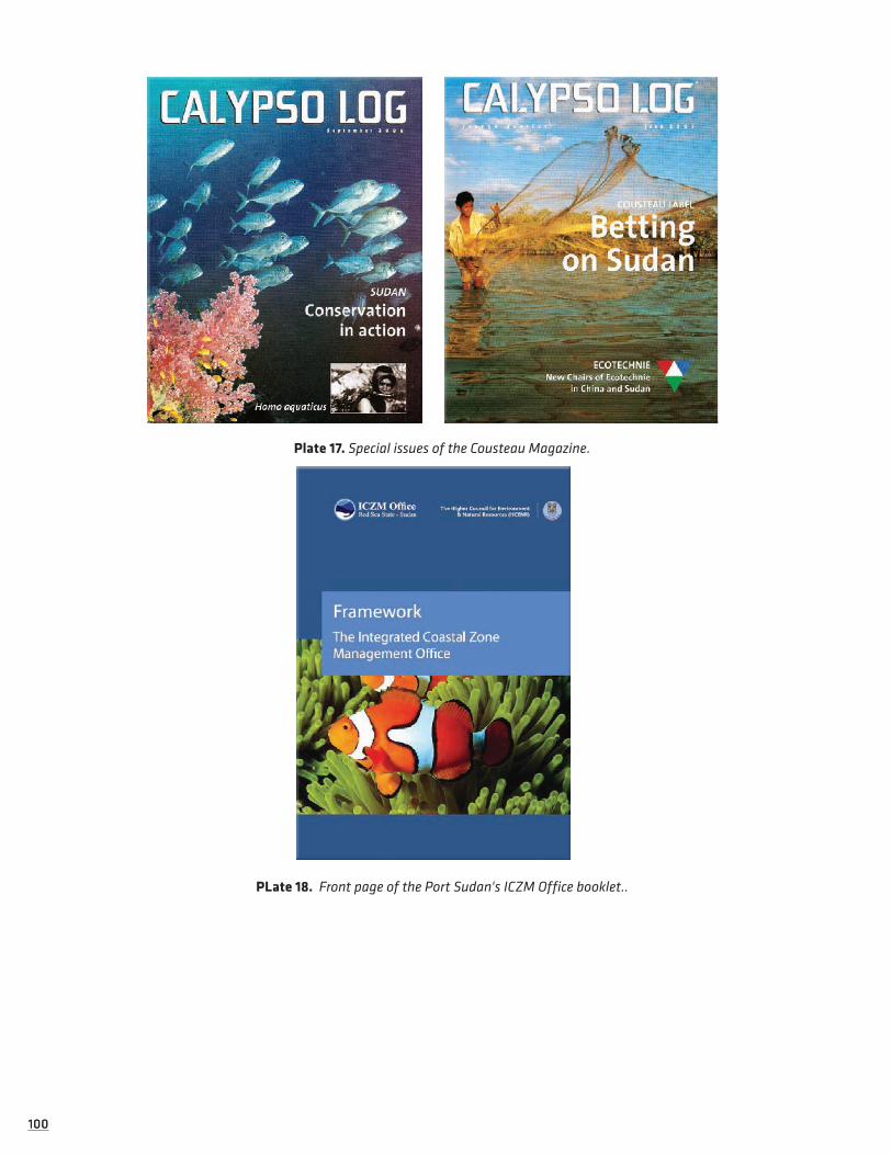
100100
Plate 17. Special issues of the Cousteau Magazine.
PLate 18. Front page of the Port Sudan's ICZM Office booklet..

101101
2.4 RECOMMENDATIONS
2.4.1 General RecommendationsStrengthen coordination with the Federal Government and align ICZM with Federal activities:
Forge a stronger link with the Federal MEPD and feed ICZM into the CBD NBSAP and reporting priorities:
• Develop and implement policies to set environmental priorities at the state level and periodically evaluate progress on the implementation of such policies;
• Establish and develop mechanisms to monitor and evaluate environmental management and the extent to which the objectives of environmental priorities are efficiently met;
• Mainstream environmental considerations and concerns in policies and strategy formulation at the state level by strengthening the capacity of the concerned agencies in priority areas;
• Facilitate private sector participation in environmental management functions;
• Strengthen the capacity of the concerned agencies and institutions (in particular, to promote MoET as the umbrella organisation for all environmental issues and affairs in the state) to address the linkages between environment problems and health, as well as the high cost (social and economic) associated with the degradation of environmental resources;
• Strengthen institutional systems—by allocating human and financial resources in particular—in order to effectively support government efforts to promote environmentally sustainable development and to address key environmental priorities;
• Define (and re-examine) the specific roles of each concerned state and national-level institution and create more efficient co-operative mechanisms;
• Review and clearly delineate the responsibilities of all the ministries and institutions involved in environ-mental policy in RSS, in order to determine the best institutional framework for environmental protection and management and to avoid any overlaps in the competencies of various agencies and institutions;
• Establish a well functioning environmental information system, where data collection and analysis should be reorganised to ensure the free flow of information between all involved actors, both governmental and non-governmental, by publishing an inventory of all relevant environmental databases;
• Establish and strengthen multisectoral partnerships, which are essential for effective environmental management;
• Establish a proper mechanism of coordination among the concerned agencies, as there is a clear lack of coordination and even communication;
• Issue the necessary bylaws and regulations; special attention and priority should be given to the monitor-ing and inspection bylaws, EIA, marine environment and coast protection, air and water protection, etc.;
• Raise awareness at the decision makers’ level; this, of course, should be in parallel to other awareness programs aimed at other target groups (community, schools, woman sector, etc.);
• Mainstream environmental concerns at the early stages of planning and development processes in the state;
• Establish a “Monitoring and Inspection” system so it supports and complements the EIA system.
2.4.2 Recommendations for EIAPriority needs in relation to strengthening EIA procedures and practice in RSS can be summarised as follows:
Strengthening Institutional Capacity and Participation:
• Updating the institutional framework by defining specific EIA mandates for the MoET and HCENR, in coordination with the Ministry of Planning and the Ministry of Investment and Economy and other rele-vant government agencies; It is now one ministry namely, Ministry of Economic Planning and Investment.
• Creation of an appropriate structure for MoET, especially through the establishment of an EIA Unit in the MoET and an EIA Committee comprised of relevant actors and stakeholders (including those from relevant

102102
Ministries). Such sub-units should be created following a comprehensive needs assessment; a Technical Assistant is needed to be appointed and be hosted by the MoET to do the full process as described above in the report. Staff of the unit might be mobilized from the different departments of the MoET or might be transferred from other Environmental Ministries to work for the unit within the MoET.
• Formal collaboration should be developed between the MoET (and other environmental Ministries involved in the EIA process) and academic/research institutions in RSS (namely the RSU and MRI), and such institutions should accordingly receive increased State support to enable them to contribute to EIA mandates;
• Official commitment should be obtained from all relevant stakeholders and Ministries to apply environ-mental concerns in all stages of planning processes and, especially, to conduct rigid EIAs.
• Stakeholder consultation should take place in conjunction with all phases of project development and EIA procedures. Also, the 2007 Law of Environment No.11 should be reviewed with stakeholder input;
• MoET EIA staff, other relevant Ministry personnel and participating institutions should receive increased capacity-building in regards to all stages of EIA. This could take place through training provided by EIA experts, through study trips overseas to experience other examples of effective EIA practice, or through any other means deemed appropriate and useful by the involved parties.
Strengthening the Legal Framework:
• Issue official by-laws and regulations to accompany EIA legislation. Included in this should be stipulations about penalties for failure to conduct EIA and for other violations of the EIA system;
• Develop a specific environmental standards set for RSS, especially focused on coastal and marine envi-ronments
Promote Environmental Best Practice for Development Projects:
• More sustainable development alternatives should be considered for all proposed and existing develop-ment projects (especially for Category B projects); for example solar energy for buildings, harbour nets to reduce ballast-water pollution, etc.;
• Ensuring that local communities benefit from development projects may indirectly encourage better envi-ronmental management. For example, the fact that local communities do not currently benefit greatly from tourism in RSS might help explain their low interest in protecting their marine resources. Asso-ciating clear economic incentives with environmental best practice and sustainable use may therefore promote more sustainable industry practice.
2.4.3 Recommendations for EducationPriority activities for the EWG and SMoE in regards to general education reform planning for RSS include:
Partnership Mapping and Consolidation:
Meet with and establish collaboration with the other education projects being conducted in RSS (namely the WB-UNICEF and EC initiatives), in order to determine division of responsibilities so as to avoid duplica-tion of efforts and to best utilise available resources. UNESCO should be approached to provide the SMoE, EWG and ICZM Office with a methodology model for partnership mapping, as well as to help coordinate with the EC and UNICEF to explore funding opportunities for future education planning work.
Capacity-Building:
Liaise with the FMoGE in regards to its capacity-building programme for education planning and manage-ment at State and Locality levels. Establish a longer-term official partnership agreement between RSS SMoE and UNESCO in order to continue capacity-transfer for all stages of the education policy planning process and strategy development phases. Participants of the UNESCO workshop conducted as part of the ICZM Survey raised that more State actors should receive UNESCO training, more training should be conducted and should span a longer time period.
Data Collection:
Complete education data compilation is needed so as to build an appropriate RSS education strategy. Although it has been criticised that up-to-date population data is lacking, the EWG and SMoE can initiate
103103
discussions with the State Population Bureau for reliable population projections based on the 1993 census. For education-specific data, the Statistics Unit of the SMoE or Ms. Ibtissam Hassan from the FMoGE can provide information from the latest Statistical Yearly Book. Cost-related data shall be obtained at the State Ministry of Finance, they can also be partly gathered from the EC’s 2008 study on the Cost and Financing of Basic Education in the RSS. The EWG and SMoE should meet with the State Ministry of Finance to gather up-to-date expenditure data.
Education Sector Diagnosis:
Data gathering should feed a brief education sector analysis that should be drafted for assessing the emerg-ing needs of the RSS educational system, and which provides both qualitative and quantitative analysis, as well as consideration for environmental education. By filling the EPSSim model with the newly gathered data, the RSS education system can be analysed on an evidence basis. Such a study would further help the SMoE and FMoGE in achieving EFA goals.
Marginalised Groups:
Pursue working with an existing Beja Education Fund for the Red Sea State to integrate efforts in strength-ening the educational system for marginalised and nomadic communities in RSS, and ensuring the needs of these under-served groups are adequately considered in the RSS Education Strategy.
In regards to Environmental Education development, it is recommended that the following activities and follow-up actions take place:
ESC Proposal:
Identification of priority needs and development of a project proposal for the strengthening of environ-mental school clubs in RSS. Such considerations as the installation of solar energy devices in schools should be included. (Solar Aid is an NGO that funds such activities, and is also particularly interested in support-ing initiatives relating to education. Further information can be obtained from the organisations website: http://solar-aid.org).
ESD and UNESCO Resources:
Continue discussions with the UNESCO ESD programme to explore the feasibility for harnessing UNE-SCO resources and expertise in expanding RSS’s environmental education approach. Similarly, the possible piloting of UNESCO-MAB’s Teaching Resource Kit for Dryland Countries in select RSS schools could benefit environmental education efforts in the State.
Legal Parameters for Environmental Education:
The legal foundations for building a concrete environmental education programme in RSS should be further explored, especially given that the Federal Government acknowledges the need for ESD and environ-mental education and several avenues exist for application in the education system. The flexibility enshrined in Sudan’s education system allows for ‘the inclusion of additional material to the national syllabus to accom-modate the particularities of a certain geographical are or groups’ (FMoGE, 2004). As such, this presents an opportunity for the incorporation of a more environmentally-focused curriculum in RSS schools, which could be orientated to specifically promote coastal/marine awareness and raise technical capacities amongst RSS students to address the issues surrounding environmental management and sustainable development in the RSS context.


105
Activity linked to IOC Handbook Socioeconomic and Governance indicators:
üSE 1 : Total Economic ValueüSE 2 : Direct InvestmentüSE 3 : Total EmploymentüSE 5 : Human Pressures on HabitatsüSE 9 : Population Dynamics
üSE 10 : Marine DependencyüSE 11 : Public Access
üSE 12 : Traditional Knowledge, Innovations and Practices / Cultural Integrity
üG2 : Existing and Adequacy of Legislation Enabling ICZM
üG3 : EIA, SEA and CCA Procedures for Plans, Programmes and Projects Affecting Coastal Zones.
3.1 OVERVIEW OF SOCIETY AND ECONOMY OF RSSThe ICZM Survey is approaching the livelihoods dilemma in RSS with a long-term view to establish solid understanding of the root causes affecting the social and economic well-being of RSS communities, which will then facilitate targeted projects to improve this well-being. By conducting baseline socioeconomic sur-veys and aligning the information gathered with results from other assessments conducted during the ICZM Survey (biodiversity, governance, education, etc) the ICZM socioeconomic component will help contextualise how the inter-linkages among environmental, social, political and economic factors affect RSS communities. The subsequent development of a Socioeconomic Monitoring Programme for RSS will enable future deci-sion-making to be more responsive to the needs of RSS residents.
The following sections of the report will: provide an overview of the RSS society and economy; describe the livelihood context in the State and discuss potential opportunities for socioeconomic development, includ-ing sustainable development of the fisheries and tourism industries; detail the Socioeconomic Monitoring Programme initiated as part of the ICZM Survey; and, finally, outline the coastal development and risk management issues affecting RSS’s environmental and social well-being. Detailed sections are devoted to assessments of the villages of Dungonab Bay—Mukkawar Island Marine National Park, particularly in rela-tion to community, environmental management and sustainable livelihood opportunities for the villages.32
3.1.1 Demographics and Settlement DistributionRelated to IOC Handbook Indicator SE5.
According to State estimates, the Red Sea State has a population of approximately 846,116 people and an annual population growth rate of 2.9%, making it among Sudan’s most populated and fastest growing states (UNDP 2005, ICZMO 2008). However, the sparse and mobile nature of sections of the population, coupled with competing Federal and State budgetary claims, mean that population growth and size are a subject of some speculation. As a result, estimates from other sources, including national estimates, attribute lower growth rates and correspondingly smaller population sizes, which range between 732,000 and 824,000 peo-ple (CBS 2004, Atkinson 2005).
32 Dungonab Village and Mohammed Qol in DMNP serve as two credible locations for future implementation of pilot ICZM activities, given their proximity to and dependence on marine resources and the fact of their location within an already designated protected area. Assessments of community environmental management and sustainable live-lihood opportunities for these two villages will therefore be detailed in this report.
3 Socio-Economic Development in The Red Sea State
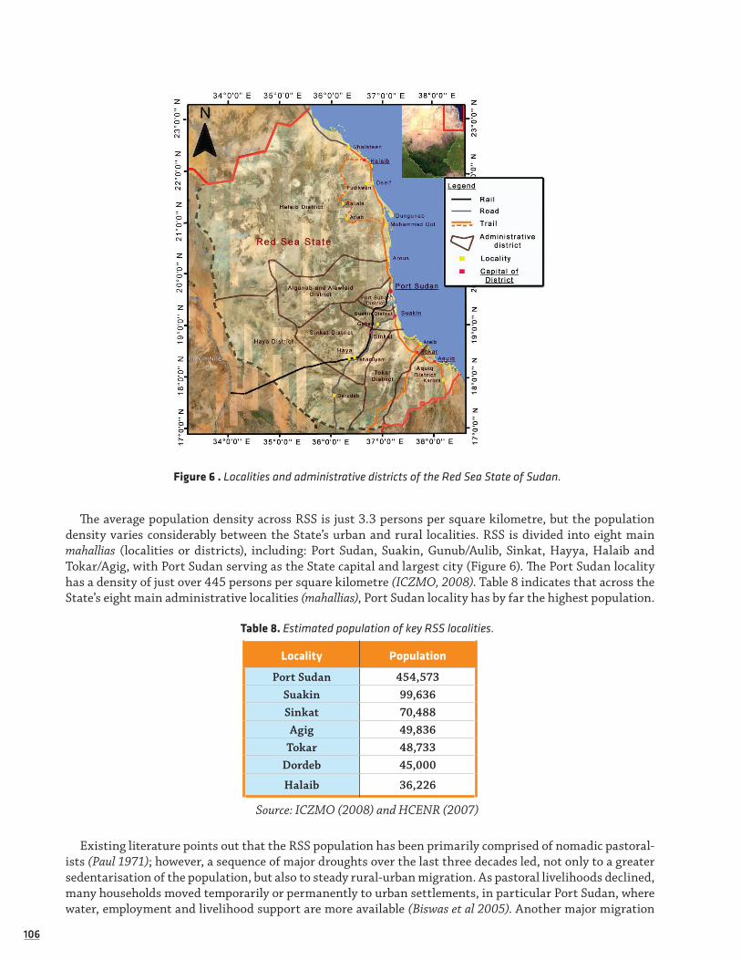
106106
Figure 6 . Localities and administrative districts of the Red Sea State of Sudan.
The average population density across RSS is just 3.3 persons per square kilometre, but the population density varies considerably between the State’s urban and rural localities. RSS is divided into eight main mahallias (localities or districts), including: Port Sudan, Suakin, Gunub/Aulib, Sinkat, Hayya, Halaib and Tokar/Agig, with Port Sudan serving as the State capital and largest city (Figure 6). The Port Sudan locality has a density of just over 445 persons per square kilometre (ICZMO, 2008). Table 8 indicates that across the State’s eight main administrative localities (mahallias), Port Sudan locality has by far the highest population.
Table 8. Estimated population of key RSS localities.
Locality Population
Port Sudan 454,573Suakin 99,636Sinkat 70,488Agig 49,836
Tokar 48,733Dordeb 45,000
Halaib 36,226
Source: ICZMO (2008) and HCENR (2007)
Existing literature points out that the RSS population has been primarily comprised of nomadic pastoral-ists (Paul 1971); however, a sequence of major droughts over the last three decades led, not only to a greater sedentarisation of the population, but also to steady rural-urban migration. As pastoral livelihoods declined, many households moved temporarily or permanently to urban settlements, in particular Port Sudan, where water, employment and livelihood support are more available (Biswas et al 2005). Another major migration

107107
pattern emerged from internally displaced peoples (IDPs) and refugees escaping armed conflict prior to the ESPA. In 2006, there were approximately 100,000 IDPs, largely residing in the shanty areas of Port Sudan (UNST 2007).
Population distribution figures indicate that over 62% of the population of RSS is now classified as urban, compared to 20% in 1956 (CBS 2004). 90% of the urban population is concentrated in the State capital of Port Sudan, with the remaining urban population in Sinkat, Suakin, Toker, Haya Durdaib and Osaif. The State’s rural population is widely dispersed, but with some seasonal migration to agricultural fields in the irrigated schemes, as well as nomadic displacements to the State’s valleys and pastures, most concentrated in Toker Delta and Khor Arab (UNST 2007).
Partly as a result of these migratory patterns and urban concentration, the average household size in RSS is about 5.4 people, which is relatively low compared to the rest of the Sudan (ICZMO 2008). There is no reliable current data for RSS population related to gender, and only limited 2003 data available for RSS population related to age, which are shown in Table 9. The Central Bureau of Statistics (2006) estimate that the dependency ratio, calculated as the percentage of household members under 15 and over 65 years of age is 39%, while WHO in Port Sudan put it at over 42% (McCreesh 2003). In both cases, the ratio is high and suggests a relatively high economic burden on household caregivers and increased vulnerability to food insecurity.
Table 9. Age distribution of RSS population.
1-15 years old 15-60 years old <60 years old
39% 55% 6%
Source: Central Bureau of Statistics (2006)
In terms of ethnicity, most of the State’s population belong to the Beja tribe and its main sub-groups of Amarar, Bishariin, Hadendowa, Beni-Amer, Ababda, as well as small size deanships, including the Shi’ayaab, Kumaylaab, Artayga, Ashraf, and Halenga. Whilst the Hadendowa, the Bisharyyin and Amarar constitute the ‘Beja proper’, all these groups are considered part of the ‘Beja confederation'. Among the three main groups of the ‘Beja proper’, the Hadendowa are, perhaps, the most numerous and powerful. (Sidahmed 1995). Hadendowa reside in the area between Sinkat and Gash, while the Amarar and Bishariin reside in Halaib. Tokar is primarily the home of the Beni-Amer and the far south, next to Kassala State, is home for the Halanga. The Bishariin reside in the northern area, while the Ababda reside around Port Sudan (Atkinson 2005). The Bisharyyn are the most common ethnic group in Dungonab village. In Mohamed Qol the most common ethnic group is the Amar’ar, although there is a great deal of overlap in both areas (Harrison & Samoilys, 2007).
The Beja’s three main groups, namely Amarar, Bishariin, and Hadendowa, share a common language and culture relating to the management of their surrounding environment, land and resource ownership and kinship. TuBedawiye, an unwritten Cushitic language, is the traditional language spoken by the Beja. Partly because it is unwritten, the language is slowly being eroded by the use of Arabic, especially amongst the younger and urbanised populations. Some of the Beni Amer are TuBedawiye speakers, while others speak Tigre. Other groups in the region, including the Helanga of Kassala and other smaller regional tribes, speak a ‘pidgin’ form of TuBedawiye.
The Rashaida is a large family Arabic tribal group, distinct from the Beja. They arrived in the RSS in the 1920s. They came in large numbers from Saudi Arabia, where they are the traditional enemies of the House of Sa’ud. Once nomadic pastoralists, moving according to fodder and water, they were forced to settle under government pressure and, while many continue to live in tents, their livelihoods tend to be more stable, linked to camel-raising and cross-border trade. Today, Rashaida are mainly found in informal traditional settlements in South Tokar and outside Port Sudan. Other ethnic groups in RSS include early West African settlers, Eritrean refugees and asylum seekers. Among the IDPs of RSS, approximately 58% originate from northern states, 17% from Kordfan, 8% from central states and 5% from Darfur (Biswas et al 1995, ICZMO 2008):

108108
Drought and civil unrest have pushed tens of thousands of IDPs and refugees to the Gash Delta area in search of vital resources, particularly water and food. The population living near the seasonal Gash river is estimated to have increased sevenfold in the past 20 years
(UNCHA/IRIN 2004).
3.1.2 History, Ideology and CultureRelated to IOC Handbook Indicator SE 12.
The Beja are among the Sudan’s longest-established peoples. The first records of the Beja in North-Eastern Sudan come from Egyptian expeditions to the area c.2500BC. Influenced by the growing number of Bedu and other Arab peoples coming across the Red Sea and from Egypt, the Beja steadily converted to Islam between 1000 and 1300AD and continued to maintain and expand their livelihoods with the Bisharyyin, and to a lesser extent the Amarar, raising and trading camels and petty goods, while the Hadendowa additionally tended cattle and sheep. The various Beja sub-groups were also involved in grain cultivation (sorghum) (Pan-tuliano 2000).
Economic development during the colonial eras of the 19th and early 20th century, including the devel-opment of cotton plantation schemes in the 'deltas' of the Toka and Gash rivers and a new port development at Port Sudan, catalysed a shift in Beja livelihoods; increasing numbers moved to towns and mines to secure waged labour. Several of the Amarar took jobs as workers on the docks, whilst the Hadendowa and some of the Bishariin took up seasonal cultivation in the Tokar and Al-Gash schemes. In the rural areas along the coastline the Beja slowly turned from pastoralists to fishermen. Nevertheless, pastoralism still continued to be the main livelihood, especially for the Hadendowa, who showed less inclination for urban life (Sidahmed 1995).
After Sudan’s independence from Great Britain in 1956, the Beja became increasingly involved in the political system of the country, but this was not enough to halt erosion of their traditional pastoralist live-lihoods. Changes and pressures on land use were compounded by successive droughts and famine, resulting in the drastic loss of the herds that served as the asset base at the centre of their livelihood and culture (Hjort af Ornäs and Dahl 1991). The Beja struggled to recover from these cumulative challenges, which are manifest today, in more urbanised and sedentary Beja livelihoods. Nevertheless, nomadic pastoralism and tribal structure are deeply engrained in the Beja and are still strongly evident in contemporary Beja culture and customs (Harrison 2007).
The Beja tribal structure is based on a patriarchal system in which the Nazir is tribal leader. Below the Nazir is the Omda and then a number of Sheikhs who each lead large extended families. Tribal Sheikhs form the framework for political and religious leadership, representing their people in negotiations with outsiders and promoting and sponsoring Islamic schools. Since the 1960s, leading Beja have forged the Beja Congress, a political wing of the confederacy, which is seeking greater self-autonomy for the Beja (Pantuliano 2000, Biswas et al 2005).
The Sheiks also usually constitute the ‘management group’ and provide the institutional framework for the complex and flexible Beja customary law, known as silif.33 Political, economic and social aspects of Beja life are regulated by silif, including access to resources, conflict resolution, environmental protection, social solidarity, preserving intergenerational memories, gender aspects, women’s roles and cultural taboos. Responsibility for silif is a chain process from individuals and heads of families up to tribal leadership level. Individuals are expected to live according to silif norms and, traditionally, no Beja can violate silif rules until a new rule is negotiated through alliances and agreements within or between the different Beja clans or lineages34 (Pantuliano 2000, Sahl et al 2004, Babiker and Pantuliano 2006).
33 Also referred to as Salif or O’Slif by some scholars (Harrison and Samoilys, 2007).
34 Although the influence of the silif on Beja society is still a highly pervading one, violations of the silif do occur. For example, some people cut whole trees, although this activity is usually blamed on outsiders who are not aware of customary law that forbids them from doing so. A minority of Beja also try to work around the taboos of the silif by cutting the bark off trees, so that when they return the tree is dead—meaning they are then permitted to collect deadwood. However, such activity is not common-place, as most Beja respect the silif and realise the fragility of their environment makes such activity unwise (Harrison & Samoilys, 2007). Of note, if someone cuts a tree in the desert he is considered a killer of people, such is the importance of the natural environment to individual survival in arid lands.

109109
Silif, and silif influenced customs and rituals, are manifest in a wide variety of forms. In terms of resource protection, for example, silif law does not allow the cutting down of green trees for wood, but allows green trees to be used as fodder. In terms of resource distribution, silif regulates the division, payment and access for different terrestrial territories (kurai) between diwab kinship groups. In terms of resource support, silif provides a framework for gifts and loans, variously known as lahagen, togwan and dangiet35, administered through patriarchal leadership to diwab members in need of support because of sickness, famine, homeless-ness, travel, marriage or death.
In terms of community solidarity, the Beja have developed ritualised greetings called Sakanab, which begin with enquiries about the family and recent goings on. These exchanges allow men to discuss reciprocal agreements and find favour with each other. Originally a source of trustworthy information on rainfall and grazing for migration, Sakanab has evolved to include the availability of work and the price of food in urban areas. In terms of community relations, silif also allows for the resolution of disputes or conflicts between diwa members through recourse to tribal officials, before reliance on the formal legal system of the state (Atkinson 2005, Harrison 2007).
Silif is central to adding structure, support and cooperation in Beja society, but is also the source of con-siderable division in traditional gender roles and responsibilities. Traditionally, men are supposed to support their wives and unmarried sisters through animal herding or agriculture, and are expected to participate in the public spheres of societal decision-making, co-operation and defence. On the other hand, Beja wom-en’s traditional responsibilities are restricted to the private and domestic sphere, being responsible for food preparation, homemaking and reproduction. They are typically discouraged from pursuing economic activi-ties and visiting markets (Harrison 2007).
Although women are traditionally allowed to accumulate assets in livestock and jewellery from a variety of economic activities, it is taboo for them to milk the livestock and, while the production of butter is an important female task symbolically linked to fertility and survival and growth of children, they are depen-dant upon their husbands or male relatives to market all goods or crafts produced. Female education and political participation is traditionally viewed as dangerous because it leads to public life and dishonour. These and other traditional conservative restrictions on women have limited their access to markets, health care and education, restricted their ability to earn income and to participate in household decision-making and resource control (Atkinson 2005).
While the aforementioned rules, norms, practices, customs and rituals characterising Beja culture remain prevalent, particularly in rural areas, they are regarded to have declining influence as a consequence of cumulative factors, including urbanisation, weakened social networks and changes to the livelihood base through the loss of livestock and the introduction of wage labour. Harrison (2007), for example, observes that for coastal settlers the practices of lahagen or togwan are now much less common because people no longer have the assets to donate. More generally, he notes that the felling of green trees is becoming over-looked with so much pressure to use charcoal as a source of income. While Atkinson (2005) observes that economic pressures have drawn women into herding, as well as agricultural tasks, such as planting, weeding and harvesting.
3.1.2.1 TOWARDS A MARINE CUSTOMARY LAW
Because of traditional dependence of Beja communities on inland resources, it is understandable that the silif does not apply directly to the use of marine resources. The development of a system of silif adapted to the marine environment (i.e. a ‘bahari Silif ’ 36) would be prudent and potentially easy to accomplish. Harrison and Samoilys (2007) suggest that the concept of bahari silif should build on existing Beja customary law to help the communities better safeguard the marine resources on which they depend. Specifically, existing rules and practices of the silif could be adapted for the use and management of marine resources and to the allocation and ownership of these resources, thus bringing these regulations in line with those developed for
35 Lahagen is the gift of animals received from friends or relatives when diwab members. Animals donated to a new owner in absence of a marriage take the name of tait. Dangeit allows for the loan of animals, especially milking goats, to poorer households between diwab members (Babiker and Pantuliano 2006).
36 ‘Bahari Silif ’ is the suggested term of Paul Harrison, translated by Ahmed Tamim.

110110
the general management of Dungonab Bay—Mukkawwar Island Marine National Park, as well as Federal and State laws on resource use and marine management.
Once recognised as part of customary law, any issues over punishment, resource allocation or favour may be dealt with in typical Beja leadership style. Building on the bahari silif, this customary law could be struc-tured through a village environmental management planning process (i.e. the VEMP process discussed in Section 4.2.4 below).
3.1.3 Settlements and Social InfrastructureRelated to IOC Handbook Indicator SE 11.
The harsh physical environment of RSS and transhumance pastoralism has, in rural areas, led to the development of small dispersed hamlet settlements concentrated along the khors, where the availability of water, pasture and agricultural land is greatest. Traditionally, families migrated on a seasonal basis between different locations to benefit from flooded khors, but settlements have become more permanently estab-lished as communities became increasingly sedentary. While rural settlements still tend to be small and widely dispersed, they now also tend to be served by the markets of central villages, many of which emerged as locations for the delivery and distribution of food aid during the famine affecting eastern Sudan in the 1980s (Atkinson 2005).
As previously noted, droughts, war and economic changes lead to the displacement and migration of many rural and war affected households to the peripheries of urban centres. This displacement and migration lead to the growth of large new settlement zones around the State’s towns and cities, especially Port Sudan, Tokar, Halayeb and Sinkat. Migration to Port Sudan has been particularly pronounced, with most growth in unplanned shanties outside the city that now house an estimated 60% of the city’s population. This settle-ment pattern has intensified the pressure on employment and the already overstretched services in these urban centres (Ibid 2005).
There is a dearth of research on housing type across both the rural and urban settlements of RSS. However, research on housing types across largely rural areas of State localities, as part of a wider study of livelihood vulnerability in RSS by Biswas et al (2005), found that 93% of those surveyed lived in thatch and mud or birish (woven matting over wooden frames) structures; only 8% lived in huts or brick houses. They speculate that, while this is related to affordability, it also reflects the traditionally nomadic nature of the population, for which brick homes would be impractical. In terms of household assets, they found that, on average, just 40% of the households owned productive assets (axes, hoes, fishing tools) and that ownership of non-pro-ductive assets was very low, with just 16% owning radios and no household surveyed owning a television set (Table 10).
Table 10. Household Asset Ownership (%).
Beds Tools Furniture Bike/cart Radio Jewellery TV
Tokar 71 42 23 15 22 31 0
Sinkat 75 43 5 11 3 3 0
Halaib 19 31 38 16 24 31 0
Total 68 40 21 14 16 22 0
Source: Biswas et al 2005
The principle means of transportation between settlements in the RSS is by motor vehicle. Well-main-tained asphalt roads link Port Sudan with Sinkat and Tokar, and Suakin with Tokar. Recently, an asphalt road between Port Sudan, Mohammed Qol and Egypt has also been constructed to support established trad-ing routes to Port Sudan. Road access between most rural settlements, however, remains very limited, with many villages and hamlets only linked by tracks or not accessible by mechanised transport at all. Travel between most of the rural settlements is therefore restricted to private and commercial vehicles and can be difficult or impossible without four-wheel drive, particularly during the region’s rainy season (Babiker and Pantuliano 2006).

111111
Table 11. Key Social Infrastructure across Localities (2008).
Haya P.Sud Suakin Tokar Sinkat Halaib Agig G&O
Hospitals 2 16 2 2 5 1 0 0
Clinics - 47 1 6 1 - 3 -
Midwives 26 171 12 7 9 4 11 6
Schools 62 201 40 41 44 45 22 64
NGOs 4 14 4 4 3 5 5 7
Police Stations 5 18 3 5 6 3 4 2
Courts 2 9 2 2 3 1 3 2
Source: ICZMO (2008)
Table 11 outlines key social infrastructure for RSS localities in 2008. There is a lack of available time series or distribution data on health or education facilities in the RSS. However, most reports suggest that access to health care facilities outside urban centres is poor with only about 20% of rural villages in the state having health centres or clinics. Furthermore, the costs of healthcare are prohibitive and prevent many people, even in urban areas, from accessing services (UNST 2007).
Table 12. Health facilities in the RSS 2004-2006.
GeneralHospitals
BedsHosp with specialists
Specialist Hosp.
Health centres
DispensariesDressing stations
P.H.C.Blood banks
X-ray units
2004 19 985 2 9 31 32 18 174 2 6
2005 19 1025 2 9 33 37 19 171 2 6
2006 12 858 1 4 35 37 25 158 1 6
Source: Central Bureau of Statistics (2006)
Table 12 shows the different health facilities available across RSS between 2004 and 2006. The data sug-gests that there was a decline in the absolute number of most facilities. In relative terms, the data shows that in this period the number of hospitals per 100,000 people declined from 2.6 to 1.6, the number of hospital beds per 100,000 declined from 134 to 116, and the number of public health centres (P.H.C) per 100,000 declined from 23.7 to 19.8. During the same period, Table 13 shows the number of many health service personnel increasing, with general physicians per 100,000 rising from 14 to 22. However, public health infrastructure suffered reductions to both facilities and staffing, with their personnel per 100,000 dramatically reduced from 103 to 69.
Table 13. Health service personnel in RSS 2004-2006.
Physicians Technicians Nurses Med. assistants Public health
2004 2004 101 60 427 229
2005 152 205 428 253 507
2006 161 184 480 264 553
Source: Central Bureau of Statistics (2006)

112112
With the exception of higher educational institutions, Table 14 shows the different educational facilities available across RSS for 2004 and 2006. While the number of primary and secondary schools appear to have remained broadly stable between these years, the figures suggest a dramatic decline in the number of pre-school facilities, including nurseries and khalwas.
Table 14. Education facilities in the RSS 2004-2006.
Nursery and Khalwa Primary Schools Secondary Schools
2004 474 336 48
2006 214 336 45
Source: Central Bureau of Statistics (2006)
Table 15 shows that this decline occurs at the same time as an increased pre-school intake, and a slight decline in pre-school teacher numbers, so it must be assumed that there was a significant consolidation of pre-school facilities and staff during this period. Therefore, while the number of pupils to teachers in primary and secondary schools actually falls between 2004 and 2006, the number of pupils to teachers in pre-school institutions increases significantly.
Table 15. Staff and pupil numbers and ratios in RSS 2004-2006.
Nursery and Khalwa Primary School Academic Secondary
2004 2005 2006 2004 2005 2006 2004 2005 2006
Teachers 470 428 428 3,687 3,688 3,686 690 428 1,087
Girls 3,780 4,701 4,876 46,536 36,952 42,798 7,075 10,748 8,187
Boys 3,973 4,965 4,737 46,884 44,415 40,619 9,352 10,583 8,780
Total 7,753 9,666 9,613 93,420 81,367 83,417 16,427 21,331 16,967
No./Teacher 16.5 22.5 22.5 25.3 22 22.6 23.8 49.8 15.6
Source: ICZMO (2008) HCENR (2007)
In addition to the social infrastructure already noted, most localities have local organisations, including youth groups, credit/saving and farmer’s associations, school, mosque and health committees, which help support the State’s social facilities (Babiker and Pantuliano 2006). These organisations and facilities, in turn, often rely on the support of non-government organisations (NGOs). The principal international NGOs in RSS are Oxfam, GOAL, Accord, ACF, Sudanese Red Crescent and Ockenden International. Their projects range from dietary supplements, micro-credit, women’s education, income generation and HIV/AIDS aware-ness (Biswas et al 2005).
The number of UN agencies, programs and offices in RSS is limited: WFP; UNDP; RCO and UNMIS (Department of Safely and Security and MOVCON only) have a permanent presence while FAO and UNICEF are opening sub-offices in RSS; WHO and UNMAO serve the State from Kassala. UNFPA operates in RSS through its counterpart, the Ministry of Health. The funding of both UN Agencies and NGOs is insufficient to allow for the expansion of activities necessary to meet the needs of RSS, so major gaps remain across all sectors (UNST 2007).
Among the most significant gaps and concerns for these organisations and the people of RSS, is access to safe drinking water. Approximately 65% of the general population and 90% of the rural population lack access to safe drinking water (UNST 2007). Indeed, in a state where there is no permanent surface water, available water is so limited that water consumption itself is severely constrained. According to UNEP

113113
(2007), however, the major constraint lies not with availability, as often assumed, but underinvestment in the necessary extraction and purification infrastructure.
In the larger and more permanent villages of RSS government and non-government organisations have invested in water supply and collection points (usually wells), but these are often distant and the average time spent to collect water in RSS is long, at 119 minutes. The longest collection times are reported for Sinkat locality, where villagers travel an average 190 minutes, while the shortest collection times are reported in Halaib at 40 minutes. Given this, 20% of RSS households purchase their water directly from vendors. House-holds that purchase water pay most in Halaib (298 SD per week) and pay least in Sinkat (67 SD per week) (RSSMH 2004, Biswas et al 2005).
As with most public utilities in RSS, waste management suffers from severe underinvestment. There are currently no wastewater treatment facilities in RSS and approximately 75% of the general population lack access to adequate sanitation facilities. Sanitation issues are particularly acute in IDP settlements and poorer urban fringes, where over-crowding, and the absence of sewage drainage and treatment have given rise to ‘open toilets’ on vacant plots and the discharge of sewage into watercourses. Although better-off communi-ties typically rely on septic tanks, the waste is often then emptied into seasonal watercourses. In Port Sudan, for example, septic tank waste is dumped in the main wadi that supplies Port Sudan with its drinking water.
3.1.4 Health and EducationEducation levels in RSS are relatively low due, among other factors, to inadequate educational infrastructure, the legacy of traditionally discouraging women from pursuing education, and lack of adequate training and remuneration for teachers. This is exemplified in Table 16 below that shows the level of educational attain-ment of household heads to be consistently low, based on samples taken across key localities in the RSS. The low level of education is also manifest in the strikingly high levels of illiteracy in RSS, which averaged 50% across RSS, but which are as high as 89% in the locality of Halaieb. Education and literacy levels are most alarming among females, with 71% of the over-15 years old surveyed identified as unschooled and illiterate (RSSMH 2006).
Table 16. Head of Household Educational Attainment across key Localities 2006.
Locality No EducationReligious Education
Primary SchoolSecondary
SchoolHigh School
Sinkat 45% 34% 17% 5% 0%
Port Sudan 50% 28% 14% 5% 3%
Halaib 64% 17% 18% 2% 0%
Tokar 54% 29% 11% 4% 1%
Source: RSSMH (2007)
Table 17 shows the comparative rural and urban rates of primary school enrolment and completion for RSS. The primary school enrolment rate across the State is between 59-62% and the primary school dropout rate is about 20%. It is interesting to note that while primary school enrolment levels are much lower in rural areas (about 53%) compared to urban areas (about 68%), the primary school drop out rate in urban areas (about 35%) is markedly higher than the drop out rate in rural areas (about 7%), so more pupils from rural areas actually complete primary schooling. Alongside the high drop-out rates, other issues relating to schooling include the inability of the poor to pay for school fees or to cover the opportunity cost of child labour (Babiker & Pantuliano, 2006: 24).

114114
Table 17. Rural and Urban Primary School Enrolment and Completion across RSS.
RSS Rural Urban
School Age Child
Enter School
Complete School
School Age Child
Enter School
Complete School
School Age Child
Enter School
Complete School
Girls 70,349 41,719 28,640 30,626 16,117 14,505 39,737 25,602 14,135
Rate 100% 59.3% 40.7% 43.5% 52.6% 47.4% 56.5% 64.4% 35.6%
Boys 88,729 55,023 33,706 51,294 28,315 22,979 37,335 26,608 10,727
Rate 100% 62% 38% 57.9% 55.2% 44.8% 42.2% 71.3% 28.7%
Source: ICZMO (2008) HCENR (2007)
RSS lacks comprehensive quantitative data on specific health conditions, but sufficient indicators and qualitative accounts exist to show health levels to be of critical concern. Notably, RSS has the highest infant mortality rates in the country, at 116 per 1,000 compared to 68 per 1,000 for the rest of Northern Sudan and an under-five mortality rate that is close to alarm thresholds at 165 per 1,000, compared to 64 per 1,000 nationally. The maternal mortality rate in RSS is also high at 556 per 100,000 live births, compared to 550 nationally. This is partly attributed to the widespread practice of female genital mutilation (up to 90% in areas of RSS) (RSSMH 2006, UNST 2007).
Communicable conditions, including malaria, diarrhoea, tuberculosis, cholera, dengue fever and menin-gitis, are prevalent in RSS and require continuous monitoring for outbreaks. Table 18 below illustrates the prevalence of respiratory and gastric conditions reported across the RSS in 2006. Communicable diseases will be the cause of a large proportion of these conditions. Indeed, it is estimated that among all reported dis-eases in RSS 80% are waterborne and the direct result of inadequate waste management and poor sanitation measures (Biswas et al 2005, UNST 2007).
Table 18. Reported Respiratory and Gastric Conditions and Mortality in RSS Population (2006).
Reported Number
Proportion of all conditions
Rate per 1000 People
Mortality Number
Respiratory Conditions 58,137 14% 78 93
Gastric Conditions 29,238 9% 39 71
Source: ICZMO (2008), HCENR (2007)
HIV AIDS is among the most serious communicable diseases in RSS and a number of factors make the population particularly vulnerable. Specifically, the State is characterised by high demographic mobility, including refugees, IDPs and seasonal workers. Each group consists of many thousands of people who travel within and between RSS and other regions. Furthermore, there are high concentrations of other high-risk groups in the region, such as: the military service, sex workers, truck drivers, street children and nomads. Studies suggest that this situation is aggravated by low level awareness and elevated levels of risky sexual behaviour (UNST 2007).
Perhaps the biggest health concern in RSS, however, is malnutrition, which consistently exhibits higher prevalence in RSS than any other state in the country. Table 19 shows the results of a study of child and caregiver malnutrition by RSSMH (2006) across Sinkat, Port Sudan, Halaib and Tokar. The prevalence of global acute malnutrition (GAM) ranged from 20% in rural Port Sudan to 31% in Sinkat. Surveys conducted in 2002 and 2004 by SMoH, with support from Oxfam GB, report similar GAM rates by locality. Indeed, of 20 nutrition surveys conducted in the last ten years, only 2 have reported GAM rates below the emergency threshold of 15% (Oxfam 2005).

115115
Table 19. Child and Caregiver Acute Malnutrition rates in RSS (2006).
Locality
Global Acute Malnutrition Severe Acute Malnutrition
Children Caregiver Children Caregiver
Sinkat 31% 22% 5% 9%
Port Sudan 20% 18% 3% 8%
Halaib 30% 19% 7% 8%
Tokar 27% 11% 6% 6%
Source: RSSMH (2006)
3.1.5 Livelihoods and EconomyRelated to IOC Handbook Indicators SE1, SE 2, SE 3.
3.1.5.1 OVERVIEW OF THE RSS LIVELIHOOD AND ECONOMIC CONTEXT
RSS has a significant natural resource base, including gold, oil, natural gas and fish stock. It is also stra-tegically important, with Port Sudan being the gateway for the import and export of grain, oil and other commodities. To date, however, the State has failed to benefit from these natural and strategic assets and remains one of the poorest in Sudan. Although mechanisation and State resident employment discrimi-nation are cited, this failure is more often attributed to disproportionately low-level Federal Government investment in RSS and distorted federal tax and redistribution practices that lack transparency (Bekoe and Kiplagat 2006).
This lack of transparency is evidenced in the particularly limited information publicly available on the RSS economy. Table 20 below, however, shows the state budgets aggregated income and expenditure between 2005-7. As the State operates a zero budgeting system, the figures illustrate that for 2005 and 2006 there was an income deficit, with Federal funds to the State for 2005 and 2006 being 4.48% of the proposed bud-get (SDD 641,614,000) and 27.94% of the proposed budget (SDD 7,467,251,000) respectively. Although this resulted in the cutting of planned expenditures, income and expenditure did increase markedly overall in this period (UNST 2007).
Table 20. RSS Budget 2005-2007 (Sudanese Dinars).
2005 2006 2007
Proposed Income and Expenditure 16,286,578,496 36,335,001,250 70,081,187,002
Actual Income and Expenditure 14,318,063,577 26,730,605,624
Income and Expenditure Deficit 1,968514,919 9,604,395,626
Source: UNST (2007)
The distribution of expenditure per capita is shown in Table 21 below. Working on the assumption that the expenditure figures have been adjusted for inflation, significant increases in social development expenditure in RSS are evident between 2002 and 2006. The increase is most notable in 2006, following the establish-ment of a four-year Reconstruction and Development Fund for the region, amounting to a total US $600 million, as part of the Eastern States Peace Agreement (ESPA), between the Government of Sudan and the Eastern Front (UNDP 2008).

116116
Table 21. RSS Per Capita Spending 2002-2006 (‘000’s Sudanese Dinars).
Locality 2002 2003 2004 2005 2006
Gross Pro-poor Spend 4,782.5 5,763.3 8,366.4 11,127.5 37,184.0
Development Spend 1,250.8 1,434.0 1,863.4 2,988.4 25,540.0
Agriculture 107.6 222.3 273.9 328.8 4,881.9
Utilities 674.8 647.2 740.7 1,344.2 10,441.0
Education 192.4 303.6 348.8 524.5 1,470.3
Health 191.6 163.1 325.7 513.4 3,536.1
Welfare 70.7 97.9 174.3 277.5 1,531.7
Current Pro-poor Spend 3,531.7 4,329.3 6,503.0 8,139.1 11,644.0
Development Expenditure 1,916.0 2,109.7 3,742.8 4,473.7 26,790.9
Source: ICZMO (2008)
Although the most significant productive sectors in the RSS are recognised to be shipping, oil and gas, pastoralism, agriculture and fisheries, the specific and comparative economic contribution of each sector to RSS, in terms of either capital investment, wages or taxes, is not publicly disclosed. As a result, any quanti-tative impression of the specific economic contribution of each sector is restricted to production, handling or ownership volumes, while any quantitative impression of the comparative contribution of each sector is restricted to employment. For RSS, the most recent official unemployment rates are from 1998, when they were 21.1%, against a national average of 11.8% (Oxfam 1998). Table 22 provides available employment data by sector for 2007 and shows pastoralism and agriculture to be by far the most significant sectors in employment terms.
Table 22. RSS Distribution of Employment by Sector and Locality in 2007.
RSS Haya Portsudan Suakin Tokar Sinkat Halaib Agig G&O
Fisheries 3,420 - 600 700 - - 650 1,495 -
Agriculture 28,896 - 6,800 2,228 10,020 745 4,430 1,673 3,000
Pastoralism 74,488 - - 15,000 21,514 14,662 1,340 14,950 -
Retail 16,770 300 13,320 1,000 1,400 1,200 200 250 100
Manufacturing 4,292 - 4,292 - - - - - -
Oil & Gas 920 22 851 19 17 15 2 7 2
Mining 750 - - - - - - - -
Administrative 7,832 360 3,888 364 516 1105 471 508 620
Tourism 837 - 261 540 - - - - -
Source: ICZMO (2008)
Pastoralism has traditionally served as the primary economic activity for the Beja, although a more seden-tary, uncertain form of pastoralism has slowly replaced the pure nomadic pastoralism of times past. Where households once raised herds of camels and large flocks of small ruminants, taking advantage of winter and summer pastures and water availability, the typical pastoralist household now raises only a small number of goats or sheep within a highly circumscribed pasture area. The Beshariin, Hadendawa and the Amarar are

117117
most inclined toward the pastoral livelihood, occupying the more mountainous wadis of the RSS interior (Biswas et al 2005).
Table 23 shows estimated livestock population by animal type in RSS in 2001. According to this, total RSS livestock was around 1,274,359 heads. Goats, which represent an important source of cash and food for relatively poor rural households, represent nearly 52% of the livestock population, while sheep, camels and cattle represent 26%, 17% and 5% respectively. Camels and sheep tend to be raised by the relatively better off and cattle tend to be confined to the Tokar Delta area where range and water resource are more widely available (Khojali 2005).
Table 23. Livestock population of the RSS by type, 2001.
Goats Sheep Camels Cattle Total
Population 659,208 329,301 224,530 61320 1,274,359
Percent 51.7% 26% 17.6% 4.8% 100%
Source: Khojali (2005)
Livestock quality and production is very significantly affected by the availability of water, with poor water supplies resulting in inadequate pastures and drinking water for the animals. Consequently, many livestock are lost during the droughts affecting the state and the quality of surviving animals is generally very poor. Another significant constraint on pastoralism in RSS has been the limited access to markets, as most live-stock markets tend to be found only in the urban centres, like Tokar town, and in villages, like Ashat and Dolabyai. Indeed, Port Sudan livestock market is the only livestock market serving the Port Sudan locality (Khojali 2005, UNST 2007).
These conditions have led many traditional pastoralist households to diversify into agriculture, particularly toward the delta areas and the south where rainfall is higher. In Sinkat locality, for example, agro-pastoral-ists groups will grow sorghum in the khor and wadi runoff areas during the summer rains and, after the harvest, feed animals the crop fodder during the dry season. Agro-pastoralist households are sedentary, although some move their animals to the edge of irrigation schemes to take advantage of harvest remains. Households with larger livestock herds, including those with cattle, tend to be permanently located closer to the schemes (Biswas et al 2005).
Table 24. Sorghum and millet production figures: Area in (000) fed, production in (000) m.ton and yield kg/fed.
2006/2005 2005/2004 2004/2003
Area Produce Yield Area Produce Yield Area Produce Yield
Irrigated Sector (Tokar) 19.15 11.6 600.40 7.9 2.2 300.15 9.13 3.2 320.13
5
Rain Fed Sector (RSS) 8.5 1.1 135.90 6.2 1.1 150.15 12.7 2.1 180.18
Source: Central Bureau of Statistics (2006)
The Tokar and Gash schemes also provide significant employment to labourers. Around 10,000 agricultural labourers are employed to cultivate cotton and vegetables in Tokar Delta, while the Gash Delta agricultural scheme employs 6,000-9,000 seasonal workers, many of whom are Hadendawa from the Red Sea Hills (Leif 2001). Labourers on the schemes are often paid in-kind and allowed to use the fodder, particularly during the sorghum harvest. In effect then, the agricultural schemes are comprised of actual landowners, who cultivate their parcels and raise their livestock, sharecroppers, who cultivate parcels of land belonging to absentee landowners, and labourers, who either live in the vicinity or immigrate during the agricultural campaign (Biswas et al 2005).
118118
Another emerging migration pattern is that of inland inhabitants to the coast, seeking livelihoods in fishing, salt extraction and pearl collection (Khojali 2005). Hook and line artisanal fishing, using traditional boats with small motors, provides a principal livelihood for many communities along the state’s coast. Although some fish year-round, the main fishing season occurs from April to August when sea winds are more subdued. The fish are generally sold to buyers in Port Sudan. However, artisanal fishing is increasingly constrained by a lack of local infrastructure, market demand and depleting stocks following competition from industrial trawlers (Biswas et al 2005).
Throughout the region, no combination of crop production, fishing or livestock activities can provide an adequate livelihood for the vast majority of the rural population, so many people have resorted to logging, firewood collection and charcoal making37 (for which there is great demand from urban centres), as well pro-ducing rural products like ghee, mats, and baskets (Babiker and Pantuliano 2006). However, logging, firewood and charcoal production have contributed to such a marked depletion of these resources that these liveli-hoods are threatened. In addition, dom palms, whose leaves provide the material for mats and baskets and whose trunks are important for housebuilding, are becoming scarce through over-cutting, while imported plastic alternatives reduce demand for such goods (Khojali 2005).
The constraints of resource depletion, market competition and access, land grab for agricultural schemes and severe droughts, mean many aforementioned traditional and adaptive, subsistence livelihoods have been progressively relegated to a secondary status. The pervasive transformation of livelihoods has been toward unskilled wage labouring in urban areas and the agricultural schemes, which now provide the State’s primary source of income generation. In Port Sudan, much unskilled wage labour has been absorbed in construction and, for a more sustained period, in the docks, which (as shown in Table 25) are handling escalating volumes of imports and exports.
Table 25. Volume of imports and exports from Port Sudan.
2004 2005 2006
Exports 373,922 343,780 395,568
Imports 3,330,745 5,476,200 5,263,631
Total (tons) 3,704,667 5,819,980 5,659,199
Source: Central Bureau of Statistics (2006)
In Port Sudan’s labour market, however, people face other constraints and insecurities. Despite its stra-tegic importance, there is limited business outside of construction and shipping and, despite the increased volume of cargo handling, employment opportunities inside the port’s docks have been reduced through mechanisation (Atkinson 2005). In addition, the Beja also now compete with imported labourers, or migrants from south and west Sudan, who generally possess better education, skills and experience (Pantuliano 2005). Finally, the shift away from a subsistence livelihood base has left household sustenance dependent on vola-tile market forces. There is much evidence to suggest that fluctuations in grain, livestock or charcoal prices have a profound impact on access to food for most households. This food insecurity situation is compounded by the state’s requirement to source 90% of the grain and foodstuffs it consumes from outside (Khojali 2005).
Livelihood options in RSS therefore, appear vulnerable and restricted. They are also affected by critical constraint factors, including poor service and market access, and low education and health levels, yet these can be addressed. While NGOs and government have implemented many livelihood interventions, they have often been within the context of emergency relief, steered by political or donor agendas and rarely based on a full assessment of need or impact. The development of RSS communities is only likely to be successfully met if projects, policies and programmes better understand these long-term critical constraint factors and, in the future, are designed to address them.
37 Charcoal is made from acacia species (sanagreb) and, more recently, from a thorny bush, well adapted to arid conditions, called mesquite locally (Prosopis sps – an anti-desertificaion tree introduced in the 1970’s that is prolifically invasive and has become a noxious weed) (Snell and Ali 2004).

119119
The following programmes and projects that were all implemented after 2008 might have met the condi-tions mentioned above but their results need to be assessed:
1. EU: Eastern Recovery and Development Programme; The European Union funded this programme which was implemented in the 3 eastern States during July 2009 until December 2012.
Overall objective: To facilitate the economic development of the Eastern Region of Northern Sudan
Programme purpose: To improve livelihood security of poor and vulnerable people living in the Red Sea, Kassala and Gedaref States through the targeted provision of infrastructure and services. Additionally the project aims at enhancing the capacity of local authorities and local implementing partners in the planning, management and coordination of public and donors investments in the targeted areas
2. EU: Sudan Food Security Programme;
The Sudan Food Security Programme (SFSP) aims at improving food security in four States of Sudan using a two-pronged approach: (1) Improving the States’ capacity to effectively put in place food security policies and strategic plans and (2) Increasing the productivity of rural smallholders. The programme builds on les-sons learnt from STABEX-funded programmes, which were terminated at the end of 2012.
The programme contributes to areas where the EU has a comparative advantage and a history of involve-ment since cooperation with Sudan was resumed in 2005.
3. Canadian CIDA: Support to Marine Fisheries: Creating Sustainable Livelihoods in Fishing Communi-ties in the Red Sea State;
The overall objective of the project is to increase incomes and improve livelihoods in the fishing communi-ties of the Red Sea State. This will be accomplished through a central focus on the development of 3 landing sites and closely linked business-oriented community associations.
4. UNDP: Local Governance and Public Expenditures Management Project. The project started in 2009 and was supposed to be closed by December 2012.
The project intented to assist in the following areas:
• Strengthening planning and public expenditure management;
• Strengthening the legal and policy framework for intergovernmental fiscal relations;
• Strengthening institutional capacity for decentralised governance at the state level;
• Facilitating legal, policy and institutional reforms
An Executive Summary of UNDP Evaluation Report is available and the key findings are:
• The project contributed to accelerating progress towards the Millennium Development Goals (MDGs) in several sectorial activities.
• The project did not sufficiently engage at the federal level because of the policy context in 2011 with a lot of unclear definition of responsibilities in terms of legal and policy reform at federal level.
• There was increased focus on provision of basic services in eastern Sudan. The states undertook reviews of their respective state laws and administrative arrangements, culminating in issuance of state decrees, policies and guidelines to enhance delivery of basic services.
• Civil society and community participation was increased. A Civil Society Network was established in the Red Sea State in September 2010 and funded by the RSS in 2013.
• Slow implementation of decentralisation affected progress on project objectives and the decentralisa-tion process was not accompanied by transfer of resources, thereby making the local governments to continue to rely on state support to implement projects.
• The project delivered its intended outputs, but the pace was not the same in all states.
• The risk to project sustainability was high, particularly with regards to continued budget support at federal and state levels, as well as continued capacity development and institutional stability.

120120
3.1.5.2 THE TRADITIONAL BEJA LIVELIHOODS SYSTEM
The Beja’s livelihood system and settlement patterns have been directly affected by the harsh nature of their environmental surroundings. Pastoralism has traditionally served as the primary economic activity for the Beja, although their survival strategy also requires engagement in other supplementary economic activities and the exploitation of a range of natural resources. Other economic activities pursued by the Beja include charcoal making, firewood collecting, fishing, mining, agriculture and sale of rural products that include ghee, milk, mats, baskets and leather goods (Babiker & Pantuliano, 2006: 14). Pastoralism and eco-nomic diversification have defined the Beja’s mobile lifestyle in order for them to best harness the necessary natural resources for themselves and their livestock. In times of drought, disease and other such hardships, Beja pastoralists have ensured food security for struggling members of their communities through a social security system based on reciprocity of livestock and other customary systems of resource distribution, such as the silif.
Traditional livelihood and survival mechanisms, however, have come under increasing threat, due to a variety of external factors, such as: the claiming of key fertile lands by colonial and subsequent governments for the creation of agricultural schemes; the damming of important water sources in order to irrigate the agricultural schemes; widespread overgrazing, environmental degradation, conflict and fighting that has limited the access of Beja to certain areas; and, severe droughts (Babiker & Pantuliano, 2006: 15). With the increasing difficulty for Beja to pursue their traditional pastoralist lifestyle, Beja are now increasingly moving to urban centres in order to try to earn a living. Young men mostly find work in mines and ports. However, this work is normally sporadic and does not guarantee long-term stability. Furthermore, the mechanisation of Port Sudan has resulted in reduced job opportunities.
Vulnerability resulting from limited access to water resources is another cause of concern for the Beja. In some areas of RSS, over 50% of household income is reserved for water purchasing (Babiker & Pantuliano, 2006: 18). Because of their absence in policy-making, the needs of the Beja receive insufficient consideration in government infrastructure designs and damming projects (ibid: 24).
Despite the growing hardships for the Beja people and other residents of RSS, the government has been weak in introducing the necessary development policies and procedures: to try to stabilise markets and intro-duce fairer terms of trade for rural communities; to provide necessary infrastructure to rural communities, such as roads, water, schools and other services; and, to address the root causes for the increasing vulnera-bility of the Beja and other rural groups. Until recently, livelihood support interventions have therefore been pursued primarily by foreign and local NGOs and largely, within the context of emergency relief. While many of these efforts have seen positive results, they never-the-less remain inadequate to effectively address the complexity of the situation and to provide for the long-term needs of vulnerable communities in RSS.
3.1.6 The Villages of Dungonab Bay-Mukkawwar Island Marine National ParkVillage Locations and Demographics:
Two main villages exist in the Dungonab Bay – Mukkawwar Island Marine National Park (DMNP): Mohammed Qol and Dungonab Village. Mohammed Qol is located on the coastal strip of land between the Red Sea hills and the sea itself. It is an open area which has developed over time.
The population of Mohammed Qol, according to village figures, is as follows:
• Under 5 years: 100
• 5 – 15 years: 90
• 15 – 40 years: 250
• 40 – 60 years: 190
• Over 60 years: 90
Dungonab village is found to the western mainland part of the Dungonab Bay area, north of Mohammed Qol and south of Khor Shanab.

121121
The total population of Dungonab Village has been estimated at 2,000 (PERSGA, 2004). Village figures estimate the number of residents in each Dungonab area as follows:
• Dungonab: 800
• Shanab: 200
• Dalau: 300
• Halaga: 150
• Riwaya: 150
Village Histories and Culture:
Mohammed Qol was a fisherman and trader who came to Sudan from Arabia, fleeing the poverty of the time and in search of Sudan’s reputed commodities. His settlement in the area brought significant economic prosperity and led to the development of a larger village that now bears his name. Mohammed Qol thrived as a centre of trade until the creation of Port Sudan in the early 1900s, which replaced it in importance. Mohammed Qol has continued to see changes over time, especially following the influx of people who moved to the area following the great droughts of the 1940s and 1980s. Inland pastoralists lost most of their live-stock and moved to Mohammed Qol in search of opportunities in fishing, shell collection and trade. Before the loss of livestock people used to go to Mohammed Qol seasonally, returning to pursue their regular pas-toralist activities inland. There is a continued relationship between Mohammed Qol village and inland Beja who trade livestock, firewood and charcoal in exchange for fish and other commodities.
Dungonab Village became a settlement during the Mahdi period, when people moved to the coast follow-ing the starvation of the land during the droughts of the time. The settlement became permanent following Independence.
The Beja society in the two villages is exclusively Muslim. It is governed through a patriarchal system involving a hierarchy of leadership, beginning with the Nazir based in Port Sudan, who is represented by an Omda in the village, who in turn is supported by Sheiks. Silif is used to govern use of the natural resources in the area, although (as discussed above), this has yet to be appropriately adapted to management of marine resources.
However, fishing communities of Dungonab and Mohammed Qol villages have both already established certain rules and regulations applying to the management and use of marine resources that could be for-malised into a Bahari silif system, as discussed above. For example, in Dungonab adaptation of the silif stipulates that it is forbidden to destroy the reef and to catch juvenile fish. Furthermore, it condemns the catch of dolphins, dugongs, turtles, swordfish and certain sharks. As this does not appear to be understood (or possible to implement) by all fishermen in the area (Harrison, 2007), formalisation of these stipulations into a customary marine law is necessary. It is encouraging that the development of such law (a Bahari Silif), was looked upon favourably in both villages, especially as the foundation is already there (ibid).
Economic Activities:
Economic activities in Mohammed Qol and Dungonab Villages primarily include the following:
• Animal Husbandry: The Beja of this area used to have ample numbers of livestock to keep them self-suf-ficient. Now they have only a token amount, if any. However, the level of skills and experiences related to animal husbandry is considerable. Many wish to restock and most still reinvest any surplus financial capital into livestock if they can 38;
• Agriculture: Agricultural production is limited: it is rain fed and occurs a long distances inland for both villages. Production is usually found on the banks of khors and in wadis, of which there are few close to Mohammed Qol or Dungonab. The harsh and unpredictable climate makes farming highly problematic with limited options in terms of crops and a reliance on rain or groundwater;
38 This option must be treated with care. The stocking rate of the land has not improved, in fact with the severe envi-ronmental degradation of the last decades it is likely to have decreased, yet the population of potential pastoralists has increased. It is now unlikely that all family units that desire to do so, could re-stock to the level of a viable livestock unit—i.e. the number of animals necessary to support their livelihood.

122122
• Goods Trading: Trading is a long established livelihood activity, woven into the history of the Beja and their self-definition. Many people would still prefer to find new opportunities to trade, such as between Egypt and Port Sudan, or Khartoum or locally. Men trade livestock, petty goods and essentials like bot-tled water, motor oil and diesel. Women trade both livestock and petty goods, such as cigarettes, sugar and salt. Some sell perfume;
• Artisanal Businesses: Many of the Beja are skilled craftsmen and women, and have either historical or recently developed skill-sets in particular artisanal trades. These include, for men, boat building, net making, blacksmithing, mechanics, electricians, livestock butchering, fish processing, leather tanning and catering. For women, these include cooking, baking, making handicrafts and tailoring.
• Shell Collection: Some women collect shells for use as perfume. Some of the shells they keep for use for themselves and their husbands, others they sell. Shells producing dh’ufra perfumes are a lucrative busi-ness. Some women collect sea cucumbers. In season, groups of men in Dungonab regularly use diving equipment to fish for sea cucumbers and shells in deeper water or dive for pearls with the nearby Gulf Pearl Company.
• Fishing: Fishing is largely a male activity. However, women sometimes fish in the shallows, although they do not go out on boats. Other women dry and salt fish, usually for sale. This allows the fish to last longer without refrigeration. Salted fish are favoured and used most of all. Adverse weather conditions and a lack of equipment to cope with them mean that fishing largely comes to a halt during the autumn-winter months.
Community Social Services:
Mohammed Qol has a police station, government Security office, a military camp, mosques, schools, a health centre and shops. It also has resident compounds for two NGO support organisations, APF and ACORD. Dungonab has a Koran school, a mosque, a school, a health centre and shops.
Plate 19 . A school in Mohamed Qol, Dungonab National Park.

123123
Plate 20 . Fish market in Port Sudan.
3.2 LIVELIHOOD OPPORTUNITIES AND SUSTAINABLE DEVELOPMENT‘If our present practices continue, wild animals will die and so will our children, and that is the most endangered species of all: the children who must inherit the mess we are creating.’ (PPC’s
1977 NAACP Speech)
Related to IOC Handbook Indicators SE 10, SE 12.
In a situation of widespread poverty and rural community subsistence on over exploited, natural resources, it is essential to be able to find a balance between poverty alleviation and the conservation of natural resources. It should be recognised that marine and coastal resources provide food and livelihoods and thus, if utilised sustainably, can act as a safeguard against malnutrition and poverty, whilst being main-tained in their own right.
The diversification of livelihoods, including the introduction of alternative economic opportunities, is particularly important in cases where a particular livelihood involves unsustainable utilisation of natural resources. The latter could be an increasing risk in RSS given the growing dependence of coastal communi-ties on marine resources. The assessment of biodiversity conducted as part of the ICZM Survey enables the design of such livelihood alternatives (and as discussed below) to be based on solid science and in such a way as to avoid threatening the health and sustainability of the natural coastal/marine environment. Further-more, the potential increase of economic stability and food security available to communities through the development of livelihood alternatives helps reduce the likelihood of resource-based conflicts, which have previously been frequent throughout Eastern Sudan.
3.2.1 Promoting Peace and Security through Sustainable Livelihoods
‘Natural resource endowment has two faces. It can potentially be a source of income and pros-perity for a country, but may also contribute to destabilisation and conflict…’
(World Bank)
The difficult livelihood situation for much of the RSS population—resulting largely from persistent pov-erty, inconsistent government policies and natural resource degradation—garnered enough resentment and frustration to fuel a low-intensity rebel insurgency that continued for eleven years before the signing of

124124
the Eastern Sudan Peace Agreement (ESPA), between the Sudanese Government and the Eastern Front, in October 2006.
UNDP particularly attributes the root causes of the conflict in Sudan’s eastern region to natural resource issues39; specifically, the linkage between access to natural resources, equity in resource distribution and livelihoods (UNDP, 2008). It describes the interaction between conflict and environment in Sudan as two-fold: on the one hand, conflict has directly resulted in environmental impacts and indirectly, on such issues as population displacement, poor governance, conflict-related resource exploitation, and low investment in, or prioritisation of, sustainable development (ibid). On the other hand, environmental issues have also been a causative factor for conflicts; especially, as relates to oil and gas reserves, agricultural land issues, water, etc. (ibid).
As applies to Eastern Sudan, competition over scarce resources, such as water, land and grazing areas, is one of the primary causes of inter and intra tribal tension in rural areas (ibid). This is exacerbated by the continuous degradation and over-exploitation of natural resources (such as desertification caused by environmental mismanagement and climate change, degradation of pasture land and pollution of water sources in RSS). Droughts have further been a major issue in RSS; they have contributed to food insecurity and are ‘strongly linked to human displacement and related conflicts’ (UNEP, 2007). The potential for conflict over dwindling natural resources is especially potent given the ‘particular vulnerability of the dry, northern Sudanese environment’ (ibid), such as is typical of much of the Red Sea State.
Droughts have severely impacted the Beja livelihoods and traditional pastoralist/nomadic lifestyles, and have contributed to conflicts over land and resources in RSS. Desertification has been and continues to be a particular problem in Sudan. Further desertification is estimated to lead to a 20 percent drop in food production in the country (UNEP, 2007), which risks further perpetuating the natural resource deple-tion-poverty-conflict cycle. The presence of a significant number of arms, coupled by widespread feelings of exclusion from political, social and economic processes and fuelled by resentment over desperate livelihood situations, further compromises sustainable peace and development (ibid) in Eastern Sudan: ‘Long-term peace in the region will not be possible unless these underlying and closely linked environmental and livelihood issues are resolved.’ (ibid).
The ESPA covers economic, political and security issues and has created a necessary framework for enabling increased wealth-sharing among the three Eastern States. It renews the commitment to decentralisation and power-sharing between the Federal and State levels, including increased representation of the Eastern Suda-nese in Federal governance (UNDP, 2008). Creating the legal foundation for improvements to livelihoods in RSS is a necessary precursor to peace and related sustainable development:
Given that peace cannot be sustained without basic human security and strong national insti-tutions to uphold the rule of law and bring justice to all citizens, the ESPA represents a major opportunity for restoring the social contract between the authorities and citizens, building
confidence in sound and transparent law enforcement institutions. (UNDP, 2008).
In recognising the link between poverty alleviation and sustainable development, the ESPA further provides for the sustainable management of the Red Sea State’s natural resources, while simultaneously addressing the livelihoods’ crisis experienced by the majority of the RSS population. The ESPA, therefore, enables a favourable context for the ICZM Survey to fill a previously unaddressed niche. In taking an inte-grated approach to economic empowerment and associated reduction of resource-based conflict, Article 1, Point 4 of the ESPA lays out that:
39 Although the environment is an important factor in perpetuating conflicts, this report does not mean to imply that it is the only, causative factor. A complex relationship between social, political, economic and environmental issues all contribute to conflict and must all be considered in conflict resolution/analysis scenarios. However, as the environmental-livelihood-peace interaction is most pertinent to this current study, it will serve as the focus of discussion here, especially as this interaction is a crucial underlying factor motivating and framing the very nature of the ICZM Survey work in RSS.

125125
‘The political system in the Sudan shall ensure the respect, protection and promotion of human rights and fundamental freedoms for all citizens; good governance, political pluralism, and peaceful transition of power through fair, free and observed elections; and stability and sus-
tainable development’ (ESPA, 2006).
Accordingly, the ESPA precipitated the elaboration of a three-year US $600 million Development Fund for the Eastern States. RSS exhibits potential for sustainable development of several key industries, which can benefit both the livelihoods of RSS communities as well the environment, if sustainably and equitably managed.
Sustainable fisheries and responsible tourism represent two such potential industries. Both, however, currently operate in limited capacity and with little or no benefits accruing to local RSS residents. For exam-ple, many of the larger-scale fishery activities (namely the operations of foreign trawler vessels) are the result of contracts created between certain government officials and foreign companies, which lack accountability or transparency, not to mention environmental monitoring or enforcement of fisheries regulations. As a result, local communities see little if any profit from such activity; on the contrary, their livelihoods suffer as a result of the large-scale depletion of fisheries resources.
The Canadian Government (CIDA) supported a project for fisheries development “Creating Sustainable Livelihood in Fishing Communities in the Red Sea State of Sudan” and one of its activities was the construc-tion of the 3 fish landing sites at Suakin, Mohammed Qol and Oseif. The targeted fishing technics were long line fisheries in small boats with outside engines and a small ice box. The landing sites enable the fishermen to deliver their fish catch to the site and are paid the price of the fish according to the species and the weight and can return immediately to the sea to continue their fishing operations. This process encourage the fish-ermen to catch more fish and the amount of daily catch of Suakin increased from one ton per month to 17 tons per month in 2012 and it is currently around 23 tons per months, as reported by the management of the site. 3 ice factories are also established adjacent to each of the 3 landing sites. This also helped the fishermen to get the ice they need at a low price and is available all time. Merchants from the community started selling fuel and spare parts and bottled water to the fishermen which also flourished their business.
Similarly, tourism operations in RSS are not currently harnessing their full potential in regards to provid-ing opportunities for RSS residents, as many of the main operations are foreign-owned and often staffed by foreign workers.
Increased involvement of local communities in the management of the Sudanese MPAs also represents a practical measure to better protect the Parks, while simultaneously, offering alternative livelihoods for communities associated with the Parks.
(The development of sustainable fisheries and tourism industries, as well as Village Environmental Management Plans, are discussed below).
3.2.2 Economic Valuation of Sudan's Marine and Coastal Resources
“The fact that coral reefs have tremendous value often seems to elude policy and decision-mak-ers...Economic valuation can help to ensure coral reefs are properly taken into account in public-decision-making...In addition, economic valuation enables the assessment of monetary losses to the economy when reefs are damaged as a result of human activities.” (Cesar, Burke
& Pet-Soede, 2003).
Related to IOC Handbook Indicator SE 1.
The global value of coral reefs is estimated at about US $800 billion, calculated on a 50 year time frame. Coral reefs provide a variety of goods and services, which translate into important economic benefits for soci-ety (Cesar, Burke & Pet-Soede (2003). The Economics of Worldwide Coral Reef Degradation. Cesar Environmental Economics Consulting, Arnheim, The Netherlands). The costs associated with the loss of these goods and services can be considerable, making investment in their proper management more cost effective in the long-run.
For example, coastal/reef tourism is also growing annually, with estimated global profits of US $9.6 billion (Cesar et al, 2003). However, the reduction in quality to coastal-marine areas and the corresponding reduction in tourism figures to these areas is directly proportional. Furthermore, coral reefs provide a natural protec-

126126
tive barrier, guarding inshore/coastal areas from strong waves and heavy sea-borne storms. The protective function of reefs is estimated to be worth US $9 billion annually (ibid). Finally, the research and conservation value (as well as the non-use value) of reef biodiversity is valued at US $5.5 billion per year (ibid).
More specifically, coral reefs provide people with the following primary environmental services:
• Seafood: As long as proper management is in place, coral reefs can yield an average of 15 tons of fish and seafood per square kilometre per year (Bryant, Burke, McManus & Spalding (1998). Reefs at Risk: A Map-Based Indicator of Threats to the World’s Coral Reefs. World Resources Institute). For Sudan, based on it’s, approximately, 2,720km2 of reef coverage (UNEP-WCMC, World Atlas of Coral Reefs: http://coral.unep.ch/atlaspr.htm), as a rough estimate, 40,800 tonnes of fish and seafood could be harvested annually. The key point to stress, however, is that these yields (and associated profits) are only possible with sustainable management and sound fishing practices, of Sudan’s fisheries. For example, the World Bank estimates that Indonesia’s fishing industry potential is worth over US $320million annually (with employment of over 10,000 fishermen), however, the country forfeits more than $10 million of this industry each year, due to unsustainable practices, overexploitation and associated degradation of the coral reef support system (Bryant et al., 1998). 90% of the world’s fish stocks survive on coral reefs within 200 miles of the shore, meaning that millions of people worldwide depend directly on the health of reefs and the resources and associated income, reefs support.
• New Medicine: Scientists are increasingly researching and testing the potential of marine organisms to help treat certain diseases. Marine organisms serve as the target of about one-half of all new cancer drug research (Bryant et al., 1998) and are therefore positioned to possibly serve a rather lucrative phar-maceutical industry.
• Recreational Value and Tourism: Coral reefs and the myriad of life they support attract thousands of tour-ists wishing to snorkel, scuba dive, swim and otherwise enjoy, coastal vacations. The tourism industry visiting Florida’s reefs, for example, contributes USD$1.6 million to the State’s economy each year (Bry-ant et al., 1998). About half of the gross national product (GNP) of many Caribbean countries comes from tourism revenues, and the region attracts 57% of the world’s scuba travellers (Brander, Van Beukering & Cesar (2006). The Recreational Value of Coral Reefs: A Meta-Analysis. Ecological Economics 63 (2007) 209-218). With forward-thinking planning and low-impact, construction, operation and technology design, many negative impacts of tourism can be avoided; most can be minimised and managed, so as to reduce the negative impacts significantly (Patterson & all, 1998).
• Coastal Protection: Coral reefs (as well as other natural structures associated with coastal areas, including sand dunes) serve as important natural barrier systems that protect coastal areas (including man-made developments built close to shorelines, such as harbours and ports) from impacts of strong waves and storms. The recent Cyclone Gonu that hit Oman in 2007, is a good example of how the buffer function of natural structures should not be underestimated during development planning. Oman replaced an important coastal dune system with a housing development, thereby making the coast and inland areas more vulnerable to the cyclone. As a consequence of the destruction caused by the cyclone, a huge toll was taken on the Omani economy (resulting in $4 million in reconstruction efforts), halted Oman’s oil and gas exports, damaged key infrastructure, including roads, bridges and water supply lines, and caused major floods and landslides across the country.
Despite their important functions and economic contributions, however, coral reefs are becoming increas-ingly threatened around the world, with the greatest risk stemming from human development (Patterson et al., 1998). Compounding this danger is the reality that coral reefs can take hundreds of years to form and are particularly sensitive ecosystems, meaning effective management of development is absolutely critical for their prolonged health and the long-term benefits they can provide. Scientists estimate there could be as many as nine million species associated with coral reef ecosystems, which are, therefore, major repositories of biodiversity (Bryant et al., 1998).
Red Sea coral reefs are a high-value resource to the region largely because they attract a high number of European tourists seeking dive adventures, provide commercially important fish that are served by local hotels and restaurants, and help to protect and consolidate the desert shorelines and property from sea-originating storms (Bryant et al., 1998). According to a study assessing the degree of risk to coral reefs around the world, about 60% of reefs found in the Middle Eastern region are considered at risk due to coastal

127127
development, overfishing, oil spill vulnerability and rapid tourism expansion without consideration for the carrying-capacity of sites (ibid). Such disregard for environmental safeguards will result in high costs in the long-run, as the environmental services of the Red Sea are rapidly and irreversibly depleted.
3.2.2.1 EVALUATING THE COSTS OF CORAL REEF DAMAGE IN RSS:
According to a recent study, destroying just one kilometre of coral reef can result in costs of between USD $137,000 to USD $1.2 million over a 25-year period when factoring in fisheries, tourism and protection values alone (Bryant et al., 1998). As there is an estimated 2,720 sq km of coral reefs in Sudanese waters, the damage to these important ecosystems could therefore result in significant costs. In the worst case sce-nario, total destruction would result in at least US $372,640,000 losses over a 25-year period, or roughly US $14,905,600 per year.
3.2.3 A Need for Sustainable FisheriesThe diverse and productive marine and coastal habitats present in the Red Sea State support a number of fisheries, ranging from locally exploited food fisheries to high value export fisheries that have been exploited to varying degrees for at least 100 years. Sudan’s coastal fisheries appear to be largely semi-commercial or artisanal with some industrial (trawling), which contrasts with many coral reef regions of the Indo-Pacific where there is still much small-scale subsistence fishing (Wells et al, 2007). This means there tends to be fewer species that are taken, as efforts target high value species, such as grouper and sea cucumbers.
While there is great potential for Sudan to support thriving and lucrative, marine, sustainably managed fisheries, this is compromised by the current insufficient management, despite evidence of some serious levels of over-exploitation. If current management practices are not improved, the industry will not prove profitable over the long-term and sustained economic and social benefits from fisheries will ultimately suffer as a result.
The biodiversity survey component of the ICZM Survey included a qualitative assessment of the coastal fisheries that comprised semi-structured interviews with fishermen at sea, direct observations of fishing activities and, informal discussions with various Sudanese colleagues. The information gathered, together with the analyses of the 2007 biodiversity survey data on exploited species, as well as information obtained from other literature, provides a preliminary assessment of the current status of Sudan’s coastal fisheries.40
The following sections of this report: outline the fisheries management arrangements in RSS; describe the general fisheries context in RSS; outline the methods used for the recent assessment of RSS fisheries undertaken as part of the ICZM Survey; and, present the key findings (drawing also on the results from the biodiversity survey), as well as discuss various scenarios and recommendations for more sustainable management of the various fisheries.
3.2.3.1 FORMAL FISHERIES MANAGEMENT ARRANGEMENTS
The fishery industry is managed through a system of Federal and State agencies and frameworks, which are primarily governed by the Marine Fisheries Ordinance (1937) and its related by-laws. On a Federal level the following agencies are directly involved in fisheries management: the Fisheries Administration (within the Ministry of Animal Resources); Fisheries Training Institute (Ministry of Animal Resources and Fisher-ies); and, the Fisheries Research Centre (Ministry of Science and Technology). The Fisheries Administration involves three main divisions focusing on Capture Fisheries, Aquaculture and Conservation respectively, and is generally mandated to address issues pertaining to policy formulation, planning, training and overall supervision and management of the fisheries sector (FAO, 2002). On a State-level, the Fisheries Adminis-tration falls under the State Ministry of Agriculture and coordinates strongly with the Marine Fisheries Department in Port Sudan, as well as the RSS Fisheries Research Station (FAO, 2002).
40 As no detailed assessment of the fisheries was completed within this study, the information presented here should not be considered definitive or quantitative.
128128
In 2002, Sudan launched a Quarter-Century Strategy (2002-2027) that includes issues pertaining to fisheries development and sustainable use. One of the objectives listed in this Strategy is for the reform of legislative and institutional arrangements for fisheries in order to more effectively manage, monitor and develop the industry (Saeed, 2004).
As outlined in a report produced by the Animal Resources Research Corporation (Saeed, 2004), the follow-ing technical measures are employed by the Fisheries Administration and partner institutions to manage fisheries:
• Regulation of access: This includes requiring fishermen and fishing crafts to obtain fishing licences, while foreign vessels require a special permit. The licenses granted to fishermen allow them ‘open access’ to the Sudanese waters, meaning they are not confined by season or location restrictions. For foreign ves-sels, however, permits carry clear restrictions to fishing zone, season and type of fishery allowed to be targeted. No catch quota currently exists for any fishing activity.
• Mesh regulations: Stipulations on mesh size for fishing gear. Routine inspections will confiscate any illegal nets.
• Fish size regulations: Specifications on minimal, permissible fish size for the most important fishery species.
• Banning of certain fishing methods: Prohibition of destructive fishing methods, including the use of dyna-mite, poisons and spear guns.
• Closed areas: As a protected Marine National Park, Sanganeb Atoll is completely off-limits to fishing activity. Dungonab Bay is a closed area for any fishing activity, except that conducted by local inhab-itants for subsistence and small-scale business. Thus, resident communities are allowed to engage in controlled oyster farming, wild oyster collection and small-scale fishing.
• Closed seasons: certain fishing activities are barred during certain seasons (normally the breeding sea-sons for select species, such as shrimp).
It should be noted that despite the existence of such a regulatory framework for fisheries in RSS, enforce-ment is unsatisfactory, meaning that many prohibited activities are conducted with little or no consequence to the perpetrators. Furthermore, a general lack of communication about fishery prohibitions means that many fishers may not even be aware when they are conducting illegal activities, nor what possible alterna-tives may be. Poor monitoring also means that there is high potential for illegal fishing by foreign vessels in Sudan (UNEP, 2007).
3.2.3.2 GENERAL FISHERIES CONTEXT IN RSS
The marine fisheries industry in Sudan is currently small-scale and largely artisanal. It typically employs traditional gear, craft and fishing techniques in near shore areas. May through June is the major fishing season for communities in northern RSS, namely the villages in DMNP.
While hand-line fishing contributes to roughly 80% of fish catch in Sudan (UNEP, 2007), other methods of concern include small and medium-sized trawlers and purse seiners (Saeed, 2004). Large scale fisheries are constrained by several factors, most notably a general lack of facilities to handle fish catch (including ice pro-duction facilities needed to transport fish caught in remote areas to urban centres), as well as poor domestic markets and weak market outlets (traditionally, the Sudanese taste for fish is relatively low). An annual fish catch yield of approximately 1,100 tonnes includes a limited export market to Egypt and Saudi Arabia, and an export (mainly to Europe) of between 200-300 tonnes of trochus shellfish (UNEP, 2007).
Invertebrate fisheries are an important source of secondary and/or seasonal income for coastal commu-nities along the Sudanese coast. The most important fisheries are those for: sea-cucumbers (bêche-de-mer), particularly in their processed state; gastropods Trochus and Strombus; and, to a lesser extent, Lambis, Murex and Tridacna. A fishery for wild pearl oyster (Pinctada) is also reported to exist, although this appears to be at a very low level of intensity. Other species, however, such as giant clams and lobster, appear to represent totally unexploited populations. Fishing of invertebrates is currently largely seasonal, taking place mostly over the summer months. It is mostly a cash fishery for export (PERSGA, 2004). Buyers of these fishery products are either from Port Sudan or abroad.

129129
3.2.3.3 ICZM FISHERIES ASSESSMENT METHODS
Two opportunities arose during the biodiversity survey to obtain information on Sudan’s coastal fisheries through a) a visit to the main fish market in Port Sudan; b) semi-structured interviews with fishermen in situ, together with direct observations of the practices of these fishermen. The interviews were conducted on islands where fishermen were camping or on the mainland where fishermen were found fishing. They had to be done quickly and opportunistically in between the dives for the biodiversity survey. The interviews were conducted in Arabic by Sheik el Din and were structured as shown in Table 26 below.
Table 26. Questions posed to fishers during the biodiversity survey to obtain qualitative information on current fisheries observed during the survey (October-November 2007).
Questions Information Obtained
1) Who is fishing? Describes the fishers – from local communities to foreign fishers
2) What are they catching?- What species- Where are the fishing grounds- When do they fish species x
Describes the catchDescribes the main fishing areas of Sudan’s coastDescribes any seasonality in fishing
3) Where does the catch go?- Who buys it?- What is the market chain?- Who are the buyers?- What quantities and value are involved
Describes the value of the fishery and the market chain
3.2.3.4 FISHERIES ASSESSMENT RESULTS
Six key fisheries were observed on Sudan’s coast and described as follows:
1. Hand line / hook and line – for shallower reef fishes (groupers - gushar, najil), and deep water snapper.
2. Gill net - bottom set for mullet, emperor, snapper, and surface set for pelagics, trevally, etc.
3. Collection of Trochus (kokian).
4. Collection of sea cucumber.
5. Collection of molluscs (Lambis and Strombus) for perfume (dh’ufra) and meat.
6. Trawling for prawns and lizard fish (Saurida spp. – “macaroni”).
These six key fisheries are described below. There are also existing fisheries for sharks and a trade in aquarium or ornamental reef fishes, but these fisheries are not presented here. Very little information was obtained on ornamental fishes and the shark fishery is discussed in the shark and rays section.
A visit to the fish market in Port Sudan provided a preliminary indication of the types of coastal fisheries operating in Sudan that are sold in the local market. The species observed and their relative numbers are given in Table 41:
The species in the market indicate that the following kinds of fisheries by habitat and gear are occurring on Sudan’s coast:
• Hook and line (hand line) for coral reef fishes – various species;
• Netting near/on reefs for unicorn fish (Naso unicornis) and bump head parrot fish (Bolbometapon muri-catum);
• Hook and line fishing on the deeper continental shelf for deep water snapper (Pristipomoides spp);
• Gill and/or seine netting in shallow sand, seagrass and mud areas for mullet, emperors, juvenile snap-pers and pomadasids.
All of these fisheries were observed during the biodiversity survey and are described below. Other fish-eries, primarily the mollusc (shells) and sea cucumber fisheries that were seen operating at sea but whose

130130
product was not sold in Port Sudan, are also described. An exchange rate of around 1USD=2 SDG can be applied to the catch values provided.
Table 27. Fish species seen in Port Sudan market, 4th November 2007, 9:00-10:00 am. Quantities are expressed as follows: Few = less than 5 fish; Several = > 5 < 20; Many = > 20.
Note lack of pelagics (Spanish mackerel, tuna etc) – only trevally seen.
Groupers Notes on quantity and fish sizes etc.
P. pessuliferous Few. Juvenile seen, mainly adults
P. areolatus 1 seen
C. oligosticta 1 seen
A. rogaa Several
Variola louti Few. Juvenile seen, mainly adults
Snappers
L. fulviflamma Several
L. kasmira Few
L. bohar Juvenile seen, mainly adults
L. argentimac 1 only seen
L. gibbus Few
Pristipomoides sp. Many. Large sizes, juveniles not seen
Emperors
L. mahsena Several
L. harak Many
L. obsoletus Several
L. olivaceus 1 large one seen
L. lentjan Many
Parrot Fish
Bolbometapon muricatum Several, headless
Sweetlips
Plectorynchus gibbosus Several
P. albovittatus Several
Trevally
Carangoides sp Many
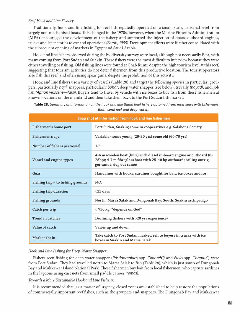
131131
Reef Hook and Line Fishery
Traditionally, hook and line fishing for reef fish reputedly operated on a small–scale, artisanal level from largely non-mechanised boats. This changed in the 1970s, however, when the Marine Fisheries Administration (MFA) encouraged the development of the fishery and supported the injection of boats, outboard engines, trucks and ice factories to expand operations (Farah, 1999). Development efforts were further consolidated with the subsequent opening of markets in Egypt and Saudi Arabia.
Hook and line fishers observed during the biodiversity survey were local, although not necessarily Beja, with many coming from Port Sudan and Suakin. These fishers were the most difficult to interview because they were either travelling or fishing. Old fishing lines were found at Chab Rumi, despite the high tourism level at this reef, suggesting that tourism activities do not deter fishermen from this productive location. The tourist operators also fish this reef, and often using spear guns, despite the prohibition of this activity.
Hook and line fishers use a variety of vessels (Table 28) and target the following species in particular: grou-pers, particularly najil; snappers, particularly bohar; deep water snapper (see below); trevally (bayad); and, job fish (Aprion viriscens—farsi). Buyers tend to travel by vehicle with ice boxes to buy fish from these fishermen at known locations on the mainland and then take them back to the Port Sudan fish market.
Table 28. Summary of information on the hook and line (hand line) fishery obtained from interviews with fishermen (both coral reef and deep water).
Snap shot of information from hook and line fishermen
Fishermen’s home port Port Sudan, Suakin; some in cooperatives e.g. Salabona Society
Fishermen’s age Variable - some young (20-30 yrs) some old (60-70 yrs)
Number of fishers per vessel 1-5
Vessel and engine types4-6 m wooden boat (huri) with diesel in-board engine or outboard (8-25hp); 4-7 m fibreglass boat with 25-40 hp outboard; sailing outrig-ger canoe; dug out canoe
Gear Hand lines with hooks, sardines bought for bait; ice boxes and ice
Fishing trip – to fishing grounds N/A
Fishing trip duration <15 days
Fishing grounds North: Marsa Salak and Dungonab Bay; South: Suakin archipelago
Catch per trip < 750 kg. “depends on God”
Trend in catches Declining (fishers with >20 yrs experience)
Value of catch Varies up and down
Market chain Take catch to Port Sudan market; sell to buyers in trucks with ice boxes in Suakin and Marsa Salak
Hook and Line Fishing for Deep-Water Snapper:
Fishers seen fishing for deep water snapper (Pristipomoides spp. (“kooreb”) and Etelis spp. (“hamur”) were from Port Sudan. They had travelled north to Marsa Salak to fish (Table 28), which is just south of Dungonab Bay and Mukkawar Island National Park. These fishermen buy bait from local fishermen, who capture sardines in the lagoons using cast nets from small paddle canoes (remas). Towards a More Sustainable Hook and Line Fishery:
It is recommended that, as a matter of urgency, closed zones are established to help restore the populations of commercially important reef fishes, such as the groupers and snappers. The Dungonab Bay and Mukkawar

132132
Island National Park provides an ideal management framework and legislation for these closed zones for Sudan’s northern coastline (Samoilys 2008). Closed zones within this large Park (~3,000km2) may suffice to provide ade-quate management protection for reef stocks on the northern coast. This would serve to seed the Marsa Salak area, where fishing pressure appeared to be high and thus, hopefully, help stocks recover in that area. Similar areas need to be considered in the Suakin archipelago, though enforcement there will be very difficult.
Another closed zone should be the globally renowned SCUBA diving site of Chab Rumi, since the fishing is depleting the fish that tourists wish to see. The two activities are not compatible and there are plenty of reefs that can remain open to fishermen. In addition, the tourist operators should be advised to set an example and not fish at their dive sites. Spearfishing, especially, should be immediately prohibited, as it is illegal by Sudanese law and conveys the wrong message to Sudanese crews, visitors and tourists onboard dive boats.
Closed zones should also be situated so that they protect the spawning aggregation sites of groupers and snappers. Both taxa are known to form large spawning aggregations that are highly predictable in space and time. Deliberate targeting of spawning aggregations of nagil species in DMNP began in about 1996 with the chance discovery of a spawning site near Mukkawwar Island. Fishing of spawning aggregations has since devel-oped into a regular fishing activity for some local communities, despite the strong economic and ecological disincentives (PERSGA, 2002).
There are two species of coral trout or najil (Plectropomus) in Sudan’s waters. The abundance of both was so low on the biodiversity survey that it is hard to imagine how they can sustain a proper fishery. The potential for having a productive fishery on coral trout is probably high from what we know about the biology of coral trout and the operation of such a fishery on Australia’s Great Barrier Reef. If properly managed, this could be an important and valuable fishery for Sudan. The preferred management of coral trout requires: areas permanently closed to fishing; protection of spawning aggregations; and, size limits. The first two options are very feasible in Sudan and should be supported by the tourism industry. Size limits can be relatively easily enforced at the export stage, when product is inspected.
Controlling the export of product is also highly recommended, as a way of limiting effort in this fishery and this does not require extensive enforcement. The export of coral trout (Plectropomus spp. – “najil”) to Saudi Arabia is currently closed by Saudi Arabia. This closure should be maintained by the Sudanese authorities and extended to all exports until stocks recover. The impacts of the closure should be monitored by underwater visual census (UVC) surveys (as done in the biodiversity survey) of these species, as they are highly amenable to this method (Samoilys and Carlos 2000). It is highly recommended that the MFA work closely with the fishers in the closures and the monitoring.Gill-Netting
Little information was obtained on this gear. Fishers tend to use this gear in conjunction with hand-lining to target different species at different locations, depending on the tides and time of day. For example, shallow bottom-set gill nets are used along the shoreline or on the reef flats as the tide goes out to capture mullet (“arabi”), emperor, sweetlips and snapper. Typical shoreline catches are 5kg per net per set. Surface set gill nets in deeper water are used to catch pelagics, such as Spanish mackerel and trevally. Bottom set gill nets in deeper water (~30m) are set at night. Some of these fishers target sharks (see section 2.7). The Port Sudan market survey suggested that nets of some sort must be used to catch the bump headed parrot fish, Bolbometapon muricatum (“hamar el bahr”) and unicorn fish (Naso unicornis), although it is not certain, at this point in time, which exact type of nets are used.Collection of Trochus (Mother of Pearl) - Export Fishery
The Trochus fishery has reputedly operated since the 1920s providing mother-of-pearl for the European but-ton market (Farah, 1999). This export fishery developed on a commercial scale in Sudan in the 1960s, and then declined dramatically in the 1980s and 1990s, reputedly due to overfishing (Farah 1999). Trochus and Pinctada species contribute over 90% of wild mollusc collection and are mostly exported to Europe as raw material for button manufacturing, cosmetics and inlay works (Saeed, 2004). Approximately 200-300 tonnes of Trochus shellfish are exported each year (UNEP, 2007). However, catch per unit effort and the total catch landed have fallen recently and there are strong signs that this is due to over-collection.
Average national exports of Trochus for 1980-1997 suggests a harvest of almost 300t/year (PERSGA, 2004). This places Sudan as the third largest producer of Trochus shells, behind the Solomon Islands at 578t/year and

133133
New Caledonia at 349t/year over the same period (ibid). Sudan is therefore by far the largest producer of Trochus outside the Pacific Ocean. The popularity of the fishery probably stems from the lack of fisheries infrastructure along most of the mainland, particularly the lack of ice-making facilities and cold storage.
Fishermen interviewed during the biodiversity survey were from Suakin and travelled at least 4 hours to the reefs around Sha’ab Anbar, where they collect the shells(Table 29). They live on board their wooden huri boat and typically do not fish for other species.
Table 29. Summary of information on the Trochus fishery obtained from interviews with fishermen.
Snap shot of information from Trochus fishermen
Fishermen’s home port Suakin
Fishermen’s age Mainly < 30yrs one ~70 yrs
Number of fishers per vessel 6
Vessel and engine Wooden 8m clinker built “huri”, diesel inboard, 2 tender boats - “rema”
Gear Hand collection; plastic drums to store shells
Fishing trip – to fishing grounds 4 hrs
Fishing trip duration 2-3 weeks
Fishing grounds Sha’ab Anbar, Suakin archipelago
Catch per trip N/A
Trend in catches Declining
Value of catch 1,350 SDP per 1 tonne
Market chain Basha factory in Port Sudan who process them and then export to Europe
No Trochus were counted in any of the 40 detailed survey sites of the biodiversity survey. Only one Trochus gastropod was seen in the entire survey - on a quick site at Sha’ab Anbar. Although the low numbers may be due to the fact that the habitat of this species (reef flat / reef crest) was not surveyed quantitatively, they more likely suggest that the fishery is overexploited and may have even collapsed (although the fishermen interviewed did not mention that it was no longer economically viable).
Collection of Sea Cucumber – Export Fishery
Sea cucumbers have been fished in Sudan for export to Singapore and Hong Kong since around the early 1980s (Farah 1999). This is a valuable global industry and, with the current rate of growth in the Chinese economy, the demand for sea cucumbers will continue to rise. There is therefore potential for a valuable export fishery, but also the collapse of such a fishery if it is not regulated and managed properly.
Sea cucumbers are collected from a depth of up to 60m from shallow reef areas. They are first cleaned to remove the intestines, then placed in a barrel of salt. Next, they are boiled for about one hour, before being sun dried.

134134
The following companies in Port Sudan were named as being involved in this industry: Aaid Company, El Ahmour, Al Batan, and Al Gelad. Al-Gelad’s headquarters is in Khartoum, but also has a branch in Port Sudan. These companies provide all the gear for the fishery (Table 30) and export the dried sea cucumbers to Asia.
Table 30. Summary of information on the sea cucumber fishery obtained from interviews with fishermen.
Snap shot of information from sea cucumber fishermen
Fishermen’s home port Port Sudan and Suakin; also divers from Tanzania and Egypt
Fishermen’s age Divers are < 40 yrs; > 50 yr olds maintain camp, dry cucumbers, usually in charge.
Number of fishers per operation 15-30; 4-6 divers per fibreglass boat
Vessel and engine per operation2-4 fibreglass 7 m boats with 25-30 hp outboard engines for diving; 1 huri with tender vessels for transporting dried product to Suakin/Port Sudan.
Gear per operationSCUBA gear: 40 - 100 tanks, 1-2 compressors; hand collection with net; boiling drums; mats for sun drying, sacks for transporting dried sea cucumbers
Fishing trip – distance travelled N/A
Fishing trip duration 1 month. ~8 months per year (due to weather)
Fishing grounds
Fish all reefs from Port Sudan to Suakin archipelago except Towar-itit and Bashair oil terminal where fishing is prohibited. In Suakin archipelago they fish from camps on islands: Salada Kebir, Talla Talla Kebir, Talla Talla Segir, Harorayeat
Catch per trip (1 month) 1993 – 26,000 individuals on snorkel 2007 – 6-7,000 individuals on SCUBA
Trend in catches Severe decline –hard to find and most fishers are diving to >40m to find them
Value of catch 4-7 SDP per individual
Market chainBuyers/companies in Suakin, Port Sudan, Khartoum and Egypt; exported to Asia.I buyer exports 2-3,000 t/month to Hong Kong
The biodiversity survey found populations of sea cucumbers to be severely depleted. Densities were 10 times lower in Sudan than those on fished reefs elsewhere in East Africa and around 100 times lower than those on unfished reefs in East Africa (Muthiga and Ndirangu 2000, Othina and Samoilys 2005). A fisherman, who has fished sea cucumbers since the 1970s, said in an interview that he had seen a large drop in catch rate over the years and he estimated that catches are around 25% of what they used to be in the early 1990s. He mentioned that sea cucumbers were collected by snorkel in the 1990s but now SCUBA gear was used (Table 31). Such declines in figures suggest severe overfishing. The very low species diversity (only 8 total species were identified) suggests that some species may have been fished out.
Towards a More Sustainable Sea Cucumber Fishery:
As previously mentioned, the biodiversity survey and the figures on catch per unit of effort indicate that Sudan’s sea cucumber population densities are at critically low levels. Sea cucumbers are a valuable resource and if Sudan is to retain their sea cucumber populations for future generations and as a valuable export fishery it is highly recommended that a moratorium is placed on this fishery. It should be closed until stocks recover. In the meantime, Sudan could explore mariculture of the high value Holothuria scabra sea cucumber,

135135
which is now increasingly understood and possible (Conand and Muthiga 2007). There are several manage-ment groups and networks for sea cucumbers and it is recommended that the RSS’s MFA and the ICZM Office join these groups to be part of a growing regional expertise in the management of these valuable fisheries.
Table 31. Species list of sea cucumbers observed at fishing camps; average density counted for each commercial fishery group during the biodiversity survey; fishery value categories assigned during biodiversity survey and interviews,
and prices. Densities from biodiversity survey (medium and low value species were combined). 1 SDP = ~ 0.5USD.
Species observed at fishing camps
ArabicPrice per
individualFishery value
Average density individuals/100m2
Holothuria scabra abushutur7 SDP
High0.025
H. nobilis abushutur
Actinopyga mauritania abushereira4 SDP
Medium
0.019
Thelenota ananas abushok Medium
H. atra abusonoun
N/A
Low
H. edulis abudam Low
A. miliaris abukaboub Low
H. parva abukaboub Low
There are also serious health hazards within this fishery from SCUBA diving. Fishers receive no training and no dive computers or dive tables are used. Fishers dive regularly to 40m and more, and deaths have been reported. An immediate measure would be to prohibit collection using SCUBA, a regulation that has been introduced in other countries (e.g. Kenya) to prevent overfishing, as it protects deeper populations that can then re-seed the shallow areas. The inaccessible deep areas function as closed zones, where breeding stocks are protected. If the fishery is opened up later and SCUBA is allowed it is essential that it be regulated for health and safety; investors/companies being required to provide SCUBA training to their divers.
Collection of Molluscs
Lambis and Strombus gastropods are exploited for their opercula (dh’ufra), which are used to make perfume (khumbra). The meat is also eaten after boiling. No mollusc fishermen were found during the survey, so the information on this fishery is based on observations of discarded shells, informal discussions with the crew and Sudanese colleagues, and from village interviews conducted by other experts in Dungonab and Moham-med Qol in Dungonab Bay and Mukkawar island National Park (Harrison, 2007)41.
Both men and women collect mollusc shells, although women have the responsibility of making the per-fume. Some of the perfume is kept for use by the women and their husbands; the rest they sell, including via export to Yemen and Somalia (Harrison 2007). Two types of perfume are typically made—one for men and one for women. Around 2,000 shells are needed to make 0.5kg of perfume, which is considerably expensive and, as a result, has exerted high fishing pressure on these animals (Farah 1999). Although the fishery has reputedly operated for centuries, fishing and exploitation of marine life is not an ancient cultural activity of the Beja coastal people. They only became engaged in the activities around the 1940s (Pantuliano 2002). Therefore, the exact origin of the fishery in Sudan and the historical actors remain to be understood.
41 Paul Harrison was contracted by African Parks Foundation in 2007 to conduct assessments of sustainable livelihood alternatives for communities residing in DMNP, as well as of opportunities for village environmental management plans.

136136
Large middens were seen in several places on the mainland (e.g. Marsa Salak) and on the islands in the Suakin archipelago. For instance, there were several middens on the small peninsula at Marsa Salak, which is a well used fisher camp with good road access. The predominant shells in the middens are Lambis and Strombus (80%) with some Murex gastropod shells, turtle bones and Tridacna clams among them. Possibly, the fish buyers, who drive up from Port Sudan to buy fish from hook-and-line fishermen operating in the area, may also buy the mollusc opercula for the perfume industry. Middens were also seen throughout Dun-gonab Bay and Mukkawar Island National Park in 2006 (Samoilys pers. obs.). An enormous midden of Lambis and Strombus shells was discovered at Marsa Suakin South on the reef flat; it was so large it looked like an island from a distance. Presumably, this location represented a favoured site for cleaning the molluscs to extract the meat and opercula and has been used over decades of fishing for these molluscs in the area.
The very low densities of Lambis and Strombus in the biodiversity survey—almost 30 times lower than densities of these species recorded elsewhere in East Africa (Othina and Samoilys 2005)—would suggest that this traditional fishery has been seriously over-exploited.
i) Towards a More Sustainable Mollusc Fishery: Population levels of Lambis and Strombus gastropods, as measured on the biodiversity survey, suggest these species are heavily overexploited for the perfume industry. We would recommend that areas be closed to shell collecting in cooperation with local fishers to help populations recover. Dungonab Bay and Mukkawar Island and the two villages Mohammed Qol and Dungonab would be an ideal place to trial this management approach (see Harrison and Samoilys 2007). The impacts of the closures should be monitored to assess population recovery by conducting abundance surveys of the molluscs. This monitoring should be done with local fishers to engage them in the management of the fishery. However, alternatives will need to be offered to local men and women collecting these shells, as this may be their only source of livelihood.
Trawling for Prawns and Lizard Fish
At the time of the survey two large (~20-30m) bottom trawlers from Egypt were licensed to fish in the Suakin archipelago area, though the permit from the MFA was for 20 days only. The fishermen on board, also hire fibreglass boats with outboard engines from the MFA. With these vessels, fishers are able to fish around the reefs and islands by hand-line and gill net. An Egyptian fisherman was interviewed, and provided information about the trawling activity (Table 32).
Table 32. Species taken by Egyptian trawlers. Non trawl gear represents catches from fibreglass boats.
Arabic English Fishing gear
MacaronaGamberiBarbuni???CabouriaBayad abiyat
Lizard fishPrawnsGoat fishSlipper lobsterSquidCuttlefishCrabsWhite trevally
Trawl
Mugil or arabiGusherNajilAgamBayad??
MulletGrouperCoral troutSmall barracudaTrevally
Mixed pelagics – tuna, Spanish mackerel, barracuda
Set shoreline gillnetHand lineLong line with single hooks""Trolling
Mullet are highly sought after by the Egyptians. They are salted in large blue containers and taken back to Egypt. This final product is called farsirh.

137137
Apparently the trawl fishery is set to expand with 20 new licenses to be issued to Egyptian owners. There appeared to be no regulation of the fishery—for example, no enforced closed seasons or areas42, and it was not clear that any stock assessment had been done on the two target species: lizard fish (Saurida spp.) and prawns.
Minimising Trawling Impact:
It is recommended that Regulations that include a closed season and closed zones are introduced for the trawl fishery, and that stock assessment research is conducted on both the target species (prawns and lizard fish). The fishery also needs to be carefully controlled so that it does not conflict with other users, such as local fishers and the marine parks. The MFA should re-consider the renting of fibreglass boats for reef fishing to trawling vessels, as this directly competes with Sudanese fishers and several of the species taken in the hand-line reef fisheries are already overexploited, particularly the najil grouper.
ERDP trained the staff of the Marine Fishery Administration and the fishermen on two more fishing tech-niques. Namely the bottom set long line and the drop line/wooden hand reel techniques. ERDP contracted a carpenter to produce 20 hand reels which were distributed to 10 fishermen groups after being trained on their use.
Also ERDP trained the staff of the MFA and the fishermen on the use of the fish finders tools and procured 100 pieces which were handed over to the MFA who provides them to the fishermen on loan bases during their fishing trips. 70 pieces of GPSs were procured by ERDP and handed over to the MFA to provide them to the fishermen during their fishing trips similar to the fish finders. This action certainly contributed to incrise the socioeconomic resilience of the local fisherman and at this stage we could only assume that the project also included the support of sustainable fishing practices.
3.2.3.5 OPPORTUNITIES FOR SUSTAINABLE FISHERIES DEVELOPMENT
Opportunities for Fisheries Development within the Marine Parks:
Residents within DMNP are almost entirely dependent upon extractive resource uses within the Park, with fishing forming their major source of sustenance.43 Currently, fishing is not viewed as a significantly profitable source of income within this sector, mainly due to the difficulty for fishers’ difficulty in trans-porting their catches to Port Sudan. Although most activities are artisanal on a self-employed basis, there is substantial scope for the development of controlled sustainable fisheries in DMNP. This would result in increased income-generating opportunities for poverty-stricken coastal communities within the Park.
Although little, known fishing activity takes place within SMNP, largely because few fishermen are willing to venture out as far as the Atoll, there is potential for the development of a sustainable fishery industry in the Park (particularly purse-seine fisheries). This will become particularly prudent as fish stocks begin to dwindle closer to shore. Any fishery activities, however, must be implemented and managed using an eco-system-approach and strong enforcement measures. If sustainably managed, fisheries development within MPAs can be a valuable economic opportunity for local communities and, as activities take place within a controlled environment, environmental safeguards are more likely to be respected.
42 As mentioned elsewhere in this section, DMNP and SMNP are technically off-limits to fishing activity (except for subsistence level fishing in DMNP by resident communities). However, as enforcement is lacking in RSS for fisheries, it is not certain whether these trawlers abide by the restrictions or not. Greater research into this would therefore be prudent.
43 A 2002 survey in DMNP revealed that approximately 40 people are full-time fishermen in Mohammed Qol village, although others take part in fisheries on a part-time, seasonal or casual basis. About 30 people are full-time fisher-men in Dungonab Village.

138138
Opportunities for Developing a Lobster Fishery:
The highly valuable tropical lobster is probably unexploited in Sudan, as there is no tradition for eating these animals and there is no export fishery. This is, therefore, a potential fishery for development. Care must be taken to establish input and output controls so that the fishery is developed and managed sustainably. There are plenty of examples to learn from, both in the region (for example in Somalia and Kenya where the fishery has been overexploited) and elsewhere in the world (such as in Western Australia, where the fishery is strongly controlled and has been awarded Marine Stewardship Council certification).
Plate 21 . Fishermen targeting Sea Cucumbers interviewed during the ICZM survey in 2007.
Plate 22 . Traditional small fishing boat entering Suakin.

139139
3.2.4 Toward Sustainable Tourism in RSSRelated to IOC Handbook Indicators SE 1 & SE 2.
The tourism industry is amongst the fastest growing sectors of the global economy44 and tourism to the Red Sea State of Sudan is expected to increase substantially in the future. An improving political situation in Sudan, a more attractive investor climate and the increasing development taking place will all work to make the Sudanese coastline more attractive and accessible to the wider foreign and local public.
As a former Minister of Tourism and a previous Chairman of the Hilton management group (a joint ven-ture among the Sudanese Government, a private Kuwaiti company and the Hilton Hotel), the current State Governor is viewing tourism development in RSS as a top priority (Mr. Bakhiet Yousif, Human Resources and Duty Manager, pers. comm. with L. Salm, Dec. 2007). The Governor is actively working to improve tourism in the Red Sea State, largely by taking the Egyptian Red Sea tourism experience as a model (i.e. resort style mass tourism development) (ibid).
Increasing examples from around the world point to the fact that traditional, exploitative forms of mass tourism often result in short-lived benefits, and can incur considerable costs due to the environmental and social impacts caused. Responsibly-designed tourism development, on-the-other-hand, can offer opportuni-ties to align poverty-alleviation and socioeconomic alternatives with a sustainable development framework that respects long-term preservation of natural resources.
Furthermore, it is likely that mass tourism destinations will lose their profitability in the long-run, as the negative environmental, social and cultural impacts of the unsustainable industry become increasingly pronounced. Resort-style destinations are already losing favour among tour operators, host countries and tourists themselves.45 Instead, a growing market is developing for sustainable tourism alternatives - alter-natives that consciously avoid impacts and that maximise long-term environmental, social and economic benefits in destination countries.
The over-arching intention for this tourism section of the ICZM Survey report is to serve as a guidance reference to help encourage RSS tourism actors to consider sustainability in their tourism development planning, and to equip them with ideas and tools to proceed in this regard. In turn, this will better enable RSS tourism to transfer long-term benefits to RSS populations while simultaneously safe-guarding the rich marine-coastal environment upon which the success of any form of tourism in the State will ultimately depend. This section will therefore provide justification for sustainable approaches according to global trends; describe the current RSS tourism context; outline positive and negative case studies of tourism operations from around the world (which can serve as instructive examples of the potential and pitfalls of different tourism approaches); and, posit a way-forward for sustainable tourism development in RSS, including dis-cussions of carrying-capacity, potential RSS pilot sites for initial activities and improving hotel best practice.
44 Approximately 1.6 million annual travellers are anticipated by 2020 (http://www.kitf.kz/en/2007/news_items/world-tourism-facts-and-figures/). According to the World Travel and Tourism Council, tourism and tourism-related industries accounted in 2006 for approximately 8.3% of global jobs, 9.3% of international investments, 12% of exports, and 3.6% of world GDP, with tourists contributing approximately 10.2% of the total world consumer expense (bid). In the year 2000, tourism accounted for about 11% of the global export of commodities and services, surpassing the trade volume of international foodstuffs, textiles and chemicals (ibid). Notable increases in tourism to the Middle East, Africa (8.1% growth) and Asia have also been observed during recent years (ibid).
45 Studies have shown that many tourists are increasingly designing their travels based on the quality and pristine nature of the environmental surroundings—the vast majority of them choosing trips that have the least impact on local ecosystems. The majority of all tourists surveyed in the U.S and Europe in 2005, for example, felt that pristine environmental conditions constituted a key attraction and element to their choice of destination, and that their travel experiences were best with well-preserved natural, cultural and historical sites (Chafe & Honey, 2005). Similarly, social responsibility serves as another key consideration for many tourists.
140140
3.2.4.1 SUSTAINABLE TOURISM TYPES AND TRENDS:
The definition of mass and sustainable tourism can be summarised as:
Mass tourism: Traditional, large-scale tourism. This type of tourism generally refers to an industry domi-nated by big (foreign) tourist conglomerates and transnational corporations, where the services they provide differ little from one country to the next, where there is little interaction with local communities and where respect for the environment and cultures is not of great importance to the tourism business operators. (http://www.ecoturismolatino.com/eng/ecotravellers/alternative/articles).
Sustainable tourism: Requires the informed participation of all relevant stakeholders, as well as strong political leadership to ensure wide participation and consensus-building. Achieving sustainable tourism requires constant monitoring of impacts, introducing necessary preventative and/or corrective measures whenever necessary. (World Tourism Organisation, 2004). Sustainable tourism implies “meeting the needs of the present without compromising the ability of future generations to meet their own needs.” (World Commission on Environment and Development, 1987).
Sustainable tourism can take many forms, from small-scale wilderness excursions, to traditional tourism styles that are distinguished by more environmentally and socially friendly practices and guiding philoso-phies. More specifically, the various categories and subcategories can be defined as follows:
• Responsible Tourism: Minimises negative economic, environmental and social impacts; generates greater economic benefits for local people and enhances the well-being of host communities; involves local people in decisions that affect their lives and life chances; makes positive contributions to the conser-vation of natural and cultural heritage embracing diversity; provides enjoyable experiences for tourists through meaningful connections with local people, and a greater understanding of local cultural, social and environmental issues; and, is culturally sensitive, encourages respect between tourists and host, and builds local pride and confidence (Cape Town Declaration on Responsible Tourist in Destinations, 2002).
• Ecotourism: Responsible tourism to natural areas that conserves the environment and improves the well-being of local people. Some important principles of ecotourism include: minimisation of impact (both environmental and cultural); building environmental and cultural awareness and respect; and, providing direct financial benefits for conservation, as well as income and empowerment of local people (TIES, 1990).
• Nature-based Tourism: A form of responsible tourism that helps conserve the natural environment of a destination while also contributing to the welfare of local communities. Furthermore, nature-based tourism provides incentives for local communities and landowners to conserve their natural areas and habitats - the very resources upon which the industry depends (http://www.tpwd.state.tx.us/landwater/land/programs/tourism/: Texas Parks and Wildlife Department; “What is Nature Tourism?”)
• Community Tourism: A subsector of ecotourism, which elaborates on the social dimension of the industry by requiring that local communities have substantial control over, and involvement in, the development and management of tourism in their area, and also, by ensuring that a significant proportion of benefits generated from tourism remains within the community (WWF Community Tourism Guidelines, 2001).
Countries and tourism businesses therefore have an increasingly varied degree of choice when it comes to offering a tourism product. As the sustainable tourism market grows and the more exploitative conventional approaches receive greater scrutiny, countries and companies on the cusp of tourism investment (such as Sudan) must think strategically for the longer-term by prioritising sustainable approaches that cater to this growing market. Otherwise, operations may risk falling off the tourism map before significant profits even take effect in the first place.
Studies have shown that a majority of tourists to certain destinations are interested in social, cultural and environmental issues (Chafe & Honey, 2005). A 2005 global tourism survey found that more than three-quar-ters of American tourists ‘feel it is important not to damage the environment’ and that about 17 million U.S tourists factor in the extent of environmental protection when they plan their holidays (ibid). Similarly, 87% of travellers surveyed in Britain in 2002 considered it ‘very’ or ‘fairly important’ that their holiday not

141141
damage the environment, with 69% having booked their last trip specifically so that it would cause the least possible impact to the environment (ibid).
A study conducted by leading environmental economic valuation experts from around the world on the recreational value of coral reefs found that many visitors prefer to have an ‘unfettered and uncrowded expe-rience of the marine environment’ (Brander, Van Beukering & Cesar (2006). The Recreational Value of Coral Reefs: A Meta-Analysis. Ecological Economics 63 (2007) 209-218), meaning that they were not looking for a mass tourism holiday, but rather a lower-key and more intimate experience with their environs.
In terms of social responsibility, over three quarters (76%) of British tourists, surveyed in 2002, felt it was important that their travels benefit local communities and populations and were often willing to pay more for companies, tour operators and hotels that are more socially-concerned.
Travellers are not the only ones, however, choosing to support sustainable practices. Many tour opera-tors themselves are designing responsible policies, recognising that environmental and socially responsible practices are not only a profitable marketing tactic for their operations, but that low-impact practices are essential for long-term business operations (Chafe & Honey, 2005). Many businesses have found they are at a competitive advantage over their conventional counterparts when advertising responsible tourism - for example, most British operators (small, medium and large) surveyed during a 2000 national tourism sur-vey agreed that tourists ‘nearly every time’ base their decisions on which operator to use according to the company’s sustainability record and responsible practices (ibid). For example tourists often give preference to stay at hotels and use tour operators that have environmental policies and are involved in local social and environmental stewardship campaigns (ibid).
Willingness to Pay for Responsible Alternatives: A 2005 tourism study found that at least one third of trav-ellers surveyed were willing to pay more for holidays that safeguard/benefit local communities and that don’t impact the environment (Chafe & Honey, 2005). In 1998, British tourists spent about £2 billion (USD$4 billion) on trips to developing countries, which was roughly equivalent to the British government’s annual aid budget during that time (ibid).
A survey of U.S, Australian and British tourists found that 70% of those surveyed would pay up to USD $150 more for a two-week stay in hotels with a more responsible ‘environmental attitude’ (Chafe & Honey, 2005). Half of British travellers were willing to pay more for their trip, as long as the money was guaran-teed to be dedicated to preserving the local environment and trying to reduce/reverse negative side-effects of unsustainable tourism (ibid). Almost all Italian tourists surveyed (93.7%) thought that accommodation should adopt environmental protection measures, and a majority of Dutch travellers (73%) said they would use information on environmental responsibility to help determine their choices of hotels/accommodation. (The possibility for encouraging the Mercure Hotel in Port Sudan to adopt more sustainable policies is further out-lined below).
Many travellers are also willing to pay more for tours that aim to protect historical and cultural aspects of the destination; some studies reveal that tourists are willing to pay four to six times the entrance fee for areas that benefit local communities, protect the environment and increase tourism information (Chafe & Honey, 2005).
Park entrance fees have proven effective in MPAs around the world as an important source of revenue for helping to finance Park management; in many cases this has enabled Parks to become self-financing (Wielgus, Chadwick-Furman, Zeitouni & Shechter (2003). Effects of Coral Reef Attribute Damage on Recreational Welfare. Marine Resource Economics, Vol. 18, pp. 225-237. Marine Resources Foundation: USA). Self-financing can help secure the continued sustainable management of the Parks.
Calculations produced in the UK reveal that, between 1999 and 2000, the ‘ethical consumption market’ increased 15% and consumer purchases increased 18.2% when ‘ethical alternatives’ existed in the market (Chafe & Honey, 2005). Ethical investment is similarly increasing at a remarkable 20% per year (ibid).
Based on the increasing ethical consumption market and Sudan’s rich marine and coastal areas, there is great scope to design an RSS tourism plan around sustainability principles and to find investors that recog-nise the benefits of this approach.

142142
3.2.4.2 THE RSS TOURISM CONTEXT, CONSIDERATIONS AND OPPORTUNITIES
Accurate tourism information and statistics are hard to come by for RSS, as few tourism-specific studies have been previously conducted in the State. The most recent tourism figures available to the public were compiled in 2001 for the time period 1987-2000, and are useful in providing a point of comparison for future estimations as well as for highlighting general tourism trends46:
Table 33. Tourism Figures for RSS – 1987-2000.
Month 1987 1995 1999 2000 Average Standard Deviation
January 28 51 47 65 47.75 15.26
February 89 117 121 138 116.25 20.32
March 112 96 103 184 123.75 40.70
April 62 60 93 90 76.25 17.67
May -- -- -- -- --
June -- -- -- -- --
July -- -- -- -- --
August -- -- -- -- --
September -- 46 51 47 48 2.65
October 39 65 66 83 63 18.15
November 54 78 85 112 82 23.87
December 41 53 49 59 51 7.55
TOTAL 425 566 615 778
Source: SMNP Site Specific Master Plan with Management Guidelines, 2004
The above figures (Table 33) reveal strong seasonal patterns, with the peak tourism season lasting from February through March, but with zero visitors during the hot summer months. This is confirmed by inter-views with dive operators based in Port Sudan. Furthermore, the winter months (and especially the Eid holidays) see increases in local tourism, mainly from Khartoum (Mr. Bakhiet Yousif, Hilton/Mercure Human Resources and Duty Manager, pers. comm. with L. Salm, Dec. 2007).
General tourism trends in Sudan similarly show dramatic increases in tourist numbers and revenue in a relatively short period of time. Table 34 below summarises these national trends.
Table 34. Visitor numbers and revenue generated by the Sudanese tourism industry during the 2000-2006 time period.
Revenue (in US$ million) Number of Tourists Year
29.9 37,609 200060.0 50,000 200161.8 51,500 200262.7 52,291 200368.3 60,566 2004
316.4 245,797 2005409.3 328,156 2006
Source: Ministry of Tourism and National Heritage, Dept of Statistics and Information
46 These figures represent numbers of visitors arriving in Port Sudan via air, and therefore do not reflect the boat-based tourism (normally arriving from Egypt or Saudi Arabia).

143143
Of the major States in Northern Sudan, the following table shows how the Red Sea State has the second greatest number of hotel rooms after Khartoum (2006 figures). This can suggest that RSS is likely the sec-ond-most frequently visited area in Northern Sudan.
Table 35. Number of Hotels and Rooms in Northern Sudanese States in 2006.
State No. of Rooms No. of Hotels
Khartoum 1,792 37Red Sea State 316 7Northern State 30 2Blue Nile N.A. 2Kassala 166 7El Gadaref 86 2El Gezira 246 7
Source: Ministry of Tourism and National Heritage, Dept of Statistics and Information
The fact that tourism in Sudan is increasing rapidly and that RSS is likely the second most popular desti-nation in Northern Sudan, indicates that sustainable tourism infrastructure development planning should be pursued as a matter of priority to better maintain the integrity of RSS’s natural, cultural and social assets. A needed first step would be creating a clearly defined institutional and legal framework for tourism, as well as a mechanism for collaboration amongst the various ministries with a stake in tourism development. Once a sustainable strategy has been developed, effective marketing will be important to attract visitors and help realise the potential benefits of the tourism industry. Mr. Bakhiet Yousif (Human Resources and Duty Man-ager for the Hilton/Mercure) believes that the lack of a given organisation in charge of promoting tourism is partly to blame for the low levels of foreign tourism (Mr. Bakhiet Yousif, pers. comm.).
Mr. Yousif also revealed that there is currently little eco-tourism thinking amongst Sudanese, mainly because the Sudanese are generally not well-educated in tourism, much less in sustainable practices. What tourism actors are most exposed to are the more conventional resort-style/large hotel tourism models oper-ating in Sudan or in neighbouring countries. The Hilton (which has had a long presence in Sudan but which does not have a history of particularly sustainable practices) has therefore served as a primary model hotel for the country’s tourism development (Mr. Yousif, pers. comm.).
Infrastructure and Hotels in the Red Sea State:
According to the Ministry of Environment and Tourism (MoET), a total of seven hotels exist in Port Sudan, with the largest being the five-star Mercure Hotel (formerly the Hilton Hotel until management was transferred to the Accor Group in January 2008).
The Hilton/Mercure/Coral has had a three-and-a-half-year presence in Port Sudan and has catered pri-marily to foreign visitors. Other smaller hotels in Port Sudan (such as the four-star Palace Basheer Hotel and the Al-Maysara Hotel) are locally-owned and cater primarily to the local/domestic tourism industry for over-night stays, as well as to the expatriate community for restaurant options in Port Sudan. Neither the Hilton nor the Mercure had/have policies to promote local involvement or to give back to the community; nor do they have well-developed environmental policies.
Apart from these hotels in Port Sudan, other tourism operations in RSS catering to the foreign mar-ket include the four-star Arous Village Resort, approximately 50km north of Port Sudan and the Red Sea Camp Resort, which is the first eco-camp lodge in the State and located about 30 km north of Port Sudan. An in-land hotel in the Red Sea Hill area of Arkawit caters to local tourists, especially during the summer months for those escaping the heat of the coastal zone.
Arous, which is the first of its kind in the Red Sea State, is situated on 50 acres and has a 60-person, 15-bungalow capacity. It offers a variety of water-sports, from diving and snorkelling, to jet-skiing, boat trips, underwater photography opportunities and exploration of underwater cultural sits, such as the Umbria shipwreck and the Sanganeb Lighthouse. Arous also offers terrestrial-based activities, including quad-biking and visits to important cultural and natural sites (www.arousresort.com).

144144
The Red Sea Camp Resort is built on coral rock facing the sea, with the Red Sea Hills as a backdrop. Accom-modation is provided in luxury-style, Bedouin tents and has a 20-person capacity. The Camp also houses the Sudan Divers’ company (which is the only dive company currently operating in Sudan) and offers a variety of other activities and water-sports. The on-site restaurant caters Sudanese, Middle Eastern and European vegetarian cuisine. Average price/night is US $85, all year-round (www.tripadvisor.com).
The RSS Wali (Governor) has done much to improve Port Sudan, such as developing the Corniche and encouraging shops to open to sell beverages, food, etc. Such activities ultimately help to attract tourism in the area. Furthermore, the new coastal road running from Port Sudan to Egypt’s southern border will facilitate access to the Red Sea State’s northern areas, making tourism operations much more viable for both local and foreign tourists. The Red Sea Camp Resort, for example, has already seen improvements following the road’s construction.
Live-Aboard Boat Dive Operators:
The majority of the international tourism in the RSS revolves around the dive industry and the live-aboard dive boats. The number of live-aboard dive vessels operating out of Port Sudan has increased from 8 vessels in 2000 to 13 vessels in 2014. There are 8 European-owned boats permanently stationed in Sudan and 7 Egyptian boats that visit Sudan on a weekly basis throughout the diving season. The boats have an average total capacity of between ~115 and ~110 dive clients per week, respectively, with a total capacity of ~225 clients per week. These dive boats collectively have the capacity to receive between 8000-9,000 tourists per annum in Sudan. The cost for each client is between USD 1600 and USD 2500 per week, and the total gross estimated income is USD 15-17 million per annum. These figures do not account for other occasional foreign, live-aboard dive vessels that also visit Sudanese waters from the Mediterranean and Egypt.
Tourist live-aboard dive boats primarily visit places close to Port Sudan, including Sanganeb Marine National Park and the famed Shaab Rumi. Diving within Dungonab and Mukkawar Island Marine National Park, often focuses on offshore dive sites such as Angarosh on the reserve boundary as there are limited facilities on land. The dive tourism season in RSS extends from the end of September to June. The dive boats typically visit the manta ray aggregation at Mesharifa within Dungonab Bay Marine Park (DMNP) between September and November. Compiled survey and observation data and initial satellite tagging data, however, confirm the manta rays are present year round.
The prime months for viewing sharks on the offshore reefs are between February and May. The summer months (June-August) are too hot for tourism; even many local RSS residents temporarily move to cooler areas in Sudan to escape the heat during these months. Most dive tourism clients come from Europe, particu-larly England, Germany, Austria, Italy, France and Spain, but also increasingly from Eastern Europe (such as Estonia, and Russia). The vast majority of tourists are ‘fanatical divers’, while many are avid photographers. Another important recent development is a new weekly direct flight route between Dubai and Port Sudan. This flight, operated by a new airline FlyDubai, provides an extremely reliable and simplified travel route for internationals to directly fly into Port Sudan (avoiding the previously required transit through Khartoum). This has also led to the emergence of a new type of regional tourism, mostly composed of foreign expatriates and permanent resident from the Emirates, whowish to have an authentic Red Sea experience.
A major down-side of the RSS dive tourism is that the industry generally has very little interaction with local communities and contributes little to the local economy (mainly because it is boat-based and interna-tionally-organised). Claudio Aigo discussed how dive businesses have explored having their clients stay in resorts and hotels in RSS. However, this has not worked due to a variety of factors, which together decrease the quality of stays in RSS and accordingly do not meet the expectations of high-paying dive customers. These factors include ‘no alcoholic drinks’, a lack of ‘good staff to manage’ and many ‘logistical problems’, including issues relating to electricity and water (Claudio Aigo, email comm.).
The tourism facilities and infrastructure in RSS should therefore be improved if the State first wishes to meet the standards expected by high-paying visitors and second, to maximise its profits to the local econ-omy. Such improvements, however, should be designed and marketed according to sustainable/ecotourism models, where visitors can receive a degree of intimacy with local environments and communities while participating in holidays that have the least possible impact on the assets to which tourists are attracted in the first place. So as to ensure provisions and safeguards are adequately in place before rapid tourism expansion irreversibly impacts the integrity of these areas, management officials for the MPAs in RSS, as a

145145
matter of priority, should consider developing a sustainable tourism strategy specifically for the Parks, but which should feed into a similar strategy for the RSS at large. Similarly, a tourism strategy with predictions for potential tourism revenues could help argue against the development of other high-impact industries in the area (such as oil extraction operations, as are currently being explored).
The following figure indicates the level and degree of taxes and fees paid by dive boat operators for their tourism businesses in RSS:
Figure 7 . Taxes and fees incurred by the Government for dive boat operations in RSS.
Tourism and the MPAs:
The Parks and surrounding areas have huge potential for the development of sustainable and high-value marine ecotourism. Some of the dive sites surveyed in both 2002 and 2006 were identified as among the very best in the region (African Parks Foundation, 2006, Sudan Marine Parks Survey Expedition: Survey Report).
Tourism is currently by far the most important direct use of SMNP’s resources (and serves as the largest potential source of income for the Park). It could become equally important in DMNP, after the necessary infrastructure and management requirements are put in place. Tourism in the Parks has the potential to significantly contribute to the financing and long-term maintenance of these protected areas.
Tourism is still very underdeveloped in Sudan. As most tourism that does visit the Sudanese Red Sea comes via foreign live-aboard boats, there are no formal visitor facilities at either of the Parks. The lighthouse at SMNP, for example, has the capacity to house a visitor centre. African Parks was seeking strengthened collaboration with the Sea Ports Authority to enable this development in the near future. African Parks had also constructed a permanent compound building at DMNP to facilitate a more permanent Management presence within the boundaries of the Park. The architectural design of this facility also includes a visitor centre on the premises.
In Costa Rica, for example, over 85% of tourists felt that national parks and protected areas are the most important places to visit in the country (Honey & Chafe). Furthermore, many tourists support controlled access and careful regulation of visitation to national parks and protected areas, in order to ensure they do not exceed carrying capacity and are destroyed as a result. Tourism to SMNP and DMNP should, therefore, only be allowed once the Parks have the capacity to handle increased visitors (including mooring buoys for dive boats) and following the determination of carrying capacity for the sites.

146146
Tourism Impacts and Threats in RSS:
So far, impacts from tourism are minimal, given the current low-numbers of visitors to the Sudanese Red Sea. However, tourism numbers are increasing, which inevitably brings increased risk and the need for better planning. Potential risk from tourism (and other development) is especially high given that marine ecosystems (primarily coral reefs) are highly fragile and vulnerable to even small changes in environmental quality. Furthermore, as pristine coral reefs and the ecosystems they support represent the primary attrac-tions for tourism to RSS, the success of the industry will ultimately rest on the long-term health of these natural assets.
Red Sea coral reefs are a high-value resource to the region largely because they attract a high number of European tourists seeking dive adventures, provide commercially important fish that are served by local hotels and restaurants and help to protect and consolidate the desert shorelines and property from sea-orig-inating storms (Bryant, Burke, McManus & Spalding (1998). Reefs at Risk: A Map-Based Indicator of Threats to the World’s Coral Reefs. World Resources Institute). According to a study assessing the degree of risk to coral reefs around the world, about 60% of reefs found in the Middle Eastern region are considered at risk due to coastal development, overfishing, oil spill vulnerability and rapid tourism expansion without consideration for the carrying-capacity of sites (Bryant et al., 1998). Such disregard for environmental considerations will result in high costs in the long-run, if the environmental services of the Red Sea are rapidly and irreversibly depleted due to weak planning and management.
A major issue that will seriously jeopardise the integrity of marine/coastal ecosystems, as well as the sustainability of a tourism trade in RSS, is the inadequate regulatory framework for the industry. The lack of meaningful tourism-related legislation and monitoring activities means that, currently, the tourism industry in RSS does not have an officially-endorsed design to guide investment, planning, development, manage-ment, monitoring and consideration for environmental sustainability. While minimal at present, damage from divers and souvenir collectors is already evident on certain areas of coral reef, especially those most frequented such as Chab Rumi. Such evidence includes visible anchor damage, garbage and coral breakage. Local recreational use has impacted coastal vegetation, which threatens coastal dune stability and damage from off-road vehicles is also evident (PEMSEA, 2008). Without awareness programmes and the imposition of regulatory systems to mitigate such impact (such as penalties and fines), misuse will only continue and increase in the future as more visitors come to RSS and as the Port Sudan-Egypt coastal road facilitates greater access to RSS’s northern coasts.
While current tourism investment is limited in the Red Sea State, there are, apparently, a number of companies (mostly on the Arabian Peninsula) negotiating for mass tourism-style investment opportunities in the near future (Mr. Bakhiet Yousif, Hilton Human Resources and Duty Manager, pers. comm. with L. Salm, Dec. 2008). Such development would severely impact the environment, as well as RSS communities, if effective regulatory mechanisms, impact assessments and alternative, more sustainable options are not sufficiently explored beforehand.
Finally, increases in inland development activities in RSS will pose greater risks to the integrity of the marine/coastal ecosystems, as chemical run-off, waste, sedimentation and other threats eventually make their way to (or get dumped directly in) the sea. Roughly 22% of the world’s coral reefs are currently under medium to high risk from land-based sources of pollution (Wielgus et al, 2003). The connection between inland operations and coastal/marine environmental health should therefore be considered in proposed tourism (and other) development proposals, with EIAs being enforced to minimise threat.
Tourism development should be designed and integrated within an overall economic development strat-egy for RSS, which considers inland-coastal links; costs for infrastructure development and improvement (waste treatment facilities, water sources, etc.) to respond to population increases during the tourism season; mechanisms for increasing the participation local communities and the distribution of tourism benefits to improve their economies; harnessing of tourism development as a public awareness opportunity to increase understanding on the need for sustainable use of natural resources; and, alignment of tourism development with other sectors of the economy to increase efficiency and ensure benefits are not solely limited to the tourism season.
Official Interest and Opportunities to Increase Tourism in the State: According to Dr. Taha Bedawi (HCENR-RSS Secretary General, ICZM Office Director and SECS-RSS Chairman), tourism is a priority for

147147
the RSS Government and the State’s Governor is interested in tourism development and creating a tourism strategy for RSS. Furthermore, according to Ms. Afra Hussein of the Ministry of Finance, Sudan’s 25-year-plan and RSS’s Five Year Plan both consider tourism development as one of the most important areas for economic investment in the near future and the State is looking for interested private sector companies in this regard (Ms. Afrah Hussein, pers. comm. with L.Salm, Dec. 2007).
Dr. Taha stated that a major weak-point for tourism development in RSS is that the Sudanese are generally sceptical of tourism (Dr, Taha Bedawi, pers. comm. with L. Salm, Dec. 2007). A sustainable approach - where local communities see tangible benefits, where benefits are equitably distributed and where the natural assets and resource base are well-managed to ensure long-term use - is therefore, important to garner wid-er-spread support for this potential, revenue-generating industry. A tourism strategy should be: acceptable to all stakeholders; include sound and enforced policies; outline clear rules of operation for private investors to minimise negative impacts; and, be based on internationally-recognised codes of sustainable tourism conduct.
Specific considerations identified by Dr. Taha include:
• RSS need for a comprehensive tourism design, which should be created with consideration to the links between tourism, biodiversity, cultural protection and socioeconomic benefits;
• Capacity and training, which are important to successfully develop the industry, as currently, candidates are weak in this field and capacity and awareness of sustainable tourism needs are low;
• Making tourism a public issue. It should be developed according to a bottom-up process and the Gov-ernor should be open to a people-approach. For example, the Arous and De Kock tourism resorts are high-cost businesses, but they do not benefit local communities;
• Recognising that appropriate marketing is important. RSS should develop a good marketing strategy linked with tourism development to attract visitors and make tourism development a viable activity for the RSS economy. A starting point for marketing could be on a national-basis (i.e. targeting Embassies, UN and international NGOs based in Khartoum).
Mr. Yousif feels that if there were greater numbers of direct flights into Port Sudan, tourism would see a significant increase.
As mentioned earlier, Mr. Bakhiet Yousif (Human Resources and Duty Manager of the Hilton/Mercure Hotel) confirmed the general lack of tourism capacity (especially ecotourism) among RSS actors and indi-cated the Diwali’s interest to follow Egypt’s mass resort tourism model (Mr. Bakhiet Yousif, pers. comm.). Mr. Yousif also mentioned that private Dubai companies are developing linkages in Sudan in order to increase investment in tourism (and other sectors) in the Red Sea State. Mr. Yousif said he already knows of one company interested to invest in building resorts along the entire Sudanese coastline.
A major complaint of the Diwali in regards to the tourism sector, however, is precisely the lack of local investment, which he partially blames for the low level of local involvement in the tourism industry (Mr. Bakhiet Yousif, pers. comm.). Mr. Yousif feels the State needs an official tourism office to coordinate and over see tourism investments and projects, to invite foreign companies, as well as to encourage small-scale, local-ly-run tourism enterprises.
He feels that if local actors were to receive funds from external donors or agencies, people could develop small-scale tourism initiatives that are more culturally-sensitive and more socially responsible. He referred to a German donor’s contribution to the sustainable development of Arous Village Resort and to tourism operations in Dinder National Park that could be used as an example to promote similar initiatives in RSS.
He also suggested that a way to improve this could be by privatising the airport transport shuttle service (as is done elsewhere in the world). Management of this service by a local actor would increase local partic-ipation in tourism benefits and provide a market niche for the development of this business opportunity (similarly, gift shops for the hotels could also help local entrepreneurs). The manager further recommended that foreign-owned hotels in RSS be required to provide extensive and rigorous training programmes for local job-seekers. The current lack of such training means that the larger foreign hotels often bring in work-ers from overseas, as they are more knowledgeable on how to cater to the expectations of foreign tourists. The lack of such opportunities for local RSS residents likely contributes to the low level of public interest in tourism development, given that they have not yet seen the benefits possible from such an industry. Mr. You-

148148
sif (recruited from Khartoum) revealed that the Hilton (now Mercure) did not have a governing framework to try to maximise the cycling of benefits into the local economy and for local actors.
3.2.4.3 TOURISM CASE STUDIES – POSITIVE AND NEGATIVE IMPACTS
Thailand: The Environmental-Economic Decline Cycle47:
Thailand has traditionally relied almost exclusively on its natural and historical assets to attract tourism. However, Thailand’s failure to plan for and manage tourism development in a sustainable way has meant that high levels of degradation are jeopardising the continued success and economic viability of this eco-nomic mainstay of the country. Thailand faces huge threats to its environmental and cultural/historical sites, which is costing the country both in terms of actual monetary requirements to mitigate further dam-age, as well as from declining tourism income, as visitors seek more pristine conditions offered elsewhere around the world. Thailand therefore, serves as a classic case study of how poor initial planning has resulted in a short-lived and highly destructive form of mass tourism.
The main impacts of Thailand’s mass tourism industry can be summarised into environmental and social impact categories:
• Environmental impacts: Degradation of nature sites and conservation areas. Thailand encouraged the use of pristine environmental areas and resources without first investing in supporting management, infrastructure and amenities, and without conducting a thorough assessment of the tourism carry-ing-capacity nor EIAs. As demand for tourism grew, Thailand invested too heavily in accommodating and feeding the tourists, and spent too little on protecting the environmental resources. Thailand’s tourism was developed without proper planning or monitoring mechanisms in place, so that within as little as 10 years, important natural areas in Thailand have been irreversibly ravaged and overexploited (Kruger, Tamara (1996). Thailand Tourism: http://www.american.edu/ted/thaitour.htm).
• Social, cultural and health impacts: Prostitution, drug addictions, AIDS, erosion of traditional values, increases in the cost of living, unequal income distribution, rapid increases in land prices in some loca-tions and dramatic rises in garbage, pollution, overcrowding and vandalism. Some estimates say that Thailand cannot cope effectively with 75% of the waste that is created each day, largely due to the great numbers of tourists and the lack of infrastructural planning prior to the construction of ever increas-ing tourist accommodations. Some islands also suffer water and power shortages because of depletion caused by the tourism trade (Kruger, 1996). Furthermore, destructive-style mass tourism has negatively affected the economic status of poor Thais, who have frequently suffered as a result of tourism booms. This is largely due to forcible displacement of the poor from coastal areas, meaning many local fishermen and their families have been uprooted from their coastal lands in order to make room for large hotels and resorts.
These impacts can mostly be attributed to a number of pitfalls, including:
• Lack of long-term sustainable tourism planning prior to rapid tourism development and lack of skill by Thai planners in the field of ‘recreation management’;
• Lack of information and technology to help manage the industry and its impacts;
• Lack of authority for proper implementation, lack of coordination among government officials and departments and lack of resources.
• Government and business interests lying more in short-term profits (and associated exploitation), and not in ensuring the best alternative for the local economy, environment and communities.
47 The majority of information for this text comes from the following source: Fuller, Belinda (Ed.) (1997), ‘Thailand Tourism: Vision 2012’ published in TDRI Quarterly Review, Vol.12, No.2, June 1997, pp.14-24. Where this may have deviated, the appropriate source is cited directly in the text.

149149
• Lack of local ownership of tourism businesses. Most tourism facilities are owned and managed by external/foreign private companies, which are more concerned about short-term profits and have little vested interest in ensuring the long-term sustainability of their facility. This is largely because such companies are free to withdraw their investment and set up in alternative locations that are attract-ing more tourists (Kruger, 1996). As some local residents commented about these exploitative foreign businesses: ‘Business owners do not realise the importance of environment conservation because they just came to make profit. When the island is totally destroyed and cannot give benefits to them anymore, they will leave’ (ibid). Local counterparts, on-the-other-hand, do not have this freedom and often have a more patriotic attachment to the health of their own environmental and cultural assets.
As a consequence of the above factors and associated impacts, the previously pristine tourism resources available in Thailand are being lost one after another and, mostly, these losses are irreversible. Substantial costs have therefore been incurred and heavy investments required of the Government to try to restore these failing environments and degraded historical sites.
Recognising that a change in attitude and procedure is necessary for the continuation of a profitable tour-ism industry in Thailand, the Government has embarked on developing a study entitled ‘Greening of Thai Tourism’, which will address how the country can develop tourism sustainably and try to reverse the adverse impacts caused by previous activities. However, many experts feel such effort is coming too late: due to the extent of irreversible degradation of Thailand’s environmental and social assets, Thailand is considered to be ‘ fast approaching a crisis situation’ (Kruger, 1996), and the devastation is just too extensive for the Thai government to afford to try to clean up areas. Furthermore, because Thai tourism has declined with the deteriorating state of the environment, the revenues generated from tourism are insufficient to cover these clean-up costs: ‘the influx of what has been termed “mass” tourism has caused the more discerning tourist to look for more pristine, less developed spots’ (ibid).
Seychelles Ministry of Tourism and Transport (2001). Vision 21: Tourism Development in Seychelles, 2001-2010.
Maldives—The Importance of a Sustainable Tourism Policy Framework: The Maldives is heralded as an example of best practice in sustainable tourism, and shows the importance of the role of government as both regulator and facilitator for tourism development and investment (Saeed).48 Tourism is managed and regulated through the Maldives Tourism Master Plan developed by the Government.
The Maldives sustainable tourism strategy has brought many benefits to the islands and is currently positioned as the leading industry in the country. The main elements that contribute to the success and sustainability of the Maldivian industry include:
• Strong legal and institutional arrangements: The key factor enabling the success of sustainable tourism in the Maldives is the favourable and forward-thinking policy environment. The government created the Ministry of Tourism and formulated policies to help set the development direction and strengthen the institutional capacity for administering and monitoring the tourism sector. The policies have created the foundation for comprehensive planning for the industry. The government also created a foreign investment law to encourage and regulate foreign investment into the tourism sector. To ensure only responsible investors operate in the Maldives, the government set up operational standards to guide these investors in their activities. The National Council for Protection of the Environment and an Envi-ronmental Research Unit (established under the Ministry of Planning) has also been set up in order to collect, manage and monitor environmental data and thereby continually assess the sustainability of the industry.
48 The Seychelles also provides a valuable example of sustainable high-profile/high-cost tourism, where the State has been instrumental in ensuring this approach. The Seychelle tourism driving mantra can be summarised as: “Tour-ism in Seychelles shall continue to be developed to the highest standards for the optimum social and economic benefit of the Seychellois people while maintaining a commitment to the protection and conservation of the natural environment and biodiversity” (Seychelles Ministry of Tourism and Transport, 2001, Vision 21: Tourism Development in Seychelles, 2001-2010). The Maldives and Egypt were favoured as case studies in the body of the report, given their cultural similarities, and geographical proximity (in the case of Egypt). Their models may therefore appear more applicable to the RSS context.

150150
• Integration with environmental protection efforts: Development of the Maldives’ tourism industry is placed and planned for in the country’s general development strategy, as well as in the National Environment Action Plans (NEAP and NEAP II). Environmental protection has been incorporated across all sectors (EC CSP), and has achieved notable progress due to its effective regulatory and institutional framework. The larger environmental framework within which tourism is embedded further covers such aspects as, inter alia: multi-stakeholder consultation; assessment of the effects of environmental degradation on human wellbeing; development and implementation of management methods best suited to the natural and social environment of the Maldives; and, strengthening of national capacity in environmen-tal protection and management. To help achieve these objectives sustainable tourism development is embedded within an integrated coastal zone management framework, which also includes such aspects as: biodiversity conservation; integrated reef resources management; integrated water resources man-agement; management of solid wastes and sewage; pollution control and managing of hazardous wastes; and, land resources management and sustainable agriculture (EC CSP).
• Selective Private Sector Investment: The Maldives tourism policy framework enables private sector involvement in all aspects of industry development. However, it favours and restricts involvement to those businesses and entrepreneurs who accept and work according to the sustainable model advocated by the government. In recognising the importance of the marine environment not only for Maldivian well-being but for its ability to promote the tourism industry, Maldives tourism is specifically designed to reject development of large-scale, low budget mass tourism, favouring a model that brings the least possible impact to the environment instead. Accordingly, environmental standards are enforced and cover such issues as, inter alia: mandatory EIAs prior to all development projects; controlled construc-tion; and, restrictions on cutting down trees or altering the natural vegetation. For example, coral and sand-mining have been prohibited because of the huge toll they take on coral ecosystems. Furthermore, the government has designated a series of marine protected areas where certain activities (anchoring, fishing, removal of coral, etc) are strictly prohibited (Saeed). The Maldivian government ensures that all investors, business partners and tourists themselves are responsible in their operations and conduct and respect the sustainable ethic prioritised by the government: ‘the unique solitude, peace and har-mony with the environment of the Maldives as a premium product that is sold selectively’.
• Resort and Hotel Responsibilities: The Maldives Tourism Master Plan requires resorts to be self-contained, able to produce their own energy and water supplies and equipped with waste management systems (for solid and sewage waste) on their premises. Waste management is a common problem associated with tourism development (especially poorly planned tourism expansion). The Maldivian government, therefore, makes it mandatory for resorts to install incinerators, bottle crushers and compactors, as well as wastewater treatment plants, as part of their development plans. Furthermore, the government requires the carrying-capacity of the environmental threshold to be determined prior to hotel/resort development and expansion.
• Strict Land-Use Provisions: In order to guard against the overexploitation of the environment and to ensure development best fits with the aesthetics of the natural landscape, the Government has stipu-lated that the maximum built-up area of the islands must be limited to 20% of land area and building heights cannot exceed vegetation levels. A minimum percent of the beaches must be reserved for public use and 12% must be left as open space. Furthermore, all resorts and guestrooms must be built with sufficient set-back from the beach line, in order to ensure that erosion is kept at a minimum and to accordingly better protect inland areas from rising sea levels and sea-borne storms. (Saeed).
High cost tourism and environmental-social stability is therefore a success in the country that will continue to bring benefits over the long-term, because of cautious, well-planned and forward-thinking development and the commitment of all partners to address and provide alternatives to possible negative impacts due to tourism expansion.
Because the tourist experience on the Maldives is an ‘environmental paradise’, tourist packages are not considered cheap. However, because the Maldives offers a unique example of uncrowded, pristine, sustain-able tourism, which also ensures fair wages for local workers, the islands offer a luxury good for which many people are willing to pay the higher price. Over 75% of tourists to the Maldives come from Europe and seek a ‘sense of discovery’ that still exists in the Maldives despite 27 years of tourism and development. The strict environmental standards have ensured that the tourism product remains luxurious and of the highest

151151
quality, while still respecting the natural and social surroundings in the process. With tourism becoming an increasingly competitive industry world-wide, the Maldives is at a competitive advantage given the unique and pristine experience it offers and is able to ask higher prices as a result.
Tourism therefore is a major contributor to socio-economic growth in the Maldives and generates a third of government revenue. It has further has led to the development of a range of tertiary activities supporting the tourism industry. As a result of the well-planned, responsible and forward-thinking tourism approach, the Maldivian population now enjoys a generally higher standard of living than before.
Egypt’s Sustainable Strategy and Best Practice Model:49
Egypt developed its sustainable tourism strategy with the help of USAID (and associated contractors hired for this activity, including PA Consulting, IRG/Winrock International and AED/GreenCom), which worked under the larger directive of the Egypt Environmental Policy Programme (USAID, Egypt: Red Sea Sustainable Tourism, www.usaid.gov). It is recommended for RSS to similarly seek expert collaboration in the design and implementation of the State’s own sustainable strategy.
The process Egypt used provides a notable example of the necessary steps in the development of a sustain-able, development strategy. Key elements of Egypt’s Sustainable Strategy and Best Practice model are outlined in easy-to-read bullet points below, so as to provide a guidance mechanism for tourism development in Sudan.
The following summarises the key considerations recommended for the initial strategy planning and development process:
• Identification of the sustainable tourism development authority and formulation of a multidisciplinary team: The authority will most likely be the Ministry of Tourism, which should then identify a core group of investors and companies interested in developing enterprises according to a sustainable model and that encourages ethical and responsible practices as part of their operations. It is ideal to also include NGOs/private consultants who can ensure that the investors and the Ministry are considering the key environmental and social criteria needed to develop sustainable business. This group will then form the development team that will be responsible for developing the infrastructure, support facilities and overall framework that will guide the tourism development process. The team should also formulate a sustainable financing strategy for the tourism industry (this is particular important and viable for the MPAs).
• Selection of a tourism centre site (as well as other potential pilot sites, such as the MPAs) and preparation of the development and associated land-use plan: The development plan should identify such aspects as: trans-portation and circulation system (roads, cornices, trails, bike paths); common areas (commercial centre, public beaches); open space (parks, flood ways, protected areas); basic infrastructure and services (waste management, water supply system, employee housing, etc); along with land-use management consider-ations generally. This provides an overall framework to help individual investors identify opportunities. The plan should clearly outline the tourism centre’s philosophy and vision of sustainability, which will form the basis for marketing strategies and also help guide EIA and permitting procedures. Marine recreation development should receive special attention in the development plan. The ICZM Office staff can draw on their experience at the Aqaba Marine Park in this regard and harness the expertise of their contacts there.
49 The information for this section was taken primarily from the following document: Best Practices for Tourism Centre Development along the Red Sea Coast, 1998. Where this may have deviated, the source is cited directly in the text.

152152
• Completion of an EIA for the proposed development plan: The EIA must address both the possible short-term impacts of development decisions, as well as long-term potential consequences that could take form during the operational lifespan of the tourism centre. After identifying potential risks and undesirable side-effects of development, the EIA should also propose alternatives. It should also propose a viable monitoring strategy that should be undertaken to ensure that operations do not undermine environ-mental and social wellbeing during the lifetime of tourism operations. This EIA should be undertaken by a professional team of experienced scientists, engineers and planners and must be based on field research and investigations, which will gather and compare data against previous surveys and findings. Based on the EIA findings and recommendations, modifications to the initial development plan must be made in order to maintain sustainability goals. For example, it may recommend that key sites and sen-sitive areas (i.e. mangrove areas) should be kept free of development, as mangroves provide important services necessary for the continued health of the wider environment and marine resources.
• Carrying out of the design and engineering aspects, making sure to utilise best practices and sustainable tech-nologies: Once a plan has been agreed upon by a range of stakeholders, planners, investors, experts and key Ministries, the design of infrastructure for the tourism centre and pilot sites can begin. Develop-ers should not be allowed to invest and develop without a permit, which will be granted based on the agreement of the investor to conduct operations that are conducive with the sustainability values of the Plan. Furthermore, focused EIAs for each development project should be conducted to ensure individual projects do not go against the general EIA and related recommendations already produced. Architects and engineers will be expected to follow the guidance and requirements of the Plan and the EIAs.
• Community consultation and participation: Tourism development activities should make sure that the local communities receive sufficient benefit from tourism activities and that benefits are distributed equita-bly. Such participation should include local environmental management schemes (a village environmental management plan for DMNP is discussed in further detail in following sections of the socioeconomic chapter of this report), endorsement of local entrepreneurship and business opportunities, and due consideration for the particular concerns and needs identified by community actors themselves. Local approval for tourism development activities will ultimately help determine the extent of success for the tourism industry.
• Commencement of environmental monitoring and management of natural areas: Environmental monitoring should include studies such as: water quality testing; fish surveys; coral growth measurements; habi-tat types and health; identification of spawning areas or other sites important to the life-cycles of key species; and, turtle nesting beaches, etc. Initial monitoring should designate and record the test/mon-itoring locations and determine baselines against which further studies can be tested and changes can be evaluated accordingly. In terms of protected areas, effective management plans must be put in place and enforced, boundaries defined, access and use control measures and restrictions implemented (i.e. only seasonal fishing or no fishing, no anchoring, etc), awareness raising and establishment of a financ-ing plan and entrance fees, etc. A good baseline for environmental quality has already been achieved through the ICZM Survey activities in 2007 and 2008, along with the 2006 African Parks Survey Expe-dition findings.
• Construction of tourism development projects: Construction should be designed to minimise the potential environmental impacts identified by incorporating best practices in construction design, sustainable land-use and renewable energy use. For example, the Plan should include requirements for architectural designs based on traditional methods/aesthetics and that integrate with the local landscape. Develop-ments must be set-back from the coast to an appropriate distance as identified during EIA procedures, so as to avoid erosion and other potential impacts of building too close to the shoreline. A construction management plan should be developed and a framework for monitoring of compliance and enforcement of construction regulations must be implemented by the development authority and multidisciplinary team.
• Begin operations, maintenance and on-going monitoring: Codes of conduct, certification and refining ‘green’ and responsible strategies are all ways to better ensure the long-term commitment to sustainability of developments. Activities should be continually monitored and tested against the baseline data so that down-turns, changes, and potential increases in impacts are adequately identified in advanced and addressed accordingly.

153153
3.2.4.4 TOWARDS A SUSTAINABLE TOURISM STRATEGY IN RSS:
Calculating Tourism Carrying-Capacity:
Tourist carrying-capacity can be defined as: ‘The maximum number of people that may visit a tourist destination at the same time, without causing destruction of the physical, economic and socio-cultural envi-ronment and an unacceptable decrease in the quality of the visitors’ satisfaction.’ (The ‘Tourism Carrying Capacity Assessment’, 2005, Priority Actions Programme Regional Activity Centre (PAP/RAC) of the Mediterra-nean Action Plan (UNEP): http://www.sustainabletourism.org/index.php?option=com_content&task=view&id=14&Itemid=29&lang=en).
The Priority Actions Programme Regional Activity Centre (PAP/RAC) of the Mediterranean Action Plan (UNEP-MAP) has formulated a Tourism Carrying-Capacity Assessment tool and ‘Guidelines for Carrying Capacity Assessment for Tourism in Mediterranean Coastal Areas’ (which focuses on the more under-developed countries of the region). These documents and associated methodologies can serve as valuable models for adaptation and application in RSS. The aim would be for the incorporation of a tourism carrying capacity tool into planning and management of the tourism industry in RSS, which would identify the upper desirable limits of development corresponding with optimal use of tourism resources.
An obvious starting point for identifying carrying-capacity in RSS could be with the dive industry. For example, international expertise recommend that dive sites can generally sustain a maximum number of 4,000-6,000 dives annually (PERSGA, SMNP Site Specific Master Plan with Management Guidelines, 2004). This estimation can therefore be used as a basis on which to build sustainable management plans for the Parks and self-financing schemes. Of course a site-specific carrying capacity should be calculated for both parks, but initial planning could proceed in the meantime by considering the lower of the above figures (4,000 divers per site).
Important considerations in determining carrying-capacity for terrestrial tourism development (and as is especially important for RSS given the low-level of infrastructure, services and facilities available for even the general public) are issues pertaining to waste management, water availability and electricity/power. These services are already inadequate to provide for the current residents of RSS (as discussed in the coastal development section of this report), thus, dramatic increases in visitors will put further pressure on these facilities. Without adequate treatment facilities and if current poor waste disposal practices continue, the associated impacts to human and environmental health will be considerable. It is suggested that the private sector should therefore be required to provide such services (i.e. waste disposal and treatment facilities, as well as solar power and other renewable power sources) as a prerequisite for investment (as is required in the Maldives).
Alongside the conduct of carrying capacity assessments to determine the desired extent and type of tour-ism development, tourism should be continually monitored and controlled against a set of indicators to ensure capacity (and changes in this capacity) is never over-reached. Detailed elaboration of these activities should be considered as a priority in further ICZM activities and phases.
Potential Pilot Sites for Sustainable Tourism Expansion in RSS:
Potential for Tourism Development in DMNP: Sudan’s marine and coastal areas are currently the most import-ant foreign tourist attractions in the country (UNEP, Post Conflict Environmental Assessment, 2007). Given its exceptional natural assets and protected status, the Dungonab Bay-Mukkawar Island Marine National Park (DMNP) holds considerable potential for the development of sustainable high-value/high-profile tourism. Sudan is already world-renowned, among sport divers, for the quality and condition of its coral reefs and biodiversity. DMNP’s extensive turtle and bird nesting areas, endangered populations of important spe-cies, combined with the area’s exquisite diving opportunities, aesthetic quality and archaeological features create a well-rounded and unique, tourist experience. Furthermore, tourism can help bring benefits to local communities (namely Dungonab Village and Mohammed Qol) and contribute to the diversification of their livelihood activities.
DMNP has, historically, not been frequented by the tourist trade, or much other human interaction for that matter, so the Park could market itself as an ‘elite’ destination and be designed to cater to a high-paying

154154
clientele interested in remote and untouched natural destinations.50 Attracting fewer visitors but offering a higher-cost product could help contribute to the self-financing of DMNP in the long-term (if tourist reve-nues are filtered into the management and conservation cycle), while also reducing the impacts that would be inevitable with greater numbers of visitors. This is where the Maldivian model could be particularly instructive, as all decisions for investors, hotel capacity, development options and marketing fit within the premeditated sustainable tourism strategy, which focuses more on quality than on quantity.
Tourism to the Sudanese Parks is expected to increase substantially in the near future. It is critical, there-fore, for Park management and the RSS Government to design a DMNP-specific tourism plan (including an enforced zonation scheme), which fits into an overall sustainable tourism strategy for RSS as a whole.
This is particularly important as infrastructure in DMNP is not currently adequate for the Park to pro-mote itself as a tourist destination in the near future.51 While African Parks Foundation has been steadily developing the management system for DMNP, much work remains to be done. Effective management is a prerequisite for the development of low-impact tourism; if necessary infrastructure, legislation, financing, monitoring, and daily management activities are not firmly in place before tourism takes root in DMNP, the Park will risk being rapidly degraded before the full potential of the Park has even been harnessed. It will thus lose its long-term economic and conservation potential (as has been the case in many protected areas in Thailand for example).
The Bonaire Marine Park (BMP) in the Dutch Caribbean demonstrates how the tourism trade and conservation can work together to protect coral reefs and contribute to livelihood opportunities for local communities. The Park management has been successful in virtually eliminating destructive practices (such as anchoring, coral collecting, spearfishing, etc.), while permitting traditional fishing to ensure local com-munities are not negatively affected by Park operations. Like in RSS, tourism to Bonaire is almost entirely dive tourism, which constitutes a mainstay of the local economy. BMP is entirely self-financing, through its fee system and other related activities.
DMNP’s large area (2,800 km2) means there is scope to establish a zonation system52 for the Park that will allow for different types and levels of usage, so that resident livelihoods, foreign tourism and local recre-ational use can all function in the controlled Park area. The DMNP Site Specific Master Plan with Management Guidelines (PERSGA, 2004) proposes the following zonation scheme, which provides an indication of how and where tourism activities could fit in:
50 While it is recommended that this high-profile/high-cost approach is pursued for the foreign tourism trade, it is also important to ensure that local Sudanese also have adequate opportunities to have access to the Park. DMNP’s substantial size would allow for a zonation scheme that reserves public access areas in addition to controlled access areas. Furthermore, it must be ensured that tourist decisions do not impinge negatively on the resident subsistence fishermen, who rely on the resources of the Park for their livelihoods. Awareness campaigns promoting fishery best-practice would be prudent in this case, both to limit impact as well as to encourage sustainable long-term management of fish stocks. In all cases, management must ensure there is adequate personnel, financing, routine monitoring and enforcement to keep all potential impact to a minimum.
51 This point was raised following the 2002 PERSGA surveys of DMNP and has been further reinforced by APF and the subsequent surveys that have been conducted in the area in recent years.
52 Such a system must be based on multi-stakeholder consultations to make sure all primary users agree to and under-stand zoning decisions.

155155
Table 36. Key features of the proposed zone types within DMNP.
Zone Area/Feature Represented Main PurposePermitted Activities
Prohibited Activities
Nature Sanctuary
IUCN Category I
Mukawwar Island (south and east): internationally important turtle nesting beaches; mangroves, lagoons, seagrasses and coral reefs.
Southern end Khor Naitaib: pristine and highly unusual coral and fish communities in highly stressed environment, semi-enclosed or isolated.
Western islands in Dungonab Bay: fragile but very healthy coral communities, diverse fish communities and nesting birds.
One of the further offshore reefs (provisionally Abington): representative deep-water reef with communities of corals, reef fishes, and large pelagic fishes. Easily disturbed by visitors or low levels of fishing.
Preservation of key biological features of national/interna-tional significance
Protection of endangered species
Patrolling by park staff
Non-destruc-tive scientific research and monitoring
Coastal development
All extractive resource uses
Tourist activities
Anchoring over corals
Zone Area/Feature Represented Main PurposePermitted Activities
Prohibited Activities
NatureReserve
(terrestrial)
IUCNCategory II
All terrestrial areas outside General Use Zones: exceptional landscapes; representative coastal habitats and biodiversity; charismatic and threatened species.
All islands not included in Nature Sanctuaries.
Safeguarding of important resources/features
Buffer zone for management of marine areas and shorelines
Protection of all vulnerable island sites.
Regulated, non-destruc-tive activities, (except coastal development)
Coastal development
Destructive resource uses
NatureReserve
(Marine)
IUCNCategory II
Offshore reefs including Shambaya, Merlot and Angarush
Northern part of Khor Naitaib.
Areas for non-destructive and non-extractive recreational use.
Providing buffer zones for Nature Sanctuaries, and/or providing an added level of protection above that within Resource Use Zones.
Regulated, non-destruc-tive activities
Diving may be allowed, but following guidelines
Extractive or destructive resource uses
(Continued)
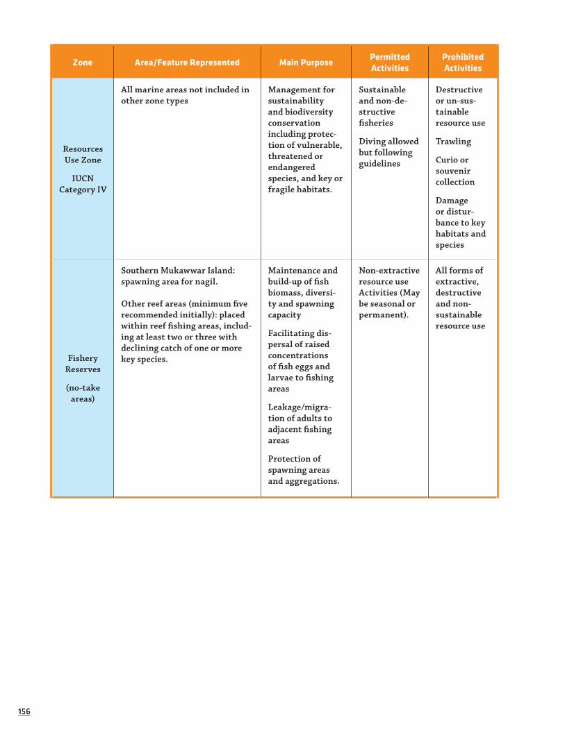
156156
Zone Area/Feature Represented Main PurposePermitted Activities
Prohibited Activities
Resources Use Zone
IUCNCategory IV
All marine areas not included in other zone types
Management for sustainabilityand biodiversity conservationincluding protec-tion of vulnerable, threatened orendangered species, and key or fragile habitats.
Sustainable and non-de-structive fisheries
Diving allowed but following guidelines
Destructive or un-sus-tainable resource use
Trawling
Curio or souvenir collection
Damage or distur-bance to key habitats and species
Fishery Reserves
(no-take areas)
Southern Mukawwar Island: spawning area for nagil.
Other reef areas (minimum five recommended initially): placed within reef fishing areas, includ-ing at least two or three with declining catch of one or more key species.
Maintenance and build-up of fish biomass, diversi-ty and spawning capacity
Facilitating dis-persal of raised concentrations of fish eggs and larvae to fishing areas
Leakage/migra-tion of adults to adjacent fishing areas
Protection of spawning areas and aggregations.
Non-extractive resource useActivities (May be seasonal or permanent).
All forms of extractive,destructive and non- sustainableresource use

157157
The following Figure 8 shows a visual map of the above-mentioned zones:
Figure 8 . Proposed Zoning designations in DMNP. (For more details please refer to the DMNP Site-Specific Management Plan)
The Potential for Tourism Expansion in Arkawit/Sinkat:53 During its April 2008 mission to RSS, PEMSEA included a basic assessment of the tourism potential in the Arkawit area, which is an inland mountainous area located 100km southwest of Port Sudan and reached only by private vehicle. Arkawit was identified as a priority pilot site by the RSS ICZM Office, as well as by Mr. Bakhiet Yousif.
Because of its relatively good weather year-round, Arkawit served as a primary summer capital for the British administration based in Suakin during the colonial reign. The area’s hilly landscape is quite beautiful, with tranquil scenery and views of Suakin’s coastal area. Arkawit also hosts the tomb (and important his-torical site) of a famous Sudanese guerrilla leader, who led local inhabitants against the British forces. In the past, Arkawit’s landscape was largely forested, however, droughts, growing exploitation of natural resources from urbanisation and browsing pressure, have reduced this to only a few scattered patches of trees and vegetative pasture areas. Desertification has been a growing problem throughout RSS.
PEMSEA identified the following potential tourism activities that could be promoted in the area:
• Promotion of tourism activities in the area in various forms, such as the establishment of appropriately designed information boards and other interpretative materials. This would help enhance the education and awareness of both in-coming tourists, as well as local residents.
• Exploring the possibility of a ‘home-stay’ program. Interested and qualified families may allot a portion of their house—such as one bedroom and a separate toilet—that may accommodate tourists, both local and foreign. Based on earlier consultations, some families have already expressed willingness to be part of such a tourism ‘homestay’ program.
53 The RSS Government has identified the Arkawit area as having strong potential for tourism development and to serve as a potential preliminary site for tourism development.

158158
• Rehabilitation of the hotel in Arkawit. A new hotel, Jebel Al Sit Resort, has been built within the town. It is composed of 3 wings each with about 15 bed rooms. A restaurant for 100 people is attached to the hotel and Conference hall with 80 seats and equipped with audio-visual equipments. Attached to the hotel is a marketing centre. A number of cafes are constructed out of the hotel and are scattered around the area apart from each other where local coffee and tea are served and meals can be prepared upon request (www.jebelalsitresourt.com).
During summer months, many families from the coastal towns stay in Arkawit to escape the heat, so it already supports a regular local tourism industry.
The expertise of the Sudanese Environmental Conservation Society (SECS-RSS) could also be sought for sustainable development in the area. SECS-RSS has already completed several projects in Arkawit, relating mainly to education and energy. For example SECS-RSS has helped install several solar power units through-out the area and could participate in further ‘greening’ the town and its tourist venues.
Despite its beauty and history, Arkawit exhibits several challenges that would need to be addressed before the development of tourism. Water was an obvious limiting factor in the area. Currently, the hotel’s reservoir is filled by a water truck, which also distributes to some households along the road. Aside from this, the area has some deep wells, as well as a few electric-powered water pumps. Arkawit already experiences prob-lems with the over-burdening of available waste facilities, water supplies and electricity during the summer months, when the population expands dramatically.
A tourism development plan for Arkawit would therefore need to address the issue of resource distribu-tion, making sure that increased resource needs for incoming tourists do not reduce the availability for local residents. Waste management facilities would need to be developed alongside any potential tourism venues and prospective private investors should be required to provide for these basic infrastructural needs. In the event that donors are approached to aid tourism development and associated socioeconomic improvement projects, these infrastructural needs should be included in the funding proposals.
Greening the Coral Hotel Policies and Practice:
“With increasing competition in the industry, the companies that dare to become more ethical and respond to this unmet consumer demand will be able to gain a competitive edge.” (Tearfund, 2000).
(Tearfund, 2000).
Another potential pilot project is the reform of the current policies and practices of the Coral Hotel (for-merly known as Hilton and then Mercury) to enable it to become a model of best practice in responsible tourism. Eventually, the RSS Government should approach the Hotel with a requirement to meet certain sustainability indicators by a given date - indicators that would measure the extent the hotel gives back to local communities and local economy, and reduce the Hotel’s environmental impact. The The former Hilton Hotel (now Coral Hotel) in Khartoum has, historically, served as the tourism model and a training ground for Sudanese tourism initiatives. Therefore, more responsible hotel policies and practice could have a ben-eficial impact on influencing more sustainable thinking on a broader scale and for locally-owned start-up tourism initiatives. It would also provide a level of responsibility that future investors should have to match or exceed. Furthermore, promoting and marketing itself as a responsible venture could help attract tourism to the hotel and help business in the long-run. As mentioned earlier, a majority of the European tourists surveyed in 2005 revealed they are willing to pay more for responsible hotel and tour operator services (Chafe &Honey, 2005).54
54 An Australian study revealed that accredited operators find certification to have a ‘beneficial impact on their oper-ations’ (Chafe & Honey, 2005). A survey in Costa Rica found that businesses providing sustained environmental performance and that organised themselves in order to cater to “green consumers” could set themselves apart from competitors and gain price premiums as a result (ibid).

159159
Increasing the sustainability of the Coral would not have to be a difficult endeavour initially. It could be phased in during a step-by-step process, beginning with what would be easily achievable and require the least possible expense to the Hotel (i.e. not washing linens on a daily basis55). Eventually, it would be ideal for the Hotel to invest more heavily in: renewable energy technologies (where plausible); outreach programmes for RSS communities, such as training programmes to increase the employment of local workers in the Hotel; sustainability practices; and, developing partnerships with the private sector and non-profit organisations (international and local) for specific projects and infrastructure development that benefit local communities and their economy.56
The transfer of management from Accor Group (which includes the Mercure Hotel chain) to Hospitality Management Holdings (HMH) head quartered in Dubaï presents a viable opportunity for hotel reform; espe-cially given the existence of the HMH’s Environmental Policy (http://www.hmh-dubai.com/policy.asp).
For example Accor has established a partnership with WWF in Australia, whereby USD$1 of all rooms booked at Accor hotels is paid to WWF to support its conservation activities in the area. This idea should be explored in RSS as a method to help fund the conservation of the Marine Parks.
In regards to potential future hotel development and investment in RSS, tourism actors should consider allowing only smaller-scale initiatives in the State. Benefits of small-scale operations generally result in increased profits being returned to local communities and economies. For example, the 2000 survey of British tour operators revealed that approximately 70% of the cost of trips conducted by small operators remains in the local economy (Chafe & Honey, 2005). This percentage, however, decreases as the size of the operator increases: medium-sized companies could only claim 35% remaining in local economies, while large industries could not even create an estimate (ibid). Furthermore, consumers often prefer small-scale tourism activities and facilities in the first place, as they are able to enjoy a more personal and intimate experience in their destination. About half of American tourists surveyed in 2005, for example, preferred small-scale accommodations that were run by local people, as opposed to mass tourism style resorts and hotels run by foreign companies (ibid).
Finally, it is worth mentioning that a number of institutions are now operational in Khartoum and other towns giving training in the field of tourism and archaeology, (i) College of Tourism and Archaeology, Uni-versity of Dongola, Northern State; (ii) College of Aviation, Khartoum North which is also offering a B. Sc degree in Tourism and Archaeology; and (iii) College of Hotel Management and Tourism in Khartoum.
3.2.4.5 SUMMARY AND DISCUSSION:
As detailed above, poorly planned exploitative tourism can result in many negative, irreversible, environ-mental and social, side-effects; whereas sustainable tourism planning can offer alternatives, help to mitigate these impacts and even raise the wellbeing of communities and the environment in the process. RSS offers many opportunities for sustainable and profitable tourism over the long-term. Based on the considerable wealth of its natural and social assets, as well as the low level of tourism currently operating in the State (including some already existing ecotourism accommodation), the State is well situated to found its tourism planning on sustainability principles.
55 The Hilton had begun placing cards in hotel rooms for guests to put on their beds to stipulate to hotel staff that they would not mind sheets and towels not being washed daily; though this was rarely followed by hotel staff, who habitually changed linen daily as they had originally been trained to do.
56 The vast majority of British, Australian and American tourists (90% of British tourists, and two thirds of U.S. and Australia tourists) feel that hotels have a major responsibility in protecting the environment of areas in which they operate; they were more likely to choose hotels that displayed a “responsible environmental attitude” (Chafe & Honey, 2005). About half of all British, Australian and American tourists feel it is very important for hotels to support/con-tribute to local businesses and economies and to invest in local schools, hospitals and other important services; they would choose companies that exhibit written codes of ethical conduct for community/culture and environmental best practice (ibid).

160160
Coral reefs are being increasingly threatened around the world from human activities, including, most notably: coastal development; overexploitation; pollution and run-off; and, direct human contact. All of these activities are dramatically increased by mass tourism, meaning that strong management and efficient pre-planning is vital if the integrity of the coral reefs, marine environment and associated economic and social wellbeing are to be enjoyed well into the future. A number of key planning instruments and approaches can help in this process of reducing the negative impacts of coastal development and tourism expansion.
The design and implementation of a sustainable tourism strategy for RSS could therefore consider following a process of (or similar to) the following:
• Phase 1: Surveys and gaining understanding of the RSS tourism context. This was begun during the ICZM Survey period, the results of which are discussed in this report. However, this work should be continued to a greater degree in the near future;
• Phase 2: Capacity-building, stakeholder consultations and selection of an expert tourism consultant to help with the development of a sustainable strategy for RSS. Phase 2 should also identify carry-ing-capacity for potential pilot areas (including DMNP and SMNP) and begin work with the Accor Group and Mercure Hotel to increase its sustainable practices. The carrying capacities and specific guidelines should be included in the RSS Master Plan and the GIS;
• Phase 3: Sustainable tourism strategy design, development of a policy, legal and clear institutional framework, and promotion of private sector partnerships, including the selection of potential responsi-ble investors committed to sustainability principles;
• Phase 4: Testing of the tourism strategy in selected pilot sites and/or with targeted pilot projects (i.e. in DMNP, Sinkat and by encouraging hotel best practice);
• Phase 5: Expansion of the sustainable tourism strategy to RSS as a whole.
3.2.4.6 RESOURCES FOR FURTHER GUIDANCE ON TOURISM DEVELOPMENT IN RSS:
• Best Practices for Tourism Centre Development along the Red Sea Coast (Tourism Development Authority, 1998)
• Helmy, Eman (2004). Towards Integration of Sustainabiity into Toursim Planning in Developing Countries: Egypt as a Case Study. Current Issues in Tourism, Vol. 7, No. 6, 2004.
• Maldives Ministry Home Affairs, Housing and the Environment (2002). The National Biodiversity Strat-egy and Action Plan of the Maldives. Male: Ministry of Home Affairs, Housing and the Environment.
• Seychelles Ministry of Tourism and Transport (2001). Seychelles Ecotourism Strategy for the 21st Century (SETS-21).
• Seychelles Ministry of Tourism and Transport (2001). Vision 21: Tourism Development in Seychelles, 2001-2010.
• WWF-International (2001). Guidelines for Community-Based Ecotourism Development
• WWF-UK (2002). Holiday Footprinting: A Practical Tool for Responsible Tourism. www.wwf.org

161161
3.2.5 Village Environmental Management and Livelihood Opportunities for DMNP Communities
As technical advisor to African Parks Foundation (APF) in the implementation of management for the Dungonab Bay-Mukkawwar Island Marine National Park (DMNP), the IUCN East Africa Regional Office (EARO) conducted fieldwork and facilitation activities in September 2007 to assess the initial development of Village Environmental Management Plans (VEMPs)57 for the villages of Mohammad Qol and Dungonab in DMNP. The assessment provides information on the VEMP process in the villages to date, as well as illus-trates a suggested framework that can be used to guide the further phases of VEMP implementation in these villages. The VEMP study has been conducted alongside coastal livelihoods assessments (CLAs) in DMNP and the development of a General Management Plan (GMP) for the Park. The study was further formulated to compliment the ICZM baseline socioeconomic survey-work being carried out in RSS. The following sec-tions will outline the results and recommendations produced as part of the VEMP study.58
3.2.5.1 BACKGROUND AND OVERVIEW OF VEMP PROCESS IN DMNP
Village Environmental Management Plans allow a participatory, ‘bottom-up’ process of management for DMNP, which will influence the GMP (currently being developed for DMNP) by incorporating local views and responding to local concerns. As a community-based management system, successful VEMPs should allow communities a level of oversight of the resources upon which they depend, be they terrestrial or marine. Accordingly, this translates into mutual benefits for both community and Park management authorities; as local communities are granted active participation in the management of their natural resources, the greater sense of ownership they obtain means they are more likely to take better care of their environment, which can subsequently reduce the routine management requirements for Park authorities. The GMP being developed for the Parks will accordingly build upon and incorporate the initial findings and actions realised during the VEMP process.
Several factors existing in DMNP communities provide an enabling environment for the VEMP process, especially in regards to:
a) the Beja59 customary silif law (discussed above);
b) the fact that there has only been a recent shift towards dependency on marine resources by the DMNP communities due to poverty, means that these resources are still relatively healthy; and
c) the Beja generally recognise that their future rests on careful management of terrestrial and marine resources.
There are still, however, a number of hurdles to cross. The silif and its related systems will not solve the question of resource management alone. Furthermore, the silif did not develop from marine based livelihoods, though there are some limited guidelines in Dungonab village that have potential for further expansion (i.e. Bahari silif ). Also, lack of funding and lack of training compromises successful VEMP implementation; with incomes being very low for the DMNP communities, prioritising the environment will be hard to achieve without prior economic development. The Beja will therefore need financial support throughout the VEMP process to allow living costs to be met and, thereby, ensuring the environment remains a priority. Eventually, a financially self-sustaining scenario should be achieved.
57 The VEMP technique used for this study was adapted from the ‘VEMPing for Partnerships’ framework developed by Hogan and Bashagi (2005) for IUCN during work in MPAs in Tanzania. It was modified to the social and geographical context of DMNP and the Beja communities and utilised a combination of community-based and general natural resource management planning experience of the study associates.
58 Text for these sections comes from the document Village Environmental Management Plans (VEMPs) for Dungonab Bay and Mukkawwar Island National Park: Creation and Development of VEMPs for the Villages of Mohammed Qol and Dungo-nab, Red Sea State Sudan, which was developed by Paul Harrison and Melita Samoilys following assessment work in the two DMNP villages and published with funding support from African Parks Foundation.
59 As previously discussed elsewhere in this report, the Beja constitute the main ethnic group in and around DMNP.

162162
3.2.5.2 ASSESSMENT OF NATURAL RESOURCES AND OPPORTUNITIES IN DMNP VILLAGES
A preliminary activity in the elaboration of the VEMP process in Dungonab Village and Mohammed Qol was to assess the villagers’ understanding of the natural resources available to them and how they use these resources. This information then fed into discussions related to management issues and opportunities and recommen-dations on how natural resources can be better utilised in the future. There is a strong demand in these two villages for training in understanding of marine resources, resource management and sustainable use.
Natural Resources and Issues in Mohammed Qol:
Table 37. Natural Resources Available to Mohammed Qol (Habitats and Species60).
Habitat Type Location Species Available
Sea East of Mohammed Qol.
Turtles, dolphins, coral trout, trevally, emperor fish, ankabut, abu salama, bahr hatay, yas, abu magas, najma, bahar, farsi, kraib, abu garen, abu gadah, sanjan, arabi, hareed, abu shanab, mila, bureet kam, sutan.
Reef
Mashareef, Sahara, Abu Goshaa, Ras Kaidan, Bayer, Abu Gizir, Areck taweit, Magreit, Halamy, Keylalab, Abo haded, Perat, Sabir.
Turtles, dolphins, coral trout, emperor fish, sardines, ankabut, bahr hatay, yas, abu magas, najma, biyad, bahar, farsi, kraib, abu garen, abu gadah, sanjan, arabi, hareed, abu shanab, mila, bureet kam, sutan.
MangrovesMorgasum, Rawaya Peninsula (south), Inkeifal, Sheikh Okod.
Mangroves, tree species (sagania, saroab, adleeb, shashow berus), fish, birds, bird eggs.
Terrestrial forestNorthwest of Mohammed Qol, Amenay, Handod, Mokeab, Mabrob, Yawekowar.
Acacia spp, foxes, birds, wild cats
Landing sites
Mohammed Qol, Tibadaib, Abu Khufan, Ankaful sageer, Ankaful, Abu Mihzan, Kokial, Sisala, Karbanneet.
Fish, including trevally emperor, arabi, seagan, sareat, abu garen, birds, molluscs.
Salt pansMohammed Qol, Sheikh Okod, Inkeifal, Handaktaab. Foxes, birds, wild cats.
Agricultural areas Yamanay, Hokab, Bailla. Foxes, birds, falcons, snakes, wild cats, eagles.
Livestock grazing areas Kalainay, Tisaray, Magalum,
Hokab, Yamanay, Ograa, Bailla.
Kwad, aila, yadda, shikayab, shighis, sogomataib, graira, shoah, damoor, hadmeeb, sanamuk, tubrik.
Islands Abu Grim, Masharifa, Muka-wwar (Mugarsum), Mayteib, Bayer, Sarara, Abu Gosh, Taylla.
Fish, birds, molluscs.
60 Species listed in italics are the local names for these fish; translations were not available prior to the writing of this study.

163163
Table 38. Natural Resource Issues for Mohammed Qol.
Issues
Habitat
Sea Terrestrial ForestsBeaches and Mangroves
Livestock and Pastures
Uses and Values
Of value: fish, sharks (for eating & sale), zurumbac and other molluscs (for food and sale of meat, per-fumes and pearls), sea cucumbers, dugong & turtles eaten but only if unintentionally caught, Manta rays and dolphins have no intrinsic value.
Acacia spp. especially san-gonab for fruit and fodder for goats & sheep, firewood if dry/dead, charcoal, camel medicine, gum for animal skin tanning, shade, hous-ing materials, weapons
Mangroves used for grazing by camels in dry season although sometimes they get trapped in mud and die. Also, fodder in general, build-ing, gum for dental problems, fish, sardines, birds, birds eggs, zurumbac shells
Livestock bring many benefits in-cluding milk, meat, hair, skin, leather, shamla shelter, wool, ghee, ropes, carry water and supplies
Management
There is no marine management system, nor any silif for the sea. There is a need for training by APF or partners.
Green trees are not allowed to be cut, including for outsiders but some ignore this silif. Pastures are managed carefully; if an outsider comes with a large herd that is too much for the pasture, he is asked to move on.
Cutting of mangroves is forbidden by silif.
In the past people looked after their livestock well, now they don't. Watering is an issue. Livestock are branded. They are treated with medicines.
Problems
No knowledge of fish quotas, no way of stopping outsiders fishing in trawlers. Competition in north near Osief, means they don't fish up there anymore. Short-age of equipment, lack of engines & mechan-ics, lack of funds, lack of dive gear. Less fish than in past. Mer-chants impose fixed prices on fish.
Outsiders come and cut the green trees or eat all the pas-ture and there is no way to prevent this happening. Fire is also a prob-lem. Forests are very reduced. Lack of water.
There is a risk to camels and the areas are diffi-cult to guard.
People used to migrate following the rain and good pasture, now they don't. Fodder is expensive as it is now bought not found through grazing over long distances.
(Continued)

164164
Opportunities
Lack of marketing opportunities. These may be developed. Opportunity to ban outsiders from fishing in the Park.
To set up a Sangonab Acacia nursery, where they can be watered so they grow up strong and can be re-planted.
There is a need to fence man-grove areas to protect both the camels and the mangroves.
Restocking would bring wealth and improve liveli-hoods.
Recommendations
Find alternatives to fishing or improve production in certain areas.
Set up tree nurseries and wells; find ways of protecting the forest by patrolling.
Find a means to fence the man-groves.
Restocking pro-gramme if possible including supply of fodder. Dig new wells
Natural Resources and Issues in Dungonab Village:
Table 39. Natural Resources in Dungonab Village.
Habitat Type Location Species Available
Sea East of the village
Grouper species, including greasy groupers, emper-or, trevally, coral trout, sea horses, dolphins, Bayat, Pahar, Arabi, Senteya, Rahaw, Gaham, Seagan, Ponob, Sherwell, Abo Garesh, Safun, Pahret, Kamut, Abo Munshar, Hoot, Sharun, Arnab Albaher, Abu Sandok, Kaburea, Steakosa, Hareat, Ganay, Ganafea, Abu Goba, Havey Meak, Agoss Shagroma, Abu dama, Abu salama, Gorna Foufne, Rashan.
Khors – Water courses
Mok, Goumaya, Halaga, Heba, Hebakwan, Palau.
Rabbit, deer, fox, Sanoot, Kamob, Agaweib, Peras, Saraoob, Shashoeit, Saganeib.
Shallow reefs
Aloa, Ras Abu Hamed, Goba, Hamsa, Abu Magboul, Adleyay, Hambokeib, Shagar Island, Umtarda Island.
Zurumbac shells, cumper shells, fish, bosra, hareet, gata, arabi, sengan, halgom.
Deep reefsAreg Tawein, Areg Gerney, Mengrey Sabeat, Halamey, Malalab, Abu Haded, Umdarda, Haythop.
‘Most’ types of fish including grouper species, including greasy groupers, emperor, trevally, coral trout, pahat, oyins, zarale, osmut.
Mangroves Abu Shagra Island, Tadoph, Hyscoot, Shanab, Dalau, Hebakwan, Dalaweit.
Birds, antelope, osprey, sardines, kaporea, uboga-da, kumbarey.
Terrestrial forest
Inside Khor Shanab, Somaya, Mook, Hebakwan.
Sanganab acacia, shashoi, adleib, saroob, ageib dalau, rabbits, snakes, birds, eagles, falcon, scorpi-ons, antelope, fox, wild cat.
Marsa – Landing
sitesYamanay, Hokab, Bailla.
Sardines, arabi, gumabri, seagan, kass, alklada, nakat, Elbahar, Abu Gadaha, Abu Munshar (tur-tles), dugong.
Salt pans Oloob, Ahumbukeit, Shanab, Dungonab. Abu Galumbu, umbushbush.
Seashores Magsala, Ras Dungonab, Gobna Khamsu, Elmena Oloy.
Arabi, kass, segan, nagat, elbahar, ubumushmush, turtles.
(Continued)

165165
Agricultural land
Dungonab, Humbokeit, Khor Gomadya, Khor Shanab, Dalau, Habakwan, Garat.
Rabbit, antelope, wild cat, foxed, rats, scorpions, snakes, porcupine, sorghum, watermelon, vegeta-bles, millet, tomatoes, sakanab, adhib.
Islands Um Elskeik, Abu tardi, Halaga, Shagel, Husoot, Harakel, Saatala, Ashbay. Ubugara, umbushbush, abu gadaf.
PasturesAbu Grim, Masharifa, Mukawwar (Mugarsum), Mayteib, Bayer, Sarara, Abu Gosh, Taylla.
Rabbit, antelope, tumbed, snakes, scorpion, fox, okat, shagshek, shosh, pushes, tadab, senab, seatal, hesoob, okool (various grasses).
Table 40. Natural Resource Issues for Dungonab Village.
Issues
Habitat
Sea Reefs ForestsLivestock and
Pastures
Uses and Values
Fish bring food & livelihood. Some creatures are not allowed to be caught (e.g. Dol-phin, Abu Gadar, Naget Elbahar, Saphan, Manta, Turtle).
There are many types of fish to be found there and the reefs protect the bay from bad weather.
Mangrove forests are good for feed-ing camels and in the past were used to construct boats. Terrestrial forests provide fodder for animals, charcoal, firewood, building materials, hunting, medication, tooth-brushes.
Wool, skins, leath-er for clothing and containers, shoes, milk, camel skin for building, string rope., local music (drum), shamla blanket (also sold).
Management
Fishing requires skilled people. Problems with storms, rains, weather in general. Injuries by stone fish (cured through burning wound), sting ray (shock).
Fishing requires skilled people because of the diffi-culties and dangers of the reef. The reefs need protec-tion from damage.
Terrestrial for-ests are managed through the application of the silif and territo-rial management by lineage, but mangroves are not protected by silif.
More male camels needed for repro-duction. Milkpro-ducing livestock are given fodder, others sent to pasture. Protect-ed from predators by building enclo-sures.
Problems
There are too many outsiders and no means of con-trolling marine us-age, fish prices get so low at times it is not worth fishing.
It is difficult to monitor according to respondents because of lack of knowledge and equipment.
There are reduced forests. Mesquite is rampant and needs to be eradicated as it drains the water
Predators, drought, disease, reduc-tion in number of animals, reduced production.
Opportunities
There is a need for an agreement and the use of a marine customary law that can be implemented.
As with the sea in general, there is a need for an agree-ment and the use of a marine custom-ary law that can be implemented.
There is a need to replant certain spe-cies of trees such as teker, dalau, arak, salau potentially in woodlots.
Develop a farm for growing fodder and a nursery for trees, improve water sources and provide vets.
166166
3.2.5.3 STATUS OF VEMP APPLICATION IN THE DMNP VILLAGES
As a result of the initial work conducted in September 2007, the Mohammed Qol village now understands VEMP to be a way to formalise a system for the village to be able to manage their own resources in partner-ship with DMNP authorities. Village representatives ,participating in the VEMP training, stated that they could see how the VEMP could be an extension of the silif; they further highlighted the need for training in environmental management for villagers, if VEMP implementation is to be successful over the long-term.
Villagers in DMNP also showed support for the VEMP process, however they voiced that they have not yet seen real benefit from the Park but that they hope to soon. In regards to suggestions for seasonal fisheries, the villagers raised that they would need to be presented with economic alternatives to make such a practice economically viable.
3.2.5.4 VILLAGE-BASED ZONING SCHEMES
It was agreed a detailed zoning scheme will need to be developed in future VEMP phases. Of note, residents stated there is no formal management system for fishing. Although fisheries regulations do exist from the Ministry of Agriculture, Animal Wealth and Natural Resources, they are outdated (1937 with a small amend-ment of 1975), are poorly enforced and, many villagers are not even aware of them (M. Samoilys pers.comm.). A key concern that arose during discussion of management zones was that trawlers from other nations, especially Egypt and China, are being allowed free access into nearby fishing areas. While complaints have been made to Sudanese authorities, a lack of available resources for patrolling means that little is done in response to such complaints.
Although they are keen to conserve their environment, villagers are reluctant to limit their own fishing activities when outsiders can fish at far greater levels. Villagers would therefore like any zoning scheme to ban outsiders, to insist on a monitored process and, to establish areas with different usage levels. Separately, participants from both villages suggested that they develop zones in the following format, which may be developed further according to the results from ecological surveys and further in-depth discussions with fishers that may take place in the coming months.
The recommended zones would not only be geographical, but also related to different species:
• Non-utilisation: stipulations against the catch (whether for sale or for food) of such species as turtles and dolphins, (other species should ideally be added to this).
• Specified utilisation: catch should only be allowed for very restricted occasional consumption, and only where they are caught by accident. (Although dugong was originally identified as a species under this category, the species should more ideally be placed under the ‘non-utilisation’ category).
• General use: such as for most types of fish, sea shells (this will need further definition).
3.2.5.5 INTRODUCING MANAGEMENT SYSTEMS FOR THE DMNP VILLAGES
A number of key issues and points were discussed in the process of introducing the concept of an institu-tional management system for Mohamed Qol, as follows:
Institutional Arrangements:
To organise marine resources and conserve them there needs to be a Village Natural Resource Committee (VNRC), which will strengthen and assist the silif in a formal way and fill the gaps in the silif where they exist. The VNRC will be formed from responsible local people with representatives from the locality and RSS State Government. The committee must have internal laws to ensure its proper management and should receive training in the best way of establishing itself so that it is transparent, representative, accountable and effective. The VNRC once formed will need to report on exactly what resources and species can be found in its area.
The VNRC should also comprise sub-committees, perhaps 4-5, which manage particular issues, such as dolphin protection. Specific people will have specific responsibilities. A liaison person should be designated to facilitate communications between all the different partners, including the Wildlife Administration, the locality and Mohammed Qol VNRC amongst others. VNRC members will regularly communicate with

167167
rangers. Transparency, accountability and roles for representatives of both genders will be crucial in the development of the VNRC and its subcommittees.
Resource Management:
Conserving resources will mean they can be maintained in the long term. The problem will be in making sure outsiders are prevented from fishing in the area. Only people from Mohammed Qol and Dungonab should be allowed to fish in the MPA. Different local people can be given management roles for certain areas or species, such as managing najil stocks.
Alternative Livelihoods:
If the local people are going to have to limit their resource use there will need to be alternative livelihood options. People will even stop fishing altogether if there are enough sustainable alternatives. Tourism is a good option for the future but people must be given training on how to work with it and benefit from it in order to avoid a situation like Sharm el Sheikh (Egypt), where local people often do not benefit and outsiders get the good jobs.
Capacity-building: There is a need for training on many levels; in tourism, in improved fishing, in natural resource management (especially marine) and, in new trades and crafts.
Silif and Legal Arrangements: There will need to be some time spent developing a ‘bahari silif ’ to ensure there are clear guidelines over marine resource management. These can then be formalised into the VEMP process. The complete silif, where it relates to natural resource management and taboos, will need to be written down, including any adaptations made, so that its guidelines can be formalised into the VEMP and GMP. Once the silif is complete in regards the VEMP, it will be possible for the VNRC and tribal leadership to work together to administer punishments through the traditional discussion process.
Financial Arrangements: There will need to be a mechanism to manage the finances of the VEMP and VNRC and the financial relationship with the MPA management; namely, a means to ensure any financial transac-tions are managed responsibly, accountably and with precision.
3.2.6 Assessing Alternative Livelihood Opportunities for DMNP Communities61
3.2.6.1 OVERVIEW AND METHODOLOGY
IUCN and APF conducted Coastal Livelihood Assessments (CLAs) for Dungonab Village and Mohammed Qol in 2007 to compliment and integrate with the work carried-out as part of the VEMP process for these villages, as well as the ICZM Survey socioeconomic baseline assessment for RSS more generally. The CLAs were based on discussions with community representatives and include proposals for alternative or supple-mentary livelihood interventions for the DMNP villages.
Four discussion groups were conducted (two per village, one per gender) representing a sample of the village inhabitants, typical livelihood activities and age groups. Attention was first given to livelihood assets (also referred to as capital); following this basis of understanding it was then possible to discuss and analyse externalities and areas of vulnerability that affect livelihoods, such as climatic seasonality and institutional/political structures and processes. After access to this information, the next step was to devise sustainable livelihood strategies that are realistic and appropriate to the conditions and issues raised during the liveli-hood assessment.
61 Content from this section is drawn from A Socioeconomic Assessment of Sustainable Livelihoods Regimes for Communities of Dungonab Bay and Mukkawwar Island Marine National Park, Sudan: Incorporating Livelihood Intervention Strategies and Recommendations for the Development of Alternative Income Generating Activities, which was developed by Paul Harrison for APF and published in December in 2007.

168168
3.2.6.2 ACCESS TO ASSETS
Livelihood assessments in each village allowed the research to define the assets (capital) available to com-munities of each village. Assets were divided into the following categories: Natural (nature, environment), Human (skills and capacity), Physical (services and infrastructure), Social (community) and Financial (access to savings and credit). In the Beja context, natural capital or assets refer to living assets, such as marine and land resources, common property resources, pasture, farmland and vegetation. Social capital incorporates the use of kinship and social welfare systems and the governance of society through customary law. It also includes herd redistribution mechanisms. Financial capital includes savings or investments in-kind.
The DMNP area is sparse in such assets: natural resources and vegetation are limited on land. The heat is considerable, especially during summer months and the middle of the day. The impact of climate on liveli-hood activities is apparent; most activities come to a stand-still during the hottest hours.
3.2.6.3 ANALYSIS OF ASSETS
Natural Assets:
Natural assets amongst the Beja of Mohamed Qol and Dungonab villages are split between barr and bahar; land and sea. It is clear that land based assets are those most familiar to the Beja in a historical sense and that, even after a generation or more of living and working with the sea, many of the sea’s natural assets are not yet fully understood, largely because of limited means to access and learn about them. The fish species most commonly mentioned in discussion groups were coral trout, groupers of various kinds - espe-cially greasy groupers - snappers, Spanish mackerel and emperors. There is an awareness of other marine species including sharks (which are often feared), turtles, dolphins, manta rays and dugongs. The knowledge of these has usually come about from catching them (notably dolphins and dugongs) in fishing nets, whether deliberately or by accident. There is also knowledge of crabs, sea-cucumbers and molluscs, especially those important for household use or as income.
As previously mentioned, villagers use the opercula of certain molluscs, such as Lambis (spider shells) and Strombus (Conch), to produce dh’ufra perfume.
Beyond the marine resources found within it, no mention was made by the communities of the sea itself as an asset. For example, there was no mention that sea water passed through desalination plants produces drinking water, perhaps because this is taken for granted or perhaps because the desalination process is still limited. Ground water is available for some parts of the year, although it is sometimes saline.
On land, resources are said to be increasingly limited, especially for those living on the coastal strip and not in the hills inland. There are limited areas of forest, with mostly Acacia species that are utilised for fire-wood, charcoal production and medicinal plants. Wood is also used for shelter and fodder. For the most part, fuel-wood is gathered and sold by those living inland and much less so by the inhabitants of the coastal strip. The latter made up the majority of the respondents of discussion groups for this study.
Wildlife is found in some areas, particularly gazelles, foxes, snakes and various species of birds, including birds of prey. There is limited land available for rain fed agriculture; still there is an aspiration amongst a number of people in both villages, especially women, to increase agricultural capacity. However, there is very little agricultural land available – for example few people grow sorghum to make traditional dhura por-ridge (or feed their livestock), so people either eat more foul (made from horse beans) or buy their sorghum instead. If greater agricultural production was possible, people would be able to grow more of their own food rather than have to buy it, as well as further diversify their incomes.
Livestock include camels, goats and sheep. Not everyone owns camels and those that do usually own only one. A combination of 3-5 sheep or goats is a common amount for those that own them. As noted above, livestock numbers have plummeted over only two to three generations. The first phase is reported to be a loss of their camels between the 1940s and 1980s, the second phase a sudden decrease in the sheep and goats that had replaced the camels. The numbers of livestock are now much too low to live off without alternative livelihood options (upwards of 40 head of goats or sheep and one camel per household of six people is consid-ered the minimum for sustainable livelihoods as pastoralists).

169169
Human Assets:
For women, there are a range of productive skills available that are channelled into income generating activities. A great deal of experience can be found in livestock rearing and production, including the means of breeding and healing livestock, as well as the use of all aspects of dead animals, especially camels. However, with limited livestock numbers these skills are utilised less and less.
In general, because of limited education or financial assets, women have limited skills in the productive development of other livelihood activities. However, there are a number which are evident, some of which have been developed with the support of NGOs. Amongst the women, these are centred on the ability to make handicrafts (mats, baskets, blankets) and in trading petty goods. Women also collect shells and make dh’ufra perfume, but they do not go out to sea.
Other productive skills held by women include tailoring and farming. Other skills include cooking, cleaning, childrearing, fuel-wood collection, collecting water and general maintenance of the household. Although not productive economically, these activities still form an essential part of the fabric of Beja society and well-being.
Men continue to build on skills forged over generations in livestock production and trading. A large num-ber are accomplished fishermen and many understand the sea and the resources available to them, whether locally or in Oseif. Many also understand the basic artisanal skills required to maintain their fishing gear. There is limited knowledge of how to increase their incomes from fishing and take advantage of new or potential markets. Notably, many of the youth are reported to struggle to find income generating opportu-nities in their villages. In line with the findings of Pantuliano (2000), it is clear from discussions that many of the young people leave to find other opportunities, such as in Oseif or Port Sudan. Consequently, they are becoming detached in what they can learn from the older generations, largely because much of that knowl-edge, particularly where it relates to livestock production, can no longer be applied.
Social Assets:
As noted earlier, the existence of the silif provides a central role in adding structure, discipline and the means of cooperation in Beja society, although it is seen to be in decline by most respondents. The commu-nity always offers assistance if a person is sick, going to travel, getting married, or when someone dies. This is within silif. Each time of assistance has its own name, such as lahagen or togwan. However, for those who have lost their livestock and moved to the coast, these practices are much less common. This is largely because people no longer have the financial basis to support others; most live a hand to mouth existence.
In terms of formal associations, these are limited to those developed by NGOs such as ACORD. Many of the associations are said to be dormant or defunct. This is perceived to be because of a lack of capacity (largely financial) to make such associations function economically. It may also be because the format in which they are developed is relatively new to Beja society and needs encouraging. It is notable that Beja soci-ety is clearly stratified by gender, thus initiatives by women’s groups are limited by what they may achieve within the context of Beja society, where women’s ability to engage in economic opportunities to their full potential is restricted.
Financial Assets:
For villages throughout the CLA study, respondents unanimously stated that it is very difficult to save cash and that most people fail to do so. This is mostly due to the fact that the majority of respondents operate on a subsistence basis and do not generate significant incomes. It is also due to the fact that this is not a culture of saving cash. Some women previously used a sanduk to keep their savings in. Now they say they no longer have savings to put in such a box. Where saving is possible, it is usually reinvested into livestock, jewellery or small businesses.
Access to micro credit in rural areas of Sudan is highly difficult. The vast majority of respondents have no access to credit or do not know how to access it. Only a few have experience of taking loans. Distance from the institutions, lack of infrastructure, awareness and collateral, as well as high interest rates and lack of formal groups being formed to share loans together, make many respondents sceptical about success. Fur-ther limitations are a lack of start-up capital to put down as deposits and difficulty in paying back loans. The latter is exacerbated by insufficient knowledge of bookkeeping or cash flow management. The communities consulted had little education on these matters and this has been borne out by experience: previous attempts

170170
to take loans failed when those who were lent the money failed to pay them back. Instead, people borrow from each other, especially from shopkeepers, although this is also becoming increasingly difficult as lenders too often fail to see their monies returned.
Physical Assets:
Physical assets are limited. The new Port Sudan-Egypt coastal road is seen as both a blessing and a curse. For some, especially in Dungonab that have built up their businesses by the road, such as the three restau-rants found there, the road will bring income from travellers passing through. For those away from the road in both villages, especially in Mohammed Qol, the tarmac road will mean travellers do not need to take as many breaks on the Egypt-Port Sudan-Egypt journey and will increasingly pass by Mohammed Qol. Once completed, the tarmac road will also increase the ease of movement to other towns and will likely encourage the trend of rural-urban migration.
Social services are limited, both schools and health clinics lack facilities, trained staff and proper equip-ment. An interview was held with Mohammed Kalra, assistant at Dungonab Health Centre. He noted that a new hospital is being built in the new village but, in the meantime, facilities are very limited. They are in need of more staff including technicians, better equipment and transport. Whole new villages are being built by RSS Government, It is difficult at this stage to see whether the new villages will be a positive impact on social and economic progress or a limiting one. Advantages will include good quality housing being available, compared to the current houses made of driftwood. Disadvantages will include the distance from the sea and the likelihood of the new houses being hot and cramped to live in, as well as not being developed along kinship lines.
3.2.6.4 CHALLENGES AND THREATS
Challenges and threats to livelihoods are complex and numerous, especially in a situation where the com-munities live in basic conditions, have few capital reserves and thus rely extensively on their surrounding natural resources, some of which are seasonal and affected by climatic variability. The Beja of this area are also vulnerable to shocks, such as political change, natural disasters, disease, drought and famine, and often have few means to combat or cushion themselves against unforeseen events, especially now that their live-stock numbers are insufficient to sustain them. This means that, with ever more regularity, dependence on natural resources, for survival, or profit, or both, is increased and thus social and economic costs also become ecological costs.
Vulnerability Context for DMNP Villages:
Understanding the degree in which a community is vulnerable at certain times or in particular circum-stances is a key part of a sustainable livelihoods assessment, as is understanding the likelihood of shocks that may occur seasonally or temporally. Ultimately, the more vulnerable a community is, the more at risk they are from external influences or shocks and the more likely they are to be in an unsustainable position, potentially unable to maintain their asset base or their relationships.
The Beja of Mohammed Qol and Dungonab perceive themselves to be increasingly vulnerable to threats, particularly in periods when they struggle to bring together sufficient incomes to guarantee their own food security. At the time of research, they had lost their market to sell fish, particularly coral trout, because the Saudi Arabians had banned imports from Sudan due to a food hygiene scare. Without that income stream and with little else to replace it on that level, the Beja are in an increasingly vulnerable position. The previous year they had had a similar problem with the mollusc/shells market that also shut down for a period for reasons not known within the discussion group. The climate also has a considerable impact on their lives: if there is no rain there is no pasture and thus no milk; in winter, bad weather often prevents them from fishing. An increased level of vulnerability exposes the Beja to external shocks, especially drought and eco-nomic changes, such as the loss of the fish market to Saudi Arabia in 2007. Key to reducing their exposure to such shocks will be addressing the shortfall of their assets and the provision of a cushion of a greater level of assets.
Seasonal Challenges:
Information was gathered related to changing circumstances over the course of the year and how these circumstances impacted on whether respondents felt a particular month was a relatively difficult or an easy

171171
time. Understanding whether a period is difficult or not, and the reasons why, help illustrate the vulnerable periods; times when people may feel their survival is threatened and may respond by increasing the level of reliance on their natural assets or on local or external support.
Life in Dungonab and Mohamed Qol runs closely with the seasons. People are highly dependent on the climate for their livelihood activities and highly vulnerable to extremes in climatic seasonality. Lack of rain means there is no new pasture for livestock or water for crops. Too much rain causes floods and has a simi-larly negative effect. The non-equilibrium environment in which they live is highly unpredictable and usually temperamental, encouraging a fatalistic viewpoint. As one woman noted: ‘the rain is sent by God, how can we know when it is coming?’
Overall, the winter is considered the hardest time of year because it is difficult for people to fish due to the cold, strong winds and lack of equipment to deal with these conditions. These limit the fishermen’s ability to go fishing. Therefore, catches are considerably reduced in winter. There are also reported to be fewer aggrega-tions of fish during the winter. For those that have livestock, however, the winter is a good time with fresh pasture after the rains. Summer is considered the best time by most respondents because it is a good time for fishing, with aggregations of various species not far from shore and good weather conditions.
Notably, the Beja may be able to make the most of their seasons if they plan carefully and diversify their activities. Though wintertime is a difficult period for fishing, it is also the period of best grazing when there is good pasture for livestock. As the pasture withers away in the summer, fishing catch rates increase and the weather is hot even out at sea. Getting the right balance of activities through diversification will support sustainable livelihood regimes.
Key Constraints and Problem-Solving:
Understanding constraints helps with the identification of priority areas to focus efforts for future improvement, whether solved internally or with external support.
When asked how to solve their problems, respondents were either fatalistic (it is not something we can change/out of our hands) or they were able to offer a range of solutions. Finding a range of sustainable and profitable sources of income and markets was considered the best way to solve all the other problems, except for improvement of social services for which people would like external support, especially from NGOs, to tie in with their own potential input.
Specifically, regarding health services, respondents made formal requests in both villages for an ambu-lance and for generators. The former, to ensure they can get the very sick to medical treatment in a timely enough manner to save lives and the latter, to be able to keep their medicines and treatment rooms cool.
3.2.6.5 TOWARDS ALTERNATIVE LIVELIHOOD ACTIVITIES
As discussed elsewhere in this report, the primary livelihood activities for the Beja communities of Dungo-nab Village and Mohammed Qol include: animal husbandry; agriculture; goods-trading; artisanal business; shell collection; and, fishing.
Discussions were held about how the Beja of Mohammed Qol and Dungonab villages, both male and female, felt their livelihood activities would develop in the future. These discussions were held on the basis that most people feel they are not earning sufficient incomes to survive. Many feel vulnerable and would be willing to develop future livelihood activities that are sustainable within the current ecological context, providing that they have support with developing alternatives, which are both credible and profitable. All the activities mentioned below have been suggested in discussion groups or by individuals and developed for the purpose of this study62.
62 Discussion here on the possibilities for livelihood diversification and development has been expanded from the pri-orities identified by DMNP communities. It therefore, does not necessarily reflect the full spectrum of opportunities available to these communities or as seen as viable by the ICZM Survey. For example, tourism opportunities have the potential to factor more greatly in economic diversification schemes for the communities.

172172
Economic Diversification:
The Beja recognise that neither livestock nor fishing are providing sufficient income to keep people from poverty. They recognise the need to find the means to further diversify Beja livelihoods and reduce economic and ecological risks in doing so. This is particularly important as the Beja have largely lost their former primary livelihood activity of animal husbandry, yet have not fully been able to find a replacement. The replacement may in fact become a range of diverse alternative income-generating activities (AIGs). From the perspective of DMNP, which wishes to manage its marine resources, particularly, in a sustainable manner, it is also of key importance that, as the Park is developed, there will be alternatives to fishing put in place in areas which the Park wishes to close to fishing, even if only seasonally. As Babiker & Pantuliano (2006) remark:
Economic diversification has always been an important strategy for the Beja to complement family income at certain times of the year or during periods of crisis. Multi-resource economies are characteristic of pastoralist societies and they imply the involvement of some members of the family in economic activities other than livestock keeping. Some of the main activities in which the Beja have for a long time been engaging are agriculture, fishing, mining, firewood collection, charcoal making and sale of rural products like milk, ghee, mats, baskets and leather goods. Labour migration to town, especially to Port Sudan as cash labourers on the docks, has also been a constant feature of the Beja economy. However, the scope of the involvement in these non-pastoral activities has dramatically changed over the years. There seems to be a more permanent shift to alternative sources of livelihoods as opposed to seasonal or crisis-re-
lated moves to increase family income (Babiker & Pantuliano, 2006)
Limitations of Diversification:
It is important to be aware of the background reality of an arid, non-equilibrium climate, where little can be predicted where the weather is concerned and the heat and desiccation of the land limits many activities that may otherwise bring economic growth. There are also other limiting factors. A small population is one such limitation, especially as a percentage of the youth continue to leave the village to pursue opportunities in urban areas. A limited population, especially one with a low income base, means limited market oppor-tunities. Low education levels are another, as is a fear of change that is related to both low education and historically conservative attitudes of the Beja to new opportunities, although both these factors are now shifting.
Another key limitation is the level of communications and infrastructure available. The influence of the Egyptian-funded tarmac road that is being developed from Egypt to Port Sudan will bring about vast changes upon its completion, expected in 2009. Benefits to the area will likely be focused on Dungonab, where traders have set up three restaurants and a number of petty good stores. However, the quality of the new road means travel times are becoming shorter and shorter. For as long as the tarmac road remains in a good state of repair, residents of Mohammed Qol and Dungonab will have to adapt to a trading market that will be centred on the rhythms and customer demands of travellers on that road and locate and develop their businesses accordingly. On the positive side, the road is likely to increase the pace that new technologies and goods are brought into the area including mobile telephones and ultimately the Internet.
Agricultural Development:
Women’s groups in both Mohammed Qol and Dungonab favour the development of agriculture. However, this is an enterprise that would take considerable resources to develop and it is difficult to see how it would be sustainable if such resources became unavailable. Beyond the current limited seasonal farming carried out inland, to boost agricultural production on a grander scale would require irrigation, most likely through drip-fed mechanisms. This kind of production is rarely seen in arid environments, except where there is considerable commercial venture capital available.
Irrigated agriculture would require water to be brought from deep wells or from the sea through a desali-nation plant. It would then have to be pumped through pipesand mixed in with nutritional feed. It is likely that some kind of green-housing would be required or at least shading structures. In short, although some support may be offered to existing farming practices through the provision of tools and better seeds, devel-

173173
opment of large scale agriculture is unrealistic in this climate without a considerable investment of financial and human capital.
Trading Opportunities:
With their historical experience and given the skills available, many Beja of both villages, male and female, have shown considerable interest in developing their own trading businesses, whether catering to local markets or further afield. In discussions, trading in petty goods was considered the most popular future livelihood activity, probably because it can be developed to suit individuals and their families.
• Petty Goods Trading: Depending on the goods traded and the size of the enterprise, the trade in petty goods can be managed with relatively little seed capital. The issue will be on keeping the number of traders lim-ited to the size of the market. However, if that balance can be found there are opportunities for both men and women to trade in goods such as cigarettes, soft drinks, bottled water, engine oil, diesel and petrol, packaged foods, perfumes, incense, cakes, other foods and so on. Petty trade can be carried out internally in both villages, between villages, between villages and towns, such as Oseif and Port Sudan, and between countries, trading back and forth within Egypt to Port Sudan, Kassala or Khartoum.
• Clothing & Women’s Items Trading: There is an interest in setting up or improving on clothes stores, which can sell women and men’s clothes, both imported and locally made. As such stores are likely to be run by women or have a feminine influence there is a potential for setting up shops which sell both clothes and other items of interest to women, such as costume jewellery and incense.
• Groceries Trading: There is an interest in setting up shops dedicated to groceries, the stock of which is likely to have been brought up from Port Sudan or Egypt, or grown locally. Providing that there is a market and that competition is not too fierce, this kind of business may be able to succeed in both villages.
• Electronics Trading: As the coastal road is developed and the Beja communities become more exposed to the outside world, especially to passers-by from Egypt and the rest of Sudan, electrical supply will become more common in the form of generators and solar power. With electricity will develop a market for elec-tronic goods, especially televisions, radios, satellite dishes, receivers, mobile phones and computer games. As this early market develops there is the opportunity to set up one or two shops selling electrical equip-ment, which could provide training on how to look after these goods. This will be a niche market aimed at the currently very few people who can afford such luxuries, but nonetheless the interest and long-term opportunity is there.
• Charcoal & Firewood Trading: There is a current and continued interest in the trade of firewood and charcoal to meet the energy requirements of the local area and Port Sudan, especially for those people who have moved into this area as a replacement activity to animal husbandry. There is the potential to develop this industry in a more regulated manner, perhaps through the planting of acacia woodlots in dedicated areas to feed this demand and selling labelled bags showing that it has been sourced sustainably. If the trade cannot be managed sustainably it is recommended that alternatives be found both in terms of energy requirements and in suitable AIGs.
Artisanal Services:
Taking advantage of the range of skills and experience to be found in artisanal activities, there is potential to support specialist individuals in offering services particular to their own skill sets and capabilities. The following activities, in particular, may be encouraged if there is there are the financial inputs and technical support available.
• Mechanical Services: As an increasing number of people living in the villages of Dungonab and Mohammed Qol use motor vehicles and as the new road encourages a greater degree of motorised traffic between Egypt and other parts of Sudan, there will be an increasing need for the skills of specialist mechanics. There is a need for mechanical skills to fix both road-going vehicles and both inboard and outboard engines on fishing boats. In the future there will likely be a demand for mechanics to fix or offer support services to leisure-focused vessels, such as dive boats, as and when tourism is developed in the Park.
• Blacksmith Services: With the villages of Dungonab and Mohammed Qol being relatively isolated from urban centres there exists an opportunity to develop individuals’ skills and services in blacksmithing. Where there is a demand for metal work to a certain technical level, blacksmiths can and will be able to provide a useful and economically productive service providing the demand is present and the level of

174174
quality sufficient to meet people’s needs. This will be a niche market, but nonetheless the interest and opportunity is there.
• Butchery Services: With the use of meat, especially goat and sheep produce being an essential part of the Beja diet (far more so than fish which is only eaten in times of hunger and shortage), there may be an opportunity to develop specific local services in butcheries, building on what is currently offered. If the meat can be kept fresh, there is likely to be a market for butchers to supply both local roadside restaurants and households.
• Bakery Services: Along similar lines to butchery services, bread making is integral to the Beja diet. Whilst there are many household bread ovens in existence, there may be an opportunity to develop family run bakeries to offer bread to both restaurants and households.
• Handicrafts Services: There is a range of handicrafts made by the Beja, especially the women. The devel-opment of cottage industries selling handicrafts is likely to be a practical source of additional income and an opportunity to specialise. ACORD has previously begun a process of supporting women in the development of handicrafts and there is potential to develop these further. If in the future there is an opportunity to develop tourism in the Park, handicrafts will be an ever more important source of income. These can include mat and basket making and the production of tanned leather goods.
Animal Husbandry:
With the deep rooted knowledge of livestock, a small scale restocking programme has the potential to bring livestock numbers back up to levels which could provide a sound economic and nutritional base for both villages. If well managed, specific groups could run breeding centres that provide both meat and other animal products, such as leather, which would be able to feed into other small business ventures, such as butchery, leather tanning and the making of handicrafts. It is clear from the study that if the opportunity arises (namely the provision of financial capital), many people would like to focus their energies on restock-ing and breeding livestock, particularly goats and sheep which have a higher turnover, but also camels for specialist markets and local use. However, it is important that this intervention be considered in contexts where: there is a strong culture and understanding of pastoralism that has not been lost; access to markets and appropriate inputs to safeguard populations are available; and, where pastoralists are able to sufficiently cushion themselves for the shocks of seasonally adverse climatic conditions.
Offshore Fishing:
Fishing has become an essential livelihood activity to the Beja under study. Although many women lack a detailed understanding of how to invest in new equipment because they are usually not familiar with the details, many notably point to the sea as one of key importance to future incomes, especially if the market into Jeddah (Saudi Arabia) reopens. Men with fishing experience point to the fact that the sea is one resource that still holds huge opportunities for them, providing that the markets can be maintained and the appro-priate tools (gear and other equipment) are available. A number of men were able to provide specific details on how they may improve their catch given the right conditions. These are expanded upon below.
Transportation Opportunities:
There is a lack of transport connecting Mohammed Qol and Dungonab a distance of 25km, thus there is potential to offer public transport services. These may be developed in two forms, one as a minibus shuttle service between the villages and potentially further afield, two, through the provision of a limited number of auto-rickshaws to be utilised in the local area of each village. To develop these would require start up funds for the individuals or group concerned.
3.2.6.6 LIVELIHOOD INTERVENTIONS
As the potential future livelihood activities listed in the previous section show, there are a broad number of livelihood activities available to each community, given the right factors. It is necessary to identify both the activity and the enabling environment that will either allow a given AIG to develop or show it to be inappropriate. If an AIG is to be taken forward it will need to adhere to core objectives of the Park, namely, to reduce pressure on marine resources and to strengthen livelihoods.

175175
A number of AIGs are proposed for potential trials that build upon the future livelihood activities pro-posed by the Beja listed above. These are discussed below together with an explanation of the tools and technical interventions that will be required for any such livelihood to be successful.
Tools for Intervention:
A combination of lack of financial capital and lack of training and technical knowledge is the most prohib-itive factor in developing AIGs in the Beja communities in the Park. Therefore, before specific interventions are discussed, an overview is given of the tools required for intervention.
• Financing: Microfinance is one option for providing funds for a range of income generating activities, especially where external sources of funds are not available or are in short supply. However, given, in their own words, the lack of understanding of financial management amongst most Beja in the study area and the lessons learnt from the failed lending programme run by ACORD, micro credit is not recommended as an intervention tool in this instance, unless considerable training in bookkeeping and financial planning is first given. Instead, a model such as APF’s Community Fund programme, which is paid monthly to each village for their own benefit, seems a more suitable option. Such funding should be given in line with the priority AIGs identified and following the submission of proposals and/or interviews with the local community groups.
• Technical Support and Advice: In all sectors discussed during the livelihood assessments, participants fre-quently showed concerns that a key limitation to their prosperity was the lack of knowledge or capacity of specific activities, whether in developing an existing activity or an AIG. Depending on which AIG they are being supported to develop, communities will require advice and training from research bodies, spe-cialists and potential business partners before engaging in pilot projects and future AIGs. Knowledge of the laws relating to proposed activities, such as which resources or species can be utilised within which areas, will also be required, as well as initial Environmental Impact Assessments where necessary. Further consultation with appropriate Sudanese institutions and NGOs is advisable in order not to repeat research or ignore established successful practices. Core areas which will require technical support and capacity building include: bookkeeping, planning and financial management; the formation of appropriate CBOs or businesses; markets, marketing and quality control; detailed aspects of the specific AIG by experienced partners; provision of links to new markets and networks; and, legal issues relating to the specific AIG.
Sectors for Intervention:
(i) Offshore Fishing: Fishing, as shown in the assessments is a highly significant form of income generation for the Beja of Mohammed Qol and Dungonab. Interventions which aim to take the pressure away from fish and other marine stocks in the shallow and protected waters of the bay can be through the establishment of an AIG that develops fishing in the deep waters away from the bay environment. Currently, though a minority of community owned boats have the capacity to fish in deeper, exposed waters, the majority do not. A further limitation is that the majority of fishers do not have the gear for deeper waters and larger catches. Most of the fibreglass boats with outboard engines are owned by a Sudanese government holding company. Therefore, there will be a need for the formation of CBOs to manage new boats as a business, as it will not be possible to use the fibreglass boats unless clear agreements are drawn up. In any case, the current fibreglass boats are inadequate for offshore or larger scale fishing operations.
Thus, interventions in current unsustainable fishing practices will need to be in the form of the introduc-tion of larger vessels, equipped with inboard engines. The vessels will need to be stable enough to cope with rough weather and high seas, and have accommodation. Navigation equipment and winter weather clothing will be required to increase the distance that can be travelled out to sea and to allow the fishers to sail during the winter months. Gear will need to be provided. Such items may include: reels and hook and line for deep water demersal fishes; and, surface set gill nets, upwards of 3 1⁄2 inches, for pelagics such as Spanish mack-erel and tuna. Although the fishers have a broad depth of established knowledge, training should be provided to craft and use the new vessels, manage sails, maintain engines, deal with the currents and weather. Train-ing in how to treat their catch and of the potential markets for different species will also be necessary. Cool boxes should be installed of significant capacity to be able to hold a metric tonne of catch per trip. Ice for these may either be supplied by buyers in Port Sudan or through the purchase of a generator-powered refrig-eration unit based in each village, although purchase and maintenance of these will be difficult and costly.

176176
It may also be possible for the fishermen to hire both vehicles and iceboxes from Port Sudan as a pack-age deal. Keeping the stocks fresh until the market place will be vital to increasing incomes. Clearly, it is first essential to gauge whether a market exists following the problems with the Saudi Arabian market in 2007. If only a seasonal market exists then the yield should be of sufficient value to allow the fishermen to resume terrestrial livelihood activities out of season. The profit and loss of this enterprise should be carefully assessed according to requirements, but is expected to cost in the range of US $12-15,000 to set up, including one new boat and all the associated equipment on a relatively basic level, or in the range of US $200,000 for high quality, fully equipped fishing vessels.
Fish Aggregating Devices (FADs) may be introduced in the longer term. These are rafts or buoys anchored to the sea floor, which could be deployed in deep water (1,000-2,000m depth) to attract skipjacks and yellow fin tuna and other offshore pelagic fishes (Ireland et al, 2004). FADs are cited as a highly successful AIG in the Comoros Islands (ibid) but are untested in Red Sea waters. It is, therefore, recommended that further research/consultation on FADs as part of an offshore fishery AIG in DMNP is conducted. They are likely to be expensive to set up and training will be required. They are estimated to cost in the region of US $2,000 each (D. Kooistra, pers comm.). Before any introduction of an offshore fishing project, further assessment of the stock’s viability should first be carried out, including a cost-benefit analysis and an ecological assessment of whether there are sustainable stocks of pelagic or deep-sea demersal fish stocks.
As mentioned above (4.2.3.4) the EU funded Eastern Recovery and Development Programme (ERDP) provided 100 pieces of fish finders to help fishermen on spotting the area of concentration of fish and with the help of the GPSs provided they can go back and forth to the same location during the same day or the following day(s). Regarding the issue of how to treat their catch, ERDP also trained the fishermen on post harvest steps to prolong the time of keeping the fish fresh. They were trained on bleeding technique to drain blood out of the body of the fish and to remove the easily perishable parts (gills and intestine) before they are put in ice boxes.
A number of Beja fishermen interested in developing their fishing opportunities, particularly with najil, suggested that if the middle man can be cut out, they can make in the region of SDG5 gross per kilogram at source, if they transport it in good condition to Port Sudan, they can make up to SDG9 gross per kilogram. In their own discussions, they calculated that there would be no fishing in January or February due to lack of stocks. They also stated that in July there can be heavy competition with foreign trawlers, who also fish najil on the side for export and this floods the market (M. Samoilys pers comm.).
(ii) Mariculture: Apart from the pearl oyster farm, referred to below, there is no noted practice of maricul-ture in either Mohammed Qol or Dungonab. There is, however, a sound knowledge of marine species that may be utilised for mariculture. Currently, there is a random collection of various species of mollusc, notably for the use of the opercula for perfumes and oysters for pearls. Sea cucumbers are also collected and sold to interested buyers, where markets can be found. Potentially then, with guidance, inhabitants of Mohammed Qol or Dungonab may be shown how to breed sea cucumbers in ponds, if this is considered feasible by con-sulted experts. Similarly under advice, they may be taught to breed certain species of finfish in ponds and molluscs in submerged cages. The limitation to pond cultures in this area is the limited tidal flow; thus there are likely to be very few sites with sufficient tidal flow to support such an activity. The limitation of cages is in where these may be placed and how they may be accessed, the knowledge of which is constrained by the limited experience and appropriate technology. Nonetheless, it is recommended that research be carried out into the feasibility of mariculture for the Beja of this area.

177177
(iii) Pearl Oyster Farming: As a form of mariculture, farming of pearl oysters63 has strong potential as an AIG for a select family or group of individuals. There are currently two ways in which oysters are found. The first is the collection of natural oysters by divers. The problem with this activity is that naturally found oysters very rarely produce pearls of any commercial value. The pearls within are usually very small and often misshapen. There is also the issue of sustainability; there are a limited number of oysters and it would require the collection of many thousands to produce a profitable yield on a regular basis, which is likely to be well beyond the capacity of Dungonab Bay. A survey of oyster numbers would give a definitive understanding of their capacity.
Of greater economic value and more sustainable is to farm oysters artificially. This is the process being undertaken by the Gulf Pearl Company64 in Dungonab Bay. The company is open to a proposal by the Beja communities, to offer oyster spats to out-growers. They are also willing, for an agreed fee, to train a small number of local people in the complicated process of how to successfully insert a round 7.5mm ball, made from a pagtoe shell, in conjunction with grafting tissue into selected oysters and then rearing them (Dev, pers comm.). The process can produce a perfectly spherical pearl of considerable commercial value. These would be sold through the company’s channels to its buyers in Dubai. 40% of grafted oysters produce sale-able pearls and the price range for each pearl can be between US $10 and $50 depending on the grade (A to D). There is also the secondary benefit that, if it can be kept in good condition and a market found, oysters also have commercial value for their meat.
The advantage of working in partnership with the pearl company is that the technical support is on hand, as is access to markets. The disadvantage is that as it is a complicated process, only very few people would benefit. However, it is an AIG worth assessing further as a potential intervention.
(iv) Animal Husbandry: As has been discussed above, livestock breeding and rearing is well understood by the Beja in general, especially the older generations. A potential intervention would be to set up a pilot restocking programme in both villages, especially of sheep and goats. The profit and loss of this enterprise should be carefully assessed according to requirements. The advantage of such a programme would be that if successful a steady restocking of livestock would reduce the reliance on the sea. It would also reduce the level of seasonal vulnerability that the Beja face during the winter when they cannot fish and thus their reli-ance on external support. Reintroduction of substantial numbers of livestock through a carefully monitored breeding regime managed by specialist partners would allow the Beja the diversity of income and thus the freedom to choose whether to spend part of the year inland and re-establish older practices of nomadic or semi-nomadic pastoralism. However, for the latter to be successful it would require a substantial restocking programme, which is likely to be beyond either the financial capacity or the objectives of its the current players. However, if external funds could be sourced, livestock restocking is likely to be sound intervention providing it is done within the limitations of a non-equilibrium, arid terrestrial climate and fading indige-nous knowledge.
Trading Centres: Many of the Beja who were consulted for this study in both villages expressed an interest in developing their businesses and artisanal trades, examples of which have been given above. It is suggested that two trading centres be developed if the funds allow. The first would be by the roadside in Dungonab near the current restaurants and trading area. The second could be by the roadside on the outskirts of Mohammed Qol, near the new village.
63 Oyster farming originally started in Dungonab in 1905, when the mother-of-pearl shells were exported for high quality inlay work, jewelry and buttons.
64 The Gulf Pearl Company is apparently the only pearl farming project licensed by the government of Sudan. They say they work on a balanced policy of making the company feasible in terms of its economic growth, maintaining the resource and harvesting resources for the benefit of people. They are in support of regulated activity. The company grows the black-lip pearl oyster (Pinctada margaritifera) for their pearls and their entire harvest is produced using farmed species. The black-lip pearl oyster occurs throughout the Indo-Pacific, but its culture is best known from the South Pacific.

178178
The aim of both trading centres would be to sell goods and services in well-organised shopping centres. Both would sell petty goods as well as specialist products or services, depending on the type of artisanal capacity available. Key to the success of such ventures would be careful management during the set up phase to ensure a highly marketable trading centre is produced, as well as careful attention to where and how any financial grants made for these activities are invested, at least until the training period is completed.
Of real importance will be the location of both shopping centres and the range of goods and services involved in the shopping centre businesses. It is not particularly important that these are well designed structures but it will be important to make sure that there is the right mix of trades and goods on offer. It would be advisable to develop both shopping centres to offer different goods and services, so that passers-by will stop at both knowing that what is available in one place is not available at the next. For example, Dungo-nab currently dominates the restaurant market and thus it would be unwise for Mohammed Qol to try and take a share of that market, as they are unlikely to succeed at this stage, whereas they may be well placed in setting up an electronics shop, or a women’s clothing store.
A spirit of cooperation should be fostered between the traders and artisans being assisted in both villages, if such assistance is forthcoming. However, careful consideration will need to be made of which markets are feasible and which will be best placed in each area. A transport system between the two villages would encourage trade. The disadvantage of this intervention is that it is complex in ownership, would likely need financing from external partners and would be set up in an area with limited economic development. All such factors should be considered and the profit and loss of this enterprise should be carefully assessed according to requirements.
Tourism: One area discussed regularly during this study was the potential for tourism development fol-lowing the development of the Park. It is widely felt that tourism is at least five years away but that there is a strong interest amongst the Beja of both villages in seeing it work. If successful, tourism would offer a boost to the economy on many levels. Currently the limitations of the Beja in working in tourism is their general lack of skills and experience in working in such a sector, a lack of language skills particularly in English and a lack of understanding of the advantages and disadvantages that tourism can bring to a society. There would need to be a considerable training and awareness programme well in advance of any proposed tourism venture to bring the skill sets of the communities up to an appropriate standard.
It is also of note that there are concerns amongst the inhabitants of both Dungonab and Mohammed Qol that tourism will impact upon their culture, especially with regards to codes of behaviour and dress. How-ever most feel confident that they would be able to preserve their culture, maintain their current livelihoods and benefit economically from the introduction of tourism. A tourism AIG would be a potential intervention able to allow for greater economic diversification and the reduction of activities that have a negative impact on the natural environment. As such, the potential for tourism in as far as it would benefit Beja livelihoods, is one worth continued assessment.
3.2.6.7 STRENGTHENING PARTNERSHIPS FOR LIVELIHOOD ALTERNATIVES
Understanding the types of relationship a community has with various different institutions is a key aspect of a livelihood assessment and the findings presented help to understand not only whether their relation-ships are socially, politically or economically sustainable, but also whether the community is under threat by other institutions or whether, indeed, it presents a threat to the interests of other institutions.
Assessments included gaining an understanding of the institutions that have a political, social or economic influence on the communities in the study area and these are given below. Key institutions include those that relate to leadership, those that relate to social services and those that relate to income or community support. They are listed in order of importance following prioritisation exercises carried out in discussion groups.
For Mohammed Qol, the Locality Government offices are seen as most important. Where these are more distant as in Dungonab they are not seen as important. Education is of prime importance as a key institution to most people, as are institutions for health services, to a slightly lesser degree. Aside from tribal leadership, formal government and social services institutions, ACORD and APF were considered the most important and influential, effectively because of their roles as service providers. Religious guidance is seen as important to social life, both in the form of mosques and Koran schools. Civil society institutions, including women’s

179179
centres and community development centres, are also seen as important. The army provides water and trans-portation from time to time, as do the Security. The police help oversee law and order through witnessing the procedures of the silif councils.
It is of note that by their own admission, despite being an immensely hospitable people, the Beja are typically distrustful of outsiders, even those of their own people if from different diwab. This attitude may in part be related to their historical need to survive on minimum resources in an unpredictable, natural environment and thus became protective. However, there is a sense that a lack of trust makes it difficult for outsiders to bring benefits for the Beja to learn from the activities and experiences of others to improve their own livelihoods. It is thus notable that there are relatively few institutions in the area, partly perhaps due to Beja attitudes but, perhaps, more so because of the harsh and unpredictable environment in which they live being not being particularly attractive. This situation is also due to the reality of the political and economic situation of north-eastern Sudan. The lack of institutions, especially in the private sector, limits learning, growth and trading opportunities and the scope for investment into the area. Currently, private sector institutions of note are limited to the pearl farm and the salt mine, the former of which employs a handful of people, the latter offering little economic advantage to the villages.
Potential Partnerships
There was insufficient time to meet with many stakeholders or potential partners, as this was not part of the terms of this study. However, useful discussions were held with ACORD and the Gulf Pearl Company in Dungonab and these are summarised below. If there had been the opportunity, it would have been of interest to develop discussions with companies engaging in the fish trade and that of livestock and petty goods, to both gauge the interest in buying from the Beja of this area and to understand more about the different markets available. One such potential partner, for example, may be the fish market in Port Sudan.
1. ACORD Sudan: ACORD have been working in the Dungonab Bay area since 1987 (Tamin, pers comm.) Their first phase of work was 1987—1996; their second has been running since 1997. They work under four key themes; livelihoods (incorporating training and credit, water and agriculture and livestock and fisheries), civil society, peace building and food security. They also work on the cross-cutting issues of HIV-AIDS and gender. ACORD are interested in partnerships with other NGOs in developing their work in supporting development for the Beja. They are currently working in consortium with organisations, such as SOS Sahel, International Refugee Committee and several Sudanese NGOs, in the areas of improving livelihoods, capacity building and provision of basic ser-vices with multi-million euro financing from the EC and Sudanese Government, through UNDP, for the 3-year, Recovery and Rehabilitation Programme. With their previous experience in these areas and their network,
2. Gulf Pearl Company: An interview was held with Daniel Dev, a consultant for the Gulf Pearl Company based in Dungonab. Theirs is apparently the only pearl farming project licensed by the government of Sudan. They say they work on a balanced policy of making the company feasible in terms of its economic growth, maintaining the resource and harvesting resources for the benefit of people. They are in support of regulated activity. Oyster farming originally started in Dungonab in 1905, when the mother-of-pearl shells were exported for high quality inlay work, jewellery and buttons. The current pearl company grow the black-lip pearl oyster (Pinctada margaritifera) for their pearls, and their entire harvest is produced using farmed species. The black-lip pearl oyster occurs throughout the Indo-Pacific but its culture is best known from the South Pacific. The Gulf Pearl Company uses artificial spat collectors strung in a line for the first stage of the farming process. From this process usually over 100,000 immature pearl producing shells are produced. Of these, the farm uses about a third, the rest they release into the sea, repopulating the bay. They take spats of 2cm in length and grow these in cages. Before growing them, they inject a perfectly spherical pellet into the grafting tissue of the oyster to grow pearls.
This company is a potential partner for the management body that will be responsible of the park and the community and are willing to train carefully selected individuals in the process. This is better detailed further in section 4.2.6.6 Livelihood Interventions above.

180180
The company signed an agreement with the government to work for 10 years and they started in 1998. Since 2008 work of the company started to diminish and by 2011 stopped completely. The company didn’t renew their contract.
3.2.7 Improving Livelihoods in Inland RSS (Sinkat-Arkawit area)During their mission to RSS, the PEMSEA team visited Sinkat Municipality to get a sense of the livelihood situation in the area and to explore the potential for it to serve as an inland demonstration/pilot project for later ICZM phases. Sinkat Municipality covers roughly 66 villages and has an altitude of about 800m above sea level. The team met with Mr. Sharif El Malik (Commissioner of Sinkat Locality), together with his two staff members, in order to discuss their resource management concerns, as well as proposed project interventions.
Sinkat Municipality is largely devoted to terrestrial agriculture. Many households are engaged in raising livestock and planting crops. As a pastoralist community, the area has communal grazing areas for camels, cattle, goats and sheep. However, Sinkat communities are experiencing increasingly limited pasture areas, due to the droughts that have occurred over the last few years. The crops being planted are mainly sorghum with a few high value vegetables, such as beans and cabbages. More recently, the government has encouraged the planting of several fruit trees. Grapes and olives are also now being planted, as the area has a similar climate to the Mediterranean. There are no large-scale projects along the ‘Al Gezira Land’ of Sinkat.
Several development challenges exist in the area, including outdated agricultural technologies (which are still quite traditional). Many of the implements and/or tools are hand-held, such as hoes and shovels. Secondly, water is a major limiting factor—an issue that has been exacerbated by recent droughts. Sinkat lacks large-scale water harvesting facilities to collect, store and take full advantage of any excess rainwater during the rainy season. Thirdly, the population has also very limited livelihood skills aside from agricul-ture, so economic diversification is important. Mr. Sharif El Malik, therefore, proposed some ‘vocational’ training that may benefit the populace, particularly the youth sector. He suggested skills development in such fields as carpentry, electricity and automotives. As mentioned above (3.3.2.3) with support from the EU funded ERDP, a vocational training centre at Sinkat was provided with training materials and school leavers were enrolled in a 6 months duration training within the centre. After graduation they were provided with working tools and kits to help them start their business in the area. Finally, the Municipality experiences dramatic demographic changes during the summer months; many RSS families move to the area to escape the excessive heat elsewhere in the State and particularly closer to the coast. Sinkat’s comparatively pleasant climate attracts many local families and tourists, who generally either reside with relatives living perma-nently in the area or live in outdoor tents. Because of the sheer number of visitors to Sinkat during these summer months, the associated liquid and solid waste disposal is quite problematic.
In line with these major problems/issues, three key interventions could be considered to help improve the livelihood situation in Sinkat—all of which are related to agriculture:
• Household or backyard vegetable gardening
• Establishment of fruit orchards
• Rehabilitation of habitats for pasture lands.
The first two project components should be in the form of organised cooperatives and can be based on previous UNDP agricultural cooperative models. Amongst these past cooperatives, cattle projects were documented to be the most successful. Hence, the interventions listed above should be viewed more as enhancements to livelihood activities and their order of implementation should be prioritised by the local Government. Other interventions should address the development of better infrastructure facilities, nec-essary for the improvement of water and waste management, which also take account of the population expansion during the summer months.
ERDP supported the department of Horticulture, Ministry of Agriculture of the Red Sea State to establish a drip irrigation network in a community farm at Gabait town of Sinkat Locality. Two community farms at Erkawit town of Sinkat Locality were also supported by ERDP. The 2 farms at Erkawit were successful in growing vegetables and managed to establish fruit trees within their farms. However the farm at Gabait was not successful and faced some technical problems and social problems pushed by personal interests. At

181181
Sinkat town the HQ of the locality, ERDP, financed establishment of a goat breeding centre under the man-agement of the department of Animal Resources at the Locality of Sinkat. Syrian goats (males and females) were imported from Syria and were kept at the centre built by ERDP. Local goats were brought by the com-munity to the centre for cross breeding with the Syrian bucks.
3.3 COASTAL DEVELOPMENT AND RISK MANAGEMENT‘We have to prepare for what life could become in 40 years. We need to outline what is possible and what is impossible with the non-renewable resources of the Earth. What role will techno-logical improvement play? Taking all this into account, what kind of life can we produce in the
best way for 10 billion people? That's a problem that needs to be solved.’
( Jacques Yves Cousteau)
Related to IOC Handbook Indicators SE 5 and G 3.
Coastal development has historically been at a minimum along the Sudanese coastline, which has therefore minimised the extent of environmental impact in the area and concentrated it mostly around the urban cen-tres. This situation is now rapidly changing, with the onset of accelerated development, driven and impacted inter alia by the expanding oil industry and increasing export activities. The signing of the 2005 CPA and 2006 ESPA has particularly created a more favourable investor climate enabling such development to take root. But hasty approval of development projects in a previously underdeveloped and poverty-stricken State, means that activities are proceeding without adequate management and planning to set a more sustainable development framework beforehand.
The threats facing Sudan’s marine/coastal areas and the long-term well-being of RSS communities are therefore numerous. Most pertain to the following development activities and side-effects: off-shore oil and gas exploration and oil extraction; increasing ship traffic and associated risks, such as navigational hazards and oil spills; a weak legal framework and inadequate ratification of international shipping conventions (especially IMO conventions); lack of capacity to respond to serious oil spills; rapid and unsustainable urban-isation, insufficient urban planning and poor provision of public services and infrastructure to respond to growing populations; unsustainable construction activities (such as dredging in the case of port devel-opment); growing, industrial-scale fisheries; and, a growing spread of tourism southwards from Egypt to central and southern parts of the Red Sea.
The following sections of this report provide an overview of development and risk management within the Red Sea State, with a view to position the Sudanese situation within the larger national, regional and even global contexts where appropriate.65 It identifies the major factors that are already, or that may in future, affect the Sudanese coastal zone and identifies priority actions that can be taken by Sudan to mitigate poten-tial impacts. The discussion places particular focus on coastal development activities (especially oil), urban services and infrastructure (transportation, waste management, water and sanitation, and utilities), as well as port, navigation, maritime and pollution related risks.66
65 The fact of the interconnectedness and transitory nature of many marine-related issues and activities (maritime, pollution, etc) require a greater view of regional dynamics so as to best confront and mitigate more localised con-cerns and issues.
66 The information obtained for these report sections has been gathered by on-the-ground assessments, interviews and site visits, as well as through a literature review of key available documents.

182182
3.3.1 Coastal Development
‘Shelter, potable water, sanitation and waste management are cross-cutting issues, and defi-ciencies in any of these areas can be categorised as development, health and environmental
problems’ (UNEP, 2007: 120).
3.3.1.1 URBANISATION AND COASTAL CITIES
The majority of the RSS population is concentrated in the two main urban centres of Port Sudan (61.2%) (Babiker & Pantuliano, 2006) and Suakin. The existence of settlements elsewhere along the coast remains relatively low. Urbanisation is occurring rapidly, which is resulting in compromised urban planning, infra-structure stretched beyond capacity, overcrowding and urban sprawl, and numerous associated human and environmental health risks.
The major factors motivating such high urbanisation rates in RSS include: drought and desertification making rural survival progressively more difficult; mechanised agriculture schemes that usurp land from traditional rural farmers; and, general efforts by the rural poor to escape poverty by pursuing employment in cities and to gain improved access to essential services, such as medical care and schools (UNEP, 2007: 122). However, many urban settlers are confronted with considerable hardships even in the cities and often cannot afford available services as a result. Adequate data on urban growth rates in RSS are not currently available, but qualitative analysis is clear that the current system is not sustainable if Port Sudan and Suakin continue to expand without more effective management measures and improved urban planning.
Rapid and uncontrolled urbanisation of Port Sudan and Suakin is a leading contributor to environmental problems in RSS. Steady degradation is particularly taking place in the developed strip between the two cities, alongside symptoms of overgrazing, land degradation and unsustainable resource use throughout dry-land RSS. Mangrove stands, for example, are currently being degraded all along the coastline, due to a variety of reasons including development projects, overgrazing by camels, or harvesting for firewood by coastal communities (UNEP, 2007). Similarly, seagrass beds and other marine and subtidal habitats are being destroyed in and around RSS ports, as a result of poor port development practices and inadequate ship and other waste treatment facilities. Pollution from land-based sources, especially the lack of wastewater treat-ment, is a particularly strong concern, as are the risks associated with the growing oil industry.
3.3.1.2 BASIC INFRASTRUCTURE AND SERVICE MANAGEMENT
Infrastructure in rural areas is a particular area of concern and contributes greatly to the livelihoods cri-sis in the State. Growing populations in cities and inadequate urban planning threaten to push available infrastructure and services beyond capacity. Lack of investment, due to insufficient Government funding, generally affects all major sectors relating to public services and infrastructure.
Roads and Transportation:
A significant recent development in RSS is the construction of a new coastal road connecting Port Sudan and the northern Egyptian border. While the road can help serve important functions of the RSS economy, its construction and route pose significant threats to the integrity of the marine and coastal environments it runs through or close to. No environmental or social impact was conducted for this project. Of particular concern is the fact that the road passes through the boundaries of the Dungonab Marine National Park, in several places running within metres of beaches, mangroves, coral reefs and highly valuable and fragile areas, such as Khor Shanaab. Until this development, there had been no paved roads within/close to the MPA or between the MPA and Port Sudan. This factor, in combination with the considerable distance between DMNP and Port Sudan, is probably a major reason for the relatively good condition of the area up until now.
The new paved road, however, will decrease the travel time from Port Sudan to Dungonab from seven hours to one hour, increasing access to the MPA and the Northern coastline by at least an order of mag-nitude. This will likely encourage and greatly facilitate increased human activity in the area, such as open access (unregulated) extractive and non-extractive resource use and increased development.
Evident changes to land-use patterns of the DMNP area are already apparent as a result of the road, including the displacement of the Dungonab Village and Mohammed Qol communities farther away from

183183
the coast. The 2006 African Parks Survey also witnessed clear misuse of natural areas. Khor Shinaab, for example, is becoming a popular stop-off point for workers and travellers coming mainly from Port Sudan. Activities observed at Khor Shinaab during the Survey (in addition to passing traffic on the road) included the landing of fish from fishing boats for sale to buyers from Port Sudan, the preparation of a site on the southern side of the Khor for building work, camping as well as littering and rubbish dumping from dhows, road construction work (Plate 23) and campers.
A new paved road will also be constructed between Toker and Garoura in the southern part of the Red Sea State. The road, 176 km long, will be passing mostly away from the coast especially between Agig and Garoura. Cost of construction of the road is from the Eastern Sudan Reconstruction and Development Fund (ESRDF). ESRDF is a government institution formulated after signature of Eastern Sudan Peace Agreement in 2006. It is responsible for fund raising and planning of developmental projects in eastern Sudan, the three states of Red Sea, Kassala and Gedaref. In March 2010 ESRDF participated in preparation for and attended the Donors Conference convened at Kuwait where donors pledged funds for the developmental projects in Eastern Sudan. Cost of the road is obtained from the Red Sea State share from the Donors fund. The road will link a very good fishing site in the southern part of the RSS (Agig). Although the site is rich in fish, it is away from Port Sudan and in rough terrain, so marketing is a big problem and people from the area are reluctant to rely on fishing as a livelihood. The road will change the situation a lot. Fish can be sent by trucks to Port Sudan or even to other towns of Kassala, Atbara and Khartoum when construction of the road is finished. Work on the road started in January 2014 and it will be finished in 2 years according to the contract signed with the construction company.
Water and Sanitation:
Rates of access to safe drinking water in Sudan are on the same par as in poorer countries in Africa and have seen steady declines over the past decade (UNEP, 2007: 127). This is in stark contrast to the fact that Sudan actually has adequate water resources (rivers, lakes, seasonal streams, and groundwater) to provide for most of the population’s needs. The major constraints, therefore, lie not with quantity, as is often assumed, but in underinvestment in necessary infrastructure for extraction and purification, as well as the fact that poverty restricts the accessibility of poorer families to the water market. The remote locations and nomadic nature of much of the rural population in RSS further complicates water access and supply.
Much of the RSS population must purchase their water directly from vendors (typically donkey-driven carts attached to cylindrical metal water tanks), especially in the drier rural areas where water points are few and far between. ESRDF has also constructed a new water desalinization plant at Agig (500 M3per day) and another one at Marafit village between Toker and Agig and overhauled an old one at the same place. The salt is directly rejected in the Agig Bay and the environmental impacts should be monitored.
It is estimated that Northern Sudanese residents spend up to 40% of their daily income on purchasing water (UNEP, 2007:127).
In regards to sewage and sanitation, RSS similarly suffers from inadequate facilities, which as a result, threatens both environmental and human health. Sanitation issues are particularly bad in IDP settlements and the poorer urban fringes, where overcrowding, lack of sewage drainage systems and, especially, treat-ment facilities mean vacant plots are commonly used as ‘open toilets’, or sewage is discharged directly into nearby watercourses. Untreated sewage, finding its way to the sea, threatens to promote eutrophication, due to the high nutrient levels it contains. This will cause the smothering of corals and the pollution of key habitats, such as seagrass beds, thereby threatening the biodiversity integrity of marine areas generally. Discharge of untreated sewage poses a further health risk by increasing the likelihood of disease contraction by people who come in contact with contaminated areas (both coastal and marine).
Wealthier communities typically rely on septic tanks to manage their sewage. However, when tanks are full, the contents are emptied via a suction tanker that then dumps the sewage elsewhere, normally in vacant land or seasonal watercourses. In Port Sudan, septic tank waste is often dumped in the main wadi that supplies Port Sudan with its drinking water. As raised by UNEP: ‘this process is particularly inequitable, as it essentially transfers the waterborne disease risk from the affluent to the poor, who take their water from such water-courses’ (UNEP, 2007: 128). With the rapid urbanisation taking place in Port Sudan, the risks of stretching the existing sewage networks beyond capacity increases dramatically, threatening to further jeopardise human and environmental health and render important resources (such as water sources) unusable.
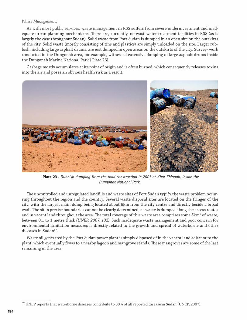
184184
Waste Management:
As with most public services, waste management in RSS suffers from severe underinvestment and inad-equate urban planning mechanisms. There are, currently, no wastewater treatment facilities in RSS (as is largely the case throughout Sudan). Solid waste from Port Sudan is dumped in an open site on the outskirts of the city. Solid waste (mostly consisting of tins and plastics) are simply unloaded on the site. Larger rub-bish, including large asphalt drums, are just dumped in open areas on the outskirts of the city. Survey- work conducted in the Dungonab area, for example, witnessed extensive dumping of large asphalt drums inside the Dungonab Marine National Park ( Plate 23).
Garbage mostly accumulates at its point of origin and is often burned, which consequently releases toxins into the air and poses an obvious health risk as a result.
Plate 23 . Rubbish dumping from the road construction in 2007 at Khor Shinaab, inside the Dungonab National Park.
The uncontrolled and unregulated landfills and waste sites of Port Sudan typify the waste problem occur-ring throughout the region and the country. Several waste disposal sites are located on the fringes of the city, with the largest main dump being located about 6km from the city centre and directly beside a broad wadi. The site’s precise boundaries cannot be clearly determined, as waste is dumped along the access routes and in vacant land throughout the area. The total coverage of this waste area comprises some 5km2 of waste, between 0.1 to 1 metre thick (UNEP, 2007: 132). Such inadequate waste management and poor concern for environmental sanitation measures is directly related to the growth and spread of waterborne and other diseases in Sudan67.
Waste oil generated by the Port Sudan power plant is simply disposed of in the vacant land adjacent to the plant, which eventually flows to a nearby lagoon and mangrove stands. These mangroves are some of the last remaining in the area.
67 UNEP reports that waterborne diseases contribute to 80% of all reported disease in Sudan (UNEP, 2007).

185185
Plastic bag rubbish is a problem especially in the urban areas and its environs, as bags are easily carried by the wind and become lodged in trees, bushes, not to mention in the marine environments, where they risk smothering corals or, being mistaken for jellyfish, choke sea turtles as a result. No recycling programmes operate in RSS and no waste separation is undertaken at source, meaning all waste (including slaughter-house debris and food waste; medical wastes including bandages, syringes, blood packs, drugs and the like; raw solid and liquid sewage; chemicals, etc) are present in dumping sites and daily waste streams, meaning that they are often dumped directly in watercourses, or they are left exposed for human access and animals to feed on (UNEP, 2007: 132).
Utilities and Service Plants:
Utilities in RSS are generally owned by the State and suffer from inadequate investment and out-dated technologies. Complicating enforcement of their appropriate management is the fact that they provide essential services to RSS citizens, meaning their activity cannot be interrupted because of unsatisfactory legal compliance or unacceptable performance (UNEP, 2007: 147).
Even amongst developing countries, electrification in Sudan is comparably low, as over 90 percent of the population still relies on wood and charcoal for their primary source of energy (according to a 1998 survey). Charcoal making therefore constitutes a significant industry for much of the population. It also contributes greatly to the rapid deforestation (including of mangrove forests) occurring throughout much of RSS and Sudan. As previously discussed, charcoal making represents an important alternative economic activity in the nomadic Beja livelihood diversification schemes. Thus, encouraging a shift from this traditional activity by promoting the use of alternative energy (such as LPG) becomes a highly sensitive and largely political issue. As stated by UNEP: ‘This move from one energy source to others is a typical example of the environmental trade-offs that occur with development’ (UNEP, 2007: 133).
The power plants operating in Port Sudan represent clear examples of poor environmental planning and management. Electricity for the city is supplied by the use of several government-operated oil-fired genera-tion stations. Power Station C, which has been built on previous salt marshes 5km south of Port Sudan on the Port Sudan-Suakin road, is located just 200m from a shallow lagoon, 500m from one of the last remaining mangrove forests in the area and similarly close to a main local recreation site along the coast (UNEP, 2007: 146). The large amount of waste oil produced by the diesel generators is simply disposed of on the ground of vacant lot abutting the station. This oil, eventually, makes its way to the nearby lagoon and mangrove stands, aided by open channels that have been cut in the sediment to facilitate its flow (ibid).
Hydroelectric power generated from Merawi Dam has been supplying eastern Sudan including the Red Sea State since 2009. The old diesel generators are now used as stand by for emergency situations or when there is overload especially during the summer season (July-September). ESRDF will also finance connec-tion of Toker town to the national electric supply grid which will enable improve the livelihood of the rural communities and improve the services of the services centres including schools, hospitals and others. The Port Sudan desalination plant also presents several risks especially in relation to waste disposal. An SIA exercise conducted by the ICZM Socioeconomic Working Group and the Socioeconomic expert, Dr. Magnus Macfarlane, evidenced the problematic nature of the Plant.
3.3.1.3 INDUSTRIAL DEVELOPMENT IN THE COASTAL ZONE
Habitat destruction, as a result of coastal development, is still localised to commercial centres. Pressure is expected to increase rapidly with the planned implementation of industrial projects and the establishment of an Economic Free Zone (EFZ), which will cover 600 square kilometres of coastal zone between Port Sudan and Suakin, including three major mangrove areas. Highly diverse coral reefs, such as Towartit, are located immediately in front of the planned EFZ. Heavy industries, petrochemical industries, fish processing fac-tories, slaughter houses with a capacity of 3,000 head per day, tanneries and warehouses are planned to be established in the area. Industrial developments at the entrance of Port Sudan harbour are anticipated to reclaim 5-8 hectares of land from the sea by landfill for the construction of industrial processing plants. This will cause loss of coastal and marine habitats and coral reef areas such as Wingate and Towartit. Already the extension of the two ports, Port Sudan and Suakin, including the construction of new port facilities involv-ing dredging and filling, resulted in severe pressure on coral reefs. The environmental impact is expected

186186
to be very severe and is likely to be become a source of serious concern along the Sudanese coast, unless appropriate environmental precautions are taken.
Urban Development: Allocation of the limited freshwater resources with inadequate concern for water con-servation and insufficient maintenance of distribution systems affects surface and groundwater reserves in the same way as described under industrial activities. The discharge of untreated or insufficiently treated sewage results in groundwater impacts and alteration in the marine environment. Near human habitations, especially in Port Sudan, solid waste is dumped on the shore and into the sea, causing damage to coastal and marine life and deterioration of the aesthetic quality. The main cause of the problem is a lack of efficient waste collection and disposal systems, aggravated by a general lack of awareness
Maritime hazards: The extensive coral reef systems of the Sudanese Red Sea coast pose severe problems to navigation. These complex navigational hazards, combined with heavy maritime traffic and limited nav-igational devices, result in constant risks of ship collisions and grounding. Problems are particularly severe near the ports of Port Sudan and Suakin, both of which have to be approached through channels among large reef complexes. Marine vessel sewage and discharge of solid waste pose additional threats. In the absence of waste reception facilities at the ports, ships dispose of their waste offshore. There is a constant threat of oil spills of any magnitude. Oil leaks on a regular basis from the oil terminal and tankers in Port Sudan harbour, which is already seriously polluted by oil. The Port Sudan power plant and shipyard, discharge their waste oil directly into the sea. Outdated, inadequate technology and a lack of enforcement of existing regulations are the main reasons for this alarming situation.
Commercial fisheries: At present, commercial fisheries are of minor importance, but with the promotion of investments this situation may change rapidly. In the past, non-selective trawls did considerable damage to the seafloor and its biota. Without available data on stocks, it is impossible to determine MSY. Shark resources are already being depleted and catches by local fishermen are declining rapidly because of uncon-trolled large-scale shark fisheries from other countries of the Region for the East-Asian shark fin market. Although no new licenses have been issued, in order to stop commercial shark fisheries, the situation is still alarming due to the large number of illegal fishing vessels. Large amounts of by-catch, including turtles, dolphins and finfish are discarded, almost invariably dead.
Artisanal fisheries: Limited availability of boats, engines and fishing gear have led to low fishing efforts off-shore and restriction to small fishing areas, leaving these near-shore, easily-accessible areas locally over-exploited, while overall finfish resources targeted by artisanal fisheries are under-exploited. Locally reduced finfish catches in the areas accessible to artisanal fishermen have a major impact on other resources. Many fishermen resorted to kokian, as an alternative source of income. Near Suakin, which was once the most important production area, kokian stocks are declining rapidly, with the annual harvest dropping from 163 metric tons in 1990-91 to just 26 metric tons in 1992-93. This is more than an 80 percent decline within just two years. Local fishermen, who are in need of subsidiary food sources, also continue to collect turtle eggs on the offshore islands. The overall pressure on turtle populations in the Sudanese Red Sea is unknown.
Many of the above mentioned problems are attributed to inadequate environmental planning, limited use of environmental assessment, a general lack of law enforcement, a lack of awareness even among law enforcement authorities, weak institutions and the absence of surveillance. Recently, power was transferred from the central government to federal states. Yet the new system is not yet well established, resulting in an unsatisfactory legal situation and inadequate enforcement of existing regulations.
The impact of previously ineffectual environmental governance of industry in Sudan has taken a serious toll on many of Sudan’s natural resources and habitats. While governance has been steadily improving as of about 2000, major short-falls and challenges remain, especially in the areas of project development, impact assessment, improving out-dated facilities and technologies, and in changing attitudes at higher levels of Government in support of more sustainable and responsible practices (UNEP, 2007: 141). Furthermore, most industrial operations (aside from oil related activities) have suffered from serious lack of investment over the years, which has thereby compromised their environmental performance. It has also meant that routine monitoring and assessment exercises have been rudimentary at best.
The signing of the 2005 CPA and 2006 ESPA has led to an improved investor climate in Sudan, mean-ing greater numbers of development proposals and projects are taking root in RSS, which, if not efficiently managed and sustainably guided, will inevitably result in environmental and social consequences. Industry

187187
is technically governed by the Environmental Framework Act (2001) and must technically comply with both National and State legislation. In practice, however, lack of enforcement, inadequate assessments and poor monitoring means industrial performance is insufficiently scrutinised.
The main industries currently operating in the Port Sudan area and coastal zone relate to: oil industry operations (refinery, export terminal, oil and gas exploration activities), harbour operations and warehous-ing, utilities (power stations, a desalination plant), saltworks, other small industry and food processing (such as sesame seed oil production) activities, along with growing tourism and fisheries industries. The growth of the oil industry has also contributed to an increase in service industries and imports. The major industries, aside from oil, will be outlined below, with section 4.4.2 being dedicated entirely to oil development.
The most significant issues relating to industry in RSS include: lack of EIA, SIA, or public consultation for development projects; poor environmental performance, mostly resulting from out-dated facilities and equipment; lack of forward-thinking policies and management approaches at the higher levels of govern-ment; and, high levels of governmental backing for certain development projects, meaning activities progress rapidly with little opportunity for public scrutiny or enforcement of environmental and social assessments. (UNEP, 2007). Taken individually and together, such poor management and planning for industrial activities and disposal of associated waste and by-products, means that the threats to human and environmental health are inevitable and unjustifiable, as they are ultimately avoidable if only better practices are introduced and enforced.
Shrimp farming:
During this survey, one Shrimp Farm existed south of Port Sudan, farming the Black Tiger Prawn (P.monodon) mainly for export (raw and processed) to Saudi Arabia (4,125mt in 2004, FAO fishery country profile, 2008).
Other shrimp farms are being planned, but it was not possible during this survey to have access to the feasibility study and thus have a precise idea of the shrimp farm development envisioned by the Red Sea State or the potential sites that may host the farms.
Nevertheless, we wish to attract attention on the potential environmental and social problems linked to the development of Shrimp farms.
Environmental issues: During the 1980s and 1990s, about 35% of the world's mangroves vanished and shrimp farming was the major cause (Valiela and al., 2001). Areas of mangroves were cleared, reducing the associated biodiversity and discharging the nutrient-rich effluents into the environment, seriously upsetting the ecological balance. The effluents contain waste waters with significant amounts of chemical fertilizers, pesticides, and antibiotics that pollute the environment. Prolonged use of a pond can lead to an incremental build-up of bottom sludge from waste products and excrements. Flushing a pond never completely removes this sludge and, eventually, the pond is abandoned, leaving behind a wasteland with the soil made unusable for any other purposes due to the high levels of salinity, acidity and toxic chemicals (ACA/MPEDA: Health Manual, 2003). Thus, a typical pond in an extensive farm can be used for only a few years. An Indian study estimated the time to rehabilitate such lands to be about 30 years (International Shrimp Action Network, 2000). Thailand has banned inland shrimp farms since 1999 because they caused too much destruction of agricultural lands due to salination (FAO, 2000). Many of these problems stem from using mangrove land that has high natural pyrite content (acid sulphate soil) and poor drainage.
Social Issues: Poorly planned shrimp farming could bring threats to local livelihoods. A shadow cost of $10 is left in terms of ecological devastation and ruined livelihoods for each $ of export earnings to companies (Vandana Shiva, reaction to Oxfam Trade Report, 2002). The poorly planned and rapid expansion of shrimp farms could result in the local coastal population being denied access to the coast by a strip of shrimp farms with serious impacts on the local fisheries. Such problems are compounded by the degradation of common resources, such as excessive use of freshwater to control the salinity of the ponds, causing the water table to sink and leading to the salination of freshwater aquifers by an inflow of salt water (Barraclough and Fin-ger-Stich, 2008).
It is also important to stress that land concentrations in a few hands has been recognised to carry an increased risk of social and economic problems developing, especially if the landowners are non-local (Hempel and Al, 2002).

188188
If fish farming is to be developed, then the legislatory framework should ensure that preference is given to small-scale cooperative farms, directly owned by local populations (family, villages, etc). Thus, the inhab-itants of the RSS will benefit directly. There will be minimised impacts on the environment, as the natural balance between this activity and others will be maintained, as it would be implemented by the same users of the resources, rather than external stakeholders with no additional interests or ties to the local natural and socio-economic environment.
To summarise, conflicts with local communities usually have two root causes:
i) Competition for common resources such as land and water use rights,
ii) Changes induced by wealth redistribution.
Recommendation: Adopt the best practices for shrimp farming developed by the World Bank (Shrimp Farming and the Environment: Boyd and al., 2002). The key points of which are provided in the Recommenda-tions section of this chapter.
Dungonab Salt Works Factory:
The salt works on the southern part of the Dungonab Peninsula has been active since the early 20th cen-tury. The salt pans cover a large area, but very few workers are employed to attend them. The total number of workers at the plant never exceeds one hundred and is usually considerably smaller than this. Trucks transport the salt from the area to Port Sudan and make up a large proportion of the road traffic.
Overall, the environmental impact of the salt works beyond its own boundaries appears to be minimal and, given that the activity has been carried out for almost a century, it is clearly environmentally sustain-able in its present form. Any changes in methods or expansion of its size will, however, have to be closely monitored and should seek initial approval from and integration with the MPA Management.
Extraction and Mining (from Metz, 1991):
In 1990 the mining industry accounted for less than 1 percent of the total GDP of Sudan. A wide range of minerals exist in Sudan, but the size of reserves had not been determined in most cases.
Non-hydrocarbon minerals of actual or potential commercial value include gold, chrome, copper, iron, manganese, asbestos, gypsum, mica, limestone, marble and uranium. Gold had been mined in the Red Sea Hills since Pharaonic times. Between 1900 and 1954, several British enterprises worked gold mines in the area and extracted a considerable quantity of the metal—one mine alone reportedly produced three tons of gold between 1924 and 1936. During the 1970s, the Government's Geological Survey Administration located more than fifty potential gold-producing sites in different parts of the country. Several joint ventures between the Sudanese Mining Corporation, a government enterprise, and foreign companies were launched in the 1980s; these undertakings produced gold at Gebeit and several other mines near the Red Sea Hills beginning in 1987. In 1988, about 78,000kg of gold ore were mined in Sudan. In late 1990, Sudan and two French mining companies formed a joint venture company to exploit gold reserves in the Khawr Ariab wadi in the Red Sea Hills.
Large gypsum deposits, estimated to contain reserves of 220 million tonnes, were found along the Red Sea coast. Reportedly of high purity, the ore was mined mainly north of Port Sudan. In the late 1980s, about 20,000 tonnes were produced annually, about 6,000 tonnes by the Sudanese Mining Corporation and the remainder by private operations. Gypsum was used mostly in the production of cement. Limestone, found in substantial quantities in Sudan, was mined both for use in making cement and for other construction materials. Marble was also quarried for the latter purpose.
There are more than 500 million tonnes of iron ore deposits in the Fodikwan area of the Red Sea Hills, and beginning in the late 1980s a project had been planned to produce between 120,000 and 200,000 tonnes a month.
Gravel and sand are being extracted near the dump site in Port Sudan, as well as elsewhere in RSS. In Port Sudan, the extracted materials are being sourced from river gorges. A private company, Elthager Company - Sandstone, manages the gravel and sand extraction.
Another potential source of mineral wealth was the Red Sea bed. In 1974, officials established a joint Sudanese-Saudi Arabian agency to develop those resources, which included zinc, silver, copper and other

189189
minerals. Explorations below the 2,000m mark have indicated that large quantities of the minerals are pres-ent, but, as of 1990, no actual extraction had been undertaken.
Table 41. Threats to the coastal and marine environment and natural resources in Sudan (Upgraded from PERSGA 2000)
IssueSymptoms/
impactsImmediate
causesRoot causes Extent Severity
Habitat Destruction
Coastal development
Dredging and filling, destruction of coral reefs
Urban, indus-trial and port development
Inadequate environ-mental planning, limited use of envi-ronmental assess-ment
70km strip local, starting from Port Su-dan to Suakin. In addition to sheikh Ibrahi-em and Galb Ala’alam city*
Severe
Mangrove cutting and overgrazing
Deterioration of mangrove habitat, de-creased fish and shrimp catches, reduced water quality
Industrial and port develop-ment, grazing by camels, wood collec-tion, decreased freshwater supply
Lack of regulations and management, lack of awareness, lack of alternative fuel, damming of wadis
Throughout the area, especially south of Port Sudan
Severe between Port Sudan and Suakin
Physical damage to coral reefs
Loss of coral habitat and decline in reef associated fauna
Anchor damage, ship grounding, damage by fishing nets
Poor navigation con-trol systems, lack of moorings, destruc-tive fishing methods
Local, through-out the area
Low to moderate
Damage to coral reefs by visitors
Coral break-age, decline in reef associated fauna
Trampling of shallow reef flats, coral breakage, marine souve-nir collecting, anchor damage
Lack of management and enforcement, lack of environmen-tal awareness
Localised Currently low
Living Marine Resources
Potential over fishing of najil (Plectro-pomus) for export markets
Decrease in average size
Increased fishing efforts, landing beyond MSY
Lack of management and enforcement, lack of environmen-tal awareness
Throughout the area, concen-trated in north-ern part
High
Illegal shark fisheries
85% decline in national landings over past 10 years, damage to reef from nets.
Illegal fishingLack of surveillance and enforcement of existing regulations
Throughout the area Severe
(Continued)

190190
Potential over fishing of kokian (Tro-chus, Strombus, Lambis) for local and export markets
80% decline in annual landings over 9 years
Increasing fishing efforts
Lack of stock assessment hampers resource manage-ment
Southern coast and Moham-med Qol Area
Severe
Planned fish and shrimp farming
Irreversible conversion of coastal habi-tats, mangrove destruction, declining wa-ter quality
Pond construc-tion, mangrove destruction, possible use of chemicals, hormones and nutrients
Poor planning and inadequate impact assessments
Localised with growing poten-tial
Low, may become severe
By catch of Turtles, Dugongs and Collection of turtle eggs by artisanal fisher-men
Decrease of numbers in the wild and in nesting populations of turtles
Need for sub-sidiary food supply
Lack of public awareness, lack of alternative food resources, lack of enforcement
Offshore fisher-ies and islands
Low to moderate
Potential over fishing of sea cucumber for export market
Decrease in av-erage size and abundances
Illegal fishing Lack of surveillance and enforcement
Localised southern coast and Mohamed Qol area and isles
Severe
IssueSymptoms/
impactsImmediate
causesRoot causes Extent Severity
Navigation and Maritime Risks
Navigation risks
Extensive and routine risk of ship collisions and grounding
Limited navi-gation devices and poorly sep-arated traffic
Complex navigational hazards, heavy maritime traffic
Throughout the area, particular in port areas, emerging prob-lem near Free Zone
Moderate to severe
Marine vessel sewage
Localised ma-rine and beach pollution
Discharge from ships
Inadequate on-board treatment, lack of port reception facilities
Throughout the area Moderate
Ship discharge of solid waste
Solid waste on shoreline, in mangrove areas and coral reefs
Discharge of solid waste from ships
Inadequate disposal facilities, inadequate surveillance and en-forcement, lack of port reception facilities
Throughout the area Moderate
Ballast water
Contamina-tion of coastal and marine biota, new species
Discharge of ballast water
Up sense of ballast water treatment facilities.
Particular in port areas, dur-ing upload and off load
Severe
(Continued)

191191
Petroleum Development and Transport
Small oil spills (<20 mt)
Beach contam-ination, dam-age to coastal and marine biota
Tanker clean-ing, discharge of waste oil, bunker oil spill
Lack of reception facilities at ports, inadequate control, lack of enforcement
Localised throughout the area
Moderate
Medium oil spills (20-100 mt)
Beach contam-ination, dam-age to coastal and marine biota
Discharges from termi-nals, small accidents at sea
Inadequate control and monitoring of procedures, equip-ment and personnel, inadequate training
Localised throughout the area
Moderate to severe
Large oil spills (> 100 mt)
Destruction of coastal and marine biota and habitats, devastation of beaches
Rupture of oil tanks in collision or wreckage
Insufficient tanker safety specifica-tions, poor naviga-tion aids.
Localised throughout the Region
Severe
Industrial Activities
Surface and groundwater use
Excessive exploitation of surface and groundwater for industrial use
Excessive pumping, inad-equate concern for water con-servation
Poor regulation of water exploitation
Localised in in-dustrial areas, emerging issue Free Zone and desalination plants.
Moderate to severe
Industrial pollution
Decline in water quality
Chronic release of pollutants
Lack of enforce-ment, inadequate technology
Localised, emerging issue in free zone
Currently low to moderate
Waste oil dis-posal
Soil and groundwater pollution
Improper dis-posal of used motor oil
Lack of proper oil disposal and recov-ery options, lack of effective regulations and enforcement
LocalisedCurrently low to moderate
Urban Development
Surface and groundwater
Excessive exploitation of surface and groundwater for industrial use
Excessive pumping of groundwater
Allocation of water resources with inad-equate concern for water conservation, inadequate mainte-nance of distribu-tion systems
Localised Moderate to severe
Discharge of untreated or insufficiently treated sewage
Groundwa-ter impacts, eutrophication and alteration of marine environment, threats to public health
Lack of sewage treatment plants, lack of maintenance of existing plants
Inadequate pollu-tion control regula-tions, monitoring and enforcement
Localised, urban areas
Moderate to severe
(Continued)

192192
Disposal of solid waste
Damage to coastal and marine life, deterioration of aesthetics
Improper gar-bage disposal
Lack of adequate waste disposal regulations and en-forcement, lack of a waste management system, inadequate public awareness
Localised Moderate to severe
Other Concerns
Sedimentation from agricul-ture and graz-ing
Destruction of vegetation cover, dune mobilization, coral smoth-ering
Grazing by livestock, fuel wood collec-tion
Inadequate man-agement of coastal grazing
Localised Low to moderate
Use of pesti-cides in coastal zones
Contamina-tion of soils and water
Large scale use of pesticides for locust control
Inadequate planning and surveillance, lack of awareness
Throughout much of the area
Moderate to severe
*Sheikh Ibrahim is a new port for the export of livestock and fisheries to the Gulf States. Construction of the port has already started but it is causing destruction of a lot corals most of which were healthy without any signs of bleaching according to a study done by the scientists of the Marine Science Department of the Red Sea State University. Galab Ala’alam is the local name of Mukwar or Mugarsam Island where construction of new buildings already started.
3.3.1.4 LINKING ENVIRONMENTAL AND HUMAN HEALTH: LOCAL AND GLOBAL
‘We forget that the water cycle and the life cycle are one. There is no such thing as the environ-ment of a single species—of man, for example, or of a town, a locality. The only environment
is the environment of life.’
(Jacques Yves Cousteau, 1972)
Mismanaged environmental services, alongside poorly planned development, rapid urbanisation, deplorable waste management and use of out-dated technologies by many RSS industries not only poses a serious threat to environmental health, but also to the health of human populations in the State, especially those in and around the urban centres. The 2007 UNEP Post Conflict Environmental Assessment highlights how most urban and environmental health issues are closely linked, which means solutions should similarly be inte-grated. The greatest health risks identified by UNEP stem from: rapid urbanisation; poor urban planning; unsafe drinking water, unsatisfactory sanitation and waterborne diseases; lack of solid waste management; air pollution and urban transport; energy production and unsustainable construction. As outlined above, all these issues are (or risk being in the near future) areas of concern in RSS.
With one of the highest population growth rates in the country (2.9 %) and extremely high rates of urbanisa-tion (Babiker & Pantuliano, 2006), the environmental and social risks in RSS are numerous, especially given the extent of poverty and harsh environmental conditions through much of the State. Infrastructure in Port Sudan and Suakin, therefore, often operates close to or at capacity. Current infrastructure and services are insufficient to address the myriad needs linked with city management, especially in terms of waste management and related health threats:
‘The shortcomings in water quality and sanitation in Sudan are directly reflected in the inci-dence of waterborne diseases, which make up 80 percent of reported diseases in the country. The incidence of disease is highly seasonal: the greatest problems usually occur at the start of the wet season as the rains and run off mobilise the faecal matter and pollution that have
193193
accumulated during the dry season…Apart from the routine waterborne illnesses such as chol-era, dysentery, hepatitis A and a range of parasitic infections like schistosomiasis, a number of tropical illnesses including malaria, sleeping sickness, river blindness, guinea worm and
visceral leishmaniasis are still prevalent.’ (UNEP, 2007: 129).
Furthermore, no systematic air quality monitoring takes place in RSS. While the Environmental Framework Act (2001) does stipulate several prohibitions on air pollution, it does not provide quantifiable standards to assess and monitor it. As a result, the performance of factories, facilities and other such operations cannot be meaningfully evaluated, nor can regulatory authorities effectively develop their measurement capacities. Although air emissions do not pose a critical level of concern in RSS at present, especially given the low level of development and comparably small industrial operations, a proactive, preventative approach would be prudent. Without some degree of monitoring and measurement in place, it would be impossible to identify areas of real or potential concern, therefore making mitigation and remedial measures more difficult and more costly.
As oil activities and other investments further take root in RSS, as an increasing urban population expands the number of cars on the roads and as garbage continues to be burnt as a form of disposal, the respiratory and other health impacts are obvious. Most cars, trucks and buses driven in Port Sudan, for example, are generally older models that use poor quality leaded gasoline and which spew fuel emissions. The transportation of pol-lutants in the form of aerosol (and easily breathed) particles during sand and dust storms presents an additional concern, especially given the prevalence of such storms in the drier areas of RSS and Sudan.
The 2005 Interim National Constitution considers the management of urban and health sectors to fall under the primary responsibility of States, which will then allot duties to locality and city level authorities. The Federal Government is involved to some extent in aspects relating to physical development, health, water, irrigation and transport (UNEP, 2007: 134). As pertains to ensuring environmental and human health, the Provisional Constitution of the Red Sea State (2005) determined ‘the State to work towards enhancing community health and protecting the marine and terrestrial environment and maintain the ecological balance of ecosystems within these environments’ (Chapter 2, Article 11: The Guiding Principles for Health and Environment). Formal, legal rec-ognition of the link between development practices and impacts on environmental and human health should be further sanctioned to better promote responsible development and sustainable infrastructure, systems.
The expansion of responsible urban planning and adequate infrastructure is, however, compromised pri-marily by inadequate financing at the State level to address such needs: ‘The main issue for State Governments in Sudan (outside Khartoum) in areas such as urban planning and environmental health is insufficient funding: local officials are generally quite aware of the problems but cannot act in the absence of funds’ (UNEP, 2007: 136). It would therefore be useful for RSS Ministries to explore harnessing private sector funding to contribute to appropriate urban planning and responsible development needs. For example, to use taxes levied from inter-ested investors towards updating infrastructure in a more responsible and sustainable way and/or to insist that industrial investors include waste management systems that responsibly dispose of their by-products (agree-ment for such industries to operate in RSS would be dependent on industry commitment to provide such services, and on the ‘polluter pays’ principle in a proactive/preventative sense).Health and ICZM:
As environmental and human health are inseparable and extremely important aspects of coastal/marine and urban planning, as well as cross-cutting issues for ICZM generally, the ICZM Survey has addressed this issue in several ways.
Firstly, to expose RSS actors (most notably, the ICZM Office staff) to critical urban planning needs (prin-cipally wastewater treatment facilities) that contribute to ICZM and help protect environmental and human health. In August 2007, the ICZM Office team made a study tour to Aqaba, Jordan to witness coastal develop-ment and marine park operations. Included in this mission was a visit to the local wastewater treatment facility, including a tour, discussions with the managers and presentation of the key mechanisms and strategies of the plant.
The Plant was established due to the increasing need to manage waste generated by Aqaba’s growing pop-ulation. Previously, effluent had been discharged directly into the sea, which posed severe environmental and human health consequences and received strong global condemnation as well. The Plant operates on a zero-discharge policy, meaning all treated material must be reused. Accordingly, treated sludge is converted
194194
into fertilisers and other secondary products that can then be used for growing local plants and other agricul-tural needs. Liquids are eliminated via evaporation. All effluent complies with national and international safety and sanitation standards.
Secondly, to raise understanding of the connection between local marine/coastal mismanagement and the wider global system, the ICZM Project partnered with the Harvard Medical School, Centre for Health and the Global Environment68, in order to harness the school’s expertise and travelling exhibit ‘Healthy Oceans, Healthy Humans’. The exhibit outlines the inseparability between human and ocean well-being, in both a positive and negative sense, and focuses on three general categories, including food security, bioprospecting and weather patterns.
To address the wider regional and global implications of environmental health, the ICZM Project had the exhibit translated into Arabic. The exhibit will travel around the region, including Sudan, to further promote these concepts to the wider public and key Governmental actors in the Red Sea countries.
Among the key points of this exhibit and the most useful for Sudan at the current time, is the recommenda-tion for increased use of renewable technologies, restricted dumping in the ocean and sustainable resource use; in other words, a mentality of ‘take less from the ocean, and put less in’. The exhibit highlights how oceans house over 50,000 compounds that hold medicinal properties, meaning oceans provide substantial opportunities for medicinal research. Bioprospecting is becoming an increasing activity worldwide: coral reefs serve as the ‘medicine chests’ of the sea, providing new drugs for diseases like cancer and AIDS. Furthermore, oceans help ensure food security, as fish constitute a globally important source of protein, providing more than beef or chicken. As fish stocks are threatened by over-fishing and pollution, however, so too is human nutrition. Up to 70% of fisheries are over harvested and are also increasingly becoming contaminated with such toxins as mer-cury and PCBs, which contribute to brain and heart damage, as well as nervous system malfunction in humans. www.chge.med.harvard.edu/programs/healthyoceans/index.htm
3.3.2 Oil Development: Operations, Management and Issues
‘Sudan belongs to the least developed countries in the world, but is unique among low income post conflict countries in terms of available domestic resources.’
(ECOS & Fatal Transactions, 2008)
3.3.2.1 OIL MANAGEMENT AND OPERATIONS
The oil industry in Sudan is overseen by the Ministry of Energy and Mining and presided over by the Govern-ment of National Unity (GoNU). The 1998 Petroleum Wealth Act and the 2001 Environmental Framework Act technically stipulate environmental performance prerequisites for oil industry operations. However, even Government actors of the MEPD have revealed the difficulty of gaining access to inspect the elusive oil sites, meaning that it has not been possible to sanction them for lack of compliance (UNEP, 2007: 154). The Marine Oil Spill Response Plan is now obsolete and no EIA or SIA documents are publicly available.
Substantial oil and gas resources have been found in RSS and further exploration is planned.
68 The Harvard Centre for Health and the Global Environment aims to create educational materials that inspire marine conservation by demonstrating how human health depends on a healthy ocean environment. The program is based on the Centre’s belief that by using the powerful, direct connection of human health, people will be moved to think about the ocean not just as a vacation spot or mysterious underworld, but as part of the system that fosters human life. This is a collaborative program, working closely with advisors and partners across the United States (www.chge.med.harvard.edu/programs/healthyoceans/index.htm).

195195
Other oil operations are scattered along the coast, including a marine export terminal at Port Sudan and a refinery south of Port Sudan, which provide a degree of economic benefit both locally and nationally. The upstream oil industry69 in Sudan is anticipated to dominate industrial activity for at least a generation, with moderate growth expected in the currently small downstream sector70 (UNEP, 2007: 142). Four crude oil export pipelines connect oil fields elsewhere in Northern Sudan with Port Sudan, which comprise a combined length of 3,900 km.
Sudan is becoming an increasingly important oil exporting country within the region. In recent years, two crude oil export terminals have been brought into operation at Bashayer and the oil products import/export terminal at El Khair has been opened.
Sudan has demarcated a 38,200km2 block off the coast of the Red Sea (Block 13) for oil exploration, which encompasses DMNP. An initial exploration investment of US $25 million will be required for the first three years. In late June 2007, Sudan signed a deal with a Chinese state oil firm, China National Petroleum Corpora-tion (CNPC), granting it a 40 percent stake in Block 13. Both an Indonesian state firm and the Sudanese state firm Sudanpet have a 15 percent stake in the site, with the Nigerian Express firm, AfricaEnergy firm and the Sudanese Dindir Petroleum International taking 10 percent. Sudan’s National Petroleum Commission approved the deal. The Italian company, Agip, first began work in the area in 1959 after finding evidence of oil and gas reserves. Three wells were drilled, but ‘were not commercial’ according to official sources (Reuters, Sudan assigns Chinese CNPC offshore oil block, 27 July 2007: http://africa.reuters.com/business/news/usnBAN747285.html).
Block 15, covers an area of 28,655km2 within the Red Sea Basin, with roughly half being located in deep waters between 300m to 800m deep. Equity is shared between the following shareholders: Petronas and CNPC (35% stakes), Sudapet (15 percent), Express Petroleum of Nigeria (10 percent) and the Sudanese company High Tech Group (5 percent). The signing of the Exploration and Production Sharing Agreement (EPSA) marks Sudan’s first integrated gas project. The EPSA entitles the investors to sell discovered gas jointly with the GoNU and be granted an opportunity to invest in potential downstream gas, power and petrochemical projects that may arise from the site’s resources. To begin operations, investors committed to acquire a minimum of 3,500km of 2D seismic line and 500km2 of 3D seismic line, to drill five wildcat wells and to allot a minimum expendi-ture of US $58million in three commitment phases over a six year period. (African Oil Journal.com, First Sudan Offshore Block Award for Petronas, 30 Aug 2005: http://www.africanoiljournal.com/8302005%20first_sudan_off-shore_block_award%20for%20petronas.htm)
In 2010, the Sudanese government has started its first overseas offshore exploration in the Red Sea Basin off Port Sudan with the help of the state China National Petroleum Corporation. The well falls in Area 15 under the franchise of the Red Sea Petroleum Operating Co., a consortium of five firms including the CNPC, Malaysia’s state oil firm Petronas, Sudan’s state oil firm Sudapet, Nigeria’s Express Petroleum and Sudanese firm High Tech Group (Sudan Tribune, 3 feb 2010 : http://sudantribune.com/spip.php?article33991).
The confidentiality of oil contracts in Sudan makes thorough scrutiny difficult, so it is possible that other potential investments and operations are in the process of being developed, or may be developed in the not too distant future. For example, the northern most area of land above DMNP is a potential concession site, although it is unclear on the precise status of oil activity. Some sources indicate that the Swedish oil company Lundin has concession rights there, although this has not been verified at the current writing of this report.
69 The upstream oil industry encompasses exploration for crude oil and gas, extraction, transport via pipelines and tankers to market locations. Such activities dominate the Sudanese industry at present, as no petrochemical indus-tries currently operate and only limited activity takes place in the refinement of oil and gas into usable products.
70 In this sector, oil and gas are refined and converted into usable products (petrol, diesel, lubricants) and sold accord-ingly.

196196
Port Sudan also has an export terminal for liquid petroleum gas (LPG), which has been identified as a pos-sible industry that could be expanded in Sudan. Increasing production and use of LPG could help offset the negative environmental impacts caused by gas flaring during oil production (which results in green house gas emissions and air quality issues) as well as provide an alternative energy source for the Sudanese, thereby minimising reliance on charcoal making and its associated mangrove cutting and deforestation (UNEP, 2007: 151). In 2005, the annual consumption of LPG in Sudan was 102,000 tonnes; government estimates, however, put the potential domestic demand at 554,000 tonnes per year (ibid).
3.3.2.2 OIL INDUSTRY THREATS AND ISSUES
The most serious environmental implications from oil development activities arise mainly from the lack of environmental consideration in the planning of new projects (including insufficient or nonexistent EIA and SIA protocols), poor environmental performance of operations, the considerable risk of oil spills and other pollution-related issues. Secondary impacts include the urbanisation/settlement booms that can result from the increased economic attractiveness of oil sites for workers, as well as related construction impacts, such as roads, pipelines and other infrastructure that intrude into previously inaccessible areas (such as DMNP in the case of the new Egypt-Port Sudan coastal road).
Increasing oil exploration, extraction and transport amplifies the likelihood and severity of potential risk and associated environmental degradation. Oil spills, during maritime transport, represent the biggest environmental concern confronting the industry. However, the disposal of water associated with crude oil extraction is another largely overlooked risk, especially given the lack of industrial wastewater treatment facilities in RSS. The potential for oil spills at sea is heightened by the many navigational hazards existing in the Sudanese Red Sea. The need for updated charting and hydrographical surveys of the Red Sea to mitigate such risk is further discussed in a later Section.
Exploration activities are a particular area of concern at present, given that exploration plans are increas-ing including in and around Dungonab Marine National Park.
Without properly enforced management criteria and the use of more sustainable technologies, oil explo-ration activities can have the greatest impact on the environment of all other phases of oil production. This is mostly due to the large areas typically affected, the temporary nature of the work and that the impacts of exploration can last for generations if effective remediation practices are not undertaken. The risk is further compounded by the fact that exploration is only successful in 10% of cases, with unsuccessful operations being simply abandoned by oil companies (UNEP, 2007: 149).
In regards to DMNP, the new coastal road (which no doubt was constructed with at least partial consider-ation for facilitating oil development in Northern RSS and assisting the transport of oil) is already showing signs of increased use and impacts along the coast in parts of the MPA. Increased heavy equipment needed for operations, the creation of seismic survey lines and the establishment of drilling sites in the area, will wreak havoc on the protected area’s vulnerable mangroves, coastal vegetation, coral reefs, seagrass beds and subtidal habitats, and on the integrity of its fragile ecosystems at large. The resulting erosion, siltation and sedimentation, noise disturbances, increased rubbish and oil diffusion, among other risks, will further compound the environmental and social impacts of such activity.

197197
Figure 9. Localisation of the main economic activities and licensed oil Fields in the Red Sea State. Block 13 and 15 includes the two Marine Protected Areas of Sudan (Sanganeb and Dungonab Bay National Parks).
With the increasing operations in oil exploration and refinement, the threats associated with contami-nated water from such operations will become increasingly pronounced, posing serious risks to the health of coral reefs and other coastal and marine habitats in the vicinity of such operations (UNEP, 2007: 150).
It is worth mentioning that, currently, most oil operations in RSS are run by Chinese companies71 alongside GoNU. Both the Sudanese and Chinese do not have positive track-records when it comes to environmental (or social) performance of industry, which does not bode well for the industry’s sustainable growth and man-agement, especially given the confidential nature of oil contracts and the associated absence of independent scrutiny of oil ventures: ‘Elsewhere in the world...the general experience is that the industry’s level of environmental performance is closely linked to the level of external scrutiny—secrecy is bad for performance’ (UNEP, 2007: 149).
In regards to SIA, oil operations elsewhere in Sudan have been pursued with little if any consideration for the concerns of local communities. Whole communities have routinely been expelled from their traditional lands so that development can take place (Pantuliano, 2005). Furthermore, direct benefits to local RSS com-munities are limited, especially in terms of job creation and technology transfer, as most profits go to the Government and companies mainly hire their own nationals (U.S. Department of State, 2007).
Oil Spill Threats: The risk of oil spills stems from two main activities, including the process of loading oil on ships from shore, as well as during the navigation of oil-loaded ships in the Red Sea.
A small-scale spill event during loading operations was reported at the marine export terminal in RSS in 2004, which resulted in a spill of approximately 10m3 (UNEP, 2007: 151). The modern facilities used at the export terminal, however, minimises the risks of a major spill occurring as long as operations are well managed.
71 Most western oil companies operating in Sudan gradually pulled out as a result of the North-South civil war and their own domestic pressures, of forced sanctions against Sudan.

198198
Oil spills from ship transport presents a larger and much more serious risk, especially given the fragile environment of the Sudanese Red Sea, the increasing volume of traffic and the navigational hazards present throughout the area in the form of shallow submerged coral reefs, small islands, and sandbars. The tanker traffic at the Port Sudan terminal is growing alongside the increased development of the oil industry in Sudan, with over 200 tankers expected to visit the terminal per year. As the Sudanese coast is lined with fringing reefs, few safe havens are available for ships in distress.
Because of the high risk of the Sudanese territorial seas, it would be impossible to completely eradicate the threat of oil spills. However, Sudan’s safeguards to respond to potential spills are deemed in-line with inter-national standards. Sudan’s contingency planning and risk preparedness to respond to oil spills and marine pollution is further along with a discussion on the relevant MARPOL protocols addressing these issues.
3.3.3 Ports, Navigation and Maritime Issues in Sudan
3.3.3.1 RED SEA MARINE TRAFFIC
The Red Sea and Gulf of Aden form part of the major east-west shipping route passing through the Suez Canal, which carries around 7-8% of global seaborne trade. Almost 17,000 vessels totalling well over 600 million NRT (Net Registered Ton) were in transit through the Canal in 2004 and the number of ships and their tonnage is increasing year by year. The great majority of these vessels also pass through the Straits of Bab el Mandeb at the southern entrance to the Red Sea.
At present, the total number of ship passages in the southern Red Sea is estimated to be around 22,000 annually, including tankers carrying around 85 million tonnes of oil from the Gulf and from Sudan into the Red Sea.
Traffic passes from the Indian Ocean and Gulf of Aden, via Bab el Mandeb, to the Sudanese ports of Port Sudan and Suakin. There is also crossing traffic between these ports and the port of Jeddah on the east coast of the Red Sea in the Kingdom of Saudi Arabia that lays NE of Port Sudan.
3.3.3.2 LEGAL FOUNDATIONS
IMO is the United Nations specialised agency with responsibility for the safety and security of shipping and the prevention of marine pollution by ships. Its responsibilities are met through the preparation of draft Conventions, Protocols and other Instruments, which are then considered by the maritime world at Assem-blies held at IMO Headquarters in London. Sudan joined IMO in 1974.
Ratification of IMO conventions and their implementation by the state may be regarded as one measure of the significance of the state within the international maritime community. In general, states wishing to increase their ‘maritime’ footprint will ratify all the IMO Conventions that they can take responsibility for through effective implementation.
The total number of IMO Conventions relating directly to shipping and maritime activities listed by IMO is now 60. Sudan has ratified only 9 of these conventions since it joined IMO 34 years ago and this position has not changed over the past 5 years.

199199
Table 42. IMO Conventions to which Sudan is a Party (May 2008).
Brief Title of Convention Date of Accession by Sudan
IMO Convention 1949 5 July 1974
IMO Amendments 1993 21 May 2002
SOLAS Convention 74 15 May 1990
LOAD LINES Convention 66 26 September 1991
TONNAGE Convention 69 21 May 2002
COLREGS 1972 (most recent) 11 March 2003
STCW Convention 78 26 February 1997
SUA Convention 88 22 May 2000
SUA Protocol 88 22 May 2000
Source: IMO Web Site
Given the growing significance of maritime trade to Sudan, as evidenced by its increasing container and bulk cargo volumes and highly important oil exports, the position of the country with respect to accession to IMO Conventions remains very weak. Some other countries in the region, such as Egypt, Jordan, the Kingdom of Saudi Arabia and Yemen, have been far more pro-active in recent years in their involvement with the IMO and in their accessions to IMO conventions. Changes in the Region since 2005 are shown in Table 43 below.
Table 43. IMO Convention Accessions in the Region since 2005.
Country Djibouti Egypt Eritrea Jordan KSA Somalia Sudan Yemen
2005 11 35 8 12 24 2 9 19
2008 12 36 10 23 29 2 9 22
Source: IMO Web Site
It is important that Sudan should carefully review, through the Ministries of Transport, Environment and Justice, its position with respect to the ratification of IMO conventions, in particular, and examine the case for becoming a party to several other key conventions that would strengthen its maritime position.
Ratification of any Convention, Protocol or other Instrument relating to maritime matters by a Govern-ment requires certain procedures to be followed. These will vary from state to state depending on national law and practice and current procedures are known to the Maritime Administration Directorate, SPC and Ministries concerned.
While the number of Conventions that Sudan is a party to is small, nevertheless it is a party to some of the key Conventions on which the work of IMO is based. Other important Conventions that it could or should become party to are discussed below.
Strengthening Sudan’s Legal Mandates:
As indicated in this section, Sudan becoming a party to MARPOL 73/78 and other important IMO Con-ventions dealing with prevention of pollution to the marine environment from ships, dumping of waste, intervention, compensation, search and rescue, facilitation, salvage, wreck removal, pollution response mea-sure and ballast water, will have significant benefits to the country and to the marine environment. There are other IMO and ILO Conventions that Sudan could usefully become a party to, but the ones reviewed above may be considered as the ones that should take priority.

200200
MARPOL 73/78 is particularly important and should be the focus of Sudan’s efforts for the immediate future. Ratification of MARPOL 73/78 would not only positively affect Sudan, but also the Red Sea in gen-eral. It will increase the likelihood that the Red Sea and Gulf of Aden will become, in practice, a Special Area under MARPOL 73/78, joining the Mediterranean and, from 01 August 2008, The Gulfs area, thus offering a greater degree of protection to the region from oil that could enter the water from the thousands of ships in transit through the Red Sea.
It has been recommended that a pollution map for the Red Sea and Gulf of Aden be prepared, giving ship-owners details of all ports in the region where oily waste can be properly disposed. Such a map would provide the shipping industry with the information ships require in voyage planning, in relation to where ships can discharge MARPOL waste materials for each of the region’s ports. The map and full details of the facilities available should be published and posted on PERSGA and port web sites. This measure will assist in the process of allowing IMO to decide when the Special Area status of the Red Sea and Gulf of Aden can enter into force.
Another very useful action would be to circulate a questionnaire to ships calling at Sudan’s ports to ask the captains what they require by way of reception facilities at each port in order to enable their ships to conform to MARPOL 73/78 demands. Standard IMO questionnaire forms are available for this purpose.
Advice from the Maritime Administration Directorate is that Sudan wishes to become a party to MAR-POL 73/78 as soon as the necessary legislation is in place. It is also working towards becoming a party to the CLC and FUND Conventions, through the Ministry of Justice and the Directorate is pushing for progress to be made regarding the OPRC and Intervention Conventions.
The Directorate is also interested in seeing progress made on the introduction of Long Range Identifi-cation and Tracking (LRIT), which will, inter alia, greatly assist in search and rescue efforts in the region. SOLAS regulation V/19-1 that relates to LRIT entered into force on 01 January 2008 and will apply to ships constructed on or after 31 December 2008. Progress on decisions relating to LRIT was made during the 84th Session of the Maritime Safety Committee in May 2008 and the LRIT system is intended to become opera-tional by 30 December 2008. The MSC also instructed the ad hoc LRIT Group to consider and report to the 85th session of the MSC in November-December 2008 on all matters relating to the development of a plan for the continuity of service of the LRIT system and, if possible, to develop such a plan.
For each of the Conventions mentioned in this section, Sudan would be able to request technical support from IMO through the IMO ITCP to assist with the drafting of national legislation and any other support that the Sudanese Authorities consider would assist in moving the accession process forward.
The ITCP was established to help developing countries to improve their ability to comply with interna-tional rules and standards relating to maritime safety and the prevention and control of maritime pollution. It gives priority to technical assistance programmes that focus on human resources development and insti-tutional capacity-building, which provides a good fit with the current requirements of Sudan.
3.3.3.3 SUDANESE PORT AND MARITIME SECTOR
The port and maritime sector in Sudan has a long history, based on trade along the coast from north to south and trade across the Red Sea. Suakin was established as an important port many centuries ago. The port and maritime sector is now relatively well developed and the infrastructure established to handle the country’s international transport requirements has seen significant investment in recent years. The administration to run these assets is well established and can provide effective management able to take and implement decisions, particularly those relating to new investment. However, enforced EIA procedures for harbour con-struction activities is seriously lacking.
There are a number of areas where improvements are needed and this report identifies some of those relating to coastal waters and the marine environment.
The main organisations responsible for the ports and maritime sector of Sudan are as follows:
• Sea Ports Corporation (SPC), under the Ministry of Transport, responsible for the construction, develop-ment, operation and maintenance of ports and harbours, and for navigation aids in Sudanese waters;
• Maritime Administration Directorate (MAD), which is closely connected with the SPC and under the same Ministry. Its primary responsibility is for policy and regulatory matters relating to shipping and seamen.
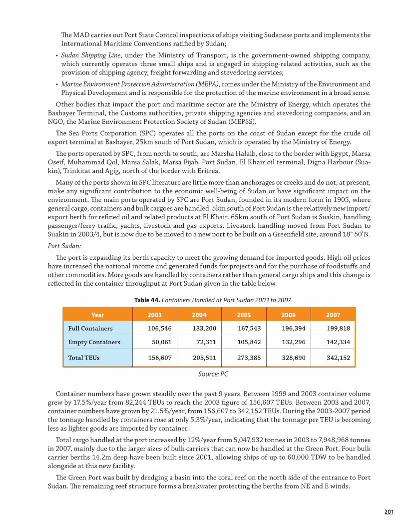
201201
The MAD carries out Port State Control inspections of ships visiting Sudanese ports and implements the International Maritime Conventions ratified by Sudan;
• Sudan Shipping Line, under the Ministry of Transport, is the government-owned shipping company, which currently operates three small ships and is engaged in shipping-related activities, such as the provision of shipping agency, freight forwarding and stevedoring services;
• Marine Environment Protection Administration (MEPA), comes under the Ministry of the Environment and Physical Development and is responsible for the protection of the marine environment in a broad sense.
Other bodies that impact the port and maritime sector are the Ministry of Energy, which operates the Bashayer Terminal, the Customs authorities, private shipping agencies and stevedoring companies, and an NGO, the Marine Environment Protection Society of Sudan (MEPSS).
The Sea Ports Corporation (SPC) operates all the ports on the coast of Sudan except for the crude oil export terminal at Bashayer, 25km south of Port Sudan, which is operated by the Ministry of Energy.
The ports operated by SPC, from north to south, are Marsha Halaib, close to the border with Egypt, Marsa Oseif, Muhammad Qol, Marsa Salak, Marsa Fijab, Port Sudan, El Khair oil terminal, Digna Harbour (Sua-kin), Trinkitat and Agig, north of the border with Eritrea.
Many of the ports shown in SPC literature are little more than anchorages or creeks and do not, at present, make any significant contribution to the economic well-being of Sudan or have significant impact on the environment. The main ports operated by SPC are Port Sudan, founded in its modern form in 1905, where general cargo, containers and bulk cargoes are handled. 5km south of Port Sudan is the relatively new import/export berth for refined oil and related products at El Khair. 65km south of Port Sudan is Suakin, handling passenger/ferry traffic, yachts, livestock and gas exports. Livestock handling moved from Port Sudan to Suakin in 2003/4, but is now due to be moved to a new port to be built on a Greenfield site, around 18° 50’N.
Port Sudan:
The port is expanding its berth capacity to meet the growing demand for imported goods. High oil prices have increased the national income and generated funds for projects and for the purchase of foodstuffs and other commodities. More goods are handled by containers rather than general cargo ships and this change is reflected in the container throughput at Port Sudan given in the table below.
Table 44. Containers Handled at Port Sudan 2003 to 2007.
Year 2003 2004 2005 2006 2007
Full Containers 106,546 133,200 167,543 196,394 199,818
Empty Containers 50,061 72,311 105,842 132,296 142,334
Total TEUs 156,607 205,511 273,385 328,690 342,152
Source: PC
Container numbers have grown steadily over the past 9 years. Between 1999 and 2003 container volume grew by 17.5%/year from 82,244 TEUs to reach the 2003 figure of 156,607 TEUs. Between 2003 and 2007, container numbers have grown by 21.5%/year, from 156,607 to 342,152 TEUs. During the 2003-2007 period the tonnage handled by containers rose at only 5.3%/year, indicating that the tonnage per TEU is becoming less as lighter goods are imported by container.
Total cargo handled at the port increased by 12%/year from 5,047,932 tonnes in 2003 to 7,948,968 tonnes in 2007, mainly due to the larger sizes of bulk carriers that can now be handled at the Green Port. Four bulk carrier berths 14.2m deep have been built since 2001, allowing ships of up to 60,000 TDW to be handled alongside at this new facility.
The Green Port was built by dredging a basin into the coral reef on the north side of the entrance to Port Sudan. The remaining reef structure forms a breakwater protecting the berths from NE and E winds.

202202
The fact that Port Sudan can now handle larger ships is also reflected in the number of ships calling at the port. Over the period 1999 to 2003, the number of ship calls averaged 1,155/year. Between 2003 and 2007 the number of ship calls averaged 1,271, with the number reaching 1,500 in 2005 and falling to just over 1,000 in 2007.
Table 45. Cargo Tonnage Handled at Port Sudan 2003 to 2007.
Year 2003 2004 2005 2006 2007
Imports 4,113,791 5,652,882 7,514,187 7,686,009 6,219,163
Exports 934,141 1,017,137 887,140 1,584,181 1,729,805
Total 5,047,932 6,670,019 8,401,327 9,270,190 7,948,968
Source: PC
However, the average consignment carried increased by 89% over this period from 4,150 tonnes to 7,850 tonnes as the ability to import larger consignments of bulk cargo affected ship numbers.
Table 46. Ship Calls at Port Sudan and Tonnage/Ship 2003 to 2007.
Year 2003 2004 2005 2006 2007
Ship Calls 1,216 1,379 1,512 1,234 1,014
Tonnes/ship 4,151 4,837 5,556 7,512 7,839
Source: PC
The fact that larger ships are now calling at Port Sudan has implications for the environment. Although these ships are not carrying oil as cargo, the size of their oil bunker (fuel) tanks has become much greater. Modern ships have an increased range and bunker fuel tanks holding 3,000 tonnes of heavy fuel oil are not unusual. In addition, ships of greater length, beam, draught and (when discharged or carrying containers on deck), greater windage area are more difficult to control in adverse weather conditions and, if and when they are involved in an incident, will be carrying more bunker fuel that could be spilled.
The trend towards increasing ship sizes is likely to continue, as the SPC is now building over 700m of new container quay at a depth of 16m to allow it to handle larger container ships than the existing container quays at 12.5m depth are able to.
El Khair Petroleum Terminal:
This terminal was opened in May 2004 and allows fully loaded tankers of up to 50,000 DWT to be berthed. As shown in Exhibit 5, El Khair terminal was again built by dredging a basin into the coral reef, but on the south side of the entrance to Port Sudan. The remaining reef structure again forms a breakwater protecting the berths from NE and E winds. Access to the terminal is via a 2km long causeway that also carries the loading and discharging pipelines that connect the loading/discharging arms with the storage tanks ashore.
An incident in early 2008, when during strong winds, ropes to the tugs parted and a tanker drifted onto the berth and damaged the fire monitor tower, has emphasised the need for careful examination of the forces that such vessels, and the tugs, must contend with. The entrance to the berth through the reef is 122m wide and ships of length up to 210m and a draught of 13.3m are allowed to berth there. The length of the basin is 322m and, as the width is not sufficient to turn large ships; these are berthed stern first.
To handle a growing tonnage of oil and LPG, a second berth is due to be added in the near future, WNW of the existing berth. Wind, current, tide and wave measurements at the terminal are being taken at present to provide the parameters needed for the new design. The second berth will either be located in an extension to the basin, made wide enough for ships to be turned, or a second entrance will be dredged through the coral reef to the north that will allow ships to enter and leave the berths in the same direction.

203203
The terminal is equipped with seven lines, varying in size from 4 inch diameter (for LPG vapour) to 16 inch for handling Mogas, Fuel Oil and Gas Oil. The terminal also handles Naptha, Avtur (jet fuel) and LPG Liquid. Annual capacity is reported to be 2.67 million tonnes/year, consisting of 1.62 million tonnes of oil products exported, plus 0.214 million tonnes of LPG exports. Import capacity is 0.843 million tonnes.
In 2007, the terminal handled 760,352 tonnes of imports and 550,937 tonnes of various types of oil exports, total 1.311 million tonnes.
Tankers older than 20 years are not allowed to use this berth and no dirty ballast may be discharged, as no reception facilities for slops or dirty ballast are available at present.
Port Sudan Refinery:
For many years a small refinery operated around 12km south of Port Sudan. The refinery was closed down some years ago and the oil berths inside the port, Nos. 17 and 18 were converted to create the existing container terminal. The El Khair terminal was built to meet Sudan’s requirements for oil product imports and exports.
The Refinery is being rebuilt and it is reported that it will be opened again in around 2011. It will have the capacity to handle oil residues from ships. This will be a very important step forward for the central Red Sea, as discussed later in this report.
Bashayer Oil Export Terminal:
This terminal lies in the generally deep channel between the Towartit Reef on the eastern side and the coast to the west and is controlled by the Ministry of Energy. It was opened in 1999 with one Single Buoy Mooring (SBM) for the export of crude oil. The level of oil production in Sudan has now reached an estimated 500,000 barrels/day, or around 25 million tonnes/year. Because of this growth, a second SBM was installed in 2006 to the south of the first SBM. The two export terminals are known as Bashayer 1 and Bashayer 2. Crude oil tankers of up to 300,000 TDW can now call at these terminals.
Bashayer 1 is connected by pipeline to six oil storage tanks ashore with a combined capacity of around 4 million barrels. Bashayer 2 is connected by pipeline to shore tanks with a storage capacity of 3.2 million barrels. Given the volumes of crude oil handled, and the size of tankers involved in loading the oil, the two Bashayer terminals have a high potential for causing damage to the surrounding reefs, coast and waters should a serious incident occur. So far only one relatively minor incident has been reported, that of a pipeline rupture. It is critical that all necessary measures are taken to prevent a major spill at this key national facility.
Suakin (Osman Digna Port):
Although the ancient port of Suakin has historically handled relatively small amounts of cargo, it provides important services to the country.
As shown in Table 47, cargo tonnages have grown over the 2003-2007 period by an average of 44.4%/year, indicating the growing importance of this facility.
Table 47. Ship Calls at Suakin 2003 to 2007..
Year 2003 2004 2005 2006 2007
Imports 68,131 50,660 155,236 297,197 433,618
Exports 39,502 9,819 41,886 45,397 35,047
Total 107,633 60,479 197,122 342,594 468,665
Source: PC
The port is built at the western end of a natural and very well sheltered inlet around 65km south of Port Sudan. Natural water depth is 10-11m and the width of the entrance channel 110m at its narrowest point. It is now used mainly for the carriage of passengers between Sudan and the Kingdom of Saudi Arabia and is particularly busy during the pilgrimage season. An expansion programme that will see the access channel widened in places and an improved turning area dredged, is under way. The main quay at the port is 300m in

204204
length and has an alongside depth of 10m. Ferries are equipped with stern ramps and berth stern to the quay with their anchors holding the bows in place. A number of other smaller berths have been built at Suakin to handle livestock, LPG and other cargoes. Passengers using the ferries often bring substantial quantities of personal baggage with them from Jeddah.
Suakin is also a popular harbour for touring yachts, which follow the coast of the Red Sea in both direc-tions. Yachts can anchor in quiet water between the old town on the island and the more modern development on the mainland.
New Livestock Port:
SPC plans to construct a new port to handle livestock around 35km south of Suakin. This port will also be located in a channel between an offshore reef and the coast. As discussed later in this report, the area in which the proposed port is to be situated has been added to the area that would be covered by the Hydro-graphic survey.
As mentioned in Table 66 on page 87 above, and the explanation at the footnote, Sheikh Ibrahim Port is the local name for the new livestock port under construction. Work started since 2011 on the channel and is almost finished now, where a lot of destruction was caused to the corals. A number of water courses were blocked before reaching the sea. This will negatively affect the mangroves forests in the area.
3.3.3.4 HYDROGRAPHICAL SURVEYS
Sudan’s coastline extends some 300 nautical miles from the border with Egypt to the border with Eritrea along a stretch of the Red Sea that has a width of around 140 nautical miles from the coast of Sudan to that of the Kingdom of Saudi Arabia. Much of the Sudanese coastline is protected by coral reefs that form a partial barrier between the sea and the land. These reefs extend up to 48 miles from the coast, at Masamirit Reef and navigation between the coast and the outer extremities of the reefs can be hazardous for shipping.
SPC has established navigation aids on several of the most significant reefs and carries out inspection vis-its of the navigation aids on an annual basis using craft based at Port Sudan. The distance from Port Sudan to the light at Masamirit, for example, is 100 miles. However, most of the isolated and potentially dangerous reefs along the Sudanese coast, particularly those lying between Port Sudan and the border with Eritrea, are unmarked.
Ports have been built at points on the coast where large indentations exist, often created by rain run-off from the mountains that can rise to heights of well over 1,000 m at a distance of 40-60km west of the coast. At locations such as at Port Sudan and Suakin, gaps in the barrier reefs allow clear or reasonably clear access from the sea to the coast.
Between the reefs deep or very deep water is generally found, with the reef structures rising steeply from the sea bed. Typically water depths around the reefs are of the order of 100m to 700m. No recent hydrographic surveys of Sudanese waters have been undertaken and the positions of reefs, the discovery of possible unknown hazards, the possible identification of unmarked passages through barrier reefs and the measurement of water depths to modern standards is a task that remains to be carried out.
Sudanese coastal charts are based mainly on surveys that were conducted between 1859 and 1982, using in most cases hand lead lines and sextants. Additional information from soundings taken by ships on passage and some commercial surveys has been added to the database with which chart compilers work. Warnings appear on several of the existing charts of the proposed areas to be re-surveyed regarding the unreliability of data.
In recent years, the nature of the traffic and size of ships calling at Sudanese ports and terminals and the capacity of the port facilities have changed dramatically. Tankers of up to 300,000 TDW can now call at the Bashayer oil terminals to load crude oil. But the charts of the approaches to Bashayer are based primarily on surveys and miscellaneous soundings dating from 1859 onwards. In addition, the layout of the charts covering Sudanese ports and coastal waters has not been revised for many years.
The existence of new port facilities and terminals, such as the Green Port at Port Sudan and the El Khair Oil Terminal, suggests that re-visiting the layouts of the existing charts to see if navigation safety on the coast can be improved by changing the coverage, would be a very useful service.

205205
The UKHO has for some years been discussing with the Sudanese authorities their wish to conduct survey work in the coastal waters of Sudan. UKHO would also welcome a bi-lateral arrangement with Sudan under which copies of charts and other publications would be provided to Sudan and navigational data would be regularly exchanged between the two parties.
The conduct of surveys of Sudan’s coastal waters to modern standards and the potential improvement of chart layout is therefore of great importance to the SPC, to the Ministry of Energy and to the Ministry of Environment and Natural Resources. Modern surveys would provide substantial benefits to Sudan.
Main Areas Needing to be Surveyed in Sudanese Ports and Coastal Waters:
The extent of the proposed surveys of Sudanese waters, port approaches, terminals and ports has been examined several times by UKHO over the past three years. In 2006, UKHO presented a report to SPC con-taining proposals for surveys that, if implemented, would cover all of Sudan’s near-coastal waters from the Egyptian to the Eritrean borders, extending some 300 nautical miles north to south. The work proposed and described was prioritised and the former Area 1, lying roughly between Port Sudan and the reefs and coastal channel south of Suakin, with parts of the former Area 2, covers approximately the extent of the surveys being considered under the revised concepts presented in this report.
This section of the report on requirements for hydrographic surveying in Sudanese waters is based on work carried out by UKHO in mid-2008 that proposes eight potential areas for survey, described as Options 1 to 7b below. It extends from the Wingate Reef north of Port Sudan to the southern end of the deepwater channel along the coast protected by a fringing reef that terminates in latitude 18° 50’N.

206206
Table 48. Potential areas for hydrographical surveys in the Sudanese Red Sea.
Option Area Description of Coverage Importance
Option 1
Port Sudan to Suakin (excluding Towartit Reef)
Covers a total area of around 920km2.
Provides important coverage of the area between the Wingate Reef north of Port Sudan, the channel between the Towartit Reef and the coast, south to the northern side of the Waladab reef that lies south of Suakin. This option covers all the coastal chan-nels and reefs in the close approaches to Port Sudan, El Khair Terminal, the Bashayer Ter-minals and Suakin. It also covers the outer edges of all the reefs.
Subject to the type of survey equipment used, completion of Option 1 could also provide valu-able coverage of the coastal strip between a point north of Port Sudan to one south of Suakin.
Completion of this option will allow charts covering these waters, including the north and south chan-nels to the Bashayer oil terminal, and the terminal itself, to be re-schemed where considered necessary and published as new editions.
Option 2
Towartit Reef
Covers a total area of around 240km2.
This option would cover the whole of the Towartit Reef, which until now remains largely unsurveyed.
Option 2 is an important part of the survey work because:
a) it is a very large reef structure lying close to the primary ports and terminals on the Sudanese coast;
b) it is possible that channels exist through the reef that could pro-vide an alternative route for ships that would be useful to SPC, or for diving or other leisure craft that support Sudan’s tourist industry;
c) having an accurate chart of the reef will provide very useful infor-mation for environmental studies;
d) it may help to identify suitable positions for new navigation aids marking the reef.
Option 3
Outer approaches to Port Sudan
Option 3 covers a total area of around 790km2.
This option covers the area be-tween the Wingate and Sanganeb reefs and Sha’ab Jibna. It would include a survey of the eastern edge of the Towartit reef north of the area covered by Option 4 immediately to the south. Depths in this area on current charts are above 400m.
A survey that provides full cover-age of this area would identify any shallower patches that have not so far been discovered.
(Continued)

207207
Option Area Description of Coverage Importance
Option 4
Outer approaches to Suakin
The total area of Option 3 is around 590km2.
This option covers the outer approaches to Suakin, between Sha’ab Jibna and Hindi Gidir and the northern end of Sha’ab Anbar. It would include a survey of the eastern edge of the Towartit reef south of the area covered by Option 3.
Depths in this area as shown on current charts are generally above 400 m. It would cover the SE extremity of Towartit reef where a patch of 3.8 m is marked on the chart.
It is reported that two ferries have passed over the top of the shallow 3.8 m deep patch in recent years, fortunately without serious damage being recorded. The risk, however, for more damage in the future re-mains a concern.
A survey that provides full coverage of this area would again identify any shallower patches that have not so far been discovered.
Option 5
Port Sudan (UK Admiral-ty Chart No. 3492)
The area to be surveyed is of the order of 2 km2.
The area to be covered by the pro-posed survey of Port Sudan under Option 5 extends from the border between Option 1 to the east. It covers all the working area of the harbour up to the road bridge connecting West Town to East Town and the seaward end of the wadi that lies west of the contain-er terminal.
It includes the harbour entrance, the south side of the entrance where new container berths will be built, the El Khair terminal and the Green Port.
It is possible that, during detailed survey planning, the area covered by this survey could be extended to include a larger area in the ap-proaches to the El Khair terminal.
If the decision is made to extend the coverage of the existing UK Admiral-ty Chart No. 3492 to include areas of water that are used by ships ap-proaching or leaving El Khair, such an extension of Option 5 could be particularly useful.
Option 6
Suakin (UK Admiralty Chart 81)
The total area to be surveyed is of the order of 4.5 km2.
The area to be covered by the proposed survey of Suakin under Option 6 extends westwards from the border between Option 1 to the east, beyond the 100 m line.
The survey then covers harbour entrance channel and the various berths that have been construct-ed along this channel. It would survey all the working area of the harbour up to the yacht anchorage south of Old Suakin and the creek area east of Old Suakin island and Condenser island.
(Continued)

208208
Option Area Description of Coverage Importance
Option 7a
Suakin to Marsa esh Sheikh – Corridor and Feeder Channel.
The total area to be surveyed under Option 7a is 328 km.2
7a covers the deep channel along the coast to the point just north of Sha’ab el Shubuk. It then in-cludes the feeder channel to the east via the Middle Shoal out to deeper water.
SPC intends to establish a port to handle livestock south of Suakin and has requested that the area in which this new port development will be built should be included in hydro-graphical survey work.
Option 7b
Suakin to Marsa esh Sheikh and Outer Ap-proaches.
The total area to be surveyed includes a number of off-lying reefs and covers 686 km2.
Option 7b includes coverage of Option 7a. It extends over the whole of the area from the coast eastwards to approximately 37° 38'E, where the depths increase as more open water is reached.
The boundary of Option 7b is the southern limit of Area 1 to the north, and to the south a line running about 2 nautical miles north of Sha’ab el Shubuk out to the Jinniya beacon.
SPC intends to establish a port to handle livestock south of Suakin and has requested that the area in which this new port development will be built should be included in hydro-graphical survey work.
Bi-Lateral Arrangement with UKHO:
The UK Hydrographic Office has visited Sudan on more than one occasion and expressed its wish to pro-mote the exchange of hydrographic data and information with Sudan. In accordance with recommendations by the International Hydrographic Organisation, UKHO has signed Bi-lateral Agreements with a number of countries around the world and has Agreements with a number of other states bordering the Red Sea and Gulf of Aden, including a recent Agreement with Yemen.
Under these Bi-lateral Agreements the UKHO and the State agree to the mutual exchange of charts, notices to mariners, bulletins and other nautical publications in their mutual areas of interest, to enhance maritime safety and protection of the marine environment.
The Participants also agree to exchange information on technological developments in the fields related to their work, including hydrography, cartography and information technology. Where appropriate, the Partic-ipants will supplement this with assistance in training, research and implementation. A number of trainees from Yemen, for example, have benefited from the bi-lateral agreement with Yemen by attending training events in Hydrographic surveying arranged through the UKHO.
A Bi-lateral Agreement with the UKHO would be benefit Sudan in several ways and these advantages should be carefully considered:
• Sudan would receive, free of charge, copies of charts and sailing directions when these are updated by UKHO;
• Sudan would receive payment for sales of charts of its ports and coastal waters for which it has provided survey data and on other publications produced by UKHO that include data generated by Sudan;
• Payment would be based on an agreed percentage of the sale price of the charts and other publications. The percentage would depend on the amount of data generated by Sudan, which could include commercial surveys conducted on behalf of SPC and/or other Sudanese companies.

209209
New Routeing Measures:
During discussions in Port Sudan with key marine personnel on the need for new routeing measures for the coastal waters of Sudan, it was evident that there are differing views on the need, or otherwise, for such measures.
The open water forming the approaches to Port Sudan between the Wingate and Towartit Reefs are 5 miles wide, without any known obstructions and there may be no case for introducing routeing measures in this area.
However, the approaches to Suakin, the main passenger terminal for ferries between Sudan and Saudi Arabia, are obstructed by offshore reefs to some extent and there are several reasons for considering new routeing measures and/or new navigation aids in this area. Briefly, these are that a) existing navigation aids can be unreliable, b) their lights are sometimes difficult to see and these are not monitored, c) it is reported that two ferries approaching Suakin have already scraped over the top of the SE corner of Towartit Reef, where a patch 3.8m deep exists, d) it is reported that a third ferry has managed to pass from the open sea to a position close to the Bashayer Terminal in conditions of poor visibility that are not uncommon during sum-mer months, and e) GPS positions are reported to be unreliable in the approaches to Suakin on occasions.
There is therefore an argument for introducing routeing measures in the Suakin approaches, supported by additional navigation aids. The location, design, arrangements for monitoring and maintenance etc. of the navigation aids would need to be carefully considered as part of the process of designing the new measures.
There is also an argument for introducing routeing measures in the channel leading to the Bashayer Ter-minal. Tankers calling at Bashayer initially approached the terminal from both the southern and northern entrances to this channel, but because of the 13 metre patch roughly in the centre of the approach channel, the long run for the pilot boat from Port Sudan to meet ships approaching from the south, and reported prob-lems turning into the channel from the south under certain weather conditions, all tankers now approach the terminal from the north.
There would be sufficient space to introduce routeing measures in the channel at a position SSE of Towartit Elbow and/or at another point along the access route.
However, decisions on new routeing measures for Sudanese waters, supported as necessary by new or upgraded navigation aids, will need to be deferred until the hydrographic survey programme has been completed. The pre-requisites of the IMO Navigation Safety Committee to review proposed new routeing measures are a) for hydrographic surveys to modern standards, covering the proposed areas where the rou-teing measures will be established, must have been completed and b) adequate navigation aids must exist in the area to ensure the safety of navigation for ships using the measures.
The documentation needed for Sudan to submit proposals for new routeing measures for use by interna-tional shipping to IMO can be prepared after completion of the surveys, together with an examination of the need for improvements to navigation aids that lie along the routes to Sudanese ports to support any new measures proposed, or to improve these aids in general.
Sea Ports Corporation proposed the Hydrographical surveys and the prepared the budget for that for a number of times. Although the tenders and their technical specifications were prepared more that 3 times but the Federal Ministry of Finance failed to allocate the budget needed and consequently the surveys were not done.
3.3.4 Marine and Coastal Pollution
‘Water and air, the two essential fluids on which all life depends, have become global garbage cans.’
(Jacques Yves Cousteau)
Linked to IOC Handbook indicators SE 5, SE 6, G2 and G3.
Sudan’s oil production and transport industry, and its associated oil spill threats, acts as the major pollu-tion threat to RSS’s coastal and marine areas. Other sources of pollution threatening Sudan’s coastal zone include: cooling water discharges from industrial, power and desalination plants; unregulated discharge of

210210
industrial waste products; disposal of used oil from vehicles and industry; illegal discharges of ballast water, tank washings, oily sludge, accidental spillages, vessel sewage and solid wastes from Sudan’s high volume of ship traffic; and, minimally, from rubbish and littering.
Although there is a lack of wastewater treatment facilities, currently the marine/coastal areas are not threatened by wastewater pollution from inland sources (this is largely due to the limited and seasonal fresh-water releases into the ocean).
3.3.4.1 OIL SPILL CONTINGENCY PLANNING AND RESPONSE PREPAREDNESS
Sudan’s response preparedness associated with its export oil industry appears in-line or slightly below global standards. Improvements in surfactant-based response mobilisation and increased Tier 2 level coordination would be beneficial (UNEP, 2007: 152).
‘The marine oil terminal and Port Sudan both have Tier 1 facilities...The oil terminal manage-ment has conducted several training exercises to build capacity, including spill containment boom deployment. However, there is reportedly no oil dispersant (surfactant) capacity in-country, and UNEP interviews indicated that Tier 2 planning was not well advanced due to difficulties in communication between different ministries and government bodies. The Minis-try of Energy and Mining reported that the marine oil terminal had a Tier 3 agreement with
Oil Spill Response Limited in Southampton (not verified).’ (UNEP, 2007: 152).
The Federal Government Council of Ministers approved Sudan’s National Oil Spill and Contingency Plan (NOSCP) in 2004. PERSGA collaborated with the Marine Environment Protection Administration (MEPA) to encourage the preparation of the NOSCP and assisted with financial and administrative support. In 2005, a final draft law establishing a National Trust Fund for Oil Spill Combating was prepared and sent to the Cabinet of Ministers for approval.
Currently, Sudan has capacity to respond to oil spills at the Tier 1 level. Bashayer oil terminal at Gezirat Abd Alla port in the Red Sea State has a Tier 1 response capability that includes booms, one skimmer, a tug, launch, inflatable and stockpiles of dispersant. At Port Sudan, the Sea Ports Corporation has 400m of boom in 25 sections on a hydraulic reel, a skimmer, dispersant pump and 2 marine pumps. Bashayer and Port Sudan are planning to establish a Tier 2 Centre where operations and costs will be shared between the two ports (PERSGA). Unfortunately and in view of shortage of funds establishment of the centre has not finished and efforts to finish that stopped in view of the fact that the committee formed to follow up on that is no longer functioning after the Head of the committee went on retirement.
The NOSCP recognises Sanganeb Atoll as a sensitive area with high priority for protection. The Park Management Plans contain provisions for and highly recommend the development of site-specific oil spill contingency plans tailored specifically for each Marine Park, which are well-integrated with the NOCSP. The Plans further highlight how monitoring and research are essential activities needed to assess the impact and recovery of resources following an oil spill. As such, the protection aims of the Parks will be better main-tained and safeguarded, meaning that their biological resources and integrity will suffer the least possible impact in the event of an oil spill.
Furthermore, the regional Marine Emergency Mutual Aid Centre (MEMAC), established in Hurghada, Egypt in 2004, will help to minimise effects of oil spills in the Region that may impact the Sudanese coastal/marine zone. MEMAC serves to strengthen the capacities of Member States and facilitate cooperation among them in order to timely and effectively combat pollution by oil and other harmful substances, in cases of marine emergencies. It further works to assist Member States in developing their own national capabilities to combat pollution by oil and other harmful substances and coordinate and facilitate information exchange, technological cooperation and training in these regards.
Ultimately, these regional efforts are key to helping safeguard Sudan’s resources, given the intercon-nectedness of oceans, the grave threats that can result to marine and coastal areas from oil spills and the transboundary collaboration that such incidents demand.
Pollution Response Capacity: Sudan has some Tier 1 pollution response equipment at Bashayer Terminal. Bashayer has 450m of booms available and the total equipment at Bashayer and Port Sudan include 1,250m

211211
of booms, 3 skimmers, 3 marine pumps and one set of dispersant spraying equipment. In 2007, the Maritime Administration Directorate took delivery of a new Pollution Combating craft, built by Damen Shipyard, which is now based at Port Sudan. The delivery of this purpose-built boat has further improved Sudan’s capability to combat pollution caused by oil.
However, Sudan is not yet in a position to deal with major oil spills. In the case of a major pollution incident, it will require external support. A number of countries in the region make use of international agencies, such as the services available through Oil Spill Response Limited (Southampton, UK)/East Asia Response Limited (Singapore) to provide emergency services. These, in conjunction with the first response capabilities available through Bashayer and the pollution combating craft, could cover Sudan’s current requirements in the event of spills offshore Sudan. Sudan’s capacity to avoid pollution incidents would be further enhanced through the proposed hydrographic surveys and upgrading of navigation aids. Implementation of key elements of the 2005 ‘Preparedness and Response’ Action Plan for the Red Sea and Gulf of Aden would also benefit the country when incidents occur.
Box 1. Definitions of Tier response capacities.
Tier 1: Small spills that can be managed using the resources available to the facility (or to a local government unit in the case of small ship or coastal spills);
Tier 2: Small to intermediate-scale spills that require a coordinated response using local and national resources; and
Tier 3: Large spills requiring both national-level mobilisation and the importation of interna-tional specialised spill response resources. There are many centres worldwide capable of providing such equipment, but only three major centres (Southampton, Singapore and Dubai) are designed for rapid and large-scale international responses.
Source: UNEP, 2007: pp 152
Other forms of pollution from ships, such as from garbage and sewage and the means of combating such pollution through, in particular, Port State Control inspections, are discussed elsewhere in this report.
The Maritime Administration Directorate:
While other agencies, in particular the High Council for Environment and Natural Resources in the Red Sea State and the programme for Integrated Coastal Zone Management, have direct responsibilities for the care of the marine environment, the main agency responsible for combating pollution from ships that oper-ate in Sudanese ports and coastal waters is the Maritime Administration Directorate (MAD).
The Directorate comes under the Ministry of Transport and deals with a range of issues relating to mari-time safety and administration, including policy and regulatory matters and Port State inspections of ships. MAD also issues licences to agents wishing to collect and dispose of garbage and oily wastes from ships in Sudanese ports. MAD currently operates from offices located in Khartoum and in Port Sudan.
The number of qualified and experienced technical staff holding Certificates of Competency as Master Mariners or Chief Engineers available to the Directorate is limited; it is, currently, reduced to two survey-ors and the Director. Their ability to cover the five ports and terminals on the Sudanese coast is therefore restricted and additional qualified staff are required by the Directorate to allow it to increase the percentage of ships that are subject to Port State Control inspections.
The MAD therefore focuses its attention on inspections of ships calling for the first time at Sudanese ports and terminals, and at Port Sudan in particular. It makes an assessment of the condition of the ship and what actions may need to be taken to bring it up to required standards. The Director has confirmed that in fact the number of detentions imposed on ships calling at Sudanese ports is relatively low and that the problems mostly relate to failures to meet safe manning requirements, especially on smaller ships.
He attributes the reason for this to the relatively strict requirements imposed on ships in transit through the Suez Canal and to the work carried out by Port State Control inspectors in other ports, such as Aqaba

212212
in Jordan. This emphasises the advantages of regional cooperation in conducting Port State Control inspec-tions of ships.
MAD remains under the umbrella of the SPC, which provides funding for its activities and made possible the purchase of the pollution combating boat. The dependence of the MAD on SPC is perhaps less than ideal, but does provide the country with a capacity that it would otherwise not enjoy. MAD personnel attend meetings of the Indian Ocean Memorandum of Understanding on Port State Control, as Sudan is a member of the IOMoU and works, to the extent possible, to IOMoU guidelines.
While the pollution combating boat is an important addition to the equipment available in Sudan, it is essential that the equipment provided with the boat for pollution combating is deployed and tested regu-larly. Regular exercises should be required, so that the training provided when the boat was delivered is not forgotten and the crew remain competent to deal with pollution incidents along the coast.
In addition to the funding available to the Directorate from the SPC, MAD is able to generate revenue from other sources, such as the provision of Certificates of Seaworthiness for ships calling at Sudanese ports to load cargo. These certificates confirm that the ships are fit to carry the cargoes that they are due to lift and their issue is subject to a fee, payable to the MAD. The MAD also derives some of its income from fines imposed on ships that cause pollution in Sudanese waters, or are responsible for some other infringement of the law relating to the work of the MAD.
Pollution and MARPOL 73/78:
With respect to the requirements of the MARPOL 73/78 Annexes, the provision of reception facilities should be adequately considered with the building of the new Port Sudan refinery. The facilities at the refin-ery are due to be connected by pipeline with the terminal at El Khair to allow oily waste to be removed from ships and pumped to the refinery for treatment and suitable disposal. It is anticipated that waste from other ports, such as that from the main berths at Port Sudan, can also be taken to the refinery facilities for treat-ment, when these become available.
An IMO expert in Reception Facilities carried out an investigation of the ports and terminals in RSS in 2005 and the following paragraphs summarise the State’s current methods of dealing with waste disposal.
At the Bashayer terminal, where only Segregated Ballast Tankers are allowed to call and ships have arrived to load following relatively long voyages (of more than 1,200 nautical miles or 72 hours), there is effectively no requirement for reception facilities to be provided, as crude oil from Bashayer is loaded on top of any slops remaining in the tanks.
There is a potential demand for the disposal of oily waste from ships calling at the El Khair terminal, but the SPC requires ships calling at El Khair to produce, before docking, a certificate of insurance or a financial guarantee covering the ship against liability or damage due to oil pollution. It cannot offer facilities for the disposal of oily waste at present.
With regard to the requirements of Annex I of MARPOL 73/78 at Port Sudan and Suakin, oily water and sludge from the ports can be collected by private contractors, using mobile tankers or trucks, from ships when these are alongside. Quantities up to 20 tonnes per truck can be removed. A contractor collects, processes and disposes of waste oil, but the process of obtaining permissions from the Customs Authority and from MAD is reported to be difficult and simplification of the process using alternative methods of monitoring the processes is recommended. At present there are no records available on the amount of oil collected and disposed of.
Waste oil can be used in furnaces at industrial plants in Port Sudan, such as cement plants, where there is a considerable demand.
Annex II of MARPOL 73/78 applies to chemical tank washings. At present there are no facilities for treat-ing such washings in Sudanese ports and terminals. Similarly, facilities for dealing with materials covered by Annex III of MARPOL 73/78, harmful/noxious substances in packaged form, do not exist. In view of the increasing volume of containers arriving at Port Sudan, a percentage of which will contain chemicals, there is a need for arrangements to be provided to deal with such materials, at the container berths in Port Sudan particularly.

213213
There are also no facilities for dealing with sewage under Annex IV of MARPOL 73/78. As Port Sudan, with a population of around 2 million, has no sewage treatment plant at present but relies mainly on soak-away pits, sewage from ships cannot be received and processed ashore. This situation is, of course, not desirable, but until such time as facilities for sewage treatment are available in the city no effective action to cure the problem would seem to be available. Ships could be required to retain sewage on board in holding tanks for disposal at sea, but this option is also not ideal.
With regard to Annex V of MARPOL 73/78, pollution from garbage, Port Sudan and Suakin both offer facilities for garbage disposal that are charged for under the port tariff. Garbage is collected directly from the ships on request, or from skips that are made available on the quay side into which ships can dispose of their garbage. Garbage is not separated into different categories and there are no records of the quantities sent for disposal. Disposal of ship waste and waste from the port itself is reported to be by incineration within the port area, or by removal to municipal dumps. Inspectors from the Port Health Authority check that garbage from ships is disposed of, which should include the incineration of any quarantine waste generated by ships.
In view of the current situation within Port Sudan, where large quantities of plastic and other garbage are disposed of in open areas and/or wadis, and enter the harbour from wadis leading into Port Sudan, the efforts to control ship pollution, while appreciated and necessary, do not provide a solution to the problems of the city itself and action on this matter, under a different programme, is very necessary. In fact the Marine Environment Protection Society of Sudan (MEPSS) has, from time to time, organised beach clean-up ses-sions where school children have been invited to participate. The MEPSS has expressed its concerns over the volume of garbage collecting in the wadis leading into the harbour that is carried there during the infrequent rains.
At Bashayer and El Khair there are no facilities for the disposal of ship garbage.
There are no requirements in Sudanese ports and terminals relating to Annex VI, prevention of air pol-lution from ships. The control of emissions from machinery operating on ships remains unregulated. This is an understandable situation, but in view of the increasing momentum towards controlling air pollution caused by shipping, and the requirements being introduced by IMO for the use of cleaner fuels, the Sudanese Authorities should monitor the changes taking place around the world and in regional ports particularly, and be prepared to introduce their own legislation to allow them to be party to Annex VI of MARPOL 73/78.
Marine Incident Investigations:
The investigation of Marine Incidents is primarily the responsibility of the MAD. Under the Strategic Action Programme implemented by PERSGA, a Workshop on Marine Accident Investigations was conducted in Port Sudan in 2003. At this workshop, conducted by a former head of the UK Marine Accident Investiga-tion Branch, participants were given training in methods of conducting investigations and were provided with instruction books, produced specifically for the workshop, giving details of how such investigations are carried out in major maritime countries.
There have been a number of marine incidents in Sudanese waters in recent years, some of which have been matters for investigation. Most recently, an accident at the Bashayer Terminal involving leakage from a loading pipeline to a tanker, caused a relatively minor spill. The MAD is responsible for investigating any oil spill or other discharge violation from any source.
The most important function of investigations is, as pointed out in the 2003 workshop, to identify causes of accidents/incidents and to learn the lessons that come from them. At present, there is evidently a need to update the knowledge within the small group of MAD professional staff. In addition, revised investigation procedures are being developed by IMO at present, with the support of the UK Marine Accident Investigation Branch. When these revisions have been completed, they can very usefully be provided for staff of the MAD to assist them in their duties to investigate accidents.
3.3.4.2 SHIP WASTE AND BALLAST WATER MANAGEMENT
Sudan has, in the early years of the 21st century, become an oil exporting country. Ports and terminals from which oil is exported are at risk from the presence of Invasive Aquatic Species (IAS), brought in by ballast water carried in tankers between their last discharging port and the next loading port. In view of the impor-tance of the marine environment in the area around the Bashayer Oil Terminal, in particular, all possible measures should be taken to prevent these waters and reef areas from being affected by IAS.

214214
The lack of treatment facilities in the Ports for ship waste and ballast water means that incoming ves-sels are forced to discharge in the open seas as they approach, posing great dangers for the introduction of invasive and alien species, as well as causing siltation and other pollution damage to coral reefs. Small oil slicks (1-10m3) have been reported in the Sudanese Red Sea. These have been caused by bilge clearing from passing ships. This, however, is a global problem that is not linked to Sudan’s oil industry (UNEP, 2007: 152). However, lack of patrolling and enforcement measures means there is little regulation of this issue by Sudan or the RSS governments.
It is also reported that exploration for oil and gas at offshore fields is being started in Sudanese waters, which, if successful, will result in a further increase in the tonnage of ballast water that could be brought to and discharged in Sudanese coastal waters.
As noted in the section above on the IMO ‘International Convention for the Control and Management of Ships’ Ballast Water and Sediments’, 2004, known as the Ballast Water Convention, a study of the current situation with respect to actions on Ballast Water Management in Sudan was undertaken in 2005 by a ballast water expert. His mission included meetings with the Minister of Transport and Minister of the Environ-ment in Khartoum, with a number of organisations in Port Sudan and with representatives of the first of the two Bashayer terminals, at Bashayer. As a result of his meetings, the following conclusions, relating to the situation at the end of 2005, were reached:
• The first oil terminal at Bashayer was aware of the dangers of IAS reaching the terminal in ship’s ballast water;
• The Terminal Manager at El Khair terminal attended the Workshop on Ballast Water Management held in Jeddah in November 2005 intended to raise awareness and provide training in the Convention for key personnel from the region;
• Bashayer requests tankers arriving at the terminal to exchange their ballast water at sea between leaving the last discharging port and arriving at Bashayer, which is a method of at least reducing the risk of IAS from the previous discharging port from reaching Sudanese waters;
• The IMO Reporting Form for Ballast Water is not in use at Bashayer or El Khair;
• There was no information regarding the presence of IAS in the waters of Sudan, although the University of the Red Sea at Port Sudan had started sampling work, had been provided with some equipment for this purpose and had trained a number of staff. The University of Khartoum was also involved in conducting biological investigations in coastal areas.
• There was no lead agency for ballast water management in Sudan. The main agency responsible for mari-time matters and Port State Control, the Maritime Administration Directorate, could have a role to play in such management, presumably by working closely with the Ministry of Environment and the High Council for Environment and Natural Resources in the Red Sea State.
• There are no laws in Sudan at present that govern ballast water management for the purposes of min-imising species transfers. The Sudanese Maritime Act of 1961, which has been updated but not yet implemented, governs maritime matters. The Environmental Law of 2001 provides the framework for environmental legislation.
• The Environmental Protection Agency in Sudan has a state law for the protection of the Red Sea and the existing biodiversity legislation has some restrictions on species movements, which may be applicable to the regulation of ballast water transfers.
The eventual objective of the Ballast Water Management Convention is to prevent ships that trade inter-nationally from transferring IAS from one part of the world to another. For Sudanese waters this is most important. Since 2005, there has been useful progress in the measures available to control the movement of IAS between countries, while the profile of Ballast Water Management issues has been raised significantly.
The number of countries that are now parties to the Ballast Water Management Convention has roughly doubled compared with 2005, bringing the date by which this Convention will enter into force closer. How-ever, these represent only a very small percentage of the world fleet, currently around 10% of the percentage required for the Convention to enter into force. So far, the large ship-owning flag states have not become parties to the Convention and, in September 2007, the IMO Secretary General expressed his concern at

215215
the length of time being taken for conventions intended to protect the marine environment to enter into force. In recognition of the importance of the Ballast Water Convention, at the IMO Marine Environmental Protection Committee Meeting in April 2008, the Committee urged other states to become parties to this Convention.
Funding for the next phase of the Global Ballast Water Management Programme, Globallast Partnerships (full title “Building Partnerships to Assist Developing Countries to Reduce the Transfer of Harmful Aquatic Organisms in Ships’ Ballast Water”) was approved by the Global Environment Facility (GEF) in June 2007 and preparatory work on this next phase has been ongoing since that time. The objective of this phase is to assist particularly vulnerable countries and/or regions, including specifically the Red Sea and Gulf of Aden, to enact legal, policy and institutional reforms to meet the objectives of the International Convention for the Control and Management of Ships' Ballast Water and Sediments.
This is precisely the type of support that is required by Sudan and plans are being made by the Programme Director to implement activities in this Region.
The Ministry of Environment in Sudan has already indicated its wish to see the ratification of the Ballast Water Convention through the Maritime Administration and the Administration sees no reason why Sudan should not become a party to it. It is clearly in Sudan’s interests that it should become a party to this Conven-tion as soon as possible.
What is now required is support for the development of legal instruments for Sudan that will allow this process to move forward, which will become available in 2008 through the new GloBallast Partnerships programme.
3.4 DESIGNING A SOCIOECONOMIC MONITORING PROGRAMME FOR RSS
3.4.1 RSS Socioeconomic Development Plan: 2005-2008The Red Sea State Ministry of Finance launched a Socioeconomic Development Plan in July 2005 to address the root causes of livelihood issues in RSS. The objectives and policy guidelines outlined by the Plan were designed to be implemented during 2005-2008 [the first three years of the interim period set by the CPA between the Sudan People’s Liberation Movement (SPLM) and the National Congress Party (NCP)]. The gen-eral objective of the plan is ‘to raise the standard of living of people, both urban and rural, culturally, socially, politically, and administratively, through improved livelihoods, education and health services’ (RSS, 2005).
The Guidelines for the Plan’s development, its specific objectives and policy statements to assist imple-mentation are summarised in Table 49 below:
A major pitfall of the Plan, however, was that it was designed by technocrats and received little public input, nor with provisions for implementation, monitoring and evaluation (Babiker & Pantuliano, 2006: 32). Because of the lack of stakeholder consultation and participation in the design of the Plan, it lacks the legit-imacy to make meaningful strides towards improving the socioeconomic conditions for a majority of the population of RSS.
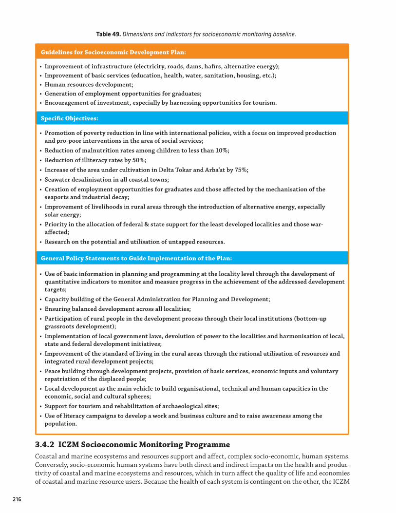
216216
Table 49. Dimensions and indicators for socioeconomic monitoring baseline.
Guidelines for Socioeconomic Development Plan:
• Improvement of infrastructure (electricity, roads, dams, hafirs, alternative energy);• Improvement of basic services (education, health, water, sanitation, housing, etc.);• Human resources development;• Generation of employment opportunities for graduates;• Encouragement of investment, especially by harnessing opportunities for tourism.
Specific Objectives:
• Promotion of poverty reduction in line with international policies, with a focus on improved production and pro-poor interventions in the area of social services;
• Reduction of malnutrition rates among children to less than 10%;• Reduction of illiteracy rates by 50%;• Increase of the area under cultivation in Delta Tokar and Arba’at by 75%;• Seawater desalinisation in all coastal towns; • Creation of employment opportunities for graduates and those affected by the mechanisation of the
seaports and industrial decay;• Improvement of livelihoods in rural areas through the introduction of alternative energy, especially
solar energy;• Priority in the allocation of federal & state support for the least developed localities and those war-
affected;• Research on the potential and utilisation of untapped resources.
General Policy Statements to Guide Implementation of the Plan:
• Use of basic information in planning and programming at the locality level through the development of quantitative indicators to monitor and measure progress in the achievement of the addressed development targets;
• Capacity building of the General Administration for Planning and Development;• Ensuring balanced development across all localities;• Participation of rural people in the development process through their local institutions (bottom-up
grassroots development);• Implementation of local government laws, devolution of power to the localities and harmonisation of local,
state and federal development initiatives;• Improvement of the standard of living in the rural areas through the rational utilisation of resources and
integrated rural development projects;• Peace building through development projects, provision of basic services, economic inputs and voluntary
repatriation of the displaced people;• Local development as the main vehicle to build organisational, technical and human capacities in the
economic, social and cultural spheres;• Support for tourism and rehabilitation of archaeological sites;• Use of literacy campaigns to develop a work and business culture and to raise awareness among the
population.
3.4.2 ICZM Socioeconomic Monitoring ProgrammeCoastal and marine ecosystems and resources support and affect, complex socio-economic, human systems. Conversely, socio-economic human systems have both direct and indirect impacts on the health and produc-tivity of coastal and marine ecosystems and resources, which in turn affect the quality of life and economies of coastal and marine resource users. Because the health of each system is contingent on the other, the ICZM
217217
process focuses on the interaction between marine and terrestrial environments. It must posses the capacity to assess, manage and sustainably develop the socio-economic, as well as the biophysical, dimensions of coastal and marine areas.
To possess the capacity to assess and manage any system and its related dimensions, however, it is first necessary to understand the system and any direct or indirect interactions it has on other systems. To under-stand the socio-economic dimensions of the coastal and marine environment, a baseline must be developed to provide a profile of the socio-economic environment and monitoring must be developed to record and analyse changes to the profile over time.
This section describes the development of a socio-economic baseline and monitoring programme for the ICZM office, including a work plan for the ongoing development of the baseline and monitoring programme over the next twelve months. The section also documents the subsequent development of a socio-economic impact assessment (SIA) framework for the ICZM office. It is specifically developed to help analyse socio-eco-nomic and biophysical interactions related to the coastal environment. More generally, it has been developed to utilise baseline and monitoring data in assessing and managing policies and projects related to the coastal environment in the future.
3.4.2.1 DESIGNING THE SOCIOECONOMIC BASELINE
A baseline defines the existing conditions and past trends within the geographic area of developments. Generically, the term baseline simply means a geographical area and time line from which to base subse-quent assessment and ongoing monitoring. For example, with individual developments, the geographical area is identified as per the area of the development, along with the distribution of populations affected; but for wider plans or more numerous projects, such as those under ICZM, the relevant geographical area may be set within a wider area and context and include more dispersed stakeholders, such as pressure groups, organisations, and institutions.
One of the main reasons for researching and defining a socio-economic baseline is that it provides an understanding of the existing environment, which is fundamental to the identification and projection of potential impacts and, therefore, to the appropriate design of mitigation and management measures for proposed developments. Another important reason is that the baseline provides a reference point against which the characteristics and parameters of any changes in the socio-economic environment, identified through monitoring, can be analysed and evaluated. Finally, relevant baseline data greatly expedites the consideration of alternatives in project and policy decision-making because good basic information already exists (IAIA 2003).
As the socio-economic environment contains so many elements, the identification and selection of key socio-economic dimensions and indicators provide the foundations for the development of a manageable baseline and monitoring programme. Indicators may be quantitative or qualitative. The former represent numerical or statistical measures that can be used to make sense of, monitor, or evaluate some phenomenon: a number or a percentage, i.e. disaggregated data on target beneficiaries of a project (sex, ethnicity, religion, etc.). The latter are narrative descriptions of phenomenon measured through people's opinions and percep-tions or non-quantitative facts.
To determine the scope of the socio-economic indicators selected for a baseline, it was recognised that the key socio-economic issues and parameters of pertinence to the coastal zone of the RSS must first be identified. This then became one of the main objectives of a three-day workshop, organised by the Higher Council of Environment and Natural Resources RSS, the ICZM Office and the Regional Organisation for the Conservation of the Red Sea and Gulf of Aden Environment (PERSGA), in Port Sudan between June 17th and 19th, 2007.
Given that effective ICZM planning must balance crosscutting issues on sustainable development and marine conservation, a wide-range of stakeholders were represented at the workshop:
Red Sea State Government Ministries and Departments included: Ministry of Animal Resources, Higher Council of Environment and Natural Resources, The Fisheries Administration, Ministry of the Environment, The Census Bureau and the Ministry of Finance (including the Department of Planning and the Department of Industry). Other national participants included: The Red Sea University (Faculty of Marine Science and fisheries, Institute for Marine Research, Faculty of Economics and Social Science), Agency for Cooperation in

218218
Research and Development (ACORD), Food and Agriculture Organisation (FAO), Sudanese Environmental Conservation Society-Red Sea Branch (SECS-RSS), Port Sudan Association for Entrepreneur Development (PASED), as well as local experts and professors of fisheries, coastal conservation and marine biology. Inter-national organisations and consultants included: PERSGA, African Parks Foundation, a Socio-economic Assessment expert, a SocMon72 expert, and a fisheries expert.
The workshop successfully identified a range of key socio-economic issues for which it was agreed indica-tors should be adopted or developed. Participants at the workshop also referenced existing literature, either specific to the RSS or more generally relevant to coastal and marine management, as sources to support issues they had identified, or as sources of further issues and indicators for incorporation into the ICZM socio-economic baseline. Key literature included:
Assessment of El-Shark Company and Proposals for a Work Plan (2003). (Presented by Abdall Shidri-Ohaj). The report assesses the Oshaf Fishing Company and its replacement El-Shark. The report covers the environ-ment of the north (where the company functioned), providing statistical data on fish catches between 1999 and 2001 and the export trade to Saudi Arabia. The report analyses the income and expenditure of Oshaf, as well as the assets of the El-Shark replacement company. It further provides recommendations for the development of the fishing sector in the North RSS, including the rehabilitation of an ice plant to enable fish transportation to Port Sudan.
Five-Year National Work-Plan. (Presented by Afrah Hussein, Ministry of Finance). The Work-Plan provides a chapter for each sector relevant to socioeconomics, including development, economics, environment, etc. The plan was prepared according to a comprehensive database of information, termed the 'Encyclopaedia', which is available through Access. The Plan also relied on information supplied by the OXFAM Work Plan and the World Food Programme Annual Assessment of Programmes document. All operational programmes in the state were required to submit their Work Plans to Afrah Hussein (Ministry of Finance) to develop the five-year strategy.
The IOC Handbook for Measuring the Progress and Outcomes of Integrated Costal and Ocean Management Hand-book (2006).
These, and other references and issues highlighted in the workshop, were used to subsequently generate an overview of the socio-economic environment of the RSS and as the basis for the first phase of socio-economic indicator identification and selection. It was agreed in the workshop that a second phase of socio-economic indicator identification and selection was needed to consider plans and projects likely to take place in the future, including (but not limited to) oil exploration, aquaculture and desalination plants, for which investor interests existed.
With the RSS government gearing towards giving concessions to such investors in the near future, it was felt that a broad scope of indicators would be required to provide a socio-economic profile across a wide and multi-level geographic area within the RSS, and to monitor a broad range of potential socio-economic impacts within the RSS. Therefore, while the first phase of baseline indicator identification and selection focused on indicators relevant to current and recent past socio-economic issues, the second phase of indica-tor identification and selection focused on supplementing these indicators, where necessary, with indicators that could also potentially capture and monitor the profile and impacts of future policy and project develop-ments in the RSS.
This second phase required a broader review of potential socio-economic issues and indicators within the context of coastal zones. In addition to a series of SIA scenario exercises (see later) held with ICZM Office and the expert advisory team as part of a second workshop, this review involved drawing on respected generic sources of literature on socio-economic baseline, monitoring and assessment. Literature of partic-ular note in this process was; the International Association for Impact Assessment’s (2003) Social Impact Assessment International Guidelines and Principles; the International Finance Corporation’s (2003) Addressing the Social Dimensions of Private Sector Projects; and the EU Working Group’s (2003) ICZM Sustainability indicators.
72 SocMon is an initiative aimed at helping coastal managers better understand and incorporate the socioeconomic context into coastal management programs. This initiative is being implemented at the global and regional levels, and is administered by a consortium of partners, the core partners being NOAA: the Global Coral Reef Monitoring Network, WorldFish Centre, and Conservation International.
219219
From both phases of research, the following key socio-economic issues were identified for indicator devel-opment:
• S1. Demography: Population size; density; gender balance; age structure of households and communities; ethnic composition; seasonal migration patterns including leisure and labour migrants; distribution of age and ethnicity (all significant stake-holders and underrepresented and disadvantaged populations and groups).
• S2. Culture, Society and Family: Ideology and belief systems; recreational and cultural facilities; languages; gender roles and responsibilities; heritage resources; psychological coping and adjustment capacity; social cohesion; quality of life; friendship and kinship networks and patterns of cleavage or cooperation; levels of residential stability.
• S3. Governance: Political and social resources; governance structures and processes; authority and resources to address issues and problems; linkages among geopolitical units (federal, state, county, local and inter-local); crime rates, including murder, assault and theft.
• S4. Housing and Social Infrastructure: Availability of housing; number of settlements; household size; settlement type and distribution; proportion of housing with key facilities; support organisations; public transport networks; postal and telephonic networks; criminal justice, cultural, educational, and health-care institutions.
• S5. Health and Education: Capacities of relevant health care and education systems or institutions (for instance, the school system); proportion of the population having, or having had, primary, secondary and higher education; education performance standards; health profiles, including; birth rates, morbidity rates; vector borne disease prevalence etc.
• S6. Economy and Resource Use: Corporate and personal taxation; contribution to the economy by sector; value of exports; management and administration costs; foreign direct investment; natural resource use; payroll size and the amounts of business and sales receipts and taxes by sector and type of firm; aspects of the environment seen as resources/problems; areas having economic significance; attitudes toward, and patterns of, natural resource use.
• S7. Livelihoods: Employment distribution; average income per person and household; cost of living; access to opportunities; individual taxation; available labour by occupational category by race and national ori-gin; unemployment and underemployment numbers; presence of distinctive or potentially vulnerable groups (for instance, low income).
Across these socio-economic issues, corresponding primary and proxy socio-economic indicators were identified before using the SMART criteria for indicator selection:
Specific: measures, as closely as possible, the result it is intended to measure
Measurable: quantitative (where possible); no ambiguity on what is being measured
Attainable: it is technically possible to obtain data at a reasonable cost
Result-oriented: reliable; general agreement over interpretation of the results
Time-bound: data can be collected frequently enough to inform progress and influence decisions
After applying SMART, the socio-economic dimensions and indicators, listed in Table 50, were finally selected to provide the foundations for the ICZM office’s baseline and monitoring programme It will be noted that this list is, relatively, geographically and thematically broad. The main reason for this was the need for the baseline to accommodate a wide variety of potential policy and project developments across the RSS in the future. Similarly, the socio-economic baseline utilises relatively generic and widely comparable indicators, drawn from different sources, in acknowledgement of the need to be applicable and recognisable to a range of government, investor and civil society project and policy stakeholders. It also acknowledges the need to adopt indicators utilised by other local, national and international organisations operating in the region to minimise the duplication of research efforts:

220220
Table 50. Dimensions and indicators for socioeconomic monitoring baseline.
Dimensions and Indicators Village City Locality State
Demography
Population Size (number)
Population Density (per KM square)
Average Age (number)
Average Family Unit Size (number)
Gender Balance (ratio)
Health
Birth Rate (per thousand)
Mortality Rate (per thousand)
Respiratory Infection Rate (per thousand)
Gastric Infection Rate (per thousand)
Eye Infection Rate (per thousand)
Vector Bourne Rate (per thousand)
Economy
Unemployment Rates (percent)
Employment Distribution (percent by sector)
Average Income (number)
Average Income by Sector (number)
Cost of Living (e.g. standard food basket) (number)
Individual Taxation (percent)
Land Use: Farming (percent)
Investment by Government ($ per head population)
Private Sector Investment ($ per head of population)
Foreign Direct Investment ($ per head of population)
Value of Exports ($ per annum)
Management and Administration Costs ($ per annum)
Agricultural Contribution ($ per annum)
Fishery Contribution ($ per annum)
Tourism Contribution ($ per annum)
Oil and Gas Contribution ($ per annum)
Mining Contribution ($ per annum)
Manufacturing Contribution ($ per annum)
Services Contribution ($ per annum)
(Continued)

221221
Dimensions and Indicators Village City Locality State
Social Infrastructure
Hospitals,Clinics (number)
Schools (number)
NGOs (number)
Police Station (number)
Courts (number)
Public Transport Links (yes / no)
Water Supply (pipe, well, pond)
Education
University (% of university age)
Secondary Education (% secondary age group)
Primary Education (% primary age group)
Settlements
Settlements (number)
Settlement Distribution (e.g. % house, flat, temporary shelter)
Proportion of Settlements with phone, electric, pot water (%)
Demography
Recreational or Cultural Facilities/institutions (number)
Religious Groups Balance (percent)
Ethnic Groups and Balance (percent)
Languages (number)
Number of Heritage Resources (number)
Number of Protected Resources (number)
Crime
Murder Rate (per thousand)
Suicide Rate (per thousand)
Assault Rate (per thousand)
Theft Rate (per thousand)
3.4.2.2 DEVELOPING THE SOCIOECONOMIC BASELINE
Having identified the relevant socio-economic indicators and parameters, it was recognised that a socio-eco-nomic database needed to be developed to facilitate the manageable recording and analysis of data across this wide scope of indicators. The SocMon database was specifically generated for this purpose using Mic-rosoft’s ‘Access’ in November 2007. It now represents the first consolidated publicly accessible source of socio-economic data for the RSS. Following familiarisation and training (see later), the database is now in

222222
use by the ICZM Office. It is designed with a user-friendly interface: it can be updated by users wanting to add data; and, interrogated by users wanting to analyse data, across a number of different geographical and thematic levels.
The data used to populate the database, and develop the baseline and monitoring for the ICZM Office, was, and continues to be, drawn from both secondary and primary sources of information of relevance at the state through to village levels. To avoid duplication of effort, and expedite population of the SocMon database as efficiently as possible, secondary sources were used in the first instance. This involved the review by the ICZM Office of numerous existing sources, including, but not limited to; academic papers, field studies and general surveys; NGO appraisals and mini-surveys; federal census; local newspaper articles; ministerial reports; and, the state encyclopaedia.
The review of secondary sources of information allowed for approximately fifty percent of the SocMon database to be populated at the state and locality level. However, secondary sources of data across many of the indicators, particularly at city and village level, were either not available or were insufficiently detailed or reliable enough to justify inclusion. It was, therefore, necessary to undertake primary research to fill some of the key remaining gaps in the database and build a more comprehensive socio-economic baseline profile. At the same time, it was recognised that the resources did not exist to do a comprehensive socio-economic survey of the entire RSS, so it was agreed to focus the primary research on the coastal localities and settle-ments of the RSS.
This primary research enabled further population of the SocMon database across the socio-economic indi-cators, particularly for coastal localities and settlements. Although significant gaps still remain, a creditable amount has been achieved to date, given the necessarily broad geographic and thematic scope of the data-base. The long anticipated RSS census will, once completed, allow for the filling of many remaining data gaps in the database. Moreover, the SocMon database is an ongoing tool designed, fundamentally, to provide basic up to date data across a wide range of generic and comparative indicators, with supplementary data being collected on an ‘as needs’ basis, as specific project and policy developments are presented to, or proposed by, the ICZM Office.
Integral to the development of the socio-economic baseline and monitoring and conducted in parallel with the socio-economic database, the ICZM Office has also identified and documented a list of significant RSS government, civil society, community and business stakeholders. Key political, economic and social relationships between these stakeholders are currently being mapped by the ICZM Office. This process of stakeholder identification and mapping extends the utility of the database and the scope of the baseline and monitoring. It also provides pre-established foundations for stakeholder consultation, as coastal zone developments are proposed.
3.4.2.3 CONTEXTUALISING THE SOCIOECONOMIC BASELINE
In November 2007, Dr Magnus Macfarlane, assisted by Miss Lauren Salm, conducted a five-day training workshop with the ICZM Office and their socio-economic team in Port Sudan. The first objective of the work-shop was to familiarise and train the group in using the SocMon database as an information management tool to support the baseline and monitoring. In addition to group learning, each participant received one-on-one tutoring in navigating, inputting, and analysing the database, using familiar existing secondary sources or relevant scenarios. Participants also received guidelines on using the database, as part of the workshop information and training pack.
As the socio-economic assessment of projects and policies related to the coastal zone forms one of the key roles of the ICZM office, the second workshop objective was to place baseline and monitoring develop-ment, supported by the SocMon database, within this context. To this end, the group were provided with an introduction to, and training in, socio-economic impact assessment (SIA) and stakeholder consultation (SC). The first part of training was theoretical, and involved interactive presentations on SIA and SC principles, procedures and methods. The presentations were accompanied by SIA and SC guidelines, given to partici-pants as part of their workshop information and training pack. Box. 2 summarises the procedural SIA and SC guidelines:
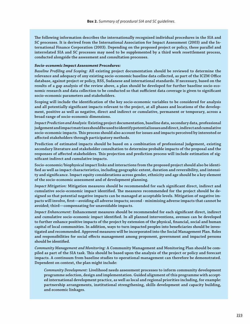
223223
Box 2. Summary of procedural SIA and SC guidelines.
The following information describes the internationally recognised individual procedures in the SIA and SC processes. It is derived from the International Association for Impact Assessment (2003) and the In-ternational Finance Corporation (2003). Depending on the proposed project or policy, these parallel and interrelated SIA and SC processes may need to be supplemented by a third work resettlement process, conducted alongside the assessment and consultation processes.
Socio-economic Impact Assessment Procedures:Baseline Profiling and Scoping: All existing project documentation should be reviewed to determine the relevance and adequacy of any existing socio-economic baseline data collected, as part of the ICZM Office database, against project or policy, RSS, Sudanese and international standards. If necessary, based on the results of a gap analysis of the review above, a plan should be developed for further baseline socio-eco-nomic research and data collection to be conducted so that sufficient data coverage is given to significant socio-economic parameters and stakeholders.
Scoping will include the identification of the key socio-economic variables to be considered for analysis and all potentially significant impacts relevant to the project, at all phases and locations of the develop-ment, positive as well as negative, direct and indirect or cumulative, permanent or temporary, across a broad range of socio-economic dimensions.
Impact Prediction and Analysis: Existing project documentation, baseline data, secondary data, professional judgement and impact matrixes should be used to identify potential issues and direct, indirect and cumulative socio-economic impacts. This process should also account for issues and impacts perceived by interested or affected stakeholders through participatory methods.
Prediction of estimated impacts should be based on a combination of professional judgement, existing secondary literature and stakeholder consultation to determine probable impacts of the proposal and the responses of affected stakeholders. This projection and prediction process will include estimation of sig-nificant indirect and cumulative impacts.
Socio-economic/biophysical impact links and interactions from the proposed project should also be identi-fied as well as impact characteristics, including geographic extent, duration and reversibility, and intensi-ty and significance. Impact equity considerations across gender, ethnicity and age should be a key element of the socio-economic assessment and of development planning.
Impact Mitigation: Mitigation measures should be recommended for each significant direct, indirect and cumulative socio-economic impact identified. The measures recommended for the project should be de-signed so that potential negative impacts can be managed at acceptable levels. Mitigation of negative im-pacts will involve, first—avoiding all adverse impacts; second - minimising adverse impacts that cannot be avoided; third—compensating for unavoidable impacts.
Impact Enhancement: Enhancement measures should be recommended for each significant direct, indirect and cumulative socio-economic impact identified. In all planned interventions, avenues can be developed to further enhance positive impacts of the project by extension of the physical, financial, social and human capital of local communities. In addition, ways to turn impacted peoples into beneficiaries should be inves-tigated and recommended. Approved measures will be incorporated into the Social Management Plan. Roles and responsibilities for social effects management among proponent, government and impacted persons should be identified.
Community Management and Monitoring: A Community Management and Monitoring Plan should be com-piled as part of the SIA task. This should be based upon the analysis of the project or policy and forecast impacts. A continuum from baseline studies to operational management can therefore be demonstrated. Dependent on context, the plan might include:
Community Development: Livelihood needs assessment processes to inform community development programme selection, design and implementation. Guided alignment of this programme with accept-ed international development practice, as well as local and regional priorities including, for example: partnership arrangements, institutional strengthening, skills development and capacity building, and economic linkages.

224224
Resource Provision: Development of financial tools and resources to support community development plan implementation, including assessment of: (1) Any project-specific trust funds as additional funding for community development. (2) The legitimate and sufficient flow of proceeds from taxes, bonds or trust funds to intended beneficiaries. (3) Measures to ensure funds are available to mitigate unexpected negative social impacts.
Monitoring and Disclosure: Development of a stakeholder derived monitoring system to; (a) indicate deviations and unanticipated impacts from the proposed plan and to allow for more exacting analy-sis of impacts and mitigation measures to inform subsequent audits; (b) ensure compliance and con-tinual improvement including audit systems and corrective action plans; (c) verify compliance with applicable regulatory and voluntary standards.
Stakeholder Consultation Procedures:Profiling and Mapping: Identify, and understand the profile and key relationships between, the proposed project’s key stakeholders (defined as ‘local groups and individuals either directly or indirectly signifi-cantly affecting, or affected by, the proposed project’).
Disclosure and Dissemination: Disclose information about the proposed project to stakeholders potential-ly affected by the project, because informed stakeholders will better understand the trade-offs between project costs and benefits and be able to contribute meaningfully to project assessment and design.
Assessment Consultation: Answer further questions that key stakeholders and wider constituents may have about the project from initial information disclosure. Understand and address any remaining con-cerns or opportunities identified by stakeholder representatives and constituents, including all sug-gested measures for mitigation and enhancement in managing these issues.
Validation: Verify project related expression and understanding, through a process of assessor, tech-nique and sampling triangulation. In particular, ensure that project related expression and under-standing extends to the least well-represented and most vulnerable project affected people.
Ongoing Consultation and Grievance: Develop expectation management procedures, and representative ongoing engagement and feedback mechanisms, based on context specific demographic and cultural characteristics, stakeholder comment and recognised best-practice consultation guidelines like World Bank’s OD4.00 and IFC’s (2005) Consultation Manual.
The second part of the workshop training was applied rather than theoretical and involved taking the group on a field trip to a large desalination plant on the outskirts of Port Sudan. The plant served as a case study for the group; they could conduct a rapid SIA and apply the theoretical knowledge and understanding of SIA that they had gained in the previous days.
Prior to visiting the plant, the team collected and reviewed stakeholder and socio-economic baseline information associated with the plant and its operational area of influence. This was followed by a tour of the plant by the general manager. On return to the ICZM Office the group worked as a team to scope the socio-economic impacts of the plant, including connected and secondary impacts on the marine environ-ment. They used this to design mitigation measures and to then determine the most important variables to monitor in connection with the plant. On completion of the training, participants proudly received a certificate of learning in SIA and SC.
3.4.2.4 ON-GOING DEVELOPMENT OF THE BASELINE AND SOCIOECONOMIC PROGRAMME
The following table establishes a proposed work plan for the continued development and management by the ICZM Office of the SocMon database and the baseline and monitoring programme it supports, over the next twelve months. This ongoing effort is important in the context of the database because of the lack of any alternative consolidated socio-economic database in the RSS to which stakeholders can refer. It is important in the context of the baseline because of the increasing number of high profile coastal zone related project and policy developments being proposed in the RSS. Finally, this ongoing effort is important in the context of monitoring because of the rapidly changing socio-economic dynamics in RSS at this time that need to be captured through monitoring and used to continually update the SocMon database and baseline.

225225
Table 51. Proposed workplan for development and management of the RSS SocMon database.
Task DutyMonth
Notes1 2 3 4 5 6 7 8 9 10 11 12
1
Designate or appoint an appro-priately qualified and experienced staff member to have sole over-sight/responsibil-ity for manage-ment of SocMon database.
ICZMDirector |
This is to ensure consistency in the way data is entered into the database. The position is essentially tech-nical and should be undertaken by a person who has had formal train-ing in IT.
2
Designate or appoint an appro-priately qualified and experienced staff member to have lead over-sight/responsibil-ity for managing socio data collec-tion.
ICZM Director |
This is to ensure consistency in the way data is collect-ed. The position is essentially aca-demic and should be undertaken by a person who has social science qualifications and experience.
3
Incorporate any remaining data from existing pri-mary and second-ary sources not already entered into the database.
Database Manager | |
For example, there are sources used in the RSS Socio-eco-nomic Overview that need incor-porating into the SocMon database.
4
Contact all stake-holder organisa-tions (e.g. CBS) and request to be informed of, or sent, relevant data as generated.
Research Manager | |
This is also about awareness and relationship build-ing around the SocMon database and baseline profile and ICZM more generally.
5
Continually iden-tify, collect and enter any emerging sources of second-ary data (especially census data) that have not already been collected and entered.
Research Manager/Database Manager
| | | | | | | | | | | |
This forms the focus of the monitoring programme, which should additionally include annual review of contin-ued appropriate-ness of the existing indicator set over the long term.
(Continued)

226226
Task DutyMonth
Notes1 2 3 4 5 6 7 8 9 10 11 12
6
Update and com-plete the mapping of stakeholders, including identifica-tion of key stake-holder relation-ships.
Research Manager | |
Although significant stakeholder groups have been identified, a number need to be classified and a num-ber of new groups have emerged.
7
Expand the exist-ing database so that stakeholder information can be cross-referenced in a digital format.
Database Manager | |
In summary, there needs to be a relatively seam-less integration of processes that will require technical and socio-economic input.
8
Identify and docu-ment all remaining data gaps at RSS and locality levels and coastal zone city and village levels.
Database Manager | |
These represent the priority levels and areas that need completing in the SocMon database.
9
Design and un-dertake further primary research to collect and fill all data gaps identified in the analysis above.
Database Manager/ Assistants
| | | |
For RSS and locality level gaps sophisticated sam-pling procedures will be required because it will not be viable to survey whole areas.
10
Geo-reference all spatially related SocMon data and integrate or digitally link this with the marine GIS.
Database Manager/
GIS Manager
| | |
Detailed dialogue between database and GIS opera-tors, with possible specialist input, will be required to complete this task.
11
Use all further information col-lected to update and develop Dr Macfarlane’s RSS Socio-economic Overview into comprehensive RSS Baseline Profile.
Research Manager | | |
This baseline pro-file should be up-dated annually and provide reasonable summary coverage across all the RSS geographic level and key dimensions and issues.
(Continued)
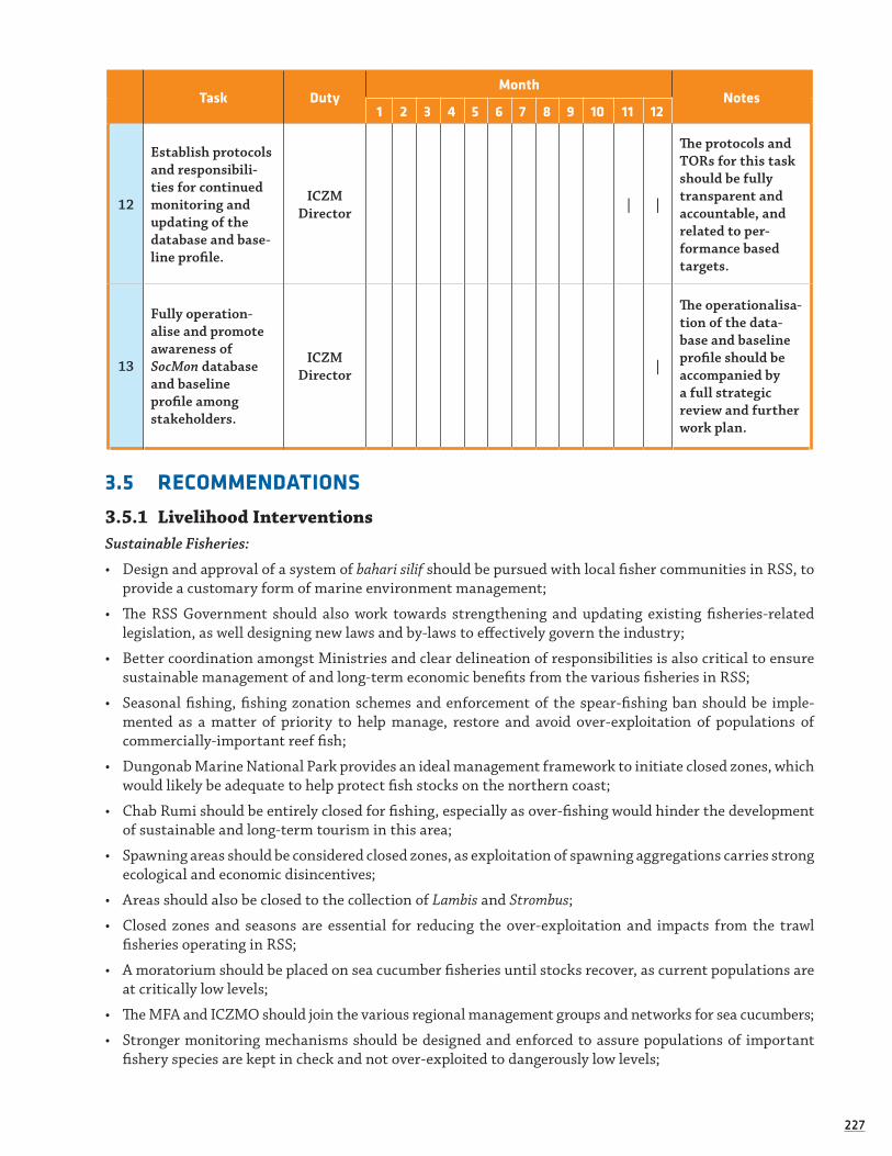
227227
Task DutyMonth
Notes1 2 3 4 5 6 7 8 9 10 11 12
12
Establish protocols and responsibili-ties for continued monitoring and updating of the database and base-line profile.
ICZMDirector | |
The protocols and TORs for this task should be fully transparent and accountable, and related to per-formance based targets.
13
Fully operation-alise and promote awareness of SocMon database and baseline profile among stakeholders.
ICZMDirector |
The operationalisa-tion of the data-base and baseline profile should be accompanied by a full strategic review and further work plan.
3.5 RECOMMENDATIONS
3.5.1 Livelihood InterventionsSustainable Fisheries:
• Design and approval of a system of bahari silif should be pursued with local fisher communities in RSS, to provide a customary form of marine environment management;
• The RSS Government should also work towards strengthening and updating existing fisheries-related legislation, as well designing new laws and by-laws to effectively govern the industry;
• Better coordination amongst Ministries and clear delineation of responsibilities is also critical to ensure sustainable management of and long-term economic benefits from the various fisheries in RSS;
• Seasonal fishing, fishing zonation schemes and enforcement of the spear-fishing ban should be imple-mented as a matter of priority to help manage, restore and avoid over-exploitation of populations of commercially-important reef fish;
• Dungonab Marine National Park provides an ideal management framework to initiate closed zones, which would likely be adequate to help protect fish stocks on the northern coast;
• Chab Rumi should be entirely closed for fishing, especially as over-fishing would hinder the development of sustainable and long-term tourism in this area;
• Spawning areas should be considered closed zones, as exploitation of spawning aggregations carries strong ecological and economic disincentives;
• Areas should also be closed to the collection of Lambis and Strombus;
• Closed zones and seasons are essential for reducing the over-exploitation and impacts from the trawl fisheries operating in RSS;
• A moratorium should be placed on sea cucumber fisheries until stocks recover, as current populations are at critically low levels;
• The MFA and ICZMO should join the various regional management groups and networks for sea cucumbers;
• Stronger monitoring mechanisms should be designed and enforced to assure populations of important fishery species are kept in check and not over-exploited to dangerously low levels;

228228
• Similarly, stronger monitoring of fishery activities is important to minimise the use of unsustainable prac-tices. Monitoring of the trawl fishery is critical to make sure these activities do not dangerously impact on the livelihoods of local small-scale fishers, deplete populations of important fisheries, or destroy import-ant marine habitats;
• The MFA should reconsider the hiring of fibreglass boats for reef fishing to trawling vessels, as this directly competes with Sudanese fishers and several of the species taken in the hand line reef fisheries are already overexploited, particularly the najil grouper;
• An ecosystem approach to fisheries management should be implemented for DMNP, to both provide eco-nomic opportunities for local communities, as well as ensure the integrity of the natural environment and fishery populations;
• Controlled purse-seine and lobster fisheries, for example, hold potential for further sustainable development.
Sustainable Tourism:
• Contact and establish a partnership with Accor Hotel Group for increasing the responsibility of the Mer-cure Hotel in RSS;
• An urgent assessment and consulting mission should be devoted to design a RSS sustainable tourism strategy, including collaboration with sustainable tourism practice areas, in Egypt Seychelles, and/or Mal-dives to obtain on-site experience of how a high-profile/high-cost/low-impact tourism model could work;
• Develop an investor profile document, which outlines the qualities and expectations for prospective investors.
Livelihood Interventions in the MPA villages
Developing Tools for Intervention:
• Financing: developing Community Fund programme based on the model developed by APF, to be given in line with the priority AIGs identified and following the submission of proposals and/or interviews with the local community groups;
• Technical Support and Advice: technical support and capacity building in bookkeeping, planning and finan-cial management; the formation of appropriate CBOs or businesses; markets, marketing and quality control; detailed aspects of the specific AIG by experienced partners; provision of links to new markets and networks; and, legal issues relating to the specific AIG;
• Equipment Provision: through a gear exchange programme ,particularly in fishery, to replace most damag-ing gear with newer and less harmful types.
Developing Six Sectors for Intervention:
• Offshore Fishing: an AIG which will develop fishing in the deep waters away from the bay environment.
• Assessment of the stock’s viability should first be carried out, including a cost-benefit analysis and an ecological assessment of whether there are sustainable stocks of pelagic or deep sea, demersal fish stocks;
• Evaluation of the existence of an annual or seasonal market for offshore fishing products;
• Assessment of cost and benefits for two options - i) around US $15,000 to set up one new boat and all the associated equipment at a basic level; and, ii) around US $200,000 for high quality, fully equipped fishing vessels;
• Introduction of larger vessels equipped with inboard engines and adapted equipment, such as winter weather clothing, navigation equipment and new adequate fishing gear. Reels and hook and line for deep water demersal fishes, surface set gill nets upwards of 31⁄2 inches for pelagics, such as Spanish mackerel and tuna are an example of potential gear that could be introduced;
• Training to craft and use the new vessels, manage sails, maintain engines, deal with the currents and weather;
• Training in how to treat their catch and of the potential markets for different species;
• Cool boxes should be installed with a capacity to hold a metric tonne of catch per trip;

229229
• Means to keep the stocks fresh until the market place: either generator-powered refrigeration unit based in each village is an option to consider, with care of purchase and maintenance cost and difficul-ties, or the alternative is for the fishermen to hire both vehicles and iceboxes from Port Sudan;
• Further research/consultation on Fish Aggregating Devices (FADs) as part of an offshore fishery AIG in DMNP is conducted.
• Mariculture: research should be carried out into the feasibility of mariculture for the Beja of this area. Potential species to investigate for the possibility of breeding include sea cucumbers in ponds, certain species of finfish in ponds and molluscs in submerged cages.
• Pearl Oyster Farming in collaboration with the Gulf Pearl Company :
• Assessment of the potential intervention following expression of willingness from the Gulf Pearl Company;
• Engage the drafting of a proposal from the Beja communities to the Gulf Pearl Company, which will include the definition of the access to the market through the company and to train a small number of local people in the complicated process of seeding the pearls and breeding the Oysters.
• Animal Husbandry:
• Careful assessment of potential profit and loss, taking into account the limitations of a non-equilib-rium, arid terrestrial climate and fading indigenous knowledge;
• Set up a pilot restocking programme in both villages, especially of sheep and goats, with reintroduction of substantial numbers of livestock through a carefully monitored breeding regime, managed by spe-cialist partners;
• Possibility to then re-establish older practices of nomadic or semi-nomadic pastoralism.
• Trading Centres:
• The profit and loss of this enterprise should be carefully assessed according to requirements;
• Two trading centres be developed (one in Dungonab and one in Mohammed Qol);
• The two shopping centres should offer different goods;
• Careful consideration will need to be made into which markets are feasible and which will be best placed in which areas.
• Tourism:
• Continued assessment of the potential for tourism is worthwhile and needed;
• Considerable training and an awareness programme to be conducted well in advance of any proposed tourism venture, to bring the skill sets of the communities up to an appropriate standard.
Strengthening Partnerships for Livelihood Alternatives
• Develop discussions with companies engaging in trade of fish, livestock and petty goods to both gauge the interest in buying from the Beja of this area and to understand more about the different markets available;
• Develop a focussed action on evaluating possible links with the fish market in Port Sudan;
• Pursue discussions with ACORD Sudan;
• Pursue discussions with Gulf Pearl Company.
Improving Livelihoods in Inland RSS (Sinkat-Arkawit area)
• Introduction and improvement of household or backyard vegetable gardening in the form of organised cooperatives based on previous UNDP agricultural cooperative models;
• Establishment of fruit orchards (organised cooperatives based on previous UNDP agricultural cooperative models);
• Re-explore possibilities of organised cooperatives for cattle projects;
• Rehabilitation of habitats for pasture lands;

230230
• Improve water and waste management, taking into account population expansion during the summer months.
Coastal Development:
Oil development:
• Create clear guidelines holding private oil investors (and other companies) responsible for environmen-tal safeguards and clean technologies. ‘Unlike many other sectors of the economy, industry generally has the capacity to invest its own funds in improving environmental performance, and site-specific solutions are usually straightforward. If required, capacity-building can also be purchased in the commercial market’ (UNEP, 2007: 156)
• A national oil industry environment act with accompanying statutory guidelines and standards should be developed. This would be a major venture requiring a cooperative approach with the oil industry.
Shrimp farming and aquaculture
• Establish, maintain and develop an appropriate legal and administrative framework, which facilitates the development of responsible aquaculture;
• Promote responsible development and management of aquaculture, including an advance evaluation of the effects of aquaculture development on genetic diversity and ecosystem integrity, based on the best available scientific information;
• Produce and regularly update aquaculture development strategies and plans, as required, to ensure that aquaculture development is ecologically sustainable and to allow the rational use of resources shared by aquaculture and other activities;
• Ensure that the livelihoods of local communities and their access to fishing grounds are not negatively affected by aquaculture developments;
• Establish effective procedures specific to aquaculture to undertake appropriate environmental assess-ment and monitoring with the aim of minimizing adverse ecological changes and related economic and social consequences resulting from water extraction, land use, discharge of effluents, use of drugs and chemicals, and other aquaculture activities;
• Promote responsible aquaculture practices in support of rural communities, producer organizations and fish farmers;
• Promote active participation of fish farmers and their communities in the development of responsible aquaculture management practices;
• Promote efforts which improve selection and use of appropriate feeds, feed additives and fertilizers, including manures;
• Promote effective farm and fish health management practices favouring hygienic measures and vaccines. Safe, effective and minimal use of therapeutants, hormones and drugs, antibiotics and other disease con-trol chemicals should be ensure;
• Regulate the use of chemical inputs in aquaculture, which are hazardous to human health and the envi-ronment;
• Require that the disposal of wastes such as offal, sludge, dead or diseased fish, excess veterinary drugs and other hazardous chemical inputs does not constitute a hazard to human health and the environment;
• Ensure the food safety of aquaculture products and promote efforts which maintain product quality and improve their value through particular care before and during harvesting and on-site processing and in storage and transport of the products.

231231
Sustainable construction techniques and renewable energies:
In its Post Conflict Environmental Assessment (2007), UNEP raises the possibility of introducing tech-niques such as stabilised earth technology, which is already used on a small-scale in areas in Sudan.73 The activities being pursued in the sustainable development of Suakin by Mallinson Architects provides a poten-tial opportunity for training local Sudanese in sustainable construction techniques. A demonstration project (linked with a capacity-building component) should be pursued in Suakin or Port Sudan. Collaboration with various UN agencies (harnessing their expertise in sustainable construction techniques) should also be pur-sued and factored into proposals for construction needs (i.e. school construction), as the UN has already conducted similar activities elsewhere in Sudan. Collaboration with the UN (specifically UNICEF) should also be pursued for environmental sanitation and water projects.
Renewable energy opportunities should be further explored. For example, solar energy could have greater potential in RSS. Paul Symonds from the EC has indicated that solar cookers have been explored elsewhere in Sudan and found to be not so viable for many (especially more traditional) RSS communities given the needs of traditional cooking practices, however, solar-aided hot water systems are viable and would reduce the BTU requirement. Solar power for community centres has also proved to be effective, though expensive (battery maintenance is also a concern (L. Salm, pers. Comm.). Thus, the plausibility for solar energy should be further researched, especially as it could be used in conjunction with other energy sources to offset dependence on conventional and less sustainable energy supplies.
Infrastructure, basic services and health:
The Government needs to explore ways to increase investment in necessary infrastructure and basic services, especially waste management. Formal, legal recognition of the linkage between development practices and impacts on environmental and human health should be further sanctioned to better promote responsible development and sustainable infrastructure systems. It would, therefore, be useful for RSS Ministries to explore harnessing private sector funding to contribute to appropriate urban planning and responsible development needs. For example, to use taxes levied from interested investors towards updating infrastructure in a more responsible and sustainable way and/or to insist that industrial investors include waste management systems that responsibly dispose of their by-products (agreement for such industries to operate in RSS would be dependent on industry commitment to provide such services, and on the ‘polluter pays’ principle in a proactive/preventative sense).
Aqaba, Jordan, offers several examples that could be followed by Sudan, including its waste-water treat-ment facility (already visited by ICZMO staff), as well as its air-quality monitoring system (an EU-funded project).
3.5.2 Risk Management:Responsible port operations:
With oil revenues improving the economy of the country in general, drawing in large amounts of raw materials and equipment needed for construction, and raising port revenues further, the SPC is now in a position where it is able to consider other projects, with or without the assistance of outside agencies. The SPC is, therefore, encouraged to seek external assistance (where needed) in terms of expertise and funding to make port development and maintenance more sustainable, especially to introduce modern technologies to reduce risks associated with port construction and operations.
73 The demand for fuel to fire bricks is one of the causes of deforestation in Sudan. Therefore an alternative brick-mak-ing method is necessary to mitigate this issue. One such method proposed by UNEP is through ‘stabilised earth techniques’ that compress a mixture of clay, silt, sand and a suitable binder, to make dense bricks. Such compressed earth technology has been used for the construction of the Haj Yousef experimental school in Northern Kharotum and other such demonstration projects, which have proven successful. Its expansion and training of RSS experts could therefore promote a new industry in RSS for urban developmental needs. Compressed earth construction requires roughly one to two percent of the energy needed for material development per cubic metre that cement and fired bricks use. This would translate into major savings in firewood accordingly. An added advantage is that the technology can be commercially self-sustaining. Market access is only currently limited by lack of capacity (UNEP, 2007: 135)

232232
Legal strengthening:
It is recommended that the Ministries of Transport and Justice, together with key personnel within SPC and the MAD, should draw up a priority list of Conventions that they wish to accede to, for discussion with IMO. IMO should then be invited in 2009 - using funds provided through the IMO’s Integrated Technical Cooperation Programme (ITCP) - to send a consultant to Sudan to review the current position and the list of Conventions with the Ministries, SPC and MAD. They should then decide for which Conventions Sudan should draft national legislation. It is hoped that, for the reasons given elsewhere in this report, MARPOL 73/78 will be one of the top priority conventions to be considered by Sudan.
Hydrographical surveys:
The current charts of Sudanese waters have been in use for well over 100 years and the actions required to update these charts to modern standards have not yet been taken. Considering the volume and value of trade, the number of ships that are now calling at Sudanese ports and generating revenue, and the potential consequences if an accident were to occur, investment in modern surveys for the main entry and exit routes and areas of the coast that are so important to the marine environment, can be considered a relatively small investment. It will lay the foundation for the improvement of charts of port approaches, coastal reefs and sites for new ports, and detailed coastline maps not currently available, that will serve the country for very many years to come. The SPC and Sudan should therefore maintain relations with the Hamburg Ports Con-sultancy in order to prepare the specifications that will meet the SPC’s requirements for the survey work. Preparation of ‘environmental maps’ should be considered and new routing measures, based on the hydro-graphic survey results, should be developed and implemented in the coming years, as a matter of priority.
Ballast water management:
It is important that the Authorities in Sudan keep in touch with the team leading the GloBallast Partner-ships Programme so that no opportunities for training etc. are missed. It is also proposed that some of the funding available through this programme should be used specifically to help Sudan to prepare for accession to this very important convention. Sudan specifically needs to improve the following relating to ballast water management: increased awareness, capacity-building and training; use of tankers to exchange ballast water (or implementation of another system to reduce the need for ships to dump their wastes in the open waters in their approach to RSS ports); a clearer definition of a lead agency and its responsibilities to deal with ballast water; and, the creation of adequate legislation and laws to govern ballast water management (including the ratification of the Ballast Water Convention).
Oil spill response capacity:
Sudan needs to improve its response capacity to deal with major oil spills, specifically in surfactant-based response mobilisation and increased Tier 2 level coordination. Accordingly, Sudan should seek support from one of the international response organisations with this capacity. It should introduce mechanisms to require companies operating major oil terminals to provide funding for developing this capacity on the basis of the ‘polluter pays’ principle.
Capacity-building and training:
Sudan should also seek to increase national capacity by sending two staff members from the MAD and probably SPC for training to the two-year Master’s degree level at World Maritime University (WMU) at Malmo, Sweden, which offers a course in Maritime Administration. A second, one year Master’s programme, should be undertaken at the International Maritime Law Institute (IMLI) in Malta, in International Mar-itime Law. Funding for both these programmes is available from sponsoring countries and organisations. Details of sponsorship for suitably qualified candidates are available from the WMU and IMLI. In order to improve the pollution response capacity in Sudan, MAD should also consider sending staff to undertake short courses offered at the IMO training centre in Trieste, Italy. Sudan should also seek to improve its capacity to deal with oily wastes generated by ships calling at the country’s ports, and, similarly, to deal with garbage and sewage.

233233
3.5.3 Completion of the Socioeconomic Monitoring ProgrammeAs a full 12-month work program has been designed as part of the initial survey and assessment con-
ducted in the Socioeconomic Monitoring Programme, the recommendation at this stage is to pursue and complete this program, as it will give the baseline to engage in future steps in this area.


235
4.1 GAP ANALYSIS Broad Gap Analysis
Table 52. Measuring Progress in the Implementation of ICZM (from EU Working Group on indicators and data). Dnk = Don’t Know.
Phase ActionNational Regional
2003 2208 2003 2008
Planning and management are taking place in the coastal zone
1Decisions about planning and managing the coast are governed by general legal instruments. dnk yes dnk yes
2Sectoral stakeholders meet on an ad hoc basis to discuss specific and marine issues. dnk no no no
3There are spatial development plans which include the coastal zone but do not treat it as a distinct and separate identity.
dnk no no yes
4Aspects of the coastal zone, including marine areas, are regularly monitored. dnk no no yes
5Planning on the coast includes the statutory protection of natural areas. dnk dnk no yes
A framework exists for taking ICZM forward
6Existing instruments are being adapted and combined to deal with coastal planning and management issues.
dnk dnk no yes
7Adequate funding is usually available for undertak-ing actions on the coast. no no no no
8A stocktake of the coast (identifying who does what, where and how) has been carried out. no no no no
9There is a formal mechanism whereby stakeholders meet regularly to discuss a range of coastal and marine issues.
no no no no
10Ad hoc actions on the coast are being carried out that include recognisable elements of ICZM. no no no yes
11A sustainable development strategy which includes specific references to coasts and seas is in place. no yes no yes
12Guidelines have been produced by national, regional or local governments which advise planning authori-ties on appropriate uses of the coastal zone.
no no no no
(Continued)
4 Gap Analysis and Summary of Recommendations

236
Phase ActionNational Regional
2003 2208 2003 2008
Most aspects of an ICZM approach to planning and managing the coast are in place and functioning reasonably well.
13All relevant parties concerned in the ICZM deci-sion-making process have been identified and are involved.
no no no yes
14A report on the State of the Coast has been written with the intention of repeating the exercise every five or ten years.
no no no yes
15There is a statutory integrated coastal zone man-agement plan. no no no no
16Strategic Environmental Assessments are used commonly to examine policies, strategies and plans for the coastal zone.
no no no no
17A non-statutory coastal zone management strate-gy has been drawn up and an action plan is being implemented.
no no no yes
18There are open channels of communication between those responsible for the coast at all levels of government.
no no no yes
19Each administrative level has at least one member of staff whose sole responsibility is ICZM. no no no no
20Statutory development plans span the interface between land and sea. dnk dnk no no
21 Spatial planning of sea areas is required by law. dnk dnk no no
22A number of properly staffed and properly funded partnerships of coastal and marine stakeholders have been set up.
no dnk no yes
23Coastal and estuary partnerships are consulted routinely about proposals to do with the coastal zone.
dnk dnk no dnk
24Adequate mechanisms are in place to allow coast-al communications to take a participative role in ICZM decisions.
no no no no
(Continued)
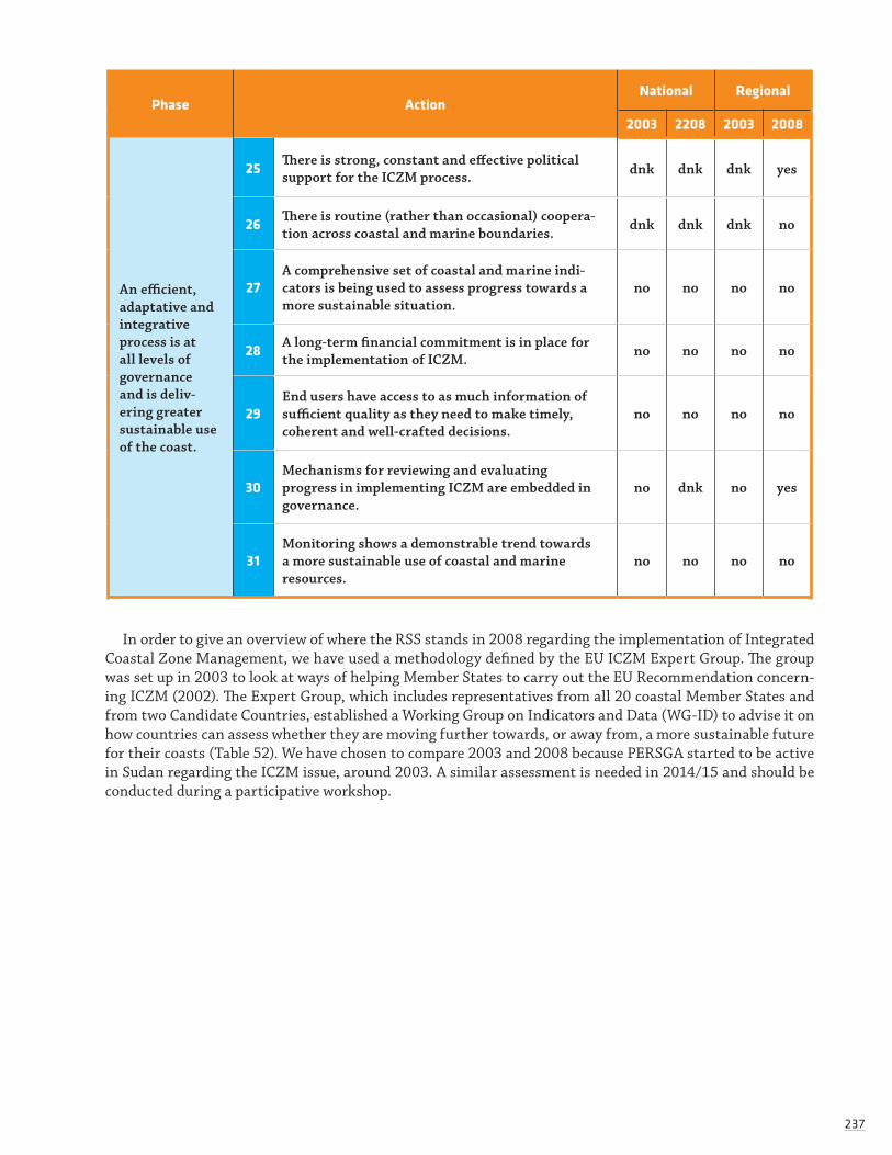
237
Phase ActionNational Regional
2003 2208 2003 2008
An efficient, adaptative and integrative process is at all levels of governance and is deliv-ering greater sustainable use of the coast.
25There is strong, constant and effective political support for the ICZM process. dnk dnk dnk yes
26There is routine (rather than occasional) coopera-tion across coastal and marine boundaries. dnk dnk dnk no
27A comprehensive set of coastal and marine indi-cators is being used to assess progress towards a more sustainable situation.
no no no no
28A long-term financial commitment is in place for the implementation of ICZM. no no no no
29End users have access to as much information of sufficient quality as they need to make timely, coherent and well-crafted decisions.
no no no no
30Mechanisms for reviewing and evaluating progress in implementing ICZM are embedded in governance.
no dnk no yes
31Monitoring shows a demonstrable trend towards a more sustainable use of coastal and marine resources.
no no no no
In order to give an overview of where the RSS stands in 2008 regarding the implementation of Integrated Coastal Zone Management, we have used a methodology defined by the EU ICZM Expert Group. The group was set up in 2003 to look at ways of helping Member States to carry out the EU Recommendation concern-ing ICZM (2002). The Expert Group, which includes representatives from all 20 coastal Member States and from two Candidate Countries, established a Working Group on Indicators and Data (WG-ID) to advise it on how countries can assess whether they are moving further towards, or away from, a more sustainable future for their coasts (Table 52). We have chosen to compare 2003 and 2008 because PERSGA started to be active in Sudan regarding the ICZM issue, around 2003. A similar assessment is needed in 2014/15 and should be conducted during a participative workshop.

238238
4.2 REFERENCESAfrican Parks Foundation (2006). Sudan Marine Parks Survey Expedition Report 2006: Dungonab Bay and
Mukawwar Island National Park &Sanganeb Atoll Marine National Park, Sudan. 121+115 pp. African Parks Foundation.
Allen, G & Steene, R. (1994). Indo-Pacific Coral Reef Field Guide. Tropical Reef Research, Singapore.
Atkinson (2005). Food Security and Livelihood Analysis of Red Sea State. Oxfam: Port Sudan.
Babiker, M. & Pantuliano, S. (2006). Addressing Chronic Livelihoods Vulnerability in Red Sea State, Sudan. Oxfam: Khartoum.
Bekoe, D., & Kiplagat, N. (2006). Peacemaking and Peacebuilding in Eastern Sudan. USI Peace Briefing. US Institute of Peace: www.usip.org.
Bellwood, D.R. & Wainwright, P.C. (2002). The history and biogeography of fishes on coral reefs. pp. 5–32 in P.F. Sale (ed.). Coral Reef Fishes. Dynamics and Diversity in a Complex Ecosystem. Academic Press, Lon-don and San Diego.
Biswas, P. Finan, T. & Hagens, C. (2005). A Livelihood Vulnerability and Nutritional Assessment of Rural Kassala and Red Sea State. TANGO, FAO, UNDP.
Blum, S.D. (1989). Biogeography of the Chaetodontidae: an analysis of allopatry among closely related spe-cies. Env. Biol. Fishes 25: 9-31.
Brander, L.M., Van Beukering, P. Van & Cesar, H.S.J. (2007). The Recreational Value of Coral Reefs: A Meta-Analysis. Ecological Economics 63 (2007) 209-218.
Briggs, J.C. (1974). Marine Zoogeography. McGraw-Hill, New York. 475pp.
Brown, B.E. & Suharsono (1990). Damage and recovery of coral reefs affected by El Nino related seawater warming in the Thousand Islands, Indonesia. Coral Reefs, 8: 163-170.
Bryant D., Burke L., Mcmanus J. & Spalding, M. (1998). Reefs at Risk: A Map-Based Indicator of Threats to the World’s Coral Reefs. World Resources Institute, International Center for Living Aquatic Resources Management, World Conservation Monitoring Centre and United Nations Environment Programme, Washington, D.C.
Camhi, M., Fowler, S., Musick, J., Bräutigam, A. & Fordham, S. (1998). Sharks and their relatives: Ecology and Conservation. Occasional Paper of the IUCN Species Survival Commission. Occas. Pap. No. 20.
Central Bureau Of Statistics (2006). Sudan Statistical Yearbook 2006. CBS: Khartoum.
Chafe & Honey (2005). Consumer Demand and Operator Support for Socially and Enviornmnetally Respon-sible Toursim, CESD/TIES Working Paper No. 104.
Chiffings, A.W. (1995). Arabian Seas. A global representative system of Marine Protected Areas. Volume Three. Central Indian Ocean, Arabian Seas, East Africa and East Asian Seas. (ed. G. Kelleher, C. Bleakley & S. Wells), pp. 39-70. Great Barrier Reef Marine Park Authority/International Union for Conservation of Nature/World Bank.
Clarke, K.R. & Warwick, R.M. (2001). Change in marine communities: an approach to statistical analysis and interpretation, 2nd Edn. PRIMER – E. Plymouth.
Conand, C. and muthiga N.A. (eds.) (2007). Commercial sea cucumbers: a review for the Western Indian Ocean. WIOMSA Book Series No. 5. iii+ 67pp.
Crossland, C. (1907). Reports on the marine biology of the Sudanese Red Sea. 4. The recent history of the coral reefs of the mid-west shores of the Red Sea. J. Linn. Soc. Lond. 31: 14-30.
Crossland, C. (1911). Reports on the marine biology of the Sudanese Red Sea: A physical description of Khor Dungonab. J. Linn. Soc. Lond. 31: 265-286.
Currie, R.J., Fisher, A.E. & Hargreaves, P.M. (1973). Arabian Sea Upwelling. The Biology of the Indian Ocean (B. Zeitschel & S.A. Gerlach, eds.). Ecological Studies 3 (1.4) 37–52.

239239
DeVantier, L., De’ath, A.G., Done, T.J. & Turak, E.I. (1998). Ecological assessment of a complex natural system: a case study from the Great Barrier Reef. Ecological Applications 8: 480-496.
DeVantier, L., Turak, E., Al-Shaikh, K. & Death, G. (2000). Coral communiites of the central-northern Saudi Arabian Red Sea. Fauna of Arabia 18: 23–66.
DeVantier, L., De’ath, G., Klaus, R., Al-Moghrabi, S., Abdullaziz, M., Reinicke, G.B. & Cheung, C. (2004). Reef-building corals and coral communities of the Socotra Archipelago, a zoogeographic ‘crossroads’ in the Arabian Sea. Fauna of Arabia 20: 117-168.
Done, T.J. (1982). Patterns in the distribution of coral communities across the Great Barrier Reef. Coral Reefs 1 (2): 95-107.
Eastern States Peace Agreement (2006): www.sudantribune.com.
Edmunds, P.J. (1994). Evidence that reef-wide patterns of coral bleaching may be the result of the distribu-tion of bleaching-susceptible coral clones. Marine Biology 121: 137-142.
Edwards, A.J. & Head, S.M. (eds.) (1987). Red Sea. Pergamon Press, Oxford. 441pp.
Edwards, A.J. (1987). Climate and oceanography. In: A.J. Edwards & S.M. Head (eds.) Red Sea. Pergamon Press, Oxford. pp. 45-68.
El Bashir, Y.H.A. (2004). Mesquite in Sudan. Workshop on Control and Eradication of Mesquite and other Nox-ious Weeds. Wad Medani. Hospitality Palace. 14 February 2004 (unpublished).
Elsidig, N.A., Abdelsalam, A.H. & Abdelmagid, T.D. (1998). Socio-Economic, Environmental and Man-agement Aspects of Mesquite in Kassala State (Sudan) Sudanese Social Forestry Society. p. 96.
English, S., Wilkinson, C. & Baker, V. (1997). Survey Manual for Tropical Marine Resources. Australian Institute of Marine Science. 2nd edn. Townsville.
European Coalition on Oil in Sudan and Fatal Transactions (2008). Who’s Oil? Sudan’s Oil Industry: Facts and Analysis, April 2008. IKV Pax Christ.
European Commission (2008). Cost and Financing of Basic Education in Sudan: Draft Report.
Fabricius, K. and P. Alderslade (2001). Soft Corals and Sea Fans: A comprehensive guide to the tropical shallow water genera of the Central West Pacific, the Indian Ocean and the Red Sea. Australian Insti-tute of Marine Science, Townsville. 264pp.
Farah, O.M. (1982). The bathymetry, oceanography and bottom sediments of Dungonab Bay (Red Sea), Sudan. Ph.D. Thesis, University of Delaware, 1982. 148pp.
Farah, O.M. (1999). Assessment of threats, pressures, opportunities and options on biodiversity and on the sustainable use of marine biological resources: Diversity in fisheries in marine and coastal habitats of the Red Sea, Sudan. Red Sea Fisheries Research Station. 23pp.
Federal Ministry of Education, General Directorate of Education Planning (2004). The Develop-ment of Education: National Report of Sudan.
Feldheim, K.A. and Edrén, S.M.C (2002). Impacts of Dredging on Marine Communities: the Bimini Lemon Shark. Bahamas Journal of Science.
Feldheim, K.A., Gruber, S.H. And M.V. Ashley. (2002). The breeding biology of lemon sharks at a tropical nursery lagoon. Proc. R. Soc. Lond. B Biol. Sci. 269: 1655.
Fishpool, L.D.C. & Evans, M.I., EDS. (2001). Important Bird Areas in Africa and associated islands: Priority sites for conservation. Newbury and Cambridge, UK: Pisces Publications and BirdLife International (BirdLife Conservation Series No. 11).
Gladstone, W. (2000). The ecological and social basis for management of a Red Sea marine-protected area. Ocean & Coastal Management 43: 1015–1032.
Gleason, M.G. (1993). Effects of disturbance on coral communities: bleaching in Moorea, French Polynesia. Coral Reefs 12: 193-201.
Crossland, C. (1913). Desert and water gardens of the Red Sea. London.

240240
Glynn, P.W. (ed.) (2001). A collection of studies on the effects of the 1997-98 El Niño Southern Oscillation event on corals and coral reefs in the eastern tropical Pacific. Bull. Mar. Sci., 69: 1-288.
Glynn, P.W. (1991). Coral reef bleaching in the 1980s and possible connections with global warming. TREE 6: 175-179.
Glynn, P.W. (1993). Coral-reef bleaching: ecological perspectives. Coral Reefs 12: 1-17.
Glynn P.W. & D’croz, L. (1990). Experimental evidence for high temperature stress as the cause of El Nino-coincident coral mortality. Coral Reefs 8: 181-192.
Goren, M. & Dor, M. (1994). An updated checklist of the fishes of the Red Sea CLOFRES II. The Israel Academy of Sciences and Humanities, Jerusalem. 120pp.
Government of Kowait (2010). The International Donors and Investors Conference for Eastern Sudan. Conference Document. 119 pp.
Government of Sudan and Eastern Sudan Front (2006). Eastern Sudan Peace Agreement (ESPA). 10 pp.
Gravier, C. (1911). Les recifs de coraux et les madreporaires de la Baie de Tadjourah: Gulf of Aden. Annales de l’Institute Océanographique. Paris 2: 99.
Grimsditch, G.D. & Salm, R.V. (2006). Coral Reef Resilience and Resistance to Bleaching. IUCN, Gland, Swit-zerland.
Guilcher, A. (1988). Coral Reef Geomorphology. John Wiley & Sons Inc.
Harrison, P. (2007). A Socio-economic Assessment of Sustainable Livelihoods Regimes for Communities of Dungonab Bay and Mukkawar Island National Park, Sudan: Incorporating Livelihood Intervention Strategies and Recommendations for the Development of Alternative Income Generating Activities. IUCN EARO, Nairobi. 34pp + appendices.
Harrison, P. & Samoilys, M.A. (2007). Village Environmental Management Plans (VEMPs) for Dungonab Bay and Mukkawar Island National Park: Creation and Development of VEMPs for the villages of Mohammed Qol and Dungonab, Red Sea State, Sudan. IUCN Nairobi/African Parks Foundation. ix + 44pp.
Hass, H. (1952). Under the Red Sea (translated from the German by James Cleugh). Jarrolds, London. 208pp.
HCENR (2007). Statistical Database.
Head, S. (1980). The ecology of corals in the Sudanese Red Sea. Ph.D. Thesis, University of Cambridge.
Heemstra, P.C. & Randall, J.E. (1993). Groupers of the World (Family Serranidae, Subfamily Epinephe-linae): An Annotated and Illustrated Catalogue of the Grouper, Rockcod, Hind, Coral Grouper and Lyretail Species Known to Date. FAO Fisheries Synopsis, no. 125, vol. 16. vii + 382pp.
Heupel, M.R., Carlson, J.K. & C.A. Simpfendorfer (2007). Shark nursery areas: concepts, definitions, characterization and assumptions. Marine Ecology Progress Series 337: 287-297.
Heupel, M.R. AND C.A. Simpfendorfer (2005). Quantitative analysis of shark aggregation behavior. Marine Biology 147: 1239-1249.
Heupel, M.R. and C.a. Simpfendorfer (2005). Using acoustic monitoring to evaluate MPAs for shark nurs-ery areas: the importance of long-term data. Marine Technology Society Journal 39: 10-18.
Hillary, A., Kokkonen, M. & Max, L. (2002). Proceedings of the World Heritage Marine Biodiversity Work-shop: Hanoi, Vietnam, February 25-March 1, 2002, World Heritage Paper No. 4.
Hodgson, G. & LIEBELER, J. (2002). The Global Coral Reef Crisis; Trends and Solutions.
IUCN (2008). Climate Change and Coral Reefs working group home page. http://www.iucn.org/themes/marine/coral_reefs/cccr/cccr_home.html.
Kemp, J.M. (1998). Zoogeography of the coral reef fishes of the Socotra Archipelago. Journal of Biogeography 25: 919-933.

241241
Kemp, J., Klaus, R., Salem, M., Awadalla, Y. & Saleh B. (2002). Survey of the Proposed Marine Protected Area at Dunganob Bay and Mukkawar Island, Sudan. PERSGA SAP Component 5 A Regional Network of Marine Protected Areas. 164pp.
Khojali, A. (2005). Livelihoods and Markets in Rural Port Sudan and Tokar. Oxfam: Oxford.
Klaus, R. & Turner, J.R. (1999). Littoral and Sublittoral Surveys of the Socotra Archipelago. Conservation and Sustainable Use of Socotra Archipelago. Marine Habitat, Biodiversity and Fisheries Surveys and Management. Report of Phase I. UNOPS YEM/96/G32; Contract no. C-972248. 83pp. + 99 classifica-tion maps.
Klaus, R. & Turner, J.R. (2001a). Mapping the marine biotopes of the Socotra Archipelago. Conservation and Sustainable Use of Socotra Archipelago. Marine Habitat, Biodiversity and Fisheries Surveys and Management. Report of Phase III. UNOPS YEM/96/G32; Contract no. C-972248.
Klaus, R. & Turner, J.R. (2001b). Marine biotope manual for the Socotra Archipelago.Conservation and Sustainable Use of Socotra Archipelago. Marine Habitat, Biodiversity and Fisheries Surveys and Man-agement. Report of Phase III. UNOPS YEM/96/G32; Contract no. C-972248.
Klaus, R. & Turner, J.R. (2004). The marine biotopes of the Socotra Island Group. Fauna of Arabia 20: 45-115.
Klaus, R., Hardman, E.R. & Persand, S. (2008). Mapping the Biotopes in the Rodrigues Lagoons and the Cre-ation of a Geographical Information System for Management of the South Eastern Marine Protected Area. First Interim Report of GIS and Ecology Team, UNDP, Rodrigues Regional Assesmbly. 152pp.
Knowlton, N., Weil, E., Weight, L.A., & Guzmán, H.M. (1992). Sibling species in Montastrea annularis, coral bleaching, and the coral climate record. Science 255: 330–333.
Kohler, K.E. and S.M. GILL (2006). Coral Point Count with Excel extensions (CPCe): A Visual Basic program for the determination of coral and substrate coverage using random point count methodology. Com-puters and Geosciences, Vol. 32, No. 9, pp. 1259-1269.
Krupp, F., Türkay, M., El Hag, A.G.D. & NASR, D. (eds.) (1994). Comparative Ecological Analysis of Biota and Habitats in Littoral and Shallow Sublittoral Waters of the Sudanese Red Sea. Forschungsinstitut Senckenberg, Frankfurt & Faculty of Marine Science and Fisheries, Port Sudan.
Lessios, H.A. (1995). Diadema antillarum 10 years after mass mortality: Still rare, despite help from a com-petitor. Proc Royal Soc London Ser B 259: 331-337.
Marshall P.A., & Baird A.H. (2000). Bleaching of corals on the Great Barrier Reef: differential susceptibil-ities among taxa. Coral Reefs 19: 155-163.
Mastaller, M. (1987) Molluscs of the Red Sea. In: A.J. Edwards & S.M. Head (eds.) Red Sea. Pergamon Press, Oxford. pp. 194-214.
McClanahan, T.R. (2000). Coral reef use and conservation. pp. 39-80 In: McClanahan, T.R., Sheppard, C.R.C. and Obura, D.O. (eds.) Coral Reefs of the Indian Ocean: their ecology and conservation. 525pp.
McClanahan, T.R., Kamukuru, A.T., Muthiga, N.A., Gilagagher Yebio M. & Obura, D. (1995). Effect of sea urchin reductions on algae, coral and fish populations. Conservation Biology 10: 136-154.
McCook, L.J. (1999). Macroalgae, nutrients and phase shifts on coral reefs: scientific issues and manage-ment consequences for the Great Barrier Reef. Coral Reefs 18: 357-367.
McCreesh, M. (2003). Public Health Assessment for Red Sea State. Oxfam: Oxford.
Mergner, H. & Schumacher, H. (1985). Quantitative Analysis of Coral Communities on Sanganeb Atoll (Central Red Sea) Comparison with Aqaba reefs (Northern Red Sea). In: Proceedings of the Fifth Inter-national Coral Reef Congress, Tahiti 6: 243-248.
Hughes, T.P. (1994). Catastrophes, phase shifts, and large-scale degradation of a Caribbean coral reef. Science 265: 1547-50.
IAIA (2003). International Guidelines and Principles for SIA. ICGP: Washington.

242242
IFC (2003). Addressing the Social Dimensions of Private Sector Projects. Good Practice Note Number 3. IFC: Washington.
Integrated Coastal Zone Management Office (2008). RSS Socio-economic Monitoring Database for ICZM. ICZM: Port Sudan.
IUCN (2004). Managing Marine Protected Areas: A Toolkit for the Western Indian Ocean. IUCN Eastern African Regional Programme, Nairobi, Kenya. xii+172pp.
Miller, I.R. & De’ath, A.G. (1996). Effects of training on observer performance in assessing benthic cover by means of the manta tow technique. Marine and Freshwater Research 47: 19-26.
Miller, I. & Müller, R. (1999). Validity and reproducibility of benthic cover estimates made during broad-scale surveys of coral reefs by manta tow. Coral Reefs 18(4): 353-356.
Ministry of Environment and Physical Development. (2006). CBD Third National Report.
Ministry of Environment and Tourism. (2000). CBD National Biodiversity Strategy and Action Plan.
Ministry of Home Affairs, Housing and Environment (2002). National Biodiversity Strategy and Action Plan for the Maldives. Ministry of Home Affairs, Housing and Environment: Male, Maldives.
Moore, R.J. & Balzarotti, M.A. (1977). Report of the 1976 expedition to Suakin Archipelago (Sudanese Red Sea). Results of marine turtle survey and notes on bird life. Unpublished report. vi + 27pp.
Muthiga, N.A. & Ndirangu, S. (2000). Village based larviculture and stock enhancement of sea cucumbers (Echinodermata: Holothuroidea) on the Kenyan coast. Final Technical Report, Biodiversity Support Fund.
Nardi, K., Jones, G.p., Moran, M.j. & Y.w. Chen (2004). Contrasting effects of marine protected areas on the abundance of two exploited reef fishes at the sub-tropical Houtman Abrolhos Islands, Western Australia. Env. Cons. 31(2): 160-168.
Ormond, R.F.G. & Edwards, A.J. (1987). Red Sea Fishes. In: A.J. Edwards & S.M. Head (eds.) Red Sea. Pergamon Press, Oxford. pp. 251-287.
Ormond, R.F.G. & Campbell, A.C. (1974). Formation and Breakdown of Acanthaster plancii Aggregations in the Red Sea. Proc. 2nd Int. Coral Reef Symp., Brisbane. 1: 595-619.
Ormond, R.F.G. (1980). Management and Conservation of Red Sea Habitats. Proc. Symp. Coastal and Marine Environment of the Red Sea, Gulf of Aden and Tropical Western Indian Ocean, Khartoum.2: 327-372.
Ormond, R.F.G., Dawson-Shepherd, A.r., Price, A.r.g. & Pitts, R.j. (1984). Report on the distribution of habitats and species in the Saudi Arabian Red Sea. Part I. Reports to the Meteorology and Environ-mental Protection Administration, Jeddah.
Othina, A. & Samoilys M. (2005). Impacts of management on coral reefs in Tanga, Tanzania. IUCN-EARO, Nairobi. 66pp.
OXFAM (1998). Poverty Baseline. Oxfam: Port Sudan.
Pantuliano, S. (2000). Changing Livelihoods: Urban Adaptation of the Beja Pastoralists of Halaib Province. Unpublished Ph.D. Thesis. University Of Leeds.
Pantuliano, S. (2002). ‘Sustaining Livelihoods Across the Rural-Urban Divide: Changes and Challenges Facing The Beja Pastoralists’. IIED. 52pp.
Pantuliano, S. (2005). Comprehensive Peace? Causes and consequences of under-development and insta-bility in Eastern Sudan. NGO Paper: IDS Dar Salam.
Paul, A. (1971). A History of the Beja Tribes of the Sudan. London: F.Cass.Vii.
PERSGA (2001). Country Reports. PERSGA, Jeddah. 205pp.
PERSGA (2002). The Red Sea and Gulf of Aden Network of Marine Protected Areas: Regional Master Plan. PERSGA Technical Series #1. PERSGA Jeddah. 82pp.
PERSGA (2003). Survey of the Proposed Marine Protected Area at Dungonab Bay and Mukawwar Island, Sudan. PERSGA, Jeddah. 93pp.

243243
PERSGA (2004a). Dungonab Bay-Mukawwar Island Proposed Marine Protected Area. Site Specific Master Plan with Management Guidelines. PERSGA. Jeddah.
PERSGA/GEF (2004b). Sanganeb Marine National Park Site-Specific Master Plan with Management Guide-lines. PERSGA, Jeddah. 96pp.
PERSGA (2005). Dungonab Bay-Mukawwar Island Proposed Marine Protected Area. Site Specific master Plan with Management Guidelines. PERSGA. Jeddah. 106pp.
PERSGA/UNEP (2003). National Oil Spill Contingency Plan for Sudan. PERSGA Technical Series No. 6. PERSGA, Jeddah.
Red Sea State Ministry of Health (2004). Evaluation of Nutrition and Food Security Situation in Rural Areas of the Red Sea State. Oxfam: Port Sudan.
Red Sea State Ministry of Health (2006). Nutrition Anthropometric Survey and Food Security Assess-ment in Sinkat, Port Sudan, Halaib and Tokar, Red Sea State.
Riegl, B. (2003). Global climate change and coral reefs: different effects in two high latitude areas (Arabian Gulf, South Africa). Coral Reefs 22(3):
Reinicke, G.B. (1997). Xeniidae (Coelenterate: Octocorallia) of the Red Sea, with descriptions of six new species of Xenia. Fauna of Arabia 16: 5–62.
Reinicke, G.B., Kroll, S.D.K. & Schuhmacher, H. (2003). Patterns and Changes of Reef-Coral Communi-ties at the Sanganeb-Atoll (Sudan, Central Red Sea): 1980 to 1991. Facies 49: 271-298.
Richmond, M.D. (ed.) (1999). A Guide to the Seashores of Eastern Africa. 448pp. SIDA / SAREC.
Roberts, C.M., Dawson Shepherd, A.R. & Ormond, R.f.g. (1992). Large-scale variation in assemblage structure of Red Sea butterflyfishes and angelfishes. J. Biogeog. 19: 239-250.
Roghi, G. & BaschierI, F. (1956) Dhalak (translated by Priscilla Hastings) Kaye, London. 280pp.
Sadovy, Y., Kulbicki, M., Labrosse, P., Letourneur, Y., Lokani, P. & Donaldson, T.J. (2003). The hump-head wrasse, Cheilinus undulatus: synopsis of a threatened and poorly known giant coral reef fish. Reviews in Fish Biology and Fisheries 13 (3): 327-364.
Sahl, I.M., Elkarib, A.K. & Mohammed, E.M. (2004). Towards a New Silif: Breaking the Silence on FGM among Beja Pastoralists of Eastern Sudan. Accord: Nairobi.
Salm, R.V., Smith, S.E. & Llewellyn, G. (2001). Mitigating the impact of coral bleaching through marine protected area design. pp 81–88 in: H.Z. Schuttenberg (ed.) Coral bleaching: causes, consequences, and response. Coastal management report 2230. Coastal Resources Center, Narragansett, Rhode Island.
Samoilys, M.A & Carlos, G. (2000). Determining methods of underwater visual census for estimating the abundance of coral reef fishes. Env. Biol. Fish. 57: 289-304.
Sheppard, C.R.C. & Wells, S. (1988). Directory of Coral Reefs of International Importance. Vol 2. Indian Ocean Region. International Union for Conservation of Nature, Gland, and United Nations Environ-mental Programme, Nairobi, p. 389.
Sheppard, C.R.C. & Sheppard, A.L.S. (1991). Corals and coral communities of Arabia. Fauna of Saudi Arabia 12: 3-191.
Sheppard, C.R.C. & Wells, S.M. (1988). Coral Reefs of the World. Volume 2: Indian Ocean, Red Sea and Gulf. 389pp.
Shepperd, C.R.C., Price, A.R.G. & Roberts, C.M. (1992). Marine ecology of the Arabian region. Academic Press, London and San Diego. 359pp.
Sidahmed, A.S. (1995). The Beja. http://www.sudanupdate.org/reports/peoples/beja.htm/.
Snell, M. & Ali, M. (2004). Water and Sanitation Assessment, Red Sea State. Oxfam: Oxford.
Spalding M.D., Ravilious C, & Green E.P. (2001). World Atlas of Coral Reefs. University of California Press, Berkeley, USA. 428pp.

244244
Turak, E., Brodie, J.e. & Devantier, L. (2007). Reef-building corals and coral communities of the Yemen Red Sea. Fauna of Arabia, 1-40.
Turner, J.R. & Klaus, R. (2005). Coral Reefs of the Mascarenes, Western Indian Ocean. Philosophical Trans-actions of the Royal Society of London A 363: 229-250.
UNDP (2005). An Analysis of Food Security Constraints and Potentials in the Red Sea State and Kassala States, Eastern Sudan. Khartoum: UNDP.
UNDP (2008). UNDP in Eastern Sudan. http://www.sd.undp.org/UNDP_eastern_sudan.htm.
UNDP (2009). Local Governance and Public Expenditure Management in East Sudan (http://www.sd.undp.org/content/sudan/en/home/operations/projects/democratic_governance/local-governance-devel-opment-public-expenditure-management-in-ea.html).
UNEP (2007). Sudan: Post Conflict Environmental Assessment. UNEP: Nairobi.
UNESCO (2008). UNESCO National Education Support Strategy. UNESCO: Khartoum.
UNST (2007). East Sudan: Analysis and Priorities. 25th May.
Veron, J.E.N. (2000). Corals of the world. Volumes 1, 2, and 3. Australian Institute of Marine Science and CRR Qld. Pty. Ltd. Australia. 1389pp.
Vine, P.J. & Vine, M.P. (1980). Ecology of Sudanese coral reefs with particular reference to reef morphology and distribution of fishes. In: Proceedings of Symposium on the Coastal and Marine Environment of the Red Sea, Gulf of Aden and Tropical Western Indian Ocean. 1: 87-104. ALECSO.
Vogt, H., MONTEBON, A.R.F. & ALCALA, M.L.R. (1997). Underwater video sampling: An effective method for coral reef surveys? Proc.8th Int. Coral Reef Symp 2: 1447–1452.
Wallace, C. (1999). Staghorn corals of the World. CSIRO Publishing, Collingwood.
Wells, S., Samoilys, M.A., Anderson, J., Kalombo, H. & S. Makoloweka (2007). Collaborative Fisher-ies Management in Tanga, Northern Tanzania. In: McClanahan, T.R. and J.C. Castilla (eds.) Fisheries Management: Progress towards Sustainability. Blackwell. pp. 139-165.
West, J.M. & SALM, R.V. (2003). Resistance and Resilience to Coral Bleaching: Implications for Coral Reef Conservation and Management. Conservation Biology. 17( 4) 956-967.
Winterbottom, R. (1985). Revision of the congrogadid Haliophis (Pisces: Perciformes), with the description of a new species from Indonesia, and comments on the endemic fish fauna of the northern Red Sea. Can. J. Zool. 63: 209-217.
WWF International (2001). Guidelines for Community-Based Tourism Development.
Samoilys, M.A, Wells S., Anderson J., Horrill, C., Kalonbo, H. & Verheij, E. (2007). Fisheries and their management in Tanga Region. In: Wells, S., Makoloweka, S., and Samoilys M. (eds.) Putting Adaptive Management Into Practice: Collaborative Coastal Management in Tanga, northern Tanzania. IUCN Eastern Africa Regional Office. pp. 46-76.
Samoilys M.A. (2008). Proposed management framework for Dungonab Bay and Mukkawar Island National Park. IUCN, Nairobi/African Parks Foundation. 32pp.
Scheer, G. & Pillai, C.S.G. (1983). Report on the stony corals of the Red Sea. Zoologica, Stuttgart. 133: 1-198.
Schuhmacher, H. (1974). On the conditions accompanying the first settlement of corals on artifical reefs with special reference to the influence of grazing sea urchins (Eilat, Red Sea). Proc of the 2nd Int Coral Reef Sym 1: 257-367.
Schuhmacher, H. (1989). Development of coral communities on artificial reef types over 20 years (Eilat, Red Sea). Proc 6th Int. Coral Reef Symp 3: 379-384.
Schuhmacher, H., Kiene, W. And Dullo, W. (1995). Factors controlling Holocene reef growth: an interdis-ciplinary approach. Facies 32: 145-188.
Schumacher, H. & MERGNER, H. (1985). Quantitative Analyse von Korallengemeinschaften des San-ganeb-Atolls (mittleres Rotes Meer). II. Vergleich mit einem Riffareal bei Aqaba (nordliches Rotes Meer) am Nordrande des indopazifischen Riffgurtels. Helgo. Meeresunt., 39: 419-440.

245245
Seychelles Ministry of Tourism & Transport, Seychelles Eco-Tourism Strategy for the 21st Strategy (SETS-21).
Sheppard, C.R.C. And A.L.S. Sheppard (1985). Reefs and coral assemblages of Saudi Arabia 1. The central Red Seaat Madinat al Sinaiyah. Fauna of Saudi Arabia 7: 17-36.

246
Equipe Cousteau • 40 Rue des Renaudes • 75017 Paris • Tel: +33 (0) 1 44 34 06 06
WWW.COUSTEAU.ORG
CUS T ODIA NS OF T HE SE A