TOTAL OF 10 PAGES ONLY MAY BE XEROXED r:
153
THE GlAOAL GroMQli:PHQlQGY OF WEST-C f NTIW. Nf'NI'OiJNDlANO: "iAllS aA'f TO THE TOPSAILS CENTRE FOR NEWFOUNDLAND STUDIES TOTAL OF 10 PAGES ONLY MAY BE XEROXED jWi thout Author', Permillionl CHRI:>ToPHUl M. TU CI(ER r:
-
Upload
khangminh22 -
Category
Documents
-
view
4 -
download
0
Transcript of TOTAL OF 10 PAGES ONLY MAY BE XEROXED r:

THE GlAOAL GroMQli:PHQlQGY OF WEST-Cf NTIW. Nf'NI'OiJNDlANO:
"iA llS aA 'f TO THE TOPSAILS
CENTRE FOR NEWFOUNDLAND STUDIES
TOTAL OF 10 PAGES ONLYMAY BE XEROXED
jWithout Auth or ' , Permillionl
CHRI:>ToPHUl M. TUCI(ER
r:


THE GLACJ'.!lL GEOMORPHOLOGY OF WEST>-CENTRAL
'. ,NEWFOUNDLAND; HALLS BAY, TO
THE TOPSAILS
by
©Ch"otOPh:,M. 'I'ucke'r'
A t}J.eSi,G submitted in pa.rtia.l. fulfilment of, the 'requirements
. for the degree of Mast~r _of Science.
. ,I;Iepartment of GeographyMemorial University of NewfoundlandSt,. John's. Newfoundlan4
August 1973

, ABSTRACT
THE GLACI/tL GEOMORl'HOLOGY .OF WEST-CENTRAL
NEWFOUNDLAND; HALLS BAY 10
THE TOPSAILS
by
Christopher -M. Tucker
During the-'late Wisconsin gl.ac Lat Lon; tee flow'in west-centrs-l
~~;foumilllnd was to th'e north-northeast and north~Elt, sub-parallel to
Eltnictural lineations. Conatruct-donaI foms -at this stage included
drumlins, drumlinoid :l;.orm8 and ribbed ,moraiile.
The coast 'of Hal~8 Bay'vss_deglaciated about l~,OOO B.P. in a'"relatively short period during which gLac fonar-ln e deltas were formed
at $p~ingdale, Dock Point, White Point. Barney's BFook, West,Pond,
South Brook and Sugarloaf I' ~he l~tterl three being remnants ,of 8- •
contiriuouB terrace. Subsequent net' isostatic and eustatic change
positioned t~e delta~ approximately 250 feet .-(75 meters) .ollbove,preSeDt
sea level.
Ai'ter th~ initlal--c'oaatal stage of degltl.ciatlen. ice. "Uhd.UlIii
inland by stainating in the valleys Bnd lowiands leaving ridged ablation
, .,moraine _and kettle topography.
Ice receded in this -aeane'r to a platea~ level 19 lO1le: (30 kJiis.).'
from the coast, where a pause.in retreat occurred. ·During this _stage
a series of recessional moraines vee built and a zone of eskers femid "., t;
/

near, Barney's,"J;lrook'and southeast of Sheftield HilL Surficial. cseveese
~lll1ng~ 'are 'also found within this ,zo;"e. _A final, tcpog'raphdce.Lky
controll,ed flow' into the Kitty'!! Brook - chafnLakea valley ayat.am
followed by ~tagnation, resulted i~ t.he fabrication of a series of
recessional~ablation 'moraines.
Last ice in'. the field a,rea ....as' situ'ated,to'the sout~st of
Gaff Topsail and is evid~nced by an area ofchummocky, di~integrati.on
moraine.

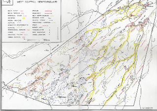
5. GLACIAL MAP COMMENTARY
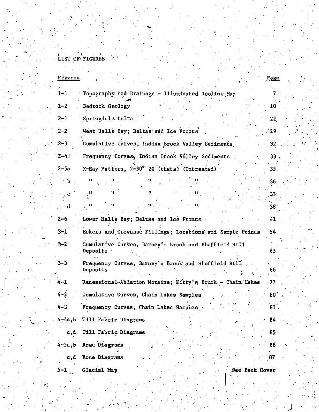
TAllLE OF CONTENTS
)List' ~f Figures
List of Tables
Li~t" of' Plates
AcknowledSeD!.ents '
rNJ;RODUCTION
CHAl'TERS
1. THE FIELD AREA
2. THE 'HALLS BA~,', DELTASYST~
3. ESKERS AND CREVASSE FILLINGS
4. Ti:1:E KITTY'S ilROOK - CHAIN'LAKES MORAiNES::k' ",.:'~.
6,. CONCLUSIONS ANDDISCUSSION
Selected Bibliography. . .Appendix 1 Tecm;lques. 'InstrUlll~ntis and
2 Textur~l Analyses Shltheais
3 Abbreviations
Page
17
"~-'''i
9./;02
111'1
f '. "LIST .OF' FIGURES
1-1 Dopog'ruphy and Drainage '- Illuminated Iso1:Lne ,MaP
1-2 Bedrock Geology 10
2;.1 'Springdale' Delta 22,
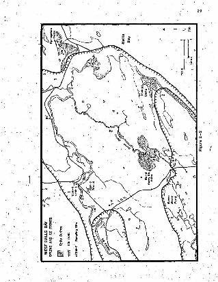
2-2 Weat Halls Bay; ,Delta's' and Ice Front;s' '29
2-3 'Cumulative ccrves , Inddan .:BrOOk Valley' Sediments, 32
2-4 I Frequency ccevee, Indian' Brook Valley seareenea 33
2-5a X:-Ray Pattern, 2':'~OO 2e"(ih~ta)' (untreated).' 35
~6 .
.37'
38
2-6 Lower Halls Bay; Deltas and Ice Fronts 41
3-1 Eeker's and, Crevalis~ F1lling~; Locations, and S~ple Points 54
3-2 Cumulative CurVes, Barney's Brook and Sheffield HillDeposits 65
3-3 Frequency ccevee, Ba:rney's Brook 'and Sheffield liii'i ,Deposits ' ", 66
4...1 .Recessional-Ablation Moraine;, .Kt'tty,'l'l B'NOk .-. Chain"Lakes 77
4-2 CUlllulative Curves, Chain Lakes Samples 60 '
4-3 'Frequency Curves, Chain Lakes Satllples 81
4-:-4a,b T111 Fabric Diagrams
c,d Till Fabric Dlagr~ms
4-Sa,b Rose 'Diagrams
C',d Rose Diagrams
'84
"86
B7
5-1 Glacial Map Sel!'Back Cover
)

6- 1
. 6- 2
" '. . A-I,.., ....A- 2
,I.
Recess1ona~ Ice P08 ~ t10D8 and . I ce 11"" tiir~ c: t .:lon8
Lo=tiOCIl 'Ment i one d CA"t!l i de tb~ FIeld Area
Mean V II Sk~UIl .
Skewness ,VB 'St andar d ~1atlOD -
Skewne sll Vel Kur t osis
.•..
: 103
' 109
rae
",- 129
1] 0'
. . :., -.~;" ~..
J. .
. \

LIST OF TABLES
1-1
2-1
3-1
3-3
4-2
Cli~tological Records for Buchans and Springdale
ITextural Analysi.s; 'car:~1P-ated n,ta for llldianBrookValley Samples 72 M~5 ~i~4n M~B
Elevations of ~rrllces'and Raised Shoreline Featureson' the Halls Bay Delta Systeml\l '
, .Distinctive Featpres of Eskers and Crevasge IF'111ing~
Textura.l Analysis, Calculated Data for High ,~entral
Plateau Samples 72 E-I "': 72E-4
Textural Boundary (~. units) at 90%,of Cumulative Weight
'rexturat Analysis, Calculated Data for Chain. LakesSamples 72-2 ..,; 72-3
Till 'Fabric nata, Calculated and In~erpteted
15
31
12
57
67
69 ...
82
88'

,/
L I ST or,PLAl'f.S
.1 . The; Field Are ., E.R. .t .S. I mage
2 . !b': Sp~ln'gdale Del e .a . Sou J;.b'llea t s~r..
j . The Spring dale Del t A. i n 't. Sa rp, ,
4 . · · loc:a t.1 oll ) . Zoee.of Sande .aDd GTaw la , Spri~J;dgl~ Ik~ t.'a .
.5. Loca t i on 6 • . Pore se l: B~~d .1ng , Spr1~gda.~e ~~it&
6 . Location 7. _ Indurll t ed , S~lt . Sprlngdile Delta
7 . Cll.lc.:1te Dep ollit
8 . Loca tion 4 . High Dbchuge Haterlal ~ Spr i ngdale, Del~a
9 . Bedded Silt s ' and Clays , I n di an Br ook.
"1 0 , Tile ~e~ Po nd .Ten-a c e
11 . The Sugar1~a~ t erra ce
. • 1 2 . ·The S~hbrOok' I err ac e .
~<~ 13. She ll Su, l e 72; 29$
1 4 . Lirver Halla Bot,. ,
. 15 • .The Baney 's .ar~t. £sur
.1 6 . per~h~ Er ra~lU . Rutley' s Brook 'i ,ur ,". . 17 • The S~.f,pe ~d Bi U Bake,r . ·
18.~ The For et op 8dl Ar e.a
19. Sample Pit 72 [-4
20 . The -~ittyl ll Bre ok - ,Cha1n "Lake-a' Ana
2 1. The Chain Lakes Mor B1aes
2Z ~ Mor aine .72 - 3
. 2 3 - . 'c.».e. Ki.1e 343'- :rbe'I i t t y" Broo k "Delta : '
~.
"
,(
'",""2S
",28:
42
42
"'"
.,sc.lO
"""""74
i.
""
. '.'
. 74.. ree KJ.uy'" Br ook ·0e1 ta .
25 . Kitty 's ~ook Valley
,-
"
~~
'" ,- !!..s.! ./9 2-.
93
.:

\.ACKNOWLEOaIDmNTS l
The writer wishes to 'thank several 'individuals and ,organizatiotls
who aided in the preparat:Lon an~ writing of this thesLs.
Mr. R. J. Rogerson, Department of Geo.gra.'phy, Memorial University,
of Newfoundland, supe'rvd.aed- th~ res~arch and wr:Ltin'g of the thesis 'an~
provided advice that was of benefit at -aj j atagee of, preparat fon,
Dr. D. R. Grant of the'Geological Survey of Canada inOttawa. ,. .?upplied logistical s\lPp~rt early in the field 'season (through a
noR.E :E. - D.M.A.R~ glacial-,g~ology-geocheinical survey), and adv;1.~e
during the preliminary thesi!!! preparardondncludfng permission to use
radiocarbon date G.S.C",-1733.
Dr. J: B. Macjrherson.-Department:of Geog~aphy. 'Memorial ,
University of Newfo~ndland;gave counsel in the initial planning stages
~f Ch~ thes:lS,and ongoirie; di~cua~i+On throughout the atud,Y.
0,1'. It:: Slatt. DeparCment of Geology, Mem~rial univers~tx of
Newfouridla.nd,a.dvised- the writer on sedimentological technfquea and f. .
made laboratory ,facilities available for t he l!-nalyses •..Mr. M. Crane. Departme~t of .Geo8jraphy, Memorial .University of
Newfoundland, advised in the preparation of diagrams and aided in the
rep reductLen of the glacial. map.
Ms. ,C., Deorksen cOl;ltl:'ibuted her" eXcellent eketich of the
Foretopsail which appeaxe as the fto~i:1sPiece of t.he thesillo'
'~ Nawf,oimdland and i.ab~ador F'orestry :ervice provi.ded facilities _~
incl ding airphotoafor an iriitial analYSiS._~.!~:m.~-. •-.
Canadian Nat~~~l Railwaya 'arranged transportation' in ~h!'!
".* For these lind other abbreviations, see Appendix 3, p , 1~1.'
. - '"'~~' : " - ' ' ~

.~
..a'out-hern sections of t'he area: wIthout'" which th~~'field :Work. involved
. _~ri .:C~PtE1~s."Iii '!!nd IV,wo~ld", have ,~~~ d1f'fi-~tilli-- to a'Jc:ompl1Sh. ~c " .' .\), '. ' .
. -', y -_:..-~~" ,, .
-(
i.'
, INTRODlJCTION ' ..
,~ ~
Ob i eet1ve~ • • " . : ; . ?. The raise d l'le. !stoe.ene - d9~te. B at - ~~1l8 ~y Bn~ tfe ic.larid
' g lacial f",," t ure a of ... ' t -C;OUl. t ral II:ewfoim dl4nd • have be en -.d~B;ribed by. , ' " I .. t" . •
.s e ee ra r au tbors 1D th e put .f i f ty ,ye a n. ,Much of th s ·ea r l y 'U t @ro t ur e ,
1M qua litatlve i n i ts app rnae.b ~d tend'B .~lY to identify problem. . ; . .
are-as and apeculat-e on ' llolut i ons .; : A d,etdl-Qel.andyds of the _, . . ,
JII()J:Phoio~ and. Cht,~l~gy C1£ ' the" v~r_~o,~~ do:po l!li~,~, 'rb ,requi r ed "
c CI.m.p l ement re l a t ed s t ud ies oi t he nor~h COBst (G~,?t:. 196 9, ~ 197C) ,
, ~cl W~ l:It coall~ (~r,ookU ...;969) _an~ ..t~i det~rlll~~,! ".P a~ticul~r 'Wheth""r
the}nner-o~ter drif t ' zone. de s cribe? by J enne,lII , (1960) in eu t ""ni' .
...-Ne.'(ouod l and end liy~.d'lVi8t. (1965 ( 10 th~ _Iieid are8 do' in fac t.. .ex~ t . LUtlcqvi9t 8190 , u i ae a t he _po u i bili ty of l nvnioa o f the Balle
Ray area bY ' e~rl" "'1e~on'81n L8bia_~~r l C4/. whi cb 'heb.:ae; on- evldene.e " .
.f ro:, the Jerin@'s~ ~960 :-C1bu~ ~;' an d iJOlltb~8~;OdIlD t.~ s t ria", . : '"
The pre ilent llt ud; I nvolve s an overall a.li' photo ~alY8:i8 .wd .. ' . - .the ptoduction ot' 4 81~d.a! ~p pluB t t:e de.~ai~ed ana i yd18 of three '
~pecific. pl'oble1l are.. def1~~d by prev1~8 l1tentu'[~, &!ld t~e PYe.
' ~ill1t1ary ait .photo i!'terp~~tatl~. - It 15 hoped -tha~ . & .or e. 'tigO'[OUli
"1?p,roach t han f ormer ly .&t t elllPt e d ~ll pr0v:- de eOllle s pecifi c answer s .
0 '[ wi11 at l east Ie -de!inll proble.roa 'With ~8'W i~forllllltl00:
\.
Loclltion of St~v Aru '
The field are a ot' 624 squar e ~le8 (1597 eq.usre kma. ) ili lo catee! '
in ~8t-eent:ral l'l'e>rtoundbnel a~ ext:end~ f ,[ ~lII SPrin8dal~ iD_t l,le' nor.tli 'co
.\
PLATE 1. THE FIELD AREA
1. Halls Bay2 . Springdale3. Town of South Brook4 . Howley5 . Burnt Berry Pond6. West Pond7 . South Pond8 . Chain Lakes9. Lit t I e Sandy Pond
10 . Gull Pond11. Indian Brook
For completer identificationsr e f e r to the Glacial Map ,Chap ter V. The light areabe tween Chain Lakes and LittleSandy Pond shows a recentsnowfall on the High CentralPlateau .
SCALE: 1 CM. - 10 KMS.1 INCH • 16 HILES
EAR1'II RESOURCES TECHNOLOGYSATELITE IMAGE 5. HI 72
0 '
j us t s ou th of t b e C. S. il:'; l ine a t:' the 'l'opsalls o~ .the"'U gh Cent r al
. , Plat e au (P lat e. 1) . TweMo~d a'nd Kac.Cl1ntoc'k . (i94 0 ) i dentify, th e
. plat eau a s "tha t part of the Atlantic· Upl a nd eew een ene Gr and Lake
~te Ba y Ea.ain and 4 line l!xtendl D. ~ f r Ol:l Ha ,ll[ l] Ba~' t o t he ~ead of Re d
In~lan La ke" (p , 1702) . '
\- ~ "To the 9ou thue s l:• • s ect ion Of ' t,h ft uppe r Ki tty 's Brook ~nd
Chal~ Lakes dr ain a ge sys t e .. 15 included in th e U eld aree ,
Or ganb a t i on of t he Th~8 i ll
Chap t e r I 86r\'68 , as a n Intr~duct~on t o th e field area;, t he
t l;lpogr a ph y , • gene r a l be drock ge o l ogy . dr il.ina~e ... cli mat e . vegetation ,
acces s 'a nd hu man geog raphy of wes t -centra l Ne,:,,! o~ndl llnd are discul!I6ed.
b rie fly .-,,.. . ','
Chapt e r '.II describes th e Sp J:"ingda i e aod l ower Halls Bay .dQ ~ta. .
. eYlltel:l8. It exa:d M S t h e var ious unconsQl1 d8 Ud .d e po61t & 1n · lndla~
Br o ok v a l l ey and lII eve r a l IUr~ne . s bell lIC1Pl,e1l. f oun d d n th e area . -A
d!!.Script ton o f th e deg laciat i ol'l. .p roce Jl ~ .and ·ch r ono l ogy of 't.he coa s t al
Chapter III 18 c~m:llrned vi.th a ~~roe o f eske r-' l1 ke f e a tures 1::' . • _". . 4 '
. th e sout h-cen t ra! portion of t be 8t ud,. area" ' t h at wer e i dentl fl!,d b,.
Lundqvi ;'t (1965) liS ope n erev ee ee fillings and to o f lilllit c d va l,ue t o
interpre ting ice flow " , Ip , 296) . A morpllolog1cal M d te.xtur al an~lYl!I!s .
wa~ cond uc te d on sp ec ific depoa t tu and a rein terpretat io n based on
these result's 1s pt es en te d ,
Chaptl!'r l V exs'Il1nes a .se rieg - of rid aell l oca t ed i n th e so uthwest
corne<of t be ,fi e l d a r e a a t ~t.ty · s ,Brook ,and C~I1tl Lakes . 'The fe a tln::ikll
\<Iue briefly de,s cribed ' by HacCllntock slid Twenh ofel (19 40) as bei~g
' ,.
. :. r ec es sioDlLl DOra 1nu • . thay are II 8igDlf1~nt pll:rt o f t~ ~rall
Itudy since I t . lI~\~e~u~ed t hat la~t iC~ ~lted in th~s v i cinity, ID1d, -: .
u such , th e depa,lit ll, ~ght indicate a l a t e , t Dpo 8t' l phiclI11 y eon trolled .. . .i ce ~ ~c.:. . Till fab r i c ~ te:rt. uxal &':lalyeeswere _COaP~ted and II
~t~o'!; .~~~t. l01'l 11 8ugge llt ed fo r the de:~odt. . . . :.·......., i~?f' ·Cl:apter V pree~t. II glacul "t:.ip of t he .at' u ~a.aed 00 8 de tall ';d
i nt erpretation of 1 115·. 8~O and 1 :50.000, ~ lr ·phot os . ~ e;xplanatlo~ of -~
the l e gend"'is i nclude d and it Is hop ed t hat this , '~ con j unction wi th
t he ,map 1w l 11 be o f s ome pra.ctica l vaV:\e in fut~re , glacial chronol~ilel1
and glacial drift llt ud i .. t or ndneral <>e::o;ploratiou .
Chap t er VI e~rlzea the Wor k preeented i n the 'Previous
"e.ha pt e r e lIa~ SY11. tli 8S hu II chronology of t he l u t , 1'o/Igoe ai WisCODe'i ll
glacia tiOn an d t he sequ~ce of deglacia t i on . Sevenl c~t8 a re I'oade
'pe r t a ining ~o previous studiel!l and 8 . note b . ';'S8' 0"[ poila i bili t ies fo r
f uru r,e · re~e..rch ...-ith ln ~he f ield area and 111~rac~8.. Fer:pru:r a L t ·o i t.
'Iechniquell, pi~ld Instnm.en.t'a an d Anal yses are d~II~lI l1 ed in' _(
Appen di::l:: 'l ; They outli n.e t.he bade proe~dure. u.e~ :f.u .anal yzi ng IIedi».~ t.
chir~eterlU;lc ll Gd budfonlS discu ssed In t.he · vadeua cba~t.ers • .
_ ./ A b rie.f aeeond appendix pr eeea t8 8rBphe of ttl. UDCOD8Dltdat~~ ,:
. se di men t da ta plDtt~d 1.~ , sev e n l text urally dU~dPt.l~e c:oabf.!:1a t lDC1.I: .
Lodl!l t 1 c8 •
The i n it. i a l put ' of t;he field Beas~'n (MA,.)~. W,!lll spent in
Spr i ng d!l1e an d a ro und .t he lower Ha~lB ~y ar ea. Tr avel was by, car
. whi le ~oct t r av .ln e til ~rll. complet e d t o l ee 8 ac c:eaaible a r e as. Camp
~B est.8bH:~~d near IUV~.~ 1Irook. f or , stu dy ar ound -l wer Halls

B~! ~nd the Department of Mines base camp was. used
about three- weeks .while in.1>pringdale and vidnity.
a period of
writer wl1-s
etnpl.oyed for a period du~ing the f:Leid season with a Department. of RegioI).al.
Economic Expansion -. nepartment of Mines, Agricult.ure and Resources,
glacial '-drift project under the direction of Dr. 'D. R. Grant of the
Geological Survey of Canada, (Grant: :1973).
The second part of the field season involved work<on the High
CentrS;1 Plateau. Access to the Kitty's Brook - Chain Lakes area. we,s. . .
by C.N.R. "speeder" £r-omHawley; camp w~s set up near the aouthern
end of Chain Lakes ar:d foot traverses were ecmpleted o",er a radina of
'about three miles..' Various stops were made along Kitty's. Brook valiey
on the return journey.
The TOPll~i1B area was approached from the east. Agaill; a C.N.R~
"speeder", this time from Millertown Junction, waa tpe initial mode of
tralport. From' Gaff, To;sail, -the a~e~ wals fovered e~tenBiVe1Y 00· foot. .with a base camp being established at Foretopsa11 from which traverses
were made to Barney's Brook and Sheffield Hill (Chapter IV).
A final.foray was made around Springdale. Halls Bayaudthe
lIl.!ljor,valleys in the' nor thejm part of the field area. ~11 secondary
roada we~e,ariven to" field check the,air photo analy~is•. S~eral of
the prival;e r-cada , that is, to Gull Bridge Mines and the Price., .
(Newfoundland) Pulp and Paper Ltd. road .ec Dawes Pond and Lake Bond
were also covered to,check interpretations .further.

CHAPTER I
THE.FIELD AREA
Topography
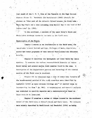
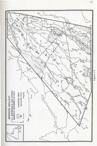
::Thl! fiel~ area (Fig. l-l9,ndPlate l~ may b: generally
divi'ded into two'phyaiogrllphic regiona; (1) .che H:ahe Day - Gull'Pond
Lovjanda , (2) the High Central Plateau.
1. The Halls Bay - Gull Pond area 113 char.acterbe.d by a'north
northeas'terly structural-topographic trend which is emphasized by .
glacially scoured bedrock r Ldgea, -Ha.Ll.s Bay, proper is 9,. fjord With
a 150 fath0!U8 (270 meters) "threshold erose to sbcce-, ,In- this northern
section of the field area, Bu~it elevations slope from 750.feet
(225 meters) southwest of Gull l'ondto about'SOO feet (l50 meters)
just north of Springdale. Prominent bedrock peaks OCCUT· fit 456 feet
(137 meters) l'lt Springdnle ~d 855 feet (257. meters) Qt, beeIl H1.11
behind "-the town of South. Brook.
Neale and Nash (1963) map a tight synclina.!· meia fol101dnS"
the wea't:ern aho;re of W,,:st Pond 1n a northeasterly direction to the
mouth,of Indian J3rook. With41 the central section of;the Halls
~Y'- Gull Pond low1.B.nda, t"heauthors descr~be a broad synclinal
trough with its exta roughly paralleling the upper reaches of 'West
Brook. The.,synclinal fa-Ids re~ch a~titudes ,0£ 800 feet' (2.40 ~ters),
-northeast of Sheffiald. Lake and 974 feet (292 meters) .et Nutmeg, H:f;ii. . .northwest of Gull Pond. Elevations of 500' feet '(150 meters) are
t~iCa1 of the' aXial area of the' ~rough. ' .•
wo.. EZ 0:;: 7II:
" go
~ i:I:Q.
.. 0II: c
" 0o ()Q.
g
i- e

\, .'
2. The .aecond. topographic subdivision includes the area south of
Gull Pond in the east, Sheffield Lake in the west and extends beyond
the southern iimic of the field area. ThiB is the High Central
P'Lat.eaues dasc'r'Lbed by Twenhofel and MacClint.ock (1940). The
boundary" betwe~~ the t~ physiographic units r.s sharply defined by a
- -break in slop-e at th~ 900 eeec (2' meters) ~ontour. So'lifluction
lobes and' ,thick drift cover the break in slope. PlAteau' elevations
dope gently from 1500 feet (450. meters) in 'the south to 1000 feet
(300 meters) at the northern edge of the plateau. West-esst. tilt
from 1500 feet (450 meters) near Chain Lakes to 800 feet. (240 meters)
at Little Sandy Pond. The terrain between Little Sandy Pond an~ the
~astern border: of the field area may be included in the first physio
graphic subdivision.
The Topsails are proufnent; hills on the' High Central PlateauI '~ .~
,which' are referred. til as llIonadno,:ks by Twenhof~l and MacClintock (1940) .
. The authors propose that bef~~e glaciation the' ridges were probsbly
"high places,i',with graded s~opes, on the pla~eau, and that jointing in
the granite b.edroek, flici1itated, plucking which led to their becoming
crags•. ,In 'view of their description of the Topsails' being 'formed by
glacial 'action rather than by long term circumdermdatiol1. it seems
ra~hei: inappropriate that t.hey t-efiet- '-fa the peaks as eonadnccke , The
T<;lpaalls are- all elongated 040-045 'and rise 200-250 f eet; t60-75 meters)
above the surrounding topography. " Sheffield Bill may be included ~ith
the granite Topsails though it is located fU1:the'r west. Elevation~-'of
the peaks, are 'Bl;I follows: Sheffield Rill. 1639 f~et' (492 meten),
Foretopsail Hill. l!iIO'feet (483 me'tet:I!!)~ Main Topsail, 1822 feet
(547 meters): and Gall Topsail, 1650 feet (495 meters).e
>-------
text . .D
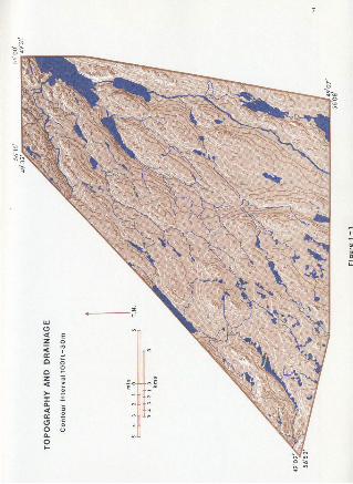
General Bedrocl> Geology
The bedrock geology of the field area has' been mapped in psrt
r by Kalliokoski (1953) and more completely by Neale and Nash (1963).
The following genenUizat10ns 'have been ~de from Neale and Nash;
nUlllbe'rs on F~gure ~:::-3' ind\cate bedrock type and are 1detltif1ed, in the
------------ '
Th~ High Central Plateau is underlain by Devonian Topsails
granite (l8); pale ~ed equigranular granite, quartz, monzonite and
grancddorLt.a, The central synclinal troughs inc:ludi the area ~a
far north aa Springdale consiat of :ti:e Springdale G up,(lS), that ia;
zones of (a) red sandstone and conglomerate, red d greenish grey
shale and minor Lfae at.one ;" (b) red sandstone, onglomerate, limy
s.iltstone and shale, (c) silicic flow and "p'yrockee t Lc ro~~s and .
(d) bssic flow and ~OC.lsst,iC reeks • .The 0f~ovic:i.an Lush's Bight
G~oup (5), located no;th'of Springdale; is fOl1lled oiicbia'tolle basalt
and sndeaite",intnor'pyroclaatic rocke , greywacke, Blate and chert.
The ~'rea around' Gull ,Pond,ls part of' .t~e Ordovician Explo,lta Group (6);
the ROberts Arm Formation includes basdt, ¢nor pyroclastic rocks,
silicic f~ow roek6' and ba6ie, 6i11s.· The Crescent Lake' Formation' .
ccntadtia- ebete , minor 'chert, 'greywacke, and rhyolite., The a~ea between
Littie S~dy Pond and Balls Bay comprises var1()Us pat,ehes of g;anite~
.gl'anodiodte and syenite si"mil~r in age to the Topsails granite (18),
as well as" Devonian quartz -diodte",diorite and gabbro (17). Southwest
of Sheffiel~ Lake there -ia a zone, of .Sil1!r~an 'andesite, ,basalt flow
and pyroeiaBtie rocka, (11).
. Th~ fi~~d 'area "ia part of the Centrai Mi~ra1 'Be"lt of
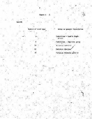
Legend
Figure 1 - 2
Number of rock type"
5,
11
17
18
Group or gene!al description
Ordovician - Lush I s, Bightgroup.
_Ordovician - Exploits group
Silurian andeedte /'
Devonian dior.1te/
Devonian Topsails granite
10

)
\
.11
Newfoundland. (Roae etyZ.• 1970) ~ and as such has been 'subject 'to
extensive mineralogical eiploratlon by the American Smelting and
Rerinlng Company in the south and British Newfoundland Exploration
V, Limited and N01"anlla Exploration" toward\! the northeast. While a numbe'r
~ of shortl1ved mining operations were located in the Belt, Gullbridge
"\Mines at Gull Pci.~d wall the only 'one within the fi_eld area. Neale and
Nash (1963) a,tate' t~at a headframe 'and mofng pla~t ,were ff.r8~ con- ,
atructed in 1956 but after an -initial'run, production ceased in 1971.
Rose et at. (1970) note that the occuzrence of ~'ulfide minerals on
Gull Pond has been known. since 1905. Pyrrhotite, pyrite, chalcopyrite
and magnetite 8S well as quartz, chlorite, sericite, biotite., cordieJ:ite
and. tremolite-actiuoiite occur <in Ientdcufar masses in sheared zones
of the 'Roberta Ann Group. Many of the above minerala are found in
erratic boulders ofunknolm provenance and have been studied by Beliden
Mining Company of' Sweden in, an attempt to discover their specific origin'.
For, the lDO~t part drainage in the central an; anrtbe'rn eectidone
_of the field 'ares' i~ to thEi n~rthesst in drift~f_:I,l1ed valleys foll~ng
structural lows I)'ig. 1-1 and Plate'1). Streams sJ;e net well i~ised
---- in their ccureee-except for Indian Brook which 'Is' deep,ly entrenched
and flows ever bedrock in its 'fewer sections. Between 'the T.C.H. and
Sprlngdal~. me.ander' acars are via:f;.ble ever a broad ten·;l.cs'.",These
however 1QB.y eereee -ec a much larger deg~acia.~ river flowing within
I~dian B~ekvalley. nd g~aded' to a highc.rsea- level.
on the High Central lateau the drainage pattern is' deranged
~typieal .of glaeiated o aeeaua) though a haphazard northesst'trend

, "
predominates across t.h@ bouldery surface. ~ear ~h'7 sout.hwe~.t: 'corner
Of,t,~~l:eau.. ,fiow La. southwest down.K,ittyls ~rook valley and to
the northwest 1n the, upper Chain. 'Lakes valley to Sl:\effield Lake. ' A
drainage d1vid~ ~rom which water flows "sout heas t to "nea Ind-:1,an l~ke
is locate? just south' of the field area.
", Although ponds are numerous througho~t the "f~e:ld ares..! m9st
are BjIWll•. Leaa 'than 2 square miles, ~S 8~. ,kma.) in area, nd'la~geBt;West",Pond' 3",4 square miles (8.8 sq. Rma.r and South Pond 3.6 ,square. ' "
miiss, (9.1 sq. lema.) are confined to deep, valleys with areas of thick
till. a"nd gl~ciofluvial material. TO,~h'e west ~nd ."esst. Sheffield
Lake and Gull Pond are located 1n strtiqtl,lral basins. The Chain: Lakes
ayatem, at th~'8outhwesi: corner of the' area, is d~d by a series o~,'
morainal deposits (see Chapte~ IV).
Vegetation
The veget.ation 'pf west.-central' Newfoundland can b':- ';relat.ed ;~
Rl1y8iograph~c fjcubdivisions. The plateau level is devoid of forest
cover; vegetation consists of alder thicke.ta~~B) and occasional
' pa t ches of st~ted w~1~e spruce (piaea gtauoo) in poorly drained)
ahe Ltiet-ed areas •• Generally, plant species, are limite;d to low 'bUshes
on the moratnal cO,ver and grasses on the nume,:ous' string b08~' On
the te~ain north' and below the High Centrall'1a:teau, wh~re d~au-..age
i~ well,-defined an,p ~oi1s more' fully dev~lope~, fO~"!t:_,~,ovet:--ts
extensive.
D\,-~ (1964) ecatee that. balsam fir, (Abies"'l;a~~ea), O,~cuPies
all 80:1,18 except the ertremely dry and wet ones in undisturbed
-, 13.
epruce (PiciJa mariana) or ,tlder. Hardwood 'fore6~s ,'are' a1w~y/':;f, fire'
origin 'aI¥! .c ontai~ whi.te birch, -(Beiu1.~ paPYI'ifel'f Marsh), trembiip.g
asilen."' (Populus t'1'emuloides) and p~n 'cher-ry (PI'UnUB pennsylvllnica).
Black spruce is also a, dominant burn epccr.es and 'is prominent 'around
Halls Bay.
Climate
Obtaini,ng long term clima'Uc data 'f~'r the fi:ld ,area ia C
., difficul\ince no stations have been in operation for ext ended periods
on this section of the island. Long term statistics from Buchaua (50.
'"mi~es (80 kma, ) southwest of Springdale) are used aa being indicative of
climatic"condit'ioi1s on the High Central ~lateau and"month1y.8~e:tage~ for
Springdale (197i) describe coasts:i' condi~i'Ons. (Table 1-1). While the
'two, groups of figures are not 8t~ictly comparabl~, they do suggest '
variations, in cli.ma~a- between the two ~in zopes of the fleld area.
Precip'~tation is well d'istributed throughout the year w~t~ 8,
alight maximt:m in the fall: xcveeeer g;nerally being the. wettest month,
(Hare. 1952). Wint'ers are r-eLandve'Iy mild. thouf:h colder on the inland. .'.·plat~'au. Snowfall is mOd'eratelYheavy over the who~e field area with
• • I"~ •
more than 100 inches (254 cms , ) being experienc~ on average. Total~ ,'/:' ,
annual preCipitation ~s ali&htly higher at Buchana. 36.7 'inches {9l.-8'-
ellis.) ccmparedwtth 34.7 inc:hes (90.8,CDlS.) at 'Springdale-~ Augu~.t is
,8~ightly warmer than July at the r~_aat .but; inland the reverse is true.'
. Tliisis probably a reault of lingering Arctic ice and the Labr-ador', . .,. .
Current whichl~elays or moderates sUllllller waz;rn1;-h on most of the c9Bstal
sections ',of ,t he island.

AcceSB to dIe perimetete of the field area is axce.Hent; ,
14~'j:~,- _.'
Hare (1952) states that the. vege"tative season 'starts between
the"15th-20t.h of May. more than.8 month beh-ind Montreal or 6l;'tawa.
The' frost free seseen is about 100 d~YB. from early June. to mid
September, in the,southern part of the field area; in the coastal
zfe the season Is probably longer.' again due -to the modifying marine
i~f1uenc.e.II
1cceS8 and Human Geography
IIThe Trans Canada Highway follows the east termination and' northerly
margins and the Canadian National Rail~BY cuts the southern boundary;Iiac~e8B to the plateau Is ava1.1abl~ fr?m"either Ho:wley in the west or
!~ller.~O?ffi :JUn,ction in the e~Bt,•. Both" settlements were used as
starting points on traverses to the High Central Plateau.
: j Springdale, the largest town in the field area and the economic
!hUb of Green Bay, is .Locat ed 13 miles (117 luna.) weet, 0'£ Grand 'Falls
'and' 118 mil~8 (189 kms.) east of Corner Brook by road.' Until recently,
'. ,'IS.pr.ingdale wea e dorm!.tory .town for. a population working " WluLleaback.
and tittle Bay mines which have 6~nce' been c~08ed. Employment in th.e
'town i,s...... gener-ated by service establishments for the populus of Green\ .~::.' ," ~ _ :: ~ ". ' , .
[:
" . a'~OVi~C1al1Y ~pe'rated Vocational SChO.Ol.' a DoMoA.R.. ge,?chemical
aborat.ory and several diamond drilling operat~on8.' Much of the
~ opulation is emplQ~ed in the woods operationa of Price (Newfoundland)
Pulp an~ Paper and Bowecere , Ltd. both of which have extensive cutdng
rights,in the field area. Springdale also pr'ovidea a ,link with Notre.
i"",& Dame Bay and Labrador .on the C.N.R. ,coastal boat; service.

TABLE 1-1
cLIMAtOLOGICAL RECORDS FOR l!UCHANS AND SPRINGDALE
BuclUms'Lons Tenn (1942-1971) Climatological Record
1- lL l! ! J! 1- 1- ! ~ Q !! E.Mean Daily Temp "F. 16 .9' 15.7 21.0 31.5 42.1 52.6 00.0 59.0 51.8 41.5 32. 5 22.2-
" Max.," " " 23.3 22.5 28.1 38.1 '50.9 62.5 70.0 67.7 60.4 ~8.4 38.1 28.3
~, Min." " " 10.5 8.9 13.8 24,8 33.3 42.6 49.9 50 ..3 43.2 34.5 26.9 16.0
Snowfall (dnchea} 23.2 21.0 18.1 9.6 1.3 0.9 0 0 0 i.7 9.9 20.6
tOTAL;' PFTN. 3.31 2.92 2.35- 2.10 2.42 2.60 2.94 3.68 3.57 3.33 4.11 3.40
Sllringda1e 1971 Climatological Record
1- lL J! ! J! 1- 1- ! ~ Q !! QMean Daily Temp~F. 20.6 15.8 30.0 3]..9 50.1 53.8 62.0 65.3 52.8 4.24 35.6 16.1
Max. I' " " 24.8 28.1 37.9 44.6 60.3 63.8 73.3 72.9 62'.3 49.6 42.5 25.6
" Min." " " 13.91 '7' 22.1 31.2 39.8 43.8 50.7 57.7 43.3 35.1 28.6 6.5
SnoWfall (inche,) 39.8 6.5 30,.0 8.0 0 0 0 0 0 0 13.0 19.8
TOTAL, PPTN. 4.21 1,46 3.05 3.46 1.65 2.78 2.76 3.97 3.03 2.19 4.04 1.13
t:
~

16
South Brook, lor-Bud 15 miles (24 kms.). south of Sprin$dale
waas shipping center for. f:l0pp~r concentrate from th: ;now defunc t
Gullbridge Mines. Its eeoaonto .viability ie derived f.rom the logging
cpeeatdcne of private' contractoraior the paper' mills' at Grand Fa'lts
and Corner Brook.
"he Halla A Bay area' Is presently, ~ndergoing some amall economic. ., .revitalization with the development of'it~ natural tourist facilities.
Both provincial and private ~ampsitel1l have been opef;led during the
past few vears ,
)

.'
,CHAPTER II
THE 'HAL~S' BAl'" DEr:JSYSTE~
Introducti~~ , , . (
Halls Bay contains a number of rl;l.lsed Pleistocene deltas at,
various locales from Springdale in the north to South BTO~k and "'West
~ottOin at .the head of Halls 'Bay. pte deltas 'have been. described by
. Lundqvdat; (1965) who proposes a genaraj, scheme for construction of the"
system fol10wil1g the Jennees (1960) theory of an' inner-out,ar drift
ebeee , He hypothesizes individual :!.ce,lobe.s protruding 'from aninlar1~
ice. sheet 'and filli~g,' t~e valleys, which feed in~o Halls .Bay , Jenness
,argues, that: tha inner:"outer drift 'z onea Ln northeast Newfoundland
.resulted by either a still-stand at .a position of discontinuous
end moraine or a f:f,nal'major advance from farther inl~d. He
identifies, the outer 'Jrift zone, (coeeeet 'side) by ground moraine and
the inner drift. zone ;~try, "slightly younger eskers"kamep aD..d ground
y. moraine" (p , 161) . SUPP,oB,edly,final melting produced .cne glaci,of1uvia.l
deposits that radiate coastward to form deltss.
·Despite. the 'jenness argumel,l't,- Lundqvist, mentions that no end
moraine could be distinguished', at the Bone boundary in west':'central
Newfoundland. To substantiate' the theory he describes' the inn"er-,?uter
boundary on the basis o~' t~ick"ialmost continuoua. inner. d~ift and thin
outer drift wherl!!-u •.• bedrofk structure is cle~r1y visible through
tbethin' overburden, even where! bedrock l.s not 'exposed" (p. 299). The
deltas st· Springdale and Seuth Brook. as well as Kings Polnt and Botwood

IS""·
(t~e Lat.t.e r: two being located 'outside' the field area) are, interpreted
by. Lun~qVist as being cont.emporaneoua and part of the boundary .bet.ween
inner and outer dTift.aince such a. halt ,woUld allow che depoalt1on of
much thickeT glaciofluvial sed:menta than would a continuous eeceeatcn
?f the ice. The po~s;l:bl11ty lilf the delt.a,s· being deposited 1n 1ce.daIllllled
waterbo~.ies. as desczdbed by Jenness is also suggested by Lundqvlst.
Jenness proposes a series of .i. s oba se s from elevations of former
1II81;"ine Leve.Le, baaed on hia work on the northeast coast and that of, Flint
(1940). for -the w;est coast.... He assumes coe eeraporenecue deglaciation, for
the whole n~rth ccaae , afrhough unp roven , and envisages a ,0' isobaae of
no net postglacial emergence paaa1ngthrough, the ,isthmus of Avalon.
100 feet (30 meters) of uplift" at Ba'stport in Bon,avista and 250 feet
(7-5 meters) at ,Halls Bay relative to present; sell. level. Since rebound (
. ;l.s ,pr~p.?rtlonal· to i~e thickn.ess. the vsIU:~' Inddcate late lUscoDsin '. .
ic~ contentrated over the west-e~tral:~8ect.ion of the island.
A glacial study completed by DSlIIlIISn (in WiltO!l,'1957) portraJ¥l
the Halls Bay delta deposits as being similar in. origin to these of
St. Georges Bay (MacClintock and Twenhofel (1940) and' Brookes (1969»).
, The process aa presented iii. the Wilton report would nave an extensive
81aciofluvi~~'pedod with a readvance of ice depo'd.ting ,till 1:'2 feet
(O.3-0.'6'meters). thick on ,top; of the deltas; Damman continues by
hypothesizing a gradual rececaeic" rise of the land which' resulted in
rivers flowing .into Halls Bay cutting their, way t,?rough old deltaie. .
depositB.leav~ng s~ parts ·of the deltas ss high terraces.
Several authors have. studied the, Halls "Bay deltas .ae indlvi,dual. ' . .. Units within 'the systeJll.. .MaCClintock and Tw~hOf~l (1940) descrfbe
the SpriDgd~e terrace as "an emerged Pleistocene delta of sand and

1:"
19
gr~vel' that has scattered boulders strewn on top at 260 feet (78 meters)., " ,
a.J;l;l.. They depict the delta as being over 1500 f,e~t (450 meters) long,
800-;-900, feet (240-270 meters) wide, about 200 feet (60 meters) thick and~ .resting against a bedrock hill northwest of Springdale which is 5itua~ed
on' a 30 feet (9 meters) .t~rl'ace ec t~~ ·foot of the main scarp. The
authors state that the deposit is an eroded remna~t"cf a once extensive
de~?Bit of much-pitted, outwash that filled all the valleys draining into
Halls Bay snd that cercecee in th~ South, Brook valley at 1~, ~5 and 240
• feet (4.5, 16,'5 and,72 meters) are fr~gtllented' remains of ·the continuous1 .:' ,- _ - _ .'_ ,"
"Halls Bay ~elta." The lower two ,terraces are wave-cut in drift while
the third i8~,'the original· depositional surface of the delta.
The'Springda1e delta is also described by Lundqvist, - (1965) v Be
suggests it was formed, perctcutarf.y in its !,,!~stern secti.oI!:, by meltwater
flowing south, noting that the beda dip slightly away froiD the hills·
northwest of the town. Similarly. bedding in other deposits in the
area slopes outward from locsl centers. unli~e MacCl1ntock' and '1Wenhofe~. _
~dqvist visualizes the 240 feet (72 meters): terrace at Sou Brook
as heing an i~,olated terrace formed i~ front of Weat Brook alley.
Since theor-tee and IIlOrphologica1, deac;~~ti~ns und .for the
Halls ,Bay deposits. an att,empt ~aa beea lllSde ~o quantify a?d qualify'
the cha~acter~stics of the system and present some 'conc1,l;Isions as to
their method of formation.
THE SPRINGDALE DELTA
Morphology
In actual s'be the ·SprIngdale ,d~lta 1s 8~hat larger th~
20
deac-rdbed "by MacCl1nt.l?ck and Twenhofe1 (1940). On':l.ta eastern face
the delta 1s over 3600 feet (1080 meters) .long,while the southwest scarp
, (Plate 2) is 2500 feet. (750 meters) ~ length fr.om the ~edrock cliff
notth1:"'est of the toWn' to its southern sp,it-like extrem1ty~
The ~ighest point o~ the delta sur~ace was ecesurea at 252 feet
(75.6 meters) a.B.1. The surface ·of the deposit is hummocky and shows
some dissection. Near the eastern edge of the scarp th~B a' kettle
remnant at 200 feet (60 meters).
Several terraces and raised shorelines .ar'e visible, on the eastern
.face of the delta 5Plate 3). A weakly developed terra~e Is vblble,
whic1l 'varies in elevation from 209 feet .(62.7 meters) at the top southern
end, 'to 220 feet (66 meters) further east. Towards the extreme south-
eaet end 0; -che delta a reading of 181 feet (54.3 !Jle.ters) wS""Qbtained
on- a. raised shoreline. while further north Dear H1llI\:ter I s Brook s height
of ISOfeet '(45 meters) vas ~aStired at the' edge of the scarp. This
variationlin height may be a result of erosion by the brook at loca,tion
2 (Fi-gure 2-1).
As previo~sly mentioned, the town of Springdale is built on a
lower terrace of the deltl!. though it is approximately 50 feet (is meters)
·rath'i;.r than 30 fee.t (9 meters)' a.B.l.' as reported, by MacClintock and
~hofe1 (1940). Near the governm~t "!harf. elevations of 35-40 feet
(10.5-12 metets) are probably a -reeere of er.oa1.on and slump 'slong
Huxter's Brook~ A break il;l dope occurs at..,.68 feet (20.4 meters) on the
east side of the delta and".~t 89 fee.t '(26.7. meters) in the gravel ~it
near the Department of'Highways Depot (local;ion~. Plate 4).

21

o
2'

PLATE 3. THE SPRINGDALE DELTA, EAST SCARP.
PLATE 4. LOCATION 3, ZONE OF SANDS AND GRAVELS,SPRINGDALE DELTA.
23
24
sedimentary Structure
. -.Bxpoaed ,bedding in the delta te chaotic; however. de,scriptions
are made with reference to various plates (especially Plate 2) and
Figure 2-1.
At location 3 there ~ a mass of highly dd ssecned silty
mater~al at 78 feet.J23.4 meters) en whic.h a strike of 0106 and ~P
of _100 R was 'recorded. - From the location and melange of material it
Would appear that tl}ls was a zone of turbidity or daposdt.Lon of finss
related to a period of lower melt_water discharge".
La.rge DoulderydepoeitB at location 4 are 118 feet {35.4 'metersY
a.8.1. and- contain well rounded'clasts up to 3,fee.t (0.9 meters) ~n
diameter cemented with a gravel Ulatl:ix. , ,Thirty feet (9 meters) of
fores~t, lIl8terla! above the boulder ,zon~ contains rounded stones '~-J
inches (1.3-7.6 ems.) -in diameter and has strike and dip of 010: 10° R.
N(!Il1:: th~ southwest end of tbe delta at point 6 (Plate 5) th~e
a~e excellent exposures of ;f0reset grave~s at 130 feet, (39 meters).
Bedd:Lng planes, measured' at various, ~ints, strike 060-070· with dips
of 15°-25".It. Texturally, chit-deposits are finer, Ehan the forese.ts
noted-at location 5; the size range. being ~1~ inches (1.3-3.8 CllIS')"
ALthe southeasl,.eomet of the de1~a at a height of 85 feet
(25.5 meters)_ (locat:ion"7. Plste 6)' the're is a_un of ,sl;1ghtly
indurated sandy aeddraent atr;l.king .3l{6·and dipping 2So'L. ~l1e the
b!!dding'plane doea not correspond to locat:i_o:n 3, 'the deposits m.a.y be
related in that, they represent sim:Ll.ar depositional environments.
Bedding north~ast of lluxter 1 e Brook is indicative ,of a flow' of
1llllterial through the stream gap; north of the _delta.ch~ot:Leal1y bedded

PLATE 5. LOCATION 6, FORESET BEDDING ORIENTED060-070 , 15°_25° R, SPRINGDALE DELTA.
PLATE 6. LOCATION 7, INDURATED SILT, ORIENTED346, 25° L, SPRINGDALE DELTA.
25

(53.4 meters) a large maes of calcite is visible (Plste 7). D.M.A.R.
sources indicate thati-bhe calcite is Qrdoyicisn llnd. related to, the
Lush 'e Bight Group ". The height of the exp~sure,corresponds, favorably
to the previously'mentione'd 18Dfeet (54 meters) erosional terrace.
An attempt was made to relate lateral meltwater or kame terrace ,
LeveIe on the north side of Indian Brook valley to'deposition of the
Springdale delta ': however br.eaks in ~lope were poor-Iy ~e.f1ned and' no.
. specific correlations were possible.
~
~ :!From the .data outlined above and 'presented in Fi~re, -2.-1 it is
gug8~ated. that the Springdale delta WIlS deposited in Halls. Bay from
me~twater' flowing thr~ugh, the designated route snd aipng -~hat is ~ow
Huxte~' s Brook. Th7mod1fi~d kettle/hole on t~e ,eastern eege of th!;
del~a and,lhe bedrock meltwater c~nnet indicate that ice .blocked Indian <
Bxock valley during deposition and was' close to the western- face of the
~'del~a. Recorded dips and strikes signify ,that while inlt~81 flow ~s,
down the nO,rth side of In?ian. Brook valley, meltwater. involved in
delta deposition also 'flowed to the 'east-northeast and depos:1tswrapped
around the masEf:1ve bedrock outcrops. '"
Tid~s -and curxence in the bay modif:1ed the delta and .e).ongated
its southern tip into the epIt-like Sh8jl~ sh~ in the plan vie'"
(FigUre ,2-1).
Nolumea of meltwater varied conaiderably,during delta deposition,
This ia implied frim-the mass of bouldery 1llater~al at location '4,. . . 'J

,.
'- o. '
s ,t . ';"
27
(Pl ate 8).: i~tc:a t:l.ve Of.1I period 'of very h i~.b d~ lIcharg~ ~ J."urther .
dePO!i ltion~ of.large ~ounC~. of fines ont o th e °bou i de r layer ' -would
.dgnr~YI II 1I.ab l!lh o.r tal SlO'W~ng~ of ~el~.llter. fl ow, ~ ' . '- .
. It 18 ,fuhhl!t' Iluggnted .t ha t; ' t he de lta ...as a t nd""t 1::;e r.uch" core. .
\ ·eJl teu.sl~e '1/ a n:~th-~~U·th dlr~tioo t.h.~ i t 1s ..no~. S~.u.i6h Adzira~t~ . ..
· Char~ . No. ~591 . dCle5 no t '.i nd i ClIt e de:Po81tl~n of l a rg e quantities 01
Ile d~nt outRid@ 1?,H a n llreok Arm, rat:h er t h e \00 f lltha.ms (180 me't-e~II )
thresh old Is ~tO lle to encr e. at t h i s point . .." ,
{fl -rc e t eeee · retreat~d in Indian Brook ve:lle,- . During tJtis t1!lie '
the de~ta Wall ele~"ted by l!lostatic · r ebound , Wi t h , llub 8eque~t 210 'f.ee ~
( 63 IIe t e r s). I Bd fe e t ($4 Jle t er s ). and 50"fee t (15 metera) atll'l-s tanda, ,
. '?Ccur r ing a f ter i n1 t .l al de l Ca de(lo81tioll. No" eorrebt l~n~ J:, e~vee.o
e't lli - etands;"'and gla ,: i d :retreat are ecdaaged, ra t he r t !te term i8
~itl terpr.e ted as ~ea1l1i1g ~ point 'in the ~h~ ' t he ... t.I!~ of ' i aos tat.le;
an~ eus ta'ttc cha p-ie" were br iefly coxparablB '! ea l,ll t i ng in .th e cu tt. ing .. . . . .. of tenac ea. on th e or ig inal .delta .
o Ind~D Buck .V Ill ~leI ~e~i;~t5 . . ;~: . . : '. i~ '",De. tra.vetlu~8' a lo r.g I~ian Brook. va1 1e1 . fine. 11llt .,.clay ~~pos1t8
wer e not~d e t , va d OUIL }oCll tlon a (Fi gurtl 2-2) . fo r t he m(lst ' part the
d~poei't6, are I ·) ~~e~ , (~ .3-~ . 9 met ers) thick a~d ' are co~ered by vary i ng
amoun t ,s of gl ac i . f).uvi a l . gr av els. ' howe',l!!r.. en e 4e poa i t' 5 miles (8 b,.o.).' " . ' : ' . '
weal of Springda l e a'nd north ef the I ndian Brook Bridge is more tp,an. " . . " '
, ,41 f eet (11 .3 mRt~r•• ) th~ck. f rom Its ' tbi~ glaciofluVia l flap t?',}h~
. II trv~wi: 'bed • . •The ~~:h.ent aa ee i s h~dd"'d ( Pl a te 9$. and ~~ws varylrl lt
pink aDd &~"'; ~olorat.iO~lJ'. · i\
~ - .' ,

PLATE 8 . HIGH DISCHARGE BOULDERZONE CAPPED BY FORESET GRAVELS ,SPRINGDALE DELTA .
28
PLATE 7. CALCITE DEPOSITAT NOTCH, 180 FEET (54 METERS)A.S .L. SPRINGDALE, NORTH.
~'~f
~~ ~, ~ j~ ~. .~;
~. ~
~g I>\\'iI .~l;~
. -I I.: ..'',,!;
i .'

Two pOIIs 1bl1i U n . e:d ..et fo r the or lgu1 of the d!'posits .
, 30
,1. The c laylil lllIly be ll8 r1n e. Thill woul d IilUiiu t ~.pld deglaciation
and carine tran5ire8a~on up t.hl!. va l l ey which at t hat etne- va a ~Bo9t atlc:.U)'
de pr e s sed ( all wu t he w ole area). f 9I loyed bj cO:lslderable ll iaciofluv~al
de J?Os i tic::!. h~ ll\laQd liIourcell . wi t h dd t.. ce t.e:trucUoa at t he 'i:lou th of
the va lley . The level area we.at... of the T.e.e. - Sprlggdale hi ghway '
i n t ersection wo~. thus be iDterp reted 8S ~llUYl il~if.1 1 'over a fl at.
lllarin e eed:iDeo t ba s e .
2", The lIedlmenU may .be l acustrine In origi n . They would then have
,beef deposited 10 ponded water at' verrcce l~'c.lelll and e l e....atdons" alon~
/ ' t he valley 8ySt~!II. This ne ed not have occ urred i n direct aS8oc.1 a t l on. .
.with delta depa aitloCl ~t ' Sp r ingea l e butrathat a'" Ice retrea t ed up
,vall ey , orin .any bo'dy of pos tglacial ponded wate~ . '
. iIn an a ttempt to decide t he Ilet bod o~ dl!lr:ddDll. several
analyses ver. c Otpl.hd . F~t' s.U:pl es were tho~.a:; two were obtained
f~'oc tbe r..lIssive depo sit north oL Indian 'Brook. Bridge• . Sa2:ple 72 K:"7. . .va~ frOll a gre y d Iey lenA "-hile 7i K.-B 'lieec ad vbWl.l:y f ll:u!.r in t ext:or.
and .h a d a pi nkillh bue , T\m II_pI e s vere t akm f ! o.. a lI.eandct'~ Q ca1" r u t.
0 .3 IIl1le - (0.48 b:.) fUl"tber vest . Bouth of ttte Spr1ng4de high",a, .
SaJtP1e 7Z~5 lias dug f r O\'ll .a 6-;8 .inches (l5-~O cu .); th ick, l ens tbat
1I1oped ,in an e.anerl)' direco.t1on and sample 12 K-6 w.. r l!llloved fro. a ' ,I '· ·
f oot (0.3 meter ) t hick l ens of sediment 4 f p-at (1.2 eecera) higher and
SO feet (15 met eI' ll) f urther west • • By comparioR, t he two aeee it ~Il
• hope d tro be able ee relate t.hem more Hu.:t1y ; (a) in a tot.s,l ~rpha
l ogi cal context in Indian Brook ! olley and (b) llll individua l eedmnt
Ilcpl es ~thiD 'sp ecific depo81~8 .
' ...~.

31 "
Text ure,l Analye1 . -
Init1.ally wet a!i,ve and pipette 1IIl1l'1~"of t~e f1e'c tions. finer
.t~ 4{1 (phi) wer e c Ol!:Puted as described 1n Appen d b 1., Ttte. resulu. . .va n plotte~ em Cllallatlve Curv es and Freq uency Curves (Fi guru 2- 3
~ . ' ~
and 2~4). The _an , inel ul1 ve gt'aph:i c atanda'td devia tion, kur tos is and '
· i nel us i v e Bl'ap Me ske vnett ve r e c.al c ulate d ' a e, out i tn:e.t ~od tb e r e sults
' ta bulat e d in Table 2-1,~ ,
TABLE 2- 1
CALCui:'.uED DAr ". FOR INDIAN BROOK VALLEY' ~AMI'LES 72 M5 - 72 M8
SA.'<PLE w.A.. INCLUS I VE ,GRAPHI C KU~OSIS , INCLUS'm GRAl'HIGstAJiDARD DtvlA'IION 'KIMIES'
12 MS" 7 .73 <) 2.21, ' ve ry poorly 0.9·3 zeeokurt lc 0 . 2.1. f ine skewed iso rted
7" " 7 . 281) 2 ..69~ ve ry poorly 0 .87 plllty k\1l'tlc 0 .17 near 117nnetrl cals or ted
72 1!7 ".62~ 1. 7(» poorl; sort ed 1 . 67 'Very..
0 . 52 strongl y flnt.l~ptokurtic .....,
72 'MB 6.10+ 2.~ very poody 1 . 0.5 aesolwr t i c 0 . 32 8 troD gly _filleao rted akewd '
,Sampl e s 72 H-S aM 72'.lf-6 ecintal n more clays t.han ,the f ina l t ve
SlImples . ,72 M-.6 hu a greater pa rcent age o f coar 811r (J~4~) IIIllterial,
~hU8 exp laining ltli nea r _symmet r i cal plat.ykur t l c curve . seceuee -of l ti1
high ve ry fttie sand content , s ampl e 72 M-7 · i~' l ep t okurtic. ,J. ae c.on d4ry'
modf! in , the lo-12{l range has t he ef f e c t 0( '. produc ing a Ilt:;r:ongly fine
, s ltewed YreqU f!Ucy cl,lrv"~'I~ A11 eu:ple e have a viaible seC:DDdary -ode b ."
t he clay frllc Uou tbou&b per cen ta ges a~ , c~81dei&~lY highs!: fo r saDPl,e's .
72 H-S 'a a d 7~'1. ":"6. '
· ' .r
,. :II : ::,:i'..... ."
e . ~ ' 0 ~ g ~ . -2eDIIII"J1d I AII. lftWn:) .
: .
'.:'.. ~
J2
~.. ..J
... ...• ,.. ..

, ::1' es..! ,-~. ,
'; ,.
FREQUENC Y cuavss
-- - 72" -'•• ,. Ti _ _ 6
······ 72- _7-.!... n ll ~'
," '\ '
, ....~'\. ~\
~~""... .., ....'" '
-, :.~ .
'. . :,·~.~·~ :··.·r•.............. .
• " 10 11, "1:1 ' n lo!.. 0 u"u.
' J]
.: ::.

I.34
A section was cut from the eaasdve Indian Brook de1?osit" and
the following Beq~em:e was measured:
TOP0.70 inches (2 Cms.) 'grey0.60- inches (l.7 ems.) pink1.85 inches (4.7 ems.) grey0:90. inches (2.2 ems.) pink4.10 inches (10.5 'eee.) grey0.55 inches (1.5 ems.) pink1.9 dnchea (5 CIIIS.)- greyBOTTOM
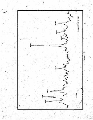
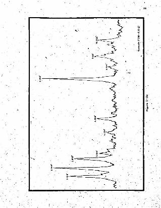
X-Ray Analysis
To test tJ1e differences in compositionaf the various .samplea,
an X-raY'llhalysiB of the sections finer "than 84> was attempted. sa. .explained by Carroll __ (1970) and outlined in Appendix 1. The initial
patterns run 'from 2-30 degrees 26 have' been. draft~d a~d ate presented
BS 'Figure 2-5 a , b, c lind d.
Compositionally the samples were si1J!ilar. All 'contained
'chl orit e ,(14A C (001). 1Ao (002)~. amphibol.ea (8.4UO). mlca-i1lit~
(lOAo (001). SAO (002»" quartz (3.33Ao• 4.21A~) and feldspars (3.17
3.1~A"). No montmoriHomte or kaolinite waa peeeent , The samp1es'did
vary in the amounts of -specific minerals they ·contained. Related, to the'
textursl ~ns.lyses; Satnple 7~ ~-5 and 72 H-6 eon tained greater' pr.0portions .
of clay, thus their patterns aredistur~ed :snd have more background
"no16e." ,Peaks are not aa sharp es.ebcee of 72 M-7 and 72 M-8 wpic? are
?ointed and, 'in ~y caasll 3-.4 times the ,heiJhf of the' backgroUnd pattern.

"···1;
~···"ello
'"~e·:.~I><
..... .
36
./
37
.i
3.
r---------~~
~,-=====-~

Steteo Microscope' Analysis
A stereo microscope sna1ysis w~s ecmp Ieted-on samples 72. M-7
and 72 H-8. No grey-pink 'color differentiation waa visible.- A ,search
was. made '~f all samples under 4<jl for foraJD1n1fera and diatolD.S, however
none were found.
For the following reasons it is concluded . that the, sediments
are lacustrine in origin.
1. The textur81 variations ::'n samples 72 H~7 and 72 M-8, and the
sedimentary section indicate p.:obab1e vaning.
/..
' 2 '. The '.mniDated bedding o.f gravels and silts in the meander scar\' , '
deac.rdbee ncn-earme depositiona~' environments.
, . J. The .absence of fOranfrn!f~ta ~d diatoms, ;hile not neceaaa'rd.Ly-
proving a Lacuatrrfne environment, cattainly is evidence for non-marine
deposition.
'l;he sltitudi&'l differertces in 72: M~5-6 and 72 M-7-8 IR1ght
expisU: the' higher proport.i~n8 of clay' in" ~e former two samples., Ai
the poi~t of higher elevation, (Fig. 2-2)' :nd thus later depo~itio~•.
meltwater flow had probably.slowed and sediment transported to t~
same locale would have been cona1der~bly 'finer. No other c;ompo,sittona1
variations were noted; this 1s logical since it is'ass~d'i:hat eet.r-
. water flowed over bedr.oc;k and' outwash of t~e same der~vation''- th~t ie,
down the upp~r reachea of Indian Brook valley and Burnt Berry Pond
valley. ,Since samples 72 M-7 and 72 M-8 were obtained frOl1l. only the
top f~' feet of an .ex~ensive mass 'of sediment, it 'may be that the

"40. \
lower sections l?£ the d~posit "are marine UI origin. Based on, the ra~her
superficial analyses presented, it -as ob,Vious that the p09siblli.ty shpuld
not be, ruled out an? .that; further work is needed to properly evaluate
the problem.
THE LOWER HALLS BAY DELTAS
Burnt Berry Brook and Dock Point
A rudsed delta- remnant is located 1.4 miles (2.3 kina.) north~ast
of Burnt Be~ry Pond. 'Island!! on, the delta surface are 250; f~et '(75
meters) a.s.~•• how-ever ~he ddaaectied scarp is nearer 180 feet (54
meters) in elevat~on. ,No field data were 'collected on this feature.
but from an 'air photo analysis it eppeera that thlir.delta vee deposited
bY,melt.witter ieauing from an .Ice front located in or near Burnt Berry
Pond; terrain around fhe de~ta renu;'lant is, h~cky and' kettled, suggeatdng ,
stagnant ice.
Two miles (3.2· kma.) east of the ahC!ve deposit 'there ia a r~ised
rlelta. at- Dock POiJ;lt. 'Sca~ and surface b&ights~~.r:e 'similar' to 'tb~se of
-the Burnt Be~ry Brook delta. A 50, feet (15 metex:s) erosional ter-race
is, visible near -tihe bottom of the Dock Point scarp and ccntmuee along
the .southwest coast of HaIJ,.s Ila~. ,,1
~
A raise;d delta ·re~~n~. immedie:tely due wesi:"~f Riverhead B~O()~ ~
was ,the aubjec:t o~ field analysis· (Fig. i 2-6). Various e.l~v~tionB were
taken on ,the main,delts ~carp;',near the_,,:aeter,nmos~ edge.-<?late 10) a
height of· 20'0 feet (60 mete~B) was recorded. Several kettles.'are
iocated on llfi';~u~ace ,of the fea[Ur~; th~ bpr.tolll ~f"the,'east~we.Bt·.. ,.. .•. p

"
t
41

42
PLATE 9. BEDDED SILTS ANDCLAYS NORTH OF INDIANBROOK BRIDGE, 93 FEET(27.9 METERS) A.S.L.
PLATE 10 . THE WEST PONDTERRACE SHOWING 210 FDIT(60.3 METERS) AND 53FJlIlT (15 .9 METERS) LEVELS.RIVERHEAD BROOK IS INCISEDIN THE LOWER LEVEL.

43
trending kettle nea.r~8t the T.e.H. is 10~ f~et (32.7 meter8) a.s.l.
The slopes of the kettle are rounded and show indications of fluvial
or marine ac.tion.
North, of the highway and southwest of Eaton Point- a 176 fOQ,t
(53.4 meters) level was recorded. The top of the no:z:thern section of
the delta: is hummocky and was ~ured at various po~ntB'as 200-210
feet (60-60.3 metera). The base of , the main de Lt.a acarp s southwest
of Eaton Point is 53 feet (15.9 meters) .a.B.1.
~ Hajo'i cuts in the delta. -are thickly covered ,with scree making
strike and dip messurslllE}nta difficult to" obt,aln,' however one orientation. "of 345~ 35° R was recorded on, the ma-in West Pond terrace at an-elevation
of '100 feet (JO mete'ra). This coincides with ,4 at;ike. and dip of- 345:
~2° R obtained in the 50 ,forit' (15 meters) terrace at the mcut.h of
Riverh~ad Brook. Fote.set gravels expoaed 'in tq.e 50 feet (15 meters)
t.e'rxace are loosely compacted with sub-rounded to 'rounded pebbfea ~-6.' .
~nches (I.3-~5.3 ems.) in diameter. 'On top of the 50 feet (15 meters)
terrace there are 9 feet (2.7, meters) of postglacial' lag gravels that
contain -pbUllded stones l-12}nches (2.5-30 Cllls.) in diameter.':
Sugarloaf.
A' traverse. Was comp~eted from west to eeet 'across the SugarJ-oaf
terrace (F~g;' 2-6. p';'~te 11) and elevations ~ve been ~eco~d~d frOID
~everal locations.' No. bedding 'pllSnes weie via~ble, however!. At the
break in' slope on the west 'Side of the terrace a height of 56 feet
{17_.4 eeeerej wee noted ~ile on the eastern end, towards South' Brook,
a "break in slope occura ,at 49 feet (14.7 meters). Outcrops a-re .visible
j 44
on: the delta surface at 309 feet (92.7 meters). The main delljjB. scarp
.is 212 feet (63.6 meters) a.e s L, while further back on the 'terrace a
recording of 245 feet (73.5 meters) was made , Modern stream dis
slicti~n of'th'e delta scarp is extensive. but despite this, the surface
ia quite even and no m!l.j~r kettle depressions .vere encountered either
dur~,ng the trave:se or from 'air ~hoto analysis.
. S~uth Brook
Directly east of ·the town, the main scarp of the South Btook
terra~e 16 249 feet" {74.7 meterB)a.~.1. Further south near the T.e.H.,
-the .hedght; of the delta drops t o 218' feet (65.4 meters)., Two erosional
terr~ceB are located'.within t~e t oen, ~he upper is '58 feet (17.4 ~ters)
s;s.l.,at the main break tn·slope and the lower was measured as 29 feet
(8.7 met~rs) st,the town wharf. Only one cut was visible on the main
scarp (Plate 12). The six feet (1.8 meters) of topsets or lag graVels. ,which cap the terrace at this point are well rounded 'and contain stones
up to 1.5 feet (.45 meters) in diamet'cr. One orientation of 020-dipping
35 0 L was obtained)however, it: is thought that this' conforms to slope
bedding r::'-thE!'t than true delt~a foresets.
;In cbe South Brook and RiveJhead Brook valley bottoms, bedde~
glaC.lo~luvial ~terlal waa noted ••, No apecificorientntions were
obtained,and the texture of the deposits alter~d with location. In
'e~rtain cuee , the glacionuvial mat.eri~l was cap.pea by varying 'thick..
neaaee of postglacial lag gravels.
~
The top of the dell;a'at Wh~te Podnt. (Fig,. '2-6) ,i8:220 feet

PLATE 11 . THE SUGARLOAF TERRACE AND SUGARLOAF. PHOTOGRAPHEDFACING NORTH. TERRACE HEIGHT IS 250 FEET
(75 METERS) AT THE LEFT .
PLATE 12. THE SotTIH BROOK TERRACE WITHBEDD ING ORIENTED 020 11
, 35° L.
45

46
(66 JIlElters) a s e s L, A break in slope occurs at 110 teet (33 meters)
with an. erosional scarp at 54 feet (16.2 meters). A third level vas
no~ed at an-ejevacfon of 20 feet (6 meters), No be~ding wa~ visible
'on the face of the Wh.lte Point delta, however a newly cpenedc boxroc
pit on the highway ~dway across the terrace has good' exposures of.
topsete and rcreeets , "Orientations of 330-34S·were obtained with dips
rangill'g from 7°_13° R. It is oot possible to be, ~ore specific.' in
,describing, sediment texture ~nthis pit since material varied fro~
sandy c'ros.s -beddfng to foresets with enoneeup to 10 inches (25.4
ems.) in diameter.
Shell "SsWles
In early ,summer 1972. ' D., R. Grant recovered a sample of BalaYIU8
which was subsequently dated at 12,000 ±220B,P. (G.S.C. -'1733). The
shell~ were Incated. 55 feet (17.5 meters) a s ssL, in a stony'peUte
located at the front of the Sugarloaf terrace.
Two shell samples were co.l.Lect.ed in the Halls Bay ar~4 by the
writer. Sample 72-!55, Mytiz'U8 eduU8~ ,wa'll located ,in a sand l~s in
fcreaet; gravels on Ri;"erhead Brook (Fig. ,2-6) 29 feet (8.7 eecere)
a,'s.l. Sample 72-255 contained perfect 'spec~enB of BiateUa ~ti(!a
(Plate 13)'., The vaampLe wss, removed-'t"rom.s cut in stony pelite 15 feet
(4.5,meters) a.s.l.~1n Spring Cove at the eastern end of Halls Bay
(Fig. 2-6). Pieces of the shells we.re visible 00 the surface cif the
cut but most were dug from the compact silt •. Both,these samples are
estimat.ed tc be aimllar ,in age ~o G.B.C. - 1733 and are' significant :t,o
that they date the _innermost ..series of glaciomarine deltas of the
, n~rtbeaat c~ast ~f the 1a1.and.

".<t .
Henders:)o <IfC) obta ined eceee llbell UJtplea uc etbcf t be ·
field area whi ch ~r,e '~ub ll; e~uent ly da ted . Salllp h C. S. C. - 55 ( 11 , 520 t
180 B.P .). ~eG'IT:t c);;IlcarYa. J.:ya "t zouncata aIld Iiit;tsl.'ta ~tiea: Vall ·
ob t a in e d fr oq II s11 t y clay . l 60 f e et (4 8 cetus) a .s . l. in th e. Bail. Ve na
River. C.S .C. - 1S , colle cted £1"0:1; t il l-like tro1tedal 35-42 feet
(10 .5-12 .6 ~ters) a .8 . l . i n lUd d l e Am . Green Bay , wa s da t e d a t. 11 . 950. - , , .
:!: 170 B.P • •At Sou t hwest Arll , creen Bay, a Bm ple of H{..aU Ua arct ica\ .... , "
, and Mya truncata Wall depos it ed 11,880 :!: l70 ,B.F . the sh ells wer e loca ted
in silt~ bottO~SBt Cl Ays 40 f eet . (12 m; t e rs ) . ~ 1l . 1 .
Conc l us i on s and Di s c uuion
The sh ell date. from Green Bay .a nd Halls Bay are rou gl1;L,.
equival~t . No one da t e ,t a l b ou tS id e tl\1i .uppe~ o r l ower s t a t.b U c6i
eeeor. of t.he ot he r sa:pl e s • . Excl uding satJp le G.S.C. - 5S all were 1_~
than 60.fee t (18 ~eters) a , 11 . 1. and tbWi rep re sent deep vllte r grcvd~
in de.lta ? ot t OCls e ta . The. datea .tndicate.that ~reen Bay a::.f ~1l11 Bay
vere deglaciatad 'wi t h i n a fairly narrow interval oC time approx:1c&tely, . ' .. . . ,' . ... .
· 12 . 000 ·B. F . , and that t be . delta 8 we.re not, Il8h a s been sugg es t ed by. . .' , . . ' .
J enn e lUl (196 0) n~LidqVi8t.. <1965~ . d. podted ~ ic e _~~ lab ll.
Tbe f allowi ng eeqceece 15 propos ed f or the de gla<: laUoa of Halls Bay.
, A c lll ving: itafr(l n t r apidly deg lft c1aud Halls Bay until i t '~ ' .
, bec ame land ,fas t i n ~~diBll ,'BrOOk Bnd in t he valleYII, 't"o t he eout.h whe r e
i t: remained while del:l a: ~epOIl1 t. ion took p l a ce Rot Sprin gdale and l ower '
Halle' Bay. Bottom "'.t~\of 't he ,de l t lll!l fr on t in g oQ Halls B~~ are .
,. eq ufv aken t in tim e and~rn ~n,Od"d a t . t ee 'eee e..;n~l poni tion 1
: (P1g e . 2- Z, Z-6). Construct ion of t he Spi ioadale delta occurred "f r om ', .\

(
48
lateral meltwater in Indian Bzook valley and deposition a.C~OBB the
~edrock ridge northwest 'of the main terrace, (Fig.' 2-1). Material
was derived from the valley systems' to ube eese and aIcng the
north side of Indian Brook valley.
The silt' units throughout Indian Brook valley may represent: a
lacustrl~e envlron~nt:. during: this retreat or. later. though tbe
possibility of a marine origin for the lower portions of the large
mass. of sediment near IndilUl. Brook Bridse :is not, discounted. Marine
waters certainly penetrated some! distance up the Indian' Brook ~ Burnt
' ller r y Brook valley for delta deposition to occur southwest of Springd8.1e'.
Further analysis Is necessary for complete clari~:tcat~on of this
problem.
As ice reareae continued, major IIlarine delta deposition to~k
place .ec Burnt Berry Brook, Dock Point and White Poll).t w.tth continued
minor depos~'t:ion at' the head of Ha.Ll.s nay (Position 2, f1.gs. i-2, 2-6).
Although there is little remaining evidence to confil'lll the idea, it: is
possible to epecul.at.e that aMosition 2,_ a. 2S{) f~6t (75 ~ter~) terrace
was constructed just southeast of the T.C.H. - Springdale highway
:Ln,tersection. This would have paralleled the existi.ng terraces' at Burnt
Berry Brook. Dock Point and White Point.
Finally, weltwater frani ice located in West Pond and Seuth Pond,
valley~ (Positi,on 3. Fig. 2-6) was 'responsible for 'the ta~Jer proportion
of West POnd, Sugarloaf .and South B~ook eet-rece coi1.struc,Hotl.. Greates't.
~ount:~ 'of ice recession between /positions l'snd :3 took place' Oil
inter.fl~ves' with ~~.a~\~~}-y'KSIOWretreat: in the:valleys-. ~ttle holes
and hwmocky lDoraine Qn,\he highlands around the depos1t,El indicate that

49
ice fronts were near the deltas during their construction.
Ic ~B also concluded that the: delta system at the head of Halls
Bay which ineludes the West Point, Sugarloaf and South Brook terraces,
completely filled the lower pe:rimeter of the bay. Con~lnued glaciofluvi81
and postglacial erasion remOved la.rge portions of the delta .from the .
.J:WOvalleys (plate ,14). BritiSh Admiralty c~rt No. 4591 shows depth
aounddngs of 30-40 fathoms (54-72 meters) in lower Halla Bay with a:
sudden drop ta,103-120 fathoms (185-216" meters) immediatel? north of
Dock,Pa'int. Th:Ls Bugge,sta major fjord infilling'by the eroded .de Lcadc
material.
'During 'and after. the ,P~SB of ice removal f~om the fietd area,
isostatic rebound caused the terrain to' be uplifted. - From recorded'
el~va.t1onB of thel&'11s
Bay deltas-the" marine limit .or linlit of post-
glacial emergence r~lative to, preeenesaee level is 250 feet (75 meters).
Various sccrcea-eaee sea teve'te for 12,009 B.P. as being about 172-224
feet (52-68 meters) below present j.eveja.. Walcott (1972) suggests a
level o~--224 feet (-68 meters) based on Grant's (1970) work. on the •
Grellt Northern PeninsuI.8 of Newfoundland. Flint (1971) indicate~ 8.
sea level of o::l.82feet (55 meters); Andrews (1970) quotes. .God~in et al. '(1958) ~s pree:iCting' genereL '"sea l~ve1s of :-i?2 feet,
(-52 meters) at: 12,000 B..P., All the above values are based on curves
constructed fr?m radiocarbon-dated ehej.Ia and /Illlterial .aaaueed ,to have
been e:x:isting at sea level. Thi ll is a major weakn~ss 'in that cerl:ain
specie.s subsisted at consddexabke depths ,depending, on the temperature
~ salinity ?f the water.
For -,this reason ~u8tat1c curvep mey.overestilllBte the'smuut

PLATE 13. SAMPLE 72-255. OF HIATELLA ARCTICA,LOCATEO AT SPRING COVE 15 FEET
(4.5 METERS) A.S .L .
PLATE 14 . LOWER HALLS BAY SHOWING; SOUTH BROOK TERRACE.LEFT . SUGARLOAF TERRACE. CENTER. AND THE
SUGARLOAF. LEFT CENTER.
50

51 .,
. o f Ilea l evel c.ha:l.ge by all ouc h a s 60 feet (18 ~ura) : EO'Wevex. f n lCl
', t he appr odaate ,e~. tat i c; d~ta ~t may be t h""t c . 440 ~feet . (l 33 ..c;ters) .'
.of isostatic uplif t ~9 t a ken 'p lace lli nce 12 . 000 B.P. o.f vtdch 190 f eet
(57 _ t en ) hili been ob.sc.u r ed ~Y a ~lIt.atlc rillf! 1n -ilea' level during the
11 81l1e pO&tg1~ f.al i.llut'val.
Ero siona l te rrace.s .occu r a t 220 . 200 . 180 , SO an d 30 f eet (66 •
. 60. 54, 15 and 9 Ilete re). (Tabl e 2- 2) . ' All llXc~pt t he 5~ fo~t (15
met e'1'. " leve l a r e. poor l y d ef ine d ' and do not ,a.ppea r on all deposi t s i n '
Halle Bay • .• The '50' fo o t (15 meters) t~rr8.ce is' con tinu ous throughout
t~e area and r epre lll!utli: a wajo,r still·staud. Thh i~ not to euggee t;
th at 't he other sti ll" llta.nds wer e not i llliJor.tsnt bU~ t hat evi dence fo r
thelll 'ill _sc~t)') ha vi ng be en r e:aov~d by . l a t er m;ar i ue e r oal00. or IIl.SlI
w'a6 tiag of . ·uO~OD.SOHda.t~d Q, te r i a l .
~ .

f~
~ . :
.- ~
~ .~ .
. ij
. , N I,\
~§l!li!
. <1. :2~
~.~
~I':~ ' . ,
~
J
1 • ., • •i~
~
~ ..... e. - 3' -l ~ ~ ..
N N
,; ,; •~
. ~
B ~ - -et ~ ,
N~
• .... •~ 6 -~ - e ;1~
~e
~ ::l ~~
-; . ~
~ ~ ~ · •c. ::.: e 0 e~
~e
,5 ..N
~ N
~e • •~ ~ 0.....e
] ~ ~
~ •.! ~~ .~ ... c~
j ~ e 0 'N ~
.. •~ ~~ • ,; a-
~ · e ~ af c~
~ ~ ~ ~N
l~ ,
" . ~
I'lf~ .',.;i~
' 52

~ GHAPTER. III
ESKERS AND CREVASSE FILLINGS.
The purpose ~f this chapter is to relate a zone of ~Ske;l~g· and
crevasse' fi1~ings (Fig. 3-1) tc the" overa'U pattern of deglaciation of
the ~n6 Bay - Topsails area. the central ,:iart of the f1e~d ·ar,ea. is
marked by a number of ridges. of appa.rl!'0t glaciofluvial origin. t>-ir
J?~oto analysis reveals. that while some of them appear ~o be crev~68e
fi11ip.gs, 'as ~uggested by Lundqvtat , (l96S~, others bear a. greater
similarity to true eskere,
Generally, all' the deposits studied are on the nigh Cent~a.l
Plateau with the larger an~ mOre promib.e.nt onea being ioca.t:ed at the
northern boundar~. s.Jlecifica11y near Bamey',s Brook and she.;fiel.d Hi~l.
The -l~rger ridges near the edge of' the pl~Ceal:l ar,e up to 3 miles (4.8
kina.) long while, further 'south 'lengths ~;~ about 9.8 mile (l.3'~.).
Lundqvd.at; (l965)~eacribes one or the features 'lying outsi:de
the present Btudy- ares ss "e 1.ow,hut sharp ridge of a type that in
Sweden is considered to have been ,jorrned 11\ ope-tl;"crevB.sses· in ~he
ice.. .'. and is of liinited v~lul! for the detemination, o~ ice flow"
(p , 296). He. observes r~hsta11 "eskers" in the cb:rrent' fie'ld area
are (If this o.rigin. In o,rder to interpret the ~ligh Central Plateau
depositG;-ad~qUately. it is neceaaar-y to, describe, va.rious 'p,oss1hie
lD~thods of, formation.
" .

i,/ 54
55 1
Wh~le' eng4cia.1>" and sup ragLac Le.L proceB.~es have been suggeat ed ,," , ....
Flint (1971) fEtvor"s ~I;\ eubgjacfaj, origin for the: depos f.t Lcn of esker
material; whereby, in a late phase of deglaciation'psur~ace mel~wate.r
seeps thro:ugh the i~e aeeking the·u.J-owest PO\aibl-e <'.hann~lWays., Wat~r
and sediment t~a~sported via this ,route is' deposited partly. along Ithe
b~dsof, such channels and._partl: into ~on~ed bodies 'of water at ~~
glader [i!;rI!linua.
L.eWi~', (l9~9» ·:u g gest8 fha't extema~IY PO~d-;d .water 1s ;;'ot ....t
neceaaat-y fOl: frontal or near-froo"ta! eaker deposition. He observed
\' an esker in the proceB~,of :'f~rmation' at a 'l.ocat~~n where a contemporary
v~ller,gbc;.ier ternlinatea ~~ a gent~e slope covered with aQlifluc~;L6tr
·deb~JB. Since the valley had not contatned water recently, Leloj:is
explains that ponding neceasary for esker development. had.occurred under
e., '!:!lacier and .deposLt.Lon had taken place in et.agnan.t water dammed
in ice caves.
Embleton and King (197'O); euv'Laege a similar meth~-a of cgker. .constd7tiO~. ' Instead of 'requiring' ~ond~d.water near the glacter
t ezmfnus , they maintain that a reduction of terrain gradient undef the'",' , • ",< • '.' ,f-' , "" ice or blocking. of st.ream cbanrieLs by the co~lapse of decaying ice may .
be i:nstrumental in init'iat11;lg th~ deposit.ion of Jl1steriai in subglacial
channels.
A variant .of ,th~ frontal and no:rtll;al esklirs( me,~tioried above i~
the"~eaded e~ker wnich 1'6 formed"by the',annual addition of smallI
mounds .of s,edime,nts as an ice front retreats.' ,The. summer- periD? of
"rapi~er" f;low.' adds ,to each ~e.ad.whl1e. w~te.r iB r~preaeni:ed by the

56
intervening gap.
Crevasse Fillings
Doc'rnkamp....and Kdng Cv971~ descrihe it process -of· crevasse
filling on west Baffin Island Whe~e they observe .that. the irregularity
of the deposits, in plan and" profile, Lndf.cat.eal'that; they are not
formed ~Y f Lowfng "Water but that: they -:epres.ent. the fi~l1ngof cr~ckB
in dead ice by material bedng a~CUlIlulated:. f,rom the surface above. The
slow wa~hing down into the hollows would account for ddmdnut Lcn of
ridge height cceerds the d:ll;l~al end 00£ the ridge. From several
publicationa {esp , ~lint. 192B) jhe following auimnary l?f variatiqns in
esker ~d~ cirt~~~se f~lling morphology is tendered (Table 3-1). The
~ ", ~~able - :'i's s~if,..explanRtorY an~' w~h not; be'el~borated on 8,t t~iEl point.
Morphology
Barney's Brook
The Barney's Brook tresker'I! ie'lo~ated' 4 miles (6.4 km~.) no reb
east, of Foretopsail (Fig. 3-1)-and is approximately 2.9 miles (4.6 kms.)" • I '
in length. The .f ea tur'e trends 130·00 its main sectaon ~hl1e near. what
appear to be dist.al distributuries the orient.ation is 070-080° (Plate 15).
on :he se~tion of the deposit;' east of Bamli!Y's ~~ook"perched
erratics .are numerous. The granite boulders are 3-5 feet (0,9-1.-5
metera) in diameter and of~en have numerous smaller erratics stacked
_ato.p them (Plate~ ),6). Th'e <:'~est .ef the feature is sharp 'and_hUllJlllocky.
s~e ~nsleB taken' at' sample poi".J-t~' varied from :S' minimum of 16° to a. '
maxi~Ulll of zz", Towards ,.the ice_marginal, end, near sample point; 72 E-I.
the depos~t iii 28 feet (8.4 meters') above the general terrain »:while at

..: TABLE ' 3- 1 '
DI StINCtIVE FEATURES OF ESKER.S AND CREVASSE FILL INGS
ESKERS I ' CREVASSE FILLINGS
1. ~;~::~~:it:';~"::a ~dbutar) . r e t e rmi na l or 'll. ;;~a;~it::a~~~~::: :~~: ~:;:,~:i~~:\:ar:;nes ,and i ncorporat ed ...i t h i n t h. l a t t a r .
l:;
6 ; Crli!ll,t e levati on s a r e. :Sl lll.1lar t o Dur ro un dlngkame and k~ttle ' r i ms ',
7, Compos i t i on is Gitrllarto t hat. of ell ke r a ;lide slope angles a lao almila r ,
' . .J . Usually (not ·alwa.Y-Il) t r~nd para llel to t he'
direc t i on of de e mOVO! lMn t and m.&y bedf ac cn zdn uoua .
4 .. C01Jllllon l y 'sinuous i n plan' and a rran ged i n, 41striputary-trlbut ary a y5 ttl Dls.
2 . Most a re sh ort . aes s t ha D 0,25 III1l e a (0 . 4 ku .)and r ange fro. 12 - 15 hAt (3. 6-4 .5 me~era ) ,i n..he i gh t : .
3 . Trend in any di r ec t.l O'll. r agardl e ss' of i~~direc t i on and are c.oI)tiouoUIl r a t hllr t ha nbr-o ke n , '
r4. Are ~ot arranged 11\· di 5~ribu~ary sys l tl.lll8 bu t , ' :
vhene aaaccLat.ed vith l ak ll de po ilits mBrginal .t.o i ce edge !JaY ee r ge vi th ,t.hi:lll; are gun etdly
' et r !l1ght t hough may ben d aharp ly a round ke t tler ima. . ' ,
5 . Tr e nd uphni and c r oll. 'd i vid",a wit.h no ' C.Jwllge ~ , . ~ops a r e hor i zOnta l ,on d th~ f •• l~rea do no~ · ..in the volUlle of th e depos h ; Crestll are . pass over divi des . ' .knobby and hum.ocky oT und u14 t inS . r a re l yleve l f o r 'l ong d1l1tanc.c ll ,
6 . Cr~~t ereveetcn e DOt r e late d to lIur-round1n gdeposit s . ' -: , It'
" 7 .' Mat.erial coar-se . laclul sa nd I! lUll! c1 3YIII "pr e doad nan c e of 'g ra vde an d c:obbl e ll . ,Vi sib l e bedding in t t lUlsv e rs e sec tionsparallels slop" lit ..:egl .. at nat . 18 - 30~egrees . - ,
. , 2 . ,CoImanl y seve ra l mile. in l eng t h ; h. i gbt oj.. 12- 45 fee t ' (3 . 6:-13 . 5 _ u.ra) .

TARLE:3-1 (CONTINUED)
ESKERS ·CREVASSE FILLINGs. "
8.. Bedding _variable With setpis~ratified ec.ncc- 8. Bedding is nio'derately foreset to horizontal.stratified lenticular masses. Sections of Secl;:Lqns never show coatings of till.
, ~~1~m:':~1~_~::~'~e~r-m:~:c~b::~~~~ ~~.;~:~s.eLce ,
9. Ridgf:_ er:e-sts trend upwards in,the-direction 9,-, Gradient slopes do,wn in-the direction_of wst~r_
of ~former i ce f~ow to !=each.'a maximums.t flow indicating inO.... accumulation, i,e •• ridgethe- distal· end-, .heights diminish towards _the ·distal end -of -_the_
deposit.
~
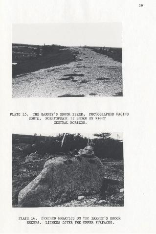
PLATE 15. THE BARNEY'S BROOK ESKER, PHOTOGRAPHED FACINGSOUTH. FORETOPSAIL IS SHOWN ON RIGHT
CENTRAL HORIZON .
PLATE 16. PERCHED ERRATICS ON THE BARNEY'S BROOKESKERS. LICHENS COVER THE UPPER SURFACES.
59

60
sample point 72 E"3,. about 0.9 mile (1.3 kIDs.) further west, height
decreases rc 16 feet (4.:8 meters),
The c e esce are devoid of Vl!getat:i.o~ with-heathland lind scrub
covering the sides and surrounding low areas. In general thete-rrain
slopes gentjy to the north east and 1:s ilcil,lldery in nature. ,Well{
weathered, pale eei, equigranular "Topsails granite" (Neale and
Nash, 1963) b~drock i s visible and erraticsiif ~he same li:-hology
litter the area. Near Barney's Brook "ceke'r" the 'terrain. becomes more
hummocky. indicative 'of ablation moraine (Glacial Map, Chapter'S).
though cowards the not:thesat end of the teacure the hummocks have II" .. "
crensver'ee linearity euggeatdng highly dissected recesaional moraines.
Al tbough- a more detailed texcurat analysis will be presented
~a~ thi~ chapter. i.t was obs~rved _that aU:r~ace material' of th~depcaLt appeared vet.t-ecrred with a distinct lack of ,clasts over 1::'2
inches (2.5-5 cms , ) in diameter.~The possil:Hlity .eXiSts that ·sorting
was not a result of glaciofluvial'deposition but rather of 'postgl-acial, ,
or pe.riglacial action. however ',since' sediment ~ize did not dncrea.ee
sub8ta~tiallY with'depth. the' initial aseump tdon is probabj.y' ~?rrect.
Sheffield Hill
A .prcmd.nent; glaCiofluvial ridge located 0.9 mile (1.4 'kuls.)
southeast of -Sheffield Hill, is morPholOgically 'similar to the deposit
descrlbedat Barney's Brook: ,It.is 1.1 miles (1.8lans.) .tn length.
oriented 355~ :and increased' iri 'breath and height towards the north
nOrthW8S't (Plate 17).I
'1

61
ot'rounded to sub-iangukat- granite and gcanudfor-Ltie 1-,2 .1nche.s· ,(2.5-5
caa , ) in 'diameter. S~milarly. from an initial-inspection, there seemed
to be a lack of argillaceous material or large boulders within the
deposit, though as was noted at Earney's Brook;" e.rratics ~itter the
surface. In places several smaller eeeatnce are perched 08 the 18rger
base boulders.
At'the lowaouthern end .of the "esker" heights vary from 17-18
feet' (5.1~5.4 meters). Near the center. of the feature height increases
to za feet (6,,9 metera) and slope angleas,e 25° (west) and 26° (eaet j ;
The J;lortlternmoat 'aect'iO~ has 8'teep){~ide8 a~d.a aharpcrcs~ ab~ut 10
feet (3 1Il,eten) wide while height waB leveled 8s41 feet (12.3llieter·~)•.
Thl su.rfac·~,of, the .dep08:lt is' devofd 'of, vegetation, at its, 4
southern extremity but 'is covered-",itlf scrub spruce and "juniper itowarda
S~effield Hill. Valley axial gradient iapoOrly," defined at ~hiJ .
Ieeeeden, Minor valley eLopea a~,e oriented n~rthe.ast lind southwest: .'
though major topographic. slope\ is to the northwest.
Foretop'sa:il
0.6 mile, (0.96 ,kina.) west of Fqretopsa.l1 there i,B a a'maller
esker of' creva~'se filli~g remnant 0..5 miles' '(0.80 kms.) in 'length
(Place 18) '. It 'is orl~nted'355'" has a. low, broad, crest an'd side 'slope
engkea of 19" (south)' and ,18" (notth). Althoug~ the i~ature is n feet
(3.3 me[~~s.) above ['he immediate terrain;, surrounding ablation moraine"
is generally.of the same, or greeter , he tght , There .are no '_surfa~e "
boulders and vegetation 1.a minim~l; A pit was dug to ,a depth of 2.5
feet (0.75' meters) and. no bo~dery material was encountered, rathe~ the
\
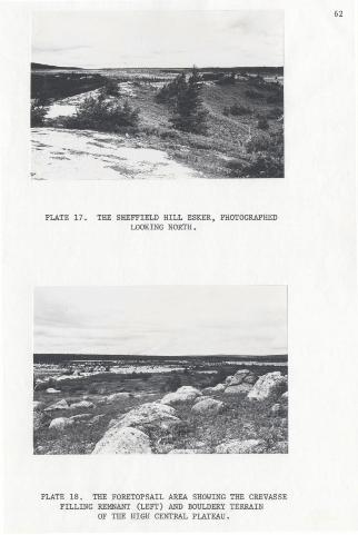
PLATE 17 . THE SHEFFIELD HILL ESKER. PHOTOGRAPHEDLOOKING NORTH.
PLATE 18. THE FORETOPSAIL AREA SHOWING THE CREVASSEFILLING REMNANT (LEFT) AND BOULDERY TERRAIN
OF THE HIGH CENTRAL PLATEAU.
62

63, ' .
. sediment was well· .eoreed and eub-rounded containing cla~ta from 0.8,0-1.3
.mchea (2-3 ems.) in diameter.
Air" Pho~e Deduced Morphologies
r . A ridge !"ituateli -~n the valley north of Little Sandy Pond
appears from"\lir photo analysis to be morphologically _~1m11ar to the
Barney's Brciok "esker," 1.5 Iniles \2.4 kms.) to the West. The. depPllit
follows the va~ley .!1xis at 340~ani is diss,:cted by meltw";'ter channels
and existing Btre4ms. (Fig. 3-1). lts·overa.ll·'length (1.2 miles, 1.9
Ions.) and orientation further indicate a relation to the Barney's' Brook
complex. The -Little Sandy Pond'valley is filled' with glaciofluvial . .~
mat.eef.a L and surrounding drift is ebundan t ,
Two miles (3.2 kmB.)east-Bouthea~tof Por et.opaafI ther~ ~s B.
deposit ~hich may be a true' crevaese fil~ing as described by Lundqvist" ,(1965). <It is approximat"ely 0.8 milf!!'s (D.9S'kms.) .in length apd branches
at ~Il.rious p'oints., Part '''''f'.the·feature trends J5SowhHe 17~her eeccacne
are oriented'DlO°·.md 035':', The ridgea, are_hi~hlY:diBs~cte'd"end pitted. ..
with kettle holes.
Prominent me1~wa'ter ehanD.elsh~ve been plotted frolll the air
photoa (F1gure"-<~-I). Near Sheffield Hill the pattern indicp-tes',a. ,
p.ortherly flo~ of IOO.ltw~ter. 'while :i.nthe B~rney's:Brook area flow
~aa, radial frqm the Burround!ng sUlllllli;s with -final fio1\' , to the north
north~ast·down Barney's Brook and West'Brook. "
Textural Analysis
Samples were collected ~rom. the deposits, ec . Barney's Brook a~d
:Sheffield Hill. All were taken unsieved from.a dep tji of 2.5~3 reet"
\.
, . ... (O·. 7~.9 Inte rw) o~ tbe slo-p~a' 6 £ the featur~a. · Four aarplea "ere..
'an.al y.zed;" t br H f~ 8ll~lley'" Brook "esker ," 72 I!- l (mos t" easte~ly).
J2 E- 2 , 72"E-J , and OM , 72 E-4 ; f r Clll t he S.~e~Ueld Hilllle9k.er ~n
(Fig . 3-1)
1> -e t s nda r d siev e ac.a lys18 wall COl:lilleted at whol e '*.in terva ls .
A9 out lined - i n Append i x 1.. Individual pe~c. ';'tagee ee r e c:':lc'.dat ed fo r
th~ s4ftp'l e: weight ll B~ ,t h<!'l r esul ts ...ere · pl ott ed on Cumula tive (Aritb
me~·l i:. Or dinate ) Cu~u (Fig. 3-2) and FT eq~ency Cun.:e~ ( Fig . 3,-3) ; "
A plpett~ a,n~lY91B \,1118 not comple ted on the f r Rctions -Less than '41jl. ' .
s m c e o~ly a" gen e r al ' ~ndlcat1on , of (or Lack Of~81aciofluvia l . act lon
wll ll:i:e.q~ired alJ li r~8ul t . which WOUld. be obvious " frOll1 t.he . standard
: d eve analys 1!I. A fab r i c analysis w8118 ttellp t ed a t BollIIlpl e 'poi n t
72 ~:-4 . (P l.a.te 19) .bu t th e .s ed ill.eDt wlI!J- ne1ther ~,ell consol~dated no r
wu~ nhe ' pebb~n .~lon~ll\ed" enOugh t o cO%plete "an llMlY·I!I~ " w1t.h. 8n~ .
d egree - of accur acy . ·
" R:ault ll
The fOli,",,1tl8 .r~ lIut't8 ",er~ _obt ained fro~ . the" ""te:rt~~aI, .
" u aly61s (TlIb~e 3~2) . ·
.: ~ .

· I.. ·· 1
.' .~ . ~ CUMULATIV~ CURVES
.6'
-,
. ',.'
'. '
--72E-.l"' - - - . 72 E - 2
·· · •.. · · 7 2 E -.. 3.. • • • • • • •. 7 2 t: - ~ , .
' .. : ,

' , '
"
~, 12
,, &, '~_11<,
. : 10
•j ,'.: : 7
.', fREQUENCY CU.RV!!S
I 2 .. ..{lJ-UnU• . "
..,
- '-72E- I
.~ .. "';-72E :-1.. ...' 72 1-3 . . -. ; 7' £ _ ~
" : "
, .-'
"

67
TABLE-3-2
CALCULATED DATA FOR HIGH CENTRAL PLATEAUSAMPLES n a-r '- 72 £-4
Sample Itl~lUBive Graphic Mj:!sn Kurtosis InclusiveStandard Deviation Graphic Skewness
L 241/1 Poorly'~orted~
72. E-1 +l.O7¢ 0.95 Mesokurtic 0.'06- NearSymmetrical
72 E-2 1.96$ " -0.-13$ 1.21. Leptoku~tic 0,23 Fine Skewed
72 E....3 1.53$ " " +o.9N 1.11 Leptokurt1c 0.25' " "12'E-4 1.091/1 " " -1.58¢ o.si Mesokureic 0.30 " "
.
All four samples have primary modes occurring in a zone, of -:ery
coarse sa_nd~ :-,ith an abr~pt b'reak in eLope on ,bol;h sides •.of -tbe modal
peak -(Fig': 3-3),. It is" pos~ibie that the primary modes may have been.. . .
influen~ed by the up?er 11mit placed on the sievin~, though in three
, of the fC!llr samploi,s anaiyzed fl distinct~baence of materiai greater'
than -2$ occurs. Notabiy, though, there is' alack of fine~and
(2-341) with 11 slight incre'a~e in very fine sand (2~4,%), in aU samples
(Fig. 3-3).
From the Cumulative Curve's (F1S:'3-2),-oi:le may observe that
~t least 90il: of the seditnent is confined to tnaterial coarse'r than
2.6¢;' that :!-s. with a sllat"P'break in slope of the curves within the. '~ ",.sand' categories' (Table,' 3-3).

PLATE 19. SAMPLE PIT 72 E-4 SHOWING SUB-ROUNDED.GLACIOFLlNIAL SEDIMENT IN THE SHEFFIELD
HILL ESKER.
68

. \
." . " ., :
"TABLE ] - 3
"
~~ BOt:l,'D!R'i ($ UNITS) ' AT 90% CumtATl VE: lo."EIc;HT- - .: - • • " 4. .. .
~. . f 'WlITS
12 E- 1 +Q. 60~ , .
72 E- 2 +2 . 6~
' 72 E-3 +1, 204'
72 E- 4 O.O~
Si n c e' the aa rapLe e 'War e nee ob t a i n ed from con t ;suOU6 be d di ng plan es, i t' 1_
vol,tld .be unwi s e to ;uti lllate 'an y 5P~t1ai re~atlon$ f or dePiilsitioIl, .however .
. .' t he 'l a Ck of very U ne 84'1d an d silt i s a n~table gene'r a i featur~ .
SUllp lu 12' E~2 ~d'72 E- 3 lIIaY' be described a·&)ePtok·u~~ic .
!,~B~iblY tbl~ ' ~9 a res u l t of - ~he ..luge amcu'nt of mat e rial in t he :- ~~
-O~ ,.ra nge .' Sn:pi~.8 12 E-~ '. iUd 72 1:-4' ,'Ir Q~~~J"tle a.~d [bU~ ha;~ mor e
., ~v!in aedfxcn t. ~ 1s ~dbut'10~~ • . :.&.11. except .72 E-1t re fiD~ ~:~e~: _'1:\11& ;.
-dces , not .1r;? l y th,8t t hey con tain a l a r ge 8mbunt of s ilt or yery . Une
. i ~nd bu't .[ a t her , 1ndi ca l es ~ 8ke~ing . o<~?e rr.eq~eney "curv e -to ~h~ fil\~
"6ec t i on ; hmoeve1 all 6811:~les are ' in ~ <;lo sely de fi ned ran ge a nd a-ce .C:~PO~_~ !>le_ i n ~ g\'n~r~ ~ sc ope of , P~slt iv{~r U ile ~~e~IlG~·~.-
" ,: .. 'St e r eo Mi cr o!lcope Atlali:s15
: Fr om an e~$m1~"' ~ion of, t he 2¢ sections "of " th e ..aampl e .!! under a , '
ate'"re~ I1i;~rosc~p~ , :1 ~ .waa n o',~e"~ t~:: Samp! "ell ?2'ewl . -2 and 3 had '
b round~ess value~ of ' 0. 30 (Power~ <,(':1.953) sca l e) ';', t ha t i.~; they were
6vb.-~ngular wi th "" hi sh 'degr e e, of' 13 pl'ler lcl ty . ':sa:mpl e 72 E-4 ,va s more ' "
4Q~Iil~r ' (O. 20) ' with . : hj8h~ !I'Pheridt~ . -A ~atDiG~ .. : p ro~ablY 'due ~~ ': ,
. /. .
\
/
70
.~ s ligh t. poli s h waS v1Sib~e 0';' t he qU3r h i1: actl~n . the laue; be ing
.. ' .. ~.indi ca t ive of ab ce sion by wat er t r an s port.
~ . . .A~ , & gene t al resul t o f th e analY l:l ~s th er e would seem t o be a
ce rta:;.n '~DOUnt of lo r ting by 'WaUt' and a l ad: of fine s and very coarlle
::::::.:::::~~::::.~ .:. .' ". . .~ j ' :• "Fr om t.~ e ~extC:al ana~Y81s. : WlOrphOlQSleB. ~~~ lit.er~url!. . i t ill
,"conc l uded that' t he two f ea t.ut-e s at BarilCY' s Br¢ok , ....\11ch incl udes the
, deposit '!? U\t 18 Sa~dy pon~.'· va,J-l~Y., ,and the , Shef field Rillfor~'t lon ,
ate t rue eeke r u , The rea sons. fo r d:-c i dl ng 80 ar e :
1. The h igh nutllher .o f· un di s t u r b e d p er~hQd ;C rTat ~ci on the d~pos lts
;3t Sheffield Hlli , ;n~~atll l!y I B Brook . If .me tta te r lal had b.een
. .- - . ' .I ndged a s Iibm.rt.i inPl a t e 16 ; The err8tlc s v e re 'proba bl y dep cs Lt ed frO:JI
·;-~l;:~ s:;. ,Ill\d IIUPrlg!4c tal deb r a :1.5-Lce s t a gn,a te d in ·si t>.4,
2. The wei! vashed , irsn~~r rateria l , oIlJJd 14~k of :i very f ine
liand-~ilt fr~ct ion V01J1d' a1 i '0 indicate e l;k~ r-Uk~ cOlJpo&1~lon. 'Jb~·se. \. . . .
s i gbify flOW' deposition 8¥ a r eroval of 6pecd tic '8ed i u llt: f ractions· ,'.' } : . .ra t~e.~ t~~ i nfillin g a lld 100r sor t ing of 'lG«t,er ial. . \ r
3. The, dinlend oM o f t he fl!Qturl!ll ' ar~ gr7~te r.~ th ose out l ~IlBd
· by Fl~t '(1928) fo r crev~lIl1; fi 111ng~ (Point 2, Ts ble 3- 1 ) • .
, .
"
. ..4. In each of t hA l oca tions the ar ea lilurrol.ll'lding che eake.:ra i a
. f re e of large amow:t s ,o f ~bla tion mor a i ne '~d ket tln , the presen ce
....,'. of. .w.hic~ woul d ' l~ ly c;~:'aSge .£1111;""8 11 (point 6 , i ,able 3-1) .
' 5 . While _n o ~d!ll'1g vall di~coVered. · t~~ do..iI not .pre clude
Q .••
r.

71
cla88if~catlon ;0£' the .deposf.ta as ~skers since FJ,int (1926) notes that
thc'y may be semi-st.ratified t? ?on~st4:t1fied (P~int 8, Tabl~ 3-1).
6. Thea8~oclation of the BarneyI8~Brook-Little Sandy 'Pond. , , ...'
valley complex with an area of recessional mor,sine conforms with point- 1
(Table 3-1) which defines esker location a5i;being within,and trlbuta~7 .\"
to,terminal or recessional, mot-adne , This is possibly, -t.he weakest of -. , -,'
the ~rit'eria listed for d<ec'idln~ t'he feature origin~. ,While the point
• is valid for smaller" l,ocalbed valley I eskers, deposits the size' of
,Munro esker (lat. 48° N"long., BOo W) which is 250 miles -(400 kills.)
'long and, 1-4 mil'es(i.6-6.4 kms.) wide 'CLEfe, 1965) woul~ obviously
.', beass'oeiated with multi-variate gladal depqs Lt.s ,. .
,The otientation of the eskers seems -unueuaf.vamce in an 'overall
field' concexr i~e,lll.ovement was to the northeas't}" h/wever it may be"
~~iained"',with rela.tion, to more localized fl~w. F~llowing an initial
8ta~e of c.oastal delta ~onstruetlon, let: -cerreuced 'steadily" until a
,pauae'oecur~ed at the~~o fee.43 meter_5}' eo~tour·delj.ne~ting the.
'High Centrai Plateau (Chap tu'r l.and Fig; 3-H'- South and southwest of. ,,' ".." "," -.;'-
this. linti' ice remained long' enough for esker. foraatdqn,
Neale and Naah (1,,96'~') in8{ '~eat-ea~t arose and Ql ee :for~s near: the'. .
Ba.rn~Y~8 Brook gdurce. ai.-ea -1.ndi"ca~ing late east a~d west {.ae· flow.
Within thil:l' zone, however, the terrain, is fla~:Any"!ltiong hydro
LcgdceL gr::,-di~nts ',l-{ou:ld have" been...cmifined t;ci 'maj or valleys ..: Ice at
~his' ~tage"Of',deg~llCia~ionwas. ~h~~ a~d majqr'-hills pres!'!nted rr»:
FT,?1ll the c.rit~r·ia outlined by DOQrrika~ and King: (197.l}..~. .,y'
thickening 'of an .eaker towarda its dee ma,rginal or distal. "end', (p.oint 9', \ .
\,;:") .I
t.

72
Table 3-1), n appear e that for the Ba.rneyts Brook esker hydrological
gradient wall to the southwest and then northeast- ~t its terminus. Major. .topograph:l.c obstacles were avoided and. final flow was confined to the
BarI1£.Y's 'BrO'?k Valley., Flow in the Little Sandy PO?i1. - Barney's Brook'
esker was to the northwest.. Or Lenuat Lon of the deposit conforma with
the long-valiey .exts ; ,roughly north wi-th a nor"thwest component at the. - . , . - . . -. , .
di.stal end. Meltwater flow 'in the Sheffield Hill esker was to-the north,
in a shall,ow valley conto:;xt lind with a localized hydrological. gradiei4.
Thes 'e ori.entations arc logical s'ino::e, ace was thicker. several
miletsouthwest of' the e~kers and in the case, of the Sheffield ' Hill.
v~ci,nitytheJ;.e had 'been a lIleste~ly. component to \~e flo: ~t 'a"'lat~ ( .
~tage of 'deglaciation (Chapter IV). Further east at·Barney·s B'rook. ,
, topographic gradiend and valleys would have been pronoun.=:d enough
to control late ice flow in an approxi~te uortherly direl;t1:;m.,The di-rection Of mel twa ter- channels on. the H~gh Central :
~ " '.. ' " "."Plateau (Fig. 3-:-1 and Glacial Map, Chapter'V) . ,co)llpa r e fav:ourably with
t l;e OJ:ieniat~ons of the esk~r~. The, dl.ann~l p'atJ;e'1::ns"i~d~cate topo-.
ri;ra?hic flow ~t'a) to the nortnweBt near: Sheffield Hi1~,. and ,(b) into the
Barney's Brook drainage ~ystem further east .. "Ihus the zone of eskers, • . ll>".
is .dud Lca t Ive of ~ate topograph:£.cally controJ)ed ice _f,low ·ft'om -the ,High
Central Pjatesu,
Other; features analyzed in' tht~'-vicinity of .Fore~opsail are
creveeee fili'1n8e S1mii.~r· to'~h08e descri~edbY Lundqviat (·l~65). They.
8·!~·highlY lissected, aasociate/wtth' ketti~s and ~platibn m;ra.ine.
tr~ at. veraoua. angles..with1n <3-speS~~1c d~poai't ~nd are 1':.,99 t~:a~ 1" -,
fl~~~.Jgn~.Lill.e..lw~tlf. " " ..' ,
, ,l:li

Cl!AP'rER IV
TRE KITTY!S BROOK - CHAIN LAJ.{BS MORAINES;
,~
'The Kitty's, irook - Chain Lakea valley system contains' a
series. o~ 'larg,e SOI;1,lheast-northwest or~en~ed ridges. ~',The field
area 'extends towarks the southwest ,tdinclude these features ,
Al.th~~gh dOininan;! ice' flow c<:>nsidered in the. total study',-waato the" , ..../ ," .' .
northeast, it is from the, Kitty's Brook - Chain Lakes area of the.', ~ , .
High Central' pJ'ateau that late ~opograp~ic fJ-ow w~s directed .d'o'Wn-
valley to the soutJiw~s't, and chen not-t.bweat; into Sand'~ ILa~e
(Plate 20) •. Thus, snalyz~nf; the-Kitty',s Brook- 'Chain 'Lakes 'fe~t:ur~:'l
may be considered an important __step iq 'synthe~idng the deglacial
sequence of 'the fielo;!,. area.
Several early researcbersmede note. 'of the general area .• , .' J I
'Coleman (l926) decided, that ~he High Central p'lateau had not been. ,
gIll-dated' diiring 'the Wis'C:o~sin: JThe ge~eral tableland 'does ~'ot suggest glaciation since ',
it 15 a 'plain covered, with great bowlders (SIC) of granite,8Il~..l>':""jW>t:--ll'Jee'-th.e-----underlyingbedzcck which shows as
. ,(ow bare ridges in ptacee but "is, usua:t1y hidden by coarse
: '/:~~c~~n~ ~t;,~n~i~~, :i::~iY~~;~~h:~:~~Bt;f~~~\~r~~~nate~ in
/ mountatna (';['opsails) snll.,the tabl,e1snd .'~: • suggeet thatglaciation ~as probub.Ly of, Kansan or"Jerseyan age.(pp , t05-~6} .~ . , ','C'," ,,'
I " ' ".;' ~,'Coleman'llnistake in detiLng the T'opBa~ls ,area glac.iation
: 'tn ~-"'\',:." .:. ., •••••over••:"'--~.
\
)
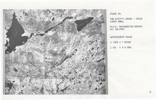
PLATE 20.
THE KITTY 'S BROOK - CHAINLAKES AREA.
N.A .P . UNCORRECTEO MOSAICNO. RE-5992
APPROXIMATE SCALE
1 INCH • 4 MILES
1 CM. • 5 .6 KMS.
.....

,"
HaeCj.Lrrtock and TvenhofeL (1940) make specific mention of the
Kitty' a, Brook aree r •. t. !Gaff ~~:s~~~t[~~e~~o~~e]t:~~~~n~~ ~~~l~o~Oo~t~~op~::~,~u at(15-60 -meters) high c9mpo"!.ed of gravel, and till. In~~r'"epe'r sad are kettle ho l.aa-of equivalent dimenstons, many ofwhich contain lakes. .
The Kitty's Brook 'moraines were built when tongues oft.he upland ide, cap projected part way down the valley.This .stand .• was either';1 halt in ·r e ces s i on orposaib.ly a :e-advance .. [p , 1.745) , I
Prest et: at; (1967)" 'have mapped the. ridg~B as ribbed mcre tne ,
large scaj,e features. with a treneeerse linear pat.cern giving 8 ribbedr-
effect to the land surface:.' . . . ~ .
The individualri~8onsist of bou.Lder-y ridges up to' amile 0(1.6 ,kIllS.) or 'more length; 30-90 .f ee t (9-12 meter.s)high with crests JOO-IOOQ, feet (90-300 meters) apart (peesu,
.1968, p , 6). 1./ '
i.'e~ (1962) attributes t~e fo rmajrfon ,of i'i~beci, ;oraine to an ., . . ~ , . ". ",
~. ~veri1ding,ofb'1's,al till. The mou.ldin g:...proCe6&.is. d.esc,ribea ..ae occurring'
.iili~g r~-advanc~ when ~e.A.-Ce ~iipped ove)- unfxoaeu till with quantitles. . .. ,of the materia;! be-ing built up or uridercu~ at, the ice edge by a bull-
, , .djer: ef fec,t" . 'As the .material :,~c~me IIlo,re. compac.t' and', re~~stant ': ice
moved up ,and ove~ the f"idge, cO~~1n.u1ng its advance b! rep~"ting.~~J·,
.; \'
-./

'/
76
The uncer t af.n origin of the. features an? ttte importance of
the zanetn the sequence of deglaciation of the fi;eld srera nece.s sd tiated
.,.4, a trs-v:erse in the Kitty's Brook -; Chain Lake a area. Several,saInplea
wel:e colle~ted for Ifter textura'l analy~is and a'Se_des of ,till-fabric
diagrams we're plotted.
Morynology
The ~out~wes't Chain. Lakes a'res 'deposita ar~, from 700-1500 feet
(210-450 meters) 'wf.de in a north-south dt.re ctton , span 1-1,3 nliles
(1.6"':2;1 kills.) acro6~', the valley 'and are spaced 2000-2500 fe~~ aparf
. (Fi
o
g . 4-~, Plate 21). ,'\0 t~e ~ortbeast. t ocards .Sheffi,:ld ·H~ll.- spa~rgbetween-me ~eatures incre.a~es to 3500-5000 feet (1.1-1.4- iuns;) while '
central lake, ~si:em ridges are, discontinuous. Heights of t~e li~=aments
in the southwasl; area range from 50-90' feet (15~27111etenl)) at the
t, . northeastern extr;eniity of t:h~'-lake-ch!l.1n heights, increase to -130-140
f~et (39....,42 me~~rs). Th~', 'maj~r northeaate;lY "trf'nding troug~ ~n 'hiCh
th~ featu~e}~ i~e .tocarea is 1.0~i.4 liI±ies (l.6~Z.1 kms.) wide~and '150:-200
teet; (4~-60 met~rs) deep c Many of the ~ineament crests coiricid'~ in
elevation with the I11gh 'Cent:ral'Platea~ 'at '1250 feet (375 meters) to
die east and Witch a s'narrow pjanar remnant west at the valley.
Towar-ds- the southwest,' the slop;s of the depoeita are veX'y
smooth with slope angles approJ\:~rnat~lY equal';',5Plate 2~)' at' ~he
northeastern" end. o.~,'the valley:..system SlOP;8
t~,re, steepel":~and, concave
. i,n plan and proff.le towards the. southwest, auggeandng ice cod'tact
fE!~ture~. 'Lakea:iin the center of the v~lleY' are e4?nga--di w)d;e at either "
end 'of ",," 'y*' they are r,;"d~d. \ <',- ..

' .
'1" : '
.. ' '~l.".~ 0
. ' .............:;.( '" "
. ( """..'\ J ?'. \
\\
.....
,or:·~ ~ .
'"
' .

PLATE 21, THE CHAIN LAKES RECESSIONAL-ABLATIONMORAI NES PHOTOGRAPHED FACING SOIJTllWEST.
PLATE 22. CHAIN LAKES MORAINE 72-3 . NOTE THELOBATE CREST AND SHALLOW SLOPE ANGLE·
78
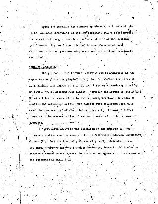
-.I 79
.... - since-tne depoatt s are concave up' slope at: both ~.ndS of }~e_- _
"valley ,system,orientations of 285-35Qor e pr e'sen t only' a c'rend norin to
the s t ruaturujvrrough, Moraines .o~\~e ,east side of the' ~illtea~, .. "
(middle-east. Fii'. 4-1) are oriented in a northeaat-southwe'f1t·, i
dIrection; their heights 'and slopes are sim1lar_to,those pre\'q~UlllY
desrc.r abed ,
Textural Analysis!o>'
The purppse of the textural anarysis was to ~~certlolinif the
deposits are 'gl~eis.l or gla~iof1uv.ial; that is, whet~e"r the IIl8.teri~l
is 'a glad~l till shaped by a, fInal',ice thrust 'or outwaEih deposited by
meltwater around. stagnant .:icebo:iie.s, No'rmaLl.y the latter.1s str,atified.
No stratification was visible in the dep osd t aj.therefore. in order to "f\
c~rufirm the materi:,1,6! origin" two sa~les were col~ected from cuts.
nea,t. the southwest end of 'Chain Lakea,(F:j.g. 4-1). It was, felt -that
\ . ", .sieve analysis was completed on t.he Sll.inples at whole <p
-1 .int.e.rvalS and th~. resul~s were -plotted c:'n Arithme,~ic \~~dinai:e cumuiat~ve_
Curves .(F.1g. 4-2) and Frequency curves (Fig. 4-3). _Ca\.lculations of
'~he mean, inclusive' ~r~·~h.ic st,9.n;.ard d~~i~ti~; kurtosis and inclusive
grap~c' s~wne;6 wer.e completed '~s outlined.' in AP?endiX 1. The r~sultsare ~ pr,esented in ,T.ible, 4-i.
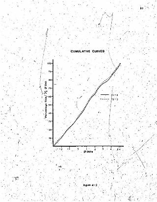
I ,
": "
':f
I+
I.:I
, I'I
...•
CUMULAT IVE CURVES
/ " / ,,,.
i. ···..... ,.~ -~ - . t: ~ ·:, I
'I -IIiI,
' JI
~ ..' .
'"
80
,. ,.-.
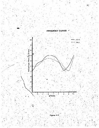
8 1. :.,
..."-.
FREatiEiicY 'C URVES F
"
"
~ .
. . -:. .'
..~
: ..,. • 0 _ 1 '..I21UlIItt• •
':'\1:'. ,---.--:-,....--r-~...,...:-;-T--'-T--T-, . , . '
. "
'./
r' j ., ;. ~. ., '
. ." ,
. ~: i .' ... • . --
. ... :.:i :.
F li~,. " -3 : .
r ~ ., '
82
Reauies .
TABLE 4-1
CALCULATED I!A'IA FOR cHAni' LAKESSAMPLE'S 72-2 - 72-3
,
Mean Inc,luBive' Graptlic lCurt'Dsis" Inclusive,Sample
St.andard Deviation , Graph:J..c
"'Skewness
'2. S,4¢' Very -J~.orly:.-,
72.-2.' .... 1.1.31- o.eo 'Platyklirtic O.04;.Near Sym-Sorted metrical
72-:3 LIO~ 2. 52t "-." "' 0.6:6 Very b:oi~ " "~
Platykurtic
The above r~5ulrs are ind~f..:tive 'o£.',a glacial' t ;:i.ll., The 'poor',Y • .!>.· ...,.. ""
sort.ing and _Symmet.riC~l FrequenCY5~rveB>~~~e~~t~e .'ma.~erial ,haa 'not,
been exposed to signifi-cant, g~aciefl~v~al actio~-,The,kurtQSis-V~lU~8-
. of '~BOand '.66 describe the bimoda;L quality of the sediments (Fig.' 4""3)'''
Both samples have a iack of "material in. the 3-4¢ Huge., - This conforms',:"
. Stereo Hicr",scope -Ansi/sis' ,;: , '-
" , Fr"1' a ,~.;"m1"u~cdpel";;'Y'i' 'Of, 'he 2>, ".,,,n:, ~~thet1.1,l samples, it ,was Ils,certained Ithat 'the' grains are augulai tp yery, , I '
83
,.'angular '!.i;', Powers (195.3» with. a low 'degree, of sphericity. There is
little polish to th~ quartzc:ontent of both samples. This is indicative
of a til! and of glacial abrasion which results in tiny angular
irregularities'"'or fresh fra~ture Burfaces (F61k. 1968).
~
To further tea~. the various theories of the origin of the '
K!ttyls Brook -Chain Lakes features, several till fabric analyseB'
': were completed on ee Lected de.~o~_1ts ~F1g. 4-4, a,h.e,d).' If the
• . ~eatures were ribbed moraine or recessional features. poe. t;lould ex"pect
11' I1rimary mode normal to ridge crests ,)Bince both f eaeut-ee at::';. ..
derivat.ives of ice £10\1.
Cow~68) deecrdbea the orientation of Bt:raight~ridg..ed
~ibbed '-~or~ine cl',sts as '~apJ'l~aring in all case.s to fall 'close to the
. direction of a gtac1ation" (p , 1150). For curved ridges he found
that 'fabrics indicated movement related to "boeb the direction' of
gb.ciatio;, and' t~ .scce attribute ,of the 'ridge itself" (p. 1153).
Recea~ional ;nonLine is a reaultant dwup, of ground mors:l.neby
stagnating ice but since 'it bee been carried along du'rdng advance it
--~---,---;-~-"--woi:iId~SQ1I1E!cla8tor[eritsdonparll.iieli~ f'i~~l flow......
Railway cuts were 'used ee aites where pos6i~ie, end when: not,
fabric pits _were dug to a depth of 36-48 inches (90-120 ems.) in au
attempt to avoid zones affected by frost 'heaving and we/il.therihg.
Feature t~ends were noted .in the field 'IlIhile pHmary and secon~a,ry
modes were visually 1nte;,pr'eted from, Rose diagrams of the data, (Fig.I ,
4-~~ s,b,c,-d)'. Means' and standard devistions were obtained from
\

• Claet
o . Rou ted Clnt .
4-- M•• - .
t :
. fb). . ' Fltu' ... -A '
••
.- - - '- -
~. '
': .:
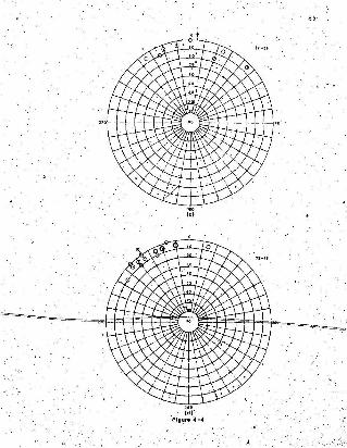
85,
,..(dlr"
Figure .~- ...

o ·
I
86

.:8 7
...", ld) '
· l=lgll f. · .. .:5I. ..... ~ .

.\,'
88
'the .tiif £ab~iC: di~grams and _-ap;licat;Lqn of the 're'~e~~nt C:~1~ulat1~rlSoutlined' i~ -wpen4ix 1. The r esu lts :are pre~en':ed in Table' 4 - 2.
TABLE -2, \
TILL FARRICDATA, CULATED AND_I~ERPRE1'ED'~ v»
Sample M,m S'ta~!iard Deviat,ion 1° Mode 2° Mode,
~--172-1:F 010 30' 350 090 010
72-2F 42' J55 055 010
72_3F 005. 27' 020 160 345
72-4F 325 22' 330 200 320
Primary' orien~~tiop-s for '72"-lF end 72-4F are a:ppro:ldmately
p,arallel to feat~re,ei()ngation. Fabric 72;2F h~6 a weaktY developed
priDUiry '..od~ with a' st:oog eecondat-y mode normal to the. ridge cre,st.
PrImary mode' orientation for 72-3F'is 180° from the assume'tt
i~ fl~ direction, that is it shows a u;arked plunge towards O~~~
This probsb1y occurred because the till fabric diagram was constructed
from cla,ats on 'the northerly or up-valley elcpe of 'the ridge'; all
other samples were obtained' from centrsl"positions or down-valley\ ,~ ,
slopes. Othetil'ise'th'j- till'fab.rlc ceteneaeacuee 72-3F has ~ primary'
mode 'sub-parallel to '1:ee, flow and a secondary mode Pl'lra1lel to feature",elongation. In a'l.L cases two fabric modea have been cbservedj one.
parallel and one transverse ,to eeeuseddce flo,!!, frain Kitty's Bra.ok
valley: If one ia to explain' the feature~ either 8S,ribbed inorairie
~ .
j
s-,
89
. or';~ecess~on~.imoraine as pre,;,iously discussed, the. bimodal' aspect. .
of ,.the till J;abr~Cdi~8raDlll need c1a,~.ific.ation.
'-,., . . '. "
DiSCUB9{on), , _ ' ": . ~ '.' ""
. Glenn, DOUI'jer and Wear (1957)' n~tf!. that ;in "till fabrics where
there Is-a secondaz-y-mode , it Is usually-at right angles to th",: primary
mode and may exceed it in magnitude. In this. instance the authors are
aSBum:n g that a pr~~y 'mode is parallel t'~' ~ce' flow rath'e~ than being the
dominant orientation: They augge~t that' there are significant coe-
"relations "between, pro'larenesa of clasts and a 'tendency to transverse
modes, which they' .acco~~t .,.for b"y' collisions -between more elongate
stones. " - ~Harris (196!l) explain~:the relation' of secondary ,modes to
rougbneea of cer'ratn. In areas. of- high relative relief 'he found that
tii'f fabrics had a high' M.S :O.C., '(App,endix,1) 'andrpoor' tI1Od~~ orientat'io,~
in the'directiop pf ice flow. ' ,W:Ltha rels.t'ive rel1l!l',f of, lOO-20q feet
oo-sc meters)' A notable development of tranlilverse modes wae ~b6'erved"
Sim'llar1y, ,Andrews and Smith (1970)' de-scribe the occurrence of
" - , ' ''''a dominant'mode'at right angles to 7c~ flow. ,They interpret the
Phe~OIllenon w~th' the 1de';' that as iC~m:dil e, bedrock slope, ~11l.6trO~ling and thrusting b~c.omes the m~in or~entat:l.on~p'roduci.n~proce66;
that -is, Ii ereneverse mode' h produced by changes in, local flow
,conditions.
Rutter '(:)..964) atudied clast orientations in, surging' and normal
glacier moraine. He found that nO,nnal' gul~ier dePosits have a'trOng',
preferred Orientations in tbe approximate direction of ice ,~low.'

laterre-working in a ?ear-~urfac.e [iiI "unit.
90
Ill. surging glat:i~rs atone orientations are .we~k. 'and, ,where, they are'
appat:~ry.t•.'- are not -necesss"rily paraliel' ro.Hce , On~, fabric s1te_~
"normal' gLac Lartmocadne <showed a ilefi,nite: tra1lsverse orientation.' This
he cxp Iudns by observing that the samp'Ie site was on a at.eep slope and; '#l . . •
may have suffered pus t edepus.i t.Lona I 8lUlIlp or alternately, ccceaec.or
ablat:i.~n debris dep08!te,d' at 'the ice ma~gin. Wh!le his ideas.:are
worthy of, note,ft WOUld. be'Wlw1se 'toll'laCe too much' e'mphas:1.s,cr; t~~
si~cl:! ~he'KittyI8 .'Brook - 'Chain Lakes .depcsd t s a're unlike th-08~ id
Rutter's area',
Dreifnania (MacCli~tock'a~d·Dreimanil'l. 196".) describes a series
or till fab,tics with two maximum orl~nta:tionB aeparateq by ,an angle\
~f 60~. ~ne repreaear s. the penu1.timate glads! mo~e~ent', the ether-
defines. the latest', whicn re-orlented at aeaet. half of the elongate
pebbles parallel to the fabric maximUm. of the' overlying til,l.
It i~ felt that the proceaa described by Dreimanis is. not
app1,.icable to the Kitty's. Brook ,- Chain Lakes area, since ·here
orientations were obtained near' the surface',of a contiguous ti11
unit. One migh~ suggest that 'the tran6vers~ molles were obt'ai.ned from
penultimate ice flow over 'the ridge north of Chain Lakes towards'
White B,y,h=ever, .it '<0 lUke1Y that aucb an orient"io; would aurvdve
. ... \,..~.c
The following mechanisms. may b(JeBponsib~e for ·the. strong.. .
transverse secondary modes in the Kitty's Brook - C¥ln Lakes area
dEipoaits:
- _~e-or1entat;ion of' prolate claa~a during -final flow.
Unfortunately"thia cannot be tested since"-no record of indiv1.dual clast

91
",' shepeajmd their orientation was taken.
- Hedght; above t.he valley Hoo'r. This _1a probably the moat
,likely reason since all till" fabric sites were 100":150 feet (30-45 meters)
above the valley ,floor and relat1.ve1}' near- the bedrock walls. No pits
were- ~ug en the lower central remnants. of the. features.
Andrews and King (1968) state che writer's view ill the fo~1~1n8: .
A till fabric is a iJample of a iarger un9a~Pled set Of' :'!pebb Les and ednce fabrics may vary markedly within the sametill expoeure s Ilingle sample. single site resultl>' should beuaedw:l.t.h caut.ion. (p. "458)
Obvlouely lni\ny more till fabrics analyses of the Kll::t.y's
..,\ ' -Brook.- Chain Lakes ridges need to be conrp'leced, be;Ol:e one can
concl~VelY'in-t~pret their dom:l.nant febr.ic ~r1entat10nB.
, The Kitty' a Brook Glaciofluvial Deposit,
At mile 343 on the c..N.R •• on the north aide' of 'Kitty's Brook
I-valley there is a small outwash de Lta or faD (P~ates"23 'and 24). -t;,ore
set beddi~g :in the deposit strikes _'oio~. .ddpa 16 0 .01;and conta1Iis' large
I B~onesl-j ,fee~ (~.3-~.9 ,et,ers) in diametC!~. _On the ValleY--flOO'r.
! (Plats"25) and in the toP~t material, large well rotmded to sub-
I rounded"boulders 2-4 feet (0.6-1:2' meters) in diameter ius Visible., 'Theslil are indicative of large volumes of water that must havf! poured
'~ the valley late in deglad~tion. '
~r photo analysis of the feature :l'ndicatea several melt
:Iwat~r Channl!!'~~ that may have contributed to its formation. The
,deposit, eppeara to be a aefee 'foJ;llled in a small glacial 'lake,·1 •
t8l'llllled up between two of the I4Ora~al,features (Fig., 4"~~ ,and since
emptied by indaion of Kitty'a Brook. The deposit is preaentlyi . .I
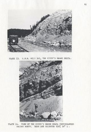
92
PLATE 23. C.N .R. THE KITTY'S BROOK DELTA.
PLATE 24. VIEW OF THE KITTY'S BROOK DELTA PHOTOGRAPHEDFACING NORTH. BEDS ARE ORIENTED 020~ 16° L •

PLATE 25. KITTY' S BROOK VALLEY. (NOTE LARGEWELL-ROUNDED BOULDERS). PHOTOGRAPHED
FACING NORTHWEST.
93

94. :' .
being used by. Canadian. National Railways as a' borrow pit and it is. . - . . . . .ilnpo'ssible to det e'rmdne the former "extent of the ~~ita. though since
it is nearly 60 reet (18 meters)' tihdck-depcad'tLcin pr~bably .c~.tinued.
for -a considerable period .oi time.
~.
Several feature,s 0,£ the ridges prohib1~_ ttie~r clssaifiqatl,ori
as-ribbed morain,e. Clast Orienta~10n is not well, enough def1n~d ."
meet the purum'eteIs outlined by Cowan (1968); also their morph?logical i
, ,dimensions 'and spacing BI:e greater than described by'Pr-eet '(1958) .
. From their morphology and the texturl\'l analyses. the following system.
-( is proposed -for their eonstruction.
The High, Central. ,Plateau was an,lee' dispersal centre in the, .
late Wisconsin. During degla'ciation, ice flolf may have belln towards
the. north or northwest as evidenced by eeieere and ',me.ltwater channels
(Chapter III). Ice pouring off the- plateau flowed no:rth-northe;sst
towards Sheffield Lake-and southwest down K1tty's 'Brook vall,e~(Plat~
20). The 'large nor'theast-aouthwest oriented till ridges ea~t' of' Cha:~
Lakes' (Fig. 4-1) may b~ relUlted to topographic flow from the plateau
into the vall~y system.', 'Ice contact s~opes :in"th~ lo~eT northeast
sections of Chain' Lakes, valley suggest that rather than forJDing a
"series of true recessional mora~nes.,ice s csgnaucd in lar~,e blocks
behind the deposits; g~~lng th~ their el~ngated, .ccncave-convex
• fct-ma , ,Hence the depoad.Ee ~aYbe Cli1l1Si~.dd aa__~~ repillsionl1l-ablatioD.
moraine. ~ ,~
,[£~, The delta in Kf"t,ty's Brook vaj.Leyvas deposited just befo're ,~
f'

final g~aciof1tNial ,stage whicb eonne ct ed.Ehe individual Ponds and
formed a "c:omplet~ dr.sinage eyetea •
. 1'
\.
ss
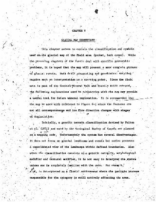
! .~_.
" . . 1.
CILIl'T1!R V
GLACIAL HAP C~ARY '
This ' ehap~er servea to e1q)~n. t he c~eifi'~atio~ ~ . syabob
us ed ~.~he 8.i a<:ld _p of th e field ~'ea (poch t. beek. eov..e~j .- :lo'h11e
. t he precedi ng chapuu 0.' t he thesis deal with Ip edUc" ge~~bic
· pr~bie:m9 . it 15 hoped that t~8 aap wi ll p~/il.ent. ? lIlOre' e Olllple t e.. pict ur e
~iglaclal even~ B. 80th drift prospecting a;id gaoch Qm.1c.al« sampling ..
require. BU~h :"-0 1ntflt'l"rl':tatl~n as a sta r t i ? 8 ,point , Si nce the f ield
area is pare of t.he Central~ ~neral :B.e~t ~nd ' he avily drif t cover ed •
.' .t}le fof low1ns e:lqll allat1 ons use d ":In .c cinj.un c. t i~ with t he I118p lI.8y Pftl vlde'. ' . . ;" , ' .
. • ~Beful t oo l fo r f ut ur e ~er~ exp l o..ation . · I t 18 r~5~~-.¥--
.: t he Clap ~f! u sed vf t b refel:~e to Figure 6- 1 ' BiDC. "tb~ f eatures are
D. ~t _a ll con te1lpo r anaoJ8 ~d , l ce fltJ\l dlrec ~l~ chanles. With etage~. . . Q
of degladatioD.. . .. Init:i.• lly•• gr?et:'1c . t: erraJ:1 ,c1&881fi~t10Zl .deYise~ by FlJltol1
- 'a t ~~ . ' (19~ , . lId u~"ed by the Geol oe:1cal SurVey of "Cana"da 1tlil6 planl1ed
" ...~__~ za;~Ii~1 code ! .· ~:UortUl1~telY th e 6Y8t~ h.. a ~everal dbadv8lltal~a •
. . I t .doe El not f ocus en l iac.tal Landf Onlll and rvent. but ee t ber pr e aen u
97
The m'odifiers' state, that the zone Is a .sandy, thermokarst plain.
Consequently, a modified form.,.of the Glacisl Map of. Canada {Prest, Gr~~
and- Rampton (1967)) and Fulton.'s classifications has been attempted.
Unlike either of the terrain classifications mentioned, morainal,zones have not -been bounded; r-ather gradational symbols have been ueed
r: ,that connote densities or mnrginal \':0088 of specific features. The
following liat preaente some of r.he. termS. used with brief explanations;
ot.hers are s8lf explanatory.
Delta SurfaceJ ..>The delta surface Jie8cr~b,~.s:;the raised deposits In~a modern
concexe, No differentiation 18 made under this head~ng foi terrace
levels 'in evidence on the main scarp. Landward· boundaries were con
structed at bedrock outcrops or distinCt breaks in' slope.)
Erosional Terrace
A well defined terrace has been mapped at' the 50 feet (15
meter~)-le~el. Other eros,iona'1 features' exist (Chap,~er II) bic.~re
not cont"1ttuous-dl'l a" delta depo.sits and for-reasons of scali/have
not been included.
Kettle holes have only been indicated ..men they ,ar~ locat~d
o'n or near delta su~faces. Numerous kettles occur-in several areas,
but again because of scales and denaf.tdea of the -featurea they have
not been mapped.

...~
Included Vi thln t hh denotation an utanals deposited. . .,. ' -, - . .\"...pt'oglae1a~ly an d ~erivf!d lIpl!e.1fic ally f r Clllmdt vat.!' all lee retreated
in land . ' Es s en t ially th es e lir~ croslI-bedl!ed .eedi Clf'.nts of 'vary i ng grain
Il1z£lI dep osited i ll. 'lll t}e,. t r ains .
l'Ca1or '!'.eoode r Scar
The .1iIoym,bo l hi s been uied at onl~ one ~OC.tlol\ and dMcr lbu a
featur e t1~at mi ght be tllistak.enly inte rp re t ed. as a r a l aed delta r emnant :
Ri bb ed Mnraln e
Ribbe d ' '~or~ln8 ' h~1J been desc1"lbed with ~Ollll detail "in Chapter ·I V.. .' : ..Within the f1e.~4 area it 18 confined to shallOW' valleya ~nd aallodate~
with. e longa t e 1ake ll which v~6uall, aq>~1fy _the ddga 8 . .Pr e6t (1968) '
desc.d. bes t ee corsine,~s. oc.eurring on t he nimk.e of dru:dloo1d rid,gas .
;:.ilnd eak.erll or on tbe" lov gro~d. betwi~ , t he lll' In' ve at-c.entral ~ev-.
. fo~dl~d ,r i bbed cord;,: 1. g~emlly .iuisoel a te d wi th dru=lino1d ddie8 ,
Drual1nl1 llu4 DnPll1u oid Rid gee
Tru e drUQ~1n1 vitb a te e p etcee end, a,Cld tapU~d dl.Btal e1 0Fe an
thinly du tnbut ed ' lD t he field a rea . Feature. 1lIlIpped a s, such 1M' ~r. . . ..ay nor. be reck-cor ed but their .e.xte rn al morp hology is 81~1Ilr ' to ' the :
'cla liai~al dOIlll!~Bhap8d t111 ,s t"r uc·f:u r e .
Drum11n~1d tl~ge6 a re more n~rou. and 1nclude nat;row elongat e '
r ock-cored t~dgll.8 ' t apere d at either end. though the s t 0911 end lila)' be,, .lllOra blunt t han t he lee (Prest, 196 8 ) . Where detlnedby a.BtoB~ and
: l ee ·f om . direction of flow has , been indl'cated. howeVlltr~. ~aeverB.l "of ..
the ~ru;al1nOLd, ridsn ,..r. Dot ",ell dev-l;optl~ and ~n lo~~ed where t he

99
senao of ice floW l's not :Lmne.diate.ly certain.
Flint (1971) observes the fo11ow1ng for drumlin forms and ice.
flciw:
1. The presence of such forms establish the existence of anactively flowing gladerat the time of formation in contrastwith Lee-con tact d.rift which indicates comparatively inactiveice.2. .The long axis of the streamline. forms are a more reliableindication of the general dLeec t.Lon of movement of a fot'lller;glacier than are striations because they are less influenced~y local topography (p , 106).
BUlIIDlocky Dis:1.ntegra[ion HaYsine
Lundqvls~ (1965) classifies such a deposit all an. ~rregul'ar
hummocky ablation moraine. Prest (1968) refers to an orlg1n~1 ~rk
by Gravenor 'and t.upsch (1959' when be describes the features -as "high
relief. irregularly -mounded and deeply pitted type- of non-orie.n·te,d
hummocky moraine whi~h is' 'believed to form as a result o'f _glacier
de~integra~ion or 'stagnation" (p , 11). In the field, area deposits are
from 75-100 feet (23-30 meters) high though Prest reports extretae
eases, of' 200 feet (60 meters) in other loeat:~ons. The ~~epo~;y near
Gaff 'Topsail ere nee _extensi"'(~1y pitte!i but Irather are :lIequi dimeil s i ona l
'mounded surfaces," (Prest j 1968)' on a plate~u. - Th~ lowlands ar-ound the
-mor~ine .a.re boggy and .ccneatn numerous shallow lakes.
Ridged Ablation Moraine
More prevalent is a type of dhintegration moraine described
'by" Ho~pe. (1952) •. Areas of s.uch. deposits contain: .
L ridge~ up to lOO_US,feet (30',;,35 meters) in'~e1ght. (Inwest-central Newfoundla.nd ridge heights are in ,the rangeof 50~6~ Jet (~5-18 meters).

100
b
2. "dead ice hollows.
3. moraine plateaus:, o----F _1" _ .
. In the .above atudy the ,~lj~eB are. regard,e.d ee being formed imde'rneatb
the ice through the, squeezing of water-ecekea morainal material Into
basal'c.llvt,tlea. The dead,ic.e" hollows. indicate areas of residual ice,
While the moraine plateaus are considered to be se'condary features.
Hoppe alternatively s'uggeat s the plateaus m:Lght represent original
elevations of t mat.er La'l. .below the lee. Ridged ablati.on moraine is
ci?nfined'to valleys and haa little value for det~UIl1.ning :lee direct.ion
(HoPP,e. (1952), Lundqvlst (1965». St~lker (1960) notes that,the moraine
does not~e:cesBari1y represent former ice she,at'margins, but. rather may_. .denote cbangea in the rate of, or even hal~s in, the lowe.ring of the
surfac.e of an ace sheet.
Recesa:Lonal MOra:Lnes
'The, category includes the recessional-ablation moraine described
.in Chapter IV and other 'Illarg:lnal and lobate 'recesad.ona'l, feature- remnllnts.
The designation may include inter1<iba-te moraine or kame terraceI
remnants without differentiation, slnce-many of the feat~res_vere mapped
. Wtthout{ieid analysis. '
Structural Lineations
St~cturai lineations ~re not to be confused with. drumlinoid" " .. ' - .
_~idges. They indicate-the, o;ientation, of out~rop r:1.dges and bedrock
trends." For the central section "cf the field area, elongation of th,
'~symb~lS in~lca,tes the' limbs ot' ma~s~clinal troughs (Neale sn:~ Nash,
1963) ~

101
Gladal Stdae
'Striae' have been plotted' near Halls Bay and Lncj.ude only those
mapped by th e writer. ceneee have been recorded 'by Neale :and Nash
(1963) and Lundqv Lat (196';;'>.
Striations plotted on the map are:
L Lower Wolf Cove, Springdale - 070 0
2. Roche moutonnee south-southeast of South Pond - 035~ 020"
3. East of Burnt ~eFry Pond - 090~ llO~ 1~5°
4. North of South 'Brook town _ 020"
5. Robe:ri::a Ann Road -' 315~ 330",
.,
r ,
"
CHAPTER VI
CONCLUSIONS AND DISCUSSION
From the air photo interp~etation and ~alYBes appL'ked to
specific glacial, fe:;\eures. if is poesdbLe to suggese a' sequence ,of
event\ for the ~te glacial and postglacial of weat-c.,entral,Newf01,indland.
The 'field area is more' of a tiansect than an entity, 'thus some cor-
relations are implied with surrounding areae , baaed on the research o.f
others and .c:urrent field evidence for the "aeme Bay - Topsails" area',
lee fronts .(Figure 6-1) are spproximaelous orily and were' plotted from
ice-marginal. deposits where possible "and che're "not; were ilnplied from
the' gene;al terrain. The figUre sh'oul~ 'not b~ considered' SS' a spat:fall}'. ,
exact ~h1;onologic.al.eecuencej but rather ,as an indication of .the manner
in which ice·retre.ated.
,DlIr,1n~ the late Wisconsin. maximum, rce fl~ in the fie.1darea .
WaG t!J the. nort.heusf "(Fig. 6-:1)' and north towards White B~y from an
ice cap' centered south pf' ~he fiel~ .area, on the High Cen'ti:al Plat~u.
The odentations of drllDllinoid l:idges aee evidence of thb floW, BS
are the zones o'~ ribbed moral.D.e which. are slllll-ll,a"ad confined to valley
bot.tomswhere late flow would have been strongest. _.Mu1t.i~directional, . ,
stl:iae indicate 18.te flow during which 'ice chfnge~ dl~ect,i6n a,l:!, ,i~
.".mov:ed 8J:"ound out~rops and· off mirior plate~ull" :into ·va~leya.
It is considered that tberevee at no, ,time an inVOlsionof

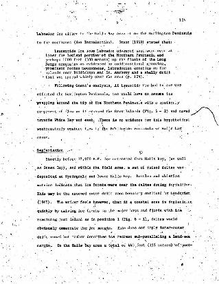
t04
Labrador ice either in the Halls Bay area or on the Burlington Peninsula
to the northwest (See Introduc.tion). Grant (1969) states that:
Laurentide ice srcn Labrador advanced southward over atleast the lowland portion' of the Northern Peninsula andperhaps 1000 'feel: (300 meters) up the' flanks of. the LongRange mountains as evidenced by.unidirectional grooving.prominent'roches moutonnees ,Labradorian erreeace on theuplands near Roddicktpn and St. Anthony snd a shelly drift
. that was spread wide~y over the area (p , 124).
Following Grant's 80a1y816, ,If Lauentids Lee had in any way
affe,::ted the Burlington Pantusu,la, one would have to, assume ice
~apPing around the tip 0'£ the Northern l'eninsuia with a southerLy~ . ,
ctimponent of flow as it crceeed the Grey islands (pig. 6 - 2) and moved~
tcvarde White ~.y.od e ea ;)T/"re is no evrdence fo< this hypothe""t , .. \
southeasterly onshore flow in ~e Bu'1:"lington Peninsula or Hal~s Bay;
"Shortly before ,12,000 B.P.' ice retreated from Halls Bay. (as well
. a.s Green Bay)', and within the _field _area, a set of raised deitas was
deposite,d at Spr.ingdale and ,lower Halls Bay. Kettles and ablation
moraine indicate ,that ice' rronts-vere near the deltas during depc's Ltdcn ,
This may be the assumed outer drift zone .boundary outlined by L1indqvist
(1965). The wr:ter f~els rr: that if ~ coastal area Is deglaciated
qulc~ly by calving ice fronts in the major bays and fjords with ace
remaining just inland as in position 1 (Fig. 6 - 1). deltas WDuld
obviously demarcate the j.ce margin. This does not imply inner-outer
drift zones but rather desc:dbes ice retreat sub-paralleling, a land-sea, . ,
margin. In the Halls Bay area a t9.tal ~f 440 ;feet (133 meters)"~f'\Iost-

I
105 '
. . .
. ~ s~. f eet ( 1x e t e i u) ne t e::l",rg ence af~er " B eus ~atic rhe 1n t.he same .
p eriod of 192 feet (58 r.eters) .
. ~ing t he de l ta~hul1d ing s tage , i ce r e t r u t ed f ro :o the co as t
by ·sta~t1ng in t he va lleys ~nd lowland II bet"e~ pos1 t l .onB 2 ao;1_3
(Fig. 6 -r 1). R1.dl ed ab lation ~TBine 1a f ound in ' the middle a~ uppe r
sec.tions of the vll1 l eye tobere .1 c:e "as t hi ck enough to caua e ba lla!
. equee afn g ne~e98l1ry fo r tt ll fOT1ll9tion. In th e ' are-a TlOrtheas t of She£"-
field Lake , ridged. abla tion lIIorl1ine pa rt ally DV jI;rl1 eB' all earlier zone
of ribbed moraine . Radial mel twa t er c nnels a round the hills are furthl"l"
ev idence ,of sta gnant l owLand ice and eneral. tbinning 1n ea r l y deg1si=-latlon _ '
At pos ition 4 (Fi g . 6' - 1) a 8 t111_ Ilt~nd 19 indicated._ The ecne
is ~ellm.lted by a gTOUp of e..IIke~B j us t. lnddu lUI ab ru pt steepening ' to
" the High centreI rlatea~ fro; .800 f eet ..q4oa etna) to aa.ll~ f ee t
( ;1.30 lIet ers) l~vel. Althoug h i.ce stagnated in th is zone, lUI evidenced
by th e r idge. d &bla:-r0n e e ra ree and eaker " . e~e1"al 2 i nor ltage. "of
reeeeeaecet ea r aines n ear B.tI..rney la Brook a nc,; L.lt,t Ie SaM y Pond BuggeBt
~~rl1er De t l va f low . The features Bre pro bably related .t o the l1t.t.y ',
Br oo k - Chain ~keB ~ec• .lsiOlUl I-abl a t1oc Eora lnee- and a t~ogiapb1.5=811Y
' c:on t r olle d flow £1'011 th e Hi gh Centnl Plateau • .e eeve es e fi l l ing s 1n the
area poac-date th e 1'id.!oed ablation moraine and tllly ,ba conald er ed a Unal
c:o I18tr uc:.ti Oli.al form i~ th e seq ue nc e of deglad.atio~ .
On t.be low~r HIl11B ~';y-Gul1 Po~d·level . t~e nor t heas t erly
tr_~nding valley trains' ~arlved m~cb of t~e~rill.i f 1'olllt~~_·
a11d final clegl'acia tion. No clima tic eaUllIilB, lUll enviBaged f o r the 8t111
stand . rat~er 't lt 1 .11' a~w.ed ' th~t th e e~etI t WlUiI a ~uul t of i ce ~le41'1~a
,.f
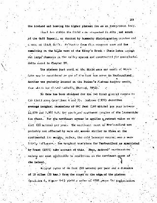
,106·
the lowland and leaving the higher plateau ice as an, ~ndependent body.
Final ice within the field area stagnated in situ juat south
.of the Gaff Topsail, as denoted by hummocky disintegrati?i3, moraine and
a acne of thick drift. Meltwater from this stagnant zone and ice
r~aining on the bi.J.la west of the'Kitty's Brook - Chain Lakea-'.triugh
cut large' channe,ls in the. valley system and constructed _the postglacial
delta notM in Chapter IV.
Th; plateau juat south of the. field area and north of Binra
Lake may be c'onside.red sa one of ,the, last ice areas. in Newfoundland.
Another vaa probably located on the Buchan's Plateaufur/=-he.r errut h ,
f'rcm which,ice .flowed radially, (Murray, 19?5);
N~ date has bee.YJ obcafned for the two final glaci~i eVI7~tB' in
the",fie1d .areB;> (po~itiona '4 and 5). 'Andrews (1972) describe~'
average !lISrgins1 r~ce'ssions' of ,860 feet (260 Dieters) pi!:r year be tween
iz,ooo ~d 7.000 B.P,- for southend northwest llCarg1na of the Laurent:l,de'
ice ~heet. For ~~e. n~rtheast c~rner he applies ~retreat vsj.ue of 66
'feet' (2ci meters) per year. The nO'I"thea~t coast of Newfoundland was
probably not affected by ws'rrnair .IIl8.SS~!l similar to those at theI ' .•
C0ll:tinental ice mar~!n,. 'tatber, the cold Labrador current _was.a more
likely infl..uance:- I~e ~a:rginal pOBi~ions. for Newfoundl~nd,as spe~,?lsted .
: by Prest" (1970) 'take'acco~t of'this.' Th~s. Andrews' northeastertt
value.: are molt '1'~plicable to .,conditions on the. ~orth.east coa~t of
the ie.l~d..~. ~Retreat rates of 66 feet' (20 'meters) per year and s. dista:nce
. . ~
of 19 miles (30 kms.) fr0ll?- the coast'to the edgs.,of the pkat.eau
(position 4. Figure 6;.,1) yield a value of -1500, yeaia for deg~.ac1at'lon·
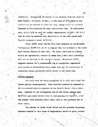
". >"
107
cond lC1onll . R~.~lyin'i the Illethod 'to the ,dl l tAn.c e ~.rOll the c:ou t ee
: Gaf f Top l5~ll. (34 .lllih.s', 5.5 bs.) , a 't ime lipan of 27SO.yea r s 18 cal
culat ed f or ice. t lltr est t o r~a t'.h t be are~ . t hou gh f i ll.al ice probably
~eaa1ned at. wehb ·POlitioo. fOt 80Cle c ODal de u bl e U.IJIe. If r -adloca:r ba n •
da te . C. S. C.-1733 is us ed for co.a~tal deglaciat i on (12 , 000 1: 220 5 .' . ).' <. . .... . 6
tben it \.-"CuIe! be ~pecte4 t be t deglael~t1on o f t he a r l!a .1u::oWld G.off
1op 81lil occurred a t a bout 9~ 2So B.P .
Gran t -(1969) da t es th~ Ten Mile Lake ,read~anc e. on t he Nort.h ern
Peninsula at 10 , 900 B,P .,liIo it i~ Logdce.L t hat :LCII rmsmed on ,t.he south
High Central Platuu s t · thi l!l time. -rhe date ll ca l culat ed by AI!dre~:
met hod. are sp,e cula t lVe, however it seems. t hat .4 llIOr l! exact chr onol ogy
will no t be obtai ned , tn t.hfl i nne d fa te tutuT!!. ' H&cpher:son ' (19 13)
. augg~st& r easons for~ Ill', COftllider':'bL Li.a in ' polStli lSe~al , veg e t ativJ
e?lon 1z:atlon in !fevfoundland ' w 1c1:.,l:l1gh t rule ~t tb e posa l bl l1 t y 'of
ae cur a t el" da t i na non-urine i nland events 111. t be field ar ea .
Chai n Lakes .
....... "'_ Furthe r Rea ea r ch .
'Ihe fi e l d a rea .a.nd ecnee peri~t.eral to i t offer =seh' aeope~ for, '. . '
f u t ur e glacial invlIlt i s a [ions. Y.or e det a iled r esea rch Is requh:ed OR. . ' . , '
t.~ J:'eeeaoi on·i.l - ab1at i on mora~e8 iti eha K1tty l ~ Br ook - Chain .l.a ke il •
area ~ Analysis o.~ t htl. nor~he~atern end of t ha" valley com.p~x ne ar ,
S~effield Lak e would f ur ther ,he l p in Interpret1na , t he ~epo8its. s ince '
• t.he preeenc Brudy !ucl~es. only a small area at tbe 1I0UrhwMr',end' ofI ( .
I ce r etr eat i n 'It!:dl an I1rol?k 'Valley a.ad: t he r ro babl e Ia cu8tr:1Jle
de pos its re~ted ' t o t hia ' et agl! ~i ' degl~ciat lon 8f1culd be . gl!e~ .fUTthe~

108
attention. tit may be:' that fi,oal topographic flow into the valley was.
-\, f~,om the pLat.eau areas j:o -the nor'th and south and thl!.t:- reaid1;1al ice
remained in the upp~~ PVt of th~valley ': a,conaid::able time after
ice retreated from the 'ccas r ,
2 ......A,majorgla.c.ial study shoull'( be undertaken ~irectly t? ~~e east
of "the'field area in the Twin .Lakes - Botwood vicinity (Figure 6-2).
An ensdye Le of "the Botw+1od delta complex and glacioflUvial depoadue
al0I!:g the "Co":~ further north" mi8ht- provide additional data to the
inner-outer drif t zone~ theory.
LundqviB~, (1965) has !'Iupported the Je'nne~s (1960) argument
. by constructing a "supposed line, o~ retarcls.tionll frolll just east of
.B~ahops Fa1,ls on the Exploits River to Kings Poin~ in Green Bay. (
It appe.ars "however that the boun~a!y should be muc.~ further ·northeast
than ita presentlosition immediately north of the Twin Lakes ar~-a.
The writer has n ~ed r~iBe'd 81a~iQflUVial ceeeacea on t~e ~ortheastC.988t Of~ Not:re ~ame Bay, ~hic.h Illay ~e 'further,evidenc;e. of ice r~tal;;dat1on
BUb-paralleling the coast.
!,JIIo, .. ' ,( Gra,he (1972) de.scribes an e.ast,e __",\flow in the Twin, Lakes--'
~otre Dame Bay area. In addition 1=0 the .nor t h t~' no.:'theasterly
f'low, he BuggeB~B radial flow from a remnant ice mass sou~h" of Frozen
Ocesn Lake similar to' the last ice centers of the Topsails and BUcbans
Plateau. "Dated slllllpies fr~ the Eotwood complex or t'hemore.'northerly. .raised glaciomarine' depositll would ,lIdd credence _to the possibility that
as' ye-~ be substantiated •.
"

\.
' Q -..~---
<I.. 0 , !I
:" ~ e .- \~bQ · .:
~ ,~
/ :
:'.' ,
•

110
'3. 'Expansion of the field south. to the Bucbana Plateau would be,. ,'I. . ' , '
a-lfort~h~le ~ent.u"re - in terms ofdealrlbing another. possible 'last ice
center. re- has been c:on~'luded t hat; within' the field area the "'Gaff
Top9a~~bll was an area of last ice. Additionally, certainly the higher
Buchans Plate,au. just southwest an? norr,heast of Hinda Lake might be,
considered, a .last ice ref~ge" since it is from this point that the
terrain ececce ,to slope ilway to the south and west. _A study: .cf the
plateau' with eiophaaia. on- the Lloyd's River valley. the" Little Grand ~f""
Lake valley and the lo.wer Rinds Lake Plateau, wouLd fill a large 'void
'-:0 the' glacial his"tory of the' island.
'In the"field of glacial geomorphology, the islAnd of. -', . - , .Newfoundland is one of the least s~udie,d areas in Canada. With
, incre~s~g de~ands .being_ pl;ced on ~nV1ronmenta+ understanding
d~riv-:d fro~uch reaeerch , it is hoped that further studies .on the
,i s l and wiH rece~ve the financial and ..logistical support which they
deserve.

SELECTEDBIBLIOGRAPHY
ANDREW~, J. T. 1963
.:rhe <:-ross-valley moraines ofnorth-c.entral Baffin Island,Northwest Territories_Geoa_ Bull. Can. -\'01. 8, 'No. '2. pp , 174-193.
ANDREW~. J. T. and KING. C. A. M. 1968'
Comparative 'till fabrics and till fabric variab1lity in a till"eheee _and a drumlin: a' sIIU111,scale study. ~ <
Proe. ,Yorks. Gaol. Soc. Vol. 36, pp , 435~46l.
ANDREWS, J. T; and SMITH, D. 1. 1970
Stat.1stical analye1s of till i:abric-<- methodology, local lindregional' variability.Quart.,J. Geol. Soc. London Vol. 125, No. SOD, Part 4-,pp, 503,.;542.
ANDREWS, J.,T. ,1970
A geomorphical study of post-glacial uplift -with particularreference to Arctic Canada.1.B.G, Special Publicati,on n:Institut.e of British Geographers. 156 pLondon.
~REI.i5-. J.'~. '1972
The Wisconsin Laurentide Ice Sheet - ~8per8al ~
;:~:~r~;a~r~:l~:: ~~G~~i~N~~R::::~~ga::n~;!:i~lC Imp~1catlons.
BAIRD~ D. M. 1931
Geology of t.he Burlington Peninsula.G.S.C.Paper, 21.
BOUSF1ELD, E. L. 1960
Canadian Atlant1c Sea Shells. '.National Museum of Canada, .Cat. No.' R 92 - 1659.Ottawa, 12 p ,
r'
112
BRooKES:r. A. 1969
Late Pleistocene glacial-events in southwest Newfound,land.Paper presented at INQUA C~ngreB8. sect • 6, Group 2PariB.~
BROOKES, ~. A,. 1969
tate glacial-marine overlap in western NeWfoundland.Can. J. Earth Sci, Vol. 6, pp , 1397-1404. .
BRUCKNER, W. D. '1969
1'08;-g18C181- features in Newfoundland. eastern Canada.Eclogae"Geologlcs.l Heivetiee. Vol. 62, No.2; \'
CARROLL, D. 1970
Clsy minerals: 'A guide to their X-ray Ident1fl~Btion;G.g.A. Spedal P~per. 126, Pl'. 45-55.
CHAMBERLAIN;' T.' C. 1895
Notes on the Geology Of. NeWfoundlAnd.Bull. Geol. Soc. Am. Vol. 6, p , 467.
COLEMAN, A. D.I926
The Pleistocene of Newfoundland.'J. of Geol. V~l. 34; pp 193-223.
COOK, J •. D. 1946
Kame ('.0181'1e)(88 and perforation. de~~Blt8.~. J. Sci. Vol. 244. Pl'. 573-583.
COOPER" J. R.· 1936
/ Geology of the south half of Bay opis1snds igneous: 'c~lex,Newfoundland. 'Nfld. 'Dept. Nat. Rell. GeoL See. Bull. 4.
COWAN, N. R. (1968)
Ribbed mora.ine: till fabric analyais and origin.Can. J .. Earth Sci. VO~". 5, No.5, pp. 1l45~.
DALY. R. A. 1921
Post-g1adal watping of Newfoundland and Nova Scot.f,a.~.:lOI;;eries,5.'PP.,381-391.

"'113
• DAMMANl A. w. 1964.
Some foresttypea of central Newfoundland and their relationto environmental factors.Foreat Science Monograph. -Pub. of the SOl;,. of Am. Foresters;
DOOIUlKAMP, -to C. and KING, C. A. H. 1971
Numerical Analysis in GeOlllOrphology: an introduction;Edward Al:'nold Ltid .• London., 372 p-
DRE'~IS, A•.end VAGN'ERS. U:.fu. 1971
Bimodal distribution of rock and mineral fragments in basaltill. .tn Till, a Symposium.Goldthwaite. R._P. --"(ell.)ColUlllbua. pp. 237-.<:.50.
~
DYCK, W. and FYLES, J. G, 1963- '
Geological Survey of Canada Radiocarbon dates E' and II.G.S.C. Paper~ 63-21,. pp , 17~18~
DYKE, A. S. "1973
A geomorphologic-a! map and' description of an emerged Pleistocenedelta, Eaatpqft Penina.uln, Newfoundland.Maritime Sediments. Vol.- 8. No.2, pp , 68~72.
EMBLETQN"C. and ,KING, C.A.H. 1970
Glacia! and Periglacial GeolliO'rpholOBY.Macmillan of Canada, Toronto. 608 P,_
FAIRBRIDGE. R. W. 1958
Dating the !atest movement of Quaternary sea level.Trans. N. Y. Acad. Sci. Vol; 20. .p, 47l.
FARRAND, 'W. G. and GAJDA. 'R. T. 1962
Isobases of the Wisconsin marine' 1imit- in Canada:Geog. BulL No,. 17, pp, 5~Z2 •
. FLINT, ~. F.' 1928
El1'kera and crevasse fillings.~. Uol., 215. pp , 410-416.
114
rimT., R,'F .. 1940
Late ,Quaternary changes of level in western and southernNewfoundland.Bull. Geol. Soc" Am. Vol. 51, w- 1757-1780 •.
\ , .FLINT. R. F. 1951 /'.
: H1ghland ,:entres of former glacial £.m.'flow in noctbern ~or'th'America. .Bull. Gaol. Soc. Am. Vol. 62, pp , 2l~38.
FLINT. R. F. 1971'
, Glacial and Quaternary Geology.John Wiley and Sons Inc •• Toronto. 892 p ,
FOLK, R. L. 196B-
Petrology of Sedimentary ·Rocks.Hemphl11s Book secee, Austin .. Texas. 170 p ,
FRIEDMAN, G'•.M. 1961
'Destinl::t1on between ,dune, beach and river sands fJ:om tlieb;textural chaeaccerLsttos-,'J. Sed. Pet. Vol. 31. pp , 514-529.
GERMAN. R. 1964
~~=~::~-untersuchUngen an glsz.tgen und &lazlflw:~len
Neues; Jahrb. Geol. u.'Pa1.8ont. Vol.,7, pp. 388-390.
GLEN. J.• 'W•• DONNER, J. J. end WEST, R. G. (19,57)
On the mechan1!?ID- by which stones in till become oriented.Am; J. Sci.' Vol. 255, pp. 194-205.
GODWIN, H. SU~TE, R, P. and WILLIS, E. H. '1958
Rsdi~ca~bon -dating of the eustatic rise in ocean level.Nsture. VoL 181. pp. 1518-1519.
GRANT. D. -R., ,1969
Late' Pleis1;ocene re-ad~nce of, piedmont glaciers'. ,in wellter~Newfoundland... . . . •
• Maritime Sedim.ents. Vol. 5, No. ~~ pp. 126-128~
lis
GRAN!t. D. R. 1969
Surficial deposits, geOlDorphic 'features •. and late Quaternaryhistory of the terminus of the Northern Peninsula of Newfound- .land and adjacent Quebec-Labrador.Mat:'it1me. Sedili'lent~: ':01. 5, so, 3, pp, 123~1~5.
GR,ANT, .0 •. R. 1970
Quaternary Geology, Great Northern Peninsu;La "- Island of Newfoundland.G.S.C. Paper.' 70...;1. Part.A; pp, .172-174.
'GRANT. D. R. 1972
Surficial Geology. West.ert Newfoundland.G.S.C._ Paper. 72-1, Part. A, 'pp. 157-160;
GRANT, D. R. 1973
Canada-~ewfoundland and Labrador Mineral: Development Program",Project 6.G.S.C. Pllper. 7J-l, Part A. pp. 196-198.
GRAVENOR,: C. P. and KlJPSCH, W. "0' , 1959
Ice' disintegration'features in western CanB\Ia,'~. GeoL Vol. 67. pp , 48-64.
HARE, F. K. 1952-
Ih~~~~:~~c~i' ::l~:~d of Ne~oundland.Geog. Bull. Vol. 2, pp. 36-88.
HARRIS, S. A. 1969
Th~ meaning of till fabrics.in.Processes and Mathod in Canadian Geography - Geomorphology.pp , 143-164.Methuen Pub, , Toronto.
HENDERSON. E. P. 1960
-Surficial Geology, St. John's', Newfoundland.G.S.t. Map.' 35-1959.
HOlMES, A. 1947
lCaIDes.~.,,~ol, 245,.pp.'24Q-249.
(

/116
HoPPE, G. 1948 ~
~e l~tr!:!at of Lea from the lower reg. ions of ~or~littl!n asl11u trated by the land rceeact.coa.,Geogr~phica (Upsala). No,. 2.0, pp. 104-108.
'\
r--HUlIIIllOcky moraine regions with.-spe.cial 're fexence to foheinterior of Norrbotten. .GeDS', Annal. 'Yolo 34. pp .. 1-71.
JENNESS, S. E. 1~60
1I0PPE,"(C 1952
Late Pleistocene glaciation .nf eastern Newfoundland.Bull. Geol. Soc. Am. Vol. 71, PP' 161-180
KALLIOKOSKI. J. .1953.
Preliminary, Map. Springdale, Newfoundland.G. S. C. pa~l!.r. 53-5.
KERR, J. H. 1870 ~
Ice Marks in Newfoundland;art. J. 01.- Soc. London. Vol. 26, pp. 704-705.
LEE. H. A.' 01952,
Method deglaciation, age of submergence and rate of·-upliftwest and east of Hudson Bay:Biu!. Periglac1alnY No. -11, pp. 239-245.
LEE, H. A. 196~
, Investigation of eskers for mineral exploration.G.S.C. Paper. 65-:14. ;f
LEWIS, W./V. 1949 -, .. "
• 'An esker in process of .l;~rmation: saveebceen,.: J?tunhei a , 1947.J. G1sc. VoL i,'No. 6,:~p. 314-319.
LUNOqvIST, J. 1965
Glacial G,eology in Northcrn"Newfoundland. .. Geologiaka Foreningensi. .vca , 87, 'pp- 285-306.
mCCLINTOCK, P. and TWEN~OFEL, .w•.1940.
Wis~nson glaciation. in Newfoundland".Bull. Geol. Soc;" Am. VOl. 51, pp , 1129-1756~
~MACCLINTOCK, P. and DREIMANIS, A" ,1964 ••
ze-crtentetion. of till fabric' bY overi'Lding gl~cier in the St.Lawrence Valley.~. Vol.' 262. PPl 133-142.
117
~CLEA.'f . B. S. 1947
Geology .:lei Minu a l Depos i ts "of t he _Li t t l e 84y Ar ea .Nn e!. Geol . SUN . Bull. 22 •
. ~o.'i . J . B. 1973
Con t r lbudcm t o Ob cu ll81on :"Lau r e nt i de. l e e Sheet .Arc t ic and Alpine Rese a rc h .IN PRESS
·MlLNE, J . 1814 ·
5yu:poa1W1.on Retrea t of W~lConal.D
Notes on t he phys ica l fe a tures and th e min aral deposits ofNewf OllnU an d. . , .Quart. J . Gaol, Soc. Vol. 30, p , 726.
HuRRAY, R. c. '1955'
Directions of , la rder ice motion 1n 8out h.c8nt r a l Newfoundl an d •.:!.:.....£!2!.. Vol, 63, pp . 268-27 4~
NEALE. :t . i!-. W. lin d NASH\ .W. A. 1963
Saudi Lake t'.ap Are~ .C. S .C. Pape r • . 62- 28 .
N!A1:E . E ~ . R . 10;
. KiOg ' 1 1'01nt area N~vfouiJ.dland . 'IopographYand "Clac; 101og Y.lJnpubl1l1hed t"~u.scrlpt .
PtIlERS. H.- C:. )953
A DeW rOUDdn~U- s c ah f OI: Se()ll:1l!-aUry .Partlc.ltH• •~. ' Vol . 23 , p p . 117-1l9; , .
. . .~RBST . V. K. , GRANT , D. a , and RAMPl'OO . V. If . U67 .
Gladd & P' of Ca~d~ •. G. S . C. Map. 12S3A~ ' ~ .
PREST-. v. K. ,)~68 . ' .... -.J (N~lature . of moraines and ice flov fea tu res a9 app+!ed t elt~e Glacial H4.f of ·Canada . .G.s .C. P. per. 67.-57 .

PREST, .v. -K. 1970
Pleistocene. Geol,ogy and Surficial' Deposits., .in-Geo1ogy,and Economic Mine-rille of ClUlada.ed~ by Douglas, R._J. W. pp.675-764.Queen's Printer, Ottawa. .
PRICE, R. J. 1966
RICHARDS,H. G. 1940
M{lrine. Pleistace:ne' f a,sBils _from Newfoundland.Bull. <Geo!. Soc. Aln.'Vol. ,51, w- 1181-1788.
ROGERSON, R. J. and TUCKER, ,C;. M., 1972
Observations on the glacial history of the Avalon rentnauie ,Maritime Sediments. Vol. 8, pp, -25-31.
ROSE,'E. R., SANFORD" B. V. end RACQUEBARD, P. A.;. 1970
Economic Minerala of Southeastern Canada. ~in Geology and' Economic Minerals of Canada.ed, by Douglas, R. J. W. pp •. 305-364.Queens Prfrrter , Ottawa.
RYDEIt, J. M. 1971
Some' aspec.ts of _the morphOl!letxy of parag1ada1 alluvial fansin Bouth-centra1 B.C.Can. J-. Ear,th Sci. Vol.._ 8 '_,No. 10, pp, 1252-1~64 •
.RUTTER, .N. W. 1969
Comparison "Of moraines formed by surging and noz-tna'l,glaciera.Can. 'J. Earth sct , Vol. 6. pp. 991-999. -
SHEPARD, P; P•. 1-961
Sea level rise during the paet. 20.000 years;ZUt.e. fur Geam.- "supplementisnd 3, pp. 30-35.
S1ATT, R. M. 1972
Texture and composition of ,till 'derived from'parent:rock~o~,
~~~~r~:i~g ~~~~~~'p:~ui~~;;o~e1\1foW1d1an4'
119
~LEY. r.c.r, and UNWrN\~'D. J. 19,68'
The. formation and Sh~pe of drumlins and' their distribution!and orie~tatiol\ in drumlin fieids.J. Glac, VoL 7, pp. 377-'390.
STALKER. A. MacS. (1960)
Surficial geology of ,the Red Deer :- Stettler map area,G.S.C. Mem. 306. .
STOKES. J. C. 1958
An esker like rUge in' hocess of formation, Flatisen, Norwa~.~.Vol. 3, pp ... 2B -290.·
SWlFl'. P; J. P., SCHUBEL, J. R. an .SHELDO~. R. W. "1972
sree anaJysls of fine grain suspended sedllnenta.~. Vol. '42, pp. 1 -134.
T.ANNfR. V. 1940
The-Glac.iationof Long Range of estern 'Newfoundland, A briefContribution. " " .Gaol. Foran. Forhandl. Bd, 62, H 4, pp. 361-368.
Three Cl~ dated pollen diagrams 'fro~ ewfoundland, Canada. ~!Advancing Frontiers of Flanc Sciences Vol. 16. pp , 149-162.
TRaWLS. R. D•• EDWARDS, D. v. A:. and FULTON, R. J. 1971.
Legend' explanation.G.S.C. open file reports 29, 59, 106.
TwENHO~LI J~\}963
Phys:Lography ·.of Newfoundland.Am. J: Sci; vei. 3. pp. 1-24.
TWENHOFEL, W. H. and MAC'CLINTOCK•. P.' 1940
Surface of Newfoundland.:Bull. Ceol. Soc.. Am. VoL 51, pp. 1665-1728.
TWENHOFEL, W. H. 1947
Th~ Silurian of ealilUrd' N~6undl~ndWith some: data relating to
~:~~~8~~i~Y--V~~.Wi4~:U:~~ .~~~~~1On of ,~ewfound~and.
120
~ALCar; I a.. I. "1972
Late, Quaternary vertical movements in eastern North,Americp.;quantitative evidence of glacio-:l,ooatatlc rebound.Reviews of Geophysics and Space Physics .. V61. la, No.4,pp. a49_8B4. •
WIDMER, ·K. 1950
Geology of the B'erm1,tIlge Bay l1tea Newfoundland..Unpublished Ph.D. the8i~. Princ~ton Un1versity.
·'WILLIAMS, R. 1962
Botwood (Weat HaH) Map Area Newfoundland.G.S.C.Paper-•. 62-9.
WILTON. W. C. 1957
Experimental Area: No.2. Halls Bay. Newfoundland.Establishment Report~
Dept. N. Aff airs and Nat. Rea. pp,·7-16.F~reatFY Brauch.Project N.F., 25.

'rECHNIQUES, ~NS'rR1JMEN'rS AND ANALYSES
Various field and laboratory methods 1Je1"e used in prepara_tion
of 'the mee r,e , 'Wb.ile moat are s~ndsrd"tec-hniqueB. a liat is pxovdded
"widi descriptions where neeeseaey ,
Ssmplins Tec.lmigues
Unconsolidated drift ~ubj ec t ed t.o the various analyses W8S,
obtain'ed by's standard procedure. Generally, 5 pound (2 ..5'kgm~.)
samples J:rere acqu11"ed from cuts and packaged unsi!ved i~ polyet'ilylene
sample bags. Where good cuts weJ:e not. available. pits were dug to, a.
depth of Z-2.5 feet (O.6Z-0. ~6 ~meter) to avoid Z01\es of weatl1ering.
Silt s.amples obtained from a large deposit near Indian Brook
(Gnapter II) were ~iiced from a. sediment.ary sec t tee that had been
removed intact from the fiel~ a~ and mounted on e metal retainer.
Other silta analy;'ed were proc~red in a manner similar to the ~ri'f't
samples.
, Field Instruments
"';"variO!l~ p~ec:ea of ' a;parl!-tus were ~ use tbr~'ghout the field
. season. In additio~ to the standard' field equipment, a"Wallaee ~nd
Tiennan barometric 'altimeter was used; The instrument was zeroed at
high tide level a~d field readings "were interpolated to tile neare~t \;
'Z feet (0.6 eeeers) .. Co~ections for atDlOaphel;".1.c ~E!IIIPerature va~tst.iona
~re applied using a gli~8 psychrometer and ~ graphic s"cale ptoV1ded "rl.th
the altimeter. Most COBsul 'elevations "and ~hose With::l.n tWo hours wa11d.ng
)
distance of datum vere.obtained by this method.
A ~nd level was used' to determine heights above .rhe general
surface of temote featnres and deposit.s.
Till Fabric 'Analysis
'r Till fabric analysis 'Was at t empt ed on several deposit~ in the
Ki.tty's Brook, - Chain Lakes area. Each'fahric sna.1ysill consists of
or ntation an;d dip measurements w~ich were plotted on polu, equidistant
project! (Chapter IV. Figure .4-4). with orientations on a series of
radii spaced at egree intervals and dips on eonceneetc c1reles
indicating t~e .angle ~rOlD the horbontal. ~be circles were
also spaced at 10 degree intervals. Data was meaeuz'ed to the nearest
5 degrees and all bearings w~re corrected for magn.:ti-c deClit'tiO~.
Pebble size was generally from 1-2 inc.hes (2.5-5 ems.) with a long ,to
short axis ratio of not tess than 2.5:1.
A.'measure of probabllU._ aa to wbether the clasts sampled were
preferent:1.ally'6riented or ·ri~t was calculated .automatically in the field
using Harris' (1969) method based on the co~ventional chi square
test, in which the nUmber of pebbles in s specified class is compared
with the nUll\ber of pebbles there wou;td be if all. the e~sses were
equally filled. By following the graph:!:c results one is able to
determine exactly how'!!W0y pebbles are required in the primary .ade
out of a total number counted to achieve il. 95%, level of. confidence
~r the minimum s:l.gnificantorientation count (M.S.O.C.).
To calcu1ate' the meat( and- standard deviation of the fabrics
without the negati~ effecf of a 360 degree diagrB.lll•. points illclude~

.' .in an arbitrarily decLded minor he.If of the p~6jection were r!'tated'
180 degr~eB. The means .and standard deviations were cal!lulated for.
~ ~,range of 0-180.degrees uaing a 20 degeees class interval, . The
, results ',were then converted tc azimuthal bearings relative to true
north.
Size Analisis. . .
A dry.Bieve analyais was coap.Iet.ed-on all sediment ~amplI!B:.
An upper limit of -3~ (phi) and lower limit of 4¢' were used .-at whole
$ intervals. Ea~h l09.gtD.I:I. (3.5 O)'l.) 8ampl~ was oven dried and then
sieved for 15 'minutes on a Ro~tap vibrator: It. is ac.knowle.dged tha~
whole ,¢ units.are too' large for detailed sediment: work, however the
oojective, 'was to p'reaen.t; a general qW!,lltitative description of
various featu~eB and not a detailed aedime?tolciglc~l analysis.
Several samples containing large ~tn?unt,P of .E!ilt,and clay. we're
'analysed for texruret var~~tions,ua.ing a meth~d of ,p1.pet~e analysis
outlined by Folk q,96~). ,The, technique Ls beaed on the settling'"
,velocities :of pa1:ticles computed with reference to, Stokes Law.
V..%(ds-dw) ~ 1:2 • where: V- fa~~ 'veloc~.ty in clII~/sec., ~8 • ~ensi~Y.
of the sphere. dw .. density of the fluid. g. acceleration due to
gravity, n '" viacos;tty of t~e fluid and r • thj::! radius of the sphere.
F,?lk re-arre.ng~d'~he equation ~d provided a::'c~.~~antIlA", dep'endent,
UPO?;S, da , and a , which",is. a function of ti!ll}pera~ure. By knowing
the wat~r temperature afld· p'srt'iCl~,"d~nsitY. the t~e zequfred for any,
'particle to fail ariy depth thioush a «IJ:~ 'of ~ter' can be caicuia~ed"
aJld th,UII; t.he ~un~'o:i a specUic s'~e Of·;;ea~ont~lnedin's
, . \ .. . '.\
\

124
,.Frio~ to pipette analys;l,S, the ~e!,-lment samples were wet sieved
and the material. finer than -44> wss trested with B202 overnight to" ,
remove organic ':lmpuT:ties. samplesowers' di\,~ersed with .IN sOdi~in
hSKllllls'taphosphate ('calg'on)-and the analysis completed as 0l:jtlined, by
;Folk.
,From the various t.ex'tuTll.t,analyses, .cceuractve and individuai
~ercentage weights' w:t:e calcuh.te.d /or the. samples and. th.e re,~ults
(» plOFt~d on Cumulative (ar.ithmetic ~rd1nate) C~rvep ~,d Ere~Uenpy
Curv~s.·· The following 'statistical parame.'t~rs were determined from
Folk (1968):
*eao." ,H2o .. 116 + 1$50 + P.84, J
'Inclusiv~ Graphic .. o .. '/'84 ;.. "'16 + .1.95 _ ,l,5St~dard Deviation 1 ~ ', ~
;:;::;:e Gr~phic .. Sk p P1~ ~;t:4_~¢i:iO + P,i ,~¢t~?_-,¢~t50
Kurtosis c ~ .. ¢95 - ¢5 .,,' ··~5.""-¢25)
~ray Analysis"
To te,5t the var~~~16n5 1n composition ~f ce~ta1n samples, an
X":rll,Yanalysis' of the,s~ctions,finer than 8lj>-was attempted (outlined ,by.
ca~Oll. 19:70) •. drient~d,'.,sainP,,'" vere p"par.~~r ";.,ya1o ,bY,eo.tin8
81a.ss slides with suspensions. ~f. the tllaterro be tested. ,Three
~li~es of"e,ach sSl!lple ~ere made;. The~ wer€lair'dr1e.d and the,pT'1:lclU:I?
was"re'P~ated~.as;i;ure'a'thick COJ!.ting • -The procedure 'all~wed the •" '
• 1 ,day part'lelS!' to settle with the ooi fa'ce parali~l co the glide.
us .
t.be : ot' le:ntat~cn p acee lla ry for seo.ml.ing .
An 1nlt1a! ~X-ray plltte rn u,:ng II Pbillips d1ffr ae t ODet er an d
a pTopot"tional couute r was run f ro . 2-30 degreea. ~e (t beta) at t be. . .
.foll~ 1n s trurJC!tl.[ setting_ : 2 degrel!ll 28 ",uncing.speed . 40 n>•• .
20 ~ • • Te .... 4 , 200 c . p . s. and a chart apee d. of 20 Ql.. per minu te .
'lbe r esults 'in d llgree a 2e..ve re c:emve'r t ed t o d- 'spocingS in ang stroms :
and the "cla y lIineral. pc-a sellt wer e detet'lli oed . To teat f o r rIODt-:
lllOr~llotlite . II ,aecond s;1de of each IJlUIlple was t reated o~rnlght in
8 ' ~eg91cat or with ethylene glY,col at ' a tempQra~urQ of .8P~ C . As soon
as pb~Slble after rl"movi~g t he BUde froPl th o. dlllll!~ator ~ pattern .
W8lI r un f r om 2~15 degrees 2B at; th e setting. use d previous ly. A' final ... ' , " . " "
s lide of 't he samples WaR analys~d t o determine ~ether "ksolitlite or
eh1od~ was pr ';8 e:l t . Th. 88.. p1e a \len f iT a t p1Ae~ in 8 p~~heat@d
...rHe rureece a t ~OoC for OQe hour. u pOn r emVa1 t hey were lIC8nned
. a t th e . ab ove se ttLolS .
Stereo" Hl crollcopP Anli lyll l l1.
. : A e eeeee atcroaco!e was U8~d t o ~t1a~!Il"e _the·?-t fi::ac~1at1 of ai.l
aed bent aa::apleo. '. FrOCl eh_ lit lldy . rfut1<:le · r OUlldnu 8 and sp hericity .
. ~'re des~rlbe~ u d Og. Pow.e.rs '(l ?si ) eriteria . The degree of ' PO~18b on
the quart.r: fract!~11 WIlJl alao not ed and a search wallo lIlIl~e of IIpec l f l c
sll~p1es f or fod:lllin1fera ~nd diat oms.
c.

~TEXTURAL ANALYSES COSI-rnS
The purpose of the following appendf.x le, to present graphical
compos:li:es of all samplea ,analysed, plotted in various' atatistically
~ descriptive combinations.
Mean 'size ane skewnea~are pl~tted in ·Figure'A-l. A.good
se~aration is obtained betveep the silt sampiea (a) frolll ~ndian Brook
valley and the eaker (e) and tdll (t) ai'unples. ,one esker sstnpla
is grouped with the tilla, 'Although near symmetrical" ita mean
size, does not vary substantially 'from the other esker samples,
,which are' fine skewed.
In plotting skewness against standard 'deviation, -Figure A-2,.', ., (
,a well defined separation, occu~s between the sedi1lle~t types. The,
tIll, samples have. a broad ~tandard deviation which Is a result of
the glactaltyderived ,poorly sorted texture. ,EBke,r samples are
sorted to a greater degree and generally finer ,skewe(!.~hanthe till;.
the dita although not ee wen sorted as the eske~ samples are
strongly fine akewed ,
A .pocr definition of water laid 'samples wa~ obtairied ,when
skewriesa ,was plotted with kurtQsia. From the results Qbta'ined it
waul;!' be difficult tp deecrfbe a E!pecifi~ hYdroiogicalet,LvirotlJllent.
, The ~illB are well B'i:i'parate,d from the esker and ailt samples, ~i,nce a;.l
water laid, material vas, finely akewed.,
It would be premature, to' ex.pl~in the variances more :t:han
supe't'fidally ~ased.on so small a,samp~ number. With a·sreAter qus.ntity,

of sample's .. boundaries ·sh.oul~ be -def Lned more exactly.'"though
deviations from the 'norm would still be present.
127 ~

..e~'"....::>
~zcw
"
~ ~0
~ .~ ~~
; ~IS>
" ..
. ~
~,
: 12~
,~
;:: ,
' ..".
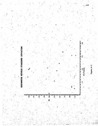
•. . 129
~
z!2!Cs.. . .cc
~
a:az~ . ,.. J 0=·· ~
. :::> ... :; i..a: .,.. t;
~
> f:l..z~"..
~ ~ ~ .
:: ,
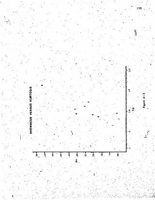
' j
...iiis="."..
. "...~.......
· z~.."OJ
130
1
ABBREVIATIONS
C.N.R.
D. M. A. R.
D.R.E.E.
M.S.O,.C.
N.A.P. -
T.C.H.
/'Canadian Nat:{.onal RaiiwaysDepar'tm,ent 'of Mines, Agric.~lture andResources, Government of Newfoundlandand Labrador.
Department of Regional Economic Expandon,Govermnent of Canflda. .,
Mean standard orientation count.
Na'tional Air Photo, Library, Governmentof Canada.
Trans-Canada Highway.
I