Thurlow Road Speed Survey - City of Belleville
27
Type Location (X/Y) Type Location (X/Y) Airport Parkway Atkins Mitchell 80 none Bylaw: Mitchell Tyendinaga none Reverse Tyendinaga Mitchell 80 319137.5/4897381.8 Mitchell Atkins none Airport Parkway West CityLimit Elmwood Drive 60 60 312517.7/4895360.8 Bylaw: 60 312809.1/4895449.7 80 313287.5/4895584.4 Reverse Elmwood Drive City Limit 60 313284.9/4895591.0 60 312805.0/4895458.0 Ashe Crescent Point Anne Rd. End none none Bylaw: Reverse End Point Anne Rd. none Ashley Street Highway 62 Harmony 50 50 306748.6/4900204.4 Bylaw: 3666 / 50km/hr 50 306648.3/4900446.5 Harmony Tile 50 306526.5/4900728.6 50 306257.6/4901249.7 50 306006.3/4901420.1 Tile Frankford Road none Frankford Road Mudcat 50 305772.7/4901585.2 50 305759.5/4901617.0 50 305688.2/4901850.1 50 305592.8/4902156.5 50 305504.8/4902451.9 Mudcat Ducette Road 50 305478.1/4902540.6 Ducette Old Madoc Road 50 305444.2/4902664.4 50 305368.5/4902907.3 50 305292.3/4903140.9 Old Madoc Road Highway 62 none Reverse Highway 62 Old Madoc Rd. none Old Madoc Rd. Ducette Rd. 50 305209.6/4903366.6 50 305295.5/4903104.4 Thurlow Road Speed Survey Posted Limit Regulatory Signs Topography Road Name From To 1
-
Upload
khangminh22 -
Category
Documents
-
view
0 -
download
0
Transcript of Thurlow Road Speed Survey - City of Belleville

Type Location (X/Y) Type Location (X/Y)
Airport Parkway Atkins Mitchell 80 none
Bylaw: Mitchell Tyendinaga none
Reverse Tyendinaga Mitchell 80 319137.5/4897381.8
Mitchell Atkins none
Airport Parkway West CityLimit Elmwood Drive 60 60 312517.7/4895360.8
Bylaw: 60 312809.1/4895449.7
80 313287.5/4895584.4
Reverse Elmwood Drive City Limit 60 313284.9/4895591.0
60 312805.0/4895458.0
Ashe Crescent Point Anne Rd. End none none
Bylaw:
Reverse End Point Anne Rd. none
Ashley Street Highway 62 Harmony 50 50 306748.6/4900204.4
Bylaw: 3666 / 50km/hr 50 306648.3/4900446.5
Harmony Tile 50 306526.5/4900728.6
50 306257.6/4901249.7
50 306006.3/4901420.1
Tile Frankford Road none
Frankford Road Mudcat 50 305772.7/4901585.2
50 305759.5/4901617.0
50 305688.2/4901850.1
50 305592.8/4902156.5
50 305504.8/4902451.9
Mudcat Ducette Road 50 305478.1/4902540.6
Ducette Old Madoc Road 50 305444.2/4902664.4
50 305368.5/4902907.3
50 305292.3/4903140.9
Old Madoc Road Highway 62 none
Reverse Highway 62 Old Madoc Rd. none
Old Madoc Rd. Ducette Rd. 50 305209.6/4903366.6
50 305295.5/4903104.4
Thurlow Road Speed Survey
Posted
Limit
Regulatory Signs TopographyRoad Name From To
1

Type Location (X/Y) Type Location (X/Y)
Thurlow Road Speed Survey
Posted
Limit
Regulatory Signs TopographyRoad Name From To
50 305381.8/4902837.1
Ducette Rd. Mudcat Rd. 50 305461.0/4902564.0
Mudcat Rd. Frankford Rd. 50 305506.4/4902398.1
50 305598.1/4902122.5
50 305702.6/4901773.0
Frankford Rd. Tile Rd. 50 305792.4/4901556.3
Tile Rd. Harmony Rd. 50 306029.4/4901359.6
50 306278.1/4901228.3
50 306411.7/4900978.8
50 306522.1/4900721.0
Harmony Rd. Highway 62 none
Atkins Road Airport Parkway end none none
Bylaw:
Reverse end Airport Parkway none
Barnett Street Gavey St. McDougall Dr. none none
Bylaw:
Reverse McDougall Dr. Gavey St. none
Bay Street Cul De Sac Hoskin none none
Bylaw: Hoskin End none
Reverse End Hoskin none
Hoskin Cul De Sac none
Beatty Road Zion Road Bethel Road none none
Bylaw: Bethel Townsend none
Reverse Townsend Bethel none
Bethel Zion Road none
Bethany Road Casey Blessington none none Corner 313137.2/4900185.9
Bylaw: Corner 313156.0/4900318.9
Reverse Blessington Casey None
2

Type Location (X/Y) Type Location (X/Y)
Thurlow Road Speed Survey
Posted
Limit
Regulatory Signs TopographyRoad Name From To
Bethel Road Beatty Road Morgan Road none none
Bylaw: Morgan Cranston Road none
Cranston Gifford Road none
Gifford Road Phillipston Road none
Phillipston Road Foxton Road none
Reverse Foxton Road Phillipston Road none hill 311387.8/4911063.8
hill CA. 1105
hill CA. 965
Phillipston Road Gifford Road none
Gifford Road Cranston none hill CA. 560
hill CA. 527
Cranston Morgan none hill CA. 351
Morgan Beatty Road none hill CA. 164
Bird Crescent Maitland Dr. Thurlow Dr. 40 40 307136.8/4896453.9
Bylaw: 2589 / 40km/hr
Reverse Thurlow Dr. Maitland Dr. none
Black Diamond Road Cannifton Road Lywood Street none no trucks 308909.4/4896654.3
Bylaw: Lywood Street Highway 37 none
Highway 37 End none
Reverse End Highway 37 none
Highway 37 Lywood Street no trucks 309094.2/4896712.2
Lywood Street Cannifton Road none
Blessington Road Highway 37 Ritz Road 80 80 309940.2/4899039.5
Bylaw: Ritz Road Forsythe Road none
Forsythe Road Bethany Road none
Bethany Road Bronk Road 80 313161.1/4900585.2
Bronk Road Brennan Road none
Brennan Road Tyendinaga 80 315958.2/4902493.0
Reverse Tyendinaga Brennan Road 80 317160.1/4903273.4
Brennan Road Bronk Road none
Bronk Road Bethany Road 80 315716.8/4902306.3
3

Type Location (X/Y) Type Location (X/Y)
Thurlow Road Speed Survey
Posted
Limit
Regulatory Signs TopographyRoad Name From To
Bethany Road Forsythe Road 80 313027.8/4900501.7
Forsythe Road Ritz Road none
Ritz Road Highway 37 none
Boundary Road Thurlow Boundary Foxton Road none none
Bylaw: Foxton Road Highway 37 none
Highway 37 Roslin Road none
Roslin Road Tyendinaga none
Reverse Tyendinaga Roslin Road none
Roslin Road Highway 37 none
Highway 37 Foxton Road none
Foxton Road Thurlow Boundary none
Brennan Road Casey Road Blessington Road none none Corner 317239.6/4901287.4
Bylaw: Corner 316062.6/4902163.1
Reverse Blessington Road Casey Road none Corner 315998.3/4902236.6
Corner 317193.0/4901340.1
Bristol Place Simcoe Drive End none none
Bylaw:
Reverse End Simcoe Drive none
Bronk Road Blessington Road Harmony Road none none
Bylaw: Harmony Road Thrasher Road none
Thrasher Road Hall Settlement Road none
Hall Settlement Road Scuttlehole Road none
Scuttlehole Road End none
Reverse End Scuttlehole Road none
Scuttlehole Road Hall Settlement Road none
Hall Settlement Road Thrasher Road none
Thrasher Road Harmony Road none
Harmony Road Blessington Road none
Bryant Crescent Willett Road Zion Road none none
4

Type Location (X/Y) Type Location (X/Y)
Thurlow Road Speed Survey
Posted
Limit
Regulatory Signs TopographyRoad Name From To
Bylaw:
Reverse Zion Road Willett Road none
Burns Drive Old Highway 2 End none none
Bylaw:
Reverse End Old Highway 2 none
Canniff Street Cannifon Road North Lywood Street none none
Bylaw:
Reverse Lywood Street Cannifon Road North none
Cannifton Road North Highway 37 Black Diamond Rd. 50 no trucks 308874.4/4896460.4
Bylaw: 50 308826.2/4896607.5
Black Diamond Rd. Latchford 50 308836.2/4896784.0
Latchford McCall 50 308867.6/4897087.6
McCall Canniff none
Caniff Farnham 50 308880.4/4897383.8
Farnham Tankfarm 50 308965.5/4897553.0
Tank Farm Short no trucks 309178.8/4897794.6
50 309204.7/4897824.8
Short Highway 37 50 309648.8/4898523.6
Reverse Highway 37 Short no trucks 309593.7/4898624.8
50 309619.2/4898596.5
Short Tank Farm 50 309617.4/4898337.4
Tank Farm Farnham 50 309049.0/4897657.8
Farnham Caniff no trucks 308879.3/4897453.6
50 308871.2/4897348.3
Caniff McCall none
McCall Latchford none
Latchford Black Diamond Rd. 50 308840.1/4896923.5
Black Diamond Rd. Highway 37 50 308817.2/4896596.4
Carelton Cove Highway 62 End none none
Bylaw:
Reverse End Highway 62 none
5

Type Location (X/Y) Type Location (X/Y)
Thurlow Road Speed Survey
Posted
Limit
Regulatory Signs TopographyRoad Name From To
Carley Court Sycamore Street End none none
Bylaw:
Reverse End Sycamore Street none
Casey Road Highway 37 Forsythe Road 60 60 310257.4/4898326.8
Bylaw: 3594 / 60km/hr 310781.8/4898601.7
Forsythe Road Eggleton Road 60 311271.6/4898894.8
60 311959.9/4899203.8
60 312416.2/4899378.2
Eggleton Road Bethany Road 60 313030.1/4899565.1
Bethany Road Mitchell Road 60 313413.7/4899501.7
60 314034.9/4899417.4
60 314646.9/4899584.4
60 315212.2/4899830.9
60 315720.8/4900106.4
Mitchell Road Christie Drive 60 316066.7/4900230.4
Christie Drive Brennan Road 60 316645.5/4900477.1
Brennan Road Craig Road 60 317437.6/4900813.7
Reverse Craig Brennan Road none
Brennan Road Christie Drive 60 317340.7/4900784.7
60 316752.0/4900532.4
Christie Drive Mitchell Road 60 316246.0/4900308.8
Mitchell Road Bethany Road 60 315839.8/4900151.1
60 315257.4/4899868.8
60 315704.0/4899608.1
60 314097.8/4899434.0
60 313456.0/4899502.8
Bethany Road Eggleton Road 60 313203.0/4899554.2
Eggleton Road Forsythe Road 60 312513.8/4899424.3
60 311920.3/4899195.3
60 311518.7/4899026.7
Forsythe Road Highway 37 60 311161.8/4898839.8
60 310595.2/4898509.5
Cemetery Road Mudcat Road Denyes Road none none
Bylaw:
Reverse Denyes Road Mudcat Road none
6

Type Location (X/Y) Type Location (X/Y)
Thurlow Road Speed Survey
Posted
Limit
Regulatory Signs TopographyRoad Name From To
Length (m):
Chelsea Crescent Simcoe Drive Farnham Road none none
Bylaw: Farham Road Simcoe Drive none
Reverse Simcoe Drive Farham Road none
Farham Road Simcoe Drive none
Chestnut Drive Simcoe Drive End none none
Bylaw:
Reverse End Simcoe Drive none
Christian School Road Sunningdale Drive End none none
Bylaw:
Reverse End Sunningdale Drive none
Christie Drive Casey Road End none none
Bylaw:
Reverse End Casey Road none
Clearview Road Highway 62 Pine Hill Crescent 60 60 303318.4/4908924.8
Bylaw: Pine Hill Crescent Kelly Road 60 303805.6/4090907.6 hill 303551.1/4908938.8
60 304263.6/4909282.7 hill 305096.0/4910605.0
60 304613.0/4909658.7
60 304542.5/4910210.4
60 304994.7/4910564.5
Kelly Road Morgan Road none hill 305843.9/4910833.6
Morgan Road Gifford Road none hill CA. 1054
Reverse Gifford Road Morgan Road none
Morgan Road Kelly Road none
Kelly Road Pine Hill Crescent 60 305087.0/4910612.3
60 304600.1/4910339.1
60 304553.0/4909835.7
60 304404.0/4909388.1
Pine Hill Crescent Highway 62 60 303865.5/4909226.1
Cloverleaf Drive Sidney Street Millennium Pkwy. 40 No Trucks 307134.9/4896081.1
7

Type Location (X/Y) Type Location (X/Y)
Thurlow Road Speed Survey
Posted
Limit
Regulatory Signs TopographyRoad Name From To
Bylaw: 3738 / 40-60km/h 40 307157.1/4896090.8
40 307426.8/4896178.2
Reverse Millennium Pkwy. Sidney St. No Trucks 307879.5/4896320.6
40 307879.5/4896320.6
40 307668.0/4896264.0
40 307381.6/4896170.0
Cottage Lane Thrasher Road End none none
Bylaw:
Reverse End Thrasher Road none
Countrycharm Drive Mudcat Road Windwhisper Drive none none
Bylaw: Windwhisper Drive End none
Reverse End Windwhisper Drive none
Windwhisper Drive Mudcat Road none
Length (m):
Cox Drive Maitland Drive Gavey Street none none
Bylaw:
Reverse Gavey Street Maitland Drive none
Craig Road End Casey Road none none
Bylaw:
Reverse Casey Road End none
Cranston Road Zion Road Willett Road none none
Bylaw: Willett Road Bethel Road none
Reverse Bethel Road Willett Road none
Willett Road Zion Road none
Denyes Road Phillipston Road Cemetery Road none none
Bylaw: Cemetery Road Highway 37 none
Reverse Highway 37 Cemetery Road none
Cemetery Road Phillipston Road none
8

Type Location (X/Y) Type Location (X/Y)
Thurlow Road Speed Survey
Posted
Limit
Regulatory Signs TopographyRoad Name From To
Dorset Court Simcoe Drive End none none
Bylaw:
Reverse End Simcoe Drive none
Doxtator Drive Point Anne Road Manley Drive 50 50 316409.2/4892316.3 90 corner 316307.2/4892229.5
Bylaw:
Reverse Manley Drive Point Anne Road none
Ducette Road Ashley Street Highway 62 50 none
Bylaw:
Reverse Highway 62 Ashley Street 50 305155.1/4902706.0
50 305336.7/4902650.0
Dutch Girl Road Highway 62 Quinte West none none
Bylaw:
Reverse Quinte West Highway 62 none
Eggleton Road End Casey Road none none
Bylaw:
Reverse Casey Road End none
Elmwood Drive Old Highway 2 Airport Parkway 60 no trucks 314658.1/4893608.6
Bylaw: 2594 / 60km/hr 60 314657.4/4893616.9
60 314391.7/4894497.0
60 314309.4/4894791.8
60 314221.0/4895088.6
Reverse Airport Parkway Old Highway 2 60 314015.7/4895758.6
no trucks 314015.7/4895758.6
60 314107.2/4895450.2
60 314277.1/4894879.3
60 314480.2/4894190.6
Essex Drive Bristol Place End none none
Bylaw:
9

Type Location (X/Y) Type Location (X/Y)
Thurlow Road Speed Survey
Posted
Limit
Regulatory Signs TopographyRoad Name From To
Reverse End Bristol Place none
Length (m):
Farnham Road Cannifton Road North Moira Lea Court 60 no trucks 308712.7/4897600.7
Bylaw: 3436 / 60km/hr Moira Lea Court Simcoe Drive 60 308712.7/4897600.7
Simcoe Drive Oakwood Lane none
Oakwood Lane Scott Drive 60 308407.1/4898242.0
60 308264.7/4898523.7
Scott Drive Highway 62 none
Reverse Highway 62 Scott Drive no trucks 307338.4/4898793.6
60 307338.4/4898793.6
Scott Drive Oakwood Lane 60 308178.4/4898663.8
Oakwood Lane Simcoe Drive 60 308459.1/4898090.7
Simcoe Drive Moira Lea Court none
Moira Lea Court Cannifton Road North none
Forsythe Road Blessington Road Casey Road none none
Bylaw: Casey Road End none
Reverse End Casey Road none
Casey Road Blessington Road none
Fox Lane Mudcat Lane End none none
Bylaw:
Reverse End Mudcat Lane none
Foxboro-Stirling Road Highway 62 Quinte West none none
Bylaw:
Reverse Quinte West Highway 62 none
Length (m):
Foxton Road Highway 37 Zion Road none none
Bylaw: Zion Road Bethel Road none
Bethel Road Boundary Road none
Reverse Boundary Road Bethel Road none hill 311777.3/4911521.5
Bethel Road Zion Road none hill 312350.4/4909804.8
Zion Road Highway 37 none
10

Type Location (X/Y) Type Location (X/Y)
Thurlow Road Speed Survey
Posted
Limit
Regulatory Signs TopographyRoad Name From To
Frankford Road Ashley Street Highway 62 50 50 305737.7/4901564.7
Bylaw: 305592.4/4901512.3
Reverse Highway 62 Ashley Street 50 305453.6/4901446.0
305596.2/4901504.8
Gardiner Street Gavey Street End none none
Bylaw:
Reverse End Gavey Street none
Gavey Street Parsons Court Barnett Street none none
Bylaw: Barnett Street McDougall Drive none
McDougall Drive Cox Drive none
Cox Drive Gardiner Street none
Gardiner Street End none
Reverse End Gardiner Street none
Gardiner Street Cox Drive none
Cox Drive McDougall Drive none
McDougall Drive Barnett Street none
Barnett Street Parsons Court none
Gentlebreeze Drive Windwhisper Drive End none none
Bylaw:
Reverse End Windwhisper Drive none
Gifford Road Bethel Road Clearview Road none none
Bylaw:
Reverse Clearview Road Bethel Road none
Grass Boulevard Old Highway 2 End 30 30 315511.9/4893899.4
Bylaw: 3847 / 30km/h
Reverse End Old Highway 2 none
Greenfield Park River Rd. End none none
Bylaw: 3136 / 40km/hr
11

Type Location (X/Y) Type Location (X/Y)
Thurlow Road Speed Survey
Posted
Limit
Regulatory Signs TopographyRoad Name From To
Reverse End River Rd. none
Hall Settlement Road Bronk Rd. End none none
Bylaw:
Reverse End Bronk Rd. none
Halloway Heights Highway 62 Halloway Rd. 50 50 304063.9/4906809.1
Bylaw: hill 303861.2/4906811.9
Halloway Rd. Highway 62 50 303672.1/4907019.4
Reverse Highway 62 Halloway Rd. 50 303774.7/4907391.6
Halloway Rd. Highway 62 none
Halloway Road Halloway Heights Quinte West none none
Bylaw:
Reverse Quinte West Halloway Heights none
Harmony Road Ashley St. River Rd. 60 60 306643.5/4900545.3
Bylaw: 2585 35mph River Rd. Homan Rd. 60 307150.0/4900714.6
60 307736.4/4900896.2
Homan Rd. Plumpton Rd. none
Plumpton Rd. Highway 37 60 308173.8/4901036.3
60 308768.1/4901221.3
40 school 309255.3/4901375.3
Highway 37 Shaw Rd. 60 310718.2/4902307.0
Shaw Rd. Bronk Rd. none
Bronk Rd. Tyendinaga none
Reverse Tyendinaga Bronk Rd. 80 316596.7/4905323.8
Bronk Rd. Shaw Rd. none
Shaw Rd. Highway 37 60 310712.9/4902312.7
Highway 37 Plumpton Rd. 60 309846.5/4901568.8
40 school 309732.6/4901536.8
60 308656.4/4901199.1
Plumpton Rd. Homan Rd. none
Homan Rd. River Rd. 60 307982.1/4900986.0
60 307544.5/4900848.2
12

Type Location (X/Y) Type Location (X/Y)
Thurlow Road Speed Survey
Posted
Limit
Regulatory Signs TopographyRoad Name From To
River Rd. Ashley St. 60 307075.1/4900698.2
Hill Street Zion Rd. End none none
Bylaw:
Reverse End Zion Rd. none
Homan Road Harmony Rd. End 50 50 307992.7/4901008.5
Bylaw: 2587 / 60km/hr
Reverse End Harmony Rd. 50 307841.4/4901490.9
Hoskin Court Hoskin Rd. End none none
Bylaw:
Reverse End Hoskin Rd. none
Hoskin Road Highway 37 Hoskin Court 60 none
Bylaw: Hoskin Court Thurlow Queen St. 60 312379.9/4906840.3
Thurlow Queen St. Bay St. none
Bay St. Lata Dr. 60 312910.9/4907086.4
60 313094.5/4907667.0
Lata Dr. End none
Reverse End Lata Dr. none
Lata Dr. Bay St. 60 313216.0/4907895.6
60 312999.7/4907363.6
Bay St. Thurlow Queen St. none
Thurlow Queen St. Hoskin Court 60 312612.2/4906915.8
Hoskin Court Highway 37 none
Joy Court Wiser Rd. End none none
Bylaw:
Reverse End Wiser Rd. none
Kelly Road Beatty Rd. Townsend Rd. none none
Bylaw: Townsend Rd. Clearview Rd. none
Reverse Clearview Rd. Townsend Rd. none
Townsend Rd. Beatty Rd. none
13

Type Location (X/Y) Type Location (X/Y)
Thurlow Road Speed Survey
Posted
Limit
Regulatory Signs TopographyRoad Name From To
Lane Crescent Point Anne Rd. Thurlow Lane Ave. none none
Bylaw: Thurlow Lane Ave. Ashe Cr. none
Ashe Cr. End none
Reverse End Ashe Cr. none
Ashe Cr. Thurlow Lane Ave. none
Thurlow Lane Ave. Point Anne Rd. none
Latchford Street Lywood St. Cannifton Rd. N none none
Bylaw: Cannifton Rd. N End none
Reverse End Cannifton Rd. N none
Cannifton Rd. N Lywood St. none
Latta Drive Hoskin Rd. Highway 37 60 60 313201.3/4907998.8
Bylaw: 2586 / 60km/hr
Reverse Highway 37 Hoskin Rd. 60 313008.7/4908454.4
Leslie Road Highway 37 Tyendenaga none none
Bylaw:
Reverse Tyendenaga Highway 37 none
Lywood Street Highway 37 Black Diamond Rd. none none
Bylaw: Black Diamond Rd. Latchford St. none
Latchford St. McCall St. none
McCall St. Cannif St. none
Reverse Cannif St. McCall St. none
McCall St. Latchford St. none
Latchford St. Black Diamond Rd. none
Black Diamond Rd. Highway 37 none
Maitland Drive Sidney St. Bird Cr. 60 60 307052.8/4896382.7
Bylaw: 1884 / 35mph Bird Cr. Cox Dr. 60 307414.1/4896547.8
Cox Dr. Highway 62 60 307696.6/4896701.3
Highway 62 Mineral Rd. 60 308091.9/4897020.3
14

Type Location (X/Y) Type Location (X/Y)
Thurlow Road Speed Survey
Posted
Limit
Regulatory Signs TopographyRoad Name From To
Mineral Rd. Parks Dr. none
Parks Dr. Farnham Rd. 60 308540.2/4897408.0
Reverse Farnham Rd. Parks Dr. 60 308678.9/4897543.8
Parks Dr. Mineral Rd. 60 308482.6/4897371.2
60 308305.9/4897211.2
Mineral Rd. Highway 62 60 308167.3/4897089.7
Highway 62 Cox Dr. 60 308015.2/4896963.6
60 307794.3/4896778.7
60 307559.4/4896635.0
Cox Dr. Bird Cr. none
Bird Cr. Sidney St. none
Manley Drive Point Anne Rd. Doxtator Dr. 50 50 316525.3/4891930.2
Bylaw: 2950 / 50km/hr Doxtator Dr. End 50 316291.8/4891941.4
50 315984.6/4891941.1
Reverse End Doxtator Dr. 50 315867.7/4891935.4
Doxtator Dr. Point Anne Rd. 50 316410.8/4891927.6
McCall Street Lywood St. Cannifton Rd. N none none
Bylaw: Cannifton Rd. N End none
Reverse End Cannifton Rd. N none
Cannifton Rd. N Lywood St. none
McDonnell Lane Mudcat Rd. End none none
Bylaw:
Reverse End Mudcat Rd. none
McDougall Drive Parsons Ct. Barnett St. none none
Bylaw: Barnett St. Gavey St. none
Reverse Gavey St. Barnett St. none
Barnett St. Parsons Ct. none
Millennium Parkway Sidney St. Cloverleaf Dr. none none
15

Type Location (X/Y) Type Location (X/Y)
Thurlow Road Speed Survey
Posted
Limit
Regulatory Signs TopographyRoad Name From To
Bylaw: Cloverleaf Dr. Highway 62 none
Highway 62 Mineral Dr. none
Mineral Dr. End none
Reverse End Mineral Dr. none
Mineral Dr. Highway 62 none
Highway 62 Cloverleaf Dr. none
Cloverleaf Dr. Sidney St. none
Mineral Road Millennium Pkwy. Parks Dr. none none
Bylaw: Parks Dr. Maitland Dr. none
Reverse Maitland Dr. Parks Dr. none
Parks Dr. Millennium Pkwy. none
Mitchell Road Old Highway 2 Airport Pkwy. none none
Bylaw: Airport Pkwy. 401 none
401 Casey Rd. none
Reverse Casey Rd. 401 none
401 Airport Pkwy. none
Airport Pkwy. Old Highway 2 none
Moira Lee Court Farnham Rd. End none none
Bylaw:
Reverse End Farnham Rd. none
Morgan Road Bethel Rd. Clearview Rd. none none
Bylaw:
Reverse Clearview Rd. Bethel Rd. none
Mudcat Road Ashley St. Fox Ln. 60 60 305558.0/4902481.5
Bylaw: 60 305848.0/4902567.2
Fox Ln. Sharpes Ln. 60 306578.4/4902785.1
Sharpes Ln. Sanctuary Ln. 60 306827.3/4903133.8
60 306951.5/4903410.1
60 307058.1/4903687.7
16

Type Location (X/Y) Type Location (X/Y)
Thurlow Road Speed Survey
Posted
Limit
Regulatory Signs TopographyRoad Name From To
80 307172.7/4903862.9
Sanctuary Ln. McDonnell Ln. none
McDonnell Ln. Countrycharm Dr. none
Countrycharm Dr. Phillipston Rd. none
Reverse Phillipston Rd. Countrycharm Dr. 80 311298.7/4906500.7
Countrycharm Dr. McDonnell Ln. none
McDonnell Ln. Sanctuary Ln. none
Sanctuary Ln. Sharpes Ln. 60 307116.5/4903864.4
60 307050.9/4903675.5
60 306950.5/4903423.8
60 306817.0/4903138.4
Sharpes Ln. Fox Ln. none
Fox Ln. Ashley St. 60 306427.2/4902747.8
60 305884.7/4902574.9
O'Brien Road Highway37 End none none
Bylaw:
Reverse End Highway 37 none
O'Neill Drive Old Kingston Rd. Wexford Ct. none none
Bylaw: Wexford Ct. Penny Ln. none
Reverse Penny Ln. Wexford Ct. none
Wexford Ct. Old Kingston Rd. none
Oakwood Lane Farnham Rd. End none none
Bylaw:
Reverse End Farnham Rd. none
Old Highway 2 City Limit Old Kingston Rd. 80 80 313143.7/4893317.0
Bylaw: Old Kingston Rd. Old Kingston Rd. none
Old Kingston Rd. Elmwood Dr. none
Elmwood Dr. Grass Blvd. none
Grass Blvd. Point Anne Road none
Point Anne Road Mitchell Rd. 80 314983.2/4893676.6
Mitchell Rd. Burns Dr. none
17

Type Location (X/Y) Type Location (X/Y)
Thurlow Road Speed Survey
Posted
Limit
Regulatory Signs TopographyRoad Name From To
Reverse Burns Dr. Mitchell Rd. none
Mitchell Rd. Point Anne Road none
Point Anne Road Grass Blvd. none
Grass Blvd. Elmwood Dr. none
Elmwood Dr. Old Kingston Rd. none
Old Kingston Rd. Old Kingston Rd. none
Old Kingston Rd. City Limit 60 313163.8/4893344.1
Old Kingston Road Old Highway 2 O'Neill Dr. 50 50 314264.9/4893508.3
Bylaw: 2963 / 50km/hr 50 314026.6/4893518.2
O'Neill Dr. Old Highway 2 50 313884.3/4893520.7
50 313605.1/4893478.5
50 313320.4/4893397.5
Reverse Old Highway 2 O'Neill Dr. 50 313292.9/4893384.7
50 313620.5/4893475.6
O'Neill Dr. Old Highway 2 50 314022.5/4893512.8
Old Madoc Road Highway 62 Ashley St. 60 60 305130.9/4903533.2
Bylaw: 3666 / 60km/hr Ashley St. Zion Rd. 60 305207.2/4903641.8
60 305381.2/4903909.7
60 305557.2/4904153.1
60 305698.4/4904402.1
60 305821.0/4904709.1
60 305786.1/4905018.4
60 305469.9/4905391.2
Zion Rd. Highway 62 60 305030.1/4905955.5
Reverse Highway 62 Zion Rd. 60 304614.2/4906387.9
304756.3/4906284.4
Zion Rd. Ashley St. 60 305154.1/4905749.7
60 305597.8/4905264.5
60 305787.8/4905001.2
60 305751.1/4904538.0
60 305621.1/4904277.9
60 305513.0/4904110.1
18

Type Location (X/Y) Type Location (X/Y)
Thurlow Road Speed Survey
Posted
Limit
Regulatory Signs TopographyRoad Name From To
60 305340.1/4903865.9
Ashley St. Highway 62 none
Old Mill Park Fox Ln. End none none
Bylaw:
Reverse End Fox Ln. none
O'Neill Drive Old Kingston Rd. Wexford Ct. none none
Wexford Ct. Penny Ln. none
Reverse Penny Ln. Wexford Ct. none
Wexford Ct. Old Kingston Rd. none
Parks Drive Mineral Rd. Maitland Dr. none none
Bylaw:
Reverse Maitland Dr. Mineral Rd. none
Length (m):
Parsons Court Gavey St. End none none
Bylaw:
Reverse End Gavey St. none
Penny Lane O'Neill Dr. End none none
Bylaw:
Reverse End O'Neill Dr. none
Phillipston road Mudcat Rd. Denyes Rd. none none
Bylaw: Denyes Rd. Zion Rd. none hill 311163.9/4907156.9
hill 310923.1/4907917.9
Zion Rd. Bethel Rd. none hill 310622.1/4908990.4
hill 310358.0/4909826.5
Bethel Rd. Centre Hastings none
Reverse Centre Hastings Bethel Rd. none
Bethel Rd. Zion Rd. none
Zion Rd. Denyes Rd. none
Denyes Rd. Mudcat Rd. none
Pine Hill Crescent Highway 62 Clearview Rd. 60 60 303741.1/4907914.1
19
Type Location (X/Y) Type Location (X/Y)
Thurlow Road Speed Survey
Posted
Limit
Regulatory Signs TopographyRoad Name From To
Bylaw: 3362 / 60km/hr Clearview Rd. Highway 62 none
Reverse Highway 62 Clearview Rd. none
Clearview Rd. Highway 62 none
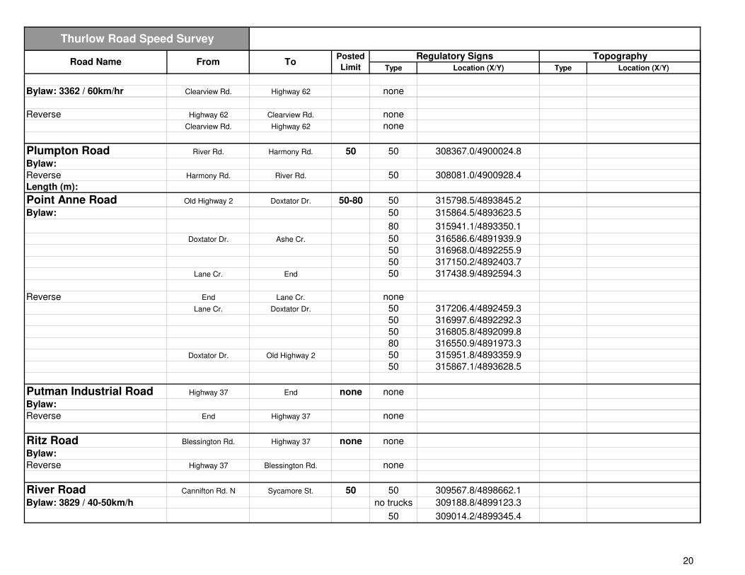
Plumpton Road River Rd. Harmony Rd. 50 50 308367.0/4900024.8
Bylaw:
Reverse Harmony Rd. River Rd. 50 308081.0/4900928.4
Length (m):
Point Anne Road Old Highway 2 Doxtator Dr. 50-80 50 315798.5/4893845.2
Bylaw: 50 315864.5/4893623.5
80 315941.1/4893350.1
Doxtator Dr. Ashe Cr. 50 316586.6/4891939.9
50 316968.0/4892255.9
50 317150.2/4892403.7
Lane Cr. End 50 317438.9/4892594.3
Reverse End Lane Cr. none
Lane Cr. Doxtator Dr. 50 317206.4/4892459.3
50 316997.6/4892292.3
50 316805.8/4892099.8
80 316550.9/4891973.3
Doxtator Dr. Old Highway 2 50 315951.8/4893359.9
50 315867.1/4893628.5
Putman Industrial Road Highway 37 End none none
Bylaw:
Reverse End Highway 37 none
Ritz Road Blessington Rd. Highway 37 none none
Bylaw:
Reverse Highway 37 Blessington Rd. none
River Road Cannifton Rd. N Sycamore St. 50 50 309567.8/4898662.1
Bylaw: 3829 / 40-50km/h no trucks 309188.8/4899123.3
50 309014.2/4899345.4
20

Type Location (X/Y) Type Location (X/Y)
Thurlow Road Speed Survey
Posted
Limit
Regulatory Signs TopographyRoad Name From To
50 308734.9/4899666.5
Sycamore St. Plumpton Rd. none
Plumpton Greenfield Pk. 50 308326.8/4899951.5
50 307784.8/4900204.5
40 307367.7/4900377.7
Greenfield Pk. Harmony Rd. none
Harmony Rd. End none
Reverse End Harmony Rd. none
Harmony Rd. Greenfield Pk. no trucks 307095.4/4900681.8
40 307115.1/4900635.2
Greenfield Pk. Plumpton Rd. 50 307369.0/4900379.9
50 307853.2/4900168.4
Plumpton Rd. Sycamore St. 50 308409.7/4899904.8
Sycamore St. Cannifton Rd. N. 50 308887.0/4899549.3
50 309007.6/4899336.2
50 309183.9/4899120.9
Riverside Crescent Ashley St. End none none
Bylaw:
Reverse End Ashley St. none
Roslin Road Highway 37 Shannonville Rd. 50 50 313864.7/4912617.4
Bylaw: 2599 / 50km/hr 50 313977.7/4913205.0
Reverse Shannonville Rd. Highway 37 none
Roy Bouleverd Towncentre Dr. Highway 62 none none
Bylaw: Highway 62 Towncentre Dr. none
Reverse Towncentre Dr. Highway 62 none
Highway 62 Towncentre Dr. none
Sanctuary Lane Mudcat Lane End none none
Bylaw:
Reverse End Mudcat Lane none
21

Type Location (X/Y) Type Location (X/Y)
Thurlow Road Speed Survey
Posted
Limit
Regulatory Signs TopographyRoad Name From To
Scott Drive Farnham Rd. End none none
Bylaw:
Reverse End Farnham Rd. none
Scuttlehole Road Lata Dr. Bronk Rd. 60 none
Bylaw: 2591 / 60km/hr Bronk Rd. Shannon Rd. 60 313544.2/4907997.7
313742.1/4908561.4
Shannon Rd. Tyendenaga 60 313872.2/4909001.9
60 314136.6/4909466.7
60 314326.8/4910077.1
Reverse Tyendenaga Shannon Rd. 60 314782.0/4910926.6
60 314493.1/4910362.9
60 314258.9/4909736.1
Shannon Rd. Bronk Rd. 60 313852.9/4908920.1
60 313649.9/4908325.8
Bronk Rd. Lata Dr. none
Shannon Road Scuttlehole Rd. Tyendenaga none none
Bylaw:
Reverse Tyendenaga Scuttlehole Rd. none
Sharpes Lane Mudcat Rd. End none none
Bylaw:
Reverse End Mudcat Rd. none
Shaw Road Harmony Rd. End none none
Bylaw:
Reverse End Harmony Rd. none
Short Street Tank Farm Rd. Cannifton Rd. N none none
Bylaw:
Reverse Cannifton Rd. N Tank Farm Rd. no littering 309771.4/4898145.6
Sidney Street North 401 Millennium Drive 60 none
Bylaw: 2593 / 60km/hr Millennium Dr. Cloverleaf Dr. 60 307185.2/4895896.0
1883 / 35mph Cloverleaf Dr. Maitland Dr. 60 307092.2/4896164.6
22

Type Location (X/Y) Type Location (X/Y)
Thurlow Road Speed Survey
Posted
Limit
Regulatory Signs TopographyRoad Name From To
Maitland Dr. Thurlow Drive 60 307002.4/4896438.2
Thurlow Dr. Sunningdale Dr. 80 306895.2/4896769.6
Sunningdale Dr. Vermilyea Rd. none
Sills Road Highway 37 end 40 40 311119.1/4904230.8
Bylaw: 3982 / 40km/h
Reverse End Highway 37 40 311611.2/4904357.9
Simcoe Drive Farnham Rd. Chelsea Cr. none none
Bylaw: Chelsea Cr. Chelsea Cr. none
Chelsea Cr. Bristol Pl. none
Bristol Pl. Dorset Ct. none
Dorset Ct. Chestnut Dr. none
Reverse Chestnut Dr. Dorset Ct. none
Dorset Ct. Bristol Pl. none
Bristol Pl. Chelsea Cr. none
Chelsea Cr. Chelsea Cr. none
Chelsea Cr. Farnham Rd. none
Smith Road Highway 62 Quinte West none none
Bylaw:
Reverse Quinte West Highway 62 none
Sunningdale Road Sidney St. N Highway 62 none none
Bylaw:
Reverse Highway 62 Sidney St. N none
Sycamore Street River Rd. Carley Ct. none none
Bylaw: Carley Ct. End none
Reverse End Carley Ct. none
Carley Ct. River Rd. none
Tank Farm Road Cannifton Rd. N Short St. 60 60 309195.2/4897778.7
Bylaw: 3582 / 60km/hr Short St. Highway 37 none
23

Type Location (X/Y) Type Location (X/Y)
Thurlow Road Speed Survey
Posted
Limit
Regulatory Signs TopographyRoad Name From To
Reverse Highway 37 Short St. 60 310047.5/4898235.7
60 309809.1/4898095.4
Short St. Cannifton Rd. N none
Tile Drive Ashley St. End none none
Bylaw:
Reverse End Ashley St. none
Thrasher Road Highway 37 O'Brien 60 none
Bylaw: 3493 / 60km/hr O'Brien Bronk Rd. 60 311388.2/4904628.1
60 312526.5/4905102.9
60 313102.4/4905300.5
60 313703.1/4905498.1
60 314256.9/4905718.4
Bronk Rd. Treverton Rd. 60 314679.6/4905941.0
60 315757.3/4906537.7
Treverton Rd. Tyendenaga none
Reverse Tyendenaga Treverton Rd. 60 315988.7/4907244.7
Treverton Rd. Bronk Rd. 60 316029.1/4906700.0
60 315506.3/4906400.8
60 314977.7/4906097.9
Bronk Rd. O'Brien 60 314574.0/4905894.0
60 313979.1/4905590.0
60 313403.0/4905407.4
60 312827.7/4905215.3
60 312260.7/4905015.1
60 311673.4/4904763.1
O'Brien Highway 37 none
Thurlow Drive Sidney St. Bird Cr. none none
Bylaw: 2589 / 40km/hr Bird Cr. End none
Reverse End Bird Cr. none
Bird Cr. Sidney St. none
Thurlow Lane Avenue Lane Cr. End none none
Bylaw:
24

Type Location (X/Y) Type Location (X/Y)
Thurlow Road Speed Survey
Posted
Limit
Regulatory Signs TopographyRoad Name From To
Reverse End Lane Cr. none
Thurlow Queen Street Hoskin Rd. End none none
Bylaw:
Reverse End Hoskin Rd. none
Tile Drive Ashley St. End none none
Bylaw:
Reverse End Ashley St. none
Towncentre Drive Roy Blvd. End none none
Bylaw:
Reverse End Roy Blvd. none
Townsend Road Highway 62 Kelly Rd. none none
Bylaw:
Reverse Kelly Rd. Highway 62 none hill 304912.6/4908483.9
Treverton Road Thrasher Rd. End none none
Bylaw:
Reverse End Thrasher Rd. none
Tuftsville road Clearview Rd. Quinte West none none
Bylaw:
Reverse Quinte West Clearview Rd. none
Vermilyea Road Highway 62 Quinte West 60 60 306320.3/4898637.4
Bylaw: 306816.1/4898766.5
Reverse Quinte West Highway 62 none 306816.1/4898766.5
307241.0/4898794.5
Wexford Court O'Neill Rd. End none none
Bylaw:
Reverse End O'Neill Rd. none
Willett Road Zion Rd. Bryant Cr. none none
25

Type Location (X/Y) Type Location (X/Y)
Thurlow Road Speed Survey
Posted
Limit
Regulatory Signs TopographyRoad Name From To
Bylaw: Bryant Cr. Cranston Rd. none
Cranston Rd. Bethel Rd. none
Reverse Bethel Rd. Cranston Rd. none
Cranston Rd. Bryant Cr. none
Bryant Cr. Zion Rd. none
Windwhisper Drive Countrycharm Dr. Gentlebreeze Dr. none none
Bylaw: Gentlebreeze Dr. End none
Reverse End Gentlebreeze Dr. none
Gentlebreeze Dr. Countrycharm Dr. none
Wiser Road Highway 37 Joy Ct. none none
Bylaw: Joy Ct. End none
Reverse End Joy Ct. none
Joy Ct. Highway 37 none
Yorke Drive Ashley St. End none none
Bylaw:
Reverse End Ashley St. none
Zion Road Old Madoc Rd. Hill St. none none
Bylaw: Hill St. Beatty Rd. none
Beatty Rd. Bryant Cr. none
Bryant Cr. Willett Rd. none
Willett Rd. Cranston Rd. none
Cranston Rd. Phillipston Rd. none
Phillipston Rd. Foxton Rd. none
Reverse Foxton Rd. Phillipston Rd. none
Phillipston Rd. Cranston Rd. none
Cranston Rd. Willett Rd. none
Willett Rd. Bryant Cr. none
Bryant Cr. Beatty Rd. none
Beatty Rd. Hill St. none
26

Type Location (X/Y) Type Location (X/Y)
Thurlow Road Speed Survey
Posted
Limit
Regulatory Signs TopographyRoad Name From To
Hill St. Old Madoc Rd. none
27