Thinking Outside the Box to Expand Metropolitan Travel Choices
23
i TRB Paper #11-0563 Thinking Outside the Box to Expand Metropolitan Travel Choices Patrick DeCorla-Souza 1 Federal Highway Administration, 1200 New Jersey Ave SE, Washington, DC 20590 Phone: 202-366-4076 E-Mail: [email protected] Wayne Berman Federal Highway Administration, 1200 New Jersey Ave SE, Washington, DC 20590 Phone: 202-366-4069 E-Mail: [email protected] John Halkias Federal Highway Administration, 1200 New Jersey Ave SE, Washington, DC 20590 Phone: 202-366-2183 E-Mail: [email protected] Abstract: 185 words Paper: 5,500 words Tables: 3 Figures: 5 FINAL Prepared for publication in the Transportation Research Record March 19, 2011 1 Disclaimer: The views expressed are those of the authors and not necessarily those of the U.S. Department of Transportation or the Federal Highway Administration.
-
Upload
independent -
Category
Documents
-
view
6 -
download
0
Transcript of Thinking Outside the Box to Expand Metropolitan Travel Choices

i
TRB Paper #11-0563
Thinking Outside the Box to Expand Metropolitan Travel Choices
Patrick DeCorla-Souza1
Federal Highway Administration,
1200 New Jersey Ave SE, Washington, DC 20590 Phone: 202-366-4076
E-Mail: [email protected]
Wayne Berman Federal Highway Administration,
1200 New Jersey Ave SE, Washington, DC 20590 Phone: 202-366-4069
E-Mail: [email protected]
John Halkias Federal Highway Administration,
1200 New Jersey Ave SE, Washington, DC 20590 Phone: 202-366-2183
E-Mail: [email protected]
Abstract: 185 words Paper: 5,500 words
Tables: 3 Figures: 5
FINAL Prepared for publication in the Transportation Research Record
March 19, 2011
1 Disclaimer: The views expressed are those of the authors and not necessarily those of the
U.S. Department of Transportation or the Federal Highway Administration.
ii DeCorla-Souza, Berman and Halkias
ii
Thinking Outside the Box to Expand Metropolitan Travel Choices
Patrick DeCorla-Souza
Wayne Berman John Halkias
Abstract
The Multimodal Expressway system concept presented in this paper would introduce travel choices for suburban commuters in major metropolitan areas relatively quickly and inexpensively. The entire existing limited-access highway system would provide for free flow of carpool vehicles and buses by temporarily slowing down (or stopping) and releasing excess traffic at freeway entrance ramps and on the freeway mainline at a series of concentric “cordon” locations around the core of the metropolitan area. At these locations, travel lanes would be created on the shoulder and restricted to use by buses and high-occupancy vehicles with three or more persons, allowing them to by-pass the slower moving “metered” general-purpose traffic. A multi-centered Bus Rapid Transit system would serve commute trips between suburban residential areas and major employment centers. The transit system would be supplemented with a flexible carpooling system. An enhanced version of the concept would introduce variable peak period tolls to encourage further mode shifts, reduce traffic demand and help pay for system costs. Sketch-planning estimates of costs for freeway, transit and flexible carpooling investments suggest that the capital costs could be self-financed through road pricing revenues.
1
Thinking Outside the Box to Expand Metropolitan Travel Choices
Patrick DeCorla-Souza
Wayne Berman John Halkias
INTRODUCTION
Travel demand continues to grow in U.S. metropolitan areas, while environmental constraints and high costs for construction of highways and transit fixed-guideways (mainly light, heavy, and commuter rail) limit the amount of new highway and public transit capacity that can be added. On the other hand, many suburban commuters have few alternatives to driving alone because of limited transit and ridesharing alternatives, especially if they work at a suburban employment center. Strategies are needed to create viable transit and ridesharing alternatives.
This paper presents for discussion an approach involving a synergistic combination of innovative multimodal strategies that could meet suburban commuter needs relatively quickly and inexpensively. The ideas in the paper are preliminary and are being presented in order to generate discussion in the transportation community and further development of the ideas. The approach is termed the Multimodal Expressway system. THE MULTIMODAL EXPRESSWAY CONCEPT The key strategies incorporated in the Multimodal Expressway concept are Active Traffic Management, a region-wide multi-centered Bus Rapid Transit system connecting suburban residential areas with major employment centers, and flexible carpooling. The main features of the basic concept are summarized in Table 1 and are discussed below. An enhanced version of the concept that incorporates road pricing is presented in the next section. This is followed by a discussion of costs and funding. Active Traffic Management Active Traffic Management (ATM) involves a group of strategies to improve traffic flow and reduce congestion and crashes on freeways. It makes use of automatic systems and human intervention to manage traffic flow and improve the safety of road users. Key ATM strategies incorporated in the Multimodal Expressway concept are ramp metering, freeway speed controls, temporary shoulder use, and rapid response to freeway accidents and incidents.
Ramp metering involves slowing down or stopping excess traffic at freeway entrance ramps and releasing them more slowly into the mainline freeway traffic stream. A key issue with this approach is that commuters entering the freeway system at distant suburban and exurban locations unfairly benefit from the delays imposed at ramp meters on commuters living in the urban core who enter the system closer to the city center. It also provides an inducement for suburban sprawl since it offers a perverse incentive to those who wish to live in distant suburbs, i.e., free flow of traffic is provided for them at the cost of delaying urban core dwellers at freeway entrance ramp meters. Even in metropolitan areas where ramp metering is not
2 DeCorla-Souza, Berman and Halkias
2
deployed, those who commute from distant suburbs impose much more delay on those who live in the urban core due to the longer trips they make, traveling through more highway segments that are congested.
The Multimodal Expressway concept attempts to address these issues by using overhead highway lane speed controls at concentric cordons around the urban core to “meter” traffic on the freeway mainline (see Figures 1 and 2). Hourly traffic volumes are thereby reduced on the freeway system within the urban core, allowing ramp meters within the central portions of the metropolitan area to discharge vehicles at a faster rate. This reduces delays to urban core dwellers. Moreover, ramp metering itself becomes more feasible, since faster release of vehicles makes it less likely that ramp meter queues would back up into the surface street system.
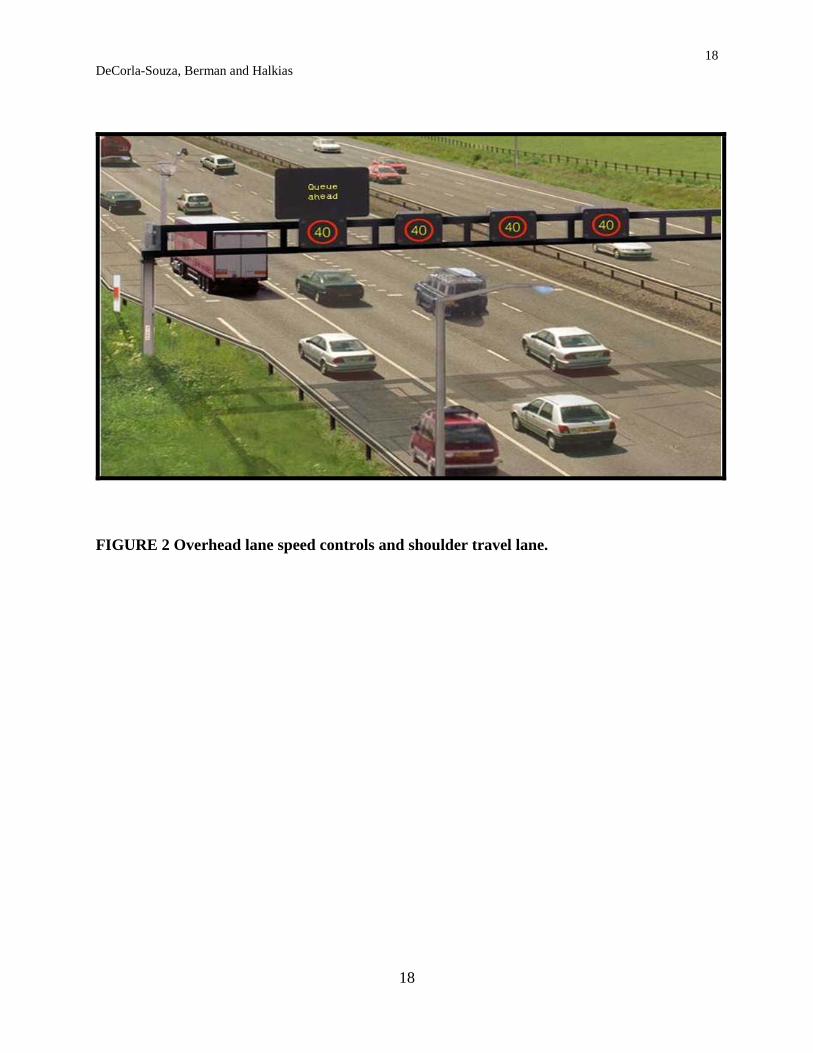
Controlling freeway speeds and metering traffic at the cordon locations will not only improve overall freeway system performance but also reduce the likelihood of primary accidents or incidents that result when congestion is encountered randomly and unexpectedly. Sign gantries spanning the facility (see Figure 2) would provide speed limit information and varying additional information. During the height of the peak periods when the freeway system in the urban core is operating at capacity, the metered mainline cordon locations would effectively function like ramp meters with very low speeds. This concept is similar to air traffic control – aircraft are held at originating airports until the destination airport has sufficient capacity to handle their arrival.
Speed compliance will need to be enforced. The ideal way will be through automated enforcement using speed cameras. This is already used extensively in Europe to enforce speed compliance. But in the US, legislative approval for camera speed enforcement may be difficult to get in some states. Those states will need to rely on manual speed enforcement, with a police car at each cordon. It may take a few tickets to be issued before motorists begin complying with the speed limits. Fortunately, it will take only one complying motorist in a platoon of vehicles in a lane to ensure that all vehicles behind that motorist will be in compliance and operating at a harmonized speed.
At metered mainline cordon locations, a “dynamic” shoulder travel lane (1) would be created on the left for use by buses and vehicles with three or more persons (HOV-3+ vehicles) when speed controls are in operation. The shoulder lane could be created using existing pavement and right-of-way by narrowing existing regular lanes within the speed controlled zone in advance of the cordon line. Figure 2 illustrates an operating shoulder travel lane in the U.K. which incorporates a refuge area to accommodate vehicle breakdowns. Shoulder travel lanes would also be created at freeway entrance ramps for use by buses and HOV-3+ vehicles to bypass queues when ramp meters are operating.
Cordon lines could be strategically located on a fairly long freeway segment. Criteria for location would include: (1) availability of sufficient shoulder widths or rights-of-way to create the shoulder travel lane; (2) sufficient weaving distance from the cordon to the next downstream exit ramp such that an HOV-3+ vehicle driver in the left shoulder lane could easily weave to the right to get off; and (3) sufficient weaving distance for buses or HOV-3+ vehicles entering at an upstream on-ramp to switch over to the left shoulder lane in advance of arriving at the back end of queued vehicles. If the queues back up too far, it would indicate that traffic would need to be released at a faster rate at that cordon, and an additional cordon would need to be created further downstream at an appropriate location. If space permits, the right shoulder could be converted into a travel lane to provide additional temporary “storage space” for queuing vehicles, reducing overall queue lengths in all lanes.
3 DeCorla-Souza, Berman and Halkias
3
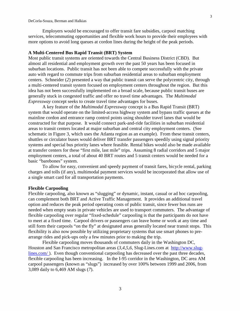
Employers would be encouraged to offer transit fare subsidies, carpool matching services, telecommuting opportunities and flexible work hours to provide their employees with more options to avoid long queues at cordon lines during the height of the peak periods. A Multi-Centered Bus Rapid Transit (BRT) System Most public transit systems are oriented towards the Central Business District (CBD). But almost all residential and employment growth over the past 50 years has been focused in suburban locations. Public transit has not been able to compete successfully with the private auto with regard to commute trips from suburban residential areas to suburban employment centers. Schneider (2) presented a way that public transit can serve the polycentric city, through a multi-centered transit system focused on employment centers throughout the region. But this idea has not been successfully implemented on a broad scale, because public transit buses are generally stuck in congested traffic and offer no travel time advantages. The Multimodal Expressway concept seeks to create travel time advantages for buses.
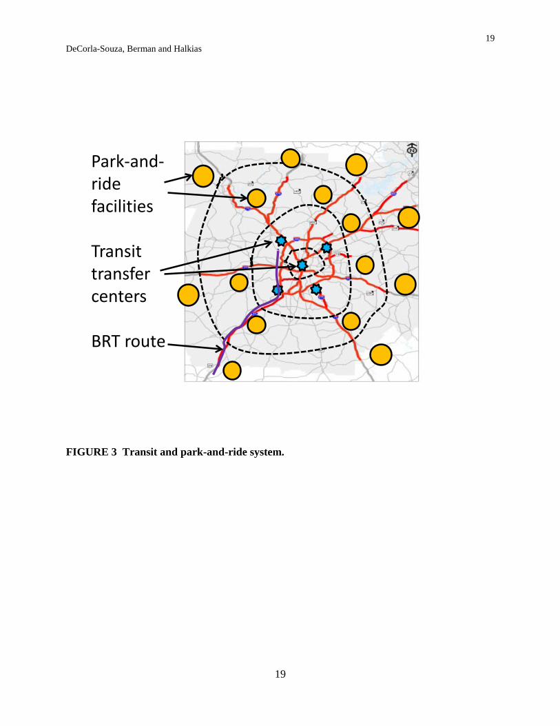
A key feature of the Multimodal Expressway concept is a Bus Rapid Transit (BRT) system that would operate on the limited-access highway system and bypass traffic queues at the mainline cordon and entrance ramp control points using shoulder travel lanes that would be constructed for that purpose. It would connect park-and-ride facilities in suburban residential areas to transit centers located at major suburban and central city employment centers. (See schematic in Figure 3, which uses the Atlanta region as an example). From these transit centers, shuttles or circulator buses would deliver BRT transfer passengers speedily using signal priority systems and special bus priority lanes where feasible. Rental bikes would also be made available at transfer centers for these “first mile, last mile” trips. Assuming 8 radial corridors and 5 major employment centers, a total of about 40 BRT routes and 5 transit centers would be needed for a basic “barebones” system.
To allow for easy, convenient and speedy payment of transit fares, bicycle rental, parking charges and tolls (if any), multimodal payment services would be incorporated that allow use of a single smart card for all transportation payments. Flexible Carpooling Flexible carpooling, also known as “slugging” or dynamic, instant, casual or ad hoc carpooling, can complement both BRT and Active Traffic Management. It provides an additional travel option and reduces the peak period operating costs of public transit, since fewer bus runs are needed when empty seats in private vehicles are used to transport commuters. The advantage of flexible carpooling over regular “fixed-schedule” carpooling is that the participants do not have to meet at a fixed time. Carpool drivers or passengers can leave home or work at any time and still form their carpools “on the fly” at designated areas generally located near transit stops. This flexibility is also now possible by utilizing proprietary systems that use smart phones to pre-arrange rides and pick-ups only a few minutes prior to making the trip.
Flexible carpooling moves thousands of commuters daily in the Washington DC, Houston and San Francisco metropolitan areas (3,4,5,6, Slug-Lines.com at http://www.slug-lines.com/ ). Even though conventional carpooling has decreased over the past three decades, flexible carpooling has been increasing. In the I-95 corridor in the Washington, DC area AM carpool passengers (known as “slugs”) increased by over 100% between 1999 and 2006, from 3,089 daily to 6,469 AM slugs (7).
4 DeCorla-Souza, Berman and Halkias
4
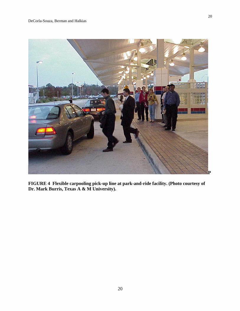
With flexible carpooling, a car needing additional passengers to meet the high occupancy vehicle (HOV) lane minimum vehicle occupancy requirements pulls up to a pick-up line designated for a particular major employment destination. The commuters first in line get into the car (see Figure 4). No money is exchanged because of the mutual benefit, i.e., a faster trip in the HOV lane for drivers, and transit fare savings (and often travel time savings relative to transit) for carpool passengers.
Flexible carpooling has tremendous potential at the regionwide scale if the entire limited-access highway system could provide preferential treatment for HOV-3+ vehicles, as proposed with the Multimodal Expressway system. HOV-3+ vehicles would be allowed to bypass metered general-purpose traffic at on-ramps and at cordon locations using the restricted shoulder travel lanes, providing a significant incentive for carpool formation. Additional incentives could be provided through guaranteed rides home, user screening programs and promotions such as payments to individuals to try carpooling for several months (8).
The Multimodal Expressway system would provide parking for transit and carpool passengers at suburban transit stops and route termini. Costs could be reduced by leasing required spaces from shopping centers or religious institutions whose facilities are generally designed to accommodate weekend peaks. An Internet-based system would provide information on transit bus routes, fares, travel times and schedules as well as carpool information, including information on flexible carpooling opportunities, location of park-and-ride lots, parking charges and tolls (if any), and a comparison of estimated trip travel times and costs by alternative modes, including driving alone. This would allow commuters to make pre-trip travel mode choices that best fit their needs.
According to Oliphant (9), flexible carpooling has very few known drawbacks. Transit providers may object to it because it competes with transit for ridership. Security concerns are often expressed. However, flexible carpooling has been operating for over 30 years without any serious incident. Minett (10,11) discusses how technology can be employed to address security concerns using pre-registration of drivers and passengers. Oliphant (9) suggests that an HOV-3+ requirement is preferable to HOV-2+, because passengers and drivers may find HOV-2 awkward and feel unsafe in an HOV-2 vehicle. He suggests that HOV-3 is the minimum vehicle occupancy needed to allay these concerns.
Oliphant (9) notes that some governmental bodies may distance themselves from flexible carpooling due to liability concerns. If they were to support or promote it and someone were to get injured while doing it, the governmental body could be held liable. Some protection may be available under sovereign immunity, but this may not cover all situations. In Northern Virginia, Arlington County provides support for flexible carpooling by providing signage at pick-up locations, but the Virginia Department of Transportation does not provide such support (9). Potential Impacts Traffic simulation modeling could provide estimates of the extent of the traffic flow benefits of a Multimodal Expressway system. It is anticipated that Multimodal Expressway systems will increase freeway vehicle throughput, reduce overall freeway system delays and improve travel time reliability by reducing stop-and-go traffic on the freeway system and isolating congestion at cordon locations where vehicle speeds are harmonized using speed controls. Consequently, net reductions in pollutant emissions, fuel consumption and greenhouse gas emissions are likely.
5 DeCorla-Souza, Berman and Halkias
5
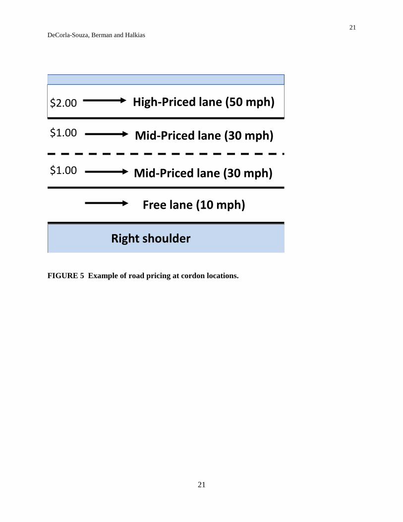
Yet, commute times for suburban and exurban commuters not in HOV-3+ carpools or buses are likely to increase. Assuming a 10 percent increase in freeway travel time for these commuters (i.e., an increase of 3 minutes for a 30-minute freeway commute), a travel time elasticity of -0.5 (12) would suggest that there would be a 5 percent reduction in trips that would be subjected to the increased delay. If suburban commuters comprise half of all freeway vehicle miles traveled (VMT) in peak periods, a 2.5 percent reduction in systemwide peak period VMT might be expected. ENHANCEMENTS TO THE MULTIMODAL EXPRESSWAY CONCEPT To further enhance the effectiveness of the basic Multimodal Expressway system, monetary incentives for changes in travel behavior could be introduced by encouraging pricing strategies such as employee parking cash-out (13), pay-as-you-drive insurance (14), and road pricing that can (where reasonable alternatives to driving are available) provide incentives for users to shift non-essential travel to off-peak hours or seek alternatives to peak driving (15). Small (16) discusses the dramatic effects that road pricing can have on transit operations. He notes that raising the monetary price of car travel induces some modal shifting to public transit. Reduced congestion makes public transit buses operating on the street or highway system faster and cheaper to operate. When route coverage and service frequency are increased to handle the increased demand, this further enhances the service quality perceived by the transit rider. Finally, higher costs for auto commuting cause land near major business centers to become more valuable, and hence to be developed at higher residential and commercial densities. This further enhances the market potential of public transit by increasing its density of demand in just those areas where it is already most efficient. With a Multimodal Expressway system enhanced with road pricing, drivers who are not in carpools with the required occupancy might pay tolls that vary based on demand at cordon locations, instead of paying with their time through freeway delays. Various forms of road pricing have been successfully deployed in the U.S. and internationally, including charges for use of individual highway lanes, charges for use of a facility (i.e., tolls on all lanes), and charges to cross a cordon or drive within a heavily-trafficked area. These options could be considered for deployment on the Multimodal Expressway system. Creative ideas could be generated and discussed through public involvement. One such idea offered for discussion is as follows: Permit differing travel speeds on different mainline freeway lanes at the cordon locations (see Figure 5), with differing toll rates commensurate with the speed allowed. Toll charges would be collected electronically (using electronic transponders or video tolling) and could vary dynamically (i.e., changing as often as every 3 minutes, as on priced lanes operating in Minneapolis) to ensure full utilization of each lane’s capacity. For example, on an eight-lane freeway (4 lanes per direction), lane 1 could provide toll-free service at 10 mph (a delay of 5 minutes over a one-mile control zone, assuming a free-flow speed of 60 mph), lane 2 and 3 could provide 30 mph service for a $1.00 charge (with a delay of 1 minute over a one-mile zone), and lane 4 could provide 50 mph service for a $2.00 charge (with delay of only a few seconds). Free service could be provided for buses and for HOV-3+ vehicles in any lane, avoiding the need to upgrade the left shoulder to a travel lane, but making enforcement for HOV-3+ vehicles somewhat more difficult. One option that could be explored to facilitate HOV enforcement is to require pre-registration of all carpool drivers and their vehicles to get the toll exemption, as well as pre-

6 DeCorla-Souza, Berman and Halkias
6
registration of all carpool passengers. Private vendors of smartphone-based dynamic ridesharing systems have already developed protocols that could be used to verify that the match between a driver and carpool passengers has been made. These processes could be used to certify the toll exemption for HOVs. Economists have suggested that differentiation of levels of service maximizes social welfare by providing an array of travel choices based on willingness to pay (17). Conventional priced lanes offer only two choices, catering only to people at the high ends and low ends of the time value distribution. Intermediate value users cannot justify paying for the priced lanes, but are forced to sit in greater congestion than they would have faced without pricing on the premium lanes. Having multiple service level choices addresses their needs. As with priced lane projects operating in the U.S., the Multimodal Expressway system would provide motorists with advance information on toll rates and speeds upstream of the cordon toll gantries to allow them sufficient time to make a choice of level of service.
Lane changes could be prohibited within the speed-controlled zone using solid white painted lines on the pavement to so indicate, and this could be camera-enforced. Motorists’ vehicle transponders could be read by readers placed at frequent intervals in the speed controlled zone. Motorists would be charged for the most expensive lane used. This would eliminate any incentive to change lanes to save money.
Speed compliance and prohibitions on lane changing could be enforced using camera or on-site enforcement, as discussed earlier. However, even though lane changing would be prohibited within the charging zone, there might be an incentive for a driver in a slower-moving (less costly) lane to weave into a faster-moving (more costly) lane, thus disrupting the flow of traffic in that lane and increasing the possibility of accidents. This is the type of behavior seen normally on congested freeways where lane changing is not prohibited, all lanes are free and no extra charges are incurred by the driver in changing lanes. With Multimodal Expressways the driver will incur a higher toll cost with the lane change in addition to a moving violation for crossing a solid white line. Thus, instances of lane changing are likely to be much fewer than on congested free highways. To make it easier for the public to comprehend the new system and gain public acceptance, it may be advantageous to begin with pricing only one lane, i.e., the leftmost lane, similar to single priced lanes already operating in the U.S. After the public has become accustomed to this innovation and appreciates the benefits of the approach, additional lanes might be priced, with moderate speeds and toll rates as discussed above. Potential Effectiveness Studies completed for the Federal Highway Administration (18, 19) as well as for the U.K.’s Department for Transport (20) suggest that a relatively small reduction in existing traffic of about 10 percent can restore free-flowing traffic conditions on metropolitan highway systems. This may be observed nationally on Columbus Day, when a relatively small percentage of commuters are off work, or in Washington, DC in August when Congress is not in session. This suggests that in order to significantly reduce highway congestion, about 10 percent of peak period drivers would need to be diverted to transit, ridesharing or telecommuting, or to traveling during shoulder or off-peak hours.
The 10 percent figure may appear arbitrary and not sustainable in the long term as traffic demand grows in the future. One might ask: why would the same 10 percent reduction in traffic be sufficient in a heavily congested urban area as in lightly congested urban area? To
7 DeCorla-Souza, Berman and Halkias
7
understand why, one must consider the entire peak period. When there are high levels of congestion, traffic spreads out over a longer and longer period as people leave earlier or later in order to avoid the worst congested hours.
Take the example of a heavily congested area where the peak arrivals on a freeway last for three hours from 6 am to 9 am. If there is 10 percent extra traffic in the 6-7 am hour, it queues up in the 7-8 am hour along with the 10 percent extra traffic in the 7-8 am hour, so there is 20 percent extra traffic in the 7-8 am hour. Likewise, there is 30 percent extra traffic queued up in the 8-9 am hour. One would need to reduce 8-9 am traffic by 30 percent to get rid of the 8-9 am queue. But if one had already reduced 6-7 am traffic by 10 percent and 7-8 am traffic by 10 percent to begin with, one would only need to reduce 8-9 am traffic by 10 percent.
More congested urban areas have longer peak periods due to peak spreading and therefore more time for a bigger buildup of queues, which makes their average travel times longer. Less congested areas have shorter peak periods and fewer congested hours, so total extra traffic over the entire peak period is also less. Bhatt (21) suggests that road pricing elasticities range from “about -0.10 to -0.15 at the low end to -0.30 to -0.40 at the high end depending on the charge, the current costs of travel and the capacity of alternative roads and transit systems.” Using the low-end elasticity of -0.10 and applying it to the estimated fuel cost for an average round-trip suburban commute of about $3.00 suggests that the average round-trip toll would need to be $3.00 to achieve a 10 percent reduction in traffic. At the high-end elasticity of -0.40, the average round-trip toll would need to be $0.75 to achieve the same traffic reduction. For a commuter driving to work 250 weekdays per year, the extra annual costs could thus be somewhere between $190 and $750. COSTS AND FUNDING A “back-of-the-envelope” sketch-planning analysis was undertaken to get an understanding of the potential capital costs for implementing the highway, BRT and flexible carpooling components of the Multimodal Expressway system in a prototypical metropolitan area with about 3.0 to 4.5 million people (e.g., Minneapolis, Seattle, Atlanta or Washington, DC). Cost estimates were developed for two scenarios:
1. The basic Multimodal Expressway system. 2. An enhanced Multimodal Expressway system with road pricing, i.e., variable charges at
cordon locations. Costs for Highway Components Costs for implementing the highway features of the Multimodal Expressway system, i.e., Active Traffic Management, tolling and shoulder travel lanes, were estimated based on parameters in the TRUCE model (22). As the cost estimates in Table 2 show, the highway components of the Multimodal Expressway system would require a total investment of about $1.0 billion and $0.7 billion respectively for Scenarios 1 and 2.
Some metro areas such as Atlanta have developed managed lane system plans. Costs for the highway components of the managed lane system plan proposed for Atlanta, estimated at $16 billion (23), provide an indication of the scale of highway investment envisioned in some metro areas to address congestion. Atlanta’s plan would require construction of new lanes and taking of new rights of way. On the other hand, the basic Multimodal Expressway system could be implemented with minimal new highway construction, i.e., primarily strengthening of shoulders
8 DeCorla-Souza, Berman and Halkias
8
at speed controlled zones on existing rights-of-way. The enhanced system with pricing would not require any new highway construction since shoulder travel lanes would not be needed. Costs for BRT and Flexible Carpooling Components The capital cost estimates for BRT and flexible carpooling for each scenario are presented in Table 3, based on the following assumptions:
• Equal numbers of BRT system riders and flexible carpool passengers (excluding drivers). • The basic BRT system in Scenario 1 needs 160 transit buses to serve 10,000 (one-way)
passenger trips on 40 routes, assuming an average cycle time of 80 minutes and headways of 20 minutes. (Cycle time will be relatively low because most of the BRT trip will be in free-flow mode on the freeway system). Ridership quadruples in Scenario 2 due to road pricing with tolls designed to reduce peak period vehicle miles of travel (VMT) by about 10 percent.
• Five new transit transfer facilities would be constructed at major employment centers, with five circulator transit buses operating at each center in Scenario 1. Costs for transfer centers double for Scenario 2.
• Parking spaces would be needed at park-and-ride facilities at the rate of one space per transit round-trip and one space per carpool passenger round-trip. In a typical major metro area such as Seattle, freeway system VMT is about 30 million
daily. Peak period VMT amounts to about one-half of daily VMT, or about 15 million. Thus the VMT reductions estimated in Table 3, i.e., 0.4 million to 1.6 million for Scenarios 1 and 2 amount to about 2.5 percent and 10 percent of peak period freeway traffic respectively. Total Multimodal Expressway System Investment Cost As shown in Table 3, estimated total capital costs for all components of the Multimodal Expressway system are about $1.5 billion and $2.4 billion for Scenarios 1 and 2 respectively. About a third of the costs for Scenario 2 are costs for park-and-ride facilities, estimated at a total cost of $0.8 billion at $10,000 per space. However, this cost is low in comparison with the capital costs that would otherwise need to be incurred to provide highway capacity to serve those parked vehicles for an average 20-mile freeway commute round trip.
The cost per freeway lane-mile estimated by the Federal Highway Administration for freeway lane additions in major urban areas with more than 200,000 people is about $15 million, adjusted for inflation (24). Thus it costs about $300 million to construct 20 additional urban freeway lane-miles at an average cost of $15 million per lane-mile. Dividing $300 million by estimated peak period directional lane use of 4,000 vehicles daily results in a capital cost of $75,000 per vehicle served – so the parking cost of $10,000 per vehicle for the Multimodal Expressway system is a bargain by comparison. Moreover, employers would save on costs for providing parking for their employees at the work site. Over the long term employers who own their parking facilities would be able to shed excess parking, put the space to alternative use, or expand the number of employees at the work site without having to increase parking space.
The $2.4 billion total cost for Scenario 2 may appear to be high, but one should note that it is far lower than the $6.0 billion in capital costs estimated for new highway capacity that would otherwise need to be built to serve the 80,000 vehicles parked at the park-and-ride facilities under Scenario 2 (see last line of Table 3). Moreover, with drivers being charged for peak hour use, it would be possible to raise peak hour transit fares, reducing or eliminating the
9 DeCorla-Souza, Berman and Halkias
9
need for transit operating subsidies, and increasing the comparative attractiveness of flexible carpooling. Funding Scenario 2 will also bring in a significant amount of net revenue from congestion charges. “Partial” congestion pricing of only one or two freeway lanes proposed in Atlanta’s managed lane system plan is estimated to be capable of financing $9 billion in capital investment for the system (23). It is estimated that the Multimodal Expressway system, in which more lanes would be priced, may be able to support financing of capital costs somewhere in the range of $1.5 billion to $6 billion. This range is based on an estimated annual toll revenue stream ranging from $140 million to $560 million, assuming the previously estimated average peak period toll ranging from $0.75 to $3.00 per daily commute round-trip, daily peak period freeway VMT of 15 million, an average round-trip freeway trip length of 20 miles, and tolling operations on 250 weekdays per year.
The above estimates suggest that revenue from Scenario 2 could be sufficient to fund its relatively small $2.4 billion capital costs. Surplus revenue could be used to restore the aging urban freeway infrastructure, expand critical bottlenecks, make safety improvements and enhance alternative modes, or it could be returned to motorists (especially to low-income motorists, to address equity concerns) in the form of rebates on other fees such as annual registration fees to reduce the financial burden of the extra annual costs for commuter tolls.
While the extra annual costs per commuter estimated previously at $190 to $750 may be deemed to be high, one should note that annualized capital costs for providing new highway capacity to serve the peak period travel needs of drivers averages $4,875 per commuter per year based on the previously estimated capital cost of $75,000 per commuter to provide new lane capacity. This is calculated using an annualization factor of 0.065 based on a discount rate of 5.25 percent and a 30-year investment life. Thus the marginal cost to provide for peak period demand per commuter is over six times the high-end estimate of commuter charges. Economists note that marginal user charges should be equal to marginal costs if economic efficiency is to be maximized. Thus, user charges for Multimodal Expressways would still be far below the level that could be justified on grounds of economic efficiency.
Additionally, the national freeway system is aging and the cost per freeway lane-mile to reconstruct and rehabilitate existing freeways in major urban areas with more than 200,000 people is estimated by the Federal Highway Administration at about $7.5 million, adjusted for inflation (24). Dividing this cost by the approximately 20,000 vehicles that use a lane per day, and using the 0.065 annualization factor noted above, this cost translates to an annualized cost of $24.38 per vehicle per mile or $488 annually for a 20-mile daily round trip. This is in the middle of the range of the extra annual costs to commuters who would pay tolls under Scenario 2. Thus charges that commuters would be paying would be roughly equivalent to the added public costs that highway agencies need to incur to preserve the existing system beyond its 50-year life.
The suggested funding approach for Scenario 2 does reflect a radical change in the conventional use of toll revenue – toll revenue would be used to fund an entire new mass transit system. The argument for such a radical change in use of toll revenue is made by Giglio (25):
“ .. mass transportation systems in major metropolitan regions… could take many commuter trips off urban roadways during high demand periods if they had sufficient capacity – which they can’t currently afford to build. Motorist user charges represent the only new source of transportation revenue. Doesn’t it make sense to use some of it to
10 DeCorla-Souza, Berman and Halkias
10
help support complementary surface transportation systems rather than mindlessly struggle to build more roadway lane miles ad infinitum?” Obtaining funding for transit and flexible carpooling under Scenario 1 may be more
difficult. Businesses located in major employment centers will benefit from reduced costs to provide employee parking, better access to labor due to transit improvements, and reduced costs for transport of goods due to reduced congestion resulting from mode shifts and Active Traffic Management. Thus, “value capture” funding might be considered, such as new transportation taxes on businesses in major employment centers (i.e., Business Improvement Districts), or an increment in real estate taxes on all commercial properties that benefit from improved commuter access and reduced congestion. Implementation For procurement of toll collection, park-and-ride, ATM and transit services, it might be possible to explore new approaches involving private participation for provision of these services in order to control costs, ensure performance and encourage innovation. Contracts that compensate private providers based on performance could be considered, for example through “shadow tolls” based on person-miles of service provided at specified threshold travel speeds on urban core freeway segments (26). New institutional arrangements will also need to be developed to support collaboration between Federal, state and local highway and transit agencies and local land use planning agencies. For example, toll collection and allocation of revenue will need inter-jurisdictional agreements, and possibly creation of a regional mobility authority. Collaboration will also be needed to institute transit priority treatments on the surface street system and land use policies to facilitate higher employment and residential densities in areas with good transit access. CONCLUSIONS This paper has presented for discussion a range of scenarios involving an innovative concept termed the Multimodal Expressway system that seeks to expand travel choices in major metropolitan areas. The system synergistically combines Active Traffic Management, Bus Rapid Transit and flexible carpooling, and may be enhanced with road pricing strategies. Multimodal Expressway system implementation costs would be small relative to the costs needed to add highway lanes or transit fixed-guideways, and it could be implemented in a much shorter time-frame. Details of the system will need to be developed based on the specifics of each metro area. Simulation modeling will be needed to better understand travel demand and system performance impacts in each area. Finally, innovations will be needed to address operational challenges related to all-electronic “open road” toll collection and toll, HOV occupancy and speed enforcement. Acknowledgements: The views expressed in this paper are those of the authors and not necessarily those of the U.S. Department of Transportation or the Federal Highway Administration. The authors would like to acknowledge valuable comments received on earlier versions of this paper by Lew Pratsch, Jack Opiola, Robert Poole, David Hartgen, William Ankner, Michael Replogle, Marty Stone, D.J. Gribbin and anonymous reviewers of the Transportation Research Board’s Committee on Emerging and Innovative Public Transport and Technologies.
11 DeCorla-Souza, Berman and Halkias
11
REFERENCES 1. FHWA. Efficient Use of Highway Capacity, Summary: Report to Congress. Publication #
FHWA-HOP-10-023. May 2010. Available at: bit.ly/HCR1210, or at: http://republicans.transportation.house.gov/Media/file/111th/Highways/2010-12-23-FHWA_Efficient_Use_of_Capacity_Report.pdf
2. Schneider, Jerry B. Transit and the Polycentric City: Final Report. Prepared by Urban Transportation Program, Departments of Civil Engineering and Urban Planning, University of Washington; prepared for U.S. Department of Transportation, Urban Mass Transportation Administration, University Research and Training Program, and Office of the Secretary of Transportation, Technology Sharing Program. 1981
3. Reno, Arlee T., W. A. Gellert, and A. Verzosa. Evaluation of Springfield Instant Carpooling. In Transportation Research Record No. 1212, Journal of the Transportation Research Board, pp 53-62. 1989.
4. Spielberg, Frank and Phillip Shapiro. Mating Habits of Slugs: Dynamic Carpool Formation in the I-95/I-395 Corridor of Northern Virginia. In Transportation Research Record No. 1711, pp 31-38. 2003.
5. Burris, M. and J. R. Winn. Slugging in Houston – Casual Carpool Passenger Characteristics. Journal of Public Transportation, 9 (5), pp 23-39. 2006.
6. Beroldo, S. Casual Carpooling in the San Francisco Bay Area. Transportation Quarterly, 44 (1), pp 133-150. 1990.
7. Vanasse Hangen Brustlin, Inc. Dynamic Ridesharing (Slugging) Data. Final Report. Prepared for Virginia Department of Transportation. June 15, 2006.
8. Burbank, Cynthia J. and Nick Nigro. Saving Oil and Reducing Greenhouse Gas Emissions through U.S. Federal Transportation Policy. Pew Center on Global Climate Change. February 2011.
9. Oliphant, Marc. The Native Slugs of Northern Virginia – A Profile of Slugging in the Washington DC Region. MS Thesis, Virginia Polytechnic Institute. 2008.
10. Minett, Paul. Enabling a Flexible Ridesharing Response to Congestion Pricing. Presented at the Innovations in Pricing of Transportation Systems Conference & Workshop, Orlando, Florida. University of Florida. May 2010.
11. Minett, Paul. Not Only Seeing, But Also Knowing Who is in the HOV. Presented at the Innovations in Pricing of Transportation Systems Conference & Workshop, Orlando, Florida. University of Florida. May 2010.
12. DeCorla-Souza, Patrick and Harry Cohen. Estimating Induced Travel for Evaluation of Metropolitan Highway Expansion. Transportation 26: 249-262, 1999.
13. Shoup, Donald C. Evaluating the Effects of Parking Cash-Out: Eight Case Studies. California Air Resources Board, Research Division, Sacramento, CA. 1997. Available at: http://www.arb.ca.gov/research/apr/past/93-308a.pdf
14. Bordoff, Jason and Pascal Noel. Pay-As-You-Drive Auto Insurance: A Simple Way to Reduce Driving-Related Harms and Increase Equity. Hamilton Project Discussion Paper. Brookings Institution. July 2008. Available at: http://www.brookings.edu/papers/2008/07_payd_bordoffnoel.aspx
12 DeCorla-Souza, Berman and Halkias
12
15. U.S. Department of Transportation. U.S. DOT Strategic Plan: FY 2010 – FY2015: Transportation for a New Generation. April 15, 2010. Available at: http://www.dot.gov/stratplan/dot_strategic_plan_10-15.pdf
16. Small, Kenneth A. Road Pricing and Public Transport. University of California Energy Institute. September 2003.
17. Small, Kenneth A., Clifford Winston, and Jia Yan. Differential Road Pricing, Express Lanes, and Carpools: Exploiting Heterogeneous Preferences in Policy Design, Brookings-Wharton Papers in Urban Affairs, 2006, pp. 53-96. Available at: http://www.trg.wsu.edu/docs/publications/RoadsPaperWP2008_Yan.pdf
18. The Louis Berger Group, Inc. Examining the Speed-Flow-Delay Paradox in the Washington, DC Region: Potential Impacts of Reduced Traffic on Congestion Delay and Potential for Reductions in Discretionary Travel during Peak Periods. Prepared for FHWA, 2009. Avalable at: http://ops.fhwa.dot.gov/publications/fhwahop09017/fhwahop09017.pdf
19. Noblis, Inc. Roadway Network Productivity Assessment: System-Wide Analysis Under Variant Travel Demand. Prepared for FHWA, 2008. Available at: http://ops.fhwa.dot.gov/publications/fhwahop09019/fhwahop09019.pdf
20. Department for Transport. Feasibility Study of Road Pricing in the U.K. 2004. Available at: http://www.dft.gov.uk/pgr/roads/introtoroads/roadcongestion/feasibilitystudy/studyreport/
21. Bhatt, Kiran. Potential of Congestion Pricing in the Washington Metropolitan Region. Curbing Gridlock: Peak Period Fees to Relieve Traffic Congestion. Special Report 242, Vol.2, Transportation Research Board, Washington, DC, 1994.
22. Booz Allen Hamilton. TRUCE 4.0 User’s Guide. Prepared for FHWA. February 2010. 23. HNTB. Atlanta Regional Managed Lane System Plan: Final Report. Prepared for the
Georgia Department of Transportation. January 2010. Available at: http://www.dot.state.ga.us/informationcenter/programs/studies/managedlanes/Documents/Forms/AllItems.aspx
24. Federal Highway Administration. 2006 Status of the Nation's Highways, Bridges, and Transit: Conditions and Performance. Appendix A: Highway Investment Analysis Methodology-- HERS Highway Improvement Cost Inputs, 2007. Available at: http://www.fhwa.dot.gov/policy/2006cpr/appa.htm#costs
25. Giglio, Joseph M. Toward a Purpose Driven Transportation Policy. Tollways. Journal of the International Bridge, Tunnel and Turnpike Association. Spring 2011.
26. DeCorla-Souza, Patrick and William G. Barker. Innovative Public-Private Partnership Models for Road Pricing/BRT Initiatives. Journal of Public Transportation, Vol. 8, No. 1, 2005, pp. 57-78. Available at:
http://www.nctr.usf.edu/jpt/pdf/jpt%208-1%20decorla.pdf

13 DeCorla-Souza, Berman and Halkias
13
List of Tables and Figures Table 1. Summary of the Basic Multimodal Expressway Concept Table 2. Capital Cost Estimates for Highway Components of the Multimodal Expressway
System Table 3. Capital Cost Estimates for the Multimodal Expressway System Figure 1. Example of Cordon Locations where Speed Controls Would Be Used to Meter Traffic. Figure 2. Overhead Lane Speed Controls and Shoulder Travel Lane Figure 3. Transit and Park-and-Ride System Figure 4. Flexible Carpooling Pick-up Line at Park-and-Ride Facility Figure 5. Example of Road Pricing at Cordon Locations
14 DeCorla-Souza, Berman and Halkias
14
TABLE 1 Summary of the Basic Multimodal Expressway Concept Multimodal Expressway Component
Short Description Objectives
Active Traffic Management
Ramp metering and freeway mainline “metering” using speed controls, along with bus priority lanes and traffic signal priority on the surface street system; enhanced emergency response
Smooth the flow of traffic thus reducing delays and increasing freeway vehicle throughput, reduce emissions, increase safety, reduce transit bus travel time, increase equity for travelers who live within the urban core, discourage choice of residential location in distant suburbs (i.e., sprawl)
Shoulder Travel Lanes
Conversion of shoulders at metered locations into temporary travel lanes to accommodate buses and HOV-3+ vehicles
Provide travel time advantages for transit buses and HOV-3+ vehicles to encourage carpooling and transit use
Bus Rapid Transit (BRT)
New BRT service operating on limited access highways between suburban residential areas and major employment centers
Improve public transit service, increase transit ridership, provide a viable transit travel choice, and reduce traffic
Flexible Carpooling Incentives
Shoulder travel lanes at metered freeway entrance ramps and at metered locations on the mainline for exclusive use by buses and HOV-3+ carpools
Reduce public costs for peak period transit service, provide a viable and low-cost travel choice for the commuter, and reduce vehicle traffic by increasing vehicle occupancy
Park-and-Ride Facilities
Leased suburban parking facilities, or new facilities, with signs designating locations for flexible carpool lines
Encourage use of public transit and facilitate flexible carpooling
Employer-Based Incentives
Employers encouraged to offer their employees transit fare subsidies, parking cash-out, carpool matching services, and telework and flexible work hours as options
Reduce queue lengths at metered locations, encourage mode shifts to transit and carpooling
Technology Multimodal traveler information available on the Internet and on smart phones; multimodal payment services that allow payment for transit, parking, bicycle rental, etc. using a single smart card or a credit card
Maximize efficiency of travelers’ mode choice and time of travel decisions; provide for easy, convenient and speedy payment for transportation services
15 DeCorla-Souza, Berman and Halkias
15
TABLE 2 Capital Cost Estimates for Highway Components
Basis* (*Unit cost estimates from TRUCE 4.0 (22))
Scenario 1: Basic Multimodal Expressway System
Scenario 2: Enhanced System with Pricing
Components Shoulder by-pass lanes at freeway entrance ramps
50 lane miles, $8.5M per lane-mile
$425 M. $425 M.
Shoulder by-pass lanes at cordon locations on the freeway mainline
50 lane miles, $8.5M per lane-mile
$425 M.
Infrastructure for Active Traffic Management including gantries, telecommunications, roadside information, management center
TRUCE 4.0 estimate for 300 freeway centerline miles
$175 M. $175 M.
Tolling infrastructure including transponders
TRUCE 4.0 estimate for 3.0 million population
$75 M.
Total
$1,025 M. $675 M.

16 DeCorla-Souza, Berman and Halkias
16
TABLE 3 Capital Cost Estimates for the Multimodal Expressway System
Basis Scenario 1: Basic Multimodal Expressway System
Scenario 2: Enhanced System with Pricing
Components Highway components From Table 2 $1,025 M. $675 M. BRT buses and bus storage facilities $1 M. per bus $160 M. $640 M. Transit transfer centers $20 M. per center $100 M. $200 M. Circulator buses and bus storage facilities $0.5 M. per bus $12.5M. $50 M. Park-and ride spaces for carpool passengers
$10 K. per space $100 M. $400 M.
Park-and-ride spaces for transit riders $10 K. per space $100 M. $400 M. Traveler information and multimodal payment systems
Lump sum $10 M. $10 M.
Total
$1,507.5 M. $2,375 M.
Demand assumptions Estimated transit ridership daily (AM) 40 routes, avg.
250/1000 riders per route
10,000 40,000
Estimated carpool passengers daily (AM) Equal to bus riders 10,000 40,000 Total drivers taken off the road(AM) Add above estimates 20,000 80,000 Estimated daily VMT reduction (AM and PM)
10 miles per one-way trip on freeway
400,000 1,600,000
Avoided highway costs
Lane-miles of new capacity that would otherwise be needed
4,000 peak VMT/lane-mile
100 400
Capital costs that would otherwise be incurred for adding lanes
$15 M. per lane-mile
$1.5 B. $6.0 B.
17 DeCorla-Souza, Berman and Halkias
17
Mainline speed controls at cordons
Imaginary cordons
FIGURE 1 Example of cordon locations where speed controls would be used to meter traffic.
18 DeCorla-Souza, Berman and Halkias
18
FIGURE 2 Overhead lane speed controls and shoulder travel lane.
19 DeCorla-Souza, Berman and Halkias
19
Park-and-ride facilities
Transit transfer centers
BRT route
FIGURE 3 Transit and park-and-ride system.
20 DeCorla-Souza, Berman and Halkias
20
P FIGURE 4 Flexible carpooling pick-up line at park-and-ride facility. (Photo courtesy of Dr. Mark Burris, Texas A & M University).
21 DeCorla-Souza, Berman and Halkias
21
Mid-Priced lane (30 mph)
Mid-Priced lane (30 mph)
Free lane (10 mph)
High-Priced lane (50 mph)
Right shoulder
$2.00
$1.00
$1.00
FIGURE 5 Example of road pricing at cordon locations.