Thermal Maturity and Hydrocarbon Generation Modelling for ...
17
Journal of Petroleum and Mining Engineering 23(1)2021 DOI: 10.21608/jpme.2021.62686.1071 Page|65 Journal of Petroleum and Mining Engineering Thermal Maturity and Hydrocarbon Generation Modelling for the Lower Rudeis Source Rock and Petroleum System Analysis in Garra Area, South Gulf of Suez, Egypt Elmaadawy, K. G. a Elbassiouny, H. A. M. a and Raslan, S. M. b a Geology Department, Faculty of Science, Menoufia University b EGAS - Egypt *Corresponding author e-mail: [email protected] Article Info Received 13 Feb. 2021 Revised 6 March 2021 Accepted 21 March 2021 Keywords Early Miocene Lower Rudeis; Maturity modelling; Generation and expulsion modeling; Garra petroleum system; South Gulf of Suez Abstract The Lower Rudeis Formation is an active source rock in the Garra region, which is characterized by a good hydrocarbon generative potential. The Lower Rudeis source rock reached the early mature stage in the Middle Miocene Langhian (15.5 Ma) and went through the mid mature stage at 0.9 Ma.. It was generated from a clay source rock, deposited under sub-oxic to oxic conditions and derived from an organic material composed mainly of terrestrial organic material. The Lower Rudeis source rock went through two phases of hydrocarbon generation and expulsion. The first phase occurred from 6.0 Ma to 3.4 Ma, while the second phase started at 3.4 Ma and continued until the present time, with a transformation ratio estimated of 42%. The oil expulsion increased to 16 mg/gTOC and gas expulsion to 40 mg/gTOC, thus the expelled hydrocarbons are mainly composed of mainly gas and some oil. In contrast to the southern province, the Garra region has a single petroleum system which is charged by pre-Miocene and Miocene, Lowers Rudeis, source rocks along vertical and lateral migration routes and the main Kareem-Rudeis reservoirs that were sealed by the Belayim evaporite. The current study is based on the geological, geochemical, biomarker and stable carbon isotope data, which were analyzed, interpreted and presented as burial, thermal and maturity models using the petroleum systems and basin analysis program (BasinMod software). Introduction The introduction should briefly place the study in a broad context and highlight why it is important. It should define the purpose of the work and its significance. The current state of the research field should be reviewed carefully, and key publications cited. Please highlight controversial and diverging hypotheses when necessary. Finally, briefly mention the main aim of the work. As far as possible, keep the introduction comprehensible to scientists outside your particular field of research. The Gulf of Suez region is considered an important petroleum province in Egypt, as it ranks 7th among the major rift basins in the world (Schlumberger, 1995) [1]. The studied wells are located in the southern part of the Gulf on the eastern side (Fig. 1). Barakat (1982) [2], Shahin and Shehab (1984) [3], Salah (1992) [4] and Alsharhan and Salah (1994) [5] studied the source rocks and their hydrocarbon potential in the southern province and concluded that the source rocks include the Duwi, Sudr, Thebes and Lower Rudeis formations. The source rocks of syn-rift Miocene contain a mixture of the II and III type of kerogen which indicates the presence of gas and oil- prone. High hydrocarbon potentiality originated from rifting, high geothermal gradient values, development of good reservoirs, such as reefs buildups as well as structure traps resulted from the rotational faulting capped by evaporite rocks. El Nady and Mohamed (2016) [6] recognized that Rudeis source rocks have poor to good generating potential to generate both gas and oil at optimum maturity. Younes and Philip (2005) [7] studied the oils based on a geochemical and a biomarker analysis in the southern province and stated that there are two separated proven petroleum systems attributed to pre-Miocene and Miocene sequences. In Garra area, the petroleum system was not accurately investigated, consequently the authors of the present research attempt to verify whether the petroleum system in Garra area is similar or different from the petroleum systems in southern province. The current research aims to assess the thermal maturity history in order to determine the mature stages of the Early Miocene Lower Rudeis source rock, and to study the hydrocarbon generation and expulsion evolution. In addition to studying the petroleum systems in Garra area to determining whether there are two petroleum systems, likewise the southern province, or only one petroleum system. For accomplishing such objectives, the authors used the available data of the organic matter from the six wells of the Lower Rudeis Formation and Duwi, Esna and Thebes formations, as well as the geochemical, biomarker and stable carbon isotope data of the oils
-
Upload
khangminh22 -
Category
Documents
-
view
3 -
download
0
Transcript of Thermal Maturity and Hydrocarbon Generation Modelling for ...

Journal of Petroleum and Mining Engineering 23(1)2021 DOI: 10.21608/jpme.2021.62686.1071
Page|65
Journal of Petroleum and Mining Engineering
Thermal Maturity and Hydrocarbon Generation Modelling for the Lower Rudeis Source Rock and Petroleum System Analysis in Garra Area, South Gulf
of Suez, Egypt Elmaadawy, K. G.a Elbassiouny, H. A. M.a and Raslan, S. M.b
a Geology Department, Faculty of Science, Menoufia University b EGAS - Egypt
*Corresponding author e-mail: [email protected]
Article Info
Received 13 Feb. 2021 Revised 6 March 2021 Accepted 21 March 2021
Keywords
Early Miocene Lower Rudeis; Maturity modelling; Generation and expulsion modeling; Garra petroleum system; South Gulf of Suez
Abstract The Lower Rudeis Formation is an active source rock in the Garra region, which is characterized by a good hydrocarbon generative potential. The Lower Rudeis source rock reached the early mature stage in the Middle Miocene Langhian (15.5 Ma) and went through the mid mature stage at 0.9 Ma.. It was generated from a clay source rock, deposited under sub-oxic to oxic conditions and derived from an organic material composed mainly of terrestrial organic material. The Lower Rudeis source rock went through two phases of hydrocarbon generation and expulsion. The first phase occurred from 6.0 Ma to 3.4 Ma, while the second phase started at 3.4 Ma and continued until the present time, with a transformation ratio estimated of 42%. The oil expulsion increased to 16 mg/gTOC and gas expulsion to 40 mg/gTOC, thus the expelled hydrocarbons are mainly composed of mainly gas and some oil. In contrast to the southern province, the Garra region has a single petroleum system which is charged by pre-Miocene and Miocene, Lowers Rudeis, source rocks along vertical and lateral migration routes and the main Kareem-Rudeis reservoirs that were sealed by the Belayim evaporite. The current study is based on the geological, geochemical, biomarker and stable carbon isotope data, which were analyzed, interpreted and presented as burial, thermal and maturity models using the petroleum systems and basin analysis program (BasinMod software).
Introduction The introduction should briefly place the study in
a broad context and highlight why it is important. It
should define the purpose of the work and its
significance. The current state of the research field
should be reviewed carefully, and key publications
cited. Please highlight controversial and diverging
hypotheses when necessary. Finally, briefly mention
the main aim of the work. As far as possible, keep the
introduction comprehensible to scientists outside
your particular field of research.
The Gulf of Suez region is considered an important
petroleum province in Egypt, as it ranks 7th among
the major rift basins in the world (Schlumberger,
1995) [1]. The studied wells are located in the
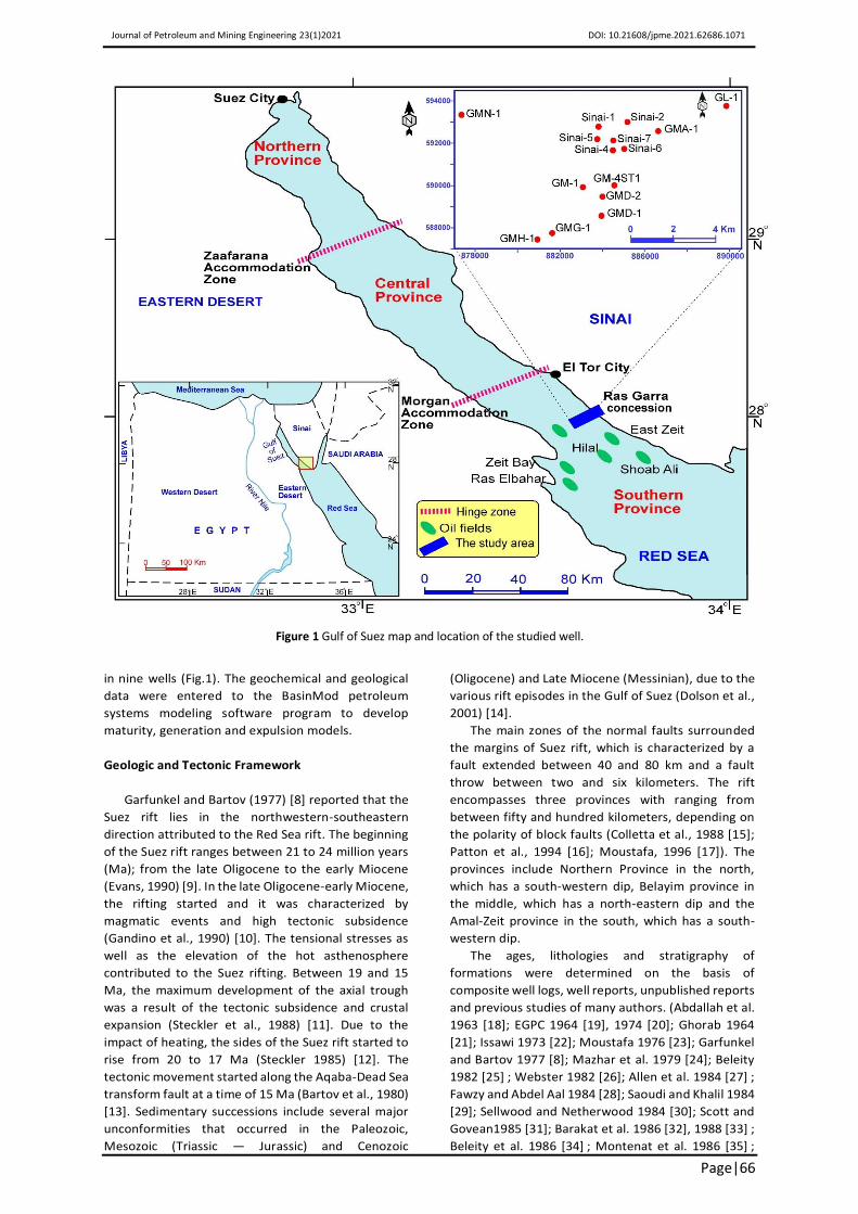
southern part of the Gulf on the eastern side (Fig. 1).
Barakat (1982) [2], Shahin and Shehab (1984) [3],
Salah (1992) [4] and Alsharhan and Salah (1994) [5]
studied the source rocks and their hydrocarbon
potential in the southern province and concluded that
the source rocks include the Duwi, Sudr, Thebes and
Lower Rudeis formations. The source rocks of syn-rift
Miocene contain a mixture of the II and III type of
kerogen which indicates the presence of gas and oil-
prone. High hydrocarbon potentiality originated from
rifting, high geothermal gradient values, development
of good reservoirs, such as reefs buildups as well as
structure traps resulted from the rotational faulting
capped by evaporite rocks. El Nady and Mohamed
(2016) [6] recognized that Rudeis source rocks have
poor to good generating potential to generate both
gas and oil at optimum maturity. Younes and Philip
(2005) [7] studied the oils based on a geochemical and
a biomarker analysis in the southern province and
stated that there are two separated proven
petroleum systems attributed to pre-Miocene and
Miocene sequences. In Garra area, the petroleum
system was not accurately investigated, consequently
the authors of the present research attempt to verify
whether the petroleum system in Garra area is similar
or different from the petroleum systems in southern
province.
The current research aims to assess the thermal
maturity history in order to determine the mature
stages of the Early Miocene Lower Rudeis source rock,
and to study the hydrocarbon generation and
expulsion evolution. In addition to studying the
petroleum systems in Garra area to determining
whether there are two petroleum systems, likewise
the southern province, or only one petroleum system.
For accomplishing such objectives, the authors used
the available data of the organic matter from the six
wells of the Lower Rudeis Formation and Duwi, Esna
and Thebes formations, as well as the geochemical,
biomarker and stable carbon isotope data of the oils
Journal of Petroleum and Mining Engineering 23(1)2021 DOI: 10.21608/jpme.2021.62686.1071
Page|66
Figure 1 Gulf of Suez map and location of the studied well.
in nine wells (Fig.1). The geochemical and geological
data were entered to the BasinMod petroleum
systems modeling software program to develop
maturity, generation and expulsion models.
Geologic and Tectonic Framework
Garfunkel and Bartov (1977) [8] reported that the
Suez rift lies in the northwestern-southeastern
direction attributed to the Red Sea rift. The beginning
of the Suez rift ranges between 21 to 24 million years
(Ma); from the late Oligocene to the early Miocene
(Evans, 1990) [9]. In the late Oligocene-early Miocene,
the rifting started and it was characterized by
magmatic events and high tectonic subsidence
(Gandino et al., 1990) [10]. The tensional stresses as
well as the elevation of the hot asthenosphere
contributed to the Suez rifting. Between 19 and 15
Ma, the maximum development of the axial trough
was a result of the tectonic subsidence and crustal
expansion (Steckler et al., 1988) [11]. Due to the
impact of heating, the sides of the Suez rift started to
rise from 20 to 17 Ma (Steckler 1985) [12]. The
tectonic movement started along the Aqaba-Dead Sea
transform fault at a time of 15 Ma (Bartov et al., 1980)
[13]. Sedimentary successions include several major
unconformities that occurred in the Paleozoic,
Mesozoic (Triassic — Jurassic) and Cenozoic
(Oligocene) and Late Miocene (Messinian), due to the
various rift episodes in the Gulf of Suez (Dolson et al.,
2001) [14].
The main zones of the normal faults surrounded
the margins of Suez rift, which is characterized by a
fault extended between 40 and 80 km and a fault
throw between two and six kilometers. The rift
encompasses three provinces with ranging from
between fifty and hundred kilometers, depending on
the polarity of block faults (Colletta et al., 1988 [15];
Patton et al., 1994 [16]; Moustafa, 1996 [17]). The
provinces include Northern Province in the north,
which has a south-western dip, Belayim province in
the middle, which has a north-eastern dip and the
Amal-Zeit province in the south, which has a south-
western dip.
The ages, lithologies and stratigraphy of
formations were determined on the basis of
composite well logs, well reports, unpublished reports
and previous studies of many authors. (Abdallah et al.
1963 [18]; EGPC 1964 [19], 1974 [20]; Ghorab 1964
[21]; Issawi 1973 [22]; Moustafa 1976 [23]; Garfunkel
and Bartov 1977 [8]; Mazhar et al. 1979 [24]; Beleity
1982 [25] ; Webster 1982 [26]; Allen et al. 1984 [27] ;
Fawzy and Abdel Aal 1984 [28]; Saoudi and Khalil 1984
[29]; Sellwood and Netherwood 1984 [30]; Scott and
Govean1985 [31]; Barakat et al. 1986 [32], 1988 [33] ;
Beleity et al. 1986 [34] ; Montenat et al. 1986 [35] ;

Journal of Petroleum and Mining Engineering 23(1)2021 DOI: 10.21608/jpme.2021.62686.1071
Page|67
Smale et al. 1988 [36] ; Burchette 1988 [37] ;
Richardson and Arthur 1988 [38]; Abd El Shafy 1990
[39]; Darwish 1992 [40]; Hughes et al. 1992 [41];
Rouchy et al. 1995 [42]; Darwish and El-Araby, 1993
[43]; Alsharhan and Salah 1994 [5], 1995 [44], 1997
[45]; Plaziat et al. 1998 [46]; Bosence et al. 1998 [47];
Salah and Alsharhan, 1998 [48]; Peijs et al. 2012 [49];
Rohais et al. 2016 [50]; Elmaadawy, 2020 [51]).
The sedimentary sequences across the Suez rift
Basin are divided into three basic sequences, based on
the Miocene rift to; pre-rift, syn-rift and post-rift,
from the oldest to the youngest, (Fig. 2).
The succession of the pre-rift, in terms of age,
ranges from the Precambrian to the Upper Eocene.
The pre-rift sequence is 1-km thick, unconformably
underlain with the Precambrian crystalline basement.
The pre-rift section consists of sandstones, shales, and
carbonates that are deposited under the terrestrial
and marine environments. In the southern province,
the Precambrian basement reached about 200 drilled
wells, at depths varying from 1000 to 5000 m. The
Nubian Sandstone has Cambrian-Early Cretaceous
age, and it is composed of clastics nonconformably
overlaying the basement. In the southern province,
the thickness of the Nubian Sandstone ranges
between 25 and 430 m. In the Garra, Nubian
Sandstone has a nonconformable relationship with
the underlying basement rocks as well as
unconformable relationship with the overlying
Matulla Formation. This formation has a Late
Cretaceous age deposited under a shoreline
condition, and it consists of sandstone, shale and shell
banks. In the Ras Garra area, the Matulla Formation
has unconformable relationship with the Nubian
Sandstones and a conformable relationship with the
Duwi Formation. The thickness of Matulla Formation
increases towards the northwest, while decreasing
towards the southern trend of Ras Garra area. The
Duwi Formation dates back to the Campanian (Upper
Senonian) age, and it is composed of the brown
limestone, chert up to 10–30%, near the base in the
Ras Garra. Duwi Formation has a conformable
relationship with Paleocene Esna Shale, and it is
underlain by the Matulla Formation, which is known
locally as Brown limestone or Lacustina Bed. It
increases in thickness to the northwest, while
decreasing to the south of the area. Esna Shale dates
back to the Late Paleocene age, and it is composed of
fossiliferous grey shale with sandy pyritic limestones.
The Thebes Formation is from the Early Eocene age,
and it is made of massive fossiliferous limestone,
often sandy, with a chert up to 10–25%. Thebes
Formation has an unconformable relationship with
the overlaying Nukhul Formation and is underlined by
the Late Paleocene Esna Shale.
Syn-rift succession began with the red deposits of
Abu Zenima Formation, which occurred at the base of
this succession, overlying the Eocene rocks with an
angular unconformity relationship. These formations
belong to Oligo-Miocene times that were
synchronous with the initiation of rifting. The rifting
time was associated with Basaltic Oligocene
intrusions. This succession is classified into two
groups: Gharandal and Ras Malaab. The formations of
Nukhul and Rudeis are assigned to the Gharandal
Group, while the formations of Ras Malaab include
Kareem, Belayim, South Gharib and Zeit.
The age of the Nukhul Formation ranges between
the Aquitanian to Burdigalian (Early Miocene). The
Nukhul Formation is divided into: Shoab Ali, Garra,
and Gharamul members from base to top. Nukhul
Formation consists of deep marine shales, anhydrites,
sandstones and reefal limestones. Nukhul Formation
is unconformably underlain the Lower Rudeis
Formation. In the Garra region, Nukhul Formation is
classified into the upper rock unit of evaporite as well
as the lower unit of clastic. The lower clastic unit
consists of a fining-upward sequence, starting with
the conglomerates grading upward into the
sandstones and shales, while the upper evaporitic unit
consists of anhydrite with the marl, calcareous shale
and limestone interbeds. The Rudeis Formation dates
back to the Burdigalian - Early Langhian age, and it is
classified into the Upper and Lower Rudeis, separated
and marked by a sharp change in facies change. The
Rudeis Formation consists of sandstones interbedded
with shale in the upper part, and of shale intercalated
with sandstones and limestones towards the base.
Kareem Formation is from the Langhian age (Middle-
Miocene) and includes Markha/Rahmi and Shagar
members from the base to top. The Belayim
Formation dates back to the Serravallian (Middle-Late
Miocene) age, and consists of Baba, Sidri, Feiran and
Hammam Faraun members, from base to top.
Whereas the Belayim Formation is composed of
anhydrite, halite, reefal carbonate and siliciclastic
deposits. The South Gharib Formation dates back to
the Serravallian -Tortonian, and it consists of a thick
evaporite, thin beds of shale and sandstones,
deposited under the shallow under deep marine
conditions. Concerning the Garra, it is composed of a
thick evaporitic body, thin shale and sand beds. Zeit
Formation dates back to the Messinian (Late Miocene)
age, and is made up of gypsum, anhydrite and halite
beds with interbeds of siltstones and shale, deposited
under shallow marine conditions. The post-rift
sequence is represented by Post-Zeit deposits of
Pliocene-Holocene age consisting of sand, sandstones
with interbeds of shales, anhydrites or limestones
deposited under shallow marine conditions.
Data and methodology
Petroleum systems and basin modeling
The construction of the burial history, maturity, as
well as hydrocarbon generation and expulsion models
are conducted by BasinMod program of the
petroleum system modeling. Burial history modeling
is based on a variety of geological and
lithostratigraphic data of the studied wells (Fig.1). The
geochemical input data needed for the Lower Rudeis

Journal of Petroleum and Mining Engineering 23(1)2021 DOI: 10.21608/jpme.2021.62686.1071
Page|68
Figure 2 Lithostratigraphic column of the Garra area indicating elements of the petroleum system (Modified after Elmaadawy, 2020).
source rock are the total organic carbon (2%),
hydrogen index (250 mg HC/g TOC) and kerogen
type III used for the construction of the maturity,
generation and expulsion models using the Method of
Suzuki et al. (1993) [52]. Hydrocarbon generation is
determined by the use of Pepper and Corvi (1995) [53]
kinetic model, with a kerogen type III. A threshold of
saturation 20% is used to model the proportion of
expelled hydrocarbons.
The main data needed for constructing a burial
history model include: lithology, formation tops,
deposition age, hiatus age, eroded thickness, and
reservoir porosity (Allen and Allen 1990) [54]. In the
current study, the input data to define the curves of
tectonic subsidence of some wells include the
beginning age of the events, such as; the formations,
erosions and hiatuses shown in table (1). In addition
to thicknesses of the formation in meters (m), and
lithologies. The burial history of the GM-A1 well was
determined in order to reflect the burial history of the
study area, because this well contains a complete
stratigraphic succession until the basement (Fig.3).
Sources for these data include: composite logs,
internal company reports, as well as the studies of
Rohais et al., (2016) [50] and Evans (1988) [55], which
Table 1 Input data for burial history modeling of wells GM-A1, and GM-G1.

Journal of Petroleum and Mining Engineering 23(1)2021 DOI: 10.21608/jpme.2021.62686.1071
Page|69
Rifting phase
Formation/event name
Begin age
(Ma)
Eroded thickness
(m)
lithology
GM-A1 well GM-G1 well
Top depth
(m)
Thickness (m)
Top depth
(m)
Thickness (m)
Post-rift
Erosion_5 0.8 20
Post Zeit 5.3 Sandstones 0 747 0 1021
Erosion_4 5.5 240
Syn-rift
Zeit 7.2 Sandstones, evaporites, shales
747 520 1021 728
South Gharib 11.8 Evaporite 1267 526 1749 870
Belayim 13.6 Evaporite, shale, sandstone
1793 121 2619 212
Post-Kareem event
14
Kareem 15.8 Shaley Sandstones
1914 99 2831 109
Upper Rudeis 16 Shaley Sandstones
2013 887 2940 129
Mid Rudeis event 17
Erosion_3 17.6 200
Lower Rudeis 19 Sandy Shales 2900 565 3069 495
Post-Nukhul event 20 Shaley Sandstones
Nukhul 22 Sandy Shales, evaporites
3465 78 3564 54
Early Clysmic event
24
Pre-rift
Erosion_2 30 18
Thebes 50.6 Limestones
Esna 62.8 Shales Duwi 83 Limestones
Matulla 88.5 Sandy Shales, evaporites
Erosion_1 250 250
Nubia 540 Shaley Sandstones
Basement 570 20 Granite 3543 3618
Figure 3 The graph of the burial history showing the curves of tectonic subsidence of GM-A1 well.
are the main source of age for hiatuses, erosions and
formations.
The modeling of the petroleum system depends
on all the available geological, petrophysical and
geological data, including data related to the thermal
history modeling, such as; BHT and thermal flow,
which are necessary for modeling. In the Garra region,
the heat flow during syn-/post rift episodes was

Journal of Petroleum and Mining Engineering 23(1)2021 DOI: 10.21608/jpme.2021.62686.1071
Page|70
63 and 82 mW/m2, while it was approximately
54 mW/m2 during the pre-rift episode. During the
post-rift episode, the value reached 63 mW/m2 due to
the prevailed cooling effect during this period
(Internal Company Report). In the studied wells, the
heat flow has different values, for instance;
74 mW/m2 (GM-G1 well), 69 mW/m2 (GM-A1 well)
and 63 mW/m2 in GL-1 well. The measured bottom
hole temperatures (BHT) as well as the calculated
temperatures in these wells show good agreement,
which consequently indicates the validation of the
thermal maturity models (Fig.4). Moreover, the model
of Javis and McKenzie (1980) [56] is applied in the
geothermal calculations. Maturity modeling is
performed in order to assess the maturation history
as well as to identify the stages of maturity via Suzuki
et al. (1993) [52], which is known as LLNL Easy % Ro
model.
Geochemical and Biomarker data
The analyses of the geochemical and biomarker
data of the oils were analyzed by Gas Chromatography
(GC), Gas Chromatography-Mass Spectrometry (GC-
MS) and stable carbon isotopes (Tables 2 &3). These
data were used to estimate the source rock,
characteristics that include the depositional
environment, organic matter type and the thermal
maturity level of the Lower Rudeis source rocks.
Results and Discussion
Characteristics of the source rock
Based on geochemical and biomarker data, oils
were classified into family A oil of GMH-1 well and
family B oils for other wells. GMH-1 well oil was
obtained from Kareem reservoir of a clay source rock,
deposited under sub-oxic to oxic conditions; high
energy and non-hypersaline depositional
environment, and derived from an organic matter
composed mainly of terrestrial organic matter. These
conditions are indicated by the heavy isotopic
signature (δC13 Sat=24.51), high Pr/Ph ratio (1.37),
high oleanane and diasteranes content, low amount
of tricyclic terpanes, the absence of gammacerane as
well as the presence of nor-neohopane and
diahopane. The relatively high oleanane (0.24)
indicates that the family A oil, was generated from the
Tertiary lower Rudeis source rocks and the steranes
isomerization and aromatization values indicate that
the level of maturity of the oil, reached early mature
stage and these results are consistent with the
constructed models of the Lower Rudeis source rock,
therefore thermal maturity models are validated. In
addition, the duration of the mature stages, the burial
temperature as well as the depth to maturity are
consistent with the calculated vitrinite reflectance
values.
The family B oils in Nukhul, Matulla and Kareem-
Rudeis reservoirs were generated from shaly source
rocks deposited under highly euxinic, anoxic and
hypersaline conditions that were indicated by; a light
isotopic signature δC13 sat, ranging from -27.74 to –
30.05); Pr/Ph ratios always less than one (Pr/Ph < 1);
low to very low oleanane content (0.04-0.13) and the
presence of gammacerane and C35, extended
Hopanes more than the C34. The family B oils were
generated from both algal and terrestrial organic
matter, indicated by high C27αββ steranes. These oils
were generated at high maturity level than family A
oils that reached mid and late mature stages, which
were indicated by the steranes isomerization and
aromatization values. The low amount of oleanane
(0.13-0.04) suggests that family B oils generated from
Late Cretaceous pre-rift source rocks.
Maturity Evolution of the Lower Rudeis source rock
Based on the vitrinite reflectance (VR) values, the
source maturity is divided into; the early mature stage
ranging from 0.50 to 0.70% Ro; and the mid-mature
stage ranging from 0.7 to 1.0% Ro of the oil window.
Lower Rudeis source rock only passed early mature as
well as mid-mature stages in the GM-A1 and GM-G1
wells (Table 4). Lower Rudeis source rock started the
stage of early mature in GM-A1 well at 15.50 Ma, in
GM-G1 well at 10.0 Ma (figs. 5a&b) and in the
remaining well, the early stage began later such as in
wells GM-4ST1 (5.90 Ma) (Fig. 5c), Sinai-1 (6.10 Ma),
Siani-7 (3.0 Ma) and in Sian-6 (1.64 Ma) (Fig. 6). The
Lower Rudeis only met the stage of mid-mature at 9.0
and 3.2 Ma in two wells of GM-A1 and GM-G1
respectively. The source rock of Lower Rudeis passed
the stage of early mature at shallow depths to
maturity of 1500 m and 1560 m in wells, while in the
other wells, the early mature started at deep depths,
reaching approximately ±2250 m. Whereas, the stage
of mid-mature began at depths of maturity up to 2320
m and 3200 m in wells GM-A1 and GM-G1
respectively. The burial temperature of the early
mature stage has high values of 106 ⁰ C and 112 in
wells GM-A1 and GM-G1 respectively, while it has
lower values in the remaining wells. The mid-mature
stage has high values of 115 ⁰ C and 128 ⁰ C in wells
GM-A1 and GM-G1 respectively. The VR ratio of the
early mature stage is 0.70 % Ro in GM-A1 and GM-G1
wells, however it has lower values in the other wells.
Regarding the stage of mid-mature has values of 0.96
% and 0.78 % Ro, respectively. The high maturity
parameters reflected high transformation ratio values
of 42 % and 18 % in GM-A1 and GM-G1 wells, which
only met the stage of mid-mature with high time
durations.

Journal of Petroleum and Mining Engineering 23(1)2021 DOI: 10.21608/jpme.2021.62686.1071
Page|71
Figure 4 Plotting of measured temperatures (BHT) and the modelled temperatures shows a good fit for the thermal models.
Table 2 The geochemical and biomarker data for oils in Garra region.
Well Gl-1 GM-D2
GM-D2
(RD)
GM-D2 GM-H1 GM-H1 Sinai-1 Sinai-2 Sinai-4 Sinai-5
Reservoir Nukhul K-R K-R Matulla Kareem Matulla K-R K-R K-R Kareem
Oil Type B B B B A B B B B B
Terpanes
Pr/Ph 0.56 0.85 0.87 0.54 1.37 0.65 0.97 1.00 1.00 0.81 Tri 0.38 0.60 0.53 0.53 0.13 0.82 0.50 0.43 0.38 0.71
Tet 0.06 0.09 0.10 0.07 0.03 0.12 0.16 0.07 0.07 0.12
Trit 6.67 6.36 5.55 7.78 4.00 6.64 3.16 6.50 5.75 6.15
TsTm 0.40 0.73 0.81 0.38 1.71 0.81 0.86 0.74 0.86 0.58
29/30 0.78 0.74 0.70 0.76 0.39 0.66 0.59 0.59 0.54 0.77
29Ts 0.13 0.30 0.26 0.12 0.21 0.25 0.22 0.21 0.22 0.19
C30 0.00 0.09 0.07 0.00 0.09 0.05 0.06 0.05 0.06 0.07 Ole (+) 0.05 0.04 0.2 0.24 0.04 0.10 0.11 0.13 0.07
Gam 0.28 0.34 0.29 0.31 O.08 0.52 0.23 0.20 0.21 0.28
29Ts/C30 0.00 3.18 3.75 0.00 2.36 4.67 3.71 4.17 3,71 2.75
Lin 0.09 0.08 0.09 0.08 0.00 0.04 0.04 0.04 0.04 0.06
S/S+R 0.57 0.56 0.54 0.57 0.55 0.57 0.55 0.56 0.57 0.81
Steranes
Dia 0.39 0.51 0.46 0.31 0.60 0.39 0.55 0.58 0.56 0.47 S/S+R 0.45 0.53 0.53 0.50 0.38 0.57 0.46 0.43 0.45 0.46
Ββ/αα 0.55 0.63 0.62 0.61 0.41 0.67 0.56 0.54 0.54 0.60
C27% 34 35 32 34 34 36 33 32 33 36
C28% 34 34 35 35 38 36 34 35 34 33
C29% 32 31 32 31 39 29 32 32 33 30
C27%/ C29% 1.08 1.13 0.99 1.11 1.18 1.24 1.03 1.00 0.99 1.20
Aromatics MPI 0.80 0.84 0.78 0.83 0.99 0.83 0.91 0.87 0.91 0.97
T/TM 0.82 0.86 0.90 0.88 0.73 0.86 0.78 0.86 0.85 0.86
K-R: Kareem-Rudeis.
Table 3 Stable isotopes analyses of oils
Well Reservoir Depth (m) HCS HCA NSO ASPH
1-Gl-1 Nukhul 1995.5-1998.5 -29.0 -28.6 -28.9 -28.9 2-GMDAL-2 Kareem-Rudeis 2384-2440 -29.5 -28.6 -28.3 -29.1
3-GMDAL-2(RD) Kareem-Rudeis 2384-2440 -29.4 -28.5 -28.6 -29.0
4-GMDAL-2 Matulla 2962-2980 -30.1 -29.4 -28.9 -29.2
5-GMHAA-1 Kareem 3044-3084 -24.5 -22.6 -22.6 -
6- GMHAA-1 Matulla 3665-3700 -29.8 -29.1 -28.3 -28.9
7-Sinai-1 Kareem-Rudeis 2142-2154 -28.1 -27.6 -28.1 -28.0
8-SINAI-2 Kareem-Rudeis 2017-2040 -27.9 -27.7 -26.7 -28.0 9-SINAI-4 Kareem-Rudeis 2090-2130 -27.7 -27.9 -27.5 -28.0
10-SINAI-5 Kareem 2338-2350 -28.3 -28.6 -28.6 -28.4

Journal of Petroleum and Mining Engineering 23(1)2021 DOI: 10.21608/jpme.2021.62686.1071
Page|72
Table 4 Lower Rudeis maturity data through the studied wells
Stage Early mature Mid-mature
The studied wells
Time (Ma)
Maturity depth
(m)
T (℃)
VR (% Ro)
Time (Ma)
Maturity depth
(m)
T (℃)
VR (% Ro)
TR %
GM-A1 15.5 1500 106 0.7 9.0 2320 115 0.96 42
GM-G1 10 1560 112 0.7 3.2 3200 128 0.78 18
GM-4ST1 5.9 2300 102 0.65 ― ― ― ― 2.2
Sinai-1 6.1 2280 107 0.66 ― ― ― ― 3.0 Sinai-6 1.64 2226 90 0.52 ― ― ― ― 2.0
Sinai-7 3.0 2290 95 0.56 ― ― ― ― 1.5
Figure 5 The burial history and maturity models indicate stages of maturity, depth and time to maturity and distribution of temperature of the Lower Rudeis source rock in wells GM-A1 (a), GM-G1 (b) and GM-4ST1 (c).
Hydrocarbon generation and expulsion history
According to Hunt (1995), Lower Rudeis is a good
source potential as it has a TOC of 2.0 wt%, passing
the early oil generation phase (10–25 % TR) and the
main oil generation phase (25–65 % TR). In GM-A1
well, the first generation phase was extended from
6.0 to 3.4 Ma. At 5.5 Ma, the rate of oil generation and
gas generation increased to 3.66 and
8.0 mg/gTOC^my

Journal of Petroleum and Mining Engineering 23(1)2021 DOI: 10.21608/jpme.2021.62686.1071
Page|73
Figure 6 The burial history and maturity models refer to stages of maturity, depth and time to maturity and distribution of temperature of the Lower Rudeis source rock in wells Sinai_1 (a), Sinai_6 (b) and Sinai_7 (c).
respectively (Fig. 7a). From 5.1 to 3.6 Ma, the
generation rates of oil and gas have the highest values
of 7.7 and 17 mg/gTOC^my, respectively. The second
phase started at 3.4 Ma and continued until the
present time, with a transformation ratio of 42%,
while Oil expulsion increased to 16 mg/gTOC and gas
expulsion to 40 mg/gTOC.
In the GM-G1 well, the Lower Rudeis source rock
underwent a single hydrocarbon generation and
expulsion phase (Fig. 7b). At 4.0 Ma, oil and gas have
the highest generation rate of 5.30 and 11.6 mg/gTOC
respectively. The transformation ratio was 18%,
resulting in the expulsion of trace amounts of oil (2.60
mg/gTOC^my) and (8.30 mg/gTOC^my) of gas.
In GM-4ST1 well, the generation rates of oil and
gas are 0.37 mg/gTOC^my and 0.82 mg/gTOC^my,
respectively due to a very low transformation ratio of
(2.2%) (Fig. 7c), besides that the Lower Rudeis source
rock did not undergo any stages of expulsion.
In Sinai wells, the Lower Rudeis source rock did not
undergo the onset of the early generation stage as it
has a low transformation ratio (TR ≤ 3%), associated
with very low generation rates. In Sinai-1well, the
transformation ratio is 3% (Fig. 8 a), while it is
estimated of less than 2% in Sinai-6 well. (Fig. 8 b)
whereas it reached a rate of less than 1.5% in Sinai-7
well (Fig. 8 c).
In Suez rift Basin, the local uplifts and hiatuses
were attributed to the Mid-Rudeis event, resulting in
stratigraphic and structural traps (Evans 1988). There
were two tectonic events formed the main traps
related to the structures including the Mid-Rudeis and
Post-Kareem events at 17 and 14 Million respectively.
The maturation of the Lower Rudeis source rocks
began at 15.53 Ma, and the generation started at 5.10

Journal of Petroleum and Mining Engineering 23(1)2021 DOI: 10.21608/jpme.2021.62686.1071
Page|74
Figure 7 Graphs showing the rates of the generated and expelled oil and gas (left side), in addition to the amounts of expulsion and transformation ratio (right side) for the Lower Rudeis in wells GM-A1(a), GM-G1(b) and GM-4ST1(c).
Ma, which marks the bottom of the early oil
generation phase in GM-A1 well. The expelled,
migrated and accumulated hydrocarbons were
preserved as a result of the deposition of effective
seals of the Miocene evaporites. Generation started
5.10 Ma and Miocene evaporites were deposited from
13.60 to 7.20 Ma, preserving the accumulated
hydrocarbons under good seals. The timing of trap
formation is approximately 17 Ma, which precedes
the timing of hydrocarbon generation and expulsion,
indicating that the migrated hydrocarbons may be
accumulated in the reservoirs of Kareem-Rudeis
(Fig.9).
Petroleum system analysis in Garra region
Maturation of the source rock, generation and
expulsion of hydrocarbon
The pre-Miocene rocks, including the Duwi, Esna
and Thebes formations, as well as the Early Miocene
Lower Rudeis Formation, are the source rocks of the
petroleum system in the Garra region. The 6-7 % TOC
and kerogen type / are characterized by the pre-
Miocene, indicating very good generating capacity
and oil prone. The pre-Miocene source rocks
underwent the early and mid-mature stages at 14.3
Ma and 2.4 Ma, at depths of 1400 m and 3007 m,
respectively with a vitrinite reflectance (VR percent)
of 0.75 % Ro in Sinai-1 well. The average
transformation ratio was 26%; with an oil generation
rate is 35.90 mg / gTOC^my gas generation rate is 6.72
mg/gTOC^my, with 52.0 mg / g TOC and 17.0 mg / g
TOC respectively for oil and gas expulsion.
Lower Rudeis source rock is characterized by 2%
TOC and kerogen type , which mainly indicates a
significant generation potential of gas and some oil.

Journal of Petroleum and Mining Engineering 23(1)2021 DOI: 10.21608/jpme.2021.62686.1071
Page|75
Figure 8 Graphs showing rates of the generated, expelled and generation oil and gas (left side), in addition to the amounts of expulsion and transformation ratio (right side) for the Lower Rudeis in wells Sinai_1 (a), Sinai_6 (b) and Sinai_7 (c).
The Lower Rudeis source rock entered the stage of
early mature in 15.5 Ma at a depth of 1500 m, and
entered the stage of mid-mature in 0.9 Ma at 2320 m,
with VR% estimated of 0.96 % Ro in GMA-1 well. The
transformation ratio was 42% with expelled gas 40
and expelled oil 16 mg/g TOC. The amount of oil
expelled from the pre-Miocene source rocks was 52
mg/g TOC, and from Lower Rudeis source rock it was
16 mg/g TOC. This indicates that the largest amount
of the migrated and accumulated oils are attributed to
pre-Miocene source rocks as confirmed by the
analysis of geochemical and biomarkers data for oils
in producing intervals. Moreover, most of the oils
generated from the pre-Miocene source rock are
(Type B) oils.
Reservoir and seal rocks
The main producing intervals in the study area are
the Kareem and Rudeis formations with an average
porosity of 16 % and 19 % respectively whereas the
lowest producing intervals for Nukhul and Matulla
formations, with an average porosity of 17 % and 18
% respectively. Seals in the Garra region include the
local top and lateral sealing rocks of Belayim
evaporite. The migration pathway through the Garra
area includes vertical migration along fault planes as
well as lateral migration along career bed. Based on
the data of spill point for the Kareem/Rudeis
producing intervals (Table 5), the expelled oil
migrated dip laterally from southwest to northeast in
the direction of the Sinai shoreline (Fig.9). In Garra,
region, a single petroleum system can be identified
due to the lack of good effective sealing rocks of the
pre-Miocene reservoirs, which form Kareem/Rudeis
reservoir that are mainly charged from the pre-
Miocene and Lower Rudeis source rocks capped by
Miocene evaporites of Belayim Formation (Fig.10).
Table 5 Spill point data for Kareem/Rudeis producing intervals in Garra region.
Well name Sinai-1
GM-D1
GM-H1
GM-A1
GM-A2
Spill point (subsea, m)
2094 2205 2992 1915 1892

Journal of Petroleum and Mining Engineering 23(1)2021 DOI: 10.21608/jpme.2021.62686.1071
Page|76
Figure 9 Geological cross-sections in Garra region indicate the direction of hydrocarbon migration to the northeast direction.
Figure 10 Graph of the events of the petroleum system chart in the Garra concession (Modified after Elmaadawy, 2020).
The development of the petroleum system in Garra
region
The development of the petroleum system
includes all factors that contribute to the source rock
maturity, generation, expulsion as well as migration,
and ultimately the accumulation and preservation of
hydrocarbons under effective sealing rocks.
The source rock of Lower Rudeis has the maximum
thickness of both (2879 &2880 m) overburden, and
source rock (537 & 565 m) in GM-G1 and GM-A1 wells,
respectively. In addition, they have the longest
maturity stages duration and thus entered the mid-
mature stage. The pre-Miocene rocks have a
maximum overburden thickness (2982 m) in Sinai-1
well, resulting in the longest duration and passing the
early stage as well as the mid-mature stage (Fig. 11).
The source rock for Lower Rudeis passed the mid-
mature stage in GM-A1 and GM-G1 wells, while only
passed the early mature stage in the other wells. With
regard to Sinai wells, the stage of early mature began
at various depths, such as; (2280 m) in Sinai-1 well;

Journal of Petroleum and Mining Engineering 23(1)2021 DOI: 10.21608/jpme.2021.62686.1071
Page|77
Figure 11 Thicknesses distribution of the Lower Rudeis source rock and overburden.
(2226 m) in Sinai-6 and (2290 m) in Sinai-7, indicating
an average critical depth of maturity estimated at
±2265 m for Sinai wells. In regard to Garra Marine
wells, the early mature stage occurred at depths of
1500, 2300 and 1560 m in wells GM-A1, GM-4ST1 and
GM-G1, respectively. In addition, Lower Rudeis
entered the mid stage at 2320, and 3200 m in GM-A1,
and GM-G1 wells, respectively with an average critical
depth ± 2760 m to mid-mature stage. GM-A1 and GM-
G1 wells started the early mature stage at shallow
depths of 1500 and 1560 m, respectively, making
them enter early and mid-mature stages.
The source rocks of the pre-Miocene underwent
the stage of early mature at (1400 m) in Sinai-1, then
at deeper depths, such as; (2200 m) in wells GM-4ST1;
(2325 m) in Sinai-7 and (2280 m).in Sinai-6. The stage
of mid-mature occurred at 3007m in Sinai-1 well, as it
encountered the stage of early mature at a very
shallow depth. In Garra region, the petroleum system
has a critical maturity depth of 1400 m and 1500 m for
pre-Miocene and for Lower Rudeis source rocks
respectively.
Lower Rudeis entered the mid-mature stage
reaching 9.0 Ma in GM-A1 well, resulting in a high
transformation ratio of 42%, and in GM-G1 well,
which entered the mid-mature stage reaching 3.2 Ma,
resulting in a transformation ratio of 18% (Fig.12). At
Sinai-1 well, the pre-Miocene rocks only passed the
stage of mid-mature. The stages of the source rock of
Duwi (2.41 Ma), Esna (2.09 Ma) and Thebes (2.0 Ma),
resulted in a transformation ratio of 29%, 25% and
23% respectively. The value of the transformation
ratio is mainly controlled by the durations of mid-
mature stage.
Tectonic subsidence occurred at a high rate in the
deposition of the Upper Rudeis (160 m / Ma) and
Lower Rudeis (435 m / Ma) formations during the rift.
After these episodes of high tectonic subsidence well
Sinai-1, the stage of early mature of the pre-Miocene
source rocks started at 14.60 Ma, and in GM-A1 well,
the Lower Rudeis rock started the stage of early
mature at 15.53 Ma (Elmaadawy, 2020 [51]).
The maturity and hydrocarbon potential of the
source rock in the southern province were
investigated in previous studies by (Barakat, 1982 [2];
Shahin and Shehab, 1984 [3]; Salah, 1992 [4];
Alsharhan and Salah, 1994 [5]; Meshref et al., 1988
[57]; Rashed, 1990 [58]; Alsharhan, 2003 [59]; Younes,
2003 [60]; Younes and Philp, 2005 [7]; El Nady, 2016
[6]; Elmaadawy, 2020 [51]). In the southern province,
two petroleum systems occurred; one petroleum
system related to the pre-Miocene succession; and
the other petroleum system related to the Miocene
succession. Source rocks, including pre-Miocene,
represented by the formations of Duwi, Sudr, Esna,
Thebes, and Miocene Lower Rudeis and Kareem.
These source rocks are characterized by an average
TOC of 3.5% with kerogen type /, indicating mainly
oil and gas prone, and the Miocene source rocks
which are characterized by an average TOC of 2.5%
with kerogen /, indicating mainly gas and oil
prone. The high hydrocarbon potential of the
southern province is attributed to rifting, the high
geothermal gradient, and the development of good
reservoirs, such as reefs buildups, and structure traps,
resulted from the rotational faulting capped by the
evaporites.
Conclusions
Via the construction of the burial / thermal
maturity models as well as the generation / expulsion
models, a number of parameters were identified,
including the mature stages (early or mid), the burial
temperature, the times and depths to maturity and
the measured vitrinite reflectance. The Miocene
source rock of Lower Rudeis, has a good generation
potential, which is mainly gas-prone, in addition to
kerogen (type III) TOC (2%) and HI (250 mg HC/g TOC).
Lower Rudeis underwent the stage of early mature
in all wells, except for GM-A1 and GM-G1 wells, which
reached the stage of mid-mature. In regard to both
wells, stages of early and mid-mature reached at the
shallowest depth (1500 m), accompanied by the
longest maturation period, besides the highest value
of burial temperature and calculated vitrinite
reflectance.
The generation and expulsion in the GM-A1 well,
reached peak rates resulting in a maximum
transformation ratio of 42%. The maturation process
started at 15.5 Ma, that passed the early and mid-
mature stages. The gas generation rate was
17 mg/gTOC^my, while the oil generation rate was
7.7 mg/gTOC^my. Most of the expelled hydrocarbons
are gas, in addition to some oil. In GM-A1, 40 mg /
gTOC is expelled from the gas, and 16 mg / gTOC from

Journal of Petroleum and Mining Engineering 23(1)2021 DOI: 10.21608/jpme.2021.62686.1071
Page|78
Figure 12 Graph indicating the early and mid-mature stage durations for the source rock of the Lower Rudeis
the oil. The GM-A1 and GM-G1 wells, reached high
values of heat flow; 69 and 74 mW/m2 respectively,
while the remaining wells reached low values,
estimated of 64 mW/m2. Both wells started the early
mature stage at 15.5 and 10 Ma respectively, however
the other wells started the early mature stage later
(Table 3). GM-A1 and GM-G1 wells have the highest
overburden thicknesses of 2897 and 2880 m
respectively, but the other wells are of lower
thicknesses. Therefore, unlike all the other wells, wells
GM-A1 and GM-G1 entered the mid-mature stage.
Hydrocarbon tarps were formed as a result of the
Mid-Rudeis event at 17 Ma and the maturation
process initiated at approximately 15.5 Ma, followed
by the deposition of the South Gharib and Belayim
seal rocks at 13.60 and 11.8 Ma, respectively. The first
phase of generation and expulsion process began at
6.0 Ma, followed by the second phase, similarly like
GM-A1 well.
The Garra region includes one petroleum system
composed mainly of pre-Miocene source rocks,
characterized by a high percentage of TOC (6-7), with
a kerogen / type. The pre-Miocene rocks
underwent the early and mid-mature stages and
maturity started at around 14.30 Ma and at nearly
1400 m depth. The hydrocarbons generated are oil, in
addition to gas. Lower Rudeis source rock is of a lower
potential than pre-Miocene, and the amounts of
generated and expelled oil are low, therefore the
main source rocks of the petroleum system in the
Garra region are of the Pre-Miocene. The main
reservoir rocks comprise the Rudeis and Kareem
formations, sealed by the Miocene evaporites of
Belayim and South Gharib formations. The migration
of oil occurred vertically along the fault planes, and
laterally in the northeastern direction.
Two petroleum systems were identified in the
southern province; one petroleum system attributed
to the pre-Miocene rocks, while the other petroleum
system attributed to Miocene rocks. One petroleum
system was identified in the Garra region, consisting
of pre-Miocene and Miocene Lower Rudeis source
rocks, charging Kareem-Rudeis reservoirs that is
capped by Belayim evaporite. The lateral migration
pathway of the hydrocarbons in northeast direction
towards Sinai massif, and likewise the direction of the
petroleum system in the Garra region.
Funding sources
This research received no external funding.
Conflicts of interest
There are no conflicts to declare.
Acknowledgements
The authors would like to express their gratitude to the Belayim Petroleum Company (Petrobel) as well as the Egyptian General Petroleum Corporation (EGPC) for providing the data required to conduct this study. Special thanks to Professor Hassan M. El-Shayeb for his support in completing this study.
References
[1] Schlumberger. Well Evaluation Conference, Egypt.
Schlumberger Technical Editing Services, 1995, Chester,
87 p.

Journal of Petroleum and Mining Engineering 23(1)2021 DOI: 10.21608/jpme.2021.62686.1071
Page|79
[2] H. Barakat, Geochemistry criteria for source rock, Gulf of
Suez. 6 th Petroleum Exploration and Production
Conference, Cairo (1982) 224 – 252.
[3] A.N Shahin and Shehab, M. Petroleum Generation,
Migration and Occurrence in the Gulf of Suez offshore,
South Sinai. 7th Petroleum Exploration and Production
Conference, Cairo, (1984) 126–152.
[4] M.G. Salah, Geochemical evaluation of the southern Gulf
of Suez, Egypt, 11th Petroleum Exploration and
Production Conference Cairo, (1992) 383–395.
[5] A.S. Alsharhan and M.G. Salah, Geology and hydrocarbon
habitat in rift setting: southern Gulf of Suez, Egypt:
Bulletin of Canadian Petroleum Geology, 42 (1994) 312–
331.
[6] M. M. El Nady and N. S. Mohamed, Source rock evaluation
for hydrocarbon generation in Halal oilfield, southern
Gulf of Suez, Egypt, Egyptian Journal of Petroleum. vol.
25, no. 3 (2016) 383–389, doi:
10.1016/j.ejpe.2015.09.003.
[7] M. A. Younes and R. P. Philp, Source rock characterization
based on biological marker distributions of crude oils in
the southern Gulf of Suez, Egypt, Journal of Petroleum
Geology, vol. 28, no. 3 (2005) 301–317, doi:
10.1111/j.1747-5457.2005.tb00085.x.
[8] Z Garfunkel and Y Bartov, The tectonics of the Suez rift.
Geol. Surv. Isr. Bull., 71 (1977) l-44.
[9] A. L. Evans., Miocene Sandstone Provenance Relations in
the Gulf of Suez: Insights into Synrift Unroofing and
Uplift History (1), AAPG Bulletin, vol. 74 (1990), doi:
10.1306/0c9b24d9-1710-11d7-8645000102c1865d.
[10] A. Gandino, L. Giori, and G. Milad, Magnetic
interpretation controlled by interactive 3D modeling in
the southern Gulf of Suez: 10th Egyptian General
Petroleum Corporation, Petroleum Exploration and
Production Conference 1 (1990) 740–786.
[11] M. S. Steckler, F. Berthelot, N. Lyberis, and X. Le Pichon,
Subsidence in the Gulf of Suez: implications for rifting
and plate kinematics, Tectonophysics, vol. 153, no. 1–4
(1988) 249–270, doi: 10.1016/0040-1951(88)90019-4.
[12] M. S. Steckler, Uplift and extension at the Gulf of Suez:
indications of induced mantle convection, Nature, vol.
317, no. 6033 (1985) 135–139, doi: 10.1038/317135a0.
[13] Y. Bartov, G. Steinitz, M. Eyal, and Y. Eyal, Sinistral
movement along the Gulf of Aqaba — its age and relation
to the opening of the Red Sea, Nature, vol. 285, no. 5762,
(1980) 220–222, doi: 10.1038/285220a0.
[14] J.C. Dolson, M.V. Shann, S. Matbouly, C. Harwood, and
R. Rashed, H. Hammouda, The petroleum potential of
Egypt, in M. W. Downey, J. C. Threet, and W. A. Morgan,
eds., Petroleum provinces of the twenty-first century:
AAPG Memoir 74 (2001) 453–482.
[15] B. Colletta, P. Le Quellec, J. Letouzey, and I. Moretti,
Longitudinal evolution of the Suez rift structure (Egypt),
Tectonophysics, vol. 153, no. 1–4 (1988) 221–233, doi:
10.1016/0040-1951(88)90017-0.
[16] T.L. Patton, A.R. Moustafa, R.A. Nelson, and S.A.
Abdine, Tectonic evolution and structural setting of the
Suez rift. In: London SM (ed) Interior rift basins,
American Association of Petroleum Geologists Memoir
59, (1994) 7–55.
[17] A. R. Moustafa, Internal structure and deformation of an
accommodation zone in the northern part of the Suez
rift, Journal of Structural Geology, vol. 18, no. 1, (1996)
93–107, doi: 10.1016/0191-8141(95)00078-r.
[18] A.M. Abdallah, A. Adindani, and N. Fahme, Stratigraphy
of the lower Mesozoic rocks, western side of the Gulf of
Suez: Egyptian Geological Survey and Mineral Resources
Department 27, (1963) 23 p.
[19] Egyptian General Petroleum Corporation (EGPC).
Oligocene and Miocene rock—stratigraphy of the Gulf of
Suez region, report of the Stratigraphic Committee:
Egyptian General Petroleum Corporation, 1964, 142 pp.
[20] Egyptian General Petroleum Corporation Stratigraphic
Committee, Miocene rock stratigraphy of Egypt: Journal
of Egyptian Geological Society 18 (1974) 1–59.
[21] M.A. Ghorab, Oligocene and Miocene rock stratigraphy
of the Gulf of Suez region, unpublished report
consultants stratigraphic committee of the EGPC. Cairo,
E.R. ,1964, 275 pp.
[22] B. Issawi, Nubia Sandstone: Type Section: Geological
Notes, AAPG Bulletin, vol. 57 (1973), doi:
10.1306/819a431c-16c5-11d7-8645000102c1865d.
[23] A.G. Moustafa, Block faulting in the Gulf of Suez.
Proceedings of the 5th Petroleum Exploration and
Production Seminar, Egypt, 1(1976), 19 p.
[24] A. Mazhar, E. Naser and Y.A. Kader, Contribution to the
Cretaceous-early Tertiary stratigraphy of southern
Galala Plateau: Journal of Egyptian Geological Society, 9
(1979) 377–387.
[25] A. Beleity, The composite standard and definition of
paleo events in the Gulf of Suez: 6th Egyptian General
Petroleum Corporation, Petroleum Exploration and
Production Conference, 1 (1982) 181–199.
[26] D.J. Webster, Post Eocene stratigraphy of the Suez Rift,
Egypt: 6th Egyptian General Petroleum Corporation,
Petroleum Exploration and Production Conference 1,
(1982) 76–189.
[27] G. Allen, A.Ayyad , G.Desforges, M.Haddadi and J. Pizon,
Subsurface sedimentological study of the Rudeis
Formation in Kareem, Ayun, Yusr and Shukheir fields, in
Proceedings of the 6th Exploration Conference: Cairo,
Egyptian General Petroleum Corporation, (1984) p.164–
176,.
[28] H. Fawzy and A. Abdel Aal, Regional study of Miocene
evaporites and Pliocene—recent sediments in the Gulf of
Suez. In Egyptian General Petroleum Corporation
(EGPC). 7th Exploration Seminar, Cairo, (1984) 49–74.
[29] A. Saoudi and B. Khalil, Distribution and hydrocarbon
potential of Nukhul sediments in the Gulf of Suez. In
Egyptian General Petroleum Corporation. 7th (EGPC)
Exploration Seminar, Cairo, (1984) 75–96.
[30] B.W Sellwood and R.E. Netherwood, Facies evolution in
the Gulf of Suez area: sedimentation history as an
indicator of rift initiation and development. Modern
Geol., 9 (1984) 43–69.
[31] R. W. Scott and F. M. Govean, Early depositional history
of a rift basin: Miocene in Western Sinai,
Palaeogeography, Palaeoclimatology, Palaeoecology,
vol. 52, no. 1–2, (1985) 143–158, doi: 10.1016/0031-
0182(85)90035-5.
[32] M.G. Barakat, M. Darwish and A.N. El-Barkooky,
Lithostratigraphy of the post-Carboniferous pre-
Cenomanian clastics in the west central Sinai and Gulf of
Suez: 8 th Egyptian General Petroleum Corporation,

Journal of Petroleum and Mining Engineering 23(1)2021 DOI: 10.21608/jpme.2021.62686.1071
Page|80
Petroleum Exploration, and Production Conference, 1
(1986) 380–405.
[33] M.G. Barakat, M. Darwish and N.S. El Outefi, Eocene
tectonostratigraphy and basin evaluation in the Gulf of
Suez petroliferous province: 9th Egyptian General
Petroleum Corporation, Petroleum Exploration, and
Production Conference 1 (1988) 1–22.
[34] A.M. Beleity, , M.Ghoneim, M. Hinnawy, M.Fathi, H.
Gebali and M. Kamel, Paleozoic stratigraphy, and
palaeotectonics in the Gulf of Suez: 9th Egyptian General
Petroleum Corporation, Petroleum Exploration, and
Production Conference 1 (1986) 96–117.
[35] C. Montenat, P. Ott d’Estevou and B.H. Purser, Tectonic
and sedimentary evolution of the Gulf of Suez and the
northwestern Red Sea: a review. Dot Trav I.G.A.L Paris.
10 (1986) 7–18.
[36] J. L. Smale, R. C. Thunell, and S. Schamel,
Sedimentological evidence for early Miocene fault
reactivation in the Gulf of Suez, Geology, vol. 16, no. 2,
(1988) p. 113, doi: 10.1130/0091-
7613(1988)016<0113:sefemf>2.3.co;2.
[37] T. P. Burchette, Tectonic control on carbonate platform
facies distribution and sequence development: Miocene,
Gulf of Suez, Sedimentary Geology, vol. 59, no. 3–4
(1988) 179–204, doi: 10.1016/0037-0738(88)90076-0.
[38] M. Richardson and M. A. Arthur, The Gulf of Suez—
northern Red Sea neogene rift: a quantitive basin
analysis, Marine and Petroleum Geology, vol. 5, no. 3,
(1988) 247–270, doi: 10.1016/0264-8172(88)90005-0.
[39] A. Abd El Shafy, Miocene-Pliocene boundary in the Gulf
of Suez region, Egypt. 10 th Egyptian General Petroleum
Corporation, Exploration Seminar, Cairo, Egypt 1(1990)
213–233.
[40] M. Darwish, Facies development of the upper Paleozoic
Lower Cretaceous sequences in the northern Galala
Plateau and evidences for their hydrocarbon reservoir
potentiality, northern Gulf of Suez: 1st International
Conference on Geology of Arab World 1 (1992) 175–213.
[41] G. Wyn Hughes, S. Abdine, and M. H. Girgis, “Miocene
biofacies development and geological history of the Gulf
of Suez, Egypt,” Marine and Petroleum Geology, vol. 9,
no. 1 (1992) 2–28, doi: 10.1016/0264-8172(92)90002-v.
[42] J. M. Rouchy, D. Noël, A. M. A. Wali, and M. A. M. Aref,
Evaporitic and biosiliceous cyclic sedimentation in the
Miocene of the Gulf of Suez—Depositional and
diagenetic aspects, Sedimentary Geology, vol. 94, no. 3–
4 (1995) 277–297, doi: 10.1016/0037-0738(94)00095-c.
[43] M. Darwish and A.M. El-Araby, Petrography and
diagenetic aspects of some siliciclastic hydrocarbon
reservoirs in relation to the rifting of the Gulf of Suez:
Geological Society of Egypt, Special Publication, 1(1993)
155–187.
[44] A.S. Alsharhan and M.G. Salah, Geology and
hydrocarbon habitat in rift setting: northern and central
Gulf of Suez, Egypt: Bulletin of Canadian Petroleum
Geology 43 (2) (1995) 156– 176.
[45] A.S. Alsharhan and M.G. Salah, Hydrocarbon Habitat in
the Gulf of Suez Rift Basin : Abstracts, AAPG Bulletin, vol.
81 (1997), doi: 10.1306/3b05c794-172a-11d7-
8645000102c1865d.
[46] J.C. Plaziat, C. Montenat, P. Barrier, M.-C. Janin, F.
Orszag-Sperber, and E. Philobbos, Stratigraphy of the
Egyptian syn-rift deposits: correlations between axial
and peripheral sequences of the north-western Red Sea
and Gulf of Suez and their relations with tectonics and
eustacy, Sedimentation and Tectonics in Rift Basins Red
Sea:- Gulf of Aden. Springer Netherlands, (1998) 211–
222, doi: 10.1007/978-94-011-4930-3_13.
[47] D. Bosence, N. Cross, and S. Hardy, Architecture and
depositional sequences of tertiary fault-block carbonate
platforms; an analysis from outcrop (Miocene, Gulf of
Suez) and computer modelling, Marine and Petroleum
Geology, vol. 15, no. 3 (1998) 203–221, doi:
10.1016/s0264-8172(98)00016-6.
[48] M. G. Salah and A. S. Alsharhan, The Precambrian
basement: A major reservoir in the rifted basin, Gulf of
Suez, Journal of Petroleum Science and Engineering, vol.
19, no. 3–4 (1998) 201–222, doi: 10.1016/s0920-
4105(97)00024-7.
[49] J. A. M. M. Peijs, T. G. Bevan, and J. T. Piombino, The Gulf
of Suez rift basin,” Regional Geology and Tectonics:
Phanerozoic Rift Systems and Sedimentary Basins.
Elsevier, (2012) 164–194, doi: 10.1016/b978-0-444-
56356-9.00007-9.
[50] S. Rohais, A. Barrois, B. Colletta, and I. Moretti, Pre-salt
to salt stratigraphic architecture in a rift basin: insights
from a basin-scale study of the Gulf of Suez (Egypt),
Arabian Journal of Geosciences, vol. 9, no. 4 (2016), doi:
10.1007/s12517-016-2327-8.
[51] K. G. Elmaadawy, Thermal maturity modelling for the
pre-Miocene source rocks in Ras Garra area, Suez rift
Basin, Egypt, Journal of African Earth Sciences, vol. 163
(2020), doi: 10.1016/j.jafrearsci.2019.103746.
[52] H. M. Noriyuki Suzuki, A Simpler Kinetic Model of
Vitrinite Reflectance, AAPG Bulletin, vol. 77 (1993), doi:
10.1306/bdff8eca-1718-11d7-8645000102c1865d.
[53] A. S. Pepper and P. J. Corvi, Simple kinetic models of
petroleum formation. Part I: oil and gas generation from
kerogen, Marine and Petroleum Geology, vol. 12, no. 3
(1995) 291–319, doi: 10.1016/0264-8172(95)98381-e.
[54] P.A. Allen and J.R. Allen, Basin analysis: principles and
applications, Oxford: Blackwell Scientific Publications,
1990.
[55] A. L. Evans, Neogene tectonic and stratigraphic events in
the Gulf of Suez rift area, Egypt, Tectonophysics, vol. 153,
no. 1–4 (1988) 235–247 , doi: 10.1016/0040-
1951(88)90018-2.
[56] G.T. Jarvis and D.P. Mackenzie, Sedimentary basin
Formation with finite extension rates. Earth Planet. Sci.
Lett. 48 (1980) 42–52, https://doi.org/10.1016/0012-
821X(80) 90168-5.
[57] W.M. Meshref, M.S. Abu Karamat and M. Gindi,
Exploration concepts for oil in the Gulf of Suez.
Proceedings of the 9th Petroleum Exploration and
Production Conference, Egyptian General Petroleum
Corporation, 1 (1988) 1-24.
[58] A. Rashed, The main fault trends in the Gulf of Suez and
their role in oil entrapment. Proceedings of the 10th
Petroleum Exploration and Production Conference,
Egyptian General Petroleum Corporation, 1 (1990) 143-
178.
[59] A.S. Alsharhan, Petroleum geology and potential
hydrocarbon plays in the Gulf of Suez rift basin, Egypt.
AAPG Bulletin, 87 (1), (2003) 143–180.
[60] M. A. Younes, Hydrocarbon seepage generation and
migration in the southern gulf of Suez, Egypt: insights

Journal of Petroleum and Mining Engineering 23(1)2021 DOI: 10.21608/jpme.2021.62686.1071
Page|81
from biomarker characteristics and source rock
modelling, Journal of Petroleum Geology, vol. 26, no. 2
(2003) 211–224, doi: 10.1111/j.1747-
5457.2003.tb00026.x.