"Theoretical and methodological implications of designing and implementing multiuser location-based...
15
ORIGINAL ARTICLE Electronic mobile guides: a survey Michael Kenteris • Damianos Gavalas • Daphne Economou Received: 29 September 2009 / Accepted: 2 March 2010 / Published online: 8 April 2010 Ó Springer-Verlag London Limited 2010 Abstract Mobile tourist guides have been in the spot light for the past decade and are becoming increasingly available in various forms to tourists visiting places. The majority of these mobile tourist guides are to be used via a constant network connection and some as proprietary standalone mobile applications installed on-device. Some are solely navigational assistants using positioning tech- nologies for large cities offering exploratory services and others are used indoors, for example as museum guides. This research paper attempts to categorize these mobile guides using a detailed set of evaluation criteria in order to extract design principles which can be used by application designers and developers. 1 Introduction The convergence of information technology, the Internet and telecommunication industry has generated massive changes in the tourism industry field. Those changes were a result of the evolution of technologies used to spread information amongst tourists and the industry. Amongst other activities, tourists use information technology to search for destination information regarding prospective places to visit and the industry makes use of such tech- nologies to offer information to tourists. In addition, due to the increase of Web 2.0 technologies such as social net- works, blogs, wiki’s, etc., tourists seek out information from their tourist peers. There are numerous Websites on hand which offer this sort of personal information space to tourists such as tourist blogs, tourist diary notes and com- munication technologies to connect with family and friends and with others. In parallel, an increase in mobile phone usages for ser- vices other than voice calls and text messaging has been also observed. This is owed to the mobile phone tran- scending from a traditional voice communication device to an instrument facilitating an interaction of the three major sectors noted above [1]. The mobile phone sector is showing a large increase in mobile phones with personal navigational systems along with an increase in the usage of the mobile Web platform. However, by nature, mobile phones will always have differences in comparison with the desktop computer; let it be screen size, input methods, or just capabilities. Also, there has been some advancement in mobile Web technologies, gone are the days of WAP- based Web pages which have been replaced by dynamic XHTML pages and partial scripting compliance, making the mobile phone a strong predecessor of traditional Web technologies (i.e. mobile blogs, mobile Webmail, mobile sites, etc.). However, the mobile phone is still evolving, which brings about problems in the making of standards. This has heightened the need for solutions which can compensate on constraints of mobile browser capabilities and the lack of device standards compliance (some attempts have been made with mobile Ajax). Current trends indicate an increase in the need of mixed mode Web applications running both on the static and on the mobile Web (i.e. gmail, google maps, facebook, youtube, etc.). One of the most popular solutions of using the mobile Web in conjunction to the static Web is the use of robust stand M. Kenteris (&) Á D. Gavalas Á D. Economou Department of Cultural Technology and Communication, University of the Aegean, Mytilene, Lesvos, Greece e-mail: [email protected] D. Gavalas e-mail: [email protected] D. Economou e-mail: [email protected] 123 Pers Ubiquit Comput (2011) 15:97–111 DOI 10.1007/s00779-010-0295-7
Transcript of "Theoretical and methodological implications of designing and implementing multiuser location-based...

ORIGINAL ARTICLE
Electronic mobile guides: a survey
Michael Kenteris • Damianos Gavalas •
Daphne Economou
Received: 29 September 2009 / Accepted: 2 March 2010 / Published online: 8 April 2010
� Springer-Verlag London Limited 2010
Abstract Mobile tourist guides have been in the spot
light for the past decade and are becoming increasingly
available in various forms to tourists visiting places. The
majority of these mobile tourist guides are to be used via a
constant network connection and some as proprietary
standalone mobile applications installed on-device. Some
are solely navigational assistants using positioning tech-
nologies for large cities offering exploratory services and
others are used indoors, for example as museum guides.
This research paper attempts to categorize these mobile
guides using a detailed set of evaluation criteria in order to
extract design principles which can be used by application
designers and developers.
1 Introduction
The convergence of information technology, the Internet
and telecommunication industry has generated massive
changes in the tourism industry field. Those changes were a
result of the evolution of technologies used to spread
information amongst tourists and the industry. Amongst
other activities, tourists use information technology to
search for destination information regarding prospective
places to visit and the industry makes use of such tech-
nologies to offer information to tourists. In addition, due to
the increase of Web 2.0 technologies such as social net-
works, blogs, wiki’s, etc., tourists seek out information
from their tourist peers. There are numerous Websites on
hand which offer this sort of personal information space to
tourists such as tourist blogs, tourist diary notes and com-
munication technologies to connect with family and friends
and with others.
In parallel, an increase in mobile phone usages for ser-
vices other than voice calls and text messaging has been
also observed. This is owed to the mobile phone tran-
scending from a traditional voice communication device to
an instrument facilitating an interaction of the three major
sectors noted above [1]. The mobile phone sector is
showing a large increase in mobile phones with personal
navigational systems along with an increase in the usage of
the mobile Web platform. However, by nature, mobile
phones will always have differences in comparison with
the desktop computer; let it be screen size, input methods,
or just capabilities. Also, there has been some advancement
in mobile Web technologies, gone are the days of WAP-
based Web pages which have been replaced by dynamic
XHTML pages and partial scripting compliance, making
the mobile phone a strong predecessor of traditional Web
technologies (i.e. mobile blogs, mobile Webmail, mobile
sites, etc.). However, the mobile phone is still evolving,
which brings about problems in the making of standards.
This has heightened the need for solutions which can
compensate on constraints of mobile browser capabilities
and the lack of device standards compliance (some
attempts have been made with mobile Ajax). Current trends
indicate an increase in the need of mixed mode Web
applications running both on the static and on the mobile
Web (i.e. gmail, google maps, facebook, youtube, etc.).
One of the most popular solutions of using the mobile Web
in conjunction to the static Web is the use of robust stand
M. Kenteris (&) � D. Gavalas � D. Economou
Department of Cultural Technology and Communication,
University of the Aegean, Mytilene, Lesvos, Greece
e-mail: [email protected]
D. Gavalas
e-mail: [email protected]
D. Economou
e-mail: [email protected]
123
Pers Ubiquit Comput (2011) 15:97–111
DOI 10.1007/s00779-010-0295-7
alone applications running on the mobile phone which
compensates on constraints of the mobile Web browser.
Due to the large number of mobile devices available
amongst users each having unique features, raises issues of
factoring to fragmented mobile phone types readily avail-
able. Most mobile application developers build separate
applications for each of the mobile devices; the software
companies want to target resulting in large development
overheads and the expense of many man hours. This in turn
has raised issues of development platforms and different
variations in porting to mobile phone devices. The question
lies in what standards will prevail to facilitate tourists
mixed mode usage of the Web in a static home/office sit-
uation and what for the dynamic mobile situation in regards
to mobile navigational tourist guide applications; what
standards do developers have to build tourist Web appli-
cations running on the Web and what for the mobile phone
sector.
This paper focuses on the evaluation of research and
commercial applications used by tourists to retrieve infor-
mation, navigation and guidance using some form of
mobile devices. For this evaluation, a large number of
relevant projects have been investigated addressing a
number of different issues. Yet, in order to extract design
principles for such a mixed mode platform area, a set of
design criteria were extracted. Focus has been given to
mobile tourist guides systems running on any hardware
architecture with or without a network connection medium.
The remainder of this paper is organized as follows:
Sect. 2 analyses the design criteria sought out to complete
this research. Section 3 evaluates the projects with respect
to the issues stated in Sect. 2. Section 4 comprises a
summary of research findings and includes some tables of
summarizing data. Section 5 discusses the extracted design
principles and concludes the paper.
2 Design criteria
In the scope of mobile tourist guides, the research carried
out over the past decade falls into two main categories [32]:
application-led research and technology-led research.
Application-led being research led by a domain problem
which is evaluated by deploying a solution and quantifying
the benefits of this solution and technology-based research
is motivated by the benefits of the solution, yet challenging
technologically wise. Thus, these two categories of
research are basically brought about from usability
designers and by device technology designers [21].
Until today, evaluation research of mobile guides has
mostly been presented by scope of issue [3, 17, 23]. Kray
et al. [17] studied map-based navigational guides evaluat-
ing guides based upon five basic issues: features offered,
situational factors, adaptation capabilities, user interaction
and architecture. Others like Chen and Kotz [3] took into
consideration the issue of context awareness to evaluate
mobile guides. As such, our evaluation attempts to address
two main questions; what design principles can be used by
application designers for the design of mobile tourist
guides; what technological choices do developers have
while embarking on this specific domain area. During the
evaluation, these two fundamental questions brought for-
ward a new sub-set of evaluation criteria which took into
consideration our vision for the creation of a nomadic1
tourist information platform running on readily available
mobile technology.
The accumulated findings of the design criteria from the
angle of both application designers and technology devel-
opers brought out our main evaluation criteria which are
summarized below in the form of questions:
• In regards to application designers:
– What information models were developed for
mobile guides; do they make use of personal
profiling and/or collaborative filtering techniques
to offer personalized information and services;
could the information model be updated easily;
could it support different languages?
– What types of input/output modalities were used?
Did the projects offer various types of information
using multimodality technologies such as 3D
graphics or speech?
– What unique services were designed and how were
they implemented (e.g. using web agents, web
services, etc.); were these services well accepted by
tourists? Did the projects integrate any existing
standards-based frameworks or initiatives to sup-
port tourist users or were all services proprietary?
• In respect to technology developers:
– What architecture was used; which technology
platform was chosen to implement the applications
in stake; could these be used in today’s mass mobile
technology devices?
– What type of network infrastructure was required to
support the project at hand; what network infra-
structure was used (e.g. WiFi, BT and 3G); could
the application adapt to changing networking envi-
ronments? What was usage cost of such systems for
the end-users?
– What type of positioning technologies and map
technologies was used to support indoor and
outdoor use; were maps used to support the user;
1 Nomadic Tourist Information platform being access to tourist
information and to personal space anytime anywhere [9].
98 Pers Ubiquit Comput (2011) 15:97–111
123

could they be used to support route finding,
dynamic itinerary support to users? What types of
location-based and context-aware services were
offered? How did navigational technology support
the user context with respect to information
published to them?
In enhancing the above-stated questions, five issues
where extracted and summarized in Fig. 1 below. All the
projects reviewed in section three are reviewed in respect
to the aforementioned issues.
3 The evaluation
The field of mobile tourism has only been around the past
decade or so, yet includes a large number of research and
commercial applications database. The majority of related
projects addressed are in the form of Websites, Web
applications and mobile guide applications all addressing
ubiquitous mobile tourism solutions. The projects investi-
gated were classified into four groups: mobile guides,
navigational assistants, web-to-mobile applications and
mobile web-based (Fig. 2).
Mobile guide applications are projects that use mobile
devices as the key user platform offering tourist information
and the use of services in various forms. The majority of the
overall projects that were evaluated were thick applications
running as a stand-alone application or on a networked
centralized application mode. Due to the incompatibility of
mobile devices, many different development platforms
were used [8]. One of the original milestone mobile guide
projects was Cyberguide [1]. The main goal of the Cyber-
guide project (see Fig. 3) was to support rapid prototyping
[20] resulting into many separate systems prototyped for
outdoor and indoor use. The guide system [5] was a mobile
tourist guide project implemented for the city of Lancaster.
The project was designed to be flexible, to enable visitors to
explore and learn about the city without the need to follow
guided tours (see Fig. 3b). The Local Location Assistant
(LoL@) [38] was a research project which investigated
location-based multimedia Universal Mobile Telecommu-
nications System (UMTS) applications (See Fig. 3c). The
main idea behind the usage scenario of LoL@ was being
able to access tourist information via tourist mobile phones
without renting a project-specific device. HIPS (Hyper
Interaction within Physical spaces) [27, 28] was a hyper-
media-based guide application (see Fig. 3d) designed to
offer support in the multiple stages of a museum visit:
Information ModelsPersonalized content
Personal ProfilingCollaborative Filtering
Context AwareUpdating content
Information ModelsPersonalized content
Personal ProfilingCollaborative Filtering
Context AwareUpdating content
Positioning / MAP Technologies
Mapping TechnologyOut/In door technology
Route Finding/ItinerariesAdaptation techniques
Positioning / MAP Technologies
Mapping TechnologyOut/In door technology
Route Finding/ItinerariesAdaptation techniques
Architecture/ Development
PlatformsFrameworksMultilingual
Architecture/ Development
PlatformsFrameworksMultilingual
Unique ServicesCommunicationContent Sharing
E-Commerce, Pre andpost visit Social Networks
Unique ServicesCommunicationContent Sharing
E-Commerce, Pre andpost visit Social Networks
Input/OutputModalities
User SituationsAccessability
Multimodality e.g. 3DInput methods
Input/OutputModalities
User SituationsAccessability
Multimodality e.g. 3DInput methods
NetworkInfrastructure
Cognitive CapabilitiesAdaptation to changing
environmentsWiFi, BT, 3G
NetworkInfrastructure
Cognitive CapabilitiesAdaptation to changing
environmentsWiFi, BT, 3G
Mobile TouristGuides
Mobile TouristGuides
Information ModelsPersonalized content
Personal ProfilingCollaborative Filtering
Context AwareUpdating content
Information ModelsPersonalized content
Personal ProfilingCollaborative Filtering
Context AwareUpdating content
Positioning / MAP Technologies
Mapping TechnologyOut/In door technology
Route Finding/ItinerariesAdaptation techniques
Positioning / MAP Technologies
Mapping TechnologyOut/In door technology
Route Finding/ItinerariesAdaptation techniques
Architecture/ Development
PlatformsFrameworksMultilingual
Architecture/ Development
PlatformsFrameworksMultilingual
Unique ServicesCommunicationContent Sharing
E-Commerce, Pre andpost visit Social Networks
Unique ServicesCommunicationContent Sharing
E-Commerce, Pre andpost visit Social Networks
Input/OutputModalities
User SituationsAccessability
Multimodality e.g. 3DInput methods
Input/OutputModalities
User SituationsAccessability
Multimodality e.g. 3DInput methods
NetworkInfrastructure
Cognitive CapabilitiesAdaptation to changing
environmentsWiFi, BT, 3G
NetworkInfrastructure
Cognitive CapabilitiesAdaptation to changing
environmentsWiFi, BT, 3G
Mobile TouristGuides
Mobile TouristGuides
Fig. 1 Evaluation criteria used
to review mobile guide projects
Mobile Web-based
applications
Mobile guide
applicationsWeb-to-mobile
applications
Mobile Phone
Navigational assistants
Fig. 2 Projects were classified into four main groups
Pers Ubiquit Comput (2011) 15:97–111 99
123

Preparation at home (pre-visit), execution on site (on-site)
and evaluation process (post-visit).
TellMaris, a Nokia Research centre prototype [18, 33],
was one of the first mobile systems to use OpenGL-based
3D maps prototype in combination with 2D maps (see
Fig. 4a) for the city of Tonsberg in Norway targeting
boating tourists in the Baltic Sea area. The project pre-
sented 2D and 3D maps on mobile devices in a way in
which to provide easier orientation for tourist [31]. The
DeepMap project [22] was a research framework con-
ducted by the European Media Lab and several cooperating
institutions that envisioned the future of tourist guidance
systems that worked as mobile guides and as a web-based
planning tool (see Fig. 4b). The CRUMPET project [29,
34] implemented, validated and tested tourism related
value-added services for nomadic users across mobile and
fixed networks (see Fig. 4c). SmartKom [40] was a mul-
timodal dialog project which combined speech, gesture and
facial expressions for both input and output (see Fig. 4d).
REAL [2] was a hybrid (combination of client–server with
application-based architecture) pedestrian navigation sys-
tem, which helped the user to find information by gener-
ating a graphical route description. The REAL project
developed a pedestrian navigation system that combined
active and passive location sensitivity in such a way that
the changeover between both adaptation paradigms was
barely noticeable for the user.
The web-to-mobile projects are projects that use the web
to offer tourist information and services to tourists by
deploying a mobile application to the user’s device. In
general, there are quite a few projects that use the web to
deploy mobile applications to their users. A popular web-
to-mobile application is the Google maps [11] application,
due to incompatibility of mobile web browsers, when a
user opens the Google maps website via a mobile phone,
instead of opening the map in the users’ browser; it redi-
rects them to a webpage where the user can download the
Google map Java ME [24] application. This is the case for
gmail and for youtube.com, when a user accesses these
pages instead of prompting them to download a thick
mobile application the mobile sites state the benefits of
their mobile applications in respect to the mobile websites,
allowing for users to decide to download the mobile
application or to use the web application as a limited
mobile web application. In the scope of tourism web
applications, there are not that many web-to-mobile pro-
jects that allow mobile applications to be customized
online then built and downloaded to the mobile phone. The
Mycitymate [26] is a web-to-mobile project (see Fig. 5a)
providing information namely of city locations like venues,
cafe, pubs, bars, accommodation etc., but also offering
personalized social features like where are my friends,
make new friends etc. The system has a Web interface for
the pre-visit stage where users select content and then can
Fig. 3 Various screenshots of
the mobile guide projects. aCyberguide: Screenshot of the
mapping service. b Guide:
Custom built browser using
WLAN for LBS. c LoL@ guide
running on a UMTS mobile
phone. d Hippie browser–based
user interface
100 Pers Ubiquit Comput (2011) 15:97–111
123

build their customized mobile phone guide application for
download and install the application on a mobile phone.
Also, in this category, the Mytilene guide (see Fig. 5b)
project is an electronic guide for the city of Mytilene,
Greece [16]. One of the outstanding features of this project
was the initiative of giving tourists multimedia information
for designated tourist locations of the Municipal Council,
running both online via a PC and offline via a mobile
device.
As for navigational assistants, these are classified as
mobile applications using a map as the basic user interface,
offering routing and guidance services to tourists through
the use of Points of Interest (POI) displaying specific
tourist information. A large number of off-the-shelf com-
mercial navigational applications were investigated but
because these applications were not solely targeting tourist
users not having tourist guides as an option, only the Nokia
Maps application [9] was incorporated. Nokia Maps is a
navigational mobile application found on most new Nokia
phones or is readily available to download from the Nokia
website. This application comprised of mapping and nav-
igation services which require either built-in GPS or
external Bluetooth GPS receivers, yet it works in simula-
tion mode for those who do not have a GPS unit. It was
stated as having maps for more than 150 countries, and
with 15 million points of interest (POI) pre-loaded as such
offering navigational and route-planning features [35]. This
application gives the tourist the ability to enhance the
Navigational assistant via the Nokia Map application (see
Fig. 6) electronic guides from traditional tourist guide
companies like BerlitzTM, Insight GuidesTM, Lonely Pla-
netTM etc., offering photos, video, audio commentary and
informed coverage on places of interest to tourists [10].
The mobile web-based applications refer to mobile
tourist (XHTML Mobile or WAP-based) portals which
offer tourist information to mobile device browsers through
a client–server HTTP interaction (e.g. [6, 7, 25] etc.).
Practically, these applications do not differentiate from
traditional ‘desktop’ web applications, as they treat mobile
devices like thin (web) clients; hence, they are not thor-
oughly reviewed in this article.
The three out of the four groups of projects were
included in this research resulting in an overall evaluation
of mobile tourist guides whereby design principles
extracted are summarized. Following is the summarized
evaluation ordered by design criteria.
3.1 Information models
The information models used varied from project to pro-
ject. Table 1 summarizes all information models stated in
this section. Some used a centralized hypermedia model
Fig. 4 Screenshots of PDA-based mobile guides. a TellMaris used
2D maps and 3D representation. b DeepMap PDA–based mobile
guide. c Crumpet PDA browser–based mobile application. d Smart-
Kom used mapping technologies
Fig. 5 Screenshots of mobile
phone guides. a MyCityMate
main user interface. b Mytilene
Guide usability study using
map-based services
Pers Ubiquit Comput (2011) 15:97–111 101
123

wherein a browser-based application is used to browse
through hypermedia content. Others used distributed
dynamic information models where the network would
push information to the users’ application upon entering
the network vicinity. While other projects used a decen-
tralized on-device storage facility system allowing for
users to have unlimited connectivity to the information, yet
not allowing for the easy updating of content. Notably, the
majority of projects used a centralized approach, i.e. a
connection of some sort to feed information to networked
mobile devices, which meant costly wireless metropolitan
installations or cost incurred for tourists using such con-
nections directly from a mobile phone device. Apart from
the information models, this section also references pro-
jects that make use of personal profile and context-aware
systems and discusses the support of multiple languages.
The Cyberguide project used a centralized hypermedia
information model basing information on maps. The sys-
tem was conceptually divided into four independent com-
ponents: the Cartographer offered users knowledge of their
physical surroundings through maps, the Librarian pro-
vided access to sights information, the Navigator provided
navigational information and the Messenger offered com-
munication services for tourists to communicate with sight
staff and for the system to communicate with visitors or
groups of visitors. The GUIDE project provided multi-
lingual information and was based upon a distributed and
dynamic information model [5]. It extended traditional
hypermedia models [4] offering information based on
personal context. The project named it ‘dynamic informa-
tion serving’, informing users of sudden change of sight
operating times, if sights are closed, the status of ticket
queues etc. The personal context involved the use of a
personal profile, in which the system explicitly prompted
the visitors to complete an entry-level survey of their
personal information, getting information based upon age,
technical background and the preferred language and also
involved the use of environment context, e.g. the time of
day, the opening times of the attractions, etc. The content
was adaptable with respect to, what the visitors had already
seen, e.g. welcomed back visitors if re-visited a site.
The LOL@ project used a hierarchical approach to
model information enabling a centralized browser meta-
phor of hypertext links, linking to text and multimedia
information [30]. The content was based on XML/XSL
using flexible templates, and the multimedia data were
accessed using the browser’s functionality. The Hippie
project also used a centralized information model and was
based on context sensitive models which apart from loca-
tion, positioning and direction also used an adaptable
personal profile, determined explicitly and implicitly log-
ging the users’ preferences which resulted to a context-
Fig. 6 Screen shot of a mobile navigational mapping application
(Nokia Maps mobile phone–based navigational tourist guide)
Table 1 Summary of
information modelsOn device
storage
Centralized hypermedia
model
Propriety application
model
Personal
profile
Context-
aware
Cyberguide 4 4
GUIDE 4 4
LoL@ 4
Hippie/HIPS 4 4 4
TellMaris 4
Deep map 4 4
CRUMPET 4 4 4
SmartKom 4
REAL 4 4 4
MyCityMate 4 4
TIP
Nokia maps 4 4
102 Pers Ubiquit Comput (2011) 15:97–111
123

aware system. The HIPS project was based on an adaptive
hypermedia information model which provided informa-
tion about the exhibits through a hierarchical method using
dynamically created Web pages having additional knowl-
edge of the user model and interests, e.g. each time an
object was visited was marked by the system so as to adapt
information provision. The user model was one of the key
strengths of this project: by evaluating user interactions and
physical navigation, recommended tours of exhibits to visit
were offered. The TellMaris project was based on a cen-
tralized client/server application model, which meant all
data was downloaded upon request via a wireless com-
munications network connection. In the mobile version, the
system displayed both 2D and 3D maps.
The core of DeepMap was the centralized geographical
information system (GIS) and other databases. The GIS
database stored spatial data while there was a database to
store temporal data (i.e. historical information of sights) and
a separate database to store topological information such as
user information and general information about places (i.e.
restaurants, cafes, shops). The information model was quite
complex as it was connected to the spatial and the other
databases. The CRUMPET project also integrated GIS as a
means to integrate large volumes of geographical data. This
meant that the project offered information on topics such as
personal tours, navigational assistance and route finding.
Map adaptation examples include culture-specific map
colouring, map generalization, user-orientation-dependent
maps, focus maps and personalization. As of personalized
services, this project argued that the solution to the prob-
lems associated to mobile devices (such as restricted screen
size, input methods, network capacity) could lie within the
adaptation of personalized information and services for
nomadic users i.e. view the same information on any device.
In CRUMPET, the adaptation of such services resided on
the notion of filtering based on a user profile which was
gathered by getting information of interests, abilities and
characteristics of the user.
The MyCityMate mobile system used a decentralized
hierarchical information model based on XML documents
and user menus. The MyCityMate system was one of the
first systems using the web-to-mobile dynamic application
generation technology to mass deploy applications to users
mobile phones. The MyCityMate system used the web
platform to attract users to choose tourist content of per-
sonal interest or automatically generate selection using an
explicit personal profile system. The system would then
deploy an application to be downloaded to the users’
mobile phone to run on an adaptable standalone mode or
connected mode. The Mytilene guide used a similar pro-
priety XML information model but also used maps to show
location of a specific sight and incorporated multimedia
tours in the mobile application.
3.2 Position and map technologies
The use of maps and positioning technologies prevailed in
most of the projects reviewed. Table 2 summarizes all
position and map technologies stated in this section. Some
systems were somewhat simplistic using raster image maps
whereas a number of systems used GIS running a client/
server functionality model. This meant that all GIS data
were stored on a central server and when needed were
rendered to be viewed on the mobile device. This method
surely needs a network connection to run, but allows for
heavy calculations to be carried out on the server side and
not on mobile devices. In the same way, a mobile network
connection is needed to extract routing information. Some
projects used sophisticated routing systems to map navi-
gational paths for users whereas other used the map just to
show an area of interest. The use of positioning technolo-
gies varied by indoor outdoor use, yet most projects used
Table 2 Summary of
positioning and mapping
technologies
Map Outdoor positioning Indoor positioning User adaptable
positioning
Cyberguide 4 GPS IRDA
GUIDE 4 WLAN
LoL@ 4 GPS/CELLID 4
Hippie/HIPS Electronic compass/IRDA
TellMaris 4 GPS
Deep Map 4 4
CRUMPET 4
SmartKom 4 GPS 4
REAL 4 GPS IRDA
MyCityMate 4 4
TIP
Nokia Maps 4 4 4
Pers Ubiquit Comput (2011) 15:97–111 103
123
GPS systems outdoors and IrDA/RFID/Bluetooth technol-
ogies indoors. Some projects offered user position adap-
tation which allowed for users to manually calibrate their
position on the map.
The Cyberguide project used image maps for indoor
situations using IrDA positioning technologies and vector
maps stored and run on device using GPS positioning
technology outdoors. The Cyberguide project also used a
logging system to track user sight visits. The GUIDE sys-
tem incorporated maps to allow visitors to use in specific
situations, but did not use them as a means of route finding
or did not use the installed WLAN technology for showing
positioning on the map, yet showed position by using the
identity of the wireless hotspot. The LOL@ used maps as
guidance and proposed an adaptable user positioning sys-
tem using GPS but also using mobile networks cell id
positioning system. The system also offered route finding
functionality and used a manual logging system as a means
for the user to capture the sights visited as a means to create
a user diary log. The Hippie/HIPS project offered guidance
not using maps but using IrDA positioning sensors at room
level and at object level and also incorporated an electronic
compass to proactively notify users of upcoming exhibits.
When a user visited a sight, this was automatically logged;
and when revisited, different information was provided.
The TellMaris project used both 2D and 3D maps as a
navigational aid for the city of Tonsberg, Norway. The use
of such technology allowing for routing functionality used
a client/server infrastructure as well as GPS positioning in
order to generate on the server side the geospatial repre-
sentation and to portray this information on the mobile
device. The DeepMap and SmartKom projects also used
GIS server side technology to generate the 2D maps
including user adaptable GPS positioning as well as route-
finding features. The CRUMPET project took the Deepmap
project one step further incorporating GIS maps as guid-
ance and route finding features using personal profile and
an agent-based recommendation system also. The My-
citymate used a Google maps mash up application to show
POI’s and used GPS for location tracking. The Mytilene
city guide used raster map to show the specific POI on the
map. No route finding or positioning technologies were
stated as being used. The NOKIA map application used
maps stored on the device. The user could track POI on the
device using GPS positioning. No means of adaptation was
available in the Nokia maps application. The route finding
is calculated via the server and later returned and showed
on the device map.
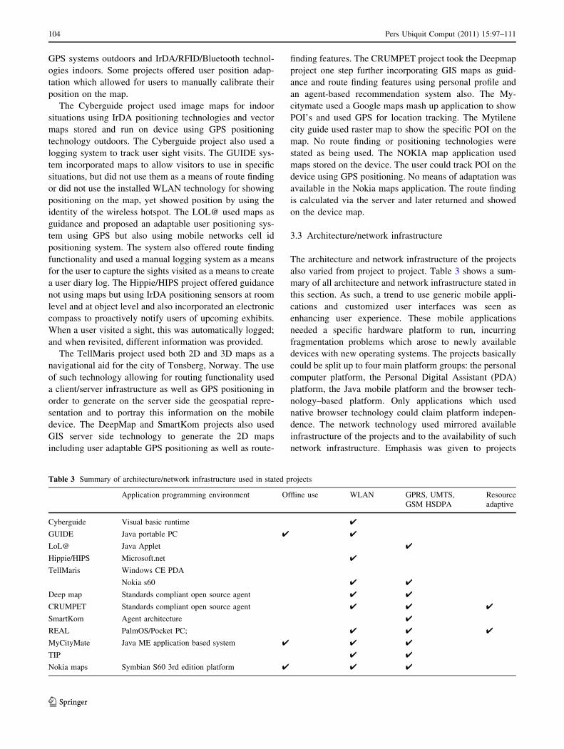
3.3 Architecture/network infrastructure
The architecture and network infrastructure of the projects
also varied from project to project. Table 3 shows a sum-
mary of all architecture and network infrastructure stated in
this section. As such, a trend to use generic mobile appli-
cations and customized user interfaces was seen as
enhancing user experience. These mobile applications
needed a specific hardware platform to run, incurring
fragmentation problems which arose to newly available
devices with new operating systems. The projects basically
could be split up to four main platform groups: the personal
computer platform, the Personal Digital Assistant (PDA)
platform, the Java mobile platform and the browser tech-
nology–based platform. Only applications which used
native browser technology could claim platform indepen-
dence. The network technology used mirrored available
infrastructure of the projects and to the availability of such
network infrastructure. Emphasis was given to projects
Table 3 Summary of architecture/network infrastructure used in stated projects
Application programming environment Offline use WLAN GPRS, UMTS,
GSM HSDPA
Resource
adaptive
Cyberguide Visual basic runtime 4
GUIDE Java portable PC 4 4
LoL@ Java Applet 4
Hippie/HIPS Microsoft.net 4
TellMaris Windows CE PDA
Nokia s60 4 4
Deep map Standards compliant open source agent 4 4
CRUMPET Standards compliant open source agent 4 4 4
SmartKom Agent architecture 4
REAL PalmOS/Pocket PC; 4 4 4
MyCityMate Java ME application based system 4 4 4
TIP 4 4
Nokia maps Symbian S60 3rd edition platform 4 4 4
104 Pers Ubiquit Comput (2011) 15:97–111
123

which were cognitive resource adaptable i.e. the software
adapts seamlessly to a change in the network environment.
Cyberguide used the Microsoft Visual Basic runtime
system running on portable device technology. The por-
table devices used a WLAN infrastructure installed on the
campus university test site. No cognitive resource adapta-
tion was mentioned for this project. The technological
infrastructure varied because of the different prototype
projects implemented. The system used a commercial
PDA; yet, at some stage, the project stated to use the Apple
MessagePad 100 with Newton 1.3. This indoor version of
the system was tested using IrDA sensors for location
tracking. The prototype was also tested on the Dauphin
DTR-1 palmtop. The GUIDE system used specific mobile
devices, namely Fujitsu TeamPad 7600 portable PC
empowered by custom Java applications. The Java appli-
cation included a Hot Java browser [36] and also included
gauges to show signal strength, an indication to which
WLAN hotspot the user was connected and another indi-
cation when the mobile guide was downloading informa-
tion. This project did not have a system of cognitive
resource adaptation due to the fact it could only run using
the WLAN as it was also its means for user position
finding. Yet, the project was adaptable to failing connec-
tions where a caching system would download and store
content on device at earlier stages allowing for the device
to gracefully degrade.
The LoL@ system was based on conventional Internet
software technology and user interface paradigms, exten-
ded by concepts to improve usability for the mobile
domain. This application targeted high-end mobile phones
and smart phones with Java Applet enabled fully fledged
Web browsers and used touch screens as input. The mobile
terminal used applet technologies, while Java Servlets
technology was employed on the server side. A network-
centric 3-tier application architecture was chosen for this
implementation enhanced with telecommunication-specific
constant network connection using UMTS (3G) or GPRS
network via a mobile phone. The fact that the LoL@
project required constant network connectivity where all
content data were stored on a server database and prepared
on demand resulted to data intensive costs for the user
which was observed as a disadvantage during user tests,
visitors were reluctant to use the system considering the
high roaming fees [38]. No adaptation capabilities were
designed for failing network shortages. The clients of the
HIPS system were PDAs which used a thin client (Web
browser) application with client–server architecture
requiring a stable network connection to operate. The PDA
devices were called HIPPIES and were connected via a
wireless LAN (WLAN) infrastructure. Apart from the use
of PDA devices, the project stated the use of notebooks or
PCs to access web content. The TellMaris project was
based on a client/server model, which meant all data were
downloaded upon request via a wireless communications
network connection. The OpenGL system was developed
on Linux, Windows and Windows CE platforms; however,
the system also ran on the Nokia communicator 92XX. In
the mobile version, the system displayed both 2D and 3D
maps simultaneously; however, the user could choose the
desired type of map. No reference was found for support of
cognitive network resource adaptation. These databases
were accessed using four main agents: The database agent
to retrieve non-spatial information; the geo-spatial database
to retrieve spatial information and to calculate geo-spatial
information (i.e. place with regards to user location); the
route agent used to compute and manage routes; the map
agent which generated at first raster maps as a picture case
and later as vector maps used to display features on the
maps. The architecture of the Deep map system was based
on the agent-oriented software paradigm which allowed
reusability of various system components. The prototype
was implemented using two technologies; one of a belt
worn Xybernaut mobile assistant IV having a visual output
on a flat touch screen mounted on the arm and the other a
laptop PC placed in the user’s backpack.
The CRUMPET implementation was based on a stan-
dards-compliant open source agent framework, extended to
support nomadic applications, devices and networks. The
system was built using a 3-tier structure; with mobile cli-
ents and user services on the two ends and the use of multi-
agent systems in between both. At the stage of usability
testing, a PDA was used as the client device using GPS as
positioning technology. Yet, it was argued that any mobile
device able to display rendered maps and simple HTML
pages could be used. The system could use all types of
networks that a tourist might be exposed to, i.e. WLAN,
GSM, GPRS, UMTS. The REAL project developed a
pedestrian navigation system that combined active and
passive location sensitivity in such a way that the
changeover between both adaptation paradigms was barely
noticeable for the user. The REAL project uses both Pal-
mOS and Pocket PC platform for indoor and uses a SONY
VAIO notebook outdoor for computational power but for
graphical and textual presentations; a special clip-on for
glasses from MicroOptical was used in conjunction with a
customized Garmin GPS unit as a pointing device. For both
indoor and outdoor systems, the 2D- and 3D-graphics are
generated via the embedded Cortona VRML1-browser.
The SmartKom uses distributed component architecture
using an agent-based multi-blackboard system. The inte-
gration platform is called MULTIPLATFORM (Multiple
Language Target Integration Platform for Modules), built
on top of open-source software, making it open, flexible
and scalable able to integrate heterogeneous software
modules implemented in diverse programming languages
Pers Ubiquit Comput (2011) 15:97–111 105
123

and running on different operating systems. SmartKom
modules were coded in C, C??, Java and Prolog. Smart-
Kom supported dynamic multi-lingual interaction by
introducing a semantic layer that encoded interactions in a
language-independent way.
The MyCitymate and the Mytilene guide systems
included a mobile application developed on the top of the
Java ME Platform [24], essentially comprising a certified
collection of Java APIs for the development of software for
small, resource-constrained devices such as cell phones and
PDAs etc. These two projects are purposely custom built
‘stand alone’ applications not needing a network connec-
tion to operate. ‘Tourists’ incorporate people visiting
international locations where roaming charges apply and
not needing a network connection to operate could be
critical in choosing a mobile tourist application. However,
just like the Nokia navigational assistant if needed, many
features are available if users want to use a network con-
nection. Features such as ‘where are my friends’ in the
MyCitymate project or the ‘download more information’ in
the Mytilene guide project.
The Nokia Navigational project has been developed
using Nokia Symbian platform supporting all s60 3rd
edition phones and other Nokia platforms. The Nokia maps
also has a free pc-based application where users upon
installation to their pc can download extra maps and voice
navigation files instead of downloading them straight to the
user’s phone.
3.4 Input/output modalities
At a first glance, the use of input/output technologies in
mobile devices seems trivial. Table 4 shows a summary of
input/output modalities stated in this section. Yet, in the
context of this in depth review, it was considered as
separate criteria for all projects reviewed. In this section,
the projects are reviewed with respect to input technologies
used by the users of the mobile devices also as to output
technologies. In addition, the projects are evaluated in
regards to accessibility and their ability to seamlessly
internationalize the specifically targeted tourist
applications.
The mobile device used in Cyberguide was a standard
PDA using a pen input and a standard PDA screen as an
output. In its documentation, there was no reference to
multi lingual support or use of any other modality tech-
nology to support other forms of output. The GUIDE
project employed devices with larger input area for use
with an input pen and a transreflective screen for use in
direct sunlight. The GUIDE project stated multilingual
support in its documentation but that was not referenced
extensively. The LOL@ project used speech as a form of
input. Tourist used speech to input control to the hierar-
chical interface gaining access to menu items. This project
allowed speech access in three different languages English,
German, French using not only one-word commands but
also natural language input phrases to control the menu.
This system did not use natural language processing other
than menu control for input purposes. The system used a
VoIP solution based on the Session Initiation Protocol
(SIP) [39] and the GSM voice codec [14].
The Hippie/HIPS system was a pen input-based system
not offering multilingual support to its users. Standard
pen input and PDA screen output were also used in the
TellMaris project, along with 3D representation on 2D
maps in an augmented reality environment to depict
buildings of historic nature (including buildings that did
not exist anymore). The DeepMap project integrated
natural language processing to mobile devices. The
Deepmap user could gain access to information by
Table 4 Summary of input/
output modalitiesKeypad Pen/screen
input
Multilingual
support
Voice/speech
input/output
3D Modelling
output
Cyberguide 4 4
GUIDE 4 4 4
LoL@ 4 4 4(3)
Hippie/HIPS 4 4
TellMaris 4 4 4 4
Deep Map 4 4 4 4 4
CRUMPET 4 4
SmartKom 4 4 4 4
REAL 4(input) 4
MyCityMate 4 4 4
TIP
Nokia Maps 4 4 4 4(output)
106 Pers Ubiquit Comput (2011) 15:97–111
123

queering the system using natural language. The system
upon queering, the database used text-to-speech to output
the information findings. The project could also be used
as a translator to interact with locals in their local lan-
guage. Again, VoIP technology was used to transfer the
voice to a server for further processing and speech rec-
ognition system to translate the spoken text to a query
towards the database. Also, GIS maps in conjunction to
3D representation were used to create an augmented
environment. The CRUMPET project supported multi-
lingual content and used a PDA browser application,
having a pen/screen modality. The SmartKom project was
a multimodal dialog system which provided for full
symmetric multimodality in which all input methods were
also available for output. The SmartKon system captured
speech, gesture and facial expressions using sensor tech-
nology trying to capture a natural experience for the user
in the form of daily human-to-human communication, by
allowing both the user and the system to interact. The
Mycitymate, Mytilene and Nokia maps make use of the
current mobile telephony devices available using keypad
and joystick as input. No reference is given for pen input
support. The Mytilene guide project offers video or audio
guide as output information of sights while Nokia Maps
offers speech output as navigation support. All the three
above-stated projects offer multilingual support. The
REAL system used speech input to accept a request for a
route description. This request was then transformed into
a user-specific request, taking into account limited cog-
nitive and network resources. The request was then passed
to the route-finding module which determined and for-
warded the optimal route to the presentation planning
module. This module optimized the presentation of the
route not only according to the resolution, screen size and
colour capabilities of the output device, but also to the
quality of the given sensor information (i.e. precision of
location, orientation and speed of the user).
3.5 Unique services
Many unique services where highlighted in the aforemen-
tioned reviewed projects. Table 5 summarizes unique ser-
vices stated in this section. The services basically fall into
three main categories: communication amongst users, tour
generator and a log system. These projects felt that com-
munication amongst tourist users was important. It was
interesting to see that most projects tied the user’s personal
profile with the tour generator offering tours that reflect the
users’ personal interests. The log system was found in
various forms, but as a fundamental system was used to
allow users to keep track of visited sights and in some cases
included a commenting system which was used to input
comments about sights visited.
Cyberguide using rapid prototyping design methods
implemented a number of applications. One such imple-
mentation had a messaging service whereby users could
contact each other and also contact members of university
stuff. For the messaging service, a wireless access system
was designed to cater for communication between tourist
users and the system. The system could document a user’s
visits which at a later stage could be sent via email to the
visitor. The GUIDE project developed an intelligent tour
guide builder which calculated customized tour guides
based on time constraints and dynamic changes to the
user’s environment (stopped, for coffee, slow walker). The
users could override the guided tour to change the next
location giving them freedom of choice. The guide system
also offered support for interactive services; a communi-
cation tool for visitors to contact the local Tourist Infor-
mation Center, messaging tool amongst visitors. It also had
Table 5 Summary of unique services
Added agent based
services
Exploratory Messaging/group
communication services
Pre visit
website
Post-visit
web
Friend position
finding
Ticket
eservices
Guided
tours
Cyberguide 4 4 4 4
GUIDE 4 4 4 4
LoL@ 4 4 4
Hippie/HIPS 4 4 4 4
TellMaris 4 4
Deep Map 4 4
CRUMPET 4 4 4
SmartKom 4 4
REAL 4
MyCityMate 4 4 4
TIP
Nokia Maps 4 4
Pers Ubiquit Comput (2011) 15:97–111 107
123

a built-in ticketing service where visitors could book
accommodation and buy tickets avoiding queues.
In the LOL@ project, a tourist diary service was offered
to users upon confirmation of arrival to a sight and/or by
accessing the My Data menu item to enter information. The
visitor could enter comments in the form of text via a
predefined screen including title, text and a link to a photo
or a video taken from the tourist mobile device. This was
later uploaded to the server and offered to the user for
viewing as a log of visited sights. The log file was not
integrated in existing Web technologies but was imple-
mented on a propriety-based Web platform in the form of
Web pages. Similarly to the Cyberguide project, the Hippie
guide also allowed for interpersonal communication and
general public communication of ideas through message
sending. The mobile system also allowed for personal
annotation added to the user’s personal space to be
accessed at the post-visit stage. Other prototypes of the
HIPS project implemented dynamic generation of presen-
tations depending on the distance the user has to the object
and how long they stood in front of the object. The
TellMaris project quoted a number of services which could
be implemented to be offered for both portable PC systems
and for mobile systems. For portable PC services like
weather forecasts, hotel reservation and navigational
guidance services were thought of and for mobile devices
users would be able to request information about various
sights or restaurants, find closest facilities or to buy specific
products. The CRUMPET system implemented guided
tours and a group messaging service.
4 Evaluation results
In this section, we discuss the results stated from the five
(5) evaluation tables listed above. Clearly, with respect to
the information model, most systems used a decentralized
web-based approach, yet others implemented proprietary-
based applications using some sort of an adaptable infor-
mation model offering personalized information to its users
via a hierarchical menu system.
Most systems used a map as a central feature which in
turn offered navigational and routing services. With only a
few exceptions, GPS has been the standard choice as out-
door positioning technology. Certainly, this can also be
confirmed by today’s increasing tendency of mobile phones
incorporating GPS units and not the use of say, telecom-
munication cell-id positioning (used in the LoL@ system).
Apart from navigational and route-finding capabilities,
only the GUIDE and the CRUMPET system offered basic
itinerary planning for its users based on a personal profile.
This feature was noted as being popular amongst tourist
users visiting the city for the first time.
As of network capabilities, all systems used a HTTP IP
connection which could be used in all cases of network
connectivity being WLAN, GPRS, UMTS. However, only
a few systems had the ability to adapt to network fluctua-
tions offering on device cached content to the user. Also,
systems such as the CRUMPET and the REAL system
were stated as being cognitive resource adaptable. This is
the ability to sense changes in network connectivity and
being able to change the network connection without
interrupting content flow.
Coming to situational factors, only some systems
enabled alternative input and output modalities. The sys-
tems implementing speech modalities for input or output
were said to be resource constrained acquiring constant
large bandwidth network connection to function properly
and efficiently due to the fact that all speech processing
was completed on the server side.
As of architecture, only systems using agent-based
architecture (CRUMPET, SmartKom) were said to be
standards based and could be easily extended offering other
services and integrating other sources of repository, other
than proprietary based. Notably, only a few systems used
thin clients of some sort to visualize hypermodel; most
systems employed the use of thick client applications to
offer a richer customizable interface.
Finally, as of services offered to tourists, it could be seen
that these were split into three different stages of a tourism
lifecycle: the pre-visit stage, the visit stage and the post-
visit stage. The pre-visit stage was implemented by some
systems offering the use of information for the places to
visit and the ability of explicitly collecting personal
information to build a personal profile. During the visit
stage, services offered were mostly combined communi-
cation—friend finder tools and diary-commenting systems
were also implemented. The post-visit stage stressed the
need of documenting the visit offering it to tourists as a
means of logging their visit to be retrieved via the internet
at a later stage.
5 Design principles versus current trends
This paper focused on the evaluation of a large number of
research and commercial applications used by tourists to
retrieve information, navigation and guidance using some
form of mobile device in the scope of application designers
and technology developers. In order to evaluate these
projects, a number of design criteria were extracted tar-
geting both designers and developers. These projects were
grouped into four groups: mobile guide applications, web-
to-mobile guides, mobile phone navigational assistants
(with built in tourist guides) and mobile web-based appli-
cations (the latter have not been extensively evaluated due
108 Pers Ubiquit Comput (2011) 15:97–111
123
to their resemblance with their web counterparts). A
number of milestone projects were incorporated which
according to the considered bibliography offered unique
experimental features and so was a number of commercial
projects offering unique services.
After analysing the above-evaluated findings (see Sect.
3), an application designer should keep in mind at least
three principles: the Information model to be used, the
Unique Services to be provided and the input/output
modalities to be incorporated in the overall project. As of
information models, there are basically three main choices:
• Decentralized information model
• Centralized information model
• Distributed dynamic information model
The decentralized approach is an on-device solution
where the information content is stored on the device. A
number of solutions used this approach where some pro-
jects used memory cards to store and encrypt the content.
This approach though brought about content update issues
and is mostly used in solutions that do not need the content
to be updated, i.e. static tourist guides. The distributed
dynamic information model was used to push specific
content to a user entering the vicinity of the network node.
This approach works in environments wherein a network
installation exists or in scenarios where the system can use
the mobile network cell ID to push information to the
users. The centralized approach in most cases was used in
conjunction to hypermedia content models. This was the
case for the majority of projects evaluated and certainly
there are a number of advantages of using the centralized
hypermedia model (easy updating of content, access on a
number of different mobile devices, etc.); the problems that
arise in this case are normally due to compatibility prob-
lems in mobile browsers which normally lead to project
developers implementing a custom browser–based appli-
cation and also in some case where the cost of connection
is incurred by the user, roaming charges are very high
making. The use of a personal profiling system could
increase the usability of the system in issue. Using a per-
sonal profiling system means the information model must
be dynamically generated in regards to the explicit profile
of the user and the implicit usage history. In conjunction
with a personal profile and knowing the users whereabouts
(using context awareness methods) as stated in the relevant
projects (see Sect. 3) increase the usability of such systems.
An application designer should design a tourist mobile
guide system keeping in mind the multilingualism; a case
of easily bringing more languages to the tourist guide
should be designed at the start of the system design. Also,
the application designer should cater for users that do not
have easy access to keyboard input and screen output
implementing alternative input/output modalities, like
speech input and output. This solution is network depen-
dant and might increase the cost of fast network
connection.
Finally, the case of unique services which should be
incorporated comes down to the scope of each application
designer’s project. Below is a potential list of ‘common
denominator’ services:
• guided tours,
• communication amongst users and the system,
• e-services (e.g. diary service, currency conversion, etc.)
• group meeting scheduler,
• registering position to friends,
• pre-visit and post-visit services support,
• rating/commenting service.
Indeed, a technology developer should surely keep in
mind the three above-mentioned design choices which an
application designer has to choose from but also choose
from a range of architecture, development platforms, net-
work infrastructure, positioning technologies and map
technologies.
The architecture chosen by the evaluated projects’
developers reflected the devices which they had to choose
from. There was no real drift to particular devices or
development platforms due to the large fragmentation
problem which mobile developers face. Most of the sys-
tems implemented used the client–server architecture and
some used propriety-based architecture, while a few used
agent-based systems. The agent-based ones were noted as
being standards compliant, which meant that they were
being able to add more services to the existing infrastruc-
ture without major changes. As of development platforms,
Visual basic.NET was popular for PDA-based projects
while Java-based systems where popular for every other
mobile device stated. All available network platforms were
used (i.e. WLAN, GPRS, UMTS and GSM); notably,
WLAN is an expensive solution and GPRS, GSM was a
slow solution as was the UMTS a costly solution which the
users of the systems incurred.
Most systems used some sort of maps in the mobile
guides, some of which were raster-based maps and others
which were GIS-based vector maps. Surely, in situations
where routing and guidance was necessary, a GIS map
server is useful; yet, raster maps better suited systems
where maps were solely used as a means of displaying the
location of POIs, when comparing the network usages and
technology requirements. As of positioning in outdoor
situations, GPS represents a reliable technology, while for
indoor positioning, IrDA and RFID tags are better suited.
As such, our evaluation revealed open research issues
and some specific areas of mobile tourist guides research
that need to be systematically investigated tying them to
current trends of the Web. Specifically, more work could
Pers Ubiquit Comput (2011) 15:97–111 109
123

be carried out on social networking for tourist users espe-
cially in the eye of recent advent of mobile social networks
[19]. The Mycitymate attempts to add such functionalities
in the form of ‘locate your friends’ services and via com-
menting of POIs service but no attempt to connect content
to current social networks (i.e. Facebook, twitter, etc.) has
been carried out. Even though much work has been already
carried out on personal profiling systems, no research has
been noted on server-side clustering of users or collabo-
rative filtering techniques of tourist content used in many
popular sites (e.g. Amazon) [13]. This server side attempt
would decrease device system resources (heavy algorithm
calculations would be done on the server), while clustering
of user profiles would enable proper assignment of users to
group of tourists with similar interests, thereby providing
space for the development of innovative personalized
features.
Lastly, this evaluation identified a few projects stated
the use of dynamic tour generation which the system apart
from proposing specific POIs’ to visit would also consider
the user’s profile in dynamically choosing the tour before
generating it. Yet, there was no claim of dynamic itinerary
generation, wherein users would state the time and days
they have available for visiting tourist sights and the sys-
tem depending on external parameters (i.e. opening times,
weather conditions, peers choices and ratings) could gen-
erate a n-day itinerary for the specific user keeping in mind
the ‘must see’ sites and the user’s profile. Recent works
proposing algorithmic solutions for optimizing personal-
ized tourist itineraries [12, 37] have revealed the potential
of such services but remain to be implemented and eval-
uated through field trials.
References
1. Abowd A, Atkeson C, Hong J, Long S, Pinkerton M (1996)
Cyberguide: a mobile context-aware tour guide. Wirel Netw
3(5):421–433
2. Baus J, Kruger A, Wahlster W (2002) A resource-adaptive
mobile navigation system. In: International conference on intel-
ligent user interfaces archive, proceedings of the 7th international
conference on intelligent user interfaces, pp 15–22
3. Chen G, Kotz D (2001) A survey of context-aware mobile
computing research. Dartmouth Computer Science Technical
Report TR2000-381
4. Cheverst K, Mitchell K, Davies N (2002) The role of adaptive
hypermedia in a context-aware tourist GUIDE. Commun ACM
45(5):47–51
5. Davies N, Cheverst K, Mitchell K, Friday A (1999) ‘Caches in
the Air’: disseminating tourist information in the guide system.
WMCSA, pp 11–19
6. Dublin.mobi (2009) Welcome to Dublin.Mobi. http://www.
dublin.mobi/mobi/, last visited March 2009
7. eIndia.mobi (2009) eIndia.mobi India’s mobile portal. http://
eindia.mobi/, last visited March 2009
8. Economou D, Gavalas D, Kenteris M, Tsekouras GE (2008)
Cultural applications for mobile device: issues and requirement
for authoring tools and development platforms. ACM SIGMO-
BILE Mobile Comput Commun Rev 12(3):18–22
9. Europe, Nokia. Nokia Europe. Nokia Europe—Maps—Main.
Nokia, http://europe.nokia.com/maps. Last visited October 2008
10. Europe, Nokia. Nokia Europe. Nokia Europe—Guides—map.
Nokia Europe. http://europe.nokia.com/A41407071. Last visited
October 2008
11. Google. Google. Google mobile mops. http://www.google.com/
mobile/default/maps.html
12. Hagen K, Kramer R, Hermkes M, Schumann B, Mueller P (2005)
Semantic matching and heuristic search for a dynamic tour guide.
In: Frew AJ, Hitz M, O’Connor P (eds) Information and com-
munication technologies in tourism. Springer
13. Herlocker J, Konstan J, Terveen L, Riedl J (2004) Evaluating
collaborative filtering recommender systems. ACM Trans Inf
Syst 22(1):5–53
14. Huerta JM, Stern RM (1998) Speech recognition from GSM
codec parameters. In: ICSLP-1998, paper 0626
15. Jeff A (2006–2007) Methods of understanding and designing for
mobile communications. Dissertation, The University Of
Queensland
16. Kenteris M, Gavalas D, Economou D (2009) An innovative mobile
electronic tourist guide application. Personal and ubiquitous
computing, 13(2). Springer Science, 2009, ISSN: 1617-4909
17. Kray C, Baus J, Cheverst K (2005) A survey of map-based
mobile guides. In: Map-based mobile services—theories, meth-
ods and implementations, pp 197–216
18. Kray C, Laakso K, Elting C, Coors V (2003) Presenting route
instructions on mobile devices. In: Proceedings of the 2003
international conference on intelligent user interfaces, IUI’03, pp
117–124
19. Larsena J, Urryb J, Axhausenc KW (2007) Networks and tourism:
mobile social life. Ann Tourism Res 34(1):244–262
20. Long S, Kooper R, Abowd GD, Atkeson CG (1996) Rapid pro-
totyping of mobile context-aware applications: the Cyberguide
case study. In: MobiCom ’96: proceedings of the 2nd annual
international conference on mobile computing and networking
21. Luyten K, Coninx K, Houben G, Winters F (2005) Blended maps
and layered semantics for a tourist mobile guide. In: The 11th
international conference on human-computer interaction, Las
Vegas, Nevada, USA. July 2005, pp 22–27
22. Malaka R, Zipf A (2000) DEEP MAP—challenging IT research
in the framework of a tourist information system. In: Information
and communication technologies in tourism, proceedings of
ENTER 2000. 7th, 2000
23. Meng L, Zipf A, Reichenbacher T (2005) Map-based mobile
services: theories, methods and implementations. Springer
24. Microsystems, Sun The Java ME platform—the most ubiquitous
application platform for mobile devices. Sun Microsystems.http://java.sun.com/javame/index.jsp
25. mobiletravelaide.com (2009) Mobile travel aide—Mobile-
friendly travel information center. http://www.mobiletravelaide.
com, last visited March 2009
26. Mycitymate. mycitymate home page. Mycitymate mobile guide.
http://www.mycitymate.com. Last visited October 2008
27. Opperman R, Specht M (2000) A context-sensitve nomadic
exhibition guide. In: Proceedings of the 2nd symposium on
handheld and ubiquitous computing, pp 127–149
28. Oppermann R, Specht M (1999) A nomadic information system
for adaptive exhibition guidance. In: Proceedings of the interna-
tional conference on hypermedia and interactivity in museums
(ichim 99), Sept 1999, pp 103–109
29. Poslad S, Laamanen H, Malaka R, Nick A, Buckle P, Zipl A
(2001) CRUMPET: Creation of user-friendly mobile services
110 Pers Ubiquit Comput (2011) 15:97–111
123

personalised for tourism. 3G Mobile Communication Technolo-
gies, 2001. Second International Conference on (Conf. Publ. No.
477), pp 28–32
30. Pospischil G, Umlauft M, Michlmayr E (2002) Designing LoL@,
a Mobile Tourist Guide for UMTS. In: Proceedings 4th interna-
tional symposium on human computer interaction with mobile
devices (Mobile HCI ‘02), Pisa, Italy. Sept 2002
31. Przybilski M, Campadello S, Saridakis T (2004) Mobile on
demand access of service-annotated 3D maps. In: Proceedings of
the 22nd IASTED international conference on SOFTWARE
ENGINEERING (SE 2004), pp 719–725
32. Sharp R, Rehman K (2005) The UbiApp workshop: what makes
good application-led research? IEEE Pervasive Comput 4(3):80–82
33. Schilling A, Coors V, Giersich M, Aasgaard R (2003) Introducing
3D GIS for the mobile community technical aspects in the case of
TellMaris. In: IMC workshop 2003 proceedings: assistance,
mobility, applications. Fraunhofer IRB Verlag, Stuttgart
34. Schmidt-Belz B, Laamanen H, Poslad S, Zipf A (2003) Location-
based mobile tourist services first user. Information and Com-
munication Technologies in Tourism (ENTER 2003)
35. s60blog.com (2008) Nokia Maps 3.0—Maps with Ovi—Mail on
Ovi—consumer messaging. The S60 Blog. http://s60blog.com/
2008/12/nokia-ovi-just-got-bigger-and-better. Last visited Oct
2008
36. Sun_Microsystems (2008) Sun Microsystems. Hot Java Browser.http://java.sun.com/products/archive/hotjava/, Sun Microsystems.
Last visited August 2008
37. Souffriau W, Vansteenwegen P, Vertommen J, Berghe GV, Ou-
dheusden D (2008) A personalized tourist trip design algorithm
for mobile Tourist guides. Appl Artif Intell 22(10):964–985
38. Umlauft M, Pospischil G, Niklfeld G, Michlmayr E (2003)
LoL@, a Mobile Tourist Guide for UMTS. J Inf Technol Tour-
sim. In: Werthner H, Veit E (eds) Cognizant, vol 5, no. 3. March
2003, pp 151–164
39. Kim W, Kim M, Lee K, Yu C, Lee B (2004) Link layer assisted
mobility support using SIP for real-time multimedia communi-
cations. In: Proceedings of the second international workshop on
mobility management & wireless access protocols, 01-01 October
2004, Philadelphia, PA, USA
40. Wahlster W (2001) SmartKom a transportable and extensible
multimodal dialogue system. In: International seminar on coor-
dination and fusion in multimodal interaction, Schloss Dagstuhl
international conference and research center for computer sci-
ence, Wadern, Saarland, Germany
Pers Ubiquit Comput (2011) 15:97–111 111
123