The University of Bradford Institutional Repository - CORE
56
The University of Bradford Institutional Repository http://bradscholars.brad.ac.uk This work is made available online in accordance with publisher policies. Please refer to the repository record for this item and our Policy Document available from the repository home page for further information. To see the final version of this work please visit the publisher’s website. Access to the published online version may require a subscription. Link to publisher version: http://dx.doi.org/ Citation: Gibson AM, Neubauer W, Flöry S et al (2017) Survey and Excavation at the Henges of the Wharfe Valley, North Yorkshire, 2013-15. Archaeological Journal. Copyright statement: © 2017 Royal Archaeological Institute. Full-text reproduced in accordance with the publisher's self-archiving policy.
-
Upload
khangminh22 -
Category
Documents
-
view
0 -
download
0
Transcript of The University of Bradford Institutional Repository - CORE

The University of Bradford Institutional Repository
http://bradscholars.brad.ac.uk
This work is made available online in accordance with publisher policies. Please refer to the
repository record for this item and our Policy Document available from the repository home
page for further information.
To see the final version of this work please visit the publisher’s website. Access to the
published online version may require a subscription.
Link to publisher version: http://dx.doi.org/
Citation: Gibson AM, Neubauer W, Flöry S et al (2017) Survey and Excavation at the Henges of
the Wharfe Valley, North Yorkshire, 2013-15. Archaeological Journal.
Copyright statement: © 2017 Royal Archaeological Institute. Full-text reproduced in accordance
with the publisher's self-archiving policy.

1
1
Survey and Excavation at the Henges of the Wharfe Valley, North Yorkshire,
2013-15
Alex Gibson1 with
Wolfgang Neubauer2, Sebastian Flöry2, Roland Filzwieser2, Erich Nau2, Petra
Schneidhofer2 & Guglielmo Strapazzon2, Philippa Bradley3, Dana Challinor4, Charles
French5, Alan Ogden1, Garry Rushworth6 and Alison Sheridan7
1 - School of Archaeological Sciences, University of Bradford
2 - Ludwig Boltzman Institute for Archaeological Prospection and Virtual Archaeology -
University of Vienna.
3 - 23 Feversham Road, Salisbury, Wilts SP1 3PP
4 - School of Archaeology, University of Oxford
5 - Department of Archaeology and Anthropology, University of Cambridge
6 - Butts Farm, Thurstonland, HD4 6XG
7 - National Museums Scotland
INTRODUCTION
Whilst the great Yorkshire henges such as those of the Thornborough complex in the A1
corridor are well known in the archaeological literature (Harding 2013) until recently,
Yarnbury (near Grassington) and Castle Dykes (near Aysgarth) were the only two ‘henges’
known in the Yorkshire Dales (Harding with Lee 1987, Nos 217 & 205). They both have
classic external banks and internal ditches but both are unusual in that they lie on high spurs
or crests between their main river valleys and smaller tributaries. They also appear to be in
apparent isolation lacking associated contemporary monuments such as ring-ditches,
barrows or cairns. Jan Harding (2013, 201) has suggested that the entrances of these sites
are generally orientated on the West-East flowing river valleys and therefore reference the
henge complexes of Thornborough, Nunwick and Hutton Moor. Whilst this works at a
general level, in detail, Castle Dykes and Yarnbury do not align on the river valleys per se
but rather on large landscape features that would appear to mark solar events. (mid-winter
sunrise at Yarnbury (Martlew 2010, 70)). In addition to these well known sites, two more
henges have recently been identified at Threshfield, one from aerial photography and the
other through Lidar survey (Gibson 2014a) whilst a small double-entranced enclosure with
associated ring-ditches has been located in the confluence of the River Wharfe and its
tributary the Skirfare, some 1.8 km North of Kilnsey (Martlew 2004). With four of the five
known or suspected sites lying in Wharfedale, and largely comprising chance discoveries, it
suggests that these sites may not be isolated phenomena and more may be awaiting
discovery in these rich upland pastures and important cross-Pennine routes (Fig 1). This
theme will be further examined below.

2
2
Fig 1 – Location map

3
3
In 2013, generously funded by the British Academy, a programme of geophysical survey
was inaugurated by the author in collaboration with the Ludwig Boltzman Institute for
Archaeological Prospection and Virtual Archaeology, University of Vienna (hereafter LBI).
This was designed to test the LBI’s highly mechanised geophysical equipment on rough
upland terrain and also to investigate not just the henge monument of Yarnbury itself, but
also some 15ha around the monument to test its apparent isolation. Unfortunately, as the
Austrian team were en route to Yarnbury, northern England experienced a severe fall of late
snow. Strong winds caused serious drifting and sub-zero temperatures prevented a thaw.
Inspection of the Yarnbury henge revealed considerable drifting against all field walls, deep
quarry pits were masked by snow forming effective pit-fall traps for the quad-bike and, more
importantly, snow-buried surface stones and frozen molehills were likely to cause serious
damage to the survey equipment. In order not to waste the journey, landowner permission
was quickly obtained to survey the lower-lying Threshfield site where drifting snow was less
of a problem and, being on improved pasture, surface stones and molehills were minimal. It
was agreed that the LBI team return in September 2013 to complete the Yarnbury survey.
A follow-up excavation at Yarnbury was mounted in 2014 and was funded by the University
of Bradford. A further landscape geophysical survey was mounted at Castle Dykes in 2015
and will be reported elsewhere.
THRESHFIELD
The site of the Threshfield survey (Fig 1) lies some 2km west-north-west of Grassington, on
the west bank of the Wharfe at 190m OD. In 2006, during routine flying by staff from English
Heritage, part of a double-ditched circular cropmark (SD987643) was noted in recently
harvested hay (Historic England Aerial Photo No20587_041 27-JUL-2006). The site
measures 40m N-S x 35m E-W internally and 51m N-S x 49m E-W overall so seemed too
large for a Bronze Age ring ditch. This has been labelled Henge 1 in this survey. No other
cropmarks have been noted in the vicinity.
In 2012, the Environment Agency provided their Lidar imagery of Wharfedale to the
Yorkshire Dales National Park Authority. This included the area of Threshfield and in the
field to the south-west of Henge 1 a circular embanked enclosure with two opposed
entrances on a NE-SW axis was noted (SD987642). This had the classic appearance of a
class II (double-entranced) henge monument and its proximity to Henge 1 was noteworthy.
This has been designated Henge 2 in the present survey. A circular mound was also located
some 260m to the SE of Henge 2 (SD989640) and appeared to have a pit in the top
suggesting unrecorded antiquarian excavation. There are no known antiquarian references
to these monuments and they do not seem to feature in the section of the Raistrick archive
housed in the J B Priestly library at the University of Bradford. It was therefore a surprise to
learn from the landowner that the field in which Henge 2 is located is known locally as Castle
Dykes (not to be confused with the Castle Dykes near Aysgarth in Wensleydale).
Threshfield (24th – 29th March 2013)
The survey was designed to create a laser-scanned Digital Terrain Model of the area
surrounding the henges (Fig 2), to cover the area with close interval magnetometry and then
to survey areas producing significant archaeological results with Ground Penetrating Radar
(Fig 3). A total area of 11.1 hectares was surveyed with magnetometry and 3.9 hectares by
GPR.

4
4
Fig 2 – DTM of the Threshfield survey area. Henge 2, the round mound and an area of
quarrying can be clearly seen.
Fig 3 – Threshfield: interpretation of the areas of Magnetometry survey.

5
5
The Round Mound
The round mound measures 27m in diameter, has a small depression some 4m in diameter
in the top (Fig 4) and rises to approximately 0.5m above the surrounding surface. It did not
respond well to the magnetometry survey (Fig 5) suggesting that it was composed of the
same material as the surrounding geology (limestone). The central pit, initially suspected as
being the result of an antiquarian investigation, did not seem to penetrate deep into the
mound. There was no sign of a surrounding ditch or any sub-mound features.
Fig 4 – Threshfield mound DTM
Fig 5 – Threshfield Mound magnetometer detail.
The GPR survey was only slightly more enlightening. The survey revealed neither
surrounding ditch nor subsurface features. The mound was visible in several time-slices (Fig

6
6
6) but again the weakness of the signal suggested that it was composed of the same
material as the local geology.
Fig 6 – GPR time slices through the Threshfield Mound

7
7
Henge 1
The DTM (Fig 2) clearly shows that Henge 1 does not survive as an earthwork, however it
did respond well to both magnetometry and GPR. The magnetometry (Fig 7) reveals slightly
more detail than the aerial photographs. The inner ditch can be seen to be irregular with a
flattened eastern sector and encloses an area 40m N-S by 35m E-W. The entrance to the
ESE is clearly visible and measures some 4.3m wide. The ditch averages 2m across and the
strength of the signal may suggest areas of burning. Inside, an oval of 11 pits measuring
15m N-S by 12m E-W may represent a timber circle however the fact that the henge and pit
circle are not concentric may suggest that they are also not exactly contemporary. Other pits
noticeable just outside the entrance and within the interior may or may not be
archaeological.
Fig 7 – Threshfield Henge 1: magnetometry survey
The outer ditch appears to be more regular although there is a slight flattening in the NW
arc. It encloses an area 51m N-S by 49m E-W. With an average width of 0.4m, the
narrowness of the ditch may possibly suggest that it represents a palisade trench.
The GPR survey suffered some data logging problems hence the blank sweeps in Fig 8. It
nevertheless confirmed the features noted in the magnetometer survey, including the off-
centre pit circle, especially in the 40-60cm time slice (Fig 8).

8
8
Fig 8 – Threshfield Henge 1: GPR survey

9
9
Henge 2
As mentioned above, the earthwork survival at Henge 2 was noted on the Environment
Agency Lidar survey so it is not surprising that it is well-defined on the DTM survey (Fig 2)
and local relief model here (Figs 9 & 10). The orientation of the earthwork is worthy of
comment. The DTM, Lidar and local relief model all show the earthwork enclosure as having
two opposed entrances orientated SW-NE but the magnetometry (Fig 11) and the GPR have
proved this to be false. The surface indications suggest that the henge has been turned
through almost 90O and this must be the result of agricultural degradation. The site lies in
improved pasture which has been regularly ploughed, rotavated and direct-drilled. The
direction of this activity follows the main SW-NE axis of the field and therefore the henge
bank has been degraded at right angles to this direction of ploughing where it offers least
resistance. Conversely, where the bank is more tangential to the direction of ploughing,
coinciding with the actual entrances, the bank material has been spread thus effectively
closing the entrance gaps. This means that despite surface appearances, the orientation of
the henge is in fact virtually the same as Henge 1: both sites reflecting the main direction of
the river valley.
Fig 9 – Threshfield Henge 2: DTM showing apparent SW-NE axis.

10
10
Fig 10 – Threshfield Henge 2: local relief model with contours.
Fig 11 – Threshfield Henge 2: Magnetometry survey showing true NW-SE axis.

11
11
The magnetometry (Fig 11) shows that Henge 2 has a broad inner ditch some 5-6m wide
enclosing an area 31m N-S by 34m E-W. Like Henge 1, it also has a narrow outer ditch that
averages just under 2m wide and though it appears similar to that at Henge 1, it is clearly
more substantial. It encloses an area some 65m in diameter. It is not clear if this outer ditch
completely encircles the henge or whether it respects the entrances. Pits below the bank to
the N of the SE entrance may suggest an earlier phase of pre-henge activity and a broadly
rectangular internal pit some 12m long and on the same orientation as the henge may also
be archaeological. Other pits within the area of survey may well be natural. Henge 2 does
not show as well in the GPR survey though the larger of the two ditches and the internal pit
are both quite clear, the latter especially in the 100-120cm time slice.
Two large pits lie outside the henge (Fig 11). One to the WNW measures some 3.5m in
diameter, while a larger roughly rectangular pit to the SW measures 12.5 x 10.5m. Both
these features may be archaeological but are clearly undated.
Other Features
Despite the ‘noise’ on the magnetometer survey (Fig 3), the majority of anomalies can be
attributed to the local geology, ground metals or quarrying. There are, however, a number of
pits that could possibly be anthropogenic though the dating of these and their exact nature
cannot be proven without excavation. Their distribution does not form any real patterning.
Two perfectly circular pits may be archaeological in origin. The first is located 150m SW of
the centre of Henge 2, near the western edge of the survey area and measures 8m across.
The second is situated 40m SW of the centre of the round mound and measures 6m in
diameter. The nature of these pits remains unknown but both are well defined, perfectly
circular and certainly do not appear to be natural features.
YARNBURY
Introduction
The class I henge at Yarnbury lies 1mile NE of the village of Grassington in upper
Wharfedale, North Yorkshire (SE014654) (Figs 1 & 12). Despite the prominence of the
earthwork enclosure (Fig 13), the site does not seem to have been recorded until the mid-
1920s when, in his review of Bronze Age Monuments, Raistrick described the circle as a
disc barrow (Raistrick 1929). It does not appear on any Ordnance Survey Map until the 1978
1:10000 edition. The site was surveyed by a J Barrett in 1963 (Barrett 1963) apparently
based on compass point bearings measured from a centre pin but this survey, now in the
NMR, was not published.

12
12
Fig 12 – Neolithic and Bronze Age monuments in the Grassington area
Fig 13 – Aerial Photograph of Yarnbury henge from the NE. Photograph by the late Barri
Jones, courtesy of Alan King.

13
13
The site was partially excavated by David Dymond of the Ordnance Survey in 1964 who
opened a narrow trench over the external bank and internal ditch and into the centre of the
monument. If any plans or sections had been made by Dymond, they no longer appear to
survive and his excavation report is so brief that it can be quoted verbatim.
At Yarnbury, just over one mile north-east of Grassington there is a circular
earthwork 116ft in diameter overall, consisting of a ditch with external bank.
On surface inspection the earthwork appeared to have the characteristics
of a henge monument. An excavation carried out in July 1964, by an
archaeological summer school based on Grantley Hall, proved this thesis.
There was no trace of an internal mound, and the entrance to the south-
east was obviously original. No traces were found of any sort of internal
structure and a square pit in the centre of the circle had been caused by an
excavation earlier this century. The ditch was rock-cut and the bank of
simple dump construction. No dating evidence was found. (Dymond 1965)
How Dymond knew that the central pit had been excavated ‘earlier this century’ is not stated
– he records no source or diagnostic finds – but rather his claim seems to have been
founded on prior knowledge otherwise one would have expected him to have used a much
more vague term such as ‘earlier antiquarian activity’. There is, however, a Collared Urn
(and fragments of a second) in Manchester Museum that is recorded as coming from
Yarnbury, Grassington, and was associated with a cremation burial (Manchester Museum
Accn No 22826: Longworth 1984, No.1152). The Collared Urn is recorded as having been
excavated in 1922-23 and presented to the museum by a Mr Bennett in December 1945.
Interestingly, a note with the urn reads ‘name of donor not to be mentioned’ which may
possibly hint at clandestine excavations or unscrupulous acquisition. If this Collared Urn did
indeed come from the Yarnbury circle, and if Raistrick knew about the excavations (as he
almost certainly would have done), it is puzzling that he did not refer to the excavation in his
1929 review, written only 5 or 6 years after the date claimed for the excavation.
Nevertheless, knowledge of the burial may have influenced his interpretation of the site as a
disc barrow for as such the site is unusual in having a well-defined entrance. That said, one
must bear in mind that in 1929 the term ‘henge’ had not yet been introduced into the
archaeological lexicon (Kendrick & Hawkes 1932).
The site was recorded as a single-entranced (class I) henge by Harding with Lee (1976) who
describe it at 335m OD, having an internal diameter of c.20.2 – 21.5m and an external
diameter of c.34-35m (Fig 13). Much smaller than many other Yorkshire henges, particularly
those of the Ure Valley, Harding with Lee comment “…the site certainly has a ‘hengiform’
appearance, and it is hard to see what else it can be” (Harding with Lee, 1987, 318). The
site was also interpreted as a henge by Martlew (2004) who was the first to publish a
detailed survey of the monument identifying the SE entrance and also an area of quarrying
on the east side, presumably resulting from the construction of the adjacent field wall, but
importantly Martlew also identified the possible location of Dymond’s excavation.
The Yarnbury circle was again interpreted as a henge by Jan Harding who suggested that
the smaller Pennine henges had their entrances facing down their respective valleys towards
the main Ure/Swale Valley sites such as Thornborough and that this may signify the
existence of late Neolithic trans-Pennine routeways, perhaps connected with the eastwards

14
14
movement of Langdale axes (Harding 2013, 205). The idea is attractive however the
orientation works only on the most general of terms: the smaller Pennine henges (Castle
Dykes, Yarnbury and Midgeley Moor in the Calder Valley) have their entrances towards
major landscape features and do not focus on the river direction as specifically as do the
Threshfield sites.
Classic henges are rarely in isolation. They often occur in areas that produce earlier,
contemporary and later sepulchro-ritual monuments (Harding with Lee 1976). They tend
toward river valleys although there are some notable exceptions such as Cairnpapple Hill,
West Lothian (Piggott, 1948). Yarnbury is unusual in that it does appear to be in isolation
and it lies not on the valley floor but on a ridge with extensive views to the south and round
to the west. There is higher ground to the north and the lead mining ridge of Hebden and
Grassington Moors forms the horizon to the east. From whichever immediate direction
Yarnbury is approached it is on the horizon (Fig 14) and for this reason might invite other
interpretations such as a signal station though clearly the presence of higher ground to the
north and east, as well as the internal ditch, argue against this. To test whether the site was
in real or perceived isolation, a programme of fieldwalking and geophysical survey was
undertaken in September 2013.
Fig 14 – Yarnbury from the NW. Photograph Alex Gibson
Field Walking
The HER records 1 scraper, 1 core scraper, 1 barbed and tanged arrowhead, 1 fragment of a jet pendant, 4 microliths and 1 blade being scattered throughout the field and recovered

15
15
Fig 15 – The Yarnbury molehill survey in progress. Each flag represents a molehill or similar animal ground disturbance.Photograph Alex Gibson
Fig 16 – Area and results of the Yarnbury. molehill survey and trenches from molehills (Craven Mus D3185/E/3). Other than the jet pendant (see below) the other finds listed could not be identified with certainty amongst the material in Craven Museum. The opportunity for fieldwalking was limited due to the permanent nature of the grass cover so it was decided to undertake a ‘molehill survey’ prior to the geophysical survey. This was undertaken by volunteers from the University of Bradford and the Upper Wharfedale Heritage Group. A series of 20m wide transects were laid out over the henge and its

16
16
environs and flags were used to mark out and identify surface disturbances for sifting (Fig 15). Despite the density of the disturbances, results were poor (Fig 16). Only some 46 artefacts were recovered, all debitage, and the assemblage is reported below.
The Geophysical Survey
As at Threshfield, the site was surveyed using Magnetometry, Ground Penetrating Radar
(GPR) and Terrestrial Laser Scanning. Some 15ha were surveyed using magnetometry with
a small area over the henge being subject to GPR.
The DTM (Fig 17) clearly shows the location of the henge and its situation within an area
streaked with hollow ways probably resulting from traffic to and from the lead mines and/or
pre-enclosure grazing to the north-east. There are no other obvious archaeological features
within the survey area with the exception of two lead test pits to the NE.
Fig 17 – DTM of the Yarnbury survey area. The henge is clearly visible to the NE of centre.
Detail of the henge itself shows not only the area damaged by quarrying in the ENE, but also
the entrance, the old excavation trench and a near central mound and depression, possibly
up-cast and settling from the earlier excavation (Fig 18). This is also visible on the local relief
model and contour survey (Fig 19).

17
17
Fig 18 – detailed DTM of the Yarnbury henge.
Fig 19 – Local relief model and contour survey of the Yarnbury henge

18
18
As mentioned above, one of the reasons that the project appealed to LBI colleagues was the
opportunity to test the equipment on rough terrain. This did indeed prove problematical and
the magnetometry had to be undertaken multi-directionally to avoid deep holes and exposed
rocks. This clearly took longer than had been originally anticipated and there are some small
gaps in the data. Nevertheless, an overall picture of the henge context was obtained (Fig
20). A number of anomalies in the region of the henge (Fig 21) can be attributed to geology
and/or ground iron and the extremely strong metallic signals from the centre of the henge
and the SW sector of the henge ditch suggested buried metal possibly resulting from the
1963 survey and/or 1964 excavation (the 2004 survey by Martlew used plastic pegs (Roger
Martlew pers comm.)). There are 1 or 2 possible internal pits. Unequivocal archaeological
activity around the henge is very sparse but a small rectangular structure underlying one of
the hollow ways some 60m SSE of the centre of the henge proved on excavation to be an
earlier Neolithic house (Fig 16, Trench 1 & Gibson 2017) and a pit some 45m to the WSW of
the centre of the henge is almost certainly anthropogenic.
Fig 20 – Yarnbury: area of magnetometry survey.
19
19
Fig 21 – Yarnbury: anomalies in the vicinity of the henge with the undated pit and Neolithic
house highlighted
Only the henge itself was revealed in the GPR survey (Fig 22). The rectangular structure
was not located suggesting that it may be quite ephemeral or that the small size of the
component parts made its detection impossible by this technique. The inside edge of the
ditch was sharply defined as expected from its rock-cut nature as recorded by Dymond
(1965).
Fig 22 – GPR survey of the henge. 60-80cm time-slice.

20
20
Other than the early Neolithic house to the SSE of the henge, some possible pits and the
henge itself, the 15ha surveyed produced little evidence for other associated or related
monuments suggesting that the perceived isolation of the henge is indeed real rather than
apparent. The local relief model (Fig 23) also indicates that Yarnbury lies at the head of a
spur (even although there is higher ground to the North) and lies at a watershed draining to
the SE and SW. The entrance faces SE towards Simon’s Seat and the midwinter sunrise.
Some possible pits in the interior may reward further exploration.
Fig 23 – Yarnbury: local terrain model.
The rough terrain did indeed test the survey equipment. The coupling on the GPR cart
snapped and this resulted in considerable damage to the cables leading to the data logger
and to the data logger itself. It was impossible to repair this damage on site. Furthermore the
clutch of the quad bike was also burnt out rendering further survey impossible.
Excavation at Yarnbury
In April 2014, the writer applied for Scheduled Monument Consent to re-excavate Dymond’s
trench and to open a small trench over one of the entrance ditch terminals. Unfortunately
SMC for the latter was refused. This at once limited the potential results of the project as
Dymond’s trench had been uproductive and deposits of cultural and absolute dating
materials might have been expected at the ditch terminal.

21
21
Nevertheless, excavation (Figs 15 & 23) over the presumed line of Dymond’s excavation,
took place between 9th and 27th June 2014 as part of a University of Bradford training
excavation. The excavation was directed by the present writer and was financed by the
University of Bradford. Volunteers from the Upper Wharfedale Heritage Group also took part.
All excavation, including deturfing and backfilling, was by hand. The trench was orientated
SW-NE but for the sake of simplifying descriptions, it will be assumed to be W-E with the
longer sides in the N and S (Fig 24).
Fig 24 – Trench location superimposed on contoured magnetometry survey.
An initial trench (Fig 16 Trench 0) measuring 2.5m square was opened over the gap in the
bank interpreted by both Martlew (2004) and the 2013 survey described above as resulting
from Dymond’s trench. The accuracy of this interpretation was confirmed and Dymond’s
irregular trench, recognised by ill-sorted stone, topsoil and subsoil backfill [4] was located in
the centre of the area. The original excavation trench [05] measured approximately 1.2 –
1.5m wide and the sides were irregular as a result of the stone-built bank. One flint and 3
chert flakes were recovered from the backfill. The untouched deposits on either side of
Dymond’s trench were not excavated beyond removal of the turf. The ditch was recorded as
rock-cut by Dymond (1965) and this proved to be the case on the outer edge. Dymond’s
backfill comprised again ill-sorted stone, topsoil and subsoil and included several short
lengths of barbed wire. These ferrous inclusions were doubtless responsible for the high
magnetic signals located during the magnetometry survey (Fig 24). Dymond’s trench over
the ditch measured approximately 1.4m wide and was on a slightly different alignment to the
22
22
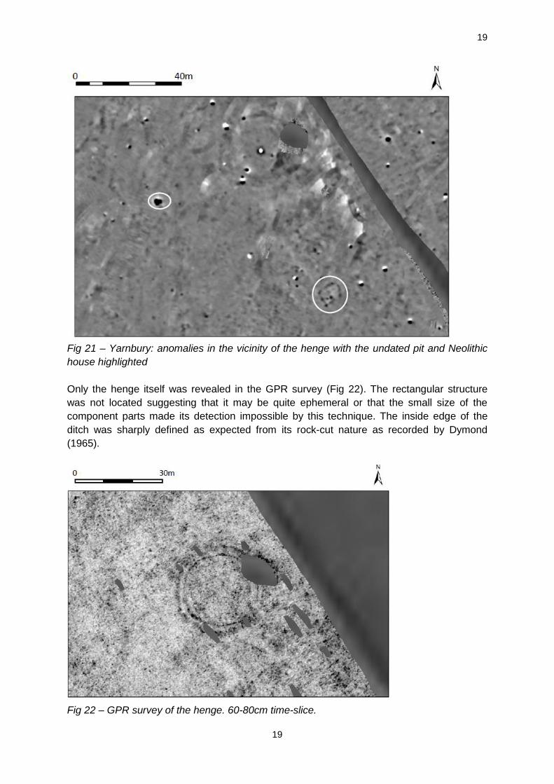
excavation through the bank perhaps caused by the large stone on the apex of the bank
running into the northern section (Fig 25).
Fig 25: Yarnbury henge: excavation plan
The present trench was then extended towards the centre of the henge on a projection of the
old trench-line however the 1964 excavation proved to have narrowed significantly and a
linear depression, 0.3m – 0.5m wide was located in the northern edge of the present trench
[15]. This was excavated into the subsoil to an average depth of 15cm and was filled with flat
stones and a topsoil and subsoil mix [14]. After a distance of 9.5m from the inner edge of the
ditch, the trench turned at right angles (Figs 25 & 26) over an area of disturbed soil which
later proved to be the central pit. This right angled turn only penetrated the backfill of the
central pit to a maximum depth of 10cm. Dymond’s report recorded the old excavation pit as
square, but no evidence to this effect could be found. Instead, the central pit survived as an
irregular area of redeposited mixed topsoil and subsoil [10] contrasting with the natural
yellow subsoil (Fig 30).
The rest of the henge’s internal area exposed by the present trench was cleaned and
planned. Due to SMC restrictions, it was not excavated beyond the base of the modern turf
and the animal-disturbed subsoil was left in situ (Fig 26). No features were recognised in this
area though it is most likely that the bioturbation of the upper subsoil would mask the top
levels of any dug features other than modern interventions and that any subsoil features
would only be recognisable once this layer had been removed. Small flint and chert flakes
and chips and a flint bladelet were recovered from the topsoil (see below).

23
23
Fig 26 – Dymond’s 1964 excavation trench running along the right (northern) side of the
excavation trench and turning at right angles over the central pit. Looking SW.
Dymond’s trench sides were cleaned back to reveal undisturbed sections through the bank
and ditch (Figs 27 & 28). The bank proved to have been of dump construction and
comprised loose stone within a redeposited subsoil matrix [16] directly overlying an irregular
layer of iron pan [17]. A sample incorporating this iron pan with the henge bank above and
the natural yellow subsoil [02] below was sent for soil micromorphology analysis (see below).
Fig 27: Yarnbury Henge – sections through bank and ditch.

24
24
Fig 28 – southern section through henge bank.
Directly below the backfill through the bank and more or less central to the old excavation
was a small pit [12] filled with dark soil [06] (Fig 25). The pit had the appearance of a
stakehole and measured 16cm in diameter and 22cm deep. The fill initially seemed to
comprise carbonised material and was 100% sampled. Once dried and floated, however, the
fill appeared to be more peaty in nature. Scanning Electron Microscopy and Loss on Ignition
analysis were undertaken at the University of Bradford to discover the exact nature of this
material and its suitability for C14 dating to produce a Terminus Post Quem for the bank but
these analyses confirmed the peaty nature of the deposit. The base of an animal burrow
seems the most likely interpretation of this feature.
The ditch measured some 3m from edge to edge and attained a maximum depth of 75cm
below the modern turf (Fig 25, 27 & 29). The western edge was cut through the natural
tabular sandstone. Natural sandstone was also noted in the eastern side though this edge
was much more smooth in profile and dug through natural subsoil. The ditch fill as revealed
in the cleaned back sections, was a smooth silty clay [18] derived from the subsoil matrix of
the bank and the exposed subsoil of the ditch edge. It seems to have been a rapid
accumulation and no layering that might be indicative of stabilisation periods and/or turf
formation was noted. This washed-in material extended to 20-40cm above the deepest part
of the ditch after which the ditch appeared to have stabilised and the remainder of the fill up
to the present turfline comprised rooty, dark humic soil [19].

25
25
Fig 29 – northern section of the henge ditch.
Pollen samples were taken at 5cm intervals through the deepest part of the N section and
are reported on below. No chronologically diagnostic artefacts (other than barbed wire from
the ditch backfill) or organic materials suitable for C14 dating were recovered from the bank,
the pre-bank soil or the ditch fills.
The 1964 trench in the interior of the henge was emptied of its backfill and cleaned. No
subsoil features were identified other than a large central pit which had been located but not
examined during the 1964 excavation. A 6” iron nail was recovered during the clearing of the
residual topsoil over the central pit and surely accounts for the strong ferrous signal noted
during the magnetometry survey of this area (Fig 23).
The irregular central pit had been cut into the subsoil to a depth of some 60cm where it
entered the unexcavated section (Figs 25 & 30) It measured 1.90m across in the northern
section and extended 1.30m into the trench. It was filled with an ill-sorted and relatively
stone-free mix of dark humic topsoil and yellow subsoil [10]. Sherds of pottery, fragments of
cremated bone (11g), three spalls of calcined flint/chert and charcoal were recovered from
the basal levels of this uniform fill. The original pit seems to have been completely destroyed
by this antiquarian activity and no in situ deposits in the pit sides or base were noted. The
pottery is exclusively Collared Urn and is from the same vessels as those in Manchester
Museum already mentioned and discussed in detail below.

26
26
Fig 30 – central pit after excavation.
The charcoal fragments represent a mixed assemblage (see below) but the fragments of
cremated bone were too small to be identifiable (see below). Given that these samples were
found in the backfill of the pit, they lack stratigraphic integrity and cannot be used for
radiocarbon dating. No other chronologically diagnostic finds nor organic materials suitable
for C14 dating were recovered from the interior of the henge.
Possible standing stone (Fig 16, Trench 2)
Outside the entrance of the henge, an edge-set stone and other earth-fast boulders, seemed
to hint at the possibility of an external splayed avenue pointing towards Simon’s Seat to the
SW. One stone was investigated but proved not to have been intentionally placed. The stone
was not set in a pit but rather appears to have been pulled up as there was a considerable
mound of pushed up natural subsoil along the NE side of the stone. There were no finds to
date this activity but it is reasonable to suggest that this took place during the construction of
the field walls c.1792-1801 in response to the Act of Enclosure. Two small flint fragments
were found in the topsoil [201] during cleaning.
Possible cairn (Fig 16 Trench 3)
Partly buried stones near the SE corner of the field wall adjacent to the henge appeared
from surface indications to possibly form a low, roughly oval cairn. It was possible that the
field wall had been sited on this feature however it was equally possible that the stones
resulted from the construction of the wall itself or represented field clearance piled up next to
the wall. A small trench (4m E-W x 2m N-S) was opened to investigate this and clearly
demonstrated the construction/clearance hypothesis to be correct. There was no depth or

27
27
structure to the cairn or its edge nor any sign of a buried soil. Four small flint fragments were
found in the topsoil [301] during cleaning.
The Pottery (Fig 31)
Small fragments of pottery were recovered by hand and from the wet sieving of the samples
from the central pit. These represent two distinct vessels.
Vessel 1 comprises 14 sherds plus small crumbs (37g) in a soft light brown fabric averaging
9mm thick and containing sparse crushed grog inclusions. The rim, base of the collar and
parts of the neck of a tripartite Collared Urn are represented. The collar motif comprises 1.5
rows of interrupted herring bone in fine twisted cord technique. The herring bone is also
bordered above and below by three encircling twisted cord lines. Two different twists are
represented. Fragments decorated with fine whipped cord maggots are also present and
represent neck and below shoulder herring bone. Three fine encircling twisted cord lines
decorate the internal rim bevel which is 10mm deep. These sherds belong to the Urn
recorded as coming from Grassington (Yarnbury) in Manchester Museum (Accn No.0.9021)
and is illustrated in Longworth’s (1984) corpus as No 1153 (Pl12e). It belongs to Longworth’s
Primary Series and is similarly early in Burgess’s (1986) scheme. Interrupted herring bone
as a collar motif is rare though it is found in whipped cord on primary series urns from
Grendon, Northants (Longworth 1984, No. 1008, Pl 14c), in twisted cord on an urn from near
Pickering, North Yorks (ibid No 1213, Pl 17a), a large primary series urn from Cwm,
Gwynedd (ibid No 2015, Pl37f) and an urn from Aldeburgh, Suffolk which also has herring
bone in the neck and below the shoulder like the Yarnbury vessel but in twisted rather than
whipped cord (ibid No.1425, Pl 50c).l
Vessel 2 comprises 9 sherds (42g) in a soft but fairly well-fired fabric. The fabric averages
7mm thick, has reddish grey-brown surfaces and contains sparse crushed stone and grog
inclusions. Three conjoining sherds represent the base of the collar from a Collared Urn and
are decorated with twisted cord impressions. The motif appears to comprise vertical lines
bordered by encircling lines but only the lower part of the motif survives. The two encircling
lines at the base of the collar border small circular stabs, 4mm in diameter. A second sherd,
possibly from the shoulder below the neck, has traces of the base of the neck concavity and
below this, a fringe of short, oblique, twisted cord lines. This indicates that the Collared Urn
has been tripartite in type. The base of the collar has had a diameter of c.22cm. The circular
stabs at the base of the collar are paralleled on urns of the primary series from Stanton
Moor, Derbyshire (Longworth 1984, No,288 Pl 28b), Knighton, Powys (ibid No2164, Pl 13b)
and Llanidan, Gwynedd where it is also associated with herring bone motif (ibid No. 2138, Pl
52b). Single rows of stabs in this position are not common on later urns. This urn is the same
as that in Manchester Museum, No 0.9022, also recorded as coming from Yarnbury, but not
apparently seen by Longworth.

28
28
Fig 31 – The Collared Urns from Yarnbury (Vessel 2 top). Scale in cms.
Worked flint, chert and quartz from Yanbury
Philippa Bradley
A total of 146 pieces of worked flint, chert and quartz and 12 pieces of burnt unworked flint were recovered from investigations at Yarnbury. The flint was recovered from the excavation of the Neolithic house and the henge as well as from the examination of molehills (‘fieldwalking’) from across the site (Fig 16 above). Diagnostic forms indicate Mesolithic to Neolithic activity. The finds from the house have been reported elsewhere (Bradley in Gibson 2017). Raw materials and condition The bulk of the assemblage is flint but grey and brown chert and quartz were also recovered, although not all of the latter are certainly worked. The flint is mainly good quality, mid-dark brown in colour with a thin buff cortex. A few pieces of yellow and grey flint were also recovered. The flint is probably from east Yorkshire or the Lincolnshire Wolds (cf. Henson 1985). Grey, brown and banded chert was also recovered. The quality of this material is variable with some pieces flaking fairly well, whilst others are crude. Chert occurs within carboniferous limestone and sources in Derbyshire and Yorkshire are probable. The quartz

29
29
occurs as small pebbles, some of which appear to have had one or two flakes removed; others are not certainly worked. The majority of the flint is in good condition with limited edge damage. Cortication is generally light and some of the assemblage is burnt. There is limited macroscopic evidence for use. Assemblage composition The assemblage is listed in Tables 1 and 2; all elements of the reduction sequence were recovered although there is a bias against the smaller elements such as chips and there was only one small keeled core and a core fragment. Diagnostic retouched forms include a possible microlith fragment. Fieldwalking (Fig 16) Forty-four pieces of worked flint, chert and quartz and two pieces of burnt unworked flint came from the examination of molehills and rabbit scrapes. Only debitage was recovered (Table 1) with flakes dominating. The majority of lithics come from the northern part of the survey area but do not coincide with any features identified during the topographic or geophysical surveys. A single core is of keeled type made of grey-brown chert. The flakes are mostly small and squat with limited evidence for preparation. This small group is not particularly diagnostic.

30
Find No
Type No Broken Y/N
No. Burnt
Comments
1 Flake 1 Y Grey flint, hard hammer, broken at prox end
3 Flake 1 Y Grey chert fragment
5 Chip 1 Y Small chip fragment
7 Flake 1 Y 1 Possible burnt chert ?flake fragment, dark brown chert
8 Irregular waste
1 N Grey chert, possible IW
9 Flake 1 Y Grey chert flake, quite large
10 Flake 1 N Grey chert, possible flake
12 Flake 1 Y ?Flake fragment, quartz
13 Flake 1 Y ?Flake fragment, quartz
15 Chip 1 Y Dark grey chert, small fragment only
17 Flake 1 N Small possible flake, quartz
19 Chip 1 Small irregualr chip, quartz not certianly worked
20 Flake 1 N Corticated flake, irregular squat flake
22 Flake 1 N Mid-brown flint, small irregular flake
23 Flake 1 N Mid-dark brown flint, rough thin vesicular coretx, small squat flake, hard hammer
24 Flake 1 Y Grey chert
27 Flake 1 Y Grey chert, small flake
28 Chip 1 Y Heavily corticated, tiny break
29 Flake 1 Y Grey chert flake, poss from opposed platform core
30 Flake 1 Y Slight break to distal end, mid-brown flint, large cherty inclusion
32 Flake 1 Y Small grey chert fragment, roughly worked
33 Flake 1 Y 1 Small broken and burnt flake
34 Burnt unworked flint
1 Y 1 Small piece of heavily burnt flint
35 Burnt unworked flint
1 Y 1 heavily burnt
36 Flake 1 Y Possible flake, grey chert breaks to prox and distal ends
37 Tested 1 N Banded grey-brown chert, a few definite flake removals

31
piece
38 Pebble 1 Y Small quartz pebble fragment not certianly worked, 1 possible flake removed
39 Pebble 1 N Small quartz pebble, possible flake scars?
40 Flake 1 N Small flake buff flint, good quality
41 Flake 1 N Small grey chert flake
42 Flake 1 Y Small iregular flake frag
44A Chip 1 N Mid-brown good quality flint
44B Chip 1 Y Small break to one edge, mid-brown good quality flint
45 Chip 1 N 1 Small heavily burnt chip
101 Flake 1 Y Small broken grey chert flake, odd gloss down one edge possibly recent
103 Flake 1 Y 1 Broken and burnt flake, partly cortical
110 Flake 1 Y Grey chert, roughly worked
120 Blade-like flake
1 N Dark brown flint, quite good quality, hinge fracture
121 Flake 1 N Banded grey-brown chert, large and irregular flake
122 Core 1 N Grey-brown chert, small keeled core
Table 1: Lithics from the molehills. Natural unworked stone removed.
32
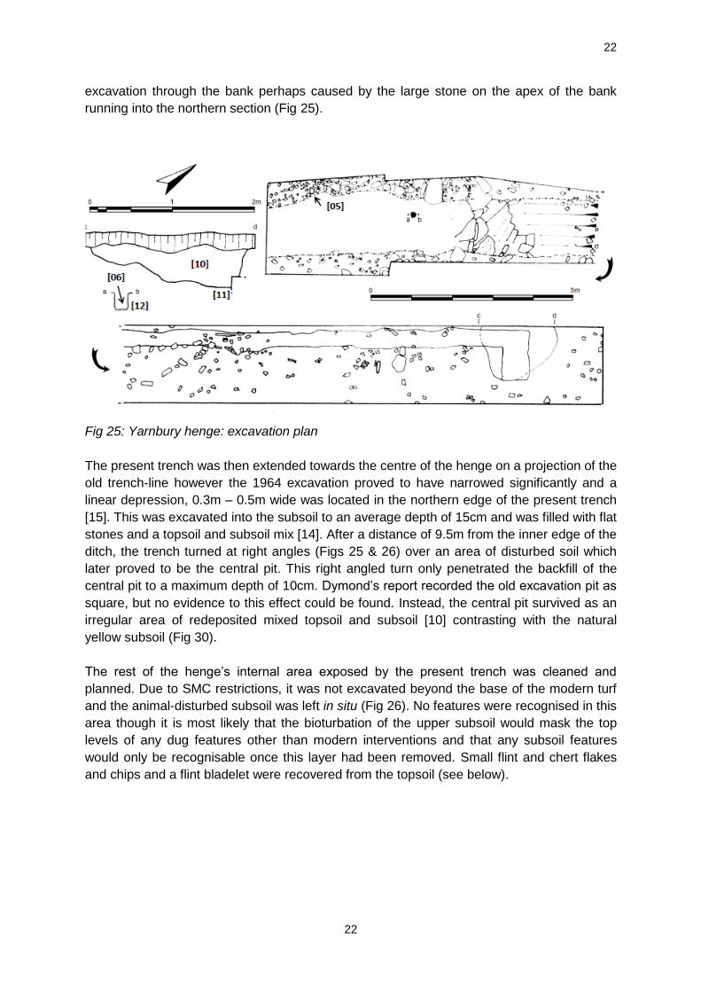
Henge A small quantity of debitage – chert and flint (eight flakes, three chips, one bladelet and one piece of burnt unworked flint) was recovered from topsoil over the henge or backfill from Dymond’s trench (Table 2). The flakes are mostly fairly small and undiagnostic. One of the chips has been burnt.
Context Find No
Type No of pieces
Broken Y/N
Burnt Comments
01 1 Chip 1 N Small chip mid-brown flint
01 1 Flake 1 Y ?grey chert
01 1 Bladelet 1 N Light brown flint, good quality
01 2 Burnt unworked
1 Y Small heavily burnt flint
01 2 Flake 1 N Slightly irregular yellow flint flake
01 2 Flake 1 Y Mid-brown flake fragment, good quality flint
01 2 Flake 1 Y Chert ?flake fragment
01 2 Chip 2 N 1 I flint, 1 burnt flint
04 3 Flake 1 N Brown flint, thin buff cortex, slightly irreg flake
04 3 Flake 1 Y Brown chert?
04 4 Flake 2 Y Chert, possible flake fragments?
10 5 Flake 3 Y 3 Small flake frags heavily burnt
Table 2: Lithics from the Henge: Context 01 – topsoil, 04 – Dymond’s backfill, 10 – central pit. Central pit Three small burnt and broken flakes were recovered from the central pit [10] within the henge. This feature also contained fragments of Collared Urn, cremated bone and charcoal (Gibson 2014a; 2014b). The small pieces of flint may have been included in the cremation pyre, not necessarily intentionally, and subsequently collected along with the cremated bone and charcoal which was then deposited in the pit. Standing stone and possible cairn Five flakes, a chip and a possible microlith fragment were recovered from contexts associated with a possible standing stone and cairn. Apart from the possible microlith fragment none of the pieces is particularly distinctive or chronologically diagnostic. Discussion of the lithics Records of Mesolithic flint from the vicinity of the henge are known (HER SD996 658; SD96NE50) and larger assemblages recovered from nearby sites such as Grassington Moor (HER SE06NW12). The small quantity of Mesolithic material from the excavations is therefore further evidence of this activity. However, the small assemblage size precludes any detailed discussion. None of the material from the henge, central pit or contexts associated with the possible standing stone and cairn is particularly diagnostic and could simply be part of a background scatter. The flakes from the central pit although burnt need not have been included in the pyre deliberately.

33
The objects of jet and jet-like material from Yarnbury
Alison Sheridan
Two unrelated ornaments, recorded as being found at Yarnbury, are housed in Skipton
Museum. One (D3185 A3) is a large, broken ‘monster bead’ of Early Neolithic date; the other
(D 3185 A2) had been a perforated triangular object resembling an enlarged version of an
Early Bronze Age necklace fastener and may be the molehill-derived ‘pendant fragment’
recorded in the HER.
The ‘monster bead’
Just over half of a large, chunky bead of approximately rectangular shape, with rounded
corners, rounded edges, gently convex broad sides, a sub-rectangular cross-section and a
longitudinal perforation; length 39 mm, width c 24 mm, maximum surviving thickness 10mm;
perforation diameter at its surviving end c 4.5 mm (Fig.32.1). The exterior surface has a very
low sheen. The bead had broken along a lamination plane running across much of the
longitudinal perforation. There are faint traces of rilling from the rotation of the drill bit in the
perforation, and along one of the long edges there are multi-directional striations, some of
which may relate to the grinding of the bead into shape (while others probably represent
ancient damage). The bead had broken in antiquity, and had also lost a chip from close to
one end; there are also ancient scratches on the broad outer surface and, as noted above,
along one edge. Where one original end of the perforation survives, the smoothness of its
edge and the slight polish to the interior of the perforation for the first few millimetres – both
characteristics of thread-wear – suggest that the bead had seen some use (but probably not
for very long) before its breakage and discard.
The bead is of a slightly laminar black material, with concentric hairline cracks on the broad
surface outlining the laminar planes. The fracture surface follows one such plane, with all its
irregularities, and is not conchoidal. Macroscopically, it appears that the raw material is a
cannel coal or oil shale rather than jet, and a source within the northern English
Carboniferous deposits would be expected (Bussell 1976).
The object is immediately recognisable as belonging to a distinctive (if morphologically
broad) class of large, Early Neolithic bead, termed ‘monster bead’ by Mary Davis apropos a
necklace including a dozen such examples found at ‘Ardiffery’, Cruden, Aberdeenshire
(Kenworthy 1977; Sheridan and Davis 2002, fig. 1). While some of these beads, like the
‘Ardiffery’ examples, are of Whitby jet, others are of cannel coal, oil shale or other generally
dark-coloured stone; an example from Flixton, Suffolk, found in a pit associated with a
complete Mildenhall-style bowl close to a long barrow, is of a grey mudstone (Sheridan
2009). The shape varies from slender elliptical (as with some of the ‘Ardiffery’ beads) to
plumper elliptical (as at Pitlethie Road, Fife: Sheridan 2007) and to near-circular and flattish
(as at Eyford Cotswold-Severn long cairn, Gloucestershire: Clarke et al. 1985, 234, with
further references). Some have collared ends, others not. Around 35 British examples are
known to the author, with at least 26 further examples – though not necessarily all of
Neolithic date – known from Ireland. (For lists Sheridan 2007; 2009). The British examples
are found as far south as Devon (e.g. Hazard Hill, Totnes: Houlder 1963, 30, fig 8.12), with
the ‘Ardiffery’ find being the furthest north; there appears to be an eastern bias to the
distribution. The examples from northern England known to the author – in addition to the
Yarnbury bead – are two found on the old ground surface below Neolithic barrows at

34
Maiden’s Grave Farm, Bridlington (Kinnes and Longworth 1985, 146, UN.103) and
Painsthorpe Wold barrow 4 (Mortimer 1905, 116, fig 275), both in East Yorkshire; a stray find
from near Thornborough, North Yorkshire (unpublished); and one from a possibly funerary
context at Quarry House, Hepburn Moor, Northumberland (Jobey 1981, 40, fig 8.17). The
widespread nature of the distribution of this type of bead – with the implicit sharing of the
design idea, and in some cases the movement of actual beads – suggests the operation of
overlapping networks of contacts linking established farming communities over large parts of
Britain and Ireland, especially along the east coast. (See also Rogers 2016 on the
importance of east-coast interactions.)
The dating evidence (reviewed in detail in Sheridan 2007 and 2009) leaves much to be
desired, but supports the suggestion of a currency during the second quarter of the fourth
millennium, and possibly before that too. The type of Yorkshire flint axehead that was found
associated with the Ardiffery jet and amber necklace – the whole assemblage being an
import to the north-east coast of Scotland from the north Yorkshire coast – can be situated
within the second quarter of that millennium, and this is consistent with the likely date of the
Mildenhall style bowl from Flixton. Among the few beads whose find contexts are
radiocarbon-dated, the example found in a pit associated with a post-built house at Pitlethie
Road, Fife is dated, by hazel charcoal from that pit, to 4995±40 BP (SUERC-6923, 3950–
3660 cal BC at 95.4% probability: Sheridan 2007; note that oak charcoal from the same pit
produced a similar date). The overall date bracket cited above encompasses that of the
Yarnbury Neolithic house (Gibson 2017), and so the bead offers a useful piece of additional
evidence for Neolithic activity in the area. It is only to be regretted that its precise findspot
remains uncertain, so that its proximity (or otherwise) to the house cannot be ascertained.
Fig 32: The bed and pendant fragments from Yarnbury
The triangular object, resembling an oversized Early Bronze Age fastener: fastener or
pendant
This damaged and incomplete object, perforated transversely close to its longest edge and
slightly off-centre, would originally have been triangular in plan, with flat faces and gently
convex sides (Fig. 32.2). The surviving piece is c 34 mm long (with an estimated original
length of just under 50 mm), c 32 mm wide and c 9 mm thick, and the perforation is c 2.5

35
mm at its narrowest, broadening out to c 8 mm on the best-preserved face. Two of the
corners and one edge had broken off, and a large part of one flat surface had spalled off.
The perforation is of asymmetrical hourglass shape, drilled more from one side than from the
other (even allowing for the loss of the surface from that side). Rilling from the rotation of the
drill bit is clearly visible on the undamaged surface, not only in the hole but also around part
of it. On the damaged side there is a hollow beside the perforation that suggests that the drill
had been repositioned during perforation from that side; indeed, it may well be that the
spalling of that surface occurred during the drilling process. The bead had been polished to a
medium sheen, or even perhaps to a high sheen (and could have lost some of that sheen
post-depositionally).
The surviving original edge of the perforation is fairly smooth around its edge, but the fairly
crisp state of the rilling in the perforation, and the absence of thread-wear polish at the
narrowest part of the perforation, suggests that this object had not seen heavy (if any) wear.
Indeed, if it had been damaged during the drilling process, it may be that it was abandoned;
smoothing of the edge of a perforation can theoretically be produced by the drilling process,
and need not invariably indicate thread wear.
Several characteristics indicate that the raw material is jet. The object is a rich blackish-
brown colour; the better-preserved surface is criss-crossed by cracks; the fracture surfaces
are conchoidal and shiny; and the object is warm to the touch. The best source of jet in
Britain is a 10-mile stretch of coast centring on Whitby, and it seems most likely that this
object originated there. The thickness of the object is commensurate with that of many
narrow deposits of jet in the cliffs there; but whether the piece had been extracted from the
cliff or gathered, as a slightly water-worn tabular pebble, from the beach below, is difficult to
determine.
As to the function of this object, the two most likely candidate interpretations are: i) a
fastener and ii) a pendant. Morphologically it resembles the triangular fasteners – usually of
jet – that had been used to fasten various types of Early Bronze Age jet/jet-like necklace
(and, in the case of a female from Culduthel, Highland, a belt: see Sheridan 2015 and
Sheridan et al. 2015 on Early Bronze Age fasteners of triangular and other shape). Dated
examples of these fasteners cluster in the 22nd to 19th centuries BC. However, the Yarnton
object is at least twice as large as most of the fasteners in question. This raises the question
of whether it had been designed as a pendant instead. One cannot rule out the possibility
that it had been designed to fasten a large or heavy object but, as noted above, whatever
the intention had been, its use-life may have been truncated by the possible drilling damage.
Whatever this object had been, the fact that a fairly sizeable piece of jet had been used, and
that this had been carried inland around 120 km (80 miles) as the crow flies, indicates that it
had been a valued object. Given the frequency of the use of triangular fasteners during the
Early Bronze Age, it is felt that the object is most likely to be of this date.

36
CALCINED BONE FROM THE CENTRAL PIT [10], YARNBURY
Alan Ogden
The assemblage comprises 7g of small fragments of mammalian bone, brittle and heat-
fractured, with a maximum length of 20mm. Most fragments are completely calcined, with
distortion and shrinkage giving the bone a porcelain-like texture and showing that the
cremation had been thorough and had exceeded a temperature of 600oC.
Calcined bone is the most difficult burnt stage to analyse because the bone warps and
cracks, with the shrinkage rate ranging from 2-25% between the temperatures of 600oC and
800oC. In this case the calcined bone is distorted, warped, and fractured beyond any
potential for classification or identification. None of the fragments could be unambiguously
identified as human.
CHARCOAL FROM THE CENTRAL PIT [10] AT YARNBURY HENGE Dana Challinor Introduction Two features associated with the henge monument – one from a small pit below the bank [6], and one from the central pit fill [10] – were sampled. As mentioned above, [6] proved to contain no charcoal. The primary aims of the analysis were to characterise the taxonomic composition and nature of the wood types found in the assemblages, in order to study the possible fuel debris from the central pit of the henge. Methodology The charcoal was fractured and sorted into groups based on the anatomical features observed in transverse section at X7 to X45 magnification. Representative fragments from each group were then selected for further examination using a Meiji incident-light microscope at up to X400 magnification. Data relating to the character of wood utilisation (woodland management, cropping regimes etc.) was also collected, where possible. A total of 50 fragments were examined. Identifications were made with reference to Schweingruber (1990), Hather (2000) and modern reference material. Classification and nomenclature follow Stace (1997). Identifications are provided to the highest taxonomic level possible according to the native British flora, i.e. where there is only a single native species, this is named, but where there are several native species, the genus or subfamily is given. Results The condition of the charcoal was generally good. Four taxa were positively identified; Quercus sp. (oak), Alnus glutinosa (alder), Corylus avellana (hazel) and Fraxinus excelsior (ash) (Table 3). Both oak heartwood and sapwood were recorded. No tyloses were observed in the ash fragments and there was no ring curvature noted. In contrast, the hazel charcoal derived from roundwood of narrow diameter. Some of the alder also exhibited roundwood characteristics.
Species Feature type
Henge Central Pit
Context 10
Quercus sp. oak 16 hs
Alnus glutinosa Gaertn. alder 17r

37
Corylus avellana L. hazel 1r
Fraxinus excelsior L. ash 16s
Total
50
h=heartwood; s=sapwood; r=roundwood Table 3: Results of the charcoal analysis (by fragment count) Another characteristic of the assemblage was the observation of slow growth in the ash. This was attested by the absence of visible late wood pores (one ring comprising mainly the large pores of spring growth) and the calculation of mean average ring width of ≤1mm/year. Moderate to high levels of vitrification were recorded in occasional fragments. Vitrification refers to the glassy appearance (and possible fusion of cells) which probably relates to the condition of the wood prior to burning (Marguerie & Hunot 2007, 1421), and/or the burning process, although it is no longer considered to be commensurate with high temperatures (McParland et al. 2010, 2686). Insect tunnels were observed in fragments of alder. The shape of the tunnels was not particularly diagnostic, but the presence of any wood boring beetles indicates that the dead wood had been inhabited prior to burning. Discussion The central pit of the henge monument produced a distinct assemblage, comprising a diverse taxonomic composition including ash and alder. This assemblage would have derived from spent fuelwood, rather than burnt structural remains. The diversity of the assemblage reflects the less discriminate collection of wood for fuel. The site falls within a region dominated by oak-hazel woodland in prehistory (Rackham 2006, 84), and it is clear that this was exploited. The indications from the pollen evidence that the monuments stood within a largely open environment may indicate that wood was being imported to the site though not necessarily from a great distance. Ash is a colonising species that flourishes in an open landscape, and alder would have grown alongside the River Wharfe, Hebden Brook or similar wetland location. That the charcoal record shows no evidence of the pine indicated in the pollen record (see below) suggests that pine was not favoured for fuel.
THE POLLEN ANALYSIS FROM THE HENGE DITCH
Garry Rushworth
Introduction
Samples obtained from the north section of the henge ditch were examined to assess their
palynological potential. Standard palynological processing methods – disaggregation in 10%
KOH solution, sieving through 160 micron mesh to remove coarse particles and on a 6
micron mesh to remove solutes and fines, swirling on a clock-glass to gravity separate fine
clastic particles – were used. The samples were stained with safranine and mounted in Gurr
Aquamount. The pollen was identified using Moore and Webb (1978) and the writer’s own
pollen type slide collection. The description of pollen follows Bennett et al. (1994) and the
nomenclature is based on Stace (2001). The results are displayed below (Table 4).
Base of ditch
The pollen indicates an open heath environment consisting mainly of grass and heather with
a probable nearby presence of hazel and alder. The occurrence of cereal may indicate

38
agricultural practices in the vicinity although only two grains were identified. The ferns and
mosses, especially Osmunda, are consistent with the damp conditions expected in ditches.
The pollen in the sample was generally in good condition.
5cms above base of ditch.
The pollen indicates an open, mainly dry, grassland environment with small amounts of
heather and scabious nearby. Again there are likely to be hazel and birch in the vicinity. The
pollen amount in this sample was sparse.
10cms above base of ditch
The pollen quantities were again sparse but the amounts present indicate a move away from
grassland to heathland. The ferns again are consistent with the damp conditions found in a
ditch. A number of the fungal spores of Vesicular-Arbuscular Mycorrhizai (VAM’s) were
observed in this sample.
15cms above base of ditch
Pollen is more abundant and shows an open grassland environment with possible stands of
alder and hazel in the vicinity. Again the polypodies are consistent with damp ditches.
20cms above base of ditch
The pollen indicates a heathland environment with heather and grass dominating the pollen
count. The polypodies and sedge are indicative of higher water amounts in the ditch with the
bladderworts suggesting standing water.

39
Base of ditch 5cm above base 10cm above base
15cm above base
20cm above base
Species No % No % No % No % No %
Alnus Alder 4 2.2 5 5.4
Betula Birch 2 4.1 1 2.3
Pinus Pine 2 1.1
Corylus Hazel 11 6.0 5 10.2 1 2.3 9 9.7 3 1.4
Ericaceae heather 26 14.3 7 14.3 18 41.9 4 4.3 100 47.0
Caryophylaceae Pinks 1 0.6 1 0.5
Cereal Cereal 2 1.1 1 2.0
Cyperaceae sedge 6 3.3 4 1.9
Epilobium willow herb 1 0.6
Knautia scabius 1 0.6 7 14.3 35 16.4
Lactuceae dandelion 2 1.1 19 20.4
Plantago plantain 1 0.6 1 2.3 1 1.1
Poaceae Grass 87 47.8 22 44.9 10 23.3 30 32.3 47 22.1
Rumex Dock 2 1.1 3 3.2 2 0.9
Urticularia bladderwort 8 3.8
Osmunda royal fern 25 13.7 1 2.0
Lycopodium clubmoss 1 0.6
Polypdium polypodies 3 1.7 3 6.1 11 25.6 21 22.6 11 5.2
Pteropsida Fern 4 2.2
Sphagnum sphagnum moss
3 1.7 1 2.0 1 2.3 1 1.1 2 0.9
Total pollen 182 49 43 93 213
Table 4: Results of the pollen analysis from the henge ditch at Yarnbury.

40
Conclusion
The pollen from these samples was well preserved and the amounts present indicate
environmental fluctuations between heathland and open grassland with small numbers of
ruderals, dandelion, dock, plantain and scabious. Occasional grains of cereal pollen were
observed at 0 and 5cms which may indicate possible cultivation in the vicinity. There are
also small amounts of arboreal pollen indicating the probability of either small stands or
single trees nearby. All the samples have small amounts of mosses and ferns which are
consistent with the damp conditions found in ditches. The samples from 5cms to 15 cms
above the ditch base are pollen sparse. The sample from 10cms above the base contained a
small number of spores of Vesicular-Arbuscular Mycorrhizai. These mychorrizai may indicate
the occurrence of soil erosion (van Geel et al 1978) and may explain the dearth of pollen at
this level if the ditch was more active at that time and there was active erosion of the sides,
whilst the occurrence of bladderwort at 20cms above the base indicates still or slow flowing
water (Stace 2001).
MICROMORPHOLOGICAL EVALUATION OF THE BURIED SOIL
Charles French
Introduction
A possible buried soil was observed beneath the surviving bank of Yarnbury henge and was
sampled for micromorphological analysis (Bullock et al. 1985; Courty et al. 1989; Stoops
2003; Murphy 1986). A description is found below.
Observations in thin section
The thin section was composed of two stratigraphic units. The upper unit in the upper 5cm of
the slide was composed of an upper zone of poorly sorted, reddish brown, sandy clay loam
with horizontally oriented gravel pebbles (Fig 33A). This soil material exhibited reddening
from amorphous sesquioxides and browning from the incorporation of highly humified
organic matter. Beneath the pebbles was a zone of similar, yellowish brown sandy clay loam
material but without the same high humic content, with its lower undulating boundary marked
in places by thin iron panned silty clay.
The lower 3+cm was composed of two intermixed fabrics. The main fabric (>80% of the
groundmass) is a sandy clay loam dominated by pure to dusty clay, weakly birefringent
striae in the groundmass (Fig 33B)and up to 50% strong reddening caused by sesquioxide
staining. The minor fabric (20%), irregularly distributed throughout in irregular aggregates,
was composed of silty clay and/or pure aggregates with weak to strong birefringence (Fig
33C).

41
Fig 33: A: The brown humic Ah horizon material in the bank material (frame width = 4.5mm;
plane polarized light). B: The weakly striated B horizon material of the buried soil (frame
width = 4.5mm; cross polarized light. C: The mixed sandy clay loam and pure to dusty clay
aggregates in the disturbed B horizon of the buried soil (frame width = 4.5mm; cross
polarized light).
Suggested interpretation
The upper part of the slide is a mixture of humic A and B soil horizon material and pebbles
and is indicative of the make–up of the henge bank. There was then an undulating and
distinct change to a buried soil beneath, the upper surface of which was characterised by a

42
very thin but discontinuous, iron pan with amorphous sesquioxde impregnation of fine
material.
The organised clay and silty clays in the buried soil below, albeit disturbed and fragmentary,
suggest that this soil had once been stable and quite well developed. This was most
probably under woodland as some kind of argillic brown earth with a clay-enriched lower B
(or Bt) horizon (Bridges 1978; Kuhn et al. 2010). Nonetheless, this buried soil had become
physically disturbed, which led to mixing of soil from both the B and argillic Bt horzions. It is
impossible to say what caused this, but it may well relate to the construction of the overlying
bank as the two fabrics are very heterogeneous and ragged in nature, rather than indicative
of more intense, longer-term mixing such as caused by past arable agriculture. These soil
mixing and oxidation processes as well as proximity to a fluctuating groundwater table have
resulted in strong amorphous sesquioxide impregnation and soil reddening (Lindbo et al.
2010).
There has obviously been considerable truncation of the upper half of the soil, removing the
former A horizon, no doubt prior to the constructon of the henge bank itself. The Iron
panning therefore, originally interpreted as a possible turfline by the excavator, is likely to be
the result of disturbance, perhaps trampling, during the construction of the bank.
The detailed soil micromorphological description
Two stratigraphic units:
Upper unit 1 (0-5cm): Structure: apedal to weakly aggregated, <2mm; Porosity: 20% vughy,
sub-rounded to irregular, <2mm; Mineral components: coarse/fine ratio = 40/60; coarse
fraction: 15% medium and 25% fine quartz, 100-750um, sub-rounded to sub-angular; fine
fraction: 20% fine quartz, 50-100um, sub-rounded to sub-angular; 40% silty clay in
groundmass; reddish brown to dark brown (PPL/CPL); Amorphous: up to 75% of
groundmass with strong humic and/or amorphous sesquyioxide staining; 10% irregular to
sub-rounded sesquioxide nodules, <500um; lower undulating boundary marked by thin
discontinuous zone of amorphous sesquioxides;
Lower unit 2 (5-8cm): two fabrics in heterogeneous mix; main fabric: >80% of groundmass;
all silty/dusty clay, often as gold (CPL) striae in groundmass; up to 50% stained with
amorphous sesquioxides; golden brown (CPL), pale golden brown (PPL), weak
birefringence; minor fabric: <20% of groundmass; irregular aggregates of silty clay, <1mm,
with internal aggregates of pure clay, gold to orangey red (CPL), strong birefringence.
CONCLUSIONS
The excavation has only been partly successful in realising the aims and objectives of that
part of the project mainly as a result of the restrictive nature of the SMC. The former
excavation trench had been correctly identified by both Martlew’s (2004) earthwork survey
and the 2013 topographic and magnetometry surveys. The variable widths of the 1964
excavation and its change in direction had not been anticipated.
The construction of the monument was confirmed as being single-phased. The bank, at least
in the excavated section, had been formed from the dumped up-cast material from the ditch
without any attempt at facing or internal structure. Despite the presence of an iron pan below
the bank, the area had been stripped of turf prior to the construction of the enclosure and the
iron pan was perhaps the result of trampling or other ground compaction during the

43
construction phase. The ditch was confirmed as being rock-cut on the western edge but
more smooth on the eastern though some bedrock did show through the natural subsoil. It
was relatively shallow and seems to have silted naturally and comparatively rapidly. There
were no traces of recuts or any activity to suggest that the ditch had been cleaned or
maintained for any period after its excavation and no chronologically diagnostic artefacts or
samples suitable for radiocarbon dating were recovered from either the ditch or from
contexts associated with the bank.
Evidence from the soil micromorphology suggests that the area of the henge was at one
time wooded and the structural oak and hazel charcoal from the Neolithic house at Yarnbury
might suggest that this was the case as late as the mid 4th millennium though clearly these
species may well have been deliberately selected as building materials (Challinor in Gibson
2017). By the time that the enclosure was constructed, however, the site was already in
open grassland with some heathers, mosses and ferns suggesting damp conditions. The
presence of limited cereal pollen in the basal sample as well as Plantago suggests
cultivation nearby and the limited presence of birch, alder and pine suggests woodland
stands perhaps in the valley sides and bottoms. Hazel appears in all the pollen samples
perhaps indicating patches of woodland, scrubland or possibly even hedges. In short, the
natural (as opposed to man-made) environment does not seem too different to that of today.
Other than the central pit discussed below, no features were located within the enclosure
although they may have been masked by the animal disturbance that affected the uppermost
layers of the subsoil. Once again the restrictive nature of the SMC did not permit further
investigation.
The Yarnbury Urns in Manchester Museum did indeed come from the centre of the henge
and it is likely that both Raistrick, and Dymond, had been aware of this at the time of the
1964 excavation. The 1922-23 date associated with the Museum accession information
justifies both Raistrick’s identification of the henge as a ‘disc barrow’ (despite its entrance)
and Dymond’s attribution of the central pit to an excavation ‘earlier this century’. Why
Dymond did not investigate this central pit further is not known: perhaps he considered it to
have been completely emptied.
Whilst the Collared Urn sherds date the central burial convincingly to the Early Bronze Age
c. 2000-1600 cal BC in broad terms, this does not of course date the construction of the
enclosure. It is equally possible that the henge was built around an area already being used
for sepulchro-ritual activity or that the Collared Urn burial was added to an already existing
monument built to observe the mid-winter sunrise. The dating of single-entranced earth
circles is far from clear or comprehensive and both Neolithic and Bronze Age examples are
known (Gibson 2012a). Equally there is growing evidence to suggest that henge earthworks
were added to already important areas almost as an act of closure (Ibid). The validity of the
word ‘henge’ has also been recently questioned given the great morphological variation
evident amongst the ‘class’ (Gibson 2012b) and the application of the term ‘hengiform’ to
upland monuments such as ring cairns and enclosed cremation cemeteries has served to
confuse the issue further. It is unfortunate that the full extent of the burial activity at Yarnbury
remains unknown.

44
DISCUSSION
With regard to the Neolithic and Bronze Age, the Yorkshire Dales remain seriously under-
studied. Unlike Northumberland, Durham, the Wolds of eastern Yorkshire and the
Derbyshire Peak District, the Dales were not the focus of the same degree of 19th century
antiquarian activity: they did not attract the likes of Greenwell, Mortimer and Bateman all of
whom published extensively. In the Dales, cave sites were explored but much antiquarian
activity is attested only by damage to monuments. Manby’s survey of the Bronze Age in
Northwest Yorkshire relies heavily on palaeoenvironmental and artefactual evidence.
Gazetteer entries for excavated sites in the Craven area of the Dales are sparse indeed and
only a single Collared Urn is recorded from Yarnbury with the comment ‘no finds details’
(Manby 1986, 106). This can now be considerably augmented. The richness of the chalkland
Wolds, like their sister Wessex, breeds research and this in turn increases the potential of
these areas for the spectacular. Equal potential may exist in less well-studied areas,
particularly in soil conditions that favour the preservation of bone, but this cannot be
demonstrated by previous interventions and subsequently acts as a dampener to research
(and funding). Furthermore, being largely within the National Park, and unlike less well
protected areas, the Dales do not host the large development projects that have done much
to advance local archaeologies through multiple and large-scale rescue excavations. Nor do
the Dales react well to aerial prospection being largely moorland or permanent pasture.
Cropmarks are rare and much aerial reconnaissance focuses on upstanding archaeological
monuments. With this in mind, the discovery from the air of Threshfield 1 as a cropmark in
grass is an example of what may lie hidden in these river valley pastures and the reporting of
artefact scatters suggest that the Dales were more densely used in the 4th to 2nd millennia
BC than the monumental record suggests.
The lithic scatters of Upper Wharfedale, (Fig 34), although undoubtedly multiperiod and
largely recovered from animal ground disturbance, are reflective of numerous visits over
time. Many are unpublished but the Craven Flint Collection catalogue in Craven Museum
(Skipton) makes interesting reading. The scatters around Arncliffe, for example, have
produced over 1000 fragments of stone, flint and chert including not just knapping waste but
artefacts such as polished stone axe fragments (particularly Langdale), leaf, petit tranchet
and barbed and tanged arrowheads, fabricators, end, side and horseshoe scrapers, serrated
blades and plano-convex knives. At Highgate Leys Lane just SE of Kettlewell, again over
1000 fragments include polished stone axe fragments, all major arrowhead types, and
scrapers including small thumbnail or button examples typical of the Early Bronze Age. At
nearby Bycliffe, a number of small findspots can be combined into an assemblage of over
5400 fragments. Tool types include all major arrowhead types, awls, cores, notched flakes
and blades, serrated blades and various scraper types as well as knapping waste and
elements of Mesolithic toolkits.
The rectilinear field systems between Conistone and Grassington have also produced rich
assemblages though this may reflect the level of collection activity in this much frequented
area (Cherry 1998; 2014). At New Close, Conistone, for example, over 500 lithics include a
Mesolithic component but also major arrowhead types, awls, retouched blades and flakes,
cores, knives, saw fragments and polished stone axe fragments. Most major scraper types
are also represented. At Conistone Old Pasture, also within the rectilinear field system,
almost 2500 finds comprise a similar assemblage with Mesolithic to Early Bronze Age types
being recognised once again including axe fragments, barbed and tanged arrowheads and

45
thumbnail scrapers. At Lea Green, the part of the field system nearest to Yarnbury, almost
1500 fragments including plano-convex knives, various scraper and arrowhead types, and
Langdale axe fragments. It is a familiar picture. Whilst much of this material may be derived
from prehistoric manuring processes, it is nevertheless indicative of settlement activity in its
broadest sense.
Fig 34:- Neolithic and Bronze Age activity in Upper Wharfedale.
Ceramics have also been found in the area around Lea Green and Coniston Pie some 1.4
km to the NE of Coniston village (Cherry 1998; 2014). Impressed Ware and Beaker
fragments have been reported and similar ceramics have also been recorded in the caves
(Gilks 1995: Leach 2015, 277). At Elbolton Cave, just over 2km to the SSE of Grassington
above the west bank of the Wharfe, Early Neolithic Carinated Bowl, Middle Neolithic
46
Impressed Ware and Early Bronze Age Collared Urn sherds were recovered (Gilks 1973)
one Collared Urn (as reconstructed) having a similarly squat profile to that from Yarnbury.
Grooved Ware, which should be broadly contemporary with the Threshfield circles, is rare in
the Dales and has only been found so far at Thaw Head Cave near Ingleton in Lonsdale
(Gilks 1995), at Lesser Kelcoe Cave, near Giggleswick in Ribbledale (Gilks 2005), at Bastow
Woods, Grassington (Manby in Cherry 1998) and at the Backstone Beck enclosure on Ilkley
Moor, Wharfedale, some 20km south-east of Yarnbury (Edwards & Bradley 1999). The Ilkley
Grooved Ware has not been published and a later Neolithic radiocarbon date on unidentified
charcoal was not strictly associated with the pottery. The other material presents potential
problems. The Bastow Wood sherd is in a thick grog-filled fabric and decorated with two
parallel incised lines. The fabric and decoration may equally be Early Bronze Age when grog
was a favoured opening material within the Collared Urn tradition (Longworth 1984). The
Kelcoe Cave material is represented by a single sherd with traces of four roughly parallel
incised lines and neither the decoration nor the fabric is exclusively Grooved Ware. The
Thaw Head sherd represents the rim of a slightly barrel-shaped vessel with crudely incised
filled triangle decoration externally. The internal rim bevel is concave. Once again, the
decoration is not exclusively Grooved Ware but can also be found on Collared Urns and it is
notable that other barrel-shaped Bronze Age pottery was recovered from the cave including
a Cordoned Urn decorated below the rim with whipped cord triangles. This is unusual as
whipped cord decoration is normally regarded as an early trait in Collared Urns (Longworth
1984; Burgess 1986). The Grooved Ware finds, therefore, are not unequivocal. Despite this
paucity of ceramic finds, it is with Grooved Ware that one would expect the Threshfield
henges to be associated. Green (1980, 108-110) identifies ripple-flaked oblique arrowheads
as part of Grooved Ware material culture and the find of a spectacular ripple-flaked
arrowhead fragment from nearby Bordley (Dodsworth 2012) therefore suggests that the
Grooved Ware complex was certainly operating in the area though not necessarily
extensively and certainly not particularly visibly.
At High Close, Grassington, 1km to the W of Yarnbury, Harker (1892) recovered a fine AOC
Beaker from an interesting cist burial below a cairn. Details of the excavation are lacking but
reanalysis of the Beaker and the circumstances of its discovery have been provided by Gilks
(2016). The cist contained a crouched inhumation, presumably associated with the Beaker,
but also the disarticulated remains of at least 2 individuals as well as cremated bone. The
finding of multiple disarticulated inhumations (and cremated remains) with Beakers is a well-
known phenomenon discussed by Petersen (1972) and revisited by Burgess and Shennan in
their Beaker Package hypothesis (1976). Such burial practices prompted the present writer
to suggest a Beaker Veneer whereby the ceramic itself masked a range of ‘native’ burial
forms (Gibson 2007). Whilst this is no longer tenable from the burial point of view,
nevertheless a wide variety of burial forms do appear to be associated with Beaker vessels,
particularly in Needham’s post-fission horizon after 2200 BC (Needham 2005: Gibson
forthcoming). This, and the appearance of Food Vessels and Collared Urns, unequivocally
derived from Middle Neolithic Impressed Wares suggests a re-emergence of Middle
Neolithic practices albeit in a modified form. This might also be reflected in the caves. As
already stated, Grooved Ware pottery is rare in caves and fissures and radiocarbon dates for
the Later Neolithic (c.3000-2500 BC) are similarly few (Leach 2015). The deposition of
human remains in caverns seems to abruptly stop with the demise of Impressed Ware only
to re-emerge with Beakers and Bronze Age pottery forms. Once again this may be indicative

47
of a Neolithic resurgence following the appearance of Beakers and coinciding with the
demise of Grooved Ware. It must be admitted, however, that cremation appears to have
been the preferred burial rite in the early 3rd millennium and unaccompanied cremations from
caves are unlikely to have been dated.
Further indications of Neolithic and Bronze Age settlement in its broadest sense are being
revealed by the research survey and excavation being undertaken in the Dales by local
heritage groups and student projects. A series of long mounds has been identified by Luke
(2013) and the Neolithic potential is currently being investigated. The large number of round
barrows and cairns and small stone circles suggest extensive sepulchro-ritual activity in the
2nd millennium and it is most likely that it is to this period that Yarnbury belongs. The
difference in scale and form between the Threshfield sites and Yarnbury is worthy of note
and it has been suggested elsewhere that large single entranced henges and the double-
entranced examples may well date to the middle of the henge period of currency, around the
middle and second half of the third millennium (Gibson 2012a). Small single-entranced
enclosures may be early such as Sarn-y-bryn-caled site 2, Powys (Gibson 2010) or late such
as Balneaves, Angus (Russel-White et al. 1992). The Collared Urn burial from the central pit
would therefore suggest that Yarnbury may well date to the latter part of this chronological
range in the early 2nd millennium and as such may well be a type of enclosed cremation
cemetery contemporary with the stone circles, ring cairns, and other Bronze Age barrows
and cairns in the area.
Of the Wharfedale stone circles (Fig 34), most are small and ruined and none have recorded
interventions. Spreads of stone suggest denuded cairns at some sites. Only the Bordley
stone circle, to the west of Threshfield has had any level of survey and attention (Martlew
2010). Known as the Druids’ Altar after reports of a trilithon-like structure at the site
(Raistrick 1929) and variously described as a cairn, a chambered tomb and a stone circle,
the site was identified as a ‘Four-Poster’ by Aubrey Burl (1988): an identification confirmed
by Martlew’s survey. The site is a composite one for the stones appear to sit on an artificial
mound, itself showing signs of unrecorded interventions. A prostrate stone some 5m to the
south of the setting may represent an outlier and the circle appears to have links to the
southernmost moonset and the midwinter sunset (Martlew 2010, 66-7). Burl has identified
the main concentration of these sites in the Tayside area but notes outliers in the Pennine
region, Wales and Southern Ireland. The association of Four-Posters with mounds is also
common and excavated examples date to the Early Bronze Age and it is likely that of the
potential stone circles in Wharfedale, the Druid’s Altar at least must be broadly contemporary
with the Yarnbury enclosure.
This project of survey and excavation, therefore, has demonstrated that despite the lack of
large-scale research in this area. Wharfedale would appear to be more mainstream than
peripheral. All the signs point to extensive exploitation of the valley sides prior to the
establishment of rectilinear field systems. Potential important Neolithic monuments remain to
be tested by excavation, and the Late Neolithic date of the classic earth circles at Threshfield
can be inferred from analogy. Monuments increase in number after the chalcolithic with the
Early Bronze Age witnessing increased monument construction. Having demonstrated that
the Collared Urns in Manchester Museum do indeed come from small-scale excavation at
the Yarnbury enclosure and though the earthwork itself remains undated, it is to this range of
sepulchro-ritual monuments that Yarnbury most likely belongs.

48
Harding (2013) has studied in detail the landscape and siting of the henges of the A1
corridor. The linear NW-SE orientated arrangement of the three Thornborough double-
entranced enclosures is well known. The entrances of the Thornborough sites share this
orientation as do the double entranced enclosures at Nunwick, Hutton Moor, Cana Burn, and
Newton Kyme all of which lie close to the east bank of the Ure and between the Ure and
Swale. The similarly aligned monumental stone row of the Devil’s Arrows at Boroughbridge
marks the confluence of the two rivers. Springs and gypsum outcrops in the area doubtless
endow the region with special significance and a ‘new’ henge has been recently discovered
at Sinderby, close to the right bank of the Swale, also in an area of springs and close to the
Thornborough-Cana Barn alignment. The orientation of this monument is currently unknown
as the entrances have not been detected. The location and alignments undoubtedly marked
an important prehistoric N-S routeway fossilised by the Roman Ermine Street, the Great
North Road, the modern A1 and the London-Edinburgh East Coast line as they squeeze
between the Pennines to the West and the North York Moors to the East. The henges of
Castle Dykes (Wensleydale), Yarnbury (Wharfedale) and the Han Royd enclosure on
Midgely Moor (Calderdale) were seen by Harding (2013) as referencing these larger henges
and marking access corridors to the Pennine massif and passes through to the West Coast.
This might now be questioned. The Castle Dykes henge has proved to be Iron Age (Gibson
in prep), and the antiquity of the Han Royd enclosure is questionable as the ditch has a fresh
cut appearance whilst the bank is slight and formed of individual dumps of material. The
Yarnbury henge can now be seen to be most likely early Bronze Age in date. The two
Threshfield henges alone might now remain to support Harding’s hypothesis being the only
monuments so far known that are likely to be contemporary with the Swale/Ure group.
As mentioned above, the dating of henges is far from secure (rarely do the ditches contain
deposited material of the kind found at causewayed enclosures) but both inclusive and
parsimonious approaches to the available radiocarbon dates suggest that single-entranced
enclosure span the 3rd and 2nd millennia BC with the larger diameter monuments occurring in
the centre of the span. The double-entranced sites seem to share a much tighter chronology
in the second half of the 3rd millennium and early second millennium BC (Gibson 2012a, figs
11 & 12) coinciding with the larger Class I monuments. None of the large Yorkshire henges
have been dated by either absolute or relative means so we can only rely on analogy to
suggest that they belong to this Late Neolithic/Early Bronze Age transition, starting in about
the 26th/25th Cal BC.
By this time, the Late Neolithic Grooved Ware complex has been well established in the area
and may even have introduced the tradition of circular enclosures at the start of the 3rd
millennium. The pan-British nature of this complex suggests substantial mobility within
Grooved Ware using groups and clearly maritime and established land routes would have
been utilised. Riverways, in particular, are easy to follow and one must assume that east
coast routes as well as transpennine relations between present day Yorkshire and Cumbria
were already well established by this time. Langdale axes in Yorkshire suggest that these
east-west routes were already active in the early Neolithic and the Yarnbury house attests
the presence of farming groups in the eastern Pennines at the start of the 37th C cal BC
(Gibson 2017).

49
Although Langdale axes are still found in later Neolithic contexts in eastern Yorkshire
(Bradley & Edmonds 1993, 179-199) radiocarbon dates suggest that quarrying at the Pikes
of Stickle had ceased in the 35th C cal BC at the start of the Middle Neolithic (Richard
Bradley pers comm) so it would appear that cross Pennine routes had already been well
established for half a millennium before the earliest appearance of henges and probably a
whole millennium before the appearance of Threshfield and the A1 sites. Once established,
these routes would persist to maintain inter-group relations, regional gatherings and trade in
perhaps more perishable items such as agricultural produce or even people. Mobility in the
Neolithic is becoming increasingly recognised through projects such as Feeding Stonehenge
and the Beaker People project (Chan et al. 2016; Parker Pearson et al. 2016) and
presumably existing long established routes were being exploited.
The major cross Pennine routes to the South and North of the Yorkshire Dales are fossilised
by modern major roads: The A64 ‘wool route’ from Kendal to the mills of Leeds and the A66
Scotch Corner to Penrith. The Wensleydale-Gardale pass also provides a major
thoroughfare however more minor and shorter but less negotiable and seasonally restricted
routes are also available and surely it is these routes that would have been exploited more in
the Neolithic. Wharfedale leads, via Littondale over Foxup Moor into Upper Ribblesdale
which in turn connects with the West-flowing River Dee in Dentondale by crossing the
watershed via Gayle Moor and the foot of Wold Fell. Alternatively Dentondale can be
reached from Wharfedale by a route up Langstrothdale, along the base of Oughtershaw Side
towards Wold Fell. Established bridle ways and rights of way crisscross through the area
and the latter route is fossilised today by the Dales Way long distance path.
The role of the Threshfield henges in these routes is admittedly speculative but meeting
places for seasonal gatherings, rituals and fairs seem logical and their positions at or near
the entrance to the steep dales may even suggest some boundary function such as access
to seasonal upland pastures. Certainly the identification of the Threshfield henges, can be
seen as raising the importance of Wharfedale in this Pennine-access network but it is
unlikely that these newly discovered monuments will be alone in the Dales.
ACKNOWLEDGEMENTS
I am grateful firstly and foremostly to the landowner of Yarnbury, Mr T. Kitching, for his
permission to survey, to excavate and for his interest throughout the project and to the Dean
family, owners of Threshfield, for their permission to undertake the survey at very short
notice. Funding for the geophysical survey was generously provided by the British Academy
Small Grants Scheme and the LBI, Vienna. A derogation from Natural England and SMC
from English Heritage were obtained through the respective good offices of Margaret Nieke
and Neil Redfern. Thanks are extended to the students from the Dept of Archaeological
Sciences for their hard work and to site-supervisor Debbie Hallam. Members of the Upper
Wharfedale Heritage Group assisted with the fieldwork and were valuable members of the
team. Rob Friel and the late John McIlwaine helped with the data processing. The
excavation was funded by the University of Bradford. Post-excavation sample processing
was undertaken on a voluntary basis by Rebekah Hart and Lynne Fynnes. Dr Jill Thompson
(University of Bradford) has freely given her advice regarding palaeoenvironmental sample
processing. The pottery was conserved by Sonia O’Connor. Access to the material in
Manchester Museum and information on its acquisition were provided by Bryan Sitch.

50
Access to the jet in Craven Museum, Skipton, was kindly facilitated by Martin Wills. The
specialists who have contributed to the post-excavation analyses (Dana Challinor, Pippa
Bradley, Alison Sheridan, Charly French and Garry Rushworth) are thanked for their prompt
and timely reports. Prof French would like to thank Tonko Rajkovaca of the McBurney
Geoarchaeology Laboratory, Department of Archaeology and Anthropology, University of
Cambridge, for making the thin section.
REFERENCES
Barrett, J. 1963. Yorkshire Archaeological Register, 1962. Yorkshire Archaeological Journal, 41, 6.
Bennett, K.D., Whittington, G. and Edwards, K.J. 1994. Recent plant nomenclature changes
and pollen morphology in the British Isles. Quaternary Newsletters73, 1-6.
Bradley, P. in prep. Worked flint, in Kingsmead Quarry, Horton, Volume 1 2003–2009
excavations (G Chaffey, A Barclay and R Pelling), Wessex Archaeology monograph 32.
Brad;ey, R. & Edmonds, M. 1993. Interpreting the Axe Trade. Cambridge: Cambridge
University Press.
Bridges, E.M. 1978. World Soils (2nd edition). Cambridge: Cambridge University Press
Bullock, P., Fedoroff, N., Jongerius, A., Stoops, G. and Tursina, T. 1985. Handbook for Soil
Thin Section Description. Wolverhampton: Waine Research
Burgess, C.B. 1986. ‘Urnes of no small Variety’: Collared urns Reviewed. Proceedings of the Prehistoric Society, 52, 339-51. Burgess, C.B. & Shennan, S.J. 1976. The Beaker Phenomenon: Some Suggestions. In C. Burgess &
R. Miket (eds) Settlement & Economy in the Third and Second Millennia BC, 309-331. BAR 33.
Oxford: British Archaeological Reports.
Burl, H.A.W. 1988. Four-Posters. Bronze Age Stone Circles of Western Europe. BAR British
Series 195. Oxford: British Archaeological Reports.
Bussell, G. D. 1976. A Preliminary Neutron Activation Analysis of Ornaments of Jet and
Similar Materials from Early Bronze Age Sites in North Derbyshire and Yorkshire. University
of Bradford: unpublished M.A. thesis.
Challinor, D. in prep. The Wood Charcoal, in D. Garton, The Excavation of a Mesolithic and Neolithic Settlement at Lismore Fields, Buxton, Derbyshire. English Heritage.
Chan, B., Vyner, S., Parker Pearson, M., Albarella, U. and Ixer, R., 2016. Resourcing
Stonehenge: Patterns of Human, Animal and Goods Mobility in the Late Neolithic. In J. Leary
and T. Kador (eds), Moving on in Neolithic Studies: Understanding Mobile Lives, 28-44.
Oxford: Oxbow.
Cherry, P. J. 1998. Prehistoric Habitation Sites at Grassington, North Yorkshire. Yorkshire Archaeological Journal, 70, 1-23.

51
Cherry, P.J., 2014. Lithic Scatters at Conistone, North Yorkshire. Prehistoric Yorkshire, 51,
32-39
Clarke, D.V., Cowie, T.G. and Foxon, A. 1985. Symbols of Power at the Time of
Stonehenge. Edinburgh: Her Majesty’s Stationery Office.
Courty, M-A., Goldberg, P. and Macphail, R.I. 1989. Soils and Micromorphology in
Archaeology. Cambridge: Cambridge University Press
Dodsworth, P. 2012. Rare Bordley Arrowhead. Prehistoric Yorkshire, 49, 25-29.
Dymond, D.P. 1965. Yorkshire Archaeological Register, 1964. Yorkshire Archaeological Journal, 41, 323-4.
Edwards, G. & Bradley, R. 1999. Rock Carvings and Neolithic Artefacts on Ilkley Moor, West
Yorkshire. In Cleal, R. & MacSween, A. (eds), Grooved Ware in Britain and Ireland, 76-77.
Neolithic Studies Group Seminar Papers No3. Oxford: Oxbow Books.
Gale, R. 2006. Appendix 2: Charcoal Fuel Analysis, in , S.J. Reed, G. Juleff & O.J. Bayer, Three Late Saxon Iron-Smelting Furnaces at Burlescombe, Devon. Proceedings of the Devon Archaeological Society, 64, 71–122. Gibson, A.M. 2007. A Beaker Veneer? Some evidence from the burial record. In M. Larsson & M. Parker Pearson (eds) From Stonehenge to the Baltic. Living with cultural diversity in the third millennium BC, 47-64. BAR International Series 1692. Oxford: Archaeopress. Gibson, A.M. 2010. New Dates for Sarn-y-bryn-caled, Powys, Wales. Proceedings of the Prehistoric Society, 76, 351-6.
Gibson, A.M. 2012a. An Introduction to the Study of Henges: Time for a Change? In A.
Gibson (ed) Enclosing the Neolithic: Recent Studies in Britain and Europe, 1-20. BAR
International Series 2440. Oxford: Archaeopress.
Gibson, A.M. 2012b. What’s in a Name? A Critical Review of Welsh Henges. In W. Britnell & R. Silvester (eds) Reflections on the Past: Essays in Honour of Frances Lynch, 78-121. Cardiff: Cambrian Archaeological Association.
Gibson, A., 2014a. Excavation of an Early Neolithic house and other features at Yarnbury
henge, West Yorkshire, PAST 78, 10–11.
Gibson, A., 2014b. Excavation at the Yarnbury henge 9th–27th June 2014. Interim report in
fulfilment of SMC, unpublished report, University of Bradford.
Gibson, A.M. 1917. Excavation of a Neolithic House at Yarnbury, near Grassington, North Yorkshire. Proceedings of the Prehistoric Society, 83, xxxx Gibson, A. M. forthcoming. Beaker burials in the context of the Neolithic and Bronze Age. In Parker Pearson, M., Richards, M., Chamberlain, A. & Jay, M. (eds). The Beaker People: Isotopes, Mobility and Diet in Prehistoric Britain. Prehistoric Society Occasional Papers Series. Oxford: Oxbow Books & The Prehistoric Society.

52
Gilks, J.A. 1973. The Neolithic and Early Bronze Age Pottery from Ellbolton Cave, Wharfedale. Yorkshire Archaeological Journal, 45, 41-54. Gilks, J.A. 1995. Later Neolithic and Bronze Age Pottery from Thaw Head Cave, Ingleton, North Yorkshire. Transactions of the Hunter Archaeological Society, 18, 1-11. Gilks, J.A. 2005. A Sherd of Later Neolithic Grooved Ware from Lesser Kelcoe Cave, Giggleswick, North Yorkshire with a note on other finds of Grooved Ware from Caves in the North of England. Transactions of the Hunter Archaeological Society, 22 (2003), 15-22. Gilks, J.A. 2016. Forty Years On: The Low Carinated All-Over-Cord Beaker from High Close, Grassington. Prehistoric Yorkshire, 53, 94-98. Green, H.S. 1980. The Flint Arrowheads of the British Isles. BAR British Series 75. Oxford: British Archaeological Reports. Harding, A.F. with Lee, G.E. 1987. Henge Monuments and Related Sites of Great Britain. Air Photographic Evidence and Catalogue. BAR British Series 197. Oxford: British Archaeological Reports.
Harding, J. 2013. Cult Religion and Pilgrimage. Archaeological Investigations at the Neolithic and Bronze Age Monument Complex of Thornborough, North Yorkshire. Research Report 174. York: Council for British Archaeology.
Harker, B.J. 1982. Discovery of Prehistoric Remains at Grassington in Craven, Yorkshire.
The Antiquary, 26, 147-9.
Hather, J G, 2000. The Identification of Northern European Woods; A Guide for Archaeologists and Conservators. London: Archetype Publications
Henson, D., 1985. The flint resources of Yorkshire and the East Midlands, Lithics 6, 2–9.
Houlder, C.H. 1963. A Neolithic settlement on Hazard Hill, Totnes, Trans Devon Arch
Exploration Soc 21, 2–31.
Jobey, G. 1981. Groups of small cairns and the excavation of a cairnfield on Millstone Hill,
Northumberland, Arch Aeliana, 5th ser, 9, 23–43.
Kendrick, T.D. & Hawkes, C.F.C. 1932. Archaeology in England & Wales, 1914-1931. London: Methuen & Co.
Kenworthy, J. 1977. A reconsideration of the ‘Ardiffery’ finds, Cruden, Aberdeenshire, Proc
Soc Antiq Scot 108 (1976–7), 80–93.
Kinnes, I.A. and Longworth, I.H. 1985. Catalogue of the Excavated Prehistoric and Romano-
British Material in the Greenwell Collection. London: British Museum Press.
Kuhn, P., Aguilar, J. and Miedema, R. 2010. Textural pedofeatures and related horizons. In
Stoops, G., Marcelino, V. and Mees, F. (eds.) Interpretation of Micromorphological features
of Soils and Regoliths, pp. 217-250. Amsterdam: Elsevier

53
Leach, S. 2015. Going Underground: An Anthropological and taphonomic study of human skeletal remains from Caves and Rock Shelters in Yorkshire. Leeds: Yorkshire Archaeological Society.
Lindbo, D.L., Stolt, M.H. and Vepraskas, M.J. 2010. Redoximorphic features. In Stoops, G.,
Marcelino, V. and Mees, F. (eds.) Interpretation of Micromorphological features of Soils and
Regoliths, pp. 129-147. Amsterdam: Elsevier
Longworth, I. H. 1984. The Collared Urns of the Bronze Age. Cambridge: Cambridge University Press. Luke, Y. 2103 Neolithic Long Mounds of the Yorkshire Dales and Allied Structures. Privately Published.
Marguerie, D. & Hunot, J., 2007. Charcoal analysis and dendrology: data from archaeological sites in north-western France. Journal of Archaeological Science, 34(9), 1417-1433.
Martlew, R. 2004. Late Prehistoric Landscapes of Upper Wharfedale: Problems and Potential. In White, R.F. & Wilson, P. R. (eds) Archaeology and Historic Landscapes of the Yorkshire Dales, 39-50. Occasional Paper 2. Leeds: Yorkshire Archaeological Society. Martlew, R. 2010. The Druid’s Altar: A ‘Scottish’ Stone Circle in Craven, North Yorkshire. Yorkshire Archaeological Journal, 82, 59-72. McParland, L.C.,Collinson, M. E., Scott, A. C., Campbell, G. & Veal, R. 2010. Is vitrification in charcoal a result of high temperature burning of wood? Journal of Archaeological Science, 37(10), 2679-2687. Moore, P.D., and Webb, J.A. 1978. An illustrated guide to pollen analysis. London: Hodder
and Stroughton.
Mortimer, J.R. 1905. Forty Years’ Researches in British and Saxon Burial Mounds of East
Yorkshire. London: Brown and Sons.
Murphy, C.P. 1986. Thin section preparation of soils and sediments. Berkhamsted: AB
Academic
Needham, S. 2005. Transforming Beaker culture in north-west Europe; processes of fusion
and fission. Proceedings of the Prehistoric Society 71: 171-217.
Parker Pearson, M., Chamberlain, A., Jay, M., Richards, M., Sheridan, A., Curtis, N.,Evans,
J., Gibson, A., Hutchison, M., Mahoney, P., Marshall, P., Montgomery, J., Needham, S.,
O’Mahoney, S., Pellegrini, M., & Wilkin, N. 2016. Beaker people in Britain: migration, mobility
and diet. Antiquity, 90 (351), 620-37.
Petersen, F. 1972. Traditions of Multiple Burial in Later Neolithic and Early Bronze Age
Britain. Archaeological Journal,, 129, 22-55.
Piggott, S. 1948. The Excavations at Cairnpapple Hill, West Lothian, 1947-48. Proceedings of the Society of Antiquaries of Scotland, 10 (1947-48), 68-123.

54
Rackham, O., 2006. Woodlands. London: Collins
Raistrick, A. 1929. The Bronze Age in West Yorkshire. Yorkshire Archaeological Journal, 29, 361 & 364. Rogers, A. 2016 Coastal connections: coastal mobility in the Neolithic. In J. Leary and T.
Kador (eds), Moving on in Neolithic Studies: Understanding Mobile Lives, 122-136. Oxford:
Oxbow.
Russell-White, C.J., Lowe, C.E & McCullagh, R.P.J., 1992. Excavations at Three Early Bronze Age Burial Monuments in Scotland. Proceedings of the Prehistoric Society,58, 285-323.
Saville, A., 1981. Mesolithic industries in Central England: an exploratory investigation using microlith typology, Archaeological Journal 138, 49–71. Schweingruber, F H, 1990. Microscopic wood anatomy, 3rd Edition, Swiss Federal Institute for Forest, Snow and Landscape Research
Sheridan, J.A. 2007 The large elliptical Neolithic bead fragment. In M. Cook, Early Neolithic
ritual activity, Bronze Age occupation and medieval activity at Pitlethie Road, Leuchars, Fife,
14–16. Tayside and Fife Archaeological Journal 13, 1–23.
Sheridan, J.A. 2009 Neolithic Stone Bead from Flixton Long Barrow (SF 1054). Unpublished
specialist report for Suffolk Archaeology, for eventual publication in S Boulter (ed)
Excavations at Flixton, Suffolk, Volume 2 (East Anglian Archaeology monograph).
Sheridan, J.A. 2015. Discussion of disc bead and spacer plate necklaces of jet and jet-like
materials. In A. Woodward and J. Hunter with D. Bukach, S.P. Needham and J.A. Sheridan,
Ritual in Early Bronze Age Grave Goods, 341–362. Oxford: Oxbow.
Sheridan, J.A., Woodward, A. and Hunter, J. 2015. Disc bead necklaces, and spacer plate
necklaces of jet and jet-like materials. In A. Woodward and J. Hunter with D. Bukach, S.P.
Needham. and J.A. Sheridan, Ritual in Early Bronze Age Grave Goods, 261–340. Oxford:
Oxbow.
Sheridan, J.A. & Davis, M. 2002 Investigating jet and jet-like artefacts from prehistoric
Scotland: the National Museums of Scotland project, Antiquity 76, 812–25.
Stace, C. 2001. New flora of the British Isles. Cambridge: Cambridge University Press.
Stoops, G. 2003. Guidelines for analysis and description of soil and regolith thin sections.
Madison. Wisconsin: Soil Science Society of America, Inc.
Stoops, G., Marcelino, V. and Mees, F. (eds.) 2010. Interpretation of Micromorphological
features of Soils and Regoliths. Amsterdam: Elsevier.

55
Thomas, P. A. 2014. Trees: Their Natural History, 2nd Edition. Cambridge: Cambridge University Press. Unger-Hamilton, R., 1988. Method in microwear analysis: prehistoric sickles and other stone
tools from Arjoune, Syria, BAR S435. Oxford: British Archaeological Reports.