
The SRT Method: Randomized Strategies for Exploration
7
The SRT Method: Randomized strategies for exploration Giuseppe Oriolo, Marilena Vendittelli, Luigi Freda, Giulio Troso Dipartimento di Informatica e Sistemistica, Universit` a di Roma “La Sapienza” Via Eudossiana 18, 00184 Roma, Italy Email: {oriolo,vendittelli,freda}@dis.uniroma1.it, [email protected] Abstract — We present a method for sensor-based ex- ploration of unknown environments by a mobile robot. The method is based on the randomized incremental generation of a data structure called Sensor-based Ran- dom Tree (SRT), which represents a roadmap of the explored area with an associated safe region. Different exploration strategies may be obtained by instantiating the general method with different perception tech- niques. Two such techniques are discussed: the first, conservative and particularly suited to noisy sensors, results in an exploration strategy called SRT-Ball. The second perception technique is more confident, and the corresponding strategy is called SRT-Star. The two strategies are critically compared by simulations as well as by experiments on the MagellanPro robot. I. Introduction The exploration of unknown environments can be con- sidered to be the fundamental problem for mobile robots, as it involves all the basic capabilities of such systems, e.g., perception, planning, localization, and navigation. From a practical viewpoint, exploration is a central task in many applications, such as planetary missions, intervention in hostile areas and automatic map building. A widely accepted definition of exploration is “the act of moving through an unknown environment while building a map that can be used for subsequent navigation”[1]. The performance of exploration strategies must then be assessed on the basis of the quality of the obtained map as well as of the time needed (or space traveled) in order to assemble it. Most of the existing techniques fall into the class of frontier-based exploration, pioneered by Yamauchi in the above cited paper. The rationale of this approach is that the robot must move towards the boundary (the fron- tier) between safe explored areas and unknown territory in order to maximize the information gain coming from new perceptions. For example, the methods proposed in [2–5] may be classified as frontier-based exploration, although they differ under other aspects (e.g., the representation of the environment, the inclusion of localization, the consid- eration of perception costs, the use of multiple robots). It is also interesting to adopt a more general AI per- spective, according to which exploration is “the process of selecting actions in active learning”[6]. In the active learning paradigm, training data are obtained as a result of the learner’s actions. In particular, the case of robot that gathers information about the environment by moving and sensing is a case of order-sensitive active learning, because the data flow is the result of all past robot actions. The central problem of exploration is how to select the next action. Frontier-based exploration is obtained when the criterion is the maximization of the action’s (expected) utility. There exists however another possibility, i.e., use a random selection mechanism (also called a random walk). The advantages of this choices are (i) simplicity and (ii) the fact that any sequence of actions will be executed even- tually. The latter property opens the road to completeness: a solution will be find whenever one exists. On the other hand, pure random action selection may be very inefficient. Our approach to the problem derives from randomized (also called probabilistic) motion planning (RMP) tech- niques, which build roadmaps of the free configuration space by generating random samples and checking them for collision [7]. In RMP, the problem setting is that of order-free active learning: what is observed about the environment depends only on the last action (the random query), because the map of the environment is available in advance and the robot does move to gather data. Hence, randomized planners can be considered as goal-oriented exploration strategies based on random action selection. As already mentioned, the (probabilistic) completeness of these planners is inherent to their nature; in addition, very high efficiency can be achieved by adding heuristics to the basic random scheme. The RRT method of [8] is a typical example which served as an inspiration for our work. In this paper, we describe an exploration method based on the random generation of robot configurations within the local safe area detected by the sensors. A data struc- ture called Sensor-based Random Tree (SRT) is created, which represents a roadmap of the explored area with an associated Safe Region (SR). Each node of the SRT consists of a free configuration with the associated Local Safe Region (LSR) as reconstructed by the perception system; the SR is the union of all the LSRs. The LSR is an estimate of the free space surrounding the robot at a given configuration; in general, its shape will depend on the sensor characteristics (for example, angular resolution) but may also reflect different atti- tudes towards perception. We will present two exploration strategies obtained by instantiating the general method
-
Upload
independent -
Category
Documents
-
view
1 -
download
0
Transcript of The SRT Method: Randomized Strategies for Exploration

The SRT Method:Randomized strategies for exploration
Giuseppe Oriolo, Marilena Vendittelli, Luigi Freda, Giulio TrosoDipartimento di Informatica e Sistemistica, Universita di Roma “La Sapienza”
Via Eudossiana 18, 00184 Roma, ItalyEmail: {oriolo,vendittelli,freda}@dis.uniroma1.it, [email protected]
Abstract— We present a method for sensor-based ex-ploration of unknown environments by a mobile robot.The method is based on the randomized incrementalgeneration of a data structure called Sensor-based Ran-dom Tree (SRT), which represents a roadmap of theexplored area with an associated safe region. Differentexploration strategies may be obtained by instantiatingthe general method with different perception tech-niques. Two such techniques are discussed: the first,conservative and particularly suited to noisy sensors,results in an exploration strategy called SRT-Ball. Thesecond perception technique is more confident, and thecorresponding strategy is called SRT-Star. The twostrategies are critically compared by simulations as wellas by experiments on the MagellanPro robot.
I. Introduction
The exploration of unknown environments can be con-sidered to be the fundamental problem for mobile robots,as it involves all the basic capabilities of such systems, e.g.,perception, planning, localization, and navigation. From apractical viewpoint, exploration is a central task in manyapplications, such as planetary missions, intervention inhostile areas and automatic map building.
A widely accepted definition of exploration is “the act ofmoving through an unknown environment while buildinga map that can be used for subsequent navigation”[1].The performance of exploration strategies must then beassessed on the basis of the quality of the obtained mapas well as of the time needed (or space traveled) in orderto assemble it. Most of the existing techniques fall into theclass of frontier-based exploration, pioneered by Yamauchiin the above cited paper. The rationale of this approach isthat the robot must move towards the boundary (the fron-tier) between safe explored areas and unknown territory inorder to maximize the information gain coming from newperceptions. For example, the methods proposed in [2–5]may be classified as frontier-based exploration, althoughthey differ under other aspects (e.g., the representation ofthe environment, the inclusion of localization, the consid-eration of perception costs, the use of multiple robots).
It is also interesting to adopt a more general AI per-spective, according to which exploration is “the processof selecting actions in active learning”[6]. In the activelearning paradigm, training data are obtained as a result ofthe learner’s actions. In particular, the case of robot that
gathers information about the environment by moving andsensing is a case of order-sensitive active learning, becausethe data flow is the result of all past robot actions. Thecentral problem of exploration is how to select the nextaction. Frontier-based exploration is obtained when thecriterion is the maximization of the action’s (expected)utility. There exists however another possibility, i.e., use arandom selection mechanism (also called a random walk).The advantages of this choices are (i) simplicity and (ii)the fact that any sequence of actions will be executed even-tually. The latter property opens the road to completeness:a solution will be find whenever one exists. On the otherhand, pure random action selection may be very inefficient.
Our approach to the problem derives from randomized(also called probabilistic) motion planning (RMP) tech-niques, which build roadmaps of the free configurationspace by generating random samples and checking themfor collision [7]. In RMP, the problem setting is thatof order-free active learning: what is observed about theenvironment depends only on the last action (the randomquery), because the map of the environment is available inadvance and the robot does move to gather data. Hence,randomized planners can be considered as goal-orientedexploration strategies based on random action selection.As already mentioned, the (probabilistic) completeness ofthese planners is inherent to their nature; in addition, veryhigh efficiency can be achieved by adding heuristics to thebasic random scheme. The RRT method of [8] is a typicalexample which served as an inspiration for our work.
In this paper, we describe an exploration method basedon the random generation of robot configurations withinthe local safe area detected by the sensors. A data struc-ture called Sensor-based Random Tree (SRT) is created,which represents a roadmap of the explored area withan associated Safe Region (SR). Each node of the SRTconsists of a free configuration with the associated LocalSafe Region (LSR) as reconstructed by the perceptionsystem; the SR is the union of all the LSRs.
The LSR is an estimate of the free space surroundingthe robot at a given configuration; in general, its shapewill depend on the sensor characteristics (for example,angular resolution) but may also reflect different atti-tudes towards perception. We will present two explorationstrategies obtained by instantiating the general method

with different perception techniques. The first, where theLSR is a ball, realizes a conservative attitude, particularlysuited to noisy or low-resolution sensors, and results inan exploration strategy called SRT-Ball. The second tech-nique is confident, and the corresponding strategy is calledSRT-Star; in this case, the LSR shape reminds of a star.The two strategies are compared by simulations as well asby experiments on the mobile robot MagellanPro.
Our exploration method will be presented under theassumption of perfect localization provided by some othermodule. While this may be the case (for example, a GPSsystem may be used in a planetary exploration mission),one cannot overlook the fact that such an assumption isoften unreasonable in unknown environments. However,our investigation is still at a preliminary stage and ourfirst interest was to assess the potential of randomizedexploration techniques. The integration of a localizationstep into the exploration process is currently in progress.
II. Exploration via the SRT method
In this section, we first clarify the working assumptionson the robot and the environment; then, we describe theproposed exploration method from a general viewpoint,i.e., independently from the particular perception strategy.
A. Working assumptionsA robot must explore a workspace, i.e., an environment
with obstacles. We take the following assumptions:
1) The workspace is planar, i.e., either IR2 or a (con-nected) subset of IR2.
2) The robot is a disk (or may be reasonably approx-imated by a disk) free to translate in any direction(holonomic or free-flying robot). Hence, the config-uration space is a copy of the workspace with theobstacles grown so as to allow for the robot size [9].
3) The robot always knows its configuration q (see thelast paragraph of the previous section).
4) The robot is equipped with a sensory system whichprovides at each q an estimate (possibly conserva-tive) of the surrounding free space. This estimate,called Local Safe Region at q and denoted by S, is astar-shaped subset of IR2, i.e., it is homeomorphic tothe closed unit ball and the line segment connectingq to any point of S is completely contained in S [9].
While the techniques presented in this paper rely onsuch assumptions, the concluding section contains somecomments about the possibility of relaxing them. The factthat the Local Safe Region is star-shaped (Assumption4) is consistent1 with the physics of the most commonsensors, i.e., range finders, but also applies to more so-phisticated perception techniques (e.g., vision). A conceptsimilar to LSRs are the ‘safe areas’ of [4].
1Simple geometry shows that this is true provided that the sensorsare located on a circle having the same center of the robot (as in sonarrings) or at the center itself (as in a rotating laser range finder).
B. The SRT method
The exploration method proposed in this paper buildsa data structure called Sensor-based Random Tree (SRT),which can be considered as a variation of the Rapidly-exploring Random Tree (RRT) proposed by LaValle in [8].Like RRT, the SRT is a tree which represents a roadmapof the free configuration space of the robot. Each nodeof the SRT consists of a collision-free configuration qwhich the robot has reached, together with a descriptionof the Local Safe Region S surrounding q as perceivedthrough the sensory system. The tree is incrementally builtby extending the structure towards randomly selecteddirections in such a way that the new configuration (andthe path reaching it) is contained in the Local Safe Region.
The algorithm implementing the SRT method can bedescribed as follows.
BUILD SRT (qinit,Kmax,Imax,α,dmin)qcurr = qinit;for k=1 to Kmax
S ← PERCEPTION(qcurr);ADD(T ,(qcurr,S));i ← 0;loop
θrand ← RANDOM DIR;r ← RAY(S,θrand);qcand ← DISPLACE(qcurr, θrand,α · r);i ← i + 1;
until (VALID(qcand,dmin,T ) or i = Imax)if VALID(qcand,dmin,T )
MOVE TO(qcand);qcurr ← qcand;
elseMOVE TO(qcurr.parent);qcurr ← qcurr.parent;
return T ;
At each iteration k of the algorithm, a perceptionprocess takes place (i.e., sensor data are gathered and elab-orated) to obtain a star-shaped region S which estimatesthe free space surrounding the robot at the current con-figuration qcurr. A new node containing the configurationqcurr and the associated LSR S is then added to the treeT . The way S is actually represented within the SRT datastructure depends on the perception strategy: in general,an algebraic description of its boundary could be used,but we shall see in the next two sections that much lighterrepresentations are possible in practice.
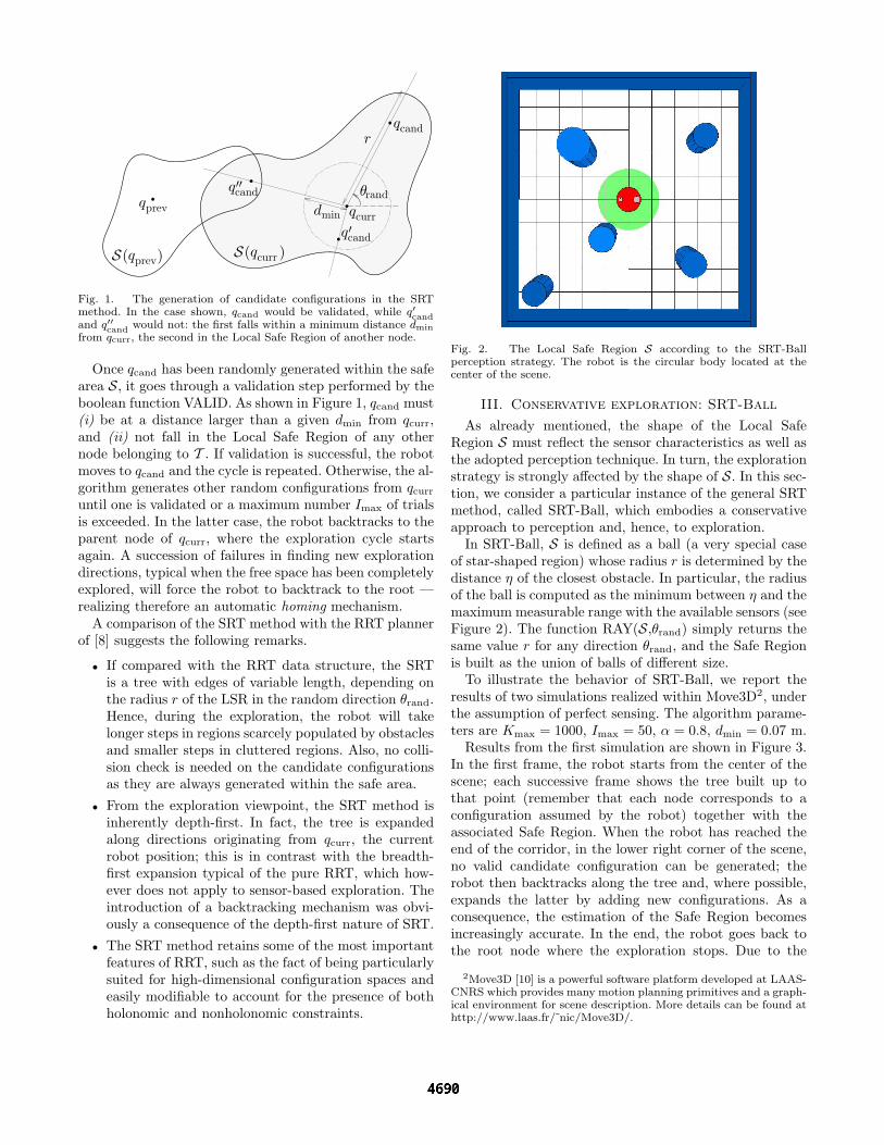
At this point, a direction of exploration θrand is ran-domly generated by the function RANDOM DIR, and thefunction RAY is invoked to compute the ‘radius’ r of Sin the direction of θrand (see Figure 1). A candidate newconfiguration qcand for the robot is determined by takinga step of length α ·r in the direction of θrand. The constantα < 1 guarantees that qcand is within the safe area S andcan be reached with a path contained in S; values of α closeto 1 will increase the exploratory attitude of the algorithm,while smaller values will augment the safety margin.
θrand
qcandr
qcand′
qcand′′
qcurrqprev
S ( )qprevS ( )qcurr
dmin
Fig. 1. The generation of candidate configurations in the SRTmethod. In the case shown, qcand would be validated, while q′candand q′′cand would not: the first falls within a minimum distance dmin
from qcurr, the second in the Local Safe Region of another node.
Once qcand has been randomly generated within the safearea S, it goes through a validation step performed by theboolean function VALID. As shown in Figure 1, qcand must(i) be at a distance larger than a given dmin from qcurr,and (ii) not fall in the Local Safe Region of any othernode belonging to T . If validation is successful, the robotmoves to qcand and the cycle is repeated. Otherwise, the al-gorithm generates other random configurations from qcurr
until one is validated or a maximum number Imax of trialsis exceeded. In the latter case, the robot backtracks to theparent node of qcurr, where the exploration cycle startsagain. A succession of failures in finding new explorationdirections, typical when the free space has been completelyexplored, will force the robot to backtrack to the root —realizing therefore an automatic homing mechanism.
A comparison of the SRT method with the RRT plannerof [8] suggests the following remarks.
• If compared with the RRT data structure, the SRTis a tree with edges of variable length, depending onthe radius r of the LSR in the random direction θrand.Hence, during the exploration, the robot will takelonger steps in regions scarcely populated by obstaclesand smaller steps in cluttered regions. Also, no colli-sion check is needed on the candidate configurationsas they are always generated within the safe area.
• From the exploration viewpoint, the SRT method isinherently depth-first. In fact, the tree is expandedalong directions originating from qcurr, the currentrobot position; this is in contrast with the breadth-first expansion typical of the pure RRT, which how-ever does not apply to sensor-based exploration. Theintroduction of a backtracking mechanism was obvi-ously a consequence of the depth-first nature of SRT.
• The SRT method retains some of the most importantfeatures of RRT, such as the fact of being particularlysuited for high-dimensional configuration spaces andeasily modifiable to account for the presence of bothholonomic and nonholonomic constraints.
Fig. 2. The Local Safe Region S according to the SRT-Ballperception strategy. The robot is the circular body located at thecenter of the scene.
III. Conservative exploration: SRT-Ball
As already mentioned, the shape of the Local SafeRegion S must reflect the sensor characteristics as well asthe adopted perception technique. In turn, the explorationstrategy is strongly affected by the shape of S. In this sec-tion, we consider a particular instance of the general SRTmethod, called SRT-Ball, which embodies a conservativeapproach to perception and, hence, to exploration.
In SRT-Ball, S is defined as a ball (a very special caseof star-shaped region) whose radius r is determined by thedistance η of the closest obstacle. In particular, the radiusof the ball is computed as the minimum between η and themaximum measurable range with the available sensors (seeFigure 2). The function RAY(S,θrand) simply returns thesame value r for any direction θrand, and the Safe Regionis built as the union of balls of different size.
To illustrate the behavior of SRT-Ball, we report theresults of two simulations realized within Move3D2, underthe assumption of perfect sensing. The algorithm parame-ters are Kmax = 1000, Imax = 50, α = 0.8, dmin = 0.07 m.
Results from the first simulation are shown in Figure 3.In the first frame, the robot starts from the center of thescene; each successive frame shows the tree built up tothat point (remember that each node corresponds to aconfiguration assumed by the robot) together with theassociated Safe Region. When the robot has reached theend of the corridor, in the lower right corner of the scene,no valid candidate configuration can be generated; therobot then backtracks along the tree and, where possible,expands the latter by adding new configurations. As aconsequence, the estimation of the Safe Region becomesincreasingly accurate. In the end, the robot goes back tothe root node where the exploration stops. Due to the
2Move3D [10] is a powerful software platform developed at LAAS-CNRS which provides many motion planning primitives and a graph-ical environment for scene description. More details can be found athttp://www.laas.fr/ nic/Move3D/.

Fig. 3. Simulation 1: The exploration process with SRT-Ball (framesare ordered from left to right and from top to bottom).
fixed circular shape of S, the boundary of the Safe Regionis a coarse approximation of the obstacles in the first fourframes. Accuracy however improves during backtracking,as can be appreciated from the last two frames.
The second simulation (Figure 4) shows how the con-servative nature of SRT-Ball may preclude the robot fromcompleting exploration tasks which require the negotiationof narrow passages. As the robot approaches the smalldoor, the perceived LSR gradually reduces due to thelateral walls: the SRT-Ball perception strategy cannot ‘see’through the opening. When the radius r of S becomessmaller than dmin, no candidate configuration can be vali-dated and the robot backtracks to the home configuration,where the exploration terminates.
IV. Confident exploration: SRT-Star
While the conservative perception of SRT-Ball ignoresthe directional information provided by most sensory sys-tems, SRT-Star can exploit it. Below, we consider the caseof a ring of range finders placed along the robot profile.
In SRT-Star, S is a star-shaped region given by theunion of different ‘cones’, with a different radius in each
Fig. 4. Simulation 2: The exploration process with SRT-Ball. Onlythe initial and final frames are shown.
cone (see Figure 5). The i-th cone radius is the minimumbetween ηi (the distance to the closest obstacle withinthe cone) and the maximum measurable range with theavailable sensors. Hence, to compute r the function RAYmust first identify the cone corresponding to θrand.
To allow a performance comparison between the twoexploration strategies, we have run the same simulations ofthe previous section with SRT-Star, under the assumptionthat a ring of 16 range finders is available. The sameparameter values have been used, except for Imax = 16.
Results obtained for the first simulation are shown inFigure 6. As can be noted by comparing the secondframe with the corresponding frame of Figure 3, SRT-Starhas a more pronounced depth-first exploration attitudewith respect to SRT-Ball, whose tree is more expandedin width. Still, the estimate of the free space built bySRT-Star is more accurate right from the start becausethe variable shape of S allows a finer reconstruction ofthe obstacle region boundary. Table I summarizes theperformance of SRT-Ball and SRT-Star in this simulation.The total traveled distance and the final number of nodesin the tree are much smaller with SRT-Star than with
Fig. 5. The Local Safe Region S according to the SRT-Starperception strategy. Note how the extension of S in some cones isreduced due to the sensor limited measurable range.

Fig. 6. Simulation 1: The exploration process with SRT-Star (framesare ordered from left to right and from top to bottom).
1st simulation SRT-Ball SRT-Startraveled distance (m) 143.4 63.8
number of nodes 419 125filling 92% 98%
TABLE I
SRT-Ball. We have also computed the percentage of thefree space that is covered by the final Safe Region (filling).
The superiority of SRT-Star is even more evident fromthe results of the second simulation in Figure 7. Now, therobot is able to cross the narrow passage; in fact, the radiusof S is not reduced in all directions as the robot approachesthe small opening, and candidate configurations across thedoor are generated and validated. A comparative summaryof the results is given in Table II: of course, SRT-Stargives a much better filling since the area beyond the smallpassage is explored. Moreover, this is obtained by travelinga smaller distance and reaching less nodes (and hence,performing less perceptions) with respect to SRT-Ball.
Simulations clips are available at the web pagehttp://www.dis.uniroma1.it/ labrob/research/SRT.html.
Fig. 7. Simulation 2: The exploration process with SRT-Star. Anintermediate and the final frame are shown.
2nd simulation SRT-Ball SRT-Startraveled distance (m) 87.6 74.4
number of nodes 155 120filling 72% 99%
TABLE II
V. SRT vs. frontier-based methods
If compared with the frontier-based approach, we notethat the SRT method does not make a distinction betweenobstacles and unexplored areas; in fact, the boundary ofthe Local Safe Region may indifferently describe the sensorrange limit or the profile of an object (see Figure 5). Thismeans that during the exploration the robot may approachareas which appear to be occluded. However, when theobstacle is at close range, candidate configurations whichwould push the robot closer to the occlusion will not bevalidated because they fall within the minimal distancedmin from the current point; thus, the robot will promptlymove away from the obstacle boundary without a signifi-cant loss of efficiency. On the other hand, a more accurateestimate of the Safe Region will typically be obtained, dueto (i) the increased precision of wide-angle range findersfrom closer distance, and (ii) the smaller size3 of theLocal Safe Region. The above is valid for the general SRTmethod, and thus for SRT-Ball and SRT-Star as well.
Another difference between the SRT method and othertechniques is the way in which the environment is rep-resented. The free space estimate built during the explo-ration is simply the union of the LSR associated to thenodes of the tree. Relatively simple post-processing opera-tions would however allow to compute a global descriptionof the Safe Region, more useful for navigation tasks.
VI. Experiments with SRT
The SRT-Ball and SRT-Star exploration strategies havebeen implemented on the MagellanPro robot available inour lab. MagellanPro is a two-wheeled differential-driverobot with a caster wheel added for stability; its shapeis circular with a diameter of 40 cm. Its sensory system
3The global Safe Region may be considered as the result of atopological erosion of the actual free space, in which the LSR acts asa variable-size structuring element.

includes a ring of 16 ultrasonic range finders (range 0.2to 4 m), a ring of 16 infrared range finders (range 0.07 to1 m) and another ring of 16 bumper sensors; besides, anon-board pan-tilt camera is available.
MagellanPro is a nonholonomic robot, and thus vio-lates the free-flying assumption of Sect. II-A. In thesepreliminary experiments, we have simply solved this prob-lem by using a rotation/translation/rotation maneuver toimplement the MOVE TO function of the SRT method.Also, we have used the built-in dead reckoning system forlocalization; while this is clearly a limitation, the homingerror at the end of the exploration was quite acceptable(see the details below).
The perception step for both SRT-Ball and SRT-Staris realized via the ultrasonic and infrared sensors: ineach sensor cone (having a 22.5◦ angle) a very basicsensor fusion between the two available range readingsis performed, so that a single range reading is obtainedfor each cone. While this directly provides the Local SafeRegion S for SRT-Star, an additional minimization overall the cones is required for SRT-Ball. The parameters forboth algorithms have been chosen as follows: Kmax = 500,Imax = 50, α = 3/4 and dmin = 10 cm.
The first experiment refers to MagellanPro exploring avery simple T-shaped environment using SRT-Star. Fig-ure 8 shows some snapshots of the exploration process:the left image of each frame was taken by a hand-heldcamera, while the right image shows the tree built by therobot together with the safe area reconstructed up to thatpoint; the actual location of the obstacles is superimposedfor the sake of clarity. The environment is successfullyexplored and the resulting SRT (which includes 28 nodes)provides a satisfactory roadmap of the free space. Inparticular, the total traveled distance is 19.8 m (considerthat the perimeter of the environment is 14.2 m). Thanksto the backtracking mechanism, MagellanPro returns tothe starting position once the exploration is completed;the homing error is 0.07 m.
Note that at some configurations the Local Safe Regionextends beyond the actual free space. This happens whenthe angle of incidence between the ultrasonic beam andthe obstacle surface is below a given threshold (falsereflection). A small value of α is used by SRT-Star to avoidthat, in these situations, the candidate configuration qcand
is placed within an obstacle. In any case, MagellanProcontinuously checks its range finders while moving; if anunexpected obstacle is detected at close distance (typi-cally, by the infrared sensors) the robot stops and performsa new perception step. We emphasize that it is possibleto detect and correct such erroneous range measures byrelatively simple elaborations (e.g., see [11]); here, wehave purposely chosen to avoid any post-processing ofthe measures in order to assess the performance of theexploration method in the presence of noisy data.
In the second experiment, MagellanPro was deployedinto a rectangular ‘room’ with two obstacles protruding
Fig. 8. Experiment 1: The exploration process with SRT-Star.
from the upper and lower wall (see Figure 9). The perime-ter of the open space boundary is now 17.5 m. The resultsobtained using SRT-Ball and SRT-Star are summarizedin Table III for comparison. As expected, the explorationpath produced by SRT-Star is much shorter (and thereforethe odometric homing error is reduced); moreover, theSRT-Star tree contains approximately 1/6 of the nodesof the SRT-Ball tree. On the other hand, the conservativeperception attitude typical of SRT-Ball drastically reducesthe inclusion of false reflections in the estimated safe area.
Experiments clips are available at the web pagehttp://www.dis.uniroma1.it/ labrob/research/SRT.html.
VII. Conclusions and future work
We have described a general method for sensor-basedexploration of unknown environments by a mobile robot.The method proceeds by building a data structure calledSensor-based Random Tree (SRT) through random gen-eration of configurations. The SRT represents a roadmapof the explored area with an associated Safe Region, anestimate of the free space as perceived by the robot duringthe exploration. Different strategies are then obtained byinstantiating the general method with different perception

Fig. 9. Second experiment: the final appearance of the tree and theassociated Safe Region obtained with SRT-Ball (above) and SRT-Star (below).
2nd experiment SRT-Ball SRT-Startraveled distance (m) 74.6 21.8
homing error (m) 0.21 0.08number of nodes 190 30
TABLE III
techniques. In particular, two such techniques have beenpresented: SRT-Ball and SRT-Star. The first is more con-servative and particularly appropriate for noisy sensors,while SRT-Star is more confident. The two strategies havebeen critically compared by simulations as well as byexperiments performed on the mobile robot MagellanPro.
Below, we briefly mention some of the extensions of thecurrent work which will be the subject of future work.
• Nonholonomic mobile robots (such as the Magel-lanPro) do not satisfy the free-flying assumption ofSect. II-A. While we have coped with this difficulty byusing rotation/translation/rotation maneuvers, moregeneral nonholonomic local planners can be used toconnect qcurr to a validated qcand; clearly, the plannermust be appropriately designed so as to guaranteethat the resulting path is completely contained in S.Also, it would be interesting to modify the construc-tion of the Local Safe Region S so as to account forthe nonholonomic obstacle distance defined in [12].
• In principle, the SRT method can be used for sensor-based exploration of high-dimensional configurationspaces; this may be, for example, the case of a mobilemanipulator. The main issue would become the gener-ation of a configuration-space Local Safe Region from
the available sensor measures. Clearly, such regioncannot be expected to be star-shaped, so it wouldbe necessary to reduce it appropriately. The samehappens with single-body mobile robots if the rangefinders are not arranged on a ring.
• Experimental results of SRT-Star in the presence offalse reflections indicate that, in order to achieverobust performance and accurate estimation of thefree space, the definition of the Local Safe RegionS must incorporate a model of the available sensorsincluding uncertainty and/or faults. For example, thesafe area definition of [4] includes a simple mechanismfor taking into account incidence angle constraints.
• As mentioned in the introduction, the integration ofa localization step into the exploration process basedon a SLAM technique is currently under way.
• One of the benefits of randomized search techniquesis that they are generally amenable to parallelization.In our case, this means that the SRT method lendsitself quite directly to an extension to multirobotexploration. However, to guarantee that the promisefor increased efficiency is fulfilled, some degree of co-ordination between the robots must be introduced [5].
References
[1] B. Yamauchi, “A frontier-based approach for autonomousexploration,” in IEEE Int. Conf. on Robotics and Automation,1997, pp. 146–151.
[2] B. Yamauchi, A. Schultz, and W. Adams, “Mobile robotexploration and map-building with continuous localization,” inIEEE Int. Conf. on Robotics and Automation, 1998, pp. 3715–3720.
[3] A. Makarenko, S. B. Williams, F. Bourgault, and H. F. Durrant-Whyte, “An experiment in integrated exploration,” inIEEE/RSJ Int. Conf. on Intelligent Robots and Systems, 2002,vol. 1, pp. 534–539.
[4] H. H. Gonzalez-Banos and J.-C. Latombe, “Navigation strate-gies for exploring indoor environments,” Int. J. Robotics Re-search, vol. 21, no. 10, pp. 829–848, 2002.
[5] W. Burgard, M. Moors, D. Fox, R. Simmons, and S. Thrun,“Collaborative multi-robot exploration,” in IEEE Int. Conf. onRobotics and Automation, 2000, vol. 1, pp. 476–481.
[6] S. Thrun, “Exploration in active learning,” in Handbook ofBrain and Cognitive Science, M. Arbib, Ed. MIT Press, 1995.
[7] J. Barraquand, L. Kavraki, J.-C. Latombe, T.Y. Li, R. Mot-wani, and P. Raghavan, “A random sampling scheme for pathplanning,” in Robotics Research: The Seventh InternationalSymposium, G. Giralt and G. Hirzinger, Eds., pp. 249–264.Springer-Verlag, London, 1996.
[8] S. M. LaValle and J. J. Kuffner, “Rapidly-exploring randomtrees: Progress and prospects,” in Algorithmic and Computa-tional Robotics: New Directions, B. R. Donald, K. M. Lynch,and D. Rus, Eds., chapter 10, pp. 293–308. A K Peters, Welles-ley, MA, 2001.
[9] J.-C. Latombe, Robot Motion Planning, Kluwer AcademicPublishers, Norwell, MA, 1991.
[10] T. Simeon, J.-P. Laumond, and F. Lamiraux, “Move3D: Ageneric platform for path planning,” in 4th Int. Symp. onAssembly and Task Planning, 2001, pp. 25–30.
[11] G. Oriolo, G. Ulivi, and M. Vendittelli, “Real-time map buildingand navigation for autonomous robots in unknown environ-ments,” IEEE Trans. on Systems, Man and Cybernetics, PartB, vol. 28, no. 3, pp. 316–333, 1998.
[12] M. Vendittelli, J.-P. Laumond, and C. Nissoux, “Obstacledistance for car-like robots,” IEEE Transactions on Roboticsand Automation, vol. 15, no. 4, pp. 678–691, 1999.


![AZ]`e SRT\ e` cVT`gVc ]`de Xc`f_U - Daily Pioneer](https://static.fdokumen.com/doc/165x107/631f5aea13819e2fbb0fb243/aze-srt-e-cvtgvc-de-xcfu-daily-pioneer.jpg)


![@aa SRT\d >R^ReR d]R^d 64 - Daily Pioneer](https://static.fdokumen.com/doc/165x107/632df348c95f46bf4c073a3c/aa-srtd-rrer-drd-64-daily-pioneer.jpg)

