The soils and vegetation of the Bisoke volcano: habitat of mountain gorillas
22
PEDOLOGIE, XLIII-2, p. 301-322, 5 tab., 5 fig., Gent 1993 TUE SOILS AND VEGETATION OF TUE BISOKE VOLCA- NO (RWANDA): HABITAT OF MOUNTAIN GORILLAS Abstract S. DONDEYNE* J.A. DECKERS* J. CHAPELLE** Six major vegetation units were identified for the altitude beits and for the different geomorphological sectors ofthe Bisoke volcano in Rwanda. An inventory of the dicotyledon species was made for each of the vege- tation units in the eastern and southern sectors, encompassing a total of 80 species, of which five to genera level. The inventory was further used as a checklist for assessing the vegetation composition by recording the presence or absence of each species in the immediate neighbourhood of the studied profiles. Nine soit profiles of the volcano were studied for their morphological, physical and chemical properties. Five in the southern and four in the eastern sector were selected according to the different vegetation beits. Histosols are dominant in the upper reaches of the mountain, corre- sponding to the afro-alpine vegetation belt, with Andosols are dominating in the lower belt under primary mountain forest and secondary herbaceous vegetation. Keywords Birunga volcanoes, Andosols, Histosols, vegetation. 1. INTRODUCTION Located along the western rift valley of East Africa, the Bisoke is one of the eight major Birunga volcanoes along the national borders of Rwanda, Zaire and Uganda (Fig. 1). It is located within the 'Volcano National Park' * Post-graduate student and Professor - Institute for Land and Water Management, KV Leuven, Vital Decosterstraat 102, B-3000 Leuven, Belgium. ** Professor, Institut Supérieur Industriel de l'Etat - Rue St Victor 3, B-5200 Huy, Belgium. 301
Transcript of The soils and vegetation of the Bisoke volcano: habitat of mountain gorillas

PEDOLOGIE, XLIII-2, p. 301-322, 5 tab., 5 fig., Gent 1993
TUE SOILS AND VEGETATION OF TUE BISOKE VOLCANO (RWANDA): HABITAT OF MOUNTAIN GORILLAS
Abstract
S. DONDEYNE* J.A. DECKERS* J. CHAPELLE**
Six major vegetation units were identified for the altitude beits and for the different geomorphological sectors ofthe Bisoke volcano in Rwanda. An inventory of the dicotyledon species was made for each of the vegetation units in the eastern and southern sectors, encompassing a total of 80 species, of which five to genera level. The inventory was further used as a checklist for assessing the vegetation composition by recording the presence or absence of each species in the immediate neighbourhood of the studied profiles.
Nine soit profiles of the volcano were studied for their morphological, physical and chemical properties. Five in the southern and four in the eastern sector were selected according to the different vegetation beits. Histosols are dominant in the upper reaches of the mountain, corresponding to the afro-alpine vegetation belt, with Andosols are dominating in the lower belt under primary mountain forest and secondary herbaceous vegetation.
Keywords Birunga volcanoes, Andosols, Histosols, vegetation.
1. INTRODUCTION
Located along the western rift valley of East Africa, the Bisoke is one of the eight major Birunga volcanoes along the national borders of Rwanda, Zaire and Uganda (Fig. 1). It is located within the 'Volcano National Park'
* Post-graduate student and Professor - Institute for Land and Water Management, KV Leuven, Vital Decosterstraat 102, B-3000 Leuven, Belgium.
** Professor, Institut Supérieur Industriel de l'Etat - Rue St Victor 3, B-5200 Huy, Belgium.
301
sjmd
Typewritten text
Citation Dondeyne S., J.A. Deckers & J. Chapelle (1993) – The soils and the vegetation of the Bisoke volcano(Rwanda): habitat of mountain gorillas. Pedologie 43(2): 301-322.

+~~'·ZAIRE U I UG::'~~0\~~ ,. ~..,~ ~ ... ~ ". ~e · . . /..,(' ~ ..... ... ~ · ~ 1( '. ' ..
~ ~~ .. . ..... ... . ... . . . . : OT . ~~. . . . . . . . . . ...... .
\
. . . -: : : -: . . -: : :~ ~.: ~ : : : : :- .. -: : : :-~ ~. : : ~ : : \. .... -: : : : ••• .It ••• 11
.... .. . . . .... .. .. . "' ....... . ... ·.6 r . . . '.:. '. .... ..•• • ••• . . . . . . • . ·d \. . . • . . . . • . . . ... . ~"'UHAVURA
·.·.· . · .· .:t:\'.·.·.·.·.·.· . ·. · .·SA8INY~ .. ~ ft :::: ~:: : l~ ~ N·YA·M~~Á~i~Ä: ~: : : : :: : ~.: .:~.: .: . ~ .. GAHINGA ..... '. ~?0.' . · ... IKENO· . '.' • .• . .. .. . . . . ul.ra
:> :: :t-> :: '. .. -: <:>:~:. -:::'j~~;;' -: '. " '11\ : : :~:'7~?~ . : .~: : : : ! ~ . : : : : : : : : : .; ~ IRUhond.
• • • • • • • • • •• • • • • ~ l.1li1 Edwlrd lUIM.
I!i~~~~ ...... ~":?::::... . ~ , .... _
RWANDA I· .. ... ·1 Lew. t .. ,* ,-,2'
°c======'z5======~30km
Figure 1. Location ofthe Birunga volcano range and the Bisoke in the north-west of Rwanda (souree: De Mulder, 1985)
(Pare National des Volcans) famous for its mountain gorrilas. During the last two decades most of the research in the national park was focusing on these unique creatures.
In the framework of a general ecological research plan ofthe park, a study of the soils and the vegetation of the Bisoke volcano was carried out from August to November 1988. The aim ofthis study was to characterize the soils and the vegetation to get an insight in ecological relationships toward a better understanding ofthe ecosystem ofthe Volcano National Park.
The volcanic cone of the Bisoke is mainly built up by leucitites, a very alkaline rock, sub-saturated in silicium (Antun et al., 1971; Rancon et al., 1983). The Bisoke is a moderately eroded strato-volcano. The base of the cone is at an altutude of about 2800 m above sea level while its summit reaches 3711 m a.s.l. The Bisoke volcano can be divided into th ree major geomorphological sectors: - A north-western sector typical for its high density of relatively shallow
parallel gullies, which are oriented north-west. The area is essentially constituted by lava and bomb deposits.
302
- A southern sector dominated by an explosion crater. The slopes are the steepest along this side ofthe volcano and de ep gullies are found here. The lower part ofthis sector is built up by lava, while the upper part is built up by deposits of crystalline tuff and deposits of scoria.
- An eastern sector characterized by a lower density of gullies compared to the previous ones, but the present gullies are very deep. It is largely built up by deposits of scoria and ashes.
In general it can be stated that the area has a perudic moisture regime. A zone between 2800 and 3200 m a.s.l. gets the highest precipitation of more than 1800 mm/year. Mean annual temperature ranges from 12 to 9°C at an altitude from 2800 to 3200 m a.s.l. to less than SOC above 3400 m a.s.l. (Jost, 1987).
Phytogeographically the vegetation of the Birunga volcanoes belongs to the afro-montane region (SchneIl, 1977). The different vegetation formations ofthe Bisoke volcano are: - The afro-alpine belt, found on the highest parts ofthe volcanoes, where the
Senecio and Lobelia formations are the most striking. The most elevated areas as weIl as the areas which are highly exposed to winds, are covered with afro-alpine meadows.
- Forests of Hagenia abyssinica and Hypericum revoltum. Although the Hagenia forest and the Hypericum forest are overlapping, they can be distinguished from each other on basis of dominance between the two species. Hypericum dominates on the higher elevated areas. Moreover a closed canopy ofHagenia can only be found on the Karisimbi, the Mikeno and the saddle area in between these two and the Bisoke. In numerous places the Hagenia and Hypericum forests have been disturbed and are replace by a secondary herbaceous vegetation.
- Marshlands occur on poorly drained sites. The largest area is located in the caldera crater of the nearby Karisimbi volcano. Considerable marshlands are also found in various saddle areas. At the rim of the Bisoke crater as weil as in the southern explosion crater some smaller swamps are found.
MATERlALS AND METHODS
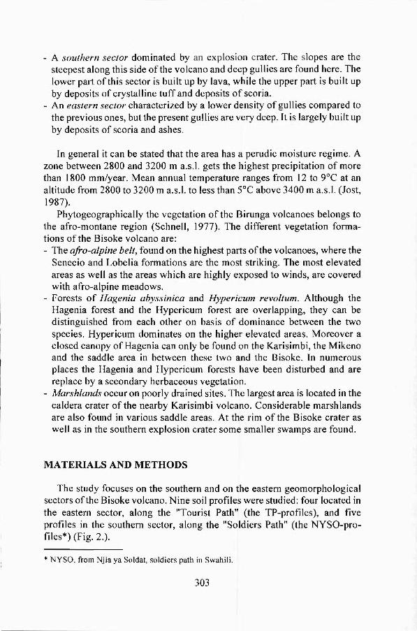
The study focuses on the southem and on the eastem geomorphological sectors ofthe Bisoke volcano. Nine soil profiles were studied: four located in the eastem sector, along the "Tourist Path" (the TP-profiles), and five profiles in the southern sector, along the "Soldiers Path" (the NYSO-profiles*) (Fig. 2.).
* NYSO, from Njia ya Soldat, soldiers path in Swahili.
303
3700
3600
3500 ESE aida
3400
-ui ai 3300
.s i 3200 E <
3100
3000
2900
0 0.4 0.8 1.2 1.8 2 km
Legend: • 1 location of NYSO profile
• 1 location of TP profile Figure 2. Schematic presentation of the vegetation units and location of the study sites in the southern (NYSO) and eastern (TP) sectors ofthe Bisoke volcano
Vege/a/ion For each identified vegetation unit along the eastem and southem sectors,
inventories of the dicotyledon plant species were made. Semi-quantitative data on the vegetation composition was obtained by recording the presence or absence of each species in ten rectangular plots of one square meter (1.67 m x 0.6 m). The total recorded area is 10 m2. The plots were taken randomly in a circIe around each profile pit, and within a range of approximately five to maximum thirty meters. It was thus necessary to be able to recognize each species in vegetative stadium, this was however not feasible for species of the genera Galium, Impa/iens, Solenos/emon, Rubus and for one type of Helichrysum.
SoUs The location ofthe soil profiles was selected during a one month prelim
inary reconnaissance survey of the area, during which the vegetation units
304

Table I. The vegetation units of the Bisoke volcano, of the th ree major geomorphological sectors and according to the elevation
Geomorphological Altitude Vegetation sector (meters a.s.I.) unit
North-western sector <2900 secondary herbaceous, fonnerly Hagenia forest
:1:3150 Hypericum/BamboolPrunus :1:3320 lower Hypericum forest, with Philipia
3460 - 3500 Senecio/Helichrysum 3500 - 3700 Senecio/Lobelia fonnations and
Afro-alpine meadows
Eastern sector 2980 - 3250 secondary herbaceaous, formerly Hagenia forest
3250 - 3330 secondary herbaceous, fonnerly Hypericum forest
3330 - 3450 upper Hypericum forest > 3450 Senecio/Lobelia formation
Southern sector < 3110 Hagenia forest not more than a marginal strip along this side
3110 - 3270 lower Hypericum forest with groundcover of Lobelia giberroa, Impatiens sp., Laportea alatipes and others
3270 - 3370 upper Hypericum forest with Lobelia stuhlmannii and Senecio mariettae
3370 - 3600 SeneciolLobelia formation >3600 Afro-alpine meadow
were identified and defined (Tabie 1) for each ofthe three geomorphological sectors of the volcano. The extension of major soil units was assessed by auger. The location ofthe soil profiles was selected so as to be representative for the vegetation units and the local topography. Except for the afro-alpine meadow, where only one profile was investigated, two profiles were studied for each vegetation unit (Fig. 2). Undisturbed core samples of 100 cm3 were taken from the major horizons for bulk density determination. The water retention curves were determined from samples of five c1early distinct profiles. The water retention between pF 0 and pF 2.8 was determined from undisturbed core samples on a sand tabie; values at pF 2.3 and 2.8 were obtained on low pressure plates, and values for 3.4 and 4.2 on high pressure plates. The saturated hydraulic
305

conductivity (Ksat) ofthe top soil was measured on the spot with a single ring infiltrometer with constant hydrostatic head.
Standard determinations consisted of pH(H20, M-KCI), carbon and nitrogen content, exchangeable bases, phosphorus and cation exchange capacity (CEC). All chemical analyses were done on air dried samples passed through 2 mm sieves. The total carbon content was determined by the wet oxidation method (Walkley and Black). The samples with a carbon content higher than 120/0 were further submitted to ashing. Mineral and total nitrogen was determined according to the method of Kjeldahl. Ca, Mg, K, Na and P were analyzed after extraction with ammonium lactate. The cation concentrations were assessed with an atomic spectrophotometer. The phosphorus level was measured using a complexion reaction with ammonium vanadate and molybdate to enable a colorimetrie test with a spectrophotometer. The CEC was determined after percolation with NH40Ac at pH 7.
3. RESULTS AND DISCUSSION
3.1. The vegetation of the Bisoke 3. J.1. The vegetation units
The identified vegetation units, for the three major geomorphological sectors of the volcano and according to the elevation, are listed in Table I. The vegetation units in the eastern sector are rather similar to those in the southern sector, except for the lower part which is dominated by secondary herbaceous vegetation. Some remaining trees however betray that this area must have been forested in the recent past.
It is striking that the vegetation units along the eastern side seem to reach higher altitudes than along the south-western side as indicated in Figure 2. This may be explained by the prevailing winds and precipitation, the majority of which are coming from the south-east. Of more importance, however, is the fact that the eastern slopes of tropieal high mountains tend to get more hours of sunshine. When the sun is rising, the sky is generally still c1ear, while the western slopes are shaded by the mountain. Towards noon time, the c10udiness usually increases, which results in less sunshine for the western sides of the mountain.
The vegetation of the north-western sector was not investigated to the same detail as for the two other sectors. It was however observed that in the lower parts Prunus africana and Phillipia johnstonii were more frequent than in the other sectors. Furthermore, on the higher parts Helichrysum species are fairly common while Lobelia stuhlmannii is rather scarce along this side of the volcano.
306
SWslde ESE slde
26 ,-------------------------~~ 30 ,---------------------------~
24
m 22 g 20
i" 18
~ 16 Cl)
~ 14 È 12
~ 10 1ii 8 '3 E 6 ::l o 4
2
28 Cl) 26 ~ 24 8.22 Cl) 20 o Q) 18
~ ~: c: ~ 12 i 10 '3 8 § 6 o 4
2 O~_,_,--,__,--r_.__,--.__,~
o 2 3 4 5 6 7 8 9 10
Cumulatlve area (square m)
Correspondlng NYSO-proflles • N1 t N2 0 N3 6 N4 x N5
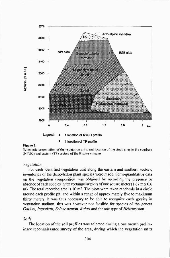
Figure 3.
2 3 4 5 6 7 8 9 10
Cumulatlve area (square m)
Correspondlng TP-proflles
• T1 t T2 0 T3 6 T4
Cumulative number of dicotyledon species in the neighbourhood of nine soil profiles
3.1.2. The composition of dicotyledon plant species The number of dicotyledon species was found to be higher at lower
altitudes. As the number of additional species tends to zero with increasing size of the observation plot, it can be concluded that an area of 10m2 is a good approximation for the minimum area (Fig. 3).
Data on the presences/absences are displayed in Table 2. The species have been grouped according to their highest presence score. Group one (G 1) corresponds with the the species of the secondary herbaceous formation around the profiles Tl * and T2, group two (G2), with the lower Hypericum forest around NI and N2, group three (G3) with the upper Hypericum forest, group four (G4) with the SeneciolLobelia fonnation and group five (G5) with the afro-alpine meadows. Species found in all units were isolated in group 0, however the group where they have the highest presence score is indicated between brackets in the tabie.
Despite the fact that for each unit typical species can clearly be identified, several species are common to neighbouring units. As could be expected, especially the lower Hypericum forest (see boxes A, 8, C in Table 4) has a great number of species in common with the secondary herbaceous formation, as weil as with the higher Hypericum forest. The former can be
* Tx refers to the corresponding TP-x profile pit Nx refers to the corresponding NYSQ-x profile
307

Table 2. The composition of dicotyledon species of the vegetation in the neighbourhood of nine soil profiles on the Bisoke
** Presence per profile* Diagram Name Group T1 T2 N1 N2 N3 T3 T4 N4 N5 T1T2 N1N2 N3T3 T4N4 N5
Crassocephalum ducis-aprutii o (1) 10 10 7 10 6 5 1 4 + .......................... Hypericum revolutum o (3) 2 + 5 8 9 7 4 2 + Hydrocotyle sibthorpioides o (3) 3 3 7 7 9 10 3 6 3 0 Galium sp. o (4) 3 6 4 5 8 6 7 8 + .......................... Oxalis procumbens 1 + + - ....--Carduus leptacanthus ·1 + + -Vernonia adolfi-frederici 1 + + -Conyza hochstetteri 1 + + -Solanum anguivii 1 + + -Oenanthe procumbens 1 + + -Urtica massaica 1 3 + -Runex bequaertii 1 + + -Ranunculus bequaertii 1 1 + + + -Cardamine africana 1 1 + -Pilea tetraphylla 1 2 + -Discopodium penninervium 1 2 + -Gynura scandens 1 3 + -Tylophoropsis heterophylla 1 + + - G1 Pilea rivularis var. riv. 1 3 + + + - + -veronica abyssinica 1 + + -Solanum aculeastrum 1 + + -Stephania abyssinica 1 2 1 Leucas alluaudi i 1 + 1 Parietaria debilis 1 + 1 Oreosyce africana 1 3 1 Solenostemon sp. 1 10 8 -Plantago palmata 1/A + + + + - ... .... Peucedanum linderi 1/A 9 + + I
I Crassula granvikii 1/A 1 + + + + - - + I
I Mentha aquatica 1/A 1 1 2 + + I A I Corydalis mi ldbraedi i 1/A + 1 1 + + - I , Droguetia iners 1/A 3 2 1 + + - I , Impatiens sp. 1/A 5 3 8 + + + - I , Laportea alatipes 1/A 8 9 10 5 + + - , , Hagenia abyssinica 1/A 3 + 1 1 + + + + - 1'--Alchemilla cryptantha 2!A 1 + 2 + + - I ....--, Cardamine hirsuta 2!A + + + I , Ranunculus multifidus 2/A + + 2 + - + -Prunus africana 2 - + + -Callitriche oreophila 2 1 + - G2 Plectranthus sp. 2 - 10 10 5 4 -Polygonum nepalense 2!B 1 1 2 3 + 1 Lobel ia giberroa 2/B 6 2 5 6 2 1 - + + Carduus nyassanus 2!B + 5 10 8 3 9 + - L.....-- B
308

Table 2. The composition of dicotyledon species of the vegetation in the neighbourhood of nine soil profiles on the Bisoke (cont'd)
Presence per profile * Diagram ** Name Group T1 T2 N1 N2 N3 T3 T4 N4 N5 T1T2 N1N2 N3T3 T4N4 N5
Parochetus communis 3/B + + 1 + 2 9 - - - I .--- I I I
Thalictrum rhynchocarpum 3/B 4 1 1 3 4 2 - - - I B I I I
Alchemilla kiwuensis 3/B 1 2 3 7 6 10 5 - - .......... ... Conyza adolfi-fridericii 3 - - + 1 4 - - - -Crassula alsinoides 3/C 2 1 1 1 2 2 + + - .......... ... ..... Stellaria senni i 3/C 3 2 6 6 7 6 + 6 - I I
I I
Stachys aculeolata 3/C + 3 1 2 1 3 3 + - I C I I I,
Viola eminni i 3/C - 1 1 7 10 4 10 1 2 .......... ... . .... Subularia monticola 3 - - - - + - + - -Senecio transmarinus 3 - - - - - 10 - - -Rapanea melanophloeios 3 - - - - 1 - - - - C3 Sanicola elata 3 - - - - + - - - -Cynoglossum lanceolatum 3 - - - - + - - - -Rumex ruwenzoriensis 3 + + - - - 9 - - -Senecio mariettae 3/0 - - + + 7 + + 1 - ... ..... Pilea rivularis var. stip. 3/0 - - - - 4 9 5 2 - IL-- I
I
Lobel ia stuhlmanni i 4/0 - - - - 6 4 6 10 1 I ,..-- I I I
Cardamine obliqua 4/0 - - 1 + 1 1 + 3 1 I I I I
Rubus sp. 4/0 - - + + + + 5 3 - I 0 I I I
Cerastium indicum 4/0 - + + + 1 + 2 + - I I I I
Hydrocotyle mannii 4/0 2 + 1 + 1 - 8 9 6 ..... ... Senecio maranguensis 4 - - - - - - - + -Conyza subscaposa 4 - - - - - - 2 - -Helichrysum sp. 4 - - - - - - + + - G4 Helichrysum helothamus 4 - - - - - - 2 - -Helichrysum formsissimum 4 - - - - - - 1 1 -Alchemilla johnstonii 4/E - - - - - - 8 9 10 ... .... Senecio johnstonii 4/E - - - - + + 7 8 4 I I
I I Callitriche vulcanicola 4/E - - - - - - + - + I I
I I Philippia johnstonii 4/E - - - - + - + + + lI.....- I
I Peucedanum kersten i i 5/E - - - - - + + + 9 I BI Senecio sabinjoensis 5/E - - - - - - + + 6
!.~ .. G5 ! Swertia eminni i 5/E - - - - - - 3 3 10 Lobelia wollastonii 5 - - - - - - - - + Cerastium octandrum 5 - - - - - - - - 5 Hypericum peplidifolium 5 - + - - - - - - +
* Number of times a species was recorded in 10 plots of 1m2; + not observed in any of the 10 plots, but observed within the concerned vegetation unit; - not observed in the concerned vegetation unit
** Grou~ Species common to several groups 0: s~ecles toünd ln a(( groups
( etwee~ brackets, th~ ~roup they belong to,
G1 acCOrdln? to thelr hlg est presence score)
species 0 secondary herbaceous formation A Gl & G2 G2 species of the lower Hypericum forest B G1 & G2 & G3 G3 species of the upper Hy~ricum forest C G1 & G2 & G3 & G4 G4 species of the Senecio Lobelia formation D G3 & G4 G5 species of the Afro-alpine meadow E G4 & G5
309

explained by the fact that this area used to be covered by forest, but it also indicates that the lower Hypericum forest has been subjected to disturbances. These disturbances can be attributed to encroachments ofthe park by herds of cattle in the past, as weil as to the wild megafauna, specially the buffaloes (Syncerus caffer) and the mountain gorillas (Gorilla gorilla beringei).
3.2. Major soils on the Bisoke 3.2.1. Morphology
A general discussion on the morphology of the studied profiles is given here. The detailed descriptions of three distinct and representative soil profiles (TP-l, TP-3, and NYSO-4), as weIl as the laboratory data, are given at the end ofthe paper.
As a general trend, it can be stated that the soil depth decreases with increasing altitude. The colours of the NYSO-profiles are darker than those of the TP-profiles. The upper horizons were invariably black, usually overlaying lighter coloured A and/or B horizons. In the latter horizons, stones, gravel and/or augite crystals were often found in slightly weathered status which resulted in a mottling pattem. A clearly developed placic horizon (Bms) occurred in two profiles (TP-3 and NYSO-I) at a depth of 5 5 to 90 cm. In other profiles (NYSO-3, -4 and NYSO-5) a comparable red layer was found on the bedrock.
The structure elements were generally moderately developed, fine to medium in size and often angular blocky. The consistency was non plastic or slightly plastic as weil as non stieky or slightly sticky in most cases. Slickensides were prominent in the horizonsjust above the bedrock ofthe NYSO-4 and -5 indicating that the soil is creeping and landslides are in deed common in the area. The phenomenon should be related to the high water holding capacity of these soils in combination with a very slow hydraulic conductivity.
3.2.2. Physical properties Soil texture
Soil texture was Silt or Silty-Clay in most cases. All dark coloured Ahorizons were thixotropie. Only the profiles at high elevation (NYSO-4, -5 and TP-4) were thixotropie in all their horizons. As is typieal for volcanic soils, the bulk densities of all horizons are very low, mostly between 0.2 and 0.7 g/cm3 for oven dry samples.
Water retention The water retention curves ofthe five sampled profiles (NYSO-2, -5, TP-
1, TP-3 and TP-4) looked all very much alike. In Figure 4 the water retention curves of the horizons of the TP-I profile are given as an example. Appar-
310

Q)
a ;j rl 0 > ~
~
s:: Q)
~
s:: 0 u
~ Q)
~
ro ::-
1
0 . 9
0 . 8
0 . 7
0 . 6
0 . 5
0 . 4
0 . 3
0 . 2
0.1
0
0 1 2 3
suction head (pF)
Horizons : • Ai + AZ o ZA3 fj, ZBw x ZBG
Figure 4. Water retention curve of the TP-I profile as a typical example for the soils of the Bisoke volcano
ently the differences in organic matter content and/or differences in mineralogy have only little or no influence. This may be due to the fact that the water retention curve of allophane rich soils is determined rather by the distribution of the pores than by the specific area, as is the case in soils with crystalline clays (Maeda et al., 1977; Warkentin et al., 1980). The major part of the water is released at a pressure head of pF 2.8, and is thus available for the plants. The pF curves reveal a very high water holding capacity ranging between 600 and 800 mm per meter soit depth.
Infiltration capacity The soils in the eastern sector, formed on pyroclastic material (TP-l, TP-
2, and TP-4), have very high infiltration capacity (Ksat between 125 to 300 mm/h). The two profiles with a placic horizon (NYSO-l and TP-3) have slow hydraulic conductivity (Ksat of 4 mm/h), while NYSO-2 and NYSO-3 have moderately high infiltration capacity (Ksat of 50 and 70 mm/h). In general the soils in the eastern sector, developed on deposits of scoria and ashes, have higher infiltration rates than the soils in the southern sector. Despite
311

their high organic matter content, the profiles NYSO-4 and NYSO-5, have a very slow hydraulic conductivity with Ksat values of 0.8 to 1.0 mm/h.
3.2.3. Chemical properties All the studied profiles are rather acidic with pH (H20) ranging from 4.2
to 6.5 (Tab Ie 3). The low pH ofthe soils is related to the predominant parent material (leucitites) which consists of easy weatherable minerais. The upper horizons, which are richer in organic matter, also seem to be more acidic (Tabie 3). The profiles NYSO-4 and NYSO-5 are found to be the most acidic, and have low pH values throughout their profile, ranging from 4.2 to 5.3. This can especially be attributed to their extremely high content in organic matter (%C ranging between 25 and 45) throughout the profile.
The Al horizons of all the profiles are rich in organic matter. The total nitrogen is high, but most ofthe samples have high CIN ratios indicating that the organic matter is not decomposing weil (TabIe 3). The accumulation of organic matter can be explained by a complexation of humus, allophanes and other weakly crystalline minerais, which make the organic matter unaccessible for micro-biological activity (Tate et al., 1980). At higher elevation, where the micro-biological activity is lower due to the colder climate, the accumulation of organic matter is even more pronounced. This is the case for NYSO-4 and NYSO-5 which are distinguished from the other profiles by their extremely high carbon content and their higher phosphorus status.
Table 3. Range values for some soil chemical properties
Property Range
pH (H2O) upper horizon 4.2 - 5.6 subsurface horizon· 4.9 - 6.5
Carbon content (%) upper horizon 31 - 77 subsurface horizon 0.9 - 36.9
Total Ni/rogen (mg NIl 00 g soil) upper horizon 1236 - 2844 subsurface horizon 255 - 1135
C/N ratio upper horizon 14.1 - 19.3 subsurface horizon 12.5 - 32.5
• subsurface horizon = lowest sampled horizon of each profile (Source: compiled from Dondeyne, 1989)
312

15
14
13
0 12
UI 11
"0 Q) 10
L "0
9
L 8
ra Ol 6
0 0 ..-........ " 0 E E
0
18
17
0 16 UI
"0 15
Q) 14
L 13 "0
12 L
11 til
10 Ol
9 0 0 8 ..-........
0 6
E E
4
Figure 5.
NYSO-1 NYSO-2 NYSO-3 NYSO- 4
Bw2 Bw4 A1 2A3 281 A2 A1
Hor-izons fr-omNYSO pr-ofi les
TP-l TP-2 TP-3
A1 2A3 28C
1\2 2Bw 2C
Hor-izons fr-om TP pr-ofi les
Ca Legend : ~
Mg
~
NYSO-5
1\1 8hs
TP-4
Content of the exchangeable bases for the major horizons of nine soil profiles of the Bisoke volcano
313

The values for the cation exchange capacity are rather high, ranging from 38.2 to 81.8 meq/l 00 g air dried soil. However, since these soils have variabie charges, depending on the pH, the values obtained with the NH40Ac method are likely to be an over estimation of the field situation. On the other hand the base saturation values are rather low.
As shown in Figure 5, the upper horizons invariably are richer in bases than the lower ones. It also appears that the lower profiles, NYSO-I, NYSO-2, but particularly TP-I and TP-2 contain more bases. In these four profiles the bivalent bases, Cart and to alesser extent Mg++ are the dominating cations, while in the higher profiles the importance of the monovalent cations K+ and Na+, tends to increase.
An analysis of the Pearson correlation coefficients, between all the measured chemical properties, reveals that the phosphorus content as weil as the content ofNH4 +, K+ and Na+ are positively and statistical significantly correlated with the organic matter (%C and total nitrogen) as can be seen from Table 4. This relationship can be explained by a mechanism whereby phosphorus and the monovalent cations are selectively bound to organo-mineral complexes as proposed by Bowden et al. (1980). On the other hand no important correlation coefficients were obtained for the bivalent cations (Ca++ and Mg++) and nitric nitrogen (Nü3-' as against NH4 +) with any ofthe chemical parameters.
Table 4. Pearson correlation coefficients ofthe phosphorus and the monovalent cations content with the organic matter (%C and total N)
NH4+ K+ Na+ P
%C 0.66 0.56 0.45 0.77 (34) (44) (44) (44)
Ntotal 0.82 0.63 0.76 0.84 (34) (34) (34) (34)
NH4+ I 0.76 0.71 0.81 (34) (34) (44)
K+ I 0.46 0.47 (44) (44)
Na+ I 0.63 (44)
Note: all coefficients are significant up to the level of at least 0.002; the number of observations is given in between brackets
314
3.2.4. Soi! classification in the major vegetation beits The major associations between soil and vegetation occurring on the
Bisoke are given in Table 5. The data set was however too limited to enable a more detailed correlation analysis between soil properties and the occurrence frequency of individual plant species. The soils of the Bisoke can be divided into two major groupings: the Andosols (or Andisols in the Soil Taxonomy system), which are typical volcanic soils, and the Histosols which are organic soils.
Andoso Is/ Andiso Is As NYSO-l and TP-3 have a c1ear placic horizon (Bms) they are desig
nated as Umbric Andosols with a 'placic phase' in the F AO'88 system. It is likely that large areas of the Bisoke volcano have Umbric Andoso/s, be it with or without aplacic phase as in NYSO-2, -3 and TP-4. These areas are mainly covered by Hypericum and Hagenia forests and locally by secondary herbaceous formations.
In the eastern sector, extensive areas were covered with secondary herbaceaous vegetation on soils which had distinct higher base saturations (TPland TP-2). As this vegetation formation provides a major part ofthe diet of the mountain gorillas (Gorilla gorilla beringei) (Fossey, 1980) it is important to note that it was mainly found on these richer soils. It can therefore be expected that this vegetation can stand a higher grazing pressure as the soils will allow a more rapid regeneration of the vegetation.
As all of the soils had, at a pressure head of 1500 kPa (pF4.2), a water retention of around ten percent for undried samples, they key out as Udivi-
Table 5. Soil classifieation in the major vegetation units ofthe Bisoke voleano
Soil Classifieation aeeording to Soil Profile Vegetation FAO ('88) Soil Taxonomy ('92)
NYSO-l lower Hyperieum forest Umbrie Andosol* Humie Udivitrand NYSO-2 lower Hyperieum forest Umbrie Andosol Thaptie Udivitrand NYSO-3 upper Hyperieum forest Umbrie Andosol Humie Udivitrand TP-3 upper Hypericum forest Umbrie Andosol* Humie Udivitrand TP-l seeondary herbaeeous Umbrie Andosol** Humie Udivitrand TP-2 seeondary herbaeeous Umbrie Andosol** Thaptie Udivitrand TP-4 Seneeio-Lobelia formation Umbrie Andosol Humie Udivitrand NYSO-4 Seneeio-Lobelia formation Folie Histosol Lithic Tropofolist NYSO-5 Afro-alpine meadow Folie Histosol Lithie Cryofolist
* with a plaeie phase ** with eonsiderable higher base saturations
315

trand in the Soil Taxonomy system (ST'92). However, as no "vitric material" were found in any of the profiles, they alternatively may fall under the Udands. In that case, NYSO-J and TP-3 will come under the Plaeudands while the other under the Fulvudands.
Histosols Due to a high organic matter content NYSO-4 and NYSO-5 are c1assified
as Histosols. As these soils are never saturated with water, they key out as Tropofolist and Cryofolist respectively in Soil Taxonomy (S1"92) and as Folie Histosols according to the FAO-Unesco soil cIassification system (F AO'88). These soils are typical for the Senecio-Lobelia formation and the Afro-alpine meadows. Although they have a high organic matter content, related to their low pH and low base saturation, they should be considered as having a low fertility status. Because ofthe prevailing perudic and isofrigid c1imatic conditions, the organic matter does not disintegrate completely, so that the major part ofthe nitrogen is not readily available for plants.
4. CONCLUSIONS
Astrong correlation between soil association and vegetation cover was established. On the Umbrie Andosols, some of them with aplacic phase, having slow to moderately high infiltration capacity, Hagenia and Hypericum forests, were found in most cases. In the eastern sector, soils were found with a very high infiltration rate and a rich exchangeable base status. Large areas with secondary herbaceous species were found on these soils which allowafast regeneration of the vegetation. This is important since this vegetation is known to provide a major part of the diet of the mountain gorillas.
The soils on the highest parts ofthe volcano, the belt ofthe giant Senecio and Lobelia and the afro-alpine meadows, are c1assified as Folie Histoso/s. They are very rich in organic matter, have low pH values, and very low infiltration capacities. Due to the prevailing cold cIimatic conditions at this altitude, organic matter decomposes slowly. The available plant nutrients are therefore limited. Besides, it was observed that these soils are creeping and subject to landslide eros ion as a natural process.
In general the soil depth decreases with the altitude. All the soils have a very high water holding capacity and a low bulk density. All samples, irrespective of their physical and chemical differences, show similar water retention characteristics and release their available water at a pressure head ofpF 2.8.
316

The upper horizons are all black, rich in organic matter, and contain the majority ofthe plant nutrients. All the soils are rather acidic, with a pH (H20) ranging between 4.2 and 6.2. The soil acidity is strongly related to the organic matter content. The lower located soil profiles are richer in exchangeable bases. However, at higher elevation, soils have relatively more monovalent cations compared to the lower areas which have higher proportions of bivalent cations. A correlation analysis indicated the existence of a mechanism of monovalent cation and phosphorus fixation to organo-mineral complexes.
The obtained data on the vegetation composition allowed to associate the species with six major vegetation units. They indicate that the lower parts of the Hypericum forests have many species in common with the formations of secondary herbaceous vegetation. This suggests that these parts ofthe forest have been disturbed, which can be attributed to the encroachment by cattle herds in the past, as weIl as to the grazing pressure of the natural megafauna, especially the buffaloes and the mountain gorillas.
ACKNOWLEDGEMENT
The authors like to acknowledge the director of the ORTPN (Office Rwandais du Tourisme et des Parcs Nationaux) and his staff for granting permission to work in the Parc National des Vo/cans and for the kind cooperation. Thanks are also due to Dr. Alan Goodall, the then director of the Karisoke Research Center. Without his support and enthusiasm this study would never have taken place. Also the staff of the Project 'Carte Pédologique du Rwanda' has contributed tremendously, especially Ir. Ignace Bizimana who took the effort to visit the profile pits, and assisted in the profile description work. Last but not least, special thanks to professor Dr. Rudy Dudal for promoting the research and for the many valuable comments and suggestions.
Note The present paper was compiled from a Master dissertation concluded in
1989 at the Faculty of Agricultural Sciences at the KV Leuven (Belgium). The original dissertation is written in Dutch, but a translation in English (including an extensive summary in French) was prepared as a report for the Dian Fossey Gorilla Fund, a copy ofwhich can be obtained on request from the principal author.
317

REFERENCES
Antun, P. , Gerards, J. and Petricec, V. (1971) Carte géologique du Rwanda à l'échelle 1/100.000, en couleurs, feuille Ruhengeri Nord (S2/ 29NWetNE). Tervuren: Mus. roy. Afr. centr., Dépt. Géologie.
Bowden, J.W., Posner, A.M. and Quirk, J.P. (1980) Adsorption and charging phenomena in variabie charge soils. In: B.K.G. Theng, editor, Soils with variabie charge. New Zealand Soc. Soil Sci. , 147-166.
De Mulder, M. (1985) The Karisimbi Volcano. - K.M.M.A. - Tervuren. Annalen, Reeks in 8° Geologische wetenschappen n090, lOl pp.
Dondeyne, S. (1989) De bodems en de vegetatie van de Bisoke vulkaan (Rwanda). Eindwerk, Faculteit Landbouwwetenschappen, KV Leuven, 132 pp.
FAO (1988) FAO-Unesco Soil Map ofthe World. Revised Legend. Soils Bulletin 60. FAO, Rome, 119 pp.
Fossey, D. (1980) Mountain Gorilla Research 1975-1976. National Geographic Society - Research Reports 1975.
Jost, C. (1987) Contraintes d'aménagement en région volcanique tropicale - La chaîne centrale des Birunga au Rwanda. Vniversité Nationale du Rwanda - Faculté des lettres - Département de géographie, 284 pp., 6 Cartes hors texte.
Maeda, T., Takenaka, H. and Warkentin, B.P. (1977) Physical Properties of Allophane Soils. Adv. Agron., 29: 229-264.
Rancon, J.-Ph. et Demange, J. (1983) Reconnaissance Géothermique de la république du Rwanda. Rapport Géovolcanologique du Rwanda. B.R.G.M., 130 pp, Carte hors texte.
Schnell, R. (1977) La tlore et la végétation de l'Afrique tropicale. Gauthiers-Villars, Paris.
SOIL SURVEY STAFF (1992) Keys to Soil Taxonomy, fifth edition. SMSS Technical Monograph No. 19, Blacksburg, Virginia, USA, 556 p.
318
Tate, K.R. and Theng, B.K.G. (1980) Organic matter and its interactions with inorganic soils constituents. In: B.K.G. Theng, editor, Soils with variabIe charge. New Zealand Soc. Soil Sci., 225-249.
Warkentin, B.P. and Maeda, T. (1980) Physical and mechanical characteristics of Andisols. In: B.K.G. Theng, editor, Soils with variabIe charge. New Zealand Soc. Soil Sci. 281-30 l.
Les sols et la végétation du volcan Bisoke (Rwanda): habitat des gorilles de montagne
Résumé Six différentes unités de végétation ont été distinguées et définies
selon les étages de végétation et les secteurs géomorphologiques du volcan Bisoke au Rwanda. Un inventaire des dicotylédones, comprenant 80 expèces dont cinq au niveau du genre, a été établi. eet inventaire a été utilisé pour relever la composition de la végétation aux alentours des profils étudiés. Les propriétés morphologiques, physiques et chimiques de neuf sols du volcan ont été étudiées: cinq sols dans Ie secteur méridional et quatre dans Ie secteur oriental du volcan ont été sélectionnés selon les différents étages de végétation. Dans l'étage afro-alpin, situé au sommet du volcan, les Histosols dom inent, tandis que les Andosols prévalent dans les étages inférieurs de la forêt ombrophile de montagne et des formations secondaires herbacées.
Remarque Le présent article est basé sur un travail de mémoire conclus en 1989 à
la Faculté des Sciences Agronomiques de la KU Leuven (Belgique). Le mémoire original est rédigé en néerlandais, mais a été traduit en anglais (comprenant un résumé extensif en français) comme rapport pour Ie Dian Fossey Gorilla Fund. Une copie de ce rapport peut être obtenu de I'auteur principal.
319
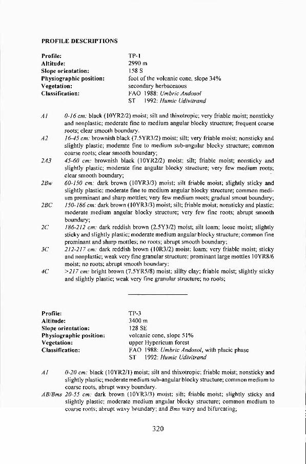
PROFILE DESCRIPTIONS
Profile: Altitude: Slope orientation: Physiographic position: Vegetation: Classification:
TP-l 2990m 158 S foot ofthe volcanic cone, slope 34% secondary herbaceaous FAO 1988: Umbric Andoso/ ST 1992: Humic Udivitrand
A I 0- I 6 cm: black (I OYR2/2) moist; silt and thixotropie; very friable moist; nonsticky and nonplastic; moderate fine to medium angular blocky structure; frequent coarse roots; clear smooth boundary.
A2 16-45 cm: brownish black (7.5YR3/2) moist; silt; very friable moist; nonsticky and slightly plastic; moderate fine to medium sub-angular blocky structure; common coarse roots; clear smooth boundary;
2A3 45-60 cm: brownish black (lOYR2/2) moist; sHt; friable moist; nonsticky and slightly plastic; moderate fine angular blocky structure; very few medium roots; clear smooth boundary;
2Bw 60-150 cm: dark brown (lOYR3/3) moist; silt friable moist; slightly sticky and slightly plastic; moderate fine to medium angular blocky structure; common medium prominant and sharp mottles; very few medium roots; gradual smout boundary;
2 BC 150-186 cm: dark brown (I OYR3/3) moist; silt; friable moist; nonsticky and plastic; moderate medium angular blocky structure; very few fine roots; abrupt smooth boundary;
2C 186-2 I 2 cm: dark reddish brown (2.5Y3/2) moist; silt loam; loose moist; slightly sticky and slightly plastic; moderate medium angular blocky structure; common fine prominant and sharp mottles; no roots; abrupt smooth boundary;
3C 2 12-2 17 cm: dark reddish brown (I OR3/2) moist; loam; very friable moist; sticky and nonplastic; weak very fine granular structure; prominant large mottles IOYR8/6 moist; no roots; abrupt smooth boundary;
4C > 2 17 cm: bright brown (7.5YR5/8) moist; sillty clay; friable moist; slightly sticky and slightly plastic; weak very fine granular structure; no roots;
Profile: Altitude: Slope orientation: Physiographic position: Vegetation: Classification:
TP-3 3400m 128 SE volcanic cone, slope 51 % upper Hypericum forest FAO 1988: Umbric Andosol, with placic phase ST 1992: Humic Udivitrand
A I 0-20 cm: black (I OYR2/1) moist; silt and thixotropic; friable moist; nonsticky and slightly plastic; moderate medium sub-angular blocky structure; common medium to coarse roots, abrupt wavy boundary.
AB/Bms 20-55 cm: dark brown (lOYR3/3) moist; silt; friable moist; slightly sticky and slightly plastic; moderate medium angular blocky structure; common medium to coarse roots; abrupt wavy boundary; and Bms wavy and bifurcating;
320

Cl 55-80 cm: dark brown (I OYR3/3) moist; loam; very friable moist; sticky and slightly plastic; moderate coarse crumbly structure; few coarse prominant sharp mottles; common medium roots; c1ear wavy boundary;
C2 80-103 cm: dark brown (IOYR3/3)moist; loam friable moist; slightly sticky and slightly plastic; moderate medium angular blocky structure; common coarse prominant sharp mottles; few fine to medium roots; c1ear irregular boundary;
2A2l 1 03-114c m: brownish black (I OYR3/2) moist; silt; friable moist; sticky and slightly plastic; moderate medium sub-angular blocky structure; very few fine roots; c1ear smooth boundary;
2A22 107-1/4 cm: black (IOYR2/1) moist; silt; very friable moist; sticky and slightly plastic; moderate fine to medium sub-angular blocky structure; very few fine roots; clear smooth boundary;
2A3 114-133 cm: yellowish brown (1 OYR5/4) moist; loam; very friable moist; sticky and slightly plastic; weak very fine to fine crumbly structure; common medium prominant sharp mottles; frequent fine roots (probably dead and buried); abrupt smooth boundary;
3R 133-170 cm: brownish black (IOYR3/2) moist; loam; very firm but loose after destruction; slightly sticky and nonplastic; structureless; frequent to abundant fine roots (probably dead and burried); abrupt smooth boundary;
Profile: Attitude: Slope orientation: Physiographic position: Vegetation: Classification:
NYSO-4 3500m 200 SSW volcanic cone, slope 53% Lobelia-Senecio zone FAO 1988: Folic Histoso/ ST 1992: Lithic Tropofolist
AI 0-9 cm: black (I OYR2/I) moist; silty c1ay and thixotropic; friable moist; nonsticky and plastic; moderate medium to coarse granular structure; frequent fine to medium roots; abrupt smooth boundary.
A2 9-34 cm: brownish black (10YR3/1) moist; silty c1ay and thixotropic; friable moist; sticky and plastic; moderate fine sub-angular blocky structure; few coarse distinct mottles; common fine to medium roots; clear smooth boundary;
A3 34-48 cm: brownish black (I OYR3/2) moist; silty c1ay and thixotropic; friable moist; sticky and plastic; moderate fine to medium angular blocky structure; frequent fine roots; c1ear smooth boundary;
Bhs 48-70 cm: black (;Y2/1) moist; silty clay and thixotropic; friable moist; sticky and nonplastic; moderate medium angular blocky structure; slickensides above the bedrock; many coarse prominant mottles; frequent to abundant fine roots; abrupt smooth boundary;
2R > 70cm
321

W tv tv
Bulk densitity and chemical properties of three representative profiles of the Bisoke volcano
Bulk Oensity Nitrogen Horizon Oepth FM 00 pH pH Ca Mg K Na CEC BS Total NH3 N03
(cm) (gfcm3) H2OM-KCI ( ---- meqfloo g air dried soil --- ) (% ) (mg Nf100 g soil)
Profile TP-1 Al 0-16 1.07 0.36 5.5 5.1 24.4 4.5 0.36 0.05 76.7 38.1 1556 8.6 6.3 A2 16-45 1.14 0.47 5.8 4.8 11.8 2.2 0.18 0.05 58.3 24.4 811 3.7 1.8 2A3 45-60 1.14 0.51 5.7 4.8 10.7 2.4 0.18 0.08 59.4 22.5 725 3.4 0.8 2Bw 60-150 1.28 0.66 6.0 4.9 7.3 2.1 0.15 0.17 38.2 25.4 256 2.0 0.2 2BC 150-186 1.37 0.71 6.2 4.9 8.1 2.5 0.23 0.23 - - - - -2C 186-212 1.47 0.85 6.5 5.3 8.0 2.1 0.26 0.22 - - - - -Profile TP-3 Al 0-20 1.11 0.31 4.9 4.2 1.9 0.8 0.51 0.11 75.4 4.4 1526 9.4 5.8 AB 20-55 1.21 0.51 5.7 5.0 0.9 0.2 0.13 0.05 55.6 2.2 6~7 2.7 1.3 Cl 55-80 1.15 0.43 5.3 4.8 1.0 0.2 0.13 0.05 51.2 2.5 476 2.6 1.2 C2 80-103 1.24 0.48 5.4 4.8 0.9 0.2 0.08 0.08 - - - - -2A21 103-114 1.18 0.48 5.3 4.8 1.0 0.2 0.08 0.08 - - - - -2A22 107-114 1.11 0.40 - - - - - - - - - - -2A3 114-133 1.17 0.54 - - - - - - - - - - -
Profile NYSO-4 Al 0-9 1.07 0.26 4.2 3.6 2.4 1.5 1.46 0.42 60.5 9.5 2235 17.8 18.6 A2 9-34 1.04 0.27 4.8 4.0 0.9 0.3 0.33 0.07 70.6 2.3 1384 6.0 0.4 A3 34-48 1.09 0.32 5.3 4.3 0.9 0.2 0.23 0.13 81.8 1.7 857 4.9 0.0 Bhs 48-70 1.12 0.30 4.9 4.3 0.9 0.2 0.13 0.06 64.2 1.9 1001 4.9 0.5
Legend FM: sample at field moisture content; 00: oven dry sample; CEC: cation exchange capacity; calculated as total of Ca, Mg, K and Na divided by the CEC and times 100
----
-------------------------------- - -- -
%C C/N P (gfl00 g) (mgfl00 g)
23.1 14.9 7 10.6 13.1 7 9.0 12.4 9 3.2 12.5 4 2.4 - 1 0.9 - 1
27.0 17.7 12 9.6 14.0 5 7.0 14.7 3 7.0 - 2 3.9 - 3 - - -- - -
34.3 15.3 38 28.7 20.7 15 24.7 28.8 7 26.2 26.2 10
BS: base saturation,