The role of alternating outcrops of sediments and basaltic lavas on seismic urban scenario: the...
29
Bull Earthquake Eng (2011) 9:411–439 DOI 10.1007/s10518-010-9202-x ORIGINAL RESEARCH PAPER The role of alternating outcrops of sediments and basaltic lavas on seismic urban scenario: the study case of Catania, Italy F. Panzera · R. Rigano · G. Lombardo · F. Cara · G. Di Giulio · A. Rovelli Received: 8 March 2010 / Accepted: 2 August 2010 / Published online: 17 August 2010 © Springer Science+Business Media B.V. 2010 Abstract Experimental data and numerical modelling were used to study the effect of local geology on the seismic response of the Catania area. The town extends on a marly clays bedrock and terraced deposits made up by coastal sands and alluvial conglomerates. This sedimentary substratum is deeply entrenched by paleo-valleys filled by lava flows and pyroc- lastics. Available borehole data and elastic parameters were used to reconstruct a geotechnical model in order to perfome 1D numerical modeling. Seismic urban scenarios were simulated considering destructive ( M w = 7.0), strong ( M w = 6.2) and moderate ( M w = 5.7) earth- quakes to assess the shaking level of the different outcropping formations. For each scenario seven real accelerograms were selected from the European Strong Motion Database to assess the expected seismic input at the bedrock. PGA and spectral acceleration at different periods were obtained in the urban area through the equivalent linear numerical code EERA, and contour maps of different levels of shaking were drawn. Standard and horizontal-to-vertical spectral ratios were achieved making use of a dataset of 172 seismic events recorded at ten sites located on the main outcropping lithotypes. Spectral ratios inferred from earthquake data were compared with theoretical transfer functions. Both experimental and numerical results confirm the role of the geological and morphologic setting of Catania. Amplification of seismic motion mainly occurs in three different stratigraphic conditions: (a) sedimentary deposits mainly diffused in the south of the study area; (b) spots of soft sediments surrounded by lava flows; (c) intensely fractured and scoriaceous basaltic lavas. Keywords Scenario earthquake · 1D modeling · PGA values · Earthquake records · Spectral ratios F. Panzera (B ) · R. Rigano · G. Lombardo Dipartimento di Scienze Geologiche, Università di Catania, Corso Italia 57, Catania, Italy e-mail: [email protected] F. Cara · G. Di Giulio · A. Rovelli Istituto Nazionale di Geofisica e Vulcanologia, Via di Vigna Murata 605, Rome, Italy 123
-
Upload
independent -
Category
Documents
-
view
3 -
download
0
Transcript of The role of alternating outcrops of sediments and basaltic lavas on seismic urban scenario: the...

Bull Earthquake Eng (2011) 9:411–439DOI 10.1007/s10518-010-9202-x
ORIGINAL RESEARCH PAPER
The role of alternating outcrops of sediments and basalticlavas on seismic urban scenario: the study caseof Catania, Italy
F. Panzera · R. Rigano · G. Lombardo · F. Cara ·G. Di Giulio · A. Rovelli
Received: 8 March 2010 / Accepted: 2 August 2010 / Published online: 17 August 2010© Springer Science+Business Media B.V. 2010
Abstract Experimental data and numerical modelling were used to study the effect oflocal geology on the seismic response of the Catania area. The town extends on a marly claysbedrock and terraced deposits made up by coastal sands and alluvial conglomerates. Thissedimentary substratum is deeply entrenched by paleo-valleys filled by lava flows and pyroc-lastics. Available borehole data and elastic parameters were used to reconstruct a geotechnicalmodel in order to perfome 1D numerical modeling. Seismic urban scenarios were simulatedconsidering destructive (Mw = 7.0), strong (Mw = 6.2) and moderate (Mw = 5.7) earth-quakes to assess the shaking level of the different outcropping formations. For each scenarioseven real accelerograms were selected from the European Strong Motion Database to assessthe expected seismic input at the bedrock. PGA and spectral acceleration at different periodswere obtained in the urban area through the equivalent linear numerical code EERA, andcontour maps of different levels of shaking were drawn. Standard and horizontal-to-verticalspectral ratios were achieved making use of a dataset of 172 seismic events recorded at tensites located on the main outcropping lithotypes. Spectral ratios inferred from earthquakedata were compared with theoretical transfer functions. Both experimental and numericalresults confirm the role of the geological and morphologic setting of Catania. Amplificationof seismic motion mainly occurs in three different stratigraphic conditions: (a) sedimentarydeposits mainly diffused in the south of the study area; (b) spots of soft sediments surroundedby lava flows; (c) intensely fractured and scoriaceous basaltic lavas.
Keywords Scenario earthquake · 1D modeling · PGA values · Earthquake records ·Spectral ratios
F. Panzera (B) · R. Rigano · G. LombardoDipartimento di Scienze Geologiche, Università di Catania, Corso Italia 57, Catania, Italye-mail: [email protected]
F. Cara · G. Di Giulio · A. RovelliIstituto Nazionale di Geofisica e Vulcanologia, Via di Vigna Murata 605, Rome, Italy
123
412 Bull Earthquake Eng (2011) 9:411–439
1 Forewords
The town of Catania is located in the eastern coast of Sicily (southern Italy) to the south ofMt. Etna. The high level of seismicity that affects the city, together with the considerablyhigh density of inhabitants living in its urban area, contributed to classify it as one of thetown having the highest seismic risk in Italy. It is also not negligible the high potential dam-age to which its historic-architectural patrimony could undergo even at moderate to smallmagnitudes.
The seismicity of this area is linked to the collisional processes between African andEuropean plates. In particular, the earthquakes occurred in 1169, 1542, 1693, 1818, 1908 andmore recently in 1990, having intensity ranging between VI and XI MCS scale (WorkingGroup MPS 2004) testify the high level of hazard in this area. The information on damagedistribution during the past earthquakes is available for downtown Catania only. In the past20 years residential areas were erected in the northern and southern part of the town. It istherefore evident the importance of evaluating the local seismic effects in the whole Cata-nia area assessing ground motion amplification and damage distribution during earthquakeshaving different magnitude and source-to-site distance.
A reliable evaluation of ground motion requires the analysis of the following three fun-damental steps: seismic radiation released by the source; path and attenuation effects in thewave propagation from the source to the city; local effects linked to elastic and anelasticproperties of soil deposits interposed between the bedrock and the “receiver” at the groundsurface.
Most of the researches about the seismic response of the Catania area were performedin the frame of two national research projects (see Faccioli and Pessina 2000; Mucciarelliand Pacor 2007). In particular, seismic sources in eastern Sicily were studied by severalauthors who estimated, also through numerical simulations, potential shaking parameters fordifferent earthquake inputs (Langer et al. 1999; Zollo et al. 1999; Azzaro and Barbano 2000;Barbano and Rigano 2001; Laurenzano et al. 2004; Laurenzano and Priolo 2005). As regardsthe second step, the evaluation of the seismic input at the bedrock, by taking into accountboth the source features of a scenario earthquake and the attenuation, was carried out by DeLorenzo et al. (2004), Giampiccolo et al. (2002, 2003, 2004). A significant improvementto the knowledge of the seismotectonic setting in south-eastern Sicily was achieved by theanalysis of the 13 December 1990 earthquake and its aftershocks. These events are, indeed,the first digital set of seismic data for the area, therefore allowing investigations on the spec-tral source parameters and estimate of attenuation and seismic scaling laws in south-easternSicily (Amato et al. 1995; Di Bona et al. 1995; Giardini et al. 1995; Scognamiglio et al.2005). As a result of all these studies, reference seismic inputs at the bedrock were assessedand both the 1693 and 1818 shocks were taken into account as reliable scenario earthquakesfor modelling seismic inputs in the Catania area (Laurenzano et al. 2004; Lombardo et al.2004).
The estimate of ground motion features at the surface was performed using numerical mod-elling as well as noise measurements. In particular, Biondi and Maugeri (2005), Lombardoet al. (2004, 2006), Catalano et al. (2005), Lombardo and Rigano (2007) evaluated the localseismic response in test sectors of the urban area, whereas preliminary estimates of siteresponse in the whole Catania area were obtained by Giampiccolo et al. (2001), Lombardoet al. (2001), Priolo et al. (2005). Further investigations on the local effects due to fault zones(Rigano et al. 2008) as well as natural cavities (Lombardo and Rigano 2009; Lanzo et al.2006; Sgarlato et al. 2009) have been recently performed and others are still in progress.
123

Bull Earthquake Eng (2011) 9:411–439 413
All these studies, besides identifying the coarse features of the elements needed to assessthe seismic hazard of the area, have focused their attention on some modelling of geolog-ical site conditions and interpreting ambient noise recordings. Nevertheless, studies so farperformed do not consider exhaustively the complexity of phenomena causing site amplifica-tion. The contribution of topographic effects and the existence, in the sedimentary deposits,of engravings filled up by quaternary and historic lava flows, are often neglected. Moreover,none of the afore mentioned studies carried out a comparison and validation of obtainedresults with findings coming from earthquake recordings. Present study therefore aims atdealing with this last aspect combining numerical and experimental approaches in order tovalidate the findings so far obtained.
2 Tectonic features and geological setting
At regional scale, the tectonics of Eastern Sicily is quite complex. Seismotectonic infor-mation and interpretations available for south-eastern Sicily suggest the existence of twogroups of possible sources for seismicity that affected the town of Catania in different time.The sources are located either close to the Ionian coast (Messina Straits and Malta-Hybleanescarpment), or inland, both in the Hyblean foreland and Etnean areas (Fig. 1). The Malta-Hyblean escarpment, a normal fault system trending NNW-SSE, is in particular considered(Azzaro and Barbano 2000) as the possible source of the destructive earthquakes (M ≈ 7.0)that struck in past centuries the Catania area.
The geo-lithologic map of the Catania urban area is shown in Fig 1. It is the result of assem-bling information coming from data and surveys performed by several authors (Carbone et al.2009; Lombardo et al. 2001; Monaco and Tortorici 1999; Monaco et al. 2000). The surfacegeology of the town derives from the combination of three processes linked to the volcanic,tectonic and human activities. As a consequence of this, the main feature of the area is acomplex sedimentary sequence interbedded between a clay basement and an upper volcanicformation with lava flows and pyroclastics that sometimes is surmounted by detritus andruins due to past earthquakes.
The bedrock of the area is composed of a Lower-Middle Pleistocene succession of marlyclays, having thickness of about 600 m. In the upper part of this succession, levels of sandand sandy clays are frequently present. These deposits are indeed followed upwards by sometens meters of fluvial-deltaic yellowish sandy clay, sand and coarse gravel, referred to theMiddle Pleistocene, called “Terreforti” formation. This formation is covered unconformablyby terraced alluvial deposits (Middle Pleistocene—Holocene), that outcrop in some placesin the northern and western part of the urban area, and are characterized by several metersthick sands, gravels and silty clays. Recent alluvial deposits (Holocene) formed by levelsof sands, silt and sometimes gravelly sands, outcrop in the southern part of the urban areaand pertain to the Simeto river plain. Such deposits grade upwards to Holocene coastal sanddeposits. However, the lithotype more frequently cropping out in the study area is the basalticlava that in pre-historical and historical times flowed onto the valleys originally existing inthe sedimentary formations. The flows have an extremely variable thickness and often areformed by alternating levels of massive lava and more or less weathered scoriae. Finally,in several parts of the historic centre, discard building materials, having thickness up toten–fifteen meters, mostly resulting from ruins due to historical earthquakes, are present.These materials were not distinguished from the slope detritus in the geo-lithologic map ofFig. 1.
123

414 Bull Earthquake Eng (2011) 9:411–439
Fig. 1 Geolithologic map of Catania urban area. The inset map shows the main structural features in easternSicily (modified from Lavecchia et al. 2007, Galadini et al. 2001) and the location of the considered scenarioearthquakes
123
Bull Earthquake Eng (2011) 9:411–439 415
Table 1 Features of scenario earthquakes; h = hypocentral depth; MW = moment magnitude
Earthquake h* (Km) MW** Repi (Km) Rhyp (Km) Focal mechanism Fault strike Reference
1990-Dec-13 13 5.68 25 28.18 Strike slip E–W Amato et al. (1995)
1818-Feb-20 13 6.20 12 17.69 Thrust ENE-WSW Lavecchia et al. (2007)
1693-Jan-11 13 7.00 15 19.85 Normal fault NNW-SSE Priolo (1999)
Epicentral distance (Repi), hypocentral distance (Rhyp), focal mechanism and fault strike were taken fromstudies quoted in the reference column* Working Group MPS (2004)** Working Group CPTI (2004)
3 Methodology
The evaluation of local seismic response was performed by combining a numerical approachwith experimental observations. The numerical study was carried out using equivalent-linearearthquake site response analyses (EERA, Bardet 2000). This numerical code requires: (a)simplified geological model to individuate macro-layers, down to the bedrock; (b) shear wavevelocity profile for the elastic properties of the macro-layers and bedrock; (c) the shear strain(γ ) non linearity of the shear modulus G and damping ratio D of macro-layers and bedrock.Moreover, a reference earthquake has to be chosen. In this study, based on the seismic historyof Catania (Azzaro et al. 1999), three scenarios earthquakes were selected as examples ofdestructive (return period ≈ 500 years), strong (return period ≈ 200–250 years) and moderate(return period ≈ 50–60 years) inputs for hazard evaluation. Table 1 lists the parameters ofthe 1693, 1818 and 1990 earthquakes that were selected as representative of a destructive,strong and moderate scenario, respectively. The Malta-Hyblean escarpment was consideredas the seismic source for both 1693 and 1990 earthquakes. As regards the 1693 earthquake,in particular, the seismic source was selected according to recent studies based on the resultscoming from seismic prospecting at sea and tsunami modeling which suggest the rupture ofa segment of the Malta-Hyblean fault escarpment (Gerardi et al. 2008; Brancato et al. 2009).The Sicilian basal thrust was considered as the possible source for the 1818 earthquake, asstated by Lavecchia et al. (2007), through analysis of structural and geophysical data (seeepicentre locations in Fig. 1).
The magnitude (MW), the hypocentre distance (Rhyp) and the focal mechanism (Table 1)stand for the input of the Cauzzi and Faccioli (2008) attenuation law in order to definethe target spectra. The authors calibrated this attenuation law using intraplate events, focaldepth within about 22 Km and moment magnitude ranging from 5.0 to 7.2. Such featuresare consistent with the seismic activity of Italian region. The authors derived an empiri-cal equation for the prediction of displacement response spectra (DRS) in the range 0.05–20 s, considering the geometric mean of the horizontal components of motion at a givenperiod. The empirical equation for the prediction of the DRS ordinates, considering an out-cropping bedrock and the focal mechanism, was taken in the form: Log10DRS (T ; ζ ) =a1 + a2 MW + a3Log10 R + aN EN + aR ER + aS ES + ε, where ai (i = 1. . .S) are the numer-ical coefficients depending on the period (T) and the damping ratio (ζ ) to be determinedthrough regressions, R is the focal distance in Km, Ex (x = N , R, S) are dummy variablesfor normal, reverse, and strike-slip fault mechanisms, respectively, and ε denotes a random
error term. Using the relation: PSA (T ; ζ ) = ( 2πT
)2DRS (T ; ζ ) pseudo-acceleration spectra
(PSA) were obtained. The PSA and the spectral acceleration (Sa) were found by the authorsto be substantially coincident in the range 0.05–10 s.
123
416 Bull Earthquake Eng (2011) 9:411–439
Fig. 2 Compatible combination of accelerograms found for the considered scenarios; upper panel refers tothe destructive scenario (1693), middle and lower panels refer to strong (1818) and moderate (1990) scenarios,respectively
Seven strong motion accelerograms, for each considered scenario, were selected fromthe European Strong Motion Database (Ambraseys et al. 2002) through the REXEL code(Iervolino et al. 2010) (see Fig. 2). The use of real seismic inputs was preferred to syntheticones since the basic problem with spectrum-compatible artificial records is that they have anexcessive number of cycles of strong motion and consequently they possess unreasonablyhigh energy content (Bommer and Acevedo 2004). According to Cauzzi and Faccioli (2008)a scaling factor of 1/Rhyp was adopted to correct the peak ground acceleration (PGAref ) andthe spectral acceleration (Sag(ref)), obtained at the bedrock through parameters reported inTable 1. This procedure allowed to scale the selected accelerograms at each site.
123

Bull Earthquake Eng (2011) 9:411–439 417
Table 2 Elastic parameters of main geological formations in the Catania area
Lithotype ρ (Kg/m3) VP (m/s) VS (m/s) σ Q (s−1)
MC Marly clay 2,000 1,235 650 0.308 35
Y Sandy clay 1,950 490 250 0.324 15–20
Coarse sand and gravel 2,000 2,000 450 0.31 20
Gravelly sand/sandy clay 1,940 640 330 0.319 22
AT Fine alluvial deposits 1,900 370 190 0.321 15
Coarse alluvial deposits 1,850 408 210 0.32 12
S Beach deposits (Sand) 1,830 430 220 0.323 12
L Massive lava 2,300 2,300 1,000 0.249 50–100
Scoriaceous/fractured lava 1,800 1,800 230 0.267 15
Pyroclastics 1,700 1,700 300 0.288 30
Massive/scoriaceous lava 1,950 750 400 0.301 20
D Discard material—detritus 1,800 1,800 210 0.31 12
The acronyms in the first column refer to the soil deposits listed in the legend of Fig. 1: MC = Marly Clay;Y = Yellowish sandy clay, sand and coarse gravel; AT = Alluvial and terraced deposit; L = Lava deposit; S = Sand; D = Discard material and detritus
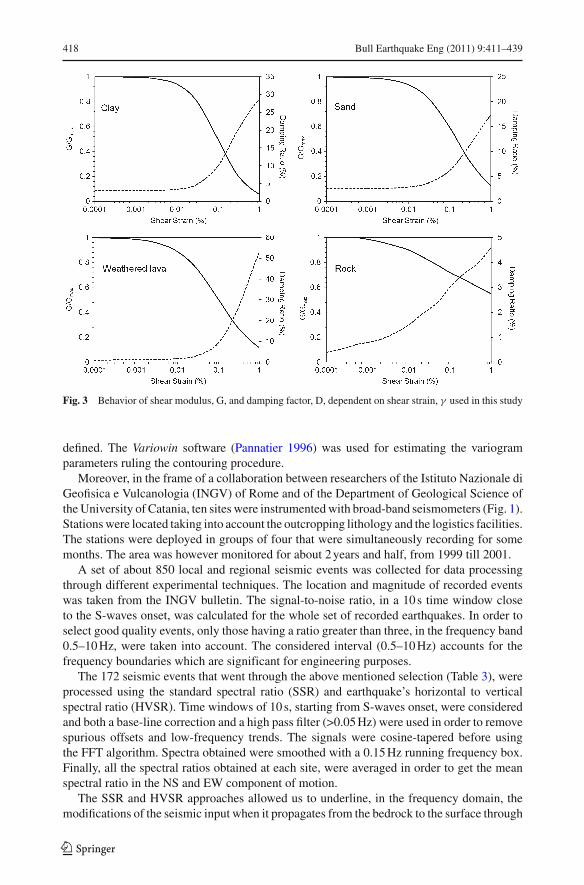
The elastic parameters of main geological formations coming out as a result of the“Catania Project” of CNR-GNDT (Faccioli and Pessina 2000) were used in order to model theinput stratigraphic sequence (Table 2). Experimental curves of the shear modulus reduction(G) and the material damping (D) as a function of shear strain (γ ) are shown in Fig. 3. Theywere taken from Carrubba and Maugeri (1988) for cohesive soils (clay) and from Cavallaroet al. (2001) for weathered lava and non cohesive soils (sand). As regards the compact lava,strain-dependent damping and shear modulus degradation curves were taken from Seed andIdriss (1970), according to Bessason and Kaynia (2002) that estimated site amplification inlava rock on soft sediments sites.
The local seismic response with EERA was calculated in 194 sites randomly distributedin the Catania urban area. The stratigraphy of selected sites was inferred from data of the“Catania Project” dataset. Among the 860 boreholes included in such dataset, we selectedthe ones that were representative of main lithotypes and that were drilled to a depth reachingthe bedrock.
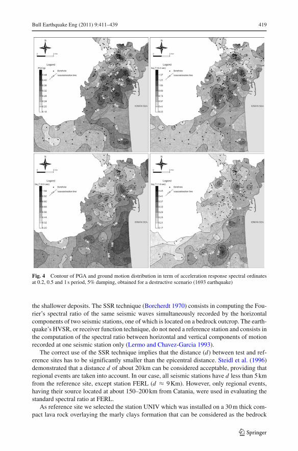
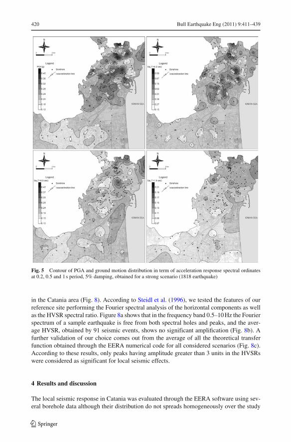
The EERA code provides as output results the PGA values, at different depth, and boththe theoretical transfer function and the response spectra. The PGA values and accelerationspectra at the 5% critical damping, for the periods 0.2, 0.5 and 1.0 s, computed at the surface,allowed us to draw iso-acceleration maps for the considered scenarios (Figs. 4, 5 and 6).The above mentioned periods were selected since they represent the range of natural periodscommonly observed for 2–3 storey up to tall buildings (about 10 storeys).
Further maps were drawn in order to summarize the local amplifications, considering threeclasses of increments and decrements with respect to PGAref and Sag(ref) (Fig. 7). Statisticalanalysis shows that the probability distribution of ground-motion spectral acceleration atindividual periods can be well approximated by log-normal distributions (e.g. Wang 2010).These maps were therefore obtained by calculating the log-normal mean deviations, at eachsite, for the three considered scenarios.
The contouring of all maps was performed through the Kriging algorithm. It is a widelyadopted geo-statistical gridding method that produces reliable maps from irregularly spaceddata. Since for a correct application of Kriging an appropriate variogram model has to be
123
418 Bull Earthquake Eng (2011) 9:411–439
Fig. 3 Behavior of shear modulus, G, and damping factor, D, dependent on shear strain, γ used in this study
defined. The Variowin software (Pannatier 1996) was used for estimating the variogramparameters ruling the contouring procedure.
Moreover, in the frame of a collaboration between researchers of the Istituto Nazionale diGeofisica e Vulcanologia (INGV) of Rome and of the Department of Geological Science ofthe University of Catania, ten sites were instrumented with broad-band seismometers (Fig. 1).Stations were located taking into account the outcropping lithology and the logistics facilities.The stations were deployed in groups of four that were simultaneously recording for somemonths. The area was however monitored for about 2 years and half, from 1999 till 2001.
A set of about 850 local and regional seismic events was collected for data processingthrough different experimental techniques. The location and magnitude of recorded eventswas taken from the INGV bulletin. The signal-to-noise ratio, in a 10 s time window closeto the S-waves onset, was calculated for the whole set of recorded earthquakes. In order toselect good quality events, only those having a ratio greater than three, in the frequency band0.5–10 Hz, were taken into account. The considered interval (0.5–10 Hz) accounts for thefrequency boundaries which are significant for engineering purposes.
The 172 seismic events that went through the above mentioned selection (Table 3), wereprocessed using the standard spectral ratio (SSR) and earthquake’s horizontal to verticalspectral ratio (HVSR). Time windows of 10 s, starting from S-waves onset, were consideredand both a base-line correction and a high pass filter (>0.05 Hz) were used in order to removespurious offsets and low-frequency trends. The signals were cosine-tapered before usingthe FFT algorithm. Spectra obtained were smoothed with a 0.15 Hz running frequency box.Finally, all the spectral ratios obtained at each site, were averaged in order to get the meanspectral ratio in the NS and EW component of motion.
The SSR and HVSR approaches allowed us to underline, in the frequency domain, themodifications of the seismic input when it propagates from the bedrock to the surface through
123
Bull Earthquake Eng (2011) 9:411–439 419
Fig. 4 Contour of PGA and ground motion distribution in term of acceleration response spectral ordinatesat 0.2, 0.5 and 1 s period, 5% damping, obtained for a destructive scenario (1693 earthquake)
the shallower deposits. The SSR technique (Borcherdt 1970) consists in computing the Fou-rier’s spectral ratio of the same seismic waves simultaneously recorded by the horizontalcomponents of two seismic stations, one of which is located on a bedrock outcrop. The earth-quake’s HVSR, or receiver function technique, do not need a reference station and consists inthe computation of the spectral ratio between horizontal and vertical components of motionrecorded at one seismic station only (Lermo and Chavez-Garcia 1993).
The correct use of the SSR technique implies that the distance (d) between test and ref-erence sites has to be significantly smaller than the epicentral distance. Steidl et al. (1996)demonstrated that a distance d of about 20 km can be considered acceptable, providing thatregional events are taken into account. In our case, all seismic stations have d less than 5 kmfrom the reference site, except station FERL (d ≈ 9 Km). However, only regional events,having their source located at about 150–200 km from Catania, were used in evaluating thestandard spectral ratio at FERL.
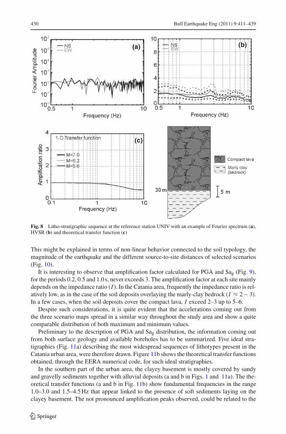
As reference site we selected the station UNIV which was installed on a 30 m thick com-pact lava rock overlaying the marly clays formation that can be considered as the bedrock
123
420 Bull Earthquake Eng (2011) 9:411–439
Fig. 5 Contour of PGA and ground motion distribution in term of acceleration response spectral ordinatesat 0.2, 0.5 and 1 s period, 5% damping, obtained for a strong scenario (1818 earthquake)
in the Catania area (Fig. 8). According to Steidl et al. (1996), we tested the features of ourreference site performing the Fourier spectral analysis of the horizontal components as wellas the HVSR spectral ratio. Figure 8a shows that in the frequency band 0.5–10 Hz the Fourierspectrum of a sample earthquake is free from both spectral holes and peaks, and the aver-age HVSR, obtained by 91 seismic events, shows no significant amplification (Fig. 8b). Afurther validation of our choice comes out from the average of all the theoretical transferfunction obtained through the EERA numerical code for all considered scenarios (Fig. 8c).According to these results, only peaks having amplitude greater than 3 units in the HVSRswere considered as significant for local seismic effects.
4 Results and discussion
The local seismic response in Catania was evaluated through the EERA software using sev-eral borehole data although their distribution do not spreads homogeneously over the study
123

Bull Earthquake Eng (2011) 9:411–439 421
Fig. 6 Contour of PGA and ground motion distribution in term of acceleration response spectral ordinatesat 0.2, 0.5 and 1 s period, 5% damping, obtained for a moderate scenario (1990 earthquake)
area. The obtained maps show the contouring of PGA and Sag at the 5% critical damping,for the periods 0.2, 0.5 and 1.0 s, values (Figs. 4, 5, 6 and 7) that are in good agreement withresults of various authors (Langer et al. 1999; Priolo 1999; Zollo et al. 1999; Laurenzano etal. 2004) which evaluated the local response in Catania area through numerical approachesbased on synthetic seismic inputs.
The PGA distribution obtained for destructive scenario shows values ranging between0.16–0.50 g (Fig. 4) whereas, PGA values ranging in the intervals 0.12–0.44 g and 0.02–0.10 g, are observed for strong and moderate scenarios, respectively (Figs. 5 and 6). It isworth noting that the site-to-source distance strongly affects the PGA values. The destructiveand the strong reference shocks used in the present study have epicentral distance of about 15and 12 Km, respectively, from downtown Catania (see Table 1). This implies that the obtainedvalues of PGA are sometimes comparable (Fig. 9), although the difference of magnitude ishigh (Mw = 7.0 for the destructive event and Mw = 6.2 for the strong one). However,the accelerogram of the 1990 earthquake, recorded on the Catania alluvial plane, showed aPGA of 0.21 g (Working Group ITACA 2008). Such a value, although is far greater than that
123
422 Bull Earthquake Eng (2011) 9:411–439
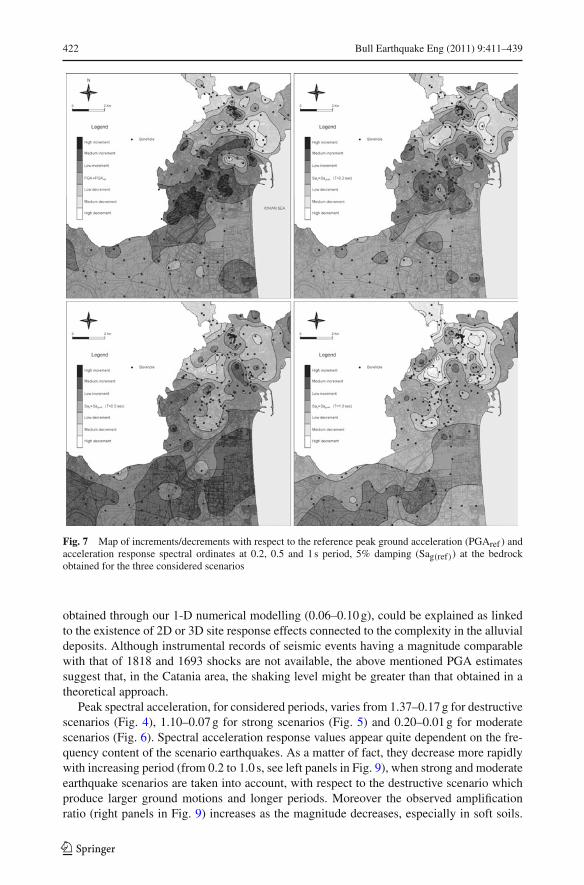
Fig. 7 Map of increments/decrements with respect to the reference peak ground acceleration (PGAref ) andacceleration response spectral ordinates at 0.2, 0.5 and 1 s period, 5% damping (Sag(ref)) at the bedrockobtained for the three considered scenarios
obtained through our 1-D numerical modelling (0.06–0.10 g), could be explained as linkedto the existence of 2D or 3D site response effects connected to the complexity in the alluvialdeposits. Although instrumental records of seismic events having a magnitude comparablewith that of 1818 and 1693 shocks are not available, the above mentioned PGA estimatessuggest that, in the Catania area, the shaking level might be greater than that obtained in atheoretical approach.
Peak spectral acceleration, for considered periods, varies from 1.37–0.17 g for destructivescenarios (Fig. 4), 1.10–0.07 g for strong scenarios (Fig. 5) and 0.20–0.01 g for moderatescenarios (Fig. 6). Spectral acceleration response values appear quite dependent on the fre-quency content of the scenario earthquakes. As a matter of fact, they decrease more rapidlywith increasing period (from 0.2 to 1.0 s, see left panels in Fig. 9), when strong and moderateearthquake scenarios are taken into account, with respect to the destructive scenario whichproduce larger ground motions and longer periods. Moreover the observed amplificationratio (right panels in Fig. 9) increases as the magnitude decreases, especially in soft soils.
123

Bull Earthquake Eng (2011) 9:411–439 423
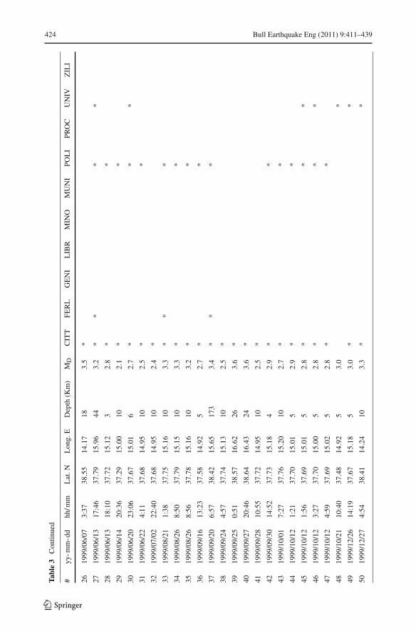
Tabl
e3
Lis
tof
sele
cted
even
tsre
cord
edat
each
seis
mic
stat
ion
loca
ted
inth
ege
olith
olog
icm
ap;M
D=
dura
tion
mag
nitu
de
#yy
-mm
-dd
hh/m
mL
at.N
Lon
g.E
Dep
th(K
m)
MD
CIT
TFE
RL
GE
NI
LIB
RM
INO
MU
NI
POL
IPR
OC
UN
IVZ
ILI
119
99/0
2/08
19:2
437
.66
14.9
95
2.7
**
*
219
99/0
2/08
21:0
637
.65
14.9
810
2.3
*
319
99/0
2/09
5:24
37.6
614
.99
102.
6*
*
419
99/0
2/13
22:5
838
.19
15.0
210
3.3
**
519
99/0
2/14
6:23
38.1
515
.05
73.
0*
**
619
99/0
2/14
11:4
538
.09
15.0
69
4.3
**
*
719
99/0
2/14
15:1
038
.21
15.0
37
3.3
**
819
99/0
2/14
15:4
338
.17
15.0
412
3.2
*
919
99/0
2/16
8:54
37.5
915
.11
102.
4*
**
1019
99/0
2/16
10:2
937
.61
15.1
610
2.1
**
*
1119
99/0
2/16
10:3
437
.60
15.1
310
2.6
**
1219
99/0
2/16
10:3
637
.63
15.0
910
2.8
*
1419
99/0
2/16
10:5
837
.62
15.1
010
2.5
**
1619
99/0
3/09
0:17
37.7
714
.92
52.
4*
1719
99/0
3/12
1:50
37.9
314
.11
122.
6*
1819
99/0
3/18
10:4
737
.75
15.0
96
3.1
*
1919
99/0
5/23
11:5
337
.90
14.9
94
3.3
**
**
2019
99/0
5/23
12:3
337
.68
14.9
95
2.8
**
2119
99/0
5/24
2:50
37.7
614
.55
162.
7*
2219
99/0
6/02
10:3
738
.50
14.0
821
4.0
**
**
2319
99/0
6/02
11:5
238
.56
14.0
111
3.8
*
2419
99/0
6/02
11:5
638
.55
13.9
97
3.8
*
2519
99/0
6/02
18:1
437
.70
14.9
65
2.8
*
123
424 Bull Earthquake Eng (2011) 9:411–439
Tabl
e3
Con
tinue
d
#yy
-mm
-dd
hh/m
mL
at.N
Lon
g.E
Dep
th(K
m)
MD
CIT
TFE
RL
GE
NI
LIB
RM
INO
MU
NI
POL
IPR
OC
UN
IVZ
ILI
2619
99/0
6/07
3:37
38.5
514
.17
183.
5*
2719
99/0
6/13
17:4
637
.79
15.9
644
3.2
**
**
2819
99/0
6/13
18:1
037
.72
15.1
23
2.8
**
2919
99/0
6/14
20:3
637
.29
15.0
010
2.1
**
3019
99/0
6/20
23:0
637
.67
15.0
16
2.7
**
*
3119
99/0
6/22
4:11
37.6
814
.95
102.
5*
*
3219
99/0
7/02
22:4
037
.68
14.9
510
2.4
*
3319
99/0
8/21
1:38
37.7
515
.16
103.
3*
**
3419
99/0
8/26
8:50
37.7
915
.15
103.
3*
*
3519
99/0
8/26
8:56
37.7
815
.16
103.
2*
*
3619
99/0
9/16
13:2
337
.58
14.9
25
2.7
**
3719
99/0
9/20
6:57
38.4
215
.65
173
3.4
**
*
3819
99/0
9/24
4:57
37.7
415
.13
102.
5*
3919
99/0
9/25
0:51
38.5
716
.62
263.
6*
4019
99/0
9/27
20:4
638
.64
16.4
324
3.6
*
4119
99/0
9/28
10:5
537
.72
14.9
510
2.5
*
4219
99/0
9/30
14:5
237
.73
15.1
84
2.9
**
4319
99/1
0/01
7:27
37.7
615
.20
102.
7*
*
4419
99/1
0/12
1:21
37.7
015
.01
52.
9*
*
4519
99/1
0/12
1:56
37.6
915
.01
52.
8*
**
4619
99/1
0/12
3:27
37.7
015
.00
52.
8*
**
4719
99/1
0/12
4:59
37.6
915
.02
52.
8*
*
4819
99/1
0/21
10:4
037
.48
14.9
25
3.0
*
4919
99/1
2/26
14:1
937
.67
15.1
85
3.0
**
5019
99/1
2/27
4:54
38.4
114
.24
103.
3*
*
123

Bull Earthquake Eng (2011) 9:411–439 425
Tabl
e3
Con
tinue
d
#yy
-mm
-dd
hh/m
mL
at.N
Lon
g.E
Dep
th(K
m)
MD
CIT
TFE
RL
GE
NI
LIB
RM
INO
MU
NI
POL
IPR
OC
UN
IVZ
ILI
5120
00/1
2/06
6:13
37.7
915
.14
32.
6*
**
*52
2000
/12/
2720
:57
37.5
514
.95
53.
2∗
∗∗
∗53
2001
/01/
0422
:20
38.7
314
.95
356
3.5
∗∗
∗∗
5420
01/0
1/08
14:3
337
.78
14.9
35
3.0
∗∗
5520
01/0
1/09
2:51
37.6
715
.13
53.
3∗
∗∗
∗56
2001
/01/
093:
3237
.67
15.1
35
2.7
∗∗
∗∗
5720
01/0
1/09
4:31
37.6
615
.17
52.
8∗
∗∗
∗58
2001
/01/
2316
:55
37.1
315
.33
153.
3∗
∗∗
∗∗
5920
01/0
1/26
8:20
37.7
514
.98
102.
8∗
∗∗
∗60
2001
/01/
268:
2037
.73
14.9
95
3.2
∗∗
∗∗
6120
01/0
1/28
14:4
037
.53
15.2
810
2.3
∗∗
∗∗
6220
01/0
2/10
17:4
637
.16
14.9
912
2.1
∗63
2001
/02/
241:
2337
.72
14.9
85
2.8
∗∗
∗∗
6420
01/0
3/07
17:2
037
.89
14.8
727
2.9
∗65
2001
/03/
2718
:12
37.7
815
.14
52.
5∗
6620
01/0
3/30
18:4
037
.69
15.0
65
2.8
∗∗
6720
01/0
4/06
7:52
37.7
415
.12
52.
6∗
6820
01/0
4/18
17:3
537
.73
15.0
15
3.0
∗69
2001
/04/
2213
:56
37.7
015
.02
53.
5∗
7020
01/0
4/23
0:36
37.7
115
.01
52.
9∗
7120
01/0
4/23
22:2
637
.73
14.9
95
2.4
∗72
2001
/04/
244:
0337
.71
15.0
25
2.8
∗∗
7320
01/0
4/25
19:3
337
.72
15.1
02
3.0
∗∗
∗74
2001
/04/
2721
:08
37.7
115
.02
72.
4∗
∗75
2001
/04/
2721
:09
37.7
015
.10
53.
1∗
∗∗
123

426 Bull Earthquake Eng (2011) 9:411–439
Tabl
e3
Con
tinue
d
#yy
-mm
-dd
hh/m
mL
at.N
Lon
g.E
Dep
th(K
m)
MD
CIT
TFE
RL
GE
NI
LIB
RM
INO
MU
NI
POL
IPR
OC
UN
IVZ
ILI
7620
01/0
4/29
20:0
037
.77
14.9
611
3.1
∗∗
∗77
2001
/05/
0321
:41
37.5
915
.03
53.
3∗
∗∗
7820
01/0
5/03
21:4
637
.62
15.0
110
2.8
∗∗
∗79
2001
/05/
044:
4237
.61
15.1
110
3.0
∗∗
∗80
2001
/05/
0720
:07
37.7
914
.98
82.
4∗
8120
01/0
5/08
3:52
38.1
414
.91
93.
3∗
8220
01/0
5/19
16:1
537
.76
14.8
914
3.0
∗∗
∗83
2001
/05/
1920
:47
37.7
414
.92
92.
9∗
∗∗
8420
01/0
5/20
20:0
837
.74
14.9
25
2.9
∗85
2001
/05/
266:
0237
.45
16.0
513
3.6
∗∗
∗86
2001
/06/
0917
:50
37.7
315
.20
52.
9∗
8720
01/0
6/21
1:26
37.7
514
.72
92.
6∗
∗88
2001
/07/
086:
2938
.52
16.7
948
3 .3
∗89
2001
/07/
1222
:45
37.6
215
.17
52.
7∗
∗90
2001
/07/
130:
0937
.77
15.0
55
2.8
∗91
2001
/07/
131:
3037
.67
15.0
95
2.5
∗∗
9220
01/0
7/13
1:36
37.6
415
.13
52.
7∗
∗93
2001
/07/
131:
3937
.65
15.0
35
2.4
∗94
2001
/07/
132:
5137
.51
15.1
75
2.5
∗95
2001
/07/
133:
1237
.65
15.1
15
4.0
∗∗
9620
01/0
7/13
3:15
37.6
715
.01
53.
9∗
∗97
2001
/07/
133:
2437
.66
15.0
45
2.5
∗98
2001
/07/
134:
3437
.66
15.0
95
2.8
∗∗
9920
01/0
7/13
4:46
37.6
815
.06
52.
9∗
∗10
020
01/0
7/13
4:49
37.6
615
.11
52.
7∗
∗
123
Bull Earthquake Eng (2011) 9:411–439 427
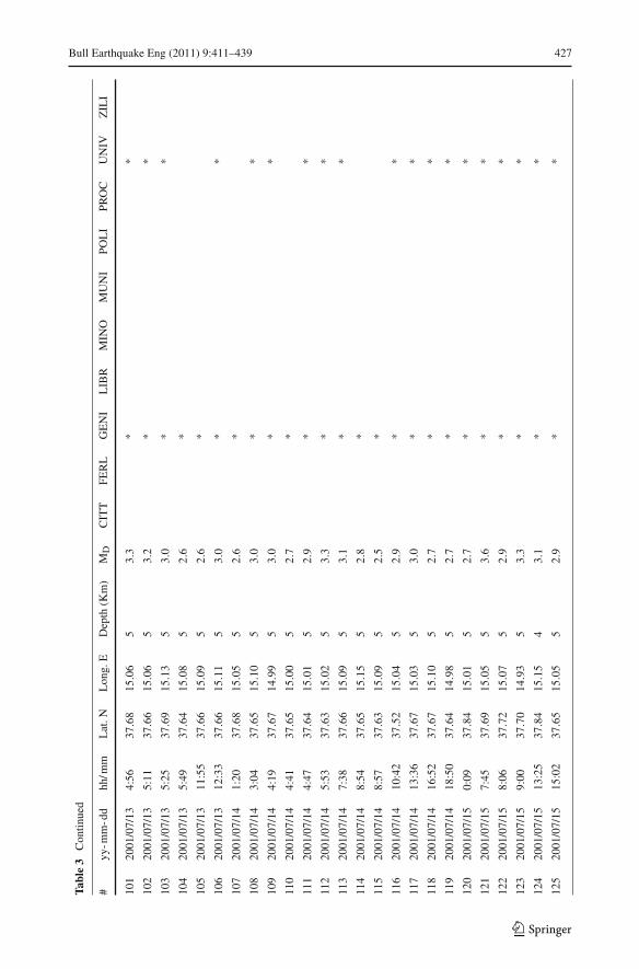
Tabl
e3
Con
tinue
d
#yy
-mm
-dd
hh/m
mL
at.N
Lon
g.E
Dep
th(K
m)
MD
CIT
TFE
RL
GE
NI
LIB
RM
INO
MU
NI
POL
IPR
OC
UN
IVZ
ILI
101
2001
/07/
134:
5637
.68
15.0
65
3.3
**
102
2001
/07/
135:
1137
.66
15.0
65
3.2
**
103
2001
/07/
135:
2537
.69
15.1
35
3.0
**
104
2001
/07/
135:
4937
.64
15.0
85
2.6
*
105
2001
/07/
1311
:55
37.6
615
.09
52.
6*
106
2001
/07/
1312
:33
37.6
615
.11
53.
0*
*
107
2001
/07/
141:
2037
.68
15.0
55
2.6
*
108
2001
/07/
143:
0437
.65
15.1
05
3.0
**
109
2001
/07/
144:
1937
.67
14.9
95
3.0
**
110
2001
/07/
144:
4137
.65
15.0
05
2.7
*
111
2001
/07/
144:
4737
.64
15.0
15
2.9
**
112
2001
/07/
145:
5337
.63
15.0
25
3.3
**
113
2001
/07/
147:
3837
.66
15.0
95
3.1
**
114
2001
/07/
148:
5437
.65
15.1
55
2.8
*
115
2001
/07/
148:
5737
.63
15.0
95
2.5
*
116
2001
/07/
1410
:42
37.5
215
.04
52.
9*
*
117
2001
/07/
1413
:36
37.6
715
.03
53.
0*
*
118
2001
/07/
1416
:52
37.6
715
.10
52.
7*
*
119
2001
/07/
1418
:50
37.6
414
.98
52.
7*
*
120
2001
/07/
150:
0937
.84
15.0
15
2.7
**
121
2001
/07/
157:
4537
.69
15.0
55
3.6
**
122
2001
/07/
158:
0637
.72
15.0
75
2.9
**
123
2001
/07/
159:
0037
.70
14.9
35
3.3
**
124
2001
/07/
1513
:25
37.8
415
.15
43.
1*
*
125
2001
/07/
1515
:02
37.6
515
.05
52.
9*
*
123

428 Bull Earthquake Eng (2011) 9:411–439
Tabl
e3
Con
tinue
d
#yy
-mm
-dd
hh/m
mL
at.N
Lon
g.E
Dep
th(K
m)
MD
CIT
TFE
RL
GE
NI
LIB
RM
INO
MU
NI
POL
IPR
OC
UN
IVZ
ILI
126
2001
/07/
1523
:38
37.6
815
.12
52.
5*
127
2001
/07/
160:
3737
.83
14.9
85
2.8
**
128
2001
/07/
162:
4437
.68
15.1
25
2.9
**
129
2001
/07/
164:
0037
.67
15.0
45
2.8
**
130
2001
/07/
167:
2737
.71
15.0
85
2.8
*
131
2001
/07/
169:
2437
.76
15.0
95
3.2
*
132
2001
/07/
1615
:08
37.4
715
.12
102.
9*
133
2001
/07/
1617
:04
37.6
815
.14
53.
4*
134
2001
/07/
1620
:27
37.6
715
.05
53.
2*
135
2001
/07/
1623
:19
37.6
715
.03
53.
3*
136
2001
/07/
170:
5937
.63
15.1
35
2.8
*
137
2001
/07/
172:
3937
.64
15.0
95
2.5
*
138
2001
/07/
175:
3337
.67
15.0
55
3.5
*
139
2001
/07/
178:
2537
.54
14.9
45
2.6
*
140
2001
/07/
1710
:08
37.8
915
.00
52.
6*
141
2001
/07/
1713
:46
37.7
315
.17
52.
6*
142
2001
/07/
1820
:00
37.7
114
.92
52.
7*
143
2001
/07/
1821
:38
37.6
714
.88
52.
7*
144
2001
/07/
2212
:32
37.6
315
.11
53.
2*
*
145
2001
/07/
2320
:42
37.6
115
.04
102.
4*
*
146
2001
/07/
3118
:47
38.4
915
.16
63.
5*
*
147
2001
/08/
173:
1538
.34
14.7
323
23.
1*
148
2001
/08/
2022
:44
37.6
715
.13
53.
4*
149
2001
/09/
1418
:53
37.5
216
.11
173.
4*
*
150
2001
/10/
0513
:29
37.2
415
.810
3*
123
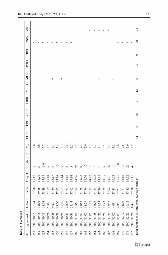
Bull Earthquake Eng (2011) 9:411–439 429
Tabl
e3
Con
tinue
d
#yy
-mm
-dd
hh/m
mL
at.N
Lon
g.E
Dep
th(K
m)
MD
CIT
TFE
RL
GE
NI
LIB
RM
INO
MU
NI
POL
IPR
OC
UN
IVZ
ILI
151
2001
/10/
1520
:44
37.5
815
.17
52.
6*
152
2001
/10/
1811
:02
39.2
616
.28
53.
6*
153
2001
/10/
1818
:08
38.4
915
.13
246
3.7
*
154
2001
/10/
265:
3837
.59
15.1
85
2.7
*
155
2001
/10/
289:
0337
.59
15.1
75
3.7
**
156
2001
/10/
2811
:00
37.6
215
.19
102.
4*
157
2001
/10/
2815
:05
37.6
115
.14
53.
3*
*
158
2001
/10/
3122
:06
37.6
115
.18
52.
5*
159
2001
/10/
3123
:44
37.6
215
.14
52.
5*
160
2001
/11/
012:
4637
.74
14.6
621
2.5
161
2001
/11/
0314
:53
37.7
514
.73
62.
7
162
2001
/11/
0318
:29
37.7
614
.76
122.
6
163
2001
/11/
0510
:17
37.1
214
.77
192.
7*
164
2001
/11/
2518
:26
37. 8
113
.95
73.
3*
165
2001
/11/
2519
:33
37.7
613
.98
14
**
166
2001
/11/
2810
:43
37.7
913
.95
53.
5*
167
2001
/11/
2916
:36
37.9
214
.927
2.4
*
168
2001
/12/
024:
0837
.41
16.5
314
3.2
*
169
2001
/12/
074:
0537
.216
.71
100
2.8
*
170
2001
/12/
1211
:06
37.6
15.1
610
2.5
*
171
2001
/12/
2210
:42
37.8
514
.72
262.
6*
172
2001
/12/
268:
4337
.78
16.1
149
2.9
*
Tota
lnum
ber
ofse
ism
icev
entf
orea
chst
atio
ns44
589
1212
519
990
22
123
430 Bull Earthquake Eng (2011) 9:411–439
Fig. 8 Litho-stratigraphic sequence at the reference station UNIV with an example of Fourier spectrum (a),HVSR (b) and theoretical transfer function (c)
This might be explained in terms of non-linear behavior connected to the soil typology, themagnitude of the earthquake and the different source-to-site distances of selected scenarios(Fig. 10).
It is interesting to observe that amplification factor calculated for PGA and Sag (Fig. 9),for the periods 0.2, 0.5 and 1.0 s, never exceeds 3. The amplification factor at each site mainlydepends on the impedance ratio (I ). In the Catania area, frequently the impedance ratio is rel-atively low, as in the case of the soil deposits overlaying the marly-clay bedrock (I ≈ 2 − 3).In a few cases, when the soil deposits cover the compact lava, I exceed 2–3 up to 5–6.
Despite such considerations, it is quite evident that the accelerations coming out fromthe three scenario maps spread in a similar way throughout the study area and show a quitecomparable distribution of both maximum and minimum values.
Preliminary to the description of PGA and Sag distribution, the information coming outfrom both surface geology and available boreholes has to be summarized. Five ideal stra-tigraphies (Fig. 11a) describing the most widespread sequences of lithotypes present in theCatania urban area, were therefore drawn. Figure 11b shows the theoretical transfer functionsobtained, through the EERA numerical code, for such ideal stratigraphies.
In the southern part of the urban area, the clayey basement is mostly covered by sandyand gravelly sediments together with alluvial deposits (a and b in Figs. 1 and 11a). The the-oretical transfer functions (a and b in Fig. 11b) show fundamental frequencies in the range1.0–3.0 and 1.5–4.5 Hz that appear linked to the presence of soft sediments laying on theclayey basement. The not pronounced amplification peaks observed, could be related to the
123

Bull Earthquake Eng (2011) 9:411–439 431
Fig. 9 PGA values and Sag ordinates at 0.2, 0.5 and 1.0 s period, 5% damping (left column). PGA to PGArefratio and Sag to Sag(ref) (right column) obtained at each borehole site; black circles, gray squares and lightgray triangles, respectively refers to destructive, strong and moderate scenario earthquakes
123

432 Bull Earthquake Eng (2011) 9:411–439
Fig. 10 Normalized response spectra for each considered scenario that show non-linearity and magnitudedependence
Fig. 11 a Ideal stratigraphies describing the main lithotype sequences characterizing the study area; in brack-ets are reported the same acronyms quoted in Table 2. b Theoretical transfer functions, for each consideredscenario, obtained taking into account the ideal stratigraphic sequence
123
Bull Earthquake Eng (2011) 9:411–439 433
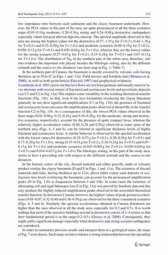
low impedance ratio between such sediments and the clayey basement underneath. How-ever, the PGA values in this part of the area, are quite pronounced in all the three scenariosmaps (0.05–0.10 g moderate, 0.20–0.36 g strong and 0.24–0.48 g destructive earthquakes)especially where terraced alluvial deposits outcrop. The spectral amplitude observed in thisarea are among the highest values for the destructive (0.57–1.53 g for T = 0.2 s, 0.44–1.16 gfor T = 0.5 s and 0.25–0.50 g for T = 1.0 s) and moderate scenarios (0.08–0.19 g for T = 0.2 s,0.056–0.12 g for T = 0.5 s and 0.020–0.04 g for T = 1.0 s), whereas they are the lowest valuesfor the strong scenario (0.27–0.63 g for T = 0.2 s, 0.15–0.28 g for T = 0.5 s and 0.07–0.13 gfor T = 1.0 s). The distribution of Sag in the southern part of the urban area, therefore, setsinto evidence the important role played, besides the lithologic setting, also by the differentazimuth and the source-to-site distances (see inset map in Fig. 1; Table 1).
In the northern part of Catania, the basement is mostly covered by volcanic soils havingthickness up to 50 m (C in Figs. 1 and 11a). Field surveys and borehole data (Monaco et al.2000), as well as both geotechnical (Faccioli 1997) and geophysical evidences(Lombardo et al. 2001) point out that lava flows are not homogeneous and usually massive la-vas alternate with several meters of fractured and scoriaceous levels and pyroclastic deposits(see C1 and C2 in Fig. 11a) This implies some variability in the resulting theoretical transferfunctions (Fig. 11b), so that, even if the lava formations overlaying the clayey basementgenerally do not show significant amplifications (C1 in Fig. 11b), the presence of fracturedand scoriaceous lavas can cause the amplification peaks observed at about 6 Hz in the transferfunction C2 in Fig. 11b. As a consequence of this, the lowest PGA values observed in thethree maps (0.02–0.04 g, 0.12–0.24 g and 0.16–0.28 g, for the moderate, strong and destruc-tive scenarios, respectively), account for the presence of quite compact lavas, whereas therelatively higher acceleration values (0.04, 0.24 and 0.28 g) observed in some spots of thenorthern area (Figs. 4, 5 and 6), can be referred to significant thickness levels of highlyfractured and scoriaceous lavas. A similar behavior is observed for the spectral accelerationwith the lowest values for destructive (0.25–0.57 g for T = 0.2 s, 0.20–0.56 g for T = 0.5 s and0.17–0.29 g for T = 1.0 s), strong (0.15–0.51 g for T = 0.2 s, 0.10–0.24 g for T = 0.5 s and 0.07–0.13 g for T = 1.0 s) and moderate scenarios (0.025–0.065 g for T = 0.2 s, 0.020–0.044 g forT = 0.5 s and 0.010–0.017 g for T = 1.0 s) The lithologic setting, in this part of the study area,seems to have a prevailing role with respect to the different azimuth and the source-to-sitedistances.
In the historic centre of the city, discard material and either gravelly sands or volcanicproduct overlay the clayey basement (D and E in Figs. 1 and 11a). The existence of discardmaterials and ruins, having thickness up to 12 m, above either coarse sand deposits or sco-riaceous lava levels overlaying the basement, can account for the pronounced amplificationpeaks (D in Fig. 11b) at frequencies between 4 and 5 Hz. In some cases the existence ofalternating soft and rigid lithotypes (see E in Fig. 11a) was proved by borehole data and thismay produce the slightly reduced amplification peaks observed in the associated theoreticaltransfer function. In downtown Catania, however, the highest values of peak ground accelera-tions (0.05–0.07, 0.32–0.40 and 0.36–0.50 g) are observed for the three considered scenarios(Figs. 4, 5 and 6). Similarly, the spectral accelerations obtained in Catania downtown arehigher than the ones observed in all the study area, especially for 0.2 and 0.5 s. It is worthnothing that most of the masonry buildings erected in downtown consist of 2–4 stories so thattheir fundamental period is in the range 0.2–0.5 s (Grasso et al. 2004). Consequently, theymight suffer significant damage especially when destructive and strong scenario earthquakesare considered.
In order to summarize previous results and interpret them in a geological sense, the mapsof Fig. 7 were drawn. Such maps set into evidence a strong relationship between the spreading
123
434 Bull Earthquake Eng (2011) 9:411–439
of the log-normal mean deviations of increments/decrements of the above mentioned valuesand the near surface geology. The highest increments are observed in the historic centre andin some spots where discard materials and detritus outcrop, as well as in some sedimentarydeposits prevailing to the south of the study area. Medium and low increments prevail inthe sectors not covered by lava flows. On the other hand, higher decrements are typical ofareas where massive lavas overlay the basement (see Fig. 7). Hence, major increments ofpeak ground acceleration and spectral acceleration are linked to sites where detritus, loosesediments and/or alluvial deposits outcrop. Conversely, decrements and consequently lowpotential damage, attain to sites where the outcropping compact lava flows directly overlaythe basement.
In order to check and validate the reliability of the results so far described, a comparisonwas made with experimental findings from earthquake recordings. The use of spectral ratiotechniques (SSR and HVSR) allowed a trustworthy estimate of fundamental frequencies inthe selected sites, although the inferred spectral amplitudes do not give univocal clues. Thespectral ratio amplitudes from the HVSRs are indeed often lower than the SSRs. Accordingto Fäh et al. (2001) this finding is a consequence of the moderate velocity contrast betweenthe bedrock and the overlaying soft sediments, as observed in this area by Lombardo etal. (2001) from ambient noise measurements. Moreover, the vertical component could bestrongly affected by local amplification effects when pronounced heterogeneities character-ize the local geology (Riepl et al. 1998; Raptakis et al. 1998, 2000; Triantafyllidis et al. 1999;Bindi et al. 2009).
In Fig. 12a the litho-stratigraphic sequences of the sites where the seismic stations werelocated, are shown. These characteristics were used as input data in EERA code for thetheoretical transfer function evaluation. The comparison between the experimental results,obtained through spectral ratios, and the theoretical 1D transfer function provided by theEERA code are shown in Fig. 12b.
The seismic stations FERL, LIBR and ZILI are located in the southern part of the area,where alluvial deposits and gravelly sands are present. In the three stations, both experimentalspectral ratios and the 1D modelling approach set into evidence the existence of amplifica-tion effects in the frequency range 1.5–5.0 Hz, therefore confirming the findings previouslydescribed for the southern part of Catania urban area. It is interesting to point out that dif-ferences between SSR and HVSR are mainly observed at FERL. Such station is located inthe Catania alluvial plain which, as demonstrated by field and borehole data (Accordi andFrancaviglia 1960; AGIP 1977; Carbone et al. 2009) is formed by highly heterogeneoussediments characterized by pronounced lateral discontinuities. These irregularities can affectthe amplitude of the vertical component of motion, because of the presence of diffractedRayleigh waves (Field and Jacob 1995; Raptakis et al. 1998, 2000), thus causing differencesbetween the SSRs and HVSRs. Moreover, the spectral ratios at both LIBR and ZILI showamplifications gradually increasing in a wide frequency range. Such effect could be inter-preted as a consequence of the already mentioned low velocity contrast that characterizes thesedimentary sequence. A strong impedance contrast, between hard and soft soils is indeedneeded to obtain pronounced fundamental frequencies either when earthquakes or ambientnoise (Fäh et al. 2001) are used as input signals.
The results of the experimental approach at the stations CITT and GENI, located on thecentral and northern part of the town, show moderate amplifications in the range 1.5–4.0 Hz.These values, which are in quite good agreement with the ones of the theoretical transferfunction, could be interpreted as amplification effects linked to soft soils, having thickness ofabout 15–20 m. Such amplifications appear in the “sedimentary windows” remaining amongthe lava flows covering the clayey basement (GENI) as well as when a scoriaceous com-
123
Bull Earthquake Eng (2011) 9:411–439 435
Fig. 12 a Litho-stratigraphic features of the recording station site; in brackets are reported the same acronymsquoted in Table 2. b Experimental and theoretical transfer functions at each seismic station; solid and dottedblack lines refer to the N–S and E–W components of motion of the SSR respectively; solid and dotted greylines refer to the N–S and E–W components of motion of the HVSR respectively; dashed black line refers tothe 1D theoretical transfer function
123
436 Bull Earthquake Eng (2011) 9:411–439
ponent prevails in the lava flows (CITT). On the other hand, when the basaltic lavas aresomewhat compact and directly lay over the bedrock, they do not produce amplificationeffects as observed for the reference site UNIV (Fig. 8).
As far as the other recording sites are concerned, they are located either on spots of softsediments and pyroclastics surrounded by lava flows (POLI, MINO), or they are sited onfairly fractured and scoriaceous basaltic lavas (PROC) sometimes covered by coarse detritusand sand (MUNI). Therefore, quite pronounced amplification peaks are observed. At POLIand MINO stations, peaks in the ranges 2.5–5.0 Hz and 3.0–8.0 Hz, respectively, are shownin both SSR and HVSR. Such ranges of values, observed in the theoretical transfer functiontoo, are more pronounced in the SSR rather than in the HVSR. It has to be specified thatboth stations are located almost at the top of a small sedimentary hill surrounded by lavaflows. This topographic setting could be responsible for the pronounced amplification effects,therefore, in our opinion, further investigations are needed to corroborate the hypothesis ofsuch effects in the ground motion.
A good match between the experimental and theoretical approach is also found at stationPROC. Here, spectral peaks in the 2.5–7.0 Hz frequency band occur. This, as the results of1D modelling indicate, can be interpreted as linked to the presence of alternating massiveand scoriaceous/fractured lavas. A similarly good match is found between the experimentaland theoretical transfer functions obtained at MUNI, where moderate amplification peaksin the range 2.0–6.0 Hz, related to about 35 m thick alternating levels of soft materials andfractured lavas, are observed.
5 Concluding remarks
The evaluation of the local seismic response in the complex geological situation of Cata-nia was undertaken using a twofold approach based on theoretical modelling, through anequivalent-linear numerical code (EERA) combined with local borehole information andexperimental methods based on spectral ratio analysis. The joint use of theory and observa-tions allowed us to obtain quantitative indications about the site response in the study areaand granted a mutual validation of results, thus making possible their interpretation into ageological framework.
Data coming from about two hundred borehole data, provided reliable stratigraphic se-quences for the investigated sites. To obtain contour maps of PGA and Sag, three differentscenario earthquakes were assumed and seven real accelerograms were selected for each con-sidered scenario. Our findings point out that all scenarios show comparable results in termsof local distribution of amplifications. The largest PGA and Sag values are concentrated inwide areas located in downtown Catania, where coarse materials and ruins of historical earth-quakes are present, as well as in sectors where soft sediments and alluvial deposits outcropamong the basaltic lava flows. On the contrary, the lowest values are observed in all sectors ofthe urban area where lava flows directly cover the marly clay bedrock, as long as the basalticlavas are not scoriaceous and/or fractured.
The results of spectral ratios techniques, performed on the earthquakes recorded in tenstations, confirm the findings previously described. Significant amplifications of the groundmotion are indeed observed in the stations located either on spots of soft sediments, likecoarse detritus and sand, surrounded by lava flows or when they are sited on fairly fracturedand scoriaceous basaltic lavas.
It is worth noting that both the SSR and HVSR techniques provide a reliable estimate of thefundamental frequencies at the investigated sites. Spectral ratio obtained through the HVSR
123

Bull Earthquake Eng (2011) 9:411–439 437
method often appear less pronounced than those obtained through the SSR. Such finding isrelated to the role played by the pronounced lateral heterogeneities existing in the area, whichaffect the vertical component of motion too (Raptakis et al. 1998; Raptakis et al. 2000; Bindiet al. 2009) as well as to the complexity of near-surface morphology (Chavez-Garcia et al.1996). It is indeed evident that further investigations are useful to take into account the com-plexity of the geological and morphologic context of such area, where strong heterogeneitieswith sedimentary paleo-valleys covered by lava flows and soft sediments hills surrounded byfields of lava do exist.
References
Accordi B, Francaviglia A (1960) La geologia del bacino del Simeto. Tecnica Agricola XII(3):221–244AGIP (1977) Temperature sotterranee. F.lli. Brugora eds., MilanoAmato A, Azzara R, Basili A, Chiarabba C, Cocco M, Di Bona M, Selvaggi G (1995) Main shock and after-
shocks of the December 13, 1990 eastern Sicily earthquake. Ann Geofis 38(2):255–266Ambraseys N, Smit P, Sigbjornsson R, Suhadolc P, Margaris B (2002) Internet-site for European strong-motion
data. European commission, research-directorate general, environment and climate programme http://www.isesd.cv.ic.ac.uk/ESD/
Azzaro R, Barbano SM, Moroni A, Mucciarelli M, Stucchi M (1999) The seismic history of Catania. J Seism3(3):235–252
Azzaro R, Barbano MS (2000) Seismogenic features of SE Sicily and scenario earthquakes for Catania. In:Faccioli R, Pessina V (eds) The catania project: earthquake damage scenarios for a high risk area in theMediterranean, vol 225. CNR-GNDT, Roma, pp 9–13
Barbano MS, Rigano R (2001) Earthquake sources and seismic hazard in south-eastern Sicily. Ann Geofis44(4):723–738
Bardet JP, Ichii K, Lin CH (2000) EERA. A computer program for equivalent-linear earthquake site responseanalyses of layered soil deposits. University of Southern California, Department of Civil Engineering,user’s manual
Bessason B, Kaynia AM (2002) Site amplification in lava rock on soft sediments. Soil Dyn Earthq Eng22(7):525–540
Bindi D, Parolai S, Cara F, Di Giulio G, Ferretti G, Luzi L, Monachesi G, Pacor F, Rovelli A (2009) Siteamplifications observed in the Gubbio Basin, central Italy: hints for lateral propagation effects. BullSeism Soc Am 99(2A):741–760
Biondi G, Maugeri M (2005) Seismic response analysis of Monte Po hill (Catania). In: Maugeri M (ed)Seismic prevention of damage a case study in a Mediterranean city, vol 14. WIT Press, Southampton, pp177–195
Bommer JJ, Acevedo AB (2004) The use of real earthquake accelerograms as input to dynamic analysis.J Earth Eng 8(1) special issue: 43–91
Borcherdt RD (1970) Effects of local geology on ground motion near San Francisco Bay. Bull Seism Soc Am60(1):29–61
Brancato A, Hole JA, Gresta S, Beale JN (2009) Determination of seismogenic structures in southeastern Sicily(Italy) by high-precision relative relocation of microearthquakes. Bull Seism Soc Am 99(3):1921–1936
Carbone S, Branca S, Lentini F, Barbano M S, Corsaro M A, Di Stefano A, Ferrara V, Monaco C, LonghitanoS, Platania I, Zanini A, De Beni E, Ferlito C (2009) Note Illustrative della Carta Geologica d’Italia allascala 1:50000, foglio 634 Catania. ISPRA, Servizio Geologico d’Italia, Organo Cartografico dello Stato,S.EL.CA. s.r.l., Firenze
Carrubba P, Maugeri M (1988) Determinazione delle proprietà dinamiche di un’argilla mediante prove dicolonna risonante. Rivista italiana di geotecnica 22(2):101–113
Catalano S, De Guidi G, Gresta S, Langer H, Lombardo G, Monaco C, Rigano R, Tortorici L (2005) Geoli-thological features and site response in the town of Catania. In: Maugeri M (ed) Seismic prevention ofdamage: a case study in a Mediterranean city, advances in earthquake engineering, vol 14. WIT Press,Southampton, pp 103–114
Cauzzi C, Faccioli E (2008) Broadband (0.05 to 20 s) prediction of displacement response spectra based onworldwide digital records. J Seismol 12(4):453–475
Cavallaro A, Grasso S, Maugeri M (2001) A dynamic geothechnical characterization of soil at Saint Nicolaalla Rena Church damaged by south eastern Sicily earthquake of 13 December 1990. In: Proceedings of
123
438 Bull Earthquake Eng (2011) 9:411–439
the 15th international conference on soil mechanics and geotechnical engineering, satellite conferenceLessons learned from recent strong earthquake. Istanbul, 25 August 2001:243–248
Chavez-Garcia FJ, Sanchez LR, Hatzfeld D (1996) Topographic site effects and HVSR. A comparison betweenobservations and theory. Bull Seism Soc Am 86(5):1559–1573
De Lorenzo S, Di Grazia G, Giampiccolo E, Gresta S, Langer H, Tusa G, Ursino A (2004) Source and Qpparameters from pulse width inversion of low magnitude earthquake data in the southeastern Sicily. JGeophys Res 109:B07308. doi:10.1029/2003JB002577
Di Bona M, Cocco M, Rovelli A, Berardi R, Boschi E (1995) Analysis of strong-motion data of the 1990eastern Sicily earthquake. Ann Geofis 38(2):283–300
Faccioli E (coordinator) (1997). Geotechnical earthquake engineering by characterisation of the Catania munic-ipal area. Technical report and CD-Rom prepared by Ingegneria Geotecnica for CNR–Gruppo NazionaleDifesa Terremoti, Milan, Italy (in Italian), p 33 + encl
Faccioli E, Pessina V (eds) (2000) The Catania project: earthquake damage scenarios for high risk area in theMediterranean. CNR—Gruppo Nazionale per la Difesa Terremoti, Roma, p 225
Fäh D, Kind F, Giardini D (2001) A theoretical investigation on H/V ratios. Geophys J Int 145(2):535–549Field EH, Jacob K (1995) A comparison and test of various site response estimation techniques. Bull Seism
Soc Am 85(4):1127–1143Galadini F, Meletti C, Vittori E (2001) Major active fault in Italy: available surface data. Netherlands J Geosc
80(3–4):273–296Gerardi F, Barbano MS, De Martini PM, Pantosti D (2008) Discrimination of Tsunami sources (earthquake
versus landslide) on the basis of historical data in eastern Sicily and southern Calabria. Bull Seism SocAm 98(6):2795–2805
Giampiccolo E, Gresta S, Ganci G (2003) Attenuation of body waves in southeastern Sicily (Italy). Phys EarthPlanet Int 135(4):267–279
Giampiccolo E, Gresta S, Mucciarelli M, De Guidi G, Gallipoli RM (2001) Information about subsoil geo-logical structure in the city of Catania: eastern Sicily from microtremor measurements. Ann Geofis44(1):1–12
Giampiccolo E, Gresta S, Rasconà F (2004) Intrinsic and scattering attenuation from observed seismic codasin southeastern Sicily, Italy. Phys Earth Planet Int 145(1–4):55–66
Giampiccolo E, Tusa G, Langer H, Gresta S (2002) Attenuation in southeastern Sicily (Italy) by applyingdifferent coda methods. J Seismol 6(4):487–501
Giardini G, Palombo B, Pino NA (1995) Long period modelling of the MEDNET waveforms for the December13, 1990 eastern Sicily earthquake. Ann Geofis 38(2):267–282
Grasso S, Lombardo G, Maugeri m, Rigano R (2004) Site effects evaluation in monumental and civil residencebuildings in the urban area of Catania. In: Atti XI Convegno Nazionale ANIDIS “L’ingegneria sismicain Italia”, Genova (Italia), 25–29 January 2004, CD-ROM
Iervolino I, Galasso C, Cosenza E (2010) REXEL: computer aided record selection for code-based seismicstructural analysis. Bull Earthq Eng 8(2):339–362
Langer H, Catalano S, Cristaldi M, De Guidi G, Gresta S, Monaco C, Tortorici L (1999) Strong ground motionsimulation in the urban area of Catania on the basis of a detailed geological survey. In: Oliveto G, BrebbiaCA (eds) Earthquake resistant engineering structures. WIT Press, Southampton, pp 343–352
Lanzo G, Lombardo G, Pagliaroli A, Rigano R (2006) Effects of natural and artificial cavities in the evaluationof local seismic response. 25◦ Convegno Nazionale GNGTS, Roma, poster section, pp 244-246
Laurenzano G, Priolo E (2005) Numerical modelling of the December 13, 1990, M = 5.8 eastern Sicily earth-quake. Bull Seis Soc Am 95(1):241–251
Laurenzano G, Priolo E, Kline P, Vuan A (2004) Near fault earthquake scenarios for the February 20, 1818M = 6.2 “Catanese” event. In: Brebbia CA (ed) Proceedings of the fourth international conference oncomputer simulation in risk analysis and hazard mitigation, risk analysis IV, Rhodes, Greece. WIT Press,Southampton, pp 81–91
Lavecchia G, Ferrarini F, de Nardis R, Visini F, Barbano MS (2007) Active thrusting as a possible seismogenicsource in Sicily (southern Italy): some insights from integrated structural–kinematic and seismologicaldata. Tectonophysics 445(3–4):145–167
Lermo J, Chavez-Garcia FJ (1993) Site effect evaluation using spectral ratio with only one station. Bull SeismSoc Am 83(5):1574–1594
Lombardo G, Coco G, Corrao M, Imposa S, Azzara R, Cara F, Rovelli A (2001) Results of microtremormeasurements in the urban area of Catania (Italy). Boll Geofis Teor Appl 42(3–4):317–334
Lombardo G, Langer H, Gresta S, Rigano R, Monaco C, De Guidi G (2006) On the importance of geolitho-logical features for the estimate of the site response: the case of Catania metropolitan area (Italy). NatHazards 38(3):339–354
123
Bull Earthquake Eng (2011) 9:411–439 439
Lombardo G, Rigano R (2007) Local seismic response in Catania (Italy): a test area in the northern part of thetown. Eng Geol 94(1–2):38–49. doi:10.1016/j.enggeo.2007.06.008
Lombardo G, Rigano R (2009) Local seismic response evaluation in natural and artificial cavities. In: Pro-ceeding of the 3◦ international symposium “karst evolution in the south Mediterranean area”, Ragusa,Italy May 2009, (in print)
Lombardo G, Rigano R, Gresta S, Langer H, Monaco C, De Guidi G (2004) Evaluation of the local seis-mic response in the area of Catania (Italy). In: Brebbia CA (ed) Proceedings of the fourth internationalconference on on computer simulation in risk analysis and hazard mitigation, risk analysis IV, Rhodes,Greece. WIT Press, Southampton, pp 103–114
Monaco C, Catalano S, De Guidi G, Gresta S, Langer H, Tortorici L (2000) The geological map of the urbanarea of Catania (eastern Sicily): morphotectonic and seismotectonic implications. Mem Soc Geol It55:425–438
Monaco C, Tortorici L (1999) Carta geologica dell’area urbana di Catania. S.E.L.C.A., Firenze, ItalyMucciarelli M, Pacor F (2007) Progetti sismologici di interesse per il DPC, progetto S3—Scenari di scuo-
timento in aree di interesse prioritario e/o strategico, task 2—effetti di sito—deleverables D3-D4-D5.http://portale.ingv.it/temi-ricerca/terremoti
Pannatier Y (1996) Variowin—software for spatial data analysis in 2D. Springer-Verlag, New York, p 91.ISBN 0-387-94579-9
Priolo E (1999) 2-D spectral element simulations of destructive ground shaking in Catania (Italy). J Seism3(3):289–309
Priolo E, Michelini A, Laurenzano G, Addia R, Puglia A (2005) Seismic response from microtremors in Cata-nia (Sicily, Italy). In: Maugeri M (ed) “Seismic prevention of damage: a case study in a Mediterraneancity”, advances in earthquake engineering vol 14. WIT Press, Southampton, pp 33–61
Raptakis D, Chavez-Garcia FJ, Makra K, Pitilakis K (2000) Site effects at Euroseistest—I. Determination ofthe valley structure and confrontation of observations with 1D analysis. Soil Dyn Earthq Eng 19(1):1–22
Raptakis D, Theodulidis N, Pitilakis K (1998) Data analysis of the euroseistest strong motion array in Volvi(Greece): standard and horizontal-to-vertical spectral ratio techniques. Earthq Spec 14(1):203–223
Riepl J, Bard P-Y, Hatzfeld D, Papaioannou C, Nechtschein S (1998) Detailed evaluation of site responseestimation methods accros and along the sedimentary valley of Volvi (EUROSEISTEST). Bull SeismSoc Am 88(2):488–502
Rigano R, Cara F, Lombardo G, Rovelli A (2008) Evidence for ground motion polarization on fault zones ofMount Etna volcano. J Geophys Res 113:B10306. doi:10.1029/2007JB005574
Seed HB, Idriss IM (1970) Soil moduli and damping factors for dynamic response analyses. Report No.EERC-70-10, University of California, Berkeley
Scognamiglio L, Malagnini L, Akinci A (2005) Ground-motion scaling in eastern Sicily, Italy. Bull Seism SocAm 95(2):568–578
Sgarlato G, Lombardo G, Rigano R (2009) Effects of underground cavities in the seismic site response eval-uation. 28◦ Convegno Nazionale GNGTS, Trieste (Italia) 16–19 Nov 2009, poster section, pp 345–346
Steidl JH, Tumarkin AG, Archuleta RJ (1996) What is a reference site? Bull Seism Soc Am 86(6): 1733–1748Triantafyllidis P, Hatzidimitriou PM, Theodulidis N, Suhadolc P, Papazachos C, Raptakis D, Lontzetidis
K (1999) Site effects in the city of Thessaloniki (Greece) estimated from acceleration data and 1-D localsoil profiles. Bull Seis Soc Am 89(2):521–537
Wang G (2010) A ground motion selection and modification method preserving characteristics and alea-tory variability of scenario earthquakes. 9th US national and 10th Canadian conference on earthquakeengineering: reaching beyond borders, Toronto (Canada) 25–29 July 2010
Working Group CPTI (2004) Catalogo Parametrico dei Terremoti Italiani, versione 2004 (CPTI04). INGV,Bologna. http://emidius.mi.ingv.it/CPTI
Working Group ITACA (2008) Data base of the Italian strong motion data. http://itaca.mi.ingv.itWorking Group MPS (2004) Redazione della mappa di pericolosità sismica prevista dall’Ordinanza PCM del
20 marzo 2003. Rapporto Conclusivo per il Dipartimento della Protezione Civile, INGV, Milano-Roma,April. 65 pp.+5 appendixes. http://zonesismiche.mi.ingv.it
Zollo A, Emolo A, Herrero A, Improta L (1999) High frequency ground motion modelling in the Catania areaassociated with the Ibleo-Maltese fault system. J Seism 3(3):279–288
123