The relationship between Late Quaternary deformation and volcanism of Mt. Etna (eastern Sicily): new...
24
The relationship between Late Quaternary deformation and volcanism of Mt. Etna (eastern Sicily): new evidence from the sedimentary substratum in the Catania region Stefano Catalano , Salvatore Torrisi, Carmelo Ferlito Dipartimento di Scienze Geologiche, Universita ' di Catania, C.so Italia, 55, 95100 Catania, Italy Received 27 November 2002; accepted 5 December 2003 Abstract Stratigraphical and structural analyses have been carried out on the Late Quaternary foredeep succession forming the Etnean substratum in the Catania region (eastern Sicily), in order to investigate in detail the chronology of deformation events that have accompanied a significant period of the eruptive activity of Mt. Etna, i.e. from 240 ka to the Present. This episode was characterised, at about 200 ka, by a main change of the petrochemical features of the emitted products from sub-alkaline to alkaline. This can be related to an evolving mantle diapir located beneath the volcano. The new stratigraphical and structural field data, presented in this paper, constrain the development, from 240 to 125 ka, of NW^SE-trending dextral faults associated with minor E^W- to NE^SW-oriented accommodation thrusts and NNW^SSE-trending normal faults that originated in a dominant transpressive regime. Strike-slip tectonics were active during the earlier emissions of sub-alkaline lavas (320^200 ka old) and part of the ancient alkaline products (180^100 ka old), from scattered eruptive systems which developed in local transtensive zones, distributed throughout the whole Etnean region. A major change in the mode of deformation, since 125 ka BP, was related to the propagation of a normal fault belt along the Ionian coast of the Catania region and the eastern sectors of the Etnean edifice. This process was associated with the growth of open folds that deformed the entire foredeep sequence exposed along the southern boundary of the Etnean edifice. During this period, eruptive activity concentrated along the main extensional features where steady and very efficient feeding systems originated. This resulted in a rapid increase in the volume of emitted alkaline products that gave rise to the construction of the modern stratovolcano during the last 80 ka. The collected data emphasise some main aspects of the relationship between tectonic deformation at a regional scale and volcanism in the Etna area. Firstly, the mode of deformation at the onset of Etnean volcanism seems to be inadequate to explain the emplacement at depth of a mantle diapir related to the occurrence of a hotspot, almost independent from the local crustal dynamics. On the other hand, the Late Quaternary structural assemblages recognised on the surface can be interpreted as direct effects of the Europe^Africa convergence, rather than as the products of deformation induced by the emplacement of the mantle diapir. In the different stages of Etnean evolution a direct relationship exists between the mode of deformation and the distribution as well as the capacity of the feeding systems. In particular, the amounts of emitted products in the different stages depend on the intensity of crustal stretching associated with deformation, rather than the volume of available molten material at depth. These conclusions represent a new perspective for the interpretion of the early stages and subsequent evolution of the 0377-0273 / 04 / $ ^ see front matter ȣ 2004 Elsevier B.V. All rights reserved. doi :10.1016/S0377-0273(03)00433-5 * Corresponding author. Tel.: +39-095-7195714; Fax: +39-095-7195712. E-mail addresses: [email protected] (S. Catalano), [email protected] (S. Torrisi). Journal of Volcanology and Geothermal Research 132 (2004) 311^334 R Available online at www.sciencedirect.com www.elsevier.com/locate/jvolgeores
-
Upload
independent -
Category
Documents
-
view
1 -
download
0
Transcript of The relationship between Late Quaternary deformation and volcanism of Mt. Etna (eastern Sicily): new...
The relationship between Late Quaternary deformation andvolcanism of Mt. Etna (eastern Sicily) : new evidence from
the sedimentary substratum in the Catania region
Stefano Catalano �, Salvatore Torrisi, Carmelo FerlitoDipartimento di Scienze Geologiche, Universita' di Catania, C.so Italia, 55, 95100 Catania, Italy
Received 27 November 2002; accepted 5 December 2003
Abstract
Stratigraphical and structural analyses have been carried out on the Late Quaternary foredeep succession formingthe Etnean substratum in the Catania region (eastern Sicily), in order to investigate in detail the chronology ofdeformation events that have accompanied a significant period of the eruptive activity of Mt. Etna, i.e. from 240 ka tothe Present. This episode was characterised, at about 200 ka, by a main change of the petrochemical features of theemitted products from sub-alkaline to alkaline. This can be related to an evolving mantle diapir located beneath thevolcano. The new stratigraphical and structural field data, presented in this paper, constrain the development, from240 to 125 ka, of NW^SE-trending dextral faults associated with minor E^W- to NE^SW-oriented accommodationthrusts and NNW^SSE-trending normal faults that originated in a dominant transpressive regime. Strike-slip tectonicswere active during the earlier emissions of sub-alkaline lavas (320^200 ka old) and part of the ancient alkalineproducts (180^100 ka old), from scattered eruptive systems which developed in local transtensive zones, distributedthroughout the whole Etnean region. A major change in the mode of deformation, since 125 ka BP, was related to thepropagation of a normal fault belt along the Ionian coast of the Catania region and the eastern sectors of the Etneanedifice. This process was associated with the growth of open folds that deformed the entire foredeep sequence exposedalong the southern boundary of the Etnean edifice. During this period, eruptive activity concentrated along the mainextensional features where steady and very efficient feeding systems originated. This resulted in a rapid increase in thevolume of emitted alkaline products that gave rise to the construction of the modern stratovolcano during the last 80ka. The collected data emphasise some main aspects of the relationship between tectonic deformation at a regionalscale and volcanism in the Etna area. Firstly, the mode of deformation at the onset of Etnean volcanism seems to beinadequate to explain the emplacement at depth of a mantle diapir related to the occurrence of a hotspot, almostindependent from the local crustal dynamics. On the other hand, the Late Quaternary structural assemblagesrecognised on the surface can be interpreted as direct effects of the Europe^Africa convergence, rather than as theproducts of deformation induced by the emplacement of the mantle diapir. In the different stages of Etnean evolutiona direct relationship exists between the mode of deformation and the distribution as well as the capacity of the feedingsystems. In particular, the amounts of emitted products in the different stages depend on the intensity of crustalstretching associated with deformation, rather than the volume of available molten material at depth. Theseconclusions represent a new perspective for the interpretion of the early stages and subsequent evolution of the
0377-0273 / 04 / $ ^ see front matter > 2004 Elsevier B.V. All rights reserved.doi:10.1016/S0377-0273(03)00433-5
* Corresponding author. Tel. : +39-095-7195714; Fax: +39-095-7195712.E-mail addresses: [email protected] (S. Catalano), [email protected] (S. Torrisi).
VOLGEO 3050 6-4-04
Journal of Volcanology and Geothermal Research 132 (2004) 311^334
R
Available online at www.sciencedirect.com
www.elsevier.com/locate/jvolgeores
volcanic activity of Mt. Etna. The proposed model also represents an useful tool in deciphering the relationshipbetween the deformation path, seismicity and volcanic activity of Mt. Etna.> 2004 Elsevier B.V. All rights reserved.
Keywords: Mt. Etna; foredeep sequence; strike-slip deformation; active tectonics; volcanism
1. Introduction
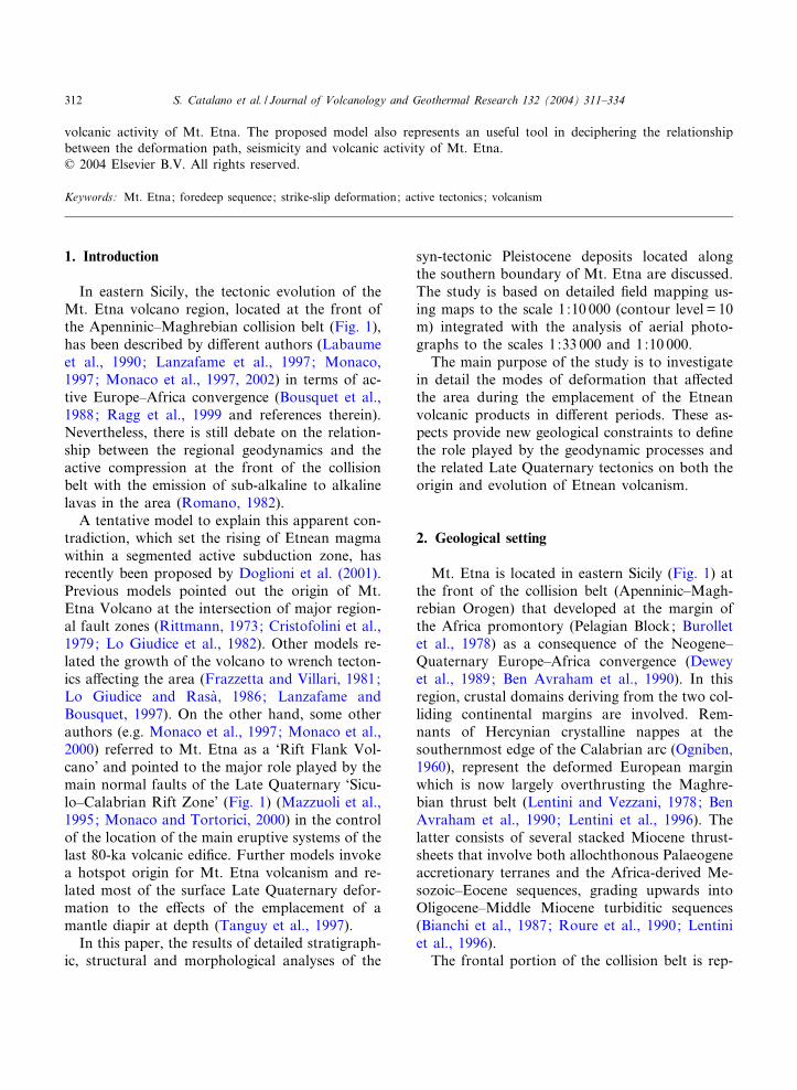
In eastern Sicily, the tectonic evolution of theMt. Etna volcano region, located at the front ofthe Apenninic^Maghrebian collision belt (Fig. 1),has been described by di¡erent authors (Labaumeet al., 1990; Lanzafame et al., 1997; Monaco,1997; Monaco et al., 1997, 2002) in terms of ac-tive Europe^Africa convergence (Bousquet et al.,1988; Ragg et al., 1999 and references therein).Nevertheless, there is still debate on the relation-ship between the regional geodynamics and theactive compression at the front of the collisionbelt with the emission of sub-alkaline to alkalinelavas in the area (Romano, 1982).
A tentative model to explain this apparent con-tradiction, which set the rising of Etnean magmawithin a segmented active subduction zone, hasrecently been proposed by Doglioni et al. (2001).Previous models pointed out the origin of Mt.Etna Volcano at the intersection of major region-al fault zones (Rittmann, 1973; Cristofolini et al.,1979; Lo Giudice et al., 1982). Other models re-lated the growth of the volcano to wrench tecton-ics a¡ecting the area (Frazzetta and Villari, 1981;Lo Giudice and Rasa', 1986; Lanzafame andBousquet, 1997). On the other hand, some otherauthors (e.g. Monaco et al., 1997; Monaco et al.,2000) referred to Mt. Etna as a ‘Rift Flank Vol-cano’ and pointed to the major role played by themain normal faults of the Late Quaternary ‘Sicu-lo^Calabrian Rift Zone’ (Fig. 1) (Mazzuoli et al.,1995; Monaco and Tortorici, 2000) in the controlof the location of the main eruptive systems of thelast 80-ka volcanic edi¢ce. Further models invokea hotspot origin for Mt. Etna volcanism and re-lated most of the surface Late Quaternary defor-mation to the e¡ects of the emplacement of amantle diapir at depth (Tanguy et al., 1997).
In this paper, the results of detailed stratigraph-ic, structural and morphological analyses of the
syn-tectonic Pleistocene deposits located alongthe southern boundary of Mt. Etna are discussed.The study is based on detailed ¢eld mapping us-ing maps to the scale 1:10 000 (contour level = 10m) integrated with the analysis of aerial photo-graphs to the scales 1:33 000 and 1:10 000.
The main purpose of the study is to investigatein detail the modes of deformation that a¡ectedthe area during the emplacement of the Etneanvolcanic products in di¡erent periods. These as-pects provide new geological constraints to de¢nethe role played by the geodynamic processes andthe related Late Quaternary tectonics on both theorigin and evolution of Etnean volcanism.
2. Geological setting
Mt. Etna is located in eastern Sicily (Fig. 1) atthe front of the collision belt (Apenninic^Magh-rebian Orogen) that developed at the margin ofthe Africa promontory (Pelagian Block; Burolletet al., 1978) as a consequence of the Neogene^Quaternary Europe^Africa convergence (Deweyet al., 1989; Ben Avraham et al., 1990). In thisregion, crustal domains deriving from the two col-liding continental margins are involved. Rem-nants of Hercynian crystalline nappes at thesouthernmost edge of the Calabrian arc (Ogniben,1960), represent the deformed European marginwhich is now largely overthrusting the Maghre-bian thrust belt (Lentini and Vezzani, 1978; BenAvraham et al., 1990; Lentini et al., 1996). Thelatter consists of several stacked Miocene thrust-sheets that involve both allochthonous Palaeogeneaccretionary terranes and the Africa-derived Me-sozoic^Eocene sequences, grading upwards intoOligocene^Middle Miocene turbiditic sequences(Bianchi et al., 1987; Roure et al., 1990; Lentiniet al., 1996).
The frontal portion of the collision belt is rep-
VOLGEO 3050 6-4-04
S. Catalano et al. / Journal of Volcanology and Geothermal Research 132 (2004) 311^334312
Fig. 1. Tectonic sketch map of eastern Sicily. Key: (1) Late Quaternary volcanics (Mt. Etna and Aeolian Islands); (2) Plio^Pleis-tocene volcanics (Hyblean Plateau); (3) Hyblean Plateau sequences; (4) Gela^Catania Foredeep deposits: (a) Middle^Upper Pleis-tocene deposits on allochthonous units, (b) Quaternary deposits on the Hyblean sequences; (5) Neogene^Quaternary accretionarywedge units; (6) Maghrebian Thrust Belt units; (7) Calabrian arc units; (8) Front of allochthonous units; (9) Main strike-slipfaults; (10) Main thrust; (11) Main Quaternary normal faults; (12) trace of the N^S regional cross-section. The regional cross-section is not to scale.
VOLGEO 3050 6-4-04
S. Catalano et al. / Journal of Volcanology and Geothermal Research 132 (2004) 311^334 313
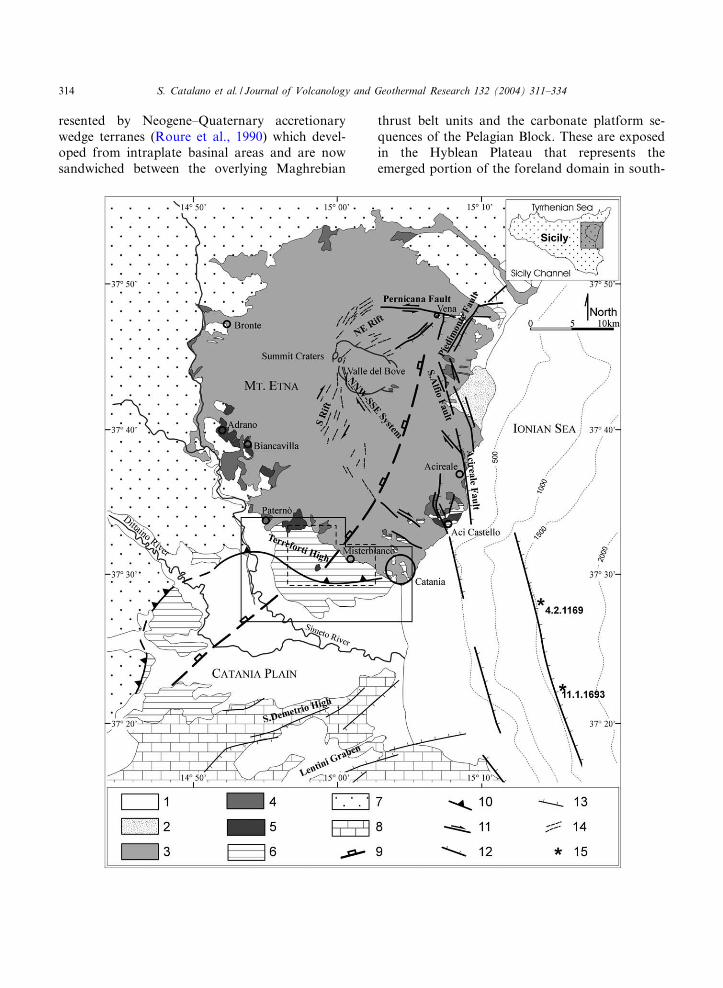
resented by Neogene^Quaternary accretionarywedge terranes (Roure et al., 1990) which devel-oped from intraplate basinal areas and are nowsandwiched between the overlying Maghrebian
thrust belt units and the carbonate platform se-quences of the Pelagian Block. These are exposedin the Hyblean Plateau that represents theemerged portion of the foreland domain in south-
VOLGEO 3050 6-4-04
S. Catalano et al. / Journal of Volcanology and Geothermal Research 132 (2004) 311^334314

eastern Sicily (Lentini et al., 1996 and referencestherein).
The external front of the Neogene^Quaternarytectonic wedge (Gela Nappe, Ogniben, 1960) restsabove Early Pleistocene horizons of the Gela^Cat-ania Foredeep (Lentini and Vezzani, 1978; Bian-chi et al., 1987).
South of Mt. Etna (Fig. 2), the NE^SW-ori-ented front of the Gela Nappe has been localised,by boreholes data and seismic lines (Torelli et al.,1998), beneath the Catania Plain. In this region,the allochthonous units tectonically overlie thetop of the carbonate sequences of the £exuredsector of the Hyblean Plateau and have been de-tected beneath more than about 1000 m of Early^Middle Pleistocene foredeep sediments.
On the surface, the allochthonous units culmi-nate along a roughly NNE^SSW-oriented rampthat, breaching the Gela Nappe, overthrust theMiddle Pleistocene deposits of the inner marginof the foredeep. This geometry of the frontal por-tion of the chain is interrupted, at the northernboundary of the Catania Plain, by a main WNW^ESE-oriented culmination of the foredeep depos-its. This forms the ‘Terreforti High’ which boundsthe volcanic edi¢ce of Mt. Etna to the south.
The tectonic lineaments described are locatedon the footwall of a main NNW^SSE-orientednormal fault belt (Fig. 2). This represents abranch of the larger ‘Siculo^Calabrian RiftZone’ (Mazzuoli et al., 1995; Monaco and Tor-torici, 2000) that a¡ects the Ionian o¡-shore ofthe region (Bianca et al., 1999) and extends tothe eastern £ank of Mt. Etna (Monaco et al.,1997). Seismological (Boschi et al., 1995a,b) andseismotectonic (Monaco and Tortorici, 2000; Az-zaro and Barbano, 2000) data suggest that the
high level seismicity of the area, characterised bythe recurrence of strong historical earthquakes(M9 7; e.g. AD 1169, 1693), is due to motionsalong the faults of the ‘Siculo^Calabrian RiftZone’ (Fig. 2).
In this regional framework, Mt. Etna Volcanohas developed on the frontal nappes of the Apen-ninic^Maghrebian collision belt (Lentini, 1982)and the Middle^Late Pleistocene foredeep depos-its (Monaco et al., 2000) uplifted along the west-ern £ank of the Rift Zone.
The volcanic edi¢ce is mainly a¡ected by theNNW^SSE- and NNE^SSW-striking normalfaults of the ‘Siculo^Calabrian Rift Zone’ thatcut through the lower eastern £ank of the vol-canic edi¢ce (Fig. 2). Extensional features (normalfaults and cracks) also a¡ect the summit areas ofthe volcano where they control the major magmafeeding systems. In more detail, they are repre-sented by: (1) the S-Rift (Kie¡er, 1975; Monacoet al., 1997) which a¡ects the southern £ank ofthe volcano; (2) the NE-Rift (Lo Giudice et al.,1982; Kie¡er, 1975), which extends from the sum-mit crater area towards the northern £ank of theedi¢ce; (3) the NNW^SSE-striking fracture sys-tem that developed from the summit area betweenthe two rift zones (Fig. 2) (Monaco et al., 1997).Pure extension along the NE-Rift is accommo-dated to the north, along an E^W-trending left-lateral shear zone known as the Pernicana Fault,and to the south along the NNW^SSE fracturesystem showing right-lateral component of mo-tion (Monaco et al., 1997). These kinematics,coupled with oblique (dextral) extension alongthe S-Rift, are consistent with the roughlyWNW^ESE-oriented regional scale extensionthat also activated the Late Quaternary master
Fig. 2. Geological sketch map of the Mt. Etna region. Key: (1) Alluvial deposits ; (2) Late Wu«rmian alluvial fan; (3) Trifoglietto,Ancient and Recent Mongibello lava £ows (80 ka to Present); (4) Ancient Alkaline Centres lava £ows (180^100 ka); (5) Sub-al-kaline lava £ows (580^250 ka); (6) Middle^Upper Pleistocene foredeep sequences; (7) Units of the Apenninic^Maghrebian colli-sion belt; (8) Hyblean Plateau sequences; (9) Front of the buried Gela Nappe; (10) Major thrust-ramp; (11) Strike-slip fault;(12) Late Quaternary normal fault of the ‘Siculo^Calabrian Rift Zone ’ ; (13) Plio^Pleistocene normal fault; (14) Dry and erup-tive ¢ssures; (15) Ms 7 earthquakes since AD 1000. The box with solid line represents the study area shown in Fig. 5; the boxwith dashed line refers to the area imaged in Fig. 11. The geometry of the Late Quaternary normal fault of the ‘Siculo^CalabrianRift Zone’, the location of main seismic events and geometry of dry and eruptive ¢ssures are from Monaco et al. (1997) andBianca et al. (1999). The geometry of faults on the northern boundary of Hyblean Plateau is from Torelli et al. (1998).
VOLGEO 3050 6-4-04
S. Catalano et al. / Journal of Volcanology and Geothermal Research 132 (2004) 311^334 315
fault segments of the ‘Siculo^Calabrian Rift Zone’in the lower eastern £ank of the volcano (Monacoet al., 1997).
During the Late Quaternary, a huge tectonicuplift up to 1.1 mm/a a¡ected the whole orogenicbelt of eastern Sicily with rates that are progres-sively decreasing towards the foreland areas ofsoutheastern Sicily (Bordoni and Valensise,1998; Catalano et al., 2003; Bianca et al., 1999).This regional extent process caused the terracingof the coastal deposits of the past 600 ka (Cata-lano and Di Stefano, 1997) that are now arrangedin distinct vertically displaced clastic wedges, eachrelated to an entire Oxygen Isotope Timescale(OIT) stage (4th order eustatic cycle) (Catalanoand Cinque, 1995; Bianca et al., 1999; Catalanoand De Guidi, 2003). Along the coast segments£anking the ‘Siculo^Calabrian Rift Zone’, such asthe case of the Etnean coast, a faster uplift-rate,
which has produced the terracing of clasticwedges related to a single eustatic peak (5th ordereustatic cycle), has been recognised as a conse-quence of the co-seismic and post-seismic defor-mation released by the active normal fault seg-ments (Bianca et al., 1999; Catalano and DeGuidi, 2003; Catalano et al., 2003; Monaco etal., 2002).
3. Geology of Mt. Etna Volcano: stratigraphy andpetrochemical features
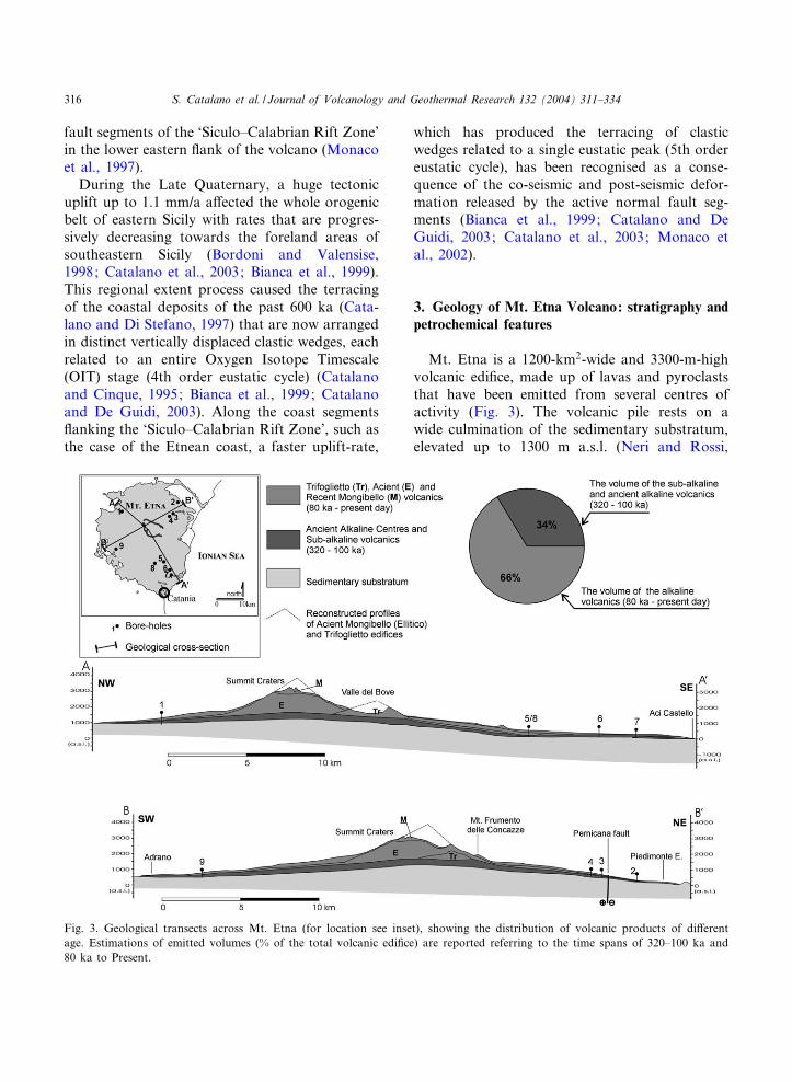
Mt. Etna is a 1200-km2-wide and 3300-m-highvolcanic edi¢ce, made up of lavas and pyroclaststhat have been emitted from several centres ofactivity (Fig. 3). The volcanic pile rests on awide culmination of the sedimentary substratum,elevated up to 1300 m a.s.l. (Neri and Rossi,
Fig. 3. Geological transects across Mt. Etna (for location see inset), showing the distribution of volcanic products of di¡erentage. Estimations of emitted volumes (% of the total volcanic edi¢ce) are reported referring to the time spans of 320^100 ka and80 ka to Present.
VOLGEO 3050 6-4-04
S. Catalano et al. / Journal of Volcanology and Geothermal Research 132 (2004) 311^334316
2002; and references therein) beneath the summitcraters, and reaches a thickness of about 2000 min the central portion of the edi¢ce.
Beneath the northwestern sector of the volcano,the sedimentary substratum is represented by theexternal units of the Apenninic^Maghrebian Or-ogen that widely crop out along the western andnorthern bundaries of the edi¢ce. These units reston the hangingwall of the NE^SW-oriented exter-nal front of the chain that is buried to the east ofthe summit crater’s area (Fig. 2).
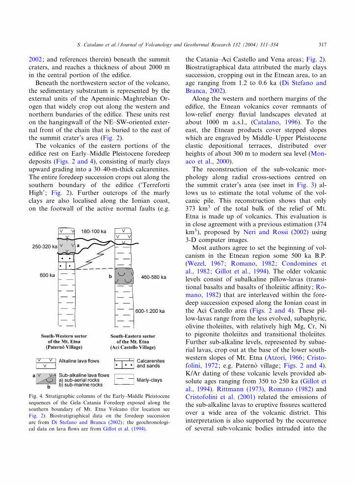
The volcanics of the eastern portions of theedi¢ce rest on Early^Middle Pleistocene foredeepdeposits (Figs. 2 and 4), consisting of marly claysupward grading into a 30^40-m-thick calcarenites.The entire foredeep succession crops out along thesouthern boundary of the edi¢ce (‘TerrefortiHigh’; Fig. 2). Further outcrops of the marlyclays are also localised along the Ionian coast,on the footwall of the active normal faults (e.g.
the Catania^Aci Castello and Vena areas; Fig. 2).Biostratigraphical data attributed the marly clayssuccession, cropping out in the Etnean area, to anage ranging from 1.2 to 0.6 ka (Di Stefano andBranca, 2002).
Along the western and northern margins of theedi¢ce, the Etnean volcanics cover remnants oflow-relief energy £uvial landscapes elevated atabout 1000 m a.s.l., (Catalano, 1996). To theeast, the Etnean products cover stepped slopeswhich are engraved by Middle^Upper Pleistoceneclastic depositional terraces, distributed overheights of about 300 m to modern sea level (Mon-aco et al., 2000).
The reconstruction of the sub-volcanic mor-phology along radial cross-sections centred onthe summit crater’s area (see inset in Fig. 3) al-lows us to estimate the total volume of the vol-canic pile. This reconstruction shows that only373 km3 of the total bulk of the relief of Mt.Etna is made up of volcanics. This evaluation isin close agreement with a previous estimation (374km3), proposed by Neri and Rossi (2002) using3-D computer images.
Most authors agree to set the beginning of vol-canism in the Etnean region some 500 ka B.P.(Wezel, 1967; Romano, 1982; Condomines etal., 1982; Gillot et al., 1994). The older volcaniclevels consist of subalkaline pillow-lavas (transi-tional basalts and basalts of tholeiitic a⁄nity; Ro-mano, 1982) that are interleaved within the fore-deep succession exposed along the Ionian coast inthe Aci Castello area (Figs. 2 and 4). These pil-low-lavas range from the less evolved, subaphyric,olivine tholeiites, with relatively high Mg, Cr, Nito pigeonite tholeiites and transitional tholeiites.Further sub-alkaline levels, represented by subae-rial lavas, crop out at the base of the lower south-western slopes of Mt. Etna (Atzori, 1966; Cristo-folini, 1972; e.g. Paterno' village; Figs. 2 and 4).K/Ar dating of these volcanic levels provided ab-solute ages ranging from 350 to 250 ka (Gillot etal., 1994). Rittmann (1973), Romano (1982) andCristofolini et al. (2001) related the emissions ofthe sub-alkaline lavas to eruptive ¢ssures scatteredover a wide area of the volcanic district. Thisinterpretation is also supported by the occurrenceof several sub-volcanic bodies intruded into the
Fig. 4. Stratigraphic columns of the Early^Middle Pleistocenesequences of the Gela^Catania Foredeep exposed along thesouthern boundary of Mt. Etna Volcano (for location seeFig. 2). Biostratigraphical data on the foredeep successionare from Di Stefano and Branca (2002); the geochronologi-cal data on lava £ows are from Gillot et al. (1994).
VOLGEO 3050 6-4-04
S. Catalano et al. / Journal of Volcanology and Geothermal Research 132 (2004) 311^334 317
country rocks. Clear examples are the AcitrezzaCyclops Islands (north of Aci Castello; Fig. 2),where magmatic levels are embedded into ther-mo-metamorphosed marly clays of Middle Pleis-tocene age (Wezel, 1967; Di Stefano and Branca,2002) and the Motta S. Anastasia volcanic neck(Fig. 2), whose age has been estimated to be 200ka (Del Negro et al., 1998).
The sub-alkaline basal horizons are largely cov-ered by more recent alkaline lavas (Figs. 2 and 3).This superposition of erupted products re£ects anevident change in the petrochemical features ofthe Etnean magmas. Such a geochemical evolu-tion can be convincingly explained by a petroge-netic model of a developing mantle diapir (Tan-guy, 1980; Condomines et al., 1982; Tanguy etal., 1997). This model predicts that the composi-tions of magmas produced by partial melting ofthe mantle depends on the depth and temperature.In general, it must be considered that magmaswith tholeiitic a⁄nity, rich in highly compatibleelements such as Mg, Cr, Ni, emitted in the earlierperiods of the Etnean volcanism, are generated byhigh degree of partial melting (s 10%) of a de-pleted lherzolite. Alkaline magmas that erupted inthe last periods of Mt. Etna activity show aLREE and other compatible elements enrichment,which is produced by a smaller degree of partialmelting of a fertile mantle or, alternatively, by themelting of a metasomatised alkali-enriched lher-zolite. Primitive magmas undergo a process of dif-ferentiation in the crust during their rise to thesurface. The di¡erentiation is mainly dominatedby crystal fractionation. In the case of the alkalinesuite, earlier settling at low crust depth of olivine,clinopyroxene, titanomagnetite and limited pla-gioclase yield to the common Etnean hawaiites.Di¡erentiation at shallower levels of the crustproduces the mugearites, benmoreites and tra-chites by fractionation of plagioclase.
The Na-alkaline a⁄nity has characterised allthe lavas and pyroclastics emitted since 180 ka(Gillot et al., 1994). The alkaline rocks of Mt.Etna range in a wide spectrum of di¡erentiatedproducts, from primitive alkali basalts to poorK trachytes, through hawaiites, mugearites andbenmoreites lavas. All these products are under-saturated being Nepheline-normative and in gen-
eral very porphyritic, except for the more evolvedtrachytes which generally show aphyric structures.The most di¡used rocks are the hawaiites showinga SiO2 content within the range 50^52%, whereasthe more primitive and evolved members are com-paratively rare.
The earlier alkaline volcanics are related toemission centres called Ancient Alkaline Centres(AAC) (Romano, 1982; Cristofolini et al., 1991),which were scattered all over the Etnean region.Relicts of these centres can be recognised only atthe southern and eastern periphery of the volcanicregion and in the Valle del Bove area (Fig. 2).Other small centres are now buried beneathmore recent products. However, their locationcan be inferred by marked morphological £exuresdraped by the recent volcanics (Cristofolini et al.,1982). The K/Ar dating of these volcanic levelsprovided absolute ages ranging from 180 to 100ka (Gillot et al., 1994).
In the periphery of the edi¢ce, the borehole data(Cristofolini et al., 1991) indicate that althoughthe sub-alkaline and ancient alkaline lava £owsare exposed in small and scattered outcrops, theyare presently buried in wider areas. These volcaniclevels can be extended also towards the centralportions of the edi¢ce, taking into account thefew outcrops in the Valle del Bove. Moreover,the superposition of the more recent volcanics ontop of the AAC drilled by the boreholes is high-lighted by the morphological £exure in the topog-raphy of the western £ank of the volcano. The fewdata available are not su⁄cient to estimate theactual variation in thickness of the buried AACvolcanics and thus their total volume. If the se-quence of sub-alkaline and ancient alkaline prod-ucts were projected beneath all the 1200 km2 ofMt. Etna with a constant thickness of about 350m, calibrated on the thicker sequences drilled byboreholes, a total volume of about 129 km3 wouldbe obtained. This represents an overestimation ofthe total bulk of these buried products, and prob-ably exceeds the actual total volume of the subae-rial volcanics emitted from 320 to 100 ka, alsoincluding the unknown eroded volumes.
Most of the modern edi¢ce (244 km3) is madeup of products which have been emitted in thelast 80 ka. These include earlier lavas and tephras
VOLGEO 3050 6-4-04
S. Catalano et al. / Journal of Volcanology and Geothermal Research 132 (2004) 311^334318
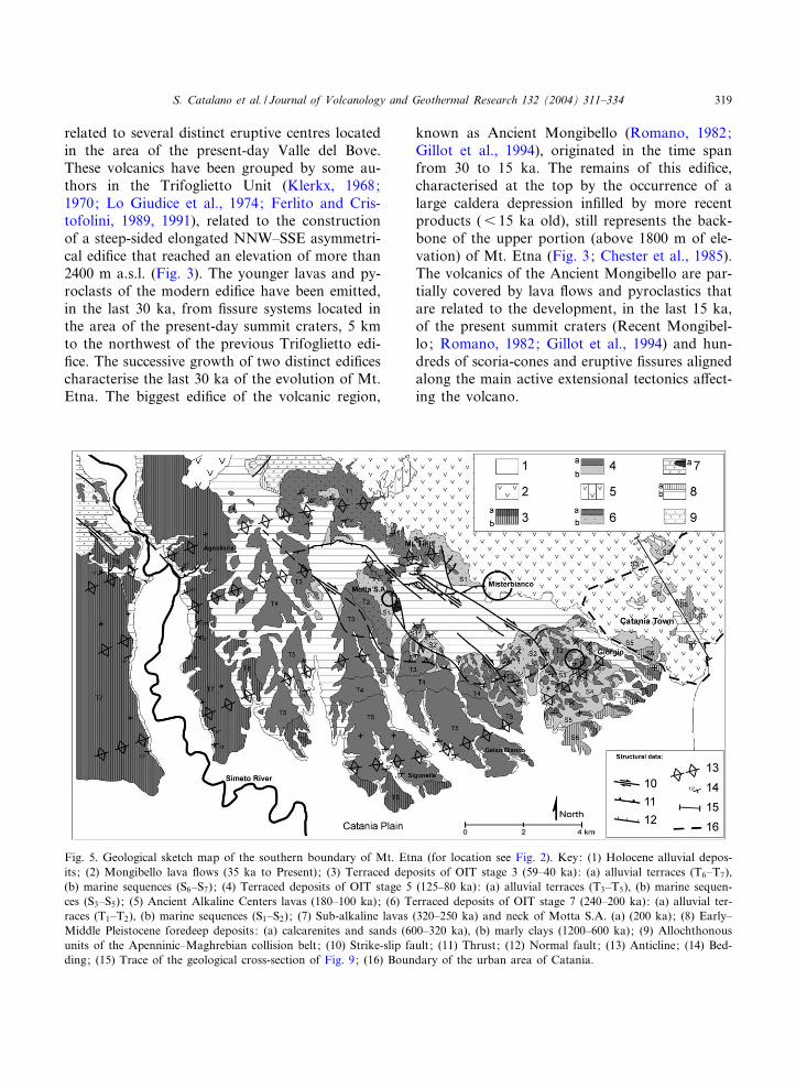
related to several distinct eruptive centres locatedin the area of the present-day Valle del Bove.These volcanics have been grouped by some au-thors in the Trifoglietto Unit (Klerkx, 1968;1970; Lo Giudice et al., 1974; Ferlito and Cris-tofolini, 1989, 1991), related to the constructionof a steep-sided elongated NNW^SSE asymmetri-cal edi¢ce that reached an elevation of more than2400 m a.s.l. (Fig. 3). The younger lavas and py-roclasts of the modern edi¢ce have been emitted,in the last 30 ka, from ¢ssure systems located inthe area of the present-day summit craters, 5 kmto the northwest of the previous Trifoglietto edi-¢ce. The successive growth of two distinct edi¢cescharacterise the last 30 ka of the evolution of Mt.Etna. The biggest edi¢ce of the volcanic region,
known as Ancient Mongibello (Romano, 1982;Gillot et al., 1994), originated in the time spanfrom 30 to 15 ka. The remains of this edi¢ce,characterised at the top by the occurrence of alarge caldera depression in¢lled by more recentproducts (6 15 ka old), still represents the back-bone of the upper portion (above 1800 m of ele-vation) of Mt. Etna (Fig. 3; Chester et al., 1985).The volcanics of the Ancient Mongibello are par-tially covered by lava £ows and pyroclastics thatare related to the development, in the last 15 ka,of the present summit craters (Recent Mongibel-lo; Romano, 1982; Gillot et al., 1994) and hun-dreds of scoria-cones and eruptive ¢ssures alignedalong the main active extensional tectonics a¡ect-ing the volcano.
Fig. 5. Geological sketch map of the southern boundary of Mt. Etna (for location see Fig. 2). Key: (1) Holocene alluvial depos-its; (2) Mongibello lava £ows (35 ka to Present); (3) Terraced deposits of OIT stage 3 (59^40 ka): (a) alluvial terraces (T6^T7),(b) marine sequences (S6^S7); (4) Terraced deposits of OIT stage 5 (125^80 ka): (a) alluvial terraces (T3^T5), (b) marine sequen-ces (S3^S5); (5) Ancient Alkaline Centers lavas (180^100 ka); (6) Terraced deposits of OIT stage 7 (240^200 ka): (a) alluvial ter-races (T1^T2), (b) marine sequences (S1^S2); (7) Sub-alkaline lavas (320^250 ka) and neck of Motta S.A. (a) (200 ka); (8) Early^Middle Pleistocene foredeep deposits: (a) calcarenites and sands (600^320 ka), (b) marly clays (1200^600 ka); (9) Allochthonousunits of the Apenninic^Maghrebian collision belt; (10) Strike-slip fault; (11) Thrust; (12) Normal fault; (13) Anticline; (14) Bed-ding; (15) Trace of the geological cross-section of Fig. 9; (16) Boundary of the urban area of Catania.
VOLGEO 3050 6-4-04
S. Catalano et al. / Journal of Volcanology and Geothermal Research 132 (2004) 311^334 319
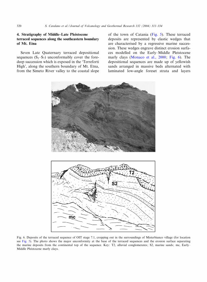
4. Stratigraphy of Middle^Late Pleistoceneterraced sequences along the southeastern boundaryof Mt. Etna
Seven Late Quaternary terraced depositionalsequences (S1^S7) unconformably cover the fore-deep succession which is exposed in the ‘TerrefortiHigh’, along the southern boundary of Mt. Etna,from the Simeto River valley to the coastal slope
of the town of Catania (Fig. 5). These terraceddeposits are represented by clastic wedges thatare characterised by a regressive marine succes-sion. These wedges engrave distinct erosion surfa-ces modelled on the Early^Middle Pleistocenemarly clays (Monaco et al., 2000; Fig. 6). Thedepositional sequences are made up of yellowishsands arranged in massive beds alternated withlaminated low-angle foreset strata and layers
Fig. 6. Deposits of the terraced sequence of OIT stage 7.1, cropping out in the surroundings of Misterbianco village (for locationsee Fig. 5). The photo shows the major unconformity at the base of the terraced sequences and the erosion surface separatingthe marine deposits from the continental top of the sequence. Key: T2, alluvial conglomerates; S2, marine sands; mc, Early^Middle Pleistocene marly clays.
VOLGEO 3050 6-4-04
S. Catalano et al. / Journal of Volcanology and Geothermal Research 132 (2004) 311^334320
characterised by cross-bedding and, in some pla-ces, water escape structures. Thin canalised layersof conglomerates, made up of cm-sized pebbles,are interlbedded with the laminated sands. Eachterraced sequence is capped by alluvial conglom-erates which are made up of well rounded, cm- todm-sized pebbles, overlying erosional surfacesmodelled on the marine deposits. The marine suc-cessions of the terraced sedimentary wedges onlaponto the marly clays substratum and progressivelypinch out toward the northwest. As a conse-
quence, the terraced deposits distributed in thewestern part of the ‘Terreforti High’, along theleft side of the Simeto River valley, are exclusivelyrepresented by the top alluvial conglomerates thatform seven distinct orders of £uvial terraces (T1^T7 in Fig. 5; Chester and Duncan, 1979, 1982).
The older depositional sequence (S1) overlies anerosion surface that undercuts the olivene tholeiitelava £ows (320^250 ka) along the northern sectorsof the ‘Terreforti High’. Several reworked wellrounded pebbles from these volcanic horizons
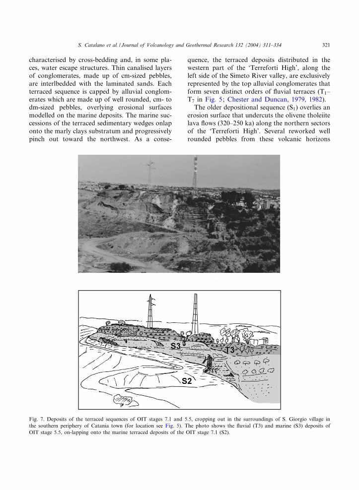
Fig. 7. Deposits of the terraced sequences of OIT stages 7.1 and 5.5, cropping out in the surroundings of S. Giorgio village inthe southern periphery of Catania town (for location see Fig. 5). The photo shows the £uvial (T3) and marine (S3) deposits ofOIT stage 5.5, on-lapping onto the marine terraced deposits of the OIT stage 7.1 (S2).
VOLGEO 3050 6-4-04
S. Catalano et al. / Journal of Volcanology and Geothermal Research 132 (2004) 311^334 321
characterise the coarse-grained alluvial depositson top of S1. The entire succession of the S1 isintruded by the sub-alkaline volcanic rocks (200ka old) that form the neck of Motta S. Anastasiavillage (Fig. 5).
Frequent volcanic pebbles from the 320^250-kalava £ows (Chester and Duncan, 1982; Monaco,1997; Monaco et al., 2000) also occur within thedeposits of S2. These consist of a marly clays ho-rizon, upward grading to the sands and conglom-
erates that engrave an erosional surface which ismodelled on both the Lower^Middle Pleistocenemarly clays and the deposits of S1.
The deposits of S3 engrave an erosional surfacewhich undercuts terraced horizons of volcanicsbelonging to the 180^100-ka eruptive period (An-cient Alkaline Lavas; Gillot et al., 1994). The de-posits of S3 on-lap onto the deformed deposits ofthe previous terraced sequences along the south-eastern sector of the ‘Terreforti High’ (Fig. 7).
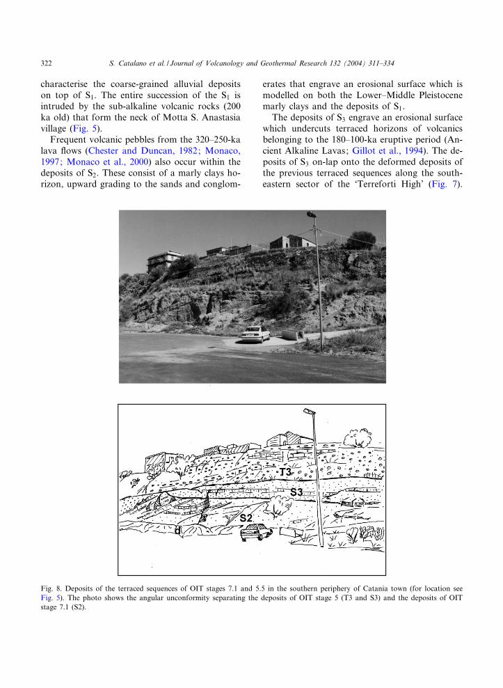
Fig. 8. Deposits of the terraced sequences of OIT stages 7.1 and 5.5 in the southern periphery of Catania town (for location seeFig. 5). The photo shows the angular unconformity separating the deposits of OIT stage 5 (T3 and S3) and the deposits of OITstage 7.1 (S2).
VOLGEO 3050 6-4-04
S. Catalano et al. / Journal of Volcanology and Geothermal Research 132 (2004) 311^334322
This contact is also marked by an evident angularunconformity, which is well exposed at the south-eastern termination of the ‘Terreforti High’ (Fig.8). In the urban area of Catania, several boreholesdrilled the deposits of S3 that are predominantlyburied beneath recent volcanics (Monaco et al.,2000). The marine succession of S3 is character-ised by the occurrence of coarse-grained levelswhich contain several pebbles from volcanic rocksderiving from lava £ows of both the 320^250-kaand 180^100-ka eruptive periods (Monaco et al.,2000).
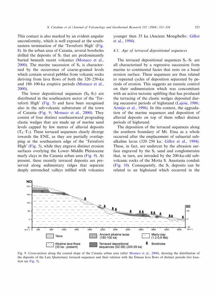
The lower depositional sequences (S4^S7) aredistributed in the southeastern sector of the ‘Ter-reforti High’ (Fig. 5) and have been recognisedalso in the sub-volcanic substratum of the townof Catania (Fig. 9; Monaco et al., 2000). Theyconsist of four distinct southeastward progradingclastic wedges that are made up of marine sandlevels capped by few metres of alluvial deposits(T4^T7). These terraced sequences clearly divergetowards the ENE, as they are partially overlap-ping at the southeastern edge of the ‘TerrefortiHigh’ (Fig. 5), while they engrave distinct erosionsurfaces overlying the Lower^Middle Pleistocenemarly clays in the Catania urban area (Fig. 9). Atpresent, these recently terraced deposits are pre-served along sedimentary ridges that separatedeeply entrenched valleys in¢lled with volcanics
younger then 35 ka (Ancient Mongibello; Gillotet al., 1994).
4.1. Age of terraced depositional sequences
The terraced depositional sequences S1^S7 areall characterised by a regressive succession frommarine to continental facies that rests on a basalerosion surface. These sequences are thus relatedto repeated cycles of deposition separated by pe-riods of erosion. This suggests an eustatic controlon their sedimentation which was concomitantwith an active tectonic uplifting that has producedthe terracing of the clastic wedges deposited dur-ing successive periods of highstand (Lajoie, 1986;Armijo et al., 1996). In this context, the aggrada-tion of the marine sequences and deposition ofalluvial deposits on top of them re£ect distinctperiods of highstand.
The deposition of the terraced sequences alongthe southern boundary of Mt. Etna as a wholeoccurred after the emplacement of subaerial sub-alkaline lavas (320^250 ka; Gillot et al., 1994).These, in fact, are undercut by the abrasion sur-face engraved by the S1 sand and conglomeratesthat, in turn, are intruded by the 200-ka-old sub-volcanic rocks of the Motta S. Anastasia conduit(Fig. 10). Consequently, the S1 deposits can berelated to an highstand which occurred in the
Fig. 9. Cross-section along the coastal slope of the Catania urban area (after Monaco et al., 2000), showing the distribution ofthe deposits of the Late Quaternary terraced sequences and their relation with the Etnean lava £ows of distinct periods (for loca-tion see Fig. 5).
VOLGEO 3050 6-4-04
S. Catalano et al. / Journal of Volcanology and Geothermal Research 132 (2004) 311^334 323
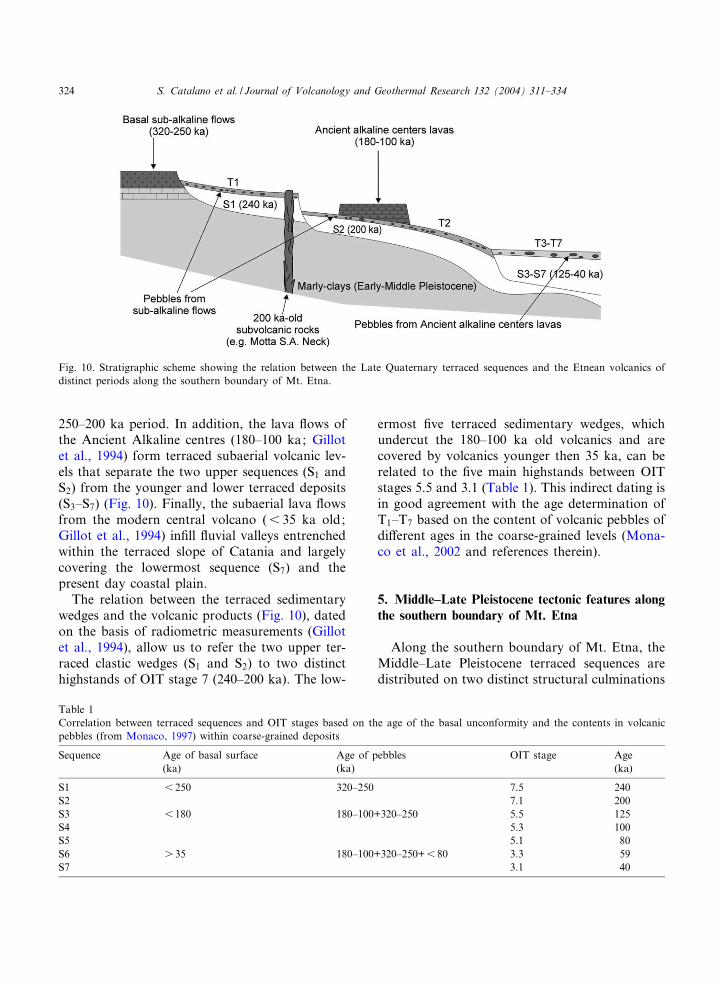
250^200 ka period. In addition, the lava £ows ofthe Ancient Alkaline centres (180^100 ka; Gillotet al., 1994) form terraced subaerial volcanic lev-els that separate the two upper sequences (S1 andS2) from the younger and lower terraced deposits(S3^S7) (Fig. 10). Finally, the subaerial lava £owsfrom the modern central volcano (6 35 ka old;Gillot et al., 1994) in¢ll £uvial valleys entrenchedwithin the terraced slope of Catania and largelycovering the lowermost sequence (S7) and thepresent day coastal plain.
The relation between the terraced sedimentarywedges and the volcanic products (Fig. 10), datedon the basis of radiometric measurements (Gillotet al., 1994), allow us to refer the two upper ter-raced clastic wedges (S1 and S2) to two distincthighstands of OIT stage 7 (240^200 ka). The low-
ermost ¢ve terraced sedimentary wedges, whichundercut the 180^100 ka old volcanics and arecovered by volcanics younger then 35 ka, can berelated to the ¢ve main highstands between OITstages 5.5 and 3.1 (Table 1). This indirect dating isin good agreement with the age determination ofT1^T7 based on the content of volcanic pebbles ofdi¡erent ages in the coarse-grained levels (Mona-co et al., 2002 and references therein).
5. Middle^Late Pleistocene tectonic features alongthe southern boundary of Mt. Etna
Along the southern boundary of Mt. Etna, theMiddle^Late Pleistocene terraced sequences aredistributed on two distinct structural culminations
Fig. 10. Stratigraphic scheme showing the relation between the Late Quaternary terraced sequences and the Etnean volcanics ofdistinct periods along the southern boundary of Mt. Etna.
Table 1Correlation between terraced sequences and OIT stages based on the age of the basal unconformity and the contents in volcanicpebbles (from Monaco, 1997) within coarse-grained deposits
Sequence Age of basal surface Age of pebbles OIT stage Age(ka) (ka) (ka)
S1 6 250 320^250 7.5 240S2 7.1 200S3 6 180 180^100+320^250 5.5 125S4 5.3 100S5 5.1 80S6 s 35 180^100+320^250+6 80 3.3 59S7 3.1 40
VOLGEO 3050 6-4-04
S. Catalano et al. / Journal of Volcanology and Geothermal Research 132 (2004) 311^334324

that occur at the front of the orogenic belt (‘Ter-reforti High’) and on the uplifting footwall of theseismogenic normal faults (Coastal slope of Cata-nia).
5.1. The Terreforti High
The ‘Terreforti High’ (Fig. 11) consists of aculmination that is con¢ned between two mainleft-stepping, WNW^ESE-striking shear zones.The southwestern boundary of the culminationis made up of distinct, several kilometres-longNW^SE-trending fault segments. These form aleft-stepping en-echelon array that develops fromthe Simeto River valley to the southern peripheryof the town of Catania. The fault segments arelinked by E^W- to NE^SW-oriented, south-verg-ing thrust ramps, which border the zone of over-lap between the faults to the southeast. Wideramp anticlines and hangingwall synclines, which
deform the Early^Middle Pleistocene marly claysand the deposits of S1 and S2, are associated tothe linking thrust ramps (Fig. 11). These compres-sional structures are widely distributed at thesoutheastern termination of the fault zone. Inthis area, the Middle Pleistocene deposits are se-verely deformed by a narrow NE^SW orientedthrust-and-fold belt that originated at the tip ofthe whole fault array. Along the fault zone, minorsegments splay out from the main faults border-ing small push-up structures. The shear zone isalso characterised by the occurrence of N160‡-ori-ented normal faults. These structures form horsetail geometries at the tips of the major strike-slipfaults and border local transtensive zones. Themost impressive transtensive zone, located in thearea of Motta S. Anastasia, is characterised by anintrusion of alkaline lavas within the foredeepsuccession (Figs. 5 and 12).
The northeastern boundary of the ‘Terreforti
Fig. 11. Overall geometry of the transpressive zone a¡ecting the Middle Pleistocene deposits along the southern boundary of Mt.Etna. Key: (1) Holocene alluvial deposits; (2) Mongibello lava £ows (35 ka to Present); (3) Deposits of OIT stage 5 (125^80ka); (4) Ancient Alkaline Centers lava £ows (180^100 ka); (5) Marine sequences and £uvial terraces of OIT stage 7.1 (200 ka);(6) Marine sequences and £uvial terraces of OIT stage 7.3 (240 ka); (7) Sub-alkaline lavas (320^250 ka) and neck of Motta S.A.(200 ka); (8) Middle Pleistocene calcarenites and sands (600^320 ka); (9) Early^Middle Pleistocene marly clays (1200^600 ka);(10) Strike-slip fault; (11) Thrust; (12) Normal fault; (13) Major anticline; (14) Minor fold; (15) Minor thrust and fault; (16)Bedding.
VOLGEO 3050 6-4-04
S. Catalano et al. / Journal of Volcanology and Geothermal Research 132 (2004) 311^334 325
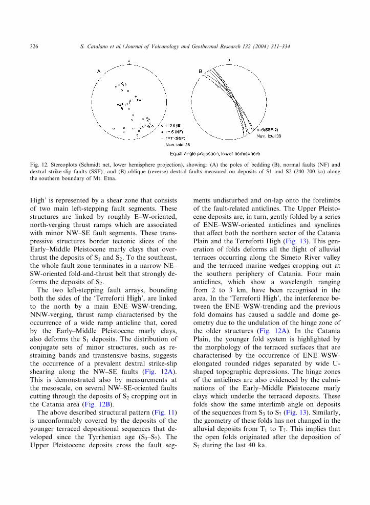
High’ is represented by a shear zone that consistsof two main left-stepping fault segments. Thesestructures are linked by roughly E^W-oriented,north-verging thrust ramps which are associatedwith minor NW^SE fault segments. These trans-pressive structures border tectonic slices of theEarly^Middle Pleistocene marly clays that over-thrust the deposits of S1 and S2. To the southeast,the whole fault zone terminates in a narrow NE^SW-oriented fold-and-thrust belt that strongly de-forms the deposits of S2.
The two left-stepping fault arrays, boundingboth the sides of the ‘Terreforti High’, are linkedto the north by a main ENE^WSW-trending,NNW-verging, thrust ramp characterised by theoccurrence of a wide ramp anticline that, coredby the Early^Middle Pleistocene marly clays,also deforms the S1 deposits. The distribution ofconjugate sets of minor structures, such as re-straining bands and transtensive basins, suggeststhe occurrence of a prevalent dextral strike-slipshearing along the NW^SE faults (Fig. 12A).This is demonstrated also by measurements atthe mesoscale, on several NW^SE-oriented faultscutting through the deposits of S2 cropping out inthe Catania area (Fig. 12B).
The above described structural pattern (Fig. 11)is unconformably covered by the deposits of theyounger terraced depositional sequences that de-veloped since the Tyrrhenian age (S3^S7). TheUpper Pleistocene deposits cross the fault seg-
ments undisturbed and on-lap onto the forelimbsof the fault-related anticlines. The Upper Pleisto-cene deposits are, in turn, gently folded by a seriesof ENE^WSW-oriented anticlines and synclinesthat a¡ect both the northern sector of the CataniaPlain and the Terreforti High (Fig. 13). This gen-eration of folds deforms all the £ight of alluvialterraces occurring along the Simeto River valleyand the terraced marine wedges cropping out atthe southern periphery of Catania. Four mainanticlines, which show a wavelength rangingfrom 2 to 3 km, have been recognised in thearea. In the ‘Terreforti High’, the interference be-tween the ENE^WSW-trending and the previousfold domains has caused a saddle and dome ge-ometry due to the undulation of the hinge zone ofthe older structures (Fig. 12A). In the CataniaPlain, the younger fold system is highlighted bythe morphology of the terraced surfaces that arecharacterised by the occurrence of ENE^WSW-elongated rounded ridges separated by wide U-shaped topographic depressions. The hinge zonesof the anticlines are also evidenced by the culmi-nations of the Early^Middle Pleistocene marlyclays which underlie the terraced deposits. Thesefolds show the same interlimb angle on depositsof the sequences from S3 to S7 (Fig. 13). Similarly,the geometry of these folds has not changed in thealluvial deposits from T1 to T7. This implies thatthe open folds originated after the deposition ofS7 during the last 40 ka.
Fig. 12. Stereoplots (Schmidt net, lower hemisphere projection), showing: (A) the poles of bedding (B), normal faults (NF) anddextral strike-slip faults (SSF); and (B) oblique (reverse) dextral faults measured on deposits of S1 and S2 (240^200 ka) alongthe southern boundary of Mt. Etna.
VOLGEO 3050 6-4-04
S. Catalano et al. / Journal of Volcanology and Geothermal Research 132 (2004) 311^334326
5.2. The coastal slope of Catania
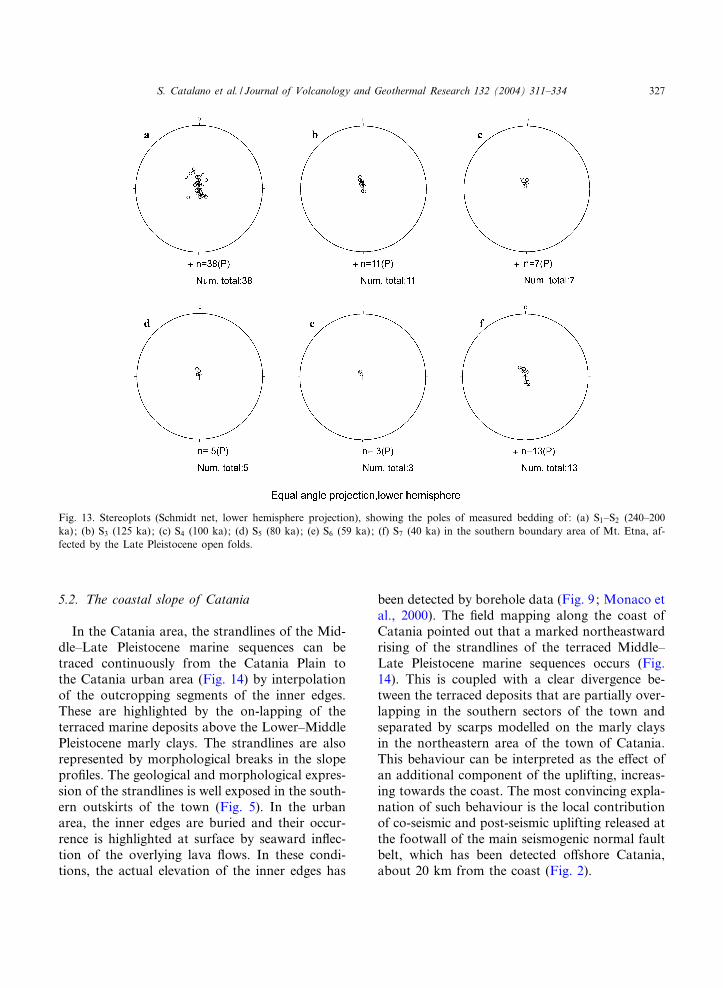
In the Catania area, the strandlines of the Mid-dle^Late Pleistocene marine sequences can betraced continuously from the Catania Plain tothe Catania urban area (Fig. 14) by interpolationof the outcropping segments of the inner edges.These are highlighted by the on-lapping of theterraced marine deposits above the Lower^MiddlePleistocene marly clays. The strandlines are alsorepresented by morphological breaks in the slopepro¢les. The geological and morphological expres-sion of the strandlines is well exposed in the south-ern outskirts of the town (Fig. 5). In the urbanarea, the inner edges are buried and their occur-rence is highlighted at surface by seaward in£ec-tion of the overlying lava £ows. In these condi-tions, the actual elevation of the inner edges has
been detected by borehole data (Fig. 9; Monaco etal., 2000). The ¢eld mapping along the coast ofCatania pointed out that a marked northeastwardrising of the strandlines of the terraced Middle^Late Pleistocene marine sequences occurs (Fig.14). This is coupled with a clear divergence be-tween the terraced deposits that are partially over-lapping in the southern sectors of the town andseparated by scarps modelled on the marly claysin the northeastern area of the town of Catania.This behaviour can be interpreted as the e¡ect ofan additional component of the uplifting, increas-ing towards the coast. The most convincing expla-nation of such behaviour is the local contributionof co-seismic and post-seismic uplifting released atthe footwall of the main seismogenic normal faultbelt, which has been detected o¡shore Catania,about 20 km from the coast (Fig. 2).
Fig. 13. Stereoplots (Schmidt net, lower hemisphere projection), showing the poles of measured bedding of: (a) S1^S2 (240^200ka); (b) S3 (125 ka); (c) S4 (100 ka); (d) S5 (80 ka); (e) S6 (59 ka); (f) S7 (40 ka) in the southern boundary area of Mt. Etna, af-fected by the Late Pleistocene open folds.
VOLGEO 3050 6-4-04
S. Catalano et al. / Journal of Volcanology and Geothermal Research 132 (2004) 311^334 327

6. Discussion
The stratigraphy of the depositional sequences,terraced along the southern boundary of Mt.Etna, gives us the opportunity to document thechronology of the deformation events that oc-curred in the past 240 ka and accompanied a sig-ni¢cant period in the evolution of Etnean volca-nism.
Depositional sequences related to OIT stage 7(S1 and S2 ; 240^200 ka old; Table 1) werestrongly deformed in a narrow fold-and-thrustbelt which is con¢ned between two main NW^SE dextral shear zones (Fig. 5). These intervenebetween large sectors, along the southwestern andeastern boundaries of the volcanic edi¢ce (e.g. AciCastello, Adrano, Biancavilla and Paterno' areas;Fig. 2), where the Middle Pleistocene foredeepsequences and the sub-alkaline volcanics (320^250 ka old), even if strongly uplifted, are unde-formed (Romano, 1979). These data suggest thatduring the 320^200 ka interval the deformation in
the Mt. Etna region was concentrated along dis-crete dextral shear zones. Accordingly, magmauprising was probably connected to N160‡ ori-ented major transtensive features which developedalong the NW^SE-trending master dextral faultsegments, as documented in the area of MottaS. Anastasia (Fig. 5). The kinematics of the over-all 240^200-ka-old structures reconstructed at thesouthern boundary of Mt. Etna is consistent withthe roughly N160‡ oriented compression that af-fected this sector of the collision belt (Ragg et al.,1999 and references therein). Moreover, the styleof the deformation recognised along the southernboundary of Mt. Etna ¢ts in well with the tectonicevolution of all the external sectors of the easternSicily orogenic belt, which were predominantlycharacterised by the development of dextral faultsystems due to the Plio^Quaternary Europe^Afri-ca convergence (Ghisetti and Vezzani, 1982; Len-tini et al., 1994, 1996; Finetti et al., 1996). MajorPleistocene NW^SE-oriented strike-slip tectonicshave been recognised also along the western and
Fig. 14. Geometry of the strandlines of the Late Pleistocene terraced sequences of the foredeep region along the southern bound-ary of Mt. Etna, from the Catania Plain to the Catania urban area.
VOLGEO 3050 6-4-04
S. Catalano et al. / Journal of Volcanology and Geothermal Research 132 (2004) 311^334328
northern boundaries of the volcano (Lentini et al.,1998). These structures represent the dominanttectonic alignment active during the Middle Pleis-tocene at the onset of Etnean volcanism (Catala-no, 1996; Monaco et al., 2002). On a larger scale,a similar tectonic picture controlled also the Mid-dle Pliocene^Early Pleistocene volcanism of theHyblean region, south of the Etnean region,
where emission centres of sub-alkaline and alka-line lavas were distributed on the footwall of nor-mal faults (e.g. the Lentini^Scordia Graben; Ghi-setti and Vezzani, 1980; Beccaluva et al., 1983)that bound transtensive zones at the tip of a ma-jor dextral strike-slip fault system, the Scicli Line(Fig. 1).
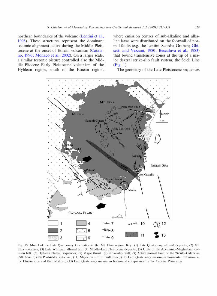
The geometry of the Late Pleistocene sequences
Fig. 15. Model of the Late Quaternary kinematics in the Mt. Etna region. Key: (1) Late Quaternary alluvial deposits; (2) Mt.Etna volcanics; (3) Late Wu«rmian alluvial fan; (4) Middle^Late Pleistocene deposits; (5) Units of the Apenninic^Maghrebian col-lision belt ; (6) Hyblean Plateau sequences; (7) Major thrust; (8) Strike-slip fault; (9) Active normal fault of the ‘Siculo^CalabrianRift Zone ’; (10) Post-40-ka anticline; (11) Major transform fault zone; (12) Late Quaternary maximum horizontal extension inthe Etnean area and that o¡shore; (13) Late Quaternary maximum horizontal compression in the Catania Plain area.
VOLGEO 3050 6-4-04
S. Catalano et al. / Journal of Volcanology and Geothermal Research 132 (2004) 311^334 329
terraced along the southern boundary of Mt. Etna(S3 and S7 ; 125^40 ka) indicates a signi¢cantchange in the mode of deformation in this region.Since 125 ka BP, an evident deformation of theterraced sequences has occurred at the footwall ofthe normal fault belt which a¡ects the area o¡-shore eastern Sicily (Fig. 14). In this period, ex-tensional features such as normal faults and frac-ture systems propagated onshore, along theeastern £ank of Mt. Etna, and controlled the lo-cation of dyke swarms feeding the post-80-ka vol-canic edi¢ces and the feeding systems of the mod-ern edi¢ce (Fig. 15; Monaco et al., 1997).Extensional features as a whole developed as re-sponses to a roughly N100‡ oriented extensionwhich has a¡ected part of the volcanic edi¢ce,including the eastern £ank and the summit cra-ter’s area. Coeval ENE^WSW-trending open foldsdeveloped in the area of the Catania Plain, underthe control of the N160‡ oriented regional com-pression. These fold domains are characterised bya constant interlimb angle measured on depositsof both the older (S1^S2) and the younger (S3^S7)terraced sequences, that suggest their growth inthe last 40 ka.
The geometry of the younger terraced sequen-ces thus indicates the coexistence of two distincttectonic domains in the Etnean area that are char-acterised by contractional and extensional re-gimes, respectively. A main boundary separatingthe two tectonic domains may be localised alongthe main active tectonic alignment composed ofNW^SE-oriented en-echelon oblique (dextral)normal faults, extending from the termination ofthe S-Rift to the Ionian coast, north of Catania(Monaco et al., 1997; Azzaro, 1999; Fig. 15).
The reconstructed tectonic history of the Mt.Etna region was coeval with a signi¢cant periodof the volcanic evolution which can be referred toas the surface manifestation of an evolving mantlediapir at depth. In this context, the deformationpattern active during the earlier stage of the erup-tive activity is, in our opinion, inadequate to ex-plain the origin of the mantle plume located be-neath the volcano and, in general, the volcanismin the area. In more detail, the few kilometreslong and hundreds of metres wide transtensivefeatures, linked to the earlier strike-slip tectonics,
imply localised crustal stretching that is not su⁄-cient to justify thermal perturbations leading tothe emplacement of a mantle diapir in the region.Moreover, the primary origin of the mantle plumefrom passive rifting-related processes (Ellis andKing, 1991), which would be consistent with thelocation of Mt. Etna on the footwall of majorLate Pleistocene normal faults, might be excludedas the existence of the mantle diapir is docu-mented in the area before the onset of normalfaulting in the region. Conversely, the tectonicframework recognised in the area cannot be ex-plained as the e¡ect of a lithospheric doming,connected to the emplacement at depth of a man-tle diapir, as has been suggested by previous au-thors (Tanguy et al., 1997). The described tectonicassemblages are, in fact, directly related to theregional scale tectonic pattern of whole easternSicily that, including large sectors beyond the in-£uence of Mt. Etna volcanism, is the consequenceof the large scale plate motion and the measuredregional stress ¢eld. Consequently, the most con-vincing explanation of Etnean volcanism is thehotspot origin of the sub-lithosperic mantleplume, independent from Late Quaternary crustaltectonics. This interpretation is also supported bythe evidence that Mt. Etna volcanism probablyrepresents the late manifestation of a larger scalevolcanism which since the Middle Pliocene af-fected wide sectors of southeastern Sicily (Hy-blean Plateau) (Fig. 1).
On the other hand, a precise relationship seemsto exist between the tectonic evolution of the Et-nean area and both the eruptive style andamounts of erupted products in the di¡erent peri-ods of Etnean volcanism. According to the mod-els on hotspot evolution, petrochemical featuresof magmas strictly depend on the degree of man-tle partial melting. In the case of Mt. Etna, thepredictable volumes of mantle involved in partialmelting are incongruent with the volumes of vol-canic rocks erupted at the surface. In more detail,petrological information on Etnean volcanics sug-gest that during the 500^200-ka timespan beneaththe Mt. Etna region a large thermal anomalycaused an extensive partial melting of the mantle,leading to the production of tholeiitic magmas. Incontrast, a minor degree of partial melting, abso-
VOLGEO 3050 6-4-04
S. Catalano et al. / Journal of Volcanology and Geothermal Research 132 (2004) 311^334330
lutely smaller than in the earlier phase, producedthe alkaline lavas erupted since 180 ka. The esti-mated volumes of products erupted in the di¡er-ent periods of Etnean volcanism indicate that thetholeiitic and the earlier alkaline lavas emittedduring the 320^100-ka time span represent atmost 34% of the totally emitted volume at Mt.Etna (Fig. 3). This implies that the huge bulk ofthe stratovolcano was produced during the last 80ka, when 66% of Etnean volcanics were emitted(Fig. 3). These data would constrain an averagegrowth rate of the edi¢ce of about 0.58 km3/ka,during the 320^100 ka period, and of about 3 km3/ka, in the last 80 ka. This evidence suggests thatonly minor amounts of all the available subalka-line and earlier alkaline magmas reached the sur-face, being mostly entrapped at depth within thecrust. This suggestion is con¢rmed by the exis-tence of high velocity bodies that, intruded at dif-ferent depth in the crust beneath the eastern £ankof the volcano (Hirn et al., 1991; Cardaci et al.,1993; De Luca et al., 1997; Villasenor et al.,1998; Laigle et al., 2000; Patane' et al., 2002),have been interpreted recently as cooled magmabatches (Chiarabba et al., 2000). This deep vol-ume can be coarsely evaluated at about 450 km3,on the basis of the tomography beneath the vol-cano proposed in Aloisi et al. (2002). The periph-eral position of the high-velocity body with regardto the location of the present-day main eruptivesystems, suggests that a large part of this volumeshould be assigned to molten sub-alkaline andalkaline material stored in the crust during theearlier stage of volcanism.
The variation of the growth-rate at Mt. Etnaseems to match the variation in the crustal modeof deformation that a¡ected the area, rather thanthe evolution of the mantle diapir. During theearlier eruptive periods, local transtensive struc-tures, developed in a dominant transpressive re-gime, represented scarcely e⁄cient ways of upris-ing for the huge bulk of tholeiitic magmas, thatprevalently resided within the crust.
On the other hand, the ¢nal growth of the stra-tovolcano is well related to the migration in theEtnean region of the extensional features from theIonian area o¡shore eastern Sicily. These struc-tures have controlled the location of feeding sys-
tems, as seen by the distribution and orientationof dyke swarms, eruptive ¢ssures and vents on thevolcanic edi¢ce ranging in age from 80 ka (Trifo-glietto unit ; Gillot et al., 1994) to the Present(Mongibello unit ; Monaco et al., 1997). In gener-al, the Late Pleistocene extensional features in thevolcanic area controlled more e⁄cient feeding sys-tems which favoured huge emissions of alkalinemagmas.
The change in the mode of deformation in theEtnean region may also re£ect the evolution fromspread and scattered emission centres, character-ising pre-80-ka volcanism, to long-standing feed-ing systems, which have been con¢ned in the ex-tensional domains, during the last 80 ka.
7. Conclusions
The analysis of Late Quaternary deformation inthe Mt. Etna region highlighted some importantaspects of the relationship between tectonic evo-lution and volcanism in this area that can be sum-marised as follows:
(1) the Late Quaternary structural patterns area direct consequence of the still active Europe^Africa convergence;
(2) the evolution of volcanism is the result of adeveloping mantle diapir located beneath the vol-canic edi¢ce;
(3) the overall Late Quaternary deformationprocesses occurring at the surface are not consis-tent with the development at depth of a mantlediapir.
(4) the mantle diapir can be interpreted as ahotspot;
(5) the evolution from sub-alkaline to alkalinevolcanism is independent of variations in the tec-tonic regime;
(6) the mode of deformation in£uenced the lo-cation of feeding systems;
(7) a relation exists between the mode of defor-mation and the volume of erupted products.
The reconstructed long-term relations betweentectonics and volcanism at Mt. Etna point outsome useful suggestions for interpreting the activedynamics of the volcano, such as the relations ofthe eruptive activity with the active deformation
VOLGEO 3050 6-4-04
S. Catalano et al. / Journal of Volcanology and Geothermal Research 132 (2004) 311^334 331
and the related local seismicity. The results of ourstudy suggest, as also stated by some authors (e.g.Monaco et al., 1997), that the major active tec-tonics a¡ecting the modern stratovolcano, as inthe past, actually represent part of a regional tec-tonic framework, rather than being the product oflocalised volcano^tectonic features. In addition,the direct dependence between amounts of crustalextension and volumes of magma erupted at thesurface could also represent a key aspect in theactive volcanism. In this framework, the activedeformation and related seismicity represent theorigin, and not the e¡ect, of magma intrusionswithin the crust and the intensity of crustal exten-sion estimated at surface could be signi¢cant inthe prediction of the volumes of the potentiallyinvolved magma in the consequent intrusions. Inthis context, the main transfer zone located alongthe southern £ank of the volcano, separating theextensional and the contractional domains, wouldaccommodate the total amounts of extension af-fecting the S-Rift area. Analogously, the NNW^SSE fracture system and the Pernicana Fault ac-commodate the extension on the summit areas ofthe volcano and along the NE-Rift. A full inves-tigation of the relation occurred between the rateof deformation and seismicity along these mainstructures with the historical eruptive episodescould represent, in the near future, a precioustool in modelling the prediction of large eruptiveevents at Mt. Etna.
Acknowledgements
We are grateful to Professor Renato Cristofoli-ni and two anonymous referees for their preciouscomments and suggestions. This research was sup-ported by grants from Catania University (resp.Professor Carmelo Monaco).
References
Aloisi, M., Cocina, O., Neri, G., Orecchio, B., Privitera, E.,2002. Seismic tomography of the crust underneath the Etnavolcano, Sicily. Phys. Earth Planet. Inter. 134, 139^155.
Atzori, P., 1966. La parete lavica di Adrano e Biancavilla. AttiAccad. Gioiena Sci. Nat. Catania 18, 50^70.
Armijo, R., Meyer, B., King, G.C.P., Rigo, A., Papanastas-siou, D., 1996. Quaternary evolution of the Corinth Rift andits implications for the Late Cenozoic evolution of the Ae-gean. Geophys. J. Int. 126, 11^53.
Azzaro, R., 1999. Earthquake surface faulting at Mount Etnavolcano (Sicily) and implications for active tectonics. J. Geo-dyn. 28, 193^213.
Azzaro, R., Barbano, S., 2000. Contributo alla compilazionedella carta delle faglie attive della Sicilia. In: Galadini, F.,Meletti A., Rebez, C. (Eds.), Le ricerche del GNDT nelcampo della pericolosita' sismica (1996^1999), pp. 227^235.
Beccaluva, L., Di Grande, A., Lo Giudice, A., Macciotta, G.,Siena, F., 1983. Carta pretrogra¢ca dell’area centro-setten-trionale iblea (Sicilia sud-orientale), scala 1:50.000. Ed.S.El.Ca., Firenze.
Ben Avraham, Z., Boccaletti, M., Cello, G., Grasso, M., Len-tini, F., Torelli, L., Tortorici, L., 1990. Principali doministrutturali dalla collisione continentale neogenico^quaterna-ria nel Mediterraneo centrale. Mem. Soc. Geol. Ital. 45,453^462.
Bianca, M., Monaco, C., Tortorici, L., Cernobori, L., 1999.Quaternary normal faulting in southeastern Sicily (Italy): Aseismic source for the 1693 large earthquake. Geophys. J.Int. 139, 370^394.
Bianchi, F., Carbone, S., Grasso, M., Invernizzi, G., Lentini,F., Longaretti, G., Merlini, S., Mostardini, F., 1987. Siciliaorientale: Pro¢lo geologico Nebrodi^Iblei. Mem. Soc. Geol.Ital. 38, 429^458.
Bordoni, P., Valensise, G., 1998. Deformation of the 125 Kamarine terraces in Italy: Tectonic implications. Coast. Tec-ton. Geol. Soc. Spec. Publ. 146, 71^110.
Boschi, E., Ferrari, G., Gasperini, P., Guidoboni, E., Smeri-glio, G., Valensise, G., 1995a. Catalogo dei forti terremoti inItalia dal 461 a.c. al 1980. Istituto Nazionale di Geo¢sica,Roma.
Boschi, E., Guidoboni, E., Dante, M., 1995b. Seismec e¡ectsof the strongest historical earthquakes in the Syracuse area.Ann. Geof. 38, 223^253.
Bousquet, J.C., Lanzafame, G., Pasquin, C., 1988. Tectonicstress and volcanism: In situ stress measurements and neo-tectonic investigations in the Etna area (Italy). Tectonophy-sics 149, 219^231.
Burollet, P.F., Mugniot, G.M., Sweeney, P., 1978. Geology ofthe Pelagian Block: The margin and basin of Southen Tu-nisia and Tripolitania. In: Nairn, A., Kanes, W., Stelhi,F.G. (Eds.), The Ocean Basin and Margin. Plenum, NewYork, pp. 331^419.
Cardaci, C., Coviello, M., Lombardo, G., Patane', G., Scarpa,R., 1993. Seismic tomography of Etna Volcano. J. Volcanol.Geotherm. Res. 56, 357^368.
Catalano, S., 1996. Il contributo dei dati morfologici nelladeterminazione dello stato di attivita' di faglie neotettoniche:esempio del versante meridionale dei Monti Nebrodi (SiciliaSettentrionale). Quaternario 9, 368^374.
Catalano, S., Cinque, A., 1995. Dati preliminari sull’evolu-zione neotettonica dei Peloritani settentrionali (Sicilia
VOLGEO 3050 6-4-04
S. Catalano et al. / Journal of Volcanology and Geothermal Research 132 (2004) 311^334332
nord-orientale) sulla base dei dati morfologici. Studi Geol.Camerti, Vol. Spec. (1995/2), 113^123.
Catalano, S., De Guidi, G., 2003. Late Quaternary uplift ofnortheastern Sicily: Relation with the active normal faultingdeformation. J. Geodyn. (in press).
Catalano, S., Di Stefano, A., 1997. Sollevamento e tettogenesiPleistocenica lungo il margine tirrenico dei Monti Peloritani:Integrazione dei dati geomorfologici, strutturali e biostrati-gra¢ci. Quaternario 10, 337^342.
Catalano, S., De Guidi, G., Monaco, C., Tortorici, G., Tor-torici L., 2003. Long term behaviour of the Late Quaternarynormal fault in the Straits of Messina (Calabrian Arc):Structural and morphological constraints. Quat. Int. 101^102, 81^91.
Chester, D.K., Duncan, A.M., 1979. Interrelationship betweenvolcanic and alluvial sequences in the evolution of the Sime-to River Valley, Mt. Etna, Sicily. Catena 6, 293^315.
Chester, D.K., Duncan, A.M., 1982. The interaction of vol-canic activity in Quaternary times upon the evolution of theAlcantara and Simeto rivers, Mt. Etna, Sicily. Catena 9,319^342.
Chester, D.K., Duncan, A.M., Guest, J.E., Kilburm, C.R.J.,1985. Mount Etna: The Anatomy of a Volcano. Champmanand Hall, London, 404 pp.
Chiarabba, C., Amato, A., Boschi, E., Barberi, F., 2000. Re-cent seismicity and tomographic modeling of the MountEtna plumbing system. J. Geophys. Res. 105, 10923^10938.
Condomines, M., Tanguy, J.C., Kie¡er, G., Allegre, C.J.,1982. Magmatic evolution of a volcano studied by 230th-238U disequilibrium and trace elements systematics: theEtna case. Geochim. Cosmochim. Acta 46, 1397^1416.
Cristofolini, R., 1972. I basalti a tendenza tholeiitica dell’Etna.Per. Miner. 41, 167^200.
Cristofolini, R., Ghisetti, F., Vezzani, L., Scarpa, R., 1982.Processi dinamici profondi e super¢ciali nell’Arco Calabroe nell’Appennino Meridionale sulla base di dati geologicisismologici e vulcanologici. Mem. Soc. Geol. Ital. 24, 497^505.
Cristofolini, R., Corsaro, R.A., Ferlito, C., 1991. Variazionipetrochimiche nella successione etnea: Un riesame in base ainuovi dati da campioni di super¢cie e da sondaggi. ActaVulcanol. 1, 25^37.
Cristofolini, R., Corsaro, R.A., Estero, R., 2001. Gli studiiniziali del vulcanismo etneo nella zona di Acicastello^Aci-trezza. Boll. Accad. Gioiena Sci. Nat. Catania 360, 31^47.
Cristofolini, R., Lentini, F., Patane, G., Rasa', R., 1979. Inte-grazione di dati geologici, geo¢sici e petrologici per la ste-sura di un pro¢lo crostale in corrispondenza dell’Etna. Boll.Soc. Geol. Ital. 98, 239^247.
De Luca, G., Filippi, L., Patane', G., Scarpa, R., Vinciguerra,S., 1997. Three dimensional velocity structure and seismicityof Mt. Etna volcano, Italy. J. Volcanol. Geotherm. Res. 79,123^138.
Del Negro, C., Lanzafame, G., Napoli, R., Pompilio, M.,1998. The age of the neck of Motta Sant’Anastasia (Sicily)as revealed by a magnetic survey. Acta Vulcanol. 10, 39^46.
Dewey, J.F., Helman, M.L., Turco, E., Hutton, D.H.W.,
Knott, S.D., 1989. Kinematics of the western Mediterra-nean. Alpine Tectonics, Geol. Soc. Spec. Publ. 45, 265^283.
Di Stefano, A., Branca, S., 2002. Long-term uplift rate of thevolcano basement (southern Italy) based on biochronologi-cal data from Pleistocene sediments. Terra Nova 14, 61^68.
Doglioni, C., Innocenti, F., Mariotti, G., 2001. Why Mt Etna?Terra Nova 13, 25^31.
Ellis, M., King, G., 1991. Structural control of £ank volcanismin the continental rift. Science 254, 839^843.
Ferlito, C., Cristofolini, R., 1989. Geologia dell’area sommi-tale dell’Etna. Atti Accad. Gioiena Sci. Nat. Catania 335,357^380.
Ferlito, C., Cristofolini, R., 1991. Evidenze di corpi subvulca-nici poco profondi nella successione etnea lungo le paretioccidentali della Valle de Bove. Mem. Soc. Geol. Ital. 47,485^493.
Finetti, I., Lentini, F., Carbone, S., Catalano, S., Del Ben, A.,1996. Il sistema Appennino meridionale ^ Arco calabro ^Sicilia nel Mediterraneo centrale: Studio geologico-geo¢sico.Boll. Soc. Geol. Ital. 115, 529^599.
Frazzetta, G., Villari, L., 1981. The feeding of the eruptiveactivity of Etna volcano: The regional stress ¢eld as a con-straint to magma uprising and eruption. Bull. Volcanol. 44,269^282.
Ghisetti, F., Vezzani, L., 1980. The structural features of theIblean Plateau and the Mount Judica area (South-EasternSicily): A microtectonic contribution to the deformationalhistory of the Calabrian Arc. Boll. Soc. Geol. Ital. 99, 57^102.
Ghisetti, F., Vezzani, L., 1982. Di¡erent styles of deformationin the Calabrian Arc (Southern Italy); implication for asismotectonics zoning. Tectonophysics 85, 149^165.
Gillot, P.Y., Kie¡er, G., Romano, R., 1994. The evolution ofMount Etna in the light of potassium^argon dating. ActaVulcanol. 5, 81^87.
Hirn, A., Nercessian, A., Sapin, M., Ferrucci, F., Wittlinger,G., 1991. Seismic heterogenety of Mt. Etna structure andactivity. Geophys. J. Int. 105, 139^153.
Kie¡er, G., 1975. Sur l’existence d’une ‘rift-zone’ a' l’Etna.C.R. Ac. Sci. D 280, 263^266.
Klerkx, J., 1968. Etude ge¤ologique et pe¤trologique de la Valledel Bove (Etna). Thesis Univ. de Liege¤, 198 pp.
Klerkx, J., 1970. La caldera de la Valle del Bove: sa signi¢ca-tion dans l’e¤volution de l’Etna (Sicile). Bull. Volcanol. 24,726^737.
Labaume, P., Bousquet, J.C., Lanzafame, G., 1990. Early de-formation at a submarine compressive front: The Quater-nary Catania foredeep south of Mt. Etna, Sicily, Italy. Tec-tonophysics 177, 349^366.
Laigle, M., Hirn, A., Sapin, M., Lepine, J.C., Diaz, J., Gallart,J., Nicolich, R., 2000. Mount Etna dense array local earth-quake P and S tomography and implications for volcanicplumbing. J. Geophys. Res. 105, 21633^21646.
Lajoie, K.R., 1986. Coastal Tectonics. Studies in Geophysics,National Academy Press, Washington, DC, pp. 95^124.
Lanzafame, G., Bousquet, J.C., 1997. The Maltese escarpmentand its extension from Mt. Etna to Aeolian Islands (Sicily)
VOLGEO 3050 6-4-04
S. Catalano et al. / Journal of Volcanology and Geothermal Research 132 (2004) 311^334 333
importance and evolution of lithosphere discontinuity. ActaVulcanol. 9, 113^120.
Lanzafame, G., Neri, M., Coltelli, M., Lodato, L., Rust, D.,1997. North^South compression in the Mt. Etna region (Si-cily) spatial and temporal distribution. Acta Vulcanol. 9,121^133.
Lentini, F., Vezzani, L., 1978. Tentativo di elaborazione diuno schema strutturale della Sicilia Orientale. Mem. Soc.Geol. Ital. 19, 495^500.
Lentini, F., 1982. The geology of the Mt. Etna basement.Mem. Soc. Geol. Ital. 23, 7^25.
Lentini, F., Carbone, S., Catalano, S., Grasso, M., 1996. Ele-menti per la ricostruzione del quadro strutturale della Siciliaorientale. Mem. Soc. Geol. Ital. 51, 179^195.
Lentini, F., Carbone, S., Catalano, S., Grasso, M., 1994. Prin-cipali lineamenti strutturali della Sicilia nord-orientale. StudiGeologici Camerti, special issue, 1995/2, 319^329.
Lentini, F., Carbone, S., Catalano, S., Vinci, G., Di Stefano,A., 1998. Schema geologico-strutturale della Sicilia nord-ori-entale, 1:100.000 scale map. Ed. S.El.Ca., Firenze.
Lo Giudice, E., Patane', G., Rasa', R., Romano, R., 1982. Thestructural framework of Mount Etna. Mem. Soc. Geol. Ital.23, 125^158.
Lo Giudice, E., Romano, R., Sturiale, C., 1974. Geologia epetrologia delle vulcaniti della parete occidentale della Valledel Bove (Etna). Rend. Soc. Ital. Petr. 30, 801^838.
Lo Giudice, E., Rasa', R., 1986. The role of the NNW struc-tural trend in the recent geodynamic evolution of north-east-ern Sicily and its volcanic implications in the area. J. Geo-dyn. 25, 309^330.
Mazzuoli, R., Tortorici, L., Ventura, G., 1995. Oblique riftingin Salina, Lipari and Vulcano islands (Aeolian islands,southern Italy). Terra Nova 7, 444^452.
Monaco, C., 1997. Tettonica pleistocenica nell’area a suddell’Etna (Sicilia orientale). Quaternario 10, 393^398.
Monaco, C., Catalano, S., De Guidi, G., Gresta, S., Langer,H., Tortorici, L., 2000. The geological map of the urbanarea of Catania (eastern Sicily): Morphotectonic and seis-motectonic implication. Mem. Soc. Geol. Ital. 55, 425^438.
Monaco, C., Bianca, M., Catalano, S., De Guidi, G., Tortor-ici, L., 2002. Sudden change in the Late Quaternary tectonicregime in eastern Sicily: Evidences from geological and geo-morphological features. Boll. Soc. Geol. Ital., vol. spec. 1,901^913.
Monaco, C., Tapponnier, P., Tortorici, L., Gillot, P.Y., 1997.Late Quaternary slip rates on the Acireale^Piedimonte nor-mal faults and tectonic origin of Mt. Etna (Sicily). EarthPlanet. Sci. Lett. 147, 125^139.
Monaco, C., Tortorici, L., 2000. Active faulting in the Cala-brian arc and eastern Sicily. J. Geodyn. 29, 407^424.
Neri, M., Rossi, M., 2002. Geometria e volume dell’apparatovulcanico etneo: il contributo o¡erto dall’uso di mappe dig-itali. I.N.G.V. Quaderni di Geo¢sica 20, 1^16.
Ogniben, L., 1960. Nota illustrativa dello schema geologicodella Sicilia orientale. Riv. Min. Sic. 64^65, 183^212.
Patane', D., Chiarabba, C., Cocina, O., De Gori, P., Moretti,M., Boschi, E., 2002. Tomographic images and 3D earth-quake locations of the seismic swarm preceding the 2001 Mt.Etna eruption: Evidence for a dyke intrusion. Geophys. Res.Lett. (in press).
Ragg, S., Grasso, M., Mu«ller, B., 1999. Patterns of tectonicstress in Sicily from borehole breakout observations and¢nite element modelling. Tectonics 18, 669^685.
Rittmann, A., 1973. Structure and evolution of Mount Etna.Philos. Trans. R. Soc. 247A, 5^16.
Romano, R., 1979. Carta geologica del Monte Etna. Ed.L.A.C., Firenze.
Romano, R., 1982. Succession of the volcanic activity in theEtnean area. Mem. Soc. Geol. Ital. 23, 27^48.
Roure, F., Howel, D.G., Muller, C., Moretti, I., 1990. LateCenozoic subduction complex of Sicily. J. Struct. Geol. 12,259^266.
Tanguy, J.C., 1980. L’Etna: e¤tude pe¤trologique et pale¤omag-netique; implications volcanologiques. Ph.D. Thesis, Univ.Paris 6, 618 pp.
Tanguy, J.C., Condominies, M., Kie¡er, G., 1997. Evolutionof the Mount Etna magma: Contraints on the present feed-ing system and eruptive mechanism. J. Volcanol. Geotherm.Res. 75, 221^250.
Torelli, L., Grasso, M., Mazzoldi, G., Peis, D., 1998. Plio^Quaternary tectonic evolution and structure of the Cataniaforedeep, the northern Hyblean Plateau and the Ionian shelf(SE Sicily). Tectonophysics 298, 209^221.
Villasenor, A., Benz, H.M., Filippi, L., De Luca, G., Scarpa,R., Patane', G., Vinciguerra, S., 1998. Three dimensional P-wave velocity structure of Mt. Etna, Italy. Geophys. Res.Lett. 25, 1975^1978.
Wezel, F.C., 1967. I terreni quaternari del substrato dell’Etna.Atti Accad. Gioiena Sci. Nat. Catania 18, 271^282.
VOLGEO 3050 6-4-04
S. Catalano et al. / Journal of Volcanology and Geothermal Research 132 (2004) 311^334334