Pacific offshore record of plinian arc volcanism in Central America: 1. Along-arc correlations
14
Pacific offshore record of plinian arc volcanism in Central America: 3. Application to forearc geology S. Kutterolf SFB574 at Kiel University/IFM-GEOMAR, Wischhofstrasse 1-3, D-24148 Kiel, Germany ([email protected]) A. Freundt SFB574 at Kiel University/IFM-GEOMAR, Wischhofstrasse 1-3, D-24148 Kiel, Germany IFM-GEOMAR, Wischhofstrasse 1-3, D-24148 Kiel, Germany U. Schacht SFB574 at Kiel University/IFM-GEOMAR, Wischhofstrasse 1-3, D-24148 Kiel, Germany CO2CRC, Australian School of Petroleum, University of Adelaide, Adelaide, South Australia 5005, Australia D. Bu ¨ rk and R. Harders SFB574 at Kiel University/IFM-GEOMAR, Wischhofstrasse 1-3, D-24148 Kiel, Germany T. Mo ¨rz MARUM, Leobener Strasse, D-28359 Bremen, Germany W. Pere ´z SFB574 at Kiel University/IFM-GEOMAR, Wischhofstrasse 1-3, D-24148 Kiel, Germany [1] Sediment gravity cores collected on the Pacific slope and incoming plate offshore Central America reach up to 400 ka back in time and contain numerous ash layers from plinian eruptions at the Central American Volcanic Arc. The compositionally distinct widespread ash layers form a framework of marker horizons that allow us to stratigraphically correlate the sediment successions along and across the Middle America Trench. Moreover, ash layers correlated with 26 known eruptions on land provide absolute time lines through these successions. Having demonstrated the correlations in part 1, we here investigate implications for submarine sedimentary processes. Average accumulation rates of pelagic sediment packages constrained by bracketing tephras of known age range from 1–6 cm/ka on the incoming plate to 30–40 cm/ka on the continental slope. There are time intervals in which the apparent pelagic sedimentation rates significantly vary laterally both on the forearc and on the incoming plate where steady conditions are usually expected. A period of unsteadiness at 17–25 ka on the forearc coincides with a period of intense erosion on land probably triggered by tectonic processes. Unsteady conditions on the incoming plate are attributed to bend faulting across the outer rise triggering erosion and resedimentation. Extremely low apparent sedimentation rates at time intervals >50–80 ka suggest stronger tectonic activity than during younger times and indicate bend faulting is unsteady on a longer timescale. Submarine landslides are often associated with ash layers forming structurally weak zones used for detachment. Ash beds constrain ages of >60 ka, 19 ka, and <6 ka for three landslides offshore Nicaragua. Phases of intense fluid venting at mud mounds produce typical sediments around the mound that become covered by normal G 3 G 3 Geochemistry Geophysics Geosystems Published by AGU and the Geochemical Society AN ELECTRONIC JOURNAL OF THE EARTH SCIENCES Geochemistry Geophysics Geosystems Article Volume 9, Number 2 8 February 2008 Q02S03, doi:10.1029/2007GC001826 ISSN: 1525-2027 Click Here for Full Articl e Copyright 2008 by the American Geophysical Union 1 of 14
Transcript of Pacific offshore record of plinian arc volcanism in Central America: 1. Along-arc correlations

Pacific offshore record of plinian arc volcanism in CentralAmerica:3. Application to forearc geology
S. KutterolfSFB574 at Kiel University/IFM-GEOMAR, Wischhofstrasse 1-3, D-24148 Kiel, Germany([email protected])
A. FreundtSFB574 at Kiel University/IFM-GEOMAR, Wischhofstrasse 1-3, D-24148 Kiel, Germany
IFM-GEOMAR, Wischhofstrasse 1-3, D-24148 Kiel, Germany
U. SchachtSFB574 at Kiel University/IFM-GEOMAR, Wischhofstrasse 1-3, D-24148 Kiel, Germany
CO2CRC, Australian School of Petroleum, University of Adelaide, Adelaide, South Australia 5005, Australia
D. Burk and R. HardersSFB574 at Kiel University/IFM-GEOMAR, Wischhofstrasse 1-3, D-24148 Kiel, Germany
T. MorzMARUM, Leobener Strasse, D-28359 Bremen, Germany
W. PerezSFB574 at Kiel University/IFM-GEOMAR, Wischhofstrasse 1-3, D-24148 Kiel, Germany
[1] Sediment gravity cores collected on the Pacific slope and incoming plate offshore Central Americareach up to 400 ka back in time and contain numerous ash layers from plinian eruptions at the CentralAmerican Volcanic Arc. The compositionally distinct widespread ash layers form a framework of markerhorizons that allow us to stratigraphically correlate the sediment successions along and across the MiddleAmerica Trench. Moreover, ash layers correlated with 26 known eruptions on land provide absolute timelines through these successions. Having demonstrated the correlations in part 1, we here investigateimplications for submarine sedimentary processes. Average accumulation rates of pelagic sedimentpackages constrained by bracketing tephras of known age range from �1–6 cm/ka on the incoming plateto 30–40 cm/ka on the continental slope. There are time intervals in which the apparent pelagicsedimentation rates significantly vary laterally both on the forearc and on the incoming plate where steadyconditions are usually expected. A period of unsteadiness at 17–25 ka on the forearc coincides with aperiod of intense erosion on land probably triggered by tectonic processes. Unsteady conditions on theincoming plate are attributed to bend faulting across the outer rise triggering erosion and resedimentation.Extremely low apparent sedimentation rates at time intervals >50–80 ka suggest stronger tectonic activitythan during younger times and indicate bend faulting is unsteady on a longer timescale. Submarinelandslides are often associated with ash layers forming structurally weak zones used for detachment. Ashbeds constrain ages of >60 ka, �19 ka, and <6 ka for three landslides offshore Nicaragua. Phases of intensefluid venting at mud mounds produce typical sediments around the mound that become covered by normal
G3G3GeochemistryGeophysics
Geosystems
Published by AGU and the Geochemical Society
AN ELECTRONIC JOURNAL OF THE EARTH SCIENCES
GeochemistryGeophysics
Geosystems
Article
Volume 9, Number 2
8 February 2008
Q02S03, doi:10.1029/2007GC001826
ISSN: 1525-2027
ClickHere
for
FullArticle
Copyright 2008 by the American Geophysical Union 1 of 14

pelagic sediment during phases of weak or no activity. Using intercalated ash layers, we determine for thefirst time the durations (several hundred to 9000 years) of highly active periods in the multistage growthhistory of mud mounds offshore Central America, which is essential to understand general mud-mounddynamics.
Components: 7470 words, 7 figures, 1 table.
Keywords: marine tephrostratigraphy; plinian volcanism; forearc geology; submarine slides; mound structures; Central
America.
Index Terms: 8455 Volcanology: Tephrochronology (1145); 8428 Volcanology: Explosive volcanism; 4219 Oceanography:
General: Continental shelf and slope processes (3002).
Received 13 September 2007; Revised 15 October 2007; Accepted 23 October 2007; Published 8 February 2008.
Kutterolf, S., A. Freundt, U. Schacht, D. Burk, R. Harders, T. Morz, and W. Perez (2008), Pacific offshore record of plinian
arc volcanism in Central America: 3. Application to forearc geology, Geochem. Geophys. Geosyst., 9, Q02S03,
doi:10.1029/2007GC001826.
————————————
Theme: Central American Subduction SystemGuest Editors: G. Alvarado, K. Hoernle, and E. Silver
1. Introduction
[2] Ash from numerous plinian, phreatoplinian andignimbrite-forming eruptions from volcanic com-plexes along the Central American Volcanic Arc(CAVA) was dispersed far westward across thePacific to form widespread ash layers extending>400 km from vent across 106 km2 [Kutterolf etal., 2007b, 2008a]. The 56 gravity cores of up to 11m length we have drilled along the Middle Amer-ica Trench on both the forearc and the incomingplate (Figure 1) contain the record of tephras andintercalated sediments reaching back to 400 ka.Distinct compositional characteristics of the ashlayers allow their correlation between cores andwith tephras exposed on land as shown in part 1[Kutterolf et al., 2008a], where we have identifiedthe distal ashes of 26 large eruptions at the CAVAand constrained the ages of 10 previously undatederuptions from the marine record. In part 2 we haveused these correlations to determine the distribu-tion characteristics of the tephras and their eruptedmagma masses which we combined with publisheddata to derive long-term magma discharge rates forthe individual volcanic systems as well as thewhole CAVA [Kutterolf et al., 2008b]. Here weuse the tephra record to constrain geological pro-cesses on the Pacific seafloor.
[3] The Central American Pacific forearc is char-acterized by the tectonics of subduction erosion, bynumerous sites of localized fluid venting (Figure 1),
and by submarine landslides triggered by gashydrate dissolution or seamount subduction. Duringrecent years these structures have been imaged ingreat detail by high resolution bathymetry andseismic profiling accompanied by geochemicalanalyses of vent fluids and biogeochemical studiesof vent fauna. However, these methods do notdetermine the ages of such structures and theirformation events. Ash layer provide a tool to deter-mine sedimentation rates and formation ages, whichwe here use to date failures of the continental slopeand to determine the ‘‘life cycle’’ of mud mounds.Such temporal constraints are essential to under-stand the dynamic processes and to identify forcingmechanisms and external controls.
2. Geological Setting
[4] The Central American Volcanic Arc (CAVA)extends from Panama in the south to Guatemala inthe north and results from the subduction of theCocos plate beneath the Caribbean plate [e.g.,Mann et al., 2007]. The CAVA is one of the mostvolcanically active regions in the world and pro-duced numerous plinian eruptions in the last sev-eral hundred thousand years, which depositedtephra layers in the Pacific Ocean. Variations inthe nature of the incoming plate [Hoernle et al.,2002], in crustal thickness and composition [Carr,1984] and in geophysical subduction parameters[Syracuse and Abers, 2006; von Huene et al.,2000], caused systematic along-arc variations in
GeochemistryGeophysicsGeosystems G3G3
kutterolf et al.: volcanism in central america, 3 10.1029/2007GC001826
2 of 14
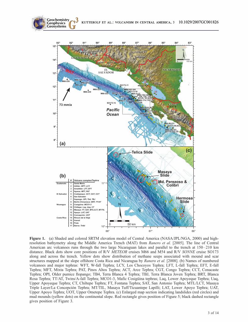
Figure 1. (a) Shaded and colored SRTM elevation model of Central America (NASA/JPL/NGA, 2000) and high-resolution bathymetry along the Middle America Trench (MAT) from Ranero et al. [2005]. The line of CentralAmerican arc volcanoes runs through the two large Nicaraguan lakes and parallel to the trench at 150–210 kmdistance. Black dots show core positions of R/V METEOR cruises M66 and M54 and R/V SONNE cruise SO173along and across the trench. Yellow dots show distribution of methane seeps associated with mound and scarstructures mapped at the slope offshore Costa Rica and Nicaragua by Ranero et al. [2008]. (b) Names of numberedvolcanoes and major tephras: WFT, W-fall Tephra; LCY, Los Chocoyos Tephra; LFT, L-fall Tephra; EFT, E-fallTephra; MFT, Mixta Tephra; PAT, Pinos Altos Tephra; ACT, Arce Tephra; CGT, Congo Tephra; CCT, ConacasteTephra; OPI, Older pumice Ilopango; TB4, Terra Blanca 4 Tephra; TBJ, Terra Blanca Joven Tephra; BRT, BlancaRosa Tephra; TT/AT, Twins/A-fall Tephra; MCO1-3, Mafic Cosiguina tephras; Laq, Lower Apoyeque Tephra; Uaq,Upper Apoyeque Tephra; CT, Chiltepe Tephra; FT, Fontana Tephra; SAT, San Antonio Tephra; MTL/LCT, MasayaTriple Layer/La Concepcion Tephra; MT/TIL, Masaya Tuff/Ticuantepe Lapilli; LAT, Lower Apoyo Tephra; UAT,Upper Apoyo Tephra; UOT, Upper Ometepe Tephra. (c) Enlarged map section indicating landslides (red circles) andmud mounds (yellow dots) on the continental slope. Red rectangle gives position of Figure 5; black dashed rectanglegives position of Figure 3.
GeochemistryGeophysicsGeosystems G3G3
kutterolf et al.: volcanism in central america, 3 10.1029/2007GC001826kutterolf et al.: volcanism in central america, 3 10.1029/2007GC001826
3 of 14

the composition of the volcanic rocks [Carr et al.,2003, 2007; Carr, 1984; Feigenson and Carr,1986; Feigenson et al., 2004; Hoernle et al.,2002; Patino et al., 1997, 2000] that are veryuseful for geochemical correlations [Kutterolf etal., 2008a].
[5] While bending into the subduction zone, theCocos plate forms an outer rise in front of thetrench along which it become dissected by numer-ous, deep-reaching bend faults [Ranero et al.,2003]. Anomalous heat flow and seismic velocitiesindicate substantial hydration of crust and upper-most mantle by seawater invading the faults [Gre-vemeyer et al., 2005], which is thought to be amajor process to carry water into the subductionzone to ultimately generate melting in the mantlewedge [Rupke et al., 2002]. As the Cocos platesubducts beneath the Caribbean plate, the forearc istectonically eroded [Clift et al., 2005; Ranero andvon Huene, 2000; Vannucchi et al., 2004; vonHuene et al., 2004a]. Subduction erosion controlsthe structure of the forearc and causes oversteepen-ing and destabilization of the continental slopeparticularly where seamounts are subducted [vonHuene et al., 2004b]. Parallel to the trench atintermediate water depths, the Middle Americanforearc is straddled with numerous fluid ventingstructures (Figure 1) believed to be fed by fluidsexpelled from subducted sediments by compactionand ascending along faults [Hensen et al., 2004;Moerz et al., 2005a, 2005b]. These include mudand carbonate mounds as well as vents at landslidescarps formed either by seamount subduction or bygas hydrate dissolution.
2.1. Mud and Carbonate Mounds
[6] Mud or carbonate mounds offshore CentralAmerica have diameters in the range of 100–2000 m and elevations above the surroundingseafloor of 20–200 m. They are composed ofover-consolidated mud clasts, liquefied mudflowsas well as highly variable authigenic carbonates.Mounds are mostly covered by massive carbonatecrusts and boulders formed by the anaerobic oxi-dation of methane at the seafloor and in theextruded sediments [Moerz et al., 2005b]. Seismicprofiles show that the mounds visible at the surfacecap are diatreme structures dissecting the gashydrate layer (visible as Bottom Simulating Re-flector, BSR) and extending at least several hun-dred meters deep into the forearc [Talukder et al.,2007]. Fluid-chemical (Cl-depleted pore waters,C-isotopes) and petrographic evidence (MORB
fragments, over-consolidated clay clasts) show thatthe fluids probably derive from dewatering ofsubducted sediments at 10–15 km depth, usingpermeable forearc faults created by tectonic erosion[Ranero et al., 2008] to ascend to the surface[Grevemeyer et al., 2004; Hensen et al., 2004;Mau et al., 2006, 2007; Moerz et al., 2005a,2005b]. The methane output flux at vent structuresis temporally variable [Mau et al., 2006]. Typicallymixed sediments occur around mound structuresthat are thought to have been ejected during phasesof intense activity [Moerz et al., 2005b]. Theirintercalation with background pelagic sedimentsdemonstrates that mound activity is not steadybut periodic. However, the lifetime of mud moundsand the age and duration of active periods arepresently unknown.
2.2. Submarine Slides
[7] The sedimentary architecture of active andpassive continental margins is frequently modifiedby submarine slope failures, which can occur onlarger scales than known from terrestrial masswasting events. Volumes of up to 20000 km3
(e.g., Agulhas slide [Hampton et al., 1996]) aremobilized, probably in a catastrophic manner, andare therefore a potential trigger mechanism fortsunamis that can devastate coastal areas [Tappinet al., 2001]. The formation of gas hydratescements and stabilizes the slope sediments but alsoprevents further compaction and build-up of shearstrength [Reston and Bialas, 2002]. Partial disso-lution of gas hydrates thus favors the formation ofsubmarine landslides that may be triggered byearthquakes, particularly on continental slopessteepened by subduction erosion [Harders et al.,2006]. Two different types of slope failure havebeen identified on the continental slope off CostaRica and Nicaragua: rotational slumps and transla-tional slides. Rotational slumps appear to be trig-gered by seamount subduction [von Huene et al.,2000, 2004b]. In contrast, the formation of trans-lational slides appears to be related to layers of lowshear strength in the sediment succession [Harderset al., 2006].
3. Marine Sediment Cores
3.1. Marine Core Sampling
[8] During R/V METEOR cruises M54/2 and M66/3 as well as R/V SONNE cruise SO173/3, 56sediment gravity cores have been collected off-shore Central America. The locations (9�120N/
GeochemistryGeophysicsGeosystems G3G3
kutterolf et al.: volcanism in central america, 3 10.1029/2007GC001826
4 of 14

84�390E and 12�450N/92�300E) of the cores are onthe oceanic plate and the continental slope in1200–4000 m water depth and distances of 150–370 km from the CAVA (Figure 1). The corescontain 213 ash horizons including primary ashlayers and slightly reworked ash that retained itscompositional integrity and stratigraphic positionand therefore can be used as marker beds. Criteriaidentifying primary and variably reworked ashhorizons, and the methods employed to correlatethem with deposits on land are described anddiscussed in part 1 [Kutterolf et al., 2008a]. Inthe following we focus on the intercalated sedi-ments and on cores from sites that have beenspecifically targeted to penetrate sediments atmound structures, landslide deposits, and landslidedetachment planes.
3.2. General Description of Cores
[9] The 56 cores collected from offshore CentralAmerica contain a total of 213 ash bearing hori-zons, including 133 distinct ash layers. Of these, 69are light gray to white felsic ashes, 24 are graylayers of intermediate composition and 40 areblack mafic layers. The ash layers and their com-ponents are described in more detail in part 1 ofthis contribution [Kutterolf et al., 2008a].
[10] Pelagic silty to sandy clay sediment is com-monly dark olive green but changes to lightershades of green deeper in the cores. The pelagicsediment is mixed with terrigeneous input from thevolcanic arc and its basement. The modal compo-sition is typically 10 to 20% total quartz, 40 to 60%of clay (mainly smectite), 20 to 30% feldspar, andfresh to incipiently altered volcanic glass shardsand rock fragments of various compositions(reworked sediments, basalts, carbonates). Addi-tionally, <10% pyrite, 10 to 20% biogenic materialincluding foraminifers, diatoms, some radiolariansand occasionally slope detritus like shells andcorals can be found in the cores. Accessory chlo-rite clasts (<2%) occur in nearly every examinedsample.
[11] In the upper part of core M66-228, M54-11,SO173-17, lower part of SO173-15, 18 and M54-13, and the entire sections of M66 cores 222 and229, the pelagic sediment is compositionally andstructurally completely monotonous indicatingcontinuous sedimentation at constant rates. In othercores and core sections, however, there are abun-dant structural indications of small-scale slumpingand mingling events interrupting the backgroundclay sedimentation, even in cores from the incom-
ing plate at considerable distance from the trenchaxis. This local small-scale reworking, however,did not significantly affect the stratigraphic order ofthe ash horizons.
[12] Sediment successions at the carbonate andmud mounds differ by including layers composi-tionally dominated by the products of these struc-tures. Color changes from dark-olive-green tolight-olive-gray of the fine grained matrix reflectincreasing abundance of carbonate mud derivedfrom the active mound. The clast components inthe lighter layers are dominated by carbonate and/ormud detritus including over-consolidated ‘‘scaly’’clay clasts that originated from deeper levels. Suchlayers are interpreted as mudflow deposits emittedby mud volcanoes [Moerz et al., 2005a, 2005b].During inactive phases of the mounds, the back-ground clay sedimentation continues. At the inter-mediate depths on the slope, these sediments areheterogeneous and include abundant detritus fromthe shelf such as fragments of oysters, corals, andwood.
4. Applications of Tephrostratigraphy toContinental Slope Geology
[13] We focus on the Pacific region offshore Nicar-agua. Table 1 summarizes a subset of 22 of thetephras correlated in part 1 that are relevant for thedetermination of ages and rates of the geologicalprocesses discussed in the following. These 22tephras have well-constrained ages, characteristiccompositions and form distinct distal marine ashbeds.
4.1. Sedimentation Rates
[14] Time marks given by dated ash layers allow usto calculate average apparent sedimentation rates ofthe intercalated pelagic sediment (Figure 2,Figure S11, and Table 1). In these calculations,the thickness of the intercalated sediment intervalis reduced by the intervening undated ash beds toobtain the pelagic sediment thickness. However,the pelagic clay is often mixed to variable extentwith volcanic ash particles, which contribute to thesedimentation rate but are not corrected for. Sedi-ment-petrographic studies underway will furtherrefine sedimentation rates. Some core sectionsshow intense bioturbation and the addition oforganic matter may have increased the sediment
1Auxiliary materials are available in the HTML. doi:10.1029/2007GC001826.
GeochemistryGeophysicsGeosystems G3G3
kutterolf et al.: volcanism in central america, 3 10.1029/2007GC001826
5 of 14

thickness. Also, we typically obtain higher appar-ent sedimentation rates for the upper few deci-meters of the cores than for deeper levels due toincomplete compaction near the seafloor. Since wedo not attempt to correct for compaction, this mustbe considered when comparing apparent sedimen-tation rates for different age intervals.
[15] In general, we observe pelagic sedimentationrates of �1–6 cm/ka on the incoming plate and upto 30–40 cm/ka on the continental slope. However,the apparent sedimentation rates vary with depth inthe cores and between cores, both at the continentalslope and on the incoming plate. In core SO173-15at a position farthest away from the trench on theincoming plate (Figure 1), the apparent sedimenta-tion rate gradually decreases with depth (Figure 2a).The high value of 27.5 cm/ka near the top reflectsthe poor compaction of the sediment. Below�60 cm bsf, the sedimentation rate rapidlydecreases to 5.7 cm/ka, similar to the 5.4 cm/kaestimated by Bowles et al. [1973]; this may be takenas a representative value of monotonous sedimen-tation on the Cocos plate offshore Nicaragua.
4.2. Sedimentation and Bend Faulting
[16] Sedimentation was not monotonous every-where on the incoming plate. In core M66-222(Figure 1; see Figure 10 in part 1), ash layers C10(distal ash of the 24.5 ka Upper Apoyo Tephra,UAT) and C15 (53 ka Congo Tephra, CGT) areseparated by �188 cm of pelagic sediment indi-cating an average accumulation rate of 6.7 cm/ka.In contrast, ash bed C10 immediately follows atopash pods of C15 in core M66-230; apparently someerosive event has removed sediment accumulatedabove C15 prior to emplacement of C10. Anotherexample is core SO173-17 on the incoming plateoffshore Nicaragua (Figure S1) where ash layersC10 (UAT) and C11, the distal ash of the Lower(LAT) Apoyo tephra, are separated by 15 cm sedi-ment such that the sedimentation rate of 2 cm/kadetermined by other ash beds implies a time periodof �7 ka between these eruptions. Geologicalevidence on land and overlapping radiocarbon ages[Kutterolf et al., 2007a] demonstrate these erup-tions occurred within a few hundred years ataround 25 ka. Moreover, LAT and UAT are sepa-rated by 7 cm sediment on the continental slope
Table 1. Summary of 22 Onshore Tephras Correlated in Part 1 That Are Relevant for the Determination of Ages andRates of the Geological Processesa
Tephra NameTephra
AcronymCorrelatedAsh Layers Age, ka Source Volcano Country
Max. Observed AshDispersal From the
Source, km
Tierra Blanca Joven Tephra TBJ C1 1.6 Ilopango Caldera El Salvador 390Masaya Tuff/Ticuantepe Lapilli MT/TIL C2 1.8 Masaya Caldera Nicaragua 200Chiltepe Tephra CT C3 1.9 Chiletepe complex Nicaragua 570Masaya Triple Layer/La Concepcion Tephra
MTL/LCT C4 2.1 Masaya Caldera Nicaragua 170
San Antonio Tephra SAT C5 6 Masaya Caldera Nicaragua 330Upper Apoyeque Tephra UAq C6 12.4 Chiletepe complex Nicaragua 300Lower Apoyeque Tephra LAq C7 17 Chiletepe complex Nicaragua 210Upper Ometepe Tephra UOT C8 19 Concepcion volcano Nicaragua 280Mafic Cosiguina Tephras MCO C9 21–23 Cosiguina volcano Nicaragua 220Upper Apoyo Tephra UAT C10 24.5 Apoyo Caldera Nicaragua 530Lower Apoyo Tephra LAT C11 24.8 Apoyo Caldera Nicaragua 270Tierra Blanca 4 Tephra TB4 C12 36 Ilopango Caldera El Salvador 380Mixta Fall Tephra MFT C13 39 Ayarza Caldera Guatemala 340Conacaste Tephra CCT C14 51 Coatepeque Caldera El Salvador 320Congo Tephra CGT C15 53 Coatepeque Caldera El Salvador 320Fontana Tephra FT C16 �60 Las Nubes Caldera Nicaragua 330Twins/A-Fall Tephra TT/AT C17 60 Berlin-Pacayal-Volcan group El Salvador 270Arce tephra ACT C18 75 Coatepeque Caldera El Salvador 320Older Ilopango Pumice OPI C20 75–84 Ilopango Caldera El Salvador 470Los Chocoyos tephra LCY C21 84 Atitlan Caldera Guatemala 1900W-Fall Tephra WFT C22 158 Atitlan Caldera Guatemala 560L-Fall Tephra LFT C23 191 Amatitlan Caldera Guatemala 810
aAsh layers (C#) were correlated by Kutterolf et al. [2008a].
GeochemistryGeophysicsGeosystems G3G3
kutterolf et al.: volcanism in central america, 3 10.1029/2007GC001826
6 of 14

(core M54-2; Figure 2c), where accumulation at43 cm/ka suggests a time interval of �200 years.The sediment interval in core SO173-17 containssmall ash lenses of underlying LAT ash indicatingthat its excess thickness is due to reworking.
[17] Anomalously low apparent sedimentationrates of mostly <1 cm/ka mark the time intervalsof 50–190 ka in core M66-223, 60–160 ka in coreM66-230, 90–190 ka in cores M66-226 and M66-228 (Figure 2b), and to lesser extent at 60–70 ka incore M66-229 (Figure S1). Lower apparent sedi-mentation rates are also found at around 200 cmdepths, or at >80 ka age, in cores SO173-17 andM54-11 closer to the trench offshore Nicaragua(Figure S1). These dramatic reductions in apparentsedimentation rate are not related to compactionbecause they occur at a similar age range but atdifferent depths in the cores, e.g., beginning at
60 cm depth bsf in cores M66-223 and M66-226but at 270 cm depth in core M66-229. Moreover,pore water analyses and strength measurements aswell as core-logging data did not reveal significantdifferences in the state of sediment compaction (T.Morz, personal communication, 2006). Structuressuch as clay lenses (see Figure 3e in part 1) andtilted ash pods rather suggest that the low apparentsedimentation rates result from repeated small-scale erosive events that occurred on the incomingplate. Although some turbidity currents from thecontinental slope may have reached the drill siteson the incoming plate, these were probably nolonger erosive after crossing the trench and climb-ing the outer rise. We rather interpret that theselocal events of erosion and reworking were relatedto tectonic activity at the numerous bend faults thatdissect the incoming plate on the outer rise and
Figure 2. Cumulative thickness of pelagic sediment versus age for selected cores. (a) Core SO173-15 on incomingplate �200 km distance from the trench. (b) Core M66-228 on incoming plate close to the trench; C25 only correlatedto marine cores, not to tephras on land. (c) Core M54-2 on the middle continental slope. Filled squares show felsicash layers and white circles show mafic ash layers correlated to field tephras (see Figure 1 for acronyms) of knownage after Kutterolf et al. [2008a]. The slopes of line segments between tephras yield average apparent accumulationrates (numbers in cm/ka). Respective diagrams for other cores are shown in auxiliary material Figure S1.
GeochemistryGeophysicsGeosystems G3G3
kutterolf et al.: volcanism in central america, 3 10.1029/2007GC001826
7 of 14

have offsets increasing toward the trench (Figure 1)[Ranero et al., 2005]. During the time span repre-sented by the cores, core positions moved about 30km along the subduction vector but remainedwithin the zone of bend faulting. Across <50 kasections of the cores, sedimentation rates are higherbut laterally variable. Apparent sedimentation ratesof 4–7.5 cm/ka in cores M66-228 and M66-229farther away from the trench contrast with 0.6 and1.1 cm/ka in cores M66-226 and M66-223 closer tothe trench where fault offsets are larger. Thissuggests a tendency for stronger sediment rework-ing where fault offsets are larger. On the otherhand, core M66-222 with 6.7 cm/ka is also close tothe trench while core M66-230 with only 4.2 cm/kalies farther away. Hence the local sedimentationand erosion of the younger core sections is con-trolled by both distance from trench (magnitude offault offset) and proximity to the local faults(unknown due to insufficient resolution of corepositioning and bathymetry). The apparent sedi-mentation rates of the older core sections aresignificantly lower but much more uniform be-tween cores. A possible explanation may be thatone or more intense tectonic events occurred be-tween 80–190 ka that caused dramatic regionalerosion irrespective of the detailed core position.An implication of this interpretation is that bendfaulting is not continuous but proceeds by sporadicbursts that are separated by periods of less intenseactivity lasting on the order of 104 years.
4.3. Sedimentation on the ContinentalSlope
[18] Cores from the continental slope offshoreNicaragua reveal large differences in apparentsedimentation rates at comparable time intervals.For example, the core M54-2 (Figure 2c) has �4 msediment between ash layers C7 (LAq) and C10(UAT), yielding accumulation at 35 cm/ka, whilethis interval is condensed to only�0.2 m (2.2 cm/ka)in neighboring core M54–13 (Figure 1). Thesediment thickness between layer C4 (2.1 kaMTL) and C7 is more than halved from coreSO173-18 to M54-2. The top section above C2(1.8 ka MT) likewise reduces from 1.5 m to 10 cm(rate from 90 to 13.3 cm/ka). The accumulatedsediment of the past 6 ka is strongly reduced (1.1cm/ka sedimentation rate) at the top of M54-13.These comparisons show that there are large localand temporal deviations from the ‘‘normal’’ accu-mulation rate of 30–40 cm/ka estimated fromother, more monotonous cores (Figure S1). Weinterpret that these variations in apparent accumu-
lation rates reflect laterally and temporally variablephases of excess sediment delivery and erosionprobably by turbidity currents descending theslope. For example, excess accumulation rate of�90 cm/ka across the upper 1.5 m of core SO173-18, which was taken from the rim of a submarinecanyon on the Nicaraguan slope (Figure 1), can beexplained by accumulation of turbidite overbanksediments from currents passing through the can-yon.
[19] On land in Nicaragua we have identified majorperiods of erosion that occurred around 17–25 kaand 2–6 ka (unconformities U1 and U2-4 [Kutterolfet al., 2007a]). Increased turbidity current activityon the continental slope causing lateral changes inapparent accumulation rates is probably linked tothese erosive phases on land which appear to berelated to tectonic activity (U1) and changingclimatic conditions (U2-4) [Kutterolf et al.,2007a]. There is no evidence on land correlatingwith erosion on the continental slope during thepast <2 ka seen in some cores; this seems to becontrolled by conditions at the slope only. We notethat this is a preliminary interpretation becausedetailed petrographic studies of the sediments stillneed to be done. The absence of sharp unconform-ities in condensed sections can be explained byreworking of the soft sediments in an unconsoli-dated state.
4.4. Submarine Landslides and Ash Layers
[20] Fast, erosive subduction of the rough CocosPlate beneath the Caribbean Plate leads to anoversteepening of the Nicaraguan continental slope[Ranero and von Huene, 2000; von Huene et al.,2004b] on which sediment packages become un-stable and collapse as submarine landslides [Hard-ers et al., 2006]. Large failures are abundant on themiddle slope offshore Nicaragua (Figure 3) andincrease the tsunami hazard. Detachment planes oflandslides typically form in sediment layers of lowshear strength. Drilling through two exposed slideplanes offshore Costa Rica (SO173-59) and Nicar-agua (M66/3-151) showed that detachment oc-curred at the level of ash layers. We use coreM66/3-151 from the Hermosa slide as an illustra-tive example. An unconformity at 1.5 m bsfseparates overlying undisturbed massive homoge-neous pelagic clay from underlying, <10-cm-thickreworked melange containing rounded intraclastsof consolidated clay in an unconsolidated claymatrix mixed with ash. This is underlain by amafic ash layer that has an eroded top and high
GeochemistryGeophysicsGeosystems G3G3
kutterolf et al.: volcanism in central america, 3 10.1029/2007GC001826
8 of 14

Figure 3. Bathymetric map of the middle slope offshore central Nicaragua (see Figure 1c) showing slide scarps thathave dimensions from several kilometers up to tens of kilometers, and headwalls up to 100 m high. Yellow circlesshow fluid vents above the Masaya Slide.
Figure 4. Physical and geochemical logging parameters of core M66/151 drilled through the detachment plane ofthe Hermosa slide (Figure 1c). The core section photograph shows the slide plane covered by a mafic ash layer of lowshear strength that is overlain by 10 cm of clay melange which is capped by the upper detachment unconformity.
GeochemistryGeophysicsGeosystems G3G3
kutterolf et al.: volcanism in central america, 3 10.1029/2007GC001826
9 of 14
porosity and low density in the core logging data(Figure 4). The massive clay below the ash layer isslightly deformed near the top. Low porosity, highdensity and high pore water alkalinity show thatthis lower clay package is significantly more com-pacted and older than the clay package above theunconformity. Measured shear strength decreasessteeply from high values in the underlying clay tolow values in the clay overlying the unconformity(Figure 4). The steep gradients in physical proper-ties and residence time (alkalinity) and the defor-mation structures strongly suggest that a significantsediment package has been removed from thislevel by sliding prior to renewed pelagic sedimen-tation above the unconformity. The shear zone ofdetachment reaches from the unconformity to theash layer but minor shear also affected the top ofthe underlying clay. Within the steep shear strengthgradient across this zone, the ash layer marks anexcursion to about half the strength value. More-over, the high porosity of the well-sorted ash andits being sealed by impermeable clay at top andbottom suggests that high pore pressure wouldhave been generated in the ash layer during com-paction, further reducing its strength. Ash layersthus are predestined to form structurally weakhorizons on which sediment packages begin toslide when triggered by processes such as steepen-ing of the slope.
[21] The mafic ash layer in the detachment zone ofthe Hermosa slide correlates with the �6 ka oldSan Antonio Tephra erupted from Masaya Caldera
[Kutterolf et al., 2007a; Perez and Freundt, 2006].The slide detachment thus occurred less than 6 kaago. Core M66/3-162 penetrated the detachmentplane of the Telica slide, which is overlain by thedistal ash of the �60 ka Fontana Tephra at 57–59 cm bsf such that the landslide occurred morethan 60 ka ago. The Masaya slide, the largestknown landslide offshore Nicaragua, occurred�19 ka ago because its detachment plane isimmediately overlain by distal ashes of the�17 ka Lower Apoyeque and �19 ka UpperOmetepe tephras in cores M66/3-132 and 220.These examples illustrate how useful marine ashlayers are to constrain ages of submarine landslidesprovided they can be correlated to tephras ofknown age or otherwise dated.
4.5. Dating Mud-Mound Activity by AshLayers
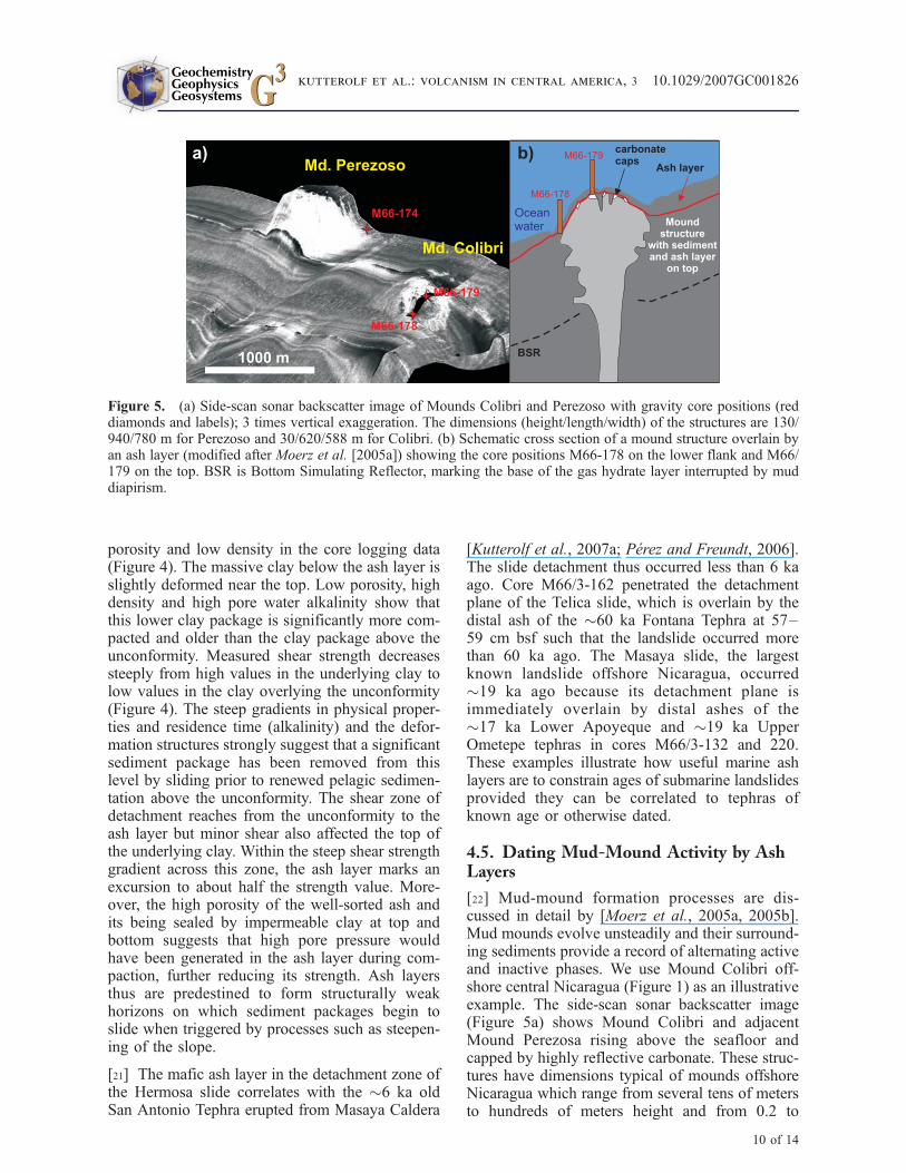
[22] Mud-mound formation processes are dis-cussed in detail by [Moerz et al., 2005a, 2005b].Mud mounds evolve unsteadily and their surround-ing sediments provide a record of alternating activeand inactive phases. We use Mound Colibri off-shore central Nicaragua (Figure 1) as an illustrativeexample. The side-scan sonar backscatter image(Figure 5a) shows Mound Colibri and adjacentMound Perezosa rising above the seafloor andcapped by highly reflective carbonate. These struc-tures have dimensions typical of mounds offshoreNicaragua which range from several tens of metersto hundreds of meters height and from 0.2 to
Figure 5. (a) Side-scan sonar backscatter image of Mounds Colibri and Perezoso with gravity core positions (reddiamonds and labels); 3 times vertical exaggeration. The dimensions (height/length/width) of the structures are 130/940/780 m for Perezoso and 30/620/588 m for Colibri. (b) Schematic cross section of a mound structure overlain byan ash layer (modified after Moerz et al. [2005a]) showing the core positions M66-178 on the lower flank and M66/179 on the top. BSR is Bottom Simulating Reflector, marking the base of the gas hydrate layer interrupted by muddiapirism.
GeochemistryGeophysicsGeosystems G3G3
kutterolf et al.: volcanism in central america, 3 10.1029/2007GC001826
10 of 14

>1.0 km2 basal area. Such visible dimensions,however, have no relation to the age of the coldseep structures (D. Burk, personal communica-tion, 2007). Core M66/3-178, drilled through theflank of Mound Colibri, contains two major typesof sediment (Figure 6a): (1) rounded clay andcarbonate clasts, ash lenses and shelf-derivedfossils dispersed in a matrix of sandy clay and(2) a bimodal population of angular scaly clay
and carbonate clasts in a fine-grained matrix ofclay or carbonate mud. The inventory of sediment(2) is the typical material ejected by moundstructures during phases of strong venting activity[Moerz et al., 2005b]. The heterolithologic sedi-ment (1) typical of the background sedimentationon the middle slope receiving input from the shelfis emplaced while the adjacent mound was rela-tively inactive. The sediments in core M66/3-178
Figure 6. (a) Lithologic section of core M66-178 with correlated ash layers. SAT, 6 ka San Antonio Tephra; UAq,12.4 ka Upper Apoyeque Tephra; LAq, �17 ka Lower Apoyeque Tephra; UAT, 24.5 ka Upper Upoyo Tephra; LAT,24.8 ka Lower Apoyo Tephra; TT/AT, �60 ka Twins/A-fall Tephra. Blue bars along section mark intervals of moundsediments; red bars mark pelagic background sediments. (b) Cumulative pelagic sediment thickness versus age.Squares mark correlated ash layers of known age. Line slopes give apparent sedimentation rates (numbers in cm/ka)varying along the core. Blue line segments mark mud-mound activity; red line sections mark phases of relativeinactivity.
GeochemistryGeophysicsGeosystems G3G3
kutterolf et al.: volcanism in central america, 3 10.1029/2007GC001826
11 of 14
are intercalated with ash layers that we correlatewith dated tephras on land. These time constraintsshow that apparent sedimentation rates are strong-ly elevated above background levels at intervalscomposed of type-2 mound sediments (Figure6b). The ash layers show that Mound Colibrihad at least three phases of high venting activityat >60 ka, a short phase at 24.5–24.8 ka, and anextended phase from 17 to �8 ka.
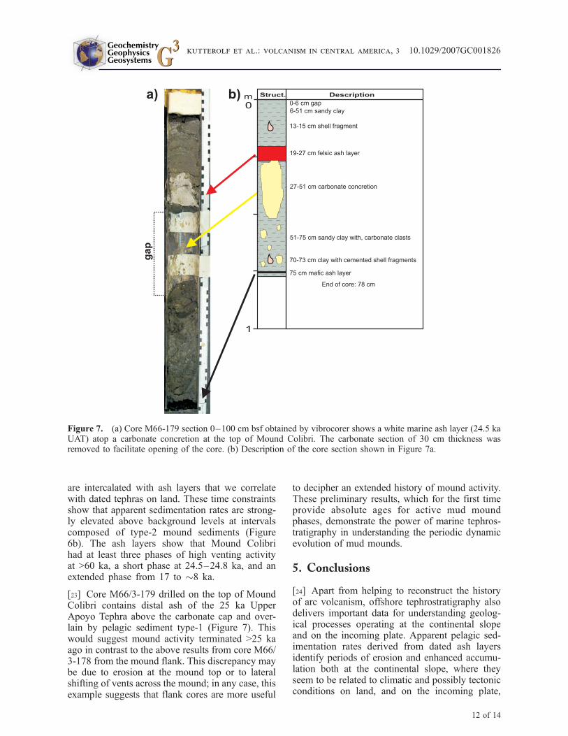
[23] Core M66/3-179 drilled on the top of MoundColibri contains distal ash of the 25 ka UpperApoyo Tephra above the carbonate cap and over-lain by pelagic sediment type-1 (Figure 7). Thiswould suggest mound activity terminated >25 kaago in contrast to the above results from core M66/3-178 from the mound flank. This discrepancy maybe due to erosion at the mound top or to lateralshifting of vents across the mound; in any case, thisexample suggests that flank cores are more useful
to decipher an extended history of mound activity.These preliminary results, which for the first timeprovide absolute ages for active mud moundphases, demonstrate the power of marine tephros-tratigraphy in understanding the periodic dynamicevolution of mud mounds.
5. Conclusions
[24] Apart from helping to reconstruct the historyof arc volcanism, offshore tephrostratigraphy alsodelivers important data for understanding geolog-ical processes operating at the continental slopeand on the incoming plate. Apparent pelagic sed-imentation rates derived from dated ash layersidentify periods of erosion and enhanced accumu-lation both at the continental slope, where theyseem to be related to climatic and possibly tectonicconditions on land, and on the incoming plate,
Figure 7. (a) Core M66-179 section 0–100 cm bsf obtained by vibrocorer shows a white marine ash layer (24.5 kaUAT) atop a carbonate concretion at the top of Mound Colibri. The carbonate section of 30 cm thickness wasremoved to facilitate opening of the core. (b) Description of the core section shown in Figure 7a.
GeochemistryGeophysicsGeosystems G3G3
kutterolf et al.: volcanism in central america, 3 10.1029/2007GC001826
12 of 14

where they are related to bend faulting of the plateacross the outer rise.
[25] Dated ash layers also constrain the times atwhich submarine landslides detached from thecontinental slope; such slides often used ash bedsas low-strength shear planes. Moreover, usingcorrelated ash layers, we were able for the firsttime to determine the age and duration of repeatedphases of high venting activity alternating withperiods of low or no activity of mud mounds.
Acknowledgments
[26] We especially thank all members of the scientific parties
of R/V METEOR cruises M66/3 and M54/2 and R/V SONNE
cruise SO173/3 for the good and successful working atmo-
sphere. Eric Steen and Mark Schmidt did the coring. We also
thank Oliver Bardtoff, Cosima Burkert, Kristina Bernoth,
Emelina Cordero, Joana Deppe, Yann Lahaye, Julia Mahlke,
Dagmar Rau, and Mario Thoner, who assisted sampling on
board, sample preparation, and analytical work. W.P. acknowl-
edges a Ph.D. stipend by the Deutscher Akademischer Aus-
tauschdienst (DAAD). We also appreciate the helpful
comments and suggestions of Vincent Salters, Stephen Blake,
Mike Carr, Phil Shane, and Tom Vogel, who reviewed an
earlier version of this paper. This publication is contribution
106 of the Sonderforschungsbereich 574 ‘‘Volatiles and Fluids
in Subduction Zones’’ at Kiel University. R/V METEOR and
R/V SONNE cruises were funded by the Deutsche Forschungs-
gemeinschaft (DFG).
References
Bowles, F. A., R. N. Jack, and I. S. E. Carmichael (1973),Investigation of deep-sea volcanic ash layers from equatorialPacific cores, Geol. Soc. Am. Bull., 84, 2371–2388.
Carr, M., M. D. Feigenson, L. C. Patino, and J. A. Walker(2003), Volcanism and geochemistry in Central America:Progress and problems, in Inside the Subduction Fac-tory, Geophys. Monogr. Ser., vol. 138, edited by J. Eiler,pp. 153–174, AGU, Washington, D. C.
Carr, M. J. (1984), Symmetrical and segmented variation ofphysical and geochemical characteristics of the CentralAmerican Volcanic Front, J. Volcanol. Geotherm. Res., 20,231–252.
Carr, M. J., L. C. Patino, and M. D. Feigenson (2007), Petrol-ogy and geochemistry of lavas, in Central America—Geol-ogy, Resources and Hazards, vol. 2, edited by J. Buntschuhand G. E. Alvarado, pp. 565–590, A. A. Balkema,Rotterdam, Netherlands.
Clift, P. D., L.-H. Chan, J. Blusztajn, G. D. Layne, M. Kastner,and R. K. Kelly (2005), Pulsed subduction accretion andtectonic erosion reconstructed since 2.5 Ma from the tephrarecord offshore Costa Rica, Geochem. Geophys. Geosyst., 6,Q09016, doi:10.1029/2005GC000963.
Feigenson, M. D., and M. J. Carr (1986), Positively correlatedNd and Sr isotope ratios of lavas from the Central Americanvolcanic front, Geology, 14, 79–82.
Feigenson, M. D., M. J. Carr, S. V. Maharaj, S. Juliano, andL. L. Bolge (2004), Lead isotope composition ofCentral Amer-
ican volcanoes: Influence of the Galapagos plume, Geochem.Geophys. Geosyst., 5, Q06001, doi:10.1029/2003GC000621.
Grevemeyer, I., A. Kopf, N. Fekete, N. Kaul, M. Heesemann,H.-H. Gennerich, M. Muller, V. Spiess, K. Wallmann, and W.Weinrebe (2004), Fluid flow trough active mud domeMound Culebra offshore Nicoya Peninsula, Costa Rica: Evi-dence from heat flow surveying, Mar. Geol., 207(1–4),145–157.
Grevemeyer, I., N. Kaul, J. L. Diaz-Naveas, H. W. Villinger,C. R. Ranero, and C. Reichert (2005), Heat flow and bend-ing-related faulting at subduction trenches: Case studies off-shore of Nicaragua and central Chile, Earth Planet. Sci. Lett.,236, 238–248.
Hampton, M. E., H. J. Lee, and J. Locat (1996), Submarinelandslides, Rev. Geophys., 34, 33–59.
Harders, R., W. Bruckmann, V. Feeser, C. Hensen, andS. Kutterolf (2006), Ash layers: The controlling factor ontranslational sliding offshore Central America?, Eos Trans.AGU, 87(52), Fall Meet. Suppl., Abstract OS43C-0666.
Hensen, C., K. Wallmann, M. Schmidt, C. R. Ranero, andE. Suess (2004), Fluid expulsion related to mud extrusionoff Costa Rica continental margin—A window to the sub-ducting slab, Geology, 32, 201–204.
Hoernle, K., P. van den Bogaard, R. Werner, B. Lissinna, G. E.Alvarado, and D. C.-Garbe-Schonberg (2002), Missing his-tory (16–71 Ma) of the Galapagos hotspot: Implications forthe tectonic and biological evolution of the Americas, Geol-ogy, 30(9), 795–798.
Kutterolf, S., A. Freundt, W. Perez, H. Wehrmann, and H.-U.Schmincke (2007a), Late Pleistocene to Holocene temporalsuccession and magnitudes of highly-explosive volcaniceruptions in west-central Nicaragua, J. Volcanol. Geotherm.Res., 163, 55–82.
Kutterolf, S., U. Schacht, H. Wehrmann, A. Freundt, andT. Morz (2007b), Onshore to offshore tephrostratigraphy andmarine ash layer diagenesis in Central America, in CentralAmerica—Geology, Resources and Hazards, vol. 2, editedby J. Buntschuh and G. E. Alvarado, pp. 395–423,A. A. Balkema, Lisse, Netherlands.
Kutterolf, S., A. Freundt, W. Perez, T. Morz, U. Schacht,H. Wehrmann, and H.-U. Schmincke (2008a), Pacific off-shore record of plinian arc volcanism in Central America:1. Along-arc correlations, Geochem. Geophys. Geosyst.,doi:10.1029/2007GC001631, in press.
Kutterolf, S., A. Freundt, and W. Perez (2008b), Pacific off-shore record of plinian arc volcanism in Central America:2. Tephra volumes and erupted masses, Geochem. Geophys.Geosyst., doi:10.1029/2007GC001791, in press.
Mann, P., R. D. Rogers, and L. Gahagan (2007), Overview ofplate tectonic history and its unresolved tectonic problems, inCentral America—Geology, Resources and Hazards, vol. 2,edited by J. Buntschuh and G. E. Alvarado, pp. 201–238,A. A. Balkema, Lisse, Netherlands.
Mau, S., H. Sahling, G. Rehder, E. Suess, P. Linke, andE. Soeding (2006), Estimates of methane output from mudextrusions at the erosive convergent margin off Costa Rica,Mar. Geol., 225, 129–144.
Mau, S., G. Rehder, I. G. Arroyo, J. Gossler, and E. Suess(2007), Indications of a link between seismotectonics andCH4 release from seeps off Costa Rica, Geochem. Geophys.Geosyst., 8, Q04003, doi:10.1029/2006GC001326.
Moerz, T., et al. (2005a), Styles and productivity of diapirismalong the Middle America margin, Part II: Mound Culebraand Mounds 11, and 12, in Mud Volcanoes, Geodynamicsand Seismicity, NATO Sci. Ser., Ser. IV, vol. 51, edited byG. Martinelli and B. Panahi, Springer, Dordrecht, Germany.
GeochemistryGeophysicsGeosystems G3G3
kutterolf et al.: volcanism in central america, 3 10.1029/2007GC001826
13 of 14

Moerz, T., A. Kopf, W. Brueckmann, H. Sahling, N. Fekete,V. Huhnerbach, D. Masson, D. A. Hepp, and E. Suess(2005b), Styles and productivity of diapirism along theMiddle America margin, Part I: Margin evolution, segmenta-tion, dewatering and mud diapirism, in Mud Volcanoes, Geo-dynamics and Seismicity, NATO Sci. Ser., Ser. IV, vol. 51,edited by G. Martinelli and B. Panahi, pp. 35–48, Springer,Dordrecht, Germany.
Patino, L. C., M. Carr, and M. D. Feigenson (1997), Cross-arcgeochemical variations in volcanic fields in Honduras C. A.:Progressive changes in source with distance from the volca-nic front, Contrib. Mineral. Petrol., 129, 341–351.
Patino, L. C., M. Carr, and M. D. Feigenson (2000), Local andregional variations in Central American arc lavas controlledby variations in subducted sediment input, Contrib. Mineral.Petrol., 138, 256–283.
Perez, W. and A. Freundt (2006), The youngest highly explo-sive basaltic eruptions from Masaya Caldera (Nicaragua):Stratigraphy and hazard assessment, in Volcanic Hazardsin Central America, edited by W. I. Rose et al., Spec. Pap.Geol. Soc. Am., 412, 189–207.
Ranero, C., and R. von Huene (2000), Subduction erosionalong the Middle of America convergent margin, Nature,404, 748–752.
Ranero, C. R., J. Phipps Morgan, K. McIntosh, and C. Reichert(2003), Bending-related faulting and mantle serpentinizationat the Middle America trench, Nature, 425, 367–373.
Ranero, C. R., A. Villasenor, J. PhippsMorgan, andW.Weinrebe(2005), Relationship between bend-faulting at trenches andintermediate-depth seismicity, Geochem. Geophys. Geosyst.,6, Q12002, doi:10.1029/2005GC000997.
Ranero, C. R., I. Grevemeyer, H. Sahling, U. Barckhausen,C. Hensen, K. Wallmann, W. Weinrebe, P. Vannucchi, R. vonHuene, and K. McIntosh (2008), Hydrogeological system oferosional convergent margins and its influence on tectonics
and interplate seismogenesis, Geochem. Geophys. Geosyst.,doi:10.1029/2007GC001679, in press.
Reston, T. and J. Bialas (2002), RV SONNE, Cruise ReportSO162, INGGAS-Test, Chile and Peru, GEOMAR Rep. 103,114 pp., IFM-GEOMAR, Kiel, Germany.
Rupke, L. H., J. P. Morgan, M. Hort, and J. A. D. Connolly(2002), Are the regional variations in Central American arclavas due to differing basaltic versus peridotitic slab sourcesof fluids?, Geology, 30, 1035–1038.
Syracuse, E. M., and G. A. Abers (2006), Global compilation ofvariations in slab depth beneath arc volcanoes and implica-tions, Geochem. Geophys. Geosyst., 7, Q05017, doi:10.1029/2005GC001045.
Talukder, A. R., J. Bialas, D. Klaeschen, D. Buerk,W. Brueckmann, T. Reston, and M. Breitzke (2007), High-resolution, deep tow, multichannel seismic and sidescansonar survey of the submarine mounds and associatedBSR off Nicaragua Pacific margin, Mar. Geol., 241(1–4),33–43.
Tappin, D. R., P. Watts, G. M. McMurtry, Y. Lafoy, andT. Matsumoto (2001), The Sissano, Papua New Guinea tsu-nami of July 1998: Offshore evidence on the source mechan-ism, Mar. Geol., 175, 1–23.
Vannucchi, P., S. Galeotti, P. Clift, C. Ranero, and R. vonHuene (2004), Longterm subduction erosion along the Gua-temalan margin of the Middle America Trench, Geology, 32,617–620.
von Huene, R., C. R. Ranero, and W. Weinrebe (2000), Qua-ternary convergent margin tectonics of Costa Rica, segmen-tation of the Cocos plate, and Central American volcanism,Tectonics, 19, 314–334.
von Huene, R., C. Ranero, and P. Vannucchi (2004a), Genericmodel of subduction erosion, Geology, 32(10), 913–916.
von Huene, R., C. R. Ranero, and P. Watts (2004b), Tsunami-genic slope failure along the Middle America Trench in twotectonic settings, Mar. Geol., 203, 303–317.
GeochemistryGeophysicsGeosystems G3G3
kutterolf et al.: volcanism in central america, 3 10.1029/2007GC001826
14 of 14