Quaternary Volcanism in Myanmar: A Record of Indian Slab ...
Back arc extension, tectonic inheritance, and volcanism
in the Ligurian Sea, Western Mediterranean
Nadege Rollet,1,2 Jacques Deverchere,1 Marie-Odile Beslier,1 Pol Guennoc,3
Jean-Pierre Rehault,4 Marc Sosson,1 and Catherine Truffert3
Received 17 April 2001; accepted 4 September 2001; published 15 June 2002.
[1] The Ligurian basin, western Mediterranean Sea,has opened from late Oligocene to early Miocenetimes, behind the Apulian subduction zone and partlywithin the western Alpine belt. We analyze the deepstructures of the basin and its conjugate margins inorder to describe the tectonic styles of opening and toinvestigate the possible contributions of forcesresponsible for the basin formation, especially thepulling force induced by the retreating subductionhinge and the gravitational body force from the Alpinewedge. To undertake this analysis, we combine newmultichannel seismic reflection data (Malis cruise,1995) with other geophysical data (previousmultichannel and monochannel seismic sections,magnetic anomalies) and constrain them bygeological sampling from two recent cruises (dredgesfrom Marco cruise, 1995, and submersible dives fromCylice cruise, 1997). From an analysis of basementmorphology and seismic facies, we refine the extent ofthe different domains in the Ligurian Sea: (1) thecontinental thinned margins, with strong changes inwidth and structure along strike and on both sides ofthe ocean; (2) the transitional domain to the basin; and(3) a narrow, atypical oceanic domain. Marginstructures are characterized by few tilted blocksalong the narrow margins, where inherited structuresseem to control synrift sedimentation and marginsegmentation. On the NW Corsican margin, extensionis distributed over more than 120 km, includingoffshore Alpine Corsica, and several oceanward faultssole on a relatively flat reflector. We interpret them asprevious Alpine thrusts reactivated during rifting asnormal faults soling on a normal ductile shear zone.Using correlations between magnetic data, seismicfacies, and sampling, we propose a new map of the
distribution of magmatism. The oceanic domaindepicts narrow, isolated magnetic anomalies and isinterpreted as tholeitic volcanics settled within anunroofed upper mantle, whereas calcalkalinevolcanism appears to be discontinuous but massiveand has jumped in space and time, from the beginningof rifting on the Ligurian margin (�30 Ma), toward theCorsican margin at the end of the Corsica-Sardiniablock rotation (�16 Ma). This space and time shiftreveals the importance of the rollback of the Apulianslab and of the migration of the Alpine-Apennines beltfront toward the E-SE for driving basin formation. Wealso state that initial rheological conditions andinherited crustal fabric induce important changes inthe styles of deformation observed along margins andbetween conjugate margins. In the NE Ligurian basinthe prerift Alpine crustal thickening together with slowrollback velocity likely contribute to distribute strainacross the whole NW Corsican margin, whereasfarther south the inherited Hercynian structuralpattern combined with a faster rollback of thesubducting plate tend to focus the extension at thefoot of the margin, up to the Sardinian rift which endswithin the SW Corsican margin. Therefore the modeof opening and the margin structures mainly dependon the balance between intrinsic, inherited crustalheterogeneity (fabric and rheological changes) andexternal conditions imposed by rollback of thesubducting lithosphere. INDEX TERMS: 3040 Marine
Geology and Geophysics: Plate tectonics (8150, 8155, 8157,
8158); 3025 Marine Geology and Geophysics: Marine seismics
(0935); 8109 Tectonophysics: Continental tectonics—extensional
(0905); 8159 Tectonophysics: Rheology—crust and lithosphere;
KEYWORDS: passive margins, back arc extension, rollback, tectonic
inheritance, subduction, Mediterranean Sea.
1. Introduction
[2] The present-day western Mediterranean setting(Figure 1) results from an incomplete collision betweenthe Africa and Eurasia plates that began during Cretaceoustimes. In this convergence context, back arc extension haswidely developed behind the Apulian NW dipping arcuatesubduction zone [e.g., Cherchi and Montadert, 1982;Dewey et al., 1989; Gueguen et al., 1997, 1998; Jolivetet al., 1999, and references therein]. Extension has been
TECTONICS, VOL. 21, NO. 3, 10.1029/2001TC900027, 2002
1Geosciences Azur UMR 6526, UPMC/CNRS/UNSA/IRD, Observa-toire Oceanologique, Villefranche-sur-Mer, France.
2Now at Geoscience Australia, Canberra, ACT, Australia.3Bureau de Recherches Geologiques et Minieres (BRGM-SGN),
Orleans, France.4Institut Universitaire Europeen de la mer (IUEM), Universite de
Bretagne Occidentale, Plouzane, France.
Copyright 2002 by the American Geophysical Union.0278-7407/02/2001TC900027$12.00
6 - 1
triggered in the Ligurian domain, the Gulf of Lion, theValencia trough, and the Alboran Sea, and has then propa-gated mostly from west to east, leading to the opening of theAlgero-Provencal basin, and later, the Tyrrhenian Sea.[3] This back arc extension has led to continental thin-
ning, subsidence, and in the basins where continentalbreakup was achieved, to the formation of oceanic domains,the nature of which is reliably assessed only in the Tyr-rhenian Sea [Kastens and Mascle, 1990]. In the case of theLigurian Sea, the thinning is as large as �18 km for thecrust and �50 km for the lithosphere relative to the ‘‘stable’’European plate structure [Kissling and Spakman, 1996;Waldhauser et al., 1998; Chamot-Rooke et al., 1999],whereas a 30-km-thick continental crust and a 70-km-thicklithosphere are documented below Corsica [Bethoux et al.,1999]. This makes this area the place where the highesttopography and Moho gradients are preserved in the Med-iterranean, with evidences for Moho steps as large as �10–20 km between the European, Adriatic, and Ligurian Mohos[Waldhauser et al., 1998; Makris et al., 1999]. Anotherimportant feature of most western Mediterranean back arcbasins (Alboran Sea, Valencia trough, Ligurian basin, Tyr-rhenian Sea) is that they developed in sites partly thickenedduring previous orogenic phases (Betic, Pyrenean, Alpine,and Apennine orogenies, respectively). The reactivation of
mountain belts through back arc extension has resulted inwidespread occurrence of exhumed and tectonicallyunroofed high-pressure metamorphic and plutonic rockswhich have been especially well documented on Corsicaand in the Tyrrhenian and Aegean seas [Jolivet et al., 1990,1999; Fournier et al., 1991; Gautier and Brun, 1994;Avigad et al., 1997; Platt et al., 1998].[4] The forces controlling the opening of several Medi-
terranean back arc basins have been intensively studiedduring the last decade. Three main types of processes havebeen proposed to explain the existence of contemporaneousand parallel extension regimes in the Tyrrhenian Sea and theApennine orogen: (1) N-S shortening induced by the con-vergence of Africa and Europe [Tapponnier, 1977; Bocca-letti et al., 1982]; (2) passive retreating subduction of theIonian-Adriatic domain [Malinverno and Ryan, 1986], laterreferred as ‘‘rollback’’ of the subducting slab; and (3)gravitational eastward collapse of the thickened Apenniniclithosphere [Channell and Mareschal, 1989]. A study usingexperimental modeling concludes that the three mechanismsmust be combined in order to simulate the tectonics of theTyrrhenian-Apennine system satisfactorily [Faccenna et al.,1996]. However, several important questions are still amatter of debate in this respect: (1) the relative importanceof tectonic forces acting during the evolution of Mediterra-
0 200 km
BeticFront
40°N
35°N
45°N
10°W 10°E0° 20°E
Offshore Olig.-Pleist. Basins Oceanic DomainsOnshore Olig.-Miocene Basins
ProvençalBasin
North Algerian Basin
Alboran Sea
TyrrhenianSea
Maghrebides
Atlas
Si
Apennines
AFRICA
EUROPE
APULIA
ValenciaTrough
Pr
C
Sa
AlpineFront
?
Alps
Pyrenees
IBERIA
Rif
Gulfof Lion
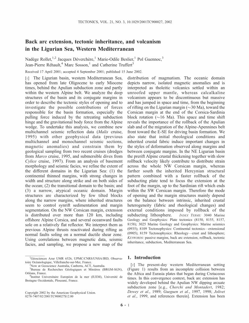
Figure 1. Simplified tectonic sketch of the western Mediterranean, modified after Gueguen et al.[1998]. Active extension has shifted eastward through time, following the rollback of the Ionian-Apuliansubduction zone (thick solid line). The eastward migration of the Apennines trench and the back arcextension is symbolized by the dark arrow. Dashed line indicates the poorly known prolongation of theAlpine Front offshore. Inset depicts the Ligurian domain under study (location on Figure 2).Abbreviations are C, Corsica; Pr, Provence; Sa, Sardinia; Si, Sicily. (Reprinted with permission fromElsevier Science.)
6 - 2 ROLLET ET AL.: LIGURIAN SEA BACK ARC STRUCTURE AND EVOLUTION
nean basins is often controversial, since they depend oncomplex, deep processes like delamination of lithosphericmantle, lateral slab detachment, variable buoyancy forces, orconvective removal of thickened lithospheric roots, whichare often poorly controlled [e.g., Carmignani et al., 1995;Lonergan and White, 1997; Carminati et al., 1998a, 1998b;Chamot-Rooke et al., 1999; Jolivet et al., 1999; Frizon deLamotte et al., 2000]; (2) the role of tectonic inheritancewithin the heterogeneous upper plate undergoing extensionbehind the subduction zone has not yet been fully under-stood, in spite of recent modeling attempts [e.g., Faccennaet al., 1996; Becker et al., 1999]; and (3) the age, nature, anddistribution of Neogene volcanism, which has accompaniedand postdated back arc extension, are poorly constrained inmany areas, and are not easily related to the various phasesof back arc evolution [e.g., Mauffret et al., 1995; Lonerganand White, 1997; Jolivet et al., 1999; Frizon de Lamotteet al., 2000;Maury et al., 2000, and references therein]. Thetwo latter points are particularly difficult to assess in theLigurian Sea case, because little attention has been paid tothis domain since the cruises performed in the 1980s [e.g.,Rehault et al., 1984, 1985].[5] This insufficient knowledge of the Ligurian domain
evolution has therefore motivated the acquisition of newdeep seismic reflection data (Malis cruise; lines located onFigure 2). This new data set is presented here, combined withprevious data (seismic and rock sampling) and constrainedby magnetic data and by rock samples newly dredged(Marco cruise) [Guennoc et al., 1995] or recovered duringsubmersible dives (Cylice cruise) [Sosson and Guennoc,1997]. They provide the unique opportunity to investigatein detail the superficial and depth structures of both marginsand the basin and to document the extent of volcanism andits migration in space and time. The present paper analyzesthe following: (1) the segmentation and the inheritance onthe conjugate margins, in mapping the variations in structureand deformation of the thinned continental crust from SW toNE, i.e., along strike; (2) the tectonic style of the conjugatecontinental margins, and the extent and structure of thenewly formed basin and of the transitional domain identifiedin between; and (3) the significance and origin of thevolcanism and magmatism in the basin and on the margins.Hypotheses on the nature of the basement in the newlyformed basin are proposed. These data also give some newinsights into the relationships between extension and mag-matism and the transition from continental rifting to seafloorspreading. From these observations we aim to better assessthe relative contribution of the different mechanisms whichled to the opening of the Ligurian basin.
2. Geodynamical and Geological Settings
2.1. Ligurian Basin Opening
[6] The opening of the first western Mediterranean basinswas initiated �30 Myr ago (see Jolivet and Faccenna[2000] for a review). They developed successively duringlate Oligocene–early Miocene in the Valencia, Ligurian,and Alboran basins [Maldonado et al., 1992; Roca and
Desegaulx, 1992; Fernandez et al., 1995], and during themiddle-late Miocene in the eastern Balearic and Algerianbasins [Roca and Desegaulx, 1992; Lonergan and White,1997; Frizon de Lamotte et al., 2000], and until lateMiocene and Plio-Pleistocene in the Tyrrhenian basin [Kas-tens et al., 1988; Gueguen et al., 1998]. All these basinswere formed in a back arc position relative to the eastwardor southward retreating Apulian (Apennines-Calabria-Maghrebides) subduction zone (Figure 1).[7] Among these basins, it is worth noting that the oldest
one, the Ligurian basin, has opened within the Alpine andnorthern Apennines collision belt in its northern part and istrending oblique to the main thrusts [Carmignani et al.,1995; Doglioni et al., 1997]. Clear compressive episodeshave occurred successively from late Eocene to Pliocene inthis part of the Alpine belt, comprising the southern sub-Alpine fold and thrust belt to the west and the internal Alpsto the east. These phases are recorded on land, in particular atthe contact of the foreland basin (the Provencal platform)with the Digne thrust sheet [Lickorish and Ford, 1998, andreferences therein] and as far as the Nice and Castellane arcsto the east, at the coastline [Ritz, 1991; Laurent et al., 2000](Figure 3). Conversely, the southwestern Ligurian basin hasdeveloped within the eastern part of the Iberian plate[Carmignani et al., 1995], where no clear influence of thePyrenean orogeny is documented. Whether the emplacementof the Oligocene mountain front near the present-day coast-line of the north Ligurian basin implies significant crustalthickening close to it is questionable. The importance ofprerift lithospheric thickening in the Liguro-Provencal zoneis therefore highly variable in space and remains controver-sial [e.g., Mauffret et al., 1995; Chamot-Rooke et al., 1999].However, note that calculated Oligocene uplift rates at thecontact of the thrust sheets in the Digne arc are comparableto those recorded in active mountain belts [Artoni andMeckel, 1998]. Furthermore, the large part of the Liguriandomain located east of the main Frontal Penninic thrust(longitude 7.7�E, Figure 3) was necessarily located withinthe inner Alps at that time and therefore is likely to haveundergone an important thickening.[8] The timing of the so-called ‘‘synorogenic’’ to ‘‘post-
orogenic’’ extension (i.e., the extension occurring after themain Alpine collision in the hinterland) is only approximate[see, e.g., Jolivet and Faccenna, 2000, and referencestherein]. Nevertheless, from synrift sediments sampled orobserved in the Gulf of Lion and the Ligurian basin[Rehault et al., 1984, 1985; Gorini et al., 1993; Seranne,1999] and from timing of uplift of rift shoulders [Jakni et al.,2000], it appears that rifting occurred from �30 Ma to �21Ma and is followed by a �30� counterclockwise drift phaseof the Corsica-Sardinia block around a rotation pole locatedin the Gulf of Genova, from �21 Ma to �16 Ma [Vigliottiand Langenheim, 1995]. Recent paleomagnetic resultscoupled with 40Ar/39Ar dating in Corsica and Sardiniaevidence a rotation of the Corsica-Sardinia block of 45�–55� during the drift phase [Gattacceca, 2001], thus con-firming the prerift position from Gueguen [1995]. Althoughapproximate, this timing shows that the Ligurian basinopened after the Eocene phase but almost contemporane-
ROLLET ET AL.: LIGURIAN SEA BACK ARC STRUCTURE AND EVOLUTION 6 - 3

ously to the nappe emplacement phase of the Alpineorogeny which took place from late Eocene to earlyMiocene times [Fry, 1989].
2.2. Volcanic Activity and Back Arc Extension
[9] Rift-related volcanism is widespread in the westernMediterranean basins (Figure 4). The oldest samples recog-nized (Oligocene in age) are located in the Valencia trough,the Sardinian rift, and along the Liguro-Provencal margins
[e.g., Coulon, 1977; Bellon, 1981]. According to kinematicsreconstructions [e.g., Rehault, 1981; Burrus, 1984; LeCann, 1987; Gueguen, 1995; Gueguen et al., 1998], thisvolcanism roughly trended NE-SW, i.e., parallel to thepaleo-subduction zone before the rotation of the Corsica-Sardinia block. Therefore this volcanic activity seems atleast partly linked to the subduction process. It is partic-ularly well expressed on the western margins of the litho-spheric continental blocks (Corsica-Sardinia-Mallorca),behind the Alpine-betic belt and the Apennines-Maghre-
Figure 2. Location of multichannel seismic reflection profiles (long-dashed lines) acquired duringMalis cruise [1995], together with previous wide-angle data (solid dark lines, including EuropeanGeoTraverse (EGT) [see Egger et al., 1988]), other multichannel seismic reflection profiles (thinner darklines) [see Rehault et al., 1984], and monochannel seismic profiles (short-dashed lines). Numbered long-dashed lines are seismic reflection profiles shown in this paper. The background is shaded topographyand bathymetry with coastline shown.
6 - 4 ROLLET ET AL.: LIGURIAN SEA BACK ARC STRUCTURE AND EVOLUTION
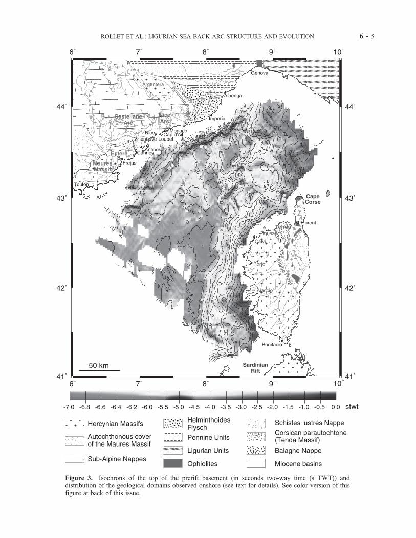
Figure 3. Isochrons of the top of the prerift basement (in seconds two-way time (s TWT)) anddistribution of the geological domains observed onshore (see text for details). See color version of thisfigure at back of this issue.
ROLLET ET AL.: LIGURIAN SEA BACK ARC STRUCTURE AND EVOLUTION 6 - 5

6 - 6 ROLLET ET AL.: LIGURIAN SEA BACK ARC STRUCTURE AND EVOLUTION
bides subduction zone [Mauffret et al., 1995; Gueguen etal., 1998]. Nevertheless, the extent of this volcanic activityonshore and offshore, and its relationship with the alkalinemagmas recognized within some of the basins like theTyrrhenian [Kastens et al., 1988; Serri et al., 1993], arepoorly known, especially within the first basins formedduring Oligocene-Miocene times, since they have under-gone a strong subsidence.[10] Carminati et al. [1998a, 1998b] propose that the
opening of the western Mediterranean in the Oligo-Mioceneis driven by the propagation of slab detachments as aconsequence of continental collision in the Alps and in theBetic-cordillera, and that the Alpine collision locked theCorsica-Sardinia drift to the east. They consider a slab break-off to have occurred along the northern African margin[Maury et al., 2000], which led to the end of the subductionzone retreat on the plate and the ‘‘jump’’ of extension towardthe Tyrrhenian area. Jolivet and Faccenna [2000] prefer toexplain the synchronism of extension in the Mediterraneanregion 30–25 Myr ago by the sharp decrease in the absolutevelocity of Africa. Determining the origin of slab retreat isbeyond the scope of this study. We will merely consider herethe sudden rollback of the slab at�30 Ma as one of the mainprocesses on which to build our tectonic regional interpre-tation. We note that the volcanic rock ages (31–24 Ma, 24–17 Ma, 17–11 Ma) recorded during the depocenter migra-tion in the foreland/foredeep domain onshore Italy [e.g.,Patacca et al., 1990; Van der Meulen et al., 1998], possiblybecause of the excess of detachment-related slab pull,correspond to ages recorded on volcanic rocks around theLigurian domain and in Sardinia (31–30 Ma for EsterelMassif and SW Sardinia; 26–24 Ma in Nice area and centralSardinian rift; 20–16 Ma in SW Corsica and northernSardinian rift; 12–11 Ma in the Gulf of Genova and NWCorsica [Coulon, 1977; Coulon et al., 1978; Bellon, 1981;Montigny et al., 1981; Rossi et al., 1998]). A detailedanalysis of the volcanism in the Ligurian basin and itsrelationship with deep structures is therefore an importanttarget for a better understanding of the early stages ofopening in the western Mediterranean Sea.
2.3. Geological History Onshore the Ligurianand Corsican Margins
[11] We choose to refer to the Ligurian margin as thesegment of the northern margin from Toulon to Genova, andthe Corsican margin as the whole eastern margin from theGulf of Genova to Bonifacio (Figure 3). Contrasting geo-logical features are observed on the exposed parts of theLigurian and Corsican margins. We briefly recall them hereas they are important for an interpretation of the offshorestructural units deduced from experimental seismology.Two main orogenic events have determined the structuralpattern of both margins: the Hercynian and the Alpineorogenies [Rehault et al., 1984; Mauffret et al., 1995;
Gueguen et al., 1998]. The diversity of outcrops observedaround the Ligurian basin emphasizes the important lateralvariations in nature and fabric of the basement.2.3.1. Ligurian Margin[12] From west to east along the Ligurian coast, there are
three major onland geological series.1. The autochthonous metamorphic Hercynian basement
of the Maures-Esterel Massif (Paleozoic) extends from westof Toulon up to Cannes. This basement is composed ofVariscan metamorphic rocks intruded by Carboniferousgranitoids. The Permian continental series surround theMaures Massif from Toulon up to Frejus and unconform-ably overlie the Variscan basement. To the northeast of theMaures Massif a large Permian volcanic zone forms thepresent-day Esterel Massif [Rouire et al., 1980].2. The autochthonous Meso-Cenozoic sedimentary cover
is between Cannes and Nice.3. The allochthonous outer alpine units are made of (1)
the Castellane and Nice arcs, formed by a pile of Mesozoicand Tertiary nappes verging toward the north; these nappesare sliding on a major decollement above the crystallinebasement [Fry, 1989; Laurent et al., 2000]; (2) theallochthonous Cenomanian-Maastrichtian HelminthoidesFlysch, located between the outer and inner Alps; and (3)and the Schistes Lustres nappe, including the ophiolitesMassif of the Voltri region located near Genova.2.3.2. Corsican Margin[13] The onshore Corsican margin displays even more
complex Cenozoic structures, with stacked nappes of oce-anic material thrusted upon the European margin andfollowed by an extension synchronous with rifting andspreading of the Ligurian basin [Jolivet et al., 1990; Four-nier et al., 1991; Malavieille et al., 1998]. Three main unitsare observed [Durand Delga, 1978].1. The allochthonous units of Alpine Corsica are mostly
composed of two different stacks of ophiolitic units: theSchistes Lustres nappe and the overlying Balagne-Nebbionappe, which also thrusts upon the western autochthonousbasement and Eocene sediments. The Balagne-Nebbionappe is composed of Mesozoic unmetamorphosed rocksof ‘‘Ligurian’’ (Adriatic oceanic plate) affinity, whereas theSchistes Lustres nappe is made of various Mesozoicmetamorphic rocks including ophiolitic paleo-Ligurianremnants and eclogitic relics deformed under HP conditions;2. The autochthonous Hercynian Corsica is mostly
composed of an Hercynian basement (Carboniferousgranites, Permian annular magmatic complexes) and pre-Hercynian rocks (Paleozoic series and metamorphic base-ment). This basement is affected by SW-NE late Hercynianfaults, which later acted as sinistral strike-slip faults duringthe Alpine phase.3. Allochthonous gneissic rocks represent two deformed
parts of the European continental margin with contrastingstyles of deformation: (1) a thrust unit recrystallized undermedium-metamorphic conditions and slightly displaced
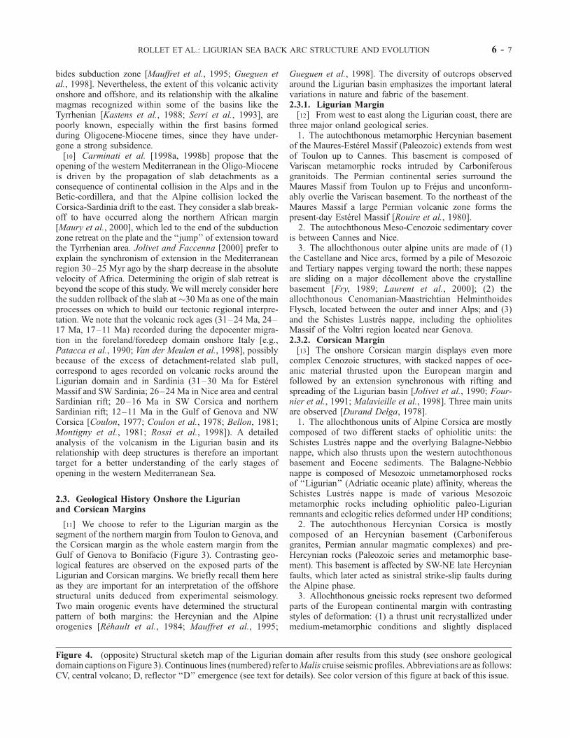
Figure 4. (opposite) Structural sketch map of the Ligurian domain after results from this study (see onshore geologicaldomain captions on Figure 3). Continuous lines (numbered) refer toMalis cruise seismic profiles. Abbreviations are as follows:CV, central volcano; D, reflector ‘‘D’’ emergence (see text for details). See color version of this figure at back of this issue.
ROLLET ET AL.: LIGURIAN SEA BACK ARC STRUCTURE AND EVOLUTION 6 - 7

toward the west (the Tenda Massif ), and (2) a supracrustalslice strongly deformed and metamorphosed under HP-LTconditions (the Sera di Pino and Farinole gneiss nappes)[see Malavieille et al., 1998, and references therein].[14] In Alpine Corsica, the exhumation (more than 50
km) of high-grade metamorphic rocks is believed to haveoccurred along a previously eastward dipping arc-continentsubduction plane [Malavieille et al., 1998], later followedby a cordillera-type metamorphic core complex denudation[Jolivet et al., 1990, 1991; Fournier et al., 1991; Car-mignani et al., 1995; Daniel et al., 1996], in a single,westward dipping subduction context [Brunet et al., 2000].[15] According to 40Ar/39Ar dating, exhumation of eclo-
gites, metamorphosed up to the blueschist facies conditions,has occurred between 45 and 38 Ma, whereas the latedenudation phase took place between 30 and 12 Ma [Brunetet al., 2000; Jakni et al., 2000]. The progressive eastwardmigration of compression and extension evidenced inAlpine Corsica and north Tyrrhenian Sea has played asignificant role in the thinning of the Corsican crust byreactivation of the thrust contacts as ductile normal faults[Jolivet et al., 1990] between 33 and 22 Ma, and againeastward between 18 and 12 Ma, at the onset of theTyrrhenian rifting [Jolivet et al., 1990; Van der Meulenet al., 1998; Brunet et al., 2000, and references therein].
3. Data Acquisition and Processing
[16] This paper uses mainly multichannel (MCS) andsingle channel (SCS) seismic reflection profiles combinedwith a new set of MCS and wide-angle data recorded duringthe Malis cruise onboard the French R/V Le Nadir(IFREMER) in 1995. The seismic interpretations have beenconstrained by samples (Marco, 1995, and Cylice, 1997cruises), reprocessed magnetic data (compilation of twoaeromagnetic surveys and reduction to the pole) and altim-etry data [Sandwell et al., 1995]. The Malis cruise collected37 MCS sections, totaling 3300 km in the Ligurian basin onboth conjugate margins and in the deep basin (Figure 2).The acquisition system was composed of a 2.5-km-longstreamer made of 96 channels, permitting a 24-fold cover-age and a far offset of 3000 m, and by a source array of 10air guns of GI-gun type (Generator-Injector), also called‘‘pulse free’’ air guns [Avedik et al., 1993, 1996]. The totalarray volume was 1935 cubic inches (31.7 L) and the signal-generating volume was 1140 cubic inches (18.7 L). Shotinterval was set at 50 m, sample rate at 4 ms, and recordlength at 17 s. Seismic processing included sphericaldivergence, attenuation of multiple energy, normal moveout (NMO) correction, stacking, FK-domain migration,depth-varying time domain filtering, and automatic gaincontrol linked to water depth.[17] When interpreting seismic reflection data we are
facing two major problems. The first one is linked to thepresence of a thick salt layer in the western Mediterraneandeep basins, formed during the Messinian salinity crisis, atthe time when the Mediterranean Sea was temporarily andrepeatedly separated from the Atlantic Ocean [Cita et al.,1978; Ryan and Cita, 1978; Clauzon et al., 1996]. This saltlayer creates an acoustic velocity inversion with depth which
does not favor the recording of acoustic waves from thelayers just beneath it. Salt diapirs also generate large hyper-bolas that strongly alter the sections even if time-migrated[e.g., de Voogd et al., 1991]. The second problem is relatedto the time arrival of the first water column multiple from theseafloor, which comes close to the top of the acousticbasement reflector in the basin (at around 6.5–7 s two-way time (TWT)) and at shallower levels on the margins:therefore this additional signal interferes with the deepestreflections within the crust. Other encountered problems are(1) the very rough bathymetry which reflects the strongimprint of the Messinian desiccation [e.g., Bellaiche, 1993];related deep canyons, which were avoided during MCS datarecording, prevent us from an easy correlation betweenparallel lines transverse to the margins; and (2) the narrowand steep upper slope of the Corsican margins which hasfavored strong erosional processes and then contributed tothe absence and/or scarcity of prerift, synrift, and evenpostrift sediments on large parts of the margin.[18] In order to minimize problems arising from the salt
layer and long-period multiple energy, we have taken partic-ular care during the acquisition and processing phases. First,we have used a particular source combination made of atuned air gun array with different volumes and depths inorder to increase the acoustic energy and frequency content.All air guns were synchronized by using the ‘‘single bubble’’pulse generating method, in order to exploit the strongenergy at low frequency contained in the first bubble pulse[Avedik et al., 1993, 1996]. This method has allowed to reacha good seismic penetration within deep layers, down to thetop of the basement of the basin and the margins, andsometimes down to the Moho (around 8–10 s TWT).Second, a particular prestack processing method was appliedon the data which attenuates the seabed multiple and somemultiples of the uppermost sediment layers. This method,based on the TPMUL method of the Geovecteur SoftwareTM
(Compagnie Generale de Geophysique, France), is designedfor computing a model of multiple events and to subtract itfrom the input gathers. The program automatically picks upthe traces for which the residual curve after normal move out(NMO) is above an upper bound imposed by the user, and itdeletes them. At a given depth, the curves are characterizedby a time difference referring to the maximum offset. Thismethod was selected among several others, as it was partic-ularly effective for eliminating the seafloor multiple energyin the deep basin and allows us to better identify the top ofthe basement in the whole basin and also locally until 10 sTWT under the margins.
4. Identification of the Various Domains
in the Ligurian Basin
[19] The Malis MCS reflection profiles have been cross-correlated with other older MCS profiles, i.e., �3500 kmof seismic sections called MS (OGS Trieste), Augusta,Odyssee, J (Institut Francais du Petrole (IFP)) [seeRehault, 1981; Rehault et al., 1984; Gennesseaux et al.,1989], and SCS profiles acquired on the upper margins[e.g., Rehault, 1981; Bellaiche, 1993; Gaullier, 1993;
6 - 8 ROLLET ET AL.: LIGURIAN SEA BACK ARC STRUCTURE AND EVOLUTION

Chaumillon et al., 1994]. Using all seismic data together,we attempt to draw the structure of the basement of theLigurian basin and the spatial distribution of the mainacoustic units below the sedimentary pile with as manydetails as possible.[20] We first propose a new and updated map of the top
of the prerift acoustic basement by interpolating the iso-chrons from one profile to another, using all the MCSreflection profiles available in the region (Figures 2 and 3).The top of the prerift sediments on the margins and the topof the acoustic basement in the deep basin have beensystematically digitized. We have also tried to recognizethe offshore continuation of the major geological domainsmapped onshore and around the basin. This new mapimproves the accuracy on the morphology and nature ofthe acoustic basement compared to previous maps [Rehault,1981; Burrus, 1984]. Moreover, on the basis of the inter-pretation of the whole data set available in the basin,including magnetic and gravity anomalies, we proposenew boundaries for the three domains recognized in theacoustic basement in the Ligurian basin, namely, (1) thecontinental thinned margins, (2) the transitional domain,and (3) the central domain (Figure 4). We rely mostly onacoustic facies changes evidenced from our interpretation ofthe homogenous and deeply penetrative (at least down tothe acoustic basement surface) Malis MCS data set.
4.1. Thinned Continental Margins
[21] Following previous authors [Pascal et al., 1993;Mauffret et al., 1995], the continental thinned conjugatemargins are limited oceanward by the slope break of thebasement acoustic facies. This domain is structured ingrabens and a few half grabens.[22] We identify offshore two major domains which are
also recognized onshore (Figure 3): (1) the Hercynianbasement and its sedimentary cover located in theMaures-Esterel Massif on the northern margin and in thewestern part of the Corsican margin, and (2) the Alpinenappes (Mesozoic cover, Eocene Flysch, ophiolites andSchistes Lustres) located east of Antibes on the northeasternpart of the Ligurian margin, and east of Ile Rousse on theeastern part of the Corsican margin. Changes of synriftstructural trends in the prerift acoustic basement correlatequite well with changes in the geology of the outcropsobserved along the coast (Figure 4): This suggests that thepreexisting structures have influenced the mode of defor-mation of the acoustic basement during rifting. The mor-phology of the top of the acoustic basement and of thedeeper reflectors also provides some indications on thewidth of the margins after rifting and on their detailedstructure, from 0 to 6 s TWT, if we neglect at first orderpossible postrift tectonic deformation. The morphology ofthe prerift acoustic basement on the Corsican margin isbetter preserved than on the conjugate margin, where theactive Messinian erosion event has strongly leveled theprerift and synrift structures. Nevertheless, on both margins,it is quite clear that the width of the margins is asym-metrical. Indeed, the Ligurian margin is about 40–50 kmwide from northeast to southwest, in contrast with the
Corsican margin which is generally wider (�70–80 kmwidth on NW and SW Corsican margins).
4.2. Transitional Domain
[23] The limits and nature of the so-called ‘‘transitionaldomain’’ (TD) identified between the continental marginsand the deep basin have been revised. The existence of a TDin the Ligurian basin was proposed by Gueguen [1995], whohas mostly based its interpretation on the correlation betweenthe change in magnetic patterns [Bayer et al., 1973;Mauffretet al., 1995] and the Messinian salt pinch at the foot of themargins. We revise the position of the oceanward limit of theTD by combining two criteria: (1) a change in magnetic fieldexpression between the quiet magnetic zone observedaround the deep basin, corresponding to negative magneticanomalies (up to 50 nT), and the disturbed magnetic field inthe deep basin; and (2) a change in the acoustic basementfacies systematically observed on seismic reflection data(Figures 5a and 5b). We have preferentially used this lattercriterion, except where seismic data are absent or too sparse(like on theSWLigurianmargin).On theMalis cruise data, theTD along the Ligurian margin is characterized by a group ofstrong reflectors at the top of the acoustic basement slightlydeepening toward the continent (Figure 5a), which generallyrepresents the deepest seismic reflectors. On the Corsicanmargin, and especially on its northwestern part, theTDdepictsa seismic facies typical ofvolcanic flowsassociatedwith large,circular magnetic anomalies (see section 6.2).We assume thatthe seismic facies changes between the TD and the deep basin(Figures 5a and 5b) likely indicate the transition to a ‘‘true’’ocean-like domain, since they can be attributed to differentgenetic and evolutionary processes of the crust. Compared toprevious studies, our TD oceanward limit is rather similar tothe one proposed by Rehault [1981] and Le Douaran et al.[1984] on the Ligurian margin, except in NW Corsica wherethis limit is shifted�20 km oceanward from Rehault’s [1981]one. Compared to previous studies, we therefore propose aslightly narrower oceanic domain in the northeastern half ofthe Ligurian basin, and a wider NW Corsican margin.
4.3. Central Domain
[24] Although deep drilling data are lacking, the centralLigurian basin is considered as an oceanic-type domain bymost authors [Rehault, 1981; Burrus, 1984; Le Douaranet al., 1984; Le Cann, 1987; Pasquale et al., 1994; Gueguen,1995;Mauffret et al., 1995; Contrucci, 1998;Gueguen et al.,1998; Contrucci et al., 2001], but with varying character-istics and shapes. These interpretations differ on the nature ofthe crust, which is poorly constrained and seems to beatypical according to geophysical data [e.g., Mauffret et al.,1995; Chamot-Rooke et al., 1999]. Indeed, the crust ischaracterized by much thinner than average thickness(<4 km) and ambiguous magnetic anomalies (too complexand discontinuous to correlate with isochrons) [see, e.g.,Bayer et al., 1973; Burrus, 1984]. We have based ourinterpretation of the atypical oceanic domain on the presenceof a particular acoustic facies (Figure 5b) formed by base-ment undulations (�5 km length and more than 1 s TWTamplitude) often covered by diffractions which are similar to
ROLLET ET AL.: LIGURIAN SEA BACK ARC STRUCTURE AND EVOLUTION 6 - 9

seismic facies identified in the Tyrrhenian Sea [Pepe et al.,2000] and calibrated with Ocean Drilling Program (ODP)site 650 well data [ODP Leg 107 Shipboard Scientific Party,1987]. This acoustic basement is overlain by sedimentswhich form several small angular unconformities due tobasement irregularities. This observation attests that theseundulations are not the only consequence of pull-up effectsdue to thickness variations of the salt layer. Finally, we alsonote from the morphology of the deep basin that no clearaxial ridge is present near the center of the basin. Instead, weobserve only several small discontinuous ridges (up to 20 kmacross) trending N030–040 (Figure 3).
5. Segmentation and Style of Deformation
on Conjugate Margins
5.1. Mapping the Margin Segmentation
[25] At large scale, prerift rheology and geological inher-itance are known to strongly influence back arc extension, as
shown for instance in the central Mediterranean [e.g., Fac-cenna et al., 1997]. We attempt here to determine the role ofinheritance and rheology in the case of the Ligurian basin.We call hereinafter ‘‘segment’’ a part of the margins charac-terized by the same trend and width on a significant distance.[26] Despite the Messinian erosion event that leveled
much of the prerift and synrift structures [e.g., Rehaultet al., 1984], we can recognize three major segments alongthe Ligurian margin (Figures 3 and 4): (1) one from Toulonto longitude 6.7�E, trending roughly E-W, poorly imagedbecause of the scarcity of seismic data, (2) one fromlongitude 6.7�E to Antibes, trending N30�–40�, relativelywide and smooth, averaging 50 km width, and (3) one fromAntibes to Albenga, trending 50�N, narrower and with anabrupt slope, averaging 40 km width. The two southernsegments limit offshore the metamorphic HercynianMaures-Esterel Massif, whereas the northern one is theoffshore prolongation of the Alpine nappes. On the Corsi-can margin (Figures 3 and 4) [see Guennoc et al., 1998], wealso observe a clear segmentation from north to south into
Figure 5. Typical facies of the acoustic basement: (a) in the transitional domain (TD), and (b) in theNW deep basin. In the TD we interpret the reflective top of the acoustic basement (arrows) as volcanicflows sourced from nearby lava centers. In the deep basin, we interpret undulations of the basement(arrows) as discontinuous volcanoes and dykes intruded in a disrupted crust (see text for details). Insetslocate the Malis lines shown. Abbreviations are as follows: stwt, seconds two-way travel time; pq, Plio-Quaternary sediments; ue, Upper Evaporites (late Messinian at �5.3 Ma); mio, Miocene sediments.
6 - 10 ROLLET ET AL.: LIGURIAN SEA BACK ARC STRUCTURE AND EVOLUTION
three main parts: (1) the first one, trending roughly N-S toN40�E in the Gulf of Genova up to Cape Corse-Calvi, isvery wide (�80 km) and corresponds to the offshorecontinuation of Alpine nappes; (2) the second segment, onthe western Corsican margin between Calvi and Ajaccio, isthe narrowest (�40 km) and marks the prolongation of theHercynian metamorphic basement observed onshore; (3) thethird segment trends roughly N160� along the southwesternCorsican margin, and becomes wider (�80 km) fromlatitudes 42�000N to 41�200N. It may be related to theoffshore prolongation of the Sardinian rift toward the north,which developed in the zone of unthickened crust reacti-vated at the end of the Ligurian opening phase and during astrong postrift magmatic event [Coulon, 1977; Montignyet al., 1981; Gennesseaux et al., 1989; Carmignani et al.,1995; Rossi et al., 1998]. Therefore this segmentationappears clearly correlated to onshore geological changes(see section 2.3) and thus suggests a clear control ofinheritance and rheology on the morphological segmenta-
tion of the margins (Figure 3) when compared to otherfactors like differential erosion or tectonic flexure [Chau-millon et al., 1994].
5.2. Control of Multiphase Inheritanceon Extensional Structures
[27] The crustal structure imaged on MCS lines, in goodagreement with the morphological segmentation, confirmsthat the style of extensional deformation is variable alongthe margins and between the conjugate margins, and that itis directly dependent on the Hercynian or Alpine inher-itance. We select one representative profile on each con-jugate margin in order to depict the structures involved atdepth in each case.5.2.1. Ligurian Margin[28] On the Ligurian margin, offshore the Maures Massif,
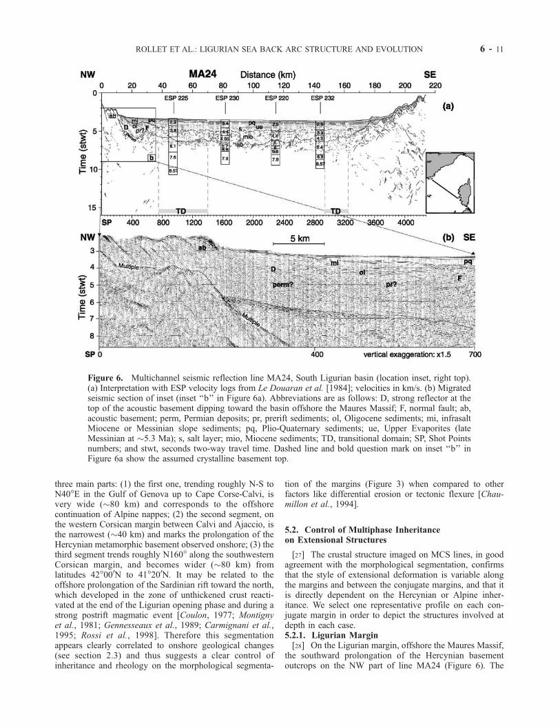
the southward prolongation of the Hercynian basementoutcrops on the NW part of line MA24 (Figure 6). The
Figure 6. Multichannel seismic reflection line MA24, South Ligurian basin (location inset, right top).(a) Interpretation with ESP velocity logs from Le Douaran et al. [1984]; velocities in km/s. (b) Migratedseismic section of inset (inset ‘‘b’’ in Figure 6a). Abbreviations are as follows: D, strong reflector at thetop of the acoustic basement dipping toward the basin offshore the Maures Massif; F, normal fault; ab,acoustic basement; perm, Permian deposits; pr, prerift sediments; ol, Oligocene sediments; mi, infrasaltMiocene or Messinian slope sediments; pq, Plio-Quaternary sediments; ue, Upper Evaporites (lateMessinian at �5.3 Ma); s, salt layer; mio, Miocene sediments; TD, transitional domain; SP, Shot Pointsnumbers; and stwt, seconds two-way travel time. Dashed line and bold question mark on inset ‘‘b’’ inFigure 6a show the assumed crystalline basement top.
ROLLET ET AL.: LIGURIAN SEA BACK ARC STRUCTURE AND EVOLUTION 6 - 11

top of the acoustic basement (‘‘ab’’) is underlined by astrong reflector (D) (between shot points 230 and 600,Figure 6) slightly deepening toward the basin (�30� ofapparent dip), down to 6.5 s TWT. Below reflector (D) weobserve a series of continuous reflectors which deepenstoward the basin (�16� dip) and top laps below it. Weinterpret these reflectors as Permian and/or Mesozoic seriesequivalent to the Permian basins and their Mesozoic coverwhich surround the Maures Massif onshore. If this hypoth-esis is correct, this sedimentary cover must be separatedfrom the diffracting crystalline basement by an unconform-ity or paleo-topography (dashed line on Figure 6a) which isnot visible on profile MA24; note basement diffractionseven on the migrated section in Figure 6b). On the basis ofthese observations and the correlation with other seismiclines, we suggest that the onshore Permian basin surroundsthe whole Maures Massif and reaches its southern limit onthe Ligurian margin. This hypothesis is consistent with theabsence of Permian sediments in Corsica, on the conjugatemargin. Above and along this reflector (D), a sedimentarycover (‘‘ol/pr’’), �4000 m thick (assuming an acousticvelocity of 4 km/s), is tilted toward the continent. Wesuggest that this series is composed of slightly deformedprerift sedimentary cover of the Maures Massif and/or bythick synrift Oligocene sediments, which would be thickerin the central part of the rift than at its end, near Saint-Tropez. Indeed, upper sediments (‘‘ol’’) have comparableacoustic facies to those observed northward of the MA24profile, in the Stoechades canyon, where Oligo-Aquitaniandeposits (from 30–28 to 21 Ma), made of interlayeredconglomerates and sandstones, have been identified bysubmersible with a thickness of at least 700 m [Bellaicheet al., 1976; Angelier et al., 1977]. On our section, thesedimentary pile (ol/pr) is bounded by two normal faults (Dand F on Figure 6) dipping toward the basin (30� and 40� ofapparent dip for D and F, respectively), and displays arollover geometry above reflector D. We show that thisreflector D, which is clearly imaged on several lines fromToulon to longitude 6.5�E, forms a continuous, nearly E-Wtrending fault along the margin (Figure 4). This trend issubparallel to the structural pattern observed onshore in theMaures Massif [Rouire et al., 1980] (Figure 3), where faultsaffect the basement and have a multiphase history inheritedfrom Stephanian time. Therefore we suggest that bothonshore and offshore fault networks were inherited fromthe same multiphase tectonic history, and that offshorestructures have been reactivated during the Oligocene open-ing of the Ligurian basin.[29] This interpretation is supported by comparable struc-
tural features geometry observed offshore and onshore theGulf of Lion [Gorini et al., 1993; Guennoc et al., 1994;Mauffret et al., 1995; Benedicto et al., 1996; Seranne,1999]. Offshore, it is interpreted as a decollement associatedwith reactivated Pyrenean thrusts. Onshore, rollover geo-metries are observed in half grabens filled by 4000-m-thickOligo-Aquitanian sediments, in and northward of the Vis-trenque graben, along listric faults flattening at depth insoutheastward dipping crustal ramps with low dip (25�).They are interpreted as synrift extensional features either
formed by inversion tectonics of inherited Pyrenean thrusts,or newly formed and controlled by crustal weakeningassociated with the previous Pyrenean thickening.5.2.2. Corsican Margin[30] On the Corsican margin, near the NW Cape Corse,
the influence of Alpine tectonics in the structural pattern isclearly observed. Profile MA02 (Figure 7), trending per-pendicular to the margin, depicts the acoustic basement(‘‘ab’’) slightly deepening toward the basin, from 4 to 6.5 sTWT, forming collapsed blocks of around 8 to 15 km width.The nature of this acoustic basement has been identified bysampling during submersible dives (Cylice cruise) [Sossonand Guennoc, 1997; Sosson et al., 1998] on the outcroppingsummit of the Glangeaud Seamount located slightly south-ward of MA02 line (Figure 4). The pegmatitic granitesampled here indicates that the Glangeaud Seamount isthe offshore prolongation of the Hercynian Corsican crys-talline basement of the Tenda Massif. Wide-angle seismicdata acquired in the region along the European GeoTraverse(EGT) profile [Egger et al., 1988] (location on Figures 2and 7, inset), provide some consistent basement velocitiesof 6.2–6.3 km/s.[31] At the foot of the margin, the top of the acoustic
basement is underlined by strong reflectors (c) gently dip-ping toward the continent with an apparent dip of 30�. Thesereflectors sole into a group of strong reflectors (d), subhor-izontal and subparallel, between 6 and 7 s TWT, locatedbetween shot points 2900 and 3100 on Figure 7. They areimaged on seismic lines along the whole NW Corsicanmargin (from Porto to the northern Cape Corse, Figure 4),from the foot of the slope down to the transitional domainboundary. By analogy with onland features, we tentativelyinterpret reflectors (c) as a thrust at the base of units relatedto the Alpine orogeny and reflectors (d) as a decollement (orshear zone) within the Alpine nappes. We have no way toknow whether reflectors (d) mark the limit between allochth-onous and autochthonous rocks. As the basement is shiftedand deepens toward the basin along these features, wepropose that they were reactivated as normal faults duringthe Ligurian basin opening. Indeed, such reactivated featuresare described onland, on the eastern flank of the TendaMassif, where normal ductile shearing reactivation occurredin the 32–25 Ma time interval along the east Tenda shearzone [Brunet et al., 2000], which was a former Alpine thrust[Jolivet et al., 1990, 1991; Daniel et al., 1996]. An offshoreanalogue is described in the northern Tyrrhenian Sea, wherecomparable tectonic features are interpreted as related to thedenudation of nappes associated with back arc exhumation[Jolivet et al., 1998].[32] In the upper margin, the acoustic facies (n), up to 1.5 s
TWT thick, is formed by layered reflectors slightly dippingtoward the continent. According to EGT data, velocitiesrange in this series from 2.2 to 4.8 km/s [Egger et al., 1988].Both sediment series (n) and the underlying acoustic base-ment are affected by NE-SW trending normal faults dippingtoward the basin with a 60� apparent dip (Figure 8). Weinterpret the series (n) as the offshore prolongation of theupper Alpine nappes which cover the acoustic basementonland. There, the Nebbio Nappe (upper unit like the
6 - 12 ROLLET ET AL.: LIGURIAN SEA BACK ARC STRUCTURE AND EVOLUTION

Balagne nappe) overthrusts the Schistes Lustres nappe (in anarrow sense), and these two Alpine units are unconform-ably overlain by the Miocene sediments (17–11 Ma) of theSt. Florent basin [Ferrandini et al., 1998]. This structuralsetting is similar to the one observed in the acoustic units inthe upper margin. Our reflection seismic interpretation(Figure 8) suggests that normal faulting took place afterthe Alpine nappes development in the upper Eocene andbefore Miocene sedimentation. Therefore these faults arecoeval with the Oligocene reactivation of former Alpinethrusts (reflectors (c) and east Tenda shear zone). Offshorecentral and southern Corsica, few steep fault scarps areshifting the top of the margin basement down the slope(Figures 4 and 6), and several transverse faults are in theprolongation of Hercynian structures onshore (Figure 4)which may have been reactivated as synrift transfer faults.
5.3. Asymmetrical Structure of Conjugate Margins
[33] The deepest structure (lower crust) of the conjugatemargins is poorly documented by the available seismic
data, as wide-angle data are scarce, and MCS data provideonly locally information down to the Moho. However, wehave identified the main gross scale structural features ofboth margins down to midcrustal levels and have cross-checked them.[34] The Ligurian margin is narrow (around 40 km
wide), mainly formed by two major tilted blocks (15–20 km wide) with locally, offshore Imperia, a third smallerblock (Figure 4). Because of Messinian erosion, the preriftgeometry is poorly preserved on this margin (Figure 9).Indeed, the Messinian erosion surface (MS) leveled theupper margin and is clearly connected to the base of thesalt (s) layer in the basin (Figure 9). The structural trend ofthe two main crustal blocks is subparallel to the main trendof the whole margin and varies from southwest to north-east (Figure 4), depending upon the tectonic inheritance:the Stephano-Permian tectonic phase to the southwestoffshore the Maures-Esterel Massif, and the Alpine tec-tonic phase to the northeast. The conjugate west Corsicanmargin is wider at its northern and southern ends (70–80 km wide), where it is composed of numerous small
Figure 7. Multichannel seismic reflection line MA02, northern Ligurian basin (location on inset, topright). (a) Profile interpretation; (b) Migrated seismic section of inset ‘‘b’’ shown in Figure 7a.Abbreviations are as follows: ab, acoustic basement of the Glangeaud-Tenda unit; n, Alpine thrustednappe; c, reflectors ‘‘c’’; d, reflectors ‘‘d’’ (see text). The European GeoTraverse (EGT) velocitydetermination from Egger et al. [1988] and the location of MCS line MA18 are shown. Otherabbreviations are as in Figure 6.
ROLLET ET AL.: LIGURIAN SEA BACK ARC STRUCTURE AND EVOLUTION 6 - 13
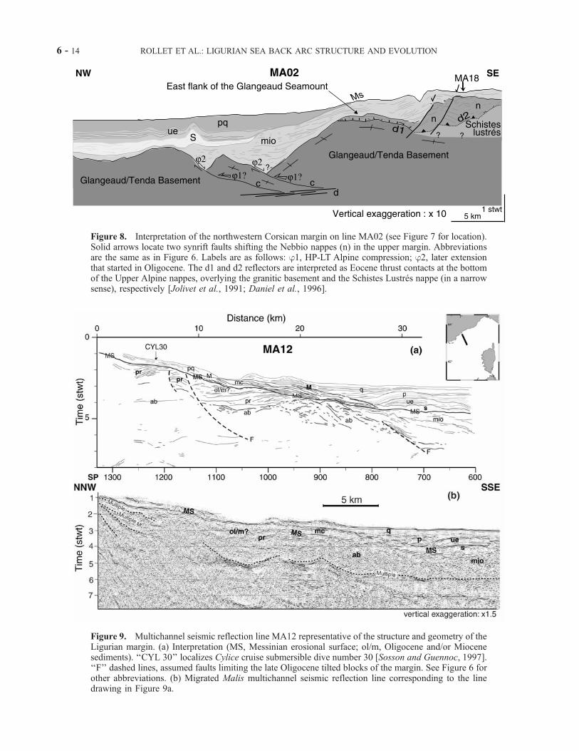
Figure 8. Interpretation of the northwestern Corsican margin on line MA02 (see Figure 7 for location).Solid arrows locate two synrift faults shifting the Nebbio nappes (n) in the upper margin. Abbreviationsare the same as in Figure 6. Labels are as follows: j1, HP-LT Alpine compression; j2, later extensionthat started in Oligocene. The d1 and d2 reflectors are interpreted as Eocene thrust contacts at the bottomof the Upper Alpine nappes, overlying the granitic basement and the Schistes Lustres nappe (in a narrowsense), respectively [Jolivet et al., 1991; Daniel et al., 1996].
Figure 9. Multichannel seismic reflection line MA12 representative of the structure and geometry of theLigurian margin. (a) Interpretation (MS, Messinian erosional surface; ol/m, Oligocene and/or Miocenesediments). ‘‘CYL 30’’ localizes Cylice cruise submersible dive number 30 [Sosson and Guennoc, 1997].‘‘F’’ dashed lines, assumed faults limiting the late Oligocene tilted blocks of the margin. See Figure 6 forother abbreviations. (b) Migrated Malis multichannel seismic reflection line corresponding to the linedrawing in Figure 9a.
6 - 14 ROLLET ET AL.: LIGURIAN SEA BACK ARC STRUCTURE AND EVOLUTION
blocks (three to seven blocks between 10 and 17 km wide;see Figures 6 and 7). The structural style on this margin isinfluenced by two different tectonic patterns: At the NEend, the Alpine inherited structures extend across theentire margin, whereas at the SW end, the northwardcontinuation of the N-S Sardinian rift localized the exten-sion in a graben at the foot of the margin (Figure 4).[35] In the sedimentary cover, the synrift sediment (ol/m)
thickness decreases progressively toward the NE on theLigurian margin. Synrift sediments are finally absent at theNE end of profile MA02 (Figure 7) and farther north. Onthe Corsican margin, no synrift deposits have been identi-fied, except for some limited Oligocene sediments discov-ered onshore [Ferrandini et al., 1999], but Miocenesediments are suboutcropping (Figures 7 and 8). Thisdeposition asymmetry depicts a different subsidence evolu-tion and/or a differential erosion history on both conjugatemargins, and a more recent differential uplift since 10 Ma[Chaumillon et al., 1994; Bigot-Cormier et al., 2000; Jakniet al., 2000]. From north to south, the top of the basementremains in a higher position further into the basin on theCorsican margin than on the Ligurian margin (Figure 6).Note that part of this difference in elevation could also berelated to the recent differential uplift between the conjugatemargins [Rehault, 1981; Chaumillon et al., 1994; Bigot-Cormier et al., 2000; Jakni et al., 2000].
6. Nature and Evolution of Magmatic Events
[36] From our MCS data interpretation constrained bysampling, we have performed a systematic identification ofvolcanic or volcanoclastic bodies in the basin and themargins. Although more data are needed to accuratelydetermine their extent at depth, we attempt here to gatherinformation from MCS seismic sections, magnetic anoma-lies, and sampling on the seafloor, in order to roughly assessthe geometry and extent of volcanic bodies and plutonicunits in the Ligurian basin, which have been only scarcelyexplored previously.
6.1. Cross Correlation of Seismic Data
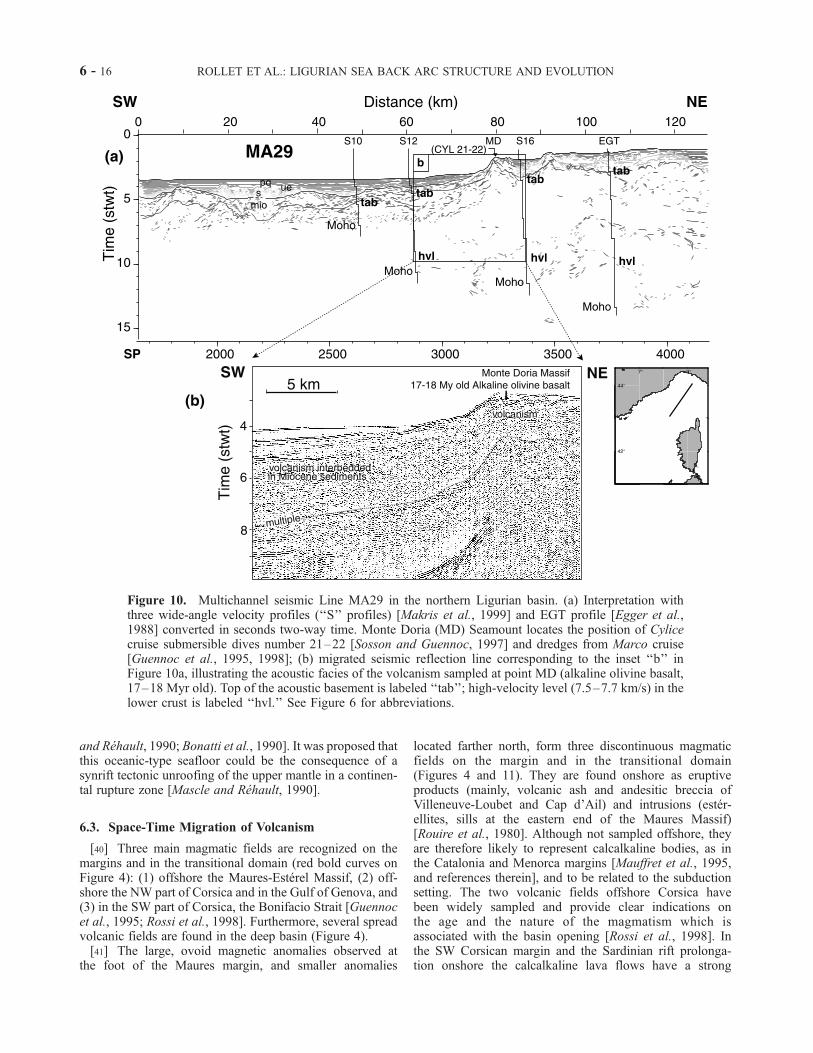
[37] Two seismic lines from Malis cruise offer the oppor-tunity to cross-check our MCS interpretations with wide-angle data down to the Moho: profile MA24 in the SW partof the Ligurian basin (ESP data from Le Douaran et al.[1984]; Figure 6), and profile MA29 in the Gulf of Genova(wide-angle data from Egger et al. [1988] and Makris et al.[1999]; Figure 10). In both places, we note the presence of ahigh-velocity layer (HVL) at the base of the crust (7.5–7.7km/s), located under peculiar seismic facies. In the Gulf ofGenova, where the HVL is well constrained by threevelocity logs, the HVL is located at depth under the MonteDoria volcano. The Monte Doria Seamount, on top of whichbasalts 11–12 Ma old were sampled by dredges andsubmersible dives (K/Ar method) [Sosson and Guennoc,1997; Rehault et al., 1998], depicts the representativeacoustic facies of the volcanic and volcanoclastic units wehave identified on the lines, which is made of short andwavy reflectors (Figure 10). This acoustic facies is charac-
terized by ovoid bodies, found in the TD, the centraldomain, and on the deep SW Corsican margin (Figure 4).[38] Several authors have previously identified a HVL
along the Ligurian margin from the Gulf of Lion to the Gulfof Genova [Le Douaran et al., 1984; Egger et al., 1988;Pascal et al., 1993; Contrucci, 1998; Chamot-Rooke et al.,1999; Rollet, 1999; Contrucci et al., 2001]. Conversely, ithas been found only locally on the Corsican margin [Con-trucci et al., 2001], but only few wide-angle data exist there.The HVL acoustic velocities range between 7.1 to 7.6 km/s.They correspond generally to 2 to 3 km thick lenticularlayers located at the base of the crust under the foot of themargin and in the TD. They have been interpreted either asdeep oceanic crust [Le Douaran et al., 1984], serpentinizedmantle [Mauffret et al., 1995], or underplated material[Makris et al., 1999]. The data set available in the Liguro-Provencal basin does not allow us yet to discriminatebetween these hypotheses.
6.2. Magnetic Anomalies Against Seismic Data
[39] The new map of magnetic anomalies reduced to thepole produced here (Figure 11) offers the opportunity tocheck our seismic interpretation and to increase the spatialcoverage of magmatic fields. This map also allows for acompletion toward the west of the map recently published byChiappini et al. [2000] and for a better control on the overallstability of the magnetic anomaly pattern published morethan 20 years ago [Bayer et al., 1973; Galdeano andRossignol, 1977]. Indeed, the pole reduction applied is likelyto provide a more accurate location of magnetic anomalies.The superimposition of the volcanic acoustic facies deter-mined (Figure 11, thick red lines) and the magnetic anoma-lies shows a fairly good fit. Volcanism identified on seismicprofiles are generally above the largest positive magneticanomalies, not only on the margins, but also (and mostly) inthe transitional domain and in the deep basin (Figure 4).Only the Monte Doria Massif is slightly shifted northwardcompared to a moderate high-anomaly zone, whereas a largeovoid anomaly west of Cape Corse seems not related to anyvolcanism identified on seismic lines. We may distinguishtwo types of magnetic signatures: High positive magneticanomalies are dominant on the margins and within thetransitional domain, whereas low positive anomalies formtwo narrow, discontinuous lineaments subparallel to thebasin axis in the deep basin. We propose that the firstsignature represents volcanic flows sourced from nearbylava centers located on the transitional domain or in thedeep basin (section 4). Concerning the second magneticsignature, the nature of the assumed volcanism in the deepbasin is unknown since it is hidden under 7–8 km ofsediments and was never drilled. In this axial domain therelation between basement reliefs and magnetic anomalies isnot simple and obvious. The sources of most magneticanomalies are therefore to be searched into intrabasementmagnetic bodies. Nevertheless, by analogy with the Tyrrhe-nian Sea we can hypothesize that the axial volcanism has atholeitic affinity and forms a thin basaltic crust overlyingmantle rocks, since both types of rocks have been identifiedthere in several boreholes (ODP Leg 107) [see, e.g., Mascle
ROLLET ET AL.: LIGURIAN SEA BACK ARC STRUCTURE AND EVOLUTION 6 - 15
and Rehault, 1990; Bonatti et al., 1990]. It was proposed thatthis oceanic-type seafloor could be the consequence of asynrift tectonic unroofing of the upper mantle in a continen-tal rupture zone [Mascle and Rehault, 1990].
6.3. Space-Time Migration of Volcanism
[40] Three main magmatic fields are recognized on themargins and in the transitional domain (red bold curves onFigure 4): (1) offshore the Maures-Esterel Massif, (2) off-shore the NW part of Corsica and in the Gulf of Genova, and(3) in the SW part of Corsica, the Bonifacio Strait [Guennocet al., 1995; Rossi et al., 1998]. Furthermore, several spreadvolcanic fields are found in the deep basin (Figure 4).[41] The large, ovoid magnetic anomalies observed at
the foot of the Maures margin, and smaller anomalies
located farther north, form three discontinuous magmaticfields on the margin and in the transitional domain(Figures 4 and 11). They are found onshore as eruptiveproducts (mainly, volcanic ash and andesitic breccia ofVilleneuve-Loubet and Cap d’Ail) and intrusions (ester-ellites, sills at the eastern end of the Maures Massif)[Rouire et al., 1980]. Although not sampled offshore, theyare therefore likely to represent calcalkaline bodies, as inthe Catalonia and Menorca margins [Mauffret et al., 1995,and references therein], and to be related to the subductionsetting. The two volcanic fields offshore Corsica havebeen widely sampled and provide clear indications onthe age and the nature of the magmatism which isassociated with the basin opening [Rossi et al., 1998]. Inthe SW Corsican margin and the Sardinian rift prolonga-tion onshore the calcalkaline lava flows have a strong
Figure 10. Multichannel seismic Line MA29 in the northern Ligurian basin. (a) Interpretation withthree wide-angle velocity profiles (‘‘S’’ profiles) [Makris et al., 1999] and EGT profile [Egger et al.,1988] converted in seconds two-way time. Monte Doria (MD) Seamount locates the position of Cylicecruise submersible dives number 21–22 [Sosson and Guennoc, 1997] and dredges from Marco cruise[Guennoc et al., 1995, 1998]; (b) migrated seismic reflection line corresponding to the inset ‘‘b’’ inFigure 10a, illustrating the acoustic facies of the volcanism sampled at point MD (alkaline olivine basalt,17–18 Myr old). Top of the acoustic basement is labeled ‘‘tab’’; high-velocity level (7.5–7.7 km/s) in thelower crust is labeled ‘‘hvl.’’ See Figure 6 for abbreviations.
6 - 16 ROLLET ET AL.: LIGURIAN SEA BACK ARC STRUCTURE AND EVOLUTION

potassic nature (basalts, acid andesites and dacites). Datingsuggests two distinct magmatic events: (1) the 40Ar/39Arages on amphiboles are 16 ± 0.4 Ma, i.e., close to the ageobtained by fission tracks on apatite (17.2 ± 0.8 Ma), andK/Ar ages on total rocks with low loss-on-ignition (21–18 Ma and 16–15 Ma) [Coulon, 1977; G. Ruffet, personalcommunication] are corroborated by 40Ar/39Ar ages onseparated biotites and amphibolites (20 Ma and 15.7 Ma;G. Ruffet, personal communication); (2) at Monte Doria(Gulf of Genova) and NW of Corsica, the lava flows arealso mostly potassic and acid, but ages indicate a morerecent event at 11–12 Ma (G. Ruffet, personal communi-cation). All ages are thus systematically younger than theones (Oligocene) recognized on the Ligurian coast, like in
Monaco, Cap d’Ail, and Villeneuve Loubet (Figure 3) [seeRouire et al., 1980].[42] Therefore the volcanism identified in the Ligurian
domain has migrated from the Ligurian margin at thebeginning of rifting, toward the Corsican margin until theend of the Corsica-Sardinia block rotation. From the com-positions and ages found by sampling in the basin we maydistinguish at least two distinct contributions: (1) calcalka-line and dominantly andesitic magmas, comparable tovolcanics found in the Gulf of Valencia and in Sardinia,first emplaced in the western Ligurian basin, and later on theCorsican margin; and (2) intrusion of magmas derived frommixing of lithosphere involved in the root of the northernApennines belt, as found in the Tyrrhenian Sea [Serri et al.,
Figure 11. Superimposition of the volcanic and magmatic bodies determined on seismic profiles (redcontours) above the magnetic anomalies newly determined by reduction to the pole. Coastlines (thin darkline) and boundaries of the transitional domain TD (thick dark line) and of the deep oceanic-type basin(gray line) proposed in the Ligurian basin are shown. Units are in nanoteslas (nT). See color version ofthis figure at back of this issue.
ROLLET ET AL.: LIGURIAN SEA BACK ARC STRUCTURE AND EVOLUTION 6 - 17
1993]. Around 12–11 Ma, a third calcalkaline and alkalinevolcanic phase is recorded only in the NE part of the basin,in the Gulf of Genova (Figure 4). This area has thereforeundergone a long-lived volcanic activity (at 21–18 Ma, 16–15 Ma, and 12–11 Ma) which seems more or less steady inspace and is close to the Toscane Province, where deforma-tion is reinitiated at the onset of Tyrrhenian opening 12–10Ma ago [Jolivet et al., 1998].
7. Discussion
7.1. Magmatism: Underplating or ‘‘Undercrusting’’?
[43] High-velocity levels (HVL) are described on severalAtlantic-type passive margins, which are interpreted eitheras underplating resulting from the partial melting of theupper mantle during rifting on volcanic margins [e.g., Whiteand McKenzie, 1989; Eldholm and Grue, 1994; Holbrooket al., 1994], or as partly serpentinized peridotites of theupper mantle exhumed in the continental breakup zone onnonvolcanic passive margins (West Iberia margin, ‘‘under-crusting’’ of Boillot et al. [1989], Pinheiro et al. [1992],Whitmarsh et al. [1993], Brun and Beslier [1996], Pickup etal. [1996]; Labrador Sea, Chian et al. [1995]; Bay ofBiscay, Thinon [1999]). As underlined by Mauffret et al.[1995], the Liguro-Provencal margins do not display themain characteristics of volcanic margins, since neitherseaward dipping reflectors nor thick HVL are found. More-over, the Tyrrhenian Sea, which opened in a similar geo-dynamic context, depicts an atypical oceanic crustcorresponding to a very thin basaltic crust overlying ser-pentinized mantle [Mascle and Rehault, 1990; ODP Leg107 Shipboard Scientific Party, 1987; Bonatti et al., 1990;Kastens and Mascle, 1990]. From our data set only, wecannot unambiguously discount previously proposedhypotheses. However, the above mentioned observations,together with the range of acoustic velocities and thegeometry and the location of the thin HVL found almostsystematically along the Ligurian margin, suggest that theHVL could represent partly serpentinized peridotites.Accordingly, volcanism would be limited to ovoid bodiesin the TD of the Ligurian basin, which indeed is furtherdocumented by magnetic data (Figure 11). The synriftexhumation of the mantle may have occurred either bysimple shear along reactivated inherited compressive struc-tures [Mauffret et al., 1995], or as a consequence of litho-spheric boudinage [Brun and Beslier, 1996].
7.2. Contributing Forces in the Opening of theLigurian Basin
[44] The formation of back arc basins has been highlydebated in plate tectonics since a long time. Several mech-anisms have been proposed to explain their evolution [e.g.,Martinez et al., 1995], many authors laying emphasis on thewestern Mediterranean case [Doglioni, 1995;Doglioni et al.,1997; Faccenna et al., 1997; Gueguen et al., 1998; Jolivetet al., 1999; Jolivet and Faccenna, 2000]. Our investigationof the Ligurian basin has focused on the structural patternand the distribution of volcanism on the margins and in the
deep basin. From these results, we seek here to speculateabout the relative contributions of forces to the formation ofthe Ligurian basin, and especially the pull force induced bythe sinking Apulian oceanic slab and the gravitationalcollapse of the Alpine orogen at the time of rifting [e.g.,Doglioni et al., 1997; Faccenna et al., 1997].[45] It is widely accepted that the pull force induced by the
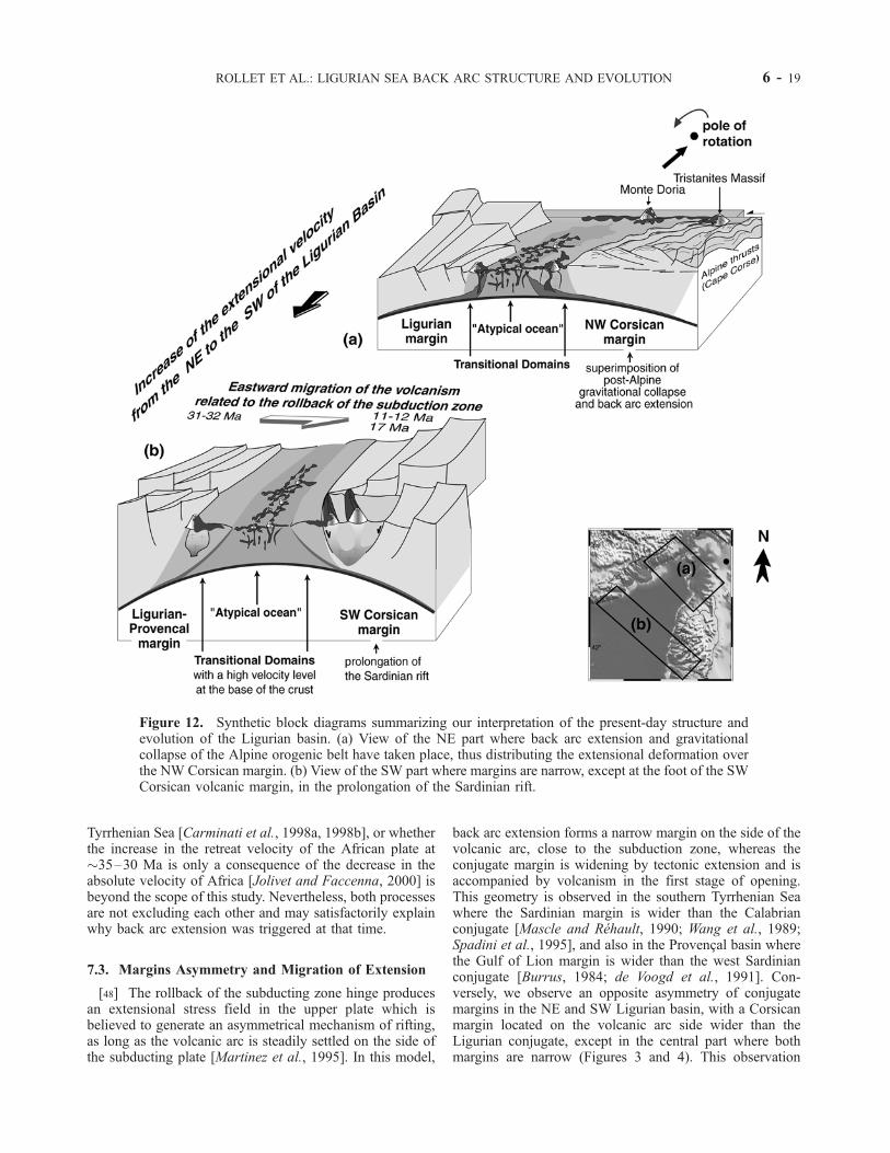
subducting Adriatic (African) slab is the most important onefor the Tyrrhenian back arc extension, which occurred incontinuity with the Ligurian basin opening [e.g.,Malinvernoand Ryan, 1986; Faccenna et al., 1996, 1997]. Consideringthe overall migration of volcanic activity, this force likelyplayed an important role also in the dynamics of the SWLigurian Sea opening, since a relatively long oceanic slabhad already been subducted at late Oligocene time [Jolivetet al., 1998; Chamot-Rooke et al., 1999]. This could haveallowed for relatively high extensional rates in the upperplate, as expected from experimental modeling [e.g., She-menda, 1993; Chemenda et al., 1996; Faccenna et al.,1996]. The Hercynian tectonic inheritance together with astrong rollback effect from the hinge of the subducting platecould have therefore localized the extension at the foot of themargin, in the prolongation of the Sardinian rift toward thenorth (Figure 12b).[46] Nevertheless, we believe that the Ligurian domain
has undergone quite contrasting conditions from NE to SW(Figure 12). Indeed, the NE domain is located quite close tothe rotation pole of the Corsica-Sardinia block [Rehaultet al., 1984], and the amount of subduction there is muchless than in the south. Furthermore, the subducting litho-sphere was continental since the Oligocene at this place,whereas it is oceanic until today south of the latitude of mid-Corsica, at�42�N [Malinverno and Ryan, 1986; Serri et al.,1993]. We therefore suggest that extension velocity (andhence, strain rate) and slab pull were strongly decreasingfrom SW to NE in the Ligurian domain at the time ofopening. This has important consequences on the style ofextension, since these parameters are known to play a keyrole in the cooling and strengthening of the rifted area andin the consequent shifting of the locus of extension [Bassi,1995; Faccenna et al., 1997]. Finally, the former Alpine-Apennines thickened crust, remnants of which have beenfound offshore NW Corsica and in the Gulf of Genova,could have been responsible for additional gravitationalbody forces (see section 2.1) and for a high Moho temper-ature (650�–800�C) in the NE Ligurian domain. Althoughthe contribution of buoyancy forces versus the slab pullcomponent cannot be quantified here, we suggest from ourobservations and from previous models of continentalextension [e.g., Buck, 1991; Bassi, 1995] that this orogenhas added a substantial contribution to produce distributedextension on the whole NW Corsican margin, and hence,even smaller strain rates. This interpretation is also evokedfor the northern Tyrrhenian opening [Faccenna et al., 1996,1997], and more widely for the Mediterranean basinsdeveloped within the Alpine orogen [Doglioni et al.,1997; Jolivet et al., 1999].[47] Whether a lateral slab detachment enhanced the
migration of extension from the Ligurian basin toward the
6 - 18 ROLLET ET AL.: LIGURIAN SEA BACK ARC STRUCTURE AND EVOLUTION
Tyrrhenian Sea [Carminati et al., 1998a, 1998b], or whetherthe increase in the retreat velocity of the African plate at�35–30 Ma is only a consequence of the decrease in theabsolute velocity of Africa [Jolivet and Faccenna, 2000] isbeyond the scope of this study. Nevertheless, both processesare not excluding each other and may satisfactorily explainwhy back arc extension was triggered at that time.
7.3. Margins Asymmetry and Migration of Extension
[48] The rollback of the subducting zone hinge producesan extensional stress field in the upper plate which isbelieved to generate an asymmetrical mechanism of rifting,as long as the volcanic arc is steadily settled on the side ofthe subducting plate [Martinez et al., 1995]. In this model,
back arc extension forms a narrow margin on the side of thevolcanic arc, close to the subduction zone, whereas theconjugate margin is widening by tectonic extension and isaccompanied by volcanism in the first stage of opening.This geometry is observed in the southern Tyrrhenian Seawhere the Sardinian margin is wider than the Calabrianconjugate [Mascle and Rehault, 1990; Wang et al., 1989;Spadini et al., 1995], and also in the Provencal basin wherethe Gulf of Lion margin is wider than the west Sardinianconjugate [Burrus, 1984; de Voogd et al., 1991]. Con-versely, we observe an opposite asymmetry of conjugatemargins in the NE and SW Ligurian basin, with a Corsicanmargin located on the volcanic arc side wider than theLigurian conjugate, except in the central part where bothmargins are narrow (Figures 3 and 4). This observation
Figure 12. Synthetic block diagrams summarizing our interpretation of the present-day structure andevolution of the Ligurian basin. (a) View of the NE part where back arc extension and gravitationalcollapse of the Alpine orogenic belt have taken place, thus distributing the extensional deformation overthe NW Corsican margin. (b) View of the SW part where margins are narrow, except at the foot of the SWCorsican volcanic margin, in the prolongation of the Sardinian rift.
ROLLET ET AL.: LIGURIAN SEA BACK ARC STRUCTURE AND EVOLUTION 6 - 19
suggests other factors to be accounted for and questionedthe general validity of the Martinez et al. [1995] hypothesis.[49] A first important parameter to examine is the strain
rate. We have postulated in the previous section (section7.2) that (1) prerift rheology is weak in the north Liguriandomain owing to geological inheritance; (2) the extensionalvelocity decreased from SW to NE during the Ligurian Seaevolution because of its scissors-shape opening. Duration ofdrifting in the Ligurian Sea, although poorly constrained,can be assumed to be �5 Ma (see section 2.1). From thewidth of the ‘‘atypical’’ oceanic domains inferred in thenorthern and western basin (�50 and �100 km, respec-tively; Figure 4), a crude estimate of the mean relativeextension velocity is �1 and �2 cm yr�1 in the north andsouth Ligurian basin, respectively. This latter value is closeto the average extension velocity found in the north Tyr-rhenian basin, estimated at �1.5–2 cm yr�1 [Faccennaet al., 1997]. This is also close to the threshold valuepostulated by Wright et al. [1996] for a slow extensionalback arc setting, whereby cross-arc seamounts and ridgesare supposed to form and to be preserved during arcmigration. Note that a similar, rough basement morphologyis observed in the Ligurian and Tyrrhenian deep basins.Conversely, these extension rates are much smaller thanrates of drifting speculated in the Algero-Provencal and thesouthern Tyrrhenian basins, which are �4–5 and �6 cmyr�1, respectively (see a review by Faccenna et al. [1997]and Chamot-Rooke et al. [1999]).[50] Two other key parameters determining the shaping
of conjugate margins are the rheological properties of thelithosphere and the asymmetry of the boundary forcesinduced by the slab rollback. In the northern TyrrhenianSea, it is proposed that the magmatic arc focuses theextensional process in the weakened ductile crust and thatthe sense of shear is controlled by the lower crust partiallymelted under the active magmatic zone [Jolivet et al., 1998].Since the thermal anomaly moves eastward as a conse-quence of the migration of the slab, the crust goes back to ahigher strength and extension jumps eastward, thus widen-ing the eastern margin [Jolivet et al., 1998; Brunet et al.,2000]. This process is likely to occur for slow rollback,relatively weak lithospheric rheology, and low strain rates,since in these conditions, strengthening is large enoughbefore yield stress is reached [Bassi, 1995]. This is indeedwhat is expected in the context of the north Tyrrhenian Sea,characterized by a continental-type subduction regime, athick postorogenic Alpine crust, and a rotation pole as closeas the Gulf of Genova [Faccenna et al., 1997].[51] From this example, it appears that other processes
than the extension velocity obviously control the style ofrifting in back arc settings, like for instance prerift crustalthickening (and consequently, rheological properties priorto rifting) and slab pull asymmetry. We have shown that inthe northern Ligurian basin, �30–20 Ma ago, (1) preriftthickening is likely; (2) extension velocity is low owing tothe proximity of the pole; and (3) slab pull is weaker thanin the south. Therefore a scenario similar to the northernTyrrhenian one [Jolivet et al., 1998] may have determinedits evolution during rifting and drifting, resulting in wide-
spread extension on the Corsican margin, on the side ofthe migrating volcanic arc. Further south, we suggest that amoderate but nevertheless faster and more efficient slabrollback may have enhanced an overall strong strain local-ization during extension, thus giving birth to rather narrowLigurian and Corsican (south and central) margins, sinceno significant crustal thickening is reported there beforethe Oligocene Ligurian rifting. In the Provencal basin, theprevious outer Pyrenean thrusting may have modified therheology of the overriding plate and favored the wideningof the Gulf of Lion margin during rifting [Burrus, 1984;Gorini et al., 1993; Seranne, 1999], whereas the westernSardinian margin remained relatively narrow [Thomas andGennesseaux, 1986]. Finally, we have shown that a strongvolcanic event at the end of the Ligurian basin opening(�17 Ma) is associated to the Sardinian rift extension up tothe SW Corsican margin [Thomas and Gennesseaux, 1986;Gennesseaux et al., 1989; Guennoc et al., 1995, 1998]. Webelieve that this second event may explain why this SWCorsican margin segment became wide. Such an event islikely related to the slowing down of the subductionvelocity which occurred at the end of the spreadingepisode in the Ligurian Sea (�15 Ma), soon relayed bya new back arc pulse in the Tyrrhenian Sea. This two-stepopening is thought to result from the interaction betweenthe slab and the 660 km transition zone in the mantle[Faccenna et al., 2001].
8. Conclusion
[52] New multichannel seismic reflection data con-strained by magnetic data and geological samples allowus to image the deep structure of the Ligurian basin and todescribe contrasting tectonic styles of opening of the basinduring its Oligocene-Miocene evolution. The Ligurian basinopening appears to result at first order from back arcextension linked to the rollback of the subducting Apulianslab and of the Alpine-Apennines belt front toward the E-SEin a way similar to what happened later in the TyrrhenianSea. Calcalkaline volcanism is recognized on both sides ofthe margins and in the transitional domains, whereas anatypical oceanic domain was formed during spreading in thedeep basin, characterized by discontinuous magneticanomalies.[53] We argue that tectonic inheritance (crustal thickening
and structural fabric) has a substantial influence on thedifferent styles of deformation on the same margin and onthe asymmetry between the conjugate margins. In the NELigurian basin the prerift Alpine thickening of the crust anda relatively slow rollback effect contribute to delocalize theextension on the NW Corsican margin, producing thegravitational collapse of this part of the Alpine orogenicbelt through the reactivation of several oceanward faultssoling on a relatively flat ductile shear zone. Farther south,the Hercynian structural inheritance combined with a moreefficient slab retreat localizes the extension, first, duringrifting in the central basin and second, at the end of driftingon the SW Corsican margin, in the prolongation of theSardinian rift.
6 - 20 ROLLET ET AL.: LIGURIAN SEA BACK ARC STRUCTURE AND EVOLUTION

[54] Using the overall pattern of migration of volcanismtoward the southeast, accurately located magnetic anoma-lies, and the structural pattern described, we propose that theevolution of the Ligurian basin took place in three mainperiods in an almost continuous process of extension:1. In the late Oligocene–early Miocene, on the upper
plate of the African-Apulian subduction, rifting initiates inthe Ligurian basin area at relatively slow velocities (�1 and�2 cm yr�1 in NE and SW, respectively) and is associatedwith important calcalkaline magmatism on land and withlarge ovoid magnetic anomalies along the western Ligurianmargin at sea. During this rifting period, a restricted numberof tilted blocks (two or three blocks on the Ligurian margin)appeared along narrow margins, except in the previouslythickened Corsican crust where extensional deformation isdistributed over 120 km at least. This extensional deforma-tion includes extensional features observed onshore inCorsica.2. From 21 Ma (end of rifting generally inferred) until
16–15 Ma the anticlockwise rotation of the Corsica-Sardinia block toward the east allows for the beginning ofoceanic spreading characterized by discontinuous tholeiticvolcanic edifices settled within unroofed mantle (asobserved in the Tyrrhenian Sea). This explains thedevelopment of magnetic anomalies atypical of oceaniccrust in the deep basin and underlined by two maindiscontinuous lineations sub-parallel to the basin axis.
3. Finally, the end of opening at 16–15 Ma is associatedwith a second important calcalkaline volcanic phase alongthe Corsican margin linked to the migration of thesubducting lithosphere toward the E-SE and to the stillongoing gravitational collapse of the Alpine orogenic belt,with calcalkaline and dominantly andesitic magmas firstemplaced along the west Corsican margin, and intrusion ofmagmas derived from mixing of lithosphere involved in theroot of the northern Apennines belt. Around 12–11 Ma, athird calcalkaline and alkaline volcanic event is recorded inthe Gulf of Genova, probably triggered by the gravitationalcollapse of the yet thick Alpine crust associated with thefirst stage of opening of the Tyrrhenian Sea.
[55] Acknowledgments. We are strongly indebted and deeply gratefulto the crews of the R/V Nadir and le Suroit (GENAVIR-IFREMER) and toall other members of the scientific staffs during Malis95, Marco95, andCylice97 cruises. E. Gueguen, G. Ruffet, and N. Chamot-Rooke arethanked for their help in data interpretations in the course of this study,as well as N. Bethoux, I. Contrucci, J. Ferrandini, R. Gloaguen, D.Lahondere, P. Rossi, F. Sage, M. Schaming, and J. Virieux for help andfruitful discussions at different stages of the work, and W. P. Schellart andC. Faccenna for helpful comments on the manuscript. This research wasfunded by INSU (Institut National des Sciences de l’Univers, CentreNational de la Recherche Scientifique, Marine Geosciences and PNRNProgrammes), CNRS, and University Pierre et Marie Curie (Paris VI).Contribution 388 of UMR 6526-Geosciences Azur (CNRS/UPMC/UNSA/IRD).
References
Angelier, J., J. Aubouin, G. Bellaiche, R. Blanchet, O.De Charpal, F. Irr, and X. Le Pichon (Groupe Es-tochade), Etude par submersible des canyons desStoechades et de Saint-Tropez, C. R. Seances Acad.Sci. Paris, Ser. D, 284, 1631–1634, 1977.
Artoni, A., and L. D. Meckel, History and deformationof a thrust sheet top basin: The Barreme basin, wes-tern Alps, SE France, in Cenozoic Foreland Basins
of Western Europe, edited by A. Mascle et al., Geol.Soc. Spec. Publ., 134, 213–237, 1998.
Avedik, F., V. Renard, J. P. Allenou, and B. Morvan,‘‘Single Bubble’’ air-gun array for deep exploration,Geophysics, 58(3), 366 –382, 1993.
Avedik, F., A. Hirn, V. Renard, R. Nicolich, J. L. Olivet,and M. Sachpazi, ‘‘Single-bubble’’ marine sourceoffers new perspectives for lithospheric exploration,Tectonophysics, 267, 57 –71, 1996.
Avigad, D., Z. Garfunkel, L. Jolivet, and J. M. Azanon,Back arc extension and denudation of Mediterra-nean eclogites, Tectonics, 16, 924–941, 1997.
Bassi, G., Relative importance of strain rate and rheol-ogy for the mode of continental extension, Geophys.J. Int., 122, 195–210, 1995.
Bayer, R., J. L. Le Mouel, and X. Le Pichon, Magneticanomaly pattern in the western Mediterranean,Earth Planet. Sci. Lett., 19, 168 –176, 1973.
Becker, T. W., C. Faccenna, R. J. O’Connell, and D.Giardini, The development of slabs in the uppermantle: Insights from numerical and laboratory ex-periments, J. Geophys. Res., 104, 15,207–15,224,1999.
Bellaiche, G., Sedimentary mechanisms and underlyingtectonic structures of the northwestern Mediterra-neanmargin, as revealed by comprehensive bathyme-tric and seismic surveys,Mar. Geol., 112, 89 – 108,1993.
Bellaiche, G., F. Irr, and M. Labarbarie, Decouverte desediments marins fini-oligocenes-aquitaniens aularge du Massif des Maures (canyons des Stoe-
chades), C. R. Seances Acad. Sci., Paris, Ser. D,283, 319–322, 1976.
Bellon, H., Chronologie radiometrique (K-Ar) des man-ifestations magmatiques autour de la Mediterraneeoccidentale entre 33 et 1 Ma, in Sedimentary Basins
of Mediterranean Margins, edited by F. C. Wezel,pp. 341 –360, Technoprint, Bologna, Italy, 1981.
Benedicto, A., P. Labaume, M. Seguret, and M. Ser-anne, Low-angle crustal ramp and basin geometryin the Gulf of Lion passive margin: Oligocene-Aquitanian Vistrenque graben, SE France, Tec-tonics, 15, 1192– 1212, 1996.
Bethoux, N., A. Deschamps, G. Nolet, E. Bertrand, I.Contrucci, M. Sosson, and J. Ferrandini, The deepstructure of Corsica (Mediterranean Sea) as inferredby Broad Band seismological profile, Geophys. Res.Lett., 26(17), 2661–2664, 1999.
Bigot-Cormier, F., G. Poupeau, and M. Sosson, Denu-dations differentielles du massif cristallin externealpin de l’Argentera (Sud-Est de la France) reveleespar thermochronologie traces de fission (apatites,zircons), C. R. Acad. Sci. Paris, Ser. II, 330,363 –370, 2000.
Boccaletti, M., C. Conedera, P. Dainelli, and P. Gocev,The Recent (Miocene-Quaternary) regmatic systemof western Mediterranean region: A new model ofensialic geodynamic evolution in a context of plas-tic/rigid deformation, J. Petrol. Geol., 5, 31 – 49,1982.
Boillot, G., G. Feraud, M. Recq, and J. Girardeau, ‘‘Un-dercrusting’’ by serpentinite beneath rifted margins,Nature, 341, 523–525, 1989.
Bonatti, E., M. Seyler, J. Channell, J. Girardeau, and G.Mascle, Peridotites drilled from the Tyrrhenian Sea,ODP Leg 107, Proc. Ocean Drill. Program Sci.Results, 107, 37 –47, 1990.
Brun, J. P., and M.-O. Beslier, Mantle exhumation atpassive margins, Earth Planet. Sci. Lett., 142, 161 –173, 1996.
Brunet, C., P. Monie, L. Jolivet, and J. P. Cadet, Migra-tion of compression and extension in the TyrrhenianSea, insights from 40Ar/39Ar ages on micas along atransect from Corsica to Tuscany, Tectonophysics,321, 127– 155, 2000.
Buck, W. R., Modes of continental lithospheric exten-sion, J. Geophys. Res., 96, 20,161–20,178, 1991.
Burrus, J., Contribution to a geodynamic synthesis ofthe Provencal basin (north western Mediterranean),Mar. Geol., 55, 247–269, 1984.
Carmignani, L., F. A. Decandia, L. Disperati, P. L.Fantozzi, A. Lazzarotto, D. Liotta, and G. Oggiano,Relationships between the Tertiary structural evolu-tion of the Sardinia-Corsica-Provencal Domain andthe Northern Apennines, Terra Nova, 7, 128– 137,1995.
Carminati, E., M. J. R. Wortel, W. Spakman, and R.Sabadini, The role of slab detachment processes inthe opening of the western-central Mediterraneanbasins: Some geological and geophysical evidence,Earth Planet. Sci. Lett., 160, 651 –665, 1998a.
Carminati, E., M. J. R. Wortel, P. T. Meijer, and R.Sabadini, The two-stage opening of the western-central Mediterranean basins: A forward modelingtest to a new evolutionary model, Earth Planet. Sci.
Lett., 160, 667 –679, 1998b.Chamot-Rooke, N., J. M. Gaulier, and F. Jestin, Con-
straints on Moho depth and crustal thickness in theLiguro-Provencal basin from 3D gravity inversion:Geodynamic implications, in The Mediterranean
Basins: Tertiary Extension Within the Alpine Oro-gen, edited by B. Durand et al., Geol. Soc. Spec.Publ., 156, 37– 62, 1999.
Channell, J. E. T., and J. C. Mareschal, Delaminationand asymmetric lithosphere thickening in the devel-opment of the Tyrrhenian rift, in Alpine Tectonics,edited by M. P. Coward, D. Dietrich, and R. G.Park, Geol. Soc. Spec. Publ., 45, 285– 301, 1989.
Chaumillon, E., J. Deverchere, J. P. Rehault, and E.
ROLLET ET AL.: LIGURIAN SEA BACK ARC STRUCTURE AND EVOLUTION 6 - 21
Gueguen, Reactivation tectonique et flexure de lamarge continentale Ligure (Mediterranee Occiden-tale), C. R. Acad. Sci. Paris, Ser. II, 319, 675–682,1994.
Chemenda, A. I., M. Mattauer, and A. N. Bokun, Con-tinental subduction and a mechanism for exhuma-tion of high-pressure metamorphic rocks: Newmodeling and field data from Oman, Earth Planet.
Sci. Lett., 143, 173 –182, 1996.Cherchi, A., and L. Montadert, Oligo-Miocene rift of
Sardinia and the early history of the western Med-iterranean basin, Nature, 298, 736 –739, 1982.
Chian, D., K. E. Louden, and I. Reid, Crustal structureof the Labrador Sea conjugate margin and implica-tions for the formation of nonvolcanic continentalmargins, J. Geophys. Res., 100, 24,239 – 24,253,1995.
Chiappini, M., A. Meloni, E. Boschi, O. Faggioni, N.Beverini, C. Carmisciano, and I. Marson, Shadedrelief magnetic anomaly map of Italy and surround-ing marine areas, Ann. Geofis., 43(5), 983 – 989,2000.
Cita, M. B., W. B. F. Ryan, and R. B. Kidd, Sedimenta-tion rates in Neogene deep sea sediments from theMediterranean and geodynamic implications oftheir changes, Initial Rep. Deep Sea Drill Proj.,Leg 42(1), 991–1002, 1978.
Clauzon, G., J. P. Suc, F. Gautier, A. Berger, and M. F.Loutre, Alternate interpretation of the Messiniansalinity crisis: Controversy resolved?, Geology, 24,363–366, 1996.
Contrucci, I., Structures profondes du bassin Nord Li-gure et structures du bassin Nord Tyrrhenien, thesede doctorat, 217 pp., Univ. de Corte, Corse, France,1998.
Contrucci, I., A. Nercessian, N. Bethoux, N. A. Mauf-fret, and G. Pascal, A Ligurian (western Mediterra-nean Sea) geophysical transect revisited, Geophys.J. Int., 146, 74–97, 2001.
Coulon, C., Le volcanisme calco-alcalin cenozoique deSardaigne (Italie): Petrologie, geochimie et genesedes laves andesitiques et des ignimbrites: Significa-tion geodynamique, these de doctorat, Univ. d’Aix-Marseille III, Aix en Provence, France, 1977.
Coulon, C., J. Dostal, and C. Dupuy, Petrology andgeochemistry of ignimbrites and associated lava-do-mes from NW Sardinia, Contrib. Mineral. Petrol.,68, 89 –98, 1978.
Daniel, J. M., L. Jolivet, B. Goffe, and C. Poinssot,Crustal-scale strain partitioning: Footwall deforma-tion below the Alpine Oligo-Miocene detachmentof Corsica, J. Struct. Geol., 18(1), 41 –59, 1996.
de Voogd, B., R. Nicolich, J. L. Olivet, F. Fanucci, J.Burrus, A. Mauffret, G. Pascal, and the ECORS-CROP Profile Group, First deep seismic reflectiontransect from the Gulf of Lions to Sardinia(ECORS-CROP profiles in western Mediterranean),in Continental Lithosphere: Deep Seismic Reflec-
tions, Geodyn. Ser., vol. 22, edited by R. Meissneret al., 265– 274, AGU, Washington, D. C., 1991.
Dewey, J. F., M. L. Helman, E. Turco, D. H. W. Hutton,and S. D. Knott, Kinematics of the western Medi-terranean, in Alpine Tectonics, edited by M. P. Cow-ard, D. Dietrich, and R. G. Park, Geol. Soc. Spec.Publ., 45, 265 –283, 1989.
Doglioni, C., Geological remarks on the relationshipsbetween extension and convergent geodynamic set-tings, Tectonophysics, 252, 253–267, 1995.
Doglioni, C., E. Gueguen, F. Sabat, and M. Fernandez,The western Mediterranean extensional basins andthe Alpine orogen, Terra Nova, 9, 109–112, 1997.
Durand Delga, M., Corse, Guides Geologiques Regio-
naux, 208 pp., Masson, Paris, 1978.Egger, A., M. Demartin, J. Ansorge, E. Banda, and M.
Maistrello, The gross structure of the crust underCorsica and Sardinia, Tectonophysics, 150, 363–389, 1988.
Eldholm, O., and K. Grue, North Atlantic volcanic mar-gins: Dimensions and production rates, J. Geophys.Res., 99, 2955–2968, 1994.
Faccenna, C., P. Davy, J. P. Brun, R. Funiciello, D.Giardini, M. Mattei, and T. Nalpas, The dynamics
of back-arc extension: An experimental approach tothe opening of the Tyrrhenian Sea, Geophys. J. Int.,126, 781–795, 1996.
Faccenna, C., M. Mattei, R. Funiciello, and L. Jolivet,Styles of back-arc extension in the Central Mediter-ranean, Terra Nova, 9, 126 –130, 1997.
Faccenna, C., T. W. Becker, F. P. Lucente, L. Jolivet,and F. Rossetti, History of subduction and back-arcextension in the Central Mediterranean, Geophys. J.Int., 145, 809– 820, 2001.
Fernandez, M., J. P. Foucher, and M. J. Furado, Evi-dence for the multi-stage formation of the south-western Valencia trough, Mar. Pet. Geol., 12,101 –109, 1995.
Ferrandini, M., J. Ferrandini, M. D. Loye-Pilot, J. But-terlin, J. Cravatte, and M. C. Janin, Le Miocene dubassin de Saint Florent (Corse): Modalites de latransgression du Burdigalien superieur et mise enevidence du Serravallien, Geobios, 311(1), 125 –137, 1998.
Ferrandini, J., P. Rossi, M. Ferrandini, G. Farjanel, L.Ginsbug, M. Schuler, and F. Geissert-Fritz, La for-mation conglomeratique du Vazzio pres d’Ajaccio(Corse du Sud), un temoin des depots du Chattiensuperieur continental synrift en Mediterranee occi-dentale, C. R. Acad. Sci. Paris, Ser. II, 329, 271 –278, 1999.
Fournier, M., L. Jolivet, B. Goffe, and R. Dubois, Al-pine Corsica metamorphic core complex, Tectonics,10, 1173–1186, 1991.
Frizon de Lamotte, D., B. Saint Bezar, and R. Bracene,The two main steps of the Atlas building and geo-dynamics of the western Mediterranean, Tectonics,19, 740 –761, 2000.
Fry, N., Southwestward thrusting and tectonics of thewestern Alps, in Alpine Tectonics, edited by M. P.Coward, D. Dietrich, and R.G. Park, Geol. Soc.Spec. Publ., 45, 83–109, 1989.
Galdeano, A., and J. C. Rossignol, Assemblage a alti-tude constante des cartes d’anomalies magnetiquescouvrant l’ensemble du bassin occidental de laMediterranee, Bull. Soc. Geol. Fr., 7(3), 461–468,1977.
Gattacceca, J., Cinematique du bassin Liguro-Provencalentre 30 et 12 Ma: Implications geodynamiques,Mem. Sci. Terre, 41, 299 pp., Ecole des Mines,Paris, 2001.
Gaullier, V., Diapirisme salifere et dynamique sedimen-taire dans le bassin Liguro-Provencal: Donnees sis-miques et modeles analogiques, these de doctorat,323 pp., Univ. Pierre et Marie Curie, Paris, 1993.
Gautier, P., and J. P. Brun, Crustal-scale geometry andkinematics of late orogenic extension in the centralAegean (Cyclades and Evia island), Tectonophysics,238, 399–424, 1994.
Gennesseaux, M., J. P. Rehault, and B. Thomas, Lamarge continentale de la Corse, Bull. Soc. Geol.Fr., 5(2), 339 –351, 1989.
Gorini, C., A. Le Marrec, and A. Mauffret, Contributionto the structural and sedimentary history of the Gulfof Lions (western Mediterranean), from the ECORSprofiles, industrial seismic profiles and well data,Bull. Soc. Geol. Fr., 164(3), 353 –363, 1993.
Gueguen, E., La Mediterranee Occidentale: Un verita-ble ocean, exemple de segmentation des marges etde hiatus cinematiques, implications sur les proces-sus d’amincissement crustal, these de doctorat, 311pp., Univ. de Bretagne Occidentale, Brest, France,1995.
Gueguen, E., C. Doglioni, and M. Fernandez, Litho-spheric boudinage in the western Mediterraneanback-arc basin, Terra Nova, 9, 184–187, 1997.
Gueguen, E., C. Doglioni, and M. Fernandez, On thepost-25 Ma geodynamic evolution of the westernMediterranean, Tectonophysics, 298, 259 – 269,1998.
Guennoc, P., N. Debeglia, C. Gorini, A. Le Marrec, andA. Mauffret, Anatomie d’une marge passive jeune(Golfe du Lion–Sud France): Apports des donneesgeophysiques, Bull. Cent. Rech. Explor. Prod. Elf.Aquitaine, 18, 33 –57, 1994.
Guennoc, P., et al., Geologie des marges corses: Cam-
pagne MARCO, paper presented at GeosciencesMarines, Seance Spec. Soc. Geol. Fr., Brest, France,1995.
Guennoc, P., J. P. Rehault, L. Gilg-Capar, J. Deverch-ere, N. Rollet, and R. Le Suave, Les marges ouest etnord de la Corse: Nouvelle cartographie a 1/250000, paper presented at Reunion des Sciences dela Terre, Brest, France, March 31 to April 3, 1998.
Holbrook, W. S., E. C. Reiter, G. M. Purdy, D. Sawyer,P. L. Stoffa, J. A. Austin, J. Oh, and J. Makris, Deepstructure of the U.S. Atlantic continental margin,offshore South Carolina, from coincident ocean bot-tom and multichannel seismic data, J. Geophys.Res., 99, 9155–9178, 1994.
Jakni, B., G. Poupeau, M. Sosson, P. Rossi, J. Ferran-dini, and P. Guennoc, Denudations cenozoıques enCorse: une analyse thermochronologique par tracesde fission sur apatites, C. R. Acad. Sci. Paris, Ser. II,331, 775– 782, 2000.
Jolivet, L., and C. Faccenna, Mediterranean extensionand the Africa-Eurasia collision, Tectonics, 19,1095– 1106, 2000.
Jolivet, L., R. Dubois, M. Fournier, B. Goffe, A. Mi-chard, and C. Jourdan, Ductile extension in AlpineCorsica, Geology, 18, 1007–1010, 1990.
Jolivet, L., J. M. Daniel, and M. Fournier, Geometryand kinematics of ductile extension in Alpine Cor-sica, Earth Planet. Sci. Lett., 104, 278 –291, 1991.
Jolivet, L., et al., Midcrustal shear zones in post-oro-genic extension: Example from the northern Tyrrhe-nian Sea, J. Geophys. Res., 103, 12,123 –12,160,1998.
Jolivet, L., D. Frizon de Lamotte, A. Mascle, and B.Durand, The Mediterranean basins: Tertiary exten-sion within the Alpine orogen: An introduction, inThe Mediterranean Basins: Tertiary Extension
Within the Alpine Orogen, edited by B. Durand etal., Geol. Soc. Spec. Publ., 156, 1 – 14, 1999.
Kastens, K., and J. Mascle, The geological evolution ofthe Tyrrhenian Sea: An introduction to the scientificresults of ODP Leg 107, Proc. Ocean Drill. Pro-
gram. Sci. Results, 107, 3 – 26, 1990.Kastens, K., et al., ODP Leg 107 in the Tyrrhenian Sea:
Insights into passive margin and back-arc evolution,Geol. Soc. Am. Bull., 100, 1140– 1156, 1988.
Kissling, E., and W. Spakman, Interpretation of tomo-graphic images of uppermost mantle structure: Ex-amples from the Western and central Alps,J. Geodyn., 21, 97 –111, 1996.
Laurent, O., J.-F. Stephan, and M. Popoff, Modalites dela structuration miocene de la branche sud de l’arcde Castellane (Chaınes subalpines meridionales),Geol. Fr., 3, 33– 65, 2000.
Le Cann, C., Le diapirisme dans le bassin Liguro-Pro-vencal (Mediterranee occidentale): Relations avec lasedimentation et la tectonique, consequences geo-dynamiques, these de doctorat, Univ. de BretagneOccidentale, Brest, France, 1987.
Le Douaran, S., J. Burrus, and F. Avedik, Deep struc-ture of the north-western Mediterranean basin: Re-sults of a two-ship seismic survey, Mar. Geol., 55,325 –345, 1984.
Lickorish, W. H., and M. Ford, Sequential restoration ofthe external Alpine Digne thrust system, SE France,constrained by kinematic data and synorogenic se-diments, in Cenozoic Foreland Basins of WesternEurope, edited by A. Mascle et al., Geol. Soc. Spec.Publ., 134, 189–211, 1998.
Lonergan, L., and N. White, Origin of the Betic-Rifmountain belt, Tectonics, 16, 504– 522, 1997.
Makris, J., F. Egloff, R. Nicolich, and R. Rihm, Crustalstructure from the Ligurian Sea to the NorthernApennines: A wide angle seismic transect, Tectono-physics, 301, 305– 319, 1999.
Malavieille, J., A. I. Chemenda, and C. Larroque, Evo-lutionary model for Alpine Corsica: Mechanism forophiolite emplacement and exhumation of high-pressure rocks, Terra Nova, 10, 317 –322, 1998.
Maldonado, A., A. C. Campillo, A. Mauffret, B. Alon-so, J. Woodside, and J. Campos, Alboran Sea lateCenozoic tectonic and stratigraphic evolution, GeoMar. Lett., 12, 179– 186, 1992.
6 - 22 ROLLET ET AL.: LIGURIAN SEA BACK ARC STRUCTURE AND EVOLUTION

Malinverno, A., and W. B. F. Ryan, Extension in theTyrrhenian Sea and shortening in the Apennines asresult of arc migration driven by sinking of thelithosphere, Tectonics, 5, 227 –245, 1986.
Martinez, F., P. Fryer, N. A. Baker, and T. Yamazaki,Evolution of back-arc rifting: Mariana Trough, 20�–24�N, J. Geophys. Res., 100, 3807–3827, 1995.
Mascle, J., and J. P. Rehault, A revised seismic strati-graphy of the Tyrrhenian Sea: Implications for thebasin evolution, Proc. Ocean Drill. Program Sci.
Results, 107, 617–636, 1990.Mauffret, A., G. Pascal, A. Maillard, and C. Gorini,
Tectonics and deep structure of the north-westernMediterranean Basin, Mar. Petrol. Geol., 12(6),645–666, 1995.
Maury, C., et al., Post-collisional Neogene magmatismof the Mediterranean Maghreb margin: A conse-quence of slab breakoff, C. R. Acad. Sci. Paris,Ser. II, 331, 159–173, 2000.
Montigny, R., J. B. Edel, and R. Thuizat, Oligo-Mio-cene rotation of Sardinia: K-Ar ages and paleomag-netic data of Tertiary volcanics, Earth Planet. Sci.
Lett., 54, 261– 271, 1981.Ocean Drilling Program (ODP) Leg 107 Shipboard
Scientific Party, Site 650, Proc. Ocean Drill. Pro-gram Initial Rep., 107, 129–285, 1987.
Pascal, G. P., A. Mauffret, and P. Patriat, The ocean-continent boundary in the Gulf of Lion from analysisof expanding spread profiles and gravity modeling,Geophys. J. Int., 113, 701–726, 1993.
Pasquale, V., M. Verdoya, and P. Chiozzi, Types of crustbeneath the Ligurian Sea, Terra Nova, 6, 255–266,1994.
Patacca, E., R. Sartori, and P. Scandone, Tyrrhenianbasin and Apenninic arcs: Kinematic relations sincelate tortonian times, Mem. Soc. Geol. It., 45, 425 –451, 1990.
Pepe, F., G. Bertotti, F. Cella, and E. Marsella, Riftedmargin formation in the south Tyrrhenian Sea: Ahigh-resolution seismic profile across the north Si-cily passive continental margin, Tectonics, 19,241–257, 2000.
Pickup, S. L. B., R. B. Whitmarsh, C. M. R. Fowler,and T. J. Reston, Insight into the nature of theocean-continent transition off West Iberia from adeep multichannel seismic reflection profile, Geol-ogy, 24, 1079–1082, 1996.
Pinheiro, L. M., R. B. Whitmarsh, and P. R. Miles, Theocean-continent boundary off the western continen-tal margin of Iberia, II, Crustal structure in the Ta-gus Abyssal Plain, Geophys. J. Int., 109, 106–124,1992.
Platt, J. P., J.-I. Soto, M. J. Whitehouse, A. J. Hurford,and S. P. Kelley, Thermal evolution, rate of exhu-mation, and tectonic significance of metamorphicrocks from the floor of the Alboran extensional ba-sin, western Mediterranean, Tectonics, 17, 671 –689, 1998.
Rehault, J.-P., Evolution tectonique et sedimentaire dubassin Ligure (Mediterranee Occidentale), thesed’etat, Univ. Pierre et Marie Curie, Paris VI, 1981.
Rehault, J.-P., G. Boillot, and A. Mauffret, The westernMediterranean basin geological evolution, Mar.
Geol., 55, 447 –477, 1984.Rehault, J.-P., G. Boillot, and A. Mauffret, The western
Mediterranean basins, in Geological Evolution of
the Mediterranean Basins, edited by D. J. Stanleyand F. C. Wezel, pp. 101 – 129, Springer-Verlag,New York, 1985.
Rehault, J.-P., H. Bellon, R. Maury, P. Rossi, P. Guen-noc, M. Sosson, and G. Poupeau, Nouveautes sur levolcanisme en mer ligure, paper presented at Re-union des Sciences de la Terre, Brest, France,March 31 to April 3, 1998.
Ritz, J. F., Evolution du champ de contrainte dans lesAlpes du sud depuis la fin de l’Oligocene: Implica-tions sismotectoniques, these de doctorat, 256 pp.,Univ. des Sci. et Tech. du Languedoc, Montpellier,France, 1991.
Roca, E., and P. Desegaulx, Analysis of the geologicalevolution and vertical movements in the Valenciatrough area, western Mediterranean, Mar. Petrol.Geol., 9, 167–185, 1992.
Rollet, N., Structures profondes et dynamique du Bas-sin Ligure et de ses marges, these de doctorat, 324pp., Univ. Pierre et Marie Curie, Geosci. Azur, Vil-lefranche-sur-Mer, France, 1999.
Rossi, P., et al., Importance du volcanisme calco-alcalinmiocene sur la marge sud-ouest de la Corse (cam-pagne MARCO), C. R. Acad. Sci. Paris, Ser. II,327, 369–376, 1998.
Rouire, J., A. Autran, A. Prost, P. Rossi, and C. Rous-set, Notice explicative de la feuille Nice a 1/250000, Bur. de Rech. Geol. et Minieres, Orleans,France, 1980.
Ryan, W. B. F., and M. B. Cita, The nature and distri-bution of Messinian erosional surfaces: Indicatorsof several kilometer deep Mediterranean in the Mio-cene, Mar. Geol., 27, 193–230, 1978.
Sandwell, D. T., M. M. Yale, and W. H. F. Smith, Grav-ity anomaly profiles from ERS-1, Topex et GeosatAltimetry, Eos Trans. AGU, 76, 89 –90, 1995.
Seranne, M., The Gulf of Lion continental margin (NWMediterranean) revisited by IBS: an overview, inThe Mediterranean Basins: Tertiary Extension
Within the Alpine Orogen, edited by B. Durand etal., Geol. Soc. Spec. Publ., 156, 15 –37, 1999.
Serri, G., F. Innocenti, and P. Manetti, Geochemical andpetrological evidence of the subduction of delami-nated Adriatic continental lithosphere in the genesisof the Neogene-Quaternary magmatism of centralItaly, Tectonophysics, 223, 117 –147, 1993.
Shemenda, A. I., Subduction of the lithosphere andback-arc dynamics: Insights from physical model-ing, J. Geophys. Res., 98, 16,167– 16,185, 1993.
Sosson, M., and P. Guennoc, Compte-rendu de la cam-pagne CYLICE, internal report, 126 pp., Ifremer,Brest, France, 1997.
Sosson, M., P. Guennoc, and CYLICE team, Nouvellescontraintes geologiques sur l’evolution du bassinligure: Resultats de la campagne de plongee CY-LICE (1997), paper presented at Reunion des
Sciences de la Terre, Brest, France, March 31 toApril 3, 1998.
Spadini, G., S. Cloetingh, and G. Bertotti, Thermo-mechanical modeling of the Tyrrhenian Sea:Lithospheric necking and kinematics of rifting,Tectonics, 14, 629–644, 1995.
Tapponnier, P., Evolution tectonique du systeme alpin enMediterranee: Poinconnement et ecrasement rigide-plastique, Bull. Soc. Geol. Fr., 7(3), 437–460, 1977.
Thinon, I., Structure profonde de la Marge Nord-Gas-cogne et du bassin Armoricain, these de doctorat,312 pp., Univ. de Brest, France, 1999.
Thomas, B., and M. Gennesseaux, A two-stage riftingin the basins of the Corsica-Sardinia straits, Mar.
Geol., 72, 225 –239, 1986.Van der Meulen, M. J., J. E. Meulenkamp, and M. J. R.
Wortel, Lateral shifts of Apenninic foredeep depo-centres reflecting detachment of subducted litho-sphere, Earth Planet. Sci. Lett., 154, 203 – 219,1998.
Vigliotti, L., and V. E. Langenheim, When did Sardiniastop rotating?: New palaeomagnetic results, TerraRes., 7, 424 –435, 1995.
Waldhauser, F., E. Kissling, J. Ansorge, and S. Mueller,Three-dimensional interface modeling with two-di-mensional seismic data: The Alpine crust-mantleboundary, Geophys. J. Int., 135, 264–278, 1998.
Wang, C. Y., W. T. Hwang, and Y. Shi, Thermal evolu-tion of a rift basin: The Tyrrhenian Sea, J. Geophys.Res., 94, 3991–4006, 1989.
White, R. S., and D. McKenzie, Magmatism at riftzones: The generation of volcanic continental mar-gins and flood basalts, J. Geophys. Res., 94, 7685–7729, 1989.
Whitmarsh, R. B., L. M. Pinheiro, P. R. Miles, M. Recq,and J. C. Sibuet, Thin crust at the western Iberiaocean-continent transition and ophiolites, Tectonics,12, 1230– 1239, 1993.
Wright, I. C., L. M. Parson, and J. A. Gamble, Evolu-tion and interaction of migrating cross-arc volcan-ism and back-arc rifting: An example from thesouthern Havre Trough (35�200–37�S), J. Geophys.Res., 101, 22,071–22086, 1996.
���������M.-O. Beslier, J. Deverchere, and M. Sosson, UMR
6526 Geosciences Azur, UPMC/CNRS/UNSA/IRD,Observatoire Oceanologique, B.P. 48, 06235 Ville-franche-sur-Mer Cedex, France. ([email protected];[email protected]; [email protected])
P. Guennoc and C. Truffert, BRGM-SGN, B. P.6009, 45060 Orleans cedex 2, France. ([email protected]; [email protected])
J.-P. Rehault, UMR 6538 Domaines Oceaniques,IUEM, Universite de Bretagne Occidentale, PlaceNicolas Copernic, 29280 Plouzane, France. ([email protected])
N. Rollet, Geoscience Australia, GPO Box 378,Canberra, ACT 2601, Australia. ([email protected])
ROLLET ET AL.: LIGURIAN SEA BACK ARC STRUCTURE AND EVOLUTION 6 - 23

Figure 3. Isochrons of the top of the prerift basement (in seconds two-way time (s TWT)) anddistribution of the geological domains observed onshore (see text for details).
ROLLET ET AL.: LIGURIAN SEA BACK ARC STRUCTURE AND EVOLUTION
6 - 5
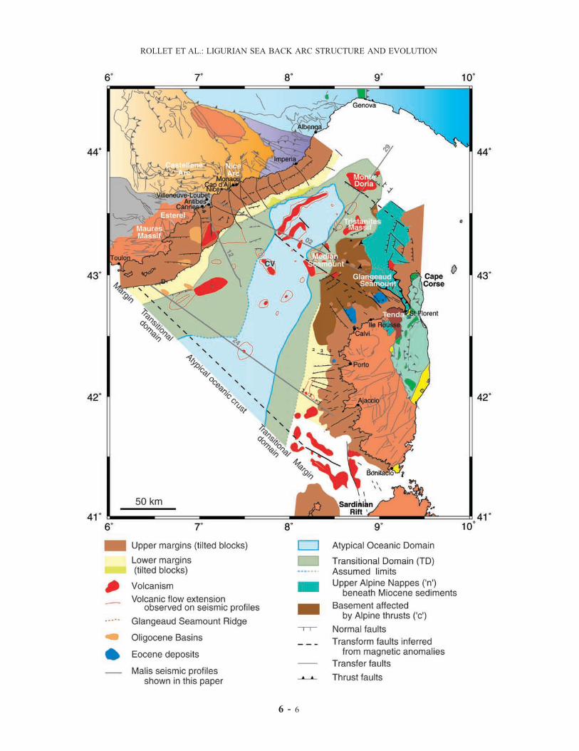
6 - 6
ROLLET ET AL.: LIGURIAN SEA BACK ARC STRUCTURE AND EVOLUTION

Figure 4. (opposite) Structural sketch map of the Ligurian domain after results from this study (see onshore geologicaldomain captions on Figure 3). Continuous lines (numbered) refer to Malis cruise seismic profiles. Abbreviations are asfollows: CV, central volcano; D, reflector ‘‘D’’ emergence (see text for details).
Figure 11. Superimposition of the volcanic and magmatic bodies determined on seismic profiles (redcontours) above the magnetic anomalies newly determined by reduction to the pole. Coastlines (thin darkline) and boundaries of the transitional domain TD (thick dark line) and of the deep oceanic-type basin(gray line) proposed in the Ligurian basin are shown. Units are in nanoteslas (nT).
6 - 7 and 6 - 17
ROLLET ET AL.: LIGURIAN SEA BACK ARC STRUCTURE AND EVOLUTION
Copyright © 2022 FDOKUMEN