
The problems of the beginning of medieval towns in the northern Caucasus
20
THE PROBLEMS OF THE BEGINNING OF MEDIEVAL TOWNS IN THE NORTHERN CAUCASUS IRINA ARZHANTSEVA, SVETLANA RUZANOVA* In the first and early second millennium AD the North Caucasus became one of the main areas of Alan culture (Fig. 1). The Alanian ethnos came about as a result of the interaction of immigrant Iranian nomadic tribes with a local settled population. This union of Alanian tribes was formed early in the first millennium and established itself in the Caucasus as the main political force for a thousand years to come (Kuznetsov 1992; Kovalevskaya 1984; Isaenko & Kuchiev 1995: 10–13). This paper deals with the evolution of Alanian settlements and is based on materials yielded by several major Alanian sites. The sites in question mark the early, middle and final stages of Alanian culture respectively but there is a chronological gap of some 600 years between them. Thus we have the opportunity to trace the evolution of settlements including the conditions for their development and functioning and, therefore, place into context the formation processes of urbanization. FIRST STAGE – THE EARLIEST PERIOD As we are mainly concerned with early medieval and medieval towns in the Northern Caucasus, that is to say the lands of Georgia at the eastern end of the Black Sea, such phenomena as proto-urban centres at the beginning of the first millennium AD in the Central Caucasian region will be mentioned only briefly. Recently excavated Alanian sites, such as Zilgi, Nizhniy Dzhulat or Brut provide us with new data enabling us to tackle the yet unsolved problem of the emer- gence and evolution of proto-urban centres in the North Caucasus. These are the so-called “earthwork” habitation sites. They comprise the foundation of the * Institute of Ethnology and Anthropology, Russian Academy of Sciences, Moscow
Transcript of The problems of the beginning of medieval towns in the northern Caucasus
203THE PROBLEMS OF THE BEGINNING OF MEDIEVAL TOWNS IN THE NORTHERN CAUCASUS
THE PROBLEMS OF THE BEGINNINGOF MEDIEVAL TOWNS
IN THE NORTHERN CAUCASUS
IRINA ARZHANTSEVA, SVETLANA RUZANOVA*
In the first and early second millennium AD the North Caucasus became oneof the main areas of Alan culture (Fig. 1). The Alanian ethnos came about asa result of the interaction of immigrant Iranian nomadic tribes with a localsettled population. This union of Alanian tribes was formed early in the firstmillennium and established itself in the Caucasus as the main political force fora thousand years to come (Kuznetsov 1992; Kovalevskaya 1984; Isaenko & Kuchiev1995: 10–13). This paper deals with the evolution of Alanian settlements and isbased on materials yielded by several major Alanian sites. The sites in questionmark the early, middle and final stages of Alanian culture respectively butthere is a chronological gap of some 600 years between them. Thus we have theopportunity to trace the evolution of settlements including the conditions for theirdevelopment and functioning and, therefore, place into context the formationprocesses of urbanization.
FIRST STAGE – THE EARLIEST PERIOD
As we are mainly concerned with early medieval and medieval towns in theNorthern Caucasus, that is to say the lands of Georgia at the eastern end of theBlack Sea, such phenomena as proto-urban centres at the beginning of the firstmillennium AD in the Central Caucasian region will be mentioned only briefly.Recently excavated Alanian sites, such as Zilgi, Nizhniy Dzhulat or Brut provideus with new data enabling us to tackle the yet unsolved problem of the emer-gence and evolution of proto-urban centres in the North Caucasus. These arethe so-called “earthwork” habitation sites. They comprise the foundation of the
* Institute of Ethnology and Anthropology, Russian Academy of Sciences, Moscow
204 IRINA ARZHANTSEVA, SVETLANA RUZANOVA
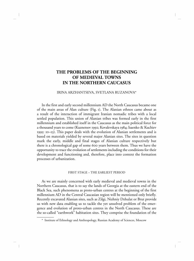
Fig. 1. Northern Caucasus, Alanian settlements, 1st millennium AD: 1 – Zilgi, zoneof “earthen work” habitation sites; 2 – Gornoe Echo, zone of stone fortresses; 3 – Kiafar site.
205THE PROBLEMS OF THE BEGINNING OF MEDIEVAL TOWNS IN THE NORTHERN CAUCASUS
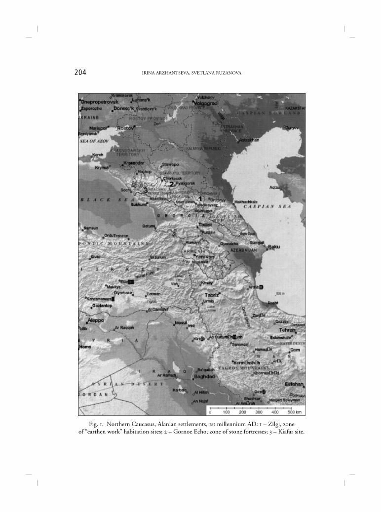
Citadel, of which the central part at least was first built on a clay-soil plateau ona river cape (Fig. 2). The foundation was a platform composed of adobe blocksand was accompanied by ditches at least 6 m deep and 15 m wide dug in thevirgin clay. The sides of the ditches were escarped and reinforced. As a result, the
Fig. 2. Zilgi site.
206 IRINA ARZHANTSEVA, SVETLANA RUZANOVA
settlement assumed the following shape: an elevated Citadel with three “habita-tion rings” or zones separated by deep ditches. The habitation mounds or ringswere encircled with mud-brick walls along the upper perimeter.
One important factor with regard to stages of urbanization and town-planningconcerns topographic location. For example, Zilgi, situated at the junction ofthe steppes and the foothills at the very beginning of the Georgian MilitaryRoad, together with other similar sites, blocked the passage to the most easilyaccessible mountain passes like the Daryal Gorge (Fig. 1). The site was strategicallyvery well placed both for military purposes and for control over caravan routes,but it also lay in the contact-zone between the lowland farmers and the steppecattle-breeders (Arzhantseva & Deopik 1989).
Another important issue concerns the new dating of Zilgi. Written sourcesmention well-developed fortifications of Iranian-speaking tribes of the NorthCaucasus on the eve of the Christian era. Thus, Tacitus (Annales XII–XIII) nar-rates that in the 1st century B.C. the Bosporan king, Mithridates, pursued by theRomans, fled to the Siraces while the Romans sided with the Aorses, both tribeslater joining the Sarmato-Alanian tribal union. The tactics elaborated by theRomans and their allies are worth noting with regard to town-planning andfortification; it was agreed that the king of the Aorses would conduct cavalryoperations whilst the Romans assumed responsibility for the siege of towns. Itwas no mere figure of speech as the Roman army, well equipped with offensiveengines, besieged (sic!) the town of Usupa which was situated on a mound andencircled with walls and ditches, instead of taking it by storm. Although, accord-ing to Tacitus, the walls of Usupa were composed not of stone but of wattle-fences and earthworks, they were sufficiently robust to require a regular siegein order to get over them. The town described by Tacitus is similar to our sitewith its wattle and daub structures. Thus, Zilgi and similar places emerged whenurbanization was already under way. It was a time when some existing settlementsdisplayed some of the traits pertaining to towns and cities. Yet Zilgi emerged asa proto-city; it was never a mere village or other minor settlement. It is worthlooking at the genesis in more detail.
1. Local evolution provided the necessary conditions for the formation of ur-ban elements in respect of: a) a growing demand for the production of handicraftsin the steppes: b) continuing development of the social structure in the lowlandpopulation especially with regard to social evolution and the formation of kin-ship ties among the Sarmato-Alans. Movses Khorenatsi’s account of the events ofthe 2nd century AD when the Armenian king Artashes married the Alanianprincess Satenik can be cited here. As a consequence of this is; c) the emergenceof fortified strongholds.
207THE PROBLEMS OF THE BEGINNING OF MEDIEVAL TOWNS IN THE NORTHERN CAUCASUS
2. In addition we can identify a strong external impetus probably originatingfrom Central Asia. Whilst every household in Zilgi, as a proto-city, is characterizedby rural traits, such as the existence of subsidiary agricultural handicrafts andagricultural implements, there is also a lack of specifically “urban finds” such asinscriptions and coins. No monumental structures have been encountered,although this may be due to the poor preservation of building remains. Yet therural nature of everyday life goes together with a high population density, compli-cated labour-consuming fortifications and well-developed trading relations, aswell as displaying evidence of many urban handicrafts including copper-casting.
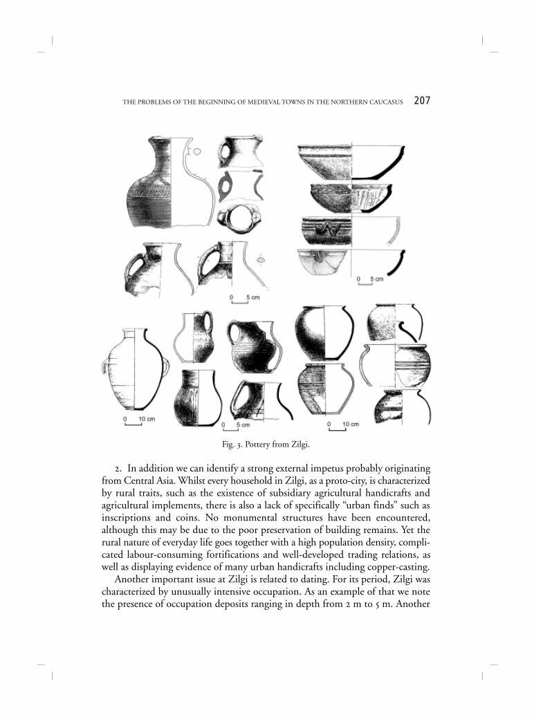
Another important issue at Zilgi is related to dating. For its period, Zilgi wascharacterized by unusually intensive occupation. As an example of that we notethe presence of occupation deposits ranging in depth from 2 m to 5 m. Another
Fig. 3. Pottery from Zilgi.
208 IRINA ARZHANTSEVA, SVETLANA RUZANOVA
example is craft specialization, specifically ceramics (Fig. 3). The inhabitants pro-duced huge quantities of pottery to an extent that was clearly superfluous formere everyday needs. There are large numbers of complicated, specialized formsof vessels, as well as a high percentage of common forms and imported wares, allindicative of urban everyday life (Arzhantseva, Deopik, Malashev 2000: 211–253).
Although Zilgi displays urban traits, it was not a city in the true sense of theword. Even the term “proto-city” should not be applied without some reserva-tion since the term implies a stage in a process of urbanization that ultimately ledto the formation of cities.
SECOND STAGE – MIDDLE PERIOD
We can see from the example of Zilgi that the emergence of major settle-ments and towns all through the history of the Alan state was determined notonly by natural landscape and socio-economic factors, but also by the need tocontrol the most important regions through which wealthy caravans with silk,wool, fur and luxury goods passed. Two major Alan groupings had appearedprobably by the 6th century AD. The western group, which is more interestingfor present purposes, inhabited the upper reaches of the Kuban’, and came underByzantium’s sphere of influence (Iessen 1941: 27; Gadlo 1984: 120–131; Kuznetsov1973: 60–74; Kuznetsov 1988: 76–78; Kovalevskaya 1984: 131–142).
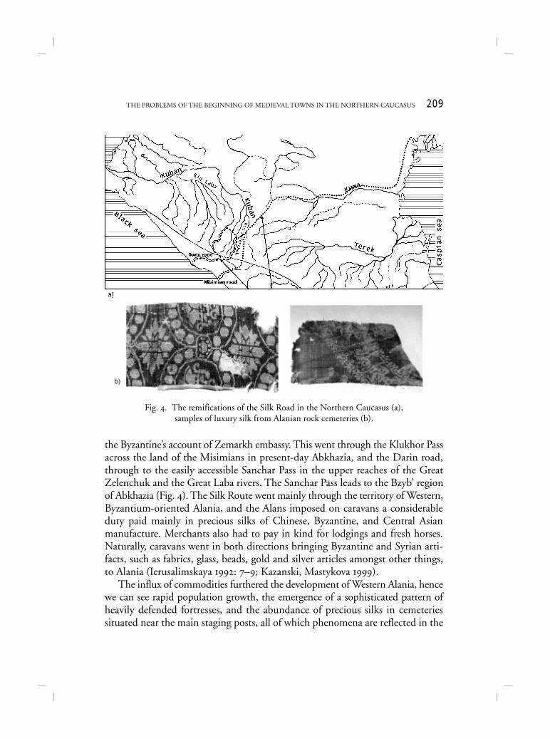
In geographical terms, the Alans held a key position in the North Caucasus, themajor cross-roads of Eurasian trading and military routes. The Alans were, there-fore, constantly drawn into the orbit of the complicated relationships of the super-powers whose interests clashed in the North Caucasus. In the second half of1st millennium AD these powers were Iran and Byzantium who fought for controlover the caravan routes, especially the Great Silk Route that ran across the NorthCaucasus through Alanian territory (Istoriya Vizantii 1967: 325). The Iranian-Byzantine struggle for the control of these routes greatly influenced the evolutionof Alania, in particular that of the union of western Alanian tribes. Before theconflict between the two great powers the main branch of the Silk Route wentthrough Iran. After the outbreak of hostilities in the 6th century the other branchgoing from China through the Ustyurt plateau, the Caspian shores and the NorthCaucasus to the North Pontic area, acquired much importance. Fierce Iranian-Byzantine wars during the 6th century AD blocked the westernmost branch ofthe Silk Route, thus giving an impetus to the Caucasian traffic (Savchenko 1993).The western Alans controlled two main North Caucasian routeways of the SilkRoute, namely the Misimian road – or Mindimian road, according to Menander
209THE PROBLEMS OF THE BEGINNING OF MEDIEVAL TOWNS IN THE NORTHERN CAUCASUS
the Byzantine’s account of Zemarkh embassy. This went through the Klukhor Passacross the land of the Misimians in present-day Abkhazia, and the Darin road,through to the easily accessible Sanchar Pass in the upper reaches of the GreatZelenchuk and the Great Laba rivers. The Sanchar Pass leads to the Bzyb’ regionof Abkhazia (Fig. 4). The Silk Route went mainly through the territory of Western,Byzantium-oriented Alania, and the Alans imposed on caravans a considerableduty paid mainly in precious silks of Chinese, Byzantine, and Central Asianmanufacture. Merchants also had to pay in kind for lodgings and fresh horses.Naturally, caravans went in both directions bringing Byzantine and Syrian arti-facts, such as fabrics, glass, beads, gold and silver articles amongst other things,to Alania (Ierusalimskaya 1992: 7–9; Kazanski, Mastykova 1999).
The influx of commodities furthered the development of Western Alania, hencewe can see rapid population growth, the emergence of a sophisticated pattern ofheavily defended fortresses, and the abundance of precious silks in cemeteriessituated near the main staging posts, all of which phenomena are reflected in the
Fig. 4. The remifications of the Silk Road in the Northern Caucasus (a),samples of luxury silk from Alanian rock cemeteries (b).
210 IRINA ARZHANTSEVA, SVETLANA RUZANOVA
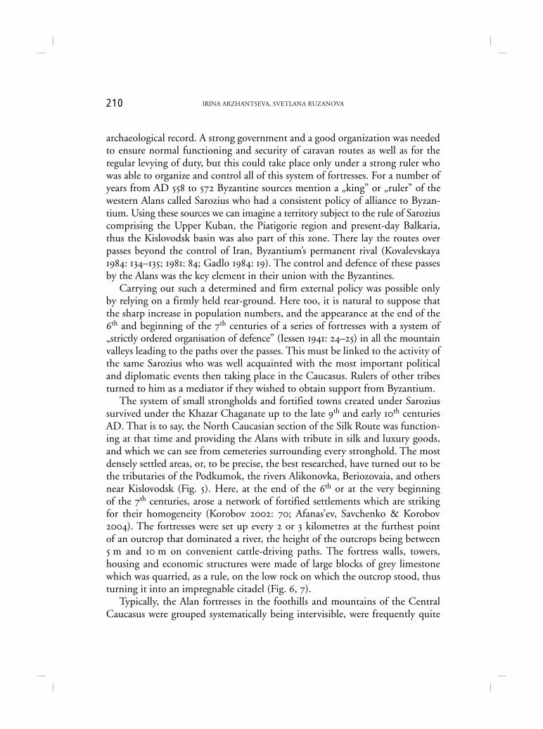
archaeological record. A strong government and a good organization was neededto ensure normal functioning and security of caravan routes as well as for theregular levying of duty, but this could take place only under a strong ruler whowas able to organize and control all of this system of fortresses. For a number ofyears from AD 558 to 572 Byzantine sources mention a „king” or „ruler” of thewestern Alans called Sarozius who had a consistent policy of alliance to Byzan-tium. Using these sources we can imagine a territory subject to the rule of Saroziuscomprising the Upper Kuban, the Piatigorie region and present-day Balkaria,thus the Kislovodsk basin was also part of this zone. There lay the routes overpasses beyond the control of Iran, Byzantium’s permanent rival (Kovalevskaya1984: 134–135; 1981: 84; Gadlo 1984: 19). The control and defence of these passesby the Alans was the key element in their union with the Byzantines.
Carrying out such a determined and firm external policy was possible onlyby relying on a firmly held rear-ground. Here too, it is natural to suppose thatthe sharp increase in population numbers, and the appearance at the end of the6th and beginning of the 7th centuries of a series of fortresses with a system of„strictly ordered organisation of defence” (Iessen 1941: 24–25) in all the mountainvalleys leading to the paths over the passes. This must be linked to the activity ofthe same Sarozius who was well acquainted with the most important politicaland diplomatic events then taking place in the Caucasus. Rulers of other tribesturned to him as a mediator if they wished to obtain support from Byzantium.
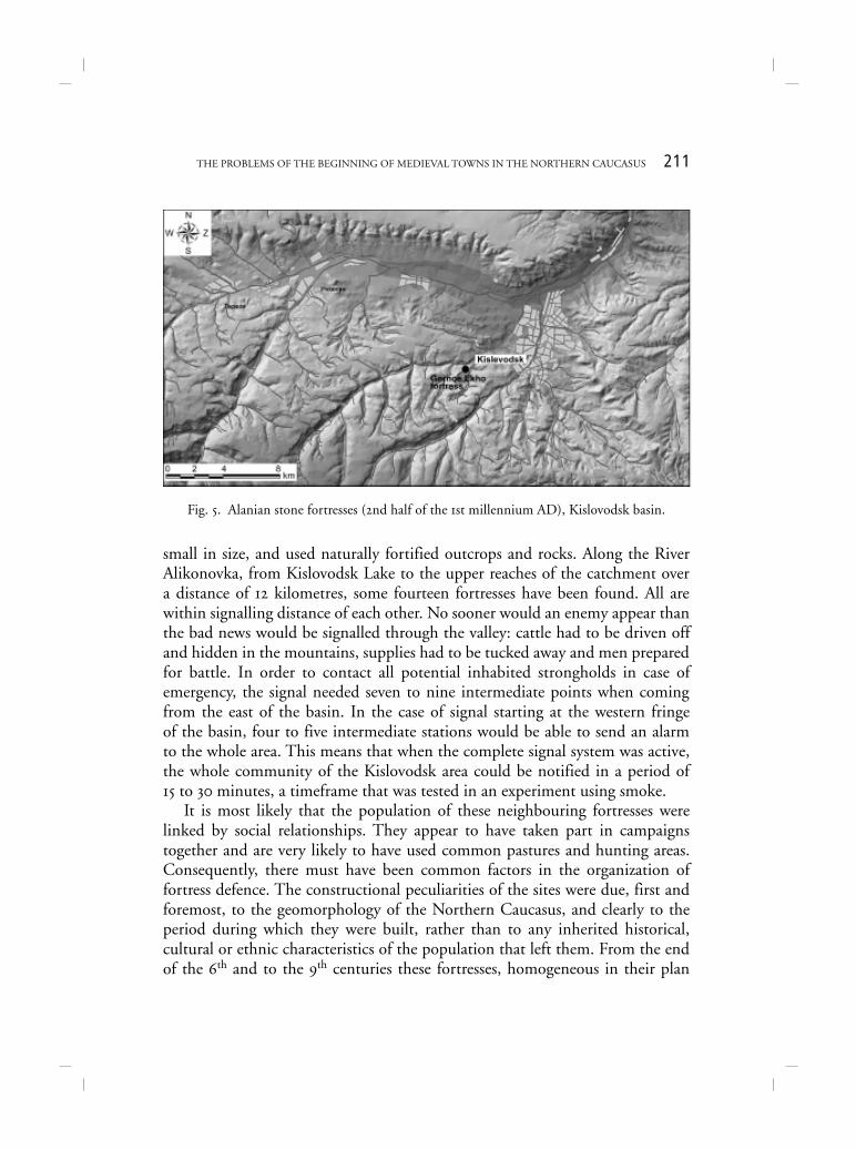
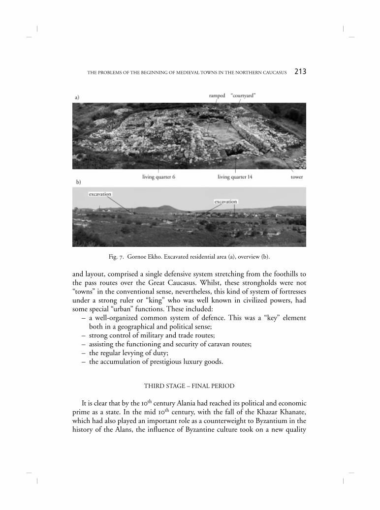
The system of small strongholds and fortified towns created under Saroziussurvived under the Khazar Chaganate up to the late 9th and early 10th centuriesAD. That is to say, the North Caucasian section of the Silk Route was function-ing at that time and providing the Alans with tribute in silk and luxury goods,and which we can see from cemeteries surrounding every stronghold. The mostdensely settled areas, or, to be precise, the best researched, have turned out to bethe tributaries of the Podkumok, the rivers Alikonovka, Beriozovaia, and othersnear Kislovodsk (Fig. 5). Here, at the end of the 6th or at the very beginningof the 7th centuries, arose a network of fortified settlements which are strikingfor their homogeneity (Korobov 2002: 70; Afanas’ev, Savchenko & Korobov2004). The fortresses were set up every 2 or 3 kilometres at the furthest pointof an outcrop that dominated a river, the height of the outcrops being between5 m and 10 m on convenient cattle-driving paths. The fortress walls, towers,housing and economic structures were made of large blocks of grey limestonewhich was quarried, as a rule, on the low rock on which the outcrop stood, thusturning it into an impregnable citadel (Fig. 6, 7).
Typically, the Alan fortresses in the foothills and mountains of the CentralCaucasus were grouped systematically being intervisible, were frequently quite
211THE PROBLEMS OF THE BEGINNING OF MEDIEVAL TOWNS IN THE NORTHERN CAUCASUS
small in size, and used naturally fortified outcrops and rocks. Along the RiverAlikonovka, from Kislovodsk Lake to the upper reaches of the catchment overa distance of 12 kilometres, some fourteen fortresses have been found. All arewithin signalling distance of each other. No sooner would an enemy appear thanthe bad news would be signalled through the valley: cattle had to be driven offand hidden in the mountains, supplies had to be tucked away and men preparedfor battle. In order to contact all potential inhabited strongholds in case ofemergency, the signal needed seven to nine intermediate points when comingfrom the east of the basin. In the case of signal starting at the western fringeof the basin, four to five intermediate stations would be able to send an alarmto the whole area. This means that when the complete signal system was active,the whole community of the Kislovodsk area could be notified in a period of15 to 30 minutes, a timeframe that was tested in an experiment using smoke.
It is most likely that the population of these neighbouring fortresses werelinked by social relationships. They appear to have taken part in campaignstogether and are very likely to have used common pastures and hunting areas.Consequently, there must have been common factors in the organization offortress defence. The constructional peculiarities of the sites were due, first andforemost, to the geomorphology of the Northern Caucasus, and clearly to theperiod during which they were built, rather than to any inherited historical,cultural or ethnic characteristics of the population that left them. From the endof the 6th and to the 9th centuries these fortresses, homogeneous in their plan
Fig. 5. Alanian stone fortresses (2nd half of the 1st millennium AD), Kislovodsk basin.
212 IRINA ARZHANTSEVA, SVETLANA RUZANOVA
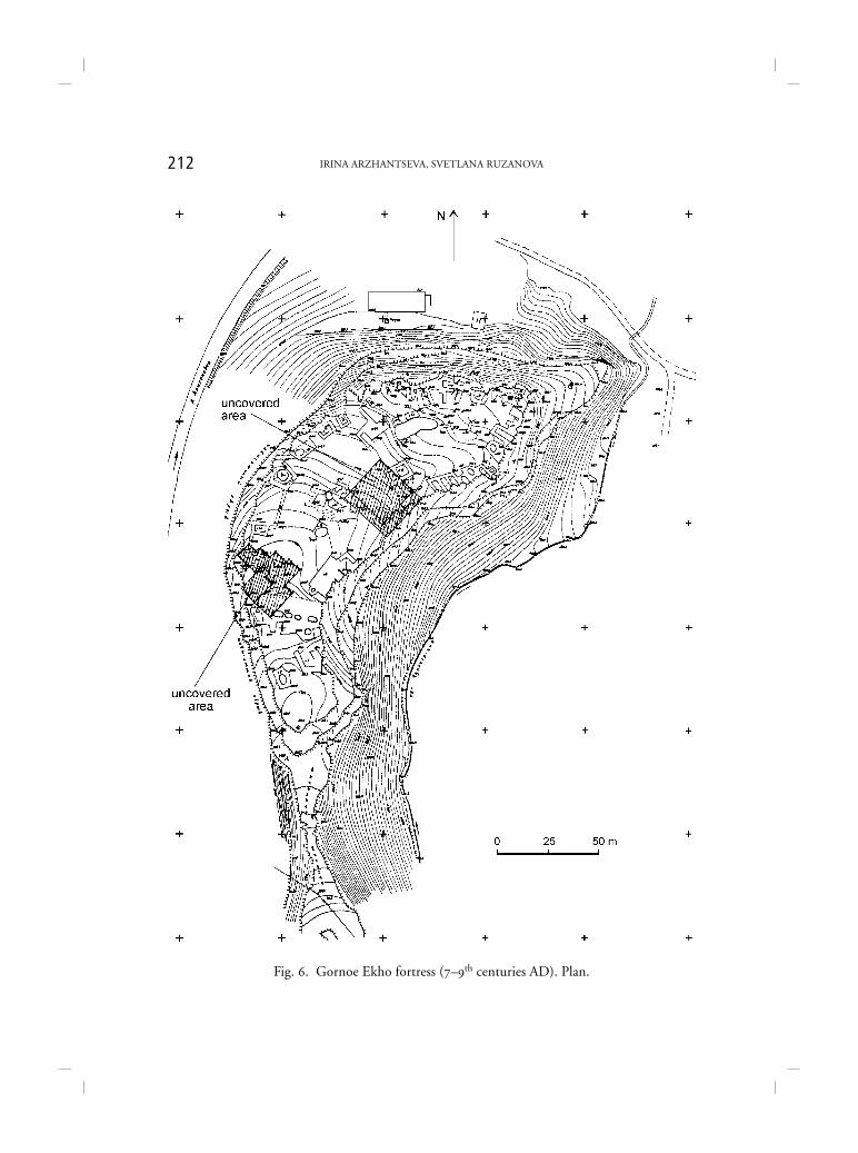
Fig. 6. Gornoe Ekho fortress (7–9th centuries AD). Plan.
213THE PROBLEMS OF THE BEGINNING OF MEDIEVAL TOWNS IN THE NORTHERN CAUCASUS
Fig. 7. Gornoe Ekho. Excavated residential area (a), overview (b).
and layout, comprised a single defensive system stretching from the foothills tothe pass routes over the Great Caucasus. Whilst, these strongholds were not“towns” in the conventional sense, nevertheless, this kind of system of fortressesunder a strong ruler or “king” who was well known in civilized powers, hadsome special “urban” functions. These included:
– a well-organized common system of defence. This was a “key” elementboth in a geographical and political sense;
– strong control of military and trade routes;– assisting the functioning and security of caravan routes;– the regular levying of duty;– the accumulation of prestigious luxury goods.
THIRD STAGE – FINAL PERIOD
It is clear that by the 10th century Alania had reached its political and economicprime as a state. In the mid 10th century, with the fall of the Khazar Khanate,which had also played an important role as a counterweight to Byzantium in thehistory of the Alans, the influence of Byzantine culture took on a new quality
214 IRINA ARZHANTSEVA, SVETLANA RUZANOVA
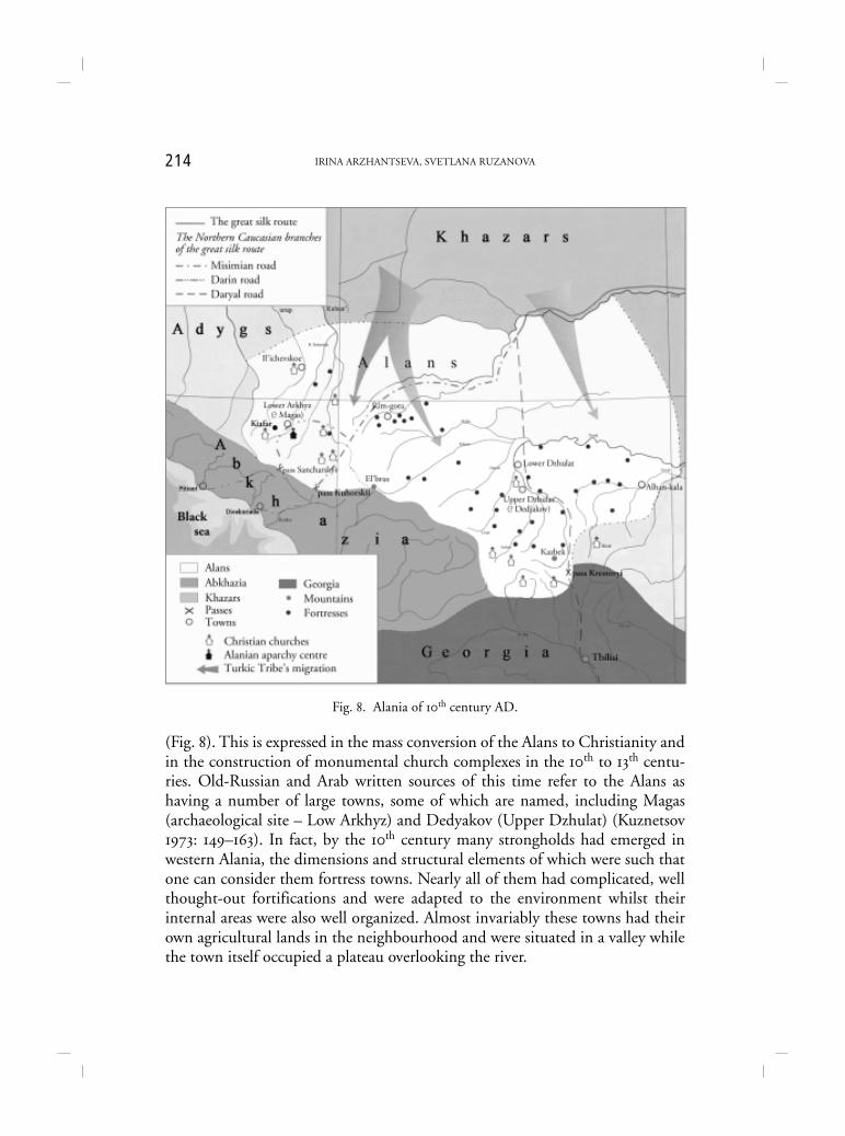
(Fig. 8). This is expressed in the mass conversion of the Alans to Christianity andin the construction of monumental church complexes in the 10th to 13th centu-ries. Old-Russian and Arab written sources of this time refer to the Alans ashaving a number of large towns, some of which are named, including Magas(archaeological site – Low Arkhyz) and Dedyakov (Upper Dzhulat) (Kuznetsov1973: 149–163). In fact, by the 10th century many strongholds had emerged inwestern Alania, the dimensions and structural elements of which were such thatone can consider them fortress towns. Nearly all of them had complicated, wellthought-out fortifications and were adapted to the environment whilst theirinternal areas were also well organized. Almost invariably these towns had theirown agricultural lands in the neighbourhood and were situated in a valley whilethe town itself occupied a plateau overlooking the river.
Fig. 8. Alania of 10th century AD.

215THE PROBLEMS OF THE BEGINNING OF MEDIEVAL TOWNS IN THE NORTHERN CAUCASUS
These towns could hardly emerge as a result of a direct Byzantine influence,but they took up local traditions, their growth and prosperity almost certainlybeing due to the intensification of Byzantine – Caucasian interrelations invarious spheres of life. Moreover, their genesis coincides chronologically withthe emergence of Old Russian cities and urban development in Byzantium. Themedieval process of urbanization that affected much of Europe and Asia Minorseemingly did not leave the North Caucasus untouched, and this itself impliesa fairly high level of inner socio-economic development attained by Alania inthe 10th century AD (Kuznetsov 1992: 245). Yet at the same time a Byzantine“impetus” can be detected along with certain building traditions, notably infortifications and cult structures, as well as the presence and participation ofByzantine artisans who followed the missionaries.
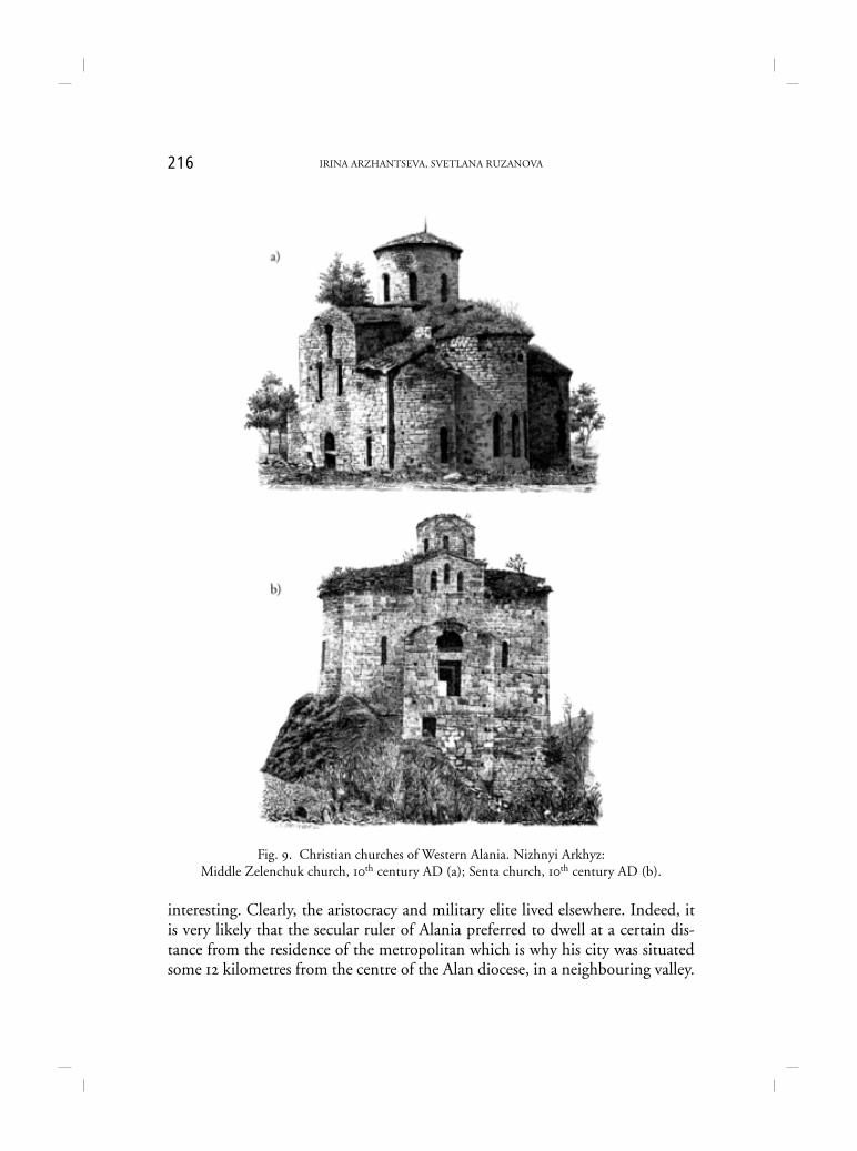
In the course of Christianization of the Alans an ecclesiastical province wasformed in the early 10th century with a metropolitan at its head (Malakhov 1992:149–170). Thus, the need arose to create the residence of Alanian metropolitansand to found a cathedral. Hence the choice of the Lower Arkhyz, an ecologicallyfavorable and sheltered place in the heart of the mountains, was very reasonable(Fig. 8). It was situated on the great road „from the Alans to the Greeks”, not farfrom Abkhazian Black Sea ports, which was also convenient for links with Byzan-tium. The erection of the Northern and Middle Temples with attached structureswas begun there. The diocesan settlement gradually became a town. Large-scalechurch building, the influx of Byzantine missionaries and the enlivening of theeconomy and culture gave a strong impetus to the evolution of the Lower Arkhyz.Three early Christian churches (the Northern, the Central and the Southern) ofthe 10th century still stand in Lower Arkhyz (Fig. 9). They were probably builtwith active assistance by Byzantine craftsmen (Perfil’eva 1992: 180–200). In the10th and 11th centuries there were far more churches – about a dozen (Kuznetsov1993: 87–116) and a significant amount of ecclesiastical equipment has beenfound. In the 11th century around the Central Church, a monastery was built,perhaps the Monastery of John the Baptist, mentioned in Byzantine sources.
To judge by the large number of houses, Lower Arkhyz was one of the majortowns of feudal western Alania (Kuznetsov 1993: 225–258). If, however, LowerArkhyz was the site of the Alanian bishop and his clergy, the question arises as towhere the residence of the ruler and feudal aristocracy of Alania may have been,and where were the numerous military garrisons located? Similarly, where wasthe cemetery where kings were buried? Archaeological excavations at LowerArkhyz have revealed no trace of any buildings which could be interpreted asa royal palace. All the burials, in stone boxes, found at or in the vicinity of LowerArkhyz are graves of commoners, even though their contents are often very
216 IRINA ARZHANTSEVA, SVETLANA RUZANOVA
interesting. Clearly, the aristocracy and military elite lived elsewhere. Indeed, itis very likely that the secular ruler of Alania preferred to dwell at a certain dis-tance from the residence of the metropolitan which is why his city was situatedsome 12 kilometres from the centre of the Alan diocese, in a neighbouring valley.
Fig. 9. Christian churches of Western Alania. Nizhnyi Arkhyz:Middle Zelenchuk church, 10th century AD (a); Senta church, 10th century AD (b).
217THE PROBLEMS OF THE BEGINNING OF MEDIEVAL TOWNS IN THE NORTHERN CAUCASUS
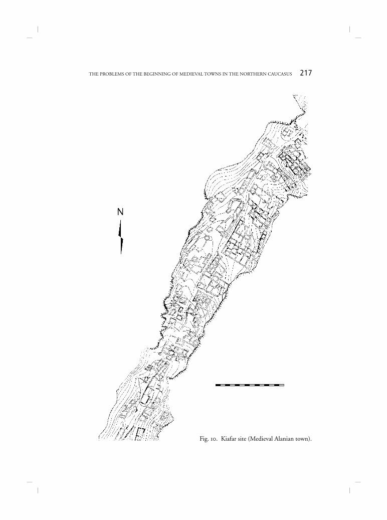
Fig. 10. Kiafar site (Medieval Alanian town).
218 IRINA ARZHANTSEVA, SVETLANA RUZANOVA
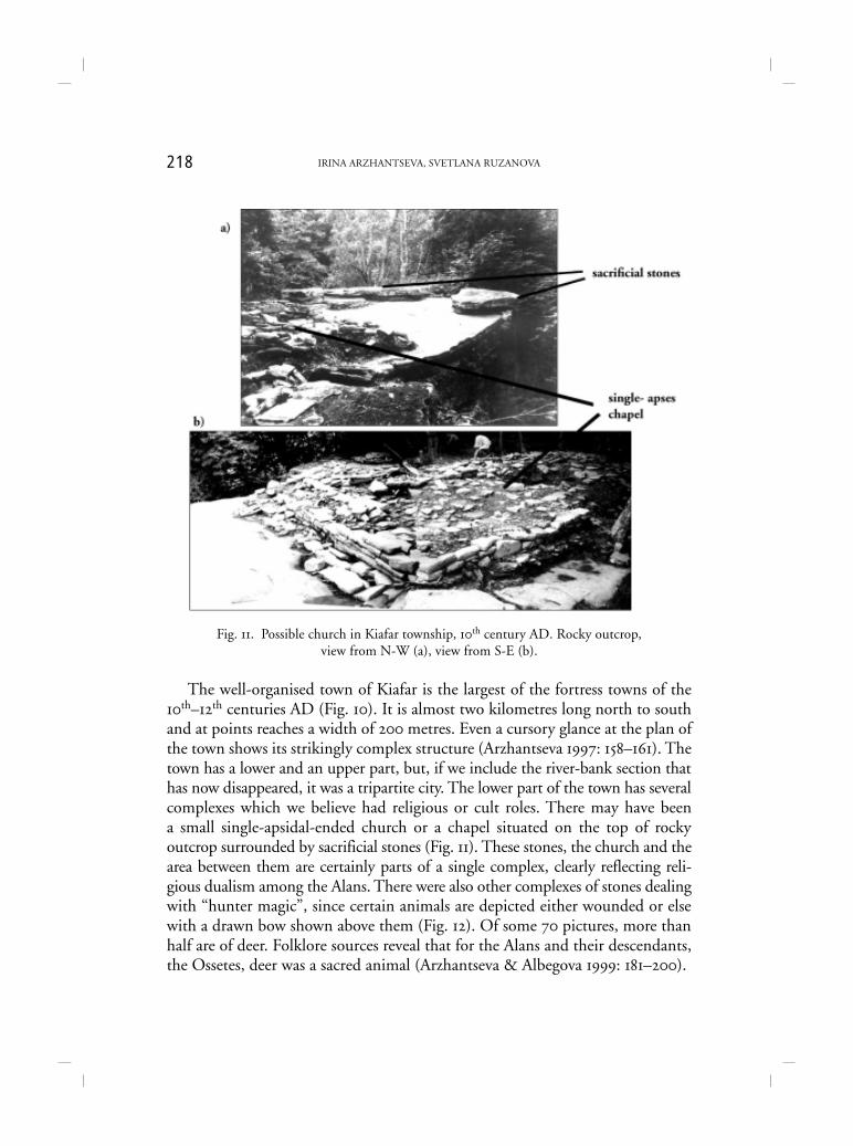
Fig. 11. Possible church in Kiafar township, 10th century AD. Rocky outcrop,view from N-W (a), view from S-E (b).
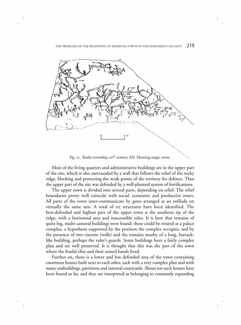
The well-organised town of Kiafar is the largest of the fortress towns of the10th–12th centuries AD (Fig. 10). It is almost two kilometres long north to southand at points reaches a width of 200 metres. Even a cursory glance at the plan ofthe town shows its strikingly complex structure (Arzhantseva 1997: 158–161). Thetown has a lower and an upper part, but, if we include the river-bank section thathas now disappeared, it was a tripartite city. The lower part of the town has severalcomplexes which we believe had religious or cult roles. There may have beena small single-apsidal-ended church or a chapel situated on the top of rockyoutcrop surrounded by sacrificial stones (Fig. 11). These stones, the church and thearea between them are certainly parts of a single complex, clearly reflecting reli-gious dualism among the Alans. There were also other complexes of stones dealingwith “hunter magic”, since certain animals are depicted either wounded or elsewith a drawn bow shown above them (Fig. 12). Of some 70 pictures, more thanhalf are of deer. Folklore sources reveal that for the Alans and their descendants,the Ossetes, deer was a sacred animal (Arzhantseva & Albegova 1999: 181–200).
219THE PROBLEMS OF THE BEGINNING OF MEDIEVAL TOWNS IN THE NORTHERN CAUCASUS
Most of the living quarters and administrative buildings are in the upper partof the site, which is also surrounded by a wall that follows the relief of the rockyridge, blocking and protecting the weak points of the territory for defence. Thusthe upper part of the site was defended by a well-planned system of fortifications.
The upper town is divided into several parts, depending on relief. The reliefboundaries pretty well coincide with social, economic and productive zones.All parts of the town inter-communicate by gates arranged as an enfilade onvirtually the same axis. A total of 115 structures have been identified. Thebest-defended and highest part of the upper town is the southern tip of theridge, with a horizontal area and inaccessible sides. It is here that remains ofquite big, multi-cameral buildings were found: these could be treated as a palacecomplex, a hypothesis supported by the position the complex occupies, and bythe presence of two cisterns (wells) and the remains nearby of a long, barrack-like building, perhaps the ruler’s guards. Some buildings have a fairly complexplan and are well preserved. It is thought that this was the part of the townwhere the feudal elite and their armed bands lived.
Further on, there is a lower and less defended area of the town containingenormous houses built next to each other, each with a very complex plan and withmany outbuildings, partitions and internal courtyards. About ten such houses havebeen found so far, and they are interpreted as belonging to constantly expanding
Fig. 12. Kiafar township, 10th century AD. Hunting magic stone.
220 IRINA ARZHANTSEVA, SVETLANA RUZANOVA
families. In a way they are extended-family houses with their own economy.Finally, the remaining part of the upper town clearly had a communal character.Situated on a gently rising, even plateau there is not a single remnant of anystructure except for four very well preserved buildings which may have had someadministrative purpose. Perhaps this was the communal centre of the town, orperhaps the population came up here from the undefended riverside part of thetown, to shelter behind the upper fortress wall at times of danger.
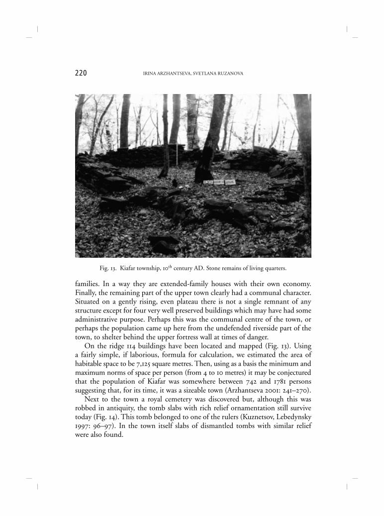
On the ridge 114 buildings have been located and mapped (Fig. 13). Usinga fairly simple, if laborious, formula for calculation, we estimated the area ofhabitable space to be 7,125 square metres. Then, using as a basis the minimum andmaximum norms of space per person (from 4 to 10 metres) it may be conjecturedthat the population of Kiafar was somewhere between 742 and 1781 personssuggesting that, for its time, it was a sizeable town (Arzhantseva 2001: 241–270).
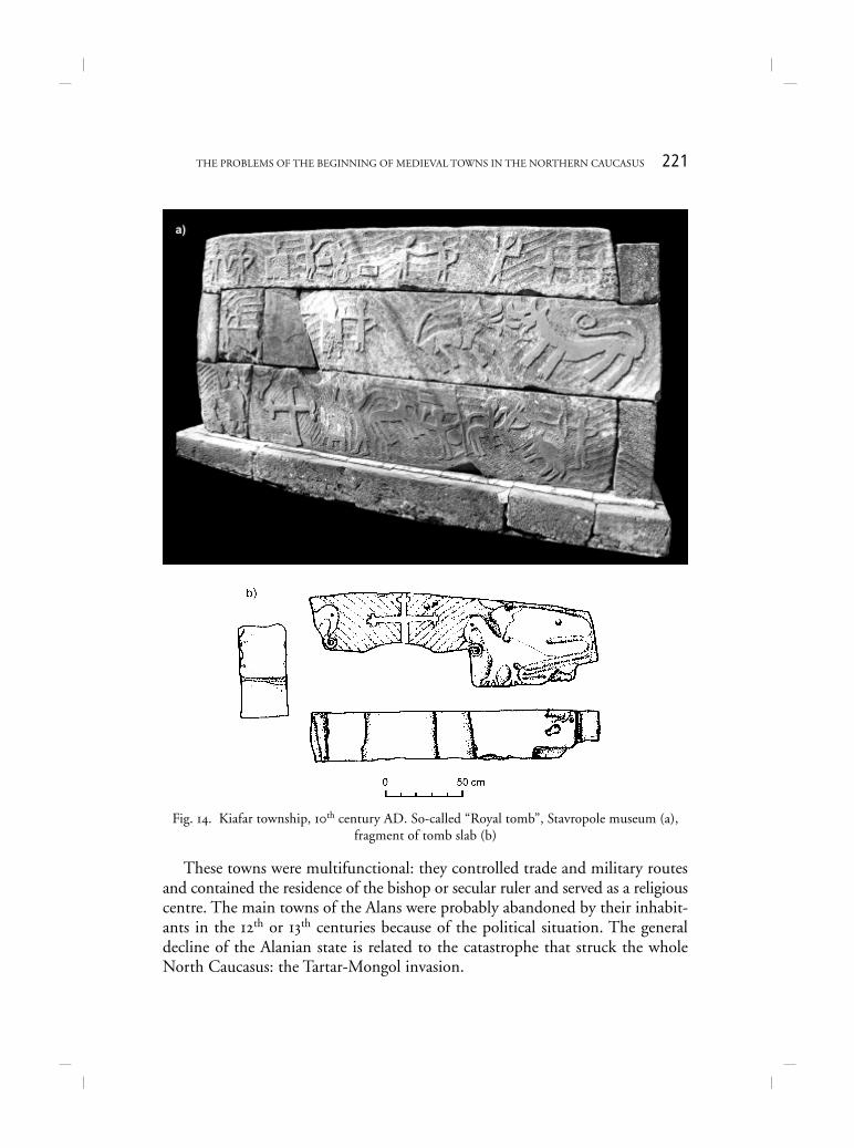
Next to the town a royal cemetery was discovered but, although this wasrobbed in antiquity, the tomb slabs with rich relief ornamentation still survivetoday (Fig. 14). This tomb belonged to one of the rulers (Kuznetsov, Lebedynsky1997: 96–97). In the town itself slabs of dismantled tombs with similar reliefwere also found.
Fig. 13. Kiafar township, 10th century AD. Stone remains of living quarters.
221THE PROBLEMS OF THE BEGINNING OF MEDIEVAL TOWNS IN THE NORTHERN CAUCASUS
These towns were multifunctional: they controlled trade and military routesand contained the residence of the bishop or secular ruler and served as a religiouscentre. The main towns of the Alans were probably abandoned by their inhabit-ants in the 12th or 13th centuries because of the political situation. The generaldecline of the Alanian state is related to the catastrophe that struck the wholeNorth Caucasus: the Tartar-Mongol invasion.
Fig. 14. Kiafar township, 10th century AD. So-called “Royal tomb”, Stavropole museum (a),fragment of tomb slab (b)
222 IRINA ARZHANTSEVA, SVETLANA RUZANOVA
REFERENCES
AFANAS’EV, G., S. SAVCHENKO & D. KOROBOV. 2004. Drevnosti Kislovoskoi Kotloviny. Moskva.ARZHANTSEVA, I. 1997. From settlement to cities. Alanian proto-cities of the 1st–2nd millennium
AD in the North Caucasus, Medieval Europe, Urbanism. I: 153–161..... 2001. Alanskoe gorodische Kiafar IX–XII vv. v Karachae, in Karachaevtsy i Balkartsy: yazyk,
etnografiya, arkheologia, fol’klor. Moskva.ARZHANTSEVA, I. & Z. ALBEGOVA. 1999. Kul’tovye kamni Kiafarskogo gorodischa (esche ras
o religioznom dualizme alan), in Drevnosti Severnogo Kavkaza. Moskva.ARZHANTSEVA, I. & D. DEOPIK. 1989. Zilgi – gorodische nachala 1-go tysiacheletiya na styke
stepei i predgoryi v Severnoi Osetii, in Uchenye zapiski komissii po izucheniu pamyatnikovtsivilizatsii drevnego I srednevekovogo Vostoka. Moskva.
ARZHANTSEVA, I., D. DEOPIK & V. MALASHEV. 2000. Zilgi - Early Alan Proto-City of the FirstMillennium AD on the boundary between Steppe and Hill Country, in Les Sites archeo-logiques en Crimea et au Caucasus. Colloquia Pontica . Leiden–Boston–Köln.
GADLO, A. 1984. Strana Ikhran (Irkhan) dagestanskoi khroniki “Derbentname”, in Voprosy arkheo-logi i etnografii Severnoi Osetii. Ordzhonikidze.
IESSEN, A. 1941. Arkheologicheskie pam’yatniki Kabardino-Balkarii. Materialy i issledovaniya poarkheologii SSSR, 3, Moskva–Leningrad.
IERUSALIMSKAYA, A. 1992. Kavkaz na Shelkovom puti. Katalog vystavki. Sankt-Peterburg.ISTORIA VIZANTII, 1967. . Moskva.ISAENKO, A. V. & V. D. KUCHIEV. 1995. Nekotorye problemy drevnei istorii alan, in Alany. Istoriya
i kul’tura. Alanica III. Vladikavkaz.KAZANSKI, M. & A. MASTYKOVA. 1999. Le Caucase du Nord et la region mediterraneenne aux
5e–6e siècles, Eurasia antiqua, 5. Mainz am Rhein.KOROBOV, D. 2002. Baza dannykh Arkheologicheskie pamyatniki Kislovodskoi kotloviny, in
XXII Krupnovskie chteniya po arkheologii Severnogo Kavkaza. Tezisy dokladov. Essentuki–Kislovodsk.
KOVALEVSKAYA, V. 1981. Severokavkazskie drevnosti, in Stepi Evrazii v epokhu srednevekov’ya.Moskva.
.... 1984. Kavkaz i Alany. Moskva.KUZNETSOV, V.A. 1971. Alania v X–XIII vv. Moskva..... 1973. Alanskaya kul’tura Tsentral’nogo Kavkaza i ee lokal’nye varianty, Sovetskaya Archeo-
logia, 2..... 1988. Durgulel’ Velikyi I Nizhnyi Arkhyz, in Metodika, issledovaniya i interpretatsiya arkheo-
logicheskikh materialov Severnogo Kavkaza. Ordzhonikidze..... 1992. Ocherki Istorii Alan. Vladikavkaz..... 1993. Nizhnyi Arkhyz. Stavropol’.KUZNETSOV, V. & I. LEBEDYNSKY. 1997. Les Alains. Cavaliers e steppes, seigneurs du Caucase. Paris.MENANDR. 1860. Prodolzhenie istorii Agaf ’evoi. Sankt-Peterburg.MALAKHOV, S.N. 1992. K voprosu o lokalizatsii eparkhial’nogo tsentra v Alanii XII–XVI, in
Alany. Zapadnaya Evropa i Vizantiya. Ordzhonikidze.PERFIL’EVA, L. 1992. K voprosu o vizantyiskom vliyanii na kul’tovyiu arkhitekturu Severo-Zapad-
nogo Kavkaza v X–XI vv., in Alany. Zapadnaya Evropa i Vizantiya. Ordzhonikidze.SAVCHENKO, E. 1993. O Severokavrazskom otrezke Velikogo Shelkovogo Puti, in II Kubanskaya
arkheologicheskaya konferentsiya: tezisy dokladov. Krasnodar.