
The Paleoenvironment and Lithic Taphonomy of Shi’Bat Dihya 1, a Middle Paleolithic Site in Wadi...
21
Research Article The Paleoenvironment and Lithic Taphonomy of Shi’Bat Dihya 1, a Middle Paleolithic Site in Wadi Surdud, Yemen Luca Sitzia, 1, * Pascal Bertran, 1,2 St ´ ephane Boulogne, 2 Michel Brenet, 1,2 R´ emy Crassard, 3 Anne Delagnes, 1 Marine Frouin, 4,5 Christine Hatt ´ e, 6 Jacques Jaubert, 1 Lamya Khalidi, 7 Erwan Messager, 8,9 Norbert Mercier, 5 Alain Meunier, 4 St ´ ephane Peign ´ e, 10 Alain Queffelec, 1 Chantal Tribolo, 5 and Roberto Macchiarelli 4,8 1 PACEA, UMR 5199 CNRS, Universit ´ e de Bordeaux 1, Talence, France 2 INRAP, Pessac, France 3 Arch ´ eorient, UMR 5133 CNRS, Maison de l’Orient et de la M ´ editerran ´ ee, Lyon, France 4 D´ epartement G ´ eosciences, Universit ´ e de Poitiers, Poitiers, France 5 CRPAA-IRAMAT, UMR 5060 CNRS, Universit ´ e de Bordeaux 3, Pessac, France 6 Laboratoire des Sciences du Climat et de l’Environnement, Domaine du CNRS, Gif-sur-Yvette, France 7 Consejo Superior de Investigaciones Cient´ ıficas, Instituci ´ on Mil ´ a Y Fontanals, C/Egipc´ ıaques, Spain 8 D´ epartement de Pr ´ ehistoire, UMR 7194 CNRS, Mus ´ eum National d’Histoire Naturelle, Paris, France 9 CEPAM UMR 7264 CNRS, Campus Saint Jean d’Ang ´ ely, Nice, France 10 D´ epartement Histoire de la Terre, UMR 7207 CNRS, Mus ´ eum National d’Histoire Naturelle, Paris, France Correspondence * Corresponding author; E-mail: [email protected] Received 16 March 2012 Accepted 6 July 2012 Scientific editing by Jamie Woodward Published online in Wiley Online Library (wileyonlinelibrary.com). doi 10.1002/gea.21419 The Shi’bat Dihya 1 site in western Yemen, dated by optically stimulated lu- minescence to 55 ka, provides insight into the Middle Paleolithic peopling of the Arabian Peninsula. The archaeological layer is interstratified within thick, sandy silt floodplain deposits filling a piedmont basin. Luminescence dates, lack of soil development, and gypsum precipitation indicate a high accretion rate of the floodplain during Marine Isotope Stage 3, in connection with a (semi)-arid environment. Rapid overbank sedimentation was likely a result of the remo- bilization of loess material deposited on the Yemeni Great Escarpment at the periphery of the adjacent Tihama coastal sand desert or of other sources. Fabric and size analyses of the lithic artifacts, together with spatial projections, indi- cate site modifications by floods. Primary modifications include (1) selective accumulation of medium-sized lithic pieces as a result of hydraulic sorting, (2) bimodal orientation of artifacts, and (3) ripple-like arrangement of lithics and bone/tooth fragments. The overrepresentation of teeth may also be a conse- quence of sorting. Although floods have distorted the original site patterning, long-distance transport of artifacts by water can be excluded, as indicated by relatively high refitting rate, close proximity of artifacts derived from the same block of raw material, and lack of abrasion of the pieces. Therefore, the site is considered “geologically” in situ because its remobilization by water occurred shortly after human abandonment. This study also stresses that the effective preservation of a site cannot be assessed without careful taphonomic study, even in a potentially favorable depositional context such as silty alluvium. C 2012 Wiley Periodicals, Inc. INTRODUCTION The Middle Paleolithic site of Shi’bat Dihya 1 (SD1) in western Yemen (Figure 1A) is one of the old- est human occupations in the Arabian Peninsula pre- served in stratigraphic context. Discovered as part of research activities in Wadi Surdud by the Paleo-Y international project (Macchiarelli and Peign ´ e, 2006; Macchiarelli, 2009) and dated by optically stimulated luminescence (OSL) at approximately 55 ka (Delagnes et al., 2012), the site has yielded a rich Middle Pa- leolithic lithic industry accompanied by a small num- ber of faunal remains. Thus, SD1, which is part of a larger complex of prehistoric sites, is an important reference point for understanding human population Geoarchaeology: An International Journal 27 (2012) 471–491 Copyright C 2012 Wiley Periodicals, Inc. 471
Transcript of The Paleoenvironment and Lithic Taphonomy of Shi’Bat Dihya 1, a Middle Paleolithic Site in Wadi...
Research Article
The Paleoenvironment and Lithic Taphonomy of Shi’Bat Dihya 1,a Middle Paleolithic Site in Wadi Surdud, YemenLuca Sitzia,1,* Pascal Bertran,1,2 Stephane Boulogne,2 Michel Brenet,1,2 Remy Crassard,3 Anne Delagnes,1
Marine Frouin,4,5 Christine Hatte,6 Jacques Jaubert,1 Lamya Khalidi,7 Erwan Messager,8,9 Norbert Mercier,5
Alain Meunier,4 Stephane Peigne,10 Alain Queffelec,1 Chantal Tribolo,5 and Roberto Macchiarelli4,8
1PACEA, UMR 5199 CNRS, Universite de Bordeaux 1, Talence, France2INRAP, Pessac, France3Archeorient, UMR 5133 CNRS, Maison de l’Orient et de la Mediterranee, Lyon, France4Departement Geosciences, Universite de Poitiers, Poitiers, France5CRPAA-IRAMAT, UMR 5060 CNRS, Universite de Bordeaux 3, Pessac, France6Laboratoire des Sciences du Climat et de l’Environnement, Domaine du CNRS, Gif-sur-Yvette, France7Consejo Superior de Investigaciones Cientıficas, Institucion Mila Y Fontanals, C/Egipcıaques, Spain8Departement de Prehistoire, UMR 7194 CNRS, Museum National d’Histoire Naturelle, Paris, France9CEPAM UMR 7264 CNRS, Campus Saint Jean d’Angely, Nice, France10Departement Histoire de la Terre, UMR 7207 CNRS, Museum National d’Histoire Naturelle, Paris, France
Correspondence*Corresponding author;
E-mail: [email protected]
Received16 March 2012
Accepted6 July 2012
Scientific editing by Jamie Woodward
Published online in Wiley Online Library
(wileyonlinelibrary.com).
doi 10.1002/gea.21419
The Shi’bat Dihya 1 site in western Yemen, dated by optically stimulated lu-minescence to 55 ka, provides insight into the Middle Paleolithic peopling ofthe Arabian Peninsula. The archaeological layer is interstratified within thick,sandy silt floodplain deposits filling a piedmont basin. Luminescence dates, lackof soil development, and gypsum precipitation indicate a high accretion rate ofthe floodplain during Marine Isotope Stage 3, in connection with a (semi)-aridenvironment. Rapid overbank sedimentation was likely a result of the remo-bilization of loess material deposited on the Yemeni Great Escarpment at theperiphery of the adjacent Tihama coastal sand desert or of other sources. Fabricand size analyses of the lithic artifacts, together with spatial projections, indi-cate site modifications by floods. Primary modifications include (1) selectiveaccumulation of medium-sized lithic pieces as a result of hydraulic sorting, (2)bimodal orientation of artifacts, and (3) ripple-like arrangement of lithics andbone/tooth fragments. The overrepresentation of teeth may also be a conse-quence of sorting. Although floods have distorted the original site patterning,long-distance transport of artifacts by water can be excluded, as indicated byrelatively high refitting rate, close proximity of artifacts derived from the sameblock of raw material, and lack of abrasion of the pieces. Therefore, the site isconsidered “geologically” in situ because its remobilization by water occurredshortly after human abandonment. This study also stresses that the effectivepreservation of a site cannot be assessed without careful taphonomic study,even in a potentially favorable depositional context such as silty alluvium. C©2012 Wiley Periodicals, Inc.
INTRODUCTION
The Middle Paleolithic site of Shi’bat Dihya 1 (SD1)in western Yemen (Figure 1A) is one of the old-est human occupations in the Arabian Peninsula pre-served in stratigraphic context. Discovered as part ofresearch activities in Wadi Surdud by the Paleo-Yinternational project (Macchiarelli and Peigne, 2006;
Macchiarelli, 2009) and dated by optically stimulatedluminescence (OSL) at approximately 55 ka (Delagneset al., 2012), the site has yielded a rich Middle Pa-leolithic lithic industry accompanied by a small num-ber of faunal remains. Thus, SD1, which is part ofa larger complex of prehistoric sites, is an importantreference point for understanding human population
Geoarchaeology: An International Journal 27 (2012) 471–491 Copyright C© 2012 Wiley Periodicals, Inc. 471
FLUVIAL PALEOENVIRONMENT AND LITHIC TAPHONOMY, YEMEN SITZIA ET AL.
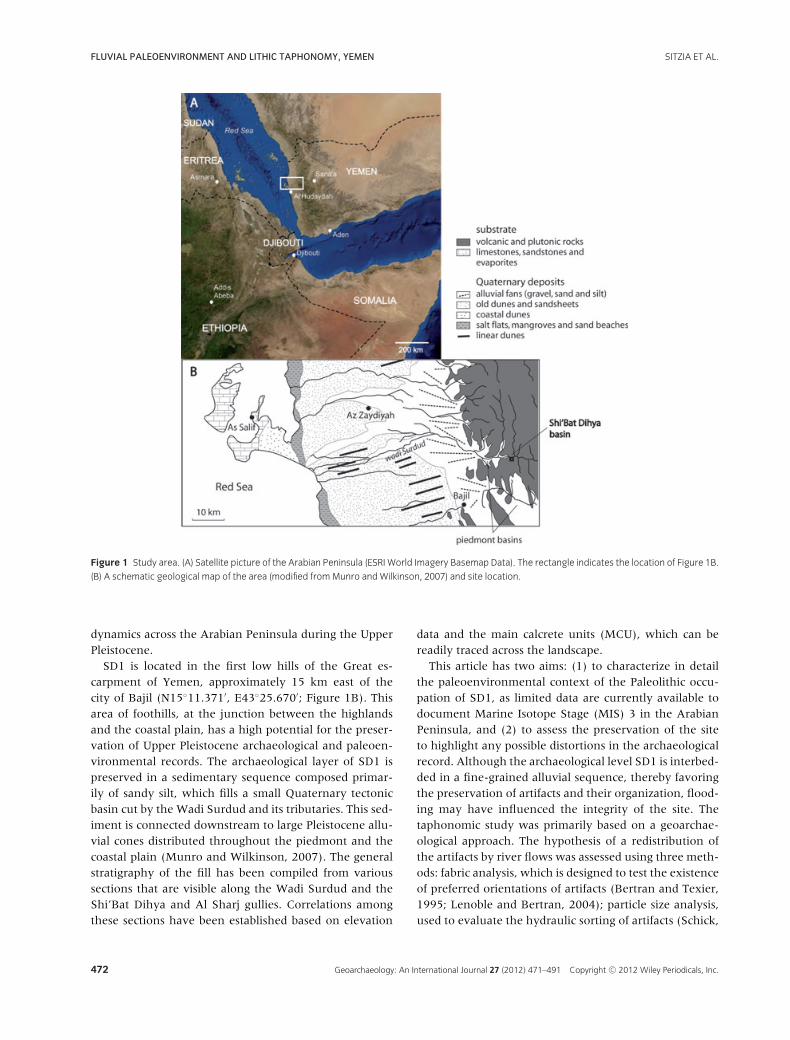
Figure 1 Study area. (A) Satellite picture of the Arabian Peninsula (ESRI World Imagery Basemap Data). The rectangle indicates the location of Figure 1B.
(B) A schematic geological map of the area (modified from Munro and Wilkinson, 2007) and site location.
dynamics across the Arabian Peninsula during the UpperPleistocene.
SD1 is located in the first low hills of the Great es-carpment of Yemen, approximately 15 km east of thecity of Bajil (N15◦11.371′, E43◦25.670′; Figure 1B). Thisarea of foothills, at the junction between the highlandsand the coastal plain, has a high potential for the preser-vation of Upper Pleistocene archaeological and paleoen-vironmental records. The archaeological layer of SD1 ispreserved in a sedimentary sequence composed primar-ily of sandy silt, which fills a small Quaternary tectonicbasin cut by the Wadi Surdud and its tributaries. This sed-iment is connected downstream to large Pleistocene allu-vial cones distributed throughout the piedmont and thecoastal plain (Munro and Wilkinson, 2007). The generalstratigraphy of the fill has been compiled from varioussections that are visible along the Wadi Surdud and theShi’Bat Dihya and Al Sharj gullies. Correlations amongthese sections have been established based on elevation
data and the main calcrete units (MCU), which can bereadily traced across the landscape.
This article has two aims: (1) to characterize in detailthe paleoenvironmental context of the Paleolithic occu-pation of SD1, as limited data are currently available todocument Marine Isotope Stage (MIS) 3 in the ArabianPeninsula, and (2) to assess the preservation of the siteto highlight any possible distortions in the archaeologicalrecord. Although the archaeological level SD1 is interbed-ded in a fine-grained alluvial sequence, thereby favoringthe preservation of artifacts and their organization, flood-ing may have influenced the integrity of the site. Thetaphonomic study was primarily based on a geoarchae-ological approach. The hypothesis of a redistribution ofthe artifacts by river flows was assessed using three meth-ods: fabric analysis, which is designed to test the existenceof preferred orientations of artifacts (Bertran and Texier,1995; Lenoble and Bertran, 2004); particle size analysis,used to evaluate the hydraulic sorting of artifacts (Schick,
472 Geoarchaeology: An International Journal 27 (2012) 471–491 Copyright C© 2012 Wiley Periodicals, Inc.
SITZIA ET AL. FLUVIAL PALEOENVIRONMENT AND LITHIC TAPHONOMY, YEMEN
1986; Bertran et al., 2006); and spatial analysis of the dis-tribution of lithic and faunal remains. The results werethen compared with data from the archaeological studyto develop the most likely scenario for the taphonomichistory of the site.
METHODS
Sediments
For the sedimentological and pedological characterizationof the alluvial stratigraphic sequence, field observationswere supplemented by sedimentological and geochemi-cal analyses. Seventeen samples were taken for grain sizeanalysis at PACEA laboratory, University of Bordeaux.After treatment with hydrogen peroxide (H2O2) to re-move organic matter and with formic acid (HCOOH, di-luted) to remove secondary calcium carbonate, the sam-ples were analyzed by sieving the fraction greater than63 μm and using laser granulometry (Mastersizer SMalvern, Marlvern, Worcestershire, UK) for the fractionbelow 63 μm. Forty-one samples were prepared for cal-cium carbonate (CaCO3), total organic carbon (TOC), andnitrogen (N) measurements according to the procedureproposed by Gauthier and Hatte (2008). The sampleswere combusted in a Fisons Instrument NA 1500 ElementAnalyzer and the carbon content determined with Ea-ger software. A standard was inserted every 10 samples.Inorganic carbon content in bulk sediment was calcu-lated assuming that mineral carbon exists only as CaCO3.Carbon isotopic signature was measured with a contin-uous flow EA-IRMS by coupling a Fisons InstrumentNA 1500 Element Analyzer to a ThermoFinigan Delta +XP Isotope-Ratio Mass Spectrometer. Two home internalstandards (oxalic acid, δ13C = −19.31‰ and GCL, δ13C =−26.70‰) were inserted every eight samples. Resultsare reported in the δ notation: δ13C = (Rsample/Rstandard
− 1) × 1000, where Rsample and Rstandard are the 13C/12Cratios of the sample and the international standard Vi-enna Pee Dee Belemnite Standard (VPDB), respectively.Measurements were at least trebled to ensure represen-tativeness. Extreme values were twice checked. Twelvethin sections were cut from blocks impregnated undervacuum with a polyester resin according to the proto-col described by Guillore (1980). Raman spectroscopywas used to determine certain mineral phases observedin the thin sections. The spectra acquisition was per-formed at CRPAA, University of Bordeaux, using a Ren-ishaw RM2000 – Leica DMLM and determined using theRRUFF database (Downs, 2006). The X-ray diffraction(XRD) patterns were recorded at HYDRASA, Universityof Poitiers, using a PANanalytical Xpert Pro diffractome-ter with Ni-filtered Cu-Kα radiation generated at 40 kV
and 40 mA and step size of 0.017◦2θ . XRD diffractogramswere recorded in the 2–65 and 2–34 ◦ 2θ Cu Kα an-gular ranges for random powders and oriented mounts,respectively. The determination of the clay species wasperformed using the decomposition procedure recom-mended by Lanson (1997) and the calculated XRD pat-terns using NEWMOD software (Reynolds, 1985). Phy-tolith extractions from bulk samples were made usingstandard methods but failed to provide any result, ei-ther because of preservation issues of biogenic silica insandy sediments or low phytolith production in the localenvironment.
Taphonomy
Lithic pieces with a long (a) axis (i.e., the maximum di-mension in any plane) greater than 2 cm and all faunalremains were located in three dimensions with an in-frared theodolite, and then numbered. Lithic pieces lessthan 2 cm in length were collected within each 25 cmquadrant area and then sieved under water on a 2 mmmesh.
The orientation and the dip of 228 objects were mea-sured using a compass and an inclinometer. The calcu-lation of eigenvalues and the projections on a Schmidtdiagram were performed with the program Stereo32, ver-sion 6.3.3 (Allmendinger, 2005). The isotropy index (SI =E3/E1) and the elongation index (EL = 1 – (E2/E1))were calculated according to Benn (1994). The intensityof the preferred orientation (Vector Magnitude L) and thep-value of the Rayleigh test, which tests whether the pre-ferred orientation is significant, were calculated using themethod proposed by Curray (1956).
The particle width (i.e., the particle intermediate b-axis) of all the lithic artifacts collected was also quanti-fied. For each square, the pieces smaller than 2 cm col-lected during the excavation and the refuse from the 2mm water sieving were passed through the following se-ries of screens: 2, 4, 5, 10, 20, 31.5, and 50 mm. Lithicslonger than 2 cm were divided into size classes by pass-ing them individually through the diagonal of the meshof a sieve to avoid damaging of the edges and to ensurethe correspondence of the widths measured by the caliperand by sieving. The width of the pieces passing througha mesh sieve d = a mm is approximately w = a
√2 mm
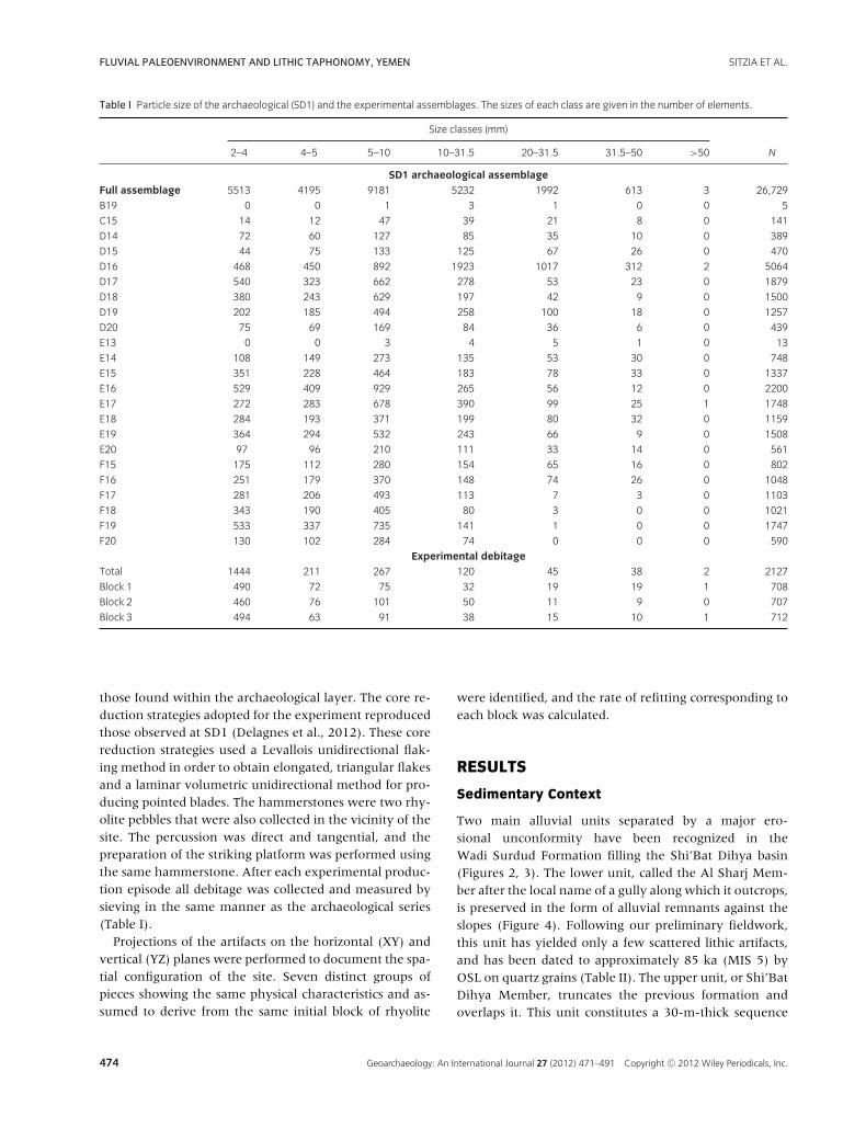
(Bertran et al., 2006). The mesh sieves used in the presentstudy correspond to true widths of artifacts, respectively,equal to 2.8, 5.7, 7.1, 14.1, 28.3, 44.5, and 70.7 mm. Thetotal number of lithics measured was 26,729 (Table I).These data were compared to the results of three exper-imental series made by one of us (M.B.) from blocks ofrhyolite collected near the site in the Shi’Bat Dihya gully.The blocks have the same petrographic characteristics as
Geoarchaeology: An International Journal 27 (2012) 471–491 Copyright C© 2012 Wiley Periodicals, Inc. 473
FLUVIAL PALEOENVIRONMENT AND LITHIC TAPHONOMY, YEMEN SITZIA ET AL.
Table I Particle size of the archaeological (SD1) and the experimental assemblages. The sizes of each class are given in the number of elements.
Size classes (mm)
2–4 4–5 5–10 10–31.5 20–31.5 31.5–50 >50 N
SD1 archaeological assemblageFull assemblage 5513 4195 9181 5232 1992 613 3 26,729
B19 0 0 1 3 1 0 0 5
C15 14 12 47 39 21 8 0 141
D14 72 60 127 85 35 10 0 389
D15 44 75 133 125 67 26 0 470
D16 468 450 892 1923 1017 312 2 5064
D17 540 323 662 278 53 23 0 1879
D18 380 243 629 197 42 9 0 1500
D19 202 185 494 258 100 18 0 1257
D20 75 69 169 84 36 6 0 439
E13 0 0 3 4 5 1 0 13
E14 108 149 273 135 53 30 0 748
E15 351 228 464 183 78 33 0 1337
E16 529 409 929 265 56 12 0 2200
E17 272 283 678 390 99 25 1 1748
E18 284 193 371 199 80 32 0 1159
E19 364 294 532 243 66 9 0 1508
E20 97 96 210 111 33 14 0 561
F15 175 112 280 154 65 16 0 802
F16 251 179 370 148 74 26 0 1048
F17 281 206 493 113 7 3 0 1103
F18 343 190 405 80 3 0 0 1021
F19 533 337 735 141 1 0 0 1747
F20 130 102 284 74 0 0 0 590
Experimental debitageTotal 1444 211 267 120 45 38 2 2127
Block 1 490 72 75 32 19 19 1 708
Block 2 460 76 101 50 11 9 0 707
Block 3 494 63 91 38 15 10 1 712
those found within the archaeological layer. The core re-duction strategies adopted for the experiment reproducedthose observed at SD1 (Delagnes et al., 2012). These corereduction strategies used a Levallois unidirectional flak-ing method in order to obtain elongated, triangular flakesand a laminar volumetric unidirectional method for pro-ducing pointed blades. The hammerstones were two rhy-olite pebbles that were also collected in the vicinity of thesite. The percussion was direct and tangential, and thepreparation of the striking platform was performed usingthe same hammerstone. After each experimental produc-tion episode all debitage was collected and measured bysieving in the same manner as the archaeological series(Table I).
Projections of the artifacts on the horizontal (XY) andvertical (YZ) planes were performed to document the spa-tial configuration of the site. Seven distinct groups ofpieces showing the same physical characteristics and as-sumed to derive from the same initial block of rhyolite
were identified, and the rate of refitting corresponding toeach block was calculated.
RESULTS
Sedimentary Context
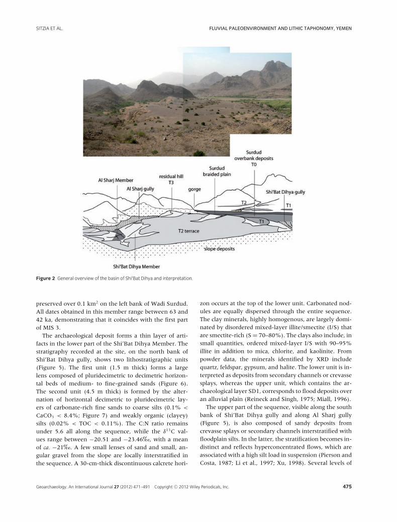
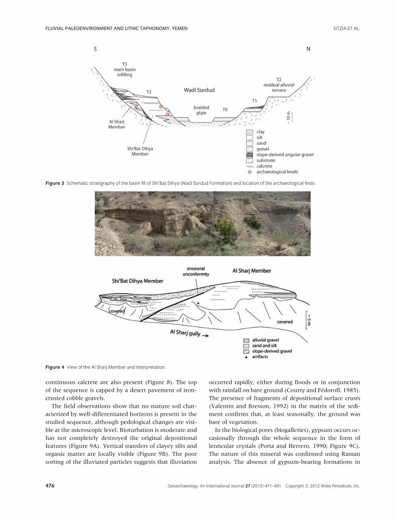
Two main alluvial units separated by a major ero-sional unconformity have been recognized in theWadi Surdud Formation filling the Shi’Bat Dihya basin(Figures 2, 3). The lower unit, called the Al Sharj Mem-ber after the local name of a gully along which it outcrops,is preserved in the form of alluvial remnants against theslopes (Figure 4). Following our preliminary fieldwork,this unit has yielded only a few scattered lithic artifacts,and has been dated to approximately 85 ka (MIS 5) byOSL on quartz grains (Table II). The upper unit, or Shi’BatDihya Member, truncates the previous formation andoverlaps it. This unit constitutes a 30-m-thick sequence
474 Geoarchaeology: An International Journal 27 (2012) 471–491 Copyright C© 2012 Wiley Periodicals, Inc.
SITZIA ET AL. FLUVIAL PALEOENVIRONMENT AND LITHIC TAPHONOMY, YEMEN
Figure 2 General overview of the basin of Shi’Bat Dihya and interpretation.
preserved over 0.1 km2 on the left bank of Wadi Surdud.All dates obtained in this member range between 63 and42 ka, demonstrating that it coincides with the first partof MIS 3.
The archaeological deposit forms a thin layer of arti-facts in the lower part of the Shi’Bat Dihya Member. Thestratigraphy recorded at the site, on the north bank ofShi’Bat Dihya gully, shows two lithostratigraphic units(Figure 5). The first unit (1.5 m thick) forms a largelens composed of pluridecimetric to decimetric horizon-tal beds of medium- to fine-grained sands (Figure 6).The second unit (4.5 m thick) is formed by the alter-nation of horizontal decimetric to pluridecimetric lay-ers of carbonate-rich fine sands to coarse silts (0.1% <
CaCO3 < 8.4%; Figure 7) and weakly organic (clayey)silts (0.02% < TOC < 0.11%). The C:N ratio remainsunder 5.6 all along the sequence, while the δ13C val-ues range between −20.51 and −23.46‰, with a meanof ca. −21‰. A few small lenses of sand and small, an-gular gravel from the slope are locally interstratified inthe sequence. A 30-cm-thick discontinuous calcrete hori-
zon occurs at the top of the lower unit. Carbonated nod-ules are equally dispersed through the entire sequence.The clay minerals, highly homogenous, are largely domi-nated by disordered mixed-layer illite/smectite (I/S) thatare smectite-rich (S = 70–80%). The clays also include, insmall quantities, ordered mixed-layer I/S with 90–95%illite in addition to mica, chlorite, and kaolinite. Frompowder data, the minerals identified by XRD includequartz, feldspar, gypsum, and halite. The lower unit is in-terpreted as deposits from secondary channels or crevassesplays, whereas the upper unit, which contains the ar-chaeological layer SD1, corresponds to flood deposits overan alluvial plain (Reineck and Singh, 1975; Miall, 1996).
The upper part of the sequence, visible along the southbank of Shi’Bat Dihya gully and along Al Sharj gully(Figure 5), is also composed of sandy deposits fromcrevasse splays or secondary channels interstratified withfloodplain silts. In the latter, the stratification becomes in-distinct and reflects hyperconcentrated flows, which areassociated with a high silt load in suspension (Pierson andCosta, 1987; Li et al., 1997; Xu, 1998). Several levels of
Geoarchaeology: An International Journal 27 (2012) 471–491 Copyright C© 2012 Wiley Periodicals, Inc. 475
FLUVIAL PALEOENVIRONMENT AND LITHIC TAPHONOMY, YEMEN SITZIA ET AL.
Figure 3 Schematic stratigraphy of the basin fill of Shi’Bat Dihya (Wadi Surdud Formation) and location of the archaeological finds.
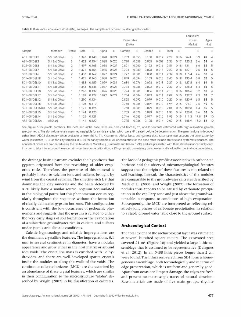
Figure 4 View of the Al Sharj Member and interpretation.
continuous calcrete are also present (Figure 8). The topof the sequence is capped by a desert pavement of iron-crusted cobble gravels.
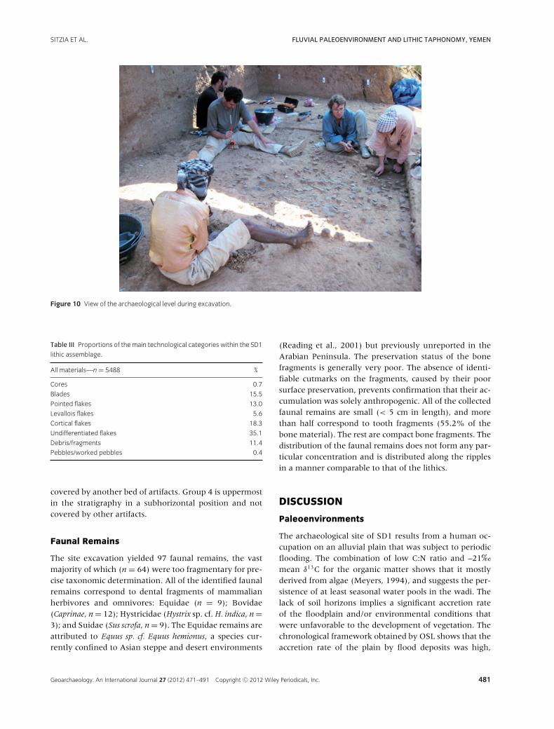
The field observations show that no mature soil char-acterized by well-differentiated horizons is present in thestudied sequence, although pedological changes are visi-ble at the microscopic level. Bioturbation is moderate andhas not completely destroyed the original depositionalfeatures (Figure 9A). Vertical transfers of clayey silts andorganic matter are locally visible (Figure 9B). The poorsorting of the illuviated particles suggests that illuviation
occurred rapidly, either during floods or in conjunctionwith rainfall on bare ground (Courty and Fedoroff, 1985).The presence of fragments of depositional surface crusts(Valentin and Bresson, 1992) in the matrix of the sedi-ment confirms that, at least seasonally, the ground wasbare of vegetation.
In the biological pores (biogalleries), gypsum occurs oc-casionally through the whole sequence in the form oflenticular crystals (Porta and Herrero, 1990; Figure 9C).The nature of this mineral was confirmed using Ramananalysis. The absence of gypsum-bearing formations in
476 Geoarchaeology: An International Journal 27 (2012) 471–491 Copyright C© 2012 Wiley Periodicals, Inc.
SITZIA ET AL. FLUVIAL PALEOENVIRONMENT AND LITHIC TAPHONOMY, YEMEN
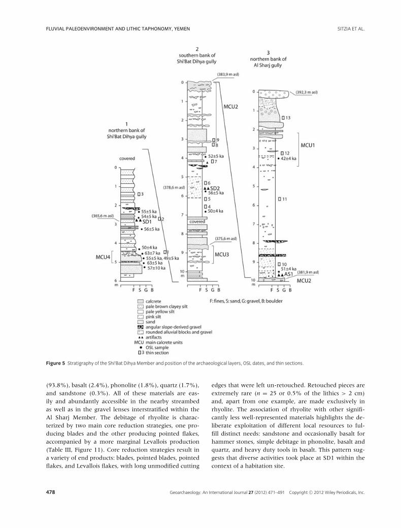
Table II Dose rates, equivalent doses (De), and ages. The samples are ordered by stratigraphic order.
Equivalent
Dose rates doses Ages
(Gy/ka) (Gy/ka) (ka)
Sample Member Profile Beta ± Alpha ± Gamma ± Cosmic ± Total ± ± ±AS1–08/OSL2 Shi Bat Dihya 3 1.343 0.148 0.078 0.024 0.739 0.055 0.130 0.017 2.29 0.16 96.4 3.9 42 4
AS1–08/OSL3 Shi Bat Dihya 3 1.422 0.154 0.088 0.026 0.790 0.059 0.065 0.009 2.36 0.17 120.2 3.6 51 4
SD2–08/OSL8 Shi Bat Dihya 2 1.497 0.165 0.088 0.027 0.801 0.060 0.123 0.016 2.51 0.18 131.1 6.6 52 5
SD2–08/OSL7 Shi Bat Dihya 2 1.371 0.154 0.075 0.023 0.724 0.080 0.098 0.013 2.27 0.18 127.1 2.5 56 5
SD2–08/OSL6 Shi Bat Dihya 2 1.433 0.162 0.077 0.024 0.727 0.081 0.088 0.011 2.32 0.18 115.4 4.6 50 4
SD1–08/OSL19 Shi Bat Dihya 1 1.421 0.160 0.080 0.025 0.849 0.094 0.103 0.013 2.45 0.19 135.4 6.8 55 5
SD1–08/OSL10 Shi Bat Dihya 1 1.488 0.159 0.099 0.031 0.684 0.076 0.098 0.013 2.37 0.18 127.5 6.4 54 5
SD1–08/OSL11 Shi Bat Dihya 1 1.343 0.145 0.087 0.027 0.774 0.086 0.092 0.012 2.30 0.17 128.3 6.4 56 5
SD1–08/OSL18 Shi Bat Dihya 1 1.246 0.132 0.076 0.023 0.724 0.081 0.086 0.011 2.13 0.16 106.6 3.2 50 4
SD1–08/OSL17 Shi Bat Dihya 1 1.182 0.127 0.072 0.022 0.754 0.084 0.083 0.011 2.09 0.15 132.2 9.3 63 7
SD1–08/OSL12 Shi Bat Dihya 1 1.290 0.134 0.828 0.092 0.079 0.010 2.20 0.16 120.9 6.5 55 5
SD1–08/OSL16 Shi Bat Dihya 1 1.103 0.119 0.760 0.085 0.079 0.010 1.94 0.15 94.2 7.5 49 5
SD1–08/OSL16 bis Shi Bat Dihya 1 1.171 0.126 0.760 0.085 0.079 0.010 2.01 0.15 109.8 4.4 55 5
SD1–08/OSL15 Shi Bat Dihya 1 1.144 0.120 0.703 0.078 0.079 0.010 1.93 0.14 120.8 3.6 63 5
SD1–08/OSL14 Shi Bat Dihya 1 1.125 0.121 0.746 0.083 0.077 0.010 1.95 0.15 111.3 17.8 57 10
AS2–08/OSL20b Al Sharj 1.141 0.122 0.775 0.086 0.105 0.014 2.02 0.15 168.9 15.2 84 10
See Figure 5 for profile numbers. The beta and alpha dose rates are deduced from U, Th, and K contents estimated with high-resolution gamma
spectrometry. The alpha dose rate is assumed negligible for sandy samples, whichwere HF treated before De determination. The gammadose is deduced
either from Al2O3 dosimetry when available or from the U, Th, K contents. Alpha, beta, and gamma dose rates take into account the attenuation by
water (estimated 10 ± 3% for silty samples, 8 ± 3% for sandy samples). All uncertainties for the dose rates include statistic and systematic sources. The
equivalent doses are calculated using the Finite Mixture Model (e.g., Galbraith and Green, 1990) and are presented with their statistical uncertainty only.
In order to take into account the uncertainty on the source calibration, a 2% systematic uncertainty was quadratically added to the final age uncertainty.
the drainage basin upstream excludes the hypothesis thatgypsum originated from the reworking of older evap-oritic rocks. Therefore, the presence of this mineral isprobably linked to calcium ions and sulfates brought bywind from the coastal sebkhas. The smectite-rich I/S thatdominates the clay minerals and the halite detected byXRD likely have a similar source. Gypsum accumulatedin the biological pores, but this phenomenon occurs reg-ularly throughout the sequence without the formationof clearly delineated gypsum horizons. This configurationis consistent with the low occurrence of pedogenic phe-nomena and suggests that the gypsum is related to eitherthe very early stages of soil formation or the evaporationof a subsurface groundwater rich in calcium and sulfatesunder (semi)-arid climatic conditions.
Calcitic hypocoatings and micritic impregnations arethe dominant crystalline features. The impregnations, 0.1mm to several centimetres in diameter, have a nodularappearance and grow either in the host matrix or aroundroot voids. The crystalline mass is enriched with Fe hy-droxides, and there are well-developed sparite crystalsinside the nodules or along the walls of the voids. Thecontinuous calcrete horizons (MCU) are characterized byan abundance of these crystal features, which are similarin their configuration to the microstructure “alpha” de-scribed by Wright (2007) in his classification of calcretes.
The lack of a pedogenic profile associated with carbonatedhorizons and the observed micromorphological featuressuggest that the origin of these features is not related tosoil leaching. Instead, the characteristics of the nodulesare comparable to the groundwater calcretes described byMack et al. (2000) and Wright (2007). The formation ofnodules thus appears to be caused by carbonate precipi-tation in the capillary zone and just above the groundwa-ter table in response to conditions of high evaporation.Subsequently, the MCU are interpreted as reflecting rel-atively long phases of carbonate precipitation in relationto a stable groundwater table close to the ground surface.
Archaeological Context
The total extent of the archaeological layer was estimatedat several hundred square meters. The excavated areacovered 21 m2 (Figure 10) and yielded a large lithic as-semblage that is assumed to be representative (Delagneset al., 2012). In all, 5488 lithic pieces longer than 2 cmwere found. The lithics recovered from SD1 form a homo-geneous assemblage, both technologically and in terms ofedge preservation, which is uniform and generally good.Apart from occasional impact damage, the edges are freshand present no macroscopic traces of natural abrasion.Raw materials are made of five main groups: rhyolite
Geoarchaeology: An International Journal 27 (2012) 471–491 Copyright C© 2012 Wiley Periodicals, Inc. 477
FLUVIAL PALEOENVIRONMENT AND LITHIC TAPHONOMY, YEMEN SITZIA ET AL.
Figure 5 Stratigraphy of the Shi’Bat Dihya Member and position of the archaeological layers, OSL dates, and thin sections.
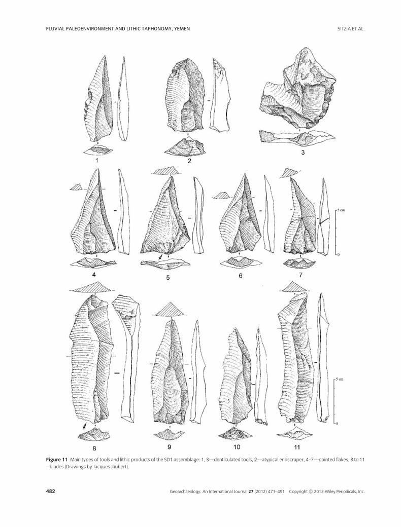
(93.8%), basalt (2.4%), phonolite (1.8%), quartz (1.7%),and sandstone (0.3%). All of these materials are eas-ily and abundantly accessible in the nearby streambedas well as in the gravel lenses interstratified within theAl Sharj Member. The debitage of rhyolite is charac-terized by two main core reduction strategies, one pro-ducing blades and the other producing pointed flakes,accompanied by a more marginal Levallois production(Table III, Figure 11). Core reduction strategies result ina variety of end products: blades, pointed blades, pointedflakes, and Levallois flakes, with long unmodified cutting
edges that were left un-retouched. Retouched pieces areextremely rare (n = 25 or 0.5% of the lithics > 2 cm)and, apart from one example, are made exclusively inrhyolite. The association of rhyolite with other signifi-cantly less well-represented materials highlights the de-liberate exploitation of different local resources to ful-fill distinct needs: sandstone and occasionally basalt forhammer stones, simple debitage in phonolite, basalt andquartz, and heavy duty tools in basalt. This pattern sug-gests that diverse activities took place at SD1 within thecontext of a habitation site.
478 Geoarchaeology: An International Journal 27 (2012) 471–491 Copyright C© 2012 Wiley Periodicals, Inc.
SITZIA ET AL. FLUVIAL PALEOENVIRONMENT AND LITHIC TAPHONOMY, YEMEN
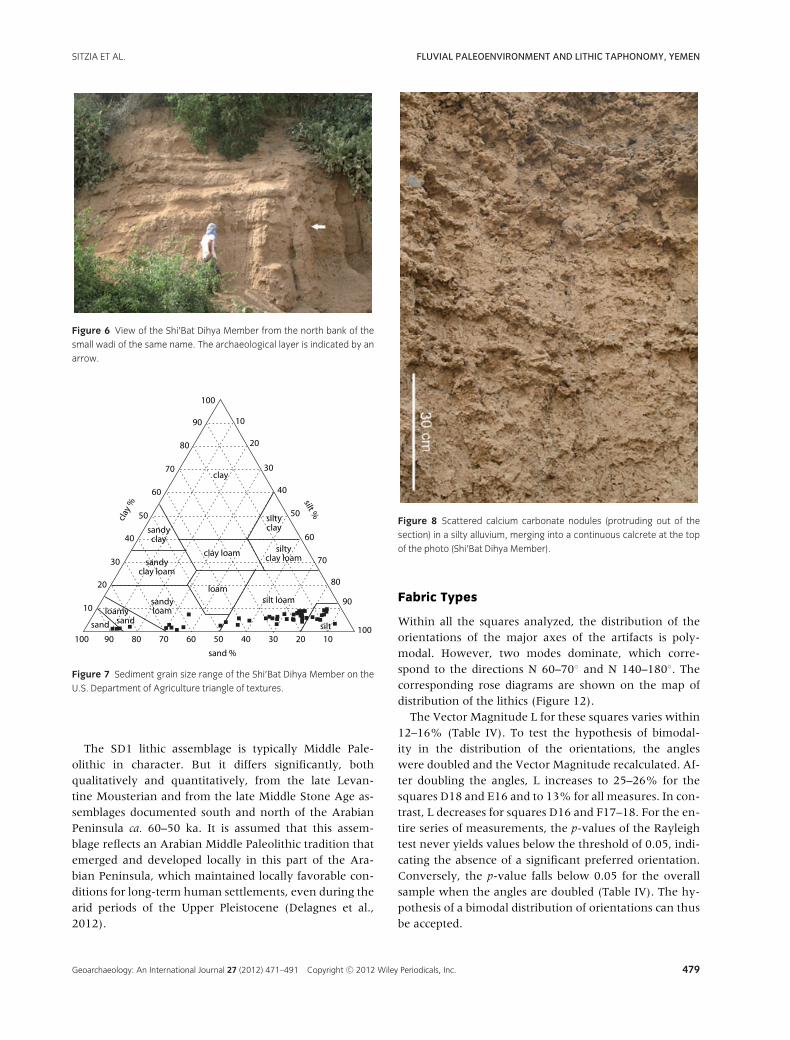
Figure 6 View of the Shi’Bat Dihya Member from the north bank of the
small wadi of the same name. The archaeological layer is indicated by an
arrow.
Figure 7 Sediment grain size range of the Shi’Bat Dihya Member on the
U.S. Department of Agriculture triangle of textures.
The SD1 lithic assemblage is typically Middle Pale-olithic in character. But it differs significantly, bothqualitatively and quantitatively, from the late Levan-tine Mousterian and from the late Middle Stone Age as-semblages documented south and north of the ArabianPeninsula ca. 60–50 ka. It is assumed that this assem-blage reflects an Arabian Middle Paleolithic tradition thatemerged and developed locally in this part of the Ara-bian Peninsula, which maintained locally favorable con-ditions for long-term human settlements, even during thearid periods of the Upper Pleistocene (Delagnes et al.,2012).
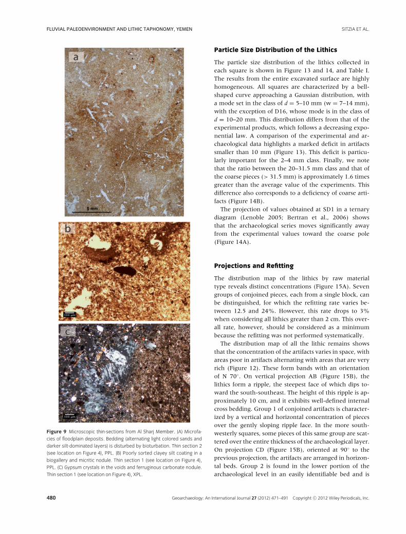
Figure 8 Scattered calcium carbonate nodules (protruding out of the
section) in a silty alluvium, merging into a continuous calcrete at the top
of the photo (Shi’Bat Dihya Member).
Fabric Types
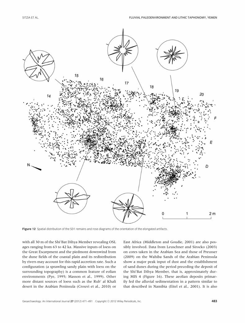
Within all the squares analyzed, the distribution of theorientations of the major axes of the artifacts is poly-modal. However, two modes dominate, which corre-spond to the directions N 60–70◦ and N 140–180◦. Thecorresponding rose diagrams are shown on the map ofdistribution of the lithics (Figure 12).
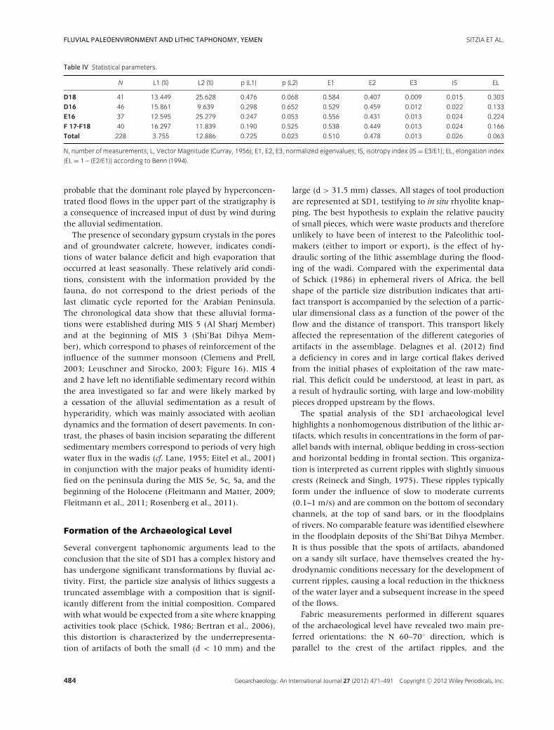
The Vector Magnitude L for these squares varies within12–16% (Table IV). To test the hypothesis of bimodal-ity in the distribution of the orientations, the angleswere doubled and the Vector Magnitude recalculated. Af-ter doubling the angles, L increases to 25–26% for thesquares D18 and E16 and to 13% for all measures. In con-trast, L decreases for squares D16 and F17–18. For the en-tire series of measurements, the p-values of the Rayleightest never yields values below the threshold of 0.05, indi-cating the absence of a significant preferred orientation.Conversely, the p-value falls below 0.05 for the overallsample when the angles are doubled (Table IV). The hy-pothesis of a bimodal distribution of orientations can thusbe accepted.
Geoarchaeology: An International Journal 27 (2012) 471–491 Copyright C© 2012 Wiley Periodicals, Inc. 479
FLUVIAL PALEOENVIRONMENT AND LITHIC TAPHONOMY, YEMEN SITZIA ET AL.
Figure 9 Microscopic thin-sections from Al Sharj Member. (A) Microfa-
cies of floodplain deposits. Bedding (alternating light colored sands and
darker silt-dominated layers) is disturbed by bioturbation. Thin section 2
(see location on Figure 4), PPL. (B) Poorly sorted clayey silt coating in a
biogallery and micritic nodule. Thin section 1 (see location on Figure 4),
PPL. (C) Gypsum crystals in the voids and ferruginous carbonate nodule.
Thin section 1 (see location on Figure 4), XPL.
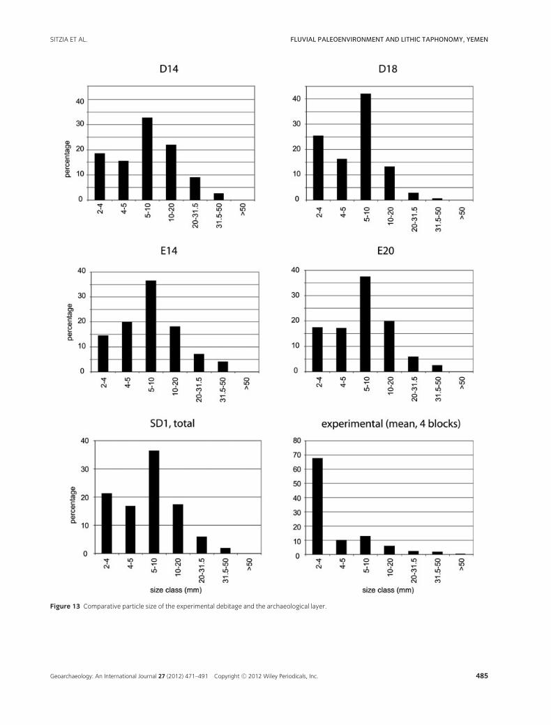
Particle Size Distribution of the Lithics
The particle size distribution of the lithics collected ineach square is shown in Figure 13 and 14, and Table I.The results from the entire excavated surface are highlyhomogeneous. All squares are characterized by a bell-shaped curve approaching a Gaussian distribution, witha mode set in the class of d = 5–10 mm (w = 7–14 mm),with the exception of D16, whose mode is in the class ofd = 10–20 mm. This distribution differs from that of theexperimental products, which follows a decreasing expo-nential law. A comparison of the experimental and ar-chaeological data highlights a marked deficit in artifactssmaller than 10 mm (Figure 13). This deficit is particu-larly important for the 2–4 mm class. Finally, we notethat the ratio between the 20–31.5 mm class and that ofthe coarse pieces (> 31.5 mm) is approximately 1.6 timesgreater than the average value of the experiments. Thisdifference also corresponds to a deficiency of coarse arti-facts (Figure 14B).
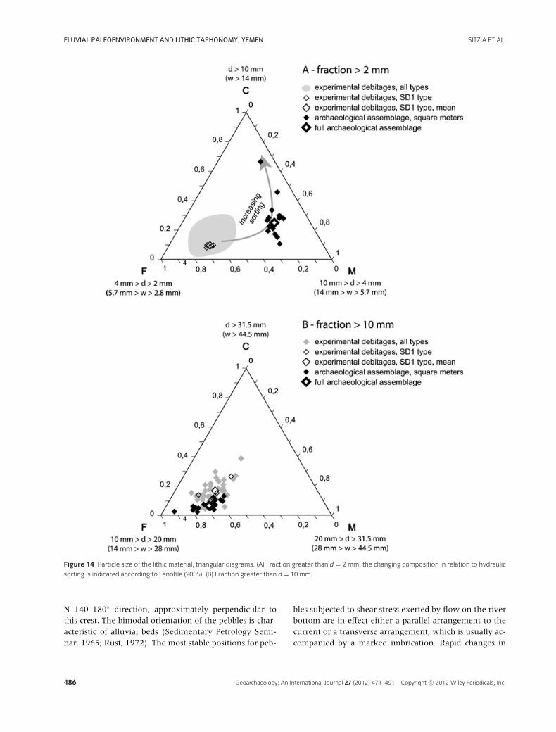
The projection of values obtained at SD1 in a ternarydiagram (Lenoble 2005; Bertran et al., 2006) showsthat the archaeological series moves significantly awayfrom the experimental values toward the coarse pole(Figure 14A).
Projections and Refitting
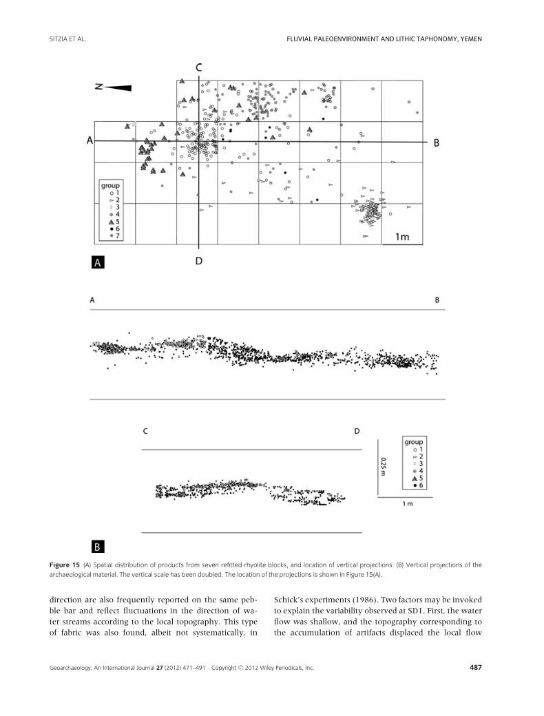
The distribution map of the lithics by raw materialtype reveals distinct concentrations (Figure 15A). Sevengroups of conjoined pieces, each from a single block, canbe distinguished, for which the refitting rate varies be-tween 12.5 and 24%. However, this rate drops to 3%when considering all lithics greater than 2 cm. This over-all rate, however, should be considered as a minimumbecause the refitting was not performed systematically.
The distribution map of all the lithic remains showsthat the concentration of the artifacts varies in space, withareas poor in artifacts alternating with areas that are veryrich (Figure 12). These form bands with an orientationof N 70◦. On vertical projection AB (Figure 15B), thelithics form a ripple, the steepest face of which dips to-ward the south-southeast. The height of this ripple is ap-proximately 10 cm, and it exhibits well-defined internalcross bedding. Group 1 of conjoined artifacts is character-ized by a vertical and horizontal concentration of piecesover the gently sloping ripple face. In the more south-westerly squares, some pieces of this same group are scat-tered over the entire thickness of the archaeological layer.On projection CD (Figure 15B), oriented at 90◦ to theprevious projection, the artifacts are arranged in horizon-tal beds. Group 2 is found in the lower portion of thearchaeological level in an easily identifiable bed and is
480 Geoarchaeology: An International Journal 27 (2012) 471–491 Copyright C© 2012 Wiley Periodicals, Inc.
SITZIA ET AL. FLUVIAL PALEOENVIRONMENT AND LITHIC TAPHONOMY, YEMEN
Figure 10 View of the archaeological level during excavation.
Table III Proportions of the main technological categories within the SD1
lithic assemblage.
All materials—n = 5488 %
Cores 0.7
Blades 15.5
Pointed flakes 13.0
Levallois flakes 5.6
Cortical flakes 18.3
Undifferentiated flakes 35.1
Debris/fragments 11.4
Pebbles/worked pebbles 0.4
covered by another bed of artifacts. Group 4 is uppermostin the stratigraphy in a subhorizontal position and notcovered by other artifacts.
Faunal Remains
The site excavation yielded 97 faunal remains, the vastmajority of which (n = 64) were too fragmentary for pre-cise taxonomic determination. All of the identified faunalremains correspond to dental fragments of mammalianherbivores and omnivores: Equidae (n = 9); Bovidae(Caprinae, n = 12); Hystricidae (Hystrix sp. cf. H. indica, n =3); and Suidae (Sus scrofa, n = 9). The Equidae remains areattributed to Equus sp. cf. Equus hemionus, a species cur-rently confined to Asian steppe and desert environments
(Reading et al., 2001) but previously unreported in theArabian Peninsula. The preservation status of the bonefragments is generally very poor. The absence of identi-fiable cutmarks on the fragments, caused by their poorsurface preservation, prevents confirmation that their ac-cumulation was solely anthropogenic. All of the collectedfaunal remains are small (< 5 cm in length), and morethan half correspond to tooth fragments (55.2% of thebone material). The rest are compact bone fragments. Thedistribution of the faunal remains does not form any par-ticular concentration and is distributed along the ripplesin a manner comparable to that of the lithics.
DISCUSSION
Paleoenvironments
The archaeological site of SD1 results from a human oc-cupation on an alluvial plain that was subject to periodicflooding. The combination of low C:N ratio and –21‰mean δ13C for the organic matter shows that it mostlyderived from algae (Meyers, 1994), and suggests the per-sistence of at least seasonal water pools in the wadi. Thelack of soil horizons implies a significant accretion rateof the floodplain and/or environmental conditions thatwere unfavorable to the development of vegetation. Thechronological framework obtained by OSL shows that theaccretion rate of the plain by flood deposits was high,
Geoarchaeology: An International Journal 27 (2012) 471–491 Copyright C© 2012 Wiley Periodicals, Inc. 481
FLUVIAL PALEOENVIRONMENT AND LITHIC TAPHONOMY, YEMEN SITZIA ET AL.
Figure 11 Main types of tools and lithic products of the SD1 assemblage: 1, 3—denticulated tools, 2—atypical endscraper, 4–7—pointed flakes, 8 to 11
– blades (Drawings by Jacques Jaubert).
482 Geoarchaeology: An International Journal 27 (2012) 471–491 Copyright C© 2012 Wiley Periodicals, Inc.
SITZIA ET AL. FLUVIAL PALEOENVIRONMENT AND LITHIC TAPHONOMY, YEMEN
Figure 12 Spatial distribution of the SD1 remains and rose diagrams of the orientation of the elongated artifacts.
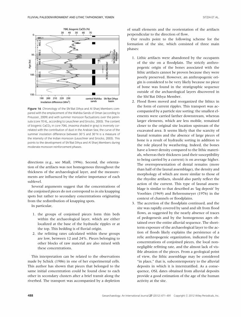
with all 30 m of the Shi’Bat Dihya Member revealing OSLages ranging from 63 to 42 ka. Massive inputs of loess onthe Great Escarpment and the piedmont downwind fromthe dune fields of the coastal plain and its redistributionby rivers may account for this rapid accretion rate. Such aconfiguration (a sprawling sandy plain with loess on thesurrounding topography) is a common feature of eolianenvironments (Pye, 1995; Masson et al., 1999). Othermore distant sources of loess such as the Rub’ al Khalidesert in the Arabian Peninsula (Crouvi et al., 2010) or
East Africa (Middleton and Goudie, 2001) are also pos-sibly involved. Data from Leuschner and Sirocko (2003)on cores taken in the Arabian Sea and those of Preusser(2009) on the Wahiba Sands of the Arabian Peninsulashow a major peak input of dust and the establishmentof sand dunes during the period preceding the deposit ofthe Shi’Bat Dihya Member, that is, approximately dur-ing MIS 4 (Figure 16). These aeolian deposits primar-ily fed the alluvial sedimentation in a pattern similar tothat described in Namibia (Eitel et al., 2001). It is also
Geoarchaeology: An International Journal 27 (2012) 471–491 Copyright C© 2012 Wiley Periodicals, Inc. 483
FLUVIAL PALEOENVIRONMENT AND LITHIC TAPHONOMY, YEMEN SITZIA ET AL.
Table IV Statistical parameters.
N L1 (%) L2 (%) p (L1) p (L2) E1 E2 E3 IS EL
D18 41 13.449 25.628 0.476 0.068 0.584 0.407 0.009 0.015 0.303
D16 46 15.861 9.639 0.298 0.652 0.529 0.459 0.012 0.022 0.133
E16 37 12.595 25.279 0.247 0.053 0.556 0.431 0.013 0.024 0.224
F 17-F18 40 16.297 11.839 0.190 0.525 0.538 0.449 0.013 0.024 0.166
Total 228 3.755 12.886 0.725 0.023 0.510 0.478 0.013 0.026 0.063
N, number of measurements; L, Vector Magnitude (Curray, 1956); E1, E2, E3, normalized eigenvalues; IS, isotropy index (IS= E3/E1); EL, elongation index
(EL = 1 – (E2/E1)) according to Benn (1994).
probable that the dominant role played by hyperconcen-trated flood flows in the upper part of the stratigraphy isa consequence of increased input of dust by wind duringthe alluvial sedimentation.
The presence of secondary gypsum crystals in the poresand of groundwater calcrete, however, indicates condi-tions of water balance deficit and high evaporation thatoccurred at least seasonally. These relatively arid condi-tions, consistent with the information provided by thefauna, do not correspond to the driest periods of thelast climatic cycle reported for the Arabian Peninsula.The chronological data show that these alluvial forma-tions were established during MIS 5 (Al Sharj Member)and at the beginning of MIS 3 (Shi’Bat Dihya Mem-ber), which correspond to phases of reinforcement of theinfluence of the summer monsoon (Clemens and Prell,2003; Leuschner and Sirocko, 2003; Figure 16). MIS 4and 2 have left no identifiable sedimentary record withinthe area investigated so far and were likely marked bya cessation of the alluvial sedimentation as a result ofhyperaridity, which was mainly associated with aeoliandynamics and the formation of desert pavements. In con-trast, the phases of basin incision separating the differentsedimentary members correspond to periods of very highwater flux in the wadis (cf. Lane, 1955; Eitel et al., 2001)in conjunction with the major peaks of humidity identi-fied on the peninsula during the MIS 5e, 5c, 5a, and thebeginning of the Holocene (Fleitmann and Matter, 2009;Fleitmann et al., 2011; Rosenberg et al., 2011).
Formation of the Archaeological Level
Several convergent taphonomic arguments lead to theconclusion that the site of SD1 has a complex history andhas undergone significant transformations by fluvial ac-tivity. First, the particle size analysis of lithics suggests atruncated assemblage with a composition that is signif-icantly different from the initial composition. Comparedwith what would be expected from a site where knappingactivities took place (Schick, 1986; Bertran et al., 2006),this distortion is characterized by the underrepresenta-tion of artifacts of both the small (d < 10 mm) and the
large (d > 31.5 mm) classes. All stages of tool productionare represented at SD1, testifying to in situ rhyolite knap-ping. The best hypothesis to explain the relative paucityof small pieces, which were waste products and thereforeunlikely to have been of interest to the Paleolithic tool-makers (either to import or export), is the effect of hy-draulic sorting of the lithic assemblage during the flood-ing of the wadi. Compared with the experimental dataof Schick (1986) in ephemeral rivers of Africa, the bellshape of the particle size distribution indicates that arti-fact transport is accompanied by the selection of a partic-ular dimensional class as a function of the power of theflow and the distance of transport. This transport likelyaffected the representation of the different categories ofartifacts in the assemblage. Delagnes et al. (2012) finda deficiency in cores and in large cortical flakes derivedfrom the initial phases of exploitation of the raw mate-rial. This deficit could be understood, at least in part, asa result of hydraulic sorting, with large and low-mobilitypieces dropped upstream by the flows.
The spatial analysis of the SD1 archaeological levelhighlights a nonhomogenous distribution of the lithic ar-tifacts, which results in concentrations in the form of par-allel bands with internal, oblique bedding in cross-sectionand horizontal bedding in frontal section. This organiza-tion is interpreted as current ripples with slightly sinuouscrests (Reineck and Singh, 1975). These ripples typicallyform under the influence of slow to moderate currents(0.1–1 m/s) and are common on the bottom of secondarychannels, at the top of sand bars, or in the floodplainsof rivers. No comparable feature was identified elsewherein the floodplain deposits of the Shi’Bat Dihya Member.It is thus possible that the spots of artifacts, abandonedon a sandy silt surface, have themselves created the hy-drodynamic conditions necessary for the development ofcurrent ripples, causing a local reduction in the thicknessof the water layer and a subsequent increase in the speedof the flows.
Fabric measurements performed in different squaresof the archaeological level have revealed two main pre-ferred orientations: the N 60–70◦ direction, which isparallel to the crest of the artifact ripples, and the
484 Geoarchaeology: An International Journal 27 (2012) 471–491 Copyright C© 2012 Wiley Periodicals, Inc.
SITZIA ET AL. FLUVIAL PALEOENVIRONMENT AND LITHIC TAPHONOMY, YEMEN
Figure 13 Comparative particle size of the experimental debitage and the archaeological layer.
Geoarchaeology: An International Journal 27 (2012) 471–491 Copyright C© 2012 Wiley Periodicals, Inc. 485
FLUVIAL PALEOENVIRONMENT AND LITHIC TAPHONOMY, YEMEN SITZIA ET AL.
Figure 14 Particle size of the lithic material, triangular diagrams. (A) Fraction greater than d = 2 mm; the changing composition in relation to hydraulic
sorting is indicated according to Lenoble (2005). (B) Fraction greater than d = 10 mm.
N 140–180◦ direction, approximately perpendicular tothis crest. The bimodal orientation of the pebbles is char-acteristic of alluvial beds (Sedimentary Petrology Semi-nar, 1965; Rust, 1972). The most stable positions for peb-
bles subjected to shear stress exerted by flow on the riverbottom are in effect either a parallel arrangement to thecurrent or a transverse arrangement, which is usually ac-companied by a marked imbrication. Rapid changes in
486 Geoarchaeology: An International Journal 27 (2012) 471–491 Copyright C© 2012 Wiley Periodicals, Inc.
SITZIA ET AL. FLUVIAL PALEOENVIRONMENT AND LITHIC TAPHONOMY, YEMEN
Figure 15 (A) Spatial distribution of products from seven refitted rhyolite blocks, and location of vertical projections. (B) Vertical projections of the
archaeological material. The vertical scale has been doubled. The location of the projections is shown in Figure 15(A).
direction are also frequently reported on the same peb-ble bar and reflect fluctuations in the direction of wa-ter streams according to the local topography. This typeof fabric was also found, albeit not systematically, in
Schick’s experiments (1986). Two factors may be invokedto explain the variability observed at SD1. First, the waterflow was shallow, and the topography corresponding tothe accumulation of artifacts displaced the local flow
Geoarchaeology: An International Journal 27 (2012) 471–491 Copyright C© 2012 Wiley Periodicals, Inc. 487
FLUVIAL PALEOENVIRONMENT AND LITHIC TAPHONOMY, YEMEN SITZIA ET AL.
Figure 16 Chronology of the Shi’Bat Dihya and Al Sharj Members com-
pared with the emplacement of the Wahiba Sands of Oman (according to
Preusser, 2009) and with summer monsoon fluctuations over the penin-
sula (core 70 KL, according to Leuschner and Sirocko, 2003). The content
of biogenic CaCO3 in core 70KL (maxima shaded in gray) is inversely cor-
related with the contribution of dust in the Arabian Sea; the curve of the
summer insolation difference between 30◦S and 30◦N is a measure of
the intensity of the Indian monsoon (Leuschner and Sirocko, 2003). This
points to the development of Shi’Bat Dihya and Al Sharj Members during
moderate monsoon reinforcement phases.
directions (e.g., see Miall, 1996). Second, the orienta-tion of the artifacts was not homogenous throughout thethickness of the archaeological layer, and the measure-ments are influenced by the relative importance of eachsublevel.
Several arguments suggest that the concentrations ofthe conjoined pieces do not correspond to in situ knappingspots but rather to secondary concentrations originatingfrom the redistribution of knapping spots.
In particular,
1. the groups of conjoined pieces form thin bedswithin the archaeological layer, which are eitherlocalized at the base of the hydraulic ripples or atthe top. This bedding is of fluvial origin.
2. the refitting rates calculated within these groupsare low, between 12 and 24%. Pieces belonging toother blocks of raw material are also mixed withthese concentrations.
This interpretation can be related to the observationsmade by Schick (1986) in one of her experimental cells.This author has shown that pieces that belonged to thesame initial concentration could be found close to eachother in secondary clusters after a brief transit along theriverbed. The transport was accompanied by a depletion
of small elements and the reorientation of the artifactsperpendicular to the direction of flow.
Our results point to the following scheme for theformation of the site, which consisted of three mainphases:
1. Lithic artifacts were abandoned by the occupantsof the site on a floodplain. The strictly anthro-pogenic origin of the bones associated with thelithic artifacts cannot be proven because they werepoorly preserved. However, an anthropogenic ori-gin is considered to be very likely because no pieceof bone was found in the stratigraphic sequenceoutside of the archaeological layers discovered inthe Shi’Bat Dihya Member.
2. Flood flows moved and reorganized the lithics inthe form of current ripples. This transport was ac-companied by a particle size sorting: the smallest el-ements were carried farther downstream, whereaslarger elements, which are less mobile, remainedcloser to the original site location upstream of theexcavated area. It seems likely that the scarcity offaunal remains and the absence of large pieces ofbone is a result of hydraulic sorting in addition tothe role played by weathering. Indeed, the boneshave a lower density compared to the lithic materi-als, whereas their thickness (and their susceptibilityto being carried by a current) is on average higher.The overrepresentation of dental remains (morethan half of the faunal assemblage), the density andmorphology of which are more similar to those ofthe rhyolite artifacts, should also partly reflect theaction of the current. This type of faunal assem-blage is similar to that described as ‘lag deposit’ byVoorhies (1969) and Behrensmeyer (1976) in thecontext of channels or floodplains.
3. The accretion of the floodplain continued, and thesite was rapidly covered by sand and silt from floodflows, as suggested by the nearly absence of tracesof pedogenesis and by the homogenous ages ob-tained over the entire alluvial sequence. The short-term exposure of the archaeological layer to the ac-tion of floods likely explains the persistence of arelic anthropogenic organization, indicated by theconcentrations of conjoined pieces, the local non-negligible refitting rate, and the almost lack of vis-ible abrasion of the pieces. From a geological pointof view, the lithic assemblage may be considered“in place,” that is, subcontemporary to the alluvialdeposits in which it is interstratified. As a conse-quence, OSL dates obtained from alluvial depositsprovide a good estimation of the age of the humanactivity at the site.
488 Geoarchaeology: An International Journal 27 (2012) 471–491 Copyright C© 2012 Wiley Periodicals, Inc.
SITZIA ET AL. FLUVIAL PALEOENVIRONMENT AND LITHIC TAPHONOMY, YEMEN
CONCLUSIONS
The site of SD1 (western Yemen) corresponds to a MiddlePaleolithic occupation in the floodplain of Wadi Surdudat the beginning of MIS 3. This floodplain was subject torapid accretion as a consequence of intense remobiliza-tion of loess deposited on the piedmont and the GreatEscarpment of Yemen. The pedological data indicate rel-atively dry conditions during the occupation of the site,which was marked by a high evaporation rate, leadingto the formation of gypsum and calcretes. These condi-tions indicate the adaptation of the local human groupsto (semi)-desert environments. However, according tothe data derived from marine cores (Clemens and Prell,2003; Leuschner and Sirocko, 2003), these conditionsdo not correspond with the driest phases of the last cli-matic cycle but rather with periods of enhanced summermonsoon and relative increase in humidity at a regionalscale.
The results of the taphonomic study conducted on theSD1 level confirm that even in a floodplain environmentusually considered to be very favorable for site preserva-tion, the archaeological record can be significantly alteredby geomorphological processes. The degradation, relatedto the flooding of the wadi, has implications for thearchaeological interpretation of the occupation level in-vestigated so far. Indeed, the spatial distribution of theartifacts at SD1 cannot be considered to be only of an-thropogenic origin but also reflects the action of flows. Aparticle size sorting has also occurred, and the underrep-resentation of certain categories of artifacts (small-sizeddebris and large pieces such as cores) does not result fromhuman export but rather from hydraulic transport. Hy-draulic sorting has also affected the distribution and likelythe representativeness of the faunal materials.
As a whole, this case study shows that detailed geoar-chaeological investigations are necessary in any environ-ment to appropriately assess the quality of informationprovided by the archaeological layer and to identify thepossible biases and distortions in the interpretation of theassemblages. In fact, the validity of the spatial distribu-tion analysis of the artifacts to identify the organizationof human activities within an archaeological site is highlydependent on secondary modifications by geomorpho-logical processes. Similarly, the interpretation of the eco-nomic status of a site, partly based on the analysis of therelative proportions of different categories of lithic prod-ucts, needs to be validated that no further sorting of theremains occurred. Even if these two conditions are notfulfilled as in the case of the SD1 site, the study nonethe-less indicates that the homogeneity and the “in place”geological character of the assemblage grant its potentialinformative value for the comprehension of the techno-
logical strategies of the Middle Paleolithic people who set-tled in Wadi Surdud.
The Paleo-Y international paleoanthropological research project,developed since 2005 by R.M. in agreement with the YemeniGeneral Organization for Antiquities and Museums (GOAM) andthe Centre Francais d’Archeologie et de Sciences Sociales deSanaa (CEFAS), has been granted by the French Ministry of For-eign Affairs (to R.M.), the French CNRS project Eclipse II (toR.M.), the L.S.B. Leakey Foundation (to A.D.). Paleo-Y, whoseaction was initiated by the generous help of A. de Maigret (Uni-versity of Naples) and J.-F. Jarrige (CNRS), greatly benefitedfrom the support of the University Bordeaux 1 (UMR PACEACNRS), the University of Poitiers (Department of Geosciences),and the French Institut National de Recherches ArcheologiquesPreventives (INRAP), and also from the collaboration of theFrench Museum National d’Histoire Naturelle and the University“La Sapienza” of Rome. For research permission and collabora-tion, Paleo-Y is indebted to A. Ba-Wazir, General Director of theGOAM; A. Garallah, Deputy of the GOAM; and A.A. Mohsen,Governor of Al-Mahqwid. We acknowledge the extraordinarycontinuous support provided by J. Lambert and M. Tuchscherer,directors of the CEFAS. The archaeological excavations at SD1and SD2 have been realized under the scientific direction of A.D.and J.J., respectively. In addition to the authors of this study, thePaleo-Y field work in Tihama and the specific research at WadiSurdud have been also contributed by E. Abbate, N. Abdulbaset,A. Abraudey, K. Al-Haj, M. Al-Halabi, A.S. Alrudy, A. Ballah,A. Coppa, A. Mosabi, H. Murad, M.A. Qasam, C. Thiebaut, J.-F.Tournepiche, P. Voinchet, and have received the friendly sup-port of E.H. Awadh, A.M. Farea, I. Hehmeyer, and E. Keall, ofthe Granary’s Museum of Zabid, and of M.A. Al-Sayyani andM. Rajeh Murad, of the GOAM. M.-C. Noel and H. Goubar, re-spectively, assured most of the administrative and logistical as-pects during the missions in Yemen. With special reference to thepresent study, we particularly thank S. Dubernet for the Ramananalyses, H. Etcheber for the determination of TOC and CaCO3,V. Eisenman for the determination of the equine remains, and A.Lenoble for bibliographic assistance. We are sincerely obliged tothe people of the Al-Mahqwid and Tihama regions for their wel-come and interest in our research activities and acknowledge thesupport of A. Auotnan, representative of the District of KhamisBani Saad. J. Woodward and two anonymous reviewers are alsoacknowledged for their helpful critical review of the manuscript.
REFERENCES
Allmendinger, R.W. (2005). Stereonet 6.3.3.
http://www.geo.cornell.edu/geology/faculty/
Behrensmeyer, A.K. (1976). Fossil assemblages in relation to
sedimentary environments in the East Rudolf Succession.
In Y. Coppens, C. Howell, G. Isaac & R. Leakey (Eds.),
Earliest man and environments in the Lake Rudolf Basin
(pp. 383–401). Chicago: University of Chicago Press.
Benn, D.I. (1994). Fabric shape and the interpretation of
sedimentary fabric data. Journal of Sedimentary Research,
64, 910–915.
Bertran, P., & Texier, J.-P. (1995). Fabric analysis: application
to paleolithic sites. Journal of Archaeological Science, 22,
521–535.
Geoarchaeology: An International Journal 27 (2012) 471–491 Copyright C© 2012 Wiley Periodicals, Inc. 489
FLUVIAL PALEOENVIRONMENT AND LITHIC TAPHONOMY, YEMEN SITZIA ET AL.
Bertran, P., Claud E., Detrain L., Lenoble, A., Bertrand, M., &
Vallin, L. (2006). Composition granulometrique des
assemblages lithiques, application a l’etude taphonomique
des sites paleolithiques. Paleo, 18, 1–30.
Clemens, S.C., & Prell, W.L. (2003). A 350,000 year
summer-monsoon multi-proxy stack from the Owen
Ridge, northern Arabian Sea. Marine Geology, 201,
35–51.
Courty, M.A., & Fedoroff, N. (1985). Micromorphology of
recent and buried soils in a semi-arid region of Northwest
India. Geoderma, 35, 287–332.
Crouvi, O., Amit, R., Enzel, Y., & Gillespie, A.R. (2010).
Active sand seas and the formation of desert loess.
Quaternary Science Reviews, 29, 2087–2098.
Curray, J.R. (1956). The analysis of two-dimensional
orientation data. Journal of Geology, 64, 117–131.
Delagnes, A., Tribolo, C., Bertran, P., Brenet, M., Crassard, R.,
Jaubert, J., Khalidi, L., Mercier, N., Nomade, S., Peigne, S.,
Sitzia, L., Tournepiche, J.F., & Macchiarelli, R. (2012).
Inland human settlement in southern Arabia 55,000 years
ago. New evidence from the Wadi Surdud Middle
Paleolithic site complex, western Yemen. Journal of
Human Evolution, 63, 452–474.
Downs, R.T. (2006). The RRUFF Project: an integrated study
of the chemistry, crystallography, Raman and infrared
spectroscopy of minerals. Program and Abstracts of the
19th General Meeting of the International Mineralogical
Association in Kobe, Japan, July 23–28, 2006.
Eitel, B., Blumel, W.D., Huser, K., & Mauz B. (2001). Dust
and loessic alluvial deposits in Northwestern Namibia
(Namaraland, Kaokoveld): Sedimentology and
palaeoclimatic evidence based on luminescence data.
Quaternary International, 76–77, 57–65.
Fleitmann, D., & Matter, A. (2009). The speleothem record of
climate variability in Southern Arabia. C.R. Geoscience,
341, 633–642.
Fleitmann, D., Burns, S. J., Pekala, M., Mangini, A.,
Al-Subbary, A., Al-Aowah, M., Kramers, J., & Matter, A.
(2011). Holocene and Pleistocene pluvial periods in
Yemen, southern Arabia. Quaternary Science Reviews,
30(7–8), 783–787.
Galbraith, R.F., & Green, P.F. (1990). Estimating the
component ages in a finite mixture. Nuclear Tracks and
Radiocarbon Measurements, 17, 197–206.
Gauthier, C., & Hatte, C. (2008). Effects of handling, storage,
and chemical treatments on delta C-13 values of terrestrial
fossil organic matter. Geophysics, Geochemistry and
Geosystem, 9, Q08011, doi:10.1029/2008GC001967.
Guillore, P. (1980). Methode de fabrication mecanique et en
serie des lames minces. Unpublished report. Paris-Grignon,
Institut National d’Agronomie, 22 p.
Lane, E.W. (1955). The importance of fluvial morphology in
hydraulic engineering. Proceedings of the American
Society of Civil Engineers, 81 (745), 1–17.
Lanson, B. (1997). Decomposition of experimental X-ray
diffraction patterns (profile fitting): A convenient way to
study clay minerals. Clays and Clay Minerals, 45, 132–
146.
Lenoble, A. (2005). Ruissellement et formation des sites
prehistoriques : referentiel actualiste et exemples
d’application au fossile. BAR International Series, 1363.
Oxford: British Archaeological Reports.
Lenoble, A., & Bertran, P. (2004). Fabric of Palaeolithic levels:
Methods and implications for site formation processes.
Journal of Archaeological Science, 31, 457–469.
Leuschner, D.C., & Sirocko, H. (2003). Orbital insolation
forcing for the Indian monsoon – A motor for global
climate changes? Palaeogeography, Palaeoclimatology,
Palaeoecology, 197, 83–95.
Li, W., Qi, P., & Sun, Z. (1997). Deformation of river bed and
the characteristics of sediment transport during
hyper-concentrated flood in the Yellow River.
International Journal of Sediment Research, 12(3),
72–79.
Macchiarelli, R. (2009). From Africa to Asia through Arabia:
models, predictions, and witnesses of first phases of human
settlement. In: O. Suleimenov & W. Iwamoto (Eds.), First
great migrations of peoples (pp. 19–25). Paris: UNESCO.
Macchiarelli, R., & Peigne, S. (2006). Le premier peuplement
de l’Arabie meridionale: la perspective Tihama (Yemen).
Bulletin et Memoires de la Societe d’Anthropologie de
Paris, 18, 231. (Abstract)
Mack, G.H., David, R.C., & Trevino, L. (2000). The
distribution and discrimination of shallow, authigenic
carbonate in the Pliocene-Pleistocene Palomas Basin,
southern Rio Grande rift. Geological Society of American
Bulletin, 122, 643–656.
Masson, J.A., Nater, E.A., Zanner, C.W., & Bell, J.C. (1999).
A new model of topographic effects on the distribution of
loess. Geomorphology, 28, 233–236.
Meyers P.A. (1994). Preservation of elemental and isotopic
source identification of sedimentary organic matter.
Chemical Geology, 114, 289–302.
Miall, A.D. (1996). The geology of fluvial deposits. New York:
Springer.
Middleton, M.J., & Goudie, A.S. (2001). Saharan dust:
sources and trajectories. Transactions of the Institute of
British Geographers NS, 26, 165–181.
Munro, R.N., & Wilkinson, T.J. (2007). Environment,
landscape and archaeology of the Yemeni Tihamah. In J.
Starkey, P. Starkey & T. Wilkinson (Eds.), Natural
resources and cultural connections of the Red sea, BAR
international series, (pp.13–33), S1661, Oxford: Arch.
Pierson, T.C., & Costa, J.E. (1987). A rheologic classification
of subaerial sediment-water flows. In J.E. Costa & G.F.
Wieczorek (Eds.), Debris flows/avalanches: Process,
recognition and mitigation. Boulder, CO: Geological
Society of America.
Porta, J., & Herrero, J. (1990). Micromorphology and genesis
of soils enriched with Gypsum. In L.A. Douglas (Ed.), Soil
490 Geoarchaeology: An International Journal 27 (2012) 471–491 Copyright C© 2012 Wiley Periodicals, Inc.

SITZIA ET AL. FLUVIAL PALEOENVIRONMENT AND LITHIC TAPHONOMY, YEMEN
micromorphology: a basic and applied science,
developments in soil science 19, (pp.321–339).
Amsterdam: Elsevier.
Preusser, F. (2009). Chronology of the impact of Quaternary
climate change on continental environments in the
Arabian Peninsula. C.R. Geoscience, 341, 621–
632.
Pye, K. (1995). The nature, origin and accumulation of loess.
Quaternary Science Reviews, 14, 653–667.
Reading, R.P., Mix, H.M., Lhagvasuren, B., Feh, C., Kane,
D.P., Dulamtseren, S., & Enkhbold, S. (2001). Status and
distribution of khulan (Equus hemionus) in Mongolia.
Journal of Zoology, 254, 381–389.
Reineck, H.-E., & Singh, I.B. (1975). Depositional
sedimentary environments. Heidelberg, Germany:
Springer-Verlag, Berlin.
Reynolds, R.C. (1985). NEWMOD, a computer program for
the calculation of one-dimensional diffraction patterns of
mixed-layer clays. In R. C. Reynolds Jr. & Dr. Brook (Eds.),
Hanover, New Hampshire.
Rosenberg, T. M, Preusser, F., Fleitmann, D., Schwalb, A.,
Penkman, K., Schmid, T. W., Al-Shanti, M. A., Kadi, K., &
Matter, A. (2011). Humid periods in southern Arabia:
Windows of opportunity for modern human dispersal.
Geology, 39(12), 1115–1118.
Rust, B.R. (1972). Pebble orientation in fluvial sediments.
Journal of Sedimentary Petrology, 42, 384–388.
Schick, K.D. (1986). Stone Age sites in the making.
Experiments in the formation and transformation of
archaeological occurrences. BAR International Series 319,
Oxford: British Archaeological Reports.
Sedimentary Petrology Seminar. (1965). Gravel fabric in Wolf
run. Sedimentology, 4, 273–283.
Valentin, C., & Bresson, L.-M. (1992). Morphology, genesis
and classification of surface crusts in loamy and sandy soils.
Geoderma, 55, 225–245.
Voorhies, M.R. (1969). Taphonomy and population dynamics
of an early Pliocene vertebrate fauna, Knox County,
Nebraska. Contributions to Geology, Special Paper no. 1.
Laramie, Wyoming: University of Wyoming.
Wright, V.P. (2007). Calcrete. In D.J. Nash and S.J. McLaren
(Eds.), Geochemical sediments and landscapes (pp. 10–45).
Oxford: Blakwell Science.
Xu, J. (1998). A study of physico-geographical factors for
formation of hyperconcentrated flows in the loess plateau
of China. Geomorphology, 24, 245–255.
Geoarchaeology: An International Journal 27 (2012) 471–491 Copyright C© 2012 Wiley Periodicals, Inc. 491