Seismically deformed sediments in the Lansjärv area ... - SKB


3
Index
Preface ....................................................................................................................................................... 5
Presentation ...............................................................................................................................................6
Abstract ..................................................................................................................................................... 8
Introduction ............................................................................................................................................. 9
Intensity - Why today? .......................................................................................................................... 10
The shortcomings of earlier scales - Why Intensity should be evaluated using ground effects. 12
General Statements ................................................................................................................................ 15
The INQUA scale ................................................................................................................................. 19
Definitions of intensity degrees ........................................................................................................... 20
Intensity - fault parameter relationships: discussion and conclusions ........................................... 26
References ............................................................................................................................................... 27
Appendix 1: References for earthquakes listed in Table 2 and 3 ................................................... 47
Appendix 2: Distribution of ground effects by type and macroseismic intensity for 114 italian historical earthquakes .................................................................................................. 53
Appendix 3: Examples of geological effects of earthquakes .......................................................... 57
Appendix 4: Comparison between the INQUA scale and the MCS-1930, MM-1956,and MKS-1964 scales ............................................................................................................................ 81
Appendix 5: Inqua EEE Scale field survey form ........................................................................... 115

5
Preface
Nearly two years ago the former Italian Agency for Environment Protection (ANPA) and the National Geological and Hydrographic-Mareographic Surveys merged to give birth to the Italian Agency for Environment Protection and for Technical Services (APAT). Among its many fields of activity, this agency, supervised by the Ministry of the Environment, is a national reference institution in the evaluation of the effects on the environment of natural and technological hazards. The law nr. 401/2001 has formalized such a role recognizing APAT as a partner of the Department of Civil Protection. In particular, the environmental agency has been involved for many years in the field of seismic hazard evaluation for siting purposes, through its pioneering studies on active tectonics, palaeoseismology and macroseismicity and its intervention after the most relevant earthquakes in Italy of the last decades, interest inherited from its former chief role of nuclear regulatory body of Italy. Therefore, APAT has eagerly welcomed the joint publication with INQUA of this monograph, which summarizes the state-of-the-art in a very promising field of earthquake hazard analysis: the earthquake intensity assessment based solely on its environmental effects, therefore not influenced by the presence and quality of human artefacts. Such study, carried out by a group of researchers from many countries, with a significant contribution of Italian scientists from APAT and other institutions, leaves its preparatory stage with this volume distributed at the 2004 International Geological congress in Florence, where an INQUA specialist meeting is devoted to this subject. In the next future, field application of the newly devised macroseismic scale will allow its verification and refinement, making available a new practical tool in our effort toward a more comprehensive characterization of seismicity, which is one of the most ruinous natural hazards in many regions of the world.
The General Director
Giorgio Cesari
6
Presentation
The INQUA Scale, the new macroseismic intensity scale only based on earthquake environmental effects (EEE) that is described in this Report, is a multi-author undertaking, developed within the INQUA Subcommission on Paleoseismicity and under a close collaboration with APAT. The Scale has been presented during the XVI INQUA Congress, held in Reno, NV, USA, on July 23 to 30, 2003. Following the scientific discussion in this meeting, the Scale has been formally adopted for a trial time-window of 4 years (2003-2007), in order to present a new updated version at the next 2007 INQUA Congress in Cairn, Australia.
The INQUA Scale, relying solely on modifications to the geological medium, has the potential to become a tool of prime importance for understanding the strength of seismic events, and therefore for mitigating the related environmental risks. Of course, such an intensity scale is intended to integrate the existing scales, not to replace them.In the practice of intensity assessment in the last 40 years or so very little advantage has been taken by the use of coseismic ground effects. The INQUA scale approach, instead, can encourage greater objectivity in the process of seismic intensity assessment through independence from the variable nature of man and his works, both for earthquakes of the historical and pre-historical periods and for those of today.Here I resume the need and rationale for studying/creating a new scale, and for why this is in the domain of Quaternarists. The intensity parameter is used in many parts of the world for seismic hazard analysis, and is destined to remain an important one in seismology, and earthquake geology and engineering. This is true for several reasons:
• Intensity studies enable the macroseismic field of historical and contemporary earthquakes to be reconstructed and, through this reconstruction, make it often possible to identify the seismogenic source.
• The isoseismal map of an earthquake makes possible the comparison between the attenuation derived using magnitude-distance relationships and the attenuation derived from the macroseismic field.
• The intensity values of an earthquake at various localities represent the combined effects of source-path and site conditions and could be very important in some cases from an engineering point of view.
• Original intensity scales are built on the observed consistency between severity (degree and extent) of ground effects and the local physical environment, which is also at the base of the concept of seismic landscape. In paleoseismology, when geologists assess the magnitude of past earthquakes, a single category of paleoseismic evidence (such as fault surface displacement, size of liquefaction features, and uplifted shorelines) is generally used. However, it could be helpful to check the assessed magnitude against other phenomena (mainly on the ground, in the epicentral area: for instance, quality and quantity of landslides, changes in topography) that are described in the intensity scales at the intensity degree coherent with the assessed magnitude and focal depth.
• Most important, this parameter allows the comparison among recent earthquakes and historical ones, based on the effects described in the intensity scale. In using earthquake
7
ground effects, this is particularly relevant for the highest degrees of the scale. In otherwords, the effects are compared rather than the calculated magnitudes of the earthquakes.
• It is proven that many natural effects occur only in the epicentral area (near field), and that they appear and start to become relevant at well-defined intensity levels. This means that a proper estimation of the intensity of an earthquake should take these effects into account.
• Experience from earthquake studies in the recent past clearly show that if the scales areapplied essentially using only effects on man and the manmade environment, intensity will come to reflect mainly the economic development of the area that experienced theearthquake instead of its “strength”.
• It is also our belief that by ignoring ground effects, it will not be possible to assess intensity accurately in sparsely populated areas and/or areas inhabited by people with differentmodes of existence, such as nomads.
• Furthermore the main problems arise for the highest degrees - XI and XII - where ground effects are the only ones that permit a reliable estimation of earthquake size. All the scales, in fact, show that in this range of intensity ground effects predominate.
This is obviously a task for Quaternarists. Intensity is a parameter used by seismologist,engineers and geologists. Establishing reliable relations between intensity and effects on theground, however, is mainly a domain where Quaternary geology is involved. For instance, noassessment can be made in this line without a solid background on the local Quaternarystratigraphy and geochronology. Earthquake effects (such as liquefactions, sinkholes, manylandslides and fault scarps) are mostly controlled by surficial deposits and the near surfacestratigraphic setting, therefore the Quaternary evolution of the area must be known in somedetail. Earthquake effects are present in all the natural environments, and specific experience in the various Quaternary processes (for instance, costal processes for tsunami effects) is ofcritical importance for a proper understanding and interpretation of their origin and evolution.The intensity thus identified must then be connected, as for historical earthquakes, with achosen source parameter—magnitude or seismic moment. Finally, increasing evidence for the need of a new intensity scale based on ground effects only comes from the last strong earthquakes recently occurred in Greece and Iran. The observations from the Aug. 14, 2003, Mw6.2, Lefkada, and the Dec. 26, 2003, Mw6.5, Bam, earthquakesclearly show that for crustal events in this range of magnitude a macroseismic survey that does not include the ground effects can give a misleading picture of the earthquake size, and inparticular a picture that is very difficult to be compared with the historical record of seismicity.
Director of the Department of
Land Resources and Soil Protection
Leonello Serva
8
Abstract
The debate originated within the Workshop of the Subcommission on Paleoseismicity held during the XV INQUA Congress in Durban, August 1999, emphasized the importance of developing a multi-proxy empirical database on earthquake ground effects that can be used by, and incorporated into, seismic-hazard assessment practices. The Subcommission selected this task as the primary goal for the past inter-congress period. An interdisciplinary Working Group (WG) was established, including geologists, seismologists and engineers, in order to formalize the collected data into a new scale of macroseismic intensity based only on ground effects: the proposed INQUA scale.
This paper illustrates the results of the research conducted by the WG, introduces the proposed INQUA scale, and discusses major issues related to this innovative approach to the intensity assessment. The INQUA scale first draft is due to Leonello Serva, based on the compilation and comparison of the three most commonly used intensity scales, i.e., the Mercalli-Cancani-Sieberg (MCS), Medvedev-Sponhouer-Karnik (MSK) and Mercalli Modified (MM). Eutizio Vittori, Eliana Esposito, Sabina Porfido and Alessandro M. Michetti produced a revised version, after (a) integration with the revised MM scale of Dengler and McPherson (1993) and (b) checking the scale against the description of coseismic ground effects and intensity assessments for several tens of historical and instrumental earthquakes in the world. This version of the INQUA scale, presented during the XVI INQUA Congress in Reno, July 23-30, 2003, is a joint contribution of the WG including new data, editing, comments and scientific discussion from Bagher and Jody Mohammadioun, Eugene Roghozin, Ruben Tatevossian, Aybars Gürpinar, Franck Audemard, Shmulik Marco, Jim McCalpin, Nils-Axel Mörner, and Valerio Comerci. At this stage, the newly revised MM scale for New Zealand (Hancox, Perrin and Dellow, 2002), kindly provided by Graeme Hancox, has been also taken into account.
The outstanding progress of paleoseismological and Quaternary geology research in the past decades makes available an entirely new knowledge for understanding the response of the physical environment to seismicity, thereby providing the basis for the proposed INQUA intensity scale. The INQUA scale allows to define the epicentral intensity starting from the VI – VII level, with increasing accuracy going towards the highest levels. In the intention of the WG, the INQUA scale should not be used alone, but in combination with the existing scales. In the intensity range up to IX – X the scale allows a comparison between environmental effects and damage indicators, emphasizing the role of primary tectonic effects, which are independent from the local economy and cultural setting. In the intensity range X to XII, the INQUA scale is arguably the only suitable tool for assessing the epicentral intensity. In summary, we regard the INQUA scale as an unreplaceable addition to all the existing scales up to the IX – X level, while it represent the substance of the epicentral intensity assessment for the highest degrees.

THE INQUA SCALE: AN INNOVATIVE APPROACH FOR ASSESSING
EARTHQUAKE INTENSITIES BASED ON SEISMICALLY-INDUCED GROUND
EFFECTS IN NATURAL ENVIRONMENT
Introduction
Exactly what is a major earthquake? And what type of tool can be used to effectivelymeasure the size of such a catastrophic event? Though long addressed, this problem has yet to receive a really definitive answer despite the considerable effort expended. The effects produced by earthquakes at the surface have notably come under close scrutiny, recognizing the fact that they actually result from the cumulated effects of the source (vibrations generated during slip, finite deformations), of the propagation of seismic waves, and, lastly, of local site effects. Well before the introduction, in 1935 by Charles Richter, of the notion of “magnitude” based onmeasurements made on instrumentally-recorded motion, certain erudite seismologists (in thepersons of Mercalli, Cancani, and Sieberg, among others), in the early years of the last century, devised the notion of the “intensity” of an earthquake at a given location, in the absence of any seismometer (e.g., Sieberg, 1930; Wood and Neumann, 1931). Here, it is indeed man himself,and the environment he has built for himself, that stand in lieu of seismic sensor: thus themanner in which earthquake vibrations affect human beings and objects, as well as damageincurred by man-made structures, are the main criteria upon which the scales of so-called“macroseismic” intensity repose. But, and “there’s the rub,” the drawback to thesemeasurements is that they integrate, analogous to the response of a seismograph, the responses of the human apparatus, and the responses of buildings, both difficult to gauge, or “calibrate,” precisely.
Might it then be possible to assess the size of earthquakes at their source on the sole basis of natural effects, thereby disposing of intermediaries (bearing in mind that human judgmentsand the behavior of his built environment are strongly influenced by socio-cultural factors that effectively resist all attempts to adequately codifying them in the intensity scales)? The need for a different approach to constructing such scales is hence clearly delineated, if for no otherreason than that it is essential for us to be capable of obtaining a reliable measurement of the size of earthquakes — not only those known to have occurred during historical times, prior to the advent of the instrumental era, but also, and perhaps more importantly yet, those that took place before history was written, or even before the regions concerned knew human occupation. This new intensity scale accordingly aims at evaluating earthquake size from the sole evidence inscribed in the environment itself (the Earth herself, recounting her past) and more particularly in the epicentral zone.
The debate originated within the Workshop of the Subcommission on Paleoseismicity held during the XV INQUA Congress in Durban, South Africa, in August 1999, led to therecognition that developing a multi-proxy empirical database on earthquake ground effects that can be used by, and incorporated into, seismic-hazard assessment practices represents oneimportant research challenge for earth scientists and engineers. Therefore, the Subcommission selected this task as the primary goal for the past inter-congress period 1999-2003. In particular, an interdisciplinary Working Group has been established comprised of geologists, seismologists and engineers, in order to formalize the collected data into a new scale of intensity based solely on ground effects, which in the following will be referred to as the INQUA scale. This paper illustrates the results of the work done by the Working Group, introduces the INQUA scale,and discusses the major issues relating to this innovative approach to the intensity assessment.
There is one very important aspect in introducing a new intensity scale into the practice. A great deal of work in seismic hazard assessment is accomplished in the world, and intensity is a basic parameter in this. Any “new word” in this research field must not result in dramaticchanges. Intensity VIII, for instance, has to mean more or less the same “strength” of theearthquake, regardless of which macroseismic phenomena (anthropic or geological) it is assessed from. Obviously the proposed INQUA intensity scale based on ground effects is not intended to replace the existing scales. We are simply affording a means to factor in the modificationsinduced by the earthquake on the physical environment, and then to compare them with theeffects taken into account by other scales. There, indeed, the combined observations of widely varied effects is most likely to yield a more representative estimate of intensity—which in turn, using modern events as test cases, can then be collated with such instrumental measurements as magnitude and seismic moment.
Intensity - Why today?
The intensity parameter is used in many parts of the world for seismic hazard analysis, and is destined to remain an important one in seismology, and earthquake geology and engineering.This is true for several reasons:
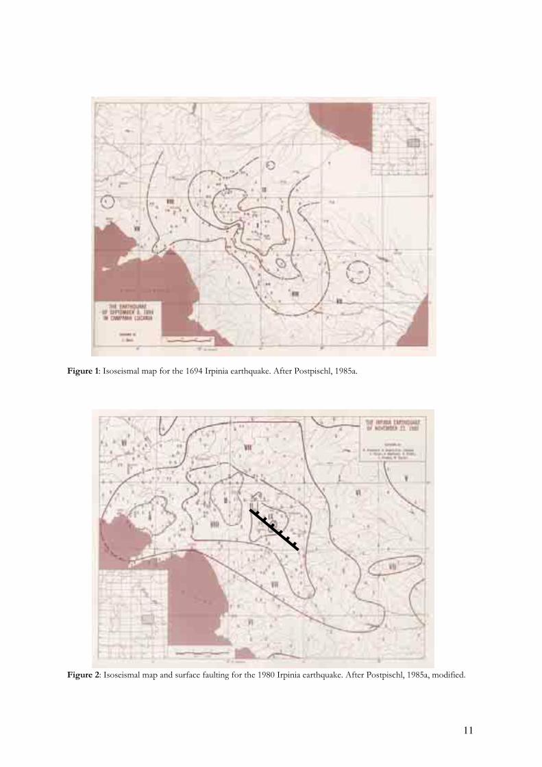
• Intensity studies enable the macroseismic field of historical and contemporary earthquakesto be reconstructed and, through this reconstruction, make it often possible to identify the seismogenic source. Figures 1 and 2 illustrate this point, by comparing the isoseismals from historical and contemporary earthquakes in the Southern Apennines of Italy.
• The isoseismal map of an earthquake makes possible the comparison between theattenuation derived using magnitude-distance relationships and the attenuation derived from the macroseismic field.
• The intensity values of an earthquake at various localities represent the combined effects of source-path and site conditions and could be very important in some cases from anengineering point of view.
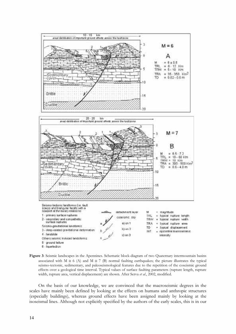
• Original intensity scales are built on the observed consistency between severity (degree and extent) of ground effects and the local physical environment, which is also at the base of the concept of seismic landscape (Serva et al., 1997; Michetti and Hancock, 1997; Serva et al.,2002; see Figure 3). In paleoseismology, when geologists assess the magnitude of pastearthquakes, a single category of paleoseismic evidence (such as fault surface displacement, size of liquefaction features, and uplifted shorelines) is generally used. However, it could be helpful to check the assessed magnitude against other phenomena (mainly on the ground, in the epicentral area: for instance, quality and quantity of landslides, changes in topography) that are described in the intensity scales at the intensity degree coherent with the assessed magnitude and focal depth.
• Most important, this parameter allows the comparison among recent earthquakes andhistorical ones, based on the effects described in the intensity scale. In using earthquakeground effects, this is particularly relevant for the highest degrees of the scale. In otherwords, the effects are compared rather than the calculated magnitudes of the earthquakes.
11
Figure 1: Isoseismal map for the 1694 Irpinia earthquake. After Postpischl, 1985a.
Figure 2: Isoseismal map and surface faulting for the 1980 Irpinia earthquake. After Postpischl, 1985a, modified.

12
The shortcomings of earlier scales — Why Intensity should be evaluated using ground effects
Earthquakes have often been described in historical chronicles, with more or less precise details, depending on the culture of the time or place, or even because of specific practical interests (e.g., Postpischl, 1985a, Ambraseys et al., 1994; Boschi et al., 1995; 1997; 2000). Countries with a rich historical heritage therefore have available a long record of earthquakes whose size can only be evaluated on the basis of their effects on man-made structures and in the environment, as reported in these chronicles. For this reason, specific scales (macroseismic scales) have been developed defining degrees of intensity expressed in Roman numerals that generally range between I and XII. In the original scales, intensity degrees were based essentially on a hierarchical classification of effects. In a general way, the diagnostic effects for the lower degrees are essentially those on people and animals, for the intermediate degrees those on objects and buildings, for the highest degrees, when the sensors related to the human environment are obviously useless because the earthquake is so strong that everything has been destroyed, those on the natural surroundings. The effects on the ground reported in the scales include primary, tectonic features such as surface faulting, and secondary, mostly shaking-induced phenomena, such as ground cracks, slope instabilities, and liquefaction (Table 1; Serva, 1994; Esposito et al., 1997). These effects are, in fact, often cited in historical and contemporary reports and have the advantage of not generally being influenced by human practices, many of them depending on source parameters and local geology alone (e.g., Koizumi, 1966; Youd and Hoose, 1978; Keefer, 1984; Xue-Cai and An-Ning, 1986; Youd and Perkins, 1987; Umeda et al., 1987; Papadopoulos and Lefkopoulos, 1993; Ambraseys and Srbulov, 1995; Esposito et al., 1997; Rodriguez et al., 1999). It is proven that many natural effects occur only in the epicentral area (near field), and that they appear and start to become relevant at well-defined intensity levels (Appendix 2). This means that a proper estimation of the intensity of an earthquake should take these effects into account.
However, over the past 40 years at least, proper attention has not been paid to these effects in estimating intensity because they were reputed to be too variable, and likewise because they were not properly weighted in the scales. For example, recent data indicate that some phenomena occur, or start to occur, at degrees other than the ones they are assigned to in the scales: liquefaction, for instance, starts at lower intensities (VI-VII, or even V; e.g., Keefer, 1984; Galli and Ferreli, 1995; Rodriguez et al., 1999, Galli, 2000, Porfido et al., 2002) and not at VII or IX as indicated in the scales. We argue that the existence of similar inconsistencies in the available macroseismic scales should not bring to the conclusion that ground effects are useless for assessing earthquake intensity. On the contrary, we believe that this is the result of several decades of research on earthquake engineering, Quaternary geology and paleoseismology, which brougth to the buildup of an entirely new knowledge in the study of coseismic environmental effects and their relations with a) the local tectonic and geomorphic setting, and b) the source parameters of the causative seismic event (e.g., Vittori et al., 1991; McCalpin, 1996; Michetti and Hancock, 1997; Yeats et al., 1997). The aim of our proposed scale is therefore to update the pre-existing scales by including this new knowledge into the earthquake intensity assessment. In fact, the problem of updating the intensity scales does also involve the effects on people and the manmade environment. For instance, a great deal of effort has been expended throughout the last century to increasing the robustness of the scales by improved definition and redistribution of the various typologies of damage to the different degrees of the scales. Along the same line, the new insights available today into the response of the physical environment to seismicity can lead to intensity evaluations which are better description of the real strength of the causative earthquake.
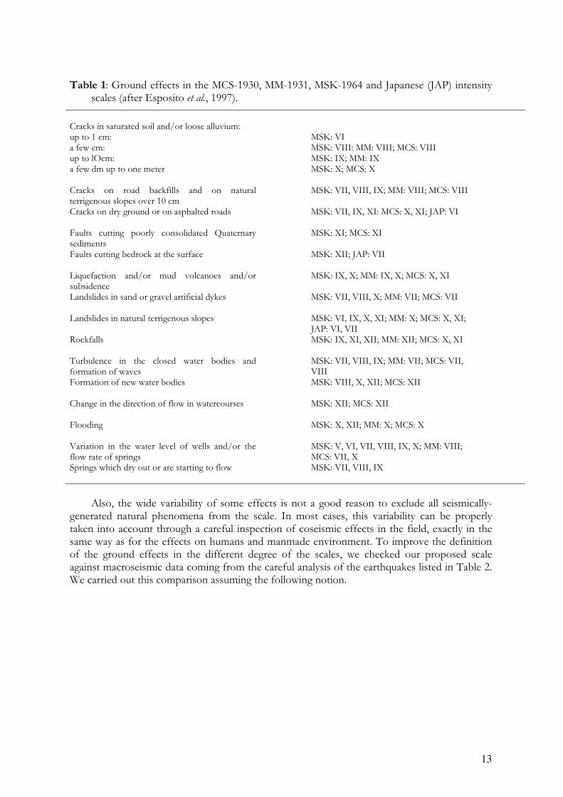
13
Table 1: Ground effects in the MCS-1930, MM-1931, MSK-1964 and Japanese (JAP) intensity scales (after Esposito et al., 1997).
Cracks in saturated soil and/or loose alluvium:
up to 1 cm: MSK: VI a few cm: MSK: VIII: MM: VIII; MCS: VIII up to lOcm: MSK: IX; MM: IX a few dm up to one meter
MSK: X; MCS: X
Cracks on road backfills and on natural terrigenous slopes over 10 cm
MSK: VII, VIII, IX; MM: VIII; MCS: VIII
Cracks on dry ground or on asphalted roads
MSK: VII, IX, XI: MCS: X, XI; JAP: VI
Faults cutting poorly consolidated Quaternary sediments
MSK: XI; MCS: XI
Faults cutting bedrock at the surface
MSK: XII; JAP: VII
Liquefaction and/or mud volcanoes and/or subsidence
MSK: IX, X; MM: IX, X; MCS: X, XI
Landslides in sand or gravel artificial dykes
MSK: VII, VIII, X; MM: VII; MCS: VII
Landslides in natural terrigenous slopes
MSK: VI, IX, X, XI; MM: X; MCS: X, XI; JAP: VI, VII
Rockfalls
MSK: IX, XI, XII; MM: XII; MCS: X, XI
Turbulence in the closed water bodies and formation of waves
MSK: VII, VIII, IX; MM: VII; MCS: VII, VIII
Formation of new water bodies
MSK: VIII, X, XII; MCS: XII
Change in the direction of flow in watercourses
MSK: XII; MCS: XII
Flooding
MSK: X, XII; MM: X; MCS: X
Variation in the water level of wells and/or the flow rate of springs
MSK: V, VI, VII, VIII, IX, X; MM: VIII; MCS: VII, X
Springs which dry out or are starting to flow MSK: VII, VIII, IX
Also, the wide variability of some effects is not a good reason to exclude all seismically-
generated natural phenomena from the scale. In most cases, this variability can be properly taken into account through a careful inspection of coseismic effects in the field, exactly in the same way as for the effects on humans and manmade environment. To improve the definition of the ground effects in the different degree of the scales, we checked our proposed scale against macroseismic data coming from the careful analysis of the earthquakes listed in Table 2. We carried out this comparison assuming the following notion.
14
Figure 3: Seismic landscapes in the Apennines. Schematic block-diagram of two Quaternary intermountain basins
associated with M ≅ 6 (A) and M ≅ 7 (B) normal faulting earthquakes; the picture illustrates the typical seismo-tectonic, sedimentary, and paleoseismological features due to the repetition of the coseismic ground effects over a geological time interval. Typical values of surface faulting parameters (rupture length, rupture width, rupture area, vertical displacement) are shown. After Serva et al., 2002, modified.
On the basis of our knowledge, we are convinced that the macroseismic degrees in the scales have mainly been defined by looking at the effects on humans and anthropic structures (especially buildings), whereas ground effects have been assigned mainly by looking at the isoseismal lines. Although not explicitly specified by the authors of the early scales, this is in our
15
opinion the reasoning behind the assignment of a given effect to a given intensity degree. In any case, this is the criterion we have adopted in this paper in order to ensure the internal consistency of the new scale, and to allow a straightforward integration with the other scales.
The supposed uncertainties lead to an increasing lack in the confidence in using ground effects as diagnostics, and progressively the effects on human perception and the anthropic environment (mainly buildings) became the only sensors analyzed for intensity assessment. Exemplifying this logic, in the latest proposal by the European Seismological Commission to revise the MSK scale (Grunthal, 1998), these effects are not reported in the scale per se, only in a brief appendix. We believe, however, that if this orientation is pursued, intensity will come to reflect mainly the economic development of the area that experienced the earthquake instead of its “strength” (Serva, 1994). It is also our belief that by ignoring ground effects, it will not be possible to assess intensity accurately in sparsely populated areas and/or areas inhabited by people with different modes of existence, such as nomads. This point has been already very clearly made by Dengler and McPherson (1993); this proposal for a new scale is the logic extension of their approach. Furthermore the main problems arise for the highest degrees - XI and XII - where ground effects are the only ones that permit a reliable estimation of earthquake size. All the scales, in fact, show that in this range of intensity ground effects predominate.
Because of all this, we deem it necessary that the seismological community (in a broad sense — all people involved in seismic risk analysis) should continue to using scales that take into account all the natural phenomena pertaining to each degree. In line with this, we propose here a scale that reports only ground effects, based on the knowledge currently available in this matter.
The scale has been compiled based on the descriptions reported in: a) the three most common intensity scales, i.e., Mercalli-Cancani-Sieberg (MCS, Sieberg, 1930), Medvedev-Sponhouer-Karnik (MSK, 1964) and Modified Mercalli (MM, Wood and Neumann, 1931; Richter, 1958); b) the paper by Dengler and McPherson (1993); c) the newly revised MM scale for New Zealand (Hancox et al., 2002) and d) a collection of pertinent papers, studies, and reports (as listed in Appendix 1). It should be noted that the description for any degree can be directly integrated into the corresponding degree of any of the above scales. Obviously, where they are not explicitly mentioned, a degree incorporates all the effects found in the lower degrees, although commonly more amply expressed and over a wider extent.
General statements
Serva (1994) and Esposito et al. (1997), among others, have already discussed some of the problems that must be dealt with when attempting to use natural effects for intensity assessment. However we think it would be useful to note the following considerations affecting the proper use of this scale.
In the following description of the proposed INQUA scale, text in italics refers to those effects directly usable to define an intensity degree (e.g., jumping stones, soil cracking, surface faulting). The size and the frequency of occurrence of many other natural effects, however, are not controlled by earthquake magnitude and hypocentral depth alone. Rather, they appear primarily to be governed by the duration and level of motion (acceleration, velocity, displacement), as well as by the frequency content of shaking, on the one hand, and by the local morphology and lithology of the terrain, on the other (so-called land vocation or likelihood or sensitivity to a specific phenomenon). For example, landslides depend on slope angles, the mechanical properties of the involved lithologies, water saturation, the nature and extent of vegetation, man-made changes and previous events. Hence, when the likelihood of an effect’s
16
occurring varies considerably depending on a number of controlling parameters, the intensity threshold can also vary significantly. So, landslides may occur for very low-intensity events (even IV; e.g., Keefer, 1984; Rodriguez et al., 1999), but can be absent even for the strongest events (XII).
For such effects to be able to be used in assessing intensity, they will need to be painstakingly evaluated on a case-by-case basis. These therefore are not indicated in our scale as determinant for intensity assessment. Notwithstanding the aforementioned limitations, we nevertheless believe that an accurate analysis, taking into proper account the land vocation, and therefore based on direct observations in the field, may allow intensity degree appraisal. For instance, in the Apennines of Italy, as well as in New Zealand, it is possible to determine well defined relationships between landslide distribution and earthquake magnitude, epicentre, isoseismals, faulting, geology, and topography (Porfido et al., 2002; Hancox et al., 2002). The analysis of the catalogues of Italian historical earthquakes (Postpischl, 1985a; 1985b; Boschi etal., 1995; 1997; 2000) carried out by Romeo and Delfino (1997) shows that the triggering threshold for landslides, below which the number and size of the slides becomes negligible (< 5 %) is degree VI-VII, whereas for liquefaction it is ca. VII. During the recent, September – October 1997, Umbria-Marche earthquake swarm in Central Italy (maximum intensity VIII-IX), the size and frequency of rockfalls along road cuts, as well as that of fractures, sharply increase as one moves towards the inside of the epicentral area (Esposito et al., 2000; Vittori et al., 2000).
Effects in the epicentral area (near field) depend essentially on the high-frequency vibration of ground motion (acceleration) and its duration, as well as on very low frequency seismic waves due to directivity and fling (slip on the fault), which give rise in the near field to long-period, so-called “killer” pulses (cf., the August, 17, 1999, Izmit/Kocaeli, Turkey and the 1999, Taiwan, earthquakes; e.g., EERI, 1999; USGS, 1999). In the far field, the effects are generally linked with long-period surface waves, more prominent on horizontal components of motion, and having long duration.
In summary, the environmental effects observed during earthquakes can be classified as follows:
A) Effects occurring under conditions of precarious equilibrium:
1) They also can be induced by other natural events or human activities;
2) They usually occur in mountainous or hilly areas, and in wet terrain;
3) The highest concentration and amplitude of such effects can indicate the epicentral area, but, alternatively, also the area most prone to this phenomenon;
4) Such effects, in the absence of independent evidence of seismicity (effects on man or man-made structures), do not allow the positive recognition of an earthquake and its intensity.
B) Effects occurring under conditions of relatively stable equilibrium:
1) Earthquake markers: ascribable, due to their nature (frequency of occurrence, size, and areal distribution) only to an earthquake as causative event.
2) Intensity gauges (mainly relevant for strong earthquakes):
a) Undoubtedly connected to earthquakes because not producible by other processes, even of exceptional intensity:
b) In no way connected only to the environmental setting. Generally they occur in two cases:

17
When the vertical component of acceleration is greater than gravity (in epicentral areas; e.g. Umeda et al., 1987);
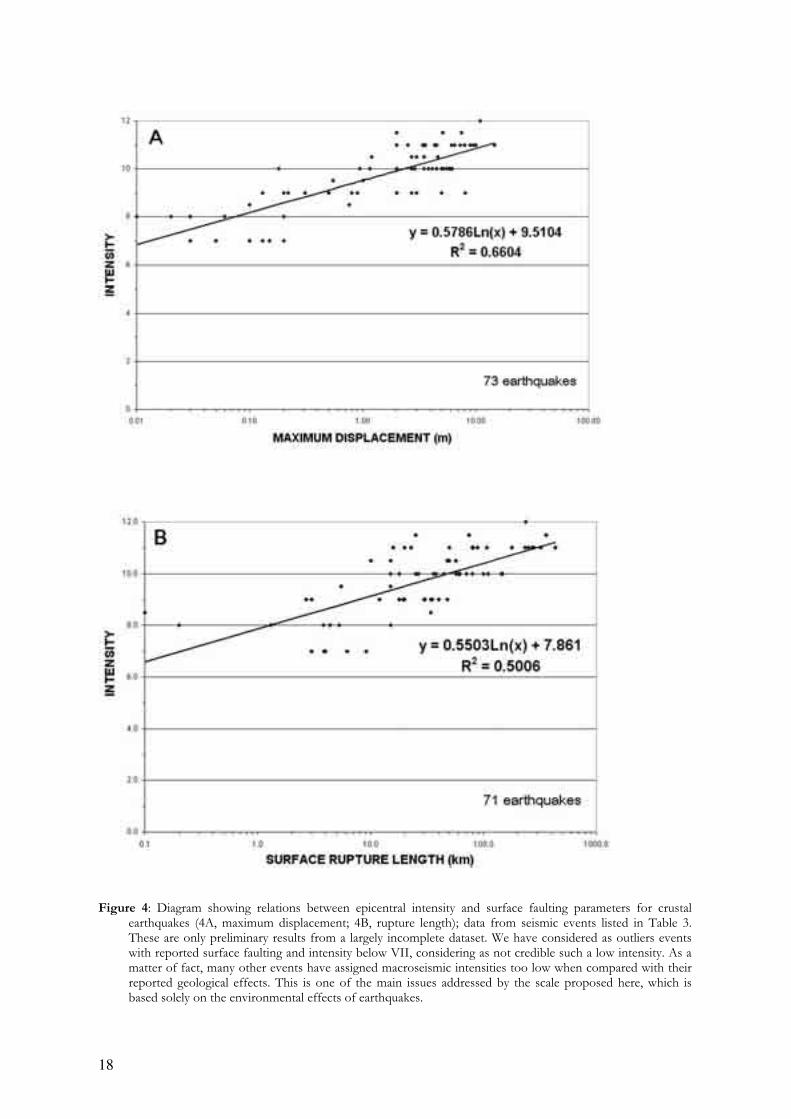
When surface faulting takes place. It begins to show up for intensities around VIII, and, for the same tectonic environment, rupture length and offset are thereafter proportional to macroseismic intensity. An original relationship between surface faulting parameters and intensity for crustal earthquakes is here proposed (Figure 4 and Table 3).
18
Figure 4: Diagram showing relations between epicentral intensity and surface faulting parameters for crustal earthquakes (4A, maximum displacement; 4B, rupture length); data from seismic events listed in Table 3. These are only preliminary results from a largely incomplete dataset. We have considered as outliers events with reported surface faulting and intensity below VII, considering as not credible such a low intensity. As a matter of fact, many other events have assigned macroseismic intensities too low when compared with their reported geological effects. This is one of the main issues addressed by the scale proposed here, which is based solely on the environmental effects of earthquakes.

19
The INQUA scale1
As already mentioned, the assignment of each environmental effect to its proper intensity interval in the following INQUA scale has been based on a careful reading of the most widely applied scales, i.e., the MM, MCS and MSK scales, integrated with more recent work indicated in the references and Appendix 1.
In particular, the diagnostics used in the INQUA scale have been compared and found consistent with the macroseismic data available for a sample of historical and contemporary Italian earthquakes, as listed in Table 2. We have accurately reviewed the surface effects of 115 earthquakes occurred in Italy since the XII century, documented in available catalogs and historical sources directly analyzed. The effects have been categorized according to the scheme in Table 4. Each effect has been associated to the macroseismic intensity attributed in the historical catalogs (Caputo and Faita, 1984; Postpischl, 1985a; 1985b; Boschi et al., 1995; Tinti and Maramai, 1996; Boschi et al., 1997; Azzaro et al., 2001; CPTI, 1999; Boschi et al., 2000) on the basis of local damage patterns.
About the intensity threshold for the occurrence of landslides, we have also taken into account the data of 40 earthquakes worldwide given in Keefer (1984), updated with other 36 events word-wide by Rodriguez et al. (1999), and 22 earthquakes in New Zealand (Hancox et al.,2002). For the onset of liquefaction we have also considered the data for Venezuela given in Rodriguez et al. (2002).
As for primary faulting, we have based our analysis on a first screening of the Wells and Coppersmith (1994) and Yeats et al. (1997) dataset of earthquakes associated to surface faulting, integrated with some recent Italian and Mediterranean region events. The screening has been based on the availability of epicentral intensity values and it is still a work in progress. We have plotted the maximum displacement and the surface rupture length versus epicentral intensity, obtaining the plots in Figure 4.
This database of macroseismic data is subject to expansion and revision in order to incorporate more case histories; however, we are convinced that the sample of seismic events studied is large enough for validating the proposed scale with a resolution consistent with the scope of the present paper. For instance, we found several crustal earthquakes associated with rupture lengths of tens of kilometers for which an epicentral intensity of VIII or even of VII (MM or MSK) has been reported. With the INQUA scale, an epicentral intensity of X or XI would have been assigned, which is unequivocally a better description of the size of these events, both in terms of magnitude and of ground shaking level.
The degrees of the INQUA scale can be directly compared with the corresponding degrees of most of the twelve-degree scales referred to above, in view of the fact that the differences among these scales are not substantial in terms of the level of accuracy they can provide (Appendix 4). The INQUA scale is an innovative proposal — or perhaps is simply the recognition that the work accomplished by earthquake scientists in the first decades of the XX century is worth pursuing along the lines of its original inspiration. It reflects the present viewpoint of its authors, which is necessarily subject to modification in its details, notwithstanding their effort to integrate the largest database possible. Contributions and criticism from other researchers are expected and will be welcomed. They will in all probability provide the basis for a revised version, where new effects may be incorporated and grade intervals of occurrence and size of effects better constrained.
1 In order to give an immediate identity to this scale, we propose to name it “Inqua EEE Scale”, where EEE would stand for “Earthquake Environmental Effects”.
20
Definitions of intensity degrees
I, II No perceptible environmental effects
a) Extremely rare occurrence of small effects detected only from instrumental observations, typically in the far field of strong earthquakes.
III No perceptible environmental effects
a) Primary effects are absent.
b) Extremely rare occurrence of small variations in water level in wells and/or the flow-rate of springs, typically in the far field of strong earthquakes.
IV No perceptible environmental effects
a) Primary effects are absent.
b) A very few cases of fine cracking at locations where lithology (e.g., loose alluvial deposits, saturated soils) and/or morphology (slopes or ridge crests) are most prone to this phenomenon.
c) Rare occurrence of small variations in water level in wells and/or the flow-rate of springs.
d) Extremely rare occurrence of small variations of chemical-physical properties of water and turbidity of water in lakes, springs and wells, especially within large karstic spring systems most prone to this phenomenon.
e) Exceptionally, rocks may fall and small landslides may be (re)activated, along slopes where equilibrium is already very unstable, e.g. steep slopes and cuts, with loose or saturated soil.
f) Extremely rare occurrence of karst vault collapses, which may result in the formation of sinkholes, where the water table is shallow within large karstic spring systems.
g) Very rare temporary sea level changes in the far field of strong earthquakes.
h) Tree limbs may shake.
V Marginal effects on the environment
a) Primary effects are absent.
b) A few cases of fine cracking at locations where lithology (e.g., loose alluvial deposits, saturated soils) and/or morphology (slopes or ridge crests) are most prone to this phenomenon.
c) Extremely rare occurrence of significant variations in water level in wells and/or the flow-rate of springs.
d) Rare occurrence of small variations of chemical-physical properties of water and turbidity of water in lakes, springs and wells.
e) Rare small rockfalls, rare rotational landslides and slump earth flows, along slopes where equilibrium is unstable, e.g. steep slopes, with loose or saturated soil.
21
f) Extremely rare cases of liquefaction (sand boil), small in size and in areas most prone to this phenomenon (hihgly susceptible, recent, alluvial and coastal deposits, shallow water table).
g) Extremely rare occurrence of karst vault collapses, which may result in the formation of sinkholes, where the water table is shallow within large karstic spring systems.
h) Occurrence of landslides under sea (lake) level in coastal areas.
i) Rare temporary sea level changes in the far field of strong earthquakes.
j) Tree limbs may shake.
VI Modest effects on the environment
a) Primary effects are absent.
b) Occasionally thin, millimetric, fractures are observed in loose alluvial deposits and/or saturated soils; along
steep slopes or riverbanks they can be 1-2 cm wide. A few minor cracks develop in paved (asphalt / stone)
roads.
c) Rare occurrence of significant variations in water level in wells and/or the flow-rate of springs.
d) Rare occurrence of variations of chemical-physical properties of water and turbidity of water in lakes, springs and wells.
e) Rockfalls and landslides up to ca. 103 m3 can occur, especially where equilibrium is unstable, e.g. steep slopes and cuts, with loose / saturated soil, or weathered / fractured rocks. The area affected by them is usually less than 1 km2.
f) Rare cases of liquefaction (sand boil), small in size and in areas most prone to this phenomenon (hihgly
susceptible, recent, alluvial and coastal deposits, shallow water table).
g) Extremely rare occurrence of karst vault collapses, which may result in the formation of sinkholes.
h) Occurrence of landslides under sea level in coastal areas.
i) Occasionally significant waves are generated in still waters.
j) In wooded areas, trees shake; a very few unstable limbs may break and fall, also depending on species and
state of health.
VII Appreciable effects on the environment
a) Primary effects observed very rarely. Limited surface faulting, with length of tens of meters and centimetric offset, may occur associated with volcano-tectonic earthquakes.
b) Fractures up to 5-10 cm wide are observed commonly in loose alluvial deposits and/or saturated soils;
rarely in dry sand, sand-clay, and clay soil fractures up to 1 cm wide. Centimetric cracks common in paved
(asphalt or stone) roads.
c) Rare occurrence of significant variations in water level in wells and/or the flow rate of springs. Very rarely, small springs may temporarily run dry or be activated.
d) Quite common occurrence of variations of chemical-physical properties of water and turbidity of water in lakes, springs and wells.
e) Scattered landslides occur in prone areas; where equilibrium is unstable (steep slopes of loose / saturated soils; rock falls on steep gorges, coastal cliffs) their size is sometimes
22
significant (103 - 105 m3); in dry sand, sand-clay, and clay soil, the volumes are usually upto 100 m3. Ruptures, slides and falls may affect riverbanks and artificial embankments and excavations (e.g., road cuts, quarries) in loose sediment or weathered / fractured rock. The affected area is usually less than 10 km2.
f) Rare cases of liquefaction, with sand boils up to 50 cm in diameter, in areas most prone to this phenomenon
(hihgly susceptible, recent, alluvial and coastal deposits, shallow water table).
g) Possible collapse of karst vaults with the formation of sinkholes, even where the water table is deep.
h) Occurrence of significant landslides under sea level in coastal areas.
i) Waves may develop in still and running waters.
j) In wooded areas, trees shake; several unstable branches may break and fall, also depending on species and state of health.
VIII Considerable effects on the environement
a) Primary effects observed rarely. Ground ruptures (surface faulting) may develop, up to several hundred
meters long, with offsets generally smaller than 5 cm, particularly for very shallow focus earthquakes, such
as volcano-tectonic events. Tectonic subsidence or uplift of the ground surface with maximum values on the
order of a few centimeters may occur.
b) Fractures up to 25 - 50 cm wide are commonly observed in loose alluvial deposits and/or saturated soils; in
rare cases fractures up to 1 cm can be observed in competent dry rocks. Decimetric cracks common in paved
(asphalt or stone) roads, as well as small pressure undulations.
c) Springs can change, generally temporarily, their flow-rate and/or elevation of outcrop. Some small springs
may even run dry. Variations in water level are observed in wells.
d) Water temperature often change in springs and/or wells. Water in lakes and rivers frequently becomes
muddy, as well as in springs.
e) Small to moderate (103 - 105 m3) landslides widespread in prone areas; rarely they can occur also on gentle slopes; where equilibrium is unstable (steep slopes of loose / saturated soils; rock falls on steep gorges, coastal cliffs) their size is sometimes large (105 - 106 m3).Landslides can occasionally dam narrow valleys causing temporary or even permanent lakes. Ruptures, slides and falls affect riverbanks and artificial embankments and excavations (e.g., road cuts, quarries) in loose sediment or weathered / fractured rock. The affected area is usually less than 100 km2.
f) Liquefaction may be frequent in the epicentral area, depending on local conditions; sand boils up to ca. 1 m
in diameter; apparent water fountains in still waters; localised lateral spreading and settlements (subsidence
up to ca. 30 cm), with fissuring parallel to waterfront areas (river banks, lakes, canals, seashores).
g) Karst vaults may collapse, forming sinkholes.
h) Frequent occurrence of landslides under the sea level in coastal areas.
i) Significant waves develop in still and running waters.
j) Trees shake vigorously; some branches or rarely even tree-trunks in very unstable equilibrium may break
and fall.
k) In dry areas, dust clouds may rise from the ground in the epicentral area.
23
IX Natural effects leave significant and permanent traces in the environment
a) Primary effects observed commonly. Ground ruptures (surface faulting) develop, up to a few km long, with
offsets generally smaller than 10 - 20 cm. Tectonic subsidence or uplift of the ground surface with maximum
values in the order of a few decimeters may occur.
b) Fractures up to 50 - 100 cm wide are commonly observed in loose alluvial deposits and/or saturated soils;
in competent rocks they can reach up to 10 cm. Significant cracks common in paved (asphalt or stone)
roads, as well as small pressure undulations.
c) Springs can change their flow-rate and/or elevation of outcrop to a considerable extent. Some small springs may even run dry. Variations in water level are observed in wells.
d) Water temperature often change in springs and/or wells. Water in lakes and rivers frequently become muddy.
e) Landsliding widespread in prone areas, also on gentle slopes; where equilibrium is unstable (steep slopes of
loose / saturated soils; rock falls on steep gorges, coastal cliffs) their size is frequently large (105 m3),
sometimes very large (106 m3). Landslides can dam narrow valleys causing temporary or even permanent
lakes. Riverbanks, artificial embankments and excavations (e.g., road cuts, quarries) frequently collapse.
The affected area is usually less than 1000 km2.
f) Liquefaction and water upsurge are frequent; sand boils up to 3 m in diameter; apparent water fountains
in still waters; frequent lateral spreading and settlements (subsidence of more than ca. 30 cm), with fissuring
parallel to waterfront areas (river banks, lakes, canals, seashores).
g) Karst vaults of relevant size collapse, forming sinkholes.
h) Frequent large landslides under the sea level in coastal areas.
i) Large waves develop in still and running waters. Small tsunamis may reach the coastal areas with tidal
waves up to 50 - 100 cm high.
j) Trees shake vigorously; branches or even tree-trunks in unstable equilibrium frequently break and fall.
k) In dry areas dust clouds may rise from the ground.
l) In the epicentral area, small stones may jump out of the ground, leaving typical imprints in soft soil.
X Environmental effects become dominant
a) Primary ruptures become leading. Ground ruptures (surface faulting) can extend for several tens of km,
with offsets reaching 50 - 100 cm and more (up to ca. 1-2 m in case of reverse faulting and 3-4 m for
normal faulting). Gravity grabens and elongated depressions develop; for very shallow focus earthquakes,
such as volcano-tectonic events, rupture lengths might be much lower. Tectonic subsidence or uplift of the
ground surface with maximum values in the order of few meters may occur.
b) Large landslides and rock-falls (> 105 - 106 m3) are frequent, practically regardless to equilibrium state
of the slopes, causing temporary or permanent barrier lakes. River banks, artificial embankments, and sides
of excavations typically collapse. Levees and earth dams may even incur serious damage. The affected area is
usually up to 5000 km2.
c) Many springs significantly change their flow-rate and/or elevation of outcrop. Some may run dry or disappear, generally temporarily. Variations in water level are observed in wells.
24
d) Water temperature often change in springs and/or wells. Water in lakes and rivers frequently become muddy.
e) Open ground cracks up to more than 1 m wide are frequent, mainly in loose alluvial deposits and/or
saturated soils; in competent rocks opening reach several decimeters. Wide cracks develop in paved (asphalt
or stone) roads, as well as pressure undulations.
f) Liquefaction, with water upsurge and soil compaction, may change the aspect of wide zones; sand volcanoes
even more than 6 m in diameter; vertical subsidence even > 1m; large and long fissures due to lateral
spreading are common.
g) Large karst vaults collapse, forming great sinkholes.
h) Frequent large landslides under the sea level in coastal areas.
i) Large waves develop in still and running waters, and crash violently into the shores. Running (rivers,
canals) and still (lakes) waters may overflow from their beds. Tsunamis reach the coastal areas, with tidal
waves up to a few meters high.
j) Trees shake vigorously; branches or even tree-trunks very frequently break and fall, if already in unstable equilibrium.
k) In dry areas, dust clouds may rise from the ground.
l) Stones, even if well anchored in the soil, may jump out of the ground, leaving typical imprints in soft soil.
XI Environmental effects become essential for intensity assessment
a) Primary surface faulting can extend for several tens of km up to more than 100 km, accompanied by offsets
reaching several meters. Gravity graben, elongated depressions and pressure ridges develop. Drainage lines
can be seriously offset. Tectonic subsidence or uplift of the ground surface with maximum values in the order
of numerous meters may occur.
b) Large landslides and rock-falls (> 105 - 106 m3) are frequent, practically regardless to equilibrium state
of the slopes, causing many temporary or permanent barrier lakes. River banks, artificial embankments,
and sides of excavations typically collapse. Levees and earth dams incur serious damage. Significant
landslides can occur at 200 – 300 km distance from the epicenter. Primary and secondary environmental
effects can be observed over territory as large as 10000 km2.
c) Many springs significantly change their flow-rate and/or elevation of outcrop. Frequently, they may run dry or disappear altogether. Variations in water level are observed in wells.
d) Water temperature often change in springs and/or wells. Water in lakes and rivers frequently becomes muddy.
e) Open ground cracks up to several meters wide are very frequent, mainly in loose alluvial deposits and/or
saturated soils. In competent rocks they can reach 1 m. Very wide cracks develop in paved (asphalt or
stone) roads, as well as large pressure undulations.
f) Liquefaction changes the aspect of extensive zones of lowland, determining vertical subsidence possibly
exceeding several meters, numerous large sand volcanoes, and severe lateral spreading features.
g) Very large karst vaults collapse, forming sinkholes.
h) Frequent large landslides under the sea level in coastal areas.
i) Large waves develop in still and running water, and crash violently into the shores. Running (rivers, canals)
and still (lakes) waters may overflow from their beds. Tsunamis reach the coastal areas with tidal waves up
to many meters high.
25
j) Trees shake vigorously; many tree branches break and several whole trees are uprooted and fall.
k) In dry areas dust clouds may arise from the ground.
l) Stones and small boulders, even if well anchored in the soil, may jump out of the ground leaving typical
imprints in soft soil.
XII Environmental effects are now the only tool enabling intensity to be assessed
a) Primary surface faulting can extend for several hundreds of km up to 1000 km, accompanied by offsets
reaching several tens of meters. Gravity graben, elongated depressions and pressure ridges develop. Drainage
lines can be seriously offset. Landscape and geomorphological changes induced by primary effects can attain
extraordinary extent and size (typical examples are the uplift or subsidence of coastlines by several meters,
appearance or disappearance from sight of significant landscape elements, rivers changing course, origination
of waterfalls, formation or disappearance of lakes).
b) Large landslides and rock-falls (> 105 - 106 m3) are frequent, practically regardless to equilibrium state
of the slopes, causing many temporary or permanent barrier lakes. River banks, artificial embankments,
and sides of excavations typically collapse. Levees and earth dams incur serious damage. Significant
landslides can occur at more than 200 – 300 km distance from the epicenter. Primary and secondary
environmental effects can be observed over territory larger than 50000 km2.
c) Many springs significantly change their flow-rate and/or elevation of outcrop. Frequently, they may run dry or disappear altogether. Variations in water level are observed in wells.
d) Water temperature often changes in springs and/or wells. Water in lakes and rivers frequently becomes muddy.
e) Ground open cracks are very frequent, up to one meter or more wide in the bedrock, up to more than 10 m
wide in loose alluvial deposits and/or saturated soils. These may extend up to several kilometers in length.
f) Liquefaction occurs over large areas and changes the morphology of extensive flat zones, determining vertical
subsidence exceeding several meters, widespread large sand volcanoes, and extensive severe lateral spreading
features.
g) Very large karst vaults collapse, forming sinkholes.
h) Frequent very large landslides under the sea level in coastal areas.
i) Large waves develop in still and running water, and crash violently into the shores. Running (rivers, canals)
and still (lakes) waters overflow from their beds; watercourses change the direction of flow. Tsunamis reach
the coastal areas with tidal waves up to tens of meters high.
j) Trees shake vigorously; many tree branches break and many whole trees are uprooted and fall.
k) In dry areas dust clouds may arise from the ground.
l) Even large boulders may jump out of the ground leaving typical imprints in soft soil.
__________________________

26
In the Appendix 5 the draft of a field survey form is proposed, for collection of data and rapid intensity estimate during field recognition following the future earthquakes. Clearly, the field test of the proposed scale should be a major task in the next future.
Intensity - fault parameter relationships: discussion and conclusions
Published empirical relationships between surface faulting parameters (i.e. rupture length, rupture area, rupture width, displacements) versus magnitude (e.g., Bonilla, 1978; Wells and Coppersmith, 1994), do not take into account dynamic parameters, notably stress drop, which varies versus fault length and slip type (cf. Mohammadioun and Serva, 2001). For instance, the systematic use, in the Wells and Coppersmith (1994) relation, of moment magnitude M (wherein stress drop is arbitrarily set at 30 bars) is liable to cause magnitudes to be either over- or underestimated. Accordingly, in order to assess the magnitudes of historical seismic events on the strength of paleoseismicity data, it is indispensable that rupture dynamics and the stress environment be taken into account. Recent paleoseismicity studies in the region of the San Andreas fault (Runnerstrom et al., 2002) indicates that maximum displacement increases versus the depth of the seismogenic zone: displacement measured at the surface accordingly represents the lower limit of this parameters, and using it will unavoidably lead to an underestimation of magnitude.
The other primary effects of earthquakes (uplift and/or subsidence) are accounted for to a certain extent by relationships between magnitude and slip-rate (e.g., Slemmons and dePolo, 1986; Petersen and Wesnousky, 1995; Anderson et al., 1996).
To date, there are no relationships linking primary ground effects and intensity. However, this connection is well evidenced in the description of the macroseismic scales for IX, X, XI, XII intensity degrees (see Table 1). We compiled new relationships using the data reported in Table 3 from a selected sample of crustal earthquakes. The data are plotted in Figure 4. We derived regression curves from the obtained values. This is a preliminary attempt that will be revised and updated by adding more detailed information on the earthquakes in Table 3, and including data from other surface faulting events.
We know that everybody can bring forward well-justified criticism concerning this approach, which we are willing to take into consideration. However, it is a fact that, within a given tectonic environment, intensity should increase if magnitude increases. It is entirely implausible that an earthquake of M = 6.5–7.0 should produce the same intensity as a M = 7.5–8 one. It is not physically correct, and macroseismic scales, if properly used, do not allow these values. Of course intensity XII, by definition, is where the scales saturate and therefore calls for professional judgment. In view of the preceding, the regressions in Figure 4 represent a very early stage of this endeavor. In fact, the purpose of publishing it is to provide a gentle provocation for the scientific community. We hope therefore that it will easily be proven false—but in the sense of Popper, 1934.
The use of ground effects for macroseismic intensity assessment is obviously affected by several uncertainties, as widely discussed in this paper. Most of the physical phenomena included in the proposed INQUA scale are relatively poor indicators of level, and should be considered carefully when used for intensity measurement. For the intensity levels lower than IX, the attempt of the INQUA scale is to bring environmental effects in line with the damage indicators. In this range, the INQUA scale should be used along with the other scales. For this reason, we have included as Appendix 4 a set of comparative tables to allow a direct integration between most commonly used scales and the INQUA proposed scale. However, in the intensity range between X and XII the distribution and size of primary tectonic effects is arguably the
27
most useful diagnostic of the intensity level. As suggested in the proposed INQUA scale, field observations on fault rupture length and surface displacement should be therefore consistently implemented in the macroseismic study of past and future earthquakes.
References
AZZARO R., BARBANO M.S., ANTICHI B., RIGANO R., 2001. Macroseismic catalogue of Mt. Etna
earthquakes from 1832 to 1998, Acta Vulcanologica, 12 (1-2), pp. 1-26.
AMBRASEYS N.N. AND SRBULOV M., 1995. Earthquake induced displacements of slopes, Soil Dynamics and Earthquake Engineering, 14, pp. 59-71.
AMBRASEYS N.N., MELVILLE C.P., AND ADAMS R.D., 1994. The Seismicity of Egypt, Arabia and
the Red Sea, Cambridge University Press, pp. 181.
ANDERSON J.G., WESNOUSKY S.G., and Stirling M.W., 1996. Earthquake Size as a Function of
Fault Slip Rate, Bulletin of the Seismological Society of America, 86, pp. 683-691.
BONILLA M.G., MAK R.K., and Lienkaemper J.J., 1984. Statistical relations among earthquake
magnitude, surface rupture length and surface fault displacement. Bulletin of the Seismological Society of America, 74, pp. 2379-2411.
BOSCHI E., FERRARI G., GASPERINI P., GUIDOBONI E., SMRIGLIO G., AND VALENSISE G.(Eds.), 1995. Catalogo dei forti terremoti in Italia dal 461 a. C. al 1980, ING-SGA, Bologna, 973 pp.
BOSCHI E., GUIDOBONI E., FERRARI G., VALENSISE G., AND GASPERINI P. (Eds.), 1997. Catalogo dei forti terremoti in Italia dal 461 a. C. al 1990, 2. ING-SGA, Bologna, 644 p.
BOSCHI E., GUIDOBONI E., FERRARI G., MARIOTTI D., VALENSISE G., AND GASPERINI P. (Eds.), 2000. Catalogo dei forti terremoti in Italia dal 461 a.C. al 1997, ING-SGA. Catalogue of
strong italian earthquakes from 461B.C. to 1997. Annali di geofisica, 34, n.4 texts and CD-ROM.
CAPUTO M. AND FAITA G., 1984. Primo catalogo dei maremoti delle coste italiane, Atti Accademia Nazionale dei Lincei, 17.
CPTI (Working group), 1999. Catalogo Parametrico dei Terremoti Italiani, ING, GNDT, SGA, SSN, Bologna, 92 pp.
DELVAUX D., ABDRAKHMATOV K.E., STROM A.L., KUCHAI O.A., VITTORI E., 2004. Active
tectonic deformation in the northern Tien Shan of Kyrgyztan. Submitted to the EGU04 Session SM11: Active deformation and lithospheric processes.
DENGLER L. AND MCPHERSON R., 1993. The 17 August 1991 Honeydaw earthquake North Coast
California: a case for revising the Modified Mercalli Scale in sparsely populated areas. Bulletin of the Seismological Society of America, 83, pp. 1081-1094.
EERI, 1999. The Izmit (Kocaeli), Turkey Earthquake of August 17, 1999, Special Earthquake Report, October 1999, pp 1-44.
ESPOSITO E., PORFIDO S., MASTROLORENZO G., NIKONOV A.A., SERVA L., 1997. Brief review
and preliminary proposal for the use of ground effects in the macroseismic intensity assesment. Proc. 30th International Geological Congress, Beijing, China, vol 5. “Contemporary lithospheric motion and seismic geology”, VSP ed., the Netherlands, pp. 233-243.
28
ESPOSITO E., PORFIDO S., SIMONELLI A.L., MASTROLORENZO G., IACCARINO G., 2000. Landslides and other surface effects induced by the 1997 Umbria-Marche seismic sequence. Engineering Geology, 58, 353-376.
EQE, 1995. The January 17, 1995 Kobe Earthquake, Summary Report, April 1995, pp. 1-6.
GALLI P., 2000. New empirical relationships between magnitude and distance for liquefaction,Tectonophysics 324, pp. 113–134.
GALLI P. and Ferreli L., 1995. A methodological approach for historical liquefaction research, in “Perspectives in Paleoseismology”, Serva L. and Slemmons D.B., Eds. AEG Special Publication N.6, pp. 35-48.
GOODMAN R.E. AND SEED H.B., 1966. Earthquake-induced displacements in sand embankments,ASCE SM, 92.
GRUNTHAL G. (Editor), 1998. European Macroseismic Scale 1998. ESC, Cahiers du Centre Européen de Géodynamique et de Sismologie, Vol. 15, Luxemburg, 79 pp.
HANCOX G.T., PERRIN N.D. AND DELLOW G.D., 2002. Recent studies of historical earthquake-
induced landsliding, ground damage, and MM intensity in New Zealand, Bulletin of the New Zealand Society for Earthquake Engineering, 35, 2, 59-95.
KEEFER D.K., 1984. Landslides caused by earthquakes. Geol. Soc. of Am. Bull. 95, pp 406-421.
KOIZUMI Y., 1966. Changes in density of sand subsoil caused by the Niigata earthquake. Soils and Foundations, 6, N.2., 25-51.
KRINITSKY E.L. AND CHANG F.K., 1988. Intensity-related earthquake ground motions. Bulletin of the Association of Engineering Geologists, 25, pp. 425-435.
YOMOGIDA K. AND NAKATA T., 1994. Large slip velocity of the surface rupture associated with the 1990
Luzon earthquake. Geophysical Research Letters, 21 (17), 1799-1802.
MC CALPIN J.P. (Ed.), 1996. Paleoseismology. Academic Press, London, 583 pp.
MICHETTI A.M., BRUNAMONTE F. AND SERVA L., 1995. Paleoseismological evidence in the epicentral
area of the January 13, 1968, Belice (SW Sicily) earthquake, in Perspectives in Paleoseismology; edited by SERVA L. and SLEMMONS D.B., Spec. Publ.6, pp. 127-139, Assoc. of Eng. Geol., Dallas, Tex.
MICHETTI A.M., BRUNAMONTE F., SERVA L., VITTORI E., 1996. Trench investigations of the 1915
Fucino earthquake fault scarps (Abruzzo, central Italy): Geological evidence of large historical events.Journal of Geophisical Research, 101, n. B3, pp. 5921-5936. Michetti A.M.
MICHETTI A.M. AND HANCOCK P.L. (Eds.), 1997. Paleoseismology: understanding past earthquakes
using Quaternary geology. Journal of Geodynamics, 24, 1-4, 256 p.
MOHAMMADIOUN B. AND SERVA L., 2001. Stress drop, slip type, earthquake magnitude—and seismic
hazard, Bull. Seism. Soc. Am. 91, pp. 694-707.
ODDONE E., 1915. Gli elementi fisici del grande terremoto marsicano fucense del 13 Gennaio 1915. Boll. Soc. Sismol. Ital., 19, pp. 71-215
PAPADOPOULOS G.A. AND LEFKOPOULOS G., 1993. Magnitude-distance relation for liquefactions in
soil from earthquakes. Bull. Seis. Soc. Am., 83, pp. 925-938.
PETERSEN M.D. AND WESNOUSKY S.G., 1994. Fault Slip Rates and Earthquake Histories for Active
Faults in Southern California, Bulletin of the Seismological Society of America 84, no. 5, pp. 1608-1649.
29
POPPER K., 1934. Logik der Forschung. Vienna.
PORFIDO S., ESPOSITO E., VITTORI E., TRANFAGLIA G., MICHETTI A. M., BLUMETTI A.M.,FERRELI L., GUERRIERI L., SERVA L., 2002. Areal distribution of ground effects induced by strong
earthquakes in the southern Apennines (Italy), Surveys in Geophysics, 23, pp. 529-562.
POSTPISCHL D., Editor, 1985a. Atlas of isoseismal maps of Italian earthquakes, CNR-PFG, Quaderni della Ricerca Scientifica 114 (2A), 164 p., Bologna.
POSTPISCHL D., Editor, 1985b. Catalogo dei terremoti italiani dall'anno 1000 al 1980. CNR-PFG, Quaderni della Ricerca Scientifica, 114 (2B), 243 p., Bologna.
REITER L., 1991, Earthquake Hazard Analysis. Columbia University Press, 254 p.
RICHTER C.F., 1958. Elementary Seismology, San Francisco, California, W.H. Freeman, p. 768.
RODRÍGUEZ C.E., BOMMER J.J., AND CHANDLER R.J., 1999. Earthquake-induced Landslides:
1980-1997, Soil Dynamics and Earthquake Engineering, 18, 325-346.
RODRIGUEZ L.M., AUDEMARD F.A. AND RODRIGUEZ J.A., 2002, Casos històricos y
contemporaneos de licuefacion de sedimentos inducidos por sismos en Venezuela desde 1530, III Jornadas Venezolanas de Sismologìa Historica, Serie Tecnica n. 1, pp 4-10.
ROMEO R. AND DELFINO L., 1997. C.E.D.I.T. (release 1.1), Catalogo nazionale degli Effetti
Deformativi del suolo Indotti da Forti Terremoti, Servizio Sismico Nazionale, RAPPORTO TECNICO SSN/RT/97/04, Maggio, 1997, 56 p. Also available online at http://www.serviziosismico.it/RT/rt9704/frameset.html
RUNNERSTROM E.E., GRANT L.B., ARROWSMITH J.R., RHODES D.D., AND STONE E.. 2002. Displacement across the Cholame segment of the San Andreas fault between 1865 and 1893 from
cadastral surveys. Bull Seism. Soc. Am. 92, pp. 2659-2669.
SERVA L., 1981. Il terremoto del 1694 in Irpinia e Basilicata. Volume speciale della Commissione ENEA-ENEL: Contributo alla caratterizzazione della sismicità del territorio Italiano, CNR, Convegno annuale Geodinamica, Udine, 1981, pp. 183-208.
SERVA L., 1994. Ground effects in the intensity scales. Terra Nova, 6, pp. 414-416.
SERVA L., VITTORI E., FERRELI L., AND MICHETTI A.M., 1997, Geology and seismic hazard. In: “Proceedings of the Second France-United States Workshop on Earthquake hazard assesment in intraplate regions: Central and eastern United States and Western Europe”, October 16, 1995, Nice, France, B. Grellet, B. MOHAMMADIOUN and W. HAYS, eds., Ouest Editions Presses Académiques, 20-24.
SERVA L., BLUMETTI A.M., GUERRIERI L., AND MICHETTI A.M., 2002. The Apennines
intermountain basins: the result of repeated strong earthquakes over a geological time interval. Boll. Soc. Geol. It., spec. vol. 1 (2001), pp. 939-946.
SHEBALIN N.V., KARNIK V., HADZIEVSKI D., 1974. Catalogue of earthquakes of the Balkan region.I, UNDP-UNESCO Survey of the seismicity of the Balkan region. Skopje, 600 p.
SIEBERG A., 1930. Geologie der Erdbeden, in Handbuch der Geophysik, 2, 4, pp. 550-555.
SIRO L., 1976. Liquefaction of sands in Friuli during May 6 and September 15, 1976 earthquakes. Boll. Geofis. Teorica e Applicata, Vol. 19, pp. 909-932.
SLEMMONS D.B. AND DEPOLO C., 1986. Evaluation of active faulting and associated hazards. In Active Tectonics, National Academy Press, Washington, D. C., USA.
30
TINTI S. AND MARAMAI A., 1996. Catalogue of tsunamis generated in Italy and in Cote d’Azur, France:
a step towards a unified catalogue of tsunamis in Europe. Annali di Geofisica, Vol. 39, pp. 1253-1299.
USGS, 1999. Implications for Earthquake risk reduction in the U.S. from the Kocaeli, Turkey, earthquake,U.S. Geological Survey Circular 1193, pp.1-64.
UMEDA Y., KUROISO A., ITO K. AND MURAMATU J., 1987. High accelerations produced by the
Western Nagano Prefecture, Japan, earthquake of 1984, Tectonophysics, 141, pp. 335-343.
VITTORI E., SYLOS-LABINI S. AND SERVA L., 1991. Paleoseismology: review of the state of the art,Tectonophysics 193, pp. 9-32.
VITTORI E., DEIANA G., ESPOSITO E., FERRELI L., MARCHEGIANI L., MASTROLORENZO G.,MICHETTI A.M., PORFIDO S., SERVA L., SIMONELLI A.L. & TONDI E., 2000. Ground effects
and surface faulting in the September-October 1997 Umbria-Marche (Central Italy) seismic sequence.Journal of Geodynamics, 29, pp. 535-564.
VITTORI E., CARVER G., JAYKO A.S., MICHETTI A.M., SLEMMONS D.B., 2003. New insight on
the Owens Valley Fault zone (Eastern California, U.S.A.) from detailed Quaternary Fault Map. XVI INQUA Congress Programs with Abstracts, July 23-30, 2003, Reno, Nevada USA.
WELLS D.L. AND COPPERSMITH K.J., 1994, New empirical relationships among magnitude, rupture
length, rupture width, rupture area and surface displacements. Bull. Seis. Soc. Am. 84, N.4, pp. 974-1002.
WOOD H.O. AND NEUMANN F., 1931. Modified Mercalli intensity scale of 1931. Bull. Seis. Soc. Am., 21, pp. 277-283.
XUE-CAI F., AND AN-NING G., 1986. The principal characteristic of earthquake landslides in China.IAEG, AIG, Vol. 2, Bari (Italy), pp. 27-45.
YEATS R.S., SIEH K. AND ALLEN C.R., 1997. The Geology of Earthquakes. Oxford University Press, New York, 568 p.
YOUD T.L. AND HOOSE S.N., 1978. Historical ground failures in Northern California triggered by
earthquakes, USGS Professional Paper 993.
YOUD T.L. AND PERKINS D.M., 1987, Mapping of liquefaction severity index, Journal of Geotechnical Engineering, 113, n. 11, pp. 1374-1392.
31
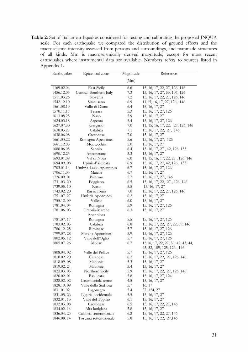
Table 2: Set of Italian earthquakes considered for testing and calibrating the proposed INQUA scale. For each earthquake we compared the distribution of ground effects and the macroseismic intensity assessed from persons and surroundings, and manmade structures of all kinds. Mm is macroseismically derived magnitude, except for most recent earthquakes where instrumental data are available. Numbers refers to sources listed in Appendix 1.
Earthquakes Epicentral zone Magnitude
(Mm)
Reference
1169.02.04 East Sicily 6.6 15, 16, 17, 22, 27, 126, 146 1456.12.05 Central -Southern Italy 7.3 15, 16, 17, 27, 53, 107, 126 1511.03.26 Slovenia 7.2 15, 16, 17, 22, 27, 126, 146 1542.12.10 Siracusano 6.9 11,15, 16, 17, 27, 126, 146 1561.08.19 Vallo di Diano 6.4 15, 16, 17, 27 1570.11.17 Ferrara 5.3 15, 16, 17, 27, 126 1613.08.25 Naso 5.9 15, 16, 17, 27 1624.03.18 Argenta 5.4 15, 16, 17, 27, 126 1627.07.30 Gargano 7.0 11, 15, 16, 17, 22, 27, 126, 146 1638.03.27 Calabria 7.1 15, 16, 17, 22, 27, 146 1638.06.08 Crotonese 7.0 15, 16, 17, 27 1661.03.22 Romagna Apennines 5.6 15, 16, 17, 27, 126 1661.12.03 Montecchio 5.0 15, 16, 17, 27 1688.06.05 Sannio 6.4 15, 16, 17, 27 , 42, 126, 133 1690.12.23 Anconetano 5.3 15, 16, 17, 27 1693.01.09 Val di Noto 6.0 11, 15, 16, 17, 22, 27 , 126, 146 1694.09. 08 Irpinia-Basilicata 6.9 15, 16, 17, 27, 42, 126, 133 1703.01.14 Umbria-Lazio Apennines 6.7 15, 16, 17, 27, 126 1706.11.03 Maiella 6.7 15, 16, 17, 27 1726.09. 01 Palermo 5.7 15, 16, 17, 27 , 146 1731.03. 20 Foggiano 6.5 15, 16, 17, 22, 27 , 126, 146 1739.05. 10 Naso 5.5 15, 16, 17, 27 1743.02. 20 Basso Ionio 7.0 15, 16, 17, 22, 27, 126, 146 1751.07. 27 Umbria Apennines 6.2 15, 16, 17, 27 1755.12. 09 Vallese 6.0 15, 16, 17, 27 1781.04. 04 Romagna 5.9 15, 16, 17, 27, 126 1781.06. 03 Umbria-Marche
Apennines6.3 15, 16, 17, 27
1781.07. 17 Romagna 5.5 15, 16, 17, 27, 126 1783.02. 05 Calabria 6.8 15, 16, 17, 22, 27, 22, 59, 146 1786.12. 25 Riminese 5.7 15, 16, 17, 27, 126 1799.07. 28 Marche Apennines 5.9 15, 16, 17, 27, 126 1802.05. 12 Valle dell’Oglio 5.7 15, 16, 17, 27, 126 1805.07. 26 Molise 6.7 15,16, 17, 22, 27, 39, 42, 43, 44,
45, 52, 109, 125, 126 , 1461808.04. 02 Valle del Pellice 5.7 15, 16, 17, 27, 126 1818.02. 20 Catanese 6.2 15, 16, 17, 22, 27, 126, 146 1818.09. 08 Madonie 5.3 15, 16, 17, 27 1819.02. 24 Madonie 5.4 15, 16, 17, 27 1823.03. 05 Northern Sicily 5.9 15, 16, 17, 22, 27, 126, 146 1826.02. 01 Basilicata 5.8 15, 16, 17, 27, 124 1828.02. 02 Casamicciola terme 4.5 15, 16, 17, 27 1828.10. 09 Valle dello Staffora 5.7 16, 17 1831.01.02 Lagonegro 5.4 27, 124, 27 1831.05. 26 Liguria occidentale 5.5 15, 16, 17, 27 1832.01. 13 Valle del Topino 6.1 15, 16, 17, 27 1832.03. 08 Crotonese 6.5 15, 16, 17, 22, 27, 146 1834.02. 14 Alta lunigiana 5.8 15, 16, 17, 27 1836.04. 25 Calabria settentrionale 6.2 15, 16, 17, 22, 27, 146 1846.08. 14 Toscana settentrionale 5.8 15, 16, 17, 22, 27,146
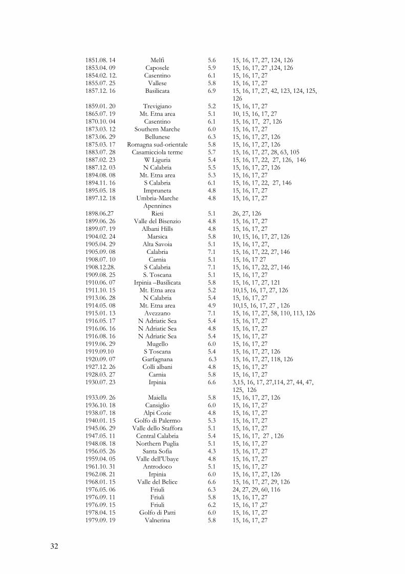
32
1851.08. 14 Melfi 5.6 15, 16, 17, 27, 124, 126 1853.04. 09 Caposele 5.9 15, 16, 17, 27 ,124, 126 1854.02. 12. Casentino 6.1 15, 16, 17, 27 1855.07. 25 Vallese 5.8 15, 16, 17, 27 1857.12. 16 Basilicata 6.9 15, 16, 17, 27, 42, 123, 124, 125,
1261859.01. 20 Trevigiano 5.2 15, 16, 17, 27 1865.07. 19 Mt. Etna area 5.1 10, 15, 16, 17, 27 1870.10. 04 Casentino 6.1 15, 16, 17, 27, 126 1873.03. 12 Southern Marche 6.0 15, 16, 17, 27 1873.06. 29 Bellunese 6.3 15, 16, 17, 27, 126 1875.03. 17 Romagna sud-orientale 5.8 15, 16, 17, 27, 126 1883.07. 28 Casamicciola terme 5.7 15, 16, 17, 27, 28, 63, 105 1887.02. 23 W Liguria 5.4 15, 16, 17, 22, 27, 126, 146 1887.12. 03 N Calabria 5.5 15, 16, 17, 27, 126 1894.08. 08 Mt. Etna area 5.3 15, 16, 17, 27 1894.11. 16 S Calabria 6.1 15, 16, 17, 22, 27, 146 1895.05. 18 Impruneta 4.8 15, 16, 17, 27 1897.12. 18 Umbria-Marche
Apennines4.8 15, 16, 17, 27
1898.06.27 Rieti 5.1 26, 27, 126 1899.06. 26 Valle del Bisenzio 4.8 15, 16, 17, 27 1899.07. 19 Albani Hills 4.8 15, 16, 17, 27 1904.02. 24 Marsica 5.8 10, 15, 16, 17, 27, 126 1905.04. 29 Alta Savoia 5.1 15, 16, 17, 27, 1905.09. 08 Calabria 7.1 15, 16, 17, 22, 27, 146 1908.07. 10 Carnia 5.1 15, 16, 17 27 1908.12.28. S Calabria 7.1 15, 16, 17, 22, 27, 146 1909.08. 25 S. Toscana 5.1 15, 16, 17, 27 1910.06. 07 Irpinia –Basilicata 5.8 15, 16, 17, 27, 121 1911.10. 15 Mt. Etna area 5.2 10,15, 16, 17, 27, 126 1913.06. 28 N Calabria 5.4 15, 16, 17, 27 1914.05. 08 Mt. Etna area 4.9 10,15, 16, 17, 27 , 126 1915.01. 13 Avezzano 7.1 15, 16, 17, 27, 58, 110, 113, 126 1916.05. 17 N Adriatic Sea 5.4 15, 16, 17, 27 1916.06. 16 N Adriatic Sea 4.8 15, 16, 17, 27 1916.08. 16 N Adriatic Sea 5.4 15, 16, 17, 27 1919.06. 29 Mugello 6.0 15, 16, 17, 27 1919.09.10 S Toscana 5.4 15, 16, 17, 27, 126 1920.09. 07 Garfagnana 6.3 15, 16, 17, 27, 118, 126 1927.12. 26 Colli albani 4.8 15, 16, 17, 27 1928.03. 27 Carnia 5.8 15, 16, 17, 27 1930.07. 23 Irpinia 6.6 3,15, 16, 17, 27,114, 27, 44, 47,
125, 126 1933.09. 26 Maiella 5.8 15, 16, 17, 27, 126 1936.10. 18 Cansiglio 6.0 15, 16, 17, 27 1938.07. 18 Alpi Cozie 4.8 15, 16, 17, 27 1940.01. 15 Golfo di Palermo 5.3 15, 16, 17, 27 1945.06. 29 Valle dello Staffora 5.1 15, 16, 17, 27 1947.05. 11 Central Calabria 5.4 15, 16, 17, 27 , 126 1948.08. 18 Northern Puglia 5.1 15, 16, 17, 27 1956.05. 26 Santa Sofia 4.3 15, 16, 17, 27 1959.04. 05 Valle dell’Ubaye 4.8 15, 16, 17, 27 1961.10. 31 Antrodoco 5.1 15, 16, 17, 27 1962.08. 21 Irpinia 6.0 15, 16, 17, 27, 126 1968.01. 15 Valle del Belice 6.6 15, 16, 17, 27, 29, 126 1976.05. 06 Friuli 6.3 24, 27, 29, 60, 116 1976.09. 11 Friuli 5.8 15, 16, 17, 27 1976.09. 15 Friuli 6.2 15, 16, 17 ,27 1978.04. 15 Golfo di Patti 6.0 15, 16, 17, 27 1979.09. 19 Valnerina 5.8 15, 16, 17, 27

33
1980.11. 23 Irpinia-Basilicata 6.9 13, 15, 27 ,41, 42, 45, 46, 48, 108, 125, 126, 127, 128, 129
1982.03. 21 Golfo di Policastro 5.1 15, 16, 17, 27 1983.11. 09 Parmense 4.6 15, 16, 17, 19,27, 27 1984. 05.07 Abruzzi Apennines 5.4 15, 16, 17, 19, 27, 45 1990.12. 13 SE Sicily 5.1 15, 16, 17, 27, 40 1997.09. 20. Umbria-Marche
Apennines6.0 1, 37, 38, 50, 51, 152
1998.09. 09 Lauria 5.6 108 2002.09. 06 Southern Tyrrhenian Sea 5.6 23, 31 2002.10. 31 San Giuliano 5.8 151
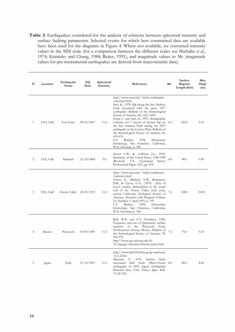
34
Table 3: Earthquakes considered for the analysis of relations between epicentral intensity and surface faulting parameters. Selected events for which best constrained data are available have been used for the diagrams in Figure 4. Where not available, we converted intensity values in the MM scale (for a comparison between the different scales see Shebalin et al.,1974; Krinitsky and Chang, 1988; Reiter, 1991), and magnitude values to Ms (magnitude values for pre-instrumental earthquakes are derived from macroseismic data).
N Location Earthquake
Name
EQ
Date
Epicentral
Intensity References Ms
Surface
Rupture
Length (km)
Max
Displ.
(m)
1 USA, Calif Fort Tejon 09/01/1857 11.0
http://www.msu.edu/~fujita/earthquake/intensity.htmlSieh, K., 1978. Slip along the San Andreas Fault associated with the great 1857 earthquake. Bulletin of the Seismological Society of America, 68, 1421-1428. Grant L. and Sieh, K, 1993. Stratigraphic evidence for 7 meters of dextral slip on the San Andreas Fault during the 1857 earthquake in the Carrizo Plain. Bulletin ofthe Seismological Society of America, 83, 619-635.C.F. Richter, 1958, Elementary Seismology, San Francisco, California, W.H. Freeman, p. 768.
8.3 322.0 9.50
2 USA, Calif Haiward 21/10/1868 9.0
Stover C.W. & Coffman J.L., 1993, Seismicity of the United States, 1568-1989 (Revised), U.S. Geological Survey Professional Paper 1527, pp. 418
6.8 48.0 0.90
3 USA, Calif Owens Valley 26/03/1872 11.0
http://www.msu.edu/~fujita/earthquake/intensity.htmlVittori, E., Michetti, A.M., Slemmons, D.B., & Carver, G.A., (1993) - Style ofrecent surface deformation at the south end of the Owens Valley fault zone, eastern California, Geological Society ofAmerica, Abstracts with Program Volume 25, Number 5, April 1993, p. 159. C.F. Richter, 1958, Elementary Seismology, San Francisco, California, W.H. Freeman, p. 768.
7.6 108.0 10.00
4 Mexico Pitaycachi 03/05/1887 11.5
Bull, W.B. and P.A: Pearthree, 1988. Frequency and size of Quateranry surface ruptures of the Pitaycachi Fault, Northeastern Sonora, Mexico, Bulletin ofthe Seismological Society of America, 78, 956-978.http://www.geo.arizona.edu/K-12/azpepp/education/history/pitay.html
7.4 75.0 5.10
5 Japan Nobi 27/10/1891 11.0
http://www.hp1039.jishin.go.jp/eqchreng/6-2-2.htmMatsuda, T., 1974. Surface faults associated with Nobi (Mino-Owari) earthquake of 1891, Japan. Earthquake Research Inst., Univ. Tokyo, Spec. Bull. 13, 85-126.
8.0 80.0 8.00
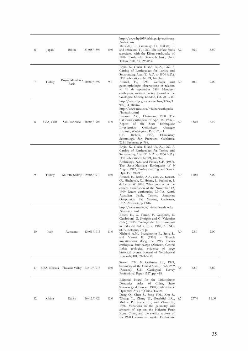
35
6 Japan Rikuu 31/08/1896 10.0
http://www.hp1039.jishin.go.jp/eqchreng/4-2-5.htmMatsuda, T., Yamazaky, H., Nakata, T. and Imaizumi T., 1980. The surface faults associated with the Rikuu earthquake of1896. Earthquake Research Inst., Univ. Tokyo, Bull., 55, 795-855.
7.2 36.0 3.50
7 Turkey Büyük Menderes
Basin20/09/1899 9.0
Ergin, K., Guclu, U and Uz, Z., 1967. A Catalog of Earthquakes for Turkey and Surrounding Area (11 A.D. to 1964 A.D.). ITU publications, No:24, Istanbul. Altunel, E., 1999. Geologic and geomorphologic observations in relation to 20 th september 1899 Menderes earthquake, western Turkey. Journal of the Geological Society, London, 156, 241-246.
7.0 40.0 2.00
8 USA, Calif San Francisco 18/04/1906 11.0
http://neic.usgs.gov/neis/eqlists/USA/1906_04_18.htmlhttp://www.msu.edu/~fujita/earthquake/intensity.htmlLawson, A.C., Chairman, 1908. The California earthquake of April 18, 1906 –Report of the State Earthquake Investigation Committee. Carnegie Institute, Washington, Pub. 87, v.1. C.F. Richter, 1958, Elementary Seismology, San Francisco, California, W.H. Freeman, p. 768.
7.9 432.0 6.10
9 Turkey Mürefte arköy 09/08/1912 10.0
Ergin, K., Guclu, U and Uz, Z., 1967. A Catalog of Earthquakes for Turkey and Surrounding Area (11 A.D. to 1964 A.D.). ITU publications, No:24, Istanbul. Ambraseys, N.N. and Finkel, C.F. (1987). The Saros-Marmara Earthquake of 9 August 1912, Earthquake Eng. and Struct. Dyn. 15: 189-211. Altunel, E., Barka, A.A., akir, Z., Kozaci, Ö., Hitchcock, C., Helms, J., Bachuber, J. & Lettis, W. 2000. What goes on at the eastern termination of the November 12, 1999 Düzce earthquake, M=7.2, North Anatolian Fault, Turkey. American Geophysical Fall Meeting, California, USA, Abstracts, p. F816.
7.0 110.0 5.00
10 Italy Avezzano 13/01/1915 11.0
http://www.msu.edu/~fujita/earthquake/intensity.htmlBoschi E., G. Ferrari, P. Gasperini, E. Guidoboni, G. Smriglio and G. Valensise (Eds.), 1995, Catalogo dei forti terremoti in Italia dal 461 a. C. al 1980, 2. ING-SGA, Bologna, 973 p. Michetti A.M., Brunamonte F., Serva L. and Vittori E. (1996) - Trench investigations along the 1915 Fucino earthquake fault scarps (Abruzzo, Central Italy): geological evidence of large historical events. Journal of Geophysical Research, 101, 5921-5936.
7.0 23.0 2.00
11 USA, Nevada Pleasant Valley 03/10/1915 10.0
Stover C.W. & Coffman J.L., 1993, Seismicity of the United States, 1568-1989 (Revised), U.S. Geological Survey Professional Paper 1527, pp. 418
7.6 62.0 5.80
12 China Kansu 16/12/1920 12.0
Editorial Board for the Lithospheric Dynamics Atlas of China, State Seismological Bureau, 1989, Lithospheric Dynamics Atlas of China. Tav 24.Deng Q., Chen S., Song F.M., Zhu S., Whang Y., Zhang W., Burchfiel B.C., Molnar P., Royden L., and Zhang P., 1986. Variations in the geometry and amount of slip on the Haiyuan Fault Zone, China, and the surface rupture ofthe 1920 Haiyuan earthquake. Earthquake
8.5 237.0 11.00
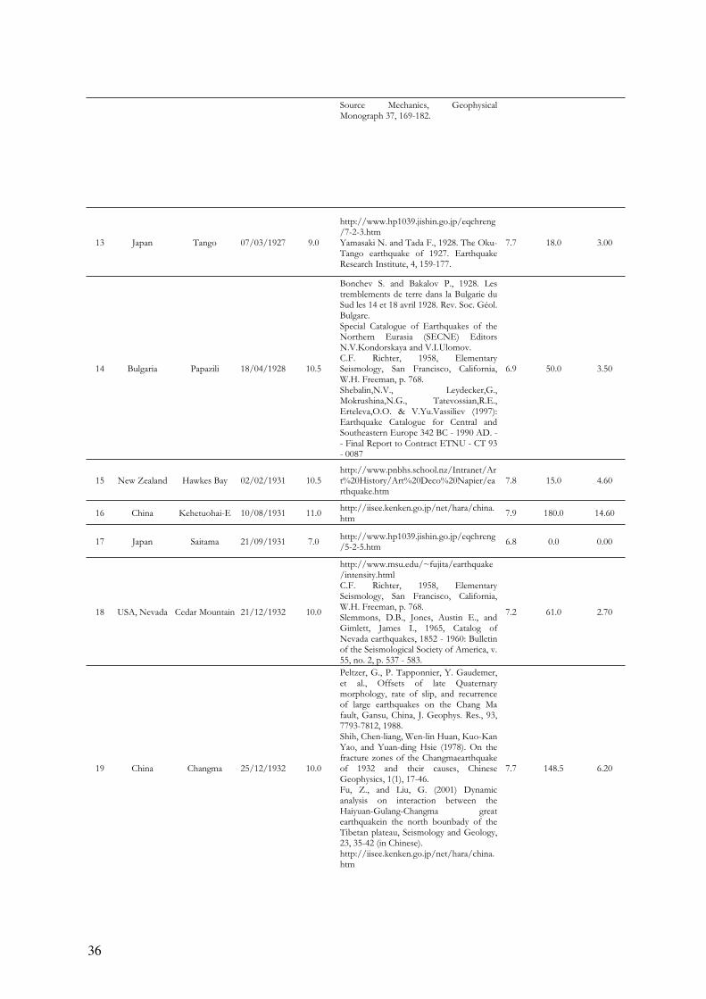
36
Source Mechanics, Geophysical Monograph 37, 169-182.
13 Japan Tango 07/03/1927 9.0
http://www.hp1039.jishin.go.jp/eqchreng/7-2-3.htmYamasaki N. and Tada F., 1928. The Oku-Tango earthquake of 1927. Earthquake Research Institute, 4, 159-177.
7.7 18.0 3.00
14 Bulgaria Papazili 18/04/1928 10.5
Bonchev S. and Bakalov P., 1928. Les tremblements de terre dans la Bulgarie du Sud les 14 et 18 avril 1928. Rev. Soc. Géol. Bulgare.Special Catalogue of Earthquakes of the Northern Eurasia (SECNE) Editors N.V.Kondorskaya and V.I.Ulomov.C.F. Richter, 1958, Elementary Seismology, San Francisco, California, W.H. Freeman, p. 768. Shebalin,N.V., Leydecker,G., Mokrushina,N.G., Tatevossian,R.E., Erteleva,O.O. & V.Yu.Vassiliev (1997):Earthquake Catalogue for Central and Southeastern Europe 342 BC - 1990 AD. -- Final Report to Contract ETNU - CT 93 - 0087
6.9 50.0 3.50
15 New Zealand Hawkes Bay 02/02/1931 10.5 http://www.pnbhs.school.nz/Intranet/Art%20History/Art%20Deco%20Napier/earthquake.htm
7.8 15.0 4.60
16 China Kehetuohai-E 10/08/1931 11.0 http://iisee.kenken.go.jp/net/hara/china.htm
7.9 180.0 14.60
17 Japan Saitama 21/09/1931 7.0 http://www.hp1039.jishin.go.jp/eqchreng/5-2-5.htm
6.8 0.0 0.00
18 USA, Nevada Cedar Mountain 21/12/1932 10.0
http://www.msu.edu/~fujita/earthquake/intensity.htmlC.F. Richter, 1958, Elementary Seismology, San Francisco, California, W.H. Freeman, p. 768. Slemmons, D.B., Jones, Austin E., and Gimlett, James I., 1965, Catalog ofNevada earthquakes, 1852 - 1960: Bulletin of the Seismological Society of America, v. 55, no. 2, p. 537 - 583.
7.2 61.0 2.70
19 China Changma 25/12/1932 10.0
Peltzer, G., P. Tapponnier, Y. Gaudemer, et al., Offsets of late Quaternary morphology, rate of slip, and recurrence of large earthquakes on the Chang Ma fault, Gansu, China, J. Geophys. Res., 93, 7793-7812, 1988.Shih, Chen-liang, Wen-lin Huan, Kuo-Kan Yao, and Yuan-ding Hsie (1978). On the fracture zones of the Changmaearthquake of 1932 and their causes, Chinese Geophysics, 1(1), 17-46. Fu, Z., and Liu, G. (2001) Dynamic analysis on interaction between the Haiyuan-Gulang-Changma great earthquakein the north bounbady of the Tibetan plateau, Seismology and Geology, 23, 35-42 (in Chinese).http://iisee.kenken.go.jp/net/hara/china.htm
7.7 148.5 6.20
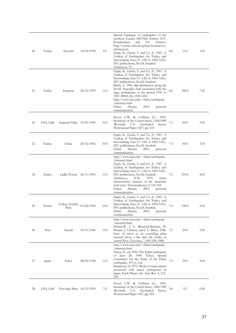
37
20 Turkey Kirsehir 19/04/1938 9.5
Special Catalogue of earthquakes of the northern Eurasia (SECNE) Editors N.V. Kondorskaya and V.I. Ulomov, http://seismo.ethz.ch/gshap/neurasia/nordasiacat.txtErgin, K., Guclu, U and Uz, Z., 1967. A Catalog of Earthquakes for Turkey and Surrounding Area (11 A.D. to 1964 A.D.). ITU publications, No:24, Istanbul. Ambraseys, 70
6.8 15.0 1.00
21 Turkey Erzincan 26/12/1939 11.0
Ergin, K., Guclu, U and Uz, Z., 1967. A Catalog of Earthquakes for Turkey and Surrounding Area (11 A.D. to 1964 A.D.). ITU publications, No:24, Istanbul. Barka, A. 1996. Slip distribution along the North Anatolian fault associated with the large earthquakes of the period 1939 to 1967. BSSA, 86, 1238-1254. http://www.msu.edu/~fujita/earthquake/intensity.htmlErhan Altunel, 2003, personal communication
8.0 360.0 7.50
22 USA, Calif Imperial Valley 19/05/1940 10.0
Stover C.W. & Coffman J.L., 1993, Seismicity of the United States, 1568-1989 (Revised), U.S. Geological Survey Professional Paper 1527, pp. 418
7.2 60.0 5.90
23 Turkey Erbaa 20/12/1942 10.0
Ergin, K., Guclu, U and Uz, Z., 1967. A Catalog of Earthquakes for Turkey and Surrounding Area (11 A.D. to 1964 A.D.). ITU publications, No:24, Istanbul. Erhan Altunel, 2003, personal communication.
7.3 45.0 3.50
24 Turkey Ladik (Tosya) 26/11/1943 11.0
http://www.msu.edu/~fujita/earthquake/intensity.htmlErgin, K., Guclu, U and Uz, Z., 1967. A Catalog of Earthquakes for Turkey and Surrounding Area (11 A.D. to 1964 A.D.). ITU publications, No:24, Istanbul. Ambraseys, N.N., 1970. Some characteristics features of the Anatolian fault zone. Tectonophysics, 9, 143-165. Erhan Altunel, 2003, personal communication
7.5 270.0 4.50
25 Turkey Çerke , Gerede,
Bolu01/02/1944 10.0
Ergin, K., Guclu, U and Uz, Z., 1967. A Catalog of Earthquakes for Turkey and Surrounding Area (11 A.D. to 1964 A.D.). ITU publications, No:24, Istanbul. Erhan Altunel, 2003, personal communication
7.4 100.0 4.50
26 Peru Ancash 10/11/1946 11.0
http://www.msu.edu/~fujita/earthquake/intensity.htmlSebrier,M., J. L. Mercier,J.Machare, D. Bonnet, J. Cabrera, and J. L. Blanc, 1988. State of stress in an overriding plate situated above a flat slab: the Andes ofcentral Peru, Tectonics, 7, 895-928, 1988.
7.3 20.0 3.50
27 Japan Fukui 28/06/1948 11.5
http://www.msu.edu/~fujita/earthquake/intensity.htmlTsuya, H., ed. 1950. The Fukui earthquake of June 28, 1948. Tokyo, Special Committee for the Study of the Fukui earthquake, 197 p., 2 pl.Kanamori, H. 1973. Mode of strain release associated with major earthquakes in Japan. Earth Planet. Sci. Ann. Rev. 1, 213-239.
7.3 25.0 2.00
28 USA, Calif Fort Sage Mtns 14/12/1950 7.0
Stover C.W. & Coffman J.L., 1993, Seismicity of the United States, 1568-1989 (Revised), U.S. Geological Survey Professional Paper 1527, pp. 418
5.6 9.2 0.20
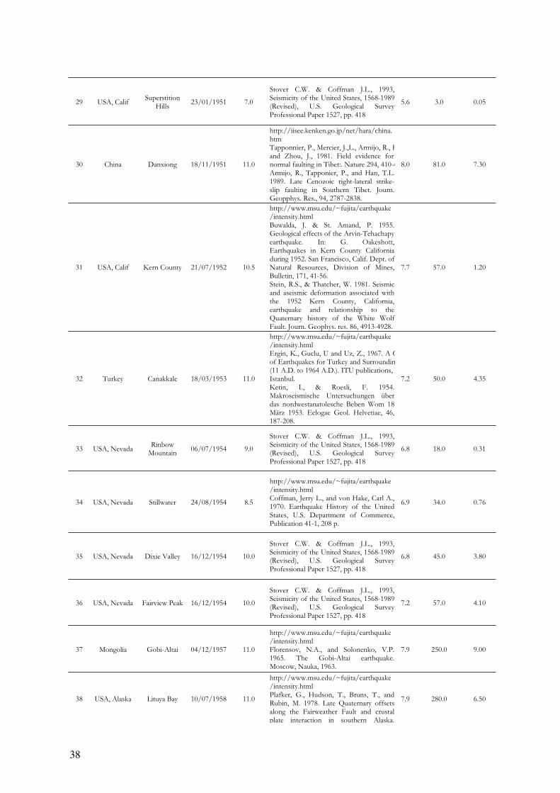
38
29 USA, Calif Superstition
Hills23/01/1951 7.0
Stover C.W. & Coffman J.L., 1993, Seismicity of the United States, 1568-1989 (Revised), U.S. Geological Survey Professional Paper 1527, pp. 418
5.6 3.0 0.05
30 China Danxiong 18/11/1951 11.0
http://iisee.kenken.go.jp/net/hara/china.htmTapponnier, P., Mercier, J.,L., Armijo, R., Hand Zhou, J., 1981. Field evidence for normal faulting in Tibet:. Nature 294, 410-4Armijo, R., Tapponier, P., and Han, T.L. 1989. Late Cenozoic right-lateral strike-slip faulting in Southern Tibet. Journ. Geopphys. Res., 94, 2787-2838.
8.0 81.0 7.30
31 USA, Calif Kern County 21/07/1952 10.5
http://www.msu.edu/~fujita/earthquake/intensity.htmlBuwalda, J. & St. Amand, P. 1955. Geological effects of the Arvin-Tehachapy earthquake. In: G. Oakeshott, Earthquakes in Kern County California during 1952. San Francisco, Calif. Dept. ofNatural Resources, Division of Mines, Bulletin, 171, 41-56. Stein, R.S., & Thatcher, W. 1981. Seismic and aseismic deformation associated with the 1952 Kern County, California, earthquake and relationship to the Quaternary history of the White WolfFault. Journ. Geophys. res. 86, 4913-4928.
7.7 57.0 1.20
32 Turkey Canakkale 18/03/1953 11.0
http://www.msu.edu/~fujita/earthquake/intensity.htmlErgin, K., Guclu, U and Uz, Z., 1967. A Cof Earthquakes for Turkey and Surroundin(11 A.D. to 1964 A.D.). ITU publications, NIstanbul.Ketin, I., & Roesli, F. 1954. Makroseismische Untersuchungen über das nordwestanatolesche Beben Wom 18 März 1953. Eclogae Geol. Helvetiae, 46, 187-208.
7.2 50.0 4.35
33 USA, Nevada Rinbow
Mountain06/07/1954 9.0
Stover C.W. & Coffman J.L., 1993, Seismicity of the United States, 1568-1989 (Revised), U.S. Geological Survey Professional Paper 1527, pp. 418
6.8 18.0 0.31
34 USA, Nevada Stillwater 24/08/1954 8.5
http://www.msu.edu/~fujita/earthquake/intensity.htmlCoffman, Jerry L., and von Hake, Carl A., 1970. Earthquake History of the United States, U.S. Department of Commerce, Publication 41-1, 208 p.
6.9 34.0 0.76
35 USA, Nevada Dixie Valley 16/12/1954 10.0
Stover C.W. & Coffman J.L., 1993, Seismicity of the United States, 1568-1989 (Revised), U.S. Geological Survey Professional Paper 1527, pp. 418
6.8 45.0 3.80
36 USA, Nevada Fairview Peak 16/12/1954 10.0
Stover C.W. & Coffman J.L., 1993, Seismicity of the United States, 1568-1989 (Revised), U.S. Geological Survey Professional Paper 1527, pp. 418
7.2 57.0 4.10
37 Mongolia Gobi-Altai 04/12/1957 11.0
http://www.msu.edu/~fujita/earthquake/intensity.htmlFlorensov, N.A., and Solonenko, V.P. 1965. The Gobi-Altai earthquake. Moscow, Nauka, 1963.
7.9 250.0 9.00
38 USA, Alaska Lituya Bay 10/07/1958 11.0
http://www.msu.edu/~fujita/earthquake/intensity.htmlPlafker, G., Hudson, T., Bruns, T., and Rubin, M. 1978. Late Quaternary offsets along the Fairweather Fault and crustal plate interaction in southern Alaska.
7.9 280.0 6.50
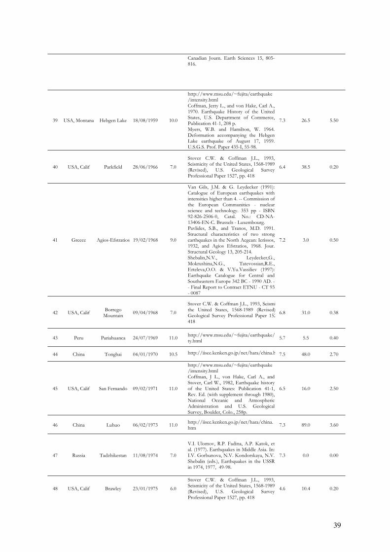
39
Canadian Journ. Earth Sciences 15, 805-816.
39 USA, Montana Hebgen Lake 18/08/1959 10.0
http://www.msu.edu/~fujita/earthquake/intensity.htmlCoffman, Jerry L., and von Hake, Carl A., 1970. Earthquake History of the United States, U.S. Department of Commerce, Publication 41-1, 208 p. Myers, W.B. and Hamilton, W. 1964. Deformation accompanying the Hebgen Lake earthquake of August 17, 1959. U.S.G.S. Prof. Paper 435-I, 55-98.
7.3 26.5 5.50
40 USA, Calif Parkfield 28/06/1966 7.0
Stover C.W. & Coffman J.L., 1993, Seismicity of the United States, 1568-1989 (Revised), U.S. Geological Survey Professional Paper 1527, pp. 418
6.4 38.5 0.20
41 Greece Agios-Efstratios 19/02/1968 9.0
Van Gils, J.M. & G. Leydecker (1991): Catalogue of European earthquakes with intensities higher than 4. -- Commission ofthe European Communities - nuclear science and technology. 353 pp - ISBN 92-826-2506-0, Catal. No.: CD-NA-13406-EN-C. Brussels - Luxembourg. Pavlides, S.B., and Tranos, M.D. 1991. Structural characteristics of two strong earthquakes in the North Aegean: Ierissos, 1932, and Agios Efstratios, 1968. Jour. Structural Geology 13, 205-214. Shebalin,N.V., Leydecker,G., Mokrushina,N.G., Tatevossian,R.E., Erteleva,O.O. & V.Yu.Vassiliev (1997): Earthquake Catalogue for Central and Southeastern Europe 342 BC - 1990 AD. -- Final Report to Contract ETNU - CT 93 - 0087
7.2 3.0 0.50
42 USA, Calif Borrego
Mountain09/04/1968 7.0
Stover C.W. & Coffman J.L., 1993, Seismithe United States, 1568-1989 (Revised)Geological Survey Professional Paper 152418
6.8 31.0 0.38
43 Peru Pariahuanca 24/07/1969 11.0 http://www.msu.edu/~fujita/earthquake/ity.html
5.7 5.5 0.40
44 China Tonghai 04/01/1970 10.5 http://iisee.kenken.go.jp/net/hara/china.h 7.5 48.0 2.70
45 USA, Calif San Fernando 09/02/1971 11.0
http://www.msu.edu/~fujita/earthquake/intensity.htmlCoffman, J L., von Hake, Carl A., and Stover, Carl W., 1982, Earthquake history of the United States: Publication 41-1, Rev. Ed. (with supplement through 1980), National Oceanic and Atmospheric Administration and U.S. Geological Survey, Boulder, Colo., 258p.
6.5 16.0 2.50
46 China Luhuo 06/02/1973 11.0 http://iisee.kenken.go.jp/net/hara/china.htm
7.3 89.0 3.60
47 Russia Tadzhikestan 11/08/1974 7.0
V.I. Ulomov, R.P. Fadina, A.P. Katok, et al. (1977). Earthquakes in Middle Asia. In: I.V. Gorbunova, N.V. Kondorskaya, N.V. Shebalin (eds.), Earthquakes in the USSR in 1974, 1977, 49-98.
7.3 0.0 0.00
48 USA, Calif Brawley 23/01/1975 6.0
Stover C.W. & Coffman J.L., 1993, Seismicity of the United States, 1568-1989 (Revised), U.S. Geological Survey Professional Paper 1527, pp. 418
4.6 10.4 0.20
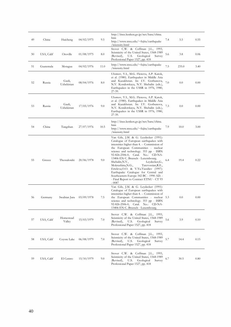
40
49 China Haicheng 04/02/1975 9.5
http://iisee.kenken.go.jp/net/hara/china.htmhttp://www.msu.edu/~fujita/earthquake/intensity.html
7.4 5.5 0.55
50 USA, Calif Oroville 01/08/1975 8.0
Stover C.W. & Coffman J.L., 1993, Seismicity of the United States, 1568-1989 (Revised), U.S. Geological Survey Professional Paper 1527, pp. 418
5.6 3.8 0.06
51 Guatemala Motagua 04/02/1976 11.0 http://www.msu.edu/~fujita/earthquake/intensity.html
7.5 235.0 3.40
52 Russia Gazli,
Uzbekistan08/04/1976 8.0
Ulomov, V.I., M.G. Flenova, A.P. Katok, et al. (1980). Earthquakes in Middle Asia and Kazakhstan. In: I.V. Gorbunova, N.V. Kondorskaya, N.V. Shebalin (eds.), Earthquakes in the USSR in 1976, 1980, 27-39.
7.0 0.0 0.00
53 Russia Gazli,
Uzbekistan17/05/1976 9.0
Ulomov, V.I., M.G. Flenova, A.P. Katok, et al. (1980). Earthquakes in Middle Asia and Kazakhstan. In: I.V. Gorbunova, N.V. Kondorskaya, N.V. Shebalin (eds.), Earthquakes in the USSR in 1976, 1980, 27-39.
7.3 0.0 0.00
54 China Tangshan 27/07/1976 10.5
http://iisee.kenken.go.jp/net/hara/china.htmhttp://www.msu.edu/~fujita/earthquake/intensity.html
7.9 10.0 3.00
55 Greece Thessaloniki 20/06/1978 9.0
Van Gils, J.M. & G. Leydecker (1991): Catalogue of European earthquakes with intensities higher than 4. -- Commission ofthe European Communities - nuclear science and technology. 353 pp - ISBN 92-826-2506-0, Catal. No.: CD-NA-13406-EN-C. Brussels - Luxembourg. Shebalin,N.V., Leydecker,G., Mokrushina,N.G., Tatevossian,R.E., Erteleva,O.O. & V.Yu.Vassiliev (1997): Earthquake Catalogue for Central and Southeastern Europe 342 BC - 1990 AD. -- Final Report to Contract ETNU - CT 93 - 0087
6.4 19.4 0.22
56 Germany Swabian Jura 03/09/1978 7.5
Van Gils, J.M. & G. Leydecker (1991): Catalogue of European earthquakes with intensities higher than 4. -- Commission ofthe European Communities - nuclear science and technology. 353 pp - ISBN 92-826-2506-0, Catal. No.: CD-NA-13406-EN-C. Brussels - Luxembourg.
5.3 0.0 0.00
57 USA, Calif Homestead
Valley15/03/1979 7.0
Stover C.W. & Coffman J.L., 1993, Seismicity of the United States, 1568-1989 (Revised), U.S. Geological Survey Professional Paper 1527, pp. 418
5.6 3.9 0.10
58 USA, Calif Coyote Lake 06/08/1979 7.0
Stover C.W. & Coffman J.L., 1993, Seismicity of the United States, 1568-1989 (Revised), U.S. Geological Survey Professional Paper 1527, pp. 418
5.7 14.4 0.15
59 USA, Calif El Centro 15/10/1979 9.0
Stover C.W. & Coffman J.L., 1993, Seismicity of the United States, 1568-1989 (Revised), U.S. Geological Survey Professional Paper 1527, pp. 418
6.7 30.5 0.80
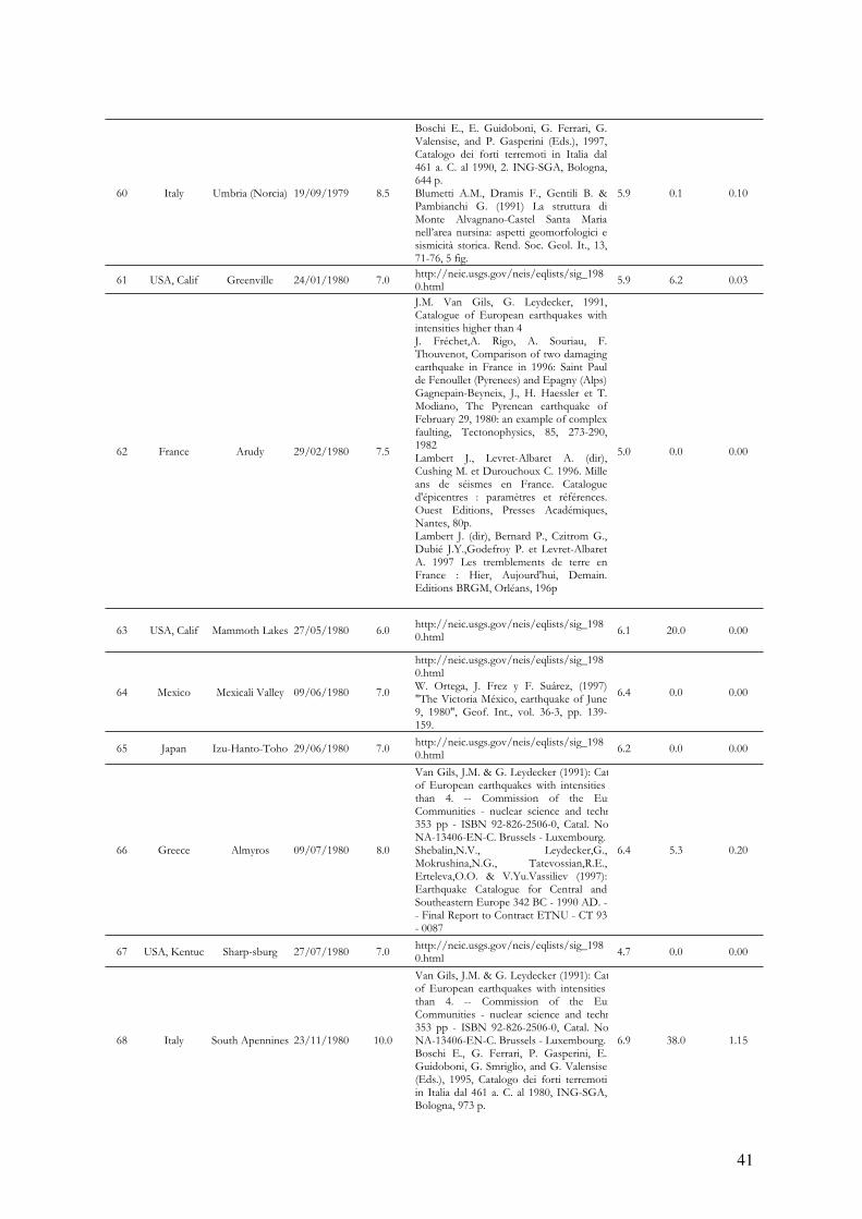
41
60 Italy Umbria (Norcia) 19/09/1979 8.5
Boschi E., E. Guidoboni, G. Ferrari, G. Valensise, and P. Gasperini (Eds.), 1997, Catalogo dei forti terremoti in Italia dal 461 a. C. al 1990, 2. ING-SGA, Bologna, 644 p. Blumetti A.M., Dramis F., Gentili B. & Pambianchi G. (1991) La struttura di Monte Alvagnano-Castel Santa Maria nell’area nursina: aspetti geomorfologici e sismicità storica. Rend. Soc. Geol. It., 13, 71-76, 5 fig.
5.9 0.1 0.10
61 USA, Calif Greenville 24/01/1980 7.0 http://neic.usgs.gov/neis/eqlists/sig_1980.html
5.9 6.2 0.03
62 France Arudy 29/02/1980 7.5
J.M. Van Gils, G. Leydecker, 1991, Catalogue of European earthquakes with intensities higher than 4J. Fréchet,A. Rigo, A. Souriau, F. Thouvenot, Comparison of two damaging earthquake in France in 1996: Saint Paul de Fenoullet (Pyrenees) and Epagny (Alps) Gagnepain-Beyneix, J., H. Haessler et T. Modiano, The Pyrenean earthquake ofFebruary 29, 1980: an example of complex faulting, Tectonophysics, 85, 273-290, 1982Lambert J., Levret-Albaret A. (dir), Cushing M. et Durouchoux C. 1996. Mille ans de séismes en France. Catalogue d'épicentres : paramètres et références. Ouest Editions, Presses Académiques,Nantes, 80p. Lambert J. (dir), Bernard P., Czitrom G., Dubié J.Y.,Godefroy P. et Levret-AlbaretA. 1997 Les tremblements de terre en France : Hier, Aujourd'hui, Demain. Editions BRGM, Orléans, 196p
5.0 0.0 0.00
63 USA, Calif Mammoth Lakes 27/05/1980 6.0 http://neic.usgs.gov/neis/eqlists/sig_1980.html
6.1 20.0 0.00
64 Mexico Mexicali Valley 09/06/1980 7.0
http://neic.usgs.gov/neis/eqlists/sig_1980.htmlW. Ortega, J. Frez y F. Suárez, (1997) "The Victoria México, earthquake of June 9, 1980", Geof. Int., vol. 36-3, pp. 139-159.
6.4 0.0 0.00
65 Japan Izu-Hanto-Toho 29/06/1980 7.0 http://neic.usgs.gov/neis/eqlists/sig_1980.html
6.2 0.0 0.00
66 Greece Almyros 09/07/1980 8.0
Van Gils, J.M. & G. Leydecker (1991): Catof European earthquakes with intensities than 4. -- Commission of the EurCommunities - nuclear science and techn353 pp - ISBN 92-826-2506-0, Catal. NoNA-13406-EN-C. Brussels - Luxembourg. Shebalin,N.V., Leydecker,G., Mokrushina,N.G., Tatevossian,R.E., Erteleva,O.O. & V.Yu.Vassiliev (1997): Earthquake Catalogue for Central and Southeastern Europe 342 BC - 1990 AD. -- Final Report to Contract ETNU - CT 93 - 0087
6.4 5.3 0.20
67 USA, Kentuc Sharp-sburg 27/07/1980 7.0 http://neic.usgs.gov/neis/eqlists/sig_1980.html
4.7 0.0 0.00
68 Italy South Apennines 23/11/1980 10.0
Van Gils, J.M. & G. Leydecker (1991): Catof European earthquakes with intensities than 4. -- Commission of the EurCommunities - nuclear science and techn353 pp - ISBN 92-826-2506-0, Catal. NoNA-13406-EN-C. Brussels - Luxembourg. Boschi E., G. Ferrari, P. Gasperini, E. Guidoboni, G. Smriglio, and G. Valensise (Eds.), 1995, Catalogo dei forti terremoti in Italia dal 461 a. C. al 1980, ING-SGA, Bologna, 973 p.
6.9 38.0 1.15
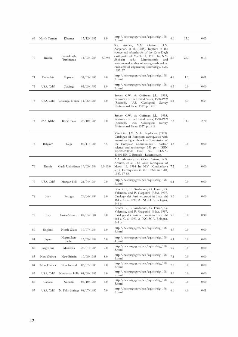
42
69 North Yemen Dhamer 13/12/1982 8.0 http://neic.usgs.gov/neis/eqlists/sig_1982.html
6.0 15.0 0.03
70 Russia Kum-Dagh,Turkmenia
14/03/1983 8.0-9.0
S.S. Arefiev, V.M. Graizer, D.N. Zargarian, et al. (1985). Rupture in the source and aftershocks of the Kum-Daghearthquake of March 14, 1983. In: N.V.Shebalin (ed.) Macroseismic andinstrumental studies of strong earthquakes. Problems of engineering seismology, n.26, 1985, 27
5.7 20.0 0.13
71 Columbia Popayan 31/03/1983 8.0 http://neic.usgs.gov/neis/eqlists/sig_1983.html
4.9 1.3 0.01
72 USA, Calif Coalinga 02/05/1983 8.0 http://neic.usgs.gov/neis/eqlists/sig_1983.html
6.5 0.0 0.00
73 USA, Calif Coalinga, Nunez 11/06/1983 6.0
Stover C.W. & Coffman J.L., 1993, Seismicity of the United States, 1568-1989 (Revised), U.S. Geological Survey Professional Paper 1527, pp. 418
5.4 3.3 0.64
74 USA, Idaho Borah Peak 28/10/1983 9.0
Stover C.W. & Coffman J.L., 1993, Seismicity of the United States, 1568-1989 (Revised), U.S. Geological Survey Professional Paper 1527, pp. 418
7.3 34.0 2.70
75 Belgium Liege 08/11/1983 4.5
Van Gils, J.M. & G. Leydecker (1991): Catalogue of European earthquakes with intensities higher than 4. -- Commission ofthe European Communities - nuclear science and technology. 353 pp - ISBN 92-826-2506-0, Catal. No.: CD-NA-13406-EN-C. Brussels - Luxembourg.
4.3 0.0 0.00
76 Russia Gazli, Uzbekistan 19/03/1984 9.0-10.0
A.A. Abdukadyrov, G.Yu. Azizov, A.G.Aronov, et al. The Gazli earthquake ofMarch 19, 1984 In: N.V. Kondorskaya (ed.), Earthquakes in the USSR in 1984, 1987, 67-85.
7.2 0.0 0.00
77 USA, Calif Morgan Hill 24/04/1984 7.0 http://neic.usgs.gov/neis/eqlists/sig_1984.html
6.1 0.0 0.00
78 Italy Perugia 29/04/1984 8.0
Boschi E., E. Guidoboni, G. Ferrari, G. Valensise, and P. Gasperini (Eds.), 1997, Catalogo dei forti terremoti in Italia dal 461 a. C. al 1990, 2. ING-SGA, Bologna, 644 p.
5.3 0.0 0.00
79 Italy Lazio-Abruzzo 07/05/1984 8.0
Boschi E., E. Guidoboni, G. Ferrari, G. Valensise, and P. Gasperini (Eds.), 1997, Catalogo dei forti terremoti in Italia dal 461 a. C. al 1990, 2. ING-SGA, Bologna, 644 p.
5.8 0.0 0.90
80 England North Wales 19/07/1984 6.0 http://neic.usgs.gov/neis/eqlists/sig_1984.html
4.7 0.0 0.00
81 Japan Naganoken-
Seibu13/09/1984 5.0
http://neic.usgs.gov/neis/eqlists/sig_1984.html
6.1 0.0 0.00
82 Argentina Mendoza 26/01/1985 7.0 http://neic.usgs.gov/neis/eqlists/sig_1985.html
5.9 0.0 0.00
83 New Guinea New Britain 10/05/1985 8.0 http://neic.usgs.gov/neis/eqlists/sig_1985.html
7.1 0.0 0.00
84 New Guinea New Ireland 03/07/1985 7.0 http://neic.usgs.gov/neis/eqlists/sig_1985.html
7.2 0.0 0.00
85 USA, Calif Kettleman Hills 04/08/1985 6.0 http://neic.usgs.gov/neis/eqlists/sig_1985.html
5.9 0.0 0.00
86 Canada Nahanni 05/10/1985 6.0 http://neic.usgs.gov/neis/eqlists/sig_1985.html
6.6 0.0 0.00
87 USA, Calif N. Palm Springs 08/07/1986 7.0 http://neic.usgs.gov/neis/eqlists/sig_1986.html
6.0 9.0 0.01
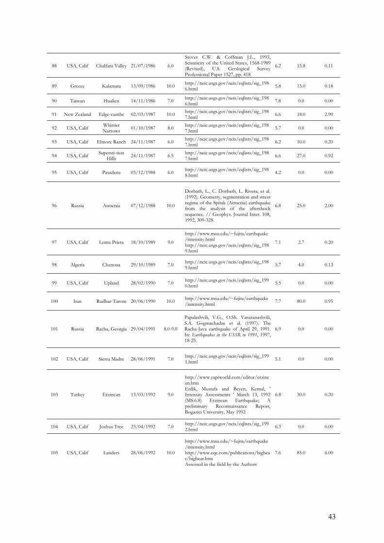
43
88 USA, Calif Chalfant Valley 21/07/1986 6.0
Stover C.W. & Coffman J.L., 1993, Seismicity of the United States, 1568-1989 (Revised), U.S. Geological Survey Professional Paper 1527, pp. 418
6.2 15.8 0.11
89 Greece Kalamata 13/09/1986 10.0 http://neic.usgs.gov/neis/eqlists/sig_1986.html
5.8 15.0 0.18
90 Taiwan Hualien 14/11/1986 7.0 http://neic.usgs.gov/neis/eqlists/sig_1986.html
7.8 0.0 0.00
91 New Zealand Edge-cumbe 02/03/1987 10.0 http://neic.usgs.gov/neis/eqlists/sig_1987.html
6.6 18.0 2.90
92 USA, Calif WhittierNarrows
01/10/1987 8.0 http://neic.usgs.gov/neis/eqlists/sig_1987.html
5.7 0.0 0.00
93 USA, Calif Elmore Ranch 24/11/1987 6.0 http://neic.usgs.gov/neis/eqlists/sig_1987.html
6.2 10.0 0.20
94 USA, Calif Supersti-tion
Hills24/11/1987 6.5
http://neic.usgs.gov/neis/eqlists/sig_1987.html
6.6 27.0 0.92
95 USA, Calif Pasadena 03/12/1988 6.0 http://neic.usgs.gov/neis/eqlists/sig_1988.html
4.2 0.0 0.00
96 Russia Armenia 07/12/1988 10.0
Dorbath, L., C. Dorbath, L. Rivera, et al. (1992). Geometry, segmentation and stress regime of the Spitak (Armenia) earthquake from the analysis of the aftershock sequence. // Geophys. Journal Inter. 108, 1992, 309-328.
6.8 25.0 2.00
97 USA, Calif Loma Prieta 18/10/1989 9.0
http://www.msu.edu/~fujita/earthquake/intensity.htmlhttp://neic.usgs.gov/neis/eqlists/sig_1989.html
7.1 2.7 0.20
98 Algeria Chenoua 29/10/1989 7.0 http://neic.usgs.gov/neis/eqlists/sig_1989.html
5.7 4.0 0.13
99 USA, Calif Upland 28/02/1990 7.0 http://neic.usgs.gov/neis/eqlists/sig_1990.html
5.5 0.0 0.00
100 Iran Rudbar-Tarom 20/06/1990 10.0 http://www.msu.edu/~fujita/earthquake/intensity.html
7.7 80.0 0.95
101 Russia Racha, Georgia 29/04/1991 8.0-9.0
Papalashvili, V.G., O.Sh. Varazanashvili, S.A. Gogmachadze et al. (1997). The Racha-Java earthquake of April 29, 1991. In: Earthquakes in the USSR in 1991, 1997, 18-25.
6.9 0.0 0.00
102 USA, Calif Sierra Madre 28/06/1991 7.0 http://neic.usgs.gov/neis/eqlists/sig_1991.html
5.1 0.0 0.00
103 Turkey Erzincan 13/03/1992 9.0
http://www.yapiworld.com/editor/erzincan.htmErdik, Mustafa and Beyen, Kemal, ' Intensity Assessments ' March 13, 1992 (MS:6.8) Erzincan Earthquake; A preliminary Reconnaissance Report, Bogazici University, May 1992
6.8 30.0 0.20
104 USA, Calif Joshua Tree 23/04/1992 7.0 http://neic.usgs.gov/neis/eqlists/sig_1992.html
6.3 0.0 0.00
105 USA, Calif Landers 28/06/1992 10.0
http://www.msu.edu/~fujita/earthquake/intensity.htmlhttp://www.eqe.com/publications/bigbear/bigbear.htmAssessed in the field by the Authors
7.6 85.0 6.00
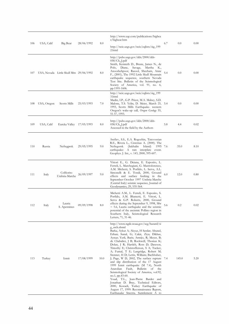
44
106 USA, Calif Big Bear 28/06/1992 8.0
http://www.eqe.com/publications/bigbear/bigbear.htm
http://neic.usgs.gov/neis/eqlists/sig_1992.html
6.7 0.0 0.00
107 USA, Nevada Little Skull Mtn 29/06/1992 8.0
http://pubs.usgs.gov/dds/2000/dds-058/Ch_J.pdfSmith, Kenneth D., Brune, James N., de Polo, Diane, Savage, Martha K., Anooshehpoor, Rasool, Sheeham, Anne F., (2001), The 1992 Little Skull Mountain earthquake sequence, southern Nevada Test Site. Bulletin of the Seismological Society of America, vol. 91, no. 6, pp.1595-1606.
5.4 0.0 0.00
108 USA, Oregon Scotts Mills 25/03/1993 7.0
http://neic.usgs.gov/neis/eqlists/sig_1993.htmlMadin, I.P., G.P. Priest, M.A. Mabey, S.D. Malone, T.S. Yelin, D. Meier, March 25, 1993, Scotts Mills Earthquake- western Oregon's wake-up call, Oregon Geology 55, 51-57, 1993.
5.4 0.0 0.00
109 USA, Calif Eureka Valley 17/05/1993 8.0 http://pubs.usgs.gov/dds/2000/dds-058/Ch_J.pdfAssessed in the field by the Authors
5.8 4.4 0.02
110 Russia Neftegprsk 29/05/1995 9.0
Arefiev, S.S., E.A. Rogozhin, Tatevossian R.E., Rivera L., Cisternas A. (2000). The Neftegorsk (Sakhalin Island) 1995 earthquake: A rare interplate event. Geophys. J. Int., v. 143, 2000, 595-607.
7.6 35.0 8.10
111 Italy Colfiorito
Umbria-Marche26/09/1997 9.0
Vittori E., G. Deiana, E. Esposito, L. Ferreli, L. Marchegiani, G. Mastrolorenzo, A.M. Michetti, S. Porfido, L. Serva, A.L. Simonelli & E. Tondi, 2000, Ground effects and surface faulting in the September-October 1997 Umbria-Marche (Central Italy) seismic sequence, Journal ofGeodynamics, 29, 535-564.
6.0 12.0 0.80
112 Italy Lauria
S. Apennines 09/09/1998 8.0
Michetti A.M., L. Ferreli, E. Esposito, S. Porfido, A.M. Blumetti, E. Vittori, L. Serva & G.P. Roberts, 2000, Ground effects during the September 9, 1998, Mw = 5.6, Lauria earthquake and the seismic potential of the aseismic Pollino region inSouthern Italy, Seismological Research Letters, 71, 31-46.
5.6 0.2 0.02
113 Turkey Izmit 17/08/1999 10.0
http://www.ngdc.noaa.gov/seg/hazard/sig_srch.shtmlBarka, Aykut A; Akyuz, H Serdar; Altunel, Erhan; Sunal, G; Cakir, Ziya; Dikbas, Aynur; Yerli, Baris; Armijo, R; Meyer, B; de Chabalier, J B; Rockwell, Thomas K; Dolan, J R; Hartleb, Ross D; Dawson, Timothy E; Christofferson, S A; Tucker, A; Fumal, T E; Langridge, Robert M; Stenner, H D; Lettis, William; Bachhuber, J; Page, W D, 2002, The surface rupture and slip distribution of the 17 August 1999 Izmit earthquake (M 7.4), North Anatolian Fault, Bulletin of the Seismological Society of America, vol.92, no.1, pp.43-60. Youd, T.L., Jean-Pierre Bardet and Jonathan D. Bray, Technical Editors, 2000, Kocaeli, Turkey Earthquake ofAugust 17, 1999: Reconnaissance Report, Earthquake Spectra, Supplement A to
7.4 145.0 5.20
45
Volume 16, EERI Publication Number 2000-03, Cd.
114 Turkey Düzce 12/11/1999 9.0
http://www.ngdc.noaa.gov/seg/hazard/sig_srch.shtmlHitchcock C., Erhan Altunel, Aykut Barka, Jeffrey Bachhuber, William Lettis, John Helms, Scott Lindvall, 2003. Timing of Late Holocene Earthquakes on the Eastern Düzce Fault and Implications for Slip Transfer between the Southern and Northern Strands of the North Anatolian Fault System, Bolu, Turkey, Turkish J. Earth Sci., 12, (2003), 119-136. Youd, T.L., Jean-Pierre Bardet and Jonathan D. Bray, Technical Editors, 2000, Kocaeli, Turkey Earthquake ofAugust 17, 1999: Reconnaissance Report, Earthquake Spectra, Supplement A to Volume 16, EERI Publication Number 2000-03, Cd.
7.2 40.0 5.00
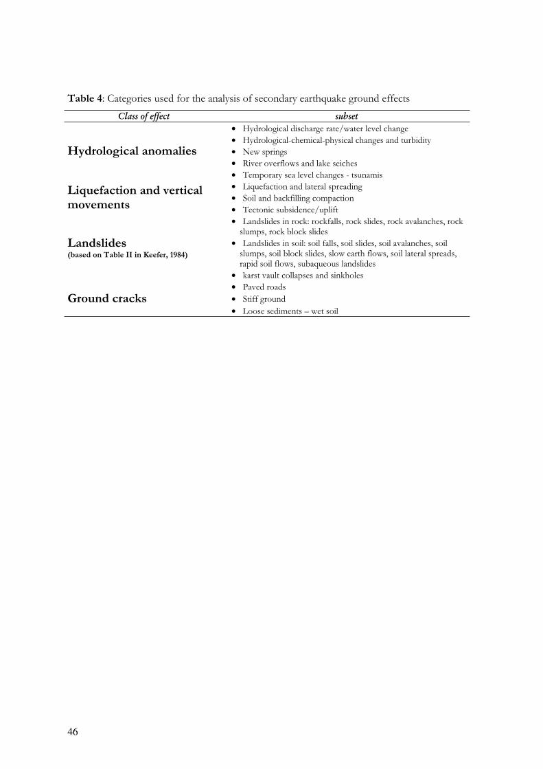
46
Table 4: Categories used for the analysis of secondary earthquake ground effects
Class of effect subset
• Hydrological discharge rate/water level change
• Hydrological-chemical-physical changes and turbidity
• New springs
• River overflows and lake seiches
Hydrological anomalies
• Temporary sea level changes - tsunamis
• Liquefaction and lateral spreading
• Soil and backfilling compaction Liquefaction and vertical
movements • Tectonic subsidence/uplift
• Landslides in rock: rockfalls, rock slides, rock avalanches, rock slumps, rock block slides
• Landslides in soil: soil falls, soil slides, soil avalanches, soil slumps, soil block slides, slow earth flows, soil lateral spreads, rapid soil flows, subaqueous landslides
Landslides(based on Table II in Keefer, 1984)
• karst vault collapses and sinkholes
• Paved roads
• Stiff ground Ground cracks
• Loose sediments – wet soil
47
APPENDIX 1
References for earthquakes listed in Tables 2 and 3
48
1.AA.VV.- Sottoprogetto 5B2 del GNDT – 1997, Effetti di superficie indotti dal sisma del 26/09/1997 e successive repliche (Umbria-
Marche)- Aggiornamento rapporto preliminare al19.10.1997. Atti 16° Conv. Naz. Gruppo Nazionale Geofisica Terra Solida, Roma, pp. 17.
2. ABDUKADYROV, A.A., G.YU. AZIZOV, A.G. ARONOV, et al. (1987). The Gazli earthquake of March 19, 1984 In: N.V. KONDORSKAYA (ed.), Earthquakes in the USSR in 1984, 1987, 67-85.
3. ALFANO G. B., 1931, Il terremoto Irpino del 23 luglio 1930. Osservatorio di Pompei 1931.
4. ALTUNEL, E., 1999. Geologic and geomorphologic observations in relation to 20 th september 1899 Menderes earthquake, western Turkey.Journal of the Geological Society, London, 156, 241-246.
5.ALTUNEL, E., BARKA, A.A., CAKIR, Z., KOZACI, Ö., HITCHCOCK, C., HELMS, J., BACHUBER, J. & LETTIS, W. 2000. What
goes on at the eastern termination of the November 12, 1999 Düzce earthquake, M=7.2, North Anatolian Fault, Turkey. American Geophysical Fall Meeting, California, USA, Abstracts, p. F816.
6. AMBRASEYS, N.N. AND FINKEL, C.F. (1987). The Saros-Marmara Earthquake of 9 August 1912, Earthquake Eng. and Struct. Dyn. 15: 189-211.
7. AREFIEV, S.S., E.A. ROGOZHIN, TATEVOSSIAN R.E., RIVERA L., CISTERNAS A. (2000). The Neftegorsk (Sakhalin Island) 1995
earthquake: A rare interplate event. Geophys. J. Int., v. 143, 2000, 595-607.
8.AREFIEV, S.S., V.M. GRAIZER, D.N. ZARGARIAN, et al. (1985). Rupture in the source and aftershocks of the Kum-Dagh earthquake of
March 14, 1983. In: N.V. SHEBALIN (ed.) Macroseismic and instrumental studies of strong earthquakes. Problems of engineering seismology, n.26, 1985, 27
9. ARMIJO, R., TAPPONIER, P., AND HAN, T.L. 1989. Late Cenozoic right-lateral strike-slip faulting in Southern Tibet. Journ. Geopphys. Res., 94, 2787-2838.
10. AZZARO R., BARBANO M.S., ANTICHI B., RIGANO R., 2001, Macroseismic catalogue of Mt. Etna earthquakes from 1832 to 1998.Acta Vulcanologia, 12 (1-2).
11.BARBANO M. S., RIGANO R., AZZARO R., 2000, Analisi storico-sismologiche sugli eventi sismici principali che hanno interessato le città di
Augusta, Noto e Siracusa. In L. DECANINI E G. F. PANZA “Scenari di pericolosità sismica ad Augusta, Siracusa e Noto”, CNR-GNDT - pp.14-31
12.
BARKA, AYKUT A; AKYUZ, H SERDAR; ALTUNEL, ERHAN; SUNAL, G; CAKIR, ZIYA; DIKBAS, AYNUR; YERLI, BARIS; ARMIJO,R; MEYER, B; DE CHABALIER, J B; ROCKWELL, THOMAS K; DOLAN, J R; HARTLEB, ROSS D; DAWSON, TIMOTHY E;CHRISTOFFERSON, S A; TUCKER, A; FUMAL, T E; LANGRIDGE, ROBERT M; STENNER, H D; LETTIS, WILLIAM; BACHHUBER,J; PAGE, W D, 2002, The surface rupture and slip distribution of the 17 August 1999 Izmit earthquake (M 7.4), North Anatolian Fault,Bulletin of the Seismological Society of America, vol.92, no.1, pp.43-60.
13.BLUMETTI A. M., ESPOSITO E., FERRELI L., MICHETTI A.M., PORFIDO S., SERVA L., VITTORI E., 2002, New data on the
novembre 23, 1980, M 6.9, Irpinia-Lucania earthquake (Southern Apennine) coseismic surface effects. Special Issue Studi Geol.Camerti, Vol. 2002, p.19-27.
14. BLUMETTI A.M., DRAMIS F., GENTILI B. & PAMBIANCHI G., 1991, La struttura di Monte Alvagnano-Castel Santa Maria nell’area
nursina: aspetti geomorfologici e sismicità storica. Rend. Soc. Geol. It., 13, 71-76,
15.BOSCHI E., E. GUIDOBONI, G. FERRARI, D. MARIOTTI, G. VALENSISE, AND P. GASPERINI (Eds.), 2000. Catalogo dei forti
terremoti in Italia dal 461 a.C. al 1997, ING-SGA. Catalogue of strong italian earthquakes from 461B.C. to 1997. Annali di geofisica, 34, n.4 texts and CD-ROM.
16. BOSCHI E., E. GUIDOBONI, G. FERRARI, G. VALENSISE, AND P. GASPERINI (Eds.), 1997, Catalogo dei forti terremoti in Italia dal
461 a. C. al 1990. ING-SGA, Bologna, 644 p.
17. BOSCHI E., FERRARI G., GASPERINI P., E. GUIDOBONI, G. SMRIGLIO, AND G. VALENSISE (Eds.), 1995, Catalogo dei forti
terremoti in Italia dal 461 a. C. al 1980, ING-SGA, Bologna, 973 p.
18. BOSI C., CAMPONESCHI B., GIGLIO G., 1976, Indizi di possibili movimenti lungo le faglie in occasione del terremoto del Friuli del 6
Maggio 1976. Boll. Soc. Geol. It. Pp.803-830
19. BRANNO A., ESPOSITO E.G.I., LUONGO G., MARTURANO A., PORFIDO S., RINALDIS V., 1985, Il terremoto di Parma del 9
novembre 1983 e il terremoto di Alfedena del 7 maggio 1984. CNR, Atti 40 Conv.GNGTS,
20. BULL, W.B. AND P.A: PEARTHREE, 1988. Frequency and size of Quateranry surface ruptures of the Pitaycachi Fault, Northeastern
Sonora, Mexico, Bulletin of the Seismological Society of America, 78, 956-978.
21.BUWALDA, J. & ST. AMAND, P. 1955. Geological effects of the Arvin-Tehachapy earthquake. In: G. OAKESHOTT, Earthquakes in Kern County California during 1952. San Francisco, Calif. Dept. of Natural Resources, Division of Mines, Bulletin, 171, 41-56.
22. CAPUTO M., FAITA G., 1984, Primo catalogo dei maremoti delle coste italiane. Atti Accademia Nazionale dei Lincei, Vol.17.
23. CARACAUSI A., DI LIBERTO V., GRASSA F., 2002, Effetti del sisma del 6.9.2002 sulle sorgenti termali della Sicilia Nord-Occidentale.http://www.ingv.it
24.CAVALLIN A., MARTINIS B., SFONDRINI G., 1977, Effetti geologici del terremoto:fenditure nel terreno e “vulcanelli “di sabbia. In Studio geologico dell’area maggiormente colpita dal terremoto friulano del 1976, ed. B. MARTINIS, pp369-392, Pubb. N.38 Progetto Finalizzato “Geodinamica” CNR
25. COFFMAN, J. L., and VON HAKE, C. A., 1970. Earthquake History of the United States, U.S. Department of Commerce, Publication 41-1, 208 p.
26. COMERCI V., MOLIN D., PASQUARÈ F., SERVA L., 2003, Risposta sismica dell’area urbana di Rieti in occasione del terremoto del 27
giugno 1898 nel bacino di Vazia (RI), Boll. Soc. Geol. It., 122 (2003), 147-156,4 ff.
27. CPTI Gruppo di lavoro 1999. Catalogo Parametrico dei Terremoti Italiani. INGV,GNDT,SGA,SSN, Bologna, pp.92.

49
28. CUBELLIS E., LUONGO G., 1998, Il terremoto del 28 luglio 1883. Danni, vittime ed effetti al suolo. In Il terremoto del 28 luglio 1883 a
Casamicciola nell’isola d’Ischia, Servizio Sismico Nazionale, p. 59-100.
29. DA ROIT R., A., FONTANILE L., SPAT G., PEZZÈ M.,1983 . Comportamento dei terreni non coesivi saturi in alcune zone colpite dai
terremoti del Friuli del 1976 e Campano Lucano del 1980. AGI- XV Conv. Naz. Geotecnica ,pp. 105-114.
30.DENG Q., CHEN S., SONG F.M., ZHU S., WHANG Y., ZHANG W., BURCHFIEL B.C., MOLNAR P., ROYDEN L., AND ZHANG P.,1986. Variations in the geometry and amount of slip on the Haiyuan Fault Zone, China, and the surface rupture of the 1920 Haiyuan
earthquake. Earthquake Source Mechanics, Geophysical Monograph 37, 169-182.
31. DI LIBERTO I.S.,CAMARDA M., DE GREGORIO S., M. LIOTTA, 2002, Misure di flusso di CO2fra v.ne S. Antonio e v.ne Burgitabis
(Cerda, Palermo). http://www.ingv.it
32. DORBATH, L., C. DORBATH, L. RIVERA, et al. (1992). Geometry, segmentation and stress regime of the Spitak (Armenia) earthquake
from the analysis of the aftershock sequence. Geophys. Journal Inter. 108, 1992, 309-328.
33. E. ESPOSITO, I. GUERRA, G. LUONGO, A. MARTURANO, S. PORFIDO, 1988, IL Terremoto dell'8 Gennaio 1988 (Ml=4.1) in
Calabria Settentrionale. Atti 70 Conv. GNGTS, Roma.
34. Editorial Board for the Lithospheric Dynamics Atlas of China, State Seismological Bureau, 1989, Lithospheric Dynamics Atlas
of China. Tav 24.
35. ERDIK, MUSTAFA AND BEYEN, KEMAL, 1992, Intensity Assessments, March 13, 1992 (MS:6.8) Erzincan Earthquake; A preliminary Reconnaissance Report, Bogazici University, May 1992
36. ERGIN, K., GUCLU, U AND UZ, Z., 1967. A Catalog of Earthquakes for Turkey and Surrounding Area (11 A.D. to 1964 A.D.).ITU publications, No:24, Istanbul.
37.ESPOSITO E., MARTINELLI G., PORFIDO S., TRANFAGLIA G., 1999, Una scheda per il rilevamento dei fenomeni idrologici indotti dalla
sequenza sismica umbro-marchigiana del 1997. Atti Conv. “Il rischio idrogeologico e la difesa del suolo”, Acc. Naz. Lincei, 154, Roma, pp. 499-503.
38.ESPOSITO E., FERRELI L., MASTROLORENZO, G.,, MICHETTI A.M., PORFIDO S., SERVA L., SIMONELLI A. L., VITTORI E.,2000, Ground effects in the september-october 1997 Umbria-Marche (Central Italy) seismic sequenze and their signficance for seismic hazard
assessment. 12WCEE 2000, paper n. 2494, pp.7.
39. ESPOSITO E., G. LUONGO, S. PORFIDO, 1991, Il terremoto del 26 luglio 1805 nella diocesi di Caiazzo; Atti- Colloquio sulle Scienze della Terra in onore di Nicola Covelli-Associazione Storica del Caiatino- Arte Tipografica, Napoli, 1991.
40.ESPOSITO E., G. LUONGO, S.M. PETRAZZUOLI, S. PORFIDO,1991, L'area epicentrale del terremoto del 13 Dicembre 1990 (Sicilia
orientale). Università di Napoli Federico. III Conferenza scientifica annuale sulle attività di ricerca del Dipartimenti. De Frede, Napoli.
41. ESPOSITO E., GARGIULO A., IACCARINO G., PORFIDO S., 1997, Analisi dei fenomeni franosi in aree ad elevata sismicità in Appennino
meridionale. Acc. Lincei n. 134. Roma, vol. 134, pp. 65-72
42.ESPOSITO E., GARGIULO A., IACCARINO G., PORFIDO S., 1998, Distribuzione dei fenomeni franosi riattivati dai terremoti
dell’Appennino meridionale. Censimento delle frane del terremoto del 1980. Proc. Int. Conv. Prevention of hydrogeological hazards. CNR-IRPI, Torino,vol. I, pp 409-429.
43. ESPOSITO E., LUONGO G., MARTURANO A., PORFIDO S., 1987, Il terremoto di S.Anna del 26 Luglio1805. Mem. Soc. Geol. It.,37, Roma.
44. ESPOSITO E., PECE R., PORFIDO S., TRANFAGLIA G., 2001, Hydrological anomalies precursory of earthquakes in Southern Apennines
(Italy). Natural Hazards and Earth System Sciences, EGS, 1, p. 137-144.
45. ESPOSITO E., PECE R., PORFIDO S., TRANFAGLIA G., ONORATI G., 1999, Effetti dei terremoti dell’Appennino meridionale sulle acque
superficiali. In: Atti Acc. Naz. Lincei 154, Roma, pp. 91-96
46. ESPOSITO E., PORFIDO S., A.L. SIMONELLI, G. MASTROLORENZO, G. IACCARINO, 2000, Landslides and other surface effects
induced by the 1997 Umbria-Marche seismic sequence. Engineering Geology 58, 353-376.
47. ESPOSITO E., PORFIDO S., IACCARINO G., TRANFAGLIA G., 2000, Terremoti e centri storici dell’Irpinia: gli effetti del terremoto del
1930, Proc. GeoBen 2000, CNR-GNDCI, 2133, 477 - 484
48.ESPOSITO E., PORFIDO S., MASTROLORENZO G., NIKONOV A.A., SERVA L.,1997, Brief rewiew and preliminary proposal for the use
of ground effects in the macroseismic intensity assesment. Proc. 30th International Geological Congress, Beijing, China, vol 5. “Contemporary lithospheric motion seismic geology, the Netherlands, VSP ed., pp. 233-243.
49. ESPOSITO E., PORFIDO S., SIMONELLI A. L., IACCARINO G., MASTROLORENZO G., 1998, Surface effects induced by the 26.09.97
Umbria-Marche earthquakes. EGS, vol. 16, Nizza.
50.ESPOSITO E., PORFIDO S., SIMONELLI A.L., IACCARINO G., MASTROLORENZO G., 1998, Effetti primari e secondari indotti dalla
sequenza sismica del 1997. Conv. Gruppo Nazionale Difesa dai Terremoti, Note relative al terremoto dell’Umbria-Marche del settembre 1997, Roma, pp.11.
51.ESPOSITO E., PORFIDO S., SIMONELLI A.L., IACCARINO G., MASTROLORENZO G., 1998, Primary and secondary ground effects
induced by the 1997 Umbria-Marche seismic sequence. International Workshop -“The resolution of geological analysis and models for earthquake faulting studies”- Camerin
52.ESPOSITO E., PORFIDO S., TRANFAGLIA G., AVINO R., 1998, Effetti idrologici associati con i terremoti dell’Appennino meridionale.Atti 16° Conv. Naz. Gruppo Nazionale Geofisica Terra Solida, Roma. ftp://www-dinma.univ.trieste.it/pub/gngts/1997/sessioni-ordinarie/08/tranfa.DOC.
53. FIGLIUOLO B., 1988, Il terremoto del 1456. Edizioni Studi Storici Meridionali, Voll.2
54. FLORENSOV, N.A., AND SOLONENKO, V.P., 1965. The Gobi-Altai earthquake. Moscow, Nauka, 1963.
55. FRÉCHET J., A. RIGO, A. SOURIAU, F. THOUVENOT, Comparison of two damaging earthquake in France in 1996: Saint Paul de
Fenoullet (Pyrenees) and Epagny (Alps)
56. FU, Z., AND LIU, G., 2001, Dynamic analysis on interaction between the Haiyuan-Gulang-Changma great earthquake in the North
boundary of the Tibetan plateau, Seismology and Geology, 23, 35-42 (in Chinese).
49
28. CUBELLIS E., LUONGO G., 1998, Il terremoto del 28 luglio 1883. Danni, vittime ed effetti al suolo. In Il terremoto del 28 luglio 1883 a
Casamicciola nell’isola d’Ischia, Servizio Sismico Nazionale, p. 59-100.
29. DA ROIT R., A., FONTANILE L., SPAT G., PEZZÈ M.,1983 . Comportamento dei terreni non coesivi saturi in alcune zone colpite dai
terremoti del Friuli del 1976 e Campano Lucano del 1980. AGI- XV Conv. Naz. Geotecnica ,pp. 105-114.
30. DENG Q., CHEN S., SONG F.M., ZHU S., WHANG Y., ZHANG W., BURCHFIEL B.C., MOLNAR P., ROYDEN L., AND ZHANG P., 1986. Variations in the geometry and amount of slip on the Haiyuan Fault Zone, China, and the surface rupture of the 1920 Haiyuan
earthquake. Earthquake Source Mechanics, Geophysical Monograph 37, 169-182.
31. DI LIBERTO I.S.,CAMARDA M., DE GREGORIO S., M. LIOTTA, 2002, Misure di flusso di CO2fra v.ne S. Antonio e v.ne Burgitabis
(Cerda, Palermo). http://www.ingv.it
32. DORBATH, L., C. DORBATH, L. RIVERA, et al. (1992). Geometry, segmentation and stress regime of the Spitak (Armenia) earthquake
from the analysis of the aftershock sequence. Geophys. Journal Inter. 108, 1992, 309-328.
33. E. ESPOSITO, I. GUERRA, G. LUONGO, A. MARTURANO, S. PORFIDO, 1988, IL Terremoto dell'8 Gennaio 1988 (Ml=4.1) in
Calabria Settentrionale. Atti 70 Conv. GNGTS, Roma.
34. Editorial Board for the Lithospheric Dynamics Atlas of China, State Seismological Bureau, 1989, Lithospheric Dynamics Atlas
of China. Tav 24.
35. ERDIK, MUSTAFA AND BEYEN, KEMAL, 1992, Intensity Assessments, March 13, 1992 (MS:6.8) Erzincan Earthquake; A preliminary Reconnaissance Report, Bogazici University, May 1992
36. ERGIN, K., GUCLU, U AND UZ, Z., 1967. A Catalog of Earthquakes for Turkey and Surrounding Area (11 A.D. to 1964 A.D.). ITU publications, No:24, Istanbul.
37. ESPOSITO E., MARTINELLI G., PORFIDO S., TRANFAGLIA G., 1999, Una scheda per il rilevamento dei fenomeni idrologici indotti dalla
sequenza sismica umbro-marchigiana del 1997. Atti Conv. “Il rischio idrogeologico e la difesa del suolo”, Acc. Naz. Lincei, 154, Roma, pp. 499-503.
38. ESPOSITO E., FERRELI L., MASTROLORENZO, G.,, MICHETTI A.M., PORFIDO S., SERVA L., SIMONELLI A. L., VITTORI E., 2000, Ground effects in the september-october 1997 Umbria-Marche (Central Italy) seismic sequenze and their signficance for seismic hazard
assessment. 12WCEE 2000, paper n. 2494, pp.7.
39. ESPOSITO E., G. LUONGO, S. PORFIDO, 1991, Il terremoto del 26 luglio 1805 nella diocesi di Caiazzo; Atti- Colloquio sulle Scienze della Terra in onore di Nicola Covelli-Associazione Storica del Caiatino- Arte Tipografica, Napoli, 1991.
40. ESPOSITO E., G. LUONGO, S.M. PETRAZZUOLI, S. PORFIDO,1991, L'area epicentrale del terremoto del 13 Dicembre 1990 (Sicilia
orientale). Università di Napoli Federico. III Conferenza scientifica annuale sulle attività di ricerca del Dipartimenti. De Frede, Napoli.
41. ESPOSITO E., GARGIULO A., IACCARINO G., PORFIDO S., 1997, Analisi dei fenomeni franosi in aree ad elevata sismicità in Appennino
meridionale. Acc. Lincei n. 134. Roma, vol. 134, pp. 65-72
42. ESPOSITO E., GARGIULO A., IACCARINO G., PORFIDO S., 1998, Distribuzione dei fenomeni franosi riattivati dai terremoti
dell’Appennino meridionale. Censimento delle frane del terremoto del 1980. Proc. Int. Conv. Prevention of hydrogeological hazards. CNR-IRPI, Torino,vol. I, pp 409-429.
43. ESPOSITO E., LUONGO G., MARTURANO A., PORFIDO S., 1987, Il terremoto di S.Anna del 26 Luglio1805. Mem. Soc. Geol. It.,37, Roma.
44. ESPOSITO E., PECE R., PORFIDO S., TRANFAGLIA G., 2001, Hydrological anomalies precursory of earthquakes in Southern Apennines
(Italy). Natural Hazards and Earth System Sciences, EGS, 1, p. 137-144.
45. ESPOSITO E., PECE R., PORFIDO S., TRANFAGLIA G., ONORATI G., 1999, Effetti dei terremoti dell’Appennino meridionale sulle acque
superficiali. In: Atti Acc. Naz. Lincei 154, Roma, pp. 91-96
46. ESPOSITO E., PORFIDO S., A.L. SIMONELLI, G. MASTROLORENZO, G. IACCARINO, 2000, Landslides and other surface effects
induced by the 1997 Umbria-Marche seismic sequence. Engineering Geology 58, 353-376.
47. ESPOSITO E., PORFIDO S., IACCARINO G., TRANFAGLIA G., 2000, Terremoti e centri storici dell’Irpinia: gli effetti del terremoto del
1930, Proc. GeoBen 2000, CNR-GNDCI, 2133, 477 - 484
48. ESPOSITO E., PORFIDO S., MASTROLORENZO G., NIKONOV A.A., SERVA L.,1997, Brief rewiew and preliminary proposal for the use
of ground effects in the macroseismic intensity assesment. Proc. 30th International Geological Congress, Beijing, China, vol 5. “Contemporary lithospheric motion seismic geology, the Netherlands, VSP ed., pp. 233-243.
49. ESPOSITO E., PORFIDO S., SIMONELLI A. L., IACCARINO G., MASTROLORENZO G., 1998, Surface effects induced by the 26.09.97
Umbria-Marche earthquakes. EGS, vol. 16, Nizza.
50. ESPOSITO E., PORFIDO S., SIMONELLI A.L., IACCARINO G., MASTROLORENZO G., 1998, Effetti primari e secondari indotti dalla
sequenza sismica del 1997. Conv. Gruppo Nazionale Difesa dai Terremoti, Note relative al terremoto dell’Umbria-Marche del settembre 1997, Roma, pp.11.
51. ESPOSITO E., PORFIDO S., SIMONELLI A.L., IACCARINO G., MASTROLORENZO G., 1998, Primary and secondary ground effects
induced by the 1997 Umbria-Marche seismic sequence. International Workshop -“The resolution of geological analysis and models for earthquake faulting studies”- Camerin
52. ESPOSITO E., PORFIDO S., TRANFAGLIA G., AVINO R., 1998, Effetti idrologici associati con i terremoti dell’Appennino meridionale. Atti 16° Conv. Naz. Gruppo Nazionale Geofisica Terra Solida, Roma. ftp://www-dinma.univ.trieste.it/pub/gngts/1997/sessioni-ordinarie/08/tranfa.DOC.
53. FIGLIUOLO B., 1988, Il terremoto del 1456. Edizioni Studi Storici Meridionali, Voll.2
54. FLORENSOV, N.A., AND SOLONENKO, V.P., 1965. The Gobi-Altai earthquake. Moscow, Nauka, 1963.
55. FRÉCHET J., A. RIGO, A. SOURIAU, F. THOUVENOT, Comparison of two damaging earthquake in France in 1996: Saint Paul de
Fenoullet (Pyrenees) and Epagny (Alps)
56. FU, Z., AND LIU, G., 2001, Dynamic analysis on interaction between the Haiyuan-Gulang-Changma great earthquake in the North
boundary of the Tibetan plateau, Seismology and Geology, 23, 35-42 (in Chinese).
50
57. GAGNEPAIN-BEYNEIX, J., H. HAESSLER AND T. MODIANO, 1982, The Pyrenean earthquake of February 29, 1980: an example of
complex faulting, Tectonophysics, 85, 273-290.
58. GALADINI F., GALLI P., GIRAUDI C., 1999, Gli effetti geologici del terremoto del 1915. In “ 13 gennaio 1915 Il terremoto nella Marsica. Agenzia di protezione Civile-SSN, pp 283-299
59. GALLI P., 2000, New empirical relationships between magnitude and distance for liquefaction. Tectonophysics 324, pp 113-134.
60. GOVI M., 1977, Phto-interpretation and mapping of the landslides triggered by the Friuli earthquake (1976), Bull. Int. Ass. Eng. Geology , N. 15, pp.67-72.
61. GOVI M., SORIANA P. F., 1977, Effetti geologici del terremoto: frane. In “Studio geologico dell’area maggiormente colpita dal terremoto friulano del 1976”, ed. B. Martinis, pp329-367, Pubb. N.38 Progetto finalizzato “Geodinamica” CNR
62. GRANT L. AND SIEH, K, 1993. Stratigraphic evidence for 7 meters of dextral slip on the San Andreas Fault during the 1857 earthquake in
the Carrizo Plain. Bulletin of the Seismological Society of America, 83, 619-635. 63. GUADAGNO, F.M. AND MELE, R., 1995. La fragile isola d'Ischia. Geologia Applicata e Idrogeologia, XXX: 177-187.
64. HITCHCOCK C., ERHAN ALTUNEL, AYKUT BARKA, JEFFREY BACHHUBER, WILLIAM LETTIS, JOHN HELMS, SCOTT LINDVALL, 2003. Timing of Late Holocene Earthquakes on the Eastern Düzce Fault and Implications for Slip Transfer between the Southern and
Northern Strands of the North Anatolian Fault System, Bolu, Turkey, Turkish J. Earth Sci., 12, (2003), 119-136. 65. http://iisee.kenken.go.jp/net/hara/china.htm
66. http://neic.usgs.gov/neis/eqlists/sig_1980.html
67. http://neic.usgs.gov/neis/eqlists/sig_1981.html
68. http://neic.usgs.gov/neis/eqlists/sig_1982.html
69. http://neic.usgs.gov/neis/eqlists/sig_1983.html
70. http://neic.usgs.gov/neis/eqlists/sig_1984.html
71. http://neic.usgs.gov/neis/eqlists/sig_1985.html
72. http://neic.usgs.gov/neis/eqlists/sig_1986.html
73. http://neic.usgs.gov/neis/eqlists/sig_1987.html
74. http://neic.usgs.gov/neis/eqlists/sig_1988.html
75. http://neic.usgs.gov/neis/eqlists/sig_1989.html
76. http://neic.usgs.gov/neis/eqlists/sig_1989.html
77. http://neic.usgs.gov/neis/eqlists/sig_1990.html
78. http://neic.usgs.gov/neis/eqlists/sig_1991.html
79. http://neic.usgs.gov/neis/eqlists/sig_1992.html
80. http://neic.usgs.gov/neis/eqlists/USA/1906_04_18.html
81. http://pubs.usgs.gov/dds/2000/dds-058/Ch_J.pdf
82. http://www.eqe.com/publications/bigbear/bigbear.htm
83. http://www.geo.arizona.edu/K-12/azpepp/education/history/pitay.html
84. http://www.hp1039.jishin.go.jp/eqchreng/4-2-5.htm
85. http://www.hp1039.jishin.go.jp/eqchreng/5-2-5.htm
86. http://www.hp1039.jishin.go.jp/eqchreng/6-2-2.htm
87. http://www.hp1039.jishin.go.jp/eqchreng/7-2-3.htm
88. http://www.johnmartin.com/earthquakes/eqshow/647011_00.htm
89. http://www.msu.edu/~fujita/earthquake/intensity.html
90. http://www.ngdc.noaa.gov/seg/hazard/sig_srch.shtml
91. http://www.pnbhs.school.nz/Intranet/Art%20History/Art%20Deco%20Napier/earthquake.htm
92. http://www.yapiworld.com/editor/erzincan.htm
93. ISK: Earthquake catalog of Kandilli Observatory, Bogazici University, Istanbul, supplied by NOAA/NGDC (MEYERS AND
VON HAKE), Boulder CO, 1985. 94. Itinerarionelmillenovecento76, viaggio nella storia sismica del Friuli, Cd, OGS, 2000
95. KANAMORI, H. 1973. Mode of strain release associated with major earthquakes in Japan. Earth Planet. Sci. Ann. Rev. 1, 213-239.
96. KETIN, I., & ROESLI, F. 1954. Makroseismische Untersuchungen über das nordwestanatolesche Beben Wom 18 März 1953. Eclogae Geol. Helvetiae, 46, 187-208.
51
97. KONDORSKAYA, N.V., AND V.I.ULOMOV, Editors, Special Catalogue of Earthquakes of the Northern Eurasia (SECNE), http://seismo.ethz.ch/gshap/neurasia/nordasiacat.txt
98. LAMBERT J., LEVRET-ALBARET A. (dir), Cushing M. et Durouchoux C., 1996. Mille ans de séismes en France. Catalogue d'épicentres : paramètres et références. Ouest Editions, Presses Académiques, Nantes, 80p.
99. LAMBERT J. (DIR), BERNARD P., CZITROM G., DUBIE J.Y.,GODEFROY P. ET LEVRET-ALBARET A. 1997 Les tremblements de terre
en France : Hier, Aujourd'hui, Demain. Editions BRGM, Orléans, 196p
100. LAWSON, A.C., CHAIRMAN, 1908. The California earthquake of April 18, 1906 – Report of the State Earthquake Investigation Committee. Carnegie Institute, Washington, Pub. 87, v.1.
101. LIENKAEMPER, J.J., PEZZOPANE, S.K., CLARK, M. M., AND RYMER, M.J., 1987, Fault fractures formed in association with the 1986
Chalfant valley, California, earthquake sequence: Preliminary report, Bulletin of the Seismological Society of America, v. 77, no. 1, p. 297-305.
102. MADIN, I.P., G.P. PRIEST, M.A. MABEY, S.D. MALONE, T.S. YELIN, D. MEIER, MARCH 25, 1993, Scotts Mills Earthquake-
western Oregon's wake-up call, Oregon Geology 55, 51-57, 1993.
103. MATSUDA, T., 1974. Surface faults associated with Nobi (Mino-Owari) earthquake of 1891, Japan. Earthquake Research Inst., Univ. Tokyo, Spec. Bull. 13, 85-126.
104. MATSUDA, T., YAMAZAKY, H., NAKATA, T. AND IMAIZUMI T., 1980. The surface faults associated with the Rikuu earthquake of
1896. Earthquake Research Inst., Univ. Tokyo, Bull., 55, 795-855.
105. MELE, R AND GUADAGNO F. M. 1992. Earthquake-induced landslides in the island of Ischia ( Southern Italy). Proceedings of 6th Int. Symposium on the Landslides . New Zealand. Balkema ed.
106. MELE, R. & DEL PRETE S. 1998. Fenomeni di instabilità dei versanti in Tufo Verde Del Monte Epomeo (Isola d'Ischia-Campania). Boll. Soc. Geol. It., 117: 93-112.
107. MELETTI C., PATACCA E., SCANDONE P., FIGLIUOLO B., 1988, Il terremoto del 1456 e la sua interpretazione nel quadro sismotettonico
dell’Appennino meridionale. In FIGLIUOLO B.“Il terremoto del 1456”. Vol 1, pp 71-108, Edizioni Studi Storici Meridionali
108.
MICHETTI A.M., BLUMETTI A.M., ESPOSITO E., FERRELI L., GUERRIERI L., PORFIDO S., SERVA L., VITTORI E., 2000, Earthquake Ground Effects and Seismic Hazard Assessment in Italy examples from the Matese and Irpinia areas, Southern Apennines, In Active Fault Research for the New Millennium, Proceedings of the Hokudan Symposium and School on Active Faulting, 279-284.
109. MICHETTI A.M., BRUNAMONTE F., SERVA L. AND VITTORI E., 1996, Trench investigations along the 1915 Fucino earthquake fault
scarps (Abruzzo, Central Italy): geological evidence of large historical events. Journal of Geophysical Research, 101, 5921-5936.
110. MICHETTI A.M., L. FERRELI, E. ESPOSITO, S. PORFIDO, A.M. BLUMETTI, E. VITTORI, L. SERVA & G.P. ROBERTS, 2000, Ground effects during the September 9, 1998, Mw = 5.6, Lauria earthquake and the seismic potential of the aseismic Pollino region in
Southern Italy, Seismological Research Letters, 71, 31-46.
111. MYERS, W.B. AND HAMILTON, W. 1964. Deformation accompanying the Hebgen Lake earthquake of August 17, 1959. U.S.G.S. Prof. Paper 435-I, 55-98.
112. ODDONE E., 1915, Gli elementi fisici del grande terremoto Morsicano-Fucense del 13 gennaio 1915. BSSI, Vol. 19 p. 71-217.
113. ODDONE E., 1932, Studio sul terremoto avvenuto il 23 luglio 1930 nell’Irpinia. Relazione a S. E. il Ministro dell’Agricoltura e Foreste. La Meteorologia pratica, Vol.13.
114. ORTEGA, W., J. FREZ Y F. SUÁREZ, 1997,The Victoria México, earthquake of June 9, 1980, Geof. Int., vol. 36-3, pp. 139-159.
115. PANIZZA M., 1976, Geologia dei depositi superficiali: settore intravallivo. In “Studio geologico dell’area maggiormente colpita dal terremoto friulano del 1976”, ed. B. Martinis, pp363-280, Pubb. N.38 Progetto finalizzato “Geodinamica” CNR
116. PAPALASHVILI, V.G., O.SH. VARAZANASHVILI, S.A. GOGMACHADZE et al.,1997. The Racha-Java earthquake of April 29, 1991. In: Earthquakes in the USSR in 1991, 1997, 18-25.
117. PATACCA E., SCANDONE P., PETRINI V., FRANCHI F., SARGENTINI M., VITALI A., 1986, Terremoto della Garfagnana del
7.9.1920. Revisione storica. In Progetto terremoto in Garfagnana-Lunigiana, CNR-GNDT Regione Toscana.
118. PAVLIDES, S.B., AND TRANOS, M.D. 1991. Structural characteristics of two strong earthquakes in the North Aegean: Ierissos, 1932, and
Agios Efstratios, 1968. Jour. Structural Geology 13, 205-214.
119. PELTZER, G., P. TAPPONNIER, Y. GAUDEMER, et al., 1988, Offsets of late Quaternary morphology, rate of slip, and recurrence of large
earthquakes on the Chang Ma fault, Gansu, China, J. Geophys. Res., 93, 7793-7812
120. PETRINI V., ESPOSITO E., LUONGO G., MARTURANO A., PORFIDO S., 1986, Il terremoto del Potentino del 23 Luglio 1986. Campi
macrosismici della stessa area a confronto. Atti 5° Conv. GNGTS, Roma.
121. PLAFKER, G., HUDSON, T., BRUNS, T., AND RUBIN, M. 1978. Late Quaternary offsets along the Fairweather Fault and crustal plate
interaction in southern Alaska. Canadian Journ. Earth Sciences 15, 805-816.
122. PORFIDO S., ESPOSITO E. ., LUONGO G., MATURANO A., 1991, Terremoti ed effetti superficiali: esempi nell’Appennino meridionale. Atti conv. “ Studio Centri Abitati Instabili” CNR-Regione Marche, pp. 225-229
123. PORFIDO S., ESPOSITO E., LUONGO G., MATURANO A., 1988, I terremoti del XIX secolo dell'Appennino Campano-Lucano. Mem. Soc. Geol. It., 41.
124. PORFIDO S., ESPOSITO E., MICHETTI A. M., BLUMETTI A.M., VITTORI E., TRANFAGLIA G., GUERRIERI L., FERRELI L., SERVA L., 2002, The geological evidence for earthquakes induced effects in the Southern Apennines (Italy). Surveys in Geophysics, 23, p. 529-562.
125. POSTPISCHL D. ( Editor) 1985, Atlas of isoseismai maps of italian earthquakes. CNR-PFO N. 114 V.2b, BO.
126. POSTPISCHL D. ( Editor) 1985, Catalogo dei terremoti italiani dall'anno 1000 al 1980. CNR-PFO N. 114 V.2b, BO.
127. POSTPISCHL D. , BRANNO A., ESPOSITO E.G.I., FERRARI G., MARTURANO A., PORFIDO S., RINALDIS V., STUCCHI M., 1985, The Irpinia earthquake of November 23, 1980. In Atlas of isoseismai maps of italian earthquakes. CNR-PFO N. 114 V.2.
52
128. POSTPISCHL D., BRANNO A., ESPOSITO E.G.I., FERRARI G., MARTURANO A., PORFIDO S., RINALDIS V., STUCCHI M., 1982, Southern Italy November 23, 1980 earthquake. Macroseismic survey. Athens.
129. RICHTER, C.F., 1958, Elementary Seismology, San Francisco, California, W.H. FREEMAN, p. 768.
130. SEBRIER,M., J. L. MERCIER,J.MACHARE, D. BONNET, J. CABRERA, AND J. L. BLANC, 1988. State of stress in an overriding plate
situated above a flat slab: the Andes of central Peru, Tectonics, 7, 895-928, 1988.
131. SERVA L., 1981a. Il terremoto del 1694 in Irpinia e Basilicata. Volume speciale della Commissione ENEA-ENEL: Contributo alla caratterizzazione della sismicità del territorio Italiano, CNR, Convegno annuale Geodinamica, Udine, 1981, 183-208.
132. SERVA L., 1981b. Il terremoto del 1688 nel Sannio. Volume speciale della Commissione ENEA-ENEL:Contributo alla caratterizzazione della sismicità del territorio Italiano, CNR, Convegno annuale P. F. Geodinamica, Udine, 1981, 209-249.
133. SERVA L., BLUMETTI A.M., MICHETTI A.M., 1988, Gli effetti sul terreno del terremoto del Fucino (13 gennaio 1915):tentativo di
interpretazione della evoluzione tettonica recente di alcune strutture. Mem. Soc. Geol. It., 35: pp 839-907.
134. SHEBALIN, N.V., LEYDECKER,G., MOKRUSHINA,N.G., TATEVOSSIAN,R.E., ERTELEVA, O.O. & V.YU.VASSILIEV, 1997, Earthquake Catalogue for Central and Southeastern Europe 342 BC - 1990 AD. Final Report to Contract ETNU - CT 93 - 0087
135. SHIH, CHEN-LIANG, WEN-LIN HUAN, KUO-KAN YAO, AND YUAN-DING HSIE, 1978, On the fracture zones of the Changma
earthquake of 1932 and their causes, Chinese Geophysics, 1(1), 17-46.
136. SIEH, K., 1978. Slip along the San Andreas Fault associated with the great 1857 earthquake. Bulletin of the Seismological Society of America, 68, 1421-1428.
137. SIRO, L., 1976. Liquefaction of sands in Friuli during May 6 and September 15, 1976 earthquakes. Boll. Geofis. Teorica e applicata, Vol. 19, pp. 909-932.
138. SLEMMONS, D.B., JONES, AUSTIN E., AND GIMLETT, JAMES I., 1965, Catalog of Nevada earthquakes, 1852 – 1960. Bulletin of the Seismological Society of America, v. 55, no. 2, p. 537 - 583.
139. SMITH, KENNETH D., BRUNE, JAMES N., DE POLO, DIANE, SAVAGE, MARTHA K., ANOOSHEHPOOR, RASOOL, SHEEHAM, ANNE F., (2001), The 1992 Little Skull Mountain earthquake sequence, southern Nevada Test Site. Bulletin of the Seismological Society of America, vol. 91, no. 6, pp.1595-1606.
140. STEIN, R.S., & THATCHER, W. 1981. Seismic and aseismic deformation associated with the 1952 Kern County, California, earthquake and
relationship to the Quaternary history of the White Wolf Fault. Journ. Geophys. res. 86, 4913-4928.
141. STOVER, C. W., and J. L. COFFMAN, 1993, Seismicity of the United States, 1568-1989 (Revised), U.S. Geological Survey Professional Paper 1527, United States Government Printing Office, Washington, D.C.
142. TAPPONNIER, P., MERCIER, J.,L., ARMIJO, R., HAN T., AND ZHOU, J., 1981. Field evidence for active normal faulting in Tibet. Nature 294, 410-414.
143. TCHALENKO,J.S., AND BERBERIAN, M., 1974, The Salmas (Iran) earthquake of May 6th, 1930, Annali Geofis., 27, 151-212.
144. SMITH, K.D., BRUNE, J.N., DE POLO D., SAVAGE, M.K., ANOOSHEHPOOR, R., SHEEHAM, ANNE F., (2001), The Little Skull
Mountain, Nevada, earthquake of 29 June 1992. Aftershock focal mechanisms and tectonic stress field implications. Bulletin of the Seismological Society of America, v. 84, p. 1484-1505.
145. TINTI S. AND MARAMAI A., 1996. Catalogue of tsunamis generated in Italy and in Cote d’Azur, France: a step towards a unified catalogue
of tsunamis in Europe. Annali di Geofisica Vol. 39, 6, p. 1253-1299.
146. TSUYA, H., ed., 1950. The Fukui earthquake of June 28, 1948. Tokyo, Special Committee for the Study of the Fukui earthquake, 197 p., 2 pl.
147. ULOMOV, V.I., M.G. FLENOVA, A.P. KATOK, et al.,1980. Earthquakes in Middle Asia and Kazakhstan. In: I.V. GORBUNOVA, N.V. KONDORSKAYA, N.V. SHEBALIN (eds.), Earthquakes in the USSR in 1976, 1980, 27-39.
148. ULOMOV, V.I., R.P. FADINA, A.P. KATOK, et al., 1977. Earthquakes in Middle Asia. In: I.V. GORBUNOVA, N.V. KONDORSKAYA, N.V. SHEBALIN (eds.), Earthquakes in the USSR in 1974, 1977, pp. 49-98.
149. VAN GILS, J.M. & G. LEYDECKER, 1991, Catalogue of European earthquakes with intensities higher than 4. Commission of the European Communities - nuclear science and technology. 353 pp - ISBN 92-826-2506-0, Catal. No.: CD-NA-13406-EN-C. Brussels - Luxembourg.
150. VITTORI E., COMERCI V., GUARNERI E., GUERRIERI L., LIGATO D., CARLOMAGNO C., ESPOSITO E., PORFIDO S., 2002, Effetti sul terreno dei terremoti del 31 ottobre e 1 novembre 2002 nel Molise orientale. APAT-ARPA Molise Relazione Tecnica RTI/TEC-DIF 181/2002
151. VITTORI E., G. DEIANA, E. ESPOSITO, L. FERRELI, L. MARCHEGIANI, G. MASTROLORENZO, A.M. MICHETTI, S. PORFIDO, L. SERVA, A.L. SIMONELLI AND E. TONDI, 2000, Ground effects and surface faulting in the September-October 1997 Umbria-Marche
(Central Italy) seismic sequence, Journal of Geodynamics, 29, 535-564.
152. VITTORI, E., MICHETTI, A.M., SLEMMONS, D.B., & CARVER, G.A., 1993, Style of recent surface deformation at the south end of the
Owens Valley fault zone, eastern California, Geological Society of America, Abstracts with Program Volume 25, Number 5, April 1993, p. 159.
153. YAMASAKI N. AND TADA F., 1928, The Oku-Tango earthquake of 1927. Earthquake Research Institute, 4, 159-177.
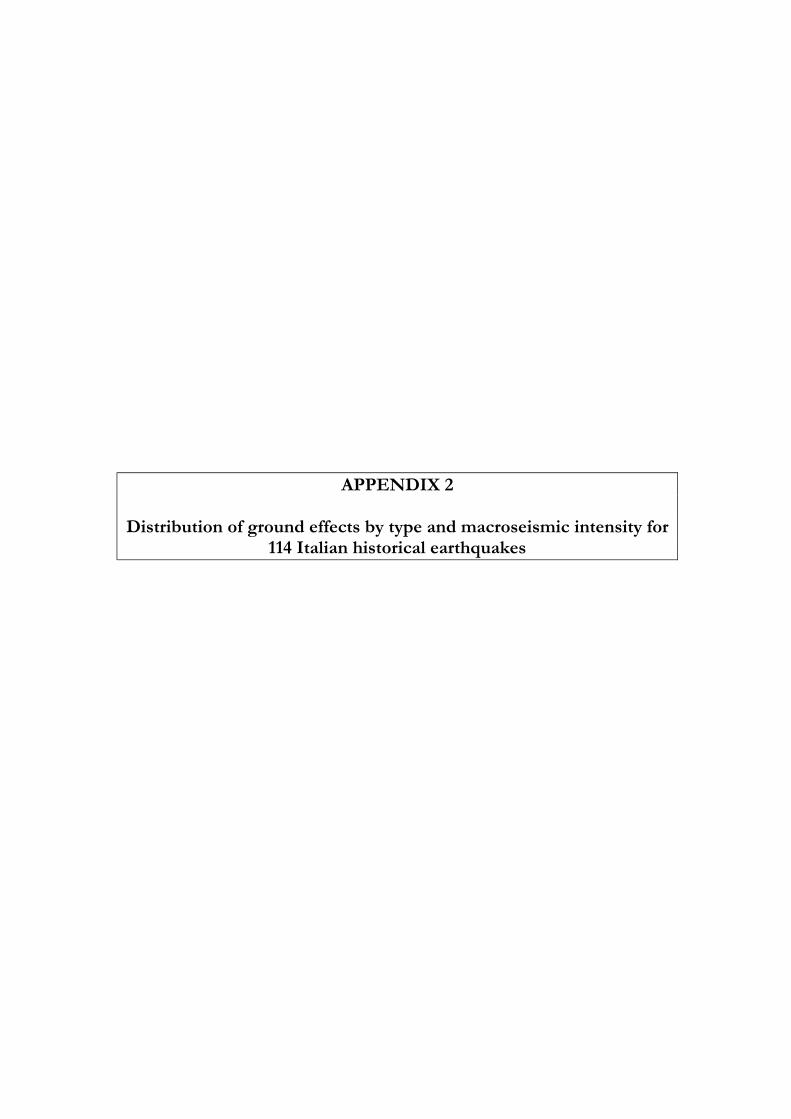
APPENDIX 2 Distribution of ground effects by type and macroseismic intensity for
114 Italian historical earthquakes
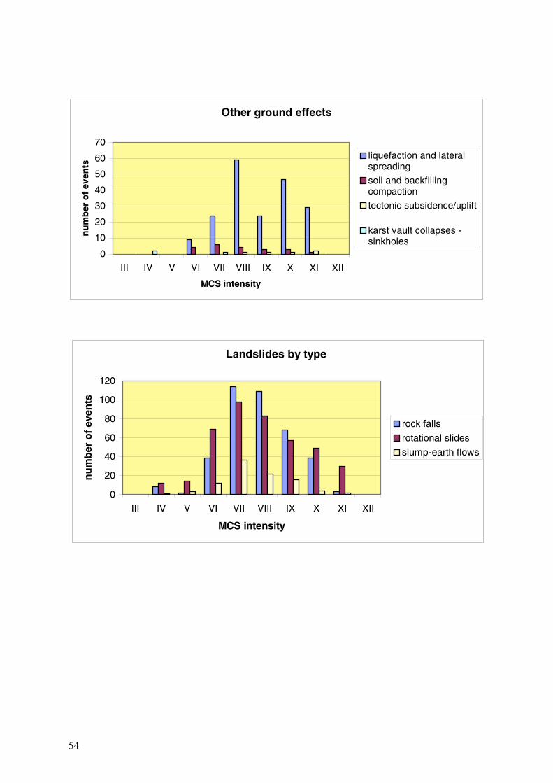
54
Landslides by type
0
20
40
60
80
100
120
III IV V VI VII VIII IX X XI XII
MCS intensity
nu
mb
er o
f ev
ents
rock falls
rotational slides
slump-earth flows
Other ground effects
0
10
20
30
40
50
60
70
III IV V VI VII VIII IX X XI XII
MCS intensity
nu
mb
er o
f ev
ents
liquefaction and lateralspreading
soil and backfillingcompaction
tectonic subsidence/uplift
karst vault collapses -sinkholes
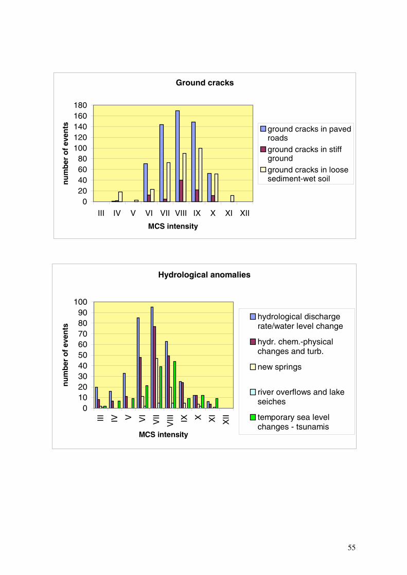
55
Hydrological anomalies
0102030405060708090
100
III IV V VI
VII
VIII IX X X
I
XII
MCS intensity
nu
mb
er o
f ev
ents
hydrological dischargerate/water level change
hydr. chem.-physicalchanges and turb.
new springs
river overflows and lakeseiches
temporary sea levelchanges - tsunamis
Ground cracks
020406080
100120140160180
III IV V VI VII VIII IX X XI XII
MCS intensity
nu
mb
er o
f ev
ents ground cracks in paved
roadsground cracks in stiffgroundground cracks in loosesediment-wet soil

APPENDIX 3
Examples of geological effects of earthquakes
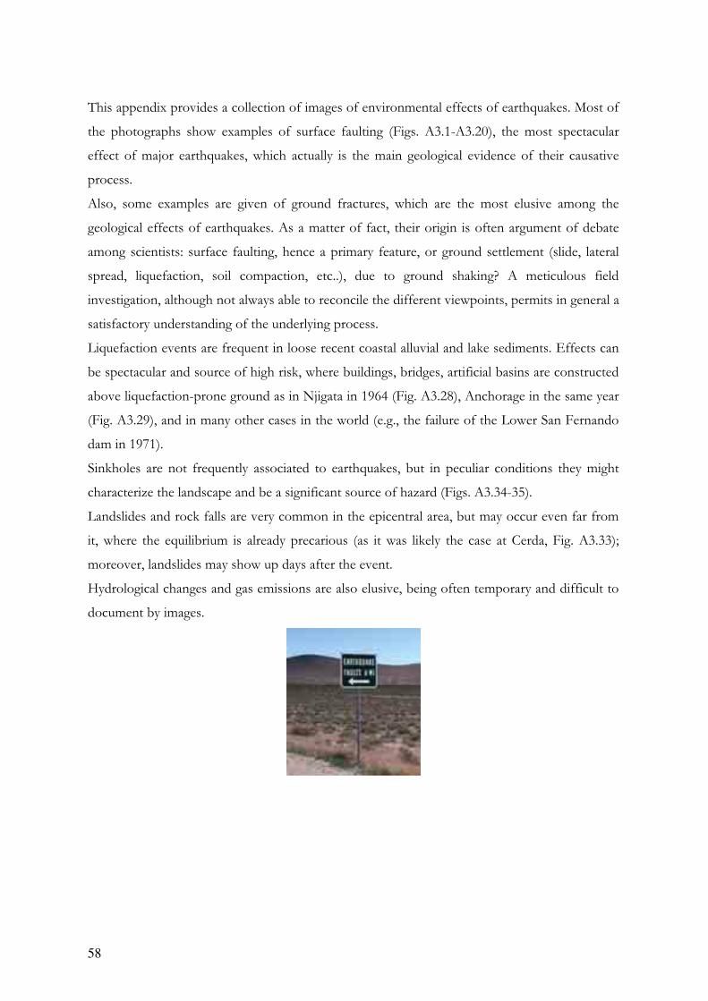
58
This appendix provides a collection of images of environmental effects of earthquakes. Most of
the photographs show examples of surface faulting (Figs. A3.1-A3.20), the most spectacular
effect of major earthquakes, which actually is the main geological evidence of their causative
process.
Also, some examples are given of ground fractures, which are the most elusive among the
geological effects of earthquakes. As a matter of fact, their origin is often argument of debate
among scientists: surface faulting, hence a primary feature, or ground settlement (slide, lateral
spread, liquefaction, soil compaction, etc..), due to ground shaking? A meticulous field
investigation, although not always able to reconcile the different viewpoints, permits in general a
satisfactory understanding of the underlying process.
Liquefaction events are frequent in loose recent coastal alluvial and lake sediments. Effects can
be spectacular and source of high risk, where buildings, bridges, artificial basins are constructed
above liquefaction-prone ground as in Njigata in 1964 (Fig. A3.28), Anchorage in the same year
(Fig. A3.29), and in many other cases in the world (e.g., the failure of the Lower San Fernando
dam in 1971).
Sinkholes are not frequently associated to earthquakes, but in peculiar conditions they might
characterize the landscape and be a significant source of hazard (Figs. A3.34-35).
Landslides and rock falls are very common in the epicentral area, but may occur even far from
it, where the equilibrium is already precarious (as it was likely the case at Cerda, Fig. A3.33);
moreover, landslides may show up days after the event.
Hydrological changes and gas emissions are also elusive, being often temporary and difficult to
document by images.
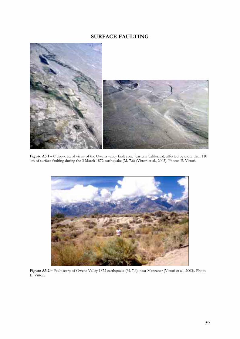
59
SURFACE FAULTING
Figure A3.1 – Oblique aerial views of the Owens valley fault zone (eastern California), affected by more than 110 km of surface faulting during the 3 March 1872 earthquake (Ms 7.6) (Vittori et al., 2003). Photos E. Vittori.
Figure A3.2 – Fault scarp of Owens Valley 1872 earthquake (Ms 7.6), near Manzanar (Vittori et al., 2003). Photo E. Vittori.

60
Figure A3.3 – Fault scarp of Borah Peak 28 October 1983 earthquake (Ms 7.3). Epicentral Intensity IX MM. Photo E. Vittori.
Figure A3.4 – Fault scarp of Dixie Valley 16 December 1954 earthquake (M 7.2) (left). Close-up view of the scarp with Burt Slemmons for scale (right). The estimated epicentral intensity was X MM. Photos E. Vittori.
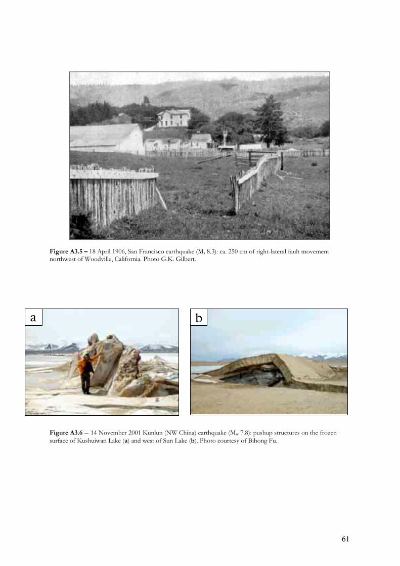
61
Figure A3.5 – 18 April 1906, San Francisco earthquake (Ms 8.3): ca. 250 cm of right-lateral fault movement northwest of Woodville, California. Photo G.K. Gilbert.
Figure A3.6 – 14 November 2001 Kunlun (NW China) earthquake (Mw 7.8): pushup structures on the frozen surface of Kushuiwan Lake (a) and west of Sun Lake (b). Photo courtesy of Bihong Fu.
a b
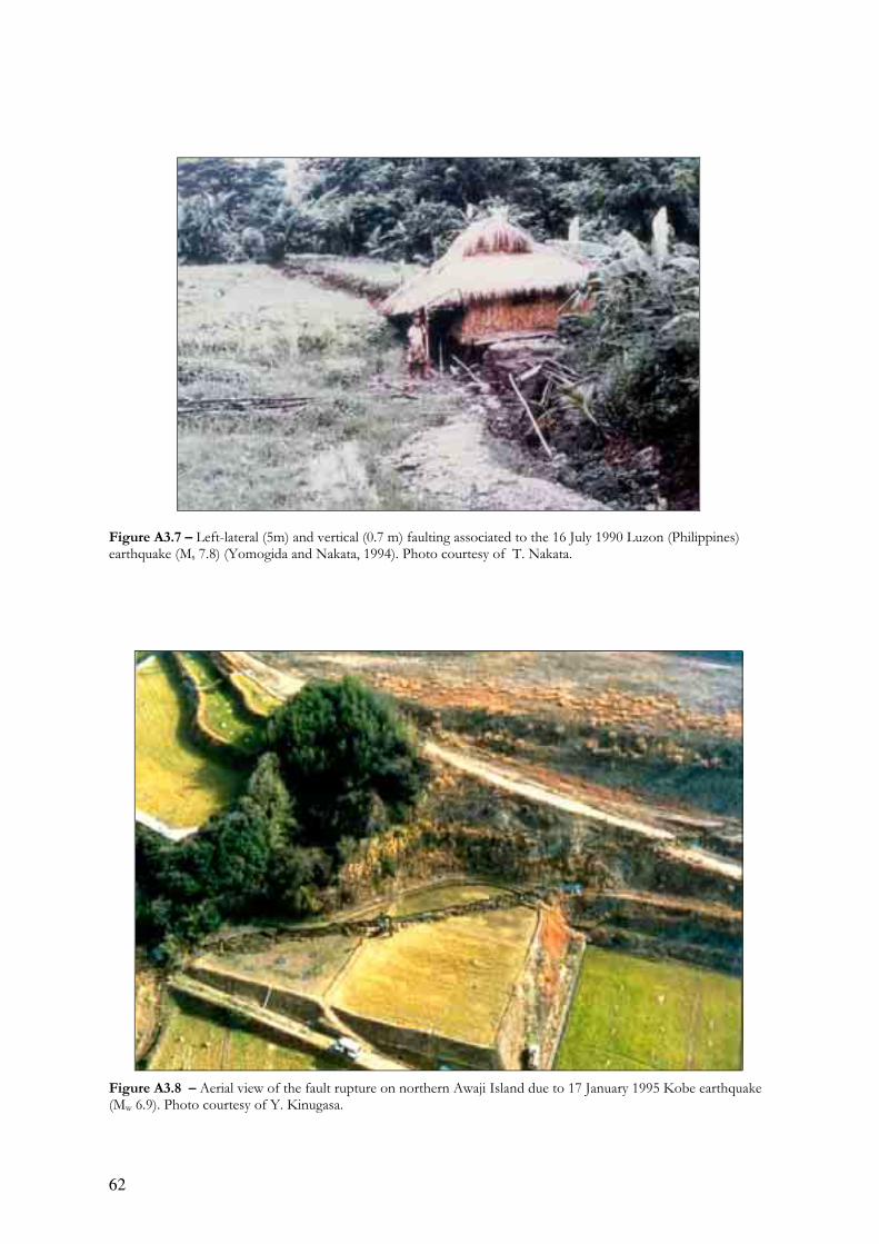
62
Figure A3.7 – Left-lateral (5m) and vertical (0.7 m) faulting associated to the 16 July 1990 Luzon (Philippines) earthquake (Ms 7.8) (Yomogida and Nakata, 1994). Photo courtesy of T. Nakata.
Figure A3.8 – Aerial view of the fault rupture on northern Awaji Island due to 17 January 1995 Kobe earthquake (Mw 6.9). Photo courtesy of Y. Kinugasa.
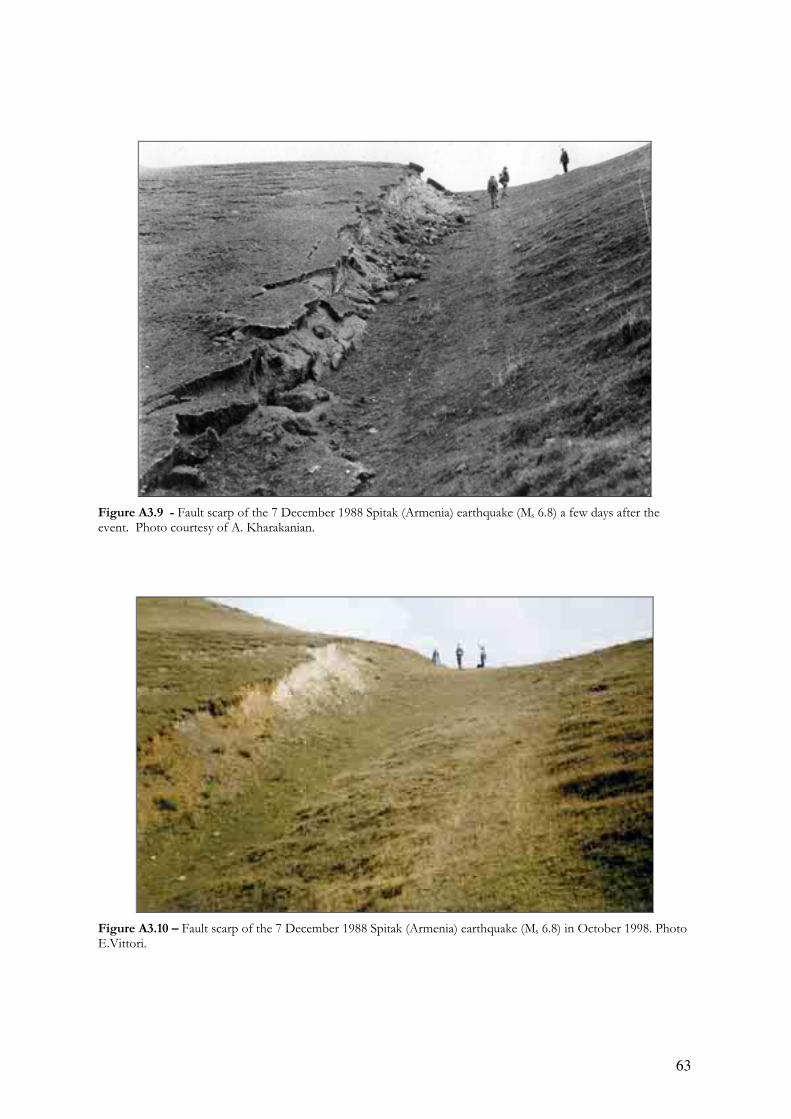
63
Figure A3.9 - Fault scarp of the 7 December 1988 Spitak (Armenia) earthquake (Ms 6.8) a few days after the event. Photo courtesy of A. Kharakanian.
Figure A3.10 – Fault scarp of the 7 December 1988 Spitak (Armenia) earthquake (Ms 6.8) in October 1998. Photo E.Vittori.
Figure A3.9 - Fault scarp of the 7 December 1988 Spitak (Armenia) earthquake (Ms 6.8) a few days after the event. Photo courtesy of A. Kharakanian.
Figure A3.10 – Fault scarp of the 7 December 1988 Spitak (Armenia) earthquake (Ms 6.8) in October 1998. Photo E.Vittori.
63

64
Figure A3.11 – Cumulative effect of repeated earthquakes along the Chon Kemin fault zone (Kyrgyzstan). The last event (Ms 8.2) took place on January 3, 1911. Photo E. Vittori.
Figure A3.12 – Detail of the fault scarp of the 1911 (Ms 8.2) Chon Kemin (Kyrgyzstan) earthquake. Courtesy of D. Delvaux (for more details see http://www.uiggm.nsc.ru/issyk-kul/1911%20kem.htm).

65
Figure A3.13 – Fault scarp (ca. 1 m high) of the 13 January 1915 (M 7.0) Avezzano earthquake (from Oddone, 1915).
Figure A3.14 – Fault scarp in the Fucino basin (San Benedetto dei Marsi site) reactivated during the January 13, 1915 (Ms 7.0) Avezzano earthquake (Michetti et al., 1996). Photo E. Vittori.
Figure A3.15 – view of the Serrone active Fault on the northwestern side of the Fucino basin (Central Apennines). Its last reactivation (ca. 1 meter of normal slip) occurred in 1915, during the ruinous Avezzano earthquake (Ms = 7) (Michetti et alii, 1996). It is readily evident the post-LGM displacement (shown by the large offset of the regularized slope), indicating the occurrence of several coseismic reactivations during the Holocene. Photo E. Vittori.

66
Figure A3.16 – Aerial oblique view of the Parasano fault, another fault reactivated in the Fucino area during the 1915 earthquake. Photo G. Carver.
Figure A3.17 – (left) Slickenside reactivated at Senerchia during the Irpinia (southern Apennines) earthquake in 1980 (Ms 6.9). Photo courtesy of A. Pissart. (Right) scarp ca. 80 cm high at Piano di Pecore (Monte Marzano) formed during the same earthquake.

67
Figure A3.18 – Trench across a fault scarp along the Pollino active fault zone (located near the border between Basilicata and Calabria, Southern Apennines). No historical events are known in the area, but the trenches have revealed a Middle Age earthquake, with significant impact for seismic hazard (Michetti et alii, 1997). Photo E. Vittori.
Figure A3.19 – Fault rupture of the September 26, 1997 earthquake (Mw 6) in Umbria-Marche region (central Italy); Vittori et alii, 2000. Photo E. Vittori.

68
Figure A3.20 – Left-lateral faulting in the eastern slope of Etna volcano (Pernicana fault). Different segments of this fault move either by creep or stick-slip. More than half a meter of slip took place here during the october-november 2002 volcanic and seismic crisis. Photo E. Vittori
Figure A3.20 – Left-lateral faulting in the eastern slope of Etna volcano (Pernicana fault). Different segments of this fault move either by creep or stick-slip. More than half a meter of slip took place here during the october-november 2002 volcanic and seismic crisis. Photo E. Vittori
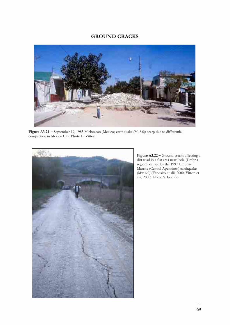
69
GROUND CRACKS
Figure A3.21 – September 19, 1985 Michoacan (Mexico) earthquake (Ms 8.0): scarp due to differential compaction in Mexico City. Photo E. Vittori.
Figure A3.22 – Ground cracks affecting a dirt road in a flat area near Isola (Umbria region), caused by the 1997 Umbria-Marche (Central Apennines) earthquake (Mw 6.0) (Esposito et alii, 2000; Vittori et alii, 2000). Photo S. Porfido.
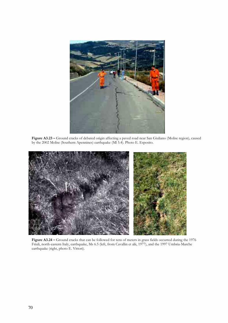
70
Figure A3.23 – Ground cracks of debated origin affecting a paved road near San Giuliano (Molise region), caused by the 2002 Molise (Southern Apennines) earthquake (Ml 5.4). Photo E. Esposito.
Figure A3.24 – Ground cracks that can be followed for tens of meters in grass fields occurred during the 1976 Friuli, north-eastern Italy, earthquake, Ms 6.5 (left, from Cavallin et alii, 1977), and the 1997 Umbria-Marche earthquake (right, photo E. Vittori).
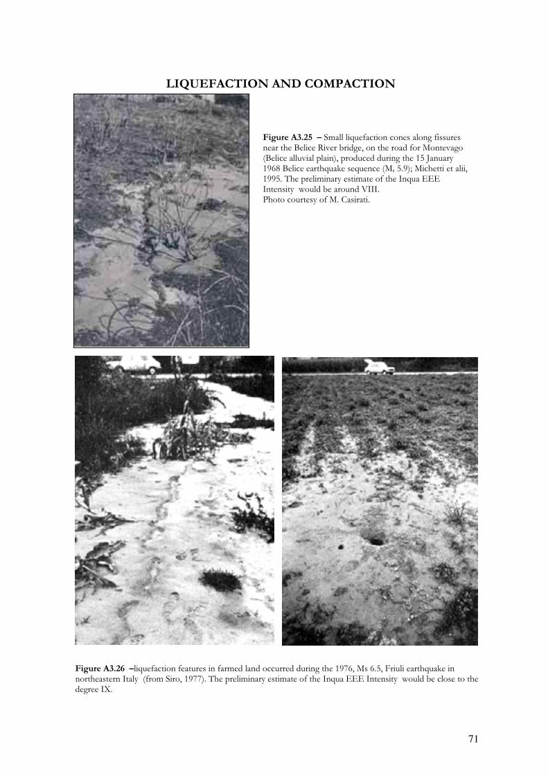
71
LIQUEFACTION AND COMPACTION
Figure A3.26 –liquefaction features in farmed land occurred during the 1976, Ms 6.5, Friuli earthquake in northeastern Italy (from Siro, 1977). The preliminary estimate of the Inqua EEE Intensity would be close to the degree IX.
Figure A3.25 – Small liquefaction cones along fissures near the Belice River bridge, on the road for Montevago (Belice alluvial plain), produced during the 15 January 1968 Belice earthquake sequence (Ms 5.9); Michetti et alii, 1995. The preliminary estimate of the Inqua EEE Intensity would be around VIII. Photo courtesy of M. Casirati.
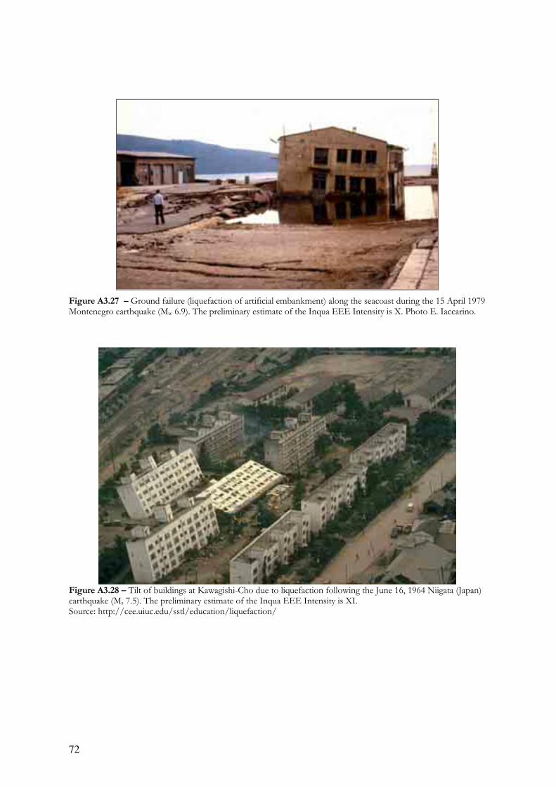
72
Figure A3.27 – Ground failure (liquefaction of artificial embankment) along the seacoast during the 15 April 1979 Montenegro earthquake (Mw 6.9). The preliminary estimate of the Inqua EEE Intensity is X. Photo E. Iaccarino.
Figure A3.28 – Tilt of buildings at Kawagishi-Cho due to liquefaction following the June 16, 1964 Niigata (Japan) earthquake (Ms 7.5). The preliminary estimate of the Inqua EEE Intensity is XI. Source: http://cee.uiuc.edu/sstl/education/liquefaction/
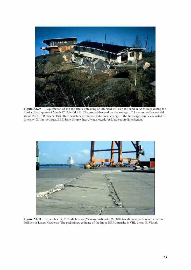
73
Figure A3.29 – Liquefaction of soil and lateral spreading of saturated soft clay and sand in Anchorage during the Alaskan Earthquake of March 27 1964 (M 8.6). The ground dropped on the average of 11 meters and houses slid about 150 to 180 meters. This effect, which determined a widespread change of the landscape, can be evaluated of Intensity XII in the Inqua EEE Scale. Source: http://cee.uiuc.edu/sstl/education/liquefaction/
Figure A3.30 – September 19, 1985 Michoacan (Mexico) earthquake (Ms 8.0): backfill compaction in the harbour facilities of Lazaro Cardenas. The preliminary estimate of the Inqua EEE Intensity is VIII. Photo E. Vittori.

74
ROCKFALLS AND SLIDES
Figure A3.31 – A ruinous rock slide detached from the flank of Mt. Brancot destroyed several houses in the village of Braulins during the 6 May 1976 Friuli earthquake (Ms 6.5) (A: photo Bordin; B from Briseghella et alii, 1976). The local MCS Intensity was VIII-IX at Braulins.
A
B
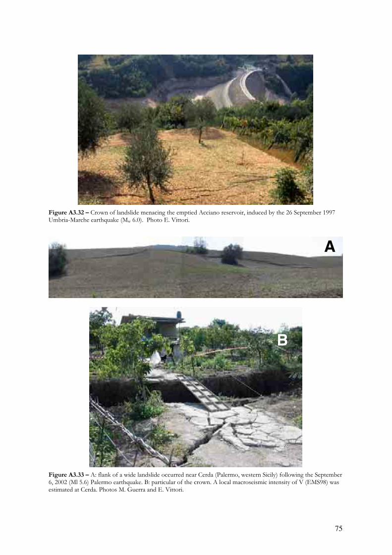
75
Figure A3.32 – Crown of landslide menacing the emptied Acciano reservoir, induced by the 26 September 1997 Umbria-Marche earthquake (Mw 6.0). Photo E. Vittori.
Figure A3.33 – A: flank of a wide landslide occurred near Cerda (Palermo, western Sicily) following the September 6, 2002 (Ml 5.6) Palermo earthquake. B: particular of the crown. A local macroseismic intensity of V (EMS98) was estimated at Cerda. Photos M. Guerra and E. Vittori.
A
B

76
Figure A3.34 – Above: rock falls from the flanks of a narrow canyon near Bam (southern Iran) following the 26 December 2003 (Mw 6.5) Bam earthquake. Below: aerial view of rock falls and sinkholes from the same area. The local macroseismic intensity was IX MM (source: Eshghi and Zarè, 2004).
Figure A3.34 – Above: rock falls from the flanks of a narrow canyon near Bam (southern Iran) following the 26 December 2003 (Mw 6.5) Bam earthquake. Below: aerial view of rock falls and sinkholes from the same area. The local macroseismic intensity was IX MM (source: Eshghi and Zarè, 2004).
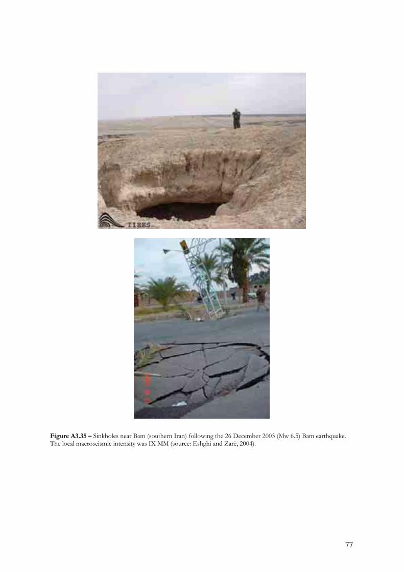
77
Figure A3.35 – Sinkholes near Bam (southern Iran) following the 26 December 2003 (Mw 6.5) Bam earthquake. The local macroseismic intensity was IX MM (source: Eshghi and Zarè, 2004).
Figure A3.35 – Sinkholes near Bam (southern Iran) following the 26 December 2003 (Mw 6.5) Bam earthquake. The local macroseismic intensity was IX MM (source: Eshghi and Zarè, 2004).

78
Figure A3.36 – Minor rock falls from the flanks of paved roads near the epicentral area of the 1997 Umbria-Marche earthquake. The preliminary estimate of the Inqua EEE Intensity is VII. Photos E.Vittori.
Figure A3.36 – Minor rock falls from the flanks of paved roads near the epicentral area of the 1997 Umbria-Marche earthquake. The preliminary estimate of the Inqua EEE Intensity is VII. Photos E.Vittori.

79
Cited papers
BRISEGHELLA L., CAPPELLARI L., DALL’AGLIO R., D’EREDITA’ R., GORI R., SIMONI L., TURRINI G., ZAUPA F., 1976, Earthquake in Friuli (Italy) 1976 – damage to historical monuments and
other buildings of artistic interest. Bollettino Geofisica Teorica ed Applicata, XIX (72), 909-932. CAVALLIN A., MARTINIS B., SFONDRINI G., 1977, Effetti geologici del terremoto: fenditure nel terreno e
“vulcanelli” di sabbia. Rivista Italiana di Paleontologia e Stratigrafia, 83 (2), 369-393. ESHGHI S., ZARE’ M., 2004, Reconnaissance report on 26 December 2003 Bam earthquake. Int. Inst. of
Earthquake Eng. and Seism., Teheran Iran. Web: http://www.iiees.ac.ir/English/eng_index.html
ESPOSITO E., PORFIDO S., SIMONELLI L., MASTROLORENZO G., IACCARINO G., 2000, Landslides and other surface effects induced by the 1997 Umbria-Marche sequence. Engineering Geology, 58, 353-376.
MICHETTI A.M., BRUNAMONTE F., SERVA L., 1995, Paleoseismological evidence in the epicentral area
of the January 13, 1968, Belice (SW Sicily) earthquake. In Perspectives in Paleoseismology; edited by L. Serva and D.B. Slemmons, Assoc. of Eng. Geol., Spec. Publ. 6, 127-139.
MICHETTI A.M., BRUNAMONTE F., SERVA L., VITTORI E., 1996, Trench investigations of the 1915
Fucino earthquake fault scarps (Abruzzo, Central Italy): geological evidence of large historical events. J. Geophys. Res., 101, 5921–5936.
MICHETTI A. M., FERRELI L., SERVA L., & VITTORI E., 1997, Geological evidence for strong historical
earthquakes in an "aseismic" region: the Pollino case (Southern Italy). Journal of Geodynamics, 24 (1-4), 67-86.
ODDONE, E., 1915, Gli elementi fisici del grande terremoto marsicano-fucense del 13 gennaio 1915. Boll. Soc. Sismol. Ital., 19, 71–216.
SIRO L., 1976, Liquefaction of sands in Friuli during may 6 and September 15 1976 earthquakes. Bollettino Geofisica Teorica ed Applicata, XIX (72), 1203-1452.
VITTORI E., DEIANA G., ESPOSITO E., FERRELI L., MARCHEGIANI L., MASTROLORENZO G., MICHETTI A.M., PORFIDO S., SERVA L., SIMONELLI A.L., TONDI E., 2000, Ground effects and
surface faulting in the September-October 1997 Umbria-Marche (Central Italy) seismic sequence. Journal of Geodynamics, 29 (3-5), 535-564.
VITTORI E., CARVER G., JAYKO A.S., MICHETTI A., SLEMMONS, D.B., 2003, New insight on the
Owens Valley Fault zone (Eastern California, U.S.A.) from detailed Quaternary Fault Map. 2003 INQUA Congress Reno (NV), July 23-30 2003, Abstract & poster.

APPENDIX 4
Comparison between the INQUA scale and the MCS-1930, MM-1931, MM-
1956, and MSK-1964 scales
for the comparison with the Japanese JMA scale see Table 1 the text
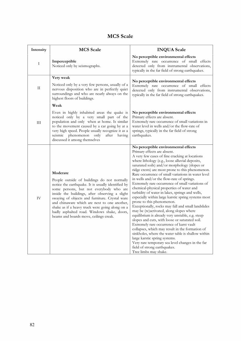
82
MCS Scale
Intensity MCS Scale INQUA Scale
I Imperceptible Noticed only by seismographs.
No perceptible environmental effects Extremely rare occurrence of small effects detected only from instrumental observations, typically in the far field of strong earthquakes.
II
Very weak
Noticed only by a very few persons, usually of a nervous disposition who are in perfectly quiet surroundings and who are nearly always on the highest floors of buildings.
No perceptible environmental effects Extremely rare occurrence of small effects detected only from instrumental observations, typically in the far field of strong earthquakes.
III
Weak
Even in highly inhabited areas the quake is noticed only by a very small part of the population and only when at home. Is similar to the movement caused by a car going by at a very high speed. People usually recognize it as a seismic phenomenon only after having discussed it among themselves
No perceptible environmental effects Primary effects are absent. Extremely rare occurrence of small variations in water level in wells and/or the flow-rate of springs, typically in the far field of strong earthquakes.
IV
Moderate
People outside of buildings do not normally notice the earthquake. It is usually identified by some persons, but not everybody who are inside the buildings, after observing a slight swaying of objects and furniture. Crystal ware and chinaware which are next to one another, shake as if a heavy truck were going along on a badly asphalted road. Windows shake, doors, beams and boards move, ceilings creak.
No perceptible environmental effects Primary effects are absent. A very few cases of fine cracking at locations where lithology (e.g., loose alluvial deposits, saturated soils) and/or morphology (slopes or ridge crests) are most prone to this phenomenon. Rare occurrence of small variations in water level in wells and/or the flow-rate of springs. Extremely rare occurrence of small variations of chemical-physical properties of water and turbidity of water in lakes, springs and wells, especially within large karstic spring systems most prone to this phenomenon. Exceptionally, rocks may fall and small landslides may be (re)activated, along slopes where equilibrium is already very unstable, e.g. steep slopes and cuts, with loose or saturated soil. Extremely rare occurrence of karst vault collapses, which may result in the formation of sinkholes, where the water table is shallow within large karstic spring systems. Very rare temporary sea level changes in the far field of strong earthquakes. Tree limbs may shake.
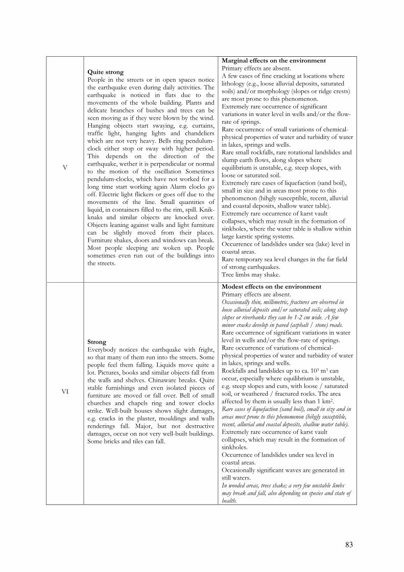
83
V
Quite strong People in the streets or in open spaces notice the earthquake even during daily activities. The earthquake is noticed in flats due to the movements of the whole building. Plants and delicate branches of bushes and trees can be seen moving as if they were blown by the wind. Hanging objects start swaying, e.g. curtains, traffic light, hanging lights and chandeliers which are not very heavy. Bells ring pendulum-clock either stop or sway with higher period. This depends on the direction of the earthquake, wether it is perpendicular or normal to the motion of the oscillation Sometimes pendulum-clocks, which have not worked for a long time start working again Alarm clocks go off. Electric light flickers or goes off due to the movements of the line. Small quantities of liquid, in containers filled to the rim, spill. Knik-knaks and similar objects are knocked over. Objects leaning against walls and light furniture can be slightly moved from their places. Furniture shakes, doors and windows can break. Most people sleeping are woken up. People sometimes even run out of the buildings into the streets.
Marginal effects on the environment Primary effects are absent. A few cases of fine cracking at locations where lithology (e.g., loose alluvial deposits, saturated soils) and/or morphology (slopes or ridge crests) are most prone to this phenomenon. Extremely rare occurrence of significant variations in water level in wells and/or the flow-rate of springs. Rare occurrence of small variations of chemical-physical properties of water and turbidity of water in lakes, springs and wells. Rare small rockfalls, rare rotational landslides and slump earth flows, along slopes where equilibrium is unstable, e.g. steep slopes, with loose or saturated soil. Extremely rare cases of liquefaction (sand boil), small in size and in areas most prone to this phenomenon (hihgly susceptible, recent, alluvial and coastal deposits, shallow water table). Extremely rare occurrence of karst vault collapses, which may result in the formation of sinkholes, where the water table is shallow within large karstic spring systems. Occurrence of landslides under sea (lake) level in coastal areas. Rare temporary sea level changes in the far field of strong earthquakes. Tree limbs may shake.
VI
Strong Everybody notices the earthquake with fright, so that many of them run into the streets. Some people feel them falling. Liquids move quite a lot. Pictures, books and similar objects fall from the walls and shelves. Chinaware breaks. Quite stable furnishings and even isolated pieces of furniture are moved or fall over. Bell of small churches and chapels ring and tower clocks strike. Well-built houses shows slight damages, e.g. cracks in the plaster, mouldings and walls renderings fall. Major, but not destructive damages, occur on not very well-built buildings. Some bricks and tiles can fall.
Modest effects on the environment Primary effects are absent. Occasionally thin, millimetric, fractures are observed in
loose alluvial deposits and/or saturated soils; along steep
slopes or riverbanks they can be 1-2 cm wide. A few
minor cracks develop in paved (asphalt / stone) roads.
Rare occurrence of significant variations in water level in wells and/or the flow-rate of springs. Rare occurrence of variations of chemical-physical properties of water and turbidity of water in lakes, springs and wells. Rockfalls and landslides up to ca. 103 m3 can occur, especially where equilibrium is unstable, e.g. steep slopes and cuts, with loose / saturated soil, or weathered / fractured rocks. The area affected by them is usually less than 1 km2. Rare cases of liquefaction (sand boil), small in size and in
areas most prone to this phenomenon (hihgly susceptible,
recent, alluvial and coastal deposits, shallow water table).
Extremely rare occurrence of karst vault collapses, which may result in the formation of sinkholes. Occurrence of landslides under sea level in coastal areas. Occasionally significant waves are generated in still waters. In wooded areas, trees shake; a very few unstable limbs
may break and fall, also depending on species and state of
health.
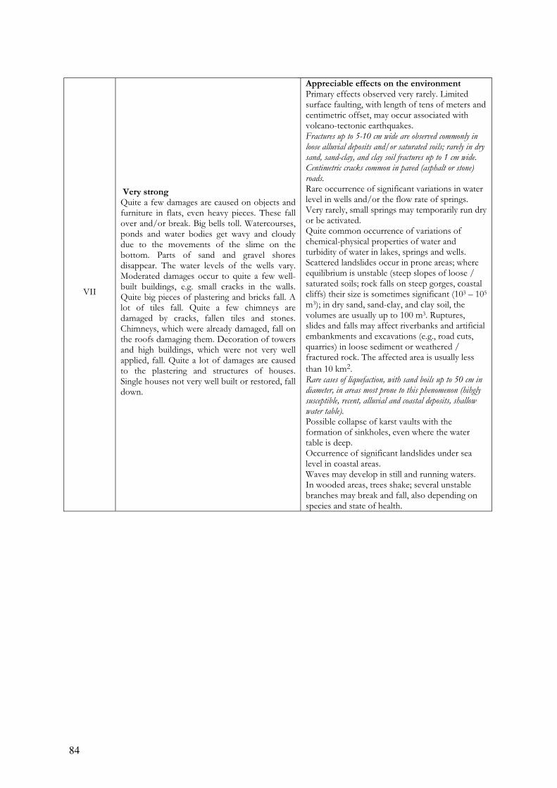
84
VII
Very strong Quite a few damages are caused on objects and furniture in flats, even heavy pieces. These fall over and/or break. Big bells toll. Watercourses, ponds and water bodies get wavy and cloudy due to the movements of the slime on the bottom. Parts of sand and gravel shores disappear. The water levels of the wells vary. Moderated damages occur to quite a few well-built buildings, e.g. small cracks in the walls. Quite big pieces of plastering and bricks fall. A lot of tiles fall. Quite a few chimneys are damaged by cracks, fallen tiles and stones. Chimneys, which were already damaged, fall on the roofs damaging them. Decoration of towers and high buildings, which were not very well applied, fall. Quite a lot of damages are caused to the plastering and structures of houses. Single houses not very well built or restored, fall down.
Appreciable effects on the environment Primary effects observed very rarely. Limited surface faulting, with length of tens of meters and centimetric offset, may occur associated with volcano-tectonic earthquakes. Fractures up to 5-10 cm wide are observed commonly in
loose alluvial deposits and/or saturated soils; rarely in dry
sand, sand-clay, and clay soil fractures up to 1 cm wide.
Centimetric cracks common in paved (asphalt or stone)
roads. Rare occurrence of significant variations in water level in wells and/or the flow rate of springs. Very rarely, small springs may temporarily run dry or be activated. Quite common occurrence of variations of chemical-physical properties of water and turbidity of water in lakes, springs and wells. Scattered landslides occur in prone areas; where equilibrium is unstable (steep slopes of loose / saturated soils; rock falls on steep gorges, coastal cliffs) their size is sometimes significant (103 – 105 m3); in dry sand, sand-clay, and clay soil, the volumes are usually up to 100 m3. Ruptures, slides and falls may affect riverbanks and artificial embankments and excavations (e.g., road cuts, quarries) in loose sediment or weathered / fractured rock. The affected area is usually less
than 10 km2. Rare cases of liquefaction, with sand boils up to 50 cm in
diameter, in areas most prone to this phenomenon (hihgly
susceptible, recent, alluvial and coastal deposits, shallow
water table). Possible collapse of karst vaults with the formation of sinkholes, even where the water table is deep. Occurrence of significant landslides under sea level in coastal areas. Waves may develop in still and running waters. In wooded areas, trees shake; several unstable branches may break and fall, also depending on species and state of health.
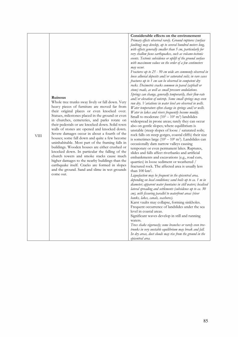
85
VIII
Ruinous Whole tree trunks sway lively or fall down. Very heavy pieces of furniture are moved far from their original places or even knocked over. Statues, milestones placed in the ground or even in churches, cemeteries, and parks rotate on their pedestals or are knocked down. Solid town walls of stones are opened and knocked down. Severe damages occur in about a fourth of the houses; some fall down and quite a few become uninhabitable. Most part of the framing falls in buildings. Wooden houses are either crushed or knocked down. In particular the falling of the church towers and smoke stacks cause much higher damages to the nearby buildings than the earthquake itself. Cracks are formed in slopes and the ground. Sand and slime in wet grounds come out.
Considerable effects on the environement Primary effects observed rarely. Ground ruptures (surface
faulting) may develop, up to several hundred meters long,
with offsets generally smaller than 5 cm, particularly for
very shallow focus earthquakes, such as volcano-tectonic
events. Tectonic subsidence or uplift of the ground surface
with maximum values on the order of a few centimeters
may occur.
Fractures up to 25 - 50 cm wide are commonly observed in
loose alluvial deposits and/or saturated soils; in rare cases
fractures up to 1 cm can be observed in competent dry
rocks. Decimetric cracks common in paved (asphalt or
stone) roads, as well as small pressure undulations.
Springs can change, generally temporarily, their flow-rate
and/or elevation of outcrop. Some small springs may even
run dry. Variations in water level are observed in wells.
Water temperature often change in springs and/or wells.
Water in lakes and rivers frequently become muddy.
Small to moderate (103 – 105 m3) landslides widespread in prone areas; rarely they can occur also on gentle slopes; where equilibrium is unstable (steep slopes of loose / saturated soils; rock falls on steep gorges, coastal cliffs) their size is sometimes large (105 – 106 m3). Landslides can occasionally dam narrow valleys causing temporary or even permanent lakes. Ruptures, slides and falls affect riverbanks and artificial embankments and excavations (e.g., road cuts, quarries) in loose sediment or weathered / fractured rock. The affected area is usually less than 100 km2. Liquefaction may be frequent in the epicentral area,
depending on local conditions; sand boils up to ca. 1 m in
diameter; apparent water fountains in still waters; localised
lateral spreading and settlements (subsidence up to ca. 30
cm), with fissuring parallel to waterfront areas (river
banks, lakes, canals, seashores).
Karst vaults may collapse, forming sinkholes. Frequent occurrence of landslides under the sea level in coastal areas. Significant waves develop in still and running waters. Trees shake vigorously; some branches or rarely even tree-
trunks in very unstable equilibrium may break and fall.
In dry areas, dust clouds may rise from the ground in the
epicentral area.

86
IX
Destructive About half of the stone houses are severely destroyed; quite a few collapse, most of them become uninhabitable. Framed houses are destroyed at the foundations and crushed. The fact that beams are torn away from their original places can often cause major damages to the buildings.
Natural effects leave significant and permanent traces in the environment Primary effects observed commonly. Ground ruptures
(surface faulting) develop, up to a few km long, with offsets
generally smaller than 10 - 20 cm. Tectonic subsidence or
uplift of the ground surface with maximum values in the
order of a few decimeters may occur.
Fractures up to 50 - 100 cm wide are commonly observed
in loose alluvial deposits and/or saturated soils; in
competent rocks they can reach up to 10 cm. Significant
cracks common in paved (asphalt or stone) roads, as well
as small pressure undulations.
Springs can change their flow-rate and/or elevation of outcrop to a considerable extent. Some small springs may even run dry. Variations in water level are observed in wells. Water temperature often change in springs and/or wells. Water in lakes and rivers frequently become muddy. Landsliding widespread in prone areas, also on gentle
slopes; where equilibrium is unstable (steep slopes of loose
/ saturated soils; rock falls on steep gorges, coastal cliffs)
their size is frequently large (105 m
3), sometimes very large
(106 m
3). Landslides can dam narrow valleys causing
temporary or even permanent lakes. Riverbanks, artificial
embankments and excavations (e.g., road cuts, quarries)
frequently collapse. The affected area is usually less than
1000 km2.
Liquefaction and water upsurge are frequent; sand boils
up to 3 m in diameter; apparent water fountains in still
waters; frequent lateral spreading and settlements
(subsidence of more than ca. 30 cm), with fissuring parallel
to waterfront areas (river banks, lakes, canals, seashores).
Karst vaults of relevant size collapse, forming sinkholes. Frequent large landslides under the sea level in coastal areas. Large waves develop in still and running waters. Small
tsunamis may reach the coastal areas with tidal waves up
to 50 - 100 cm high.
Trees shake vigorously; branches or even tree-trunks in unstable equilibrium frequently break and fall. In dry areas dust clouds may rise from the ground. In the epicentral area, small stones may jump out of the ground, leaving typical imprints in soft soil.

87
X
Completely destructive Very severe destruction of about ¾ of the buildings; most of them fall down. Very severe damages occur on solid wooden buildings and bridges; some of then are destroyed. Bank, dams, etc. are highly damaged. Railways are bent slightly and pipes (water, gas and water pipes) are cut off or broken or crushed. Cracks are formed in paved and asphalted streets, which are furthermore uplifted due to the pressure. Cracks, which width can be up to several decimetres form in thin, and above all, wet ground. In particular cracks almost a metre wide form parallel to watercourses. Not only does soil slide down hillslopes, but boulders roll down towards the valley. Rocks falls from the river embankments and cliffs. Sandy and muddy shores are moved, causing not important changes to the landscape. The water level of the wells varies continually. Rivers, canals, lakes , etc. become very wavy.
Environmental effects become dominant Primary ruptures become leading. Ground ruptures
(surface faulting) can extend for several tens of km, with
offsets reaching 50 - 100 cm and more (up to ca. 1-2 m in
case of reverse faulting and 3-4 m for normal faulting).
Gravity grabens and elongated depressions develop; for very
shallow focus earthquakes, such as volcano-tectonic events,
rupture lengths might be much lower. Tectonic subsidence
or uplift of the ground surface with maximum values in the
order of few meters may occur.
Large landslides and rock-falls (> 105 – 10
6 m
3) are
frequent, practically regardless to equilibrium state of the
slopes, causing temporary or permanent barrier lakes.
River banks, artificial embankments, and sides of
excavations typically collapse. Levees and earth dams may
even incur serious damage. The affected area is usually up
to 5000 km2.
Many springs significantly change their flow-rate and/or elevation of outcrop. Some may run dry or disappear, generally temporarily. Variations in water level are observed in wells. Water temperature often change in springs and/or wells. Water in lakes and rivers frequently become muddy. Open ground cracks up to more than 1 m wide are
frequent, mainly in loose alluvial deposits and/or
saturated soils; in competent rocks opening reach several
decimeters. Wide cracks develop in paved (asphalt or
stone) roads, as well as pressure undulations.
Liquefaction, with water upsurge and soil compaction, may
change the aspect of wide zones; sand volcanoes even more
than 6 m in diameter; vertical subsidence even > 1m; large
and long fissures due to lateral spreading are common.
Large karst vaults collapse, forming great sinkholes. Frequent large landslides under the sea level in coastal areas. Large waves develop in still and running waters, and crash
violently into the shores. Running (rivers, canals) and still
(lakes) waters may overflow from their beds. Tsunamis
reach the coastal areas, with tidal waves up to a few meters
high.
Trees shake vigorously; branches or even tree-trunks very frequently break and fall, if already in unstable equilibrium. In dry areas, dust clouds may rise from the ground. Stones, even if well anchored in the soil, may jump out of
the ground, leaving typical imprints in soft soil.
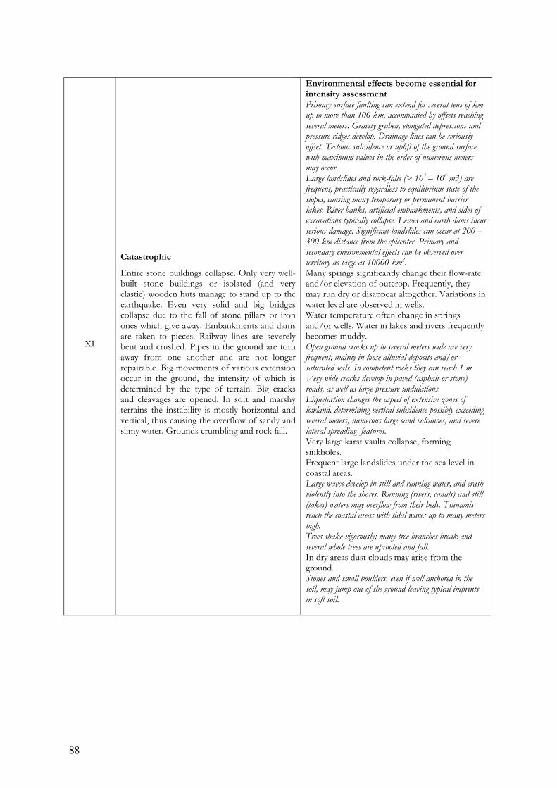
88
XI
Catastrophic
Entire stone buildings collapse. Only very well-built stone buildings or isolated (and very elastic) wooden huts manage to stand up to the earthquake. Even very solid and big bridges collapse due to the fall of stone pillars or iron ones which give away. Embankments and dams are taken to pieces. Railway lines are severely bent and crushed. Pipes in the ground are torn away from one another and are not longer repairable. Big movements of various extension occur in the ground, the intensity of which is determined by the type of terrain. Big cracks and cleavages are opened. In soft and marshy terrains the instability is mostly horizontal and vertical, thus causing the overflow of sandy and slimy water. Grounds crumbling and rock fall.
Environmental effects become essential for intensity assessment Primary surface faulting can extend for several tens of km
up to more than 100 km, accompanied by offsets reaching
several meters. Gravity graben, elongated depressions and
pressure ridges develop. Drainage lines can be seriously
offset. Tectonic subsidence or uplift of the ground surface
with maximum values in the order of numerous meters
may occur.
Large landslides and rock-falls (> 105 – 10
6 m3) are
frequent, practically regardless to equilibrium state of the
slopes, causing many temporary or permanent barrier
lakes. River banks, artificial embankments, and sides of
excavations typically collapse. Levees and earth dams incur
serious damage. Significant landslides can occur at 200 –
300 km distance from the epicenter. Primary and
secondary environmental effects can be observed over
territory as large as 10000 km2.
Many springs significantly change their flow-rate and/or elevation of outcrop. Frequently, they may run dry or disappear altogether. Variations in water level are observed in wells. Water temperature often change in springs and/or wells. Water in lakes and rivers frequently becomes muddy. Open ground cracks up to several meters wide are very
frequent, mainly in loose alluvial deposits and/or
saturated soils. In competent rocks they can reach 1 m.
Very wide cracks develop in paved (asphalt or stone)
roads, as well as large pressure undulations.
Liquefaction changes the aspect of extensive zones of
lowland, determining vertical subsidence possibly exceeding
several meters, numerous large sand volcanoes, and severe
lateral spreading features.
Very large karst vaults collapse, forming sinkholes. Frequent large landslides under the sea level in coastal areas. Large waves develop in still and running water, and crash
violently into the shores. Running (rivers, canals) and still
(lakes) waters may overflow from their beds. Tsunamis
reach the coastal areas with tidal waves up to many meters
high.
Trees shake vigorously; many tree branches break and
several whole trees are uprooted and fall.
In dry areas dust clouds may arise from the ground. Stones and small boulders, even if well anchored in the
soil, may jump out of the ground leaving typical imprints
in soft soil.

89
XII
Absolutely catastrophic No artifact can resist. The landscape change completely. Superficial and underground watercourses undergo the most different changes: waterfalls appear, water bodies disappear, rivers change their course.
Environmental effects are now the only tool enabling intensity to be assessed Primary surface faulting can extend for several hundreds of
km up to 1000 km, accompanied by offsets reaching
several tens of meters. Gravity graben, elongated
depressions and pressure ridges develop. Drainage lines can
be seriously offset. Landscape and geomorphological
changes induced by primary effects can attain
extraordinary extent and size (typical examples are the
uplift or subsidence of coastlines by several meters,
appearance or disappearance from sight of significant
landscape elements, rivers changing course, origination of
waterfalls, formation or disappearance of lakes).
Large landslides and rock-falls (> 105 – 10
6 m
3) are
frequent, practically regardless to equilibrium state of the
slopes, causing many temporary or permanent barrier
lakes. River banks, artificial embankments, and sides of
excavations typically collapse. Levees and earth dams incur
serious damage. Significant landslides can occur at more
than 200 – 300 km distance from the epicenter. Primary
and secondary environmental effects can be observed over
territory larger than 50000 km2.
Many springs significantly change their flow-rate and/or elevation of outcrop. Frequently, they may run dry or disappear altogether. Variations in water level are observed in wells. Water temperature often changes in springs and/or wells. Water in lakes and rivers frequently becomes muddy. Ground open cracks are very frequent, up to one meter or
more wide in the bedrock, up to more than 10 m wide in
loose alluvial deposits and/or saturated soils. These may
extend up to several kilometers in length.
Liquefaction occurs over large areas and changes the
morphology of extensive flat zones, determining vertical
subsidence exceeding several meters, widespread large sand
volcanoes, and extensive severe lateral spreading features.
Very large karst vaults collapse, forming sinkholes. Frequent very large landslides under the sea level in coastal areas. Large waves develop in still and running water, and crash
violently into the shores. Running (rivers, canals) and still
(lakes) waters overflow from their beds; watercourses
change the direction of flow. Tsunamis reach the coastal
areas with tidal waves up to tens of meters high.
Trees shake vigorously; many tree branches break and many whole trees are uprooted and fall. In dry areas dust clouds may arise from the ground. Even large boulders may jump out of the ground leaving typical imprints in soft soil.
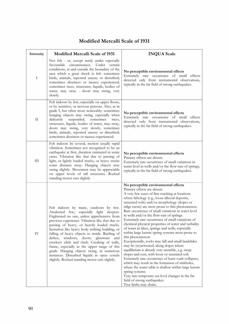
90
Modified Mercalli Scale of 1931
Intensity Modified Mercalli Scale of 1931 INQUA Scale
I
Not felt - or, except rarely under especially favourable circumstances. Under certain conditions, at and outside the boundary of the area which a great shock is felt: sometimes birds, animals, reported uneasy or disturbed; sometimes dizziness or nausea experienced; sometimes trees, structures, liquids, bodies of water, may sway - doors may swing, very slowly.
No perceptible environmental effects Extremely rare occurrence of small effects detected only from instrumental observations, typically in the far field of strong earthquakes.
II
Felt indoors by few, especially on upper floors, or by sensitive, or nervous persons. Also, as in grade I, but often more noticeably: sometimes hanging objects may swing, especially when delicately suspended; sometimes trees, structures, liquids, bodies of water, may sway, doors may swing, very slowly; sometimes birds, animals, reported uneasy or disturbed; sometimes dizziness or nausea experienced.
No perceptible environmental effects Extremely rare occurrence of small effects detected only from instrumental observations, typically in the far field of strong earthquakes.
III
Felt indoors by several, motion usually rapid vibration. Sometimes not recognized to be an earthquake at first, duration estimated in some cases. Vibration like that due to passing of light, or lightly loaded trucks, or heavy trucks some distance away. Hanging objects may swing slightly. Movement may be appreciable on upper levels of tall structures. Rocked standing motor cars slightly
No perceptible environmental effects Primary effects are absent. Extremely rare occurrence of small variations in water level in wells and/or the flow-rate of springs, typically in the far field of strong earthquakes.
IV
Felt indoors by many, outdoors by few. Awakened few, especially light sleepers. Frightened no one, unless apprehensive from previous experience. Vibration like that due to passing of heavy, or heavily loaded trucks. Sensation like heavy body striking building, or falling of heavy objects to inside. Rattling of dishes, windows, doors; glassware and crockery clink and clash. Creaking of walls, frame, especially in the upper range of this grade. Hanging objects swing, in numerous instances. Disturbed liquids in open vessels slightly. Rocked standing motor cars slightly.
No perceptible environmental effects Primary effects are absent. A very few cases of fine cracking at locations where lithology (e.g., loose alluvial deposits, saturated soils) and/or morphology (slopes or ridge crests) are most prone to this phenomenon. Rare occurrence of small variations in water level in wells and/or the flow-rate of springs. Extremely rare occurrence of small variations of chemical-physical properties of water and turbidity of water in lakes, springs and wells, especially within large karstic spring systems most prone to this phenomenon. Exceptionally, rocks may fall and small landslides may be (re)activated, along slopes where equilibrium is already very unstable, e.g. steep slopes and cuts, with loose or saturated soil. Extremely rare occurrence of karst vault collapses, which may result in the formation of sinkholes, where the water table is shallow within large karstic spring systems. Very rare temporary sea level changes in the far field of strong earthquakes. Tree limbs may shake.
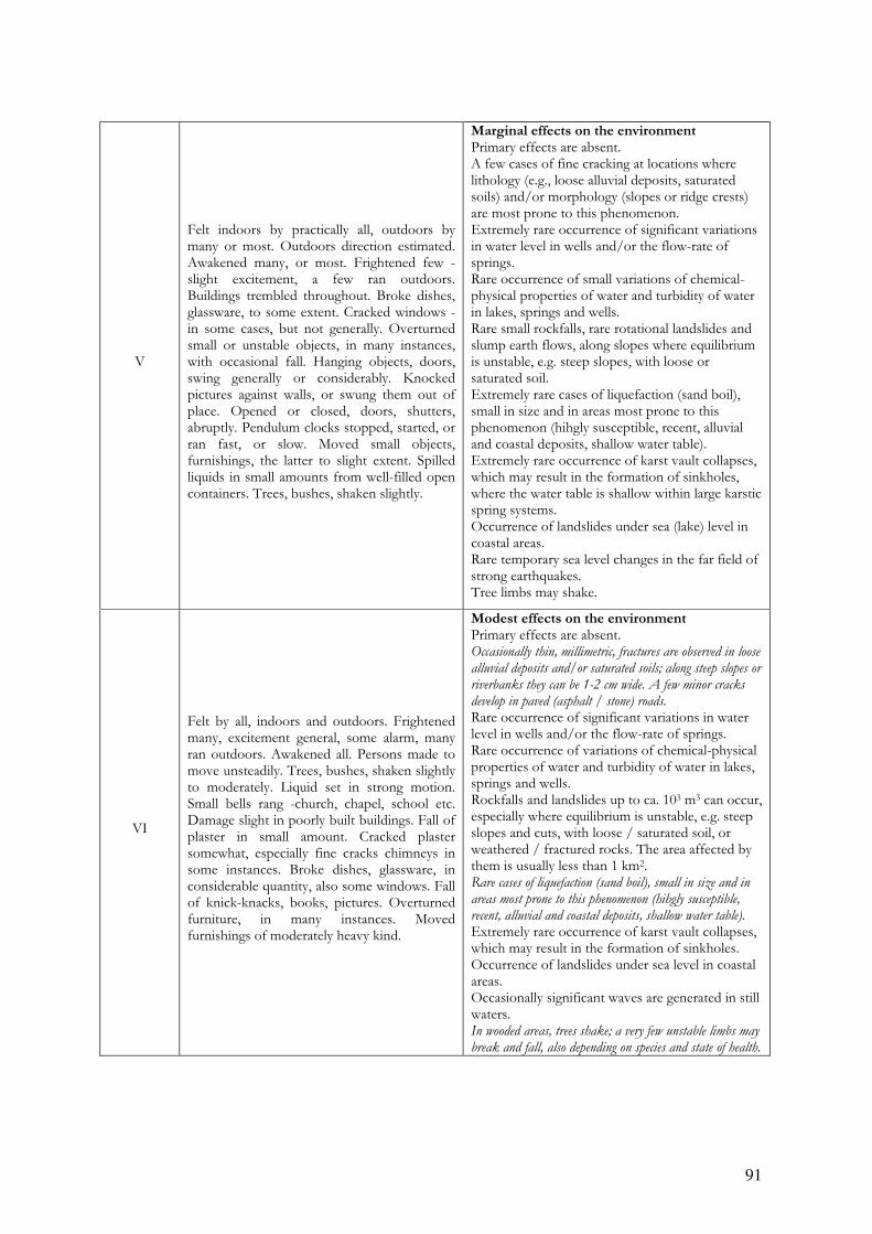
91
V
Felt indoors by practically all, outdoors by many or most. Outdoors direction estimated. Awakened many, or most. Frightened few - slight excitement, a few ran outdoors. Buildings trembled throughout. Broke dishes, glassware, to some extent. Cracked windows - in some cases, but not generally. Overturned small or unstable objects, in many instances, with occasional fall. Hanging objects, doors, swing generally or considerably. Knocked pictures against walls, or swung them out of place. Opened or closed, doors, shutters, abruptly. Pendulum clocks stopped, started, or ran fast, or slow. Moved small objects, furnishings, the latter to slight extent. Spilled liquids in small amounts from well-filled open containers. Trees, bushes, shaken slightly.
Marginal effects on the environment Primary effects are absent. A few cases of fine cracking at locations where lithology (e.g., loose alluvial deposits, saturated soils) and/or morphology (slopes or ridge crests) are most prone to this phenomenon. Extremely rare occurrence of significant variations in water level in wells and/or the flow-rate of springs. Rare occurrence of small variations of chemical-physical properties of water and turbidity of water in lakes, springs and wells. Rare small rockfalls, rare rotational landslides and slump earth flows, along slopes where equilibrium is unstable, e.g. steep slopes, with loose or saturated soil. Extremely rare cases of liquefaction (sand boil), small in size and in areas most prone to this phenomenon (hihgly susceptible, recent, alluvial and coastal deposits, shallow water table). Extremely rare occurrence of karst vault collapses, which may result in the formation of sinkholes, where the water table is shallow within large karstic spring systems. Occurrence of landslides under sea (lake) level in coastal areas. Rare temporary sea level changes in the far field of strong earthquakes. Tree limbs may shake.
VI
Felt by all, indoors and outdoors. Frightened many, excitement general, some alarm, many ran outdoors. Awakened all. Persons made to move unsteadily. Trees, bushes, shaken slightly to moderately. Liquid set in strong motion. Small bells rang -church, chapel, school etc. Damage slight in poorly built buildings. Fall of plaster in small amount. Cracked plaster somewhat, especially fine cracks chimneys in some instances. Broke dishes, glassware, in considerable quantity, also some windows. Fall of knick-knacks, books, pictures. Overturned furniture, in many instances. Moved furnishings of moderately heavy kind.
Modest effects on the environment Primary effects are absent. Occasionally thin, millimetric, fractures are observed in loose
alluvial deposits and/or saturated soils; along steep slopes or
riverbanks they can be 1-2 cm wide. A few minor cracks
develop in paved (asphalt / stone) roads.
Rare occurrence of significant variations in water level in wells and/or the flow-rate of springs. Rare occurrence of variations of chemical-physical properties of water and turbidity of water in lakes, springs and wells. Rockfalls and landslides up to ca. 103 m3 can occur, especially where equilibrium is unstable, e.g. steep slopes and cuts, with loose / saturated soil, or weathered / fractured rocks. The area affected by them is usually less than 1 km2. Rare cases of liquefaction (sand boil), small in size and in
areas most prone to this phenomenon (hihgly susceptible,
recent, alluvial and coastal deposits, shallow water table).
Extremely rare occurrence of karst vault collapses, which may result in the formation of sinkholes. Occurrence of landslides under sea level in coastal areas. Occasionally significant waves are generated in still waters. In wooded areas, trees shake; a very few unstable limbs may
break and fall, also depending on species and state of health.
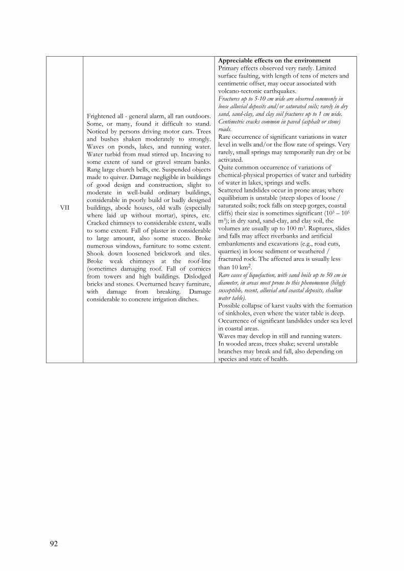
92
VII
Frightened all - general alarm, all ran outdoors. Some, or many, found it difficult to stand. Noticed by persons driving motor cars. Trees and bushes shaken moderately to strongly. Waves on ponds, lakes, and running water. Water turbid from mud stirred up. Incaving to some extent of sand or gravel stream banks. Rang large church bells, etc. Suspended objects made to quiver. Damage negligible in buildings of good design and construction, slight to moderate in well-build ordinary buildings, considerable in poorly build or badly designed buildings, abode houses, old walls (especially where laid up without mortar), spires, etc. Cracked chimneys to considerable extent, walls to some extent. Fall of plaster in considerable to large amount, also some stucco. Broke numerous windows, furniture to some extent. Shook down loosened brickwork and tiles. Broke weak chimneys at the roof-line (sometimes damaging roof. Fall of cornices from towers and high buildings. Dislodged bricks and stones. Overturned heavy furniture, with damage from breaking. Damage considerable to concrete irrigation ditches.
Appreciable effects on the environment Primary effects observed very rarely. Limited surface faulting, with length of tens of meters and centimetric offset, may occur associated with volcano-tectonic earthquakes. Fractures up to 5-10 cm wide are observed commonly in
loose alluvial deposits and/or saturated soils; rarely in dry
sand, sand-clay, and clay soil fractures up to 1 cm wide.
Centimetric cracks common in paved (asphalt or stone)
roads. Rare occurrence of significant variations in water level in wells and/or the flow rate of springs. Very rarely, small springs may temporarily run dry or be activated. Quite common occurrence of variations of chemical-physical properties of water and turbidity of water in lakes, springs and wells. Scattered landslides occur in prone areas; where equilibrium is unstable (steep slopes of loose / saturated soils; rock falls on steep gorges, coastal cliffs) their size is sometimes significant (103 – 105 m3); in dry sand, sand-clay, and clay soil, the volumes are usually up to 100 m3. Ruptures, slides and falls may affect riverbanks and artificial embankments and excavations (e.g., road cuts, quarries) in loose sediment or weathered / fractured rock. The affected area is usually less
than 10 km2. Rare cases of liquefaction, with sand boils up to 50 cm in
diameter, in areas most prone to this phenomenon (hihgly
susceptible, recent, alluvial and coastal deposits, shallow
water table). Possible collapse of karst vaults with the formation of sinkholes, even where the water table is deep. Occurrence of significant landslides under sea level in coastal areas. Waves may develop in still and running waters. In wooded areas, trees shake; several unstable branches may break and fall, also depending on species and state of health.

93
VIII
Fright general - alarm approaches panic. Disturbed persons driving motor cars. Trees shaken strongly - branches, trunks, broken off, especially palm trees. Ejected sand and mud in small amounts. Changes: temporary, permanent; in flow of springs and wells; dry wells renewed flow; in temperature of spring and well waters. Damage slight in structures (brick) built especially to withstand earthquakes. Considerable in ordinary substantial buildings, partial collapse: racked, tumbled down, wooden houses in some cases; threw out panel walls in frame structures, broke off decayed piling. Fall of walls. Cracked, broke, solid stone walls seriously. Wet ground to some extent, also ground on steep slopes. Twisting, fall, of chimneys, columns, monuments, also factory stack, towers. Moved conspicuously, overturned, very heavy furniture.
Considerable effects on the environement Primary effects observed rarely. Ground ruptures (surface
faulting) may develop, up to several hundred meters long,
with offsets generally smaller than 5 cm, particularly for very
shallow focus earthquakes, such as volcano-tectonic events.
Tectonic subsidence or uplift of the ground surface with
maximum values on the order of a few centimeters may
occur.
Fractures up to 25 - 50 cm wide are commonly observed in
loose alluvial deposits and/or saturated soils; in rare cases
fractures up to 1 cm can be observed in competent dry rocks.
Decimetric cracks common in paved (asphalt or stone)
roads, as well as small pressure undulations.
Springs can change, generally temporarily, their flow-rate
and/or elevation of outcrop. Some small springs may even
run dry. Variations in water level are observed in wells.
Water temperature often change in springs and/or wells.
Water in lakes and rivers frequently become muddy.
Small to moderate (103 – 105 m3) landslides widespread in prone areas; rarely they can occur also on gentle slopes; where equilibrium is unstable (steep slopes of loose / saturated soils; rock falls on steep gorges, coastal cliffs) their size is sometimes large (105 – 106 m3). Landslides can occasionally dam narrow valleys causing temporary or even permanent lakes. Ruptures, slides and falls affect riverbanks and artificial embankments and excavations (e.g., road cuts, quarries) in loose sediment or weathered / fractured rock. The affected area is usually less than 100 km2. Liquefaction may be frequent in the epicentral area,
depending on local conditions; sand boils up to ca. 1 m in
diameter; apparent water fountains in still waters; localised
lateral spreading and settlements (subsidence up to ca. 30
cm), with fissuring parallel to waterfront areas (river banks,
lakes, canals, seashores).
Karst vaults may collapse, forming sinkholes. Frequent occurrence of landslides under the sea level in coastal areas. Significant waves develop in still and running waters. Trees shake vigorously; some branches or rarely even tree-
trunks in very unstable equilibrium may break and fall.
In dry areas, dust clouds may rise from the ground in the
epicentral area.
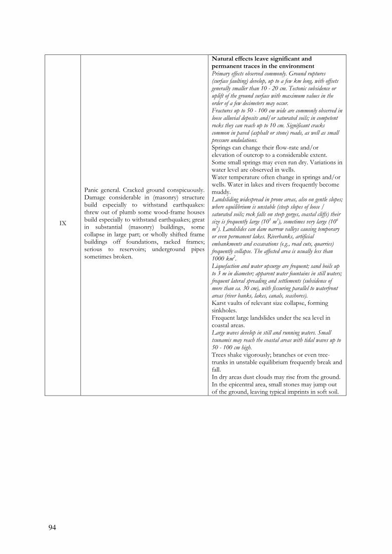
94
IX
Panic general. Cracked ground conspicuously. Damage considerable in (masonry) structure build especially to withstand earthquakes: threw out of plumb some wood-frame houses build especially to withstand earthquakes; great in substantial (masonry) buildings, some collapse in large part; or wholly shifted frame buildings off foundations, racked frames; serious to reservoirs; underground pipes sometimes broken.
Natural effects leave significant and permanent traces in the environment Primary effects observed commonly. Ground ruptures
(surface faulting) develop, up to a few km long, with offsets
generally smaller than 10 - 20 cm. Tectonic subsidence or
uplift of the ground surface with maximum values in the
order of a few decimeters may occur.
Fractures up to 50 - 100 cm wide are commonly observed in
loose alluvial deposits and/or saturated soils; in competent
rocks they can reach up to 10 cm. Significant cracks
common in paved (asphalt or stone) roads, as well as small
pressure undulations.
Springs can change their flow-rate and/or elevation of outcrop to a considerable extent. Some small springs may even run dry. Variations in water level are observed in wells. Water temperature often change in springs and/or wells. Water in lakes and rivers frequently become muddy. Landsliding widespread in prone areas, also on gentle slopes;
where equilibrium is unstable (steep slopes of loose /
saturated soils; rock falls on steep gorges, coastal cliffs) their
size is frequently large (105 m
3), sometimes very large (10
6
m3). Landslides can dam narrow valleys causing temporary
or even permanent lakes. Riverbanks, artificial
embankments and excavations (e.g., road cuts, quarries)
frequently collapse. The affected area is usually less than
1000 km2.
Liquefaction and water upsurge are frequent; sand boils up
to 3 m in diameter; apparent water fountains in still waters;
frequent lateral spreading and settlements (subsidence of
more than ca. 30 cm), with fissuring parallel to waterfront
areas (river banks, lakes, canals, seashores).
Karst vaults of relevant size collapse, forming sinkholes. Frequent large landslides under the sea level in coastal areas. Large waves develop in still and running waters. Small
tsunamis may reach the coastal areas with tidal waves up to
50 - 100 cm high.
Trees shake vigorously; branches or even tree-trunks in unstable equilibrium frequently break and fall. In dry areas dust clouds may rise from the ground. In the epicentral area, small stones may jump out of the ground, leaving typical imprints in soft soil.

95
X
Cracked ground, especially when loose and wet, up to widths of several inches; fissures up to a yard in width ran parallel to canal and stream banks. Landslides considerable from river banks and steep coasts. Shifted sand and mud horizontally on beaches and flat land. Changed level of water in wells. Threw water on banks of canals, lakes, rivers, etc. Damage serious to dams, dikes, embankments. Severe to well-build wooden structures and bridges, some destroyed. Developed dangerous cracks in excellent brick walls. Destroyed most masonry and frame structures, also their foundations. Bent railroad rails slightly. Tore apart, or crushed endwise, pipe lines buried in earth. Open cracks and broad wavy folds in
cement pavements and asphalt road surfaces.
Environmental effects become dominant Primary ruptures become leading. Ground ruptures (surface
faulting) can extend for several tens of km, with offsets
reaching 50 - 100 cm and more (up to ca. 1-2 m in case of
reverse faulting and 3-4 m for normal faulting). Gravity
grabens and elongated depressions develop; for very shallow
focus earthquakes, such as volcano-tectonic events, rupture
lengths might be much lower. Tectonic subsidence or uplift of
the ground surface with maximum values in the order of few
meters may occur.
Large landslides and rock-falls (> 105 – 10
6 m
3) are
frequent, practically regardless to equilibrium state of the
slopes, causing temporary or permanent barrier lakes. River
banks, artificial embankments, and sides of excavations
typically collapse. Levees and earth dams may even incur
serious damage. The affected area is usually up to 5000
km2.
Many springs significantly change their flow-rate and/or elevation of outcrop. Some may run dry or disappear, generally temporarily. Variations in water level are observed in wells. Water temperature often change in springs and/or wells. Water in lakes and rivers frequently become muddy. Open ground cracks up to more than 1 m wide are frequent,
mainly in loose alluvial deposits and/or saturated soils; in
competent rocks opening reach several decimeters. Wide
cracks develop in paved (asphalt or stone) roads, as well as
pressure undulations.
Liquefaction, with water upsurge and soil compaction, may
change the aspect of wide zones; sand volcanoes even more
than 6 m in diameter; vertical subsidence even > 1m; large
and long fissures due to lateral spreading are common.
Large karst vaults collapse, forming great sinkholes. Frequent large landslides under the sea level in coastal areas. Large waves develop in still and running waters, and crash
violently into the shores. Running (rivers, canals) and still
(lakes) waters may overflow from their beds. Tsunamis
reach the coastal areas, with tidal waves up to a few meters
high.
Trees shake vigorously; branches or even tree-trunks very frequently break and fall, if already in unstable equilibrium. In dry areas, dust clouds may rise from the ground. Stones, even if well anchored in the soil, may jump out of the
ground, leaving typical imprints in soft soil.
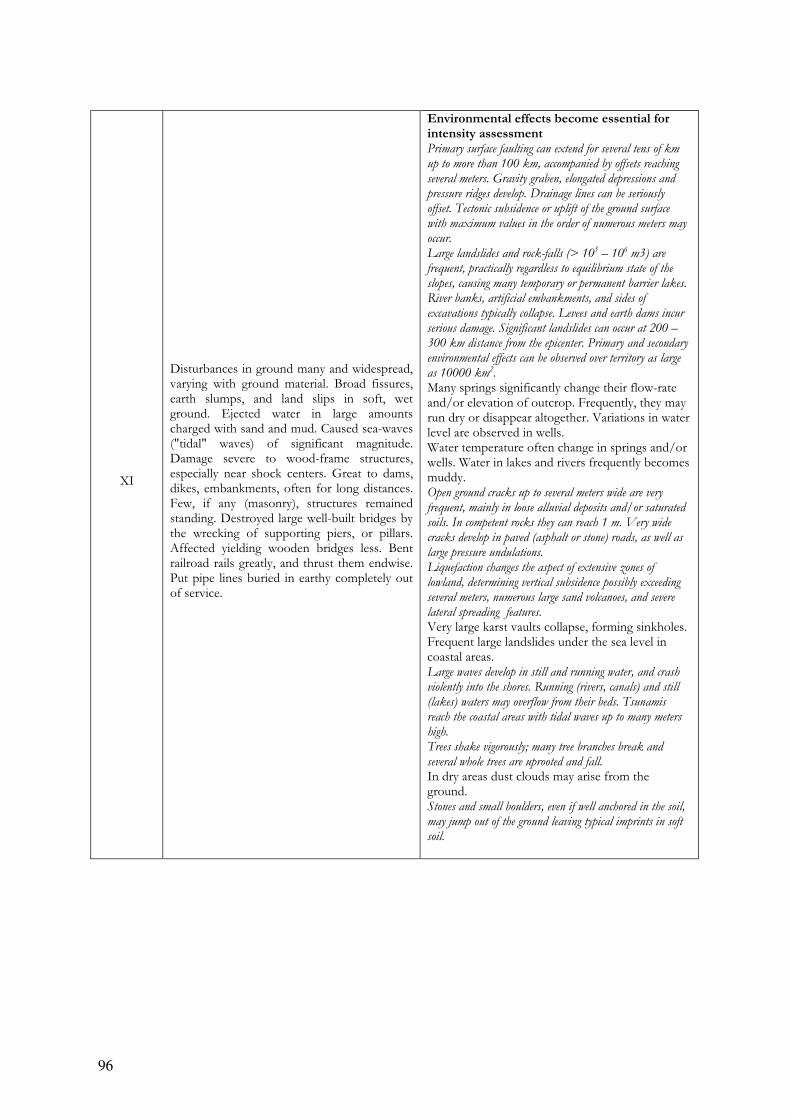
96
XI
Disturbances in ground many and widespread, varying with ground material. Broad fissures, earth slumps, and land slips in soft, wet ground. Ejected water in large amounts charged with sand and mud. Caused sea-waves ("tidal" waves) of significant magnitude. Damage severe to wood-frame structures, especially near shock centers. Great to dams, dikes, embankments, often for long distances. Few, if any (masonry), structures remained standing. Destroyed large well-built bridges by the wrecking of supporting piers, or pillars. Affected yielding wooden bridges less. Bent railroad rails greatly, and thrust them endwise. Put pipe lines buried in earthy completely out of service.
Environmental effects become essential for intensity assessment Primary surface faulting can extend for several tens of km
up to more than 100 km, accompanied by offsets reaching
several meters. Gravity graben, elongated depressions and
pressure ridges develop. Drainage lines can be seriously
offset. Tectonic subsidence or uplift of the ground surface
with maximum values in the order of numerous meters may
occur.
Large landslides and rock-falls (> 105 – 10
6 m3) are
frequent, practically regardless to equilibrium state of the
slopes, causing many temporary or permanent barrier lakes.
River banks, artificial embankments, and sides of
excavations typically collapse. Levees and earth dams incur
serious damage. Significant landslides can occur at 200 –
300 km distance from the epicenter. Primary and secondary
environmental effects can be observed over territory as large
as 10000 km2.
Many springs significantly change their flow-rate and/or elevation of outcrop. Frequently, they may run dry or disappear altogether. Variations in water level are observed in wells. Water temperature often change in springs and/or wells. Water in lakes and rivers frequently becomes muddy. Open ground cracks up to several meters wide are very
frequent, mainly in loose alluvial deposits and/or saturated
soils. In competent rocks they can reach 1 m. Very wide
cracks develop in paved (asphalt or stone) roads, as well as
large pressure undulations.
Liquefaction changes the aspect of extensive zones of
lowland, determining vertical subsidence possibly exceeding
several meters, numerous large sand volcanoes, and severe
lateral spreading features.
Very large karst vaults collapse, forming sinkholes. Frequent large landslides under the sea level in coastal areas. Large waves develop in still and running water, and crash
violently into the shores. Running (rivers, canals) and still
(lakes) waters may overflow from their beds. Tsunamis
reach the coastal areas with tidal waves up to many meters
high.
Trees shake vigorously; many tree branches break and
several whole trees are uprooted and fall.
In dry areas dust clouds may arise from the ground. Stones and small boulders, even if well anchored in the soil,
may jump out of the ground leaving typical imprints in soft
soil.
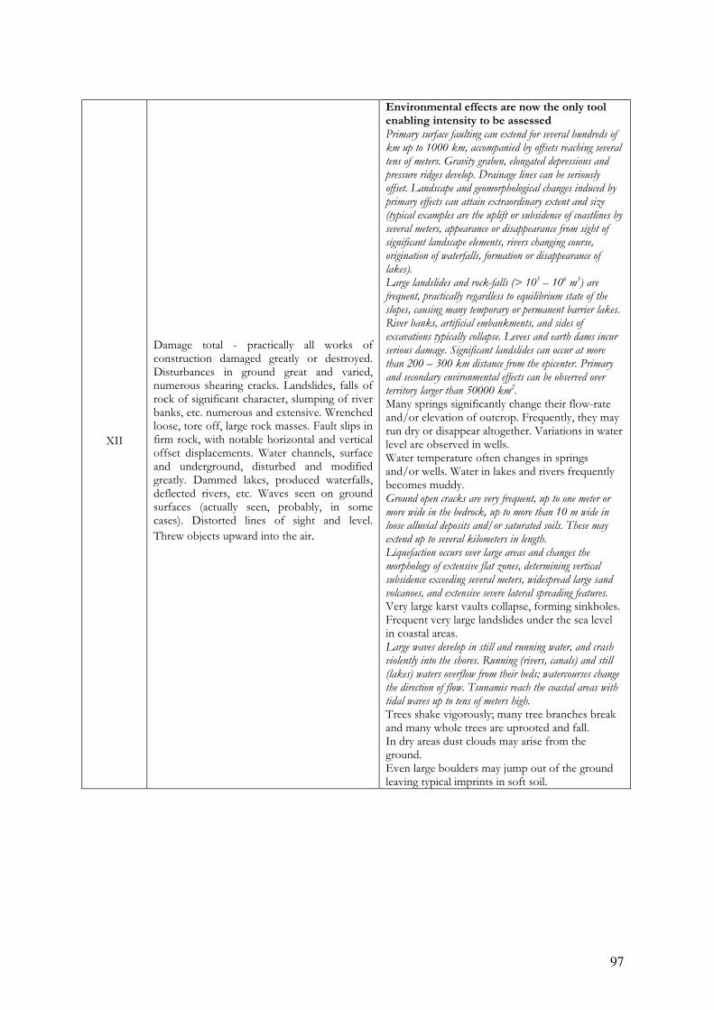
97
XII
Damage total - practically all works of construction damaged greatly or destroyed. Disturbances in ground great and varied, numerous shearing cracks. Landslides, falls of rock of significant character, slumping of river banks, etc. numerous and extensive. Wrenched loose, tore off, large rock masses. Fault slips in firm rock, with notable horizontal and vertical offset displacements. Water channels, surface and underground, disturbed and modified greatly. Dammed lakes, produced waterfalls, deflected rivers, etc. Waves seen on ground surfaces (actually seen, probably, in some cases). Distorted lines of sight and level.
Threw objects upward into the air.
Environmental effects are now the only tool enabling intensity to be assessed Primary surface faulting can extend for several hundreds of
km up to 1000 km, accompanied by offsets reaching several
tens of meters. Gravity graben, elongated depressions and
pressure ridges develop. Drainage lines can be seriously
offset. Landscape and geomorphological changes induced by
primary effects can attain extraordinary extent and size
(typical examples are the uplift or subsidence of coastlines by
several meters, appearance or disappearance from sight of
significant landscape elements, rivers changing course,
origination of waterfalls, formation or disappearance of
lakes).
Large landslides and rock-falls (> 105 – 10
6 m
3) are
frequent, practically regardless to equilibrium state of the
slopes, causing many temporary or permanent barrier lakes.
River banks, artificial embankments, and sides of
excavations typically collapse. Levees and earth dams incur
serious damage. Significant landslides can occur at more
than 200 – 300 km distance from the epicenter. Primary
and secondary environmental effects can be observed over
territory larger than 50000 km2.
Many springs significantly change their flow-rate and/or elevation of outcrop. Frequently, they may run dry or disappear altogether. Variations in water level are observed in wells. Water temperature often changes in springs and/or wells. Water in lakes and rivers frequently becomes muddy. Ground open cracks are very frequent, up to one meter or
more wide in the bedrock, up to more than 10 m wide in
loose alluvial deposits and/or saturated soils. These may
extend up to several kilometers in length.
Liquefaction occurs over large areas and changes the
morphology of extensive flat zones, determining vertical
subsidence exceeding several meters, widespread large sand
volcanoes, and extensive severe lateral spreading features.
Very large karst vaults collapse, forming sinkholes. Frequent very large landslides under the sea level in coastal areas. Large waves develop in still and running water, and crash
violently into the shores. Running (rivers, canals) and still
(lakes) waters overflow from their beds; watercourses change
the direction of flow. Tsunamis reach the coastal areas with
tidal waves up to tens of meters high.
Trees shake vigorously; many tree branches break and many whole trees are uprooted and fall. In dry areas dust clouds may arise from the ground. Even large boulders may jump out of the ground leaving typical imprints in soft soil.
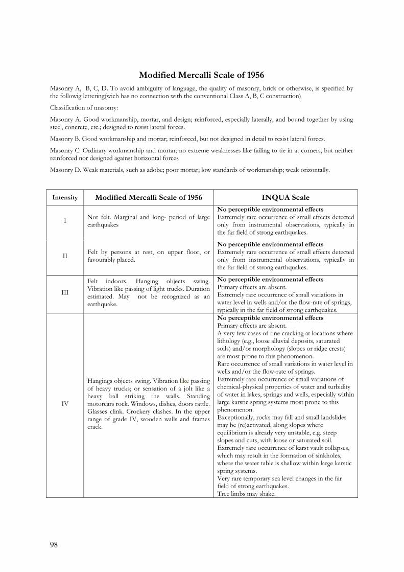
98
Modified Mercalli Scale of 1956
Masonry A, B, C, D. To avoid ambiguity of language, the quality of masonry, brick or otherwise, is specified by the followig lettering(wich has no connection with the conventional Class A, B, C construction)
Classification of masonry:
Masonry A. Good workmanship, mortar, and design; reinforced, especially laterally, and bound together by using steel, concrete, etc.; designed to resist lateral forces.
Masonry B. Good workmanship and mortar; reinforced, but not designed in detail to resist lateral forces.
Masonry C. Ordinary workmanship and mortar; no extreme weaknesses like failing to tie in at corners, but neither reinforced nor designed against horizontal forces
Masonry D. Weak materials, such as adobe; poor mortar; low standards of workmanship; weak orizontally.
Intensity Modified Mercalli Scale of 1956 INQUA Scale
I Not felt. Marginal and long- period of large earthquakes
No perceptible environmental effects Extremely rare occurrence of small effects detected only from instrumental observations, typically in the far field of strong earthquakes.
II Felt by persons at rest, on upper floor, or favourably placed.
No perceptible environmental effects Extremely rare occurrence of small effects detected only from instrumental observations, typically in the far field of strong earthquakes.
III
Felt indoors. Hanging objects swing. Vibration like passing of light trucks. Duration estimated. May not be recognized as an earthquake.
No perceptible environmental effects Primary effects are absent. Extremely rare occurrence of small variations in water level in wells and/or the flow-rate of springs, typically in the far field of strong earthquakes.
IV
Hangings objects swing. Vibration like passing of heavy trucks; or sensation of a jolt like a heavy ball striking the walls. Standing motorcars rock. Windows, dishes, doors rattle. Glasses clink. Crockery clashes. In the upper range of grade IV, wooden walls and frames crack.
No perceptible environmental effects Primary effects are absent. A very few cases of fine cracking at locations where lithology (e.g., loose alluvial deposits, saturated soils) and/or morphology (slopes or ridge crests) are most prone to this phenomenon. Rare occurrence of small variations in water level in wells and/or the flow-rate of springs. Extremely rare occurrence of small variations of chemical-physical properties of water and turbidity of water in lakes, springs and wells, especially within large karstic spring systems most prone to this phenomenon. Exceptionally, rocks may fall and small landslides may be (re)activated, along slopes where equilibrium is already very unstable, e.g. steep slopes and cuts, with loose or saturated soil. Extremely rare occurrence of karst vault collapses, which may result in the formation of sinkholes, where the water table is shallow within large karstic spring systems. Very rare temporary sea level changes in the far field of strong earthquakes. Tree limbs may shake.
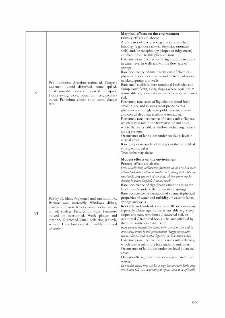
99
V
Felt outdoors; direction estimated. Sleepers wakened. Liquid disturbed, some spilled. Small unstable objects displaced or upset. Doors swing, close, open. Shutters, pictures move. Pendulum clocks stop, start, change rate.
Marginal effects on the environment Primary effects are absent. A few cases of fine cracking at locations where lithology (e.g., loose alluvial deposits, saturated soils) and/or morphology (slopes or ridge crests) are most prone to this phenomenon. Extremely rare occurrence of significant variations in water level in wells and/or the flow-rate of springs. Rare occurrence of small variations of chemical-physical properties of water and turbidity of water in lakes, springs and wells. Rare small rockfalls, rare rotational landslides and slump earth flows, along slopes where equilibrium is unstable, e.g. steep slopes, with loose or saturated soil. Extremely rare cases of liquefaction (sand boil), small in size and in areas most prone to this phenomenon (hihgly susceptible, recent, alluvial and coastal deposits, shallow water table). Extremely rare occurrence of karst vault collapses, which may result in the formation of sinkholes, where the water table is shallow within large karstic spring systems. Occurrence of landslides under sea (lake) level in coastal areas. Rare temporary sea level changes in the far field of strong earthquakes. Tree limbs may shake.
VI
Felt by all. Many frightened and run outdoors. Persons walk unsteadily. Windows, dishes, glassware broken. Knickknacks, books, and so on, off shelves. Pictures off walls. Furniture moved or overturned. Weak plaster and masonry D cracked. Small bells ring (church, school). Trees, bushes shaken visibly, or heard to rustle.
Modest effects on the environment Primary effects are absent. Occasionally thin, millimetric, fractures are observed in loose
alluvial deposits and/or saturated soils; along steep slopes or
riverbanks they can be 1-2 cm wide. A few minor cracks
develop in paved (asphalt / stone) roads.
Rare occurrence of significant variations in water level in wells and/or the flow-rate of springs. Rare occurrence of variations of chemical-physical properties of water and turbidity of water in lakes, springs and wells. Rockfalls and landslides up to ca. 103 m3 can occur, especially where equilibrium is unstable, e.g. steep slopes and cuts, with loose / saturated soil, or weathered / fractured rocks. The area affected by them is usually less than 1 km2. Rare cases of liquefaction (sand boil), small in size and in
areas most prone to this phenomenon (hihgly susceptible,
recent, alluvial and coastal deposits, shallow water table).
Extremely rare occurrence of karst vault collapses, which may result in the formation of sinkholes. Occurrence of landslides under sea level in coastal areas. Occasionally significant waves are generated in still waters. In wooded areas, trees shake; a very few unstable limbs may
break and fall, also depending on species and state of health.
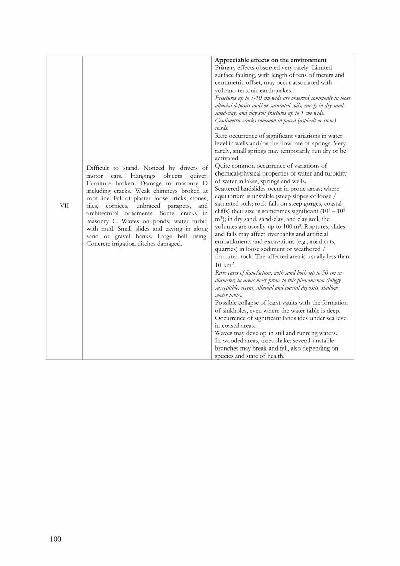
100
VII
Difficult to stand. Noticed by drivers of motor cars. Hangings objects quiver. Furniture broken. Damage to masonry D including cracks. Weak chimneys broken at roof line. Fall of plaster ,loose bricks, stones, tiles, cornices, unbraced parapets, and architectural ornaments. Some cracks in masonry C. Waves on ponds; water turbid with mud. Small slides and caving in along sand or gravel banks. Large bell rising. Concrete irrigation ditches damaged.
Appreciable effects on the environment Primary effects observed very rarely. Limited surface faulting, with length of tens of meters and centimetric offset, may occur associated with volcano-tectonic earthquakes. Fractures up to 5-10 cm wide are observed commonly in loose
alluvial deposits and/or saturated soils; rarely in dry sand,
sand-clay, and clay soil fractures up to 1 cm wide.
Centimetric cracks common in paved (asphalt or stone)
roads. Rare occurrence of significant variations in water level in wells and/or the flow rate of springs. Very rarely, small springs may temporarily run dry or be activated. Quite common occurrence of variations of chemical-physical properties of water and turbidity of water in lakes, springs and wells. Scattered landslides occur in prone areas; where equilibrium is unstable (steep slopes of loose / saturated soils; rock falls on steep gorges, coastal cliffs) their size is sometimes significant (103 – 105 m3); in dry sand, sand-clay, and clay soil, the volumes are usually up to 100 m3. Ruptures, slides and falls may affect riverbanks and artificial embankments and excavations (e.g., road cuts, quarries) in loose sediment or weathered / fractured rock. The affected area is usually less than
10 km2. Rare cases of liquefaction, with sand boils up to 50 cm in
diameter, in areas most prone to this phenomenon (hihgly
susceptible, recent, alluvial and coastal deposits, shallow
water table). Possible collapse of karst vaults with the formation of sinkholes, even where the water table is deep. Occurrence of significant landslides under sea level in coastal areas. Waves may develop in still and running waters. In wooded areas, trees shake; several unstable branches may break and fall, also depending on species and state of health.
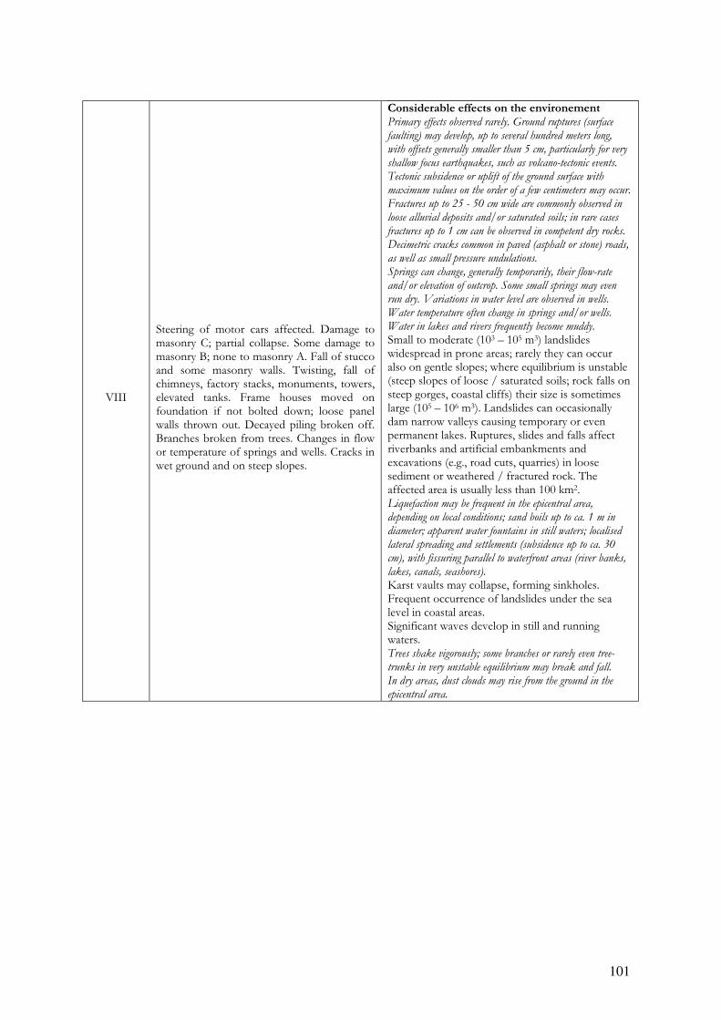
101
VIII
Steering of motor cars affected. Damage to masonry C; partial collapse. Some damage to masonry B; none to masonry A. Fall of stucco and some masonry walls. Twisting, fall of chimneys, factory stacks, monuments, towers, elevated tanks. Frame houses moved on foundation if not bolted down; loose panel walls thrown out. Decayed piling broken off. Branches broken from trees. Changes in flow or temperature of springs and wells. Cracks in wet ground and on steep slopes.
Considerable effects on the environement Primary effects observed rarely. Ground ruptures (surface
faulting) may develop, up to several hundred meters long,
with offsets generally smaller than 5 cm, particularly for very
shallow focus earthquakes, such as volcano-tectonic events.
Tectonic subsidence or uplift of the ground surface with
maximum values on the order of a few centimeters may occur.
Fractures up to 25 - 50 cm wide are commonly observed in
loose alluvial deposits and/or saturated soils; in rare cases
fractures up to 1 cm can be observed in competent dry rocks.
Decimetric cracks common in paved (asphalt or stone) roads,
as well as small pressure undulations.
Springs can change, generally temporarily, their flow-rate
and/or elevation of outcrop. Some small springs may even
run dry. Variations in water level are observed in wells.
Water temperature often change in springs and/or wells.
Water in lakes and rivers frequently become muddy.
Small to moderate (103 – 105 m3) landslides widespread in prone areas; rarely they can occur also on gentle slopes; where equilibrium is unstable (steep slopes of loose / saturated soils; rock falls on steep gorges, coastal cliffs) their size is sometimes large (105 – 106 m3). Landslides can occasionally dam narrow valleys causing temporary or even permanent lakes. Ruptures, slides and falls affect riverbanks and artificial embankments and excavations (e.g., road cuts, quarries) in loose sediment or weathered / fractured rock. The affected area is usually less than 100 km2. Liquefaction may be frequent in the epicentral area,
depending on local conditions; sand boils up to ca. 1 m in
diameter; apparent water fountains in still waters; localised
lateral spreading and settlements (subsidence up to ca. 30
cm), with fissuring parallel to waterfront areas (river banks,
lakes, canals, seashores).
Karst vaults may collapse, forming sinkholes. Frequent occurrence of landslides under the sea level in coastal areas. Significant waves develop in still and running waters. Trees shake vigorously; some branches or rarely even tree-
trunks in very unstable equilibrium may break and fall.
In dry areas, dust clouds may rise from the ground in the
epicentral area.
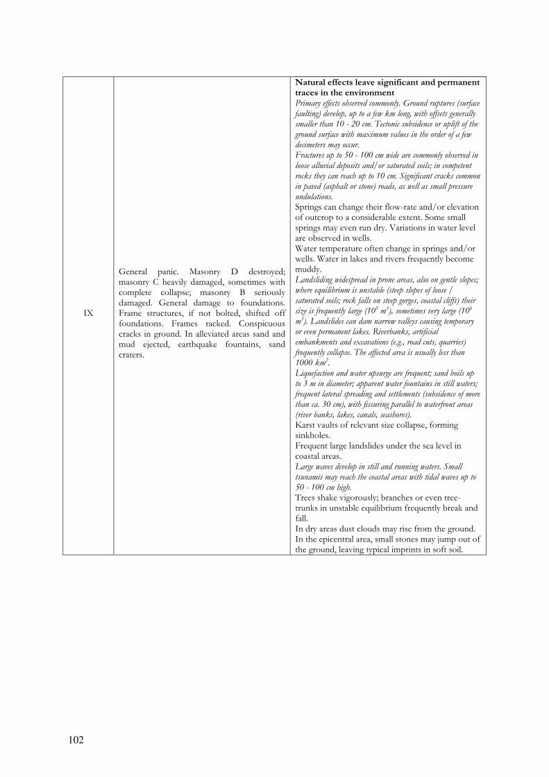
102
IX
General panic. Masonry D destroyed; masonry C heavily damaged, sometimes with complete collapse; masonry B seriously damaged. General damage to foundations. Frame structures, if not bolted, shifted off foundations. Frames racked. Conspicuous cracks in ground. In alleviated areas sand and mud ejected, earthquake fountains, sand craters.
Natural effects leave significant and permanent traces in the environment Primary effects observed commonly. Ground ruptures (surface
faulting) develop, up to a few km long, with offsets generally
smaller than 10 - 20 cm. Tectonic subsidence or uplift of the
ground surface with maximum values in the order of a few
decimeters may occur.
Fractures up to 50 - 100 cm wide are commonly observed in
loose alluvial deposits and/or saturated soils; in competent
rocks they can reach up to 10 cm. Significant cracks common
in paved (asphalt or stone) roads, as well as small pressure
undulations.
Springs can change their flow-rate and/or elevation of outcrop to a considerable extent. Some small springs may even run dry. Variations in water level are observed in wells. Water temperature often change in springs and/or wells. Water in lakes and rivers frequently become muddy. Landsliding widespread in prone areas, also on gentle slopes;
where equilibrium is unstable (steep slopes of loose /
saturated soils; rock falls on steep gorges, coastal cliffs) their
size is frequently large (105 m
3), sometimes very large (10
6
m3). Landslides can dam narrow valleys causing temporary
or even permanent lakes. Riverbanks, artificial
embankments and excavations (e.g., road cuts, quarries)
frequently collapse. The affected area is usually less than
1000 km2.
Liquefaction and water upsurge are frequent; sand boils up
to 3 m in diameter; apparent water fountains in still waters;
frequent lateral spreading and settlements (subsidence of more
than ca. 30 cm), with fissuring parallel to waterfront areas
(river banks, lakes, canals, seashores).
Karst vaults of relevant size collapse, forming sinkholes. Frequent large landslides under the sea level in coastal areas. Large waves develop in still and running waters. Small
tsunamis may reach the coastal areas with tidal waves up to
50 - 100 cm high.
Trees shake vigorously; branches or even tree-trunks in unstable equilibrium frequently break and fall. In dry areas dust clouds may rise from the ground. In the epicentral area, small stones may jump out of the ground, leaving typical imprints in soft soil.
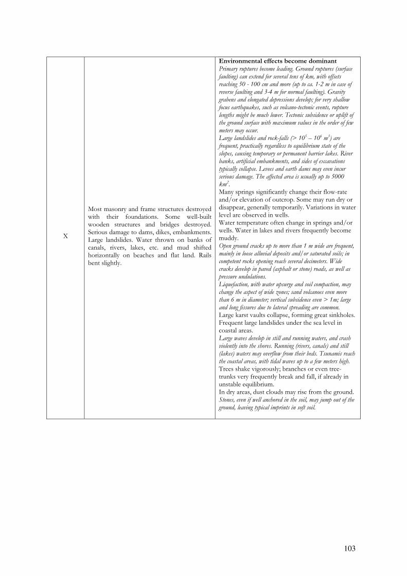
103
X
Most masonry and frame structures destroyed with their foundations. Some well-built wooden structures and bridges destroyed. Serious damage to dams, dikes, embankments. Large landslides. Water thrown on banks of canals, rivers, lakes, etc. and mud shifted horizontally on beaches and flat land. Rails bent slightly.
Environmental effects become dominant Primary ruptures become leading. Ground ruptures (surface
faulting) can extend for several tens of km, with offsets
reaching 50 - 100 cm and more (up to ca. 1-2 m in case of
reverse faulting and 3-4 m for normal faulting). Gravity
grabens and elongated depressions develop; for very shallow
focus earthquakes, such as volcano-tectonic events, rupture
lengths might be much lower. Tectonic subsidence or uplift of
the ground surface with maximum values in the order of few
meters may occur.
Large landslides and rock-falls (> 105 – 10
6 m
3) are
frequent, practically regardless to equilibrium state of the
slopes, causing temporary or permanent barrier lakes. River
banks, artificial embankments, and sides of excavations
typically collapse. Levees and earth dams may even incur
serious damage. The affected area is usually up to 5000
km2.
Many springs significantly change their flow-rate and/or elevation of outcrop. Some may run dry or disappear, generally temporarily. Variations in water level are observed in wells. Water temperature often change in springs and/or wells. Water in lakes and rivers frequently become muddy. Open ground cracks up to more than 1 m wide are frequent,
mainly in loose alluvial deposits and/or saturated soils; in
competent rocks opening reach several decimeters. Wide
cracks develop in paved (asphalt or stone) roads, as well as
pressure undulations.
Liquefaction, with water upsurge and soil compaction, may
change the aspect of wide zones; sand volcanoes even more
than 6 m in diameter; vertical subsidence even > 1m; large
and long fissures due to lateral spreading are common.
Large karst vaults collapse, forming great sinkholes. Frequent large landslides under the sea level in coastal areas. Large waves develop in still and running waters, and crash
violently into the shores. Running (rivers, canals) and still
(lakes) waters may overflow from their beds. Tsunamis reach
the coastal areas, with tidal waves up to a few meters high.
Trees shake vigorously; branches or even tree-trunks very frequently break and fall, if already in unstable equilibrium. In dry areas, dust clouds may rise from the ground. Stones, even if well anchored in the soil, may jump out of the
ground, leaving typical imprints in soft soil.

104
XI Rails bent greatly. Underground pipelines completely out of service.
Environmental effects become essential for intensity assessment Primary surface faulting can extend for several tens of km up
to more than 100 km, accompanied by offsets reaching
several meters. Gravity graben, elongated depressions and
pressure ridges develop. Drainage lines can be seriously offset.
Tectonic subsidence or uplift of the ground surface with
maximum values in the order of numerous meters may occur.
Large landslides and rock-falls (> 105 – 10
6 m3) are
frequent, practically regardless to equilibrium state of the
slopes, causing many temporary or permanent barrier lakes.
River banks, artificial embankments, and sides of
excavations typically collapse. Levees and earth dams incur
serious damage. Significant landslides can occur at 200 –
300 km distance from the epicenter. Primary and secondary
environmental effects can be observed over territory as large as
10000 km2.
Many springs significantly change their flow-rate and/or elevation of outcrop. Frequently, they may run dry or disappear altogether. Variations in water level are observed in wells. Water temperature often change in springs and/or wells. Water in lakes and rivers frequently becomes muddy. Open ground cracks up to several meters wide are very
frequent, mainly in loose alluvial deposits and/or saturated
soils. In competent rocks they can reach 1 m. Very wide
cracks develop in paved (asphalt or stone) roads, as well as
large pressure undulations.
Liquefaction changes the aspect of extensive zones of lowland,
determining vertical subsidence possibly exceeding several
meters, numerous large sand volcanoes, and severe lateral
spreading features.
Very large karst vaults collapse, forming sinkholes. Frequent large landslides under the sea level in coastal areas. Large waves develop in still and running water, and crash
violently into the shores. Running (rivers, canals) and still
(lakes) waters may overflow from their beds. Tsunamis reach
the coastal areas with tidal waves up to many meters high.
Trees shake vigorously; many tree branches break and several
whole trees are uprooted and fall.
In dry areas dust clouds may arise from the ground. Stones and small boulders, even if well anchored in the soil,
may jump out of the ground leaving typical imprints in soft
soil.
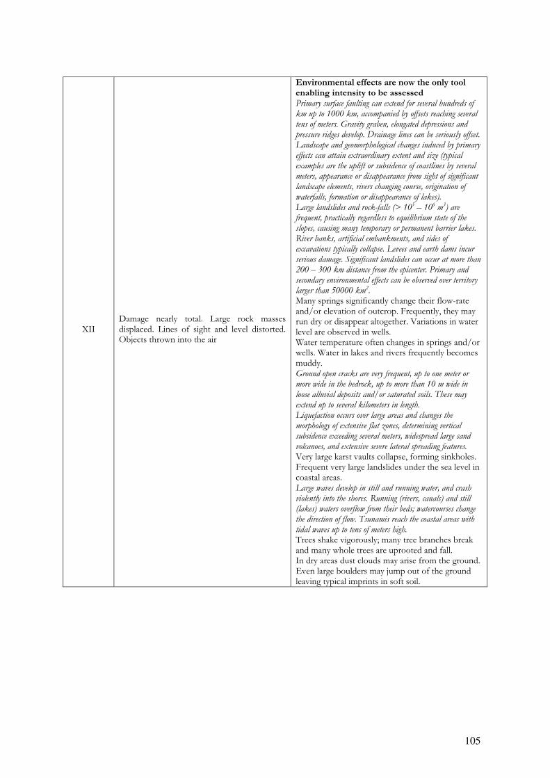
105
XII Damage nearly total. Large rock masses displaced. Lines of sight and level distorted. Objects thrown into the air
Environmental effects are now the only tool enabling intensity to be assessed Primary surface faulting can extend for several hundreds of
km up to 1000 km, accompanied by offsets reaching several
tens of meters. Gravity graben, elongated depressions and
pressure ridges develop. Drainage lines can be seriously offset.
Landscape and geomorphological changes induced by primary
effects can attain extraordinary extent and size (typical
examples are the uplift or subsidence of coastlines by several
meters, appearance or disappearance from sight of significant
landscape elements, rivers changing course, origination of
waterfalls, formation or disappearance of lakes).
Large landslides and rock-falls (> 105 – 10
6 m
3) are
frequent, practically regardless to equilibrium state of the
slopes, causing many temporary or permanent barrier lakes.
River banks, artificial embankments, and sides of
excavations typically collapse. Levees and earth dams incur
serious damage. Significant landslides can occur at more than
200 – 300 km distance from the epicenter. Primary and
secondary environmental effects can be observed over territory
larger than 50000 km2.
Many springs significantly change their flow-rate and/or elevation of outcrop. Frequently, they may run dry or disappear altogether. Variations in water level are observed in wells. Water temperature often changes in springs and/or wells. Water in lakes and rivers frequently becomes muddy. Ground open cracks are very frequent, up to one meter or
more wide in the bedrock, up to more than 10 m wide in
loose alluvial deposits and/or saturated soils. These may
extend up to several kilometers in length.
Liquefaction occurs over large areas and changes the
morphology of extensive flat zones, determining vertical
subsidence exceeding several meters, widespread large sand
volcanoes, and extensive severe lateral spreading features.
Very large karst vaults collapse, forming sinkholes. Frequent very large landslides under the sea level in coastal areas. Large waves develop in still and running water, and crash
violently into the shores. Running (rivers, canals) and still
(lakes) waters overflow from their beds; watercourses change
the direction of flow. Tsunamis reach the coastal areas with
tidal waves up to tens of meters high.
Trees shake vigorously; many tree branches break and many whole trees are uprooted and fall. In dry areas dust clouds may arise from the ground. Even large boulders may jump out of the ground leaving typical imprints in soft soil.

106
MSK Scale
Types of the structures (building not antiseismic)
Structure A: Buildings in field-stone, rural structures, adobe houses, clay houses.
B: Ordinary brick buildings, buildings of the large block and prefabricated type, half-timbered structures, buildings in natural hewn stone.
C: Reinforced buildings, well-built wooden structures.
Definition of quantity Single, a few: about 5%
Many: about 50%
Most: about 74%
Classification of damage to buildings Grade 1: Slight damage. Fine cracks in plaster; fall of small pieces of plaster. Grade 2: Moderate damage. Small cracks in wall; fall of fairly large pieces of plaster; pantiles slip off; cracks in chimneys; parts of chimneys fall down. Grade 3: Heavy damage. Large and deep cracks in walls; fall of chimneys. Grade 4: Destruction. Gaps in walls; parts of buildings may collapse; separate parts of the buildings lose their cohesion; inner walls and filled-in walls of the frame collapse. Grade 5: Total damage. Total collapse of buildings.
Intensity MSK Scale INQUA Scale
I
Not noticeable
The intensity of the vibration is below the limit of sensibility; the tremor is detected and recorded by seismographs only.
No perceptible environmental effects Extremely rare occurrence of small effects detected only from instrumental observations, typically in the far field of strong earthquakes.
II
Scarcely noticeable(very slight)
Vibration is felt only by individual people at rest in house, especially on upper floor of buildings.
No perceptible environmental effects Extremely rare occurrence of small effects detected only from instrumental observations, typically in the far field of strong earthquakes.
III
Weak, partially observed only
The earthquake is felt indoors by a few people, outdoors only in favourable circumstances. The vibration is like that due to the passing of a light truck. Attentive observers notice a slight swinging of hanging objects, somewhat more heavily on upper floor.
No perceptible environmental effects Primary effects are absent. Extremely rare occurrence of small variations in water level in wells and/or the flow-rate of springs, typically in the far field of strong earthquakes.
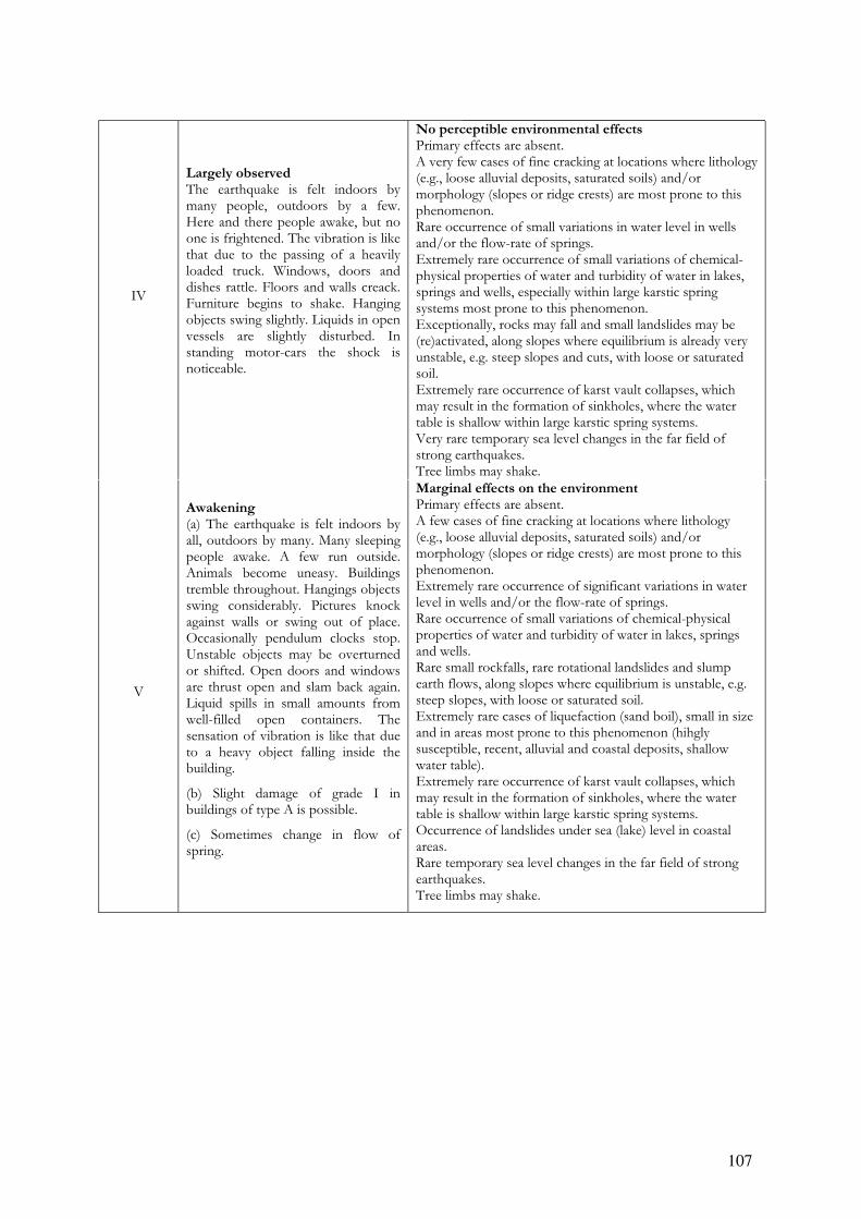
107
IV
Largely observed The earthquake is felt indoors by many people, outdoors by a few. Here and there people awake, but no one is frightened. The vibration is like that due to the passing of a heavily loaded truck. Windows, doors and dishes rattle. Floors and walls creack. Furniture begins to shake. Hanging objects swing slightly. Liquids in open vessels are slightly disturbed. In standing motor-cars the shock is noticeable.
No perceptible environmental effects Primary effects are absent. A very few cases of fine cracking at locations where lithology (e.g., loose alluvial deposits, saturated soils) and/or morphology (slopes or ridge crests) are most prone to this phenomenon. Rare occurrence of small variations in water level in wells and/or the flow-rate of springs. Extremely rare occurrence of small variations of chemical-physical properties of water and turbidity of water in lakes, springs and wells, especially within large karstic spring systems most prone to this phenomenon. Exceptionally, rocks may fall and small landslides may be (re)activated, along slopes where equilibrium is already very unstable, e.g. steep slopes and cuts, with loose or saturated soil. Extremely rare occurrence of karst vault collapses, which may result in the formation of sinkholes, where the water table is shallow within large karstic spring systems. Very rare temporary sea level changes in the far field of strong earthquakes. Tree limbs may shake.
V
Awakening (a) The earthquake is felt indoors by all, outdoors by many. Many sleeping people awake. A few run outside. Animals become uneasy. Buildings tremble throughout. Hangings objects swing considerably. Pictures knock against walls or swing out of place. Occasionally pendulum clocks stop. Unstable objects may be overturned or shifted. Open doors and windows are thrust open and slam back again. Liquid spills in small amounts from well-filled open containers. The sensation of vibration is like that due to a heavy object falling inside the building.
(b) Slight damage of grade I in buildings of type A is possible.
(c) Sometimes change in flow of spring.
Marginal effects on the environment Primary effects are absent. A few cases of fine cracking at locations where lithology (e.g., loose alluvial deposits, saturated soils) and/or morphology (slopes or ridge crests) are most prone to this phenomenon. Extremely rare occurrence of significant variations in water level in wells and/or the flow-rate of springs. Rare occurrence of small variations of chemical-physical properties of water and turbidity of water in lakes, springs and wells. Rare small rockfalls, rare rotational landslides and slump earth flows, along slopes where equilibrium is unstable, e.g. steep slopes, with loose or saturated soil. Extremely rare cases of liquefaction (sand boil), small in size and in areas most prone to this phenomenon (hihgly susceptible, recent, alluvial and coastal deposits, shallow water table). Extremely rare occurrence of karst vault collapses, which may result in the formation of sinkholes, where the water table is shallow within large karstic spring systems. Occurrence of landslides under sea (lake) level in coastal areas. Rare temporary sea level changes in the far field of strong earthquakes. Tree limbs may shake.

108
VI
Frightening (a)Felt by most, indoors and outdoMany people in buildings are frighteand run outdoors. A few persons lose tbalance. Domestic animals run out of tstalls. In a few instances dishes glassware may break, books fall dowHeavy furniture may possibly move small steeple bells may ring.. (b) Damage of grade 1 is sustained in single buildings of type B and in many of type A. Damage in a few buildings of type A is of grade 2.
(c) In a few cases cracks up to widths of 1 cm possible in wet ground; in mountains occasional landslides; changes in flow of springs and in level of well-water are observed.
Modest effects on the environment Primary effects are absent. Occasionally thin, millimetric, fractures are observed in loose alluvial
deposits and/or saturated soils; along steep slopes or riverbanks they
can be 1-2 cm wide. A few minor cracks develop in paved (asphalt /
stone) roads.
Rare occurrence of significant variations in water level in wells and/or the flow-rate of springs. Rare occurrence of variations of chemical-physical properties of water and turbidity of water in lakes, springs and wells. Rockfalls and landslides up to ca. 103 m3 can occur, especially where equilibrium is unstable, e.g. steep slopes and cuts, with loose / saturated soil, or weathered / fractured rocks. The area affected by them is usually less than 1 km2. Rare cases of liquefaction (sand boil), small in size and in areas most
prone to this phenomenon (hihgly susceptible, recent, alluvial and coastal
deposits, shallow water table).
Extremely rare occurrence of karst vault collapses, which may result in the formation of sinkholes. Occurrence of landslides under sea level in coastal areas. Occasionally significant waves are generated in still waters. In wooded areas, trees shake; a very few unstable limbs may break and
fall, also depending on species and state of health.
VII
Damage to buildings (a) Most people are frightened and run outdoors . Many find it difficult to stand. The vibration is noticed by persons driving motor-cars. Large bells ring.
(b) In many buildings of type C damage of grade 1 is caused; in many buildings of type B damage is of grade 2. Many buildings of type A suffer damage of grade 3, a few of grade 4.In single instances landslips of roadway on step slopes; cracks in roads; seams of pipelines damaged ; cracks in stone walls
(c) Waves are formed on water, and water is made turbid by mud stirred up. Water levels in wells change, and the flow of springs changes. In a few cases dry springs have their flow restored and existing springs stop flowing. In isolated instances parts of sandy or gravelly banks slip off
Appreciable effects on the environment Primary effects observed very rarely. Limited surface faulting, with length of tens of meters and centimetric offset, may occur associated with volcano-tectonic earthquakes. Fractures up to 5-10 cm wide are observed commonly in loose alluvial
deposits and/or saturated soils; rarely in dry sand, sand-clay, and clay
soil fractures up to 1 cm wide. Centimetric cracks common in paved
(asphalt or stone) roads. Rare occurrence of significant variations in water level in wells and/or the flow rate of springs. Very rarely, small springs may temporarily run dry or be activated. Quite common occurrence of variations of chemical-physical properties of water and turbidity of water in lakes, springs and wells. Scattered landslides occur in prone areas; where equilibrium is unstable (steep slopes of loose / saturated soils; rock falls on steep gorges, coastal cliffs) their size is sometimes significant (103 – 105 m3); in dry sand, sand-clay, and clay soil, the volumes are usually up to 100 m3. Ruptures, slides and falls may affect riverbanks and artificial embankments and excavations (e.g., road cuts, quarries) in loose sediment or weathered / fractured rock. The affected area is usually
less than 10 km2. Rare cases of liquefaction, with sand boils up to 50 cm in diameter, in
areas most prone to this phenomenon (hihgly susceptible, recent, alluvial
and coastal deposits, shallow water table). Possible collapse of karst vaults with the formation of sinkholes, even where the water table is deep. Occurrence of significant landslides under sea level in coastal areas. Waves may develop in still and running waters. In wooded areas, trees shake; several unstable branches may break and fall, also depending on species and state of health.

109
VIII
Destruction of buildings (a)Fright and panic; also persons driving motor-cars are disturbed. Here and there branches of trees break off. Even heavy furniture moves and partly overturns. Hanging lamps are in part damaged.
(b)Many buildings of type C suffer damage of grade 2 , a few of grade 3. Many buildings of type B suffer damage of grade 3 and a few of grade 4, and many buildings of type A suffer damage of grade 4 and a few of grade 5.Occasional breakage of pipe seams. Memorials and monuments move and twist. Tombstones overturn. Stone walls collapse.
Considerable effects on the environement Primary effects observed rarely. Ground ruptures (surface faulting) may
develop, up to several hundred meters long, with offsets generally smaller
than 5 cm, particularly for very shallow focus earthquakes, such as
volcano-tectonic events. Tectonic subsidence or uplift of the ground
surface with maximum values on the order of a few centimeters may
occur.
Fractures up to 25 - 50 cm wide are commonly observed in loose
alluvial deposits and/or saturated soils; in rare cases fractures up to 1
cm can be observed in competent dry rocks. Decimetric cracks common
in paved (asphalt or stone) roads, as well as small pressure undulations.
Springs can change, generally temporarily, their flow-rate and/or
elevation of outcrop. Some small springs may even run dry. Variations
in water level are observed in wells.
Water temperature often change in springs and/or wells. Water in
lakes and rivers frequently become muddy.
Small to moderate (103 – 105 m3) landslides widespread in prone areas; rarely they can occur also on gentle slopes; where equilibrium is unstable (steep slopes of loose / saturated soils; rock falls on steep gorges, coastal cliffs) their size is sometimes large (105 – 106 m3). Landslides can occasionally dam narrow valleys causing temporary or even permanent lakes. Ruptures, slides and falls affect riverbanks and artificial embankments and excavations (e.g., road cuts, quarries) in loose sediment or weathered / fractured rock. The affected area is usually less than 100 km2. Liquefaction may be frequent in the epicentral area, depending on local
conditions; sand boils up to ca. 1 m in diameter; apparent water
fountains in still waters; localised lateral spreading and settlements
(subsidence up to ca. 30 cm), with fissuring parallel to waterfront areas
(river banks, lakes, canals, seashores).
Karst vaults may collapse, forming sinkholes. Frequent occurrence of landslides under the sea level in coastal areas. Significant waves develop in still and running waters. Trees shake vigorously; some branches or rarely even tree-trunks in very
unstable equilibrium may break and fall.
In dry areas, dust clouds may rise from the ground in the epicentral
area.

110
IX
General damage to buildings (a) General panic; considerable damage to furniture. Animals run and fro in confusion and cry.
(b) Many buildings of type C suffer damage of grade 3, a few of grade 4. Many buildings of type B show damage of grade 4, a few of grade 5 . Many buildings of type A suffer damage of grade 5. Monuments and column falls. Considerable damage to reservoirs; undergrounds pipes partly broken. In individual cases railway lines are bent and roadways damaged.
(c) On flat land, overflow of water, sand and mud is often observed. Ground cracks to widths of up to 10 cm, on slopes and river banks more than 10 cm; furthermore a large number of slight cracks in ground; falls of rock, many land slides and earth flows; large waves on water. Dry wells renew their flow and existing wells dry up.
Natural effects leave significant and permanent traces in the environment Primary effects observed commonly. Ground ruptures (surface faulting)
develop, up to a few km long, with offsets generally smaller than 10 -
20 cm. Tectonic subsidence or uplift of the ground surface with
maximum values in the order of a few decimeters may occur.
Fractures up to 50 - 100 cm wide are commonly observed in loose
alluvial deposits and/or saturated soils; in competent rocks they can
reach up to 10 cm. Significant cracks common in paved (asphalt or
stone) roads, as well as small pressure undulations.
Springs can change their flow-rate and/or elevation of outcrop to a considerable extent. Some small springs may even run dry. Variations in water level are observed in wells. Water temperature often change in springs and/or wells. Water in lakes and rivers frequently become muddy. Landsliding widespread in prone areas, also on gentle slopes; where
equilibrium is unstable (steep slopes of loose / saturated soils; rock falls
on steep gorges, coastal cliffs) their size is frequently large (105 m
3),
sometimes very large (106 m
3). Landslides can dam narrow valleys
causing temporary or even permanent lakes. Riverbanks, artificial
embankments and excavations (e.g., road cuts, quarries) frequently
collapse. The affected area is usually less than 1000 km2.
Liquefaction and water upsurge are frequent; sand boils up to 3 m in
diameter; apparent water fountains in still waters; frequent lateral
spreading and settlements (subsidence of more than ca. 30 cm), with
fissuring parallel to waterfront areas (river banks, lakes, canals,
seashores).
Karst vaults of relevant size collapse, forming sinkholes. Frequent large landslides under the sea level in coastal areas. Large waves develop in still and running waters. Small tsunamis may
reach the coastal areas with tidal waves up to 50 - 100 cm high.
Trees shake vigorously; branches or even tree-trunks in unstable equilibrium frequently break and fall. In dry areas dust clouds may rise from the ground. In the epicentral area, small stones may jump out of the ground, leaving typical imprints in soft soil.
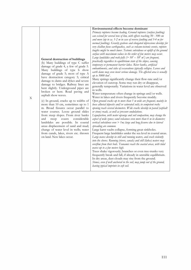
111
X
General destruction of buildings (b) Many buildings of type C suffer damage of grade 4, a few of grade 5. Many buildings of type b show damage of grade 5; most of type A have destruction category 5; critical damage to dams and dykes and severe damage to bridges. Railway lines are bent slightly. Underground pipes are broken or bent. Road paving and asphalt show waves.
(c) In ground, cracks up to widths of more than 10 cm, sometimes up to 1 m. Broad fissures occur parallel to water courses. Loose ground slides from steep slopes. From river banks and steep coasts considerable landslides are possible. In coastal areas displacement of sand and mud; change of water level in wells; water from canals, lakes, rivers etc. thrown on land. New lakes occur.
Environmental effects become dominant Primary ruptures become leading. Ground ruptures (surface faulting)
can extend for several tens of km, with offsets reaching 50 - 100 cm
and more (up to ca. 1-2 m in case of reverse faulting and 3-4 m for
normal faulting). Gravity grabens and elongated depressions develop; for
very shallow focus earthquakes, such as volcano-tectonic events, rupture
lengths might be much lower. Tectonic subsidence or uplift of the ground
surface with maximum values in the order of few meters may occur.
Large landslides and rock-falls (> 105 – 10
6 m
3) are frequent,
practically regardless to equilibrium state of the slopes, causing
temporary or permanent barrier lakes. River banks, artificial
embankments, and sides of excavations typically collapse. Levees and
earth dams may even incur serious damage. The affected area is usually
up to 5000 km2.
Many springs significantly change their flow-rate and/or elevation of outcrop. Some may run dry or disappear, generally temporarily. Variations in water level are observed in wells. Water temperature often change in springs and/or wells. Water in lakes and rivers frequently become muddy. Open ground cracks up to more than 1 m wide are frequent, mainly in
loose alluvial deposits and/or saturated soils; in competent rocks
opening reach several decimeters. Wide cracks develop in paved (asphalt
or stone) roads, as well as pressure undulations.
Liquefaction, with water upsurge and soil compaction, may change the
aspect of wide zones; sand volcanoes even more than 6 m in diameter;
vertical subsidence even > 1m; large and long fissures due to lateral
spreading are common.
Large karst vaults collapse, forming great sinkholes. Frequent large landslides under the sea level in coastal areas. Large waves develop in still and running waters, and crash violently
into the shores. Running (rivers, canals) and still (lakes) waters may
overflow from their beds. Tsunamis reach the coastal areas, with tidal
waves up to a few meters high.
Trees shake vigorously; branches or even tree-trunks very frequently break and fall, if already in unstable equilibrium. In dry areas, dust clouds may rise from the ground. Stones, even if well anchored in the soil, may jump out of the ground,
leaving typical imprints in soft soil.

112
XI
Catastrophe (b) Severe damage even to well-built buildings, bridges, water dams and railway lines; highways become useless; underground pipes destroyed.
(c) Ground considerably distorted by broad cracks and fissures, as wells as by movement in horizontal and vertical directions; numerous land slips and falls of rock
The intensity of the earthquake requires to be investigated in special way.
Environmental effects become essential for intensity assessment Primary surface faulting can extend for several tens of km up to more
than 100 km, accompanied by offsets reaching several meters. Gravity
graben, elongated depressions and pressure ridges develop. Drainage
lines can be seriously offset. Tectonic subsidence or uplift of the ground
surface with maximum values in the order of numerous meters may
occur.
Large landslides and rock-falls (> 105 – 10
6 m3) are frequent,
practically regardless to equilibrium state of the slopes, causing many
temporary or permanent barrier lakes. River banks, artificial
embankments, and sides of excavations typically collapse. Levees and
earth dams incur serious damage. Significant landslides can occur at
200 – 300 km distance from the epicenter. Primary and secondary
environmental effects can be observed over territory as large as 10000
km2.
Many springs significantly change their flow-rate and/or elevation of outcrop. Frequently, they may run dry or disappear altogether. Variations in water level are observed in wells. Water temperature often change in springs and/or wells. Water in lakes and rivers frequently becomes muddy. Open ground cracks up to several meters wide are very frequent, mainly
in loose alluvial deposits and/or saturated soils. In competent rocks
they can reach 1 m. Very wide cracks develop in paved (asphalt or
stone) roads, as well as large pressure undulations.
Liquefaction changes the aspect of extensive zones of lowland,
determining vertical subsidence possibly exceeding several meters,
numerous large sand volcanoes, and severe lateral spreading features.
Very large karst vaults collapse, forming sinkholes. Frequent large landslides under the sea level in coastal areas. Large waves develop in still and running water, and crash violently into
the shores. Running (rivers, canals) and still (lakes) waters may
overflow from their beds. Tsunamis reach the coastal areas with tidal
waves up to many meters high.
Trees shake vigorously; many tree branches break and several whole
trees are uprooted and fall.
In dry areas dust clouds may arise from the ground. Stones and small boulders, even if well anchored in the soil, may jump
out of the ground leaving typical imprints in soft soil.
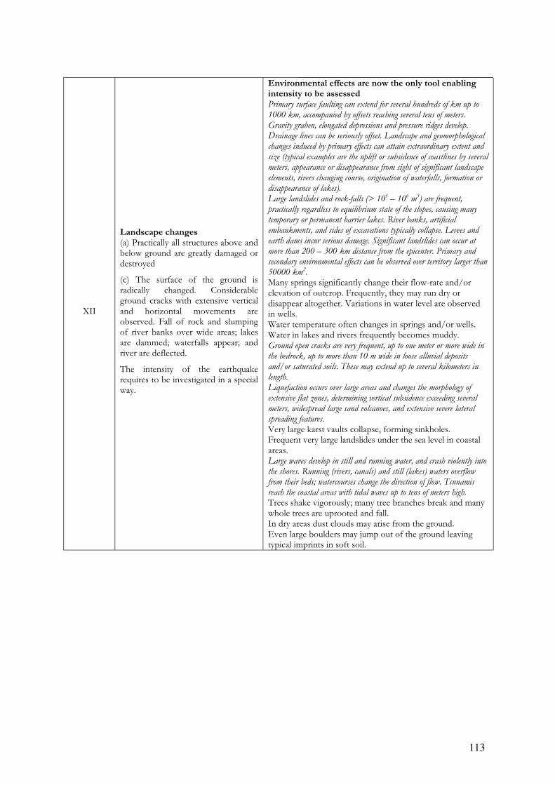
113
XII
Landscape changes (a) Practically all structures above and below ground are greatly damaged or destroyed
(c) The surface of the ground is radically changed. Considerable ground cracks with extensive vertical and horizontal movements are observed. Fall of rock and slumping of river banks over wide areas; lakes are dammed; waterfalls appear; and river are deflected.
The intensity of the earthquake requires to be investigated in a special way.
Environmental effects are now the only tool enabling intensity to be assessed Primary surface faulting can extend for several hundreds of km up to
1000 km, accompanied by offsets reaching several tens of meters.
Gravity graben, elongated depressions and pressure ridges develop.
Drainage lines can be seriously offset. Landscape and geomorphological
changes induced by primary effects can attain extraordinary extent and
size (typical examples are the uplift or subsidence of coastlines by several
meters, appearance or disappearance from sight of significant landscape
elements, rivers changing course, origination of waterfalls, formation or
disappearance of lakes).
Large landslides and rock-falls (> 105 – 10
6 m
3) are frequent,
practically regardless to equilibrium state of the slopes, causing many
temporary or permanent barrier lakes. River banks, artificial
embankments, and sides of excavations typically collapse. Levees and
earth dams incur serious damage. Significant landslides can occur at
more than 200 – 300 km distance from the epicenter. Primary and
secondary environmental effects can be observed over territory larger than
50000 km2.
Many springs significantly change their flow-rate and/or elevation of outcrop. Frequently, they may run dry or disappear altogether. Variations in water level are observed in wells. Water temperature often changes in springs and/or wells. Water in lakes and rivers frequently becomes muddy. Ground open cracks are very frequent, up to one meter or more wide in
the bedrock, up to more than 10 m wide in loose alluvial deposits
and/or saturated soils. These may extend up to several kilometers in
length.
Liquefaction occurs over large areas and changes the morphology of
extensive flat zones, determining vertical subsidence exceeding several
meters, widespread large sand volcanoes, and extensive severe lateral
spreading features.
Very large karst vaults collapse, forming sinkholes. Frequent very large landslides under the sea level in coastal areas. Large waves develop in still and running water, and crash violently into
the shores. Running (rivers, canals) and still (lakes) waters overflow
from their beds; watercourses change the direction of flow. Tsunamis
reach the coastal areas with tidal waves up to tens of meters high.
Trees shake vigorously; many tree branches break and many whole trees are uprooted and fall. In dry areas dust clouds may arise from the ground. Even large boulders may jump out of the ground leaving typical imprints in soft soil.


5
APPENDIX 5
Inqua EEE Scale field survey form
5
116
Notes on the application of the Inqua EEE scale
This document is a first draft proposal of a form aimed at summarizing in the field the main
elements characterizing each environmental effect of an earthquake, so that a local intensity can
be assigned to the site.
Instructions on how to use this form are not provided here, being most of the keys self-
explaining (hopefully). The form is conceived in such a way to be filled in the field with a
minimum effort even by a not trained specialist, although a specific experience is highly
advisable.
At this stage, all the information has been packed in a single double-faced sheet. However, more
information (sketches, notes, photographs) can be provided in additional sheets. Anyway, a
longer form may be adopted in the future, if needed. Another goal of the working group is the
realization of a sort of database of environmental effects of earthquakes, so changes to this draft
form might result necessary to make it more suitable to this end.
Critical evaluation by earthquake geologists, especially by their field testing during surveys after
an earthquake, is clearly necessary to bring this draft form to a factual efficiency. To this end it is
proposed here. Feedback is therefore not only expected, but it will be greatly welcome.

Sheet 1: Generalities
EarthquakeRegion ____________________________________ Time __________________ Magnitude Ml Ms Mb Mw _______
Intensity MM EMS MSK JMA________ Latitude ____________ Longitude_____________ datum_______________
Observation point Nr. _______ Date/hour ______________ Surveyor ________________________ Locality ________________________________
Lat _____________ Lon ______________ Km from epicentre _____ Local Intensity MM EMS____ Site PGA ____ Photos yes no
Geomorphological setting - mountain slope – mountain valley – hillslope – alluvial fan – bajada – delta - alluvial plain – marsh -
sea/river cliff – river/lake bank – sea/lake shore - arid-semiarid flat – desert - other:_______________________________________
Brief description _________________________________________________________________________________________
________________________________________________________________________________________________________
________________________________________________________________________________________________________
Main effects of seism on artefacts damage/collapse of single/multiple buildings bridge viaduct tunnel railway highway
paved/unimproved road _____________________________________________________________________________________
Environmental effect Geologic origin: tectonic / ground shaking newly formed / reactivated
Surface faulting – open fissures in bedrock - mole track - ground crack - slope movement - sinkhole - ground
settling/liquefaction/lateral spread - hydrologic anomaly - gas emission - moved/overturned stone
Other ______________________________________________________________________________________________
Non geologic noise light-emission fire vegetation: burnt grass, swinging trees, broken branches, fallen fruits...
Brief description _________________________________________________________________________________________
________________________________________________________________________________________________________
________________________________________________________________________________________________________
Major affected lithology rock densely cleaved massive stratified intrusive metamorphic volcanic lava/pyroclastic sedimentary
shale/sandstone/conglomerate/limestone/salt hard/semi-pseudo-coherent – loose sediment soil/clay/silt/sand/gravel colluvium
backfill – Sedimentary environment marine shore fan deltaic alluvial lacustrine marsh slope arid/temperate/humid
Notes___________________________________________________________________________________________________
Frequency of observed feature in the area
single/multiple number ______ over ________ km2 Already/never triggered by earthquakes
Maximum dimension length ____m width ____m area ______m2 volume ______m3
Average dimension length ____m width ____m area ______m2 volume ______m3
Notes __________________________________________________________________________________________________
Sketch

Sheet 2: Details
Earthquake Region __________________________ Time __________________
Observation point Nr. _______ Date/hour ______________ Surveyor ________________________ Locality ________________________________
Surface faulting strike ______ dip _____normal/reverse/oblique/strike-slip dextral/sinistral - total length ____km - nr of segments ___ - aligned/en-echelon right/left stepping
maximum vertical offset ____cm horizontal offset ____cm - average vertical offset ____cm horizontal offset ____cm
displaced feature for direct measurement ______________________________________
single/multiple scarp – other features push-up/pull-apart/gravity graben
Notes ___________________________________________________________________________________________________
________________________________________________________________________________________________________
Ground cracks Type fracture - mole track strike ______ dip _____ Displacement ____ cm sense of displacement_____________
Maximum length _____ m - number of features ______ over a distance of ____ m – maximum opening _____ cm
Shape straight/sinuous/curvilinear ____________________ - Possible origin surface faulting/slide/ground settling/detachment
Notes ___________________________________________________________________________________________________
Slope movement Type rock fall – deep-seated slide (sackung) - rotational slide – slump - earth flow - soil slip – other _________________________
Maximum dimension of blocks _____ m3 over a distance of ____m – Total volume _____ m3 - Humidity very/moderately/no wet
Age very old/recent/new Activity partial/total already active/quiescent
Velocity extremely/very/moderately rapid/slow Time delay for manifestation of motion _____ hours
Notes ___________________________________________________________________________________________________
________________________________________________________________________________________________________
Ground settlement - collapse Type liquefaction – compaction – lateral spread - subsidence – bulge – sinkhole – other _________________________
Maximum diameter _____ m - number of features ______ over a distance of ____ m – maximum lowering/uplift _____ cm
Shape round/elliptical/elongated/squared ____________________ positive/negative cone - Humidity very/moderately/no wet
Depth of water table ____ m – water/sand ejection –
Velocity extremely/very/moderately rapid/slow Time delay/advance for manifestation of feature _____ hours
Notes ___________________________________________________________________________________________________
________________________________________________________________________________________________________
Hydrologic anomaly Effects overflow/drying up/appearance of springs/waves/water fountain/variation of water table/discharge
rate/temperature/chemistry/turbidity where spring/river /lake/well/fountain/aqueduct other ________________
Temperature change ___C° – Discharge change ____l/s
Changed chemical component/s _________________________ - Permanent/temporary change lasted for ___hours
Tsunami: maximum wave height ____m length ____m Extent of affected coast ______ km
Velocity extremely/very/moderately rapid/slow - Time delay/advance for manifestation of feature ___hours
Notes ___________________________________________________________________________________________________
________________________________________________________________________________________________________
Intensity attribution IV V VI VII VIII IX X XI XII
Based principally on existing INQUA tables/other Intensity scale/new assessment and __________________________________
________________________________________________________________________________________________________
________________________________________________________________________________________________________
________________________________________________________________________________________________________
Copyright © 2022 FDOKUMEN