
The Iron Age in Petra and the issue of continuity with Nabataean occupation
Upload
uni-erlangenCategory
view
2download
0
Men on the RocksThe Formation of Nabataean Petra
M. Mouton & S. G. Schmid (editors)
λογος
M. M
outo
n S.
G.
Schm
id (e
ds)


Men on the RocksThe Formation of Nabataean Petra
Berlin 2013
Proceedings of a conference held in Berlin2–4 December 2011
M. Mouton & S. G. Schmid (editors)
λογος

Layout and CAP by Pascale & Marc Balty – Art’Air Editionhttp://www.artair-edition.fr
All texts translated or edited by Isabelle Ruben
Jacket photography: S. G. Schmid
Bibliographic information published by the Deutsche NationalbibliothekThe Deutsche Nationalbibliothek lists this publication in the Deutsche Nationalbibliografie;
detailed bibliographic data are available on the Internet at http://dnb.d-nb.de.
Copyright Logos Verlag Berlin GmbH 2012 and individual authorsAll rights reserved.
ISBN 978-3-8325-3313-7
Logos Verlag Berlin GmbHComeniushof, Gubener Str. 47 / D-10243 Berlin, Germanyphone: +49 (0)30 42 85 10 90 / fax: +49 (0)30 42 85 10 92
http://www.logos-verlag.com
Supplement to the Bulletin of Nabataean Studies, 1

3
Table of contents
Michel Mouton & Stephan G. SchMid. Preface ....................................................................... 5RobeRt WenninG. Towards “Early Petra”: an overview of the early history of the Nabataeans
in its context ...................................................................................................................... 7piotR bienkoWSki. The Iron Age in Petra and the issue of continuity with Nabataean
occupation ......................................................................................................................... 23david F. GRaF. Petra and the Nabataeans in the Early Hellenistic period: the literary and
archaeological evidence ...................................................................................................... 35FRançoiS Renel & Michel Mouton. The architectural remains and pottery assemblage from the
early phases at the Qasr al-Bint .......................................................................................... 57Jean-FRançoiS SalièGe †, antoine ZaZZo, chRiStine hatté & caRoline GauthieR. Radiocarbon
dating in Petra: limitations and potential in semi-arid environments .................................. 79SebaStian hoFFMann. Indications for ‘Early Petra’ based on pottery finds in the city centre:
El-Habis as a case study ..................................................................................................... 93Yvonne GeRbeR. Archaeometric investigations on Nabataean common ware pottery ............... 107laïla nehMé. The installation of social groups in Petra ............................................................ 113chRiStian auGé. Coin circulation in early Petra: a summary .................................................... 129Michel Mouton & FRançoiS Renel. The early Petra monolithic funerary blocks at Rās Sulaymān
and Bāb as-Sīq ................................................................................................................... 135thoMaS kabS. Bāb as-Siq. The necropolis of Ancient Gaia? .................................................... 163lucY WadeSon. The development of funerary architecture at Petra: the case of the Façade
tombs ................................................................................................................................ 167kaRin petRovSZkY. The infrastructure of the tomb precincts of Petra: preliminary results of the
tacheometrical survey in selected areas . ............................................................................. 189lauRent tholbecq & caRoline duRand. A late second-century BC Nabataean occupation at
Jabal Numayr: the earliest phase of the “Obodas Chapel” sanctuary . .................................. 205lauRent GoRGeRat & RobeRt WenninG. The International Aṣlaḥ Project (2010-2012):
its contribution to “Early Petra” . . ...................................................................................... 223MaRco dehneR. Continuity or change in use? Banqueting rooms in the so-called Soldier tomb
complex in Petra ................................................................................................................. 237Stephan G. SchMid. Foucault and the Nabataeans - or what space has to do with it ................... 251Will M. kennedY. The hills have eyes: GIS-based studies on a possible watchtower on Umm
al-Biyara ........................................................................................................................... 271lauRent tholbecq. The hinterland of Petra (Jordan) and the Jabal Shara during the Nabataean,
Roman and Byzantine periods ............................................................................................ 295

4
bRian beckeRS & bRiGitta Schütt. The chronology of ancient agricultural terraces in the environs of Petra ................................................................................................................ 313
paula kouki. The intensification of Nabataean agriculture in the Petra region ......................... 323RobeRt WenninG. North Arabian deities and the deities of Petra: an approach to the origins of the
Nabataeans? ...................................................................................................................... 335RobeRt WenninG. Nabataean niches and “Early Petra” ............................................................ 343veit vaelSke. Isis in Petra. Chronological and topographical aspects ....................................... 351

271
In the 2010 survey campaign, the International Umm al-Biyara Project (IUBP) was able to identify extensive Nabataean structures on the plateau of Umm al-Biyara, the rocky summit just outside the city center of Petra. The vast majority of the identified structures can generally be associated with luxury architecture offering a perfect view down to the city center. The view from Umm al-Biyara also includes the three main entrance ways into Petra: the famous entrance through the Bab as-Siq leading from the southeast through the entire city, the northern road coming from the Dead Sea through Baydah and Umm Sayhoun, and the way entering Petra from the southwest through the Wadi Thugra. It seems that the Nabataean structures on Umm al-Biyara not only once provocatively demonstrated Nabataean wealth but the strategic location of the summit offered the possibility of easy control of the wider Petra area. In order to verify this assumption of possible control, with or without a watchtower on Umm al-Biyara, the IUBP excavated a small rectangular stone structure on the far southwestern edge of the plateau in 2011, which was cautiously interpreted as a watchtower. However, the general condition of the structure is extremely poor, which does not allow any substantiated interpretations. Based on the information gained from the archaeological evidence of the presumed watchtower on Umm al-Biyara, this paper will demonstrate how GIS-based viewshed analyses can empirically analyze aspects of (inter)visibility. The degree of visibility to other outposts may contextualize the relatively early dating of the structure on Umm al-Biyara and other possible Nabataean watchtowers. This
leads us to the following questions: What insights can we gain about the early military defense system of the Nabataeans? Can we deduce certain patterns that could allow general assertions about the Nabataean communication system? Before the results of the analyses can be presented, it is first necessary to introduce the general landscape features of the studied region briefly and, after an illustration of the 2010 survey results, the archaeological evidence on the presumed tower (structure 10) on Umm al-Biyara will be described. Furthermore, after explaining the methodology, the results of the GIS-based viewshed analyses with additional archaeological finds confirming the results will be presented. As a methodological proposal, this article may suggest how to tackle further the question of an early Nabataean defense and communication system.
The landscape of The peTra region Jordan can generally be divided into five geomorphological zones (Macumber 2008: 9). The ancient city of Petra lies between the rift valley of the Wadi Arabah to the northwest, the western highlands immediately east of the Arabah rift and the central plateau to the northeast. Whereas the landscape of the rift valley is extremely flat, the terrain to the east suddenly turns into the highly eroded and far higher western highlands, of which the city of Petra itself is a part. The rugged Cambrian-Ordivician sandstone mountains of the highlands then proceed to the marine layers of limestone, marl and phosphorites of the central plateau (Bienkowski 2011: 3. 114-116; Macumber 2008: 9. 16; Lindner 1997: 25). The Cambrian
The hills have eyes: GIS-based studies on a possible watchtower on Umm al-Biyara
Will M. Kennedy
Will M. Kennedy
272
sandstone, with its red-violet and yellow-brownish color, covers most of the center of Petra. To the east, the whitish Ordivician sandstone primarily dominates at the transition to the Shara mountains (Kühne & Wanke 1989: 233-234). The dark mountains of the Wadi Siyagh and the Wadi Arabah region immediately west of Petra were formed by early volcanic activities and are predominantly made of quartz porphyry (Kühne & Wanke 1989: 241). As a result of tectonic movement, the mountain chains of the central plateau are connected by deeply cut wadis, which are a characteristic landscape feature of the Petra area (Macumber 2008: 25).
Climatically, Petra belongs to the Mediterranean Zone and can generally be described as an arid region. However, the immediate environment of Petra can be distinguished from the colder and warm dry areas of other parts of the country. Strong winds sweep through Petra, especially from the west and the southwest and the average amount of sunlight amounts to 8.6 hours per day. The annual average of the atmospheric humidity lies at 49.9% (Bienkowski 2011: 3). For the modern Petra area, an annual average of 181 mm of precipitation can be measured with the most rainfall during the winter months from October to April (Bienkowski 2011: 3; Kühne & Wanke 1989: 238). During the summer, temperatures can reach +40°C and in the winter it can snow and freeze sporadically. Without any systematic use of the water sources the wadis are dried out in the summer and when there is rainfall in the winter the small wadi rivulets can quickly change to rapidly flowing streams. The climatic conditions appear to have been more or less the same in antiquity (Kühne & Wanke 1989: 241).
Petra is situated in a steep valley, a location extremely vulnerable to both devastating flash floods and drought, rendering the control of water sources and water flow to and from the city absolutely vital. The Nabataeans were not only capable of channeling water into the city by means of water conduits from water sources along the Shara mountains such as Ain Debetbe, Ain Braq or Ain Musa, but they also knew how to divert the dangerous wadi streams during the winter months (Schmid & Bienkowski in press; Lindner 1997: 28).
The mountainous outcrop of Umm al-Biyara (fig. 1 and 2) lies about 300 m southwest of the
city center of Petra, and with a height of over 1100 m above sea level (asl), it constitutes a major landscape marker in the Petra area. To the south it is flanked by the Wadi Thugra and to the north it is bordered by the Wadi Siyagh. The Wadi Siyagh is a prolongation of the Wadi Musa, which originates from the spring of Ain Musa in the Shara mountains to the east. The Wadi Musa runs through the city center in a northwesterly direction and eventually leads to the Wadi Arabah in the west. The flat plateau forming the top of Umm al-Biyara has an approximate size of 50.000 m² (5.5 ha) (Bennett 1966: 372) and slopes downwards in southeasterly direction, and is clearly visible from the city center in the east, the Wadi Arabah and the Negev desert to the northwest, as well as Umm al-Barra and Jabal Haroun to the west. The sandstone plateau is characterized by the steep cliffs that surround it, and two centrally located rocky outcrops. The only access to the summit is a rock-cut stairway in the southeast, which can roughly be dated to the Nabataean period (Lindner 1997: 30).
previous work on umm al-Biyara
In 1929, the British Petra Exploration Fund Expedition, directed by G. Horsfield and A. Conway, conducted the first scientific research project on Umm al-Biyara and documented some Iron Age pottery finds on the surface of the plateau (Morton 1956: 26; Bennett 1966: 372). In 1933-1934, N. Glueck and G. Horsfield opened small test trenches, the findings of which confirmed the Iron Age dating of the surface finds (Bennett 1966: 374). In the tradition of early biblical archaeology, Glueck identified Umm al-Biyara with the biblical site of Sela and as an Edomite hilltop fortification1. In 1956, W. H. Morton also found a significant amount of Nabataean pottery along the eastern cliffs of the plateau, that he associated with the remains of built structures in the vicinity (Morton 1956: 29-30). Based on surface observations, Morton was able to identify a total of 13 structures, which he immediately connected to Nabataean Petra. Also, he opened a small test trench to try to understand a prominent structure on the far eastern cliff, which was later interpreted as a temple by C. M. Bennett (Schmid & Bienkowski in press).The first more in-depth archaeological inves-
1. For a more detailed discussion on the identification on Umm al-Biyara with Sela see Bienkowski 2011: 5-6.

The hills have eyes: GIS-based studies on a possible watchtower on Umm al-Biyara
273
tigations on Umm al-Biyara were conducted by Bennett, from 1960 to 19652. In 1965, Bennett organized a quick survey across the entire summit and produced a first map of the plateau, which included all documented structures (Bennett 1966: 377). However, with the exception of the structure explored by Morton, she ignored all features deemed to be of Nabataean date and primarily focused on the Iron Age or Edomite structures in the middle of the plateau. The excavations of these structures revealed room formations built of a dry walling of flat sandstone slabs and the finds included Iron Age pottery, a cosmetic pallette, a inscribed ostracon as well as an Edomite royal seal impression (Bennett 1966: 377). The lack of a prompt final publication of Bennett´s excavations left a gap in the knowledge about Iron Age Transjordan. P. Bienkowski re-evaluated the unfinished work of Bennett and published the final report in 2011, and together with S. G. Schmid, set out to further explore the presumed Nabataean structures on Umm al-Biyara and its association with Petra itself (Schmid & Bienkowski in press).
2. The last work done on Umm al-Biyara was conducted by M. Lindner on the lower so called “Nordterrasse” in 1973-1979 (Lindner 1989: 293-303).
The acTiviTies of The inTernaTional umm al-Biyara projecT
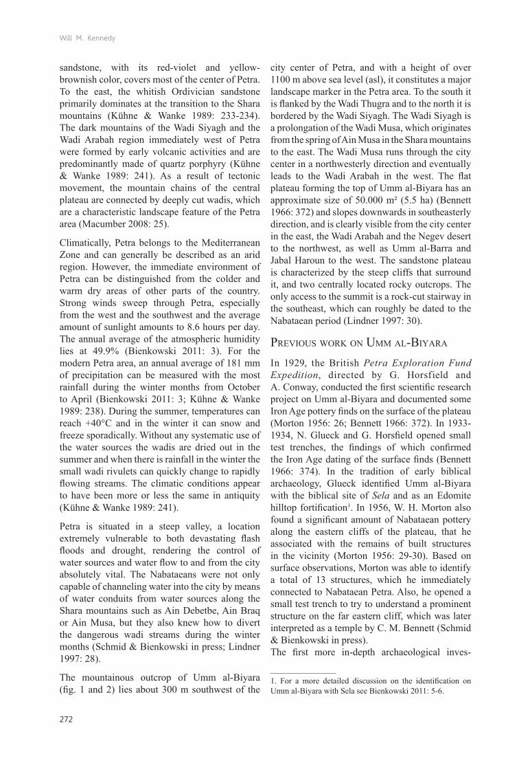
The IUBP was initiated in 2010 with the immediate aim of not only mapping the plateau in the already existing coordinate system of other archaeological projects in Petra, but more importantly, to survey precisely all structures visible on the surface (fig. 3). Additionally, all pottery and other surface finds collected during the intensive survey season of 2010 were associated with the relevant grids and structures and could also be represented in a distribution map (fig. 4).
In total, the IUBP was able to identify up to 30 structures, the majority of which are situated along the eastern side of the plateau. Eight cisterns, with their associated water channels, give the site its Arabic name, Umm al-Biyara (mother of cisterns). Based on the pottery distribution all structures, with the exception of structures 1 to 3, can be roughly dated to the Nabataean period3. Based on the large
3. It must be noted that the pottery distribution map does not offer exact numeric information and is only representative of the general trend. As grid D-E/ 4-5 demonstrates, the representation of the pottery finds may be misleading considering that only one sherd of each category was collected
Fig. 1. Umm al-Biyara looking towards the north-west (photo A. Barmasse).

Will M. Kennedy
274
Fig. 2. Satellite image of Petra with the Umm al-Biyara plateau in the south-east (integrated Bingmap function of ArcGIS 10).
quantity of tubuli and hypocaust fragments as well as hypocaust posts still in situ and the large amount of Nabataean fine ware, structure 20 was cautiously interpreted as a small bathing complex (Schmid & Bienkowski in press)4. The large amount of fine ware found around the structure suggested a preliminary date of sometime around the second half of the first century AD.
Structure 26, which was already examined by Morton (Morton 1956: 32), is situated just a few meters south of structure 20 and appeared to be similarly prominent. The structure is formed by a small rectangular room oriented north-south and was connected to a larger, elongated rectangular
here. Also, weather and erosion as well as secondary human activities must be taken into account when interpreting the distribution of the finds.4. The excavation results of the 2011 and 2012 campaigns of the IUBP confirm this assumption.
feature towards the eastern edge of the plateau. On the far eastern part of the structure, partly built and/or rock-cut step-like formations continued to the very edge of the plateau, giving a superb view over the entire city center of Petra. Morton´s assumption that it might have been a more substantial structure was confirmed by several architectural blocks found within or in the vicinity of structure 26 by the IUBP. Decorated architrave blocks, typical so-called Nabataean horn capitals and figuratively ornamented frieze blocks were among the debris of the inner structure and the collapse down the eastern slope. Considering the noticeable amount of marble slabs, it became clear that structure 26 must have been at least one of the more important buildings on the Umm al-Biyara plateau (Schmid & Bienkowski in press).
It was not surprising that immediately surrounding the Iron Age structures a high density of Edomite pottery was observed. Interestingly, however,

The hills have eyes: GIS-based studies on a possible watchtower on Umm al-Biyara
275
structure 10 appeared to be the only Nabataean-period structure that was dated based on the pottery distribution and is not situated on the eastern edge of Umm al-Biyara. Two parallel rows of flat sandstone slabs and two perpendicularly abutting walls on the far southwestern edge of the
summit suggest a rectangular structure. Due to its strategically important position, it was suggested that structure 10 may be a Nabataean watchtower (Schmid & Bienkowski in press). From structure 10 the view encompasses “[…] ‘Aïn Tibitbi in the Baydha area to ‘Aïn Braq on the road to Taybeh,
Fig. 3. Map of Umm al-Biyara with the structures defined by the IUBP in 2010 (G. Teltsch and W. Kennedy based on the map by Bennett 1966).
Will M. Kennedy
276
including ‘Aïn Mousa and the ancient settlement of el-Gji (Gaïa) [Wadi Musa]” (Schmid & Bienkowski in press). It was also argued that the presumed watchtowers at Rajif to the southeast, Jabal Qarun to the northeast, and the Wadi Arabah to the northwest where the caravan station Umm Amm Rattam is located, were visible from structure
10. Additionally, during good weather conditions, structure 10 offers a convenient visual and audible way of communication with the city center below. The strategic significance of structure 10 is amplified because the city of Petra itself is poorly protected. Umm al-Biyara constitutes the binding element between Petra and its surrounding area.
Fig. 4. Distribution map of the surface pottery finds of the IUBP 2010 (W. Kennedy based on the map by Bennett 1966).

The hills have eyes: GIS-based studies on a possible watchtower on Umm al-Biyara
277
This fact is confirmed in the historical sources. Diodorus Siculus, describing the events of 311/312 BC, mentions that the Nabataeans positioned watchtowers throughout the entire landscape, and that they communicated with each other by means of fire signals (Diod. 19, 96, 3. 97, 1). In order to research this presumed defense system of the Nabataeans further, the IUBP set out, in 2011, to gain more archaeological insights into the nature of structure 10.
Structure 10 (fig. 5 and 6) is 10 m long, 7 m wide and is almost perfectly oriented to the north. Already during the survey campaign it became clear that the remaining features were only a few centimeters above the natural bedrock. Especially on its far western edge, the visible remains were only about 5 cm above the bedrock; the structure followed the natural slope to the east, reaching a maximum height of 40 cm.
Generally, structure 10 may be divided into two halves. Whereas the entire northwestern part of the formation is lost, a neatly laid wall runs in a southern direction along the eastern side (W1). A small line of stone slabs running perpendicular to W1 turns in a western direction (W2) where another wall feature seems to run from the southern
Fig. 5. The remains of structure 10 on the far southwestern edge of Umm al-Biyara looking to the south (photo S. G. Schmid).
Fig. 6. Plan of structure 10 (drawing N. Bürkle and W. Kennedy).
Will M. Kennedy
278
end of W1 (W4). Following W2 85 cm to the west, another wall feature turns perpendicular to it in a southern direction (W3). A distinct pile of slabs, within a fine ash layer, was centered in the middle of the southern half of structure 10.
A distinct layer of collapsed sandstone slabs follows the far southern edge of the whole structure. In fact a few slabs of similar proportions to those of W1 were revealed that were in line with W1 (W4). It is also important to note that this line was set on the very edge of a distinct carving in the bedrock while the collapse layer runs on a lower level. It may, therefore, be assumed that W4 represents a planned layout and that W1 originally continued into the southern half of the structure and eventually collapsed towards the east.
A 2.50 m long channel-like cut in the rock runs through the northern quarter running parallel to W2 in the direction of the cliff. The carving then continues through the northern half. A further channel-like carving appears in the middle of the northern quarter, which continues down to the cliff in northern direction. The entire bedrock slopes from the opening of the first channel to the second. Although the stone slabs found in the second channel block water flow, it is still entirely possible that these cuts in the rock were used for drainage.
To the east, W1 is also flanked by a distinct collapse layer which contains larger slabs. Immediately north of that wall the level of the bedrock slopes in the direction of the second channel which again would confirm the hypothesis of being part of a drainage system. A circle-shaped carving marks the far western side of the northern half. Its function remains unknown.
A further find suggesting a drainage system was also documented in the southern half. Again, a channel-like cut in the rock forming a V-shape was carved into the bedrock running in an eastern direction. The channel runs through the middle of the southern half and ends on a lower bedrock level. Ignoring the collapse layer, which obviously does not belong to the original condition of the structure, it may be concluded that structure 10 was constructed on two different levels or terraces. This hypothesis is confirmed by the fact that the numerous small, irregularly formed stone slabs in the interior were laid upon a thin layer of sand and pebbles, thus leveling a presumed walking level. A similar situation is found in the interior of the northern half, where closely laid stone slabs in the far northwestern corner might suggest a very rough walking level. In order to clarify the proportions of W1, the eastern collapse was removed, revealing the bedrock floor. The wall measures 75 cm in width and has a maximum remaining height of 23 cm.
Fig. 7. Pottery phases within structure 10 (W. Kennedy).

The hills have eyes: GIS-based studies on a possible watchtower on Umm al-Biyara
279
In the southern half of the structure, W4 is also built of longer sandstone slabs coming from W2. The wall is positioned slightly more to the east, but it falls in line with the outer face of W1. The fact that the collapse layer was far more distinct in the southern half than in the north suggests that the continuation of W1 was originally more substantial. Interestingly, however, there was a 65-cm-wide gap between the eastern corner of W2 and the southern end of W1. Apart from a few collapsed stone slabs the natural bedrock, which formed a narrow ramp on a level 10 cm lower than the interior, was the only noticeable feature in that area. The ramp leads into the interior of the northern half and immediately south of it, a small gap in W2 also gives access to the southern half. The gap in the W1 may therefore have been an entrance. This assumption might be confirmed by a find in the northeastern area of the exterior where a rock-cut, step-like feature leads from the surface level of the plateau down to structure 10. The presumed steps are oriented towards the south and the possible entrance.However, the condition of structure 10 does not offer a precise basis for interpretation. All interpretations and proposals presented here must be treated with caution and do not offer a safe basis for conclusions. As a next step, it is therefore necessary to present the range of finds from within structure 10.
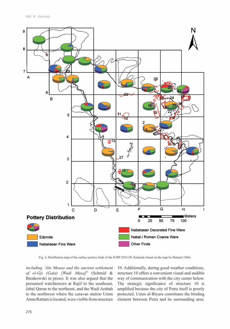
poTTery finds wiThin sTrucTure 10Considering the relatively small size and the poor condition of structure 10, it yielded a surprisingly large amount of pottery finds. In total, over 2000 sherds were documented, the majority of which can generally be dated to the Nabataean period (fig. 75). The main parts belong to Schmid´s phase 3a (second quarter of the 1st century AD) (Schmid 2000: 150)6. The relatively even balance between Nabataean fine and coarse ware is striking (fig. 8). Concerning the fine ware, Schmid´s E1c8, which belongs to phase 3a, appears to be the predominant type (fig. 9). Other Pottery finds dating to the Iron Age (7th-6th century BC) (Bienkowski 2011: 56-78) and to Schmid´s phase 1 (1st century BC) suggest that structure 10 was in use in these periods as well as in the early 2nd century AD (compare fig. 7). The presence of 1st century BC Nabataean pottery may therefore render structure 10 one of the very few archaeological finds attesting the early Nabataean phase of occupation within the immediate Petra area. Schmid´s form E2b48, belonging to his phase 1, constitutes the most diagnostic form for the first Nabataean phase
5. The bar labelled “Phase 2” represents sherds that could not be further distinguished between the other sub-phases.6. A quick assessment of the coarse ware also confirms this general dating. Information by Y. Gerber (28.06.2011).
Fig. 8. Amount of documented Nabataean fine and coarse ware (W. Kennedy).

Will M. Kennedy
280
of occupation, which is set in the first century BC (Schmid 2000: 28). The study of the pottery finds from structure 10 sets a main occupation phase to the second half of the 1st century AD and the, admittedly slim, presence of Edomite and Phase 1 pottery might suggest a use of structure 10 already in the Iron Age and the Hellenistic period. Also, considering the lack of definite Roman finds, this find does present a rare situation. The generally large quantity of pottery finds in relation to the relatively small size of the structure suggests a lot of dining and/or drinking activity within structure 10. This high density of drinking ware fits into the interpretation of structure 10 as a watchtower: As the fort at Koroni in Attica has demonstrated, a high level of drinking activities within smaller forts or watchtowers is not unique. The peninsula of Koroni is situated just off the eastern shores of Attica in the bay of Porto Raphti and has an extended fort with numerous terrace houses that date to the first half of the 3rd century BC (Lauter-Bufe 1988: 67-68). The irregularly placed houses also suggest a civilian settlement (Lauter-Bufe 1988: 77-78), but a long defensive wall running across the entire mountain range emphasizes a military character. This wall was partly equipped with watchtowers. The vast majority of the
pottery finds came from within the acropolis, and the range of pottery ware was extremely diverse, including drinking and coarse ware (Lauter-Bufe 1988: 82-84, 86-87). Surveys in the 1960s within tower structures revealed fragments of unglazed lamps, black-glazed fishplates, dishes, kantharoi, and amphorae (Vanderpool 1962: 47)7. A similar situation is attested at the Archaic military fort of Phylla at Vrachos, Euboea. One room of the fort was especially striking for its high density of pottery finds, including numerous fragments of skyphoi, lekanides, amphorae and coarse ware (Sapouna-Sakellaraki, Coulton & Metzger 2002: 50-54, 61-62). Whereas these are only two comparative examples, we might conclude that dining pottery may very well be expected within smaller military structures, as is the case with structure 10 on Umm al-Biyara.
gis-Based viewshed analyses from sTrucTure 10In recent years Geographical Information Systems (GIS) have become of increasing interest to archaeologists. Especially in landscape
7. For more information on the finds from Koroni see also Edwards 1962: 26-61 and Vanderpool 1964: 69-75.
Fig.9. Dominant pottery types within structure 10. Top: E1c7; middle: E1c8; bottom: E2b48 (drawings W. Kennedy).
Fig. 10. Iron Age rim sherds found within structure 10 (photo W. Kennedy).
Fig.11. Phase 1 pottery found within structure 10 (photo W. Kennedy).

The hills have eyes: GIS-based studies on a possible watchtower on Umm al-Biyara
281
archaeological studies, the advantages and potential of GIS-applications have been recognized. However, the problem of the “push-the-button” principle still prevails in archaeological research. In effect, the application of GIS methodologies was often only result-oriented and the theoretical background mostly neglected or only superficially understood. It is easy to treat the results of GIS-based studies without considering the methodology in general and its inherent problems. It is, therefore, necessary to introduce landscape archaeological theories concerning the phenomenon of visibility very briefly and subsequently to explore the methodology of GIS-based viewshed analyses in order to present the results of the study.
First, visibility is a cognitive phenomenon. Our visibility field defines where we view to and includes not only what we perceive, but also how we perceive (Zaplata 2008: 1). This threefold definition is fundamental for understanding the significance of visibility for humans, living in past or recent societies, since humans are so-called social actors8. The perceptive ability of humans is strongly influenced by individual experiences so that it seems impossible to make general statements on patterns of perception in regard to visibility. These patterns are too diverse and limitless and seem to be unfit for scientific research. However, within archaeological studies it is especially interesting to explore what material remains can reveal about behavioral and perceptive patterns of past cultures. How, what and where we can see to defines how material culture is formed and therefore not only has a direct impact on the structure, organization and positioning, but also on the perception and relation to and with material objects (Wheatley & Gillings 2000: 3; Constantinidis 2004: 1). Therefore, on a first level, the viewer is focused on a particular location. The viewer may be physically present in a certain place, but on a second level he projects his cultural and personal background beyond the local element influencing his perception of such. Thus the physical notion of a place is expanded, and new, materialistically non-tangible, visual spaces emerge (Zaplata 2008: 3). Seemingly, since every individual is bound by his own pattern of perception, landscape as a physical entity will
8. In this case, seeing is understood as an active and deliberate act. Humans as social actors actively define their surrounding and individual perceptions are based on that premise.
be differently perceived (Johnston 1998: 64-67). What place, however, does the material object have in the general physical as well as in the individually perceived landscape? The function, role and design of the object are important factors. Every alteration of the landscape or the object itself influences individual patterns of perception. It becomes clear that what and where we can see to has a direct impact on our individual perception and behavioral pattern. Temporal differences also impact our perception of landscapes. Consequently, there is a certain discrepancy between the results of modern scientific research on past landscapes and the actual relation of past cultures to their living environment. When conducting viewshed analyses or generally researching the aspect of visibility within past societies, these premises must be kept in mind and visibility must be described as a phenomenon which impacted past cultures` constructs of the landscape.
GIS-based viewshed analyses are based on a digital elevation model (DEM) or a digital terrain model (DTM). The raster dataset of a DEM identifies tabular values, which define visible and non-visible fields from a particular observation point. In their seminal paper, Wheatley and Gillings present four factors which are supposed to be considered when conducting viewshed analyses (Wheatley & Gillings 2000: 5-14). These are local and regional landscape conditions (also including climatic and weather conditions), the aspect of mobility, the degree of visibility to and from certain objects or places, and consideration of diachronic landscapes or find locations. A precise description of the landscape features must include the geomorphological and vegetative as well as the climatic conditions. Changes in the landscape over time must also be taken into account in order to estimate the perception of landscapes in antiquity correctly (Wheatly & Gilling 2000: 5; Constantinidis 2004: 3-4). Finally, climatic and fluctuating weather conditions define a certain dependency on seasonality of visibility (Constantinidis 2004: 6).
The issue of mobility addresses the fact that humans perceive differently when in motion. Mobility also refers to the observation height of the viewer and takes into account whether the analysis is based on the optimal observation height of an adult (between 1.60 m and 1.70 m) or on an estimated building height. Particularly when the height of a building is unknown, it is crucial to present several

Will M. Kennedy
282
analyses with different observation heights in order to justify the proposed reconstruction (Wheatley & Gillings 2000: 6-7).
Structures which have several phases and have not yet been researched archaeologically pose another problem. Structures that are incorporated into period-specific viewshed analyses, but have been in continuous use throughout time, must be described in detail, otherwise, diachronic landscapes and structures may be wrongly set into a visual relation that may not have existed in the original state of the structure or may have appeared in a later phase (Wheatley & Gillings 2000: 6-7; van Leusen 2004: 15).
As already mentioned, viewsheds are either based on DEMs or DTMs. Whereas a DEM is a height matrix in a raster format that presents cell values of the same size in tabular form, a DTM models a triangular surface out of vectorized height information (Wheatley & Gillings 2000: 9). These models become problematic when researching a large area with a small dataset. When the height resolution of a DTM is too coarse, it smoothes the available values and thus can falsify the model. For this reason free, accessible DEMs with a relatively coarse height resolution between 30 m and 90 m form the basis of much archaeological research work. Depending on the type of terrain and the radius of visibility fields, the quality of the free, accessible DEMs can be very useful. Therefore, it is not only important that the dataset of the height model is presented, but also that the methodology of the practical generation of viewshed analyses is described in order to understand potential inaccuracies of the analysis.
Wheatley and Gillings also introduce the concept of the Japanese landscape architect, Tadahiko Higuchi, who bases analyses of visibility on quantifiable distance values (Wheatley & Gillings 2000: 15-24)9. In his model, Higuchi includes factors such as distance measurements, visual ranges, horizontal and vertical angles, three-dimensionality and lighting. Especially concerning distance values, Higuchi realized that the perception of landscapes is a complex construct that becomes more and more blurred at a greater distance and thus more difficult to describe. The distance of the visibility field therefore has
9. For a more detailed insight into the concept see Higuchi 1988.
an immense impact on the quality of landscape perception. Consequently, for a well-forested landscape, Higuchi defined the height of trees as a standardized object height that the viewer relates to when overviewing the landscape. Based on this assumption, Higuchi was able to distinguish between three visibility ranges10.
The first describes a short-distance view. This includes objects that belong only to the immediate surroundings of the observation point, where visibility is of no crucial importance.The second middle-distance view scopes over a wide terrain and covers a distance in which topographical features are perceivable, but specific structures are difficult to recognize. In this case the aspect of viewing into a relative distance can be a defining factor and weather conditions such as fog and mist are relevant.Finally, in the long distance view, colors are only perceived as light or dark and the topography is merely a part of the far horizon. Visible features have no immediate impact on the viewer.The viewshed analyses presented in this paper have thus considered the following factors and methodologies:
10. Compare also van �eusen´s study of the Archaic and Compare also van �eusen´s study of the Archaic and Early Roman settlements in the Pontine region (Latium), which applied Higuchi´s viewshed model.
Fig.12. Plan of Qasr Umm Rattam (Lindner et al. 2000: 547, fig. 11).

The hills have eyes: GIS-based studies on a possible watchtower on Umm al-Biyara
283
The structures of Qasr Umm Rattam are situated about 7.5 km northwest of Petra and lie between the Wadi Musa coming from the southeast and the Wadi Umm Rattam that continues farther westwards. Directed by M. Lindner and U. Hübner, the Naturhistorische Gesellschaft Nürnberg (NHG) conducted an intensive survey of the entire area in 1997 and 1998 (Lindner et al. 2000: 535-567). Apart from a few Nabataean surface pottery finds, belonging to Schmid´s phases 1 and 2, the complex was dated to the later Nabataean period running through to the early Byzantine period (Lindner et al. 2000: 535; Lindner et al. 2007: 247). The structures comprise a watchtower (fig. 12), the main qasr, a Roman or early Byzantine administrative building, a large water reservoir and a late Nabataean or early Roman aqueduct (Lindner et al. 2000: 549-562). Agricultural terraces just northwest of the structures also belong to the complex. The watchtower at Umm Rattam is built on a 6 m high embankment and lies immediately at the confluence of the Wadi Umm Rattam and Wadi
Fig.13. Satellite image of Jabal Qaroun (integrated Bingmap function of ArcGIS 10).
land• scape and climatic conditions of the regionpotential differences in the estimated observa-•
tion heightgenerating visibility fields with the Higuchi •
methodwhen possible, a detailed description of •
structures incorporated in the study.
The viewshed analyses presented in this article are based on the free, accessible ASTER-DEM with a height resolution of 30 m11. The dataset is not optimal, but it shall suffice for a first modeling of the analyses. All analyses were conducted with a horizontal angle of 360° and a vertical angle of 90° both above and below the horizontal line. The radius of the visibility fields was defined as indefinite. Whereas the main focus of the analyses is based on structure 10 on Umm al-Biyara, three additional presumed watchtowers in the wider Petra area were also incorporated into the study.
11. Accessed from . Accessed from Accessed from http://www.gdem.aster.ersdac.or.jp/search. jsp (last access 24.07.2012).

Will M. Kennedy
284
Fig.14. The remains of the tower on Jabal Qaroun looking to the north (photo W. Kennedy).
Fig.15. The remains of the tower at Rajif looking to the east (photo S. G. Schmid).
Fig.16. Visibility field from structure 10 on Umm al-Biyara with a structure height of 4 m (W. Kennedy).
Musa. The rectangular structure is oriented from west to east and measures 10.0 m x 6.3 m at 391 m asl. The walls are 75 cm wide and the surface finds of the watchtower confirm a pre-Roman dating. The tower overlooks the entire complex to the south as well as the pathways directly north of the wadi confluence (�indner et al. 2000: 547-548). According to Lindner, Qasr Umm Rattam lies in the middle of an ancient pathway and route system that was used by local merchants and travelers and connects the qasr with Bir Madhkur, Petra, Bayda, as-Siyyagh, Ras Slaysil, Wadi-an-Naqab, Naqab ar-Ruba´I, Wadi Adulaiya, Qasr Nemla and Jabal Qarun (Lindner et al. 2000: 563, 438-545).
The watchtower of Jabal Qarun lies about 5 km northwest of Qasr Umm Rattam and is strategically well positioned on the summit of the hill at a height of 1052 m asl, just north of the Wadi Siq al-Ghurab (fig. 13 and 14).
The tower at Rajif is located about 17.4 km south-southwest of Umm al-Biyara on a terraced plateau (fig. 15). The rectangular tower is built of well-laid sandstone blocks. Preliminary surveys documented Nabataean-Roman pottery finds on the surface12. Finally, a presumed watchtower was noticed during the 2012 campaign of the IUBP, situated about 8 km northeast of structure 10 and immediately to the west of the Shara mountains, just off the road leading from Bayda to Shawbak.
In order to define a standardized structure height for all the presumed watchtowers discussed here, a
12. Oral information from S. G. Schmid during his presentation “Die Paläste der Nabatäerkönige in Petra. Luxuriöse Selbstdarstellung und internationaler Wettbewerb” (Berlin, 15.06.2011).
simple visibility field was calculated from structure 10 on Umm al-Biyara with an observation height at 1.70 m (average adult height)13. The visibility field reaches about 8 km in an eastern direction and towards the south-southeast. It encompasses a large area of the landscape, but the presumed watchtowers at Qasr Umm Rattam, Jabal Qarun and Rajif do not lie within view. Therefore, the same method was also applied with an observation height of 3 m, 4 m (fig. 16), 6 m and 8 m. With the exception of an unrealistic expansion of the visibility field of about 40 km to the northwest, no differences could be noticed. Since the poor condition of structure 10 cannot justify a structure height of 6 m or 8 m, a standardized height of 4 m was chosen. Assuming that guards with an estimated height of 1.70 m were stationed at the
13. Compare Wheatley & Gillings 2000: 7.Compare Wheatley & Gillings 2000: 7.

The hills have eyes: GIS-based studies on a possible watchtower on Umm al-Biyara
285
towers, a presumed height of the structure itself can be reconstructed at 2.30 m. This value was also applied to Qasr Umm Rattam, Jabal Qarun, Rajif and as-Shara, and thus from each tower a visibility field with an observation height of 4 m was generated.
The visibility field of Qasr Umm Rattam (fig. 17) is limited only to the south-southeast, to a distance of about 6 km. The view from Rajif encompasses
large areas to the west and north, including the Wadi Arabah, the landscape immediately south of structure 10 and even features north of the Petra valley (fig. 18). The tower below the Shara mountains overlooks the entire area between Umm al-Biyara and Jabal Qarun, and particularly a large extent of the landscape west of Petra (fig. 19 and 21). Jabal Qarun offers a far reaching view in all directions. The visibility field reaches the immediate surroundings of Qasr Umm Rattam
Fig. 18. Visibilty field from Rajif with a structure height of 4 m (W. Kennedy).
Fig. 17. Visibilty field from Qasr Umm Rattam with a structure height of 4 m (W. Kennedy).
Fig. 19. Visibility field from the as-Shara tower with a structure height of 4 m (W. Kennedy).
Fig. 20.Visibility field from Jabal Qaroun with a structure height of 4 m (W. Kennedy).

Will M. Kennedy
286
as well as the Shara mountains and the terraces at Rajif, but misses the Petra valley and Umm al-Biyara (fig. 20). It is striking that no structure lies unquestionably within the visibility field of any of the others.
The discussed visibility fields were divided into Higuchi´s short-distance, middle-distance and long-distance ranges. For the purposes of this modelling, it is assumed that the modern state of vegetation in Petra can generally be compared to the conditions in antiquity, so that the absence of trees means that they cannot be taken as a standardized height reference as proposed by Higuchi14. Based on photographs of the landscape taken from the Umm al-Biyara plateau (fig. 22), built structures with an estimated height of 4 m were chosen as reference objects. As the Higuchi method dictates, this reference height was multiplied by the factor 60 m for a short-distance view and by 1100 m for a long-distance view (Wheatley & Gillings 2000: 16, 19; van Leusen 2004: 12). Thus, a short-distance range of less than 240 m, a middle-distance range between 240 m and 4400 m and finally a long-distance range of more than 4400 m could be calculated.
The middle-distance range in particular encompasses areas where visibility is a crucial aspect. Structures can be identified as such
14. For more information on the calculation method, see For more information on the calculation method, see Wheatley & Gillings 2000: 16, 19 and van Leusen 2004: 12.
but details cannot be seen. When marking the maximum limits of the middle-distance range (4400 m), it becomes clear that, most strikingly at Jabal Qarun and Rajif, the majority of the visibility field lies beyond the meaningful middle-distance radius. Thus, structure 10 was most probably not visible from Rajif, since it lies far beyond a realistic viewing distance of 4400m and would be part of the blurry view of the horizon. In fact, no structure discussed in this paper lies within the middle-distance radius of any other structure (fig. 23). However, taking a closer look at the visibility fields within the middle-distance radii, each area incorporates parts of the landscape which are not visible from another point. The area northwest of structure 10 in particular shows a great overlap of visibility between Jabal Qarun, Qasr Umm Rattam and structure 10. The same phenomenon can be observed within the middle-distance ranges of Jabal Qarun and Qasr Umm Rattam more to the north.
The available data seemingly gives a negative answer to the question of intervisibility between the structures discussed in this paper. Still, the areas of the overlapping visible fields from Qasr Umm Rattam, Jabal Qarun and structure 10 on Umm al-Biyara may include other possible watchtowers that could have facilitated a communication system through visual means. Due to their strategically significant positions, all discussed structures may belong to an organized communication system,
Fig. 21. The as-Shara tower (left) with the view of the landscape to the west (photo W. Kennedy).

The hills have eyes: GIS-based studies on a possible watchtower on Umm al-Biyara
287
Fig. 22. View of the Petra valley from the eastern edge of Umm al-Biyara (photo W. Kennedy).
which simply cannot be verified on the basis of the dataset available so far.
Nabataean watchtowers discovered during the Wadi el-Hasa Archaeological Survey (WHS), directed by B. Macdonald (Macdonald 1984: 219-230), were studied using the same methodology. Macdonald claims that numerous Nabataean watchtowers could be documented along the Wadi el-La`ban in the Hasa region, north of Petra. He describes structures WHS 359 and 291 as a unit which has good visual contact with a larger fort structure, WHS 296 (Macdonald 1984: 224). WHS 359 is built of poorly cut rectangular blocks and measures about 4 m². WHS 291 (Rujm Muhammed) contained mostly Nabataean surface pottery material. The structure is situated about 1.3 km south of WHS 359 on the plateau of Jabal Abu-Usba, in the immediate vicinity of the Ain Misrab water source. Both posts flank the fort WHS 296, which itself is located in the valley below, and are in good visual contact.
Visibility fields were generated from these three sample structures, which were then overlaid by the relevant distance radii (fig. 24)15. The GIS-based analysis confirmed Macdonald´s assumptions. Whereas the visibility field of WHS 291 just
15. The coordinates were gathered from the Google Earth Plugin of “The Digital Archaeological Atlas of the Holy Land”. Accessible at: http://daahl.ucsd.edu/DAAHL/ (last access 24.07.2012).
misses the other two structures, all three together still form “[…] adequate means for monitoring travel both in the Wadi el La`ban to the west and the Wadi Ja‘is to the east. The watchtowers could easily communicate with Rujm Karaka to the west and other forts and watchtowers to the east” (Macdonald 1984: 226). The viewshed analysis demonstrates a clear visual unit of all three structures, which all lie well within the middle-distance radius of 4400 m. This experiment may therefore confirm the methodological approach for the structures at Qasr Umm Rattam, Rajif, Jabal
Fig. 23. Visibility fields of Qasr Umm Rattam (1), Jabal Qaroun (2) and structure 10 on Umm al-Biyara (3) with the maximum
middle-distance radii of 4400 m (W. Kennedy).

Will M. Kennedy
288
Qarun and Umm al-Biyara. Moreover, S. T. Parker, interested in the Roman defensive system after the annexation of the Nabataean realm in 106 AD, conducted several survey campaigns in the 1970s and 1980s along the Via Nova Traiana. Parker attempted methods of experimental archaeology when researching the aspect of visibility from the Roman fort at Lejjun (Parker 1986: 60, 84). The fort lies about 13 km east of the Via Nova Traiana and about 15 km southwest of Qasr Bashir. It is built in the shallow valley of the Wadi Lejjun and is surrounded by a chain of smaller hills where further forts and watchtowers are positioned at a distance of between 1.5 km and 2.5 km from each other. In his experiment, Parker manned 14 of these forts and watchtowers and researched their visual relationship by means of fire, smoke and mirroring signals. Each method was tested in the morning, afternoon and at night. As a result, it became clear that smoke signals were hardly noticeable during strong winds, but fire signals were extremely effective, especially at night. Mirroring signals were only recognizable during the day, to a maximum distance of about 5 km. Based on the good visibility of fire signals at night, a communication network was reconstructed reaching a distance of 15 km with three manned posts and a distance of 20 km with ten manned posts. This gives an average distance between posts of two and five kilometers, which fits perfectly within the proposed middle-distance radius of 4400 m.
When comparing the results of the viewshed analyses of the immediate Petra region with the WHS findings and the results of Parker´s practical experiments on visibility, the topography of the Wadi La`ban and the Wadi Lejjun, which is characterized by lower hills and is not as rugged as the Petra area, must be kept in mind. On the one hand, the positive results of the analysis of the WHS data may reflect the relatively poor quality of the DEM, but on the other hand it also emphasizes the argument that a functioning Nabataean communication system at least fulfilled the patterns proposed in this paper (see above).
Furthermore, it may be considered problematic to discuss Roman examples when researching the Nabataean defensive system, since the later Roman system did not always necessarily adopt the earlier Nabataean structures. In the past, work in Jordan has strongly emphasized the Roman defense system. The Nabataean system was only mentioned as a minor matter or was generally discussed within studies on the development of Nabataean settlement activities (Gichon 1972; Macdonald 1984; Parker 1986 and 2009; Graf 1992; Zayadine 1992; Fiema 1995; Erickson-Gini 2002 and 2006; Al-Khouri 2003; Hirschfeld 2006). Fortunately, however, it is known that, at least along the Via Nova Traiana, the Romans simply took over Nabataean watchposts after the annexation and incorporation of the Nabataean kingdom into the Roman Empire (Parker 1986: 115; Hackl et al. 2003: 69). In Jordan, however, this assumption is merely based on survey results along the Via Nova Traiana (Macdonald 1984; Al-Khouri 2003). Still, the Via Nova Traiana data offers a good overview of the geographically farther reaching, later Nabataean military presence. In her catalogue, M. Al-Khouri lists 13 military structures that, based on the surface pottery, suggest a Nabataean origin (Al-Khouri 2003: 68-92)16. This bears witness to a far-reaching Nabataean military presence on a supraregional level, but on this basis alone no conclusions can be drawn about the original nature of Nabataean regional control.
The discrepancy between the historical sources and the archaeological evidence for the early
16. These not only include watchtowers but also larger military building complexes such as at Khirbet el-Khalde, Humayma, Khirbet el-Qirana, Rujm Sadaqa, Udruh, Qasr al-Bint, Rujm Farrideyyeh, Rujm Beni Yasser, Qasr el-Al, Qasr Saliya, Qasr ez-Za´fara and Tell Hesban.
Fig. 24. Visibility fields of structures WHS 291, 296 and 359 with the maximum middle-distance radii of 4400 m (W. Kennedy).

The hills have eyes: GIS-based studies on a possible watchtower on Umm al-Biyara
289
Nabataean phase is a widely discussed topic. On an early, functioning Nabataean control system Josephus writes, around 27 AD, that a daughter of the Nabataean king Aretas IV travels from Judaea back to her father`s kingdom after a marriage disagreement with Herod Antipas:
“[…]now she had sent a good while before to Macherus, which was subject to her father and so all things necessary for her journey were made ready for her by the general of Aretas’s army; and by that means she soon came into Arabia, under the conduct of the several generals, who carried her from one to another successively; and she soon came to her father […]” (Iosephus, AJ, 18, 109)17
Scholars have stated that the Nabataeans first settled in Petra in the 1st century BC, since monumental architecture in the urban center of Petra cannot be dated earlier than that (Erickson-Gini 2002: 165; Graf et al. 2005: 417). However, more recent excavations indicate general urbani-zation activities even before the 1st century BC (Graf et al. 2005: 435). Moreover, Hellenistic small finds in Petra and in the Wadi Musa area suggest a Nabataean presence and possible earlier urban structures dating to the late 3rd or early 2nd centuries BC (Graf et al. 2005: 422-429; Parr 2007: 283) In the Negev region, archaeological evidence suggests organized Nabataean settlement already in the early 1st century BC. Excavations at the fort of Avdat (Oboda) revealed a Nabataean walking level as well as Hellenistic pottery finds through to Schmid´s phase 3a (second quarter of the 1st century AD) (Erickson-Gini 2002: 115). The fort at Avdat was crucial for the control of the coastal city of Gaza and may therefore date back to the second half of the 1st century BC and in its origins may be associated with the Nabataeans (Erickson-Gini 2002: 113). Whereas no permanent Nabataean settlements can be attested in the Negev region in the 1st century BC, it is striking that the Nabataeans manned watchtowers and stations along the caravan routes in order to control commerce from and to Gaza. As shown by posts recorded at Elusa, Nessana and Mezzad Gozal at the Dead Sea, the Nabataeans adapted earlier Iron Age structures (Erickson-Gini 2006: 157-160; Hirschfeld 2006:
17. Translated by B. Niese 1892. Available at http://www.perseus.tufts.edu/hopper/text?doc=J.+AJ+18.109&fromdoc=Perseus%3Atext%3A1999.01.0146 (last access 24.07.2012). Also see Hackl, Jenni & Schneider 2003: 534.
167-168)18. The fact that structure 10 on Umm al-Biyara not only contained Iron Age pottery but also lies immediately next to an Edomite settlement fits well with the observations in the Negev and the Nabataean adoption of Iron Age watchtowers in Jordan. Furthermore, the smooth transition from the 1st century BC to the 1st century AD, represented by pottery finds within structure 10, suggests a continuous use of the tower during the Nabataean period. Thus, the watchtower on Umm al-Biyara might be a missing piece in the puzzle of early Petra. In order to maintain a city in such a strategically disadvantageous position, as is the case for Petra, it is first necessary to control the immediate region around the city. The fact that Petra seemingly lacks a defensive city wall stresses even more the importance of an organized communication system (Dentzer 2009: 148). Considering the topographical conditions of Petra, the city would have been helplessly lost in the event of enemy attacks without a functioning network of watchtowers and guard posts. However, with such a network, potential threats could have been spotted early and neutralized (Dentzer 2009: 150). Such a system was not only crucial in a military sense, but also for administrative and sociopolitical reasons (Fiema 1995: 266). As Josephus states, Nabataean guard posts were stations for travelers, especially in difficult terrain (Gichon 1972; Fiema 1995: 264). Therefore, watchtowers were not only important in the context of larger trading routes, but also for smaller pathway systems that were central for travelers and the transmission of messages.
conclusion
This article has shown how GIS applications can place an inconclusive, single archaeological find into a temporal and functional context. Viewshed analyses confirmed the preliminary interpretation of structure 10 on Umm al-Biyara as a Nabataean watchtower. With good weather conditions and with a reconstructed total structure height of 4 m, a radius of between 240 m and 4400 m for optimal visual communication could be calculated. Although the examples of the presumed watch-towers in the immediate Petra area at Qasr Umm
18. Presumed Iron Age watchtowers in modern Jordan were Presumed Iron Age watchtowers in modern Jordan were also taken over by the Nabataeans as can be seen at Qasr ez-Za´fara, Qasr Saliya, er-Rama, Qasr el-Al, Qasr al-Bint, Rujm Sadaqa and Khirbet el-Qirana (Parr 1986: 116; Fiema 1995: 265; Al-Khouri 2003: 70-71).

Will M. Kennedy
290
Rattam, Jabal Qarun, Rajif and Umm al-Biyara do not form a visual unit, the proposed parameters for good visual contact may still be correct, as the analysis of structures in the Wadi el-Hasa and Wadi Lejjun have shown. Since structure 10 on Umm al-Biyara seems to have been in continuous use from the 1st century BC, perhaps even first used in the Iron Age, through to the 1st century AD, it may be placed within the context of an early Nabataean defense system. Therefore, the excavation results of structure 10, as well as the visual parameter, presented here, may be proposed as a preliminary model of a Nabataean communication system. In particular the overlapping visibility fields of Qasr Umm Rattam, Jabal Qarun and Umm al-Biyara may indicate positions of other watchtowers or guard posts. However, further studies must go beyond simple surface surveys and more possible watchtowers must be evaluated archaeologically. Furthermore, the relatively low resolution of the DEM used in this study should again be emphasized and a repetition of the method with a better height model would be well advised. Finally, more in-depth research on Nabataean watchtowers and their defense system should also consider the Nabataean pathway and route system
since, as communication routes, they may provide more information on the typology and character of watchtowers during the Nabataean period.
acknowledgemenTs
I would like to thank Mrs N. Bürkle for assisting the excavation of the Umm al-Biyara watchtower, Mrs G. Eberhardt and Mr. T. Müller for correcting the original draft of my thesis, Mrs U. Lieberwirth for her professional and technical advice, the organizers of the Early Petra Conference in Berlin 2012 for giving me the opportunity to present this paper, P. Bienkowski and Z. Fiema for patiently pre-editing this version of the paper, M. Holappa for helping with the layout of the plans and drawings, and finally S. G. Schmid for pushing me All Along The Watchtower in the first place.
Will M. KennedyWinckelmann-Institut
Humboldt-Universität zu BerlinUnter den Linden 6
10099 Berlin (Germany)[email protected]
References
al-khouri m. 2003. Il limes arabicus, Roma, CISU. BenneT c. m. 1966. Fouilles d’Umm el-Biyara. Rapport préliminaire, Revue biblique 73: 372-403.Bienkowski p. 2011. Excavations at Umm al-Biyara, Jordan, by Crystal-M. Bennett, 1960–1965,
Oxford, Oxbow Books.consTanTinidis d. 2004. The Interconnectivity of Cultural Sites: Sights and Sounds across a Landscape,
in Magistrat der Stadt Wien - Referat Kulturelles Erbe - Stadtarchäologie Wien (eds.), [Enter the Past].The E-way into the Four Dimensions of Cultural Heritage. Computer Applications and Quantitative Methods in Archaeology - Proceedings of the 31st Conference, Vienna, Austria, April 2003, 1227(1), Wien, Oxford, Archaeopress: 258-262.
denTzer j. m. 2009. Espace urbain et environnement dans les villes nabatéennes de Pétra, Hegra et Bosra, in F. Dumasy-Mathieu & F. Queyrel (eds.) Archéologie et environnement dans la Méditerranée antique, Genf, Droz: 143-192.
edwards g. r. 1963. Koroni. The Hellenistic Pottery, Hesperia 32: 109-111.erickson-gini T. 2002. Nabataean or Roman? Reconsidering the date of the camp at Avdat in light of
recent excavations, in P. Freeman, J. Bennett, Z. T. Fiema & B. Hoffmann (eds.), Limes XVIII: Proceedings of the XVIIIth International congress of Roman Frontier Studies, held in Amman, Jordan (September 2000), Amman, Oxford, Archaeopress: 113-130.

The hills have eyes: GIS-based studies on a possible watchtower on Umm al-Biyara
291
erickson-gini T. 2006. Down to the Sea. Nabataean Colonisation in the Negev Highlands, in P. Bienkowski & K. Galor (eds.), Crossing the Rift. Resources, Routes, Settlement Patterns and Interaction in the Wadi Arabah, Oxford, Oxbow Books: 157-166.
fiema z. T. 1995. Military Architecture and the Defense System of Roman-Byzantine Southern Jordan. A Critical Appraisal of Current Interpretations, in K. ‘Amr, F. Zayadine & M. Zaghloul (eds.), Studies in the History and Archaeology of Jordan 5, Amman, Jordan Press Foundation: 261- 269.
gichon m. 1974. Towers on the Limes Palaestinae, in D. M. Pippidi (ed.), Actes du Neuvième Congrès International d’Études sur les Frontières Romaines. Mamaia, 6-14 Sept. 1972, Bucharest, Editura Academei: 513-531.
glueck n. 1970. The Other Side of Jordan, Cambridge, Mass., American Schools of Oriental Research.
gluTz r. 1996. Das schweizerische Vermessungsnetz in Petra, in A.A.V.V., Petra Ez Zantur I. Ergebnisse der schweizerisch-liechtensteinischen Ausgrabungen 1988–1992. Terra Archaeologica, II. Mayence, Mainz, Philipp von Zabern: 7-11.
grace v. r. 1963. Notes on the Amphoras from the Koroni Peninsula, Hesperia 32: 319-334.graf d. f. 1979. A Preliminary Report on a Survey of Nabataean-Roman Military Sites in Southern
Jordan, Annual of the Department of Antiquities of Jordan 23: 121-127.graf d. f. 1992. Nabataean settlements and Roman occupation in Arabia Petraea, in M. Zaghloul
et al. (eds.), Studies in the History and Archaeology of Jordan 4, Amman, Department of Antiquities : 253-260.
graf d. f., Bedal l. a., schmid s. g. & sideBoTham s. e. 2005. The Hellenistic Petra Project: Excavations in the Civic Center, Preliminary Report of the First Season, 2004, Annual of the Department of Antiquities of Jordan 49: 417-441.
graf d. f. 2006. The Nabataeans in the Early Hellenistic Period. The Testimony of Posidippus of Pella, Topoi 14: 47-68.
graf d. f., schmid s. g. & ronza e. 2007. The Hellenistic Petra Project: Excavations in the Qasr al-Bint Temenos Area. Preliminary Report of the Second Season, Annual of the Department of Antiquities of Jordan 51: 223-238.
hackl u., jenni h. & schneider c. 2003. Quellen zur Geschichte der Nabatäer. Textsammlung mit Übersetzung und Kommentar, Freiburg, Universitäts Verlag/ Göttingen, Vandenhoeck & Ruprecht.
higuchi T. 1988. The Visual and Spatial Structure of Landscapes, Cambridge, Mass., MIT Press.hillier B. & hanson j. 1984. The Social Logic of Space, Cambridge, Cambridge University Press.hirschfeld y. 2006. The Nabataean Presence South of the Dead Sea. New Evidence, in P. Bienkowski
& K. Galor (eds.), Crossing the Rift. Resources, Routes, Settlement Patterns and Interaction in the Wadi Arabah, Oxford, Oxbow Books: 167-190.
johnsTon r. 1998. Approaches to the perception of landscape. Philosophy, theory, methodology, Archaeological Dialogues 5: 54-67.
kühne i. & wanke m. 1989. Petra: �andschaft und Pflanzenwelt, in M. Lindner (ed.), Petra und das Königreich der Nabatäer. Lebensraum, Geschichte und Kultur eines arabischen Volkes der Antike, München, Delp: 233-256.
lauTer-Bufe h. 1988. Die Festung auf Koroni und die Bucht von Porto Raphti. Ein Beitrag zur Geschichte Athens im 3. Jh. v.Chr., Marburger Winckelmann-Programm: 67-103.
leusen (van) m. 2004. Visibility and the Landscape: An Exploration of GIS Modelling Techniques?, in Magistrat der Stadt Wien-Referat Kulturelles Erbe-Stadtarchäologie Wien (eds.), [Enter the Past].The E-way into the Four Dimensions of Cultural Heritage. Computer Applications and Quantitative Methods in Archaeology - Proceedings of the 31st Conference, Vienna, Austria, April 2003, 1227(1), Wien, Oxford, Archaeopress: 352.
lindner m. 1986. Petra. Neue Ausgrabungen und Entdeckungen, München, Delp.

Will M. Kennedy
292
lindner m. 1989. Die Nordterrasse von Umm al-Biyara, in M. Lindner (ed.), Petra und das Königreich der Nabatäer. Lebensraum, Geschichte und Kultur eines arabischen Volkes der Antike, München, Delp: 293-303.
lindner m. 1997. Gut leben in einer unwirtlichen Umwelt, in R. Wenning & T. Weber (eds.), Petra. Antike Felsstadt zwischen arabischer Tradition und griechischer Norm, Mainz, Philipp von Zabern: 27-37.
lindner m., hüBner u. & hüBl j. 2000. Nabataean and Roman Presence between Petra and Wadi ’Arabah. Survey Expedition 1997/98: Umm Rattam, Annual of the Department of Antiquities of Jordan 44: 535-567.
lindner m. 2003, Über Petra hinaus. Archäologische Erkundungen im südlichen Jordanien, Rahden/ Westfalen, Leidorf.
lindner m., jansson h., gerBer y. & fiema z. T. 2007. Umm Rattam Survey: Specialized Reports, Annual of the Department of Antiquities of Jordan 51: 243-256.
macdonald B. 1984. A Nabataean and-or Roman Military Monitoring Zone Along the South Bank of the Wadi el Hasa in Southern Jordan, Echos du Monde Classique. Classical Views 3: 219-234.
macumBer p. g. 2008. Evolving Landscape and Environment in Jordan, in R. B. Adams (ed.), Jordan. An Archaeological Reader, London, Equinox Publ.: 7-34.
morTon w. h. 1956. Umm el-Biyara, The Biblical Archaeologist 19: 26-36.nakoinz o. 2006. Kommunikation und Kontrolle zur Wikingerzeit in der Kieler Bucht – Ein Beitrag
zur Methode der Sichtanalyse, Archäologie in Schleswig 11: 95-103.parker s. T. 1986. Romans and Saracens: A History of the Arabian Frontier, Dissertation Series 6,
Winona Lake, Eisenbrauns.parker s. T. 2009. The Roman Frontier in Southern Arabia: a Synthesis of Recent Research, in
W. S. Hanson (ed.), The Army and Frontiers of Rome. Papers offered to David J. Breeze on the Occasion of his sixty-fifth Birthday and his Retirement from Historic Scotland, Journal Roman Archaeology Supplementary Series 75: 142-152.
parr p. 2007. The Urban Development of Petra, in K. D. Politis (ed.) The World of the Nabataeans. Volume 2 of the International Conference “The World of the Herods and the Nabataeans” held at the British Museum, 17-19 April 2001, Stuttgart, Steiner: 273-300.
sapouna-sakellaraki e., coulTon j. j. & meTzger i. r. 2002. The Fort at Phylla, Vrachos. Excavations and Researches at a Late Archaic Fort in Central Euboea, London
schmid s. g. 1996. Die Feinkeramik der Nabatäer im Spiegel ihrer kulturhistorischen Kontakte, in M. Herfort-Koch, U. Mandel U. & U. Schädler (eds.), Hellenistische und kaiserzeitliche Keramik des östlichen Mittelmeergebietes. Kolloquium Frankfurt 24.–25. April 1995, Frankfurt, Arbeitskreis Frankfurt und die Antike: 127-145.
schmid s. g. 2000. Die Feinkeramik der Nabatäer. Typologie, Chronologie und kulturhistorische Hintergründe, Petra ez Zantur II 1. Ergebnisse der Schweizerisch-Liechtensteinischen Ausgrabungen. Terra Archaeologica IV, Mainz, Philipp von Zabern.
schmid s. g. 2008. The Hellenistic Period and the Nabataeans, in R. B. Adams (ed.) Jordan. An Archaeological Reader, London: 353-412.
schmid s.g. & Bienkowski p. in press. Preliminary Report on the 2010 Season of the International Umm al-Biyara Project, Annual of the Department of Antiquities of Jordan 55, 2011.
Tilley c. 2007. A Phenomenology of Landscape: Places, Paths and Monuments, Oxford, Berg.vanderpool e. 1961. Excavations at Koroni (Porto Raphti), Attica, 1960, Klio 39: 271-275.vanderpool e., mccredie j. r. & sTeinBerg a. 1962. Koroni. A Ptolemaic Camp on the East Coast of
Attica, Hesperia 31: 26-61.vanderpool e., mccredie j. r., sTeinBerg a. 1964. Koroni. The Date of the Camp and the Pottery,
Hesperia 33: 69-75.wenning r. 2007. The Nabataeans in History, in K. D. Politis (ed.), The World of the Nabataeans.
Volume 2 of the International Conference “The World of the Herods and the Nabataeans” held at the British Museum, 17-19 April 2001, Stuttgart, Steiner: 24-44.

The hills have eyes: GIS-based studies on a possible watchtower on Umm al-Biyara
293
wheaTley d. & gillings m. 2000. Vision, perception and GIS: developing enriched approaches to the study of archaeological visibility, in G. R. Lock (ed.), Beyond the map: archaeology and spatial technologies, Amsterdam, IOS Press: 1-27.
Zapłata R. 2008. Viewshed Analysis, Regional Studies and Cultural Perception, in A. Posluschny, K. Lambers & I. Herzog (ed.), Layers of Perception – Proceedings of the 35th Computer Applications and Quantitative Methods in Archaeology (CAA) Conference, held April 2–6, 2007, in Berlin, Germany, Bonn, Habelt: 343 (full version on CD).
zayadine f. 1992. L’espace urbain du grand Pétra: les routes et les stations caravanières, Annual of the Department of Antiquities of Jordan 36: 217-239.

Copyright © 2022 FDOKUMEN


![[Mit Isabelle Vonlanthen and Ulrich Schmid], Nationale Gemeinschaftskonzepte. Der Dichter als Volkserzieher, in: Ulrich Schmid (Hg.), Schwert, Kreuz und Adler. Die Ästhetik des nationalistischen](https://static.fdokumen.com/doc/165x107/63177d347451843eec0ab0ee/mit-isabelle-vonlanthen-and-ulrich-schmid-nationale-gemeinschaftskonzepte-der.jpg)