Unravelling provenance from Eocene–Oligocene sandstones of the Thrace Basin, North-east Greece
Upload
independentCategory
view
1download
0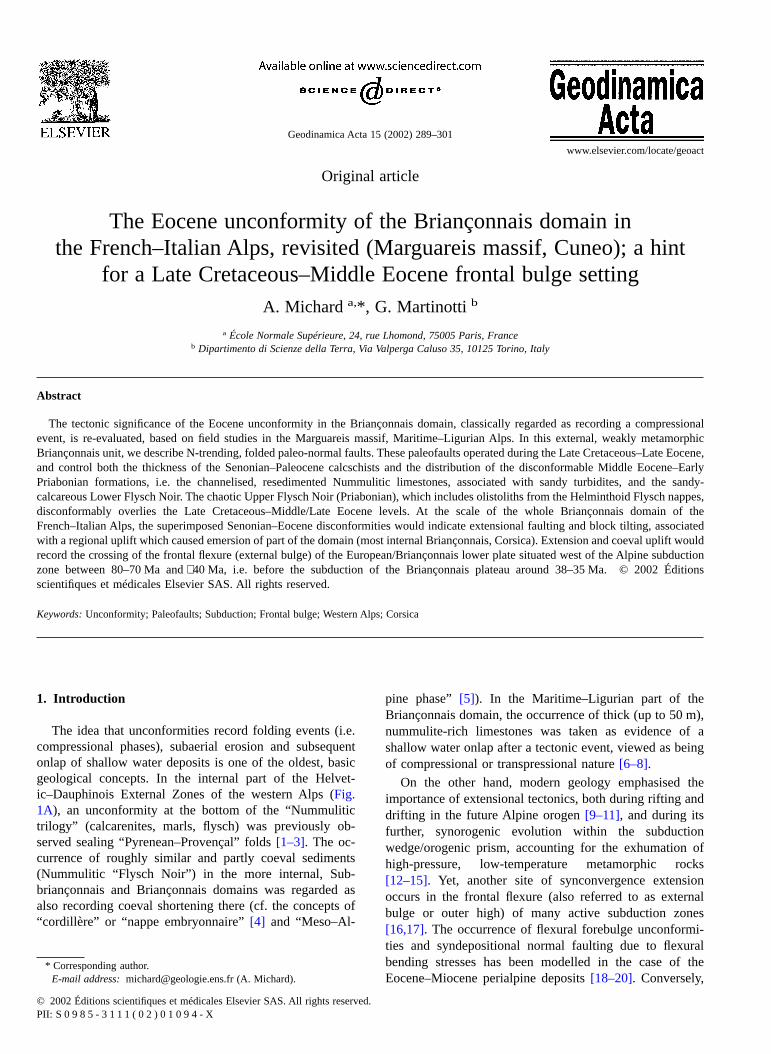
Original article
The Eocene unconformity of the Briançonnais domain inthe French–Italian Alps, revisited (Marguareis massif, Cuneo); a hint
for a Late Cretaceous–Middle Eocene frontal bulge settingA. Micharda,*, G. Martinotti b
a École Normale Supérieure, 24, rue Lhomond, 75005 Paris, Franceb Dipartimento di Scienze della Terra, Via Valperga Caluso 35, 10125 Torino, Italy
Abstract
The tectonic significance of the Eocene unconformity in the Briançonnais domain, classically regarded as recording a compressionalevent, is re-evaluated, based on field studies in the Marguareis massif, Maritime–Ligurian Alps. In this external, weakly metamorphicBriançonnais unit, we describe N-trending, folded paleo-normal faults. These paleofaults operated during the Late Cretaceous–Late Eocene,and control both the thickness of the Senonian–Paleocene calcschists and the distribution of the disconformable Middle Eocene–EarlyPriabonian formations, i.e. the channelised, resedimented Nummulitic limestones, associated with sandy turbidites, and the sandy-calcareous Lower Flysch Noir. The chaotic Upper Flysch Noir (Priabonian), which includes olistoliths from the Helminthoid Flysch nappes,disconformably overlies the Late Cretaceous–Middle/Late Eocene levels. At the scale of the whole Briançonnais domain of theFrench–Italian Alps, the superimposed Senonian–Eocene disconformities would indicate extensional faulting and block tilting, associatedwith a regional uplift which caused emersion of part of the domain (most internal Briançonnais, Corsica). Extension and coeval uplift wouldrecord the crossing of the frontal flexure (external bulge) of the European/Briançonnais lower plate situated west of the Alpine subductionzone between 80–70 Ma and∼ 40 Ma, i.e. before the subduction of the Briançonnais plateau around 38–35 Ma. © 2002 Éditionsscientifiques et médicales Elsevier SAS. All rights reserved.
Keywords: Unconformity; Paleofaults; Subduction; Frontal bulge; Western Alps; Corsica
1. Introduction
The idea that unconformities record folding events (i.e.compressional phases), subaerial erosion and subsequentonlap of shallow water deposits is one of the oldest, basicgeological concepts. In the internal part of the Helvet-ic–Dauphinois External Zones of the western Alps (Fig.1A), an unconformity at the bottom of the “Nummulitictrilogy” (calcarenites, marls, flysch) was previously ob-served sealing “Pyrenean–Provençal” folds[1–3]. The oc-currence of roughly similar and partly coeval sediments(Nummulitic “Flysch Noir”) in the more internal, Sub-briançonnais and Briançonnais domains was regarded asalso recording coeval shortening there (cf. the concepts of“cordillère” or “nappe embryonnaire”[4] and “Meso–Al-
pine phase”[5]). In the Maritime–Ligurian part of theBriançonnais domain, the occurrence of thick (up to 50 m),nummulite-rich limestones was taken as evidence of ashallow water onlap after a tectonic event, viewed as beingof compressional or transpressional nature[6–8].
On the other hand, modern geology emphasised theimportance of extensional tectonics, both during rifting anddrifting in the future Alpine orogen[9–11], and during itsfurther, synorogenic evolution within the subductionwedge/orogenic prism, accounting for the exhumation ofhigh-pressure, low-temperature metamorphic rocks[12–15]. Yet, another site of synconvergence extensionoccurs in the frontal flexure (also referred to as externalbulge or outer high) of many active subduction zones[16,17]. The occurrence of flexural forebulge unconformi-ties and syndepositional normal faulting due to flexuralbending stresses has been modelled in the case of theEocene–Miocene perialpine deposits[18–20]. Conversely,
* Corresponding author.E-mail address: [email protected] (A. Michard).
Geodinamica Acta 15 (2002) 289–301
www.elsevier.com/locate/geoact
© 2002 Éditions scientifiques et médicales Elsevier SAS. All rights reserved.PII: S 0 9 8 5 - 3 1 1 1 ( 0 2 ) 0 1 0 9 4 - X
the external bulge has not been considered yet in the Alpineliterature as a potential mechanism accounting for somepre-orogenic events in the Briançonnais domain, except forthe pioneering paper by Stampfli et al. [21] (see also [22]).In their actualistic restoration of the western Alps, Stampfliet al. [21] propose a quantitative approach of the evolutionof a foreland flexure linked to the Alpine (Piemont–Lig-urian) subduction, but limit their study to the Swiss Alps.
In the present paper, we focus on the Late Cretaceous-Paleogene stratigraphic evolution of the Briançonnais, withemphasis on the Eocene period. The Marguareis massif ofthe Maritime-Ligurian Alps is taken as a case study fordeciphering the significance of the Eocene unconformity inthe Briançonnais of the French–Italian Alps and Corsica.Based on new field data from the Marguar is massif, and onthe literature, we argue that the unconformities/
Fig. 1. The Briançonnais domain of the western/central Alps and Corsica. (A) Sketch map with location of the Marguareis massif (Fig. 2) and other citedareas (A, Acceglio; Br, Briançon; CA, Cottian Alps; E-U, Embrunais-Ubaye; GSB, Grand Saint Bernard; LA, Ligurian Alps; MA, Maritimes Alps; Sc,Schams; TS, Tambo-Suretta; Va, Vanoise). (B) Current restoration of the western Alps transect during the Early Cretaceous, after [30], [33], [74].
290 A. Michard, G. Martinotti / Geodinamica Acta 15 (2002) 289–301
disconformities observed throughout this domain during theEarly-Middle Eocene result from Late Cretaceous–Eoceneextensional deformation associated with a regional uplift.These tectonic events would record the crossing of theflexural bulge by the Briançonnais before being buried inthe Piemont–Ligurian subduction zone.
2. Geological setting
The Briançonnais (Middle Penninic) zone sensu strictoextends from Eastern Switzerland (Schams and Tambo-Suretta units) to the Prealps and Grand Saint Bernardtransect, to the Vanoise massif, Briançon region, southCottian Alps, and eventually to the Maritime-Ligurian Alps(Fig. 1A). South of the post-orogenic Ligurian Sea, theBriançonnais zone can be recognised (although with signifi-cant differences) in the autochthonous–parautochthonousunits of Corsica [23,24]. The Mesozoic sequence of theexternal/median Briançonnais units [25,26], exemplified bythe Marguareis-Ormea unit in the Ligurian transect [7,8], ischaracterised by shallow marine Triassic sediments (Scyth-ian quartzites, Middle to Upper Triassic carbonates); aLiassic–Bajocian erosional hiatus with some bauxite depos-its; transgressive, shallow water Bathonian limestones;Upper Jurassic (to Berriasian) pelagic marbles; phosphatic-manganesiferous crusts (hard-grounds) mostly dated fromthe Senonian, and Upper Cretaceous–Paleocene pelagiccalcschists (also referred to as “calcaires en plaquettes” or“marbres chloriteux” ). In the most internal Briançonnais(Ultrabriançonnais = Acceglio zone) units, the post-EarlyTriassic cover is virtually restricted to the Upper Jurassicand Upper Cretaceous levels [27,28]. From the Late Jurassicto the Late Cretaceous–Paleocene, the Briançonnais domainrepresented a submarine plateau bounded to the SE by theUpper Penninic Piemont–Ligurian ocean, and to the NW bythe Lower Penninic Valaisan–Subbriançonnais ocean ortrough (Fig. 1B). This Briançonnais plateau was eitherinterpreted as a first-order tilted block (or horst) of the distalEuropean margin [28–30], or as the northern tip of anIberia/Briançonnais plate, separated from the Europeanplate by the Pyrenean–Valaisan oceanic rift [21,31,32].
After the complete subduction of the Piemont–Ligurianocean beneath the Adria leading edge due to the Adria–E-urope convergence, the Briançonnais was incorporated intothe Alpine orogenic prism [21,30,32–36]. The Briançonnaisnappes were affected by metamorphic events, the grade ofwhich increases from the external to the internal units. In thecase of the Ligurian Alps transect, peak metamorphismoccurred under low greenschist- to low blueschist-faciesconditions in the external, Marguareis–Ormea nappe(Fe/Mg carpholite–chloritoid assemblages in the Jurassicmeta-bauxites of the eastern part of the nappe [37]), andunder deep blueschist, jadeite–quartz subfacies in the mostinternal units [38,39]. A second metamorphic event essen-tially corresponds to the retrograde evolution of the early
assemblages in the latter units. In the Marguareis–Ormeacase study, the syn- to post-metamorphic structures involve[40–42], (i) SW-verging, recumbent subisoclinal folds (P1)associated with a penetrative, axial-planar foliation (S1); (ii)N110-trending, moderately tight back-folds (P2) associatedwith a strong crenulation cleavage forming centimetre-scalemicrolithons in calcschist lithologies; and (iii) late foldstrending dominantly N130-N170 and either upright orreclined to the west (P3–P4). The syn- to late-metamorphicP1 and P2 folds occur at all scales, from some hectometresto a few millimetres, whereas the wavelength of the late- topost-metamorphic P3–P4 folds generally ranges from 1 dmto 1 km or more.
3. Late Cretaceous–Eocene stratigraphyof the Marguareis massif
In the centre of the Marguareis massif (Fig. 2) [8,40,43],the Plan Ambreuge area offers good outcrops of the wholeUpper Cretaceous–Eocene sequence lying on top of shallowdipping Upper Jurassic limestones (Fig. 3A). Complemen-tary data can be gained from the Col des Seigneurs and Colde Boaire–Col de la Perle synclines, which display signifi-cantly varied Eocene formations (Fig. 3B, C). The LateCretaceous–Paleocene part of the sequence consists of theclassical facies of planctonic, poorly siliceous calcschistswith basal Senonian hard-grounds. The major sedimentaryhiatus at the bottom of the calcschist formation is labelledhereafter the D1 discontinuity. A further discontinuity (D2discontinuity) can be defined on top of the calcschists, astheir hemipelagic, marly sedimentation is abruptly replacedupward by clastic-calcareous deposits. When complete (Fig.3A, B), the clastic–calcareous sequence begins with amassive layer of nummulitic limestones, and ends with theso-called “Flysch Noir” . On the basis of their benthicforaminifer content, the nummulitic limestones are looselydated as late Lutetian to early Priabonian, whereas theoverlying flysch is regarded as Priabonian [6,7,44]. The D2discontinuity may be defined as a disconformity as thethickness of the underlying calcschists varies from ∼ 300 m(Monte di Carsene) to ∼ 10 m (eastern part of Plan Am-breuge, A1, Fig. 2).
A third stratigraphic discontinuity (D3) can be definedwithin the flysch sequence itself. The Lower Flysch Noirmostly consists of layered deposits (fine-grained sandycarbonates, pelites, slates) including olistostromal brecciaswith nummulitic limestone olistoliths (intraclasts). In con-trast, the Upper Flysch Noir (above D3) dominantly consistsof matrix-supported breccias with exotic olistoliths, the sizeof which increases upward up to a few hundred of meters.Most of these olistoliths originate from the Upper Penninicnappes of the Helminthoid Flyschs [45,46], but basalticclasts likely reworked from the Piemont–Ligurian crusthave been also described at Cima della Fascia [47]. The D3discontinuity can be referred to again as a disconformity as,
A. Michard, G. Martinotti / Geodinamica Acta 15 (2002) 289–301 291
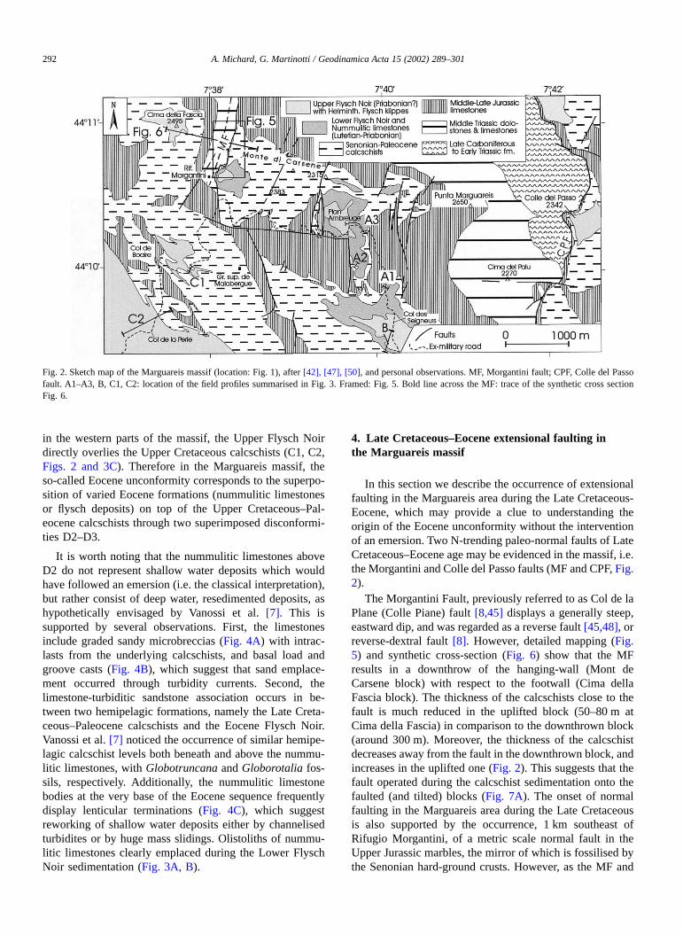
in the western parts of the massif, the Upper Flysch Noirdirectly overlies the Upper Cretaceous calcschists (C1, C2,Figs. 2 and 3C). Therefore in the Marguareis massif, theso-called Eocene unconformity corresponds to the superpo-sition of varied Eocene formations (nummulitic limestonesor flysch deposits) on top of the Upper Cretaceous–Pal-eocene calcschists through two superimposed disconformi-ties D2–D3.
It is worth noting that the nummulitic limestones aboveD2 do not represent shallow water deposits which wouldhave followed an emersion (i.e. the classical interpretation),but rather consist of deep water, resedimented deposits, ashypothetically envisaged by Vanossi et al. [7]. This issupported by several observations. First, the limestonesinclude graded sandy microbreccias (Fig. 4A) with intrac-lasts from the underlying calcschists, and basal load andgroove casts (Fig. 4B), which suggest that sand emplace-ment occurred through turbidity currents. Second, thelimestone-turbiditic sandstone association occurs in be-tween two hemipelagic formations, namely the Late Creta-ceous–Paleocene calcschists and the Eocene Flysch Noir.Vanossi et al. [7] noticed the occurrence of similar hemipe-lagic calcschist levels both beneath and above the nummu-litic limestones, with Globotruncana and Globorotalia fos-sils, respectively. Additionally, the nummulitic limestonebodies at the very base of the Eocene sequence frequentlydisplay lenticular terminations (Fig. 4C), which suggestreworking of shallow water deposits either by channelisedturbidites or by huge mass slidings. Olistoliths of nummu-litic limestones clearly emplaced during the Lower FlyschNoir sedimentation (Fig. 3A, B).
4. Late Cretaceous–Eocene extensional faulting inthe Marguareis massif
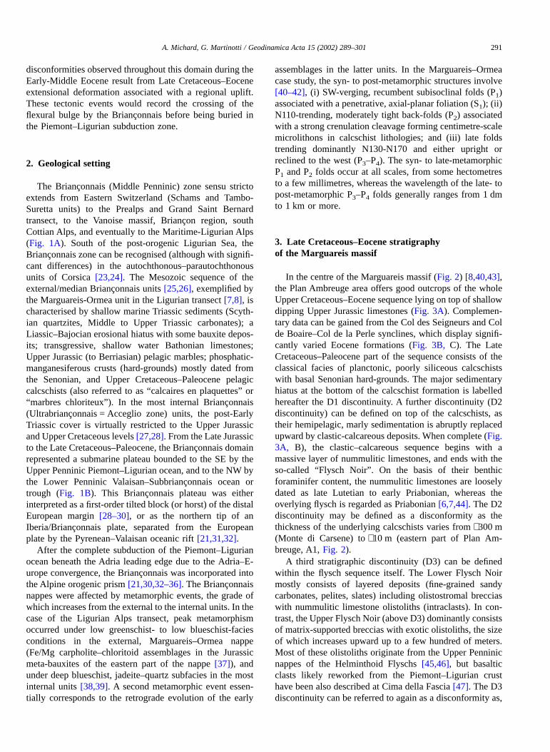
In this section we describe the occurrence of extensionalfaulting in the Marguareis area during the Late Cretaceous-Eocene, which may provide a clue to understanding theorigin of the Eocene unconformity without the interventionof an emersion. Two N-trending paleo-normal faults of LateCretaceous–Eocene age may be evidenced in the massif, i.e.the Morgantini and Colle del Passo faults (MF and CPF, Fig.2).
The Morgantini Fault, previously referred to as Col de laPlane (Colle Piane) fault [8,45] displays a generally steep,eastward dip, and was regarded as a reverse fault [45,48], orreverse-dextral fault [8]. However, detailed mapping (Fig.5) and synthetic cross-section (Fig. 6) show that the MFresults in a downthrow of the hanging-wall (Mont deCarsene block) with respect to the footwall (Cima dellaFascia block). The thickness of the calcschists close to thefault is much reduced in the uplifted block (50–80 m atCima della Fascia) in comparison to the downthrown block(around 300 m). Moreover, the thickness of the calcschistdecreases away from the fault in the downthrown block, andincreases in the uplifted one (Fig. 2). This suggests that thefault operated during the calcschist sedimentation onto thefaulted (and tilted) blocks (Fig. 7A). The onset of normalfaulting in the Marguareis area during the Late Cretaceousis also supported by the occurrence, 1 km southeast ofRifugio Morgantini, of a metric scale normal fault in theUpper Jurassic marbles, the mirror of which is fossilised bythe Senonian hard-ground crusts. However, as the MF and
Fig. 2. Sketch map of the Marguareis massif (location: Fig. 1), after [42], [47], [50], and personal observations. MF, Morgantini fault; CPF, Colle del Passofault. A1–A3, B, C1, C2: location of the field profiles summarised in Fig. 3. Framed: Fig. 5. Bold line across the MF: trace of the synthetic cross sectionFig. 6.
292 A. Michard, G. Martinotti / Geodinamica Acta 15 (2002) 289–301
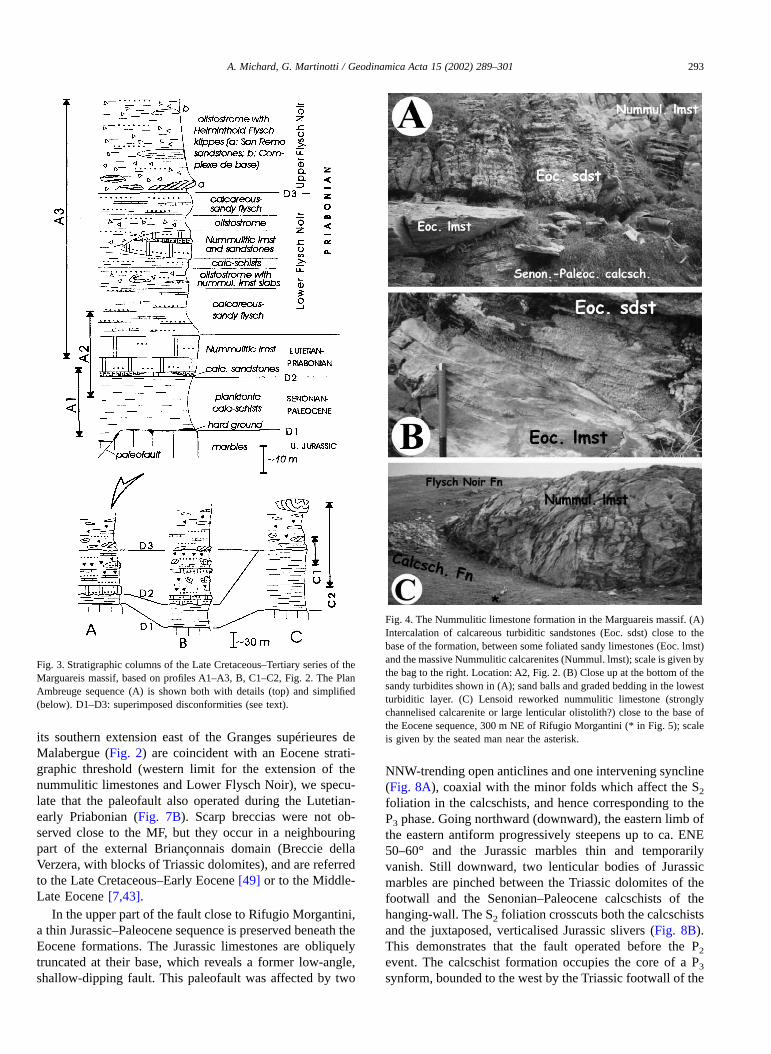
its southern extension east of the Granges supérieures deMalabergue (Fig. 2) are coincident with an Eocene strati-graphic threshold (western limit for the extension of thenummulitic limestones and Lower Flysch Noir), we specu-late that the paleofault also operated during the Lutetian-early Priabonian (Fig. 7B). Scarp breccias were not ob-served close to the MF, but they occur in a neighbouringpart of the external Briançonnais domain (Breccie dellaVerzera, with blocks of Triassic dolomites), and are referredto the Late Cretaceous–Early Eocene [49] or to the Middle-Late Eocene [7,43].
In the upper part of the fault close to Rifugio Morgantini,a thin Jurassic–Paleocene sequence is preserved beneath theEocene formations. The Jurassic limestones are obliquelytruncated at their base, which reveals a former low-angle,shallow-dipping fault. This paleofault was affected by two
NNW-trending open anticlines and one intervening syncline(Fig. 8A), coaxial with the minor folds which affect the S2
foliation in the calcschists, and hence corresponding to theP3 phase. Going northward (downward), the eastern limb ofthe eastern antiform progressively steepens up to ca. ENE50–60° and the Jurassic marbles thin and temporarilyvanish. Still downward, two lenticular bodies of Jurassicmarbles are pinched between the Triassic dolomites of thefootwall and the Senonian–Paleocene calcschists of thehanging-wall. The S2 foliation crosscuts both the calcschistsand the juxtaposed, verticalised Jurassic slivers (Fig. 8B).This demonstrates that the fault operated before the P2
event. The calcschist formation occupies the core of a P3
synform, bounded to the west by the Triassic footwall of the
Fig. 3. Stratigraphic columns of the Late Cretaceous–Tertiary series of theMarguareis massif, based on profiles A1–A3, B, C1–C2, Fig. 2. The PlanAmbreuge sequence (A) is shown both with details (top) and simplified(below). D1–D3: superimposed disconformities (see text).
Fig. 4. The Nummulitic limestone formation in the Marguareis massif. (A)Intercalation of calcareous turbiditic sandstones (Eoc. sdst) close to thebase of the formation, between some foliated sandy limestones (Eoc. lmst)and the massive Nummulitic calcarenites (Nummul. lmst); scale is given bythe bag to the right. Location: A2, Fig. 2. (B) Close up at the bottom of thesandy turbidites shown in (A); sand balls and graded bedding in the lowestturbiditic layer. (C) Lensoid reworked nummulitic limestone (stronglychannelised calcarenite or large lenticular olistolith?) close to the base ofthe Eocene sequence, 300 m NE of Rifugio Morgantini (* in Fig. 5); scaleis given by the seated man near the asterisk.
A. Michard, G. Martinotti / Geodinamica Acta 15 (2002) 289–301 293
fault, and to the east by a large P3 Jurassic–Triassic antiform[42]. Some nearly vertical, post-folding faults, which con-trol the important karstic caves in the vicinity of RifugioMorgantini, locally affect the MF plane, and increase the dipand initial throw of the paleofault.
If correct, our interpretation predicts the occurrence ofanother paleofault, similar to the MF one, east of the Montedi Carsene-Plan Ambreuge paleo-tilted block (Fig. 7). As a
matter of fact, such a fault occurs east of the PuntaMarguareis, i.e. the E-dipping Colle del Pas fault (CPF, Fig.2). Like the MF, the CPF was considered by Lanteaume etal. [8] as a post-folding compressional fault. However, thehanging-wall is clearly downthrown (Late Cretaceous–Ter-tiary outcrops) with respect to the footwall (Triassic andPermian–Carboniferous outcrops). Moreover, detailed map-ping by Filippi [50] reveals the presence of Malm sliverspinched in the fault plane, similar to those observed alongthe MF itself. We conclude from the closely similar geo-metric setting of the CPF and MF that the former representsa paleofault which is coeval with the MF paleofault, andwhich bounded to the east (present coordinates) the upliftedshoulder of the Monte di Carsene–Marguareis block.
Fig. 5. Detailed map of the Morgantini fault (MF) area, based onphotogeology and field observations, with location of Figs. 4C, 8A, 8B.
Fig. 6. Synthetic cross-section of the Morgantini paleofault (MF) and adjoining units, based on the map Fig. 5. Location: Fig. 2. UFn/LFn, Upper/LowerFlysch Noir; Nl, Nummulitic limestones; UC-P, Upper Cretaceous-Paleocene calcschists; UJ/MJ, Upper/Middle Jurassic limestones; D1–D3, disconformitiesas shown in Fig. 3; F, recent fault.
Fig. 7. Sketch illustrating the evolution of the Marguareis massif paleo-faults (MF, Morgantini fault; CPF, Colle del Pas fault). (A) Cross-sectionof the faults and adjoining tilted blocks after the Late Cretaceous–EarlyEocene extension and further disconformable Middle Eocene sedimenta-tion. (B) Cross-section of the same blocks after the Middle Eocene-earlyPriabonian final extension and further olistostrome emplacement at thefront of the advancing orogenic prism (late Priabonian).
294 A. Michard, G. Martinotti / Geodinamica Acta 15 (2002) 289–301
5. The Eocene unconformity in the Briançonnaisrealm: discussion
5.1. Extension-related disconformities
The salient conclusions of Sections 3 and 4 are twofold:(i) in the Briançonnais of the Marguareis massif, the MiddleEocene nummulitic limestones are resedimented depositsassociated with channelised turbiditic sandstones; (ii) in theMarguareis massif, the Eocene unconformity is not asubaerial post-folding unconformity like in the Helvet-ic–Dauphinois domain [1–3,51], but consists of two super-imposed, submarine disconformities (D2, D3) dated asLutetian-early Priabonian and Priabonian, respectively. Likethe earlier disconformity (D1) at the bottom of the LateCretaceous–Paleocene calcschists, D2 is only related toextensional faulting and block tilting. D3 postdates the latestpre-orogenic, extensional deformation of the substrate, andis sealed by the earliest Upper Penninic nappe emplacement.
A review of the literature suggests that similar conditionsprevailed everywhere in the Briançonnais domain duringthis period, except in its most internal and southern parts(see Section 5.2). In the Middle Penninic Préalpes Médianes[52,53], erosion and sedimentation alternated in the pelagicCouches Rouges basin (Late Cretaceous–Early Eocene),and the disconformable upper Couches Rouges (EarlyEocene) begin with submarine breccias. The overlyingMiddle–Upper Eocene flysch itself begins with calcareoussandstones including reworked nummulites and Lithotham-niae fragments [53–55]. In the Vanoise massif [56], theupper Marbres Chloriteux (Late Paleocene–Early Eocene)disconformably overlies the Maastrichtian Calcschistes àblocs, the Senonian–Paleocene Marbres Chloriteux, and theJurassic marbles through breccias and/or phosphatic crusts.The latter crusts frequently include Senonian Globotrun-cana in reworked nodules, besides of Late Paleocen-e–Middle Lutetian Globorotalia in the matrix [56,57]. The
Schistes de Pralognan (Flysch Noir) disconformably overliethe Early Eocene or Late Cretaceous Marbres Chloriteuxand, locally, the Upper Jurassic marbles, with reworkedLithothamniae fragments in the lowest Lutetian levels.Likewise in the “3ème écaille” of the classical Briançon-nais, the pelagic “Calcschistes en plaquettes” are dividedinto a Senonian–Lower Paleocene part and an Early Eocenepart by a phosphatic level with perfored pebbles andglauconite grains [58]. In the basal level of the disconform-able Flysch Noir, the occurrence of early Bartonian pelagicfossils in the argillaceous matrix [59] demonstrates that thelate Lutetian–Bartonian benthic foraminifers from the cal-carenites are resedimented from some neighbouring shallowmarine platform.
Moreover, Late Cretaceous to Eocene disconformitiesand resedimentation processes seem controlled by normalfaulting and block tilting. Fault scarp breccias are frequentin the Senonian–Early Eocene sediments of the Briançon-nais domain, at least from the Médianes to the Cottian Alps[52,54,56,57,60–63] and to the external Ligurian Briançon-nais [7]. Most of these breccias are dated as Late Creta-ceous–Paleocene, and some of them correspond to thereactivation of Liassic normal faults [30,64]. In the Ubayevalley, Gidon et al. [26] describe E-, NE- and NW-trendingpaleofaults sealed by Late Cretaceous–Paleocenecalcschists or even by Eocene Flysch Noir deposits.
5.2. Source areas for the nummulitic deposits
The question after the source areas for the Lutetian–Pria-bonian turbiditic sediments (carrying reworked Lithotham-niae and benthic foraminifers together with crystallineclasts) now arises. In the Ligurian Alps, the Castelvecchio-Cerisola unit (Ultrabriançonnais = Acceglio zone) was cer-tainly emerged prior to the sedimentation of the Lutetiancalcarenites and the Priabonian flysch, as the calcarenitesdisconformably overlie the varied Mesozoic layers and the
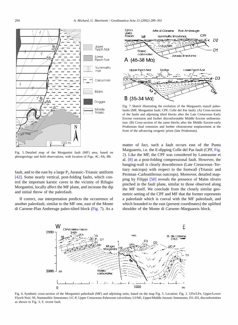
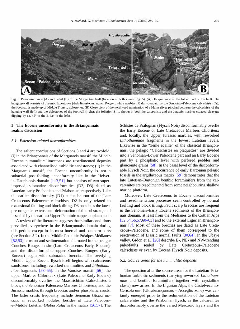
Fig. 8. Panoramic view (A) and detail (B) of the Morgantini fault (location of both views: Fig. 5). (A) Oblique view of the folded part of the fault. Thehanging-wall consists of Jurassic limestones (dark limestones: upper Dogger; white marbles: Malm) overlain by the Senonian–Paleocene calcschists (Cs);the footwall is made up of Middle Triassic dolostones. (B) Close view of the northward termination of a Malm sliver pinched between the calcschists of thehanging-wall (left) and the dolostones of the footwall (right); the foliation S3 is shown in both the calcschists and the Jurassic marbles (spaced cleavagedipping by ca. 45° to the E, i.e. to the left).
A. Michard, G. Martinotti / Geodinamica Acta 15 (2002) 289–301 295
Permian siliciclastic conglomerates [6]. In the Vanoisemassif, the Schistes de Pralognan occasionally overlies theJurassic and Triassic carbonates in the form of a coarse,basal conglomerate with Triassic dolomite and quartzitepebbles [56,57]. Hence, we propose that parts of the internalBriançonnais domain have been uplifted enough such as toreach emersion during the (Early?)-Middle Eocene. Erosioncould have easily reached the Triassic quartzites and thePaleozoic basement, as the Triassic carbonates have beenalmost totally eroded during the Liassic–Middle Jurassicemersion in these areas (Acceglio zone).
Another, and larger potential source area can be recogn-ised in the southernmost Briançonnais domain, i.e. in theautochthonous–parautochthonous Corsica, where Paleoceneto Middle Eocene shallow water conglomerates and num-mulitic limestones unconformably overlie the Paleozoicbasement and its thin Jurassic and/or Late Cretaceous cover[23,65,66]. In the Balagne autochthon [65,67], the crystal-line basement is overlain by massive conglomerates inter-bedded with, and followed upward by nummulitic lime-stones, which are dated from the Middle–Late Lutetian, andby an Upper Eocene flysch ending with a chaotic wildflysch.In the Corte autochthon, the Zurmulu conglomerates aredated as Late Paleocene–Early Eocene by a nummuliticlimestone intercalation [23]. They overlie the crystallinebasement and a thin, Ultrabriançonnais-type Mesozoic se-ries (Razzo Bianco sequence) through a contact which wasinterpreted [23] as a post-metamorphic unconformity. Incontrast, we might consider this contact as a ductilelysheared disconformity as it is crosscut by the regional,oblique foliation (pers. obs., A.M. 2000, unpublished). Thisis supported by the fact that in the neighbouring parautoch-thonous units, the Eocene flysch, dated by reworked Barto-nian nummulites, is affected by the regional, high-pressure,low-temperature metamorphism [68]. The hypothesis of aCorsican source is supported by the overall distribution ofthe nummulitic limestones in the Briançonnais domain, asthe abundance and thickness of these formations decreasenorth of the Maritime Alps. The northernmost, relativelythick Middle Eocene calcarenite–conglomerate formationoccurs in the south Cottian Alps (Cima Piconiera) [69]. Notethat the Corsican–Iberian basement was already the sourcearea for the Middle Triassic–Middle Jurassic aluminousargillites and bauxite deposits of the Briançonnais domain[70].
Vanossi et al. [7] suggested that the External domain(which was emerged during the Paleocene–Early Eocene,then partly changed into a shallow marine platform duringthe Lutetian-early Priabonian [51,71]) could account for theclastic and shallow water biogenic input in the BriançonnaisEocene basin. This hypothesis is unlikely as soon as theValais-Pyrenean oceanic basin in between the Briançonnaisplatform and the External domain (Fig. 1B) was not suturedbefore the Late Eocene [21,22,32]. As suggested by Cerianiet al. [36], the External, Subbriançonnais and Briançonnaisbasins likely merged into a single trench basin during the
Priabonian, but internal sources from the orogenic prismdominated in its internal parts (cf. basaltic clasts andHelminthoid Flysch olistoliths in the Upper Flysch Noir ofthe Marguareis massif).
5.3. Geodynamic interpretation
The Late Cretaceous–Eocene tectonic/stratigraphic evo-lution of the Briançonnais domain can be interpreted inrelation with the Europe–Adria convergence during thiscritical period. In the following, we use the geochronologictime scale compiled by Gradstein and Ogg [72]. During theLate Cretaceous–Eocene (98.9–33.7 Ma), the Briançonnaisdomain was part of the lower plate of the Alpine (Pi-emont–Ligurian) subduction zone, should this continentalplateau be the distal part of the European margin, or thenorthern tip of the Iberian plate (see Section 2). Thesubducting plate displayed, on the external (NW) side of thetrench, a flexural bending zone characterised by extensionalfaulting, and presumably by a foreland bulge (Fig. 9A), asobserved in many active subduction zones [16,17]. Whilethe leading edge of the subducting plate, i.e. the Pi-emont–Ligurian oceanic domain was being consumed in thesubduction zone (which occurred from the Late Cretaceousonward [21,30,33–35]), the Briançonnais domain had tocross the bulge (Fig. 9A, B) before being buried beneath theorogenic wedge (Fig. 9C). We consider that the role of thefrontal bulge might be recognised in the whole Briançonnaisdomain, at least in the south western Alps, through con-spicuous effects, i.e. (i) extensional faulting, responsible forthickness variations of the Senonian–Early Eocene sedi-mentation, fault scarp breccias, and for a Middle–LateEocene unconformity, related to superimposed disconformi-ties; (ii) a Late Cretaceous–Early Eocene crustal uplift,responsible for the increased sedimentation rate (Senonian-Paleocene calcareous muds following upward the starvedsedimentation of the hard ground episode [28–30]), then forthe partial emersion of the internal Briançonnais; and (iii) aMiddle–Late Eocene subsidence, just predating theBriançonnais subduction.
In the sketch model (Fig. 9), the geometry of the bulge(total width: 300 km; distance of the outer high to the trenchaxis: 100 km) is chosen as an approximation of the valuesobserved in active settings [16,17]. The 60 km width of theBriançonnais plateau is a compromise between that of thepalinspastic restorations by Lemoine et al. [28], Tricart et al.[29] and Michard and Henry [62], which range from 100 to30 km. The model assumes a Briançonnais–Adria conver-gence rate of 1 cm/year, which is a reasonable estimate inthe frame of the Tethyan plate tectonics [21]. As discussedby Cliff et al. [73], such a convergence rate might fit themost reliable isotopic datings of the Sesia schists andPiemont–Ligurian eclogites, respectively 70–65 Ma and60–40 Ma, or 46–43 Ma, according to the more recentsynthesis by Dal Piaz et al. [74]. In accordance with such alow convergence rate, the subduction dip should have been
296 A. Michard, G. Martinotti / Geodinamica Acta 15 (2002) 289–301
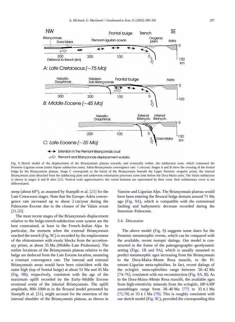
steep (about 60°), as assumed by Stampfli et al. [21] for theLate Cretaceous stages. Note that the Europe–Adria conver-gence rate increased up to about 2 cm/year during thePaleocene–Eocene due to the closure of the Valais ocean[21,33].
The most recent stages of the Briançonnais displacementrelative to the bulge-trench-subduction zone system are thebest constrained, at least in the French–Italian Alps. Inparticular, the moment when the external Briançonnaisreached the trench (Fig. 9C) is recorded by the emplacementof the olistostromes with exotic blocks from the accretion-ary prism, at about 35 Ma (Middle–Late Priabonian). Theearlier locations of the Briançonnais plateau relative to thebulge are deduced from the Late Eocene location, assuminga constant convergence rate. The internal and externalBriançonnais areas would have been coincident with theouter high (top of frontal bulge) at about 51 Ma and 45 Ma(Fig. 9B), respectively, consistent with the age of themaximum uplift recorded by the Early–Middle Eoceneerosional event of the internal Briançonnais. The upliftamplitude, 800–1000 m in the flexural model presented byStampfli et al. [21], might account for the emersion of theinternal shoulder of the Briançonnais plateau, as shown in
Vanoise and Ligurian Alps. The Briançonnais plateau wouldhave been entering the flexural bulge domain around 71 Maago (Fig. 9A), which is compatible with the extensionalfaulting and bathymetric decrease recorded during theSenonian–Paleocene.
5.4. Discussion
The above model (Fig. 9) suggests some dates for thePenninic metamorphic events, which can be compared withthe available, recent isotopic datings. Our model is con-structed in the frame of the paleogeographic–geodynamicsetting (Figs. 1B and 9A), which is usually assumed topredict metamorphic ages increasing from the Briançonnaisto the Dora-Maira–Monte Rosa massifs, to the Pi-emont–Ligurian meta-ophiolites. In fact, recent datings ofthe eclogitic meta-ophiolites range between 50–42 Ma[74–76], consistent with our reconstruction (Fig. 9A, B). Asto the Dora-Maira–Monte Rosa massifs, the available agesfrom high-retentivity minerals from the eclogitic, HP-UHPassemblages range from 38–40 Ma [77] to 35 ± 1 Ma[75,78] or 33 ± 1 Ma [79]. This is roughly consistent withour sketch model (Fig. 9C), provided the corresponding thin
Fig. 9. Sketch model of the displacement of the Briançonnais plateau towards, and eventually within, the subduction zone, which consumed thePiemont–Ligurian ocean (main Alpine subduction zone). Adria-Briançonnais convergence rate: 1 cm/year. Stages A and B show the crossing of the frontalbulge by the Briançonnais plateau. Stage C corresponds to the burial of the Briançonnais beneath the Upper Penninic orogenic prism; the internalBriançonnais units detached from the subducting plate and underwent exhumation processes some time before the Dora-Maira units. The Valais subductionis shown in stages A and B after [21]. Vertical scale approximative; the varied domains are represented by their crust, their sedimentary cover is notdifferentiated.
A. Michard, G. Martinotti / Geodinamica Acta 15 (2002) 289–301 297
crustal units were not detached from the subducting lithos-phere. In contrast, isotopic datings of the Briançonnais peakmetamorphism in the internal Grand Saint Bernardnappe, ∼ 38 Ma Rb–Sr white micas ages in the Entrelor-Nomenon backthrust [80], and 41–36 Ma Ar–Ar whitemicas ages in the Siviez–Mischabel nappe [81], seemcontradictory to our model. This can be explained assumingthat these units (by contrast with the Dora-Maira ones) weredetached from the subducting plate, some time before theLate Eocene 35 Ma stage (Fig. 9C). Indeed, if not detachedfrom the subducting plate, the internal Briançonnais wouldhave reached at that time ∼ 60 km depth. This depth exceedsby ∼ 30–40 km that recorded by the aragonite- and Mg-carpholite-chloritoid-bearing rocks from the internalBriançonnais of western Vanoise ([82,83] and Goffé, per-son. com., 2002), and by about 20 km the maximum burialdepth of the most internal Acceglio units, equilibrated in thegarnet-bearing blueschist/eclogite facies assemblages[84,85]. Therefore, we have to assume that the internalBriançonnais units had been previously detached from thesubducting plate, as proposed by several authors [33,34]. Inour model, these units reached their maximum burial depth(20–40 km) at ∼ 39–37 Ma, consistent with the reportedisotopic datings, then detached from the subducting lithos-phere. Similarly, the external Briançonnais units reachedtheir maximal burial depth (∼ 10–20 km) at about 34–33 Ma(assuming a constant subduction rate), then detached.
On the other hand, our model predicts normal faultslongitudinal or moderately oblique [86] relative to thetrench orientation, i.e. trending close to NE before theAlpine collision (according to the current reconstruction ofthe pre-orogenic Alpine domain, e.g. [21,30,33]). Recentpaleomagnetic studies in the Marguareis massif [87] suggestpost-Eocene, anticlockwise rotations of ca. 117° aboutvertical axis relative to stable Europe. Applying a clockwiserotation of the same value to the N-trending paleofaults (MFand CPF) of the Marguareis massif, we restore their initial,pre-orogenic orientation at ca. N63E, consistent with theprediction of our model.
Our reconstruction of the Briançonnais evolution in theFrench–Italian Alps is broadly in line with Stampfli et al.[21] model for the Swiss Alps, at least as far as the LateCretaceous interval is concerned. These authors proposethat the bulge could have been responsible for the hiatusesand breccias in the Late Cretaceous sedimentation of theBriançonnais domain, and possibly for the late Maastrich-tian–Paleocene intraplate volcanism described by Deville[88]. As a cautionary remark, Stampfli et al. [21] emphasisethat the Valais subduction could have uplifted the Briançon-nais plateau in a similar fashion as the bulge related to thePiemont–Ligurian subduction (see also Ceriani et al. [36]).This must be considered for the Middle–Late Eocene spanof time too, which corresponds to the end of the Valaissubduction [21,32,36,89]. However, the Valais crust wasabout 100 Myr old at that time, and hence had low buoy-ancy then. This makes the hypothesis of the Briançonnais
being uplifted by the Valais crust unlikely. Nevertheless, weemphasise that our model must be taken as a workinghypothesis which has to be improved by taking into accountnot only the possible effects of the Valais subduction, butalso those of the northward translation of the Briançonnaisterrane during the Eocene, as postulated by Stampfli et al.[21,22].
6. Conclusion
We presented a new stratigraphic and structural datasetcollected in the Marguareis massif of the Maritime–Lig-urian Briançonnais. Based on this local dataset, and on areview of the published, stratigraphic and structural datafrom the Briançonnais zone of the French–Italian Alps andCorsica, we inferred a new geodynamic interpretation of theevolution of the Briançonnais domain during the LateCretaceous–Middle Eocene. This interpretation calls uponthe occurrence of a frontal bulge in the lower plate of thePiemont–Ligurian subduction, crossed by the Briançonnaisplateau during the Late Cretaceous–Middle Eocene.
The scenario presented here above for the French–ItalianAlps and Corsica points toward an ongoing process ofsubduction of the Briançonnais domain during the Middle-Late Eocene, certainly not before 45 Ma. In the Swiss Alps,a similar conclusion is supported by Stampfli et al. [21,22],whereas Schmid et al. [33] and Schmid and Kissling [90]assume that the Briançonnais units (Tambo, Suretta,Schams) were subducted during the Paleocene–EarlyEocene. The discussion of the possibility that the Briançon-nais subduction could have been diachronic from the northto the south of the western Alps would be beyond the scopeof the present paper.
Acknowledgements
C. Chopin and B. Goffé provided useful comments on anearly draft of the manuscript. A.M. is endebted to B. Gofféand M.-D. Loye for logistic support at Ecole NormaleSupérieure, and to J. Ferrandini and P. Vellutini for helpfulguidance in the field and support in Corsica. We thankM. Collombet for the communication of a preprint of herpaper. Reviews by Stephan Schmid and Gérard Stampfli aregratefully acknowledged. This paper is dedicated to thememory of Rafaella Ruffini, from Torino laboratory, de-ceased September 2002.
References
[1] J. Boussac, Étude stratigraphique sur le Nummulitique alpin, Mém.Expl. Carte Géol. France (1912).
298 A. Michard, G. Martinotti / Geodinamica Acta 15 (2002) 289–301
[2] C. Sturani, Présence de Palaeotherium et de Pulmonés dans l’Eocènecontinental du Lauzanier (couverture sédimentaire de l’Argentera,Basses-Alpes), Trav. Lab. Géol. Fac. Sci. Grenoble 41 (1965)229–246.
[3] M. Lemoine, Rythme et modalités des plissements superposés dansles chaînes subalpines méridionales des Alpes occidentalesfrançaises, Geol. Rundsch. 3 (1972) 975–1010.
[4] M. Gignoux, Géologie stratigraphique, Masson, Paris, 1950 735pp.
[5] J. Debelmas, C. Kerchkove, J. Desmons, Sur l’âge de la phaseméso-alpine dans les zones internes des Alpes franco-italiennes, C.R. Acad. Sci. 306 sér. II (1988) 1237–1240.
[6] M. Lanteaume, G. Royant, Stratigraphie et position structurale de lasérie briançonnaise du Colle San Bernardo (confins liguro-piémontais), Eclogae Geol. Helv. 76 (1983) 631–642.
[7] M. Vanossi, L. Cortesogno, B. Galbiati, B. Messiga, G. Piccardo,R. Vannucci, Geologia delle Alpi Liguri: dati, problemi, ipotesi,Mem. Soc. Geol. Italie 28 (1984) 5–75.
[8] M. Lanteaume, N. Radulescu, M. Gravos, J. Féraud, A. Faure-Muret, D. Haccard, M. Villey, J.P. Lecanu, D. Dufay, P. Gigot,M.F. Vigne, R. Aguinet, D. Vaslet, R. Campredon, Carte géologiquede France 1/50 000, feuille Vieve-Tende (3840–3841). Noticeexplicative, Bur. Rech. Géol. Min., Orléans, (1990–1991) 129 pp.
[9] M. Lemoine, P. Tricart, G. Boillot, Ultramafic and gabbroic oceanfloor of the Ligurian Tethys (Alps, Corsica, Apennines): in search ofa genetic model, Geology 15 (1987) 622–625.
[10] S. Pastorelli, G. Martinotti, G.B. Piccardo, E. Rampone, M. Scam-belluri, The Geisspfad Complex and its relationships with the MonteLeone nappe (Lower Pennine, western Alps), in: R. Polino, R. Sac-chi (Eds.), Atti Conv. Rapporti Alpi-Appennino, Acc. Naz. Sci. deiXL, Scritti Doc. 14 (1995) 349–358.
[11] N. Froitzheim, G. Manatschal, Kinematics of Jurassic rifting, mantleexhumation, and passive margin formation in the Austroalpine andPenninic nappes (Eastern Switzerland), Geol. Soc. Am. Bull. 108(1996) 1120–1133.
[12] J.P. Platt, Dynamics of orogenic wedges and the uplift of high-pressure metamorphic rocks, Geol. Soc. Am. Bull. 97 (1986)1037–1053.
[13] A. Michard, C. Chopin, C. Henry, Compression and extension in theexhumation of the Dora-Maira coesite-bearing unit, western Alps,Italy, Tectonophysics 221 (1993) 173–193.
[14] L. Jolivet, B. Goffé, R. Bousquet, R. Oberhänsli, A. Michard,Detachments in high-pressure mountain belts, Tethyan examples,Earth Planet. Sci. Lett. 160 (1998) 31–47.
[15] J. Wheeler, S.M. Reddy, R.A. Cliff, Kinematic linkage betweeninternal zone extension and shortening in more external units in theNW Alps, J. Geol. Soc. London 158 (2001) 439–443.
[16] D.E. Byrne, D.M. Davis, L.R. Sykes, Loci and maximum size ofthrust earthquakes and the mechanics of the shallow region ofsubduction zones, Tectonics 7 (1988) 833–857.
[17] J. Dubois, C. Deplus, M. Diament, J. Daniel, J.Y. Collot, Subductionof the Bougainville seamount (Vanuatu): mechanical and geody-namic implications, Tectonophysics 149 (1988) 11–119.
[18] P.A. Allen, S.L. Crampton, H.D. Sinclair, The inception and earlyevolution of the North Alpine foreland basin, Switzerland, BasinRes. 3 (1991) 143–163.
[19] P.A. Allen, P.M. Burgess, J. Galewsky, H.D. Sinclair, Flexural-eustatic numerical model for drowning of the Eocene perialpinecarbonate ramp and implications for Alpine geodynamics, Geol.Soc. Am. Bull. 113 (2001) 1052–1066.
[20] M. Burkhard, A. Sommaruga, Evolution of the western SwissMolasse basin: structural relations with the Alps and the Jura belt, in:A. Mascle, C. Puidefàbregas, H.P. Luterbacher, M. Fernàndez(Eds.), Cenozoic foreland basins of western Europe, Geol. Soc.Spec. Publ. 134 (1998) 279–298.
[21] G.M. Stampfli, J. Mosar, D. Marquer, R. Marchant, T. Baudin,G. Borel, Subduction and obduction processes in the Swiss Alps,Tectonophysics 296 (1998) 159–204.
[22] G.M. Stampfli (Ed.), Geology of western Swiss Alps – a guide-book,Mém. Géol. Lausanne 36 (2001) 1–195.
[23] S. Amaudric du Chaffaut, Les unités alpines à la marge orientale dumassif cristallin corse, Trav. Lab. Géol. Ecole Normale Sup. 15(1982) 1–133.
[24] S. Amaudric du Chaffaut, M. Bourbon, P.-C. de Graciansky,M. Lemoine, Du Briançonnais à la Corse : modifications longitudi-nales d’une marge continentale passive de la Téthys ligure, Mem.Soc. Geol. Italie 28 (1984) 269–283.
[25] J. Debelmas, M. Lemoine, Carte géologique de France 1/50 000,feuille Guillestre (35–37). Notice explicative, Bur. Rech. Géol. Min.,Orléans (1966) 20 pp.
[26] M. Gidon, C. Kerckhove, A. Michard, P. Tricart, P. Gotteland,C. Gout, D. Leblanc, R. Lefèvre, J. Le Guernic, J. Mégard-Galli,G. Michel-Noel, Carte géologique de France 1/50 000, feuilleAiguille de Chambeyron (872). Notice explicative, Bur. Rech. Géol.Min., Orléans (1994) 90 pp.
[27] R. Lefèvre, A. Michard, Les nappes briançonnaises internes etultra-briançonnaises de la bande d’Acceglio (Alpes franco-ital-iennes) : une étude structurale et pétrographique dans le faciès desSchistes bleus à jadéite, Sci. Géol. Bull. Strasbourg 29 (1976)183–222.
[28] M. Lemoine, T. Bas, A. Arnaud-Vanneau, H. Arnaud, T. Dumont,M. Gidon, M. Bourbon, P.C. de Graciansky, J.L. Rudkiewicz,J. Mégard-Galli, P. Tricart, The continental margin of the MesozoicTethys in the western Alps, Marine Petrol. Geol. 3 (1986)179–199.
[29] P. Tricart, M. Bourbon, P.Y. Chenet, P. Cros, M. Delorme, T. Du-mont, P.C. de Graciansky, M. Lemoine, J. Mégard-Galli, M. Richez,Tectonique synsédimentaire triasico-jurassique et rifting téthysiendans la nappe briançonnaise de Peyre-Haute (Alpes occidentales),Bull. Soc.géol. France 4 (8) (1988) 669–680.
[30] M. Lemoine, P.-C. de Graciansky, P. Tricart, De l’océan à la chaînede montagnes, Tectonique des plaques dans les Alpes, Gordon &Breach, Paris, 2000, 208 pp.
[31] G.M. Stampfli, Le Briançonnais, un terrain exotique dans les Alpes ?Eclogae Geol. Helv. 86 (1993) 1–45.
[32] B. Fügenschuh, A. Loprieno, S. Ceriani, S.M. Schmid, Structuralanalysis of the Subbriançonnais and Valais units in the area ofMôutiers (Savoy, western Alps): paleogeographic and tectonicconsequences, Int. J. Earth Sci. 88 (1999) 201–218.
[33] S.M. Schmid, O.A. Pfiffner, N. Froitzheim, G. Schönborn,E. Kissling, Geophysical–Geological transect and tectonic evolutionof the Swiss–Italian Alps, Tectonics 15 (1996) 1036–1064.
[34] B. Goffé, C. Chopin, High-pressure metamorphism in the westernAlps: zoneography of metapelites, chronology and consequences,Schweiz. Mineral. Petrogr. Mitt. 66 (1986) 41–52.
[35] A. Michard, B. Goffé, C. Chopin, C. Henry, Did the western Alpsdevelop through an Oman-type stage? The geotectonic setting ofhigh-pressure metamorphism in two contrasting Tethyan transects,Eclogae Geol. Helv. 89 (1996) 43–80.
[36] S. Ceriani, S. Fügenschuh, S.M. Schmid, Multi-stage thrusting at the“Penninic Front” in the western Alps between Mont Blanc andPelvoux massifs, Int. J. Earth Sci. 90 (2001) 685–702.
[37] B. Goffé, Le faciès à carpholite-chloritoïde dans la couverturebriançonnaise des Alpes Ligures, un témoin de l’histoire tectono-métamorphique régionale, Mem. Soc. Geol. Italie 28 (1984)461–479.
[38] B. Messiga, M. Oxilia, G.B. Piccardo, M. Vanossi, Fasi metamor-fiche e deformazioni alpine nel Brianzonese e nel pre-Piemonteseesterno delle Alpi Liguri: un possibile modello evolutivo, Rend. Soc.Italie Mineral Petrol. 38 (1982) 261–280.
A. Michard, G. Martinotti / Geodinamica Acta 15 (2002) 289–301 299
[39] R. Cabella, R. Cortesogno, G. Dallagiovanna, L. Gaggero, G. Luc-chetti, Metamorfismo alpino a giadeite + quarzo in crosta continen-tale nel Brianzonese ligure, Atti Tic. Sci. Terra, Pavia 34 (1991)43–54.
[40] D. Brizio, C. Deregibus, A. Eusebio, M. Gallo, G. Gosso, E. Rat-talino, F. Rossi, S. Tosetto, M. Oxilia, Guida all’escursione: Irapporti tra la zona Brianzonese ligure e il Flysch a Elmintoidi,massiccio del Marguareis, Mem. Soc. Geol. Italie 26 (1983)579–595.
[41] A. Menardi-Noguera, Structural evolution of a Briançonnais covernappe, the Caprauna-Armetta Unit (Ligurian Alps, Italy), J. Struct.Geol. 10 (1988) 625–637.
[42] E. Carminati, Incremental strain analysis using two generations ofsyntectonic coaxial fibres: an example from the Monte MarguareisBriançonnais cover nappe (Ligurian Alps, Italy), J. Struct. Geol. 23(2001) 1441–1456.
[43] C. Kerckhove, Carte géologique de France au 1/250 000, feuille Gap(35). Notice explicative, Bur. Rech. Géol. Min., Orléans (1979) 46pp.
[44] R. Campredon, Les formations paléogènes des Alpes maritimesfranco-italiennes, Mém. h-sér. Soc. Géol. France 9 (1977) 1–197.
[45] A. Guillaume, Géologie de la Cime de la Fascia et de ses abords(Massif du Marguareis, Alpes Maritimes), C. R. Acad. Sci. 253(1961) 3003–3005.
[46] M. Lanteaume, Contribution à l’étude géologique des Alpes Mari-times franco-italiennes, Mém. Carte Géol. France (1968) 1–405.
[47] G. Gosso, D. Brizio, C. Deregibus, A. Eusebio, M. Gallo, E. Rat-talino, F. Rossi, S. Tosetto, Due cinematiche possibili per la coppiadi falde Brianzonese ligure-Flysch a Elmintoidi, Mem. Soc. Geol.Italie 26 (1983) 463–472.
[48] E. Carminati, G. Gosso, Structural map of a Ligurian Briançonnaiscover nappe (Conca del Carsene, Monte Marguareis, Ligurian Alps,Italy) and explanatory notes, Mem. Sci. Geol. Padova 52 (2000)93–99.
[49] A. Boni, A. Cerro, R. Gianotti, M. Vanossi, Note illustrative dellacarta geologica d’ Italia, scala 1:100000, foglio Albenga-Savona,Serv. Geol. Italie, Roma (1971) 142 pp.
[50] M.L. Filippi, Geologia dei versanti settentrionale e orientale delMonte Marguareis, Tesis Dipl. Univ. Torino (1992) 175 pp.
[51] M. Ford, W.H. Lickorish, N.J. Kusznir, Tertiary foreland sedimen-tation in the southern Subalpine Chains, SE France: a geodynamicappraisal, Basin Res. 11 (1999) 315–336.
[52] A. Baud, M. Septfontaine, Présentation d’un profil palinspastique dela nappe des Préalpes Médianes en Suisse occidental, Eclogae Geol.Helv. 73 (1980) 651–660.
[53] J. Mosar, G.M. Stampfli, F. Girod, western Préalpes MédianesRomandes: timing and structure. A review, Eclogae Geol. Helv. 89(1996) 389–425.
[54] H. Badoux, Géologie des Préalpes valaisannes (rive gauche duRhône), Matér. Carte Géol. Suisse 113 (1962) 1–86.
[55] C. Caron, P. Homewood, W. Wildi, The original Swiss Flysch: areappraisal of the type deposits in the Swiss Prealps, Earth Sci. Rev.26 (1989) 1–45.
[56] F. Ellenberger, Étude géologique du pays de Vanoise, Mém. Expl.Carte Géol. France (1958) 1–562.
[57] E. Jaillard, La transition Briançonnais externe-Briançonnais interneen Savoie, Géol. Alpine 65 (1989) 105–133.
[58] R. Byramjee, M. Lemoine, F. Poimboeuf, Sur une coupe fossilifèreprécisant les rapports du Crétacé supérieur et de l’Eocène de la zonebriançonnaise au nord-ouest de Serre-Chevalier (Hautes-Alpes), C.R. Acad. Sci. 236 (1953) 724–726.
[59] J.C. Barféty, P. Tricart, C. Jeudy de Grissac, La Quatrième écailleprès de Briançon (Alpes françaises) : un olistostrome précurseur del’orogenèse pennique éocène, C. R. Acad. Sci. 314 (1992) 71–76.
[60] G. Elter, Contribution à la connaissance du Briançonnais interne etde la bordure piémontaise dans les Alpes Graies nord-orientales etconsidérations sur les rapports entre les zones du Briançonnais et desSchistes lustrés, Mem. Ist. Geol. Miner. Univ. Padova 28 (1972)1–19.
[61] M. Lemoine, Brèches sédimentaires marines à la frontière entre lesdomaines briançonnais et piémontais dans les Alpes occidentales,Geol. Rundsch. 56 (1967) 320–335.
[62] A. Michard, C. Henry, Les nappes briançonnaises en haute-Ubaye(Alpes franco-italiennes). Contribution à la reconstitutionpaléogéographique du Briançonnais au Mésozoïque, Bull. Soc.Géol. France 4 (8) (1988) 693–701.
[63] M. Gidon, Les chaînons briançonnais et Subbriançonnais de la rivegauche de la Stura entre Bersezio et le Val de l’Arma (Province deCuneo, Italie), Géol. Alpine 48 (1972) 87–120.
[64] M. Sartori, Blocs basculés briançonnais en relation avec leur socleoriginel dans la nappe de Siviez-Mischabel (Valais, Suisse), C. R.Acad. Sci. 305 (1987) 999–1005.
[65] M. Durand-Delga, Principaux traits de la Corse Alpine et corréla-tions avec les Alpes ligures, Mem. Soc. Geol. Italie 28 (1984)285–329.
[66] B. Peybernès, P. Cugny, M.J. Fondecave-Vallez, Le problème de lalimite Crétacé-Tertiaire en Corse-du-Sud, Bull. Soc. Géol. France171 (2000) 451–459.
[67] E. Egal, J.-M. Caron, Tectonique polyphasée dans l’Eocène autoch-tone à la bordure ouest de la nappe de Balagne (Corse), Bull. Soc.Géol. France (date?) 315–321.
[68] P. Bézert, R. Caby, Sur l’âge post-Bartonien des événementstectono-métamorphiques alpin en bordure orientale de la Corsecristalline (Nord de Corte), Bull. Soc. Géol. France 4 (8) (1988)965–971.
[69] M. Gidon, Carte géologique de France au 1/50 000, feuille Larche(36–39). Notice explicative, Bur. Rech. Géol. Min., Orléans (1977)28 pp.
[70] C. Poinssot, B. Goffé, P. Toulhoat, Geochemistry of the Triassic-Jurassic Alpine continental deposits: origin and geodynamic impli-cations, Bull. Soc. Géol. France 168 (1997) 287–300.
[71] J.L. Pairis, R. Campredon, J. Charollais, C. Kerckhove, Paléogène –Alpes, in: S. Debrand-Passard, S. Courbouleix, M.J. Lienhardt(Eds.), Synthèse géologique du Sud-Est de la France, Mém. Bur.Rech. Géol. Min. 125 (1984) 410–413.
[72] F. Gradstein, J. Ogg, A phanerozoic time scale. Episodes 19 (1)(1996) 2.
[73] R.A. Cliff, A.C. Barnicoat, S. Inger, Early Tertiary eclogite faciesmetamorphism of the Monviso ophiolite, J. Metamorphic Geol. 16(1998) 447–455.
[74] G.V. Dal Piaz, G. Cortiana, A. Del Moro, S. Martin, G. Pennachioni,P. Tartarotti, Tertiary age and paleostructural inferences of theeclogitic imprint in the Austroalpine ouliers and Zermatt-Saasophiolite, western Alps, Int. J. Earth Sci. 90 (2001) 668–684.
[75] W. Gebauer, Alpine geochronology of the central and western Alps:new constraints for a complex geodynamic evolution, Schweiz.Mineral. Petrogr. Mitt. 79 (1999) 191–208.
[76] G.V. Dal Piaz, Geology of the Monte Rosa massif: historical reviewand personal comments, Schweiz. Mineral. Petrogr. Mitt. 81 (2001)275–303.
[77] G.R. Tilton, W. Schreyer, H.P. Shertl, Pb-Sr-Nd isotopic behavior ofdeeply subducted crustal rocks from the Dora-Maira massif, westernAlps, Italy-II: what is the age of the ultrahigh-pressure metamor-phism? Contrib. Mineral. Petrol. 108 (1991) 22–33.
[78] D. Rubatto, D. Gebauer, Eo/Oligocene (35 Ma) high-pressuremetamorphism in the Gornergrat Zone (Monte Rosa, western Alps):implications for paleogeography, Schweiz. Mineral. Petrol. Mitt. 79(1999) 353–362.
[79] S. Duchêne, J. Blichert-Toft, B. Luais, P. Télouk, J.M. Lardeaux,F. Albarède, The Lu-Hf dating of garnets and the ages of the Alpinehigh-pressure metamorphism, Nature 387 (1997) 586–589.
300 A. Michard, G. Martinotti / Geodinamica Acta 15 (2002) 289–301
[80] S.R. Freeman, S. Inger, W.H. Butler, R.A. Cliff, Dating deformationusing Rb–Sr in white mica: greenschist-facies deformation agesfrom Entrelor shear zone, Italian Alps, Tectonics 16 (1997) 57–76.
[81] M.J. Markley, C. Teyssier, M.A. Cosca, R. Caby, J.C. Hunziker,M. Sartori, Alpine deformation and 40Ar/39Ar geochronology ofsynkinematic white mica in the Siviez-Mischabel Nappe, westernPennine Alps, Switzerland, Tectonics 17 (1998) 407–425.
[82] B. Goffé, B. Velde, Contrasted metamorphic evolution in thrustedcover units of the Briançonnais zone (French Alps): a model for theconservation of HP-LT metamorphic mineral assemblages, EarthPlanet. Sci. Let. 68 (1984) 351–360.
[83] P. Gillet, B. Goffé, On the significance of aragonite occurrences inthe western Alps, Contrib. Mineral. Petrol. 99 (1988) 70–81.
[84] B. Houfflain, R. Caby, Rétrocharriages précoces en climat schistebleu à lawsonite-grenat : la bande d’Acceglio-Longet (Alpes Cotti-ennes), C. R. Acad. Sci. 304 (1987) 199–204.
[85] S. Schwartz, J.M. Lardeaux, P. Tricart, La zone d’Acceglio (Alpescottiennes) : un nouvel exemple de croûte continentale éclogitiséedans les Alpes occidentales, C. R. Acad. Sci. 330 (2000) 859–866.
[86] G.F. Moore, T.H. Shipley, P.F. Lonsdale, Subduction erosion versussediment off scrapping at the toe of the Middle America trench offGuatemala, Tectonics 5 (1986) 512–523.
[87] M. Collombet, J.C. Thomas, A. Chauvin, P. Tricart, J.P. Bouillin,J.P. Gratier, Counterclockwise rotation of the western Alps since theOligocene: new insights from paleomagnetic data, Tectonics 21(2002) 352-366.
[88] E. Deville, Within-plate type meta-volcanic deposits of Maastrich-tian–Paleocene age in the Grande Motte unit (French Alps, Vanoise):a first record in the western Alps and some implications, Geodi-namica Acta 4 (1991) 199–210.
[89] B. Goffé, R. Bousquet, Ferrocarpholite, chloritoïde et lawsonite dansles métapélites des unités du Versoyen et du Petit St Bernard (zonevalaisanne, Alpes occidentales), Schweiz. Mineral. Petrogr. Mitt. 77(1997) 137–147.
[90] S. Schmid, E. Kissling, The arc of the western Alps in the light ofgeophysical data on deep crustal structure, Tectonics 19 (2000)62–85.
A. Michard, G. Martinotti / Geodinamica Acta 15 (2002) 289–301 301
Copyright © 2022 FDOKUMEN