Sedimentation on the Madeira Abyssal Plain: Eocene-Pleistocene history of turbidite infill
9
Weaver, P.P.E., Schmincke, H.-U., Firth, J.V., and Duffield, W. (Eds.), 1998 Proceedings of the Ocean Drilling Program, Scientific Results, Vol. 157 523 30. SEDIMENTATION ON THE MADEIRA ABYSSAL PLAIN: EOCENE–PLEISTOCENE HISTORY OF TURBIDITE INFILL 1 S.M. Lebreiro, 2 P.P.E. Weaver, 2 and R.W. Howe 2 ABSTRACT The sedimentary infill of the Madeira Abyssal Plain is analyzed in detail from the upper Eocene to Holocene at Sites 950, 951, and 952. In addition to the three turbidite groups (organic, volcanic, and calcareous) described in previous publications, gray nonvolcanic, brown and volcaniclastic turbidite groups were also recognized. Site 950 shows the longest sequence begin- ning with emplacement of two coarse volcaniclastic turbidites in the late Eocene. This was followed by a long interval of pelagic clay deposition until at least the end of the Oligocene. During this time volcanic ash was added from the now-extinct Cruiser/Hyeres/Great Meteor volcanic seamounts to the west. A hiatus in the lower Miocene rock is associated with the deposi- tion of three coarse calcarenites at Site 950, also believed to be from the seamounts. The uppermost calcarenite is a clear marker bed at 16 Ma. Sites 951 and 952 comprise thick sequences of relatively thin organic turbidites through the lower Miocene sequence, representing early infill of the fracture zone valleys in which they were drilled. Many sequences of flows can be correlated between all three sites from the middle Miocene to Holocene, although a series of brown turbidites occurring during the late Miocene (6.5-13 Ma) at Site 950 is less easy to trace. Volcanic turbidites are rare or very thin prior to 7 Ma, but common and thick after this time. Gray nonvolcanic turbidites are found in four limited intervals between 10.5-14.6 Ma, 5.6-7.4 Ma, 3.8-4.2 Ma, and 1.4-1.2 Ma, and include the thickest turbidites of all (11 m at Site 952). The pelagic interbeds reveal the history of the carbonate compensation depth (CCD) which was shallower than the abyssal plain depth until ~8 Ma. Then the CCD deepened slightly, deepening again at ~5 Ma and finally entered the Pliocene/Pleis- tocene oscillatory mode at ~3.5 Ma. After this time alternating clays and marls or oozes were deposited. INTRODUCTION The Madeira Abyssal Plain (MAP) was one of a number of sites chosen in the late 1970s to study the feasibility of disposal of high- level radioactive wastes in the ocean. Although this study has now been concluded, it left a legacy of data and sedimentary models that has given great insight into deep-sea basin development (see review by Weaver et al., 1989). The main results to emerge from this work are as follows: 1. Through the last 0.75 m.y. the turbidite infill of the plain is composed of thick units deposited from individual turbidity flows, which enter the area at frequencies determined by cli- mate and sea-level change (Weaver and Kuijpers, 1983). Each sea-level change, both up and down, is associated with a single turbidite unit, except in a very few cases where two turbidites may lie adjacent to each other (Weaver et al., 1992). 2. The turbidites fall into three distinct groups: volcanic-rich (gray with high Ti, Fe, Mg, and Zr) turbidites, organic-rich (olive green with high Si, Al, K, and Li) turbidites, and calcium-car- bonate-rich (white with high Ca and Sr; Jarvis and Higgs, 1987) turbidites. These groups represent different sediment sources: the volcanic-rich ones from the oceanic islands of the Canaries and Madeira (Weaver and Rothwell, 1987), the organic-rich ones probably from the upwelling cells off northwest Africa (Weaver and Rothwell, 1987) and the calcium-carbonate–rich ones from the Cruiser/Hyeres/Great Meteor chain of seamounts to the west of the plain (Weaver et al., 1992). 3. The turbidites have silty or sandy bases proximally to their sources, but the upper layers of the turbidites are essentially ungraded muds, which may suggest deposition from high- density nonturbulent flows (McCave and Jones, 1988). 4. Turbidity current pathways can be determined from grain-size analyses of the turbidite bases, the coarsest samples indicating the most proximal parts of the flow. These show entry points from the northeast, east, and west (Weaver and Rothwell, 1987). Thickness of flows is not a good indicator of source di- rection as the turbidite muds pond, and preferentially infill any deeps in the basin floor. 5. The turbidites show the effects of early diagenesis, with relict oxidation fronts, associated metal concentrations and redox- related mobilization of trace elements, (Wilson et al., 1985; Thomson et al., 1987; Jarvis and Higgs, 1987). These effects are much more apparent in the organic-rich turbidites, which may develop striking color differences between the sediment above and below the oxidation front. 6. Through the Quaternary sediments, the turbidites are separated by pelagic units that alternate between pelagic marls (or oozes) and pelagic clays. These represent changing bottom-water masses associated with climate change (Weaver and Kuijpers, 1983). Geological Setting The MAP forms the deepest part of the Canary Basin with a water depth of 5400 m. The plain covers an area of 400 km (north-south) by 200 km (east-west) across which elevation changes by <10 m. To the 1 Weaver, P.P.E., Schmincke, H.-U., Firth, J.V., and Duffield, W. (Eds.) 1998. Proc. ODP, Sci. Results, 157: College Station, TX (Ocean Drilling Program). 2 Southampton Oceanographic Centre, Empress Dock, Southampton SO14 3ZH, United Kingdom. (Present address: CSIC-Instituto de Ciencias del Mar, Dept. de Geolo- gia y Marina Oceanografia Fisica, Paseo Juan de Borbon, s/n 08039 Barcelona, Spain. [email protected]).
Transcript of Sedimentation on the Madeira Abyssal Plain: Eocene-Pleistocene history of turbidite infill

Weaver, P.P.E., Schmincke, H.-U., Firth, J.V., and Duffield, W. (Eds.), 1998Proceedings of the Ocean Drilling Program, Scientific Results, Vol. 157
30. SEDIMENTATION ON THE MADEIRA ABYSSAL PLAIN:EOCENE–PLEISTOCENE HISTORY OF TURBIDITE INFILL 1
S.M. Lebreiro,2 P.P.E. Weaver,2 and R.W. Howe2
ABSTRACT
The sedimentary infill of the Madeira Abyssal Plain is analyzed in detail from the upper Eocene to Holocene at Sites 950,951, and 952. In addition to the three turbidite groups (organic, volcanic, and calcareous) described in previous publications,gray nonvolcanic, brown and volcaniclastic turbidite groups were also recognized. Site 950 shows the longest sequence begin-ning with emplacement of two coarse volcaniclastic turbidites in the late Eocene. This was followed by a long interval ofpelagic clay deposition until at least the end of the Oligocene. During this time volcanic ash was added from the now-extinctCruiser/Hyeres/Great Meteor volcanic seamounts to the west. A hiatus in the lower Miocene rock is associated with the deposi-tion of three coarse calcarenites at Site 950, also believed to be from the seamounts.
The uppermost calcarenite is a clear marker bed at 16 Ma. Sites 951 and 952 comprise thick sequences of relatively thinorganic turbidites through the lower Miocene sequence, representing early infill of the fracture zone valleys in which they weredrilled. Many sequences of flows can be correlated between all three sites from the middle Miocene to Holocene, although aseries of brown turbidites occurring during the late Miocene (6.5−13 Ma) at Site 950 is less easy to trace. Volcanic turbidites arerare or very thin prior to 7 Ma, but common and thick after this time. Gray nonvolcanic turbidites are found in four limitedintervals between 10.5−14.6 Ma, 5.6−7.4 Ma, 3.8−4.2 Ma, and 1.4−1.2 Ma, and include the thickest turbidites of all (11 m atSite 952).
The pelagic interbeds reveal the history of the carbonate compensation depth (CCD) which was shallower than the abyssalplain depth until ~8 Ma. Then the CCD deepened slightly, deepening again at ~5 Ma and finally entered the Pliocene/Pleis-tocene oscillatory mode at ~3.5 Ma. After this time alternating clays and marls or oozes were deposited.
ric
nts
eiriallyh-
izetingtsell,di-ny
lictox-5;cts
ichent
atedes)
aterers,
ter) by the
INTRODUCTION
The Madeira Abyssal Plain (MAP) was one of a number of siteschosen in the late 1970s to study the feasibility of disposal of high-level radioactive wastes in the ocean. Although this study has nowbeen concluded, it left a legacy of data and sedimentary models thathas given great insight into deep-sea basin development (see reviewby Weaver et al., 1989). The main results to emerge from this workare as follows:
1. Through the last 0.75 m.y. the turbidite infill of the plain iscomposed of thick units deposited from individual turbidityflows, which enter the area at frequencies determined by cli-mate and sea-level change (Weaver and Kuijpers, 1983). Eachsea-level change, both up and down, is associated with a singleturbidite unit, except in a very few cases where two turbiditesmay lie adjacent to each other (Weaver et al., 1992).
2. The turbidites fall into three distinct groups: volcanic-rich (graywith high Ti, Fe, Mg, and Zr) turbidites, organic-rich (olivegreen with high Si, Al, K, and Li) turbidites, and calcium-car-bonate-rich (white with high Ca and Sr; Jarvis and Higgs, 1987)turbidites. These groups represent different sediment sources:the volcanic-rich ones from the oceanic islands of the Canariesand Madeira (Weaver and Rothwell, 1987), the organic-richones probably from the upwelling cells off northwest Africa(Weaver and Rothwell, 1987) and the calcium-carbonate–
1Weaver, P.P.E., Schmincke, H.-U., Firth, J.V., and Duffield, W. (Eds.) 1998. Proc.ODP, Sci. Results, 157: College Station, TX (Ocean Drilling Program).
2Southampton Oceanographic Centre, Empress Dock, Southampton SO14 3ZH,United Kingdom. (Present address: CSIC-Instituto de Ciencias del Mar, Dept. de Geolo-gia y Marina Oceanografia Fisica, Paseo Juan de Borbon, s/n 08039 Barcelona, [email protected]).
h
ones from the Cruiser/Hyeres/Great Meteor chain of seamouto the west of the plain (Weaver et al., 1992).
3. The turbidites have silty or sandy bases proximally to thsources, but the upper layers of the turbidites are essentungraded muds, which may suggest deposition from higdensity nonturbulent flows (McCave and Jones, 1988).
4. Turbidity current pathways can be determined from grain-sanalyses of the turbidite bases, the coarsest samples indicathe most proximal parts of the flow. These show entry poinfrom the northeast, east, and west (Weaver and Rothw1987). Thickness of flows is not a good indicator of source rection as the turbidite muds pond, and preferentially infill adeeps in the basin floor.
5. The turbidites show the effects of early diagenesis, with reoxidation fronts, associated metal concentrations and redrelated mobilization of trace elements, (Wilson et al., 198Thomson et al., 1987; Jarvis and Higgs, 1987). These effeare much more apparent in the organic-rich turbidites, whmay develop striking color differences between the sedimabove and below the oxidation front.
6. Through the Quaternary sediments, the turbidites are separby pelagic units that alternate between pelagic marls (or oozand pelagic clays. These represent changing bottom-wmasses associated with climate change (Weaver and Kuijp1983).
Geological Setting
The MAP forms the deepest part of the Canary Basin with a wadepth of 5400 m. The plain covers an area of 400 km (north-south200 km (east-west) across which elevation changes by <10 m. To
523
S.M. LEBREIRO, P.P.E. WEAVER, R.W. HOWE
do r
ri
Cuech n uti ne
ena sn ef
ws
, Al
VebS
d, d coro
rd
ol-en
h
y
f-
-
-,
hs
d
llr-
-o
-
t-
west of the plain the topography rises toward a north-south–trenchain of seamounts—the Great Meteor to Atlantis Chain (Verhand Collette, 1983)—and beyond these it begins to rise towardMid-Atlantic Ridge. To the north it rises toward the Madeira-ToRise. The Cape Verde Rise lies to the south; the northwest Afcontinental rise, to the east (Searle, 1987). A few large sedimdraped hills protrude through the plain cover to form isolated hillsthe plain. The age of the crust beneath the MAP is mid- to Late taceous (~116−77 Ma; Searle, 1987), and two ancient crustal fractzone valleys—Cruiser and Charis—can still be traced running wnorthwest–east-southeast (Fig. 1). Numerous seismic profiles athe plain (Searle, 1987; Rothwell et al., Chap. 28, this volume) sthe crust to be draped by ~200 m of presumed pelagic clay. It isdraped topography that has been infilled by the turbidite sequeThe seismic data show the turbidite sequence to average 350thickness, although in some basement deeps it may reach as m530 m. The turbidite sequence varies from being strongly acously laminated near the top to poorly stratified or even transparentthe base (Duin and Kuijpers, 1983). This suggests some changcomposition with depth.
Drilling Objectives
The drilling of the MAP was aimed at testing the above sedimtary models through the whole time interval of turbidite depositioorder to determine the erosional history of a large submarine bWe also wished to date the sharp change from pelagic drapements to turbidite infill, which presumably represents a major chain sedimentation within the basin. A combination of the seismicterpretations (Rothwell et al., Chap. 28, this volume) with the smentological information presented here, and the stratigraphic inmation from Howe and Splendorio-Levy (Chap. 29, this volume) provide the information needed to determine sediment budgetmaterial eroded from the various mass wasting sources.
CORE LOCATION
Three sites were drilled during Leg 157 on the abyssal plainwithin fracture zone valleys where connections to the northwestrican Margin should have been continuous through time (Rothweal., Chap. 28, this volume). Site 950 (31°9.01′N, 25°36.00′W, 5437.8m) is located on the southern edge of the Cruiser Fracture Zoneley (Fig. 1). Site 951 (32°1.89′N, 24°52.23′W, 5449.4 m) is locatedin the central basin to the north, within the Charis Fracture Zone ley. Site 952 (30°47.45′N, 24°30.57′W; 5431.8 m) is situated in thCruiser Fracture Zone Valley, more proximal to the source of turity currents from the northwest African continental margin than 950.
METHODS
Visual Description
Conventional visual core descriptions were carried out aboarJOIDES Resolution, (i.e., barrel sheets; Schmincke, Weaver, Firthal., 1995) but, in addition, more detailed descriptions of turbiunits were also made. This was possible because of the distinctdifferences between the various units and because a number sedimentologists had direct experience of working with cores fthis abyssal plain. Logs produced in this way are shown in Figure(back-pocket foldout, this volume). Units that were unidentified oproblematic at sea have been re-examined to provide these upversions.
524
ingefthee
canentonre-rest-rossowthisce.
m inch ascal-ears in
n- insin.edi-ge
in-di-or-ill for
allf-
l et
Val-
al-
id-ite
theetiteolorf them2
ated
Correction of Depths
The sub-bottom depths for units within each core have beenamended to take account of a number of potential errors (see Lebreirand Weaver, Chap. 37, this volume). These corrections have generaly led to a shortening of the length of recovered sediment in each corand have eliminated all instances of recovered core being longer thathe drilled interval. Amendments included:
1. Removal of slumped and disturbed sediment at the top of eaccore. This material is probably produced by the advance of themain drill bit, and lies on top of the true sediment surface be-fore advanced hydraulic piston (APC) coring commences.
2. Elimination of void spaces. Voids do not exist in the sedimentcolumn, and unless material has fallen out of the liner after re-covery, the pieces of sediment on each side of a void will bepart of an uninterrupted sequence. The voids may be caused bgas expansion or core handling.
These corrections have provided much more accurate methods oassessing the amount of missing sediment, which is vital for determining the frequency of events.
Multisensor Track Data
Nondestructive high-resolution whole-core measurements wereobtained aboard ship. The multisensor track (MST) includes gammaray attenuation (GRAPE), compressional-wave velocity (PWL),magnetic susceptibility, and multichannel gamma spectrometer sensors (for technical details, see Schmincke, Weaver, Firth, et al.1995). Magnetic susceptibility was particularly useful for distin-guishing between the different types of turbidites since those derivedfrom a volcanic source, such as the Canary Islands, have a muchigher signal. Correlation between the three abyssal plain sites wafacilitated by comparing the magnetic susceptibility values of partic-ular turbidites since several flows have their own unique signatures.
Calcium Carbonate
Calcium carbonate measurements were made both at sea anashore using a Coulometrics 5011 Carbon Dioxide Coulometerequipped with a System 140 carbonate carbon analyzer. As with asampling, an attempt was made to avoid areas of core where biotubation was visible between adjacent units.
Terminology
Weaver and Kuijpers (1983) began a numbering system for tur-bidites on the MAP. Laterally extensive turbidites were letter codeda to w from younger to older, and small laterally restricted turbiditeswere given the letter of the turbidite above with a numbered suffix.These codes are shown in the correlation diagram (Fig. 2, backpocket foldout, this volume) but the system has not been extended tthe deeper turbidites.
SEDIMENT TYPES
In the MAP, the sedimentary infilling consists primarily of turbid-ite units separated by much thinner pelagic layers with occasional debris flows. In the MAP it is rare to find two turbidites adjacent to eachother. They are almost always separated by a pelagic layer represening a few tens of thousands of years (Weaver et al., 1992).

EOCENE–PLEISTOCENE HISTORY OF TURBIDITE INFILL
24°N
32°N
31°N
SITE 950
SITE 952
Cruiser Fracture Zone Valley
25°N 23°N26°N
5000
510052
00
53005400
54005400
5400
SITE 951•
••
Charis Fracture Zone Valley
CRUISER/ HYERES/ M
ETEOR
SEAMOUNTS
2
4
6
40 No
20 No
10 W o 30 Wo
calcareous
organicsouthern source
volcanic
organicnorthern source
2
2
2
4
4
4
4
4
4
NW
AFR
ICA
MADEIRAABYSSAL PLAIN
950951
952
IBERIAN
PEN.
Canary Is.
Great MeteorSeamount Chain
Madeira
Figure 1. Top: Geographical context of the Madeira Abyssal Plain, showing the sources of turbidite flows. Bottom: Locations of the three sites drilled on theMadeira Abyssal Plain with topographic elevations. The 5400-m contour outlines the edge of the plain.
c-ari- tur-en-
Fig-he
Pelagic Sedimentation
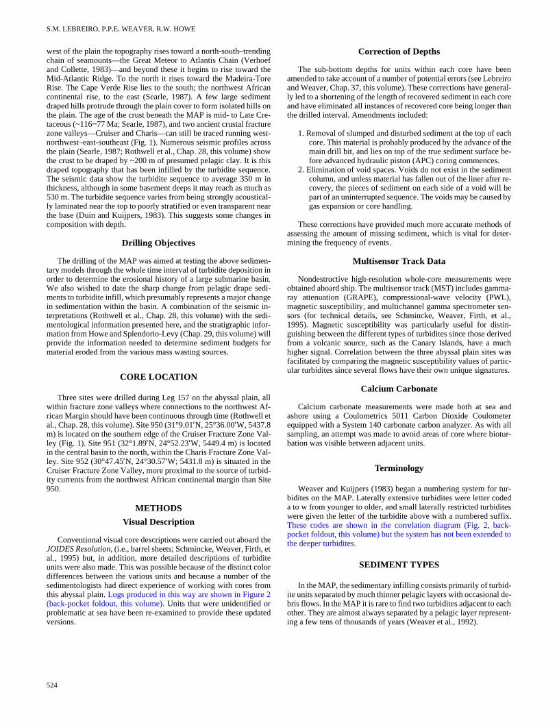
Pelagic layers vary from a few centimeters to 0.5 m in thickness.Their composition varies from almost pure carbonate ooze (up to93% CaCO3 in some lower Pleistocene layers), to pure pelagic claywith 0% CaCO3 (Fig. 3). Pelagic clay was deposited continuouslyfrom the late Eocene to the late Miocene, around 8 Ma, at which timea few layers show carbonate values of up to 30%, although these areinterspersed with pure clay layers. Through the lower Pliocene inter-val, CaCO3 values are around 20%, but there is a dramatic change at115 mbsf (Site 950), ~3.5 Ma, when strong oscillations begin. At firstthese layers show changes between 20% to 65% CaCO3, but variabil-ity rapidly increases from 5% to 85% with a number of layers havingintermediate values. There appears to be a preservation peak between75 and 15 mbsf (~2.0 to 0.5 Ma) in which several ooze layers weredeposited with over 80% CaCO3, although these were interlayeredwith marls and clays. Since 0.5 Ma, the highest carbonate values haveremained less than 70% (Fig. 3). This picture of CaCO3 oscillation re-flects the changes in ocean circulation through the Neogene. The cal-cium carbonate compensation depth (CCD) began to deepen slightlyduring the late Miocene and again in the early Miocene (≈5 Ma), andaround 3.5 Ma the CCD depth began to oscillate dramatically inphase with the Pliocene/Pleistocene glaciations. Weaver andKuijpers (1983) showed that the pelagic clay layers in the MAP weredeposited during glacials, whereas the marls and oozes were deposit-ed during interglacials. The dramatic and sharp changes in CaCO3
preservation between glacials and interglacials may be caused by re-versals in the circulation of the Atlantic Ocean (Broecker et al.,
1990). During interglacials relatively noncorrosive bottom watersgenerated in the Greenland-Norwegian Sea flow southward, displac-ing Antarctic Bottom Water (AABW) and allowing carbonate to ac-cumulate in the deep basins. The flow is compensated by a northwardmovement of surface water that carries heat to high latitudes. Duringglacials the surface water moves southward and deep corrosiveAABW spreads north, thus raising the CCD. Broecker et al. (1990)suggest these reversals in flow could be sudden, which appears to besupported by the sharp changes from clay to ooze/marl seen in thecores. Our data suggest that prior to the Pliocene/Pleistocene glacia-tions, the CCD was more stable, although its level changed a fewtimes through the late Miocene and early Pliocene. The preservationpeak in the lower Pleistocene has been noted earlier by Jansen et al.(1986). A more thorough analysis of CaCO3 fluctuations is underway(Weaver et al., unpubl. data).
Turbidites
The three turbidite groups mentioned in the “Introduction” setion (this chapter) were found at all three sites. They show some vation through time, and in the deeper parts of the sequence, otherbidite groups are also present. We will therefore discuss the sedimtary characteristics of each turbidite group through time.
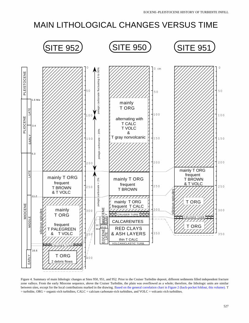
The complete sedimentary sequence for each site is shown in ure 2 (back-pocket foldout, this volume), together with some of tmany correlations between individual flows. A summary of the mainlithologic changes is presented in Figure 4.
525
S.M. LEBREIRO, P.P.E. WEAVER, R.W. HOWE
400
300
200
100
0 20 40 60 80 100
0
0 20 40 60 80 100
400
300
200
100
0
951B
0 20 40 60 80 100
500
400
300
200
100
0
SITE 950 SITE 951 SITE 952
%CaCO 3%CaCO 3 %CaCO 3
MIO
CE
NE
PLE
IST
OC
ENE
PL
IOC
EN
EEO
CE
NE
OLIG.
MIO
CE
NE
EA
RLY
MID
DLE
LAT
ELA
TE
E.
1 .6 Ma
3 .4
5 .3
1 1 .2
1 6 .6
2 3 .73 6 .6
DE
PTH
(m
bsf
)
0 .3-0.89 Ma
1.6 Ma
0.15-0.50 Ma
2.35 Ma
Å0.33 Ma
1.9 Ma
3.2 Ma
3.7 Ma3.14 Ma
5.2 Ma
8.0 Ma
Figure 3. Calcium carbonate oscillations from the pelagic interbeds at Sites 950, 951, and 952. Note only a small number of the pelagic layers were sampled. Inthe Pliocene–Pleistocene sediments, there are many more fluctuations in CaCO3 than shown here.
Organic Turbidites
These turbidites are characterized by high organic carbon content(>0.3%; De Lange et al., 1987) giving green colors, very low magnet-ic susceptibility (<20 cgs) and variable carbonate content. They rangein composition from clays to nannofossil clays and clayey nannofos-sil mixed sediments (Schmincke, Weaver, Firth, et al., 1995) with theprincipal components being clay minerals, nannofossils, and lesseramounts of quartz, dolomite, feldspar, pyrite, foraminiferal test frag-ments, and biosiliceous material. Minor amounts of silt-sized materi-al are found throughout the muds, suggesting they are ungraded, fall-ing into the E3 turbidite mud division of Piper (1978). Silt-sized ma-terial is more common toward the bases of units with laminated orgraded layers. The bases frequently contain complete benthic andplanktonic foraminifers. These organic turbidites show the classicoxidation fronts of Wilson et al. (1985), with pale green tops anddarker green bases, and frequently have a series of thin color bandsmarking intervals of metal enrichment in the oxidation front itself. In-dividual turbidites range from a few centimeters to 3−4 m in thick-ness.
526
There is a relationship between color and carbonate content (Fig.5). Three shades of green are observed: dark-green turbidites, presentmainly below 220 mbsf in each site, always correspond to <40%CaCO3; intermediate green turbidites appear through the whole col-umn, but contain 40%−60% CaCO3 above 220 mbsf and <40% below220 mbsf; and finally pale-green turbidites that contain 40%−70%CaCO3.
High organic content suggests that these turbidites derived fromupwelling areas on the northwest African Margin (see Fig. 1). Theyare unlikely to have derived from possible upwelling around the Ca-naries or Madeira because they all have very low magnetic suscepti-bilities in contrast to the volcanic-rich sediments on the island flanks.Biogenic siliceous debris, mainly diatoms and sponge spicules, ispresent in rare to common abundance at all three sites through nan-nofossil Subzone CN5a and Zone 4 (12.2−16 Ma).
It has been possible to correlate many of the individual organic-rich turbidites between the three sites as shown in Figure 2 (back-pocket foldout, this volume). Through the upper Miocene to Ho-locene sediments, all the major units can be correlated, but below thisthere is a distinct difference between Site 950 and Sites 951 and 952.
EOCENE–PLEISTOCENE HISTORY OF TURBIDITE INFILL
EO
CE
NE
SITE 950
350
300
250
200
150
100
50
0 cm
T brow ns
mainly T ORGfrequent T CALC
RED CLAYS& ASH LAYERS thin T CALC
MAIN LITHOLOGICAL CHANGES VERSUS TIME
LA
TE
SITE 952 SITE 951
350
300
250
200
150
100
50
0
mainly T ORG frequent T BROWN
T ORG
OLIG
mainly T ORG
frequent T PALEGREEN & T VOLC
T ORG 2 debris flows
VOLCANICLASTIC TURB.
CRUISER TURBCRUISER TURB
T ORG
MIO
CE
NE
EA
RL
Y
CRUISER TURB
CALCARENITES
pe
lag
ic c
arb
on
ate
~ 2
0%
pe
lag
ic c
arb
on
ate
< 2
%
350
400
300
250
200
150
100
0
50
pe
lag
ic c
arb
on
ate
flu
ctu
atin
g 0
to
90
%
mainly T ORG
alternating with T CALC T VOLC & T gray nonvolcanic
1.6 Ma
23.7
36.6
silic
iou
s sp
icu
les
silic
iou
s sp
icu
les
mainly T ORG frequent T BROWN & T VOLC
mainly T ORG frequent T BROWN & T VOLC
LA
TE
EA
RL
YL
AT
EM
IDD
LEM
IOC
EN
EP
LIO
CE
NE
EA
RL
Y
PL
EIS
TO
CE
NE
3.4
5.3
11.2
16.6
350
Figure 4. Summary of main lithologic changes at Sites 950, 951, and 952. Prior to the Cruiser Turbidite deposit, different sediments filled independent fracturezone valleys. From the early Miocene sequence, above the Cruiser Turbidite, the plain was overflowed as a whole; therefore, the lithologic units are similarbetween sites, except for the local contributions marked in the drawing. Based on the general correlation chart in Figure 2 (back-pocket foldout, this volume). T= turbidite, ORG = organic-rich turbidites, CALC = calcium carbonate-rich turbidites, and VOLC = volcanic-rich turbidites.
527

S.M. LEBREIRO, P.P.E. WEAVER, R.W. HOWE
ws t
e
st-h site,
siblew thear-
ilityay ine ofated,nts.ar,ll as
rgerock-
sitents.
lca-ver,me-ol-tive
thisanites
om
rise ashlity. thereatear-
nic-thataly-tio
ites,tur-
.5 sec-des
4.2–d fi-
65s thethree
gesranerrolop-
The latter two sites show much more frequent deposition of green tur-bidites (generally less than 1 m thick).
Pale-green turbidites were emplaced very frequently during themiddle Miocene (16−12 Ma), ranging in thickness between 0.08−0.60 m, and less frequently during the Pliocene (5.3–2 Ma), but thicknesses up to 3.7 m. In both periods, the pale-green turbiditepreferentially deposited at Site 952, according to its proximity tosource area.
In all three sites there is a distinct change in CaCO3 content of theorganic turbidites at ~6.5 Ma (~210 mbsf at each site). Below thlevels many organic turbidites have CaCO3 values below 20%,
0 20 40 60 80 0 20 40 60 80 100
Possiblyvolcanic
0 20 40 60 80 100D
EP
TH
(m
bsf)
Possiblyvolcanic
0 20 40 60 80 100
0 20 40 60
0 20 40 60 80 100
Increasedsiliciouscomponent
ORGANIC TURBIDITES
0 20 40 60 80 100
Increasedsiliciouscomponent
CALCAREOUS TURBIDITES
0 20 40 60 80 100
0 20 40
% CaCO3
0 20 40 60 80 100
400
300
200
100
0
400
300
200
100
0
400
300
200
100
0
200
100
0
200
100
0
360
340
320
300
280
260
255
500
400
300
200
100
0
200
100
0
340
320
300
280260
260
500
400
300
200
100
0
Possiblyvolcanicorigin
VOLCANIC TURBIDITES
CALCAREOUS TURBIDITES
CALCAREOUS TURBIDITES
ORGANIC TURBIDITES
ORGANIC TURBIDITES
30 50 70 90
500
400
300
200
100
0
VOLCANIC TURBIDITES
VOLCANIC TURBIDITES
DE
PT
H (
mbs
f)D
EP
TH
(m
bsf)
% CaCO3 % CaCO3
% CaCO3 % CaCO3 % CaCO3
% CaCO3 % CaCO3 % CaCO3
SIT
E 9
50
SIT
E 9
51
AS
ITE
95
1B
SIT
E 9
52
Figure 5. Calcium carbonate values for a selection of organic, volcanic, andcalcareous turbidites at Sites 950, 951, and 952.
528
ith arehe
se
whereas above these levels most turbidites have CaCO3 values of30%−60% (Fig. 5). This change in carbonate content slightly podates the increase in pelagic carbonate preservation seen at eacand may indicate a large regional deepening of the CCD. It is posthat some of the source areas of the organic turbidites were beloCCD before this event and thus were giving rise to low calcium cbonate turbidites.
Volcanic Turbidites
These turbidites are characterized by high magnetic susceptib(>100 cgs) due to the presence of volcanic minerals. They are grcolor, contain little or no organic carbon, and show a wide rangCaCO3 contents. The color and carbonate content seem to be relwith the darker gray units having lower calcium carbonate conteThe silt fractions of the volcanic turbidites contain anhedral feldsppyroxenes, and volcanically derived accessory minerals, as wefelsic volcanic glass shards in some units. Individual turbidites rangefrom a few centimeters to several meters thick, and all the laflows have been correlated between the three sites (Fig. 2, back-pet foldout, this volume).
Volcanic turbidites are very rare in the deeper parts of eachthrough the middle and lower part of the upper Miocene sedimeIn these intervals any gray turbidites are difficult to classify as vonic because of their low magnetic susceptibility. They are, howevery thin, averaging only a few centimeters to a few tens of centiters in thickness. Beginning ~7 Ma (~220 mbsf at each site), the vcanic turbidites suddenly become much thicker and show distinchigh magnetic susceptibility values (Fig. 2, back-pocket foldout, volume). From this level to the hole tops, the volcanic turbidites cbe easily correlated among the three sites. The volcanic turbidyounger than 7 Ma have CaCO3 values ranging between 30%−80%,but older than this, the few thin questionable volcanic units vary fr0%−60% CaCO3.
The upper Eocene and Oligocene intervals at Site 950 compred clays with some thin brown turbidites and numerous volcaniclayers. This whole interval has a very high magnetic susceptibiThe volcanic components here are all believed to derive fromchain of seamounts to the west of the MAP (Cruiser/Hyeres/GMeteor Chain), which we know were active volcanoes during the ly Neogene (Schmincke, Weaver, Firth, et al., 1995).
Gray Nonvolcanic Turbidites
This group of turbidites shows strong similarities to the volcagroup in terms of color, CaCO3 and organic carbon content. However, they show very low magnetic susceptibilities, which suggests they do not have a volcanic component. Element composition ansis (Jarvis et al., Chap. 31, this volume) shows higher K/Al ra(0.35:0.25) and much lower Ti/Al ratio (0.06:0.08−0.20) as the dif-ferences between nonvolcanic and organic and volcanic turbidrespectively. The nonvolcanic turbidites are among the thickest bidites recovered, exceeding 11 m at Site 952 (200.03−188.86 mbsf).
They occur in four principal groups. The first group, 12.5–11Ma, comprises a few turbidites between 260 and 253 mbsf, theond group was deposited during the interval 7.4–5.6 Ma and incluturbidites between 232 and 185 mbsf, the third group dates from 3.8 Ma and comprises turbidites between 152 and 144 mbsf, annally, group four took place between 1.6 and 1.4 Ma, turbidites −51 mbsf. The oldest group is only represented at Site 951, whereaother groups are large flows that can be correlated between the sites (Fig. 2, back-pocket foldout, this volume).
We do not know the source of these turbidites, but their aslightly postdate the origin of the volcanic Canary islands of GCanaria and Lanzarote, Tenerife, and La Palma and Hi(Schmincke, 1994). It is possible that the early submarine deve

EOCENE–PLEISTOCENE HISTORY OF TURBIDITE INFILL
fit f w cnria se.
oin
sie 7
as
COo tn
e e
sus-
and
nted.ay
lay-uldmonfromter or-nowthe sed-
di-
nd-ter-long,rs,unit m. A57-
thear-
hain,hingvol-olca-inctin towith de- Oli-yers, al- oc-nobun-hus,tive
callyatusringbeen
ren- It is Mi- sug-hesehap.
ts athas
ment of a volcanic island is associated with doming of the sedimentpile leading to mass wasting of sediments rather than volcanic mate-rial.
Volcaniclastic Turbidites
These turbidites are represented by two distinctive flows at thebase of Hole 950A (Fig 2, back-pocket foldout, this volume). Theyconsist of volcaniclastic silt and fine-grained sandstone capped bygreenish gray clay of probable turbidite origin. The silt/sand parts areplanar and trough cross-laminated with the lower turbidite gradingdown into massive sand. They consist mainly of volcanic basalticrock fragments and glass shards with only a small admixture of cal-careous reworked microfossils. Their nature and composition suggestthey were locally derived from erosion of the Cruiser/Hyeres/GreatMeteor Seamount chain to the west.
Calcareous Turbidites
These turbidites are white and show CaCO3 contents of more than80% and have negligible organic carbon content and low magneticsusceptibility. They are composed dominantly by nannofossils, andwhere they have coarser bases they are composed of foraminiferaltests. They vary from a few centimeters to ~3.6 m thick and are vol-umetrically less important than either the organic or volcanic turbid-ites. These turbidites derived from the seamounts to the west of theMAP (Weaver et al., 1992) and are funneled into the plain throughthe fracture zone valleys. As a consequence, there are more calcare-ous turbidites in the proximal Site 950, and these have more frequentand thicker sandy bases than the calcareous turbidites at Site 952,which lies distally along the same fracture zone valley. The thickercalcareous turbidites can be correlated between the three sites (Fig. 2,back-pocket foldout, this volume).
Recovery is poor between 308 and 332.5 mbsf at Site 950 (Cores157-950A-34X through 36X), but this interval does contain two cal-carenite units and a thick calcareous turbidite. The downhole logsshow this interval to consist of three separate graded beds lying be-tween 308–318.5, 322–324.5, and 326−332.5 mbsf. The upper one othese flows is widespread and distinctive, so we have named Cruiser Turbidite, after the Cruiser Seamount. The basal part oCruiser Turbidite consists of sand-sized carbonate grains mixedvolcanic debris and granule- to pebble-sized clasts of greenishup to 3 cm in diameter. The neritic calcareous grains are stroreminiscent of calcareous beach sand, and the volcanic matevery fresh, indicating that this deposit was eroded from a beachafter a volcanic eruption. The incorporation of clay clasts suggthese were ripped up from the seabed at depths below the CCDmud part of the Cruiser Turbidite at Site 950 grades from a brcarbonate-poor mud to a white carbonate-rich mud, again implymixture of sediment from well above and well below the CCD.
The Cruiser Turbidite has been correlated between all three At Site 951 it is 3.6 m thick with 0.51 m of wackestone at its basgrades from white in the lower part to green at the top and fromCaCO3 in the lower calcareous mudstone to 31% CaCO3 in the greenupper part. At Site 952 it is 3.92 m thick with 0.88 m of graded sand silt at its base. It again grades from a white calcareous mudwith CaCO3 content of 81% to a green mud at the top with a Ca3content of 27%. It appears that this unit caused considerable eron the plain, eroding pelagic clay on its approach to Site 950 andgreen abyssal plain turbidites as it progressed toward the locatioSites 951 and 952. These clays and green muds appear to bgrained than the original pelagic sediment and concentrated at thof the unit during its deposition.
thetheithlayglyl is
oonsts Thewng a
tes.. It1%
ndtone
sionhens offiner top
Brown Turbidites
These turbidites are brown, have moderately high magnetic ceptibility, CaCO3 values ranging from 5%−70%, and low organiccarbon content. Two shades of brown are observed: pale browngreenish brown, both with CaCO3 content of 20%−50%. These tur-bidites occur only in the interval between 215−281 mbsf at Site 950(~6.5–13 Ma). At Sites 951 and 952 they are not so well represeThe moderately high magnetic susceptibility of these turbidites mbe indicative of higher pelagic clay content since the pelagic clayers between turbidites have high magnetic susceptibility. It woalso account for their brown color. Because they are more comat Site 950 to the west of the plain, we assume that they derive the seamounts to the west. They presumably have a deeper waigin than the calcareous turbidites from this source. We do not kwhy they should occur over a limited time interval, although deepening of the CCD progressively after 8 Ma may have alteredimentation in their source from clay to ooze.
Debris Flows
Debris flows were identified only in the lower Miocene sements, and exclusively at Site 952. The unit between 386.64−386.81mbsf (Core 157-952A-43X) consists of indurated dark-gray sasupported clasts, which fall into two classes: subrounded, millimesized bluish green mud clasts and angular, planar, up to 7 cm dark-gray clayey silt clasts with siliceous microfossils, foraminifeand nannofossils. The clasts are horizontally oriented. The grades up into a green turbidite and has a total thickness of 7.11second debris flow with a thickness of 1.88 m occurs in Core 1952A-43X.
HISTORY OF BASIN INFILL
The history of basin infill is summarized in Figure 6, where contribution from each of the main sources: northwest African Mgin, Canary Islands, Cruiser/Hyeres/Great Meteor Seamount Cis given for each site. Site 950 extends furthest back in time reacthe upper Eocene (Howe and Sblendorio-Levy, Chap. 29, this ume). The oldest sediments cored include two coarse-grained vniclastic turbidites that appear to have derived from the now-extvolcanoes of the Cruiser/Hyeres/Great Meteor Seamount Chathe west. The vesicular nature of the altered vitric tuffs, together oxidized scoria fragments, indicate that some of the material wasrived from subaerial volcanism. The rest of the upper Eocene andgocene is represented by red clay. Numerous zeolitic ash-fall lawithin this sequence suggest the proximity of active volcanoesmost certainly the Great Meteor/Cruiser/Hyeres Chain, and thecurrence of thin brown turbidites evokes instability of the volcaflanks. These turbidites contain some volcaniclastic silt and an adance of smectite clays, indicating alteration of volcanic glass. Tthe seamount chain to the west of the MAP was volcanically acuntil at least the end of the Oligocene. There is no evidence of loderived volcanic material after this time, but there is a 8.3-m.y. hi(see Howe and Sblendorio-Levy, Chap. 29, this volume) duwhich a large part of the lower Miocene sequence could have removed.
Above the lower Miocene hiatus at Site 950 are the three calcaites that were again derived from the seamounts to the west.likely that these coarse flows caused the erosion of the lowerocene sediments. They contain shallow water or beach material,gesting that the seamounts were still subaerial. The lowest of tcalcarenites has an age of 17 Ma (Howe and Sblendorio-Levy, C29, this volume), which is slightly older than the basal sedimenSites 951 and 952. The thick upper flow—the Cruiser Turbidite—
529

S.M. LEBREIRO, P.P.E. WEAVER, R.W. HOWE
3 calcarenites
2 volcaniclasticturbidites
supply of tephraand thincalcareous and brownturbidites
supply of calcareousturbiditesAll sites
Seamountsto West
(Cruiser-Hyeres-Great Meteor)
NW African Margin
1.supply of organic-rich turbidites All sites
3 .organic-rich turbidites more frequent in Sites 951 & 952, infilling fracture zone valleys
4. organic-rich turbidites with siliceous material in Sites 951 & 952
supply of volcanic-richturbidites,All sites
Canary Islands
Brownturbidites
Pelagic sedimentation
0 20 40 60 80 100 % CaCO3
glacial / interglacialoscillationsoozes, marls, clays
gradualdeepening of CCDcalcareous clays
Abyssal Plain permanentlybelow CCD
Abyssal Plain permanentlybelow CCDred clays
4
8
12
16
28
32
36
0Ma
951
952
thin and infrequentprobable volcanicturbiditesin Sites 951 & 952
only Sites 950 & 952
mainlySite 951 2. pale-green
turbidites
12 3 4
nonvolcanicturbidites,early built ofCanary Is.?
HIATUS in Site 950 (8.3 Ma) Sites 951 and 952 terminated at 17 Ma
Figure 6. History of basin development showing the contribution of each of the main sediment sources through time.
erva-
s us
been correlated across the basin. At Sites 951 and 952 the sequencebelow the Cruiser Turbidite consists of numerous green turbidites,mostly less than a meter thick, and emplaced at a high frequency.These turbidites are not found at Site 950, and even above the CruiserTurbidite, the frequency of green turbidite emplacement is greater atSites 951 and 952. These latter two sites are situated over the centerof a fracture zone valley, and Site 950 is located more to the valleyside. Seismic data (Rothwell et al., this volume) shows that the tur-bidite sequence is much thicker in the fracture zones, and it appearsthat this is due to the early infilling of the fracture zone valleys duringthe late early and middle Miocene. The occurrence of debris flows inthe lower Miocene sediments of Site 952 suggests that this site lay atthe base of the continental slope during the early Miocene, rather thansome distance across the abyssal plain. After ~16 Ma, turbidites be-gan to spread across the whole area and the plain began to form. Thefact that these turbidites, which now cover a much larger area, are ofequal or greater thickness to those involved in the fracture zone fill-ing, suggests a large increase in the volume of each individual flow.
The deeper organic turbidites of Sites 951 and 952 (older than ~12Ma) contain significant amounts of biosiliceous material, in contrastto the organic turbidites above, which supports either a change in thedominant plankton types living along the northwest African Marginfrom siliceous to calcareous, or a change in the potential preservationof siliceous material.
From the base of the upper Miocene sediments to the Holocene, itis possible to correlate many of the turbidites among the three sites.
530
At ~7 Ma volcanic turbidites were suddenly deposited in the se-quence. A few thin, gray turbidites older than this were not conclu-sively identified as volcanic. We do not know why the deposition ofvolcanic turbidites should have begun at 7 Ma. The most likelysource of all such flows is the Canary Islands (Weaver et al., 1995;Masson, 1996), but these have a history extending back to 20 Ma(Schmincke, 1994). The islands, in fact, have an age progressionfrom east to west with Fuerteventura having an age of 20 Ma and Hi-erro in the west being less than 2 Ma. It is possible that turbidites shedfrom the older eastern islands of Lanzarote, Fuerteventura, and GranCanaria were trapped in a local basin that had filled by 7 Ma. Alter-natively, the birth of Tenerife at this time (5−7 Ma, Ancochea et al.,1990) may have breached the western margin of this local basin, thusallowing flows to travel further west to the MAP. The latter hypoth-esis is supported by the fact that the first flows are both thick and fre-quent, accounting for a sudden event rather than a gradual basin fill-ing, which would have allowed the larger flows to overflow with in-creasing force.
The amount of CaCO3 in the pelagic layers began to rise at ~8 Ma,indicating a regional deepening of the CCD at this time. Other step-like increases in CaCO3 preservation occur at ~5 and 3.5 Ma. From3.5 Ma to the present day there have been very large oscillations inthe preservation of CaCO3 linked to bottom-water changes associatedwith Pliocene–Pleistocene glaciations. The first increase in prestion at 8 Ma is associated with an increase in the average CaCO3 con-tent of the organic and volcanic turbidites at this time, which lead

EOCENE–PLEISTOCENE HISTORY OF TURBIDITE INFILL
n,la
sa
tedes.)l.
82
s crcu
enn,
9
ie
fr
by
f the
ndtal
tis-
si-
nd. ,
eira
92.tur-
hem-
ndres-
to consider that at least part of the source areas of each was previous-ly affected by dissolution. The brown turbidites with relatively lowCaCO3 contents also disappear at ~8 Ma.
ACKNOWLEDGMENTS
We thank Stephen Pink for carrying out many of the calcium car-bonate analyses. This work was supported by the European Commis-sion on Marine Science and Technology (MAST II) through theSTEAM program grant MAS2-CT94-0083 and NERC grant No.GST/02/990.
REFERENCES
Ancochea, E., Fúster, J.M., Ibarrola, E., Cendrero, A., Coello, J., HernáCantagrel, J.M., and Jamond, C., 1990. Volcanic evolution of the isof Tenerife (Canary Islands) in the light of new K-Ar data. J. Volcanol.Geotherm. Res., 44:231−249.
Broecker, W.S., Bond, G., Klas, M., Bonani, G., and Wolfi, W., 1990. A oscillator in the glacial Atlantic? 1. The concept. Paleoceanography,5:469−477.
De Lange, G.J., Jarvis, I., and Kuijpers, A., 1987. Geochemical charactics and provenance of late Quaternary sediments from the MaAbyssal Plain, North Atlantic. In Weaver, P.P.E., and Thomson, J. (EdGeology and Geochemistry of Abyssal Plains. Geol. Soc. Spec. PubLondon, 31:147−165.
Duin, E.J.T., and Kuijpers, A., 1983. Geological Studies on Abyssal Plains inthe North Atlantic: Contrib. Seabed Working Group Progr. Rept. 19Internal Rept.: Haarlem (Rijks Geol. Dienst).
Jansen, J.H.F., Kuijpers, A., and Troelstra, S.R., 1986. A mid-Brunhematic event: long-term changes in global atmospheric and ocean cition. Science, 232:619−622.
Jarvis, I., and Higgs, N., 1987. Trace-element mobility during early diagsis in distal turbidites: late Quaternary of the Madeira Abyssal PlaiAtlantic. In Weaver, P.P.E., and Thomson J. (Eds.), Geology andGeochemistry of Abyssal Plains. Geol. Soc. Spec. Publ. London, 31:17−214.
Masson, D.G., 1996. Catastrophic collapse of the volcanic island of H15 ka ago and the history of landslides in the Canary Islands. Geology,24:231−234.
McCave, I.N., and Jones, K.P.N., 1988. Deposition of ungraded mudshigh-density non-turbulent turbidity currents. Nature, 333:250−252.
Piper, D.J.W., 1978. Turbidite muds and silts on deepsea fans and aplains. In Stanley, D.J., and Kelling, G. (Eds.), Sedimentation in Subma-
F.,nd
lt
ris-ira,
,
li-la-
e-N
rro
om
ssal
rine Canyons, Fans and Trenches: Stroudsburg, PA (Dowden, Hutchin-son and Ross), 163−175.
Schmincke, H.-U., 1994. Geological Field Guide: Gran Canaria (7th ed.):Kiel, Germany (Pluto Press).
Schmincke, H.-U., Weaver, P.P.E., Firth, J.V., et al., 1995. Proc. ODP, Init.Repts., 157: College Station, TX (Ocean Drilling Program).
Searle, R.C., 1987. Regional setting and geophysical characterization oGreat Meteor East area in the Madeira Abyssal Plain. In Weaver, P.P.E.,and Thomson, J. (Eds.), Geology and Geochemistry of Abyssal Plains.Spec. Publ. Geol. Soc. London, 31:49−70.
Thomson, J., Colley, S., Higgs, N.C., Hydes, D.J., Wilson T.R.S., aSorensen, J., 1987. Geochemical oxidation fronts in NE Atlantic disturbidites and their effects in the sedimentary record. In Weaver, P.P.E.,and Thomson, J. (Eds.), Geology and Geochemistry of Abyssal Plains.Geol. Soc. Spec. Publ. London, 31:167−177.
Verhoef, J., and Collette, B.J., 1983. A tear fault system beneath the AtlanMeteor Seamount Group. Ann. Geophys., 1:199−206.
Weaver, P.P.E., and Kuijpers, A., 1983. Climatic control of turbidite depotion on the Madeira Abyssal Plain. Nature, 306:360−363.
Weaver, P.P.E., Masson, D.G., Gunn, D.E., Kidd, R.B., Rothwell, R.G., aMaddison, D.A., 1995. Sediment mass-wasting in the Canary BasinInPickering, K.T., Hiscott, R.N., Kenyon, N.H., Ricci Luchi, F., and SmithR.D.A. (Eds.), Atlas of Deep Water Environments: Architectural Style inTurbidite Systems: London (Chapman and Hall), 287−296.
Weaver, P.P.E., and Rothwell, R.G., 1987. Sedimentation on the MadAbyssal Plain over the last 300,000 years. In Weaver, P.P.E., and Thom-son, J. (Eds.), Geology and Geochemistry of Abyssal Plains. Geol. Soc.Spec. Publ. London, 31:71−86.
Weaver, P.P.E., Rothwell, R.G., Ebbing, J., Gunn, D., and Hunter, P.M., 19Correlation, frequency of emplacement and source directions of megabidites on the Madeira Abyssal Plain. Mar. Geol., 109:1−20.
Weaver, P.P.E., Thomson, J., and Jarvis, I. 1989. The geology and geocistry of Madeira Abyssal Plain sediments: a review. In Freeman, T.J.(Ed.), Advances in Underwater Technology, Ocean Science and OffshoreEngineering (Vol. 18): London (Graham and Trotman), 51−78.
Wilson, T.R.S., Thomson, J., Colley, S., Hydes, D.J., Higgs, N.C., aSorensen, J., 1985. Early organic diagenesis: the significance of progsive subsurface oxidation fronts in pelagic sediments. Geochim. Cosmo-chim. Acta., 49:811−822.
Date of initial receipt: 3 July 1996Date of acceptance: 8 March 1997Ms 157SR-128
531