Bundled turbidite deposition in the central Pandora Trough (Gulf of Papua) since Last Glacial...
15
Bundled turbidite deposition in the central Pandora Trough (Gulf of Papua) since Last Glacial Maximum: Linking sediment nature and accumulation to sea level fluctuations at millennial timescale Ste ´phan J. Jorry, 1,2 Andre ´ W. Droxler, 1 Gianni Mallarino, 3 Gerald R. Dickens, 1 Sam J. Bentley, 4 Luc Beaufort, 5 Larry C. Peterson, 6 and Bradley N. Opdyke 7 Received 28 July 2006; revised 4 June 2007; accepted 17 December 2007; published 29 March 2008. [1] Since Last Glacial Maximum (23–19 ka), Earth climate warming and deglaciation occurred in two major steps (Bølling-Allerød and Preboreal), interrupted by a short cooling interval referred to as the Younger Dryas (12.5–11.5 ka B.P.). In this study, three cores (MV-33, MV-66, and MD-40) collected in the central part of Pandora Trough (Gulf of Papua) have been analyzed, and they reveal a detailed sedimentary pattern at millennial timescale. Siliciclastic turbidites disappeared during the Bølling-Allerød and Preboreal intervals to systematically reoccur during the Younger Dryas interval. Subsequent to the final disappearance of the siliciclastic turbidites a calciturbidite occurred during meltwater pulse 1B. The Holocene interval was characterized by a lack of siliciclastic turbidites, relatively high carbonate content, and fine bank-derived aragonitic sediment. The observed millennial timescale sedimentary variability can be explained by sea level fluctuations. During the Last Glacial Maximum, siliciclastic turbidites were numerous when the lowstand coastal system was located along the modern shelf edge. Although they did not occur during the intervals of maximum flooding of the shelf (during meltwater pulses 1A and 1B), siliciclastic turbidites reappear briefly during the Younger Dryas, an interval when sea level rise slowed, stopped, or perhaps even fell. The timing of the calciturbidite coincides with the first reflooding of Eastern Fields Reef, an atoll that remained exposed for most of the glacial stages. Citation: Jorry, S. J., A. W. Droxler, G. Mallarino, G. R. Dickens, S. J. Bentley, L. Beaufort, L. C. Peterson, and B. N. Opdyke (2008), Bundled turbidite deposition in the central Pandora Trough (Gulf of Papua) since Last Glacial Maximum: Linking sediment nature and accumulation to sea level fluctuations at millennial timescale, J. Geophys. Res., 113, F01S19, doi:10.1029/2006JF000649. 1. Introduction [2] The Gulf of Papua (GOP) between northeast Australia and south Papua New Guinea (Figure 1) is an outstanding extant example of a tropical mixed siliciclastic/carbonate system [cf., Mount, 1984], where large masses of terrige- neous sand and mud discharge into a region of major neritic carbonate production. Unlike mixed systems in the ancient rock record that have received much investigation [e.g., Budd and Harris, 1990; Foreman et al., 1991; Holmes and Christie-Blick, 1993], only a few late Quaternary analogues have been studied [i.e., Ferro et al., 1999; Belopolsky and Droxler, 1999; Dunbar et al., 2000; Page et al., 2003]. The GOP represents an exquisite place to observe, describe, interpret, and ultimately understand the juxtaposition and accumulation of siliciclastic and carbonate sediments within the context of well-established late Quaternary global (eustatic) sea level change [e.g., Lambeck et al., 2002], including major millennial-scale fluctuations in the rate of change [Weaver et al., 2003; Clark et al., 2004]. [3] Sea level and climate clearly influence the nature and timing of sedimentary fill in basins adjacent to continental margins. This is particularly true for turbidites deposited along both siliciclastic [e.g., Gibbs, 1981; Bouma, 1982; Mallarino et al., 2006] and carbonate [e.g., Droxler and Schlager, 1985; Glaser and Droxler, 1993; Schlager et al., 1994; Andresen et al., 2003] margins over the last few glacial cycles. The frequency and magnitude of turbidites are generally highest along siliciclastic margins during glacial periods, because the associated lows of sea level expose the shelf, and rivers can transport their sediments JOURNAL OF GEOPHYSICAL RESEARCH, VOL. 113, F01S19, doi:10.1029/2006JF000649, 2008 Click Here for Full Articl e 1 Department of Earth Science, Rice University, Houston, Texas, USA. 2 Now at Beicip-Franlab Petroleum Consultants, Paris, France. 3 PanTerra Geoconsultants B.V., Leiderdorp, Netherlands. 4 Earth Sciences Department, Memorial University of Newfoundland, St. John’s, Newfoundland and Labrador, Canada. 5 Clouds and the Earth’s Radiant Energy System, CNRS, Universite ´ Aix-Marseille III, Aix-en-Provence, France. 6 Rosentiel School of Marine and Atmospheric Science, University of Miami, Miami, Florida, USA. 7 Department of Earth and Marine Sciences, Australian National University, Canberra, Australia. Copyright 2008 by the American Geophysical Union. 0148-0227/08/2006JF000649$09.00 F01S19 1 of 15
-
Upload
independent -
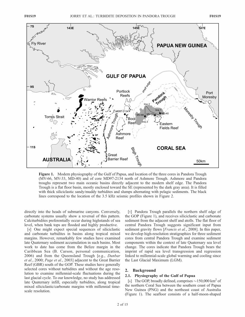
Category
Documents
-
view
3 -
download
0
Transcript of Bundled turbidite deposition in the central Pandora Trough (Gulf of Papua) since Last Glacial...

Bundled turbidite deposition in the central Pandora Trough
(Gulf of Papua) since Last Glacial Maximum: Linking
sediment nature and accumulation to sea level
fluctuations at millennial timescale
Stephan J. Jorry,1,2 Andre W. Droxler,1 Gianni Mallarino,3 Gerald R. Dickens,1
Sam J. Bentley,4 Luc Beaufort,5 Larry C. Peterson,6 and Bradley N. Opdyke7
Received 28 July 2006; revised 4 June 2007; accepted 17 December 2007; published 29 March 2008.
[1] Since Last Glacial Maximum (23–19 ka), Earth climate warming and deglaciationoccurred in two major steps (Bølling-Allerød and Preboreal), interrupted by a shortcooling interval referred to as the Younger Dryas (12.5–11.5 ka B.P.). In this study, threecores (MV-33, MV-66, and MD-40) collected in the central part of Pandora Trough (Gulfof Papua) have been analyzed, and they reveal a detailed sedimentary pattern at millennialtimescale. Siliciclastic turbidites disappeared during the Bølling-Allerød and Preborealintervals to systematically reoccur during the Younger Dryas interval. Subsequent to thefinal disappearance of the siliciclastic turbidites a calciturbidite occurred during meltwaterpulse 1B. The Holocene interval was characterized by a lack of siliciclastic turbidites,relatively high carbonate content, and fine bank-derived aragonitic sediment. Theobserved millennial timescale sedimentary variability can be explained by sea levelfluctuations. During the Last Glacial Maximum, siliciclastic turbidites were numerouswhen the lowstand coastal system was located along the modern shelf edge. Although theydid not occur during the intervals of maximum flooding of the shelf (during meltwaterpulses 1A and 1B), siliciclastic turbidites reappear briefly during the Younger Dryas, aninterval when sea level rise slowed, stopped, or perhaps even fell. The timing of thecalciturbidite coincides with the first reflooding of Eastern Fields Reef, an atoll thatremained exposed for most of the glacial stages.
Citation: Jorry, S. J., A. W. Droxler, G. Mallarino, G. R. Dickens, S. J. Bentley, L. Beaufort, L. C. Peterson, and B. N. Opdyke
(2008), Bundled turbidite deposition in the central Pandora Trough (Gulf of Papua) since Last Glacial Maximum: Linking sediment
nature and accumulation to sea level fluctuations at millennial timescale, J. Geophys. Res., 113, F01S19, doi:10.1029/2006JF000649.
1. Introduction
[2] The Gulf of Papua (GOP) between northeast Australiaand south Papua New Guinea (Figure 1) is an outstandingextant example of a tropical mixed siliciclastic/carbonatesystem [cf., Mount, 1984], where large masses of terrige-neous sand and mud discharge into a region of major neriticcarbonate production. Unlike mixed systems in the ancientrock record that have received much investigation [e.g.,
Budd and Harris, 1990; Foreman et al., 1991; Holmes andChristie-Blick, 1993], only a few late Quaternary analogueshave been studied [i.e., Ferro et al., 1999; Belopolsky andDroxler, 1999; Dunbar et al., 2000; Page et al., 2003]. TheGOP represents an exquisite place to observe, describe,interpret, and ultimately understand the juxtaposition andaccumulation of siliciclastic and carbonate sediments withinthe context of well-established late Quaternary global(eustatic) sea level change [e.g., Lambeck et al., 2002],including major millennial-scale fluctuations in the rate ofchange [Weaver et al., 2003; Clark et al., 2004].[3] Sea level and climate clearly influence the nature and
timing of sedimentary fill in basins adjacent to continentalmargins. This is particularly true for turbidites depositedalong both siliciclastic [e.g., Gibbs, 1981; Bouma, 1982;Mallarino et al., 2006] and carbonate [e.g., Droxler andSchlager, 1985; Glaser and Droxler, 1993; Schlager et al.,1994; Andresen et al., 2003] margins over the last fewglacial cycles. The frequency and magnitude of turbiditesare generally highest along siliciclastic margins duringglacial periods, because the associated lows of sea levelexpose the shelf, and rivers can transport their sediments
JOURNAL OF GEOPHYSICAL RESEARCH, VOL. 113, F01S19, doi:10.1029/2006JF000649, 2008ClickHere
for
FullArticle
1Department of Earth Science, Rice University, Houston, Texas, USA.2Now at Beicip-Franlab Petroleum Consultants, Paris, France.3PanTerra Geoconsultants B.V., Leiderdorp, Netherlands.4Earth Sciences Department, Memorial University of Newfoundland,
St. John’s, Newfoundland and Labrador, Canada.5Clouds and the Earth’s Radiant Energy System, CNRS, Universite
Aix-Marseille III, Aix-en-Provence, France.6Rosentiel School of Marine and Atmospheric Science, University of
Miami, Miami, Florida, USA.7Department of Earth and Marine Sciences, Australian National
University, Canberra, Australia.
Copyright 2008 by the American Geophysical Union.0148-0227/08/2006JF000649$09.00
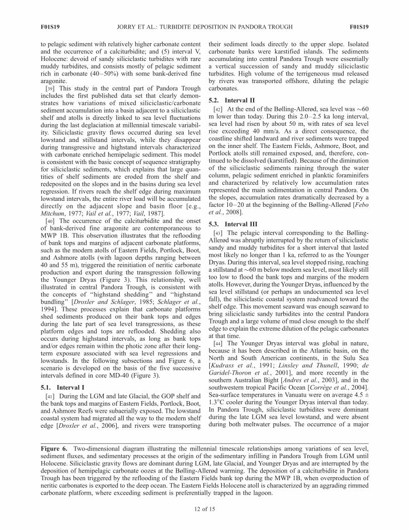
F01S19 1 of 15
directly into the heads of submarine canyons. Conversely,carbonate systems usually show a reversal of this pattern.Calciturbidites preferentially occur during highstands of sealevel, when bank tops are flooded and highly productive.[4] One might expect special sequences of siliciclastic
and carbonate turbidites in basins along tropical mixedmargins. However, remarkably few studies have examinedlate Quaternary sediment accumulation in such basins. Mostwork to date has come from the Belize margin in theCaribbean Sea (B. Carson, personal communication,2006) and from the Queensland Trough [e.g., Dunbaret al., 2000; Page et al., 2003] adjacent to the Great BarrierReef (GBR) south of the GOP. These studies have generallyselected cores without turbidites and without the age reso-lution to examine millennial-scale fluctuations during thelast glacial cycle. To our knowledge, no study has addressedlate Quaternary infill, especially turbidites, along tropicalmixed siliciclastic/carbonate margins with millennial time-scale resolution.
[5] Pandora Trough parallels the northern shelf edge ofthe GOP (Figure 1), and receives siliciclastic and carbonatesediment from the adjacent shelf and atolls. The flat floor ofcentral Pandora Trough suggests significant input fromsediment gravity flows [Francis et al., 2008]. In this paper,we develop high-resolution stratigraphies for three sedimentcores from central Pandora Trough and examine sedimentcomponents within the context of late Quaternary sea levelchange. The cores indicate that Pandora Trough bears theimprint of rapid sea level transgression and regressionlinked to millennial-scale global warming and cooling sincethe Last Glacial Maximum (LGM).
2. Background
2.1. Physiography of the Gulf of Papua
[6] The GOP, broadly defined, comprises�150,000 km2 ofthe northern Coral Sea between the southern coast of PapuaNew Guinea (PNG) and the northeast coast of Australia(Figure 1). The seafloor consists of a half-moon-shaped
Figure 1. Modern physiography of the Gulf of Papua, and location of the three cores in Pandora Trough(MV-66, MV-33, MD-40) and of core MD97-2134 north of Ashmore Trough. Ashmore and Pandoratroughs represent two main oceanic basins directly adjacent to the modern shelf edge. The PandoraTrough is a flat floor basin, mostly enclosed toward the SE (represented by the dark gray area). It is filledwith thick siliciclastic sandy/muddy turbidites and slumps alternating with pelagic sediments. The blacklines correspond to the location of the 3.5 kHz seismic profiles shown in Figure 2.
F01S19 JORRY ET AL.: TURBIDITE DEPOSITION IN PANDORA TROUGH
2 of 15
F01S19
continental shelf area of �40,000 km2 with a radius of200 km and a series of slope basins and plateaus covering�110,000 km2 [Francis et al., 2008]. Crucial to this paperare the northern and western shelves, isolated carbonateplatforms, and Pandora and Ashmore Troughs. A series oflarge rivers draining PNG annually discharge an enormousload of siliciclastic sediment, perhaps >300 x106 metrictones, into the northern GOP [Pickup and Chewings, 1983;Salomons and Eagle, 1990]. At present, most of thisdischarge accumulates along the coast, especially the innershelf [Harris et al., 1993, 1996; Walsh and Nittrouer, 2004].By contrast, the modern middle and outer shelves in thenorthwest GOP receive little siliciclastic sediment; instead,they are covered by a thin veneer of mostly carbonatesediments with occasional Halimeda bioherms [Harris etal., 1996]. However, numerous channels cut across thisportion of the shelf, and many gullies line the upper slopeof Pandora Trough [Harris et al., 1993; Francis et al., 2008].Large masses of siliciclastic sediment almost assuredlycrossed the outer central GOP shelf in the recent past.[7] The northern terminus of the modern GBR occupies
the broad western GOP shelf. This complex reef systemcomprises patch reefs on the inner and middle shelvestoward the southern Fly River delta and an almost contin-uous barrier reef along the shelf/slope break. In both places,reefs have grown to sea level. The GOP also has severallarge atolls, which include the partially shelf-attached Port-lock Reef and Ashmore, Boot, and Eastern Fields reefs.These atolls are typical rimmed reefs, reaching present sealevel and enclosing shallow lagoons with water depths of40–55 m [Francis et al., 2008; J. M. Webster, personalcommunication, 2006]. Because Holocene lagoonal sedi-ment should have minimal thickness [MacKinnon andJones, 2001; Gischler, 2003], the average present lagoondepths most likely approximate the topography of a Pleis-tocene karstified surface prior to the most recent flooding.These reef systems border Ashmore and Pandora Troughsand supply neritic carbonate sediment to these basins,especially during the Holocene.[8] Ashmore and Pandora Troughs are adjacent to the
shelf. These troughs, in particular the central part ofPandora Trough, are the focus of this study because theyrepresent traps for late Quaternary sediment. The relativelynarrow and small Ashmore Trough (Figure 1) lies betweenthe GBR to the west and the atoll chain of Ashmore, Boot,and Portlock reefs to the east. The seafloor of AshmoreTrough dips to the south toward the Bligh Trough and tothe east toward Pandora Trough so that it resembles aslope more than a basin per se. Surface sediment isdominated by neritic carbonate shed from surroundingreefs [Carson et al., 2008]. East of Ashmore Trough isthe much larger Pandora Trough (Figure 1), a basinbounded by the atoll chain of Ashmore, Boot, and Portlockreefs to the west, the GOP shelf edge to the north, andEastern Plateau (with the atoll of Eastern Fields) to thesouth. The eastern end of Pandora Trough is open toMoresby Trough. The central part of Pandora Trough hasa very flat seafloor (Figure 2), bathymetry typical for anenclosed basin filled with thick siliciclastic sandy/muddyturbidites and intervening hemipelagic sediments. North-east of Eastern Fields atoll, Pandora Trough containsdrowned parts of a broader Miocene carbonate platform
that included Eastern Fields [Tcherepanov et al., 2008].Features include a series of subparallel ridges hundreds ofmeters high (interpreted as the unburied and drowned partof the Miocene platform) and several subcircular miniba-sins about 2 km wide. These are disconnected from themain seafloor of Pandora Trough and partially filled withonlapping sedimentary units, presumably rich in muddyturbidites (Figure 2).
2.2. Late Quaternary Changes in Sea Level andClimate
[9] Over the last 23 ka, Earth systems have experienced twoextreme climate end-members and the dramatic transitionbetween them. During the LGM interval �23–19 ka B.P.,sea-surface temperatures dropped by several degrees, even intropical latitudes [Thunell et al., 1994; Lea et al., 2000;Guilderson et al., 2001; Visser et al., 2003], and eustatic sealevel was much lower than at present, probably about –125 m[Fairbanks, 1989; Yokoyama et al., 2000; Weaver et al.,2003; Clark et al., 2004; Bassett et al., 2005]. Global climatereached an optimal interglacial regime in the early Holocene�7–6 ka B.P., when sea level rose to within several m of itspresent level [Lambeck and Chappell, 2001].[10] The transition from the LGM to the Holocene was
not smooth; rather, it involved major changes in rates ofwarming and sea level rise. The �12 ka of warming, firstinitiated at 19 ka B.P. [Clark et al., 2004], was marked byseveral intervals of stepwise climatic changes, the Bølling-Allerød interval (between 14.5 and 12.5 ka B.P.) andthe Preboreal warming at the beginning of the Holocene(11.5 ka B.P.), being the most preeminent of them [Alleyet al., 1993]. Two short intervals characterized by moreglacial conditions, referred to as the Oldest and YoungerDryas, also occurred �18–14.7 and �12.5–11.5 ka B.P.,respectively [Alley et al., 1993; Hughen et al., 2000;Weaver et al., 2003]. The temporal and mechanistic linksbetween changes in temperature and sea level during thedeglaciation remain controversial [Kienast et al., 2003;Weaver et al., 2003]. Regardless, there were clearly twoshort intervals of fast sea level change commonly calledmeltwater pulse 1A (MWP 1A) and meltwater pulse 1B(MWP 1B). During these events, sea level rose by >40 and>11 mm/a (where a is years), respectively [Weaver et al.,2003]. The climate coolings (e.g., Oldest and YoungerDryas) appear coupled to plateaus in the sea level curve[Hanebuth et al., 2000; Weaver et al., 2003]; though notdemonstrated or accepted, sea level might have droppedduring these intervals [Liu et al., 2004].
3. Materials and Methods
3.1. Core Collection
[11] Three cores from Pandora Trough (Figures 1 and 2,Table 1) were examined in this study. Two jumbo pistoncores, MV25-0403-33JPC (MV-33) and MV26-0403-66JPC (MV-66), were collected during the 2004 PANASHcruise aboard R/V Melville; one Casq core MD05-2940C2
(MD-40) was collected during the 2005 PECTEN cruiseaboard R/V Marion Dufresne. The Casq corer is a 12 mlong, 0.25 m width/breadth square section gravity corer,commonly used to obtain sedimentary sequences keptalmost intact. Core MV-66 was retrieved from the middle,
F01S19 JORRY ET AL.: TURBIDITE DEPOSITION IN PANDORA TROUGH
3 of 15
F01S19
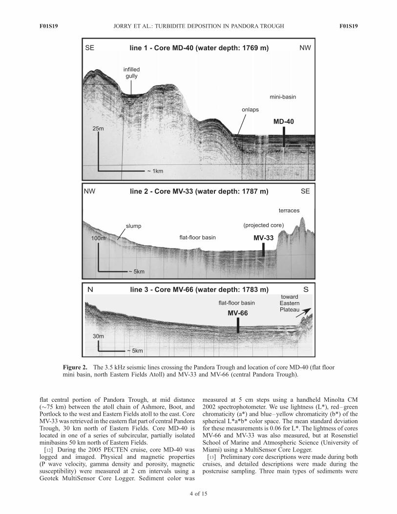
flat central portion of Pandora Trough, at mid distance(�75 km) between the atoll chain of Ashmore, Boot, andPortlock to the west and Eastern Fields atoll to the east. CoreMV-33was retrieved in the eastern flat part of central PandoraTrough, 30 km north of Eastern Fields. Core MD-40 islocated in one of a series of subcircular, partially isolatedminibasins 50 km north of Eastern Fields.[12] During the 2005 PECTEN cruise, core MD-40 was
logged and imaged. Physical and magnetic properties(P wave velocity, gamma density and porosity, magneticsusceptibility) were measured at 2 cm intervals using aGeotek MultiSensor Core Logger. Sediment color was
measured at 5 cm steps using a handheld Minolta CM2002 spectrophotometer. We use lightness (L*), red–greenchromaticity (a*) and blue–yellow chromaticity (b*) of thespherical L*a*b* color space. The mean standard deviationfor these measurements is 0.06 for L*. The lightness of coresMV-66 and MV-33 was also measured, but at RosenstielSchool of Marine and Atmospheric Science (University ofMiami) using a MultiSensor Core Logger.[13] Preliminary core descriptions were made during both
cruises, and detailed descriptions were made during thepostcruise sampling. Three main types of sediments were
Figure 2. The 3.5 kHz seismic lines crossing the Pandora Trough and location of core MD-40 (flat floormini basin, north Eastern Fields Atoll) and MV-33 and MV-66 (central Pandora Trough).
F01S19 JORRY ET AL.: TURBIDITE DEPOSITION IN PANDORA TROUGH
4 of 15
F01S19
differentiated: siliciclastic sandy and muddy turbidites,calciturbidites, and intervening hemipelagic sediment.
3.2. Size Separations
[14] Each core was sampled at 10 cm intervals, purposelyexcluding turbidites. Sediment samples were freeze-driedfor 48 h to remove pore water. Dried sediments weredisaggregated with Calgon solution and sieved with waterusing a 63 mm mesh. Both fractions were retained and driedagain.[15] The >63-mm fraction was examined under a reflected
light microscope to qualitatively assess grain composition.Throughout all three cores, carbonate dissolution is modestand planktic foraminifer tests are abundant in hemipelagicsediment intervals. Specimens are well preserved and showno evidence of mud infilling or diagenetic recrystallization(e.g., secondary carbonate cement). Samples were then drysieved to retain the >250 mm fraction from which tests ofspecific planktic foraminifer species were identified andpicked for oxygen-isotope analyses (10 tests) and foraccelerator mass spectrometer (AMS) 14C dating (500 tests).
3.3. Geochemical Observations
[16] Oxygen-isotope analyses were conducted on smallbatches of monospecific planktic foraminifera that calcify inthe surface mixed layer of the water column:Globigerinoidesruber for core MV-66 and Globigerinoides sacculifer(without the final sac-like chamber) for core MD-40. Onaverage, 10 specimens were picked from the >250 mmfraction. Specimens were ultrasonically cleaned in distilledwater after careful crushing to release potential sedimentinfilling. Samples were then roasted under vacuum at 375�Cfor 1/2 h to remove organic contaminants. Using a common100% phosphoric acid bath at 90�C, 20–50 mg of samplewere reacted and analyzed using a GV Instruments Optimaisotope ratio mass spectrometer at University of California,Davis. Isotope values are reported in delta notation relativeto Vienna Peedee belemnite. Repeated analyses of amarble working standard (calibrated against the interna-tional standard NBS-19) indicate an accuracy and precisionof 0.05% (1s).[17] A total of 10 AMS dates were also obtained in cores
MV-66, MV-33, and MD-40 (Table 2). For each measure-ment, about 500 specimens of G. ruber and G. sacculiferwere picked from the >250 mm fraction, washed in anultrasonic bath with distilled water, and dried. These ali-quots were then analyzed at the AMS laboratory at Univer-sity of California, Irvine. Reported radiocarbon ages wereconverted to calendar ages using the Radiocarbon Calibra-tion Program [Fairbanks et al., 2005]. A surface oceanreservoir correction of 468 years was used; this is the sum
of the global surface water reservoir age correction of400 years [Stuiver and Braziunas, 1993; Bard et al., 1994]and the regional reservoir age correction DR of 68 years forTorres Strait [Reimer and Reimer, 2001], assuming it to beinvariant with time. We also assume that the upper oceanwaters (i.e., where G. ruber and G. sacculifer live) do notvary by >200 years [Duplessy et al., 1991]. All ages arereported in thousands of years before present (ka B.P.),where Present is defined as 1950 AD.[18] The <63 mm fraction of sediment was used to
determine carbonate content and carbonate mineralogy.Carbonate contents were analyzed using a carbonate bomb[Muller and Gastner, 1971; Droxler et al., 1988]. About2 cm of sample were placed into a sealed vessel and reactedwith 20% HCl (2.3 mol L–1). The volume of CO2 releasedwas compared to volumes released by reacting knownamounts of 100 percent CaCO3 standard. The precision ofthe analysis is �2%.[19] Carbonate mineralogy was determined on 33 sam-
ples by X-ray diffraction (XRD). Samples were ground withan agate mortar and pestle and, depending on the amount,either packed with a spatula into an aluminum sampleholder or dispersed in a methanol solution and pipettedonto a glass slide. Analyses were conducted using a RigakuD/Max Ultima II Powder Diffractometer housed at RiceUniversity. Each sample was scanned twice: at a fast speedof 2�/min from 2 to 100� 2q for general mineralogyidentification and at a low speed of 0.25�/min from 25 to31� 2q for optimal resolution of carbonate phases. Differ-entiation of high magnesium calcite (HMC) and low mag-nesium calcite (LMC) was based on an establishedrelationship between the d104 lattice spacing shift andmole% MgCO3 [Goldsmith et al., 1961].[20] Total organic carbon (TOC) content was measured
on 88 samples of bulk sediment from core MD-40 using anEC-12 Carbon Determinator manufactured by Leco Corpo-ration. Rock samples were homogenized by grinding andthe carbonate carbon was removed by acidification. Resid-ual material was then combusted, and organic-carbon con-tents were determined from the carbon dioxide produced.Analytical precision depends on sample type and carboncontent, but averaged �0.5% for our samples.
4. Results
[21] Age/Depth models for the three cores have beendetermined on the basis of at least one of the followingglacial/interglacial stratigraphies using down core variationsof (1) d18O in planktic foraminifers G. sacculifer or G.ruber, (2) carbonate content in the fine fraction (<63mm),and (3) lightness values by digital scans. Moreover, those
Table 1. Location, Type, Bathymetry, and Length of the Studied Coresa
Core Name Core Type Latitude, �S Longitude, �N Water Depth, m Length, m
MV26-0403-66JPC Jumbo piston core 10.0020 145.1500 1783 11.68MV25-0403-33JPC Jumbo piston core 9.8670 145.6000 1787 12.76MD05-2940C2 Casq box core 9.7937 145.7248 1769 8.80
aThese cores have been retrieved in the turbiditic systems of the Pandora Trough, Gulf of Papua, during a 2004 R/V Melville(MV cores) and a 2005 R/V Marion Dufresne (MD cores) cruise. MV-66 is located at the middle of the flat floor PandoraTrough, a distal location from Eastern Fields Atoll (75 km). MV-33 has been collected on the flat floor of Pandora Trough, 30km north of Eastern Fields Atoll. MD-40 has been retrieved in the middle of a flat floor circular minibasin, located 50 km northof Eastern Fields Atoll.
F01S19 JORRY ET AL.: TURBIDITE DEPOSITION IN PANDORA TROUGH
5 of 15
F01S19
stratigraphies are solidly anchored by several 14C AMSdates.
4.1. Primary Core Chronology
[22] As true in many regions [e.g., Linsley, 1996; Durkoopet al., 1997; Chodankar et al., 2005], d18O records ofG. sacculifer and G. ruber from Coral Sea cores can becorrelated to global d18O records to obtain first-order agessince 100 ka [Anderson et al., 1989; Dunbar et al., 2000; deGaridel-Thoron et al., 2004]. There is, however, an offsetbetween the d18O of these planktic foraminiferal species,with d 18O of G. sacculifer typically about 0.5 to 0.6%heavier than that of G. ruber [e.g., Stott et al., 2002]. Thed18O of planktic foraminifera is also associated withchanges in local salinity. The modern d18O salinity rela-tionship in the tropical western Pacific is �0.2% (d18O) perunit of salinity [Fairbanks et al., 2005], although thisrelationship varies slightly from region to region and maybe lower in the western tropical Pacific, because thesummer/winter salinity contrast is low [Stott et al., 2002].[23] Ages for cores MV-66 and MD-40 were initially
determined using down core variations in the d18O ofplanktic foraminifers G. ruber and G. sacculifer, respec-tively (Figures 3 and 4). The glacial–interglacial transitionis clearly identified in both cores. In core MD-40 below400 cm, the d18O values of G. sacculifer tests range from–0.5 to –1.0%; the values decrease by –0.4% from400 to 120 cm; above 120 cm, the d18O values rangefrom –1.4 to –2.3%. For core MV-66 below 420 cm, thed18O of G. ruber tests range from –1.0 to –1.2%; they
decrease by –0.5% from 420 to 130 cm and range from–1.7 to –2.9% in the upper 130 cm of the core. Theheavy d18O values in the lower half of each core clearlycorrespond to the LGM (>23 ka B.P.), the light d18Ovalues in the upper 30 cm correspond to Holocene(<11 ka B.P.), and the intermediate d18O values charac-terize the deglacial transition. In both records, the d18Oamplitude from the LGM to Holocene is the same 1.8%for MD 40 and 1.9% for MV-66, though the d18O valuesin core MV-66 are systematically 0.6% lighter than incore MD-40.[24] The oxygen isotope stratigraphies for cores MD-40
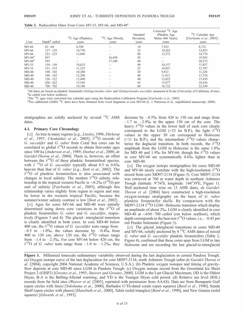
and MV-66 nicely correlate with the high-resolution d18Orecord from core MD97-2134 (Figure 3). Core MD97-2134was retrieved at 760 m water depth in northern AshmoreTrough (latitude: 9�540S, longitude: 144�390E, Figure 1).Well anchored time wise on 13 AMS dates, de Garidel-Thoron et al. [2004] have constructed a high-resolutionoxygen-isotope stratigraphy on the basis of G. ruberplanktic foraminifer shells. By comparison with theMD97-2134 d18O LGM–Holocene transition which displayan amplitude of about 2%, LGM is clearly identified in coreMD-40 at �650–700 cmbsf (cm below seafloor), whichdepth corresponds to the heaviest d18O values, i.e., –0.45 permil Peedee belemnite (Figure 3).[25] The glacial_interglacial transitions in cores MD-40
and MV-66, solidly anchored by 8 14C AMS dates of mixedG. ruber and G. sacculifer planktic foraminifers (Table 2,Figure 4), confirmed that these cores span from LGM to lateHolocene and are recording the last glacial-to-interglacial
Table 2. Radiocarbon Dates From Cores MV-33, MV-66, and MD-40a
Core Depthb cmbsf
14C Age (Planktic),years
14C Age (Wood),years
StandardDeviation,
years
Corrected 14C Age(Planktic Age
Minus 468 Years),years
14C Calendar Age[Fairbanks et al., 2005]c,
years
MV-66 62–64 8,390 � 10 7,922 8,722MV-66 127–129 10,730 � 25 10,262 12,033MV-66 221–223 13,040 � 80 12,572 14,776MV-66d 837 � 16,450 45 � 19,563MV-66d 955 � 17,100 40 � 20,272MV-33 154–156 10,625 � 40 10,157 11,837MV-33 331–333 11,325 � 25 10,857 12,787MD-40 100–102 10,280 � 20 9,812 11,226MD-40 180–182 12,280 � 40 11,812 13,724MD-40 320–322 13,490 � 40 13,022 15,439MD-40 420–422 15,545 � 45 15,077 18,436MD-40 700–702 19,190 � 60 18,722 22,349
aAll dates are based on planktic foraminifer Globigerinoides ruber and Globigerinoides sacculifer measured at Irvine (University of California, Irvine).bIn cmbsf (cm below seafloor).cThe 14C ages were converted into calendar ages using the Radiocarbon Calibration Program [Fairbanks et al., 2005].dTwo additional (AMS) 14C dates have been obtained from wood fragments at core MV-66 (L. J. Patterson et al., unpublished manuscript, 2008).
Figure 3. Millennial timescale sedimentary variability observed during the last deglaciation in central Pandora Trough.(a) Oxygen isotope curve of the last deglaciation for core MD97-2134, north Ashmore Trough (after de Garidel-Thoron etal. [2004], copyright 2004 National Academy of Sciences, U.S.A.). (b) Planktic oxygen isotopes and timing of gravity-flow deposits at core MD-40 since LGM in Pandora Trough. (c) Oxygen isotope record from the Greenland Ice SheetProject 2 (GISP2) [Grootes et al., 1993; Stuivert and Grootes, 2000]. LGM is the Last Glacial Maximum, OD is the OldestDryas, B-A is the Bølling-Allerød warming, and YD is the Younger Dryas cold period. (d) Relative sea level (RSL)records from far field sites (Weaver et al. [2003], reprinted with permission from AAAS). Data are from Bonaparte Gulf(open circles with lines) [Yokohama et al., 2000], Barbados U/Th-dated corals (open squares) [Bard et al., 1990], SundaShelf (open circles with pluses) [Hanebuth et al., 2000], Tahiti (solid triangles) [Bard et al., 1990], and New Guinea (solidsquares) [Edwards et al., 1993].
F01S19 JORRY ET AL.: TURBIDITE DEPOSITION IN PANDORA TROUGH
6 of 15
F01S19
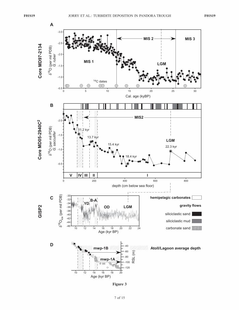
Figure 3
F01S19 JORRY ET AL.: TURBIDITE DEPOSITION IN PANDORA TROUGH
7 of 15
F01S19
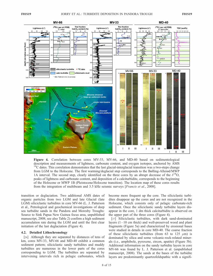
transition or deglaciation. Two additional AMS dates oforganic particles from two LGM and late Glacial (lateLGM) siliciclastic turbidites in core MV-66 (L. J. Pattersonet al., Petrological and geochemical investigations of deepsea turbidite sands in the Pandora and Moresby Troughs:Source to Sink Papua New Guinea focus area, unpublishedmanuscript, 2008; see also Table 2) confirm a high sedimentaccumulation rate during the LGM and until the first clearinitiation of the last deglaciation (Figure 4).
4.2. Detailed Lithochronology
[26] Although they are separated by distances of tens ofkm, cores MV-33, MV-66 and MD-40 exhibit a commonsediment pattern; siliciclastic sandy turbidites and muddyturbidites are numerous in the lower parts of the corescorresponding to LGM. The turbidites are separated byintervening intervals rich in pelagic carbonates, which
become more frequent up the core. The siliciclastic turbi-dites disappear up the cores and are not recognized in theHolocene, which consists only of pelagic carbonate-richsediment. Once the siliciclastic sandy turbidite layers dis-appear in the core, 1 dm thick calciturbidite is observed onthe upper part of the three cores (Figure 4).[27] Siliciclastic turbidites, with dark sand-dominated
layers (1–10 cm thick) and well-preserved wood and plantfragments (Figure 5a) and characterized by erosional baseswere studied in details in core MD-40. The coarse fractionof these siliciclastic turbidites (from 63 to 125 mm) isdominated by silica and some volcanic-rock-related miner-als (i.e., amphibole, pyroxene, zircon, apatite) (Figure 5b).Additional information on the sandy turbidite layers in coreMV-66 was found by L. J. Patterson et al. (unpublishedmanuscript, 2008). The sands at the bases of the turbiditelayers are predominantly quartzofeldspathic with a signifi-
Figure 4. Correlation between cores MV-33, MV-66, and MD-40 based on sedimentologicaldescription and measurements of lightness, carbonate content, and oxygen isotopes, anchored by AMS14C dates. This correlation demonstrates that the last glacial-interglacial transition was a two-steps changefrom LGM to the Holocene. The first warming/deglacial step corresponds to the Bølling-Allerød/MWP1A interval. The second step, clearly identified on the three cores by an abrupt decrease of the d18O,peaks of lightness and carbonate content, and deposition of a calciturbidite, corresponds to the beginningof the Holocene or MWP 1B (Pleistocene/Holocene transition). The location map of these cores resultsfrom the integration of multibeam and 3.5 kHz seismic surveys [Francis et al., 2008].
F01S19 JORRY ET AL.: TURBIDITE DEPOSITION IN PANDORA TROUGH
8 of 15
F01S19
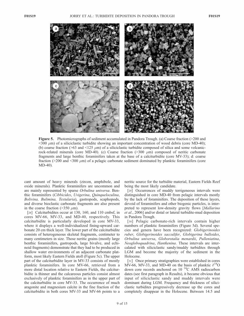
cant amount of heavy minerals (zircon, amphibole, andoxide minerals). Planktic foraminifers are uncommon andare mainly represented by sparse Orbulina universa. Ben-thic foraminifers (Cibbicides, Uvigerina, Quinqueloculina,Bolivina, Bulimina, Textularia), gastropods, scaphopods,and diverse bioclastic carbonate fragments are also presentin the coarse fraction (>350 mm).[28] Calciturbidites occur at 130, 160, and 110 cmbsf, in
cores MV-66, MV-33, and MD-40, respectively. Thiscalciturbidite is particularly developed in core MV-33,where it displays a well-individualized fining-upward car-bonate 20 cm thick layer. The lower part of the calciturbiditeconsists of heterogeneous skeletal fragments, centimeter tomany centimeters in size. Those neritic grains (mostly largebenthic foraminifers, gastropods, large bivalve, and echi-noid fragments) demonstrate that they had to be produced inshallow water environments of an adjacent carbonate plat-form, most likely Eastern Fields atoll (Figure 5c). The upperpart of the calciturbidite layer in MV-33 consists of mostlyplanktic foraminifers. In core MV-66, retrieved from amore distal location relative to Eastern Fields, the calcitur-bidite is thinner and the calcareous particles consist almostexclusively of planktic foraminifers as in the upper part ofthe calciturbidite in core MV-33. The occurrence of mucharagonite and magnesium calcite in the fine fraction of thecalciturbidite in both cores MV-33 and MV-66 points to a
neritic source for the turbidite material, Eastern Fields Reefbeing the most likely candidate.[29] Occurrences of muddy terrigeneous intervals were
distinguished in core MD-40 from pelagic intervals mostlyby the lack of foraminifers. The deposition of these layers,devoid of foraminifers and other biogenic particles, is inter-preted to represent low-density gravity flows [Mallarinoet al., 2006] and/or distal or lateral turbidite-mud depositionin Pandora Trough.[30] Pelagic carbonate-rich intervals contain higher
numbers of planktic foraminifers (Figure 5d). Several spe-cies and genera have been recognized: Globigerinoidesruber, Globigerinoides sacculifer, Globigerina bulloides,Orbulina universa, Globorotalia menardii, Pulleniatina,Neogloboquadrina, Hantkenina. These intervals are inter-calated with siliciclastic sandy/muddy turbidites throughLGM and become the majority of the sediment in theHolocene.[31] Once primary stratigraphies were established in cores
MV-66, MV-33, and MD-40 on the basis of planktic d18Odown core records anchored on 10 14C AMS radiocarbondates (see first paragraph in Results), it became obvious thatinput of siliciclastic sandy and muddy intervals weredominant during LGM. Frequency and thickness of silici-clastic turbidites progressively decrease up the cores andcompletely disappear in the Holocene. Between 14.5 and
Figure 5. Photomicrographs of sediment accumulated in Pandora Trough. (a) Coarse fraction (>200 and<300 mm) of a siliciclastic turbidite showing an important concentration of wood debris (core MD-40);(b) coarse fraction (>63 and <125 mm) of a siliciclastic turbidite composed of silica and some volcanic-rock-related minerals (core MD-40). (c) Coarse fraction (>300 mm) composed of neritic carbonatefragments and large benthic foraminifers taken at the base of a calciturbidite (core MV-33); d: coarsefraction (>200 and <300 mm) of a pelagic carbonate sediment dominated by planktic foraminifers (coreMD-40).
F01S19 JORRY ET AL.: TURBIDITE DEPOSITION IN PANDORA TROUGH
9 of 15
F01S19
12.5 ka B.P., the siliciclastic turbidites dramatically turnedinto an interval that is strictly dominated by the depositionpelagic carbonate_rich sediments. An interval between12.5 and 11.5 ka B.P. is dominated by the deposition ofsiliciclastic mud. The base and top of this interval aredefined by siliciclastic turbidites observed in all three coresstudied in Pandora Trough. Siliciclastic turbidites disappearin the central part of Pandora Trough at the beginning ofthe Holocene. This interval is marked by the occurrence ofa calciturbidite. This calciturbidite most likely representsthe initiation of neritic carbonate production. The Holoceneis strictly dominated by the deposition of pelagic carbo-nates enriched by bank-derived fine aragonite.[32] TOC content varies between 0.25% and 2.49% in
core MD-40 (Figure 4). The highest TOC values (2.49 wt%)coincide with siliciclastic turbidites, whereas low valuesgenerally characterize pelagic carbonate-richer intervals.TOC values range are 0.5–1.0% during LGM and lateGlacial, and <0.5% during the Holocene. In this study, themost plausible explanation for TOC-rich intervals isincreased supply of terrigeneous organic matter, especiallybecause most of these intervals in core MD-40 contain manywood and plant fragments (Figure 5a). These fragments arepreferentially accumulated during LGM and late Glacial,intervals coinciding with a reduced continental shelf areaand, therefore, with a relative proximity of the coastlines.
4.3. Two-Step LGM-Holocene Transition
[33] Although the glacial-interglacial transition inPandora Trough is clearly recorded by the planktic d18Ovariations, other parameters such as carbonate content andL* (Lightness) variations also illustrated the last glacial-interglacial transition. Carbonate content in cores MV-33and MV-66 ranges between 3% during LGM and 40–50%in the late Holocene (Figure 4). It is not a surprise that thevariations of L* values, directly linked to the carbonatecontent, also demonstrate the last glacial_interglacial tran-sition; the lowest L* values occur during the LGM and highvalues during the late Holocene (Figure 4). The goodagreement between variations of planktic oxygen-isotopevalues, lightness, and carbonate concentration, therefore,provide a record of the last deglaciation.[34] L* of the sediments was measured along the cores at
a high sample resolution (every 5 cm or less), and the curvesdemonstrate that the last glacial-interglacial transition wasnot smooth but rather was a two-step change from LGM tothe Holocene. Pelagic sediment (high L* values at 225 cmin core MV-66, at 338 cm in core MV-33, and at 200 cm incore MD-40), devoid of sandy and muddy turbidites andenriched in foraminifer concentration, marks a first step ineach core at the beginning of the deglaciation. This lighterinterval, corresponding to higher carbonate content (24%and 27% in cores MV-66 and MV-33, respectively) andlighter d18O values, is even more conspicuous because it isabruptly overlain by a core interval characterized by low L*and carbonate values (CaCO3 content drops to 8%), andrelatively higher d18O values (Figure 4). The beginning andend of this darker interval is framed by the occurrence oftwo siliciclastic sandy turbidites separated by an unusuallymuddy interval almost completely devoid of foraminifers.This darker interval is then, followed by a second step withincreased L* and carbonate and lighter d18O values. This
second step is emphasized by some of the highest L* andcarbonate values observed in each core, in particular at 116and 134 cmbsf in cores MV-66 and MV-33, respectively(Figure 4). These highest L* values and CaCO3 peakscorrespond to the occurrence of a calciturbidite.[35] This two-step deglaciation is relatively well
anchored in time by radiocarbon dates (Figure 4). Theoverall deglacial trend, expressed by a relatively gradualdecrease of d18O values, is interrupted by a significant coldreversal (beginning abruptly at �12.5 ka B.P. and ending at�11.5 ka B.P., interval III in Figure 3), underlain andoverlain by two stepwise warming periods occurring at�14.5 and �11.5 ka B.P. The timing of this cold reversal,as indicated by a significant increase of d18O values, lowlightness and carbonate content, corresponds relatively wellto the timing of the Younger Dryas.[36] The first warming/deglacial step (interval II in
Figure 3), evidenced by low d18O values, high CaCO3
content and high L* values, corresponds most likely to theBølling-Allerød interval during which the MWP 1Aoccurred (Figures 3 and 4). In core MD-40, a 14C age of13.7 ka B.P. precisely indicates this warming event. In coreMV-33, a 14C age of �13 ka B.P. supports this pelagicinterval as the same warming event. In core MV-66, thisevent is dated at 14.8 ka B.P., which is older than the twoother cores. This older radiocarbon age could be explained bysignificant erosion of the upper part of the Bølling-Allerødinterval during the emplacement of an overlying turbiditelayer.[37] The second warming/deglacial step, identified in the
three cores by an abrupt decrease of the d18O and peaks oflightness and carbonate content (interval IV in Figures 3and 4), corresponds to the beginning of the Holocene orMWP 1B. In the three cores, this Pleistocene/Holocenetransition is marked by the deposition of a calciturbiditeand the accumulation of bank-derived aragonite in the finecarbonate fraction. On the basis of 14C ages obtained incores MV-66 and MD-40, the timing of the calciturbiditedeposition appears synchronous at the scale of the PandoraTrough and to have occurred between 11.5 to 11.0 ka B.P..The 14C age of 11.8 ka B.P. in core MV-33, obtained fromthe upper part of the carbonate gravity flow, suggests apossible reworking of older biogenic carbonate particles.
5. Discussion
[38] In the three cores MV-33, MV-66, and MD-40, aseries of five distinct intervals at millennial timescale areobserved during the last deglaciation (Figure 3). Using theoxygen-isotope curve established on core MD-40, thesefive intervals, labeled up the core from I to V, can becorrelated with the GISP2 oxygen-isotope curve and inrespect to the sea level curve of Weaver et al. [2003]:(1) Interval I, LGM and late Glacial (including the OldestDryas): sandy and muddy intervals with siliciclastic turbi-dites; (2) interval II, Bølling-Allerød/MWP 1A (�15.0 or14.5–12.5 ka B.P.): pelagic interval devoid of sandy andmuddy siliciclastic turbidites with relatively high carbonatecontent (foraminifers and coccoliths); (3) interval III, Youn-ger Dryas (between 12.5 and 11.5 ka B.P.): terrigeneousmud-rich interval with a few thin sandy siliciclastic turbi-dites; (4) interval IV, MWP 1B (11.5–10.5 ka B.P.): return
F01S19 JORRY ET AL.: TURBIDITE DEPOSITION IN PANDORA TROUGH
10 of 15
F01S19
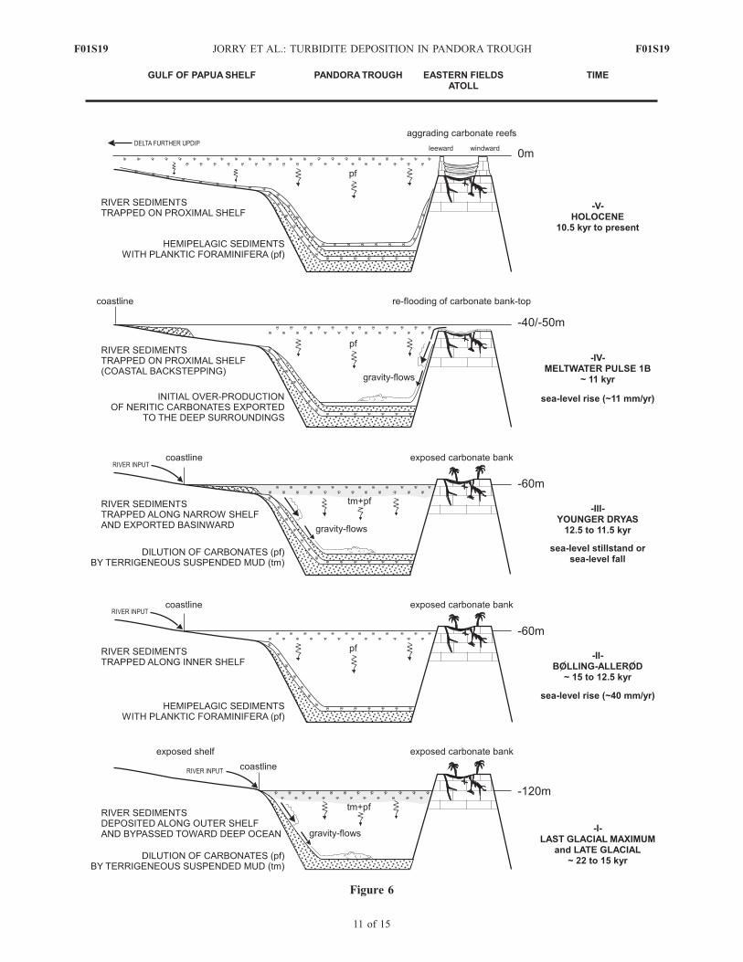
Figure 6
F01S19 JORRY ET AL.: TURBIDITE DEPOSITION IN PANDORA TROUGH
11 of 15
F01S19
to pelagic sediment with relatively higher carbonate contentand the occurrence of a calciturbidite; and (5) interval V,Holocene: devoid of sandy siliciclastic turbidites with raremuddy turbidites, and consists mostly of pelagic sedimentrich in carbonate (40–50%) with some bank-derived finearagonite.[39] This study in the central part of Pandora Trough
includes the first published data set that clearly demon-strates how variations of mixed siliciclastic/carbonatesediment accumulation into a basin adjacent to a siliciclasticshelf and atolls is directly linked to sea level fluctuationsduring the last deglaciation at millennial timescale variabil-ity. Siliciclastic gravity flows occurred during sea levellowstand and stillstand intervals, while they disappearduring transgressive and highstand intervals characterizedwith carbonate enriched hemipelagic sediment. This modelis consistent with the basic concept of sequence stratigraphyfor siliciclastic sediments, which explains that large quan-tities of shelf sediments are eroded from the shelf andredeposited on the slopes and in the basins during sea levelregression. If rivers reach the shelf edge during maximumlowstand intervals, the entire river load will be accumulateddirectly on the adjacent slope and basin floor [e.g.,Mitchum, 1977; Vail et al., 1977; Vail, 1987].[40] The occurrence of the calciturbidite and the onset
of bank-derived fine aragonite are contemporaneous toMWP 1B. This observation illustrates that the refloodingof bank tops and margins of adjacent carbonate platforms,such as the modern atolls of Eastern Fields, Portlock, Boot,and Ashmore atolls (with lagoon depths ranging between40 and 55 m), triggered the reinitiation of neritic carbonateproduction and export during the transgression followingthe Younger Dryas (Figure 3). This relationship, wellillustrated in central Pandora Trough, is consistent withthe concepts of ‘‘highstand shedding’’ and ‘‘highstandbundling’’ [Droxler and Schlager, 1985; Schlager et al.,1994]. These processes explain that carbonate platformsshed sediments produced on their bank tops and edgesduring the late part of sea level transgressions, as theseplatform edges and tops are reflooded. Shedding alsooccurs during highstand intervals, as long as bank topsand/or edges remain within the photic zone after their long-term exposure associated with sea level regressions andlowstands. In the following subsections and Figure 6, ascenario is developed on the basis of the five successiveintervals defined in core MD-40 (Figure 3).
5.1. Interval I
[41] During the LGM and late Glacial, the GOP shelf andthe bank tops and margins of Eastern Fields, Portlock, Boot,and Ashmore Reefs were subaerially exposed. The lowstandcoastal system had migrated all the way to the modern shelfedge [Droxler et al., 2006], and rivers were transporting
their sediment loads directly to the upper slope. Isolatedcarbonate banks were karstified islands. The sedimentsaccumulating into central Pandora Trough were essentiallya vertical succession of sandy and muddy siliciclasticturbidites. High volume of the terrigeneous mud releasedby rivers was transported offshore, diluting the pelagiccarbonates.
5.2. Interval II
[42] At the end of the Bølling-Allerød, sea level was �60m lower than today. During this 2.0–2.5 ka long interval,sea level had risen by about 50 m, with rates of sea levelrise exceeding 40 mm/a. As a direct consequence, thecoastline shifted landward and river sediments were trappedon the inner shelf. The Eastern Fields, Ashmore, Boot, andPortlock atolls still remained exposed, and, therefore, con-tinued to be dissolved (karstified). Because of the diminutionof the siliciclastic sediments raining through the watercolumn, pelagic sediment enriched in planktic foraminifersand characterized by relatively low accumulation ratesrepresented the main sedimentation in central Pandora. Onthe slopes, accumulation rates dramatically decreased by afactor 10–20 at the beginning of the Bølling-Allerød [Feboet al., 2008].
5.3. Interval III
[43] The pelagic interval corresponding to the Bølling-Allerød was abruptly interrupted by the return of siliciclasticsandy and muddy turbidites for a short interval that lastedmost likely no longer than 1 ka, referred to as the YoungerDryas. During this interval, sea level stopped rising, reachinga stillstand at�60 m belowmodern sea level, most likely stilltoo low to flood the bank tops and margins of the modernatolls. However, during the Younger Dryas, influenced by thesea level stillstand (or perhaps an undocumented sea levelfall), the siliciclastic coastal system readvanced toward theshelf edge. This movement seaward was enough seaward tobring siliciclastic sandy turbidites into the central PandoraTrough and a large volume of mud close enough to the shelfedge to explain the extreme dilution of the pelagic carbonatesat that time.[44] The Younger Dryas interval was global in nature,
because it has been described in the Atlantic basin, on theNorth and South American continents, in the Sulu Sea[Kudrass et al., 1991; Linsley and Thunell, 1990; deGaridel-Thoron et al., 2001], and more recently in thesouthern Australian Bight [Andres et al., 2003], and in thesouthwestern tropical Pacific Ocean [Correge et al., 2004].Sea-surface temperatures in Vanuatu were on average 4.5 ±1.3�C cooler during the Younger Dryas interval than today.In Pandora Trough, siliciclastic turbidites were dominantduring the late LGM sea level lowstand, and were absentduring both meltwater pulses. The occurrence of a major
Figure 6. Two-dimensional diagram illustrating the millennial timescale relationships among variations of sea level,sediment fluxes, and sedimentary processes at the origin of the sedimentary infilling in Pandora Trough from LGM untilHolocene. Siliciclastic gravity flows are dominant during LGM, late Glacial, and Younger Dryas and are interrupted by thedeposition of hemipelagic carbonate oozes at the Bølling-Allerød warming. The deposition of a calciturbidite in PandoraTrough has been triggered by the reflooding of the Eastern Fields bank top during the MWP 1B, when overproduction ofneritic carbonates is exported to the deep ocean. The Eastern Fields Holocene atoll is characterized by an aggrading rimmedcarbonate platform, where exceeding sediment is preferentially trapped in the lagoon.
F01S19 JORRY ET AL.: TURBIDITE DEPOSITION IN PANDORA TROUGH
12 of 15
F01S19
siliciclastic turbidite at the beginning of the Younger Dryascan be explained by cooling with no change in sea level. Itimplies that a humid climate can trigger erosion on the land,accumulation of terrigeneous sediment on a reduced shelfarea (sea level was 60 m lower than today), and export ofsiliciclastic gravity flows toward the slope and the basin.Although no direct lines of evidence for a Younger Dryassea level fall have been observed in spite of the significantadvance of the Fennoscandian ice sheet during that partic-ular interval [Mangerud et al., 1979], R. G. Fairbanks(personal communication, 2006) does not rule out such asea level fall, in particular, because a drop of sea level is nowobserved during the Oldest Dryas [Peltier and Fairbanks,2006]. On the basis of sedimentological arguments, ourstudy from Pandora trough would support this suggestedsea level fall during the Younger Dryas.
5.4. Interval IV
[45] Siliciclastic sandy and muddy turbidites were shutdown by the rapid 15–20 m sea level rise (11 mm/a) duringMWP 1B, and never returned to the central part of PandoraTrough during the Holocene. Their absence eliminatedsiliciclastic sands and the majority of the mud from theouter shelf and, therefore, the central part of PandoraTrough. The sediment in the trough became relativelyenriched in carbonates as sea level flooded the marginsand tops of the modern atolls, supplying bank-derivedaragonite in the fine sediment fraction, dated at �12 ka B.P.
5.5. Interval V
[46] The rest of the Holocene is characterized by anincrease of the carbonate content (coccoliths and plankticforaminifers) in the pelagic sediment. The typical atollmodern morphology is reinforced by their rim aggradationduring the Holocene transgression, causing loose neriticsediments to accumulate either in the lagoon or on the slopeand basin floors adjacent to the atolls.
6. Conclusions
[47] The study of three cores collected in the central partof Pandora Trough reveals a detailed sedimentary pattern atmillennial timescale during the last glacial/interglacialcycle. This sedimentary variability at millennium scaledemonstrates that the last glacial-interglacial transitionwas a two-step change from the Last Glacial Maximum tothe Holocene. The deposition of a pelagic carbonate intervalduring the Bølling-Allerød, devoid of sandy and muddyturbidites, marked the first step of deglaciation. The secondstep corresponded to the deposition of a calciturbiditeduring the meltwater pulse 1B. This two-step deglaciationwas clearly interrupted by the deposition of siliciclasticsandy and muddy turbidites during the Younger Dryas coldreversal.[48] The observed millennial timescale sedimentary var-
iability can be explained by the sea level fluctuationscorresponding to maximum rates of sea level rise (meltwaterpulses 1A and 1B, <40 mm/a, and 11 mm/a, respectively)and to a one 1 ka cooling interval of the Younger Dryas. Theinput of siliciclastic turbidites was maximal during LastGlacial Maximum, when the lowstand coastal system waslocated along the modern continental shelf edge, and
disappeared during the intervals of maximum reflooding ofthe shelf during meltwater pulses 1A and 1B. Siliciclasticturbidites reappeared briefly during the Younger Dryas, aninterval when rates of sea level rise slowed down or mostlikely stopped. The timing of the calciturbidite coincidedwith the first reflooding of Ashmore, Boot, Portlock, andEastern Fields atoll during the meltwater pulse 1B. It repre-sents the initiation of neritic carbonate production of the banktop, which had remained exposed for most of the glacialstages. The deposition of this calciturbidite (�11 ka B.P.)strongly suggests that carbonate production started veryrapidly during the second step of the deglaciation.
[49] Acknowledgments. This research was supported by the NationalScience Foundation (OCE 0305688), the Swiss National Foundation(PBGE2-111250), and by TOTAL (R62620). We are grateful to thecaptains, officers, crew members, and scientific and technical shipboardparties of the PANASH cruise on the R/V Melville part of NSF MARGINSSource-to-Sink initiative and the PECTEN cruise on the R/V MarionDufresne part of an IMAGES cruise. IPEV (Institut Polaire Paul-EmileVictor) and in particular Yvon Balut are acknowledged for support inrecovering high-quality cores with R/VMarion Dufresne. We are grateful toDavid Winter (UC Davis) who ran oxygen isotopes analyses and GuaciaraDos Santos (University of California) for radiocarbon AMS dates. Weacknowledge Philippe Lapointe at TOTAL for his continuous support andinterest and for the funding of the TOC analyses. We thank ChuckNittrouer, Bill Normack, and Chris Goldfinger for constructive commentson an earlier draft of this paper.
ReferencesAlley, R. B., et al. (1993), Abrupt increase in Greenland snow accumulationat the end of the Younger Dryas event, Nature, 362, 527–529.
Anderson, D. M., W. L. Prell, and N. J. Barratt (1989), Estimates of seasurface temperature in the Coral Sea at the Last Glacial Maximum,Paleoceanography, 4, 615–627.
Andres, M. S., S. M. Bernasconi, J. A. Mc Kenzie, and U. Rohl (2003),Southern Ocean deglacial record supports global Younger Dryas, EarthPlanet. Sci. Lett., 216, 515–524.
Andresen, N., J. J. G. Reijmer, and A. W. Droxler (2003), Timing anddistribution of calciturbidites around a deeply submerged carbonate plat-form in a seismically active setting (Pedro Bank, Northern NicaraguaRise Caribbean Sea), Int. J. Earth Sci., 92, 573–592.
Bard, E., B. Hamelin, R. G. Fairbanks, and A. Zindler (1990), Calibrationof the 14C timescale over the past 30,000 years using mass spectrometricU�Th ages from Barbados corals, Nature, 345, 405–410.
Bard, E., M. Arnold, J. Mangerud, M. Paterne, L. D. Labeyrie, J. Duprat,E. Melieres, E. Sønstegaard, and J. C. Duplessy (1994), The NorthAtlantic atmosphere-sea surface 14C gradient during the Younger Dryasclimatic event, Earth Planet. Sci. Lett., 126, 257–287.
Bassett, S. E., G. A. Milne, J. X. Mitrovica, and P. U. Clark (2005), Icesheet and solid earth influences on far-field sea-level histories, Science,309, 925–928.
Belopolsky, A. V., and A. W. Droxler (1999), Uppermost Pleistocene trans-gressive coralgal reefs on the edge of the South Texas Shelf: Analogs forreefal reservoirs buried in siliciclastic shelves, paper presented at 19thAnnual Research Conference Advanced Reservoir Characterization, GolfCoast Sect. of the Soc. of Econ. Paleontol. and Mineral. Found., Houston,Tex.
Bouma, A. H. (1982), Intraslope basins in northwest Gulf of Mexico: Akey to ancient submarine canyons and fans, in Studies in ContinentalMargin Geology, Am. Assoc. of Pet. Geol. Mem. Ser., vol. 34, edited byJ. S. Watkins and C. L. Drake, pp. 567–581, Am. Assoc. of Pet. Geol.,Tulsa, Okla.
Budd, D.A., and P.M.Harris (Eds.) (1990),Carbonate-SiliciclasticMixtures,SEMP Reprint Ser., vol. 14, 272 pp., Soc. of Sediment. Geol., Tulsa,Okla.
Carson, B., J. Francis, R. Leckie, A. Doxler, G. R. Dickens, S. J. Jorry,S. J. Bentley, L. C. Peterson, and B. Opdyke (2008), Benthic foraminiferalresponse to sea level change in the mixed siliciclastic-carbonate systemof the southern Ashmore Trough (Gulf of Papua), J. Geophys. Res.,doi:10.1029/2006JF000629, in press.
Chodankar, A. R., V. K. Banakar, and T. Oba (2005), Past 100 ky surfacesalinity-gradient response in the eastern Arabian Sea to the summermonsoon variation recorded by delta (super 18) O of G. sacculifer,Global Planet. Change, 47, 135–142.
F01S19 JORRY ET AL.: TURBIDITE DEPOSITION IN PANDORA TROUGH
13 of 15
F01S19
Clark, P. U., A. Marshall, A. McCabe, A. C. Mix, and A. J. Weaver (2004),Rapid rise of sea level 19000 years ago and its global implications,Science, 304, 1141–1144.
Correge, T., M. K. Gagan, J. W. Beck, J. S. Burr, G. Cabioch, and F. LeCornec (2004), Interdecadal variation in the extent of South Pacifictropical waters during the Younger Dryas event, Nature, 428, 927–929.
de Garidel-Thoron, T., L. Beaufort, B. K. Linsley, and S. Dannenmann(2001), Millennial-scale dynamics of the east Asian winter monsoonduring the last 200,000 years, Paleoceanography, 16, 1–12.
de Garidel-Thoron, T., L. Beaufort, F. Bassinot, and P. Henry (2004),Evidence for large methane releases to the atmosphere from deep-seagas-hydrate dissociation during the last glacial episode, Proc. Natl.Acad. Sci. U. S. A., 101, 9187–9192.
Droxler, A. W., and W. Schlager (1985), Glacial versus interglacial sedi-mentation rates and turbidite frequency in the Bahamas, Geology, 13,799–802.
Droxler, A. W., J. W. Morse, and W. A. Kornicker (1988), Controls oncarbonate mineral accumulation in Bahamian basins and adjacent Atlan-tic Ocean sediments, J. Sediment. Res., 58, 120–130.
Droxler, A. W., G. Mallarino, J. M. Francis, G. J. Dickens, B. N. Opdyke,L. Beaufort, J. Daniell, S. J. Bentley, and L. C. Peterson (2006), Earlytransgressive establishment of relict uppermost Pleistocene barrier reefson LGM coastal siliciclastic deposits in the Gulfs of Papua and Mexico:Clue to understand the Mid-Brunhes origin of modern barrier reefs, inAAPG Meeting: Abstract Book, vol. 55, pp. 37–38, Am. Assoc. of Pet.Geol., Tulsa, Okla.
Durkoop, A., W. Hale, S. Mulitza, J. Patzold, and G. Wefer (1997),Late Quaternary variations of sea surface salinity and temperature inthe western tropical Atlantic: Evidence from a18O of GlobigerinoidesSacculifer, Paleoceanography, 12, 764–772.
Dunbar, G. B., G. R. Dickens, and R. M. Carter (2000), Sediment fluxacross the Great Barrier Reef Shelf to the Queensland Trough over thelast 300 ky, Sediment. Geol., 133, 49–92.
Duplessy, J.-C., E. Bard, M. Arnold, N. J. Shackleton, J. Duprat, andL. Labeyrie (1991), How fast did the ocean-atmosphere system runduring the last deglaciation?, Earth Planet. Sci. Lett., 103, 27–40.
Edwards, R. L., J. W. Beck, G. S. Burr, D. J. Donahue, J. M. A. Chappell,A. L. Bloom, E. R. M. Druffel, and F. W. Taylor (1993), A large drop inatmospheric 14C/12C and reduced melting in the Younger Dryas, docu-mented with 230Th ages of corals, Science, 260, 962–968.
Fairbanks, R. G. (1989), A 17,000 year glacio-eustatic sea level record;influence of glacial melting rates on the Younger Dryas event and deepocean circulation, Nature, 342, 637–642.
Fairbanks, R. G., R. A. Mortlock, T. C. Chiu, L. Cao, A. Kaplan, T. P.Guilderson, T. W. Fairbanks, A. L. Bloom, P. M. Grootes, and M. J.Nadeau (2005), Radiocarbon calibration curve spanning 0 to 50000 yearsBP based on paired 230Th/ 234U/238U and 14C dates on pristine corals,Quat. Sci. Rev., 24, 1781–1796.
Febo, L. A., S. J. Bentley, J. H. Wrenn, A. W. Droxler, G. R. Dickens, L. C.Peterson, and B. Opdyke (2008), Late Pleistocene and Holocene sedi-mentation, organic-carbon delivery, and paleoclimatic inferences on thecontinental slope of the northern Pandora Trough, Gulf of Papua,J. Geophys. Res., doi:10.1029/2006JF000677, in press.
Ferro, C. E., A. W. Droxler, J. B. Anderson, and D. Mucciarone (1999),Late Quaternary shift of mixed siliciclastic-carbonate environmentsinduced by glacial eustatic sea-level fluctuations in Belize, in Advancesin Carbonate Sequence Stratigraphy: Application to Reservoirs,Outcrops, and Models, SEMP Spec. Publ., vol. 63, edited by P. M.Harris, A. H. Saller, and J. A. Simo, pp. 385–411, Soc. of Sediment.Geol., Tulsa, Okla.
Foreman, J. L., K. R. Walker, L. J. Weber, S. G. Driese, and R.B. Dreier(1991), Slope and basinal carbonate deposition in the Nolichucky Shale(Upper Cambrian), east Tennessee: Effect of carbonate suppression bysiliciclastic deposition on basin-margin morphology, in Mixed Carbo-nate-Siliciclastic Sequences, SEMP Core Workshop Ser., vol. 15, editedby A. J. Lomando and P. M. Harris, pp. 511–539, Tulsa, Okla.
Francis, J., J. J. Daniell, A. W. Droxler, G. R. Dickens, S. J. Bentley,L. C. Peterson, B. Opdyke, and L. Beaufort (2008), Deepwater geo-morphology of the mixed siliciclastic-carbonate system, Gulf of Papua,J. Geophys. Res., doi:10.1029/2007JF000851, in press.
Gibbs, R. J. (1981), Sites of river-derived sedimentation in the ocean,Geology, 9, 77–80.
Gischler, E. (2003), Holocene lagoonal development in the isolated carbo-nate platforms off Belize, Sediment. Geol., 159, 113–132.
Glaser, K. S., and A. W. Droxler (1993), Controls and development oflate Quaternary periplatform carbonate stratigraphy in Walton Basin(Northern Nicaragua Rise Caribbean Sea), Paleoceanography, 8,243–274.
Goldsmith, J. R., D. L. Graf, and H. C. Heard (1961), Lattice constants ofthe calcium magnesium carbonates, Am. Mineral., 46, 453–457.
Grootes, P. M., M. Stuiver, J. W. C. White, S. Johnsen, and J. Jouzel (1993),Comparison of oxygen isotope records from the GISP2 and GRIPGreenland ice cores, Nature, 366, 552–554.
Guilderson, T., R. G. Fairbanks, and J. Rubenstone (2001), Tropical Atlan-tic coral oxygen isotopes; glacial-interglacial sea surface temperaturesand climate change, Mar. Geol., 172, 75–89.
Hanebuth, T., K. Stattegger, and P. M. Grootes (2000), Rapid floodingof the Sunda Shelf: A late glacial sea-level record, Science, 288,1033–1035.
Harris, P. T., E. K. Baker, A. R. Cole, and S. A. Short (1993), A preliminarystudy of sedimentation in the tidally dominated Fly River delta, Gulf ofPapua, Cont. Shelf Res., 13, 441–472.
Harris, P. T., C. B. Pattiaratchi, J. B. Keene, R. W. Dalrymple, J. V. Gardner,E. K. Baker, A. R. Cole, D. Mitchell, P. Gibbs, and W. W. Schroeder(1996), Late Quaternary deltaic and carbonate sedimentation in the Gulfof Papua foreland basin: Response to sea-level change, J. Sediment. Res.,66, 801–819.
Holmes, A. E., and N. Christie-Blick (1993), Origin of sedimentary cyclesin mixed carbonate-siliciclastic systems: An example from the CanningBasin, Western Autralia, in Carbonate Sequence Stratigraphy: RecentDevelopments and Applications, Am. Assoc. of Pet. Geol. Mem. Ser.,vol. 57, edited by R. G. Loucks and J. F. Sarg, pp. 181–212, Tulsa,Okla.
Hughen, K. A., J. R. Southon, S. J. Lehman, and J. T. Overpeck (2000),Synchronous radiocarbon and climate shifts during the last deglaciation,Science, 190, 1951–1954.
Kienast, M., T. J. J. Hanebuth, C. Pelejero, and S. Steinke (2003), Syn-chroneity of meltwater pulse 1a and the Bølling warming: New evidencefrom the South China Sea, Geology, 31, 67–70.
Kudrass, H. R., H. Erlenkeuser, R. Vollbrecht, and W. Weiss (1991), Globalnature of the Younger Dryas cooling event inferred from oxygen isotopedata from Sulu sea cores, Nature, 349, 406–409.
Lambeck, K., and J. Chappell (2001), Sea level change through the lastglacial cycle, Science, 292, 679–686.
Lambeck, K., T. M. Esat, and E. K. Potter (2002), Links between climateand sea levels for the past three million years, Nature, 419, 199–206.
Lea, D. W., D. K. Pak, and H. J. Spero (2000), Climate impact of lateQuaternary equatorial Pacific sea surface temperature variations, Science,289, 1719–1724.
Lea, D. W., P. A. Martin, D. K. Pak, and H. J. Spero (2002), Reconstructinga 350 ky history of sea level using planktic Mg/Ca and oxygen isotoperecords from a Cocos Ridge core, Quat. Sci. Rev., 21, 283–293.
Linsley, B. K. (1996), Oxygen-isotope record of climate and sea-levelvariations in the Sulu Sea over the past 150000 years, Nature, 380,234–237.
Linsley, B. K., and R. C. Thunell (1990), The record of deglaciation in theSulu Sea: Evidence for the Younger Dryas event in the tropical westernPacific, Paleoceanography, 5, 1025–1039.
Liu, J. P., J. D. Milliman, S. Gao, and P. Cheng (2004), Holocene devel-opment of the Yellow River’s subaqueous delta, North Yellow Sea, Mar.Geol., 209, 45–67.
MacKinnon, L., and B. Jones (2001), Sedimentological evolution of NorthSound, Grand Cayman: A freshwater to marine carbonate successiondriven by Holocene sea-level rise, J. Sediment. Res., 71, 568–580.
Mallarino, G., R. T. Beaubouef, A. W. Droxler, V. Abreu, and L. Labeyrie(2006), Sea-level influence on the nature and timing of a minibasinsedimentary fill (northwestern slope of the Gulf of Mexico), AAPG Bull.,90, 1089–1119.
Mangerud, J., E. Larsen, O. Longva, and E. Sønstegaard (1979), Glacialhistory of western Norway 15000–10000 BP, Boreas, 8, 179–187.
Mitchum, R. M. (1977), Seismic stratigraphy and global changes of sealevel: Part 11, Glossary of terms used in seismic stratigraphy, in SeismicStratigraphy: Applications to Hydrocarbon Exploration, Am. Assoc. ofPet. Geol. Mem. Ser., vol. 26, edited by C. E. Payton, pp. 205–212, Am.Assoc. of Pet. Geol., Tulsa, Okla.
Mount, J. F. (1984), Mixing of siliciclastic and carbonate sediments inshallow shelf environments, Geology, 12, 432–435.
Muller, G., and M. Gastner (1971), The ‘‘karbonat-bombe’’: A simpledevice for the determination of the carbonate content in sediments, soils,and other materials, Neues Jahrb. Mineral. Abh., 10, 466–469.
Page, M. C., G. R. Dickens, and G. B. Dunbar (2003), Tropical view ofQuaternary sequence stratigraphy: Siliciclastic accumulation on slopeseast of the Great Barrier Reef since the Last Glacial Maximum, Geology,31, 1013–1016.
Peltier, W. R., and R. G. Fairbanks (2006), Global glacial ice volume andLast Glacial Maximum duration from an extended Barbados sea levelrecord, Quat. Sci. Rev., 25, 3322 – 3337, doi:10.1016/j.quascirev.2006.04.010.
Pickup, G., and V. H. Chewings (1983), The hydrology of the Purari and itsenvironmental implications, in The Purari: Tropical Environment of a
F01S19 JORRY ET AL.: TURBIDITE DEPOSITION IN PANDORA TROUGH
14 of 15
F01S19

High Rainfall River Basin, edited by T. Petr, pp. 123–140, Springer, NewYork.
Reimer, P. J., and R. W. Reimer (2001), A marine reservoir correctiondatabase and on-line interface, Radiocarbon, 43, 461–463. (Supplementalmaterial available at http://www.calib.org.)
Salomons, W. A. M., and A. M. Eagle (1990), Hydrology, sedimentology,and the fate and distribution of copper in mine-related discharges inthe Fly River system, Papua New Guinea, Sci. Total Environ., 97/98,345–513.
Schlager, W., J. J. G. Reijmer, and A. W. Droxler (1994), Highstand shed-ding of carbonate platforms, J. Sediment. Res., 64, 270–281.
Stott, L., C. Poulsen, S. Lund, and R. Thunell (2002), Super ENSO andglobal climate oscillations at millennial time scales, Science, 297,222–226.
Stuiver, M., and T. F. Braziunas (1993), Modeling atmospheric 14C influ-ences and 14C ages of marine samples to 10000 BC, Radiocarbon, 35,137–189.
Stuiver, M., and P. M. Grootes (2000), GISP2 Oxygen Isotope Ratios, Quat.Res., 53, 277–284.
Tcherepanov, E., A. W. Droxler, P. Lappointe, G. R. Dickens, S. J. Bentley,L. Beaufort, L. C. Peterson, J. J. Daniell, and B. Opdyke (2008),Neogene evolution of the mixed carbonate-siliciclastic system in theGulf of Papua, Papua New Guinea, J. Geophys. Res., 113, F01S21,doi:10.1029/2006JF000684.
Thunell, R. C., D. M. Anderson, D. Gellar, and Q. Miao (1994), Sea-surfacetemperature estimates for the tropical western Pacific during the lastglaciation and their implications for the Pacific warm pool, Quat. Res.,41, 255–264.
Vail, P. R. (1987), Seismic stratigraphy interpretation procedure, in Atlas ofSeismic Stratigraphy, Am. Assoc. of Pet. Geol. Stud. Geol. Ser., vol. 27,edited by A. W. Bally, pp. 1–10, Am. Assoc. of Pet. Geol., Tulsa, Okla.
Vail, P. R., R. M. Mitchum, and S. Thompson (1977), Global cycles ofrelative changes of sea level, in Seismic Stratigraphy: Applications to
Hydrocarbon Exploration, Am. Assoc. of Pet. Geol. Mem. Ser., vol. 26,edited by C. E. Payton, pp. 83–97, Am. Assoc. of Pet. Geol., Tulsa, Okla.
Visser, K., R. C. Thunell, and L. Stott (2003), Magnitude and timing oftemperature change in the Indo-Pacific warm pool during deglaciation,Nature, 421, 152–155.
Walsh, J. P., and C. A. Nittrouer (2004), Mangrove-bank sedimentation in amesotidal environment with large sediment supply, Gulf of Papua, Mar.Geol., 208, 225–248.
Weaver, A. J., O. A. Saenko, P. U. Clark, and J. X. Mitrovica (2003),Meltwater pulse 1A from Antarctica as a trigger of the Bølling-Allerødwarm interval, Science, 299, 1709–1713.
Yokoyama, Y., K. Lambeck, P. De Deckker, P. Johnston, and K. Fifield(2000), Timing of the Last Glacial Maximum from observed sea-levelminima, Nature, 406, 713–716.
�����������������������L. Beaufort, Clouds and the Earth’s Radiant Energy System, CNRS,
Universite Aix-Marseille III, BP80, F-13545 Aix-en-Provence cedex 4,France. ([email protected])S. J. Bentley, Earth Sciences Department, Memorial University of
Newfoundland, St John’s, NL, Canada A1B 3X5. ([email protected])G. R. Dickens and A. W. Droxler, Department of Earth Science, Rice
University, 6100 Main Street, Houston, TX 77005-1892, USA. ([email protected]; [email protected])S. J. Jorry, Beicip-Franlab Petroleum Consultants, 232 Avenue Napoleon
Bonaparte, F-92500 Rueil-Malmaison, France. ([email protected])G. Mallarino, PanTerra Geoconsultants B.V., Weversbaan 1-3, NL-2352
BZ Leiderdorp, Netherlands. ([email protected])B. N. Opdyke, Department of Earth and Marine Sciences, Australian
National University, Canberra, ACT 0200, Australia. ([email protected])L. C. Peterson, Rosentiel School of Marine and Atmospheric Science,
University of Miami, Miami, FL 33149, USA. ([email protected])
F01S19 JORRY ET AL.: TURBIDITE DEPOSITION IN PANDORA TROUGH
15 of 15
F01S19