The Danube River Basin District Management Plan - ICPDR
315
ICPDR / International Commission for the Protection of the Danube River / www.icpdr.org ANNEX DRAFT May 2015 The Danube River Basin District Management Plan – Update 2015
-
Upload
khangminh22 -
Category
Documents
-
view
1 -
download
0
Transcript of The Danube River Basin District Management Plan - ICPDR

ICPDR / International Commission for the Protection of the Danube River / www.icpdr.org
ANNEX
DRAFT
May 2015
The Danube River Basin District Management Plan – Update 2015

DRAFT Danube River Basin District Management Plan – Update 2015
ICPDR / International Commission for the Protection of the Danube River / www.icpdr.org
List of Annexes
Annex 1: Competent Authorities and Weblinks to National RBM Plans in the DRBD
Annex 2: Update on DRBD Surface Water Typology
Annex 3: Urban Waste Water Inventories
Annex 4: Industrial Emission Inventories
Annex 5: Future Infrastructure Projects
Annex 6: Groundwater
Annex 7: Detailed Results Status Assessment Surface Water Bodies
Annex 8: Inventory of Protected Areas
Annex 9: Economic Analysis
Annex 10: Progress in Urban Wastewater and industrial Sectors
Annex 11: Overview on Agricultural Measures
Annex 12: Progress on Measures Addressing Hydromorphological Alterations
Annex 13: Ecological Prioritisation Approach River and Habitat Continuity Restoration
Annex 14: Detailed list on Hydrological Alterations
Annex 15: Financing the Joint Programme of Measures

ICPDR / International Commission for the Protection of the Danube River / www.icpdr.org
Competent authorities and Weblinks to National RBM Plans in the DRB
Annex 1
DRAFT DRBM Plan – Update 2015
DRAFT Danube River Basin District Management Plan – Update 2015
ICPDR / International Commission for the Protection of the Danube River / www.icpdr.org
Austria Federal Ministry for Agriculture, Forestry, Environment and Water Management Stubenring 1 A-1012 Wien Web link: www.bmlfuw.gv.at Web link national RBM Plan: http://wisa.bmlfuw.gv.at
Bosnia and Herzegovina
Ministry of Foreign Trade and Economic Relations Musala 9 BiH-71000 Sarajevo Web link: www.mvteo.gov.ba
Federal Ministry of Agriculture, Water Management and Forestry Marka Marulica 2BiH-71000 Sarajevo Web link: www.fmpvs.gov.ba Ministry of Agriculture, Forestry and Water Management of Republika Srpska Trg Republike Srpske 1BiH-78000 Banja Luka Web link: www.vladars.net
Bulgaria
Ministry of Environment and Water 22 Maria-Luisa Blvd. BG-1000 Sofia Web link: www.moew.government.bg
Danube River Basin Directorate 60, Chataldzha str. BG -5800 Pleven Web link: www.dunavbd.org Web link national RBM Plan:
http://dunavbd.org/index.php?x=204
Croatia
Ministry of Agriculture Ulica grada Vukovara 78 HR-10000 Zagreb Web link: http://www.mps.hr
Czech Republic
Ministry of Environment Vrsovická 65 CZ-10010 Praha 10 Web link: www.mzp.cz Ministry of Agriculture Tesnov 17 CZ-117 05 Praha 1 Web link: www.mze.cz Germany Bavarian State Ministry for Environment and Consumer Protection Rosenkavalierplatz 2 D-81925 München Web link: www.stmuv.bayern.de/
Ministry for Environment Baden-Württemberg Kernerplatz 10 D-70182 Stuttgart Web link: www.um.baden-wuerttemberg.de/
Hungary Ministry of Interior Jozsef Attila u. 2-4 H-1051 Budapest Web link: www.kormany.hu/hu/belugyminiszterium Web link national RBM Plan: www.euvki.hu; www.vizeink.hu
Moldova Ministry of Ecology, Construction and Territorial Development 9 Cosmonautilor St. MD-2005 Chisinau Web link: currently no web link available.
Montenegro Ministry of Agriculture, Forestry and Water Management Rimski Trg 46 ME – 81000 Podgorica Web link: www.minpolj.gov.me
Romania Ministry of Environment 12 Libertatii Blvd., Sector 5 RO-04129 Bucharest Web link: www.ape-paduri.ro
National Administration “Apele Romane” 6 Edgar Quinet St., Sector 1 RO-010018 Bucharest Web link: http://www.rowater.ro Serbia Ministry of Agriculture and Environmental Protection Nemanjina 22-26 RS-11000 Beograd Web link: http://www.mpzzs.gov.rs/
Slovak Republic
Ministry of the Environment Námestie L’ Stúra 1 SK-81235 Bratislava Web link: www.enviro.gov.sk; www.vuvh.sk/rsv2
Slovenia Ministry of the Environment and Spatial Planning Dunajska 48 SI-1000 Ljubljana Web link: www.mop.gov.si/en/ Web link national RBM Plan:
http://www.mop.gov.si/si/delovna_podrocja/voda/nacrt_upravljanja_voda/nuv_besedilni_in_kartografski_del/ Web link PoMs:
http://www.mop.gov.si/si/delovna_podrocja/voda/nacrt_upravljanja_voda/#c18223 Ukraine Ministry for Environmental Protection of Ukraine 35, Uritskogo str. UA-03035 Kyiv
State Committee of Ukraine for Water Management 8, Chervonoarmiyska Str. UA-01601 Kyiv Web link: www.menr.gov.ua

ICPDR / International Commission for the Protection of the Danube River / www.icpdr.org
Update on DRBD surface water typology
Annex 2
DRAFT DRBM Plan – Update 2015

DRAFT Danube River Basin District Management Plan – Update 2015 2
ICPDR / International Commission for the Protection of the Danube River / www.icpdr.org
Typology of the Danube River
The typology of the Danube River has been developed in a joint activity by the countries sharing the Danube River for the first DBA in 2004. The Danube typology therefore constitutes a harmonised system used by all these countries. The Danube typology was based on a combination of abiotic factors of System A and System B. The most important factors are ecoregion, mean water slope, substratum composition, geomorphology and water temperature.
Ten Danube section types were identified (see Figure 1). The morphological and habitat characteristics are outlined for each section type. In order to ensure that the Danube section types are biologically meaningful, these were validated with biological data collected during the first Joint Danube Survey in 2001. Further details including definition of individual section types are given in the DBA 2013.
Figure 1: Danube section types; the dividing lines refer only to the Danube River itself.
Typology of the tributaries in the Danube River Basin District
The typologies of the Danube tributaries were developed by the countries individually. Stream types relevant on transboundary water courses were bilaterally harmonised with the neighbours. An overview of national surface water typologies is given in the DBA 2013.
Most countries in the DRB (Germany, Austria, Czech Republic, Hungary, Slovenia, Bosnia and Herzegovina, Serbia, Croatia, Romania, Bulgaria) have applied System B (Annex II, 1.2.1 WFD) for establishing their river typology. Only Slovakia and Ukraine have used System A. Countries using System B have used a number of optional factors to further describe the river types. River discharge, mean substratum composition and mean water slope are most frequently used.
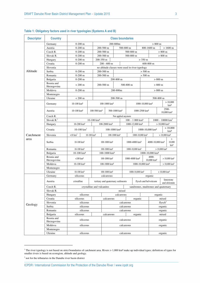
Table 1 gives an overview of the class boundaries used by the DRB countries for the common descriptors: altitude, catchment area and geology.
DRAFT Danube River Basin District Management Plan – Update 2015 3
ICPDR / International Commission for the Protection of the Danube River / www.icpdr.org
Table 1: Obligatory factors used in river typologies (Systems A and B)
Descriptor Country Class boundaries
Altitude
Germany 0-200 m 200-800m > 800 m
Austria 0-200 m 200-500 m 500-800 m 800-1600 m > 1600 m
Czech R. 0-200 m 200-500 m 500-800 m > 800 m
Slovak R. 0-200 m 200-500 m 500-800 m > 800 m
Hungary 0-200 m 200-350 m > 350 m
Croatia 0-200 m 200 - 600 m 600-800 m
Slovenia no altitude classes were used in river typology
Serbia 0-200 m 200-500 m > 500 m
Romania 0-200 m 200-500 m > 500 m
Bulgaria 0-200 m 200-800 m > 800 m
Bosnia and Herzegovina
< 200 m 200-500 m 500-800 m > 800 m
Moldova 0-200 m 200-800m > 800 m
Montenegro
Ukraine < 200 m 200-500 m 500-800 m
Catchment area
Germany 10-100 km² 100-1000 km² 1000-10,000 km² > 10,000
km²
Austria 10-100 km² 100-500 km² 500-1000 km² 1000-2500 km² 2500-
10,000 km²
Czech R. Not applied anymore
Slovak R.1 10-100 km² 100 – 1 000 km² 1000 – 10000 km2
Hungary 10-200 km² 100-2000 km² 1000-12,000 km² > 10,000 km²
Croatia 10-100 km2 100-1000 km² 1000-10,000 km² > 10,000
km²
Slovenia <10 km2 10-100 km² 100-1000 km² 1000-10,000 km² > 10,000 km²
Serbia 10-100 km² 100-1000 km² 1000-4000 km² 4000-10,000 km² >
10,000 km²
Romania 10-100 km² 100-1000 km² 1000-10,000 km² > 10,000 km²
Bulgaria 10-100 km² 100-1000 km² 1000-10,000 km²
Bosnia and Herzegovina
<100 km² 100-1000 km² 1000-4000 km² 4000-
10,000 km² > 10,000 km²
Moldova 10-100 km² 100-1000 km² 1000-10,000 km² > 10,000 km²
Montenegro
Ukraine 10-100 km² 100-1000 km² 1000-10,000 km² > 10,000 km²
Geology
Germany siliceous calcareous organic
Austria cristalline tertiary and quaternary sediments flysch and helveticum limestone
and dolomite
Czech R. crystalline and vulcanites sandstones, mudstones and quaternary
Slovak R. mixed
Hungary siliceous calcareous organic
Croatia siliceous calcareous organic mixed
Slovenia siliceous calcareous flysch2
Serbia siliceous calcareous organic
Romania siliceous calcareous organic
Bulgaria siliceous calcareous organic mixed
Bosnia and Herzegovina
siliceous calcareous organic
Moldova siliceous calcareous organic
Montenegro
Ukraine siliceous calcareous organic
1 The river typology is not based on strict boundaries of catchment area. Rivers > 1,000 km² make up individual types; definition of types for smaller rivers is based on ecoregion, altitude and geology. 2 not for the tributaries in the Danube river basin district
DRAFT Danube River Basin District Management Plan – Update 2015 4
ICPDR / International Commission for the Protection of the Danube River / www.icpdr.org
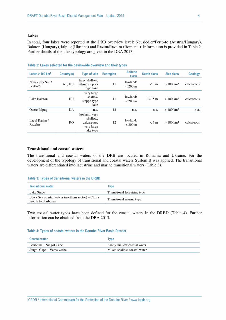
Lakes
In total, four lakes were reported at the DRB overview level: Neusiedler/Fertö-to (Austria/Hungary), Balaton (Hungary), Ialpug (Ukraine) and Razim/Razelm (Romania). Information is provided in Table 2. Further details of the lake typology are given in the DBA 2013.
Table 2: Lakes selected for the basin-wide overview and their types
Lakes > 100 km2 Country(s) Type of lake Ecoregion Altitude
class Depth class Size class Geology
Neusiedler See / Fertő-tó
AT, HU large shallow, salinic steppe-
type lake 11
lowland: < 200 m
< 3 m > 100 km² calcareous
Lake Balaton HU
very large shallow
steppe-type lake
11 lowland: < 200 m
3-15 m > 100 km² calcareous
Ozero Ialpug UA n.a. 12 n.a. n.a. > 100 km² n.a.
Lacul Razim / Razelm
RO
lowland, very shallow,
calcareous, very large lake type
12 lowland: < 200 m
< 3 m > 100 km² calcareous
Transitional and coastal waters
The transitional and coastal waters of the DRB are located in Romania and Ukraine. For the development of the typology of transitional and coastal waters System B was applied. The transitional waters are differentiated into lacustrine and marine transitional waters (Table 3).
Table 3: Types of transitional waters in the DRBD
Transitional water Type
Lake Sinoe Transitional lacustrine type
Black Sea coastal waters (northern sector) – Chilia mouth to Periboina
Transitional marine type
Two coastal water types have been defined for the coastal waters in the DRBD (Table 4). Further information can be obtained from the DBA 2013.
Table 4: Types of coastal waters in the Danube River Basin District
Coastal water Type
Periboina – Singol Cape Sandy shallow coastal water
Singol Cape – Vama veche Mixed shallow coastal water

ICPDR / International Commission for the Protection of the Danube River / www.icpdr.org
ANNEX 3
DRAFT DRBM Plan – Update 2015
Urban waste water inventories

DRAFT Danube River Basin District Management Plan – Update 2015 1
ICPDR / International Commission for the Protection of the Danube River / www.icpdr.org
Urban waste water data were collected from the countries in order to assess the point source organic substances and nutrient emissions via urban waste water
discharges for the reference year 2011/2012. Summarizing tables of the data submitted are presented in the followings.
Table 1: Agglomerations and population equivalents (PE)
Country
Number of agglomerations Generated load (PE)
Total Collected and
treated Addressed
through IAS Collected and
not treated Not collected
and not treated Total
Collected and treatment
Addressed through IAS
Collected and no treatment
Not collected and not treated
1 DE
718
718 - - -
13,629,528
13,611,069
18,459
-
-
2 AT
608
608 - - -
13,137,976
13,043,568
94,408
-
-
3 CZ
185
181
4 - -
2,395,708
2,261,870
118,431
14,907
499
4 SK
344
274
70 - -
4,874,448
4,151,739
648,449
52,120
22,140
5 HU
511
508
3 - -
11,698,020
9,957,010
1,741,010
-
-
6 SI
138
97
16
17 8
1,313,346
873,980
111,831
173,827
153,708
7 HR
152
27 -
61
64
2,916,445
1,432,588 -
479,485
1,004,372
8 BiH
241
6 -
79
156
2,045,920
299,475 -
590,254
1,156,191
9 RS
241
36
205 - -
4,581,832
697,132
737,987
3,119,028
27,685
10 RO
1,852
403
102
142 1,205
21,411,700
10,554,488
179,939
1,913,212
8,764,060
11 BG
138
29
2
50 57
4,049,697
2,540,998
7,630
522,343
978,726
12 MD
169
17
3
22 127
899,189
173,283
38,075
29,017
658,814
13 UA
315
32 -
7
276
1,952,299
708,743 -
28,346
1,215,209
Total 5,612 2,936 405 378 1,893 84,906,108 60,307,375 3,696,469 6,922,356 13,979,908
Categorisation of agglomerations is based on the highest technical level available.

DRAFT Danube River Basin District Management Plan – Update 2015 2
ICPDR / International Commission for the Protection of the Danube River / www.icpdr.org
Table 2: Organic substances (biochemical oxygen demand – BOD, chemical oxygen demand, COD) and nutrient (total nitrogen – TN, total phosphorus - TP) discharges
Country
BOD discharges (t/year) COD discharges (t/year) TN discharges (t/year) TP discharges (t/year)
Total Collected
and treated
Collected and not treated
Total Collected
and treated
Collected and not treated
Total Collected
and treated
Collected and not treated
Total Collected
and treated
Collected and not treated
1 DE
4,541
4,541
-
24,019
24,019
-
12,519
12,519
-
1,026
1,026 -
2 AT
4,262
4,262
-
26,079
26,079
-
8,453
8,453
-
647
647 -
3 CZ
941
693
248
4,897
4,427
470
1,618
1,573
45
162
155 7
4 SK
3,344
2,816
527
14,248
13,241
1,007
5,139
4,898
242
360
335 25
5 HU
5,745
5,745
-
21,606
21,606
-
7,527
7,527
-
879
879 -
6 SI
5,123
1,316
3,807
12,380
5,401
6,979
2,188
1,630
558
390
295 95
7 HR
19,640
9,139
10,501
33,899
14,648
19,251
4,298
2,758
1,540
1,123
764 359
8 BiH
17,114
4,188
12,927
31,500
7,801
23,699
2,752
856
1,896
639
197 442
9 RS
75,444
6,065
69,379
138,450
11,255
127,195
11,665
1,490
10,176
2,418
337 2,081
10 RO
62,278
32,790
29,489
141,770
85,523
56,247
21,509
16,535
4,974
2,472
1,694 778
11 BG
17,838
6,398
11,439
31,285
10,313
20,972
4,263
2,585
1,678
677
391 286
12 MD
3,534
2,728
806
6,072
4,594
1,478
675
557
118
169
141 28
13 UA
4,261
3,744
517
6,611
5,473
1,138
1,260
1,168
91
393
372 21
Total 224,066 84,426 139,640 492,814 234,378 258,436 83,865 62,548 21,318 11,355 7,232 4,122

DRAFT Danube River Basin District Management Plan – Update 2015 3
ICPDR / International Commission for the Protection of the Danube River / www.icpdr.org
Table 3: Agglomerations with operating waste water treatment plant and their PE values
Country Number of agglomerations Generated load (PE)
Primary Secondary Tertiary Primary Secondary Tertiary
1 DE - 138 580 - 470,533 13,140,536
2 AT - 5 603 - 9,037 13,034,531
3 CZ - 31 150 - 132,782 2,129,088
4 SK 4 151 119 10,029 2,110,840 2,030,870
5 HU 8 198 302 68,845 2,441,449 7,446,716
6 SI - 72 25 - 605,077 268,903
7 HR 11 13 3 116,606 1,214,192 101,790
8 BiH 1 5 - 268,800 30,675 -
9 RS 5 30 1 117,998 510,921 68,213
10 RO 58 313 32 547,577 5,688,213 4,318,698
11 BG 7 12 10 39,924 607,266 1,893,807
12 MD 11 6 - 89,123 84,160 -
13 UA 3 29 - 42,805 665,939 -
Total 108 1,003 1,825 1,301,635 14,570,527 44,435,214
Categorisation of agglomerations is based on the highest technical level available.

DRAFT Danube River Basin District Management Plan – Update 2015 4
ICPDR / International Commission for the Protection of the Danube River / www.icpdr.org
Table 4: BOD and COD discharges of the operating waste water treatment plants
Country BOD discharges (t/year) COD discharges (t/year)
NP removal N removal P removal Secondary Primary NP removal N removal P removal Secondary Primary
1 DE 3,575 123 154 688 - 19,987 641 997 2,393 -
2 AT 3,956 297 0 9 - 24,624 1,423 3 29 -
3 CZ 529 37 37 90 0 3,641 191 218 376 1
4 SK 886 - 318 1,421 191 3,238 - 1,215 8,440 348
5 HU 3,045 71 149 2,392 88 13,529 248 639 6,949 240
6 SI 190 - - 998 128 1,448 - - 3,700 252
7 HR 105 - - 7,620 1,415 577 - - 11,608 2,463
8 BiH - - - 67 4,121 - - - 246 7,555
9 RS 299 - - 4,263 1,503 548 - - 7,951 2,756
10 RO 2,729 7,242 3,379 15,144 4,296 6,235 20,743 8,981 39,309 10,255
11 BG 1,923 - 161 3,699 615 4,784 - 885 3,567 1,077
12 MD - - - 689 2,039 - - - 1,086 3,508
13 UA - - - 3,156 588 - - - 4,536 937
Total 17,236 7,770 4,200 40,235 14,985 78,611 23,247 12,937 90,192 29,392

DRAFT Danube River Basin District Management Plan – Update 2015 5
ICPDR / International Commission for the Protection of the Danube River / www.icpdr.org
Table 5: TN and TP discharges of the operating waste water treatment plants
Country TN discharges (t/year) TP discharges (t/year)
NP removal N removal P removal Secondary Primary NP removal N removal P removal Secondary Primary
1 DE 11,204 331 290 694 - 742 29 113 142 -
2 AT 7,711 722 0 20 - 600 42 0 5 -
3 CZ 1,241 80 109 142 0 116 6 16 17 -
4 SK 1,422 - 582 2,863 31 111 - 42 178 4
5 HU 4,704 98 260 2,403 62 504 9 52 309 6
6 SI 242 - - 1,354 34 38 - - 253 4
7 HR 92 - - 2,421 244 14 - - 694 56
8 BiH - - - 79 777 - - - 16 181
9 RS 66 - - 1,210 214 9 - - 282 45
10 RO 1,245 2,995 2,410 8,931 954 159 300 249 837 149
11 BG 1,429 - 142 907 106 129 - 80 164 18
12 MD - - - 218 339 - - - 62 79
13 UA - - - 1,022 146 - - - 345 27
Total 29,356 4,226 3,793 22,265 2,908 2,422 385 552 3,305 569

ICPDR / International Commission for the Protection of the Danube River / www.icpdr.org
ANNEX 4
DRAFT DRBM Plan – Update 2015
Industrial emission inventories
DRAFT Danube River Basin District Management Plan – Update 2015 1
ICPDR / International Commission for the Protection of the Danube River / www.icpdr.org
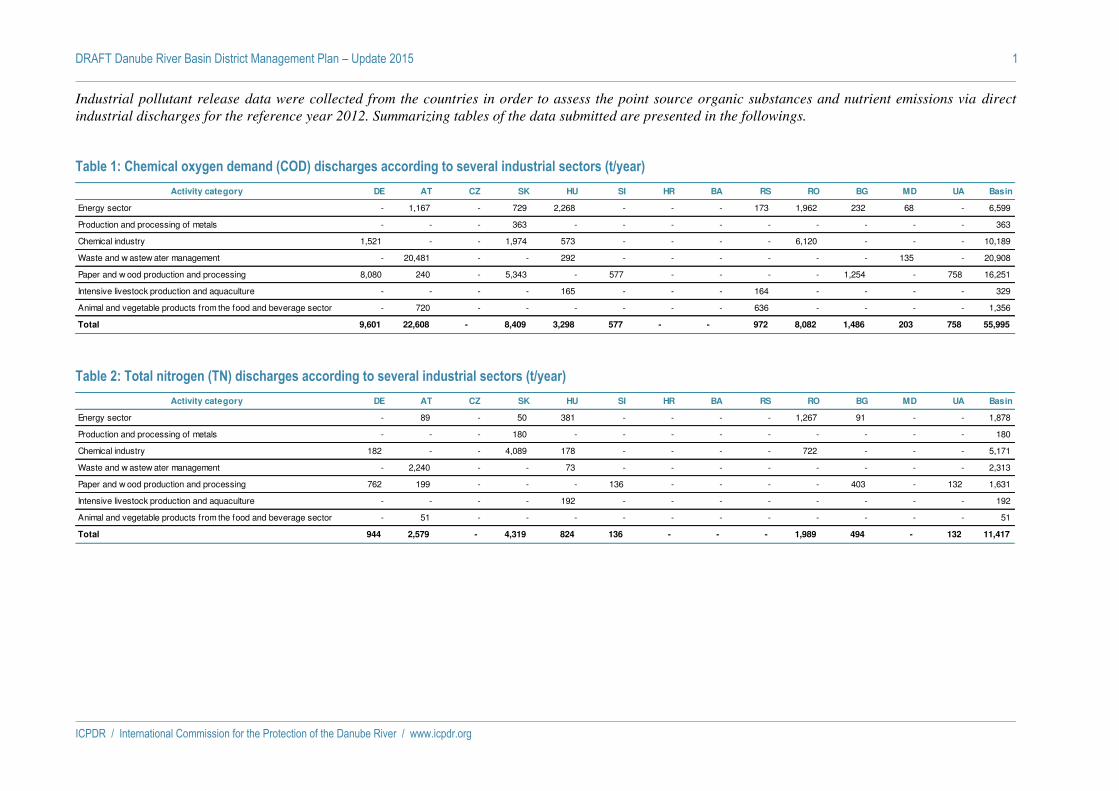
Industrial pollutant release data were collected from the countries in order to assess the point source organic substances and nutrient emissions via direct
industrial discharges for the reference year 2012. Summarizing tables of the data submitted are presented in the followings.
Table 1: Chemical oxygen demand (COD) discharges according to several industrial sectors (t/year)
Activity category DE AT CZ SK HU SI HR BA RS RO BG MD UA Basin
Energy sector - 1,167 - 729 2,268 - - - 173 1,962 232 68 - 6,599
Production and processing of metals - - - 363 - - - - - - - - - 363
Chemical industry 1,521 - - 1,974 573 - - - - 6,120 - - - 10,189
Waste and w astew ater management - 20,481 - - 292 - - - - - - 135 - 20,908
Paper and w ood production and processing 8,080 240 - 5,343 - 577 - - - - 1,254 - 758 16,251
Intensive livestock production and aquaculture - - - - 165 - - - 164 - - - - 329
Animal and vegetable products from the food and beverage sector - 720 - - - - - - 636 - - - - 1,356
Total 9,601 22,608 - 8,409 3,298 577 - - 972 8,082 1,486 203 758 55,995
Table 2: Total nitrogen (TN) discharges according to several industrial sectors (t/year)
Activity category DE AT CZ SK HU SI HR BA RS RO BG MD UA Basin
Energy sector - 89 - 50 381 - - - - 1,267 91 - - 1,878
Production and processing of metals - - - 180 - - - - - - - - - 180
Chemical industry 182 - - 4,089 178 - - - - 722 - - - 5,171
Waste and w astew ater management - 2,240 - - 73 - - - - - - - - 2,313
Paper and w ood production and processing 762 199 - - - 136 - - - - 403 - 132 1,631
Intensive livestock production and aquaculture - - - - 192 - - - - - - - - 192
Animal and vegetable products from the food and beverage sector - 51 - - - - - - - - - - - 51
Total 944 2,579 - 4,319 824 136 - - - 1,989 494 - 132 11,417
DRAFT Danube River Basin District Management Plan – Update 2015 2
ICPDR / International Commission for the Protection of the Danube River / www.icpdr.org
Table 3: Total phosphorus (TP) discharges according to several industrial sectors (t/year)
Activity category DE AT CZ SK HU SI HR BA RS RO BG MD UA Basin
Energy sector - 13 - - 8 - - - - 59 14 - - 94
Production and processing of metals - - - - - - - - - - - - - 0
Chemical industry 28 - - - 30 - - - - - - - - 59
Waste and w astew ater management - 76 - - 49 - - - - - - - - 125
Paper and w ood production and processing 107 9 - - - - - - - - 13 - 64 193
Intensive livestock production and aquaculture - - - - 12 - - - - - - - - 12
Animal and vegetable products from the food and beverage sector - 7 - - - - - - - - - - - 7
Total 136 105 - - 99 - - - - 59 27 - 64 490

ICPDR / International Commission for the Protection of the Danube River / www.icpdr.org
ANNEX 5
DRAFT DRBM Plan – Update 2015
List of Future Infrastructure Projects in the DRBD
DRAFT Danube River Basin District Management Plan – Update 2015 1
ICPDR / International Commission for the Protection of the Danube River / www.icpdr.org
Explanations
SEA = Strategic Environmental Assessment
EIA = Environmental Impact Assessment

DRAFT Danube River Basin District Management Plan – Update 2015 2
ICPDR / International Commission for the Protection of the Danube River / www.icpdr.org
Country River Water body Project title Main
purpose Description Project status
Start imple-mentation
Expected deterioration of water body
status
Trans-boundary
impact SEA EIA
Exemption WFD Art.
4(7)
AT Donau Donau_02, KW Freudenau bis
Devin, EP groß
Flussbauliches Gesamtprojekt -
Freudenau - Austrian border
Navigation Flussbauliches Gesamtprojekt -
Freudenau - Austrian border
Officially planned
2014 No No No Intended No
BG Dunav DUNAV RWB01
Improving the navigation of the
Bulgarian-Romanian section
of the Danube River
Navigation Improving the navigation of BG-RO Danube sectors from km 520 to km 530 -
Batin
Planning under preparation
2012 No Yes No Already done
No
BG Dunav DUNAV RWB01
Improving the navigation of the
Bulgarian-Romanian section
of the Danube River
Navigation Improving the navigation of BG-RO Danube sectors from km 576 to km 560 -
Belene
Planning under preparation
2012 No Yes No Already done
No
HR - Danube-Sava Canal
Navigation Construction of 61,4 km artificial canal (category Vb) from
Vukovar to Samac on the Sava River; will
shorten the waterway
Planning under preparation
2006 No Yes No Intended No
HR Sava DSRI010001, DSRI010002, DSRI010003, DSRI010004, DSRN010005, DSRN010006
Reconstruction and Improvement
of the Sava waterway in
Croatia
Navigation Reconstruction of the waterway, and upgrading it to
Category IV
Implementation of project
2003 No Yes No Already done
No
HU Sebes-Körös
Sebes-Körös felső
Árvízvédelmi biztonság
növelésének közös elősegítése a
Sebes-Körös bal parti
határszelvényénél
Flood protection
The project aims to raise the flood security
of the populationon Sebes-Körös.
Implementation of project
2013 No Yes No No No
HU Duna Duna Gönyü-Szob között
Komárom, Almásfüzitő árvízvédelmi
Flood protection
In the flood basin of Komarom-
Almasfuzito the
Implementation of project
2011 No No No No No

DRAFT Danube River Basin District Management Plan – Update 2015 3
ICPDR / International Commission for the Protection of the Danube River / www.icpdr.org
Country River Water body Project title Main
purpose Description Project status
Start imple-mentation
Expected deterioration of water body
status
Trans-boundary
impact SEA EIA
Exemption WFD Art.
4(7)
öblözet árvízvédelmi
biztonságának javítása (2.
forduló)
project aims to raise the security of the
population by increasing the dam
height
HU Tisza Tisza Belfő-csatornától
Keleti-főcsatornáig, Tisza Keleti-főcsatornától
Tiszabábolnáig, Tisza
Tiszabábolnától Kisköréig
Tiszai védvonal fejlesztések a
Tisza bal parton Tiszafüred–
Rakamaz között
Flood protection
The project aims to raise the flood security
of the population by reconstruction of the
dam, protecting forests and restoration of
engineering works.
Implementation of project
2008 No No No No No
HU -, Duna, Szentendrei
-Duna
Duna Bajától délre, Duna Gönyü-Szob között, Duna Szigetköznél,
Duna Szob-Baja között
Duna projekt Flood protection
The project aims to raise the flood security
of the population by increasing the dam
height at several segments and restoration of
engineering works.
Implementation of project
2009 No No Already done
No No
HU Tisza Tisza Kiskörétől Hármas-Körösig
Tisza hullámtér: Nagyvízi meder
vízszállító képességének
helyreállítása a szolnoki vasúti
híd és Kis
Flood protection
Between the settlements of Kisköre and Szolnok along the Tisza river the project aims to raise the flood security. The project increases the water
transport potential of the river bed.
Implementation of project
2009 No No No No No
HU Tisza Tisza Kiskörétől Hármas-Körösig
Árvízvédelmi fővédvonal fejlesztése,
Szolnok város térségi fejlesztése, a Tisza jobb parti
10.02-es
Flood protection
The project aims to raise the flood security
of the population in Szolnok.
Implementation of project
2010 No No No No No

DRAFT Danube River Basin District Management Plan – Update 2015 4
ICPDR / International Commission for the Protection of the Danube River / www.icpdr.org
Country River Water body Project title Main
purpose Description Project status
Start imple-mentation
Expected deterioration of water body
status
Trans-boundary
impact SEA EIA
Exemption WFD Art.
4(7)
HU Berettyó Berettyó Berettyó védtöltések
fejlesztése a Kis sárréti és a
Berettyóújfalui ártéri
öblözetekben
Flood protection
The project aims to raise the flood security
of the population by reconstruction of the
dam, protecting forests and restoration of
engineering works.
Implementation of project
2008 No No No No No
HU Duna Duna Szob-Baja között
Duna-menti árvízvédelmi beruházások Visegrádon
Flood protection
The project aims to raise the flood security
of the population in Visegrad.
Implementation of project
2011 No No No No No
HU Duna Duna Szob-Baja között
Sződliget Község árvízvédelmi
fejlesztése
Flood protection
The project aims to raise the flood security
of the population in Sződliget.
Implementation of project
2012 No No No No No
HU Mura Mura Mura 44+000-48+000 fkm
szelvények közötti szakaszának
mederrendezése, Murai
árvízvédelmi szakasz fejlesztése
II. forduló
Flood protection
Pit lakes are too close to the main river bed endangering the shore line to break in., The project aims to raise the flood security of
the population by increasing the dam
height
Implementation of project,
Planning under preparation
2011, 2015 No No Already done, No
Already done, No
No, Yes
HU Fekete-Körös
Fekete-Körös Mályvádi árvízi szükségtározó fejlesztése. 2.
forduló
Flood protection
The project aims to raise the flood security
by improving the condition of the Mályvád flood reservoir on the Fekete-Körös by
building new segments in the dam for water intake and increasing the height of the dam.
Implementation of project
2011 No No No No No
RO Dunarea PFII-Chiciu Imbunatatirea coditiilor de navigatie pe
sectorul comun
Navigation Imb.cond. de navig. pe Dunare intre km 824-
km403,prin redistrib.debit. intre
Planning under preparation
2011 No Yes No Already done
No

DRAFT Danube River Basin District Management Plan – Update 2015 5
ICPDR / International Commission for the Protection of the Danube River / www.icpdr.org
Country River Water body Project title Main
purpose Description Project status
Start imple-mentation
Expected deterioration of water body
status
Trans-boundary
impact SEA EIA
Exemption WFD Art.
4(7)
romano-bulgar - Popina - km 403-
km 408
Dunare si bratele secundare, redirijarea curentilor de apa si calibrarea albiei.12 puncte critice. EIA
este in curs de revizuire.
RO Dunarea PFII-Chiciu Imbunatatirea coditiilor de navigatie pe
sectorul comun romano-bulgar -
Corabia - km 626-km 632
Navigation Imb.cond. de navig. pe Dunare intre km 824-
km403,prin redistrib.debit. intre
Dunare si bratele secundare, redirijarea curentilor de apa si calibrarea albiei.12 puncte critice. EIA
este in curs de revizuire.
Planning under preparation
2011 No Yes No Already done
No
RO Dunarea PFII-Chiciu Imbunatatirea coditiilor de navigatie pe
sectorul comun romano-bulgar -
Bechet - km 675-km 678
Navigation Imb.cond. de navig. pe Dunare intre km 824-
km403,prin redistrib.debit. intre
Dunare si bratele secundare, redirijarea curentilor de apa si calibrarea albiei.12 puncte critice. EIA
este in curs de revizuire.
Planning under preparation
2011 No Yes No Already done
No
RO Dunarea PFII-Chiciu Imbunatatirea coditiilor de navigatie pe
sectorul comun romano-bulgar -
Dobrina - km 758-km 760
Navigation Imb.cond. de navig. pe Dunare intre km 824-
km403,prin redistrib.debit. intre
Dunare si bratele secundare, redirijarea curentilor de apa si calibrarea albiei.12 puncte critice. EIA
este in curs de revizuire.
Planning under preparation
2011 No Yes No Already done
No

DRAFT Danube River Basin District Management Plan – Update 2015 6
ICPDR / International Commission for the Protection of the Danube River / www.icpdr.org
Country River Water body Project title Main
purpose Description Project status
Start imple-mentation
Expected deterioration of water body
status
Trans-boundary
impact SEA EIA
Exemption WFD Art.
4(7)
RO Dunarea PFII-Chiciu Imbunatatirea coditiilor de navigatie pe
sectorul comun romano-bulgar -
B.Secia - km 783-km 786
Navigation Imb.cond. de navig. pe Dunare intre km 824-
km403,prin redistrib.debit. intre
Dunare si bratele secundare, redirijarea curentilor de apa si calibrarea albiei.12 puncte critice. EIA
este in curs de revizuire.
Planning under preparation
2011 No Yes No Already done
No
RO Dunarea PFII-Chiciu Imbunatatirea coditiilor de navigatie pe
sectorul comun romano-bulgar - Salcia - km 820-
km 824
Navigation Imb.cond. de navig. pe Dunare intre km 824-
km403,prin redistrib.debit. intre
Dunare si bratele secundare, redirijarea curentilor de apa si calibrarea albiei.12 puncte critice. EIA
este in curs de revizuire.
Planning under preparation
2011 No Yes No Already done
No
RO Dunarea Chiciu-Isaccea Imbunatatirea conditiilor de navigatie pe Dunare intre
Calarasi si Braila km 375-km175 -
etapa I
Navigation Executie lucrari hidrotehnice: km 196-
km 197 (bifurcatia bratului Caleea)
Implementation of project
2011 No No No Already done
No
RO Dunarea Chiciu-Isaccea Imbunatatirea conditiilor de navigatie pe Dunare intre
Calarasi si Braila km 375-km175 -
etapa I
Navigation Executie lucrari hidrotehnice: km 196-
km 197 (bifurcatia bratului Caleea)
Implementation of project
2011 No No No Already done
No
RO Dunarea Chiciu-Isaccea Imbunatatirea conditiilor de navigatie pe Dunare intre
Navigation Executie lucrari hidrotehnice: km 341-
km 342 (bifurcatia
Implementation of project
2011 No No No Already done
No
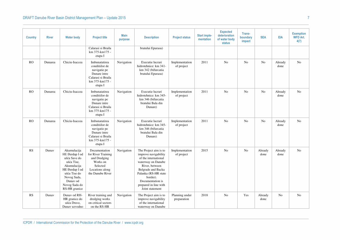
DRAFT Danube River Basin District Management Plan – Update 2015 7
ICPDR / International Commission for the Protection of the Danube River / www.icpdr.org
Country River Water body Project title Main
purpose Description Project status
Start imple-mentation
Expected deterioration of water body
status
Trans-boundary
impact SEA EIA
Exemption WFD Art.
4(7)
Calarasi si Braila km 375-km175 -
etapa I
bratului Epurasu)
RO Dunarea Chiciu-Isaccea Imbunatatirea conditiilor de navigatie pe Dunare intre
Calarasi si Braila km 375-km175 -
etapa I
Navigation Executie lucrari hidrotehnice: km 341-
km 342 (bifurcatia bratului Epurasu)
Implementation of project
2011 No No No Already done
No
RO Dunarea Chiciu-Isaccea Imbunatatirea conditiilor de navigatie pe Dunare intre
Calarasi si Braila km 375-km175 -
etapa I
Navigation Executie lucrari hidrotehnice: km 345-
km 346 (bifurcatia bratului Bala din
Dunare)
Implementation of project
2011 No No No Already done
No
RO Dunarea Chiciu-Isaccea Imbunatatirea conditiilor de navigatie pe Dunare intre
Calarasi si Braila km 375-km175 -
etapa I
Navigation Executie lucrari hidrotehnice: km 345-
km 346 (bifurcatia bratului Bala din
Dunare)
Implementation of project
2011 No No No Already done
No
RS Dunav Akumulacija HE Đerdap I od
ušća Save do ušća Tise,
Akumulacija HE Đerdap I od
ušća Tise do Novog Sada,
Dunav od Novog Sada do RS-HR granice
Documentation for River Training
and Dredging Works on Selected
Locations along the Danube River
Navigation The Project aim is to improve navigability of the international
waterway on Danube River, between
Belgrade and Backa Palanka (RS-HR state
border). Documentation is
prepared in line with Joint statement
Implementation of project
2015 No No Already done
Already done
No
RS Dunav Dunav od RH-HR granice do
ušća Drave, Dunav uzvodno
River training and dredging works
on critical sectors on the RS-HR
Navigation The Project aim is to improve navigability of the international
waterway on Danube
Planning under preparation
2018 No Yes Already done
No No

DRAFT Danube River Basin District Management Plan – Update 2015 8
ICPDR / International Commission for the Protection of the Danube River / www.icpdr.org
Country River Water body Project title Main
purpose Description Project status
Start imple-mentation
Expected deterioration of water body
status
Trans-boundary
impact SEA EIA
Exemption WFD Art.
4(7)
od ušća Drave joint stretch of the Danube River
River,on the common RS-HR sector.
RS Sava Sava uzvodno od ušća Drine
do RS-HR granice
Sava Waterway Rehabilitation
Project
Navigation The Project is part of a Program to improve navigability in the
Sava River between Belgrade, Serbia and
Sisak, Croatia.
Officially planned
2016 No Yes Already done
Intended No
RS Lim Lim uzvodno od akumulacije HE Potpeć do RS-
ME granice
Projekat izgradnje HE Brodarevo 1 i HE Brodarevo 1
Hydropower
Hydropower plant 26 MW
Officially planned
Not yet determined
Yes Yes Already done
Already done
Yes
RS Lim Lim uzvodno od akumulacije HE Potpeć do RS-
ME granice
Projekat izgradnje HE Brodarevo 1 i HE Brodarevo 2
Hydropower
Hydropower plant 32,4 MW
Officially planned
Not yet determined
Yes Yes Already done
Already done
Yes
SI Sava VT Sava Krško – Vrbina
Hidroelektrarna Brežice
Hydropower
Hydropower plant Implementation of project
2014 Yes No Already done
Already done
No
SI Sava VT Sava Krško – Vrbina
Hidroelektrarna Mokrice
Hydropower
Hydropower plant Officially planned
2016 Yes No Already done
Intended Yes

ICPDR / International Commission for the Protection of the Danube River / www.icpdr.org
ANNEX 6
DRAFT DRBM Plan – Update 2015
Groundwater in the DRBD
DRAFT Danube River Basin District Management Plan – Update 2015 2
ICPDR / International Commission for the Protection of the Danube River / www.icpdr.org
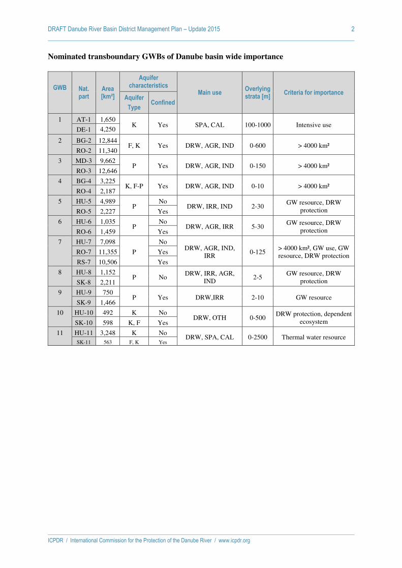
Nominated transboundary GWBs of Danube basin wide importance
GWB
Nat. part
Area [km²]
Aquifer characteristics
Main use Overlying strata [m]
Criteria for importance Aquifer
Type Confined
1 AT-1 1,650 K Yes SPA, CAL 100-1000 Intensive use
DE-1 4,250
2 BG-2 12,844 F, K Yes DRW, AGR, IND 0-600 > 4000 km²
RO-2 11,340
3 MD-3 9,662 P Yes DRW, AGR, IND 0-150 > 4000 km²
RO-3 12,646
4 BG-4 3,225 K, F-P Yes DRW, AGR, IND 0-10 > 4000 km²
RO-4 2,187
5 HU-5 4,989 P
No DRW, IRR, IND 2-30
GW resource, DRW protection RO-5 2,227 Yes
6 HU-6 1,035 P
No DRW, AGR, IRR 5-30
GW resource, DRW protection RO-6 1,459 Yes
7 HU-7 7,098
P
No DRW, AGR, IND,
IRR 0-125
> 4000 km², GW use, GW resource, DRW protection
RO-7 11,355 Yes
RS-7 10,506 Yes
8 HU-8 1,152 P No
DRW, IRR, AGR, IND
2-5 GW resource, DRW
protection SK-8 2,211
9 HU-9 750 P Yes DRW,IRR 2-10 GW resource
SK-9 1,466
10 HU-10 492 K No DRW, OTH 0-500
DRW protection, dependent ecosystem SK-10 598 K, F Yes
11 HU-11 3,248 K No DRW, SPA, CAL 0-2500 Thermal water resource
SK-11 563 F, K Yes

DRAFT Danube River Basin District Management Plan – Update 2015 3
ICPDR / International Commission for the Protection of the Danube River / www.icpdr.org
Nominated transboundary GWBs of Danube basin wide importance
Transboundary GWB Nat. part National GWB
Codes Area [km²]
Area [km²]
Aquifer characteri-sation
Main use
Ove
rlyi
ng
str
ata
Cri
teri
a fo
r im
po
rtan
ce
Aq
uif
er T
ype
Co
nfi
ned
1:
Deep Thermal
AT-1 ATGK100158 5,900 1,650 K Yes SPA, CAL 100–1000
Intensive use
DE-1 DEGK1110 4,250
2:
Upper Jurassic – Lower Cretaceous
BG-2 BG1G0000J3K051 24,184 12,844 F, K Yes DRW, AGR, IND
0–600 >4000 km²
RO-2 RODL06 11,340
3:
Middle Sarmatian - Pontian
MD-3 MDPR01 22,308
9,662 P Yes DRW, AGR, IND
0–150 >4000 km2
RO-3 ROPR05 12,646
4:
Sarmatian
BG-4 BG1G000000N049 5,412 3,225 K,
F-P
No DRW, AGR, IND
0–10 >4000 km2
RO-4 RODL04 2,187
5:
Mures / Maros
HU-5 HU_AIQ605
HU_AIQ604
HU_AIQ594
HU_AIQ593
7,216 4,989 P Yes / No
DRW, IRR, IND
2-30 GW resource, DRW protection
RO-5* ROMU20 ROMU22
2,227 1,774
6:
Somes / Szamos
HU-6 HU_AIQ649
HU_AIQ648
HU_AIQ600
HU_AIQ601
2,494 1,035 P Yes / No
DRW,AGR, IRR
5–30 GW resource, DRW protection
RO-6* ROSO01 ROSO13
1,459 1,392
7:
Upper Pannonian-Lower Pleistocene / Vojvodina / Duna-Tisza köze déli r.
HU-7 HU_AIQ528
HU_AIQ523
HU_AIQ532
HU_AIQ487
HU_AIQ590
HU_AIQ529
HU_AIQ522
HU_AIQ533
HU_AIQ486
HU_AIQ591
28,959 7,098 P Yes / Yes / No
DRW, AGR, IND, IRR
0–125 > 4000 km², GW use, GW resource, DRW protection
RO-7 ROBA18 11,355
RS-7 RS_TIS_GW_I_1
RS_TIS_GW_SI_1
RS_TIS_GW_I_2
RS_TIS_GW_SI_2
RS_TIS_GW_I_3
RS_TIS_GW_SI_3
RS_TIS_GW_I_4
RS_TIS_GW_SI_4
RS_TIS_GW_I_7
RS_TIS_GW_SI_7
RS_D_GW_I_1
RS_D_GW_SI_1
10,506
8:
Podunajska Basin, Zitny Ostrov / Szigetköz, Hanság-Rábca
HU-8 HU_AIQ654 HU_AIQ572
HU_AIQ653
HU_AIQ573
3,363 1,152 P No DRW, IRR, AGR, IND
2–5 GW resource, DRW protection
SK-8 SK1000300P SK1000200P
2,211

DRAFT Danube River Basin District Management Plan – Update 2015 4
ICPDR / International Commission for the Protection of the Danube River / www.icpdr.org
Transboundary GWB Nat. part National GWB
Codes Area [km²]
Area [km²]
Aquifer characteri-sation
Main use
Ove
rlyi
ng
str
ata
Cri
teri
a fo
r im
po
rtan
ce
Aq
uif
er T
ype
Co
nfi
ned
9:
Bodrog
HU-9 HU_AIQ495
HU_AIQ496
2,216 750
P Yes DRW,IRR 2–10 GW resource
SK-9 SK1001500P 1,466
10:
Slovensky kras / Aggtelek-hgs.
HU-10 HU_AIQ485 1,090 492 K
K, F
Yes / No
DRW, OTH 0–500 DRW protection, depend. ecosystems
SK-10 SK200480KF 598
11:
Komarnanska Vysoka Kryha / Dunántúli-khgs. északi r.
HU-11 HU_AIQ558
HU_AIQ552
HU_AIQ564
3,811 3,248 K Yes / No
DRW, SPA, CAL
0–2,500
Thermal water resource
SK-11 SK300010FK SK300020FK
563 F, K
*...GWBs overlying
Explanation to Table 1 and 2
Transboundary GWB ICPDR GWB code which is a unique identifier and the name
Nat. part Code of national shares of ICPDR GWB
National GWB Codes National codes of the individual GWBs forming the national part of a transboundary GWB of basin wide importance.
Area Whole area of the transboundary GWB covering all countries concerned / Area of national shares in km²
Aquifer
characterisation Aquifer Type: Predom. P = porous/ K = karst/ F = fissured. Multiple selections possible: Predominantly porous, karst, fissured and combinations are possible. Main type should be listed first.
Confined: Yes / No
Main use DRW = drinking water / AGR = agriculture / IRR = irrigation / IND = Industry / SPA = balneology / CAL = caloric energy / OTH = other. Multiple selections possible.
Overlying strata Indicates a range of thickness (minimum and maximum in metres)
Criteria for
importance If size < 4 000 km² criteria for importance of the GW body have to be named, they have to be bilaterally agreed upon.

DRAFT Danube River Basin District Management Plan – Update 2015 5
ICPDR / International Commission for the Protection of the Danube River / www.icpdr.org
Number of monitoring stations and density per GWB
Transboundary GWB
Nat. part
Area [km²]
QUALITY Associated to QUANTITY Associated to
Sites km²/
site
Sites bilaterally agreed for
data exchange
Drinking water protect
ed areas
Eco-system
s Sites
km²/ site
Sites bilaterally
agreed for data
exchange
Drinking water protect
ed areas
Eco-system
s
1 Deep Thermal
AT-1 1,650 4 413 -² - - 3 550 -² - - DE-1 4,250 4 1063 -² - - 4 1063 -² - - 5,900 8 738 7 843
2 Upper Jurassic – Lower Cretaceous
BG-2 12,844 6 2,141 6 yes - 6 2,141 6 yes - RO-2 11,340 26 436 -+ 5 - 1 11,318 -+ 0 -
24,184 32 756
7 3,479
3 Sarmatian – Pontian
MD-3 9,662 6 1,610 23 420 RO-3 12,646 14 903 0 6 - 10 1,253 0 0 - 22,308 20 1,115 33 673
4 Sarmatian
BG-4 3,225 5 645 5 yes - 4 806 4 yes - RO-4 2,187 21 104 -+ 2 - 13 167 0 - 5,412 26 208 17 318
5 Mures/Maros
HU-5 4,989 136 37 6 88 6 111 45 5 37 16
RO-5* 2,227 1,774
15 4
148 443 5 0 -
78 3
29 561 5 0 -
7,216 155 47 192 38
6 Somes/Szamos
HU-6 1,035 27 38 5 23 4 19 54 1 6 2
RO-6* 1,459 1,392
32 9
46 155 3
115 8
13 173 3
2,494 68 37 142 18
7 Upper Pannonian – Lower Pleisto-cene / Vojvodina / Duna-Tisza köze deli r.
HU-7 7,098 149 48 0 102 10 147 48 0 43 13 RO-7 11,355 25 454 23 - 16 712 18 - RS-7 10,506 16 657 0 ** ** 39 269 0 ** **
28,959 190 152 202 144
8 Podunajska Basin, Zitny Ostrov / Szigetköz, Hanság-Rábca
HU-8 1,152 54 21 19 35 18 106 11 41 55 31 SK-8 2,211 51 43 0 ** ** 277 8 136 ** **
3,363 105 32 383 9
9 Bodrog
HU-9 750 10 75 0 5 1 17 44 0 3 3 SK-9 1,466 17 86 0 ** ** 101 15 8 ** ** 2,216 27 82 118 19
10 Slovensky kras /Aggtelek-hsg.
HU-10 492 13 38 0 11 6 16 31 0 9 9 SK-10 598 5 120 0 ** ** 28 21 3 ** ** 1,090 18 6 44 2
11 Komarnanska Vysoka Kryha / Dunántúli-khgs. Északi r.
HU-11 3,248 24 135 0 22 8 45 72 0 20 18 SK-11 563 - - 0 ** ** - - - ** **
3,811 24 159
45 85
*...GWBs overlying; ** no information; ² unrestricted data exchange on demand; + will be updated

DRAFT Danube River Basin District Management Plan – Update 2015 6
ICPDR / International Commission for the Protection of the Danube River / www.icpdr.org
Explanation to Table 3
Transboundary GWB ICPDR GWB code which is a unique identifier and the name
Nat. part Code of national shares of ICPDR GWB
Area Area of the whole transboundary ICPDR GWB covering all countries concerned and of the national shares of the ICPDR GWB in km².
QUALITY / QUANTITY
Sites Number of monitoring sites – Reference year 2012/2013
km²/site Area in km² represented by each site – Reference year 2012/2013
Number of sites bilaterally
agreed for data exchange
Number of monitoring sites for which transboundary data exchange is bilaterally agreed.
Associated to
Drinking water protected
areas Number of monitoring sites associated to drinking water protected areas
Ecosystems Number of monitoring sites associated to ecosystems

DRAFT Danube River Basin District Management Plan – Update 2015 7
ICPDR / International Commission for the Protection of the Danube River / www.icpdr.org
Parameters and frequency for the surveillance monitoring program
AT/DE BG RS HU MD RO SK
Transboundary GWB 1 2, 4 7 5, 6, 7, 8, 9, 10, 11 3
2, 3, 4, 5, 6, 7
8, 9, 10, 11
QUALITY (with estimation of frequency)
Oxygen 1/a >1/a 1/a 1/6; <1/a 1/a >1/a pH-value 1/a >1/a 1/a >1/a* 1/a >1/a Electrical conductivity 1/a (cont. DE) >1/a 1/a >1/a* 1/a >1/a Nitrate 1/a >1/a 1/a >1/a* 1/a >1/a Ammonium 1/a >1/a 1/a >1/a* 1/a >1/a Temperature cont. >1/a 1/a >1/a* 1/a >1/a Further parameters, e.g. major ions x** x x x x x operational x x x x
QUANTITY (with estimation of frequency)
GW levels/well head pressure x x x x x x spring flows x x x x Flow characteristics x Extraction (not obligatory) x Reinjection (not obligatory) x
Remarks:
Transboundary GWB: Code of transboundary GWB of Danube basin wide importance >1/a: More than 1 per year x: Parameter is measured *… In the starting year **… A yearly program and a five year monitoring program were established. Further
parameters in DE are chloride, sulfate and total hardness

DRAFT Danube River Basin District Management Plan – Update 2015 8
ICPDR / International Commission for the Protection of the Danube River / www.icpdr.org
Summary table: Risk and Status Information of the ICPDR GW-bodies over a period of 2009 to 2021
GWB Nat. part
QUALITY QUANTITY
Status 2009
Status Pressure
Types 2009
Risk 2004 2015
Exemp-tions from
2015
Status 2015
Status Pressure
Types 2015
Significant upward trend
(parameter)
Trend reversal
(parameter)
Risk 2013 2021
Risk Pressure
Types 2021
Exemptions from 2021
(Date of achievement)
Status 2009
Status Pressure
Types 2009
Risk 2004 2015
Exemp-tions from
2015
Status 2015
Status Pressure
Types 2015
Risk 2013 2021
Risk Pressure
Types 2021
Exemptions from 2021
(Date of achievement)
1 AT-1 Good - - - Good - - - - - - Good - - - Good - - - -
DE-1 2 BG-2
Good - - - Good - - -
- - - Good - - - Good - - - - RO-2 - -
3 MD-3 Good -
Risk - Good -
Risk PS, DS, WA - Good - - - Good - - - -
RO-3 - - - 4 BG-4
Good - - - Good - - -
- - - Good - - - Good - - - - RO-4 - -
5 HU-5 Poor DS Risk Yes Poor DS
Risk DS
2027 Good -
Risk - Good - - - -
RO-5 NH4 2027 - 6 HU-6
Good - Risk
- Good -
- - -
Good - - - Good - - - - RO-6 - - - -
7 HU-7 Poor DS Risk Yes Poor DS Risk DS 2027 Poor WA Risk Yes Poor WA Risk WA 2027
RO-7 Good - - - Good - - - - - - Good - - - Good - - - -
RS-7 Good* - Risk Yes Good* - - - - Poor* WA Risk Yes Poor* WA Risk WA -** 8 HU-8 Poor DS Risk Yes Poor DS
Risk DS 2027 Poor WA Risk Yes Poor WA
- - - SK-8 Good Risk - Good -
NH4, NO3, Cl, As, SO4
- PS, DS - Good - - - Good -
9 HU-9 Good -
Risk - Good -
- - - Good - - - Good - - - -
SK-9 - - - 10 HU-10
Good - - - Good -
- - - Good - - - Good - - - SK-10 - -
11 HU-11 Good - Risk -
Good -
- - -
Poor WA Risk
Yes Poor WA Risk WA
2027
SK-11 Unknown Unknown* - Good - Unknown -
‘-‘ means ‘No’; * The status information is of low confidence as it is based on risk assessment; ** Not yet discussed
Explanation: see next page

DRAFT Danube River Basin District Management Plan – Update 2015 9
ICPDR / International Commission for the Protection of the Danube River / www.icpdr.org
Explanation to Table 4 GWB ICPDR GWB code which is a unique identifier. Nat. part Code of national shares of ICPDR GWBs
QUALITY / QUANTITY
Status 2009 Good / Poor
Status Pressure Types
2009
Indicates the significant pressures causing poor status in 2009. AR = artificial recharge, DS = diffuse sources, PS = point sources, OP = other significant pressures,
WA = water abstractions Risk 20042015 Risk / - (which means ‘no risk’)
Exemptions from 2015 Indicates whether there are exemptions for the GWB from achieving good status by 2015 at the latest.
Status 2015 Good / Poor
Status Pressure Types
2015
Indicates the significant pressures causing poor status in 2015. AR = artificial recharge, DS = diffuse sources, PS = point sources, OP = other significant pressures,
WA = water abstractions
Significant upward trend
(parameter)
Indicates for which parameter a significant sustained upward trend has been identified.
Trend reversal
(parameter) Indicates for which parameter a trend reversal could have been achieved.
Risk 20132021 Risk / - (which means ‘no risk’)
Risk Pressure Types
2021
Indicates the significant pressures causing risk of failing to achieve good status in 2021. AR = artificial recharge, DS = diffuse sources, PS = point sources, OP = other significant pressures, WA = water abstractions
Exemptions from 2021 Indicates the year by when good status is expected to be achieved.

DRAFT Danube River Basin District Management Plan – Update 2015 10
ICPDR / International Commission for the Protection of the Danube River / www.icpdr.org
Summary table: Reasons for failing good groundwater CHEMICAL status in 2015 for the ICPDR GW-bodies.
GWB Name National part Year of status assessment
Chemical Status
Which parameters cause poor status
Failed general assessment of GWB
as a whole Saline or other
intrusions
Failed achievement of WFD Article 4 objectives for
associated surface waters
Significant damage to GW dependent
terrestrial ecosystem
WFD Art 7 drinking water protected area affected
Increasing trend exceeding starting points of trend reversal
good / poor parameter Yes / No / Unknown
(parameter)
Yes / No / Unknown
(parameter)
Yes / No / Unknown
(parameter)
Yes / No / Unknown
(parameter)
Yes / No / Unknown
(parameter)
Yes / No / Unknown
(parameter)
GWB-1 Deep GWB – Thermal Water AT-1 2014 Good - - - - - - - DE-1 2014 Good - - - - - - -
GWB-2 Upper Jurassic – Lower Cretaceous GWB BG-2 2014 Good - - - - - - - RO-2 2014 Good - - - - - - -
GWB-3 Middle Sarmatian - Pontian GWB MD-3 2014 Good - - - - - - - RO-3 2014 Good - - - - - - -
GWB-4 Sarmatian GWB BG-4 2014 Good - - - - - - - RO-4 2014 Good - - - - - - -
GWB-5 Mures / Maros HU-5 2014 Poor nitrates Yes - - - - - RO-5 2014 Poor nitrates Yes - - - - -
GWB-6 Somes / Szamos HU-6 2014 Good - - - - - - - RO-6 2014 Good - - - - - - -
GWB-7 Upper Pannonian – Lower Pleistocene / Vojvodina / Duna-Tisza köze deli r.
HU-7 2014 Poor nitrates Yes - Yes - - - RO-7 2014 Good - - - - - - - RS-7 2013 Good* - - - - - - -
GWB-8 Podunajska Basin, Zitny Ostrov / Szigetköz, Hanság-Rábca
HU-8 2014 Poor nitrates Yes - - - - -
SK-8 2014 Good - - Unknown Unknown - (NH4,NO3 – agri)
(Cl, As, SO4, TOC – industry)
GWB-9 Bodrog HU-9 2014 Good - - - - - - - SK-9 2014 Good - - - Unknown Unknown - -
GWB-10 Slovensky kras / Aggtelek-hgs. HU-10 2014 Good - - - - - - - SK-10 2014 Good - - - Unknown Unknown - -
GWB-11 Komarnanska Vysoka Kryha / Dunántúli-khgs. északi r.
HU-11 2014 Good - - - - - - - SK-11 2014 Unknown - - - - - - Unknown
‘-‘ means ‘No’; * The status information is of low confidence as it is based on risk assessment;

DRAFT Danube River Basin District Management Plan – Update 2015 11
ICPDR / International Commission for the Protection of the Danube River / www.icpdr.org
Summary table: Reasons of failing good groundwater QUANTITATIVE status in 2015 for the ICPDR GW-bodies.
GWB Name National part Year of status assessment Quantitative status
Exceedance of available GW resource
Failed achievement of WFD Article 4 objectives for associated surface
waters
Significant damage to GW dependent terrestrial
ecosystem Uses affected (drinking
water use, irrigation etc.)
Intrusions detected or likely to happen due to alterations of flow
directions resulting from level changes
good / poor Yes / No / Unknown
Yes / No / Unknown
Yes / No / Unknown
Yes / No / Unknown
If yes, which?
Yes / No / Unknown
GWB-1 Deep GWB – Thermal Water AT-1 2014 Good - - - - - DE-1 2014 Good - - - - -
GWB-2 Upper Jurassic – Lower Cretaceous GWB BG-2 2014 Good - - - - - RO-2 2014 Good - - - - -
GWB-3 Middle Sarmatian - Pontian GWB MD-3 2014 Good - - - - - RO-3 2014 Good - - - - -
GWB-4 Sarmatian GWB BG-4 2014 Good - - - - - RO-4 2014 Good - - - - -
GWB-5 Mures / Maros HU-5 2014 Good - - - - - RO-5 2014 Good - - - - -
GWB-6 Somes / Szamos HU-6 2014 Good - - - - - RO-6 2014 Good - - - - -
GWB-7 Upper Pannonian – Lower Pleistocene / Vojvodina / Duna-Tisza köze deli r.
HU-7 2014 Poor Yes - Yes - - RO-7 2014 Good - - - - - RS-7 2013 Poor* Yes Unknown Unknown Unknown Unknown
GWB-8 Podunajska Basin, Zitny Ostrov / Szigetköz, Hanság-Rábca
HU-8 2014 Poor - - Yes - - SK-8 2014 Good - - - - -
GWB-9 Bodrog HU-9 2014 Good - - - - SK-9 2014 Good - - - - -
GWB-10 Slovensky kras / Aggtelek-hgs. HU-10 2014 Good - - - - SK-10 2014 Good - - - - -
GWB-11 Komarnanska Vysoka Kryha / Dunántúli-khgs. északi r.
HU-11 2014 Poor Yes Yes Yes - SK-11 2014 Unknown - - - - -
- means ‘No’; * The status information is of low confidence as it is based on risk assessment;

DRAFT Danube River Basin District Management Plan – Update 2015 12
ICPDR / International Commission for the Protection of the Danube River / www.icpdr.org
Summary table: Groundwater threshold values
GWB-2 GWB-3 GWB-4 GWB-5 GWB-6 GWB-7 GWB-8 GWB-9 GWB-10 GWB-11
Parameter unit RO-2 RO-3 RO-4 RO-5 HU-5 HU-6 RO-6 HU-7 RO-7 HU-8 SK-8 HU-9 SK-9 HU-10 HU-11
Ammonium mg/l 0.5 6.4 0.7 0.5–1.9 2–5 2–5 0.5–1.3 2–5 6.4 0.5–2 0.255–0.26 2–5 0.295 0 .5 0 .5
AOX µg/l 20 20 20 20 20 20 20
Arsenic µg/l 10 10–40 10 40 10 10 6
Benzene µg/l 10 10 10 10 10 10
Cadmium µg/l 5 5 5 5 5 5 5 5 5 5 5 5 5
Chloride mg/l 250 250 250 250 250 250 250 250 250 250 60.75–62.3 250 250 250
Chromium µg/l 500 50 500 50
Conductivity µS/cm 2500 2500 2500 2500 2500 2500 2500
Copper µg/l 100 100 100 100
Lead µg/l 10 10–70 10 10–20 10 10 30–70 10 10 10 10 10 10
Mercury µg/l 1 1 1 1 1 1 1 1 1 1 1 1
Nickel µg/l 200 20 20 20 20
Nitrates mg/l 50 50 50 50 50 50 50
Nitrites mg/l 0.5 0.5 0.5 0.5 0.5 0.5
Phenols µg/l 2 2 4
Phosphates mg/l 0.5–1.4 1.4 0.5 0.5–0.6 0.5 1
Sulphates mg/l 250 250 250 250 250–500 250 250 250–500 250 250 148.9–157.6 250 250 250
Tetrachloroethylen µg/l 10 10 10 10 10 10 10 10 10 10 10 10 10
Trichlorethylene µg/l 10 10 10 10 10 10 10 10 10 10 10 10 10
Zinc µg/l 5 5 5 5 5

DRAFT Danube River Basin District Management Plan – Update 2015 13
ICPDR / International Commission for the Protection of the Danube River / www.icpdr.org
Methodologies of status and trend assessment of the ICPDR GW-bodies
GWB-1: Deep Groundwater Body – Thermal Water
GWB-1 National share AT-1
DE-1
Status 2015 for each national GWB?
Quality (substance)
Quantity
List of individual GW-bodies forming the whole national share (national code incl. country code)
AT ATGK100158 Good Good DE DEGK1110 Good Good
Description/Characterisation of the ICPDR GW-body
The thermal groundwater of the Malm karst (Upper Jurassic) in the Lower Bavarian and
Upper Austrian Molasse Basin is of transboundary importance. It is used for spa purposes and
to gain geothermal energy. The geothermal used water is totally re-injected in the same
aquifer.
The transboundary GW-body covers a total area of 5,900 km²; the length is 155 km and the
width is up to 55 km. The aquifer is Malm (karstic limestone); the top of the Malm reaches a
depth of more than 1,000 m below sea level in the Bavarian part and 2,000 m in the Upper
Austrian part. The groundwater recharge is mainly composed of subterranean inflow of the
adjacent Bohemian Massif and infiltration of precipitation in the northern part of the GWB
area. The total groundwater recharge was determined to 820 l/s. The GW-body is selected as of
basin-wide importance because of its intensive use. An expert group takes care for the
permanent bilateral exchange of information and a sustainable transboundary use.
Description of status assessment methodology.
Chemical Status
The chemical status of the deep GWB will be described on the basis of measurement and
analysis data according to a procedure agreed between the two states. The decisive parameters
for the evaluation of the qualitative status of near-surface GWBs (such as nitrate and
pesticides) are not relevant for deep GWBs.
As expected, the parameters measured in the GWB extending over 5900 km² differ (in some
cases considerably) from site to site. This is due to regionally different geo-hydraulic
conditions. Therefore the description of the qualitative status cannot be made in the same way
as that for near-surface GWBs (on the basis of aggregated data), but made on the basis of
measurement and analysis data available at every individual measuring site. Contrary to near-
surface GWBs, it should be considered that, due to the utilization of the waters (balneological
and thermal uses), good status is not only not achieved if the concentration of certain contents
rises above a certain level, but also if it falls below it.
The available data is presently not sufficient to identify precisely enough the scope of
fluctuations relevant for individual parameters at the individual measuring sites.
Good chemical status is considered to be reached if the threshold value (TV) of the decisive
parameters neither exceed nor fall below the scope of fluctuations determined for every
measuring site. It is planned to examine the current selected scope of fluctuations on the basis
of many years of monitoring, (at least over a period of 10 years) and to adapt them, where
required.
In any case, the GWB is considered to be in a good chemical status if at least 75% of the
measuring sites meet good status.
The following parameters are used as a basis for the determination of the qualitative status of
the deep GWB: temperature, electrical conductivity, total hardness, sulphate and chloride.
Quantitative Status
No Changes since 2009
There is no interaction between deep groundwater and surface waters and/or terrestrial
ecosystems.
The quantitative status of the deep GWB can be described by means of:
- the identification of trends over a period of many years monitoring of the level of hydraulic
pressure at groundwater measuring sites and wells;

DRAFT Danube River Basin District Management Plan – Update 2015 14
ICPDR / International Commission for the Protection of the Danube River / www.icpdr.org
- a balancing calculation: a comparison between the thermal water supply and thermal
water abstractions.
Apart from Bad Füssing (records since 1948), no long-term monitoring of pressure potentials
that would be significant for a trend analysis is available.
As early as in 1998, detailed thermal water balancing was carried out for the deep GWB. In the
course of this balancing an exploitation of the available thermal water resources by thermal
water abstractions of about 25% was recorded, which corresponds to a good quantitative
status (at least 30% of the quantity available).
In the meantime, the extent of utilisation has been considerably reduced due to successfully
implemented management measures (among other things the obligation to reinject the used
thermal water exclusively). Good quantitative status could be even further improved on the
basis of the level of hydraulic pressure in the thermal waters of Bad Füssing which has risen
again since then.
With a view to the regionally uneven distribution of the available quantity, water abstraction
points and abstracted water quantities, a sub-division of the balance area into sub-areas can be
made. For these areas the decisive balance parameters can be determined separately
Groundwater threshold value relationships
No changes since 2009
Verbal description of the trend assessment methodology
No changes since 2009
Verbal description of the trend
reversal assessment methodology
No changes since 2009
Threshold values per GWB
Pollutant / Indicator TV (or range)
[unit]
NBL (or range)
[unit]
Level of TV
establishment
(national, RBD,
GWB)
Related to risk
in this GWB
[yes/-]

DRAFT Danube River Basin District Management Plan – Update 2015 15
ICPDR / International Commission for the Protection of the Danube River / www.icpdr.org
GWB-2: Upper Jurassic – Lower Cretaceous GWB
GWB-2 National share BG-2, RO-2 Status 2015 for each national GWB?
Quality (substance)
Quantity
List of individual GW-bodies forming the whole national share (national code incl. country code)
BG-2 BG1G0000J3K051 Good Good RO-2 RODL06 Good Good
Description/Characterisation of the ICPDR GW-body
Bulgaria: The starting point for identifying the geographical boundaries of the GWB
BG1G0000J3K051 (Upper Jurassic-Lower Cretaceous) is the geological boundaries. After that
additional sub-division on the basis of groundwater flow lines and piezometric heads.The
lithological composition of GWB is: limestones, dolomitic limestones and dolomites. Overlying
strata consists of marls, clays, sands, limestones, pebbles and loess. The age of the above
mentioned deposits is Hauterivian, Sarmatian, Pliocene and Quaternary. With the exception of
small cropped out areas the GWB is very well protected. There is no significant impact on the
GWB. The main use of groundwater is for drinking water, agriculture and industry supply.
There is no significant impact on the GWB in either Bulgaria (BG) or Romania (RO).
In Romania the GWB has an interaction with Lake Sintghiol situated near the Black Sea.
The criterion for selection as ‘important’ is for both GWBs the size which exceeds 4,000 km².
Description of status assessment methodology.
Chemical Status
Bulgaria: Assessment of the chemical status of groundwater has been done by: Analysing of the
results in individual monitoring points within each of the GWBs; Consideration of degree of
water exchange between groundwater and surface waters; Identifying of the pressures - sources
of pollution; The background levels have been used for threshold values determinations.
Threshold values have been determined according to CIS Guidance No. 18. Contamination
limits have been determined for all indicators listed in Annex II Part B of Directive 2006/118/EC
and indicators of the report under Art. 5 of Directive 2006/118/EC
a) nitrate , manganese , iron
b) for all pollutants and indicators of pollution have considered during the characterization
of groundwater bodies for risk assessment to not achieve good chemical status.
Romania: The criteria for the quality status assessment were: overlying strata for natural
protection, present groundwater quality, pressures and their impacts.
for each monitoring point the annual average concentrations for each indicators was
calculated; for the metals the concentration of the dissolved form was considered;
For each monitoring point the annual average concentration of the each parameters
was compared with the thresholds values (determined for each GWB) or standards
value (nitrates and pesticides).
The GWB is of good chemical status when no EQS or TV is exceeded in any monitoring
point.
The GWB is of poor chemical status when EQS or TV are exceeded at monitoring points
representing more than 20% of the GWB surface.
Quantitative Status
Bulgaria: applied that considers the impacts of anthropogenically induced long-term
alterations in groundwater level and/or flow in accordance with the "CIS Guidance № 18". Each test will assess whether the GWB is meeting the relevant environmental objectives. Not
all environmental objectives will apply to every GWB. Therefore only the relevant tests will
need to be applied as necessary.
Romania: The criterion for risk assessment of the quantity status is based on trend assessment
evolution of the groundwater levels. The quantitative status has been assessed taking into
account the CIS Guidance no.18. The following criteria have been used:
water balance
the connection with surface waters
the influence on the terrestrial ecosystems which depend directly on the GWB

DRAFT Danube River Basin District Management Plan – Update 2015 16
ICPDR / International Commission for the Protection of the Danube River / www.icpdr.org
the effects of saline or other intrusions
The quantitative status analysis has been done for the GWB level by comparing the average of
the hydrostatic level from 2011 (reference year) with the multiannual average levels (30–40
years)
Groundwater threshold value relationships
Receptors considered:
Romania: Drinking Water standards
Consideration of NBL and EQS (environmental quality standards, drinking water standards) in the TV establishment:
Romania: The methodology for TV establishment in Romania has been developed according to
CIS Guidance No. 18. NBL are the key elements in the process of TV setting. As described above,
during the TV establishment, the NBL have been compared with the drinking water standards.
The maximum allowable concentrations (MAC) provided by the Law no.458/2002 as amended,
were chosen as TV where NBL are smaller than MAC. Where NBL are higher than MAC, a small
addition of 0.2 NBL was used, in order to avoid misclassification of the respective GWB (TV =
NBL + 0.2 NBL = 1.2 NBL).
The updated list of TVs established for each GWB was published in the new Order of the Minster
no. 621/2014 approving TV for GWBs from Romania.
Bulgaria: The methodology for TV determination in Bulgaria has been developed according to
CIS Guidance No. 18. TVs are determined by comparing NBLs with criterial values (CVs).
CVs is the concentration of a pollutant (without taking into account the NBLs), which, if
exceeded, could lead to a distortion of the criteria for good status. CVs should take into
account the risk assessment and receptors of groundwater. The NBLs were determined for
each hydrogeological classes (5 classes) in the 90th percentile and 50th percentile (median) of
the statistical sample.
As a so called criterial values (CVs) have been used drinking water standards according to the
Bulgarian Regulation N-9
When we compare BLs and CVs may be two situations :
When BL is higher than CVi. In this case, TV is equal to BL.
When CV is higher than BL then TV = BL + Ktv* (CV-BL). 0 < Ktv < 1
As recommended and provides reasonable assurance can be assumed value of Ktv in the range
from 0.5 to 0.75.
Lower value (0.5) has a large certainty and should be used for GWBs, which have important
economic significance and are the sole source of drinking water supply of settlements. This value
should be used for such GWB to which they are attached particularly valuable wetlands
presence of dependent PA terrestrial ecosystems.
The higher value (0.75) should be used in all other cases or GWBs already classified bodies at
risk.
Verbal description of the trend assessment methodology
Bulgaria: The trend analysis is based on recognized statistical methods such as regression
method. Required information - period with average annual values, semi-annual or quarterly
values of the corresponding chemical component – for the first RBMP – period was 1995–2008; for the second RBMP, the period is 2006–2013. The lengths of the rows of chemical
components depend on the frequency of sampling and should be:
- In case of 1 value year: not less than 8 years with 8 values;
- In case of 2 values per year: at least 5 years with 10 values;
- In case of 4 values per year: not less than 3 years with 12–15 values.
Based on regression analysis is assessed whether there is a break in the trend i.e. after
sustained upward trend follows sustained downward trend or the opposite case the sustained
downward trend is followed by sustained upward trend.
Initially , the entire curve of the experimental data is approximated by a polynomial
curve of degree 2 ( quadratic regression curve).
If there is detected a maximum in the polynomial curve it means that a change of the
direction of the trend is available - from ascending to descending.
If there is detected a minimum in the polynomial curve it means that a change of the
direction of the trend is available - from descending to ascending.
Then, (in case of available maximum) the entire curve is divided into two branches : 1st
branch – till the date of the maximum and the second branch - after the peak.

DRAFT Danube River Basin District Management Plan – Update 2015 17
ICPDR / International Commission for the Protection of the Danube River / www.icpdr.org
In case with available minimum: 1st branch – till the date of the minimum and the second
branch - after the minimum.
Data from the first and second branch are considered separately and are approximated
by linear trends ( straight lines ) . The date at which it crossed the two approximating
straight lines corresponds to the date at which it changes the direction of the linear trend
- from ascending to descending or from descending to ascending
By extrapolation of the second ( falling) trend can be predicted date at which the starting
concentration ( 75% GWQS in our case 60% TV) will be reached
Romania: In order to assess the trend in pollutant concentrations, the results of the chemical
analysis from the monitoring points have been used. Minimum period of analysis was at least 10
years (2000–2011).
The methodology for identifying significant upper trends consists in adjustment and aggregation
of the data from each monitoring points on groundwater bodies. The trend analysis was done
using the Gwstat program.
The steps used for trend assessment were:
Identifying the monitoring points and the associated results of chemical analysis,
assessment of data series, for each year of reference period (2000–2011)
Establishment of baseline concentration for each parameter as the average concentration
registered during the year 2000
Calculation of annual average for the available data in each monitoring point
Significant upward trends were identified by Gwstat software, based on Anova Test
Verbal description of the trend
reversal assessment methodology
Bulgaria: The starting point for trend reversal should be placed where the concentration of the
pollutant reaches 75% of the groundwater quality standard or 75% of the threshold value of
the relevant pollutant. Selected starting points should be possible to reverse trends in the most
effective way before pollutant concentrations can cause irreversible changes in groundwater
quality. When we have GWB who responds too slowly to changes, there may be a need for an
early starting point and vice versa - for responsive GWB should be chosen starting point at a
later moment.
Initially, the entire curve of the experimental data is approximated by a polynomial curve of
degree 2 (quadratic regression curve).
If there is detected a maximum in the polynomial curve it means that a change of the direction
of the trend is available - from ascending to descending.
If there is detected a minimum in the polynomial curve it means that a change of the direction
of the trend is available - from descending to ascending.
Then, (in case of available maximum) the entire curve is divided into two branches: 1st branch
– till the date of the maximum and the second branch - after the peak
In case with available minimum: 1st branch – till the date of the minimum and the second
branch - after the minimum.
Data from the first and second branch are considered separately and are approximated by
linear trends (straight lines). The date at which it crossed the two approximating straight lines
corresponds to the date at which it changes the direction of the linear trend - from ascending
to descending or from descending to ascending
By extrapolation of the second (falling) trend can be predicted date at which the starting
concentration (75% GWQS in our case 60% TV) will be reached .Practically for the second
RBMP we have used 60 % from the TV.
Romania: Trend reversal assessment methodology consists also in the use of Gwstat software,
which, based on the 2 sections model, and processing the introduced data series, can indicate an
inversion in the trend slope, thus a trend reversal.
Threshold values per GWB
Pollutant /
Indicator TV (or range)
[unit] NBL (or range) [unit]
Level of TV
establishment
(national, RBD,
GWB)
Related
to risk in
this
GWB
[yes/-]
RO Nitrates 50 mg/l National -

DRAFT Danube River Basin District Management Plan – Update 2015 18
ICPDR / International Commission for the Protection of the Danube River / www.icpdr.org
RO Benzen 10 µg/l National -
RO Tricloretilena 10 µg/l National -
RO Tetracloretilena 10 µg/l National -
RO Ammonium 0.5 mg/l 0.31mg/l GWB -
RO Chlorides 250 mg/l 73,87 mg/l GWB -
RO Sulphates 250 mg/l 71,44 mg/l GWB -
RO Nitrites 0.5 mg/l 0.039 mg/l GWB -
RO Phosphates 0.5-1.4 mg/l 0.08 mg/l GWB -
RO Cadmium 0.005 mg/l 0.0001mg/l GWB -
RO Mercury 0.001 mg/l 0.000042 mg/l GWB -
RO Lead 0.01 mg/l 0.0011 mg/l GWB -
RO Arsenic 0.01 mg/l 0.00075 mg/l GWB -
GWB-3: Middle Sarmatian - Pontian GWB
GWB-3 National share MD-3
RO-3
Status 2015 for each national GWB?
Quality (substance)
Quantity
List of individual GW-bodies forming the whole national share (national code incl. country code)
MDPR01 Good Good ROPR05 Good Good
Description/Characterisation of the ICPDR GW-body
Romania: Geologically, the wells have pierced the following sub-stages of the Sarmatian:
Buglovian, Volhynian, Basarabian and Chersonian. The wells data have indicated that the
Sarmatian deposits thickness is highly variable, going from 295 m (Iaşi) to 886 m (Bârlad). It is considered that the Sarmatian deposits unconformably overlay the Late Badenian ones, because
the Early Buglovian is lacking. The upper boundary of Sarmatian, respectively the Sarmatian-
Meotian boundary, is difficult to assign due to the lack of sure paleontological elements.
Lithologically, the water-bearing deposits are constituted of thin layers with fine towards
medium grain-size (sands, rarely gravels), sometimes with lens aspect, situated at depth of 30–350 meters.
Hydrogeologically and hydrochemically, the investigation of wells data has revealed important
areal differences, of quantitative and qualitative order, both horizontally and vertically. The
differences of quantitative order are especially due to the Sarmatian deposits grain size.
The overlaying strata are predominantly represented by detritic Quaternary deposits.
The groundwater is mainly used for drinking water supply, agricultural and industrial supplies.
The criterion for selection as “important” consists in its size that exceeds 4,000 km2.
Moldova: Criteria for delineation are: geological boundaries; groundwater flow lines; chemical
and one quantitative status; GWB vulnerability; surface–groundwater interaction. The MD GWB
consists of four aquifers. First is the Baden-Sarmatian aquifer, which is the most productive and
most important for centralized water supply. Water-bearing layers are represented by limestone
with interlayers of fine grained sand, sometimes clays, marls and gypsum. Thickness of the
aquifer reaches 50 m, in some places up to 90 m, with average thickness of about 25 m. In the
northern part of the basin water bearing sediments outcrop to the pre-Quaternary surface and
these areas coincide with the recharge zones of the aquifer. Groundwater is discharging into the
valley of Prut river. Southwards Baden-Sarmatian aquifer occurs deeper and near the village
Gotesti it was detected by drilling at the depth of 572 m.
Hydraulic properties of the aquifer are rather poor. Hydraulic conductivity reaches 1–12 m/day,
with mean values of 5 m/day, transmissivity is also low – only 5–20 m²/day. Capacity of wells
varies in a range of 0.09–8l/s.
When water bearing rocks are composed of limestones they contain fresh or slightly mineralised
hydrocarbonate-calcium-sodium water with mineralization below 1 g/l. Such areas, however,
are rather scarce and groundwaters with mineralization above 1 g/l are prevailing in the basin.

DRAFT Danube River Basin District Management Plan – Update 2015 19
ICPDR / International Commission for the Protection of the Danube River / www.icpdr.org
Upper Sarmatian Meotic aquifer system (N1S3-m), which can be included in this GWB is only
partially exploited for groundwater abstraction in the southern part of the river basin. Sarmat-
Meotis deposits in the area are represented by fine-grained sands and clay with the lenses of
quartz sand with total thickness of the aquifer 60–70 m. This sand is water-bearing and contains
good quality water. The thickness of water bearing layers is 4–5 m. Yields of exploitation wells
vary between 3 and 7 m³/h. Waters from the aquifer system are supplying the needs of several
enterprises. Near the Prut river valley yields of the wells increase to 10 m³/h with the drawdown
of up to 30 m. This aquifer contains hydrocarbonate-sodium waters with total mineralization of
1–1.5 g/l. In some areas chemical composition changes to sulphate-hydrocarbonate-sodium and
mineralization increases to 2 g/l. Hydraulic parameters of the aquifer are rather poor: hydraulic
conductivity varies between 0.8–5 m/day with mean values of 2.3 m/day and transmissivity
changes in a range of 10–25 m²/day, mean being 5 m²/day.
Groundwater monitoring results over three wells for the period from 2005 to 2009 indicate a
decrease in the level of groundwater. The rate of decrease is 0.5–1.4 meter per year. This can be
attributed to an increase in the water abstraction from the operating wells located in the vicinity.
Middle Sarmatian (Congeriev) aquifer is used for a centralised water supply in the southern part
of Republic of Moldova. Groundwater is contained in fine-grained sands with interlayers of
clays, sandstones and limestones. Thickness of water bearing sediments varies from 5–15 m to
40–50 m with mean values of 20–30 m. Hydraulic properties of water bearing sands are quite
poor. Hydraulic conductivity changes from 0.6 to 1.9 m/day average being 1.3 m/day.
Transmissivity values are also very low and do not exceed 20–50 m²/day. Depth to groundwater
aquifer depends on the landscape and varies from 1.5 to 100 m. Yields of wells vary from 5 to 75
l/s. When hydrocarbonate-sulphate-chloride anions dominate in groundwater its mineralisation
is below 1.5 g/l. When chloride–hydrocarbonate and sodium ions prevail total mineralization
increases up to 2 g/l.
Groundwater from this aquifer is used for drinking and agricultural water supply in the southern
part of the basin, although its chemical quality is not very favourable for consumption.
Monitoring of the aquifer indicates a slight decrease in groundwater level with the rate of 0.4–0.65 m/a.
Pontian aquifer is spread in the southern part of Republic of Moldova. Water bearing sediments
are composed of sandy clays with interlayers of sand and shell limestone with the total thickness
of 70–80 m.
Prevailing hydraulic properties of water bearing sands are rather poor. Hydraulic conductivity
changes from 3.5–3.7 with mean values of 3 m/day. Transmissivity coefficient varies between
18–45 m²/day in some places (e.g. Giurgiulesti village) increasing to 250–260 m²/day. Depth to
groundwater aquifer depends on the landscape and varies from 2 to 125 m. Yields of wells vary
from 1.1–2.3 l/s, increasing southwards to 3.7–7.6 l/s. Near the village of Taraklia few springs
are discharging into Prut river valley with the capacity of 8–9 l/sec. Aquifer contains fresh
groundwater with mineralisation <1 g/l (figure 2.6) and prevailing ions of hydrocarbonate -
sulphate-chloride-sodium, sometimes sulphate –hydrocarbonate-sodium.
Groundwater from this aquifer is used for drinking and agricultural water supply in the southern
part of the basin.
Description of status assessment methodology.
Chemical Status
Romania: The criteria for the quality status assessment were: overlying strata for natural
protection, present groundwater quality, pressures and their impacts.
for each monitoring point the annual average concentrations for each indicator was
calculated; for the metals the concentration of the dissolved form was considered;
For each monitoring point the annual average concentration of the each parameters
was compared with the thresholds values (determined for each GWB) or standards
value (nitrates and pesticides).
The GWB is of good chemical status when no EQS or TV is exceeded in any monitoring
point.
The GWB is of poor chemical status when EQS or TV are exceeded at monitoring points
representing more than 20% of the GWB surface.
Quantitative Status:
Romania: The criterion for risk assessment of the quantity status is based on trend assessment
evolution of the groundwater levels. The quantitative status has been assessed taking into

DRAFT Danube River Basin District Management Plan – Update 2015 20
ICPDR / International Commission for the Protection of the Danube River / www.icpdr.org
account the CIS Guidance № 18. The following criteria have been used:
water balance
the connection with surface waters
the influence on the terrestrial ecosystems which depend directly on the GWB
the effects of saline or other intrusions
The quantitative status analysis has been done for the GWB level by comparing the average of
the hydrostatic level from 2011 (reference year) with the multiannual average levels (30–40
years)
Groundwater threshold value relationships
Receptors considered:
Romania: Drinking Water standards
Consideration of NBL and EQS (environmental quality standards, drinking water standards) in the TV establishment:
Romania: The methodology for TV establishment in Romania has been developed according to
CIS Guidance No. 18. NBL are the key elements in the process of TV setting. As described
previously, during the TV establishment, the NBL have been compared with the drinking water
standards. The maximum allowable concentrations (MAC) provided by the Law no.458/2002 as
amended, were chosen as TV where natural background levels (NBL) are smaller than MAC.
Where background levels are higher than MAC, a small addition of 0.2 NBL was used, in order
to avoid misclassification of the respective GWB (TV = NBL + 0.2 NBL = 1.2 NBL).
The updated list of TVs established for each GWB was published in the new Order of the Minster
no. 621/2014 approving TV for groundwater bodies from Romania.
Verbal description of the trend assessment methodology
Romania: In order to assess the trend in pollutant concentrations, the results of the chemical
analysis from the monitoring points have been used. Minimum period of analysis was at least 10
years (2000-2011).
The methodology for identifying significant upper trends consists in adjustment and aggregation
of the data from each monitoring points on groundwater bodies. The trend analysis was done
using the Gwstat program.
The steps used for trend assessment were:
Identifying the monitoring points and the associated results of chemical analysis,
assessment of data series, for each year of reference period (2000–2011)
Establishment of baseline concentration for each parameter as the average
concentration registered during the year 2000
Calculation of annual average for the available data in each monitoring point
Significant upward trends were identified by Gwstat software, based on Anova Test
Verbal description of the trend
reversal assessment methodology
RO: Trend reversal assessment methodology consists also in the use of Gwstat software, which,
based on the 2 sections model, and processing the introduced data series, can indicate an
inversion in the trend slope, thus a trend reversal.
Threshold values per GWB
Pollutant /
Indicator TV (or range)
[unit] NBL (or range) [unit]
Level of TV
establishment
(national, RBD,
GWB)
Related
to risk in
this
GWB
[yes/-]
RO Nitrates 50 mg/l National -
RO Benzen 10 µg/l National -
RO Tricloretilena 10 µg/l National -
RO Tetracloretilena 10 µg/l National -
RO Ammonium 6.4 mg/l 5,34 mg/l GWB -
RO Chlorides 250 mg/l 78,87 mg/l GWB -
RO Sulphates 250 mg/l 192 mg/l GWB -

DRAFT Danube River Basin District Management Plan – Update 2015 21
ICPDR / International Commission for the Protection of the Danube River / www.icpdr.org
RO Nitrites 0,5 mg/l 0.34 mg/l GWB -
RO Phosphates 1,4 mg/l 1,13 mg/l GWB -
RO Chromium 0,5 mg/l 0.0003033 mg/l GWB -
RO Nickel 0,2 mg/l 0.00053 mg/l GWB -
RO Copper 0,1 mg/l 0.00307 mg/l GWB -
RO Zinc 5 mg/l 0.02425 mg/l GWB -
RO Cadmium 0,005 mg/l 0.0000455 mg/l GWB -
RO Mercury 0,001 mg/l 0.000003385 mg/l GWB -
RO Lead 0,01-0,07 mg/l 0.0001825 mg/l GWB -
RO Arsenic 0,01-0,04 mg/l 0.003175 mg/l GWB -
GWB-4: Sarmatian GWB
GWB-4 National share BG-4, RO-4 Status 2015 for each national GWB?
Quality (substance)
Quantity
List of individual GW-bodies forming the whole national share (national code incl. country code)
BG-4 BG1G000000N049 Good Good RO-4 RODL04 Good Good
Description/Characterisation of the ICPDR GW-body
The starting point for identifying the boundaries of the GWB BG1G000000N049 Sarmatian is
the geological boundaries. The lithological composition of water-bearing deposits is as follows:
- in Bulgaria: limestones, sands;
- in Romania: oollitic limestones and organogenic limestones
Overlying strata consists of loess and loesses clays and clays. The age of the above mentioned
deposits is Quaternary. The GWB is vulnerable with cropped out regions of limestones and
sandstones or covered wit loess. GWB main use is for drinking water supply, agriculture and
industry supply.
The criterion for selection as ‘important’ is for both GWBs the size which exceeds 4,000 km².
Description of status assessment methodology.
Chemical Status
Bulgaria: Assessment of the chemical status of groundwater has been done by: Analysing of the
results in individual monitoring points within each of the GWBs; Consideration of degree of
water exchange between groundwater and surface waters; Identifying of the pressures - sources
of pollution; The background levels have been used for threshold values determinations.
Threshold values have been determined according to CIS Guidance No. 18. Contamination
limits have been determined for all indicators listed in Annex II Part B of Directive 2006/118/EC
and indicators of the report under Art. 5 of Directive 2006/118/EC
a) nitrate , manganese , iron
b) for all pollutants and indicators of pollution have considered during the characterization
of groundwater bodies for risk assessment to not achieve good chemical status.
Romania: The criteria for the quality status assessment were: overlying strata for natural
protection, present groundwater quality, pressures and their impacts.
for each monitoring point the annual average concentrations for each indicator was
calculated; for the metals the concentration of the dissolved form was considered;
For each monitoring point the annual average concentration of the each parameters
was compared with the thresholds values (determined for each GWB) or standards
value (nitrates and pesticides).
The GWB is of good chemical status when no EQS or TV is exceeded in any monitoring
point.
The GWB is of poor chemical status when EQS or TV are exceeded at monitoring points
representing more than 20% of the GWB surface.

DRAFT Danube River Basin District Management Plan – Update 2015 22
ICPDR / International Commission for the Protection of the Danube River / www.icpdr.org
Quantitative Status
Bulgaria: applied that considers the impacts of anthropogenically induced long-term
alterations in groundwater level and/or flow in accordance with the "CIS Guidance № 18". Each test will assess whether the GWB is meeting the relevant environmental objectives. Not
all environmental objectives will apply to every GWB. Therefore only the relevant tests will
need to be applied as necessary.
Romania: The criterion for risk assessment of the quantity status is based on trend assessment
evolution of the groundwater levels. The quantitative status has been assessed taking into
account the CIS Guidance no.18. The following criteria have been used:
water balance
the connection with surface waters
the influence on the terrestrial ecosystems which depend directly on the GWB
the effects of saline or other intrusions
The quantitative status analysis has been done for the GWB level by comparing the average of
the hydrostatic level from 2011 (reference year) with the multiannual average levels (30–40
years)
Groundwater threshold value relationships
Receptors considered:
Romania: Drinking Water standards
Consideration of NBL and EQS (environmental quality standards, drinking water standards) in the TV establishment:
Romania: The methodology for TV establishment in Romania has been developed according to
CIS Guidance No. 18. NBL are the key elements in the process of TV setting. As described above,
during the TV establishment, the NBL have been compared with the drinking water standards.
The maximum allowable concentrations (MAC) provided by the Law no.458/2002 as amended,
were chosen as TV where NBL are smaller than MAC. Where NBL are higher than MAC, a small
addition of 0.2 NBL was used, in order to avoid misclassification of the respective GWB (TV =
NBL + 0.2 NBL = 1.2 NBL).
The updated list of TVs established for each GWB was published in the new Order of the Minster
no. 621/2014 approving TV for GWBs from Romania.
Bulgaria: The methodology for TV determination in Bulgaria has been developed according to
CIS Guidance No. 18. The NBLs were determined for each hydrogeological classes (5 classes)
in the 90th percentile and 50th percentile (median) of the statistical sample.
As a so called criterial values (CVs) have been used drinking water standards according to the
Bulgarian Regulation N-9
When we compare BLs and CVs may be two situations :
When BL is higher than CVi. In this case, TV is equal to BL.
When CV is higher than BL then TV = BL + Ktv* (CV-BL). 0 < Ktv < 1
As recommended and provides reasonable assurance can be assumed value of Ktv in the range
from 0.5 to 0.75.
Lower value (0.5) has a large certainty and should be used for GWBs, which have important
economic significance and are the sole source of drinking water supply of settlements. This value
should be used for such GWB to which they are attached particularly valuable wetlands
presence of dependent PA terrestrial ecosystems.
The higher value (0.75) should be used in all other cases or GWBs already classified bodies at
risk.
Verbal description of the trend assessment methodology
Bulgaria: The trend analysis is based on recognized statistical methods such as regression
method. Required information - period with average annual values, semi-annual or quarterly
values of the corresponding chemical component – for the first RBMP – period was 1995–2008; for the second RBMP, the period is 2006–2013. The lengths of the rows of chemical
components depend on the frequency of sampling and should be:
- In case of 1 value year: not less than 8 years with 8 values;
- In case of 2 values per year: at least 5 years with 10 values
- In case of 4 values per year: not less than 3 years with 12–15 values
Based on regression analysis is assessed whether there is a break in the trend i.e. after
sustained upward trend follows sustained downward trend or the opposite case the sustained

DRAFT Danube River Basin District Management Plan – Update 2015 23
ICPDR / International Commission for the Protection of the Danube River / www.icpdr.org
downward trend is followed by sustained upward trend.
Initially , the entire curve of the experimental data is approximated by a polynomial
curve of degree 2 ( quadratic regression curve).
If there is detected a maximum in the polynomial curve it means that a change of the
direction of the trend is available - from ascending to descending.
If there is detected a minimum in the polynomial curve it means that a change of the
direction of the trend is available - from descending to ascending.
Then, (in case of available maximum) the entire curve is divided into two branches : 1st
branch – till the date of the maximum and the second branch - after the peak.
In case with available minimum: 1st branch – till the date of the minimum and the second
branch - after the minimum.
Data from the first and second branch are considered separately and are approximated
by linear trends ( straight lines ) . The date at which it crossed the two approximating
straight lines corresponds to the date at which it changes the direction of the linear trend
- from ascending to descending or from descending to ascending
By extrapolation of the second ( falling) trend can be predicted date at which the starting
concentration ( 75% GWQS in our case 60% TV) will be reached
Romania: In order to assess the trend in pollutant concentrations, the results of the chemical
analysis from the monitoring points have been used. Minimum period of analysis was at least 10
years (2000–2011).
The methodology for identifying significant upper trends consists in adjustment and aggregation
of the data from each monitoring points on groundwater bodies. The trend analysis was done
using the Gwstat program.
The steps used for trend assessment were:
Identifying the monitoring points and the associated results of chemical analysis,
assessment of data series, for each year of reference period (2000–2011)
Establishment of baseline concentration for each parameter as the average concentration
registered during the year 2000
Calculation of annual average for the available data in each monitoring point
Significant upward trends were identified by Gwstat software, based on Anova Test
Verbal description of the trend
reversal assessment methodology
Bulgaria: The starting point for trend reversal should be placed where the concentration of the
pollutant reaches 75% of the groundwater quality standard or 75% of the threshold value of
the relevant pollutant. Selected starting points should be possible to reverse trends in the most
effective way before pollutant concentrations can cause irreversible changes in groundwater
quality. When we have GWB who responds too slowly to changes, there may be a need for an
early starting point and vice versa - for responsive GWB should be chosen starting point at a
later moment.
Initially, the entire curve of the experimental data is approximated by a polynomial curve of
degree 2 (quadratic regression curve).
If there is detected a maximum in the polynomial curve it means that a change of the direction
of the trend is available - from ascending to descending.
If there is detected a minimum in the polynomial curve it means that a change of the direction
of the trend is available - from descending to ascending.
Then, (in case of available maximum) the entire curve is divided into two branches: 1st branch
– till the date of the maximum and the second branch - after the peak
In case with available minimum: 1st branch – till the date of the minimum and the second
branch - after the minimum.
Data from the first and second branch are considered separately and are approximated by
linear trends (straight lines). The date at which it crossed the two approximating straight lines
corresponds to the date at which it changes the direction of the linear trend - from ascending
to descending or from descending to ascending
By extrapolation of the second (falling) trend can be predicted date at which the starting
concentration (75% GWQS in our case 60% TV) will be reached .Practically for the second
RBMP we have used 60 % from the TV.
Romania: Trend reversal assessment methodology consists also in the use of Gwstat software,

DRAFT Danube River Basin District Management Plan – Update 2015 24
ICPDR / International Commission for the Protection of the Danube River / www.icpdr.org
which, based on the 2 sections model, and processing the introduced data series, can indicate an
inversion in the trend slope, thus a trend reversal.
Threshold values per GWB
Pollutant /
Indicator TV (or range)
[unit] NBL (or range) [unit]
Level of TV
establishment
(national, RBD,
GWB)
Related
to risk in
this
GWB
[yes/-]
RO Nitrates 50 mg/l National -
RO Benzen 10 µg/l National -
RO Tricloretilena 10 µg/l National -
RO Tetracloretilena 10 µg/l National -
RO Ammonium 0.7 mg/l 0.504 mg/l GWB -
RO Chlorides 250 mg/l 189 mg/l GWB -
RO Sulphates 250 mg/l 120.5 mg/l GWB -
RO Nitrites 0,5 mg/l 0.069 mg/l GWB -
RO Phosphates 0,5 mg/l 0.21 mg/l GWB -
RO Nickel 0,02 mg/l 0.035 mg/l GWB -
RO Zinc 5 mg/l 0.355 mg/l GWB -
RO Cadmium 0.005 mg/l 0.000202 mg/l GWB -
RO Mercury 0.001 mg/l 0.00012 mg/l GWB -
RO Lead 0.01mg/l 0.001 mg/l GWB -
RO Arsenic 0.01 mg/l 0.0013 mg/l GWB -
GWB-5: Mures / Maros
GWB-5 National share HU-5
RO-5
Status 2015 for each national GWB?
Quality (substance)
Quantity
List of individual GW-bodies forming the whole national share (national code incl. country code)
HU HU_AIQ605 Good Good HU HU_AIQ604 Good Good HU HU_AIQ594 Poor (nitrate) Good HU HU_AIQ593 Good Good RO ROMU20 Poor Good RO ROMU22 Good Good
Description/Characterisation of the ICPDR GW-body
The alluvial deposit of the Maros/Mures River lies along both sides of the southern Hungarian
– Romanian border, to the north of the actual river bed of the Maros/Mures. In particular, it is
an important water resource for drinking water purposes for both countries and water
abstraction in one country influences the water availability in the other.
The basin of the SE part of the Great Hungarian Plain is filled up with more than 2000 m thick
deposits of different ages, which are progressively thinning in Romania. The alluvial fan of the
Maros/Mures River forms the Pleistocene part of the strata. The aquifer is divided into several
GWBs in both countries. Despite the differences in the delineation method of the two countries,
it was possible to select the relevant water bodies from the transboundary point of view. Of the
four water bodies containing cold water in Hungary (HU), two contain Quaternary strata from
the surface to a depth of 30 m, namely the shallow GWBs (HU_AIQ605, HU_AIQ594).
Underneath them are two porous GWBs (GWB HU_AIQ604, HU_AIQ593), which, besides
Quaternary strata, include some parts of the Upper- Pannonian deposits as well (to a depth of
400–500 m corresponding to the surface separating cold and thermal waters). Two Quaternary
water bodies have been selected in Romania.
On the Romanian side, two water bodies are included in the transboundary evaluation because
in the Romanian method there is a separating horizon at the limit of the Upper (GWB

DRAFT Danube River Basin District Management Plan – Update 2015 25
ICPDR / International Commission for the Protection of the Danube River / www.icpdr.org
ROMU20) and Lower Pleistocene (GWB ROMU22) age of the strata. Both water bodies can be
lithologically characterised by pebbles, sands and clayey inter-layers, but the upper part is
significantly coarser with better permeability. Virtually following the same separation line on
the Hungarian side, the lower 100 m of the 250–300 m thick Pleistocene strata is silty-sand,
sandy-silt, sand and clay, and the upper part is mainly sand with gravel, so that permeability
improves towards the surface (the hydraulic conductivity of the aquifers ranges between 5–30
m/day). The covering layer is mainly sandy silt and clay of 3-13 m thickness.
On the Romanian side, the upper water body is unconfined and the lower is confined.
In Hungary both confined and unconfined conditions occur in the southern water bodies
(HU_AIQ604, HU_AIQ605) and mainly confined conditions are characteristic for the water
bodies of the upward flow system (HU_AIQ593, HU_AIQ594). The groundwater table is 2–4 m
below the surface in Hungary. Recharge in sandy areas has only local importance (15
Mm3/year). At present, because of the considerable amount of water abstracted from the deep
layers, there is a permanent recharge from shallow groundwater to the deep groundwater
system (app. 15 Mm³/year) and large areas with sandy-silty covered layers also contribute to
the recharge of the abstracted amount in Hungary. Another important element of the global
recharge of the Hungarian part is the lateral flow across the border, estimated at 15–20 Mm³/d
(uncertain value based on limited available knowledge). The direction of the groundwater flow
is from the recharge area to the discharge areas (main river valleys and zones with
groundwater level close to the surface) i.e. from SE to N and NW
Description of status assessment methodology.
Chemical status
Romania: The criteria for the chemical status assessment were: overlying strata for natural
protection, present groundwater quality, pressures and their impacts.
for each monitoring point the annual average concentrations for each indicator was
calculated; for the metals the concentration of the dissolved form was considered;
For each monitoring point the annual average concentration of the each parameters was
compared with the thresholds values (determined for each GWB) or standards value
(nitrates and pesticides).
The GWB is of good chemical status when no EQS or TV is exceeded in any monitoring
point.
The GWB is of poor chemical status when EQS or TV are exceeded at monitoring points
representing more than 20% of the GWB surface.
Quantitative Status
Romania: The criterion for risk assessment of the quantity status is based on trend assessment
evolution of the groundwater levels. The quantitative status has been assessed taking into
account CIS Guidance No.18. The following criteria have been used:
water balance
the connection with surface waters
the influence on the terrestrial ecosystems which depend directly on the GWB
the effects of saline or other intrusions
The quantitative status analysis has been done for the GWB level by comparing the average of
the hydrostatic level from 2011 (reference year) with the multiannual average levels (30–40
years).
Groundwater threshold value relationships
Receptors considered
Romania: Drinking Water standards
Consideration of NBL and EQS (environmental quality standards, drinking water standards) in the TV establishment:
Romania: The methodology for TV establishment in Romania has been developed according to
CIS Guidance No. 18. NBL are the key elements in the process of TV setting.
As described previously, during the TV establishment, the NBL have been compared with the
drinking water standards. The maximum allowable concentrations (MAC) provided by the Law
no.458/2002 as amended, were chosen as TV where NBL are smaller than MAC. Where
background levels are higher than MAC, a small addition of 0.2 NBL was used, in order to
avoid misclassification of the respective GWB (TV = NBL + 0.2 NBL = 1.2 NBL).
The updated list of TVs established for each GWB was published in the new Order of the

DRAFT Danube River Basin District Management Plan – Update 2015 26
ICPDR / International Commission for the Protection of the Danube River / www.icpdr.org
Minster no. 621/2014 approving TV for groundwater bodies from Romania.
Verbal description of the trend assessment methodology
Romania: In order to assess the trend in pollutant concentrations, the results of the chemical
analysis from the monitoring points have been used. Minimum period of analysis was at least
10 years (2000-2011).
The methodology for identifying significant upper trends consists in adjustment and
aggregation of the data from each monitoring points on groundwater bodies. The trend
analysis was done using the Gwstat program. The steps used for trend assessment were:
Identifying the monitoring points and the associated results of chemical analysis,
assessment of data series, for each year of reference period (2000–2011)
Establishment of baseline concentration for each parameter as the average
concentration registered during the year 2000
Calculation of annual average for the available data in each monitoring point
Significant upward trends were identified by Gwstat software, based on Anova Test
Verbal description of the trend reversal assessment methodology
Romania: Trend reversal assessment methodology consists also in the use of Gwstat
software, which, based on the 2 sections model, and processing the introduced data
series, can indicate an inversion in the trend slope, thus a trend reversal.
Threshold values per GWB
Pollutant / Indicator TV (or range)
[unit] NBL (or range) [unit]
Level of TV
establishment
(national,
RBD, GWB)
Related
to risk
in this
GWB
[yes/-]
HU Nitrates 50 mg/l 0,5-8,8 mg/l GWB yes
HU Ammonium 2-5 mg/l 1,97-3,6 mg/l GWB -
HU Conductivity 2500 µS/cm 1210-2500 µS/cm GWB -
HU Sulfate 250-500 mg/l 10-475 mg/l GWB -
HU Chloride 250 mg/l 32,5-240 mg/l GWB -
HU Arsenic µg/l 31,8-120 µg/l GWB -
HU Cadmium 5 µg/l 0,01-0,33 µg/l GWB -
HU Lead 10 µg/l 2,7-5 µg/l GWB -
HU Mercury 1 µg/l 0,39-0,49 µg/l GWB -
HU Trichlorethylene 10 µg/l GWB -
HU Tetrachloroethylene 10 µg/l GWB -
HU Absorbed organic
halogens AOX
20 µg/l GWB -
HU Pesticides by
components
0,1 µg/l GWB -
HU Pesticides all 0,5 µg/l GWB -
RO Nitrates 50 mg/l National Yes
RO Benzen 10 µg/l National -
RO Tricloretilena 10 µg/l National -
RO Tetracloretilena 10 µg/l National -
RO Ammonium 0.5–1.9 mg/l 0.216–1.56 mg/l GWB -
RO Chlorides 250 mg/l 66.755–179.57 mg/l GWB -
RO Sulphates 250 mg/l 102.04–193.99 mg/l GWB -
RO Nitrites 0,5 mg/l 0.046–0.2 mg/l GWB -
RO Phosphates 0,5–0.6 mg/l 0.134–0.5 mg/l GWB -
RO Chromium 0,05 mg/l 0.006296–0.00811mg/l GWB -
RO Nickel 0,02 mg/l 0.009–0.00836 mg/l GWB -
RO Copper 0.1 mg/l 0.0113–0.0117 mg/l GWB -
RO Zinc 5 mg/l 0.125–0.0274 mg/l GWB -
RO Cadmium 0.005 mg/l 0.0035 mg/l GWB -
RO Lead 0.01-0.02 mg/l 0.0075–0.01316 mg/l GWB -
RO Arsenic 0.04 mg/l 0.0289 mg/l GWB -
RO Phenols 0.002mg/l 0.0015 mg/l GWB -

DRAFT Danube River Basin District Management Plan – Update 2015 27
ICPDR / International Commission for the Protection of the Danube River / www.icpdr.org
GWB-6: Somes / Szamos
GWB-6 National share HU-6
RO-6
Status 2015 for each national GWB?
Quality (substance)
Quantity
List of individual GW-bodies forming the whole national share (national code incl. country code)
HU HU_AIQ649 Good Good HU HU_AIQ648 Good Good HU HU_AIQ600 Good Good HU HU_AIQ601 Good Good RO ROSO01 Good Good RO ROSO13 Good Good
Description/Characterisation of the ICPDR GW-body
Reasons for selection as an important transboundary GWB
The alluvial deposit of the Somes/Szamos River extends on both sides of the northern part of the
Hungarian-Romanian border. It is also connected to the aquifer system lying in Ukraine close
to the borders. The aquifer system supplies drinking water to a population of approx. 170,000
inhabitants in Romania and 50,000 inhabitants in Hungary. On the Hungarian side, due to the
lowland character and upward flow system, the terrestrial ecosystems require surplus
transpiration from groundwater; 7% of the area of the water body is under nature
conservation. The recharge zone is in Romania and Ukraine, thus the available groundwater
resource and the status of the terrestrial ecosystems on the Hungarian side depend on the
lateral flow from the neighbouring countries. The Romanian and Hungarian parts of the water
body complex are described below.
General description
The Somes/Szamos River has formed a 30–250 m thick alluvial deposit
The aquifer is divided into several GWBs in both countries. Despite the differences in the
delineation method of the two countries, it was possible to select the relevant water bodies from
the transboundary point of view.
Four water bodies containing cold water occur in Hungary. Two of them contain Quaternary
strata from the surface to a depth of 30 m, namely the shallow GWBs (HU_AIQ649,
HU_AIQ600). Underneath are the porous GWBs (HU_AIQ648, HU_AIQ601), which beside
Quaternary strata include some parts of the Upper- Pannonian deposits as well, to a depth of
400–500 m corresponding to the surface separating cold and thermal waters.
This Holocene-Pleistocene formation is divided vertically in Romania by the horizon separating
the Upper- and Lower-Pleistocene strata. In Romania two water bodies are considered,
overlapping each other, covering a surface of 1,440 km2. According to the Hungarian approach
of delineation, the cold part of the Upper-Pannonian and the Pleistocene and Holocene layers
are vertically unified. The Hungarian part can be characterised only by an upward flow system,
thus no further horizontal separation is applied. The area covered by the water body is 1,035
km2.
In Romania, the shallow (Holocene-Upper-Pleistocene) aquifer is unconfined, consisting of
sands, argillaceous sands, gravels and even boulders in the eastern part, and has a depth of
25–35 m. The silty-clayey covering layer is 5–15 m thick.
The deeper (Lower-Pleistocene) aquifer is confined (it is separated from the Upper-Pleistocene
part by a clay layer); its bottom is declining from 30 m to 130 m below the surface from East to
West. The gravely and sandy strata (characteristic to westwards from Satu-Mare town)
represent the main aquifer for water supply in the region.
In Hungary (as part of the cold water body), the Quaternary (Pleistocene) and Holocene strata
are 50 m thick at the Ukrainian border and its continuously declining bottom is around 200 m
below the surface at the western boundary. Mainly confined conditions characterise the
Hungarian part, with a silty clayey covering layer of 1–6 m (increasing from the NE to the SW).
The Quaternary aquifer is sand or gravelly sand, and the hydraulic conductivity ranges
between 10- 30 m/d. It should be noted that the Hungarian water body includes the cold water
bearing part of the Upper-Pannonian formation as well, to a depth of 400–500 m (under this
level, thermal water of a temperature greater than 30 ºC can be found).
Depth of the groundwater level (mainly pressure in confined area) below the surface ranges
between 2 and 5 m in Hungary. The flow direction is from the ENE to the WSW in both
countries, corresponding to the recharge and main discharge zones (rivers and area with

DRAFT Danube River Basin District Management Plan – Update 2015 28
ICPDR / International Commission for the Protection of the Danube River / www.icpdr.org
groundwater level close to the surface).
The recharge area is in the Romanian part of the water body (and in Ukraine). In Hungary the
infiltrated amount from local recharge zones supplies neighbouring discharge zones and
cannot be considered as part of the available groundwater resources.
Description of status assessment methodology.
Chemical status
Romania: The criteria for the chemical status assessment were: overlying strata for natural
protection, present groundwater quality, pressures and their impacts.
for each monitoring point the annual average concentrations for each indicatoris was
calculated; for the metals the concentration of the dissolved form was considered;
For each monitoring point the annual average concentration of the each parameters
was compared with the TVs (determined for each GWB) or standards value (nitrates
and pesticides).
The GWB is of good chemical status when no EQS or TV is exceeded in any
monitoring point.
The GWB is of poor chemical status when EQS or TV are exceeded at monitoring
points representing more than 20% of the GWB surface.
Quantitative Status
Romania: The criterion for risk assessment of the quantity status is based on trend assessment
evolution of the groundwater levels. The quantitative status has been assessed taking into
account the CIS Guidance No.18. The following criteria have been used:
water balance the connection with surface waters the influence on the terrestrial ecosystems which depend directly on the GWB the effects of saline or other intrusions
The quantitative status analysis has been done for the GWB level by comparing the average of
the hydrostatic level from 2011 (reference year) with the multiannual average levels (30–40
years)
Groundwater threshold value relationships
Receptors considered
Romania: Drinking Water standards
Consideration of NBL and EQS (environmental quality standards, drinking water standards) in the TV establishment:
Romania: The methodology for TV establishment in Romania has been developed according to
CIS Guidance No. 18. NBL are the key elements in the process of TV setting.
As described previously, during the TV establishment, the NBL have been compared with the
drinking water standards. The maximum allowable concentrations (MAC) provided by the Law
no.458/2002 as amended, were chosen as TV where natural background levels (NBL) are
smaller than MAC. Where background levels are higher than MAC, a small addition of 0.2
NBL was used, in order to avoid misclassification of the respective GWB (TV = NBL + 0.2 NBL
= 1.2 NBL).
The updated list of TVs established for each GWB was published in the new Order of the
Minster no. 621/2014 approving TV for groundwater bodies from Romania.
Verbal description of the trend assessment methodology
Romania: In order to assess the trend in pollutant concentrations, the results of the chemical
analysis from the monitoring points have been used. Minimum period of analysis was at least
10 years (2000-2011).
The methodology for identifying significant upper trends consists in adjustment and
aggregation of the data from each monitoring points on groundwater bodies. The trend
analysis was done using the Gwstat program.
The steps used for trend assessment were:
Identifying the monitoring points and the associated results of chemical analysis,
assessment of data series, for each year of reference period (2000–2011)
Establishment of baseline concentration for each parameter as the average
concentration registered during the year 2000
Calculation of annual average for the available data in each monitoring point
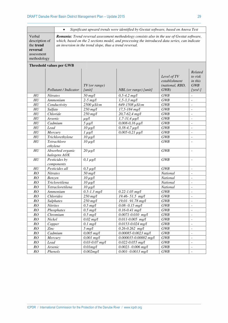
DRAFT Danube River Basin District Management Plan – Update 2015 29
ICPDR / International Commission for the Protection of the Danube River / www.icpdr.org
Significant upward trends were identified by Gwstat software, based on Anova Test
Verbal description of the trend
reversal assessment methodology
Romania: Trend reversal assessment methodology consists also in the use of Gwstat software,
which, based on the 2 sections model, and processing the introduced data series, can indicate
an inversion in the trend slope, thus a trend reversal.
Threshold values per GWB
Pollutant / Indicator TV (or range)
[unit] NBL (or range) [unit]
Level of TV
establishment
(national, RBD,
GWB)
Related
to risk
in this
GWB
[yes/-]
HU Nitrates 50 mg/l 0,5-4,2 mg/l GWB -
HU Ammonium 2-5 mg/l 1,5-3,3 mg/l GWB -
HU Conductivity 2500 µS/cm 649-1508 µS/cm GWB -
HU Sulfate 250 mg/l 17,5-184 mg/l GWB -
HU Chloride 250 mg/l 20,7-62,4 mg/l GWB -
HU Arsenic µg/l 1,7-31,4 µg/l GWB -
HU Cadmium 5 µg/l 0,008-0,16 µg/l GWB -
HU Lead 10 µg/l 0,38-4,7 µg/l GWB -
HU Mercury 1 µg/l 0,005-0,21 µg/l GWB -
HU Trichlorethylene 10 µg/l GWB -
HU Tetrachloro
ethylene
10 µg/l GWB -
HU Absorbed organic
halogens AOX
20 µg/l GWB -
HU Pesticides by
components
0,1 µg/l GWB -
HU Pesticides all 0,5 µg/l GWB -
RO Nitrates 50 mg/l National -
RO Benzen 10 µg/l National -
RO Tricloretilena 10 µg/l National -
RO Tetracloretilena 10 µg/l National -
RO Ammonium 0.5-1.3 mg/l 0.22-1.05 mg/l GWB -
RO Chlorides 250 mg/l 19.46- 51.5 mg/l GWB -
RO Sulphates 250 mg/l 19,01- 91.78 mg/l GWB -
RO Nitrites 0.5 mg/l 0.08- 0.15 mg/l GWB -
RO Phosphates 0.5 mg/l 0.16-0.41 mg/l GWB -
RO Chromium 0.5 mg/l 0.0071-0.010 mg/l GWB -
RO Nickel 0.02 mg/l 0.011-0.005 mg/l GWB -
RO Copper 0.1 mg/l 0.0153-0.024 mg/l GWB -
RO Zinc 5 mg/l 0.26-0.262 mg/l GWB -
RO Cadmium 0,005 mg/l 0.00085-0.0023 mg/l GWB -
RO Mercury 0,001 mg/l 0.000035-0.00002 mg/l GWB -
RO Lead 0.03-0.07 mg/l 0.022-0.055 mg/l GWB -
RO Arsenic 0.01mg/l 0.0021- 0.006 mg/l GWB -
RO Phenols 0.002mg/l 0.001- 0.0013 mg/l GWB -

DRAFT Danube River Basin District Management Plan – Update 2015 30
ICPDR / International Commission for the Protection of the Danube River / www.icpdr.org
GWB-7: Upper Pannonian – Lower Pleistocene / Vojvodina / Duna-Tisza köze deli r.
GWB-7 National share HU-7
RO-7
RS-7
Status 2015 for each national GWB?
Quality (substance)
Quantity
List of individual GW-bodies forming the whole national share (national code incl. country code)
HU HU_AIQ528 good good HU HU_AIQ523 good good HU HU_AIQ532 good good HU HU_AIQ487 good good HU HU_AIQ590 good poor HU HU_AIQ529 poor (nitrate) poor HU HU_AIQ522 good good HU HU_AIQ533 good poor HU HU_AIQ486 good good HU HU_AIQ591 poor (nitrate) poor RO ROBA18 good good RS RS_TIS_GW_I_1 good poor RS RS_TIS_GW_SI_1 good good RS RS_TIS_GW_I_2 good poor RS RS_TIS_GW_SI_2 good good RS RS_TIS_GW_I_3 good poor RS RS_TIS_GW_SI_3 good good RS RS_TIS_GW_I_4 good poor RS RS_TIS_GW_SI_4 good good RS RS_TIS_GW_I_7 good poor RS RS_TIS_GW_SI_7 good good RS RS_D_GW_I_1 good poor RS RS_D_GW_SI_1 good good
Description/Characterisation of the ICPDR GW-body
The GWB is mainly used for drinking water supply, agricultural and industrial supplies. The
criterion for selection as “important” consists in its size that exceeds 4,000 km².
The whole aquifer system of the Danube-Tisza region stretches from the foothills of the
northern mountainous region of Hungary to the Danube in Serbia, where the river flows to the
south-east. The western boundary is the Danube itself downstream of Budapest in Hungary but
after crossing the Hungarian border it enlarges towards Slavonia (western part of Backa in
Croatia). The eastern boundary is somewhat east from the Tisza River in Hungary and in
Serbia it includes the Banat as well, whose eastern part is in Romania. The Danube, Tisza and
Timis Rivers are important discharge-lines but cannot be considered as pure hydrodynamic
boundaries, since there is some flow under the river in the deeper aquifer that is not discharged
into the river.
The porous aquifer system between the Danube and Tisza Rivers is the biggest geological unit
of the Pannonian Basin. It lies mainly in Hungary and Serbia, with a smaller part in Croatia
and Romania. Serbia and Hungary have selected it as an important transboundary GWB
complex because: (i) size, (ii) importance in supplying drinking water for the population and
(iii) the need to satisfy the water demand of agriculture and industry, (iv) protected areas cover
a large part of the GWB complex (protection zones for vulnerable drinking water resources,
nature conservation areas and nitrate-sensitive areas).
In Serbia, the area of the whole Dunav aquifer system is 17,435 km² (the areas of Backa and
Banat). However, the transboundary importance is related only to the GWBs adjacent to the
state borders with Hungary (a total of 6 GWBs: 3 shallow (RS_TIS_GW_SI_1;
RS_TIS_GW_SI_2; RS_TIS_GW_SI_3) and 3 deep (RS_TIS_GW_I_1; RS_TIS_GW_I_2;
RS_TIS_GW_I_3)) and with Romania (a total of 6 GWBs: 3 shallow (RS_TIS_GW_SI_4;
RS_TIS_GW_SI_7; RS_D_GW_SI_1) and 3 deep (RS_TIS_GW_I_4; RS_TIS_GW_I_7;
RS_D_GW_I_1). The area of water bodies situated towards Hungary is 5,647 km2 and towards
Romania 4,859 km2, with a total aggregated area of 10,506 km2 for the Vojvodina GWB.
In Hungary, the aquifer system is divided into several water bodies according to major
subsurface catchment areas and downward-upward flow systems. For the transboundary
conciliation, only the southern part of the aquifer system is considered, which includes 10 cold

DRAFT Danube River Basin District Management Plan – Update 2015 31
ICPDR / International Commission for the Protection of the Danube River / www.icpdr.org
water bodies. Five of them contain Quaternary strata from the surface to a depth of 23–30 m.
Beneath these are five porous GWBs. Besides Quaternary strata, these include part of the
Upper-Pannonian deposits as well, to a depth of 400–500 m corresponding to the surface and
separating cold and thermal water bodies. The Hungarian part can be characterised by both
upward and downward flow systems that are the basis for the horizontal separation of the
GWBs. The area covered by these water bodies is 7,098 km2. The aquifer can be considered
unconfined in the shallow GWBs, despite a considerable area where the water level is in the
semi-permeable covering layer, and confined in the deeper ones.
The depth of the groundwater level below the surface ranges between 3 and 5 m in Hungary,
with a maximum depth of 7–12 m in the main recharge zones (HU_AIQ529, HU_AIQ591 and
HU_AIQ533).
In Romania, the aquifer system covers around 11,408 km2 and is adjacent to the state border
with Serbia. The GWB is generally confined, its covering strata being of Quaternary age. The
depth of the groundwater level below surface ranges from 3–20 m. The protection degree of the
GWB is very good. The main aquifer is the Quaternary alluvial deposit of the Danube lying on
the Pannonian strata. Its thickness is a few tens of meters at the northern, western and southern
boundary and increases up to 700 m in the middle of the basin (in the lower Tisza-valley). At
the eastern boundary, the thick Quaternary deposit is a mixture of the alluvial deposits of the
Danube and the Carpathian rivers. In respect to lithology, the aquifer consists of medium and
coarse sands and gravely sands with inter-layers and lenses of silty sands and silty clays.
Average hydraulic conductivity ranges between 5–30 m/d. The topographically elevated ridge
between the Danube and the Tisza is formed of eolian sand with relatively good recharge
conditions and phreatic groundwater. In the river valleys and east of the Tisza, mainly confined
conditions appear. The depth of the fluvial-swamp silty clays and swamp clays overlying strata
varies from 10-20 m in the western and southern part, and up to 100–125 m in the north-
eastern part of Backa and in Banat. Here, prior to intensive groundwater abstraction, an
artesian type of groundwater occurred.
The main recharge area is in Hungary, in the eolian sand ridge, and in Romania. In Hungary,
the estimated value of the recharge is approx. 220 Mm3/year. In Serbia, only local recharge
areas exist (areas of the Deliblat Sands and the Subotica/Horgos Sands), thus the lateral flow
crossing the border from the neighbouring country - as a component of the overall recharge - is
very important.
The groundwater is mainly discharged by the rivers (and drainage canals) and by the surplus
of evapotranspiration from vegetation in the areas characterised by groundwater levels close to
the surface. Small lakes and marshes in locally deeper areas (i.e. in topographic depressions)
must be considered as local discharge areas – they are important from the nature conservation
point of view. Besides natural discharge, there is also significant groundwater tapping for
various uses (drinking water, agriculture, industry, irrigation etc.). In Vojvodina, the entire
public water supply relies exclusively on groundwater from aquifers formed at different depths,
from 20 m to more than 200 m.
The direction of the groundwater flow in the upper part of the aquifer-system follows the
topography and recharge-discharge conditions. At the Hungarian-Serbian border, the flow
direction is almost parallel to the border (flowing slightly from Hungary towards Serbia). In
the deeper part, the general flow direction is NW to SE i.e. from the Danube to the Tisza in
Hungary and in Backa, while in northern Banat, the piezometric surface subsides from the
frontier zone towards the Tisza and the Timis, and in southern Banat, from the Deliblat Sands,
it dips to the south and towards the Danube.
Description of status assessment methodology.
Chemical status
Romania: The criteria for the quality status assessment were: overlying strata for natural
protection, present groundwater quality, pressures and their impacts.
for each monitoring point the annual average concentrations for each indicator was
calculated; for the metals the concentration of the dissolved form was considered;
For each monitoring point the annual average concentration of the each parameters
was compared with the TVs (determined for each GWB) or standards value (nitrates
and pesticides).
The GWB is of good chemical status when no EQS or TV is exceeded in any
monitoring point.
The GWB is of poor chemical status when EQS or TV are exceeded at monitoring

DRAFT Danube River Basin District Management Plan – Update 2015 32
ICPDR / International Commission for the Protection of the Danube River / www.icpdr.org
points representing more than 20% of the GWB surface.
Serbia: Depending on the available information for different GWBs, chemical status was
assessed using chemical monitoring data or (where no monitoring data was available) by using
risk assessment. To assess the risk of failure to achieve good chemical status due to diffuse
sources of pollution, a risk map was compiled based on natural characteristics and pollution
susceptibility (GW Vulnerability Map), and on local facilities and activities which might
contribute to pollution (CLC2000 map).
Quantitative Status
Romania: The criterion for risk assessment of the quantity status is based on trend assessment
evolution of the groundwater levels. The quantitative status has been assessed taking into
account CIS Guidance No.18. The following criteria have been used:
water balance
the connection with surface waters
the influence on the terrestrial ecosystems which depend directly on the GWB
the effects of saline or other intrusions
The quantitative status analysis has been done for the GWB level by comparing the average of
the hydrostatic level from 2011 (reference year) with the multiannual average levels (30–40
years)
Serbia: Considering the risk of not achieving good quantitative status, groundwater bodies
within which there is a registered trend of groundwater level decrease as a consequence of
abstraction are considered to be at risk. For this purpose, data time series of registered
groundwater levels were used only for shallow GWBs, since no organized monitoring of deep
aquifers exists.
For groundwater bodies where no quantitative monitoring exists, the estimate of groundwater
balance is calculated, using available data on precipitation, abstraction etc. Assessment of risk
from non-achievement of the good quantitative status until 2015 was carried out based on the
criteria that average GW abstraction over several years < 50% of groundwater recharge, no
substance intrusion into the body caused by the change of GW streaming direction and
associated surface ecosystems are not endangered by GW abstraction.
Groundwater threshold value relationships
Receptors considered:
Romania: Drinking Water standards
Consideration of NBL and EQS (environmental quality standards, drinking water standards) in the TV establishment:
Romania: The methodology for TV establishment in Romania has been developed according to
CIS Guidance No. 18. NBL are the key elements in the process of TV setting.
As described previously, during the TV establishment, the NBL have been compared with the
drinking water standards. The maximum allowable concentrations (MAC) provided by the Law
no.458/2002 as amended, were chosen as TV where natural background levels (NBL) are
smaller than MAC. Where background levels are higher than MAC, a small addition of 0.2
NBL was used, in order to avoid misclassification of the respective GWB (TV = NBL + 0.2 NBL
= 1.2 NBL).
The updated list of TVs established for each GWB was published in the new Order of the
Minster no. 621/2014 approving TV for groundwater bodies from Romania.
Verbal description of the trend assessment methodology
Romania: In order to assess the trend in pollutant concentrations, the results of the chemical
analysis from the monitoring points have been used. Minimum period of analysis was at least
10 years (2000-2011).
The methodology for identifying significant upper trends consists in adjustment and
aggregation of the data from each monitoring points on groundwater bodies. The trend
analysis was done using the Gwstat program. The steps used for trend assessment were:
Identifying the monitoring points and the associated results of chemical analysis,
assessment of data series, for each year of reference period (2000–2011)
Establishment of baseline concentration for each parameter as the average
concentration registered during the year 2000
Calculation of annual average for the available data in each monitoring point

DRAFT Danube River Basin District Management Plan – Update 2015 33
ICPDR / International Commission for the Protection of the Danube River / www.icpdr.org
Significant upward trends were identified by Gwstat software, based on Anova Test
Serbia: No methodology for trend assessment has been developed.
Verbal description of the trend
reversal assessment methodology
Romania: Trend reversal assessment methodology consists also in the use of Gwstat software,
which, based on the 2 sections model, and processing the introduced data series, can indicate
an inversion in the trend slope, thus a trend reversal.
Serbia: No methodology for trend reversal assessment has been developed
Threshold values per GWB
Pollutant / Indicator TV (or range)
[unit] NBL (or range) [unit]
Level of TV
establishment
(national, RBD,
GWB)
Related
to risk
in this
GWB
[yes/-]
HU Nitrates 50 mg/l 0,5-6,1 mg/l GWB yes
HU Ammonium 2-5 mg/l 1,3-3,6 mg/l GWB -
HU Conductivity 2500 µS/cm 565-1710 µS/cm GWB -
HU Sulfate 250-500 mg/l 5,6-333 mg/l GWB -
HU Chloride 250 mg/l 8-159 mg/l GWB -
HU Arsenic µg/l 10-106 µg/l GWB -
HU Cadmium 5 µg/l 0,01-0,3µg/l GWB -
HU Lead 10 µg/l 1-8,2 µg/l GWB -
HU Mercury 1 µg/l 0,005-0,52 µg/l GWB -
HU Trichlorethylene 10 µg/l GWB -
HU Tetrachloro
ethylene
10 µg/l GWB -
HU Absorbed organic
halogens AOX
20 µg/l GWB -
HU Pesticides by
components
0,1 µg/l GWB -
HU Pesticides all 0,5 µg/l GWB -
RO Nitrates 50 mg/l National -
RO Benzen 10 µg/l National -
RO Tricloretilena 10 µg/l National -
RO Tetracloretilena 10 µg/l National -
RO Ammonium 6.4 mg/l 5.33 mg/l GWB -
RO Chlorides 250 mg/l 51.66 mg/l GWB -
RO Sulphates 250 mg/l 69.47 mg/l GWB -
RO Nitrites 0.5 mg/l 0.137 mg/l GWB -
RO Phosphates 1 mg/l 0.774 mg/l GWB -
RO Chromium 0.05 mg/l 0.00505 mg/l GWB -
RO Nickel 0.02 mg/l 0.009573 mg/l GWB -
RO Copper 0,1 mg/l 0.017913 mg/l GWB -
RO Zinc 5 mg/l 0.350642 mg/l GWB -
RO Cadmium 0.005 mg/l 0.000333 mg/l GWB -
RO Mercury 0.001 mg/l 0.0004 mg/l GWB -
RO Lead 0.01-mg/l 0.00744 mg/l GWB -
RO Phenols 0.004 mg/l 0.003 mg/l GWB -

DRAFT Danube River Basin District Management Plan – Update 2015 34
ICPDR / International Commission for the Protection of the Danube River / www.icpdr.org
GWB-8: Podunajska Basin, Zitny Ostrov / Szigetköz, Hanság-Rábca
GWB-8 National share HU-8
SK-8
Status 2015 for each national GWB?
Quality (substance)
Quantity
List of individual GW-bodies forming the whole national share (national code incl. country code)
HU HU_AIQ654 good good HU HU_AIQ572 good good HU HU_AIQ653 poor (nitrate) good HU HU_AIQ573 good poor SK SK1000300P good good SK SK1000200P good good
Description/Characterisation of the ICPDR GW-body
Slovak Republic: The delineation consists of the following steps:
1. The aquifers are vertically divided in three floors: Quaternary sediments, Pre-
quaternary strata containing cold waters, thermal aquifers (temperature > 25°C or it
is considered as thermal by classification).
2. The pre-quaternary strata are further divided horizontally by geological types of the
aquifer: volcanic rocks, other fissured rocks, karstic rocks, porous sediments.
3. Further separation is due to the borders of the surface catchment areas considered as
river basin management units.
Hungary: The delineation of groundwater bodies in Hungary has been carried out by:
1. Separation of the main geological features: porous aquifers in the basins, karstic
aquifers, mixed formations of the mountainous regions, other than karstic aquifers.
2. Thermal water bodies are separated according to the temperature greater than 30 °C.
In the case of porous aquifers it is done vertically, while in karstic aquifers
horizontally. There are no thermal aquifers in the mountainous regions other than
karstic.
3. Further division is related to the subsurface catchment areas and vertical flow system
(in the case of porous aquifers) and to the structural and hydrological units (in the
case of karstic aquifers and mountainous regions).
For transboundary water bodies the more detailed further characterisation is carried out (n.b.
because of the numerous transboundary water bodies and the expected further 20–30 % due to
the risk of failing good status, Hungary decided to apply the methodology of further
characterisation for all water bodies).
Reasons for selecting as important transboundary GWB
The large alluvial deposit of the River Danube downstream Bratislava lies in three countries:
Slovakia (Podunajská lowland and its part: Žitný ostrov), Hungary (Northern part of Kisalföld
including the Szigetköz) and in Austria. The aquifer system has been considered by Slovakia
and Hungary as an important transboundary aquifer because of (i) its size, (ii) the unique
amount of available groundwater resource and the important actual use for drinking water and
other purposes as well (iii) the groundwater dependent terrestrial ecosystem of the floodplain,
(iv) majority of the area is protected (protection zones of drinking water abstraction sites,
nitrate sensitive areas, nature conservation areas), (v) the existence of the Gabcikovo
Hydropower System.
General description
The Danube has been playing the decisive role in the formation of the aquifer system. The main
aquifer is made up of 15–500 m thick Quaternary alluvia: hydraulically connected mixture of
sands, gravels, intercalated with numerous clay and silt lenses. The average hydraulic
conductivity is in the range of 100–500 m/day providing extremely high transmissivity,
especially in the centre of the basin. Here, the bottom of the underlying Pannonian deposits is
at a depth of 3,500 m.
The aquifer is divided into several groundwater bodies in both countries. Despite the
differences in the delineation method of the two countries, it was possible to select the relevant
water bodies from transboundary point of view: two water bodies containing cold water in
Hungary, which beside the Quaternary strata include some part of the Upper-Pannonian
deposits as well, to the depth of 400–500 m corresponding to the surface separating cold and
thermal waters (1,152 km2) and two Quaternary water bodies in Slovakia (2,211 km2) have
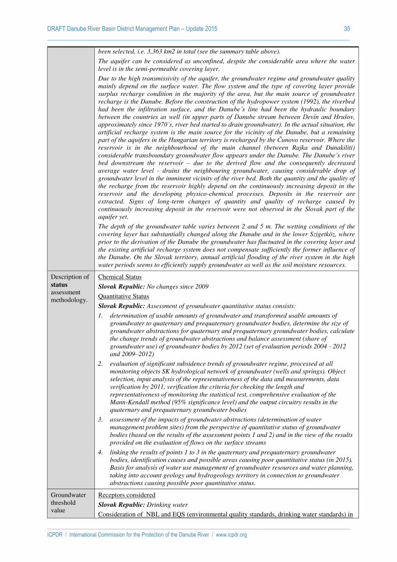
DRAFT Danube River Basin District Management Plan – Update 2015 35
ICPDR / International Commission for the Protection of the Danube River / www.icpdr.org
been selected, i.e. 3,363 km2 in total (see the summary table above).
The aquifer can be considered as unconfined, despite the considerable area where the water
level is in the semi-permeable covering layer.
Due to the high transmissivity of the aquifer, the groundwater regime and groundwater quality
mainly depend on the surface water. The flow system and the type of covering layer provide
surplus recharge condition in the majority of the area, but the main source of groundwater
recharge is the Danube. Before the construction of the hydropower system (1992), the riverbed
had been the infiltration surface, and the Danube’s line had been the hydraulic boundary between the countries as well (in upper parts of Danube stream between Devín and Hrušov, approximately since 1970’s, river bed started to drain groundwater). In the actual situation, the artificial recharge system is the main source for the vicinity of the Danube, but a remaining
part of the aquifers in the Hungarian territory is recharged by the Čunovo reservoir. Where the reservoir is in the neighbourhood of the main channel (between Rajka and Dunakiliti)
considerable transboundary groundwater flow appears under the Danube. The Danube’s river bed downstream the reservoir – due to the derived flow and the consequently decreased
average water level - drains the neighbouring groundwater, causing considerable drop of
groundwater level in the imminent vicinity of the river bed. Both the quantity and the quality of
the recharge from the reservoir highly depend on the continuously increasing deposit in the
reservoir and the developing physico-chemical processes. Deposits in the reservoir are
extracted. Signs of long-term changes of quantity and quality of recharge caused by
continuously increasing deposit in the reservoir were not observed in the Slovak part of the
aquifer yet.
The depth of the groundwater table varies between 2 and 5 m. The wetting conditions of the
covering layer has substantially changed along the Danube and in the lower Szigetköz, where
prior to the derivation of the Danube the groundwater has fluctuated in the covering layer and
the existing artificial recharge system does not compensate sufficiently the former influence of
the Danube. On the Slovak territory, annual artificial flooding of the river system in the high
water periods seems to efficiently supply groundwater as well as the soil moisture resources.
Description of status assessment methodology.
Chemical Status
Slovak Republic: No changes since 2009
Quantitative Status
Slovak Republic: Assessment of groundwater quantitative status consists:
1. determination of usable amounts of groundwater and transformed usable amounts of
groundwater to quaternary and prequaternary groundwater bodies, determine the size of
groundwater abstractions for quaternary and prequaternary groundwater bodies, calculate
the change trends of groundwater abstractions and balance assessment (share of
groundwater use) of groundwater bodies by 2012 (set of evaluation periods 2004 - 2012
and 2009–2012)
2. evaluation of significant subsidence trends of groundwater regime, processed at all
monitoring objects SK hydrological network of groundwater (wells and springs). Object
selection, input analysis of the representativeness of the data and measurements, data
verification by 2011, verification the criteria for checking the length and
representativeness of monitoring the statistical test, comprehensive evaluation of the
Mann-Kendall method (95% significance level) and the output circuitry results in the
quaternary and prequaternary groundwater bodies
3. assessment of the impacts of groundwater abstractions (determination of water
management problem sites) from the perspective of quantitative status of groundwater
bodies (based on the results of the assessment points 1 and 2) and in the view of the results
provided on the evaluation of flows on the surface streams
4. linking the results of points 1 to 3 in the quaternary and prequaternary groundwater
bodies, identification causes and possible areas causing poor quantitative status (in 2015).
Basis for analysis of water use management of groundwater resources and water planning,
taking into account geology and hydrogeology territory in connection to groundwater
abstractions causing possible poor quantitative status.
Groundwater threshold value
Receptors considered
Slovak Republic: Drinking water
Consideration of NBL and EQS (environmental quality standards, drinking water standards) in

DRAFT Danube River Basin District Management Plan – Update 2015 36
ICPDR / International Commission for the Protection of the Danube River / www.icpdr.org
relationships
the TV establishment:
Slovak Republic: Threshold value= (NBL + drinking water standards)/2
Verbal description of the trend assessment methodology
Slovak Republic: Trend is assessed separately for groundwater quality and quantity at which
for trends in quantity the procedure applies for all GW quantity monitoring sites. The
assessment follows a stepwise procedure. Consisting of the evaluation of the data sets and the
monitoring points (no gaps in time series are allowed and data from 1992–2011 were used),
consisting of the performance of the non-parametric Mann-Kendall trend test (95% confidence
level) and comprising the parametric SLOPE test (critical value 2%). At the end monitoring
points with decreasing trends are checked for significant groundwater abstractions in the area
around the well by using GIS. GWBs with decreasing trends but with no evidence of abstraction
are excluded from assessment in the 2nd RBMP. For assessing trends in concentrations of
pollutants in groundwater the evaluation period was 2000–2011. The results of surveillance
and operational monitoring were applied for the assessment. Monitoring frequency depends on
the GWB type. In the analysis the values <LOQ are replaced by LOQmax/2. Trend assessment
is only performed if the number of values <LOQ is less than 50%. Non-parametric Mann-
Kendall test with 5% significance level was applied for trend evaluation.
Verbal description of the trend
reversal assessment methodology
Slovak Republic: Not evaluated
Threshold values per GWB
Pollutant / Indicator TV (or range)
[unit]
NBL (or range)
[unit]
Level of TV
establishment
(national, RBD,
GWB)
Related to risk
in this GWB
[yes/-]
HU Nitrates 50 mg/l 2,9-7,5 mg/l GWB yes
HU Ammonium 0,5-2 mg/l 0,4-0,68 mg/l GWB -
HU Conductivity 2500 µS/cm 657-895 µS/cm GWB -
HU Sulfate 250 mg/l 88,8-220 mg/l GWB -
HU Chloride 250 mg/l 30-49,7 mg/l GWB -
HU Arsenic µg/l 2-3,9 µg/l GWB -
HU Cadmium 5 µg/l 0,17-1,1 µg/l GWB -
HU Lead 10 µg/l 1,9-3,1 µg/l GWB -
HU Mercury 1 µg/l 0,07-0,2 µg/l GWB -
HU Trichlorethylene 10 µg/l GWB -
HU Tetrachloro ethylene 10 µg/l GWB -
HU AOX 20 µg/l GWB -
HU Pesticides by
components
0,1 µg/l GWB -
HU Pesticides all 0,5 µg/l GWB -
SK1000300P NH4 0,26 mg/l GWB yes
NO3 28,3 mg/l GWB -
Cl 62,3 mg/l GWB -
As 0,006 µg/l GWB -
SO4 157,6 mg/l GWB -
SK1000200P NH4 0,255 mg/l GWB -
NO3 32,1 mg/l GWB -
Cl 60,75 mg/l GWB -
As 0,006 µg/l GWB -
SO4 148,9 mg/l GWB -
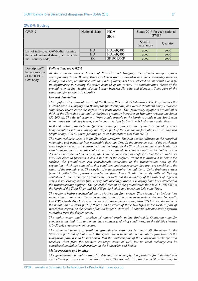
DRAFT Danube River Basin District Management Plan – Update 2015 37
ICPDR / International Commission for the Protection of the Danube River / www.icpdr.org
GWB-9: Bodrog
GWB-9 National share HU-9
SK-9
Status 2015 for each national GWB?
Quality (substance)
Quantity
List of individual GW-bodies forming the whole national share (national code incl. country code)
HU HU_AIQ495 good good HU HU_AIQ496 good good SK SK1001500P good good
Description/Characterisation of the ICPDR GW-body
Delineation: see GWB-8
At the common eastern border of Slovakia and Hungary, the alluvial aquifer system
corresponding to the Bodrog River catchment area in Slovakia and the Tisza-valley between
Záhony and Tokaj (confluence with the Bodrog River) has been selected as important due to (i)
its significance in meeting the water demand of the region, (ii) contamination threat of the
groundwater in the vicinity of state border between Slovakia and Hungary. Some part of the
water aquifer system is in Ukraine.
General description
The aquifer is the alluvial deposit of the Bodrog River and its tributaries. The Tisza divides the
lowland area in Hungary into Bodrogköz (northern part) and Rétköz (Southern part). Holocene
silty-clayey layers cover the surface with peaty areas. The Quaternary aquifer is around 60 m
thick in the Slovakian side and its thickness gradually increases in Hungary towards the South
(50-200 m). The fluvial sediments (from sandy gravels in the North to sands is the South with
intercalated silt and clay lenses) can be characterized by 5 – 30 m/d hydraulic conductivity.
In the Slovakian part only the Quaternary aquifer system is part of the transboundary water
body-complex while in Hungary the Upper part of the Pannonian formation is also attached
(depth is app. 500 m, corresponding to water temperature less than 30°C).
The main recharge area is in the Slovakian territory. The rain waters infiltrate at the marginal
mountains and penetrate into permeable deep aquifers. In the upstream part of the catchment
area surface waters also contribute to the recharge. In the Slovakian side the water bodies are
mainly unconfined or in some places partly confined. In Hungary both water bodies are in
discharge position and the main aquifers can be considered as confined. Here the groundwater
level lies close to (between 2 and 4 m below) the surface. Where it is around 2 m below the
surface, the groundwater can considerably contribute to the transpiration need of the
vegetation, which are adapted to that condition, and consequently they are very sensitive to the
status of the groundwater. The surplus of evapotranspiration and the artificial drainage system
(canals) collect the upward groundwater flow. From South, the sandy hills of Nyírség
contribute to the discharged groundwater as well, but the boundary of the waters of different
origin is not exactly known (that is why both discharge areas in Hungary have been attached to
the transboundary aquifer). The general direction of the groundwater flow is N-S (NE-SW) to
the North of the Tisza River and SE-NW in the Rétköz and uncertain below the Tisza.
The regional hydro-geochemical picture follows the flow system. Close to the river bed sections
recharging groundwater, the water quality is almost the same as in surface streams. Generally
low TDS, Ca-Mg-HCO3 type waters occur in the recharge areas, Na-HCO3 waters dominate in
the middle and western part of Rétköz, and mixture of these two types in the western part of
Bodrogköz region. At the centre of the Bodrogköz, elevated Cl-content indicates strong upward
migration from the deeper zones.
The major water quality problem of natural origin in the Bodrogköz Quaternary aquifer
complex is the high iron and manganese content (reducing conditions). In the Rétköz elevated
(10–30 /l) arsenic-content occurs.
The estimated amount of available groundwater resources is almost 50 Mm3/year in the
Slovakian part, out of that 10–15 Mm3/year should be maintained as lateral flow towards the
Hungarian part. It is to be mentioned, that the southern part of the Hungarian discharge area
receives water from the southern recharge areas as well, but no local recharge can be
considered available for abstraction in the Bodrogköz and Rétköz.
Major pressures and impacts
The groundwater is mainly used for drinking water supply, but partially for industrial and
agricultural purposes (inc. irrigation) as well. The use ratio is quite low in Slovakia: only 10

DRAFT Danube River Basin District Management Plan – Update 2015 38
ICPDR / International Commission for the Protection of the Danube River / www.icpdr.org
%. The development is limited by occurrence of technologically inappropriate substances in
water (Mn, Fe) and sometimes also by groundwater pollution from surface waters, industry,
agriculture and transport infrastructure (Strážske, Hencovce, Michalovce, Čierna nad Tisou). In Hungary the available groundwater resources of the two water bodies are quite different. In
the northern part, which is in close relation to the Slovakian part, the water demand of the
groundwater dependent aquatic and terrestrial ecosystems can be estimated at 5–8 Mm3/d,
thus the available groundwater resources is in the range of 5–7 Mm3/year. The abstracted
amount of groundwater is 3 Mm3/year, so the ratio is around 50 %, but the majority is
concentrated to Ronyva/Roňava river valley. In the southern part, the lateral flow from the recharge zone of Nyírség (app. 30 Mm3/year) provides sufficient water for the minimum water
demand of ecosystems (8-12 Mm3/year) and for 8 Mm3/year of abstraction.
In Hungary 10 significant point sources of pollution have been registered. The shallow
groundwater has usually high nitrate under the settlements, because of the inappropriate
handling of manure and the totally or partially missing sewer systems. The agriculture
contributes to the pollution as well, through use of chemicals. The estimated amunt of surplus
Nitrogen is 15 kgN/ha/year originated from the use of 88 kgN/ha/year fertilizer and 13
kgN/year manure.
The groundwater quality in Slovakia is monitored in 17 sampling sites, groundwater samples
are taken from the first aquifer 2 times per year). The Hungarian water quality monitoring is
concentrating in the surrounding of waterworks. The quality of the Ronyva/Roňava aquifer close to the waterworks of Sátoraljaújhely shows increasing tendency of Nitrate pollution: the
average concentration is around 30 mg/l, and in one production well the Nitrate-concentration
exceeds the limit value of 50 mg/l. Information on pollution in arable lands is practically
missing in this region.
The high vulnerability of groundwater and the expected future development in water demand
requires high level of protection in the Slovakian part of the region mainly oriented to measures
focused on industrial pollution sources. In Hungary the protection zones of the waterworks (5
%) need special attention.
Description of status assessment methodology.
Chemical Status
Slovak Republic: No changes since 2009
Quantitative Status
Slovak Republic: Assessment of groundwater quantitative status consists:
1. determination of usable amounts of groundwater and transformed usable amounts of
groundwater to quaternary and prequaternary groundwater bodies, determine the size of
groundwater abstractions for quaternary and prequaternary groundwater bodies, calculate
the change trends of groundwater abstractions and balance assessment (share of
groundwater use) of groundwater bodies by 2012 (set of evaluation periods 2004–2012 and
2009–2012)
2. evaluation of significant subsidence trends of groundwater regime, processed at all
monitoring objects SK hydrological network of groundwater (wells and springs). Object
selection, input analysis of the representativeness of the data and measurements, data
verification by 2011, verification the criteria for checking the length and representativeness
of monitoring the statistical test, comprehensive evaluation of the Mann-Kendall method
(95% significance level) and the output circuitry results in the quaternary and prequaternary
groundwater bodies
3. assessment of the impacts of groundwater abstractions (determination of water management
problem sites) from the perspective of quantitative status of groundwater bodies (based on
the results of the assessment points 1 and 2) and in the view of the results provided on the
evaluation of flows on the surface streams
4. linking the results of points 1 to 3 in the quaternary and prequaternary groundwater bodies,
identification causes and possible areas causing poor quantitative status (in 2015). Basis for
analysis of water use management of groundwater resources and water planning, taking into
account geology and hydrogeology territory in connection to groundwater abstractions
causing possible poor quantitative status.
Groundwater threshold
Receptors considered
Slovak Republic: Drinking water

DRAFT Danube River Basin District Management Plan – Update 2015 39
ICPDR / International Commission for the Protection of the Danube River / www.icpdr.org
value relationships
Consideration of NBL and EQS (environmental quality standards, drinking water standards) in the TV establishment:
Slovak Republic: Threshold value= (NBL + drinking water standards)/2
Verbal description of the trend assessment methodology
Slovak Republic: Trend is assessed separately for groundwater quality and quantity at which
for trends in quantity the procedure applies for all GW quantity monitoring sites. The
assessment follows a stepwise procedure. Consisting of the evaluation of the data sets and the
monitoring points (no gaps in time series are allowed and data from 1992–2011 were used),
consisting of the performance of the non-parametric Mann-Kendall trend test (95% confidence
level) and comprising the parametric SLOPE test (critical value 2%). At the end monitoring
points with decreasing trends are checked for significant groundwater abstractions in the area
around the well by using GIS. GWBs with decreasing trends but with no evidence of abstraction
are excluded from assessment in the 2nd RBMP. For assessing trends in concentrations of
pollutants in groundwater the evaluation period was 2000–2011. The results of surveillance
and operational monitoring were applied for the assessment. Monitoring frequency depends on
the GWB type. In the analysis the values <LOQ are replaced by LOQmax/2. Trend assessment
is only performed if the number of values <LOQ is less than 50%. Non-parametric Mann-
Kendall test with 5% significance level was applied for trend evaluation.
Verbal description of the trend
reversal assessment methodology
Slovak Republic: Not evaluated
Threshold values per GWB
Pollutant / Indicator TV (or range)
[unit]
NBL (or range)
[unit]
Level of TV
establishment
(national, RBD,
GWB)
Related to risk
in this GWB
[yes/-]
HU Nitrates 50 mg/l 1,2-11,4 mg/l GWB -
HU Ammonium 2-5 mg/l 1,79-3,6 mg/l GWB -
HU Conductivity 2500 µS/cm 1243-1394
µS/cm
GWB -
HU Sulfate 250 mg/l 22,7-112 mg/l GWB -
HU Chloride 250 mg/l 135-214 mg/l GWB -
HU Arsenic µg/l 6,1-8,1 µg/l GWB -
HU Cadmium 5 µg/l 0,03-1 µg/l GWB -
HU Lead 10 µg/l 3,5-4,1 µg/l GWB -
HU Mercury 1 µg/l 0,1-0,19 µg/l GWB -
HU Trichlorethylene 10 µg/l GWB -
HU Tetrachloro ethylene 10 µg/l GWB -
HU Absorbed organic
halogens AOX
20 µg/l GWB -
HU Pesticides by
components
0,1 µg/l GWB -
HU Pesticides all 0,5 µg/l GWB -
SK NH4 0,295 mg/l GWB -

DRAFT Danube River Basin District Management Plan – Update 2015 40
ICPDR / International Commission for the Protection of the Danube River / www.icpdr.org
GWB-10: Slovensky kras / Aggtelek-hgs.
GWB-10 National share HU-10
SK-10
Status 2015 for each national GWB?
Quality (substance)
Quantity
List of individual GW-bodies forming the whole national share (national code incl. country code)
HU HU_AIQ485 good good SK SK200480KF good good
Description/Characterisation of the ICPDR GW-body
Delineation: see GWB-8
The Aggtelek Mountain and the Slovensky kras form a large common karstic aquifer system in
the Eastern part of the counrtries. It is selected for presenting in the Danube-basin report as
important transboundary water body: (i) National Park covers the majority of its surface,
where the role of the groundwater is presented by springs and stalactite caves, (ii) significant
drinking water resource in Slovakia, regionally important in Hungary (iii) vulnerable area
requiring protection.
General description
The GWB is in a Mesozoic complex with morphologically visible karstic plateau and canyon-
like valleys of water courses, separating different units. Hydrogeological units are very
different according to the character of permeability, character of groundwater circulation, type
of groundwater regime, and also in the resulting yield of groundwater springs. From hydro-
geological point of view, the most important tectonic unit in the area is the Silicicum unit,
mainly its Middle Triassic and Upper Triassic part. The most important aquifer here is the
Middle and Upper Triassic limestone and dolomites with karst-fissure type of permeability.
Similarly important hydrogeological units in the Hungarian side are Alsóhegy, Nagyoldal,
Hasagistya and Galyaság, which contain the Aggtelek-Domica cave system. Tertiary basins act
as a regional impermeable barrier for the groundwater accumulated in Triassic limestone.
Groundwater circulation in these rocks is controlled by extreme heterogeneity of carbonate
rocks, following the tectonic development. These tectonically pre-destinated drainage
structures show the major influence on the directions of groundwater flow. Majority of
groundwater is drained towards big karstic springs. Areas between such tectonic faults are less
karstified and also less permeable. If not drained by cave systems or permeable tectonic faults,
groundwater usually feeds the Quaternary coverage. Specific hydraulic feature of the karstified
carbonate complex with preferred drainage structures is that no continuous groundwater table
ca be defined within the rock mass. Groundwater in many cases only fills up karstic openings –
conduits, sometimes enlarged into the cave systems, while segments between the preferred
groundwater routes are unsaturated. On the other hand, groundwater level changes in these
zones are sharp and show quick response to the meteorological situation. Typical amplitude of
groundwater level change is from 5 to 15 m. In such levels above the erosion base perennial
springs occur after an intensive rainfall events or sudden snowmelts. Hidden outflow to the
deeper structures within and outside of the area the territory (generally of westward direction
under the Tertiary sediments of the Rimavská kotlina Basin) is considered to be quite important
from the water management point of view. Groundwater abstraction for various purposes is
concentrated at the natural outflows of springs – relatively small portion is abstracted by
pumping from boreholes and wells.
Major pressures and impacts
The estimated amount of available resources in Slovenský kras is 40.4 Mm3/year, the actual
use is 21 % of available resources, mainly for drinking water purposes.
In the Hungarian side only the amount of karstic water is utilized, which flows out naturally
from karstic springs in Jósvafő, Szögliget, Komjáti, Égerszög and Aggtelek. There are enough data about karst spring discharge. Observed discharge data are available for a period of
nearly 30 years. Because of the National Park no important karstic water abstraction will be
planned on the area.
National Parks cover the majority of the area. In addition, in Hungary the total area of the
GWB is considered as Nitrate-sensitive. .
Description of status
Chemical Status:
Slovak Republic: No changes since 2009
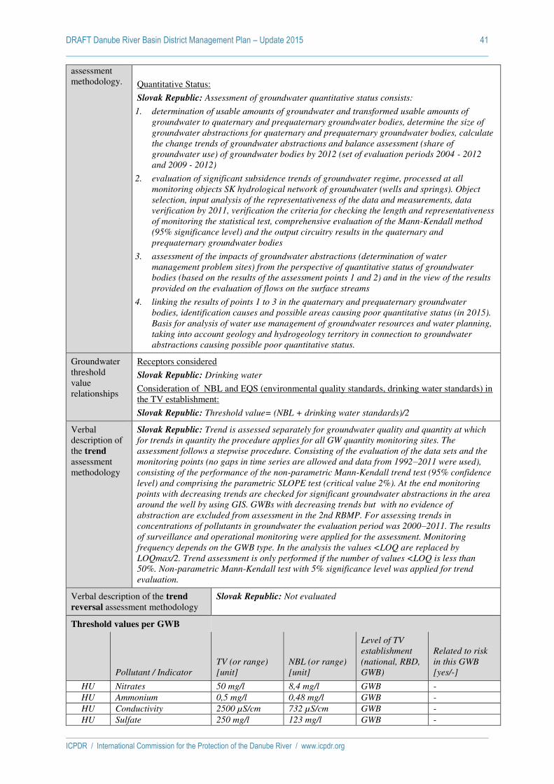
DRAFT Danube River Basin District Management Plan – Update 2015 41
ICPDR / International Commission for the Protection of the Danube River / www.icpdr.org
assessment methodology.
Quantitative Status:
Slovak Republic: Assessment of groundwater quantitative status consists:
1. determination of usable amounts of groundwater and transformed usable amounts of
groundwater to quaternary and prequaternary groundwater bodies, determine the size of
groundwater abstractions for quaternary and prequaternary groundwater bodies, calculate
the change trends of groundwater abstractions and balance assessment (share of
groundwater use) of groundwater bodies by 2012 (set of evaluation periods 2004 - 2012
and 2009 - 2012)
2. evaluation of significant subsidence trends of groundwater regime, processed at all
monitoring objects SK hydrological network of groundwater (wells and springs). Object
selection, input analysis of the representativeness of the data and measurements, data
verification by 2011, verification the criteria for checking the length and representativeness
of monitoring the statistical test, comprehensive evaluation of the Mann-Kendall method
(95% significance level) and the output circuitry results in the quaternary and
prequaternary groundwater bodies
3. assessment of the impacts of groundwater abstractions (determination of water
management problem sites) from the perspective of quantitative status of groundwater
bodies (based on the results of the assessment points 1 and 2) and in the view of the results
provided on the evaluation of flows on the surface streams
4. linking the results of points 1 to 3 in the quaternary and prequaternary groundwater
bodies, identification causes and possible areas causing poor quantitative status (in 2015).
Basis for analysis of water use management of groundwater resources and water planning,
taking into account geology and hydrogeology territory in connection to groundwater
abstractions causing possible poor quantitative status.
Groundwater threshold value relationships
Receptors considered
Slovak Republic: Drinking water
Consideration of NBL and EQS (environmental quality standards, drinking water standards) in the TV establishment:
Slovak Republic: Threshold value= (NBL + drinking water standards)/2
Verbal description of the trend assessment methodology
Slovak Republic: Trend is assessed separately for groundwater quality and quantity at which
for trends in quantity the procedure applies for all GW quantity monitoring sites. The
assessment follows a stepwise procedure. Consisting of the evaluation of the data sets and the
monitoring points (no gaps in time series are allowed and data from 1992–2011 were used),
consisting of the performance of the non-parametric Mann-Kendall trend test (95% confidence
level) and comprising the parametric SLOPE test (critical value 2%). At the end monitoring
points with decreasing trends are checked for significant groundwater abstractions in the area
around the well by using GIS. GWBs with decreasing trends but with no evidence of
abstraction are excluded from assessment in the 2nd RBMP. For assessing trends in
concentrations of pollutants in groundwater the evaluation period was 2000–2011. The results
of surveillance and operational monitoring were applied for the assessment. Monitoring
frequency depends on the GWB type. In the analysis the values <LOQ are replaced by
LOQmax/2. Trend assessment is only performed if the number of values <LOQ is less than
50%. Non-parametric Mann-Kendall test with 5% significance level was applied for trend
evaluation.
Verbal description of the trend
reversal assessment methodology
Slovak Republic: Not evaluated
Threshold values per GWB
Pollutant / Indicator TV (or range)
[unit]
NBL (or range)
[unit]
Level of TV
establishment
(national, RBD,
GWB)
Related to risk
in this GWB
[yes/-]
HU Nitrates 50 mg/l 8,4 mg/l GWB -
HU Ammonium 0,5 mg/l 0,48 mg/l GWB -
HU Conductivity 2500 µS/cm 732 µS/cm GWB -
HU Sulfate 250 mg/l 123 mg/l GWB -
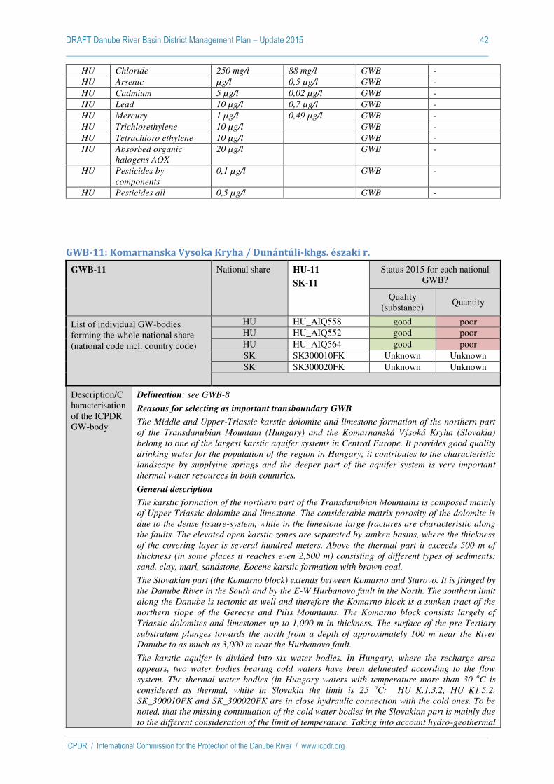
DRAFT Danube River Basin District Management Plan – Update 2015 42
ICPDR / International Commission for the Protection of the Danube River / www.icpdr.org
HU Chloride 250 mg/l 88 mg/l GWB -
HU Arsenic µg/l 0,5 µg/l GWB -
HU Cadmium 5 µg/l 0,02 µg/l GWB -
HU Lead 10 µg/l 0,7 µg/l GWB -
HU Mercury 1 µg/l 0,49 µg/l GWB -
HU Trichlorethylene 10 µg/l GWB -
HU Tetrachloro ethylene 10 µg/l GWB -
HU Absorbed organic
halogens AOX
20 µg/l GWB -
HU Pesticides by
components
0,1 µg/l GWB -
HU Pesticides all 0,5 µg/l GWB -
GWB-11: Komarnanska Vysoka Kryha / Dunántúli-khgs. északi r.
GWB-11 National share HU-11
SK-11
Status 2015 for each national GWB?
Quality (substance)
Quantity
List of individual GW-bodies forming the whole national share (national code incl. country code)
HU HU_AIQ558 good poor HU HU_AIQ552 good poor HU HU_AIQ564 good poor SK SK300010FK Unknown Unknown SK SK300020FK Unknown Unknown
Description/Characterisation of the ICPDR GW-body
Delineation: see GWB-8
Reasons for selecting as important transboundary GWB
The Middle and Upper-Triassic karstic dolomite and limestone formation of the northern part
of the Transdanubian Mountain (Hungary) and the Komarnanská Výsoká Kryha (Slovakia)
belong to one of the largest karstic aquifer systems in Central Europe. It provides good quality
drinking water for the population of the region in Hungary; it contributes to the characteristic
landscape by supplying springs and the deeper part of the aquifer system is very important
thermal water resources in both countries.
General description
The karstic formation of the northern part of the Transdanubian Mountains is composed mainly
of Upper-Triassic dolomite and limestone. The considerable matrix porosity of the dolomite is
due to the dense fissure-system, while in the limestone large fractures are characteristic along
the faults. The elevated open karstic zones are separated by sunken basins, where the thickness
of the covering layer is several hundred meters. Above the thermal part it exceeds 500 m of
thickness (in some places it reaches even 2,500 m) consisting of different types of sediments:
sand, clay, marl, sandstone, Eocene karstic formation with brown coal.
The Slovakian part (the Komarno block) extends between Komarno and Sturovo. It is fringed by
the Danube River in the South and by the E-W Hurbanovo fault in the North. The southern limit
along the Danube is tectonic as well and therefore the Komarno block is a sunken tract of the
northern slope of the Gerecse and Pilis Mountains. The Komarno block consists largely of
Triassic dolomites and limestones up to 1,000 m in thickness. The surface of the pre-Tertiary
substratum plunges towards the north from a depth of approximately 100 m near the River
Danube to as much as 3,000 m near the Hurbanovo fault.
The karstic aquifer is divided into six water bodies. In Hungary, where the recharge area
appears, two water bodies bearing cold waters have been delineated according to the flow
system. The thermal water bodies (in Hungary waters with temperature more than 30 oC is
considered as thermal, while in Slovakia the limit is 25 oC: HU_K.1.3.2, HU_K1.5.2,
SK_300010FK and SK_300020FK are in close hydraulic connection with the cold ones. To be
noted, that the missing continuation of the cold water bodies in the Slovakian part is mainly due
to the different consideration of the limit of temperature. Taking into account hydro-geothermal
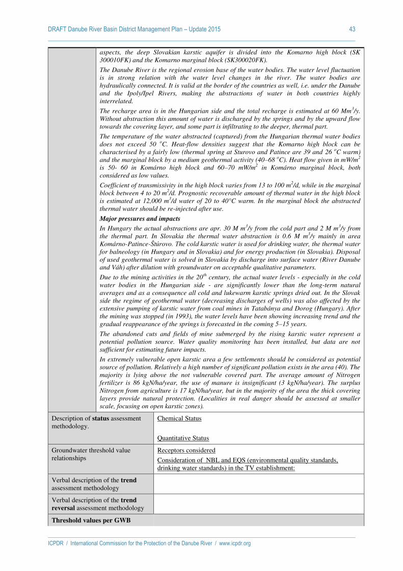
DRAFT Danube River Basin District Management Plan – Update 2015 43
ICPDR / International Commission for the Protection of the Danube River / www.icpdr.org
aspects, the deep Slovakian karstic aquifer is divided into the Komarno high block (SK
300010FK) and the Komarno marginal block (SK300020FK).
The Danube River is the regional erosion base of the water bodies. The water level fluctuation
is in strong relation with the water level changes in the river. The water bodies are
hydraulically connected. It is valid at the border of the countries as well, i.e. under the Danube
and the Ipoly/Ipel Rivers, making the abstractions of water in both countries highly
interrelated.
The recharge area is in the Hungarian side and the total recharge is estimated at 60 Mm3/y.
Without abstraction this amount of water is discharged by the springs and by the upward flow
towards the covering layer, and some part is infiltrating to the deeper, thermal part.
The temperature of the water abstracted (captured) from the Hungarian thermal water bodies
does not exceed 50 oC. Heat-flow densities suggest that the Komarno high block can be
characterised by a fairly low (thermal spring at Sturovo and Patince are 39 and 26 oC warm)
and the marginal block by a medium geothermal activity (40–68 oC). Heat flow given in mW/m
2
is 50- 60 in Komárno high block and 60–70 mW/m2 in Komárno marginal block, both
considered as low values.
Coefficient of transmissivity in the high block varies from 13 to 100 m2/d, while in the marginal
block between 4 to 20 m2/d. Prognostic recoverable amount of thermal water in the high block
is estimated at 12,000 m3/d water of 20 to 40°C warm. In the marginal block the abstracted
thermal water should be re-injected after use.
Major pressures and impacts
In Hungary the actual abstractions are apr. 30 M m3/y from the cold part and 2 M m
3/y from
the thermal part. In Slovakia the thermal water abstraction is 0.6 M m3/y mainly in area
Komárno-Patince-Štúrovo. The cold karstic water is used for drinking water, the thermal water for balneology (in Hungary and in Slovakia) and for energy production (in Slovakia). Disposal
of used geothermal water is solved in Slovakia by discharge into surface water (River Danube
and Váh) after dilution with groundwater on acceptable qualitative parameters.
Due to the mining activities in the 20th
century, the actual water levels - especially in the cold
water bodies in the Hungarian side - are significantly lower than the long-term natural
averages and as a consequence all cold and lukewarm karstic springs dried out. In the Slovak
side the regime of geothermal water (decreasing discharges of wells) was also affected by the
extensive pumping of karstic water from coal mines in Tatabánya and Dorog (Hungary). After
the mining was stopped (in 1993), the water levels have been showing increasing trend and the
gradual reappearance of the springs is forecasted in the coming 5–15 years.
The abandoned cuts and fields of mine submerged by the rising karstic water represent a
potential pollution source. Water quality monitoring has been installed, but data are not
sufficient for estimating future impacts.
In extremely vulnerable open karstic area a few settlements should be considered as potential
source of pollution. Relatively a high number of significant pollution exists in the area (40). The
majority is lying above the not vulnerable covered part. The average amount of Nitrogen
fertilizer is 86 kgN/ha/year, the use of manure is insignificant (3 kgN/ha/year). The surplus
Nitrogen from agriculture is 17 kgN/ha/year, but in the majority of the area the thick covering
layers provide natural protection. (Localities in real danger should be assessed at smaller
scale, focusing on open karstic zones).
Description of status assessment methodology.
Chemical Status
Quantitative Status
Groundwater threshold value relationships
Receptors considered
Consideration of NBL and EQS (environmental quality standards, drinking water standards) in the TV establishment:
Verbal description of the trend assessment methodology
Verbal description of the trend
reversal assessment methodology
Threshold values per GWB
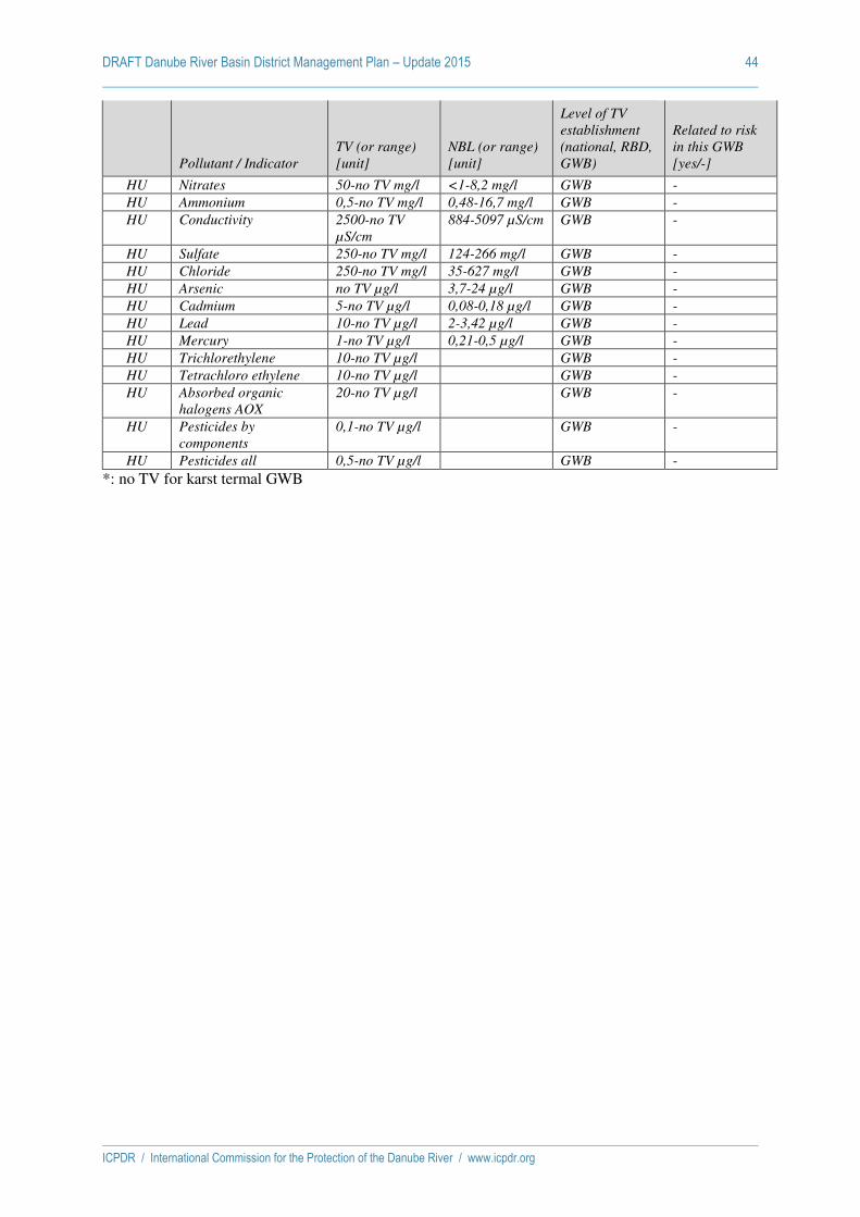
DRAFT Danube River Basin District Management Plan – Update 2015 44
ICPDR / International Commission for the Protection of the Danube River / www.icpdr.org
Pollutant / Indicator TV (or range)
[unit]
NBL (or range)
[unit]
Level of TV
establishment
(national, RBD,
GWB)
Related to risk
in this GWB
[yes/-]
HU Nitrates 50-no TV mg/l <1-8,2 mg/l GWB -
HU Ammonium 0,5-no TV mg/l 0,48-16,7 mg/l GWB -
HU Conductivity 2500-no TV
µS/cm
884-5097 µS/cm GWB -
HU Sulfate 250-no TV mg/l 124-266 mg/l GWB -
HU Chloride 250-no TV mg/l 35-627 mg/l GWB -
HU Arsenic no TV µg/l 3,7-24 µg/l GWB -
HU Cadmium 5-no TV µg/l 0,08-0,18 µg/l GWB -
HU Lead 10-no TV µg/l 2-3,42 µg/l GWB -
HU Mercury 1-no TV µg/l 0,21-0,5 µg/l GWB -
HU Trichlorethylene 10-no TV µg/l GWB -
HU Tetrachloro ethylene 10-no TV µg/l GWB -
HU Absorbed organic
halogens AOX
20-no TV µg/l GWB -
HU Pesticides by
components
0,1-no TV µg/l GWB -
HU Pesticides all 0,5-no TV µg/l GWB -
*: no TV for karst termal GWB

DRAFT Danube River Basin District Management Plan – Update 2015 45
ICPDR / International Commission for the Protection of the Danube River / www.icpdr.org
Significant pressures on the ICPDR GW-bodies
Code of ICPDR GW-body GWB-1
National share of ICPDR GW-body (nationally aggregated part) AT-1, DE-1
Status pressure types 2015
Risk pressure types 20132021
Significant Pressures for Groundwater Chemical
Yes/- Quantity
Yes/- Chemical
Yes/- Quantity
Yes/-
AT DE AT DE AT DE AT DE Point sources - -
Leakages from contaminated sites Leakages from waste disposal sites (landfill and agricultural waste disposal)
Leakages associated with oil industry infrastructure Mine water discharges Discharges to ground such as disposal of contaminated water to soak ways
Other relevant point sources (specify below) Diffuse Sources - -
due to agricultural activities due to non-sewered population Urban land use Other significant diffuse pressures (specify below) Water abstractions - -
Abstractions for agriculture Abstractions for public water supply Abstractions by industry IPPC activities Non-IPPC activities Abstractions by quarries/open cast coal sites Other major abstractions (specify below) Artificial recharge - -
Discharges to groundwater for artificial recharge purposes Returns of groundwater to GWB from which it was abstracted (e.g. for sand and gravel washing)
Mine water rebound Other major recharges (specify below) Other significant pressures - - - -
Saltwater intrusion Other intrusion (specify below)
Description of other significant pressures than those selected above.
DRAFT Danube River Basin District Management Plan – Update 2015 46
ICPDR / International Commission for the Protection of the Danube River / www.icpdr.org
Code of ICPDR GW-body GWB-2
National share of ICPDR GW-body (nationally aggregated part) BG-2, RO-2
Status pressure types 2015
Risk pressure types 20132021
Significant Pressures for Groundwater Chemical
Yes/- Quantity
Yes/- Chemical
Yes/- Quantity
Yes/-
BG RO BG RO BG RO BG RO Point sources - -
Leakages from contaminated sites Leakages from waste disposal sites (landfill and agricultural waste disposal)
Leakages associated with oil industry infrastructure Mine water discharges Discharges to ground such as disposal of contaminated water to soak ways
Other relevant point sources (specify below) Diffuse Sources - -
due to agricultural activities due to non-sewered population Urban land use Other significant diffuse pressures (specify below) Water abstractions - -
Abstractions for agriculture Abstractions for public water supply Abstractions by industry IPPC activities Non-IPPC activities Abstractions by quarries/open cast coal sites Other major abstractions (specify below) Artificial recharge - -
Discharges to groundwater for artificial recharge purposes Returns of groundwater to GWB from which it was abstracted (e.g. for sand and gravel washing)
Mine water rebound Other major recharges (specify below) Other significant pressures - - - -
Saltwater intrusion Other intrusion (specify below)
Description of other significant pressures than those selected above.

DRAFT Danube River Basin District Management Plan – Update 2015 47
ICPDR / International Commission for the Protection of the Danube River / www.icpdr.org
Code of ICPDR GW-body GWB-3
National share of ICPDR GW-body (nationally aggregated part) MD-3, RO-3
Status pressure types 2015
Risk pressure types 20132021
Significant Pressures for Groundwater Chemical
Yes/- Quantity
Yes/- Chemical
Yes/- Quantity
Yes/-
MD RO MD RO MD risk
RO MD RO
Point sources - Yes -
Leakages from contaminated sites Leakages from waste disposal sites (landfill and agricultural waste disposal)
x
Leakages associated with oil industry infrastructure x Mine water discharges Discharges to ground such as disposal of contaminated water to soak ways
Other relevant point sources (specify below) Diffuse Sources - Yes -
due to agricultural activities x due to non-sewered population x Urban land use Other significant diffuse pressures (specify below) Water abstractions - Yes - -
Abstractions for agriculture Abstractions for public water supply Abstractions by industry x IPPC activities Non-IPPC activities Abstractions by quarries/open cast coal sites Other major abstractions (specify below) Artificial recharge - -
Discharges to groundwater for artificial recharge purposes Returns of groundwater to GWB from which it was abstracted (e.g. for sand and gravel washing)
Mine water rebound Other major recharges (specify below) Other significant pressures - - - -
Saltwater intrusion Other intrusion (specify below)
Description of other significant pressures than those selected above.

DRAFT Danube River Basin District Management Plan – Update 2015 48
ICPDR / International Commission for the Protection of the Danube River / www.icpdr.org
Code of ICPDR GW-body GWB-4
National share of ICPDR GW-body (nationally aggregated part) BG-4, RO-4
Status pressure types 2015
Risk pressure types 20132021
Significant Pressures for Groundwater Chemical
Yes/- Quantity
Yes/- Chemical
Yes/- Quantity
Yes/-
BG RO BG RO BG RO BG RO Point sources - -
Leakages from contaminated sites Leakages from waste disposal sites (landfill and agricultural waste disposal)
Leakages associated with oil industry infrastructure Mine water discharges Discharges to ground such as disposal of contaminated water to soak ways
Other relevant point sources (specify below) Diffuse Sources - -
due to agricultural activities due to non-sewered population Urban land use Other significant diffuse pressures (specify below) Water abstractions - -
Abstractions for agriculture Abstractions for public water supply Abstractions by industry IPPC activities Non-IPPC activities Abstractions by quarries/open cast coal sites Other major abstractions (specify below) Artificial recharge - -
Discharges to groundwater for artificial recharge purposes Returns of groundwater to GWB from which it was abstracted (e.g. for sand and gravel washing)
Mine water rebound Other major recharges (specify below) Other significant pressures - - - -
Saltwater intrusion Other intrusion (specify below)
Description of other significant pressures than those selected above.

DRAFT Danube River Basin District Management Plan – Update 2015 49
ICPDR / International Commission for the Protection of the Danube River / www.icpdr.org
Code of ICPDR GW-body GWB-5
National share of ICPDR GW-body (nationally aggregated part) HU-5, RO-5
Status pressure types 2015
Risk pressure types 20132021
Significant Pressures for Groundwater Chemical
Yes/- Quantity
Yes/- Chemical
Yes/- Quantity
Yes/-
HU poor
RO poor
HU RO HU risk
RO risk
HU RO
Point sources - -
Leakages from contaminated sites Leakages from waste disposal sites (landfill and agricultural waste disposal)
Leakages associated with oil industry infrastructure Mine water discharges Discharges to ground such as disposal of contaminated water to soak ways
Other relevant point sources (specify below) Diffuse Sources Yes Yes
due to agricultural activities x x x due to non-sewered population x x x Urban land use x Other significant diffuse pressures (specify below) Water abstractions - -
Abstractions for agriculture Abstractions for public water supply Abstractions by industry IPPC activities Non-IPPC activities Abstractions by quarries/open cast coal sites Other major abstractions (specify below) Artificial recharge - -
Discharges to groundwater for artificial recharge purposes Returns of groundwater to GWB from which it was abstracted (e.g. for sand and gravel washing)
Mine water rebound Other major recharges (specify below) Other significant pressures - - - -
Saltwater intrusion Other intrusion (specify below)
Description of other significant pressures than those selected above.

DRAFT Danube River Basin District Management Plan – Update 2015 50
ICPDR / International Commission for the Protection of the Danube River / www.icpdr.org
Code of ICPDR GW-body GWB-6
National share of ICPDR GW-body (nationally aggregated part) HU-6, RO-6
Status pressure types 2015
Risk pressure types 20132021
Significant Pressures for Groundwater Chemical
Yes/- Quantity
Yes/- Chemical
Yes/- Quantity
Yes/-
HU RO HU RO HU RO HU RO Point sources - -
Leakages from contaminated sites Leakages from waste disposal sites (landfill and agricultural waste disposal)
Leakages associated with oil industry infrastructure Mine water discharges Discharges to ground such as disposal of contaminated water to soak ways
Other relevant point sources (specify below) Diffuse Sources - -
due to agricultural activities due to non-sewered population Urban land use Other significant diffuse pressures (specify below) Water abstractions - -
Abstractions for agriculture Abstractions for public water supply Abstractions by industry IPPC activities Non-IPPC activities Abstractions by quarries/open cast coal sites Other major abstractions (specify below) Artificial recharge - -
Discharges to groundwater for artificial recharge purposes Returns of groundwater to GWB from which it was abstracted (e.g. for sand and gravel washing)
Mine water rebound Other major recharges (specify below) Other significant pressures - - - -
Saltwater intrusion Other intrusion (specify below)
Description of other significant pressures than those selected above.

DRAFT Danube River Basin District Management Plan – Update 2015 51
ICPDR / International Commission for the Protection of the Danube River / www.icpdr.org
Code of ICPDR GW-body GWB-7
National share of ICPDR GW-body (nationally aggregated part) HU-7, RO-7, RS-7
Status pressure types 2015
Risk pressure types 20132021
Significant Pressures for Groundwater Chemical
Yes/- Quantity
Yes/- Chemical
Yes/- Quantity
Yes/-
HU poor
RO RS HU poor
RO RS poor
HU risk
RO RS
HU risk
RO RS risk
Point sources - -
Leakages from contaminated sites Leakages from waste disposal sites (landfill and agricultural waste disposal)
Leakages associated with oil industry infrastructure Mine water discharges Discharges to ground such as disposal of contaminated water to soak ways
Other relevant point sources (specify below) Diffuse Sources Yes - Yes - -
due to agricultural activities x due to non-sewered population x Urban land use x Other significant diffuse pressures (specify below) Water abstractions Yes - Yes Yes - Yes
Abstractions for agriculture x x Abstractions for public water supply x x Abstractions by industry x x IPPC activities Non-IPPC activities Abstractions by quarries/open cast coal sites Other major abstractions (specify below) Artificial recharge - -
Discharges to groundwater for artificial recharge purposes Returns of groundwater to GWB from which it was abstracted (e.g. for sand and gravel washing)
Mine water rebound Other major recharges (specify below) Other significant pressures - - - -
Saltwater intrusion Other intrusion (specify below)
Description of other significant pressures than those selected above.

DRAFT Danube River Basin District Management Plan – Update 2015 52
ICPDR / International Commission for the Protection of the Danube River / www.icpdr.org
Code of ICPDR GW-body GWB-8
National share of ICPDR GW-body (nationally aggregated part) HU-8, SK-8
Status pressure types 2015
Risk pressure types 20132021
Significant Pressures for Groundwater Chemical
Yes/- Quantity
Yes/- Chemical
Yes/- Quantity
Yes/-
HU poor
SK HU poor
SK HU risk
SK risk
HU SK
Point sources - - Yes
Leakages from contaminated sites x Leakages from waste disposal sites (landfill and agricultural waste disposal)
Leakages associated with oil industry infrastructure x Mine water discharges x Discharges to ground such as disposal of contaminated water to soak ways
Other relevant point sources (specify below) Diffuse Sources Yes Yes
due to agricultural activities x x due to non-sewered population x Urban land use x Other significant diffuse pressures (specify below) Water abstractions Yes - -
Abstractions for agriculture Abstractions for public water supply Abstractions by industry IPPC activities Non-IPPC activities Abstractions by quarries/open cast coal sites Other major abstractions (specify below) Artificial recharge - -
Discharges to groundwater for artificial recharge purposes Returns of groundwater to GWB from which it was abstracted (e.g. for sand and gravel washing)
Mine water rebound Other major recharges (specify below) Other significant pressures - - - -
Saltwater intrusion Other intrusion (specify below)
Description of other significant pressures than those selected above.

DRAFT Danube River Basin District Management Plan – Update 2015 53
ICPDR / International Commission for the Protection of the Danube River / www.icpdr.org
Code of ICPDR GW-body GWB-9
National share of ICPDR GW-body (nationally aggregated part) HU-9, SK-9
Status pressure types 2015
Risk pressure types 20132021
Significant Pressures for Groundwater Chemical
Yes/- Quantity
Yes/- Chemical
Yes/- Quantity
Yes/-
HU SK HU SK HU SK HU SK Point sources - -
Leakages from contaminated sites Leakages from waste disposal sites (landfill and agricultural waste disposal)
Leakages associated with oil industry infrastructure Mine water discharges Discharges to ground such as disposal of contaminated water to soak ways
Other relevant point sources (specify below) Diffuse Sources - -
due to agricultural activities due to non-sewered population Urban land use Other significant diffuse pressures (specify below) Water abstractions - -
Abstractions for agriculture Abstractions for public water supply Abstractions by industry IPPC activities Non-IPPC activities Abstractions by quarries/open cast coal sites Other major abstractions (specify below) Artificial recharge - -
Discharges to groundwater for artificial recharge purposes Returns of groundwater to GWB from which it was abstracted (e.g. for sand and gravel washing)
Mine water rebound Other major recharges (specify below) Other significant pressures - - - -
Saltwater intrusion Other intrusion (specify below)
Description of other significant pressures than those selected above.

DRAFT Danube River Basin District Management Plan – Update 2015 54
ICPDR / International Commission for the Protection of the Danube River / www.icpdr.org
Code of ICPDR GW-body GWB-10
National share of ICPDR GW-body (nationally aggregated part) HU-10, SK-10
Status pressure types 2015
Risk pressure types 20132021
Significant Pressures for Groundwater Chemical
Yes/- Quantity
Yes/- Chemical
Yes/- Quantity
Yes/-
HU SK HU SK HU SK HU SK Point sources - -
Leakages from contaminated sites Leakages from waste disposal sites (landfill and agricultural waste disposal)
Leakages associated with oil industry infrastructure Mine water discharges Discharges to ground such as disposal of contaminated water to soak ways
Other relevant point sources (specify below) Diffuse Sources - -
due to agricultural activities due to non-sewered population Urban land use Other significant diffuse pressures (specify below) Water abstractions - -
Abstractions for agriculture Abstractions for public water supply Abstractions by industry IPPC activities Non-IPPC activities Abstractions by quarries/open cast coal sites Other major abstractions (specify below) Artificial recharge - -
Discharges to groundwater for artificial recharge purposes Returns of groundwater to GWB from which it was abstracted (e.g. for sand and gravel washing)
Mine water rebound Other major recharges (specify below) Other significant pressures - - - -
Saltwater intrusion Other intrusion (specify below)
Description of other significant pressures than those selected above.

DRAFT Danube River Basin District Management Plan – Update 2015 55
ICPDR / International Commission for the Protection of the Danube River / www.icpdr.org
Code of ICPDR GW-body GWB-11
National share of ICPDR GW-body (nationally aggregated part) HU-11, SK-11
Status pressure types 2015
Risk pressure types 20132021
Significant Pressures for Groundwater Chemical
Yes/- Quantity
Yes/- Chemical
Yes/- Quantity
Yes/-
HU SK HU poor
SK HU SK HU risk
SK risk
Point sources - -
Leakages from contaminated sites Leakages from waste disposal sites (landfill and agricultural waste disposal)
Leakages associated with oil industry infrastructure Mine water discharges Discharges to ground such as disposal of contaminated water to soak ways
Other relevant point sources (specify below) Diffuse Sources - -
due to agricultural activities due to non-sewered population Urban land use Other significant diffuse pressures (specify below) Water abstractions Yes - Yes
Abstractions for agriculture Abstractions for public water supply Abstractions by industry IPPC activities Non-IPPC activities Abstractions by quarries/open cast coal sites Other major abstractions (specify below) x Artificial recharge - -
Discharges to groundwater for artificial recharge purposes Returns of groundwater to GWB from which it was abstracted (e.g. for sand and gravel washing)
Mine water rebound Other major recharges (specify below) Other significant pressures - - - -
Saltwater intrusion Other intrusion (specify below)
Description of other significant pressures than those selected above.
Pressures have stopped (mining activities closed)

DRAFT Danube River Basin District Management Plan – Update 2015 56
ICPDR / International Commission for the Protection of the Danube River / www.icpdr.org
Groundwater measures
The overview table indicates the status of implementation of all key measures in the following way:
MC Measure implementation Completed
Implementation of measure is estimated to be completed by the end of 2012
MO Measure implementation On-going
Implementation of measure is on-going.
(Involving administrative acts, diffuse pollution, advisory services, research etc.)
PO Construction Measure - Planning On-going
Planning of construction measure is on-going.
(Involving construction or building works)
CO Construction Measure - Construction On-going
Construction of measure is on-going.
(Involving construction or building works)
MP Measure implementation Planned
Implementation of measure is planned
The listed stages of measure implementation are structured according to the schema, which is annexed to the CIS Concept Paper for 2012 Reporting.
For construction or building works the information about the on-going implementation is divided into ‘construction planning’ and ‘construction’.
The detailed tables provide more details on particular measures in each relevant GWB:
description of the measure,
responsible authority,
quantitative information by appropriate indicators (number of measures/projects and costs).

DRAFT Danube River Basin District Management Plan – Update 2015 57
ICPDR / International Commission for the Protection of the Danube River / www.icpdr.org
GWBs at poor status in 2015 and implemented measures
DRBD-GWB 5-RO-HU 7-RO-RS-HU 8-SK-HU 11-SK-HU
National part / Status 5-RO / Quality 5-HU / Quality 7-HU / Quality 7-RS / Quantity 7-HU / Quantity 8-HU / Quality 11-HU / Quantity
Basic Measures (BM) – Article 11(3)(a)
BM-01 BathingWater BM-02 Birds BM-03 DrinkingWater CO BM-04 Seveso BM-05 EnvironmentalImpact BM-06 SewageSludge BM-07 UrbanWasteWater MC, CO MO MO MO BM-08 PlantProtectionProducts BM-09 Nitrates MC, MO MO MO MO BM-10 Habitats BM-11 IPPC MC
Other Basic Measures (OBM) – Article 11(3)(b-l)
OBM-20 CostRecoveryWaterServices OBM-21 EfficientWaterUse OBM-22 ProtectionWaterAbstractions OBM-23 ControlsWaterAbstraction MO OBM-24 RechargeAugmentationGroundwater OBM-25 PointSourceDischarge OBM-26 PollutantsDiffuse OBM-27 AdverseImpact OBM-28 PollutantDirectGroundwater OBM-29 SurfacePrioritySubstances OBM-30 AccidentalPollution
Supplementary Measures (SM) – Article
11(4)&(5)
MP MO MO, MC
MC…Measure implementation completed by end of 2012, MO…Measure implementation on-going, PO…Construction planning on-going, CO…Construction on-going, MP…Measure implementation planned

DRAFT Danube River Basin District Management Plan – Update 2015 58
ICPDR / International Commission for the Protection of the Danube River / www.icpdr.org
Detailed description of measures
[BM = basic measures, OBM = other basic measures, SM = supplementary measures].
GWB Code Size [km²]
Pressures Status Measures Exemptions
Quality Quantity Quality Quantity Quality Quantity
5-HU-RO 7,212 DS No Poor Good BM, SM No 2027
Measure completed = Implementation is estimated to be completed by the end of 2012 (reference to the measures codes in table 1) (MC)
RO – quality:
BM – 07 Construction of collecting system in Periam agglomeration
description of the measure – execution of the new sewage network in Periam locality (Timis county)
responsible authority: local authority of the Periam agglomeration
quantitative information by appropriate indicators:
- number of population equivalent covered by measure - 2676 4730 p.e.;
- total cost of the measure – 400,000 Euro;
BM-09 Applying the Code of good agricultural practice in vulnerable zones
In Romania, following the discussions with the EC, whole territory approach is applied according with Decision 221983/GC/12.06.2013 of the Interministerial Commission for the implementation of the Action Plan for the protection of waters against pollution caused by nitrates from agricultural sources.
description of the measure – building of two facilities for the livestock manure storage in Pecica and Macea localities
responsible authority: county council and local authorities
quantitative information by appropriate indicators:
- area of agricultural land covered by measures – 313.59 km2;
- total costs of the two measures – 739,000 Euro;
BM-11 Reduction of the pollutant loads in the waste waters
description of the measure – rehabilitation of the collecting system and improvement of the waste water treatment plant performance;
responsible authority: COMBINATUL AGROINDUSTRIAL Curtici (Arad County);
quantitative information by appropriate indicators: cost of the measure is 200,000 Euro.
HU – quality:
Measure implementation on-going = Measure implementation is estimated to be on-going (reference to the measures codes in table 1) (MO)
RO – quality:
BM-09 Applying of specific action programmes
In Romania, following the discussions with the EC, whole territory approach is applied according with Decision 221983/GC/12.06.2013 of the Interministerial Commission for the implementation of the Action Plan for the protection of waters against pollution caused by nitrates from agricultural sources.
description of the measure: programme of measures applied for the agriculture diffuse sources in order to reduce the effects of the agriculture activities
responsible authority: county agriculture authorities, local authorities and farmers
quantitative information: This measure is applied in whole Mures Water Basin Administrations territory.
SM Research study for evaluation of the type and quantity of pollutants in soil and groundwaters and the transfer

DRAFT Danube River Basin District Management Plan – Update 2015 59
ICPDR / International Commission for the Protection of the Danube River / www.icpdr.org
/ degradation mechanisms (MP - Measure implementation is planned)
- description of the measure: development of the modelling tools for the evaluation of spatial and temporal pollutants migration – the support tool for finalising the evaluation methodology of the groundwater status and of the pollutant trends
responsible authority: Ministry of Environment and Climatic Changes – Department of Water, Forests and Fisheries, National Administration “Romanian Waters” and National Institute for Hydrology and Water Management
quantitative information: - 1 research study;
- the estimated total cost of the research study – 150,000 Euro.
HU – quality:
description of the measure: BM07
responsible authority: local governments
quantitative information by appropriate indicators (number of measures/projects and costs):
HU transposed the Urban Waste Water Directive by Gov. decree 25/2002. (II. 27.) on the National Wastewater Collection and Treatment program. The implementation of UWWD is ongoing.
In the South Great Plain Region 52,4% of the settlements were connected to the sewage system in 2008, and 82,4% are planned to be reached by 2015.
description of the measure: BM09
responsible authority: authorities for soil protection and for environmental protection
quantitative information by appropriate indicators (number of measures/projects and costs):
HU transposed the ND by the Gov. Decree No. 27/2006. (II.7.) on the protection of waters against pollution caused by nitrates of agricultural sources. Designation of nitrate vulnerable zones (NVZ; ~2,5 million ha at present) is under revision. The Code of Good Agricultural Practice (GAP) is obligatory on NVZ’s. Outside the NVZ’s, the agri environmental measures assist the implementation of GAP on a voluntary basis.
Construction measure planning on-going = Planning of construction measure is estimated to be on-going (reference to the measures codes in table 1)
HU – quality:
Construction of measure on-going = Construction of measure is estimated to be on-going (reference to the measures codes in table 1) (CO)
RO – quality:
BM-03 Ensuring the protection areas for the drinking groundwater abstraction (CO)
description of the measure: establishment of safeguard zones and buffer zones ensuring the protected area according to the water legislation in force (Water Law 107/1996 modified and completed, HG 930/2005 and Order 1278/2011); banning measures for some activities and restricted use of land, in order to prevent the water contamination risks due to the economic and social activities
responsible authority: water authorities, local authorities ;
quantitative information: according with the Water Law 107/1996 as amended and GD 930/2005, for all drinking groundwater abstractions are establishing the safeguard zones and buffer zones, in order to prevent the water resources contamination.
BM-07 Construction of collecting system in 8 agglomerations (CO)
description of the measure – extension of existing collecting system in 8 agglomerations ) and execution of the new sewage network (Arad and Timis counties);
responsible authority: local authorities of the Arad, Pecica, Sannicolu Mare, Lipova, Nadlac, Curtici, Frumuseni, Macea agglomerations
quantitative information by appropriate indicators:
- number of population equivalent covered by 8 agglomerations – 104,253 p.e.;

DRAFT Danube River Basin District Management Plan – Update 2015 60
ICPDR / International Commission for the Protection of the Danube River / www.icpdr.org
- estimated total cost of the measure – 30,686,939 Euro.
HU – quality:
Measure not started = Implementation is estimated of not being started by end of 2012 (reference to the measures codes in table 1)
RO – quality:
HU – quality:
GWB Code Size [km²]
Pressures Status Measures Exemptions
Quality Quantity Quality Quantity Quality Quantity
7-HU-RO-RS 28,997 DS WA P/G/G P/G/P BM BM, OBM, SM 2027
Measure completed = Implementation is estimated to be completed by the end of 2012 (reference to the measures codes in table 1)
HU – quality:
RS – quantity:
SM-01
Type of measure : Supplementary measures (Annex VI, Part B), including: research, development and demonstration projects and construction designs for new GW sources
Indicators :
1. Strategy on water supply and protection of AP Vojvodina (Official Journal APV no. 1/2010):
Adopted in the Vojvodinian Assembly in December 2009, providing planning background and guidelines for solving the problems of water supply. Strategy defines responsibilities, time plan and necessary investments for the improvement of public water supply and water protection. (Responsible Authority: Government of AP Vojvodina)
Estimated cost : ~200.000 €
2. Research Study and Investigations on locations of regional GW source in the Danube alluvium (2009-2012, on-going)
Research field investigations incl. pumping tests, chemical and microbiolocal analyses for the purpose of GW resource estimation and GW protection. (Responsible Authority: Serbian Directorate for Water)
Estimated cost : ~500.000 €
3. Environmental Impact Assessment for Underwater Coal Mine Kovin on future regional GW source Kovin-Dubovac (2010, not finished)
Estimation of the impact of future underwater coal minning activities on potential regional GW source (incl. field investigations, GW modeling) (Financed by private company, under supervison of Government of AP Vojvodina)
Estimated cost : 750.000 €
4. Study on GW resource assessment on the territory of AP Vojvodina (2010, not finished)
Estimation of the GW reserves, identification of potential locations for regional GW sources for DW supply in AP Vojvodina. (Responsible Authority: Government of AP Vojvodina)
Estimated cost : 150.000 €
HU – quantity:
description of the measure: SM construction and rehabilitation project
responsible authority or beneficiary: Lower Tisza Region Environmental and Water Directorate, Szeged in HU
quantitative information by appropriate indicators (number of measures/projects and costs): (INTERREG; Code: HUSER 0602/13): Sustainable development of the use of ground waters in the region along the Hungarian-Serbian border construction and rehabilitation project. Amount of funding: 28 332 352 HUF

DRAFT Danube River Basin District Management Plan – Update 2015 61
ICPDR / International Commission for the Protection of the Danube River / www.icpdr.org
description of the measure: SM demand management measures
responsible authority or beneficiary: Ministry of Rural Development and farmers
quantitative information by appropriate indicators (number of measures/projects and costs):
Within the “New Hungary Rural Development Program” (under the European Agricultural Fund for Rural Development - EAFRD) 2007-2013 environmentally friendly investments in the field of agricultural water management can be supported (e. g. water-saving irrigation techniques). The requirements for water-saving (dripping) irrigation are regulated in the 34/2008. (III. 27) FVM Agricultural Ministerial Decree. According to the Decree only the water- and energy-saving micro-irrigation technological improvements are eligible, if water is produced from the deeper layers.
Measure implementation on-going = Measure implementation is estimated to be on-going (reference to the measures codes in table 1)
HU – quality:
description of the measure: BM07
responsible authority: local governments
quantitative information by appropriate indicators (number of measures/projects and costs):
HU transposed the Urban Waste Water Directive by Gov. decree 25/2002. (II. 27.) on the National Wastewater Collection and Treatment program. The implementation of UWWD is ongoing.
In the South Great Plain Region 52,4% of the settlements were connected to the sewage system in 2008, and 82,4% are planned to be reached by 2015.
description of the measure: BM09
responsible authority: authorities for soil protection and for environmental protection
quantitative information by appropriate indicators (number of measures/projects and costs):
HU transposed the ND by the Gov. Decree No. 27/2006. (II.7.) on the protection of waters against pollution caused by nitrates of agricultural sources. Designation of nitrate vulnerable zones (~2,5 million ha at present) is under revision. The Code of Good Agricultural Practice is obligatory on NVZ’s. Outside the NVZ’s, the agri environmental measures assist the implementation of GAP on a voluntary basis.
RS – quantity:
HU – quantity:
description of the measure: SM Construction and rehabilitation project;
responsible authority or beneficiary: Lower Tisza Region Environment and Water Directorate, Lower Danube Valley Environment and Water Directorate
quantitative information by appropriate indicators (number of measures/projects and costs):
Currently, 4 regional importance water conservation measures are ongoing, which influence the groundwater quantitative status.
Protection of water quantity and quality along the Danube valley – 2 991 019 750 HUF
Artificial recharge (intake) of Algyő main channel catchment area – 685 954 812 HUF
Artificial recharge (intake) in the Danube -Tisza Interfluvial Region – 618 592 500 HUF
Improving Water balance in the Danube -Tisza Interfluvial Region – 444 800 000 HUF
description of the measure: OBM-23
responsible authority or beneficiary: Ministry of Rural Development
quantitative information by appropriate indicators (number of measures/projects and costs):
Gov. decision 1405/2011. (XII. 25.) on the ‘Simple State’ governmental program implies the transposition of the licensing of domestic wells (i. e. used for domestic water use only) from local governments to environmental authorities where experts ensure that aspects of water management and protection are taken into consideration in the licensing procedure. The relevant legislation will be modified in 2013.
Construction measure planning on-going = Planning of construction measure is estimated to be on-going

DRAFT Danube River Basin District Management Plan – Update 2015 62
ICPDR / International Commission for the Protection of the Danube River / www.icpdr.org
(reference to the measures codes in table 1)
HU – quality:
RS – quantity:
HU – quantity:
Construction of measure on-going = Construction of measure is estimated to be on-going (reference to the measures codes in table 1)
HU – quality:
RS – quantity:
HU – quantity:
Measure not started = Implementation is estimated of not being started by end of 2012 (reference to the measures codes in table 1)
HU – quality:
RS – quantity:
HU – quantity:
description of the measure: SM, promotion of adapted agricultural production such as low water requiring crops in areas affected by drought
responsible authority or beneficiary: Ministry of Rural Development and farmers
quantitative information by appropriate indicators (number of measures/projects and costs):
The measures is planned to implement in the frame of EU funds 2014-2020 Multiannual Financial Framework (MFF).
GWB Code Size [km²]
Pressures Status Measures Exemptions
Quality Quantity Quality Quantity Quality Quantity
8-HU-SK 3,363 DS WA P/G P/G BM Yes
Measure completed = Implementation is estimated to be completed by the end of 2012 (reference to the measures codes in table 1)
HU – quality:
Measure implementation on-going = Measure implementation is estimated to be on-going (reference to the measures codes in table 1)
HU – quality:
description of the measure: BM07
responsible authority: local governments
quantitative information by appropriate indicators (number of measures/projects and costs):
HU transposed the Urban Waste Water Directive by Gov. decree 25/2002. (II. 27.) on the National Wastewater Collection and Treatment program. The implementation of UWWD is ongoing.

DRAFT Danube River Basin District Management Plan – Update 2015 63
ICPDR / International Commission for the Protection of the Danube River / www.icpdr.org
In the West Trans-danubian Region 75,8% of the settlements were connected to the sewage system in 2008, and 89,8% are planned to be reached by 2015.
description of the measure: BM09
responsible authority: authorities for soil protection and for environmental protection
quantitative information by appropriate indicators (number of measures/projects and costs):
HU transposed the ND by the Gov. Decree No. 27/2006. (II.7.) on the protection of waters against pollution caused by nitrates of agricultural sources. Designation of nitrate vulnerable zones (~2,5 million ha at present) is under revision. The Code of Good Agricultural Practice is obligatory on NVZ’s. Outside the NVZ’s, the agri environmental measures assist the implementation of GAP on a voluntary basis.
Construction measure planning on-going = Planning of construction measure is estimated to be on-going (reference to the measures codes in table 1)
HU – quality:
Construction of measure on-going = Construction of measure is estimated to be on-going (reference to the measures codes in table 1)
HU – quality:
Measure not started = Implementation is estimated of not being started by end of 2012 (reference to the measures codes in table 1)
HU – quality:
Code Size [km²]
Pressures Status Measures Exemptions
Quality Quantity Quality Quantity Quality Quantity
11-HU-SK 3,811 No WA Good P/G No No 2027
Measure completed = Implementation is estimated to be completed by the end of 2012 (reference to the measures codes in table 1)
HU – quantity:
No measures needed as the significant pressures have stopped.
Measure implementation on-going = Measure implementation is estimated to be on-going (reference to the measures codes in table 1)
HU – quantity:
Construction measure planning on-going = Planning of construction measure is estimated to be on-going (reference to the measures codes in table 1)
HU – quantity:
Construction of measure on-going = Construction of measure is estimated to be on-going (reference to the measures codes in table 1)
HU – quantity:
Measure not started = Implementation is estimated of not being started by end of 2012 (reference to the measures codes in table 1)
HU – quantity:

ANNEX 7
DRAFT DRBM Plan – Update 2015
Detailed results of classification of all assessed surface water bodies according to particular biological, hydromorphological and chemical quality elements
DRAFT Danube River Basin District Management Plan – Update 2015 2
ICPDR / International Commission for the Protection of the Danube River / www.icpdr.org
Explanations
Labels in the table Descripton Possible values
Water body code
with country code
Name of river
Biological Quality
Elements
Fish Status Class for the Water Body
1 = high, 2 = good,
3 = moderate, 4 = poor, 5 = bad
Benthic invertebrates Status Class for the Water Body
Phytobenthos and Macrophytes Status Class for the Water Body
Phytoplankton Status Class for the Water Body
Overall Biological Status
Status Class for the Water Body = worst case of the status classes of all biological quality elements (acc. to one-out-all-out principle)
Hydromorphology Hydromorphology - High Status
Only if biological quality elements are in high status hydromorphology must also be in high status
Y = Yes, N = No
General Physical
and Chemical
conditions
General Physical and Chemical
conditions supportive to the Ecological
Status
Status Class for the Water Body
1 = high, 2 = good, 3 = moderate, 4 = poor, 5 = bad
Specific pollutants Specific pollutants (good or failing for Ecological Status)
Status Class for the Water Body for specific pollutants based on national quality standards; relevant for the assessment of Ecological Status. Specific pollutants are those pollutants that are regulated at the national level (and not included in the List
G = good, F = failing
OVERALL
ECOLOGICAL
STATUS
Overall Ecological Status
Worst case of the Biological Quality Class and Specific pollutants Status Class. For High Ecological Status additionally the General Physical and Chemical Parameters and the Hydromorphology have to be in high status.
1 = high, 2 = good, 3 = moderate, 4 = poor, 5 = bad
Confidence class (Overall Ecol. Status) Confidence level of assessment (as discussed in the MA EG)
H = high, M = medium, L = low

DRAFT Danube River Basin District Management Plan – Update 2015 3
ICPDR / International Commission for the Protection of the Danube River / www.icpdr.org
Artificial and
HMWB
Artificial Water Body Is the water body artificial?
Y = Yes, N = No
HMWB Is the water body heavily modified?
Y = Yes, N = No, PN = provisionally no, PY = provisionally yes
Ecological Potential Class
If the water body is artificial or heavily modified - please give the information of the Ecological Potential Class
2 = good and above, 3 = moderate, 4 = poor, 5 = bad
Confidence class (Ecological Potential)
Confidence level of assessment (as discussed in the MA EG)
H = high, M = medium, L = low
CHEMICAL
STATUS CLASS
CHEMICAL STATUS CLASS
Chemical Status Class for all pollutants that are regulated by the EU
G = good, F = failing
Confidence (Chemical Status)
Confidence level of assessment (as discussed in the MA EG)
H = high, M = medium, L = low
Exemptions
Exemption Art. 4(4) Y = Yes, N = No
Exemption Art. 4(5) Y = Yes, N = No

DRAFT Danube River Basin District Management Plan – Update 2015 4
ICPDR / International Commission for the Protection of the Danube River / www.icpdr.org
Status assessment of the Danube river
Water Body code with country code
Name
of river Name of water body
fro
m R
iver
-km
to R
iver
-km
Biological Quality
Elements
Hy
dro
mo
rph
olo
gy -
Hig
h S
tatu
s
Gen
era
l P
hy
s. a
nd
Ch
em. co
nd
itio
ns
Sp
ecif
ic p
oll
uta
nts
OV
ER
AL
L E
CO
LO
GIC
AL
ST
AT
US
Con
fide
nce
clas
s (O
vera
ll E
col.S
tatu
s) Artificial
and HMWB
CH
EM
ICA
L S
TA
TU
S
Con
fide
nce
clas
s (C
hem
ical
Sta
tus)
Exem
pti
on
Art
. 4
(4)
Exem
pti
on
Art
. 4
(5)
Fis
h
Ben
thic
in
ver
teb
rate
s
Ph
yto
ben
tho
s &
M
acr
op
hy
tes
Ph
yto
pla
nk
ton
Ov
erall
Bio
logic
al
Sta
tus
Art
ific
ial
Wa
ter
Bo
dy
Hea
vil
y m
od
ifie
d W
ate
r B
od
y
Eco
logic
al
Po
ten
tia
l C
lass
Con
fide
nce
clas
s (E
col.
Pot.)
DEDEBW_6-01 Donau Donau oberhalb Beuroner Tal (TBG 60) 2717 2780
3 3 3 - 3 N 2 G 3 H N N F H Y N
DEDEBW_6-02 Donau Donau ab Beuroner Tal oberhalb Lauchert (TBG 61) 2676 2717
3 3 2 - 3 N 2 G 3 H N N F H Y N
DEDEBW_6-03 Donau Donau ab Lauchert oberhalb Zwiefalter Ach (TBG 62) 2640 2676
3 2 2 2 3 N 2 G 3 H N N F H Y N
DEDEBW_6-04 Donau Donau ab Zwiefalter Ach oberhalb Riß (TBG 63) 2603 2640
3 3 2 2 3 N 2 G 3 H N N F H Y N
DEDEBW_6-05 Donau Donau ab Riß oberhalb Iller (TBG 64) 2588 2603
4 3 3 2 4 N 2 G 4 H N N F H Y N
DEDEBY_1_F030_BW Donau
Donau von Einmündung Iller bis Einmündung Landgraben bei Offingen 2551 2583
2 2 2 2 2 N 2 G N Y 2 H F - Y N
DEDEBY_1_F062 Donau
Donau von Einmündung Landgraben bei Offingen bis Staustufe Donauwörth 2507 2551
3 2 2 2 3 N 2 G N Y 3 M F - Y N
DEDEBY_1_F074 Donau Donau von Donauwörth bis Einmündung Lech 2491 2507
2 2 2 3 3 N 2 G 3 H N N F - Y N
DEDEBY_1_F163 Donau Donau von Einmündung Lech bis Einmündung Paar 2438 2491
2 2 2 3 3 N 3 G 3 H N N F - Y N

DRAFT Danube River Basin District Management Plan – Update 2015 5
ICPDR / International Commission for the Protection of the Danube River / www.icpdr.org
Water Body code with country code
Name
of river Name of water body
fro
m R
iver
-km
to R
iver
-km
Biological Quality
Elements
Hy
dro
mo
rph
olo
gy -
Hig
h S
tatu
s
Gen
era
l P
hy
s. a
nd
Ch
em. co
nd
itio
ns
Sp
ecif
ic p
oll
uta
nts
OV
ER
AL
L E
CO
LO
GIC
AL
ST
AT
US
Con
fide
nce
clas
s (O
vera
ll E
col.S
tatu
s) Artificial
and HMWB
CH
EM
ICA
L S
TA
TU
S
Con
fide
nce
clas
s (C
hem
ical
Sta
tus)
Exem
pti
on
Art
. 4
(4)
Exem
pti
on
Art
. 4
(5)
Fis
h
Ben
thic
in
ver
teb
rate
s
Ph
yto
ben
tho
s &
M
acr
op
hy
tes
Ph
yto
pla
nk
ton
Ov
erall
Bio
logic
al
Sta
tus
Art
ific
ial
Wa
ter
Bo
dy
Hea
vil
y m
od
ifie
d W
ate
r B
od
y
Eco
logic
al
Po
ten
tia
l C
lass
Con
fide
nce
clas
s (E
col.
Pot.)
DEDEBY_1_F204 Donau Donau von Einmündung Paar bis Staubing (Fkm 165) 2418 2438
2 3 3 3 3 N 3 G 3 H N N F - Y N
DEDEBY_1_F205 Donau
Donau von Staubing bis Einmündung Main-Donau-Kanal 2406 2418
2 3 3 3 3 N 3 G 3 H N N F - Y N
DEDEBY_1_F223 Donau
Donau von Einmündung Main-Donau-Kanal bis Einmündung Naab 2380 2406
3 3 3 3 3 N 3 G N Y 3 H F - Y N
DEDEBY_1_F348 Donau
Donau von Einmündung Naab bis Einmündung Große Laber 0 2380
3 3 3 3 3 N 3 G N Y 3 H F - Y N
DEDEBY_1_F361 Donau
Donau von Einmündung Große Laber bis Einmündung Isar 2282 2324
2 2 3 3 3 N 2 G 3 H N N F - Y N
DEDEBY_1_F477 Donau Donau von Einmündung Isar bis Einmündung Vils 2249 2282
2 2 3 3 3 N 2 G 3 H N N F - Y N
DEDEBY_1_F478 Donau Donau von Einmündung Vils bis Einmündung Inn 2225 2249
2 2 3 3 3 N 2 G N Y 3 H F - Y N
DEDEBY_1_F633 Donau Donau von Passau bis Staatsgrenze 2202 2225
3 2 3 2 3 N 2 G N Y 3 H F - Y N
ATOK303070000 Donau Donau 2202 2223 5 - 2 - 5 N 2 G - - N Y 3 H F H Y N
ATOK410360003 Donau Donau-Aschach 2162 2202 - - - - - N 2 G - - N Y 3 M F H Y N
ATOK410360005 Donau Donau-Ottensheim_Wilhering 2146 2162
- - - - - N 2 G - - N Y 3 M G M Y N
DRAFT Danube River Basin District Management Plan – Update 2015 6
ICPDR / International Commission for the Protection of the Danube River / www.icpdr.org
Water Body code with country code
Name
of river Name of water body
fro
m R
iver
-km
to R
iver
-km
Biological Quality
Elements
Hy
dro
mo
rph
olo
gy -
Hig
h S
tatu
s
Gen
era
l P
hy
s. a
nd
Ch
em. co
nd
itio
ns
Sp
ecif
ic p
oll
uta
nts
OV
ER
AL
L E
CO
LO
GIC
AL
ST
AT
US
Con
fide
nce
clas
s (O
vera
ll E
col.S
tatu
s) Artificial
and HMWB
CH
EM
ICA
L S
TA
TU
S
Con
fide
nce
clas
s (C
hem
ical
Sta
tus)
Exem
pti
on
Art
. 4
(4)
Exem
pti
on
Art
. 4
(5)
Fis
h
Ben
thic
in
ver
teb
rate
s
Ph
yto
ben
tho
s &
M
acr
op
hy
tes
Ph
yto
pla
nk
ton
Ov
erall
Bio
logic
al
Sta
tus
Art
ific
ial
Wa
ter
Bo
dy
Hea
vil
y m
od
ifie
d W
ate
r B
od
y
Eco
logic
al
Po
ten
tia
l C
lass
Con
fide
nce
clas
s (E
col.
Pot.)
ATOK410360007 Donau
Donau_10, KW Ottensheim_Wilhering bis KW Abwinden_Asten, EP groß 2120 2146
- - - - - N 2 G - - N Y 3 M G M Y N
ATOK410360009 Donau
Donau_09 KW Abwinden_Asten bis KW Wallsee_Mitterkirchen, EP groß 2094 2120
4 - 2 - 4 N 2 G - - N Y 3 H G H Y N
ATOK410360012 Donau
Donau_08, KW Wallsee_Mitterkirchen bis KW Ybbs_Persenbeug, EP groß 2060 2094
5 - - - 5 N 2 G - - N Y 3 H G H Y N
ATOK410360002 Donau
Donau_07, KW Ybbs Persenbeug bis KW Melk, EP groß 2038 2060
- - - - - N 2 G - - N Y 3 L G M N N
ATOK410350000 Donau Donau_06, KW Melk bis Mautern, EP groß 2005 2038
5 - - - 5 N 2 G 4 H N N - - G H N N
ATOK409040012 Donau Donau_05, Mautern bis KW Altenwörth, EP groß 1980 2005
- - - - - N 2 G - - N Y 3 L G M N N
ATOK409040011 Donau
Donau_04, KW Altenwörth bis KW Greifenstein, EP groß 1950 1980
- - - - - N 2 G - - N Y 3 L G M N N
ATOK409040013 Donau Donau_03, KW Greifenstein bis KW Freudenau, EP groß 1921 1950
5 - - - 5 N 2 G - - N Y 3 H G M N N
ATOK409040008 Donau Donau_02, KW Freudenau bis Devin, EP groß 1880 1921
- - - - - N 2 G 2 H N N - - G H N N

DRAFT Danube River Basin District Management Plan – Update 2015 7
ICPDR / International Commission for the Protection of the Danube River / www.icpdr.org
Water Body code with country code
Name
of river Name of water body
fro
m R
iver
-km
to R
iver
-km
Biological Quality
Elements
Hy
dro
mo
rph
olo
gy -
Hig
h S
tatu
s
Gen
era
l P
hy
s. a
nd
Ch
em. co
nd
itio
ns
Sp
ecif
ic p
oll
uta
nts
OV
ER
AL
L E
CO
LO
GIC
AL
ST
AT
US
Con
fide
nce
clas
s (O
vera
ll E
col.S
tatu
s) Artificial
and HMWB
CH
EM
ICA
L S
TA
TU
S
Con
fide
nce
clas
s (C
hem
ical
Sta
tus)
Exem
pti
on
Art
. 4
(4)
Exem
pti
on
Art
. 4
(5)
Fis
h
Ben
thic
in
ver
teb
rate
s
Ph
yto
ben
tho
s &
M
acr
op
hy
tes
Ph
yto
pla
nk
ton
Ov
erall
Bio
logic
al
Sta
tus
Art
ific
ial
Wa
ter
Bo
dy
Hea
vil
y m
od
ifie
d W
ate
r B
od
y
Eco
logic
al
Po
ten
tia
l C
lass
Con
fide
nce
clas
s (E
col.
Pot.)
ATOK411340000 Donau Donau_01, unterhalb Devin, EP groß 1873 1880
- - - - - N 2 G 2 L N N - - G H N N
SKD0016 Dunaj Dunaj 1869 1880 - 2 2 1 2 N 2 G 2 H N N - - G M N N
SKD0019 Dunaj Dunaj 1852 1869 - 3 2 1 3 N 2 G - - N Y 3 H F M N N
SKD0017 Dunaj Dunaj 1790 1852 - 3 2 1 3 N 2 G - - N Y 3 H G M N N
HUAEP443 Duna, Duna-mellékág Duna Szigetköznél 1786 1850
N Y
SKD0018 Dunaj Dunaj 1708 1790 - 3 3 1 3 N 2 G 3 H N N - - G M N N
HUAEP446 Duna Duna Gönyü-Szob között 1708 1786 N N
HUAEP444
Duna, Szentendrei-Duna Duna Szob-Baja között 1480 1708
N N
HUAEP445 Duna Duna Bajától délre 1433 1480 N N
HRDDRI010002 Dunav DDRI010002 1382 1433 - - - - - N 2 - N Y 3 M G M - -
RSD10 Dunav Dunav uzvodno od ušća Drave 1382 1433
- 3 3 3 3 N 2 G 3 M N N F M - -
HRDDRI010001 Dunav DDRI010001 1294 1382 - - - - - N 2 - N Y 3 M G M - -
RSD9 Dunav Dunav od RH-HR granice do ušća Drave 1295 1382
- 3 3 - 3 N 2 G 3 M N N F M - -
RORW14.1_B1 Dunarea PFI 1223 1361 - 2 2 1 2 N 2 F N Y 3 H F M Y N
RSD8 Dunav Dunav od Novog Sada do RS-HR granice 1255 1295
- 3 2 - 3 N 2 G N PY 3 M F L - -

DRAFT Danube River Basin District Management Plan – Update 2015 8
ICPDR / International Commission for the Protection of the Danube River / www.icpdr.org
Water Body code with country code
Name
of river Name of water body
fro
m R
iver
-km
to R
iver
-km
Biological Quality
Elements
Hy
dro
mo
rph
olo
gy -
Hig
h S
tatu
s
Gen
era
l P
hy
s. a
nd
Ch
em. co
nd
itio
ns
Sp
ecif
ic p
oll
uta
nts
OV
ER
AL
L E
CO
LO
GIC
AL
ST
AT
US
Con
fide
nce
clas
s (O
vera
ll E
col.S
tatu
s) Artificial
and HMWB
CH
EM
ICA
L S
TA
TU
S
Con
fide
nce
clas
s (C
hem
ical
Sta
tus)
Exem
pti
on
Art
. 4
(4)
Exem
pti
on
Art
. 4
(5)
Fis
h
Ben
thic
in
ver
teb
rate
s
Ph
yto
ben
tho
s &
M
acr
op
hy
tes
Ph
yto
pla
nk
ton
Ov
erall
Bio
logic
al
Sta
tus
Art
ific
ial
Wa
ter
Bo
dy
Hea
vil
y m
od
ifie
d W
ate
r B
od
y
Eco
logic
al
Po
ten
tia
l C
lass
Con
fide
nce
clas
s (E
col.
Pot.)
RSD7 Dunav Akumulacija HE Đerdap I od ušća Tise do Novog Sada 1215 1255
- 3 2 - 3 N 2 G N Y 3 M F L - -
RORW14.1_B2 Dunarea PFII 1021 1223 - 1 1 1 1 N 2 F N Y 3 H F M Y N
RSD6 Dunav Akumulacija HE Đerdap I od ušća Save do ušća Tise 1170 1215
- 3 2 - 3 N 2 G N Y 3 M F L - -
RSD5 Dunav
Akumulacija HE Đerdap I od ušća Velike Morave do ušća Save 1105 1170
- 3 3 - 3 N 2 G N Y 3 M F M - -
RSD4 Dunav
Akumulacija HE Đerdap I od ušća Nere do ušća Velike Morave 1075 1105
- 3 2 - 3 N 2 G N Y 3 M F M - -
RSD3 Dunav Akumulacija HE Đerdap I do ušća Nere 943 1075
- 3 2 - 3 N 2 G N Y 3 M G M - -
RORW14.1_B3 Dunarea PFII-Chiciu 445 1039 3 2 1 1 3 N 3 F N Y 3 H F M N N
RSD2 Dunav Akumulacija HE Đerdap II 863 943 - 5 3 - 5 N 2 G N Y 4 L G M - -
RSD1 Dunav Dunav nizvodno od HE Đerdap II 846 863
- 4 2 - 4 N 3 G N PY 4 M G M - -
BG1DU000R001 Dunav DUNAV RWB01 374 846 - - - - - 2 G N Y - - G L - -
RORW14.1_B4 Dunarea Chiciu-Isaccea 124 446 3 2 1 1 3 N 2 G N Y 3 M G M N N
UADB_UA_02 Danube Danube 75 169 - - - - - - - - - N PY - - - - - -
UADB_UA_01 Danube Danube 75 169 - - - - - - - - - N PY - - - - - -
RORW14.1_B6 Dunarea Chilia 0 133 3 1 1 1 3 N 2 G 3 M N N G M N N
RORW14.1_B5 Dunarea Isaccea-Sulina 0 124 - 2 1 1 2 N 2 G N Y 2 M G M N N

DRAFT Danube River Basin District Management Plan – Update 2015 9
ICPDR / International Commission for the Protection of the Danube River / www.icpdr.org
Water Body code with country code
Name
of river Name of water body
fro
m R
iver
-km
to R
iver
-km
Biological Quality
Elements
Hy
dro
mo
rph
olo
gy -
Hig
h S
tatu
s
Gen
era
l P
hy
s. a
nd
Ch
em. co
nd
itio
ns
Sp
ecif
ic p
oll
uta
nts
OV
ER
AL
L E
CO
LO
GIC
AL
ST
AT
US
Con
fide
nce
clas
s (O
vera
ll E
col.S
tatu
s) Artificial
and HMWB
CH
EM
ICA
L S
TA
TU
S
Con
fide
nce
clas
s (C
hem
ical
Sta
tus)
Exem
pti
on
Art
. 4
(4)
Exem
pti
on
Art
. 4
(5)
Fis
h
Ben
thic
in
ver
teb
rate
s
Ph
yto
ben
tho
s &
M
acr
op
hy
tes
Ph
yto
pla
nk
ton
Ov
erall
Bio
logic
al
Sta
tus
Art
ific
ial
Wa
ter
Bo
dy
Hea
vil
y m
od
ifie
d W
ate
r B
od
y
Eco
logic
al
Po
ten
tia
l C
lass
Con
fide
nce
clas
s (E
col.
Pot.)
RORW14.1_B7 Dunarea Sf. Gheorghe 0 88 2 2 1 1 2 N 2 G 2 M N N G M N N
UADB_UA_03 Danube Danube 22 32 - - - - - - - - - N PY - - - - - -

DRAFT Danube River Basin District Management Plan – Update 2015 10
ICPDR / International Commission for the Protection of the Danube River / www.icpdr.org
Status assessment of the tributaries
Water Body code with country code
Name
of river Name of water body
Biological Quality
Elements
Hy
dro
mo
rph
olo
gy -
Hig
h S
tatu
s
Gen
era
l P
hy
s. a
nd
Ch
em. co
nd
itio
ns
Sp
ecif
ic p
oll
uta
nts
OV
ER
AL
L E
CO
LO
GIC
AL
ST
AT
US
Con
fide
nce
clas
s (O
vera
ll E
col.S
tatu
s) Artificial
and HMWB
CH
EM
ICA
L S
TA
TU
S
Con
fide
nce
clas
s (C
hem
ical
Sta
tus)
Exem
pti
on
Art
. 4
(4)
Exem
pti
on
Art
. 4
(5)
Fis
h
Ben
thic
in
ver
teb
rate
s
Ph
yto
ben
tho
s &
M
acr
op
hy
tes
Ph
yto
pla
nk
ton
Ov
erall
Bio
logic
al
Sta
tus
Art
ific
ial
Wa
ter
Bo
dy
Hea
vil
y m
od
ifie
d W
ate
r B
od
y
Eco
logic
al
Po
ten
tia
l C
lass
Con
fide
nce
clas
s (E
col.
Pot.)
DEDEBY_1_F509 Inn Inn von Innstau Passau-Ingling bis Mündung in die Donau
2 2 2 - 2 N 2 G 2 H N N F - Y N
DEDEBY_1_F556 Inn Inn von Einmündung Innwerkkanal bis Einmündung Alz
3 2 2 - 3 N 2 G N Y 3 H F - Y N
DEDEBY_1_F557 Inn Inn von Ausleitung Innwerkkanal bis Einmündung Innwerkkanal
4 2 2 - 4 N 3 G 4 H N N F - Y N
DEDEBY_1_F558 Inn Inn von Einmündung der Mangfall bis Jettenbach
2 2 2 - 2 N 2 G N Y 2 H F - Y N
DEDEBY_1_F583 Inn Inn von Einmündung Alz bis Einmündung der Salzach
3 2 2 - 3 N 2 G N Y 3 M F - Y N
DEDEBY_1_F654 Inn Inn von Einmündung Salzach bis unterhalb Stau Neuhaus
3 2 2 - 3 N 2 G N Y 3 M F - Y N
DEDEBY_1_F655 Inn Inn von unterhalb Stau Neuhaus bis Innstau Passau-Ingling
3 2 2 - 3 N 2 G N Y 3 M F - Y N
DEDEBY_1_F656 Inn Inn von unterhalb Kufstein bis unterhalb Erl
4 2 2 - 4 N 2 G N Y 4 M F - Y N
DRAFT Danube River Basin District Management Plan – Update 2015 11
ICPDR / International Commission for the Protection of the Danube River / www.icpdr.org
Water Body code with country code
Name
of river Name of water body
Biological Quality
Elements
Hy
dro
mo
rph
olo
gy -
Hig
h S
tatu
s
Gen
era
l P
hy
s. a
nd
Ch
em. co
nd
itio
ns
Sp
ecif
ic p
oll
uta
nts
OV
ER
AL
L E
CO
LO
GIC
AL
ST
AT
US
Con
fide
nce
clas
s (O
vera
ll E
col.S
tatu
s) Artificial
and HMWB
CH
EM
ICA
L S
TA
TU
S
Con
fide
nce
clas
s (C
hem
ical
Sta
tus)
Exem
pti
on
Art
. 4
(4)
Exem
pti
on
Art
. 4
(5)
Fis
h
Ben
thic
in
ver
teb
rate
s
Ph
yto
ben
tho
s &
M
acr
op
hy
tes
Ph
yto
pla
nk
ton
Ov
erall
Bio
logic
al
Sta
tus
Art
ific
ial
Wa
ter
Bo
dy
Hea
vil
y m
od
ifie
d W
ate
r B
od
y
Eco
logic
al
Po
ten
tia
l C
lass
Con
fide
nce
clas
s (E
col.
Pot.)
DEDEBY_1_F657 Inn
Inn von unterhalb Erl bis Einmündung der Mangfall; Moosbach; Altwasser; Husarenbach
4 2 2 - 4 N 2 G N Y 4 H F - Y N
DEDEBY_1_F373 Isar Isar von Staatsgrenze bis zum Krüner Wehr
2 2 1 - 2 N 2 G 2 H N N F - Y N
DEDEBY_1_F374 Isar Isar vom Krüner Wehr bis Sylvensteinspeicher
2 1 1 - 2 Y 2 G 2 H N N F - Y N
DEDEBY_1_F375 Isar Isar vom Sylvensteinspeicher bis Bad Tölz (Fkm 202,8)
4 2 2 - 4 N 2 G 4 H N N F - Y N
DEDEBY_1_F376 Isar Isar von Fkm 202,8 bis Fkm 195 (Bad Tölz)
3 2 2 - 3 N 2 G N Y 3 H F - Y N
DEDEBY_1_F377 Isar Isar von Fkm 195 bis Einmündung der Loisach
2 2 2 - 2 N 2 G 2 H N N F - Y N
DEDEBY_1_F402 Isar Isar von Einmündung der Loisach bis Corneliuswehr
3 2 2 - 3 N 2 G 3 H N N F - Y N
DEDEBY_1_F403 Isar Isar von Corneliuswehr bis Oberföhringer Wehr
3 2 2 - 3 N 2 G N Y 3 H F - Y N
DEDEBY_1_F404 Isar Isar von Anfang Mittlerer Isarkanal bis Moosburg
2 2 2 - 2 N 2 G 2 H N N F - Y N

DRAFT Danube River Basin District Management Plan – Update 2015 12
ICPDR / International Commission for the Protection of the Danube River / www.icpdr.org
Water Body code with country code
Name
of river Name of water body
Biological Quality
Elements
Hy
dro
mo
rph
olo
gy -
Hig
h S
tatu
s
Gen
era
l P
hy
s. a
nd
Ch
em. co
nd
itio
ns
Sp
ecif
ic p
oll
uta
nts
OV
ER
AL
L E
CO
LO
GIC
AL
ST
AT
US
Con
fide
nce
clas
s (O
vera
ll E
col.S
tatu
s) Artificial
and HMWB
CH
EM
ICA
L S
TA
TU
S
Con
fide
nce
clas
s (C
hem
ical
Sta
tus)
Exem
pti
on
Art
. 4
(4)
Exem
pti
on
Art
. 4
(5)
Fis
h
Ben
thic
in
ver
teb
rate
s
Ph
yto
ben
tho
s &
M
acr
op
hy
tes
Ph
yto
pla
nk
ton
Ov
erall
Bio
logic
al
Sta
tus
Art
ific
ial
Wa
ter
Bo
dy
Hea
vil
y m
od
ifie
d W
ate
r B
od
y
Eco
logic
al
Po
ten
tia
l C
lass
Con
fide
nce
clas
s (E
col.
Pot.)
DEDEBY_1_F405 Isar Isar von Einmündung der Amper bis Einmündung des Mittleren-Isar-Kanals
3 2 2 - 3 N 3 G 3 H N N F - Y N
DEDEBY_1_F406 Isar Isar von Moosburg bis Einmündung der Amper
3 2 2 - 3 N 3 G 3 M N N F - Y N
DEDEBY_1_F429 Isar
Isar von Einmündung des Mittleren-Isar-Kanals bis Stützkraftstufe Pielweichs bei Plattling; Kl
4 4 3 - 4 N 3 G N Y 4 H F - Y N
DEDEBY_1_F430 Isar Isar von Plattling bis Mündung in die Donau
2 3 2 - 3 N 2 G 3 H N N F - Y N
DEDEBY_1_F121 Lech
Lech mit Lechfall von Staatsgrenze bis Theresienbrücke Füssen (Fkm 168,5 - 166,3)
3 2 2 - 3 Y 2 G 3 M N N F - Y N
DEDEBY_1_F122 Lech Lech von Einmündung Lechkanal Meitingen bis Mündung in die Donau
4 - - - 4 N 2 G N Y 4 H F - Y N
DEDEBY_1_F124 Lech
Lech Mutterbett von Einmündung Wertach bis Einmündung Lechkanal bei Ostendorf
3 2 2 - 3 N 2 G N Y 3 H F - Y N

DRAFT Danube River Basin District Management Plan – Update 2015 13
ICPDR / International Commission for the Protection of the Danube River / www.icpdr.org
Water Body code with country code
Name
of river Name of water body
Biological Quality
Elements
Hy
dro
mo
rph
olo
gy -
Hig
h S
tatu
s
Gen
era
l P
hy
s. a
nd
Ch
em. co
nd
itio
ns
Sp
ecif
ic p
oll
uta
nts
OV
ER
AL
L E
CO
LO
GIC
AL
ST
AT
US
Con
fide
nce
clas
s (O
vera
ll E
col.S
tatu
s) Artificial
and HMWB
CH
EM
ICA
L S
TA
TU
S
Con
fide
nce
clas
s (C
hem
ical
Sta
tus)
Exem
pti
on
Art
. 4
(4)
Exem
pti
on
Art
. 4
(5)
Fis
h
Ben
thic
in
ver
teb
rate
s
Ph
yto
ben
tho
s &
M
acr
op
hy
tes
Ph
yto
pla
nk
ton
Ov
erall
Bio
logic
al
Sta
tus
Art
ific
ial
Wa
ter
Bo
dy
Hea
vil
y m
od
ifie
d W
ate
r B
od
y
Eco
logic
al
Po
ten
tia
l C
lass
Con
fide
nce
clas
s (E
col.
Pot.)
DEDEBY_1_F125 Lech Lech von Fkm 139 bis Fkm 133 (Litzauer Schleife)
3 2 2 - 3 N 2 G 3 H N N F - Y N
DEDEBY_1_F126 Lech Lech Mutterbett vom Hochablass Augsburg bis Einmündung Wertach
3 3 2 - 3 N 2 G N Y 3 H F - Y N
DEDEBY_1_F127 Lech Lech von Staustufe 23 bis zum Hochablass Augsburg
3 2 2 - 3 N 2 G N Y 3 H F - Y N
DEDEBY_1_F128 Lech Lech von Staustufe 1 bis Staustufe 4 (Kraftwerk Roßhaupten bis Fkm 139)
4 2 2 - 4 N 2 G N Y 4 H F - Y N
DEDEBY_1_F129 Lech Lech von Theresienbrücke Füssen bis Staustufe 1 (Kraftwerk Roßhaupten)
- 2 2 - 2 N 2 G N Y 2 H F - Y N
DEDEBY_1_F130 Lech Lech von Staustufe 15 bis Eisenbahnbrücke in Kaufering
2 2 2 - 2 N 2 G 2 H N N F - Y N
DEDEBY_1_F131 Lech Lech von Eisenbahnbrücke in Kaufering bis Staustufe 23
3 2 2 - 3 N 2 G N Y 3 M F - Y N
DEDEBY_1_F132 Lech Lech von Mündung in Schongauer Lechsee bis Staustufe 15
3 2 2 - 3 N 2 G N Y 3 M F - Y N

DRAFT Danube River Basin District Management Plan – Update 2015 14
ICPDR / International Commission for the Protection of the Danube River / www.icpdr.org
Water Body code with country code
Name
of river Name of water body
Biological Quality
Elements
Hy
dro
mo
rph
olo
gy -
Hig
h S
tatu
s
Gen
era
l P
hy
s. a
nd
Ch
em. co
nd
itio
ns
Sp
ecif
ic p
oll
uta
nts
OV
ER
AL
L E
CO
LO
GIC
AL
ST
AT
US
Con
fide
nce
clas
s (O
vera
ll E
col.S
tatu
s) Artificial
and HMWB
CH
EM
ICA
L S
TA
TU
S
Con
fide
nce
clas
s (C
hem
ical
Sta
tus)
Exem
pti
on
Art
. 4
(4)
Exem
pti
on
Art
. 4
(5)
Fis
h
Ben
thic
in
ver
teb
rate
s
Ph
yto
ben
tho
s &
M
acr
op
hy
tes
Ph
yto
pla
nk
ton
Ov
erall
Bio
logic
al
Sta
tus
Art
ific
ial
Wa
ter
Bo
dy
Hea
vil
y m
od
ifie
d W
ate
r B
od
y
Eco
logic
al
Po
ten
tia
l C
lass
Con
fide
nce
clas
s (E
col.
Pot.)
DEDEBY_1_F226 Main-Donau-Kanal Main-Donau-Kanal (Altmühl) von Dietfurt bis Mündung in die Donau
2 4 3 3 4 N 3 G N Y 4 H F - Y N
DEDEBY_1_F243 Main-Donau-Kanal Main-Donau-Kanal von Pierheim bis Dietfurt
- 2 3 3 3 Y 3 G Y N 3 H F - Y N
DEDEBY_1_F251 Naab
Tirschenreuther Waldnaab unterhalb Tirschenreuth (Fkm 168,8), Waldnaab bis Zusammenfluss mit der Hai
3 2 3 - 3 N 3 G 3 H N N F - Y N
DEDEBY_1_F252 Naab Tirschenreuther Waldnaab oh. WSP Liebenstein; Heiligenbach
4 3 3 - 4 N 3 G 4 H N N F - Y N
DEDEBY_1_F253 Naab
Tir. Waldnaab ab Einmündung in Liebensteinspeicher bis Tirschenreuth (Fkm 168,8); Geisbach von Kr
4 3 2 - 4 N 3 G 4 H N N F - Y N
DEDEBY_1_F273 Naab
Naab von Zusammenfluss Haidenaab und Waldnaab bis Mündung in die Donau
2 2 3 3 3 N 3 G 3 H N N F - Y N
DEDEBY_1_F640 Salzach Salzach von Einmündung Alzkanal bis Mündung in den Inn
3 2 2 - 3 N 2 G N Y 3 L F - Y N

DRAFT Danube River Basin District Management Plan – Update 2015 15
ICPDR / International Commission for the Protection of the Danube River / www.icpdr.org
Water Body code with country code
Name
of river Name of water body
Biological Quality
Elements
Hy
dro
mo
rph
olo
gy -
Hig
h S
tatu
s
Gen
era
l P
hy
s. a
nd
Ch
em. co
nd
itio
ns
Sp
ecif
ic p
oll
uta
nts
OV
ER
AL
L E
CO
LO
GIC
AL
ST
AT
US
Con
fide
nce
clas
s (O
vera
ll E
col.S
tatu
s) Artificial
and HMWB
CH
EM
ICA
L S
TA
TU
S
Con
fide
nce
clas
s (C
hem
ical
Sta
tus)
Exem
pti
on
Art
. 4
(4)
Exem
pti
on
Art
. 4
(5)
Fis
h
Ben
thic
in
ver
teb
rate
s
Ph
yto
ben
tho
s &
M
acr
op
hy
tes
Ph
yto
pla
nk
ton
Ov
erall
Bio
logic
al
Sta
tus
Art
ific
ial
Wa
ter
Bo
dy
Hea
vil
y m
od
ifie
d W
ate
r B
od
y
Eco
logic
al
Po
ten
tia
l C
lass
Con
fide
nce
clas
s (E
col.
Pot.)
DEDEBY_1_F641 Salzach Salzach von Einmündung Saalach bis Einmündung Alzkanal
3 1 2 - 3 N 2 G 3 H N N F - Y N
ATOK900470001 Drau Drau - 2 - - 2 N 2 G 2 M N N - - G M N N
ATOK900470003 Drau DRAU (von 515,7 bis 549,9) - - - - - N 1 G - - N Y 3 M G M N N
ATOK900470021 Drau DRAU (von 571,5 bis 611,0) - - - - - N 2 G 2 M N N - - G M N N
ATOK900470022 Drau DRAU (von 549,9 bis 571,5) - - - - - N 2 G - - N Y 3 H G M Y N
ATOK900470055 Drau DRAU (von 453,7 bis 498,5) - - - - - N 2 G - - N Y 3 M G M N N
ATOK900470056 Drau DRAU (von 498,5 bis 505,5) 2 - - - 2 N 2 G 2 M N N - - G M N N
ATOK900470057 Drau DRAU (von 505,5 bis 515,7) - - - - - N 2 G - - N Y 3 M G M N N
ATOK900470058 Drau DRAU (von 411,2 bis 435,8) 4 3 2 - 4 N 2 G - - N Y 2 H G M N N
ATOK900470059 Drau DRAU (von 435,8 bis 453,7) - - - - - N 2 G - - N Y 3 H G M N N
ATOK903540001 Drau Drau - - - - - N 2 G - - N Y 3 M G M N N
ATOK903540002 Drau Drau_1 2 - - - 2 N 2 G 2 M N N - - G M N N
ATOK903540003 Drau Drau_2 - - - - - N 2 G 4 M N N - - G M Y N
ATOK903770000 Drau DRAU (von 407,1 bis 411,2) - - - - - N 2 G - - N Y 2 H G M N N
ATOK400240027 Enns Gewässer: Enns, Abschnitt: Landesgrenze bis Radstadt
- - - - - N 2 G 4 M N N - - G M Y Y
ATOK400240089 Enns Enns - - - - - N 2 G 2 M N N - - G M N N
ATOK400240090 Enns Enns - - - - - N 2 G 2 M N N - - G M N N
ATOK400240092 Enns Enns - - - - - N 2 G 4 M N N - - G M N N

DRAFT Danube River Basin District Management Plan – Update 2015 16
ICPDR / International Commission for the Protection of the Danube River / www.icpdr.org
Water Body code with country code
Name
of river Name of water body
Biological Quality
Elements
Hy
dro
mo
rph
olo
gy -
Hig
h S
tatu
s
Gen
era
l P
hy
s. a
nd
Ch
em. co
nd
itio
ns
Sp
ecif
ic p
oll
uta
nts
OV
ER
AL
L E
CO
LO
GIC
AL
ST
AT
US
Con
fide
nce
clas
s (O
vera
ll E
col.S
tatu
s) Artificial
and HMWB
CH
EM
ICA
L S
TA
TU
S
Con
fide
nce
clas
s (C
hem
ical
Sta
tus)
Exem
pti
on
Art
. 4
(4)
Exem
pti
on
Art
. 4
(5)
Fis
h
Ben
thic
in
ver
teb
rate
s
Ph
yto
ben
tho
s &
M
acr
op
hy
tes
Ph
yto
pla
nk
ton
Ov
erall
Bio
logic
al
Sta
tus
Art
ific
ial
Wa
ter
Bo
dy
Hea
vil
y m
od
ifie
d W
ate
r B
od
y
Eco
logic
al
Po
ten
tia
l C
lass
Con
fide
nce
clas
s (E
col.
Pot.)
ATOK400240103 Enns Gewässer: Enns, Abschnitt: Ende Fischlebensraum bis Labgeggbach
- - - - - N 2 G 2 M N N - - G M N Y
ATOK400240104 Enns Gewässer: Enns, Abschnitt: Langeggbach bis Ursprung
- - - - - Y 1 G 1 M N N - - G M N Y
ATOK400240105 Enns Gewässer: Enns, Abschnitt: Radstadt bis Altenmarkt
- - - - - N 2 G - - N Y 3 H G M Y Y
ATOK400240106 Enns Gewässer: Enns, Abschnitt: Altenmarkt bis Ende Fischlebensraum
- - - - - N 2 G 4 H N N - - G M Y Y
ATOK400240163 Enns Oberhalb Flachau bis Grenze Fischlebensraum
- - - - - N 2 G 4 H N N - - G M Y Y
ATOK409970000 Enns Enns - - - - - N 2 G - - N Y 3 H G M N N
ATOK411250006 Enns Enns_Hafen Donaurückstau - - - - - N 2 G - - N Y 3 M G M Y N
ATOK411250008 Enns Enns - - - - - N 2 G - - N Y 3 L G M Y N
ATOK411250009 Enns Enns Gesäuse - - 2 - 2 N 2 G 2 M N N - - G H N N
ATOK411250010 Enns Enns 5 - - - 5 N 2 G 5 H N N - - G M N N
ATOK411250012 Enns Enns, Enns-Seitenarm - - - - - N 2 G - - N Y 3 M G M N N
ATOK411250014 Enns Enns_Thurnsdorf-Stau 5 - - - 5 N 2 G - - N Y 3 H G M Y N
ATOK411250016 Enns Enns_Mühlrading-Stau - - - - - N 2 G - - N Y 3 M G M Y N
ATOK411250018 Enns Enns_Staning - - - - - N 2 G - - N Y 3 M G M Y N
ATOK411250020 Enns Enns_Steyr-Fließstrecke 4 - - - 4 N 2 G - - N Y 3 H G M Y N

DRAFT Danube River Basin District Management Plan – Update 2015 17
ICPDR / International Commission for the Protection of the Danube River / www.icpdr.org
Water Body code with country code
Name
of river Name of water body
Biological Quality
Elements
Hy
dro
mo
rph
olo
gy -
Hig
h S
tatu
s
Gen
era
l P
hy
s. a
nd
Ch
em. co
nd
itio
ns
Sp
ecif
ic p
oll
uta
nts
OV
ER
AL
L E
CO
LO
GIC
AL
ST
AT
US
Con
fide
nce
clas
s (O
vera
ll E
col.S
tatu
s) Artificial
and HMWB
CH
EM
ICA
L S
TA
TU
S
Con
fide
nce
clas
s (C
hem
ical
Sta
tus)
Exem
pti
on
Art
. 4
(4)
Exem
pti
on
Art
. 4
(5)
Fis
h
Ben
thic
in
ver
teb
rate
s
Ph
yto
ben
tho
s &
M
acr
op
hy
tes
Ph
yto
pla
nk
ton
Ov
erall
Bio
logic
al
Sta
tus
Art
ific
ial
Wa
ter
Bo
dy
Hea
vil
y m
od
ifie
d W
ate
r B
od
y
Eco
logic
al
Po
ten
tia
l C
lass
Con
fide
nce
clas
s (E
col.
Pot.)
ATOK411250021 Enns Enns_Garsten - - - - - N 2 G - - N Y 3 M G M Y N
ATOK411250023 Enns Enns_Rosenau - - - - - N 2 G - - N Y 3 M G M Y N
ATOK411250025 Enns Enns_Ternberg - - - - - N 2 G - - N Y 3 M G M Y N
ATOK411250027 Enns Enns_Losenstein - - - - - N 2 G - - N Y 3 M G M Y N
ATOK411250029 Enns Enns_Großraming - - - - - N 2 G - - N Y 3 M G M Y N
ATOK411250031 Enns Enns_Weyer - - - - - N 2 G - - N Y 3 M G M Y N
ATOK411250035 Enns Enns_Altennmarkt_1 - - - - - N 2 G - - N Y 3 M G M Y N
ATOK411250036 Enns Enns_Hilfswehr-Enns - - - - - N 2 G - - N Y 3 M G M Y N
ATOK411250037 Enns Enns_Thurnsdorf RWStrecke - - - - - N 2 G 4 H N N - - G M Y N
ATOK304980003 Inn Inn 5 - - - 5 N 2 G - - N Y 3 H G M Y N
ATOK304980005 Inn Inn_1 - - - - - N 2 G - - N Y 3 M G M N N
ATOK304980006 Inn Inn_2 5 3 - - 5 N 2 G - - N Y 3 H G M N N
ATOK304980007 Inn Inn_1 - - - - - N 2 G - - N Y 3 M G M Y N
ATOK304980008 Inn Inn_2 - - - - - N 2 G - - N Y 3 M G M Y N
ATOK304980009 Inn Inn_3 - - - - - N 2 G - - N Y 3 M G M N N
ATOK304980010 Inn Inn_4 - - - - - N 2 G - - N Y 3 M G M N N
ATOK305340005 Inn Inn_Schärding_Neuhaus 5 - - - 5 N 2 G - - N Y 3 H G M Y N
ATOK305340007 Inn Inn_Egglfing_Obernberg - - - - - N 2 G - - N Y 3 M G M Y N
ATOK305340009 Inn Inn_Ering_Frauenstein 4 4 3 - 4 N 3 G - - N Y 3 H G H Y N
ATOK305340010 Inn Inn_Braunau_Simbach - - - - - N 3 G - - N Y 3 H G L Y N
ATOK305340011 Inn Inn_Ingling Unterwasser-Fließstrecke 5 - - - 5 N 2 G 2 H N N - - G M N N

DRAFT Danube River Basin District Management Plan – Update 2015 18
ICPDR / International Commission for the Protection of the Danube River / www.icpdr.org
Water Body code with country code
Name
of river Name of water body
Biological Quality
Elements
Hy
dro
mo
rph
olo
gy -
Hig
h S
tatu
s
Gen
era
l P
hy
s. a
nd
Ch
em. co
nd
itio
ns
Sp
ecif
ic p
oll
uta
nts
OV
ER
AL
L E
CO
LO
GIC
AL
ST
AT
US
Con
fide
nce
clas
s (O
vera
ll E
col.S
tatu
s) Artificial
and HMWB
CH
EM
ICA
L S
TA
TU
S
Con
fide
nce
clas
s (C
hem
ical
Sta
tus)
Exem
pti
on
Art
. 4
(4)
Exem
pti
on
Art
. 4
(5)
Fis
h
Ben
thic
in
ver
teb
rate
s
Ph
yto
ben
tho
s &
M
acr
op
hy
tes
Ph
yto
pla
nk
ton
Ov
erall
Bio
logic
al
Sta
tus
Art
ific
ial
Wa
ter
Bo
dy
Hea
vil
y m
od
ifie
d W
ate
r B
od
y
Eco
logic
al
Po
ten
tia
l C
lass
Con
fide
nce
clas
s (E
col.
Pot.)
ATOK305340012 Inn Inn_Ingling Stauraum - - - - - N 3 G - - N Y 3 H G M Y N
ATOK305850006 Inn Inn_1 - - - - - N 2 G - - N Y 3 H G M Y N
ATOK305850010 Inn Inn_6 4 - - - 4 N 2 G - - N Y 3 H G M N N
ATOK305850011 Inn Inn_5 - - - - - N 2 G - - N Y 3 M G M N N
ATOK307030000 Inn Inn - - - - - N 2 G - - N Y 3 M G M N N
ATOK307210001 Inn Inn_1 - - - - - N 2 G - - N Y 3 M G M N N
ATOK307210002 Inn Inn_2 - - - - - N 2 G - - N Y 3 M G M N N
ATOK301860007 Isar Isar_10 - - - - - Y 1 G 1 M N N - - G M N N
ATOK301860008 Isar Isar_11 - - - - - N 2 G 4 M N N - - G M N N
ATOK302340001 Isar Isar_1 - 1 - - 1 N 2 G 3 L N N - - G M Y N
ATOK302340002 Isar Isar_2 - - - - - Y 1 G 1 M N N - - G M N N
ATOK301500002 Lech Lech, Formarinbach - - - - - Y 1 G 1 M N N - - G M N N
ATOK301500003 Lech Lech_1_obh Zug - - - - - Y 1 G 1 L N N - - G M N N
ATOK301500004 Lech Lech_2_Ort - - - - - N 2 G 2 M N N - - G M N N
ATOK302370006 Lech Lech - - - - - N 2 G 2 M N N - - G M N N
ATOK302370007 Lech Lech 2 - - - 2 N 2 G 2 M N N - - G M N N
ATOK302370009 Lech Lech_1 4 - - - 4 N 2 G - - N Y 3 H G M N N
ATOK302370010 Lech Lech_2 - - - - - N 2 G - - N Y 3 M G M Y N
ATOK302370011 Lech Lech_1 - - - - - N 2 G 2 M N N - - G M N N
ATOK302370013 Lech Lech_2_1 - - - - - N 2 G 2 M N N - - G M N N
ATOK302370014 Lech Lech_2_2 - - - - - Y 2 G 2 H N N - - G M N N
ATOK307080000 Lech Lech 2 2 - - 2 N 2 G 2 H N N - - G M N N

DRAFT Danube River Basin District Management Plan – Update 2015 19
ICPDR / International Commission for the Protection of the Danube River / www.icpdr.org
Water Body code with country code
Name
of river Name of water body
Biological Quality
Elements
Hy
dro
mo
rph
olo
gy -
Hig
h S
tatu
s
Gen
era
l P
hy
s. a
nd
Ch
em. co
nd
itio
ns
Sp
ecif
ic p
oll
uta
nts
OV
ER
AL
L E
CO
LO
GIC
AL
ST
AT
US
Con
fide
nce
clas
s (O
vera
ll E
col.S
tatu
s) Artificial
and HMWB
CH
EM
ICA
L S
TA
TU
S
Con
fide
nce
clas
s (C
hem
ical
Sta
tus)
Exem
pti
on
Art
. 4
(4)
Exem
pti
on
Art
. 4
(5)
Fis
h
Ben
thic
in
ver
teb
rate
s
Ph
yto
ben
tho
s &
M
acr
op
hy
tes
Ph
yto
pla
nk
ton
Ov
erall
Bio
logic
al
Sta
tus
Art
ific
ial
Wa
ter
Bo
dy
Hea
vil
y m
od
ifie
d W
ate
r B
od
y
Eco
logic
al
Po
ten
tia
l C
lass
Con
fide
nce
clas
s (E
col.
Pot.)
ATOK500020001 March March, MP 2 - 3 - 3 N 3 G 3 H N N - - G H Y N
ATOK801180001 Mur Gewässer: Mur, Abschnitt: Landesgrenze bis Kendlbruck; 8011802
2 2 2 - 2 N 2 G 2 H N N - - G M N Y
ATOK801180002 Mur
Gewässer: Mur, Abschnitt: Kendlbruck bis Madling/Thomertalerbach Taurachmündung; 8011801
- - - - - N 2 G 2 H N N - - G M N Y
ATOK801180003 Mur
Gewässer: Mur, Abschnitt: Madling/Thomertalerbach bis Taurachmündung
- - - - - N 2 G 3 H N N - - G M Y Y
ATOK801180004 Mur
Gewässer: Mur, Abschnitt: Taurachmündung bis Zederhausbachmündung; 8011805
3 - - - 3 N 2 G 3 H N N - - G M Y Y
ATOK801180005 Mur Gewässer: Mur, Abschnitt: Zederhausbach bis Untere Au; 8011806
- - - - - N 2 G 2 M N N - - G M N Y
ATOK801180006 Mur Gewässer: Mur, Abschnitt: Untere Au bis Murfall
- - - - - N 2 G 2 M N N - - G M N Y
ATOK801180007 Mur Gewässer: Mur, Abschnitt: Murfall bis Rotgüldenbach
- - - - - N 2 G - - N Y 2 H G M N Y

DRAFT Danube River Basin District Management Plan – Update 2015 20
ICPDR / International Commission for the Protection of the Danube River / www.icpdr.org
Water Body code with country code
Name
of river Name of water body
Biological Quality
Elements
Hy
dro
mo
rph
olo
gy -
Hig
h S
tatu
s
Gen
era
l P
hy
s. a
nd
Ch
em. co
nd
itio
ns
Sp
ecif
ic p
oll
uta
nts
OV
ER
AL
L E
CO
LO
GIC
AL
ST
AT
US
Con
fide
nce
clas
s (O
vera
ll E
col.S
tatu
s) Artificial
and HMWB
CH
EM
ICA
L S
TA
TU
S
Con
fide
nce
clas
s (C
hem
ical
Sta
tus)
Exem
pti
on
Art
. 4
(4)
Exem
pti
on
Art
. 4
(5)
Fis
h
Ben
thic
in
ver
teb
rate
s
Ph
yto
ben
tho
s &
M
acr
op
hy
tes
Ph
yto
pla
nk
ton
Ov
erall
Bio
logic
al
Sta
tus
Art
ific
ial
Wa
ter
Bo
dy
Hea
vil
y m
od
ifie
d W
ate
r B
od
y
Eco
logic
al
Po
ten
tia
l C
lass
Con
fide
nce
clas
s (E
col.
Pot.)
ATOK801180008 Mur
Gewässer: Mur, Abschnitt: Rotgüldenbach bis Dreischuppen; 8011807
- - - - - N 2 G - - N Y 3 H G M Y Y
ATOK801180009 Mur Gewässer: Mur, Abschnitt: Drei Schuppen bis Nähe Zalußenalm
- - - - - N 2 G 2 M N N - - G M N Y
ATOK801180028 Mur Mur, Mur-Seitenarm St. Georgen - - - - - N 2 G 2 M N N - - G M N N
ATOK801180029 Mur Mur - - - - - N 2 G - - N Y 3 M G M N N
ATOK801180055 Mur Mur - - - - - N 2 G 2 M N N - - G M N N
ATOK802710002 Mur Mur - - - - - N 2 G - - N Y 2 H G H N N
ATOK802710008 Mur Mur - - - - - N 2 G - - N Y 2 M G M N N
ATOK802710009 Mur Mur - - - - - N 2 G - - N Y 3 M G M N N
ATOK802710010 Mur Mur - - - - - N 2 G 3 H N N - - G M N N
ATOK802710012 Mur Mur Graz - - - - - N 2 G 2 M N N - - G M N N
ATOK802710014 Mur Mur - - 2 - 2 N 2 G - - N Y 3 M G H N N
ATOK802710015 Mur Mur - - - - - N 2 G - - N Y 2 M G H N N
ATOK802720001 Mur Mur - - - - - N 2 G - - N Y 2 M G M N N
ATOK802720002 Mur Mur 2 - - - 2 N 2 G 2 H N N - - G M N N
ATOK802720003 Mur Mur - - - - - N 2 G - - N Y 3 M G M N N
ATOK802720004 Mur Mur - - - - - N 2 G 2 M N N - - G M N N
ATOK802720005 Mur Mur - - - - - N 2 G - - N Y 3 M G M Y N
ATOK802720006 Mur Mur - - - - - N 2 G 2 M N N - - G M N N

DRAFT Danube River Basin District Management Plan – Update 2015 21
ICPDR / International Commission for the Protection of the Danube River / www.icpdr.org
Water Body code with country code
Name
of river Name of water body
Biological Quality
Elements
Hy
dro
mo
rph
olo
gy -
Hig
h S
tatu
s
Gen
era
l P
hy
s. a
nd
Ch
em. co
nd
itio
ns
Sp
ecif
ic p
oll
uta
nts
OV
ER
AL
L E
CO
LO
GIC
AL
ST
AT
US
Con
fide
nce
clas
s (O
vera
ll E
col.S
tatu
s) Artificial
and HMWB
CH
EM
ICA
L S
TA
TU
S
Con
fide
nce
clas
s (C
hem
ical
Sta
tus)
Exem
pti
on
Art
. 4
(4)
Exem
pti
on
Art
. 4
(5)
Fis
h
Ben
thic
in
ver
teb
rate
s
Ph
yto
ben
tho
s &
M
acr
op
hy
tes
Ph
yto
pla
nk
ton
Ov
erall
Bio
logic
al
Sta
tus
Art
ific
ial
Wa
ter
Bo
dy
Hea
vil
y m
od
ifie
d W
ate
r B
od
y
Eco
logic
al
Po
ten
tia
l C
lass
Con
fide
nce
clas
s (E
col.
Pot.)
ATOK803280000 Mur Gewässer: Mur, Abschnitt: Nähe Zalußenalm bis Sticklerhütte
- - - - - N 2 G 2 M N N - - G M N Y
ATOK803280001 Mur Gewässer: Mur, Abschnitt: Sticklerhütte bis Ursprung
- - - - - Y 1 G 1 M N N - - G M N Y
ATOK804000000 Mur Mur (Mura) - - - - - N 2 G 2 H N N - - G H N N
ATOK1000960015 Raab Raab - - - - - N 2 G 4 M N N - - G M Y N
ATOK1000960017 Raab Raab - - - - - N 2 G 2 M N N - - G M N N
ATOK1000960019 Raab Raab - - - - - N 2 G 4 M N N - - G M Y N
ATOK1000960020 Raab Raab 3 - - - 3 N 2 G 3 H N N - - G M Y N
ATOK1001040041 Raab Raab_Neumarkt 2 - - - 2 N 3 G 3 H N N - - G H N N
ATOK1001040042 Raab Raab_St. Martin - - - - - N 3 G 3 H N N - - G H Y N
ATOK1001040098 Raab Raab - - 3 - 3 N 3 G - - N Y 3 M G M Y N
ATOK1001040102 Raab Raab 2 - - - 2 N 2 G 2 M N N - - G M N N
ATOK1001040105 Raab Raab - - - - - N 2 G - - N Y 3 M G M Y N
ATOK1001040108 Raab Raab - - - - - N 2 G 3 L N N - - G H N N
ATOK1001040109 Raab Raab - - - - - N 2 G 3 L N N - - G M Y N
ATOK1002140000 Raab Raab_Grenzstrecke - - - - - Y 3 G 3 L N N - - G M Y N
ATOK1002160000 Raab Raab 4 - - - 4 N 2 G 4 H N N - - G M Y N
ATOK1001790012 Rabnitz Rabnitz_Piringsdorf 4 - - - 4 N 3 G 4 H N N - - G M N N
ATOK1001790013 Rabnitz Rabnitz_Oberrabnitz - - - - - N 3 G 3 L N N - - G M Y N
ATOK1001790035 Rabnitz Rabnitz_Unterloisdorf - - - - - N 3 G 3 H N N - - G M N N

DRAFT Danube River Basin District Management Plan – Update 2015 22
ICPDR / International Commission for the Protection of the Danube River / www.icpdr.org
Water Body code with country code
Name
of river Name of water body
Biological Quality
Elements
Hy
dro
mo
rph
olo
gy -
Hig
h S
tatu
s
Gen
era
l P
hy
s. a
nd
Ch
em. co
nd
itio
ns
Sp
ecif
ic p
oll
uta
nts
OV
ER
AL
L E
CO
LO
GIC
AL
ST
AT
US
Con
fide
nce
clas
s (O
vera
ll E
col.S
tatu
s) Artificial
and HMWB
CH
EM
ICA
L S
TA
TU
S
Con
fide
nce
clas
s (C
hem
ical
Sta
tus)
Exem
pti
on
Art
. 4
(4)
Exem
pti
on
Art
. 4
(5)
Fis
h
Ben
thic
in
ver
teb
rate
s
Ph
yto
ben
tho
s &
M
acr
op
hy
tes
Ph
yto
pla
nk
ton
Ov
erall
Bio
logic
al
Sta
tus
Art
ific
ial
Wa
ter
Bo
dy
Hea
vil
y m
od
ifie
d W
ate
r B
od
y
Eco
logic
al
Po
ten
tia
l C
lass
Con
fide
nce
clas
s (E
col.
Pot.)
ATOK1001790039 Rabnitz Rabnitz_Frankenau 4 - - - 4 N 3 G 4 H N N - - G M Y N
ATOK1002370000 Rabnitz Rabnitz_01, MR - - - - - N 2 G 2 M N N - - G M N N
ATOK304690001 Salzach
Gewässer: Salzach, Abschnitt: Gasteinerachenmündung bis KW Ausleitung in Högmoos
4 - - - 4 N 2 G 4 H N N - - G M N Y
ATOK304690002 Salzach
Gewässer: Salzach, Abschnitt: KW Ausleitung in Högmoos bis Fuscherachenmündung
5 2 2 - 5 N 2 G - - N Y 3 H G M Y Y
ATOK304690003 Salzach
Gewässer: Salzach, Abschnitt: Fuscherachenmündung bis Mündung Felber Ache
- - - - - N 2 G 5 H N N - - G M N Y
ATOK304690004 Salzach Gewässer: Salzach, Abschnitt: Mündung Felber Ache bis Trattenbachmündung
4 - - - 4 N 2 G 3 H N N - - G M Y Y
ATOK304690005 Salzach
Gewässer: Salzach, Abschnitt: Trattenbachmündung bis Mündung Krimmlerache
2 - - - 2 N 2 G 2 M N N - - G M N Y
ATOK304690006 Salzach
Gewässer: Salzach, Abschnitt: Ende Fischlebensraum bis Überleitung Durlassboden
- - - - - N 2 G - - N Y 3 M G M Y Y

DRAFT Danube River Basin District Management Plan – Update 2015 23
ICPDR / International Commission for the Protection of the Danube River / www.icpdr.org
Water Body code with country code
Name
of river Name of water body
Biological Quality
Elements
Hy
dro
mo
rph
olo
gy -
Hig
h S
tatu
s
Gen
era
l P
hy
s. a
nd
Ch
em. co
nd
itio
ns
Sp
ecif
ic p
oll
uta
nts
OV
ER
AL
L E
CO
LO
GIC
AL
ST
AT
US
Con
fide
nce
clas
s (O
vera
ll E
col.S
tatu
s) Artificial
and HMWB
CH
EM
ICA
L S
TA
TU
S
Con
fide
nce
clas
s (C
hem
ical
Sta
tus)
Exem
pti
on
Art
. 4
(4)
Exem
pti
on
Art
. 4
(5)
Fis
h
Ben
thic
in
ver
teb
rate
s
Ph
yto
ben
tho
s &
M
acr
op
hy
tes
Ph
yto
pla
nk
ton
Ov
erall
Bio
logic
al
Sta
tus
Art
ific
ial
Wa
ter
Bo
dy
Hea
vil
y m
od
ifie
d W
ate
r B
od
y
Eco
logic
al
Po
ten
tia
l C
lass
Con
fide
nce
clas
s (E
col.
Pot.)
ATOK304690007 Salzach
Gewässer: Salzach, Abschnitt: Überleitung Durlassboden bis Nähe Salzachjochütte
- - - - - Y 1 G 1 M N N - - G M N Y
ATOK304690078 Salzach
Gewässer: Salzach, Abschnitt: Krimmlerachenmündung bis Ende Fischlebensraum
- - - - - N 2 G 2 M N N - - G M N Y
ATOK305000000 Salzach Gewässer: Salzach, Abschnitt: Nähe Salzachjochhütte bis Ursprung
- - - - - Y 1 G 1 M N N - - G M N Y
ATOK305350001 Salzach
Gewässer: Salzach, Abschnitt: Blühnbachmündung bis Mündung Kleinarlerache
5 - - - 5 N 2 G - - N Y 3 H G M Y Y
ATOK305350002 Salzach Gewässer: Salzach, Abschnitt: Tauglmündung bis Blühnbachmündung
5 - - - 5 N 2 G 4 M N N - - G M Y Y
ATOK305350003 Salzach Gewässer: Salzach, Abschnitt: Mündung der Oberalm bis zur Tauglmündung
- - - - - N 2 G - - N Y 3 M G M Y Y
ATOK305350004 Salzach Gewässer: Salzach, Abschnitt: von der Saalachmündung bis KW Urstein
5 2 1 - 5 N 2 G - - N Y 3 H G M Y Y
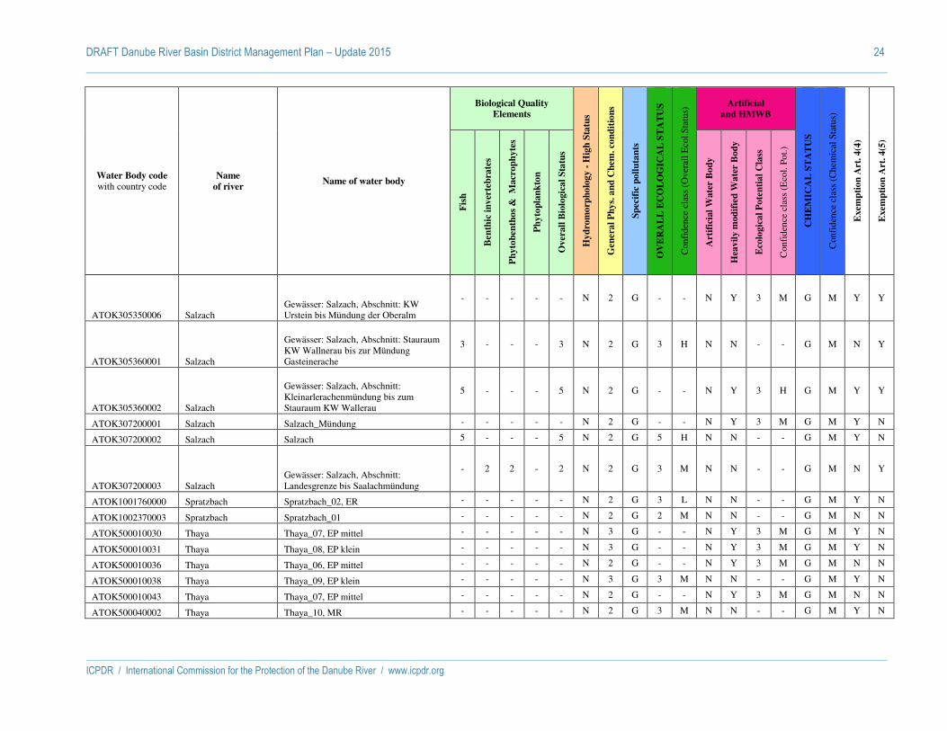
DRAFT Danube River Basin District Management Plan – Update 2015 24
ICPDR / International Commission for the Protection of the Danube River / www.icpdr.org
Water Body code with country code
Name
of river Name of water body
Biological Quality
Elements
Hy
dro
mo
rph
olo
gy -
Hig
h S
tatu
s
Gen
era
l P
hy
s. a
nd
Ch
em. co
nd
itio
ns
Sp
ecif
ic p
oll
uta
nts
OV
ER
AL
L E
CO
LO
GIC
AL
ST
AT
US
Con
fide
nce
clas
s (O
vera
ll E
col.S
tatu
s) Artificial
and HMWB
CH
EM
ICA
L S
TA
TU
S
Con
fide
nce
clas
s (C
hem
ical
Sta
tus)
Exem
pti
on
Art
. 4
(4)
Exem
pti
on
Art
. 4
(5)
Fis
h
Ben
thic
in
ver
teb
rate
s
Ph
yto
ben
tho
s &
M
acr
op
hy
tes
Ph
yto
pla
nk
ton
Ov
erall
Bio
logic
al
Sta
tus
Art
ific
ial
Wa
ter
Bo
dy
Hea
vil
y m
od
ifie
d W
ate
r B
od
y
Eco
logic
al
Po
ten
tia
l C
lass
Con
fide
nce
clas
s (E
col.
Pot.)
ATOK305350006 Salzach Gewässer: Salzach, Abschnitt: KW Urstein bis Mündung der Oberalm
- - - - - N 2 G - - N Y 3 M G M Y Y
ATOK305360001 Salzach
Gewässer: Salzach, Abschnitt: Stauraum KW Wallnerau bis zur Mündung Gasteinerache
3 - - - 3 N 2 G 3 H N N - - G M N Y
ATOK305360002 Salzach
Gewässer: Salzach, Abschnitt: Kleinarlerachenmündung bis zum Stauraum KW Wallerau
5 - - - 5 N 2 G - - N Y 3 H G M Y Y
ATOK307200001 Salzach Salzach_Mündung - - - - - N 2 G - - N Y 3 M G M Y N
ATOK307200002 Salzach Salzach 5 - - - 5 N 2 G 5 H N N - - G M Y N
ATOK307200003 Salzach Gewässer: Salzach, Abschnitt: Landesgrenze bis Saalachmündung
- 2 2 - 2 N 2 G 3 M N N - - G M N Y
ATOK1001760000 Spratzbach Spratzbach_02, ER - - - - - N 2 G 3 L N N - - G M Y N
ATOK1002370003 Spratzbach Spratzbach_01 - - - - - N 2 G 2 M N N - - G M N N
ATOK500010030 Thaya Thaya_07, EP mittel - - - - - N 3 G - - N Y 3 M G M Y N
ATOK500010031 Thaya Thaya_08, EP klein - - - - - N 3 G - - N Y 3 M G M Y N
ATOK500010036 Thaya Thaya_06, EP mittel - - - - - N 2 G - - N Y 3 M G M N N
ATOK500010038 Thaya Thaya_09, EP klein - - - - - N 3 G 3 M N N - - G M Y N
ATOK500010043 Thaya Thaya_07, EP mittel - - - - - N 2 G - - N Y 3 M G M N N
ATOK500040002 Thaya Thaya_10, MR - - - - - N 2 G 3 M N N - - G M Y N
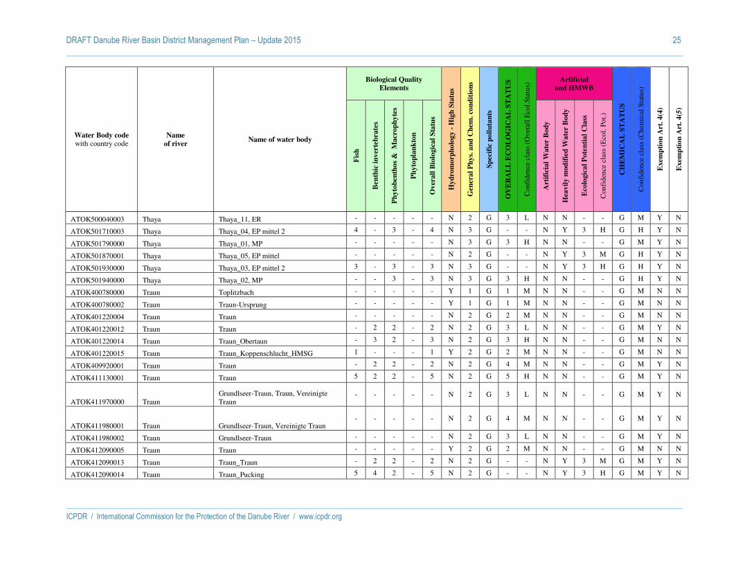
DRAFT Danube River Basin District Management Plan – Update 2015 25
ICPDR / International Commission for the Protection of the Danube River / www.icpdr.org
Water Body code with country code
Name
of river Name of water body
Biological Quality
Elements
Hy
dro
mo
rph
olo
gy -
Hig
h S
tatu
s
Gen
era
l P
hy
s. a
nd
Ch
em. co
nd
itio
ns
Sp
ecif
ic p
oll
uta
nts
OV
ER
AL
L E
CO
LO
GIC
AL
ST
AT
US
Con
fide
nce
clas
s (O
vera
ll E
col.S
tatu
s) Artificial
and HMWB
CH
EM
ICA
L S
TA
TU
S
Con
fide
nce
clas
s (C
hem
ical
Sta
tus)
Exem
pti
on
Art
. 4
(4)
Exem
pti
on
Art
. 4
(5)
Fis
h
Ben
thic
in
ver
teb
rate
s
Ph
yto
ben
tho
s &
M
acr
op
hy
tes
Ph
yto
pla
nk
ton
Ov
erall
Bio
logic
al
Sta
tus
Art
ific
ial
Wa
ter
Bo
dy
Hea
vil
y m
od
ifie
d W
ate
r B
od
y
Eco
logic
al
Po
ten
tia
l C
lass
Con
fide
nce
clas
s (E
col.
Pot.)
ATOK500040003 Thaya Thaya_11, ER - - - - - N 2 G 3 L N N - - G M Y N
ATOK501710003 Thaya Thaya_04, EP mittel 2 4 - 3 - 4 N 3 G - - N Y 3 H G H Y N
ATOK501790000 Thaya Thaya_01, MP - - - - - N 3 G 3 H N N - - G M Y N
ATOK501870001 Thaya Thaya_05, EP mittel - - - - - N 2 G - - N Y 3 M G H Y N
ATOK501930000 Thaya Thaya_03, EP mittel 2 3 - 3 - 3 N 3 G - - N Y 3 H G H Y N
ATOK501940000 Thaya Thaya_02, MP - - 3 - 3 N 3 G 3 H N N - - G H Y N
ATOK400780000 Traun Toplitzbach - - - - - Y 1 G 1 M N N - - G M N N
ATOK400780002 Traun Traun-Ursprung - - - - - Y 1 G 1 M N N - - G M N N
ATOK401220004 Traun Traun - - - - - N 2 G 2 M N N - - G M N N
ATOK401220012 Traun Traun - 2 2 - 2 N 2 G 3 L N N - - G M Y N
ATOK401220014 Traun Traun_Obertaun - 3 2 - 3 N 2 G 3 H N N - - G M N N
ATOK401220015 Traun Traun_Koppenschlucht_HMSG 1 - - - 1 Y 2 G 2 M N N - - G M N N
ATOK409920001 Traun Traun - 2 2 - 2 N 2 G 4 M N N - - G M Y N
ATOK411130001 Traun Traun 5 2 2 - 5 N 2 G 5 H N N - - G M Y N
ATOK411970000 Traun Grundlseer-Traun, Traun, Vereinigte Traun
- - - - - N 2 G 3 L N N - - G M Y N
ATOK411980001 Traun Grundlseer-Traun, Vereinigte Traun - - - - - N 2 G 4 M N N - - G M Y N
ATOK411980002 Traun Grundlseer-Traun - - - - - N 2 G 3 L N N - - G M Y N
ATOK412090005 Traun Traun - - - - - Y 2 G 2 M N N - - G M N N
ATOK412090013 Traun Traun_Traun - 2 2 - 2 N 2 G - - N Y 3 M G M Y N
ATOK412090014 Traun Traun_Pucking 5 4 2 - 5 N 2 G - - N Y 3 H G M Y N

DRAFT Danube River Basin District Management Plan – Update 2015 26
ICPDR / International Commission for the Protection of the Danube River / www.icpdr.org
Water Body code with country code
Name
of river Name of water body
Biological Quality
Elements
Hy
dro
mo
rph
olo
gy -
Hig
h S
tatu
s
Gen
era
l P
hy
s. a
nd
Ch
em. co
nd
itio
ns
Sp
ecif
ic p
oll
uta
nts
OV
ER
AL
L E
CO
LO
GIC
AL
ST
AT
US
Con
fide
nce
clas
s (O
vera
ll E
col.S
tatu
s) Artificial
and HMWB
CH
EM
ICA
L S
TA
TU
S
Con
fide
nce
clas
s (C
hem
ical
Sta
tus)
Exem
pti
on
Art
. 4
(4)
Exem
pti
on
Art
. 4
(5)
Fis
h
Ben
thic
in
ver
teb
rate
s
Ph
yto
ben
tho
s &
M
acr
op
hy
tes
Ph
yto
pla
nk
ton
Ov
erall
Bio
logic
al
Sta
tus
Art
ific
ial
Wa
ter
Bo
dy
Hea
vil
y m
od
ifie
d W
ate
r B
od
y
Eco
logic
al
Po
ten
tia
l C
lass
Con
fide
nce
clas
s (E
col.
Pot.)
ATOK412090016 Traun Traun_Marchtrenk - - - - - N 2 G - - N Y 3 M G M Y N
ATOK412090018 Traun Traun_Wels - 2 2 - 2 N 2 G 3 L N N - - G M Y N
ATOK412090020 Traun Traun_Welser_Wehr - - - - - N 2 G - - N Y 3 M G M Y N
ATOK412090024 Traun Traun_Saag - 2 2 - 2 N 2 G 4 M N N - - G M Y N
ATOK412090027 Traun Traun_Ebelsberg-Rückstau Donau - - - - - N 2 G - - N Y 3 M G M Y N
ATOK412090028 Traun Traun_Ebelsberg-RWStrecke 3 - - - 3 N 2 G 3 H N N - - G M N N
ATOK412090030 Traun Traun_Stadl - - - - - N 2 G - - N Y 3 M G M Y N
ATOK412090031 Traun Traun_Lambach - 3 1 - 3 N 1 G - - N Y 3 M G M Y N
ATOK412090032 Traun Traun_Kemating - - - - - N 2 G - - N Y 3 M G M Y N
ATOK412090036 Traun Traun - 2 1 - 2 N 2 G 3 L N N - - G M Y N
ATOK412090037 Traun Traun_Roitham_HMSG - 2 1 - 2 Y 2 G 2 M N N - - G M N N
ATOK412090040 Traun Traun_HMSG_Fischerinsel - - - - - Y 2 G 2 M N N - - G M N N
ATOK412090042 Traun Traun_Laakirchen - 2 2 - 2 N 2 G - - N Y 3 H G M Y N
ATOK412100001 Traun Traun_UW_Gmunden - - - - - N 2 G 3 L N N - - G M Y N
ATOK412100002 Traun Traun_KW_Gmunden 5 1 1 - 5 N 2 G - - N Y 3 H G M Y N
CZDYJ_0100 Dyje Dyje od státní hranice po vzdutí nádrže Vranov, vcetne toku Kreslický potok
5 3 3 - 5 3 G 5 H N N F M - N
CZDYJ_0160 Dyje Dyje od hráze nádrže Vranov po státní hranici
- 2 - - 2 2 G 2 M N N G H - N

DRAFT Danube River Basin District Management Plan – Update 2015 27
ICPDR / International Commission for the Protection of the Danube River / www.icpdr.org
Water Body code with country code
Name
of river Name of water body
Biological Quality
Elements
Hy
dro
mo
rph
olo
gy -
Hig
h S
tatu
s
Gen
era
l P
hy
s. a
nd
Ch
em. co
nd
itio
ns
Sp
ecif
ic p
oll
uta
nts
OV
ER
AL
L E
CO
LO
GIC
AL
ST
AT
US
Con
fide
nce
clas
s (O
vera
ll E
col.S
tatu
s) Artificial
and HMWB
CH
EM
ICA
L S
TA
TU
S
Con
fide
nce
clas
s (C
hem
ical
Sta
tus)
Exem
pti
on
Art
. 4
(4)
Exem
pti
on
Art
. 4
(5)
Fis
h
Ben
thic
in
ver
teb
rate
s
Ph
yto
ben
tho
s &
M
acr
op
hy
tes
Ph
yto
pla
nk
ton
Ov
erall
Bio
logic
al
Sta
tus
Art
ific
ial
Wa
ter
Bo
dy
Hea
vil
y m
od
ifie
d W
ate
r B
od
y
Eco
logic
al
Po
ten
tia
l C
lass
Con
fide
nce
clas
s (E
col.
Pot.)
CZDYJ_0170 Dyje Dyje od státní hranice po vzdutí nádrže Znojmo
- 2 2 - 2 2 G 2 H N N F M - N
CZDYJ_0180 Dyje Dyje od vzdutí nádrže Znojmo po státní hranici
- 2 2 - 2 2 G 2 H N N G H - N
CZDYJ_0190 Dyje Dyje od státní hranice po státní hranici - 2 3 - 3 3 F 3 M N N F H - N
CZDYJ_0200 Dyje Dyje od státní hranice po vzdutí nádrže Nové Mlýny I. – horní
3 2 3 - 3 3 F N Y 3 M G M - N
CZDYJ_1240 Dyje
Dyje od hráze nádrže Nové Mlýny III. - dolní po tok Odlehcovací rameno Dyje, Poštorná
- 2 - - 2 3 G N Y 3 M F H - N
CZDYJ_1260 Dyje Dyje od toku Odlehcovací rameno Dyje, Poštorná po tok Kyjovka (Stupava)
5 2 4 3 5 3 G 5 M N N F M - N
CZDYJ_1300 Dyje Dyje od toku Kyjovka (Stupava) po tok Morava
5 2 4 3 5 3 G 5 L N N F L - N
CZMOV_0010 Morava Morava od pramene po tok Krupá - 1 - - 1 2 G 2 M N N G H - N
CZMOV_0080 Morava Morava od toku Krupá po tok Desná - 1 - - 1 N 1 G 2 M N N F M - N
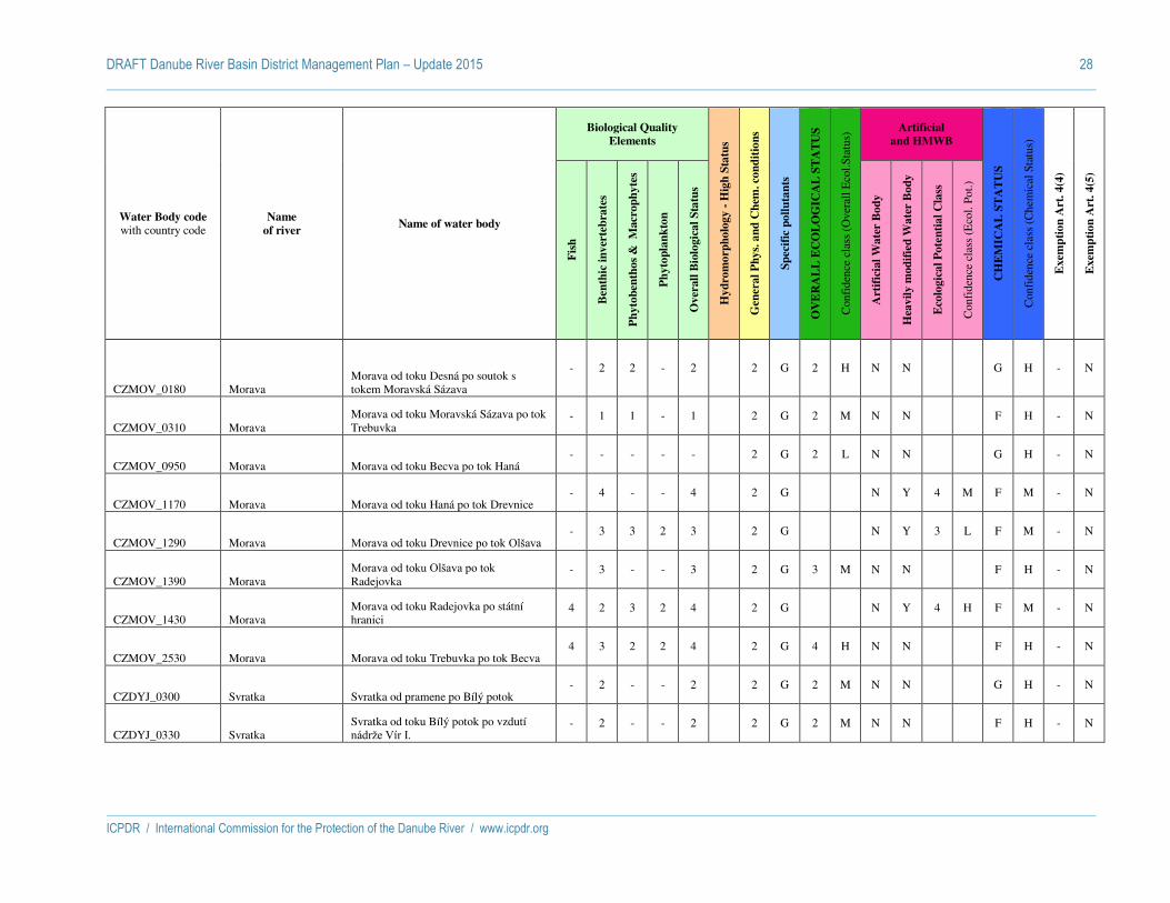
DRAFT Danube River Basin District Management Plan – Update 2015 28
ICPDR / International Commission for the Protection of the Danube River / www.icpdr.org
Water Body code with country code
Name
of river Name of water body
Biological Quality
Elements
Hy
dro
mo
rph
olo
gy -
Hig
h S
tatu
s
Gen
era
l P
hy
s. a
nd
Ch
em. co
nd
itio
ns
Sp
ecif
ic p
oll
uta
nts
OV
ER
AL
L E
CO
LO
GIC
AL
ST
AT
US
Con
fide
nce
clas
s (O
vera
ll E
col.S
tatu
s) Artificial
and HMWB
CH
EM
ICA
L S
TA
TU
S
Con
fide
nce
clas
s (C
hem
ical
Sta
tus)
Exem
pti
on
Art
. 4
(4)
Exem
pti
on
Art
. 4
(5)
Fis
h
Ben
thic
in
ver
teb
rate
s
Ph
yto
ben
tho
s &
M
acr
op
hy
tes
Ph
yto
pla
nk
ton
Ov
erall
Bio
logic
al
Sta
tus
Art
ific
ial
Wa
ter
Bo
dy
Hea
vil
y m
od
ifie
d W
ate
r B
od
y
Eco
logic
al
Po
ten
tia
l C
lass
Con
fide
nce
clas
s (E
col.
Pot.)
CZMOV_0180 Morava Morava od toku Desná po soutok s tokem Moravská Sázava
- 2 2 - 2 2 G 2 H N N G H - N
CZMOV_0310 Morava Morava od toku Moravská Sázava po tok Trebuvka
- 1 1 - 1 2 G 2 M N N F H - N
CZMOV_0950 Morava Morava od toku Becva po tok Haná - - - - - 2 G 2 L N N G H - N
CZMOV_1170 Morava Morava od toku Haná po tok Drevnice - 4 - - 4 2 G N Y 4 M F M - N
CZMOV_1290 Morava Morava od toku Drevnice po tok Olšava - 3 3 2 3 2 G N Y 3 L F M - N
CZMOV_1390 Morava Morava od toku Olšava po tok Radejovka
- 3 - - 3 2 G 3 M N N F H - N
CZMOV_1430 Morava Morava od toku Radejovka po státní hranici
4 2 3 2 4 2 G N Y 4 H F M - N
CZMOV_2530 Morava Morava od toku Trebuvka po tok Becva 4 3 2 2 4 2 G 4 H N N F H - N
CZDYJ_0300 Svratka Svratka od pramene po Bílý potok - 2 - - 2 2 G 2 M N N G H - N
CZDYJ_0330 Svratka Svratka od toku Bílý potok po vzdutí nádrže Vír I.
- 2 - - 2 2 G 2 M N N F H - N

DRAFT Danube River Basin District Management Plan – Update 2015 29
ICPDR / International Commission for the Protection of the Danube River / www.icpdr.org
Water Body code with country code
Name
of river Name of water body
Biological Quality
Elements
Hy
dro
mo
rph
olo
gy -
Hig
h S
tatu
s
Gen
era
l P
hy
s. a
nd
Ch
em. co
nd
itio
ns
Sp
ecif
ic p
oll
uta
nts
OV
ER
AL
L E
CO
LO
GIC
AL
ST
AT
US
Con
fide
nce
clas
s (O
vera
ll E
col.S
tatu
s) Artificial
and HMWB
CH
EM
ICA
L S
TA
TU
S
Con
fide
nce
clas
s (C
hem
ical
Sta
tus)
Exem
pti
on
Art
. 4
(4)
Exem
pti
on
Art
. 4
(5)
Fis
h
Ben
thic
in
ver
teb
rate
s
Ph
yto
ben
tho
s &
M
acr
op
hy
tes
Ph
yto
pla
nk
ton
Ov
erall
Bio
logic
al
Sta
tus
Art
ific
ial
Wa
ter
Bo
dy
Hea
vil
y m
od
ifie
d W
ate
r B
od
y
Eco
logic
al
Po
ten
tia
l C
lass
Con
fide
nce
clas
s (E
col.
Pot.)
CZDYJ_0380 Svratka Svratka od hráze nádrže Vír I. po tok Bobruvka (Loucka)
- 2 - - 2 2 G 2 M N N G H - N
CZDYJ_0450 Svratka Svratka od toku Bobruvka (Loucka) po vzdutí nádrže Brno
3 2 3 - 3 2 G 3 M N N F H - N
CZDYJ_0490 Svratka Svratka od hráze nádrže Brno po tok Svitava
- 2 - - 2 2 G N Y 2 M G H - N
CZDYJ_0670 Svratka Svratka od toku Svitava po tok Litava (Cézava)
2 2 3 2 3 3 G N Y 3 L F L - N
CZDYJ_0800 Svratka Svratka od toku Litava (Cézava) po vzdutí nádrže Nové Mlýny II. - strední
5 3 3 1 5 3 F 5 H N N F L - N
SKB0001 Bodrog Bodrog 2 3 3 1 3 N 2 F 3 H N N - - G M N N
SKV0003 Čierny Váh Čierny Váh - 1 2 - 2 N 2 G 2 M N N - - G M N N
SKV0004 Čierny Váh Čierny Váh 1 2 2 - 2 Y 2 G 2 H N N - - G M N N
SKH0001 Hornád Hornád 2 3 2 - 3 N 2 G 3 H N N - - G M N N
SKH0002 Hornád Hornád 1 1 2 - 2 N 2 G 2 H N N - - G M N N
SKH0003 Hornád Hornád 3 3 3 - 3 N 3 F 3 H N N - - G M N N
SKH0004 Hornád Hornád 2 3 3 1 3 N 2 G 3 H N N - - G M N N
SKR0001 Hron Hron 1 2 2 - 2 N 1 G 2 H N N - - G M N N
SKR0002 Hron Hron - - - - - N - - 3 L N N - - G L N N
SKR0003 Hron Hron 2 3 1 - 3 N 2 G 3 H N N - - G M N N
SKR0004 Hron Hron 2 3 3 - 3 Y 2 G 3 H N N - - G M N N

DRAFT Danube River Basin District Management Plan – Update 2015 30
ICPDR / International Commission for the Protection of the Danube River / www.icpdr.org
Water Body code with country code
Name
of river Name of water body
Biological Quality
Elements
Hy
dro
mo
rph
olo
gy -
Hig
h S
tatu
s
Gen
era
l P
hy
s. a
nd
Ch
em. co
nd
itio
ns
Sp
ecif
ic p
oll
uta
nts
OV
ER
AL
L E
CO
LO
GIC
AL
ST
AT
US
Con
fide
nce
clas
s (O
vera
ll E
col.S
tatu
s) Artificial
and HMWB
CH
EM
ICA
L S
TA
TU
S
Con
fide
nce
clas
s (C
hem
ical
Sta
tus)
Exem
pti
on
Art
. 4
(4)
Exem
pti
on
Art
. 4
(5)
Fis
h
Ben
thic
in
ver
teb
rate
s
Ph
yto
ben
tho
s &
M
acr
op
hy
tes
Ph
yto
pla
nk
ton
Ov
erall
Bio
logic
al
Sta
tus
Art
ific
ial
Wa
ter
Bo
dy
Hea
vil
y m
od
ifie
d W
ate
r B
od
y
Eco
logic
al
Po
ten
tia
l C
lass
Con
fide
nce
clas
s (E
col.
Pot.)
SKR0005 Hron Hron 2 3 3 3 3 N 2 G 3 H N N - - G M N N
SKI0001 Ipeľ Ipeľ 1 2 2 - 2 Y 2 F 3 H N N - - G M N N
SKI0003 Ipeľ Ipeľ - - - - - N 2 G 2 L N N - - G M N N
SKI0004 Ipeľ Ipeľ 3 3 3 3 3 N 3 G 3 H N N - - G M N N
SKB0141 Laborec Laborec - - - - - N - - 2 L N N - - G L N N
SKB0142 Laborec Laborec 1 3 2 - 3 N 2 G 3 H N N - - G M N N
SKB0144 Laborec Laborec 4 4 2 2 4 N 2 G 4 H N N - - G M N N
SKB0140 Latorica Latorica 2 3 2 1 3 N 2 F 3 H N N - - G M N N
SKM0001 Morava Morava 3 2 3 3 3 N 3 G - - N Y 3 H G M N N
SKM0002 Morava Morava 2 3 3 3 3 N 2 G 3 H N N - - G M N N
SKN0001 Nitra Nitra - 1 1 - 1 N 2 G 1 M N N - - G M N N
SKN0002 Nitra Nitra 2 3 2 - 3 N 3 G 3 H N N - - G M N N
SKN0003 Nitra Nitra 3 3 2 - 3 N 3 F 3 H N N - - F M Y N
SKN0004 Nitra Nitra 4 3 3 4 4 N 3 F - - N Y 4 H G M Y N
SKD0015
Prívodný kanál (VN Gabčíkovo) - Odpadový kanál
Prívodný kanál (VN Gabčíkovo) - Odpadový kanál
- - - 2 2 N 2 G - - Y N 2 M G M N N
SKS0001 Slaná Slaná - - - - - N - - 2 L N N - - G L N N
SKS0002 Slaná Slaná 2 2 2 - 2 N 2 F 3 H N N - - F M Y N
SKS0003 Slaná Slaná 2 3 3 2 3 N 3 G 3 H N N - - G M N N

DRAFT Danube River Basin District Management Plan – Update 2015 31
ICPDR / International Commission for the Protection of the Danube River / www.icpdr.org
Water Body code with country code
Name
of river Name of water body
Biological Quality
Elements
Hy
dro
mo
rph
olo
gy -
Hig
h S
tatu
s
Gen
era
l P
hy
s. a
nd
Ch
em. co
nd
itio
ns
Sp
ecif
ic p
oll
uta
nts
OV
ER
AL
L E
CO
LO
GIC
AL
ST
AT
US
Con
fide
nce
clas
s (O
vera
ll E
col.S
tatu
s) Artificial
and HMWB
CH
EM
ICA
L S
TA
TU
S
Con
fide
nce
clas
s (C
hem
ical
Sta
tus)
Exem
pti
on
Art
. 4
(4)
Exem
pti
on
Art
. 4
(5)
Fis
h
Ben
thic
in
ver
teb
rate
s
Ph
yto
ben
tho
s &
M
acr
op
hy
tes
Ph
yto
pla
nk
ton
Ov
erall
Bio
logic
al
Sta
tus
Art
ific
ial
Wa
ter
Bo
dy
Hea
vil
y m
od
ifie
d W
ate
r B
od
y
Eco
logic
al
Po
ten
tia
l C
lass
Con
fide
nce
clas
s (E
col.
Pot.)
SKT0001 Tisa Tisa 2 3 - 3 3 Y 2 F 3 H N N - - G M N N
SKV0005 Váh Váh 1 3 1 - 3 Y 2 G 3 H N N - - G M N N
SKV0006 Váh Váh 3 3 3 - 3 N 2 G 3 H N N - - G M N N
SKV0007 Váh Váh 4 3 3 2 4 N 2 G - - N Y 4 H G M N N
SKV0008 Váh Váh 2 3 3 2 3 N 2 G - - N Y 3 H G M N N
SKV0019 Váh Váh - 3 2 2 3 N 2 G - - N Y 3 H G M N N
SKV0027 Váh Váh 4 4 3 2 4 N 3 F - - N Y 4 H G M N N
HUAEP322 Berettyó Berettyó N Y
HUAEP334 Bodrog Bodrog N Y
HUAEP438 Dráva Dráva alsó N Y
HUAEP439 Dráva Dráva felső N N
HUAEP471 Fehér-Körös Fehér-Körös N Y
HUAEP475 Fekete-Körös Fekete-Körös N Y
HUAEP567 Hármas-Körös Hármas-Körös N Y
HUAEP579 Hernád Hernád alsó N N
HUAEP580 Hernád Hernád felső N N
HUAEP594 Hortobágy-Berettyó Hortobágy-Berettyó N Y
HUAEP595 Hortobágy-főcsatorna Hortobágy-főcsatorna N Y
HUAEP596 Hortobágy-főcsatorna Hortobágy-főcsatorna dél N Y

DRAFT Danube River Basin District Management Plan – Update 2015 32
ICPDR / International Commission for the Protection of the Danube River / www.icpdr.org
Water Body code with country code
Name
of river Name of water body
Biological Quality
Elements
Hy
dro
mo
rph
olo
gy -
Hig
h S
tatu
s
Gen
era
l P
hy
s. a
nd
Ch
em. co
nd
itio
ns
Sp
ecif
ic p
oll
uta
nts
OV
ER
AL
L E
CO
LO
GIC
AL
ST
AT
US
Con
fide
nce
clas
s (O
vera
ll E
col.S
tatu
s) Artificial
and HMWB
CH
EM
ICA
L S
TA
TU
S
Con
fide
nce
clas
s (C
hem
ical
Sta
tus)
Exem
pti
on
Art
. 4
(4)
Exem
pti
on
Art
. 4
(5)
Fis
h
Ben
thic
in
ver
teb
rate
s
Ph
yto
ben
tho
s &
M
acr
op
hy
tes
Ph
yto
pla
nk
ton
Ov
erall
Bio
logic
al
Sta
tus
Art
ific
ial
Wa
ter
Bo
dy
Hea
vil
y m
od
ifie
d W
ate
r B
od
y
Eco
logic
al
Po
ten
tia
l C
lass
Con
fide
nce
clas
s (E
col.
Pot.)
HUAEP597 Hortobágy-főcsatorna Hortobágy-főcsatorna észak N Y
HUAEP614 Ipoly Ipoly N N
HUAEP668 Kettős-Körös Kettős-Körös N Y
HUAEP783 Maros Maros torkolat N Y
HUAEP784 Maros Maros kelet N Y
HUAEP810 Mosoni-Duna Mosoni-Duna alsó N Y
HUAEP811 Mosoni-Duna Mosoni-Duna felső N Y
HUAEP812 Mosoni-Duna Mosoni-Duna középső N Y
HUAEP816 Mura Mura N N
HUAEP898 Rába Rába (Kis-Rábától) N Y
HUAEP899 Rába Rába (Csörnöc-Herpenyőtől) N Y
HUAEP900 Rába Rába (Lapincstól) N N
HUAEP901 Rába Rába (ÉDÁSZ-üzemvízcsatornától) N Y
HUAEP902 Rába Rába torkolati szakasz N Y
HUAEP903 Rába Rába (határtól) N N
HUAEP904 Rábca Rábca N Y
HUAEP919 Répce Répce felső N N
HUAEP920 Répce Répce alsó N Y
HUAEP921 Répce Répce középső N N
HUAEP931 Sajó Sajó felső N N
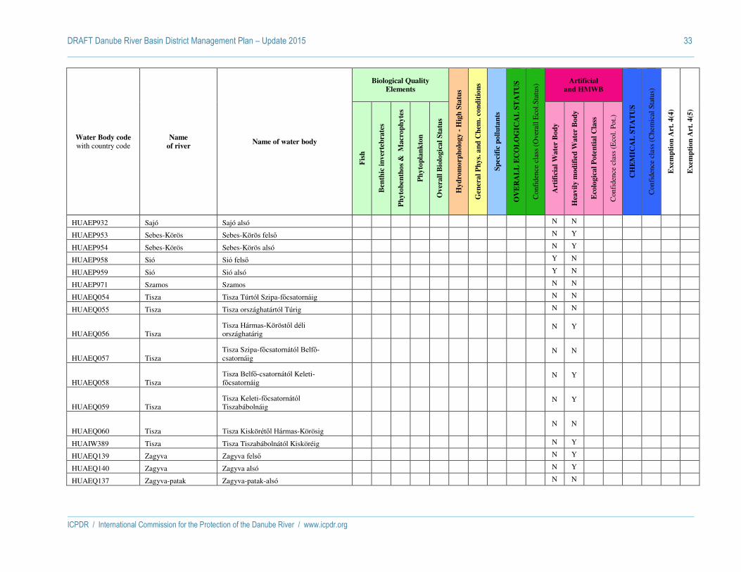
DRAFT Danube River Basin District Management Plan – Update 2015 33
ICPDR / International Commission for the Protection of the Danube River / www.icpdr.org
Water Body code with country code
Name
of river Name of water body
Biological Quality
Elements
Hy
dro
mo
rph
olo
gy -
Hig
h S
tatu
s
Gen
era
l P
hy
s. a
nd
Ch
em. co
nd
itio
ns
Sp
ecif
ic p
oll
uta
nts
OV
ER
AL
L E
CO
LO
GIC
AL
ST
AT
US
Con
fide
nce
clas
s (O
vera
ll E
col.S
tatu
s) Artificial
and HMWB
CH
EM
ICA
L S
TA
TU
S
Con
fide
nce
clas
s (C
hem
ical
Sta
tus)
Exem
pti
on
Art
. 4
(4)
Exem
pti
on
Art
. 4
(5)
Fis
h
Ben
thic
in
ver
teb
rate
s
Ph
yto
ben
tho
s &
M
acr
op
hy
tes
Ph
yto
pla
nk
ton
Ov
erall
Bio
logic
al
Sta
tus
Art
ific
ial
Wa
ter
Bo
dy
Hea
vil
y m
od
ifie
d W
ate
r B
od
y
Eco
logic
al
Po
ten
tia
l C
lass
Con
fide
nce
clas
s (E
col.
Pot.)
HUAEP932 Sajó Sajó alsó N N
HUAEP953 Sebes-Körös Sebes-Körös felső N Y
HUAEP954 Sebes-Körös Sebes-Körös alsó N Y
HUAEP958 Sió Sió felső Y N
HUAEP959 Sió Sió alsó Y N
HUAEP971 Szamos Szamos N N
HUAEQ054 Tisza Tisza Túrtól Szipa-főcsatornáig N N
HUAEQ055 Tisza Tisza országhatártól Túrig N N
HUAEQ056 Tisza Tisza Hármas-Köröstől déli országhatárig
N Y
HUAEQ057 Tisza Tisza Szipa-főcsatornától Belfő-csatornáig
N N
HUAEQ058 Tisza Tisza Belfő-csatornától Keleti-főcsatornáig
N Y
HUAEQ059 Tisza Tisza Keleti-főcsatornától Tiszabábolnáig
N Y
HUAEQ060 Tisza Tisza Kiskörétől Hármas-Körösig N N
HUAIW389 Tisza Tisza Tiszabábolnától Kisköréig N Y
HUAEQ139 Zagyva Zagyva felső N Y
HUAEQ140 Zagyva Zagyva alsó N Y
HUAEQ137 Zagyva-patak Zagyva-patak-alsó N N

DRAFT Danube River Basin District Management Plan – Update 2015 34
ICPDR / International Commission for the Protection of the Danube River / www.icpdr.org
Water Body code with country code
Name
of river Name of water body
Biological Quality
Elements
Hy
dro
mo
rph
olo
gy -
Hig
h S
tatu
s
Gen
era
l P
hy
s. a
nd
Ch
em. co
nd
itio
ns
Sp
ecif
ic p
oll
uta
nts
OV
ER
AL
L E
CO
LO
GIC
AL
ST
AT
US
Con
fide
nce
clas
s (O
vera
ll E
col.S
tatu
s) Artificial
and HMWB
CH
EM
ICA
L S
TA
TU
S
Con
fide
nce
clas
s (C
hem
ical
Sta
tus)
Exem
pti
on
Art
. 4
(4)
Exem
pti
on
Art
. 4
(5)
Fis
h
Ben
thic
in
ver
teb
rate
s
Ph
yto
ben
tho
s &
M
acr
op
hy
tes
Ph
yto
pla
nk
ton
Ov
erall
Bio
logic
al
Sta
tus
Art
ific
ial
Wa
ter
Bo
dy
Hea
vil
y m
od
ifie
d W
ate
r B
od
y
Eco
logic
al
Po
ten
tia
l C
lass
Con
fide
nce
clas
s (E
col.
Pot.)
HUAEQ138 Zagyva-patak Zagyva-patak felső és Bárna-patak N N
HUAEQ144 Zala Zala forrásvidék N N
HUAEQ146 Zala Zala (Széplaki-patakig) N N
HUAEQ147 Zala Zala (Bárándi-patakig) N N
SISI3VT197 Drava MPVT Drava mejni odsek z Avstrijo - - 2 - 2 1 G - - N Y - - G M - -
SISI3VT359 Drava MPVT Drava Dravograd - Maribor - - 2 - 2 1 G - - N Y - - G H - -
SISI3VT5171 Drava VT Drava Maribor - Ptuj - 2 3 - 3 1 G 3 M N N - - G H - -
SISI3VT930 Drava VT Drava Ptuj - Ormož - 2 3 - 3 2 G 3 L N N - - G H - -
SISI3VT970 Drava VT Drava zadrževalnik Ormoško jezero - Središče ob Dravi
- 2 1 - 2 1 G 2 H N N - - G H - -
SISI378VT Kanal Hidroelektrarne Formin UVT Kanal HE Formin
- - - - - - G - - Y N - - G H - -
SISI35172VT Kanal Hidroelektrarne Zlatoličje UVT Kanal HE Zlatoličje
- - - - - - G - - Y N - - G H - -
SISI21VT13 Kolpa VT Kolpa Osilnica - Petrina - 1 1 - 1 1 G 1 M N N - - G H - -
SISI21VT50 Kolpa VT Kolpa Petrina - Primostek - 2 2 - 2 1 G 2 M N N - - G H - -
SISI21VT70 Kolpa VT Kolpa Primostek - Kamanje - 2 2 - 2 1 G 2 H N N - - G H - -

DRAFT Danube River Basin District Management Plan – Update 2015 35
ICPDR / International Commission for the Protection of the Danube River / www.icpdr.org
Water Body code with country code
Name
of river Name of water body
Biological Quality
Elements
Hy
dro
mo
rph
olo
gy -
Hig
h S
tatu
s
Gen
era
l P
hy
s. a
nd
Ch
em. co
nd
itio
ns
Sp
ecif
ic p
oll
uta
nts
OV
ER
AL
L E
CO
LO
GIC
AL
ST
AT
US
Con
fide
nce
clas
s (O
vera
ll E
col.S
tatu
s) Artificial
and HMWB
CH
EM
ICA
L S
TA
TU
S
Con
fide
nce
clas
s (C
hem
ical
Sta
tus)
Exem
pti
on
Art
. 4
(4)
Exem
pti
on
Art
. 4
(5)
Fis
h
Ben
thic
in
ver
teb
rate
s
Ph
yto
ben
tho
s &
M
acr
op
hy
tes
Ph
yto
pla
nk
ton
Ov
erall
Bio
logic
al
Sta
tus
Art
ific
ial
Wa
ter
Bo
dy
Hea
vil
y m
od
ifie
d W
ate
r B
od
y
Eco
logic
al
Po
ten
tia
l C
lass
Con
fide
nce
clas
s (E
col.
Pot.)
SISI43VT10 Mura VT Mura Ceršak - Petanjci - 2 3 - 3 2 G 3 M N N - - G M - -
SISI43VT30 Mura VT Kučnica Mura Petanjci - Gibina - 3 3 - 3 2 G 3 H N N - - G M - -
SISI43VT50 Mura VT Mura Gibina - Podturen - 2 2 - 2 2 G 3 H N N - - G H - -
SISI111VT5 Sava VT Sava izvir - Hrušica - 2 2 - 2 1 G 2 H N N - - G H - -
SISI111VT7 Sava MPVT zadrževalnik HE Moste - - 2 - 2 2 G - - N Y - - G H - -
SISI1VT137 Sava VT Sava HE Moste - Podbrezje - 3 1 - 3 1 G 3 M N N - - G H - -
SISI1VT150 Sava VT Sava Podbrezje - Kranj - 2 2 - 2 1 G 2 H N N - - G H - -
SISI1VT170 Sava MPVT Sava Mavčiče - Medvode - - 2 - 2 1 G - - N Y - - G M - -
SISI1VT310 Sava VT Sava Medvode - Podgrad - 2 2 - 2 1 G 2 H N N - - G H - -
SISI1VT519 Sava VT Sava Podgrad - Litija - 2 3 - 3 2 G 3 M N N - - G H - -
SISI1VT557 Sava VT Sava Litija - Zidani Most - 2 2 - 2 2 G 2 H N N - - G H - -
SISI1VT713 Sava MPVT Sava Vrhovo - Boštanj - - 2 - 2 2 G - - N Y - - G M - -
SISI1VT739 Sava VT Sava Boštanj - Krško - 3 3 - 3 2 G 3 H N N - - G H - -
SISI1VT913 Sava VT Sava Krško - Vrbina - 2 2 - 2 1 G 2 H N N - - G H - -
SISI1VT930 Sava VT Sava mejni odsek - 2 3 - 3 2 G 3 M N N - - G H - -
HRDSRN165011 Česma DSRN165011 - - - - - N 3 - N Y 3 M G M - -
HRDSRN165034 Česma DSRN165034 - - - - - N 3 - N Y 3 M G M - -
HRDSRN165051 Česma DSRN165051 - - - - - N 3 - 3 M N N G M - -
HRDSRN165101 Česma DSRN165101 - - - - - Y 1 - 1 M N N G M - -
HRDSRN020001 Dobra, Kupa DSRN020001 - - - - - Y 1 - 1 M N N F M - -
HRDDRI020003 Drava DDRI020003 - - - - - N 2 - N Y 3 M G M - -

DRAFT Danube River Basin District Management Plan – Update 2015 36
ICPDR / International Commission for the Protection of the Danube River / www.icpdr.org
Water Body code with country code
Name
of river Name of water body
Biological Quality
Elements
Hy
dro
mo
rph
olo
gy -
Hig
h S
tatu
s
Gen
era
l P
hy
s. a
nd
Ch
em. co
nd
itio
ns
Sp
ecif
ic p
oll
uta
nts
OV
ER
AL
L E
CO
LO
GIC
AL
ST
AT
US
Con
fide
nce
clas
s (O
vera
ll E
col.S
tatu
s) Artificial
and HMWB
CH
EM
ICA
L S
TA
TU
S
Con
fide
nce
clas
s (C
hem
ical
Sta
tus)
Exem
pti
on
Art
. 4
(4)
Exem
pti
on
Art
. 4
(5)
Fis
h
Ben
thic
in
ver
teb
rate
s
Ph
yto
ben
tho
s &
M
acr
op
hy
tes
Ph
yto
pla
nk
ton
Ov
erall
Bio
logic
al
Sta
tus
Art
ific
ial
Wa
ter
Bo
dy
Hea
vil
y m
od
ifie
d W
ate
r B
od
y
Eco
logic
al
Po
ten
tia
l C
lass
Con
fide
nce
clas
s (E
col.
Pot.)
HRDDRI020005 Drava DDRI020005 - - - - - N 1 - 4 M N N G M - -
HRDDRI020006 Drava DDRI020006 - - - - - Y 1 - 1 M N N G M - -
HRDDRI020007 Drava DDRI020007 - - - - - N 2 - 3 M N N G M - -
HRDDRI945039 Drava DDRI945039 - - - - - N 1 - Y N 5 M G M - -
HRDDRN020001 Drava DDRN020001 - - - - - N 2 - N Y 4 M F M - -
HRDDRN020002 Drava DDRN020002 - - - - - N 2 - N Y 3 M G M - -
HRDDRI020004 Drava, Mura DDRI020004 - - - - - N 2 - N Y 3 M G M - -
HRDSRI020003 Kupa DSRI020003 - - - - - Y 1 - 1 M N N F M - -
HRDSRI020004 Kupa DSRI020004 - - - - - N 1 - 2 M N N G M - -
HRDSRN020002 Kupa DSRN020002 - - - - - Y 1 - 1 M N N F M - -
HRDSRN935009 Kupa DSRN935009 - - - - - N 1 - 2 M N N G M - -
HRDSRN160001 Lonja DSRN160001 - - - - - N 3 - 3 M N N G M - -
HRDSRN165010 Lonja DSRN165010 - - - - - N 3 - Y N 3 M G M - -
HRDDRI030001 Mura DDRI030001 - - - - - N 2 - N Y 3 M G M - -
HRDDRN035001 Mura DDRN035001 - - - - - N 3 - N Y 3 M G M - -
HRDSRI010001 Sava DSRI010001 - - - - - N 2 - N Y 4 M G M - -
HRDSRI010002 Sava DSRI010002 - - - - - N 2 - N Y 4 M G M - -
HRDSRI010003 Sava DSRI010003 - - - - - N 2 - N Y 4 M G M - -
HRDSRI010004 Sava DSRI010004 - - - - - N 2 - N Y 3 M G M - -
HRDSRI010010 Sava DSRI010010 - - - - - Y 3 - 3 M N N G M - -
HRDSRN010005 Sava DSRN010005 - - - - - N 2 - N Y 3 M F M - -
HRDSRN010006 Sava DSRN010006 - - - - - N 2 - N Y 3 M G M - -

DRAFT Danube River Basin District Management Plan – Update 2015 37
ICPDR / International Commission for the Protection of the Danube River / www.icpdr.org
Water Body code with country code
Name
of river Name of water body
Biological Quality
Elements
Hy
dro
mo
rph
olo
gy -
Hig
h S
tatu
s
Gen
era
l P
hy
s. a
nd
Ch
em. co
nd
itio
ns
Sp
ecif
ic p
oll
uta
nts
OV
ER
AL
L E
CO
LO
GIC
AL
ST
AT
US
Con
fide
nce
clas
s (O
vera
ll E
col.S
tatu
s) Artificial
and HMWB
CH
EM
ICA
L S
TA
TU
S
Con
fide
nce
clas
s (C
hem
ical
Sta
tus)
Exem
pti
on
Art
. 4
(4)
Exem
pti
on
Art
. 4
(5)
Fis
h
Ben
thic
in
ver
teb
rate
s
Ph
yto
ben
tho
s &
M
acr
op
hy
tes
Ph
yto
pla
nk
ton
Ov
erall
Bio
logic
al
Sta
tus
Art
ific
ial
Wa
ter
Bo
dy
Hea
vil
y m
od
ifie
d W
ate
r B
od
y
Eco
logic
al
Po
ten
tia
l C
lass
Con
fide
nce
clas
s (E
col.
Pot.)
HRDSRN010007 Sava DSRN010007 - - - - - N 2 - N Y 4 M G M - -
HRDSRN010008 Sava DSRN010008 - - - - - N 2 - N Y 3 M G M - -
HRDSRN010009 Sava DSRN010009 - - - - - N 2 - 2 M N N G M - -
HRDSRI030001 Una DSRI030001 - - - - - N 1 - 2 M N N G M - -
HRDSRI030002 Una DSRI030002 - - - - - Y 2 - 2 M N N G M - -
HRDSRI030003 Una DSRI030003 - - - - - Y 1 - 1 M N N G M - -
HRDSRI030004 Una DSRI030004 - - - - - Y 1 - 1 M N N G M - -
BABOS_1 Bosna BA_BOS_1 - 4 - 2 - - 4 M N N - - G L
BABOS_2 Bosna BA_BOS_2 - - - - - - - - N PN - - - -
BABOS_3 Bosna BA_BOS_3 - - - - - - - - N PN - - - -
BABOS_4 Bosna BA_BOS_4 - - - - - - - - N PN - - - -
BABOS_5 Bosna BA_BOS_5 - - - - - - - - N PN - - - -
BABOS_6 Bosna BA_BOS_6 - - - - - - - - N PN - - - -
BABOS_7 Bosna BA_BOS_7 - - - - - - - - N PN - - - -
BADR_1 Drina BA_DR_1 - 2 - 2 - - 3 M N N - - G L
BADR_3 Drina BA_DR_3 - - - - - - - - N PY - - - -
BADR_5 Drina BA_DR_5 - - - - - - - - N PY - - - -
BADR_6 Drina BA_DR_6 - - - - - - - - N PY - - - -
BADR_7 Drina BA_DR_7 - - 3 2 - - 3 M N N - - G L
BALIM_1 Lim BA_LIM_1 - 3 - 2 - - 3 M N Y - - F L
BAUNA_SAN_1 Sana BA_UNA_SAN_1 - 2 - 2 - - 3 M N N - - G L
BAUNA_SAN_2 Sana BA_UNA_SAN_2 - - - - - - - - N PN - - - -
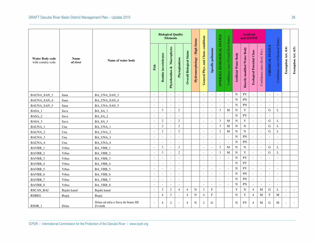
DRAFT Danube River Basin District Management Plan – Update 2015 38
ICPDR / International Commission for the Protection of the Danube River / www.icpdr.org
Water Body code with country code
Name
of river Name of water body
Biological Quality
Elements
Hy
dro
mo
rph
olo
gy -
Hig
h S
tatu
s
Gen
era
l P
hy
s. a
nd
Ch
em. co
nd
itio
ns
Sp
ecif
ic p
oll
uta
nts
OV
ER
AL
L E
CO
LO
GIC
AL
ST
AT
US
Con
fide
nce
clas
s (O
vera
ll E
col.S
tatu
s) Artificial
and HMWB
CH
EM
ICA
L S
TA
TU
S
Con
fide
nce
clas
s (C
hem
ical
Sta
tus)
Exem
pti
on
Art
. 4
(4)
Exem
pti
on
Art
. 4
(5)
Fis
h
Ben
thic
in
ver
teb
rate
s
Ph
yto
ben
tho
s &
M
acr
op
hy
tes
Ph
yto
pla
nk
ton
Ov
erall
Bio
logic
al
Sta
tus
Art
ific
ial
Wa
ter
Bo
dy
Hea
vil
y m
od
ifie
d W
ate
r B
od
y
Eco
logic
al
Po
ten
tia
l C
lass
Con
fide
nce
clas
s (E
col.
Pot.)
BAUNA_SAN_3 Sana BA_UNA_SAN_3 - - - - - - - - N PY - - - -
BAUNA_SAN_4 Sana BA_UNA_SAN_4 - - - - - - - - N PN - - - -
BAUNA_SAN_5 Sana BA_UNA_SAN_5 - - - - - - - - N PN - - - -
BASA_1 Sava BA_SA_1 - 3 - 2 - - 3 M N Y - - G L
BASA_2 Sava BA_SA_2 - - - - - - - - N PY - - - -
BASA_3 Sava BA_SA_3 - 2 - 2 - - 3 M N Y - - G L
BAUNA_1 Una BA_UNA_1 - 2 - 2 - - 3 M N N - - G L
BAUNA_2 Una BA_UNA_2 - 2 - 2 - - 2 M N N - - G L
BAUNA_3 Una BA_UNA_3 - - - - - - - - N PN - - - -
BAUNA_4 Una BA_UNA_4 - - - - - - - - N PN - - - -
BAVRB_1 Vrbas BA_VRB_1 - 3 - 2 - - 3 M N N - - G L
BAVRB_2 Vrbas BA_VRB_2 - 3 - 2 - - 3 M N Y - - G L
BAVRB_3 Vrbas BA_VRB_3 - - - - - - - - N PY - - - -
BAVRB_4 Vrbas BA_VRB_4 - - - - - - - - N PY - - - -
BAVRB_5 Vrbas BA_VRB_5 - - - - - - - - N PY - - - -
BAVRB_6 Vrbas BA_VRB_6 - - - - - - - - N PN - - - -
BAVRB_7 Vrbas BA_VRB_7 - - - - - - - - N PN - - - -
BAVRB_8 Vrbas BA_VRB_8 - - - - - - - - N PN - - - -
RSCAN_BAJ Bajski kanal Bajski kanal - 3 2 4 4 N 3 F Y N 4 M G L - -
RSBEG Begej Begej - 4 3 - 4 N 4 F N Y 4 M F M - -
RSDR_1 Drina Drina od ušća u Savu do brane HE Zvornik
- 4 2 - 4 N 2 G N PY 4 M G M - -

DRAFT Danube River Basin District Management Plan – Update 2015 39
ICPDR / International Commission for the Protection of the Danube River / www.icpdr.org
Water Body code with country code
Name
of river Name of water body
Biological Quality
Elements
Hy
dro
mo
rph
olo
gy -
Hig
h S
tatu
s
Gen
era
l P
hy
s. a
nd
Ch
em. co
nd
itio
ns
Sp
ecif
ic p
oll
uta
nts
OV
ER
AL
L E
CO
LO
GIC
AL
ST
AT
US
Con
fide
nce
clas
s (O
vera
ll E
col.S
tatu
s) Artificial
and HMWB
CH
EM
ICA
L S
TA
TU
S
Con
fide
nce
clas
s (C
hem
ical
Sta
tus)
Exem
pti
on
Art
. 4
(4)
Exem
pti
on
Art
. 4
(5)
Fis
h
Ben
thic
in
ver
teb
rate
s
Ph
yto
ben
tho
s &
M
acr
op
hy
tes
Ph
yto
pla
nk
ton
Ov
erall
Bio
logic
al
Sta
tus
Art
ific
ial
Wa
ter
Bo
dy
Hea
vil
y m
od
ifie
d W
ate
r B
od
y
Eco
logic
al
Po
ten
tia
l C
lass
Con
fide
nce
clas
s (E
col.
Pot.)
RSDR_3 Drina Drina od ušća Velike reke do brane HE Bajina Bašta
- 3 2 - 3 N 2 G 3 M N PN G M - -
RSCAN_BP-KAR DTD Bački Petrovac-Karavukovo DTD B.Petrovac-Karavukovo
- 3 3 4 4 N 3 G Y N 4 M G L - -
RSCAN_BP-NB_1 DTD Banatska Palanka-Novi Bečej DTD Ban. Palanka-Novi Bečej
- 3 2 2 3 N 3 G Y N 3 M G L - -
RSCAN_BP-NB_2 DTD Banatska Palanka-Novi Bečej DTD Ban. Palanka-Novi Bečej
- - - - - N 2 G Y N 3 L G L - -
RSCAN_BEC-BOG DTD Bečej-Bogojevo DTD Bečej-Bogojevo - 3 3 4 4 N 4 F Y N 4 M G L - -
RSCAN_KOS-MS DTD Kosančić-Mali Stapar DTD Kosančić-Mali Stapar
- - - - - N 2 G Y N 3 L G L - -
RSCAN_NS-SS DTD Novi Sad-Savino selo DTD Novi Sad-Savino selo
- 4 2 4 4 N 2 G Y N 4 M F L - -
RSCAN_OD-SO DTD Odzaci-Sombor DTD Odzaci-Sombor - - - - - N 3 F Y N 3 L G L - -
RSCAN_PR-BEZ DTD Prigrevica-Bezdan DTD Prigrevica-Bezdan
- - 2 - 2 N 3 F Y N 3 M G L - -

DRAFT Danube River Basin District Management Plan – Update 2015 40
ICPDR / International Commission for the Protection of the Danube River / www.icpdr.org
Water Body code with country code
Name
of river Name of water body
Biological Quality
Elements
Hy
dro
mo
rph
olo
gy -
Hig
h S
tatu
s
Gen
era
l P
hy
s. a
nd
Ch
em. co
nd
itio
ns
Sp
ecif
ic p
oll
uta
nts
OV
ER
AL
L E
CO
LO
GIC
AL
ST
AT
US
Con
fide
nce
clas
s (O
vera
ll E
col.S
tatu
s) Artificial
and HMWB
CH
EM
ICA
L S
TA
TU
S
Con
fide
nce
clas
s (C
hem
ical
Sta
tus)
Exem
pti
on
Art
. 4
(4)
Exem
pti
on
Art
. 4
(5)
Fis
h
Ben
thic
in
ver
teb
rate
s
Ph
yto
ben
tho
s &
M
acr
op
hy
tes
Ph
yto
pla
nk
ton
Ov
erall
Bio
logic
al
Sta
tus
Art
ific
ial
Wa
ter
Bo
dy
Hea
vil
y m
od
ifie
d W
ate
r B
od
y
Eco
logic
al
Po
ten
tia
l C
lass
Con
fide
nce
clas
s (E
col.
Pot.)
RSCAN_VR-BEZ DTD Vrbas-Bezdan DTD Vrbas-Bezdan - 3 2 2 3 N 4 F Y N 3 L F M - -
RSIB_1 Ibar Ibar od ušća u Z. Moravu do Mataruške banje
- 5 4 - 5 N 3 G 5 M N N G L - -
RSIB_2 Ibar Ibar od Mataruške banje do ušća Jošanice - - - - - N 3 G 3 L N N G L - -
RSIB_3 Ibar Ibar od ušća Jošanice do ušća Sitnice - 4 4 - 4 N 3 G 4 M N N G L - -
RSIB_4 Ibar Ibar od ušća Sitnice do brane HE Gazivode
- - - - - N 3 G 3 L N N G L - -
RSIB_6 Ibar Ibar uzvodno od ušća Paljevske reke - 1 2 - 2 N 3 G 2 M N N G - - -
RSJMOR_1 Južna Morava Južna Morava od sastava sa Z. Moravom do ušća Ribarske (Stalacka klisura)
- 4 4 - 4 N 3 F 4 M N N G L - -
RSJMOR_2 Južna Morava Južna Morava od ušća Ribarske reke do ušća Nišave
- - - - - N 3 G 3 L N PN G M - -
RSJMOR_3 Južna Morava Južna Morava od ušća Nišave do ušća Toplice
- 4 5 - 5 N 3 F 5 M N PN G L - -
RSJMOR_4 Južna Morava Južna Morava od ušća Toplice do ušća Kopašničke (Leskovačka dolina)
- - - - - N 3 F 3 L N PN G L - -
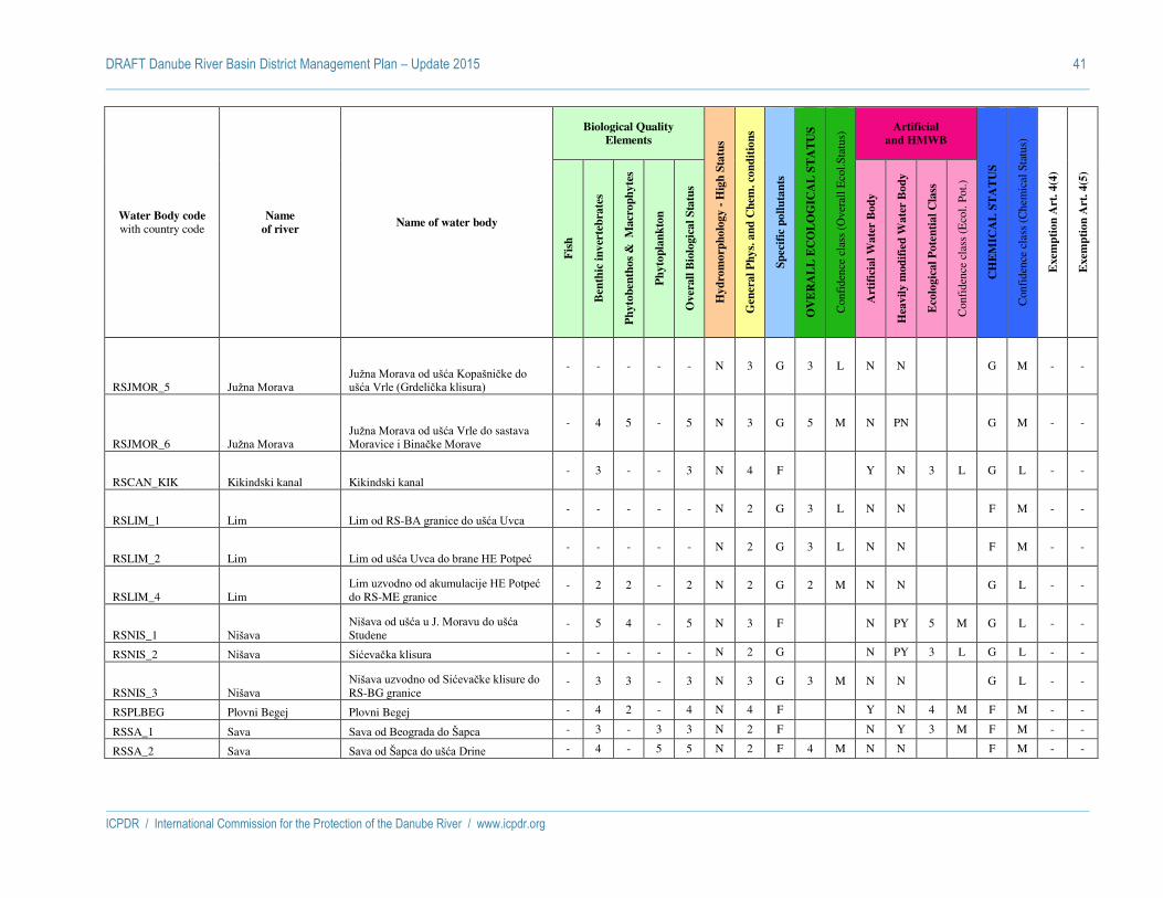
DRAFT Danube River Basin District Management Plan – Update 2015 41
ICPDR / International Commission for the Protection of the Danube River / www.icpdr.org
Water Body code with country code
Name
of river Name of water body
Biological Quality
Elements
Hy
dro
mo
rph
olo
gy -
Hig
h S
tatu
s
Gen
era
l P
hy
s. a
nd
Ch
em. co
nd
itio
ns
Sp
ecif
ic p
oll
uta
nts
OV
ER
AL
L E
CO
LO
GIC
AL
ST
AT
US
Con
fide
nce
clas
s (O
vera
ll E
col.S
tatu
s) Artificial
and HMWB
CH
EM
ICA
L S
TA
TU
S
Con
fide
nce
clas
s (C
hem
ical
Sta
tus)
Exem
pti
on
Art
. 4
(4)
Exem
pti
on
Art
. 4
(5)
Fis
h
Ben
thic
in
ver
teb
rate
s
Ph
yto
ben
tho
s &
M
acr
op
hy
tes
Ph
yto
pla
nk
ton
Ov
erall
Bio
logic
al
Sta
tus
Art
ific
ial
Wa
ter
Bo
dy
Hea
vil
y m
od
ifie
d W
ate
r B
od
y
Eco
logic
al
Po
ten
tia
l C
lass
Con
fide
nce
clas
s (E
col.
Pot.)
RSJMOR_5 Južna Morava Južna Morava od ušća Kopašničke do ušća Vrle (Grdelička klisura)
- - - - - N 3 G 3 L N N G M - -
RSJMOR_6 Južna Morava Južna Morava od ušća Vrle do sastava Moravice i Binačke Morave
- 4 5 - 5 N 3 G 5 M N PN G M - -
RSCAN_KIK Kikindski kanal Kikindski kanal - 3 - - 3 N 4 F Y N 3 L G L - -
RSLIM_1 Lim Lim od RS-BA granice do ušća Uvca - - - - - N 2 G 3 L N N F M - -
RSLIM_2 Lim Lim od ušća Uvca do brane HE Potpeć - - - - - N 2 G 3 L N N F M - -
RSLIM_4 Lim Lim uzvodno od akumulacije HE Potpeć do RS-ME granice
- 2 2 - 2 N 2 G 2 M N N G L - -
RSNIS_1 Nišava Nišava od ušća u J. Moravu do ušća Studene
- 5 4 - 5 N 3 F N PY 5 M G L - -
RSNIS_2 Nišava Sićevačka klisura - - - - - N 2 G N PY 3 L G L - -
RSNIS_3 Nišava Nišava uzvodno od Sićevačke klisure do RS-BG granice
- 3 3 - 3 N 3 G 3 M N N G L - -
RSPLBEG Plovni Begej Plovni Begej - 4 2 - 4 N 4 F Y N 4 M F M - -
RSSA_1 Sava Sava od Beograda do Šapca - 3 - 3 3 N 2 F N Y 3 M F M - -
RSSA_2 Sava Sava od Šapca do ušća Drine - 4 - 5 5 N 2 F 4 M N N F M - -

DRAFT Danube River Basin District Management Plan – Update 2015 42
ICPDR / International Commission for the Protection of the Danube River / www.icpdr.org
Water Body code with country code
Name
of river Name of water body
Biological Quality
Elements
Hy
dro
mo
rph
olo
gy -
Hig
h S
tatu
s
Gen
era
l P
hy
s. a
nd
Ch
em. co
nd
itio
ns
Sp
ecif
ic p
oll
uta
nts
OV
ER
AL
L E
CO
LO
GIC
AL
ST
AT
US
Con
fide
nce
clas
s (O
vera
ll E
col.S
tatu
s) Artificial
and HMWB
CH
EM
ICA
L S
TA
TU
S
Con
fide
nce
clas
s (C
hem
ical
Sta
tus)
Exem
pti
on
Art
. 4
(4)
Exem
pti
on
Art
. 4
(5)
Fis
h
Ben
thic
in
ver
teb
rate
s
Ph
yto
ben
tho
s &
M
acr
op
hy
tes
Ph
yto
pla
nk
ton
Ov
erall
Bio
logic
al
Sta
tus
Art
ific
ial
Wa
ter
Bo
dy
Hea
vil
y m
od
ifie
d W
ate
r B
od
y
Eco
logic
al
Po
ten
tia
l C
lass
Con
fide
nce
clas
s (E
col.
Pot.)
RSSA_3 Sava Sava uzvodno od ušća Drine do RS-HR granice
- 4 - 4 4 N 2 F 4 M N N F M - -
RSTAM_1 Tamiš Donji Tamiš - 4 2 - 4 N 3 F N PY 4 M F M - -
RSTAM_2 Tamiš Tamiš uzvodno od ustave Tomaševac do RS-RO granice
- 4 3 - 4 N 2 G N PY 4 M F L - -
RSTIM_1 Timok Timok od ušća u Dunav do Bregova (RS-BG granica)
- 4 4 - 4 N 2 F 4 M N N F L - -
RSTIM_2 Timok Timok od Bregova do Tabakovačke klisure
- - - - - N 2 F 3 L N N F L - -
RSTIM_3 Timok Tabakovačka klisura do ušća Borske reke - - - - - N 3 F 4 L N N F M - -
RSTIM_4 Timok Timok od ušća Borske reke do sastava Belog i Crnog Timoka
- 4 4 - 4 N 3 F 4 M N N F L - -
RSTIS_1 Tisa Tisa od ušća u Dunav do brane Novi Bečej
- 3 2 - 3 N 3 F N Y 3 M F M - -
RSTIS_2 Tisa Tisa uzvodno od brane Novi Bečej - 2 2 3 3 N 3 G N Y 3 M F M - -
RSVMOR_1 Velika Morava Velika Morava od ušća u Dunav do Ljubičevskog mosta
- 4 - - 4 N 3 G N Y 4 M F L - -
RSVMOR_2 Velika Morava Velika Morava od Ljubičevskog mosta do ušća Resave
- 3 - 4 4 N 3 G N PY 4 M F L - -

DRAFT Danube River Basin District Management Plan – Update 2015 43
ICPDR / International Commission for the Protection of the Danube River / www.icpdr.org
Water Body code with country code
Name
of river Name of water body
Biological Quality
Elements
Hy
dro
mo
rph
olo
gy -
Hig
h S
tatu
s
Gen
era
l P
hy
s. a
nd
Ch
em. co
nd
itio
ns
Sp
ecif
ic p
oll
uta
nts
OV
ER
AL
L E
CO
LO
GIC
AL
ST
AT
US
Con
fide
nce
clas
s (O
vera
ll E
col.S
tatu
s) Artificial
and HMWB
CH
EM
ICA
L S
TA
TU
S
Con
fide
nce
clas
s (C
hem
ical
Sta
tus)
Exem
pti
on
Art
. 4
(4)
Exem
pti
on
Art
. 4
(5)
Fis
h
Ben
thic
in
ver
teb
rate
s
Ph
yto
ben
tho
s &
M
acr
op
hy
tes
Ph
yto
pla
nk
ton
Ov
erall
Bio
logic
al
Sta
tus
Art
ific
ial
Wa
ter
Bo
dy
Hea
vil
y m
od
ifie
d W
ate
r B
od
y
Eco
logic
al
Po
ten
tia
l C
lass
Con
fide
nce
clas
s (E
col.
Pot.)
RSVMOR_3 Velika Morava Velika Morava od ušća Resave do sastava Južne i Zapadne Morave
- 3 - 4 4 N 3 G N PY 4 M F L - -
RSZMOR_1 Zapadna Morava Zapadna Morava od sastava sa Južnom Moravom do ušća Ibra
- - - - - N 3 G 3 L N N F L - -
RSZMOR_2 Zapadna Morava Zapadna Morava od ušća Ibra do brane Parmenac
- 4 4 - 4 N 2 G 4 M N N F L - -
RORW10.1_B1 Arges Arges: sector izvor - intrare Ac. Vidraru si afluentii
- 1 1 1 N 2 G 2 H N N G M N N
RORW10.1_B2 Arges Arges: sector aval Ac. Vidraru - intrare Ac. Oesti
- 3 - 3 2 G N Y 3 M G - N Y
RORW10.1_B3 Arges Arges: sector aval Ac. Golesti - intrare Ac. Zavoiul Orbului
1 1 1 1 2 G 2 H N N G - N N
RORW10.1_B4 Arges Arges: sector aval Ac. Zavoiul Orbului - intrare Ac. Frontala Ogrezeni
1 1 1 1 3 G 3 H N N G - N N
RORW10.1_B5 Arges Arges: sector aval Ac. Frontala Ogrezeni - intrare Ac. Mihailesti
- 1 2 2 2 G 2 H N N G M N N
RORW10.1_B6 Arges Arges: sector aval Ac. Mihailesti - amonte confluenta Dambovita
1 2 1 2 3 G N Y 3 H G - N N
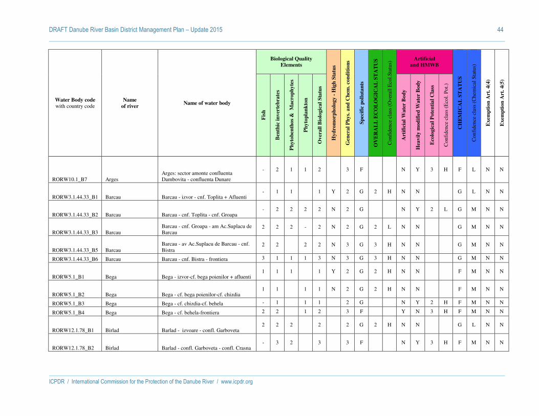
DRAFT Danube River Basin District Management Plan – Update 2015 44
ICPDR / International Commission for the Protection of the Danube River / www.icpdr.org
Water Body code with country code
Name
of river Name of water body
Biological Quality
Elements
Hy
dro
mo
rph
olo
gy -
Hig
h S
tatu
s
Gen
era
l P
hy
s. a
nd
Ch
em. co
nd
itio
ns
Sp
ecif
ic p
oll
uta
nts
OV
ER
AL
L E
CO
LO
GIC
AL
ST
AT
US
Con
fide
nce
clas
s (O
vera
ll E
col.S
tatu
s) Artificial
and HMWB
CH
EM
ICA
L S
TA
TU
S
Con
fide
nce
clas
s (C
hem
ical
Sta
tus)
Exem
pti
on
Art
. 4
(4)
Exem
pti
on
Art
. 4
(5)
Fis
h
Ben
thic
in
ver
teb
rate
s
Ph
yto
ben
tho
s &
M
acr
op
hy
tes
Ph
yto
pla
nk
ton
Ov
erall
Bio
logic
al
Sta
tus
Art
ific
ial
Wa
ter
Bo
dy
Hea
vil
y m
od
ifie
d W
ate
r B
od
y
Eco
logic
al
Po
ten
tia
l C
lass
Con
fide
nce
clas
s (E
col.
Pot.)
RORW10.1_B7 Arges Arges: sector amonte confluenta Dambovita - confluenta Dunare
- 2 1 1 2 3 F N Y 3 H F L N N
RORW3.1.44.33_B1 Barcau Barcau - izvor - cnf. Toplita + Afluenti - 1 1 1 Y 2 G 2 H N N G L N N
RORW3.1.44.33_B2 Barcau Barcau - cnf. Toplita - cnf. Groapa - 2 2 2 2 N 2 G N Y 2 L G M N N
RORW3.1.44.33_B3 Barcau Barcau - cnf. Groapa - am Ac.Suplacu de Barcau
2 2 2 - 2 N 2 G 2 L N N G M N N
RORW3.1.44.33_B5 Barcau Barcau - av Ac.Suplacu de Barcau - cnf. Bistra
2 2 2 2 N 3 G 3 H N N G M N N
RORW3.1.44.33_B6 Barcau Barcau - cnf. Bistra - frontiera 3 1 1 1 3 N 3 G 3 H N N G M N N
RORW5.1_B1 Bega Bega - izvor-cf. bega poienilor + afluenti 1 1 1 1 Y 2 G 2 H N N F M N N
RORW5.1_B2 Bega Bega - cf. bega poienilor-cf. chizdia 1 1 1 1 N 2 G 2 H N N F M N N
RORW5.1_B3 Bega Bega - cf. chizdia-cf. behela - 1 1 1 2 G N Y 2 H F M N N
RORW5.1_B4 Bega Bega - cf. behela-frontiera 2 2 1 2 3 F Y N 3 H F M N N
RORW12.1.78_B1 Birlad Barlad - izvoare - confl. Garboveta 2 2 2 2 2 G 2 H N N G L N N
RORW12.1.78_B2 Birlad Barlad - confl. Garboveta - confl. Crasna - 3 2 3 3 F N Y 3 H F M N N

DRAFT Danube River Basin District Management Plan – Update 2015 45
ICPDR / International Commission for the Protection of the Danube River / www.icpdr.org
Water Body code with country code
Name
of river Name of water body
Biological Quality
Elements
Hy
dro
mo
rph
olo
gy -
Hig
h S
tatu
s
Gen
era
l P
hy
s. a
nd
Ch
em. co
nd
itio
ns
Sp
ecif
ic p
oll
uta
nts
OV
ER
AL
L E
CO
LO
GIC
AL
ST
AT
US
Con
fide
nce
clas
s (O
vera
ll E
col.S
tatu
s) Artificial
and HMWB
CH
EM
ICA
L S
TA
TU
S
Con
fide
nce
clas
s (C
hem
ical
Sta
tus)
Exem
pti
on
Art
. 4
(4)
Exem
pti
on
Art
. 4
(5)
Fis
h
Ben
thic
in
ver
teb
rate
s
Ph
yto
ben
tho
s &
M
acr
op
hy
tes
Ph
yto
pla
nk
ton
Ov
erall
Bio
logic
al
Sta
tus
Art
ific
ial
Wa
ter
Bo
dy
Hea
vil
y m
od
ifie
d W
ate
r B
od
y
Eco
logic
al
Po
ten
tia
l C
lass
Con
fide
nce
clas
s (E
col.
Pot.)
RORW12.1.78_B3 Birlad Barlad - confl. Crasna - confl. Siret (include si derivatia Munteni - Tecucel)
- 2 2 2 2 3 G N Y 3 H G L N N
RORW12.1.53_B1 Bistrita Bistrita (izv - cf Neagra) 1 2 2 2 N 2 G 2 H N N G M N N
RORW12.1.53_B2 Bistrita Bistrita (cf Neagra - ac Izvorul Muntelui) - 2 1 2 N 2 G 2 H N N G M N N
RORW12.1.53_B4 Bistrita Bistrita (baraj Izv Muntelui - ac Pangarati
1 1 1 1 N 2 G 2 H N N G M N N
RORW12.1.53_B6 Bistrita Bistrita (baraj Batca Doamnei - ac Racova)
- 1 1 1 N 3 G 3 H N N G M N N
RORW12.1.82_B1 Buzau Buzau Izv. - Ac. Siriu si afluentii 1 1 1 1 Y 2 G 2 M N N G L N N
RORW12.1.82_B2 Buzau Buzau Ac. Siriu - Cf. Basca - 1 1 1 2 G 2 M N N G L N N
RORW12.1.82_B3 Buzau Buzau Cf. Basca - Ac. Candesti - 1 1 1 N 2 G 2 M N N G M N N
RORW12.1.82_B4 Buzau Buzau Ac. Candesti - Buzau 2 2 1 2 3 G 3 M N N G L N N
RORW12.1.82_B5 Buzau Buzau Buzau - Cf. Costei 2 2 1 2 N 3 G 3 M N N G L N N
RORW12.1.82_B6 Buzau Buzau Cf. Costei - Cf. Siret 2 1 1 2 N 3 G 3 M N N G L N N
RORW15.1.10B_B1 Canal Dunare Marea Neagra 1 Canalul Dunarea Marea Neagra 1
- 2 1 1 2 N 2 G Y N 2 M G M N N

DRAFT Danube River Basin District Management Plan – Update 2015 46
ICPDR / International Commission for the Protection of the Danube River / www.icpdr.org
Water Body code with country code
Name
of river Name of water body
Biological Quality
Elements
Hy
dro
mo
rph
olo
gy -
Hig
h S
tatu
s
Gen
era
l P
hy
s. a
nd
Ch
em. co
nd
itio
ns
Sp
ecif
ic p
oll
uta
nts
OV
ER
AL
L E
CO
LO
GIC
AL
ST
AT
US
Con
fide
nce
clas
s (O
vera
ll E
col.S
tatu
s) Artificial
and HMWB
CH
EM
ICA
L S
TA
TU
S
Con
fide
nce
clas
s (C
hem
ical
Sta
tus)
Exem
pti
on
Art
. 4
(4)
Exem
pti
on
Art
. 4
(5)
Fis
h
Ben
thic
in
ver
teb
rate
s
Ph
yto
ben
tho
s &
M
acr
op
hy
tes
Ph
yto
pla
nk
ton
Ov
erall
Bio
logic
al
Sta
tus
Art
ific
ial
Wa
ter
Bo
dy
Hea
vil
y m
od
ifie
d W
ate
r B
od
y
Eco
logic
al
Po
ten
tia
l C
lass
Con
fide
nce
clas
s (E
col.
Pot.)
RORW15.1.10B_B2
Canal Dunare Marea Neagra 2 - Canal Poarta Alba - Marea Neagra
Canalul Dunare Marea Neagra 2 - CPAMN
- 2 1 1 2 N 2 G Y N 2 M G M N N
RORW3.1_B1 Crisul Alb Crisul Alb --> izvor - am Ac.Mihaileni + Afluenti
- 1 1 1 Y 2 G 2 H N N G M N N
RORW3.1_B2 Crisul Alb Crisul Alb--Ac.Mihaileni + Afluent - 1 1 1 N 2 G 2 M N N G M N N
RORW3.1_B3 Crisul Alb Crisul Alb --> av Ac.Mihaileni - cnf. Tebea
1 2 1 2 N 2 G 2 H N N G M N N
RORW3.1_B4 Crisul Alb Crisul Alb --> cnf. Tebea - cnf. Zimbru - 1 1 1 N 2 G 2 H N N G M N N
RORW3.1_B5 Crisul Alb Crisul Alb --> cnf. Zimbru - cnf. Chisindia
2 2 2 2 2 N 2 G 2 L N N G L N N
RORW3.1_B6 Crisul Alb Crisul Alb --> cnf. Chisindia - cnf. Cigher
- 1 1 1 N 2 G 2 H N N G M N N
RORW3.1_B7 Crisul Alb Crisul Alb --> cnf. Cigher - frontiera - 1 1 1 1 N 2 G 2 H N N G M N N
RORW3.1.42_B1 Crisul Negru Crisul Negru --> izvor - cnf. Valea Mare + Afluent
- 2 1 2 N 2 G N Y 2 H G L N N

DRAFT Danube River Basin District Management Plan – Update 2015 47
ICPDR / International Commission for the Protection of the Danube River / www.icpdr.org
Water Body code with country code
Name
of river Name of water body
Biological Quality
Elements
Hy
dro
mo
rph
olo
gy -
Hig
h S
tatu
s
Gen
era
l P
hy
s. a
nd
Ch
em. co
nd
itio
ns
Sp
ecif
ic p
oll
uta
nts
OV
ER
AL
L E
CO
LO
GIC
AL
ST
AT
US
Con
fide
nce
clas
s (O
vera
ll E
col.S
tatu
s) Artificial
and HMWB
CH
EM
ICA
L S
TA
TU
S
Con
fide
nce
clas
s (C
hem
ical
Sta
tus)
Exem
pti
on
Art
. 4
(4)
Exem
pti
on
Art
. 4
(5)
Fis
h
Ben
thic
in
ver
teb
rate
s
Ph
yto
ben
tho
s &
M
acr
op
hy
tes
Ph
yto
pla
nk
ton
Ov
erall
Bio
logic
al
Sta
tus
Art
ific
ial
Wa
ter
Bo
dy
Hea
vil
y m
od
ifie
d W
ate
r B
od
y
Eco
logic
al
Po
ten
tia
l C
lass
Con
fide
nce
clas
s (E
col.
Pot.)
RORW3.1.42_B2 Crisul Negru Crisul Negru --> cnf. Valea Mare - cnf. Nimaiesti
2 1 2 2 N 2 G 2 H N N G M N N
RORW3.1.42_B3 Crisul Negru Crisul Negru --> cnf. Nimaiesti - cnf. Soimul
2 2 2 2 2 N 2 G 2 L N N G L N N
RORW3.1.42_B4 Crisul Negru Crisul Negru --> cnf. Soimul - cnf. Valea Noua
- 1 1 1 N 2 G 2 H N N G M N N
RORW3.1.42_B5 Crisul Negru Crisul Negru --> cnf. Valea Noua - frontiera
- 1 1 1 1 N 2 G 2 H N N G M N N
RORW3.1.44_B1 Crisul Repede Crisul Repede --> izvor - cnf. Sacuieu - 3 2 3 N 3 G 3 H N N G L N N
RORW3.1.44_B2 Crisul Repede Crisul Repede --> cnf. Sacuieu - cnf. Iad 2 1 1 2 N 2 G 2 M N N G M N N
RORW3.1.44_B3 Crisul Repede
Crisul Repede--Def.Crisu Repede --> cnf. Iad - out Def.Crisu Repede + Afluent
2 1 1 2 N 2 G 2 H N N G M N N
RORW3.1.44_B4 Crisul Repede Crisul Repede --> av Def.Crisu Repede - am Ac.Lugasu
2 1 1 1 2 N 2 G 2 H N N G M N N
RORW3.1.44_B6 Crisul Repede Crisul Repede --> av Ac.Tileagd - cnf. Bonor
2 2 2 2 2 N 2 G 2 L N N G L N N
RORW3.1.44_B7 Crisul Repede Crisul Repede --> cnf. Bonor - frontiera - 1 1 1 1 N 2 G N Y 2 H G M N N
RORW11.1_B1 Ialomita Ialomita Izv. - Ac. Bolboci - 1 1 1 Y 2 G 2 M N N G L N N
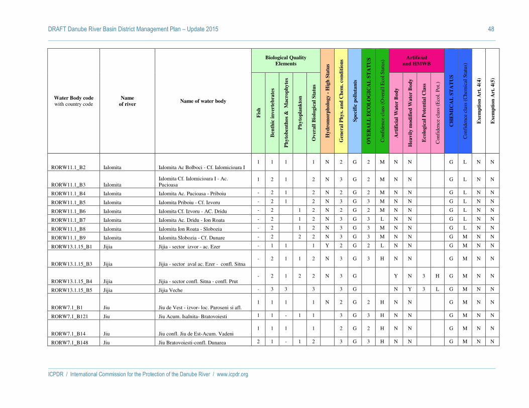
DRAFT Danube River Basin District Management Plan – Update 2015 48
ICPDR / International Commission for the Protection of the Danube River / www.icpdr.org
Water Body code with country code
Name
of river Name of water body
Biological Quality
Elements
Hy
dro
mo
rph
olo
gy -
Hig
h S
tatu
s
Gen
era
l P
hy
s. a
nd
Ch
em. co
nd
itio
ns
Sp
ecif
ic p
oll
uta
nts
OV
ER
AL
L E
CO
LO
GIC
AL
ST
AT
US
Con
fide
nce
clas
s (O
vera
ll E
col.S
tatu
s) Artificial
and HMWB
CH
EM
ICA
L S
TA
TU
S
Con
fide
nce
clas
s (C
hem
ical
Sta
tus)
Exem
pti
on
Art
. 4
(4)
Exem
pti
on
Art
. 4
(5)
Fis
h
Ben
thic
in
ver
teb
rate
s
Ph
yto
ben
tho
s &
M
acr
op
hy
tes
Ph
yto
pla
nk
ton
Ov
erall
Bio
logic
al
Sta
tus
Art
ific
ial
Wa
ter
Bo
dy
Hea
vil
y m
od
ifie
d W
ate
r B
od
y
Eco
logic
al
Po
ten
tia
l C
lass
Con
fide
nce
clas
s (E
col.
Pot.)
RORW11.1_B2 Ialomita Ialomita Ac Bolboci - Cf. Ialomicioara I 1 1 1 1 N 2 G 2 M N N G L N N
RORW11.1_B3 Ialomita Ialomita Cf. Ialomicioara I - Ac. Pucioasa
1 2 1 2 N 3 G 2 M N N G L N N
RORW11.1_B4 Ialomita Ialomita Ac. Pucioasa - Priboiu - 2 1 2 N 2 G 2 M N N G L N N
RORW11.1_B5 Ialomita Ialomita Priboiu - Cf. Izvoru - 2 1 2 N 3 G 3 M N N G L N N
RORW11.1_B6 Ialomita Ialomita Cf. Izvoru - AC. Dridu - 2 1 2 N 2 G 2 M N N G L N N
RORW11.1_B7 Ialomita Ialomita Ac. Dridu - Ion Roata - 2 1 2 N 3 G 3 L N N G L N N
RORW11.1_B8 Ialomita Ialomita Ion Roata - Slobozia - 2 1 2 N 3 G 3 M N N G L N N
RORW11.1_B9 Ialomita Ialomita Slobozia - Cf. Dunare - 2 2 2 N 3 G 3 M N N G M N N
RORW13.1.15_B1 Jijia Jijia - sector izvor - ac. Ezer - 1 1 1 Y 2 G 2 L N N G M N N
RORW13.1.15_B3 Jijia Jijia - sector aval ac. Ezer - confl. Sitna - 2 1 1 2 N 3 G 3 H N N G M N N
RORW13.1.15_B4 Jijia Jijia - sector confl. Sitna - confl. Prut - 2 1 2 2 N 3 G Y N 3 H G M N N
RORW13.1.15_B5 Jijia Jijia Veche - 3 3 3 3 G N Y 3 L G M N N
RORW7.1_B1 Jiu Jiu de Vest - izvor- loc. Paroseni si afl. 1 1 1 1 N 2 G 2 H N N G M N N
RORW7.1_B121 Jiu Jiu Acum. Isalnita- Bratovoiesti 1 1 - 1 1 3 G 3 H N N G M N N
RORW7.1_B14 Jiu Jiu confl. Jiu de Est-Acum. Vadeni 1 1 1 1 2 G 2 H N N G M N N
RORW7.1_B148 Jiu Jiu Bratovoiesti-confl. Dunarea 2 1 - 1 2 3 G 3 H N N G M N N

DRAFT Danube River Basin District Management Plan – Update 2015 49
ICPDR / International Commission for the Protection of the Danube River / www.icpdr.org
Water Body code with country code
Name
of river Name of water body
Biological Quality
Elements
Hy
dro
mo
rph
olo
gy -
Hig
h S
tatu
s
Gen
era
l P
hy
s. a
nd
Ch
em. co
nd
itio
ns
Sp
ecif
ic p
oll
uta
nts
OV
ER
AL
L E
CO
LO
GIC
AL
ST
AT
US
Con
fide
nce
clas
s (O
vera
ll E
col.S
tatu
s) Artificial
and HMWB
CH
EM
ICA
L S
TA
TU
S
Con
fide
nce
clas
s (C
hem
ical
Sta
tus)
Exem
pti
on
Art
. 4
(4)
Exem
pti
on
Art
. 4
(5)
Fis
h
Ben
thic
in
ver
teb
rate
s
Ph
yto
ben
tho
s &
M
acr
op
hy
tes
Ph
yto
pla
nk
ton
Ov
erall
Bio
logic
al
Sta
tus
Art
ific
ial
Wa
ter
Bo
dy
Hea
vil
y m
od
ifie
d W
ate
r B
od
y
Eco
logic
al
Po
ten
tia
l C
lass
Con
fide
nce
clas
s (E
col.
Pot.)
RORW7.1_B28 Jiu Jiu Tg. Jiu-Rovinari 1 2 1 2 2 G 2 H N N G M N N
RORW7.1_B4 Jiu Jiu de Vest - loc. Paroseni-confl. Jiul de Est
1 2 1 2 2 G 2 H N N G M N N
RORW7.1_B51 Jiu Jiu Rovinari-Ac. Turceni 1 1 - 1 1 N 2 G 2 H N N G M N N
RORW7.1_B57 Jiu Jiu Acum. Turceni-Acum. Isalnita 1 1 - 1 1 N 2 G 2 H N N G M N N
RORW12.1.40_B1 Moldova Moldova (izv - cf Sadova) 2 1 2 2 N 2 G 2 H N N G M N N
RORW12.1.40_B2 Moldova Moldova (cf Sadova - cf Suha) 1 1 2 2 N 2 G 2 H N N G L N N
RORW12.1.40_B3 Moldova Moldova (cf Suha - cf Vier) - 1 1 1 N 2 G 2 H N N G M N N
RORW12.1.40_B4 Moldova Moldova (cf Vier - cf Siret) 1 1 1 1 N 2 G 2 H N N G M N N
RORW4.1_B1 Mures Mures, izvor - conf. Carbunele Negru 2 2 1 2 N 2 G 2 L N N G L N N
RORW4.1_B10 Mures Mures, conf. Soimos - conf. Zadarlac 2 1 1 2 2 N 2 G N Y 2 M G M N N
RORW4.1_B11 Mures Mures, conf. Zadarlac - Romanian/Hungarian border
2 2 1 2 2 N 2 G N Y 2 M G M N N
RORW4.1_B2 Mures Mures, conf. Carbunele Negru - conf. Lazarea
- 1 1 1 N 2 G N Y 2 M G M N N
RORW4.1_B3 Mures Mures, conf. Lazarea - conf.Toplita - 1 1 1 N 2 G 2 M N N G M N N
RORW4.1_B4 Mures Mures, conf. Toplita - conf. Pietris - 1 1 1 N 2 G 2 M N N G M N N

DRAFT Danube River Basin District Management Plan – Update 2015 50
ICPDR / International Commission for the Protection of the Danube River / www.icpdr.org
Water Body code with country code
Name
of river Name of water body
Biological Quality
Elements
Hy
dro
mo
rph
olo
gy -
Hig
h S
tatu
s
Gen
era
l P
hy
s. a
nd
Ch
em. co
nd
itio
ns
Sp
ecif
ic p
oll
uta
nts
OV
ER
AL
L E
CO
LO
GIC
AL
ST
AT
US
Con
fide
nce
clas
s (O
vera
ll E
col.S
tatu
s) Artificial
and HMWB
CH
EM
ICA
L S
TA
TU
S
Con
fide
nce
clas
s (C
hem
ical
Sta
tus)
Exem
pti
on
Art
. 4
(4)
Exem
pti
on
Art
. 4
(5)
Fis
h
Ben
thic
in
ver
teb
rate
s
Ph
yto
ben
tho
s &
M
acr
op
hy
tes
Ph
yto
pla
nk
ton
Ov
erall
Bio
logic
al
Sta
tus
Art
ific
ial
Wa
ter
Bo
dy
Hea
vil
y m
od
ifie
d W
ate
r B
od
y
Eco
logic
al
Po
ten
tia
l C
lass
Con
fide
nce
clas
s (E
col.
Pot.)
RORW4.1_B5 Mures Mures, conf. Pietris - conf. Petrilaca - 1 1 1 1 N 2 G 2 M N N G M N N
RORW4.1_B6 Mures Mures, conf. Petrilaca - conf. Aries - 2 - 3 3 N 3 G N Y 3 M G M N N
RORW4.1_B7 Mures Mures, conf. Aries - conf. Cerna 2 2 1 2 2 N 2 G N Y 2 M G M N N
RORW4.1_B8 Mures Mures, conf. Cerna - conf. Dobra 2 2 - 3 3 N 2 G N Y 3 M G M Y N
RORW4.1_B9 Mures Mures, conf. Dobra - conf. Soimos 1 2 1 - 2 N 2 G 2 M N N G M N N
ROLW8.1_B10 Olt
Olt - ac.Ionesti, Zavideni, Dragasani, Strejesti, Arcesti...Draganesti si av Frunzaru
- 1 1 1 2 G N Y 2 H F M N N
ROLW8.1_B11 Olt Olt - acumulare Rusanesti si Izbiceni - 1 2 2 2 G N Y 2 H G M N N
ROLW8.1_B7 Olt Olt - am. Ac. Voila, Vistea, Arpas, Scorei Arig si aval ac. Racovita
- 1 2 2 3 - N Y 3 H G L N Y
ROLW8.1_B9 Olt
Olt - am.ac.Robesti, Cornet, Gura Lotrului, Turnu...Rm Valcea, Raureni, Govora si av Babeni
- 1 2 2 3 G N Y 3 H G L N Y
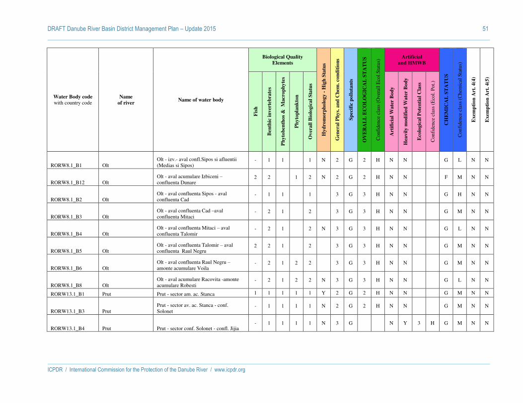
DRAFT Danube River Basin District Management Plan – Update 2015 51
ICPDR / International Commission for the Protection of the Danube River / www.icpdr.org
Water Body code with country code
Name
of river Name of water body
Biological Quality
Elements
Hy
dro
mo
rph
olo
gy -
Hig
h S
tatu
s
Gen
era
l P
hy
s. a
nd
Ch
em. co
nd
itio
ns
Sp
ecif
ic p
oll
uta
nts
OV
ER
AL
L E
CO
LO
GIC
AL
ST
AT
US
Con
fide
nce
clas
s (O
vera
ll E
col.S
tatu
s) Artificial
and HMWB
CH
EM
ICA
L S
TA
TU
S
Con
fide
nce
clas
s (C
hem
ical
Sta
tus)
Exem
pti
on
Art
. 4
(4)
Exem
pti
on
Art
. 4
(5)
Fis
h
Ben
thic
in
ver
teb
rate
s
Ph
yto
ben
tho
s &
M
acr
op
hy
tes
Ph
yto
pla
nk
ton
Ov
erall
Bio
logic
al
Sta
tus
Art
ific
ial
Wa
ter
Bo
dy
Hea
vil
y m
od
ifie
d W
ate
r B
od
y
Eco
logic
al
Po
ten
tia
l C
lass
Con
fide
nce
clas
s (E
col.
Pot.)
RORW8.1_B1 Olt Olt - izv.- aval confl.Sipos si afluentii (Medias si Sipos)
- 1 1 1 N 2 G 2 H N N G L N N
RORW8.1_B12 Olt Olt - aval acumulare Izbiceni – confluenta Dunare
2 2 1 2 N 2 G 2 H N N F M N N
RORW8.1_B2 Olt Olt - aval confluenta Sipos - aval confluenta Cad
- 1 1 1 3 G 3 H N N G H N N
RORW8.1_B3 Olt Olt - aval confluenta Cad –aval confluenta Mitaci
- 2 1 2 3 G 3 H N N G M N N
RORW8.1_B4 Olt Olt - aval confluenta Mitaci – aval confluenta Talomir
- 2 1 2 N 3 G 3 H N N G L N N
RORW8.1_B5 Olt Olt - aval confluenta Talomir – aval confluenta Raul Negru
2 2 1 2 3 G 3 H N N G M N N
RORW8.1_B6 Olt Olt - aval confluenta Raul Negru – amonte acumulare Voila
- 2 1 2 2 3 G 3 H N N G M N N
RORW8.1_B8 Olt Olt - aval acumulare Racovita -amonte acumulare Robesti
- 2 1 2 2 N 3 G 3 H N N G L N N
RORW13.1_B1 Prut Prut - sector am. ac. Stanca 1 1 1 1 1 Y 2 G 2 H N N G M N N
RORW13.1_B3 Prut Prut - sector av. ac. Stanca - conf. Solonet
- 1 1 1 1 N 2 G 2 H N N G M N N
RORW13.1_B4 Prut Prut - sector conf. Solonet - confl. Jijia - 1 1 1 1 N 3 G N Y 3 H G M N N
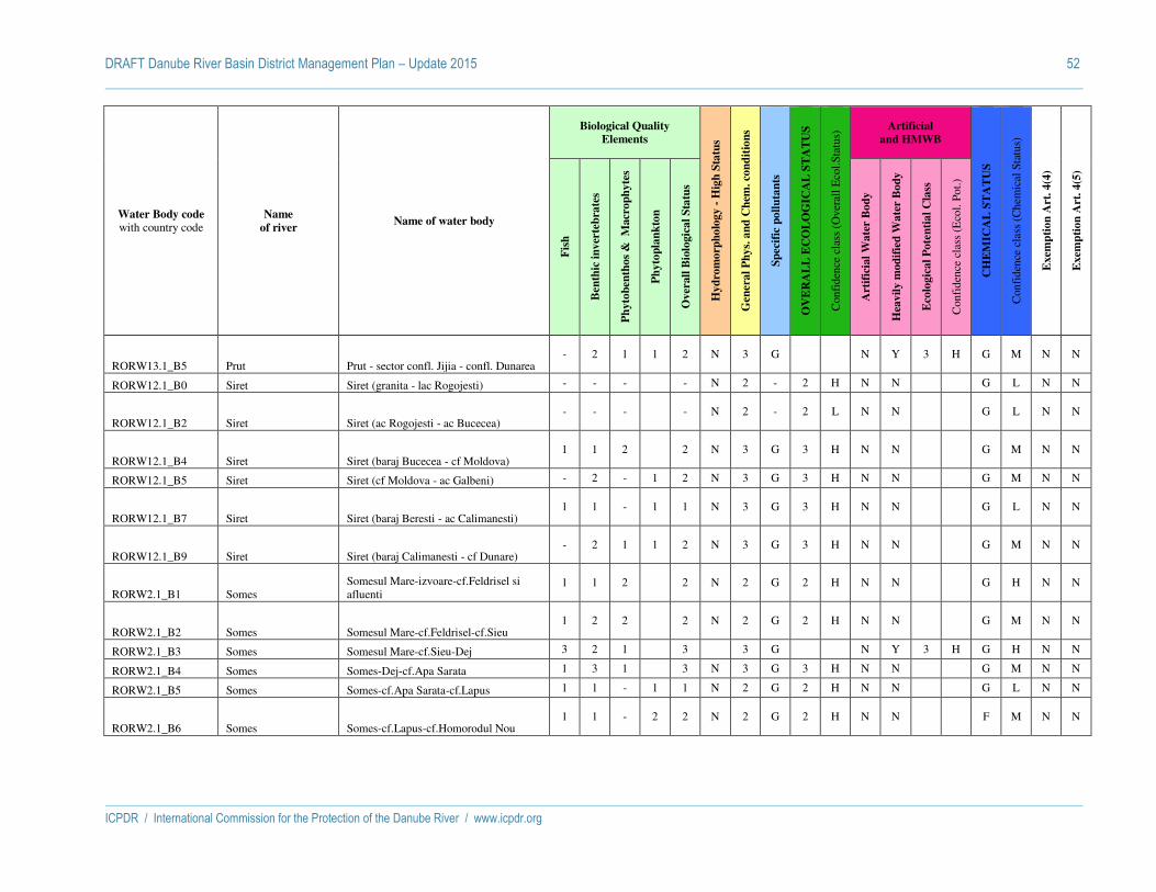
DRAFT Danube River Basin District Management Plan – Update 2015 52
ICPDR / International Commission for the Protection of the Danube River / www.icpdr.org
Water Body code with country code
Name
of river Name of water body
Biological Quality
Elements
Hy
dro
mo
rph
olo
gy -
Hig
h S
tatu
s
Gen
era
l P
hy
s. a
nd
Ch
em. co
nd
itio
ns
Sp
ecif
ic p
oll
uta
nts
OV
ER
AL
L E
CO
LO
GIC
AL
ST
AT
US
Con
fide
nce
clas
s (O
vera
ll E
col.S
tatu
s) Artificial
and HMWB
CH
EM
ICA
L S
TA
TU
S
Con
fide
nce
clas
s (C
hem
ical
Sta
tus)
Exem
pti
on
Art
. 4
(4)
Exem
pti
on
Art
. 4
(5)
Fis
h
Ben
thic
in
ver
teb
rate
s
Ph
yto
ben
tho
s &
M
acr
op
hy
tes
Ph
yto
pla
nk
ton
Ov
erall
Bio
logic
al
Sta
tus
Art
ific
ial
Wa
ter
Bo
dy
Hea
vil
y m
od
ifie
d W
ate
r B
od
y
Eco
logic
al
Po
ten
tia
l C
lass
Con
fide
nce
clas
s (E
col.
Pot.)
RORW13.1_B5 Prut Prut - sector confl. Jijia - confl. Dunarea - 2 1 1 2 N 3 G N Y 3 H G M N N
RORW12.1_B0 Siret Siret (granita - lac Rogojesti) - - - - N 2 - 2 H N N G L N N
RORW12.1_B2 Siret Siret (ac Rogojesti - ac Bucecea) - - - - N 2 - 2 L N N G L N N
RORW12.1_B4 Siret Siret (baraj Bucecea - cf Moldova) 1 1 2 2 N 3 G 3 H N N G M N N
RORW12.1_B5 Siret Siret (cf Moldova - ac Galbeni) - 2 - 1 2 N 3 G 3 H N N G M N N
RORW12.1_B7 Siret Siret (baraj Beresti - ac Calimanesti) 1 1 - 1 1 N 3 G 3 H N N G L N N
RORW12.1_B9 Siret Siret (baraj Calimanesti - cf Dunare) - 2 1 1 2 N 3 G 3 H N N G M N N
RORW2.1_B1 Somes Somesul Mare-izvoare-cf.Feldrisel si afluenti
1 1 2 2 N 2 G 2 H N N G H N N
RORW2.1_B2 Somes Somesul Mare-cf.Feldrisel-cf.Sieu 1 2 2 2 N 2 G 2 H N N G M N N
RORW2.1_B3 Somes Somesul Mare-cf.Sieu-Dej 3 2 1 3 3 G N Y 3 H G H N N
RORW2.1_B4 Somes Somes-Dej-cf.Apa Sarata 1 3 1 3 N 3 G 3 H N N G M N N
RORW2.1_B5 Somes Somes-cf.Apa Sarata-cf.Lapus 1 1 - 1 1 N 2 G 2 H N N G L N N
RORW2.1_B6 Somes Somes-cf.Lapus-cf.Homorodul Nou 1 1 - 2 2 N 2 G 2 H N N F M N N
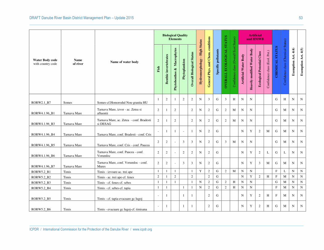
DRAFT Danube River Basin District Management Plan – Update 2015 53
ICPDR / International Commission for the Protection of the Danube River / www.icpdr.org
Water Body code with country code
Name
of river Name of water body
Biological Quality
Elements
Hy
dro
mo
rph
olo
gy -
Hig
h S
tatu
s
Gen
era
l P
hy
s. a
nd
Ch
em. co
nd
itio
ns
Sp
ecif
ic p
oll
uta
nts
OV
ER
AL
L E
CO
LO
GIC
AL
ST
AT
US
Con
fide
nce
clas
s (O
vera
ll E
col.S
tatu
s) Artificial
and HMWB
CH
EM
ICA
L S
TA
TU
S
Con
fide
nce
clas
s (C
hem
ical
Sta
tus)
Exem
pti
on
Art
. 4
(4)
Exem
pti
on
Art
. 4
(5)
Fis
h
Ben
thic
in
ver
teb
rate
s
Ph
yto
ben
tho
s &
M
acr
op
hy
tes
Ph
yto
pla
nk
ton
Ov
erall
Bio
logic
al
Sta
tus
Art
ific
ial
Wa
ter
Bo
dy
Hea
vil
y m
od
ifie
d W
ate
r B
od
y
Eco
logic
al
Po
ten
tia
l C
lass
Con
fide
nce
clas
s (E
col.
Pot.)
RORW2.1_B7 Somes Somes-cf.Homorodul Nou-granita HU 1 2 1 2 2 N 3 G 3 H N N G H N N
RORW4.1.96_B1 Tarnava Mare Tarnava Mare, izvor - ac. Zetea si afluentii
2 1 2 2 N 2 G 2 M N N G M N N
RORW4.1.96_B3 Tarnava Mare Tarnava Mare, ac. Zetea - conf. Bradesti si DESAG
2 1 2 2 N 2 G 2 M N N G M N N
RORW4.1.96_B4 Tarnava Mare Tarnava Mare, conf. Bradesti - conf. Cris - 1 1 - 1 N 2 G N Y 2 M G M N N
RORW4.1.96_B5 Tarnava Mare Tarnava Mare, conf. Cris - conf. Paucea 2 2 - 3 3 N 2 G 3 M N N G M N N
RORW4.1.96_B6 Tarnava Mare Tarnava Mare, conf. Paucea - conf. Vorumloc
2 2 - 2 2 N 2 G N Y 2 L G L N N
RORW4.1.96_B7 Tarnava Mare Tarnava Mare, conf. Vorumloc - conf. Mures
2 2 - 3 3 N 2 G N Y 3 M G M N N
RORW5.2_B1 Timis Timis - izvoare-ac. trei ape 1 1 1 1 Y 2 G 2 M N N F L N N
RORW5.2_B2 Timis Timis - ac. trei ape-cf. fenes 2 1 2 2 2 G N Y 2 H F M N N
RORW5.2_B3 Timis Timis - cf. fenes-cf. sebes 1 1 1 1 N 2 G 2 H N N G M N N
RORW5.2_B4 Timis Timis - cf. sebes-cf. tapia 1 1 1 1 N 2 G 2 H N N F M N N
RORW5.2_B5 Timis Timis - cf. tapia-evacuare gc lugoj - 1 1 1 2 G N Y 2 H F M N N
RORW5.2_B6 Timis Timis - evacuare gc lugoj-cf. timisana - 1 1 1 2 G N Y 2 H G M N N

DRAFT Danube River Basin District Management Plan – Update 2015 54
ICPDR / International Commission for the Protection of the Danube River / www.icpdr.org
Water Body code with country code
Name
of river Name of water body
Biological Quality
Elements
Hy
dro
mo
rph
olo
gy -
Hig
h S
tatu
s
Gen
era
l P
hy
s. a
nd
Ch
em. co
nd
itio
ns
Sp
ecif
ic p
oll
uta
nts
OV
ER
AL
L E
CO
LO
GIC
AL
ST
AT
US
Con
fide
nce
clas
s (O
vera
ll E
col.S
tatu
s) Artificial
and HMWB
CH
EM
ICA
L S
TA
TU
S
Con
fide
nce
clas
s (C
hem
ical
Sta
tus)
Exem
pti
on
Art
. 4
(4)
Exem
pti
on
Art
. 4
(5)
Fis
h
Ben
thic
in
ver
teb
rate
s
Ph
yto
ben
tho
s &
M
acr
op
hy
tes
Ph
yto
pla
nk
ton
Ov
erall
Bio
logic
al
Sta
tus
Art
ific
ial
Wa
ter
Bo
dy
Hea
vil
y m
od
ifie
d W
ate
r B
od
y
Eco
logic
al
Po
ten
tia
l C
lass
Con
fide
nce
clas
s (E
col.
Pot.)
RORW5.2_B7 Timis Timis - cf. timisana-frontiera - 1 1 1 N 2 G 2 H N N F M N N
RORW1.1_B1 Tisa Tisa 1 1 - 1 N 2 G 2 H N N G M N N
RORW12.1.69_B1 Trotus Trotus (izvor - cf Valea Rece) - - - - Y 2 - 2 L N N G M N N
RORW12.1.69_B2 Trotus Trotus (cf Valea Rece - cf Urmenis) - 1 1 1 N 3 G 3 H N N G M N N
RORW12.1.69_B3 Trotus Trotus ( cf Urmenis - cf Tazlau) 2 2 1 2 N 3 G 3 H N N G M N N
RORW12.1.69_B4 Trotus Trotus (cf Tazlau - cf Siret) - 1 - 1 1 N 3 G 3 H N N G M N N
RORW9.1_B2 Vedea Vedea : confluenta Vedita - amonte confluenta Cotmeana
1 1 1 1 N 2 G 2 H N N G - N N
RORW9.1_B3 Vedea Vedea : confluenta Cotmeana - amonte evacuare Rosiori de Vede
1 1 1 1 N 2 G 2 H N N G - N N
RORW9.1_B4 Vedea Vedea : amonte evacuare Rosiori de Vede - confluenta Paraul Cainelui
- 1 1 1 3 G 3 H N N F L N N
RORW9.1_B5 Vedea Vedea : confluenta Paraul Cainelui - amonte evacuare Alexandria
- 1 1 1 3 G 3 H N N F L N N
RORW9.1_B6 Vedea Vedea : amonte evacuare Alexandria - amonte confluenta Teleorman
- 1 2 2 2 3 G 3 H N N G - N N
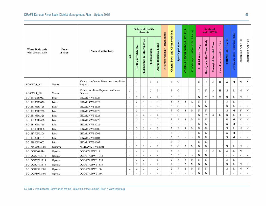
DRAFT Danube River Basin District Management Plan – Update 2015 55
ICPDR / International Commission for the Protection of the Danube River / www.icpdr.org
Water Body code with country code
Name
of river Name of water body
Biological Quality
Elements
Hy
dro
mo
rph
olo
gy -
Hig
h S
tatu
s
Gen
era
l P
hy
s. a
nd
Ch
em. co
nd
itio
ns
Sp
ecif
ic p
oll
uta
nts
OV
ER
AL
L E
CO
LO
GIC
AL
ST
AT
US
Con
fide
nce
clas
s (O
vera
ll E
col.S
tatu
s) Artificial
and HMWB
CH
EM
ICA
L S
TA
TU
S
Con
fide
nce
clas
s (C
hem
ical
Sta
tus)
Exem
pti
on
Art
. 4
(4)
Exem
pti
on
Art
. 4
(5)
Fis
h
Ben
thic
in
ver
teb
rate
s
Ph
yto
ben
tho
s &
M
acr
op
hy
tes
Ph
yto
pla
nk
ton
Ov
erall
Bio
logic
al
Sta
tus
Art
ific
ial
Wa
ter
Bo
dy
Hea
vil
y m
od
ifie
d W
ate
r B
od
y
Eco
logic
al
Po
ten
tia
l C
lass
Con
fide
nce
clas
s (E
col.
Pot.)
RORW9.1_B7 Vedea Vedea : confluenta Teleorman - localitate Bujoru
- 1 1 1 3 G N Y 3 H G M N N
RORW9.1_B8 Vedea Vedea : localitate Bujoru - confluenta Dunare
3 1 2 3 3 G Y N 3 H G L N N
BG1IS100R1027 Iskar ISKAR RWB1027 - 2 2 - 2 3 F N Y 2 M G L N N
BG1IS135R1026 Iskar ISKAR RWB1026 - 3 4 - 4 3 F 4 L N N G L - -
BG1IS135R1126 Iskar ISKAR RWB1126 - - - - - 3 G - - N N G L - -
BG1IS135R1226 Iskar ISKAR RWB1226 - 3 4 - 4 3 G 4 M N N G M Y N
BG1IS135R1326 Iskar ISKAR RWB1326 - 3 4 - 4 3 G N Y 4 L G L Y -
BG1IS135R1426 Iskar ISKAR RWB1426 - 5 4 - 5 3 F 5 M N N F M Y N
BG1IS135R1726 Iskar ISKAR RWB1726 - - - - - 3 F - - N N G M - -
BG1IS700R1006 Iskar ISKAR RWB1006 - 3 3 - 3 2 F 3 M N N G L N N
BG1IS700R1206 Iskar ISKAR RWB1206 - - - - - 3 F - - N N G M - -
BG1IS789R1104 Iskar ISKAR RWB1104 - - - - - 3 F - - N N G M - -
BG1IS900R1003 Iskar ISKAR RWB1003 - - - - - 3 F - - N N - - - -
BG1NV200R1001 Nishava NISHAVA RWB1001 - 2 2 - 2 3 G 2 M N N G L N N
BG1OG100R014 Ogosta OGOSTA RWB14 - 3 3 - 3 3 F N Y 3 L G L N -
BG1OG307R1013 Ogosta OGOSTA RWB1013 - - - - - 3 F - - N N - - - -
BG1OG307R1213 Ogosta OGOSTA RWB1213 - 3 2 - 3 2 F 3 M N N G L - -
BG1OG307R1313 Ogosta OGOSTA RWB1313 - 2 2 - 2 2 F 2 M N N G L N N
BG1OG789R1001 Ogosta OGOSTA RWB1001 2 2 2 - 2 2 F 2 M N N G L N N
BG1OG789R1401 Ogosta OGOSTA RWB1401 - - - - - 2 F - - N N - - - -

DRAFT Danube River Basin District Management Plan – Update 2015 56
ICPDR / International Commission for the Protection of the Danube River / www.icpdr.org
Water Body code with country code
Name
of river Name of water body
Biological Quality
Elements
Hy
dro
mo
rph
olo
gy -
Hig
h S
tatu
s
Gen
era
l P
hy
s. a
nd
Ch
em. co
nd
itio
ns
Sp
ecif
ic p
oll
uta
nts
OV
ER
AL
L E
CO
LO
GIC
AL
ST
AT
US
Con
fide
nce
clas
s (O
vera
ll E
col.S
tatu
s) Artificial
and HMWB
CH
EM
ICA
L S
TA
TU
S
Con
fide
nce
clas
s (C
hem
ical
Sta
tus)
Exem
pti
on
Art
. 4
(4)
Exem
pti
on
Art
. 4
(5)
Fis
h
Ben
thic
in
ver
teb
rate
s
Ph
yto
ben
tho
s &
M
acr
op
hy
tes
Ph
yto
pla
nk
ton
Ov
erall
Bio
logic
al
Sta
tus
Art
ific
ial
Wa
ter
Bo
dy
Hea
vil
y m
od
ifie
d W
ate
r B
od
y
Eco
logic
al
Po
ten
tia
l C
lass
Con
fide
nce
clas
s (E
col.
Pot.)
BG1OG789R1501 Ogosta OGOSTA RWB1501 - - - - - 2 F - - N N - - - -
BG1OG789R1601 Ogosta OGOSTA RWB1601 5 2 2 - 5 2 F 2 M N N G L N N
BG1WO100R001 Timok TIMOK WORWB01 - 5 3 - 5 3 F 5 M N N F L Y N
BG1YN130R1029 Yantra YANTRA RWB1029 - 3 - - 3 2 F N Y 3 M G L - -
BG1YN307R1027 Yantra YANTRA RWB1027 - 2 2 - 2 2 F 2 M N N G M N N
BG1YN307R1127 Yantra YANTRA RWB1127 - - - - - 2 F - - N N G M - -
BG1YN700R1017 Yantra YANTRA RWB1017 - 3 3 - 3 3 G 3 M N N G M N -
BG1YN900R1015 Yantra YANTRA RWB1015 - 4 4 - 4 3 G 4 M N N G M Y -
BG1YN900R1215 Yantra YANTRA RWB1215 - 5 2 - 5 3 G 2 M N N G M N N
BG1YN900R1415 Yantra YANTRA RWB1415 - - - - - 2 G - - N N G M - -
MD0201/01 Prut Prut - - - - - N 2 G - - N N - - G L - -
MD0201/02 Prut Prut - 3 - 2 3 N 4 G 2 L N N - - F L - -
MD0201/03 Prut Prut - - - - - N 4 G 2 L N N - - F L - -
MD0201/04 Prut Prut - - - - - N 4 G - - N N - - F L - -
MD0201/05 Prut Prut (l.a.Costesti Stinca) - - - - - N 4 G - - N Y - - F L - -
MD0201/07 Prut Prut - 3 - 2 3 N 2 G - - N N - - G L - -
MD0201/08 Prut Prut - - - - - N 2 G - - N N - - G L - -
MD0201/09 Prut Prut - - - - - N 2 G - - N N - - G L - -
MD0201/10 Prut Prut - 3 - 2 3 N 2 G 2 L N N - - G L - -
MD0201/11 Prut Prut - 3 - 2 3 N 4 G - - N N - - F L - -
MD0201/12 Prut Prut - - - - - N 4 G 2 L N N - - F L - -
MD0201/13 Prut Prut - 3 - 2 3 N 4 G 2 L N N - - F L - -

DRAFT Danube River Basin District Management Plan – Update 2015 57
ICPDR / International Commission for the Protection of the Danube River / www.icpdr.org
Water Body code with country code
Name
of river Name of water body
Biological Quality
Elements
Hy
dro
mo
rph
olo
gy -
Hig
h S
tatu
s
Gen
era
l P
hy
s. a
nd
Ch
em. co
nd
itio
ns
Sp
ecif
ic p
oll
uta
nts
OV
ER
AL
L E
CO
LO
GIC
AL
ST
AT
US
Con
fide
nce
clas
s (O
vera
ll E
col.S
tatu
s) Artificial
and HMWB
CH
EM
ICA
L S
TA
TU
S
Con
fide
nce
clas
s (C
hem
ical
Sta
tus)
Exem
pti
on
Art
. 4
(4)
Exem
pti
on
Art
. 4
(5)
Fis
h
Ben
thic
in
ver
teb
rate
s
Ph
yto
ben
tho
s &
M
acr
op
hy
tes
Ph
yto
pla
nk
ton
Ov
erall
Bio
logic
al
Sta
tus
Art
ific
ial
Wa
ter
Bo
dy
Hea
vil
y m
od
ifie
d W
ate
r B
od
y
Eco
logic
al
Po
ten
tia
l C
lass
Con
fide
nce
clas
s (E
col.
Pot.)
MD0201/14 Prut Prut - - - - - N 4 G - - N N - - F L - -
MD0201/15 Prut Prut - 3 - 2 3 N 4 G - - N N - - F L - -
UALAR01 Latorica Tisa - - - - - - - - - N N - - - - - -
UALAR02 Latorica Tisa - - - - - - - - - N N - - - - - -
UALAR03 Latorica Tisa - - - - - - - - - N N - - - - - -
UA0201/01 Prut Prut - - - - - - - - - N N - - - - - -
UA0201/02 Prut Prut - - - - - - - - - N N - - - - - -
UA0201/03 Prut Prut - - - - - - - - - N N - - - - - -
UA0201/04 Prut Prut - - - - - - - - - N N - - - - - -
UA0201/05 Prut Prut - - - - - - - - - N N - - - - - -
UA0201/06 Prut Prut - - - - - - - - - N N - - - - - -
UA0201/07 Prut Prut - - - - - - - - - N N - - - - - -
UA0201/08 Prut Prut - - - - - - - - - N N - - - - - -
UA0201/09 Prut Prut - - - - - - - - - N N - - - - - -
UA0201/10 Prut Prut - - - - - - - - - N N - - - - - -
UA0201/11 Prut Prut - - - - - - - - - N N - - - - - -
UA0201/12 Prut Prut - - - - - - - - - N N - - - - - -
UA0201/13 Prut Prut - - - - - - - - - N N - - - - - -
UA0201/14 Prut Prut - - - - - - - - - N N - - - - - -
UA0201/15 Prut Prut - - - - - - - - - N N - - - - - -
UA0201/16 Prut Prut - - - - - - - - - N N - - - - - -
UA0201/17 Prut Prut - - - - - - - - - N N - - - - - -

DRAFT Danube River Basin District Management Plan – Update 2015 58
ICPDR / International Commission for the Protection of the Danube River / www.icpdr.org
Water Body code with country code
Name
of river Name of water body
Biological Quality
Elements
Hy
dro
mo
rph
olo
gy -
Hig
h S
tatu
s
Gen
era
l P
hy
s. a
nd
Ch
em. co
nd
itio
ns
Sp
ecif
ic p
oll
uta
nts
OV
ER
AL
L E
CO
LO
GIC
AL
ST
AT
US
Con
fide
nce
clas
s (O
vera
ll E
col.S
tatu
s) Artificial
and HMWB
CH
EM
ICA
L S
TA
TU
S
Con
fide
nce
clas
s (C
hem
ical
Sta
tus)
Exem
pti
on
Art
. 4
(4)
Exem
pti
on
Art
. 4
(5)
Fis
h
Ben
thic
in
ver
teb
rate
s
Ph
yto
ben
tho
s &
M
acr
op
hy
tes
Ph
yto
pla
nk
ton
Ov
erall
Bio
logic
al
Sta
tus
Art
ific
ial
Wa
ter
Bo
dy
Hea
vil
y m
od
ifie
d W
ate
r B
od
y
Eco
logic
al
Po
ten
tia
l C
lass
Con
fide
nce
clas
s (E
col.
Pot.)
UA0201/18 Prut Prut - - - - - - - - - N N - - - - - -
UA0201/19 Prut Prut - - - - - - - - - N N - - - - - -
UA0201/20 Prut Prut - - - - - - - - - N N - - - - - -
UA0201/21 Prut Prut - - - - - - - - - N N - - - - - -
UA0201/22 Prut Prut - - - - - - - - - N N - - - - - -
UA0201/23 Prut Prut - - - - - - - - - N N - - - - - -
UA0201/24 Prut Prut - - - - - - - - - N N - - - - - -
UA0201/25 Prut Prut - - - - - - - - - N N - - - - - -
UA0201/26 Prut Prut - - - - - - - - - N N - - - - - -
UA0201/27 Prut Prut - - - - - - - - - N N - - - - - -
UA0201/28 Prut Prut - - - - - - - - - N N - - - - - -
UA0201/29 Prut Prut - - - - - - - - - N N - - - - - -
UASr Siret Siret - - - - - - - - - N N - - - - - -
UATISR01 Tisza Tisa - - - - - - - - - N N - - - - - -
UATISR02 Tisza Tisa - - - - - - - - - N N - - - - - -
UATISR03 Tisza Tisa - - - - - - - - - N N - - - - - -
UATISR04 Tisza Tisa - - - - - - - - - N N - - - - - -
UATISR05 Tisza Tisa - - - - - - - - - N N - - - - - -

DRAFT Danube River Basin District Management Plan – Update 2015 59
ICPDR / International Commission for the Protection of the Danube River / www.icpdr.org
Status assessment of lakes
Water Body code with country code
Name of water body
Biological Quality Elements
Hy
dro
mo
rph
olo
gy -
Hig
h S
tatu
s
Gen
era
l P
hy
s. a
nd
Ch
em. co
nd
itio
ns
Sp
ecif
ic p
oll
uta
nts
OV
ER
AL
L E
CO
LO
GIC
AL
ST
AT
US
Con
fide
nce
clas
s (O
vera
ll E
col.S
tatu
s)
Artificial
and HMWB
CH
EM
ICA
L S
TA
TU
S
Con
fide
nce
clas
s (C
hem
ical
Sta
tus)
Exem
pti
on
Art
. 4
(4)
Exem
pti
on
Art
. 4
(5)
Fis
h
Ben
thic
in
ver
teb
rate
s
Ph
yto
ben
tho
s &
M
acr
op
hy
tes
Ph
yto
pla
nk
ton
Ov
erall
Bio
logic
al
Sta
tus
Art
ific
ial
Wa
ter
Bo
dy
Hea
vil
y m
od
ifie
d W
ate
r B
od
y
Eco
logic
al
Po
ten
tia
l C
lass
Con
fide
nce
clas
s (E
col.
Pot.)
ATOK10500200 Neusiedler See 2 2 2 2 2 Y 2 G 2 M N N G H N N
HUAIH049 Balaton N N
HUAIH070 Fertő N N
ROLW14.1_B7 Razim - - 2 2 2 Y 2 G 2 M N N G M N N
UAKUW Kugurlui (Yalpug-Kugurlui Lakes) N PY
UAYAW Yalpug (Yalpug-Kugurlui Lakes) N Y

DRAFT Danube River Basin District Management Plan – Update 2015 60
ICPDR / International Commission for the Protection of the Danube River / www.icpdr.org
Explanations
Labels in the table Descripton Possible values
Water body code
with country code
Name of water body
Biological Quality
Elements
Fish Status Class for the Water Body
1 = high, 2 = good,
3 = moderate, 4 = poor, 5 = bad
Benthic invertebrates Status Class for the Water Body
Angiosperms Status Class for the Water Body
Macroalgae Status Class for the Water Body
Phytoplankton Status Class for the Water Body
Overall Biological Status Status Class for the Water Body = worst case of the status classes of all
biological quality elements (acc. to one-out-all-out principle)
Hydromorphology Hydromorphology - High Status Only if biological quality elements are in high status hydromorphology
must also be in high status Y = Yes, N = No
General Physical and
Chemical conditions
General Physical and Chemical
conditions SUPPORTIVE to the
Ecological Status
Status Class for the Water Body 1 = high, 2 = good, 3 = moderate, 4 = poor, 5 =
bad
Specific pollutants Specific pollutants (good or failing
for Ecological Status)
Status Class for the Water Body for specific pollutants based on national quality standards; relevant for the assessment of Ecological Status.
Specific pollutants are those pollutants that are regulated at the national level (and not included in the List
G = good, F = failing
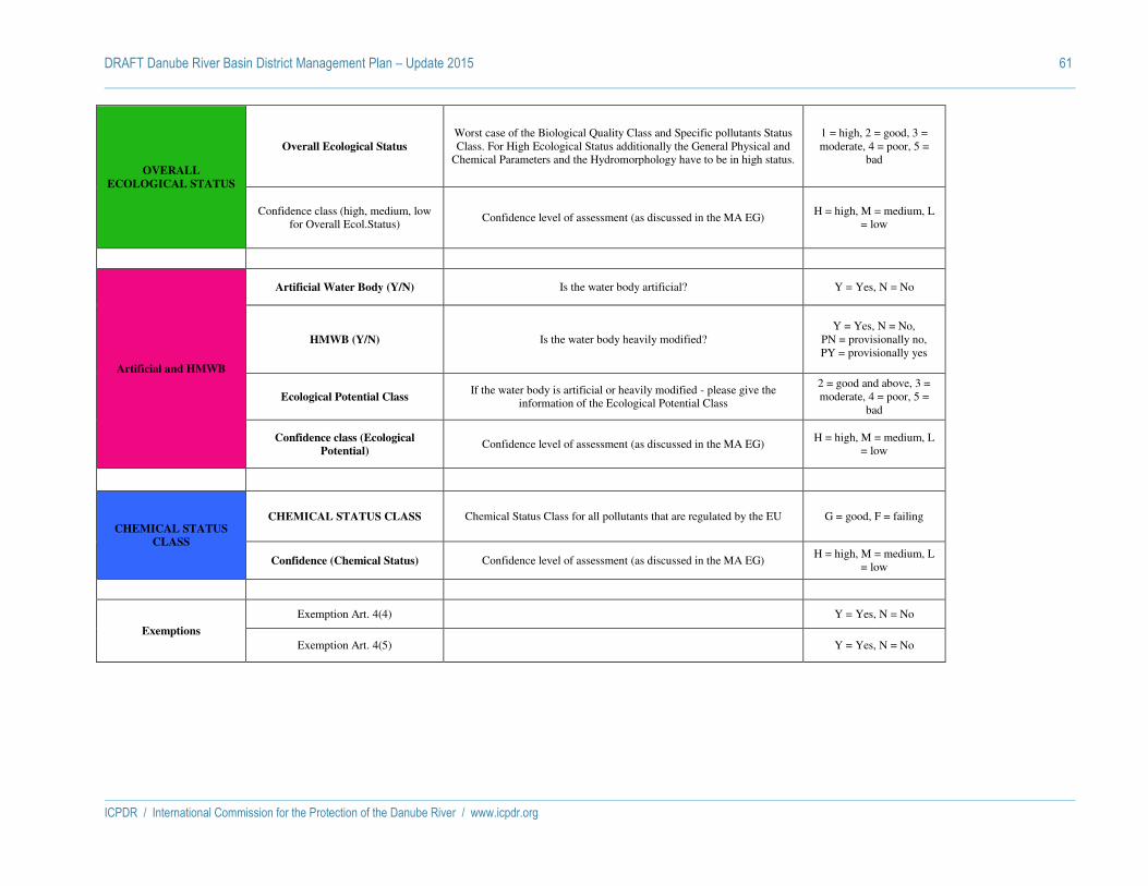
DRAFT Danube River Basin District Management Plan – Update 2015 61
ICPDR / International Commission for the Protection of the Danube River / www.icpdr.org
OVERALL
ECOLOGICAL STATUS
Overall Ecological Status
Worst case of the Biological Quality Class and Specific pollutants Status Class. For High Ecological Status additionally the General Physical and
Chemical Parameters and the Hydromorphology have to be in high status.
1 = high, 2 = good, 3 = moderate, 4 = poor, 5 =
bad
Confidence class (high, medium, low for Overall Ecol.Status)
Confidence level of assessment (as discussed in the MA EG) H = high, M = medium, L
= low
Artificial and HMWB
Artificial Water Body (Y/N) Is the water body artificial? Y = Yes, N = No
HMWB (Y/N) Is the water body heavily modified? Y = Yes, N = No,
PN = provisionally no, PY = provisionally yes
Ecological Potential Class If the water body is artificial or heavily modified - please give the
information of the Ecological Potential Class
2 = good and above, 3 = moderate, 4 = poor, 5 =
bad
Confidence class (Ecological
Potential) Confidence level of assessment (as discussed in the MA EG)
H = high, M = medium, L = low
CHEMICAL STATUS
CLASS
CHEMICAL STATUS CLASS Chemical Status Class for all pollutants that are regulated by the EU G = good, F = failing
Confidence (Chemical Status) Confidence level of assessment (as discussed in the MA EG) H = high, M = medium, L
= low
Exemptions
Exemption Art. 4(4) Y = Yes, N = No
Exemption Art. 4(5) Y = Yes, N = No

DRAFT Danube River Basin District Management Plan – Update 2015 62
ICPDR / International Commission for the Protection of the Danube River / www.icpdr.org
Status assessment of coastal waters
Water Body code with country code
Name of water body
Biological Quality Elements
Hy
dro
mo
rph
olo
gy -
Hig
h S
tatu
s
Gen
era
l P
hy
s. a
nd
Ch
em. co
nd
itio
ns
Sp
ecif
ic p
oll
uta
nts
OV
ER
AL
L E
CO
LO
GIC
AL
ST
AT
US
Con
fide
nce
clas
s (O
vera
ll E
col.S
tatu
s)
Artificial
and HMWB
CH
EM
ICA
L S
TA
TU
S
Con
fide
nce
clas
s (C
hem
ical
Sta
tus)
Exem
pti
on
Art
. 4
(4)
Exem
pti
on
Art
. 4
(5)
Fis
h
Ben
thic
in
ver
teb
rate
s
An
gio
sper
ms
Ma
croa
lga
e
Ph
yto
pla
nk
ton
Ov
erall
Bio
logic
al
Sta
tus
Art
ific
ial
Wa
ter
Bo
dy
Hea
vil
y m
od
ifie
d W
ate
r B
od
y
Eco
logic
al
Po
ten
tia
l C
lass
Con
fide
nce
clas
s (E
col.
Pot.)
ROCT01_B1 Periboina-Cap Singol 1 - - 3 3 Y 3 G 3 M N N G M N N
ROCT01_B2 Mangalia 1 - - 2 2 N 3 G N Y 3 M G M N N
ROCT02_B1 Cap Singol-Eforie Nord - - - 2 2 N 3 G N Y 3 M G M N N
ROCT02_B2 Eforie Nord-Vama Veche 1 - - 2 2 Y 3 G 3 M N N G M N N
UABScstl Black Sea coastal N 0
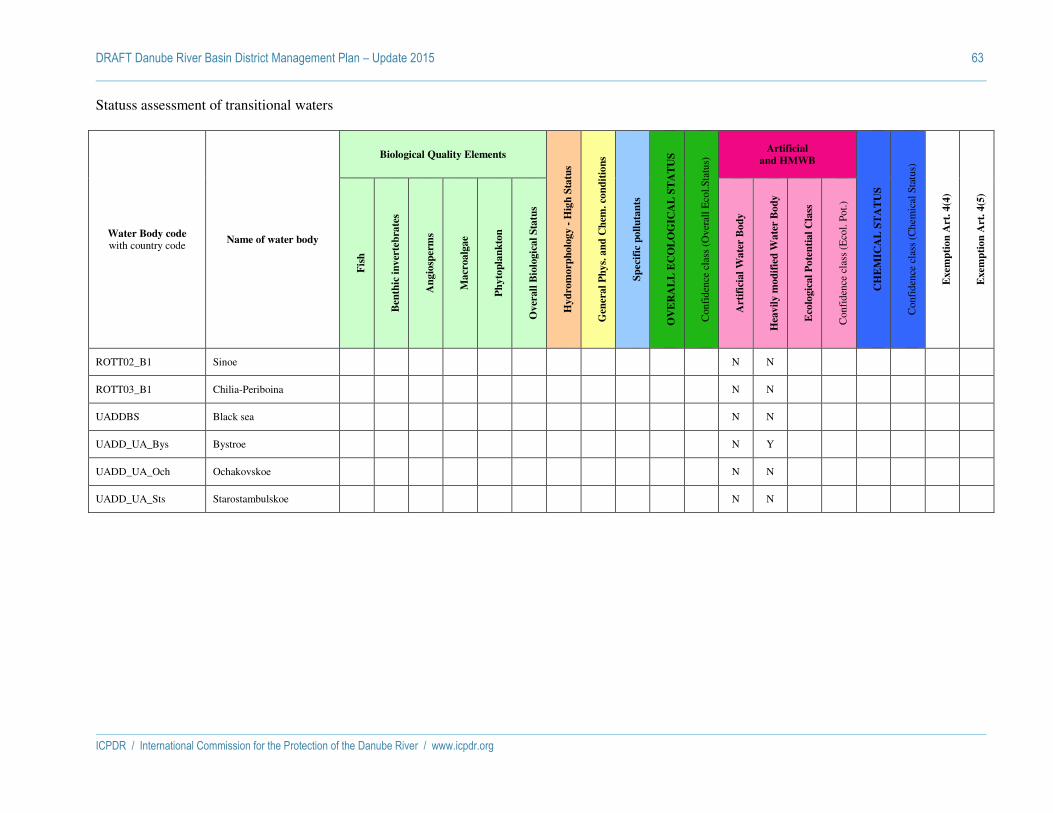
DRAFT Danube River Basin District Management Plan – Update 2015 63
ICPDR / International Commission for the Protection of the Danube River / www.icpdr.org
Statuss assessment of transitional waters
Water Body code with country code
Name of water body
Biological Quality Elements
Hy
dro
mo
rph
olo
gy -
Hig
h S
tatu
s
Gen
era
l P
hy
s. a
nd
Ch
em. co
nd
itio
ns
Sp
ecif
ic p
oll
uta
nts
OV
ER
AL
L E
CO
LO
GIC
AL
ST
AT
US
Con
fide
nce
clas
s (O
vera
ll E
col.S
tatu
s) Artificial
and HMWB
CH
EM
ICA
L S
TA
TU
S
Con
fide
nce
clas
s (C
hem
ical
Sta
tus)
Exem
pti
on
Art
. 4
(4)
Exem
pti
on
Art
. 4
(5)
Fis
h
Ben
thic
in
ver
teb
rate
s
An
gio
sper
ms
Ma
croa
lga
e
Ph
yto
pla
nk
ton
Ov
erall
Bio
logic
al
Sta
tus
Art
ific
ial
Wa
ter
Bo
dy
Hea
vil
y m
od
ifie
d W
ate
r B
od
y
Eco
logic
al
Po
ten
tia
l C
lass
Con
fide
nce
clas
s (E
col.
Pot.)
ROTT02_B1 Sinoe N N
ROTT03_B1 Chilia-Periboina N N
UADDBS Black sea N N
UADD_UA_Bys Bystroe N Y
UADD_UA_Och Ochakovskoe N N
UADD_UA_Sts Starostambulskoe N N

ICPDR / International Commission for the Protection of the Danube River / www.icpdr.org
ANNEX 8
DRAFT DRBM Plan – Update 2015
Inventory of Protected Areas

DRAFT Danube River Basin District Management Plan – Update 2015 1
ICPDR / International Commission for the Protection of the Danube River / www.icpdr.org
Explanations
Types:
H = Habitat (FFH) Directive
B = Bird Protection Directive
O = Others (Non EU MS)
Data on protected areas for Germany as listed in this Annex is from the 1st DRBM Plan 2009.
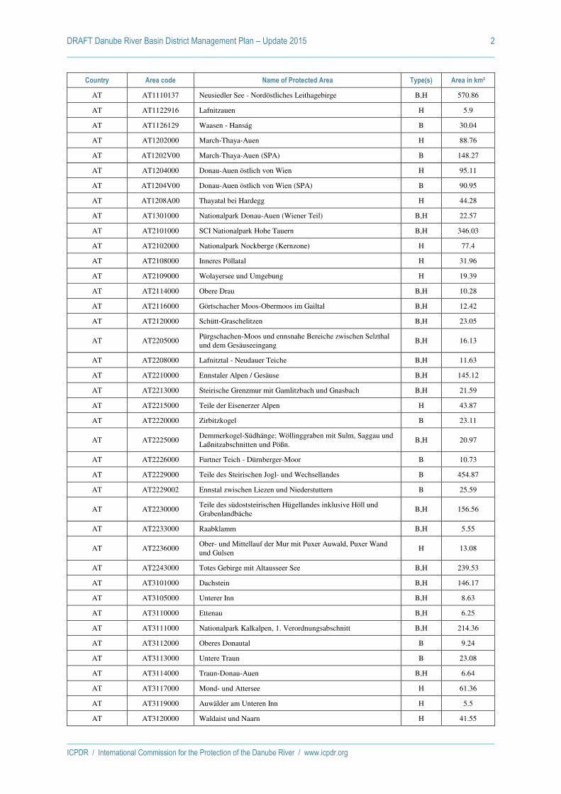
DRAFT Danube River Basin District Management Plan – Update 2015 2
ICPDR / International Commission for the Protection of the Danube River / www.icpdr.org
Country Area code Name of Protected Area Type(s) Area in km²
AT AT1110137 Neusiedler See - Nordöstliches Leithagebirge B,H 570.86
AT AT1122916 Lafnitzauen H 5.9
AT AT1126129 Waasen - Hanság B 30.04
AT AT1202000 March-Thaya-Auen H 88.76
AT AT1202V00 March-Thaya-Auen (SPA) B 148.27
AT AT1204000 Donau-Auen östlich von Wien H 95.11
AT AT1204V00 Donau-Auen östlich von Wien (SPA) B 90.95
AT AT1208A00 Thayatal bei Hardegg H 44.28
AT AT1301000 Nationalpark Donau-Auen (Wiener Teil) B,H 22.57
AT AT2101000 SCI Nationalpark Hohe Tauern B,H 346.03
AT AT2102000 Nationalpark Nockberge (Kernzone) H 77.4
AT AT2108000 Inneres Pöllatal H 31.96
AT AT2109000 Wolayersee und Umgebung H 19.39
AT AT2114000 Obere Drau B,H 10.28
AT AT2116000 Görtschacher Moos-Obermoos im Gailtal B,H 12.42
AT AT2120000 Schütt-Graschelitzen B,H 23.05
AT AT2205000 Pürgschachen-Moos und ennsnahe Bereiche zwischen Selzthal und dem Gesäuseeingang
B,H 16.13
AT AT2208000 Lafnitztal - Neudauer Teiche B,H 11.63
AT AT2210000 Ennstaler Alpen / Gesäuse B,H 145.12
AT AT2213000 Steirische Grenzmur mit Gamlitzbach und Gnasbach B,H 21.59
AT AT2215000 Teile der Eisenerzer Alpen H 43.87
AT AT2220000 Zirbitzkogel B 23.11
AT AT2225000 Demmerkogel-Südhänge; Wöllinggraben mit Sulm, Saggau und Laßnitzabschnitten und Pößn.
B,H 20.97
AT AT2226000 Furtner Teich - Dürnberger-Moor B 10.73
AT AT2229000 Teile des Steirischen Jogl- und Wechsellandes B 454.87
AT AT2229002 Ennstal zwischen Liezen und Niederstuttern B 25.59
AT AT2230000 Teile des südoststeirischen Hügellandes inklusive Höll und Grabenlandbäche
B,H 156.56
AT AT2233000 Raabklamm B,H 5.55
AT AT2236000 Ober- und Mittellauf der Mur mit Puxer Auwald, Puxer Wand und Gulsen
H 13.08
AT AT2243000 Totes Gebirge mit Altausseer See B,H 239.53
AT AT3101000 Dachstein B,H 146.17
AT AT3105000 Unterer Inn B,H 8.63
AT AT3110000 Ettenau B,H 6.25
AT AT3111000 Nationalpark Kalkalpen, 1. Verordnungsabschnitt B,H 214.36
AT AT3112000 Oberes Donautal B 9.24
AT AT3113000 Untere Traun B 23.08
AT AT3114000 Traun-Donau-Auen B,H 6.64
AT AT3117000 Mond- und Attersee H 61.36
AT AT3119000 Auwälder am Unteren Inn H 5.5
AT AT3120000 Waldaist und Naarn H 41.55
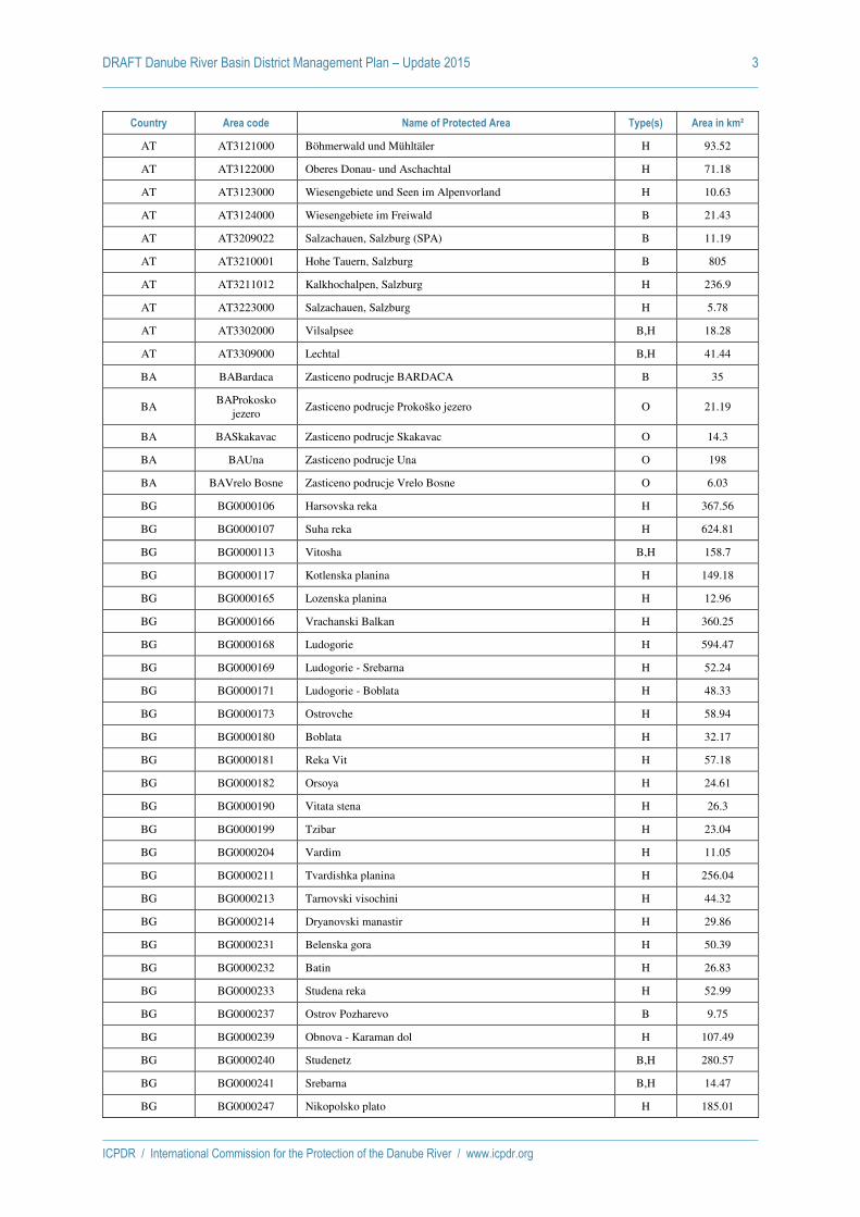
DRAFT Danube River Basin District Management Plan – Update 2015 3
ICPDR / International Commission for the Protection of the Danube River / www.icpdr.org
Country Area code Name of Protected Area Type(s) Area in km²
AT AT3121000 Böhmerwald und Mühltäler H 93.52
AT AT3122000 Oberes Donau- und Aschachtal H 71.18
AT AT3123000 Wiesengebiete und Seen im Alpenvorland H 10.63
AT AT3124000 Wiesengebiete im Freiwald B 21.43
AT AT3209022 Salzachauen, Salzburg (SPA) B 11.19
AT AT3210001 Hohe Tauern, Salzburg B 805
AT AT3211012 Kalkhochalpen, Salzburg H 236.9
AT AT3223000 Salzachauen, Salzburg H 5.78
AT AT3302000 Vilsalpsee B,H 18.28
AT AT3309000 Lechtal B,H 41.44
BA BABardaca Zasticeno podrucje BARDACA B 35
BA BAProkosko
jezero Zasticeno podrucje Prokoško jezero O 21.19
BA BASkakavac Zasticeno podrucje Skakavac O 14.3
BA BAUna Zasticeno podrucje Una O 198
BA BAVrelo Bosne Zasticeno podrucje Vrelo Bosne O 6.03
BG BG0000106 Harsovska reka H 367.56
BG BG0000107 Suha reka H 624.81
BG BG0000113 Vitosha B,H 158.7
BG BG0000117 Kotlenska planina H 149.18
BG BG0000165 Lozenska planina H 12.96
BG BG0000166 Vrachanski Balkan H 360.25
BG BG0000168 Ludogorie H 594.47
BG BG0000169 Ludogorie - Srebarna H 52.24
BG BG0000171 Ludogorie - Boblata H 48.33
BG BG0000173 Ostrovche H 58.94
BG BG0000180 Boblata H 32.17
BG BG0000181 Reka Vit H 57.18
BG BG0000182 Orsoya H 24.61
BG BG0000190 Vitata stena H 26.3
BG BG0000199 Tzibar H 23.04
BG BG0000204 Vardim H 11.05
BG BG0000211 Tvardishka planina H 256.04
BG BG0000213 Tarnovski visochini H 44.32
BG BG0000214 Dryanovski manastir H 29.86
BG BG0000231 Belenska gora H 50.39
BG BG0000232 Batin H 26.83
BG BG0000233 Studena reka H 52.99
BG BG0000237 Ostrov Pozharevo B 9.75
BG BG0000239 Obnova - Karaman dol H 107.49
BG BG0000240 Studenetz B,H 280.57
BG BG0000241 Srebarna B,H 14.47
BG BG0000247 Nikopolsko plato H 185.01

DRAFT Danube River Basin District Management Plan – Update 2015 4
ICPDR / International Commission for the Protection of the Danube River / www.icpdr.org
Country Area code Name of Protected Area Type(s) Area in km²
BG BG0000263 Skalsko H 21.89
BG BG0000275 Yazovir Stamboliyski H 93.53
BG BG0000308 Verila H 37.48
BG BG0000313 Rui H 16.36
BG BG0000322 Dragoman H 213.57
BG BG0000332 Karlukovski karst B 142.17
BG BG0000334 Ostrov H 34.4
BG BG0000335 Karaboaz H 122
BG BG0000336 Zlatiya H 31.95
BG BG0000339 Rabrovo H 9.11
BG BG0000340 Tzar Petrovo H 17.48
BG BG0000374 Bebresh H 68.22
BG BG0000377 Kalimok - Brashlen H 73.32
BG BG0000396 Persina H 223.77
BG BG0000399 Bulgarka H 210.91
BG BG0000432 Golyama reka H 74.52
BG BG0000494 Tzentralen Balkan B,H 312.21
BG BG0000495 Rila B,H 206.5
BG BG0000497 Archar H 5.97
BG BG0000498 Vidbol H 13.05
BG BG0000500 Voynitza H 23.13
BG BG0000503 Reka Lom H 14.41
BG BG0000507 Deleina H 22.58
BG BG0000509 Tzibritza H 9.63
BG BG0000517 Portitovtsi-Vladimirovo H 6.64
BG BG0000518 Vartopski dol H 9.87
BG BG0000521 Makresh H 20.61
BG BG0000522 Vidinski park H 15.79
BG BG0000523 Shishentzi H 5.73
BG BG0000529 Marten-Ryahovo H 11.73
BG BG0000530 Pozharevo - Garvan H 58.66
BG BG0000533 Ostrovi Kozlodui H 6.06
BG BG0000569 Kardam H 9.18
BG BG0000570 Izvorovo - Kraishte H 10.81
BG BG0000572 Rositza - Loznitza H 18.12
BG BG0000576 Svishtovska gora H 19.17
BG BG0000608 Lomovete H 324.89
BG BG0000609 Reka Rositza H 14.41
BG BG0000610 Reka Yantra H 139
BG BG0000611 Yazovir Gorni Dubnik H 25.39
BG BG0000613 Reka Iskar H 94.58
BG BG0000614 Reka Ogosta H 12.53
BG BG0000615 Devetashko plato H 149.97

DRAFT Danube River Basin District Management Plan – Update 2015 5
ICPDR / International Commission for the Protection of the Danube River / www.icpdr.org
Country Area code Name of Protected Area Type(s) Area in km²
BG BG0000616 Mikre H 154.47
BG BG0000617 Reka Palakariya H 31.56
BG BG0000618 Vidima H 18.23
BG BG0000624 Lyubash H 12.67
BG BG0001014 Karlukovo H 288.42
BG BG0001017 Karvav kamak H 36.5
BG BG0001036 Balgarski izvor H 26.19
BG BG0001037 Pastrina H 35.52
BG BG0001040 Zapadna stara planina i Predba H 2193.03
BG BG0001042 Iskarski prolom - Rzhana H 226.93
BG BG0001043 Etropole - Baylovo H 191.26
BG BG0001307 Plana H 27.89
BG BG0001389 Sredna Gora H 21.42
BG BG0001493 Tzentralen Balkan - buffer H 867.22
BG BG0002001 Rayanovtsi B 132.02
BG BG0002002 Zapaden Balkan B 1467.72
BG BG0002004 Dolni Bogrov-Kazichene B 22.54
BG BG0002005 Ponor B 314.06
BG BG0002009 Zlatiata B 435.38
BG BG0002017 Complex Belenski Ostrovi B 66.83
BG BG0002018 Ostrov Vardim B 11.66
BG BG0002024 Ribarnitsi Mechka B 27.11
BG BG0002025 Lomovete B 43.08
BG BG0002029 Kotlenska planina B 196.89
BG BG0002030 Complex Kalimok B 92.2
BG BG0002039 Harsovska reka B 354
BG BG0002048 Suha reka B 257.5
BG BG0002053 Vrachanski Balkan B 309.17
BG BG0002062 Ludogorie B 913.15
BG BG0002074 Nikopolsko plato B 222.31
BG BG0002083 Svishtovsko-Belenska nizina B 54.39
BG BG0002084 Palakaria B 158.25
BG BG0002085 Chairya B 14.5
BG BG0002088 Mikre B 123.87
BG BG0002090 Berkovitsa B 28.04
BG BG0002091 Ostrov Lakat B 11.56
BG BG0002095 Gorni Dabnik-Telish B 34
BG BG0002096 Obnova B 54.21
BG BG0002101 Meshtitsa B 16.27
BG BG0002102 Devetashko plato B 78.92
BG BG0002104 Tsibarsko blato B 9.11
BG BG0002109 Vasilyovska planina B 454.84
BG BG0002110 Apriltsi B 19.42

DRAFT Danube River Basin District Management Plan – Update 2015 6
ICPDR / International Commission for the Protection of the Danube River / www.icpdr.org
Country Area code Name of Protected Area Type(s) Area in km²
BG BG0002111 Velchevo B 23.1
BG BG0002112 Ruy B 173.94
CZ CZ0314024 Šumava H 107.77
CZ CZ0320180 Čerchovský les H 21.91
CZ CZ0323151 Kateřinský a Nivní potok H 9.79
CZ CZ0324026 Niva Nemanického potoka H 6.81
CZ CZ0530146 Králický Sněžník H 17.16
CZ CZ0614131 Údolí Oslavy a Chvojnice H 23.39
CZ CZ0614134 Údolí Jihlavy H 8.62
CZ CZ0620009 Lednické rybníky H 6.18
CZ CZ0620245 Rakovecké údolí H 7.56
CZ CZ0621025 Bzenecká Doubrava - Strážnické Pomoraví B 11.72
CZ CZ0621027 Soutok-Tvrdonicko B 95.59
CZ CZ0621028 Lednické rybníky B 6.85
CZ CZ0621029 Pálava B 85.39
CZ CZ0621030 Střední nádrž vodního díla Nové Mlýny B 10.47
CZ CZ0624064 Krumlovský les H 19.46
CZ CZ0624068 Strážnická Morava H 6.59
CZ CZ0624070 Hodonínská doubrava H 30.29
CZ CZ0624072 Čertoryje H 48.52
CZ CZ0624095 Údolí Dyje H 18.21
CZ CZ0624096 Podyjí H 62.68
CZ CZ0624099 Niva Dyje H 32.49
CZ CZ0624103 Mušovský luh H 5.57
CZ CZ0624119 Soutok - Podluží H 97
CZ CZ0624130 Moravský kras H 64.85
CZ CZ0710161 Království H 5.88
CZ CZ0711018 Litovelské Pomoraví B 93.19
CZ CZ0714073 Litovelské Pomoraví H 94.59
CZ CZ0714075 Keprník H 17.51
CZ CZ0714077 Praděd H 28.02
CZ CZ0714085 Morava - Chropyňský luh H 32.05
CZ CZ0714133 Libavá H 67.32
CZ CZ0720033 Semetín H 13.27
CZ CZ0720192 Velká Vela H 7.71
CZ CZ0720422 Valy-Bučník H 10.95
CZ CZ0720428 Na Koncoch H 17.35
CZ CZ0720435 Podkrálovec H 9.62
CZ CZ0720437 Valentová H 5.58
CZ CZ0724089 Beskydy H 632.22
CZ CZ0724090 Bílé Karpaty H 200.34
CZ CZ0724091 Chřiby H 192.26
CZ CZ0724107 Nedakonický les H 15.25

DRAFT Danube River Basin District Management Plan – Update 2015 7
ICPDR / International Commission for the Protection of the Danube River / www.icpdr.org
Country Area code Name of Protected Area Type(s) Area in km²
CZ CZ0724120 Kněžpolský les H 5.21
CZ CZ0724121 Nad Jasenkou H 7.39
CZ CZ0724429 Hostýnské vrchy H 23.97
CZ CZ0724430 Vlárský průsmyk H 31.69
DE DE5937-471 Schneeberggebiet und Goldkronacher / Sophientaler Forst B 26.19
DE DE6139-371 Waldnaabtal zwischen Tirschenreuth und Windisch-Eschenbach H 26.18
DE DE6139-471 Waldnaabaue westlich Tirschenreuth B 22.59
DE DE6237-371
Heidenaab, Creussenaue und Weihergebiet nordwestlich Eschenbach H 18.65
DE DE6336-301 US-Truppenübungsplatz Grafenwöhr B,H 192.79
DE DE6336-471 Vilsecker Mulde B 9.2
DE DE6337-371 Vilsecker Mulde mit den Tälern der Schmalnohe und Wiesenohe H 9.39
DE DE6338-301
Lohen im Manteler Forst mit Schießlweiher und Straßweiherkette H 7.73
DE DE6338-401 Manteler Forst B 26.92
DE DE6528-371 Anstieg der Frankenhöhe östlich der A 7 H 11.79
DE DE6537-371 Vils von Vilseck bis zur Mündung in die Naab H 6.22
DE DE6541-371 Bayerische Schwarzach und Biberbach H 5.3
DE DE6636-371 Lauterachtal H 8.23
DE DE6639-371 Talsystem von Schwarzach, Auerbach und Ascha H 7.84
DE DE6639-372
Charlottenhofer Weihergebiet, Hirtlohweiher und Langwiedteiche B,H 9.31
DE DE6728-471 Altmühltal mit Brunst-Schwaigau und Altmühlsee B 49.71
DE DE6736-302 Truppenübungsplatz Hohenfels B,H 149.06
DE DE6741-371
Chamb, Regentalaue und Regen zwischen Roding und Donaumündung H 31.94
DE DE6741-471 Regentalaue und Chambtal mit Rötelseeweihergebiet B 27.78
DE DE6830-371 Obere Altmühl mit Brunst-Schwaigau und Wiesmet H 45.08
DE DE6833-371 Trauf der südlichen Frankenalb H 41.47
DE DE6834-301 Trauf der mittleren Frankenalb im Sulztal H 12.24
DE DE6836-371 Schwarze Laaber H 11.6
DE DE6844-371 Oberlauf des Weißen Regens bis Kötzting mit Kaitersbachaue H 6.37
DE DE6844-373 Großer und Kleiner Arber mit Arberseen H 22.96
DE DE6935-371
Weiße, Wissinger, Breitenbrunner Laaber u. Kreuzberg bei Dietfurt H 23.23
DE DE6937-371
Naab unterhalb Schwarzenfeld und Donau von Poikam bis Regensburg H 11.15
DE DE6939-302 Bachtäler im Falkensteiner Vorwald H 13.87
DE DE6939-371 Trockenhänge am Donaurandbruch H 5.21
DE DE6946-301 Nationalpark Bayerischer Wald B,H 242.18
DE DE7029-371 Wörnitztal H 38.93
DE DE7036-371
Trockenhänge im unteren Altmühltal mit Laaberleiten und Galgental H 27.19
DE DE7037-471
Felsen und Hangwälder im Altmühl-, Naab-, Laber- und Donautal B 48.44
DE DE7038-371 Standortübungsplatz Oberhinkofen H 5.27

DRAFT Danube River Basin District Management Plan – Update 2015 8
ICPDR / International Commission for the Protection of the Danube River / www.icpdr.org
Country Area code Name of Protected Area Type(s) Area in km²
DE DE7040-302 Wälder im Donautal B,H 12.89
DE DE7040-371 Donau und Altwässer zwischen Regensburg und Straubing H 21.94
DE DE7040-471 Donau zwischen Regensburg und Straubing B 32.6
DE DE7043-371 Deggendorfer Vorwald H 14.98
DE DE7045-371 Oberlauf des Regens und Nebenbäche H 19.22
DE DE7128-371 Trockenverbund am Rand des Nördlinger Rieses H 9.5
DE DE7130-471 Nördlinger Ries und Wörnitztal B 70.36
DE DE7132-371
Mittleres Altmühltal mit Wellheimer Trockental und Schambachtal H 42.01
DE DE7132-471
Felsen und Hangwälder im Altmühltal und Wellheimer Trockental B 36.12
DE DE7136-301 'Weltenburger Enge' und 'Hirschberg und Altmühlleiten' H 9.34
DE DE7136-304 Donauauen zwischen Ingolstadt und Weltenburg H 27.67
DE DE7138-372
Tal der Großen Laaber zwischen Sandsbach und Unterdeggenbach H 6.82
DE DE7142-301 Donauauen zwischen Straubing und Vilshofen H 47.86
DE DE7142-471 Donau zwischen Straubing und Vilshofen B 67.76
DE DE7229-471 Riesalb mit Kesseltal B 120.37
DE DE7230-371
Donauwörther Forst mit Standortübungsplatz und Harburger Karab H 24.01
DE DE7231-471 Donauauen zwischen Lechmündung und Ingolstadt B 69.61
DE DE7232-301 Donau mit Jura-Hängen zwischen Leitheim und Neuburg H 32.81
DE DE7233-372 Donauauen mit Gerolfinger Eichenwald H 29.27
DE DE7233-373 Donaumoosbäche, Zucheringer Wörth und Brucker Forst H 9.47
DE DE7243-301 Untere Isar zwischen Landau und Plattling H 12.17
DE DE7243-302 Isarmündung H 19.07
DE DE7243-401 Untere Isar oberhalb Mündung B 9.74
DE DE7243-402 Isarmündung B 21.13
DE DE7246-371 Ilz-Talsystem H 28.45
DE DE7329-301 Donauauen Blindheim-Donaumünster H 12.11
DE DE7329-372 Jurawälder nördlich Höchstädt H 38.2
DE DE7330-301 Mertinger Hölle und umgebende Feuchtgebiete H 8.58
DE DE7330-471 Wiesenbrüterlebensraum Schwäbisches Donauried B 39.66
DE DE7335-371 Feilenmoos mit Nöttinger Viehweide H 8.7
DE DE7341-471 Wiesenbrütergebiete im Unteren Isartal B 13.84
DE DE7347-371 Erlau H 5.75
DE DE7427-471 Schwäbisches Donaumoos B 25.78
DE DE7428-301 Donau-Auen zwischen Thalfingen und Höchstädt H 57.97
DE DE7428-471 Donauauen B 80.53
DE DE7433-371 Paar H 29.7
DE DE7439-371 Isarleiten bei der Gretlmühle H 6.43
DE DE7440-371 Vilstal zwischen Vilsbiburg und Marklkofen H 8.35
DE DE7446-301 Donauleiten von Passau bis Jochenstein H 5.17
DE DE7446-371 Östlicher Neuburger Wald und Innleiten bis Vornbach H 10.89

DRAFT Danube River Basin District Management Plan – Update 2015 9
ICPDR / International Commission for the Protection of the Danube River / www.icpdr.org
Country Area code Name of Protected Area Type(s) Area in km²
DE DE7447-371 Donau von Kachlet bis Jochenstein mit Inn- und Ilzmündung H 5.08
DE DE7537-301 Isarauen von Unterföhring bis Landshut H 52.77
DE DE7537-401 Naturschutzgebiet "Vogelfreistätte Mittlere Isarstauseen" B 5.87
DE DE7630-371 Schmuttertal H 9
DE DE7631-371 Lechauen zwischen Königsbrunn und Augsburg H 23.04
DE DE7631-372 Lech zwischen Landsberg und Königsbrunn mit Auen und Leite H 25.02
DE DE7635-301 Ampertal H 21.72
DE DE7636-471 Freisinger Moos B 11.3
DE DE7726-371 Untere Illerauen H 16.42
DE DE7736-471 Ismaninger Speichersee und Fischteiche B 10.29
DE DE7739-371 Isental mit Nebenbächen H 7.66
DE DE7742-371 Inn und Untere Alz H 15.65
DE DE7744-371 Salzach und Unterer Inn H 56.89
DE DE7744-471 Salzach und Inn B 48.28
DE DE7820-441 Südwestalb und Oberes Donautal B 428.56
DE DE7823-341 Donau zwischen Munderkingen und Riedlingen H 14.29
DE DE7828-471 Mindeltal B 26.55
DE DE7829-301 Angelberger Forst H 6.41
DE DE7832-371 Ampermoos H 5.29
DE DE7833-371
Moore und Buchenwälder zwischen Etterschlag und Fürstenfeldbruck H 7.76
DE DE7837-371 Ebersberger und Großhaager Forst H 38.41
DE DE7919-341 Donautal und Hochflächen von Tuttlingen bis Beuron H 54.26
DE DE7920-342 Oberes Donautal zwischen Beuron und Sigmaringen H 27.04
DE DE7922-342 Donau zwischen Riedlingen und Sigmaringen H 11.66
DE DE7932-372 Ammerseeufer und Leitenwälder H 9.53
DE DE7932-471 Ammerseegebiet B 77.1
DE DE7934-371 Moore und Wälder der Endmoräne bei Starnberg H 5.87
DE DE7939-301 Innauen und Leitenwälder H 35.53
DE DE7939-401 NSG 'Vogelfreistätte Innstausee bei Attel und Freiham' B 5.67
DE DE8016-341 Baar H 22.24
DE DE8017-341 Nördliche Baaralb und Donau bei Immendingen H 24.98
DE DE8017-441 Baar B 377.58
DE DE8031-471 Mittleres Lechtal B 32.08
DE DE8032-371 Ammersee-Südufer und Raistinger Wiesen H 8.82
DE DE8032-372 Moore und Wälder westlich Dießen H 25.91
DE DE8033-371 Moränenlandschaft zwischen Ammersee und Starnberger See H 20.73
DE DE8034-371 Oberes Isartal H 46.71
DE DE8038-371 Rotter Forst und Rott H 8.47
DE DE8039-302 Moore und Seen nordöstlich Rosenheim H 5.6
DE DE8039-371 Murn, Murner Filz und Eiselfinger See H 5.14
DE DE8040-371 Moorgebiet von Eggstädt-Hemhof bis Seeon H 21.16
DE DE8040-471 Moorgebiet von Eggstätt-Hemhof bis Seeon B 20.06

DRAFT Danube River Basin District Management Plan – Update 2015 10
ICPDR / International Commission for the Protection of the Danube River / www.icpdr.org
Country Area code Name of Protected Area Type(s) Area in km²
DE DE8127-301 Illerdurchbruch zwischen Reicholzried und Lautrach H 9.68
DE DE8131-301 Moorkette von Peiting bis Wessobrunn H 9.43
DE DE8131-371 Lech zwischen Hirschau und Landsberg mit Auen und Leiten H 28.9
DE DE8133-301 Naturschutzgebiet 'Osterseen' H 10.87
DE DE8133-302
Eberfinger Drumlinfeld mit Magnetsrieder Hardt u. Bernrieder Filz H 11.16
DE DE8133-371 Starnberger See H 56.89
DE DE8133-401 Starnberger See B 56.93
DE DE8134-371
Moore südlich Königsdorf, Rothenrainer Moore und Königsdorfer Alm H 10.98
DE DE8135-371 Moore zwischen Dietramszell und Deining H 9.61
DE DE8136-302 Taubenberg B,H 18.5
DE DE8136-371 Mangfalltal H 13.47
DE DE8138-372 Moore um Raubling H 10.28
DE DE8139-371 Simsseegebiet H 10.42
DE DE8140-371 Moore südlich des Chiemsees H 35.67
DE DE8140-372 Chiemsee H 81.51
DE DE8140-471 Chiemseegebiet mit Alz B 103.55
DE DE8141-471 Moore südlich des Chiemsees B 27.21
DE DE8142-371 Moore im Salzach-Hügelland H 13.08
DE DE8142-372 Oberes Surtal und Urstromtal Höglwörth H 8.78
DE DE8227-373 Kürnacher Wald H 27.6
DE DE8228-301 Kempter Wald mit Oberem Rottachtal H 40.96
DE DE8232-371 Grasleitner Moorlandschaft H 21.38
DE DE8233-301
Moor- und Drumlinlandschaft zwischen Hohenkasten und Antdorf H 14.12
DE DE8234-371 Moore um Penzberg H 11.62
DE DE8235-301 Ellbach- und Kirchseemoor H 11.72
DE DE8235-371 Attenloher Filzen und Mariensteiner Moore H 6.51
DE DE8236-371 Flyschberge bei Bad Wiessee H 9.55
DE DE8237-371 Leitzachtal H 22.39
DE DE8239-371 Hochriesgebiet und Hangwälder im Aschauer Tal H 18.26
DE DE8239-372 Geigelstein und Achentaldurchbruch H 32.07
DE DE8239-401 Geigelstein B 32.08
DE DE8241-372 Östliche Chiemgauer Alpen H 129.23
DE DE8327-304 Rottachberg und Rottachschlucht H 5.27
DE DE8329-301 Wertachdurchbruch B,H 8.76
DE DE8329-303 Sulzschneider Moore H 17.95
DE DE8330-371 Urspringer Filz,Premer Filz und Viehweiden H 5.48
DE DE8330-471
Ammergebirge mit Kienberg und Schwarzenberg sowie Falkenstein B 301.05
DE DE8331-302
Ammer vom Alpenrand b. zum NSG 'Vogelfreistätte Ammersee-Südufer' H 23.91
DE DE8331-303
Trauchberger Ach, Moore und Wälder am Nordrand des Ammergebirges H 11.29

DRAFT Danube River Basin District Management Plan – Update 2015 11
ICPDR / International Commission for the Protection of the Danube River / www.icpdr.org
Country Area code Name of Protected Area Type(s) Area in km²
DE DE8332-301 Murnauer Moos H 42.9
DE DE8332-371 Moore im oberen Ammertal H 6.29
DE DE8332-372 Moränenlandschaft zwischen Staffelsee und Baiersoien H 25.92
DE DE8332-471 Murnaür Moos und Pfrühlmoos B 72.82
DE DE8334-371 Loisach-Kochelsee-Moore H 19
DE DE8334-373 Kesselberggebiet H 6.48
DE DE8334-471 Loisach-Kochelsee-Moore B 41.84
DE DE8336-371 Mangfallgebirge H 148.72
DE DE8342-301 Nationalpark Berchtesgaden B,H 213.64
DE DE8342-302 NSG 'Aschau', NSG 'Schwarzbach' und Schwimmendes Moos H 8.04
DE DE8343-303 Untersberg H 35.14
DE DE8426-302 Nagelfluhkette Hochgrat-Steineberg H 19.93
DE DE8429-303 Kienberg mit Magerrasen im Tal der Steinacher Ach H 6.24
DE DE8430-301 Naturschutzgebiet 'Bannwaldsee' H 5.58
DE DE8430-303 Falkenstein, Alatsee, Faulenbacher- und Lechtal H 9.87
DE DE8431-371 Ammergebirge H 275.82
DE DE8432-301 Loisachtal zwischen Farchant und Eschenlohe H 6.92
DE DE8433-301 Karwendel mit Isar B,H 195.9
DE DE8433-371 Estergebirge H 60.77
DE DE8434-372 Jachenau und Extensivwiesen bei Fleck H 14.52
DE DE8527-301 Hörnergruppe H 11.83
DE DE8528-301 Allgäuer Hochalpen H 212.27
DE DE8532-371 Wettersteingebirge H 42.57
DE DE8532-471 Naturschutzgebiet "Schachen und Reintal" B 39.64
DE DE8533-301 Mittenwalder Buckelwiesen H 19.29
DE DE8626-301 Hoher Ifen H 24.51
HR HR1054 Plitvička jezera O 296.2
HR HR146755 Jelas polje O 195.26
HR HR146758 Bara Dvorina kraj Donje Bebrine O 7.37
HR HR15602 Kopački rit O 231.43
HR HR15605 Ue podrucje Kopačkog rita O 72.37
HR HR15614 Medvednica O 179.36
HR HR15615 Bijele i Samarske stijene O 11.26
HR HR15618 Crna Mlaka O 6.94
HR HR2518 Risnjak O 63.45
HR HR377823 Vuka O 5.23
HR HR377833 Mura O 143.54
HR HR377853 Ž umberak - Samoborsko gorje O 342.43
HR HR377920 Turopoljski lug i vlaž ne livade uz rijeku Odru O 33.48
HR HR378013 Odransko polje O 93.99
HR HR378033 Papuk O 343.07
HR HR392915 Sunjsko polje O 203.2
HR HR393049 Mura-Drava O 1448.11

DRAFT Danube River Basin District Management Plan – Update 2015 12
ICPDR / International Commission for the Protection of the Danube River / www.icpdr.org
Country Area code Name of Protected Area Type(s) Area in km²
HR HR63666 Lonjsko polje O 511.26
HR HR81108 Veliki Paž ut O 12.01
HR HR81116 Varoški Lug O 8.97
HR HR81145 Jankovac O 6.48
HR HRHR1000001 Pokupski bazen B 449.69
HR HRHR1000002 Sava kod Hručice (s okolnim ljunčarama) B 17.58
HR HRHR1000003 Turopolje B 227.44
HR HRHR1000004 Donja Posavina B 1258.87
HR HRHR1000005 Jelas polje s ribnjacima i poplavnim paš njacima uz Savu B 418.46
HR HRHR1000006 Spačvanski bazen B 429.3
HR HRHR1000011
Ribnjaci Grudnjak i Naički ribnjak s kompleksom luž njakovih š uma B
205.56
HR HRHR1000013 Dravske akumulacije B 196.81
HR HRHR1000014 Gornji tok Drave (od Donje Dubrave do Terezinog polja) B 341.21
HR HRHR1000015 Srednji tok Drave (od Terezinog polja do Donjeg Miholjca) B 171.76
HR HRHR1000016 Podunavlje i donje Podravlje B 823.99
HR HRHR1000040 Papuk B 362.72
HR HRHR2000364 Mura H 145.93
HR HRHR2000365 Plitvica H 21.5
HR HRHR2000366 Bednja H 42.25
HR HRHR2000372 Dunav - Vukovar H 61.83
HR HRHR2000382 Potok Zbel H 7.45
HR HRHR2000387 Beletinec H 16.17
HR HRHR2000388 Slanje H 6.76
HR HRHR2000394 Kopa_ki rit H 231.27
HR HRHR2000401 Uš_e Plitvice i Bednje H 13.5
HR HRHR2000409 Kri_nica H 6.98
HR HRHR2000414 Izvorišno podru_je Odre H 9.05
HR HRHR2000415 Odransko polje H 84.96
HR HRHR2000416 Lonjsko polje H 501.83
HR HRHR2000420 Sunjsko polje H 203.6
HR HRHR2000424 Vlakanac - Radinje H 32.05
HR HRHR2000426 Dvorina H 20.64
HR HRHR2000427 Gajna H 5.65
HR HRHR2000431 Sava - Štitar H 17.55
HR HRHR2000439 Dolina Bijele H 5.16
HR HRHR2000452 Zrinska gora H 356.59
HR HRHR2000463 dolina Une H 39.35
HR HRHR2000465 Ž utica H 46.97
HR HRHR2000569 Vuka H 5.23
HR HRHR2000580 Papuk H 350.34
HR HRHR2000583 Medvednica H 226.09
HR HRHR2000592 Ogulinsko-plaš_ansko podru_je H 434.78

DRAFT Danube River Basin District Management Plan – Update 2015 13
ICPDR / International Commission for the Protection of the Danube River / www.icpdr.org
Country Area code Name of Protected Area Type(s) Area in km²
HR HRHR2000593 Mre_nica - Tounj_ica H 15.21
HR HRHR2000595 Korana H 25.74
HR HRHR2000609 Dolina Dretulje H 5.81
HR HRHR2000613 Stari tok Drave I H 26.41
HR HRHR2000614 Stari tok Drave II H 24.51
HR HRHR2000620 Mala i Velika Utinja H 21.5
HR HRHR2000631 Odra H 5.03
HR HRHR2000632 Krbavsko polje H 118.53
HR HRHR2000634 Stajni_ko polje H 5
HR HRHR2000642 Kupa H 63.66
HR HRHR2000646 Polje Lug H 7.31
HR HRHR2000879 Lapa_ko polje H 22.23
HR HRHR2001070 Sutla H 5.53
HR HRHR2001118 Park šuma Jankovac H 6.38
HR HRHR2001311 Sava H 123.61
HR HRHR5000006 Spa_vanski bazen H 429.3
HR HRHR5000013 Šire podru_je Drave H 1527.98
HR HRHR5000019 Gorski kotar, Primorje i sjeverna Lika H 1651.27
HR HRHR5000020 Nacionalni park Plitvi_ka jezera (s Vrhovinskim poljem) H 266.49
HU HU109/NP/74 Kiskunsági Nemzeti Park O 505.23
HU HU112/TK/75 Ócsai Tájvédelmi Körzet O 36.45
HU HU118/TK/75 Lázbérci Tájvédelmi Körzet O 37.18
HU HU122/TK/76 Pusztaszeri Tájvédelmi Körzet O 223.33
HU HU124/TT/76 Péteri-tavi madárrezervátum természetvédelmi terület O 7.8
HU HU126/TK/76 Zselici Tájvédelmi Körzet O 83.01
HU HU138/NP/76 Bükki Nemzeti Park O 428.41
HU HU139/TK/76 Vértesi Tájvédelmi Körzet O 152.08
HU HU140/TK/77 Soproni Tájvédelmi Körzet O 50.68
HU HU146/TK/77 Kelet-Mecsek Tájvédelmi Körzet O 93.39
HU HU148/TT/77 Tiszadobi-ártér természetvédelmi terület O 10.21
HU HU150/TT/77 Nagybereki Fehér-víz természetvédelmi terület O 15.83
HU HU152/TK/77 Gerecsei Tájvédelmi Körzet O 86.6
HU HU158/TK/78 Közép-tiszai Tájvédelmi Körzet O 94.52
HU HU164/TT/78 Tiszatelek– Tiszaberceli-ártér természetvédelmi terület O 15.06
HU HU170/TK/80 Kőszegi Tájvédelmi Körzet O 43.35
HU HU171/TK/82 Szatmár-beregi Tájvédelmi Körzet O 218.92
HU HU172/TK/84 Zempléni Tájvédelmi Körzet O 267.65
HU HU177/NP/85 Aggteleki Nemzeti Park O 201.84
HU HU180/TK/85 Mátrai Tájvédelmi Körzet O 129.88
HU HU181/TK/86 Sárréti Tájvédelmi Körzet O 22.14
HU HU183/TK/86 Tokaj–Bodrogzug Tájvédelmi Körzet O 52.86
HU HU184/TT/86 Bihari-legelő természetvédelmi terület O 7.7
HU HU185/TT/86 Balatonfüredi-erdő természetvédelmi terület O 8.69

DRAFT Danube River Basin District Management Plan – Update 2015 14
ICPDR / International Commission for the Protection of the Danube River / www.icpdr.org
Country Area code Name of Protected Area Type(s) Area in km²
HU HU187/TK/87 Szigetközi Tájvédelmi Körzet O 96.87
HU HU201/TK/88 Hajdúsági Tájvédelmi Körzet O 70.9
HU HU211/TK/89 Karancs– Medves Tájvédelmi Körzet O 66.2
HU HU212/TK/89 Borsodi-Mezőség Tájvédelmi Körzet O 184.3
HU HU219/TT/90 Császártöltési Vörös Mocsár Természetvédelmi Terület O 9.3
HU HU221/TT/90 Kiskőrösi-turjános természetvédelmi terület O 6.41
HU HU230/TT/90 Kecskeri-puszta Természetvédelmi Terület O 12.63
HU HU232/TK/90 Kesznyéteni Tájvédelmi Körzet O 58.33
HU HU238/NP/91 Fertő– Hanság Nemzeti Park O 237.27
HU HU240/TK/91 Magas-bakonyi Tájvédelmi Körzet O 87.32
HU HU242/TK/91 Boronka-melléki Tájvédelmi Körzet O 84.96
HU HU253/TK/92 Pannonhalmi Tájvédelmi Körzet O 82.85
HU HU258/TK/93 Hevesi Füves Puszták Tájvédelmi Körzet O 161.07
HU HU260/TK/93 Tarnavidéki Tájvédelmi Körzet O 93.84
HU HU271/NP/96 Duna–Dráva Nemzeti Park O 496.34
HU HU272/TT/96 Rétszilasi-tavak Természetvédelmi Terület O 14.96
HU HU274/TT/96 Long-erdő természetvédelmi terület O 10.05
HU HU276/NP/97 Körös– Maros Nemzeti Park O 512.01
HU HU280/TK/97 Sárvíz-völgye Tájvédelmi Körzet O 34.8
HU HU282/NP/97 Balaton-felvidéki Nemzeti Park O 580.56
HU HU283/NP/97 Duna– Ipoly Nemzeti Park O 606.69
HU HU284/TK/98 Bihari-sík Tájvédelmi Körzet O 166.05
HU HU287/TK/98 Tápió-Hajta Vidéke Tájvédelmi Körzet O 42.31
HU HU293/TK/99 Dél-Mezőföld Tájvédelmi Körzet O 77.52
HU HU296/NP/02 ĩrségi Nemzeti Park O 438.98
HU HU308/TK/07 Mura-menti Tájvédelmi Körzet O 19.02
HU HU319/TK/09 Nyugat-Mecsek Tájvédelmi Körzet O 103.65
HU HU330/TK/12 Körös-éri Tájvédelmi Körzet O 22.24
HU HU87/TT/66 Dinnyési-fertő természetvédelmi terület O 5.29
HU HU94/TK/71 Mártélyi Tájvédelmi Körzet O 22.76
HU HU97/NP/73 Hortobágyi Nemzeti Park O 811.31
HU HUAN10001 Aggteleki-karszt B 236.2
HU HUAN10002 Putnok-dombság B 71.16
HU HUAN20001 Aggteleki-karszt és peremterületei H 231.04
HU HUAN20002 Rakaca-völgy és oldalvölgyei H 20.82
HU HUAN20003 Bódva-völgy és Sas-patak-völgye H 26.95
HU HUAN20004 Hernád-völgy és Sajóládi-erdő H 50.38
HU HUAN20005 Szuha-völgy H 10.39
HU HUAN20006 Sajó-völgy H 20.75
HU HUAN21007 Bózsva-patak H 8.32
HU HUBF10001 Mórichelyi-halastavak B 6.49
HU HUBF20001 Keleti-Bakony H 226.5
HU HUBF20002 Papod és Miklád H 77.35

DRAFT Danube River Basin District Management Plan – Update 2015 15
ICPDR / International Commission for the Protection of the Danube River / www.icpdr.org
Country Area code Name of Protected Area Type(s) Area in km²
HU HUBF20003 Kab-hegy H 80.76
HU HUBF20004 Agár-tető H 51.36
HU HUBF20006 Tihanyi-félsziget H 7.74
HU HUBF20007 Monostorapáti Fekete-hegy H 17.89
HU HUBF20009 Devecseri Széki-erdő H 15.94
HU HUBF20011 Felső-Nyirádi-erdő és Meggyes-erdő H 41.77
HU HUBF20014 Pécselyi-medence H 8.67
HU HUBF20015 Marcal-medence H 48.87
HU HUBF20016 Öreg-hegyi riviéra H 12.07
HU HUBF20017 Kádártai dolomitmezők H 7.93
HU HUBF20028 Tapolcai-medence H 23.01
HU HUBF20034 Balatonfüredi-erdő H 34.9
HU HUBF20035 Keszthelyi-hegység H 148.98
HU HUBF20037 Alsó-Zala-völgy H 65.52
HU HUBF20039 Nyugat-Göcsej H 45.25
HU HUBF20040 Vétyempuszta H 41.41
HU HUBF20043 Mura mente H 21.45
HU HUBF20044 Kerka mente H 73.41
HU HUBF20045 Szévíz–Principális-csatorna H 80.19
HU HUBF20046 Oltárc H 89.61
HU HUBF20047 Felső-Zala-völgy H 11.1
HU HUBF20048 Kebele H 19.25
HU HUBF20049 Dél-zalai homokvidék H 29.09
HU HUBF20050 Csörnyeberek H 21.34
HU HUBF20052 Sárvíz-patak mente H 11.86
HU HUBF20054 Nagykapornaki erdő H 6.38
HU HUBF20055 Remetekert H 9.72
HU HUBF30001 Északi-Bakony B,H 257.79
HU HUBF30002 Balaton B,H 594.83
HU HUBF30003 Kis-Balaton B,H 133.44
HU HUBN10001 Bodrogzug–Kopasz-hegy–Taktaköz B 226.46
HU HUBN10002 Borsodi-sík B 362.4
HU HUBN10003 Bükk hegység és peremterületei B 662.08
HU HUBN10004 Hevesi-sík B 770.16
HU HUBN10005 Kesznyéten B 63.53
HU HUBN10006 Mátra B 373.07
HU HUBN10007 Zempléni-hegység a Szerencsi-dombsággal és a Hernád-völggyel B 1145.37
HU HUBN20001 Bükk-fennsík és Lök-völgy H 143.83
HU HUBN20002 Hór-völgy és Déli-Bükk H 55.2
HU HUBN20007 Kisgyőri Halom-vár– Csincse-völgy– Cseh-völgy H 10.01
HU HUBN20012 Egerbakta-Bátor környéki erdők H 26.3
HU HUBN20013 Hevesaranyosi-Fedémesi dombvidék H 12.38
HU HUBN20014 Gyepes-völgy H 30.13

DRAFT Danube River Basin District Management Plan – Update 2015 16
ICPDR / International Commission for the Protection of the Danube River / www.icpdr.org
Country Area code Name of Protected Area Type(s) Area in km²
HU HUBN20015 Izra-völgy és Arlói-tó H 13.49
HU HUBN20018 Upponyi-szoros H 12.9
HU HUBN20021 Domaházi Hangony-patak völgye H 11.71
HU HUBN20025 Nagybarcai Liget-hegy és sajóvelezdi Égett-hegy H 12.02
HU HUBN20034 Borsodi-Mezőség H 148.5
HU HUBN20041 Pélyi szikesek H 27.69
HU HUBN20047 Mátra északi letörése H 7.8
HU HUBN20049 Mátrabérc– Fallóskúti-rétek H 15.07
HU HUBN20051 Nyugat-Mátra H 14.99
HU HUBN20056 Tepke H 24.23
HU HUBN20057 Bézma H 8.32
HU HUBN20062 Középső-Ipoly-völgy H 16.79
HU HUBN20063 Karancs H 8.82
HU HUBN20069 Kesznyéteni Sajó-öböl H 47.29
HU HUBN20071 Bodrogzug és Bodrog hullámtere H 73.72
HU HUBN20081 Long-erdő H 31.6
HU HUBN20084 Központi-Zempléni-hegység H 86.66
HU HUBN20085 Északi-Zempléni-hegység H 18.54
HU HUBN20087 Baskói-rétek H 5.86
HU HUBN20089 Füzéri Pál-hegy H 7.33
HU HUDD10002 Nyugat-Dráva B 152.37
HU HUDD10003 Gemenc B 196.41
HU HUDD10004 Béda-Karapancsa B 87.22
HU HUDD10007 Mecsek B 206.35
HU HUDD10008 Belső-Somogy B 333.28
HU HUDD10012 Balatoni berkek B 86.49
HU HUDD20001 Tenkes H 15.59
HU HUDD20004 Dél-Zselic H 68.05
HU HUDD20007 Kelet-Dráva H 66.24
HU HUDD20008 Ormánsági erdők H 105.32
HU HUDD20011 Szekszárdi-dombvidék H 24.46
HU HUDD20012 Geresdi-dombvidék H 65.67
HU HUDD20014 Jánosházi-erdő és Égett-berek H 6.19
HU HUDD20015 Kisbajomi erdők H 13
HU HUDD20016 Észak-Zselici erdőségek H 162.48
HU HUDD20017 Mocsoládi-erdő H 25.86
HU HUDD20020 Közép-mezőföldi löszvölgyek H 15.98
HU HUDD20023 Tolnai Duna H 71.62
HU HUDD20026 Lengyel-hőgyészi erdők H 36.36
HU HUDD20029 Kisszékelyi-dombság H 29.79
HU HUDD20030 Mecsek H 261.81
HU HUDD20031 Fehérvíz H 15.5
HU HUDD20032 Gemenc H 207.04
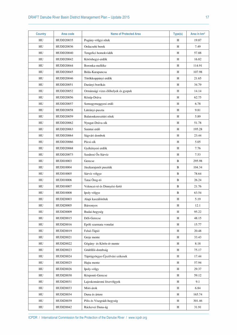
DRAFT Danube River Basin District Management Plan – Update 2015 17
ICPDR / International Commission for the Protection of the Danube River / www.icpdr.org
Country Area code Name of Protected Area Type(s) Area in km²
HU HUDD20035 Pogány-völgyi rétek H 19.87
HU HUDD20036 Ordacsehi berek H 7.49
HU HUDD20040 Tengelici homokvidék H 57.88
HU HUDD20042 Köröshegyi-erdők H 16.82
HU HUDD20044 Boronka-melléke H 114.91
HU HUDD20045 Béda-Karapancsa H 107.98
HU HUDD20046 Törökkoppányi erdők H 21.65
HU HUDD20051 Darányi borókás H 34.79
HU HUDD20052 Ormánsági vizes élőhelyek és gyepek H 14.14
HU HUDD20056 Közép-Dráva H 62.75
HU HUDD20057 Somogymeggyesi erdő H 6.78
HU HUDD20058 Látrányi-puszta H 9.81
HU HUDD20059 Balatonkeresztúri rétek H 5.89
HU HUDD20062 Nyugat-Dráva-sík H 51.78
HU HUDD20063 Szentai erdő H 195.28
HU HUDD20064 Ságvári dombok H 23.44
HU HUDD20066 Pécsi-sík H 5.05
HU HUDD20068 Gyékényesi erdők H 7.76
HU HUDD20073 Szedresi ĩs-Sárvíz H 7.53
HU HUDI10003 Gerecse B 295.98
HU HUDI10004 Jászkarajenői puszták B 104.34
HU HUDI10005 Sárvíz völgye B 78.64
HU HUDI10006 Tatai Öreg-tó B 26.24
HU HUDI10007 Velencei-tó és Dinnyési-fertő B 21.76
HU HUDI10008 Ipoly völgye B 63.54
HU HUDI20003 Alapi kaszálórétek H 5.19
HU HUDI20005 Bársonyos H 12.1
HU HUDI20009 Budai-hegység H 95.22
HU HUDI20015 Déli-Gerecse H 48.15
HU HUDI20016 Epöli szarmata vonulat H 15.77
HU HUDI20019 Felső-Tápió H 20.48
HU HUDI20021 Gerje mente H 33.43
HU HUDI20022 Gógány- és Kőrös-ér mente H 8.18
HU HUDI20023 Gödöllői-dombság H 75.17
HU HUDI20024 Tápiógyörgye-Újszilvási szikesek H 17.44
HU HUDI20025 Hajta mente H 57.94
HU HUDI20026 Ipoly-völgy H 29.37
HU HUDI20030 Központi-Gerecse H 59.12
HU HUDI20031 Lajoskomáromi löszvölgyek H 9.1
HU HUDI20033 Móri-árok H 6.84
HU HUDI20034 Duna és ártere H 165.74
HU HUDI20039 Pilis és Visegrádi-hegység H 301.46
HU HUDI20042 Ráckevei Duna-ág H 31.91

DRAFT Danube River Basin District Management Plan – Update 2015 18
ICPDR / International Commission for the Protection of the Danube River / www.icpdr.org
Country Area code Name of Protected Area Type(s) Area in km²
HU HUDI20044 Sárrét H 41.09
HU HUDI20046 Székek H 36.16
HU HUDI20049 Szentgyörgypuszta H 9.75
HU HUDI20050 Alsó-Tápió és patakvölgyek H 18.01
HU HUDI20051 Turjánvidék H 122.13
HU HUDI20054 Velencei-tó H 10.82
HU HUDI30001 Vértes B,H 255.54
HU HUDI30002 Zámolyi-medence B,H 25.95
HU HUFH10001 Fertő-tó B 86.97
HU HUFH10004 Mosoni-sík B 130.96
HU HUFH20001 Rábaköz H 59.73
HU HUFH20002 Fertő-tó H 112.99
HU HUFH20003 Fertőmelléki dombsor H 25.64
HU HUFH20009 Gönyüi-homokvidék H 28.81
HU HUFH20010 Répce mente H 16.26
HU HUFH20011 Rába H 51.07
HU HUFH20012 Soproni-hegység H 52.64
HU HUFH20013 Határ-menti erdők H 22.53
HU HUFH30004 Szigetköz B,H 171.83
HU HUFH30005 Hanság B,H 135.45
HU HUHN10001 Szatmár-Bereg B 528.48
HU HUHN10002 Hortobágy B 1211.1
HU HUHN10004 Közép-Tisza B 136.39
HU HUHN10008 Felső-Tisza B 148.2
HU HUHN20001 Felső-Tisza H 286.82
HU HUHN20002 Hortobágy H 1051.7
HU HUHN20003 Tisza-tó H 178.3
HU HUHN20004 Felső-Sebes-Körös H 5.18
HU HUHN20008 Kismarj-pocsaj-esztári gyepek H 24.27
HU HUHN20013 Közép-Bihar H 120.45
HU HUHN20015 Közép-Tisza H 142.36
HU HUHN20016 Kék-Kálló-völgye H 15.04
HU HUHN20032 Gúti-erdő H 56.83
HU HUHN20035 Ömbölyi-erdő és Fényi-erdő H 14.33
HU HUHN20045 Kaszonyi-hegy– Dédai-erdő H 13.27
HU HUHN20046 Gelénes– Beregdaróc H 11.59
HU HUHN20047 Vámosatya-Csaroda H 20.08
HU HUHN20048 Tarpa-Tákos H 63.51
HU HUHN20049 Lónya-Tiszaszalka H 41.35
HU HUHN20050 Kömörő-Fülesd H 19.44
HU HUHN20053 Magosligeti-erdő és gyepek H 5.6
HU HUHN20054 Csaholc– Garbolc H 40.54
HU HUHN20055 Rozsály– Csengersima H 9.85

DRAFT Danube River Basin District Management Plan – Update 2015 19
ICPDR / International Commission for the Protection of the Danube River / www.icpdr.org
Country Area code Name of Protected Area Type(s) Area in km²
HU HUHN20058 Teremi-erdő H 9.12
HU HUHN20069 Hajdúszoboszlói szikes gyepek H 5.54
HU HUHN20113 Kisvárdai gyepek H 6.87
HU HUHN21164 Liget-legelő H 22.07
HU HUKM10002 Kis-Sárrét B 83.4
HU HUKM10003 Dévaványai-sík B 252.14
HU HUKM10004 Vásárhelyi- és Csanádi-puszták B 218.33
HU HUKM10005 Cserebökényi-puszták B 280.75
HU HUKM20001 Hódmezővásárhely környéki és csanádi-háti puszták H 164.19
HU HUKM20002 Hómezővásárhelyi Kék-tó H 39.1
HU HUKM20004 Száraz-ér H 15.22
HU HUKM20005 Deszki gyepek H 5.37
HU HUKM20008 Maros H 59.65
HU HUKM20012 Fekete-, Fehér- és Kettős-Körös H 19.8
HU HUKM20014 Dévaványa környéki gyepek H 140.27
HU HUKM20015 Hortobágy-Berettyó H 30.79
HU HUKM20016 Sebes-Körös H 14.55
HU HUKM20017 Hármas-Körös H 78.18
HU HUKM20019 Dél-bihari szikesek H 65.22
HU HUKM20026 Tóniszállás-szarvasi gyepek H 5.87
HU HUKM20027 Cserebökény H 100
HU HUKM20028 Tőkei gyepek H 29.86
HU HUKM20029 Szentesi gyepek H 6.06
HU HUKM20030 Lapistó-Fertő H 19.03
HU HUKN10001 Felső-Kiskunsági szikes puszták és turjánvidék B 418.16
HU HUKN10002 Kiskunsági szikes tavak és az őrjegi turjánvidék B 357.22
HU HUKN10004 Tisza Alpár-Bokrosi ártéri öblözete B 50.27
HU HUKN10007 Alsó-Tiszavölgy B 362.93
HU HUKN10008 Balástya-Szatymaz környéki homokvidék B 61.72
HU HUKN20002 Peszéri-erdő H 16.28
HU HUKN20003 Felső-kiskunsági turjánvidék H 144.36
HU HUKN20004 Dél-Bácska H 7.81
HU HUKN20008 Déli-Homokhátság H 23.86
HU HUKN20013 Fülöpszállás-soltszentimre-csengődi lápok H 31.23
HU HUKN20015 Ágasegyháza-orgoványi rétek H 43.21
HU HUKN20017 Közép-csongrádi szikesek H 11.43
HU HUKN20019 Baksi-puszta H 48.75
HU HUKN20020 Harkai-tó H 6.62
HU HUKN20021 Ökördierdőtelekikeceli lápok H 25.18
HU HUKN20022 Kiskőrösi turjános H 28.71
HU HUKN20024 Bócsa-bugaci homokpuszta H 116.6
HU HUKN20026 Móricgáti lápok H 7.67
HU HUKN20028 Tisza Alpár-Bokrosi ártéri öblözet H 32.88

DRAFT Danube River Basin District Management Plan – Update 2015 20
ICPDR / International Commission for the Protection of the Danube River / www.icpdr.org
Country Area code Name of Protected Area Type(s) Area in km²
HU HUKN20031 Alsó-Tisza hullámtér H 79.3
HU HUKN20032 Dél-ĩrjeg H 45.85
HU HUKN20036 Imre-hegy– pirtó– kiskunhalasi homokbuckák H 15.64
HU HUKN30001 Csongrád-Bokrosi Sós-tó B 7.14
HU HUKN30002 Gátéri Fehér-tó B 8.14
HU HUKN30003 Izsáki Kolon-tó B,H 35.82
HU HUON10001 ĩrség B 456.94
HU HUON20002 Kőszegi-hegység H 40.18
HU HUON20003 Ablánc-patak völgye H 14.65
HU HUON20008 Rába és Csörnöc-völgy H 121.47
HU HUON20012 Kemenessömjéni cserjés legelő H 6.18
HU HUON20018 ĩrség H 441.65
MD MDPA03 Feteti-Fetesti O 5.55
MD MDPA04 La Costel-Gordinesti O 7.39
MD MDPA05 Zabriceni-Onesti O 5.93
MD MDPA06 Suta de Movila-Cobani O 6.88
MD MDPA08 Padurea Domneasca-Cobani O 60.52
MD MDPA09 Izvoare-Risipeni-Risipeneni O 15.41
MD MDPA13 Vila Nisporeni-Nisporeni O 41.55
MD MDPA14 Padurea Hincesti-Mereseni O 46.78
MD MDPA18 Prutul de Jos-Manta O 132.47
RO RO2.104. Zona carstică - Cheile Dâmbovita O 12.46
RO RO2.125. Valea Vâlsanului O 118.85
RO RO2.234. Rezervatia naturală Bucegi (Abruptul Bucsoiu, Mălăesti, Gaura) O 17.17
RO RO2.243. Rezervatia naturală Cheile Dopca O 20.63
RO RO2.253. Rezervatia naturală Muntele Postăvarul O 12.36
RO RO2.257. Rezervatia naturală Pădurea Bogătii O 63.3
RO RO2.260. Lacul Jirlău-Trup Visani O 5.43
RO RO2.271. Balta Albă O 11.67
RO RO2.272. Balta Amara O 8.14
RO RO2.276. Rezervatia Cheile Nerei – Beusnita O 41.86
RO RO2.277. Valea Ciclovei – Ilidia O 19.63
RO RO2.282. Cheile Carasului O 32.65
RO RO2.283. Izvoarele Carasului O 5.78
RO RO2.284. Izvoarele Nerei O 50.73
RO RO2.285. Cheile Gârlistei O 5.11
RO RO2.298. Rezervaţia naturală Valea Mare O 11.64
RO RO2.334. Stufarisurile de la Sic I O 5.04
RO RO2.337. Pestera din Piatra Ponorului O 17.08
RO RO2.345. Vama Veche – 2 Mai (Acvatoriul litoralul marin) O 55.6
RO RO2.346. Grindul Chituc DD– A O 23
RO RO2.347. Grindul Lupilor DD– A O 20.74
RO RO2.372. Mestecănisul de la Reci O 21.13

DRAFT Danube River Basin District Management Plan – Update 2015 21
ICPDR / International Commission for the Protection of the Danube River / www.icpdr.org
Country Area code Name of Protected Area Type(s) Area in km²
RO RO2.376. Orzea - Zănoaga O 7.13
RO RO2.389. Gogosu Stefănel O 8.17
RO RO2.399. Cleanov O 7.39
RO RO2.414. Lunca joasă a Prutului O 11.69
RO RO2.422. Piatra Closanilor O 23.58
RO RO2.442. Cheile Sohodolului O 6.1
RO RO2.482. Cheile Bicazului si Lacul Rosu O 22
RO RO2.483. Masivul Hăsmasul Mare, Piatra Singuratică O 8.76
RO RO2.485. Cheile Vârghisului si pesterile din chei O 7.71
RO RO2.494. Rezervatia Stiintifică Gemenele O 19.29
RO RO2.497. Complexul carstic Călianu – Ponorici – Ciclovina O 15.5
RO RO2.499. Cheile si Pestera Sura Mare O 37.95
RO RO2.500. Pestera Tecuri (Complexul carstic Răchitaua – Tecuri) O 5.36
RO RO2.525. Codrii seculari de pe valea Dobrisoarei si Prisloapei O 5.04
RO RO2.530. Cheile Cernei O 5.35
RO RO2.556. Raul Prut O 53.21
RO RO2.580. Cornu Nedeii-Ciungii Bălăsânii O 25.14
RO RO2.583. Cheile Lăpusului (între Groape si Împreunături) O 14.87
RO RO2.589. Piatra Rea O 5.23
RO RO2.597.
Gura Văii - Vârciorova PN - D, Municipiul Drobeta - Turnu Severin, localitatea O 7.21
RO RO2.600. Pădurea de liliac Ponoarele Comuna Ponoarele O 6.17
RO RO2.601. Tufărisurile mediteraneene de la Isverna Comuna Isverna O 5
RO RO2.602. Vârful lui Stan, PN-B, Comuna Isverna O 7.1
RO RO2.603. Valea Tesna PN-B Comuna Balta O 10.65
RO RO2.613. Complexul carstic de la Ponoarele Comuna Ponoarele O 6.63
RO RO2.615. Cheile Cosustei O 7.19
RO RO2.616. Cornetul Babelor si Cerboaniei Comuna Balta O 8.51
RO RO2.619. Cornetul Băltii, Comuna Balta O 9.35
RO RO2.638. Defileul Deda - Toplita O 91.57
RO RO2.643. Cheile Bicazului O 17.46
RO RO2.658. Rezervatia de zimbri Neamt O 121.14
RO RO2.672. Abruptul Prahovean Bucegi O 56.33
RO RO2.673. Muntii Colti lui Barbes O 8.73
RO RO2.680. Cursul inferior al râului Tur, Comuna Călinesti Oas O 15.12
RO RO2.701. Valea Bâlii O 5.07
RO RO2.705. Iezerele Cindrelului O 14.53
RO RO2.706. Parcul Natural Dumbrava Sibiului O 10.06
RO RO2.707. Parcul Natural Cindrel O 79.13
RO RO2.709. Golul Alpin al Munţilor Făgăras O 48.45
RO RO2.715. Tinovul Poiana Stampei O 6.44
RO RO2.722. Pietrele Doamnei-Rarău O 9.7
RO RO2.723. Codrul Secular Slătioara O 10.07

DRAFT Danube River Basin District Management Plan – Update 2015 22
ICPDR / International Commission for the Protection of the Danube River / www.icpdr.org
Country Area code Name of Protected Area Type(s) Area in km²
RO RO2.730. Jnepenisul cu Pinus Cembra-Călimani PN-K O 5.61
RO RO2.750. Rosca – Buhaiova DD– A O 94.56
RO RO2.751. Pădurea Letea DD– A O 30.85
RO RO2.752. Grindul si Lacul Răducu DD– A O 26.64
RO RO2.754. Complexul Vătafu Lungulet DDA O 16.21
RO RO2.755. Pădurea Caraorman DD– A O 22.49
RO RO2.758. Complexul Sacalin Zătoana DD– A O 213.93
RO RO2.761. Lacul Potcoava DD– A O 6.26
RO RO2.798. Pădurea Călinesti - Brezoi O 9.93
RO RO2.826. Rezervaţia naturală Valea Tisitei O 27.12
RO RO2.827. Rezervatia naturală Pădurea Neagra O 5.99
RO ROA Delta Dunarii - zona marina O 5800
RO ROA.1 Defileul Muresului Superior O 94.94
RO ROA.1. Defileul Jiului O 111.36
RO ROB Domogled - Valea Cernei O 611.9
RO ROC Retezat O 381.17
RO ROD Portile de Fier O 1300
RO ROE Cheile Nerei - Beusnita O 367.07
RO ROF Apuseni O 760.22
RO ROG Muntii Rodnei O 472.07
RO ROH Bucegi O 325.98
RO ROI Cheile Bicazului - Hasmas O 69.33
RO ROII.1. Buila - Vanturarita O 44.9
RO ROJ Ceahlau O 77.39
RO ROK Calimani O 239.15
RO ROL Cozia O 167.21
RO ROM Piatra Craiului O 147.81
RO RON Gradistea Muncelului - Cioclovina O 381.16
RO ROO Semenic - Cheile Carasului O 362.19
RO ROP Muntii Macinului O 111.14
RO ROR Balta Mica a Brailei O 204.6
RO ROS Vanatori-Neamt O 308.41
RO ROSCI0002 Apuseni H 759.43
RO ROSCI0004 Bagau H 31.29
RO ROSCI0005 Balta Alba - Amara - Jirlau - Lacul Sarat Câineni H 63
RO ROSCI0006 Balta Mica a Brailei H 208.72
RO ROSCI0007 Bazinul Ciucului de Jos H 26.93
RO ROSCI0008 Betfia H 17.48
RO ROSCI0009 Bisoca H 11.63
RO ROSCI0012 Bratul Macin H 102.35
RO ROSCI0013 Bucegi H 387.87
RO ROSCI0014 Bucsani H 5.13
RO ROSCI0015 Buila - Vânturarita H 45.25

DRAFT Danube River Basin District Management Plan – Update 2015 23
ICPDR / International Commission for the Protection of the Danube River / www.icpdr.org
Country Area code Name of Protected Area Type(s) Area in km²
RO ROSCI0019 Calimani - Gurghiu H 1349.66
RO ROSCI0020 Câmpia Careiului H 236.36
RO ROSCI0021 Câmpia Ierului H 212.83
RO ROSCI0022 Canaralele Dunarii H 259.43
RO ROSCI0024 Ceahlau H 77.37
RO ROSCI0025 Cefa H 52.57
RO ROSCI0027 Cheile Bicazului - Hasmas H 76.41
RO ROSCI0028 Cheile Cernei H 5.77
RO ROSCI0029 Cheile Glodului, Cibului si Mazii H 7.35
RO ROSCI0030 Cheile Lapusului H 16.6
RO ROSCI0031 Cheile Nerei - Beusnita H 377.2
RO ROSCI0036 Cheile Vârghisului H 8.34
RO ROSCI0037 Ciomad - Balvanyos H 59.91
RO ROSCI0038 Ciucas H 218.64
RO ROSCI0039 Ciuperceni - Desa H 395.74
RO ROSCI0040 Coasta Lunii H 6.94
RO ROSCI0042 Codru Moma H 246.5
RO ROSCI0043 Comana H 264.81
RO ROSCI0044 Corabia - Turnu Magurele H 81.85
RO ROSCI0045 Coridorul Jiului H 710.93
RO ROSCI0046 Cozia H 167.6
RO ROSCI0047 Creasta Nemirei H 35.09
RO ROSCI0048 Crisul Alb H 8.91
RO ROSCI0049 Crisul Negru H 18.27
RO ROSCI0050 Crisul Repede amonte de Oradea H 18.59
RO ROSCI0051 Cusma H 442.53
RO ROSCI0056 Dealul Ciocas - Dealul Vitelului H 9.17
RO ROSCI0058 Dealul lui Dumnezeu H 5.79
RO ROSCI0061 Defileul Crisului Negru H 22.03
RO ROSCI0062 Defileul Crisului Repede - Padurea Craiului H 394.11
RO ROSCI0063 Defileul Jiului H 109.46
RO ROSCI0064 Defileul Muresului H 341.34
RO ROSCI0065 Delta Dunarii H 4530.76
RO ROSCI0066 Delta Dunarii - zona marina H 737.56
RO ROSCI0069 Domogled - Valea Cernei H 621.71
RO ROSCI0070 Drocea H 261.08
RO ROSCI0071 Dumbraveni - Valea Urluia - Lacul Vederoasa H 179.75
RO ROSCI0074 Fagetul Clujului - Valea Morii H 16.67
RO ROSCI0075 Padurea Patrauti H 87.46
RO ROSCI0076 Dealul Mare - Hârlau H 251.12
RO ROSCI0084 Ferice - Plai H 19.97
RO ROSCI0085 Frumoasa H 1373.59
RO ROSCI0086 Gaina - Lucina H 8.48

DRAFT Danube River Basin District Management Plan – Update 2015 24
ICPDR / International Commission for the Protection of the Danube River / www.icpdr.org
Country Area code Name of Protected Area Type(s) Area in km²
RO ROSCI0087 Gradistea Muncelului - Ciclovina H 398.18
RO ROSCI0088 Gura Vedei - Saica - Slobozia H 97.93
RO ROSCI0089 Gutâi - Creasta Cocosului H 6.84
RO ROSCI0090 Harghita Madaras H 133.73
RO ROSCI0091 Herculian H 128.83
RO ROSCI0092 Ignis H 195.98
RO ROSCI0099 Lacul Stiucilor - Sic - Puini - Bontida H 37.98
RO ROSCI0101 Larion H 30.23
RO ROSCI0102 Leaota H 13.93
RO ROSCI0103 Lunca Buzaului H 69.86
RO ROSCI0104 Lunca Inferioara a Crisului Repede H 6.56
RO ROSCI0105 Lunca Joasa a Prutului H 48.21
RO ROSCI0106 Lunca Mijlocie a Argesului H 36.14
RO ROSCI0108 Lunca Muresului Inferior H 174.65
RO ROSCI0109 Lunca Timisului H 99.19
RO ROSCI0111 Mestecanisul de la Reci H 21.04
RO ROSCI0115 Mlastina Satchinez H 22.9
RO ROSCI0116 Molhasurile Capatânei H 8.16
RO ROSCI0119 Muntele Mare H 16.54
RO ROSCI0122 Muntii Fagaras H 1986.17
RO ROSCI0123 Muntii Macinului H 168.94
RO ROSCI0124 Muntii Maramuresului H 1068.91
RO ROSCI0125 Muntii Rodnei H 480.62
RO ROSCI0126 Muntii Tarcu H 586.57
RO ROSCI0128 Nordul Gorjului de Est H 491.6
RO ROSCI0129 Nordul Gorjului de Vest H 869.58
RO ROSCI0130 Oituz - Ojdula H 153.5
RO ROSCI0131 Oltenita - Mostistea - Chiciu H 113.49
RO ROSCI0132 Oltul Mijlociu - Cibin - Hârtibaciu H 28.26
RO ROSCI0135 Padurea Bârnova - Repedea H 122.16
RO ROSCI0137 Padurea Bogatii H 63.52
RO ROSCI0138 Padurea Bolintin H 57.36
RO ROSCI0140 Padurea Calugareasca H 6.77
RO ROSCI0149 Padurea Eseschioi - Lacul Bugeac H 29.67
RO ROSCI0152 Padurea Floreanu - Frumusica - Ciurea H 189.78
RO ROSCI0154 Padurea Glodeni H 10.42
RO ROSCI0155 Padurea Goroniste H 9.52
RO ROSCI0156 Muntii Gosman H 171.56
RO ROSCI0157 Padurea Hagieni - Cotul Vaii H 36.2
RO ROSCI0158 Padurea Balteni - Hârboanca H 5.26
RO ROSCI0162 Lunca Siretului Inferior H 250.81
RO ROSCI0166 Padurea Resca Hotarani H 16.3
RO ROSCI0168 Padurea Sarului H 67.93

DRAFT Danube River Basin District Management Plan – Update 2015 25
ICPDR / International Commission for the Protection of the Danube River / www.icpdr.org
Country Area code Name of Protected Area Type(s) Area in km²
RO ROSCI0172 Padurea si Valea Canaraua Fetii - Iortmac H 136.32
RO ROSCI0173 Padurea Stârmina H 27.69
RO ROSCI0177 Padurea Topana H 8.91
RO ROSCI0187 Pajistile lui Suciu H 160.05
RO ROSCI0188 Parâng H 304.34
RO ROSCI0190 Penteleu H 112.68
RO ROSCI0194 Piatra Craiului H 158.67
RO ROSCI0195 Piatra Mare H 42.74
RO ROSCI0198 Platoul Mehedinti H 535.94
RO ROSCI0200 Platoul Vascau H 49.83
RO ROSCI0201 Podisul Nord Dobrogean H 847.99
RO ROSCI0202 Silvostepa Olteniei H 92.97
RO ROSCI0206 Portile de Fier H 1255.46
RO ROSCI0207 Postavarul H 13.03
RO ROSCI0208 Putna - Vrancea H 381.82
RO ROSCI0211 Podisul Secaselor H 70.14
RO ROSCI0212 Rarau - Giumalau H 25.47
RO ROSCI0213 Râul Prut H 80.7
RO ROSCI0214 Râul Tur H 205.15
RO ROSCI0217 Retezat H 435.61
RO ROSCI0218 Dealul Mocrei - Rovina - Ineu H 37.3
RO ROSCI0219 Rusca Montana H 127.58
RO ROSCI0220 Sacueni H 7.33
RO ROSCI0222 Saraturile Jijia Inferioara - Prut H 106.13
RO ROSCI0224 Scrovistea H 33.91
RO ROSCI0225 Seaca - Optasani H 21.1
RO ROSCI0226 Semenic - Cheile Carasului H 375.54
RO ROSCI0227 Sighisoara - Târnava Mare H 858.15
RO ROSCI0229 Siriu H 62.3
RO ROSCI0230 Slanic H 14.08
RO ROSCI0231 Nadab - Socodor - Varsad H 66.61
RO ROSCI0233 Somesul Rece H 85.29
RO ROSCI0236 Strei - Hateg H 249.68
RO ROSCI0238 Suatu -Cojocna - Crairât H 41.46
RO ROSCI0239 Târnovu Mare - Latorita H 13.66
RO ROSCI0240 Tasad H 15.57
RO ROSCI0241 Tinovul Apa Lina - Honcsok H 79.06
RO ROSCI0247 Tinovul Mare Poiana Stampei H 6.93
RO ROSCI0250 Tinutul Padurenilor H 72
RO ROSCI0251 Tisa Superioara H 63.1
RO ROSCI0252 Toplita - Scaunul Rotund Borsec H 54.66
RO ROSCI0253 Trascau H 500.64
RO ROSCI0259 Valea Calmatuiului H 179.23
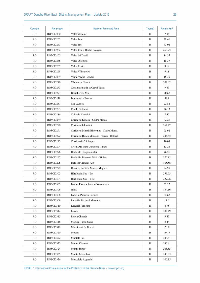
DRAFT Danube River Basin District Management Plan – Update 2015 26
ICPDR / International Commission for the Protection of the Danube River / www.icpdr.org
Country Area code Name of Protected Area Type(s) Area in km²
RO ROSCI0260 Valea Cepelor H 7.96
RO ROSCI0262 Valea Iadei H 29.46
RO ROSCI0263 Valea Ierii H 63.02
RO ROSCI0264 Valea Izei si Dealul Solovan H 468.73
RO ROSCI0265 Valea lui David H 14.35
RO ROSCI0266 Valea Oltetului H 15.37
RO ROSCI0267 Valea Rosie H 8.19
RO ROSCI0268 Valea Vâlsanului H 94.8
RO ROSCI0269 Vama Veche - 2 Mai H 15.35
RO ROSCI0270 Vânatori - Neamt H 302.02
RO ROSCI0273 Zona marina de la Capul Tuzla H 9.83
RO ROSCI0277 Becicherecu Mic H 20.67
RO ROSCI0278 Bordusani - Borcea H 58.1
RO ROSCI0281 Cap Aurora H 22.82
RO ROSCI0283 Cheile Doftanei H 26.13
RO ROSCI0286 Colinele Elanului H 7.55
RO ROSCI0289 Coridorul Drocea - Codru Moma H 32.29
RO ROSCI0290 Coridorul Ialomitei H 267.27
RO ROSCI0291 Coridorul Muntii Bihorului - Codru Moma H 75.92
RO ROSCI0292 Coridorul Rusca Montana - Tarcu - Retezat H 244.42
RO ROSCI0293 Costinesti - 23 August H 10.09
RO ROSCI0294 Crisul Alb între Gurahont si Ineu H 12.28
RO ROSCI0296 Dealurile Dragasaniului H 76.26
RO ROSCI0297 Dealurile Târnavei Mici - Biches H 370.82
RO ROSCI0298 Defileul Crisului Alb H 165.58
RO ROSCI0299 Dunarea la Gârla Mare – Maglavit H 94.95
RO ROSCI0303 Hârtibaciu Sud - Est H 259.03
RO ROSCI0304 Hârtibaciu Sud - Vest H 227.26
RO ROSCI0305 Ianca - Plopu - Sarat - Comaneasca H 32.22
RO ROSCI0306 Jiana H 134.16
RO ROSCI0308 Lacul si Padurea Cernica H 32.67
RO ROSCI0309 Lacurile din jurul Mascurei H 11.6
RO ROSCI0310 Lacurile Falticeni H 8.95
RO ROSCI0314 Lozna H 102.49
RO ROSCI0315 Lunca Chineja H 9.45
RO ROSCI0318 Magura Târgu Ocna H 8.44
RO ROSCI0319 Mlastina de la Fetesti H 20.2
RO ROSCI0320 Mociar H 40.17
RO ROSCI0322 Muntele Ses H 348.81
RO ROSCI0323 Muntii Ciucului H 596.41
RO ROSCI0324 Muntii Bihor H 208.85
RO ROSCI0325 Muntii Metaliferi H 143.03
RO ROSCI0326 Muscelele Argesului H 100.15

DRAFT Danube River Basin District Management Plan – Update 2015 27
ICPDR / International Commission for the Protection of the Danube River / www.icpdr.org
Country Area code Name of Protected Area Type(s) Area in km²
RO ROSCI0327 Nemira - Lapos H 98.65
RO ROSCI0328 Obcinele Bucovinei H 322.46
RO ROSCI0329 Oltul Superior H 15.08
RO ROSCI0333 Pajistile Sarmasel - Milas - Urmenis H 11.36
RO ROSCI0334 Padurea Buciumeni - Homocea H 49.93
RO ROSCI0335 Padurea Dobrina - Husi H 85.18
RO ROSCI0337 Padurea Neudorfului H 45.02
RO ROSCI0339 Padurea Povernii - Valea Cernita H 8.7
RO ROSCI0341 Padurea si Lacul Stolnici H 15.26
RO ROSCI0342 Padurea Târgu Mures H 5.74
RO ROSCI0343 Padurile din Silvostepa Mostistei H 21.2
RO ROSCI0344 Padurile din Sudul Piemontului Cândesti H 43.13
RO ROSCI0345 Pajistea Cenad H 60.31
RO ROSCI0350 Lunca Teuzului H 52.39
RO ROSCI0352 Persani H 22.61
RO ROSCI0354 Platforma Cotmeana H 125.28
RO ROSCI0355 Podisul Lipovei - Poiana Rusca H 357.1
RO ROSCI0357 Porumbeni H 70.52
RO ROSCI0359 Prigoria - Bengesti H 24.89
RO ROSCI0360 Râul Bârlad între Zorleni si Gura Gârbovatului H 25.69
RO ROSCI0361 Râul Caras H 5.88
RO ROSCI0362 Râul Gilort H 8.73
RO ROSCI0363 Râul Moldova între Oniceni si Mitesti H 32.15
RO ROSCI0364 Râul Moldova între Tupilati si Roman H 47.21
RO ROSCI0365 Râul Moldova între Paltinoasa si Rusi H 53.03
RO ROSCI0366 Râul Motru H 19.21
RO ROSCI0367 Râul Mures între Moresti si Ogra H 5.27
RO ROSCI0370 Râul Mures între Lipova si Paulis H 6.19
RO ROSCI0373 Râul Mures între Branisca si Ilia H 18.84
RO ROSCI0374 Râul Negru H 10.01
RO ROSCI0376 Râul Olt între Maruntei si Turnu Magurele H 121.46
RO ROSCI0377 Râul Putna H 6.55
RO ROSCI0378 Râul Siret între Pascani si Roman H 37.11
RO ROSCI0379 Râul Suceava H 8.81
RO ROSCI0380 Râul Suceava Liteni H 12.54
RO ROSCI0381 Râul Târgului - Argesel - Râusor H 132.13
RO ROSCI0382 Râul Târnava Mare între Copsa Mica si Mihalt H 9.3
RO ROSCI0385 Râul Timis între Rusca si Prisaca H 14.41
RO ROSCI0386 Râul Vedea H 90.77
RO ROSCI0387 Salonta H 35.86
RO ROSCI0389 Saraturile de la Gura Ialomitei - Mihai Bravu H 34.49
RO ROSCI0390 Saraturile Dinias H 10.12
RO ROSCI0391 Siretul Mijlociu - Bucecea H 5.7

DRAFT Danube River Basin District Management Plan – Update 2015 28
ICPDR / International Commission for the Protection of the Danube River / www.icpdr.org
Country Area code Name of Protected Area Type(s) Area in km²
RO ROSCI0393 Somesul Mare H 5.57
RO ROSCI0395 Soveja H 45.65
RO ROSCI0400 Sieu - Budac H 8.88
RO ROSCI0403 Vânju Mare H 21.88
RO ROSCI0406 Zarandul de Est H 203.15
RO ROSCI0407 Zarandul de Vest H 88.88
RO ROSPA0001 Aliman - Adamclisi B 194.68
RO ROSPA0002 Allah Bair - Capidava B 116.45
RO ROSPA0003 Avrig - Scorei - Fagaras B 30.23
RO ROSPA0004 Balta Alba - Amara - Jirlau B 20.23
RO ROSPA0005 Balta Mica a Brailei B 258.56
RO ROSPA0006 Balta Tataru B 99.81
RO ROSPA0007 Balta Vederoasa B 21.44
RO ROSPA0008 Baneasa - Canaraua Fetei B 61
RO ROSPA0009 Bestepe - Mahmudia B 36.63
RO ROSPA0010 Bistret B 19.16
RO ROSPA0011 Blahnita B 440
RO ROSPA0012 Bratul Borcea B 130.97
RO ROSPA0013 Calafat - Ciuperceni - Dunare B 293.68
RO ROSPA0014 Câmpia Cermeiului B 244.24
RO ROSPA0015 Câmpia Crisului Alb si Crisului Negru B 395.02
RO ROSPA0016 Câmpia Nirului - Valea Ierului B 385.4
RO ROSPA0017 Canaralele de la Hârsova B 74.06
RO ROSPA0018 Cheile Bicazului - Hasmas B 79.61
RO ROSPA0019 Cheile Dobrogei B 109.33
RO ROSPA0020 Cheile Nerei-Beusnita B 404.22
RO ROSPA0021 Ciocanesti - Dunare B 8.68
RO ROSPA0022 Comana B 249.56
RO ROSPA0023 Confluenta Jiu - Dunare B 197.67
RO ROSPA0024 Confluenta Olt - Dunare B 210.56
RO ROSPA0025 Cozia - Buila - Vânturarita B 217.69
RO ROSPA0026 Cursul Dunarii - Bazias - Portile de Fier B 99.1
RO ROSPA0027 Dealurile Homoroadelor B 370.93
RO ROSPA0028 Dealurile Târnavelor si Valea Nirajului B 860.73
RO ROSPA0029 Defileul Muresului Inferior - Dealurile Lipovei B 556.6
RO ROSPA0030 Defileul Muresului Superior B 95.14
RO ROSPA0031 Delta Dunarii si Complexul Razim - Sinoie B 5086.88
RO ROSPA0032 Deniz Tepe B 19
RO ROSPA0033 Depresiunea si Muntii Giurgeului B 878.92
RO ROSPA0034 Depresiunea si Muntii Ciucului B 517.44
RO ROSPA0035 Domogled-Valea Cernei B 665.08
RO ROSPA0036 Dumbraveni B 20.56
RO ROSPA0037 Dumbravita - Rotbav - Magura Codlei B 45.36

DRAFT Danube River Basin District Management Plan – Update 2015 29
ICPDR / International Commission for the Protection of the Danube River / www.icpdr.org
Country Area code Name of Protected Area Type(s) Area in km²
RO ROSPA0038 Dunare - Oltenita B 60.25
RO ROSPA0039 Dunare - Ostroave B 162.24
RO ROSPA0040 Dunarea Veche - Bratul Macin B 187.59
RO ROSPA0042 Elesteele Jijiei si Miletinului B 189.9
RO ROSPA0043 Frumoasa B 1309.67
RO ROSPA0044 Gradistea - Caldarusani - Dridu B 64.42
RO ROSPA0045 Gradistea Muncelului - Cioclovina B 380.6
RO ROSPA0046 Gruia - Gârla Mare B 27.56
RO ROSPA0047 Hunedoara Timisana B 15.37
RO ROSPA0048 Ianca - Plopu - Sarat B 19.82
RO ROSPA0049 Iazurile de pe valea Ibanesei - Baseului - Podrigai B 27.05
RO ROSPA0050 Iazurile Mihesu de Câmpie - Taureni B 12.09
RO ROSPA0051 Iezer Calarasi B 50.01
RO ROSPA0053 Lacul Bugeac B 13.92
RO ROSPA0054 Lacul Dunareni B 12.61
RO ROSPA0055 Lacul Galatui B 8.13
RO ROSPA0056 Lacul Oltina B 33.03
RO ROSPA0057 Lacul Siutghiol B 18.49
RO ROSPA0058 Lacul Stânca Costesti B 18.65
RO ROSPA0059 Lacul Strachina B 20.14
RO ROSPA0060 Lacul Tasaul B 27.01
RO ROSPA0061 Lacul Techirghiol B 29.39
RO ROSPA0062 Lacurile de acumulare de pe Arges B 22.6
RO ROSPA0063 Lacurile de acumulare Buhusi - Bacau - Beres B 55.76
RO ROSPA0064 Lacurile Falticeni B 7.27
RO ROSPA0065 Lacurile Fundata -Amara B 20.36
RO ROSPA0066 Limanu-Herghelia B 8.74
RO ROSPA0067 Lunca Barcaului B 52.91
RO ROSPA0068 Lunca Inferioara a Turului B 202.35
RO ROSPA0069 Lunca Muresului Inferior B 174.09
RO ROSPA0070 Lunca Prutului-Vladesti-Frumusita B 143.91
RO ROSPA0071 Lunca Siretului Inferior B 364.92
RO ROSPA0072 Lunca Siretului Mijlociu B 104.55
RO ROSPA0073 Macin - Niculitel B 673.61
RO ROSPA0074 Maglavit B 36.47
RO ROSPA0075 Magura Odobesti B 131.64
RO ROSPA0076 Marea Neagra B 1488.47
RO ROSPA0077 Maxineni B 15.04
RO ROSPA0080 Muntii Almajului - Locvei B 1181.42
RO ROSPA0081 Muntii Apuseni - Vladeasa B 930.82
RO ROSPA0082 Muntii Bodoc Baraolt B 565.92
RO ROSPA0083 Muntii Rarau - Giumalau B 21.57
RO ROSPA0084 Muntii Retezat B 382.83

DRAFT Danube River Basin District Management Plan – Update 2015 30
ICPDR / International Commission for the Protection of the Danube River / www.icpdr.org
Country Area code Name of Protected Area Type(s) Area in km²
RO ROSPA0085 Muntii Rodnei B 548.32
RO ROSPA0086 Muntii Semenic - Cheile Carasului B 362.4
RO ROSPA0087 Muntii Trascaului B 931.89
RO ROSPA0088 Muntii Vrancei B 381.8
RO ROSPA0089 Obcina Feredeului B 637.59
RO ROSPA0090 Ostrovu Lung - Gostinu B 23.72
RO ROSPA0091 Padurea Babadag B 584.73
RO ROSPA0092 Padurea Bârnova B 128.87
RO ROSPA0093 Padurea Bogata B 63.29
RO ROSPA0094 Padurea Hagieni B 13.74
RO ROSPA0095 Padurea Macedonia B 46.25
RO ROSPA0096 Padurea Miclesti B 86.31
RO ROSPA0097 Pescaria Cefa - Padurea Radvani B 121.64
RO ROSPA0098 Piemontul Fagaras B 712.56
RO ROSPA0099 Podisul Hârtibaciu B 2375.15
RO ROSPA0100 Stepa Casimcea B 222.02
RO ROSPA0101 Stepa Saraiu - Horea B 41.86
RO ROSPA0102 Suhaia B 44.65
RO ROSPA0103 Valea Alceului B 36.34
RO ROSPA0104 Valea Fizesului - Sic - Lacul Stiucilor B 16.27
RO ROSPA0105 Valea Mostistea B 65.78
RO ROSPA0106 Valea Oltului Inferior B 527.86
RO ROSPA0107 Vânatori - Neamt B 308.4
RO ROSPA0108 Vedea - Dunare B 223.74
RO ROSPA0109 Acumularile Belcesti B 20.99
RO ROSPA0110 Acumularile Rogojesti - Bucecea B 21.06
RO ROSPA0111 Bertestii de Sus - Gura Ialomitei B 68.9
RO ROSPA0112 Câmpia Gherghitei B 75.88
RO ROSPA0113 Cânepisti B 62.12
RO ROSPA0114 Cursul Mijlociu al Somesului B 332.59
RO ROSPA0115 Defileul Crisului Repede-Valea Iadului B 171.71
RO ROSPA0116 Dorohoi-Saua Bucecei B 253.3
RO ROSPA0117 Drocea - Zarand B 406.77
RO ROSPA0118 Grindu - Valea Macrisului B 32.58
RO ROSPA0119 Horga - Zorleni B 201.88
RO ROSPA0120 Kogalniceanu - Gura Ialomitei B 68.94
RO ROSPA0121 Lacul Brates B 158.01
RO ROSPA0122 Lacul si Padurea Cernica B 37.44
RO ROSPA0123 Lacurile de acumulare de pe Crisul Repede B 18.18
RO ROSPA0124 Lacurile de pe Valea Ilfovului B 5.97
RO ROSPA0127 Lunca Bârzavei B 23.93
RO ROSPA0128 Lunca Timisului B 134.04
RO ROSPA0129 Masivul Ceahlau B 278.37

DRAFT Danube River Basin District Management Plan – Update 2015 31
ICPDR / International Commission for the Protection of the Danube River / www.icpdr.org
Country Area code Name of Protected Area Type(s) Area in km²
RO ROSPA0130 Mata - Cârja - Radeanu B 57.68
RO ROSPA0131 Muntii Maramuresului B 709.88
RO ROSPA0132 Muntii Metaliferi B 266.71
RO ROSPA0133 Muntii Calimani B 290.48
RO ROSPA0134 Muntii Gutâi B 284.06
RO ROSPA0136 Oltenita - Ulmeni B 121.69
RO ROSPA0137 Padurea Radomir B 12.33
RO ROSPA0138 Piatra Soimului - Scorteni - Gârleni B 374.45
RO ROSPA0139 Piemontul Muntilor Metaliferi si Vintului B 83.88
RO ROSPA0140 Scrovistea B 33.56
RO ROSPA0141 Subcarpatii Vrancei B 358.23
RO ROSPA0142 Teremia Mare - Tomnatic B 66.34
RO ROSPA0143 Tisa Superioara B 28.39
RO ROSPA0144 Uivar-Dinias B 100.43
RO ROSPA0145 Valea Calmatuiului B 205.15
RO ROSPA0146 Valea Câlnistei B 25.38
RO ROSPA0148 Vitanesti-Rasmiresti B 11.08
RO ROSPA0149 Depresiunea Bozovici B 96.59
RO ROT Cefa O 50.04
RO ROV.1. Lunca Muresului O 173.55
RO ROV.2 Lunca Joasa a Prutului Inferior O 72.61
RO ROV.3. Comana O 249.63
RO ROV.4. Geoparcul Dinozaurilor Tara Hategului O 1000
RO ROV.5. Muntii Maramuresului O 1300
RO ROV.6. Geoparcul Platoul Mehedinti O 1100
RO ROV.7. Putna - Vrancea O 381.9
RS RS121 Fruška gora O 261.24
RS RS155 Deliblatska peščara O 353.61
RS RS314 Đerdap O 636
RS RS365 Sićevačka klisura O 77
RS RS470 Tara O 192
RS RS471 Kopaonik O 118
RS RS483 Subotička peščara O 54.05
RS RS484 Palić O 7.35
RS RS485 Gornje Podunavlje O 193.55
RS RS50 Obedska bara O 99.14
RS RS517 Klisura reke Gradac O 13
RS RS595 Uvac O 75
RS RS596 Klisura reke Trešnjice O 6
RS RS599 Zasavica O 6.21
RS RS601 Pašnjaci velike droplje O 9.98
RS RS602 Karađorđevo O 30.45
RS RS603 Selevenjske pustare O 6.43

DRAFT Danube River Basin District Management Plan – Update 2015 32
ICPDR / International Commission for the Protection of the Danube River / www.icpdr.org
Country Area code Name of Protected Area Type(s) Area in km²
RS RS604 Stara planina O 1143
RS RS605 Tikvara O 5.31
RS RS608 Koviljsko-petrovaradinski rit O 58.89
RS RS612 Lazarev kanjon O 18
RS RS613 Ovčarsko-Kablarska klisura O 22
RS RS615 Golija O 752
RS RS619 Slano Kopovo O 10.07
RS RS64 Ludaško jezero O 8.6
RS RS661 Šargan-Mokra Gora O 108
RS RS663 Jegrička O 11.44
RS RS666 Vlasina O 128.15
RS RS69 Carska bara O 47.26
SI SISI3000046 Bela Krajina H 5.18
SI SISI3000051 Krakovski gozd H 34.19
SI SISI3000057 Vrhtrebnje - Sv. Ana H 6.96
SI SISI3000059 Mirna H 5.47
SI SISI3000062 Gradac H 15.07
SI SISI3000075 Lahinja H 8.5
SI SISI3000100 Gozd Kranj - Škofja Loka H 19.44
SI SISI3000101 Gozd Olševek - Adergas H 8.39
SI SISI3000126 Nanoščica H 7.71
SI SISI3000149 Obrež H 7.58
SI SISI3000166 Razbor H 14.5
SI SISI3000171 Radensko polje - Viršnica H 5.22
SI SISI3000172 Zgornja Drava s pritoki H 46.83
SI SISI3000173 Bloščica H 7.89
SI SISI3000175 Kolpa H 6.85
SI SISI3000188 Ajdovska planota H 24.09
SI SISI3000191 Ajdovska jama H 17.22
SI SISI3000192 Radulja s pritoki H 13.09
SI SISI3000194 Radgonsko - Kapelske Gorice H 10.84
SI SISI3000197 Slavinski Ravnik H 11.86
SI SISI3000205 Kandrše - Drtijščica H 13.6
SI SISI3000206 Lubnik H 12.68
SI SISI3000214 Ličenca pri Poljčanah H 27.28
SI SISI3000215 Mura H 102.52
SI SISI3000219 Grad Brdo - Preddvor H 5.82
SI SISI3000220 Drava H 36.93
SI SISI3000221 Goričko H 448.24
SI SISI3000224 Huda luknja H 30.18
SI SISI3000231 Javorniki - Snežnik H 440.39
SI SISI3000232 Notranjski trikotnik H 152.32
SI SISI3000253 Julijske Alpe H 740.86
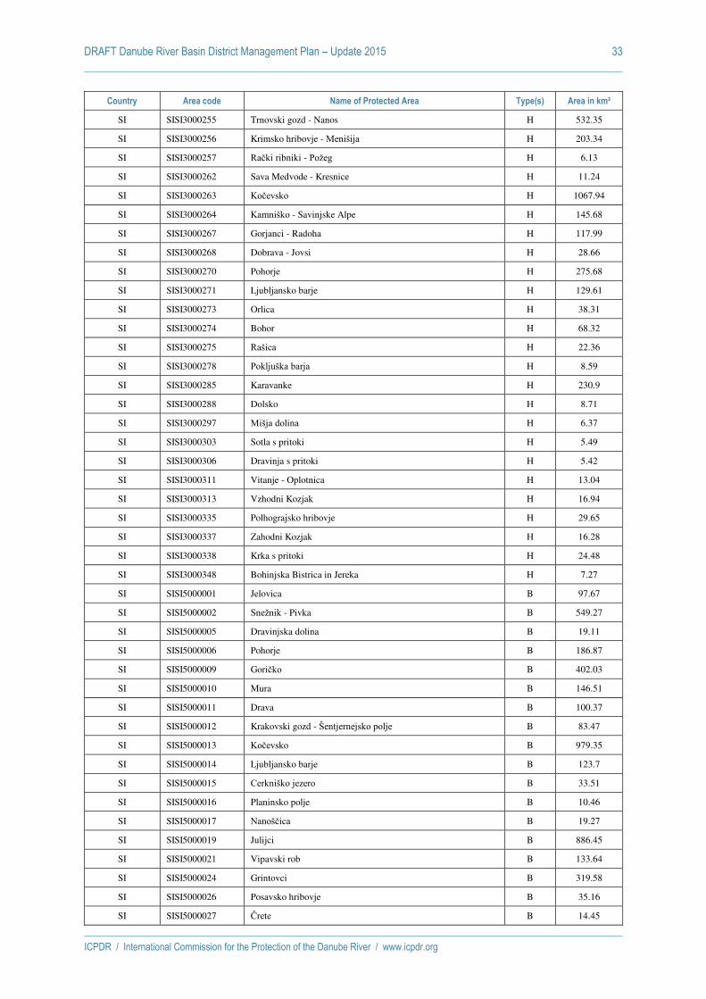
DRAFT Danube River Basin District Management Plan – Update 2015 33
ICPDR / International Commission for the Protection of the Danube River / www.icpdr.org
Country Area code Name of Protected Area Type(s) Area in km²
SI SISI3000255 Trnovski gozd - Nanos H 532.35
SI SISI3000256 Krimsko hribovje - Menišija H 203.34
SI SISI3000257 Rački ribniki - Požeg H 6.13
SI SISI3000262 Sava Medvode - Kresnice H 11.24
SI SISI3000263 Kočevsko H 1067.94
SI SISI3000264 Kamniško - Savinjske Alpe H 145.68
SI SISI3000267 Gorjanci - Radoha H 117.99
SI SISI3000268 Dobrava - Jovsi H 28.66
SI SISI3000270 Pohorje H 275.68
SI SISI3000271 Ljubljansko barje H 129.61
SI SISI3000273 Orlica H 38.31
SI SISI3000274 Bohor H 68.32
SI SISI3000275 Rašica H 22.36
SI SISI3000278 Pokljuška barja H 8.59
SI SISI3000285 Karavanke H 230.9
SI SISI3000288 Dolsko H 8.71
SI SISI3000297 Mišja dolina H 6.37
SI SISI3000303 Sotla s pritoki H 5.49
SI SISI3000306 Dravinja s pritoki H 5.42
SI SISI3000311 Vitanje - Oplotnica H 13.04
SI SISI3000313 Vzhodni Kozjak H 16.94
SI SISI3000335 Polhograjsko hribovje H 29.65
SI SISI3000337 Zahodni Kozjak H 16.28
SI SISI3000338 Krka s pritoki H 24.48
SI SISI3000348 Bohinjska Bistrica in Jereka H 7.27
SI SISI5000001 Jelovica B 97.67
SI SISI5000002 Snežnik - Pivka B 549.27
SI SISI5000005 Dravinjska dolina B 19.11
SI SISI5000006 Pohorje B 186.87
SI SISI5000009 Goričko B 402.03
SI SISI5000010 Mura B 146.51
SI SISI5000011 Drava B 100.37
SI SISI5000012 Krakovski gozd - Šentjernejsko polje B 83.47
SI SISI5000013 Kočevsko B 979.35
SI SISI5000014 Ljubljansko barje B 123.7
SI SISI5000015 Cerkniško jezero B 33.51
SI SISI5000016 Planinsko polje B 10.46
SI SISI5000017 Nanoščica B 19.27
SI SISI5000019 Julijci B 886.45
SI SISI5000021 Vipavski rob B 133.64
SI SISI5000024 Grintovci B 319.58
SI SISI5000026 Posavsko hribovje B 35.16
SI SISI5000027 Črete B 14.45

DRAFT Danube River Basin District Management Plan – Update 2015 34
ICPDR / International Commission for the Protection of the Danube River / www.icpdr.org
Country Area code Name of Protected Area Type(s) Area in km²
SI SISI5000029 Gluha loza B 14.42
SI SISI5000032 Dobrava - Jovsi B 28.49
SI SISI5000033 Kozjansko B 80.42
SK SKCHVU002 Bukovské vrchy B 409.32
SK SKCHVU003 Cerová vrchovina - Porimavie B 301.88
SK SKCHVU005 Dolné Považie B 311.96
SK SKCHVU007 Dunajské luhy B 165.12
SK SKCHVU008 Horná Orava B 587.38
SK SKCHVU009 Košická kotlina B 173.54
SK SKCHVU010 Kráľová B 12.16
SK SKCHVU013 Malá Fatra B 662.28
SK SKCHVU015 Medzibodrožie B 337.54
SK SKCHVU016 Záhorské Pomoravie B 310.73
SK SKCHVU019 Ostrovné lúky B 82.98
SK SKCHVU021 Poiplie B 80.63
SK SKCHVU023 Úľanská mokraę B 181.74
SK SKCHVU024 Senianske rybníky B 26.68
SK SKCHVU026 Sĺňava B 5.09
SK SKCHVU027 Slovenský kras B 438.6
SK SKCHVU037 Ondavská rovina B 159.07
SK SKCHVU051 Levočské vrchy B 455.98
SK SKUEV0006 Latorica H 75.01
SK SKUEV0036 Litava H 26.3
SK SKUEV0048 Dukla H 68.61
SK SKUEV0057 Rašeliniská Oravskej kotliny H 8.4
SK SKUEV0064 Bratislavské luhy H 6.92
SK SKUEV0090 Dunajské luhy H 45.42
SK SKUEV0104 Homoľské Karpaty H 51.83
SK SKUEV0110 Levočská dubina H 6
SK SKUEV0112 Slovenský raj H 168.65
SK SKUEV0125 Gajarské alúvium Moravy H 12.44
SK SKUEV0130 Zobor H 19.05
SK SKUEV0163 Rudava H 19.59
SK SKUEV0168 Horný les H 5.56
SK SKUEV0173 Kotlina H 6.17
SK SKUEV0188 Pilsko H 7.01
SK SKUEV0189 Babia hora H 5.04
SK SKUEV0192 Prosečné H 23
SK SKUEV0194 Hybická tiesňava H 5.64
SK SKUEV0197 Salatín H 33.45
SK SKUEV0203 Stolica H 28.12
SK SKUEV0205 Hubková H 27.93
SK SKUEV0209 Morské oko H 160.08

DRAFT Danube River Basin District Management Plan – Update 2015 35
ICPDR / International Commission for the Protection of the Danube River / www.icpdr.org
Country Area code Name of Protected Area Type(s) Area in km²
SK SKUEV0210 Stinská H 15.27
SK SKUEV0211 Daňová H 8.98
SK SKUEV0225 Muránska planina H 202.57
SK SKUEV0229 Bukovské vrchy H 292.31
SK SKUEV0238 Veľká Fatra H 463.49
SK SKUEV0251 Zázrivské lazy H 29.28
SK SKUEV0252 Malá Fatra H 222.53
SK SKUEV0256 Strážovské vrchy H 299.73
SK SKUEV0259 Stará hora H 24
SK SKUEV0263 Hodrušská hornatina H 102.68
SK SKUEV0264 Klokoč H 22.81
SK SKUEV0265 Suť H 90.41
SK SKUEV0266 Skalka H 97.15
SK SKUEV0267 Biele hory H 101.46
SK SKUEV0269 Ostrovné lúčky H 6.28
SK SKUEV0273 Vtáčnik H 100.57
SK SKUEV0274 Baské H 40.33
SK SKUEV0275 Kňaží stôl H 42.27
SK SKUEV0276 Kuchynská hornatina H 32.75
SK SKUEV0278 Brezovské Karpaty H 26.71
SK SKUEV0279 Šúr H 6.55
SK SKUEV0282 Tisovský kras H 14.69
SK SKUEV0287 Galmus H 32
SK SKUEV0288 Kysucké Beskydy H 70.01
SK SKUEV0295 Biskupické luhy H 9.16
SK SKUEV0299 Baranovo H 8.61
SK SKUEV0302 Ęumbierske Tatry H 440.28
SK SKUEV0305 Choč H 16.27
SK SKUEV0306 Pod Suchým hrádkom H 7.53
SK SKUEV0307 Tatry H 669.94
SK SKUEV0310 Kráľovohoľské Tatry H 304.79
SK SKUEV0313 Devínske jazero H 12.64
SK SKUEV0318 Pod Bukovou H 5.38
SK SKUEV0319 Poľana H 30.72
SK SKUEV0326 Strahuľka H 11.7
SK SKUEV0327 Milič H 51.13
SK SKUEV0328 Stredné Pohornádie H 70.93
SK SKUEV0331 Čergovský Minčol H 42.62
SK SKUEV0332 Čergov H 60.29
SK SKUEV0337 Pieniny H 13.02
SK SKUEV0356 Horný vrch H 60.28
SK SKUEV0357 Cerová vrchovina H 26.28
SK SKUEV0366 Drienčanský kras H 16.09

DRAFT Danube River Basin District Management Plan – Update 2015 36
ICPDR / International Commission for the Protection of the Danube River / www.icpdr.org
Country Area code Name of Protected Area Type(s) Area in km²
SK SKUEV0367 Holubyho kopanice H 39
SK SKUEV0387 Beskyd H 53.49
SK SKUEV0393 Dunaj H 14.26
SK SKUEV0642 Javornícky hrebeň H 13.56
SK SKUEV0663 Šíp H 17.94
SK SKUEV1337 Pieniny H 13.9
UA UA01 Danube Biosphere reserve O 520
UA UA02 Izmail Islands O 16
UA UA11 Kartal lake O 8
UA UA12 Kugurlui Lake O 84
UA UA30 Pritisanskij regional landscape park O 280
UA UA37 Lung O 17
UA UA41 Pistenka O 26
UA UA42 Gutsulshina O 387
UA UA43 Cheremoshskiy O 234
UA UA44 Verhovynskiy O 104
UA UA47 Chernivetskiy O 200
UA UA48 Vyzhnytskyi O 128
UA UA49 Uzhanskyi O 395
UA UA50 Carpathian National Park O 528
UA UA51 Carpathian Biosphere reserve O 547

ICPDR / International Commission for the Protection of the Danube River / www.icpdr.org
ANNEX 9
DRAFT DRBM Plan – Update 2015
Economic Analysis – Synthesis of Questionnaires

DRAFT Danube River Basin District Management Plan – Update 2015 1
ICPDR / International Commission for the Protection of the Danube River / www.icpdr.org
The economics analysis of the DRAFT DRBM Plan – Update 2015 is based on the economic analysis
which was performed for the 2013 Update of the Danube Basin Analysis. Two questionnaires were
developed and sent out in 2013 for the collection of information on economics from the Danube
countries (the information was updated, if necessary, by the Danube countries in 2015). The
questionnaires treat inter alia water pricing, cost recovery (CR) and environmental and resource costs
(ERC) - topics which are closely interlinked. This synthesis provides an overview on the approaches
which are in place in the Danube countries. The collected information is summarised in form of tables
as presented below (tables 1 to 6).
Tables 7 and 8 represent the results of a second survey done in the aftermath of the TG ECON
meetings in Zagreb and Vienna (2014/2015), and concern approaches towards Disproportionality of
Costs and Exemptions, as well as projections of trends regarding socio-economic developments.
Data from Serbia does not include data from the Autonomous Provinces Kosovo and Metohija.
Table 1: Investment costs for water supply and wastewater, and priorities of investments for the period 2009-2015*
Country
Demand and Supply Costs1
[EUR]
Only demand costs
[EUR]
Only investment costs (without distinguishing)
[EUR]
Priorities/main objectives of investments
DE - -
Water supply services: 340 million EUR / year
Waste water services: 490 million EUR / year
Aggregated investment costs: 830 million on average per annum
Good Status of water bodies
AT - - 3.2 billion Good Status
CZ - 822 million Good Status
SK - -
1,086 million EUR** (water supply +
wastewater)
of which:
water supply: 101 million
wastewater: 985 million
Good status and UWWT
HU 3.1 billion / 2.3 billion
(until 2012) 2,675.38 million -
Drinking Water and UWWT derogations
SI -
1.1 billion (1,020.6 mio EUR for
wastewater collection and treatment for
households and 113.4 mio EUR for water
supply for households)2
(2010-2015)
-
Wastewater collection and treatment for
households and water supply for households.
HR 1.9 billion / 650 million - - Drinking Water and
UWWT
BA - 653 million - Good Status and
UWWT
ME n. a.
1 According to the questionnaires: demand cost are the "total costs related to implementing the EU Directives"; supply costs are the investment costs that could be realistically covered. 2 The costs for the Danube River Basin are estimated according to the relation of the Danube River Basin´s area to Slovenia´s territory (81% of the total area).

DRAFT Danube River Basin District Management Plan – Update 2015 2
ICPDR / International Commission for the Protection of the Danube River / www.icpdr.org
RS 1.8 billion / 900 million - - UWWT
RO - -
UWWT (waste water treatment and sewerage
systems): 12,700 million Euro; Water supply: 7,580 million Euro
UWWT and
Water Supply
BG -
1.6 billion
(2010-2015; wastewater collection
and treatment) Assessment of
investment costs for the time 2016-2021 is forthcoming task in the frame of RBMP-
updating process.
- UWWT/priority in the
first RBMP
MD - - 3.2 billion
(over 20 years) WWT (urban and rural)
UA n. a.
*timescales: 2009-2015, if not noted otherwise.
**data for the whole country (Danube part represents 96.23 % of the total territory of Slovakia).
Table 2: What are water services - what are water uses?
Country Only water supply and
wastewater
Water supply, wastewater AND
others
Included in cost recovery calculations
(Y/N) Other definitions
DE Y
AT Y
(based on estimation)
CZ
Rivers and river basin management; surface
water abstraction; GW abstraction; discharge of wastewater into surface
water; discharge of wastewater into GW; impoundment for the energy production; navigation – only
recreation
N
(but in the 2nd cycle, several others will be
added)
SK
Use of hydro-energy potential of water-
course; abstraction of energy water from
watercourse; abstraction of surface water from
water-course
Y Navigation is defined as a "public service - paid
by the state"
HU
Agricultural water services for irrigation,
fishponds, etc.
Water abstraction for its own use (for industrial, agricultural, households and thermal water uses)
Y
(the other different water uses are taken into consideration as “water
uses” (according to WFD Article 2 Definition 39))

DRAFT Danube River Basin District Management Plan – Update 2015 3
ICPDR / International Commission for the Protection of the Danube River / www.icpdr.org
Damming and storage of water for energy
production
SI
23 further services defined
Partly (financial costs recovery for public
water supply and for public wastewater
collection and treatment services was assessed
and the internalized part of ERC were considered for all water services).
HR Y
BA
13 other water services defined
N
ME n. a.
RS
(irrigation) N
RO
Storage, impoundment, regulation, quantitative
and qualitative assessment of water resources, operative
hydrological activities, hydrological prognoses, receiving the pollutants
in surface water according to legal
requirements, flood protection
Y
BG
Y
All costs considered (financial,
environmental and resource costs)
Public water supply; public collection of waste water; public treatment of waste
water; individual water supply in industry;
individual water supply in agriculture for
irrigation; individual water supply for stock-breeding; producing of electric power by water electric plant; protection
of harmful impact of water; conservation of water; navigation and
other activities connected with
navigation; individual drinking water supply
MD Y
UA n. a.

DRAFT Danube River Basin District Management Plan – Update 2015 4
ICPDR / International Commission for the Protection of the Danube River / www.icpdr.org
Table 3: Water pricing policies in place, and prices of water services/uses
Country Water service Environmental cost
[EUR/m3, EUR/?, not assessed]
Resource cost
[EUR/m3, EUR/?, not assessed]
Payment* for environmental cost recovery
[EUR/m3, no payment*]
Payment* for resource cost recovery
[EUR/m3, no payment*]
DE
Water supply ERC are considered in the recovery of the costs of water supply
services (EUR/m3); they are not quantified individually ERC are considered in the recovery of the costs of water supply
services (EUR/m3); they are not quantified individually
Waste water treatment ERC are considered in the recovery of the costs of waste water
services; they are not quantified individually ERC are considered in the recovery of the costs of waste water
services; they are not quantified individually
AT
Water supply ERC are internalized in the price for drinking water (EUR/m3), but
they are not assessed Payments for ERC are internalized in the price for drinking water
(EUR/m3), but they are not assessed
WWT ERC are internalized in the price for wastewater treatment (EUR/m3),
but they are not assessed Payments for ERC are internalized in the price for wastewater
treatment (EUR/m3), but they are not assessed
CZ
Drinking water supply ERC costs in the form of charges for groundwater and surface water abstraction is internalized in the price for drinking water (EUR/m3)
No separate payment exists. ERC recovery costs are internalized.
Wastewater treatment ERC are in the form of charges for pollution and volume of discharged
wastewater. See the answer above.
Water storage and impoundment for energy
production
ERC costs in the form of charges for impoundments are internalized in the price which is agreed between the customer and State Enterprises
of River Basin Management(EUR/m3) No separate payment exists. ERC recovery costs are internalized.
Navigation Not assessed Not assessed No payment No payment
SK
Water supply for households, industry and agriculture
Not assessed
Resource cost in the form of charges for groundwater
abstraction as well as payments for surface water abstraction is
internalized in the price for drinking water (EUR/m3)
No payment No separate payment, only the
internalized one
Collection and treatment of wastewater
Environmental cost in the form of charges for discharge of
wastewater is internalized in the price for the collection and
treatment of wastewater (EUR/m3)
Not assessed No separate payment, only the
internalized one No payment
Use of hydro-energy- potential of watercourse
Not assessed Not assessed No payment No payment
Abstraction of energy water Not assessed Not assessed No payment No payment

DRAFT Danube River Basin District Management Plan – Update 2015 5
ICPDR / International Commission for the Protection of the Danube River / www.icpdr.org
Country Water service Environmental cost
[EUR/m3, EUR/?, not assessed]
Resource cost
[EUR/m3, EUR/?, not assessed]
Payment* for environmental cost recovery
[EUR/m3, no payment*]
Payment* for resource cost recovery
[EUR/m3, no payment*]
from watercourse
Abstraction of surface water from watercourse
Not assessed Not assessed No payment
The payment for surface water abstraction is determined in
EUR/m3 and is a component of the price for drinking water. This
payment is considered as covering a part of resource costs.
HU
Wastewater collection and treatment for industry public
EC are internalized in the price for wastewater treatment (EUR/m3)
- 0,0241 -
Direct discharge of industry EC are internalized in the water
load fee (EUR/m3) - 0,00161 -
Direct discharge of other sector EC are internalized in the water
load fee (EUR/m3) - 0,01811 -
Public water supply for households and others
- RC are internalized in the price
for wastewater treatment (EUR/m3)
- 0,0181
Water supply for industry (own wells)
- RC are internalized in water
resource fee (EUR/m3) - 0,0551
Water supply for agriculture (livestock)
- - - n. a.
Water supply for agriculture (irrigation, fishponds, rice
production) - - - 0
SI3
Wastewater collection and treatment for industry
not assessed
(only internalized part assessed)
not assessed
(only internalized part assessed)
Environmental tax:
26.4125 EUR/unit load -
Wastewater collection and treatment for households
not assessed
(only internalized part assessed)
not assessed
(only internalized part assessed) Environmental tax: 26.4125
EUR/unit load -
Water abstraction for drinking not assessed not assessed Water reimbursement fee: 0.0638 EUR/m3
3 Data for Slovenia updated according to the draft of 2nd RBMP 2015-2021.

DRAFT Danube River Basin District Management Plan – Update 2015 6
ICPDR / International Commission for the Protection of the Danube River / www.icpdr.org
Country Water service Environmental cost
[EUR/m3, EUR/?, not assessed]
Resource cost
[EUR/m3, EUR/?, not assessed]
Payment* for environmental cost recovery
[EUR/m3, no payment*]
Payment* for resource cost recovery
[EUR/m3, no payment*]
water supply (only internalized part assessed) (only internalized part assessed)
Water abstraction for drink industry
not assessed
(only internalized part assessed)
not assessed
(only internalized part assessed)
Water reimbursement fee: 0.092 EUR/m3
Water reimbursement fee: 0.092 EUR/m3
Payment for water rights (details in Slovene RBMP for Danube RBD)
Water abstraction for technological purposes
not assessed
(only internalized part assessed)
not assessed
(only internalized part assessed) Water reimbursement fee: 0.092 EUR/m3
Water abstraction for swimming pools open to public, natural
spas
not assessed
(only internalized part assessed)
not assessed
(only internalized part assessed)
Water reimbursement fee: 0.092 EUR/m3
For natural spas: Payment for water rights (details in Slovene RBMP for Danube RBD)
Water abstraction for snowmaking
not assessed
(only internalized part assessed)
not assessed
(only internalized part assessed) Water reimbursement fee: 0.0666 EUR/m3
Water abstraction for irrigation in agriculture
not assessed
(only internalized part assessed)
not assessed
(only internalized part assessed) Water reimbursement fee: 0.0015 EUR/m3
Water abstraction for irrigation of non-agricultural activities
not assessed
(only internalized part assessed)
not assessed
(only internalized part assessed) Water reimbursement fee: 0.0919 EUR/m3
Water abstraction for technological purposes for
cooling thermal and nuclear power plants
not assessed
(only internalized part assessed)
not assessed
(only internalized part assessed) Water reimbursement fee: 0.00738 EUR/m3
Water abstraction for aquaculture of salmonid fish
not assessed
(only internalized part assessed)
not assessed
(only internalized part assessed) Water reimbursement fee: 0.000036 EUR/m3 available water for
abstraction from water source
Water abstraction from public water supply services for drink
industry
not assessed
(only internalized part assessed)
not assessed
(only internalized part assessed) Water reimbursement fee: 0.1009 EUR/m3
Water abstraction for technological purposes where
water is main ingredient
not assessed
(only internalized part assessed)
not assessed
(only internalized part assessed) Water reimbursement fee: 0.1009 EUR/m3
Water abstraction for swimming pools open to public, natural
not assessed
(only internalized part assessed)
not assessed
(only internalized part assessed) Water reimbursement fee: 0.1009 EUR/m3

DRAFT Danube River Basin District Management Plan – Update 2015 7
ICPDR / International Commission for the Protection of the Danube River / www.icpdr.org
Country Water service Environmental cost
[EUR/m3, EUR/?, not assessed]
Resource cost
[EUR/m3, EUR/?, not assessed]
Payment* for environmental cost recovery
[EUR/m3, no payment*]
Payment* for resource cost recovery
[EUR/m3, no payment*]
spas
Water abstraction for irrigation. not assessed
(only internalized part assessed)
not assessed
(only internalized part assessed) Water reimbursement fee: 0.1009 EUR/m3
Electricity production in hydropower plants below 10
MW
not assessed
(only internalized part assessed)
not assessed
(only internalized part assessed) Water reimbursement fee: 0.2361 EUR/MWh potential water energy, available for electricity production according to obtained water right
Electricity production in hydropower plants from 10
MW and above
not assessed (only internalized part assessed)
not assessed (only internalized part assessed)
Water reimbursement fee: 1.8127 EUR/MWh potential water energy, available for electricity production according to obtained water right
Payment for water rights (details in Slovene RBMP for Danube RBD)
Water used for heat production not assessed
(only internalized part assessed)
not assessed
(only internalized part assessed)
Water reimbursement fee: 0.974 EUR/MWh energy, available for heat production according to obtained water right
Payment for water rights (details in Slovene RBMP for Danube RBD)
Water used for water driven mills, saws and other similar
devices
not assessed
(only internalized part assessed)
not assessed
(only internalized part assessed) Water reimbursement fee: 0.1948 EUR/MWh potential water energy,
available for mechanical work according to obtained water right
Sediment extraction not assessed (only internalized
part assessed) not assessed (only internalized
part assessed)
Reimbursement fee: 3.1 EUR/m3 of extracted gravel; 13.9 EUR/m3 of extracted sand
Payment for water rights (details in Slovene RBMP for Danube RBD)
Water used for cyprinid fish aquaculture
not assessed
(only internalized part assessed)
not assessed
(only internalized part assessed) Water reimbursement fee: 0.000972 EUR/m2
Water used for mariculture not assessed
(only internalized part assessed)
not assessed
(only internalized part assessed) Water reimbursement fee: 0.00498 EUR/m2
Water used for commercial pond fishing
not assessed
(only internalized part assessed)
not assessed
(only internalized part assessed) Water reimbursement fee: 0.0194 EUR/m2
The use of water areas for the operation of ports to vessels
not assessed (only internalized part assessed)
not assessed (only internalized part assessed)
Water reimbursement fee: 2.07 EUR/m2 for tourist harbours,
0.345 EUR/m2 for local ports, sports ports and other,
0.25 EUR/m2 for ports larger than 1,000,000 m2, 0.0207 EUR/m2 for ports smaller than 1,000,000 m2 and for areas of entering and exiting
corridors, 0,345 EUR/m2 for waterside land used for embarking

DRAFT Danube River Basin District Management Plan – Update 2015 8
ICPDR / International Commission for the Protection of the Danube River / www.icpdr.org
Country Water service Environmental cost
[EUR/m3, EUR/?, not assessed]
Resource cost
[EUR/m3, EUR/?, not assessed]
Payment* for environmental cost recovery
[EUR/m3, no payment*]
Payment* for resource cost recovery
[EUR/m3, no payment*]
The use of water areas for the operation of anchoring vessels
not assessed
(only internalized part assessed)
not assessed
(only internalized part assessed)
Water reimbursement fee: 2.07 EUR/m2 for local anchorages,
0,0128 EUR/m2 for anchorages larger than 10,000,000 m2
The use of water areas for operation of bathing places
not assessed
(only internalized part assessed)
not assessed
(only internalized part assessed) Water reimbursement fee: 0.9597 EUR/m2
HR
Wastewater service
Water protection fee: 2.85 HRK/m3 or 0.38 EUR/m3 for households (for industry depends on level of pollution);
Development fee introduced on local level and vary from 0–4.0 HRK/m3 or 0.53 EUR/m3
ERC are partly internalized through water price (in form of water fees). Assessment of ERC is ongoing.
3.0 HRK/m3 or 0.4 EUR/m3 For purpose of this questionnaire rough estimation has been made,
based on Annual Financial Plan of Hrvatske vode (National Agency for water Management)
Water supply service
Water use fee: 1.35 HRK/m3 or 0.18 EUR/m3 abstracted water; Water use fee for energy (5-7,5% of price of 1kWh for generation of electrical power and 2 HRK/kW/year for plant
operation); Development fee - introduced on local level and vary from 0–4.0 HRK/m3 or 0-0.53 HRK/m3
ERC are partly internalized through water price (in form of water fees). Assessment of ERC is ongoing.
1.7 HRK/m3 or 0.22 EUR/m3 For purpose of this questionnaire rough estimation has been made,
based on Annual Financial Plan of Hrvatske vode (National Agency for water Management)
BA
Public water supply - - - 0.005 Euro/ m3 of abstracted
water
Bottling of water & mineral water
- - - 1.00 Euro/ m3 of abstracted
water
Water supply to industry and others (abstraction)
- - - 0.01/0.015 Euro/m3 (RS/FBiH)
Irrigation (abstraction) - - - 0.001 Euro/m3 BA
Fish farming (abstract.) - - - 0.0005 Euro/m3 (RS only) abstr.
water
Fish farming (pollution) - - 0.01/0.025 (RS/FBiH) Euro/kg
produc. fish -
Electricity production - - 0.0005 Euro/kWh of produced
electricity -
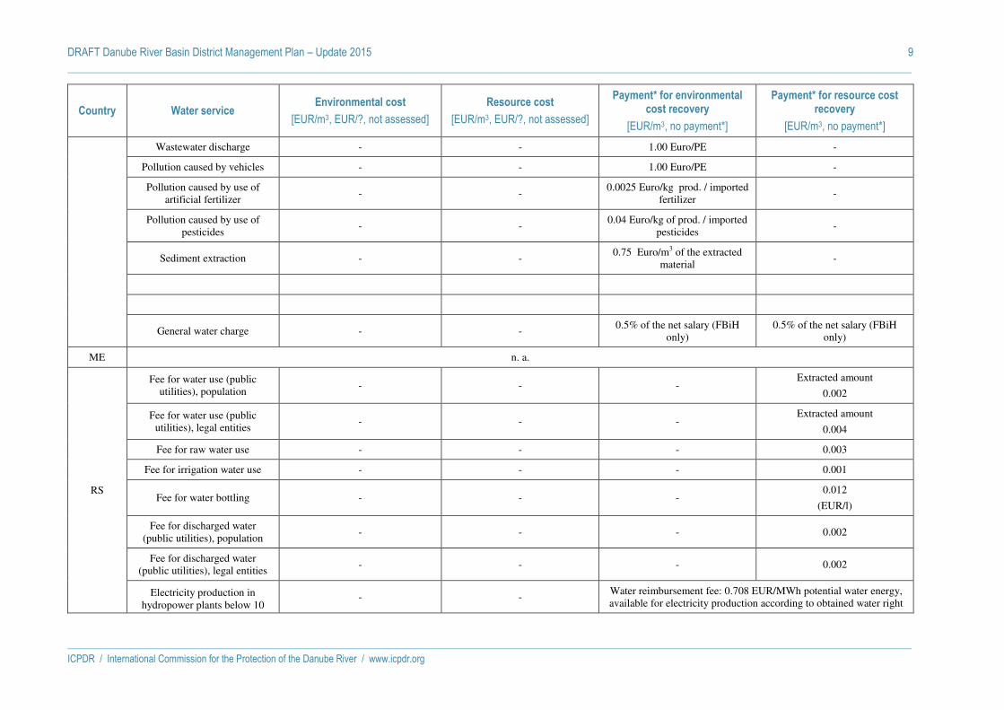
DRAFT Danube River Basin District Management Plan – Update 2015 9
ICPDR / International Commission for the Protection of the Danube River / www.icpdr.org
Country Water service Environmental cost
[EUR/m3, EUR/?, not assessed]
Resource cost
[EUR/m3, EUR/?, not assessed]
Payment* for environmental cost recovery
[EUR/m3, no payment*]
Payment* for resource cost recovery
[EUR/m3, no payment*]
Wastewater discharge - - 1.00 Euro/PE -
Pollution caused by vehicles - - 1.00 Euro/PE -
Pollution caused by use of artificial fertilizer
- - 0.0025 Euro/kg prod. / imported
fertilizer -
Pollution caused by use of pesticides
- - 0.04 Euro/kg of prod. / imported
pesticides -
Sediment extraction - - 0.75 Euro/m3 of the extracted
material -
General water charge - - 0.5% of the net salary (FBiH
only) 0.5% of the net salary (FBiH
only)
ME n. a.
RS
Fee for water use (public utilities), population
- - - Extracted amount
0.002
Fee for water use (public utilities), legal entities
- - - Extracted amount
0.004
Fee for raw water use - - - 0.003
Fee for irrigation water use - - - 0.001
Fee for water bottling - - - 0.012
(EUR/l)
Fee for discharged water (public utilities), population
- - - 0.002
Fee for discharged water (public utilities), legal entities
- - - 0.002
Electricity production in hydropower plants below 10
- - Water reimbursement fee: 0.708 EUR/MWh potential water energy, available for electricity production according to obtained water right
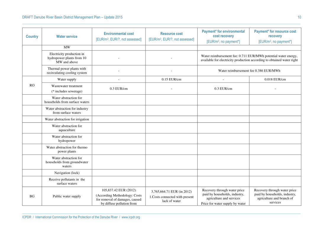
DRAFT Danube River Basin District Management Plan – Update 2015 10
ICPDR / International Commission for the Protection of the Danube River / www.icpdr.org
Country Water service Environmental cost
[EUR/m3, EUR/?, not assessed]
Resource cost
[EUR/m3, EUR/?, not assessed]
Payment* for environmental cost recovery
[EUR/m3, no payment*]
Payment* for resource cost recovery
[EUR/m3, no payment*]
MW
Electricity production in hydropower plants from 10
MW and above - -
Water reimbursement fee: 0.711 EUR/MWh potential water energy, available for electricity production according to obtained water right
Thermal power plants with recirculating cooling system
- - Water reimbursement fee 0.386 EUR/MWh
RO
Water supply - 0.15 EUR/cm - 0.018 EUR/cm
Wastewater treatment
(* includes sewerage) 0.3 EUR/cm - 0.3 EUR/cm -
Water abstraction for
households from surface waters
Water abstraction for industry
from surface waters
Water abstraction for irrigation
Water abstraction for
aquaculture
Water abstraction for
hydropower
Water abstraction for thermo
power plants
Water abstraction for
households from groundwater waters
Navigation (lock)
Receive pollutants in the
surface waters
BG Public water supply
105,837.42 EUR (2012)
(According Methodology: Costs for removal of damages, caused
by diffuse pollution from
3,765,664.71 EUR (in 2012)
1.Costs connected with present lack of water
Recovery through water price paid by households, industry,
agriculture and services
Price for water supply by water
Recovery through water price paid by households, industry,
agriculture and branch of services

DRAFT Danube River Basin District Management Plan – Update 2015 11
ICPDR / International Commission for the Protection of the Danube River / www.icpdr.org
Country Water service Environmental cost
[EUR/m3, EUR/?, not assessed]
Resource cost
[EUR/m3, EUR/?, not assessed]
Payment* for environmental cost recovery
[EUR/m3, no payment*]
Payment* for resource cost recovery
[EUR/m3, no payment*]
agriculture, stock-breeding and fish- breeding)
2.Costs connected with future lack of water
companies/drinking water: 0.41 €/m3;
Price for water supply for irrigation/supply by “Irrigation
systems”: 0.18 €/ m3
Price for water supply by water companies/drinking water: 0.41
€/ m3
Price for water supply for irrigation/supply by “Irrigation
systems”: 0.18 €/ m3
Public collection of waste water
13,260,866.23 EUR (in 2012)
(Costs for removal of damages, caused by diffuse pollution from
settlements without sewage system)
No identified resource costs
Recovery through prices of public collection of waste water
Price for collection of waste water: 0.09 €/ m3
N
Public treatment of waste water
27 240 608,85 EUR (in 2012)
(1.Costs for removal of damages, caused by point pollution of waste
water from households and industry /building of WWT-Plants
2. Costs for removal of damages, caused by diffuse pollution from
landfills)
No identified resource costs
Recovery through prices of treatment of waste water
Price for treatment of waste water: 0.14 €/ m3
N
Individual water supply in
industry No identified environmental costs
Costs in case of future water scarcity (no resource costs for
2008-2012: 0 €/m3) N
Recovery through fee for water use according to National Tariff
for fees:
0.045€/m3 – surface water.
0.07€/m3 – ground water.
Individual water supply in agriculture for irrigation
7,669.38 EUR (in 2012)
(Costs for removal of damages, caused by diffuse pollution from
agriculture)
Costs in case of future water scarcity (no resource costs for
2008-2012: 0 €/m3)
Recovery through fee for water use according to National Tariff
for fees:
0.0005€/m3 – surface water
0.005€ m3 – ground water
Recovery through fee for water use according to National Tariff
for fees
0.0005€/m3 – surface water
0.005€/m3 – ground water
Individual water supply for
stock-breeding and fish-breeding
750,065.19 EUR (in 2012)
(Costs for removal of damages, caused by diffuse pollution from
Costs in case of future water scarcity (no resource costs for the period 2008-2012: 0 €/m3)
Recovery through fee for water use according to National Tariff
for fees:
Recovery through fee for water use according to National Tariff
for fees

DRAFT Danube River Basin District Management Plan – Update 2015 12
ICPDR / International Commission for the Protection of the Danube River / www.icpdr.org
Country Water service Environmental cost
[EUR/m3, EUR/?, not assessed]
Resource cost
[EUR/m3, EUR/?, not assessed]
Payment* for environmental cost recovery
[EUR/m3, no payment*]
Payment* for resource cost recovery
[EUR/m3, no payment*]
stock-breeding and fish-breeding) 0.0005€/m3 – surface water
0.005€/m3 – ground water
0.0005€/m3 – surface water
0.005€/m3 – ground water
Producing of electric power by
water electric plant
16,361.34 EUR (in 2012)
(1.Costs for removal of damages, caused by drying of rivers due to water use of hydro power plants;
2. Costs for removal of damages, caused by interruption of
continuation of the rivers due to water use of hydro power plants
/costs for building of fish-passages)
Costs in case of future water scarcity, but no resource costs for
the period 2008-2012: 0 €/ m3
Recovery through fee for water use according to National Tariff for fees: 0.0008 €/m3
Recovery through fee for water use according to National Tariff
for fees:
0.0008 €/m3
Protection of harmful impact of
water
Costs for measures for recovery of damages due to gravel extraction:
2008-2012: 0 €/ m3 No identified resource costs
No fee. Cost recovery:
- Own incomes of municipalities
- State financing for “Irrigation systems”
-State transfers
Total amount for 2012: 20,577,453.03 EUR;
No
Water conservation No identified environmental costs
(only financial costs) No identified resource costs
(only financial costs)
No fee. Cost recovery of financial costs only
No fee. Cost recovery of financial costs only
Navigation and other activities
connected with navigation
Costs for removal and prevention of damages, caused by navigation :2008-2012 for Danube - 0 €/m3
No identified resource costs Cost recovery through harbor fees paid by shipping sector:
2008-2012 for Danube - 0 €/ m3 No
Individual drinking water
supply No identified environmental costs
Costs in case of future water scarcity, but no resource costs for
the period 2008-2012: 0 €/m3 No
Cost recovery through fees for issue of permits
0.02 €/m3 – surface water
0.75 €/m3 – ground water
MD Water supply for households,
industry, agro-industry, hydropower, irrigation, fishery
not assessed Resource cost is paid in the form of payments for special water use
into the state budget and is no tax no tax
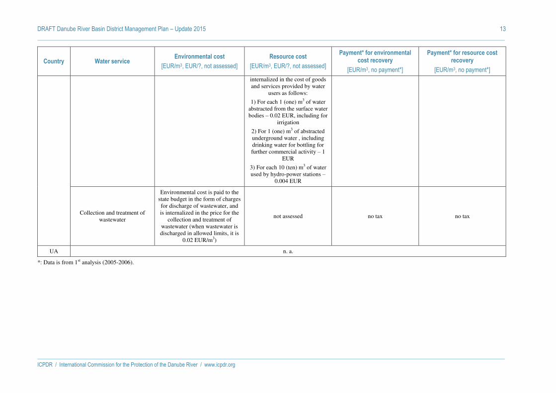
DRAFT Danube River Basin District Management Plan – Update 2015 13
ICPDR / International Commission for the Protection of the Danube River / www.icpdr.org
Country Water service Environmental cost
[EUR/m3, EUR/?, not assessed]
Resource cost
[EUR/m3, EUR/?, not assessed]
Payment* for environmental cost recovery
[EUR/m3, no payment*]
Payment* for resource cost recovery
[EUR/m3, no payment*]
internalized in the cost of goods and services provided by water
users as follows:
1) For each 1 (one) m3 of water abstracted from the surface water bodies – 0.02 EUR, including for
irrigation
2) For 1 (one) m3 of abstracted underground water , including drinking water for bottling for further commercial activity – 1
EUR
3) For each 10 (ten) m3 of water used by hydro-power stations –
0.004 EUR
Collection and treatment of wastewater
Environmental cost is paid to the state budget in the form of charges for discharge of wastewater, and is internalized in the price for the
collection and treatment of wastewater (when wastewater is discharged in allowed limits, it is
0.02 EUR/m3)
not assessed no tax no tax
UA n. a.
*: Data is from 1st analysis (2005-2006).
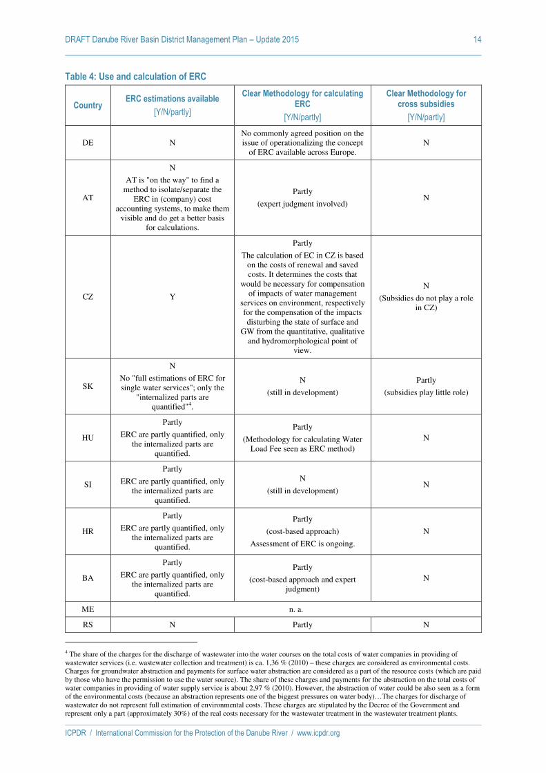
DRAFT Danube River Basin District Management Plan – Update 2015 14
ICPDR / International Commission for the Protection of the Danube River / www.icpdr.org
Table 4: Use and calculation of ERC
Country ERC estimations available
[Y/N/partly]
Clear Methodology for calculating ERC
[Y/N/partly]
Clear Methodology for cross subsidies
[Y/N/partly]
DE N No commonly agreed position on the issue of operationalizing the concept
of ERC available across Europe. N
AT
N
AT is "on the way" to find a method to isolate/separate the
ERC in (company) cost accounting systems, to make them
visible and do get a better basis for calculations.
Partly
(expert judgment involved) N
CZ Y
Partly
The calculation of EC in CZ is based on the costs of renewal and saved costs. It determines the costs that
would be necessary for compensation of impacts of water management
services on environment, respectively for the compensation of the impacts disturbing the state of surface and
GW from the quantitative, qualitative and hydromorphological point of
view.
N
(Subsidies do not play a role in CZ)
SK
N
No "full estimations of ERC for single water services"; only the
"internalized parts are quantified"4.
N
(still in development)
Partly
(subsidies play little role)
HU
Partly
ERC are partly quantified, only the internalized parts are
quantified.
Partly
(Methodology for calculating Water Load Fee seen as ERC method)
N
SI
Partly
ERC are partly quantified, only the internalized parts are
quantified.
N
(still in development) N
HR
Partly
ERC are partly quantified, only the internalized parts are
quantified.
Partly
(cost-based approach)
Assessment of ERC is ongoing.
N
BA
Partly
ERC are partly quantified, only the internalized parts are
quantified.
Partly
(cost-based approach and expert judgment)
N
ME n. a.
RS N Partly N
4 The share of the charges for the discharge of wastewater into the water courses on the total costs of water companies in providing of wastewater services (i.e. wastewater collection and treatment) is ca. 1,36 % (2010) – these charges are considered as environmental costs. Charges for groundwater abstraction and payments for surface water abstraction are considered as a part of the resource costs (which are paid by those who have the permission to use the water source). The share of these charges and payments for the abstraction on the total costs of water companies in providing of water supply service is about 2,97 % (2010). However, the abstraction of water could be also seen as a form of the environmental costs (because an abstraction represents one of the biggest pressures on water body)…The charges for discharge of wastewater do not represent full estimation of environmental costs. These charges are stipulated by the Decree of the Government and represent only a part (approximately 30%) of the real costs necessary for the wastewater treatment in the wastewater treatment plants.

DRAFT Danube River Basin District Management Plan – Update 2015 15
ICPDR / International Commission for the Protection of the Danube River / www.icpdr.org
Country ERC estimations available
[Y/N/partly]
Clear Methodology for calculating ERC
[Y/N/partly]
Clear Methodology for cross subsidies
[Y/N/partly]
No "full estimations of ERC for each water service", but parts are
included in charges/fees.
(cost-based approach)
RO
Partly
ERC are partly quantified, only the internalized parts are
quantified.
Partly
(cost-based approach) No cross subsidy legally
imposed
BG Y
ERC are quantified (2008-2012) Y (Methodology is developed) N
MD
N
No estimations of ERC for each water service, but ERC "are
internalized".
N N
UA n. a.
Table 5: Cost Recovery (CR)
Country
Prices and costs for water services
available5
[Y/N/partly]
Levels of CR stated
[Y/N/partly]
Levels of CR for all defined water services
[Y/N]
Clear methodology for calculating CR
[Y/N/partly]
DE Y
(water supply and waste water services)
Y
(water supply and waste water services)
Y Y
AT
Y
(total costs and total revenues of water
services (water supply and wastewater
treatment) are available, as well as bandwidths/ ranges of average water
prices
Y
Y
Y
(based on expert judgment)
CZ Y
(abstraction, water supply and wastewater)
Partly
(all O&M costs are fully covered, when
including also subsidies on investment we would not reach 100% of cost
recovery)
N
(only water supply services and wastewater
treatment)
N
SK Y
(for all five water services)
Y Y N
(seems only financial costs are considered)
HU
Y
(for the 1st econ analysis) / partly (for
the 2nd economic analysis)
Y
(for the 1st econ analysis for drinking water and waste water) / partly (for the 2nd analysis, which is ongoing)
Partly
(analysis is ongoing)
Partly
(analysis is ongoing)
5 For exact amounts, see table 3 above.

DRAFT Danube River Basin District Management Plan – Update 2015 16
ICPDR / International Commission for the Protection of the Danube River / www.icpdr.org
Country
Prices and costs for water services
available5
[Y/N/partly]
Levels of CR stated
[Y/N/partly]
Levels of CR for all defined water services
[Y/N]
Clear methodology for calculating CR
[Y/N/partly]
SI Y
(for several water services)
Partly
N
(only for public water supply and for public wastewater collection
and treatment services)
Partly
(only financial costs and internalized part of environmental and
resource costs considered)
HR
Partly
(water supply for households and
industry)
Y Y
Y
(methodology and CR calculation will be
included in 2nd National RBMP)
BA
Y
(water supply and wastewater, excluding
treatment)
Y Y
Partly
(depreciation, water loses, environmental
and resource costs are not included)
ME n. a.
RS
Partly
(water supply for households and
industry)
N N N
RO
Partly
(water supply for households and
industry)
N N
N
(only O&M costs considered; no figures
provided)
BG Y
(for all water services) Y Y Y
MD Y
(water supply and wastewater)
N N N
UA n. a.
Table 6: The links between ERC and payments
Country CR through
fees/charges/taxes CR through permits
CR through mitigation/supplementary
measures
Clear definition of water services paying
for RC and/or EC?
DE
Concerted definition across Germany;
differing definitions available and put into
practice across Europe.
AT
Through the Programme of Measures the cost recovery regarding ERC was carried
out.
Y
(water supply and wastewater)
CZ - - Unclear
SK -
(CR through mitigation/supplementary
Y (water supply: RC; wastewater: EC)

DRAFT Danube River Basin District Management Plan – Update 2015 17
ICPDR / International Commission for the Protection of the Danube River / www.icpdr.org
Country CR through
fees/charges/taxes CR through permits
CR through mitigation/supplementary
measures
Clear definition of water services paying
for RC and/or EC?
measures)
HU
(at least for abstraction)
-
Y
(all water users except irrigation, fishponds and rice production)
SI Y
(all water services)
HR -
Through the Programme of Measures the cost recovery analysis regarding ERC was
carried out
Y
BA - - Y
(see table 3)
ME n. a.
RS - -
RO - - Y
(water supply: RC; wastewater: EC)
BG
(for some water services)
No -
Costs for some measures of the PoM
will be covered by incomes of water services and fees
MD - Y
(water supply: RC; wastewater: EC)
UA n. a.
Table 7: Use of Disproportionality of Costs in the Danube countries
Country
"Disproportionality of costs" used as a justification for
exemptions (Y/N)*
Disproportionality applied for justifying
Article 4.4 exemptions (Y/N)*
Disproportionality applied for justifying Article 4.5
exemptions (Y/N)*
Methodology/analysis tools used#
Austria Y Y N CEA
Bosnia and Herzegovina
N (or partly) - - -
Bulgaria - - - -
Croatia Y Y Y
Cost-benefit-Analyses
Affordability,
Cost-Effectiveness Analysis
Czech Republic
N - - -
Germany (Danube
RB) Y Y N
Assessment and evaluation of costs and
benefits
Hungary - - - -
Moldova - - - -

DRAFT Danube River Basin District Management Plan – Update 2015 18
ICPDR / International Commission for the Protection of the Danube River / www.icpdr.org
Country
"Disproportionality of costs" used as a justification for
exemptions (Y/N)*
Disproportionality applied for justifying
Article 4.4 exemptions (Y/N)*
Disproportionality applied for justifying Article 4.5
exemptions (Y/N)*
Methodology/analysis tools used#
Montenegro - - - -
Romania Y Y Y
Cost-benefit- Analyses
Affordability,
Cost-Effectiveness Analysis
Serbia N - - -
Slovak Republic
Y Y Y Affordability,
Cost-Effectiveness Analysis
Slovenia Currently unknown Currently unknown Currently unknown Currently unknown
Ukraine - - - -
Questions marked with * will be reporting requirements (EC Reporting Guidance 2016 v4.9 of 30th January 2015).
Questions marked with # are "conditional" reporting requirements, i.e. required if disproportionality has been used (EC Reporting Guidance 2016 v4.9).

DRAFT Danube River Basin District Management Plan – Update 2015 19
ICPDR / International Commission for the Protection of the Danube River / www.icpdr.org
Table 8: Socio-economic trends in the Danube countries
Economic growth in
general until 2021
Economic growth in agriculture until 2021
Economic growth in industry until 2021
Growth in electricity
production (thermal) until
2020
Growth in electricity production
(hydropower) until 2020 (change in GWh/a produced
2013-2020)*
Growth in energy production
(biomass) until 2020 (change in GWh/a produced
2013-2020)#
Population growth until 2021
(changes in total population 2013-2021 at constant fertility rates)+
Water demand per capita
(development until 2021)
Austria
Average economic
growth: 1,5% p.a. until 2025.
Overall economic
output-growth: 1,8%
Agricultural area will decrease:
Tendencies for intensifying agriculture will decrease.
Chemicals and chemical products: growth of 5,1% p.a.
Metals: annual growth rate: 2,4%.
Wood and paper e.g.: corresponds to the overall economic
average.
Below overall economic average:
glass, products of stone and earth, food
products and beverages
n. a. +10.9% (37,958 to 42,114 GWh/a)
+7.9% (4,769 to 5,147 GWh/a)
+2.2% 120 l/capita/day until 2050
(source see below6)
Bosnia and Herzegovina
- - - - +607% (1,667 to 10,121 GWh/a) see
below for explanation)
No information -2.9% -
Bulgaria
GVA 2021: 27 507 mio. €
(realistic scenario)
and
20 110 mio € (baseline
GVA 2021: 1 120 mio € (realistic scenario)
and
854 mio € (baseline scenario)
GVA 2021: 6 782 mio € (realistic scenario)
and
5054 mio euro (baseline scenario)
n. a. +10% (3,374 to 3,712 GWh/a)
+44.6% (251 to 865 GWh/a)
-7.3% Water demand 2021 (1000m³; realistic
scenario):
Households: 124.526 Industry: 84.783
Agriculture: 14.026 Services:
6 BMLFUW, ÖVGW, BOKU, 2012: Wasserverbrauch und Wasserbedarf, Auswertung empirischer Daten zum Wasserverbrauch.
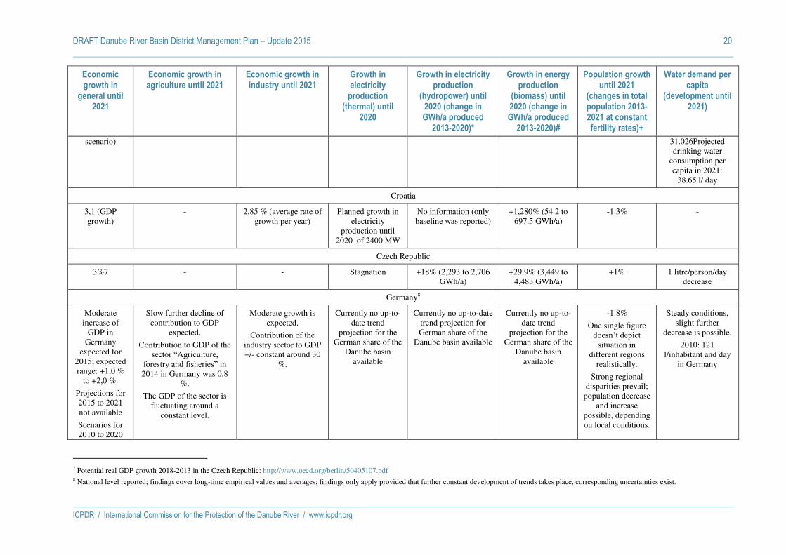
DRAFT Danube River Basin District Management Plan – Update 2015 20
ICPDR / International Commission for the Protection of the Danube River / www.icpdr.org
Economic growth in
general until 2021
Economic growth in agriculture until 2021
Economic growth in industry until 2021
Growth in electricity
production (thermal) until
2020
Growth in electricity production
(hydropower) until 2020 (change in GWh/a produced
2013-2020)*
Growth in energy production
(biomass) until 2020 (change in GWh/a produced
2013-2020)#
Population growth until 2021
(changes in total population 2013-2021 at constant fertility rates)+
Water demand per capita
(development until 2021)
scenario) 31.026Projected drinking water
consumption per capita in 2021:
38.65 l/ day
Croatia
3,1 (GDP growth)
- 2,85 % (average rate of growth per year)
Planned growth in electricity
production until 2020 of 2400 MW
No information (only baseline was reported)
+1,280% (54.2 to 697.5 GWh/a)
-1.3% -
Czech Republic
3%7 - - Stagnation +18% (2,293 to 2,706 GWh/a)
+29.9% (3,449 to 4,483 GWh/a)
+1% 1 litre/person/day decrease
Germany8
Moderate increase of
GDP in Germany
expected for 2015; expected range: +1,0 %
to +2,0 %.
Projections for 2015 to 2021 not available
Scenarios for 2010 to 2020
Slow further decline of contribution to GDP
expected.
Contribution to GDP of the sector “Agriculture,
forestry and fisheries” in 2014 in Germany was 0,8
%.
The GDP of the sector is fluctuating around a
constant level.
Moderate growth is expected.
Contribution of the industry sector to GDP +/- constant around 30
%.
Currently no up-to-date trend
projection for the German share of the
Danube basin available
Currently no up-to-date trend projection for German share of the
Danube basin available
Currently no up-to-date trend
projection for the German share of the
Danube basin available
-1.8%
One single figure doesn’t depict
situation in different regions
realistically.
Strong regional disparities prevail;
population decrease and increase
possible, depending on local conditions.
Steady conditions, slight further
decrease is possible.
2010: 121 l/inhabitant and day
in Germany
7 Potential real GDP growth 2018-2013 in the Czech Republic: http://www.oecd.org/berlin/50405107.pdf 8 National level reported; findings cover long-time empirical values and averages; findings only apply provided that further constant development of trends takes place, corresponding uncertainties exist.

DRAFT Danube River Basin District Management Plan – Update 2015 21
ICPDR / International Commission for the Protection of the Danube River / www.icpdr.org
Economic growth in
general until 2021
Economic growth in agriculture until 2021
Economic growth in industry until 2021
Growth in electricity
production (thermal) until
2020
Growth in electricity production
(hydropower) until 2020 (change in GWh/a produced
2013-2020)*
Growth in energy production
(biomass) until 2020 (change in GWh/a produced
2013-2020)#
Population growth until 2021
(changes in total population 2013-2021 at constant fertility rates)+
Water demand per capita
(development until 2021)
for Germany range from an average rate of growth per year
of +1,2 % to +1,9 %9.
Hungary
- - - - +26% (188 to 238 GWh/a)
+58.5% (2,097 to 3,324 GWh/a)
-2.7% -
Moldova
- - - - No information +620% (5 to 31 GWh/a)
-5.3% -
Montenegro
- - - - No information Exceptionally large growth (from 1.1 GWh/a in 2013 to 101 GWh in 2020)
+/- 0% -
Romania
- - 5.4%10 13% +/- 0% (19,857 to +41.6% (1,200 to -3.4% -
9 Source: HWWI, October 2013 10 Data are available till 2018 according to the National Commission for Prognosis.

DRAFT Danube River Basin District Management Plan – Update 2015 22
ICPDR / International Commission for the Protection of the Danube River / www.icpdr.org
Economic growth in
general until 2021
Economic growth in agriculture until 2021
Economic growth in industry until 2021
Growth in electricity
production (thermal) until
2020
Growth in electricity production
(hydropower) until 2020 (change in GWh/a produced
2013-2020)*
Growth in energy production
(biomass) until 2020 (change in GWh/a produced
2013-2020)#
Population growth until 2021
(changes in total population 2013-2021 at constant fertility rates)+
Water demand per capita
(development until 2021)
19,768 GWh/a) 2,900 GWh/a)
Serbia
- - - - +15.2% (10,636 to 12,260 GWh/a)
Exceptionally large growth (from 0
GWh/a in 2013 to 945 GWh in 2020)
-4.1% -
Slovak Republic
Slow acceleration:
2015: +2,9 %
2016: + 3,6 %
2017: + 3,6%
2018: + 3,7 %.
- lower inflation rate
- growth of export sector
expected
- foreign investments will
stagnate
- unemploy-ment will decline
Estimates of economic
growth for the period after
Highest priority in the agricultural sector is to
increase efficiency (stabilize animal
production, revive special crop production).
The projected development are (up to 2020):
Pigs: sows increase by 30,000pcs and increase of
their reproductive performance parameters at
the level of 20-21 piglets/sow.
Poultry: increase in numbers of poultry (states
in breeding) at least 885,000pcs (i. e. in 6 runs annually = 5,310,000pcs).
Bovine animals: stopping the decline in the state of cattle and stabilization of
In total, the industrial production
(manufacturing) will retain its about 80 %-share in GDP creation.
13
a) Current fossil fuel power
plants:
2015: 6,3 TWh
2020: 6,3TWh
2025: 6,0 TWh
2030: 5,7 TWh
2035: 5,0 TWh
b) Suggested fossil fuel
power plants:
2015: 0,3 TWh
2020: 0,7 TWh
2025: 1,0 TWh
2030: 1,3 TWh
2035: 1,7 TWh
Also the nuclear power plants
operate on the principle of thermal
+6% (5,099 to 5,400 GWh/a)
+62.8% (1,050 to 1,710 GWh/a)
-0.7% Available is estimate of specific water consumption per
capita (public water supply) in two
variants:
Variant 1:
2015: 81,7 liter/year
2016: 82,0 lit/y
2017: 82,3 lit/y
2018: 82,6 lit/y
2019: 82,9 lit/y
2020: 83,2 lit/y
2021: 83,5 lit/y
Variant 2:
2015: 81,7 lit/y
2016: 82,4 lit/y
2017: 83,1 lit/y

DRAFT Danube River Basin District Management Plan – Update 2015 23
ICPDR / International Commission for the Protection of the Danube River / www.icpdr.org
Economic growth in
general until 2021
Economic growth in agriculture until 2021
Economic growth in industry until 2021
Growth in electricity
production (thermal) until
2020
Growth in electricity production
(hydropower) until 2020 (change in GWh/a produced
2013-2020)*
Growth in energy production
(biomass) until 2020 (change in GWh/a produced
2013-2020)#
Population growth until 2021
(changes in total population 2013-2021 at constant fertility rates)+
Water demand per capita
(development until 2021)
2018 are not available11.
milk production.
Sheep and goats: continuous increase in
numbers of breeding and
production support from sheep's milk and meat.
Vegetables: increase in harvested area of
vegetables by 3,000 ha and increase vegetables
production by 120.2 % at the level of 240,000t.
Fruit: revitalization fruit orchards during 5-7 years
in the area of 4,500 ha.
Potatoes: increase on harvest area of potatoes by
743 ha.12
power plants – using the principle
of change of thermal energy into electrical. Expected
electricity production in nuclear power
plants:
2015: 15,5 TWh
2020: 23,7 TWh
2025: 23,7 TWh
2030: 32,8 TWh
2035: 32,8 TWh14
2018: 83,9 lit/y
2019: 84,6 lit/y
2020: 85,3 lit/y
2021: 86,0 lit/y
Slovenia
- - - - +21.9% (4,198 to 5,121 +47.9% (457 to 676 +0.1% -
13 Source: Evaluation of Routing Options and Conditions for Development of Industrial Production in Slovakia after 2013 (Ministry of Economy of the SR, 2012). An additional source could be “The Innovation Strategy of the Slovak Republic for the years 2014 – 2020”. 11 Source: Ministry of Finance of the Slovak Republic (as of January 2015). 12 Prognosis in the agricultural sector is developed based on the “Conception of Agriculture Development of the Slovak Republic for 2013-2020”; additional source: “Rural Development Programme of the Slovak Republic for the period 2014-2020". 14 There is considered only a limited construction of resources for fossil fuels and therefore only smaller sources based on natural gas with combined electricity and heat production are included in the review (mainly realized as reconstructions to replace old blocks that do not meet the new emission regulations. The thermal power plant “Vojany” with capacity of 880 MW is the largest fossil fuel power plant in Slovakia. At the power plant “Vojany 1” will operate two fluidized blocks of 110 MW, corresponding to emission requirements even after 2015. “Elektrárne Nováky” is a thermal power plant which ensures the sales of domestic coal for electricity and heat production in terms of general economic interest. In order to fulfill the new emission regulations valid after 2015 two blocks have to be reconstructed (2 x 110 MW). Construction of large steam-gas
power plants is not intended because of air protection and preference for carbon-free nuclear power and renewable energy.

DRAFT Danube River Basin District Management Plan – Update 2015 24
ICPDR / International Commission for the Protection of the Danube River / www.icpdr.org
Economic growth in
general until 2021
Economic growth in agriculture until 2021
Economic growth in industry until 2021
Growth in electricity
production (thermal) until
2020
Growth in electricity production
(hydropower) until 2020 (change in GWh/a produced
2013-2020)*
Growth in energy production
(biomass) until 2020 (change in GWh/a produced
2013-2020)#
Population growth until 2021
(changes in total population 2013-2021 at constant fertility rates)+
Water demand per capita
(development until 2021)
GWh/a) GWh/a)
Ukraine
- - - - +25% (0.16 to 0.2 GWh/a)
Exceptionally large growth (from 0
GWh/a before 2014 to 4.220 GWh in
2020)
-6.3% -
*Information on hydropower retrieved from the Assessment Report on Hydropower Generation in the Danube Basin; the exception is BG, where data was retrieved from the National Action Plan under the RES Directive (there was no figure for 2020). All data on hydropower applies to the national level, except HR and UA (Danube-part). For RS, the value also includes the Kosovo – a territory defined by the United Nations resolution 1244 (1999) as an autonomous province of the Republic of Serbia administered by the UN. BA reported data for the current amount of electricity production for the national part of the Danube River Basin, while the figures for the expected amount of electricity production in the year 2020 refer to the whole country. For Romania, the reference year was hydrological exceptional, an increase is therefore also expected. Data for Moldova covers time span from 2015 to 2020.
#Based on the National Action Plans in the framework of the Renewable Energies Directive (RES Directive). For non-EU countries, only for Bosnia and Herzegovina there was no NAP available. Data is on the national level.
+National level data, based on: United Nations, Department of Economic and Social Affairs, Population Division (2013) - World Population Prospects: The 2012 Revision.

DRAFT Danube River Basin District Management Plan – Update 2015
ICPDR / International Commission for the Protection of the Danube River / www.icpdr.org
Summary Assessments of trends for some Danube countries
Slovakia
Agriculture: In the “Conception of Agriculture Development of the Slovak Republic for 2013-2020” considered increase in production of selected animal commodities by 2020 at the national level (compared with 2002) does not create a real risk to the increase of water pollution with nitrogen. The emergence of such risk, which is subject to a variety of environmental factors and management cannot be excluded at farm level.
Considered increase in production of selected crop commodities by 2020 (compared with 2002) does not create preconditions for significant agriculture intensity increase and relating increase in industrial fertilizer consumption. Increase in fertilizer consumption is influenced by production of crops for marketing in relation to the realization prices. It can be stated that current intensity of nitrogen fertilization in industrial fertilizers already at present exceeds the requirements arising from the target increase in production of selected crop commodities (requirements of the “Conception”). The impact of the increase in the intensity of nitrogen fertilization for increasing risk of pollution of water resources cannot be excluded at the farm level. In relation to the risk of pollution of surface- and groundwater with nitrogen from agriculture should be noted that the surplus balance of nitrogen is more objective indicator of non-productive nitrogen losses from agriculture than the actual consumption of nitrogen in industrial and organic fertilizers.
Industry: Key position in industry has the manufacturing, which will be a driver of economic growth also in the development up to 2020. Growth tendencies of the industry of Slovakia will be accompanied by increasing its technological level. Best development prospects in the horizon to the 2020 has the automotive industry and related sectors, especially machinery industry, electrical engineering, metallurgical industry, chemical industry (production of tires and plastics) and part of the furniture industry (car seats). Thanks new investment a favorable economic development will reach also the pulp and paper industry and glass industry.
Each of the (above mentioned) industries use to a greater or lesser extent water. Automotive industry, which is the leading branch, uses in car manufacturing large quantities so called "rinse water" for degreasing and surface treatment of bodyworks. The water must be properly adjusted for each of the production processes. Moreover, it is often necessary to recycle water: the objective is to minimize the consumption of new water and to prevent the penetration of heavy metals from surface treatment processes into wastewater (use of technology of selective ion exchange). Boiler water, cooling water and water for humidification are further examples of the water use in the car industry.
Energy (from: Draft Energy Policy until 2035): According to the reference scenario in the coming period it is envisaged the growth in final energy consumption up to 2035. The energy-saving scenario envisages a further reduction of final consumption. Between 2010 and 2012 there was a significant 10% (40 PJ) decrease in final energy consumption. For saving scenario and application of long-term key measures of energy efficiency, by 2035 further final energy consumption decrease may arise.
It is assumed that by the influence of the turbulence of the economic crisis the consumption of electricity in Slovakia reaches pre-crisis levels until 2017. In the period 2015-2017 the annual increase of electricity consumption should reach 1.7%, and in the next two years it is expected to slow down to 1.4%, respectively 1.3%. As regards the balance of consumption and production of electricity a positive balance is expected only from 2016.
The largest producer of electricity at the national level is “Slovenské elektrárne, a.s.”, with the market share of 82 %. The company uses the surface water mainly as technological and cooling water and hydro-energy potential in hydropower plants. The discharge of wastewater is based on the valid permits issued by water management authorities. As the operation of power plants can have a negative influence on status of water, the company within the monitoring of groundwater and surface water ensures the control of this aspect. Data on hydrological and hydrogeological water status is continuously collected in different sites of individual power plants and their surroundings.
Hydropower: In Slovakia, the largest proportion of renewable electricity production belongs to hydropower, which covers 98% of electricity from renewable sources. The use of hydro-energy potential is approximately 57%. The potential suitable for small hydropower plants, however, is used only to 25%. Hydropower will continue to have a relatively important share of electricity production from renewable sources and by 2020 a dynamic development of mainly small hydropower plants is expected. Note: “Conception of using the hydropower potential of water courses of Slovakia until 2030” will be finished by the end of 2015 (after approval of this conception the size of usable hydropower potential will be specified).
Electricity production from hydropower can have, depending on the type of hydro power plant (derivative hydropower plant, accumulation and pumped-storage hydropower plants), a negative impact on the aquatic environment, natural environment and ecosystems. Hydropower is identified as one of the main causes of hydromorphological changes, loss of longitudinal continuity of flow and significant negative impacts on fish stocks. However, not all hydroelectric power must necessarily have resulted in a deterioration of ecological status according to the WFD.
Bosnia and Herzegovina
Increase in capacity of the urban waste water treatment from current 90,000 PE for additional 600,000 PE, through construction and reconstruction of the WWTPs.
Also in Bosnia and Herzegovina there is in strategic document planned to increase development of hydropower –electricity production and it is planned till 2021 to grow agricultural sector.
Germany
In the course of the analysis of future anthropogenic developments until 2021 in the German share of the Danube basin, socio-economic indicators were considered as well as figures concerning the hydrologic budget, the development of water abstraction and waste water disposal, the energy sector, agriculture and forestry, inland water transport and flood protection.

DRAFT Danube River Basin District Management Plan – Update 2015
ICPDR / International Commission for the Protection of the Danube River / www.icpdr.org
The development of the different sectors is widely interconnected and the effects of the observable trends are partly opposed.
Yet it remains to be stated that economic growth and use of resources, like water, are decoupled in a society based on the provision of services. Even though interactions clearly exist, changes of economic parameters don’t necessarily induce direct changes of ecologic parameters, e.g. concerning the use of water resources and the hydrological balance.
In the overall view the pressure situation due to the observable trends in anthropogenic activities in the considered timeframe can be expected to remain steadily on the current level. Based on the available information, no additional endangerment for achieving the environmental objectives is to be expected, yet, under the assumption of the continuation of currently observable trends, the future pressure situation can’t be expected to improve until 2021. More detailed information on future developments concerning the driving forces affecting the pressure situation on water bodies and, in the end, water status as well as trends and developments concerning the provision of water services, can be obtained in the River Basin Management Plans for the German share of the Danube Basin, provided by Bavaria and Baden-Württemberg.
Austria
Agriculture: Owing to the studied indicators of potential water pollution (livestock or landuse) and accordingly to the prognosis of the Austrian Institute of economic research (WIFO) in the background document for the Economic Analysis 2013 the following things are predicted till 2025:
in regions with favourable conditions for the expansion of milk production, an increase of the application of organic fertilizer will take place; an overall decrease of the agricultural area will happen. This also reduces the risk of diffuse pollution, provided that the specific intensities do not increase; as Organic agriculture will be even more financially supported in the next programme for rural development, the tendencies for intensifying agriculture will heavily decrease owing to the market conditions; the reason for regional differences in the river basins of Rhine and Danube will be led back to structural facts in these regions.
The expected decrease in beef production (laid down in the prognosis for the (Austrian) river basin management plan 2009) has taken place in the last decade. Unlike a decade ago it is now not to be expected that extensive forms of production will be extended. Relatively high agricultural prices tend to strengthen tendencies towards intensification (see, nitrogen balance in recent years).The impact of climate change could enhance an intensification in the coming decades. However, the agri-environmental program and conditions of the 1st pillar of the CAP weaken these trends.
Industry, Production of goods
Given the observed development of water intensity and the expected production growth, it should be expected, that industrial water consumption will decline in the range of 5% to 15% by 2025.
It is assumed that the amount of waste water will continue to develop in line with water use. I.e. a moderate reduction is to be expected in the period to 2025.
Electricity generation
The electricity generation by hydro power (excluding Pumped storage power plants) will increase till 2025 by an annual average of 0.9% from 132 PJ (2010) to 152 PJ. The share of hydropower (excluding Pumped storage power plants) in domestic generation falls during this period from 54% to 52%. The share of fossil fuel power decreases from almost a quarter to 17%. The share of electricity produced from renewable energy sources (wind, photovoltaic, biomass) increases from 7% to almost 15%.
It was assumed that production losses in small hydropower and run-of-river power occur (> 10 MW) from 2011 and increase linearly until 2027. The losses in storage power plants on the other hand become noticeable from 2021. Furthermore, it was assumed that at the same time the existing potential for plant optimization for existing small hydro- and run-of-river power plants is used. Thus, the (2005) calculated losses are largely compensated..
Czech Republic
Water abstraction and waste water discharge for/from agriculture and industry in the Czech Republic are not expected to increase and the likely scenario (in abstraction and discharge) for the two sectors is stagnation. On the other hand, water abstraction and waste water discharge are expected to increase in case of households. Number of inhabitants supplied with water from water supply systems and inhabitants connected to sewerage systems and WWTPs is also expected to increase. Water quality should be positively affected by construction and improvements of WWTPs.
ICPDR / International Commission for the Protection of the Danube River / www.icpdr.org
ANNEX 10
DRAFT DRBM Plan – Update 2015
Progress in urban wastewater and industrial sectors by 2015

Danube River Basin District Management Plan – Update 2015 1
ICPDR / International Commission for the Protection of the Danube River / www.icpdr.org
Country
Basic / supplementary measures
Remarks
UWWTD implementation IED and BAT
P-free
detergents Others Agglomerations
>10,000 PE (and
year)
Sensitive areas %
Estimated total
costs
(mil. Euro)
Funding sources
(mil. Euro) Status of
implementation Trend
EU National
Germany Accomplished Art. 5(8), combined with Art. 5(4)
Full compliance reached, no further significant costs
Will be made available at a later point in time
Will be made available at a later point in time
Implemented Continuous improvement corresponding to updating BAT
P-free detergents are in use
Basic measures implemented, a minor number of projects still pending
Austria Accomplished Art. 5(8), combined with Art 5(4)
Full compliance reached, ongoing costs for maintenance and reinvestments
65 (2012) for total investments of 265 (Federal funding only)
Implemented Continuous improvement corresponding to updating BAT
P-free detergents are in use
Basic measures implemented
Czech Republic
Accomplished Whole territory Full compliance reached, ongoing costs for maintenance and reinvestments
Will be made available later
Will be made available later
Implemented Continuous improvement corresponding to updating BAT
dishwasher agents: P content is not restricted.
Detergents with concentration of P lower than 0,5 % weight are in use except in industries and institutions where washing is organized by specially trained personnel
Measures are proposed in framework of the River Basin Management Plan (RBM Plan)
Supplementary measures are planned as part of RBM Plan
Slovakia 2010 Whole territory In Continuous The EU Measures 2010

Danube River Basin District Management Plan – Update 2015 2
ICPDR / International Commission for the Protection of the Danube River / www.icpdr.org
Country
Basic / supplementary measures
Remarks
UWWTD implementation IED and BAT
P-free
detergents Others Agglomerations
>10,000 PE (and
year)
Sensitive areas %
Estimated total
costs
(mil. Euro)
Funding sources
(mil. Euro) Status of
implementation Trend
EU National
Art. 5(8) implementation improve-ment corresponding to updating BAT
Regulation
No 259/2012 as regards the use of phosphates and other phosphorus compounds in
consumer laundry detergents and consumer automatic dishwasher detergents will be implemented
will be proposed in the framework of the RBM Plan
Slovenia 2010. Art. 5 (8); Also: existing UWWTP=>10,000 PE in Danube Region must upgrade to tertiary treatment till August 2016
More than 884 (a) More than 35 (a)
State – more than 398 (a)
Municipal – more than 133 (a)
Loans – more than 318 (a)
Implemented Continuous improvement corresponding to updating BAT
P-free and P-including detergents are in use. Regulation on implementing the EU Regulation No 259/2012 as regards the use of phosphates and other phosphorus compounds in consumer laundry detergents and
Advisory services for farmers.
In progress.
(a) more detailed information is not available

Danube River Basin District Management Plan – Update 2015 3
ICPDR / International Commission for the Protection of the Danube River / www.icpdr.org
Country
Basic / supplementary measures
Remarks
UWWTD implementation IED and BAT
P-free
detergents Others Agglomerations
>10,000 PE (and
year)
Sensitive areas %
Estimated total
costs
(mil. Euro)
Funding sources
(mil. Euro) Status of
implementation Trend
EU National
consumer automatic dishwasher detergents is in process of adoption right now – November 2014)
Croatia 2018 (for agglomerations larger than 15.000 PE)
2020 (for agglomerations between 10.000 and 15.000 PE - in sensitive areas)
2023 (for all of remaining agglomerations)
Decision on sensitive areas was issued in 2010. Danube river basin a catchment area of sensitive area due to eutrophycation of the Danube Delta - more advanced treatment with nitrogen and phosphorus removal in all agglomerations larger than 10.000 PE.
For Danube River RBD: Total construction costs EUR 1885 million, by means of which the Republic of Croatia would comply with the requirements of the Urban Waste Water Treatment Directive (Danube River RBD, till 2023.) . The greatest investments are expected in the period 2013 – 2018, amounting to slightly more than EUR 196 million per year.
EU funds: EUR 1225 million (till 2023)
National funds: EUR 660 million (till 2023)
Implemented Continuous improvement corresponding to updating BAT.
EU legislation concerning the detergents is transposed into Croatian legislation. No production of P - detergents
Total construction costs EUR 3191 million, by means of which the Republic of Croatia would comply with the requirements of the Urban Waste Water Treatment Directive. The greatest investments are expected in the period 2013 – 2018, amounting to slightly more than EUR 294 million per

Danube River Basin District Management Plan – Update 2015 4
ICPDR / International Commission for the Protection of the Danube River / www.icpdr.org
Country
Basic / supplementary measures
Remarks
UWWTD implementation IED and BAT
P-free
detergents Others Agglomerations
>10,000 PE (and
year)
Sensitive areas %
Estimated total
costs
(mil. Euro)
Funding sources
(mil. Euro) Status of
implementation Trend
EU National
year.
Serbia Construction ongoing for two WWTP, for three WWTP construction not yet started, planning on-going for one WWTP and for six WWTP planning not yet started ;
Proposal for designation of SA in Serbia is expected in 2015 through the cooperation Project with Swedish EPA (Designation of sensitive and vulnerable zones according to the ND and UWWD).
4500 -5000 mil. EUR for capital costs. Estimated by national experts;
Unknown Unknown
Six permits have been issued and 105 out of an estimated 161 IPPC installations have submitted for permits.
Slow progress Partially in use;
Bosnia and Herzegovina
Two existing wastewater treatment plants (WWTP) >10,000 PE and three planned WWTP of same size by 2015
Will be defined in 2013
First estimates about 450 (160 agglomerations with >2000 PE).
Unknown Unknown Full implementation is not determined yet. In preparation are 6 BAT for food industry.
Slow progress Domestic factory produces about 50% P-free detergents, for imported product no information
Hungary Will be implemented by 31st Dec 2015 in 3 steps:
31st Dec 2015 (normal area, 2000-15000 PE)
31st Dec 2010 (normal area
On the basis of Art 5 (8) 3 sensitive areas were designated.
From 2009 Art 5 (4) P and N reduction rate calculation method is using
2405
(2013-15)
1563*
(2013-15)
842*
(2013-15)
Implemented Continuous improvement corresponding to updating BAT
Approx. 90% assumed as P-free by 2014 in household detergent’ uses.
In 2013 the 259/2004/EK regulation came into force, which will have
Measures will be proposed in the framework of the 2nd RBM Plan.
*Estimation: app. 35% of the cost is covered from national, and app. 65 % from EU sources.

Danube River Basin District Management Plan – Update 2015 5
ICPDR / International Commission for the Protection of the Danube River / www.icpdr.org
Country
Basic / supplementary measures
Remarks
UWWTD implementation IED and BAT
P-free
detergents Others Agglomerations
>10,000 PE (and
year)
Sensitive areas %
Estimated total
costs
(mil. Euro)
Funding sources
(mil. Euro) Status of
implementation Trend
EU National
above 15.000PE)
31st Dec 2008 in sensitive area 10000-15000 PE
by HU. further positive effect using more P-free household detergent in HU.
Bulgaria 2010 Whole Bulgarian part of the Danube River District
352.06 (including Urban WWTP and collecting systems)
178.36
(According to implementation programme of Directive 91/271/EEC)
173.7
(According to Implementation program of Directive 91/271/EEC)
Under implementation
Issue of permits corresponding to IPPC requirements
The EU Regulation
No 259/2012 as regards the use of phosphates and other phosphorus compounds in
consumer laundry detergents and consumer automatic dishwasher detergents will be implemented
Basic measures will be proposed in the framework of the RBM Plan
Romania 2015 (2018 for agglomerations between 2000 -10,000 PE) according to the EU Accession Treaty
Whole territory
Art 5 (2)
Art 5 (8)
13,400 (including agglomerations between 2000 -10,000 PE) according to the Accession Treaty
2700 (Cohesion Fund for the period 2007-2013) in the frame of the Sectoral Operational Program for
500 (National co-finance for EU Fund 2007-2013)
1792 (Loans at different International
Under implementation (maximum transition period obtained December 2015)
Continuous improvement corresponding to IPPC permits and IED permits
The decrease in trend of average % of P in AWM detergents is continuing. Romania will implement the provisions of the EU
Measures are proposed in the framework of the National RBM
In progress

Danube River Basin District Management Plan – Update 2015 6
ICPDR / International Commission for the Protection of the Danube River / www.icpdr.org
Country
Basic / supplementary measures
Remarks
UWWTD implementation IED and BAT
P-free
detergents Others Agglomerations
>10,000 PE (and
year)
Sensitive areas %
Estimated total
costs
(mil. Euro)
Funding sources
(mil. Euro) Status of
implementation Trend
EU National
12,084 (starting with 2007, for all agglomerations, basic and supplementary measures) according to the first National RBM Plan, out of which 10,772 until 2015 and 1,312 until 2018 for basic measures and 2024 for supplementary measures
Environment
2420 (Cohesion Fund for the period 2014-2020) in the frame of the Operational Program for Large Infrastructure
Finance Institutions for the period 2006-2009)
427 (National co-finance for EU Fund 2014-2020)
Regulation No 259/2012 as regards the use of phosphates and other phosphorus compounds in consumer laundry detergents and consumer automatic dishwasher detergents (deadline 31st December 2016).
Plan
Moldova Till 2026
State of 2014
Not applicable
Not applicable
1,8000 (source: Water Supply & Sanitation Strategy)
6,7 (for all MD)
1,530 (estimate)
6,5 (for all MD)
270 (estimate)
0,2 (for all MD)
MD-EU Association Agreement was ratified by the Parliament in July 2014 (Law No 112 of July 2, 2014). Action Plan for implementation of MD-EU Association Agreement was approved by GD No 808 of Oct
In progress No progress In progress
For reporting of state of 2014, there exists no national statistics on UWWTP implementation a) disaggregated per PE of agglomerations, and b) foreign investments,

Danube River Basin District Management Plan – Update 2015 7
ICPDR / International Commission for the Protection of the Danube River / www.icpdr.org
Country
Basic / supplementary measures
Remarks
UWWTD implementation IED and BAT
P-free
detergents Others Agglomerations
>10,000 PE (and
year)
Sensitive areas %
Estimated total
costs
(mil. Euro)
Funding sources
(mil. Euro) Status of
implementation Trend
EU National
7, 2014. According to Action Plan, evaluation of institutional capacities and gaps in national legislation will be done in the 4th quarter of 2015, and study aimed at identification of installations requiring permits will be finished in 4th quarter of 2016
and c) EU funds very. Therefore provided figures on funding sources relate to a) all foreign investment, which are mainly EU (source of data: National Statistics on Investments of 2013, and open publications) and b) figures on Funding Sources are estimated.
Ukraine 2020 Not designated. Designation will be decided according EU-UA Association Agreement timetable.
will be determined by the implementation plan of the UWWTP directive
- The National Law “Programme for Drinking Water” adopted 20th of October 20011
No obligation to implement.
The National Plant Protection Low was adopted in 1998. In 2006 Ukraine
Coordination of national legislation with EU standards in phytosanitary.
The Law "State regulation of detergents" had been registered in the national Parliament. This law provides a partial reduction
In progress
Not developed

Danube River Basin District Management Plan – Update 2015 8
ICPDR / International Commission for the Protection of the Danube River / www.icpdr.org
Country
Basic / supplementary measures
Remarks
UWWTD implementation IED and BAT
P-free
detergents Others Agglomerations
>10,000 PE (and
year)
Sensitive areas %
Estimated total
costs
(mil. Euro)
Funding sources
(mil. Euro) Status of
implementation Trend
EU National
N3933-VI) provids finance for 2015 of 916.4 mln UA hrn.
During previous years The Programme for Drinking Water was usually underfunded. The State Budget for 2015 has not been adopted.
Probably, many programs will be significantly reduced, because of the war with Russia.
subscribed the IPPC.
of phosphate compounds in detergents from 17% to 0.7% during 7 years. The law has not yet been adopted.
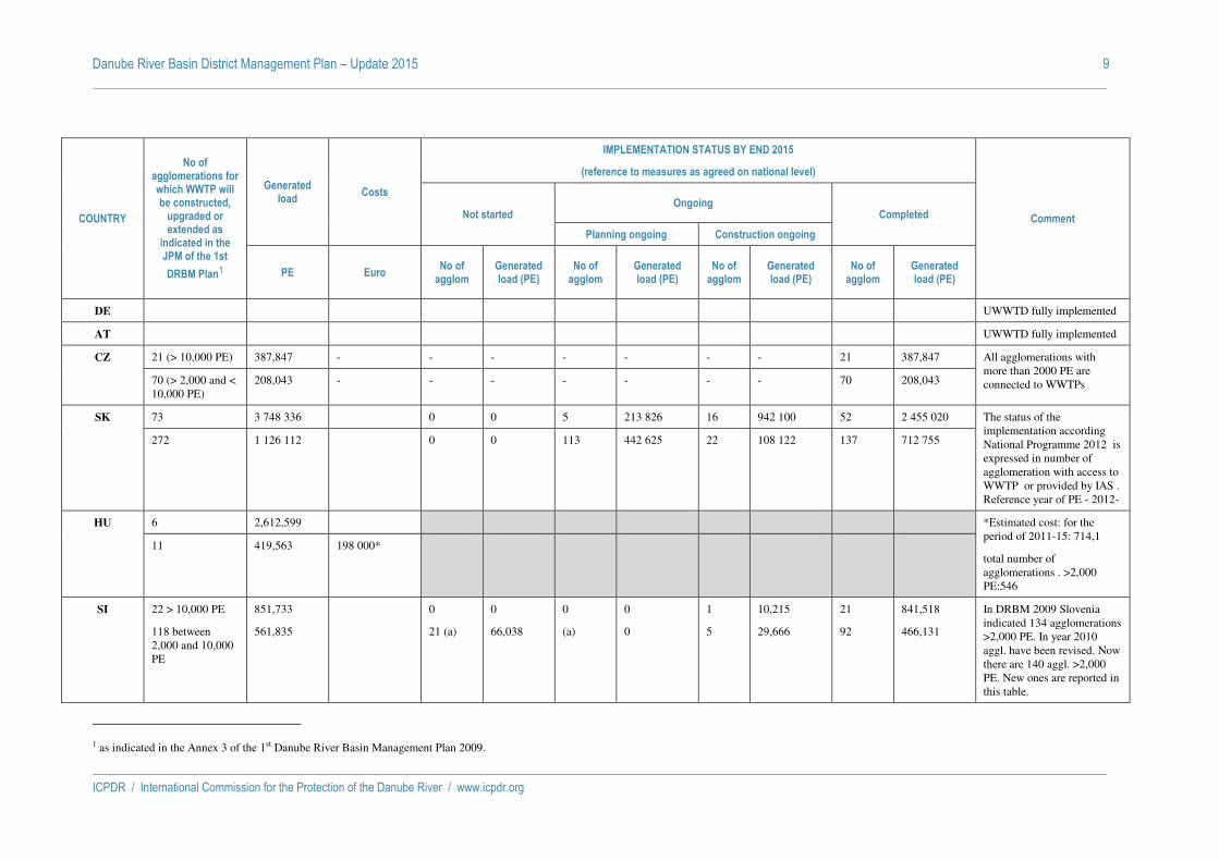
Danube River Basin District Management Plan – Update 2015 9
ICPDR / International Commission for the Protection of the Danube River / www.icpdr.org
COUNTRY
No of agglomerations for which WWTP will be constructed,
upgraded or extended as
indicated in the JPM of the 1st
DRBM Plan1
Generated load
Costs
IMPLEMENTATION STATUS BY END 2015
(reference to measures as agreed on national level)
Comment Not started Ongoing
Completed
Planning ongoing Construction ongoing
PE Euro No of
agglom Generated load (PE)
No of agglom
Generated load (PE)
No of agglom
Generated load (PE)
No of agglom
Generated load (PE)
DE UWWTD fully implemented
AT UWWTD fully implemented
CZ 21 (> 10,000 PE) 387,847 - - - - - - - 21 387,847 All agglomerations with more than 2000 PE are connected to WWTPs 70 (> 2,000 and <
10,000 PE) 208,043 - - - - - - - 70 208,043
SK 73 3 748 336 0 0 5 213 826 16 942 100 52 2 455 020 The status of the implementation according National Programme 2012 is expressed in number of agglomeration with access to WWTP or provided by IAS . Reference year of PE - 2012-
272 1 126 112 0 0 113 442 625 22 108 122 137 712 755
HU 6 2,612,599 *Estimated cost: for the period of 2011-15: 714,1
total number of agglomerations . >2,000 PE:546
11 419,563 198 000*
SI 22 > 10,000 PE
118 between 2,000 and 10,000 PE
851,733
561,835
0
21 (a)
0
66,038
0
(a)
0
0
1
5
10,215
29,666
21
92
841,518
466,131
In DRBM 2009 Slovenia indicated 134 agglomerations >2,000 PE. In year 2010 aggl. have been revised. Now there are 140 aggl. >2,000 PE. New ones are reported in this table.
1 as indicated in the Annex 3 of the 1st Danube River Basin Management Plan 2009.
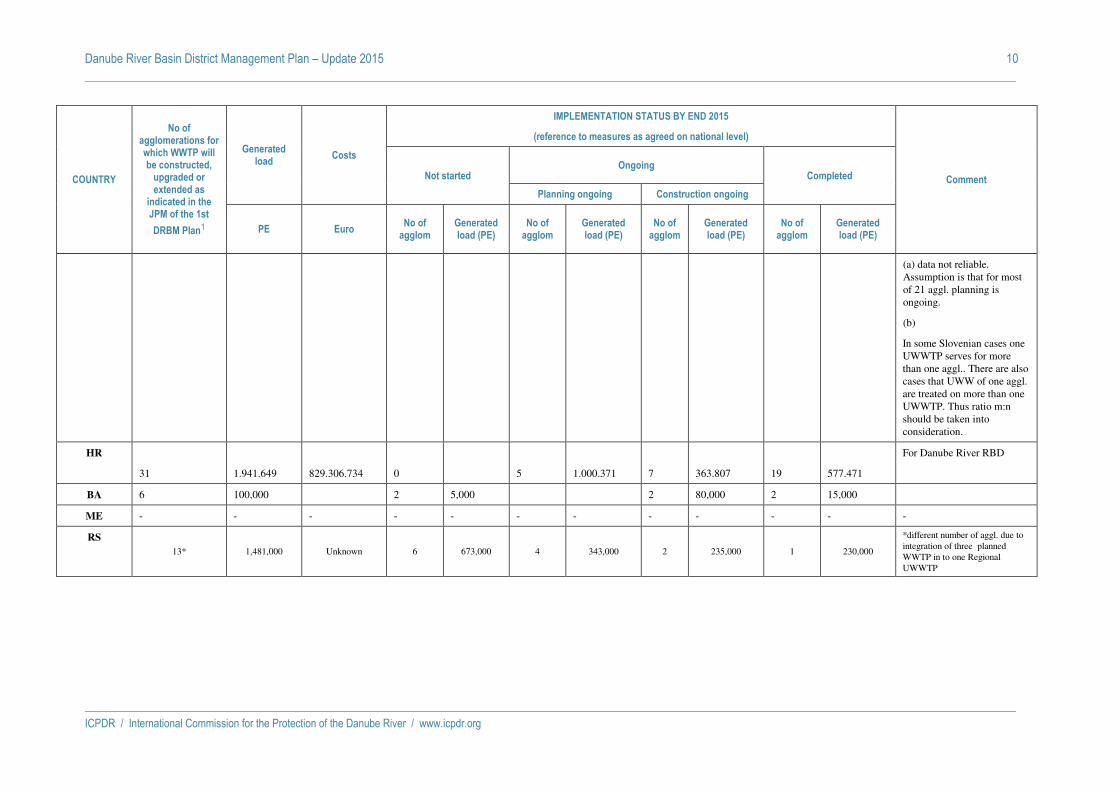
Danube River Basin District Management Plan – Update 2015 10
ICPDR / International Commission for the Protection of the Danube River / www.icpdr.org
COUNTRY
No of agglomerations for which WWTP will be constructed,
upgraded or extended as
indicated in the JPM of the 1st
DRBM Plan1
Generated load
Costs
IMPLEMENTATION STATUS BY END 2015
(reference to measures as agreed on national level)
Comment Not started Ongoing
Completed
Planning ongoing Construction ongoing
PE Euro No of
agglom Generated load (PE)
No of agglom
Generated load (PE)
No of agglom
Generated load (PE)
No of agglom
Generated load (PE)
(a) data not reliable. Assumption is that for most of 21 aggl. planning is ongoing.
(b)
In some Slovenian cases one UWWTP serves for more than one aggl.. There are also cases that UWW of one aggl. are treated on more than one UWWTP. Thus ratio m:n should be taken into consideration.
HR
31
1.941.649
829.306.734
0
5
1.000.371
7
363.807
19
577.471
For Danube River RBD
BA 6 100,000 2 5,000 2 80,000 2 15,000
ME - - - - - - - - - - - -
RS
13* 1,481,000 Unknown 6 673,000 4 343,000 2 235,000 1 230,000
*different number of aggl. due to integration of three planned WWTP in to one Regional UWWTP

Danube River Basin District Management Plan – Update 2015 11
ICPDR / International Commission for the Protection of the Danube River / www.icpdr.org
COUNTRY
No of agglomerations for which WWTP will be constructed,
upgraded or extended as
indicated in the JPM of the 1st
DRBM Plan1
Generated load
Costs
IMPLEMENTATION STATUS BY END 2015
(reference to measures as agreed on national level)
Comment Not started Ongoing
Completed
Planning ongoing Construction ongoing
PE Euro No of
agglom Generated load (PE)
No of agglom
Generated load (PE)
No of agglom
Generated load (PE)
No of agglom
Generated load (PE)
RO 1350
18,836,562 6,994,988,374 88
677,921 320
2,358,894 480
10,531,653 462
5,268,094 This situation is a result of the rearrangement of agglomerations delineation due to the reconsideration of the priorities and funding according to the new County Master Plans and local strategies developed after 2012.
As consequence in comparison with the baseline scenario presented in the Annex 3 of the DRBMP 2009, the total number of agglomerations with more than 2000 p.e. decreased from 2609 to 1852, out of which 1625 agglomerations between 2000-10000 p.e. and 227 agglomerations with more than 10000 p.e.
For the period 2010-2015, there will be financed works for all agglomerations with more than 10000 p.e. and 1123 agglomerations between 2000-10000 p.e., representing around 89% of total biodegradable organic loads.
BG 171 1,628,204 380,678,360 109 496,090 57 616,113 5 516,001

Danube River Basin District Management Plan – Update 2015 12
ICPDR / International Commission for the Protection of the Danube River / www.icpdr.org
COUNTRY
No of agglomerations for which WWTP will be constructed,
upgraded or extended as
indicated in the JPM of the 1st
DRBM Plan1
Generated load
Costs
IMPLEMENTATION STATUS BY END 2015
(reference to measures as agreed on national level)
Comment Not started Ongoing
Completed
Planning ongoing Construction ongoing
PE Euro No of
agglom Generated load (PE)
No of agglom
Generated load (PE)
No of agglom
Generated load (PE)
No of agglom
Generated load (PE)
MD 4 137,000 19,320,000 4 137,000 2 32000 0 0 3 40600 In 3 agglomerations with total generated load of 40600 PE upgrade and extension of UWWTPs which were not included in the DRBMP were completed Construction of UWWTPs for 4 agglomerations included in the DRBMP has not started yet.
UA 14 638,600 2,600,000 5 559,350 3 30,116 4 47,034 2 (1 – for tubercular clinic)
2,000 (100) For 1 UWWTP (Beregomet, PE 2,511 (Siret basin) is planned 127.5 th.Euro but financing has not yet arrived
TOTAL 2,187 27,862,986 7,397,586,734 235 2,614,399 509 3,380,123 539 10,933,932 887 7,973,811
ICPDR / International Commission for the Protection of the Danube River / www.icpdr.org
ANNEX 11
DRAFT DRBM Plan – Update 2015
Trends and implementation of measures in agriculture by 2015

DRAFT Danube River Basin District Management Plan – Update 2015 1
ICPDR / International Commission for the Protection of the Danube River / www.icpdr.org
Country
Land use development assessment (% change)
Livestock
trends
Inorganic fertilisers application
Nitrogen (N) surplus
(trends)
Nitrates Directive implementation Rural Development
Programmes (Axis 2) (mil Euro) Cultivated
agricultural area Forestation Urban area Year Vulnerable zones %
Germany -11 0 +1 -14%2 No changes declining due to further increases in N-efficiency;
estimate at present – 6%
1996 Action Programme for the whole German territory
Will be made available at a later point of time
Austria Slightly declining, with an estimate of –3,5% (period 2006-2010)
Slight increase due to climate change and use of marginal agricultural land
Increasing, but an estimate cannot be given
0,3% 3 2,4% 4 Stabilized level between 25kg/ha and 35kg/ha
Fully implemented Action Programme for the whole Austrian territory i.e. Austria accepts Black Sea waters as a vulnerable zone
817 (2012)5
5.698 (2007-2013)
Czech
Republic
Slight decrease (-1) Slight increase (0,2)
Increasing, but an estimate
cannot be given
Decrease (- 10 %)
Slight increase (+ 5 % N-fertilizers and P-fertilizers)
Stabilized level 2004 41,6% of Czech Republic
Will be made available at a later point in time
Slovakia6 Decrease by 1.3%
Increase by 0.5%
Increase by 3%
Cattle – decrease by 8%
Pigs – decrease by 42%
Sheep/goats – increase by 17,5%
Poultry – decrease
Increase by 35% in total (of which N increase by 45%, P2O5 increase by 23%).
Stabilized level, under 50 kg/ha, values till now visibly influenced by variability of climatic conditions of concrete year
2004 33.5% of Slovak country
Will be available later
1 National statistics for total area; near total area are used at present
2 Data from Bavarian Grassland Study 2008
3 Data from AT Nitrates Report 2012
4 Data from AT Nitrates Report 2012
5 Grüner Bericht 2014 (www.gruenerbericht.at)
6 Comments from Slovakia – Data correspond to national scale and is based on Index 2011/2006. Data source – national statistics.
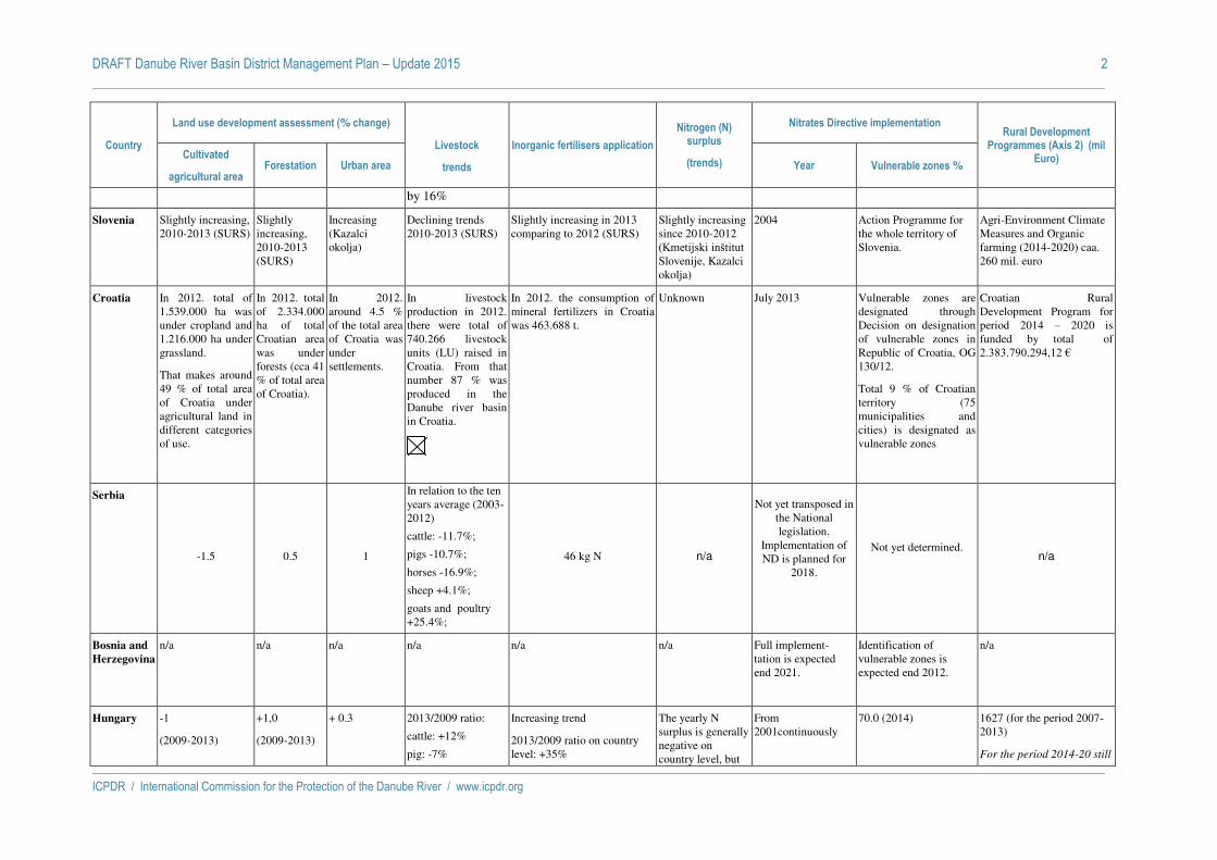
DRAFT Danube River Basin District Management Plan – Update 2015 2
ICPDR / International Commission for the Protection of the Danube River / www.icpdr.org
Country
Land use development assessment (% change)
Livestock
trends
Inorganic fertilisers application
Nitrogen (N) surplus
(trends)
Nitrates Directive implementation Rural Development
Programmes (Axis 2) (mil Euro) Cultivated
agricultural area Forestation Urban area Year Vulnerable zones %
by 16%
Slovenia Slightly increasing, 2010-2013 (SURS)
Slightly increasing, 2010-2013 (SURS)
Increasing (Kazalci okolja)
Declining trends 2010-2013 (SURS)
Slightly increasing in 2013 comparing to 2012 (SURS)
Slightly increasing since 2010-2012 (Kmetijski inštitut Slovenije, Kazalci okolja)
2004 Action Programme for the whole territory of Slovenia.
Agri-Environment Climate Measures and Organic farming (2014-2020) caa. 260 mil. euro
Croatia In 2012. total of 1.539.000 ha was under cropland and 1.216.000 ha under grassland.
That makes around 49 % of total area of Croatia under agricultural land in different categories of use.
In 2012. total of 2.334.000 ha of total Croatian area was under forests (cca 41 % of total area of Croatia).
In 2012. around 4.5 % of the total area of Croatia was under settlements.
In livestock production in 2012. there were total of 740.266 livestock units (LU) raised in Croatia. From that number 87 % was produced in the Danube river basin in Croatia.
In 2012. the consumption of mineral fertilizers in Croatia was 463.688 t.
Unknown July 2013 Vulnerable zones are designated through Decision on designation of vulnerable zones in Republic of Croatia, OG 130/12.
Total 9 % of Croatian territory (75 municipalities and cities) is designated as vulnerable zones
Croatian Rural Development Program for period 2014 – 2020 is funded by total of 2.383.790.294,12 €
Serbia
-1.5 0.5 1
In relation to the ten years average (2003-2012)
cattle: -11.7%;
pigs -10.7%;
horses -16.9%;
sheep +4.1%;
goats and poultry +25.4%;
46 kg N n/a
Not yet transposed in the National legislation.
Implementation of ND is planned for
2018.
Not yet determined.
n/a
Bosnia and
Herzegovina
n/a n/a n/a n/a n/a n/a Full implement-tation is expected end 2021.
Identification of vulnerable zones is expected end 2012.
n/a
Hungary -1
(2009-2013)
+1,0
(2009-2013)
+ 0.3 2013/2009 ratio:
cattle: +12%
pig: -7%
Increasing trend
2013/2009 ratio on country level: +35%
The yearly N surplus is generally negative on country level, but
From 2001continuously
70.0 (2014) 1627 (for the period 2007-2013)
For the period 2014-20 still

DRAFT Danube River Basin District Management Plan – Update 2015 3
ICPDR / International Commission for the Protection of the Danube River / www.icpdr.org
Country
Land use development assessment (% change)
Livestock
trends
Inorganic fertilisers application
Nitrogen (N) surplus
(trends)
Nitrates Directive implementation Rural Development
Programmes (Axis 2) (mil Euro) Cultivated
agricultural area Forestation Urban area Year Vulnerable zones %
sheep: +4 %
poultry: -8%
From 2009 to 2012 slightly decreasing (cattle, pig, sheep, poultry), but from 2012-2013 slightly increasing trends mainly in cattle, pig.
Brutto NPK fertilizer application ( kg /hectare): 2009. 64 2010 72 2011 77 2012 82 2013 93
there are some years when the mean value is positive
Year /N- balance (kgN/hectar) 2004 -13 2008 -18 2011 - 2
(There are bigger differences on the county level averages. )
under negotiation with EU
Commission.
Bulgaria Slight increase of the arable area and decrease of the total agricultural area
Slightly increasing
Slightly increasing
For the livestock
equivalent indicator it is expected to increase by up to 2.5% by 2013
It is expected to increase regarding the use of inorganic fertilisers.
Total balance of nutrients in the soil is negative.
N surplus is not expected.
2004: Identifi-cation of vulnerable zones
2006:
First Action Programme
34 For the whole country:
3242 – National Rural Development programme 2007-2013, of which
777 for Axis 2 - Nature protection including protection of water resources.
Romania Slightly decreasing
(based on Statistics 2005-2013 )
Very slight increasing
(based on Statistics 2005-2013 )
Slightly increasing
(based on Statistics 2005-2013 )
Decreasing for cattle, pigs, horses and poultry and increasing for sheep and goats (but still far behind EU average)
based on National Institute of Statistics 2005-2013 )
Slightly increasing until 2011 and after then a slightlyy decreasing but still far behind EU average.
(based on Statistics 2005-2013 )
N surplus is still very low compared with other EU member states. No important changes are expected taking into consideration the trends for livestock and fertilisers. (2005 – 2013)
2007-2010 -first action programme
2011-2013 –second action programme
2014-2017 – third action programme
6.70 (for the first Action Programme)
57.7 (for the second Action Programme)
whole territory approach (for the third action programme)
- 2792 for Axis 2, 2007 - 2013 (realized, including cofinancing )
- 3723 planed for Environmental Measures for the next National Rural Development Plan 2014 - 2020
Moldova + 0,5 (2010-2013) Slight increase, by 400 ha (2010-2013)
+ 0,3 (2010-2013)
-14% (2010-2013) + 72% , from them, nitrogen fertilizers + 64 (2010-2012), however, organic farming is practiced on 1,7% of cultivated lands (or ca. on
Not estimated n/a n/a ac. 277 (2010-2014) (source CAPMU Progress Report I sem:2014) Separate figure for Axis 2 is unavailable

DRAFT Danube River Basin District Management Plan – Update 2015 4
ICPDR / International Commission for the Protection of the Danube River / www.icpdr.org
Country
Land use development assessment (% change)
Livestock
trends
Inorganic fertilisers application
Nitrogen (N) surplus
(trends)
Nitrates Directive implementation Rural Development
Programmes (Axis 2) (mil Euro) Cultivated
agricultural area Forestation Urban area Year Vulnerable zones %
20,5 thousand ha in the MD part of the Danube basin)
Ukraine -0.05% according State Agency of Land Resources of Ukraine
+0.09% for all Ukraine
Forestation by region:
Transkarpathian oblast- 724.6 thous.ha;
Ivano-Frankivska oblast– 633 thous.ha ;
Chernivetska oblast-257.9 thous.ha
Odeska oblast– 223.9 thous.ha
+0.52%
By regions:
Transkarpathian oblast- 25.9 thous.ha;
Ivano-Frankivska oblast– 34.52 thous.ha ;
Chernivetska oblast-20.5 thous.ha
Odeska oblast– 54.4 thous.ha
2014 to 2013 (%)
Cattle: -2.5%
Pigs: +4.5%
Sheep: -0.2%
Poultry: +7.5%
+ 19%
By regions :
Transkarpathian - (-6.5%)
Ivano-Frankivska– (-9.3%)
Chernivetska – +38.2%
Odeska – +18.2
Not estimated n/a n/a 16,057 - State Special Programme of Rural Development (for period 2007 – 2015)

DRAFT Danube River Basin District Management Plan – Update 2015 5
ICPDR / International Commission for the Protection of the Danube River / www.icpdr.org
C
OU
NT
RY
MEASURES
Afforestation of agricultural land ha
/year (2007-2015)
Manure storage capacity (months)
Prohibition periods for applying fertilizer and
manure (months)
Limitation of N and phosphorous application Code of Good
Agricultural practices in line with ND
requirements (ha)
NVZ (ha) comparison with the values from
the ND implementation,
respectively similar areas declared
Restrictions of some agricultural activities on
slopes (slope in %) • kg/ha on agricultural land
• kg/ha on grass land
DE
No legal obligation (woodland area increased by 1 % since 1980)
6 months 1st Nov – 31st Jan of the following year on arable land, 15th Nov – 31st Jan of the following year on grass land. In the time from the harvest of the main crop till winter it is not allowed to apply more manure than the actual need of the following main crop, cover crop or on the field remaining cropstraw is, together not more than 40kg of ammonium-N or 80 kg total-N per hectare
170 kg N/ha from livestock manure in line with ND
170 - 230 kg N/ha from livestock manure in line with ND and EC 2006/1013/EG depending on no. of harvests, balance of N and P
Whole territory approach, code of good agricultural practice is therefore included in the Düngeverordnung (ca. 5 mio. ha)
Whole territory approach according to Article 5 (6) of the ND
On arable land with a mean slope > 10 % in a distance of 20 m to the upper edge of the bank of a surface water the application of N or P containing fertilizers is not allowed within a distance of 3 m to the upper edge of the bank. Otherwise fertilizers can be applied between the distance from 3 until 10 m to the upper edge of the bank if these fertilizers are introduced directly into the soil, or at the remaining part of the area according to the specific provisions.

DRAFT Danube River Basin District Management Plan – Update 2015 6
ICPDR / International Commission for the Protection of the Danube River / www.icpdr.org
CO
UN
TR
Y
MEASURES
Afforestation of agricultural land ha
/year (2007-2015)
Manure storage capacity (months)
Prohibition periods for applying fertilizer and
manure (months)
Limitation of N and phosphorous application Code of Good
Agricultural practices in line with ND
requirements (ha)
NVZ (ha) comparison with the values from
the ND implementation,
respectively similar areas declared
Restrictions of some agricultural activities on
slopes (slope in %) • kg/ha on agricultural land
• kg/ha on grass land
AT
No legal obligation; wooded area increased by 8 % since 1961; during the last years the area was almost constant. 4,0 million ha woodland, 48 % of the state territory
At least 6 months. Certificates of leak proves tests are required
15th Oct - 15th Feb of the following year on agricultural land in general, 15th Nov - 15th Feb, if following crop is sawn until 15th October 30th Nov - 28th Feb of the following year on grassland, 30th Nov - 15th February for manure, compost within the period -from harvest till the beginning of the respective prohibition period and -for grassland from 1st Oct till the beginning of the respective prohibition period it is not allowed to apply fertilizers containing more than 60 kg of N per hectare
60 - 240 kg N/ha depending on crop requirement (expected crop yield) and soil potential in total (170 kg N/ha from livestock manure in line with ND)
40 - 280 kg N/ha depending on no. of cuts
Whole territory approach, code of good agricultural practice is therefore included in the Nitrates Action Programme (ca. 3.2 mio. ha)
Whole territory approach according to Article 5 (6) of the ND
The application of N containing fertilizers including sewage sludge on agricultural fields with average slope of more than 10% within distance of 20m towards surface waters has to comply with the following obligations: the application of N containing fertilizers – with the exception of solid manure and compost - has to be split in all cases where more than 100 kg/ha of N is foreseen to be applied; in case of crops with a late start of the growing season in spring, the slope has to be subdivided with horizontal sowing stripes with soil covering plants, or between arable land foreseen for fertilization and surface waters a buffer strip of 20 m, or fields have to be vegetated over winter period.

DRAFT Danube River Basin District Management Plan – Update 2015 7
ICPDR / International Commission for the Protection of the Danube River / www.icpdr.org
CO
UN
TR
Y
MEASURES
Afforestation of agricultural land ha
/year (2007-2015)
Manure storage capacity (months)
Prohibition periods for applying fertilizer and
manure (months)
Limitation of N and phosphorous application Code of Good
Agricultural practices in line with ND
requirements (ha)
NVZ (ha) comparison with the values from
the ND implementation,
respectively similar areas declared
Restrictions of some agricultural activities on
slopes (slope in %) • kg/ha on agricultural land
• kg/ha on grass land
CZ
385 ha/year (2,5 % from agri area of NVZ for the actual period). During the whole programming time, the measure is implemented with the necessity of 18 years commitment for the HRDP and 15 years commitment for the RDP. In accordance with period of implementation of this measure, the annual number of new afforested hectares has a downward trend (2010 – 236 ha). Concerning the first results of mid-term evaluation there is more over importance for local ecosystems and regional benefits.
The capacity of storage spaces for manure must be sufficient for storing of manure during the period of ban for the fertilization.The deposition of solid manure and solid organic fertilizers on agricultural land is permissible for 12 months at longest. The deposition at the same place can be repeated after 4 years of land cultivation. Since 01.01.2014 the capacity of storage spaces for manure will have to correspond to the need for storage of their six-month production.
Use of fertilizers with a slow releasable N on arable land is prohibited between 1. 6. – 31. 7. (this provision does not apply in the case of subsequent cultivation of winter crops and catch crops) and in period between 15.12 - 15.2. Use of fertilizers with slow releasable N on grassland is prohibited between 15.12. - 15.2. Periods of fertilization ban are not applicable for faeces and urine left on the land by livestock during grazing or their other stay on agricultural land and for fertilizing covered areas (greenhouses, plastic foil greenhouses).
The quantity of total N kg/ha applied anually on agricultural land in organic and combined organic/inorganic fertilizers and manure cannot exceed on average in total area of agricultural land of farm entreprise 170 kg . ha-1, while including agricultural land appropriate for fertilization.
Application of N fertilizing substances is restricted to 80 kg of total N/ha. The calculation of used N dose per ha shall be carried out on the basis of data on total N input in organic and combined organic / inorganic fertilizers and manure.
Code of Good Agricultural practices application is obligatory in the whole area – area of 3 531 370,65 ha (35 313,7 km2), in line with ND. ND requirements are obligatory for NVZ defined. For the rest of agricultural areas are implemented on the voluntary bases.
Area of NVZ designated for ND in 2011 – 1 759 883,73 ha (arable land – 1 476 534,04 ha and grass land - 256 198,78 ha) – 49,83 % of total agricultural area. Quality monitoring report in 2012.
Appropriate agrotechnical erosion control measures which are in the conformity with site conditions shall be carried out on agricultural plots with arable land on erosion endangered soils, delimited in accordance with main soil unit (limit of 7 or 12 degrees). Appropriate agrotechnical erosion control measures are especially: contour line cultivation, soil protective cultivation with retaining of organic residues on soil surfaces, mulching, sowing into protective crop and/or stubble, sowing into rough cut or discontinuous ridging.

DRAFT Danube River Basin District Management Plan – Update 2015 8
ICPDR / International Commission for the Protection of the Danube River / www.icpdr.org
CO
UN
TR
Y
MEASURES
Afforestation of agricultural land ha
/year (2007-2015)
Manure storage capacity (months)
Prohibition periods for applying fertilizer and
manure (months)
Limitation of N and phosphorous application Code of Good
Agricultural practices in line with ND
requirements (ha)
NVZ (ha) comparison with the values from
the ND implementation,
respectively similar areas declared
Restrictions of some agricultural activities on
slopes (slope in %) • kg/ha on agricultural land
• kg/ha on grass land
SK
To 31th December 2013, first afforestation of the agricultural land, supported from RDP 2007-2013, was realized on 255 ha (0.013% of UAA).
In national legislation (MoA Decree No 338/2005) is embedded the requirement for 6-12 months storage capacity for solid manure and 3-4 months for liquid manure. Because legally defined storage capacities for animal manures in NVZs are insufficient, the relevant AP is under revision. With regard to 6 months storage capacity for solid and liquid animal manure there is still indicated some deficit which can be solved via completion of them or via contracting external storage.
In revised AP in VZs there is assumed more stringent definition of period with prohibition of manures containing nitrogen as it is at present (15th November to 15th February).
Besides ND limit (170 kg N/ha from animal manures in VZs) N inputs are limited via maximum single N rate. In the revised AP in NVZs there will be defined also the maximum fertilizer N rate for individual crops. P application is long term under the crop demands.
Soil with slope above 7o : 80 kg N/ha. Phosphorous is not limited
Code of Good Agricultural practices application is obligatory in vulnerable areas – area of 1,461,646 ha (14616.46 km2) and recommended - outside of vulnerable zones (total agricultural land in the whole SR with manure application: 1,939,275 ha (19392.75 km2).
Since 2004, the area of NVZs was unchanged and represents 60% of agricultural land.
1. Whole territory of Slovakia on recommended base (through Code of Good Agricultural practices ) : a. Land with slope above 12% should not be used as arable land 2. Whole territory of Slovakia – obligation: a. Fertilizers are not applied on land with slope above 12%, if there is a risk of washing them out to surface water ( MP SR Regulation Nr.338/2005 (§ 14) issued to the Act on fertilizers) 3. NVZ – obligation: a. Land with slope above 12% is prohibited for using it as arable land and is not allowed to fertilize it with nitrate fertilizers b. On agricultural land with slope above 7% is necessary to carry out anti erosion measures.
HU
During the period 2007/13, the average afforestation in HU was in ha/year 2007: 18.948
In accordance with The Code of Good Agricultural Practice the capacity of the farmyard manure
No manure shall be applied between 31 Okt and 15 Feb, except for the top dressing of winter cereals where
The annual volume of N applied through organic manure on agricultural areas may not exceed 170 kg/ha. Whether it
No special limit value for grass land in Hungary.
HU transposed the ND. The rules of the Code of Good Agricultural Practices are obligatory on the
The designation entered into force by the Government Decree No. 27/2006. (II.7.) on the
As for plantations on slopes more than 15 %, fertilizers may be applied only if the anti-erosion measures
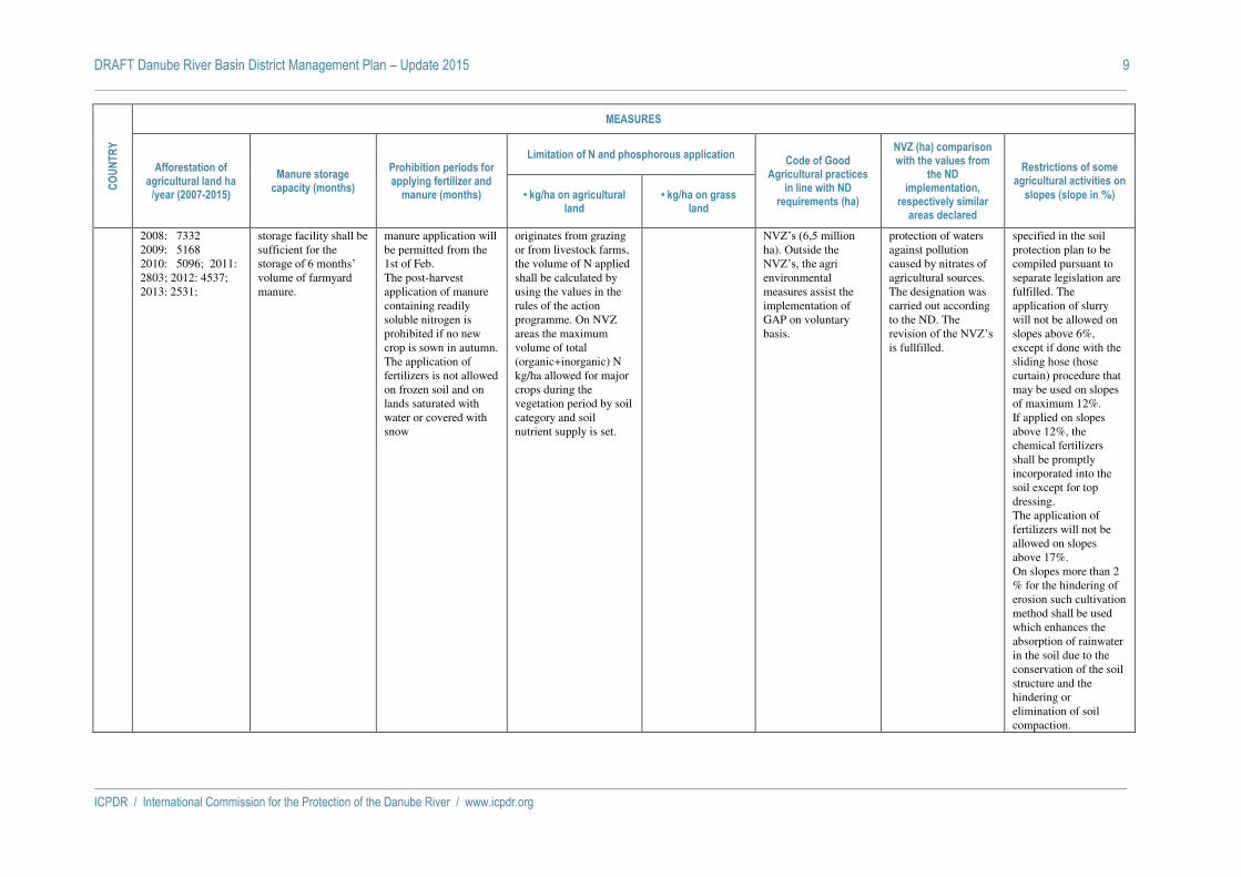
DRAFT Danube River Basin District Management Plan – Update 2015 9
ICPDR / International Commission for the Protection of the Danube River / www.icpdr.org
CO
UN
TR
Y
MEASURES
Afforestation of agricultural land ha
/year (2007-2015)
Manure storage capacity (months)
Prohibition periods for applying fertilizer and
manure (months)
Limitation of N and phosphorous application Code of Good
Agricultural practices in line with ND
requirements (ha)
NVZ (ha) comparison with the values from
the ND implementation,
respectively similar areas declared
Restrictions of some agricultural activities on
slopes (slope in %) • kg/ha on agricultural land
• kg/ha on grass land
2008: 7332 2009: 5168 2010: 5096; 2011: 2803; 2012: 4537; 2013: 2531;
storage facility shall be sufficient for the storage of 6 months’ volume of farmyard manure.
manure application will be permitted from the 1st of Feb. The post-harvest application of manure containing readily soluble nitrogen is prohibited if no new crop is sown in autumn. The application of fertilizers is not allowed on frozen soil and on lands saturated with water or covered with snow
originates from grazing or from livestock farms, the volume of N applied shall be calculated by using the values in the rules of the action programme. On NVZ areas the maximum volume of total (organic+inorganic) N kg/ha allowed for major crops during the vegetation period by soil category and soil nutrient supply is set.
NVZ’s (6,5 million ha). Outside the NVZ’s, the agri environmental measures assist the implementation of GAP on voluntary basis.
protection of waters against pollution caused by nitrates of agricultural sources. The designation was carried out according to the ND. The revision of the NVZ’s is fullfilled.
specified in the soil protection plan to be compiled pursuant to separate legislation are fulfilled. The application of slurry will not be allowed on slopes above 6%, except if done with the sliding hose (hose curtain) procedure that may be used on slopes of maximum 12%. If applied on slopes above 12%, the chemical fertilizers shall be promptly incorporated into the soil except for top dressing. The application of fertilizers will not be allowed on slopes above 17%. On slopes more than 2 % for the hindering of erosion such cultivation method shall be used which enhances the absorption of rainwater in the soil due to the conservation of the soil structure and the hindering or elimination of soil compaction.

DRAFT Danube River Basin District Management Plan – Update 2015 10
ICPDR / International Commission for the Protection of the Danube River / www.icpdr.org
CO
UN
TR
Y
MEASURES
Afforestation of agricultural land ha
/year (2007-2015)
Manure storage capacity (months)
Prohibition periods for applying fertilizer and
manure (months)
Limitation of N and phosphorous application Code of Good
Agricultural practices in line with ND
requirements (ha)
NVZ (ha) comparison with the values from
the ND implementation,
respectively similar areas declared
Restrictions of some agricultural activities on
slopes (slope in %) • kg/ha on agricultural land
• kg/ha on grass land
SI
2012 - 13945 ha, 2014 - 23391 ha (Dejanska raba MKGP, Kmetijsko zemljišče v zaraščanju - 1410)
15th of Nov till 15th of Feb; some areas from 1st of December till 31th of Jan. On areas higher than 800 m from 15th Nov till 1st March. (Uradni list RS, št. 113/09 in 5/13)
Manure: 15th of Nov till 15th of Feb; some areas from 1st of December till 31th of Jan. On areas higher than 800 m from 15th Nov till 1st March Fertilizers: 15th of Nov till 1st of March; except for fertilizing crops in greenhouse. For winter crops prohibition is from 1st of Dec till 15th of Feb. (Uradni list RS, št. 113/09 in 5/13)
Nitrogen 60 - 320 kg N/ha per year depending on crop; table 4 of Annex 1 of Decree (Uradni list RS, št. 113/09 in 5/13)
Nitrogen 170 - 320 kg N/ha per year depending on no. of harvests; table 4 of Annex 1 of Decree (Uradni list RS, št. 113/09 in 5/13)
Whole territory approach, code of good agricultural practice is therefore included in the Nitrates Action Programme (agricultural land in use – ca. 460.000 ha)
Whole territory approach according to Article 5 (6) of the ND
On slopes greater than 20%. Nitrates Action Programme: The application of manure on land has to be split in separate applications, only up to 80 kg/ha per single application of N are allowed to be spread. (Uradni list RS, št. 113/09 in 5/13)
HR
Ministry of Agriculture does not collect data on aforestation of agricultural land.
According to the 1st Action Programme the requirement for storage capacity is 6 months.
According to the Ist Action Programme fapplicaiton of manure is prohibited from 15th of November untill 15th of February. Also the application of fertilisers and manure is prohibited on water saturated, floded, frozen or snow covered agricultural land.
In the period 2013. - 2017. yearly limit for application of nitrogen is 210 kgN/ha. After this period, the appplication limit will be minimized to 170 kgN/ha/year. Moreower, in Ist Action Programme the limits for application of nitrogen according to the agricultural plant species.
Limits for application of nitrogen on grassland is 240 kg N/ha
The Brochure Codes of Good Agricultural Practice has been issued in 2009 by Croatian Ministry of Agriculture in cooperation with Croatian Advisory Service. The Brochure consists of Codes of Good Agricultural Practice in usage of Land, Air, Water and Animal Welfare.
NVZ in Croatia are established through the Governmental Deccision on designation of vulnerable zones, OG 130/12. Vulnerabla zones in Croatia cover 9 % of land teritorry (75 local municipalities and cities).
Accorting to the Ordinance on Cross compliance, OG 32/14, agricultural activity on slopes with inclination 15 % or more must be conducted perpendicular to the slope.
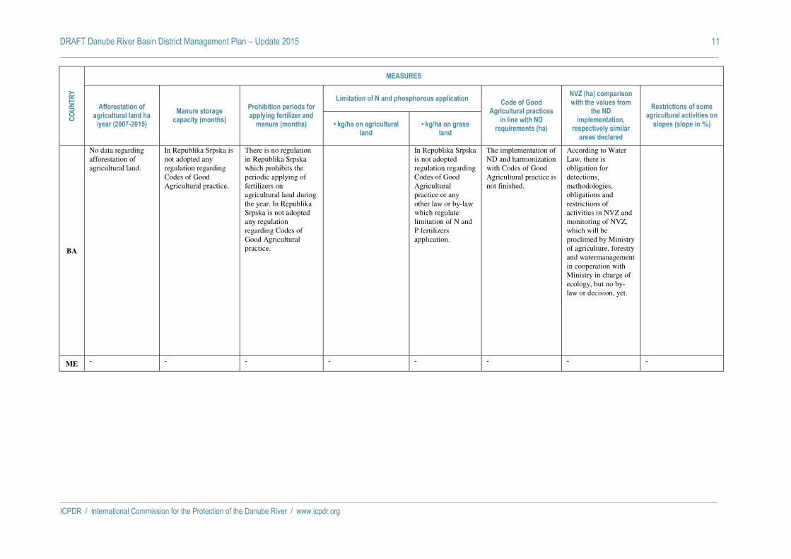
DRAFT Danube River Basin District Management Plan – Update 2015 11
ICPDR / International Commission for the Protection of the Danube River / www.icpdr.org
CO
UN
TR
Y
MEASURES
Afforestation of agricultural land ha
/year (2007-2015)
Manure storage capacity (months)
Prohibition periods for applying fertilizer and
manure (months)
Limitation of N and phosphorous application Code of Good
Agricultural practices in line with ND
requirements (ha)
NVZ (ha) comparison with the values from
the ND implementation,
respectively similar areas declared
Restrictions of some agricultural activities on
slopes (slope in %) • kg/ha on agricultural land
• kg/ha on grass land
BA
No data regarding afforestation of agricultural land.
In Republika Srpska is not adopted any regulation regarding Codes of Good Agricultural practice.
There is no regulation in Republika Srpska which prohibits the periodic applying of fertilizers on agricultural land during the year. In Republika Srpska is not adopted any regulation regarding Codes of Good Agricultural practice.
In Republika Srpska is not adopted regulation regarding Codes of Good Agricultural practice or any other law or by-law which regulate limitation of N and P fertilizers application.
The implementation of ND and harmonization with Codes of Good Agricultural practice is not finished.
According to Water Law, there is obligation for detections, methodologies, obligations and restrictions of activities in NVZ and monitoring of NVZ, which will be proclimed by Ministry of agriculture, forestry and watermanagement in cooperation with Ministry in charge of ecology, but no by-law or decision, yet.
ME - - - - - - - -

DRAFT Danube River Basin District Management Plan – Update 2015 12
ICPDR / International Commission for the Protection of the Danube River / www.icpdr.org
CO
UN
TR
Y
MEASURES
Afforestation of agricultural land ha
/year (2007-2015)
Manure storage capacity (months)
Prohibition periods for applying fertilizer and
manure (months)
Limitation of N and phosphorous application Code of Good
Agricultural practices in line with ND
requirements (ha)
NVZ (ha) comparison with the values from
the ND implementation,
respectively similar areas declared
Restrictions of some agricultural activities on
slopes (slope in %) • kg/ha on agricultural land
• kg/ha on grass land
RS
During the period 2010/2012, the average afforestation in Serbia was 2386 ha /year. By 2015 it is expected that aforestation area will be enlarged to 3000ha/year.
Legal framework for manure storage capacity is in preparation. Recommendation for storage capacity is 6 months, and will be implemented via transpositon of ND.
There is no regulation in Serbia which prohibits the periodic applying of fertilizers on agricultural land during the year. Traditionaly, fertilizers are not applying on a frost or snow covered land.
n/a n/a
Activities for transposition of ND with Code of Good Agricultural have been initiated. CGA published in 2010 though the project DREPR is now in the proces of updating.
NVZ areas according to ND are not designated. Proposal for designation of VZ in Serbia is expected in 2015 through the cooperation Project with Swedish EPA (Designation of sensitive and vulnerable zones according to the ND and UWWD).
According to Low on Agricultural land (2009) agicultural area with a slope greater than 10% has to be cultivated parallel to contour lines and area with a slopes greater than 25% should not be used as arible land. Responsibility for implementation these restrictions is under local government.

DRAFT Danube River Basin District Management Plan – Update 2015 13
ICPDR / International Commission for the Protection of the Danube River / www.icpdr.org
CO
UN
TR
Y
MEASURES
Afforestation of agricultural land ha
/year (2007-2015)
Manure storage capacity (months)
Prohibition periods for applying fertilizer and
manure (months)
Limitation of N and phosphorous application Code of Good
Agricultural practices in line with ND
requirements (ha)
NVZ (ha) comparison with the values from
the ND implementation,
respectively similar areas declared
Restrictions of some agricultural activities on
slopes (slope in %) • kg/ha on agricultural land
• kg/ha on grass land
RO
According to the data of National Statistics Institute the afforestation has registered a slight increasing less than 1% (2007-2012).
The capacity of manure facilities must be at least 6.5 months for liquid manure and 5.5 months for solid manure.
According to the third Action Program, the prohibition periods are as follows: - For solid manure: 1'st Nov – 15'st March. - Liquid manure and mineral fertilizers are splited in 3 categories of prohibition periods as follows: * For autumn crops the prohibition is from 1'st Nov – 1'st March, * for other crops the prohibition is from 1'st Oct – 15'st March, * for pastures the prohibition is from 1'st Oct – 15'st March.
Third AP allows maximum 170 kg of nitrogen of organic fertilizer per hectare. Also, in the sanitary and hydrogeological safeguard zone, the fertilizers are forbidden to be applied or handled.
Third AP allows maximum 170 kg of nitrogen of organic fertilizer per hectare. Also, in the sanitary and hydrogeological safeguard zone, the fertilizers are forbidden to be applied or handled.
In the process of implementation of the Nitrates Directive, the Code of Good Agricultural Practices (CGAP) has been elaborated and harmonized with ND. The provisions of the CGAP are mandatory on whole territory of Romania (23 mil. ha).
For the first Action Program (2005 – 2008), a surface of 16,000 skm (6.7 % from the total surface) was designated as NVZ. Since December 2008, the NVZ surface increased at 137,500 skm (13,750,000 ha), which was representing 57.7 % from the total surface. For the third AP Romania adopted whole territory approach - art 3 (5) ND. (23,839 mil. ha, 100% of the total surface).
The third Action Programme stipulates the following: (1) fertilizers are to be incorporated into the soil taking into account weather forecasts (it is forbiden to apply fertilizers, especially liquid manure when intense precipitation are forecasted). (2) On the arable land with slopes between 2% - 8%, it is recomended the preservation of autumn crops and winter cover crops at minumum 20% from the farm arable land comprised in this category of slope area. (3) On the arable land with slope between 8 and 15 %, it is recommended the preservation of automn crops and winter cover crops at minumum 25% from the farm arable land comprised in this category of slope area. In this area it is recomandet that the fertilizers to be incorporated into the soil in maximum 24 hours. (4) On the arable land

DRAFT Danube River Basin District Management Plan – Update 2015 14
ICPDR / International Commission for the Protection of the Danube River / www.icpdr.org
CO
UN
TR
Y
MEASURES
Afforestation of agricultural land ha
/year (2007-2015)
Manure storage capacity (months)
Prohibition periods for applying fertilizer and
manure (months)
Limitation of N and phosphorous application Code of Good
Agricultural practices in line with ND
requirements (ha)
NVZ (ha) comparison with the values from
the ND implementation,
respectively similar areas declared
Restrictions of some agricultural activities on
slopes (slope in %) • kg/ha on agricultural land
• kg/ha on grass land
with slope > 15 %, it is obligatory the preservation of automn crops and winter cover crops at minumum 30% from the farm arable land comprised in this category of slope area. On these areas, the application of fertilizers is made only by incorporation into the soil immediately after application (no later than 24 hours) with slope > 15 %, it is obligatory the preservation of automn crops and winter cover crops at minumum 30% from the farm arable land comprised in this category of slope area. On these areas, the application of fertilizers is made only by incorporation into the soil immediately after application (no later than 24 hours)
BG
A total of 592,3 ha of afforestation of agricultural land for the period 2007-2012 was realized within the Bulgarian part of the Danube
In line with ND, a PoM to reduce and prevent nitrate pollution from agricultural sources in the NVZ and Rules for good agricultural
For NVZ, the importation of nitrogenous fertilizers (organic and mineral) is prohibited during the following periods: - From 1 November to
In the area of NVZ for all crops, meadows and permanent pasture, the imported quantity of Nitrogen from organic fertilizer during the year must not exceed 170 kg
Complying with the same requirements as on agricultural land
Bulgaria transposed the ND. The rules of the Code of Good Agricultural practices are obligatory within the NVZ, for the Bulgarian part of the
The NVZ was designated by the Decree 930/25.10.2010 of the Minister of Environment and Water. In 2010 the
For NVZ measures are foreseenfor the use of N fertilizers (mineral and organic / inorganic) on land with slopes greater than 6° such as: treatment of soil should
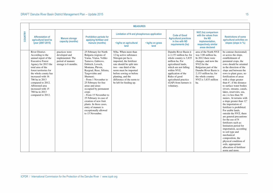
DRAFT Danube River Basin District Management Plan – Update 2015 15
ICPDR / International Commission for the Protection of the Danube River / www.icpdr.org
CO
UN
TR
Y
MEASURES
Afforestation of agricultural land ha
/year (2007-2015)
Manure storage capacity (months)
Prohibition periods for applying fertilizer and
manure (months)
Limitation of N and phosphorous application Code of Good
Agricultural practices in line with ND
requirements (ha)
NVZ (ha) comparison with the values from
the ND implementation,
respectively similar areas declared
Restrictions of some agricultural activities on
slopes (slope in %) • kg/ha on agricultural land
• kg/ha on grass land
River District. According to the annual report of the Executive Forest Agency for 2013 the total area of the forest territories for the whole county has increased with 16 706 ha in 2013 compared to 2012. Afforested area increased with 15 788 ha in 2013 compared to 2012.
practices were developed and implemented. The period of manure storage is 6 months.
25 February for North Bulgaria (regions of Varna, Vratsa, Veliko Tarnovo, Gabrovo, Dobrich, Lovech, Montana, Pleven, Razgrad, Ruse, Silistra, Targovishte and Shumen). - From 1 November to 25 February for free areas and areas occupied by permanent crops - From 15 November to 25 February in case of creation of new fruit plants. In these cases, entry of manure is exceptionally allowed to 15 November.
N/ha. When more than 12 kg active substance Nitrogen per ha is imported, the fertilizer rate should be split into two - one third of the norm must be imported before sowing or before planting, and the difference of the norm to be left for feeding up.
Danube River Basin it is 2,153 million ha; for whole country is 3,835 million ha. For agricultural lands, which are not falling within NVZ, application of the Rules of good agricultural practice (GAP) from farmers is voluntary.
area of the North NVZ was 3.08 million ha. In 2012 there were changes, and now the NVZ for the Bulgarian part of the Danube River Basin is 2,153 million ha; for the whole country NVZ is 3,835 million ha.
be contour (horizontal) or across the slope, establishment of perennial crops, the rows should be oriented in the direction of the slope and between the rows to plant grass, no fertilization of areas with a slope greater than 6°, if the distance to surface water bodies (rivers, streams, canals, lakes, reservoirs, sea, etc.) is less than 50 meters. At terrains with a slope greater than 12° the importation of fertilizer is prohibited. For arable lands, outside the NVZ, there are general precautions for the use of N fertilizers such as: limitation period for importation, according to soil type and mechanical composition, the physical condition of soils, appropriate allocation of fertilizer norm and more.

DRAFT Danube River Basin District Management Plan – Update 2015 16
ICPDR / International Commission for the Protection of the Danube River / www.icpdr.org
CO
UN
TR
Y
MEASURES
Afforestation of agricultural land ha
/year (2007-2015)
Manure storage capacity (months)
Prohibition periods for applying fertilizer and
manure (months)
Limitation of N and phosphorous application Code of Good
Agricultural practices in line with ND
requirements (ha)
NVZ (ha) comparison with the values from
the ND implementation,
respectively similar areas declared
Restrictions of some agricultural activities on
slopes (slope in %) • kg/ha on agricultural land
• kg/ha on grass land
MD
Project “Creation of forests under the jurisdiction of local public administration” - 2006-2009, reforested 10589 ha of eroded and degraded agricultural lands, through planting 2653,91 ha; in 2007 – 3861,75 ha; in 2008 – 2818,74 ha, and in 2009 – 1254,21 ha. Forest plantation activities were implemented in in many areas. The goal is to maintain, regenerate, and, where possible, expand current forests. The cost of reforestation and maintenance was approximately US$1,000/ha for the first few years until forest cover has been established
The provision is not included in any of the laws and regulations. Manure storage is allowed in specialized storage houses. The total estimated quantity of manure stored at the platforms is of 82,530 tn which represent 794 t of nutrients reduced. Adoption of manure management practices in middle Prut basin contributed to a reduction of nutrient discharges up to 40 kg N/ha/year and 36 kg P/ha/year.
National regulations are in place to monitor the timing and amount of fertilizer applications so as to minimize nutrient runoff. A key government program on using new land and increasing soil fertility includes specific soil protection measures, including fertilizer application techniques and financial assistance for soil protection activities. There is no legal restriction for applying of manure. The recommendations: chemical fertilizers containing N should be applied to the land shortly before the start of the growing season, i.e. March, provided ground and weather conditions are suitable, and others.
According to Code of Good Agricultural Practice, 10 kg of mineral fertilizers containing N /ha should be applied in order to prevent mineral N depletion. Also, 8- 10 t manure /ha/year should be applied to non-eroded soils, 14-15 t/ha /year to eroded soils, 10-12 t/ha/year to irrigated soils.
This provision is not included in the Code of Good Agricultural Practice. The main sources of pollution are runoff from agricultural fields and inappropriate manure management. Although pesticide and fertilizer use has shown a stable declining trend for the last 4-5 years, approximately 30 percent of agricultural lands currently lack P, which seriously affects soil fertility.
Moldova has already completed a Code of Good Agricultural Practice which was developed in accordance with European normative acts and Moldovan legislation, it does not represent a mandatory document, but just a set of recommendation.. The Code was widely considered as too technical/scientific to be effective and a revuion is planned.
The designation of NVZ is not provided by the Moldovan legislation, and that provision was not included in any of the laws and regulations. In this case, action programs should be implemented on the entire territory. In undertaking a revision of the Code of Good Agricultural Practice the following steps should be undertaken.
No legal provisions for restriction of agricultural activities on slopes but just recommendations. Nevertheless, crops are still mainly grown without consideration to proper relief and soil type in terms of soil conservation. The excessive transformation of hilly pastures and meadows into land for annual crops, without any attention paid to relief, physical or biological monitoring is a case. Overall eroded area increases by 0.86% a year. The annual loss of fertile soil particles amounts to about 22 x 106 t year-1, with maximum erosion rates greater than 30 t ha-1 year-1. The economic value of eroded soil corresponds to an estimated annual loss of 45-55 €MIO.

DRAFT Danube River Basin District Management Plan – Update 2015 17
ICPDR / International Commission for the Protection of the Danube River / www.icpdr.org
CO
UN
TR
Y
MEASURES
Afforestation of agricultural land ha
/year (2007-2015)
Manure storage capacity (months)
Prohibition periods for applying fertilizer and
manure (months)
Limitation of N and phosphorous application Code of Good
Agricultural practices in line with ND
requirements (ha)
NVZ (ha) comparison with the values from
the ND implementation,
respectively similar areas declared
Restrictions of some agricultural activities on
slopes (slope in %) • kg/ha on agricultural land
• kg/ha on grass land
UA
According to data of the State Forest Resources Agency were reforested eroded and degraded agricultural lands: 2012 – 55.4 thou. ha 2013 – 57.6 thou. ha In Ukraine forest management is provided according the State Programme "Forests of Ukraine"for 2010-2015, adopted by 16.09.09 № 977. Budget for 2015 will be 4520.7 million UA hryvna. According the Programme 107700 ha will be added in year 2015.
Manure storage is regulated by the Law about waste. According this Law manure storage is allowed in specialized storage places, authorized in conformity with an established procedure. The large agricultural enterprises store manure both liquid and solid forms. Household manure storage are only as solid. The total quantity of produced manure in Ukraine was 12136 thousand t in 2013.
There is no legal restriction for applying of manure. Norms of fertilizers are established depends on the content of N or P in soil and volumes of application of organic fertilizers. Appropriate recommendation nitrogen fertilizers are applied only in spring (if soils are sandy or sandy loam – directly before planting). 20 % of phosphorus are recommended to apply in spring and 80 % – in autumn.
Doses of fertilizers depend on soil, crop and a plant-forecrop. Dose is defined by 3 methods: calculation, field, complex. Limitation: Nitrogen 30 - 180 kg N/ha per year Phosphorus – 45-90 kg P/ha her year Manure – 20-60 t/ha.
Nitrogen 80-120kg/ha, phosphorus 45-60 kg/ha. In year 2010 had been applied nitrogen fertilizers: Tizsa basin – 980 t; Prut basin – 4790 t in Ivano-Frankivska region and 5530 t in Chernivetska region; Lower Danube pare – 41620 t in Odeska region.
Scientific bases and technology of optimum cultivation of separate cultures are developed. It is not a mandatory document just a set of recommendation.
The designation of NVZ is not provided by the Ukrainian legislation, and that provision was not included in any of the laws and regulations.
There exists no legal provisions for restriction of agricultural activities on slopes but just recommendations. Agricultural activities depends of slope: < 3% - cultivation of all cultures is allowed; 3–9 % - soil-protective crop rotations are applied; >9–15 % - the contour-strips organisation of territory and soil-protective crop rotations are applied; >15% - only grass is allowed. By the general estimations about 31,7 % of the lands are eroded in Ukraine. Amount of eroded lands annually increases by 80-90 thousand ha.

DRAFT Danube River Basin District Management Plan – Update 2015 18
ICPDR / International Commission for the Protection of the Danube River / www.icpdr.org
CO
UN
TR
Y
MEASURES
Area with organic production (ha)
Measures against erosion: buffer stripes (river in km, m of width)
Erosion-minimizing cultivation systems (catch crops) (ha of arable land)
Establishment of wetlands (ha of new wetlands or
rehabilitated ones)
Nutrient Balances (% of farmers obliged to do the nutrient
balances)
On Farm Advice/Extension Services (no of farmers trained)
DE
336.300 hectares (= 7,4 % of the utilised agricultural area in whole Baden-Württemberg and Bavaria) – are managed according to the criteria of organic farming (2013). No legal obligation
Whole territory 10 m (rivers, slope >10%): see column 9; optional (financial support) Bavaria: on arable land buffer stripes with a width of 10 - 30 m to the water pollution control and soil conservation. On application of fertilisers containing N or P, the direct discharge of nutrients into surface waters has to be avoided, and the run-off into surface waters has to be prevented.
Optional (financial support) Bavaria 2013: ca. 125.800 ha (6,1 % of arable land); Optional (financial support) Baden-Württemberg 2013: ca. 34.900 ha (18 % of arable land)
No relevant 100 % according to Düngeverordnung
Bavarian water protection advisory service: 11 consultants especially for implementation of the WFD; ca 6.600 consultations p.a. Water protection advisory service Baden-Württemberg: 6 consultants with focus on water protection

DRAFT Danube River Basin District Management Plan – Update 2015 19
ICPDR / International Commission for the Protection of the Danube River / www.icpdr.org
CO
UN
TR
Y
MEASURES
Area with organic production (ha)
Measures against erosion: buffer stripes (river in km, m of width)
Erosion-minimizing cultivation systems (catch crops) (ha of arable land)
Establishment of wetlands (ha of new wetlands or
rehabilitated ones)
Nutrient Balances (% of farmers obliged to do the nutrient
balances)
On Farm Advice/Extension Services (no of farmers trained)
AT
533.230 hectares not including alpine pastures (= 20 % of the utilised agricultural area) – are managed according to the criteria of organic farming (2012). No legal obligation
Whole territory (ca. 100,000 km rivers) During fertilization of agricultural land the direct discharge of nutrients into surface waters has to be avoided by keeping a distance between the border of the spreading-width of fertilizers and the upper edge of the bank of the respective surface water. Furthermore, run-off into surface waters has to be prevented. The minimum distance must be 5m (rivers) 10m (rivers, when areas within distance of 20m to rivers have average slopes >10%) 20m (stagnant waters) In cases of permanently vegetated buffer stripes between agricultural field and surface waters or application using soil injection the distances can be halved (with exception of areas with average slope >10% within distance of 20m towards stagnant waters).
Financial support from the subsidy program "ÖPUL". In 2012: 47.464 farms with 426.539 ha participated in measures on catch crops; 4.249 farms with 156.007 ha participated in measure on precautinary soil conservation and water protection; in total 110.274 farms (76%) participated the Austrian RDP "ÖPUL" with in total € 526 million subsidies.
National parks "Lake Neusiedl-Seewinkel" (9.064 ha) and "Donau-Auen" (9.323 ha). Nature and landscape protection area
Nutrient balances with obligatory documentation for all farms > 5 ha agricultural area (> 15 ha agricultural area, if more than 90 % is grassland) or > 2 ha vegetable gardening or > 2 ha vineyards; in total 110.000 farms (60 % of all farms). From 2015 onwards: obligation to document the amount of fertilizers applied; this is necessary for any control;
Austrian Water Protection Advisory Service: 17.000 consultations p.a.; 500 trainings and lectures; 7 consultants, 44 specially trained farmers as working group leaders, ca. 2.130 working group members (farmers) + several Soil Protection Advisory Services in Austria
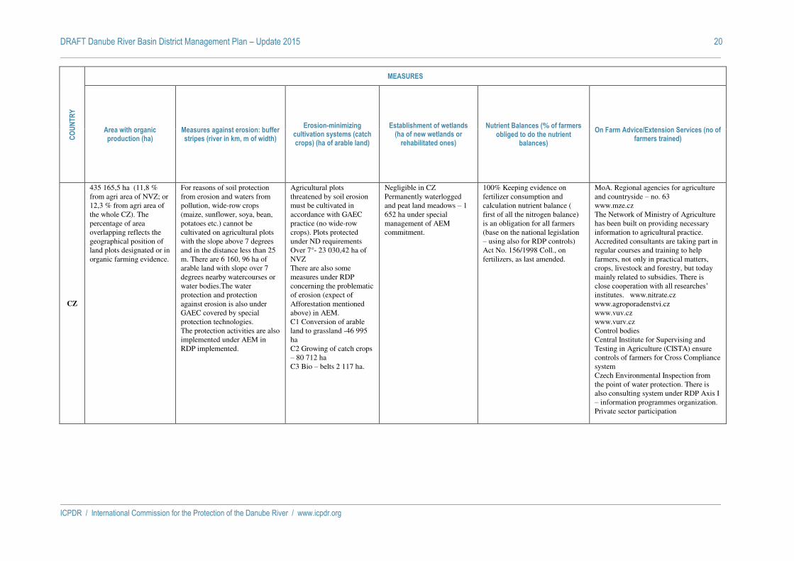
DRAFT Danube River Basin District Management Plan – Update 2015 20
ICPDR / International Commission for the Protection of the Danube River / www.icpdr.org
CO
UN
TR
Y
MEASURES
Area with organic production (ha)
Measures against erosion: buffer stripes (river in km, m of width)
Erosion-minimizing cultivation systems (catch crops) (ha of arable land)
Establishment of wetlands (ha of new wetlands or
rehabilitated ones)
Nutrient Balances (% of farmers obliged to do the nutrient
balances)
On Farm Advice/Extension Services (no of farmers trained)
CZ
435 165,5 ha (11,8 % from agri area of NVZ; or 12,3 % from agri area of the whole CZ). The percentage of area overlapping reflects the geographical position of land plots designated or in organic farming evidence.
For reasons of soil protection from erosion and waters from pollution, wide-row crops (maize, sunflower, soya, bean, potatoes etc.) cannot be cultivated on agricultural plots with the slope above 7 degrees and in the distance less than 25 m. There are 6 160, 96 ha of arable land with slope over 7 degrees nearby watercourses or water bodies.The water protection and protection against erosion is also under GAEC covered by special protection technologies. The protection activities are also implemented under AEM in RDP implemented.
Agricultural plots threatened by soil erosion must be cultivated in accordance with GAEC practice (no wide-row crops). Plots protected under ND requirements Over 7°- 23 030,42 ha of NVZ There are also some measures under RDP concerning the problematic of erosion (expect of Afforestation mentioned above) in AEM. C1 Conversion of arable land to grassland -46 995 ha C2 Growing of catch crops – 80 712 ha C3 Bio – belts 2 117 ha.
Negligible in CZ Permanently waterlogged and peat land meadows – 1 652 ha under special management of AEM commitment.
100% Keeping evidence on fertilizer consumption and calculation nutrient balance ( first of all the nitrogen balance) is an obligation for all farmers (base on the national legislation – using also for RDP controls) Act No. 156/1998 Coll., on fertilizers, as last amended.
MoA. Regional agencies for agriculture and countryside – no. 63 www.mze.cz The Network of Ministry of Agriculture has been built on providing necessary information to agricultural practice. Accredited consultants are taking part in regular courses and training to help farmers, not only in practical matters, crops, livestock and forestry, but today mainly related to subsidies. There is close cooperation with all researches’ institutes. www.nitrate.cz www.agroporadenstvi.cz www.vuv.cz www.vurv.cz Control bodies Central Institute for Supervising and Testing in Agriculture (CISTA) ensure controls of farmers for Cross Compliance system Czech Environmental Inspection from the point of water protection. There is also consulting system under RDP Axis I – information programmes organization. Private sector participation

DRAFT Danube River Basin District Management Plan – Update 2015 21
ICPDR / International Commission for the Protection of the Danube River / www.icpdr.org
CO
UN
TR
Y
MEASURES
Area with organic production (ha)
Measures against erosion: buffer stripes (river in km, m of width)
Erosion-minimizing cultivation systems (catch crops) (ha of arable land)
Establishment of wetlands (ha of new wetlands or
rehabilitated ones)
Nutrient Balances (% of farmers obliged to do the nutrient
balances)
On Farm Advice/Extension Services (no of farmers trained)
SK
To 31th December 2013, organic farming was supported from RDP 2007-2013 on area 148 988 ha (7.72% of UAA).
Whole territory (61,147 km rivers). Fertilizers are prohibited to apply, in minimum width of 10 m from surface waters (rivers, reservoirs, fish ponds, wetlands)
To 31th December 2013, protection of the soil against erosion was (within Agri-environmental payments) supported from RDP 2007-2013 on area 3 697 ha (0.19% of UAA)
Negligible 100% Keeping evidence on fertilizer consumption and calculation nutrient balance ( first of all the nitrogen balance) is an obligation for all farmers (according to MP SR Regulation Nr. 338/2005 (§ 16) issued to the Act on fertilizers)
Agricultural advice service in SR provides Agroinštitút Nitra. To 31th December 2013, 338 farmers received support from RDP 2007-2013 within on farm advisory services. Utilization of agricultural services wiil be suported also by Rural Development Programme SR 2014 – 2020.
HU
The establishment of buffer stripes has been legislated, the implementation starts from the 1st of Jan 2012.
The Agri Environmental Program between 2009-2014 (5-year program) cultivation of catch crops is compulsory on 750 thousand hectares of arable lands. Catch crop must be applied at least once in 5 ys in these areas.
The establishment of new wetlands is not foreseen. The remediation of the existing wetlands are subsidised by the frame of the Environment and Energy Operational Programme (KEOP) as subprograms e.g.: Complex Water protection investments, and habitat-related infrastructure development The implementation is going on.
At the time of planning the nutrient management of agricultural areas, the volume of nutrients to be applied shall be calculated in view of the nutrient supply of the soil and the nutrient demand of the crop that is necessary for a crop yield adjusted to the conditions of the actual. Soil analysis in every 5 year is an important element of this assessment.
The institutional structure of the Hungarian 73/2007. (July 27th) FVM Decree of the Ministry of Agriculture gives the Common Agricultural Policy support schemes to assist the functioning of agricultural advisory system.The agricultural extension system of duties: a) The National Advisory Centre, b) the regional advisory centers, c) the regional advisory centers, d) of professional counseling centers, and e) the National Advisory Committee There are no figures available on the number of farmers trained.
SI
38897 ha (SURS, 2013 - zemljišča z ekološkim kmetovanjem in zemljišča v preusmeritvi v ekološko kmetovanje)
Buffer stripes for Rivers 1st order 15 m of width and Rivers 2nd order 5 m of width
Optional (financial support)
Most actions for keeping exsisting wetlands with sustainable management. BioMura project establishing of old canal distributaries
All farmers who use mineral fertilizers are obliged to make nutrient balances and farmers who participate in Agri-Environment Climate Measures
Slovenian chamber for agriculture and foresty (KGZS) organizes trainings and advisory through regional units. Farmers who apply for Agri-Environment Climate Measures must attend training.

DRAFT Danube River Basin District Management Plan – Update 2015 22
ICPDR / International Commission for the Protection of the Danube River / www.icpdr.org
CO
UN
TR
Y
MEASURES
Area with organic production (ha)
Measures against erosion: buffer stripes (river in km, m of width)
Erosion-minimizing cultivation systems (catch crops) (ha of arable land)
Establishment of wetlands (ha of new wetlands or
rehabilitated ones)
Nutrient Balances (% of farmers obliged to do the nutrient
balances)
On Farm Advice/Extension Services (no of farmers trained)
HR
In 2013 there were 1609 agricultural producers doing organic production on 3,12% of agricultural land in Croatia.
Buffer stripes are desiganted through Ist Action Programme and are as follows: – at 20 m distance from the outer edge of a lake bed, or other standing water,– at 3 m distance from the outer edge of water course beds having a width of 5 meters or more,– on slanted terrains along the water courses, having a slope greater than 10% within a distance of less than 10 m from the outer edge of the water course bed. Buffer stripes are also obligatory GAEC 1 according to the Ordinance on Cross compliance.
Problems with soil erosion should be settled through minimal soil cover. On agricultural parcels with slopes of 15% or more, ploughing should be performed only perpendicular to the slope. All GAEC standards prescribed in Ordinance are obligatory for farmers in use of direct payments in Croatia.
In 2012. there is 74.000 ha of wetlands and this number is slightly increased (+2.000 ha) from 1990.
Farmers are not obliged to do the nutrient balance on their farms.
The Agricultural Advisory Service in Croatia employs 239 employees, mostly Agricultural Engineers. It has offices in each Croatian county and Zagreb.

DRAFT Danube River Basin District Management Plan – Update 2015 23
ICPDR / International Commission for the Protection of the Danube River / www.icpdr.org
CO
UN
TR
Y
MEASURES
Area with organic production (ha)
Measures against erosion: buffer stripes (river in km, m of width)
Erosion-minimizing cultivation systems (catch crops) (ha of arable land)
Establishment of wetlands (ha of new wetlands or
rehabilitated ones)
Nutrient Balances (% of farmers obliged to do the nutrient
balances)
On Farm Advice/Extension Services (no of farmers trained)
BA
No valuable data. (till the date of filling in this table)
Measures against erosion are prohibition of: a) Perform operations in the area and in the way that intensify erosion and creation of flood flows b) Bare-denudate surface, c) Clear forest areas which prevent slide of soil and snow deposit, flatten the flows or protect in other way downstream territories against harmful erosion influence, d) Obstruct the springs, e) Collect or divert collected water through erosive or sliding territories without supervision, and other activities.
No data. There is no organized establishment of new or revitalization of old wetlands in Republika Srpska.
ME - - - - - -
RS
Area of organic production covers about 0,5%, or 11.000 ha of total 5.000.000 ha of agricultural lands.
Measures against erosion are organised locally. Buffer strips are not regulated by low.
Technical measures against erosion are applied on ~ 160000 ha/year and biological measures on ~120000 ha/year. Due to extremely developed erosion, every biological work was done simultaniously with the technical work and administrative measures against erosion are applied on ¼ of Serbian territory.
There is no organized establishment of new, or revitalization of old wetlands in Serbia.
About 150 farmers (who owns at the most 50 000 ha and 18 to 1000 cows ) went through training for nutrient balances implementation. The number of farmers who went through the training is presented in promiles.
In accordance with the Low on the performance of advisory and professional work in the field of agriculture (OG.RS 30/10) agricultural advisory and extension services are organised in 34 municipalities.

DRAFT Danube River Basin District Management Plan – Update 2015 24
ICPDR / International Commission for the Protection of the Danube River / www.icpdr.org
CO
UN
TR
Y
MEASURES
Area with organic production (ha)
Measures against erosion: buffer stripes (river in km, m of width)
Erosion-minimizing cultivation systems (catch crops) (ha of arable land)
Establishment of wetlands (ha of new wetlands or
rehabilitated ones)
Nutrient Balances (% of farmers obliged to do the nutrient
balances)
On Farm Advice/Extension Services (no of farmers trained)
RO
In 2013, the area of organic production covered 301148 ha, representing over 2% of the agricultural area. (source: Ministry of Agriculture and Rural Development)
The third AP requires additional buffer strips besides the ones stipulated in Romanian Water Law 107/1996 with further amendments (where the buffer strips must have a width between 2 m to 50 m, depending by the width of water courses, type and use of water resources or hydrotechnical works). The additional buffer strips must have a width: a) 1 m for land with slope < 12%; b) 3 m for land with slope > 12%.
Applied being considered an important measure for prevention of soil erosion
There are measures and studies proposed in the Program of Measures of the River Basin Management Plan, which will be implemented particularly in the second and the third planning cycle.
100 % according to the tird AP In Romania there are 2 main institutions which conduct training for farmers, Ministry of Environment and Climate Change (MECC) and Ministry of Agriculture and Rural Development (MARD). From 2012 - middle 2014 MECC trained 6020 farmers, 2415 specialists who work in the structures and organizations involved in environmental issues, 1452 people from several institutions such as local authorities, agronomists, doctors and veterinarians, teachers and others. In the same period, MARD trained 1301 young farmers in 50 training sessions and 17307 farmers who practice subsistence agriculture in 692 sessions. In parallel County Agricultural Chambers, which are under the technical coordination of MARD, conducted in 2012 - middle 2014 over 3900 information/training sessions in 1700 localities with the participation of over 60000 farmers.

DRAFT Danube River Basin District Management Plan – Update 2015 25
ICPDR / International Commission for the Protection of the Danube River / www.icpdr.org
CO
UN
TR
Y
MEASURES
Area with organic production (ha)
Measures against erosion: buffer stripes (river in km, m of width)
Erosion-minimizing cultivation systems (catch crops) (ha of arable land)
Establishment of wetlands (ha of new wetlands or
rehabilitated ones)
Nutrient Balances (% of farmers obliged to do the nutrient
balances)
On Farm Advice/Extension Services (no of farmers trained)
BG
At the end of 2013 the total number of organic products registered in the Ministry of Agriculture and Food, organic producers, processors and retailers was 3123, in 2012 the number is 2016, in 2011 the number is 1054. In 2013, the areas with organic production in the National system of control (areas in transition period and areas passed the transition period) reached 56 287.05 ha. Source: Ministry of
Agriculture and Food,
based on data from
annual reports of the
controlling persons of
organic production.
National standards introducing Conditions for keeping land in good agricultural and environmental condition (GAEC) are obligatory for all farmers, owners and / or users of agricultural land, which receive support under various schemes of the CAP, complementary national payments and the following measures from the Programme for Rural Development: payments to farmers for environmental constraints in mountain areas; Agricultural environmental payments; Natura 2000 payments for lands; forests, etc. It is mandatory the establishment of buffer strips with a minimum width of 5 meters along the surface water bodies (rivers, reservoirs, lakes, sea), with the exception of rice cells by natural vegetation (grass, trees, shrubs) or maintained in sod. The application of mineral and organic N fertilizers in the buffer strips is prohibited.
Measures include the enforcement of the implementation of the National standards to protect the soil from erosion. The feature 'catch crops' is not observed in arable land. Associated crops "meadows - orchards" in the utilized agricultural area: during 2011- 19 196 ha of meadows, orchards; Vegetables’ production areas are 872 ha. during 2012 - 19 097 ha of meadows, orchards; during 2013 - 15 945 ha of meadows, orchards; during 2014 - 15 868 ha of meadows, orchards. Source: Ministry of
Agriculture and Food,
Department "Agricultural
Statistics", based on data
from Survey "Production
of vegetables"
In 2011 the National list of wetlands with International importance was extended with "Karst Dragoman marsh complex" with a total area of 14,967 ha, which includes some of the last preserved karst marshes in Bulgaria. A project for two wetlands Restoration (activities on physical restoration of the wetlands in the two protected areas) was implemented and completed. Three projects are under implementation, financed by the Operational Programme Environment 2007-2013, Priority Axis 3: Biodiversity - habitat restoration through the hydraulic measures, restoration of priority habitats type wetlands.
The National Agricultural Advisory Service (NAAS) conducts regular free information and training seminars for agricultural producers. Part of the measures include training of the agricultural producers on fertilizer rates. Rates should be determined based on the collected and analyzed soil samples for soils’ reserves with nitrogen, phosphorus and potassium, organic carbon, etc., which will help to determine the amount of imported fertilizers.
The National Agricultural Advisory Service (NAAS) implemeneted 4 projects, financed by Operational Programme Rural Development 2007 - 2013, Measure 111 "Professional training, information activities and dissemination of knowledge". The aim of the projects is to provide consulting, training and information services to farmers. In the frame of the project a total of 1784 farmers were trained.

DRAFT Danube River Basin District Management Plan – Update 2015 26
ICPDR / International Commission for the Protection of the Danube River / www.icpdr.org
CO
UN
TR
Y
MEASURES
Area with organic production (ha)
Measures against erosion: buffer stripes (river in km, m of width)
Erosion-minimizing cultivation systems (catch crops) (ha of arable land)
Establishment of wetlands (ha of new wetlands or
rehabilitated ones)
Nutrient Balances (% of farmers obliged to do the nutrient
balances)
On Farm Advice/Extension Services (no of farmers trained)
MD
Inn 2006, the organically farmed area amounted from 11000 to 12.392 hectares. By 2015, area under organic farming has to increased up to 31.100 ha. The production volume shall be increased to about 75.000 tons (mainly, wine, sunflower oil, walnuts, lavender oil, honey, and dried and frozen fruits) – these data were provided by three certification bodies.
From 2009 till 2012, area under forest ptotection strips has decreased by 3%. In August 2014, GoM ratified Program for Soil Ferility Improvement and Increase 2011-2020 which stipulates applying of mitigation measures against erosion. In January 2014, GoM approved National Plan on extending the forest vegetation areas for 2014-2018. The proposed measures provide for afforestation of the degraded lands, the strips for the protection of rivers and water basins, as well as the strips for protection of farmlands over an area of at least 13,000 hectares. The national plan also aims at protecting the soil against erosion and improving the water balance. The estimated cost of the actions envisaged in the plan amounts to about 295 million lei, with the money earmarked from the state budget, National Ecological Fund and external donations
Systems are being appled, but precise data are unavailabe. Estimate data 433000 ha of arable land in the MD part of the Put River basin)
Ca. 200 ha (Middle & Low Prut)
There exists no legal provisions to keep the Nutrient Balance by farmers.
Agricultural extension services are well developed through a network of non-state institutions, private companies, technical assistance projects, and farmer organizations. The foundations for the extension system are offered by the non-governmental organization National Rural Development Agency (ACSA), which includes a network of 35 Regional Centres Service Providers, 425 consultants (350 local, and 75 – regiona). On an annual basis, the network provides over 250 thousand advisory services, including around 3500 seminars and training programs, approximately 3000 written recommendations, 2500 round tables and meetings, over 45 thousand on-site visits and approximately 200 thousand individual consultations. From 2010 till 2014, total number of trained farmers is ca. 4000 (all MD)

DRAFT Danube River Basin District Management Plan – Update 2015 27
ICPDR / International Commission for the Protection of the Danube River / www.icpdr.org
CO
UN
TR
Y
MEASURES
Area with organic production (ha)
Measures against erosion: buffer stripes (river in km, m of width)
Erosion-minimizing cultivation systems (catch crops) (ha of arable land)
Establishment of wetlands (ha of new wetlands or
rehabilitated ones)
Nutrient Balances (% of farmers obliged to do the nutrient
balances)
On Farm Advice/Extension Services (no of farmers trained)
UA
According to various estimates the organically farmed area amounted 280 000 hectares. The Law on organic manufacture is accepted on April, 21st 2011. Besides, the Law about safety and quality of food operates in the country. The Government Programme on development of organic farming is accepted. According the Programme area under organic farming has to take 2% of arable lands in 2012 and 7% – in 2015. Ukraine took 20 place in the world on manufacture of organic products. Certification bodies have been created with the help of Switzerland. Three fairs on organic products have taken place in Lviv during years 2009–2011.
According the Item 87 of the Water Code buffer stripes for small rivers are 2.5 m of width, for middle rivers– 50 m, for big rivers – 100 m. On slopes the width of buffer strips doubles. Other measures against erosion: crop rotation, crop nutrient management with soil testing, the use of organic fertilizer, avoiding of deep plowing, contour plowing, strip cropping, livestock grazing practices, etc.
Environment-friendly practices which included erosion-minimizing cultivation system (crop rotation, crop nutrient management with soil testing, the use of organic fertilizer, avoiding of deep plowing, contour plowing, strip cropping,) are stimulated by State (financial support).
Black See region of Ukraine has 600 thausand ha of wetlands. One has the status of the international importance (Danube plavni). Programs of rehabilitated systems in Lower Danube (irelands Tatarin, Ermakov, lakes Katlabukh, Saf’yany) are ongoing in cooperation with Wild World Fund. About 12 000 ha (33 objects) will be restored at performance of the Tizsa RBMP.
There exists no legal provisions to keep the Nutrient Balance
The Low on Farm Advice activity has been adopted on 17.06.2004, some changes have been brought in 2010. The three-level system of advisory services is created. Public National association of Advisory services has been registered: www.dorada.org.ua. Agricultural extension services are well developed through a network of non-state institutions, private companies, technical assistance projects, and farmer organizations. The foundations for the extension system were established with the technical assistance of a number of the European countries. In Tisza basin (Zakarpatska region) operate 3 Regional Centres, in Prut basin - 7 Regional Centres, in Lower Danube part – 2 Regional Centres.

ICPDR / International Commission for the Protection of the Danube River / www.icpdr.org
ANNEX 12
Draft DRBM Plan – Update 2015
Progress on measures addressing hydromorphological alterations
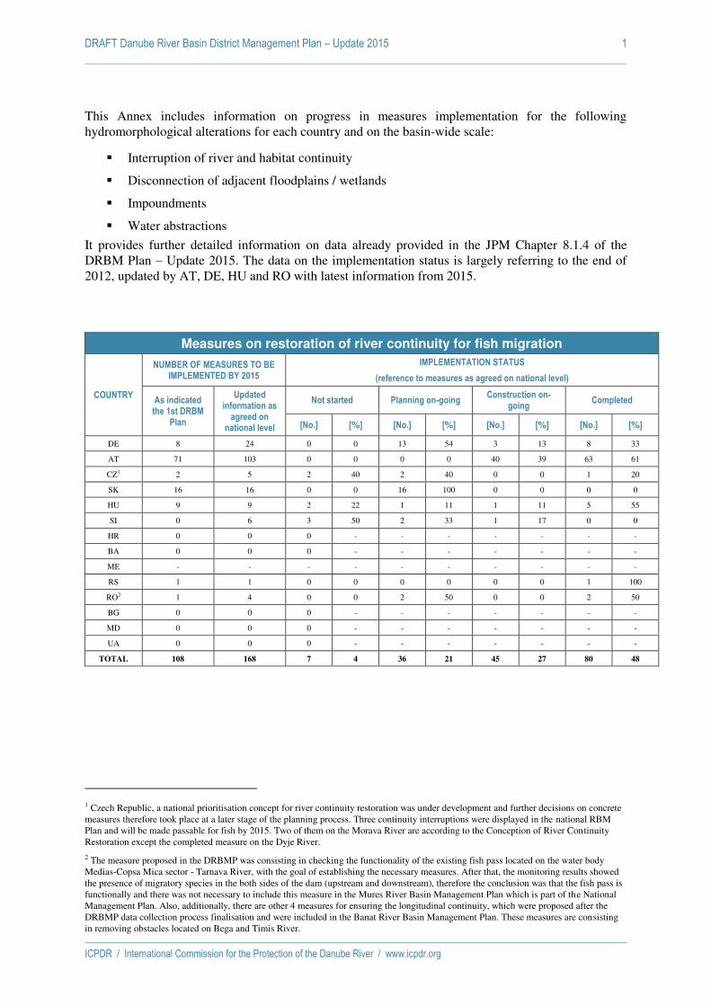
DRAFT Danube River Basin District Management Plan – Update 2015 1
ICPDR / International Commission for the Protection of the Danube River / www.icpdr.org
This Annex includes information on progress in measures implementation for the following hydromorphological alterations for each country and on the basin-wide scale:
Interruption of river and habitat continuity
Disconnection of adjacent floodplains / wetlands
Impoundments
Water abstractions
It provides further detailed information on data already provided in the JPM Chapter 8.1.4 of the DRBM Plan – Update 2015. The data on the implementation status is largely referring to the end of 2012, updated by AT, DE, HU and RO with latest information from 2015.
Measures on restoration of river continuity for fish migration
COUNTRY
NUMBER OF MEASURES TO BE IMPLEMENTED BY 2015
IMPLEMENTATION STATUS
(reference to measures as agreed on national level)
As indicated the 1st DRBM
Plan
Updated information as
agreed on national level
Not started Planning on-going Construction on-
going Completed
[No.] [%] [No.] [%] [No.] [%] [No.] [%]
DE 8 24 0 0 13 54 3 13 8 33
AT 71 103 0 0 0 0 40 39 63 61
CZ1 2 5 2 40 2 40 0 0 1 20
SK 16 16 0 0 16 100 0 0 0 0
HU 9 9 2 22 1 11 1 11 5 55
SI 0 6 3 50 2 33 1 17 0 0
HR 0 0 0 - - - - - - -
BA 0 0 0 - - - - - - -
ME - - - - - - - - - -
RS 1 1 0 0 0 0 0 0 1 100
RO2 1 4 0 0 2 50 0 0 2 50
BG 0 0 0 - - - - - - -
MD 0 0 0 - - - - - - -
UA 0 0 0 - - - - - - -
TOTAL 108 168 7 4 36 21 45 27 80 48
1 Czech Republic, a national prioritisation concept for river continuity restoration was under development and further decisions on concrete measures therefore took place at a later stage of the planning process. Three continuity interruptions were displayed in the national RBM Plan and will be made passable for fish by 2015. Two of them on the Morava River are according to the Conception of River Continuity Restoration except the completed measure on the Dyje River.
2 The measure proposed in the DRBMP was consisting in checking the functionality of the existing fish pass located on the water body Medias-Copsa Mica sector - Tarnava River, with the goal of establishing the necessary measures. After that, the monitoring results showed the presence of migratory species in the both sides of the dam (upstream and downstream), therefore the conclusion was that the fish pass is functionally and there was not necessary to include this measure in the Mures River Basin Management Plan which is part of the National Management Plan. Also, additionally, there are other 4 measures for ensuring the longitudinal continuity, which were proposed after the DRBMP data collection process finalisation and were included in the Banat River Basin Management Plan. These measures are consisting in removing obstacles located on Bega and Timis River.

DRAFT Danube River Basin District Management Plan – Update 2015 2
ICPDR / International Commission for the Protection of the Danube River / www.icpdr.org
Measures on disconnected adjacent floodplains / wetlands - NUMBER
COUNTRY
NUMBER OF AGREED MEASURES TO BE
IMPLEMENTED BY 2015
IMPLEMENTATION STATUS
(reference to measures as agreed on national level)
As indicated in the 1st
DRBM Plan
Updated information
as agreed on national level
Not started Planning on-
going Construction on-
going
Completed
partially re-connected
totally re-connected
[No.] [No.] [%] [No.] [%] [No.] [%] [No.] % [No.] %
DE 2 2 0 0 0 0 0 0 1 50 1 50
AT 1 1 0 0 0 0 0 0 1 100 0 0
CZ 0 0 - - - - - - - - - -
SK 0 0 - - - - - - - - - -
HU 3 3 0 0 0 0 1 33 2 66 0 0
SI 1 1 0 0 0 0 0 0 0 0 1 100
HR 0 0 - - - - - - - - - -
BA 0 0 - - - - - - - - - -
ME - - - - - - - - - - - -
RS 4 4 0 0 0 0 1 25 2 50 1 25
RO 0 0 - - - - - - - - - -
BG 0 0 - - - - - - - - - -
MD 0 0 - - - - - - - - - -
UA 0 0 - - - - - - - - - -
TOTAL 11 11 0 0 0 0 2 18 6 55 3 27
Measures on disconnected adjacent floodplains / wetlands - AREA
COUNTRY
AREA OF FLOODPLAINS / WETLANDS TO BE
ADDRESSED BY MEASURES UNTIL 2015
IMPLEMENTATION STATUS
(reference to measures as agreed on national level)
As indicated in the 1st
DRBM Plan
Updated information
as agreed on national level
Not started Planning on-
going Construction
on-going
Completed
partially re-connected
totally re-connected
[ha] [ha] [%] [ha] [%] [ha] [%] [ha] % [ha] %
DE 5,964 5,964 0 0 0 0 0 0 2,926 49 3,038 51
AT 9,554 9,554 0 0 0 0 0 0 9,554 100 0 0
CZ 0 0 - - - - - - - - - -
SK 0 0 - - - - - - - - - -
HU 13,330 13,330 0 0 0 0 330 2 13,0003 98 0 0
SI 1,520 1,520 0 0 0 0 0 0 0 0 1,520 100
HR 0 0 - - - - - - - - - -
BA 0 0 - - - - - - - - - -
ME - - - - - - - - - - - -
RS 31,932 31,932 0 0 0 0 9,895 31 21,064 66 973 3
RO 0 0 - - - - - - - - - -
BG 0 0 - - - - - - - - - -
MD 0 0 - - - - - - - - - -
UA 0 0 - - - - - - - - - -
TOTAL 62,300 62,300 0 0 0 0 10,225 16 46,544 75 5,531 9
3 Measures for 13,000ha of floodplains / wetlands were started to be implemented in HU, whereas the actually reconnected area is 2.888ha by end 2012.

DRAFT Danube River Basin District Management Plan – Update 2015 3
ICPDR / International Commission for the Protection of the Danube River / www.icpdr.org
Measures on impoundments
COUNTRY
NUMBER OF IMPOUNDMENTS TO BE IMPROVED BY 2015
IMPLEMENTATION STATUS
(reference to measures as agreed on national level)
As indicated in the JPM of the 1st DRBM Plan
Updated information as
agreed on national level
Not started Planning on-going Construction on-
going Completed
[No.] [%] [No.] [%] [No.] [%] [No.] [%]
DE 1 1 0 0 0 0 0 0 1 100
AT 30 30 - - 21 70 - - 9 30
CZ 0 0 - - - - - - - -
SK 2 0 - - - - - - - -
HU 17 15 - - 1 5 1 5 15 90
SI 0 6 0 0 5 83 1 17 0 0
HR 0 0 - - - - - - - -
BA 0 0 - - - - - - - -
ME - - - - - - - - - -
RS 0 0 - - - - - - - -
RO4 2 0 - - - - - - - -
BG 0 0 - - - - - - - -
MD 0 0 - - - - - - - -
UA 0 0 - - - - - - - -
TOTAL 52 52 0 0 27 52 2 4 25 44
Measures on water abstractions
COUNTRY
NUMBER OF WATER ABSTRACTIONS TO BE
IMPROVED BY 2015
IMPLEMENTATION STATUS
(reference to measures as agreed on national level)
As indicated in the 1st DRBM
Plan
Updated information as
agreed on national level
Not started Planning on-going Implementation on-
going Completed
[No.] [%] [No.] [%] [No.] [%] [No.] [%]
DE 2 2 0 0 0 0 0 0 2 100
AT 21 16 0 0 - - - - 16 100
CZ 0 1 0 0 0 0 0 0 1 100
SK 6 6 0 0 6 100 0 0 0 0
HU 12 12 0 0 2 17 2 17 8 67
SI 0 0 - - - - - - - -
HR 0 0 - - - - - - - -
BA 0 0 - - - - - - - -
ME - - - - - - - - - -
RS 0 0 - - - - - - - -
RO5 1 0 - - - - - - - -
BG 0 0 - - - - - - - -
MD 0 0 - - - - - - - -
UA 0 0 - - - - - - - -
TOTAL 42 37 0 0 8 22 2 5 27 73
4 The measures proposed in the DRBMP were related to the establishment of the hydrological regime for Fantanele –Belisand Gilau dams. In the period between the elaboration of the DRBMP (2009) and the finalization of the Somes - Tisa River Basin Management Plan (2010), the water bodies have been analysed taking into consideration the HMWB designation test and ecological potential assessment. The analysis shows that the good ecological potential has been achieved for both water bodies and therefore the measures were not included in the Somes – Tisa River Management Plan and further in the National Management Plan.
5 The measure of ensuring the minimum ecological flow downstream Tileagd dam (Crisul Repede River) proposed in the DRBMP was not included as such in the National Management Plan due to the fact that the good ecological status of the downstream water body was achieved. However, the condition of ensuring the ecological flow is included in the water management permit, issued in 2013 according to the Water Law 107/1996 with subsequent amendments.
ICPDR / International Commission for the Protection of the Danube River / www.icpdr.org
ANNEX 13
DRAFT DRBM Plan – Update 2015
Update of the ecological prioritization of measures to restore river and habitat continuity in the DRBD

DRAFT Danube River Basin District Management Plan – Update 2015 2
ICPDR / International Commission for the Protection of the Danube River / www.icpdr.org
Table of Contents
1 Introduction 3
2 Objective 3
3 Distribution of long- and medium-distant migrants in the DRB 5
3.1 Methodology (LDM and MDM in the DRB) 5 3.2 Results (LDM and MDM in the DRB) 6
4 Update of the Prioritisation approach of the Danube river basin 8
4.1 Criteria 8
4.1.1 Application area 8
4.1.2 Continuity interruptions 9
4.1.3 Main migration routes 9
4.1.4 Location of the barrier (distance from mouth) 10
4.1.5 Reconnected habitat length 10
4.1.6 Protected site (Natura2000) or national protection site 10
4.1.7 Anthropogenic pressures 11
4.2 Methodology 11
4.3 Results 13
4.4 References 15

DRAFT Danube River Basin District Management Plan – Update 2015 3
ICPDR / International Commission for the Protection of the Danube River / www.icpdr.org
1 Introduction
In order to enable a sound estimation of where to target measures most effectively at the basin-wide scale, an ecological prioritisation of measures to restore river and habitat continuity in the DRBD has been carried out. A respective study has already been performed for the first DRBM Plan in 2009 which was now further developed and updated. At the Danube Ministerial Meeting 2010, the Danube Declaration was adopted, inter alia reconfirming the commitment “to further develop and make full use of the ecological prioritisation approach for measures to restore river and habitat continuity in order to ensure that they are ecologically most efficient”. In order to take a step in the further development of the approach, discussions have been conducted in the frame of the ICPDR, considering different criteria and rankings. Following data provisions for the DRBM Plan – Update 2015 and further input from Danube countries, the prioritisation index was updated.
2 Objective
All fish species of the Danube River Basin (DRB) are migratory to some extent, however, the importance of migrations for the viability of fish populations considerable vary among species. Migrations are different in terms of migration distances, migration direction (upstream, downstream, lateral), spawning habitats, seasons, life stages, etc.. In general, in the DRB migratory requirements are more distinct in lowland than in head water fish communities (Figure 1).
Long-distance-migrants (LDM) such as beluga (Huso huso) migrated up to several thousand kilometres from the Black Sea to the barbel zone in the DRB. Medium-distance-migrants (MDM, so called potamodromous fish species) like nase (Chondrostoma nasus) and barbel (Barbus barbus) migrate within the river over distances of 30 to 200 km (Waidbacher & Haidvogl 1998). A significant number of lowland fish species depend on floodplain spawning habitats during spring season. Contrarily, headwater fish species migrate comparable short distances as living and spawning habitats are mostly not far away. Nevertheless, in the long term all species need an open continuum for e.g. re-colonisation after catastrophic events and for genetic exchange. To ensure the achievement or the maintenance of the good ecological status on a long term, all species need an open continuum for e.g. recolonization after catastrophic events and genetic exchange.
With reference to the Vision stated in the DRBM Plan – Update 2015 that “anthropogenic barriers and habitat deficits do not hinder fish migration and spawning anymore”, the overall goal of continuity restoration in the DRBD should be free fish migration routes within the entire DRB. However, due to the high number of barriers and limited resources a prioritisation of measures is necessary. The ecological prioritisation approach provides indications on a step-wise and efficient implementation of restoration measures on the basin-wide scale. It provides useful information on the estimated effects of the national measures in relation to their ecological effectiveness on the basin-wide scale. The approach could serve as a supportive tool for future measure implementation. Therefore, it also supports the feedback from the international to the national level and vice versa in the DRB. Therefore, the ecological prioritisation approach represents an important component for River Basin Management Planning and could constitute an important basis for discussions on measures addressing river and habitat continuity interruptions within the Joint Programmes of Measures (JPM).

DRAFT Danube River Basin District Management Plan – Update 2015 4
ICPDR / International Commission for the Protection of the Danube River / www.icpdr.org
Figure 1: Fish zones and abiotic conditions in running waters (adapted from Jungwirth et al. 2003)
constrainedbraided
meandering
delta
Relative proportion
Age of water wave
Biological and chemical
oxygen demand
Summer temperature
Gradient
Silt substrate
Atmospheric
oxygen input
River kilometre
Lowland riverHeadwater
Fish zones and biocoenotic regions
Trout Grayling Barbel Bream Flounder
Epi-/Metarhithral Hyporhithral Epipotamal Metapotamal Hypopotamal

DRAFT Danube River Basin District Management Plan – Update 2015 5
ICPDR / International Commission for the Protection of the Danube River / www.icpdr.org
3 Distribution of long- and medium-distant migrants in the DRB
3.1 Methodology (LDM and MDM in the DRB) Historic upstream occurrence of long-distance migrants (LDM) in the DRB is dominated by sturgeon species as those species are known to have migrated long distances within the Danube catchment. A sturgeon migration map provided by the ICPDR was compared and updated with recent literature reviews and results of the EU-project EFI+ (Evaluation and improvement of the European Fish Index, http://efi-plus.boku.ac.at).
The potential distribution (habitat) of MDM was modelled using data from EU-project EFI+ including data from the DRB and other catchments in Europe.
Within the frame of the EU-project EFI+ most of the European fish species have been classified according to their migratory behaviour, i.e. long-distance-migrants (LDM see Table 1), medium-distance-migrants (MDM) and resident species (RS). Out of the 58 fish species classified as MDM 9 key species were selected occurring in the DRB (Tab. 2).
Table 1: Examples for long distance migrants (LDM) in the DRB (based on EFI+ guild classification, see http://efi-plus.boku.ac.at)
Nr. Sientific name English name
1 Huso huso Great stugeon, beluga 2 Acipenser guldenstaedti Russian sturgeon 3 Acipenser nudiventris Ship sturgeon 4 Acipenser stellatus Stellate sturgeon 5 Alosa caspia Caspian shad 6 Alosa immaculate (pontica) Pontic shad
Table 2: List of medium-distance migrants (MDM) in the DRB (based on EFI+ guild classification, see http://efi-plus.boku.ac.at) used for modelling habitat of MDM in the DRB
Nr. Scientific name English name
1 Abramis brama Common bream
2 Abramis sapa Danubian bream
3 Acipenser ruthenus Sterlet
4 Aspius aspius Asp
5 Barbus barbus Barbel
6 Chondrostoma nasus. Nase
7 Hucho hucho Danube salmon
8 Lota lota Burbot
9 Vimba vimba Vimba

DRAFT Danube River Basin District Management Plan – Update 2015 6
ICPDR / International Commission for the Protection of the Danube River / www.icpdr.org
The consolidated EFI+ database comprises about 10,000 sites all over Europe. About 1,000 sites are located in the DRB. Unfortunately, the number of sites from the Danube catchment with occurrence of MDM is small (379 sites) and not sufficient for model calibration. Therefore, data from additional European catchments comparable with the DRB was used. By restricting the selection of data to Illies’s ecoregions 3 to 16 we tried to avoid a bias from Mediterranean (Iberian) and Nordic (Scandinavia) influences, as the distribution of MDM might follow different rules in those areas. Out of the resulting 3,800 sites we selected all sites (1,268 sites) where MDM were recorded and randomly a similar sized set of data from sites where MDM did not occur. In total, about 2,500 sites were used to calibrate the model.
Regression Tree techniques were used for modelling MDM occurrence as this technique allows using also non-normally distributed data. All modelling was done with the open source software R®. The Regression Tree function of R® (rpart) includes an internal validation as the variable selection and splitting process is repeated 500 times. The results were additionally validated by using only data from the DRB.
For calculating predictive environmental variables such as catchment size, elevation and river gradient the CCM river model was used developed by the JRC in Ispra (Vogt et al. 2007) which had been also used for the EFI+ project. The CCM is a modelled river network and hence there are slight deviations between the modelled river courses and the real ones. This is mainly true in the headwaters where the CCM sometimes selects different tributaries compared to other maps. Another problem may occur in lowland rivers with very low gradient in plain terrain where the actual and modelled river course may deviate. The deviations do not significantly affect the results as environmental variables used for the modelling are quite stable against river course deviations.
3.2 Results (LDM and MDM in the DRB) Information on of the natural distribution of LDM sturgeon species in the DRB served as a basis (Hensel & Holcik, 1997). According to additional data from the EFI+ project and information received from national fish experts of the DRB contacted via the ICPDR slight changes of the original ICPDR maps have been made for the first approach in 2009: The occurrence of sturgeon species in the Isar river (Bavaria) was restricted to the lower part of the river. LDM sturgeons occurrence has been added to the lower Inn river and lower Salzach river (Austria).
The modelled distribution of the MDM in the DRB using Regression-Tree analyses shows that the presence and absence of medium-distance migrants (MDM) is mainly determined by the size of the catchment (Figure 2). River segments with upstream catchment areas (AREA_ctch) less than 284 km2 have a very low probability of MDM. In addition, river segments with an upstream catchment size of less than 1,401 km2 and a mean elevation of the upstream catchment (ELEV_MN_du) of more than 819 m have also a low probability of MDM. All other river segments have a high probability of occurrence of MDM. The model explains the variability of probability of occurrence by about 42 %. Applying the model to the data, presence and absence can be explained by about 82 % and 78 %. Applying the model to the data from the DRB only reveals similar predictions of presence (78 %) and absence (81 %) approving the applicability of the model to the DRB. Figure 2 clearly shows the separation between the habitat of the LDM, MDM and the head waters above the MDM in the DRB.
Results of modelled MDM habitat were checked by the countries of the DRB and only minor deviations from the real conditions were reported and included in the final map.

DRAFT Danube River Basin District Management Plan – Update 2015 7
ICPDR / International Commission for the Protection of the Danube River / www.icpdr.org
The MDM habitat, however, was only modelled for rivers with a catchment >4000 km². It is most likely that the MDM habitat extends also in smaller rivers. Therefore, if this criterion is applied on a national level considering also smaller rivers, all MDM-habitats have to be identified.
Figure 2: Regression-Tree model for medium-distance migrants using data from the EFI+ project: Probability of occurrence and number sites of each branch (upstream catchment areas: AREA_ctch, mean elevation of the upstream catchment: ELEV_MN_du, gradient of river segment: ALT_GRADIENT).
|AREA_ctch< 284
ALT_GRADIENT>=0.55 AREA_ctch< 1401
ELEV_MN_du>=819.2
0.07198n=653
0.3532n=436
0.2033n=123
0.6373n=477
0.8782n=829

DRAFT Danube River Basin District Management Plan – Update 2015 8
ICPDR / International Commission for the Protection of the Danube River / www.icpdr.org
4 Update of the Prioritisation approach of the Danube river basin
Although the application of different methodologies (GIS approach, optimisation approach) was discussed, the scoring and ranking method (as used in the 1st DRBM Plan 2009) was again applied in the updated version. It has the advantage of transparency and comprehensibility and allows a direct comparison with the results included in the 1st DRBM Plan.
For the updated version, several new criteria were discussed with regard to their availability and suitability. Besides ecological criteria, also other economically / technical criteria were discussed with the result, that such criteria can be incorporated on a national level but the basin-wide prioritisation approach should focus on ecological criteria. These were extended, including now also hydro-morphological pressures (impoundments, hydropeaking stretches and residual flow stretches).
4.1 Criteria The following datasets were used for the updated approach.
Table 3: Used criteria and datasets
Used data Dataset (name)
Continuity interruptions Barriers*
longcontinterr
River network river water bodies >4000km²* LDM-/MDM-habitat*
rw-body4000_trans
Protected areas water-relevant habitat protection areas (FFH)* water-relevant bird protection areas* other Nature protection areas for water-dependent species and water-related habitats (WFD Art. 5)*
pa_habitat pa_bird_trans pa_oth_a_trans
Hydro-morphological pressures (new!) segment with impoundment** segment with hydro peaking** segment with water abstraction**
rwbody_hydroaltimp_trans rwbody_hydroalthpeak_trans rwbody_hydroaltabs_trans
* Original criteria already used for the DRBM Plan 2009 ** Additional criteria
4.1.1 Application area The prioritisation approach is only applied for rivers with catchment areas larger than 4.000 km², which is the river network addressed in the frame of ICPDR assessments. Smaller catchments are subject for the national level.

DRAFT Danube River Basin District Management Plan – Update 2015 9
ICPDR / International Commission for the Protection of the Danube River / www.icpdr.org
4.1.2 Continuity interruptions The dataset (longcontinterr) includes a total of 1,085 barriers. However, only barriers relevant for the level A (rivers with catchment areas larger 4.000 km2) were considered (i.e. 1,005 barriers). For the prioritisation index, all impassable barriers within the LDM and MDM were defined as relevant.
Table 4: Identification of barriers relevant for PI-calculation
No fish aid (0; 8; G, N, U) Fish aid (Y) Total
LDM Danube 14* 8 22
LDM tributary 62* 10 72
MDM 424* 250 674
headwater 209 28 237
total 296 709 1,005
* barriers relevant for PI calculation (n = 500)
Although it has to be assumed that barriers classified as passable (“Y”) within the LDM-habitat are not passable for large sturgeons, these barriers were not considered for PI-calculation. Since there are no standardised fish pass solutions for these species, individual measures have to be taken. The adaptation of existing fish passes in Austria and Germany to allow the passage of large sturgeons will be necessary when these species are able to reach the respective barriers, which means, when the Iron Gates and Gabcikovo are passable. A respective step-wise approach for continuity restoration is described in the DRBM Plan – Update 2015.
4.1.3 Main migration routes In case of the approach applied in the 1st Danube River Basin Management Plan, the main migration routes of migratory species were considered. Therefore, the distribution of long and medium-distant migratory species was modelled (see chapter 3). This criterion was already modelled for the first approach. The model predicts a low probability of MDM for segments with upstream catchment area (AREA-ctch) <284 km² or upstream catchment <1401 and mean elevation of upstream catchment (ELEV_MN_du) >819 m. Besides that, the LDM-habitat was adapted unmodified for the updated approach compared to the information which was used for the DRBM Plan 2009. In case of downscaling (i.e. change the actual classification from LDM-habitat to non-LDM-habitat), detailed proof is required that the species was not present in the respective river section.
The LDM- and MDM-habitat information was furthermore transferred to the river body network of the ICPDR (rw-body4000_trans).
As in the first DRBM Plan, the prioritisation principle follows the idea that LDM within the Danube receive the highest priority followed by LDM within the tributaries. MDM receive less priority and head waters typical habitats for short distance migrators are excluded from the prioritisation process. Therefore, priorities are considered as follows:
Long distance migrants habitat in Danube (rating = 4)
Long-distance migrants habitat in Danube tributaries (rating = 2)

DRAFT Danube River Basin District Management Plan – Update 2015 10
ICPDR / International Commission for the Protection of the Danube River / www.icpdr.org
Medium-distance migrants habitat (rating = 1)
Short-distance migrants (head waters) (rating = 0)
4.1.4 Location of the barrier (distance from mouth) With regard that fish usually migrate from downstream to upstream, obstacles at the mouth of a river receive higher priority than upstream obstacles and giving more emphasis on the main river (e.g. Danube) than on the tributaries. The more distant an obstacle is located from the river mouth the less priority is given to the obstacle. The two criteria “obstacle in first river segment upstream of river mouth” and “distance from mouth” were already included in the 1st approach and are combined to one criterion in the updated approach. By adding up the individual rankings per criterion, the following rankings are applied:
Obstacle in first river segment including barriers upstream of Danube delta (rating = 5)
Obstacle in first river segment upstream of mouth (rating = 4)
Obstacle in second river segment upstream of mouth (rating = 2)
Obstacle in third river segment upstream of mouth (rating = 1)
Obstacle in segment upstream of third river segment (rating = 0)
Segments classification is based on the CCM-river network (Vogt et al. 2006). River segments are defined as the river stretch between two tributaries. The highest priority is given to the barriers at Iron Gate, since these barriers represent the most downstream barriers within the Danube itself.
4.1.5 Reconnected habitat length In order to achieve the highest ecological effects, higher weight is given to river stretches that are less fragmented by continuity interruptions. The reconnected habitat for each barrier was calculated by adding up the distance to the next up- and downstream barrier, whereby only relevant (i.e. impassable) barriers were considered. The distance was only calculated within the river, where the barrier was located. For the most downstream barrier within a tributary or the Danube (e.g. Iron Gate), the distance to the confluence/delta was used instead of the distance to the next downstream barrier.
For this criterion different river length classes for the Danube and the tributaries were defined. Based on experiences in the Danube, the following thresholds were defined by expert judgement:
>50 km (>100 km Danube) (rating = 2)
20-50 km (40 – 100 km Danube) (rating = 1)
<20 km (<40 km Danube) (rating = 0)
Also this criterion was only adopted and recalculated with the updated barrier-information.
4.1.6 Protected site (Natura2000) or national protection site Apart from the WFD relevant criteria, additional criteria stemming from EU legislation like Council Directive 92/43/EEC on the Conservation of natural habitats and of wild fauna and flora was used, requiring to achieve a favourable conservation status in Natura 2000 areas. Taking into account that fish species and habitats are also part of the Natura 2000 goals it is reasonable that the protection status also should be considered in the prioritisation approach.

DRAFT Danube River Basin District Management Plan – Update 2015 11
ICPDR / International Commission for the Protection of the Danube River / www.icpdr.org
Obstacles within a distance of 500 m of water-relevant Natura 2000 areas which are important for fish receive higher priority as it is more likely that those river segments are maintained in good habitat status and will be restored to a larger degree than un-protected river segments, thus providing good habitat quality. For non-EU member states, other protected areas are used as a substitute for Natura 2000 areas. Therefore, higher priority is given to barriers located within or close to a water-relevant protection site.
Barrier within/close to protected area (water-relevant Natura 2000 or other) (rating = 1)
Barrier in area without protection status (rating = 0)
4.1.7 Anthropogenic pressures Additional criteria are included in the updated version which consider anthropogenic pressures. With regard to impoundments, hydro peaking and water abstraction, data was used whether a water body is impacted by these pressures or not1. However, more detailed information (e.g. the exact location and length of the respective pressures) was not available. Also the pressure “morphological alteration” was considered as relevant for the PI, however, at the moment, there is no uniform classification scheme in the Danube catchment. While some countries classified the hydro-morphological condition of their river water bodies with “1” (i.e. high) and “2-5” (i.e. good-bad) others used a more detailed classification of “1-2” (i.e. high-good), “3” (i.e. moderate) and “4-5” (i.e. poor-bad). Therefore, in total, three pressure types were used for the updated PI calculation.
4.2 Methodology For calculating the PI again the CCM river network (Vogt et al. 2006) was used. Rivers with more than 4.000 km² catchment size were extracted from the CCM. River segments are defined as the river stretch between two tributaries. 1,085 locations of barriers were reported by the Danube countries (status March 2015). Only those barriers relevant for the level A were considered (i.e. 1,005). Then, those barriers were select which are not passable for fish in 2015 (FISH_AID ≠ YES; N= 709). Using various GIS tools the first obstacle upstream the mouth, the distance from the mouth, the length of reconnected habitat, and proximity of protected areas is calculated and the PI computed.
In summary, the following ratings were used for the calculation of the old and new PIs.
Table 5: Criteria and their rating for considered PIs
Criteria Rating
1. Migratory habitat
- Long-distance migrants habitat (Danube) - Long-distance migrants habitat (tributary) - Medium-distance migrants habitat - Short-distance migrants habitat (head waters)
4 2 1 0
2. River Segment
- First river segment in Danube - First river segment upstream of mouth (tributary)
5 4
1 For Slovenia, data on hydro peaking and water abstraction were not reported yet and therefore cannot be considered for PI
calculation.

DRAFT Danube River Basin District Management Plan – Update 2015 12
ICPDR / International Commission for the Protection of the Danube River / www.icpdr.org
- Second river segment upstream of mouth - Third river segment upstream of mouth - River segments upstream of third river segment
2 1 0
3. Length of reconnected habitat (Danube/tributary)
- >100 km / >50 km (tributary) - 40-100 km / 20-50 km (tributary) - <40 km / <20 km (tributary)
2 1 0
4. Protected site
- Yes - No
1 0
5. Pressures*
- 0 pressures - 1 pressure - 2 pressures - 3 pressures
3 2 1 0
As in the first prioritisation approach, the selection of prioritisation criteria for continuity restoration was mainly based on the migratory behaviour of LDM and MDM in the DRB. The prioritisation principle follows the idea that LDM within the Danube receive the highest priority (weight 4) followed by LDM within the tributaries (weight 2). MDM receive less priority (weight 1) and head waters are excluded from the prioritisation process (weight 0). Within this prioritisation framework obstacles at the mouth of a river receive higher priority than upstream obstacles and giving more emphasis on the Danube than on the tributaries. The more distant an obstacle is located from the river mouth the less priority is given to the obstacle. In order to give higher weight to river segments that are less fragmented by continuity interruptions, the length of the reconnected habitat depending on the length of river segments was weighted. For this criterion different river lengths classes for the Danube and the tributaries were defined to consider the river size. The final criterion is related to the protection status. Obstacles within water-related protected areas of the NATURA2000 network and other protected areas for non-EU Member States receive higher priority as it is more likely that those river segments are maintained in good habitat status and will be restored to a larger degree than un-protected river segments. Finally, the new PI also considers anthropogenic pressures, whereby barriers in un-impacted water bodies (0 pressures) received the highest rating while barriers in impacted water bodies received less or no scoring (3 pressure types).
Again, the criteria are combined by computing a prioritisation index (PI) by weighting the first criteria (migratory habitat) by the cumulated weight of the other criteria. At first, the old formula and old criteria-rankings were applied with the updated database. Then, also new criteria (i.e. anthropogenic pressures) were included in the PI:
PInew = migratory habitat x (1 + barrier location + reconnected habitat length + protected site + anthropogenic pressures)
For the new PI, several versions with different pressure-scorings were calculated to check the sensibility of the index. The decision on the final method was made at the 14th HYMO Task Group Meeting in February 2015.
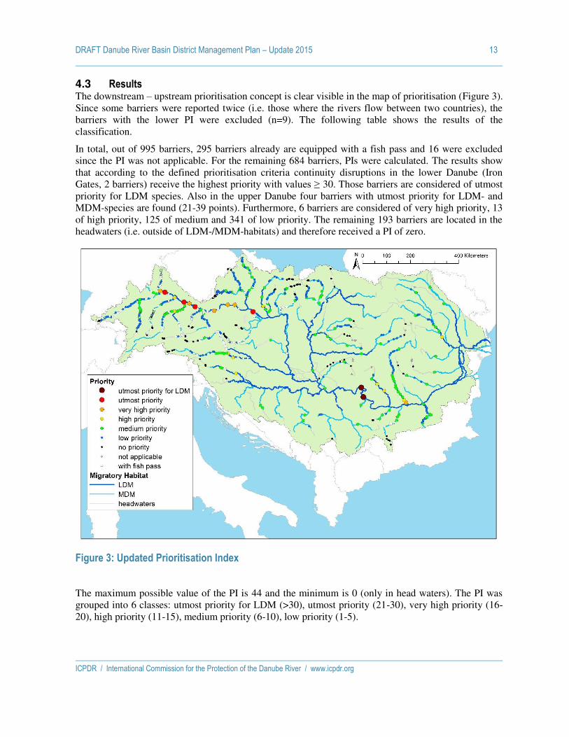
DRAFT Danube River Basin District Management Plan – Update 2015 13
ICPDR / International Commission for the Protection of the Danube River / www.icpdr.org
4.3 Results The downstream – upstream prioritisation concept is clear visible in the map of prioritisation (Figure 3). Since some barriers were reported twice (i.e. those where the rivers flow between two countries), the barriers with the lower PI were excluded (n=9). The following table shows the results of the classification.
In total, out of 995 barriers, 295 barriers already are equipped with a fish pass and 16 were excluded since the PI was not applicable. For the remaining 684 barriers, PIs were calculated. The results show that according to the defined prioritisation criteria continuity disruptions in the lower Danube (Iron Gates, 2 barriers) receive the highest priority with values ≥ 30. Those barriers are considered of utmost priority for LDM species. Also in the upper Danube four barriers with utmost priority for LDM- and MDM-species are found (21-39 points). Furthermore, 6 barriers are considered of very high priority, 13 of high priority, 125 of medium and 341 of low priority. The remaining 193 barriers are located in the headwaters (i.e. outside of LDM-/MDM-habitats) and therefore received a PI of zero.
Figure 3: Updated Prioritisation Index
The maximum possible value of the PI is 44 and the minimum is 0 (only in head waters). The PI was grouped into 6 classes: utmost priority for LDM (>30), utmost priority (21-30), very high priority (16-20), high priority (11-15), medium priority (6-10), low priority (1-5).

DRAFT Danube River Basin District Management Plan – Update 2015 14
ICPDR / International Commission for the Protection of the Danube River / www.icpdr.org
Table 6: Results of different PI calculations
Table 7: Number of barriers per criterion (only barriers with PI > 0)
5 4 3 2 1 0
Habitat - LDM Danube - LDM Trib. MDM headwater
number of barriers
11
57 423 0
Segment 1 Danube 1 Trib. - 2 Trib. 3 Trib. >3 Trib.
number of barriers 2 11
5 19 454
Recnonnected length Danube - - - >100 km 40-100 km <40 km
number of barriers
8 5 31
Reconnected length Tributary - - - >50 km 20-50 km <20 km
number of barriers
90 124 233
Protected site - - -
yes no
number of barriers
289 202
Pressures - - 0 1 2 3
number of barriers
172 204 108 7
PI barriers Priority
- 296 with fish pass
- 16 not applicable
0 193 no priority
1 4
low priority
2 44
3 51
4 124
5 118
6 56
medium priority
7 20
8 16
9 3
10 30
12 9 high priority
14 4
16 2
very high priority 18 1
20 3
24 4 utmost priority
44 2 utmost priority for LDM
DRAFT Danube River Basin District Management Plan – Update 2015 15
ICPDR / International Commission for the Protection of the Danube River / www.icpdr.org
4.4 References Jungwirth, M., Haidvogl, G., Moog, O., Muhar, S., Schmutz, S. (2003): Angewandte
Fischökologie an Fließgewässern. p552; Facultas Universitätsverlag,Wien; ISBN 3-8252-2113-X.
Vogt, J.V. et al. (2007): A pan-European River and Catchment Database. European Commission - JRC, Luxembourg, (EUR 22920 EN) 120 pp.
Waidbacher, H. & G. Haidvogl (1998): Fish migration and fish passage facilities in the Danube: Past and present. -In: Jungwirth, M., Schmutz, S. & Weiss, S. (eds.): Fish Migration and Fish Bypasses. Oxford, -Fishing News Books: pp.85-98.
Schmutz S. and Trautwein C. (2009): Ecological prioritization of measures to restore river and habitat continuity in the DRBD, Annex 18 of the DRBMP.
Hensel K. & Holcik J. (1997): Past and current status of sturgeons in the upper and middle Danube River. Environmental Biology of Fishes 48: 184-200.

ICPDR / International Commission for the Protection of the Danube River / www.icpdr.org
ANNEX 14
DRAFT DRBM Plan – Update 2015
Detailed list on hydrological alterations in the DRBD

DRAFT Danube River Basin District Management Plan – Update 2015
ICPDR / International Commission for the Protection of the Danube River / www.icpdr.org
Explanations
n.a. = Not Applicable In each table hydrological alterations are listed separately. One water body can have more than one hydrological alterations.

DRAFT Danube River Basin District Management Plan – Update 2015 3
ICPDR / International Commission for the Protection of the Danube River / www.icpdr.org
List of Water Abstractions
Country River RWB code Residual water
discharge First usage Second usage Third usage Restored 2015 Measure 2021
AT Drau ATOK903540003 Yes Hydropower n.a. n.a. Not yet Yes
AT Enns ATOK400240106 Yes Hydropower n.a. n.a. Not yet Yes
AT Enns ATOK411250012 Yes Hydropower n.a. n.a. Not yet Yes
AT Enns ATOK411250012 Yes Hydropower n.a. n.a. Not yet Yes
AT Enns ATOK411250012 Yes Hydropower n.a. n.a. Not yet Yes
AT Inn ATOK304980003 Yes Hydropower n.a. n.a. Yes
AT Inn ATOK304980010 Yes Hydropower n.a. n.a. Yes
AT Inn ATOK305850011 Yes Hydropower n.a. n.a. Yes
AT Isar ATOK301860008 Yes Hydropower n.a. n.a. Not yet No due to
exemption Art 4.4
AT Lech ATOK301500004 Yes n.a. n.a. n.a. Not yet No due to
exemption Art 4.4
AT Lech ATOK302370006 Yes Hydropower n.a. n.a. Yes
AT Lech ATOK302370010 Yes Hydropower n.a. n.a. Yes
AT Lech ATOK307080000 Yes Hydropower n.a. n.a. Yes
AT Mur ATOK801180007 Yes Hydropower n.a. n.a. Not yet No due to
exemption Art 4.4
AT Mur ATOK801180008 Yes Hydropower n.a. n.a. Not yet No due to
exemption Art 4.4
AT Mur ATOK802710002 Yes Hydropower n.a. n.a. Yes
AT Mur ATOK802710002 Yes Hydropower n.a. n.a. Not yet No due to
exemption Art 4.4
AT Mur ATOK802710008 Yes Hydropower n.a. n.a. Yes
AT Mur ATOK802710009 Yes Hydropower n.a. n.a. Not yet Yes

DRAFT Danube River Basin District Management Plan – Update 2015 4
ICPDR / International Commission for the Protection of the Danube River / www.icpdr.org
Country River RWB code Residual water
discharge First usage Second usage Third usage Restored 2015 Measure 2021
AT Mur ATOK802710009 Yes Hydropower n.a. n.a. Yes
AT Mur ATOK802710009 Yes Hydropower n.a. n.a. Not yet Yes
AT Mur ATOK802710009 Yes Hydropower n.a. n.a. Yes
AT Mur ATOK802720005 Yes Hydropower n.a. n.a. Not yet No due to
exemption Art 4.4
AT Mur ATOK802720005 Yes Hydropower n.a. n.a. Not yet No due to
exemption Art 4.4
AT Mur ATOK802720005 Yes Hydropower n.a. n.a. Not yet No due to
exemption Art 4.4
AT Mur ATOK802720006 Yes Hydropower n.a. n.a. Not yet No due to
exemption Art 4.4
AT Raab ATOK1000960015 Yes Hydropower n.a. n.a. Not yet Yes
AT Raab ATOK1000960019 Yes Hydropower n.a. n.a. Not yet No due to
exemption Art 4.4
AT Raab ATOK1000960019 Yes Hydropower n.a. n.a. Not yet No due to
exemption Art 4.4
AT Raab ATOK1000960020 Yes Hydropower n.a. n.a. Not yet No due to
exemption Art 4.4
AT Raab ATOK1001040108 Yes Hydropower n.a. n.a. Not yet No due to
exemption Art 4.4
AT Raab ATOK1001040108 Yes Hydropower n.a. n.a. Not yet Yes
AT Raab ATOK1002160000 Yes Hydropower n.a. n.a. Not yet Yes
AT Salzach ATOK304690001 Yes Hydropower n.a. n.a. Yes
AT Salzach ATOK304690006 Yes Hydropower n.a. n.a. Not yet No due to
exemption Art 4.4
AT Salzach ATOK304690078 Yes Hydropower n.a. n.a. Not yet No due to
exemption Art 4.4
AT Salzach ATOK305360002 Yes Hydropower n.a. n.a. Yes

DRAFT Danube River Basin District Management Plan – Update 2015 5
ICPDR / International Commission for the Protection of the Danube River / www.icpdr.org
Country River RWB code Residual water
discharge First usage Second usage Third usage Restored 2015 Measure 2021
AT Thaya ATOK500010030 Yes n.a. n.a. n.a. Not yet Yes
AT Thaya ATOK500010030 Yes Hydropower n.a. n.a. Not yet Yes
AT Thaya ATOK500010031 Yes Hydropower n.a. n.a. Not yet Yes
AT Thaya ATOK500010036 Yes Hydropower n.a. n.a. Yes
AT Thaya ATOK500010036 Yes Hydropower n.a. n.a. Yes
AT Thaya ATOK500010043 Yes Hydropower n.a. n.a. Yes
AT Thaya ATOK500010043 Yes Hydropower n.a. n.a. Yes
AT Traun ATOK409920001 Yes Hydropower n.a. n.a. Not yet Yes
AT Traun ATOK411980001 Yes Hydropower n.a. n.a. Not yet No due to
exemption Art 4.4
AT Traun ATOK411980001 Yes Hydropower n.a. n.a. Not yet Yes
AT Traun ATOK411980002 Yes Hydropower n.a. n.a. Not yet No due to
exemption Art 4.4
AT Traun ATOK412090013 Yes Hydropower n.a. n.a. Not yet Yes
AT Traun ATOK412090027 Yes Hydropower n.a. n.a. Not yet Yes
AT Traun ATOK412090042 Yes Hydropower n.a. n.a. Yes
AT Traun ATOK412090042 Yes Hydropower n.a. n.a. Yes
BG Dunav BG1DU000R001 No Production of electricity
(cooling) n.a. n.a. Not necessary
BG Dunav BG1DU000R001 No Irrigation n.a. n.a. Not necessary
BG Dunav BG1DU000R001 No Irrigation n.a. n.a. Not necessary
BG Dunav BG1DU000R001 No Manufacturing industry n.a. n.a. Not necessary
BG Dunav BG1DU000R001 No Manufacturing industry n.a. n.a. Not necessary
BG Dunav BG1DU000R001 No Manufacturing industry n.a. n.a. Not necessary
BG Dunav BG1DU000R001 No Manufacturing industry n.a. n.a. Not necessary
BG Dunav BG1DU000R001 No Manufacturing industry n.a. n.a. Not necessary

DRAFT Danube River Basin District Management Plan – Update 2015 6
ICPDR / International Commission for the Protection of the Danube River / www.icpdr.org
Country River RWB code Residual water
discharge First usage Second usage Third usage Restored 2015 Measure 2021
BG Dunav BG1DU000R001 No Manufacturing industry n.a. n.a. Not necessary
BG Dunav BG1DU000R001 No Irrigation n.a. n.a. Not necessary
BG Dunav BG1DU000R001 No Manufacturing industry n.a. n.a. Not necessary
BG Dunav BG1DU000R001 No Manufacturing industry n.a. n.a. Not necessary
BG Dunav BG1DU000R001 No Irrigation n.a. n.a. Not necessary
BG Dunav BG1DU000R001 No Manufacturing industry n.a. n.a. Not necessary
BG Dunav BG1DU000R001 No Manufacturing industry n.a. n.a. Not necessary
BG Dunav BG1DU000R001 No Manufacturing industry n.a. n.a. Not necessary
BG Dunav BG1DU000R001 No Manufacturing industry Production of electricity
(cooling) n.a. Not necessary
BG Iskar BG1IS100R1027 No Manufacturing industry n.a. n.a. Not necessary
BG Iskar BG1IS100R1027 No Irrigation n.a. n.a. Not necessary
BG Iskar BG1IS135R1026 No Hydropower n.a. n.a. Not necessary
BG Iskar BG1IS135R1126 Yes Hydropower n.a. n.a. Not yet No due to
exemption Art 4.4
BG Iskar BG1IS135R1126 No Agriculture, forestry and
fishing (including fish farms) canals
n.a. n.a. Not necessary
BG Iskar BG1IS135R1226 Yes Hydropower n.a. n.a. Not yet No due to
exemption Art 4.4
BG Iskar BG1IS135R1226 No Manufacturing industry n.a. n.a. Not necessary
BG Iskar BG1IS135R1226 Yes Hydropower n.a. n.a. Not yet No due to
exemption Art 4.4
BG Iskar BG1IS135R1226 No Hydropower n.a. n.a. Not necessary
BG Iskar BG1IS135R1226 No Manufacturing industry n.a. n.a. Not necessary
BG Iskar BG1IS135R1226 Yes Hydropower n.a. n.a. Not yet No due to
exemption Art 4.4
BG Iskar BG1IS135R1426 No Manufacturing industry n.a. n.a. Not necessary

DRAFT Danube River Basin District Management Plan – Update 2015 7
ICPDR / International Commission for the Protection of the Danube River / www.icpdr.org
Country River RWB code Residual water
discharge First usage Second usage Third usage Restored 2015 Measure 2021
BG Iskar BG1IS135R1726 No Irrigation n.a. n.a. Not necessary
BG Iskar BG1IS789R1104 No Agriculture, forestry and
fishing (including fish farms) canals
n.a. n.a. Not necessary
BG Iskar BG1IS900R1003 No Agriculture, forestry and
fishing (including fish farms) canals
Irrigation n.a. Not necessary
BG Ogosta BG1OG307R1013 No Irrigation n.a. n.a. Not necessary
BG Ogosta BG1OG307R1013 No Irrigation n.a. n.a. Not necessary
BG Ogosta BG1OG307R1013 No Irrigation n.a. n.a. Not necessary
BG Ogosta BG1OG307R1213 No Manufacturing industry n.a. n.a. Not necessary
BG Ogosta BG1OG307R1213 No Manufacturing industry n.a. n.a. Not necessary
BG Yantra BG1YN307R1027 No Irrigation n.a. n.a. Not necessary
BG Yantra BG1YN307R1027 No Irrigation n.a. n.a. Not necessary
BG Yantra BG1YN307R1027 No Irrigation n.a. n.a. Not necessary
BG Yantra BG1YN307R1127 No Manufacturing industry n.a. n.a. Not necessary
BG Yantra BG1YN307R1127 No Manufacturing industry n.a. n.a. Not necessary
BG Yantra BG1YN700R1017 Yes Hydropower n.a. n.a. Not yet No due to
exemption Art 4.4
BG Yantra BG1YN900R1015 Yes Hydropower n.a. n.a. Not yet No due to
exemption Art 4.4
BG Yantra BG1YN900R1015 No Hydropower n.a. n.a. Not necessary
BG Yantra BG1YN900R1015 No Hydropower n.a. n.a. Not necessary
BG Yantra BG1YN900R1015 No Hydropower n.a. n.a. Not necessary
BG Yantra BG1YN900R1015 No Manufacturing industry n.a. n.a. Not necessary
BG Yantra BG1YN900R1015 No Hydropower n.a. n.a. Not necessary
BG Yantra BG1YN900R1215 No Public water supply n.a. n.a. Not necessary
BG Yantra BG1YN900R1415 No Manufacturing industry n.a. n.a. Not necessary

DRAFT Danube River Basin District Management Plan – Update 2015 8
ICPDR / International Commission for the Protection of the Danube River / www.icpdr.org
Country River RWB code Residual water
discharge First usage Second usage Third usage Restored 2015 Measure 2021
BG Yantra BG1YN900R1415 No Manufacturing industry n.a. n.a. Not necessary
DE Donau DEDEBW_6-01 Unknown Hydropower n.a. n.a. Not yet Yes
DE Donau DEDEBW_6-02 Unknown Hydropower n.a. n.a. Not yet Yes
DE Donau DEDEBW_6-03 Unknown Hydropower n.a. n.a. Not yet Yes
DE Donau DEDEBW_6-04 Unknown Hydropower n.a. n.a. Not yet Yes
DE Donau DEDEBW_6-05 Unknown Hydropower n.a. n.a. Not yet Yes
DE Isar DEDEBY_1_F373 Unknown Other major abstractions n.a. n.a. Not necessary
DE Isar DEDEBY_1_F402 Unknown Other major abstractions n.a. n.a. Not yet Yes
DE Lech DEDEBY_1_F128 Unknown Other major abstractions n.a. n.a. Not yet Yes
DE Naab DEDEBY_1_F273 Unknown Other major abstractions n.a. n.a. Not yet Yes
HU Duna, Szentendrei-Duna HUAEP444 No Production of electricity
(cooling) n.a. n.a. Not necessary
HU Duna, Szentendrei-Duna HUAEP444 No Production of electricity
(cooling) n.a. n.a. Not necessary
HU Duna, Szentendrei-Duna HUAEP444 No Production of electricity
(cooling) n.a. n.a. Not necessary
HU Hármas-Körös HUAEP567 No Irrigation Other major abstractions Agriculture, forestry and
fishing (including fish farms) canals
Not necessary
HU Rába HUAEP898 No Other major abstractions n.a. n.a. Not necessary
HU Rába HUAEP900 No Hydropower n.a. n.a. Not necessary
HU Rába HUAEP900 No Hydropower n.a. n.a. Not necessary
HU Rába HUAEP901 No Hydropower n.a. n.a. Not necessary
HU Rába HUAEP903 No Hydropower n.a. n.a. Not necessary
HU Tisza HUAEQ056 No Irrigation n.a. n.a. Not necessary
HU Tisza HUAEQ056 No Irrigation n.a. n.a. Not necessary
HU Tisza HUAEQ059 No Other major abstractions Agriculture, forestry and
fishing (including fish farms) canals
Public water supply Not yet
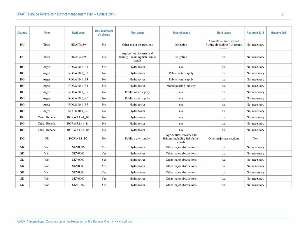
DRAFT Danube River Basin District Management Plan – Update 2015 9
ICPDR / International Commission for the Protection of the Danube River / www.icpdr.org
Country River RWB code Residual water
discharge First usage Second usage Third usage Restored 2015 Measure 2021
HU Tisza HUAIW389 No Other major abstractions Irrigation Agriculture, forestry and
fishing (including fish farms) canals
Not necessary
HU Tisza HUAIW389 No Agriculture, forestry and
fishing (including fish farms) canals
Irrigation n.a. Not necessary
RO Arges ROLW10.1_B1 Yes Hydropower n.a. n.a. Not necessary
RO Arges ROLW10.1_B2 No Hydropower Public water supply n.a. Not necessary
RO Arges ROLW10.1_B3 No Hydropower Public water supply n.a. Not necessary
RO Arges ROLW10.1_B4 No Hydropower Manufacturing industry n.a. Not necessary
RO Arges ROLW10.1_B5 No Public water supply n.a. n.a. Not necessary
RO Arges ROLW10.1_B6 No Public water supply n.a. n.a. Not necessary
RO Arges ROLW10.1_B7 No Hydropower n.a. n.a. Not necessary
RO Arges RORW10.1_B2 No Hydropower n.a. n.a. Not necessary
RO Crisul Repede RORW3.1.44_B2 No Hydropower n.a. n.a. Not necessary
RO Crisul Repede RORW3.1.44_B4 No Hydropower n.a. n.a. Not necessary
RO Crisul Repede RORW3.1.44_B6 No Hydropower n.a. n.a. Not necessary
RO Olt RORW8.1_B2 No Public water supply Agriculture, forestry and
fishing (including fish farms) canals
Other major abstractions Yes
SK Váh SKV0006 Yes Hydropower Other major abstractions n.a. Not necessary
SK Váh SKV0007 Yes Hydropower Other major abstractions n.a. Not necessary
SK Váh SKV0007 Yes Hydropower Other major abstractions n.a. Not necessary
SK Váh SKV0007 Yes Hydropower Other major abstractions n.a. Not necessary
SK Váh SKV0007 Yes Hydropower Other major abstractions n.a. Not necessary
SK Váh SKV0007 Yes Hydropower Other major abstractions n.a. Not necessary
SK Váh SKV1002 Yes Hydropower Other major abstractions n.a. Not necessary
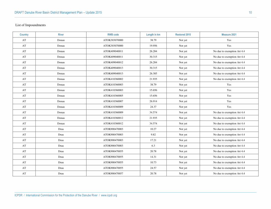
DRAFT Danube River Basin District Management Plan – Update 2015 10
ICPDR / International Commission for the Protection of the Danube River / www.icpdr.org
List of Impoundments
Country River RWB code Length in km Restored 2015 Measure 2021
AT Donau ATOK303070000 38.79 Not yet Yes
AT Donau ATOK303070000 19.956 Not yet Yes
AT Donau ATOK409040011 26.284 Not yet No due to exemption Art 4.4
AT Donau ATOK409040011 30.315 Not yet No due to exemption Art 4.4
AT Donau ATOK409040012 26.284 Not yet No due to exemption Art 4.4
AT Donau ATOK409040013 30.315 Not yet No due to exemption Art 4.4
AT Donau ATOK409040013 26.385 Not yet No due to exemption Art 4.4
AT Donau ATOK410360002 21.935 Not yet No due to exemption Art 4.4
AT Donau ATOK410360003 38.79 Not yet Yes
AT Donau ATOK410360003 15.656 Not yet Yes
AT Donau ATOK410360005 15.656 Not yet Yes
AT Donau ATOK410360007 26.914 Not yet Yes
AT Donau ATOK410360009 24.37 Not yet Yes
AT Donau ATOK410360009 34.574 Not yet No due to exemption Art 4.4
AT Donau ATOK410360012 21.935 Not yet No due to exemption Art 4.4
AT Donau ATOK410360012 34.574 Not yet No due to exemption Art 4.4
AT Drau ATOK900470003 10.27 Not yet No due to exemption Art 4.4
AT Drau ATOK900470003 9.82 Not yet No due to exemption Art 4.4
AT Drau ATOK900470003 17.21 Not yet No due to exemption Art 4.4
AT Drau ATOK900470003 6.3 Not yet No due to exemption Art 4.4
AT Drau ATOK900470055 20.78 Not yet No due to exemption Art 4.4
AT Drau ATOK900470055 14.31 Not yet No due to exemption Art 4.4
AT Drau ATOK900470055 10.73 Not yet No due to exemption Art 4.4
AT Drau ATOK900470055 24.57 Not yet No due to exemption Art 4.4
AT Drau ATOK900470057 20.78 Not yet No due to exemption Art 4.4

DRAFT Danube River Basin District Management Plan – Update 2015 11
ICPDR / International Commission for the Protection of the Danube River / www.icpdr.org
Country River RWB code Length in km Restored 2015 Measure 2021
AT Drau ATOK900470057 17.21 Not yet No due to exemption Art 4.4
AT Drau ATOK900470058 24.57 Not yet No due to exemption Art 4.4
AT Drau ATOK900470058 5.5 Not yet No due to exemption Art 4.4
AT Drau ATOK900470058 16.52 Not yet No due to exemption Art 4.4
AT Enns ATOK400240106 0.1 Not yet No due to exemption Art 4.4
AT Enns ATOK411250006 2.991 Not yet No due to exemption Art 4.4
AT Enns ATOK411250008 2.598 Not yet No due to exemption Art 4.4
AT Enns ATOK411250008 1.317 Not yet No due to exemption Art 4.4
AT Enns ATOK411250012 2.827 Not yet No due to exemption Art 4.4
AT Enns ATOK411250012 2.598 Not yet No due to exemption Art 4.4
AT Enns ATOK411250012 11.952 Not yet Yes
AT Enns ATOK411250012 3.064 Not yet No due to exemption Art 4.4
AT Enns ATOK411250014 5.304 Not yet Yes
AT Enns ATOK411250014 4.823 Not yet Yes
AT Enns ATOK411250016 5.605 Not yet Yes
AT Enns ATOK411250018 8.687 Not yet Yes
AT Enns ATOK411250020 8.687 Not yet Yes
AT Enns ATOK411250021 4.956 Not yet Yes
AT Enns ATOK411250023 7.325 Not yet Yes
AT Enns ATOK411250025 7.348 Not yet Yes
AT Enns ATOK411250027 8.548 Not yet Yes
AT Enns ATOK411250029 12.61 Not yet Yes
AT Enns ATOK411250031 11.952 Not yet Yes
AT Enns ATOK411250031 9.021 Not yet Yes
AT Enns ATOK411250036 4.823 Not yet Yes
AT Enns ATOK411250036 2.991 Not yet No due to exemption Art 4.4

DRAFT Danube River Basin District Management Plan – Update 2015 12
ICPDR / International Commission for the Protection of the Danube River / www.icpdr.org
Country River RWB code Length in km Restored 2015 Measure 2021
AT Inn ATOK304980003 12.14 Not yet No due to exemption Art 4.4
AT Inn ATOK304980003 6.431 Not yet No due to exemption Art 4.4
AT Inn ATOK304980003 2.674 Not yet No due to exemption Art 4.4
AT Inn ATOK305340005 16.346 Not yet No due to exemption Art 4.4
AT Inn ATOK305340007 12.346 Not yet No due to exemption Art 4.4
AT Inn ATOK305340009 12.075 Not yet No due to exemption Art 4.4
AT Inn ATOK305340010 7.527 Not yet No due to exemption Art 4.4
AT Inn ATOK305340012 14.336 Not yet No due to exemption Art 4.4
AT Inn ATOK305850011 3.259 Not yet No due to exemption Art 4.4
AT Inn ATOK307030000 7.311 Not yet No due to exemption Art 4.4
AT Inn ATOK307030000 12.14 Not yet No due to exemption Art 4.4
AT Lech ATOK302370010 1.761 Not yet No due to exemption Art 4.4
AT Mur ATOK801180007 0.481 Not yet No due to exemption Art 4.4
AT Mur ATOK801180008 0.32 Not yet No due to exemption Art 4.4
AT Mur ATOK801180029 1.594 Not yet No due to exemption Art 4.4
AT Mur ATOK801180029 2.458 Not yet No due to exemption Art 4.4
AT Mur ATOK802710002 0.995 Not yet No due to exemption Art 4.4
AT Mur ATOK802710002 0.691 Not yet No due to exemption Art 4.4
AT Mur ATOK802710002 1.175 Not yet No due to exemption Art 4.4
AT Mur ATOK802710002 0.58 Not yet No due to exemption Art 4.4
AT Mur ATOK802710002 1.148 Not yet No due to exemption Art 4.4
AT Mur ATOK802710008 2.258 Not yet No due to exemption Art 4.4
AT Mur ATOK802710009 3.053 Not yet No due to exemption Art 4.4
AT Mur ATOK802710009 1.587 Not yet No due to exemption Art 4.4
AT Mur ATOK802710009 3.033 Not yet No due to exemption Art 4.4
AT Mur ATOK802710009 2.266 Not yet No due to exemption Art 4.4
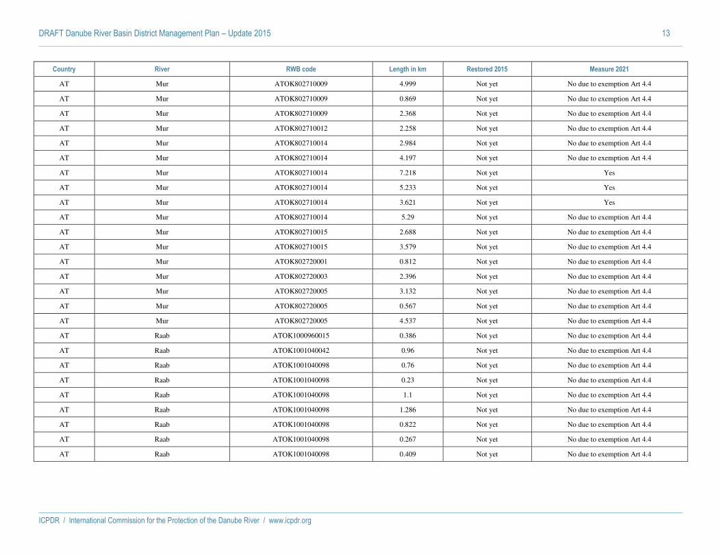
DRAFT Danube River Basin District Management Plan – Update 2015 13
ICPDR / International Commission for the Protection of the Danube River / www.icpdr.org
Country River RWB code Length in km Restored 2015 Measure 2021
AT Mur ATOK802710009 4.999 Not yet No due to exemption Art 4.4
AT Mur ATOK802710009 0.869 Not yet No due to exemption Art 4.4
AT Mur ATOK802710009 2.368 Not yet No due to exemption Art 4.4
AT Mur ATOK802710012 2.258 Not yet No due to exemption Art 4.4
AT Mur ATOK802710014 2.984 Not yet No due to exemption Art 4.4
AT Mur ATOK802710014 4.197 Not yet No due to exemption Art 4.4
AT Mur ATOK802710014 7.218 Not yet Yes
AT Mur ATOK802710014 5.233 Not yet Yes
AT Mur ATOK802710014 3.621 Not yet Yes
AT Mur ATOK802710014 5.29 Not yet No due to exemption Art 4.4
AT Mur ATOK802710015 2.688 Not yet No due to exemption Art 4.4
AT Mur ATOK802710015 3.579 Not yet No due to exemption Art 4.4
AT Mur ATOK802720001 0.812 Not yet No due to exemption Art 4.4
AT Mur ATOK802720003 2.396 Not yet No due to exemption Art 4.4
AT Mur ATOK802720005 3.132 Not yet No due to exemption Art 4.4
AT Mur ATOK802720005 0.567 Not yet No due to exemption Art 4.4
AT Mur ATOK802720005 4.537 Not yet No due to exemption Art 4.4
AT Raab ATOK1000960015 0.386 Not yet No due to exemption Art 4.4
AT Raab ATOK1001040042 0.96 Not yet No due to exemption Art 4.4
AT Raab ATOK1001040098 0.76 Not yet No due to exemption Art 4.4
AT Raab ATOK1001040098 0.23 Not yet No due to exemption Art 4.4
AT Raab ATOK1001040098 1.1 Not yet No due to exemption Art 4.4
AT Raab ATOK1001040098 1.286 Not yet No due to exemption Art 4.4
AT Raab ATOK1001040098 0.822 Not yet No due to exemption Art 4.4
AT Raab ATOK1001040098 0.267 Not yet No due to exemption Art 4.4
AT Raab ATOK1001040098 0.409 Not yet No due to exemption Art 4.4

DRAFT Danube River Basin District Management Plan – Update 2015 14
ICPDR / International Commission for the Protection of the Danube River / www.icpdr.org
Country River RWB code Length in km Restored 2015 Measure 2021
AT Raab ATOK1001040098 1.097 Not yet No due to exemption Art 4.4
AT Raab ATOK1001040105 0.654 Not yet No due to exemption Art 4.4
AT Raab ATOK1001040105 2.312 Not yet No due to exemption Art 4.4
AT Raab ATOK1001040105 1.43 Not yet No due to exemption Art 4.4
AT Raab ATOK1001040105 1.316 Not yet No due to exemption Art 4.4
AT Raab ATOK1001040108 0.197 Not yet No due to exemption Art 4.4
AT Raab ATOK1001040108 0.398 Not yet No due to exemption Art 4.4
AT Salzach ATOK304690002 4.503 Yes
AT Salzach ATOK304690002 1.2 Not yet No due to exemption Art 4.4
AT Salzach ATOK304690003 4.503 Yes
AT Salzach ATOK305350001 4.07 Yes
AT Salzach ATOK305350001 2.73 Yes
AT Salzach ATOK305350001 4.3 Yes
AT Salzach ATOK305350001 3.96 Yes
AT Salzach ATOK305350003 2.39 Yes
AT Salzach ATOK305350003 1.63 Not yet No due to exemption Art 4.4
AT Salzach ATOK305350004 4 Yes
AT Salzach ATOK305350004 0.34 Not yet No due to exemption Art 4.4
AT Salzach ATOK305350004 5.29 Yes
AT Salzach ATOK305350006 2.39 Yes
AT Salzach ATOK305350006 5.29 Yes
AT Salzach ATOK305360002 1.51 Not yet No due to exemption Art 4.4
AT Salzach ATOK305360002 2.97 Not yet No due to exemption Art 4.4
AT Salzach ATOK305360002 3.07 Yes
AT Salzach ATOK305360002 3.96 Yes
AT Salzach ATOK307200001 5.061 Not yet No due to exemption Art 4.4

DRAFT Danube River Basin District Management Plan – Update 2015 15
ICPDR / International Commission for the Protection of the Danube River / www.icpdr.org
Country River RWB code Length in km Restored 2015 Measure 2021
AT Thaya ATOK500010030 1.289 Not yet No due to exemption Art 4.4
AT Thaya ATOK500010030 1.789 Not yet No due to exemption Art 4.4
AT Thaya ATOK500010030 0.946 Not yet No due to exemption Art 4.4
AT Thaya ATOK500010030 0.587 Not yet No due to exemption Art 4.4
AT Thaya ATOK500010030 0.473 Not yet No due to exemption Art 4.4
AT Thaya ATOK500010030 1.655 Not yet No due to exemption Art 4.4
AT Thaya ATOK500010030 0.347 Not yet No due to exemption Art 4.4
AT Thaya ATOK500010030 0.978 Not yet No due to exemption Art 4.4
AT Thaya ATOK500010030 0.78 Not yet No due to exemption Art 4.4
AT Thaya ATOK500010030 0.939 Not yet No due to exemption Art 4.4
AT Thaya ATOK500010030 0.857 Not yet No due to exemption Art 4.4
AT Thaya ATOK500010030 1.11 Not yet No due to exemption Art 4.4
AT Thaya ATOK500010031 0.556 Not yet No due to exemption Art 4.4
AT Thaya ATOK500010031 1.218 Not yet No due to exemption Art 4.4
AT Thaya ATOK500010031 1.11 Not yet No due to exemption Art 4.4
AT Thaya ATOK500010031 0.143 Not yet No due to exemption Art 4.4
AT Thaya ATOK500010031 1.577 Not yet No due to exemption Art 4.4
AT Thaya ATOK500010036 1.427 Not yet No due to exemption Art 4.4
AT Thaya ATOK500010036 0.821 Not yet No due to exemption Art 4.4
AT Thaya ATOK500010036 1.085 Not yet No due to exemption Art 4.4
AT Thaya ATOK500010036 3.251 Not yet No due to exemption Art 4.4
AT Thaya ATOK500010036 0.476 Not yet No due to exemption Art 4.4
AT Thaya ATOK500010036 0.844 Not yet No due to exemption Art 4.4
AT Thaya ATOK500010036 1.464 Not yet No due to exemption Art 4.4
AT Thaya ATOK500010036 1.424 Not yet No due to exemption Art 4.4
AT Thaya ATOK500010036 0.995 Not yet No due to exemption Art 4.4

DRAFT Danube River Basin District Management Plan – Update 2015 16
ICPDR / International Commission for the Protection of the Danube River / www.icpdr.org
Country River RWB code Length in km Restored 2015 Measure 2021
AT Thaya ATOK500010036 0.203 Not yet No due to exemption Art 4.4
AT Thaya ATOK500010036 0.999 Not yet No due to exemption Art 4.4
AT Thaya ATOK500010036 1.287 Not yet No due to exemption Art 4.4
AT Thaya ATOK500010036 0.29 Not yet No due to exemption Art 4.4
AT Thaya ATOK500010038 0.544 Not yet No due to exemption Art 4.4
AT Thaya ATOK500010038 0.104 Not yet No due to exemption Art 4.4
AT Thaya ATOK500010038 0.191 Not yet No due to exemption Art 4.4
AT Thaya ATOK500010038 0.178 Not yet No due to exemption Art 4.4
AT Thaya ATOK500010038 0.637 Not yet No due to exemption Art 4.4
AT Thaya ATOK500010038 1.065 Not yet No due to exemption Art 4.4
AT Thaya ATOK500010038 0.15 Not yet No due to exemption Art 4.4
AT Thaya ATOK500010038 0.636 Not yet No due to exemption Art 4.4
AT Thaya ATOK500010038 0.556 Not yet No due to exemption Art 4.4
AT Thaya ATOK500010038 0.483 Not yet No due to exemption Art 4.4
AT Thaya ATOK500010038 0.089 Not yet No due to exemption Art 4.4
AT Thaya ATOK500010038 0.157 Not yet No due to exemption Art 4.4
AT Thaya ATOK500010043 1.541 Not yet No due to exemption Art 4.4
AT Thaya ATOK500010043 1.261 Not yet No due to exemption Art 4.4
AT Thaya ATOK500010043 1.181 Not yet No due to exemption Art 4.4
AT Thaya ATOK500010043 1.071 Not yet No due to exemption Art 4.4
AT Thaya ATOK500010043 0.432 Not yet No due to exemption Art 4.4
AT Thaya ATOK500010043 0.197 Not yet No due to exemption Art 4.4
AT Thaya ATOK500010043 1.084 Not yet No due to exemption Art 4.4
AT Thaya ATOK500010043 0.806 Not yet No due to exemption Art 4.4
AT Thaya ATOK500010043 1.094 Not yet No due to exemption Art 4.4
AT Thaya ATOK500010043 0.117 Not yet No due to exemption Art 4.4

DRAFT Danube River Basin District Management Plan – Update 2015 17
ICPDR / International Commission for the Protection of the Danube River / www.icpdr.org
Country River RWB code Length in km Restored 2015 Measure 2021
AT Thaya ATOK500010043 0.943 Not yet No due to exemption Art 4.4
AT Thaya ATOK500010043 0.547 Not yet No due to exemption Art 4.4
AT Thaya ATOK500010043 1.226 Not yet No due to exemption Art 4.4
AT Thaya ATOK500010043 0.334 Not yet No due to exemption Art 4.4
AT Thaya ATOK500010043 1.823 Not yet No due to exemption Art 4.4
AT Thaya ATOK500010043 0.946 Not yet No due to exemption Art 4.4
AT Thaya ATOK500010043 1.723 Not yet No due to exemption Art 4.4
AT Thaya ATOK500040002 0.198 Not yet No due to exemption Art 4.4
AT Thaya ATOK500040002 0.203 Not yet No due to exemption Art 4.4
AT Thaya ATOK500040002 0.338 Not yet No due to exemption Art 4.4
AT Thaya ATOK500040002 0.208 Not yet No due to exemption Art 4.4
AT Thaya ATOK500040002 0.2 Not yet No due to exemption Art 4.4
AT Thaya ATOK500040002 0.21 Not yet No due to exemption Art 4.4
AT Thaya ATOK500040002 0.208 Not yet No due to exemption Art 4.4
AT Thaya ATOK500040002 0.2 Not yet No due to exemption Art 4.4
AT Thaya ATOK500040002 0.2 Not yet No due to exemption Art 4.4
AT Thaya ATOK500040002 0.2 Not yet No due to exemption Art 4.4
AT Thaya ATOK500040002 0.199 Not yet No due to exemption Art 4.4
AT Thaya ATOK500040002 0.2 Not yet No due to exemption Art 4.4
AT Thaya ATOK500040002 0.199 Not yet No due to exemption Art 4.4
AT Thaya ATOK500040002 0.202 Not yet No due to exemption Art 4.4
AT Thaya ATOK500040002 0.221 Not yet No due to exemption Art 4.4
AT Thaya ATOK500040002 0.201 Not yet No due to exemption Art 4.4
AT Traun ATOK401220012 0.2 Not yet Yes
AT Traun ATOK409920001 0.2 Not yet Yes
AT Traun ATOK409920001 0.16 Not yet Yes
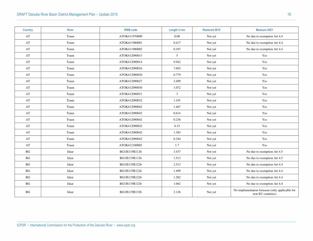
DRAFT Danube River Basin District Management Plan – Update 2015 18
ICPDR / International Commission for the Protection of the Danube River / www.icpdr.org
Country River RWB code Length in km Restored 2015 Measure 2021
AT Traun ATOK411970000 0.08 Not yet No due to exemption Art 4.4
AT Traun ATOK411980001 0.417 Not yet No due to exemption Art 4.4
AT Traun ATOK411980002 0.107 Not yet No due to exemption Art 4.4
AT Traun ATOK412090013 5 Not yet Yes
AT Traun ATOK412090014 9.942 Not yet Yes
AT Traun ATOK412090016 7.603 Not yet Yes
AT Traun ATOK412090020 0.779 Not yet Yes
AT Traun ATOK412090027 3.499 Not yet Yes
AT Traun ATOK412090030 1.072 Not yet Yes
AT Traun ATOK412090031 3 Not yet Yes
AT Traun ATOK412090032 1.191 Not yet Yes
AT Traun ATOK412090042 1.467 Not yet Yes
AT Traun ATOK412090042 0.614 Not yet Yes
AT Traun ATOK412090042 0.236 Not yet Yes
AT Traun ATOK412090042 0.15 Not yet Yes
AT Traun ATOK412090042 1.383 Not yet Yes
AT Traun ATOK412090042 0.344 Not yet Yes
AT Traun ATOK412100002 1.7 Not yet Yes
BG Iskar BG1IS135R1126 3.437 Not yet No due to exemption Art 4.5
BG Iskar BG1IS135R1126 1.513 Not yet No due to exemption Art 4.5
BG Iskar BG1IS135R1226 2.513 Not yet No due to exemption Art 4.4
BG Iskar BG1IS135R1226 1.499 Not yet No due to exemption Art 4.4
BG Iskar BG1IS135R1226 1.282 Not yet No due to exemption Art 4.4
BG Iskar BG1IS135R1226 1.062 Not yet No due to exemption Art 4.4
BG Iskar BG1IS135R1326 2.126 Not yet No implementation foreseen (only applicable for
non-EU countries)
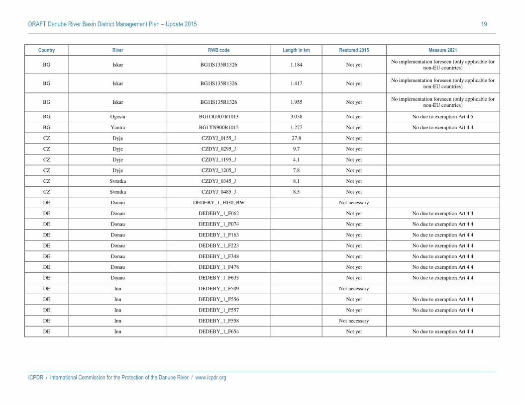
DRAFT Danube River Basin District Management Plan – Update 2015 19
ICPDR / International Commission for the Protection of the Danube River / www.icpdr.org
Country River RWB code Length in km Restored 2015 Measure 2021
BG Iskar BG1IS135R1326 1.184 Not yet No implementation foreseen (only applicable for
non-EU countries)
BG Iskar BG1IS135R1326 1.417 Not yet No implementation foreseen (only applicable for
non-EU countries)
BG Iskar BG1IS135R1326 1.955 Not yet No implementation foreseen (only applicable for
non-EU countries)
BG Ogosta BG1OG307R1013 3.058 Not yet No due to exemption Art 4.5
BG Yantra BG1YN900R1015 1.277 Not yet No due to exemption Art 4.4
CZ Dyje CZDYJ_0155_J 27.8 Not yet
CZ Dyje CZDYJ_0295_J 9.7 Not yet
CZ Dyje CZDYJ_1195_J 4.1 Not yet
CZ Dyje CZDYJ_1205_J 7.8 Not yet
CZ Svratka CZDYJ_0345_J 8.1 Not yet
CZ Svratka CZDYJ_0485_J 8.5 Not yet
DE Donau DEDEBY_1_F030_BW
Not necessary
DE Donau DEDEBY_1_F062
Not yet No due to exemption Art 4.4
DE Donau DEDEBY_1_F074
Not yet No due to exemption Art 4.4
DE Donau DEDEBY_1_F163
Not yet No due to exemption Art 4.4
DE Donau DEDEBY_1_F223
Not yet No due to exemption Art 4.4
DE Donau DEDEBY_1_F348
Not yet No due to exemption Art 4.4
DE Donau DEDEBY_1_F478
Not yet No due to exemption Art 4.4
DE Donau DEDEBY_1_F633
Not yet No due to exemption Art 4.4
DE Inn DEDEBY_1_F509
Not necessary
DE Inn DEDEBY_1_F556
Not yet No due to exemption Art 4.4
DE Inn DEDEBY_1_F557
Not yet No due to exemption Art 4.4
DE Inn DEDEBY_1_F558
Not necessary
DE Inn DEDEBY_1_F654
Not yet No due to exemption Art 4.4

DRAFT Danube River Basin District Management Plan – Update 2015 20
ICPDR / International Commission for the Protection of the Danube River / www.icpdr.org
Country River RWB code Length in km Restored 2015 Measure 2021
DE Inn DEDEBY_1_F656
Not yet No due to exemption Art 4.4
DE Inn DEDEBY_1_F657
Not yet No due to exemption Art 4.4
DE Isar DEDEBY_1_F375
Not yet No due to exemption Art 4.4
DE Isar DEDEBY_1_F376
Not yet No due to exemption Art 4.4
DE Isar DEDEBY_1_F429
Not yet No due to exemption Art 4.4
DE Isar DEDEBY_1_F430
Not yet No due to exemption Art 4.4
DE Lech DEDEBY_1_F122
Not yet No due to exemption Art 4.4
DE Lech DEDEBY_1_F128
Not yet No due to exemption Art 4.4
DE Lech DEDEBY_1_F131
Not yet No due to exemption Art 4.4
DE Lech DEDEBY_1_F132
Not yet No due to exemption Art 4.4
DE Main-Donau-Kanal DEDEBY_1_F226
Not yet No due to exemption Art 4.4
DE Naab DEDEBY_1_F273
Not yet Yes
HR Drava HRDDRI020005 11.08 Not necessary
HR Drava HRDDRI020005 8.91 Not necessary
HR Drava HRDDRI020007 3.62 Not necessary
HR Kupa HRDSRN020002 0.59 Not necessary
HU Berettyó HUAEP322 6 Not necessary
HU Duna, Duna-mellékág HUAEP443 18.5 Not necessary
HU Fehér-Körös HUAEP471 10 Not necessary
HU Hármas-Körös HUAEP567 68 Yes
HU Hortobágy-főcsatorna HUAEP595 31 Not necessary
HU Kettős-Körös HUAEP668 15 Not yet
HU Mosoni-Duna HUAEP812 5 Yes
HU Rába HUAEP899 5 Yes
HU Rába HUAEP900 6 Yes
HU Rába HUAEP900 4 Yes

DRAFT Danube River Basin District Management Plan – Update 2015 21
ICPDR / International Commission for the Protection of the Danube River / www.icpdr.org
Country River RWB code Length in km Restored 2015 Measure 2021
HU Rába HUAEP903 5 Not yet
HU Rába HUAEP903 1 Not yet
HU Rába HUAEP903 3 Yes
HU Rábca HUAEP904 6 Not necessary
HU Rábca HUAEP904 6 Not yet
HU Rábca HUAEP904 5 Not yet
HU Répce HUAEP920 4.5 Yes
HU Sebes-Körös HUAEP953 10 Not necessary
HU Sebes-Körös HUAEP954 48 Yes
HU Sió HUAEP958 2.1 Not yet
HU Sió HUAEP959 25.4 Not yet
HU Tisza HUAEQ059 75 Not yet
HU Tisza HUAIW389 115 Not necessary
HU Zagyva HUAEQ139 3 Not necessary
HU Zagyva HUAEQ139 3 Not yet
MD Prut MD0201/05 54 Not necessary
MD Prut MD0201/06 54 Not necessary
RO Arges ROLW10.1_B1 19 Not necessary
RO Arges ROLW10.1_B2 36 Not necessary
RO Arges ROLW10.1_B3 16 Not necessary
RO Arges ROLW10.1_B4 13 Not necessary
RO Arges ROLW10.1_B5 6.56 Not necessary
RO Arges ROLW10.1_B6 3.98 Not necessary
RO Arges ROLW10.1_B7 13 Not necessary
RO Barcau ROLW3.1.44.33_B4 4 Not yet Yes
RO Bega RORW5.1_B2 2.361 Not necessary

DRAFT Danube River Basin District Management Plan – Update 2015 22
ICPDR / International Commission for the Protection of the Danube River / www.icpdr.org
Country River RWB code Length in km Restored 2015 Measure 2021
RO Bega RORW5.1_B3 0.942 Not yet Yes
RO Bega RORW5.1_B3 5.334 Not necessary
RO Bega RORW5.1_B3 8.43 Not necessary
RO Bega RORW5.1_B4 15.117 Not necessary
RO Bega RORW5.1_B4 15.063 Not necessary
RO Bega RORW5.1_B4 14.533 Not necessary
RO Bistrita ROLW12.1.53_B3 25.9 Not necessary
RO Bistrita ROLW12.1.53_B5 6 Not necessary
RO Bistrita ROLW12.1.53_B5 5 Not necessary
RO Bistrita ROLW12.1.53_B5 9 Not necessary
RO Bistrita ROLW12.1.53_B7 5.1 Not necessary
RO Bistrita ROLW12.1.53_B7 2 Not necessary
RO Bistrita ROLW12.1.53_B7 5 Not necessary
RO Bistrita ROLW12.1.53_B7 3.5 Not necessary
RO Bistrita ROLW12.1.53_B7 2.85 Not necessary
RO Buzau ROLW12.1.82_B1 9.5 Not necessary
RO Buzau ROLW12.1.82_B2 2 Not necessary
RO Crisul Repede ROLW3.1.44_B5 7 Not necessary
RO Crisul Repede ROLW3.1.44_B5 7.5 Not necessary
RO Crisul Repede RORW3.1.44_B7 1.5 Not necessary
RO Dunarea RORW14.1_B1 138.5 Not necessary
RO Dunarea RORW14.1_B2 82.9 Not necessary
RO Ialomita ROLW11.1_B1 2.2 Not necessary
RO Ialomita ROLW11.1_B2 2.3 Not necessary
RO Ialomita ROLW11.1_B3 11 Not necessary
RO Jijia ROLW13.1.15_B2 4 Not necessary

DRAFT Danube River Basin District Management Plan – Update 2015 23
ICPDR / International Commission for the Protection of the Danube River / www.icpdr.org
Country River RWB code Length in km Restored 2015 Measure 2021
RO Jiu ROLW7.1_B120 3.646 Not necessary
RO Jiu ROLW7.1_B56 8.095 Not necessary
RO Jiu RORW7.1_B4 0.779 Not necessary
RO Olt ROLW8.1_B10 87 Yes
RO Olt ROLW8.1_B11 40 Yes
RO Olt ROLW8.1_B7 67 Not necessary
RO Olt ROLW8.1_B9 81 Not necessary
RO Olt RORW8.1_B2 1.2 Yes
RO Prut ROLW13.1_B2 42 Not necessary
RO Siret ROLW12.1_B1 13.2 Not necessary
RO Siret ROLW12.1_B3 11.9 Not necessary
RO Siret ROLW12.1_B6 13 Not necessary
RO Siret ROLW12.1_B6 7 Not necessary
RO Siret ROLW12.1_B6 29 Not necessary
RO Siret ROLW12.1_B8 10.44 Not necessary
RO Somes RORW2.1_B3 4.8 Not yet Yes
RO Timis ROLW5.2_B1 1.93 Not necessary
RO Timis RORW5.2_B5 2.987 Not necessary
RO Timis RORW5.2_B5 2.318 Not necessary
RS Begej RSBEG 29.8 Not yet No implementation foreseen (only applicable for
non-EU countries)
RS Drina RSDR_2 20.3 Not yet No implementation foreseen (only applicable for
non-EU countries)
RS Drina RSDR_4 23.7 Not yet No implementation foreseen (only applicable for
non-EU countries)
RS Dunav RSD2 81 Not yet No implementation foreseen (only applicable for
non-EU countries)
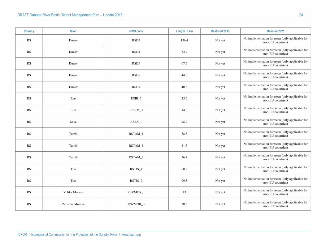
DRAFT Danube River Basin District Management Plan – Update 2015 24
ICPDR / International Commission for the Protection of the Danube River / www.icpdr.org
Country River RWB code Length in km Restored 2015 Measure 2021
RS Dunav RSD3 136.4 Not yet No implementation foreseen (only applicable for
non-EU countries)
RS Dunav RSD4 32.9 Not yet No implementation foreseen (only applicable for
non-EU countries)
RS Dunav RSD5 67.5 Not yet No implementation foreseen (only applicable for
non-EU countries)
RS Dunav RSD6 44.6 Not yet No implementation foreseen (only applicable for
non-EU countries)
RS Dunav RSD7 40.8 Not yet No implementation foreseen (only applicable for
non-EU countries)
RS Ibar RSIB_5 25.6 Not yet No implementation foreseen (only applicable for
non-EU countries)
RS Lim RSLIM_3 14.8 Not yet No implementation foreseen (only applicable for
non-EU countries)
RS Sava RSSA_1 98.9 Not yet No implementation foreseen (only applicable for
non-EU countries)
RS Tamiš RSTAM_1 38.8 Not yet No implementation foreseen (only applicable for
non-EU countries)
RS Tamiš RSTAM_1 41.5 Not yet No implementation foreseen (only applicable for
non-EU countries)
RS Tamiš RSTAM_2 36.4 Not yet No implementation foreseen (only applicable for
non-EU countries)
RS Tisa RSTIS_1 60.8 Not yet No implementation foreseen (only applicable for
non-EU countries)
RS Tisa RSTIS_2 99.5 Not yet No implementation foreseen (only applicable for
non-EU countries)
RS Velika Morava RSVMOR_1 13 Not yet No implementation foreseen (only applicable for
non-EU countries)
RS Zapadna Morava RSZMOR_3 30.6 Not yet No implementation foreseen (only applicable for
non-EU countries)

DRAFT Danube River Basin District Management Plan – Update 2015 25
ICPDR / International Commission for the Protection of the Danube River / www.icpdr.org
Country River RWB code Length in km Restored 2015 Measure 2021
SI Drava SISI3VT359 10 Not yet
SI Drava SISI3VT359 16 Not yet
SI Drava SISI3VT359 8 Not yet
SI Drava SISI3VT359 13 Not yet
SI Drava SISI3VT359 13 Not yet
SI Drava SISI3VT359 12 Not yet
SI Sava SISI1VT170 7 Not yet
SI Sava SISI1VT170 6 Not yet
SI Sava SISI1VT713 10 Not yet
SI Sava SISI1VT739 9 Not yet
SI Sava SISI1VT739 9 Not yet
SI Sava SISI1VT739 10 Not yet
SK Dunaj SKD0019 17.4 Not yet No due to exemption Art 4.4
SK Hornád SKH0003 1.4 Not yet No due to exemption Art 4.4
SK Hornád SKH0004 1.2 Not yet No due to exemption Art 4.4
SK Hornád SKH1001 2.6 Not yet No due to exemption Art 4.4
SK Hornád SKH1001 20 Not yet No due to exemption Art 4.4
SK Hron SKR0005 2.5 Not yet No due to exemption Art 4.4
SK Hron SKR0005 4 Not yet No due to exemption Art 4.4
SK Hron SKR0005 4 Not yet No due to exemption Art 4.4
SK Ipeľ SKI0004 9.1 Not yet No due to exemption Art 4.4
SK Ipeľ SKI0004 9.2 Not yet No due to exemption Art 4.4
SK Ipeľ SKI0004 3.2 Not yet No due to exemption Art 4.4
SK Ipeľ SKI0004 6.5 Not yet No due to exemption Art 4.4
SK Ipeľ SKI0004 7 Not yet No due to exemption Art 4.4
SK Ipeľ SKI0004 6.2 Not yet No due to exemption Art 4.4

DRAFT Danube River Basin District Management Plan – Update 2015 26
ICPDR / International Commission for the Protection of the Danube River / www.icpdr.org
Country River RWB code Length in km Restored 2015 Measure 2021
SK Ipeľ SKI0004 6.5 Not yet No due to exemption Art 4.4
SK Ipeľ SKI0004 6 Not yet No due to exemption Art 4.4
SK Ipeľ SKI1001 3.7 Not yet No due to exemption Art 4.4
SK Laborec SKB0142 1.2 Not yet No due to exemption Art 4.4
SK Laborec SKB0144 1.6 Not yet No due to exemption Art 4.4
SK Nitra SKN0004 6.3 Not yet No due to exemption Art 4.4
SK Nitra SKN0004 12.2 Not yet No due to exemption Art 4.4
SK Nitra SKN0004 4 Not yet No due to exemption Art 4.4
SK Nitra SKN0004 7.1 Not yet No due to exemption Art 4.4
SK Váh SKV0006 3.7 Not yet No due to exemption Art 4.4
SK Váh SKV0007 10 Not yet No due to exemption Art 4.4
SK Váh SKV0007 7.8 Not yet No due to exemption Art 4.4
SK Váh SKV0007 7.3 Not yet No due to exemption Art 4.4
SK Váh SKV0007 4.4 Not yet No due to exemption Art 4.4
SK Váh SKV0007 10.1 Not yet No due to exemption Art 4.4
SK Váh SKV0027 19.3 Not yet No due to exemption Art 4.4
SK Váh SKV1001 8.4 Not yet No due to exemption Art 4.4
SK Váh SKV1001 3.2 Not yet No due to exemption Art 4.4
SK Váh SKV1002 5.9 Not yet No due to exemption Art 4.4
SK Váh SKV1003 11.8 Not yet No due to exemption Art 4.4

DRAFT Danube River Basin District Management Plan – Update 2015 27
ICPDR / International Commission for the Protection of the Danube River / www.icpdr.org
List of Hydropeaking
Country River RWB Code Water level fluctuation >1m/day Restored 2015 Measure 2021
AT Drau ATOK900470022 Yes Not yet No due to exemption Art 4.4
AT Drau ATOK903540001 Yes Not yet No due to exemption Art 4.4
AT Drau ATOK903540002 Yes Not yet No due to exemption Art 4.4
AT Enns ATOK409970000 Yes Not yet No due to exemption Art 4.4
AT Enns ATOK411250010 Yes Not yet No due to exemption Art 4.4
AT Enns ATOK411250020 Yes Not yet No due to exemption Art 4.4
AT Enns ATOK411250021 Yes Not yet No due to exemption Art 4.4
AT Inn ATOK304980003 Yes Not yet No due to exemption Art 4.4
AT Inn ATOK304980006 Yes Not yet No due to exemption Art 4.4
AT Inn ATOK304980006 Yes Not yet No due to exemption Art 4.4
AT Inn ATOK304980009 Yes Not yet No due to exemption Art 4.4
AT Inn ATOK304980009 Yes Not yet No due to exemption Art 4.4
AT Inn ATOK304980009 Yes Not yet No due to exemption Art 4.4
AT Inn ATOK304980010 Yes Not yet No due to exemption Art 4.4
AT Inn ATOK305850011 Yes Not yet No due to exemption Art 4.4
AT Inn ATOK305850011 Yes Not yet No due to exemption Art 4.4
AT Lech ATOK307080000 Yes Not yet No due to exemption Art 4.4
AT Mur ATOK801180004 Yes Not yet No due to exemption Art 4.4
AT Mur ATOK801180006 Yes Not yet No due to exemption Art 4.4
AT Raab ATOK1001040108 Yes Not yet No due to exemption Art 4.4
AT Raab ATOK1002160000 Yes Not yet No due to exemption Art 4.4
AT Salzach ATOK304690004 Yes Not yet No due to exemption Art 4.4
AT Salzach ATOK304690005 Yes Not yet No due to exemption Art 4.4
AT Salzach ATOK305350001 Yes Not yet No due to exemption Art 4.4
AT Salzach ATOK305350001 Yes Not yet No due to exemption Art 4.4
AT Salzach ATOK305350001 Yes Not yet No due to exemption Art 4.4
AT Salzach ATOK305350001 Yes Not yet No due to exemption Art 4.4
AT Salzach ATOK305350001 Yes Not yet No due to exemption Art 4.4
AT Salzach ATOK305350003 Yes Not yet No due to exemption Art 4.4
AT Salzach ATOK305350003 Yes Not yet No due to exemption Art 4.4
AT Salzach ATOK305350004 Yes Not yet No due to exemption Art 4.4
AT Salzach ATOK305350004 Yes Not yet No due to exemption Art 4.4
AT Salzach ATOK305350006 Yes Not yet No due to exemption Art 4.4
AT Salzach ATOK305350006 Yes Not yet No due to exemption Art 4.4
AT Salzach ATOK305360002 Yes Not yet No due to exemption Art 4.4
AT Salzach ATOK305360002 Yes Not yet No due to exemption Art 4.4

DRAFT Danube River Basin District Management Plan – Update 2015 28
ICPDR / International Commission for the Protection of the Danube River / www.icpdr.org
Country River RWB Code Water level fluctuation >1m/day Restored 2015 Measure 2021
AT Salzach ATOK305360002 Yes Not yet No due to exemption Art 4.4
AT Salzach ATOK305360002 Yes Not yet No due to exemption Art 4.4
AT Salzach ATOK307200002 Yes Not yet No due to exemption Art 4.4
AT Salzach ATOK307200003 Yes Not yet No due to exemption Art 4.4
AT Thaya ATOK501870001 Yes Not yet No due to exemption Art 4.4
DE Donau DEDEBY_1_F163 Unknown Not yet No due to exemption Art 4.4
DE Isar DEDEBY_1_F429 Unknown Not yet No due to exemption Art 4.4
DE Lech DEDEBY_1_F122 Unknown Not yet No due to exemption Art 4.4
DE Lech DEDEBY_1_F124 Unknown Not yet No due to exemption Art 4.4
DE Lech DEDEBY_1_F125 Unknown Not yet Yes
DE Lech DEDEBY_1_F128 Unknown Not yet Yes
DE Lech DEDEBY_1_F131 Unknown Not yet Yes
DE Lech DEDEBY_1_F132 Unknown Not yet Yes
HR Drava HRDDRI020005 Yes Yes
HU Tisza HUAIW389 Yes Not necessary

ICPDR / International Commission for the Protection of the Danube River / www.icpdr.org
ANNEX 15
DRAFT DRBM Plan – Update 2015
Financing the Joint Programme of Measures
DRAFT Danube River Basin District Management Plan – Update 2015 2
ICPDR / International Commission for the Protection of the Danube River / www.icpdr.org
Financing Program Organisation Description (Main) Type of pressure (SWMIs) Other eligibility criteria Sources/further information regarding
application
European Regional Development Fund (ERDF)
EU (European Structural and Investment Funds/ESIF)
The ERDF aims to strengthen economic, social and territorial cohesion in the EU by correcting imbalances between regions. The ERDF supports regional and local development to contribute to all of the thematic objectives, laid down in the CPR1.
TO 5 (climate change adaptation, risk prevention): ecosystem-based approaches for hydromorphological alterations (reconnection of wetlands/floodplains), possibly nutrient pollution (diffuse pollution from agriculture). TO 6 (protecting the environment and promoting resource efficiency): organic pollution (UWWTP, industrial point sources), nutrient pollution (UWWTP, industrial point sources), hazardous substances pollution (UWWTP industrial point sources), hydromorphological alterations (reconnection of wetlands/floodplains).
Only EU Member States eligible MS/regions are classified according to "more developed regions/transition regions/less developed regions" (influencing minimum allocations set for a number of priority areas).
*Common Provisions Regulation2. *ESIF general: http://ec.europa.eu/contracts_grants/funds_en.htm *Project database: http://ec.europa.eu/regional_policy/index.cfm/en/projects/?LAN=EN&pay=ALL®ion=ALL&the=97&type=ALL&per=2
European Social Fund (ESF)
EU (European Structural and Investment Funds/ESIF)
The European Social Fund (ESF) is the main financial instrument for investing in employment opportunities, better education, improvement of the situation of the most vulnerable people; capacity building in the environment is also being supported.
No direct linkage to the Danube SWMIs. Possible indirect linkages in all areas regarding capacity building, mainly BAT/BAP.
Only EU Member States eligible
*Common Provisions Regulation (see footnote 3 above) *ESIF general: http://ec.europa.eu/contracts_grants/funds_en.htm *Project database: see link under ERDF
Cohesion Fund EU (European The Cohesion Fund helps Climate change adaptation and risk Only EU Member *Common Provisions
1 The thematic objectives are: 1. research and development, and innovation; 2. information and communication technologies; 3.competitiveness of SMEs; 4. shift towards a low-carbon economy; 5. climate change adaptation, risk prevention; 6. protecting the environment and promotion resource efficiency; 7. promoting sustainable transport; 8. employment and labor mobility; 9. social inclusion and poverty; 10. education, and training; 11. institutional capacity and efficiency of public administration. TO 5 and 6 are particularly relevant for water and marine policy. 2 More detailed information on eligibility, financial instruments, ex-ante conditionalities and management and control principles, as well as common elements on strategic planning and programming, thematic objectives linked to the Europe 2020 Strategy and visions on the Common Strategic Framework and on the Partnership Agreements to be agreed between the Commission and each Member State can be found in the Common Provisions Regulation/CPR (No 1303/2013 OF THE EUROPEAN PARLIAMENT AND OF THE COUNCIL of 17 December 2013), to be found here: http://eur-lex.europa.eu/legal-content/EN/TXT/?uri=CELEX:32013R1303.

DRAFT Danube River Basin District Management Plan – Update 2015 3
ICPDR / International Commission for the Protection of the Danube River / www.icpdr.org
Financing Program Organisation Description (Main) Type of pressure (SWMIs) Other eligibility criteria Sources/further information regarding
application
(CF) Structural and Investment Funds/ESIF)
Member States with a GNI 3 per capita of less than 90% of the EU-27 average to invest in TEN-T transport networks and the environment.
prevention: hydromorphological alterations (reconnection of wetlands/floodplains). Investment in the water and waste sectors, and the urban environment: organic pollution (UWWTP, industrial point sources), nutrient pollution (UWWTP, industrial point sources, urban run-off), hazardous substances pollution (UWWTP, industrial point sources, urban run-off). Investment in energy, provided it has positive environmental benefits: possibly all hydromorphological pressures if linked to hydropower.
States with a GNI per capita of less than 90% of the EU-27 average. For the 2014-2020 period, the Cohesion Fund concerns (in the Danube RB) Bulgaria, Croatia, the Czech Republic, Hungary, Romania, Slovakia and Slovenia (see map at the end of the table). Ex-ante conditionality: Existence of a water pricing policy (with adequate incentives and contributions of different users) Adoption of RBMP
Regulation (see footnote 3 above) *ESIF general: http://ec.europa.eu/contracts_grants/funds_en.htm *Project database: see link under ERDF
European Maritime and Fisheries Fund (EMFF)
EU (European Structural and Investment Funds/ESIF)
The EMFF is the primary financing instrument for the reformed Common Fisheries Policy (CFP) and the Integrated Maritime Policy (IMP), including the Marine Strategy Framework Directive (MSFD).
No direct linkage to the Danube SWMIs. Possible indirect linkages in transitional/coastal water, e.g. with regard to data collection on fish species, or the management, restoration and monitoring of coastal Natura2000 sites.
Only EU Member States eligible
*Common Provisions Regulation (see footnote 3 above) *ESIF general: http://ec.europa.eu/contracts_grants/funds_en.htm
CAP/European Agricultural Fund for Rural Development (EAFRD)
EU (European Structural and Investment Funds/ESIF)
The EAFRD is one of the primary financing instruments for the Pillar II of the CAP (Rural Development), which sets a number of environmental objectives, notably: 1: efficient, responsible and
1: efficient, responsible and sustainable use of water resources in agriculture: only indirect links to SWMIs; cooperation and irrigation/water savings possible (Art. 17 investments, linked to irrigation). 2: ensuring that agricultural activities help/do not represent a constraint/to achieve GES and
Only EU Member States eligible
*Common Provisions Regulation (see footnote 3 above) *ESIF general: http://ec.europa.eu/contracts_grants/funds_en.htm
3 Gross National Income.
DRAFT Danube River Basin District Management Plan – Update 2015 4
ICPDR / International Commission for the Protection of the Danube River / www.icpdr.org
Financing Program Organisation Description (Main) Type of pressure (SWMIs) Other eligibility criteria Sources/further information regarding
application
sustainable use of water resources in agriculture; 2: ensuring that agricultural activities help/do not represent a constraint/to achieve GES and goals of the WFD; 3: implementation of the ecosystem-based approach when addressing challenges linked to climate change; 4: restoration of natural water cycle and of fresh water ecosystems and ambient ecosystems. 30% of the 95 billion € in 2014-2020 are earmarked for environment and climate.
goals of the WFD: organic pollution (animal feeding/breeding lots), nutrient pollution (diffuse emissions from agriculture, animal feeding/breeding lots), hazardous substances pollution (diffuse sources from agriculture), hydromorphological alterations (reconnection of wetlands/floodplains). (Art. 28 agri-environment-climate payments and Art. 29 organic farming cover the complex issue of interlinked water, soil and biodiversity elements linked to agricultural diffuse sources; Art. 30 payments covered for areas under strict protection). 3: implementation of the ecosystem-based approach when addressing challenges linked to climate change: possibly hydromorphological alterations (reconnection of wetlands/floodplains), organic/nutrient/hazardous substances pollution (through changes in land use intensity or forest cover: Art. 18 "restoring agricultural production potential damaged by natural disasters and catastrophic events and introduction of appropriate prevention actions" and Art. 24 "prevention and restoration of damage to forests from forest fires and natural disasters and catastrophic events). 4: restoration of natural water cycle and of fresh water ecosystems and ambient ecosystems: possibly hydromorphological alterations (reconnection of wetlands/floodplains), organic/nutrient/hazardous substances pollution (through changes in land use
*Agriculture and Rural Development: http://ec.europa.eu/agriculture/rural-development-2014-2020/index_en.htm *Applications via the national ministries responsible for EAFRD implementation/funding (list of ministries: http://ec.europa.eu/agriculture/links-to-ministries/index_en.htm).

DRAFT Danube River Basin District Management Plan – Update 2015 5
ICPDR / International Commission for the Protection of the Danube River / www.icpdr.org
Financing Program Organisation Description (Main) Type of pressure (SWMIs) Other eligibility criteria Sources/further information regarding
application
intensity or forest cover: Art. 17 investments in non-productive physical assets, such as achieving biodiversity conservation status of species and habitat as well as enhancing the public amenity value of a Natura 2000 area or other high nature value systems).
LIFE EU LIFE is the EU's only financing program entirely devoted to environmental objectives. It has four general objectives: 1. contributing to the shift towards a sustainable, low-carbon and climate-resilient economy, as well as to the protection of the environment and of biodiversity; 2: improving the development, implementation and enforcement of EU environmental and climate policy and legislation; 3: improving environmental and climate governance at all levels, including better involvement of civil society, non-governmental organizations (NGOs) and local actors; and 4: supporting the implementation of the 7th Environment Action Programme. LIFE 2014-2020 also incorporates new "LIFE Integrated Projects", larger projects (an average EU contribution of 10 million €) aiming at contributing to the implementation of some
Potentially addresses all SWMIs through the "LIFE Integrated Projects" (organic pollution indirectly). Foci are ecosystem-based approaches: organic pollution (indirectly through natural buffer zones), nutrient pollution (diffuse sources from agriculture and agricultural atmospheric emissions, urban run-off), hazardous substances pollution (diffuse sources, mainly from agriculture, but potentially also from urban and landfill/mining sites), hydromorphological alterations (longitudinal river continuity, reconnection of wetlands/floodplains, hydrological alterations). Also measures targeting sediments (retention measures) and IAS. Through the many links to climate and resilience, synergy effects between climate change adaptation, mitigation and water/biodiversity protection (keywords: NWRM, green infrastructure).
EU and non-EU countries (candidate countries and the Western Balkan countries involved in the Stabilisation and Association Process, as well as countries to which the European Neighbourhood Policy applies). Projects must apply to "priority areas" and related specific objectives: Component Environment: "resource efficiency", "nature and biodiversity" and "environmental governance and information". Component Climate Action: climate change mitigation, adaptation and governance/ information.
*General information: http://ec.europa.eu/environment/life/ *LIFE regulation (english): http://eur-lex.europa.eu/legal-content/EN/TXT/PDF/?uri=CELEX:32013R1293&from=EN *COM Presentation on LIFE: http://ec.europa.eu/environment/life/about/documents/life2014-2020.pdf *National contact points: http://ec.europa.eu/environment/life/contact/nationalcontact/index.htm *EP Briefing: http://www.europarl.europa.eu/RegData/etudes/BRIE/2015/548992/EPRS_BRI%282015%29548992_REV1_EN.pdf

DRAFT Danube River Basin District Management Plan – Update 2015 6
ICPDR / International Commission for the Protection of the Danube River / www.icpdr.org
Financing Program Organisation Description (Main) Type of pressure (SWMIs) Other eligibility criteria Sources/further information regarding
application
environmental EU policies, in particular the WFD and the MSFD.
Horizon 2020 EU Horizon 2020 is the funding program for research and innovation for the period 2014-2020. It is structured around tackling a series of “Societal Challenges” (SC), of which SC 2 on “Food security, sustainable agriculture and forestry, marine and maritime and inland water research, and the bioeconomy” and SC 5 on “Climate action, resource efficiency and raw materials” are of the greatest relevance for research linked to WFD implementation.
No direct link to Danube SWMIs, but research to support measures/knowledge on any SWMI is possible.
EU and non-EU countries (associated countries). Research program, SME participation possible. Most projects require at least three partners.
*Application process and help: http://ec.europa.eu/programmes/horizon2020/en/how-get-funding *National contact points: http://ec.europa.eu/research/participants/portal/desktop/en/support/national_contact_points.html
INTERREG V/European Territorial Cooperation (ETC)
EU INTERREG programs are a specific strand of funding possibilities within the cohesion policy funding, under the European Territorial Cooperation (ETC) goal. INTERREG programs typically focus on cooperation between regions and Member States, and are generally aimed at enabling exchange of experience, knowledge and good practices among relevant stakeholders from different MS and/or regions.
No direct link to Danube SWMIs, but enabling exchange of experience, knowledge and good practices can benefit implementation of measures in all areas.
EU and non-EU countries. Programs can be cross-border (along internal EU borders), transnational (cover larger areas of co-operation such as the Danube Basin), and interregional at EU-28 level (between regional and local bodies in different countries belonging also to different regions).
*Information on ETC and INTERREG V: http://ec.europa.eu/regional_policy/index.cfm/en/policy/cooperation/european-territorial/ *Project database: http://ec.europa.eu/regional_policy/index.cfm/en/projects/?LAN=EN&pay=ALL®ion=ALL&the=97&type=ALL&per=2 List of programs: http://www.danube-region.eu/2014-03-21-07-28-38/etc-ipa-cbc-

DRAFT Danube River Basin District Management Plan – Update 2015 7
ICPDR / International Commission for the Protection of the Danube River / www.icpdr.org
Financing Program Organisation Description (Main) Type of pressure (SWMIs) Other eligibility criteria Sources/further information regarding
application
and-enpi-cbc-programmes
European Neighbourhood Instrument (ENI)
EU ENI is providing direct support for the EU´s external policies. For environmental actions, target 4 ("encouraging development, poverty reduction, internal economic, social and territorial cohesion, rural development, climate action and disaster resilience") can be of relevance.
Support for non-EU countries participating in cross-border ERDF/INTERREG programs possible. Otherwise, potential link to Danube SWMIs though various funding opportunities; see Handbook for details.
Non-EU (candidates, possible candidates and neighboring countries; in the Danube region: Moldova and Ukraine)
*EU Funding Handbook for the neighborhood: http://www.enpi-info.eu/files/publications/EU%20funding%20Handbook%20-%20Final%2026Feb.pdf *ENI Regulation: http://eur-lex.europa.eu/LexUriServ/LexUriServ.do?uri=OJ:L:2014:077:0027:0043:EN:PDF List of programs: http://www.danube-region.eu/2014-03-21-07-28-38/etc-ipa-cbc-and-enpi-cbc-programmes
Instrument for Pre-Accession Assistance (IPA II)
EU Since 2007, the Instrument for Pre-Accession Assistance (IPA) replaces a series of EU programs and financial instruments for candidate countries or potential candidate countries (such as PHARE, ISPA, SAPRD etc.). It is organized along five components, which are: 1. assistance for transition and institution building; 2- cross-border cooperation (with EU MS and other countries eligible for IPA);
In the Danube RB, only C1 and C2 are being funded: 1. assistance for transition and institution building; 2- cross-border cooperation (with EU MS and other countries eligible for IPA). Hence, no direct link to Danube SWMIs, although institution building and cross-border cooperation can benefit implementation of measures in all areas.
EU candidate countries (Turkey and FYROM) are eligible for all five components of IPA, potential candidate countries in the Western Balkans (Albania, Bosnia-Herzegovina, Montenegro, Serbia, and Kosovo under UN Security Council Resolution 1244/99) are eligible only for the
*More information: http://www.welcomeurope.com/european-funds/ipa-ii-instrument-pre-accession-assistance-2014-2020-838+738.html#tab=onglet_details *More information: http://ec.europa.eu/regional_policy/index.cfm/EN/funding/ipa/ List of programs: http://www.danube-

DRAFT Danube River Basin District Management Plan – Update 2015 8
ICPDR / International Commission for the Protection of the Danube River / www.icpdr.org
Financing Program Organisation Description (Main) Type of pressure (SWMIs) Other eligibility criteria Sources/further information regarding
application
3. regional development (transport, environment, regional and economic development); 4. human resources (strengthening human capital and combating exclusion); 5. rural development.
first two components.
region.eu/2014-03-21-07-28-38/etc-ipa-cbc-and-enpi-cbc-programmes
International Bank for Reconstruction and Development (IBRD)
World Bank (WB)
The World Bank is an international financial institution that provides loans to developing countries. It consists of two agencies (IBRD and IDA) and focuses on the following fields: - human development (e.g. education, health); - agriculture and rural development (e.g. irrigation and rural services); - environmental protection (e.g. pollution reduction, establishing and enforcing regulations); - infrastructure (e.g. roads, urban regeneration, and electricity); - large industrial construction projects; - governance (e.g. anti-corruption, legal institutions development). The IBRD and IDA provide loans at preferential rates to member countries, as well as grants to the poorest countries.
Ni direct link to Danube SWMIs, although a multitude of projects/measures benefitting WFD implementation can be financed by WB loans (see also the examples listed under GEF). It has to be remarked, however, that IBRD provides only loans (though at preferential rates), not grants. IDA also provides grants.
IBRD: middle income and creditworthy low-income countries (all Danube except DE and AT). IDA: Moldova (and Kosovo)
*Products and Services: http://www.worldbank.org/en/projects-operations/products-and-services *WB Country Reports: http://web.worldbank.org/WBSITE/EXTERNAL/PROJECTS/0,,menuPK:64383817~pagePK:64387457~piPK:64387543~theSitePK:40941,00.html
International Development Association (IDA)
Global Environment Facility (GEF)
GEF The Global Environment Facility is a partnership for international cooperation where 183 countries work together with international
GEF provides grants to various types of projects (Climate Change Adaptation Projects and Small Grants Programme (SGP) most relevant) ranging from several thousand
Most countries should be eligible, depending on the focal area, eligibility criteria
*Templates and guidelines available at: http://www.thegef.org/gef/guidelines_templates

DRAFT Danube River Basin District Management Plan – Update 2015 9
ICPDR / International Commission for the Protection of the Danube River / www.icpdr.org
Financing Program Organisation Description (Main) Type of pressure (SWMIs) Other eligibility criteria Sources/further information regarding
application
institutions, civil society organizations and the private sector, to address global environmental issues.
dollars to several million dollars. Projects are supported in several "focal areas", of which the most relevant are: Biodiversity, Climate Change, Chemicals and Waste. Financing is provided through grants and non-grants. Funding possible with regard to all Danube SWMIs.
established by the relevant COP of the respective convention, and some others (see http://www.thegef.org/gef/node/1432).
*Project types: http://www.thegef.org/gef/project_types *Example from Moldova: http://www.worldbank.org/projects/P075995/agricultural-pollution-control-gef-project?lang=en&tab=overview *Example from Romania: http://www.worldbank.org/projects/P093775/romania-integrated-nutrient-pollution-control-project?lang=en
European Investment Bank (EIB)
EU The EIB is the EU's bank, offering loans (individual for projects over 25 Mio. €, intermediate to other banks/institutions for SME with projects under 25 Mio. €). The EIB finances a broad range of projects in all sectors of the economy, adhering to one of the six priority objectives, of which two are of special importance for WFD implementation in the Danube: - Environmental sustainability (climate action and urban/natural environment); - Sustainable, competitive and
No direct link to Danube SWMIs, but the EIB´s financing can help to unlock financing from other sources, particularly from the EU budget. It has to be remarked, however, that the EIB provides loans, not grants.
EU and non-EU countries (all Danube countries).
*Applying for a loan: http://www.eib.org/projects/cycle/applying_loan/index.htm *Detailed information on products: http://www.eib.org/projects/priorities/sme/products/index.htm *For the Western Balkans, see Western Balkans Investment Framework: http://www.wbif.eu/

DRAFT Danube River Basin District Management Plan – Update 2015 10
ICPDR / International Commission for the Protection of the Danube River / www.icpdr.org
Financing Program Organisation Description (Main) Type of pressure (SWMIs) Other eligibility criteria Sources/further information regarding
application
secure energy. European Bank for Reconstruction and Development (EBRD)
International The EBRD is a development bank offering loans and other financial products (like equities) in more than 30 countries from central Europe to Central Asia. Although the name suggests European ownership, the biggest shareholder are the United States. The EBRD supports private sector development (meeting the requirements, of which to "satisfy banking and environmental standards" is a part) in the relevant sectors agribusiness, energy efficiency & climate change (see Sustainable Energy Initiative), municipal & environmental infrastructure; power and energy.
No direct link to Danube SWMIs, although a multitude of (mostly private sector) projects/investments can be supported (such as improving animal feeding/breeding lots etc.). The "Sustainable Energy Initiative" (including renewable energy and adaptation projects) finances projects in energy efficiency, renewable energy and climate change adaptation/resilience. It has to be remarked, however, that the EIB provides loans, not grants.
All countries in the Danube RB - except Austria and Germany - are eligible for loans.
*Products and Services: http://www.ebrd.com/what-we-do/products-and-services.html *Sustainable Energy Initiative: www.ebrd.com/cs/Satellite?c=Content&cid=1395237439462&pagename=EBRD%2FContent%2FDownloadDocument

DRAFT Danube River Basin District Management Plan – Update 2015
ICPDR / International Commission for the Protection of the Danube River / www.icpdr.org
Structural Funds Eligibility
Source: EC Commission, DG REGIO (presentation at the 4th EU Water Conference 2015).