Hydropower Development in the Trishuli River Basin, Nepal
24
-
Upload
khangminh22 -
Category
Documents
-
view
1 -
download
0
Transcript of Hydropower Development in the Trishuli River Basin, Nepal

1
EXECUTIVE SUMMARY
Introduction
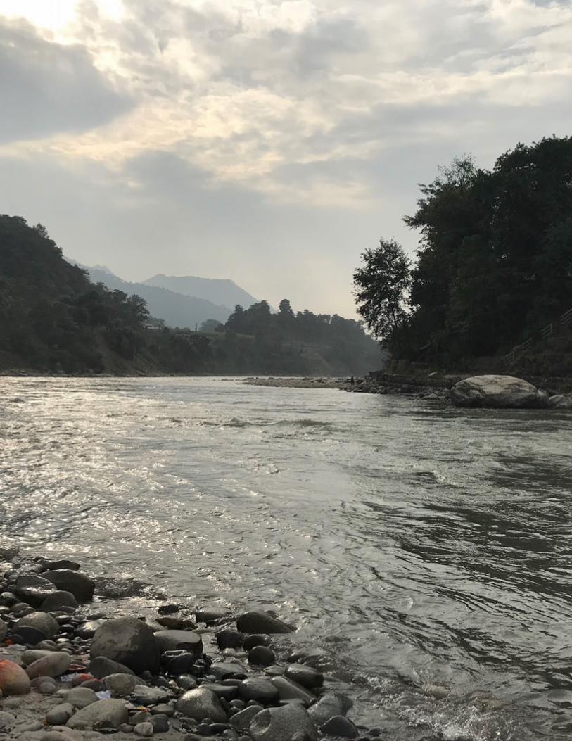
The Trishuli River Basin (TRB) covers an area of 32,000 square kilometers across the Central Development Region of Nepal and makes up approximately 13% of the Gandaki River Basin. The Trishuli River originates in the Trans-Himalayan Zone within the Tibet Autonomous Region of the People’s Republic of China. The Trishuli River cascades downward from an altitude of 2,600 meters into Nepal at the Rasuwa Pass (Rasuwa District). It continues its descent for 130 kilometers through high-altitude mountains (Nuwakot, Dhading, and Gorkha Districts) before joining the Kali Gandaki River at Devighat (Chitwan District).
There are six operational hydropower projects along the Trishuli River and its major tributaries that total 81 megawatts (MW). In addition, seven hydropower
projects (total of 286 MW) are under construction and at least 23 hydropower projects are in the planning stage with survey licenses being issued by the Department of Electricity Development (DoED June 2018).
Cumulative impacts of operational hydropower projects; such as aquatic habitat fragmentation, degradation of the catchment area, reduced water availability, and an increased risk of landslides are already evident in the TRB (ESSA 2014). In April 2015, Nepal suffered a major earthquake that further altered environmental and social conditions (ERM 2019). While hydropower developers have prepared Environmental Impact Assessments (EIAs) for specific projects within the TRB, there have been limited efforts to provide a basin-level understanding of cumulative impacts to valued
Figure ES.1 Overview of the Trishuli River Basin
Features Description
Catchment area
6,624.7 square kilometers up to the confluence with Budhi Gandaki River
Physiography • Varied spatial distribution across mountains of Trans Himalaya to the Middle Hills and the Siwalik range
• Steep and fragile geomorphology makes the area vulnerable to natural disasters
Hydrology • Spatial distribution varies across physiographic zones creating microclimates that affect annual water availability
• Springs are a major source of water
Key biodiversity areas
• Langtang National Park and buffer area of Shivpuri National Park
• Migratory route for aquatic fauna and flyways for migratory birds
• Link protected areas in the north with Shivpuri National Park toward the east and Chitwan National Park toward the South
Livelihood patterns
Main economic activities include forestry, agriculture and participation in tourism-related activities from rafting, and religious sites
Demographic Trends
• Low population density upstream with a gradual increase downstream (the five districts have an average population density of 144 square kilometers)
• Brahmin Chhetri, Gurung, Magar, Tamang, Newar, Thakali, Tharu, Bhote and Dalit are the major ethnic groups in the region (the majority of the people follow Hinduism and Buddhism)
• Other than Chitwan, most districts have had a negative population growth indicating out-migration
These demographic trends, and especially the negative population growth rates and changing sex ratios, have implications on natural resource management and the roles of gender in agriculture and resource governance (Ministry of Forests and Soil Conservation 2015).
Natural disasters are critical drivers of vulnerability for communities, particularly floods, landslides, forest fires, and the Gorkha earthquake of April 2015.
144/km2
population density
42%of the total
population is employed
1,117 : 1000sex ratio
of females tomales
Source: Adapted from information obtained in the Strategy and Action Plan 2016–2025 (Ministry of Forests and Soil Conservation 2015) and Dandekhya et al. 2017. Note that in 2018 the Ministry of Forests and Soil Conservation became the Ministry of Forests and Environment.

2 Cumulative Impact Assessment and Management: Hydropower Development in the Trishuli River Basin, Nepal
environmental components (VECs)1 in the context of multiple hydropower projects acting in concert with the altered baseline conditions (since the April 2015 earthquake) and other stressors.
This Cumulative Impact Assessment and Management (CIA) of hydropower development in the TRB has been undertaken by the International Finance Corporation (IFC) to strengthen understanding of environmental and social impacts of hydropower development that go beyond individual project-level impact assessments and by considering a multiproject, basin-wide understanding of potential cumulative impacts in the TRB.
The “Executive Summary” of the CIA describes the key findings of a year-long assessment (from December 2017 to January 2019) and includes the following:
• An overview of the TRB along with the rationale
1 VECs are defined as fundamental elements of the physical, biological, or socioeconomic environment (including the air, water, soil, terrain, vegetation, wildlife, fish, birds, and land use) that are likely to be the most sensitive receptors to the impacts of a proposed project or the cumulative impacts of several projects. While VECs include social dimensions, they are defined as valued environmental components as per IFC 2013.
for spatial and temporal boundaries and VECs identification
• A quantitative and qualitative understanding of potential cumulative impacts across VECs (to the extent feasible and using qualitative extrapolation) as identified by stakeholder groups
• Recommendations on mitigation measures along with a framework for the establishment of sustainable development pathways that may be implemented and monitored by hydropower developers, local communities, and national stakeholders
The CIA follows a six-step process (Figure ES.2) provided subsequently as per the IFC Good Practice Handbook on Cumulative Impact Assessment and Management (IFC 2013).
Figure ES.2 Cumulative Impact Assessment Process
Note: VEC = valued environmental component.
Determine spatial and temporal boundaries
Determine present conditions of VECs
Assess cumulative impacts and evaluate their significance over VECs' predicted future conditions
Design and implement: (a) adequate strategies, plans, and procedures to manage cumulative impacts, (b) appropriate monitoring indicators, and (c) supervision mechanisms
Identify VECs in consultation with a�ected communities and stakeholders
Identify all developments and external natural and social stressors a�ecting the VECs
Step
1St
ep 2
Step
3St
ep 4
& 5
Step
6
Analysis of the existing legal, institutional,
and governance framew
ork

Executive Summary 3
Step 1: Determining Spatial and Temporal Boundaries
Spatial Extent of the Study Area
The spatial extent of the study area includes the entire catchment of the Trishuli River from the Tibetan border to the point immediately downstream of the Super Trishuli Hydropower Project (Map ES.1).
For ascertaining the baseline conditions with respect to the VECs, the study area was divided into the upstream, midstream, and downstream reaches on the basis of topographic elevation, water temperature, and agro-climatic zones.
Temporal Boundaries
Temporal boundaries considered for the CIA include
projects in two scenarios likely to be developed within the next 10 years (“projects under construction and committed”) and within 50 years (“full development scenario,” which includes all “committed scenario” projects plus future planned projects). These scenarios are in addition to an “existing scenario,” which includes six projects presently operating.
Step 2: Identify VECs, Developments, and Stressors
Identification of VECs
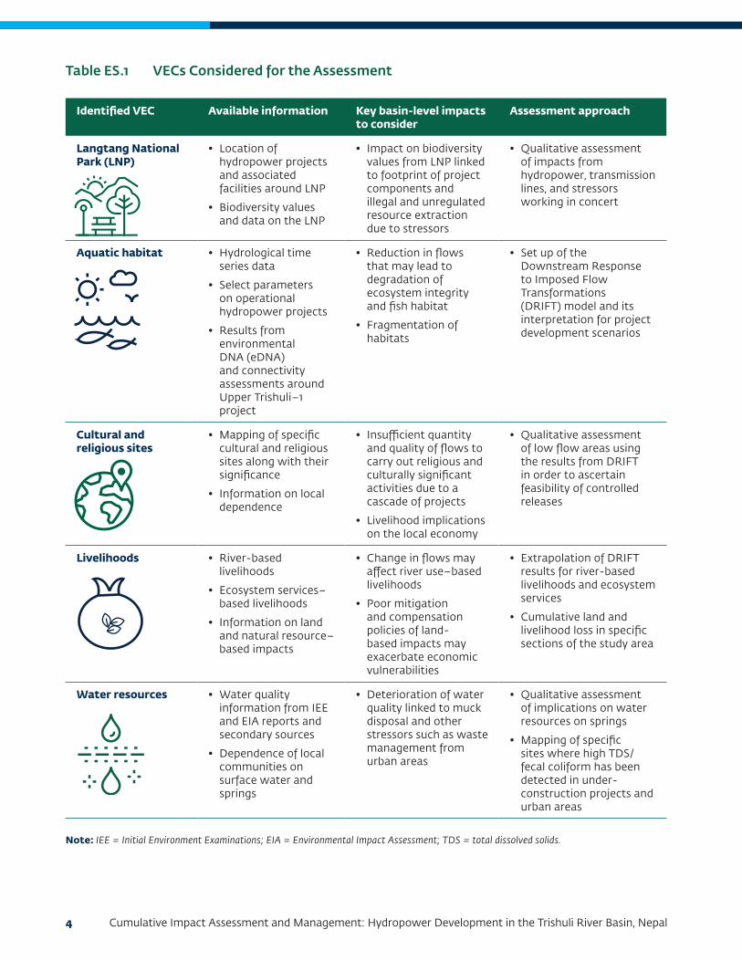
Table ES.1 summarizes the VECs included in the CIA; they were identified through a robust stakeholder engagement program across federal, district, and community levels. Identification of VECs also included
Map ES.1 Spatial Extent of the Study Area
4 Cumulative Impact Assessment and Management: Hydropower Development in the Trishuli River Basin, Nepal
Identified VEC Available information Key basin-level impacts to consider
Assessment approach
Langtang National Park (LNP)
• Location of hydropower projects and associated facilities around LNP
• Biodiversity values and data on the LNP
• Impact on biodiversity values from LNP linked to footprint of project components and illegal and unregulated resource extraction due to stressors
• Qualitative assessment of impacts from hydropower, transmission lines, and stressors working in concert
Aquatic habitat • Hydrological time series data
• Select parameters on operational hydropower projects
• Results from environmental DNA (eDNA) and connectivity assessments around Upper Trishuli–1 project
• Reduction in flows that may lead to degradation of ecosystem integrity and fish habitat
• Fragmentation of habitats
• Set up of the Downstream Response to Imposed Flow Transformations (DRIFT) model and its interpretation for project development scenarios
Cultural and religious sites
• Mapping of specific cultural and religious sites along with their significance
• Information on local dependence
• Insufficient quantity and quality of flows to carry out religious and culturally significant activities due to a cascade of projects
• Livelihood implications on the local economy
• Qualitative assessment of low flow areas using the results from DRIFT in order to ascertain feasibility of controlled releases
Livelihoods • River-based livelihoods
• Ecosystem services– based livelihoods
• Information on land and natural resource–based impacts
• Change in flows may affect river use–based livelihoods
• Poor mitigation and compensation policies of land-based impacts may exacerbate economic vulnerabilities
• Extrapolation of DRIFT results for river-based livelihoods and ecosystem services
• Cumulative land and livelihood loss in specific sections of the study area
Water resources • Water quality information from IEE and EIA reports and secondary sources
• Dependence of local communities on surface water and springs
• Deterioration of water quality linked to muck disposal and other stressors such as waste management from urban areas
• Qualitative assessment of implications on water resources on springs
• Mapping of specific sites where high TDS/fecal coliform has been detected in under-construction projects and urban areas
Table ES.1 VECs Considered for the Assessment
Note: IEE = Initial Environment Examinations; EIA = Environmental Impact Assessment; TDS = total dissolved solids.
Executive Summary 5
field reconnaissance and literature reviews. A total of 52 stakeholder groups were identified and prioritized for consultation across the study timeline; they represent a subset of the following broad categories:
Hydropower Developers: Entities (independent power producers) that will own and operate under construction, committed, and planned hydropower projects that are considered for the Trishuli CIA and that actively participate in the Hydropower Developers Forum
Government Authorities (ministries and national authorities): Key ministries and departments that manage and establish policies to regulate the resources and VECs that are considered by the project
District Authorities: Departments of the national authorities and ministries that implement the policies established at a national level under the governance mechanisms put in place by respective Chief District Officers
Local Authorities: Urban and rural municipalities and specific local governance bodies (for example, the Wildlife Crime and Control Branch) that have been established for local governance and management of resources within the identified administrative structures and jurisdictions
Local and National NGOs: Entities that are active in promoting development and conservation activities within the TRB
International NGOs: Entities that are engaged at national- and international-level discussions on hydropower development and that may be actively interested in the outcomes of the CIA at a river-basin level
External Agencies: These include local contractors and companies engaged in sand mining, local infrastructure development, and so forth that are contributing to localized stressors for the VECs identified
Research Agencies: These include fisheries research stations as well as local entities that are undertaking ongoing data collection linked to critical resources such as aquatic ecosystems
Affected Communities: Local communities within the 20 urban and rural municipalities that inhabit the area of influence of existing and under-construction hydropower projects across the TRB.
Identification of All Developments for Consideration of Basin-level Impacts
Hydropower development has been the main development activity in recent years in the TRB in view of the basin’s hydropower potential and the area’s existing power deficit. In addition to the six operational projects and the seven projects under construction projects, another 23 projects (1,163 MW) are in different stages of planning (from financial closure to being allotted a survey license) as per DoED data of June 2018 (Table ES.2).
Several project development scenarios (see Table ES.4) were assumed to help understand cumulative impacts along with available information on major associated project facilities, such as transmission lines and access roads. Scenarios 1, 2a, 2b, and 3 include Business-as-Usual (BAU), Management, and High Management actions (see Tables ES.6 and ES.7).
Scenario 1: Existing Projects Scenario (Baseline): This development scenario represents the present conditions in which six of the existing projects are operational, and is referred to as Existing or Operational Scenario.
Scenario 2a: Under Construction Scenario (Existing + Under-Construction Projects). This scenario represents the expected conditions considering six existing projects, and seven under-construction projects.
Scenario 2b: Under Construction and Committed Scenario (Existing + Under-Construction + Committed Projects) (within 10 years). This scenario represents the expected conditions considering Scenario 1 and 2a plus the UT-1 project, which is the only project with a power purchase agreement that is not yet under construction.
Scenario 3: Full Development Scenario (all projects foreseen within 50 years): This scenario represents conditions in which all of the above and 23 other planned projects are operational.

6 Cumulative Impact Assessment and Management: Hydropower Development in the Trishuli River Basin, Nepal
Status Main stem projects Capacity (MW) Tributary Capacity (MW)
Operational 2 38 4 43
Trishuli 24 Chilime 22
Devighat 14 Mailung Khola 5
Tadi Khola 14
Thoppal Khola 2
Under construction
3 208 4 78
Rasuwagadhi 111 Upper Sanjen 14.8
Upper Trishuli - 3A (UT-3A)
60 Sanjen Hydro 42.5
Upper Trishuli - 3B (UT-3B)
37 Upper Mailung A 6.42
Upper Mailung Khola
14.3
Planned 6 582.6 17 581
Upper Trishuli–1 (UT-1) 216 Sanjen Khola 78
Trishuli Galchi 75 Langtang Khola Small
10
Super Trishuli 100 Salankhu Khola 2.5
Upper Trishuli 2 102 Phalaku Khola 14.7
Upper Trishuli 1 Cascade
24.6 Phalaku Khola 5
Middle Trishuli Ganga Nadi
65 Upper Tadi 11
Middle Tadi Khola 5
Lower Tadi 4.993
Ankhu Khola 49.5
Bhotekoshi Khola 33.5
Mathillo Langtang 24.35
Langtang Khola 310
Trishuli Khola 4.409
Upper Mailung B 7.5
Middle Mailung 10
Tadi Ghyamphedi 4.7
Tadi Khola 5.5
Table ES.2 Trishuli River Basin Hydropower Projects
Note: UT-1 is considered a committed project.
Executive Summary 7
External Stressors
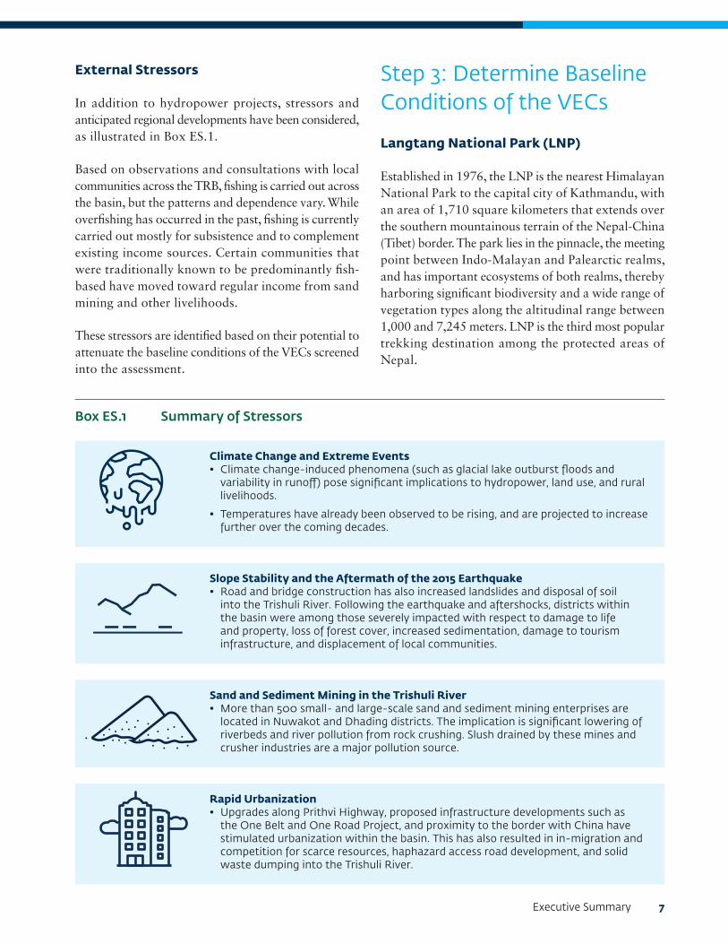
In addition to hydropower projects, stressors and anticipated regional developments have been considered, as illustrated in Box ES.1.
Based on observations and consultations with local communities across the TRB, fishing is carried out across the basin, but the patterns and dependence vary. While overfishing has occurred in the past, fishing is currently carried out mostly for subsistence and to complement existing income sources. Certain communities that were traditionally known to be predominantly fish-based have moved toward regular income from sand mining and other livelihoods.
These stressors are identified based on their potential to attenuate the baseline conditions of the VECs screened into the assessment.
Step 3: Determine Baseline Conditions of the VECs
Langtang National Park (LNP)
Established in 1976, the LNP is the nearest Himalayan National Park to the capital city of Kathmandu, with an area of 1,710 square kilometers that extends over the southern mountainous terrain of the Nepal-China (Tibet) border. The park lies in the pinnacle, the meeting point between Indo-Malayan and Palearctic realms, and has important ecosystems of both realms, thereby harboring significant biodiversity and a wide range of vegetation types along the altitudinal range between 1,000 and 7,245 meters. LNP is the third most popular trekking destination among the protected areas of Nepal.
.
... .
.
. . ..
..
..
. ..
..
... .
..
Climate Change and Extreme Events• Climate change-induced phenomena (such as glacial lake outburst floods and
variability in runoff) pose significant implications to hydropower, land use, and rural livelihoods.
• Temperatures have already been observed to be rising, and are projected to increase further over the coming decades.
Slope Stability and the Aftermath of the 2015 Earthquake• Road and bridge construction has also increased landslides and disposal of soil
into the Trishuli River. Following the earthquake and aftershocks, districts within the basin were among those severely impacted with respect to damage to life and property, loss of forest cover, increased sedimentation, damage to tourism infrastructure, and displacement of local communities.
Sand and Sediment Mining in the Trishuli River• More than 500 small- and large-scale sand and sediment mining enterprises are
located in Nuwakot and Dhading districts. The implication is significant lowering of riverbeds and river pollution from rock crushing. Slush drained by these mines and crusher industries are a major pollution source.
Rapid Urbanization• Upgrades along Prithvi Highway, proposed infrastructure developments such as
the One Belt and One Road Project, and proximity to the border with China have stimulated urbanization within the basin. This has also resulted in in-migration and competition for scarce resources, haphazard access road development, and solid waste dumping into the Trishuli River.
Box ES.1 Summary of Stressors
.
... .
.
. . ..
..
..
. ..
..
... .
..
8 Cumulative Impact Assessment and Management: Hydropower Development in the Trishuli River Basin, Nepal
The LNP was perceived to be an important VEC for terrestrial habitat due to the forest land requirement and proposed transmission lines of at least four planned hydropower projects within the national park. Construction of infrastructure and access roads may cumulatively impact biodiversity habitats within the LNP.
Aquatic Habitat
The aquatic baseline of the basin, which is categorized according to the cold, cool, and cool to warm bioclimatic zones, was compiled from three sources:
• Review of secondary literature and available, representative EIAs
• A 2018 basin-wide aquatic environmental DNA (eDNA) survey carried out by the Centre for Molecular Dynamics Nepal (CMDN)
• Review of secondary literature and EIAs (Rajbanshi 1996; NESS 2012–14) revealed the presence of 49 species. Of these 49 species, 5 species are listed as threatened: Tor putitora (EN), Schizothorax richardsonii (VU), Neolissocheilus hexagonolepis (NT), Tor tor (NT), which are migratory, and Balitora brucei (NT) are present in the Trishuli River (IUCN 2019, Red List version 2018-1). Two species, Danio aequipinnulus and Psilorhynchoides pseudecheneis, are endemic to Nepal.
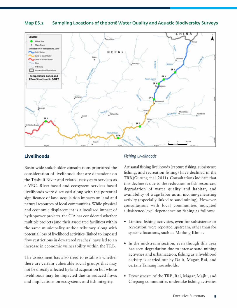
The 2018 surveys sampled aquatic water quality, macroinvertebrates, periphyton, and fish species at seven ecological flow sites (Map ES.2).
From the Sweco (2016) surveys, which focused on the upper Trishuli River area, breeding Common Snow Trout (Schizothorax richardsonii) individuals were recorded from Chilime Khola (upstream of UT-1) and Andheri Khola (downstream of Trishuli 3B), although no data were presented on fish size distribution. The densities of Common Snow Trout fry and fingerlings in the main river were considerably less than in the
2 A review of tourism brochures that provide information on rafting and recreational activities in the basin suggests that the river is named after the trident wielded by Lord Shiva of the Hindu pantheon. Legend proclaims that Lord Shiva drove his trident into the ground at Gosaikunda to create three springs that are the source of the river.
tributaries, which seem to be of vital importance to the fish population. Species diversity and fish abundance increased downstream. The authors also observed that the Trishuli 3A infrastructure could already be acting as a barrier to upstream fish migration.
The 2018 surveys were undertaken in the upstream reach of the TRB. This included an eDNA analysis (CMDN 2018) which identified a total of 25 fish species. It may be noted that eDNA is still in experimental stages and results are being confirmed and tested with further studies. One issue is that the reference eDNA database (NCBI GenBank) has limited data available on Himalayan fish species, which creates uncertainties in the species identifications from the eDNA study. The application of eDNA is being further investigated for use in long-term monitoring of fish in the TRB.
Due to their threatened and migratory status, and because they are fished extensively for commercial and sustenance purposes, the Common Snow Trout and the Golden Mahseer were determined to be important components of the Aquatic Habitat VEC.
Cultural Sites
The TRB has religious and mythological value to local communities due to the myths concerning the origins of the river.2 The river flow supports cultural practices and rituals linked to religious ceremonies and cremation rites of Hindus. The population in the upstream of the basin is predominantly Buddhist and does not practice cremation rites along the banks of the river. Cremation and/or burial practices of communities such as the Tamang, Gurung, and Chepang are linked to groves and forested areas in the uplands and not to the river. However, other communities undertake cremation rites along the main stem of the TRB. Two specific locations—Uttargaya (between upstream and midstream) and Devighat (midstream)—have emerged as regionally significant for pilgrims and national tourists due to the inflow of multiple tributaries that support cremation-related rites and temples of local significance.
Executive Summary 9
Livelihoods
Basin-wide stakeholder consultations prioritized the
consideration of livelihoods that are dependent on
the Trishuli River and related ecosystem services as
a VEC. River-based and ecosystem services-based
livelihoods were discussed along with the potential
significance of land-acquisition impacts on land and
natural resources of local communities. While physical
and economic displacement is a localized impact of
hydropower projects, the CIA has considered whether
multiple projects (and their associated facilities) within
the same municipality and/or tributary along with
potential loss of livelihood activities (linked to imposed
flow restrictions in dewatered reaches) have led to an
increase in economic vulnerability within the TRB.
The assessment has also tried to establish whether
there are certain vulnerable social groups that may
not be directly affected by land acquisition but whose
livelihoods may be impacted due to reduced flows
and implications on ecosystems and fish integrity.
Map ES.2 Sampling Locations of the 2018 Water Quality and Aquatic Biodiversity Surveys
Fishing Livelihoods
Artisanal fishing livelihoods (capture fishing, subsistence fishing, and recreation fishing) have declined in the TRB (Gurung et al. 2011). Consultations indicate that this decline is due to the reduction in fish resources, degradation of water quality and habitat, and availability of wage labor as an income-generating activity (especially linked to sand mining). However, consultations with local communities indicated subsistence-level dependence on fishing as follows:
• Limited fishing activities, even for subsistence or recreation, were reported upstream, other than for specific locations, such as Mailung Khola.
• In the midstream section, even though this area has seen degradation due to intense sand mining activities and urbanization, fishing as a livelihood activity is carried out by Dalit, Magar, Rai, and certain Tamang households.
• Downstream of the TRB, Rai, Magar, Majhi, and Chepang communities undertake fishing activities

10 Cumulative Impact Assessment and Management: Hydropower Development in the Trishuli River Basin, Nepal
in Icchyakayamana and Gandaki municipalities above the confluence between Trishuli and Budhi Gandaki to supply restaurants along the Prithvi Highway and linked to seasonal demands from activities such as tourism, rafting, pilgrimage, and so forth.
There is limited processing and/or value addition of fish that are caught since they are either sold to restaurants or consumed. Fishery Research Stations in Nuwakot and Dhunche (funded by the Nepal Agricultural Research Council) has been focusing on intensification of aquaculture and capture fisheries to support livelihood activities that are less dependent on flows.
Overall, cumulative impacts on fishing livelihoods are not considered significant, as few people depend on fishing livelihoods and have already shifted to aquaculture and capture fisheries. Impacts to subsistence-level fishing are best managed through the CIA’s biodiversity-related recommendations.
Other Ecosystem Services-Based Livelihoods
Some communities and families in the midstream and downstream sections of the study area rely on the river for some ecosystem services-based livelihoods, such as for irrigation, river-based sand mining, and whitewater rafting.
The gradual urbanization, upgrading of local infrastructure, and the development of hydropower projects in the TRB have spurred local enterprise and trade opportunities. These are linked to sand and gravel mining; crusher units and quarries; construction contractors and service providers for hydropower developers; the general plying of private vehicles and dumper trucks; and the establishment of restaurants and grocery stores in urban areas and tourist towns.
Primary consultations with local communities and the Nepal Association of Rafting Agencies indicated that whitewater rafting as a tourism and recreational activity occurs only in the downstream area of the basin. The peak season for rafting is from October to February, when 15,000 to 20,000 tourists visit
annually to raft. June to August each year (during the monsoon season) is the low season for this activity, due to the velocity of the river.
Water Resources
Water availability in the TRB depends on annual rainfall and glacier melt (upstream in the Tibet Autonomous Region) and is affected by extreme events and interventions such as river diversion schemes (Dandekhya et al. 2017).
In the upstream study area, it has been reported that during the earthquake water infrastructure such as pipes in Rasuwa District were badly damaged, leaving villages with no access to clean and safe drinking water (CAFOD 2015). There is no use of river water for irrigation or for drinking in view of the altitude and general riparian topography, which makes access to the riverbank difficult. The midstream area in Nuwakot faces scarcity of safe drinking water, which is exacerbated by landslides that engulf available drinking water pipelines (Dandekhya and Piryani 2015).
In Kispang, Bidur, and Benighat the major drinking water source is piped water supply and is not linked to the river or to springs. There are exceptions in some villages, such as Belkotgadi, where the communities have installed wells on the banks of the Trishuli. In the downstream area, it is estimated that each settlement in this district has one or two streams. Local communities use piped water (not the Trishuli River) for drinking. However, the source of water for agriculture varies from river water channeled directly to the fields to water directed to small-scale storage systems, such as ponds and tanks.
Analysis of water quality based on turbidity and coliform levels (from untreated domestic sewage) at various sections along the river indicates that turbidity levels are high as the river flows through the midstream and downstream sections, and it is likely that sand and gravel mining are significant contributors to high turbidity levels. E-coli concentrations, while exceeding the National Drinking Water Quality Standards (NDWQS) at all sampling locations, is highest in the midstream and downstream sections.

Executive Summary 11
Springs are unlikely to be cumulatively impacted by hydropower projects in the TRB. However as project specific impacts are likely; it is essential that developers carry out a preconstruction baseline study of springs in and around the dam, diversion tunnels, and other excavation areas (for example, quarries).
Steps 4 and 5: Evaluation of Cumulative Impacts on VECs and their significance
Cumulative Impacts on Aquatic Habitat
The DRIFT model evaluated multiple stressors on aquatic habitat and classified the resulting habitat condition using ecosystem integrity categories ranging from unmodified (“A”) to critically/extremely modified (“F”), which are described in Table ES.3.
Table ES.4 shows the predicted changes in ecosystem integrity at each of the seven environmental flows (EFlows) study sites (presented in Map ES.2) for existing/baseline conditions and then incrementally for each of the different scenarios under a business-as-usual scenario (construction and operation in compliance
with local requirements). As indicated in Table ES.4, ecosystem integrity along the Trishuli River, in the absence of significant management actions, such as those that would be required if IFC’s Performance Standards (PS) were to be applied, is predicted to decline primarily from ecosystem integrity categories B and C to categories D and E for the most part.
Qualitative Discussion of Cumulative Impacts on Other VECs
The analysis of cumulative impacts on VECs involves estimating the future state of the VECs that may result from the impacts they experience from various past, present, and predictable future developments. Cumulative impacts as described in the report are based on current and planned conditions of the TRB, without any responsive actions to prevent or reduce the impacts.
Table ES.5 summarizes key cumulative impacts on each identified VEC in the TRB.
In the business-as-usual project development scenarios, construction and commissioning timelines of the under-construction and planned projects are likely to coincide within a 7 to 10 year timeline across the
Ecological category
Corresponding DRIFT overall integrity score
Description of the habitat condition
A >-0.25 Unmodified: The ecosystem is still in a natural condition.
B >-0.75 Slightly modified: A small change in natural habitats and biota has taken place, but the ecosystem functions are essentially unchanged.
C >-1.5 Moderately modified: Loss and change of natural habitat and biota has occurred, but the basic ecosystem functions are still predominantly unchanged.
D >-2.5 Largely modified: A large loss of natural habitat, biota and basic ecosystem functions has occurred.
E >-3.5 Seriously modified: The loss of natural habitat, biota, and basic ecosystem functions is extensive.
F <-3.5 Critically/extremely modified. The system has been critically modified with an almost complete loss of natural habitat and biota. In the worst instances, basic ecosystem functions have been changed and the changes are irreversible.
Table ES.3 Ecosystem Integrity Categories
Note: DRIFT = Downstream Response to Imposed Flow Transformations model.

12 Cumulative Impact Assessment and Management: Hydropower Development in the Trishuli River Basin, Nepal
upstream and midstream reaches. This timeline will also coincide with regional developments such as the OBOR linkage, an increase access road construction, and gradual urbanization in the midstream.
During this timeline, the intensity of the following impacts are likely to amplify overall in the TRB, especially in Rasuwa and Nuwakot Districts: (i) In-migration to the basin; (ii) local economic and demographic changes; (iii) pressure on local resources
linked to community forest user groups (CFUGs), drinking water facilities, health infrastructure, and so forth; and (iv) community health and safety impacts. While the mitigation of adverse impacts is to some extent covered by approved Environment Management Plans (EMPs) of hydropower projects, there is a need to demarcate zones of intense hydropower development and an overarching approach to “localized cumulative impacts management” involving the developers, contractors, and municipalities.
EFlows site/ reach
Existing (Scenario 1)
Under- construction (Scenario 2a)
Under- construction
and committed (Scenario 2b)
Full development (Scenario 3)
EFlows Site 1 B B/C C/D D
EFlows Site 2 B B/C E E
EFlows Site 3 C C/D D E
EFlows Site 4 C C C D
EFlows Site 5 C C C D
EFlows Site 6 C/D C/D C/D D
EFlows Site 7 B B B C
Table ES.4 Changes in Overall Ecosystem Integrity across Project Development Scenarios
Note: Letter grades are defined in Table ES.3.
Identified VEC Key non-HPP stressors
Cumulative impacts from HPPs
Cumulative impact significance
Terrestrial biodiversity: Langtang National Park (LNP)
• Infrastructure development associated with upgrading of the Prithvi Highway and the proposed One Belt One Road (OBOR) initiative road infrastructure connecting to the China Border
• Declining populations of species of conservation significance through illegal extraction, exploitation, and export
• No significant impacts envisaged on wildlife dispersal and migratory bird corridors
• Access roads and transmission lines will provide improved access and potentially increase illegal entry into the LNP, resulting in the loss and degradation of habitat from logging and wildlife through poaching.
• Lower capacity transmission lines within the park have a minimal footprint and thereby do not impact habitat for threatened or endemic species.
• The transmission line network is unlikely to endanger any major flyway for migratory bird species.
Table ES.5 Summary of Cumulative Impacts if Unmitigated
Continued on the next page

Executive Summary 13
Identified VEC Key non-HPP stressors Cumulative impacts from HPPs
Cumulative impact significance
Aquatic habitat: Habitat quality
• Sand and gravel mining and processing
• Soil from landslides and dumping of spoil from road construction degrading aquatic habitat
• Alteration of aquatic habitats and deterioration of water quality as indicated by ecosystem integrity results across project development scenarios
• Significance was evaluated on the basis of ecosystem integrity as predicted by the DRIFT model at different EFlows sites. Ecosystem integrity is expected to progressively deteriorate based on the scenarios modelled from existing ecosystem integrity categories B, C, and D (slightly/moderately/largely modified) to D and E (largely/seriously modified) for the full-development scenario, if there are no mitigation measures implemented.
Aquatic habitat: Aquatic biodiversity (particularly fish) These are populations that are in discrete management units due to cumulative impact of HPPs and include altered ecological flows in diversion reaches.
• Sand and sediment mining
• Access roads that may render stretches of the river upstream accessible with potential increase in unregulated fishing
• Climate change resulting in long-term temporal changes in flow in diversion reaches already compromised by low flows caused by dams
• Impediments to upstream and downstream migration in both main stem and tributaries as a result of multiple HPP dams, leading to declines of Snow Trout and Mahseer populations
• Degradation of aquatic habitats and lowered water depths from modification on natural flow regimes leading to impediments to upstream migration
• Significance evaluated based on DRIFT modelling. Based on the scenarios modelled, fish integrity is expected to progressively deteriorate if there are no mitigation measures implemented. Existing integrity ranges from Ecosystem Integrity Category B (slightly modified) to Ecosystem Integrity Category C/D (moderately/largely modified). These are predicted to deteriorate to Ecosystem Integrity categories. E (seriously modified) and F (critically/extremely modified) for the full-development scenario.
Cultural and religious sites: Uttargaya and Devighat These sites have regional importance as sites for Hindu rituals, ceremonies, and pilgrimages during the year.
• Sand and gravel mining activities resulting in degradation of river banks, with river subsidence altering water quality
• Quality of water linked to increased fecal coliform and pollution-load untreated sewage from nearby towns; furthering loss of heritage resources and intangible cultural services relative to the baseline condition
• Reduction in flow in specific river segments (for example, diversion reaches)
• Significance evaluated based on water quality and flow. Flow impacts are expected to be more project specific than cumulative and best managed as part of individual project EIA review process.
Continued on the next page

14 Cumulative Impact Assessment and Management: Hydropower Development in the Trishuli River Basin, Nepal
Identified VEC Key non-HPP stressors Cumulative impacts from HPPs
Cumulative impact significance
Livelihoods Unregulated fishing has been declining, but it continues to contribute to subsistence livelihoods as well as providing a supplementary income source from sale of fish to restaurants and hotels along the Prithvi Highway.
• Sand and sediment mining leading to degradation of aquatic habitat and with implications on fish resources
• In the full-development scenario, fish integrity likely to be significantly impacted in the upstream reach, indicating a general decline in the possibility of fishing-based livelihood
• Livelihood impacts may increase on certain vulnerable social groups (Rai, Magar, and Dalit) that may depend on fishing more than other communities
• Significance evaluated based on DRIFT-modelled changes to overall fish integrity. Assessment indicates that fish abundance will be impacted, although relatively few families rely exclusively on fishing as a livelihood.
• Overall significance of impacts upstream is linked to economic displacement and will be significant in view of multiple projects.
• Overall significance of impacts midstream is minor; however, specific communities such as Rai, Magar, and Dalit may be affected due to loss of livelihoods linked to fishing.
• Overall significance of impacts downstream is minor, other than for local communities that support rafting and tourism activities—localized impact linked to Super Trishuli HPP.
Water resources: Surface water quality Basin water quality is poor, and turbidity and coliform levels increase in downstream. Trishuli River is not used directly for drinking.
• Sand and sediment mining
• Spoil disposal from construction activities
• Solid waste and untreated sewage from major or urban settlements along the banks of the Trishuli River
• Additional projects in concert with increased intensity of existing stressors likely to further degrade habitats, but may tend to be spatially restricted (other than in the midstream reach)
• Significance analysis of water quality based on turbidity and coliform levels at various sections along the river indicates that the impacts of stressors such as sand and gravel mining and disposal of soil are significant.
Note: HPP = hydropower project.
Executive Summary 15
Steps 6: Managing Cumulative Impacts
This step describes proposed mitigation measures for each of the identified VECs, but also proposes a “high-management” action for enhanced management and protection of VECs and suggests an organizational structure for effective cooperative management of these important river basin resources.
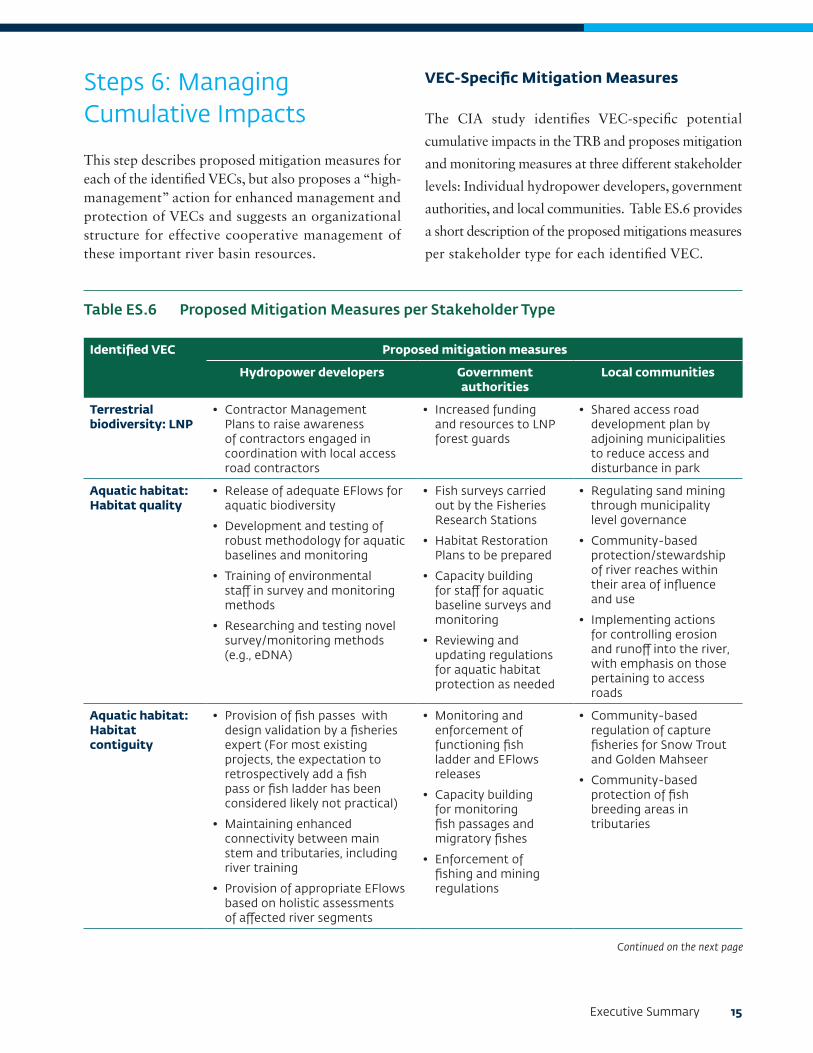
VEC-Specific Mitigation Measures
The CIA study identifies VEC-specific potential
cumulative impacts in the TRB and proposes mitigation
and monitoring measures at three different stakeholder
levels: Individual hydropower developers, government
authorities, and local communities. Table ES.6 provides
a short description of the proposed mitigations measures
per stakeholder type for each identified VEC.
Identified VEC Proposed mitigation measures
Hydropower developers Government authorities
Local communities
Terrestrial biodiversity: LNP
• Contractor Management Plans to raise awareness of contractors engaged in coordination with local access road contractors
• Increased funding and resources to LNP forest guards
• Shared access road development plan by adjoining municipalities to reduce access and disturbance in park
Aquatic habitat: Habitat quality
• Release of adequate EFlows for aquatic biodiversity
• Development and testing of robust methodology for aquatic baselines and monitoring
• Training of environmental staff in survey and monitoring methods
• Researching and testing novel survey/monitoring methods (e.g., eDNA)
• Fish surveys carried out by the Fisheries Research Stations
• Habitat Restoration Plans to be prepared
• Capacity building for staff for aquatic baseline surveys and monitoring
• Reviewing and updating regulations for aquatic habitat protection as needed
• Regulating sand mining through municipality level governance
• Community-based protection/stewardship of river reaches within their area of influence and use
• Implementing actions for controlling erosion and runoff into the river, with emphasis on those pertaining to access roads
Aquatic habitat: Habitat contiguity
• Provision of fish passes with design validation by a fisheries expert (For most existing projects, the expectation to retrospectively add a fish pass or fish ladder has been considered likely not practical)
• Maintaining enhanced connectivity between main stem and tributaries, including river training
• Provision of appropriate EFlows based on holistic assessments of affected river segments
• Monitoring and enforcement of functioning fish ladder and EFlows releases
• Capacity building for monitoring fish passages and migratory fishes
• Enforcement of fishing and mining regulations
• Community-based regulation of capture fisheries for Snow Trout and Golden Mahseer
• Community-based protection of fish breeding areas in tributaries
Table ES.6 Proposed Mitigation Measures per Stakeholder Type
Continued on the next page

16 Cumulative Impact Assessment and Management: Hydropower Development in the Trishuli River Basin, Nepal
Identified VEC Proposed mitigation measures
Hydropower developers Government authorities
Local communities
Aquatic habitat: Habitat contiguity (continued)
• Development and testing of robust monitoring methodology; training of environmental staff
• Monitoring of fish passage and abundance during migratory season
• Enhancement of fish breeding areas in tributaries
• Additional research on fish hatcheries to international standards
Cultural and religious sites: Uttargaya and Devighat
• Undertaking an assessment of the actual requirements for water flow in dewater reaches for normal rituals as well as during specific times through the year, especially during the dry season
• Regional policy directives to temporarily stop mining activities at least during key festivals/pilgrimages and regionally significant rituals
• Implementing domestic wastewater treatment for towns currently discharging untreated sewage into the river
• Raising awareness among local communities and sand and gravel mining entities for management of waste along with specific zones being declared for muck/spoil disposal
• Education to stop disposal of solid waste in riverbeds and tributaries
• Construction of septic systems
Livelihoods • Granting reservoir area fishing rights and/or licenses based on district allocations
• Developing focused livelihood support plans for specific communities of cold-water aquaculture schemes
• Agreement on principles of avoidance measures, compensation, and livelihood restoration
• Good grievance redress mechanism
• Developing Sustainable Fishing Plans for specific sections of the basin
• Coordinating with individual hydropower developers to ensure livelihoods are restored
• Implementation of Sustainable Fishing Plans
• Community-based cold-water aquaculture/fish farm schemes
• Community monitoring and supervision
Water resources: Surface water quality
• Implementation of the Environment Management Plan on muck disposal during construction
• Implementation of regulations on sand and gravel mining
• Exploring sewage treatment options
• Increase awareness by local communities on household waste disposal through engaging with municipal authorities and community-based organizations.
Executive Summary 17
Proposed High-Management Action
Steps 4 and 5 in the CIA process show that the assessed scenarios would result in significant degradation of aquatic biodiversity and several other VECs. Although the mitigation actions proposed in Table ES.5 and Table ES.6 are a start to mitigating cumulative impacts, based on the level of development proposed for the TRB, additional management actions at a higher level, such as a high-management action, are also suggested to address the significant cumulative impacts that are predicted to affect the basin.
The high-management action comprises a combination of quasi-regulatory, incentive-based, and technical measures to manage fish populations in the TRB along with regulation of sediment mining and watershed management; all will contribute to improvement of habitats and consequently reduction of cumulative impacts across VECs. This scenario suggests measures to be jointly implemented by hydropower developers, municipalities, and local communities, facilitated by the perception of shared benefits until a basin-level sustainable hydropower strategy for Trishuli is adopted by the government of Nepal.
Trishuli Hydropower Developers Forum
• Developers• Lenders (facilitated by the IFC)• NEA• DoED• MoFE• MoEWRI• Others by invitation
Community volunteers for implementation
Project-specific forums (e.g. UT1 Adivasi Janajati Advisory
Council
Local HSE leads of projectssuch as UT1, UT3A,
Mailung, etc.
Municipalityrepresentatives
Structure of LMC2 in upstream reach of TRB
Community river guards and mining supervisors
for monitoring activities
Local Impact Management Committee 1 (LMC1)
Local Impact Management Committee 2 (LMC2) LMC3 LMC4, etc.
Technical Resources Group
Figure ES.3 Proposed Structure to Implement a High-Management Action
Note: NEA = Nepal Electricity Authority; DoED = Department of Electricity Development; MoFE = Ministry of Forests and Environment; MoEWRI = Ministry of Energy, Water Resources, and Irrigation.

18 Cumulative Impact Assessment and Management: Hydropower Development in the Trishuli River Basin, Nepal
The high-management action is premised under the following assumptions:
• Hydropower developers across the TRB will sign on to a cumulative impacts management charter that goes beyond compliance requirements of EMP implementation of individual hydropower projects. This charter will form the basis of a formal structure to set up the Trishuli Hydropower Developer’s Forum (THDF) as a developer-driven institution to manage cumulative impacts.
• Municipalities will be empowered under the proposed revisions to the Environment-Friendly Local Governance Framework (2013) to align with the proposed decentralization in the federal
governance structure and to form Local Impact Management Committees (LMCs), which will include participation from hydropower developers and local NGOs/community-based organizations.
• A technical resource group (through participation by government ministries, conservation groups, research agencies, and multilateral development banks/donor agency experts) will provide strategic support and guidance for approval by the THDF and implementation by the LMCs.
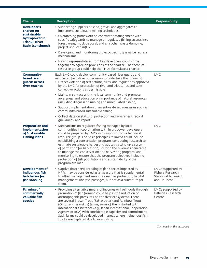
Table ES.7 summarizes sustainable development pathways that can be conceptualized and implemented under the high-management action.
Theme Description Responsibility
Developer’s charter on sustainable hydropower in Trishuli River Basin
This would be a vision and commitments-driven document that could include the following:• Applying a uniform set of standards for including fish passages in the
design of projects based on a review of contemporary and innovative designs for fish in conjunction with leading experts in this discipline
• Developing guidelines to prepare and implement an environmental flow management framework for each hydropower project based on available secondary guidance on adaptive management: This should be project/reach specific keeping in mind ecological, cultural and social sensitivities inherent for the river reach
• Researching and developing a robust standard methodology for aquatic baseline surveys and monitoring for ESIAs to be used by all hydropower projects and possibly adopted into government regulations: Train HPP and government staff in methodologies
• Assessing land-based and livelihood impacts from projects in order to develop and fund livelihood restoration measures (e.g. fishing, skills development, and agricultural intensification schemes) as a form of local community development around hydropower projects
• Expanding the regulatory EMPs into a comprehensive Environmental and Social Management Plan that would incorporate safeguards to manage localized social impacts linked to in-migration, resource requirements, and community health and safety
• Conducting issue- or theme-specific studies for sensitivities within the area of influence of the hydropower project, such as assessment of flows for cultural practices, inventory of springs, and so forth
• Developing principles for all future land acquisition based on avoidance measures, compensation at replacement cost, informed consultation, and participation and emphasis on livelihood restoration of affected communities
Trishuli Hydropower Developers Forum (THDF) with support from Local Impact Management Committees (LMCs)
Table ES.7 Suggested Elements of a High-Management Action
Continued on the next page
Executive Summary 19
Theme Description Responsibility
Developer’s charter on sustainable hydropower in Trishuli River Basin (continued)
• Supporting suppliers of sand, gravel, and aggregates to implement sustainable mining techniques
• Overarching framework on contractor management with specific safeguards to manage unregulated fishing, access into forest areas, muck disposal, and any other waste dumping, project-induced influx
• Developing and monitoring project-specific grievance redress mechanisms
• Having representatives from key developers could come together to agree on provisions of the charter: The technical resource group could help the THDF formulate a charter.
Community-based river guards across river reaches
Each LMC could deploy community-based river guards and associated field-level supervision to undertake the following:• Detect violation of restrictions, rules, and regulations approved
by the LMC for protection of river and tributaries and take corrective actions as permissible
• Maintain contact with the local community and promote awareness and education on importance of natural resources (including illegal sand mining and unregulated fishing)
• Support implementation of incentive-based measures such as community-based sustainable fishing
• Collect data on status of protection and awareness, record grievances, and report
LMC
Preparation and implementation of Sustainable Fishing Plans
• Mechanisms on regulated fishing managed by local communities in coordination with hydropower developers could be prepared by LMCs with support from a technical resource group. The basic principles followed could include establishing a conservation program, conducting research to estimate sustainable harvesting quotas, setting up a system of permitting for harvesting, utilizing the revenues generated to manage the conservation and harvesting program, and monitoring to ensure that the program objectives including protection of fish populations and sustainability of the program are met.
LMC
Development of indigenous fish hatcheries for fish stocking
• Captive (hatchery) breeding of fish species impacted by HPPs may be considered as a measure that is supplemental to other management measures such as protection, habitat management, and fish passages, but not as a substitute for them.
LMCs supported by Fishery Research Station at Nuwakot and Dhunche
Farming of commercially valuable fish species
• Providing alternative means of incomes or livelihoods through promotion of fish farming could help in the reduction of anthropogenic pressures on the river ecosystems. There are several Brown Trout (Salmo trutta) and Rainbow Trout (Oncorhynchus mykiss) farms, some of them started with international assistance (e.g., Japan International Cooperation Agency, or JICA) with considerable capacity and commitment. Such farms could be developed in areas where indigenous fish stocks are depleted due to overfishing.
LMCs supported by Fisheries Research Centre
Continued on the next page

20 Cumulative Impact Assessment and Management: Hydropower Development in the Trishuli River Basin, Nepal
Theme Description Responsibility
Preparation and implementation of Sustainable Sediment Mining Plans
• Given that it is entirely plausible that the demand for sediment will continue to increase in the foreseeable future, achieving the high-management action would necessitate management and control that could limit the impact of mining on the river and its tributaries in the face of increased demand and volumes being abstracted. This mining plans could be elaborated to include the following:
o Ban mining in sensitive areas and identifying nonsensitive areas to focus mining activities.
o Mine outside the riverbed only in the river banks, and ensure that any unavoidable mining in the riverbed takes place in areas expected to be flooded by reservoirs instead of in the projected dewatered reaches.
o Implement on-site control of mining activities linked to equipment and techniques used, manage spoil disposal, and so forth.
o Rehabilitate or restore habitats already degraded by mining, especially in the midstream reach.
o Identify alternative sources of aggregate for construction: Among other practices, (i) reuse spoil from construction of hydropower projects, and (ii) use open rock quarries on hillsides (with due recognition of any springs) as source of gravel.
• An important component of the sustainable sediment mining plans would be to appoint community based mining supervisors and guards from within the LMCs to enforce restrictions.
• Depending on the level of pressure from mining, the number of supervisors and guards assigned for this purpose could vary, and where pressures are low, the responsibilities for implementation of the sustainable sediment mining plan could be assigned to the river guards.
• These mining plans could be developed by municipalities, as sand and sediment mining enterprises are a major source of revenue. There is also an overlap between owners of sand-mining entities and key local leaders (including municipality representatives). Municipalities may seek support from the technical resource group for the identification of mining areas through modelling (to predict the location, quality, and quantity of sediment deposits linked with hydropower projects); identification of key ecological sites or reaches within the system to identify no-go or restricted use areas; and the necessary engagement with the affected mining and local community.
LMCs with potential assistance from the District Coordination Committee.
Watershed management
• A watershed management program could help improve water quality in the basin, critical for the protection of biodiversity and river-based livelihoods. Actions that could be supported by the THDF and LMCs include (i) programs focusing on areas including reforestation to meet community requirements for fuel wood and timber remaining within the limits of sustainable harvesting to reduce erosion and risk of landslides, and (ii) land-use management.
LMCs
Continued on the next page
Executive Summary 21
Theme Description Responsibility
Watershed management (continued)
• The watershed management program could also link to any basin-level plans and benefit-sharing plans. In partnership with the provincial government it could allow for the coordinated planning and implementation of watershed and community investment initiatives. Also, suggestions should be included for management of water use in both agriculture and households, and management of water quality at the local level, including enhanced community wastewater treatment.
Delineating no-go areas for hydropower development
• LMCs could strongly advocate for setting aside stretches of river and tributaries that are of high ecological importance to help preserve key features of aquatic biodiversity in the basin—including spawning grounds of fish and stretches or tributaries still in pristine condition, for example, the undammed Nyam khola, a tributary of the Mailung Khola, which is an important source site for Common Snow Trout for the Mailung Khola downstream of the dewatered area of the Mailung Khola HPP. LMCs, through the THDF, could recommend certain no-go areas for consideration by DoED, NEA, and MoEWRI. The technical resource group could support capacity building and reaching out to the provincial and national government ministries and departments.
LMCs
Mahseer and Snow Trout sanctuary
• Consider designating one or more important fish spawning tributaries (for example, the Tadi Khola) as a Mahseer and Snow Trout sanctuary, which would remain free flowing (that is, no hydropower development) and develop and foster domestic wastewater treatment and solid waste management to improve water quality and riparian and river health.
THDF with support from LMCs
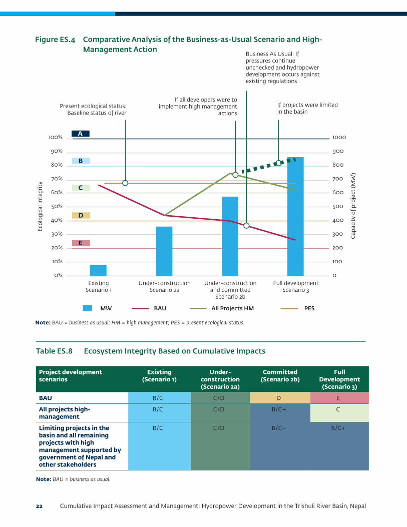
Cumulative Impact Assessment of the Alternative Management Scenarios
Figure ES.4 and Table ES.8 illustrate ecosystem integrity ratings along the Trishuli River under a business-as-usual scenario (continuation of complying only with local regulation) and an all projects high-management action (for example, all projects implementing mitigation measures compliant with IFC PS/good international industry practice, or GIIP) for each of the project development scenarios.
In summary, this analysis indicates the following (refer to Table ES.3 and Table ES.4 for the ecosystem integrity ratings A to F):
• Present ecological status (PES) shows the Trishuli River maintaining an existing ecosystem integrity of B/C assuming no new hydropower development or increase in external stressors (Scenario 1).
• The business-as-usual (BAU) scenario shows ecosystem integrity of the Trishuli River degrading
from existing B/C conditions, to C/D as under-construction HPPs come on line (Scenario 2a), decreasing further to D as the committed project (UT-1 HPP) is constructed (Scenario 2b), and ultimately falling to E as future planned projects are developed (Scenario 3). Clearly this would not be a sustainable outcome.
• The all projects high-management also shows the ecosystem integrity of the Trishuli River degrading to C/D as under-construction HPPs come on line (Scenario 2a), but then an improvement to a B ecosystem integrity rating as high-management measures are required for all new HPPs and retro-fitted on the existing HPPs. In the full-development scenario (Scenario 3), and given the sheer magnitude of the impacts associated with 23 additional HPPs (committed and planned), the Trishuli River ecosystem integrity is ultimately predicted to degrade back to a C, even if all projects apply GIIP per IFC PSs. An ecosystem integrity rating of B could be maintained, however, if the future number of HPPs in the basin were limited.
22 Cumulative Impact Assessment and Management: Hydropower Development in the Trishuli River Basin, Nepal
Figure ES.4 Comparative Analysis of the Business-as-Usual Scenario and High- Management Action
Note: BAU = business as usual; HM = high management; PES = present ecological status.
E
D
C
B
A100%
90%
80%
70%
60%
50%
40%
30%
20%
10%
0%
1000
900
800
700
600
500
400
300
200
100
0
Ecol
ogic
al in
tegr
ity
Cap
acit
y of
pro
ject
(MW
)
Present ecological status:Baseline status of river
If all developers were toimplement high management
actionsIf projects were limited in the basin
Business As Usual: Ifpressures continueunchecked and hydropowerdevelopment occurs againstexisting regulations
MW BAU All Projects HM PES
ExistingScenario 1
Under-constructionScenario 2a
Under-construction and committed
Scenario 2b
Full developmentScenario 3
Table ES.8 Ecosystem Integrity Based on Cumulative Impacts
Project development scenarios
Existing (Scenario 1)
Under- construction (Scenario 2a)
Committed (Scenario 2b)
Full Development
(Scenario 3)
BAU B/C C/D D E
All projects high-management
B/C C/D B/C+ C
Limiting projects in the basin and all remaining projects with high management supported by government of Nepal and other stakeholders
B/C C/D B/C+ B/C+
Note: BAU = business as usual.

Executive Summary 23
Based on the DRIFT model results, the analysis suggests that implementation of a high-management action can help maintain, or even improve, the ecosystem integrity of the TRB.
Implementation of the High-Management Action
The institutional structure illustrated in Figure ES.3 is recommended to be set up to implement high-management actions that are combined into a TRB Management Plan by the technical resource group with a reference to the Sustainable Hydropower Development Charter. The structure of each LMC would build on existing networks of health, safety, and environment teams of hydropower developers, river user groups (fishing, irrigation, sanitation, and so forth), Langtang National Park authorities, CFUGs, and representatives of project specific committees (for example, the UT-1 Adibasi Janajati Advisory Council). A suggested function of each LMC includes the following:
• Implementation of the TRB Management Plan for an identified spatial stretch of the river
• Watershed management and habitat conservation actions
• Creating awareness among local communities and settlements on biodiversity conservation, proper waste management, and sustainable fisheries
• Imposing regulations and/or moratoriums on capture fisheries during the breeding season and on intensive techniques of fishing
• Forming and mobilization of community-based patrolling (river guards and mining supervisors) who will also undertake periodic monitoring of the implementation of commitments under the Sustainable Hydropower Development Charter
The identified institutional structure will also have a formal mechanism to communicate its approach, initiatives, and outcomes. Localized stakeholder engagement will also need facilitation by the Provincial/Municipality and/or District Coordination Committee representatives.
CIA Conclusions
Hydropower development combined with stressors and key regional initiatives cumulatively affect VECs such as aquatic and terrestrial biodiversity, livelihoods, cultural and religious sites, and water resources within the TRB. The upstream reach is likely to be more significantly affected due to the number of projects that are coming up in Mailung Khola, Langtang National Park, and Salankhu Khola over and above the main stem. Given the large number of proposed hydropower projects and other stressors in the basin, continuation of a business-as-usual approach is predicted to result in significant degradation of the Trishuli River and other important VECs, including terrestrial biodiversity, community livelihoods, cultural and religious sites, and water quality.
The suggested high-management action offers a sustainable development pathway to maintain, or potentially even enhance, current levels of ecosystem integrity and VEC conditions. This high-management approach is envisioned as a cooperative approach that could be implemented through a combination of developer-driven mitigation measures, community-based monitoring, civil society and university technical support, and governmental oversight. The implementation of these mitigation measures is expected to promote sustainable development while developing hydroelectric projects in the TRB, balancing the need for optimal energy supply with environmental protection, maintenance of social livelihoods and well-being, and sustainable management of water resources.