Exploring applications of fieldwork data: A case study of MalakMalak complex predicates in discourse

Libyan Studies 39 (2008)
175
The Cyrenaican Prehistory Project 2008: the second season of investigations of the Haua Fteah cave and its landscape, and further results from the initial (2007) fieldwork
By Graeme Barker,1 Laura Basell,2 Ian Brooks,3 Lucilla Burn,4 Caroline Cartwright,5 Franca Cole,6 John Davison,7 Lucy Farr,1 Rainer Grün,8 Roisin Hamilton,7 Chris Hunt,7 Robyn Inglis,6 Zenobia Jacobs,9 Victoria Leitch,10 Jacob Morales,11 Iain Morley,1 Mike Morley,12 Steven Pawley,13 Alex Pryor,6 Ryan Rabett,1 Tim Reynolds,14 Hwedi el-Rishi,15 Richard Roberts,9
David Simpson,7 Chris Stimpson,6 Mohammed Touati16 and Marijke van der Veen17
AbstractThe second (2008) season of fieldwork of the Cyrenaican Prehistory Project has significantly advanced understanding of the Haua Fteah stratigraphy and of the archaeology and geomorphology of the landscape in which the cave is located. The excavations of the McBurney backfill have reached a total depth of 7.5 m below the present ground surface, the depth at which two human mandibles were found in the 1950s excavations. Reconnaissance at the Hagfet ed-Dabba established that the sediments associated with the Upper Palaeolithic ‘Dabban’ industry were more or less entirely removed by the McBurney excavation. Exploratory excavations in the Hagfet al-Gama, a coastal cave west of the Haua Fteah, found evidence of Mesolithic, Neolithic, and Hellenistic occupation. The initial results from the study of botanical remains, both macroscopic and microscopic, obtained in the 2007 season at the Haua Fteah confirm the potential of the site to yield a rich suite of materials to inform on climatic and environmental change, and on human activities in the cave.
IntroductionBy Graeme Barker, Chris Hunt and Tim Reynolds
North Africa is likely to have played a critical role in the colonisation of Europe by modern humans c. 40,000 years ago, but when, how, and why cognitively modern human populations emerged in this region are the subjects of lively debate (Barton et al. 2007; Marean and
1 McDonald Institute for Archaeological Research, University of Cambridge, UK.2 Research Laboratory for Archaeology and the History of Art, University of Oxford, UK.3 Engineering Archaeological Services Ltd, Blaenau Ffestiniog, UK.4 Fitzwilliam Museum, Cambridge, UK.5 Science Group, British Museum, London, UK.6 Department of Archaeology, University of Cambridge, UK.7 School of Geography, Archaeology, and Palaeoecology, Queen’s University of Belfast, UK.8 Research School of Earth Sciences, Australian National University, Canberra, Australia.9 School of Earth and Environmental Sciences, University of Wollongong, Australia.10 Institute of Archaeology, University of Oxford, UK.11 Departamento de Sciencias Historicas, University of Las Palmas, Spain.12 Museum of London Archaeology Service, London, UK.13 Department of Geography, Royal Holloway University of London, UK.14 Faculty of Continuing Education, Birkbeck College London, UK.15 Department of Geography, Garyunis University, Benghazi, Libya.16 Department of Archaeology, Omar Mukhtar University, al-Beida, Libya.17 School of Archaeology and Ancient History, University of Leicester, UK.

G. BARKER ET AL.
176
Assefa 2005). The timing and nature of the transition from hunting and gathering to farming, the so-called Neolithic Revolution intensively studied for decades in the Near East and Europe, are equally obscure in the case of North Africa (Barker 2006). The Cyrenaican Prehistory Project (CPP) is seeking to contribute to these debates through an inter-disciplinary programme of archaeological fieldwork, science-based archaeology, and environmental science in the Gebel Akhdar (‘Green Mountain’) massif of northeast Libya (Fig. 1).
The first component of the project is the re-excavation of the major prehistoric cave of the Haua Fteah, excavated to a depth of 14 m in the 1950s by Charles McBurney of the University of Cambridge (McBurney 1967). The results of his pioneering study, combined with trial work in 2007 (Barker et al. 2007), indicate that the site represents a unique opportunity for high-resolution analysis of changes in climate and environment, and of hominin responses to these, over at least the past 100,000 years. The second component of the project is a programme of archaeological and geomorphological survey, allied palaeoecological studies and targeted excavations, elsewhere in the Gebel Akhdar, to set the new work at the Haua Fteah in a regional context. This report describes the second season of fieldwork (March/April 2008), and also presents some preliminary results of the laboratory studies of data collected in the 2007 season.
The McBurney excavations revealed what is commonly regarded as the longest sequence of human occupation in North Africa. As finally completed in 1955, McBurney’s 14 m trench consisted of three sections: an Upper Trench measuring approximately 10 m by 10 m by 2 m deep; a Middle Trench measuring approximately 7 m by 6 m by 5.5 m deep; and a Deep Sounding measuring approximately 2.5 m by 1.5 m by 6.5 m deep. McBurney had no access to methods of numerical dating before 40,000 years ago (the maximum extent of the
Figure 1. The survey area of the Cyrenaican Prehistory Project in northeast Libya, showing the location of the Haua Fteah cave and other locations mentioned in the text (drawing: D. Kemp).
Survey Area
100 m
200 m
500 m
0 50 km
NMediterranean Sea
Desert
Littoral
HauaFteah
Pre-desertPre-desert
Gebel AkhdarGebel Akhdar
Wadi KufWadi Kuf
Hagfetal-Gama
Hagfeted-Dabba
Hagfeted-Dabba
Wadi Derna
Wadi Derna
0 300 km
HauaFteah
N

THE CYRENAICAN PREHISTORY PROJECT 2008
177
then pioneering method of radiocarbon or 14C dating), and estimated the antiquity of the initial occupation of the cave on the basis of assumptions about sedimentation rates. These suggested that the earliest material in the Deep Sounding, which he defined as a ‘Pre-Aurignacian’ Middle Palaeolithic (so-called because of the presence of lithic forms with similarities to later Upper Palaeolithic forms), might date to about 80,000 years ago, though a later review of the evidence suggests that this age may be a considerable underestimate (Moyer 2003). In the lower part of the Middle Trench was a series of Middle Palaeolithic stone industries and near its base the excavators discovered two human mandibles originally thought to be Neanderthal or similar (‘Neanderthaloid’), but now generally regarded as more likely to belong to robust modern humans (Foley and Lahr 1997; Hublin 2000; McBrearty and Brooks 2000). The upper portion of the Middle Trench contained a sequence of Upper Palaeolithic lithic industries, beginning with what McBurney classified as the ‘Dabban culture’ on the basis of similarities to material he had found in the Hagfet ed-Dabba cave in the Wadi Kuf (Fig. 1). Radiocarbon ages indicated that the Dabban culture began (Layer XXV) about 40,000 radiocarbon years ago (or BP, before the present) and lasted until c. 14,000 BP (Layer XVI). It was succeeded (Layers XV–XI) by a late Palaeolithic ‘Eastern Oranian’ or ‘Iberomaurusian’ culture or lithic industry, dated by McBurney to c. 14,000–10,000 years ago. The Upper Trench revealed a sequence of Holocene occupation that began with the ‘Libyco-Capsian’ Mesolithic (Layers X, IX) dated by McBurney to c. 8000–5000 BC and continued through the Neolithic (Layers VIII–VI, c. 5000–2700 BC), to the Graeco-Roman period (Layer III) and recent centuries (Layers II, I). The excavation was backfilled with earth and stones at the end of the 1955 season.
In April 2007 we removed the 1950s backfill of the Upper Trench and about 2 m of the Middle Trench, in about one-third of its area, establishing the robustness of the original faces and their suitability for analytical interventions. Detailed ‘running sections’ (that is, continuous sections, but stepped from the Upper to Middle Trench) were constructed on the western and southern faces, which correlations with the McBurney section drawings indicate span from the present day to (at least) the Last Glacial Maximum. A comprehensive series of charcoal and shell samples was taken from these sections for 14C dating, together with sediment samples to gain information on the environments in which the deposits accumulated, the vegetation of the surrounding landscape and, potentially, human activities in that landscape. A small-scale trial programme of flotation of organic residues indicated the good survival of carbonised botanical remains from both Holocene and Pleistocene contexts. Geomorphological fieldwork in the vicinity of the cave identified a series of later Quaternary sediments, including: ancient marine deposits at 60 m asl (above sea level) associated with Middle Palaeolithic artefacts; a second set at approximately 8–11 m asl associated with a warm fauna, probably dating to the last interglacial; overlying the latter, colluvial and aeolian deposits containing flake-based stone artefacts; younger alluvial fan and wadi deposits and stratified screes likely to be of terminal Pleistocene age; and cave sites with stratigraphies, fauna, and artefacts consistent with occupations in the late Pleistocene and early Holocene. Archaeological survey within a kilometre of the cave found a low-density but more-or-less ubiquitous ‘background scatter’ of Middle Palaeolithic materials with a patchier distribution of later material, patterning that suggested real differences in past

G. BARKER ET AL.
178
human behaviour and use of the landscape and not simply the effects of post-depositional processes (such as lithics moving downslope and accumulating on flatter surfaces), which are certainly in evidence.
The specific objectives of the 2008 season were:
• To complete the excavation of the backfill of the Middle Trench and to record its exposed faces in detail;
• To complete a comprehensive programme of sampling the exposed faces for dating and palaeoenvironmental samples;
• To commence excavation of Pleistocene sediments adjacent to the McBurney trench; and
• To continue the programme of geomorphological and archaeological surveys in the landscape to identify Pleistocene and Holocene sediments and archaeological materials likely to be broadly contemporary with the Haua Fteah hominin occupations; and if warranted, to excavate selected sites to collect samples for dating and palaeoenvironmental analysis.
Excavations in the Haua Fteah, 2008By Tim Reynolds, Laura Basell and Lucy Farr
The 2008 excavations in the Haua Fteah had three principal aims: the removal of the McBurney backfill from the Middle Trench; archaeological investigation of the surviving in situ deposits by section cleaning and sampling; and sedimentological studies of the Holocene deposits exposed by the excavation of the Upper Trench in 2007.
The first aim was undertaken using four workmen supervised and assisted by project staff. In the 2007 season two ‘slots’ of Middle Trench backfill were removed, measuring in combination 4.6 m by 2.4 m by 2 m deep (4 m below the present ground surface). In 2008 the backfill was removed from the entire Middle Trench to a depth of 2.5 m (4.5 m below the present ground surface), and in an area measuring 4.6 m by 2.4 m in the eastern part of the trench down to the top of the McBurney Deep Sounding, 7.5 m below the present ground surface. This was less than had been planned for the 2008 season, but logistical priorities meant that a step of backfill deposits was left to facilitate access to the exposed sections and ensure the health and safety of personnel. For the same reasons we did not embark on the planned excavation of a 2 m by 1 m trench adjacent to the north-facing section of the Middle Trench, which will be commenced in the next season.
The second aim of excavation involved targeted investigation of the surviving archaeology. All exposed sections were cleaned by trowelling and unique ‘contexts’ assigned to all identifiable exposed layers or stratigraphic units. ‘Bulk samples’ of sediment were then excavated by trowel in vertical columns. In 2007 two such columns were cut, both in the Holocene sediments of

THE CYRENAICAN PREHISTORY PROJECT 2008
179
the east-facing section of the Upper Trench. Two more sample columns were excavated in the 2008 season, one on the east-facing section of the Middle Trench to a depth of 2.6 m, through Oranian and Dabban sediments, and the other on the south face of the Upper Trench and west face of the Middle Trench (to 2.2 m depth) to give a parallel sequence from the Dabban to recent occupations. The sample columns were cut to these depths because at the end of the 2008 season the upper 2 m of the Middle Trench were covered with cross-braced timber shoring, making these sediments less accessible for sampling in the future (see below, Fig. 19). The lithics recovered during the excavation of the sample columns are described below.
The bulk samples, consisting wherever possible of standard units of approximately 10 litres of sediment, were then processed at the project base in Shahat in a water flotation system kindly loaned to the project by the Euesperides Project (Fig. 2). Using this system carbonised botanical remains (seeds, plant fragments, and wood charcoal) were floated off and collected in 1 mm and 0.5 mm sieves, while the remaining ‘heavy residues’ were washed through a 1 mm mesh. As described later in this report, the initial results of the study of the charred botanical remains collected by flotation in the 2007 season indicate that these materials will provide a significant body of information on changing vegetation around the cave and the human use of plants. The dried ‘heavy residues’ were then dry-sieved through a 3 mm mesh. The >3 mm fraction was sorted by hand to retrieve all cultural remains such as lithics, animal bone fragments, and shells. Trial sorting of a sample of the residues under 3 mm indicates that they will be an important source of microfauna, and these residues have all been retained for that purpose.
A further two samples, each of approximately 20 cc of sediment, were removed from each stratigraphic unit or context behind the bulk sample void, one for the characterisation of physical and chemical properties and also to investigate whether pollen and phytoliths survive (work to be undertaken at Queen’s University Belfast) and one to investigate if starch grains survive (work to be undertaken at the University of Leicester). (The physical and chemical analyses will provide important information on sediment formation processes, pollen and phytoliths are potentially vital indicators of past environments, and starch grains would inform on the human use of starch-rich plants.) Behind these, all visible fragments of charcoal were collected as potential samples for 14C dating.
All cleaned faces outside the sampling columns were also searched for charcoal for 14C dating and wood identification. Approximately 130 such samples of charcoal were collected from the column samples and cleaned faces during the 2008 season, to augment the 50 samples from the 2007 season being dated by the Oxford Radiocarbon Accelerator Unit. The samples span the entire range of exposed sediments and should provide dating for Neolithic, Capsian, Oranian (Ibero-Maurusian), Dabban, and Levallois-Mousterian cultural layers.
Ten animal teeth were also collected from the exposed faces and Pleistocene sediments in the sample columns, for an experimental programme of tooth enamel dating by Electron Spin Resonance (ESR) at the Australian National University, Canberra. The technique has a potential age range significantly beyond that of 14C (for which ages of 50,000 years ago are at the extreme range) and if the results of the pilot work are positive, will be an invaluable adjunct to the Optically Stimulated Luminescence (OSL) dating programme reported below.

G. BARKER ET AL.
180
Figure 2. (Above) Flotation of sediment samples from the Haua Fteah for botanical remains; and (below) sorted heavy residues from the same process (photograph: G. Barker).

THE CYRENAICAN PREHISTORY PROJECT 2008
181
Micromorphological samplingBy Robyn Inglis
A programme of micromorphological sampling was initiated in the 2008 season as part of a doctoral dissertation at the University of Cambridge. Thin-section micromorphology allows the high-resolution study of sedimentary features, and thus the elucidation of depositional and post-depositional processes which are irresolvable using other physical and chemical analyses (Courty 2001; Courty et al. 1989; Stein 2001). The assessment of the nature and rate of sedimentation and of the continuity of the stratigraphy (e.g. Farrand 1993; 2001; Mlekuž et al. 2008) is of particular interest in the case of the Haua Fteah. Micromorphological studies can detect hiatuses in sedimentation, as well as measures of variance in rates of deposition. The nature of anthropogenic features is also a key part of the investigation of the cave deposits and cultural context. The objective of the study is to construct a robust, high-resolution, history of sedimentation that, in combination with the other sedimentological analyses, should inform on the nature and extent of climatic and anthropogenic formation processes and their interplay at different times in the cave’s history.
In this initial exploratory phase of the project, a total of 29 sediment blocks for thin sectioning was taken from the newly exposed sections, using Kubiena tins (Fig. 3). Five blocks were cut from the south-facing section of the Upper Trench and 24 from the Middle Trench, from its
Figure 3. Cutting a soil block for micromorphological analysis from the south-facing section of the Upper Trench, Haua Fteah (photograph: G. Barker).

G. BARKER ET AL.
182
east-, north-, and west-facing sections. Areas targeted included: the Neolithic sediments and a series of possible Holocene mudflow deposits; colluvial inwash silty deposits in the Levallois-Mousterian layers; and the major sedimentological facies shift from the latter, which appear to consist predominantly of inwash deposits, to the gravel-dominated sediments of the upper 2 m of the Middle Trench, which appear to be predominantly the result of roof fall within the cave. On presently available dating, this facies shift coincides with the cold glacial climates of the late Marine Isotope Stages (MIS)3 and MIS2. Isolated sediment blocks were taken where possible from silty lenses within these gravels. The viability of block sampling the gravels will be investigated in future seasons. The thin sections will be prepared in the Charles McBurney Laboratory for Geoarchaeology (University of Cambridge).
OSL dating programmeBy Richard Roberts, Zenobia Jacobs and Rainer Grün
OSL dating of sediments provides the opportunity to determine the burial ages of artefacts and other objects of archaeological interest within and – of particular importance for the investigation of the Haua Fteah’s occupation history – beyond the range of 14C dating. Ages obtained by OSL dating provide estimates of the time elapsed since the dated mineral grains were last exposed to sunlight and, in contrast to 14C ages, are determined directly in calendar years. By dating individual sand-sized grains of quartz, it is possible to directly check the stratigraphic integrity of archaeological deposits and the possible effects of post-depositional disturbance (e.g. mixing
Table 1. Archaeological associations of the 12 samples taken from the Middle Trench of the Haua Fteah for OSL dating at the University of Wollongong (UoW); see Figure 5 for their locations.
UoW sample code McBurney layer(s) CPP context(s) McBurney archaeological association
HF1 XI / XII 180 Final Oranian
HF2 XIV / XV 185, 188, 189 Early Oranian
HF3 XVII / XVIII 201 Late Dabban
HF4 XX 235, 439, 444 Early/Late Dabban
HF5 XXIV 445, 459 Early Dabban
HF6 XXVI 498 Levallois Mousterian
HF7 XXVIII 503, 504 Levallois Mousterian
HF8 XXX 513 Aterian
HF9 XXX / XXXI 536, 537, 562 Aterian
HF10 XXXII / XXXIII 523, 524 Levallois Mousterian and Homo remains
HF11 XXXIV 528, 563, 564, 565 Mousterian of Acheulian Tradition
HF12 XXXV 538, 564, 565 Pre-Aurignacian
THE CYRENAICAN PREHISTORY PROJECT 2008
183
by anthropogenic or other processes) and the adequacy of pre-depositional light exposure (Jacobs and Roberts 2007).
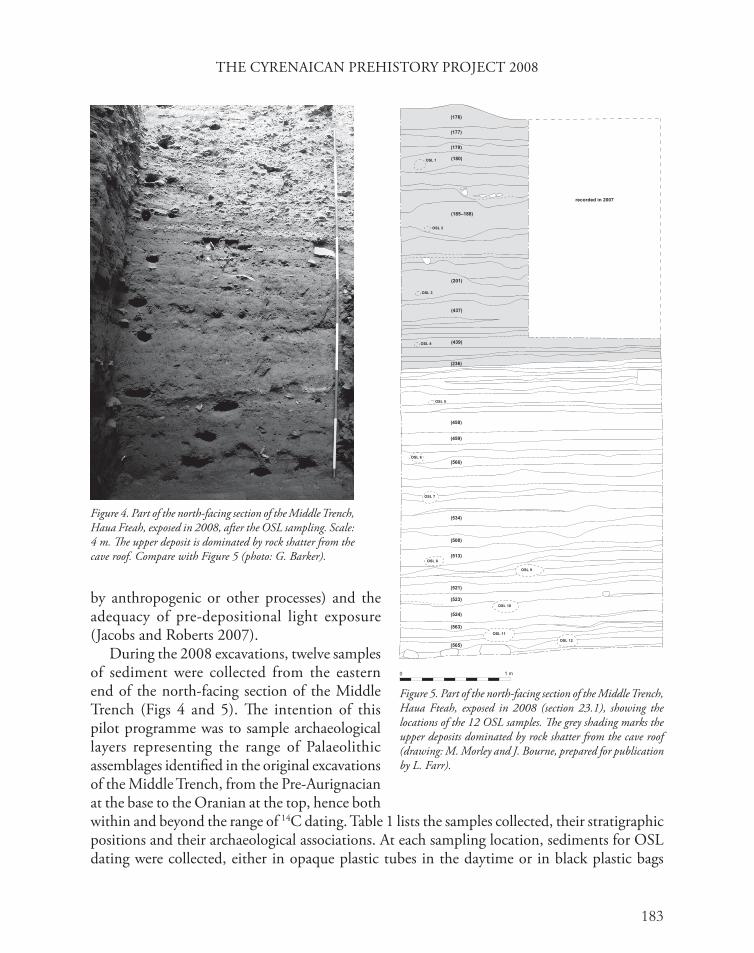
During the 2008 excavations, twelve samples of sediment were collected from the eastern end of the north-facing section of the Middle Trench (Figs 4 and 5). The intention of this pilot programme was to sample archaeological layers representing the range of Palaeolithic assemblages identified in the original excavations of the Middle Trench, from the Pre-Aurignacian at the base to the Oranian at the top, hence both within and beyond the range of 14C dating. Table 1 lists the samples collected, their stratigraphic positions and their archaeological associations. At each sampling location, sediments for OSL dating were collected, either in opaque plastic tubes in the daytime or in black plastic bags
Figure 5. Part of the north-facing section of the Middle Trench, Haua Fteah, exposed in 2008 (section 23.1), showing the locations of the 12 OSL samples. The grey shading marks the upper deposits dominated by rock shatter from the cave roof (drawing: M. Morley and J. Bourne, prepared for publication by L. Farr).
Figure 4. Part of the north-facing section of the Middle Trench, Haua Fteah, exposed in 2008, after the OSL sampling. Scale: 4 m. The upper deposit is dominated by rock shatter from the cave roof. Compare with Figure 5 (photo: G. Barker).

G. BARKER ET AL.
184
Table 2. Lithofacies identified in the Holocene sediments of the Haua Fteah.
Litho-facies code
Description Interpretation Excavation contexts (layers)
D Matrix to clast-supported diamicton consisting of subangular cobbles to small boulders in a silty matrix. Weak clast long-axis imbrication is predominantly north–south. In the upper part, laminated silts, clayey silts and ash layers between clasts. Layers usually infill existing topography and wedge out southward.
Mudflow deposits originating on the doline floor outside the cave during heavy rainfall events. Infiltration deposits between clasts in the upper part of the units.
126, 142, 146, 149, 153
D1 Diamict, unsorted, clasts mostly rounded and randomly orientated, clods of calcreted riverine sediments, lumps of charred material, ashy lenses, dispersed carbonised and uncarbonised goat guano.
Made ground: layer of fill introduced into the cave and bulldozed into position during the 1980s.
147, 148
G Clast to matrix-supported gravel, clasts subrounded-subangular, long-axis imbrication follows depositional dip, silty matrix. Lenticular sediment bodies occupying gullies.
Waterlain gully-fill. 152 (lower)
Si Silts, sometimes with fine sands, massive or indistinctly to distinctly southward-dipping cross- and plane-laminated, occasional small stones. Layers usually infill existing topography and wedge out southward.
Wash and rill deposits originating on the doline floor outside the cave during heavy rainfall events.
132, 135, 136, 138, 150, 156, 154, 155, 400
Sil Silts, sometimes clayey, well laminated. Settling-out deposits from quiet water.
128, 134
Bo Openwork breccia, clasts very angular, general depositional dip and clast long axes dipping northward. Clast long-axis orientation and depositional dip generally northward. Lenticular sediment bodies in cross-section.
Debris-avalanche deposits resulting from rockfall.
173
B Breccia, clast to matrix-supported, silty, some ash in places. Clasts angular, with long axes conforming to depositional dip. Some size-sorting. Depositional dips generally northward.
Debris-avalanche deposit resulting from rockfall. Minor admixture of cultural material.
144, 169, 170, 172, 176, 177
Ba Breccia, clast-supported to matrix supported, matrix mostly silt and/or ash and containing artefacts, bone, shell and charcoal. Clasts angular to slightly subangular, clast long-axis orientation and depositional dip generally northward. Lenticular sediment bodies in cross-section, wedging out northward in long section.
Occupation debris, rockfall and aeolian silt relocated in small debris avalanches.
129, 130, 131, 133, 143, 151, 159, 161–168, 401
At Ash, silty and with occasional stones, containing artefacts, shell, bone, crudely and indistinctly tabular-bedded.
Occupation debris. 135, 402

THE CYRENAICAN PREHISTORY PROJECT 2008
185
at night using a red-filtered torch for illumination. Sediments for environmental radioactivity and moisture content determinations were collected in clear zip-lock plastic bags, and in situ gamma-ray spectrometry measurements were made using the University of Wollongong portable spectrometer. These dosimetric measurements, as well as the OSL measurements that will be performed at the University of Wollongong, are required to calculate an OSL age. Some lumps of limestone roof spall were collected in order to determine if any quartz grains contained therein might influence the OSL age determinations for the archaeological deposits. Samples HF1, HF2 and HF3 were collected for purposes of cross-checking against 14C determinations on co-deposited charcoal, and duplicate sediment samples were collected at three locations (HF3, HF8 and HF10) with the aim of performing an inter-laboratory comparison of OSL dating procedures at the University of Wollongong and Royal Holloway University of London.
Holocene depositional environmentsBy Chris Hunt
One important aspect of research in the 2008 season was to investigate the Holocene depositional environments in the Haua Fteah to establish the major depositional processes. Major changes in lithofacies (sedimentary units relating to particular formation processes) and pedogenesis (soil formation) are distinguishable in the upper part of the sequence and relate to changes in predominant processes and in human activity. Holocene lithofacies for the east-facing and north-facing sections of the Upper Trench are set out and interpreted in Table 2. The facies analysis omits pedogenesis and pedogenic features in the sediments, which will be the subject of a doctoral thesis (see above, Micromorphological sampling).
This analysis suggests that two important processes leading to the deposition of the Graeco-Roman and later layers have been the accumulation and burning of goat dung, and surface wash of soil from the doline to the north. Both processes are part of the present cave environment: Mr Salim Hussain, whose family is one of the current owners of the cave, described the process
Litho-facies code
Description Interpretation Excavation contexts (layers)
Atg Ash and carbonised goat pellets, occasional to frequent artefacts, bone and shell.
Burning of goat guano layers. 135, 137, 145, 158, 159, 175, 176
Al Laminated or cross-bedded silty ash, containing occasional artefacts, bone and shell.
Accumulation of ash in quiet water.
17, 127, 146, 139, 141, 140, 152 (upper), 157
Table 2. Lithofacies identified in the Holocene sediments of the Haua Fteah. (cont.)

G. BARKER ET AL.
186
of regularly firing the accumulated dung of one or more seasons of use of the cave as a goat pen, and he also recounted how a few years ago he had been almost drowned in the cave during a flash-flood which occurred as the result of a heavy rainstorm. One massive mud- and debris-flow appears to have occurred shortly before the building of the Graeco-Roman structure (our excavation contexts 126 and 153, which correlate with McBurney’s Layer III), incorporating material from the doline. Our current hypothesis is that the distinctive intense reddish colouration of these upper silt-rich and diamict horizons is not the result, predominantly, of pedogenesis in situ, but of the input of material from the doline floor outside the cave that was already heavily pedogenically-modified by cultivation. The clasts in the diamict horizons show similar morphology to the plough-rounded stones present on the current doline surface and the strong red colouration is present in the soils of the doline, which are presently cultivated. The general absence of the red colour consistent with eroded soil in the Holocene sediments below context (128), which correlates with McBurney’s Layer V, the earliest of his ‘Historic’ layers, suggests that the surface of the doline was not significantly disrupted by ploughing before the deposition of this layer.
The dominant processes leading to sediment deposition in the Holocene prehistoric layers (McBurney’s Libyco-Capsian Layers X and IX and Neolithic
Figure 6. Lithic artefacts collected in the sediment sampling programme of the Middle Trench, Haua Fteah: 1–3. backed bladelets (context 237); 4. opposed platformed core (context 240); 5–8. backed bladelets (context 240); 9. inversely backed blade (context 175); 10. endscraper (context 175) (drawing: T. Reynolds).

THE CYRENAICAN PREHISTORY PROJECT 2008
187
Layers VIII–VI) appear to have been the small-scale surface wash of aeolian silt from the doline to the north, together with debris-avalanches from the south resulting from disturbance of cultural deposits and the occasional rockfall. It follows that the nature of human activity in and around the Haua in the Holocene seems to have changed considerably just before deposition of our context (128), or the beginning of McBurney’s Historic phase. Before that time, the cultural deposits probably reflect the discard of domestic waste, cooking fires and the like, whereas thereafter, the cultural deposits
become dominated by the effects of burning of animal dung, with comparatively minor domestic waste, and the inwash of sediments resulting from cultivation adjacent to the cave. These are only preliminary field observations, of course, the validity of which will be explored in the laboratory studies of the sediments, including of their micromorphology.
Table 3. Lithics collected in the sediment sampling programme of the Middle Trench of the Haua Fteah.
Context Likely age Description Fig.
175 Capsian endscraper on secondary blade and partially inversely-backed tertiary blade 6
179 Capsian 42 pieces including six backed blades one of which may have been broken during backing to produce a microburin-like piece
7
208 Capsian 16 pieces including an endscraper, a single platformed flake core and a possible burin spall.
n/a
212 Capsian 8 pieces, all unretouched n/a
217 Capsian 11 pieces including a single backed bladelet n/a
223 Capsian single fragment of shatter n/a
237 Capsian 18 pieces, including three backed bladelets 6
238 Capsian 49 pieces including a microburin, 2 backed bladelets, a geometric microlith (rectangle), and a utilised bladelet
n/a
240 Oranian 40 pieces including 2 opposed platformed bladelet cores and four backed bladelets
6
242 Oranian 4 unretouched pieces n/a
247 Oranian 2 unretouched pieces n/a
Figure 7. Lithic artefacts collected in the sediment sampling programme of the Middle Trench, Haua Fteah: 1–4 and 6. backed blades; 5. microburin-like backed bladelet (context 179) (drawing: T. Reynolds).

G. BARKER ET AL.
188
Lithics from the Haua FteahBy Tim Reynolds
The 2008 excavation of the two sample columns produced a small collection of material that has been collected by context. The preliminary assessment of this material, selected pieces of which are illustrated in Figures 6 and 7, is shown in Table 3. The identifiable tools and technology support McBurney’s attribution of the associated layers: as shown in Table 3, contexts above (238) would be Libyco-Capsian and those listed as below (238) would fit an Oranian attribution.
Excavations at site CPP1647, Hagfet ed-Dabba (‘Cave of the Hyena’)By Chris Stimpson and Ryan Rabett
The cave of Hagfet ed-Dabba (site CPP1647, UTM: 34 S 0552781E, 3616306N) is situated high on the south-facing slope of a tributary wadi of the Wadi Kuf, the main watershed of the Gebel Akhdar (Fig. 8). The site is located approximately 365 m above present sea level in an area characterised by Mediterranean woodland
habitats and maquis. The cave has two south-facing entrances: a larger eastern entrance and a smaller western opening, separated by a large limestone column (Fig. 9). The main chamber measures approximately 23 m by 7.5 m. An inner chamber is located in the northeast corner of the main chamber, with an entrance approximately 2.7 m above the present floor surface of the cave. The cave was subject to archaeological investigations by the expedition led by Charles McBurney in 1949. This effort focused, apparently exclusively, on the eastern portion of the cave, where the excavation consisted of a series of six parallel trenches, each 4–10 m long aligned north to south, running from the northern cave wall to the southeastern entrance (McBurney 1960; McBurney and Hey 1955). The blade industry recovered from the excavations provided McBurney with his exemplar for the Upper Palaeolithic of the Gebel Akhdar, the Dabban, though the site is currently dated solely by reference to the 14C dates he obtained from Dabban layers at the Haua Fteah.
Reconnaissance fieldwork during the 2008 season had three aims: to carry out an accurate Total Station survey of the site and its immediate area; to excavate a test pit to locate, expose, and sample any remaining sections from the McBurney excavations in the eastern half of the main chamber; and to assess the potential of the site for larger-scale investigations in the future.
Figure 8. Looking northeast to the entrance of Hagfet ed-Dabba, from the floor of the Wadi Kuf (photo: G. Barker).

THE CYRENAICAN PREHISTORY PROJECT 2008
189
A remnant of a standing section was identified underneath a boulder just inside the east entrance of the cave. This section (most likely the west face of McBurney’s ‘Z’ trench I in his grid 6) was very weathered, eroded, and penetrated by roots, and no stratigraphic units could be discerned. A 1 m by 1 m trench was excavated besides the eroded section, in the vicinity of the western limit of the McBurney ‘A’ trench, grids 7 and 8. This revealed a friable homogeneous dark grey-brown silt (context 001), some 23 cm thick, that overlay three discrete basal layers similar to those described by the original excavators (Fig. 10). The upper of these is a very compact red silt (context 002; Munsell 5YR 4/4 reddish brown), probably McBurney’s Layer VII. This overlay a hard layer of decomposing limestone and speleothem fragments, probably McBurney’s Layer VIII. A compact yellowish-red silty-clay (context 003; Munsell 5YR 4/6 yellowish red) overlying the compact red silt is probably a remnant of McBurney’s Layer VI. Bulk samples and sediment samples were taken from contexts (002) and (003), and charcoal samples for 14C dating from context (003) and its interface with (002). The lithics from the test pits included a burnt chert fragment in context (002) and twenty pieces in context (003), including an opposed platformed bladelet core and a small number of blades and bladelets, but no retouched pieces.
The test pits indicate that all but the compact basal layers excavated and described by the McBurney team have been completely removed from the eastern part of the shelter. By contrast, the western area of the main chamber appears to be relatively undisturbed. It will also be desirable to establish the age, nature, and depth of the deposit that has accumulated in the inner northeastern chamber, described as approximately 10 feet (3 m) deep by McBurney
Figure 9. Plan of Hagfet ed-Dabba (drawing: I. Brooks, and prepared for publication by D. Kemp).

G. BARKER ET AL.
190
and Hey (1955), as it may represent a deep accumulation of deposits introduced from a (now blocked) chimney opening into the overlying plateau.
Excavations at site CPP2008, Hagfet al-GamaBy Mike Morley and Ian Brooks
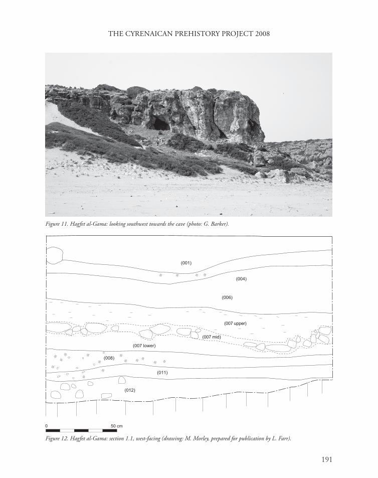
Hagfet al-Gama is a small (approximately 7.6 m wide by 7.0 m in height by 7.3 m deep) cave, situated at an elevation of approximately 21 m asl on the eastern side of the mouth of the Wadi al-Gama, facing northeast over the present-day beach (UTM 34 S 0531356E, 3626074N) (Fig. 11). The cave is one of a series of at least six small caves formed within a range of low cliffs rising from beach level to a mean height of approximately 40 m asl. A substantial fortified site of Hellenistic and Roman date is situated on the headland immediately above it. The cave consists of a main chamber and the shallow remains of a second chamber or rock shelter to the north.
Two trenches were excavated to the surface of bedrock. Trench 1 was situated in the small rock shelter, and was excavated to bedrock at a maximum depth of 0.40 m. The sedimentary sequence comprised a suite of fine-grained sediments, some of which were ash- and charcoal-rich, containing wheel-made pottery of Late Classical and Hellenistic dates. Trench 2 was excavated in the main cave chamber, and contained a sedimentary sequence 1.2 m in depth (Fig. 12). The upper deposit (contexts 001–006) consisted of interstratified burnt layers relating to the use of the cave in recent centuries. The next sedimentary unit (007) consisted of coarse cobbles overlain by fine densely-compacted silt units exhibiting horizontal laminar structures towards the upper contact consistent with a beaten floor. Below this was a series of charcoal- and ash-rich sediments strongly anthropogenic in character (contexts 008–012), the upper part of which (008) may have been truncated horizontally by the overlying construction phase, on the evidence of the very well-defined and regular contact between the two. Below this was the basal deposit (contexts 011 and 012) overlying the limestone bedrock, comprising coarse angular gravels in a pale sandy matrix.
Figure 10. Hagfet ed-Dabba: section 1.1, south-facing (drawing: C. Stimpson, prepared for publication by L. Farr).
THE CYRENAICAN PREHISTORY PROJECT 2008
191
Figure 11. Hagfet al-Gama: looking southwest towards the cave (photo: G. Barker).
Figure 12. Hagfet al-Gama: section 1.1, west-facing (drawing: M. Morley, prepared for publication by L. Farr).

G. BARKER ET AL.
192
The findsBy Franca Cole, Victoria Leitch, Lucilla Burn, Tim Reynolds and Graeme Barker
Ceramics recovered from contexts (002), (005), (006), (007), (008), and (009) in Trench 2 were studied in the field by Franca Cole and Victoria Leitch for indications for the dating of these contexts, the types of vessels represented and their possible use in the cave during these periods; further study will need to quantify the assemblage, identify parallels, and catalogue the vessels from which they came. The material can be summarised by context as follows:
(002): a small number of (where identifiable) Hellenistic body sherds; no recognisably Roman forms or wares; all sherds are coarsewares, with the exception of a single fragment of Attic black glaze;
(005): a small number of non-diagnostic coarseware sherds, probably of local manufacture;
(006): a small number of Hellenistic coarsewares and finewares, including the rim of a table-amphora; two body sherds (brown slip, close-packed quartz temper), probably Punic;
(007): a large quantity of coarsewares and finewares, of both local and regional manufacture, including fragments of amphorae, table-amphorae, pitchers, juglets, thick-walled storage vessels, basins, lids, cooking wares, and high-fired table/serving wares; diagnostic types include a local imitation of a Punic lopas (shallow casserole) and fragments of lekanai (open bowls; Swift 2005). Imported wares included Hellenistic brown dribble-ware plates, and imitation Attic black glaze. More exotic imports included fragments of a fifth-century BC east Aegean late ‘Orientalising’ plate with meander rim (Marie-Henriette Gates, pers. comm.), a sherd from a fine-walled bucchero vessel (possibly seventh to sixth centuries BC), and numerous fragments of imported Aegean cookwares.
(008): a small number of predominantly local, thick-walled, wheel-made coarsewares, including a local amphora sherd and a fragment of self-slipped coarseware, probably an Aegean import;
(009): a single fragment of thick-walled wheel-made pottery, probably of local manufacture.
Attic black glaze pottery, such as that found in context (002), went out of production in the third century BC, and this, in combination with the absence of Roman pottery, suggests a Late Hellenistic (third to second centuries BC) date for the last occupation of the cave. The ceramic evidence further supports the identified stratigraphy of the cave, with a broadly Hellenistic interpretation for context (005) and evidence of Punic influences (fourth to third centuries BC) in context (006). The pottery from context (007) spans a wider date range, from the seventh to fifth centuries BC. The wide range of domestic vessel types represented may be the discarded remains of an earlier household assemblage incorporated into the cobbled floor.

THE CYRENAICAN PREHISTORY PROJECT 2008
193
The Hellenistic date is confirmed by the presence in context (007) of a fragment of a moulded terracotta mask (SF 4), studied by Lucilla Burn (Fig. 13). Enough of the mask is preserved to see that the eyes, nostrils and mouth (the straight, finished upper edge of which is partially preserved) were pierced, a practice which seems to have started in the third century BC and is confined to models of dramatic masks, in imitation of those actually worn by actors. The high peak of hair in the centre and the relatively flat, rather than fully three-dimensional, appearance of the face suggest the date may well be third century BC, rather than later. The mask seems female and the lack of obviously comic characteristics (no furrowed brow or wrinkled cheeks) suggests that it may belong to a tragic character. A band crosses the forehead with a crescent-shaped, diadem-like central element above it: to left and right of this are small pointed projections, probably leaves (though the possibility of horns need not be ruled out), with circular fruits or flowers beyond (preserved, with traces of rose-madder on the proper right side only). Terracotta masks are found in most parts of the Greek world. They are not especially common in Cyrenaica but are not unknown there: for a comic example collected by George Dennis, see Burn and Higgins (2001 pl. 135, no. 2833). Like most terracottas, the function of terracotta masks is likely to have depended on the context where they were used. Some are found in tombs or sanctuaries, but they are not infrequently discovered in domestic contexts where they may have had either (or both) a decorative and a cult purpose (Rumscheid 2006).
Figure 13. Moulded terracotta mask fragment from Hagfet al-Gama (context 007, SF 4), probably of Early Hellenistic date (photo: G. Barker).

G. BARKER ET AL.
194
Although broken in antiquity, the ceramics showed very little sign of wear, suggesting minimal disturbance over time. A wide range of vessel forms and types was represented, including storage vessels, cookwares showing signs of use, serving or tablewares, and fine imported wares. The material, particularly that from context (007), includes a full range of domestic types, suggesting that it was owned by people using both local and regional pottery and who had access to a range of imported goods. Very few of the sherds could be re-joined, suggesting a pattern of domestic discard over time, and that vessels had not originally been deposited intact. Overall, the ceramic evidence suggests that the cave was used for habitation between the sixth and second centuries BC, and that from the beginning of this time, the inhabitants were part of a local trade network that had regular access to imported goods from the Aegean and eastern Mediterranean. The later deposits suggest a broader, Punic influence, indicating additional coastal trade from the West. The absence of pottery in the uppermost level, and the absence of Roman and later wares, suggests that the cave had ceased to be used for habitation purposes by this time.
The charcoal- and ash-rich sediments underneath the early Hellenistic/late Classical structure (contexts 008, 009 and 010) contained a total of 533 lithic pieces, of which 181 were burnt. There were three cores, all small, with single platforms and used to produce bladelets and small flakes. There were two core edge rejuvenation flakes and most blank platforms were either plain (n=88) or crushed (n=25). The majority of pieces were tertiary and there was a single primary flake, suggesting reduction from cores prepared elsewhere (but given the size of the excavation, not necessarily off-site). A single hammerstone was recovered. The tools recovered (Fig. 14) consisted of: two endscrapers, a multiple burin, nine backed bladelets, four lunates (these were termed crescents in the 2007 report, but the terminology is changed here to match that used by McBurney), four burins, two truncated bladelets, two microlithic rods, a knife/scraper, a backed blade, and a tanged and backed bladelet. This assemblage is large for such a small excavation and suggests a high degree of lithic activity on the site. The tool collection supports an attribution to the Neolithic. These lithics were associated with abundant food remains in the form of butchered bone and molluscs.
The animal bones were extremely fragmented, mostly under 1 cm in size, about a third of which was burnt. The identifiable fragments consisted largely of ovicaprids, though there were occasional fragments of bovid, pig, and bird. The small size of most of the ovicaprid remains suggests that many are likely to belong to domestic sheep and goats, though there were a few pieces of larger animals that are likely to belong to wild caprids (the material is now under detailed study). The molluscs consisted almost entirely of large landsnails, in particular Theba and Helix spp., suggestive of relatively open landscapes with scrub. Their preservation is not consistent with animal or bird predation and in the context of the cave these almost certainly reflect food detritus.
The basal deposit, contexts (011) and (012), yielded a total of 506 lithic pieces, of which 207 were burnt. Of the nine cores, four were opposed platformed, three were single platformed, and the rest were informal. All produced a mix of small flakes and bladelet/flakes. There was a single pebble fragment that could have come from a hammerstone. The majority of identifiable platforms was plain (n=24) or crushed (n=16). Tools from context (011) comprised a truncated

THE CYRENAICAN PREHISTORY PROJECT 2008
195
Figure 14. Lithics from context (008), Hagfet al-Gama, likely to be Neolithic in date: 1. endscraper; 2. multiple burin; 3, 4. backed bladelets; 5. truncated bladelet; 6. knife/scraper; 7. inversely backed bladelet; 8. truncated bladelet; 9. tanged and backed bladelet; 10, 11. lunates; 12. burin on a backed bladelet; 13. microlithic rod (drawing: T. Reynolds).

G. BARKER ET AL.
196
flake, a dihedral burin, a microlithic rod, an endscraper, five backed bladelets, a burin spall, and a truncated and backed bladelet (Fig. 15). This assemblage resembles that from context (008), but is on larger blanks and lacks the geometric component (apart from the rod) and so may reflect an earlier, possibly Mesolithic, date. The fauna was again dominated by ovicaprid bones, with a marked predominance of larger caprid bones compared with the material in contexts (008) and (010). The mollusc fauna is again dominated by large landsnails likely to be food refuse. The scarcity of marine molluscs in these two layers, given the closeness of the site to a currently-rocky shoreline, is perhaps surprising, given their prevalence at the Haua Fteah in layers of approximately-similar age, and may reflect persistent differences in food-procurement strategies between the sites.
Detailed interpretation of the cultural sequence found in Trench 2 at Hafget al-Gama must await the results of radiocarbon dating the series of charcoal samples taken from the major contexts, as well as the full analysis of the material summarised above, samples taken for sedimentological and palynological analysis, and botanical remains retrieved by flotation. However, it appears likely that the cave was used regularly through the Holocene by prehistoric people equipped first with Libyco-Capsian (Mesolithic) and later with Neolithic lithics, hence broadly contemporary with the occupations at the Haua Fteah in McBurney’s Layers X and IX (Libyco-Capsian) and Layers VIII–VI (Neolithic). The contrast between the sediments and finds associated with the Libyco-Capsian and Neolithic material at Hagfet al-Gama suggests that the frequency of occupation may have increased in intensity over time.
Excavations at site CPP2015, Wadi al-GamaBy Alex Pryor
Site CPP2015 is a prominent rock shelter located a few hundred metres from Hagfet al-Gama, situated on the western side of the Wadi al-Gama in a similar position overlooking the beach (UTM 34S 0531060E, 5626100N; 22 m asl). A chamber carved into the bedrock at the rear of the shelter is one of a series of Graeco-Roman rock-cut tombs in this locality. Modern surface materials indicate that the shelter is frequently used as a resting place by local shepherds, as well as being a popular picnic site. A 1 m by 1 m test pit was excavated here to determine the site’s potential for further investigation. The top 10–15 cm comprised a layer of modern debris containing goat droppings, pieces of twig, and scattered charcoal from small localised fires. Under this was a hard compacted red-brown layer, with an area of looser material in the southwest corner and fragments of wooden planking. Further investigation revealed the looser material to be a burial cut, with the articulated feet and lower legs of an adult human skeleton visible in the trench, the limb bones continuing into the east-facing section at 40 cm depth. The burial was not disturbed any further, but its orientation, with feet to the east, and the condition of the planking, suggests a Muslim burial, presumably one of the local shepherding populations in recent centuries. Excavation of the test-pit ceased at this point, but auguring indicated that the burial was dug into a layer of beach sand that continued down to a depth of at least 90 cm apparently devoid of cultural material apart from a thin lens of charcoal at approximately 70 cm depth, which was sampled for 14C dating.

THE CYRENAICAN PREHISTORY PROJECT 2008
197
Figure 15. Lithics from context (011), Hagfet al-Gama, likely to be Mesolithic in date: 1–3. backed bladelets; 4. truncated and backed bladelet; 5. dihedral burin; 6. carinate endscraper; 7. truncated flake; 8. bilaterally retouched bladelet (drawing: T. Reynolds).

G. BARKER ET AL.
198
Geomorphological fieldworkBy Chris Hunt, John Davison, Roisin Hamilton, Steven Pawley, Hwedi el-Rishi and David Simpson
The 2008 geomorphological fieldwork in the landscape proceeded on a number of fronts, some following up lines of research started in the 2007 season, some new. In general, much of the work was to test, consolidate, and expand on the lines of evidence found in the 2007 season. One important part of the work was to test and confirm the stratigraphic units distinguished in the landscape around the Haua Fteah in the 2007 season and to locate and sample material suitable for dating using OSL and 14C geochronologies. Detailed investigations were undertaken at a number of localities to improve understanding of stratigraphic sequences and their interpretation in terms of environmental change and human activity. A total of 77 new geomorphological exposures was recorded in the 2008 fieldwork and 12 key exposures found in the 2007 season were reassessed and sampled for OSL and radiocarbon dating (see below, OSL dating programme). In addition to the stratigraphic and sedimentological studies of standing sections which characterised the 2007 season, an Eijelkamp corer was used to investigate the sediments flooring a coastal sabkha or salt lagoon at Chascem el-Chelb (CPP1723, UTM 34S: 0542656E, 0629281N) and a small doline fill west of the Haua Fteah (CPP1725, UTM 34S: 0595358E, 0641020N) during the 2008 season. Cores of, respectively, 3.2 m and 4.5 m depth were taken for sedimentological and palynological analysis. Much work was also done to gain understanding of the modern environment as a baseline for understanding environments in the past.
Site CPP1541By Mike Morley and Steven Pawley
Site CPP1541, a road-section exposure of part of a small cave, is located approximately 1 km to the east of the Haua Fteah (Barker et al. 2007, fig. 17), reflecting several phases of deposition during the Middle to Late Pleistocene and Holocene (Fig. 16). Very well cemented, silt-dominated, diamictite beds containing angular clasts and frequent insect burrow casts form much of the lower part of the cave fill. Bedding surfaces that dip northward, the general alignment of clasts, and the massive structure, indicate that these units were deposited as a series of debris flows derived from upslope sources to the south of the site. Well-rounded gravels showing chatter-marking overlie the mudflow units in the eastern margin of the cave. These coarse gravels may record a period of shallow-marine deposition when sea levels were higher during a Middle Pleistocene interglacial. The gravels subsequently became densely cemented with calcium carbonate (suggested by gravels which adhere to the roof of the cave), filling pore spaces and forming areas of laminar calcrete before an erosional phase occurred, possibly resulting from a second high sea-level event. Sedimentation continued with several further debris-flow events, occasionally punctuated by weak palaeosol formation until the cave was finally infilled with inwashed Holocene soil sourced from the plateau above. No definite human artefacts were found in the exposure, though animal remains included a lower third molar of a gazelle and a molar fragment of an Ammotragus (Barbary sheep), both important prey animals of late glacial

THE CYRENAICAN PREHISTORY PROJECT 2008
199
Palaeolithic populations in Cyrenaica (Higgs 1967; Klein and Scott 1986). Samples of calcreted beds and sandy units within the gravels were collected for uranium series and OSL dating.
OSL dating programmeBy Steven Pawley
Sample collection for OSL dating was carried out at twelve localities in the landscape around the Haua Fteah to construct a framework for understanding the timing of major climatic and environmental changes (Table 4). Samples were collected from a series of uplifted shallow-marine terraces, fossil sand dune landforms, and alluvial fan/wadi gravels that were identified during the 2007 season of geomorphological fieldwork (Barker et al. 2007). As in the case of the Haua Fteah, dating is to be carried out at two luminescence laboratories for purposes of inter-comparison, in this case with Royal Holloway University of London taking the lead and the University of Wollongong providing age cross-checks on two samples.
The oldest deposits sampled consist of shallow-marine sands and gravels occurring at an elevation of 60 m asl and containing lithic artefacts of Middle Palaeolithic aspect (Barker et al. 2007). OSL dating will be able to test whether the deposits reflect a last interglacial (c. 125,000 BP) marine high stand and neotectonic uplift, or alternatively result from an earlier high sea-level event. Such a shoreline position, lying close to the elevation of Haua Fteah, has potential implications for the processes of accumulation of sediments and for understanding the human record in the lowermost parts of the cave sequence. Raised beach deposits and cemented sand dunes at lower elevations (8–10 m asl) were also sampled for dating. Alluvial fan deposits overlie these dunes and are thought to be related to deposition during the Last Glacial Maximum (LGM), c. 18,000 BP, associated with cold climate conditions, sparse vegetation cover and high sediment availability.
Figure 16. Site CPP1541: section 1.1, north-facing (drawing: M. Morley, prepared for publication by L. Farr).

G. BARKER ET AL.
200
Archaeological surveyBy Iain Morley and Tim Reynolds
Investigation into the past human use of the landscape around the Haua Fteah continued in 2008 with a second survey transect in the vicinity of the cave. This consisted of a north to south transect, approximately 2 km in length, parallel with the transect carried out in the 2007 season, in this case between the Haua Fteah and the Wadi Hashluf to the east of the cave, running from the coast to the main watershed behind the cave at 240–280 m asl. The purpose of the survey was to identify the surface presence of lithic and other archaeological materials, as well as possible lithic raw material sources. A team of four walkers spaced 10 m apart recorded the count of archaeological material every 10 m on a north to south line as indicated by a hand-held Garmin GPS system. The landscape throughout the transect consisted of Mediterranean scrub with low trees and bushes, growing in areas of sediment-soil between protuberances of the limestone bedrock, and afforded generally very good visibility of the ground surface. The landscape is predominantly used for the grazing of livestock (goats and, on the lower slopes, some cattle and donkeys), with patchy additional use for arable crops on the lower areas.
With the exception of two pieces of ceramic coarseware the archaeological material encountered consisted exclusively of lithic artefacts, including blades, flakes and cores.
Table 4. The geomorphological contexts of the samples taken in the landscape around the Haua Fteah for OSL dating at Royal Holloway University of London. LGM – Last Glacial Maximum. MIS – Marine Isotope Stage. Samples CPP1533-04 and CPP1730-02 are also being dated at the University of Wollongong.
Site name Stratigraphy Inferred age
CPP1523 Raised beach sands and gravels (3) MIS 5e
CPP1533 Shallow-marine sands and gravels (4) MIS 5e
CPP1541 MudflowMudflowShallow-marine deposits (1)Mudflow
HoloceneLGMMIS 5eLate Middle Pleistocene cold stage
CPP1588 Cemented sand dune (1) MIS 5/3
CPP1571 Uncemented alluvial fan depositsPalaeosolCemented alluvial fan deposits (2)
LGMLate Pleistocene warm stageLate Middle Pleistocene cold stage
CPP1593 to CPP1595
Uncemented alluvial deposits (2)Cemented alluvial gravelsAlluvial silt and tufa deposit (1)Cemented alluvial gravels
LGMLate Pleistocene cold stage(s)Late Middle Pleistocene
CPP1727 to CPP1730
Alluvial fan gravels (1)Cemented sand dune (3)
LGMMIS 5/3
CPP1731 Floodplain silt (1) Late Middle Pleistocene warm stage
Total number of samples = 19

THE CYRENAICAN PREHISTORY PROJECT 2008
201
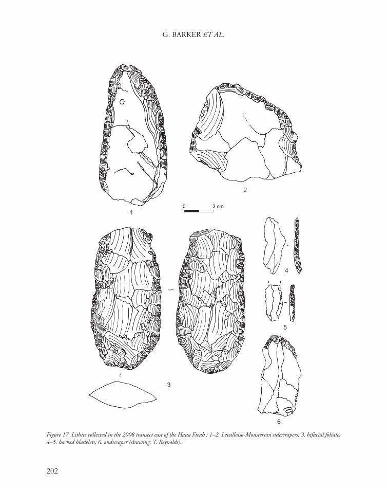
The amount of material counted on this transect was less than that seen in the 2007 transect to the west. As in that transect, however, the quantities of material observed varied markedly, the greatest concentrations occurring on the terrace areas and gentler slopes. As noted previously (Barker et al. 2007, 112) this is symptomatic of the dynamic nature of the landscape, with artefacts tending to be re-deposited from slopes and accumulating in flatter areas. Following completion of the north to south transect, six 2 m by 2 m surface collections of lithic artefacts were carried out at points on the line of the transect. The first of these was on the top of the watershed at the southern terminus of the transect, an extension of a scatter sampled in 2007 associated with the uppermost of the chert bands mapped in the vicinity of the Haua Fteah (see below). Three were located above and behind (south of ) the Haua Fteah, and two between the cave and the coast. The majority of the identifiable material seen and collected was again Middle Palaeolithic (Fig. 17), though a single backed bladelet and a blade-based endscraper likely to be Upper Palaeolithic were also recovered.
Chert resourcesBy Ian Brooks
The lithic resources of the immediate environs of the Haua Fteah consist of a series of cherts in the Eocene limestones of the Gebel Akhdar and some derived deposits. The primary resource includes both bands and discrete nodules within the parent limestone, whilst the derived deposits consist largely of wadi and beach gravels.
Three chert bands have been located, together with a small number of more dispersed resources forming the primary chert deposits of the area. The lowest of the three chert bands occurs at approximately 70 m asl, to the west of the Haua Fteah, and consists of a tabular band of opaque, coarsely grained chert, often highly fractured and iron stained, which can probably be regarded as a resource of last resort. The second band outcrops at approximately 170 m asl and is more variable in appearance, with thick tabular bands morphing into semi-tabular bands and a few lenticular nodules in places. The chert is generally grey, opaque, and of variable texture. In general the tabular bands tend to be fractured and of poorer quality, indeed where the tabular bands are thickest they often contain a core of unsilisified material. The discrete nodules tend to be of higher quality, some with zones of semi-translucent, fine-grained chert. The highest band outcrops at approximately 280 m asl and is associated with extensive knapping scatters. The chert here tends to occur in lenticular nodules, although semi-tabular banding and more spherical nodules exist. It tends to be grey, opaque, and fairly finely textured and was obviously a preferred resource.
Between the two upper bands a few dispersed nodules were also noted. These occur in two forms: sub-spherical nodules, approximately 150–250 mm in diameter, and thin lenticular nodules, typically 20–30 mm thick. The sub-spherical nodules were of a poorly translucent, grey/brown, chert of good knapping characteristics, whereas the lenticular nodules were of more translucent, high-quality chert, but were of limited application for knapping because of their size. Both of these cherts were associated with a dispersed knapping/testing scatter (CPP2030, UTM 34S 0598648N, 3640140S).
G. BARKER ET AL.
202
Figure 17. Lithics collected in the 2008 transect east of the Haua Fteah : 1–2. Levalloiso-Mousterian sidescrapers; 3. bifacial foliate; 4–5. backed bladelets; 6. endscraper (drawing: T. Reynolds).

THE CYRENAICAN PREHISTORY PROJECT 2008
203
A cursory inspection of the archaeological material recovered from Haua Fteah indicates that these local resources form only a part of the chert sources that were exploited by the cave’s prehistoric occupants. The potential source or sources of finer quality, translucent and semi-translucent cherts have yet to be defined.
Taphonomic researchBy Chris Hunt
A further facet of the environmental programme was the development of the taphonomic studies commenced in the 2007 season, to provide signatures of present processes to aid the interpretation of the palaeoecological records. Twenty-six wood samples were taken for comparative studies of wood anatomy, to enable recognition of these species in the fossil record. Two sticky-slide traverses, consisting of 22 sticky slides, were made in the Haua Fteah to examine pollen sedimentation patterns in the cave. Sixteen samples of modern depositional environments were made, to help provide modern analogues for or comparisons with ancient depositional environments. Three modern hearths in the Haua Fteah were planned, sectioned, and sampled for palynology to provide comparison with the ash layers in the cave, and a small cave in the mouth of Wadi Botamssa used as a shepherd shelter (CPP1530) was planned and samples taken from its hearths for the same purpose. Ecological surveys of molluscs were also made to enable recognition of ancient environments using fossil molluscan remains (Table 5). The data suggest that many molluscs are microhabitat-dependant, occurring even in very desertic environments where runoff concentration leads to suitably-vegetated localities, such as CPP1617. Most taxa seem to have distinct habitat requirements, underlining the likely potential for palaeoenvironmental reconstruction of the mollusc samples being collected from Quaternary deposits in the Haua Fteah and elsewhere in the landscape.
Modern stabling practices and diagnostic sedimentsBy Mike Morley
Sedimentary evidence for the stabling of livestock is commonly encountered in Mediterranean cave and rock shelter sediment sequences from the Neolithic onwards and is an important signature of the development of animal husbandry (Karkanas 2006). In order to more easily identify these sediments in archaeological contexts, which can suffer from a variety of post-depositional transformations (diagenesis), an analogue study of modern stabling sediments was undertaken at Haua Fteah. Bulk disaggregated samples and intact blocks of sediment for microstratigraphic analysis were removed from a section cut through the upper 0.30 m of recent stabling sediments accumulated at the rear of the cave. A detailed interview with the goatherd and primary user of the cave (Mr Salim Hussain) was conducted to elucidate the changing nature of livestock practices being used at the site over the past half century. A suite of analytical techniques will be used to quantify the nature of these modern stabling sediments and establish signatures for their recognition in archaeological contexts.

G. BARKER ET AL.
204
Vegetation Molluscs CPP site
Young Mediterranean wadi-terrace scrub woodland with Cupressus, Rosmarinus, Cistus, Quercus, Wadi Bottamsa
aff. Eobania sp., Chondrula sp., Helix melanostoma
1773
Pinus-Juniperus woodland, Wadi Cheritables Chondrula sp., Trochoidea aff. pyramidata 1617
Rock faces and cave roofs Clausiliid 1778, 1779
Exposed hilltop open Juniperus-Pistacia scrub, near the Haua Fteah, 230 m asl
Trochoidea aff. pyramidata, Clausiliid, Eobania sp., Chondrula sp., Rumina decollata, Helix melanostoma
1781
Dense Juniperus scrub, near the Haua Fteah, 173 m asl Clausiliid, Trochoidea aff. pyramidata, Theba pisana, Eobania sp.
1782
Juniperus-Pistacia scrub below the Haua Fteah Helix melanostoma, rare Rumina decollata 1757
Diverse heavily-grazed Juniperus-Pistacia-Crataegus-Salvia-Ceratonia scrub on steep slopes near the Haua Fteah
Theba pisana, Helix pomatia, ?Cernuella sp., Caracollina lenticulina, Trochoidea sp., Clausiliid
1754
Heavily-grazed grassland on terraces below the Haua Fteah
Theba pisana, Cernuella sp., Rumina decollata
1755
Coastal garrigue of Pistacia, Zizyphus, Artemisia, Salvia, Juniper, Sedum
Helix melanostoma, Cernuella sp., Helicella sp., Rumina decollata
1583, 1587b
Open coastal garrigue of Zizyphus, Pistacia and annual herbs
Helicella sp., Cernuella sp. 1584
Exposed limestone pavement on edge of storm-wave washed zone, rare Silene, Sedum
Cernuella sp. 1587a
Inland Zizyphus-Salvia-Pistacia annual herb garrigue near Lamludah, 652 m asl
Cernuella sp. 1611
Inland steppe-garrigue with Zizyphus, Thymus, Salvia, Helianthemum, Artemisia, annual grasses and herbs 10 km south of Al Qubbah, 579 m asl
Helicella sp., Cernuella sp., rare juvenile Helix melanostoma
1612
Steppe with Acacia, grasses, chenopod bushes, Artemisia, Salvia 15 km south of Marawah, 600 m asl
Cernuella sp., Helicella sp. 1621
Steppe with chenopod bushes, grasses, herbs 505 m asl Trochoidea sp., Cernuella sp. 1620
Chenopod scrub, 25 km south of Marawah, 392 m asl Rumina decollata, Trochoidea sp. 1619
Inland wadi-floor vegetation of broom, chenopods and herbs, near Al Mklily, 216 m asl
Helix melanostoma, Cernuella sp., Trochoidea sp.
1617
Barley fields below the Haua Fteah No molluscs 1780
Table 5. Mollusc ecological signatures of modern vegetation and environment.

THE CYRENAICAN PREHISTORY PROJECT 2008
205
Pleistocene and Holocene landscapes: further results from the initial (2007) fieldwork
Preliminary observations on the wood charcoalBy Caroline Cartwright and Chris Hunt
The charcoal samples taken in 2007 that were selected for submission to the Oxford Radiocarbon Accelerator Unit for 14C dating (funded by the NERC/AHRC ORADS programme) were identified by Caroline Cartwright using standard techniques of light microscopy, using a Leica Aristomet polarising microscope with darkfield capabilities and a range of objectives that comprise magnifications from ×50 to ×1000 (Cartwright and Parkington 1997; Table 6). Each charcoal fragment was fractured by (gloved) hand to ensure a crisp, dust-free plane, in order to expose transverse (TS), radial longitudinal (RLS), and tangential longitudinal (TLS) surfaces for identification. The softwood and hardwood identifications were achieved by examining up to 86 anatomical features present in the TS, RLS, and TLS of the charcoal fragments, by comparison with reference collection specimens, wood anatomy atlases (e.g. Gale and Cutler 2000; Jagiella and Kurschner 1987; Neumann et al. 2001; Schweingruber 1990a; 1990b) and computer-aided wood identification programmes (Wheeler et al. 1986; 1989). The samples derive from archaeological contexts spanning from the Dabban Upper Palaeolithic to the Classical.
The charcoals were identified to species level only for those fragments where there were sufficient diagnostic anatomical features visible within cell structures and/or where there was an exact match with reference material which has been identified to species according to the documented geographical extent of that taxon. Where identification to species was not possible, because the charcoal was not sufficiently well preserved or the taxonomic attribution to species did not comprise sufficient diagnostic anatomical structure, the genus was cited but the species was noted as ‘sp.’. Where the poor condition of the charcoal and the inconclusive matching of the charcoal to specific reference material prevented species determination, the genus was qualified by ‘sp.’ (e.g. Rhus sp.), despite the fact that other samples might allow a suggested specific determination. Where a close match with reference material could be made (and taking into account the fact that other species of that taxon may be present within the study area), the wood charcoal identification was annotated as ‘cf.’ with regard to species (e.g. Rhus cf. tripartita).
It would be premature to attempt palaeoenvironmental, archaeobotanical, and biogeographical interpretation of the material on the basis of the small quantity of charcoal identified thus far for the purposes of the 14C dating programme, and in advance of detailed studies of the sediments from which they were collected. However, it is striking that even in such a limited dataset there do seem to be significant trends between layers which probably reflect real changes in vegetation, climate, and procurement strategies. Current woody vegetation outside the cave is dominated by junipers, but also includes species such as Pistacia, Sarcopoterium, and Rhus; the nearest Cupressus are currently half a kilometre away in the Wadi Bottamsa. Limoniastrum only grows close to the shoreline. Pines grow at Cyrene/Shahat, where they are thought to have been planted during the Italian period, and on the high slopes above the Wadi Cheritables, but

G. BARKER ET AL.
206
HF environmental sample number
Context Section McBurney layer Comment Charcoal
188 126 5.1/6.1 III ‘historic’ phase occupation Sarcopoterium spinosum; Retama retam
190 126 5.1/6.1 III ‘historic’ phase occupation Juniperus sp.
189 127 5.1/6.1 III base, ‘historic’ phase occupation Juniperus sp. (bark)
200 129 5.1/6.1 VI top, Pottery Neolithic Pistacia cf. lentiscus
233 129 5.1/6.1 VI top, Pottery Neolithic Pistacia cf. lentiscus
237 129 5.1/6.1 VI top, Pottery Neolithic Pistacia cf. lentiscus
243 129 5.1/6.1 VI top, Pottery Neolithic Zygophyllum sp.
209 131 5.1/6.1 VIII main Neolithic occupation Rhus cf. tripartita
244 131 5.1/6.1 VIII main Neolithic occupation Suaeda sp.
314 131 5.1/6.1 VIII main Neolithic occupation Pistacia sp.
238 132 5.1/6.1 VIII main Neolithic occupation Ephedra sp.
315 132 5.1/6.1 VIII main Neolithic occupation Juniperus sp.
379 132 12.1 VIII main Neolithic occupation Juniperus sp.
380 132 12.1 VIII main Neolithic occupation Rhus cf. tripartita
236 133 5.1/6.1 IX Libyco-Capsian Juniperus sp.
240 133 5.1/6.1 IX Libyco-Capsian Rhus cf. tripartita
198 134 5.1/6.1 IX Libyco-Capsian Pistacia sp.
230 135 5.1/6.1 X Libyco-Capsian Rhus cf. tripartita
231 135 5.1/6.1 X Libyco-Capsian Juniperus sp.
234 135 5.1/6.1 X Libyco-Capsian Limoniastrum sp.
235 135 5.1/6.1 X Libyco-Capsian Cupressus sp.
249 135 5.1/6.1 X Libyco-Capsian Juniperus sp.
251 135 5.1/6.1 X Libyco-Capsian Juniperus sp.
310 135 5.1/6.1 X Libyco-Capsian Juniperus sp.
312 135 5.1/6.1 X Libyco-Capsian Juniperus sp., Tamarix sp., Acacia sp. and Rhus sp.
313 135/136 5.1/6.1 X Libyco-Capsian Juniperus sp.
254 136 5.1/6.1 X Libyco-Capsian Juniperus sp.
317 176 16.1 X Libyco-Capsian Juniperus sp.
319 176 16.1 X Libyco-Capsian Juniperus sp.
Table 6. Haua Fteah 2007: wood charcoal identifications.

THE CYRENAICAN PREHISTORY PROJECT 2008
207
HF environmental sample number
Context Section McBurney layer Comment Charcoal
426 208 16.1 X Libyco-Capsian Juniperus sp.
285 179 16.1 XI Oranian Juniperus sp.
330 179 16.1 XI Libyco-Capsian Juniperus sp.
454 179 16.1 XI Oranian Juniperus sp.
388 181 16.1 XII Oranian Juniperus sp.
287 182 16.1 XII Oranian Juniperus sp.
390 182 16.1 XII Oranian Juniperus sp.
288 183 16.1 XIII Oranian Rhus sp.
289 183 16.1 XIII Oranian Rhus sp.
290 184 16.1 XIII Oranian Cupressus sp.
292 186 16.1 XIV Oranian Cupressus sp.
293 187 16.1 XIV Oranian Pistacia sp.
295 187 16.1 XIV Oranian Pistacia sp.
437 238 13.1 XIV Oranian Pinus sp.
438 238 13.1 XIV Oranian Pinus sp.
456 238 13.1 XIV Oranian Pistacia sp.
458 238 13.1 XIV Oranian Pinus sp.
436 240 13.1 XIV Oranian Salix cf. subserrata
439 240 13.1 XIV Oranian possibly Cedrus sp.
459 240 13.1 XIV Oranian Pistacia sp.
460 240 13.1 XIV Oranian Pistacia sp.
466 240 13.1 XIV Oranian Rhus sp.
467 240 13.1 XIV Oranian Rhus sp.
445 241 13.1 XIV Oranian Juniperus sp.
296 194 16.1 XVI Dabban Cupressus sp.
427 238 16.1 XVI Dabban Cupressus sp.
429 238 16.1 XVI Dabban Juniperus sp., Rhus sp.
461 243 13.1 XVII Dabban Pistacia sp.
440 244 13.1 XVII Dabban Pistacia sp.
464 244 13.1 XVII Dabban Rhus sp.
419 207 16.1 XIX/XX ?basal Dabban Cupressus sp.
Table 6. Haua Fteah 2007: wood charcoal identifications. (cont.)

G. BARKER ET AL.
208
their status is thought to be non-native (Musbah Mohammed, pers. comm.). The assemblage of the Historic period appears to reflect conditions that are broadly similar to the present. The dominance of Pistacia in the Pottery Neolithic levels may reflect greater pressure on firewood collection, since this is a species that regenerates well, whereas junipers are killed by intensive cutting for firewood. The charcoal species of the main Neolithic levels and upper part of the Libyco-Capsian are also likely to reflect severe human pressure on local vegetation, because the gathering of small coastal shrubs such as Suadea and Limoniastrum would be unlikely if firewood was abundant close to the cave. Biogeographically these early Holocene assemblages are congruent with modern vegetation in the area around the cave, whereas the presence of pine, cedar, and willow in the Oranian levels suggests a cooler environment, as we would expect during the Last Glacial Maximum. The charcoal in the Dabban layers is biogeographically similar to the modern vegetation. The lack of small-shrub and scrub species in the Oranian and Dabban layers is perhaps consistent with lower levels of firewood gathering and less intense human activity than in the Holocene assemblages.
Preliminary observations on the macrobotanical remainsBy Jacob Morales and Marijke van der Veen
Thirty-two samples of macrobotanical remains from the Haua Fteah that had been retrieved from the flotation of 3-litre sediment samples in the 2007 season were sorted with a binocular microscope. Seed density was low to moderate, around 3.4 seeds per litre of sediment on average, and the plant remains were generally charred, reasonably well-preserved and identifiable (Table 7; Fig. 18).
A single flotation sample taken from the Dabban layers did not contain any plant remains. The Libyco-Capsian levels contained a low quantity of seeds but they are very interesting because some of them are cultivated plants. One seed of hulled barley (Hordeum vulgare) and two of large legumes (pea, bean or vetch) were collected in context (135). If AMS dating of these plant remains confirms the dates obtained by McBurney from this part of the sequence (his Layer X, with dates in the sixth millennium BC), these crop remains can be considered the oldest from Libya. Wild plants were also identified, including a seed of Pistacia lentiscus, an important tree in the economy of the Mediterranean peoples. Fruits of Pistacia lentiscus are today used as a food and also to produce oil, among other types of exploitation.
HF environmental sample number
Context Section McBurney layer Comment Charcoal
304 207 16.1 XIX/XX ?basal Dabban Juniperus sp.
447 259 16.1 XIX/XX ?basal Dabban Juniperus sp.
448 259 16.1 XIX/XX ?basal Dabban Juniperus sp.
Table 6. Haua Fteah 2007: wood charcoal identifications. (cont.)

THE CYRENAICAN PREHISTORY PROJECT 2008
209
Figure 18. Carbonised plant remains from the Haua Fteah: 1. Hordeum vulgare, barley (Libyco-Capsian); 2. Pisum/Vicia sp., pea/bean (Neolithic); 3. Pisum/Vicia sp., pea/bean (Libyco-Capsian); 4. Olea, olive (Graeco-Roman); 5. Juniperus sp., juniper (Graeco-Roman); 6. Pistacia lentiscus, mastic tree (Pottery Neolithic); 7. Pistacia lentiscus, mastic tree (Neolithic) (photo: J. Morales).

G. BARKER ET AL.
210
Phase Dabb Dabb Lib-Cap Lib-Cap Lib-Cap Lib-Cap Lib-Cap Lib-Cap Lib-CapContext 197 196 151 150 136
lower136 upper
136 135 lower
135
Sample no. 421 420 272 271 229 228 186 226 226Volume in litres 3 3 3 3 3 3 3 3 3% sorted 1.0 mm fraction 100 100 100 100 100 100 100 100 100% sorted 0.5 mm fraction 100 100 100 100 100 50 100 25 25CultivatedHordeum vulgare, barley - - - - - - - - 1Cerealia indet., grain - - - - - 1 - - -Vicia/Pisum (pea/bean/vetch) - - - - - - - - 1Wildcf. Anagallis arvensis - - - - - - - - -cf. Cistus sp. - - - - - - - - -Convolvulus sp. - - - - - - - - -Juniperus sp. seed - - - - - - - - -Juniperus sp. leaf fragment - - - - - - - - -Lamiaceae type 1 - - - - - - - - -Lamiaceae type 2 - - - - - - - - -Small legume (Trifolium, Medicago)
- - - - - - - - -
Malva sp. - - - - - - - - -Myrtaceae - - - - - - - - 4Olea europaea (wild?) - - - - - - - - -type Pistacia atlantica - - - - - - - - -Pistacia lentiscus - - - - - - - - 1Poaceae - - - - - - - 1 -Scorpiurus sp. - - - - - - - - -type Teucrium - - - - - - - - -cf. Vicia sp. - - - - - - 1 - -Indet. type 2 - - - - - - - - -Indet. type 4 - - - - - - - - -Indet. type 5 - - - - - - - - -Indet. fragment - - 1 4 - 3 3 6 8TOTAL 0 0 1 4 0 4 4 7 15Seed density per litre 0 0 0.3 1.3 0 1.3 1.3 2.3 5Dung fragments - - - - - - - - -No. charcoal fragm. >5 mm 0 0 2 4 10 27 3 35 40
Table 7. Haua Fteah 2007: provisional identification of macrobotanical remains. Dabb = Dabban; Lib-Cap = Libyco-Capsian; Neo = Neolithic; PNeo = Pottery Neolithic; Hist = Historic; Gre-Rom = Graeco-Roman.
THE CYRENAICAN PREHISTORY PROJECT 2008
211
Lib-Cap Lib-Cap Lib-Cap Neo Neo Neo PNeo PNeo PNeo PNeo Hist Hist Hist Gre-Rom Gre-Rom135 134 133 132 131 131 129 129 128 128 127 126 126 145 143
185 184 183 182 207 181 196 179 192 178 177 191 176 281 2243 3 3 3 3 3 3 3 3 3 3 3 3 3 3100 100 100 100 100 100 100 100 100 100 100 100 100 100 100100 100 100 100 50 100 100 100 100 100 100 100 100 100 50
- - - - - - - - - - 1 - - - -- - - - - - - - - - 1 - - - -1 - - - 1 - - - - - - - - - -
- - - - - - - - - - 2 - - - -- - - - - - - - - - - - - 3 -- - - - - - - - - - - - - 1 -- - - - - - - - - - - 1 1 - -- - - - - - - - - - - 1 - 13 -- - - - - - - - - - 1 - - - -- - - - - - - - - - - - - - -- - - - - 2 - - 1 - 53 - - 4 -
- - - - - - - - - - - - - - -- - - - 1 - - - - - - - - - -- - - - - - - - - - - - - 1 -- - - - 1 - - - - - - - - - -- - - - 2 - - 1 - - - - - - -- - - - - - - - - - - - - - -- - - 1 - - - - - - 22 - - 2 -- - - - - 2 - - - - - - - - -- - - - - - - - - - - - - - -- - - - 2 - - - - - - - - - -- - - - - - - - - - - - - - -- - - - - - - - - - - - - - -- 1 2 6 10 1 3 1 1 1 6 1 1 10 11 1 2 7 17 5 3 2 2 1 86 3 2 34 10.3 0.3 0.6 2.3 5.6 1.6 1 0.6 0.6 0.3 28.6 1 0.6 11.3 0.3- - - - - - - - - - - - - X -6 2 10 3 90 12 4 5 1 0 3 12 10 13 17
Table 7. Haua Fteah 2007: provisional identification of macrobotanical remains. (cont.)

G. BARKER ET AL.
212
Phase Gre-Rom Gre-Rom Gre-Rom Gre-Rom Gre-Rom ? ? ?
Context 142 141 140 139 138 130 130 125 TOTAL
Sample no. 266 164 162 160 157 180 201 175Volume in litres 3 3 3 3 3 3 3 3 96% sorted 1.0 mm fraction 100 100 100 100 100 100 100 100% sorted 0.5 mm fraction 100 100 100 100 100 100 100 100 CultivatedHordeum vulgare, barley - - - - - - - - 2Cerealia indet., grain - - - - - - - - 2Vicia/Pisum (pea/bean/vetch) - - - - - - - - 3Wildcf. Anagallis arvensis - - - - 1 - - - 3cf. Cistus sp. - 1 - 3 32 - - - 39Convolvulus sp. - - - - - - - - 1Juniperus sp. seed - 2 - 1 2 - - - 7Juniperus sp. leaf fragment - - 3 16 6 - - - 39Lamiaceae type 1 - - - - - - - - 1Lamiaceae type 2 - - 2 1 2 - - - 5Small legume (Trifolium, Medicago) - 3 2 1 2 - 3 1 72
Malva sp. - - - - 1 - - - 1Myrtaceae - - - 1 - 1 - - 7Olea europaea (wild?) - - - - - - - - 1type Pistacia atlantica - - - - - - - - 1Pistacia lentiscus - - - - - - - - 4Poaceae - - - - - - - - 1Scorpiurus sp. - 1 1 1 - - - 1 29type Teucrium - - - - - - - - 2cf. Vicia sp. - - - - - - - - 1Indet. type 2 - - - - - - - - 2Indet. type 4 - - - - 4 - - - 4Indet. type 5 - - - 1 3 - - - 4Indet. fragment - - 6 4 1 3 1 4 89TOTAL 0 7 14 29 54 4 4 6 320Seed density per litre 0 2.3 4.6 9.6 18 1.3 1.3 2 3.4Dung fragments - X - - X - - -No. charcoal fragm. >5 mm 0 0 7 17 24 16 35 14 422
Table 7. Haua Fteah 2007: provisional identification of macrobotanical remains. (cont.)

THE CYRENAICAN PREHISTORY PROJECT 2008
213
The Neolithic samples contained sparse plant remains. One seed of a cultivated legume was identified, in context (131), but it was not well-enough preserved for an accurate identification. In addition, some wild plants were recovered including Pistacia lentiscus, Scorpiurus sp. and other small legumes, the latter two possibly representing forage plants (wild plants selected for grazing). Pottery Neolithic levels did not contain any cultivated remains; one seed of Pistacia lentiscus and another one from a small legume were recovered.
The Historic layers contained far more plentiful plant remains, context (127) being especially rich in seeds. One grain of hulled barley (Hordeum vulgare) plus an unidentified cereal were the only cultivated plants recognised. Seeds of wild plants including Scorpiurus and small legumes were extremely abundant, mainly in context (127), as well as Juniperus seeds (Juniperus fruits are edible and used today to produce different foods and drinks). Several of the Graeco-Roman samples (contexts 145–138) were rich in seed remains, though no cultivated plants were recovered; an olive seed was found in context (145), but the size of this seed is very small so it is not clear whether it derives from a wild or cultivated plant. Wild plants were abundant in most of the samples, the most profuse being Cistus sp., Juniperus sp., and small legumes. Charred dung remains (probably from goats or sheep) were also recovered, so it is possible that some of the wild plants represent forage and reached the site through the use of dung pellets as fuel, or perhaps the dung was burnt in situ by shepherds camping in the cave, as the modern shepherds do.
Recent environmental changeChris Hunt, John Davison, Roisin Hamilton and David Simpson
Although the project focuses on the pre-Classical periods, our field and laboratory work necessarily involves reconnaissance investigations of more recent material, in part to establish the extent to which climatic changes in the historical periods observed in our data can be correlated with the regional records of Mediterranean Europe and/or the Sahara. Initial results have been obtained from the investigation in 2007 of sediments in a small cave (CPP1565) near the mouth of Wadi Bottamsa, the wadi immediately west of the Haua Fteah, and from a reconnaissance dendrochronological study carried out in 2007 on incremental cores from Cupressus trees on low terraces and hillslopes in the same wadi and from a juniper tree outside the Haua Fteah.
The pollen evidence from CPP1565 suggests that in the mid-first millennium AD (dated on the basis of late Roman ceramics in the sediments) the environment in coastal Cyrenaica near the Haua Fteah was highly degraded as the result of cereal and olive cultivation, with little natural vegetation and considerable soil erosion. At some time during the medieval period, however, as the climate became very dry, steppe and desertic plants spread, cereal cultivation diminished, olive cultivation locally seems to have ceased and trees were effectively absent. In more recent times, trees appear in the pollen record and the modern Mediterranean woodland seems to have developed.
Evidence from around the eastern Mediterranean and in eastern North Africa indicates that there was significant aridification in these regions at the time of the European ‘Little Ice Age’

G. BARKER ET AL.
214
(Hunt et al. 2007). Oral historical records suggest that severe drought also occurred at this time in Cyrenaica, with a breakdown of previous settlement and agricultural patterns (Ahmed Buzaian, pers. comm.). According to the dendrochronological records, the oldest trees in the region are no more than 470 years old, an age consistent with the palynological evidence of a lack of arboreal vegetation during the ‘Little Ice Age’. The dendrochronological results for trees growing on wadi gravels further suggest that catastrophic floods were occurring in the wadi before the trees started to grow in the sixteenth to nineteenth centuries. Such catastrophic floods may be linked to exceptional rainfall events during a generally arid period, as has been reported elsewhere around the eastern Mediterranean (Hunt et al. 2007; Newson et al. 2007).
DiscussionBy Graeme Barker, Chris Hunt and Tim Reynolds
The second season of fieldwork of the Cyrenaican Prehistory Project has significantly advanced understanding of the Haua Fteah stratigraphy and of the archaeology and geomorphology of the landscape in which the cave is located. The bulk of the backfill of the Middle Trench has been removed, to a total depth of 7.5 m below the present ground surface (the base of the Middle Trench and top of the Deep Sounding), the approximate depth where McBurney located the two human mandibles alongside lithic material categorised as Pre-Aurignacian, his basal Middle Palaeolithic industry. Understanding of the cultural and natural processes forming the Holocene deposits of the Upper Trench has been significantly advanced, though the field observations need to be supported by laboratory studies of the sediments. The exposed faces have been recorded in detail and sampled comprehensively for dating and palaeoenvironmental samples, the Upper Trench protected with wire mesh and the upper section of the Middle Trench protected with timber shuttering at the end of this process (Fig. 19).
The planned beginning of excavation of Pleistocene sediments adjacent to the Middle Trench in the Haua Fteah had to be postponed to the following season because of the availability of personnel, but the excavation programme at sites elsewhere in the study area, including Hagfet ed-Dabba (CPP1647) and in particular Hagfet al-Gama (CPP2008), more than compensated for this. The work at Hagfet ed-Dabba established that the sediments associated with the Upper Palaeolithic ‘Dabban’ industry were more or less entirely removed by the McBurney excavation, but that the western and interior parts of the cave remain intact. The Hagfet al-Gama, a small coastal cave, produced a remarkable sequence of Mesolithic and Neolithic occupation evidence, followed by reuse in the early Hellenistic period.
The orthodox view of the Mesolithic–Neolithic transition in the Mediterranean used to be that there was an abrupt transition from (Mesolithic) hunting, fishing, and gathering to (Neolithic) mixed farming, the latter interpreted as being introduced by new people from the Near East. In recent years it has become clear the situation is much more complex on the northern side of the Mediterranean, with the indigenous population of foragers (hunter-fisher-gatherers) in many localities gradually acquiring domesticates and combining foraging with pastoralism (especially of sheep and goats) for many centuries, even millennia, before they developed a full

THE CYRENAICAN PREHISTORY PROJECT 2008
215
commitment to agriculture (Barker 2006). Far less is known about the process on the southern side of the Mediterranean basin, where the Haua Fteah still represents the main stratigraphic sequence of Mesolithic and Neolithic material culture on the entire North African littoral. Hence the new finds from Hagfet al-Gama have a potential importance for the study of the transition to farming in North Africa out of all proportion to the small size and reconnaissance nature of the excavation. If the remarkable terracotta mask (Fig. 13) and associated finds of the Hellenistic period, and indications of flooring, are evidence for the use of the cave for some kind of cultic activity, the site also adds further insights into the nature of Hellenistic religious life away from the major centres of population in Cyrenaica.
Alongside the excavation programme, the geomorphological fieldwork in the landscape was able to significantly advance understanding of the deposits and relationships established in the initial season of fieldwork (Barker et al. 2007, 105–109), enabling us to propose the provisional Quaternary sequence summarised in Table 8. Once the dating framework is established, the relationship between these deposits and global events can be verified. The dating framework will also enable correlations to be established between the sedimentation events identified in the study area (and thus changing ecology and climate) and the archaeological sequences in the Haua Fteah and the changes in human activity recorded there.
The initial results from the study of botanical remains, both macroscopic and microscopic, obtained in the 2007 season confirm the potential of the Haua Fteah and its landscape to
Figure 19. Shoring the upper 2 m of the Middle Trench (photo: G. Barker).

G. BARKER ET AL.
216
yield a rich suite of materials to inform on climatic and environmental change, and on human activities in the landscape. Whilst the climate of the interior of North Africa was characterised by intense cold and aridity in the late Pleistocene (Maley 2000), the small sample of wood charcoal studied thus far (preparatory to 14C dating) suggests that the northern side of the Gebel Akhdar remained relatively wooded at this time, a refugium for plant and animal species and the human populations exploiting them who inhabited caves such as the Haua Fteah and Hagfet ed-Dabba. The macrobotanical remains recovered so far give us hints at the plant resources available to ‘Libyco-Capsian’ Mesolithic people camping in the Haua Fteah in the early Holocene. Intriguingly, these include on current evidence (which needs to be tested by direct AMS dating of selected seeds) morphologically domesticated cereals and legumes dating to the sixth millennium BC, the earliest in North Africa and contemporary with early farming villages in the Levant and Greece, as well as plants such as Scorpiurus sp. typically used as livestock forage. Fodder plants and dung are also preserved in the Graeco-Roman layers but not domesticated plants, though the contemporary pollen obtained from sediments in a small cave near the Haua Fteah indicate a Classical landscape highly degraded by cereal and olive cultivation that became even more desertic in the medieval period. Dendrochonology confirms the instability of the climate over the past 470 years.
The results of the 2008 fieldwork, together with the initial studies of materials collected in 2007, make it clear that the integration of ‘deep-time’ cultural and palaeoenvironmental data from the Haua Fteah and other excavations with the spatial behavioural data and palaeoecological sequences from the landscape should allow the Cyrenaican Prehistory Project to investigate with depth and precision the strategies developed by past human populations over the past 200,000 years to utilise a typical North African landscape; to understand how they variously responded to the challenges of profound climatic and environmental change; and to establish the extent to which cultural change was driven by, and/or independent of, these landscape transformations.
PostscriptIn May 2008 Condrill AB were kind enough to drill a 150 mm diameter core approximately 8 m to the east of the main trench in the Haua Fteah using a vehicle-mounted Atlas Copco Rotamec R50 rig, in order to obtain sediment depth data to inform the future excavation strategy. The sediment samples collected in the drilling process have still to be studied in detail, but the indications are that the drill encountered decayed limestone at 13.5–14 m below the present ground surface and then solid limestone to 21.3 m, when drilling ceased. Whilst the configurations of the subsurface rock could well vary considerably across the cave, the core suggests that there is unlikely to be a significant depth of cultural deposit to be excavated below the base of McBurney’s Deep Sounding at 14 m depth below the present ground surface.
AcknowledgementsWe would like to acknowledge in particular the permission of the Department of Antiquities of Libya to undertake the project; the financial support of the Society for Libyan Studies, the Leakey Foundation, and the University

THE CYRENAICAN PREHISTORY PROJECT 2008
217
Unit Thickness Description Depositional environment
Inferred age Archaeology
12 <2 m Yellow-brown trough cross-bedded very silty gravels in wadi-mouths.
Wadi gravels. Probably early post-war to late 1970s.
Tin cans, rubber tires and ceramics of post-war aspect.
11 1.5–3 m, occasionally >6 m
Yellow-brown boulder-rich gravels often showing pronounced tabular bar-forms and with silty interbeds.
Wadi gravels deposited during major flood events.
From dendrochronology, more than 470 years.
None recorded.
10 >6 m Whitish-brown beach and dune sands passing laterally into dense reddish sublaminated sabkha silts and shelly lagoonal muds.
Beaches, coastal dunes, sabkhas and lagoons.
Holocene. None recorded.
9 >4 m Karstic depression-fills: dark brown diamicts passing up into fine greyish- brown organic muds, then sublaminated dense reddish-brown silts.
Redeposited soils, pool deposits and seasonal pool deposits.
Holocene. None recorded.
8 2 m Brownish channel-fill silts and thin gravels sometimes containing a relatively diverse mollusc fauna, passing up into thin trough cross-bedded silty gravels.
Alluvial fan deposits of meandering streams, passing up into gravels deposited in a braidplain environment.
Late Glacial and very early Holocene.
Several localities with blade-based industries of broad Early Holocene aspect.
7 <4 m Cave fills of reddish-brown and dark reddish-brown very silty diamicts, variably lithified and containing occasional bone and mollusc shells.
Cave fills. Late Pleistocene to late Holocene.
Occasional undifferentiated flakes, in one case late Roman ceramics.
6 >5 m Pale reddish-brown silty diamicts with clast long axes orientated downslope and rare, restricted terrestrial mollusc faunas interbedded with reddish-brown clayey silty diamicts with small rootcasts and slightly more diverse mollusc faunas.
Stratified screes deposited during freeze–thaw, with abundant aeolian silt input.
Rare blades of broad Upper Palaeolithic aspect.
Table 8. The provisional Quaternary sequence identified in the landscape around the Haua Fteah (source: Chris Hunt).

G. BARKER ET AL.
218
Unit Thickness Description Depositional environment
Inferred age Archaeology
5 >12 m Brownish silty gravels including some horizons containing boulders up to 2.5 m diameter, interbedded with silty diamicts and silts sometimes containing restricted land mollusc faunas and root-cast nodules. A prominent reddened palaeosoil underlain by a plugged calcrete horizon is interbedded in this sequence.
Alluvial fan and wadi gravels, colluvia and silty channel-fills deposited in a braidplain environment, with palaeosoils, mostly incipient.
Last glaciation (broadly). Palaeosoil development most probably reflects interstadials.
Very rare blade-based lithics in top 0.5 m. Very rare lithics of broad Middle Palaeolithic aspect throughout.
4 >10 m Pale brown fine sands showing large-scale cross-sets predominantly dipping northward, forming dune-shaped features passing below current sea level. Occasional terrestrial molluscs and root-casts. Highly lithified, mostly point-contact cemented.
Dunes deposited by predominantly northerly winds during falling sea levels.
Early last glaciation.
Very occasional lithics of broad Middle Palaeolithic aspect usually associated with root-cast horizons.
3 >6 m Interfingering silty colluvia, reddish sandy gravels, pale brown gravelly sands, cross-laminated fine sands and rare shelly limestones on coastal platforms at 2–8 m asl passing laterally into imbricated reddish fine to medium gravels with occasional silt lenses containing Phragmites rhizomes at the mouths of wadis. Spring tufas and interbedded silts and fine gravels upstream. Highly lithified, mostly point-contact cemented but sometimes plugged calcrete. Rising to approximately 8 m asl.
Back-beach, beach and shallow-marine limestones passing laterally into wadi deposits.
Last interglacial. Occasional lithics of broad Middle Palaeolithic aspect in back-beach deposits.
2 >2 m Reddish-brown silty gravels and silts with root-cast nodules. Highly lithified and with plugged and occasionally laminar calcrete horizons to 0.6 m thick on surface.
Alluvial fan deposits.
Middle Pleistocene cold stage(s).
None recorded.
Table 8. The provisional Quaternary sequence identified in the landscape around the Haua Fteah. (cont.)

THE CYRENAICAN PREHISTORY PROJECT 2008
219
of Cambridge, for the fieldwork, and of the Australian Research Council for the travel costs of Rainer Grün, Zenobia Jacobs and Richard Roberts; and the significant help in kind provided by the Department of Antiquities in Tripoli and Cyrene, AMEC (with thanks especially to Simon Lyons and Ruth Codd) and Condrill AB (with thanks especially to Anders Nillson and Bill Smith). The personal support of the President of the Department of Antiquities, Dr Giuma Anag, and the Controller of Antiquities for Cyrene, Abdelgader al-Muzeini, has been vital to the success of the project. Further invaluable support for the project was provided by Paul Bennett (Chair of the Society for Libyan Studies), Mustapha Turjman (Department of Antiquities, Tripoli), Ibreike Quinhe (Inspector of Antiquities, Apollonia), Mohammed Touati and Fathullah Khalifa (Department of Archaeology, Omar al-Mukhtar University, al-Beida), and Ahmed Buzaian (Department of Archaeology, University of Garyunis, Benghazi). Special thanks are due to the team’s cook Rajap Mohammed Hadad, drivers Abullah al-Mabruk and Hamza Abdelgader al-Muzeini, and site workmen Refaie Mohammed abd Alorhim, Omar abd Alhamid Mostafa, Aziden Salem Hussein, and Ahmad Said Hussein. The field team consisted of: Graeme Barker, Laura Basell, Joanne Bourne, Ian Brooks, Franca Cole, Lucy Farr, Rainer Grün, Chris Hunt, Robyn Inglis, Zenobia Jacobs, Iain Morley, Mike Morley, Steven Pawley, Alex Pryor, Ryan Rabett, Tim Reynolds, Hwedi Mohammed el-Rishi, Richard Roberts, Chris Stimpson, Mohammed Touati, Natalie Uomini, and Mark Verhoeven. The fieldwork took place from 29 March to 26 April 2008.
ReferencesBarker, G. 2006. The Agricultural Revolution in Prehistory: Why Did Foragers Become Farmers? Oxford, Oxford
University Press.Barker, G., Hunt, C. and Reynolds, T. (with Brooks, I. and el-Rishi, H.) 2007. The Haua Fteah, Cyrenaica
(Northeast Libya): renewed investigations of the cave and its landscape, 2007. Libyan Studies 38: 93–114.Barton, R.N.E., Bouzouggar, A., Bronk-Ramsey, C., Collcutt, S., Higham, T.F.G., Humphrey, L.T., Parfitt, S.A.,
Rhodes, E.J., Schwenninger, J.-L., Stringer, C., Turner, E. and Ward, S. 2007. Abrupt climatic change and chronology of the Upper Palaeolithic in Northern and Eastern Morocco. In Mellars, P., Boyle, K., Bar-Yosef, O. and Stringer, C. (eds), Rethinking the Human Revolution. McDonald Institute for Archaeological Research, Cambridge: 177–186.
Unit Thickness Description Depositional environment
Inferred age Archaeology
1 >20 m, usually a remanié layer approximately 1 m thick
Interfingering red-brown silts, pale brown sands and gravels with marine molluscs, and sometimes-shelly limestones showing burrowing structures. Highly lithified throughout and with thick plugged and laminar calcretes up to 2 m thick on the surface in many localities. Rising to approximately 60 m asl.
Sabkha, back-beach and beach deposits rarely overlain by subtidal sands and sub-wave-base limestones, interfingering with submarine fan-delta gravels and overlaid by fluvial gravels.
Middle Pleistocene (broadly) interglacial.
Occasional lithics of broad Middle Palaeolithic aspect in back-beach deposits.
Table 8. The provisional Quaternary sequence identified in the landscape around the Haua Fteah. (cont.)

Burn, L. and Higgins, R. 2001. Catalogue of Greek Terracottas in the British Museum III. British Museum, London.
Cartwright, C.R. and Parkington, J.E. 1997. The wood charcoal assemblages from Elands Bay Cave, southwestern Cape: principles, procedures and preliminary interpretation. South African Archaeological Bulletin 52: 59–72.
Courty, M.-A. 2001. Microfacies analysis assisting archaeological stratigraphy. In Gildberg, P., Halliday, V.T. and Ferring, C.R. (eds), Earth Sciences and Archaeology. Kluwer Academic/Plenum Publishers, New York: 205–240.
Courty, M.-A., Goldberd, P. and MacPhail, R. 1989. Soils and Micromorphology in Archaeology. Cambridge University Press, Cambridge.
Farrand, W.R. 1993. Discontinuity in the stratigraphic record: snapshots from Franchthi Cave. In Goldberg, P. Nash, D.T. and Petraglia, M.D. (eds), Formation Processes in Archaeological Context. Prehistory Press, Madison: 85–96.
Farrand, W.R. 2001. Sediments and stratigraphy in rockshelters and caves: a personal perspective on principles and pragmatics. Geoarchaeology 15.5: 537–557.
Foley, R. and Lahr, M.M. 1997. Mode 3 technologies and the evolution of modern humans. Cambridge Archaeological Journal 7: 3–36.
Gale, R. and Cutler, D. 2000. Plants in Archaeology – Identification Manual of Artefacts of Plant Origin from Europe and the Mediterranean. Royal Botanic Gardens, Kew.
Higgs, E.S. 1967. Environment and climate – the evidence from mammalian fauna. In McBurney, C.B.M., The Haua Fteah (Cyrenaica) and the Stone Age of the South-East Mediterranean. Cambridge University Press, Cambridge: 16–44.
Hublin, J.-J. 2000. Modern – Non-modern hominid interactions: a Mediterranean perspective. In Bar-Yosef, O. and Pilbeam, D. (eds), The Geography of Neandertals and Modern Humans in Europe and the Greater Mediterranean. Peabody Museum Bulletin 8. Peabody Museum of Archaeology and Ethnology, Harvard: 157–182.
Hunt, C.O., Gilbertson, D.D. and El-Rishi, H.A. 2007. An 8000-year history of landscape, climate and copper exploitation in the Middle East: the Wadi Faynan and the Wadi Dana National Reserve in southern Jordan. Journal of Archaeological Science 34: 1306–1338.
Jacobs, Z. and Roberts, R.G. 2007. Advances in optically-stimulated luminescence dating of individual grains of quartz from archaeological deposits. Evolutionary Anthropology 16: 210–223.
Jagiella, C. and Kurschner, H. 1987. Atlas Der Holzer Saudi Arabiens: Die Holzanatomie Der Wichtigsten Baume Und Straucher Arabiens. Beihefte Zum Tubinger Atlas Des Vorderen Orients. Ludwig Reichert, Wiesbaden.
Karkanas, P. 2006. Late Neolithic household activities in marginal areas: the micromorphological evidence from the Kouveleiki caves, Peloponnese, Greece. Journal of Archaeological Science 33.11: 1628–1641.
Klein, R.G. and Scott, K. 1986. Re-analysis of faunal assemblages from the Haua Fteah and other late Quaternary archaeological sites in Cyrenaican Libya. Journal of Archaeological Science 13: 515–42.
Maley, J. 2000. Last Glacial Maximum lacustrine and fluviatile formations in the Tibesti and other Saharan mountains, and large-scale climatic teleconnections linked to activity in the Subtropical Jet Stream. Global and Planetary Change 26: 121–136.
Marean, C.W. and Assefa, Z. 2005. The Middle and Upper Pleistocene African record for the biological and behavioral origins of modern humans. In Stahl, A. (ed.), African Archaeology: A Critical Introduction. Blackwell, Malden: 93–129.
G. BARKER ET AL.
220

THE CYRENAICAN PREHISTORY PROJECT 2008
221
McBrearty, S. and Brooks, A.S. 2000. The revolution that wasn’t: a new interpretation of the origin of modern human behavior. Journal of Human Evolution 39: 453–563.
McBurney, C.B.M. 1960. The Stone Age of Northern Africa. Penguin Books, London.McBurney, C.B.M. 1967. The Haua Fteah (Cyrenaica) and the Stone Age of the South-East Mediterranean. Cambridge
University Press, Cambridge.McBurney, C.B.M. and Hey, R.W. 1955. Prehistory and Pleistocene Geology in Cyrenaican Libya: a record of two
seasons’ geological and archaeological fieldwork in the Gebel Akhdar hills, with a summary of prehistoric finds from neighbouring territories. Cambridge University Press, Cambridge.
Mlekuž, D., Budja, M., Payton, R. and Bonsall, C. 2008. ‘Mind the Gap’: caves, radiocarbon sequences, and the Mesolithic–Neolithic transition in Europe – lessons from the Mala Triglavca rockshelter site. Geoarchaeology 23.3: 398–416.
Moyer, C. 2003. The Organisation of Lithic Technology in the Middle and Early Upper Palaeolithic Industries at the Haua Fteah, Libya. Unpublished PhD thesis, University of Cambridge.
Neumann, K., Schoch, W., Détienne, P. and Schweingruber, F.H. 2001. Woods of the Sahara and the Sahel. Paul Haupt, Berne.
Newson, P., Mattingly, D., Daly, P., Tomber, R., el-Rishi, H., Gilbertson, D., Grattan, J., Hunt, C., McLaren, S. and Pyatt, B. 2007. The Islamic and Ottoman periods. In Barker, G., Gilbertson, D. and Mattingly, D. (eds.), Archaeology and Desertification: The Wadi Faynan Landscape Survey, Southern Jordan. Levant Supplementary Series 6, Council for British Research in the Levant. Oxbow Books, Oxford: 349–368.
Rumscheid, F. 2006. Die figürlichen Terrakoten von Priene. Reichert Verlag, Wiesbaden.Schweingruber, F.H. 1990a. Microscopic Wood anatomy (3rd edition). Swiss Federal Institute for Forest, Snow and
Landscape Research, Birmensdorf.Schweingruber, F.H. 1990b. Anatomy of European Woods. Paul Haupt, Berne.Stein, J.K. 2001. A review of site formation processes and their relevance to geoarchaeology. In Gildberg, P., Halliday,
V.T. and Ferring, C.R. (eds), Earth Sciences and Archaeology. Kluwer Academic/Plenum Publishers, New York: 37–54.
Swift, K. 2005. Classical and Hellenistic Coarse Pottery from Euesperides. Unpublished PhD thesis, University of Oxford.
Wheeler, E.A., Baas, P. and Gasson, P.E. (eds), 1989. IAWA list of microscopic features for hardwood identification. Bulletin of the International Association of Wood Anatomy 10: 219–332.
Wheeler, E.A., Pearson, R.G., LaPasha, C.A., Zack, T. and Hatley, W. 1986. Computer-Aided Wood Identification. North Carolina Agriculture Research Service Bulletin 474, North Carolina.

Copyright © 2022 FDOKUMEN