Fieldwork at Markland Farm, Derbyshire, July 2015
27
0 Fieldwork at Markland Farm, Derbyshire, July 2015 Interim report prepared by Tim Cockrell, Colin Merrony, Angela Walker and John Carrot
-
Upload
independent -
Category
Documents
-
view
0 -
download
0
Transcript of Fieldwork at Markland Farm, Derbyshire, July 2015

0
Fieldwork at Markland Farm, Derbyshire, July 2015
Interim report prepared by
Tim Cockrell, Colin Merrony, Angela Walker and John Carrot

1
Contents
Summary 2
Location, geology, topography 2
Historical and archaeological background 4
Aims and objectives 7
Methodology 8
The fieldwork 9
Discussion and conclusions 14
Recommendations 16
Acknowledgements 16
References 16
Appendix 1: Assessment of biological remains from three small sediment
samples collected during an auger survey undertaken at Markland Farm,
north of Elmton, Derbyshire 18
Appendix 2: Additional Photographs 25

2
Summary
An auger survey and test pitting was undertaken at Markland farm, Elmton, North Derbyshire, at a location where a
probable former watercourse entered the small gorge at Markland Grips. The gorge lies at the centre of where
considerable activity took place throughout later prehistory, proved by the recovery of chipped stone assemblages
from the vicinity. It was thought that environmental analysis of any surviving organic deposits would shed light on
the character of the landscape in prehistory and how it changed over time. It was realised that an opportunity
existed both to enhance understanding of the prehistoric landscape, disseminate results in the local community, and
provide a high quality experience to members of the public in the course of undertaking the fieldwork.
The fieldwork took place over two days in July 2015, involving volunteers drawn from Limestone Journeys
Community Archaeology Group, assisting staff and students from the University of Sheffield. Along with the auger
survey, the edge of the gorge was investigated with three test pits. The soil conditions proved to be poor for organic
preservation, resulting in the recovery of insignificant data. The test pitting did not result in the detection of any
activity visible on the terrace overlooking the gorge, other than some data suggestive of ephemeral activity at an
indeterminate point in prehistory.
The experience of the day's activities included members of the public who were able to take part in meaningful
engagement with their historic environment in a social context. The volunteers enhanced their understanding and
appreciation of the local environment and its history, and contributed to the production of new data about the
character of that environment.
Location, Geology and Topography
Markland Farm is located to the immediate north of the village of Elmton, in north east Derbyshire (NGR 450575
373995). It is situated close to the base of a shallow basin in the Magnesian Limestone ridge that runs north-south in
eastern England, framed approximately by the villages of Elmton, Clowne and Creswell (figure 1). This basin is cut by
a series of narrow gorges that once channelled flowing water down through where two of the gorges converge at
Markland Grips. The farm, and adjacent field which comprises the present study area, lie alongside the course of one
of the aforementioned gorges at the point where the southern spur of Markland Grips begins (cover illustration).
Overlying the Magnesian Limestone bedrock, later sedimentary deposits of possible Aeolian or colluvial origin infill
the aforementioned gorge (figure 2). Peats are not obviously in evidence, but much of the bottom of this gorge is
wet and the topography suggests that this might have been the case for much of the site's history.

3
Figure 1: Location of Markland Farm, Derbyshire (reproduced from Ordnance Survey © Crown Copyright).
Figure 2: Geological formations at Markland Farm: Magnesian Limestone (salmon pink), Alluvium (yellow), Coal
Measures (grey),artificial (hatched), and superficial (lilac)(reproduced from Ordnance Survey © Crown Copyright
2015)

4
Historical and Archaeological Background
Elmton is the nearest settlement to Markland Farm, approximately only 300m to its south west. Elmton is first
mentioned in historical records as early as the Domesday survey, where it is accredited with the unusually high
population of 39 households. The lands here were held by Swein in 1066, who by 1086 had been replaced with his
Norman Successor William of Aincourt. Elmton is next mentioned in the Thurgaton Cartulary, a document probably
written c.1200, where it is stated that Walter Deyncourt had been granted 2 Bovates of land (Beresford 2010: 2). The
existence of a manor house and perhaps even a castle is further implied in the document (Beresford 2010: 2-3).
The present church at Elmton is a post-medieval structure dating to 1771, but occupies the location of a church that
is reputed to have existed here since at least the Domesday survey of 1086 (Heritage Gateway HER 5211). The
present village spreads mostly to the south east of the church, and is suspected to have been larger during the
medieval period (or possibly has repositioned its centre of gravity slightly), as earthworks are reported to have been
detected in the vicinity of the road junction between the church and Rose cottage (Heritage Gateway HER 5210). It is
not clear whether these are located to the north or south of the junction, but a map of 1835 is reputed to show a
lane between Spring Lane and Oxcroft Lane. This could have been where structures backed up against the lane
marked on the 1835 map.
Grange Farm consists of buildings that relate to the 18th and 19th centuries, but an Augustinian Grange of
Thurgaton Priory is claimed to have existed at Elmton at an earlier date (HeritageGateway HER 5252). A sketch map
of 1765 shows "an ancient Dovecote" on the north end of the farm, the foundation platform of which still exists. This
dovecote is shown on the 1st edition OS map of the area (figure 3), on which the farm is called a "Manor House". On
this basis, the farm does not appear to have a demonstrable link to a medieval grange.
Figure 3: Elmton, c.1875. (reproduced from Ordnance Survey © Crown Copyright).
5
Until recently, archaeological research in the vicinity of Elmton was entirely absent, although the village roughly
centres on an area of landscape that has yielded much archaeologically over the last century. This has most notably
been in the context of Creswell Crags, with its rich presence of Palaeolithic information, especially due to the
activities of Leslie Armstrong (Armstrong 1926; Wall and Jacobi 2000). Less well known is the continuity of activity at
the crags and its vicinity throughout later prehistory (Armstrong 1926; Manby 1964; Cockrell forthcoming).
Armstrong was also responsible for recovering data spanning prehistory from the nearby Whaley rock shelter site
(Armstrong 1949; 1950; 1951; 1952; 1953). Other sites investigated archaeologically include the Later Prehistoric
defended enclosures at Markland Grips (Lane 1970), the Early Neolithic long cairn at Whitwell quarry, immediately
to the west of Creswell Crags (Vyner and Wall 2011), and the recovery of a disturbed assemblage of Mesolithic
flintwork and other prehistoric material culture from a site at Bolsover (Jones 1995). The activities of H. Lane during
the 1960s have, in addition, demonstrated that the designated ancient woodland of Scarcliffe Park, to the immediate
east of Bolsover and south of Elmton, is rich in material culture and upstanding archaeological remains dating from
the Early Bronze Age through to the Medieval period (Beresford 2012).
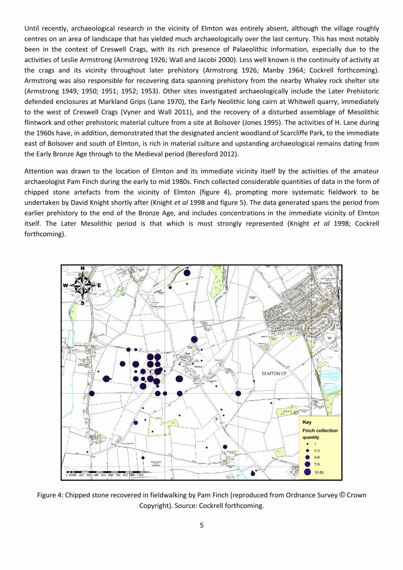
Attention was drawn to the location of Elmton and its immediate vicinity itself by the activities of the amateur
archaeologist Pam Finch during the early to mid 1980s. Finch collected considerable quantities of data in the form of
chipped stone artefacts from the vicinity of Elmton (figure 4), prompting more systematic fieldwork to be
undertaken by David Knight shortly after (Knight et al 1998 and figure 5). The data generated spans the period from
earlier prehistory to the end of the Bronze Age, and includes concentrations in the immediate vicinity of Elmton
itself. The Later Mesolithic period is that which is most strongly represented (Knight et al 1998; Cockrell
forthcoming).
Figure 4: Chipped stone recovered in fieldwalking by Pam Finch (reproduced from Ordnance Survey © Crown
Copyright). Source: Cockrell forthcoming.

6
More recently, the gorges and crags of Markland Grips were surveyed (Davies et al 2004). 12 caves and 41
possible rock shelters were identified, although only a couple were thought to have archaeological
potential.
Figure 5: Chipped stone recovered by the Elmton Fieldwalking Project. Fields walked marked in violet (reproduced
from Ordnance Survey © Crown Copyright). Source: Cockrell forthcoming.
Archaeological interest in the area of Elmton was recently renewed by the activities of the local archaeologist
Mathew Beresford, in conjunction with Limestone Journeys Community Archaeology Group. Beresford and his group
initially sought to identify the location of the putative castle noted above. Beresford has suggested that Camp Hill is
the site of the castle (Beresford 2010: 20). This remains open to question, but evidence including platforms, chipped
stone and polished stone axes are suggestive of the presence of a settlement in the Late Neolithic or Early Bronze
Age (Heritage Gateway HER 5226). Sherds and coins recovered indicate that this settlement might have carried on
as late as the Roman Period.
Beresford's work in the area with Creswell is ongoing, although the results of the Elmton Research Project are due to
be complete by later in 2015 (M. Beresford: pers.comm.). The most recent fieldwork undertaken under the auspices

7
of the project took place in the field to the immediate south of the road junction described above, with trial
excavations revealing features of probable Post Medieval date (M. Beresford: pers.comm.).
The present study arose as a result of ongoing doctoral research by Tim Cockrell, one of the authors of this report.
Cockrell collected data from the area arising from the fieldwork undertaken by Armstrong, Finch and Knight et al
amongst others. After analysing the prehistoric material culture from the area, and its distribution, it was noted that
the main concentrations coalesced around the village of Elmton, and in particular around the axis of several localised
valleys and gorges leading down into the village where the road junction is situated between the church and Rose
cottage. A site visit resulted in Cockrell observing that much of this localised low point in the Magnesian Limestone
was wet. The village pond is located here as well as a functioning well. To the north east of the study area, standing
water was observed in the gorge (plate 3). It was suspected that this area had probably been a wet area since the
remote past, possibly with one or more seasonal springs having their confluence at the site of the present road
junction.
The site presented the possibility that organic preservation might be in evidence. This could furnish important data
that would assist in understanding the nature of the local environment in the past, and the communities of people
that inhabited it. If true, not only would this help to further understanding of the local sequence, but would also
make an important contribution to the regional and possibly the national sequence: Much research has been
undertaken to this end over the last century, drawing upon data recovered in the Southern Pennines and
Humberhead Levels, but not in the landscape between, and in particular from the normally free draining Magnesian
Limestone ridge (Cockrell forthcoming). It was further realized that the undertaking of fieldwork to recover data in
order to enhance understanding of the history of the local environment would offer an opportunity for local people
to engage with that process directly. That participation would furnish insights into the methodologies of
environmental prospection, its significance for understanding local history, and provide an opportunity to engage in
moderate physical activity that would contribute to volunteer's health and wellbeing.
Fieldwork was undertaken in March 2015. This resulted in the recovery of sediments that had limited research value,
but which were sufficient to confirm the former wetland character of the locality (Cockrell et al 2015: 14-15). The
day's activities, moreover, had provided a stimulating and insightful experience for local people. It was later decided
in the light of this encouraging start that further work was merited in the area, if a suitable site could be identified
with environmental potential.
Aims and Objectives
The main general aim was to conduct academic research in the furtherance of understanding long term landscape
use in the region, including how and why that use has changed over time.
A further aim was to provide a high quality experience for local volunteers, facilitating their engagement with the
local environment and its history.
To contribute to the first aim, the objective of the research was to determine whether or not deposits suitable for
environmental analysis were present in the gorge to the immediate south of the entrance to the south spur of
Markland Grips, and recover samples for analysis. Additionally, prospection for relevant material culture in order to
ascertain whether or not the study area was the location of human activity in prehistory was a further objective.
To achieve the second aim, it was decided that the methods by which augering is undertaken were to be
demonstrated to volunteers, with explanations given for how that work contributes to environmental history and

8
human engagement with the landscape. It was to be hoped that volunteers would also take part in the activity,
subject to their needs and wishes, and that related archaeological activities could also be directly engaged in.
Methodology
The fieldwork was undertaken over the course of two days, including the recovery of soil samples at intervals using a
gouge auger along a single transect taken at right angles to the long axis of the gorge at the point of the study area
(figure 3; plate 2).
The other archaeological activities included a walk over survey of the vicinity of the augering, and the excavation of
three 1m square test pits on the terrace overlooking the line of the gorge.
Figure 3: The study area, augering transect (red line), and test pits (violet squares): south to north test pits 1-3.

9
The Fieldwork
Augering
A transect was established by the laying out of a tape measure, between the sides of the gorge along 20 metres,
with zero at the south west end of the tape (plate 2). 20 metres was sufficient to take in the beginning of the east
facing slope, with the north east end located as close to the field boundary as possible.
Plate 1: Augering transect line across the gorge, facing north east to the west facing cliff and scarp edge of the gorge.
Source: Tim Cockrell.

10
The first core was excavated at the 2m mark where, as expected, no subsoil deposits were encountered above the
bedrock and no sample retained. At the 4m mark a sample was recovered from a depth of 0.25m below the surface.
The sample consisted of a fine silty deposit of very dry mid red brown topsoil considered too poor for analysis and
not retained. The sample extracted at the 6m mark was deeper, at .42m. The final .1m of sediment had a darker hue
but was otherwise unremarkable, and not retained. The 8m mark sample was .4m deep and the soil moist. The final
.1m of sediment consisted of dark yellow brown clay silt. The 10m sample was .35m deep. The top .2m consisted of
topsoil, with the final .15m consisting of dark yellow brown clay silt with inclusions of moderate flecks of iron
stained fragments of Magnesian Limestone. The sample extracted at 12m lay directly over an outcrop of Magnesian
Limestone bedrock lying just beneath the turf. At .12m deep the sample consisted of dry mid black brown soil. A
similar sample was extracted at the 14m mark to a depth of .15, on the far side of the aforementioned outcrop.
The cores extracted above were not considered suitable for analysis but at the 16m mark a moist sample of light
black grey silt was recovered as a stratified column sample. At 18m a similar sample was recovered at a depth of
.37m. At 20m the first .25m of soil consisted of mid black brown silty soil with occasional chips of Magnesian
Limestone inclusions. Below this, to a depth of .48m was recovered another column of mid grey brown silty clay,
with a large inclusion of Iron rich Magnesian Limestone.
Test pits
Test pit one
After removal of the turf, the light grey brown topsoil (1001), was excavated to a depth of .2m. The subsoil beneath
(1002) was excavated to a further depth of .2m. This consisted of mid yellow brown subsoil with frequent small
inclusions of Magnesian Limestone. Below this was excavated a layer of dark orange brown silty clay (1003). Full
excavation was halted at a depth of .07m of this context, due to the complete absence of any finds, in any of the
contexts, or any other sign of disturbance. Further excavation was continued with a gauge auger in order to
determine how deep the bedrock lay. No finds or inclusions were recovered from the core excavation and an
examination of the soil and profile of the core indicated that the remaining soil deposit was a continuance of context
1003. The total depth of deposits was 1m (plate 2).
Test pit Two
After removal of the turf the light grey brown topsoil (2001) was excavated to a depth of .11m. The subsoil beneath
(2002) was excavated to a further depth of .14m. This consisted of mid yellow brown subsoil with frequent small
inclusions of Magnesian Limestone. Below this was a small lens of dark orange brown subsoil (2003) beneath which
was a distinct patch of sub-angular Magnesian Limestone pebbles of similar size (approximately 60mm square, plate
3; plate 4). From this patch of Limestone was recovered a very small river gravel pebble and a larger example
(approximately 30mmx15mm), along with a large fragment of a fire cracked stone with pink discolouration to its
outer surface indicative of exposure to high temperatures. Below this a layer identical to 2003 continued to a depth
of .72m below the surface, from which only a small number of very small river gravel pebbles were recovered, and
no other finds. Full excavation was halted at this point and continued with the gauge auger, as with test pit one.
Bedrock was encountered at a total depth of 1.04m. As before, the contents of the core sample and its profile were
not suggestive of soil colour changes or the presence of archaeological material (plate 4).

11
Plate 2: East facing section of test pit one. Source: T. F. Cockrell.
Plate 3: Working shot of test pit two facing south east showing some of the Limestone Cobbles visible in plan under
excavation. Source: T.F. Cockrell.

12
Plate 4: Post excavation photo of test pit 2, showing the east facing section and the Magnesian Limestone pebbles
removed (top left, on the surface). Source: T.F. Cockrell.
Test pit three
The topsoil layer (3001) of light grey brown material with no inclusions was excavated to .14m deep, beneath which
a thin lens of mid red brown subsoil (3002) was characterised by frequent chips of angular Magnesian Limestone,
.04m deep. A small fragment of bone was recovered from this context along with a chunk of burnt organic material.
Beneath this context was a layer consisting of mid red brown silty clay (3003), with almost no inclusions present at
all, no finds, and no other signs of disturbance. Below 3003 was a very thin lens of light red brown silty clay (3004)
directly overlying the natural bedrock (3005) of degraded and probably frost damaged Magnesian Limestone. This

13
shelved at an angle, west-east, downslope towards the bottom of the gorge (plate 5). The bedrock lay a mere .37m
below the surface.
Plate 5: Post excavation photo of test pit 3. Source: T.F. Cockrell.
.

14
Discussion and conclusion
One of the criteria used to choose the present location for study was its topographical character. This includes the
presence of a terrace overlooking the floodplain of a narrow gorge, which elsewhere in the region has often proved
to be the location of considerable activity in the Mesolithic and Early Neolithic periods. Open sites such as Deepcar
and Morehall in the upper Don Valley (Radley and Mellars 1964; J. Radley: unpublished archive, Museums Sheffield),
The Don Gorge (Peace 1981), and Misterton Carr in North Nottinghamshire (Buckland 1973) have all furnished data
for such activity. The present site is also in the vicinity of possible rock shelters and caves in gorges which, elsewhere,
have also yielded data for similar activity. These include Whaley rock shelter (Manby 1964), Lob Wells and Thorpe
Common Rock shelters (unpublished archive held by Creswell Crags; Anon. 1973; Jenkinson 1980; Brooks 1989;
Richards 1989), Stone rock shelter (unpublished archive held by Clifton Park Museum; Wall and Jacobi 2000: 12) and
Creswell Crags (Armstrong 1926; Gilks 1975).
In the light of the above, the almost complete absence for anthropogenic activity and complete absence of chipped
stone artefacts in particular at what must be considered a prime candidate for such activity therefore demands
explanation. Locally, there are concentrations of Mesolithic and Neolithic activity, apart from at Creswell Crags, at
Elmton, Markland Grips and to a limited extent at Camp Hill (figure 4). Analysis of the density of finds across the
locality confirms that these are sites of real concentrated activity (figure 5).
The local sites mentioned above do not appear, prima facie, to be particularly more advantageous in terms of access
to resources. In some senses they might even be argued to be less so, since open air sites at Camp Hill, Markland
Grips and Elmton are more exposed to the elements; the terrace at Markland Farm is overlooked by higher ground
on all but its south side.
Test pit 2 did furnish an obviously fire cracked stone, which suggests that the preparation of food might have taken
place nearby, although at what date other than prehistoric it is impossible to say. Other river pebbles were
recovered from test pit 2, in a deposit that is unusually deep for soils on the Magnesian Limestone. Test pit 1 also
had unusually deep deposits. Both of these were located to either side of a linear depression covered with lush grass
that is a possible palaeochannel, suggesting that the present study area was also the location of a confluence in the
past. Confluences are also known to have been attractive to mobile communities in prehistory, of which the
aforementioned sites of Morehall and Deepcar provide excellent examples. This adds to the implausible likelihood of
the lack of archaeological data from the present study area.
Three test pits were excavated, which is not a large number. Test pits, moreover, are "tests" because of their
speculative nature. Nevertheless the nature of the present location and the presence of significant assemblages of
chipped stone in the near vicinity render the total absence of data at the present site intriguing.
It is possible that though this location was accessed and used in the prehistoric past, that for reasons unknown it was
a place where settlement was deliberately avoided rather than simply absent by coincidence.
The auger survey undertaken at this location did not add more detail to the results of the survey at Elmton earlier in
the year (Cockrell et al 2015). This is disappointing; Mr Jeff Platt, a local farmer with land adjacent to the present
study area reports that within his lifetime water still flowed along the bottom of the gorge as it entered Markland
Grips. It is possible, therefore, that organic deposits existed at this location until quite recently. This anecdote
suggests that the water table has dropped in recent times.

15
Figure 4: Distribution of chipped stone in the vicinity of the study area.
Figure 5: Concentrations of chipped stone in the vicinity of the study area: Dark blue - high, pale blue - low. Cream
shaded areas - approximate extent of modern urban expansion.

16
Recommendations
In terms of the archaeological prospection, the curious absence of finds in the present study area merits further
investigation. Test pitting in the vicinity of the study area, and a programme of fieldwalking and test pitting in the
fields to the east and north should be undertaken to confirm whether or not the immediate area was indeed
deliberately avoided in prehistory, or whether the current, very limited, investigation furnished a merely coincidental
result.
The overall results, including the results of the work undertaken in March (Cockrell et al 2015), have usefully
confirmed the presence of localised wetland environments in the past, but no detail and in particular no sequence or
dating. However, the results of the present auger survey suggest that there would be no benefit to further such
work in the immediate area, where there is little prospect of gaining additional useful information. Nevertheless, the
questions regarding the nature of the environmental sequence remain and the one place in the locality where
organic deposits might well still exist is the vicinity of Creswell Crags itself, through which still flows an extant
stream. Data from there, if present, would not elucidate knowledge about Elmton itself, but would provide perfectly
valid information at the slightly wider scale of a location that has furnished archaeological data relating to the same
periods of the past.
In terms of community interest and involvement, it is clear from the attendance at the public lecture on the subject,
given by Tim Cockrell on the 18th of July, that interest is high. Local people who took part in the fieldwork, including
the aforementioned Mr Platt, were highly engaged with the activities undertaken and can be expected to benefit in
various ways from involvement with more investigations, should they take place in the future.
Acknowledgements
The authors would like to thank Creswell Crags Heritage Trust and Limestone Journeys for their support of the
present study. In particular, Emma Hancock and Lesley Sharpe are thanked for their help and patience in the
preparation of the work. The authors are especially grateful to the landowner, David Jessop, for granting us
permission to work on his land. Volunteers from the University of Sheffield and local volunteers are warmly thanked
for their participation, without which the present work would have been impossible to complete.
References
Anon. 1973. Archaeological Register. Yorkshire Archaeological Journal Vol. 45: 198-213.
Armstrong, L. 1926. Excavations at Creswell Crags, Derbyshire, 1924-26. Transactions of the Hunter Archaeological
Society Vol.III. No. 2: 117.
Armstrong, L. 1949. Exploration of Prehistoric Sites in East Derbyshire. Derbyshire Archaeological Journal. Vol.
LXIX:69-74.
Armstrong, L. 1950. Exploration of Prehistoric Sites in East Derbyshire. Derbyshire Archaeological Journal. Vol.
LXX:88-91.
Armstrong, L. 1951. Exploration of Prehistoric Sites in East Derbyshire. Derbyshire Archaeological Journal. Vol.
LXXI:66-68.
Armstrong, L. 1952. Exploration of Prehistoric Sites in East Derbyshire. Derbyshire Archaeological Journal. Vol.
LXXII:133-36.
Armstrong, L. 1953. Exploration of Prehistoric Sites in East Derbyshire. Derbyshire Archaeological Journal. Vol.
LXXIII:102-104.

17
Beresford, B. 2010. Elmton Castle Research Project: Interim Report. Unpublished interim report.
Beresford, B. 2012. Scarcliffe Park: A Journey Through Time. Unpublished report.
Brooks, I. 1989. The Viability of Micropalaeontology to the Sourcing of Flint. University of Sheffield. Unpublished PhD
thesis.
Buckland, P. and Dolby, M. 1973. Mesolithic and Later Material from Misterton Carr, Nottinghamshire, an
Interim Report. Transactions of the Thoroton Society Nottinghamshire 77: 5-33.
Cockrell, T. forthcoming. The Don Valley in Prehistory: Upland and Lowland Developments and Interactions.
Cockrell, T., Merrony, C., Walker, A., and Carrot, J. 2015. Fieldwork at Elmton, Derbyshire, March 2015. Unpublished
report.
Davies, G., Badcock, A., Mills, N., and Smith B. 2004. Creswell Crags Limestone Heritage Area Management Action
Plan. ARCUS. Unpublished report.
Domesday: http://opendomesday.org/place/SK5073/elmton/. Accessed on 12.4.2015.
Gilks, J. 1975. Early Bronze Age Beakers from Pin Hole Cave, Creswell Crags, Derbyshire. Derbyshire Archaeological
Journal Vol. XCIII: 8-15.
HeritageGateway: www.heritagegateway.org.uk/Gateway/Results_Application.aspx?resourceID=1023. Accessed on
12.1.2015.
Jenkinson R, 1980. Flint Report, Thorpe Common Rock Shelter. Unpublished report, Creswell Crags Visitor Centre.
Jones, A. 1995. Sherwood Lodge, Bolsover, Archaeological Investigations, 1992-3. Derbyshire Archaeological Journal.
Vol. 115:84-106.
Knight, D., Garton, D., and Leary, R. 1998. The Elmton Fieldwalking Survey: Prehistoric and Romano-British Artefact
Scatters. Derbyshire Archaeological Journal. Vol. 118:69-85.
Lane, H. 1970. Markland Grips Iron Age Promontory Fort: An Interim Report. Derbyshire Archaeological Journal. Vol.
LXXXIX: 59-67.
Manby, T. 1964. Some Mesolithic Sites in the Peak District and Trent Basin. Derbyshire Archaeological Journal. Vol.
LXXXIII:10-24.
Peace, A. 1981. Cadeby Cliff, Conisbrough, an Archaeological Report. Unpublished interim report.
Doncaster Museum.
Radley, J. and Mellars P. 1964. A Mesolithic Structure at Deepcar, Yorkshire, England, and the Affinities of
its associated Flint Industries. Proceedings of the Prehistoric Society 30: 1-24.
Richards, T. 1989. Initial Results of Blood Residue Analysis of Lithic Artefacts from Thorpe Common Rock
Shelter, South Yorkshire. In Brooks, I. and Philips, P. (eds) Breaking the Stony Silence: 5-33. Oxford: BAR.
Vyner, B. and Wall, I. 2011. A Neolithic Long Cairn at Whitwell. Derbyshire Archaeological Journal. Vol. 131:1-132.
Wall, I., and Jacobi, R. 2000. An Assessment of the Pleistocene Collections from the Cave and Rockshelter Sites in the
Creswell Area. Creswell Heritage Trust.

18
Appendix 1: Assessment of biological remains from three small sediment samples
collected during an auger survey undertaken at Markland Farm, north of Elmton,
Derbyshire
Angela Walker and John Carrott
Palaeoecology Research Services Ltd
Introduction
The general aim of the Markland Farm fieldwork was to conduct academic research designed to further understand
the nature of long term landscape use in the region, including how and why that use has changed over time. To
contribute to this an auger survey was undertaken during July 2015 (approximate NGR SK 505 739) to determine
whether or not deposits suitable for environmental analysis were present and to recover samples for initial
assessment.
The fieldwork was also conducted in order to provide a high quality experience for local volunteers and to facilitate
their engagement with the local environment and its history and incorporated fieldwalking and the excavation of
three small (one metre square) test pits.
Coring was undertaken, using a gouge auger, along a single 20 metre transect at right angles to the long axis of a
narrow gorge. Locations were investigated at 2 metre intervals along the transect but only those at the 16, 18 and 20
metre marks were considered suitable for assessment. At the 16 metre mark a moist sample of light black/grey silt
was recovered as a stratified column sample (base depth 0.38m below ground level) and at 18 metres a similar
sample was recovered at a depth of 0.37m. At 20 metres the first 0.25m of soil consisted of mid black/brown silty
soil with occasional inclusions of chips of Magnesian Limestone but below this (base depth 0.48m) another column
of mid grey/brown silty clay was recovered, with a large inclusion of iron-rich Magnesian Limestone.
The three small sediment sequences recovered, one at each of the 16, 18 and 20 metre marks of the transect, were
submitted to Palaeoecology Research Services Limited (PRS), Kingston upon Hull, for an assessment of their
bioarchaeological potential.

19
Methods
The lithologies of the small sediment sequence samples were recorded and any inclusions noted. Other than tiny (<1
ml) subsamples extracted for examination for microfossils (two from each sequence), the samples were then
processed in their entirety for the recovery of plant and invertebrate macrofossils, broadly following the techniques
of Kenward et al. (1980; 1986). However, the individual samples were too small to require any significant
disaggregation and were simply washed directly through a 300 micron sieve.
The tiny washovers contained uncharred organic remains and were recorded wet. Each was examined for
macrofossils and other remains present using a low-power microscope (x7 to x45 magnification). The components
were recorded either as actual counts or via a five-point semi-quantitative scale: 1 – few/rare, up to 3
individuals/items or a trace level component of the whole; 2 – some/present, 4 to 20 items or a minor component; 3
– many/frequent, 21 to 50 or a significant component; 4 – very many/abundant, 51 to 200 or a major component;
and 5 – super-abundant, over 200 items/individuals or a dominant component of the whole.
There were no separate mineral residue fractions after processing; although sand grains were noted in each of the
washovers, mostly fused together in one, and occasional tiny ‘crumbs’ (<1 mm) of undisaggregated sediment were
present in another.
Macrofossil remains were identified by comparison with modern reference material (where possible), and the use of
published works (e.g. Cappers et al. 2006 for plant remains). Remains were identified to the lowest taxon possible or
necessary to achieve the aims of the project. Nomenclature for plant species follows Stace (1997). No invertebrate
remains were present.
All of the charcoal fragments recovered were less than 3 mm (mostly less than 2 mm) and too small and too poorly
preserved to provide clean cross-sections for examination; no identifications were possible.
Microfossil ‘squash’ subsamples were examined from each sample using the ‘squash’ technique of Dainton (1992), originally designed specifically to assess the content of eggs of intestinal parasitic nematodes; however, this method routinely reveals the presence of other microfossils, such as pollen and diatoms, which were the primary focus of the investigation here. The slides were scanned at x150 magnification and at x600 where necessary. Provisional identifications for pollen grains and spores were made by comparison with modern reference material and the use of published works (principally Moore et al. 1991). During recording, consideration was given to the suitability of macrofossil remains for submission for radiocarbon
dating by standard radiometric technique or accelerator mass spectrometry (AMS).

20
Results
The results are presented below in auger location order.
Core at 16 metre mark of transect; base at depth 0.38 metres below ground level
Sample 1 (36 g; approximately 45 ml)
The core sample represented 75 mm of sediment (0.38 to 0.305 m below ground level) and was approximately 23
mm square in cross-section. The sediment was consistent through the sequence and composed of a moist (just), mid
brown (with occasional mid orange/orange-brown streaks throughout), firm (working soft), silt, with inclusions of a
few fine rootlets at 18-22 mm and 51-69 mm from the base.
The tiny wet washover (1 ml) was principally sand with ‘wispy’ rootlets. Also present, but in very small numbers (all
abundance score 1), were fragments of plant epidermis, flat stem fragments (to 18 mm), indeterminate charcoal (to
1 mm) and small ‘crumbs’ of undisaggregated sediment (to 1 mm). No identifiable plant macrofossils were recorded
and no invertebrate macrofossils were present.
Two microfossil subsamples were extracted at 10 mm and 50 mm from the base of the core. At 10 mm the
subsample was almost entirely inorganic, with just a trace of organic detritus and a single fungal spore. The
subsample at 50 mm (from base) was of almost identical composition with a few (abundance score 1) fragments of
fungal hyphae (but no spores). No intestinal parasite eggs were present in either of the subsamples.
Core at 18 metre mark of transect; base at depth 0.37 metres below ground level
Sample 2 (59.5 g; approximately 75 ml)
The core sample represented 130 mm of sediment (0.37 to 0.24 m below ground level) and was approximately 20
mm square in cross-section. The sediment was consistent through the sequence and composed of a moist, mid
brown (somewhat mottled with light/mid brown and mid grey-brown throughout), firm (working soft), silt; the
upper 35 mm was drier and had crumbled, however. There was a trace level inclusion of fine rootlet at ~45 mm from
the base.
Sand and ‘wispy’ rootlet material were the major components of the tiny wet washover (2 ml). The root material
comprised ‘scraps’ of round roots as well as small flat fragments that appeared to be multiple pieces from a larger
item. The washover also contained small numbers of plant epidermis fragments and indeterminate charcoal (to 3

21
mm), both abundance score 1, and a single fragment of amorphous vesicular matter. It is probable that the last was
of plant origin but owing to its poor state of preservation it was not possible to identify it more closely. A single
uncharred indeterminate ‘seed’ fragment, with no diagnostic features or countable structural elements, was also
recorded. No invertebrate macrofossils were present.
Two microfossil subsamples were extracted at 10 mm and 55 mm from the base of the core. The subsamples were
effectively identical in composition being almost entirely inorganic, with just a trace of organic detritus and no
intestinal parasite eggs or other identifiable microfossils present.
Core at 20 metre mark of transect; base at depth 0.47 metres below ground level
Sample 3 (45.8 g; approximately 50 ml)
The core sample represented 75 mm of sediment (0.47 to 0.395 m below ground level) and was approximately 20
mm square in cross-section. The sediment was mostly consistent through the sequence and composed of a moist
(just), mid brown to mid grey-brown, firm (working soft), silt. There were also two areas of sand inclusions, however.
The lower of these ranged from 9-21 mm from the base, extended across up to 15 mm of the width of the core
(irregularly but generally narrowing with increasing depth) and was a dry, mid orange, brittle (?indurated or
mineralised) to crumbly, sand. The upper inclusion of dry, very light yellow to light/mid yellow/orange,
unconsolidated, sand, was located roughly centrally within the core and formed an irregular but approximately
hemispherical depression into the upper limit of the silt with a maximum depth of 6 mm. There were also trace level
inclusions of fine rootlet at 20-23 mm and 30-32 mm from the base.
The main components of the tiny wet washover (3 ml) were, again, sand and very fine rootlet. The sand grains were
angular and were often fused together into larger units (to 13 mm); this material exhibited orange staining and both
characteristics probably result from an iron-rich mineral present in the soil. The washover also contained a few
fragments of indeterminate charcoal (to 2 mm; abundance score 1) and one flint fragment (to 2 mm). A single poorly
preserved achene of buttercup (Ranunculus sp.) was the only plant macrofossil recorded and no invertebrate
macrofossils were present.
Two microfossil subsamples were extracted at 10 mm and 55 mm from the base of the core. Both subsamples were
very similar in general composition being almost all inorganic, with a little organic detritus (including a trace of
microscopic ?charcoal) and some fragments of fungal hyphae (abundance score 2). The subsample at 10 mm also
contained a single poorly preserved (intact but heavily eroded) pollen grain/spore (very tentatively identified as of
?campion/catchfly; cf. Silene sp.). The subsample at 55 mm (from base) also contained a single fungal spore and
three pollen grains/spores; the latter comprised one very well preserved (and perhaps most likely a modern
contaminant) grass (Poaceae)-type pollen grain and two others which were poorly preserved (crumpled and heavily
eroded) one of which was indeterminate and the other perhaps of alder (cf. Alnus). Neither subsample contained
any intestinal parasite eggs.

22
Discussion and statement of potential
The only macrofossil remains within the tiny quantities of material recovered from the samples that were perhaps of
‘ancient’ origin were traces of indeterminate charcoal from each and a single fragment of charred amorphous
vesicular material (which was probably of plant origin) from the core at the 18 metre mark of the transect. Most of
the organic material present in each sample was almost certainly modern intrusive/contaminant and was composed
of fragments of rootlet and indeterminate plant epidermis/detritus, with single ‘seeds’ (or fragments thereof) from
the cores at the 18 and 20 metre marks (the first indeterminate and the second a poorly preserved buttercup
achene). No invertebrate remains were recorded and although the charcoal may represent fuel waste it could
equally derive from natural fires. Overall, there was no definitive evidence for human activity and there were no
assemblages of remains which could provide any insight into the past environment.
Microfossil remains of potential interpretative value were similarly few, poorly preserved and uninformative; a
markedly better preserved grass-type pollen grain from the core at the 20 metre mark was probably a modern
contaminant.
Although only very small quantities of charcoal were recovered from the samples these might be sufficient for AMS
dating (although micro-sample techniques would probably have to be employed). However, none of this material
was identifiable or roundwood of determinable age of wood growth. Charcoal of indeterminate species and age of
growth cannot be recommended for radiocarbon dating as the associated ‘old wood problem’ may result in a
radiocarbon date significantly earlier (but by an unknown amount) than the charring event being returned; the
carbon content being fixed at the time of the wood’s growth.
Recommendations
No further study of the very limited quantities of biological remains present in the samples is warranted.
Retention and disposal Unless required for purposes other than the study of the biological remains present, all of the current material may
be discarded.

23
Archive
All of the extant material is currently stored by Palaeoecology Research Services (Unit 4, National Industrial Estate,
Bontoft Avenue, Kingston upon Hull), pending return to the excavator (or permission to discard), along with paper
and electronic records pertaining to the work described here.
Acknowledgements
The authors are grateful to Tim Cockrell, for providing the material and the supporting information, and Creswell
Heritage Trust who financed the project.
References
Cappers, R. T. J., Bekker, R. and Jans J. E. A. (2006). Digitale Zadenatlas van Nederland. Groningen Archaeological
Studies 4. Groningen: Barkhuis Publishing and Groningen University Library.
Dainton, M. (1992). A quick, semi-quantitative method for recording nematode gut parasite eggs from archaeological
deposits. Circaea, the Journal of the Association for Environmental Archaeology 9, 58-63.
Kenward, H. K., Hall, A. R. and Jones, A. K. G. (1980). A tested set of techniques for the extraction of plant and animal
macrofossils from waterlogged archaeological deposits. Science and Archaeology 22, 3-15.
Kenward, H. K., Engleman, C., Robertson, A. and Large, F. (1986b). Rapid scanning of urban archaeological deposits
for insect remains. Circaea 3, 163-172.

24
Moore, P. D., Webb, J. A. and Collinson, M. E. (1991). Pollen Analysis. Second Edition. Oxford: Blackwell.
Stace, C. (1997). New flora of the British Isles: 2nd Edition. Cambridge: Cambridge University Press.

25
Appendix 2: Additional Photographs
Plate 6: Local volunteers excavating test pit 2. Source: Tim Cockrell.

26
Plate 7: Showing the locations of test pits 1 and 2 in relation to the probable palaeo-channel (dark patch of grass to
the right of centre, and the entrance to Markland Grips (left), facing south to Elmton (background). Source: Tim
Cockrell.
Plate 8: volunteers from the University of Sheffield excavating test pit 2 (foreground) and test pit 3 (background),
facing north towards Markland grips. Source: Tim Cockrell.