Archaeological and Historical Investigations at Smith’s Island, Bermuda: A Summary of Fieldwork,...
50
Archaeological and Historical Investigations at Smith’s Island, Bermuda: A Summary of Fieldwork, June 2010 ________________________ A Report Prepared for the Department of Parks, Ministry of the Environment, Bermuda Government By Michael Jarvis Associate Professor of History, University of Rochester
Transcript of Archaeological and Historical Investigations at Smith’s Island, Bermuda: A Summary of Fieldwork,...

Archaeological and Historical Investigations at Smith’s Island, Bermuda:
A Summary of Fieldwork, June 2010 ________________________
A Report Prepared for the Department of Parks,
Ministry of the Environment, Bermuda Government
By Michael Jarvis
Associate Professor of History, University of Rochester

2
Introduction and Project Aims
This report summarizes the finding of the first field season’s investigations of the Bermuda Government’s 20-acre Smith’s Island Amenity Park, which occupies the eastern third of this historic island. Because no archaeology and very little historical research has been done on Smith’s Island, the goals of this initial investigation were to 1) use archival sources to reconstruct the island’s history and known inhabitants, 2) identify historical maps and photographs that visually document potential archaeological sites on the island, and 3) conduct a pedestrian survey to confirm the locations of sites revealed through documents and discover additional ones. The placement of a house on Richard Norwood’s surveys of 1617 and 1662-63 near Pitcher’s Point also presented the opportunity to test whether house icons on his maps were merely decorative or reflected the actual locations of seventeenth-century households.
Figure 1. Smith’s Island on John Speed’s 1626 Map of Bermuda (above) and Richard Norwood’s mss. 1662/63 survey (left). Note the placement of a long barracks-like house adjoining The Narrows on the Speed map (which actually reflects the state of the island in 1617) and the house near Pitcher’s Point on both maps (1739 Gabriel Mathias copy of Norwood, 1663, CO 700/BERMUDA3, The National Archives, Kew Gardens, UK)
The most singular and important site known to be on Smith’s Island has never been located: the homestead that mariners Christopher Carter, Edward Chard, and Edward Waters established in between

3
Sir George Somers’ return voyage from Virginia to Bermuda in November 1610 and the July 1612 arrival of the Plough with Bermuda’s first deliberately sent settlers. Located somewhere on Smith’s Island, the three men cleared an acre of land around their home, on which they grew various food crops and the first tobacco cultivated by Englishmen in an American colony. They operated at least one rowboat or sailboat, which they used to explore the rest of Bermuda, to fish, and perhaps to salvage items from the nearby Sea Venture wreck site and abandoned 1609-10 castatways’ camp on St. George’s Island. After finding an enormous and extremely valuable lump of ambergris at Somerset Island, they also built a shallop to sail for Newfoundland or England. Smith’s Island was also briefly the site of Bermuda’s first capital: Governor Richard Moore and the settlers who arrived on the Plough spent several weeks building a town on Smith’s Island before relocating across Town Harbour to St. George’s. Other than a few ephemeral sites associated with shipwrecked sixteenth-century mariners and the two camps established by Sea Venture sailors and castaways, Smith’s Island boasts two of Bermuda’s earliest archaeological sites and was the home of the three “first Bermudians.” These sites predate even the UNESCO World Heritage Sites of St. George’s and the fantastic ring of early fortifications guarding St. George’s and Southampton/Castle Harbours. The fourth aim of this summer’s fieldwork was to hypothesize likely locations for these very important sites in light of the topography of Smith’s Island and to search for visible traces of these early remains. Considering that these buildings were probably lightly framed post-and-beam timber houses and were apparently abandoned soon after 1612, there was a low probability of detecting them through surface observation alone.
If time allowed, we also hoped to reconnoiter the other two-thirds of Smith’s Island in private or Bermuda National Trust hands and begin to consider the island as a whole, in the broadest context of domestic and maritime uses across four centuries. This would include visiting a whale processing station built in 1758 and the Forbes House (built circa 1770) and its associated outbuildings, both located on Smith’s Island’s north shore. Conducting oral interviews with current residents living there promised to shed light on the island’s recent history and the locations of potential sites which they might have observed.
The field work -- and this report – also explicitly addresses the six elements of archaeological assessment outlined in Department of Planning Document GN119:
1. Impact on resources: will any proposed (or future) work disturb the ground in any way and therefore alter or destroy potential archaeological resources?
2. Site integrity: has the area where proposed work is planned already been excavated in a manner that reduces the research or public value of any archaeological resources?
3. Presence of materials: Is there evidence of archaeological resources or historic structures on the property?
4. Research value: how important would be the potential archaeological resources?
5. Rarity: How unique is the site in question, in relation to the island’s cultural heritage?

4
6. Public Value: How important is the site in question, in relation to the island’s cultural heritage?
Report Organization
The discussion that follows is divided into three sections. The Historical Overview section documents Smith’s Island’s known occupants and the activities in which they engaged, from 1610 through the present, with special attention given to the eastern third of the island. This section also integrates relevant maps and aerial photos to help identify site locations and assess landscape changes, particularly in regard to the intensive commercial farming that occurred in the 1970s. The Archaeological Pedestrian Survey provides an inventory of the sites discovered during our June 2010 investigation, dated and interpreted based on the historical overview. In total, more than a dozen sites and features were located in eight discrete occupation areas. The Archaeological Testing section discusses the very limited excavation that was conducted, limited to two 50 cm square test units and one meter-square unit opened to better identify and date the Oven Site, which is located approximately where Norwood’s 1663 map places a house. The report concludes with a summary archaeological assessment following Bermuda Government Department of Planning criteria and makes recommendations for further research, preservation policies, and long-term development potential. All photographs are by the author unless otherwise credited.
Acknowledgments
The June 2010 fieldwork was entirely self-funded and would have not been possible without the financial support of the University of Rochester and through the overwhelming generosity of Rick Spurling, who contributed much time, sweat, historical knowledge, hospitality, and the use of his boat to the project. Without his support, this fieldwork simply could not have been undertaken. I thank Lisa Johnston and Andrew Pettit and the Bermuda Government’s Parks Department for granting me permission to carry out this reconnaissance. I am also grateful to Richard Lowry and the Bermuda Government Ministry of the Environment, Planning and Infrastructure Strategy for providing aerial photography images of Smith’s Island dating to 1941, 1962, 1973, and 1981 that helped me date and assess the impact of large-scale commercial farming in recent decades. As chair of the Bermuda National Trust’s Archaeological Research Committee and Heritage Officer in the Planning Department, Richard Lowry also helped me prepare for undertaking this fieldwork in the spring of 2010, providing historical information and answering various email inquiries about field logistics. Archivist Karla Hayward and the staff of the Bermuda Archives facilitated historical research into Smith’s Island’s past by providing prompt access to relevant documents and maps. St. David’s Islander Anthony Deshields provided me with some timely information about Smith’s Island’s recent past, as did Garth Rothwell and other current residents of Smith’s Island, who graciously tolerated our daily visits and occasional rambles through their back yards. Michael Spurling generously lent the use of his wonderful home to the field team during out investigations; I suspect that few archaeologists in the field have enjoyed more luxurious quarters. As has been the case for more than two decades, Dr. Edward Harris and Dr. Marley

5
R. Brown III have steadfastly promoted historical archaeology and preservation in Bermuda. Both are inspiring mentors who set a high bar in conducting fieldwork. Anyone who digs in Bermuda owes both of them an enormous debt, myself chief among them.
My biggest thanks go to my field crew, Rick Spurling, Charlotte Jarvis, and Alexandra Mairs, who volunteered their time and energy and made this summer’s investigations so successful. Rick and Charlotte braved the poison ivy and dense brambles of the park’s overgrown interior to blaze new trails and their sharp eyes spotted several archaeological sites that do not appear on any map. Alexandra joined us just as we began mapping and excavating at the Oven Site and put her past experience as a field archaeologist gained at Millersville University to good use in the three test pits we opened. Rick’s careful reading of early seventeenth-century documents and his theories on Carter, Chard, and Waters’ activities guided our reconnaissance efforts and our explorations of Smith’s Island’s landscape. Charlotte Jarvis put up with sometimes boring and often demanding work that would exceed the patience of most eleven-year-olds with few complaints. Without their committed involvement and hard work, we would know far less about Smith’s Island’s past, and its future potential as a laboratory for learning about Bermuda’s seventeenth-, eighteenth-, and nineteenth-century history.

6
I. HISTORICAL OVERVIEW
Smith’s Island has been inhabited since 1610, when Christopher Carter, Edward Waters, and Edward Chard established a farm and homestead there after Sir George Somers’ return to Bermuda from Virginia. Probably based on interviews with Christopher Carter, Governor Nathaniel Butler notes in his History of the Bermdaes (written circa 1622) that the three men grew Indian corn, beans, and pumpkins using seeds brought from Virginia on the Patience on an acre of ground they cleared on Smith’s Island. They also grew a Spanish variety of tobacco, which Sea Venture castaways had found growing at Tobacco Bay or Spanish Point – presumably at the site of an earlier Iberian shipwreck castaways’ camp. The men presumably chose Smith’s Island over St. George’s, St. David’s, and all other islands for its compact size, its close proximity to Town Cut Channel and the eastern reefs, and easy access to the promontory of “Strachey’s Watch” (St. David’s Head) via Great Bay, from which they could spot approaching ships.
Smith’s Island was briefly inhabited by the fifty or so settlers whom the Virginia Company dispatched to colonize Bermuda after the Plough arrived in July 1612. Governor Richard Moore first landed them on Smith’s Island and had them set to work building houses (probably on the sheltered southern side of the island, with the Plough anchored in Smith’s Sound or Dolly’s Bay), but soon reconsidered the location and moved them all across the harbour to establish the town of St. George’s. Richard Norwood placed two buildings on Smith’s Island in his 1617 survey (later engraved and published by John Speed in 1626), but historical records do not reveal who occupied them. The sixty-acre island was named for Sir Thomas Smith, one of the greatest proponents of English overseas trade and expansion and the first governor of the Virginia and Bermuda Companies. Along with all of St. George’s Island and half of St. David’s Island, Smith’s Island was “public land” that belonged to the Bermuda Company. In reorganizing the civil administration of the colony in 1621, the company allotted the use of Smith’s Island to the commander of nearby Smith’s Fort (on Governor’s Island immediately to the east of Smith’s Island) as compensation for his service. This arrangement lasted until 1758, when Governor William Popple converted much of St. George’s Parish’s public (or crown) land into semi-private property that grantees held on long-term leases subject to an annual quitrent.1
Identification of the commanders of Smith’s Fort and Smith’s Island’s actual occupants remain elusive through the first half of the seventeenth century. Godherd Asser secured the post as commander of Smith’s Island by 1650, as suggested by his identification as “Captain” in colonial records. Asser was
1 Nathaniel Butler, The Historye of the Bermudaes or Summer Islands, ed. J.H. Lefroy (London, 1882), 17-23; E.A. McCallan, Life on Old St. David’s Bermuda (2nd ed., Hamilton, Bermuda, 1986), 215-216, 238-240. See also Terry Tucker, “Smith’s Island – Pocket of Peace,” The Bermudian Jan. 1962, 20-21, 35, 37, and Jack Arnell and Edward Harris, “A History of Some of the Islands in St. George’s Harbour,” Bermuda Journal of Archaeology and Maritime History 3 (1991): 43-45.

7
originally from Devon, England, and emigrated to Bermuda around 1626 to take up land belonging to Barnstable merchant John Delbridge and act as one of Delbridge’s local agents. He was a cooper by trade but grew tobacco at the three shares that he leased from Delbridge in Hamilton Tribe near Shark Hole (#7 on Norwood’s 1663 survey). Because Hamilton shares had poor soil, the Bermuda Company granted Delbridge an additional fifteen acres on St. David’s island (#32 on Norwood’s 1663 survey), which Asser also leased. Asser was certainly commander of Smith’s Fort in 1656, since in that year he turned out Thomas Littleton as the fort’s lieutenant in order to give the post to his son-in-law, John Fox. Delegating the day-to-day operations of manning Smith’s Fort to Fox, Asser actually probably spent little or no time at Smith’s Fort or even in St. George’s Parish before 1669, when he was appointed to the Governor’s Council and thereafter required to regularly attend meetings at the capital. So although Asser was the occupant of record of Smith’s Island when Richard Norwood resurveyed Bermuda in 1662 and 1663, it was his other son-in-law, Boaz Sharpe, who actually lived there.2
Godherd Asser died in 1675 and left an inventory that only documents his household in Hamilton. Boaz Sharpe and his wife, Mary Asser Sharpe, continued to reside on Smith’s Island, since Boaz inherited command of Smith’s Fort after his father-in-law’s death. Their son, Henry Sharpe, took up land nearby on St. David’s Island (30 acres adjoining Smith’s Island; shares #33-34 on Norwood’s 1663 survey) after inheriting it from his paternal grandfather, but Henry died in 1682 and his two minor daughters were placed under the guardianship of Henry’s uncle, John Fox. Boaz and Mary’s other son, Asser Sharpe, was among the many young men who ventured off to sea in the 1670s as a pioneer in Bermuda’s shift from an agricultural to a maritime economy. As captain of Smith’s Fort in January 1679, Boaz Sharpe was ordered to ensure that his son Asser did not land any of the Indian slaves he had brought to Bermuda on the barque Plantation from South Carolina, in conformity with the Bermuda Council’s 1675 ban on importing any slaves into the island. (Asser was similarly bonded not to land any slaves or face a £100 fine.) Poor record keeping on the part of company officials frustrates efforts to reconstruct Asser Sharpe’s other maritime activities, but a blurry, water-damaged list of accounts relating to a 1692 voyage testifies to a continuous maritime career spanning at least two decades.3
Captain Boaz Sharpe died in 1706, and a probate inventory made in March 1707 provides a detailed glimpse into the furnishings and arrangement of his simple home on Smith’s Island -- almost certainly
2 A.C. Hollis Hallett, ed., Records of the Somer Islands Company, 1615-1684. 3 vols. (Bermuda Maritime Museum Press, 2007) I: 65, 99, 110, 147, 156, 160, 164, 306, 307, 394, 434, 650; II: 3; III: 74, 93, 110, 123, 139 [hereafter Hallett, RSIC]; McCallan, Life on Old St. David’s, 240.. 3 Incomplete inventory, Capt. Godherd Asser, Oct. 7 and 11, 1675; Book of Wills 1: 292, Bermuda Archives; Memorandum between Ephraim Fox and Lt. Boaz Sharpe, March 2, 1677/78; Deed of Gift, Henry Sharpe Sr. Henry Sharpe Jr. (actually his grandson), Sept. 4, 1678; Bermuda Colonial Records 8, fol. 31; Memoranda with Lt. Boaz Sharpe and Asser Sharpe, Jan. 13, 1678/78; Bermuda Colonial Records 8, fol. 31; ship accounts, 1692, Bermuda Colonial Records 8, fol. 171. Wallace Gandy, ed., Association Oath Rolls: British Plantations, 1696 (London, 1922), 48, reveals that Boaz Sharpe was commander of Smith’s Fort in 1696 and also lists Asser Sharpe (mariner), Samuel Sharpe (possibly Boaz’s son), and John, Benjamin, and Experience Fox. A good inventory of Henry Sharpe Jr.’s recently inherited house and possessions was taken in January 1682, soon after his death – one of the earliest for St. David’s Island; Book of Wills 1: 288, 312. An “aged and infirm” Henry Sharpe Sr. agreed to free his mulatto boy James Burt in 1679 upon his death; Bermuda Colonial Records 8: 154.
8
the one marked on Richard Norwood’s 1663 map and perhaps that on the 1617 survey as well. The two-room house was typical of many early planters’ homes, featuring a “hall” and “chamber.” Sharpe’s hall was furnished with four chairs, six stools, and a variety of chests to provide seating, but no table. It also contained a bed but little else. The chamber had a greater variety of personal items, including a bedstead and trundle bed, pewter plates, a cup, parcels of earthenware and glass bottles, some old books, and his sword – a symbolically important prop identifying him as an officer and fort commander. A candlestick and lantern provided illumination after dark. Some napkins and table linens and a churn and a spinning wheel probably belonged to his late wife and were also kept in the room; the spinning wheel was perhaps used by the enslaved women he owned. Outside the house, Sharpe owned a small boat (vital for traveling off the island and to nearby Smith’s Fort), as well as two cows, a sheep, and several hogs that presumably ranged freely around the island.4
The inventory’s most startling revelation is in the slaves whom Sharpe owned: nine Indian men, women, and children, apparently of two couples and their five children. A widower with sons either living on St. David’s or constantly away at sea, Boaz Sharpe was apparently the sole white resident of Smith’s Island, far outnumbered by his slaves: Philip and Andrew, Dinah and Sue, their daughters Jude, Ruth, Dina, and Rose, and a child only two days old when the inventory was made. The many beds listed in the inventory suggest that Sharpe’s slaves slept in both rooms of the house, including on the trundle bed next to his own. The absence of cooking equipment (typically listed in other inventories of the period) raises the possibility that the inventory appraisers did not thoroughly record the entire household: there may have been a detached kitchen nearby where some of the slaves slept and prepared the household’s food. Although the inventory gives no indication of where these Indian slaves came from, Asser Sharpe’s documented trade with South Carolina and his earlier transportation of Indian slaves suggests that they were among the many Native American captives whom English-allied borderland Indians sold to English traders in the Southeast in the 1670s, 1680s, and 1690s, most of whom were exported from Charleston to sugar plantations in Barbados and the British Leeward Islands. 5
Who lived on Smith’s Island in the decades after Boaz Sharpe’s death is not clear, and it is quite possible that his slaves were the island’s sole occupants for a while. If the conjecture that Sharpe’s house was a timber-frame structure and the same as that marked on Norwood’s maps is correct, the building would have been in poor shape by 1712 and likely a casualty of the hurricane that struck that year. (Hurricanes in 1712 and 1714 damaged much of St. George’s and razed old wooden structures throughout Bermuda.) It appears that no white householder was living on Smith’s Island in 1727 when an island-wide property assessment was made: of Boaz Sharpe’s heirs, Asser Sr. was living on St. David’s, his son
4 Inventory, Boaz Sharpe, March 13, 1706/7, Book of Wills 3, part 2: 178-180. 5 Inventory, Sharpe, Book of Wills 3,2:179-180. I am grateful to Lily Carhart for noting the curious absence of cooking equipment in Sharpe’s inventory. On South Carolina’s considerable Indian exports during this period, see Allan Gallay, The Indian Slave Trade: The Rise of the English Empire in the American South, 1670-1717 (New Haven, 2002).

9
Asser Jr. resided in St. George’s, and Henry Sharpe (probably Asser Sr.’s son) owned land on St. David’s. Asser Sharpe made no mention of Smith’s Island in his 1737 will. 6
Asser Sharpe’s daughter, Elizabeth, married James Pitcher and both were living on Smith’s Island when Pitcher made his will in 1753; the place-name Pitcher’s Point on the north shore of the island’s eastern side suggests that they may have built a house and lived near this area. Pitcher’s will reveals that the couple had one adult daughter, Anne, who had married Daniel Burchall of St. George’s and at least five black slaves: a boy named Toby (who was to be sold), women named Ruth and Dinah, a man called Tom, and a girl named Hannah.7
A sketch of a single-story, gable-roofed stone ruin that Thomas Driver drew in the 1810s may have been that of the Pitchers’ house (since destroyed and/or not located during this summer’s reconnaissance) or of another early home. The sketch may reflect the remains of a hybrid timber-frame and stone house (not dissimilar to vernacular “Stone-Ender” houses in seventeenth-century Rhode Island), in which the wooden portion of the house has been destroyed, leaving only a single stone wall buttressed by its chimney. The massive size of both the chimney stack and hearth are consistent with at least early eighteenth-century construction observed in datable St. George’s houses:
Figure 2. Thomas Driver Sketch, courtesy of Fay and Geoffrey Elliott Collection, Bermuda Archives
6 1727 Bermuda property assessment, CO 37/12:10-12, The National Archives, UK. 7 Will, James Pitcher, April 13, 1753, Book of Wills 8:287-288.

10
Actually, by the 1750s Smith’s Island had become quite crowded. When Governor William Popple authorized St. George’s public lands to be auctioned in June 1758 to bidders willing to pay an annual quitrent to the Crown, Smith’s Island had been divided into five parcels. Charles Davis, Elizabeth Pitcher, and Sibella Sharpe (probably Boaz Sharpe’s descendants) occupied the easternmost 15 ½ acres (encompassed by Smith’s Island Amenity Park), with David Sears (12 acres), Benjamin Gantlett and Joseph Lightborn (12 acres), Samuel Adams (12 acres), and Sarah Higgs and Robert Burchall (12 acres) living on or using lands to the west. St. George’s merchant John Slater obtained all five parcels after bidding a total of £1,024 for the right to use all of Smith’s Island in return for remitted a quitrent equal to 3% of his purchase price annually. Popple granted a half-acre lot on Smith’s Island’s north upon which the East End Whaling Company had already erected an equipment storehouse and tryworks in a separate transaction to Jonathan Burch as the company’s agent.8
Within a decade, John Slater had transferred his claim to Smith’s Island to Dr. George Forbes, his next-door-neighbor in St. George’s. Around 1770, Forbes built a fine Georgian mansion at the western end of Smith’s Island near a small bay. The site was probably chosen for its proximity to St. George’s, where the Forbes family lived for most of the year. Family letters refer to it as a farm, but Dr. George may have also used it as a refuge at times when smallpox and other infectious diseases ravaged St. George’s, and also perhaps for isolating patients whom he deliberately infected with smallpox in order to provide them with lifetime immunity. A precursor to Edward Jenner’s pioneering inoculation technique of using cowpox to impart immunity in human patients, Dr. George Forbes practiced variolation, in which he infected patients with live smallpox. The practice was highly controversial in Bermuda due to the risk of contagious patients spreading smallpox to the population at large. The Bermuda Assembly vigorously debated quarantine and variolation and vacillated between outlawing the practice and setting up strict procedures for physicians to follow. Smallpox Bay at Smith’s Island’s eastern end may have gained its name through Forbes’s medical activities. The small single-room house located there might have housed Forbes’s patients or infected sailors and passengers from arriving ships who fell under quarantine legislation until they were no longer contagious. The absence of a fireplace in this building suggests that, if the site was used by patients, they were being fed and cared for by others living elsewhere on the island.
In addition to Smith’s Island, the Forbes family also acquired Paget Island by lease under similar quitrent terms. They used both islands for cultivating valuable stands of mature cedar trees, for raising livestock, and as farms through at least the 1810s. After Dr. George Forbes died in 1778, his widow Mary (nee Jones, daughter of the Hon. Francis Jones) spend most of the rest of her life living at the family home on Smith’s Island with a few of the family slaves – an isolation that troubled her son, Dr. Francis Forbes, greatly. After his father’s death, Francis established his brother James (a ne’er do well who failed professionally despite formal medical training, due to an apparently serious drinking problem) on Paget Island, largely to keep him out of trouble and prevent him from forming “connubial connections” with immoral St. George’s girls. In 1789, George Forbes’s estate was assessed £300 for Forbes House (a.k.a. Banana Manor) in St. George’s, £360 for the lease of 30 acres of public land in St. George’s at Town Cut,
8 Book of Grants 1: 33-37, 42.

11
£738 for the lease of Smith’s Island (incorrectly stated at 51.1 acres) and an additional £700 for the value of the cedar trees growing on it, suggesting it was extensively forested at the time. The Forbes’s house on Smith’s Island was assessed at £583 – nearly twice the value of their home in town. Computed at 32.25 acres, their Paget Island property was valued at £375, with cedar worth an additional £280 growing upon it. Altogether, Dr. George Forbes’s estate was valued at £3,371, making him the second richest property-holder in St. George’s Parish.9
We know little about how the Forbes family used Smith’s Island or who lived there during their long tenure. Located quite close to the Town Channel leading to the open ocean but with its sheltered southern shore hidden from view from St. George’s, Smith’s Island would have been an ideal site for smuggling during the turbulent years between the American Revolution and the War of 1812. Thomas Hurd’s 1798 map and other surviving eighteenth-century maps reveal little detail and only the Forbes mansion and whalehouse on a largely tree-covered Smith’s Island, however.
Figure 3. Thomas Hurd’s Survey of Bermuda, 1798 (United Kingdom Hydrographic Office, Taunton, UK)
9Letterbook of Dr. Francis Forbes, 1788-1800, reprinted in BHQ, vols. 4-11; Bermuda Property Assessment, c. 1789, BHQ 3 (1946): 104.

12
After widow Mary Forbes died in 1797, Dr. Francis Forbes gained control over Smith’s and Paget Islands. By then the value of Smith’s Island’s land (correctly noted at 61.5 acres) and timber had diminished somewhat to £1,015 and £800, respectively, suggesting that the family had harvested and sold timber to the value of £400 in the decade after 1789. Dr. Francis spent little or no time on either island himself: as a physician with an active practice in St. George’s and as a member of the governor’s council, he was kept busy in town. He died in 1814, leaving three heirs: a daughter Jane, who married St. George’s merchant John Davenport, and sons George and Francis. In 1818, Francis Jr., who had studied law at Lincoln’s Inn in London and had returned to Bermuda in 1811 as the colony’s Attorney General, arranged for the Crown to formally regrant Smith’s Island to him as three parcels – apparently his grandfather’s original grant had lapsed due to the family’s failure to pay the annual quitrent. Francis Forbes, Jr., was then serving as Newfoundland’s Chief Justice at the time but returned to Bermuda soon after this grant, citing ill health for resigning his northern posting. According to the new grant, the eastern third of Smith’s Island (modern Smith’s Island Amenity Park) was valued at £341.6.8 and subject to an annual rent of £10.4.10, paid in half-yearly installments; the new grant stipulated that the land would revert back to the crown if the rent was more than three months late. Francis kept the eastern and middle portion of Smith’s Island for himself (his brother George left Bermuda for a career in the British Army and eventually rose to the rank of general, serving under the Duke of Wellington) but arranged in 1818 for the western third of Smith’s Island to be granted to his sister Jane and brother-in-law, John Davenport.10
A map labeled “Smith’s Island, about 62 acres, Surveyed by John Van Norden, Surveyor Generall, August and September 181_” dates to the time of this regranting. The eastern third is labeled “George Forbes” and the western third marked “John Davenport,” suggesting an even division among Dr. Francis Forbes’s three children. Francis Forbes, Jr., retained the middle third, with both the Forbes mansion and the whale station. The map shows only a handful of buildings -- icons rather than accurate footprints, given how the Forbes mansion is portrayed – but it does establish that the small house at Smallpox Bay was standing by this date, as well as a building to the east of the whaling station. (Lightly penciled additions of [west to east] “Samuel,” “Est. J.J. Outerbridge,” and “J.M.Hayward” date to between 1872 and 1882 and reveal later owners; see below.)11
10 E.A. McCallan, Life on Old St. David’s, 240-241; Henry Wilkinson, “Sir Francis Forbes of Bermuda and New South Wales,” BHQ 6: 11-14; Bermuda Government Parks, Smith’s Island deeds file, deed, John Skinner to Samuel Chapman, April 10, 1872, Bermuda Book of Deeds 26:141. 11 Survey in Corporation of St. George’s files, no reference, no provenance (in 1996, large wooden box in storeroom by Rose Hill service station).

13
Figure 4. Smith’s Island, 1818?, surveyed by John Van Norden, Courtesy of the Corporation of St. George’s.
In February 1821, Francis Forbes advertised the sale or lease of his portion of Smith’s Island in the Bermuda Gazettel:
FOR SALE OR RENT
That pleasantly situated and desirable Residence on Smith’s Island,
the property of Francis Forbes, Esq., with outbuildings, fishpond, etc.
together with about fifty acres of good pasture land, and a large tank
conveniently situated for the supplying of shipping with water. Also, a
quantity of ship and house timber.
For terms apply to William Tucker, Esq. or George Forbes.
The ad is noteworthy for establishing a date for the construction of the large tank complex at Pitcher’s Point on park land, as well as for revealing the continued practice of cultivating cedar, which by 1821

14
would have reached dimensions suitable for large ship construction. No one stepped forward to purchase the tract (or rather the long-term lease from the Crown for the tract), however, and if Forbes rented it out, the transaction is not recorded. Within two years, Francis Forbes was appointed Chief Justice of New South Wales, Australia (a post he held until his death in Sydney in 1844) and was knighted in 1837 for his service to the British Empire. Ownership of Francis Forbes’s Bermuda property passed to his son George, and then to his grandson David Grant Forbes in 1864, both of whom lived in Australia. Through an appointed attorney, David Grant Forbes arranged for his grandfather’s two Smith’s Island tracts to be auctioned in October 1870. Joseph Clements Hayward acquired the eastern third for £95 and Joseph John Outerbridge secured the middle tract. Within weeks, however, Joseph Clements Hayward sold the eastern third tract to his brother, Joseph Ming Hayward, for £100.12
During the 1880s, Smith’s Island was put to more vigorous agricultural use. Claude William McCallan and his wife Louisa acquired the Forbes mansion and the western and middle thirds of Smith’s Island in 1882 (apparently through John Joseph Outerbridge’s middle tract descending to Louisa). Their nephew, local historian Ernest A. McCallan, recalled that they “created a home on Smith’s Island which was a joy to them and their friends” in the renovated and enlarged Forbes mansion. The McCallan farm was “an experimental station” where “many kinds of crops were grown, particularly English peas,” citrus, grapes, and other fruits. Under the care of hired foreman Walter Richardson, the McCallans’ herd of Berkshire pigs and Jersey cows thrived and provided milk to St. George’s households. This farm was also the site of the first recorded control of a plant disease in Bermuda after Claude McCallan successfully isolated powdery mildew in 1889, which was then assaulting the island’s bean crop. McCallan was very active in civil affairs and promoted many agricultural and cultural improvements; in addition to representing St. George’s in the colonial assembly, he was also active in St. George’s town governance, the St. George’s Improvement Commission, the Bermuda Board of Agriculture, the RSPCA, and the Bermuda Agricultural Exhibition Association. Although McCallan worked most of Smith’s Island’s fields, small planters from St. David’s hired lots at “Red Patch,” an area on the island’s southern shore opposite Church Wharf.13
While the McCallans farmed the western two-thirds of Smith’s Island, Joseph Ming Hayward (or his tenants) worked the eastern portion. Hayward, a successful merchant and mayor of St. George’s who lived at Rosebank Cottage on Wellington Street, probably spent little time at his Smith’s Island property. He did explore it, however, and had discovered the location of several primitive rock ovens, which he showed to Governor Sir John Henry Lefroy in the mid-1870s. In 1880, Hayward sold or mortgaged a portion of his holding to Paget merchant Daniel Trimingham for £450, but the extent of this property transfer is not recorded. Architectural evidence suggests that the stone cottage located in the center of the tract was probably built during this period. In June 1891, Robert Hartley James, a St. George’s merchant, bought out both Hayward and Trimingham for an unspecified price and the property stayed in this family until it was sold to the Bermuda Government in 1987. E.A. McCallan recalled that James “grew lilies and other crops on the eastern end” in the early 20th century, while the western end (formerly Davenport, now Bermuda National Trust) was “not well cultivated within my memory.”
12 Bermuda Government Parks, Smith’s Island deeds file; Wilkinson, “Sir Francis Forbes,” 14. 13 McCallan, Life on Old St. David’s, 242.
15
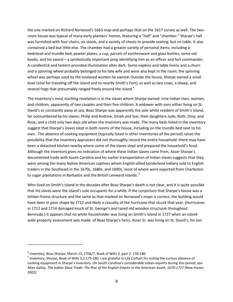
The 1901 Savage Map shows an assortment of fields relating to the McCallans’ and James’s agricultural activities, the footprint of the small building at Smallpox Bay, an L-shaped stone cottage in the middle of the James tract, a large tank near Pitcher’s Point (noted in the 1821 Forbes ad), and a rectangular building near the north shore close to the James-McCallan property line. Several other water catchments and tanks (presumably used for watering livestock) and the footprints of the whalehouse and Forbes mansion and associated outbuildings are also noted.14
Figure 5. 1901 Savage map, based on a survey conducted in 1898-99.
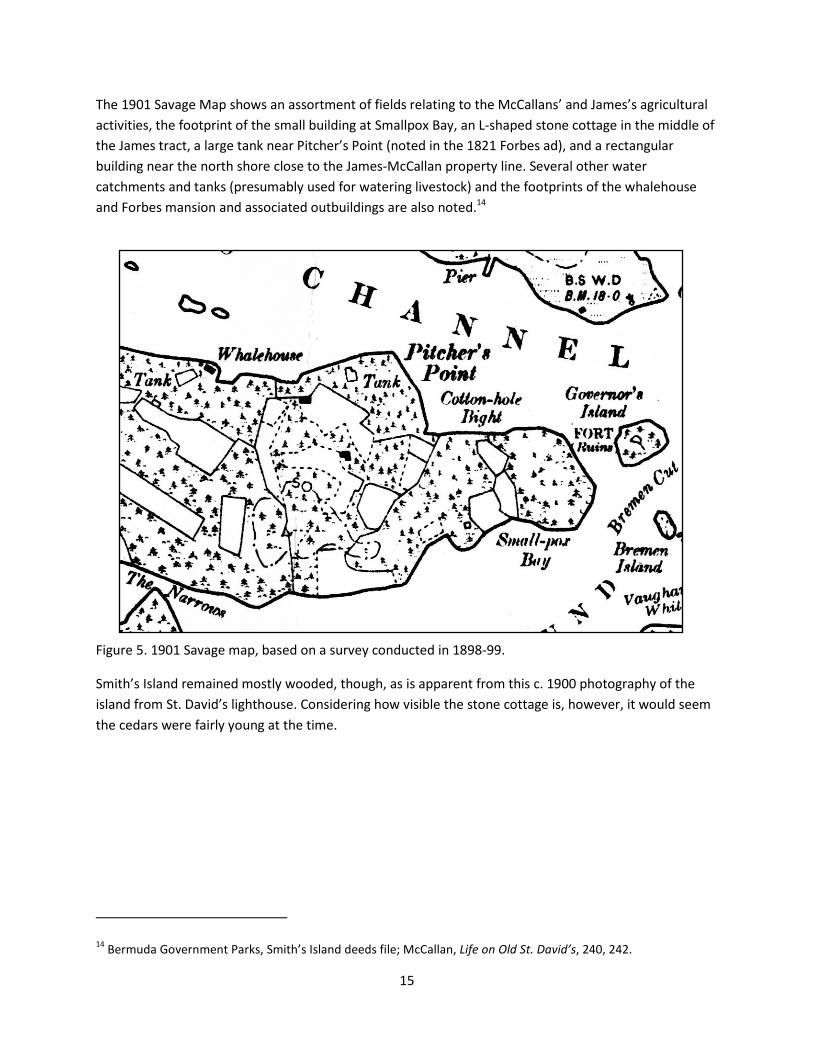
Smith’s Island remained mostly wooded, though, as is apparent from this c. 1900 photography of the island from St. David’s lighthouse. Considering how visible the stone cottage is, however, it would seem the cedars were fairly young at the time.
14 Bermuda Government Parks, Smith’s Island deeds file; McCallan, Life on Old St. David’s, 240, 242.
16
Figure 6. View of Smith’s Island from St. David’s Light looking north, Courtesy of Carter House Museum.
A British Admiralty chart of St. George’s Harbour reveals some additional information not on the Savage map, most notably the presence of a shipwreck just to the north of Pitcher’s Point and several navigational posts on the island’s shore.

17
Figure 7. 1927 Admiralty Chart (author’s collection)
Aerial photos of Smith’s Island taken in connection with the U.S. naval base and airfield construction in 1941 reveal numerous small fields in the park portion of the island, more than were present on the Savage map. The photography also clearly shows a trapezoidal hillside water catchment that funneled water into the large tank at Pitcher’s Point.
Figure 8. 1941 Aerial photo of Smith’s Island, courtesy of the Survey Section, Ministry of the Environment, Planning and Infrastructure Strategy, Bermuda Government.

18
Garth Rothwell, who currently lives in Forbes House on Smith’s Island, related this summer that, as he understood it, U.S. military personnel families rented and lived in the stone cottage in the 1940s through the 1960s. At the time, a regular ferry connected Smith’s Island with St. George’s and enabled children living on the island to attend school across the harbour. When another set of aerial photographs were taken in 1962 to prepare an ordinance survey map, many of Smith’s Island’s fields appear to have been left fallow or become overgrown since 1941.
Figure 9. 1962 Aerial photo of Smith’s Island, courtesy of the Survey Section, Ministry of the Environment, Planning and Infrastructure Strategy, Bermuda Government
In the late 1960s or early 1973, large-scale commercial agriculture resulting in considerable landscape modification was undertaken at the eastern third of the island under the Lovejoy family. Various St. George’s residents asserted that a “religious cult” did much of this farming, operating under an arrangement similar to “hippie” or counter-cultural communes in the U.S. southwest at the time, but Garth Rothwell opined that this remembrance in local lore is overblown and exaggerated: he states that a couple named Lovejoy did grow vegetables on a large scale using greenhouses and modern commercial hydroponic farming methods. He recalls that they were very religious (devout Baptists) but dismisses that they led a cult. Quite a few young people apparently volunteered or were paid to work

19
there at the time, which has perhaps led to the appearance of a commune. Rothwell had heard that the Lovejoys had encountered legal and emigration difficulties after they shifted to growing flowers and nursery stock. Rothwell suspected that rival Bermudian nursery owners, resenting this new competition, complained to government and got the Lovejoys’ immigration status revoked. It is not clear whether the Lovejoys owned the property or rented it from the heirs of Robert James, but 1973 and 1981 maps and aerial photos clearly establish the significant extent to which they altered the landscape as they grew plants on a massive scale:
Figure 10. 1973 Ordinance Survey Map (Bermuda Archives).
This map reveals the creation of several new roads or paths, as well as several new buildings in the center of the island and near Smallpox Bay. The island’s eastern tip was covered with greenhouse buildings and its original topographical contours probably extensively leveled prior to their construction. The stone cottage at the tract’s center (shown with roof intact and apparently occupied in the 1962 photograph) had fallen to ruin eleven years later, marked only by its tank, but a new building had been erected across the road.
Road and building construction, field clearing, and landscape modification comes through even more clearly in this 1973 aerial photograph:

20
Figure 11. 1973 aerial photo of Smith’s Island, courtesy of the Survey Section, Ministry of the Environment, Planning and Infrastructure Strategy, Bermuda Government.
Many of the fields portrayed on the Ordnance Survey maps were apparently covered with shiny plastic tarps or carpeted with plants growing in planters’ pots. The regular placement of trees or bushes in some fields suggest a tree nursery or orchard configuration. The stone cottage is clearly revealed as a roofless ruin. The exposed white areas surrounding the greenhouses at the island’s eastern tip reveal extensive leveling, probably with a bulldozer or other mechanized means. A large bare quarry appears to the west of the Pitcher’s Point water tank, but it is not clear whether this reflects new quarrying or the exposure of an old quarry dating to the Forbes period (see discussion in section II). The field on the southern side of the island seems to exhibit terracing, or perhaps exposes sharp changes in the island’s natural topography.
By 1981, the greenhouse complex at the eastern tip had been dismantled and many of the other fields appear to have been less intensively used:

21
Figure 12. 1981 aerial photo of Smith’s Island, courtesy of the Survey Section, Ministry of the Environment, Planning and Infrastructure Strategy, Bermuda Government.
Additional research and oral interviews will hopefully shed light on the rise and fall of commercial farming at Smith’s Island and provide a better understanding of the clearing, farming methods, chemical fertilizers, and equipment used ,and outbuildings constructed to support the enterprise. By the mid-1980s it would seem that farming was no longer commercially viable. In August 1987, Robert Outerbridge, Charles Gosling, and Ambrose Gosling of Bermuda and Susan James Hunt of Richmond, Surrey, England sold the property to the Bermuda Government, which set it aside as a park. Six weeks later, Hurricane Emily unexpectedly struck Bermuda and her 90-mile-an-hour winds no doubt did tremendous damage to any of the flimsy outbuildings still standing eastern Smith’s Island’s exposed landscape. Without constant attention, the fields, paths, and cleared areas quickly became overgrown as Mexican pepper, allspice, and other fast-growing species recovered open areas in Emily’s wake. By July 1991, when this author made his first attempt to reconnoiter the island for potential archaeological remains, roads and paths were nearly impassable and the fields were covered by brush already four to eight feet high.
In the two decades since 1991, trees growing in the former fields have reached a considerable thickness. Some field areas now have a pronounced forest canopy above them, especially those in the center of

22
the island to the south of the Hayward/James-era stone cottage. The eastern tip where the greenhouse complex was located is now covered with very dense vegetation and poison ivy, while the flattened platform upon which the greenhouses once stood now boasts a stand of casuarinas.15
Figure 13. View of former greenhouse complex at the eastern tip of Smith’s Island, from Smallpox Bay
15 Bermuda Government Parks, Smith’s Island deeds file.

23
II. ARCHAEOLOGICAL PEDESTRIAN SURVEY
A pedestrian survey -- systematically walking over the surface of a target area in order to spot above-ground features and visible anomalies – was undertaken throughout the two-week investigation in to identify occupation and activity sites revealed on maps and aerial photographs and through historic research. Because time and dense undergrowth did not permit full coverage of the entire 20-acre tract, we focused on the area north of the central east-west road that bisected the park. We also closely scrutinized the shore by boat at low tide in order to identify maritime-related features visible on the foreshore. We had also planned to conduct a snorkel survey of the bays and waters adjoining the park to complement our terrestrial survey but did not have enough time.
Identified sites were grouped by occupation areas designated in the order in which they were found. GPS coordinates were taken using a Garmin Oregon GPS unit to obtain approximate locations. It is hoped that the Survey Section of the Bermuda Government Ministry of the Environment, Planning and Infrastructure Strategy might deploy their far more accurate transponder to recapture far more precise site coordinates and link them to the Planning Department’s GIS for the island. Coordinates are listed in Appendix A.
During the survey, it became apparent that Lt. Savage did not apparently cover Smith’s Island carefully, since there are several features that clearly predate 1898 which are not marked on his map. This raises concerns about many researchers’ past use of the Savage map as a TPQ/TAQ dating tool when they assume that features not appearing on his map cannot predate 1899. In general, we found several pockets of promising old features in between areas that had been cleared for fields or modified recently during the Lovejoy era of commercial farming.
Throughout the survey, the team found numerous places where cedar trees had very recently been poached: freshly cut stumps at ground level and numerous small cut branches nearby. In two areas we even found a scatter of sawdust, suggesting the theft had been done within a month or two. The Parks Department should be aware of these thefts. There are several houses currently under construction in the privately owned middle portion of Smith’s Island that are incorporating exposed cedar beams, which may have been illicitly obtained from park land.

24
Main Occupation/Activity areas discussed in this section (2005 image, courtesy of Google Earth)
1.0 Western Quarry
Near the western edge of the park property and just north of the central east-west path, we found the southern face of a large old quarry not marked on any of our maps. The area was heavily wooded in all the aerial photographs and thus seems to have escaped identification. The top edge of the quarry is marked with a scatter of cut but broken stones of large dimensions. The south face parallels the path for about 50 feet, with an irregular cutting that suggests longtime use and organic expansion as quarrymen worked rock seams. The drop from the top edge (path level) to the quarry floor is about 10 feet at its deepest. On the quarry floor we found numerous dressed stones of varying but generally large dimensions.
There seems to have been a makeshift wall (now largely fallen down) in the center of the quarry running north-south, perhaps part of an animal enclosure made after active quarrying was discontinued. The size

25
of dead cedars growing out of the quarry floor (at least 16 inches in diameter) suggests that at least a half-century had elapsed between the quarry’s abandonment and the cedar blight of the late 1940s.
1.1 Southeastern Quarry Corner
Following the south quarry wall east led us to a cluster of features in the quarry’s SE corner. These included a coarse stone wall using quarry off-cuts that was roughly 3 ft. high which formed an enclosure and a water trough carved into a large square block measuring roughly two ft. by four ft. The presence of a deteriorating wooden gate, several wooden posts, and wire lining the enclosure suggests that this was a livestock pen, probably dating to the late 19th or early 20th century when the Jameses and McCallans actively farmed the area. Near the SE corner, someone carved “7.XIX.XII E.W.” into the wall face, which may be an approximation of the date 7.19.12. Also nearby is “R.H. 1985”, an inscription that Charlotte Jarvis also observed
carved into a rock at Gates Fort, across the harbour in St. George’s. From this corner, the eastern wall of the quarry extends north and gets gradually shallower over the course of about 50 feet. The floor of the quarry become irregular due to the presence of broken stones and is covered with more vegetation. The eastern wall face parallels a once-cleared but now heavily overgrown field to the immediate east, with the interface marked with a line of loose rock.
1.2 Square Feature Cut into West Quarry Wall
Following the south quarry wall west led to the SW corner. The west quarry wall extended about 50 feet north, following an irregular path. Large piles of broken cut stone were piled against the wall in several places. About 40 ft. north of the SW corner where the wall jogged west and was excavated to a depth of at least 8 feet, we found a curious square feature cut
26
into the wall face that sloped back to a depth of about 10 inches. The slope of the cut resembles the rear portion of a fireplace. The floor of the cut was covered with leaves, soil, and stone rubble and was left undisturbed for future archaeological investigation. It is not clear whether the feature dates to the period when the quarry was in active use or was made after its abandonment.
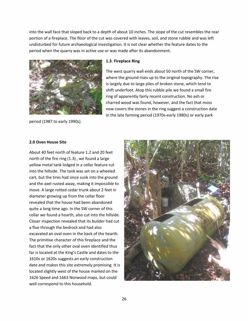
1.3. Fireplace Ring
The west quarry wall ends about 50 north of the SW corner, where the ground rises up to the original topography. The rise is largely due to large piles of broken stone, which tend to shift underfoot. Atop this rubble pile we found a small fire ring of apparently fairly recent construction. No ash or charred wood was found, however, and the fact that moss now covers the stones in the ring suggest a construction date in the late farming period (1970s-early 1980s) or early park
period (1987 to early 1990s).
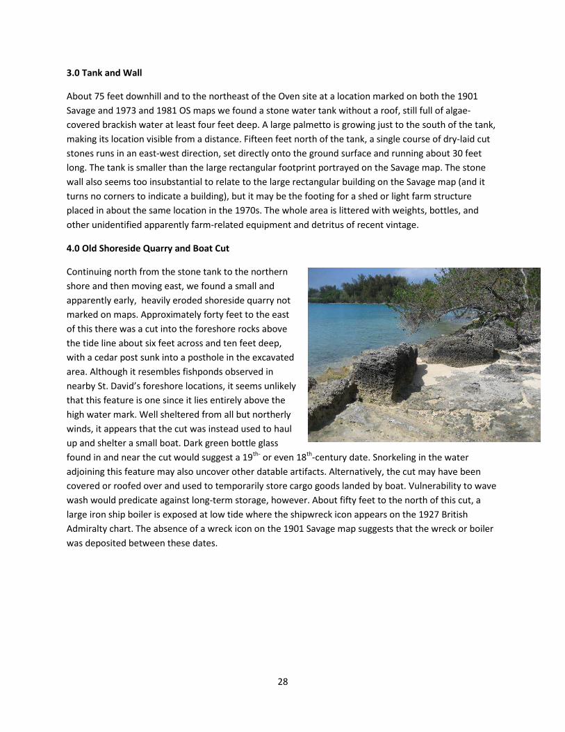
2.0 Oven House Site
About 40 feet north of feature 1.2 and 20 feet north of the fire ring (1.3) , we found a large yellow metal tank lodged in a cellar feature cut into the hillside. The tank was set on a wheeled cart, but the tires had since sunk into the ground and the axel rusted away, making it impossible to move. A large rotted cedar trunk about 2 feet in diameter growing up from the cellar floor revealed that the house had been abandoned quite a long time ago. In the SW corner of this cellar we found a hearth, also cut into the hillside. Closer inspection revealed that its builder had cut a flue through the bedrock and had also excavated an oval oven in the back of the hearth. The primitive character of this fireplace and the fact that the only other oval oven identified thus far is located at the King’s Castle and dates to the 1610s or 1620s suggests an early construction date and makes this site extremely promising. It is located slightly west of the house marked on the 1626 Speed and 1663 Norwood maps, but could well correspond to this household.

27
To determine the age of this house site, we targeted the area for surface clearing, close recording and test excavation (covered in section III). The cellar dimensions measured about 10 ft. by 11 feet, with a further cut into the bedrock about 3 feet east of the hearth’s face. This face was covered with cut stone debris and was left uncleared/unexcavated.
Several other features at this site were also striking. At the top of the cellar’s west wall in the SW corner was a round footing for a horizontal timber beam (hearth mantle?) or perhaps the footing for an angled roof rafter of large dimensions. A round cut feature approximately a foot in diameter and a foot deep had been carved into the center of the cellar’s west wall (similar to the 1.2 cut feature in the quarry wall), but it is not clear whether this had been done when the house was occupied or after it had been abandoned. This site was probably among those that Joseph Ming Hayward showed to Gov. Lefroy in the 1870s, since it possessed the sort of readily identifiable “old oven” that E.A. McCallan noted Hayward had discovered in Life on Old St. David’s.
Nov. 2010 Update: A visit to the site after Hurricane Igor passed through showed no visible damage. Incredibly, an inflated swim ring that we hung on a tree nearby was still in situ despite the hurricane’s high winds, testifying to how well this site on the northern/lee side of the island is sheltered – a fact that early settlers no doubt also appreciated.
Oven
Flue
Hearth
28
3.0 Tank and Wall
About 75 feet downhill and to the northeast of the Oven site at a location marked on both the 1901 Savage and 1973 and 1981 OS maps we found a stone water tank without a roof, still full of algae-covered brackish water at least four feet deep. A large palmetto is growing just to the south of the tank, making its location visible from a distance. Fifteen feet north of the tank, a single course of dry-laid cut stones runs in an east-west direction, set directly onto the ground surface and running about 30 feet long. The tank is smaller than the large rectangular footprint portrayed on the Savage map. The stone wall also seems too insubstantial to relate to the large rectangular building on the Savage map (and it turns no corners to indicate a building), but it may be the footing for a shed or light farm structure placed in about the same location in the 1970s. The whole area is littered with weights, bottles, and other unidentified apparently farm-related equipment and detritus of recent vintage.
4.0 Old Shoreside Quarry and Boat Cut
Continuing north from the stone tank to the northern shore and then moving east, we found a small and apparently early, heavily eroded shoreside quarry not marked on maps. Approximately forty feet to the east of this there was a cut into the foreshore rocks above the tide line about six feet across and ten feet deep, with a cedar post sunk into a posthole in the excavated area. Although it resembles fishponds observed in nearby St. David’s foreshore locations, it seems unlikely that this feature is one since it lies entirely above the high water mark. Well sheltered from all but northerly winds, it appears that the cut was instead used to haul up and shelter a small boat. Dark green bottle glass found in and near the cut would suggest a 19th- or even 18th-century date. Snorkeling in the water adjoining this feature may also uncover other datable artifacts. Alternatively, the cut may have been covered or roofed over and used to temporarily store cargo goods landed by boat. Vulnerability to wave wash would predicate against long-term storage, however. About fifty feet to the north of this cut, a large iron ship boiler is exposed at low tide where the shipwreck icon appears on the 1927 British Admiralty chart. The absence of a wreck icon on the 1901 Savage map suggests that the wreck or boiler was deposited between these dates.

29
5.0 Stone Cottage Complex
Located at the center of the island and marked as an L-shaped structure on the Savage map, we found the overgrown ruins of a roofless three-room stone cottage. It appears on the c. 1900 panoramic view from St. David’s Light and on the 1941 and 1962 aerial photographs with a roof but had become a ruin by 1973, when it does not appear on either the aerial photograph or OS map. Although quite close to the main road and the large but now overgrown field immediately to its north, it was difficult to spot due to the large trees and heavy vegetation that now surround it. The cottage has a short path leading to its north-facing front door, a small front room, a larger main room with a chimney with a traditional waist-high fireplace on the eastern side of its south wall, and a small room and walled patio to the west.
Back wall of cut
Cut with cedar post

30
Although most of the roof had collapsed, a portion remained in the main room. Some details of interior molding and lavender plaster color were visible. The narrow rectangular construction of the chimney suggests a nineteenth-century date.
UPDATE: I was able to briefly revisit Smith’s Island in November 2010 and discovered that Hurricane Igor had knocked over the south wall and chimney of the cottage, pushing a large amount of stone debris into the ruin’s interior. The east wall (which had been leaning outward in the summer) has now toppled over as well.
Surrounding this house is a tank (5.1) without a cover to the south, which is marked on the 1973 and 1981 OS maps and several other features typical of a farmstead. A shallow quarried-out area (5.2) to the cottage’s south and east has various farming detritus and is partly enclosed by a dry-stone wall, suggesting that the James family and other inhabitants used it as a makeshift livestock pen. About forty feet to the east and across the central path we found a windowless privy (5.3) with a flat roof and one door. Its single wooden seat is still visible but the wooden floor has since rotted away. Curiously, although old and dating to the cottage’s occupation, the privy does not appear on any map.

31
We searched to the east of the cottage for signs or remains of the large square structure marked on the 1973 and 1981 OS maps and aerial photographs but could not find any traces.
6.0 Pitcher’s Point Features
From the Stone Cottage site, the main road turns south briefly and then heads east toward Smallpox Bay and the island’s eastern tip. A small path and line of electric poles led north from here to Pitcher’s Point, following the eastern edge of the formerly large field north of the cottage. The path leads to a hill that dominates Pitcher’s Point peninsula, whose northern half has been cleared to form a large trapezoidal water catchment (6.1) that drains into a very large water tank (6.2). Casuarina trees now cover the catchment surface and have carpeted it with their needles. A low stone wall bisects the catchment. Measuring about 20 feet by 40 feet, the now-roofless tank has heavily buttressed exterior walls and would have held an enormous quantity of water when in repair. The tank appears on the 1901 Savage map and probably dates to Francis Forbes’s 1821 ad, since its proximity to the shore and traces of a substantial dock or wharf (6.3) would have enabled vessels departing Bermuda to conveniently take on water on the way out of St. George’s Harbor. In actuality, it is two tanks, divided by a wall bisecting the structure, but it is unclear whether this was the original configuration of the tank or a later modification. At the base of the tank at the NW and NE corners, there are access doors for gravity-fed discharge of the water when the tanks were full. Dividing the tank into two chambers facilitated water management or perhaps enabled the owner to assess the volume of water discharged to departing ships.
Water access door

32
Although the Dock (6.3) does not appear on any map, it appears old. Its eroded profile is clearly visible from the shore and large numbers of large stone blocks are strewn in the water adjoining the point:
To the east and west of the Pitcher’s Point tank, catchment, and dock are two very large quarries (6.4 and 6.5) whose southern walls are as high as 20 feet and thus pose a danger to unwary hikers. A large volume of stone has been excavated from these two sites, perhaps for export on ships departing Bermuda, for building houses in St. George’s, or for the fortifications built across the channel at Paget Island. A few very large blocks found on the quarry floor approximate the size of the stones used to construct the ruined dock.

33
Above and slightly to the west of the westernmost of the two quarries, we found a collection of modern mechanical equipment, including what appears to be an industrial compressor and several large iron tanks. It would seem that the dock was viable for landing very heavy equipment as late as the 1970s. Oral interviews with people who worked on the Lovejoy farm at the time might better identify what this equipment was and how it was used. The Parks Department might also consider conducting chemical testing to determine whether substances stored in these tanks are dangerous and pose a health risk.
7.0 Cottonhole Bight Beach
Although this area does not have any specific features indicating a building, the flat sloping beach here is littered with artifacts and perhaps postholes. Naturally sheltered from all but northeast winds, it would have made an ideal boatbuilding site or a place to haul boats up to protect them from storms. Of all the shoreside locations, this spot would seem the most logical choice for Christopher Carter, Edward Waters, and Edward Chard to have built their shallop in 1611 and offers a convenient landing place for Smith’s Islands inhabitants past and present. To the south of the beach, the soil is rich, very red, and distinctively claylike – highly

34
unusual in Bermuda. We observed a piece of tin-glazed earthenware and a coarse brick fragment eroding out of the soil interface with the beach, raising the intriguing possibility that at some early date, Bermudian colonists may have attempted to make bricks nearby. (Only one attempt at brick-making is mentioned in historical records, the efforts of experimental alchemist William White in 1649.) To the south of the beach, a sheltered wooded valley leads back to the main road.
Following the coastline to the east toward the island’s eastern tip and 1973 greenhouse site, we quickly encountered thick brush and large heaps of stone rubble and dead tree trunks. It became apparent that a bulldozer or excavator had leveled the land to the south and had pushed displaced stone, soil, and trees onto the foreshore. Sadly, it would seem that few if any archaeological features or remains likely survive on the eastern third of the park land. Jack Arnell and Edward Harris have speculated that early settlers under Governor Richard Moore may have built a fort at Smith’s Island’s eastern tip. Although we

35
never reached the area during our survey, evidence of the extensive earthmoving between Cottonhole Bight Beach and the eastern tip makes the survival of this hypothetical battery highly unlikely.16
8.0 Smallpox Bay
The last area surveyed was Smallpox Bay, on the southern side of Smith’s Island facing onto Smith’s Island Sound and the Oswego Islands. A small single-room stone building adjoins the bay, set back about 60 feet from the shore upslope and about 40 feet south of the main path connecting the stone cottage (5.0) with the island’s eastern tip. Most of the building’s stone slate roof survives in situ. Curiously, there is no chimney. The wooden window frames are of pegged mortise and tenon construction. The building footprint appears on both the 1818-era Van Norden survey and the 1901 Savage map and can be made out on the 1941 and 1962 aerial photographs as well with its gable roof fully intact. Near this building by the shore, we found red brick fragments, a piece of gray, blue, and purple Westerwald stoneware with sprig appliqué design (left in situ) dating to the 1770s or earlier, the remains of a small primitive dock, and what appears to be heavily eroded stone steps carved into the rocky foreshore. The remains of a 1960s-era blue car are rusting to bits just south of the building and large piles of black plastic tarping and deteriorating plastic seedling planters lie between this house and the main path. We searched for evidence of the large rectangular structure indicated on the 1973 aerial photo and OS map but could not find anything.
16Arnell and Harris, “History of Some of the Islands in St. George’s Harbour,” 45.

36
Nov. 2010 UPDATE: Hurricane Igor knocked down the roof of this building and a large vertical crack has appeared in its south wall.
Westerwald and brick fragments
Westerwald and brick fragments
37
III. ARCHAEOLOGICAL TESTING
Although we originally envisioned applying a systematic shovel testing approach to the surveyed area, limited time and the area’s densely overgrown topography did not permit this. Instead, only a modest around of excavation was undertaken: one 50 cm shovel test unit near Cottonhole Bight Beach (area 7.0) and one 50 cm test unit and stratigraphically excavated meter square unit at the Oven House site (area 2.0). All excavation was done by trowel and all soil was screened through quarter-inch wire mesh. All artifacts were cleaned, inventoried, and left in the care of the Bermuda National Trust Archaeological Research Committee upon departure.
TP 1. Cottonhole Bight Beach
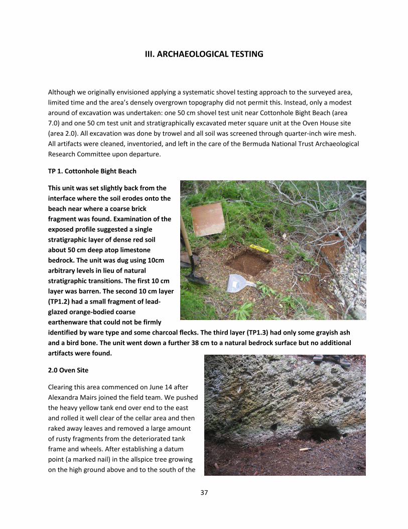
This unit was set slightly back from the interface where the soil erodes onto the beach near where a coarse brick fragment was found. Examination of the exposed profile suggested a single stratigraphic layer of dense red soil about 50 cm deep atop limestone bedrock. The unit was dug using 10cm arbitrary levels in lieu of natural stratigraphic transitions. The first 10 cm layer was barren. The second 10 cm layer (TP1.2) had a small fragment of lead-glazed orange-bodied coarse earthenware that could not be firmly identified by ware type and some charcoal flecks. The third layer (TP1.3) had only some grayish ash and a bird bone. The unit went down a further 38 cm to a natural bedrock surface but no additional artifacts were found.
2.0 Oven Site
Clearing this area commenced on June 14 after Alexandra Mairs joined the field team. We pushed the heavy yellow tank end over end to the east and rolled it well clear of the cellar area and then raked away leaves and removed a large amount of rusty fragments from the deteriorated tank frame and wheels. After establishing a datum point (a marked nail) in the allspice tree growing on the high ground above and to the south of the

38
chimney flue, we established a grid over the site and mapped it in plan. We chose unit N3W1 (with a small portion of W2 extending to the vertical cellar wall) to excavate, since it promised to help us interpret a round feature cut into the cellar’s west wall.
Aside from the top ten centimeters (which was full of roots, rusted fragments from the tank, and other modern artifacts), there were three broad stratigraphic layers: a thick destruction/abandonment layer with brick and cut stone fragments that sloped toward the cellar walls and two relatively flat layers that seem to relate to the period when the house was occupied. Cross-mendable artifacts (notably fragments

39
of a fluted lead crystal glass) were present in both layers, indicating that a post-depositional migration of artifacts between layers had occurred due to insect, worm, rodent or other N-transforms. The treatment of these as two layers was based on the appearance of a thin grey ashy/greasy oval lens with charcoal flecks near the round feature cut into the cellar wall – suggesting that the feature was used (but only briefly) as the site for a fire before the house was abandoned.
Ashy lens, N3W1-2, looking east.
Full excavation revealed that the round feature had been hacked out of the wall with a hatchet or shovel, probably midway through the house’s occupation. And well above the cellar’s bedrock floor (which exhibited similar tool cut marks). Two round features extended into the bedrock below floor level.

40
One had a cedar section protruding from it that appeared to be the remains of a post, but excavation subsequently revealed that it is probably the remains of a root from the ancient dead cedar standing next to the fireplace. The hole went down 25 cm and its fill included artifacts, suggesting the tree root followed a pre-existing feature cut of unknown purpose.
Test Pit 2 – Oven Site
In addition to N3W1-2, we excavated a 50 cm test unit at what would be the SW quarter of unit N4E3 on the site grid. This location was chosen to determine in part the depth of the cellar below natural bedrock contours and also to test the hypothesis that the cellar area might be only the back room of a larger timber-frame structure built on the flat ground immediately to its east. TP 2 had only two layers (modern topsoil and brown loam) and was very shallow – only 28 cm deep. It yielded modern glass in its upper layer and no artifacts below. It bottomed out on deteriorating natural bedrock 168 cm below the datum point – some 30 cm above the top surface of N3W1-2 and 85 cm above the cellar’s stone floor. Evidence thus suggests there was no structure in this area, or that evidence of such a structure has been destroyed.
Dating and Interpretation
The structure at the oven site was created by cutting a shallow platform out of a rising hillside – an easy expedient using axes and shovels. The round feature in the west wall and its probable brief use as a fireplace is puzzling, given the presence of a hearth and oven five feet away. Artifacts were found throughout the excavated layers but in relatively small quantities. The thick destruction/abandonment
Bedrock floor
Cedar root and hole
Hearth and oven

41
layers had several broken bricks, animal bone, bottle glass fragments, iron and copper alloy nails, and charcoal in its upper layer (Cxt 003), including several machine-cut and one wire nail, dating it to the second half of the nineteenth century. Artifacts in the rubble matrix in the lower part of this destruction layer (Cxt 004) included hand-wrought iron and machine-made copper alloy nails, animal bone, glass, and a few sherds of late pearlware or whiteware. Artifacts in the transitional layer between clear house occupation layers and the rubble layer above include a copper-alloy button marked “Ne Plus Ultra,” 3 fragments of a thick iron plate, one iron strap, the shank and part of a blade portion of a chisel or sword, and numerous bone and nail fragments.
Artifacts in the loamy layers beneath the destruction layer (Cxt 006-010) all date to the eighteenth century and include several pipestems (2x7/64, 5/64, 4/64” bore diameter), wrought iron nails, flat thin dark green glass from a case bottle, a wood and copper-alloy button, fish bones, tin-glazed earthenware, lead-glazed coarse red earthenware with yellow slip decorations, some charcoal, two small over-fired brick fragments, and, curiously, eight sherds of a finely engraved and fluted crystal wine glass.

42
The absence of all of the typical “horizon” ceramics in the occupation layers (salt-glazed stoneware, creamware, pearlware) is striking, given their ubiquity in documented eighteenth-century Bermuda household inventories. Also noteworthy is the absence of Chinese porcelain and window glass.
Although further excavation is required to create a statistically reliable basis for interpretation, the assemblage from unit N3W1-2 suggests that the household was quite poor by Bermudian standards, or perhaps that the structure was not intensively occupied past the 1740s. The absence of diagnostic seventeenth-century ceramics does not allow us to firmly identify this site as the house on the 1663 Norwood map, but the assemblage does not rule this out either. The presence of a fine, expensive lead crystal glass is puzzling when considered against the poverty and paucity of the rest of the assemblage, raising the possibility that it might have been smuggled (possibly by a mariner with access to inexpensive sources in foreign ports) or stolen from a wealthier household. The assemblage is not inconsistent with that listed in Boaz Sharpe’s 1706 inventory, although the house documented in the probate inventory is larger than the oven site cellar alone. Perhaps this site was a small detached kitchen near the larger main house, as yet still unlocated? (The absence of cooking equipment listed in the Sharpe inventory, as noted in section I, is significant.) If the main house was located to the south, later quarrying could well have destroyed the archaeological remains of this structure. Alternatively, the main house could have been situated to the north or east but, as a post-and-beam structure, would have left no traces to reveal its location visible to surface reconnaissance alone.
Etched and fluted crystal glass fragment

43
IV. Archaeological Assessment, Recommendations, and Further Research
When the Bermuda Government purchased the eastern third of Smith’s Island in 1987, it happily became the caretaker of a unique collection of archaeological sites spanning four centuries. Public acquisition has preserved these sites more or less intact, although slight deterioration due to invasive vegetation, storms, and other natural forces has occurred. The overgrown nature of most of the park has serendipitously discouraged most members of the public from visiting the island, which has helped minimize site disturbance. Any plans to promote greater visitation (such as was done at Hog Bay Park in the mid-1990s) should strive to carefully balance preservation of known (and yet to be found) archaeological sites with the development of public access infrastructure.
Although brief, the 2010 field season was resoundingly successful in its aims. Documentary research revealed most of the known owners and occupants of Smith’s Island over the past 400 years, as well as some of agricultural, industrial, and maritime activities in which they engaged. Through maps and foot survey, we identified eight activity areas with more than a dozen sites and began to assess the extent of disturbance of the archaeological record caused by large-scale commercial farming in the 1970s.
The Oven Site is the most promising among those located during this field investigation. Although test excavations were inconclusive in confirming that this was the house marked on the 1663 Norwood map, the Oven Site is clearly an important early domestic site that promised to add greatly to our limited knowledge of early Bermudian architecture. It is very likely a timber-frame building or timber-stone hybrid structure. Substantially undisturbed, future clearing excavation within the cellar area and to the west, south and east will enable us to define the dimensions and configuration of the house and firmly date its construction and abandonment. Filled with stone rubble from the toppled chimney, excavation of the fireplace and oven were left to future field seasons. The distinctive oven in the back of the site’s hearth invites investigation and further research into seventeenth-century diet and cooking techniques as well.
If the site can be firmly linked to Boaz Sharpe, the house’s assemblage might shed unprecedented light on enslaved Native Americans living in Bermuda – making it a site of national importance and of especial interest to St. David’s Islanders who ethnically affiliate themselves with Native American ancestry. Perhaps diagnostic artifacts might be found that would reveal the socio-cultural and ethnic origins within North America of Sharpe’s Indian slaves. Historic records and inter-colonial Indian slave trade trends suggest that they were disembarked from the Carolinas, but the South Carolina slave trade in the 1680s and 1690s drew captives from as far west as Mississippi and as far south as Key West, Florida. The Oven Site is thus unique in its potential to explore a striking and (for Bermuda) culturally distinct aspect of slavery and slave life. Given the paucity of historic documentation for the Asser and Sharpe families and pre-1758 residents of Smith’s Island, future archaeological excavation represents the only way we

44
are likely to learn more about Bermuda Company-period occupation of the island and how later generations transitioned from agriculture to seafaring.
While the Oven Site promised to teach us much about slavery and daily life in an apparently poor seventeenth- to eighteenth-century household, the Middle Cottage offers an ideal site for examining late nineteenth-century farming in a post-Emancipation era. Taking a holistic approach toward agriculture over four centuries, Smith’s Island potentially offers investigators an array of farming sites ranging from Carter, Chard, and Waters’ first commercial cultivation of tobacco in 1611 through modern hydroponic and technologically intensive cultivation in the 1970s. The island would be a wonderful laboratory for considering the evolution of agriculture in Bermuda across four centuries, taking into consideration changes in crops, farming strategies and technology, and market destinations for produce. Such a study would contribute to broader debates concerning the blending of subsistence and commercial cultivation among early modern European colonizers and the use of enslaved and free labour in household- and market-oriented agricultural pursuits.
Excavation and additional historical research into smallpox inoculation practices and quarantine procedures is needed to better understand the intriguing building at Smallpox Bay, which predates 1818. It may have been occupied by Forbes family slaves, or have been used for medical treatment: the sorts of artifacts recovered from the site should reveal the uses to which the building was put.
The purpose of the tank to the north of the Oven Site can be better understood through further investigation: was it associated with a now-destroyed building marked on the Savage Map (perhaps a wooden structure sitting on stone pilings), or was it a standalone tank used to support farming and livestock rearing? Systematic shovel testing in this and other target areas promises to greatly expand the preliminary interpretations presented in this report.
Additional foot survey work is needed to identify sites between the main road and the south shore. Although no buildings are marked on any of the maps, there may be the remains of structures predating the Forbes family’s acquisition of Smith’s Island. The site of the Carter, Chard, and Waters homestead may be entirely buried, perhaps on the high ground overlooking the sheltered sound between Smith’s and St. David’s Islands. Covering perhaps seven acres, careful reconnaissance of this area alone would require a week in the field.
Survey work could also be fruitfully extended to the waters surrounding Smith’s Island. Artifact concentrations just offshore can suggest occupation date ranges for several shore based sites and may reveal evidence of maritime activities such as boatbuilding, fishing, and smuggling. The remains of the Pitcher’s Point dock might also be studied to discern late eighteenth- or early nineteenth-century construction techniques.
The Parks Department should be aware that cedars are being stolen from park land and contemplate means to discourage or apprehend poachers. Unfortunately there are no viable houses where a caretaker can live. Middle Cottage, which might have been re-roofed and renovated, has now become a complete ruin thanks to Hurricane Igor. Chemical testing might also be done on the storage tanks above Pitcher’s Point dock and perhaps on the soil in the greenhouse area at the island’s eastern tip. But other

45
than the cedar poaching, the field team observed very little public intrusion on park land: thick brush, poison ivy, and difficulty of access seem to deter most visitors.
Archaeological Assessment
As outlined in Department of Planning Document GN119, Archaeological Assessment explicitly considers six specific criteria or sets of questions,:
1. Impact on resources: will any proposed work disturb the ground in any way and therefore alter or destroy potential archaeological resources?
2. Site integrity: has the area where proposed work is planned already been excavated in a manner that reduces the research or public value of any archaeological resources?
3. Presence of materials: Is there evidence of archaeological resources or historic structures on the property?
4. Research value: how important would be the potential archaeological resources?
5. Rarity: How unique is the site in question, in relation to the island’s cultural heritage?
6. Public Value: How important is the site in question, in relation to the island’s cultural heritage?
Fortunately in the context of the Parks Department’s portion of Smith’s Island, no work that would impact archaeological remains is currently being contemplates, so criteria #1 does not apply. Aerial photographs from 1973 and 1981 and preliminary foot survey revelations make it clear that farming and mechanical earthmoving equipment have already substantially compromised the archaeological integrity and likely survival of sites in the eastern portion of the island (criteria #2). Quarrying in the 19th or even the 18th century has also potentially destroyed sites dating to earlier periods but it is not possible to assess what may have been lost as a result. Much of the rest of the area is well preserved, however, especially the Oven Site and area near Cottonhole Bight. The historic overview section of this report and results from the foot survey and test excavations reveal an abundance of evidence of historic structures and activities (criteria #3), underscoring the high value of Smith’s Island generally (and the park area specifically) to future archaeological research. Smith’s Island boasts several rare or unique types of sites, including the Oven Site (with its early architectural elements), the whalehouse and related tryworks and whale processing features, and the as-yet-undiscovered farmstead of Christopher Carter, Edward Chard, and Edward Waters – a site of national significance as Bermuda’s earliest farm and of international significance as the place where tobacco was first commercially cultivated within English America. If the Oven Site can be confirmed as Boaz Sharpe’s home, this site would also be of national significance for the light it might shed on enslaved Native Americans’ experience. The public value and

46
archaeological significance of Smith’s Island is extremely high, and it is most fortunate that at least two-thirds of it is protected under Bermuda Government and Bermuda National Trust auspices.
Future Planning and Research: An Integrated Island-Wide Approach
The most ambitious research and development scheme for the understanding and management of historic sites and cultural resources at Smith’s Island would consider the island as a whole unit of investigation – as it was through most of its history. Although more survey and archaeological work needs to be done at the park, the most pressing area to assess is the middle third of the island, most of which is in private hands and thus vulnerable to loss. House-building is proceeding at an incredibly high rate, with several houses currently planned or under construction. Although there are no legal means to compel owners to permit archaeologists to identify, assess, and record possible sites on their properties, the Bermuda National Trust’s Archaeological Research Committee, personnel in the Parks Department, or Bermuda’s Heritage Officer could appeal to individual owners for such permission. Owned by the Bermuda National Trust, the western third of the island is under no threat of development but should be surveyed to identify archaeological sites such as quarries and domestic sites – after all, there were five homesteads spread across the island in 1758. Marked with a long barracks structure on the 1626 map, the southern shore of this middle section was perhaps the site of a significant residence (possibly the Carter, Chard, and Waters house) or the site where Governor Richard Moore had the Plough’s settlers begin to build a town in July 1612. Suggestive documentary evidence alone calls for more thorough archaeological investigation.
If permission from private owners could be obtained, the Whalehouse and Forbes House should be mapped and investigated archaeologically. The Whalehouse is detailed in several manuscript maps and its operations in the 1750s and 1760s are recorded extensively in company accounts. It is the best preserved example of a whale processing station and can shed light on this important Bermudian activity. Bermuda was one of the few English colonies to intensively employ slave labor in both obtaining and processing whales, including the use of enslaves women to render blubber into oil. Surveying the waters adjoining the whalehouse might also yield the remains of equipment using in whaling, as well as the bones of whales bearing butcher’s marks. Zooarchaeological information about the size/age and species of whales obtained from the bones would also reveal the types of whales taken.17
The Forbes House represents a blend of country house, medical outpost, and rural farm. It was built in the modern Georgian style by an elite Scottish-Bermudian family as a rural retreat to impress guests, but also served as a retirement hermitage for Mary Forbes in her widowhood. Family slaves in fact made up the vast majority of island residents during the Forbes period. The material culture of the Forbes House and its cluster of outbuildings would thus predominately reflect slave culture and activities, with a
17Michael Jarvis, In The Eye Of All Trade: Bermuda, Bermudians, and the Maritime Atlantic World, 1680-1783 (Chapel Hill, 2010), 247-249; Aldemaro Romero, “Between War and Poverty: Whaling in 18th-Century Bermuda,” BJAMH 18 (2007), 7-32.

47
decidedly gender-inflected component in this female-run, female-majority household. The Forbes’ farming and livestock-raising activities were unusual during a period when Bermuda’s economy was intensively maritime in focus and most Bermudian men held agriculture in contempt. The hypothesis that Dr. George Forbes used this house (or the Smallpox Bay house) for treating patients could also be tested archaeologically through the presence or absence of medical paraphernalia.18
Taken as a whole, Smith’s Island offers us a representative cross-section of Bermudian activities since colonization commenced. It was the colony’s cradle – the site of the first farm and (briefly) the first capital. Throughout the seventeenth century, residents blended tobacco cultivation with livestock raising and a diversified range of other agricultural pursuits in ways typical of planters throughout the island. Brick fragments from Cottonhole Bight Beach raise the possibility that experimental brick-making might have occurred. Like households throughout the rest of Bermuda, Smith’s Island’s tenants came to own slaves and employ them in their homes and fields, but unlike the majority of planter homes (which were home to Africans and African-American creoles), the Sharpe household had at least two families of Native American slaves. As Bermuda transitioned from agriculture to a wide array of maritime activities in the late seventeenth century, Smith’s Island reflected the shift with numerous shoreside features such as docks, boat cuts, and quarries for exporting stone and as a base for coastal whaling. Although the present whalehouse dates only to 1758, the island may have been used for landing and processing whales before this time – perhaps as early as the 1670s, when the Bermuda Company tried to develop a large-scale seasonal whale fishery. With its proximity to the outer reefs and the open ocean, as well as to an urban market in nearby St. George’s, Smith’s Island was a logical base for a wide range of coastal maritime activities such as fishing, turtling, wreck salvage, and smuggling. These activities are not documented, either due to their covert nature, taken-for-granted ubiquity, or performance by illiterate actors. The Forbes family’s acquisition of the island as a cedar reserve and farm reflects a traditional strategy that Bermudians employed generally to sustain their shipbuilding industry, reduce the need for imported food, and (especially in light of the near-famine conditions that prevailed during much of the American Revolution) hedge against the collapse of overseas provisions supply during a time when Bermuda could only feed itself for a quarter of the year.
Through much of the nineteenth century, the distant or absentee ownership (or rather leaseholding) of the Forbes family forestalled extensive development. After 1872, the island entered a new phase of enlightened agricultural activity using the latest environmental knowledge of the day under Claude McCallan. Barbed wire and fence lines throughout the island testify to the cordoning of free-ranging livestock. As an experimental agricultural station, Smith’s Island is historically important and could be further investigated using the surviving records of the many organizations in which McCallan was a leader or active member, as well as government reports on agriculture. These records may also shed light on the James family’ activities on the park portion of the island. Finally, oral interviews and further research on the Lovejoys’ farming in the 1970s can shed valuable light on the introduction of modern
18 Michael Jarvis, Bermuda’s Architectural Heritage: St. George’s (Bermuda National Trust, 1998), 86-87; Jarvis, In The Eye Of All Trade, 99-100, 364-365.

48
farming techniques and technologies into Bermuda and the possible utopian and religious motives and aspirations of farm workers during a period of intense social and cultural questioning.
Smith’s Island largely owes its very high level of preservation to the fact that it has never been physically joined to St. David’s Island. A bridge connecting the two was proposed in the 1960s and much of the middle third of the island was subdivided into small lots in anticipation of intense building should the bridge be built, but this was happily prevented from occurring. With no paved roads and only a handful of motor vehicles, Smith’s Island reflects Bermuda’s state prior to the 1940s – a rare time capsule preserving an earlier and now largely vanished Bermuda. Although there are currently no plans of which this author is aware to revive efforts to build a bridge to connect Smith’s Island with the rest of Bermuda, the consequences of such a bridge would seriously compromise the preservation of numerous archaeological sites and the unique character of Smith’s Island as an isolated window onto an earlier Bermuda that has been all but eclipsed through rampant development over the past four decades. On the other hand, establishing periodic public opportunities to visit the island by boats operated by Parks Department employees would promote appreciation of Smith’s Island and its unique collection of sites and landmarks. Additional archaeological investigation can provide the basis for a historic trail through the island or, most ambitiously, a living history interpretive site showcasing a reconstructed early timber-frame house and the activities in which Bermuda’s earliest settlers engaged.
2012 and Bermuda’s 400th Anniversary of Deliberate Colonization
Although Smith’s Island can teach us much about four centuries of Bermudian history, the Carter, Chard, and Waters farm remains the most compelling site to identify and excavate. Just as Gates/St. Catherine’s Bay became the focus of Sea Venture commemoration in 2009, Smith’s Island is the logical epicenter for commemoration activities in July 2012 as Bermuda celebrates its proper 400th anniversary of settlement. It is where Governor Moore and the Plough’s settlers first stepped ashore and entered into a binding covenant to form a Christian commonwealth. Smith’s Island was also home to the three “First Bermudians,” who taught arriving colonists how to plant, fish, and otherwise survive. Smith’s Island’s fields yielded Bermuda’s first cash crop – tobacco -- and provided sustenance and seeds that enabled Moore’s colonists to survive through the fall of 1612 and raise new crops across the harbour at St. George’s.
Although the Carter-Waters-Chard site is likely to be challenging to find, the Parks Department (perhaps in partnership with the Department of Community and Cultural Affairs, the St. George’s Foundation, and/or the Bermuda National Trust) should consider funding further archaeological investigations during the summers of 2011 and especially 2012 to find this singular site. Other than the island’s dense brush cover, the main obstacle is the logistics of housing archaeologists and volunteers and getting them to and from Smith’s Island each day. If by special arrangement part of the barracks or camping facilities at nearby Paget Island can be set aside for a field team’s use and a boat be procured to daily shuttle them the short distance to Smith’s Island, most of the logistical impediments to pursuing the search for the “First Farm” Site would be removed. We have a tremendous opportunity to study the very dawn of

49
Bermudian society at its inception on the cedar-clad shores of Smith’s Island, but only two years with which to work if this archaeological investigation is to be conjoined with Bermuda’s 400th anniversary commemorations.

50
Appendix A
Approximate GPS coordinates for select features/sites noted, taken with a Garmin Oregon 300 model GPS.
1.0 Quarry middle of S wall N 32° 22’ 18.4” W 64° 39’ 45.4”
1.0 Quarry SE corner N 32° 22’ 18.8” W 64° 39’ 44.7”
1.0 Quarry, NE end (wall vanishes) N 32° 22’ 19.2” W 64° 39’ 45.2”
1.1 Quarry SW corner N 32° 22’ 18.1” W 64° 39’ 45.8”
1.1 Trough feature N 32° 22’ 18.9” W 64° 39’ 45.2”
1.2 Cut feature in quarry wall N 32° 22’ 19.3” W 64° 39’ 45.8”
1.3 Firepit near Oven Site N 32° 22’ 19.3” W 64° 39’ 45.7”
2.0 Oven House SW Corner N 32° 22’ 19.4” W 64° 39’ 45.8”
2.0 Oven House NW Corner N 32° 22’ 19.3” W 64° 39’ 45.8”
2.0 Oven House NE Corner N 32° 22’ 19.5” W 64° 39’ 45.7”
5.0 Middle House fireplace N 32° 22’ 17.6” W 64° 39’ 42.8”
5.0 Middle House, SW corner N 32° 22’ 17.7” W 64° 39’ 42.7”
5.1 Middle House Tank SW corner N 32° 22’ 17.6” W 64° 39’ 43.1”
5.2 Middle House Quarry NW corner N 32° 22’ 17.4” W 64° 39’ 43.0”
5.2 Middle House Quarry NE corner N 32° 22’ 17.4” W 64° 39’ 42.8”
5.2 Middle House Quarry SE corner N 32° 22’ 17.6” W 64° 39’ 42.6”
5.3 Middle House Privy, NE corner N 32° 22’ 17.0” W 64° 39’ 42.1”
5.3 Middle House Privy, SW corner N 32° 22’ 16.9” W 64° 39’ 42.2”
7.0 Cotton Hole Bight Beach, Delft N 32° 22’ 18.7” W 64° 39’ 39.3”
7.0 Cotton Hole Bight Beach, Brick N 32° 22’ 18.5” W 64° 39’ 38.7”