Ancient Herat Revisited. New Data from Recent Archaeological Fieldwork
56
Transcript of Ancient Herat Revisited. New Data from Recent Archaeological Fieldwork
Ute Franke
Ancient Herat Revisited. New Data fromRecent Archaeological Fieldwork
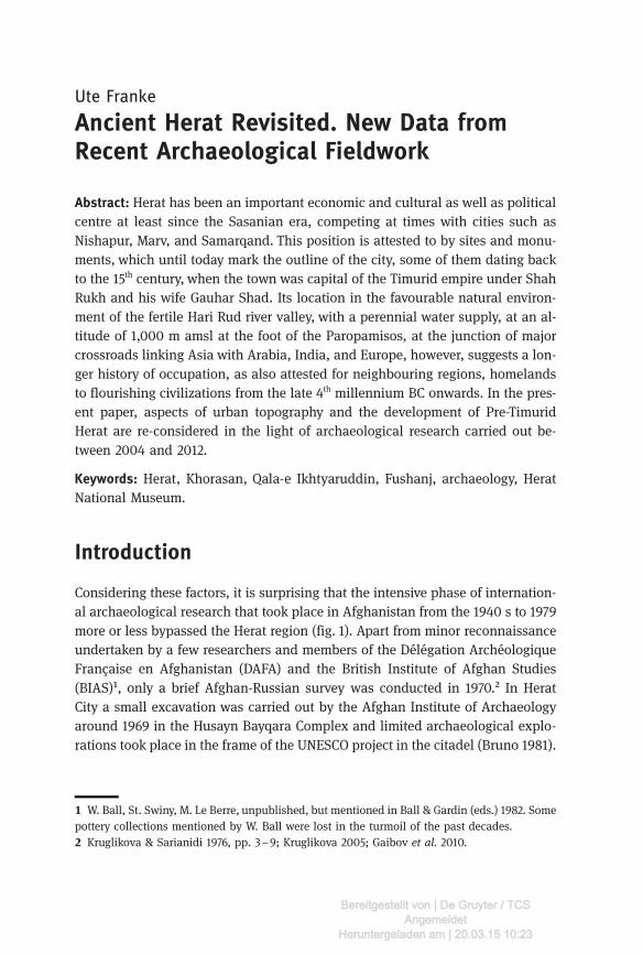
Abstract: Herat has been an important economic and cultural as well as politicalcentre at least since the Sasanian era, competing at times with cities such asNishapur, Marv, and Samarqand. This position is attested to by sites and monu-ments, which until today mark the outline of the city, some of them dating backto the 15th century, when the town was capital of the Timurid empire under ShahRukh and his wife Gauhar Shad. Its location in the favourable natural environ-ment of the fertile Hari Rud river valley, with a perennial water supply, at an al-titude of 1,000 m amsl at the foot of the Paropamisos, at the junction of majorcrossroads linking Asia with Arabia, India, and Europe, however, suggests a lon-ger history of occupation, as also attested for neighbouring regions, homelandsto flourishing civilizations from the late 4th millennium BC onwards. In the pres-ent paper, aspects of urban topography and the development of Pre-TimuridHerat are re-considered in the light of archaeological research carried out be-tween 2004 and 2012.
Keywords: Herat, Khorasan, Qala-e Ikhtyaruddin, Fushanj, archaeology, HeratNational Museum.
Introduction
Considering these factors, it is surprising that the intensive phase of internation-al archaeological research that took place in Afghanistan from the 1940 s to 1979more or less bypassed the Herat region (fig. 1). Apart from minor reconnaissanceundertaken by a few researchers and members of the Délégation ArchéologiqueFrançaise en Afghanistan (DAFA) and the British Institute of Afghan Studies(BIAS)¹, only a brief Afghan-Russian survey was conducted in 1970.² In HeratCity a small excavation was carried out by the Afghan Institute of Archaeologyaround 1969 in the Husayn Bayqara Complex and limited archaeological explo-rations took place in the frame of the UNESCO project in the citadel (Bruno 1981).
W. Ball, St. Swiny, M. Le Berre, unpublished, but mentioned in Ball & Gardin (eds.) 1982. Somepottery collections mentioned by W. Ball were lost in the turmoil of the past decades. Kruglikova & Sarianidi 1976, pp. 3–9; Kruglikova 2005; Gaibov et al. 2010.
Bereitgestellt von | De Gruyter / TCSAngemeldet
Heruntergeladen am | 20.03.15 10:23
Scholarly research³ focussed on the historic record and on architecture, particu-larly from the Timurid era, and dealt with artwork attributed to Herat in interna-tional collections.⁴ This information, along with the historical references, studiesof preserved monuments, site plans and layout served as basis for important re-search on the urban development of Herat.⁵
The available literature, along with ancient travel reports, other sources andcomments as well as unpublished accounts, is thoroughly compiled in Ball &Gardin (1982), who, however, state that “some of the great historical centres,such as Herat, Kandahar and Kabul, are surrounded by a paucity of information”(Ball 1982, p. 21).⁶ Concerning Herat, this is particularly true for the pre-Timuridand pre-Islamic periods, while, as a result of the more abundant historical, cul-ture-historical and architectural record, information about the Timurid city ismore comprehensive. Yet, the lack of archaeological work, and therefore of de-tailed typological and stratigraphical analyses, necessarily leaves many ques-tions open.
Hence, when excavations in Bagh-e Babur in Kabul were nearing completionin 2004, the Joint German-Afghan Archaeological Mission initiated an archaeo-logical project in Herat, in cooperation with the National Institute of Archaeol-ogy and the Department of Monuments and Sites. Starting with a survey andthe documentation of sites and monuments in Herat Province, excavationsand surveys in Herat City, conducted in collaboration with the DAFA, and a mu-seum project were to follow. Even though this work is also by no means compre-hensive for reasons explained below, the focus of historic records and tangibleheritage on the later periods is now better balanced since the body of informa-tion has been widened, at least as far as the material culture and, to some extent,information on urban development are concerned.
Following a brief outline of these projects and a summary of the historicalevidence, the contribution of this research to topics such as urban topographyand development and land use is discussed.
Allen 1981, 1983; Brandenburg 1977; Golombek 1969, 1992; O′Kane 1987; Golombek & Wilber1988; Szuppe 2004b. For the later periods see Nölle-Karimi 2013 and Szuppe 2004b for furtherreferences. Melikian-Chirvani 1979, 1982; see contributions in Franke 2008 for further references on var-ious groups of objects in the Herat Museum. Gaube 1977; Allen 1981, 1983; most recently and with extensive historical references and dis-cussions: Szuppe 2004a, 2004b. An update of W. Ball′s book that will incorporate these contributions and also the archaeo-logical fieldwork taken up again in some parts of Afghanistan in 2002 is in preparation. M.Szuppe′s (2004) seminal article on Herat in the Encyclopædia Iranica is updated in the on-line-version.
64 Ute Franke
Bereitgestellt von | De Gruyter / TCSAngemeldet
Heruntergeladen am | 20.03.15 10:23
Recent Archaeological Fieldwork in Herat⁷
Documentation of Sites and Monuments in Herat Province(2004–2006)
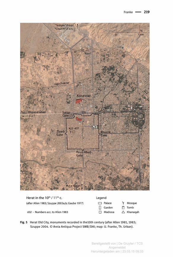
The regional survey aimed at the location and documentation of sites and monu-ments in Herat Province (2004–2006). 315 sites of various types were recorded in16 districts of the province, dating from the late 3rd millennium BC through theearly 20th century (figs. 2, 3). However, systematic surface surveys with randomwalking could not be realized in such a vast area and difficult terrain, also due tothe extent of mined areas, the lack of roads, tracks and logistic facilities; Shin-dand, Farsi, Adraskan, and Kushk Kohna were not accessible at all. Althoughthus the data set does not provide a complete picture of the ancient landscape,it presents a considerable increase in the known number of sites and in the qual-ity of information. In addition to information on the physical and cultural envi-ronment, a reference collection of objects, mostly pottery, was gathered(fig. 4a,b). These data present a primary set of records and facilitate thematic ap-proaches to the cultural, political, and economic development of a landscapethrough time from different perspectives.
Quest for the Roots of an Old City
The survey was supplemented in 2005 by a project devoted to investigating theroots of Herat City through archaeological excavations and prospections in var-ious parts of the city (2005–2009). Such a quest is neither easy nor straightfor-ward: in the densely populated Old City (Shahr-e Kohna, shahrestan) and its sur-roundings, open spaces suitable for archaeological investigations are limited.The fact that even the Timurid city is buried under meter-high urban debristhat has accumulated since the 16th century, makes test soundings in searchfor older remains highly time-consuming and costly, without guaranteed success(fig. 5).
The search for the roots of Herat began in Kohandez⁸, the mounded areanorth of Shahr-e Kohna, commonly hold to be the location of the oldest city
All projects are presently prepared for publication, see Franke & Urban, forthcoming 1, forth-coming 2; Franke & Müller-Wiener, forthcoming. Excavations at Kohandez and the Old City survey were conducted in collaboration with theDAFA team, directed first by R. Besenval, later by Ph. Marquis.
Ancient Herat Revisited. New Data from Recent Archaeological Fieldwork 65
Bereitgestellt von | De Gruyter / TCSAngemeldet
Heruntergeladen am | 20.03.15 10:23
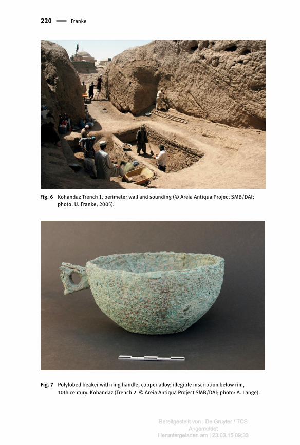
(e.g. Szuppe 2004a). The area is crowned by the shrines of Shahzada Qasem⁹and Abdullah bin Muawiyah, buildings finished or refurbished in the time of Hu-sayn Bayqara¹⁰. A large graveyard developed around the shrines, but althoughthe area is partly enclosed by a man-made earthwork, modern habitation grad-ually approaches beyond this wall, making excavations along the fringes of thecemetery difficult and limited in space (fig. 6). Research focussed on the north-ern perimeter wall and the chronological depth of the deposits. In the south,near the shrine of Shahzada Qasem, an occupation dating to the 9th-11th centurieswas discovered (figs. 7, 8), while northeast of the shrine of Abdullah bin Mua-wiyah, an early 1st millennium BC occupation came to light, corresponding toevidence found on the citadel in 2005 (fig. 28).
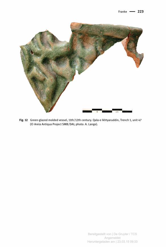
The impressive fortress Qala-e Ikhtyaruddin is situated at the central north-ern part of the square Old City (fig. 9). Its interior space is divided into a lowerand an upper citadel. The latter is dominated by the ruins of a palace built byAmir Abdurrahman, which up to the 1950s still stood three storeys high, andby restored foundations of buildings from the 17th-18th centuries. The palace, con-structed before 1900, marks the end of the military function of the citadel.
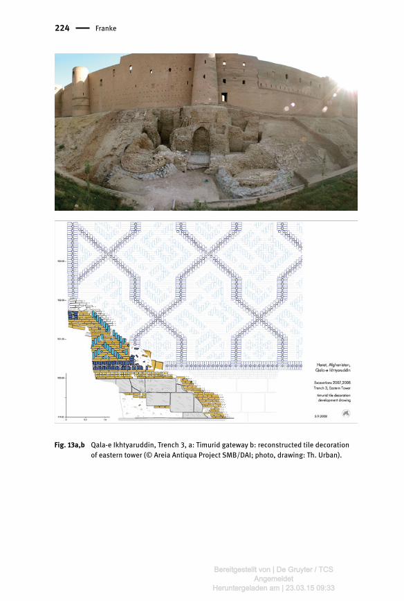
Excavations started in 2005 in the upper courtyard, the highest and most ac-cessible part of the site. A sequence of building levels and pits dating from the19th to the 12th centuries was excavated (figs. 10, 12), beneath which, surprisingly,a 7 m high mud (pakhsa) and mud brick platform came to light that rests on nat-ural soil and dates to the 1st millennium BC (fig. 11). This first prove for a prehis-toric occupation on the spot was confirmed in 2008 by the finds from Kohandez.In addition, new evidence for the structural history of the fortress was obtainedin a trench at the northern foot of the citadel (Tr. 3), where the old Timurid gate-way with two towers and a bridge crossing the moat were excavated. (fig. 13a, b).
Herat Museum & Archive
A first, brief documentation of the newly – and only shortly – opened exhibitionof the museum in Herat in 2005 (Franke 2008) revealed the importance of thecollection for understanding the historical development of the region and thecity. The then 1200 archaeological objects and 260 manuscripts and books pro-vide insights into the regional material culture and local technologies, perfectly
Also: Emamzade Abu’l Qassem. At least the latter monument dates back to the Kart period (Golombek & Wilber 1988, p. 312;O’Kane 1987, #37; Allen 1983, no. 562).
66 Ute Franke
Bereitgestellt von | De Gruyter / TCSAngemeldet
Heruntergeladen am | 20.03.15 10:23
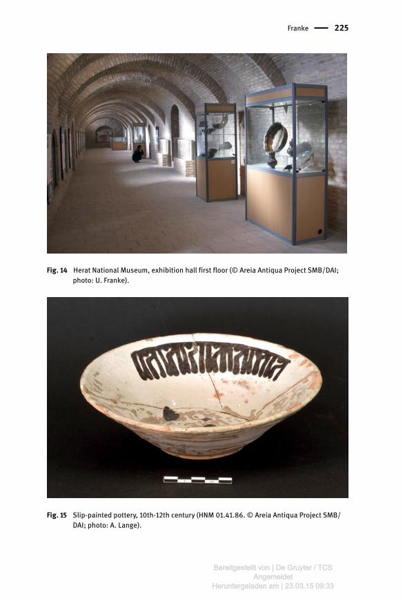
supplementing the fragmented material gathered during the surveys and excava-tions, and the objects in the art market that are attributed to Herat, or more gen-erally to Northeastern Iran/Khorasan. In 2008, the documentation and conserva-tion of the collection started on a large scale, at the same time as the citadelrenovation project carried out by the Aga Khan Trust for Culture (AKTC). Thisproject offered the opportunity to implement a conservation laboratory and anewly designed exhibition. Work was completed in October 2011, when 460 ob-jects and 40 manuscripts from the late 3rd millennium BC through the 19th/early20th century were put on display, providing the chance to visualize the history ofthe city and its region for a general audience (Franke 2012, figs. 14– 17).
These three projects supplement each other in an ideal way, one providingspatial, the other temporal and the latter art historical information. They notonly shed light on the relationship between the city and its hinterland, andHerat′s role in and contribution to the cultural landscape of Khorasan, butalso support the identification of technological and stylistic features which areessential for defining regional styles that set the craft production of GreaterHerat apart from that of other centres in Khorasan.¹¹
Herat from the Sasanian to the Kartid Era
Khorasan was established as a political entity in the early decades of Sasanianhegemony (226–652 CE); it encompassed, with varying extensions through time,the lands from Gorgan to Tus, Faryab, Balkh and Marv. Herat is mentioned ascapital of one of its four divisions, along with Nishapur, Marv, and Balkh.Harēv / Hari is also listed by King Shapur I as one of twelve capitals of the em-pire, with a mint where Sasanian gold coins were struck, as Balkh and Marv.¹² Inthe 5th century, Christian and Zoroastrian communities lived in Herat, of which atemple and church were still reported in the 10th century.¹³ Herat resisted theArab armies until 651/2, with the support of its Hephthalite and Turkic popula-tions, whose regional centre was Badghis.
See e.g. von Gladiß 2008; Müller-Wiener 2008, forthcoming 1, forthcoming 2. Marquart 1931, pp. 11, 46; Vogelsang 2004; most likely an idealized picture of the actual pat-tern (Daniel 1979, p. 16). See also the comments of Grenet 1996, p. 381 on the mints in these threecities. The presence of Jewish communities can also be assumed since four synagogues are knownfrom Herat (Ittig 2005). They are mentioned in historical records and several tomb stones datedto the early 12th century were documented in Ghur (Herberg, pers. comm.; Ghoriyan: Ball & Gar-din 1982, no. 373).
Ancient Herat Revisited. New Data from Recent Archaeological Fieldwork 67
Bereitgestellt von | De Gruyter / TCSAngemeldet
Heruntergeladen am | 20.03.15 10:23
Little is known about this time and the subsequent centuries to the revolt ofAbu Muslim and the early decades of the Abbasid caliphate. The time is markedby unrest and problems caused through sectarian forces, economic constraintson the population, and shifting political alliances among the local rulers andwith the central government. One of these sectarian movements was led by Us-tadhsis, referred to by Ya‘qubi and others as ruler of Herat; although his role,background and religious affiliation are not clear, he reportedly was able to mus-ter 300,000 supporters, mostly from Badghis and Sistan.¹⁴
With the rise of regional dynasties in the east, particularly the Tahirids, theSaffarids and later the Samanids, a period of relative independency, peace, andprosperity began within this domain of the Abbasid caliphate. Herat apparentlygained importance although Nishapur and Balkh respectively were the capitals.Situated at a critical location, the town changed hands a couple of times untilthe Samanids, previously Tahirid governors of Herat, defeated the Saffarids atBalkh and ruled Khorasan from 900 to 999, when they were disposed by the Qar-akhanids and the Ghaznavids. Due to heavy taxes levied by the latter, Herat andits lands were handed over by the citizens to the Qarakhanid (1006) and Saljuk(1038) armies. The fights for power between Ghurids, post-Saljuk rulers andKhwarezm-Shahs were accompanied by shifting factions and turmoil that alsoaffected Herat. The city was besieged, its towers and walls breached in 1175/6,1202, 1204, and again in 1206, when the Ghurid viceroy of Herat, who after thedeath of Mu’izz-ad-din Ghuri (d. 1206) had handed over the city to the Khwarez-mian Sultan Mohammad, changed sides again. He was killed in revenge, the citycaptured and heavily damaged.¹⁵ Nevertheless, in 1217 Yaqut¹⁶ described Herat asthe richest and largest city that he had ever seen, standing in the midst of a fer-tile country (Le Strange 1905, p. 409).
When in 1221 the Khwarezmian governor of Herat declined the offer of Tolui,son of Djinghis Khan, to surrender the city peacefully, the latter took Herat, de-stroyed the citadel and allegedly killed c. 12,000 soldiers.¹⁷ Following the murderof his deputy in the Great Mosque, Djinghis Khan sent an army of 80,000 men,captured the city after six months of siege, killed the population and devastatedthe lands and irrigation systems.
Herat recovered under the Kart dynasty, a distant relative of the Ghurids andhigh-ranking officials in Herat since 1202. After 1254, under Möngke Khan and
Whether with a neo-Zoroastrian background, as mentioned by Bosworth 2007, p. 154), is notclear (Daniel 1979, pp. 133– 136; Szuppe 2004a, p. 207). Further details and references are provided in Szuppe 2004a, p. 207–9. Possibly quoting from an older source, not a contemporary visit (pers. comm C.-P. Haase). Szuppe 2004a, p. 208.
68 Ute Franke
Bereitgestellt von | De Gruyter / TCSAngemeldet
Heruntergeladen am | 20.03.15 10:23
the Ilkhanid rulers Hulegu and Abaqa Khan, the Kart became governors of Herat,Balkh, Sistan, and the lands until India. Later, they acted rather independentlyand, after the death of the last llkhanid ruler Abu Said in 1335, became rulers ofKhorasan for the next 50 years. They are generally credited with rebuilding thetown after the Mongol devastations, particularly the city walls, the citadel (1305),two palaces and – twice – the Great Mosque. However, dynastic quarrels and ad-vances of the nobility opened the doors for Timur′s army, to whom they handedover Herat in 1381. Timur spared the population but dismantled the fortificationsand took the iron gates and treasures to Shahr-e Sabz. Following a rebellion in1383, the city was destroyed and large parts of the population moved to Trans-oxania. Shah Rukh, youngest son of Timur, was appointed governor of Heratin 1397; when he accessed the throne after Timur′s death he shifted the capitalof the Timurid Empire from Samarqand to Herat in 1409. The reconstructionand/or beautification of the citadel and the bazaars was reportedly completedonly in 1415/6 (Allen 1983, p. 19).
Urban Topography and Development
Historical Sources
In the 10th century Estakhri, Ibn Haukal and Muqaddasi describe Herat as a largecity with four gates, three of wood, one of iron (Bab Saray), with a c. 2 x 2 kmwide fortification, and a citadel¹⁸ with its own fortification and four gates. TheGreat Mosque of Herat, located in the north-eastern quarter of the site, is saidto be of unequalled beauty in Khorasan and Sistan; attached to its qibla-wallin the west was the prison, indicating that the royal residence was situated near-by, probably in the same location as in the early 20th century.¹⁹ The oldest pre-served parts of the mosque date back to the late 12th century, namely the old por-tal in the southeast (fig. 18), constructed during a Ghurid restoration of themosque²⁰, possibly when the mausoleum of Ghiyath ad-din Mohammad
Named Kohandez or Qal’ah according to Le Strange (1905, p. 408). Gaube 1977, p. 220: 1979, 53 s. In the 1920 s, the governor′s palace, stables, and other officialbuildings were still located west of the mosque (Niedermayer & Diez 1924).The north indicationin the map reproduced by Brandenburg (1977, p. 30) is not correct. Later, comprehensive restorations are mentioned for the late 14th century and in 1543/4 by Lal(1834), who, however, does not refer to the major work carried out under Ali Shir in 1498 (seeBrandenburg 1977, p. 31).
Ancient Herat Revisited. New Data from Recent Archaeological Fieldwork 69
Bereitgestellt von | De Gruyter / TCSAngemeldet
Heruntergeladen am | 20.03.15 10:23
(1163– 1203)²¹ was attached in the north. Between 1200 and 1203, a madrasa wasbuilt near the Iraq gate, in the same area where a madrasa sponsored by Nizamal-Mulk in 1067– 1092 and a Saljuk mosque were reportedly already standing.²²
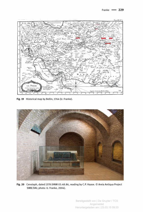
The town was already then surrounded by extensive suburbs and gardens inall directions except the north. The area was irrigated through canals, of whichseven are already mentioned by name by Muqaddasi; 300 years later, Mustaufilists nine canals (Le Strange 1905, p. 407). The former also refers to Pul-eMalan, the bridge spanning the Hari Rud, 12 km or half a day′s journey to thesouth. The north was desert, but according to Estakhri the Juy-e Enjil was alreadypresent.²³ 11 km north of Herat, in the mountains, stood a much frequented firetemple (Sereshk or Arshak²⁴), later overbuilt by a fortress named Shamiran (LeStrange 1905, p. 409, see fig. 19) and, halfway to the city, a church. Fromthese mountains came paving stones and mill-stones for wind mills, describedin the 13th century by Qazvini²⁵, a common sight in Herat until a few decadesback. One day′s journey northeast of Herat lies Karukh, in the 10th century alleg-edly the second-largest town of Herat district, where plenty of apricots and rai-sins were grown.²⁶ A series of other towns are mentioned on the route to Jam fur-ther south. The governmental palace²⁷ was reportedly located in Khorasanabad,about 1.5 km west of Herat on the road to Fushanj, an important site in the his-torical landscape around Herat.
The interior decoration dates partly to the early 14th century. According to Byron (1935) therewas a stucco inscription on the cupola, already collapsed in 1833, which contained titles used byUljaitu and Abu Said; these are not mentioned by Wilber who studied the building in 1935 (Bran-denburg 1977, p. 32). Wilber 1955, p. 136; Brandenburg 1977, p. 31; Szuppe 2004a; located further southeast byAllen 1983, p. 14, no. 423, 477 and 414. Estakhri, as well as Ibn Haukal, Muqaddasi: see detailed references in Le Strange 1905,pp. 407–411; Szuppe 2004a; Gaube 1977, p. 217. Estakhri, Ibn Haukal in Le Strange 1905, p. 408; Szuppe 2004a. After Le Strange 1905, p. 409. Ibn Haukal, in Le Strange 1905, p. 410. Szuppe 2004a, 206. Gaube (1977, p. 225) places this building 18 km west of Herat. It has notbeen located on the ground.
70 Ute Franke
Bereitgestellt von | De Gruyter / TCSAngemeldet
Heruntergeladen am | 20.03.15 10:23
Excursus on Fushanj
Fushanj is a historic site, allegedly founded by Shapur I, with a suffragan bish-opric in the 6th century BC, subordinate to Herat.²⁸ Like Herat, it was taken fromthe Hephthalites and ruled first by the deputy of the Umayyad governor of Khor-asan, and after 750 by Mus’ab b. Ruzaiq, an associate of Abu Moslem and grand-father of Tahir ibn Husayn who became governor of Khorasan in 821.²⁹ The citylater fell to the Saffarids, then to the Samanids, Ghaznavids, and Saljuks. In the10th century, it was half the size of Herat and, like the latter lay in a plain, twoleagues distant from the mountains. The town was well built amid trees, stronglyfortified and surrounded by a wall with three gates and a ditch. In the 14th cen-tury, Mustaufi writes that the city is famous for its water melons, grapes, andwind mills. A Mongol invasion is not recorded, but the city, its fortress and ram-parts was destroyed by Timur in 1381.³⁰ According to Le Strange (1905, p. 411) thename Fushanj vanished after Timur′s assault, but Bosworth (2000, p. 230) refersto frequent references in Hafiz-i Abru – who also described its remarkable for-tress – and argues that the town was destroyed only in the 16th or 17th century.
The location and identification of Fushanj varies. According to Bosworth(2000, p. 229), “the name is also reflected in the Būšang of the Hodūd al-ʿālam, a town in medieval eastern Khorasan, situated just to the south of theHari Rud River, and variously described in the sources as being between sixand ten farsak (i.e. 36 km or 60 km) south to west-southwest of Herat.” However,Bosworth (2000) also writes “Šāpūr I …… took control of the Herat and Bādgīsregion, in which Fūšanj was situated” and “At the time of the Arab conquestof Khorasan, Herat and Bādgīs were under Hephthalite control, and these dis-tricts and Fūšanj were under what Balādorī calls “a powerful prince” (ʿazīm).”
Despite the references to Badghis, in which district a fortress named Fou-cheng is also shown in the map of Ottens (see note 29), Fushanj is generally lo-cated west of Herat.
While Bosworth (2000) equates it with modern Ghoriyan, Ferrier (1857), Sa-mizay (1981, p. 30), O’Kane (1985, p. 18) and Ball & Gardin (1982, p. 290) identifyit with Zendejan, 30 km further to the east (see fig. 19). Both towns are historical
Spelled Būšanj (Arabic), Būšang (Hodud al-Alam), and Pūšang (Middle Persian) according toBosworth 2000, p. 229; see also Le Strange 1905, p. 408; Szuppe 2004a, p. 206 s and Grenet 1996,p. 379. A map by Bellin shows a “Fusheng” north of Herat, while one by J. Ottens shows “Fou-cheng” to the north and “Boucheng” to the west of Herat, both 18th century. Bosworth 2000, p. 230; Saljuqi 1967. Described by al-Yazdi, see O’Kane 1985, p. 18; Le Strange 1905, p. 411. I am grateful to B.O’Kane for providing me images of the cenotaph, and a copy of his paper.
Ancient Herat Revisited. New Data from Recent Archaeological Fieldwork 71
Bereitgestellt von | De Gruyter / TCSAngemeldet
Heruntergeladen am | 20.03.15 10:23
places with a fortress, but there is no conclusive archaeological evidence fromeither.³¹
Zendejan has a number of monuments and a fortress, but they are rather oflater date. However, Rabat-e Pai, a near-by shrine is dated for structural reasonsto the 14th century by Samizay (1981, p. 36). More importantly, Samizay (1981, p.30 s), following Fikri Saljuqi (1967, pp. 141– 143), reports a mausoleum with the –already then fragmentary – cenotaph of Muhammad Ghazi, a high-ranking per-son. A tile in the Herat Museum provides the date 780 H/1378 (Haase 2008.fig. 20, see note 48).³² The monument and the cenotaph, thoroughly discussedby O’Kane (1985), certainly proof that Zendejan was of major importance duringthe Kart period.
Ghoriyan, situated about 70 km west of Herat, has an old mosque, dated tothe 12th or 15th century on epigraphic and stylistic grounds respectively, and a 19th
century fortress.³³ Further evidence for a 12th century occupation somewhere nearGhoriyan are Hebrew inscriptions found in the surroundings (Ball & Gardin 1982no. 373).
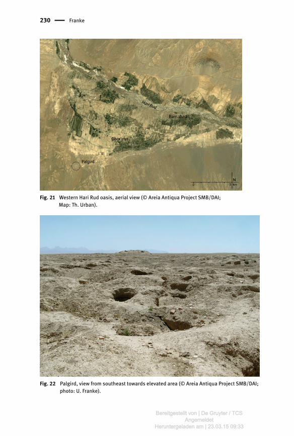
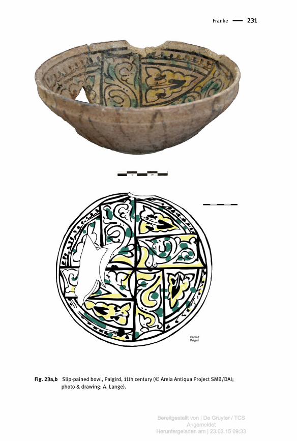
However, 8 km west of Ghoriyan, a large site – with a diameter of c. 1.5 km alittle less than half the size of Old Herat – was discovered (fig. 4a,b, 21–24).³⁴ Themound, known today as Palgird, is enclosed by a perimeter wall. House plansare visible and finds, mostly high quality pottery of well-known types, are scat-tered all over the heavily looted mound. An elevated portion is marked by mudbrick architecture, where illegal excavations have exposed walls and remains ofvaults. The city is located close to a vast qanat-system of unknown date, and acouple of smaller mounds are scattered in the vicinity. The sherds indicate,that the place was devastated and abandoned after the Mongol invasion.
While due to the monumentality it is tempting to identify Palgird with Fush-anj, this archaeological evidence does not concur with the 14th century and laterreferences (see above). Yet, it is likewise difficult to imagine that such a largeplace remained unnoticed in the enumeration of sites along the trade routes.
Although Ball & Gardin (1982 no. 1259) locate Fushanj in Zendejan, their description refersonly to a thin scatter of sherds, while there are no mounds. The area was also surveyed byour team and, likewise, no large archaeological site was found. Samizay (1981, p. 30 s) did not see the fragment with the date. Following Fikri Saljuki, heattributed the cenotaph to Nasir al-din Alp Ghazi, son of Sultan Qara Arslan, who died in thefight against the Khwarezm Shahs 600 H. This dating was refuted by O’Kane (1985) who correctlydated the cenotaph to the 14th century, without having seen the tile with the date. This evidencewill be further dealt with in a forthcoming publication by C.-P. Haase. See also note 48. Samizay 1981, p. 20 s; Ball & Gardin 1982, p. 109 no. 373. The site is mentioned by Ball & Gardin (1982, no. 794) under the name of Palgird or GhoriyanTepe, with a very brief entry only.
72 Ute Franke
Bereitgestellt von | De Gruyter / TCSAngemeldet
Heruntergeladen am | 20.03.15 10:23
If Palgird was Fushanj, the town must have shifted to Ghoriyan after the Mongolinvasion. However, if Zendejan is historic Fushanj, Palgird probably was one ofthe three towns – Sanjan, Farjird/Kharjird, and Kusuy – mentioned to followeach other in a row on the road to Zuzan, west of and belonging to Fushanj.³⁵Phonetically the modern name is close to Farjird/Kharjird, but Kusuy, onemarch to the east, was the largest town, one third as large as Fushanj, withmany unbaked brick houses, closest to Herat and north of Farjird. No matterwhether either identification holds true, the site adds an important feature tothe historical urban landscape around Herat.
In addition to the historical records and architectural remains, objects ofhigh artistic and technological quality ascribed to Herat highlight the role ofthe city as an economic and cultural centre, known particularly for the produc-tion of priced metalwork. Already al-Biruni refers to Herat as a famous centre ofsteel-making, noted for its egg-shaped ingots.³⁶ The city is also known for itsblades, probably similar to one depicted on a coin minted 1048/9 in Herat.³⁷11th century coins from Herat found in the western world and elsewhere attestits participation in widespread economic networks.³⁸ The metal working tradi-tion continued in the 12th and 13th centuries. A masterpiece from this period isthe Bobrinsky kettle, dated Muharram 563/December 1163, and ascribed toHerat as production place. Not only does it provide in Persian the names ofthe artists who cast (Mohammad ibn Abd al-Wahid) and engraved it (Massudibn Ahmad), but also the name of the client (Abd ar-Rahman ibn Abdallah ar-Ra-shidi) who had it made for Rashid ad-Din Azizi ibn Abul-Husain al-Zendjani, amerchant.³⁹ This tradition was obviously only briefly interrupted by the Mongolinvasion in 1221/2, although devastations were heavy.⁴⁰ Upon order of IlkhanAbaqa in 1264/5 a kār-khāna was founded in Herat and several pieces of art at-tributed to Herat mirror the high standards of contemporary production.⁴¹
Le Strange 1905, pp. 358, 411, see also fig. 1. Allan/Gilmour 2000, p. 38; Allan 1979, p. 67; quoted after Çakır Phillip, forthcoming. Çakır Phillip, forthcoming. Müller-Wiener, forthcoming 2. Von Gladiß (2012, p. 74 s) relates “al-Zendjani” with Azarbaidjan. Blair & Bloom (2005, p.344 s) do not discuss this question, but mention that Massud ibn Ahmad was from Herat. Summarizing the historical references provided by Ibn Rusta, al-Mostaufi, Sayf Heravi, andHafiz-i Abru, Szuppe (2004a, p. 208) states, that while there were 400 villages in Herat villayet inthe 10th century, it were still only 200 in the early 15th century. The city could muster 190,000soldiers before the Mongol conquest. Inlaid metal vessel with chinoise influence, century 1265 (Musée du Louvre, see O’Kane2008, p. 126); an inlaid brass ewer with repoussé decoration, c. 1180–1200 (British Museum,OA 1848.–8–5.2; Roxburgh 2005, cat. No. 48; O’Kane 2008, p. 118).
Ancient Herat Revisited. New Data from Recent Archaeological Fieldwork 73
Bereitgestellt von | De Gruyter / TCSAngemeldet
Heruntergeladen am | 20.03.15 10:23
Repairs of the destroyed channel system, essential for the water supply ofthe city, started in 1236, allegedly by a group of weavers.⁴² This marks the recov-ery and increasing urban development attributed to the Kart, high-ranking offi-cials in Herat since 1202, governors since 1254, and rather independent rulersafter 1335. Their input to urban development is evident from reports of new foun-dations or repairs of religious buildings and cemeteries, a royal residence nearthe mosque, three khanaqah in the Iraq- or Malik quarter, and gardens with pa-vilions and shrines in the suburbs (fig. 27).⁴³ The citadel, now known as Qala-eIkhtyaruddin after a general of Ghiyath ad-Din Mohammad, was rebuilt with theroyal residence from 1299 onwards, and a walled space, the Bagh-e Shahr withroyal mosque (?) and khanaqah, added at its northern foot.⁴⁴ The city′s earthendefences were re-built, the darvaza-e malek fixed with an iron gate. The con-struction of a 6 km x 6 km long defence wall around the city starting from theJuy-e Enjil, attributed to Mu’izz ad-Din (1331– 1370), implies that the extramuros quarters expanded now well into the north.⁴⁵ Around 1333, Ibn Battuta de-scribed Herat as the largest inhabited town in Khorasan, being one of the fourlargest of the country, of which Balkh and Marv were destroyed, Herat and “Mai-sabur” inhabited.⁴⁶
Even though the location of buildings and other structures is often not ascer-tained, it is clear that the Kartids decisively shaped the urban landscape, takingover and extending existing older patterns within the walled city and designing anew layout in the expansion towards north and northeast. However, despite theirundisputed contribution to the urban development, only few objects, apart fromtomb stones and remains of architectural decoration, can be attributed to thisperiod. One rare masterpiece is the above-mentioned glazed cenotaph of excep-tional quality from the mausoleum of Mohammad Ghazi in Zendejan, erected fora princely person in Sha’ban 780/end of November-December 1378 (fig. 20).⁴⁷ An-
According to Sayf Heravi, quoted in Szuppe 2004a, p. 209. For detailed lists see Allen 1983, p. 47, fig. 2; Szuppe 2004b. Seven cemeteries and shrinespatronized by the Kart (starting with Fakhr ad-Din) and taken over by Timurid are mentionedby Allen 1983, pp. 29, 46 s; six by Szuppe (2004b). Szuppe 2004b refers to it as Idgah-e divari or mosalla and refers to Allen 1981, no. 228. MostKart buildings except two palaces built by his successor Ghiyath ad-Din are attributed to Fakhral-din in ArchNet and by Szuppe (2004b). However, Herat had just come under siege by Uljeitu′sarmy when Fakhr ad-Din died in 1307 (Szuppe 2004a, p. 209), so the citadel was probably re-paired later. Reported in the late 15th century by Esfizari, see Szuppe 2004b; Gaube 1977, pp. 225, 229. Ibn Battuta, edition by Leicht 1974, p. 50. Tiles from the cenotaph were found in the collection of the museum and elsewhere in Herat,broken into many pieces. The provenance and date of entry are not recorded. According to F.
74 Ute Franke
Bereitgestellt von | De Gruyter / TCSAngemeldet
Heruntergeladen am | 20.03.15 10:23
other piece is a small sherd which carries the name of “Sultan Malik Ghiyath ..” atitle that most likely refers to Ghiyath ud-din Pir ’Ali (1370–1389. Fig. 25). Thecollection of pottery luxury wares in the Herat Museum, ranging from a few lus-tre sherds to Sultanabad and Bamiyan wares, is small, but of high quality(fig. 26).
Urban expansion was carried further on a large scale by the Timurids. Theirrule, however, started with destruction of the city in 1381 – the population wasspared, but the outer wall and ramparts were demolished, the iron doors of theMalik gate and the Kart treasure taken away. In 1383, following a rebellionagainst Timur’s son Miranshah, governor of Herat, the city was destroyed, exceptthe mosque, craftsmen, scholars, and artists were deported. These interventionsmust have had a lasting effect on the city. In any case, information on buildingactivities during Timur′s lifetime, when Shah Rukh was governor of Herat, is lim-ited. Large-scale development started only when he accessed the throne andmade Herat his capital. Reportedly, 55 buildings and 20 gardens were locatedoutside and 32 inside the city at the end of the Timurid period.⁴⁸
New Archaeological Evidence and its Implications
While historical information remains the most important source for assessingurban life in its wider context, archaeology provides essential evidence for anumber of aspects particularly the range of material culture and its chronologi-cal and spatial context. However, archaeology in a living and expanding city isdifficult. In the Old City and the former suburbs the tangible testimony is badlyaffected, destroyed, or substantially changed through time by human develop-
Saljuqi (1967, followed by Samizay 1981), fragments were brought to Herat from Zendejan, whileothers remained on the spot. Samizay provides a plan of the mausoleum, while O’Kane discuss-es the building and the cenotaph in detail. He was unable, however, to see the pieces in theHerat Museum. The inscription corresponds well with the mention that Fushanj was “underwhat Balādorī (Fotūh, p. 405) calls “a powerful prince” (ʿazīm).” (Bosworth 2000, 230; seeabove note 33 and p. 6 s). Interestingly, images published by Samizay (1981, p. 33) andO’Kane (1985 Pl. XIIa) shows a couple of prehistoric alabaster columns scattered around thetomb. At least some of them were also brought to Herat, where they are now on display (Franke2008, 2012). After Hafiz-i Abru, Khvandamir, Babur (see Gaube 1977, pp. 228–230; Brandenburg 1977, p.26; Szuppe 2004b). Allen (1983) provides a detailed account of tradition and transformation inthe urban pattern and its socio-economic context from the late Kartid period through the time ofHusayn Bayqara and Ali Shir. See also O’Kane 1987, Golombek 1992 and Szuppe (2004a, b), withreferences to more recent publications.
Ancient Herat Revisited. New Data from Recent Archaeological Fieldwork 75
Bereitgestellt von | De Gruyter / TCSAngemeldet
Heruntergeladen am | 20.03.15 10:23
ment and growth.⁴⁹ The ancient deposits are buried by meter-high debris layersand hence out of reach, with even geo-prospection impossible because of thedump. Although Timurid and other historical buildings are visible in theurban landscape, the majority of buildings mentioned in the written sources can-not be identified on the ground. Yet, the new evidence contributes to the historyof the city, urban topography, the building history of the citadel, and, most im-portantly, it provides Herat with a hinterland. In addition, large collections ofstratified find assemblages are now available for typological and comparativestudies, providing information on various types of common as well as more so-phisticated wares. Combined with the holdings of the museum, which have astrong focus on the pre-Timurid eras, for the first time, the regional cultural set-ting can be addressed. Some results of the archaeological research are summar-ized below, however, the evaluation of the data is still ongoing and in a prelimi-nary stage.
Excavations at Kohandez
Kohandez, name of a mound to the north of the walled city, is generally believedto be the location of the oldest settlement in Herat.⁵⁰ The mounded area has itshighest point in the north from where it slopes towards south and east. Its north-ern edge is marked by an earthen perimeter wall, while a deep lying pit in thesouth, just beyond the shrines of Shahzada Qasem and ʿAbdullah bin Muawiya,is its lowest point. There, the birth place of Khwoja Abdullah Ansari (born 1006in Herat) is allegedly located, just to the east of Trench 2, in a room that todaylies c. 1.5 m below surface level (figs. 28, 29).
Excavations carried out in 2005 and 2008⁵¹ confirmed the presence of a pre-Islamic as well as of a 10th/11th century habitation, and a post-Timurid usage, theformer laying underneath the level of the Timurid cemetery. Work in the northfocussed on investigating the perimeter wall and assessing the depth of the de-posits (Trenches 1 and 3).
Aworthwhile project would be the excavation and clearance of the plan of the Mosalla Com-plex, although no great stratigraphic depth can be expected there judged on evidence providedby a sounding carried out by Th. Urban on behalf of UNESCO in 2011. Later also called Tall-e Bangiyan. See on this topic in general e.g. Samizay 1981, p. 86; Allen1983; Szuppe 2004b, p. 211, Grenet 1996, p. 381: Greek and older Kohandez is not discussed byGaube 1976, 1979. Excavations in Kohandez were carried out in cooperation with the DAFA.
76 Ute Franke
Bereitgestellt von | De Gruyter / TCSAngemeldet
Heruntergeladen am | 20.03.15 10:23
The wall, visible along the northern fringe of the mound, is an important fea-ture because of its assumed antiquity and idealized extension: the layout of theneighbouring houses and lanes led to the hypothetical reconstruction of a circu-lar enwalled area which in the south is connected with the wall of the square OldCity and the citadel mound.⁵² Hence, a bulldozer section was enlarged andcleaned. It revealed a 12.7 m high section, rising 8 m above present surfaceand 4.5 m below, with gravel layers sloping diagonally from south to north(fig. 6). Mud bricks were only used in one portion, at a higher level further tothe west, where a gap indicates an opening. A few sherds were collectedthere, some Timurid and Safavid, and more recent.⁵³ The course of the wallwas followed further towards east in building pits and sections until c. 40 mwest of the main road. In no other part along the hypothetical outline aroundKohandez a trace of the wall was found.⁵⁴
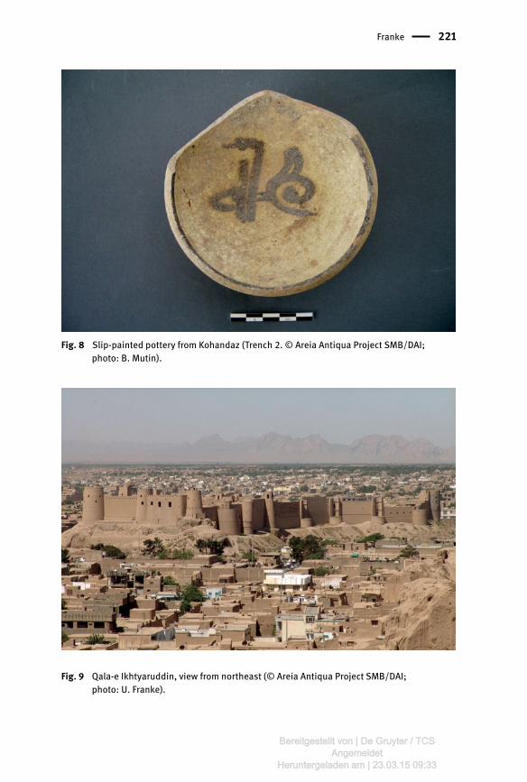
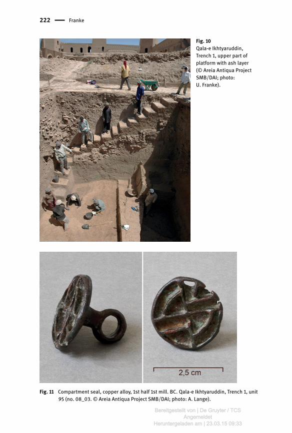
Trench 2 was excavated at the southern limits of the cemetery where the sur-face drops from 960 m to 953 m amsl, i.e. more or less the present surface levelsouth of Kohandez. The height of the upper deposits, related to the Timurid cem-etery and shrine, is 3 m. Underneath, a layer of compact mud came to light intowhich two pits were dug. In these pits a number of slip-painted ceramics and ametal cup were found, badly affected by deposition in humid conditions (figs. 7,8). Nevertheless, the polylobed shape and the ring handle with a – now broken –thumb rest have good parallels from the 9th /10th or 11th century (Melikian-Chirva-ni 1974).⁵⁵ The same date is induced by the pottery. From this level, the groundsloped further towards a depression in the south, which was filled with standingwater until a few decades ago and used as thrash area for garbage until recently.A sounding excavated at the edge of the slope revealed two layers of burialswhich were dug into finely layered silt deposits. These deposits, clearly attribut-able to regular episodes of low speed flooding, continued without anthropogenicfinds for further 7 m, the maximum depth reachable in this small area with in-stable deposits for an excavator. As a result it is clear that this part of the site wasoriginally a flood (irrigation?) zone, and that it was used as a burial ground at
E.g. Grenet 1996 fig. 8a. The wall was used until the 1970 s as military outpost during the mujaheddin fighting. See Grenet 1996, fig. 8a, based on a 1842 map, but extending the evidence visible in thatmap. For a simpler version of the map see the plan dated 1840 (fig. 34). The cup carries an inscription along the outer rim which is illegible due to heavy corrosion.A similarly shaped, elaborately decorated cup with a Kufic inscription giving blessings was oncein the possession of the Herat Museum (Melikian-Chirvani 1974, fig. 15). It is most likely the ob-ject on sale, in a reworked condition (inscription on one side, handle), in Sharjah (http://www.rubylane.com/item/875383-lotA1477/Seljuk-Bronze-Lobed-cup-layed).
Ancient Herat Revisited. New Data from Recent Archaeological Fieldwork 77
Bereitgestellt von | De Gruyter / TCSAngemeldet
Heruntergeladen am | 20.03.15 10:23
quite an early date. The area was then compacted by clay layers which are datedby the finds described above. Another levelling took place during the Timuridera, at the latest when the two shrines were built or restored under Husayn Bai-qara. Their last refurbishment by Amir Habibullah (c. 1905) is also attested by thefinds.
Trench 4, opened in 2008 at the southeastern edge of the mound near themodern houses, brought to light – under substantial recent debris layers andlate Islamic material – remains of a small structure. Parts of the ceramic assem-blage are similar to pottery from Qala-e Ikhtyaruddin, Trench 1 (see below). Eightradiocarbon samples provide dates to the 9th/8th century BC⁵⁶, confirming the 1st
millennium BC readings obtained at Qala-e Ikhtyaruddin.Due to the small size of the excavations, interpretation of the type, extension
and date of occupation at Kohandez are limited. Pending detailed studies of thepottery by the DAFA, so far Greek, Hephthalite, Sasanian or pre-9th/10th centuryCE occupations are not attested to. The subsequent habitation attested to by thearchaeological record dates to that time, when also, allegedly, the shrine ofShahzada Qasem was built above his grave (d. 190/805; Samizay 1981, p. 92).It was discovered only at the south-western edge of the mound, an area alreadythen used as burial ground (Trench 2). No earlier levels were present in this part.The shrine of Shahzada Abdullah was built under the Kart in the early 14th cen-tury next to the other monument, probably as part of their urban expansion to-wards north (see above). The shrines were restored and the graveyard graduallyexpanded all over the mound. Major refurbishments were again carried out inthe early 20th century under Amir Habibullah.
Excavations at Qale-e Ikhtyaruddin
The citadel is located at the central northern edge of the ancient mud fortifica-tions, partly on a mound rising 13 m above street level. The outer wall, includingbattlements, runs c. 260 m in East-West and 60 m – 80 m in north-south direc-tion, enclosing an area of c. 18,000 m2.⁵⁷ The defences are 16 m high and rein-forced with 18 towers reaching a height of c. 31 m above street level. Thespace is divided into an upper citadel with a well, dungeons, and – allegedly– treasury, and a lower part, framed in the north by an elongation of the elevated
I am grateful to Ph. Marquis and J. Cluny for making the data available to me. The size of 18 x 42 m mentioned in Szuppe (2004a) for the raised part is too small; the cor-responding measure provided in ArchNet probably refers only to the late 19th century courtyardstructures of the palace of Amir Abdurrahman.
78 Ute Franke
Bereitgestellt von | De Gruyter / TCSAngemeldet
Heruntergeladen am | 20.03.15 10:23

portion that terminates with the Timurid tower in the west (fig. 33). These twoparts are separated in the interior by a narrow north-south passage. The structur-al differences between the upper and the lower parts are still clearly visible in19th century maps (fig. 34). The buildings in the lower courtyard, mostly garrisonsand stables, and the outer fortification with the towers and wall-walks are oflater date, probably the 17th-19th century. Only the north-western part with the Ti-murid tower dates back in its foundations to the Timurid period (Bruno 1981).⁵⁸
Trench 1, upper courtyard
In 2005, excavations started in an empty space on the upper citadel where due tothe height of the mound the longest possible stratigraphic sequence was to beexpected (Trench 1, areas a and b, each 7 m x 10 m. Fig. 35). Sealed by the pave-ment of Amir Abdurrahman, drainage systems for his palace and two further ma-sonry underneath were excavated, the lower one associated with two skeletons.The structures date to the 17th/18th century and can be related to the buildingsfurther east, excavated and restored by Bruno (1981). The lower layers were dis-turbed and mostly without structures probably caused by the constant clearingof the area between destructions and rebuilding which removed the archaeolog-ical evidence. To light came deep pits filled with building rubble, ashes, pottery,and, in one case, a skeleton with hands once tied on the back, a mixed array offinds dating to the 17th/18th to 12th centuries (fig. 12).
These pits are dug into a massive pakhsa platform. It appeared at a level 5 mbelow surface and extended to a depth of 12 m below surface. It was founded onalluvial silt layers which were followed two further meters through drilling. Onlyin its lower part, large-sized mud bricks were used.⁵⁹ Scattered potsherds andone level with architecture, ashes, and small finds provide sufficient evidence,additionally supported by radiocarbon samples, to date these remains to the8th/7th through 5th centuries BC (figs. 10, 11). This first-time testimony for a prehis-toric occupation in Herat was widened by the excavations in Kohandez Trench 4(2008, see above).
No clear evidence is at hand to date the addition of the western part of the citadel. It is at-tributed to the Kart Period by ArchNet AS05689. However, there were several thorough refurbish-ments and rebuildings of the citadel in post-Timurid times and the present shape and appear-ance post-dates the Timurid building. The lower citadel and the fortification and its towerswere completely rebuilt in the 70es by the UNESCO project, and repaired again after 2008 byAKTC. 50/60 x 25/30 x 5/6 cm.
Ancient Herat Revisited. New Data from Recent Archaeological Fieldwork 79
Bereitgestellt von | De Gruyter / TCSAngemeldet
Heruntergeladen am | 20.03.15 10:23

Trench 3, northern foot of citadel
Important evidence for the structural history of the citadel was obtained in alarge horizontal clearing and soundings at the northern foot of the citadel(Tr. 3). In this area, the team directed by A. Bruno had uncovered traces of a cir-cular brick tower and remains of a sandstone and brick glacis. The UNESCO teamhad to leave the site in 1979 and the area was left open until 2007. Due to insta-bilities in the citadel wall, measures for stabilising this portion had to be taken.⁶⁰Subsequent excavations by the German-Afghan Archaeological Mission in 2007and 2008 led to the discovery of one of the main gateways of the Timurid citadel(see above. Figs. 36, 37).
The complex consists of the following structures: two brick towers withtraces of the original tile work, executed with white, blue and turquoise glazedand unglazed bricks (banna’i), creating a geometric pattern that corresponds tothe decoration of the Timurid tower, a cross-shaped central room with vaulteddoorways providing access to the entrance and two side rooms, one with ahigh, vaulted niche, large parts of the sandstone and brick glacis attached tothe citadel and towers, and remains of a bridge. The entrance hall and bent pas-sage leading into the citadel were blocked in the 17th or 18th century when towerXVIII and the adjoining walls were built on top.
Along with evidence obtained from a trench located east of the Timuridtower (Tr. 2), the following building phases are proposed:1. debris layers on the slope from an older structure (pre-Timurid)2. construction of the gateway, several phases of subsequent repairs3. construction of a sandstone glacis4. construction of a fired brick glacis on top of the decayed sandstone glacis5. framing of the lower part of the towers with large stones, changes in the in-
terior entrance system6. walls inserted into the original structures7. the gateway fell out of use: blocking and filling of the entrance room and
walkway, building of tower XVIII on top of these structures
A few stray finds from the prehistoric period and 10th to 12th centuries were foundin Trench 2 and 3, but no associated structures are preserved. The date of thescant remains of Phase 1 is not clear, but a Kartid date is likely since several re-pairs of the citadel are reported (e.g. 1299 or 1305, see above). The main gateway
To solve these stability problems and to prevent further decay of the brickwork, the gatewaywas reconstructed in 2009.
80 Ute Franke
Bereitgestellt von | De Gruyter / TCSAngemeldet
Heruntergeladen am | 20.03.15 10:23
is dated through its construction and decoration to the Timurid period, mostlikely the reign of Shah Rukh who had the citadel repaired, or at least the faiencetiling completed, by 1419 (Allen 1983, p. 18). This date is supported by the radio-carbon analysis of a wooden beam from the eastern tower. The filling of the en-trance room which served as foundation for tower XVIII indicates a major struc-tural change of the citadel that must have taken place, probably in the frame of amassive rebuilding, during the late 17th/early 18th century.
Conclusions
There is a general agreement among scholars that Ancient Herat did not changeits location through time⁶¹, as e.g. Marv and Samarqand. Kohandez is believed tobe the oldest part of the city, often attributed to at least Alexander the Great⁶²;the citadel, situated at the southern part of the oval shaped enclosed area,was attached to it. Later, at an undefined date, the medieval (square) city wasannexed to this more ancient site, and both functioned simultaneously “for along time”.⁶³ The date of the origin of the square city and Kohandez’ further de-velopment – or abandonment – remain open. Grenet (1996, pp. 379–381), how-ever, argues that the square city, to which the citadel was attached, was foundedbeside an older settlement at Kohandez by Shapur I; he compares the plan anddevelopment of Herat to Bactra/Balkh.⁶⁴
This discussion, and the wider topic of the growth of the city, requires reli-able information on chronology, urban and natural development, and land use.The fieldwork described above contributes to a couple of aspects, without solv-ing the open questions. Issues that can be addressed, with proper caution due tothe limited size and nature of the excavations, are general topography and theantiquity of and relation between Kohandez and the citadel, while fresh evidenceconcerning the origin and development of Shahr-e Kohna is still lacking.
An important argument that Kohandez is the most ancient site in Herat is –in the absence of archaeological data until 2005 – the reconstruction of an oval-shaped or circular shape of the mound and its enclosure wall, which later an-nexed the citadel. This projection is based on an idealized extension of thenorthern perimeter wall, following the layout of the houses and lanes in the
Shifts in terms of a wider scale, not between Kohandez and the Old City. E.g. Szuppe 2004b, p. 211, see also note 51. Szuppe 2004b, p. 211. See Gaube (1979, p. 55) for comparisons of the square city to sites in Iran and Central Asia.
Ancient Herat Revisited. New Data from Recent Archaeological Fieldwork 81
Bereitgestellt von | De Gruyter / TCSAngemeldet
Heruntergeladen am | 20.03.15 10:23
city plan and in 19th/20th century maps (fig. 34). Yet, the actual outline of the walland an ovoid shape of the mound are not that clear.
While, in fact, it appears at a first glance that the layout of streets and lanesin the north do delineate an oval, this impression is mostly induced by visuallylinking the northern perimeter wall with the south-western zoning of the citadel,and particularly by connecting it with the small, curved road leading from thecitadel through the city gate and fortification towards northwest and thennorth (as the main road). However, the wall is traceable only in the north, andits course is rather straight, only slightly curved towards southeast at onepoint (fig. 27, hatching). The old maps also reveal an almost regular north-south oriented street pattern along the western and eastern fringes of themounded area (fig. 34) – a pattern that is still recognizable in contemporary aer-ial views (fig. 29, inset). Likewise, the north-south walls visible at the westernfringe and further east are not curved (but of rather recent date). Finally, themain street, the old khiyaban, leads almost straight towards north from its junc-tion with the citadel lane, being only slightly curved near Kohandez.
Concerning the date of the northern wall, it may have been built any timebefore the Timurid period. There are no indications for a pre- or early Islamic ori-gin. Yet, unlike previously assumed, it is not built from mud and mud bricks, butgravel; hence it is very different in terms of construction from the prehistoricplatform in Qala-e Ikhtyaruddin (Trench 1).
Nevertheless, the recent work at Kohandez attested to the presence of a 1st
millennium BC site, without younger structures on top.⁶⁵ The next attested hab-itation, found c. 250 m to the southwest, dates to the 9th/10th century AD. It restson 8 m high fluvial sediments, without older deposits.
These findings reveal that, based on limited evidence, settlement patterns atKohandez are not easy to understand. Since size, contours, height, and topogra-phy of the mounded area are not clear, its shape may have been of any form;there are no reliable indications to reconstruct a rounded site.
The excavations on the citadel mound provide similarly fragmented evi-dence: there are no traces of an occupation between the mid-1st millenniumBC and the earlier Islamic period. However, recalling the particular functionand history of the citadel, which included several episodes of demolition, clear-ing, and rebuilding, this may well be incidental. But, while prehistoric and 10th –12th century sherds were found erratically in all trenches, ceramics from the pe-riods in between are not, as far as we can say at present.
Except medieval dump and disturbed layers.
82 Ute Franke
Bereitgestellt von | De Gruyter / TCSAngemeldet
Heruntergeladen am | 20.03.15 10:23

Concerning land use and site development, it has to be emphasized that the7 m high platform excavated in Trench 1 rests on alluvial silt deposits of the sametype, and starting at about the same level, as those unearthed in the lower cit-adel (Trench 4), at its outer northern foot (Trench 2, next to the Timuridtower), and in Kohandez Trench 2. This evidence indicates that the wider areawas seasonally flooded by slowly flowing water from the Hari Rud and/or itsdrainage systems. Pending further research on topography and land use, onecan hypothesize that the citadel and Kohandez were located on elevations, sep-arated by low-lying plots which gradually filled up with sediments, in Kohandezup to the 10th century levels. At that time, the square city was already flourishing.The extension of the canal network mentioned since the 10th century must havecontributed efficiently to the regulation of the flow water and put an end to un-wanted sedimentation.⁶⁶
The existence of prehistoric settlement remains in Kohandez and on the cit-adel mound, and the lack of evidence for a subsequent occupation at both siteslead to the question when the square city was founded and how these areas de-veloped through time, more precisely between the 4th/3rd centuries BC and the 9th
century AD.Where was the Alexandria in Areia founded by Alexander the Greatand Sasanian Herat, not to speak of the Achaemenian, Parthian, Hephthaliteand early Islamic times?
So far, there is no evidence from the square city, and options for extensivearchaeological investigations there in future are dim. The inspection of the re-maining parts of the fortification, open spaces in the south-western quarter, ofbuilding pits by our team, and the work of the Aga Khan Trust for Culture inthe Old City, that included the excavation of wells and water basins, revealed al-most no remains predating the Timurid period except a few potsherds. Althoughthis lack of evidence is not surprising considering that the height of post-Timuriddebris layers is 4–6 m, which puts these levels beyond the reach of a spade andeven remote testing methods, it is disappointed and leaves the historical recordsas the most important sources⁶⁷, supplemented by archaeological findings andprospections elsewhere in the city and its surroundings.
Accordingly, it is beyond doubt that the square city was firmly established inplan and layout, with the main buildings and a fortification, in the 10th century.From that time onwards, the northern suburbs were developed, including Ko-handez. Notwithstanding previous settlement there, it appears unlikely that Ko-
Accompanied though by the loss of the fertilizing effect of flooding. The fact that in the 10th
century the canal network is described south of the city is not in contradiction with this hypoth-esis since the floods and drainage water must have been captured well upriver. See p. 5ss.
Ancient Herat Revisited. New Data from Recent Archaeological Fieldwork 83
Bereitgestellt von | De Gruyter / TCSAngemeldet
Heruntergeladen am | 20.03.15 10:23

handez was the important centre of Herat at this time, recalling its approximatesize and nature of remains. One rather envisages there the outcrops of urbangrowth, with bazaars along the major communication routes, induced by thelack of space in the city centre where trade was thriving and several large build-ings were newly constructed or restored.⁶⁸ In the late Kart period, when the largeouter enclosure wall⁶⁹ was built, this area was further developed, but apparentlyrather with spacious gardens and shrines than dense living quarters.⁷⁰ Hence,considering the overall evidence, Grenet′s (1996, pp. 379–381) proposal thatsince its foundation by Shapur I the square city was the centre of AncientHerat is most compelling.
Beyond Kohandez and the Mosalla, where natural bedrock comes close tothe surface and archaeological remains are not concealed, traces of human uti-lisation are few. A survey in the extended archaeological zone south and south-west of Gazurgah did not produce architectural remains and only a few sherds,dating to the Timurid and later Islamic periods. The soundings in the MosallaComplex brought to light a pre-Timurid level, but not of substantial nature,hence, dating is difficult, but 10th/11th century material was not present.
Looking to the suburbs in the east, west and south of Herat, no vestiges of alarger, ancient settlement were discovered. Yet, this negative evidence is not con-clusive, since the above-mentioned sedimentation within the active flood plainof the Hari Rud might have buried low-lying and minor sites to the south andwest of Herat, likewise, they might have vanished under the intense cultivation,or they were not detected by us since systematic prospections were not feasiblein the densely populated and cultivated Hari Rud areas. On the other hand, theregional survey has shown that the period from the 10th to the 13th/14th centurywas one of intensive settlement in the wider region, particularly towards west(Palgird), north and northeast (fig. 38).⁷¹
E.g. fortification, Great Mosque, governmental palace, prison, see above p. 6ss. This does notrule out the existence of a major building in the northern part of Kohandez before the Kartid era(Samizay 1981). Clearly visible mounding reaching a height of c. 2–3 m just south of the centralnorthern part of the wall must be pointed out in this regard, though its function is not clear. Nopre-Timurid sherds were found there. See note 46. Szuppe 2004b, p. 211; Allen 1981 no. 53. Habitation there probably came to an end, or wasrestricted to beyond the cemetery, during the late Kartid or Timurid period. As mentioned above,at least one shrine and a cemetery were present, and the construction levels clearly visible in thesection. The latter marked by a slightly different material culture. This period is also very stronglyrepresented in the museum collection, which will be published in Franke & Müller-Wiener, forth-coming.
84 Ute Franke
Bereitgestellt von | De Gruyter / TCSAngemeldet
Heruntergeladen am | 20.03.15 10:23

Acknowledgements
The Herat-Projects were carried out by the Deutsches Archäologisches Institut,Eurasien-Abteilung, and the Museum für Islamische Kunst, Staatliche Museenzu Berlin, in collaboration with the Ministry of Information & Culture, Govern-ment of the Islamic Republic of Afghanistan, particularly the Institute of Archae-ology, the Department of Monuments and Sites, and the Kabul National Museum.Parts of the project were jointly conducted with the Délégation ArchéologiqueFrançaise en Afghanistan (DAFA) and the Aga Khan Trust for Culture. We arevery grateful to the German Foreign Office, Cultural Heritage Preservation Pro-gram, and the German Embassy in Kabul for their generous financial support.Additional funds were granted by the Gerda-Henkel-Foundation for the conser-vation training program in Berlin. My thanks are due to these institutions andtheir staff, our colleagues and friends for their support as well as to theteams. I am grateful to Th. Urban for preparing the images and maps used inthis paper, to C.-P. Haase for his comments on an earlier draft, and to RoccoRante for his patience.
Bibliography
Allan, J. W. 1979. Persian Metal Technology 700– 1300 AD, London.Allan, J. W. and Gilmour, B. 2000. “Persian Steel. The Tanavoli Collection”, in Oxford Studies
in Islamic Art 15, Oxford.Allen, T. 1981. A Catalogue of Toponyms and Monuments of Timurid Herat, Agha Khan
Program for Islamic Architecture, Cambridge, Massachusetts.Allen, T. 1983. “Timurid Herat”, Beihefte zum Tübinger Atlas des Vorderen Orients, Reihe B,
Nr. 56, Wiesbaden.ArchNet. Article on the citadel of Herat (http://archnet.org/library/sites/one-site.jsp?
site_id=11348).Ball, W. and Gardin, J.-C. 1982. Archaeological Gazetteer of Afghanistan, Asie Centrale I/II,
Recherches sur les Civilisations, Synthèse no. 8, Paris.Barthold, W. 1938. Herat unter Husein Baiqara, dem Timuriden, Leipzig (reprinted Nendeln
1966).Bahra, W. 2011. Herat. Negin-e Khorasan, Herat.Blair, Sh. and Bloom, J. 2005. Die frühen Reiche des Ostens (9.–12.Jh): Ghaznawiden und
Ghuriden, in Hattstein, M. & Delius, P. (eds.), Islamische Kunst und Architektur, TandemVerlag, pp. 328–345.
Bosworth, C. E. 2000. “Fušanj”, in Encyclopædia Iranica X/ 3, pp. 229–230.Bosworth, C. E. 2007. Historic Cities of the Islamic World, Leiden.Brandenburg, D. 1977. Herat. Eine timuridische Hauptstadt, Graz.
Ancient Herat Revisited. New Data from Recent Archaeological Fieldwork 85
Bereitgestellt von | De Gruyter / TCSAngemeldet
Heruntergeladen am | 20.03.15 10:23
Bruno, A. 1981. Restoration of Monuments in Herat, UNESCO-UNDP Technical Report,Afghanistan, Paris.
Çakır Phillip, F. (forthcoming), Wars and Weapons – The Weapons Collection of the HeratNational Museum, in Franke, U. & Müller-Wiener, M. (eds.), Ancient Herat: Collections ofthe Museum and Archive in Herat. Areia Antiqua II, Berlin.
Daniel, E. L. 1979. The political and social history of Khurasan under Abbasid rule, 747–820,Minneaolis/Chicago.
Diez, E. 1918. Churasanische Baudenkmäler 1, Berlin.Ettinghausen, R. 1943. “Bobrinsky” Kettle“”, in Gazette des Beaux Arts, pp. 193–208.Ferrier, J. P. 1856. Caravan Journeys and Wanderings in Persia, Afghanistan, Turkistan, and
Baluchistan, with Historical notices of the countries lying between Russia and India,London.
Franke, U. 2008. “In Search for the Historical Roots of a Region”, in Franke, U. (ed.), NationalMuseum Herat – Areia Antiqua Through Time, Berlin, pp. 71–85.
Franke, U. 2012. Ancient Herat Through time. The Collection of the National Museum andArchive in Herat. Guide through the exhibition, with contributions by C.-P. Haase and R.Keller, Herat.
Franke, U. and Urban, Th. (forthcoming), Ancient Herat: Documentation of Sites andMonuments in Herat Province. Areia Antiqua I, Berlin.
Franke, U. and Müller-Wiener, M. (eds.) (forthcoming), Ancient Herat: Collections of theMuseum and Archive in Herat. Areia Antiqua II, Berlin.
Franke, U. and Urban, Th. (forthcoming). Ancient Herat: Excavations and Explorations in HeratCity. Areia Antiqua III, Berlin.
Gaibov, V. A., Koschelenko, G. A., and Trebeleva, G. V. 2010. “Archaeological Gazetteer ofAfghanistan”, in Parthica 12, Addenda, I, Herat Oasis, pp. 107–116.
Gaube, H. 1977. “Innenstadt und Vorstadt. Kontinuität und Wandel im Stadtbild von Heratzwischen dem 10. und dem 15. Jahrhundert”, in Schweizer, G. (ed.), Beiträge zurGeographie orientalischer Städte und Märkte, Tübinger Atlas des Vorderen Orients,Beiheft, Reihe B, no. 24, pp. 213–240.
Gaube, H. 1979. “Herat: An Indo-Iranian City?”, in Gaube, H., Iranian Cities, New York,pp. 31–63.
Golombek, L. 1969. The Timurid Shrine at Gazurgah. An Iconographic Interpretation ofArchitecture, Royal Ontario Museum Art and Archaeology Occasional Papers 15, Toronto.
Golombek, L. 1992. (ed.). “Timurid art and culture”, Iran and Central Asia in the fifteenthcentury, selected papers from the Symposium “Timurid and Turkmen Societies inTransition: Iran in the Fifteenth Century”, in Studies in Islamic Art and Architecture 6,Leiden.
Golombek, L. and Wilber, D. (eds.) 1988. The Timurid Architecture of Iran and Turan,Princeton Monographs in Art and Archaeology 46. Princeton.
Grenet, F. 1996. “Crise et Sortie de Crise en Bactriane-Sogdiane aux IVe-Ve siècles: dehéritage antique à l′adoption de modèles Sassanides “, in La Persia e L′Asia Centrale daAlessandro al X Secolo, Atti dei Convegni Lincei, Rome, pp. 367–390.
Haase, C.-P. 2008. “Herat: An Islamic Metropolis”, in Franke, U. (ed.), National Museum Herat– Areia Antiqua Through Time, Berlin, pp. 19–27.
Haase, C.-P. (forthcoming). “A Princely Cenotaph”, in Franke, U. and Müller-Wiener, M. (eds.),Ancient Herat II: Collections of the Museum and Archive in Herat, Areia Antiqua II,Berlin.
86 Ute Franke
Bereitgestellt von | De Gruyter / TCSAngemeldet
Heruntergeladen am | 20.03.15 10:23
Ibn Battuta. 1974. Reisen ans Ende der Welt, ed. Leicht, H.D., Tübingen/Basel.Ittig, A. 2005. Documentation of Afghanistan Synagogues, International Survey of Jewish
Monuments (http://www.isjm.org/country/herat.htm).Khazeni. A. 2003. “Herat”, in E. Yarshater (ed.), Encyclopædia Iranica, vol. 12/2,
pp. 203–205.Kruglikova, I. T. 2005. “The Exploration of Archaeological Sites Performed by the Members of
Soviet-Afghanistan Expedition (SAE) in the North and the northwest of Afghanistan in1969–1976” (in Russian), in Journal of Historical, Philological and Cultural Studies,Moskow, pp. 309–437.
Kruglikova, I. T. and Sarianidi, V. I. et al. 1976. Drevnyaya Baktrija, MaterialySovetsko-Afanskoj ekspedicii 1969– 1973, Moskau.
Lal, M. 1834. “A Brief Description of Herat”, in Journal of the Asiatic Society of Bengal, pp. 3,9–18.
Le Strange, G. 1905. The Lands of the Eastern Caliphate. Mesopotamia, Persia and CentralAsia from the Moslem Conquest to the Time of Timur, Cambridge.
Marquart, J. 1931. A catalogue of the provincial capitals of Eranshahr, Rome.Melikian-Chirvani, A. S. 1974. “The White Bronzes of Early Islamic Iran”, in Metropolitan
Museum Journal, vol. 9, pp. 123–151.Melikian-Chirvani, A. S. 1979. “Les Bronzes de Khorasan 6”, in Studia Iranica 8, pp. 7–32.Melikian-Chirvani, A. S. 1982. Islamic Metalwork from the Iranian World 8th-18th centuries,
London.Müller-Wiener, M. (forthcoming 1). “Relief Ware: Of Moulds and Stamps”, in Franke, U. &
Müller-Wiener, M. (eds.) forthcoming, Ancient Herat: Collections of the Museum andArchive in Herat. Areia Antiqua II, Berlin.
Müller-Wiener, M. (forthcoming 2). “Metalwork from the 10th to 13th Centuries”, in Franke, U.& Müller-Wiener, M. (eds.) forthcoming, Ancient Herat: Collections of the Museum andArchive in Herat. Areia Antiqua II, Berlin.
Niedermeyer, O. V. and Diez, E. 1924. Afghanistan, Leipzig.Nölle-Karimi, Chr. 2013. The Pearl in Its Midst. Herat and the Mapping of Khurāsān from the
Fifteenth to the Nineteenth Centuries, Vienna.O’Kane, B. 1985. The Tomb of Muhammad Ghazi at Fushang, in Annales Islamogiques 21,
pp. 113–128O’Kane, B. 1987. Timurid Architecture in Khurasan, Costa Mesa, California.O’Kane, B. 2008. Die Schätze des Islam. Kostbarkeiten aus zwei Jahrtausenden, Tandem
Verlag.Pugachenkova, G. A. 1968. “Les monuments peu connus de l’architecture médiévale de
l’Afghanistan”, in Afghanistan, vol. XXI/1, pp. 17–52.Roxburgh, D. R. (ed.) 2005. Turks. A Journey of a Thousand Years, 600– 1600, Exhibition
Catalogue Royal Academy of Arts, London.Samizay, M. R. 1981. Islamic Architecture in Herat. A Study Towards Conservation, Kabul.Saljuqi, F. 1967. Ḥavāshī-yi ākhar musammā be Taʿlīqāt, vol. 3 of Asîl al-dîn Vâ’iz Haravî /
Hiravî, ’Abdallâh al-Husaynî, Risâle-i Mazârât-i Herât, vols. 1–2, ed. by Fikrî Saljuqi,Kabul.
Szuppe, M. 2004a. “Herat”, in E. Yarshater (ed.), Encyclopædia Iranica, XII/2, pp. 206–211.Szuppe, M. 2004b. “Herat”, in E. Yarshater (ed.), Encyclopædia Iranica, XII/2, pp. 211–217.
Ancient Herat Revisited. New Data from Recent Archaeological Fieldwork 87
Bereitgestellt von | De Gruyter / TCSAngemeldet
Heruntergeladen am | 20.03.15 10:23
Tomaschek, W. 1883. Zur historischen Topographie von Persien, Sitzungsberichte derphilosophisch-historischen Classe der Kaiserlichen Akademie der Wissenschaften zuWien, Bd. 102, 223, Osnabrück.
Trinkler, E. 1928. Through the Heart of Afghanistan, London.Vogelsang, W. J. 2004. “Herat”, in E. Yarshater (ed.), Encyclopædia Iranica, XII, pp. 205–206.von Gladiß, A. 2012.Glanz und Substanz. Metallarbeiten in der Sammlung des Museums für
Islamische Kunst (8. bis 17. Jahrhundert), Berlin.Wilber, D. 1955. The Architecture of Islamic Iran. The Ilkhanid Period, Princeton.
88 Ute Franke
Bereitgestellt von | De Gruyter / TCSAngemeldet
Heruntergeladen am | 20.03.15 10:23
216 Franke
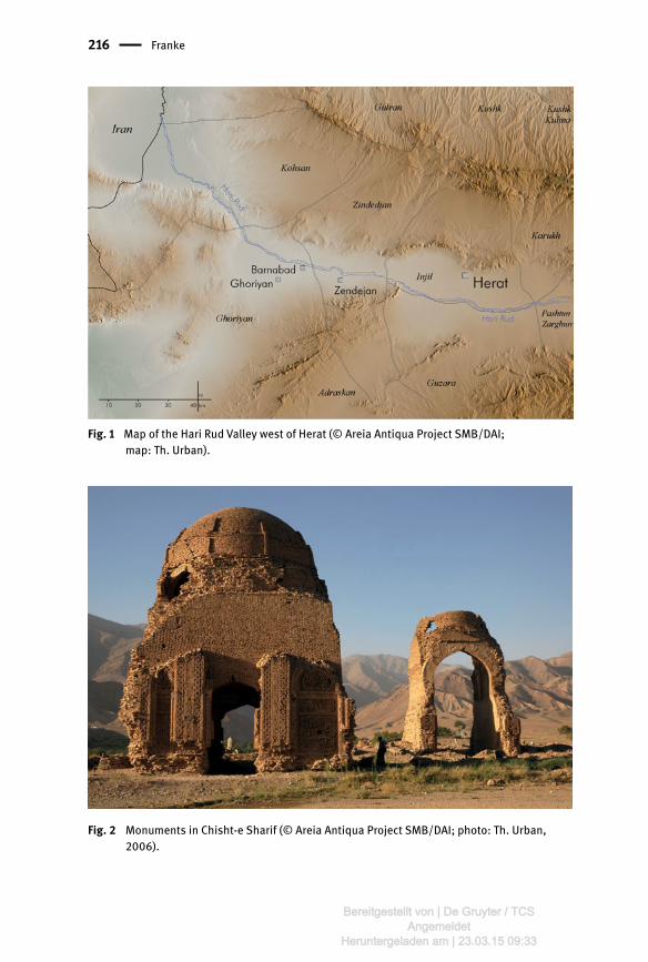
Fig. 1 Map of the Hari Rud Valley west of Herat (© Areia Antiqua Project SMB/DAI; map: Th. Urban).
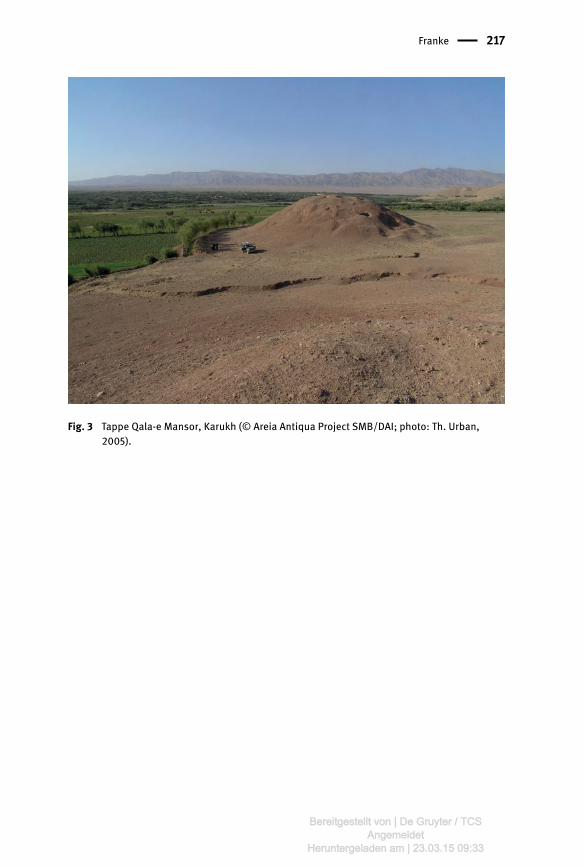
Fig. 2 Monuments in Chisht-e Sharif (© Areia Antiqua Project SMB/DAI; photo: Th. Urban, 2006).
Bereitgestellt von | De Gruyter / TCSAngemeldet
Heruntergeladen am | 23.03.15 09:33
Franke 217
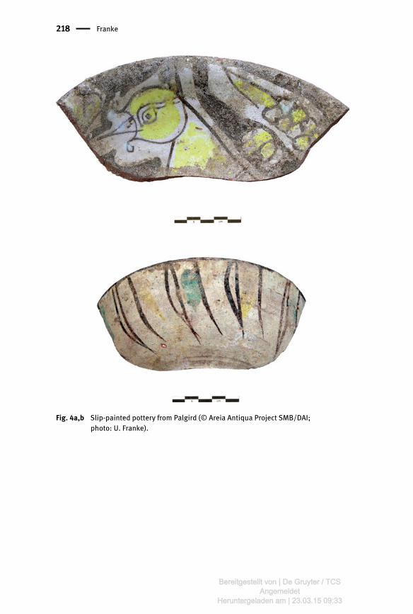
Fig. 3 Tappe Qala-e Mansor, Karukh (© Areia Antiqua Project SMB/DAI; photo: Th. Urban, 2005).
Bereitgestellt von | De Gruyter / TCSAngemeldet
Heruntergeladen am | 23.03.15 09:33
218 Franke
Abb. 46: Schale des Penthesilea-Malers. 450–440 v. Chr. Antikenslg., München
Fig. 4a,b Slip-painted pottery from Palgird (© Areia Antiqua Project SMB/DAI; photo: U. Franke).
Bereitgestellt von | De Gruyter / TCSAngemeldet
Heruntergeladen am | 23.03.15 09:33
Franke 219
Fig. 5 Herat Old City, monuments recorded in the10th century (after Allen 1981, 1983; Szuppe 2004. © Areia Antiqua Project SMB/DAI; map: U. Franke, Th. Urban).
Bereitgestellt von | De Gruyter / TCSAngemeldet
Heruntergeladen am | 23.03.15 09:33
220 Franke
Fig. 6 Kohandaz Trench 1, perimeter wall and sounding (© Areia Antiqua Project SMB/DAI; photo: U. Franke, 2005).
Fig. 7 Polylobed beaker with ring handle, copper alloy; illegible inscription below rim, 10th century. Kohandaz (Trench 2. © Areia Antiqua Project SMB/DAI; photo: A. Lange).
Bereitgestellt von | De Gruyter / TCSAngemeldet
Heruntergeladen am | 23.03.15 09:33
Franke 221
Fig. 8 Slip-painted pottery from Kohandaz (Trench 2. © Areia Antiqua Project SMB/DAI; photo: B. Mutin).
Fig. 9 Qala-e Ikhtyaruddin, view from northeast (© Areia Antiqua Project SMB/DAI; photo: U. Franke).
Bereitgestellt von | De Gruyter / TCSAngemeldet
Heruntergeladen am | 23.03.15 09:33
222 Franke
Fig. 10 Qala-e Ikhtyaruddin, Trench 1, upper part of platform with ash layer (© Areia Antiqua Project SMB/DAI; photo: U. Franke).
Fig. 11 Compartment seal, copper alloy, 1st half 1st mill. BC. Qala-e Ikhtyaruddin, Trench 1, unit 95 (no. 08_03. © Areia Antiqua Project SMB/DAI; photo: A. Lange).
Bereitgestellt von | De Gruyter / TCSAngemeldet
Heruntergeladen am | 23.03.15 09:33
Franke 223
Fig. 12 Green-glazed molded vessel, 11th/12th century. Qala-e Ikhtyaruddin, Trench 1, unit 47 (© Areia Antiqua Project SMB/DAI; photo: A. Lange).
Bereitgestellt von | De Gruyter / TCSAngemeldet
Heruntergeladen am | 23.03.15 09:33
224 Franke
Fig. 13a,b Qala-e Ikhtyaruddin, Trench 3, a: Timurid gateway b: reconstructed tile decoration of eastern tower (© Areia Antiqua Project SMB/DAI; photo, drawing: Th. Urban).
Bereitgestellt von | De Gruyter / TCSAngemeldet
Heruntergeladen am | 23.03.15 09:33
Franke 225
Fig. 14 Herat National Museum, exhibition hall first floor (© Areia Antiqua Project SMB/DAI; photo: U. Franke).
Fig. 15 Slip-painted pottery, 10th-12th century (HNM 01.41.86. © Areia Antiqua Project SMB/DAI; photo: A. Lange).
Bereitgestellt von | De Gruyter / TCSAngemeldet
Heruntergeladen am | 23.03.15 09:33
226 Franke
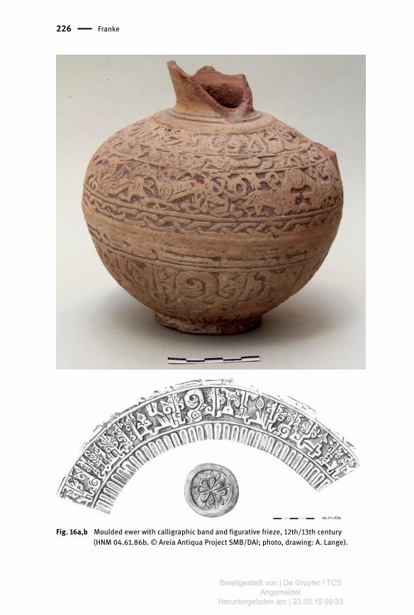
Fig. 16a,b Moulded ewer with calligraphic band and figurative frieze, 12th/13th century (HNM 04.61.86b. © Areia Antiqua Project SMB/DAI; photo, drawing: A. Lange).
Bereitgestellt von | De Gruyter / TCSAngemeldet
Heruntergeladen am | 23.03.15 09:33

Franke 227
Fig. 17 Body of ewer, copper alloy, with copper inlay and signature of Ḥasan bā Sahl, 12th century (HNM 02.26.86, reading by M. Müller-Wiener. © Areia Antiqua Project SMB/DAI; photo: A. Lange).
Bereitgestellt von | De Gruyter / TCSAngemeldet
Heruntergeladen am | 23.03.15 09:33

228 Franke
Fig. 18 Friday Mosque Herat, Ghurid portal (A.K. Mohammady).
Bereitgestellt von | De Gruyter / TCSAngemeldet
Heruntergeladen am | 23.03.15 09:33
Franke 229
Fig. 19 Historical map by Bellin, 1764 (U. Franke).
Fig. 20 Cenotaph, dated 1378 (HNM 03.48.86, reading by C.P. Haase. © Areia Antiqua Project SMB/DAI; photo: U. Franke, 2004).
Bereitgestellt von | De Gruyter / TCSAngemeldet
Heruntergeladen am | 23.03.15 09:33
230 Franke
Fig. 21 Western Hari Rud oasis, aerial view (© Areia Antiqua Project SMB/DAI; Map: Th. Urban).
Fig. 22 Palgird, view from southeast towards elevated area (© Areia Antiqua Project SMB/DAI; photo: U. Franke).
Bereitgestellt von | De Gruyter / TCSAngemeldet
Heruntergeladen am | 23.03.15 09:33
Franke 231
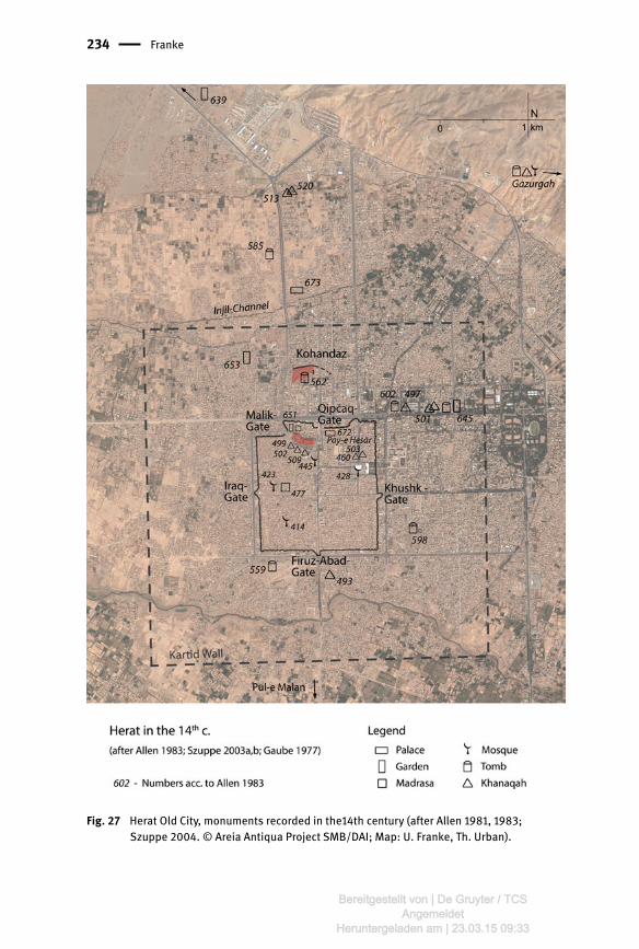
Fig. 23a,b Slip-pained bowl, Palgird, 11th century (© Areia Antiqua Project SMB/DAI; photo & drawing: A. Lange).
Bereitgestellt von | De Gruyter / TCSAngemeldet
Heruntergeladen am | 23.03.15 09:33

232 Franke
Fig. 24 Slip-pained bowl, 11th/12th century (HNM 012.09.11. © Areia Antiqua Project SMB/DAI; photo: A. Lange).
Fig. 25 Potsherd, composite body, blue and black decoration under transparent glaze, inscribed with the name “Sultan malik ghiyath…”, 14th century (HNM 88.095, old conservation. © Areia Antiqua Project SMB/DAI; photo: A. Lange).
Bereitgestellt von | De Gruyter / TCSAngemeldet
Heruntergeladen am | 23.03.15 09:33

Franke 233
Fig. 26 Various glazed fritwares 12th - 14th century in the Herat National Museum (© Areia Antiqua Project SMB/DAI; photo: A. Lange).
Bereitgestellt von | De Gruyter / TCSAngemeldet
Heruntergeladen am | 23.03.15 09:33
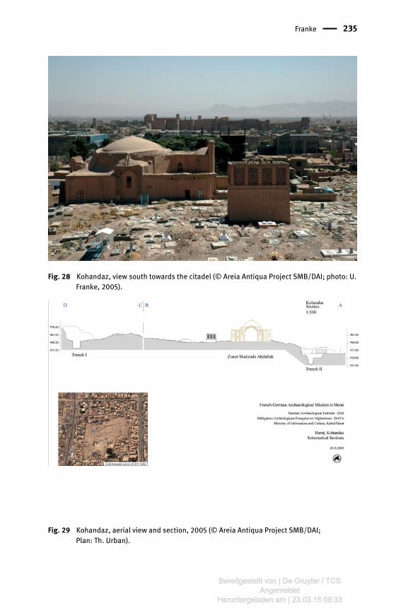
234 Franke
Fig. 27 Herat Old City, monuments recorded in the14th century (after Allen 1981, 1983; Szuppe 2004. © Areia Antiqua Project SMB/DAI; Map: U. Franke, Th. Urban).
Bereitgestellt von | De Gruyter / TCSAngemeldet
Heruntergeladen am | 23.03.15 09:33
Franke 235
Fig. 28 Kohandaz, view south towards the citadel (© Areia Antiqua Project SMB/DAI; photo: U. Franke, 2005).
Fig. 29 Kohandaz, aerial view and section, 2005 (© Areia Antiqua Project SMB/DAI; Plan: Th. Urban).
Bereitgestellt von | De Gruyter / TCSAngemeldet
Heruntergeladen am | 23.03.15 09:33
236 Franke
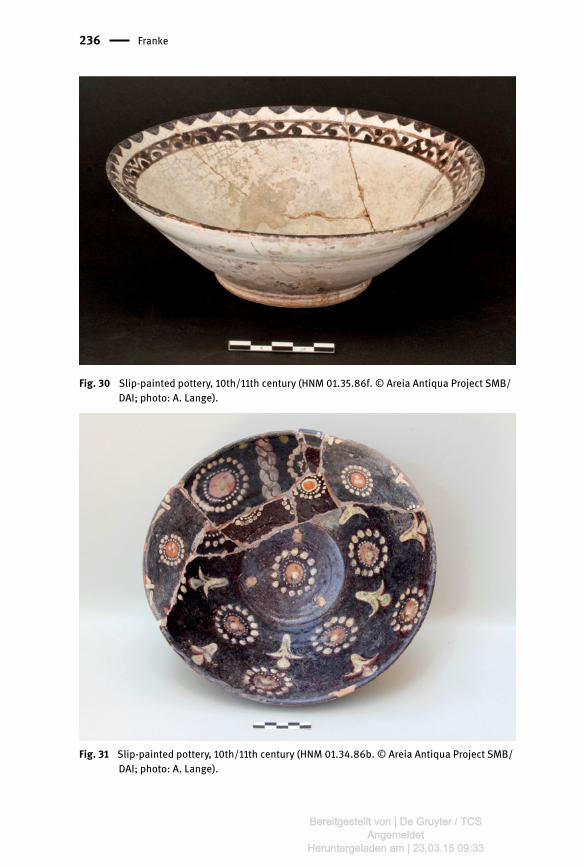
Fig. 30 Slip-painted pottery, 10th/11th century (HNM 01.35.86f. © Areia Antiqua Project SMB/DAI; photo: A. Lange).
Fig. 31 Slip-painted pottery, 10th/11th century (HNM 01.34.86b. © Areia Antiqua Project SMB/DAI; photo: A. Lange).
Bereitgestellt von | De Gruyter / TCSAngemeldet
Heruntergeladen am | 23.03.15 09:33

Franke 237
Fig. 32 Slip-painted pottery, 10th/11th century, joint rom sherds of two vessels (HNM 02.33.86a. © Areia Antiqua Project SMB/DAI; photo: A. Lange).
Fig. 33 Qala-e Ikhtyaruddin, aerial view (© Areia Antiqua Project SMB/DAI; AKTC, 2008).
Bereitgestellt von | De Gruyter / TCSAngemeldet
Heruntergeladen am | 23.03.15 09:33
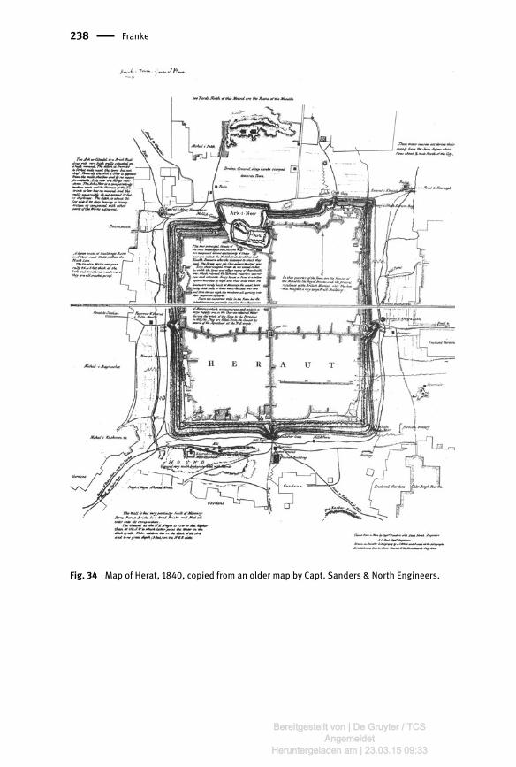
238 Franke
Fig. 34 Map of Herat, 1840, copied from an older map by Capt. Sanders & North Engineers.
Bereitgestellt von | De Gruyter / TCSAngemeldet
Heruntergeladen am | 23.03.15 09:33

Franke 239
Fig. 35 Qala-e Ikhtyaruddin, Trench 1, court of Amir Abdur Rahman´s palace (© Areia Antiqua Project SMB/DAI; photo: U. Franke, 2005).
Fig. 36 Qala-e Ikhtyaruddin, Trench 3, reconstructed Timurid gateway and tower XVII, view to southeast (© Areia Antiqua Project SMB/DAI; photo: Th. Urban).
Bereitgestellt von | De Gruyter / TCSAngemeldet
Heruntergeladen am | 23.03.15 09:33
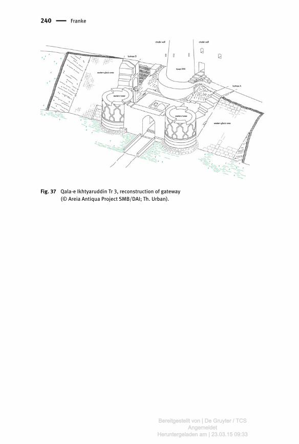
240 Franke
Fig. 37 Qala-e Ikhtyaruddin Tr 3, reconstruction of gateway (© Areia Antiqua Project SMB/DAI; Th. Urban).
Bereitgestellt von | De Gruyter / TCSAngemeldet
Heruntergeladen am | 23.03.15 09:33
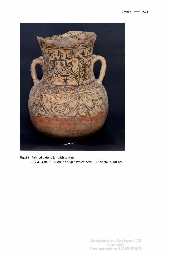
Franke 241
Fig. 38 Painted pottery jar, 13th century (HNM 04.08.86. © Areia Antiqua Project SMB/DAI; photo: A. Lange).
Bereitgestellt von | De Gruyter / TCSAngemeldet
Heruntergeladen am | 23.03.15 09:33