The calabrian fiumara streams Sorriso Terranova
18
l Z. Geomorph. N.F.j Suppl.-Vol.143 109-125 Berlin · Stuttgart June 2006 The Calabrianfiumara streams Marino Sorriso-Valvo and Oreste Terranova with 7 figures and l table Summary. Calabria is the southernmost part of the Italian peninsula. Its climate is Mediterranean with arid conditions along spots of the Ionian coast and montane modifications. Its morphology is dominateci by tectonics, with mountains and valleys corresponding to uplifted blocks and intervening grabens, respec- tively. Most of the streams in Calabria are fiumara torrents with very steep slopes and riverbeds; the latter are usually flat, braided and wide, covered with coarse-grained alluvium. Alternating predominance of debris production by mass-movement and erosion on slopes, and of the transport capacity of fiumara tor- rents, gives rise to their typical strong aggradation/degradation cycles which may last from years to cen- turies. Factors of fiumara generation are essentially four: geodynamics, lithology of the drainage basins, cli- mate and human pressure. Geodynamics, in particular tectonic uplift, is the generator of relief energy keeping the morphogenetic processes at a high magnitude and in a relatively stationary condition since the end of the Early Quaternary. Occasionally, earthquakes act as landslide trigger events. Widespread diffusion of lithic rocks is the origin of coarse-grained alluvium. Aggressive climate with intense storms and high variability is the cause of widespread mass-movement reactivation. Human pressure acting either directly on riverbed stocks, or indirectly on climate changes, may strongly influence the degradation/ aggradation regime of fiumara torrents that, in turn, is reflected in the beach aggradation/degradation regime. Hypsometric curves of fiumara basins are predominantly concave, even though departures from this form are numerous; the average value of the hypsometric integrai, however, indicates equilibrium condi- tions. This may explain why riverbeds of fiumara, though presenting aggradation/degradation cycles, are essentially stationary forms since at least the Holocene. The drainage network is characterised by a high number of anomalous branches. The hydraulic regime of fiumara is typically torrential as regards surface runoff, but a relatively regular ground-water flux in the alluvial bed is a common feature. In comparison to other Mediterranean ephemeral streams, Calabrian fiumara streams are charac- terised by an extremely high rate of mass-movement on the slopes, by a high solid/liquid discharge average rate, by the scarcity of evidences of discontinuous gullying to accommodate for stages of reduction in solid/liquid discharge rate, and by the neat prevalence of fiumara torrents on the Ionian side of Calabria, due to the geologica! and climatic peculiarities of this side of the peninsula .. Résumé. Les Fiumare Calabraises. La Calabre est la partie la plus méridionale de la péninsule italienne. Son climat est méditerranéen, avec cles caractères d'aridité dans certaines zones de la còte ionienne et cles modifications dans !es régions montagneuses. Sa morphologie est dominée par la tectonique, avec des montagnes et cles vallées correspondant respectivement à cles blocs soulevés età cles fossés tectoniques. La plupart cles cours d'eau de la Calabre sont cles fiumare avec cles pentes et cles lits très escarpés; !es lits sont généralement plats, amples et tressés (braided), constitués par cles sédiments grossiers. La prédominance alternée de la production de détritus, due à cles processus d'érosion et à cles éboule- ments, et de la capacité de transport cles fiumare, souligne leur remarquable autant que typique caractère cyclique dans l'aggradation/dégradation pouvant durer depuis des années jusqu'à cles siècles. Les facteurs de génération de la fiumara sont au nombre de quatre: la géodynamique, la lithologie cles bassins, le climat, la pression anthropique. La géodynamique, et notamment le soulèvement tectonique, c'est le générateur de l'énergie de relief qui maintient !es processus morphogénétique à une magnitude 0044-2798/06/0143-0109 s 4.25 © 2006 Gebriider Borntraeger, D-14129-Berlin · D-70176 Stuttgart
-
Upload
independent -
Category
Documents
-
view
1 -
download
0
Transcript of The calabrian fiumara streams Sorriso Terranova
l Z. Geomorph. N.F.j Suppl.-Vol.143 109-125 Berlin · Stuttgart June 2006
The Calabrianfiumara streams
Marino Sorriso-Valvo and Oreste Terranova
with 7 figures and l table
~ Summary. Calabria is the southernmost part of the Italian peninsula. Its climate is Mediterranean with arid conditions along spots of the Ionian coast and montane modifications. Its morphology is dominateci by tectonics, with mountains and valleys corresponding to uplifted blocks and intervening grabens, respectively. Most of the streams in Calabria are fiumara torrents with very steep slopes and riverbeds; the latter are usually flat, braided and wide, covered with coarse-grained alluvium. Alternating predominance of debris production by mass-movement and erosion on slopes, and of the transport capacity of fiumara torrents, gives rise to their typical strong aggradation/degradation cycles which may last from years to centuries.
Factors of fiumara generation are essentially four: geodynamics, lithology of the drainage basins, climate and human pressure. Geodynamics, in particular tectonic uplift, is the generator of relief energy keeping the morphogenetic processes at a high magnitude and in a relatively stationary condition since the end of the Early Quaternary. Occasionally, earthquakes act as landslide trigger events. Widespread diffusion of lithic rocks is the origin of coarse-grained alluvium. Aggressive clima te with intense storms and high variability is the cause of widespread mass-movement reactivation. Human pressure acting either directly on riverbed stocks, or indirectly on climate changes, may strongly influence the degradation/ aggradation regime of fiumara torrents that, in turn, is reflected in the beach aggradation/degradation regime.
Hypsometric curves of fiumara basins are predominantly concave, even though departures from this form are numerous; the average value of the hypsometric integrai, however, indicates equilibrium conditions. This may explain why riverbeds of fiumara, though presenting aggradation/degradation cycles, are essentially stationary forms since a t least the Holocene. The drainage network is characterised by a high number of anomalous branches. The hydraulic regime of fiumara is typically torrential as regards surface runoff, but a relatively regular ground-water flux in the alluvial bed is a common feature.
In comparison to other Mediterranean ephemeral streams, Calabrian fiumara streams are characterised by an extremely high rate of mass-movement on the slopes, by a high solid/liquid discharge average rate, by the scarcity of evidences of discontinuous gullying to accommodate for stages of reduction in solid/liquid discharge rate, and by the neat prevalence of fiumara torrents on the Ionian side of Calabria, due to the geologica! and climatic peculiarities of this side of the peninsula ..
Résumé. Les Fiumare Calabraises. La Calabre est la partie la plus méridionale de la péninsule italienne. Son climat est méditerranéen, avec cles caractères d'aridité dans certaines zones de la còte ionienne et cles modifications dans !es régions montagneuses. Sa morphologie est dominée par la tectonique, avec des montagnes et cles vallées correspondant respectivement à cles blocs soulevés età cles fossés tectoniques.
La plupart cles cours d'eau de la Calabre sont cles fiumare avec cles pentes et cles lits très escarpés; !es lits sont généralement plats, amples et tressés (braided), constitués par cles sédiments grossiers.
La prédominance alternée de la production de détritus, due à cles processus d'érosion et à cles éboulements, et de la capacité de transport cles fiumare, souligne leur remarquable autant que typique caractère cyclique dans l'aggradation/dégradation pouvant durer depuis des années jusqu'à cles siècles.
Les facteurs de génération de la fiumara sont au nombre de quatre: la géodynamique, la lithologie cles bassins, le clima t, la pression anthropique. La géodynamique, et notamment le soulèvement tectonique, c'est le générateur de l'énergie de relief qui maintient !es processus morphogénétique à une magnitude
0044-2798/06/0143-0109 s 4.25 © 2006 Gebriider Borntraeger, D-14129-Berlin · D-70176 Stuttgart
110 Marino Sorriso-Valva and Oreste Terranova
élevée et dans une condition relativement stationnaire depuis la fin du Quaternaire inférieur. Occasionnellement, ce sont les séismes qui représentent la cause des éboulements. L'ampie diffusion de roches lithiques explique la présence de sédiments à grains grossiers dans les alluvions. Le climat agressif, avec des orages intenses et une variabilité élevée, c'est la cause de la réactivation fréquente des éboulements. La pression anthropique, agissant directement sur les dépòts de sédiments ainsi qu'indirectement sur les
changements climatiques, peut influencer de façon remarquable le régime d'aggradation/dégradation des fiumare. Cette influence se répercute sur le régime des plages correspondant.
Les courbes hypsométriques des bassins des fiumare sont généralement concaves, mème si souvent elles s'éloignent de cette forme. Les valeurs moyennes de l'intégral hypsométrique, néanmoins, indiquent des conditions d'équilibre. Cela peut expliquer pourquoi les fiumare, mème si elles présentent des cycles d'aggradation/dégradation, sont essentiellement des formes stationnaires, du moins depuis l'Holocène.
Les réseaux de drainage sont caractérisés par un nombre élevé de branches irrégulières. Le régime hydrologique est typiquement torrentiel pour ce qui concerne les écoulements de surface, mais, d'habitude, il est relativement régulier pour ce qui concerne les écoulements dans le lit alluvionnaire.
Par rapport aux autres cours d'eau éphémères de l'environnement méditerranéen, le fiumare calabraises sont caractérisées par un nombre relativement élevé d'éboulements sur les pentes, par un haut rapport moyen entre débit solide/débit liquide, par des faibles preuves de «discontinuous gullying» afin d'adapter les phases de réduction dans le rapport débit solide/débit liquide et parla nette prédominance des fiumare sur le versant ionien calabrais, gràce aux caractéristiques géologiques et climatiques de la région.
Zusammenfassung. Die kalabresische Fiumara. Kalabrien ist der siidlichste Teil der italienischen
Halbinsel. Es hat ein typisch mediterranes Klima: Iangs der ionischen Kiiste ist es eher trocken und auf den Gebirgen ist es wechselhaft. Die Morphologie Kalabriens ist von tektonischen Prozessen beherrscht; die Berge und die Taler entsprechen entweder Horsten oder dazwischen liegenden Graben. Die meisten
Wasserlaufe in Kalabrien sindFiumara, d.h. reiiìende Strome, mit sehr steilen Hangen und Flussbetten. Letztere sind normalerweise eben, breit, mit verflochtenen Rinnen und mit grobkornigem Alluvium bedeckt. Vier Faktoren erzeugen die Fiumara: Geodynamik, Lithologie des Wassereinzugsgebiets, Klima und menschliche Eingriffe. Geodynamik, und besonders tektonische Erhebungen, erzeugen Reliefenergie und bewirken, dass der morphogenetische Vorgang seit dem Pleistozan immerzu mit hoher Intensitat und unter relativ stationaren Bedingungen ablauft. Gelegentlich sind Erdbeben die Ursache von Erdrutschen. Das verbreitete Auftreten von lithischen Gesteinen ist verantwortlich fiir das Auftreten von grobkornigem Alluvium. Aggressives, sehr veranderliches Klima mit starken Gewittern ist der Grund der weit verbreiteten Massenbewegungen. Menschliche Eingriffe, die entweder direkt auf Flussablagerungen oder indirekt auf Veranderungen des Klimas einwirken, konnen das Ablagerungs/ Abtragungs
Regime der Fiumara stark beeinflussen, das sich widerum auf das Strand-Ablagerungs/Abtragungs-Regime auswirkt.
Die hypsometrischen Kurven der Fiumaraeinzugsgebiete sind iiberwiegend konkav, obwohl die Abweichungen von dieser Form zahlreich sind; jedoch zeigt der Durchschnittswert des hypsometrischen Integrals einen Gleichgewichtzustand an. Das kann erklaren, warum die Fiumarabetten trotz Ablagerungs/Abtragungs-Zyklen seit dem Holozan stationare Formen sind. Das Flussnetz hat meist zahlreiche anomale Arme. Das Abflussregime der Fiumara ist typischerweise reissend; ein relativ regelmassiger
Grundwasserflux in den alluvialen Flussbetten ist weit verbreitet.
Im Vergleich zu anderen ephemeren Stromen des Mittelmeeres haben die kalabresischen Fiumara sehr starke Massenbewegungen an den Hangen mit hohem mittleren Sedimenttransport, geringe Hinweise auf ,discontinuous gullying", um die Reduktion des Sedimenttransports wettzumachen, und ein groiìeres Vorkommen im ionischen Teil von Kalabrien, wegen der geologischen und klimatischen Einzig
artigkeit dieser Seite der Halbinsel.
The Calabrian fiumara streams 111
1 lntroduction
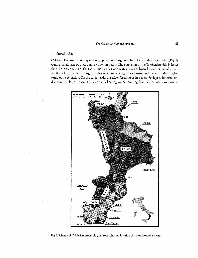
Calabria, because of its rugged orography, has a large number of small drainage basins (Fig. 1). Only a small part of their courses flow on plains. The extension of the Tyrrhenian side is lesser
than the lonian o ne. On the former side, only two streams have the hydrological regime of a river: the River Lao, due to the large number of karstic springs in its basins; and the River Mesima, because of its extension. On the lonian side, the River Crati flows in a tectonic depression (graben)
draining the largest basin in Calabria, collecting waters coming from surrounding mountains
•OK~--==~ .. ~~km 40 50
Tyrrhenian Sea
Ionian Sea
Fig. 1. Scheme of Calabrian orography, hydrography and location of major fiumara streams.

112 Marino Sorriso-Valvo an d Oreste Terranova
and forming the Plain of Sibari. Other relatively large rivers drain the eastern side of Sila moun
tains. In the northernmost and in the southern portions of the lonian side of Calabria, a great
number of streams with typical braided riverbeds drain the steep slopes of the mountains and
reach the sea after passing a narrow hilly bel t. These streams are the Calabrian fiumare (sing.
fiumara). This name comes from Sicilian and Calabrian noun jumara. Fiumara is reported in
FAIRBRIDGE (1968) as a regional term for ephemeral stream. lt will be named either fiumara or
fiumara torrent in the following text.
The aim of this paper is to highlight the morphological and hydrological pre-eminent charac
ters of fiumara streams, based on published papers and on unpublished matter.
2 Calabria and its climate
The Calabrian climate is typically Mediterranean, Csa in KOEPPEN (1948) classification, with local
variations towards arid conditions and montane modifications (wetter summers and lower aver
age temperature, with more than one month of snow cover). In the dry season (April to September)
rainfall is 20-30% of the yearly total precipitation, about 1150 mm. The mean annual temperature
ranges from 5 °C on the Pollino range (Fig. 1), with 10 °C on the mountain slopes, to 18 °C along
the coast. The average temperature inJuly is more than 22 °C and rainfall may be O. The maxi
mum daily temperature may exceed 40 °C on some days inJuly and August. The strong seasonal
contrast is enhanced by a rapid change of clima te conditions when passing from one season to the
other. The average temperature inJanuary is c.10 °C along the coasts and 4 °C in the mountains,
above 1500 and 1700 m on the Sila and Aspromonte massifs, respectively, where average temperature
may frequently be under O 0 C. In the summertime the temperature is more evenly distributed
with values around 24 °C. In generai, all over Calabria the temperature is linearly and negatively
correlateci with elevation, with a gradient (-0.65 °C/hm) dose to the wet adiabatic gradient. In
particular, the average gradient is -0.748 °C/hm on the lonian side, and of -0.610 °C/hm on the
Tyrrhenian side (CATANI et al. 1995).
Orography strongly influences the precipitation regime (BELLECCI et al. 2002), due to fronts
transversally approaching the Calabria peninsula, and convective cells climbing up the steep sea
side slopes of the mountain chains. The Fohn blows to the lee-side of the mountain chains causing
drier and warmer climate in the largest valleys. In generai, low-pressure conditions cause, in all
seasons, intensive and long-lasting storms brought by warm fronts approaching from the south
east, bringing red silt-rich rains and very uncomfortable warm and wet Sirocco conditions. Cold
fronts from Icelandic zone may reach Calabria from the north-west especially in winter, with
high intensity rainfall; in the short springtime, rainfalls are lower but the weather is highly un
stable; in summer strong convective storms are frequent, sometimes small tornados may form on
the sea that may reach inland; in the autumn, Siberian cold fronts may approach from the north
east, with intensive precipitations; these may occur also during the winter, in which case a thick
snow cover may form also at low elevations.
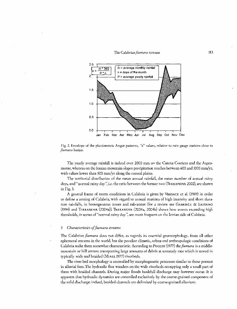
Fig. 2 shows the pattern of the pluviometric Angot coefficient (PINNA 1977) typical for terri
tories where fiumara torrents are most developed in Calabria.
2.
1.0
0.5
0.0
The Calabrianfiumara streams
m = average monthly rainfall
n = days of the month
P = average yearly rainfall
Jan Feb Mar Aor May Jun Jul Aug Sep Oct Nov Dee
113
Fig. 2. Envelope of the pluviometric Angot patterns, "a" values, relative to rain gauge stations dose to
fiumara basins.
The yearly average rainfall is indeed over 2000 mm on the Catena Costiera and the Aspromonte, whereas on the lonian mountain slopes precipitation reaches between 600 and 1000 mm/yr, with values lower than 500 mm/yr along the coastal plains.
The territorial distribution of the mean annual rainfall, the mean number of annual rainy days, and "normal rainy day", i.e. the ratio between the former two (TERRANOVA 2002), are shown in Fig. 3.
A generai frame of storm conditions in Calabria is given by VERSACE et al. (1989) in order to define a zoning of Calabria, with regard to annual maxima of high intensity and short duration rainfalls, in homogeneous zones and sub-zones (for a review see GABRIELE & IrRITANO (1994) and TERRANOVA (2004a)). TERRANOVA (2004a, 2004b) shows how events exceeding high thresholds, ih terms of "normal rainy day", are more frequent o n the lonian side of Calabria.
3 Characteristics of fiumara streams
The Calabrian fiumara does not differ, as regards its essential geomorphology, from all other ephemeral streams in the world, but the peculiar climatic, urban and anthropologic conditions of
Calabria make them somewhat characteristic. According to PUGLISI (1977) the fiumara is a middlemountain or hill torrent transporting large amounts of debris at unsteady rate which is stored in typically wide and braided (MIALL 1977) riverbeds.
The river bed morphology is controlled by morphogenetic processes similar to those present in alluvial fans. The hydraulic flux wanders on the wide riverbeds occupying only a small part of them with braided channels. During major floods bankfull discharge may however occur. lt is apparent that hydraulic dynamics are controlled exclusively by the coarse-grained component of the solid discharge: indeed, braided channels are delimited by coarse-grained alluvium.

114 Marino Sorriso-Valva an d Oreste Terranova
m m 466-800
lllllll!ll800-1100 -1100-1400 -1400-2126
days 63-80
g80-90 111190-100 -100-110 -110-120 -120-130 -130-179
mm/day
5.22-7 iliW?7 -8 Ila 8-9 l!llllll9-10 lllllllll0-11
- 11-12 -12-13 -13-17.3
Fig. 3. Mean annual rainfall, average rainy days and normal rainy day iso-curves maps.
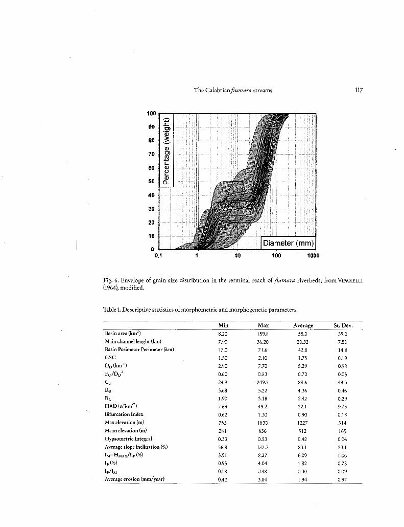
To summarize the most distinctive features of a fiumara, data from 50 basins are selected. The main geomorphic parameters and relevant geometry of Calabrian fiumara watersheds have been measured and derived by means of GIS procedures (IAQUINTA & TERRANOVA 2005), based on a 40m square grid DEM and on divides and blue lines (from 1 : 25,000 scale maps). All data are stored in a relational data-base linked with the GIS. Geomorphologic parameters are the following: basin area; basin perimeter; length of main channel; Gravelius shape coefficient GSC; drainage density DD; channel frequency Fc; coefficient of torrentiality Cr; Hierarchical Anomaly Density HAD (Number of anomalous streams per km2
); bifurcation index; Strahler-Horton RB and RL ratios. Table 1 shows minimum, maximum and average values of all the parameters above; largest and smallest 3 values have been excluded from computation in order to avoid the influence of peculiar cases.
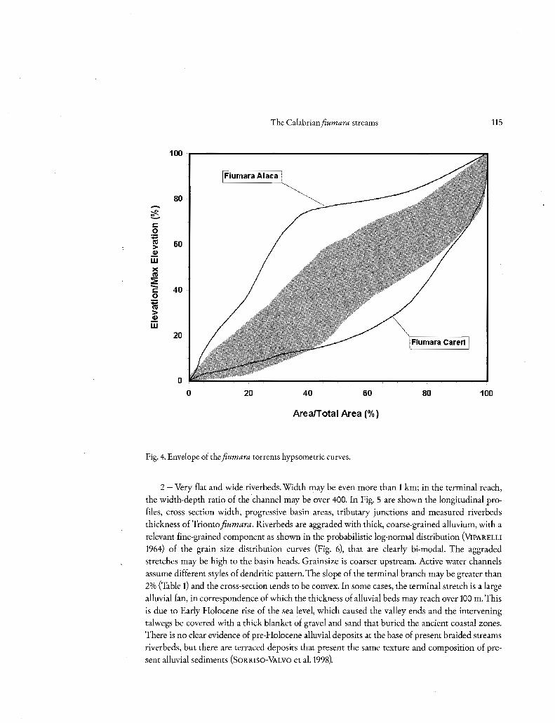
Based on these parameters, distinctive characteristics of Calabrian fiumara streams are: 1 - Drainage basins rather small, irregular in plant and the values of the Gravelius shape coef
ficients greater than 1.5 indicate basins falling into the most elongated class. The slope gradients are very high (even more that 50%); hypsographic curves are characterized by a pronounced concavity, sometimes with some convexities (Fig. 4) and the average value for the hypsometric integrai indicates an equilibrium condition; the drainage density is fairly high, indicating low soil permeability. Average Fc/DD2 = 0.70, i.e. greater than 0.694, should correspond to a "mature" state of the basin evolution (MELTON 1958). RB > 3.7 indicates a prevalence of parallel and trellis patterns. Highest flood peaks correspond to round-shaped basins, with high RB· Lastly, anomalous branches (AvENA et al. 1976) are very frequent, and the conservativeness of the drainage net is indicated by the bifurcation ratio when it approaches O, while its range is in generai between 0.2 and 2.
The Calabrian fiumara streams 115
100
Fiumara A Iaea
80 -c 1: o
:;:::: co 60 > Cl,)
w x co 2 - 40 1: o :;:::: co > Cl,)
w 20
o o 20 40 60 80 100
Area/Total Area(%)
Fig. 4. Envelope of the fiumara torrents hypsometric curves.
2 - Very flat and wide riverbeds. Width may be even more than l km; in the terminai reach,
the width-depth ratio of the channel may be over 400. In Fig. 5 are shown the longitudinal pro
files, cross section width, progressive basin areas, tributary junctions and measured riverbeds
thickness of Trionto fiumara. Riverbeds are aggraded with thick, coarse-grained alluvium, with a
relevant fine-grained component as shown in the probabilistic log-normal distribution (VIPARELLI
1964) of the grain size distribution curves (Fig. 6), that are clearly bi-modal. The aggraded stretches may be high to the basin heads. Grainsize is coarser upstream. Active water channels
assume different styles of dendritic pattern. The slope of the terminai branch may be greater than
2% (Table l) and the cross-section tends to be convex. In some cases, the terminai stretch is a large
alluvial fan, in correspondence of which the thickness of alluvial beds may reach over 100 m. This
is due to Early Holocene rise of the sea level, which caused the valley ends and the intervening talwegs be covered with a thick blanket of grave! and sand that buried the ancient coastal zones. There is no clear evidence of pre-Holocene alluvial deposits at the base of present braided streams
riverbeds, but there are terraced deposits that present the same texture and composition of pre
sent alluvial sediments (SORRISO-VALVO et al. 1998).

TRIONTO Cross section width (m)
(m~.s.L) 0~ c 1r ~
400 5! S! .... o . ';:::
300 l '-.....,/~~ i5 "' -=· .5! l t:
'-' 200 l ~ In li5!!! ...: - L (,:;!,..... -
100 l l ~ ,:!!!NIIill6~
o l - -
20 15 10 s(km)
Fig. 5. Longitudinal profile and cross sections of the Fiumara Trionto.
A(s) A= 288.8
IF = 0.0107 l r bank 'T and left banks .. l Il; l
t:: i7i ~ "' "'l~ l Cii l
,~. 6 r,w 4
o 5 l!!
A
(km2)
300
200
100
50
l
...
i
...... ...... O'
~ ., ::l. ~ o [/) o ..., ::l. "' o :< ., < o ., ~ o.. o ..., "' "' ,.., "' ~ ..., ..., ., ~ o < .,
The Calabrian fiumara streams 117
1oo--~~~~---:~~~--~
90
80
70
60
50
40
30 ~····
20
10 ~····i-····
O f zewlt'ftff 0.1 10 100 1000
Fig. 6. Envelope of grain size distribution in the terminai reach of fiumara riverbeds, from VIPARELLI
(1964), modified.
Table 1. Descriptive statistics of morphometric and morphogenetic parameters.
Mi n Ma x Average St.Dev.
Basin area (km2) 8.20 159.8 55.0 39.0
Main channellenght (km) 7.90 36.20 20.32 7.50
Basin Perimeter Perimeter (km) 17.0 71.6 42.8 14.8
GSC 1.50 2.10 1.75 0.19 Dn(km.1
) 2.90 7.70 5.29 0.98
Fc/Dn2
0.60 0.83 0.70 0.05
eT 24.9 249.5 88.6 49.3
RB 3.68 5.22 4.36 0.46
RL 1.90 3.18 2.42 0.29
HAD (n°km'2 ) 7.69 49.2 22.1 9.73
Bifurcation Index 0.62 1.30 0.90 0.18
Max elevati o n (m) 753 1830 1227 314
Mean elevation (m) 281 836 512 165
Hypsometric Integrai 0.33 0.53 0.42 0.06
Average slope inclination (%) 56.8 182.7 83.1 23.1
IM=HMAXf'Lp (%) 3.91 8.27 6.09 1.06
lp(%) 0.95 4.04 1.82 0.78
lp/lM 0.18 0.48 0.30 0.09
Average erosion (mm/year) 0.42 3.84 1.94 0.97
118 Marino Sorriso-Valvo an d Oreste Terranova
3 - Braided channel networks and (less-frequent) step-wise longitudinal profiles. Both features are present in the fiumara riverbeds, even though steps on profiles are rare everywhere and, however, not higher than a few decimeters. Braided channel require coarse-grained riverbeds
and strong variation in solid/liquid discharge ratio that may reach two orders of magnitude: from 0.004 for summer suspended load (ERGENZINGER 1987), to 0.5 for almost-hyper concentrateci flood flows in a mountain reach. As a higher solid/liquid discharge ratio requires higher channel
gradients, braided networks in the riverbeds accommodate high-frequency changes in the solid/ liquid discharge ratio due to normally alternating flood and magra regimes. Steps on the longitudinal profile are due to discontinuous gullying (LEOPOLD et al. 1964) as for the "ramblas" in Catalonia, and probably reflect a long-term reduction in the solid/liquid ratio (L LEOPOLD, pers. comm.). Steps are not present in stili aggrading riverbeds, such that of Fiumara Amendolea.
4 - Torrential hydrological regime. 100-year annual flood may be more than one order of magnitude greather than the yearly average; the seasonal variation may also be extreme, with dry beds in the summertime and very high discharge during major floods (in the Amendolea Fiumara, basin area 150.4 km2
, bankfull discharge reached 930 m3s-1 in January 1973). Lesser floods may not reach the sea. The liquid discharge of a fiumara in normal regime is rather low in the upper branches, diminishes downstream where ground-water flux forms in the alluvial beds, and in gen
erai increases in the terminai branch because of the presence of the salt-water wedge that keeps the fresh water flowing on the soft-salt water interface. On occasion of strong storms, hydrograms display a very rapid discharge increment that may occur in the space of tens of minutes to a few hours. Such floods may occur with a recurrence interval of a few decades in a given fiumara, but
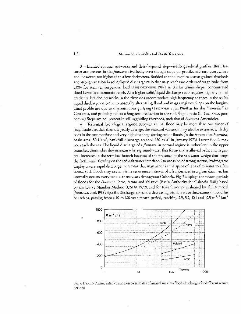
normally occurs every two or three years throughout Calabria. Fig. 7 displays the return periods of floods for the Fiumara Ferro, Armo and Valanidi (Basin Authority for Calabria 2001), based on the Curve Number Method (USDA 1972), and for River Trionto, evaluated by TCEV model (VERSA CE et al.1989). Specific discharge, somehow decreasing with the watershed extension, doubles or trebles, passing from a 10 to 100 year return period, reaching 2.9, 5.2, 10.1 and 10.5 m3 s -l km-2
1000~----~----~.---------~~--------~---,
Q (rri3s'1)
800
600
400
200
0 T~~ 10 100 1000
Fig. 7. Trionto, Armo, Valanidi and Ferro estimates of annua! maxima floods discharges for different return periods.
The Calabrianfiumara streams 119
respectively in the Trionto, Ferro, Armo and Valanidi torrents. Bankfull discharge may occur also where the riverbed is severa! hundreds metres wide. In these conditions, flow depth is 2 m at most,
but is capable of rolling rock masses of 4 m in diameter.
5 - Delta-type debauchments. Deltas are typical in Mediterranean area, where tides are small.
In fiumara streams, a seasonal variability of delta morphology is common. Deltas progradate in
winter and decline in summertime, when a quequeverse deposit beach ridge forms that deviates
the terminai trait of the main stream that flows parallel to the coast before joining the sea. When
large floods occur this bar is broken and a crescentic bar may form in front of the debauch; such bar, however lasts few days, especially if the sea is stormy (SORRISO-VALVO et al. 2004).
4 Fiumara generation jàctors in Calabria
There are essentially four factors of fiumara generation: geodynamics, lithology of drainage basin slopes, climate and human activity.
4.1 Geodynamics
Present and recent geodynamics in Calabria is of the block-faulting type, due to the rapid uplift
initiated at the end of the Lower Pleistocene (WESTAWAY 1993, SORRISO-VALVO 1993). This uplift,
however, did not begin ali over Calabria at the same time. Present inner zones started first, except for the longitudinal grabens of the River Crati in Northern Calabria and of the River Mesima in
Southern Calabria. Major uplifting blocks are separated by the transversal Catanzaro Graben.
The average uplift rate is c. 1-1.2 mm/yr for inner blocks and becomes less and less, up to O in
some spots, to negative values of up to 10 mm/yr along traits of the lonian coast. As a conse
quence of that, the Quaternary average rate of uplift is strongly correlateci with the elevation
above sea level.
lmportant norma! faults separate the blocks uplifting at different rates. Most of these faults
are active and, together with other regional faults with relevant strike-slip displacement that are
due to the on-going collision of European and African plates, are responsible for the highly seis
mic nature of this stretch of territory. Uplift rate may be affected by the erosion of a large volume
of rocks along the mid-course of consequent streams (MouN et al. 2004). In Calabria, indeed, the
midcourse of most consequent streams corresponds to the steep slopes of the uplifted crustal blocks, so the higher erosion capacity is enhanced by the local high relief and slope. This higher
erosion might ease isostatic reaction in a block-faulted crust, but actually tectonic evidence of
such intermediate block upheaval is not clear. Related faulting and jointing play a determinant
role in causing the degradation of the rock quality, related to slope stability, and, consequently,
the high territorial incidence of mass-movement.
Earthquakes cause an increment of landslide activity that may continue in the following
years. Major earthquakes are reported to have caused an increase in landslide activity which in some cases have reached dramatic intensity (DE DoLOMIEU 1785, CoTECCHIA et al. 1969), and
this increase in landslide activity of course resulted in the strong aggradation phases of fiumara
riverbeds (ERGENZINGER 1987).
120 Marino Sorriso-Valvo an d Oreste Terranova
4.2 Lithology ofslopes
The geologica! structure and lithology of the slopes is determinant in the generation of fiumare
for two main reasons. First, landslide-prone rocks are necessary, as landsliding is by far the most important process providing sediments for the fiumara riverbed. Second, lithic rocks, or at least
relevant lithic component in the outcropping rocks must be present, otherwise there is no materia!
to form the coarse-grained riverbed. The whole drainage basin is not necessarily carved on litified
rocks; what is important is that source materia! is on the litified rock outcrops.
4.3 Climate
As illustrateci above, regional climate, especially along the lonian side, is characterised by a
marked variability of rainstorm intensity and duration. When such extreme events occur, a great deal of mass-movements are reactivated (ERGENZINGER et al. 1978, IovrNE & PETRUCCI 1998, SORRISO-VALVO et al. 2004); consequently, a huge amount of debris is mobilised and brought from the slopes to the drainage network at once. Due to the notable proneness to mass-movement of
the Calabrian slopes, the volume mobilised during an extreme event (more than 20 yr return per
iod) may exceed by two orders of magnitude that of a norma! event (2 to 10 years return period).
Mass-movement itself and transport by running water bring large volumes of debris to the drainage system that progressively washes it off to the sea. For a while, the duration of wich generally
depends on the flood rate, the debris budget coming from the slopes is in excess of the transport capability of the drainage network. When the peak mass movement rate is over, a large amount
of debris remains in the channel system and will keep moving on the slopes in a few of the subse
quent years, determining an aggradation in the channel network that will be gradually substituted by a degradation phase when the feeding from the slope has reached a much lower magni
tude.
Most of debris is stored in the large terminai alluvial fan, in riverbeds, and in montane fans that are mainly related with debris flows (SoRRISO-VALVO et al. 1998). Part of these fans are directly
feeded by landslides or landslide zones, displaying waxing/vaning cycles strictly related to land
slide activity (SORRISO-VALVO 1988).
The recurrence of extreme meteorologica! events gives the fiumara riverbed regime a typical
cyclical character. The aggradation of channel systems suddenly (sometimes contemporaneously) extends to the coasts downstream along the shore drift. Similarly, the degradation stage will be mirrored, with a more or less long time lag, in the beaches degradation regime.
4.4 Human activity
Human activity is assuming a growing importance in modern morphodynamics. In addition to
clearance cutting for pasture and early agricultural practices in the lowlands dating from the Bronze Age (2nd millenium B. C.), in Calabria, the effects of human pressure became relevant in
the Greek and Roman times. These early effects are difficult to distinguish from natura! ones
(e.g. climatic changes). However, land degradation results in stream bed aggradation. VrTA-FINZI
(1972) claims natura! effects, while others (e.g. BRDCKNER 1986) stress the role of human activity.
The Calabrianjìumara streams 121
In tbe yth Century B. C., tbe great pbilosopber Plato blamed tbe widespread use of forest clearance-cutting as tbe cause of land degradation. Deforestation, for construction and energy needs, and for gatbering new land to agriculture, continued extensively tbrougbout Mediterranean Europe, even if Calabria remained largely covered by a tbick forest on tbe mountain reacbes, not so mucb in tbe bills and plains. Forest cover bas a positive effect on slope stability, but at tbe present days most landslides and badlands affect tbe forested slope if tbe slope gradient and rock condi
tions are favourable to mass-movement and erosion. Slope erosion studies by means of sprinkling experiments on natural micro-catcbments bave sbown tbat forest cover may efficiently defend tbe soil against erosion, provided tbe slope angle is below criticai values that depend on the rock types (SoRRISO-VALVO et al. 1995). However, it seems widely accepted tbat human pressure on
land bas caused a widespread land degradation, especially in territory wbere the stability of tbe · vegetation and slopes was already under pressure from climatic modifications, and intrinsic slope conditions do not allow a recovery after tbe first slope failure occurs.
At present, human pressure is great also in tbe sense of slope stabilisation, by means of severa! types of remedial measures for slope stability and streambeds erosion. Botb measures reduce tbe debris contribution from slopes and, even more, riverbed mobility, so riverbed dynamics is stopped and beacb erosion increased. Wbere tbe riverbeds are little affected by intervention mea
sures, tbe present buman activity is against fiumara aggradation, favouring riverbed erosion. On tbe otber band, it is well-acknowledged, nowadays, tbat buman activity favours a sbort to medium term climatic cbange moving the climate towards a more aggressive character, and tbis is instead in favour of fiumara-type bed building.
5 Magnitude of morphogenetic processes in Calabrian fiumara streams
In paragrapb 4.2, it was discussed bow, in order to develop epbemeral streams, tbe imbalance be
tween debris production on slopes, and transport capability of tbe stream network, is determinant. Such imbalance may exist also in the presence of a moderate production of debris from tbe slope. In Calabrian fiumara streams, tbe morpbogenesis dynamics is great on both the slopes and tbe stream cbannels.
Large (more tban 106 m3 debris) landslides are common in Calabria, especially in Soutb Calabria. Wben these landslides are reactivated, tbe production of debris lasts for decades, and conse
quently tbe aggradation pbase along the downstream channel may be mucb longer and dramatic tban usual. For example, a large scale landslide was reactivated in tbe basin of tbe fiumara Amendolea in 1951. Since tben, tbe riverbeds are aggrading downstream tbe junction of the tributary valley wbere the landslide occurred (SoRRISO-VALVO 2004). A bridge crossing the fiumara c. 5 km
downstream of the junction bad more tban 10 m of clearance in 1973. Since 2002, every winter tbe riverbed debris overrides tbe bridge wbicb must be cleaned. Tbe large-scale landslide is still active. Large-scale landslides, tberefore, bave tbe same effects as extreme meteorologica! events, with the difference tbat their effects regard only tbe downstream network, and leave tbe conditions in neighbouring basins unchanged. Tbis is clearly visible in tbe River Trionto basin, wbere three fligbts of convergent terraces derive from tbe mass-movement activity in tbree large land
slide areas limited to o ne or a few sub-basins. Landsliding produced a large amount of debris that filled tbe valley bottom with 70 to 120 m thick debris-flow deposits. The oldest valley fill has been
122 Marino Sorriso-Valvo an d Oreste Terranova
active unti! 2,900 years B.P. (SORRISO-VALVO 1997), but the age it started is unknown, though it
is considered to be Holocene due to its overali grade of weathering.
To give an idea of the order of magnitude of the annua! debris budget, we can consider the re
sult of studies conducted in the rugged basins of the Fiumara Buonamico and Fiumara Laverde
(ERGENZINGER 1987) and in the relatively smooth basin of an unnamed small basin in south Ca
labria. In the Laverde basin (117.0 km2), the average erosion rate has been measured at 10 mm/yr;
while in the Buonamico basin (136.4 km2) the erosion rate has been assessed at 2.5 mm/yr for the
last 50 years. In the 23 km2-extended basin, the erosion rate has been assessed at l mm/yr in the
last three years. Ali basins are carved in high-grade, but jointed metamorphic rocks. On long
term basis, the average erosion rate for the two larger basins decreases to c. 0.14 and 0.25 mm/yr,
respectively. TERRANOVA et al. (2004) assessed the erosion rate for the whole region, by means of
the RUSLE model (RENARD et al. 1996) obtaining a value of 1.9 mm/yr.
Such different results indicate that the sediment transport may vary dramaticaliy over times,
and it depends on the occurrence of extreme events that can produce large amounts of debris. lt is generaliy acknowledged that it takes 20-25 years for the stream to recover from the extra
aggradation to the normal stream conditions, after each extreme meteorologica! event.
The debris produced by landslides traveliing downstream is in waves. This resulted from a
comparison of cm-accurate measurements of riverbed longitudinal profiles on an aggrading
stream in theTyrrhenian side of Calabria, from 1951 to 2002. Measures clearly show debris waves propagating downstream of a debris-flow area reactivated severa! times since 1951, at an average
speed of hundreds of m per year (SoRRISO-VALVO & VELTRI 2006). There is thus a pulsating beha
viour in the mass transport, and a long sequence of debris waves moves downstream every winter
towards the terminai fan and the sea. For the Buonamico basin, the magnitude of sediment yield
varies from 1,000 to 10xl06m3/yr, but the low frequency-high magnitude events are those that do most of the physical work in moving the debris either along the river or the slopes. When such
events occur, debris transport exceeds the n ormai values by severa! orders of magnitude.
6 Discussion and conclusions
The Fiumara streams are ephemeral streams similar to those that can be observed ali over the
Mediterranean Countries. They represent, however, an interesting geomorphological topic as
their morphology is rugged, but the dominant shape of the hypsometric curve and the average value for the hypsometric integrai (Fig. 5 and Table l) indicates an equilibrium condition, while it
is weli known (ERGENZINGER 1987, SORRISO-VALVO 1993) that the Calabrian morphology is in a
non-equilibrium condition, due to the intense tectonic activity of the area.
l t is so confirmed that the correspondence of given value ranges of morphometric parameters
with evolution stages of drainage basins, are applicable only criticaliy, especially to tectonically
active areas. Thus, the observed values of the hypsometric integrai are to be considered as typical for non-equilibrium basins in tectonicaliy active areas, where relief is continualiy produced.
Values of RB (Table 1), almost always greather than 3.7, indicate a prevalence of paraliel and
treliis patterns, confirming observations that describe the structural contro! on drainage pattern
(SORRISO-VALVO 1993, PARISE et al. 1997).
The Calabrianfiumara streams 123
The Fiumara streams formed at the beginning of the Holocene, as indicated by the age of
100-m thick coastal sediments and by their continuity with modern riverbed deposits, and present
the same distinctive characters since at least historical times, i.e. ca. 2,600 years BP (VITA-FINZI
1972, SORRISO-VALVO 1998). These characters are: aggraded riverbeds, aggradation/degradation
cycles, but no long-term trend towards aggradation or degradation.
This suggests that fiumara torrents are since a while a stationary form in a non-equilibrium
geomorphic environment.
More in detail, peculiar features of Calabrian fiumara torrents can be summarised as fol
lows:
1 - The thickness of alluvial beds is in the order of tens of m in the inner branches, but it may
reach over 80m near the debauchment. This is probably due to Holocene rise of the sea-level.
2 - Mass-movement rates are extremely high in their basins, also where hard rock crops out,
due to their high grade of weathering and tectonic disturbance.
3 - Braiding is the most common way for stream accommodate for variations in solid/liquid dis
charge ratio, rather than discontinuous gullying.
4- Geology of Calabria is such that mass-movement-prone outcrops are more extended on its
lonian side with respect to theTyrrhenian side. Geology, including tectonic features, strongly
controls the morphology of the slopes that are on average more deeply incised by the streams
draining the lonian side, even though the lonian continental slope is as a whole less steep
than theTyrrhenian one (SoRRISO-VALVO 1993).
5 - The Ionian continental side, where most of Calabrian fiumara streams flow, has a more aggres
sive climate, with more intense storms, compared to the Tyrrhenian side. This has the same
effects of Calabria geology in producing fiumare with more outstanding characteristics on
the Ionian side than those on theTyrrhenian side.
Acknowledgements
Authors wish to tank one anonymous referee for the fruitful suggestions that substantially im
proved the paper, and the editor for her kind and helpful willingness.
References
AvENA, G., GIULIANO, G. & LUPA PALMIERI, E. (1976): Sulla valutazione quantitativa della gerarchizzazione ed evoluzione dei reticoli fluviali.- Boll. Soc. Geol. Ital. 86: 781-796.
Basin Authority for Calabria (2001): Piano di assetto idrogeologico. - Regione Calabria. Catanzaro, Italy.
BELLECCI, C., FEDERico, S., CASELLA, G., AvoRIO, E., Lo FEUDO, T. & SiscA, M. (2002): Intense Precipitation in Southern Italy.- In: GAUDIO, R. (ed.): NewTrends in Hydrology.- Editoriale BIOS, Cosenza, Italy, 57: 74.
BRùCKNER, H. (1986): Man's impact on the evolution of the physical environment in the Mediterranean region in historical times.- GeoJournal16 (1): 7-17.
124 Marino Sorriso-Valvo and Oreste Terranova
CATANI, R., FABBRI, P., PRIANTE, M. & SUPPO, M. (1995): Caratteri climatici della Calabria. Utilizzazione del coefficiente di variazione per l'individuazione di aree pluviometriche omogenee.- Idrotecnica 6:341-352.
COTECCHIA, V., TRAVAGLINI, G. & MELIDORO, G. (1969): I movimenti franosi e gli sconvolgimenti della rete idrografica in Calabria dal terremoto del1783. - Geo!. A p p!. Idrogeol. 4: 1-2 4.
DE DoLOMIEU, D. (1785) Memoria sopra i tremuoti della Calabria. - 96 pp., Librai francesi rimpetta S. Angelo a Nido, Napoli, Italy.
ERGENZINGER, P. (1987): Chaos and order-the channel geometry of grave! bed braided rivers. - Catena suppl. 10: 85-98.
ERGENZINGER, P., GORLER, K., IBBEKEN, H., 0BEMHAUF, P. & RuMHOR, J. (1978): Calabrian Are an Ionian Sea: vertical movements, erosional and sedimentary balance. - In: CLASS, H., RoEDER, R. & ScHMIDT, K. (eds.): Alps, Apennines, Hellenides.- pp. 359-373, E. Schweizerbart'sche Verlagsbuchhandlung, Stuttgart.
FAIRBRIDGE, R.W. (1968): The encyclopedia of geomorphology.- New York, Reinhold Book Co. GABRIELE, S. & liRITANO, G. (1994): Alcuni aspetti teorici ed applicativi nella regionalizzazione delle
piene con il modello TCEV.- GNDCI, 1089, CNR-IRPI, Cosenza, Italy. IAQUINTA, P. & TERRANOVA, O. (2005): Hydro-Geo Analyst: Software di analisi geomorfologico-quanti
tativa di bacini idrografici.- CNR-IRPI Report, Cosenza, Italy. !OVINE, G. & PETRUCCI, O. (1998): Effetti sui versanti e sul fondovalle indotti da un evento eccezionale
nel bacino di una fiumara calabra (T. Pagliara).- Boli. Soc. Geo!. Ital. 117: 821-840. KoEPPEN, W (1948): Climatologia: con un e studio de los climas de la Tierra.- México. LEOPOLD, L.B., WoLMAN, M.G. & MILLER, J.P. (1964): Fluvial Processes in Geomorphology. - 522 pp.,
Freeman, San Francisco, CA, USA. MELTON, M. (1958): Geometrie properties of mature drainage systems and their representation in an
E4 phase space.- Journ. Geo!. 66: 35-54. MIALL, A.D. (1977): A review of the braided-river depositional environment.- Earth-Sci. Rev.13: 1-62. MoLIN, P., PAZZAGLIA, FJ. & DRAMIS, F. (2004): Geomorphic expression of active tectonics in a rapidly
deforming forearc, Sila massif, Calabria, Southern Italy.- Amer.Journ. Sci. 304:559-589. PARISE, M., SoRRISO-VALVO, M. & TANSI, C. (1997): Mass movement related to tectonics in the Aspro
monte massif (southern Italy).- Engin. Geo!. 47: 89-106. 1 PINNA, M. (1977): Climatologia.- UTET, Torino, Italy. PUGLISI, S. (1977): Caratteri degli interventi di sistemazione idraulico-forestale. - In: BAGNARESI, U.,
SuGGELLI, A. & PuGLISI, S. (eds.): La sistemazione del suolo nei territori montani. - pp. 29-45, Edagricole, Bologna, Italy.
RENARD, K.G., FosTER, G.R., WEESIES, G.A., McCooL, D.K. & YoDER, D.C. (1996): Predicting soil erosion by water: a guide to conservation planning with the Revised Universal Soil Loss Equation.- Agriculture Handbook 703, Agriculture Research Service, USDA, Washington, USA.
SORRISO-VALVO, M. (1988): Landslide-related fans in Calabria.- Catena Suppl.13: 109-121. SoRRISO-VALVO, M. (1993): The geomorphology of Calabria -A sketch. - Geogr. Fis. Din. Quat. 16:
75-80. SoRRISO-VALVO, M. (1997): Landsliding during Holocene in Calabria.- In: MATTHEWS, A., BRUNSDEN, D.,
FRENZEL, B., GU\SER, B. & WEiss, M.: Rapid mass movement as a source of climate evidence for the Holocene.- pp. 97-108, G. Fischer, Stuttgart, Jena, Liibeck, Ulm.
SoRRISO-VALVO, M. (1998): Alluvial fans: hazard sites and occurrences in Calabria.- In: ANDAH, K. (ed.): Managing hydro-geological disasters in a vulnerable environment.- CNR/IHP-Italian Nat. Comm., GNDCI, 1900: Z21-229, Grifo Publishers, Perugia, Italy.
SORRISO-V ALVO, M. (2004): 19. Fiumare.- In: Istituto Geografico Militare (ed.): Italia. Atlante dei tipi geografici.- pp. 161-163, Firenze, Italy.
SoRRISO-VALVO, M., ANTRONICO, L. & LE PERA, E. (1998): Controls on modern fan morphology in Calabria, Southern Italy.- Geomorphology 24: 169-187.
nférieur. Occasioniiffusion de roches :limat agressif, avec :e des éboulements. directement sur !es on/dégradation des
s, meme si souvent anmoins, indiquent :ésentent des cycles depuis l'Holocène. ·s. Le régime hydromais, d'habitude, il
fiumare calabraises •ar un haut rapport 1ing» afin d'adapter 1inance des fiumare
~la région.
il der italienischen 1er trocken und auf ozessen beherrscht; ;raben. Die meisten
en und Flussbetten. ~éirnigem Alluvium 1zugsgebiets, Klima eugen Reliefenergie nit hoher Intensitat e Ursache von Erd. das Auftreten von
ttern ist der Grund ~kt auf Flussablage
~rungs/AbtragungsAbtragungs-Regime
•av, obwohl die Abes hypsometrischen >etten trotz Ablage-
1at meist zahlreiche elativ regelmassiger
Jresischen Fiumara
•sport, geringe Hinzumachen, und ein Jimatischen Einzig-
"
The Calabrianjìumara streams 125
SORRISO-VALVO, M., ANTRONICO, L., GAUDIO, R., GULLÀ ' G., !OVINE, G., MERENDA, G., MINERVINO, L, NICOLETTI, P.G., PETRUCCI, O. & TERRANOVA, O. (2004): Carta dei dissesti causati in Calabria meridionale dall'evento meteorologico dell' 8-10 settembre 2000. - CNR-GNDCI, 2859, Geodata 45, Rubbettino, Soveria Mannelli (CZ), Italy.
SORRISO-VALVO, M., BRYAN, R.B., YAIR, A., !oviNO, F. & ANTRONICO, L. (1995): Impact of afforestation on hydrological response and sediment production in a small Calabrian catchment. - Catena 25: 89-104.
SORRISO-VALVO, M .. & SYLVESTER, A. (1993): The relationship between geology and landforms along a coastal mountain front, northern Calabria, Italy.- Earth Surf. Proc. Landforms 18: 257-273.
SORRISO-VALVO, M. & VELTRI, P. (2006): Effects of long-lasting landslide activity on riverbeds. A case study.- (submitted to Geomorphology).
TERRANOVA, O. (2002): Probabilistic definition and analysis of severe rainy events. - In: BREBBIA, C.A. (ed.): Risk Analysis III.- pp. 531-540, WIT Press, Southampton, Boston.
TERRANOVA, O. (2004a): Caratteristiche degli eventi pluviometrici a scala giornaliera in Calabria. -XXIX Convegno di Idraulica e Costruzioni Idrauliche, Trento, 7-10 settembre.- BIOS 2: 343-350, Cosenza. Italy.
TERRANOVA, O. (2004b): Regional analysis of superficial slope instability risk in Calabria (Italy) through a pluviometrical approach. - In: BREBBIA, C.A. (ed.): Risk Analysis IV. - pp. 257-266, WIT Press, Southampton, Boston.
TERRANOVA, 0., ANTRONICO, L., CoscARELLI, R., IAQUINTA, P. & NACCARATO, G. (2004): Valutazione del Rischio Erosivo in Calabria. Rapporto finale della Convenzione di collaborazione scientifica con l'Agenzia Regionale per lo Sviluppo ed i Servizi in Agricoltura.- CNR-IRPI, Cosenza, Italy.
USDA, Soil Conservation Service (1972): Hydrology.- In: National Engineering Handbook, Section 4. -US Govt. Printing Office, Washington DC.
VERSACE, P., FERRARI, E., GABRIELE, S. & Rossi, F. (1989): Valutazione delle piene in Calabria (bozza finale).- CNR-IRPI, Geodata, 30, Cosenza, Italy.
VIPARELLI, C. (1964): Granulometria delle alluvioni dei torrenti calabri.- Geotecnica, Milano, Italy. VIPARELLI, M. (1972): La sistemazione delle aste terminali delle fiumare calabre. -Istituto di idraulica e
costruzioni idrauliche dell'università di Napoli. Liguori editore, Napoli, Italy. VITA-FINZI, C. (1972): Supply of fluvial sediment to the Mediterranean during the last 20,000 years. -
In: STANLEY, D. (ed.): The Mediterranean sea.- pp. 34-46, Stroudburg. WESTAWAY, R. (1993): Quaternary uplift of southern Italy.- J. Geophys. Res. 98:21741-21772.
Address of the authors: Dr. M.G. Sorriso-Valvo, Eng. Oreste G. Terranova, Research Institute for Hydraulic-Geologic Protection, National Research Council, Via Cavour 4-6,87030 Rende (CS), Italy. Te!.:++ 39 984 835530; fax:+ + 39 984 835319; e-mail address: [email protected], [email protected].
nférieur. Occasioniiffusion de roches :limat agressif, avec :e des éboulements. directement sur les on/dégradation des
s, meme si souvent anmoins, indiquent résentent des cycles depuis l'Holocène. ·s. Le régime hydromais, d'habitude, il
fiumare calabraises 1ar un haut rapport 1ing» afin d'adapter 1inance des fiumare
~la région.
il der italienischen 1er trocken und auf ozessen beherrscht; ;raben. Die meisten
en und Flussbetten.
~ornigem Alluvium 1zugsgebiets, Klima eugen Reliefenergie nit hoher Intensitat e Ursache von Erd- das Auftreten von ttern ist der Grund
~kt auf Flussablage~rungs/ AbtragungsAbtragungs-Regime
cav, obwohl die Abes hypsometrischen >etten trotz Ablage<at meist zahlreiche elativ regelmassiger
xesischen Fiumara 1sport, geringe Hin:zumachen, und ein
Jimatischen Einzig-
~
The Calabrianjìumara streams 125
SoRRiso-VALvo, M., ANTRONico, L., GAumo, R., GuLLÀ , G., IoviNE, G., MERENDA, G., MINERVINO, I., NICOLETTI, P.G., PETRUCCI, O. & TERRANOVA, O. (2004): Carta dei dissesti causati in Calabria meridionale dall'evento meteorologico dell'8-10 settembre 2000.- CNR-GNDCI, 2859, Geodata 45, Rubbettino, Soveria Mannelli ( CZ), Italy.
SORRISO-VALVO, M., BRYAN, R.B., YAIR, A., !oviNo, F. & ANTRONICO, L. (1995): Impact of afforestation on hydrological response and sediment production in a small Calabrian catchment. - Catena 25: 89-104.
SORRISO-VALVO, M .. & SYLVESTER, A. (1993): The relationship between geology and landforms along a coastal mountain front, northern Calabria, Italy.- Earth Surf. Proc. Landforms 18: 257-273.
SORRISO-VALVO, M. & VELTRI, P. (2006): Effects of long-lasting landslide activity on riverbeds. A case study.- (submitted to Geomorphology).
TERRANOVA, O. (2002): Probabilistic definition and analysis of severe rainy events. - In: BREBBIA, C.A. (ed.): Risk Analysis III.- pp. 531-540, WIT Press, Southampton, Boston.
TERRANOVA, O. (2004a): Caratteristiche degli eventi pluviometrici a scala giornaliera in Calabria. -XXIX Convegno di Idraulica e Costruzioni Idrauliche, Trento, 7-10 settembre.- BIOS 2:343-350, Cosenza. Italy.
TERRANOVA, O. (2004b): Regional analysis of superficial slope instability risk in Calabria (Italy) through a pluviometrical approach. - In: BREBBIA, C.A. (ed.): Risk Analysis IV. - pp. 257-266, WIT Press, Southampton, Boston.
TERRANOVA, 0., ANTRONICO, L., CoscARELLI, R., IAQUINTA, P. & NAcCARATO, G. (2004): Valutazione del Rischio Erosivo in Calabria. Rapporto finale della Convenzione di collaborazione scientifica con l'Agenzia Regionale per lo Sviluppo ed i Servizi in Agricoltura.- CNR-IRPI, Cosenza, Italy.
USDA, Soil Conservation Service (1972): Hydrology.- In: National Engineering Handbook, Section 4. -US Govt. Printing Office, Washington DC.
VERSACE, P., FERRARI, E., GABRIELE, S. & Rossi, F. (1989): Valutazione delle piene in Calabria (bozza finale).- CNR-IRPI, Geodata, 30, Cosenza, Italy.
VIPARELLI, C. (1964): Granulometria delle alluvioni dei torrenti calabri.- Geotecnica, Milano, Italy. VIPARELLI, M. (1972): La sistemazione delle aste terminali delle fiumare calabre. - Istituto di idraulica e
costruzioni idrauliche dell'università di Napoli. Liguori editore, Napoli, Italy. VITA-FINZI, C. (1972): Supply of fluvial sediment to the Mediterranean during the last 20,000 years. -
In: STANLEY, D. (ed.): The Mediterranean sea.- pp. 34-46, Stroudburg. WESTAWAY, R. (1993): Quaternary uplift of southern Italy.- J. Geophys. Res. 98: 21741-21772.
Address of the authors: Dr. M.G. Sorriso-Valvo, Eng. Oreste G. Terranova, Research Institute for Hydraulic-Geologic Protection, National Research Council, Via Cavour 4-6,87030 Rende (CS), Italy. Tel.: + + 39 984 835530; fax:++ 39 984 835319; e-mail address: [email protected], [email protected].