The ancient cisterns of Hellenistic Gadara/Umm Qais (Jordan)
10
The ancient ci sterns of Hellenistic Gadara/Umm Qais (Jordan) Patrick Keilholz Abstract The main purpose of the survey of Gadara's ancient rock cisterns was to establish how many people they supplied with fresh water. In 2006 80 cisterns were documented on Gadara's Hellenistic Acropolis hilI and 36 were eloser surveyed inside. With these data it has been possible to analyse and c1assify certain constructional features, such as storage volume, eonstruction profile, sealing, and the seoop hole mounting structure. Some ofthe cisterns could be dated in relation to other historie buildings. The overall storage volLllne ofthe cisterns in conjunetion with fllrther urban hydrologieal analyses provides fairly aeellrate figures on Gadara 's water supply dllring the late Hellenistie period. Therefore, approxi- mately 2000 people were able to survive within the city walls a I O-monthly besiegement through the Hasmonaen king Alexander Jannaeus (98 B.C.) until he look il over. Dipl.-Ing. Palrick Keilholz Instituts flir Wasserwesen Universität der Bundeswehr München Munich, Germany Introduction During war times water supply was one of the most important criteria for the success or failure of a besieged city. Even if the city walls could defy the attacks, the besieged inhabitants needed water to survive. lfthe city had expanded around aspring or if it had wells inside its walls connected with groundwater, the water supply was ensured. In case the city got water from a well -hidden aqueduct, a long term resistance of the besieged city was pos- sible. However, if the ways of water supply previ- ously mentioned were not possible, the only means to get water was to catch rainfall and save it inside the city walls using cisterns or reservoirs. The early development of the city of Gadara was closely connected to the local water resources. Only ifGadara, which was known as a military for- tress during the Hellenistic time, had a better water supply, it could res ist its enemies and could expand further. The water resources of Gadara were very limited. Indeed the city was located on xeric, rocky ridge outskirts ofthe Jordan and the Yarmuk valley (Figure I). Apart from that, the climate ofthe region is semiarid, which means that the only rainfalls are during the winter season. The water demand during the Hellenistic era could only be satisfied by collecting and saving precipitations in cisterns. On the basis of the study of ancient cisterns it is possible to estimate the number of inhabitants who could survive a histori- cal besiegement. By analysing these cisterns, it is also possible to get new information about their construction. Development of the historical water supply in Gadara The first mention of the settlement by the Greek historian Polybius was traced back to the third century B.C. He described the city as a military fortress which had already the status of a "Polis" (Greek: city).' Current ceramic discoveries con- firmed the existence of the settlement at this time." The center of the settlement consisted of an Acropolis hili during the second century B.C. It is weil known, that the city walls were built in theses times. Furthermore, a new temple district north of the Acropolis hili was created. 3 The military favourable geographie location of the city had the disadvantage that water resources on the rocky ridge were rare. No springs or wells I Po lybius, Hist. V 71,3 . "Gadara slill remained. a /011'n considered 10 be Ihe s/I"Ongesl in Ihal dislriCl, and silling down before il and bringing siege balleries 10 bear on il he very sool1lerrified il inlo submission. ,. Posselt 1999, passim . 1 Hoffmann 2002, 103 - 112.
Transcript of The ancient cisterns of Hellenistic Gadara/Umm Qais (Jordan)
The ancient ci sterns of Hellenistic Gadara/Umm Qais (Jordan)
Patrick Keilholz
Abstract
The main purpose of the survey of Gadara's ancient rock cisterns was to establish how many people
they supplied with fresh water. In 2006 80 cisterns were documented on Gadara's Hellenistic Acropolis
hilI and 36 were eloser surveyed inside. With these data it has been possible to analyse and c1assify
certain constructional features, such as storage volume, eonstruction profi le, sealing, and the seoop
hole mounting structure. Some ofthe cisterns could be dated in relation to other historie buildings . The
overall storage volLllne ofthe cisterns in conjunetion with fllrther urban hydrologieal analyses provides
fairly aeellrate figures on Gadara 's water supply dllring the late Hellenistie period. Therefore, approxi
mately 2000 people were able to survive within the city walls a I O-monthly besiegement through the
Hasmonaen king Alexander Jannaeus (98 B.C.) until he look il over.
Dipl. -Ing. Palrick Keilholz
Instituts flir Wasserwesen
Universität der Bundeswehr München
Munich, Germany
Introduction
During war times water supply was one of the
most important criteria for the success or failure of
a besieged city. Even if the city walls could defy
the attacks, the besieged inhabitants needed water
to survive. lfthe city had expanded around aspring
or if it had wells inside its walls connected with
groundwater, the water supply was ensured. In case
the city got water from a well-hidden aqueduct, a
long term resistance of the besieged city was pos
sible. However, if the ways of water supply previ
ously mentioned were not possible, the only means
to get water was to catch rainfall and save it inside
the city walls using cisterns or reservoirs.
The early development of the city of Gadara was
closely connected to the local water resources .
Only ifGadara, which was known as a military for
tress during the Hellenistic time, had a better water
supply, it could res ist its enemies and could expand
further. The water resources of Gadara were very
limited. Indeed the city was located on xeric, rocky
ridge outskirts ofthe Jordan and the Yarmuk valley
(Figure I). Apart from that, the climate ofthe region
is semiarid, which means that the only rainfalls are
during the winter season.
The water demand during the Hellenistic era
could only be satisfied by collect ing and saving
precipitations in cisterns. On the basis of the study
of ancient cisterns it is possible to estimate the
number of inhabitants who could survive a histori
cal besiegement. By analysing these cisterns, it is
also possible to get new information about their
construction.
Development of the historical water supply
in Gadara
The first mention of the settlement by the Greek
historian Polybius was traced back to the third
century B.C. He described the city as a military
fortress which had already the status of a "Polis"
(Greek: city).' Current ceramic discoveries con
firmed the existence of the settlement at this
time." The center of the settlement consisted of an
Acropolis hili during the second century B.C. It is
weil known, that the city walls were built in theses
times. Furthermore, a new temple district north of
the Acropolis hili was created.3
The military favourable geographie location of
the city had the disadvantage that water resources
on the rocky ridge were rare. No springs or wells
I Polybius, Hist. V 71,3 . "Gadara slill remained. a /011'n
considered 10 be Ihe s/I"Ongesl in Ihal dislriCl, and silling
down before il and bringing siege balleries 10 bear on il he
very sool1lerrified il inlo submission. ,.
Posselt 1999, passim.
1 Hoffmann 2002, 103- 112.
28 Patrick Keilholz
Israel GvJan
Lake Tiberias Syria -212 mNN
N
@ TIAbUa TI Decapolis cities
Elevation
640 m msl 560 480 400 320
Jordan 240 160 80 0 -80
Kapitolias -160 -240
-5 10 15km TI Irbid Based on: USGS
Fig. I Location of Gadara and the neighboring Decapolis Cilies.
inside the city walls were possible because the
groundwater was located deeply in the karstic
rock . Furthermore, along the high hillsides around
Gadara the groundwater came out as karstic spring.
Today three of these springs are known which
were aillocated outside ofthe city walls during the
Hellenistic era. The major spring was the Ain Qais,
which has a current spring yield of 1.1 I/s and is
nowadays located 200 m below the ancient settle
ment of Gadara.4 During peacetime the spring was
a good water addition for the inhabitants ofGadara,
especially for the shepherds to water the cattle, and
for the farmers to irrigate their fields. However,
during a siege it was impossible for the inhabitants
to use the out-walls springs whereas they provided
a good water supply for the besiegers.
At these times besiegements happened from
time to time. During the early first century B.C.,
Gadara was besieged by the Hasmonian Alexander
Jannaeus, who finally took over the city after 10
months of besieging.5 The only reason why the
people could resist for such a long time were the
cisterns used for water supply. They collected the
4 Mutewekil 2008, 430.
; Flavius.Ant.XIII.13.3.,.SowhenA Ie.randerwasdeliv
eredfi'ol11 the/ear he was in of Ptolemy. he present~y made
SRTM-3 (2001)
rainfalls from the roofs of the bui Idings and stored
it in subterranean reservoirs, which they dug into
the rock.
Design and construction of the eisterns of
Gadara
The main task of cisterns is to balance the sea
sonal fluctuations of the natural water demand.
During the wet period in winter and spring, the
water is saved in small reservoirs and then used during summer and autumn, when there is nearly
no precipitation. This kind of reservoir can be often
found in semiarid climate zones.
The term "cistern" comes from the Latin word
"cisterna" (=subterranean water tank). The present
definition of a cistern is a tank for the collection and
storage ofwater from precipitation, which was col
lected on adequate surfaces.6 Although the original
meaning is not used anymore, it was entirely mean
ingful in the Roman period. Thus for Roman people
the only acceptable water quality (cold and not in contact with light) was the one from "cisterna".
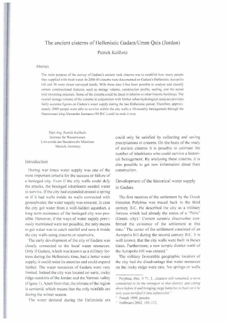
Today inside the Hellenistic city 80 ci sterns can
be found. They are only rock dug cisterns and all
of them have a similar shape. 7 Thirty-six of these
an expedition against Coelesyria. He also took Gadara. 6 DIN 4046 1996, 14: No. 4.44.
after a siege ()ften 1110nths'·. 7 Keilholz 2007,202.
The ancient eisterns of Hellenistic Gadara/Umm Qais (Jordan) 29
N
21.Q4
m~
---;-
-'J
J 1
L ~
22'()2 22.(), r'
f'\w, \'lOJ, V" . I
2O-a3 !i
3O-a,
O'S!l
'2'()2 Olj
25.Q, o fii 23--0'
2k02
U~
24'()3
25.Q2 a
1 '-
27-03 -0131 O~ '8-02
27.()2
n
3O-aS
1.'
30-a4
ß
,5.Q2
~
17.()' '8-0' .
Or.\ if.t
B 28-02
30.Q4 --cistem number
t ß.!.-- depth [mI I L--;:, d~oc~um~e!:.:' n:':ta::;;ti;::Con~' , vOlume [m') ,
~----------------~--= -------- ß mea.ured from inside
9 0-20
Q 60·'00 -----~ ~ " O~ measuf'fldonly thedepth
O !U1 no measurements 0 180 - 200 '00 , '25m , '\ [5.3) \Y
TopograpNcallnvantory plan 2006. GermS" Arcnaeologlcal InstibJto. Orientsi Oepartment. Cl. eührigl ehr. Hartl-Reiter
Fig.2 Localion, slOrable volume and depth ofthe eisterns (capacily Ofulilization and inhabitant values),
bllildings were investigated and measured from
inside (Figure 2).
A vertical shaft is first constructed into the karstic
rock that widens up into a cavem in the depth. In
that way the cistem gets its typical profile, like a
pear, bottle, funnel or a cube. The storage has to be
sealed up with waterproof mortar; otherwise there
wOlild be a high leakage especially in karstic rocks
with partly wide crevices.
Often there was a soil layer which separated the
rock surface from the soil surface. To connect the
cistem shaft with the surface it was necessary to
bllild a walled cistem neck into the soil. The final
stone and the only visible part ofthe cistem was the
socket stone, which was the so called pllteal (lat.
putells = shaft, weil, pit).
In the following, the different methods of con
struction ofthe cistems ofGadara will be discussed.
Starable volurne and construction profile
The storage volume of cistems strongly depended
on their lIse and moreover on the available surfaces
to collect rainfall water. For instance a private
30 Patrick Keilhol z
8
I ~
" e o ;[ .r:. 4 Ci. .. 'tI
3
E • '" N
C • IJ ~ . 2, • Q; • a. ;:a • '" :2 •
E • ~ . <ci <ö •
" '" . c:> c '" . '" :2 •
100 200 300 400
slorage volume [m3J
y -= 1_9794xo 1J4!;
R' "08717
e pear
<0 bottle
o cube
l:J. tunnel
- admlltance !unctlon
5 ::!.:
1..--- 0
500
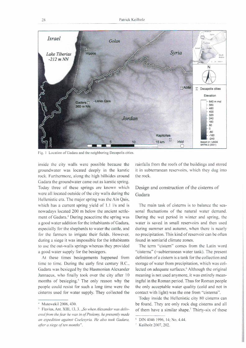
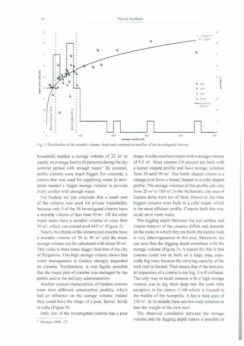
Fig.3 Distribution ofthe storable volume, depth and construction profiles ofthe investigated ci sterns.
household needed a storage volume of 22 m3 to
supply an average family (6 persons) during the dry
summer period with enough water. 8 By contrast,
public cisterns were mllch bigger. For example, a
cistern that was used for supplying water to mili
taries needed a bigger storage volume to provide
every soldier with enough water.
For Gadara we can conclude that a small part
of the ci sterns was used for private households,
becallse only 5 of the 36 investigated cisterns have
a storable volume of less than 30 m3• All the other
water tanks have a storable volume of more than
30 m3• wh ich can extend until445 m3 (Figure 3).
Nearly two thirds ofthe constructed ci sterns have
a storable volume of 30 to 90 m3 and the mean
storage volume can be calculated with about 90 m3•
This value is three times bigger than that ofthe city
of Pergamon. This high storage volume shows that
water management in Gadara strongly depended
on cisterns. Furthermore. it was highly possible
that the major part of cisterns was managed by the
pllblic and/or the military administration.
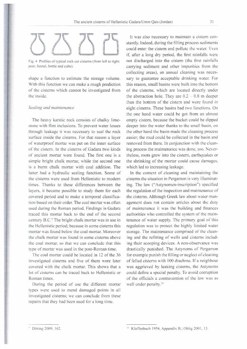
Another typical characteristic of Gadara cisterns
were their different construction profiles, which
had an influence on the storage voilime. Indeed
they could have the shape of a pear, fllnnel, bottle
or cube (Figllre 4).
Only one of the investigated cisterns has a pear
~ Brinker 1990, 17.
shape. It is the smallest cistern with a storage voilime
of9.5 m3• Most cisterns (16 pieces) are bllilt with
a funnel shaped profile and have storage volumes
from 30 until 90 m3• The bottle shaped cistern is a
change over from a funnel shaped to a cube shaped
profile. The storage volumes ofthis profile can vary
from 20 m3 to 165 m3. In the Hellenistic city area of
Gadara there were ten of them. However, the nine
biggest cisterns were built in a cube shape, wh ich
is the most efficient profile. Cisterns built this way
could store more water.
The digging depth (between the soil surface and
cistern bottom) of the cisterns differs and depends
on the rocks in wh ich they are built; the karstic rock
is very inhomogeneous in this area. Moreover, we
can note that the digging depth correlates with the
storage volume (Figure 3). A reason for this is that
cisterns could not be built on a large area, espe
cially big ones, because the carrying capacity ofthe
rock roofis limited. That means that ifthe horizon
tal expansion of a cistern is too big, it wi 11 collapse.
The only way to build cisterns with a high storage
volume was to dig them deep into the rock. One
exception is the cistern 11 -04 which is located in the middle of the Acropolis. It has a base area of
130 m2• In its middle there are two rock columns to
bear the weight of the rock roof.
The observed correlation between the storage
volume and the digging depth makes it possible to
The ancient cistems of Hellenistic GadaraJUmm Qais (Jordan) 31
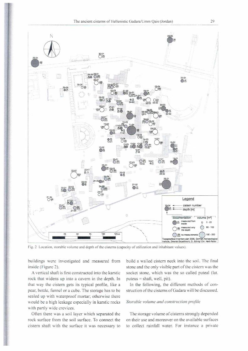
(3 ... "" ...... 5' i. ,;;
.. c::
Fig.4 Profiles of typical rock cut cistel"l1S (from left to right:
pear. funnel, bottle and cube).
shape a funct ion to estimate the storage volume.
With this tunction we can make a rough prediction
of the cisterns which cannot be investigated from
the inside.
Sea/ing and mainlenance
The heavy karstic rock consists of chalky lime
stone with flint inclusions. To prevent water losses
through leakage it was necessary to seal the rock
surface inside the cisterns. For that reason a layer
of waterproof mortar was put on the inner surface
of the cistern . In the cisterns of Gadara two kinds
of ancient mortar were found. The first one is a
simple bright chalk mortar, while the second one
is aburnt chalk mortar with coal addition. The
latter had a hydraulic sealing function. So me of
the cisterns were used from Hellenistic to modern
times. Thanks to these differences between the
layers, it became possible to study them for each
covered period and to make a temporal classifica
ti on based on their order. The coal mortar was often
used dllring the Roman period. Findings in Gadara
traced this mortar back to the end of the second
century B.C.9 The bright chalk mortar was in lIse in
the Hellenistic period; because in some cisterns this mortar was found below the coal mortar. Moreover
the chalk mortar was found in so me eisterns above
the coal mortar, so that we can conclllde that this
type of mortar was used in the post-Roman time.
The coal mortar cOlild be located in 12 of the 36
investigated cisterns and five of them were later
covered with the chalk mortar. This shows that a
lot of cisterns can be traced back to Hellenistic or
Roman times.
Dliring the period of use the different mortar
types were lIsed to mend damaged points in all
investigated ci sterns; we can conclude from these
repairs that they had been lIsed tor a long time.
" Döring2009.162.
It was also necessary to maintain a cistern con
stantly. Indeed, during the filling process sediments
could enter the cistern and pollute the water. Even
if~ after a long dry period, the first rain falls were
not discharged into the cistern (the first rainfalls
carrying sediment and other impllrities from the
collecting areas), an annllal cleaning was neces
sary to guarantee acceptable drinking water. For
this reason, small basins were built into the bottom
of the cisterns, which are located directly under
the abstraction hole. They are 0.2 - 0.8 m deeper
than the bottom of the cistern and were found in
eight cisterns. These basins had two functions . On
the one hand water could be got from an almost
empty cistern, because the bucket could be dipped
deeper into the water thanks to the small basin, on
the other hand the basin made the cleaning process
easier; the mud cOlild be collected in the basin and
removed from there. In conjunction with the c1ean
ing process the maintenance was done, too. Never
theless, roots grew into the cistern, earthquakes or
the shrinking of the mortar could cause damages,
which led to increasing leakage.
In the context of c1eaning and maintaining the
cisterns the situation in Pergamon is very illuminat
ing. The law ("Astynomen-inscription") specified
the regulation of the inspection and maintenance of
the cisterns. Although Greek law about water man
agement does not contain articles about the duty
of maintenance it was the building and finances
allthorities who controlled the system of the main
tenance of water supply. The primary goal of this
regulation was to protect the highly limited water storage. The maintenance comprised of the c1ean
ing and the refitting of wells and cisterns includ
ing their scooping devices. A non-observance was
drastically punished. The Astynoms of Pergamon
for example pllnish the filling or neglect of c1eaning
of fe lied cisterns with 100 drachma. I fa neighbour
was aggrieved by leaking cisterns, the Astynoms
could define a special penalty. To avoid corrllption
of the officials a contravention of the law was as weil under penalty. 10
10 Klaffenbach 1954, Appendix B.: Ohlig 200 I. 13 .
32 Patrick Keilholz
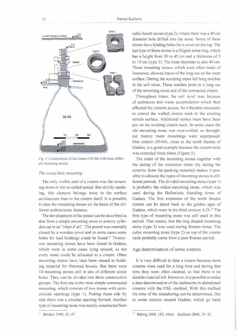
current terrain surface 0.0
349.5
type 2 cubic basalt stones (type 2), where there was a 40 cm
diameter hole drilIed into the stolle. Some of these
stones have binding holes for a cover on the top. The
last type ofthese stones is a filigree stone ring, which
has a height from 30 to 40 cm and a thickness of 5
to 10 cm (type 3). The inner diameter is also 40 cm.
These mounting stones, which were often made of
type 1 limestone, showed traces ofthe long use on the inner
Fig.5 Construction ofthe eistern (30-04) with three different mounting stones.
The scoop hole mounting
The only visible part of a cistern was the mount
ing stone or the so-called puteal. But strictly speak
ing, this element belongs more to the surface
architecture than to the cistern itse lf. It is possible
to date the mounting stones on the basis of the dif
ferent architectonic features .
The development ofthe puteal can be described as that from a simple mounting stone or pottery cylin
ders up to an "objet d'art". The puteal was normally
closed by a wooden cover and in some cases some
holes for lead bindings could be found. 11 Twenty
one mounting stones have been found in Gadara,
which were in some cases lying around, so not
every stone could be allocated to a cistern . Other
mounting stones have later been reused as build
ing material for Ottoman houses. But there were
14 mounting stones still in situ of different scoop
holes. They can be divided into three construction
groups. The first one is the most simple constructed mOllnting, which consists of two stolles with semi
circlllar openings (type I). Putting them side by
side there was a circular opening formed . Another
type of mounting stone was mostly constructed from
II Brinker 1990,42-47.
surface. During the scooping ropes left long notches
in the soft stone. These notches point to a long use
ofthe mounting stone and ofthe connected eistern .
Throughout times, the soil level rose becallse
of sediments and waste accllmlllation which then
affected the cisterns access. So it became necessary
to extend the walled cistern neck to the existing
terrain surface. Additional stones must have been
put on the existing cistern neck. In some cases the
old mounting stone was over-walled, so through
out history more mountings were superposed.
One cistern (30-04), close to the north theatre of
Gadara, is a good example because the cistern neck
was extended three times (Figure 5).
The order of the mounting stones together with
the dating of the extension times (by dating the
ceramic from the packing material) makes it pos
sible to allocate the types of mounting stones to dif
ferent periods. The divided mounting stone (type I)
is probably the oldest mounting stone, which was
used during the Hellenistic fOllnding times of
Gadara. The first extension of the north theatre
cistern can be dated back to the golden ages of
Gadara, which were in the third century A.D. I:! The
first type of mounting stone was still lIsed in this period. That means, that the ring shaped mounti ng
stone (type 3) was used dllring Roman times. The
cubic mOllnting stone (type 2) on top of the cistern
neck probably came from a post Roman period.
Age determination of some ci sterns
It is very difficlllt to date a cistern becallse most
cisterns were used for a long time and dllring that
time they were often cleaned, so that there is no
datable materialleft. However, it is possible to make
a date determination ofthe sediments in abandoned
cisterns with the OSL- method. With this method
the time ofthe abandoning can be determined. like
in some cisterns around Gadara, which go back
I ~ Bührig 2009, 185; Abert - Keilholz 2008, 35-42.

The ancient cistems of Helleni stic Gadara/Umm Qais (Jordan) 33
Cistern Age Comment (terminus ante quem)
29-29 2nd half 2nd cent A.D. Destroyed by the construction of the water divider
30-01 Begin I st cent A.D. Destroyed by the construction of the north theatre
30-02 Begin I st cent A.D. Destroyed by the construction of the north theatre
30-04 Begin 3nd cent A.D. Used before the construction of the temple 11
31 -0 I 2nd half 2nd cent A.D. Destroyed by the construction of the upper tunnel
31 -02 2nd half 2nd cent A.D. Destroyed by the construction of the upper tunnel
31 -03 2nd half 2nd cent A.D. Destroyed by the construction of the upper tunnel
Tab. I Age determination of some cistems.
to the third century A.O. 13 Another possibility IS
to date the organic material in the mortar of cis
terns with the radio-carbon-method. Moreover it is
possible to date some cisterns in Gadara thanks to
other ancient buildings, by using their construction
or their destruction date (table I).
This dating shows that six of the seven ci sterns
were destroyed during the Roman period because
of the construction of other buildings or struc
tures. Since this time the city got fresh water from
the new aqueduct Qanat Fir'un, for which reason
the cistems became unnecessary. But a lot of the
cisterns were still used, because the high located
Acropolis hili could not be supplied by the water
from the deeper aqueduct.
Estimating the maximum number of inhabit
ants during the Hellenistic period
F or analysing the settlement history of Gadara it
is important to know how many people lived there.
For instance, we could estimate Gadara's popula
tion du ring the siege of the year 98 B.C. thanks to
the documentation provided by Flavius Josephus
(first century A.O.) and know ofthe use ofcisterns
as the only water supply during the besiegement.
But it is only possible to determine the number of
inhabitants at this time by making so me assump
tions, which only leads to an estimation of the size
of the population. The determination will be made
by the followi ng hypotheses :
The historical amount of precipitation is in
accordance with the mean present amount of precipitation of 480 mm/year.l~
All 80 documented cisterns date back to the
Hellenistic period; there is no other cistern.
11 Kraushaar u. a., 2012, 237f. I·' EXACT 1998,44.
The storage volume of the cisterns which
could not be measured from inside will be cal
culated with an admittance function. For cis
terns with unknown depth a mean depth will be
supposed.
The last 5% of water left in the cistern will
not be used because ofits bad quality and its dif
ficult access for scooping.
If there was a precipitation average of 480 mm/
year which could water the city area of 5.25 ha,
then rainfalls would supply about 25200 m3/year of
potential drinking water. However, not every drop
was collected in the cistems. There were losses by
interception, evaporation and infiltration, and not
every surface was used for collecting water. For
hydrological calculation it is necessary to reduce
the precipitation with a run-off coefficient, wh ich
can be calculated by the following equations:
Vol = P . <P . AE
with
With: P = precipitation [m]
p . e/J <POO-p
Pd f
= effective precipitation[m]
<P = run-off coefficient [-]
Al' = extend of the catchment area [m2]
For Gadara a run-off coefficient of 0.50 is real
istic. That means that 50 % of the available pre
cipitations ( 12600 m3/year) could be stored in the
cistems during a year. The total storage volume of
all 80 cistems is 6400 m3• But the cistems could
save more water during the year, while during
the filling periods in winter and spring water was
used by the population. Oue to an annual balance
of stored and used water it is possible to calculate
the real storage volume. Moreover it is necessary
to consider spatial etfects. In some cases there
34 Patrick Keil holz
29-04
, , '"'J
N
, 03-0203-01 HO·.\I,
30-05 e M.
30-04 e M; ..29-28,
il.e;i i :
, ! 03-O~_ 31-02 05-01 Oll 04-01
efo1. 31-01 l~
L.J 02-02 3;-:03 J
.~~. 07'll3
11 il 0s:Q1 ... · 07-01 07-02 !iO ~, ,bl, ••
. & l! 04-02
105-02
Oii OH 05-03
30-03
06-01
Oß
09-06 l!0 e,ji, ~5 O!j ~SO " "30-02
13-03
09-04 fl0 09-02
0* 09-03
~.-13-06 • .\1, 14-03
Og O~ 14-01
12-02 er&, 13-05 13-04 13-02 il
1- ~.,\I, OM oil 14-02
- '- ~
Oll
22-02
O~
22-01 ,.'
~·~l.
25-01 .MI 23-01 .11 23-02
Oll 25-02 . ,\1,
16-01 .~
17-01 16-01 1
etl!! 0» _.------
_ .. _- ---I' 27-02
20-01 20-02 tl ·- etl!! .. "'- ... - .~
21-04 efo1. Legend
~ --cistem number .&!-.--,
I ~ __ ~~~ , utilization I I population
\) [%] [person]
o 20-29% o 0-10
o 70-79% o 40-50
- 100% 090-100
Topographlcallnventory plan 2006. German Archaeologlcal Institute. Oriental Oe artment, CI. Büh ' ehr. Hartl·Rcitor
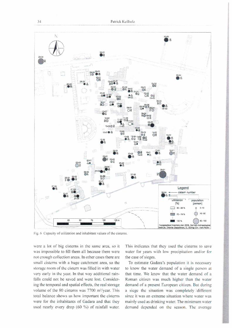
Fig. 6 Capacity ofutilization and inhabitant values ofthe cisterns.
were a lot of big ci sterns In the same area, so it
was impossible to fill themall because there were
not enough collection areas. In other cases there are
small cisterns with a huge catchment area, so the
storage room of the cistern was filled in with water
very early in the year. In that way additional rain
falls could not be saved and were lost. Consider
ing the temporal and spatial effects, the real storage
volume of the 80 cisterns was 7700 m3/year. This
total balance shows us how important the cisterns
were for the inhabitants of Gadara and that they
used nearly every drop (60 %) of rainfall water.
This indicates that they used the cisterns to save
water for years with low precipitation and/or fo r
the case of sieges.
To estimate Gadara 's population it is necessary
to know the water demand of a single person at
tllat time. We know that the water demand of a
Roman citizen was much higher than the water
demand of a present European citizen . But during
a siege the situation was completely different
since it was an extreme situation where water was
mainly used as drinking water. The min imum water
demand depended on the season. The average
The ancient eisterns of Hellenistic Gadara/Umm Qais (Jordan) 35
water consumption was 13 litres per day during
the summer, but during the winter 7 litres per day
had to be enough. 15 These daily water volumes
include water for drinking, cooking, minimal
hygiene and providing for some domestic animals.
So it becomes possible to determine the maximum
number of inhabitants which could survive a siege.
The calculation can be done on the 10-month siege
carried out by the Hasmonian Alexander Jannaeus
(98 8.c.). During that year the inhabitants could
on Iy use the water of the ci sterns to endure the dry
summer months.
If, under consideration of these assumptions, the
cisterns were used the whole year, approximately
2050 people could resist the besiegement for one
year (Figure 6).
With reference to the settlement area we can
estimate a realistic density of population of 400
inhabitants per hectare. This is a little less than
the density of population of current oriental cities,
where there live 500 inhabitants per hectare. 16 This
shows that the estimation of Gadara's population
by analysing their water consumption is realistic
and that the city could resist a siege for one year
only with the use of the cistern water.
Conclusion
The development of the ancient city of Gadara
took place in a strong relationship with the water
demand. Only if there was enough water could
the city develop. During the Hellenistic per iod the
city was a military fortress which later became a
powerful commercial town, which belonged to
I; Gabrecht 1968, 34.
11> Kenyon 1976. 48.
the trading alliance of the Decapolis. At this time
the water supply was mainly provided by the cis
terns. Currently 80 ofthese buildings were found in
the Hellenistic city area of Gadara. Collecting and
storing precipitations make it possible to resist long
sieges or dry summer months.
The construction and design of the cisterns was
discussed by analysing the storage volume, the
shapes and the scoop hole construction with the
mounting stones. With a mean storage volume of
90 m3 the cisterns are much bigger than other cis
terns of ancient cities during that time. Seven of
the investigated ci sterns date back to the Roman
period or are even older. Analyses of the water
management point out that during a siege like the
I ü-montly besiegement under Alexander Jannaeus
more than 2000 people could survive by using the
water from the cisterns.
Acknowledgments
The research work was carried out in context
with the research project "The urban and cu 1-
tural historical development of the ancient city of
Gadara; the modern Umm Qais", wh ich is an enter
prise ofthe German Archaeologicallnstitute (DA!)
and the Staatliche Museen Berlin under the lead
ership of Dr. Claudia Bührig and Prof. Dr. Günter
Schauerte. The work was partly sponsored by the
German Water Historie Association (DWhG) and
supervised by Prof. Dr. Henning Fahlbusch from
the University of Applied Sciences, Lübeck.
36 Patrick Keilholz
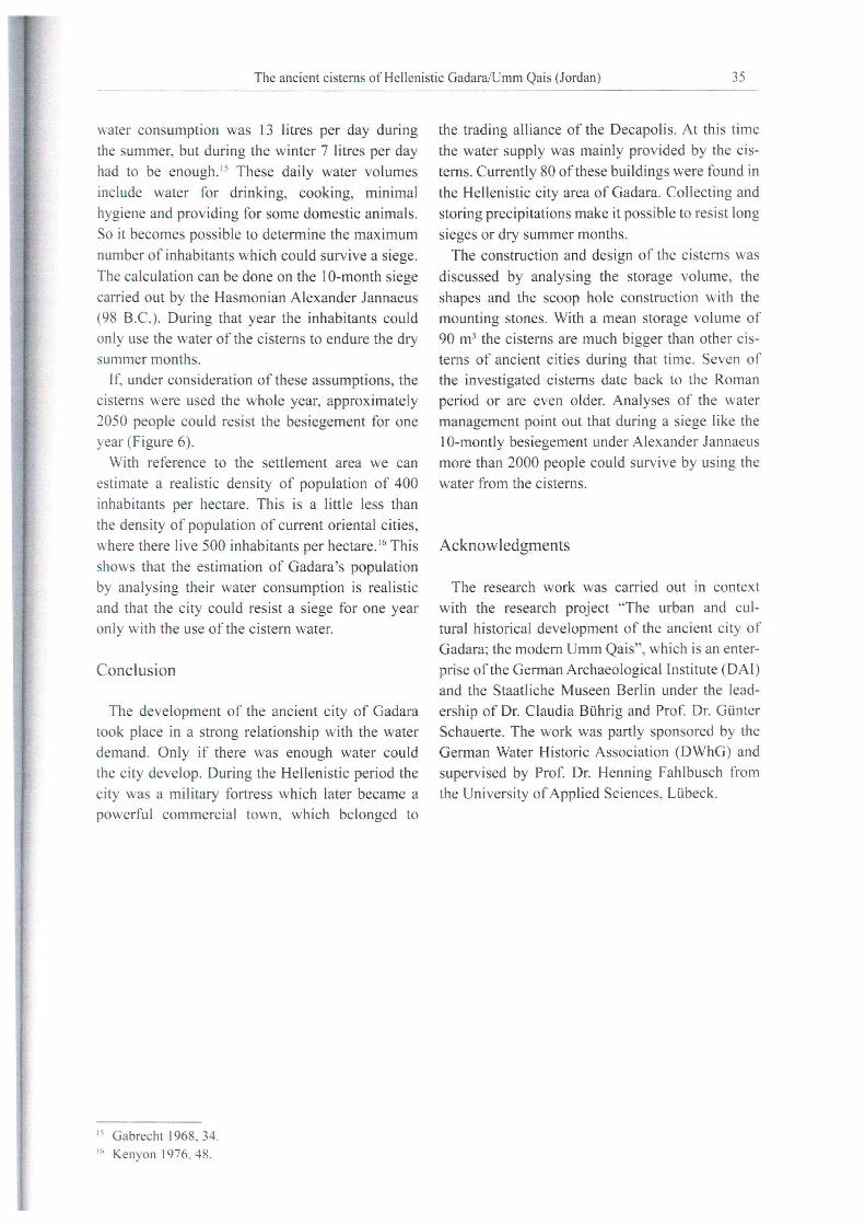
Literature
Abert - Keilholz 2008 B. Abert - P. Keilholz, Elemente der Wasserversorgung in GadaralJordanien, unpublished project report at the University of Applied Sciences, Lübeck (Uibeck 2008)
Brinker 1990 W. Brinker. Wasserspeicherung in Zisternen. Ei n Beitrag zur Frage der Wasserversorgung früher Städte, Mitteilungen des Leichtweiss-Instituts für Wasserbau der Technischen Universität Braunschweig 109, 1990
Bührig 2009 C. Bührig. Das Theater-Tempel-Areal von Gadara/Umm Qais. Struktureller Wandel eines urbanen Raums, ZOrA 2,2009. 162-207
DIN 4046 DIN-Taschenbuch 211. Wasserversorgung, Abwassertechnik. Wasserbau - Begriffe (Berlin 1996)
Döring 2009 M. Döring, Qanat Fir'un - Documentation of the 100 kilometres aqueduct tunnel in northern Jordan, Annual ofthe Department of Antiquities of Jordan 53, 2009, 153-165
EXACT Executive Action Team, Middle East Water Data Banks Project, Overview of Middle East water resourcesWater resources of Palestinian, Jordanian, and Israeli interest. 1998.44. zuletzt aktualisiert am 07.10.2005, <http://exact-me.org/overview!index ydf. htm> (11.06 .2012)
Hoffmann 2002 A. Hoffmann. Topographie und Stadtgeschichte von GadaralUmm Qais, in: A. Hoffmann - S. Kerner (Hrsg.) Gadara - Gerasa und die Dekapolis (U niversity of Michigan 2002) 98-124
Flavius J. .I. Flavius. The New Complete Works of Josephus, Kregel Academic & Professional; Rev Exp Su edition (.Iune 10. 1999). Book XIII , Chapter. 13,3
Keilholz 2007 P. Keilholz. Die Zisternen der antiken Stadt Gadara (Umm Qais. Jordanien), Schriften der Deutschen Wasserhistorischen Gesellschaft (DWhG) e.v. 9, 2007, 195-228
Kenyon 1976 K. M. Kenyon, Archäologie im Heiligen Land (Neukirchen-Vluyn 1976)
Klaffenbach 1954 G. Klaffenbach. Die Astynomeninschrift von Pergamon. Abhandlung der deutschen Akademie der Wissenschaften zu Berlin (Berlin 1954)
Kraushaar u. a. 2012 S. Kraushaar - T. Schumann - G. Ollesch - C. Siebert - T. Rödiger. Erosion and Sedimentation Studies in the Wadi AI Arab Catchment/ North Jordan - Alternative Method Application and First Results in a Data Scarce, Proceedings "Hydrogeology of Arid Environments", Poster Abstract 237- 238 and Poster (Hannover 20 12)
Gabrecht 1968 G. Gabrecht, Untersuchung wasserwirtschaftlicher Anlagen im Bereich der Hochburg von Pergamon im Sommer 1967, Wasserbaulaboratorium der Middle East Technical University (Ankara. 1968) - unpublished
Obeidat u. a. 2008 M. M .Obeidat - F. Y. Ahmad - N. A. Hamouri - A. M. Massadeh - F. S. Athamneh. Assessment ofnitrate contamination of karst springs, Bani Kanana, Northern Jordan, Revista Mexicana de Ciencias Geol6gicas 25/3. 2008,426-437
Ohlig 2001 C. Ohlig, De Aquis Pompeiorum : Das Castellum Aquae in Pompeji: Herkunft, Zuleitung und Verteilung des Wassers (Norderstedt 2001)
Polybius. The Histories, Loeb Classical Library: Revised edition (May 16,2011), Volume 111: Books 5, V 71.3.
Posseit 1999 E. PosseIt, Gadara-Keramik. Entwicklung einer Typologie, unpublished master thesis at : Seminar fUr Klassische Archäologie der Freien Universität Berlin 1999