The Cultural and Economic Composition of Late Hellenistic Upper Galilee
342
The Cultural and Economic Composition of Late Hellenistic Upper Galilee: A Case Study of the Squatters at Tel Kedesh by Justin Thomas Winger A dissertation submitted in partial fulfillment of the requirements for the degree of Doctor of Philosophy (Near Eastern Studies) in The University of Michigan 2012 Doctoral Committee: Professor Sharon C. Herbert, Co-Chair Associate Professor Yaron Z. Eliav, Co-Chair Professor Gabriele Boccaccini Professor Raymond H. Van Dam
Transcript of The Cultural and Economic Composition of Late Hellenistic Upper Galilee

The Cultural and Economic Composition of Late Hellenistic Upper Galilee:
A Case Study of the Squatters at Tel Kedesh
by
Justin Thomas Winger
A dissertation submitted in partial fulfillment
of the requirements for the degree of
Doctor of Philosophy
(Near Eastern Studies)
in The University of Michigan
2012
Doctoral Committee:
Professor Sharon C. Herbert, Co-Chair
Associate Professor Yaron Z. Eliav, Co-Chair
Professor Gabriele Boccaccini
Professor Raymond H. Van Dam
© Justin Thomas Winger 2012

ii
For Mom and Dad, Gail and Jim
.ܪܘ�ܪ�. ܐ��ܝ ܗ�

iii
Acknowledgements
There are many people who must be thanked in a project of this size and scope.
First and foremost, I would like to thank my parents. From a very early age they instilled
in me their belief in the importance of education. They have offered unwavering love and
support in every endeavor that I have undertaken, including this one. I owe them more
than I will ever be able to repay. It is to them and to my aunt and uncle that this
dissertation is dedicated.
Gail Winger and Jim Woods, my aunt and uncle, have supported me in so many
ways during the past seven years that it would be obscene to list them all. Many (though
certainly not all) of their contributions to this dissertation have come in forms other than
information about the ancient Mediterranean. They are brilliant, thoughtful, and wise, and
although their field of expertise is neuropsychopharmacology, their contributions to this
dissertation and the process that brought me to this point are indelible.
Sharon Herbert and Andrea Berlin, the co-directors of the Tel Kedesh
excavations, allowed me to be a part of the Tel Kedesh team for six seasons and gave me
the idea for this project, not to mention unfettered access to the material that constitutes
the core of this dissertation. Sharon devised and created all of the databases except for the
pottery database (which was the work of Peter Stone), without which very little of this
data could have been analyzed in the allotted time. In addition, Sharon is probably the
person to whom I owe the most as a graduate student at the University of Michigan. She
has been a mentor, a friend, and an advisor, and she is a brilliant scholar and a master

iv
stratigrapher. She deserves much of the credit (and none of the blame) for any abilities
that I might possess as an archaeologist. She is one of the few people about whom I can
say that I could not have done this without her.
Yaron Eliav has been a guiding force throughout my graduate career and is
probably the one who deserves the most credit for teaching me how to think. His ability
to think outside the box and conceptualize both the theoretical issues and practical
realities of the ancient world from a wholly new and different perspective is, in my
experience, unparalleled. He has been an invaluable fount of information, but even more
than that (and more importantly), he has been an incisive and brilliant critic. This
dissertation would be far worse if it was not for Yaron’s commitment to me as a graduate
student and to a mission to make me an excellent scholar.
The other two members of my committee, Ray Van Dam and Gabriele
Boccaccini, have also been influential forces in my graduate career. Gabriele was the co-
director of the graduate program in which I started my career and Ray has been a
professor and a friend since I came to the University of Michigan. He has provided me
with valuable insight and mentorship over the last seven years, both professional and
personal, and will serve as an example of mentorship to which I will aspire as a professor.
I can honestly say he is one of the people who I will most miss when I leave Ann Arbor.
Kate Larson is a brilliant colleague, one of my closest friends, and has been an
invaluable resource. As a colleague she has been the person to whom I routinely went to
brainstorm or try out new hypotheses. She read versions of chapters in progress, as well
as a version of the entire dissertation, and has consistently offered invaluable insights,
critiques, and ideas. She deserves to have a table inserted here that acknowledges all of

v
the contributions that she has made; if only I had kept track of every one over the last
year and a half. Although I could have completed this dissertation without her, it would
have been far worse. I am so thankful that I did not have to.
The rest of the people who were a part of the Tel Kedesh team through the years
have also provided help and contributed to the preservation and digitization of the data
that I have been allowed to work with. Lorene Sterner has been an invaluable resource at
the Kelsey Museum. Richard Redding not only read the faunal remains but was kind
enough to sit down with me for hours and work through the data. Meg Morden, the
Kedesh registrar, is responsible for the correct and precise recording of all but the
uninventoried ceramic data; without her there would be very little to work with indeed.
Lindy Lindorfer and Sarah Rabe were the architects. Any plan of any part of the Tel
Kedesh site that I have adapted for my use in this dissertation is the result of them
drawing and digitizing the drawings, a painstaking process that required hundreds, if not
thousands, of hours over the course of the last twelve years. Suzanne Davis and Claudia
Chemello were our conservators and were responsible for the cleaning, reconstruction,
and preservation of finds. Sue Webb was our pre-publication photographer of the
inventoried items. She and Grant Webb are responsible for any photograph of an item in
this dissertation. Fritz McBride was our artist for all but one season (when Hannah
Schnobrich took over) and they created fantastic drawings of the small finds. Donald
Ariel provided the official coin and stamped amphora handle readings. Danny Syon

vi
provided field readings and was of invaluable help in the field and by providing me with
a copy of his dissertation on the numismatics of the region.1
I must reserve special thanks for Peter Stone, the Tel Kedesh ceramicist in 2008,
2009, and 2010 and the author of his own dissertation on the pottery from Tel Kedesh.2
His encyclopedic knowledge of the ceramic data from all phases of the Administrative
Building and all years of excavation, his completion of the monumental task of digitizing
all of the Tel Kedesh ceramic records and (more importantly) his willingness to share it
with me, his knowledge of Hellenistic pottery throughout the Mediterranean, and his
willingness to answer my many questions were invaluable. As should be the case with all
archaeological reports with respect to ceramicists, I could not have completed this
dissertation without him.
I must also thank Dr. Jim Strange. By early 2000 I had become interested in
archaeology and was looking for my first dig. I wrote to him expressing interest in his
excavations at Sepphoris and told him that I was looking to be trained as an
archaeologist. He had never met me before, but after inquiring into my knowledge,
motivation, and future plans he took me on, placed me with his one of his best
supervisors, and saw to it that I was trained in field methodology. It was an important,
defining moment on the path that brought me here.
Alex Zwinak in IPCAA and Angela Beskow and Angela Beskow and Wendy
Burr in Near Eastern Studies were the people who made things happen at the
departmental level and to whom I could always turn for answers or with needs with
1 D. Syon, "Tyre and Gamla: A Study in the Monetary Influence of Southern Phoenicia on Galilee and the
Gola in the Hellenistic and Roman Periods" (Ph.D. Dissertation, The Hebrew University of Jerusalem,
2004). 2 Peter Stone, "'Provincial' Perspectives: The Persian, Ptolemaic, and Seleucid Administrative Center at Tel
Kedesh in a Regional Context" (Ph.D. Dissertation, University of Cincinnati, 2012).

vii
respect to administrative bureaucracy. I am not sure that it would have been possible to
finish my graduate degree without them. Doug Chapman, Mike O’Brien, and Jeff Pillars
at CrossFit Ann Arbor have provided me with friendship, focus, and physical and mental
challenges over the past two and a half years.
Sara Goeman has provided me with laughter and love, if not always proper
grammar, for the past year, both of which are requisite for enduring graduate school and
the dissertation writing process. Her easy-going nature and ability to keep things in
perspective, not to mention her ability to provide “real world reality” as a counterbalance
to the often unreal world of academic life, have been priceless contributions to the
academic content that can be found below.
Sarah Mann, my sister and confidant, has been an unwavering source of love and
support. Throughout this process she has been the person to whom I have always been
able to turn. She is also one of the few wholly good people that I’ve ever known.
Finally, I would like to thank Kyle, Karis, and Caleb Mann. I hope that one day
they too will have nieces and nephews who will help them to understand the pure,
unadulterated joy that they have provided me with. I am so proud to be their uncle.
What follows would not be what it is without all of the above; any mistakes or
disappointments found herein are my responsibility alone.

viii
Table of Contents
Acknowledgements ...................................................................................................... iii
List of Figures ................................................................................................................x
List of Tables .............................................................................................................. xii
List of Appendices ..................................................................................................... xiii
List of Abbreviations ..................................................................................................xiv
Abstract ..................................................................................................................... xvii
Chapter 1 Discoveries and Questions...........................................................................1
Discoveries and Problems: The Squatter Phase at Tel Kedesh............................................................ 3 The Possibility of Hasmonaean Expansion into Galilee Prior to 104/3 BCE ....................................... 7 Material and Immaterial Aspects of Society ...................................................................................... 9 Society, Culture, and Material Culture ............................................................................................ 15 A Brief Excursus on the Special Case of Jews and Judaism ............................................................. 28 The Squatters and Choices of Consumption .................................................................................... 32
Chapter 2 The Cultural and Political Landscape of Hellenistic Galilee and the
Surrounding Regions ................................................................................................... 36
Galilee in the Iron Age ................................................................................................................... 39 Galilee in the Early Roman Period .................................................................................................. 45 Galilee in Regional Politics............................................................................................................. 53 Kedesh in the Literary Record ........................................................................................................ 57
Chapter 3 Evidence for Early Jewish Expansion into the Galilee and an Analysis of
1 Maccabees, Josephus, and the Hasmonaean Settlements ........................................ 59
Judaea and “the Three Districts Being Added To it From Samaria and Galilee” ............................... 63 Alexander Jannaeus in Galilee (ca. 125 BCE) ................................................................................. 80 1 Maccabees’ Presentation of Jonathan’s Settlement Practices ......................................................... 83 Jonathan at Kedesh ......................................................................................................................... 91 Hasmonaean Settlement Practices: Gezer, Strato’s Tower, and Beit Zur .......................................... 93 Strato’s Tower ................................................................................................................................ 98 Beit Zur........................................................................................................................................ 101
Chapter 4 The “Squatters” at Tel Kedesh ................................................................ 106
Part I: Background and Overview ..................................................................................................... 108 Tel Kedesh and the Persian-Hellenistic Administrative Building (PHAB): A Brief Geographical and
Historical Orientataion ................................................................................................................. 109
Part II: Summary of the Archaeological Evidence for the Squatters ................................................... 112 Date ............................................................................................................................................. 112

ix
Architecture ................................................................................................................................. 117 The Ceramic and Non-ceramic Assemblages................................................................................. 118 Abandonment ............................................................................................................................... 124
Part III: The Squatter-Used Areas of the Building ............................................................................. 126 The Northern Corridor (Figure 10) ................................................................................................ 126 Room C1, including areas C1a and C1b (Figure 14) ...................................................................... 128 The Central Courtyard – Architecture (Figure 17) ......................................................................... 133 The Central Courtyard – Soil Loci (Figure 17) .............................................................................. 137 Room W2 (Figure 23)................................................................................................................... 141 The Western Corridor (Figure 27 and Figure 28) ........................................................................... 144 Room S2 – A Room with Questionable Squatter Presence (Figure 31) ........................................... 146 Room C2 (Figure 37, Figure 38) ................................................................................................... 152 Room C3 (Figure 39).................................................................................................................... 156 Room C4 (Figure 40, Figure 41, Figure 42)................................................................................... 157 Room C5 (Figure 43, Figure 44) ................................................................................................... 159 Room C6 (Figure 45).................................................................................................................... 160 Room C7 (Figure 45).................................................................................................................... 164 The South-Central Corridor (Figure 46) ........................................................................................ 164 The Stylobate Corridor (Figure 47) ............................................................................................... 165 Room E1 (Figure 49) .................................................................................................................... 168 Room E2 (Figure 50) .................................................................................................................... 170 Room E3 (Figure 51) .................................................................................................................... 171 Room E4 (Figure 52) .................................................................................................................... 173 The Northeastern Corridor (Figure 55) .......................................................................................... 174 The Eastern Corridor (Figure 54) .................................................................................................. 175
Part IV: Uninhabited Parts of the Building ....................................................................................... 176 The Northern Rooms (Rooms N3, N4, N6 and the Northern Entrance – Figure 55) ........................ 176 The Northwestern Rooms (Rooms N1 and N2 – Figure 56) ........................................................... 177 The Western Rooms (Rooms W1, W3, W4, W4a, W5, W6, and W7 – Figure 57) .......................... 182 The Rooms South of the Central Courtyard (Rooms S3 and S4 – Figure 60) .................................. 188 The Rooms South of the South-Central Corridor (Rooms S5, S6, S7, S9, and S11 – Figure 61) ...... 190 The Southern Rooms (Rooms S8 and S10 – Figure 62) ................................................................. 195 The Rooms South of the Southeastern Corridor (Rooms S12, S13, and S14 – Figure 63) ............... 202
Chapter 5 The Squatters as the Dispossessed Urban Poor of Kedesh .................... 204
Appendix I: Naming and Numbering Conventions Used in this Dissertation ......... 282
The Tel ........................................................................................................................................ 282 Rooms within the Administrative Building ................................................................................... 283
Appendix II: A Short Primer on the Pottery Found at Tel Kedesh ......................... 286
Table 2 – Ceramic Fabrics Commonly Found at Tel Kedesh ............................................................. 286
Appendix III: Greek and English Texts of 1 Maccabees 10:25-45; Ant. 13.48-57; 1
Maccabees 11:18-39; and Ant. 13.121-131 ................................................................ 288
Works Cited ............................................................................................................... 297

x
List of Figures
Figure 1: Map of the region showing the location of Kedesh and other sites................. 217
Figure 2: Tel Kedesh with excavation grid. .................................................................. 218
Figure 3: Aerial photo of the Administrative Building at the end of the 2010 season. ... 219
Figure 4: Plan of the Squatter-phase Administrative Building. ..................................... 220
Figure 5: Plan of the Squatter phase showing the location of Squatter-phase coins and
Rhodian stamped amphora handles. ............................................................ 221
Figure 6: Density of Basaltic Cooking Ware (BCW) fragmentary vessels within the
Administrative Building. ............................................................................ 222
Figure 7: Density of Eastern Sigillata ‘A’ (ESA) fragmentary vessels within the
Administrative Building. ............................................................................ 223
Figure 8: Density of Tan Grey Marl (TGM) fragmentary vessels within the
Administrative Building. ............................................................................ 224
Figure 9: The Administrative Building with Squatter architecture shown in black. ....... 225
Figure 10: Plan of the Northern Corridor, the Northern Rooms, and the Northern
Entrance. .................................................................................................... 226
Figure 11: The Northern Corridor, from the east. ......................................................... 227
Figure 12: Tabun CB35022/CB36042, partially excavated, with BCW cookpot K10P056
in situ. ........................................................................................................ 228
Figure 13: Tabun CB35022/CB36042. ........................................................................ 229
Figure 14: Plan of Room C1, including C1a and C1b. .................................................. 230
Figure 15: Rooms C1 and C1a, view from the east. ...................................................... 231
Figure 16: Wall CB36037 and pavers CB36017, view from the south. ........................ 232
Figure 17: Plan of the Central Courtyard. ..................................................................... 233
Figure 18: Pavement CB37017 in the northwest corner of the Central Courtyard, view
from the west.............................................................................................. 234
Figure 19: Tabun CB37031, in the northwest corner of the Central Courtyard, view from
the northeast. .............................................................................................. 235
Figure 20: Plaster bin CB26006. .................................................................................. 236
Figure 21: Wall CB16023 and stone basin K06S023.................................................... 237
Figure 22: The southwestern corner of the Central Courtyard, view from the east. ....... 238
Figure 23: Plan of Room W2. ...................................................................................... 239
Figure 24: Room W2. Top: View from the north.......................................................... 240
Figure 25: Door block CB37003, between rooms Rooms W2 and N2. ......................... 241
Figure 26: Room W2, view from the east. .................................................................... 242
Figure 27: Plan of the Western Corridor. ..................................................................... 243
Figure 28: Plan of the Western Corridor (detail). ......................................................... 244
Figure 29: The northern half of the Western Corridor, view from the north. ................. 245
Figure 30: Tabun CB37030 and paving stones CB37032, view from the northeast. ..... 246
Figure 31: Plan of Room S2. ........................................................................................ 247

xi
Figure 32: A view into Room S2 from the west. .......................................................... 248
Figure 33: Door block CB17071, blocking the doorway between Rooms S2 and S1 (in
wall CB17003). .......................................................................................... 249
Figure 34: Doorway between Rooms S2 and S1 (in wall CB17003)............................. 250
Figure 35: The doorway between Rooms S2 and S1 and blocking stones CB17071, view
from the north. ........................................................................................... 251
Figure 36: PHAB-phase doorway blockage between the Stylobate Corridor and the
northeastern corner of Room C2 (in wall CB35021). .................................. 252
Figure 37: Plan of Room C2. ....................................................................................... 253
Figure 38: Room C2, view from the north. ................................................................... 254
Figure 39: Plan of Room C3. ....................................................................................... 255
Figure 40: Rooms C4 and C3, view from the east. ....................................................... 256
Figure 41: Plan of Room C4. ....................................................................................... 257
Figure 42: Room C4, view from the east. ..................................................................... 258
Figure 43: Plan of Room C5. ....................................................................................... 259
Figure 44. Below: Room C5, view from the north. ....................................................... 260
Figure 45: Plan of Rooms C6 and C7. .......................................................................... 261
Figure 46: Plan of the South-Central Corridor. ............................................................. 262
Figure 47: Plan of the Stylobate Corridor. .................................................................... 263
Figure 48: Tabuns CB25004 and CB25005. ................................................................ 264
Figure 49: Plan of Room E1. ....................................................................................... 265
Figure 50: Plan of Room E2. ....................................................................................... 266
Figure 51: Plan of Room E3. ....................................................................................... 267
Figure 52: Plan of Room E4. ....................................................................................... 268
Figure 53: Tabun CB25041. ........................................................................................ 269
Figure 54: Plan of the Eastern Corridor. ....................................................................... 270
Figure 55: Plan of the Northern Corridor, the Northern Rooms (Rooms N3, N4, and N6),
and the Northern Entrance. ......................................................................... 271
Figure 56: Plan of the Northwestern Rooms (Rooms N1 and N2). ............................... 272
Figure 57: Plan of the Western Rooms. ........................................................................ 273
Figure 58: Plaster floor CB28003 in the doorway between Rooms W5 and W4a, view
from the south. ........................................................................................... 274
Figure 59: Room W4, view from the north. .................................................................. 275
Figure 60: Plan of the rooms south of the Central Courtyard (Rooms S2, S3, and S4). . 276
Figure 61: Rooms south of the South-Central Corridor (Rooms S5, S6, S7, S9, S10, and
S11). .......................................................................................................... 277
Figure 62: Plan of Room S8. ........................................................................................ 278
Figure 63: Plan of the Southeastern Corridor and the rooms to the south of it (Rooms
S12, S14, and S13). .................................................................................... 279
Figure 64: Tabun CB17038 and platform CB17041, view from the south. ................... 280
Figure 65: Tabun CB17039, view from the south......................................................... 281
xii
List of Tables
Table 1: Excerpt from The Annals of Tiglath-Pileser III ................................................ 41
Table 2: The letters from Demetrius I and Demetrius II to Jonathan, as represented by 1
Maccabees.................................................................................................... 69
Table 3: Squatter-Phase Coins and Stamped Amphora Handles ................................... 115

xiii
List of Appendices
Appendix I: Naming and Numbering Conventions Used in this Dissertation ................. 282
Appendix II: A Short Primer on the Pottery Found at Tel Kedesh ................................. 286
Appendix III: Greek and English Texts of 1 Maccabees 10:25-45; Ant. 13.48-57;
1 Maccabees 11:18-39; and Ant. 13.121-131 ..................................................... 288

xiv
List of Abbreviations
Reference Works BDB The Brown-Driver-Briggs Hebrew and English Lexicon1
GLAJJ Stern, Greek and Latin Authors on Jews and Judaism2
OCD Oxford Classical Dictionary3
OEANE Oxford Encyclopedia of the Ancient Near East4
NEAEHL New Encyclopedia of Archaeological Excavations in the Holy Land5
RIA Reallexikon der Assyriologie und Vorderasiatischen Archäologie6
WDSP Wadi Daliyeh Samaritan Papyri7
Periodicals
AA American Antiquity
ABSA The Annual of the British School at Athens
ADAJ Annual of the Department of Antiquities, Jordan
AE American Ethnologist
AJA American Journal of Archaeology
AASOR Annual of the American Schools of Archaeological Research
ANRW Aufsteig und Niedergang der Römischen Welt
BA Biblical Archaeologist
BAIAS Bulletin of the Anglo-Israel Archaeological Society
BAR Biblical Archaeology Review
BASOR Bulletin of the American Schools of Oriental Research
BBSAJ Bulletin of the British School of Archaeology in Jerusalem
BJPES Bulletin of the Jewish Palestine Exploration Society
CJ Classical Journal
CQ Classical Quarterly
EI Eretz Israel
1 Francis Brown et al., The Brown-Driver-Briggs Hebrew and English Lexicon (Peabody, Mass.:
Hendrickson Publishers, 1996). 2 Menahem Stern, Greek and Latin Authors on Jews and Judaism, 3 vols. (Jerusalem: Israel Academy of
Sciences and Humanities, 1974). 3 Simon Hornblower and Antony Spawforth, The Oxford Classical Dictionary, 3rd ed. (Oxford; New York:
Oxford University Press, 2003). 4 Eric M. Meyers, ed., The Oxford Encyclopedia of Archaeology in the Near East, 5 vols.The Oxford
Encyclopedia of Archaeology in the Near East(New York: Oxford University Press, 1997). 5 Ephraim Stern, Ayelet Levinzon-Gilboa, and J. Aviram, The New Encyclopedia of Archaeological
Excavations in the Holy Land, 5 vols. (Jerusalem; New York: Israel Exploration Society & Carta; Simon & Schuster, 1993). 6 Erich Ebeling and Bruno Meissner, Reallexikon der Assyriologie und Vorderasiatischen Archäologie
(Berlin, Leipzig: W. de Gruyter & co., 1928). 7 Douglas Marvin Gropp et al., Wadi Daliyeh II: The Samaria Papyri from Wadi Daliyeh XXVIII,
Miscellanea, Part 2. Discoveries in the Judaean Desert, vol. 28 (Oxford: Clarendon Press, 2001).

xv
ESI Excavations and Surveys in Israel
HTR Harvard Theological Review
HUCA Hebrew Union College Annual
IEJ Israel Exploration Journal
INR Israel Numismatic Research
JAAR Journal of the American Academy of Religion
JAS Journal of Archaeological Science
JBL Journal of Biblical Literature
JEA Journal of Egyptian Archaeology
JFA Jounral of Field Archaeology
JGS Journal of Glass Studies
JJP Journal of Juristic Papyrology
JJS Journal of Jewish Studies
JNES Journal of Near Eastern Studies
JQR Jewish Quarterly Review
JRA Journal of Roman Archaeology
JRS Journal of Roman Studies
JSJ Journal for the Study of Judaism in the Persian, Hellenistic, and Roman
Period
JSP Journal for the Study of the Pseudepigrapha
LASBF Liber Annuus Studii Biblici Franciscani
NT Novum Testamentum
NTS New Testament Studies
PEQ Palestine Exploration Quarterly
QDAP Quarterly of the Department of Antiquities, Palestine
RB Review Biblique
CI Scripta Classica Israelica
Ancient Literature The abbreviations for ancient literature used herein follow the academic standards (see,
e.g., the SBL Handbook of Style).8 The most frequently used are listed below.
1 Macc. 1 Maccabees
2 Macc. 2 Maccabees
Ant. Josephus, Antiquities of the Jews
Apion Josephus, Against Apion
Geog. Strabo, Geography
Life Josephus, Life
m. Shev Tractate Shevi’it from the Mishnah Other tractates from the Mishnah are
indicated by the use of a lowercase “m.” preceding them. See the SBL
Handbook of Style.
Nat. Hist. Pliny, Natural History
Onomast. Eusebius, Onomasticon
Periplus Pseudo-Scylax, Periplus
8 Patrick H. Alexander, Society of Biblical Literature, and Shirley Decker-Lucke, The SBL Handbook of
Style: For Ancient Near Eastern, Biblical, and Early Christian Studies (Peabody, Mass.: Hendrickson,
1999).

xvi
t. Shev. Tractate Shevi’it from the Tosefta. Other tractates from the Tosefta are
indicated by the use of a lowercase “t.” preceding them. See the SBL
Handbook of Style.
War Josephus, Jewish War
Other BCW Basaltic Cooking Ware (a fabric type associated with Squatter occupation at
Tel Kedesh)
BSP Black Slipped Predecessor (the black slipped predecessor to ESA),
petrographically identified as being from the same clay source as ESA. See
Kathleen Slane, “The Fine Wares” in Andrea Berlin and Kathleen Slane, Tel
Anafa II, i, The Hellenistic and Roman Pottery. Journal of Roman
Archaeology Supplementary Series 10, ed. Sharon Herbert (Ann Arbor, MI:
Kelsey Museum, 1997).
ESA Eastern Terra Sigillata “A”
LHSB The Late Hellenistic Stuccoed Building at Tel Anafa, Israel. See Sharon
Herbert, Tel Anafa I: Final Report on Ten Years of Excavation at a Hellenistic
and Roman Settlement in Northern Israel. Journal of Roman Archaeology
Supplement Series 10. (Ann Arbor, MI: Kelsey Museum of Archaeology,
1994).
PHAB The Persian/Hellenistic Administrative Building at Tel Kedesh. Also used as a
shorthand reference to the strata that correspond to the administrative use of
the building (i.e., the Persian and pre-Squatter Hellenistic strata).
TGM Tan Grey Marl (a fabric type associated with Squatter occupation at Tel
Kedesh)

xvii
Abstract
In 1999 a large building was discovered at Tel Kedesh that had been the administrative
center for northern Upper Galilee in the Persian, Ptolemaic, and Seleucid periods. The
building had been partially destroyed and abandoned around 143 BCE, a date that
corresponds remarkably well with 1 Maccabees’ account of the defeat of the Seleucid
army by the Hasmonaeans (1 Maccabees 11:62-74). Approximately 5 years later it was
repurposed for domestic use and inhabited by an otherwise unknown group of people
(“the Squatters”) whose material culture was very different from both that of the
Persian/Hellenistic Administrative Building (PHAB) and that of the Late Hellenistic
Stuccoed Building, a villa at Tel Anafa, ca. 12 km northeast of Kedesh that was being
built at the same time that the Squatters were living in the administrative building. Many
of the Squatter vessels came from Lower Galilee and represent shapes that have parallels
at Jerusalem, Shechem, Pella, Gamla, and Khirbet esh-Shuhara; they also suggest
southern potting traditions. This dissertation explores the possibility that the Squatters at
Tel Kedesh could have been Jews settled by Jonathan after his defeat of Demetrius II (or
Galileans who migrated northward) within the context of academic debates over early
Hasmonaean annexation of and Jewish expansion into Galilee (i.e., prior to 103 BCE). It
uses the data from Kedesh to explore important questions about social changes brought
about by the decline of Seleucid power and the consequent rise of autonomous “states”
on the eve of Roman annexation of the Eastern Mediterranean. On a more theoretical
level it raises questions about the degree to which we can equate material remains with
actual cultures in history (“Do pots equal people?”), issues of identity in antiquity
(individual, group, ethnic, religious, and cultural), and intercultural relations and
economic transactions in border regions. In synthesizing the above analyses it concludes
that the Squatters were most likely the dispossessed urban poor of the city of Kedesh and
exposes the ubiquitous but previously unstudied phenomenon of people making homes in
abandoned urban buildings in antiquity.

1
Chapter 1
Discoveries and Questions
“All archaeological inference about past societies (including, potentially,
the identification of social groups and boundaries) hinges critically upon
an understanding of the relationship between material and non-material
aspects of culture and society: left with only remnants of the former, we
seek to use them to perceive and comprehend the latter. That is the essence
of the archaeological endeavor.” –Michael Dietler and Ingrid Herbich1
“The aspects of things that are most important for us are hidden because of
their simplicity and familiarity. (One is unable to notice something
because it is always before one’s eyes.) The real foundations of his
enquiry do not strike a man at all. Unless that fact has at some time struck
him.—And this means: we fail to be struck by what, once seen, is most
striking and most powerful.” –Ludwig Wittgenstein2
In 144 or 143 BCE the Hasmonean Jewish army, led by the High Priest Jonathan,
defeated the Seleucid army in the Plain of Hazor, some 20 km north of the Sea of Galilee.
The event was recorded in the book of 1 Maccabees, our lone source for the actions of the
Hasmonaeans in the period between 167 BCE and 135 BCE and generally regarded by
scholars to be an official dynastic record composed by a court writer during the reign of
John Hyrcanus I (134-104 BCE). It reads:
(Jonathan) passed through the country as far as Damascus. 63Then
Jonathan heard that the officers of Demetrius had come to Kedesh in
Galilee with a large army, intending to remove him from office [or
1 Michael Dietler and Ingrid Herbich, "Habitus, Techniques, Style: An Integrated Approach to the Social
Understanding of Material Culture and Boundaries," in The Archaeology of Social Boundaries, ed. Miriam
Stark (Washington, D. C.: Smithsonian Institute Press, 1998), 233. 2 Die für uns wichtigsten Aspekte der Dinge sind durch ihre Einfachheit und Alltäglichkeit verborgen. (Man kann es nicht bemerken, – weil man es immer vor Augen hat.) Die eigentlichen Grundlagen seiner
Forschung fallen dem Menschen gar nicht auf. Es sei den, daß ihm dies einmal aufgefallen ist. –Und das
heißt: das, was, einmal gesehen, das Auffallendste und Stärkste ist, fällt uns nicht auf.” Ludwig
Wittgenstein, Philosophical Investigations, no. 129. See, e.g., Ludwig Wittgenstein and G. E. M.
Anscombe, Philosophical Investigations, 2nd ed. (Oxford, UK; Malden, Mass.: Blackwell, 1997), 50.

2
“intending to divert him from his mission”].3 64He went to meet them, but
left his brother Simon in the country… 67Jonathan and his army encamped
by the waters of Gennesaret (i.e., the Sea of Galilee). Early in the morning
they marched to the plain of Hazor, 68and there in the plain the army of the
foreigners met him; they had set an ambush against him in the mountains,
but they themselves met him face to face. 69Then the men in ambush
emerged from their places and joined battle. 70All the men with Jonathan
fled; not one of them was left except Mattathias son of Absalom and Judas
son of Chalphi, commanders of the forces of the army. 71Jonathan tore his
clothes, put dust on his head, and prayed. 72Then he turned back to the
battle against the enemy and routed them, and they fled. 73When his men
who were fleeing saw this, they returned to him and joined him in the
pursuit as far as Kadesh, to [the Seleucid] camp, and there they encamped. 74As many as three thousand of the foreigners fell that day. And Jonathan
returned to Jerusalem. (1 Maccabees 11:62-74)4
Given that many, if not most, scholars have understood the Hasmonaeans to have had
expansionistic plans to return Israel to its biblical (i.e., God-given) borders – as indeed
they nearly did in over the following fifty years, Jonathan’s immediate return to
Jerusalem, 150 kilometers to the south, seems strange. One might suspect that Jonathan
left a garrison behind, having (re-)established a Jewish foothold in the biblical land of
Naphtali.
3 Jonathan A. Goldstein, I Maccabees: A New Translation, With Introduction and Commentary, 1st ed.
Anchor Bible Commentary Series, vol. 41 (Garden City, N.Y.: Doubleday, 1976), 442. See Chapter 3 for
further discussion. 4 kai. hvxi,wsan oi avpo. Ga,zhj Iwnaqan kai. e;dwken auvtoi/j dexia.j kai. e;laben tou.j ui`ou.j tw/n avrco,ntwn auvtw/n eivj o[mhra kai. evxape,steilen auvtou.j eivj Ierousalhm kai. dih/lqen th.n cw,ran e[wj Damaskou/ 63kai. h;kousen Iwnaqan o[ti parh/san oi a;rcontej Dhmhtri,ou eivj Khdej th.n evn th/| Galilai,a| meta. duna,mewj pollh/j boulo,menoi metasth/sai auvto.n th/j crei,aj 64kai. sunh,nthsen auvtoi/j to.n de. avdelfo.n auvtou/ Simwna kate,lipen evn th/| cw,ra| 65kai. parene,balen Simwn evpi. Baiqsoura kai. evpole,mei auvth.n hme,raj polla.j kai. sune,kleisen auvth,n 66kai. hvxi,wsan auvto.n tou/ dexia.j labei/n kai. e;dwken auvtoi/j kai. evxe,balen auvtou.j evkei/qen kai. katela,beto th.n po,lin kai. e;qeto evpV auvth.n froura,n 67kai. Iwnaqan kai. h parembolh. auvtou/ parene,balon evpi. to. u[dwr tou/ Gennhsar kai. w;rqrisan to. prwi. eivj to. pedi,on Aswr 68kai. ivdou. h parembolh. avllofu,lwn avph,nta auvtw/| evn tw/| pedi,w| kai. evxe,balon e;nedron evpV auvto.n evn toi/j o;resin auvtoi. de. avph,nthsan evx evnanti,aj 69ta. de. e;nedra evxane,sthsan evk tw/n to,pwn auvtw/n kai. sunh/yan po,lemon 70kai. e;fugon oi para. Iwnaqou pa,ntej ouvde. ei-j katelei,fqh avpV auvtw/n plh.n Mattaqiaj o tou/ Ayalwmou kai. Ioudaj o tou/ Calfi a;rcontej th/j stratia/j tw/n duna,mewn 71kai. die,rrhxen Iwnaqan ta. ima,tia auvtou/ kai. evpe,qeto gh/n evpi. th.n kefalh.n auvtou/ kai. proshu,xato 72kai. upe,streyen pro.j auvtou.j pole,mw| kai. evtropw,sato auvtou,j kai. e;fugon 73kai. ei=don oi feu,gontej parV auvtou/ kai. evpe,streyan evpV auvto.n kai. evdi,wkon metV auvtou/ e[wj Kedej e[wj th/j parembolh/j auvtw/n kai. parene,balon evkei/ 74kai. e;peson evk tw/n avllofu,lwn evn th/| hme,ra| evkei,nh| eivj a;ndraj triscili,ouj kai. evpe,streyen Iwnaqan eivj Ierousalhm. Cf. the
parallel in Ant. 13.154 ff.

3
Discoveries and Problems: The Squatter Phase at Tel Kedesh
In 1999 a large administrative building was discovered at Tel Kedesh, an
archaeological site located ca. 10 km northwest of Hazor and ca. 1 km southeast of the
modern Israel/Lebanon border (33.110133°N/35.530943°E; New Israel Grid Coordinates
249997/779517 – see Figure 1, Figure 2, Figure 3, and Figure 4).5 The building was
constructed around 500 BCE and its inhabitants appear to have been in charge of the
administration of the region for the Persians, Ptolemies, and Seleucids, as is evidenced by
the discovery of storerooms, a lavish dining area, an archive room with more than 2,200
bullae (one of which reads “governor over the land” in Phoenician), and a seal with
iconography that has parallels in the Persepolis Fortification Archives.6 This use of the
building ended with partial destruction that can be archaeologically dated to within a year
or two of 143 BCE. There is every reason to think that the abandonment of this building
and the end of its status as a locus of administrative hegemony was the result of
Jonathan’s defeat of Demetrius and the gradual implosion of the Seleucid Empire.
Subsequent to the building’s abandonment it appears to have laid empty for a
period of approximately 3-5 years, after which it was reinhabited and repurposed by an
otherwise unknown group of squatters.7 They divided up the Persian/Helenistic
Administrative Building (PHAB) space by building walls that were inferior to those built
5 Sharon Herbert and Andrea Berlin, "A New Administrative Center for Persian and Hellenistic Galilee:
Preliminary Report of the University of Michigan/University of Minnesota Excavations at Kedesh,"
BASOR 329 (2003), 13-59; Sharon Herbert, "The Hellenistic Archives from Tel Kedesh (Israel) and
Seleucia-on-the-Tigris (Iraq)," Bulletin of the University of Michigan Museums of Art and Archaeology 15
(2003), 65-86. 6 For more information and data, see Herbert and Berlin, "A New Administrative Center for Persian and
Hellenistic Galilee: Preliminary Report of the University of Michigan/University of Minnesota Excavations
at Kedesh."; Joseph Naveh and Donald T. Ariel, "Selected Inscribed Sealings from Kedesh in Upper Galilee," BASOR 329 (2003), 61-80. 7 The word “squatter” is used here and elsewhere in this dissertation without the pejorative connotation that
often accompanies it in modern contexts. It is defined as somebody having no formal or legal title to the
land or building occupied by him or her. It has been capitalized in this work when used in reference to the
particular squatters who inhabited the Administrative Building at Tel Kedesh.

4
during the PHAB phases (0.45-0.65 m wide, vs. the Administrative Building’s 0.80-1.0
m-wide walls, and not founded as deeply, not constructed with foundation trenches, and
often neither vertically or horizontally straight). Their ceramic and non-ceramic
assemblage included cooking pots, table ware, jewelry, loom weights, and spindle
whorls, and they built ovens (traditionally called “tabuns” in this part of the world) in the
middle of corridors and otherwise repurposed space in such a way as to make it clear that
what had been an administrative building was now the locus of domestic use (see Figure
9).
The most remarkable aspect of the Squatters’ material culture was their pottery,
some of which was very different from that of both the chronologically earlier inhabitants
of the PHAB and the chronologically similar inhabitants of the Late Hellenistic Stuccoed
Building (LHSB) at Tel Anafa, a villa ca. 12 km northeast of Kedesh that was inhabited
by wealthy Phoenicians (see Figure 1).8 Most of the forms and fabrics represented in the
Squatter phases were not found in the earlier PHAB phases: at least 101 reconstructable
vessels were recovered that are associated with the final, pre-abandonment phase of the
PHAB (i.e., vessels that were left behind and/or destroyed in situ when the building was
abandoned);9 among them are no vessels in Eastern Sigillata A (ESA), Basaltic Cooking
Ware (BCW) or Tan Gray Marl (TGM), all pottery fabrics that are associated with the
Squatters.10 Petrographic analysis has shown that the Basaltic Cooking Ware, which
8 Sharon Herbert, Tel Anafa I: Final Report on Ten Years of Excavation at a Hellenistic and Roman
Settlement in Northern Israel. Journal of Roman Archaeology Supplementary Series 10 (Ann Arbor, MI:
Kelsey Museum, 1994). 9 Peter Stone, personal communication. See also Stone, "'Provincial' Perspectives: The Persian, Ptolemaic, and Seleucid Administrative Center at Tel Kedesh in a Regional Context," especially chapter 5. 10 As will be discussed below, the reason for ESA not being represented in the PHAB is chronological, not
material-cultural, as the PHAB was abandoned just before ESA began to be produced. The pottery that was
produced from the same clay source as (but chronologically earlier than) ESA is called Black Slipped
Predecessor (BSP) and is well represented in the PHAB phases. ESA, then, is a chronological marker of

5
comprised almost all of the Squatters’ cooking ware, originated in the Golan Heights or
the Chorazin plateau in lower Galilee, ca. 20 km to the southest.11 It has been found at
Gamla in the Golan Heights (a Jewish site in this period), Karm er Ras in lower Galilee,
and Khirbet esh-Shuhara, a site located ca. 8 km. southwest of Kedesh at which there are
abandonment and rehabitation phases similar in time to those in the administrative
building at Kedesh (see Figure 1).12 It has not been found in any quantity at Tel Anafa or
Dan, both of which are clearly non-Jewish sites located in the Huleh Valley, ca. 13 km
and 19 km northeast of Kedesh, respectively, and with arguably the same access to the
Golan Heights and Lower Galilee.13 On the other hand, the PHAB cooking ware has been
petrographically identified as having been produced from clay sources located along the
coast, probably in or near the predominantly Phoenician coastal cities of Tyre and Akko,
35 and 45 km to the west, respectively (as the crow flies; overland routes would have
been longer).
The shapes of many of the Squatter vessels are also unlike those found in the pre-
Squatter phases of the administrative building but have parallels in Jerusalem, Shechem,
Pella, Gamla, and Khirbet esh-Shuhara. In fact, “all of the new forms and wares attested
post-143 BCE occupation but should probably be viewed as equivalent to BSP with respect to trade
patterns (and, perhaps, socio-economic status as well, to the degree that ESA can be an indicator of socio-
economic status). See Kathleen Slane, "The Fine Wares," in Tel Anafa II, i: The Hellenistic and Roman
Pottery, ed. Sharon Herbert. Journal of Roman Archaeology Supplementary Series No. 10, Part II, i (Ann
Arbor, MI: Kelsey Museum of the University of Michigan, 1997). 11 Anastasia Shapiro, Andrea Berlin, and Peter Stone, "Tel Kedesh - Fabrics and Wares," (Unpublished
Report). 12 See Stone, "'Provincial' Perspectives: The Persian, Ptolemaic, and Seleucid Administrative Center at Tel
Kedesh in a Regional Context."; Mordechai Aviam and Aharoni Amitai, "Excavations at Khirbet esh-
Shuhara," in Erets Zafon: Studies in Galilean Archaeology, ed. Zvi Gal (Hebrew; Jerusalem: Israel
Antiquities Authority, 2002); Danny Syon, "Coins from the Excavations at Khirbet esh-Shuhara," in Erets Zafon: Studies in Galilean Archaeology, ed. Zvi Gal (Hebrew; Jerusalem: Israel Antiquities Authority,
2002). 13 Herbert, Tel Anafa I: Final Report on Ten Years of Excavation at a Hellenistic and Roman Settlement in
Northern Israel; Stone, "'Provincial' Perspectives: The Persian, Ptolemaic, and Seleucid Administrative
Center at Tel Kedesh in a Regional Context."

6
in quantity at Kedesh in [Squatter] loci find earlier parallels at sites inland and to the
south, most notably Shechem and Jerusalem in the Central Hills.”14 The only site north of
the Sea of Galilee which has presented parallels for these new forms is Khirbet esh-
Shuhara, which, as has just been noted, has a similar abandonment/reoccupation history
as the Kedesh squatter phase. The fabric of some of these “southern shapes” also seems
to betray southern potting traditions. Basaltic Cooking Ware has an abundance of calcite
inclusions, which necessitate very specific techniques during the preparation of the clay
and/or the firing of the vessels in order to keep them from being destroyed in the kiln.
Calcite has thermal expansion coefficients similar to clay minerals, so a calcite temper
can enhance the thermal shock resistance of the pot. However, it begins to decompose
into CO2 and CaO (which combines with H2O to form the significantly more volumous
Ca(OH) 2) at temperatures as low as 620° C, with the result that spalling and complete
vessel failure tends to occur at temperatures above 700-750° C.15 This problem can be
mitigated by firing in a reduced environment, by firing below 650° C or above 900° C, by
docking (dunking pots in cold water after firing), or by adding salt to the the clay before
14 See the “Squatter Kedesh in a Regional Context” section of Chapter 5 in Stone, "'Provincial'
Perspectives: The Persian, Ptolemaic, and Seleucid Administrative Center at Tel Kedesh in a Regional
Context." 15 Manuel García-Heras, "Regional Shared Style and Technology: A Minerological and Compositional
Study of Celtiberian Pottery from Numantia, Spain," JFA 27, no. 4 (2000), 437-454; Susan I. Rotroff, The
Athenian Agora, Vol. 33, Hellenistic Pottery: The Plain Wares (Athens: The American School of Classical
Studies at Athens, 2006), 32. Rye puts the critical temperature at 800° C. See Owen S. Rye, "Traditional
Palestinian Potters," Research Reports, National Geographic Society 17 (1984), 769-776: 769. See also
Diane E. Beynon et al., "Tempering Types and Sources for Early Bronze Age Ceramics from Bab edh-
Dhra' and Numeira, Jordan," JFA 13, no. 3 (1986), 297-305; Gordon Bronitsky, Pottery Technology: Ideas
and Approaches. Westview Special Studies in Archaeological Research (Boulder: Westview Press, 1989); Gordon Bronitsky and Robert Hamer, "Experiments in Ceramic Technology: The Effects of Various
Tempering Materials on Impact and Thermal Shock Resistance," American Antiquity 51 (1986), 89-101;
James K. Feathers, "Effects of Temper on Strength of Ceramics: Response to Bronitsky and Hamer,"
American Antiquity 54, no. 3 (1989), 579-588; Gordon Bronitsky, "Ceramics and Temper: A Response to
Feathers," American Antiquity 54, no. 3 (1989), 589-593.

7
firing.16 Calcite had not been used in cooking vessels in the Galilee since the Iron Age or
Persian period; it was, however, used as a temper in cooking vessels throughout the
Hellenistic period at sites in the Central Hills.17 As Stone has suggested,
The production of cooking vessels using a temper with specific qualities
that were both beneficial for the function of vessels but which required
specialized knowledge of firing properties to avoid destruction in the kiln
suggests the movement of potters from the Central Hills to the Chorazim
plateau and/or the dissemination of particular potting practices.18
The Possibility of Hasmonaean Expansion into Galilee Prior to 104/3 BCE
The available information suggests that the Hasmonaeans defeated Demetrius,
“conquered” the city of Kedesh (at least to the degree that it no longer housed the
region’s administrative center), after which time people with new commercial ties to
Lower Galilee, Samaria, and Judaea converted the administrative building into housing
units and lived in it. Nearly all scholars have concluded that the Galilee was not annexed
16 Rotroff, The Athenian Agora, Vol. 33, Hellenistic Pottery: The Plain Wares, 32. See also Prudence M.
Rice, Pottery Analysis: A Sourcebook (Chicago: University of Chicago Press, 1987), 97-98; Owen S. Rye,
"Keeping Your Temper Under Control: Materials and Manufacturing of Papaun Pottery," Archaeology and
Physical Anthropology in Oceania 11 (1976), 106-137: 120-121; L. Kleptner and P. Johnson, "Technology
and the Primitive Pottery: Mississippian Pottery Development Seen Through the Eyes of a Ceramic
Engineer," in Technology and Style, Ceramics and Civilization, Vol. II, ed. W. D. Kingery vol. 250-271
(Columbus, OH: American Ceramic Society, 1986), 251-253. 17 Stone, “’Provincial’ Perspectives: The Persian, Ptolemaic, and Seleucid Administrative Center at Tel Kedesh in a Regional Context,” Chapter 5, citing Shapiro’s unpublished report of 2010. Rotroff cites two
ethnoarchaeological studies of 20th century Palestinian potters adding calcite to clay in the Central Hill
region: G. M. Crowfoot, "Pots, Ancient and Modern," PEQ (1932), 179-187; Rye, "Traditional Palestinian
Potters." See Rotroff, The Athenian Agora, Vol. 33, Hellenistic Pottery: The Plain Wares, 32. 18 Stone, "'Provincial' Perspectives: The Persian, Ptolemaic, and Seleucid Administrative Center at Tel
Kedesh in a Regional Context," Chapter 5. The first known Hasmonaean coins bear the name Yehohanan,
which could be either John Hyrcanus I or Alexander Jannaeus (whose Hebrew name was Jonathan).
Meshorer finds good evidence for Alexander Jannaeus, while Rappaport thinks that it was John Hyrcanus I
and Ronen prefers Aristobulus I. For the evidence in favor of Meshorer’s argument, see Ya'akov Meshorer,
Jewish Coins of the Second Temple Period (Tel Aviv: Am Hassefer, 1967); Ya'akov Meshorer, "The
Beginning of Hasmonaean Coinage," IEJ 24, no. 1 (1974), 59-61., which provides new evidence and is
contra B. Kanael, "Ancient Jewish Coins and their Historical Importance," BA 26 (1963), 38-62. See also Ya'akov Meshorer, Ancient Jewish Coinage, 2 vols. (Dix Hills, N.Y.: Amphora Books, 1982). For
Rappaport’s argument see Uriel Rappaport, "The Emergence of Hasmonaean Coinage," Association for
Jewish Studies Review 1, no. (1976), 171-186; Leo Kadman, The Coins of Akko Ptolemais (Tel-Aviv:
Schocken, 1961). For Ronen’s position see Yigal Ronen, "The First Hasmonean Coins," BA 50, no. 2
(1987), 105-107.
8
by the Hasmonaeans until 104/3 BCE, based on one problematic sentence in Josephus
(Antiquities 13.318-319); is it possible that the Hasmonaeans expanded into Upper
Galilee 40 years earlier? Both Galilees (Upper and Lower) and the Golan experienced an
explosion of settlement activity in the mid-2nd century BCE,19 and although this has not
been explicitly identified to be the result of Hasmonean expansion, a few scholars have
suggested that the Hasmoneans annexed part of (presumably Lower) Galilee as early as
152 BCE on the basis of a letter in which Demetrius I promised Jonathan that he would
not collect tribute from “the three districts added to Judaea from Samaria and Galilee.”20
Numismatic evidence from 132-130 BCE includes “a rather surprising number of bronze
coins of Antiochus VII from the mint of Jerusalem [that] have been found in Galilee.”21
The fortress of Qeren Naftali, located 3.5 km southeast of Tel Kedesh in Upper Galilee,
19 Galilee in general:Eric Meyers, James F. Strange, and Dennis Groh, "The Meiron Excavation Project: Archaeological Survey in the Galilee and Golan, 1976," BASOR 230 (1978), 1-24; Mordechai Aviam,
"Galilee: The Hellenistic to Byzantine Periods" in Ephraim Stern, ed., NEAEHL, 2:453-458 (New York:
Simon & Schuster, 1993), 453. Upper Galilee: Rafi Frankel et al., Settlement Dynamics and Regional
Diversity in Ancient Upper Galilee: Archaeological Survey of Upper Galilee. IAA Reports 14 (Jerusalem:
Israel Antiquities Authority, 2001), esp. 108-110, 128 and pls. 113-115, 121-122. Huleh Valley: Andrea
Berlin, "Archaeological Sources for the History of Palestine. Between Large Forces: Palestine in the
Hellenistic Period," BA 60, no. 1 (1997), 2-51: 26. Golan: Zvi Ma’oz has come to the same conclusions
with respect to the Golan: “From [200 BCE] onward, until the Byzantine period, there is impressive growth
in the number of sites in the Golan, the amount of built-up area, and the population: from seventy-eight
sites in the second century BCE (thirty-three of them Ituraean settlements), to 108 in the first century CE,
and to 173 and more in the sixth.” See also Zvi Ma'oz, "Golan: Hellenistic Period to the Middle Ages" in Ephraim Stern, ed., NEAEHL, 2:534-546 (New York: Simon & Schuster, 1993), 534. See also Zvi Ma'oz,
"Golan in the Hellenistic Period," ESI 4 (1985), 79-80. Uzi Leibner’s survey of the region just west of the
Sea of Galilee adds some information to the issue at hand but the survey data is only assessed with regard
to the Hellenistic period in general (i.e., 300-100 BCE), and do not include the Persian period. As a result,
change within those 200 years, or change between the Persian and Hellenistic periods, is impossible to
discern. See Uzi Leibner, Settlement and History in Hellenistic, Roman, and Byzantine Galilee: An
Archaeological Survey of the Eastern Galilee. Texte und Studien zum antiken Judentum, (Tübingen: Mohr
Siebeck, 2009). 20 1 Maccabees 10:25-42 – that date of ca. 152 BCE is based on 1 Macc 10:1-2 For an in-depth study of this
letter, see Chapter 3. 21 Danny Syon, "Numismatic Evidence of Jewish Presence in Galilee before the Hasmonean Annexation?,"
INR 1 (1996), 21-24. Twelve coins of this uncommon type have been found at various sites in Galilee (Gush Halava/Gischala [1], Gamla/Gamala [4], Yodefat/Iotapata [2], Shihin/Asochis [1], Arbel/Arbela [1],
Bet She’an/Nysa-Scythopolis [2], and Tel Basul near Bet She’an [1]), as compared to at least 55 in Judaea.
Part of the argument centers around the common agreement among numismatists that bronze coins do not
travel far from their mints and were not normally accepted as currency in all places. The suggestion is that
these coins showed up in these cities as the result of pilgrimage to the Jerusalem Temple.

9
has been interpreted by its excavator to have been “part of the defense system of
Hasmonaean Galilee,” though perhaps not until the reign of John Hyrcanus I (134-104
BCE).22 Finally, Josephus reported that John Hyrcanus I banished his son, the future
Hasmonaean leader Alexander Jannaeus, to the Galilee sometime around 125 BCE
(Antiquities 13.320-322), which some have claimed is evidence for the existence of
Jewish urban centers in the region in that period. Perhaps the suggestion that the
Squatters are evidence of Jewish presence at Kedesh around 140 BCE is not so far-
fetched after all.
Material and Immaterial Aspects of Society
The Squatters’ material remains seem to indicate that they were either new,
different people settling at Kedesh – their material remains were new and different from
those of the PHAB – or that they were local people reusing the abandoned administrative
building after a battle that drastically changed trade routes in the region. Even if the
Squatters were not official, “state-sponsored” Hasmonaean settlers (see Chapter 3,
below), the nature of the archaeological evidence demands that we take seriously the
possibility that the sudden appearance of Lower Galilean ceramic forms and fabrics with
the Squatters is evidence of a new ethnicity or society at Kedesh, especially in the face of
evidence that Basaltic Cooking Ware and Tan Gray Marl vessels do not appear at nearby
Phoenician sites like Tel Anafa and Dan (see Figure 1). Lower Galilee and the Central
Hill region were inhabited, to one degree or another, by Jews, a people group that has
traditionally been understood to have enforced ethnic boundaries more strictly than other
people groups.
22 Mordechai Aviam, Jews, Pagans, and Christians in the Galilee: 25 Years of Archaeological Excavations
and Surveys: Hellenistic to Byzantine periods (Rochester, NY: University of Rochester Press, 2004), 63.

10
However, the history of archaeological inquiry has shown that the task of
connecting archaeological remains with social and ethnic groups is more difficult than it
might seem. The question at the heart of most, if not all archaeological inquiry is that of
the relationship between material culture and historical society. Indeed, even this most
common of academic phrases used to describe the things that we find in the dirt during
the course of an archaeological excavation – “material culture” – betrays its modern
raison d’être. Material culture, after all, is a social phenomenon: it was created within a
culture, and the choices that went into its creation were conditioned by that culture. We
ought to be able to “get back to” that culture through the material that its people left
behind. Such attempts to say something about a historical society from its archaeological
remains go back at least as far as V. Gordon Childe, who used the word “culture” to
describe archaeological units that were demarcated on the basis of the regional
distribution of associated stylistic similarities of material.23 This made sense within the
conceptual framework that Childe was working, as he was trying to categorize groups of
material in order to compare them to one another. But the assumption of a one-to-one
relationship between material and social cultures was picked up and exploited in other
fields. Within the field of Syro-Palestinian archaeology, the “Biblical Archaeology” of
the 19th and early 20th centuries gave rise, in whole or in part, to archaeologists
attempting to find material evidence for people and events recorded in the literary (i.e.,
biblical) sources. So the collared rim storage jars that were first excavated in Iron I strata
in the central hill region of Israel, where the Bible says that the Israelites settled, became
23 V. Gordon Childe, Piecing Together the Past: The Interpretation of Archeological Data (London:
Routledge & Paul, 1956).

11
the “Israelite” pottery,24 and the bichrome ware that was found at sites situated along the
coast was understood to be the sign of Philistine presence on the basis of biblical
evidence that identified those towns and cities as Philistine.25
This sort of one-to-one identification between pots and people was ultimately
rejected amongst anthropological archaeologists, largely as a result of the work of
anthropological archaeologists like Binford in the 1960s and the rise of processual
archaeology. Their methodological conclusions influenced biblical archaeology as well,
but a continuing desire on the part of archaeologists to be able to say something about the
social significance of material culture dictated that the assumption that archaeological
remains can be “read” for ethnic and cultural information persisted, as can be seen in the
logical contortions that biblical archaeologists often exhibited. For instance, Dothan was
forced to conclude that the city of Beth Shemesh had an Israelite population but was
under Philistine economic and political control in the 10th century BCE because the
biblical sources said that the city was Israelite but archaeogists found a large quantity of
stratified “Philistine pottery.” Some of the more recent studies have represented
responsible attempts to explore the boundaries of what we can say about this connection,
24 There are many examples, but see, e.g., William Foxwell Albright, "Excavations and Results at Tell el-
Ful (Gibeah of Saul)," AASOR 4 (1922-1923), iii-160. On p. i he writes, “The importance of our study
largely lies in the fact that it is here possible to date Israelite and Jewish ceramic types definitely, thus
eliminating much of the indefiniteness which has hitherto prevented the archaeologist from evaluating his
finds from a historical point of view” (my emphasis). In his discussion of Clark and Macalister’s
publication of over forty vases from tombs at Tell el-Ful, he writes, “Macalister reached the conclusion,
from which no archaeologist would dissent, that this pottery was all Israelite and Jewish…” Though he is
careful to distinguish between “Hebrew” and “Israelite” occupation (the former being “a gradual,
unorganized movement into the country, which continued for some three or four hundred years before the
Israelite conquest” – see p. 44, n. 2), it is a foregone conclusion that ethnic groups can be easily discerned
in the material record. 25 See, e.g, Trude Dothan’s comment: “Fortunately for us, the material culture of the Philistines is represented by a combination of archaeological and historical evidence that make ethnic identification
almost certain. In our discussion of the sites we will…above all…emphasize the pottery, which is the
hallmark and chief indicator of Philistine culture.” See Trude Krakauer Dothan, The Philistines and Their
Material Culture (New Haven: Yale University Press, 1981), 25. Thanks to Steve Werlin for pointing me to
both of these references.

12
while others have simply replicated the traditional and biblical archaeological approaches
while expressing them in the thinly veiled and often ambiguous language of trade
patterns, cultural influence, or “food pathways.” For example, a type of pottery called
Galilean Coarse Ware (GCW) has been identified as a marker of non-Jewish presence in
the southern Levant to such a degree that the presence of GCW at a site that has
otherwise been interpreted to have been Jewish has been grounds for identifying two
phases – one “pagan” and the other “Jewish.”26 Another type of pottery found at sites in
the Golan Heights that were assumed to be Ituraean was initially called “Golan Ware”
and later changed to the more ethnicity-indicating “Ituraean Ware.” The result has
created a situation in which the presence of this type of pottery is often interpreted as
evidence of Ituraean presence (or, alternatively, confirmation of the assumption that a
particular site was an Ituraean town or village).27 The ethnic appellation in “Phoenician
26 There are many examples; one will suffice here: “The possible connection between the cult objects from
these two sites and the GCW suggests that the GCW could be an identifying feature of pagan residences in
the Galilee (mainly Upper Galilee), and that the abandonment of these sites corresponds to the Hasmonaean
conquest [which was religiously motivated, as “it is obvious that the Hasmonaean kings aspired to conquer
the Galilee” because “their goal was to rule an empire as large as the kingdom of David and Solomon”].
Aviam, Jews, Pagans, and Christians in the Galilee: 25 Years of Archaeological Excavations and Surveys:
Hellenistic to Byzantine periods, 44, 48. See also Frankel et al., Settlement Dynamics and Regional
Diversity in Ancient Upper Galilee: Archaeological Survey of Upper Galilee. A further related problem is
the identification of GCW, as Stone has noted: “The fabric described as Galilean coarseware actually appears to consist of several distinct but related fabrics distributed only in the Upper Galilee.” Stone,
"'Provincial' Perspectives: The Persian, Ptolemaic, and Seleucid Administrative Center at Tel Kedesh in a
Regional Context," Chapter 5, n. 10. He notes there a forthcoming article by Frankel and Berlin:Andrea
Berlin and Rafi Frankel, "The Sanctuary at Mizpe Yammim: Phoenician Cult and Territory in the Upper
Galilee During the Persian Period," BASOR (Forthcoming). With respect to GCW, see, for instance, the
example of Qeren Naftali: Aviam, Jews, Pagans, and Christians in the Galilee: 25 Years of Archaeological
Excavations and Surveys: Hellenistic to Byzantine periods, 59-88. In all fairness, it must be noted that
Aviam’s conclusion is not based entirely on the pottery: his designation of a stepped pool as a miqveh in
Room 1 of Square D (pp. 69-70), as well as his interpretation of Josephus’ accounts of the exploits of
Aristobulus I and John Hyrcanus, contribute to his overall phasing of the site, and vice-versa. But the logic
seems to be largely circular and GCW is explicitly discussed as evidence for non-Jewish occupation of sites
prior to Jewish conquest on p. 63. 27 See, e.g., Shimon Dar, Settlements and Cult Sites on Mount Hermon, Israel: Ituraean Culture in the
Hellenistic and Roman Periods. BAR International Series (Oxford: Tempus Reparatum, 1993); Shimon
Dar, History of the Hermon: Sites of the Ituraeans (Hebrew; Tel Aviv: Ha-Kibbutz Ha-Meukhad, 1994). E.
Myers has written a somewhat scathing critique of Dar’s approach and conclusions. Though she is overly
deconstructionistic in her approach and does not delve very deeply into the archaeological evidence, she is

13
Semi-Fine” represents more responsible in that it indicates the Phoenician source, and not
the find spots, of the pottery.28 However, in at least some cases the mapping of its find
spots has been described as “Phoenician market routes,” which have then been assumed
to represent ethnic boundaries, presumably the result of an assumption that Phoenician
market routes would delineate themselves along Phoenician ethnic lines (Phoenicians
would only trade with Phoenicians; Phoenician wares would not cross ethnic boundaries)
and/or that Jews would have enforced a presumed ideal of little or no interaction with
non-Jews (and, perhaps, especially Hellenized non-Jews).29 The language used makes the
conclusion more palatable than the outright statement of the equation that (Phoenician
nevertheless correct in her critique of Ituraean Ware. See E. A. Myers, The Ituraeans and the Roman Near
East: Reassessing the Sources. Society for New Testament Studies Monograph Series 147 (Cambridge ;
New York: Cambridge University Press, 2010). 28 Andrea Berlin, "Tel Anafa II, i: The Hellenistic and Roman Pottery: The Plain Wares," in Journal of
Roman Archaeology Supplementary Series 10, ed. Sharon Herbert (Ann Arbor, MI: Kelsey Museum of Archaeology, 1997). 29 Andrea Berlin, "From Monarchy to Markets: The Phoenicians in Hellenistic Palestine," BASOR 306
(1997), 75-88; Berlin, "Archaeological Sources for the History of Palestine. Between Large Forces:
Palestine in the Hellenistic Period." The argument is less that Phoenicians only bought pottery from
Phoenicians (or that Phoenicians only sold pottery to Phoenicians, though that is explicitly implied in
“From Monarchy to Markets”) than it is the assumption that Jews kept to themselves, presumably as a
result of conceptions of “separatedness” and “purity.” The conclusion is tacitly assumed rather than
explicitly argued, and comes out in statements such as “…the material culture and lifestyle of the Jewish
central hills did not wash quickly over the land” (my emphasis – the unqualified connection is between
material culture, society [including religion, when the statement is read in context], physical location, and
cultural influence), as well as in the continual identification of Eastern Sigillata A and Phoenician Semi-Fine as hallmarks of non-Jewish settlements (or, when they are found in Jewish settlements, as evidence of
the “Hellenization” of those settlements, often with a sense of Jews becoming “less Jewish” in a religious
sense). See Berlin, "Archaeological Sources for the History of Palestine. Between Large Forces: Palestine
in the Hellenistic Period," throughout, but especially pp. 23, 29, 30, 36, 39, 40, 43, and the inset box on p.
24. The connection between Phoenician Semi-Fine and Phoenician populations is more explicit in “From
Monarchy to Markets,” in which one finds statements such as “It is reasonable to suppose that [Phoenician
vendors] journeying to [the Hula Valley in Upper Galilee], as probably everywhere else that their wares
occur, was in response to the demands of the many Phoenicians living in the area” (p. 85, my emphasis).
She goes on to cite a “provocative” 1989 theory by M. Stevenson as evidence that “the decidedly
‘Phoenician’ character of the Hula Valley settlements’ Hellenistic-period material culture [i.e., the presence
of Phoenician Semi-Fine] may further document the social phenomenon of ‘identity-conscious social
groups’… [which are defined as] peoples who perceive themselves as sharing important common characteristics distinct from their immediate neighbors.” She does not give any evidence of such a
perception on the part of the Phoenicians and there is no further discussion of this or other theories of
culture. In the end, there is good reason to reject such interpretations of pottery as “signaling” ethnic
identity and borders (see below). See Berlin, "From Monarchy to Markets: The Phoenicians in Hellenistic
Palestine."throughout, but especially pp. 84-85

14
Semi-Fine = evidence for Phoenician people and culture), but the conclusion is
nonetheless the same.
Another way that scholars have attempted to connect ancient societies to their
material remains has been through the study of “style” (i.e., decoration) on pottery as
evidence of different cultures. The failure of this approach to produce reliable results with
respect to the movement and interaction of ancient people groups has led some scholars
in the field of classical archaeology to instead study the form (i.e., the function) of
vessels, and to identify function with cultural or ethnic groups on the premise that
different cultures had different cuisines and styles of food preparation and consumption.
So, for instance, Andrea Zifferero has suggested a link between “domestic pottery, food
systems, and ethnicity,” and Jordi Principal has argued for dietary (and therefore cultural,
though this word is never explicitly defined) changes being expressed in ceramic forms.30
However, while some of these investigations into the link(s) between form, function, and
culture show promise, many fall victim to the complexities involved in discerning
meaningful differences in form, the possibility that one form can have many functions
(including ones which its creator did not envision or intend), and the reality that
correlation does not indicate causation. So, for instance, Paul Arthur’s correlation
between cookpots collocated with a preponderance of pig bones on the one hand, and
casseroles collocated with a preponderance of sheep/goat bones on the other, might argue
for the identification of culture groups by their pottery, as well as an ability to
differentiate between locals and foreigners in the material record, but it does not
30 Jordi Principal, "Late Hellenistic Black-Gloss Wares in the North-Eastern Iberian Peninsula: Production
Traditions and Social Practices," in Old Pottery in a New Century: Innovating Perspectives on Roman
Pottery Studies (Atti del Convegno Internazionale di Studi, Catania, 22-24 Aprile 2004), ed. Daniele
Malfitana, Jeroen Poblome, and John Lund. Monografie dell'Istituto per i Beni Archeologici e
Monumentali - C.N.R., 1 (Catania: Bretschneider, 2006).

15
necessarily.31 Questions of how form relates to function and whether ceramic form can be
usefully and reliably used to indicate different people groups, however, are not useful for
our analysis of the Squatters at Tel Kedesh because there is no indication that the tiny
differences in form were functionally meaningful. (It is one thing to argue for a
functional difference in form between a cookpot and a casserole; it is quite another to
argue for a functional difference between a cookpot with a 5 cm.-high neck and one with
a 10 cm.-high neck. This issue is discussed more fully at the end of this chapter in the text
associated with footnote 64.) As a result (and as will be discussed further below), the
Squatters’ pottery represents a situation in which the differences in form and fabric might
be a meaningful indication of a new ethnic group had moved into the building, but it need
not necessarily. It could indicate, for instance, that a new economic group or social sub-
group within the larger ethnic group represented by the PHAB occupants had moved into
the building. No conclusions can be reached on the basis of the pottery alone.
Society, Culture, and Material Culture
However, recent anthropological and classical archaeological explorations of
theories of identity and socio-cultural borders in human societies have yielded an
exploitable link between ancient societies and their material culture that is helpful for our
investigation of the Squatters.32 In so doing they have shown that critical questions such
31 Paul Arthur, "Pots and Boundaries. On Cultural and Economic Areas Between Late Antiquity and the
Early Middle Ages," in LRCW 2: Late Roman Coarse Wares, Cooking Wares and Amphorae in the
Mediterranean: Archaeology and Archaeometry, ed. Michel Bonifay and Jean-Christophe Tréglia. BAR
International Series (Oxford: Archaeopress, 2007). 32 Chief among the classical archaeologists (see below for the anthropologists who advocate for theoretical approaches to ethnicity in the interpretation of archaeological evidence) are probably Siân Jones and
Jonathan Hall: Siân Jones, The Archaeology of Ethnicity: Constructing Identities in the Past and Present
(London; New York: Routledge, 1997); Siân Jones, "Identities in Practice: Towards an Archaeological
Perspective on Jewish Identity in Antiquity," in Jewish Local Patriotism and Self-Identification in the
Graeco-Roman Period, ed. Siân Jones and Sarah Pearce. Journal for the Study of the Pseudepigrapha

16
as “What is culture?” and “What is ethnicity?” are not being asked by archaeologists (let
alone answered), and that what Wittgenstein observed about epistemology (above, p. 1) is
also true of the fields of ancient history and archaeology. The terms, concepts, and people
groups that are most familiar to us and, more importantly, the conceptual frameworks
within which we conduct our scholarly investigations, are the locale of many of the
questions that we tend to neglect: “[That which should be] the real foundations of his
inquiry do not strike a man at all. Unless that fact has at some time struck him.” These
scholars have further shown that identity (whether individual, group, ethnic, or cultural)
is dynamic and constantly renegotiated, not bounded by socio-political limits,33 and
therefore that any archaeological interpretation that seeks to say something about ancient
culture and cultural interactions must first understand “culture.”
There is no doubt that material culture and the societies that produce and consume
it are linked; the questions are How? and To what degree? Any discussion of society,
culture, or ethnicity must begin with a definition of these words,34 and any definition
must find its foundation in the theoretical concept of groups, for all of these entities are,
at their core, social groups. Social groups of all kinds form identities when (and as)
individuals internalize shared group norms and values and segregate themselves (or
segregate others from them) by establishing criteria of membership to determine
Supplement Series 31 (Sheffield: Sheffield Academic Press, 1998); Jonathan M. Hall, Ethnic Identity in
Greek Antiquity (Cambridge: Cambridge University Press, 1997). 33 So also Jones: “Ethnic groups are not neatly packaged, territorially bounded, culture-bearing units in the present, nor are they likely to have been in the past.” See Jones, The Archaeology of Ethnicity:
Constructing Identities in the Past and Present, 104. 34 So also Siân Jones, who has pointed out that one of the problems that plagues the modern study of
ancient ethnicities is that these terms too often go undefined in the literature. See Jones, The Archaeology of
Ethnicity: Constructing Identities in the Past and Present, xiii, 29.

17
inclusion and exclusion.35 This process is the result of daily interpersonal and
intercultural negotiations, as well as the interpretation of written and unwritten traditions.
It is what Bourdieu called habitus: the structures, dispositions, and actions of the group
influence those of each individual within the group, and vice-versa, and they generate
patterns of human action that appear to be operating as though the result of rules, but
which in fact operate without rules.36 In Bourdieu’s words, the dispositions (i.e., the ways
that people learn to act within the context of a group or society; the manifestation of the
society or group in a person) are both “structured structures” and “structuring
structures.”37
Ethnic groups are a particular kind of social group that claim common kinship and
blood lines, as well as (in most cases) some conception of a shared history and
homeland.38 But ethnic groups’ purported biological criteria of membership, as well as
the perceived homogeneity that goes along with it, are in fact as much of a social
construct as the bounding criteria of any other social group. Although ethnic boundaries
are circumscribed in language of consanguineous exclusionary criteria, people who
35 Hall defines a social group as the “internalization by the individual of shared group norms and values… [It] exists alongside a ‘personal identity’…” See Hall, Ethnic Identity in Greek Antiquity, 30. He continues,
“In day-to-day interaction it is going to be a question of one’s personal identity that is brought to bear.
When, however, the identity of the group is threatened, a response on the individual level is mobilized
because the identity of the ethnic group has been internalized by the individual, with the consequence that
injury to the group is seen as an injury to the self.” See also Jones, "Identities in Practice: Towards an
Archaeological Perspective on Jewish Identity in Antiquity," in Jewish Local Patriotism and Self-
Identification in the Graeco-Roman Period, 38. 36 Bourdieu defined habitus as “systems of durable, transposable dispositions, structured structures
predisposed to function as structuring structures, that is, as principles of the generation and structuring of
practices and representations which can be objectively ‘regulated’ and ‘regular’ without in any way being
the product of obedience to rules…” (original emphasis). See Pierre Bourdieu, Outline of a Theory of
Practice. Cambridge Studies in Social Anthropology 16 (Cambridge; New York: Cambridge University Press, 1977), 72. 37 Bourdieu, Outline of a Theory of Practice, 72. 38 This is to say that ethnic groups differ from most other social groups in that they define themselves
primarily with respect to the same group in the past, and so a length time over which the group exists is
important for its definition.

18
should be excluded on these grounds are regularly allowed into the group for a variety of
socio-cultural reasons, such as intermarriage, adoption (legal or informal), and friendship.
The perseverance of ethnic groups is never (and, over long periods of time, cannot be)
maintained by permanent exclusion or by preventing boundary crossing. Indeed, it is in
the act of crossing boundaries that the boundaries are affirmed.39 And when the
boundaries are crossed, exclusionary criteria must be revised or, more often,
reinterpreted. The fact that ethnic groups persist over long periods of time despite the
permeability of their boundaries demonstrates just how effective these adaptation
strategies can be, and this constant renegotiation of the defining criteria of exclusion or
inclusion means that “maintenance” of group identity is actually the perpetual
reconstruction of group identity.40
Archaeologists look for patterns in the material culture of ancient social groups in
order to get at what Dietler and Herbich call techniques – the human actions that resulted
in the production, consumption, and utilization of those objects.41 These actions are
important because they are expressions of conscious and unconscious choices made by
individuals within an ancient society, and as such those choices can convey information
about how that society was composed, how individuals and groups within it interacted
39 So also Hall, Ethnic Identity in Greek Antiquity, 29. 40 So also Hall: “Ethnic identity is a cultural construct, perpetually renewed and renegotiated through
discourse and social praxis”; Satlow: “A community’s ‘Judaism’ is not made by a collection of texts or
norms but by historically and socially situated human beings who engage, filter, and activate their traditions
according to their local understandings”; Jones: “Ethnicity involves the subjective construction of identity
on the basis of real or assumed shared culture and/or common descent…” See Hall, Ethnic Identity in
Greek Antiquity, 19; Michael L. Satlow, "Defining Judaism: Accounting for 'Religions' in the Study of
Religion," JAAR 74, no. 4 (2006), 837-860: 846; Jones, "Identities in Practice: Towards an Archaeological
Perspective on Jewish Identity in Antiquity," in Jewish Local Patriotism and Self-Identification in the
Graeco-Roman Period, 37. 41 This term comes from the French tradition of technologie or ethnologie des techniques, which pays close
attention to the process of making choices at all stages of the chaîne opératoire of production (essentially,
the technical sequence of operations that result in the production of an object). See Dietler and Herbich,
"Habitus, Techniques, Style: An Integrated Approach to the Social Understanding of Material Culture and
Boundaries," in The Archaeology of Social Boundaries, 235 and endnotes 232 and 233.
19
with one another, and how the society interacted with other societies. But techniques
cannot be understood as instantaneous action (although they usually are). Choices and
actions are, like culture, conditioned by the habitus, and consequently they are created
through a temporally extended process that Dietler and Herbich have termed the chaîne
opératoire (essentially, the technical sequence of operations that result in the production
or consumption of an object). In other words, although it is true that the material cultural
patterns that we find in the archaeological record are the result of purposeful, socially
contextualized human actions, to put it into these terms is to oversimplify the issue. It is
not the case that a society’s culture is simply reflected in an individual’s actions (and,
therefore, that material culture is equivalent to society) because the crucial link between a
society and its individuals’ actions is choice conditioned by habitus. People in antiquity
made choices that led to actions that produced and consumed objects. Put in terms of
Bourdieu, Dietler, and Herbich, the production, use, and disposal of objects is the result
of many actors, conditioned by one or more habitus, making many choices for different
reasons. There is a connection between ancient societies and their material culture, and it
is to be found in technique (i.e., actions that are the result of choices), when understood
as a part of the chaîne opératoire.
The habitus is manifested in material culture through choices made during the
production process. These choices produce either a conscious, active expression of the
habitus – the category of “style,” which includes those aspects of material culture that are
not attributable to either the technology or the function of the object, or an unconscious,
passive reflection of the habitus – the category of “form,” which includes those aspects of
material culture that are attributable to either the technology or the function of the

20
object.42 Both require that the material culture be “read” and interpreted (i.e., that
meaningful information be extracted from it) in order for it to have communicated
information about the person, people, or society that produced or consumed it. In the case
of the Squatters, the aspects of material culture that are particular to them, when
compared with the previous inhabitants of the PHAB, are BCW cooking pots and Tan
Gray Marl utility vessels, which are distinctive in their technology and their form, but not
their style. As a result, and as noted above, the problems of associating style with
particular social groups are not important for our purposes. (We will, however, return to
the question of form).
The process of making choices in the procurement and use of material culture is
little different from that involved in producing it. It is possible for choices made by
consumers to bring about changes in the product, and therefore in material cultural
patterns (e.g., in a case in which one culture is producing something to meet the tastes
and/or needs of another culture, or the way that market demands – shaped by habitus –
force changes in market supply), but this will not always be the case, and even when it is,
it does not necessitate a change in the producing culture’s habitus. More often, the
consumer’s habitus (when it is different from the producer’s habitus) conditions the
choices that actors make in the consumption of material culture. So the question to be
asked is Why might people consume certain kinds of material culture and not others?
Why might the Squatters have chosen to use BCW cooking pots instead of Sandy
cooking ware, Gritty cooking ware, or Spatter Painted Ware (as the inhabitants of the
Late Hellenistic Stuccoed Building at Tel Anafa did)? There are four possibilities: (1)
42 Dietler and Herbich, "Habitus, Techniques, Style: An Integrated Approach to the Social Understanding
of Material Culture and Boundaries," in The Archaeology of Social Boundaries, 236ff.

21
personal or group demands (e.g., aesthetics, religious prohibitions, etc); (2) function; (3)
market routes and trade networks (choices being made about interaction with producers
or marketers before choices are being made about what to consume. This is different than
the question of availability, which is covered in option 4); and (4) economic and market
variables like economic class, cost, advertisement, availability, etc. In the first three
instances the habitus conditions the choice. In the last instance habitus plus necessity
conditions choice.
We now find ourselves at the crux of the problem: in order to be able to say
anything about an ancient society through its material culture, we must interpret the
material culture in such a way as to understand the choices that informed technique
because the production and consumption of objects (the chaîne opératoire) can occur in a
variety of ways for a variety of reasons. For instance, the interpretation of a stepped,
plastered pool as a miqveh (a ritual bath known from Jewish texts to be associated with
theological purity concerns and used for ritual cleansing) is often problematic, and
debates over their interpretation and their status as a marker for the presence of Jews in
the material record have not infrequently erupted in scholarly literature precisely because
we cannot assume motive on the part of ancient users of objects, even when we know
something about the habitus.43 Scholars can point to Rabbinic legal requirements that a
miqveh hold 40 seahs of water, that the water be “living water” (מיים חיים) supplied in a
43 See, e.g., E. P. Sanders, Jewish law from Jesus to the Mishnah: Five Studies (London; Philadelphia:
SCM Press; Trinity Press International, 1990); Ronny Reich, "The Hot Bath-House (balneum), the
Miqweh, and the Jewish Community in the Second Temple Period," JJS 39 (1988), 102-107; Hanan Eshel,
"A Note on ‘Miqvaot’ at Sepphoris," in Archaeology and the Galilee: Texts and Contexts in the Graeco-Roman and Byzantine Periods, ed. Douglas R. Edwards and C. Thomas McCollough (Atlanta: Scholars
Press, 1997); Hanan Eshel, "The Pools of Sepphoris: Ritual Baths or Bathtubs: They’re Not Ritual Baths,"
BAR 26, no. 4 (2000), 42-45; Eric Meyers, "Yes, They Are," BAR 26, no. 4 (2000), 46-48; Ronny Reich,
"They Are Ritual Baths," BAR 28, no. 2 (2002), 50-55; Yonatan Adler, "Ritual Baths Adjacent to Tombs:
An Analysis of the Archaeological Evidence in Light of the Halakhic Sources," JSJ 40 (2009), 55-73.

22
way such that it is not drawn by hand, etc., and on that basis argue that a particular
plastered pool found at a particular archaeological site is a miqveh.44 But what of those
miqva’ot that were not built to the specifications that were codified in the Mishnah, or
water reservoirs that were built according to such specifications but that were not used as
miqva’ot? It is not just a theoretical question, because the identification of a miqveh at an
archaeological site means not just Jewish presence, but the presence of Jews who were
concerned with ritual purity, which suggests that their religious, legal, cultural, ethnic,
and economic ties correspond to those expressed by certain authors whose works we
possess today. Put simply, the identification of one stepped, plastered installation as a
miqveh speaks volumes about the culture and society of the people who lived in that town
or city.
To translate this discussion into terms of pottery, we can classify and categorize
differences in the ceramic record of a given site or region, but how can we determine
which differences were culturally significant and which were not? How might we know if
a change in a certain form, production method, or style of pottery is indicative of a choice
that was meaningful within the producing or the consuming cultures? When dealing with
the material remains of a historical society (i.e., a society for which we have a historical
account, or from which we have the writings of an author or authors), we can try to
understand the habitus that has conditioned the chaîne opératoire, and from it to
understand the choices that were made. But any text provides only a snapshot of the
culture taken by a particular individual (who is a member of many social groups) at a
44 See m. Miqva’ot.

23
particular time in history.45 Each one of these snapshots in and of itself preserves only a
tiny bit of information about the culture in which it was composed, and so we are left to
create a whole picture out of a patchwork of bits. When we study “the Jews” in 164 BCE
Judaea (however we define the word “Jews”), we rarely acknowledge that they are not
only a different group from the actual Jews that lived in 164 BCE Judaea (even if they
are similar), but also that they are different from “the Jews” of 1 BCE Judaea or those of
164 BCE Galilee. Of course the paucity of evidence for life in antiquity is such that
modern scholarship is unable to provide the nuance and resolution that is commensurate
with the reality of life in the ancient world, and we must do what we can with what we
have (a point to which I will turn shortly). But the lack of nuance in the history of
research of these groups has also perpetuated the problem of describing ethnic groups in
terms that do not recognize the fact that they are metaphors for (or schematics of) the
actual human societies that they represent. In the specific case of the Galilee and the
people living in it the situation is complicated further by the fact that extant texts related
to Hellenistic and Roman Galilee were nearly all written by elites for elite audiences and
are, with the exception of the large portion of the corpus that is represented by Josephus,
disproportionately theological in content. As a result, when scholars conclude that “Jews”
lived in Lower Galilee in the late Hellenistic and early Roman periods, the definition of
that term cannot help but be overly developed with respect to elite and theological
concerns (not to mention under representative of aspects of culture that were not
important for the authors’ purposes). Put differently, the constructed societies of
45 So also Jones: “A particular group’s identity is unlikely to be monolithic or homogenous, and the same is
true for the cultural beliefs and practices which inform that identity.” See Jones, "Identities in Practice:
Towards an Archaeological Perspective on Jewish Identity in Antiquity," in Jewish Local Patriotism and
Self-Identification in the Graeco-Roman Period, 39.

24
historical and archaeological discourse are “second order categories” and the reality of
the social practice behind them are “first order realities.”
This intractable problem is new neither to archaeologists nor historians. But it
means that archaeologists are, by definition, interpreting the remains of first order
categories via isomorphic, temporally static second order categories when they attempt to
create a link between ancient cultures and their physical remains.46 As a result, to the
degree that those second order categories have not accounted for the complexities and
fluidities of social and cultural identities or the contextual negotiation of borders (and I
am arguing here that modern scholarship has done a poor job of this, especially with
regard to the Jews), the interpretation of archaeological remains will remain simplistic
and reductionistic.47 This is not to say that nothing can be learned from texts and applied
to material culture, only that it requires both a caution and the discipline to correct for the
problems inherent in recreating ancient societies from texts, and that it is unlikely that it
will come easily or produce “some handy simple formula of ready utility to
archaeologists.”48
46 Jones, applying Bourdieu’s conclusions to questions of ethnicity and archaeology, has come to the same
conclusion: “In reconstructing past ethnic groups, historians and archaeologists have colluded in giving
precedence to literary representations of ethnicity and searching for an isomorphic reflection of such
categories in the archaeological record. Yet to do so, I suggest, is to make the mistake of conflating
qualitatively different manifestations of ethnicity. … The point that I wish to emphasize here is the
importance of recognizing the qualitative difference between objectified, inscriptive, representations of
ethnicity [i.e., those that are recorded in historical sources] and the praxis of ethnicity.” See Jones,
"Identities in Practice: Towards an Archaeological Perspective on Jewish Identity in Antiquity," in Jewish
Local Patriotism and Self-Identification in the Graeco-Roman Period, 46-47. 47 This has been put well by Dietler and Herbich: “Where culture is viewed simply as a reflection, or an
effect, of uniformly shared cognitive structure rather than as an historical social process, there is little scope within such an essentially static perspective for understanding change in either [material culture] or
society.” See Dietler and Herbich, "Habitus, Techniques, Style: An Integrated Approach to the Social
Understanding of Material Culture and Boundaries," in The Archaeology of Social Boundaries, 239. 48 Dietler and Herbich, "Habitus, Techniques, Style: An Integrated Approach to the Social Understanding
of Material Culture and Boundaries," in The Archaeology of Social Boundaries, 234.

25
In the specific case of the Tel Kedesh Squatters, we have two avenues that we
might pursue. One is to investigate the possibility that they were Lower Galilean Jews, in
which case we can attempt to say something about the habitus that informed their choices
based on what we know of Lower Galilean Jews. The other is to start from a less
teleological position and treat them as a generic, ahistorical social group. In this case the
situation is even more problematic, for the material record is unlikely to provide any solid
conclusions in and of itself, and we must be content with the reality that material culture
cannot answer all of our questions. It must be supplemented with other information, one
option for which is to turn to responsible ethnoarchaeological approaches in order to
understand the range of factors that influence choices made in the production and
consumption of pots.
The Luo people of western Kenya provide one such example.49 They live in an
area of approximately 10,000 km2 and are surrounded by peoples of different linguistic
groups. They are divided by lineage into several “tribes” and “sub-tribes” that are
traditional land-holding units and have strong territorial affiliations. But aspects of
identity are not confined to issues of territorial, tribal, sub-tribal, or familial
identification: for instance, the Luo do not practice circumcision, while the neighboring
Luyia do.
The Luo potters, all of whom are women who live on their husbands’ patrilineal
homestead, make 13 different types of vessel (excluding two that they produce
exclusively for a neighboring people group and a series of recently developed imitations
49 Michael Dietler and Ingrid Herbich, "Ceramics and Ethnic Identity: Ethnoarchaeological Observations on
the Distribution of Pottery Styles and the Relationship Between the Social Contexts of Production and
Consumption," in Terre Cuite et Société: La céramique, document technique, économique, culturel (Juan-
les-Pins: Association pour la Promotion et la Diffusion des Connaissances Archéologiques, 1994).

26
of European forms that are produced by a few communities).50 The vast majority of pots
are sold by the women themselves at local periodic markets, and over 90% of the pots
sold to primary customers remain within 15 km. of the market (which makes sense given
that most of them are carried to and from markets by foot).51 Though all Luo pottery can
be grouped into 13 vessel types, any one region within Luo territory only uses between 9
and 11 of the forms, and people in all regions seem to use whatever pottery they consume
for a roughly identical set of functions. In addition, there are only two types of vessel that
are represented throughout the Luo area, and those types are not unique to the Luo.
Indeed, no forms are made both by all Luo potter communities and exclusively by Luo
potters: the only two forms which are made by all Luo potter communities are also made
by Luyia potters. Furthermore, variations on a common type have been found to be the
result of different local conceptual traditions, as opposed to being variations on a
common ideal type. “There is no global Luo «emic» classification that corresponds to our
analytical set of 13 form categories, but rather a number of local classification schemes
which we have chosen to aggregate this way.”52
Dietler and Herbich’s study of the Luo also found that choices made in the
consumption of pottery was both a socially complex phenomenon and not affected by
social borders (whether ethnic, tribal, or linguistic). When micro-styles (i.e., different
50 “Types of vessel” here means “a range of shapes produced [that] can be divided for analytical purposes
into a polythetic sets of…different abstract form categories.” The production of pottery is not a potter’s
livelihood among the Luo. They have the same agricultural and domestic responsibilities as other Luo
women, and the sale of their pottery supplies only a small subsidiary income. They are taught how to make
pottery by their mothers-in-law and they are found on homesteads that are clustered around a clay source.
There are usually several potters per homestead. In total these potters constitute only 1% of the female Luo
population. 51 Dietler and Herbich came to this figure after tracking the location of 1,104 pots. Traders sometimes buy pots in bulk and transport them to further distances for resale at other markets and/or homesteads, thus
increasing the distance of those pots from market, but those pots were not included in the 90%. 52 Dietler and Herbich, "Ceramics and Ethnic Identity: Ethnoarchaeological Observations on the
Distribution of Pottery Styles and the Relationship Between the Social Contexts of Production and
Consumption," in Terre Cuite et Société: La céramique, document technique, économique, culturel, 463.
27
characteristic combinations of decorative, formal, and technical traits that allow one to
clearly distinguish the products of different pottery communities) were mapped, they
were fairly uniform in all directions, cutting across important ethnic and/or sub-tribal
boundaries, whether between the Luo and their Bantu-speaking neighbors or various Luo
sub-tribes.53 Furthermore, at markets on the Luo/Luyia border, where potters of both
ethnic groups sold vessels of quite distinctive styles, no preference was demonstrated by
consumers for the pots produced by potters of their own group. In other words, when the
pots’ final destinations were mapped, the resulting picture was not of ethnic or cultural
boundaries, but of a market cachment area, regardless of market location:
The borders of territories and groups which are clearly important to people
are not reflected in the distribution of ceramic styles; and the boundaries
of the style zones fall in areas which are of no cultural or social
significance… Consequently, it must be admitted that for archaeologists
neither the spatial distribution of ceramic styles nor regional resemblances
in pot forms are necessarily very good indicators of ethnic identity.
Homogenous style zones may pass across traditionally hostile borders, and
the boundaries of these style zones may bisect groups with a strong sense
of mutual identity.54
If social boundaries have little or no effect on the distribution of consumed pots in
a system in which pots are transported on women’s heads to and from market, resulting in
nearly all of the pots moving less than 15 km., how much more will this be the case for
large-scale trade in wares over hundreds or thousands of kilometers? The vessels have no
role in the maintenance of group boundaries, and there are no messages encoded in the
53 Dietler and Herbich point out that regular armed conflict and invasion and defense of territory have
occurred both between Luo sub-tribes and between the Luo and the Luyia over the past few centuries.
These acts of aggression were only halted (with difficulty) by the colonial government at the beginning of
the 20th century, but arguments about territorial boundaries have continued in the courts since then.
Furthermore, both the Luo and Luyia has a rich stock of negative ethnic stereotypes that they apply to the other. 54 Dietler and Herbich, "Ceramics and Ethnic Identity: Ethnoarchaeological Observations on the
Distribution of Pottery Styles and the Relationship Between the Social Contexts of Production and
Consumption," in Terre Cuite et Société: La céramique, document technique, économique, culturel, 468-
469.

28
styles that serve as symbols of ethnic, sub-tribal or other group identity. This is not to say
that the people groups who lived in Hellenistic Galilee necessarily behaved like the Luo,
but rather that any argument that ethnic, tribal, or other social boundaries have an impact
on patterns of consumption must bring both evidence for it and reason that the habitus
governed the actors to act that way. Dietler and Herbich’s study of the Luo also
highlights just how complex human societies are – a fact that is rarely, if ever,
acknowledged by archaeologists and historians of antiquity.
A Brief Excursus on the Special Case of Jews and Judaism
The conclusion that ethnic or social boundaries do not necessarily constrain
human interaction (and therefore trade) might seem obvious. However, the assumption
that the Jews of antiquity were different from all other people groups as a result of
conceptions of religious purity has long insinuated itself into the interpretation of
archaeological remains in Israel/Palestine. This situation is the result, in large part, of the
phenomenon that I described above: the texts from which we have recreated ancient
“Judaism” are predominantly concerned with religious and theological issues as a result
of the continued survival of the Jewish and Christian religions.55 This conception is
sometimes expressed in terms of the Jewish religion being a defining criterion of
ethnicity, and the existence of the religious category “Judaism” (or “Samaritanism,” or
“Christianity”) alongside an absence of categories such as “Phoenicianism,”
“Ituraeanism,” and “Syrianity” only serves to underscore the point: we think of Jews in
antiquity very differently than we think of other people groups, in large part due to the
fact that these are ancient people groups that gave us two of the religions of the modern
55 For a quick survey of the definition of this word as it changed over centuries see Satlow, "Defining
Judaism: Accounting for 'Religions' in the Study of Religion," 838-842.

29
world.56 Religion undoubtedly played a role in ancient Jewish identity, as religion played
a role in every individual’s and group’s identity in antiquity. However, we tend to put
much greater emphasis on the role of religion for the Jews than for any other people
group, again as a result of (a) the survival of the religion and the practice of the religion
among modern scholars who study aspects of ancient Judaism, (b) the survival of so
much literature about the religion, and (c) the overwhelming focus within that literature
on theology.What is even meant by “the Jewish religion”? The “religion of the Bible”?
The “religion of the Temple authorities”? The “religion of the people”? Which texts or
artifacts should we prefer in order to answer this question, and how do we know if our
interpretation of them is representative of an ancient definition? Traditionally the great
amount of Rabbinic literature and the obvious fact that there was some connection
between the Jewish religion of the Rabbis and that of the Second Temple period has
meant that Second Temple Judaism has been interpreted in light of the Rabbinic texts.
We find miqva’ot and stone vessels in Second Temple Jerusalem and read about miqva’ot
and stone vessels in the Rabbinic texts; therefore Second Temple Judaism must have
56 The Greek word translated into English as “Judaism” (Ἰουδαϊσμὸς) is unknown in ancient literature
before the writing of 2 Maccabees in the late 2nd century BCE. See 2 Macc. 2:21-22; 4:11-13; 8:1; and
14:38. Cohen has argued that this is evidence that the concept of “Judaism” was in place by this time, while
Mason has argued against this view. See Shaye J. D. Cohen, The Beginnings of Jewishness: Boundaries,
Varieties, Uncertainties. Hellenistic Culture and Society 31 (Berkeley: University of California Press,
1999); Steve Mason, "Jews, Judaeans, Judaizing, Judaism: Problems of Categorization in Ancient History,"
JSJ 38 (2007), 457-512. Satlow, accepting at least parts of Boyarin’s argument that Christianity brought
about the concept of a religion as a category separate from ethnicity (a concept that was ultimately rejected
by the rabbis) argues that, “Only in the Middle Ages do we find the penetration of the concept of ‘Judaism’
into Hebrew. One of the first, perhaps even the first, attestation of the Hebrew term for Judaism, yahadut,
appears in Abraham Abulafia’s Book of the Testimony.” See Satlow, "Defining Judaism: Accounting for 'Religions' in the Study of Religion," 840. Cf. Daniel Boyarin, Border Lines: The Partition of Judaeo-
Christianity (Philadelphia: University of Pennsylvania Press, 2004). The point here is that “Judaism” is
indeed anachronistic when speaking of Phoenicians, Nabateans, and Syrians, yet that is precisely how it is
normally used in modern scholarship and one of the reasons that we have such a difficult time properly
categorizing and conceptualizing Jews in antiquity.

30
been concerned with purity in the same way that the authors and compilers of the
Rabbinic texts were.
There is, however, a more problematic issue: modern scholarship on ancient Jews
and Judaism has tended to assume the presence of a monolithic orthodoxy (e.g., “Second
Temple Judaism”) and tacitly concluded that any departure from this orthodoxy was in
some sense deviant from a “norm.”57 This is a different assumption of monolithicness
than that discussed above; this is the assumption of cultural homogeny among Jews that
is the result of centuries of assumption of religious orthodoxy. The majority of
scholarship over the last 150 years has emphasized or explicitly defined “Judaism” as the
Yahwistic, Jerusalem Temple-centered religion of Judaea, and to then create an ethnicity
and culture out of that religion, to the degree that E.P. Sanders changed the face of the
study of Judaism as recently as the 1980s (with the results being applied well into the late
1990s or early 2000s) by arguing for a variety of “Second Temple Judaisms.”58 His
argument was based primarily on the fact that we find a variety of theological and
religious viewpoints in the extant literature. The underlying presuppositions that Sanders
was both assuming and critiquing were that of a monolithic (religious) orthodoxy, as well
as a relative inability in the modern age to think of “Judaism” as something other than a
religion.
However, not only is the assumption that Jewish religion was more or less
equivalent to Jewish culture and ethnicity problematic, there is no good reason to assume
57 An assumption present in such conclusions is that extant texts, when properly interpreted by modern methods, will provide us with an emic definition of “Judaism” from which we can determine the degree to
which other texts and communities were different (usually with at least a nuance of deviance). 58 E. P. Sanders, Paul and Palestinian Judaism: A Comparison of Patterns of Religion (London: SCM
Press, 1977); E. P. Sanders, Judaism: Practice and Belief, 63 BCE-66 CE (Philadelphia, PA: Trinity Press
International, 1992).

31
that religious orthodoxy (let alone cultural orthodoxy) was a concept in the Second
Temple period. “Orthodoxy” and “heresy” are concepts that were created by the later
religions of Christianity and Rabbinic Judaism,59 and the requirements for orthodoxy are
significant: there must be a person or group with the power to define and enforce that
which is orthodox; there must be a motive and a payoff for the group in power to enforce
that which is orthodox; there must be a means of communicating that decision to all who
are to be affected by it; there must be a method and infrastructure that allows the
enforcement of the definitions of orthodoxy and heresy; and there must be a
communication network that allows “orthodoxy” to be continuously monitored and
standardized.60
Most importantly, the typical unstated presupposition that Judaism in antiquity
was a monolithic orthodoxy forces the study of ancient Judaism to assume that if there
were Jews in Hellenistic Galilee then they can only have defined their “Jewishness” in
accordance with or opposition to the “Judaism of the Bible,” the “Judaism of the
59 So also Boyarin, Border Lines: The Partition of Judaeo-Christianity; Cohen, The Beginnings of
Jewishness: Boundaries, Varieties, Uncertainties; Satlow, "Defining Judaism: Accounting for 'Religions' in
the Study of Religion."; Michael L. Satlow, "Disappearing Categories: Using Categories in the Study of
Religion," Method and Theory in the Study of Religion 17 (2005), 287-298; Mason, "Jews, Judaeans,
Judaizing, Judaism: Problems of Categorization in Ancient History." Barclay writes, “There is a further danger in the term ‘orthodoxy’ if it is employed with Christian presuppositions, which give more weight to
‘ideas’ than practices.” See John M. G. Barclay, Jews in the Mediterranean Diaspora From Alexander to
Trajan (323 BCE - 117 CE) (Edinburgh: T&T Clark, 1996), 86.n.7 See also the debate on this matter
between McEleney and Aune: N. J. McEleney, "Orthodoxy in Judaism of the First Century Christian
Century," JSJ 4 (1973), 18-42; David E. Aune, "Orthodoxy in First Century Judaism? A Response to N. J.
McEleney," JSJ 7 (1976), 1-10. Grabbe rightly recognized that ‘orthodoxy is in the eye of the beholder’
and that this term belongs ‘within confessional belief rather than historical investigation’.” See Lester L.
Grabbe, Comparative Philology and the Text of Job: A Study in Methodology. SBL Dissertation Series 34
(Missoula, Montana: Scholars Press, 1977). 60 The communication requirement alone was a heavy burden in the ancient world: in the Roman period (in
which most regions had better roads than in the Hellenistic or Persian period), travel by land was no faster
than 15-25 miles per day (faster by sea at probably 2-6 knots, and with a more direct route to the destination, but also more unpredictable), making the distance between Pisidian Antioch and Ephesus to be
13 days, between Rome and Syria to be between five and ten weeks, and between Jerusalem and Galilee to
be at least 4 days. See Tacitus, Annales 6.50; Josephus, Antiquities 18:122-124 for an account of the 5-
week trip of the announcement that Tiberius had died; as well as Cicero, Epistulae ad familiars 12.10.2 and
ad Att. 14.9.3 for his account of ships taking 50 and over 100 days to reach Rome from Syria.
32
Temple,” or some other modern academic construct. Once any nuance of normality
becomes attached to a category of ancient culture, religion, or way of life, all variants are,
by definition, nuanced as somehow abnormal. Such a perspective precludes the
possibility that people in Hellenistic Galilee negotiated their identities within the
immediate historical, cultural, and geographical contexts in which they lived, which is
how we understand all ancient people groups except Jews and Christians. Given all of the
variables discussed above, it simply does not make sense to conceptualize ancient Jews as
having been culturally and economically isolated from non-Jews around them. Indeed,
there are dozens, if not hundreds, of textual sources that provide just such “exceptions to
the rule.” Nevertheless, this presupposition continues to exert influence in academic
thought about the Jews.
One final point: one of the problems inherent in the tacit scholarly consensus that
there was some semblance of “Jewish orthodoxy” from which all other forms of Judaism
deviated is that it gives “Judaism” agency. Judaism is a system, and it is not the system
that acts or is acted on, but the individuals that are a part of the system. "‘Judaism’ does
not have agency – Jews do.”61
The Squatters and Choices of Consumption
Let us return to the proposition of four realms in which choices might be made by
consumers in an actual ancient society and apply them to the Squatters. The most
important changing variable between the material culture of the PHAB occupants and
that of the Squatters is to be found in the cooking pots, in which case aesthetics will not
61 Michael L. Satlow, Who Needs Theory? An Historian's Polemic. A Plenary Address Given to the
Northeast Regional Society of Biblical Literature Meeting in Newton, Massachusetts on April 16, 2010.
(2010 [cited December 1 2010]); available from http://msatlow.blogspot.com/2010/04/last-friday-i-
delivered-plenary-address.html.

33
have been a factor. However, if we begin with the assumption that the Squatters were
Jews, then perhaps we would assume that they made decisions to interact with certain
salesmen, either for reasons of purity (not with regard to only using a specific type of
cooking pot, but with regard to only interacting with certain types of people) or because
they were a very closed and segregated society and so only knew Jewish marketers
(perhaps analogous to certain modern ultra-orthodox groups). But this would not make
any sense at all. For starters, there is absolutely no evidence that Jews were such a closed
society, especially outside the borders of Judaea. Josephus and 1 Maccabees consistently
represented Jews in the Galilee, the Decapolis, the coastal cities, and Syria as living with
non-Jews.62 Furthermore, all of the Squatter coins are from coastal mints, including the
26 bronze coins of Antiochus VII, the Jerusalem issues of which have been suggested to
be evidence of Jewish presence and economic interaction with Jerusalem.63 They were
clearly interacting with coastal markets to one degree or another. In addition, no miqva’ot
or stone vessels have been found at Kedesh, and although the faunal profile of the
Squatters is incomplete, all of the Squatter loci contained pig bones.
Another option is that of an unknown non-Kedesh-affiliated social group who
moved into the abandoned building at Kedesh, bringing their “foreign” pottery with them,
and who then maintained their trade connections once there (i.e., continued to bring
“foreign” pottery into Kedesh). Such people could also be “Galileans” – whether Jews or
not – moving north from Galilee or left by Jonathan in the wake of Demetrius’ defeat, or
62 See also the discussion of the cultural landscape of the Galilee in the Early Roman period in Chapter 2. 63 Syon, "Numismatic Evidence of Jewish Presence in Galilee before the Hasmonean Annexation?."
Twelve coins of this uncommon type have been found at various sites in Galilee (Gush Halava/Gischala, Gamla/Gamala, Yodefat/Iotapata, Shihin/Asochis, Arbel/Arbela, Bet She’an/Nysa-Scythopolis, and Tel
Basul near Bet She’an), as compared to at least 55 in Judaea. Part of the argument centers around the
common agreement among numismatists that bronze coins do not travel far from their mints and were not
normally accepted as currency in all places. The suggestion is that these coins showed up in these cities as
the result of pilgrimage to the Jerusalem Temple.

34
another people group altogether. Such a hypothesis would require one of two scenarios.
Either the town of Kedesh was completely destroyed and all of its inhabitants run off or
enslaved by Jonathan (i.e., the Squatters moved into an abandoned city for which there
were no existing trade relations), or the Squatters were a people group that moved with
such a unique culinary culture such that they bought certain vessels because those vessels
allowed them to cook the kinds of food that they ate (i.e., vessel form = vessel function).
Josephus knew Kedesh to be a Tyrian city in his day, so the first scenario would require
the Seleucid-era (Tyrian) city to have been entirely depopulated, reinhabited by another
people group who, at some point in the subsequent decades, abandoned the city, after
which the city was again reinhabited by Tyrians. Such massive shifts over the course of
250 years are, perhaps, not entirely impossible, but it does seem a little fantastic to
imagine that they would have occurred without some some mention of it in 1 Maccabees
(which is not shy about portraying the Hasmonaeans as destroying cities) or Josephus.
Instead, Kedesh is consistently portrayed as a Tyrian city in all of the extant sources. The
second possibility would require the form of the high-necked cooking pots to have a
function that would not be served by short-necked cooking pots, which is also unlikely.
This theory has been advanced for the Frankish crusaders in Corinth in the 14th century
CE,64 but it hinges entirely on an unfounded argument that the high neck collected so
much exiting steam that it changed the water content of the food being cooked in it to
such a degree that its users found folded neck cookpots to be unusable. Not only do I find
that argument to be implausible, but Squatter cookpots tend to have high splayed necks,
not high inturned necks, as the high-necked cook pots from 14th century Corinth did, and
64 Louise Joyner, "Cooking Pots as Indicators of Cultural Change: A Petrographic Study of Byzantine and
Frankish Cooking Wares from Corinth," Hesperia: The Journal of the American School of Classical
Studies at Athens 76, no. 1 (2007), 183-227.
35
so the shift in form does not suggest a shift in function. The only option that is left is that
the shifts in material culture are due to economic and/or market variables, a possibility
that I will turn to in Chapter 5. In the meantime, Jonathan’s presence at Kedesh and the
lack of good information about Hasmonaean presence in Galilee prior to 104/3 BCE
necessitate a closer look at the literary sources. First, however, we need a geopolitical
framework within which to work.

36
Chapter 2
The Cultural and Political Landscape of
Hellenistic Galilee and the Surrounding Regions
Other than a few way-stations along roads, Galilee was virtually uninhabited from the
eighth to the second century B.C.E., when Jews repopulated it.1
The resettlement of the Galilean region began gradually prior to the Persian period [ca.
600 BCE]...2
The population density during the Persian period [ca. 600-323 BCE] was similar to the
last years of the Israelite period before the onslaught of the Assyrians in the 720s BCE.3
Nevertheless,…as descendants of Israelites, the Galileans would have found 'the laws of
the Judaeans' different from their own indigenous customs and traditions … [T]hey had
undergone more than eight centuries of separate development.4
…only a very few Galileans would have been descendants of the northern Israelites or
descendants of any gentiles who had lived alongside them.5
The quotes above highlight the fact that there is very little scholarly consensus
about the population and ethnic makeup of Galilee in the era prior to Palestine’s
1 John Dominic Crossan and Jonathan L. Reed, Excavating Jesus: Beneath the Stones, Behind the Texts, 1st
HarperCollins paperback ed. (San Francisco: HarperSanFrancisco, 2002), 32. They follow Zvi Gal, “Israel
in Exile,” who wrote that “Lower Galilee was practically deserted by the end of the eighth century [BCE].”
See Zvi Gal, "Israel in Exile," BAR 24, no. 3 (1998): 52; Zvi Gal, The Lower Galilee: Settlement
Geography in the period of the Bible (Hebrew; Tel Aviv: HaKibutz HaMeuhad: HaHevrah LaHakirat
Erets-Yisrael VeAtikoteha, 1990); Zvi Gal, Lower Galilee During the Iron Age. ASOR Dissertation Series,
vol. 8 (Winona Lake, IN: Eisenbrauns, 1992). Gal’s conclusion seems to hold sway over many of the
Biblical historians and archaeologists. See below for a critique of his position. 2 Milton Moreland, "The Inhabitants of Galilee in the Hellenistic and Early Roman Periods: Probes into the
Archaeological and Literary Evidence," in Religion, Ethnicity, and Identity in Ancient Galilee ed. Jürgen
Zangenberg, Harold W. Attridge, and Dale B. Martin (Tübingen: Mohr Siebeck, 2007), 133-159, 144. 3 N Zori, Land of Issachar: Archaeological Survey (Jerusalem: Survey of Israel, 1977). 4Richard A. Horsley, Galilee: History, Politics, People (Valley Forge, Pa.: Trinity Press International,
1995), 50-51. 5Mark A. Chancey, The Myth of a Gentile Galilee. Society for New Testament Studies Monograph Series,
vol. 134 (Cambridge; New York: Cambridge University Press, 2002), 44.

37
annexation to Rome in 64/3 BCE. This is due in part to an almost complete lack of
historical sources, as those that were deemed unimportant to Judaism or Christianity were
not well preserved in the following centuries, and Galilee was, from this perspective,
insignificant between the fall of the Northern Kingdom in 722 BCE and the Hasmonean
expansion into the region. Conversely, Galilee’s status as the stage of Jesus’ ministry and
the home of many of the Rabbis made it a focal point for Christians and Jews from Late
Antquity onward, resulting in the preservation of texts written about Galilee in the years
between 70 and 200 CE to the exclusion of others. Today those texts constitute the vast
majority of extant information about Galilee in all periods. This situation has further
contributed to a phenomenon in which the vast majority of modern scholarly inquiry into
ancient Galilee has been for the purpose of giving a social context to Jesus and the
Rabbis.
The late 1st century CE Judaean historian Josephus described the Galilee as
consisting of two parts.6 Lower Galilee was the region between the villages of Xaloth in
the south and Bersabe in the north, and was bounded on the west by the territory of
Ptolemais and Carmel, and on the east by the Jordan River, Hippene, Gadaris, and
Gaulanitis on the east. Upper Galilee ran from Bersabe in the south to Baca in the north
(which, he noted, was at the edge of Tyrian territory), and from Meroth on the west to
Thella on the east (which was a village near the Jordan river – note that here he is
referring to that part of the Jordan which flowed from Lake Hula to the Sea of Galilee).7
The modern equivalence between the cardinal direction north and the word “up” would
have made little sense in ancient times, and it is most likely that “Upper Galilee” was not
6 The region might have received its name from the Hebrew גליל, meaning “circle,” as a reference to its
topographical encirclement by more mountainous terrain. 7 War 3.35ff.

38
understood as “Northern Galilee” but as “Galilee of higher elevation” in antiquity.
Josephus’ dividing line between the two Galilees falls in the Beit HaKerem Valley and
the Ammud stream to its east, north of which is a significant increase in elevation.8 This
border and this understanding of Upper and Lower can also be found in the Mishnah,
which locates Kfar Hananyah (which is in the Beit HaKerem Valley, next to Bersabe) on
the border between Lower and Upper Galilee and notes that Upper Galilee is the region
where sycamore trees do not grow.9 Although the precise location of its borders may
have shifted slightly (especially in the north), the Galilee seems to have been conceived
of and treated as a geographical entity throughout history, as it is today.
Josephus also lays out the surrounding regions in specific terms, and the
boundaries are again notably topographical. To the south of the Galilee is the region of
Samaria, which starts at the village of Ginea (perhaps modern Jenin),10 where the Jezreel
valley begins to climb southward into the central hill that runs south past Jerusalem to the
Negev Desert.11 Samaria is bounded on the south by Judaea, and while the eastern and
western boundaries are not mentioned by Josephus, it is likely that the eastern and
western boundaries of Judaea and the Galilee provide the answer: Samaria was probably
bounded on the east by the Jordan river (as both the Galilee and Judaea were), and on the
8 It is worth noting that the modern Israeli Highway 85 – which, like ancient roads, was built along a path
of least topographical resistance – runs through the Beit haKerem valley and closely approximates this
dividing line between Upper and Lower Galilee. Anyone who has driven along Highway 85 will have noted
the “lowlands” to the south and the steeply climbing mountains immediately to the north. 9 See m. Shev. 9:2; t. Shev. 7:6. 10 Modern Jenin is widely accepted as the location of Ginea, in part because the modern Arabic
pronunciation of “Jenin” is etymologically connected to the Hebrew Bible’s Ein Ganim, and the book of
Judith’s “Gini.” This connection was first identified by the 14th century physician and topographer Isaac
Ben Moses, who wrote under the pen name Ishtori HaParchi. See ,ספר כפתור אישתורי הפרחי וצבי הירש אדלמן
)1851(ברלין: זיטטענפעלד, ופרח . At any rate, it is clear from Josephus that he considered (a) the Jezreel Valley (“the great plain”) to be part of Lower Galilee, and (b) the region of Samaria to start at the southern edge of
the Jezreel and run southward. 11 Though note that at War 3.39 Josephus defines the southern border of the Galilee as being at Xaloth
(modern Iksal), on the northern edge of the Jezreel. The Mishnah puts it at Kfar Otnay (modern Lejjun) –
see m. Git. 7.7.

39
west either by the Mediterranean or by the region of one or more of the cities in the
coastal plain – perhaps Apollonia and Caesarea Maritima (just as the coastal city of
Ptolemais bounded the Galilee and the coastal city of Joppa bounded Judaea). To the east
of Galilee and Samaria was the region of the Decapolis, which has historically been
understood to have been settled by Greek soldiers and to have had predominantly non-
Jewish populations.
Galilee in the Iron Age
Josephus’ 30 books about the Jewish revolt against Rome and the history of the
Jewish people make it clear that the majority of the population of the Galilee in the late
1st century CE was Jewish. However, demographic details about the people who lived in
this region during the Hellenistic period are completely missing. Nearly all scholars have
founded their conclusions about this period on evidence from Annals 18 and 24 of the
Annals of the Assyrian king Tiglath-Pileser III and books of the Hebrew Bible that were
written in the 8th-7th centuries BCE. Prior to 734 BCE, when Tiglath Pileser III invaded
the region, Galilee was part of the (northern) Israelite kingdom of Israel, which,
according to common if disputed scholarly consensus, had split from the (southern)
Israelite kingdom of Judah in the 10th century BCE. Annals 18 and 24, which are
extremely fragmentary, record the number of people deported from Galilee in and after
734 BCE, which, if scholars’ readings are correct, totaled 13,520 (see Table 1).12
Scholarly estimates of the total population from which this 13,520 should be subtracted
12 Though the texts are fragmentary, Annal 18 gives the numbers 625, 650, and 656 as the number of people
taken from what are presumably Galilean cities, while lines 9’-10’ of Annal 24 read “13,250 [people…]
with their belongings [I carried off to Assyria].” See Table 1.

40
have ranged from 17,600 (for the urban population of the Galilee),13 in which case 77%
of the urban population was deported, to 93,750 (for all of Galilee), in which case only
14% of the population was deported.14
The vast difference between these two numbers and their importance for
understanding the ethnic, religious, and demographic makeup of the Galilee in the
Hellenistic period requires belaboring the point for a moment. The first number was
arrived at based on an assumption of 40 people per dunam (a number chosen because it is
the midpoint of Broshi and Gophna’s suggestions of 30-50 people per dunam) and a
group of cities with a total area of 338 dunams.15 Gal’s logic and methodology are as
follows:
The site [from] which 625 people were exiled covered an area of [i.e.,
“would have covered an area of”] 15.6 dunams, and the other two sites
[i.e., from which 650 and 656 people were exiled] were [i.e., would have
been] 16 dunams. This is a typical size for Lower Galilee cities, including
Tel Mador (1.43), Khirbet Abu Mudawer Tamra (1.45), Hurbat Shimshit
(1.22), Hurbat Gamum (2.6), and others… Five cities with an area of
between 40 and 60 dunams have been surveyed along with three
additional sites containing areas between 14 and 20 dunams. Ten more
sites had very limited areas and were rural in nature. The cumulative area
of these cities is 440 dunams, theoretically representing 17,600 people –
4,048 more than the number listed in the Assyrian source. I argue then,
that the Assyrian figures reflect reality, although they do not present the
entire picture because of their fragmentary nature.16
13 Gal, Lower Galilee During the Iron Age, 109. 14 Magen Broshi and Israel Finkelstein, "The Population of Palestine in Iron Age II," BASOR 287 (1992),
47-60. 15 Magen Broshi and R. Gophna, "The Settlements and Population of Palestine in the Early Bronze Age II-
III," BASOR 253 (1984), 41-43. 16 Gal, Lower Galilee During the Iron Age, 109. As noted above, Gal’s conclusion has been very
influential. For instance, Jonathan Reed has written that “there are no villages, no hamlets, no farmsteads,
nothing at all indicative of a population that could harvest the Galilean valleys for the Assyrian stores, much less sustained cultural and religious traditions through the centuries.” So also Mark Chancey: “The
interior of Galilee, in short, was still relatively sparsely populated on the eve of the Maccabean campaigns.”
See Jonathan L. Reed, Archaeology and the Galilean Jesus: A Re-examination of the Evidence (Harrisburg,
Penn.: Trinity Press International, 2000), 32; Chancey, The Myth of a Gentile Galilee, 44.

41
17 Hayim Tadmor, The Inscriptions of Tiglath-Pileser III King of Assyria (Jerusalem: Israel Academy of
Sciences and Humanities, 1994), 80-83.
Annal 18 Annal 24 1’ … 1’ without (?) […
2’ [… like] a (dense) fog [I covered] him […
2’ without (?) […
3’ [… of 16] districts of Bit-[Humri] 3’ of 16 di[stricts of Bit-Humri (Israel) (Israel)
I [demolished] ut[terly…] […]
4’ […x captives from the city of …]bara, 4’ capti[ves from…] 625 captives from the city of […] […]
[…] 5’ 226 [captives from…]
5’ […x captives from the city of] Hina- 6’ captives [from …] tuna, 650 captives from the city of […]
Ku[…] […]
[…] 7’ 400 [(+ x) captives from …]
6’ […x captives from the city of Ya]tbite […] 656 captives from the city of Sa…[… 8’ 656 cap[tives from the city of Sa…
[…] (altogether)]
[…] 9’ 13,520 [people…] […] 10’ with their belongings [I carried off to
[…] Assyria]
7’ […] the cities of Aruma and Marum [the cities of Aruma and Marum] […] 11’ [situated in] rugged mountains [I
[…] conquered (?) …]
8’ […Mitinti of] Ashkelon 12’ Mitinti of Ash[kelon]
[broke] the loyalty oath [… and] [broke the loyalty oath … and]
[revolted against me …] 13’ re[volted] against me […]
9’ [The defeat of Re]zin [the defeat of Rezin]
He saw and in an attack of [panic/ 14’ he saw and was fri[ghtened …]
insanity…] […]
[…] 15’ [he was stricken] with panic […]
10’ […Rukibtu, the son of …] 16’ Rukibtu, the son of […]
sat on his throne as [king …]
11’ …] he wandered around and beseeched
me. 500 […
12’ …] and I entered his city; 15 citi[es …
13’ …I] dibi’ilu the Arabian […
Table 1: Excerpt from The Annals of Tiglath-Pileser III17

42
Alhough Gal’s number is cited far more often by scholars of the Hellenistic and Roman
periods, Broshi and Finkelstein’s number of 93,750 for the total population of Galilee
seems far more likely. They used a density coefficient of 250 inhabitants per hectare (i.e.,
25 inhabitants per dunam; 38% smaller than Gal’s), a number that they arrived at by
looking at both present-day settlements in traditional societies, which yield 200-250
inhabitants per hectare, and an analysis of the layout of four excavated Iron II sites,
which yielded 270 inhabitants per hectare. Their population estimate for all of Western
Palestine in the mid-eighth century BCE is ca. 400,000, and their population estimate for
regions pertinent to this study are: 25,000 for Upper Galilee; 22,500 for Lower Galilee;
18,750 for the Huleh Valley; and 27,500 for the Jezreel Valley.18 Gal is right: the
evidence is indeed fragmentary; but what we have suggests that it is much more likely
that the Assyrians deported fewer than 25% than it is that they deported almost 75%.
The few other extant written sources do not help to clarify the situation. 2 Kings
15:29 recorded that Tiglath-Pileser captured “…Galilee [and] all the land of Naphtali;
and he carried off the people to Assyria,” but any interpretation even approximating a
numerical (or at least statistical) meaning of the phrase נפתליכל ארץ (“all the land of
Naphtali”) is impossible.19 Some scholars have pointed to the fact that Hezekiah is
reported to have sent messengers north to call Jews to Jerusalem for Passover, and
18 Broshi and Finkelstein, "The Population of Palestine in Iron Age II," 53ff. Their population estimates for
Samaria are: Mt. Gilboa: 1,250; Mt. Carmel: 3000; Northern Samaria: 50,000; the city of Samaria: 15,000; Southern Samaria: 33,000 (total: 102,250). 19 E.g., 2 Kings 15:29: “In the days of King Pekah of Israel, King Tiglath-pileser of Assyria came and
captured Ijon, Abel-beth-maacah, Janoah, Kedesh, Hazor, Gilead, and Galilee, all the land of Naphtali; and
he carried the people captive to Assyria” ( אבל - עיון ואת-ישראל בא תגלת פלאסר מלך אשור ויקח את-בימי פקח מלךויגלם אשורההגלילה כל ארץ נפתלי -הגלעד ואת-חצור ואת-קדש ואת- ינוח ואת-מעכה ואת-בית ).

43
(only?) a few Galileans responded.20 2 Kings recorded that both Jehoiakim and
Hezekiah’s son Manasseh married Galilean women (but were they Israelites, and were
they representative of many?).21 And the author of 2 Chronicles wrote that Josiah’s
reforms in the 7th century BCE reached “as far as Naphtali.”22 The information in these
passages is so open to interpretation that they have been used as evidence by scholars on
both sides of the debate.
Nevertheless, as can be seen in the quotes cited earlier in this chapter, most
scholars of the Galilee have stated strong opinions as to whether or not there were
Israelites living in the Galilee in this period (nearly all of them concluding that there were
not), often using phrases such as “significantly depopulated” or “totally depopulated” to
describe the situation after Tiglath-Pileser III. One fact that has been entirely neglected
amidst the fray is that one’s conclusions about the state of affairs in the wake of the
Assyrian conquest of the Northern Kingdom probably matter very little.23 We have no
historical information for events in the Galilee during the rest of the Neo-Assyrian period
(which lasted 120 years), the Neo-Babylonian period (which lasted 73 years), or the
Persian period (which lasted 207 years). We have only slightly more information for the
Ptolemaic and Seleucid periods, when the two empires fought over control of the region
for 100 years before the Seleucids established themselves as the sole rulers for the 50 or
so years prior to the rise of the Hasmoneans. Many things can happen in the course of
550 years regardless of whether 14% or 77% of the population was deported prior to it,
20 2 Chronicles 30:10-11. 21 2 Kings 21:19; 22:36. 22 2 Chronicles 34:6. 23 This is in contrast to the apparent conclusion of most modern scholars, who uniformly cite the
deportations of the Galileans as prima fascie evidence for the cultural makeup of the Galilee in the late
Hellenistic period. See references to Chancey, Horsley, Reed, Freyne, et al., above.

44
and I can think of no other period of history in which scholars have assumed that one
event changed a people group or a region to such a degree that it effectively lay deslolate
for half a millenium, especially in the face of silence from the sources.24 These scholars’
conclusions are all the more problematic given that major roads handling international
travel and trade ran through the Galilee from the Iron Age to the Islamic period.25 Indeed,
the entire recorded history of this bottleneck of a land bridge connecting Asia and Africa
is characterized by kings, nations, and armies traveling through it and warring over it for
one purpose or another. Even if that had not been the case and there was not only peace
in the Middle East for 550 years, but for some reason there was no significant overland
travel through it, Galilee contains some of the most agriculturally fertile land in the
region. It does not make sense to conclude that the Galilee was an unknown, forgotten
24 Gal’s work constitutes one of the few archaeological surveys of Galilee that focuses on periods prior to
the Hellenistic period (though see the references above on page 8, note 19, which include some new
evidence). A new assessment of all survey data that includes any Iron or Persian period sites is in order.
Such a study could begin with Condor’s Survey of Western Palestine and its related texts and include the
following: William Foxwell Albright, "Some Archaeological and Topographical Results of a Trip through
Palestine," BASOR 11 (1923), 1-14; William Foxwell Albright, "Archaeological and Topographical
Explorations in Palestine and Syria," BASOR 49 (1933), 23-31; Moshe Hartal, Northern Golan Heights:
The Archaeological Survey as Source of Local History (Hebrew; Qazrin: Agaf HaAtiqot VeHaMuzeonim,
1989); Frankel et al., Settlement Dynamics and Regional Diversity in Ancient Upper Galilee: Archaeological Survey of Upper Galilee; Meyers, Strange, and Groh, "The Meiron Excavation Project:
Archaeological Survey in the Galilee and Golan, 1976," Fig. 9; Shimon Dar, Landscape and Pattern: An
Archaeological Survey of Samaria 800 B.C.E.-636 C. E. BAR International Series (Oxford: BAR, 1986);
Israel Finkelstein, Zvi Ledeman, and Shlomo Bunimovits, Highlands of Many Cultures: The Southern
Samaria Survey, The Sites. Monograph Series of the Institute of Archaeology, vol. 14 (Tel Aviv: Institute
of Archaeology, 1997); Rafi Frankel and Nimrod Getzov, Archaeological Survey of Israel: Map of Achziv
(1), Map of Hanita (2) (Jerusalem: Israel Antiquities Authority, 1997). The reference for Condor is C. R.
Conder, Horatio Herbert Kitchener, and Edward Henry Palmer, The Survey of Sestern Palestine (London:
The Committee of the Palestine Exploration Fund, 1881). Thanks to Kate Larson for allowing me to use
references from her seminar paper on the history archaeological surveys in Israel/Palestine. 25 Not to mention that comparative evidence that suggests that it was standard practice for the Assyrians to
resettle areas from which they deported people (as they did in Samaria), though there is no record of such activity occurring in Galilee. For roads, see Israel Roll, "Imperial Roads Across and Trade Routes Beyond
the Roman Provinces of Judaea-Palaestina and Arabia: The State of Research," Tel Aviv 32 (2005), 107-
118; Israel Roll, "Between Damascus and Megiddo: Roads and Transportation in Antiquity Across the
Northeastern Approaches to the Holy Land," in Man Near A Roman Arch: Studies Presented to Prof.
Yoram Tsafrir, ed. Leah Di Segni, et al. (Jerusalem: Israel Exploration Society, 2009).

45
backwater that was immune to change because of isolation.26 We simply cannot conclude
that there was cultural and demographic stasis in the Galilee over a 550 year period based
on fragmentary information at one end of the chronology and silence in between.
Galilee in the Early Roman Period
The other end of that chronological span is the Roman period. The writings of the
Jewish historian Flavius Josephus, when coupled with those of the New Testament
gospels and archaeological finds, paint a picture in which the majority of the population
in Lower Galilee was oriented toward Judaea with respect to religion, politics, and
loyalty (if not identity). Jesus and his disciples – all from Lower Galilee – were Jerusalem
Temple-oriented men who observed the Sabbath and the holy days (if not, perhaps, some
of the purity laws).27 This is nowhere more evident than in Jesus’ crucifixion in
Jerusalem at Passover and the book of Acts’ portrayal of Jesus’ disciples relocating to
Jerusalem in the wake of his death so that they could be closer to the Temple. Although
Jesus and his disciples only account for thirteen people in Galilee in the early first
century CE, Jesus spent most of his time preaching about Jewish religion and values
there, apparently gathering a large following, and it is clear that he both preached to Jews
and was opposed by Jews (not gentiles). It is widely accepted that many towns – namely,
Nazareth, Capernaum, Sepphoris, Shihin (Asochis), Cana, Jotapata, Tiberias,
Terichaea/Magdala, Arbela, Chorazin, and Bethsaida in Lower Galilee, and Kfar
Hananyah, Gischala/Gush Halav, Khirbet Shema’, Meiron, Nabratein, and Meroth in
Upper Galilee – had Jewish populations in the 1st century CE. Gush Halav in Upper
26 In all fairness it should be noted that some have argued that the region was exploited for its agriculture
but not inhabited as a result of most (if not all) of Galilee being designated as the King’s Land. 27 For examples of Jesus not observing (or at least protesting some contemporary Jewish groups’
interpretations of) purity laws, see, e.g., Mark 2:15-17; 7:1-23; Matthew 15:20; 23:25-26; Luke 11:37-41.

46
Galilee, in particular, seems to have had a population with strong political and religious
ties to Jerusalem, for it was the hometown of John of Gischala, who was Josephus’ main
rival for power over the Galilean forces rebelling against Rome and one of the rebel
leaders in the last days of Jerusalem. Yodefat is also commonly assumed to have had a
large Jewish population in the Early Roman period, as it was the site of a major battle
between Josephus’ forces and the Romans and stone vessels have been excavated there.28
Stone vessels were, according to Rabbinic texts, impervious to impurity and therefore
have become a universal marker in the archaeological record for the presence of Jews.
Though the textual evidence for this practice dates to the 3rd century CE,29 the presence of
these vessels in 1st century CE strata, combined with the Mishnah’s dependence on the
Hebrew Bible and both literary and religious traditions that go back to the 1st century CE,
if not before, suggest that at least some shared these purity concerns in the 1st century.
Although stone vessels have also been found outside of Palestine in the Roman period
(e.g., at Pompeii), and Livy and Varro mention them in non-Jewish contexts, within
Palestine they have not been found at “non-Jewish” sites (e.g., the Decapolis and coastal
cities), but have been found at the Lower Galilean sites of Sepphoris,30 Capernaum,31
Meiron,32 Kfar Hananyah,33 Gamla,34 Hammat Tiberias,35 Nabratein,36 Khirbet Shema,
28Douglas R. Edwards, "Jotapata" in Ephraim Stern, ed., NEAEHL, 3:252 (New York: Simon and Schuster,
1993); Douglas Edwards, Mordechai Aviam, and David Adan-Bayewitz, "Yodefat, 1992," IEJ 45 (1995),
191-197: 195-196; David Adan-Bayewitz and Mordechai Aviam, "Iotapata, Josephus, and the Siege of 67:
Preliminary Report on the 1992-1994 Seasons," JRA 10 (1997), 131-165: 151-153, 164. 29 See, e.g., m. Kelim 2.1; 4.4; 10.1. 30 Over 100 fragments. 31 Up to 150 fragments – see Jonathan L. Reed, "Galileans, 'Israelite Village Communities,' and the Sayings
Gospel Q," in Galilee Through the Centuries: Confluence of Cultures, ed. Eric Meyers (Winona Lake:
Eisenbrauns, 1999). 32 One stone cup – see Eric M. Meyers, James F. Strange, and Carol L. Meyers, Excavations at Ancient
Meiron, Upper Galilee, Israel, 1971-72, 1974-75, 1977. Meiron Excavation Project (Cambridge, Mass.:
American Schools of Oriental Research, 1981), 152. 33 One handle, perhaps dating to the first century CE or earlier – see David Adan-Bayewitz, "Kefar
Hananyah, 1987," IEJ 39 (1989), 98-99.

47
Ibelin, Bethlehem of Galilee, and Migdal Ha-Emeq.37 Stone vessels of unknown or
unstratified contexts have also been found at Nazareth, Asochis/Shikhin, and Tiberias,38
and the village of Reina, north of Nazareth in Lower Galilee, has been identified as a
production center for stone vessels.39 A less certain marker of Jewish presence than
limestone vessels (but no less certainly cited as evidence) are miqva’ot (Jewish ritual
baths), which were also associated with purity concerns. Archaeologists have interpreted
them as having been found at Sepphoris,40 Yodefat,41 Nazareth, Tiberias, Gamla,42
34 See Shemaryah Gutman, "Gamla" in Ephraim Stern, ed., NEAEHL, 2:463 (New York: Simon &
Schuster, 1993); S. Gutman and D. Wagner, "Gamla - 1984/1985/1986," ESI 5 (1986), 41. 35 See Yizhar Hirschfeld, "Tiberias" in Ephraim Stern, ed., NEAEHL, 4:1468 (New York: Simon &
Schuster, 1993); Fanny Vitto, "Tiberias: The Roman Tomb" in Ephraim Stern, ed., NEAEHL, 4:1473 (New
York: Simon & Schuster, 1993); Moshe Dothan, Hammath Tiberias (Jerusalem: Israel Exploration Society,
1983), 63, Figure 64; Roland Deines, Jüdische Steingefässe und pharisäische Frömmigkeit: ein
archäologisch-historischer Beitrag zum Verständnis von Joh 2,6 und der jüdischen Reinheitshalacha zur
Zeit Jesu. Wissenschaftliche Untersuchungen zum Neuen Testament 2 Reihe (Tübingen: J.C.B. Mohr,
1993), 147. 36 Eric M. Meyers, Carol L. Meyers, and Gabriela Bijovsky, Excavations at Ancient Nabratein: Synagogue and Environs. Meiron Excavation Project (Winona Lake, Ind.: Eisenbrauns, 2009); Eric Meyers, James F.
Strange, and Carol L. Meyers, "Nabratein, 1980," IEJ (1981), 108-110. 37 Yitzhak Magen, "The Stone Vessel Industry During the Second Temple Period," in 'Purity Broke Out in
Israel': Stone Vessels in the Late Second Temple Period, ed. Reuben and Edith Hecht Museum (University
of Haifa) and Ofra Guri-Rimon (Hebrew and English; Haifa: University of Haifa, 1994), 25 and 25*. 38 Nazareth: Bellarmino Bagatti, Excavations in Nazareth. Publications of the Studium Biblicum
Franciscanum, vol. 17 (Jerusalem,: Franciscan Print. Press, 1969), 228-231. Note that the presence of
marble and the large diameter of the stone vases suggest a later-than-1st-century CE date. Asochis/Shikhin
(from surface survey only, so of unknown date): James F. Strange, Dennis E. Groh, and Thomas R. W.
Longstaff, "Excataions at Sepphoris: Location and Identification of Shikhin," IEJ 44, no. 3-4 (1994), 216-
227; James F. Strange, Dennis E. Groh, and Thomas R. W. Longstaff, "Excavations at Sepphoris: The Location and Identification of Shikhin," IEJ 45, no. 3 (1995), 171-187; James F. Strange, Dennis E. Groh,
and Thomas R. W. Longstaff, The Location and Identification of Ancient Shikhin (Asochis); available from
www.colby.edu/rel/shikhin.html. Tiberias (a fragment of a stone vessel found under the floor of a 3rd
century CE building): Yizhar Hirschfeld, "Tiberias," ESI 9 (1989/1990), 107-109. 39 Magen, "The Stone Vessel Industry During the Second Temple Period," in 'Purity Broke Out in Israel':
Stone Vessels in the Late Second Temple Period, 8. Though it is assumed that Reina was a Jewish village
(not least because of its location), it is worth considering that the fact that its inhabitants produced stone
vessels does not necessarily mean that Reina was a Jewish village. 40 James F. Strange, "Six Campaigns at Sepphoris: The University of South Florida Excavations, 1983-
1989," in The Galilee in Late Antiquity, ed. Lee I. Levine (New York; Jerusalem: Jewish Theological
Seminary of America, 1992), 345; James F. Strange, Thomas R. W. Longstaff, and Dennis Groh,
Excavations at Sepphoris. Brill Reference Library of Judaism, vol. 22 (Leiden; Boston: Brill, 2006). See also the references above, page 21 footnote 43. 41 Edwards, "Jotapata" in NEAEHL 3:252, 3:252; Douglas R. Edwards, "Yodefat," in OEANE (New York:
1997); Edwards, Aviam, and Adan-Bayewitz, "Yodefat, 1992," 195-196; Adan-Bayewitz and Aviam,
"Iotapata, Josephus, and the Siege of 67: Preliminary Report on the 1992-1994 Seasons."; D. Adan-
Bayewitz, "Yodefat," ESI 16 (1997), 42-45; D. Adan-Bayewitz, "Yodefat," Tarbiz 66 (1997), 449-470; D.
48
Chorazin, Beit Yinam, Beit Shearim, Har Arbel, Khirbet Shema, and Sasa.43 That said,
the interpretation of a stepped, plastered pool as a miqveh is often problematic, and, as
was mentioned above, debates of their interpretation and their status as a marker for the
presence of Jews in the material record have not infrequently erupted in scholarly
literature.44 The absence of pig bones45 and the presence of secondary burial in ossuaries,
both of which are less reliable but nevertheless assumed markers of Jewish presence,
have been found at Kafr Kanna,46 Meiron, Qiryat Tiv’on (near Beit She’arim),47 and in
the modern town of Nazareth ‘Illit.48 Finally, first century CE synagogues have been
excavated at Gamla in the Golan Heights and at Migdal and (possibly) Capernaum on the
northern shore of the Dead Sea.
It is also worth noting that Josephus wrote in multiple places that he and two other
priests were sent to the Galilee not just to bring rebel elements under control of the new
central government in Jerusalem, but also to collect tithes (Life 63). Whether or not this is
Adan-Bayewitz and Mordechai Aviam, "Yodefat," IEJ 45 (1995), 2-3; D. Adan-Bayewitz and Mordechai
Aviam, "Yodefat," JRA 10 (1997), 131-165; D. Adan-Bayewitz and Mordechai Aviam, "Yodefat," AJA 98
(2000), 509-510. 42 For Nazareth, Tiberias, Yodefat, and Gamla see Reed, "Galileans, 'Israelite Village Communities,' and
the Sayings Gospel Q," in Galilee Through the Centuries: Confluence of Cultures, 87-108. 43 For Chorazin, Beit Yinam, Beit Shearim, Har Arbel, Khirbet Shema, and Sasa see Reed, Archaeology and the Galilean Jesus: A Re-examination of the Evidence, 47-55. 44 See, e.g., Sanders, Jewish law from Jesus to the Mishnah: Five Studies; Reich, "The Hot Bath-House
(balneum), the Miqweh, and the Jewish Community in the Second Temple Period."; Eshel, "A Note on
‘Miqvaot’ at Sepphoris," in Archaeology and the Galilee: Texts and Contexts in the Graeco-Roman and
Byzantine Periods; Eshel, "The Pools of Sepphoris: Ritual Baths or Bathtubs: They’re Not Ritual Baths.";
Meyers, "Yes, They Are."; Reich, "They Are Ritual Baths."; Adler, "Ritual Baths Adjacent to Tombs: An
Analysis of the Archaeological Evidence in Light of the Halakhic Sources." 45 Bone profiles have not been published with any consistency, but scholars have made much of the
(relative) lack of pig bones at Sepphoris prior to the Byzantine period. See Billy J Grantham, "Sepphoris:
Ethnic Complexity at an Ancient Galilean City" (Ph.D. Dissertation, Northwestern University, 1996). 46 One, dating to the late 1st or early 2nd centuries CE, contained ossuary fragments. See Nissim Najjar,
"Kfar Kana (A)," ESI 16 (1997), 46-47; Hana Abu Uqsa and Nissim Najjar, "Kfar Kana (B)," ESI 16 (1997), 48-49; A. Berman, "Kfar Kana," ESI 7-8 (1988-1989), 107-108. 47 Seven ossuaries made of stone and one made out of clay. One contains the inscription “Maria Caoulos.”
See Fanny Vitto, "Qiryat Tiv'on," IEJ 24 (1974), 274; Fanny Vitto, "Kiriat Tiv'on," RB 79 (1972), 574-576. 48 One, dating to the 1st or 2nd century CE. See Nurit Feig, "Nazareth 'Ilit," IEJ 33 (1986), 116-117;
"Nazareth 'Illit," ESI 1 (1982), 78-79; Arfan Najjar and Nissim Najjar, "Nazareth," ESI 16 (1997), 49.

49
an indication of piety on the part of Galileans, or simply civil law under the High Priest,
is open to debate. In addition, Josephus, as a representative of the Jerusalem government,
apparently planned to demolish Herod’s palace in Tiberias on account of it containing
figures of living creatures (which, he wrote, were prohibited by Jewish law).49 And when
two nobles of King Agrippa defected from Trachonitis to Josephus, the “Jews”
(Ἰουδαίοι)50 wanted to circumcise them if the nobles were to live among them (Life 112-
113).
All of these examples serve to exemplify what has long been the conclusion of
scholars, namely that there was a sizeable Jewish population in Lower Galilee in the
Roman period. But to what degree have research questions such as How Jewish was the
Galilee? determined not only the answers but also the conceptual framework within
which we think about the Galilee? Though the absence of pig bones and the presence of
stone vessels, miqva’ot, and secondary burial practices might indeed be archaeological
markers of a Jewish presence, it is important to honestly question just how much they tell
us. The total evidence from the archaeological sites listed above accounts for 1 stone cup,
1 stone cup handle, and 250 fragments of stone vessels (all of which came from from two
sites); a disputed number of miqva’ot, not to exceed 24 (according to Reich, who has an
inclusive definition of what constitutes a miqveh; or 2, according to Lawrence);51 and a
49 …καθαιρεθῆναι τὸν οἶκον τὸν ὑπὸ Ἡρώδου τοῦ τετράρχου κατασκευασθέντα ζῴων μορφὰς ἔχοντα. –
Life 64ff. 50 There is an ongoing debate as to whether Ίουδαίοι should be translated as “Jews” or “Judaeans.” For a
good survey of the discussion and a compelling argument for the latter translation see Mason, "Jews,
Judaeans, Judaizing, Judaism: Problems of Categorization in Ancient History." 51 Ronny Reich, "Miqwa'ot (Jewish Ritual Immersion Baths) in Eretz-Israel in the Second Temple and the
Mishnah and Talmud periods" (The Hebrew University of Jerusalem, 1990); Jonathan David Lawrence,
Washing in Water: Trajectories of Ritual Bathing in the Hebrew Bible and Second Temple Literature.
Academia Biblica (Atlanta: Society of Biblical Literature, 2006), 158-160 and Figures 151-152 (pp. 204-
205); B. G. Wright, "Jewish Ritual Baths - Interpreting the Digs and the Texts: Some Issues in the Social

50
handful of tombs with ossuaries. For how many Jews might we reasonably suggest that
these finds are evidence? In raising this question I am not suggesting that population
numbers for Jews must match the number of “Jewish” finds, nor that Jews did not inhabit
the Galilee in the Roman period. Rather, I am again asking what we mean when we use
the term “Jew” for inhabitants of Lower Galilee in antiquity and I am pointing out that
modern scholars have routinely assumed a Jewish majority in Galilean villages, towns,
and cities based on the New Testament and Josephus, and continue to use the
archaeological record to confirm it. The archaeological record, however, contains, on the
whole, very little archaeological evidence for the artificial second order academic
category that has been labeled “Jews” and that has been used to interpret many
archaeological sites..
The textual evidence must be critically examined as well. All of our sources are
essentially Jewish in origin,52 and Josephus was clearly trying to present a Jewish
perspective on Jews to his audiences, with only peripheral concern for non-Jews.
Moreover, the presence of non-Jews in Jewish sources is almost always passed over by
scholars. Matthew 8.5ff and Luke 7:1-10 note the presence of a non-Jewish centurion in
Capernaum, the fishing village in which Jesus based his ministry. Presumably this man
came to Capernaum to seek Jesus’ help, and was not a resident of the village, but unless
one argues that this story is entirely a literary device, it suggests the presence of a non-
Jewish army commander in the region. The city of Tiberias, built ca. 18-20 CE, was
apparently built over tombs, rendering the city itself unclean to Jews concerned with
History of Second Temple Judaism," in The Archaeology of Israel: Constructing the Past, Interpreting the
Present, ed. Neil Asher Silberman and D. Small (Sheffield: Sheffield University Press, 1997). 52 Sources such as Strabo and Pliny provide general information, but nothing in depth. And although one
can argue that the gospel of Luke, for instance, was written by a gentile, he was obviously focusing on
Jewish concerns, not to mention likely working from a Jewish source (the Gospel of Mark).

51
purity.53 However, as Josephus described it,54 this probably would not have mattered very
much, since Herod Antipas filled it with “a promiscuous rabble, no small contingent
being Galilean, with such as were drafted from territory subject to him and brought
forcibly to the new foundation… Herod accepted as participants even poor men who
were brought in to join the others from any and all places of origin. It was a question
whether some were even free beyond cavil.”55 That said, Josephus – a priest – apparently
did not have a problem with entering Tiberias, and he met with Jews in a synagogue there
to decide how the city would respond to the advancing Roman army.56 On the other hand,
the agoranomos in 31 CE was “Gaius Julias,” not a traditional Jewish name (though that
does not necessarily mean that he was not “Jewish”), while in 43 CE the agoranomoi
were Iaesias [son of] Mathias and Animos (or, perhaps, Aianimos) [son of] Monimos.57
There is suggestion of Roman cremation practices at Cana, which, given the common
assumption that Palestinian Jews in the Second Temple period were averse to cremation,
53 Ant. 18.36-38; War 2.168; y. Shev. 9:1 (38d); Genesis Rabbah 79:6; Pesiqta deRav Kahana § 11;
Qohelet Rabbah 10:8 (26b); Lee I. Levine, "R. Simeon b. Yohai and the Purification of Tiberias: History
and Tradition," HUCA 49 (1978), 143-185; Jeffrey L. Rubenstein, Talmudic Stories: Narrative Art,
Composition, and Culture (Baltimore: Johns Hopkins University Press, 1999), 105-138. 54 Or, “as Josephus’ source described it…” 55 Ant. 18.36-38: ~Hrw,dhj de. o` tetra,rchj evpi. me,ga ga.r h=n tw/| Tiberi,w| fili,aj proelqw,n oivkodomei/tai po,lin evpw,numon auvtw/| Tiberia,da toi/j krati,stoij evpikti,saj auvth.n th/j Galilai,aj evpi. li,mnh| th/| Gennhsari,tidi qerma, te ouvk a;pwqe,n evstin evn kw,mh| VAmmaqou.j o;noma auvth/| 37 su,gkludej de. w;|kisan ouvk ovli,gon de. kai. to. Galilai/on h=n kai. o[soi me.n evk th/j u`pV auvtw/| gh/j avnagkastoi. kai. pro.j bi,an eivj th.n katoiki,an avgo,menoi tine.j de. kai. tw/n evn te,lei evde,xato de. auvtoi/j sunoi,kouj kai. tou.j pantaco,qen evpisunagome,nouj a;ndraj avpo,rouj 38 e;sti dV ou]j mhde. safw/j evleuqe,rouj polla, te auvtou.j kavpi. polloi/j hvleuqe,rwsen kai. euvhrge,thsen avna,gkasma tou/ mh. avpolei,yein th.n po,lin evpiqei,j kataskeuai/j te oivkh,sewn te,lesi toi/j auvtou/ kai. gh/j evpido,sei eivdw.j para,nomon to.n oivkismo.n o;nta kai. avpo. tou/ VIoudai,oij patri,ou dia. to. evpi. mnh,masin a] polla. th/|de h=n avnh|rhme,noij th.n i[drusin th/| Tiberia,di gene,sqai miarou.j de. evpi. e`pta. hme,raj ei=nai tou.j oivkh,toraj avgoreu,ei hmi/n to. no,mimon… 56 Life 277-9. 57 See Shraga Qedar, "Two Lead Weights of Herod Antipas and Agrippa II and the Early History of
Tiberias," INJ 9 (1986-1987), 29-35: 29. The inscription on one weight is ΕΠΙ ΗΡΩΔΟΥ / ΤΕΤΡΑΡΞΟΥ /
ΛΔΛ ΑΓΟΡΑ / ΓΑΙ / ΟΥ / ΙΟΥΛΙΟΥ / ΕΤΑΛΕΝΤΟ. The inscription on the other weight is: [Verso]
ΛΜΓ / ΒΑ CΙΑ / ΕΩC ΜΕ / ΓΑΛΟΥΑ / ΓΡΙΠΠΑ Κ / ΥΡΙΟ; [recto] ΑΓΟΡΑΝΟ / ΜΟΥΝΤΩΝ /
ΙΑΕΣΑΙΟΥ Μ / ΑΘΙΟΥ, Κ ·ΑΙ Α / ΝΙΜΟ Σ ΜΟΝ / ΙΜΟΥ.

52
would suggest a non-Jewish presence.58 In Life 368-372 (and the parallel in War 2.622)
Josephus offers amnesty to the followers of John of Gischala if they join him. Four
thousand join Josephus and John is left with none but “his own citizens, and about fifteen
hundred strangers that came from the metropolis of Tyre.”59 Even Paneas, a patently
“pagan” city on the northern edge of Upper Galilee, had Jews living among a non-Jewish
majority, for they asked John of Gischala to send them pure oil so that they would not
have to transgress the Torah by using the oil of the Greeks.60
Again, the suggestion is not that Jews did not make up a large portion of
the Galilean population; rather, it is to point out that the foci and agendas of our
authors are Judeo-centric, that the extant literary sources have been preserved
largely for religious reasons, and that the vast majority of modern historical and
archaeological research has had as its goal the project of learning more about the
Jews in Roman Galilee. As a result, the picture of an almost entirely Jewish
Galilee is entirely understandable…and also not entirely accurate. A further issue,
which I will raise but not pursue here, is the question of what “Jewish” means in a
statement such as “the majority of the population was Jewish.” Does it mean that
they were religiously the same as the Judaeans? That they were politically aligned
with the Judaeans? That they worshipped at the Jerusalem Temple? That they
followed certain purity laws (e.g., used stone vessels and miqva’ot)? That they
saw themselves as sharing in the history, lineage, and ancestral laws of the
58 Bellarmino Bagatti, "Antichità di Kh. Qana e Kefr Kanna," LASBF 15 (1965), 251-292: 260; Richard
Mackowski, "Scholars' Qanah: A Re-examination of the Evidence in Favor of Khirbet Qanah," Biblische Zeitschrift 23 (1979), 278-284: 281. 59 Life 372: μόνοι δὲ τῷ Ἰωάννῃ παρέμειναν οἱ πολῖται καὶ ξένοι τινὲς ἐκ τῆς Τυρίων μητροπόλεως ὡς
χίλιοι καὶ πεντακόσιοι Ἰωάννης μὲν οὖν οὕτω καταστρατηγηθεὶς ὑπ’ έμοῦ τὸ λοιπὸν έν τῇ πατρίδι περίφοβος ἔμεινεν. 60 Life 70-76. Cf. War 2.585-594.
53
Judaeans? That they only married other “Jews”? That they attended a synagogue
regularly? That they did not have idols or amulets of other gods? That they paid
tithes and/or taxes to the Jerusalem Temple? Certainly the outwared practice of
religion has become a major defining characteristic of the second order academic
category called “Jews.” But the real-life situation in Roman Galilee was not quite
so black-and-white as the categories that modern academia has created for study.
Galilee in Regional Politics
From a political perspective, it is important to understand the several unions and
divisions that occurred in this region between the Hasmonean revolt (167 BCE) and the
revolt of 66-73 CE. The Hasmonean revolt began in Modi’in, ca. 20 km northwest of
Jerusalem, in 167 BCE, and it initially resulted in a sphere of influence (one can hardly
call it a “kingdom” in its earlier phases) centered around Jerusalem, the capital of Judaea.
According to Josephus and 1st and 2nd Maccabees, the Hamonean rulers attained more
power and land as time went on. Jonathan (161-142 BCE) annexed a portion of Peraea, a
region just east of Judaea along the Dead Sea, and another small area just north of Judaea.
Simon (142-134 BCE) annexed Jaffa and Gezer. John Hyrcanus (134-104 BCE) annexed
Samaria, the coastal region between Jaffa and the territory of Ashkelon, and Idumaea (to
the south of Judaea. Aristobulus I (104-103 BCE) added Galilee and Ituraea, if one
sentence in Josephus can be trusted. And Alexander Jannaeus (103-76 BCE) added
Gaulanitis, Gilead (including a few of the Decapolis cities), the coast from Mt. Carmel to
Apollonia, southern Peraea, southern Idumaea, and Gaza. At its greatest extent, under
Alexander Jannaeus, the Hasmonaean kingdom apparently included Peraea, Gaulanitis, at
least part of Ituraea, Galilee, Samaria, Judaea, Idumaea, and Gaza. The only portion of

54
the coast not controlled by the Hasmonaeans was the territory of Ascalon and the coast
north of Mt. Carmel.
When Pompey arrived in the region in 64 BCE, he had to intervene in a civil war
between the last of the Hasmonaeans, Ηyrcanus II and Aristobulus II. According to
Josephus, the result was that all of these regions were made a part of the Roman province
of Syria, and he took the Decapolis cities and the coastal cities away from Judaean rule,
granting them a state of semi-autonomy. In 41 BCE Marc Antony appointed Herod (“the
Great”) and his brother Phasael joint tetrarchs of Judaea on behalf of the Romans, and in
38 BCE Herod conquered Galilee. He continued to expand the area of his rule, and by 20
BCE Herod ruled a single kingdom that included the regions of Ituraea, Batanaea,
Trachonitis, Gaulanitis, Auranitis, Galilee, Samaria, Judaea, Peraea, and Idumaea. When
Herod died in 4 BCE, his kingdom was divided between his sons. Archaeleus received
Idumaea, Judaea, and Samaria; Antipas received Peraea and Galilee; Philip received
Auranitis, Trachonitis, Batanaea, Gaulanitis, and Ituraea; and Salome received two small
areas – one on the west bank of the Jordan River, between Phaesalis and Archaealis, and
another on the coast of the Mediterranean, between Yavneh and Ashdod. The Decapolis,
the region between Ashdod and Gaza, the Phoenician coast, and Chalcis were overseen
by the Roman procurator in Syria.
While it might be tempting to see these imperially-decreed divisions and reunions
as having occurred along ethnic lines (on a model such as Pompey taking the Decapolis
and coastal cities away from the Hasmonaeans on the grounds of the population not being
Jewish), it is unlikely that this was the case. There were times in which imperial powers
decided that cities and regions annexed to Judaea either must or were not required to

55
follow Judaean ancestral laws (e.g., in the letter from Demetrius to Jonathan – see below,
Chapter 3), but the regions themselves were topographically defined (and, as was
suggested for the Galilee, above, were likely of mixed populations). So Josephus
described the regions of Samaria and Judaea not as “the place that Samaritans live,” or
“the place that Judaeans live” – a distinction that he makes elsewhere. Rather, he wrote
that “[Samaria] is entirely of the same nature as Judaea, for both countries are made up of
hills and valleys, are moist enough for agriculture, and are very fruitful… And, as the
greatest sign of excellence and abundance, both [regions] are very full of people.”61 In
like fashion, the “border” between Upper and Lower Galilee is an east-west “line,” to the
north of which there is a sharp escarpment and an increase in elevation, and to the south
of which are lowland valleys separated by hills. Likewise, according to Josephus, the
division between Galilee and Samaria is the wide, flat Jezreel valley (τὸ μέγα πεδίον, “the
great plain” – e.g., War 3.39),62 with Samaria being the hilly region to the south.
The same can be said for the other regions that Josephus describes. When he does
make comments that on the surface may seem to be areas designated by people groups
(e.g., “Carmel, a mountain that had formerly belonged to the Galileans, but now belonged
to the Tyrians,”63 or “[Galilee’s] northern parts are bounded by Tyre and the country of
the Tyrians”),64 closer examination makes it clear that he does not have an ethnic group
in mind, but cities, inhabitants of cities, and hinterlands controlled by cities.
61 War 3.48-50. 62 For another instance of this reference to the Jezreel Valley, see War 2.188. For a non-Josephan reference,
see Judith 1:8 (τὸ μέγα πεδίον Έσδρηλων). For a more precise placement of Έσδρηλων in Judith, see 4:6
and 7:3. 63 War 3.35. 64 War 3.38.

56
This conclusion is bolstered by the names of the regions themselves. Judaea,
Samaria, and Galillee are carry-overs from the Hebrew Bible;65 the rest of the regional
names probably reflect their topography. Trachonitis (Τραχωνῖτις) comes from the Greek
word τραχών, referring to a rugged, stony tract of land.66 Auranitis (Ἀυρανίτις) is from
the Hebrew name for a regional mountain (חורן), and perhaps from a word meaning
“black land,” i.e., a basaltic region.67 Batanaea is also a Hebrew name, from the Hebrew
locale בשן (which itself is a cognate of the adjective meaning “smooth” or “fertile”), and
occurs in the Greek as Βασάν, Βασανῖτις, and Βαταναία.68 Gaulanitis received its name,
according to Eusebius, from a “great city” within it.69 Though arguments made from
etymologies are notoriously difficult to sustain, and as such I will not push this point very
hard, this particular line of reasoning is most significant in that there is no evidence that
these regional names have any connection with ethnic groups.70 As far as Josephus’
description of Galilee and the surrounding regions goes in War 3.35-58, regional borders
are topographic determinations, and this can be easily seen not only by observing the way
65 Though it is interesting – and important from a historical-etymological perspective – that the first
instance of שומרון [“Samaria”] is in 1 Kings, and that its etymology is connected to Omri’s purchase of a
hill from a man named Shemer. See 1Kings 16:24. Also, as noted above, it is possible – if not likely – that
“Galilee” is geographical as well. See page 35, footnote 6. 66 See LSJ, “τραχὠν”; Strabo, Geog. 16.2.16; 16.2.20; Eusebius, Onomasticon, “Itouraia”. Note also
Ptolemy 5.15, 26, who refers to Τραχωνῖται Ἄραβες. For inscriptional evidence for this name see Emil
Schürer, A History of the Jewish People in the Time of Jesus Christ (175 B.C.-A.D. 135), ed. Geza Vermes,
Fergus Millar, and Matthew Black, 2nd rev. ed., 3 vols. (Edinburgh: T & T Clark, 1979-1987), I:377. 67 See BDB, !r'w>x;; Schürer, A History of the Jewish People in the Time of Jesus Christ (175 B.C.-A.D. 135),
I:377. 68 See Eusebius, Onomasticon, “Basan” – Βασὰν...ἅυτη έστὶ Βασανῖτης, ἡ νῦν καλουμένη Βαταναία. 69 Eusebius, Onomasticon, “Gaulon or Golan (Golam)”: “Now a great city (large village) called Golan in
the Batanaia. The city and the district have the same name. (From this name the whole region is also
named.)” 70 For an example of somebody writing a geographical description of the Mediterranean based on ethnic
distinctions (which, though 400 years earlier than Josephus, nevertheless highlights the differences that an
ethnic vs. topographical framework can make), see Pseudo-Scylax’s Periplus, e.g., Patrick Counillon and
Scylax, Pseudo-Skylax: le périple du Pont-Euxin: texte, traduction, commentaire philologique et
historique. Scripta Antiqua (Bordeaux; Paris: Ausonius; Diffusion De Boccard, 2004).

57
in which Josephus describes the regions, but also by simply looking at a topographical
map of the area.
Kedesh in the Literary Record
Topographical boundaries probably go a long way toward explaining why
Josephus is so often seems to contradict himself when describing where a town or village
is. In Ant. 5.63 Josephus described Kedesh as “also a place in Galilee,” and in Ant. 5.91
as “a place of the Upper Galilee.” However, in Ant. 13.154 he describes Kedesh as a
place that “lies between the land of the Tyrians and the Galilee.” There are many other
examples of this phenomenon, and the most plausible explanation is twofold: (1) the
concept of borders as entailing lines on a map is a modern one, and not applicable to the
ancient world, and (2) as far as the specific case of Josephus goes, his regional
designations were topographical and therefore somewhat general.
The earliest reference to Kedesh is in Joshua 20:7, where it is listed as the Levite
city in the territory of the tribe of Naphtali after the Exodus.71 In the monarchic period,
the Israelite king Solomon is said to have put Ahinadab over the affairs of all Galilee as
far as Sidon,72 and also to have given twenty cities in the Galilee to Hiram the king of
Tyre, who was not pleased with them and named the area ארץ כבול (“the land of the
border”), which the text says is “a name that they have until this day.” 73 Kedesh is not
mentioned in this passage, and may not have been associated with this gift (even if we
assume the historicity of the text, which is uncertain).74 Kedesh is also mentioned twice
71 Joshua 19:32ff.; 20:1ff.; Ant. 5.86, 91. Cf. 1 Chronicles 6:76. 72 Ant. 8.36. 73 1 Kings 9:11ff.; Ant. 8.142. 74 Also interesting is that Josephus does not understand כבול as “border,” but as a Phoenician word for “that
which does not please.”

58
in the Zenon papyri.75 However, until the most recent excavations little else was known
of Kedesh as a town apart from Josephus’ writings at the end of the 1st century CE.
Josephus’ mapping of the Galilean borders (above) puts Kedesh either on the
northern border of Upper Galilee or just north of it, which makes sense of his seemingly
paradoxical statements that the Canaanite kings “pitched their camp at Beeroth, a city of
the Upper Galilee, not far from Kedesh, which is itself also a place in Galilee,”76 then that
Kedesh was “a place that lies between the land of the Tyrians and Galilee”77 when
retelling a story from 1 Maccabees, and finally that Kedesh was a city belonging to Tyre
and hostile to the Jews in his own day.78 These statements also stand to underline a few
points that have been made above: (a) textually and archaeologically Galilee was divided
between Upper and Lower, and the majority of Jews who lived in Galilee in the
Hellenistic and Roman periods lived in Lower Galilee; and (b) he most northern village
or twon for which we have evidence for significant Jewish presence is Gischala (Gush
Halav) on the western side of the Huleh Valley (and then only in the late 1st century CE)
and Gamla on the eastern side (see Figure 1). So what was Jonathan doing up there, so far
from home, and what did he do after he defeated the Seleucid army and encamped at
Kedesh?
75 P. Cairo Zen. 1 59.004. See C. C. Edgar, Zenon Papyri, 4 vols. Catalogue général des antiquités
égyptiennes du Músée du Caire Vols 79, 82, 85, & 90 (Le Caire: Impr. de l'Institut français d'archéologie
orientale, 1925); William Linn Westermann, Clinton Walker Keyes, and Herbert Liebesny, Zenon Papyri:
Business Papers of the Third Century B.C. Dealing with Palestine and Egypt, vol. 2 (New York: Columbia
University, 1940). Both texts apparently date to 259 BCE. 76 Ant. 5.63. 77 …metaxu. dV evsti.n au[th th/j te Turi,wn gh/j kai. th/j Galilai,aj… (Ant. 13.154). 78 War 2.459; 4.105. Cf. Ant. 12:331ff.; m. Arak 9:6.

59
Chapter 3
Evidence for Early Jewish Expansion into the Galilee and an Analysis of
1 Maccabees, Josephus, and the Hasmonaean Settlements
The majority of scholars would say that the Hasmonaeans annexed Galilee to
Judaea in 104-103 BCE.1 The Maccabean revolt against Antiochus IV in 167 BCE had
led to a slowly expanding kingdom, and by 145 BCE Jonathan was given military
oversight of the region as far north as Damascus, and his brother Simon was, according to
1 Maccabees, made the governor of the coast “from Egypt to the Ladder of Tyre.”2 As
noted above, Simon, who ruled from 142-135 BCE, added Gezer and Joppa to Judaea,
and his son, John Hyrcanus I (ruled 134-104 BCE), expanded Judaea’s borders to include
Samaria and Idumaea. However, it was not until the reign of his son Aristobulus I (104-
103 BCE) that the borders of the Hasmonaean kingdom were extended as far north as
Galilee, at least according to Josephus:
[Aristobulus I] was called a lover of the Greeks; and had conferred many
benefits on his own country, and made war against Ituraea, and added a
great part of it to Judaea, and compelled the inhabitants, if they would
continue in that country, to be circumcised, and to live according to the
1 The following only scratches the surface: Aviam, Jews, Pagans, and Christians in the Galilee: 25 Years
of Archaeological Excavations and Surveys: Hellenistic to Byzantine periods; Chancey, The Myth of a
Gentile Galilee; Mark A. Chancey, Greco-Roman Culture and the Galilee of Jesus. Society for New
Testament Studies Monograph Series (Cambridge, UK ; New York: Cambridge University Press, 2005);
Seán Freyne, Galilee from Alexander the Great to Hadrian, 323 B.C.E. to 135 C.E.: A Study of Second
Temple Judaism (Wilmington, Del.: Michael Glazier, 1980); Seán Freyne, Galilee, Jesus and the Gospels:
Literary Approaches and Historical Investigations (Dublin: Gill and Macmillan, 1988); Sean Freyne, Galilee and Gospel: Collected Essays. Wissenschaftliche Untersuchungen zum Neuen Testament
(Tübingen: Mohr Siebeck, 2000); Dar, Settlements and Cult Sites on Mount Hermon, Israel: Ituraean
Culture in the Hellenistic and Roman Periods; Dar, History of the Hermon: Sites of the Ituraeans. 2 1 Macc. 11:59-62. The Ladder of Tyre is the beginning of the semi-mountainous region at the modern
coastal border between Israel and Lebanon.

60
Jewish laws. 319He was naturally a man of candour, and of great modesty,
as Strabo bears witness, in the name of Timagenes; who says thus: “This
man was a person of candor, and very serviceable to the Jews; for he
added a country to them, and obtained a part of the nation of the Ituraeans
for them, and bound them to them by the bond of circumcision.
(Antiquities 13.318-319)3
Galilee is not mentioned in this passage, but given that the Ituraeans were
probably located somewhere in the region of Mt. Hermon or in Lebanon,4 this passage
has consequently been interpreted to mean that Aristobulus annexed Galilee to Judaea by
virtue of the fact that Galilee is located between Ituraea and Judaea. However, this
conclusion has been challenged by a minority of scholars, who have suggested that
Josephus’ evidence is misleading. The passage constitutes the entirety of what we know
about any conquest of the Ituraeans; nothing of the sort is mentioned in Josephus’ first
composition about Aristobulus, War 1.84 (indeed, the only mention at all of the Ituraeans
comes in Antiquties, which was written ca. 20 years after War). Furthermore, what we
have comes in an incredibly sweeping, polemical statement that is followed by a third-
hand report from Timagenes via Strabo. We know little to nothing about Timagenes; he
is probably the rhetor Timagenes of Alexandria who was taken to Rome as a captive in
55 BCE and who wrote many books including an anti-Roman, “hellenocentric and
3 dV evpispe,ndw touvmo.n ai-ma toi/j miaifonhqei/sin tau/tV eivpw.n evpapoqnh,skei toi/j lo,goij basileu,saj evniauto,n crhmati,saj me.n File,llhn polla. dV euvergeth,saj th.n patri,da polemh,saj VItourai,ouj kai. pollh.n auvtw/n th/j cw,raj th/| VIoudai,a| proskthsa,menoj avnagka,saj te tou.j evnoikou/ntaj eiv bou,lontai me,nein evn th/| cw,ra| perite,mnesqai kai. kata. tou.j VIoudai,wn no,mouj zh/n 319fu,sei dV evpieikei/ ke,crhto kai. sfo,dra h=n aivdou/j h[ttwn wj marturei/ tou,tw| kai. Stra,bwn evk tou/ Timage,nouj ovno,matoj le,gwn ou[twj evpieikh,j te evge,neto ou-toj o` avnh.r kai. polla. toi/j VIoudai,oij crh,simoj cw,ran te ga.r auvtoi/j prosekth,sato kai. to. me,roj tou/ tw/n VItourai,wn e;qnouj wv|keiw,sato desmw/| suna,yaj th/| tw/n aivdoi,wn peritomh/| 4 Some have suggested that perhaps they had expanded southward into Galilee, but this is a minority
opinion for which there is no evidence whatsoever, archaeological or otherwise. See Dar, History of the
Hermon: Sites of the Ituraeans; Dar, Settlements and Cult Sites on Mount Hermon, Israel: Ituraean Culture
in the Hellenistic and Roman Periods; Myers, The Ituraeans and the Roman Near East: Reassessing the
Sources.

61
barbophile” book called On Kings.5 His statement that Aristobulus was “a man of candor
and very serviceable to the Jews” (and Josephus’ paraphrase of it) is in direct (and
bizarre) contradiction to Josephus’ portrayal of him both in War and earlier in Antiquities
as a brutal ruler who killed his mother and brother.
Some have suggested that if Aristobulus had any interaction with the Ituraeans, it
was more likely to have been on the level of an alliance than a conquest.6 The probability
that the process of converting and administering a people group so far from Judaea could
have been completed in Aristobulus’ one year reign (104-103 BCE) seems unlikely, and
without Josephus’ interpretive comment ([Άριστόβουλος] πολεμήσας Ἰτουραίους) we
would have no evidence whatsoever of an act of war. Furthermore, there is no reference
to any occupation of Galilee or Ituraea after Aristobulus I and, as Bar-Kochva has
pointed out, Josephus’ suggestion that inhabitants of certain Galilean settlements did not
fight to defend themselves on the Sabbath in 103 BCE seems to be unlikely behavior for
new converts (e.g., Asochis in Ant. 13.337).7 The only other people reported to have been
forcibly converted to Judaism through circumcision are the Idumaeans (note the
similarity of the name),8 an account of which comes to us also from Josephus and Strabo,
5 Klaus Meister, "Timagenes," in The Oxford Classical Dictionary, ed. Simon Hornblower and Antony
Spawforth (Oxford; New York: Oxford University Press, 1996); Schürer, A History of the Jewish People in
the Time of Jesus Christ (175 B.C.-A.D. 135). 6 See, e.g., Aryeh Kasher, Jews, Idumaeans, and Ancient Arabs: Relations of the Jews in Eretz-Israel with
the Nations of the Frontier and the Desert During the Hellenistic and Roman Era (332 BCE-70 CE). Texte
und Studien zum antiken Judentum, 18 (Tübingen: Mohr, 1988), 46-113; Bezalel Bar-Kochva, "Manpower,
Economics and Internal Strife in the Hasmonean State," in Armées et fiscalité dans le monde antique: Actes
du colloque national, Paris, 14-16 Octobre 1976, ed. H. Van Effentere. Colloques nationaux du Centre national de la recherche scientifique no 936 (Paris: CNRS, 1977), 191-192. 7 Bar-Kochva, "Manpower, Economics and Internal Strife in the Hasmonean State," in Armées et fiscalité
dans le monde antique: Actes du colloque national, Paris, 14-16 Octobre 1976, 192. 8 While it is highly unlikely that Josephus would have mixed them up, it is not inconceivable that
Timagenes, Strabo, or a copyist might have.

62
as well as Ptolemy the Historian.9 In that case, Josephus and Ptolemy wrote that the
Idumaeans were forced to circumcise and observe Jewish laws and customs, while Strabo
wrote that the Idumaeans were Nabataeans who joined the Judaeans (“and shared in the
same customs with them”) after being banished from Nabataea following an uprising.
Kasher has argued that none of these accounts is entirely correct, but that Strabo is likely
to be the most accurate on the issue of circumcision because (a) Strabo was repulsed by
the Jewish custom of circumcision and disliked the Hasmonaeans, and would likely have
seized on any opportunity to report them as forcibly circumcising another nation; (b)
Josephus is using a later source (probably Nicolaus of Damascus) whose writings were
anti-Hasmonaean; (c) Josephus reported to his Roman audience on other occasions that
he prevented the forcible circumcision of a gentile; and (d) as far as we can tell, the
Idumaeans already practiced circumcision.10
On the other hand, a lack of reference to the occupation of the Galilee after
Aristobulus I does not mean that there was not one, and there is no reason to think that
the Galilee was entirely devoid of Jews prior to Aristobulus, so Asochis need not be
representative of new converts. The complications involved in converting and
administering a new people group and region far from Judaea could explain why the
Ituraeans are autonomous in all subsequent representations of them. The above critiques
of Josephus are valid, but at most they call Josephus’ account into question. This debate
over the legitimacy of Josephus’ statements about Aristobulus’ annexation of Galilee
9 Ant. 13.257-258; 15.254-255; Stern, GLAJJ I.146; Strabo, Geog. 15, 2, 34. What follows is the argument
of Kasher, Jews, Idumaeans, and Ancient Arabs: Relations of the Jews in Eretz-Israel with the Nations of the Frontier and the Desert During the Hellenistic and Roman Era (332 BCE-70 CE), 46ff. 10 Kasher also argues from later rabbinic material that forced circumcision was against the law, but this line
of reasoning is anachronistic. See Kasher, Jews, Idumaeans, and Ancient Arabs: Relations of the Jews in
Eretz-Israel with the Nations of the Frontier and the Desert During the Hellenistic and Roman Era (332
BCE-70 CE), 46-77.
63
might be further elucidated by evidence for expansion into the region earlier than
Aristobulus (e.g., earlier expansion or attempts at expansion could have laid the
groundwork for whatever alliance or conquest that might have occurred in 104/3 BCE).
In other words, the important question is not whether Aristobulus expanded Judaean
territory to include Galilee, but whether he was the first to do so. There are two ways to
go about answering this question: by comparing the Squatter stratum at Tel Kedesh to
known texts and to known archaeological remains.
Judaea and “the Three Districts Being Added To it From Samaria and Galilee”11
Let us return to the argument, mentioned above, that 1 Maccabees’ account of the
letters written to Jonathan by Demetrius I and Demetrius II, in which they promise to add
three districts to Judaea from Samaria and Galilee, are evidence of either the Judaization
or administration of the Galilee (see Table 2 and Appendix III). They are important not
only because Galilee appears in these letters in the context of territory added to Judaea by
Seleucid rulers, but because the letters are chronologically proximal to the battle below
Kedesh in 143 BCE.
The Letter of Demetrius I (ca. 152 BCE)
In 152 BCE Alexander Balas, a pretender to the Seleucid throne, landed at Acco-
Ptolemais, threatening the ruling king, Demetrius I. Demetrius decided that it would be
best to secure Jonathan’s support before Alexander did, and so he sent Jonathan a letter
that authorized the release of Judaean hostages that had been kept in the citadel in
Jerusalem, allowed Jonathan to recruit and arm troops, and made him an ally. Not
11 See Table 2 for comparisons of the texts and Appendix III for all of all texts discussed here.
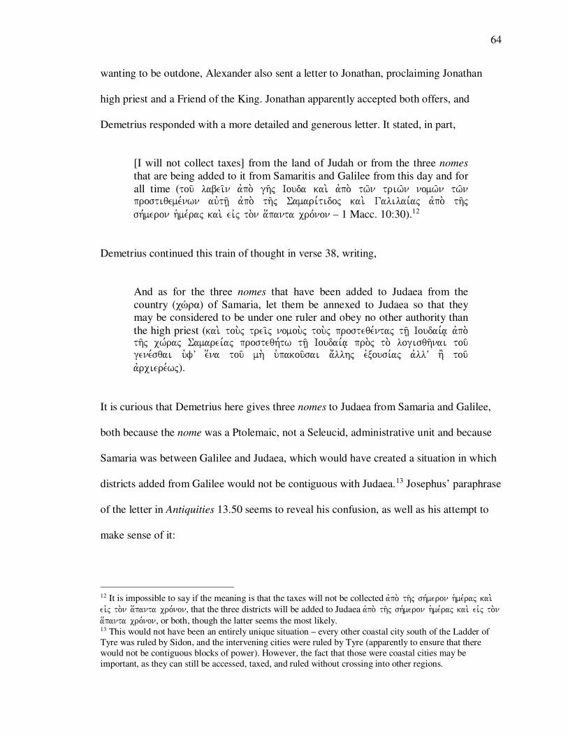
64
wanting to be outdone, Alexander also sent a letter to Jonathan, proclaiming Jonathan
high priest and a Friend of the King. Jonathan apparently accepted both offers, and
Demetrius responded with a more detailed and generous letter. It stated, in part,
[I will not collect taxes] from the land of Judah or from the three nomes
that are being added to it from Samaritis and Galilee from this day and for
all time (tou/ labei/n avpo. gh/j Iouda kai. avpo. tw/n triw/n nomw/n tw/n prostiqeme,nwn auvth/| avpo. th/j Samari,tidoj kai. Galilai,aj avpo. th/j sh,meron h`me,raj kai. eivj to.n a[panta cro,non – 1 Macc. 10:30).12
Demetrius continued this train of thought in verse 38, writing,
And as for the three nomes that have been added to Judaea from the
country (χώρα) of Samaria, let them be annexed to Judaea so that they
may be considered to be under one ruler and obey no other authority than
the high priest (kai. tou.j trei/j nomou.j tou.j prosteqe,ntaj th/| Ioudai,a| avpo. th/j cw,raj Samarei,aj prosteqh,tw th/| Ioudai,a| pro.j to. logisqh/nai tou/ gene,sqai ufV e[na tou/ mh. u`pakou/sai a;llhj evxousi,aj avllV h' tou/ avrciere,wj).
It is curious that Demetrius here gives three nomes to Judaea from Samaria and Galilee,
both because the nome was a Ptolemaic, not a Seleucid, administrative unit and because
Samaria was between Galilee and Judaea, which would have created a situation in which
districts added from Galilee would not be contiguous with Judaea.13 Josephus’ paraphrase
of the letter in Antiquities 13.50 seems to reveal his confusion, as well as his attempt to
make sense of it:
12 It is impossible to say if the meaning is that the taxes will not be collected avpo. th/j sh,meron hme,raj kai. eivj to.n a[panta cro,non, that the three districts will be added to Judaea avpo. th/j sh,meron hme,raj kai. eivj to.n a[panta cro,non, or both, though the latter seems the most likely. 13 This would not have been an entirely unique situation – every other coastal city south of the Ladder of
Tyre was ruled by Sidon, and the intervening cities were ruled by Tyre (apparently to ensure that there
would not be contiguous blocks of power). However, the fact that those were coastal cities may be
important, as they can still be accessed, taxed, and ruled without crossing into other regions.
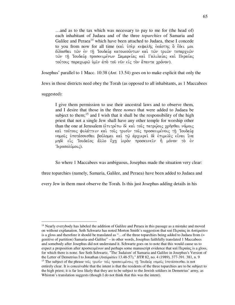
65
…and as to the tax which was necessary to pay to me for (the head of)
each inhabitant of Judaea and of the three toparchies of Samaria and
Galilee and Peraea14 which have been attached to Judaea, these I concede
to you from now for all time (kai. u`pe.r kefalh/j e`ka,sthj o] e;dei moi di,dosqai tw/n evn th/| VIoudai,a| katoikou,ntwn kai. tw/n triw/n toparciw/n tw/n th/| VIoudai,a| proskeime,nwn Samarei,aj kai. Galilai,aj kai. Perai,aj tou,touj paracwrw/ umi/n avpo. tou/ nu/n eivj to.n a[panta cro,non).
Josephus’ parallel to 1 Macc. 10:38 (Ant. 13.54) goes on to make explicit that only the
Jews in those districts need obey the Torah (as opposed to all inhabitants, as 1 Maccabees
suggested):
I give them permission to use their ancestral laws and to observe them,
and I desire that those in the three nomes that were added to Judaea be
subject to them;15 and I wish that it shall be the responsibility of the high
priest that not a single Jew shall have any other temple for worship other
than the one at Jerusalem (evpitre,pw de. kai. toi/j patrw,|oij crh/sqai no,moij kai. tou,touj fula,ttein kai. toi/j trisi.n toi/j proskeime,noij th/| VIoudai,a| nomoi/j u`pota,ssesqai bou,lomai kai. tw/| avrcierei/ de. evpimele.j ei=nai i[na mhde. ei-j VIoudai/oj a;llo e;ch| iero.n proskunei/n h' mo,non to. evn ~Ierosolu,moij).
So where 1 Maccabees was ambiguous, Josephus made the situation very clear:
three toparchies (namely, Samaria, Galilee, and Peraea) have been added to Judaea and
every Jew in them must observe the Torah. Is this just Josephus adding details in his
14 Nearly everybody has labeled the addition of Galilee and Peraea in this passage as a mistake and moved on without explanation. Seth Schwartz has noted Morton Smith’s suggestion that καὶ Περαίας in Antiquities
is a gloss and therefore it should be translated as “…of the three toparchies being added to Judaea from (=
genitive of partition) Samaria-and-Galilee” – in other words, Josephus faithfully translated 1 Maccabees
and somebody after Josephus did not understand it. Schwartz goes on to note that this would cause us to
expect a preposition after προσκειμένων and perhaps some manuscript evidence that καὶ Περαίας is a gloss,
for which there is none. See Seth Schwartz, "The 'Judaism' of Samaria and Galilee in Josephus's Version of
the Letter of Demetrius I to Jonathan (Antiquities 13.48-57)," HTR 82, no. 4 (1989), 377-391. 381, n. 9 15 The subject of the phrase toi/j trisi.n toi/j proskeime,noij th/| VIoudai,a| nomoi/j upota,ssesqai is not
entirely clear. It is conceivable that the intent is that the residents of the three toparchies are to be subject to
the high priest; it is far less likely that they are to be subject to the Jewish soldiers in Demetrius’ army, as
Whiston’s translation suggests (though I do not think that this was the intent).
66
paraphrase to fit his rhetorical purposes,16 or is he including another source that the
author of 1 Maccabees either did not have or did not include?
The Letter of Demetrius II (ca. 145 BCE)
1 Maccabees 11:28-38 provides further elucidation. By 145 BCE, Alexander had
been killed, Ptolemy VI had died, Demetrius II had become king, and Jonathan was
besieging the citadel in Jerusalem. An angry Demetrius II demanded that Jonathan end
the siege and meet him at Acco-Ptolemais. When Jonathan came bearing gifts and won
Demetrius’ favor, Demetrius reconfirmed Jonathan’s high priesthood and made Jonathan
one of his chief Friends. According to 1 Maccabees, Jonathan then “asked the king to free
Judaea and the three toparchies of Samaritis from tribute” (kai. hvxi,wsen Iwnaqan to.n
basile,a poih/sai th.n Ioudai,an avforolo,ghton kai. ta.j trei/j toparci,aj kai. th.n
Samari/tin – 1 Macc. 11:28). In response Demetrius wrote the following letter:
King Demetrius to his brother Jonathan and to the nation of the Jews,
greetings. 31This copy of the letter that we wrote concerning you to our
kinsman Lasthenes we have written to you also, so that you may know
what it says. 32King Demetrius to his father Lasthenes, greetings. 33 have
determined to do good to the nation of the Jews, who are our friends and
fulfill their obligations to us, because of the goodwill they show toward us. 34We have confirmed as their possession both the territory (o[riao[riao[riao[ria) of
Judaea and the three nomes of Aphairema and Lydda and Rathamin;
the latter, with all of the region bordering them, were added to Judaea
from Samaritis (e`sta,kamen auvtoi/j ta, te o[ria th/j Ioudai,aj kai. tou.j (e`sta,kamen auvtoi/j ta, te o[ria th/j Ioudai,aj kai. tou.j (e`sta,kamen auvtoi/j ta, te o[ria th/j Ioudai,aj kai. tou.j (e`sta,kamen auvtoi/j ta, te o[ria th/j Ioudai,aj kai. tou.j trei/j nomou.j Afairema kai. Ludda kai. Rtrei/j nomou.j Afairema kai. Ludda kai. Rtrei/j nomou.j Afairema kai. Ludda kai. Rtrei/j nomou.j Afairema kai. Ludda kai. Raqamin prosete,qhsan th/| Ioudai,a| aqamin prosete,qhsan th/| Ioudai,a| aqamin prosete,qhsan th/| Ioudai,a| aqamin prosete,qhsan th/| Ioudai,a| avpo. th/j Samari,tidoj kai. pa,nta ta. sugkurou/nta auvtoi/javpo. th/j Samari,tidoj kai. pa,nta ta. sugkurou/nta auvtoi/javpo. th/j Samari,tidoj kai. pa,nta ta. sugkurou/nta auvtoi/javpo. th/j Samari,tidoj kai. pa,nta ta. sugkurou/nta auvtoi/j). To all those
who offer sacrifice in Jerusalem we have granted release from the royal
taxes that the king formerly received from them each year, from the crops
of the land and the fruit of the trees. 35And the other payments henceforth
due to us of the tithes, and the taxes due to us, and the salt pits and the
crown taxes due to us – from all these we shall grant them release. 36And
16 For this argument, see Schwartz, "The 'Judaism' of Samaria and Galilee in Josephus's Version of the
Letter of Demetrius I to Jonathan (Antiquities 13.48-57)."
67
not one of these grants shall be canceled from this time on forever. 37Now
therefore take care to make a copy of this, and let it be given to Jonathan
and put up in a conspicuous place on the holy mountain. (1 Macc. 11:30-
38)17
Josephus has an account of Jonathan’s meeting with Demetrius as well, in addition to a
copy of the letter that Demetrius wrote. Josephus began by paraphrasing 1 Macc. 11:28:
...when [Jonathan] petitioned [Demetrius] that he would demand no more
than three hundred talents for the tribute of all Judaea and the three
toparchies of Samaritis, and Joppa,18 and Galilee, [Demetrius] complied
with the proposal, and gave him a letter confirming all those grants; the
contents of which were as follows… (…[VIwna,qou] parakale,santoj auvto,n (Dhmh,trion) o[pwj u`pe.r th/j VIoudai,aj a`pa,shj kai. tw/n triw/n toparciw/n Samarei,aj kai. VIo,pphj kai. Galilai,aj triako,sia telh/| ta,lanta di,dwsin kai. peri. pa,ntwn evpistola,j ai] periei/con tou/ton to.n tro,pon – Ant.
13.125).
Josephus then proceeded to present a letter that, up until the end of the sentence in which
Demetrius designates the three districts as “Aphairema, and Lydda, and Ramatha, which
have been added to Judaea out of Samaria, with what appertains to them” (parascei/n kai.
tou.j trei/j nomou.j VAfai,rema kai. Lu,dda kai. ~Ramaqain oi] th/| VIoudai,a| prosete,qhsan
17 basileu.j Dhmh,trioj Iwnaqan tw/| avdelfw/| cai,rein kai. e;qnei Ioudai,wn 31to. avnti,grafon th/j evpistolh/j h-j evgra,yamen Lasqe,nei tw/| suggenei/ hmw/n peri. u`mw/n gegra,famen kai. pro.j u`ma/j o[pwj eivdh/te 32basileu.j Dhmh,trioj Lasqe,nei tw/| patri. cai,rein 33tw/| e;qnei tw/n Ioudai,wn fi,loij hmw/n kai. sunthrou/sin ta. pro.j hma/j di,kaia evkri,namen avgaqo.n poih/sai ca,rin th/j evx auvtw/n euvnoi,aj pro.j hma/j 34343434e`sta,kamen auvtoi/j ta, te e`sta,kamen auvtoi/j ta, te e`sta,kamen auvtoi/j ta, te e`sta,kamen auvtoi/j ta, te o[ria th/j Ioudai,aj kai. tou.j trei/j nomou.j o[ria th/j Ioudai,aj kai. tou.j trei/j nomou.j o[ria th/j Ioudai,aj kai. tou.j trei/j nomou.j o[ria th/j Ioudai,aj kai. tou.j trei/j nomou.j Afairema kai. Ludda kai. Raqamin prosete,qhsan th/| Ioudai,a| avpo. Afairema kai. Ludda kai. Raqamin prosete,qhsan th/| Ioudai,a| avpo. Afairema kai. Ludda kai. Raqamin prosete,qhsan th/| Ioudai,a| avpo. Afairema kai. Ludda kai. Raqamin prosete,qhsan th/| Ioudai,a| avpo. th/j Samari,tidoj kai. pa,nta ta. sugkurou/nta auvtoi/j pa/sin toi/j qusia,zousin eivj Ieroso,luma avnti. tw/n th/j Samari,tidoj kai. pa,nta ta. sugkurou/nta auvtoi/j pa/sin toi/j qusia,zousin eivj Ieroso,luma avnti. tw/n th/j Samari,tidoj kai. pa,nta ta. sugkurou/nta auvtoi/j pa/sin toi/j qusia,zousin eivj Ieroso,luma avnti. tw/n th/j Samari,tidoj kai. pa,nta ta. sugkurou/nta auvtoi/j pa/sin toi/j qusia,zousin eivj Ieroso,luma avnti. tw/n basilikw/n wbasilikw/n wbasilikw/n wbasilikw/n w-- --n evla,mbanen o basileu.j parV auvtw/n to. pro,teron katV evnian evla,mbanen o basileu.j parV auvtw/n to. pro,teron katV evnian evla,mbanen o basileu.j parV auvtw/n to. pro,teron katV evnian evla,mbanen o basileu.j parV auvtw/n to. pro,teron katV evniauto.n avpo. tw/n genhma,twn th/j gh/j uto.n avpo. tw/n genhma,twn th/j gh/j uto.n avpo. tw/n genhma,twn th/j gh/j uto.n avpo. tw/n genhma,twn th/j gh/j kai. tw/n avkrodru,wn kai. tw/n avkrodru,wn kai. tw/n avkrodru,wn kai. tw/n avkrodru,wn 35kai. ta. a;lla ta. avnh,konta hmi/n avpo. tou/ nu/n tw/n dekatw/n kai. tw/n telw/n tw/n avnhko,ntwn hmi/n kai. ta.j tou/ a`lo.j li,mnaj kai. tou.j avnh,kontaj hmi/n stefa,nouj pa,nta evparke,somen auvtoi/j 36kai. ouvk avqethqh,setai ouvde. e]n tou,twn avpo. tou/ nu/n eivj to.n a[panta cro,non 37nu/n ou=n evpime,lesqe tou/ poih/sai tou,twn avnti,grafon kai. doqh,tw Iwnaqan kai. teqh,tw evn tw/| o;rei tw/| a`gi,w| evn to,pw| evpish,mw| 38kai. ei=den Dhmh,trioj o basileu.j o[ti hsu,casen h gh/ evnw,pion auvtou/ kai. ouvde.n auvtw/| avnqeisth,kei kai. avpe,lusen pa,saj ta.j duna,meij auvtou/ e[kaston eivj to.n i;dion to,pon plh.n tw/n xe,nwn duna,mewn w-n evxenolo,ghsen avpo. tw/n nh,swn tw/n evqnw/n kai. h;cqranan auvtw/| pa/sai ai duna,meij ai avpo. tw/n pate,rwn 18 Whiston’s translation has “Peraea” here, presumably as the result of an attempt to harmonize this passage
with Ant. 13.54. No extant manuscript preserves here Peraea as a variant. E (i.e., the Epitome manuscript,
used by Zonaras and dated by Niese to the 10th-11th century) preserves the only variant: Ἰοπης. See Flavius
Josephus and Benedikt Niese, Flavii Iosephi Opera: edidit et apparatu critico instruxit Benedictus Niese
(Berolini: apud Weidmannos, 1887)., volume III

68
avpo. th/j Samarei,tidoj kai. ta. proskurou/nta tou,toij),19 is nearly a word-for-word copy
of the version that we have in Rahlf’s edition of 1 Maccabees (see Table 2).
19 basileu.j Dhmh,trioj VIwna,qh| tw/| avdelfw/| kai. tw/| e;qnei tw/n VIoudai,wn cai,rein to. avnti,grafon th/j evpistolh/j h-j e;graya Lasqe,nei tw/| suggenei/ hmw/n avpesta,lkamen umi/n i[na eivdh/te 127 basileu.j Dhmh,trioj Lasqe,nei tw/| patri. cai,rein tw/| VIoudai,wn e;qnei o;nti fi,lw| kai. ta. di,kaia ta. pro.j hma/j fula,ttonti th/j euvnoi,aj e;krina ca,rin parascei/n kai. tou.j trei/j nomou.j VAfai,rema kai. Lu,dda kai. ~Ramaqain oi] th/| VIoudai,a| prosete,qhsan avpo. th/j Samarei,tidoj kai. ta. proskurou/nta tou,toij 128 e;ti te o[sa para. tw/n quo,ntwn evn ~Ierosolu,moij evla,mbanon oi pro. evmou/ basilei/j kai. o[sa avpo. tw/n karpw/n th/j gh/j kai. tw/n futw/n kai. ta=lla ta. prosh,konta hmi/n kai. ta.j li,mnaj tw/n a`lw/n kai. tou.j komizome,nouj hmi/n stefa,nouj avfi,hmi auvtoi/j kai. ouvde.n parabibasqh,setai tou,twn avpo. tou/ nu/n ouvde. eivj to.n a[panta cro,non fro,ntison ou=n i[na tou,twn avnti,grafon ge,nhtai kai. doqh/| VIwna,qh|

69
Dem
etri
us
I a
nd
Jo
nath
an
(ca.
152 B
CE
)
Tex
t/P
ass
ag
e
Des
crip
tio
n
Top
arch
y/N
om
e
Dis
tric
t N
am
es
1 M
acc
. 1
0:3
0
Let
ter
of
Dem
etri
us
I to
Jonath
an
Thre
e nom
es
Fro
m S
am
arit
is a
nd G
ali
lee
(avpo
. th/j
Sam
ari,tid
ojSam
ari,tid
ojSam
ari,tid
ojSam
ari,tid
oj k
ai.
Gal
ilai
,aj)
1 M
acc
. 1
0:3
8
Let
ter
of
Dem
etri
us
I to
Jonath
an (
cont.
) T
hre
e nom
es
Fro
m t
he
χώρα
of
Sa
ma
ria
(avp
o. th
/j cw
,raj Sam
arei,aj
Sam
arei,aj
Sam
arei,aj
Sam
arei,aj
)
An
tiq
uit
ies
13.5
0
Let
ter
of
Dem
etri
us
I to
Jonath
an
Thre
e to
parc
hie
s O
f S
am
ari
a,
Gali
lee,
an
d P
eraea
(ka
i. tw
/n tr
iw/n
topa
rciw
/n tw
/n th
/| VIoud
ai,a|
pros
keim
e,nwn
Sam
arei,aj
Sam
arei,aj
Sam
arei,aj
Sam
arei,aj
kai
. Gal
ilai
,aj k
ai.
Per
ai,aj
)
An
tiq
uit
ies
13.5
4
Let
ter
of
Dem
etri
us
I to
Jonath
an (
cont.
) T
hre
e nom
es
N/A
Dem
etri
us
II a
nd
Jo
nath
an
(ca.
145 B
CE
)
Tex
t/P
ass
ag
e
Des
crip
tio
n
Top
arch
y/N
om
e
Dis
tric
t N
am
es
1 M
acc
. 1
1:2
8
Jonath
an s
pea
kin
g t
o D
emet
rius
II
Thre
e to
parc
hie
s A
nd S
am
arit
is
(ta.j
tre
i/j t
opar
ci,aj
kai
. th.n
Sam
ari/tin
Sam
ari/tin
Sam
ari/tin
Sam
ari/tin
)
1 M
acc
. 1
1:3
4
Let
ter
of
Dem
etri
us
II t
o J
onath
an
Thre
e nom
es
Of
Ap
hair
ema,
Lu
dda,
and R
ath
am
a a
nd t
he
part
s adjo
inin
g
them
…ad
ded
fro
m S
am
arit
is (ka
i. to
u.j t
rei/j n
omou
.j Afai
rema
kai
. Lud
da k
ai. R
aqam
in…
avpo.
th/j
Sam
ari,t
idoj
Sam
ari,t
idoj
Sam
ari,t
idoj
Sam
ari,t
idoj
…ka
i. pa
,nta
ta. s
ugku
rou/n
ta a
uvtoi
/j)
An
tiq
uit
ies
13.1
25
Jonath
an s
pea
kin
g t
o D
emet
rius
II
Thre
e to
parc
hie
s O
f S
am
ari
a,
Jop
pa,
and G
ali
lee
(kai
. tw/n
triw
/n to
parc
iw/n
Sam
arei,aj
Sam
arei,aj
Sam
arei,aj
Sam
arei,aj
kai
. VIo,pp
hj k
ai. G
alil
ai,aj
)
An
tiq
uit
ies
13.1
27
Let
ter
of
Dem
etri
us
II t
o J
onath
an
T
hre
e nom
es
Ap
hair
ema,
Lyd
da,
and R
am
ath
a…
and t
hin
gs
per
tain
ing t
o
them
…ad
ded
fro
m S
am
arit
is (ou
.j tr
ei/j no
mou.j
VAfai
,rema
ka
i. Lu,d
da k
ai. ~Ram
aqai
n oi
] th/|
VIou
dai,a
| pro
sete,qh
san
avpo.
th/j Sam
arei,tido
jSam
arei,tido
jSam
arei,tido
jSam
arei,tido
j ka
i. ta
. pro
skur
ou/nt
a to
u,toi
j)
Tab
le 2
: T
he
lett
ers
fro
m D
em
etri
us
I an
d D
em
etri
us
II t
o J
onat
han
, as
rep
rese
nte
d b
y 1
Macc
abee
s

70
There are three categories of inconsistency in these letters, all of which are
highlighted in Table 2: (1) Shifts in terminology between νόμος and τοπαρχία; (2) shifts
in terminology between Σαμαρῖτις and Σαμαρεία; and (3) a lack of agreement as to what
the proper name designations were for the districts that were annexed to Judaea. At first
glance it appears that 1 Maccabees, which was probably composed ca. 100 BCE by a
member of the Hasmonaean court who therefore probably had access to originals or
copies of these letters,1 used the terms νόμος and Σαμαρῖτις, while Josephus, writing ca.
100 CE when Palestine was under the administrative control of the Romans, used the
terms τοπαρχία and Σαμαρεία. Josephus does use νόμος in Ant. 13.54 and 13.127, but he
was copying 1 Maccabees and his use of νόμος in Ant. 13.127 is the only Josephan
passage (of those being considered here) that is nearly a word-for-word copy of 1
Maccabees 11:34. And the author of 1 Maccabees does appear to use τοπαρχία in 1
Maccabees 11:28, but its presence in the text is likely the result of a later gloss.2 This
conclusion is further underscored by a quick look at Josephus’ use of τοπαρχία and
1 The majority opinion is that 1 Maccabees was composed ca. 100 BCE, but Seth Schwartz has argued for
dating the composition of 1 Maccabees to ca. 132-128 BCE. See Seth Schwartz, "Israel and the Nations
Roundabout: 1 Maccabees and the Hasmonaean Expansion," JJS 42, no. 1 (1991), 16-38. 2 This passage (1 Maccabees 11:28) represents the only instance of τοπαρχία in the entire Septuagint. Its
occurrence is most easily and satisfactorily explained as the result of a later gloss that was incorporated into
the text. The meaning of the letter is admittedly opaque: how could the hree nomes of Aphairema, Ludda,
and Rathama (along with the region bordering them) be added to Judaea from Samaria (ἀπὸ τῆς
Σαμαρίτιδος). Not only were the three “nomes” actually toparchies, but Samaritis itself was the equivalent
of a nome, so the text seems to be saying that the nome of Samaritis had three nomes within it. A gloss,
then, was inserted (or copied from the margin) to explain what Demetrius’ letter meant without changing
the contents of the letter. The Greek of the gloss further suggests this interpretation of events: though
English translations have mistranslated the passage as, “Jonathan asked the king to free Judaea and the
three districts (toparchies) of Samaria from tribute,” the Greek says that Jonathan asked the king to free
Judaea and the three toparchies and Samaria from tribute (kai. hvxi,wsen Iwnaqan to.n basile,a poih/sai th.n Ioudai,an avforolo,ghton kai. ta.j trei/j toparci,aj kai. th.n Samari/tin). As for the other places in the
Septuagint in which νόμος is used instead of τοπαρχία, it is either an artifact of translation (a text in
Hebrew or Aramaic, translated into Greek by an Alexandrian, would most likely preserve the Alexandrian
word for “district” (νόμος), or it is a result of the Ptolemies using the nome system throughout their
kingdom and Palestine not coming under Seleucid control until 199 BCE (i.e., after most of the books of
the Septuagint were translated into Greek).

71
νόμος. The entities depicted in these letters are stereotypical Josephan τοπαρχία,3 and,
aside from Ant. 13.54 and 13.127, he only uses νόμος with an administrative meaning in
five other places, all of which are specific references to the Egyptian nome of Heliopolis.4
In addition, most scholars have concluded that the Ptolemies administered at least part of
Palestine under the Egyptian nome system, and that the Seleucids continued this practice
Seleucids after the battle of Paneas in 199 BCE, in large part due to the evidence of these
leters. It is worth considering, however, that if 1 Maccabees was translated into Greek by
and Egyptian, as the existence of the Septuagint makes possible (though hardly certain),
the use of toparchy in place of nome in 1 Maccabees would have required knowledge of
Seleucid administrative practices on the part of a translator, and it would make sense that
the translator, encountering a Semitic word for “district,” would have used the
designation that made the most sense to him (νόμος).
The more illuminating discrepancy in the letters are the differences in occurrence
between Σαμαρίτις and Σαμαρείας. Although there is very little difference between the
two words (especially to English-speaking ears that are used to hearing about
“Samaritans” who lived in or came from “Samaria”), their forms are quite important.
According to the Hebrew Bible, the name “Shomron” (שמרון), from which the English
word “Samaria” comes, is apparently the result of the Israelite king Omri’s purchase of a
hill from a man named Shemer.5 Whether or not that is the correct etymology, the
3 Ant. 8:35, 284; 13:50, 102, 125; 18:31; War 1:45; 2:98, 167, 235, 252, 509, 567, 652; 3:48, 54; 4:444f, 504, 511, 551. The Roman administrative system in the east has been well documented. An early example
is A. H. M. Jones, "The Urbanization of Palestine," JRS 21 (1931), 78-85. 4 Ant. 12:388; 13:70; 20:236; War 1:33; 7:426. 5 1Kings 16:24. Note also Josephus’ explanation in Ant. 8.312: “[Omri reigned for 6 years in Tirzah] and
the rest in the city called Somareon, which was named Samaria by the Greeks. He himself designated it to
be called Somaraios, after Somaros, who sold him the mountain on which he built the city.” (h=rxen o VAmari/noj e;th dw,deka tou,twn ta. me.n e]x evn Qa,rsw| po,lei ta. de. loipa. evn Swmarew/ni legome,nh| po,lei upo.

72
Hebrew Bible makes it clear that the city of Shomron (שמרון) was the capital of the
northern kingdom of Israel,6 and coins from the 4th century BCE and the Wadi ed-
Daliyeh papyri show that the city or fortress of Shomron (שמרן) was the capital city of a
province by the same name (מדינתא שמרין) in the Persian period.7 The name Σαμαρίτις, on
the other hand, probably comes from the Ptolemaic administration of the region, as
regional names ending with –ιτις are common in areas that were once ruled by the
Ptolemies.8
It therefore comes as no surprise that Σαμαρῖτις occurs only three times in the
entire Septuagint (as opposed Σαμαρεία, which occurs 107 times), all of which are in 1
Maccabees, and all of which occur in or associated with the official correspondences
under consideration here.9 These statistics are likely due to the fact that (a) the city of
Samaria is referenced far more often in the Hebrew Bible than the district in which it
resided; and (b) only the very late books of the Septuagint were written late enough to
have any opportunity to make reference to the Ptolemaic district in which the city of
Samaria resided, and only the books of Maccabees are of a genre that would have taken
de. ~Ellh,nwn Samarei,a| kaloume,nh| proshgo,reuse dV auvth.n auvto.j Swmarai/oj avpo. tou/ to. o;roj avpodome,nou auvtw/| evfV w-| kateskeu,ase th.n po,lin Swma,rou) 6 E.g., 1 Ki. 16:29; 20:1; 21:18; 2 Ki. 3:1; et al. 7 WDSP 4.1; 5.1; 14.9; 19.1; and 26.1. (See Gropp et al., Wadi Daliyeh II: The Samaria Papyri from Wadi
Daliyeh XXVIII, Miscellanea, Part 2.) So also Ezra 4:10: !yIr"m.v' yDI hy"r>qi. For the coins, see Ya'akov Meshorer
and Shraga Qedar, Samarian Coinage. Publications of the Israel Numismatic Society: Numismatic Studies and Researches (Jerusalem: Israel Numismatic Society, 1999). The papyri are not pointed, so the vowels
are questionable. In the Hebrew Bible it is consistently !Arm.vo in Hebrew and !yIr"m.v' in Aramaic (Ezra 4:10;
4:17). Though the qametz followed by a sheva in the Aramaic suggests a long “o” vowel, the Canaanite
shift suggests reading it as a long “a” vowel, which probably explains the aleph in the Greek. The
Targumim are interesting in that they consistently point the word according to the Hebrew pronunciation: !ArmAv and !Arm.vo (e.g., 1 Ki. 13:32 and 1 Ki. 16:32), as also the Peshitta’s consistent ���� (e.g., Luke
17:11; John 4:4, 9; Acts 1:8; 8:1, 5, 9, 14; 15:3), though note the curious and unique instance of ���� in
the list of “Judaea, Galilee, and Samaria” in Acts 9:31. 8 So A. H. M. Jones, The Greek City from Alexander to Justinian (Oxford: Clarendon Press, 1940), 20-21.
Note, however, that there are provinces with –ιτις names in Asia Minor. See Stephen Mitchell, Anatolia:
Land, Men, and Gods in Asia Minor, 2 vols. (Oxford: Oxford University Press, 1993). 9 1 Macc. 10:30; 11:28, 34. Σαμαρεία occurs twice in 1 Maccabees: 1 Macc. 3:10; 10:38, both of which
probably refer to the city of Samaria, even if somewhat circumlocuitously.

73
note of or made reference to such administrative details. Josephus’ use of the terms is
slightly inconsistent, as Josephus is often wont to be. For the most part, however, he
follows the same pattern. He consistently uses Σαμαρίτις as a reference to the region,
including in the sections in which he explicitly delineates and describes the regions of
Galilee, Judaea, and Σαμαρείτις,10 and nearly all of the105 occurrences of the word
Σαμαρεία reflect the explicit or implicit designation of a city.11 The exception to this rule
is when Σαμαρεία is preceded by forms of the words κοίλη or χώρα, as in War 1.213,
302; Ant. 12.154, 175; and 14.411.
Once these nuances inherent in the words Σαμαρεία and Σαμαρ(ε)ίτις are
understood, the letters from Demetrius I and Demetrius II to Jonathan begin to make
sense. The toparchy of Samaria (i.e., a small administrative unit named accordint to its
“capital” city) that will be added to Judaea in Ant. 13:50 and 13.125 is referred to by the
name Σαμαρεία, while the region or district of Σαμαρ(ε)ίτις out of which a toparchy or
nome is to be dded to Judaea is referred to by the name Σαμαρ(ε)ίτις (1 Macc. 10:30,
11:34, and Ant. 13.127). The only exception is 1 Macc. 10:38, in which three nomes are
being added to Judaea from the χώρα of Σαμαρεία. As noted above in the discussion of
Josephus’ use of Σαμαρεία, this construction ought to be rendered along the lines of
“from the vicinity (of the city of) Samaria” or “from the hinterland (of the city of)
10 War 3.37, 48. The only exception is in Ant. 7.103, where Josephus is citing Nicolaus of Damascus as
saying that Herod “made an expedition against the Jews and laid waste to the city that is now called
Samareitis.” 11 Noteable among these instances is Ant. 9.278-9, in which Josephus writes that Shalmaneser besieged the
city of Samaria for 3 years, took it, and took the Israelites to Media and Persia. He then replaced them by moving people from Kutha “into Samaria and into the country of the Israelites” (εἰς τὴν Σαμάρειαν καὶ τὴν
τῶν Ἰσραηλιτῶν χώραν). There are five exceptions: War 2.247 (which is set in the time of, and may reflect
the reality of, the Roman administration of the region), Ant. 11.21, 167; 12.224; and 20.118 (in which the
village of Ginea is described as lying on the border of Σαμαρεία, even though the same village had been
described in War 3.48 as marking the border between Galilee and Σαμαρείτις).

74
Samaria.” This usage of χώρα is consistent not only with Josephus’, but can also be found
elsewhere in 1 Maccabees12 and the later books of the Septuagint.13
Within the framework that has been supplied by the foregoing discussion of the
linguistics of these passages we can now turn to the question of exactly what was added
to Judaea by Demetrius I. Let us first look to the the internal logic and cohesion of the
earliest preserved copy of the first letter, that of Demetrius I, as recorded in 1 Maccabees.
The letter begins with a typical greeting formula before foreshadowing its structure in
10:27-28: “Now continue still to keep faith with us, and we will repay you with good for
what you do for us; we will grant you many immunities and give you gifts.”14 Verses 29-
35 then describe the immunities,15 and verses 36-45 describe the gifts.16 In other words,
structurally speaking, it is verse 38 (kai. tou.j trei/j nomou.j tou.j prosteqe,ntaj th/| Ioudai,a|
avpo. th/j cw,raj Samarei,aj prosteqh,tw th/| Ioudai,a| pro.j to. logisqh/nai tou/ gene,sqai ufV
e[na tou/ mh. u`pakou/sai a;llhj evxousi,aj avllV h' tou/ avrciere,wj), and not verse 30, that is
12 13 E.g.,1 Macc. 7:7 (the χώρα of the king) and 12:32 (the χώρα of Damascus), as well as in many places
denoting the “land of Israel” with a clear indication of borders and Jewish authority within those borders.
See also 1 Esd. 5:45; 8:13; 9:37. Ezra 7:16, et al. Esth. 4:3 and Neh. 1:3 should also be added to this list, for although they don’t explicitly mention a referent, it can be deduced from the context. 14 kai. nu/n evmmei,nate e;ti tou/ sunthrh/sai pro.j hma/j pi,stin kai. avntapodw,somen umi/n avgaqa. avnqV w-n poiei/te meqV hmw/n 28kai. avfh,somen umi/n avfe,mata polla. kai. dw,somen umi/n do,mata 15 Immunities: exemption from tribute, salt tax, crown levies; exemption from the tax of one-third of yearly
grain and one-half of the yearly fruit for the land of Judah and the 3 nomes being added to it from Samaritis
and Galilee – “[which is to say], Jerusalem and its environs, its tithes and its revenues, shall be holy and
free from tax; release of control of the citadel; release of Jewish captives within Demetrius’ kingdom;
exemption of tax on captives’ livestock; freedom form work for Judaeans on festivals, Sabbaths, new
moons, appointed days, and for three days before and after a festival; and freedom from the obligation to
provide for the military. 16 Gifts: up to 30,000 Judaeans can be in the army, they will be put into positions of power, and they will be
commanded by Judaeans; 3 nomes will be annexed to Judaea from the χώρα of Samaria and they will be
considered to be under one ruler and will obey no other authority than the high priest in Jerusalem; Acco-Ptolemais and its surrounding land have also been given to Jerusalem, to meet the expenses of the temple;
the king will pay 15,000 shekels per year, as well as additional funds for the service of the temple; the
5,000 shekels of silver that have in the past been paid to Seleucid officials will now go to the priests in the
temple; anybody who takes refuge in the temple because of money owed to the king will be released; the
king will pay for the rebuilding and restoring of the temple, the walls in Jerusalem, and the walls in Judaea.

75
the description of the gift. This conclusion corresponds well with the earlier discussion of
1 Maccabees’ use of Σαμαρεία and Σαμαρίτις: not only does the structure of 1 Maccabees
argue for 10:34 as the more reliable of the two passages, but also 10:34 should be
preferred because it is more specific: the nomes are to be added from the χώρα of [the
city of] Samaria.
Next let us look to the section of the letters for which there is the greatest amount
of agreement among the ancient authors, namely 1 Macc. 11:34 and Ant. 13.127. The fact
that Josephus paraphrased 1 Maccabees’ presentation of the events leading up to the letter
from Demetrius II to Jonathan, and paraphrased the last portion of the letter as well, but
that Josephus’ version of the first portion of that letter is an almost identical copy of the
letter preserved in the Septuagint, suggests that Josephus is either copying 1 Maccabees
or that both 1 Maccabees and Josephus are copying another text (i.e., the text of this letter
that was apparently placed “in a conspicuous place on the holy mountain” – see 1
Maccabees 11:37). It is more likely to have been the former, given that Josephus was
writing from Rome and that he returned to paraphrasing before the letter ends and the
possibility (if not the likelihood) that the letter would have been originally written in
Greek and erected near the Temple in that language, rather than being translated to
Hebrew or Aramaic.17 That said, we must not forget that 1 Maccabees was originally
written in Hebrew or Aramaic and only later translated into Greek. The differences
17 The so called “Temple Warning Inscription” from the Temple Mount that prohibited non-Jews from
entering into an area of the temple precincts (likely dating to the Herodian period) was in Greek precisely
because it was aimed at foreigners. On the other hand, the Theodotus dedicatory inscription was also in
Greek, and there is no good reason to think that educated, literate Jews would not have spoken Greek in the Herodian period or even the early first century CE, even if the linguistic picture for the Hasmonaean period
is far murkier than for the Herodian period. It is possible that engraving the letter in Greek would project its
status as a letter from the Seleucid king; or we could point to the original Semitic language of 1 Maccabees
– an official Hasmonaean court document – as evidence for the use and/or importance of the language in
the Jerusalem aristocracy and government around 100 BCE.

76
between 1 Maccabees’ and Josephus’ versions of the letter could well be the result of one
or both translation events.
Whatever the case, the close agreement between 1 Maccabees and Josephus, plus
the suggestion in the letter that it was inscribed and placed in public, require us to prefer
the first part of the letter as the most authoritative text on the matter and to understand the
additions to Judaea to have been the cities of Aphairema, Ludda, and either Ramatha or
Rathama, plus their hinterlands. Josephus’ statement in Ant. 13.125 (three lines prior to
his statement that the cities were Aphairema, Ludda, and Ramatha) that Demetrius II
annexed the three toparchies of Samaritis, Joppa, and Galilee, which parallels his
statement in Ant. 13.50 that Demetrius I annexed the toparchies of Samaria, Galilee, and
Peraea, is admittedly a problem. Although Josephus has been accused of sloppy work,
this seems unbelievable,18 and there are no textual variants that might explain the text that
we have before us. However, it might be possible to explain his quick shift here, as well
as his additions of Galilee and Peraea elsewhere, in addition to his apparent changing of 1
Maccabees’ Ῥαθαμιν to Ῥαμαθιν.19 Ἀφαιρεμα is not mentioned elsewhere in Josephus,
but it can be found in Joshua codex A (19:17) where it is listed as a city in the tribal
allotment of Issachar, in lower Galilee; Lydda is well represented elsewhere in Josephus
as a town of Samaritans that was well known to have been given to Judaea;20 and in Ant.
8.411 Josephus mentions a Ῥαμαθην that is a city of 9th century BCE Gilead, across the
Jordan from Judaea (i.e., Ramoth Gilead, which would have been in the region of the
18 So also Schwartz, though he comes to a much different conclusion. See Schwartz, "The 'Judaism' of
Samaria and Galilee in Josephus's Version of the Letter of Demetrius I to Jonathan (Antiquities 13.48-57)." 19 There is one witness each to the textual variants Ῥαμαθαιμ (l-62), Ῥαμαθεμ (L), ramath(a)e (LaLV),
ramath (LaB); רמתים (SyI); and רצתא (SyII). All other other manuscripts have a variant of Ῥαθαμιν:
Ῥαθαμ(ε)ιν (A,S,V, q, 62, 46,55, 58, 106, 311); Ῥαθμινα τιναις (i.e., ραθ<α>μιν αιτινες – 340. Note that
αιτινες is added to the text by L’, 58, 311, LaBV, and SyI); 20 War2.242, 567; 3.55; Ant. 14.202; 20.130.

77
Decapolis in the Roman period, just north of the “border” between the Decapolis and
Peraea). It is true that the change from Ῥαθαμιν to Ῥαμαθιν could simply be the result of
metathesis in the historical transmission of this document, but if it were intentional (or
even a mistake of metathesis on the part of Josephus prior to writing), and if Josephus did
not know exactly where the city had stood, Ant. 13.125 could be read with a partitive
genitive: “[Jonathan] petitioned [Demetrius] that he would give him 300 talents for all of
Judaea and the three toparchies, [one of which is in] Samaria, [one of which is in] Peraea,
and [one of which is in] Galilee.”21 This is not to say that Josephus’ paraphrase of Ant.
13.125 is more reliable than the beginning of Demetrius I’s letter, but simply one
explanation that gives an internal logic to Josephus’ writing (as opposed to an
explanation that requires us to throw the passage out with no explanation). Indeed, if this
interpretation is correct, it shows Josephus to be doing what he can be seen to do
elsewhere, namely, using a historical document to say what he wants his audience to hear
about the Jews.
Whatever the case, the fact that (a) this letter, and this letter only, was apparently
erected in public in Jerusalem; (b) Josephus is paraphrasing 1 Maccabees in Ant. 13.125
but is almost word-for-word in 13.127; (c) that the list of “Samaria, Joppa, and Galilee”
in 13.125 neither makes geographical sense nor does it make sense of Josephus’
conceptualization of τοπαρχία (see above), but “Aphairema, Lydda, and
Ramatha/Rathama” do;22 and (d) that Josephus preserved 1 Maccabees’ νομοὺς here – a
21 It is worth noting here that Josephus would have known that his audience would not have known where
Aphairema, Lydda, and Ramatha were. It is possible that simply expected his readers to assume that one city was in each region. 22 As far as Josephus’ designation of the three regions as being Samaria, Joppa (or Peraea), and Galilee
goes, there are a variety of possible explanations. Two likely ones are that Josephus added Galilee and
Peraea to 1 Maccabees’s mention of Samaria because both were regions that shared a border with Samaria
and both were given to Herod Antipas after Herod the Great’s kingdom was broken up (Ant 17.185, 276;

78
word that he only ever used with this meaning of the Egyptian nome of Hieropolis (see
above) all point to the conclusion that this text is the earliest and most reliable source on
the matter, and consequently that the districts added to Judaea were Aphairema, Lydda,
and Ramatha. This makes good topographical sense, too. Rather than imagining districts
being added to Judaea that were physically disconnected from it (if we understand the
situation to have been “three toparchies from Samaria and Galilee,” for instance), or such
huge sections of Palestine being added to Judaea that they would have more than tripled
its size (if we understand the situation to have been the addition of Samaria, Galilee, and
Peraea, which anyway would have been hyparchies or eparchies, but not toparchies), we
find the addition of small districts consisting of a city and its hinterland on Judaea’s
northern border: most scholars have concluded that that Aphairema was just north of
Bethel, Ramathaim was east of Joppa, and Lydda was southeast of Joppa (see Figure 1).
Given the conclusions that 1 Maccabees 11:34 is the most reliable text on the
matter and that 1 Maccabees 10:38 is the most specific description within the letter of
Demetrius I to Jonathan of the reions that were eing added to Judaea, it is clear that the
presence of Γαλιλαία in 1 Macc. 10/Ant. 13.48-57 must be explained away. There are two
possibilities that make the most sense: either the letter from Demetrius I to Jonathan as a
whole is saying that three nomes are being added to Judah from an administrative district
called Samaritis-and-Galilee23 or the addition of Γαλιλαίας to verse 30 is a later addition
18.240), or that Josephus added Galilee and Peraea because they had concentrations of Jews in his day (so
Schwartz, "The 'Judaism' of Samaria and Galilee in Josephus's Version of the Letter of Demetrius I to
Jonathan (Antiquities 13.48-57)."). 23 First proposed by Momigliano and followed by Goldstein, but opposed by Alt and Avi-Yonah (on p. 24, though note that he seems to embrace it on p. 48). See Arnaldo Momigliano, "Errori ntorno alle toparchie
della Palestina," Rivista di filologia e di istruzione classica 58 (1930), 71-74; Michael Avi-Yonah, The
Holy Land From the Persian to the Arab conquests (536 B.C. to A.D. 640): A Historical Geography (Grand
Rapids, Mich.: Baker Book House, 1966), 24, 25, 48; Albrecht Alt, Kleine Schriften zur Geschicte des
Volkes Israel (Munich: Beck, 1953), II.404. According to Avi-Yonah, Alt published his ideas as early as

79
to the text (perhaps an addition that occurred in the 200 or so years between the
composition of 1 Maccabees and the composition of Antiquities, which could explain
Josephus’ addition of Peraea to a version of 1 Maccabees that read ...τῶν τριῶν
τοπαρχιῶν τῶν τῇ Ἰουδαίᾳ προσκειμένων Σαμαρείας καὶ Γαλιλαίας...).24
The former explanation, while tidy, has little support: to my knowledge, 1
Maccabees 10:30 preserves the only known evidence for such a name of this well-known
administrative district. The latter explanation is simply not very satisfying. On the other
hand, these letters in 1 Maccabees preserve what is to my knowledge the only evidence
for the widespread scholarly conclusion that the Ptolemies imposed the Egytian nome
system in its administration of regions outside of Egypt, and this would be neither the
first nor the last time that a later addition has been argued to have made its way into the
text. The number of textual variants for any given ancient text might, in and of
1938 in Palästina-Jahrbuch, pages 90-92. See also Goldstein, I Maccabees: A New Translation, With Introduction and Commentary, 408; Avi-Yonah, The Holy Land From the Persian to the Arab conquests
(536 B.C. to A.D. 640): A Historical Geography, 48. Goldstein has concluded that “Samaritis-and-Galilee”
arrived here as the result of a well-informed gloss that was incorporated into the text. 24 Most scholars have explained Ant. 13.50 in this way, suggesting that he chose to supply Peraea because
he knew that Judaea, Samaria, Galilee, and Peraea were the places where the vast majority of Palestinian
Jews lived in his day (and, perhaps, figured that this was the historical reason for it). It is clear that this was
Josephus’ concept of the cultural landscape: see, for instance, War 3.35-58, in which the physical landscape
of Galilee, Peraea, Samaria, and Judaea is inserted his story of Vespasian and Titus entering the region to
make war against the Jews. Although he says that he has“described the country of Judaea and those that lie
around it,” (ta. me.n dh. peri. th/j VIoudai,wn te kai. pe,rix cw,raj wj evnh/n ma,lista sunto,mwj avphgge,lkamen),
in fact he has neglected Idumaea and the coast. However, this explanation does not that fact does not
provide a good reason for Josephus’ use of the word τοπαρχία. If Josephus meant to use both the word
τοπαρχία and the names Samaria, Galilee, and Peraea, then Ant. 13.50 and 13.125 would be the only two
places in all of his works in which τοπαρχία does not mean “a city and its hinterland.” There are 21
occurrences: Ant. 8.35 (Bethlehem), 284 (Bethel and Jeshanah); 13.50 (Samaritis and Galilee?!), 102
(Ekron), 125 (Samaria and Joppa and Galilee?!); 18.31 (Jamnia and perhaps, though elided, Phasaelis and
Archelaus); War 1.45 (Gophna); 2.98 (Archelaus’), 167 (Salome’s τοπαρχία and perhaps,although elided,
Jamnia and Phasaelis), 235 (Acrabatene), 252 (Abila, Julias in Peraea, Tarichea, and Tiberias in Galilee), 509 (Narbatene), 567 (Thamnia and perhaps, although elided, Lydda, Joppa, and Emmaus), 652
(Acrabatene); 3.48 (Acrabatene), 54 (the toparchic cities of Judaea: Gophna, Acrabatta, Thamna, Lydda,
Emmaus, Pella, Idumaea, Engedi, Herodium, Jericho, Jamnia, Joppa); 4.444f. (Thamnia and Bethletephon,
and perhaps, although elided, Lydda and Jamnia), 504 (Acrabatene), 511 (Acrabatene), 551 (Gophna and
Acrabatta).

80
themselves, suggest that this is the more likely explanation, however great a cop-out it
might seem.
Alexander Jannaeus in Galilee (ca. 125 BCE)
Even if the letters of Demetrius I and Demetrius II do not contain any evidence
that the Seleucids put all or part of Galilee under Hasmonaean control, we must also
consider Josephus’ story that Alexander Jannaeus was banished to Galilee by his father
when he was a child (Ant. 13.320-322). However, Bar-Kochva rightly notes that it simply
cannot be taken as evidence of any dense Jewish settlement in the region, as has often
been the case. Josephus’ account is both fantastical and likely based on Nicolaus of
Damascus’ writings that sought to denigrate the Hasmonaeans in support of Herod the
Great (who was Idumaean and whose power came as a result of the demise of
Hasmonaean control):25
When Aristobulus was dead, his wife Salome, who, by the Greeks, was
called Alexandra, let his brethren out of prison, (for Aristobulus had kept
them in bonds, as we have said already,) and made Alexander Janneus
king, who was the superior in age and in moderation. This child happened
to be hated by his father as soon as he was born, and could never be
permitted to come into his father's sight till he died. The occasion of which
hatred is thus reported: When Hyrcanus chiefly loved the two oldest of his
sons, Antigonus and Aristobulus, God appeared to him in his sleep, of
whom he inquired which of his sons should be his successor. Upon God's
showing him the countenance of Alexander, he was grieved that he was to
be the heir of all his goods, and allowed him to be brought up in Galilee.
However, God did not deceive Hyrcanus…26
25 Bar-Kochva, "Manpower, Economics and Internal Strife in the Hasmonean State," in Armées et fiscalité
dans le monde antique: Actes du colloque national, Paris, 14-16 Octobre 1976, 192. 26 Teleuth,santoj de. VAristobou,lou Sali,na h gunh. auvtou/ legome,nh de. u`po. ~Ellh,nwn VAlexa,ndra lu,sasa tou.j avdelfou.j auvtou/ dedeme,nouj ga.r auvtou.j ei=cen VAristo,bouloj wj proeirh,kamen VIanai/on to.n kai. VAle,xandron basile,a kaqi,sthsin to.n kai. kaqV hliki,an prou,conta kai. metrio,thta w-| kai. sune,bh gennhqe,nti euvqu.j mishqh/nai upo. tou/ patro.j kai. me,cri th/j teleuth/j auvtou/ mhke,ti eivj o;yin avfike,sqai to. dV ai;tion tou/ mi,souj toio,nde le,getai gene,sqai ste,rgwn ma,lista tw/n pai,dwn ~Urkano.j tou.j presbute,rouj VAnti,gonon kai. VAristo,boulon fane,nta kata. tou.j u[pnouj auvtw/| to.n qeo.n evphrw,ta ti,j auvtou/ tw/n pai,dwn me,llei e;sesqai dia,docoj tou/ de. qeou/ tou.j tou,tou carakth/raj dei,xantoj luphqei.j o[ti tw/n avgaqw/n auvtou/ pa,ntwn ou-toj e;stai klhrono,moj geno,menon ei;asen evn th/| Galilai,a| tre,fesqai o me,ntoi qeo.j ouv dieyeu,sato to.n ~Urkano,n

81
It is well known that one of Josephus’ primary sources on the Herodian period was
Nicolaus of Damascus, who is widely regarded as having been a prolific anti-
Hasmonaean author who has been seen by most if not all scholars as being engaged in a
campaign of sorts to denigrate Jannaeus’ image. It has also been argued that this story
was inspired by the Oedipus myth (cf. also Herodotus, 1.107). It is also not clear how it
would be possible that Hyrcanus could have already preferred the two oldest of “all his
sons” before Jannaeus was born, seen Alexander Jannaeus’ χαρακτῆρ in his dream, been
advised that the latter would be his successor and regretted it to the extent of banishing
the infant immediately after his birth,27 and it is at least possible that this passage is
Nicolaus implying that even Jannaeus’ father hated him and tried to get rid of him at all
costs. Even if not, those who attribute some validity to the story must admit that Galilee
was regarded as a desolate place (and this was certainly Nicolaus’ meaning) and not as a
flourishing and dense concentration of Jewish population.28 Furthermore, it is hard to
imagine that the son of a king (even a hated one) actually having been sent to a desolate
place, especially one outside of Hasmonaean control (unless he was a hostage, but there
is no suggestion of that here).
Furthermore, if 1 Macc. 5:9-54 is to be believed, it would seem that there were
few, if any, Jews left in the Galilee before Judas’ rescue mission around 164 BCE (and
27 Bar-Kochva, "Manpower, Economics and Internal Strife in the Hasmonean State," in Armées et fiscalité
dans le monde antique: Actes du colloque national, Paris, 14-16 Octobre 1976, 192; Joshua Efron, "Shim'on ben-Shetakh va-Yan'ai ha-Melekh," in In Memory of Gedaliyahu Alon: Essays in Jewish History
and Philology, ed. Menahem Dorman, Schmuel Safrai, and Menahem Stern (Hebrew; Tel Aviv: Hakibbutz
Hameuchad, 1970). 28 Bar-Kochva, "Manpower, Economics and Internal Strife in the Hasmonean State," in Armées et fiscalité
dans le monde antique: Actes du colloque national, Paris, 14-16 Octobre 1976, 193.

82
few, if any, afterwards).29 Those who conclude that the majority of the inhabitants of the
Galilee in this period were Jewish usually dismiss the expression “Galilee of the
Gentiles” in 1 Macc. 5:15 as merely a biblical phrase (Isa. 9:1).30 But this will not do –
not least because it does not make sense during the time of John Hyrcanus’ reign, which
is when the book was likely written. If the Galilee was inhabited by a Jewish majority at
this time, what would be the point of the author of 1 Maccabees disqualifying “historic”
claims of Jewish rights to the region when John Hyrcanus’ expansion was just getting
underway (1 Macc. 15:33-34), unless it was an accurate depiction of the region as a
whole?31
I am not arguing here that there were no Jews in Galilee in 125 BCE, but rather
that (a) there are at least serious problems with Josephus’ story in Ant. 13.320-322, if not
enough evidence to consider it entirely fallacious, and (b) there certainly is not enough
evidence to conclude on the basis of this passage alone that there was a flourishing
Jewish population in Galilee at this time – especially not one that was administered from
29 Josephus’ version of this story in Ant. 12.334, in which he says that only the Jews who were rescued
from captivity were evacuated from Judaea, would be a happy medium that would allow 1 Maccabees to be
correct and leave Jews in Galilee. However, Bar-Kochva rightly notes that it can only be understood as an
unsuccessful paraphrase of 1 Maccabees because there is no evidence that Josephus had any other source
for his knowledge of the campaigns of Judas. Furthermore, Josephus’ version of Hasmonean events
between 167-135 BCE is almost entirely paraphrased (often with anachronistic Roman-period
interpolations). See Bar-Kochva, "Manpower, Economics and Internal Strife in the Hasmonean State," in
Armées et fiscalité dans le monde antique: Actes du colloque national, Paris, 14-16 Octobre 1976, 193 n.
193. 30 1 Macc. 5:1-15: “When the Gentiles all around heard that the altar had been rebuilt and the sanctuary
dedicated as it was before, they became very angry, and they determined to destroy the descendants of
Jacob who lived among them. So they began to kill and destroy among the people …Messengers, with their
garments torn, came [to Judas and his brothers] from Galilee and…said that the people of Ptolemais and
Tyre and Sidon, and all Gallilee of the Gentiles had gathered together against them ‘to annihilate us.’” 31 Bar-Kochva, "Manpower, Economics and Internal Strife in the Hasmonean State," in Armées et fiscalité
dans le monde antique: Actes du colloque national, Paris, 14-16 Octobre 1976, 192-193. 1 Macc. 15:33-34
reads, “Simon said to [Athenobius, Friend of Antiochus] in reply: "We have neither taken foreign land nor
seized foreign property, but only the inheritance of our ancestors, which at one time had been unjustly
taken by our enemies. 34 Now that we have the opportunity, we are firmly holding the inheritance of our
ancestors.” (kai. avpokriqei.j Simwn ei=pen auvtw/| ou;te gh/n avllotri,an eivlh,famen ou;te avllotri,wn kekrath,kamen avlla. th/j klhronomi,aj tw/n pate,rwn hmw/n u`po. de. evcqrw/n hmw/n avkri,twj e;n tini kairw/| katekrath,qh 34 hmei/j de. kairo.n e;contej avnteco,meqa th/j klhronomi,aj tw/n pate,rwn hmw/n)

83
Jerusalem. Furthermore, there is no reason to think that anything other than Lower
Galilee is envisioned here, and as was seen in Chapter 2, there was a vast difference
between Upper and Lower Galilee in the Hellenistic period. As a result, any evidence that
this passage might lend to an argument for significant Jewish presence by 125 BCE, it
would still be well south of Kedesh.
1 Maccabees’ Presentation of Jonathan’s Settlement Practices
Although 1 Maccabees and Josephus do not present a case for annexation or
political control of the Galilee, it does not preclude the possibility that the Hasmonaeans
settled people there. 1 Maccabees clearly presents various Hasmonaean rulers settling
Judaeans in conquered cities; is it possible that the Squatters at Tel Kedesh are evidence
of such practices?
The similarities between 1 Maccabees and biblical histories, especially the
Former Prophets (נביאים ראשונים – Joshua, Judges, Samuel, Kings) are so obvious that
there is universal scholarly consensus that the author of 1 Maccabees intentionally
imitated them.32 The author of 1 Maccabees uses citations from the Bible and makes
indirect references to Biblical passages (this phenomenon is not limited to the Former
Prophets), he uses Biblical idioms and phrases, and he imitates Biblical prototypes. For
example, in 1 Macc. 2:26 Mattathias is presented as an analog to Phineas, the grandson of
Aaron and a high priest known for his zealous attack against heresy (Num. 24-25).33 But
32 E.g., Goldstein, I Maccabees: A New Translation, With Introduction and Commentary; Schwartz, "Israel
and the Nations Roundabout: 1 Maccabees and the Hasmonaean Expansion," 31-32; Uriel Rappaport, "A
Note on the Use of the Bible in 1 Maccabees," in Biblical Perspectives: Early Use and Interpretation of the Bible in Light of the Dead Sea Scrolls. Proceedings of the First International Symposium of the Orion
Center, 12-14 May, 1996, ed. Michael E. Stone and Esther G. Chazon (Leiden: Brill, 1996). 33 1 Macc. 2:26: “Thus he burned with zeal for the law, just as Phinehas did against Zimri son of Salu.” For
this and the following parallels (as well as many more), see Goldstein, I Maccabees: A New Translation,
With Introduction and Commentary.

84
the presentation goes further than simply comparing Mattathias to Phineas and describing
the Maccabean revolt as the result of Mattathias’ “burning with zeal and…giving vent to
righteous anger.” The story of Mattahias actually follows the model of Phineas: both are
depicted as arising during a time of God’s wrath against Israel, and God’s wrath ceases as
a result of Phineas’ and Mattathias’ actions (Num. 25:3; 1 Macc. 1:63-2:1). There are
also parallels between the story of Mattathias and the spies Joshua and Caleb. In
Numbers 13-14 Israel is rebellious (“…do not rebel against the Lord” – avlla. avpo. tou/
kuri,ou mh. avposta,tai) but Caleb and Joshua are loyal. In 1 Maccabees Mattathias rebels
against the enforced non-Jewish religion, and he and his family remain loyal:
“Even if all the nations that live under the rule of the king obey him, and
have chosen to obey his commandments, everyone of them abandoning
the religion of their ancestors [avposth/nai e[kastoj avpo. latrei,aj pate,rwn auvtou/], I and my sons and my brothers will continue to live by the
covenant of our ancestors. Far be it from us to desert the law and the
ordinances. We will not obey the king's words by turning aside from our
religion to the right hand or to the left." (1 Macc. 2:19)
Mattathias then flees to the hills in language similar to Biblical descriptions of David.34
When he dies, Mattathias is compared to Abraham, Joseph, Phineas, Joshua, Caleb,
David, Elijah, and Daniel in his farewell address.35 Such parallels are not confined to
Mattathias. Judas and Jonathan are described as judges of Israel in the Biblical tradition,
and the author of 1 Maccabees regularly borrows language from Samuel and Chronicles
to describe Judas’ great deeds in the same terms as the feats of Saul, Jonathan, and
especially David.36
34 1 Macc. 2:27-28, 42-43; 1 Sam. 22:1-2; 23:14 35 1 Macc 4:60-5: 68. For a more full discussion of these examples and themes, see Goldstein, I
Maccabees: A New Translation, With Introduction and Commentary. 36 Judas: Judges 3:30; 1 Macc. 7:50; Jonathan: Judges 10:9; 11:6; 1 Macc. 9:23, 29, 73.

85
The use of the Former Prophets’ language extends also to descriptions of the Jews
and where they live. Throughout Joshua, Judges, Samuel, and 1 Maccabees the word
“Israel” is often shorthand for (or in apposition to) “the people” (העם/τὸν λαὸν). But when
1 Maccabees is placed within its proper historical context, the presence of “Israel” is
strange. Historically, “Israel” meant something very different in the time of the united
monarchy than it did after the kingdom split in the time of Rehoboam (end of the 10th
century BCE), when “Israel” came to designate the “Northern Kingdom,” as opposed to
“Judah” in the south. This existential reality of divided kingdoms lasted for
approximately 200 years before Tiglath-Pileser III destroyed the Northern Kingdom of
Israel in 723 BCE. “Judah” continued to exist as a political and geographical entity until
586 BCE, when Nebuchadnezzar took Jerusalem and exiled many of its inhabitants. After
586 BCE, the only people who used a name from the root ישראל were the Samaritans,
who called themselves “Israelites,” as we know from from the 4th century BCE Wadi ed-
Daliyeh papyri, coins from the Hellenistic and Roman periods,37 and even in the
Samaritan Chronicles of the 6th-10th centuries CE.38 So the official court history of the
Hasmonaean dynasty39 used a word for “his” people – people that both called themselves
37 See the entirety of Meshorer and Qedar, Samarian Coinage. 38 John Macdonald, The Samaritan Chronicle No. II, Or Sepher Ha-Yamim. From Joshua to
Nebuchadnezzar. Beihefte zur Zeitschrift für die alttestamentliche Wissenschaft, vol. 107 (Berlin: De
Gruyter, 1969); Joshua and Oliver Turnbull Crane, The Samaritan Chronicle Or The Book of Joshua the
son of Nun. Translated from the Arabic (New York: J. B. Alden, 1890); Jeffrey M. Cohen, A Samaritan
Chronicle: A Source-Critical Analysis of the Life and Times of the Great Samaritan Reformer, Baba
Rabbah. Studia Post-Biblica, vol. 30 (Leiden: Brill, 1981). 39 Rappaport, "A Note on the Use of the Bible in 1 Maccabees," in Biblical Perspectives: Early Use and
Interpretation of the Bible in Light of the Dead Sea Scrolls. Proceedings of the First International
Symposium of the Orion Center, 12-14 May, 1996, 177; Goldstein, I Maccabees: A New Translation, With
Introduction and Commentary. See also Schürer, A History of the Jewish People in the Time of Jesus Christ (175 B.C.-A.D. 135), 3.1:180-185; Harold W. Attridge, "Historiography," in Jewish Writings of the Second
Temple Period: Apocrypha, Pseudepigrapha, Qumran, Sectarian writings, Philo, Josephus, ed. Michael E.
Stone. Compendia Rerum Iudaicarum ad Novum Testamentum II: Literature of the Jewish People in the
Period of the Second Temple and the Talmud (Assen, Netherlands; Philadelphia: Van Gorcum; Fortress
Press, 1984), 171-176. Schwartz notes that the one person who has argued that 1 Maccabees did not have a

86
“Judaeans” and were called “Judaeans” by the nations around them – that (a) in his own
time was the self-designation of an “other” people who lived outside his peoples’ borders
and who worshiped Yahweh at Mt. Gerizim instead of Jerusalem and (b) that prior to his
time had a 450 year-long meaning for “the Northern Kingdom,” expressly distinct from
Judah, that had its capital in Samaria. The ideological reasons for using this word are
easy to imagine (as is the possibility that it was being used expressly in opposition to the
Samaritans, who were politically and ideologically threatening enough that John
Hyrcanus destroyed the city of Samaria and the temple at Mt. Gerizim in 113-110 BCE).
However, in practical reality it is strange, all the moreso because, according to the author
of 1 Maccabees, “Israel” lived in “Judah/Judaea.”
The extent of 1 Maccabees’ use of “Israel” is worth dwelling on for a moment
because it has important implications for understanding the veracity of 1 Maccabees’
representation of Hasmonaean expansion vis à vis the author’s conception of what
“Israel’s” God-given borders ought to be. It is no surprise that the author of 1 Maccabees
would compare the Maccabees to Phineas, Joshua, David, and others in order to describe
them as leaders of Israel.40 Generally speaking, it is clear that “Israel” means “the Jews”
as an ἔθνος (that is, both “a people” and “a nation”) who are loved and protected by God,
and who are led by the “chosen” Hasmoneans.41 It is not an abstract, disembodied entity,
either. Although Ἰσραήλ is grammatically feminine singular, it is consistently followed
by 3rd person plural prepositions (“their,” “they,” “those,” etc.) in 1 Maccabees. God is
pro-Hasmonaean agenda was Robert Henry Pfeiffer, History of New Testament Times, With an Introduction
to the Apocrypha (New York: Harper, 1949). Note also Seth Schwartz’s argument for dating 1 Maccabees
earlier, ca. 132-128 BCE: Schwartz, "Israel and the Nations Roundabout: 1 Maccabees and the Hasmonaean Expansion," p. 17, n. 13. 40 E.g., the mourning cry “of Israel” over the death of Judas in 1 Macc. 9:21: “‘How is the mighty fallen,
savior of Israel!’” 41 E.g., 1 Macc. 5:62: “[Joseph and Azariah] did not belong to the family of those men through whom
deliverance was given to Israel.”

87
the “savior of Israel” who performs mighty deeds through the people of Israel, for
instance when he is asked to “hem in this army by the hand of your people Israel” (1
Macc. 4.30-31). Antiochus IV is presented as having come to Jerusalem with a large
force and “destroying many people of Israel” (1 Macc. 1.30). His officers “kept using
violence against Israel” (1 Macc. 1.58), but “many in Israel stood firm and were resolved
in their hearts not to eat unclean food” (1 Macc. 1.62). When the Hasideans joined the
Maccabees early in the revolt, they are described as “mighty warriors of Israel” (1 Macc.
2.42). In a few places “Israel” is best translated in English as “Israelites,” which further
highlights the breadth and depth of 1 Maccabee’s definition of the word – for instance
when “the Gentiles in Gilead gathered together against the Israelites who lived in their
territory, and planned to destroy them” (1 Macc. 5.9). And when each of the Hasmonean
rulers died, “all Israel mourned for him with great lamentation.”42
However, “Israel” does not designate “all Jews” but rather “true Jews” – that is,
supporters of the Hasmonean regime. Thus in 1 Macc. 6.18-21, the “men in the citadel”
who have been “hemming Israel in around the sanctuary” are joined by the “ungodly of
Israel” when they go to Antiochus to request reinforcements to stop the Hasmoneans.
Likewise, the evil (i.e., “ungodly” – ἀσεβής) Alcimus, who wants to replace Jonathan as
high priest, leads “all the lawless and ungodly men of Israel” to Demetrius in an attempt
to get him to overthrow the Hasmoneans (1 Macc. 7:5).
It is worth noting that the author of 1 Maccabees uses the Greek words Ἰουδαῖοι
(“Judaeans”) and Ἰουδαία (“Judaea”) as well, but where “Israel” is clearly used with the
biblical histories in mind, Ἰουδαῖοι and Ἰουδαία are practical terms and Ίουδαῖοι is not a
42 Mattathias: 1 Macc. 2.70; Judas: 1 Macc. 9.20 [note that he is also called “the savior of Israel,” a quote
from 2 Sam. 1:19]; Jonathan: 1 Macc. 13.26.

88
strictly interchangeable synonym for “Israel.” Rather, Ἰουδαῖοι is only ever used in
reference to “Israel” when non-Judaeans are speaking (in diplomatic letters, treaties, etc.),
and by Judaeans themselves in official domestic documents. So, for instance, we find that
the Romans and the Spartans write not to “The Israelites” or “The Nation of Israel,” but
to the “Judaeans” (Ἰουδαῖοι). The difference serves to further elucidate the point: to the
Seleucids (or the Ptolemies, or the Spartans, or the Romans), the people who live in the
region called “Judaea” are “Judaeans,” not “Israelites,” in the same way that the people
who live in Syria are “Syrians” and those who live in Alexandria are “Alexandrians.”43 In
like fashion, “Judah” (or “Judaea”) is always a place in 1 Maccabees.44 It is the toparchy
in which Jerusalem is the main city and, as mentioned above, it is also the place where
“Israel” resides. So we find, over and over, references to “the cities of Judah,”45 “the
towns of Judah,”46 “Jerusalem and the towns of Judah,”47 “the men of Judah,”48 “the
residents of Judah and Jerusalem,”49 and, most importantly, “the borders of Judaea” and
“the land of Judah,” which is the place that Seleucid kings go when they “invade
Judaea.”50 In other words, “Judah” and “Judaea” are always terms used of a physical
locale in 1 Maccabees, and that locale is the place in which “Israel” lives.
43 One interesting exception that proves the rule is 1 Macc. 11:45ff. Demetrius’ troops have revolted and he
appeals to Jonathan for help. When the people of Antioch also revolt and take to the streets, the author of 1
Maccabees writes that “the king called the Judaeans to his aid, and they rallied around him… When the
people saw that the Judaeans had gained control of the city as they pleased, their courage failed and they
cried out to the king… And the Judaeans gained glory in the sight of the king and all of the people in his
kingdom and they returned to Jerusalem with a large amount of spoil.” 44 There is an almost equal use of the terms (27 occurrences of “Judah” and 26 of “Judaea”). 45 Cities of Judah:1 Macc. 1:29; 1 Macc. 3:8. Cities of Judaea: 1 Macc. 9:50. 46 Towns or villages of Judah: 1 Macc. 1:54. Towns or villages of Judaea: 1 Macc. 7:46; 14:33. 47 Jerusalem and the towns of Judah: 1 Macc. 1:44. 48 Men of Judah: 1 Macc. 2.18 (here possibly referring to non-Jews in Judah). Men of Judaea: 1 Macc. 9:63. 49 Residents of Judah: 1 Macc. 2:18; 6:12. Residents of Judaea: 1 Macc. 3:34. 50 Land of Judah: 1 Macc. 3:39; 5:45, 53, 68; 6:5; 7:12, 22, 50; 9:1, 57, 72; 10:30, 33, 37; 12:4, 46, 52;
13:1, 12. (Land of) Judaea: 1 Macc. 5:8, 18, 23; 6:48, 53; 7:24; 9:60; 10:38, 45; 11:28; 12:35; 13:33; 15:39,
41; 16:10. Borders of Judaea: 1 Macc. 5:60; 14:33; 15:30. Invasion of Judaea: 1 Macc. 4:35; 15:40.

89
All of this exploration into the language of 1 Maccabees becomes important for
questions related to Hasmonaean expansion when it is placed into a conversation with
observations about historiography. 1 Maccabees is a court history that is not simply
attempting to tell the story of the Maccabean revolt and Maccabean rule;51 it is doing so
in terms that essentially present them as messiah figures on par with the greatest Israelite
leaders who ever lived. Given that Judas and his brothers are presented in terms of
biblical figures like Joshua or David, and their deeds as reminiscences of biblical
histories, we might expect to find them restoring “Israel” (as opposed to “the Judaeans”)
to its God-given, biblical borders – all the more so because so many other historians and
authors of the time did exactly this.52
But, surprisingly, this is precisely what we do not find in 1 Maccabees. Rather,
“Israel” resides in Judaea, and only in Judaea. It is as though the author of 1 Maccabees,
in spite of all of his biblical knowledge, does not know that God promised “Israel” more
land than the Seleucid region of Judaea; or it is as though the Maccabees never expanded
their borders to those extents. The stories in 1 Macc. 5 record the Maccabees rescuing the
Jews from the persecutions of the Gentiles…and bringing them back to Judaea, not
conquering the regions, settling Jews, and resurrecting biblical Israel. When Jonathan is
led to his death at Ptolemais by Trypho, he first leaves 2,000 soldiers in Galilee (1 Macc.
12:46ff). When they find out that he and the 1,000 soldiers with him have been killed,
51 Here I use the term “Maccabean” to refer to Mattathias and his sons. The history that is 1 Maccabees
stops when the last of Mattathias’ sons dies. This may be intentional (note the reference to the chronicles of
the high priesthood of John Hyrcanus in the last verse of 1 Maccabees), or it may simply be due to a
chronographical vagary, namely that 1 Maccabees was written shortly after Simon died. 52 It has been argued that Josephus often has a very nationalistic geography (especially in Antiquities), and
that Ben Sira, Jubilees, and the Genesis Apocryphon have Israel’s divinely-promised borders in mind. See,
e.g., Ben Sira 44:21, Jubilees 10:29, and Ben-Zion Rosenfeld, "Flavius Josephus and His Portrayal of the
Coast (Paralia) of Contemporary Roman Palestine: Geography and Ideology," JQR 91, no. 1-2 (2000), 143-
183.

90
they flee back to Judaea. Not only did they clearly have no reinforcements north of
Judaea, but the author of 1 Maccabees wrote that they were pursued and “all reached the
land of Judah safely.”53 The clear implication is that only when they reached the borders
of Seleucid Judaea were they finally safe.
The point here is that throughout the entirety of 1 Maccabees, “Israel” – which is
to say, “the Jews,” reside in Judaea. There are also no pretentions whatsoever on the part
of the Maccabees to restore “Israel” to its God-givenl land, even though they are the
“saviors of Israel,” chosen by God.54
This discussion of 1 Maccabees’ portrayal of Hamonaean actions outside of
Judaea brings us back full-circle to Jonathan and Demetrius at Kedesh. Jonathan had not
been given any of the Galilee by any Seleucid ruler, and 1 Maccabees does not portray
Mattathias or any of his sons as having any desire to return Israel to its God-given land,
even when doing so would require little more than the strategic insertion of a few
sentences. 1 Maccabees depicts Jonathan as simply returning to Jerusalem after defeating
Demetrius and overrunning Kedesh – not settling Jews there, not leaving soldiers behind,
but winning a battle and going home. There is no good reason to think that anything else
happened.
53 Issue of areas added to Judaea – seems to be a totally historical account of what happened….and it’s only
a couple of little areas, not a bunch more. There seems to be no exaggeration here. See 1 Maccabees 10:30;
1 Maccabees 10:38; 1 Maccabees 11:28; 1 Maccabees 11:34; I Maccabees 11:57; Ant 13:50; Ant 13:127. See also the following for juxtapositions of Judaea and Samaria: Ant 12:7; Ant 12:154; Ant 12:175; Ant
13:50; Ant 13:125; Ant 13:127; Ant 14:411; Ant 14:450; Ant 17:319; Ant 17:342; Ant 19:274; Ant 19:351;
Jwr 1:302; Jwr 2:96; Jwr 3:48; Jwr 3:51 54 “Savior of Israel” is only explicitly used of Judas at 1 Macc. 9:21, but implied for the other brothers – see
1 Macc. 5:62.

91
Jonathan at Kedesh
We can explain how (and, in some cases, why) 1 Maccabees depicted the
Hasmonaeans and their actions, but that only takes us back to the mind of the
historiographer. Why did the Hasmonaeans themselves not attempt to expand Israel’s
borders? Why did Judas rescue Jews and bring them back to Judaea in 1 Maccabees 5
instead of bringing Judaea to the Jews? More proximal to our purposes, why did Jonathan
not establish a foothold at Kedesh (or even further south in Galilee) after defeating
Demetrius and, as we know from the archaeological remains, dislodging the Seleucid
administrative hold on the region?
For all of the lionizing that goes on when it comes to discussions of the
Hasmoneans rising up, throwing off the yoke of the Seleucid empire, and establishing the
only autonomous Jewish state that existed between 586 BCE and 1948 CE, we cannot
forget that Jonathan was still a client high priest. He was not a king, but rather an
ethnarch who had authority over a very small region (namely, Judaea and 3 small
districts). He could not mint coins; he had only recently been authorized to have a
standing army (and the text makes it clear that it was only after this authorization that he
created one), regardless of the fact that there had been a fighting force of one degree or
another prior to that; he built walls around Jerusalem only after being given permission.
Any degree of autonomy that we can imagine Jonathan having had at this point in time
could not have been more than the taking of calculated risks based on the instability,
overcommitments, and weaknesses of his Seleucid overlords. 1 Maccabees presents him
as a judge, a high priest, and a divinely-appointed leader of Israel who resides in Judaea
and is in control of nothing more than Judaea. Although his brother Simon was made
governor over the coast, it is important to note that it was done by a usurping Seleucid

92
king, and the author of 1 Maccabees goes to no lengths to make it seem like the “savior
of Israel” acquired that God-given land for God’s people Israel.
The broader context of the battle that ended at Kedesh was Trypho having
provoked Demetrius II’s troops to rebel against him and then effectively usurping the
Seleucid throne by declaring a very young Antiochus VI to be king in place of the
reigning Demetrius. Antiochus (i.e., Trypho), wanting to gain additional support in his
bid for the throne, wrote to Jonathan confirming his high priesthood, setting him over
“the four districts,”55 and declaring his brother Simon to be the governor of the coast
from the Ladder of Tyre to the borders of Egypt (perhaps the most ostentatious offer in
the entire history of the Hasmonean dynasty). Jonathan then “set out and traveled beyond
the river and among the towns, and all the army of Syria gathered to him as allies” (1
Macc. 11:60). Not long afterward we find the account of Jonathan’s battle with
Demetrius II and his apparently immediate return to Jerusalem. It is as a result of these
political machinations that Goldstein has suggested reading v. 63 as “…Demetrius’
commanders had come to Kedesh in Galilee with a large force, intending to divert him
from his mission.” That is, Demetrius II was still in control of much of the coast from
Seleucia through Tyre,56 and Jonathan had aligned himself with the usurpers Trypho and
Antiochus. In Demetrius’ eyes Jonathan no longer held office and Demetrius wanted to
stop him from organizing forces loyal to Antiochus VI.
55 Cf. the parallel in Ant. 13.145. Goldstein, following Abel and Dalman, suggests that this fourth district
might be Akrabattene. Avi-Yonah suggests that it was the Tobiad stronghold and/or Madaba in Transjordan. Or perhaps it is somehow a reference to the coast, as Antiochus (i.e., Tryphon) makes Simon
the governor of the coast “from the Ladder of Tyre to the border of Egypt” in the same letter. See
Goldstein, I Maccabees: A New Translation, With Introduction and Commentary, 439; Avi-Yonah, The
Holy Land From the Persian to the Arab conquests (536 B.C. to A.D. 640): A Historical Geography, 57. 56 Goldstein, I Maccabees: A New Translation, With Introduction and Commentary, 442.

93
Hasmonaean Settlement Practices: Gezer, Strato’s Tower, and Beit Zur
There are explicit and implicit references in 1 Maccabees to the Hasmonaean
rulers settling Jews in cities (e.g., Gaza, Gezer, Strato’s Tower, Beit Zur, and Joppa – see
1 Macc 9:52; 13:43ff; 14:34; Ant. 13.261). According to the sources this practice was not
adopted until Simon’s reign (e.g., 1 Macc. 14:34, 37) and these settlements were created
for the strategic security of Jerusalem, Judaea, and Judaean access to the coast
(intuitively, but also explicitly at 1 Macc. 14:37). Let us set aside all of the foregoing
discussions of literary texts for a moment and investigate from an archaeological
perspective the possibility that the Squatters in the Administrative Building at Tel Kedesh
were Jews. How do their material remains compare with the excavated strata dating to
Hasmonaean settlement periods in cities in which we know that the Hasmonaeans settled
Jews? Gaza, Gezer, Strato’s Tower, Beit Zur, and Joppa are cities that 1 Maccabees and
Josephus present as having been “colonized” by the Hasmonaeans. The archaeological
evidence from Gaza and Joppa is too meager to provide material for comparison, but
Gezer, Beit Zur, and Strato’s Tower have yielded enough to at least begin to answer
questions about the nature of their inhabitants.
Gezer
In 142 BCE Simon besieged and took the town of Gezer (which had been fortified
by Bacchides, who had placed a garrison there), expelled its residents, “cleansed the
houses in which there were idols,” thereby “casting out of it all uncleanness,” and
resettled it with “men who observed the law.”57 Excavations at Gezer have uncovered
57 1 Macc. 13:43-48. Cf. 1 Macc. 9:50-52. Note also the Greek language graffito discovered by Macalister
that reads “To blazes with Simon’s palace” (CIJ II.1184).

94
houses dated to this period,58 as well as evidence of destruction by fire (Stratum IIC,
Phase 11) and immediate rebuilding (Stratum IIB, Phase 10). A coin of Antiochus VII
that was found sealed underneath a Phase 9 surface established its terminus post quem as
133 BCE. As a result, the excavators have suggested that Stratum IIC, Phase 11 and its
destruction level should be assigned to Simon’s conquest of the city; Stratum IIB, Phase
10 to Simon’s settlement; and Stratum IIB, Phase 9 to an extensive rebuilding program
that was started after Antiochus VII confirmed Judaea’s independence and allowed the
Hasmoneans to mint coins.59 It has been asserted that the pottery of Stratum IIC is
markedly different from that of Stratum IIB, and that the Stratum IIB pottery matches the
Jews’ “wholesale uniformity of the household inventories of Jewish settlements” that was
indicative of their disinterest in (or inability to obtain) imported vessels of any kind – a
state of affairs that some have argued to have been found universally in early Hellenistic
strata throughout the Central Hill region of Palestine and that “bespeaks a deliberate
policy of economic independence” that was “an aspect of Hasmonean policy” and was
“in marked contrast to settlements along the coast, in the north, Transjordan, the Negev,
and Idumaea, all of which continued to participate in the broader Mediterranean
economy.”60
58 See Robert Alexander Stewart Macalister, The Excavation of Gezer 1902-1903 and 1907-1909. Vol. 1-3.
Palestine Exploration Fund (London: Palestine Exploration Fund, 1912). Note, however, that Macalister
did not date the houses more narrowly than to the “Hellenistic period,” and that he did not provide the
evidence on which he based his conclusion. Other domestic architecture has been found by the Hebrew
Union College team in Field VII. See Seymour Gitin, Gezer III: A Ceramic Typology of the Late Iron II,
Persian and Hellenistic Periods at Tell Gezer, 2 vols. Annual of the Nelson Glueck School of Biblical
Archaeology (Jerusalem: Hebrew Union College, 1990); Joe D. Seger, "The Search for Maccabean Gezer,"
BA 39 (1976), 142-144. 59 1 Macc. 15:1-6; Gitin, Gezer III: A Ceramic Typology of the Late Iron II, Persian and Hellenistic
Periods at Tell Gezer, I.24-26; 31-32. Stratum IIB is dated to 142-100 BCE; Stratum IIA is dated to 100-64
BCE. 60 Berlin, "Archaeological Sources for the History of Palestine. Between Large Forces: Palestine in the
Hellenistic Period," 29-30.

95
Further archaeological evidence for the Jewish nature of Gezer’s residents in the
period after 142 BCE comes from stepped, plastered installations in eight houses that
Macalister interpreted to be rainwater cisterns but that have since been shown to be
miqva’ot.61 Though Macalister did not date the houses more narrowly than to the
Hasmonean period, Reich has argued that the miqva’ot should be dated to the period after
142 BCE on the basis of 1 Maccabees 13:43-48 and the fact that the wing of one of the
houses containing a miqveh was built approximately 30 degrees off-axis from the rest of
the house, suggesting that it was built after the house. The construction of the northern
part of the house was dated to sometime between 198 and 142 BCE, and the southern part
of the house (the part containing the miqveh) therefore seems to have been built after 142
BCE.62 “This house, like the entire town, was not destroyed but was occupied by one of
the Jewish families brought to the site by Simon. This family found on the site a house
suitable for living but without a miqveh, which was then added to the old house.”63 This
addition was clearly integrated into the structure of the house, as opposed to being a sort
of outhouse, and all of the houses containing miqva’ot were built of durable building
materials, and were usually roofed with a stone barrel vault.64
Aside from these architectural features, not a lot can be said about Hasmonaean
Gezer. Most excavators of the site have focused on the Bronze and Iron Ages, and while
Macalister claimed to have found a “Maccabean Castle,” he has been roundly criticized
61 Ronny Reich, "Archaeological Evidence of the Jewish Population at Hasmonean Gezer," IEJ 31 (1981), 48-52. 62 This house is in Trenches 10-12 of Macalister’s excavations. See Macalister, The Excavation of Gezer
1902-1903 and 1907-1909. Vol. 1-3. 63 Reich, "Archaeological Evidence of the Jewish Population at Hasmonean Gezer," 51. 64 Reich, "Archaeological Evidence of the Jewish Population at Hasmonean Gezer," 51.

96
for not excavating stratigraphically enough to have known what he had found.65 As a
result, even though he found pottery types and forms that have been found to date to
between the mid-2nd century to mid-1st century BCE elsewhere in the Mediterranean,
there is no evidence to contradict a claim that they were all desposited prior to the
Hasmonaean takeover.66 However, other finds that have been more securely dated call
into question the assertion, noted above, that Hasmonaean Gezer was culturally and
economically isolated from the coast, the north, the Transjordan, Idumaea, and the Negev
(not to mention the rest of the Mediterranean). Phase IIB, the phase that corresponds to
the Hasmonaean takeover of Gezer, contained jars, jugs, flasks, and bowls with parallels
at Ashdod,67 cooking pots with parallels at Akko,68 and many different types of ESA
vessels, most of which have parallels at Ashdod, and which include a mold-made
“Megarian” bowl and a fish plate with parallels at Akko.69 It should be remembered that
65 See, e.g., Paul W. Lapp and Nancy L. Lapp, "A Comparative Study of a Hellenistic Pottery Group from
Beth-Zur," BASOR 151 (1958), 16-27; Reich, "Archaeological Evidence of the Jewish Population at
Hasmonean Gezer."; Seger, "The Search for Maccabean Gezer." 66 E.g., Lagynoi: A form that is dated in Athenian Agora strata to the period between 275 BCE and the
Augustan period: Macalister, The Excavation of Gezer 1902-1903 and 1907-1909. Vol. 1-3, 214; pl.
CLXXX:210; Rotroff, The Athenian Agora, Vol. 33, Hellenistic Pottery: The Plain Wares, 82-83; Figs 16-
18; Pls. 15-17. Fusiform unguentaria (could be as early as the mid-3rd century BCE, but need not be so
early: note Gitin’s Type 190): Macalister, The Excavation of Gezer 1902-1903 and 1907-1909. Vol. 1-3, pl.
CLXXIX:21; Sharon Herbert et al., Tel Anafa II, i: The Hellenistic and Roman Pottery. Journal of Roman Archaeology Supplementary Series (Ann Arbor, MI: Kelsey Museum of the University of Michigan, 1997),
61-62; Gitin, Gezer III: A Ceramic Typology of the Late Iron II, Persian and Hellenistic Periods at Tell
Gezer, I.245. Phoenician amphoriskoi: Rotroff dates this form of Phoenician amphoriskoi at Athens to 180
BCE – 1st century BCE but points to pages in Gitin’s Gezer volume that deal with the Persian period and
Late Iron Age II and a plate number that does not exist in the section on Early Hellenistic pottery: Gitin,
Gezer III: A Ceramic Typology of the Late Iron II, Persian and Hellenistic Periods at Tell Gezer, 76-77,
245., pl. 34:28; Rotroff, The Athenian Agora, Vol. 33, Hellenistic Pottery: The Plain Wares, 161-162; Figs.
169-170; Pls. 158-159. Plain pan with handles: dated at Athens to 180 BCE – 1st century BCE and was
found by Macalister: Macalister, The Excavation of Gezer 1902-1903 and 1907-1909. Vol. 1-3, vol. 2, p.
217; vol. 213, pl. CLXXIX:219; Rotroff, The Athenian Agora, Vol. 33, Hellenistic Pottery: The Plain
Wares, 188; Fig 186; Pls. 170, 171. 67 Examples that date between the mid-2nd century BCE and the mid-1st century BCE include (but are not limited to): Jar types 161B, 163A, 164C; Amphora Type 174; Strainer Type 182J; Flask 183B; Juglet Type
185, 187A, 187B; Amphoriskos Type 189, Bowl Types 194A, 194B; 195A, 195B, 195C, etc. 68 E.g., Cooking Pot Type 239C, dated to the early 1st century BCE. 69 A non-exhaustive list includes Bowl Types 194C, 195C, 197, 203, 205D, 207, 208D, 208F, 209A-D,
201A-C, 211A-B, 212A-B, 213A-B; Fish Plate Forms 214 and 215; Krater 227; etc. A few of these forms

97
the recent University of Michigan/University of Minnesota excavations at Tel Kedesh
have refined the terminus post quem for the production of ESA to ca. 145 BCE. As a
result, it is unlikely that any of the ESA at Gezer comes from the period prior to Simon’s
capure of it in 142 BCE, and the excavators concluded that “the continuity of Hasmonean
control of Gezer from 142-64 B.C. is strongly supported by the archaeological evidence,
which indicates uninterrupted occupation from Phase 9 through Phase 3, during which
time the expanded architectural plan testifies to the growth of the city.”70 Perhaps one of
the reasons that Gezer has been held up as an example of a site with only Central Hill
parallels for its pottery is because the Gezer volume that deals with most of the
Hellenistic pottery uses Central Hill sites almost exclusively for comparanda.71 Whatever
the case, the sudden shift in pottery that has been posited does not seem to be borne out
by the ceramic evidence. Indeed, the excavators’ description of Phases IIB and IIA are
delineated historically, not archaeologically, and a different Field VII excavation of Late
Hellenistic (viz., Hasmonaean) domestic strata uncovered a stamped Rhodian amphora
handle and a lead weight stamped with the word ΑΓΟΡΑΝΟΜΟΥΝΤΟΣ.72
In conclusion, it seems that there is in fact little or no shift in the cultural and
economic associations (certainly not the quarantine that has been asserted). But even if
that case could not be made, it is clear that the inhabitants of Hasmonaean Gezer had
well-built houses and miqva’ot with barrel-vaulted ceilings. When they reused structures
might be best dated to the very early second century BCE (i.e., just prior to Simon’s conquest), but most of
them are dated to the late 2nd century BCE. Most of these forms have parallels at Ashdod. Form 213A is the
late-2nd century BCE “Megarian” bowl. Form 215 is the late 2nd century BCE ESA Fish Plate with parallels
at Akko. 70 Gitin, Gezer III: A Ceramic Typology of the Late Iron II, Persian and Hellenistic Periods at Tell Gezer,
25-26. 71 With only a few exceptions, all parallels come from Samaria, Shiqmona, Tiryat Yehuda, Ein Gedi,
Ashdod, Ramat Rahel, Shechem, Samaria, Bethel, Tel Mevorakh, Heshbon, and Jerusalem. 72 Seger, "The Search for Maccabean Gezer."

98
for domestic use they built substantial additions with new foundations. In other words,
the Hasmonaean settlement of Gezer provides neither an archaeological model nor a
parallel for the Squatters at Kedesh.
Strato’s Tower
Strato’s Tower, the city that later became the site for Herod’s building of
Caesarea Maritima, is not mentioned in 1 Maccabees, but Josephus says that it was
procured by Alexander Jannaeus from Zoilus, and he lists it among the cities possessed
by the Jews at the end of Alexander Jannaeus’ reign (only to be taken back from the Jews
by Pompey).73 The second century CE text Megillat Ta’anit records a tradition that the
Hasmonaeans settled Jews there.74 It reads, “On the 14th of Sivan, the capture of Migdal
Zur,” and a 5th century CE scholion makes the following comment:
This refers to Caesarea, the daughter of Edom, which is situated among
the sand dunes; for under Greece (i.e., the Seleucids) she was a peg driven
into Israel. They (the Jews) could not capture her, since strong men were
to be found there. And when the Hasmonaeans became powerful they
conquered them (the inhabitants) and drove them out while settling Jews
within the city. They declared the day on which they captured it a
holiday.75
At the beginning of Hasmonaean rule only the region of Samaria and three non-Jewish
cities divided Judaea from the next-largest Jewish population in Galilee. John Hyrcanus I
subdued Samaria, Scythopolis, the Jezreel Valley, and Mt. Carmel (Ant 13.252-8; 275-83;
73 Ant. 13.235, 324ff., 356, 395; 14.76; War 1.156. 74 H. Lichtenstein, "Die Fastenrolle," HUCA 8-9 (1931-1932), 257-258. 75 Translation by Lee I. Levine, "The Hasmonean Conquest of Strato's Tower," IEJ 24, no. 1 (1974), 62-69.
Levine is, to my knowledge, the first to identify Strato’s Tower as Migdal Zur in Megillat Ta’anit.

99
War 1.64-66), leaving only Strato’s Tower and Dor. Alexander Jannaeus took those two
cities at the outset of his reign and settled Jews at the former.76
Excavations of the shoreline north of Caesarea’s Crusader city and west of its
Byzantine synagogue have revealed architectural remains that are accepted to have been
part of the town of Strato’s Tower. Two chambers in a quay designated by the Caesarea
Ancient Harbour Excavation Project as Area J have strata that were dated to the second
half of the second century BCE and the latter part of the first century BCE. The pre-
Herodian pottery included molded, so-called “Megarian” bowls, ESA plates and bowls,
amphorae known from Phoenician and Punic sites to have been used for the preservation
of fish, and a few Rhodian amphorae, one of which had a stamp dated to the last quarter
of the second century BCE.77 Further excavations nearby discovered the same sorts of
pottery, along with Rhodian amphora handles dated to 180-108 BCE.78 A wall in
(Raban’s) Area I, which was in a vault inside the Crusader city, produced ESA, cooking
ware, and a Rhodian amphora handle from the late 2nd-early 1st century BCE in the
foundation trench of a wall and the beaten-earth floor above it.79 A finer-grained analysis
76 Levine, "The Hasmonean Conquest of Strato's Tower," 67. 77 Avner Raban, "Recent Maritime Archaeological Research in Israel," International Journal of Nautical Archaeology and Underwater Exploration 12, no. 3 (1983), 229-251: 250; Avner Raban, "In Search of
Straton's Tower," in Caesarea Papers, vol. 1: Straton's Tower, Herod's Harbour, and Roman and
Byzantine Caesarea, ed. Robert Lindley Vann. Journal of Roman Archaeoloy Supplementary Series 5 (Ann
Arbor, MI: Journal of Roman Archaeology, 1992), 11. 78 Raban, "In Search of Straton's Tower," in Caesarea Papers, vol. 1: Straton's Tower, Herod's Harbour,
and Roman and Byzantine Caesarea, 12. 79 Avi-Yonah apparently excavated a large Hellenistic building in (or west of?) Field G of the Joint
Expedition to Caesarea Maritima, as well as a rectangular courtyard house in Area A (west of Field G).
Neither were ever published. The plan of the large Hellenistic building, however, is published in Raban, “In
Search of Strato’s Tower.” However, the account is a bit confusing. In 1989 Raban wrote in The Harbors of
Caesarea Maritima that (a) the bulk of the pre-Herodian finds at Caesarea come from the excavations just
south and SE of the Caesarea Ancient Harbour Excavation Project’s Area J and from the Joint Expedition to Caesarea Maritima’s Field G; and (b) there are five structures in this area: (1) a courtyard-style house in
Avi-Yonah’s Area A, next to CAHEP’s Area J; (2) a quay in CAHEP’s Area J); (3) a series of 3 basins; (4)
a corner of an ashlar building that was exposed at the eastern end of Negev’s Trench D; and (5) the north
wall and its towers. However, in 1992 Raban wrote in “In Search of Strato’s Tower” that he spent time
going over the material from Avi-Yonah’s large Hellenistic building in Field G and does not mention the

100
suggests that fine ware was imported into Strato’s Tower up until the time of the
construction of Caesarea Maritima (22-9 BCE).80 Of the fifteen amphorae that possibly
pre-date Herodian reconstruction of Strato’s Tower, two are from the Aegean and four
come from the eastern Mediterranean generally.81
Eighteen coins of Alexander Jannaeus (and only ten Seleucid coins of the entire
second century BCE) were found “in the Caesarea environs,” suggesting that the account
in Megillat Ta’anit is correct.82 Hasmonean coins have also been found at other
purportedly conquered sites, such as Dor, Gerasa, and Samaria (Kasher 1990:142;
Applebaum 1989: 21 n. 51).
house. Presumably they are the same structure (though not certainly – Avi-Yonah uncovered the corner of
“a large house” in Area D in 1962 – see M. Avi-Yonah and A. Negev, “Caesarea,” IEJ 13 [1963]), and
perhaps the later designations are the result of having recently worked with Avi-Yonah’s material (Avi-
Yonah had excavated in the 1960s and died in 1974, so the differences could not be the result of excavations after 1989). Whatever the case, Raban was mostly interested in the architecture of Strato’s
Tower (even moreso the date of construction of the walls) and not the pottery, so the totality of the
published evidence is no more precise than “…fragments of bowls ornamented in relief, pieces of black-
glazed vessels and many other utensils typical of the Hellenistic period.” See John Peter Oleson and Avner
Raban, The Harbours of Caesarea Maritima: Results of the Caesarea Ancient Harbour Excavation Project,
1980-1985. BAR International Series (Oxford: B.A.R., 1989), Volume 1, part ii, page 272; Raban, "In
Search of Straton's Tower," in Caesarea Papers, vol. 1: Straton's Tower, Herod's Harbour, and Roman and
Byzantine Caesarea, 20. 80 Oleson and Raban, The Harbours of Caesarea Maritima: Results of the Caesarea Ancient Harbour
Excavation Project, 1980-1985, Volume 2, p. 44ff. 81 Oleson and Raban, The Harbours of Caesarea Maritima: Results of the Caesarea Ancient Harbour Excavation Project, 1980-1985, volume 2, p. 5ff. 82 Lee I. Levine, Caesarea under Roman Rule. Studies in Judaism in Late Antiquity (Leiden: Brill, 1975),
149 n. 144. That said, to my knowledge no Hasmonaean coins have been discovered at Caesarea/Strato’s
Tower proper. It appears that Levine’s number comes from H. Hamburger, "Coins from Caesarea and the
History of the City," BJPES 15 (1950). However, it is unclear exactly where these coins came from.
Hamburger’s survey extended from Nahal HaTaninim (north of Crocodilonopolis) to approximately 1.5 km
south of Sdot Yam. While he provides a map with letters that apparently designate where the majority of
coins from different eras were found, the only eras identified were the Arab period, the Byzantine period,
the period of Constantine and his sons, and the era of the Roman procurators. If the Hasmonaean coins are
to be associated with the areas on the map associated with coins of the Roman procurators, then all eighteen
coins came from the area southeast of Sdot Yam, which is 2.5-3 km. south of the excavations that have
been identified with Strato’s Tower. No Hasmonaean coins, however, are listed in the following works: Oleson and Raban, The Harbours of Caesarea Maritima: Results of the Caesarea Ancient Harbour
Excavation Project, 1980-1985; Lee I. Levine and Ehud Netzer, Excavations at Caesarea Maritima: 1975,
1976, 1979, Final report. Qedem (Jerusalem: Institute of Archaeology, Hebrew University of Jerusalem,
1986); Leo Kadman, The Coins of Caesarea Maritima. Corpus Nummorum Palaestinensium (Jerusalem:
Schocken, 1957).

101
The limited extent of the published Hellenistic material does not, perhaps, allow
us to say with certainty that the material culture of Strato’s Tower did not change
appreciably, even if the actual culture did.83 However, it is worth noting that the
excavators found no evidence for either a decrease in imports or the presence of Judaean
pottery in the Hasmonaean era. Twenty-five of the forty-four catalogued ESA vessels
have been dated to the 2nd-1st centuries BCE or the 1st century BCE-1st century CE.84
Only of 4 of the 9 catalogued “kitchen vessels” that have a date span covering the
Hasmonean period are from a Palestinian provenance, along with only 6 of 15 of the
coarse wares (and we would expect coarse wares to be local). In addition, a skyphos
dating to the Hellenistic period/1st century BCE found, as well as an eastern
Mediterranean cup, an Italian jar, and a western Mediterranean jar dated to 125-30
BCE.85 If these strata are evidence of Jewish occupation, these Jews did not eschew non-
Jewish pottery in the way that many scholars envision them to have done.
Perhaps more important for our purposes, there is also no indication whatsoever
that there was any architecture that looked anything like the Squatters’ at Kedesh. As
with Gezer, the Hasmonaean-period architecture was solid and well-built.
Beit Zur
Beit Zur was also conquered at various points during Hasmonean rule and
occupied, to one degree or another, by Jews. According to 1 Maccabees, it was initially
83 This is partly due to the extent of excavations at the northern edge of Caesarea Maritima, partly due to
the fact that Avi-Yonah never published the Hellenistic building, and partly due to the extensive Byzantine building activity that severely damaged earlier levels – see Avner Raban and R. R. Stieglitz, "Caesarea,"
IEJ 38 (1988), 271-278. 84 Oleson and Raban, The Harbours of Caesarea Maritima: Results of the Caesarea Ancient Harbour
Excavation Project, 1980-1985, volume 1, pp. 49-57 and 87 ff. 85 Jars: p. 95-6;

102
conquered by Judas, who stationed a garrison there.86 It was subsequently retaken by
Antiochus V (or, more likely, Lysias), who stationed a guard there,87 refortified by
Bacchides,88 and retaken by Simon, who “removed [the residents] from there, took
possession of the city and set a garrison over it” (kai. hvxi,wsan auvto.n tou/ dexia.j labei/n
kai. e;dwken auvtoi/j kai. evxe,balen auvtou.j evkei/qen kai. katela,beto th.n po,lin kai. e;qeto evpV
auvth.n froura,n).89 Beit Zur is also mentioned in the decree passed by the nation lauding
Simon’s achievements as a city on the border of Judaea that Simon fortified, which fits
the pattern of Hasmonaeans resettling conquered cities with Jews when the cities lie on
the border of Judaea.90 However, it is unclear as to whether or not he resettled the city or
just placed soldiers there. The decree apparently read,
He fortified the cities of Judaea, and Beit Zur on the borders of Judaea,
where formerly the arms of the enemy had been stored, and he placed
there a garrison of Jews. He also fortified Joppa, which is by the sea, and
Gazara, which is on the borders of Azotus, where the enemy formerly
dwelt. He settled Jews there, and provided in those cities whatever was
necessary for their restoration91
86 1 Macc. 4:29-61; 6:7, 26-31. 87 1 Macc. 6:28-50. 88 1 Macc. 9:52; 10:12-14. 89 1 Macc. 11:65-66. See also the poem in 1 Macc. 14:7 and the summary of Simon’s accomplishments in 1
Macc. 14: 33. The parallel in Josephus is in Ant. 13.155-156: “…[Jonathan left Simon] in Judaea, who
raised as large an army as he was able out of the country and then camped before Beit Zur and besieged it,
that being the strongest place in all Judaea; for a garrison of Demetrius’ [soldiers] held it, as we have
already indicated. But as Simon was making siege ramps and raising his siege engines with being very
eager about his siege of Beit Zur, the garrison was afraid lest the place should be taken by Simon by force
and they all be killed, so they sent to Simon and requested oaths that they would not be harmed by him, but
would be allowed to leave the place and go to Demetrius. And he gave them his promise, threw them out of
the city, and placed a garrison of his own in it.” (o]j strato.n evk th/j cw,raj sunagagw.n wj evnh/n ikanw,taton th.n Beqsou,ran poliorkw/n proseka,qhto cwri,on th/j VIoudai,aj ovcurw,taton katei/cen ga.r auvto. froura. Dhmhtri,ou dedh,lwtai dV hmi/n tou/to kai. pro,teron wj de. cw,mata me.n evgei,rantoj tou/ Si,mwnoj mhcanh,mata dV ista,ntoj kai. pollh/| spoudh/| crwme,nou peri. th.n th/j Beqsou,rou poliorki,an e;deisan oi frouroi, mh. kata. kra,toj evxaireqe,ntoj tou/ cwri,ou diafqarw/sin pe,myantej pro.j to.n Si,mwna hvxi,oun o[rkouj labo,ntej w[ste mhde.n upV auvtou/ paqei/n katalipei/n to. cwri,on kai. pro.j Dhmh,trion avpelqei/n o de. dou.j tau,taj auvtoi/j ta.j pi,steij evkba,llei me.n evkei,nouj evk th/j po,lewj auvto.j de. froura.n kaqi,sthsin ivdi,an). 90 1 Macc. 14:27-46, esp. 33-34. It seems clear that the decree was passed by the bulk of the nation, and not
just Simon’s adherents, from the compromises between political factions that make their way into it. See
Goldstein, I Maccabees: A New Translation, With Introduction and Commentary, 493 ff. 91 kai. wvcu,rwsen ta.j po,leij th/j Ioudai,aj kai. th.n Baiqsouran th.n evpi. tw/n ori,wn th/j Ioudai,aj ou- h=n ta. o[pla tw/n polemi,wn to. pro,teron kai. e;qeto evkei/ froura.n a;ndraj Ioudai,ouj kai. Iopphn wvcu,rwsen th.n evpi.

103
Does the phrase “he settled Jews there, and provided in those cities whatever was
necessary for their restoration” (kai. katw,|kisen evkei/ Ioudai,ouj kai. o[sa evpith,deia h=n
pro.j th/| tou,twn evpanorqw,sei e;qeto evn auvtoi/j) refer only to the cities mentioned
immediately before, namely Joppa and Gazara, or does it refer to Beit Zur as well?
Unfortunately, Josephus only summarizes the first part of this passage (adding Jamnia to
Gazara and Joppa as the list of cities that Simon conquered), and Beit Zur is not
mentioned at all.92 Goldstein has argued that 1 Macc. 14:7 does not refer to the
repatriation of Jews, in part because of the possibility that the author of 1 Maccabees here
drew on Habakuk 1:9, “the sole biblical parallel,” and notes that the decree of the Jewish
people in 14:29-49 does not mention that Simon captured Beit Zur.93 Be that as it may,
the evidence is sufficiently ambiguous to provide support for either argument.
Furthermore, although it is clear that a Hasmonean garrison was placed in the city
sometime between 145-143 BCE, and likely remained there at least to the time of John
Hyrcanus, and although there is no elucidation of the ethnic makeup of that garrison, it
th/j qala,sshj kai. th.n Gazaran th.n evpi. tw/n ori,wn VAzw,tou evn h-| w;|koun oi pole,mioi to. pro,teron kai. katw,|kisen evkei/ Ioudai,ouj kai. o[sa evpith,deia h=n pro.j th/| tou,twn evpanorqw,sei e;qeto evn auvtoi/j (1 Macc.
14:33-34). It is possible that Josephus is right here, as Cendebeus “arrived at Jamnia and began to provoke
the people and to invade Judaea and to take the people captive and kill them” (kai. paregenh,qh Kendebai/oj eivj Ia,mneian kai. h;rxato tou/ evreqi,zein to.n lao.n kai. evmbateu,ein eivj th.n Ioudai,an kai. aivcmalwti,zein to.n lao.n kai. foneu,ein) in 1 Macc. 15:40. 92 Ant. 13.213-215. Beit Zur is only mentioned in Ant. 13.42 with specific reference to Jonathan (it was also
besieged by Simon while Jonathan was in the Galilee – see Ant. 13.155): “And Jonathan dwelt in
Jerusalem…and he gave orders that the city walls should be rebuilt…and when those in the garrisons that
were in Judaea saw this they fled to Antioch, all except the ones in the city of Beit Zur and the ones in the
citadel of Jerusalem, for the great part of these were the wicked and deserting Jews and on account of this
they did not abandon their garrisons.” Goldstein has argued convincingly that 1 Macc. 15:15-24 should
come after 14:24, and that a likely explanation for this misplacement is that sheets of the scroll were pasted
together in the wrong order prior to Josephus receiving a copy (based on the fact that the displaced passage
contains 1005 Greek letters – that is, approximately three full columns – and that a three-column sheet would have been common). Josephus, then, discarded both the letter to the Romans and the decree of the
Jewish people about Simon because they did not make chronological sense, yet found a way to relate
Simon’s ties to Rome “without giving an embarrassing date” (Ant. 13.217). See Goldstein, I Maccabees: A
New Translation, With Introduction and Commentary, 493-494. 93 Goldstein, I Maccabees: A New Translation, With Introduction and Commentary, 490-491, 502.

104
was almost certainly Jewish, for although the Hasmonaean army had mercenary units,
there is little to no evidence for them prior to the reign of John Hyrcanus I.94 We might
speculate that if the soldiers were Jewish, then the town was also resettled with Jews – a
hypothesis supported by the fact that the population of Beit Zur began to decline after
John Hyrcanus conquered Idumaea (ca. 125 BCE – see below), thus obviating the need of
a garrison at Beit Zur; but that is by no means certain.
Nevertheless, although Beit Zur might not be representative of an “official”
Hasmonaean colony, there was a Hasmonaean presence, so perhaps the archaeological
remains can provide some information about the material culture of its Jewish settlement.
The excavators note that Beit Zur was a prosperous town under Antiochus IV. A
marketplace, cisterns, reservoirs, and numerous bathrooms were found (including
bathtubs and foot baths). The old Middle Bronze Age wall was reconstructed ca. 165
BCE (i.e., after Judas took Beit Zur) and it is possible, if not likely, that Phase II of the
citadel was constructed at this time as well. The third citadel was apparently built by
Bacchides, around 161 BCE. After Simon’s conquest of Beit Zur the town returned to a
peaceful existence and the population expanded outside the city walls, as is exemplified
by a house that was built against the outside face of the city wall. The population
gradually declined and the city came to an end in the first quarter of the first century
BCE. Twenty-nine Rhodian or other stamped jar handles were found that date to the
Hellenistic period (though more exact details have not been published). The numismatic
94 Josephus says that John Hyrcanus I was the first to employ foreign troops (Ant. 13.249 and War 1.61). Kasher thinks that these passages have been misplaced by Josephus into the events of 129 BCE and thinks
it more likely that the enlistment of foreign mercenaries took place between 122 and 108 BCE, based on his
belief that it makes more sense that John Hyrcanus would have started to employ mercenaries during a time
of tranquility (cf. Ant. 13.372). See Aryeh Kasher, "The Changes in Manpower and Ethnic Composition of
the Hasmonaean Army (167-63 BCE)," JQR 81, no. 3-4 (1991), 325-352: 346.

105
evidence corroborates this interpretation: 180 Seleucid coins were found, dated to
between 225-96 BCE, along with 20 Hasmonaean coins, dated to between 125-78 BCE.95
Once again, the architecture and finds in Hasmonaean strata at Beit Zur look very
much like those at Gezer and Strato’s Tower: not cut off from the trade and commerce of
the region, and exhibiting architecture and wealth that is very much unlike that of the
Squatters. All of the data and analysis in this chapter leads to only one conclusion:
textually and archaeologically there is no reason to think that Jonathan settled anybody at
Kedesh after defeating Demetrius in 143 BCE. When the analysis of the history, texts,
and material culture of the mid- to late-2nd century BCE are combined with Chapter 1’s
theoretical discussion of the ways that ethnicity and social culture are expressed in
material culture, there is simply no good reason to think that the change in material
culture should be regarded as a change in ethnicity.
The question of who the Kedesh Squatters were, and where they came from, must
therefore return to the metaphorical Square One and begin by carefully considering the
archaeological evidence for them.
95 Robert W. Funk, "Beth-Zur" in Ephraim Stern, ed., NEAEHL, 1:259-261 (New York: Simon & Schuster,
1993); Robert W. Funk, "The 1957 Campaign at Beth-Zur," BASOR 150 (1958), 8-20; Lapp and Lapp, "A
Comparative Study of a Hellenistic Pottery Group from Beth-Zur." Lapp characterizes the numismatic
evidence as reflecting “‘intensive occupation’ in the time of Antiochus Epiphanes, a very limited
occupation between 160 and145 B.C., and a larger community again in the reigns of Demetrius II,
Antiochus VII, and John Hyrcanus.” It should be noted, however, that many numismatists, chief among
them Ya’akov Meshorer, have argued that Alexander Jannaeus was the first Hasmonaean to mint coins, no
matter how 1 Macc. 15:6 is interpreted. The first known Hasmonaean coins bear the name Yehohanan,
which could be either John Hyrcanus I or Alexander Jannaeus (whose Hebrew name was Jonathan).
Meshorer finds good evidence for Alexander Jannaeus, while Rappaport thinks that it was John Hyrcanus I
and Ronen prefers Aristobulus I. For the evidence in favor of Meshorer’s argument, see Meshorer, Jewish Coins of the Second Temple Period; Meshorer, "The Beginning of Hasmonaean Coinage.", which provides
new evidence and is contra Kanael, "Ancient Jewish Coins and their Historical Importance." See also
Meshorer, Ancient Jewish Coinage. For Rappaport’s argument see Rappaport, "The Emergence of
Hasmonaean Coinage."; Kadman, The Coins of Akko Ptolemais. For Ronen’s position see Ronen, "The
First Hasmonean Coins."

106
Chapter 4
The “Squatters” at Tel Kedesh
The chapter that follows provides all of the evidence for the presence and
character of the Squatters’ habitation of the building, as well as the logic exercised in the
interpretation of the often ambiguous data, which constitute the foundation for the rest of
this dissertation.1 The reason for belaboring the archaeological data in such a technical
way is twofold: (1) to provide what might be the first-ever close archaeological analysis
of rehabitation of an abandoned building in antiquity (cf. Chapter 5); (2) to provide a
quantifiable and qualifiable argument for where the Squatters were in the building and
exactly what Squatter presence looked like. This second point should not be dismissed as
unimportant, given the ephemeral nature of the Squatters’ material remains. There is only
one Squatter primary deposit: a cookpot in a tabun. Other than this, all of the Squatter
material mixed up with PHAB and early Roman wall robbing material. In addition, the
identifiable Squatter pottery (BCW, ESA, and TGM) accounts for a mere 58.4 kg of the
more than 20,700 kg of pottery that was recovered over five and a half seasons at Tel
Kedesh. An argument must be made not only for the existence, but for any conclusion
with respect to their presence in the building. The importance of these material remains
both for the he larger social historical and questions with which this dissertation is
engaged, require more support than a simple, brief overview of the number and dates of
1 Sharon Herbert devised the recording system used at Tel Kedesh and created the database from which I
compiled the total pottery and soil weight totals. Peter Stone for created the database of pottery fabric
weights that has allowed me to work closely with and digitally manipulate the Squatter data. I could not
have examined the Squatters at this resolution without them. I created the database which matches soil and
architectural loci with rooms.

107
their coins, description of what their pottery looked like, etc. Is there an argument to be
made for their permanent habitation in the building, or were they seasonal workers? Were
women present? Is there reason to believe that a large amount of arrowheads belonged to
them? Answers to questions like these provide a more fine-grained picture of the
Squatters that in turn contribute to their identification as e.g., families, shepherds, or
soldiers. In addition, there is a long history of archaeological scholarship that has passed
over poorly preserved “squatter” occupational remains such as these with little more than
a sentence (or paragraph) of description, which has left a hole in our understanding of the
poor (i.e., the vast majority of the population) in antiquity. One of the contributions that
this dissertation makes is a detailed analysis of the material remains of the urban poor of
the city of Kedesh, one that could potentially be of use to others in the way that I wished
for archaeological evidence of squatting when I was writing this. Unfortunately, these
goals cannot be accomplished without presenting the data.
However, many will only be interested in the larger questions with which this
dissertation is engaged and will only care about the archaeological conclusions. Therefore
I will begin with a short overview of the chronological and archaeological context for the
Squatters and then provide summary of the findings. These will be followed by the in-
depth analysis of the archaeological evidence that is divided into two sections: the
Squatter-used areas of the building and the uninhabited areas of the building (see the
Table of Contents). Appendix I provides the naming and numbering conventions used in
this chapter and Appendix II provides a short primer on the significance of the various
kinds of pottery found at Tel Kedesh.

108
PART I: BACKGROUND AND OVERVIEW
The site of Tel Kedesh (33.110133°N/35.530943°E; New Israel Grid Coordinates
249997/779517) is an oblong double tel located ca. 10 miles northwest of Hazor and ca.
0.65 miles south of the modern Israel/Lebanon border in northern Galilee. It is
approximately 31 hectares (76 acres), 800 m. long on a NNW/SSE axis and 115 to 300
m. wide on a SSW/NNE axis. The surface of the upper (northern) tel sits at ca. 490 m.
above sea level while the lower (southern) tel sits at ca. 450 m. above sea level (see
Figure 2).
Tel Kedesh has been more or less continuously occupied from at the Early Bronze
Age until 1948. In 1953 Yohanan Aharoni excavated a 17 m.-long step trench in the
northwestern slope of the tel in conjunction with the building of modern highway 899
(see Figure 2). He discovered architecture and pottery dating to the Early Bronze Age;
abundant pottery from the Middle Bronze Age; and scattered pottery from the Late
Bronze Age, Iron Age I and II, and the Hellenistic and Islamic Periods.2 Additional
evidence for limited occupation in the Byzantine period, as well as pottery associated
with wall robbing from the Roman period that suggests Roman-period occupation
somewhere on the tel, has been found on the southern tel and in the saddle between the
southern and northern tels by the University of Michigan/University of Minnesota team.
The remains of an Ottoman-period “Water House” and of a village from which
Palestinians fledthat was abandoned in 1948 are still visible on the east side of the tel and
on the upper tel, respectively.
2 Herbert and Berlin, "A New Administrative Center for Persian and Hellenistic Galilee: Preliminary
Report of the University of Michigan/University of Minnesota Excavations at Kedesh," 15.

109
Tel Kedesh and the Persian-Hellenistic Administrative Building (PHAB):
A Brief Geographical and Historical Orientataion
It has long been known that there was some sort of settlement at Kedesh, at least
in the early Hellenistic period. The city is cited twice in the papyri of Zenon, the secretary
of Apollonius (who was himself the treasurer of Ptolemy II), who traveled throughout
Palestine, apparently collecting tribute.3 However, until the most recent excavations little
else was known of Kedesh as a town aside from Josephus’ writings at the end of the 1st
century CE, and nothing whatsoever was known of its administrative authority.
A magnetometric survey of the southern tel in 1998 indicated the existence of a
large building at its the southern end.4 A further five and a half seasons of excavation5
have revealed that building to be a nearly 1,900 m2 administrative center dating to the
Persian and Hellenistic periods (Figure 3, Figure 4). It was built ca. 500 BCE and was
used continuously until its abandonment, ca. 145 BCE. Its structure in the final phase was
that of a rectangular building with its long axis (ca. 51 m.) oriented east/west and a row
of rooms along the outer walls. There is a large courtyard to the west of the center of the
building, to the east of which is a dining complex. East of this dining complex is a
corridor lined by two north/south-running stylobates (the Styolobate Corridor).6
The Persian-Hellenistic Administrative Building (PHAB) was abandoned
suddenly, as is clear from at least 101 reconstructable or whole vessels found in the
3 P. Cairo Zen. 1 59.004. See Edgar, Zenon Papyri; Westermann, Keyes, and Liebesny, Zenon Papyri:
Business Papers of the Third Century B.C. Dealing with Palestine and Egypt. Both texts apparently date to
259 BCE. 4 Prior to the magnetometry a surface survey was conducted and two probe trenches were dug in 1997,
which exposed well preserved Hellenistic remains 0.5 to 1.3 m. below the modern surface. See Herbert and
Berlin, "A New Administrative Center for Persian and Hellenistic Galilee: Preliminary Report of the
University of Michigan/University of Minnesota Excavations at Kedesh," 17. 5 Excavation was conducted in 1999, 2000, 2006, 2008, 2009, and for a half season in 2010. Another half
season is planned for the summer of 2012. 6 The southern tel was gridded into twelve 90 x 90 m. areas, designated W (west), C (central), or E (east),
and labeled A-D from south to north. The 81 10 x 10 m. squares within each area are numbered from 1.1 in
the southeast to 9.9 in the northwest. See Figure 2 and Appendix I.

110
building, with large groupings found in situ in Rooms N2 and W3, as well as primary
floor deposits in other rooms, most notably Rooms W7, W3, S10, and N1. In addition,
destruction layers covering otherwise undisturbed primary floor deposits were discovered
in Rooms S10 and N1.7 Among the many whole and mendable vessels were three
stamped Rhodian amphora handles dating to 146 BCE.8 A closer abandonment date of
144-143 BCE is suggested by a Rhodian amphora handle dating to 144-118 BCE9 that
was found among 7 other handles dating to the final phase of the PHAB in the floor
deposit of Room W3, a room in which no evidence of Squatter use was found (see
below). In addition, all coins of Demetrius II’s first reign (145-143 BCE) for which we
have an archaeological context were discovered in rooms not used by the Squatters.10
As was noted in Chapter 1, an abandonment date of 144-143 BCE corresponds
surprisingly well with the Seleucid general Demetrius II’s defeat at the hands of the
Hasmonean king Jonathan in the Huleh Valley just east of Tel Kedesh (1 Maccabees
11:63-74). Subsequent to this sudden abandonment the PHAB appears to have lain
uninhabited for a short period of time (perhaps 3-5 years), after which it was reinhabited
by the people who are the subject of this study. Though the archaeological details of their
occupation will be dealt with below, it is worth noting at the outset that their material
culture was very different from that of the PHAB inhabitants. It is impossible to tell
7 The fill with evidence of burning (CB35037) at the northern end of the Stylobate Corridor might be
further evidence of destruction, as its LDM is TGM and a sandy cooking ware necked cookpot. It’s at the right elevation for a final-PHAB locus and it is immediately under early modern fill. 8 K00SAH010 (146 BCE), K00SAH011 (146 BCE), K00SAH013 (198-146 BCE) in Room N1.
K08SAH008 (154/53-146 BCE) was found in the Room S10 floor deposit and, given the destruction layer
and proposed function of the room, probably should be interpreted as dating to 146 BCE as well. 9 K06SAH014. The other handles dated to 166-146 BCE (K06SAH009 and K06SAH010), 150 BCE
(K06SAH006), 154-153 BCE (K06SAH012 and K06SAH013), 154/3-146 BCE (K06SAH011), and 147
BCE (K06SAH008). 10 K99C022 (CB24012/subsoil), K00C054 (CB46016/Room N4), K00C059 (CB46016/Room N4),
K06C017 (CB16040/Room S5), and K06C028 (found in the east dump).

111
exactly when they showed up and when they left, but numismatic evidence and Rhodian
amphora handle stamps suggest that they used the building from around 138 BCE-114
BCE (see Table 1 and discussion, below).
At some point before the second half of the first century BCE the walls of the
building were robbed, often quite deeply and sometimes to their Persian-period
foundations.11 It has been suggested that these stones were used for the houses and
buildings of the Early Roman town of Kedesh (Josephus knows of a town here in the late
1st century CE, as does the Mishnah, which was compiled around 220 CE).12 The only
further evidence of human activity within the building are three Byzantine-era burials,
one Islamic burial, and modern pottery, bullet casings, etc. in the topsoil. It is clear that at
some point in the more recent past the area in which the building lies was used for
agriculture, as east/west rubble patterns in the topsoil and subsoil around walls suggest
plowing in those directions, as do east/west-oriented gouges that have been found on
some of the stylobate ashlars.
11 This date has been reached as a result of Kfar Hananyah body sherds and form 4a cooking pot rims that
were found in the post-robbing fill of many of these walls. 12 See, e.g., War 2.459; 4.105. Cf. Ant. 12:331ff., m. Arak 9:6. There is also a Roman-period temple below
the tel on the east side (see Figure 2).

112
PART II: SUMMARY OF THE ARCHAEOLOGICAL EVIDENCE FOR THE SQUATTERS
Any precise conclusion about the use of the building after the PHAB’s
abandonment is very difficult to arrive at. Nearly everything that was left behind by the
Squatters – tabuns, walls, pottery, and objects – was destroyed, strewn about, and mixed
up with PHAB material by the people who robbed the walls, and they often dug through
floors and into earlier strata in order to retrieve deep wall stones. As a result, Squatter loci
are contaminated both with material from earlier PHAB phases and with post-Squatter
material. There are only a handful of loci that can be considered to even approximate a
primary deposit, and all of the loci with large amounts of material known to be Squatter
have both Roman LDMs (Latest Dateable Material - see Appendix I) and a large amount
of PHAB pottery. Teasing out what in these loci belonged to the Squatters, what came
from the PHAB, and what was deposited after the walls were robbed is incredibly
difficult. However, given the things that we know certainly belonged to the Squatters
(walls, floors, tabuns, coins, Rhodian stamped amphora handles, ESA, TGM, and BCW –
see Figure 5, Figure 6, Figure 7, Figure 8, and Figure 9), some general comments can be
made about them.
Date
The Squatters appear to have inhabited the building from ca. 138 BCE to ca. 114
BCE. The abandonment of the PHAB contributes a firm terminus ante quem of 144-143
BCE, and the numismatic evidence suggests that that date might be refined to sometime
after 140 BCE, perhaps down to 138 BCE. Soil deposition on top of PHAB floors but
underneath Squatter architecture in many parts of the building confirms a short
abandonment phase between the PHAB and Squatter phases. Eastern Sigillata ‘A’ (ESA)

113
pottery was found in Squatter loci but not in PHAB loci (including the abandonment
phase), and ESA is known from other sites to have been produced beginning in 140-130
BCE.13 Of the 60 Rhodian stamped amphora handles that were found, nine were illegible
and therefore undateable,14 43 dated to the period between 198-145 BCE,15 and 4 dated to
143-123 BCE.16 It is worth noting that all four of the Squatter-phase stamped amphora
handles were found in rooms that had Squatter architecture. Fifty-six coins were also
recovered dating to the Squatter phase. They evenly spanned the period between 138-
114/112 BCE (see Table 1) and although the Squatter occupation only constitutes 6% of
the total period in which the building was inhabited, their coins comprise 37% of the
coins that were found in the building.17 Fifty-two of the 55 Squatter coins date to the first
13 See, e.g., Slane, "The Fine Wares," in Tel Anafa II, i: The Hellenistic and Roman Pottery. See also the
discussion of the Squatters’ ceramic assemblage, below, and especially footnote 30. 14 K00SAH001, K00SAH005, K00SAH017, K00SAH019, K00SAH020, K00SAH021, K06SAH004,
K06SAH005, and K08SAH006. 15 K99SAH003, K99SAH005, K99SAH006, K99SAH007, K99SAH008, K99SAH009, K99SAH010,
K00SAH002, K00SAH003, K00SAH004, K00SAH006, K00SAH007, K00SAH010, K00SAH011, K00SAH012, K00SAH013, K00SAH014, K00SAH015, K00SAH016, K00SAH018, K06SAH002,
K06SAH003, K06SAH006, K06SAH007, K06SAH008, K06SAH009, K06SAH010, K06SAH011,
K06SAH012, K06SAH013, K06SAH014, K08SAH001, K08SAH002, K08SAH007, K08SAH008,
K09SAH001, K09SAH002, K09SAH003, K09SAH004, K09SAH005, K09SAH006, K10SAH001, and
K10SAH002. Interestingly, all of the Rhodian amphora handles in the building date to the Seleucid period
(i.e., after 200 BCE). 16 K08SAH003 (143/2-128 BCE, from CB37025, in Room C1b); K06SAH001 (140-138 BCE, from
CB37003, in Room W2); K00SAH008 (132 BCE, from CB27013, in the Central Courtyard); K00SAH009
(129-123 BCE, from CB27012, in the Central Courtyard). One other handle, K09SAH003, could
conceivably be Squatter, as it dates to 145-143/2 BCE, but it was found in the subsoil of CB2.8 NE, so
context does not provide any further clues. K10SAH001 and K01SAH002 (145 BCE) could also be
Squatter. They are from the handles of one Rhodian amphora (K10P011), the the rim, neck, and part of the
shoulders of which were found sitting upright in early modern fill in the middle of the Stylobate corridor,
an area of heavy Squatter activity. However, it is equally possible that the upper portion of a Rhodian
amphora from the PHAB (or from somewhere outside of the PHAB) was discovered and reused in the
Early Modern period. This would explain the absence of the rest of the amphora. 17 98 coins and 56 Rhodian stamped amphora handles were recovered from the combined PHAB (i.e., pre-Squatter) phases. Note that this number includes all 29 coins that could not be dated more narrowly than to
the Seleucid period (“2nd century BCE”), some of which could conceivably date to the Squatter period. The
percentage of Squatter to PHAB coins might drop slightly once the official readings of the 2010 coins are
made available. If preliminary field readings are correct then there will be a further 10 PHAB coins and 3
Squatter-phase coins, dropping the percentage of Squatter coins to 35.7%.

114
15 years of Squatter occupation, a number that can be compared to only 12 coins dating
to the final 15 years of PHAB occupation.18
The coins and stamped amphora handles also give us the closest possible
approximation of the beginning and end of the Squatter phase of the building. Squatter
use of the building seems to have changed or tapered off sometime after 123/2 BCE, as
the corpus of fifty-two evenly-spread coins end suddenly with a coin of Cleopatra and
Antiochus VIII. A further 3 coins dating to 116-112 BCE were found in loci with
Squatter material, suggesting a date sometime after 114-112 BCE as a final abandonment
(or early wall robbing?) date. One further coin dating to between 58 BCE and 43 CE has
been found in the building;19 after that there is nothing until the Byzantine period. It is
impossible to know how long these coins stayed in circulation in the ancient world, so
neither the beginning nor the end dates of the Squatter phase are firm. However, the
Rhodian stamped amphora handles, which date to between 143/138 BCE and 129-123
BCE,20 lend further support to this tentative conclusion. Furthermore, the density and
even distribution of coins during the period of known Squatter occupation, their sudden
end, and the deposition of Early Roman pottery (Kfar Hananyah form 4a)21 in the soil
overlying the robbed walls of the building leads one to conclude that the Squatters could
not have continued in the building much past the first quarter of the 1st century BCE.
18 Including the 5 coins of Demetrius II that date to 145-143 BCE. K00C027 (CB15001/CB1.5 NE subsoil
– 159-158 BCE), K06C032 (CB36029/Room C1 – 159-158 BCE), K08C030 (CB16058/Room S6 – 159-
158 BCE), K06C026 (found in the south dump – 159-142 BCE), K08C012 (CB2.6 SE/SW cleaning – 153-
144 BCE), K06C007 (CB17002/Room S3 – 153-143 BCE), K06C025 (CB16025/Room S5 – 153-143
BCE), K00C059 (CB46016/Room N4 – 145-144 BCE), K06C028 (found in the east dump – 145-144
BCE), K99C022 (CB24012/CB2.4 NE subsoil – 144-143 BCE), K00C054 (CB46016/Room N4 – 144-143
BCE), and K06C017 (CB16040/Room S5 – 144-143 BCE). 19 K00C028, found in the subsoil of CB1.5 SE. 20 K00SAH009. 21 David Adan-Bayewitz, Common Pottery in Roman Galilee: A Study of Local Trade (Ramat Gan: Bar-
Ilan University Press, 1993).

115
Table 3: Squatter-Phase Coins and Stamped Amphora Handles22
See Figure 5 for a map of their locations. Date
BCE Minting Authority Mint
Inventory
Number Locus Room
143/2-
128
Rhodian Stamped
Amphora Handle N/A K08SAH003 CB37025 Room C1b
140-138
Rhodian Stamped
Amphora Handle N/A K06SAH001 CB37007 Room W2
140-132 Autonomous Akko-Ptolemais Akko-Ptolemais K00C012 CB24033 Room E2
140-132 Autonomous Akko-Ptolemais Akko-Ptolemais K06C002 CB36007 Room C2
138-137 Antiochus VII Tyre K08C042 CA95012
Subsoil in CA9.5
NW
138-129 Antiochus VII Tyre K06C012 CB26013 Room C3
136-135 Antiochus VII Tyre K00C007 CB39005 Topsoil in CB3.9
SW
136-135 Antiochus VII Tyre K00C011 CB24033 Room E2
136-135 Antiochus VII Tyre K00C037 CB24035 Room E1
136-135 Antiochus VII Tyre K08C033 CB37029 Room C1b
136-135 Antiochus VII Tyre K09C002 CB36045
Room C2/
Northern Corridor
136-135 Antiochus VII Tyre K09C006 CB37042
Western Corridor/
Central Courtyard
136-134 Antiochus VII Tyre K00C008 CB24033 Room E2
136-134 Antiochus VII Tyre K00C030 CB36002 Room C2
136-134 Antiochus VII Tyre K00C033 CB24035 Room E1
135-134 Antiochus VII Tyre K00C002 CB24033 Room E2
135-134 Antiochus VII Tyre K00C020 CB24033 Room E2
135-134 Antiochus VII Tyre K00C034 CB24035 Room E1
135-134 Antiochus VII Tyre K08C009 CB16000 Topsoil in CB1.6
NE
135-134 Antiochus VII Tyre K09C017 CB37007 Room W2
135-134 Antiochus VII Tyre K08C045 CB17000 Surface
135-133 Antiochus VII Tyre K09C018 CB15000
Topsoil in CB1.5
NE
134-133 Antiochus VII Tyre K00C001 CB27000 Topsoil in CB2.7
SW
134-133 Antiochus VII Tyre K00C003 CB24033 Room E2
134-133 Antiochus VII Tyre K00C041 CB27013
Central Courtyard
(SW corner)
134-133 Antiochus VII Tyre K06C003 CB37007 Room W2
134-133 Antiochus VII Tyre K08C008 CB26037 Room C6
134-133 Antiochus VII Tyre K08C015 CB26011
Subsoil in CB2.6
NE
134-133 Antiochus VII Tyre K08C019 CB37025 Room C1b
134-133 Antiochus VII Tyre K08C028 CB28010 Room W4a
22 Coin and stamped amphora handle were read and dated by Donald Ariel.

116
132
Rhodian Stamped
Amphora Handle N/A K00SAH008 CB27010
Central Courtyard
(SW corner)
129-128 Demetrius II (2nd reign) Tyre K00C006 CB27020
Subsoil in CB2.7
SW
129-128 Demetrius II (2nd reign) Tyre K00C032 CB24035 Room E1
129-128 Demetrius II (2nd reign) Tyre K00C053 CB24035 Room E1
129-128 Demetrius II (2nd reign) Tyre K08C013 CB37018 Room C1b
129-128 Demetrius II (2nd reign) Tyre K08C021 CB37025 Room C1b
129-128 Demetrius II (2nd reign) Tyre K08C043 CB17008 Room S3
129-128 Demetrius II (2nd reign) Tyre K09C022 CB36050 Room C2
129-126 Demetrius II (2nd reign) Tyre K00C005 CB24033 Room E2
129-123
Rhodian Stamped
Amphora Handle N/A K00SAH009 CB27010
Central Courtyard
(SW corner)
128-127 Demetrius II (2nd reign) Tyre K99C017 CB24011 Room E1
128-127 Demetrius II (2nd reign) Tyre K00C036 CB24035 Room E1
128-127 Demetrius II (2nd reign) Tyre K00C043 CB36004 Room C2
128-127 Demetrius II (2nd reign) Tyre K08C011 CB37007 Room W2
126-125 Cleopatra and Antiochus VIII Akko-Ptolemais K99C004 CB24013 Subsoil in CB2.4 SE
126-125 Cleopatra and Antiochus VIII Akko-Ptolemais K00C004 CB24033 Room E2
126-125 Cleopatra and Antiochus VIII Akko-Ptolemais K00C039 CB24035 Room E1
126-125 Cleopatra and Antiochus VIII Akko-Ptolemais K00C045 CB24035 Room E1
126-125 Cleopatra and Antiochus VIII Akko-Ptolemais K08C014 CB37007 Room W2
126-125 Cleopatra and Antiochus VIII Akko-Ptolemais K08C022 CB37025 Room C1b
126-125 Cleopatra and Antiochus VIII Akko-Ptolemais K09C020 CB23004
Topsoil in CB2.3
SW
126-123 Cleopatra and Antiochus VIII Akko-Ptolemais K00C009 CB24033 Room E2
126-123 Cleopatra and Antiochus VIII Antioch K00C013 CB24033 Room E2
126-123 Cleopatra and Antiochus VIII Akko-Ptolemais K00C035 CB24035 Room E1
126-123 Cleopatra and Antiochus VIII Akko-Ptolemais K00C040 CB24035 Room E1
126-123 Cleopatra and Antiochus VIII Akko-Ptolemais K06C008 CB37007 Room W2
123-122 Cleopatra and Antiochus VIII Tyre K99C008 CB24000 Topsoil in CB 2.4
NW
116-103 Ptolemy IX/X Paphos K00C038 CB24035 Room E1
114-112 Antiochus IX Antioch K00C017 CB24036 Room E1
114-112 Antiochus IX Antioch K09C024 CB36045
Room C2/
Northern Corridor
58BCE-43CE Unknown Unknown K00C028 CB15001 Subsoil in CB1.5 SE

117
Architecture
The Squatters inhabited the central portion of what had been the Administrative
Building. The Squatters divided up the PHAB space by building partition walls,23 which
were built of stone but were not as wide as those of the PHAB (0.45-0.65 m., vs. 0.80-1.0
m.), were shallowly founded, and were often not straight. They also built 7 tabuns
(ovens)24 in a way that made it clear that the PHAB had gone out of use (for instance, two
tabuns were constructed in the middle of the Northern Corridor and two other tabuns
were constructed in the Stylobate Corridor – see Figure 9). Sometimes the Squatters
reused PHAB floors, and where they did not they had mostly beaten-earth floors.
However, in a few places (namely, the Stylobate Corridor and the northwest corner of the
Central Courtyard) they built nice, crushed limestone surfaces.
Squatter architecture exists only in the northern part of the Western Corridor, the
northwest corner of the Northern Corridor, the northern part of the Stylobate Corridor,
and in Rooms C1, C2, C6, C7, and E3. They also rebuilt or built up the walls between
Rooms E1, E2, E3, and E4 – see Figure 9). In other words, there is no Squatter
architecture south of Room C6, which is approximately 2.7 m. southeast of the center of
23 CB36036 and CB36037 in Room C1; CB36022 and CB36033 in Room C2; CB37005 between Room
W2 and the Western Corridor; CB26033 in Room C5; CB25035 between Room E1 and Room E3;
CB24009 and CB24010 between Room E1 and Room E3; CB24005 between Room 2 East and Room E4;
and CB23001 between Room 2 East and the Eastern Corridor. The Squatter-built walls in CB2.4 tend to be
as wide (or wider) than the PHAB walls because they were built on top of PHAB walls. See the discussion of rooms Room E1, Room 2 East, Room E4, and Room E3. 24 CB35042/CB36042 in the Northern Corridor; CB37030 in the Western Corridor; CB37031 in the
northwest corner of the Central Courtyard; CB36024 in Room C2; CB25004 in the Stylobate Corridor;
CB25005 (an upside-down Hermon Jar reused as a tabun) in the Stylobate Corridor; and CB25041 in
Room E3.

118
the building.25 The stamped amphora handles are also concentrated in the northern half of
the building, and while four coins were found south of Room C6, three of them were in
topsoil (see Figure 5 and Table 1).
This Squatters’ building and remodeling activity occurred in at least two phases,
as is evident from wall CB37005 in Room W2 (page 142); the two floors laid around
tabun CB25041 in Room E3 (see below, page 171) floors CB37040 and CB37032 in the
Western Corridor (page 144); floors CB35003 and CB35005 in Room C2 (page 153);
and suggested by floors CB37023 and CB37019 in Room C1a (page 132).
The Ceramic and Non-ceramic Assemblages26
As was explained in Chapter 1, at least 101 reconstructable vessels were
recovered that are associated with the final, pre-abandonment phase of the PHAB (i.e.,
vessels that were left behind and/or destroyed in situ when the building was
abandoned).27 Among them were no vessels in Eastern Sigillata A (ESA), Basaltic
Cooking Ware (BCW) or Tan Gray Marl (TGM), all pottery fabrics that are associated
with the Squatters (see Figure 6, Figure 7, and Figure 8).28 The reason for the ESA is
chronological: the PHAB analog to ESA is Black Slipped Predecessor (BSP), which has
been shown by Neutron Activation Analysis to be chemically identical to ESA.29 The
25 From the center of Room C6 it is ca. 27 m. to the west wall of the building and ca. 25 m. to the east wall;
20 m. to the north wall and ca. 15 m. to the south wall. 26 For an in-depth discussion of all wares and forms found at Kedesh, including petrographic analysis, see
Stone, "'Provincial' Perspectives: The Persian, Ptolemaic, and Seleucid Administrative Center at Tel
Kedesh in a Regional Context." 27 Peter Stone, personal communication. See also Stone, "'Provincial' Perspectives: The Persian, Ptolemaic,
and Seleucid Administrative Center at Tel Kedesh in a Regional Context," especially chapter 5. 28 Peter Stone, personal communication. See also Stone, "'Provincial' Perspectives: The Persian, Ptolemaic,
and Seleucid Administrative Center at Tel Kedesh in a Regional Context." 29 See Slane, "The Fine Wares," in Tel Anafa II, i: The Hellenistic and Roman Pottery.

119
production of BSP began around 160 BCE,30 while ESAwas produced beginning around
140-130 BCE.31 As a result, BSP is found in final-PHAB loci and ESA is found in
Squatter loci. ESA is a very clean, hard, light pinkish brown (5YR 7/4) fine ware that was
fired at an extremely high temperature – as high as 850-900° C. It has a semi lustrous to
lustrous red slip that was applied by dipping vessels into a vat of slip, and it was
produced on the northern Levantine coast (between Antioch and Beirut, and possibly also
on the northern and eastern portions of Cyprus).32
BCW, which was the main cooking ware of the Squatters (see Figure 6),33 was
made from clays derived from the volcanic soils of the central and northern Golan
Heights or the Khorazin plateau above the northern end of the Sea of Galilee, ca. 20 km.
southeast of Kedesh (see Figure 1).34 It is characterized by a ferruginous matrix
containing some silt-sized grains of minerals derived from basalt (i.e., plagioclase,
olivine, iddingsite, and augite) that was tempered with 5-7 percent of crushed crystalline
30 Slane, "The Fine Wares," in Tel Anafa II, i: The Hellenistic and Roman Pottery; Andrea Berlin, "Jewish
Life Before the Revolt: The Archaeological Evidence," JSJ 36, no. 4 (2005), 417-470: 442-443; Berlin,
"Archaeological Sources for the History of Palestine. Between Large Forces: Palestine in the Hellenistic
Period," 21. 31 Slane, "The Fine Wares," in Tel Anafa II, i: The Hellenistic and Roman Pottery; J. W. Hayes, Paphos III:
The Hellenistic and Roman Pottery (Nicosia: Department of Antiquities, Cyprus, 1991); J. W. Hayes, "Sigillata Orientali" in Enciclopedia dell'arte antica classica e orientale. Atlante delle forme ceramiche II:
Ceramica fine romana nel Bacino Mediterraneo (tardo ellenismo e primo impero), 1-96 (Rome: Istituto
della Enciclopedia italiana, 1985), 12-13.See also Elam, Slane, and Berlin, contra Genneweg and the early
conclusions from Tarsus, Antioch, and Samaria. Note, however, that Genneweg, Perlman, and Yellin
correctly identified Cyprus as a source for ESA through Neutron Activation Analysis even if their early
date for the start of production has since been rejected. See J. Elam, M. Glascock, and K. Slane, "A Re-
Examination of the Provenance of Eastern Sigillata A," in Proceedings of the 26th International
Symposium on Archaeometry, Toronto, 1988, ed. R. M. Farquhar (Toronto: University of Toronto, 1989);
Kathleen Slane et al., "Compositional Analysis of Eastern Sigillata A and Related Wares from Tel Anafa
(Israel)," JAS 21 (1994), 51-64; Berlin, "Jewish Life Before the Revolt: The Archaeological Evidence,"
442-443; Berlin, "Archaeological Sources for the History of Palestine. Between Large Forces: Palestine in
the Hellenistic Period," 21; Jan Genneweg, Isadore Perlman, and Joseph Yellin, The Provenience, Typology, and Chronology of Eastern Terra Sigillata. Qedem, vol. 17 (Jerusalem: The Hebrew University
of Jerusalem, 1983). 32 Shapiro, Berlin, and Stone, "Tel Kedesh - Fabrics and Wares," 1ff. 33 There were a few gritty cooking ware vessels that were clearly Squatter. 34 Shapiro, Berlin, and Stone, "Tel Kedesh - Fabrics and Wares," 20.

120
calcite, with rhombic and angular grains varying in size between 0.1 and 1.0 mm.35 This
information is important for two reasons, one ancient and one modern. Some ancient
potters added calcite to the fabric of cooking vessels to prevent them from fracturing as
the elements of the clay expanded and contracted at different rates when heated.36 The
calcite increases the fabric’s tensile strength without decreasing its ability to conduct
heat, allowing potters to create more efficient thin-walled cooking vessels. It was thought
that this practice died out in the Iron Age, perhaps as a result of the depopulation of the
Galilee after the invasion of Tiglath-Pileser III.37 From a modern archaeological
perspective, the calcite temper in the matrix of the fabric, which is visually very different
from the main PHAB cooking wares (sandy cookware and gritty cookware), allows easy
identification in the field. Basaltic Cooking Ware is known in earlier contexts elsewhere
in the Galilee (for instance, at Gamla),38 but it is entirely absent at Kedesh in strata that
pre-date the abandonment of the building.
Both the inclusion of calcite in the fabric of BCW and the high-necked forms that
have been found at Kedesh are reminiscent of potting traditions from Lower Galilee and
the Central Hill region near Shechem and Jerusalem. BCW replaced the cooking wares of
the PHAB (sandy cooking ware and gritty cooking ware), which were produced on the
35 See ibid, 20 and the references cited there: A. Sneh, Y. Bartov, and M. Rosensaft, Geological Map of
Israel 1:200,000, Sheet 1 (Jerusalem: Geological Survey of Israel, 1998); S Ravikovitch, Manual and Map
of Soils in Israel (Jerusalem: Magnes Press; The Hebrew University of Jerusalem, 1969); O. Williams-
Thorpe et al., "Archaeology, Geochemistry, and Trade of Igneous Rock Millstones in Cyprus During the
Late Bronze Age to Roman Periods," Geoarchaeology 6, no. 1 (1991), 27-60: 34-35; M. Wieder and D.
Adan-Bayewitz, "Soil Parent Materials and the Pottery of Roman Galilee: A Comparative Study,"
Geoarchaeology 17 (2002), 395-415. 36 For more references, see Chapter 1. 37 Shapiro, Berlin, and Stone, "Tel Kedesh - Fabrics and Wares," 20. Note also a reference cited there: J. Glass et al., "Petrographic Analysis of Late Bronze Age and Iron Age I Pottery Assemblages," in Shiloh:
The Archaeology of a Biblical Site, ed. I. Finkelstein, S. Bunimovitz, and Z. Ledeman (Tel Aviv: The
Institute of Archaeology, 1993). 38 Andrea Berlin, Gamla I: The Pottery of the Second Temple Period: The Shmarya Gutmann Excavations,
1976-1989. IAA reports (Jerusalem: Israel Antiquities Authority, 2006).

121
Mediterranean coast (probably in the Acco-Ptolemais region), ca. 40 km to the west.
BCW was not found at Tel Anafa, where the Late Hellenistic Stuccoed Building (LHSB)
was being built during the time that the Squatters were living in the administrative
building at Kedesh, nor at Tel Dan (the cooking wares at Tel Anafa were primarily sandy
cooking ware and Spatter Painted Ware). The cooking pots with high splayed necks,
which is the most common form in the Squatter assemblage, are also unknown at Tel
Anafa.
Tan Gray Marl (TGM) appears to be a Squatter replacement for the Spatter
Painted Ware that was found in the PHAB and at Tel Anafa (see Figure 8). There is no
evidence that Spatter Painted Ware vessels continued to be brought into the building after
its abandonment (though one vessel may have been reused), vessels in both fabrics
function as table ware. The provenance of TGM has not been established, but it is
thought to have been made locally, perhaps in the Naphtali heights to the west of the
Huleh Valley, where Kedesh is located. Spatter Painted Ware was probably made
somewhere in the Huleh Valley or the Golan Heights.39
The Squatter assemblage is a domestic assemblage, as is clear when it is
compared with that of the PHAB phases and the LHSB at Tel Anafa (which was a villa).
Most indicative of this conclusion are the proportions of utility, cooking, and table
vessels in the overall assemblage.40 The cooking vessels, which made up 34-59% of the
39 Note, however, that Neutron Activated Analysis of twelve samples of what Berlin had identified as
Spatter Painted Ware showed that only four came from the same manufacturing center. See Jan Gunneweg
and Joseph Yellin, "Appendix 2: The Origin of Some Plain Ware Pottery from Tel Anafa," in Tel Anafa II,
i: The Hellenistic and Roman Pottery, ed. Sharon Herbert (Ann Arbor, MI: Kelsey Museum, 1997), 240. 40 The ceramic assemblage data that follows are the conclusions of the Tel Kedesh ceramicist, Peter Stone,
based on rim counts and his stratification and phasing of the site. The ephemeral nature of the Squatter
material remains requires an upper and lower number of the possible Squatter vessels. See Stone,
"'Provincial' Perspectives: The Persian, Ptolemaic, and Seleucid Administrative Center at Tel Kedesh in a
Regional Context."

122
Squatter assemblage (371-446 vessels), as compared to 12% of the PHAB assemblage
and 31% of the Tel Anafa assemblage, was almost entirely comprised of BCW cooking
pots, stew pots, and casseroles, although there were a few gritty cooking ware necked
cooking pots with grooved rims and necked pointed rim cooking pots. The table ware
consisted of 119 vessels (9-19% of the assemblage, as opposed to 35% of the 3rd century
BCE PHAB assemblage, 61% of the 2nd century BCE PHAB assemblage, and 25% of the
Tel Anafa assemblage), and included 34 cast glass drinking vessels, Tan Gray Marl
bowls and saucers, and ESA plates and bowls. The table vessel assemblage is far more
varied in terms of the types of fabrics represented (including imported wares) at Tel
Anafa and in the PHAB than in the Squatter phase within the PHAB. However, the ratio
of 3-4 small bowls and saucers to large plates in the Squatter phase is the same as at Tel
Anafa. Utility vessels account for 9-13% of the Squatter assemblage (83-126 vessels), as
opposed to 5% of the PHAB assemblage and 11% of the Tel Anafa assemblage. They
include curled rim mortaria, Tan Gray Marl jugs with squared rims and round bottoms,
overhanging rim kraters (perhaps), and Phoenician Semi-Fine flasks (perhaps). The
Squatter storage/transport vessels make up 4-8% of the total Squatter assemblage (much
like Tel Anafa’s 3%), and include only mid-sized jars, as opposed to mostly large jars in
the PHAB phases.41 There are a few Phoenician Semi-Fine baggy jars and the four
Rhodian amphorae that belong to the Squatter phase (though it is impossible to tell if the
Squatters drank the wine that was originally in the amphorae or simply reused the
vessels). The Phoenician Semi-Fine vessels, which were produced somewhere on the
41 This and what follows (with respect to the Squatter assemblage and comparisons to the PHAB and Tel
Anafa) are from Peter Stone’s work on the ceramic assemblages at Tel Kedesh. See Stone, "'Provincial'
Perspectives: The Persian, Ptolemaic, and Seleucid Administrative Center at Tel Kedesh in a Regional
Context," Chapter 5.

123
Phoenician coast, seem undoubtedly to have been bought or imported by the Squatters,
but their presence in such great quantities in the PHAB phases and the lack of clean,
sealed, or primary Squatter loci prohibits any assessment of the quantity in the Squatter
phases. As a result we can only say that they comprise 0.5-16% of the Squatter
assemblage (3-220 vessels). Squatter service vessels must have been Phoenician Semi-
Fine, as no service vessels were found in other fabrics, and so they comprise 0-20% of
the assemblage (0-284 vessels).42 Toilet vessels comprised less than 1%-9% of the
Squatter assemblage (6-122 vessels), which is roughly the same as at Tel Anafa.
The rest of the artifacts that were excavated are much more difficult to assign to
either the Squatter or the PHAB phases, given the disturbed nature of the Squatter loci
and the undateable nature of the finds. However, again a few tentative conclusions can be
reached. When loci with the highest density of Squatter pottery are sorted,43 there are few
non-ceramic inventoried items. However, three items that show up in quantity are copper
alloy spatulas, loom weights, and fibulae. Three of the six copper alloy spatulas
recovered from the building were found in the top twenty most Squatter-pottery-dense
loci, and another was found in a locus that had some Squatter pottery in it. Fourteen of
the 28 loomweights, and all of the pyramidal loom weights, that were found in the
building came from loci with Squatter pottery in them. There were 4 loom weights in the
42 Phoenician Semi-Fine is highly represented in all of the PHAB phases of the building, and, as mentioned
above, the Squatter phase was highly disturbed, often having been dug through by the wall robbers, thus
mixing Squatter-phase pottery with PHAB-phase pottery. The resulting picture is one in which it is very
difficult to distinguish the degree to which the Phoenician Semi-Fine in the Squatter phases belonged to the Squatters (as opposed to being intrusive PHAB-phase pottery). For a more full description of the highly
disturbed nature of the Squatter phase, see below. Note also Stone’s conclusion that the Squatters did
indeed have Phoenician Semi-Fine vessels. 43 The loci were sorted not by the greatest amount of Squatter pottery, but by the greatest density. CB35011
had the greatest amount of Squatter pottery (5 kg of BCW and 0.1 kg of ESA), but the total amount of
pottery in the locus was 134.65 kg, so the /density of Squatter pottery to non-Squatter pottery was only
3.8%.

124
top 25 most Squatter-pottery-dense loci and 6 in the top 35. Finally, eight of the 18
fibulae found in the building (5 copper alloy and 3 iron) were found in loci with Squatter
pottery; 3 copper alloy fibulae were in the top 35 most Squatter-pottery-dense loci.
Abandonment
As in modernity, there were a wide variety of reasons for and types of
abandonment in antiquity, including catastrophic, gradual, permanent, episodic, seasonal,
punctuated, and agricultural.44 In the case of the Squatters it is difficult to say which type
best represents them. On the one hand, there is a relatively small amount of pottery in the
building, and very few whole or reconstructable vessels, suggesting that the vessels that
were being used when the Squatters left were taken with them. If abandonment had been
rapid, we would expect that things of value and things of small bulk would be taken first;
thus pottery would likely have been left behind in greater quantities. On the other hand,
the bulk of the coins were found in two pits in Rooms E1 and E2 with a large amount of
detritus that suggests that they may have been small hoards that were inadvertently swept
into the pit with other trash, probably by the people who robbed the walls (who might
have been the Squatters themselves). The coins in the pits, plus the cooking pot that was
found in situ in a tabun, suggests rapid abandonment – or at least the inability to return to
44 The excavation of various mining camps in the southwest Yukon in the 1970s produced evidence of
various types of abandonment behaviors. Though abandonment behavior of late nineteenth- and early
twentieth-century Alaska might seem to be irrelevant for the study of the Hellenistic Mediterranean, the
study confined itself to questions of the manner in which sites were abandoned (i.e., gradually or rapidly)
and whether the inhabitants planned to return. As a result, “even though archaeological sites may differ in
content through time and space, the processes responsible for their initial formation should remain
generally the same. While the exact nature of these processes may vary with level of technology, cultural
conditioning, material availability, etc., cultural materials still predominantly are transferred from the systemic to the archaeological context by processes of discard and abandonment, regardless of what is
being transferred and why.” See Catherine M. Cameron and Steve A. Tomka, eds., Abandonment of
Settlements and Regions: Ethnoarchaeological and Archaeological Approaches. New Directions in
ArchaeologyAbandonment of Settlements and Regions: Ethnoarchaeological and Archaeological
Approaches(Cambridge: Cambridge University Press, 1993), 261.

125
retrieve the coins. Furthermore, when BCW and ESA were found in any quantity, they
were primarily found in different areas of rooms or the building (i.e., there were no loci
with both high amounts of ESA and high amounts of BCW).45 It is possible that this is
the result of pre-abandonment caching, but we would probably expect any caching to
have been in the same place, regardless of vessel type or ware. Rather, the separation of
cooking pots and table wares suggests the possibility that they were in their original
locations when the Squatters left, which, if true, also suggests rapid abandonment.
45 For example, the locus that had the highest amount of ESA and BCW together was CB35011, which had
5 kg of BCW and 0.1 kg of ESA (in a total of 134.7 kg of pottery).

126
PART III: THE SQUATTER-USED AREAS OF THE BUILDING46
The Northern Corridor (Figure 10)............................................................................... 126
Room C1, including areas C1a and C1b (Figure 15) .................................................... 128
The Central Courtyard – Architecture (Figure 17) ........................................................ 133
The Central Courtyard – Soil Loci (Figure 17) ............................................................. 137
Room W2 (Figure 26) .................................................................................................. 141
The Western Corridor (Figure 27 and Figure 28) ......................................................... 144
Room S2 – A Room with Questionable Squatter Presence (Figure 31) ......................... 146
Room C2 (Figure 37 and Figure 38) ............................................................................ 152
Room C3 (Figure 39) ................................................................................................... 156
Room C4 (Figure 40, Figure 41, and Figure 42) ........................................................... 157
Room C5 (Figure 43 and Figure 44) ............................................................................ 159
Room C6 (Figure 45) ................................................................................................... 160
Room C7 (Figure 45) ................................................................................................... 164
The South-Central Corridor (Figure 46) ....................................................................... 164
Stylobate Corridor (Figure 47) ..................................................................................... 165
Room E1 (Figure 49) ................................................................................................... 168
Room E2 (Figure 50) ................................................................................................... 170
Room E3 (Figure 51) ................................................................................................... 171
Room E4 (Figure 52) ................................................................................................... 173
The Northeastern Corridor (Figure 55)......................................................................... 174
The Eastern Corridor (Figure 54) ................................................................................. 175
As noted above, the Squatters primarily inhabited the central part of the building
(see Figure 5, Figure 6, Figure 7, Figure 8, and Figure 9). What follows is a room-by-
room analysis of Squatter presence within the Administrative Building.
The Northern Corridor (Figure 10)
The Northern Corridor presents one of the best cases of both Squatter presence
(some of the best-preserved loci are from this area of the building) and of clear
46 What follows is the result of my personal analysis of the 1,086 loci that comprise the excavation of the
PHAB and Squatter phases of the building at Tel Kedesh, often at the level of one or more of the the more
than 3,500 units. That said, I would be remiss if I did not acknowledge the fact that I came to this project
after Sharon Herbert had preliminarily stratified the excavation and thank her for allowing me to see copies of the stratigraphic reports that she submitted to the Israel Antiquities Authority at the end of each season. I
would also not have been able to analyze the results of the pottery field readings as quickly if it were not
for Peter Stone’s digitized database of those readings. It should be pointed out that those pottery readings
included 54 separate categories and occurred at the unit [not the locus] level, and so constitute an enormous
undertaking.

127
reappropriation of PHAB space. A column drum and a line of stones47 were placed at the
east end of the corridor, effectively blocking passage (see Figure 11).48 West of this
blockage they built a tabun (at the border between trenches CB3.6 and CB3.5),49 and a
group of stones just west of it seems to be deliberate as well. This tabun constitutes one
of the few primary deposits left from the Squatter phase. It was found with a nearly
complete Basaltic Cooking Ware cookpot50 inside of it, further confirmation that the
Basaltic Cooking Ware was the standard ware for Squatter cookpots (see Figure 11).
This tabun’s construction is typical of other Squatter tabuns: the interior walls
were made of orange clay, and large pot sherds, faced plaster fragments, and flat stones
were attached to the exterior (see Figure 13). The internal diameter at the base was 0.69
m. and the walls were 7 cm. thick. The tabun tapered as it rose and the internal diameter
at the highest point of preservation was 0.65 m. The cookpot found in situ inside the
tabun was resting on a layer of ashy gray soil. As with many other (but not all) parts of
the building in which we have found Squatter-use installations, no floor was found to be
associated with the tabun itself, though there were a few small patches of floor nearby51
with a surface elevation of 464.58 m. (the bottom of the bottom of the tabun was at
464.62 m.).
There is no reason to think that the walls of the PHAB in the Northern Corridor
were not still standing throughout the Squatter phase, but the floors had been covered
47 CB35024 48 The LDM in CB35024.1 was Coastal Fine South, Spatter, and Sandy cookware, but it does not make
sense to posit the column drum as part of the PHAB. Furthermore, the LDMs in and under floor CB35025,
on which the column drum sits, were BCW and a high-necked sandy cookware cookpot. 49 CB36042/CB35042 50 K10P056 51 CB35023

128
with an abandonment layer of silt. This layer,52 a 16 cm.-thick layer of fine, silty yellow-
brown soil with virtually no stone or pebble inclusions, was found directly on top of the
PHAB Northern Corridor floor.53 Rather than removing this abandonment deposition and
reusing the floor that was already there, the Squatters created new surfaces on top of it.
To the east of the column drum it was a cobble surface54 and between the column drum
and the tabun it appeared as 3 small patches of plaster/limestone floor.55 To the west of
the tabun they reused the floor of the final phase of the building.56
Room C1, including areas C1a and C1b (Figure 14)
Room C1, as excavated, presents an interesting problem in that the wall between
Room C1 and the Central Courtyard57 was robbed down below the level of the courtyard
52 CB35025.1 53 CB35026. Though the LDM in CB35025.1 was BCW, the BCW was only found in the upper elevations,
immediately under the cobbles. Besides, it makes more sense to understand the Squatters’ laying a cobble
floor 16 cm. above the PHAB floor as the result of the soil being there when they arrived than to interpret it
as manual fill (which included some of their own pottery) that was put on top of a nice PHAB floor in order
to lay another floor. Furthermore, CB35025.1 had between 10.4 and 16 grams of pottery per liter of soil
(the average was 13.8 g/L), which is a very small amount. This, plus the fact that the soil had virtually no
other inclusions, suggests that its deposition was the result of abandonment. How did the BCW get
underneath the cobbles? Perhaps it was used as a soil surface for some time before the cobbles were laid. 54 CB35025 55 CB35023 56 CB36039/CB46023. At some point during the life of the PHAB wall CB36041 (the southern wall of
room Room N3) was torn down and floor CB36039/CB46023 was laid throughout Room N3, over the top
of wall CB36041, and throughout the Northern Corridor. Room N3 was likely open to the elements after
this remodeling (see below). There is also an issue of varying elevations here. The PHAB floor that the
squatters reused at the west end of the Northern Corridor and in Room N3 (CB36039/CB46023) was found
at ca. 465.09 m., while the surfaces east of the tabun are approximately 50 cm. lower. The bottom of the
tabun was found to be at 464.62 m., the plaster floor patches were at ca. 464.58 m., the bottom of the
column drum was at 464.60 m., and the cobble surface was at 464.56 m. This may be due in part to
elevations dropping off as one moves from west to east across the tel (a phenomenon that occurs across the
site), but it also means that there was a step down somewhere in the western part of the Northern Corridor.
Evidence for the former includes the fact that the upper elevation of the southern wall of the Northern
Corridor (CB36038/CB35012), which was not robbed, drops from 464.95 m. in the west, to 464.80 m. at the western edge of CB 3.5, to 464.80 m. at the eastern edge of CB 3.5. Evidence for the latter includes the
fact that floor CB35026, the PHAB-phase floor in the eastern extreme of the Northern Corridor was at
464.33 m. and the PHAB-phase floor in the western extreme of the Northern Corridor
(CB36039/CB46023) was at 465.09 m. 57 CB36034, upper elevation of 464.84 m.

129
floor.58 The fact that the wall was robbed before excavation means that we cannot know
if there was a doorway through which to access the Central Courtyard from this room,
though one possibility is that there was a doorway between Room C1 and the Central
Courtyard exactly where the wall is most deeply robbed – namely, in the exact center of
that wall, where it crosses the CB3.6 SW/CB3.7SE baulk line.59 The argument would be
that doorways would present the only possible way to find oneself “on top of” a wall in
order to remove its stones (for that is the easiest way to rob stones from a wall) if the
mudbrick superstructure of the wall had not yet collapsed.60
The final-PHAB configuration of Room C1 is difficult to determine. The
Squatters created a small room in the SE corner of room C1, 2.7 x 2.4 m., with an 0.8 m.-
wide doorway. They did this by building two partition walls: an east/west wall61 abutting
PHAB wall,62 and a north/south wall63 that is bonded to the east/west wall (see Figure
13). No foundation trenches were dug for the construction of these walls, and no floor
surface was found in Room C1. Within Room C1a there was an installation consisting of
a stone trough64 that had been broken into two pieces and set side-by-side,65 ca. 0.7 m.
58 CB36035, upper elevation of 464.92 m. There is no reason to think that this wall was not extant in the
Squatter phase. The plaster of the courtyard floor stopped at the wall and did not continue over the top of it, as floor CB36039/CB46023 did between the Northern Corridor and Room N3 (see above, p. 98, n. 56). It is
possible that the Squatters robbed this particular wall in order to allow access between the Central
Courtyard and Room C1, but there is no evidence for it. 59 Another option, though less likely, is that there was no wall here, but that Room C1 was open to the
courtyard. However, if this were the case it would require some sort of columnation to hold up the roof, and
there is not enough space between the top of what is left of wall CB36034 to host the ashlars that we see in
this kind of construction elsewhere in the building. Compare the stylobate ashlars that still exist in wall
CB16030, between Room S4 and Room S5, and the way that the cobble subfloor has been laid up against
the top of the drafting on the face of the ashlar, leaving them to stick up above the floor slightly. The same
phenomenon occurs in the interaction between the floors laid up against stylobates CB25001 and
CB25007. 60 Most doorways in the PHAB did not have a threshold stone. Instead, the plaster of the floor was laid over the top of the wall foundation (see, e.g., Figure 29 and Figure 32). 61 CB36037 62 CB36018 63 CB36036 64 K06S024

130
east of the north/south wall and ca. 1.7 m. west of the PHAB wall. Between these trough
halves and the PHAB wall were 9 paving stones66 that ran up against east/west Squatter
wall (see Figure 15). All of these features had roughly the same founding and surface
elevations.67
The interpretation of Room C1b is more problematic than the Northern Corridor
or Room C1a. As noted above, the wall between the Central Courtyard and Room C1b
has been robbed down to 464.99 m. (high)/464.81 m. (low). The courtyard floor
immediately to the south68 is at 464.92 m. (see Figure 16). The wall that divides between
the Western Corridor and Room C1b69 has been robbed down to 465.36 m. (high)/465.05
m. (low), and that high point consists of only a ca. 70 cm.-long section of wall
immediately north of the intersection with the east/west wall that divides between Room
C1b and the Central Courtyard. In other words, while there is a lot of Squatter material in
this area, it all has been found in highly disrupted contexts. For example, because the wall
between Room C1b and the Central Courtyard had been so deeply robbed, the soil on top
of the courtyard floor, on top of the pavers in Room C1a, and coming down on the
troughs in Room C1a constituted a contiguous soil locus (i.e., the soil looked the same
and was dug as one depositional unit until the robbed-out wall was found).70 However,
65 CB36033 66 CB36017 67 The top of the pavers was at 465.09/465.03 m, and they were sitting on a soil surface at 464.87 m. The
elevation of the rim of the trough halves was 465.16, and the elevation of the trough portion was at 465.07
m. The trough halves were sitting on a soil surface at 464.91/464.82 m. The founding level of wall
CB36037 was at 464.79 m. and the founding level of wall CB36036 was at 464.74 m. The distance between the extant pavers and the nearest edge of the trough halves was 0.6 m. It is unknown if there were
originally more pavers (taken as part of the robbing episode), or if these 9 stones constituted the entirety of
the original surface. It is worth noting that a juglet base with a false ring foot dating to the 1st century BCE-
1st century CE was found between the paving stones, undoubtedly from the robbing episode. 68 CB37022 69 CB37002 70 CB36027

131
even when the soil units that were dug on top of the courtyard were separated out,71 there
was still a significant amount of material that was ambiguous with regard to the question
of whether it belonged to the Squatters left it, such as an astragalus;72 a Phoenician Semi-
Fine juglet,73 a bronze tool,74 a basalt hand stone fragment,75 a basalt mortar base,76
another bronze tool,77 two iron tools,78 and a glass bowl body sherd79 in unit CB3.6.061B,
and a bronze tool80 and ceramic funnel81 in unit CB3.6.064.
The same can be said for the rubble that was excavated from above the courtyard
floor in in CB 3.7 SW,82 which is one of the soil loci which contains large amounts of
Squatter material but had pottery spanning from the Bronze Age to the Byzantine
period.83 It had Kfar Hananya, ESA, BCW, a coin of Antiochus VIII and Cleopatra,84 a
coin of Demetrius II’s second reign,85 a coin of Antiochus VIII,86 an ESA dish rim,87 a
casserole rim,88 a Hellenistic Black Glaze cup,89 a Hellenistic Black Glaze pottery sherd
71 CB3.6.060, CB3.6.061A, CB3.6.061B, CB3.6.063, CB3.6.064, and CB3.6.067. 72 In CB3.6.060. 73 K06P043 74 K06M030 75 K06S026 76 K06S025 77 K06T#1011 78 K06T#1006 and K06T#1007 79 K06T#1143 80 K06T#1020 81 K06P051 82 CB37007 83 The other soil loci containing Squatter material are CB37018 (a 1 m2 probe in the NE corner of CB3.7
SE); CB37025 (the remnants of wall robbing activity); and CB37027 (the fill of disturbed soil associated
with the construction of wall CB37021). There is one coin of Antiochus VII (K08C033) and a fragment of
an ESA hemispherical bowl that were found in baulk trimming units CB3.7.142 and CB3.7.111,
respectively. 84 K08C014 (126-125 BCE) 85 K08C011 (128-127 BCE) 86 K08C017 (135-134 BCE) 87 K08P070 88 K08P071 89 K08P215
132
with an “X” on it,90 a hollow iron pipe fragment,91 an Attic lekythos,92 a Persian White
Ware jar rim,93 and a Persian White Ware saucer.94 This is a typical picture of Squatter
material remains: the non-ceramic finds cannot be assigned to a period, Squatter or
otherwise.
What can be said, with certainty, is that the Squatters used this room. The walls
that enclose the room certainly were in place, as was the doorway into Room N3. A small
piece of floor composed of plaster mixed with soil and pebbles95 could have been a
Squatter surface; another floor nearby, constructed of limestone chips and soil, probably
was not, given its elevation.96 Alternatively, this latter floor might be evidence of two
Squatter phases, as is the case elsewhere (e.g., tabun CB25041 and the floors around and
under it in Room E3), in which case the pavers (and walls?) in Room C1a constitute a
second phase, and this surface, along with some nearby stones97 constitute a squatter use
surface (perhaps the original building floor) and some sort of wall/installation (perhaps
even a wall that was dismantled).
90 K08I001 91 K08M024 92 K08P088 93 K08P034 94 K08P217 95 CB37019, at an elevation of 464.97 m. (the pavement in Room C1a was at 465.03-465.09 m.). 96 CB37023 (at elevation 464.72 m. in the west and 464.67 m. in the east). The foundation of the Squatter
walls in Room C1a were at 464.74 m. and 464.79 m. 97 CB37021

133
The Central Courtyard – Architecture (Figure 17)98
The variable nature of elevations within the Administrative Building is perhaps
nowhere better exemplified than in the thick, sturdy Central Courtyard floor, which was
found at 464.93 m.,99 464.98 m.,100 465.00 m.,101 464.92 m. (high)/464.55 m. (low),102
464.76 m.,103 and 464.79 m.104 Architecturally there are several features in the courtyard
that are the result of the Squatters’ use of the building. In the northwestern corner of the
Central Courtyard (in the southeastern corner of CB 3.7 SE) there is a section paving
stones above the courtyard floor (see Figure 32).105 The LDM of the soil among these
stones, as well as in the soil on top of them,106 was a sherd of a high necked cookpot, and
the LDM underneath them was ESA.107 There were also pieces of PHAB wall plaster
found in the soil underneath the pavers, which is a common find in Squatter loci, as well
as chert blade fragments.108
Approximately 2.5 m. west of the western edge of these pavers the Squatters built
a tabun and embedded an ashlar109 in the floor 7 cm. to the south (see Figure 18).110 As
with the tabun in the Northern and Western Corridors, chunks of face plaster from the
98 The Central Courtyard consists of the area bounded on the north by wall CB36034/CB37020 (running
between the Central Courtyard and Room C1), on the west by wall CB37002/CB27001 (running between
the Central Courtyard and the Western Corridor), on the south by wall CB27004/CB17003/CB16034
(dividing between the Central Courtyard and Room S2, S3, and S4), and on the east by
CB16030/CB26001/CB36018 (dividing between the Central Courtyard and Room C3, Room C5, and the
South-Central Corridor). 99 CB36033 100 CB36033 101 CB37026 102 CB26006 103 CB27008 104 CB17015 105 CB37017, with an upper elevation of 465.15 m./465.11 m. 106 CB37026 107 CB37017.1 108 K08T#1372 109 CB37026 110 CB37031. It stood 22 cm. east of wall CB37002 and 45 cm. south of wall CB37020 and was 73-79 cm.
in diameter and slightly oblong, with ca. 5 cm.-thick walls.

134
PHAB walls and pottery were affixed to the outer walls, and no floor was found. The
courtyard floor in this area111 was found to have three laminates (from 465.00 m. down to
464.84 m.) and the tabun was found to either have been cut through all of the floor
laminates or placed on the floor and then the upper laminate(s) laid up against it.112 The
limestone ashlar that was embedded in the floor appears in the photos to be lying flat,
with an upper elevation not more than 5 cm. above that of the floor and, as noted above, 7
cm. southwest of the tabun.113 The LDM of the soil both inside the tabun114 and above
it115 was BCW, and while no identifiable pottery was found in the 0.1 m. underneath it,
there were two pieces of plaster, suggesting that construction post-dated the deterioration
of the plaster-faced building walls.
In the southeastern corner of the courtyard (in CB2.6 SW) a plaster bin was found
sitting upright on the courtyard floor at a declination of ca. 13 degrees to the east of the
north/south axis of the building (see Figure 19). Its dimensions were ca. 0.9 x 0.95 m. and
while its north and east sides were well and moderately preserved, respectively, its south
and west sides were not preserved at all. It was sitting on a layer of soil at an elevation of
111 CB3702 112 The locus and unit sheets simply say that the tabun was cut through the floor (see the locus sheet for the
courtyard floor, CB37026). However, the existence of a 3 laminate plaster floor in relation to a tabun is
reminiscent of the (Squatter) three laminate plaster floor in CB 2.5 (CB25039, CB25040, CB25042,
CB25043). In that case the second laminate was cut through, a tabun was placed on the lower laminate, and
the upper laminate was laid up against the tabun. Furthermore, the photos from CB3.7 SE indicate that the
upper laminate is laid up against the tabun walls – there is no soil between the plaster surface and the tabun.
The final report says that “We came down upon a squatter era tabun, CB37031, cut into the courtyard floor, CB37026. … This is on top of a crushed limestone floor, CB37026, 22cm East of CB37002, and 45 cm
south of wall CB37020. It is 7cm NW of a limestone ashlar embedded in the limestone floor.” The locus
sheet for the tabun (CB37031) says the same thing. There is no further evidence on the unit sheets. Taken
together, it seems that we have the same situation here as in CB 2.5. The bottom of the tabun wall was at
464.85 m. 113 The limestone ashlar did not receive its own locus number and it appears that no elevations were taken
(it is not mentioned on the unit sheets and was neither drawn nor the elevations recorded on the top plans). 114 CB37031.0 115 CB37039

135
464.63 m. that was on top of the courtyard floor (which was at 464.55 m.).116 A sherd of
ESA was discovered in the soil sealed by the bin, revealing it to be either used by the
Squatters or, more likely, thrown there during the wall robbing episodes. Ca. 1.1 m.
southwest of this bin, and similarly oriented with respect to the building walls, was a
stone basin117 lying up against the wall dividing the Central Courtyard from Room S4.118
It, too, appears to be the result of a robbing episode; however, its proximity to another
similarly-oriented bin and a strangely-oriented wall leave open the possibility that this is
a disturbed Squatter installation.
Another wall119 was discovered extending 0.72 m. into the Central Courtyard
from the wall that divides the Central Courtyard from Room S4120 at a 68 degree western
declination from that wall (see Figure 21).121 It is difficult to determine whether or not it
constitutes Squatter construction. When it was first excavated in 2006 it continued into
the unexcavated area of CB2.6 SW, but when CB2.6 SW was excavated in 2008, no
evidence for the wall could be found. However, there was a cut in the courtyard floor
with what appeared to be one course of a wall in it (see Figure 19),122 though this course
of a wall seemed to be oriented more truly north than that found in 2006. Whether the
two walls were connected and the upper courses of CB26029 were robbed, or CB16023
had nothing whatsoever to do with CB26029, is unknown. It should be noted that the top
of the one course of stones that constitutes CB26029 as found was at 464.60 m., which is
116 The top edge of the bin was at 464.96 m. and the bottom (inside the bin) was at 464.71 m 117 K06S023 118 CB16034/CB17003 119 CB16023 120 CB16034 121 CB16023 had four courses, to an absolute elevation of 465.10 m. (high)/465.03 m. (low), and it was
0.60 m. wide. It was preserved to a height of 0.67 m. Note that this is the same width as the Squatter walls
in Room C1 (CB36037 and CB36038). 122 CB26029

136
the same elevation as the courtyard floor next to it. A small patch of plaster floor
(CB16024) to the east of wall CB16023 was found to be laid up against it and over the
lowest course, with a surface elevation of 464.62 m.
The LDM among the stones in wall CB16023 was Late Roman and Byzantine,
but the LDM in the 0.1 underneath the wall and plaster floor was a Phoenician Semi-Fine
lagynos, which need not be later than the occupation of the building. Furthermore, there
was no deeper floor found – it seems that CB16024 is the PHAB courtyard floor. That
said, there was also mud brick present in the 0.1 m. underneath it, suggesting (but not
necessitating) a construction date for both the floor and the wall after the abandonment of
the building. The conclusion that these strangely oriented walls belong to a PHAB phase
of the building seems unlikely (they are built like, and to the same dimensions as, the
Squatter walls in Room C1; besides, what function would they serve?). The most likely
explanation is that the floor CB26006/CB16024 (or at least the upper surface/laminate of
it), as well as walls CB16023 and CB26029, belong to the Squatter phase of the building.
Another patch of floor123 was discovered just west of the stone basin K06S023, at
an elevation of 464.79 m. (the courtyard floor here is at 464.79/464.77 m.). This floor is
likely the same as a patch of plaster floor found in the southeastern corner of CB 2.7
SE.124 It potentially (though not certainly) provides further evidence for a terminus ante
quem for the Squatter habitation, for a Phoenician Semi-Fine plain rim saucer lid and a
(possibly) Roman Jar rim were found in the sealed 0.1 m. underneath it.
In the southwestern corner of the courtyard is a small room (Room S1) that is
impossible to say whether or not the Squatters used. It was built by the construction of
123 CB17015 124 CB27015, at 464.85 m.

137
two walls (see Figure 22).125 The east/west wall126 is of pier and rubble construction and
runs east from the western wall of the Central Courtyard (a PHAB-phase wall),127 while
the north/south wall128 was found to bond with PHAB wall CB17003/CB27004. The
LDM underneath the two walls was Local Fine and Hellenistic wheel-ridged cookware –
nothing that need date later than the PHAB. However, even though these two walls sit
higher than the Central Courtyard floor, the fact that they bond with the two walls of the
courtyard makes it extremely unlikely that the Squatters built them. However, their
existence at the time of excavation (not to mention the LDM of Kfar Hananya cookware
within wall CB27006) means that they (and therefore room Room S1) existed at the time
that the Squatters were in the building. The floor in Room S1, a plaster floor with a
surface elevation of 465.01 m. (high)/464.95 m. (low),129 was well above the courtyard
floor130 but had Hellenistic wheel-ridged cookware and a Phoenician Semi Fine baggy jar
in it, and the 0.1 m. beneath it had an LDM of Sandy cookware (2nd century BCE).
The Central Courtyard – Soil Loci (Figure 17)
As noted above, the wall that divides Room C1 from the Central Courtyard131 was
robbed down below the level of the courtyard floor (which lies at ca. 464.92 m. in this
part of the courtyard). It seems likely that the door between Room C1 and the Central
Courtyard was at the place where that wall is most deeply robbed, namely at the center of
125 Wall CB27006, running north/south and bonding to the southern wall of the Central Courtyard
(CB17003/CB27004), and wall CB27005, running east/west and bonding with the west wall of the Central
Courtyard (CB27001). It was preserved to 465.22 m. and had a founding elevation of 464.88 m. 126 CB27005. It was found preserved to 465.22 m. (high)/465.08 m. (low) and was founded at an elevation
of 464.95 m. 127 CB27001 128 CB27006 129 CB27007 130 CB27008, at 464.75 m. here. 131 CB37020

138
the wall, where it crosses between CB3.6 SW to CB3.7SE (see section on Room C1,
above). As a result of the nearby ancient congress between these two areas and the
subsequent robbing episode, it is difficult to determine what of the material found in the
soil locus on top of the courtyard floor in CB 3.6 SW132 might have belonged to the
Squatters. On the one hand, the nearby features – the paving stones,133 the tabun,134 and
the ashlar to its south – testify to Squatter presence. On the other hand, as previously
discussed, the precise nature of that presence (are the tools theirs? The chert blades?) is
unclear.
Squatter material was found in the upper elevations – for instance a coin from
Demetrius II’s second reign,135 an ESA dish rim,136 and a coin of Cleopatra and
Antiochus VIII.137. However, this locus is essentially subsoil, and the lowest of these
items was found above 465.35 m. A large amount of Squatter material was recovered
from the soil and debris from the robbing of the wall between the Central Courtyard and
Room C1b:138 0.85 kg (plus 10 sherds) of ESA in 10 units,139 a high necked cookpot in
one unit,140 three coins, and a stamped Rhodian amphora handle.141 However, everything
except 3 sherds of ESA were found in units dug north of that wall. On the other hand, the
132 CB36027 133 CB37017 134 CB37031 135 K08C011 (128-127 BCE) 136 K08P070 137 K08C014 (126-125 BCE). All of these were found in CB37007 . Ambigious finds in the Central
Courtyard units of CB37007 include a hollow iron pipe (K08M024), metal and a nail from CB3.7.091, an
Iron chisel and a nail from CB3.7.094, and casserole rim K08P071 from CB3.7.102 138 CB37025, 139 The units with ESA were CB3.7.085, CB3.7.086, CB3.7.088, CB3.7.097, CB3.7.099, CB3.7.105,
CB3.7.106, CB3.7.113, CB3.7.116, and CB3.7.117. An incurved rim bowl in ESA was also inventoried from CB3.7.088 (K08P036). 140 CB3.7.144. 141 K08C019 (Antiochus VII – 134-133 BCE); K08C021 (Demetrius II, second reign – 129-128 BCE);
K08C022 (Cleopatra and Antiochus VIII – 126-125 BCE). The stamped amphora handle dates to 143/42-
128 BCE (K08SAH003).

139
soil associated with the robbing of the wall dividing the Central Courtyard from the
Western Corridor142 had much more Squatter material in the units that overlay the Central
Courtyard: 1.55 kg of BCW (plus a further 13 sherds),143 one sherd of ESA, one cast
glass body sherd, a coin of Antiochus VII, and plaster.144 As for the rest of the material in
these loci, once again it is as yet impossible to determine what belongs to the Squatter
phase and what is from the PHAB phase. The Squatter material in CB37025 is mixed in
with material that is certainly not Squatter,145 as well as material that is ambiguous.146
Throughout the courtyard the picture stays the same. A rubble layer that extended
across CB2.6 NW147 contained a high necked sandy cookware cookpot, 0.35 kg (plus 1
sherd) of ESA, and an ESA platter with a ring-foot base.148 The soil underneath this
rubble layer,149 which came down on the courtyard floor had a further 6 sherds of ESA,
plaster, and glass;150 and the soil in a cut in the courtyard floor151 had another sherd of
142 Soil locus CB37042; wall CB37002. 143 CB3.7.190: 0.6 kg of BCW; CB3.7.195: 4 sherds of BCW; CB3.7.196: 4 sherds of BCW; CB3.7.198:
0.45 kg of BCW; CB3.7.199: 0.5 kg of BCW; CB3.7.204: 5 sherds of BCW. 144 The ESA is from CB3.7.199; the cast glass body sherd (K09T#584) and the coin (K09C006 – 136-135
BCE) are from CB3.7.197. 145 K08C018 (Alexander III, 336-323 BCE); K08C020 (Antiochus III, 222-187 BCE); K08C005
(Antiochus IV, 175-173 BCE); K08P035 (a Punic amphora); K08P093 (a spatter ware mortarium);
K08P094 (Attic black glaze); K08P095 (and Orange Jar rim); K08P014 (a gritty cookware cookpot rim and
handle); K08P105 (a Persian cookpot); K08P117 (an Iron Age bowl); K08L010 (an Erotes lamp fragment);
K08L013 (a folded lamp fragment). 146 K08C024 (a coin unreadable but known to be Seleucid); K08P072 (a BSP bowl fragment); K08P218 (a
Peach-Grey Jar fragment); K08P080 (a Phoenician semi-fine amphoriskos); K08M006 (a net hook [?]);
K08M010 (a double hook); K08M013 (a fibula arch and pin); K08M025 (an iron tack); K08M011 (a
medallion); K08BD001 (a double-pierced trapezoidal agate bead); K08BI005 (a bone spatula). 147 CB26013, extending from 465.28 m. down to 464.92 m. (the courtyard floor is at 464.92 m.
[high]/464.84 m. [low] here). 148 K06P022. CB26013 had an LDM of Kfar Hananya cookware. The ambiguous material here includes a
generic Seleucid 2nd century BCE coin (K06C012); a nail (K06M012); a Delphiniform lamp (K06L010);
and a BSP plate rim (K06P023). The non-Squatter material in CB26013 includes an Attic wheelmade lamp
(K06L020); a Cypriote black/red rim (K06P001); and a mortarium that joins with fragments from
CB26019 (K06P066). 149 CB26019 150 CB26019 had 1 small sherd of Early Islamic pottery, as well as Early Roman cookware. Ambiguous
material includes a Delphiniform lamp (K06L011); an iron hook or latch (K06M013); a bronze knife
fragment (K06M014); a BSP plate (K06P034); illegible Rhodian stamped amphora handles (K06SAH004

140
ESA, Judaean style cookware, Late Hellenistic cookware, and wall plaster.152 The same
sort of pattern can be seen in CB 2.6 SW. Fill and rubble covering most of CB 2.6 SW153
and coming down on the courtyard floor154 had an LDM of ESA in five of its seven units.
The total amount of ESA (0.1 kg) was complimented by 0.01 kg of BCW, high-necked
cookpot fragments, and 0.38 kg of a Brindisi amphora (late 2nd-late 1st centuries BCE).155
There is further good evidence for Squatter presence in Room S1, but the bulk of
it is again in higher elevations. The soil156 above the floor in Room S1 and the upper floor
above the courtyard in the southeastern corner of CB 2.7 SE157 had 2 ESA rims and a
BCW lid.158 The soil above the wall dividing between the Central Courtyard and the
Western Corridor) had an LDM of blown glass (ca. 50 BCE), ESA, a coin of Antiochus
VII,159 a stamped amphora handle dating to 132 BCE,160 an ESA incurved rim bowl
foot,161 and an ESA incurved rim bowl.162
and K06SAH005); bronze rods K06T#579 and K06T#641; and nails and glass. Material that is certainly
not Squatter in CB26019 includes a Local Fine wheelmade lamp (K06L012); an Iron Age I fragment
(K06P027); a 1st century CE lamp discus (K08T#655); an Attic black glaze lamp nozzle; and a Persian
folded lamp. 151 CB26021 152 Five folded lamp fragments were also found in this cut into the courtyard floor, which could as easily be
from the soil below the courtyard floor as from the debris scattered on top of it during the wall robbing. 153 CB26036 154 from 464.89 m. down to 464.49 m. 155 K08P149 156 CB27017 157 CB27015 158 As well as a Koan Knidian cup (K00P111), plaster, metal, the base of a moldmade lamp, a folded lamp
sherd, a lamp nozzle, and a moldmade bowl. It is worth mentioning that the Koan Knidian cup joins with
fragments from CB27019, a fill in the Western Corridor. 159 K00C041 (134-133 BCE) 160 K00SAH008 161 K00P162 162 K00P151. There was a very high pottery density in this rubble locus (19.46 g/L). Ambiguous finds
included a Phoenician Semi Fine jug (K00P092); a local motza jar rim (K00P046); a BSP offset rim plate (K00P144); a Phoenician Semi-Fine round mouth table juglet (K00P087); a Phoenician Semi-Fine
amphoriskos (K00P156); Rhodian amphora fragments K00P125 and K00P037; a table amphora [WHAT
FABRIC??] (K00P189); an amphoriskos or Cypriote juglet (K00P140); a moldmade bowl in ESA or BSP
(K00P219); a Phoenician Semi-Fine table amphora (K00P189); a BSP fishplate (K00P157); a BSP
hemispherical bowl (K00P107); an imported plate [WHAT FABRIC?!] (K00P147); an imported cookpot

141
Room W2 (Figure 23)
Though the walls in this northern area of the Western Corridor have been robbed
to one degree or another,163 it is clear that they were in existence during the Squatter
phase. The doorway that existed between the Western Corridor and Room N2 during the
PHAB phases was blocked up with ashlars and stones,164 most likely by the Squatters
(see Figure 24). The reasoning for this conclusion is that (a) the room to the north (Room
N2) was found with 12 amphorae leaning against the wall, which is typical elsewhere in
the building in rooms that went unused after the PHAB was abandoned. Furthermore, it
seems very unlikely that the room was blocked off during the life of the Administrative
Building. Finally, while the LDM in the soil underneath the doorway blocks was
Hellenistic cookware, there was also wall plaster which, while not diagnostic, is
suggestive of the Squatters. PHAB wall plaster is associated with many – if not all – of
the Squatter loci, probably the result of the degradation of the building over time and the
lack of ability or desire on the part of the Squatters to repair the plastered walls. While a
good deal of this wall plaster is likely the result of the wall robbing episodes and the
subsequent mixing of material from the wall robbing phase(s) with that of the Squatter
phase, PHAB wall plaster was used by the Squatters to reinforce and/or insulate their
lid [WHAT FABRIC??!] (K00P158); a sandy cookpot (K00P150); a Western Mediterranean amphora rim
(K00P161); an offset rim plate (K00P144); a bone tool (K00BI002); glass; a grindstone; a stone pindle
whorl; a cosmetic applicator; the back of a moldmade figurine; nails; metal; and flint. Unambiguously not
Squatter items in this locus include a coin of Antiochus III (K00C026 – 222-187 BCE); Stamped amphora
handle K00SAH012 (188 BCE); a White Ware bowl ring foot (K00P049); a Kfar Hananya 3A casserole in
sandy cook fabric (K00P083); overhanging rim kraters [WHAT FABRIC??] K00P121 and K00P222; a
Koan Knidian cup in an unknown fabric (K00P111); an Early Bronze platter in spatter ware (K00P146); a curled ridged rim mortarium (K00P160); and the blown glass that gives this locus its LDM. 163 CB37001, the western wall of Room W2, is preserved as high as 465.75 m.; CB37004, the north wall of
Room W2, is preserved to 465.86 m.; and CB37002, the eastern wall of Room W2, is preserved to 465.12
m. 164 CB37003

142
tabuns and chunks of it, along with flat fieldstones, have been found on the outside of
every Squatter tabun.
The southern wall of Room W2,165 which has been created out of the northern
part of the Western Corridor, is also likely Squatter (see Figure 25). Though the LDM
underneath it was a wheel-made lamp fragment (i.e., terminus post quem of the 5th
century BCE), the wall was poorly constructed, ca. 80 cm. thick at its best-preserved
point, and had a well-defined north face, suggesting that its builders were using the area
to the north. This, plus the facts that this wall has divided the Western Corridor into a
room, that the Squatters were clearly using Room W2 (see below), and that it is above the
level of beaten earth floor CB37010 (see below) make it most likely that this is a Squatter
wall/doorway into Room W2. As with many other Squatter-used rooms in the building,
no floor or living surface was found to be associated with this wall.
Evidence for Squatter presence in Room W2, in addition to the installations (see
below) includes a coin of Cleopatra and Antiochus VIII,166 a coin of Antiochus VII,167 an
autonomous Acco/Ptolemais coin,168 and an ESA molded bowl fragment.169 All were
found in the rubble subsoil170 and the non-rubble fill below that,171 both of which covered
the entire room.
It is possible that here again we see evidence for two phases. The bottom of
(presumably Squatter) wall CB37005 is at 465.31/465.23 m., which is to say that it’s
floating 17-25 cm. above (presumably final PHAB phase) floor CB37010. Between the
165 CB37005. Upper elevation 465.65 m. (high)/465.63 m. (low); founding elevation 465.31 m.
(high)/465.23 m. (low). 166 K06C008 (126-123 BCE) 167 K06C003 (134-133 BCE) 168 K06C002 (prior to 132 BCE) 169 K06P025 170 CB37007; LDM: Byzantine. 171 CB37008; LDM: Early Roman.

143
two (in elevation, not in loci) is soil locus CB37008 (465.23-465.05 m.), which has an
ESA mold made bowl in it, as well as loom weights K06TC004 and K06TC005.172
Another soil surface was also discovered173 that showed signs of having been
burnt (it was dark grey to black all the way through its 0.5-1.0 cm. thickness in its best-
preserved parts). The few obvious signs of burning elsewhere in the building are, with the
exception of Room N1, coterminous with the building’s abandonment. The same is likely
here, for this floor’s elevation is 17-25 cm. below the foundation course of wall CB37005
and is a good deal deeper than the PHAB floor in Room N2, just through the doorway to
the north (at elev. 465.34 m. [high]/465.14 m. [low]). It is possible (likely?) that there
was a step up into Room N2 from the Western corridor as there seems to have been
between the Northern Corridor and Room N3 (ca. 10 cm. – 30 cm. step up, depending on
which elevation we take for Room N2 as being original – the step up from the Northern
Corridor to Room N3 was ca. 40 cm.).Equally likely is that this floor is a Squatter-phase
floor. The soil sealed underneath the floor contained a Early Roman cookpot bodysherds,
as well as a Parthian Green Glazed everted rim bowl fragment.174 How then would we
account for the fact that wall CB37005 is “floating” 17-25 cm. above this surface? Here
again we see two Squatter phases.
There was also a doorway between Rooms W2 and W1. However, as will be
covered below, there is virtually no evidence for Squatter occupation in Room W1. For
some reason – perhaps the early collapse of the roofs of the outer rooms – the Squatters
seemed not to have used the outer rooms (or, if they did, they didn’t leave things in
them).
172 Also arrowhead K06M003 173 CB37010, at elevation 465.06 m. 174 K06P076

144
The Western Corridor (Figure 27 and Figure 28)
South of room Room W2 there is further evidence of Squatter use. Tabun
CB37030175 was found without a floor but with a founding elevation of 465.16 m. (high,
in the east)/465.08 m. (low, in the west) and an upper preserved elevation of 465.56 m.
(see Figure 26).176 The walls of the tabun were constructed differently than other Squatter
tabuns, being built in two layers, each 2-4 cm. thick, between which was a 3-4 cm. wall
of soil. The soil inside the tabun177 had PHAB wall plaster and an LDM of BCW. The 10
cm. below the tabun had an LDM of local fine ware. Around the tabun a patchy, friable
soil surface178 was uncovered at an elevation of 464.40 m., an elevation corresponding to
a ring of stones around the tabun (see Figure 29). The LDM in this floor was ESA and
BCW, and the LDM of the (admittedly unsealed) 10 centimeters below the floor was
BCW (there were also two PHAB wall plaster fragments). To the north of the tabun a
small section of flat fieldstone pavers was found179 with a surface elevation of 465.32 m.
and an LDM of Roman jar (or Roman cookware). The 0.1 m. underneath it had an LDM
of (possible) BCW. Once again, these two floors seem to be evidence of two Squatter
phases.
In the southern portion of the Western Corridor there is little architecture
associated with the Squatters other than the PHAB walls. No floor was found – neither
Squatter nor from the PHAB. Indeed, in Room S2, the room that opens onto the Western
Corridor in the south where a very impressive plaster floor was found, the floor continues
into the doorway between Room S2 and the corridor but stops there (see Figure 30). The
175 Ca. 88-96 cm. in diameter. 176 CB37030.0, the soil inside the tabun: 465.43 m. down to 465.16 m. (high)/465.08 m. (low); CB37030.1,
0.1 underneath the tabun: 465.16 m. (high)/465.08 m. (low) down to 464.88 m 177 CB37030.0 178 CB37040 179 CB37032

145
floor in Room S2180 lay at 465.16 m. in the doorway to the Western Corridor and at
465.08 m. on the east side of the room. Though no floor was found in the southern
portion of the Western Corridor, it is interesting to note that tabun CB37030 in the
northern part of the Western Corridor had the same founding levels as the floor in Room
S2.
The soil loci in the Western Corridor exhibited the problem typical of Squatter
material that got mixed in with Early Roman robbing/post-robbing material. Some things
are undeniably Squatter, such as the ESA, BCW, a coin of Demetrius II’s second reign,181
and a cast glass body sherd.182 However, many items may or may not have belonged to
the Squatters: an unfired loom weight, chert blades, a copper alloy fibula arch and pin, an
iron rasp fragment, a limestone spindle whorl, and two unfired loom weights from
CB37042;183 a lead fragment, a chert blade, a carnelian bead, an iron tool, a copper alloy
fibula arch and hinge from CB37043;184 a basalt weight, an iron knife blade, a hand
stone, and a pestle stone from CB37047;185 metal and stone jewelry found in
CB27018186; metal, a molded bowl fragment, lead, glass, and a loom weight found in
180 CB17052 181 K00C006 (129-128 BCE), from subsoil locus CB27020. 182 From CB3.7.197. Unk. T# (look it up). 183 K09TC012, from CB3.7.198 (unfired loom weight), K09T#??, from CB3.7.195 and CB3.7.197 (two
chert blades); K09M011, from CB3.7.199 (copper alloy fibula arch and pin); K09T#700, from ??? (iron
rasp fragment); K09S008 (limestone spindle whorl); and K09TC010/K09TC011 (two unfired loom
weights). 184 K09T#?? (lead fragment); K09T#?? (chert blade); K09BD003 (carnelian bead); K09M017 (iron tool);
and K09M020 (copper alloy fibula arch and hinge). 185 K09S024 (basalt weight); K09S025 (iron knife blade); K09T#??? (hand stone); K09T#??? (pestle
stone). Note that this locus is described as “Persian fill … Persian and likely Iron Age material, below
CB37030.1 [the Squatter tabun’s 0.1]. However it has 259 fragments of plaster in it and an LDM of Kfar
Hananya. 186 K09T#407, from CB3.7.028 (metal) and K09T#399 (stone jewelry), from CB3.7.027.

146
CB27019187; two pieces of glass found in CB27020188; a basalt hand stone from
CB17063;189 and blue and black spacer beads and an iron tack or nail head from
CB17064.190 Many of these items (e.g., the carnelian beads, the fibulas, and the loom
weights, the catapult bolt) could tell us a lot about who the Squatters were (domestic
households? Soldiers? Seasonal farmers or shepherds?) if we could definitively tie them
to the Squatters.
Room S2 – A Room with Questionable Squatter Presence (Figure 31)191
There are two doorways into Room S2, one on the west, leading into the Western
Corridor, and one in its northern wall, leading into the small room that was built into the
southwestern corner of the Central Courtyard (Room S1). The final-PHAB floor of Room
S2 was 3-5 cm.-thick plaster floor192 with a sturdy cobble subfloor.193 It was found intact
and running up against all four walls, though the floor and subfloor were discovered to be
missing in the extreme northeast corner of the room. In the southwestern corner of the
room, a rectangular plaster bin was found to have been built on top of the floor and
against the walls.194
187 K09T#451, from CB3.7.031 (metal), K09T#1067, from CB3.7.040 (molded bowl fragment);
K09T#1067, from CB3.7.061 (lead); K09T#1753, from CB3.7.061 (glass); and K09T#1521, from CB2.7.088 (loom weight). 188 K09T#114, from CB3.7.006 and K09T#115, from CB3.7.007. 189 K09S006 (basalt handstone). CB1.7.212 and CB1.7.215 were the only units in CB17063 that were dug
over/in the Western Corridor. The rest were in Room S2. 190 K09T#538 (blue and black spacer beads); K09T#539 (iron tack or nail head). CB1.7.216 is the only unit
in CB17064 that was dug in the Western Corridor. The others were in Room S2. 191 Room S2 is bounded by walls CB17003/CB27004 (on the north), CB17001 (on the east), CB17005 (on
the south), and CB17026/CB27001 (on the west). 192 CB17052. Its surface elevation was 465.16 m. (high)/465.08 m. (low). 193 CB17052.1 194 CB17051, built against walls CB17003/CB27004 and CB17026.

147
The northern doorway (leading into the Central Courtyard) was found to have
been blocked.195 Four large stones had been set vertically in the doorway: one large
ashlar up against each door jamb and a two large pieces of limestone blocking the
doorway itself (see Figure 33 and Figure 34). Wall plaster was discovered on the eastern
door jamb, between the ashlar and the jamb itself, and these were founded at an elevation
of ca. 464.92 m., which is to say, at least 10 cm. below the level of the plaster floor in
Room S2 (which was at 465.16 m./465.08 m.) and nearly 10 cm. below the plaster floor
in Room S1 (CB27007, at 465.01 m. just north of the doorway).196 The door blocks that
were placed against the plastered door jambs were flush with the northern and southern
faces of the northern wall of Room S1 and one ashlar was found lying as a stretcher in the
doorway, flush with the northern face of the wall, with an upper elevation of 465.03 m.
(see Figure 35).197 However, the two limestone pieces standing upright on the south side
of the doorway bellied out into Room S2 and were founded at an elevation of ca. 465.12
m. (i.e., at the level of the floor surface – see Figure 33). The LDM of the soil under and
around the southern door blocks was Ras al-Fukra (i.e., early modern)198 while the LDM
for the soil underneath the elevation of these door blocks (a pass under the cobbles of the
subfloor of CB17052, including in the area of the door block) was two sherds of Kfar
195 CB17071 196 End CB2.7.056. 197 The northern half of this doorway was dug in 2000, and that is when this ashlar was found. See the unit sheet for CB2.7.066 and the top plan for June 23, 2000. 198 Unit CB1.7.207, dug from 465.42 m. (the top of the two large stones that bellied into Room S2) down to
464.90 m. and locused along with CB1.7.232 as CB17071.1 (see next footnote). Note that, as mentioned in
the previous footnote, the northern half of this doorway was dug in 2000 and lay exposed to the elements
for nine years before the southern door blocks and the soil around them were excavated. The Ras al-Fuqra
pottery (one sherd) found in this unit could be the result of contamination from prolonged exposure, or it
could be the result of soil churned up in the early modern period.

148
Hananya 4a (i.e., Early Roman).199 When the door blocks and the stones associated with
them were removed, the excavators discovered that the plaster floor of the room did not
continue underneath them – it was intact to a point just south of the door blocks.
However, it was impossible to tell if the floor had been cut when the door blocks were
put in or if the floor was too degraded to find (see Figure 34).
There are four possible interpretations of this door blocking event. It is possible
that the blocking of this doorway is coterminous with the blocking of the doorways in the
eastern rooms (Rooms W1, W3, W4, and W5), and that all of these blocking events
occurred after the Squatters abandoned the building, perhaps associated with reuse of
these rooms as animal pens (i.e., coterminous with stone structure CB27002/CB27003 in
the Western Corridor, which was at an elevation of ca. 465.70 m.). The second option is
that this doorway was blocked in the last phase of the PHAB (prior to the abandonment),
at the time that Room S1 was built (the small room in the southwest corner of the Central
Courtyard), and perhaps also when the bin in the southwest corner of the room was
installed. Room S2 was probably accessed from the Central Courtyard, and this might
have been the reason that the door between Rooms S2 and S1 was blocked. This would
make sense of the more deeply founded blocking stones that were up against the plaster
of the original doorjamb. Furthermore, the door blocking was flush with the northern face
of the wall between Room S2 and the Central Courtyard, as opposed to its bellying out on
the southern face, perhaps suggesting that the blocking was intentionally executed for the
purposes of Room S1’s construction. However, such an interpretation requires an
explanation for the fact that the thick plaster floor and subfloor of Room S2 seems to
199 Unit CB1.7.232, dug from 464.97 m. down to 464.83 m, and locused along with CB1.7.207 as
CB17071.1 (see previous footnote).

149
have either been laid or refinished after the doorway was blocked (in which case the floor
was laid and the walls were plastered with care, but no care was taken to see that the door
blocking was flush with the south face of the northern wall of the room). The third option
is that the Squatters blocked this door, and that for unknown reasons they wanted to
access this room from the Western Corridor but not from the Central Courtyard. This
option requires an explanation as to why the Squatters would have dug down to the
stones underlying the doorway in order to found the stones deeply against the door jambs,
but then placed the other blocking stones at the level of the floor. The fourth option is that
there are two blocking episodes in this doorway.
This last option seems the most likely. The inhabitants of the PHAB, throughout
its various phases, exhibited a penchant for well-constructed architecture, while the
Squatters often built walls on dirt or plaster floors without digging foundations. It would
make sense that if this northern doorway was to be blocked during any of the PHAB
phases, the PHAB inhabitants would not have simply placed ashlars on top of the plaster
floor in the doorway. Rather, they would likely have dug down below the plaster floor to
find the wall below it, and would then have founded their stones on the wall. This
excavation to find the top of the wall would account for the disturbance of the plaster
floor and subfloor in and just south of the doorway. The fact that the door blocks which
were placed up against the plastered door jambs were flush with the north and south faces
of the wall fit this scenario as well. The two large stones bellying out into Room S2
would then have been placed there after the abandonment of the building. Indeed, the
construction of this door block looks very much like the construction of the door block
between Rooms N2 and W2 (see Figure 25), which was clearly placed by the Squatters.

150
The problem with this interpretation is the question of why somebody
(presumably the Squatters) felt a need to further block a doorway that had already been
blocked (though at the level of the floors of Rooms S2 and S1 this time). The answer is
unclear, but there seem to be two possibilities. Either the doorway was later unblocked
(between the PHAB phases and the later blockers), or the doorway was not actually
blocked the first time around, but was rather narrowed. As noted above, an ashlar was
found stretching across the doorway, flush with the northern face, with an upper elevation
of 465.03. This ashlar spanned the distance between the ashlars that were placed up
against the plastered door jambs and its upper elevation is very close to the elevation of
the floors on either side of the doorway. Why a doorway would need to be narrowed is
unclear, but the function of room Room S1, as well as the function of Room S2 before
and after the placement of the plastered bin, is also unclear. Perhaps more wall space was
needed in Room S2. Perhaps cultural sensibilities included a connection between
doorway width and the function of space. What is clear is that the original door width
(the door with the plastered door jambs) was 1.09 m., an apparently standard width that is
similar to other doorways, such as the one between Rooms S12 and S11 (1.06 m.), the
one between Rooms S5 and S6 (1.13 m.), the one between Rooms W1 and N1 (1.09 m.),
the one between Rooms W3 and W1 (1.09 m.), and others. The narrower doorway, if
indeed the doorway was narrowed instead of blocked was between 0.50-0.67 m. (it is
difficult to tell exactly because the stones were so degraded). This is a width that is very
much like the doorway into storeroom Room W7 (0.52 m.),200 or the door between
Rooms S4 and S5 (0.64 m.)
200 Room W7 was found with a thick plaster floor, on top of which at least 5 Hermon jars were found lying
on their sides and crushed. The floor continued into the doorway to the north.

151
The soil on top of the floor in Room S2201 had very little Squatter material in it.
The LDM was ESA (1 sherd) and BCW (0.14 kg, plus 4 sherds). The rubble above it202
had an LDM of Roman cookware and 0.26 kg of BCW. As with other areas of the
building, these two loci included a lot of material that may or may not have belonged to
the Squatters: an iron needle, and iron chisel, a carnelian spacer bead, a copper alloy
strip, and a stand lamp in CB17063;203 and a folded lead sheet, iron plate, another
carnelian bead, a TA 129 cup rim, and an iron catapult bolt from CB17064.204
Did the Squatters use this room? It’s hard to say. The doorway opens into the
Western Corridor, where there is good evidence for their presence. The blocking up of
the northern door would seem to indicate Squatter activity (unless it was placed there by
somebody after the Squatters had abandoned the building), as would the somewhat
significant amounts of BCW (0.66 kg plus 4 sherds). But did that cookware end up in the
room as a result of disturbance in the Western Corridor, where we have good evidence of
Squatter presence? Alternatively, must we only conclude that Squatters were in rooms
that contain a good deal of evidence that can only be traced to them (coins, stamped
amphora handles, BCW, and ESA)? Or is it possible that they used this room (and the bin
in this room), but left no broken pot sherds behind?
201 CB17064 202 CB17063 203 K09T#?? (iron needle); K09T#118 (iron chisel); K09T#250 (copper alloy strip); K09L002 (stand lamp). 204 K09T#155 (lead folded sheet); K09T#156 (iron plate); K09T#160 (carnelian bead); K09P182 (TA 129
cup rim); K09M001 (iron catapult bolt).
152
Room C2 (Figure 37, Figure 38)205
Room C2 is a relatively large room (48 m2).206 During the final phase of the
PHAB this room was likely part of a dining complex that also included Rooms C3, C4,
C5, C6, and C7. There is molded, painted plaster on all four walls of Room C2 and there
is a fine opus signinum mosaic floor in Rooms C3 and C5 that probably once existed in
Room C2. The doorway between Rooms C2 and C3 is preserved in the southwestern
corner. Another doorway existed in the far northeastern corner (leading into the Northern
Corridor) in the final phase of the PHAB.
The Squatters built two walls in the northwest corner of this room.207 The
north/south wall reused column drums and large ashlar blocks, while the east/west wall
was a rubble wall. As might be expected from Squatter walls, they are not quite
perpendicular to one another, they were constructed without a foundation trench, and
final-PHAB wall plaster was found between the east/west wall and the western wall of
Room C2.208
The southwest corner of Room C2 had a succession of floors. The highest209 was
found underneath a Squatter-built tabun210 that was founded upon it (see Figure 38). The
tabun had been constructed against the western wall of Room C2 and had cobbles around
the perimeter of its base. The floor upon which the tabun was founded did not bond with
the western wall of Room C2; instead one of the cobbles of the external ring of the tabun
205 Room C2 is bounded by CB35012 to the north, CB35021 to the east, CB35002/CB25003 to the south
(which has been robbed down to 464.17 m. [high]/464.15 m. [low]), and CB36018 to the west. 206 Bounded by CB35012 to the north, CB35021 to the east, CB35002/CB25003 to the south (which has been robbed down to 464.17 m. [high]/464.15 m. [low]), and CB36018 to the west. 207 CB36022 (running north/south) and CB36023 (running east/west). CB36022 was removed in locus
CB36010, which had an LDM of “mid-1st century BCE cookware.” 208 CB36018 209 CB35003, with a surface elevation of 464.39 m. 210 CB35001. The tabun had an internal diameter of 0.37 m. and an outside diameter of 0.42 m. Its founding
elevation was 464.36 m.

153
had been placed between the tabun and the wall and was sitting on soil. This suggests that
the floor was Squatter-built, a proposition that is confirmed by the 0.1 m. of soil
underneath it: though the LDM in floor CB35003 was BSP and CFN, the LDM in
CB35003.1 was BCW.211 In like fashion, the LDM in tabun CB35001 was 0.18 kg of
BCW (it is worth noting that there was no Sandy Cooking Ware in this locus). All of the
sherds in the 0.3 kg of pottery from this locus were small and worn except the BCW,
which had good edges, suggesting that the BCW had not been moved or churned up
much – if at all – since it was broken.212
The stratigraphy below floor CB35003 is a bit difficult to parse. There was soil
immediately below the floor213 that came down on floor CB35005, at 464.29 m. (see
Figure 38). Though the LDM of the lower floor was Sandy Cooking Ware and
Phoenician Semi-Fine, and the LDM of CB35005.1 (which extended down to 464.03 m.)
was Sandy Cooking Ware, some of the soil214 underneath CB35005 had an LDM of ESA
and BCW. Floor CB35006 was found floating in that soil at an elevation of 464.16 m.,
and the 0.1 m. of soil beneath it had an LDM of BCW. It is likely that this is again
evidence of two Squatter phases, as it seems unlikely that floor CB35003 was associated
with another, later tabun that was positioned nearby.215 This tabun,216 with a founding
211 In the spirit of full disclosure I must admit that CB35003 consisted of two patches of floor, one 2.2 x
1.15 m., the other 0.45 x 0.60 m. Nevertheless, CB35003.1 was a sealed locus. 212 The LDM in CB35001.1 was Sandy Cooking Ware. 213 K09 CB35013. CB35013 was mistakenly assigned twice – to this soil locus in 2009 and to the west wall
of Room N6 in 2010. 214 CB35004 215 CB35024. The only other floor (CB35027) was found in the northeastern corner of the room at 464.30
m. with an LDM of bricky cookware. The LDM in CB35027.1 was Spatter, Phoenician Semi-Fine, and
Sandy Cooking Ware. 216 CB36024

154
elevation of 464.66 m.,217 was built in the doorway between Rooms C2 and C3. It was
only fragmentarily preserved, but it must have been quite large, with an internal diameter
of ca. 1.1 m., and it must have been built up against wall CB36018.218 The LDM
associated with the removal of this tabun219 was 1st century BCE cookware, and the locus
included two cookpots.220 That said, given the fragmentary state of preservation of this
tabun (not to mention the floors in the southwest portion of this room) it is hard to believe
that CB36009.1 was a truly sealed locus, and therefore the LDM should not be construed
as insurmountable evidence for a post-Squatter construction date.
Above these floors were five Squatter occupation loci that were destroyed by the
wall robbers. CB35011221 covered tabun CB35001 (that is, the tabun was fully
articulated in this locus), floor CB35003, and floor CB35005. It had an LDM of Kfar
Hananya, Roman cooking ware, and Roman jar. It also had 4.0 kg (plus 7 sherds) of
BCW and 0.1 kg (plus 4 sherds) of ESA. Inventoried items included an ESA cup,222 a
BCW “kum kum”223 a BCW high-necked cookpot,224 a BCW cookpot rim,225 and a
reused Spatter jug.226
217 The removal of this tabun was CB36009 (464.89 m. to 464.66 m.), and CB36009.1 extended from
464.67 m. to 464.50 m. 218 Wall CB36018 was preserved to an upper elevation of 464.93 m. (high)/464.86 m. (low). The drawings
also seem to indicate that there were stones and/or pottery incorporated the walls – also standard for
Squatter tabuns – but the locus sheet says very little and the 2000 photos are only extant in negative format. I have not had the opportunity yet to digitize these photos. 219 CB36009.1 220 K00P196 and K00P171. 221 2009 elevations: 464.59 m. to 463.93 m.; LDM: Kfar Hananya and Roman cooking ware; 2010
elevations: 464.62 m. to 464.16 m.; LDM: Kfar Hananya and Roman jar. 222 K09P050 223 K09P188 224 K10P071 (mends with fragments from CB35010) 225 K10P074 (mends with fragments from CB35010) 226 K10P034. Other inventoried items included a lagynos neck and handle stump (K09P051), an
amphoriskos toe (K09P177), an amphoriskos (K10P070), a complete intact copper spatula (K09M033), a
basalt grinding stone (K10S004), 5 jar fragments (K10P034), a folded rim jug (K10P069 – fragments mend
with fragments from CB35010), a baggy jar (K10P072), a lagynos (K10P073), a cast glass and a blown

155
The CB 3.6 NE analog to CB35011 was CB36050. It extended from 464.88 m.
down to 464.30 m. and had an LDM of Roman cookware (though only one sherd from 28
kg of pottery – the next LDM was BCW).
Covering CB35011, part of floor CB35005, and floor CB35027 was CB35010,
which had an LDM of Kfar Hananya, Roman cooking ware, and BCW. It extended from
464.77 m. down to 464.09 m.227 Six of the inventoried items from CB35011 (the folded
rim jug,228 the BCW high-necked cookpot,229 the BCW cookpot rim,230 the
amphoriskos,231 the baggy jar,232 and the lagynos233) mended with fragments from
CB35010. CB35010 also had 1.8 kg of BCW and 4 sherds of ESA.234
Elsewhere in the trench 1.75 kg of BCW and 14 sherds of ESA were found in
CB35009,235 which was a rubble locus with a Kfar Hananya, Roman jar, and Roman
cooking ware LDM. It extended from 465.02 m. down to 464.35 m.236 and it covered
CB35010, CB35011, and wall CB35012. A unit of CB35034 (Early Modern disturbance
spanning wall CB35021) that was above Room C2 had the upper 1/3 of a high necked
glass body sherd (K09T#476), a rectangular thin iron plate (K09T#579), 3 fragments of a lead strip
(K09T#592), and a Phoenician Semi-Fine foot (K10T#271) 227 2009 elevations: 464.77m. down to 464.16 m.; 2010 elevations: 464.36 m. down to 464.09 m. 228 K09P069 229 K10P071 230 K10P074 231 K10P070 232 K10P072 233 K10P073 234 Other inventoried items from CB35010 included: 3 fragments of a copper alloy double-ended…
(K09M003), a Phoenician Semi-Fine jug toe (K09P042), half of an ointment jar (K09P049), 3 fragments of
a CFN saucer (K09P046), a coreform black and white perfume bottle body sherd, a clear glass body sherd,
a clear blown glass vessel body sherd (K09T#349), and a tessera (K09T#351).
The CB3.6 SE analog to CB35010 was CB36045, which had a Kfar Hananya LDM and extended
from 464.40 m. down to 464.68 m. It is remarkable for its almost complete lack of Squatter pottery (there were 2 sherds of BCW in CB3.6.103) and 24 inventoried items 235 Other items included an intact long handled copper spatula (K09M002) and a cast glass fragment
(K09T#477). 236 The 2009 elevations were 465.02 m. down to 464.55 m.; the 2010 elevations were 464.89 m. down to
464.47 m.

156
BCW cookpot.237A unit of CB36002 (the “accumulation debris in the entirety of CB3.6
SE except the northwestern corner” that extended from 464.97 m. down to 464.84 m.,
had an LDM of Kfar Hananya, and came down on walls CB36018 and CB36022) had a
coin of Antiochus VII in it.238 A layer of “accumulation debris” in the southeastern corner
of CB3.6 SE (CB36002) had 0.01 kg ESA and an LDM: 1st century BCE cooking ware.
Finally, two pits were uncovered in Room C2. Pit CB35035 extended from
464.23 m. down to 463.93 m. and was partially covered by floor CB35027. It had an
LDM of TGM, BCW, and a possible roman jar, as well as K10I002 (conical green stamp
seal with “master of animals” on it); pit CB35036 had an unguentarium (K10P066). It is
unlikely that they were created or used by the Squatters, especially given the great span
of the material found within them (Persian-Roman). Rather, they were probably pits into
which debris was swept, as was the case with the pits in Rooms E1 and E2.
Room C3 (Figure 39)239
During the final phase of the PHAB this tiny “room” was probably some sort of
foyer transition space between the Central Courtyard and the dining complex. It was
bounded by CB36020 to the north, CB26003 to the east, CB26002 to the south, and
CB26001 to the west. Two steps lead up from Room C3 to the Central Couryard and a
doorway in the northwest and southeast corners led into Rooms C2 and C5. The mosaic
floor240 that was found in Room C5 continued into Room C3 and into the doorway
between Rooms C3 and C2. The situation to the east, however, is completely unknown.
237 K10P055 238 K00C030 (136-134 BCE). Metal fragments were also found in this locus. 239 It was bounded by CB36020 to the north, CB26003 to the east, CB26002 to the south, and CB26001 to
the west. 240 CB26004

157
Wall CB26003, which had an upper elevation of 464.45 m. at the northern end of Room
C5, was robbed completely between Rooms C3 and C4 – down to its foundations (at
463.35 m. – mosaic floor CB26004 had a surface elevation of 464.47 m.[high]/464.37 m.
[low] – see Figure 40). All of the walls had molded and painted plaster on them.
It would seem clear that the Squatters used this room, given their presence in the
Central Courtyard, Room C1, Room C2 (though, admittedly, the doorway between
Rooms C2 and C3 was blocked by tabun CB36024), Room C5 (see below), Room C4
(see below), Room C6 (see below), and Room C7 (see below). The relative lack of
material within this room, then, must be due to the small size of the room (and,
consequently, its usability), as well as the extensive robbing of CB26003 and the massive
and deep disruption in Room C4 (see below).
Room C4 (Figure 40, Figure 41, Figure 42)
Room C4 was heavily disrupted throughout (see Figure 42). The only floor found
was a poorly preserved pebble and soil floor.241 Patches of it were found 1 m. west of the
western stylobate;242 west of north/south line of rocks CB25018243 it was only preserved
in the southwest corner of the room. It stopped short ca. 15 cm. south of wall CB25003
and was cut through by a layer of heavy rubble debris.244 The LDM of this floor was ESA
(4 sherds were found among 13.3 kg [plus 16 sherds] of pottery), and the LDM in the soil
underneath it was a Phoenician Semi-Fine juglet foot and BSP.245
241 CB25002. It had a surface elevation of 464.22 m. 242 CB25001 243 These rocks had an LDM of a Judaean cupped rim juglet (K08P122). 244 CB25017 245 A small section of this floor was preserved well enough to excavate a sealed locus underneath
(CB25002.1). This contained the Phoenician Semi-Fine juglet foot. The soil underneath the other patches
of floor were excavated as CB25014 and contained the BSP LDM.

158
Also found at roughly the same elevation as floor CB25002 were two ashlar
paving stones and a nearby ring of stones.246 The LDM underneath them were fragments
of a Cypriote incurved rim bowl and skyphos (need not be later than the 3rd century
BCE). Though it is clear that the material under the paving stones is not from the
Squatters, it is unclear whether these stones were Squatter-placed, in part because it is
unclear when the floor of this room was destroyed. There is at least a case to be made
that these stones are from the wall robbing episode, as the surface that they were sitting
on was at 464.15 m. Though their surface elevation was just above that of floor CB15002
(and thus reminiscent of the ashlar in the northwest corner of the Central Courtyard that
was embedded in floor CB37022, next to tabun CB37031) the soil that they were sitting
on was the same as the post-robbing upper level of wall CB25003 (464.17 m.
[high]/464.15 m. [low] – see Figure 42).
The soil above floor CB25002 (and covering stylobate CB25001 and wall
CB25003) was CB25011,247 the LDM of which was a Broneer Type 23 lamp (dates to
the 1st century CE). Five sherds of BCW and a cast glass bowl rim248 were also recovered
from this locus.249 Below CB25011 and floor CB25002 was massive mixed fill
(CB25017), more than a meter deep, extending from 464.30 m. down to 463.18 m. It had
an LDM of ESA and twenty-two inventoried objects.250
246 CB25015, with a bottom elevation of 464.15 m., and a surface elevation of 464.28 m. 247 CB25011 extended from 464.73 m. down to 464.17 m. 248 K08G002 249 Other items included an iron fibula arch (K08M003), an iron net hook (K08M007), a stone weight
(K08S001), a spindle whorl (K08S025), a limestone Doric capital (K08S021), a PBG rim (K08P158), an
RBG rim (K08P159), an East Greek Kotyle (K08P160), an Attic Olpe (K08P161), and two stamped amphora handles, one of which was illegible (K08SAH006) and the other of which dated to 159-158 BCE
(K08SAH007). 250 An astragalus (K08BI004), an RBG handle with graffito on it (K08I002), an intact delphiniform lamp
(K08L011), a lamp nozzle (K08L012), a mold made lamp (K08L015), a complete Phoenician Semi-Fine
juglet (K08P074), an Attic bowl rim (K08P079), an Attic Black Glaze bowl rim (K08P098), an Attic Black

159
This room is interesting because of its relative lack of Squatter material. The great
degree of disruption in this room (and ESA LDMs down very deep) leads to a conclusion
that any primary Squatter deposit has entirely disappeared. But however mixed up it
might be, in the end we have the roughly the same amount of Squatter material per liter
of soil as we had in the Southern room. One must question, therefore, whether the
Squatters were in Room C4 at all. When was the floor of this room destroyed and rubble,
pottery, and other material mixed up to such a great degree and so deeply? Is it possible
that this is a sort of non-burning destruction layer that was coterminous with the
abandonment of the building? In terms of patterns of travel in the building, Room C2 was
entered from the doorway in the northeast corner. A tabun blocked transit into Room C3.
Rooms C5 and C7 were likely entered from doorways that led into the South-Central
Corridor. We have no way of knowing if there was a wall on stylobate CB25001, or
whether the Stylobate Corridor was roofed. It is possible that the placement of tabuns in
the building was deliberately in areas that were open to the air or immediately adjacent to
them. If this is the case, then the placement of the tabun in the doorway between Rooms
C2 and C3 could have been due to a lack of roof over Room C3. The same might be said
for the tabun(s) in the Stylobate Corridor.
Room C5 (Figure 43, Figure 44)
To the south of Room C3 (and connected to it via a doorway in the southeastern
corner of Room C3) is Room C5. Within it was the mosaic floor that was extant in Room
Glaze stamped plate (K08P099), a Phoenician Semi-Fine jug (K08P100), a Phoenician Semi-Fine
jug/juglet (K08P101), a grooved rim cup (K08P120), a Persian White Ware bottle (K08P121), a painted
bowl in an unknown ware (K08P226), a handstone (K08S018), a mill frame fragment (K08S004), a spindle
whorl (K08S005), a Doric capital (K08S0007), a millstone (K08S019), and two RBG stamped amphora
handles with oval stamps (K08SAH004 and K08SAH005).

160
C3.251 In the southwestern corner of the room there were two rubble walls standing, one
course high and one course wide252 that were built on top of the mosaic floor. Underneath
it, in CB26023.1, there was a high-necked cookpot fragment, suggesting that this tiny
1.28 m2 room was Squatter-built. The soil above the mosaic floor253 seems to confirm this
interpretation. It had an LDM of ESA and included five inventoried items, two of which
(a BCW cookpot that was found sitting on the floor254 and an ESA mastos255) were
Squatter (see Figure 44). The other vessel that was on the floor, a Hermon “B” jar,256
could possibly have belonged to the Squatters. The Hermon jar is a form and fabric that
was in use in the building when it was abandoned and fragments of Hermon jars were
reused in Squatter tabuns and in Squatter architecture in Room C6 (see below). The final
two items, a cupped rim juglet257 and a fragment of an alabaster Persian vessel foot,258
were found in the soil above the floor (not sitting on the floor, as the other three vessels
were). Covering CB36032 was a fill (CB26030) that covered the entirety of the room and
had a Roman/Byzantine LDM.259 In it was 0.28 kg of ESA (plus 2 sherds) and BCW.260
Room C6 (Figure 45)
Room C6 was originally part of the dining complex during the final PHAB phase
of the building, as evidenced by the painted and molded plaster on the east face of
251 CB26004 252 CB26023 253 CB26032 254 K08P108 255 K08P022. Sherds from this vessel were also found in CB26032 (unit CB2.6.106b). 256 K08P064 257 K08P046 258 K08S038 259 CB26030 extended from 464.97 m. down to 464.35 m. 260 There were 8 items inventoried from this locus: a Phoenician Semi-Fine folded lamp fragment
(K08L003), a delphiniform mold made lamp (K08L004), an Athenian lekythos (K08P009), two Spatter
body sherds that could be imitation Cypriote (K08P010 and K08P011), an Attic cup rim (K08P018), an
Attic stamped body sherd (K08P019), and a black spindle whorl (K08S003).

161
CB26003 and the north face of CB26025. Wall CB25024, which is an upper wall on top
of wall CB25032, seems to have been built by the Squatters. Wall CB25024 extends
north from the southern trench line of CB2.5 SW for approximately 1.60 m., where it
abuts wall CB25055.261 At this point CB25024 ends and the lower wall, CB25032, is
robbed down to an elevation of 463.74 m. for the rest of its length until it abuts E/W wall
CB25026 to the north (its uppermost elevation was 464.26 m.). BCW cookware was
discovered in wall CB25024 (i.e., between the stones in the core of the wall); soil and
plaster were found on top of wall CB25032 and below CB25024; and the plaster on wall
CB25055 ran behind wall CB25024 but above the height of wall CB25032.262 To the
west of wall CB25024/CB25032 was a Squatter installation consisting of a pier263 and a
261 Wall CB25055 is built on top of a lower, wider wall (CB15036). Wall CB25055 is 75 cm. thick, while
the lower wall CB15036 is 90 cm. thick. Given that this is a standard phenomenon in the building for
Hellenistic walls built on top of Persian walls, that stylobate CB25001 abuts CB15036, and that CB25055 is almost undoubtedly second-phase Hellenistic, I suggest that CB15036 has a Persian foundation. 262 I suggested in my final report for 2009 that wall CB25032 was an early Hellenistic-phase wall (it has
column drums being reused for piers in it) that was plastered over in a late PHAB phase to turn Room C4,
Room C6, and Room C7 into one room. If this is true it would account for the soil and plaster found
between CB25032 and CB25024, as well as the plaster on wall CB25055 running down to the top of
CB25032 (wall plaster regularly binds with floor plaster in the final PHAB phase of the building – see, e.g.,
the photos of the northwest corner of Room S3). Furthermore, to my knowledge this is one of only two
places in the building that the Squatters built a wall on top of a PHAB wall (i.e., they put a wall in where
one had collapsed or been robbed). The other place is between Room E1 and Room E3.
It at first seems strange that wall CB25024 could have been built directly on top of wall CB25032
if wall CB5032 was covered by floor CB25029 in a previous phase. However, there are two possible explanations. First, there are other places in the building in which walls were plastered over with floors and
the wall is visible in spite of the floor. Secondly, there was a sink hole to the west of CB25032, where
CB25032 meets CB25055, as evidenced by a sudden 21 cm. drop in the surface of floor CB25029. If that
surface ran over the top of wall CB25032 (unknown because it was trenched on both sides, as explained
below), the wall would have been evident. Furthermore, in the place where the floor sank we found a small
pit that extended from the west face of wall CB25032 to a small patch of floor CB25029 at the western
trench line, approximately 50 centimeters to the west. We also discovered a small trench, ca. 10 cm. wide
and ca. 10 cm. deep, along both sides of CB25032. This trench did not cut through the lower crushed
limestone floor (CB25030) on the east side of CB25032 and was very straight and clearly not the result of
erosion or other random damage. It was clearly not a robbing trench (nothing had been robbed), nor a
foundation trench (it was below the foundation of CB25024). I suggest, then, that the Squatters cut a tiny
trench through floor CB25029 in order to delineate the line of the wall, removed some or all of the crushed limestone surface that was on top of wall CB25032, and then built CB25024. This sort of building activity
is known in all phases of the building. It should be noted that at the level of the trenching activity, but in the
area of the pit, we found a complete delphiniform lamp sitting horizontally on top of a large horizontal
piece of a BCW cookpot. 263 CB25031

162
Hermon jar264 that had been broken in half and wedged between the pier and wall
CB25024.
There were four surfaces in this area: a soil surface north of the pier (but not north
of the Hermon jar),265 with a surface elevation of 464.43-464.33 m.; a soil surface south
of the pier, with a surface elevation of 464.43 m.;266 a hard-packed soil surface with
plaster inclusions267 against wall CB26003 at 464.35 m.; and a crushed limestone floor
below these two soil surfaces at elevations 464.17 m. (N), 464.28 m. (center), and
464.12/464.07 m. (S).268
These surfaces were defined less by soil compaction than by the discovery of
sherds, wall plaster, and a piece of worked marble269 lying horizontally. That said, the
LDM of CB25037 was BCW and TGM, while the LDM of CB25037.1 was Phoenician
Semi-Fine and Sandy Cooking Ware. The LDM of CB25045 was BCW and TGM and
the LDM of CB25045.1 was BCW, TGM, and ESA. A coin of some sort was found in
CB25045.1.270 Floor CB26028 had an LDM of TGM and ESA.271 Floor CB25029
appears to be the final-PHAB floor in this area, with an LDM of LCWAM and TGM and
Spatter as the LDM in CB25029.1.There were also two “paver slabs”272 that abutted each
other and the east face of wall CB26003 and an elevation of 464.58 m. The LDM
underneath them was TGM and Local Fine.
264 CB25025/K09P030 265 CB25037 266 CB25045 267 CB26028 268 CB25029 269 K09S007, the only piece of marble found in the building. 270 K09C003. The coin conspectus has a date of 174-150 BCE, but there is no other information in the
entry. 271 There was no CB26028.1. This locus also included a bead (K08BD003) 272 CB26024

163
The soil273 above floors CB25037 and CB25045 included 0.16 kg of BCW and 3
sherds of ESA. A further 0.14 kg of BCW and 1 sherd of ESA was recovered from the
soil in the robbing trench over the northern section of CB25032. In addition, the soil274
associated with Squatter use in this room had 0.16 kg of BCW. The soil275 above floor
CB26028 included two mostly whole vessels, a BCW cookpot276 and a Phoenician Semi-
Fine jug.277 The soil278 above that, with a Kfar Hananya LDM, included most of a BCW
high-necked cookpot,279 a BCW cooking pot lid,280 and a coin of Antiochus VII.281
It is unknown whether wall CB25024 continued north all the way to wall
CB25026/CB26027. At some point wall CB25032, and perhaps wall CB25024,
was/were robbed north of the northern end of CB25024, down to an elevation of 463.60
m. Though some robbing activity in the building might be attributable to the Squatter
phase (they needed stones to build walls too), the proximity of the wall robbing in CB 2.5
SW and SE to known Squatter installations suggests that the robbing must be later. The
Squatter surfaces that are so prominent to the east and west of both wall CB25024 and
installations CB25031 and CB25025 are missing in the line of wall CB25032 where it
273 CB25046. The units in CB25046 were locused together as wall robbing disruption of Squatter deposits
throughout CB 2.5. The following units belong in the following rooms: In Room C7: CB2.5.107;
CB2.5.110; CB2.5.112; CB2.5.117; CB2.5.131; CB2.5.140. In Room C6: CB2.5.105; CB2.5.109;
CB2.5.111; CB2.5.118; CB2.5.119; CB2.5.122; CB2.5.129. Units over the robbed northern section of
CB25032: CB2.5.108; CB2.5.116; CB2.5.118; CB2.5.120. Stylobate Corridor: CB2.5.157; CB2.5.158;
CB2.5.159; CB2.5.160; CB2.5.161; CB2.5.170; CB2.5.175; CB2.5.187. CB2.5.177 was the upper layer of
soil in tabun CB25041 (east of the eastern stylobate); CB2.5.168 was at the northern end of the eastern
stylobate. 274 CB25047. The units in CB25047 were locused together as Squatter use units throughout CB2.5 SW.
The following units belong in the following rooms: In Room C7: CB1.5.136; CB2.5.239. In Room C6: CB2.5.125; CB2.5.126; CB2.5.127. 275 CB26038 276 K08P049 277 K08P050 278 CB26037 279 K08P020 280 Three other items were inventoried in this locus: a Local Fine delphiniform lamp (K08L005), a Local
Fine or TGM ring foot (K08P082), and a stone pendant (K08S012). 281 K08C008 (134-133 BCE)

164
has been robbed. Indeed, there was nothing but rubble in the area north of CB25024
down to the robbed portion of CB25032. The soil associated with this activity hadd
LDMs of BCW cookware and TGM.282
Room C7 (Figure 45)
Two surfaces were discovered in Room C7: a crushed limestone floor with a
surface elevation of 464.25 m 283 and a crushed limestone floor with a surface elevation
of 464.07 m.284 (Stylobate CB25001’s surface was at an elevation of 464.34-464.29 m.)
Immediately above the upper crushed limestone floor (CB25027) we found very compact
soil which was burnt in one area, next to which we found a ca. 15 cm. x 8 cm. x 1 cm.
trace of tabun. The soil285 above floor CB25027 had more than 0.07 kg of BCW and
significant amounts of wall plaster; the soil286 associated with Squatter use in this room
had a further 0.1kg (plus 2 sherds) of BCW.
The South-Central Corridor (Figure 46)
The South-Central Corridor is the avenue of congress between the Central
Courtyard and the Stylobate Corridor. It is open (or there were doorways) to the east and
282 CB25051 283 CB25027 284 CB25030 285 CB25046. The units in CB25046 were locused together as wall robbing disruption of Squatter deposits
throughout CB 2.5. The following units belong in the following rooms: In Room C7: CB2.5.107;
CB2.5.110; CB2.5.112; CB2.5.117; CB2.5.131; CB2.5.140. In Room C6: CB2.5.105; CB2.5.109;
CB2.5.111; CB2.5.118; CB2.5.119; CB2.5.122; CB2.5.129. Units over the robbed northern section of CB25032: CB2.5.108; CB2.5.116; CB2.5.118; CB2.5.120. Stylobate Corridor: CB2.5.157; CB2.5.158;
CB2.5.159; CB2.5.160; CB2.5.161; CB2.5.170; CB2.5.175; CB2.5.187. CB2.5.177 was the upper layer of
soil in tabun CB25041 (east of the eastern stylobate); CB2.5.168 was at the northern end of the eastern
stylobate. 286 CB25047. The units in CB25047 were locused together as Squatter use units throughout CB2.5 SW.
The following units belong in the following rooms: In Room C7: CB1.5.136; CB2.5.239. In Room C6:
CB2.5.125; CB2.5.126; CB2.5.127.

165
west. Within it a floor was uncovered287 with a surface elevation of 464.35 m./464.43
m.288 Drain CB16009 ran in the western portion of the corridor, draining the southeastern
corner of the Central Courtyard. The top of the capstones was at 464.59 m.
The soil above the floor was subsoil,289 which in CB1.5 NW had 6 sherds of
BCW and 0.055 kg (plus 3 sherds) of ESA. Six body sherds and a handle of BCW was
also found in a fill in the northeastern corner of CB1.5 NW;290 another sherd was
recovered from the robber’s trench over wall CB15023.291 The small amount of Squatter
material in this area makes sense, given that it is a corridor that runs between two known-
Squatter-use areas (the Central Courtyard and the Stylobate Corridor).
The Stylobate Corridor (Figure 47)
The Stylobate Corridor is bounded on the west by stylobate CB25001 and on the
east by stylobate CB25007/CB15021. North of the point where CB25001 ends, wall
CB35021 forms the western boundary of the Stylobate Corridor and the area to the east is
unexcavated. At the northern end of the Stylobate Corridor there is a doorway and
threshold that is effectively an eastern extension of the southern wall of the Northern
Corridor.292
Between the stylobates two (or three?) surfaces were uncovered. Moving from
north to south they are: a pebbly plaster floor293 with a surface elevation of 464.31 m. in
CB3.5 SE that abutted wall CB35021 and the doorway into the Northern Entrance; a
287 CB15029/CB16053 288 The LDM in CB16053 was BSP; the LDM in CB16053.1 was Classical Black Slip, Phoenician Semi-
Fine, and Spatter. Floor CB15029 was not excavated. 289 CB15001 and CB16037 290 CB15025 291 CB15026 292 CB35012 293 CB35028

166
beaten-earth floor294 at elevations 464.31-464.29 m. in CB2.5 SE; and a crushed
limestone floor295 that covered the entire area between the stylobates at an elevation of
464.12 m. in CB2.5 SE, at an elevation of 464.05 m. in CB2.5 NE, and at an elevation of
464.35 m. (high)/464.02 m. (low) in CB1.5 NE and NW. CB35028 had an LDM of
Roman Jar and 1 sherd of ESA in it (there was no CB35028.1);296 CB25006 had 3 sherds
of ESA in it;297 CB25034 had an LDM of ESA;298 CB15029 was not excavated.
The soil on top of these floors yielded far less Squatter material than was
expected, given the Squatter features in the Stylobate Corridor (see below). The Early
Modern disturbance299 that was on the east and west sides of wall CB35021 and covered
floor CB35028 yielded good Squatter pottery on the west side of the wall but far less on
the east side.300 The soil locus on top of floor CB25006301 had only 0.02 kg of ESA and
the locus on top of floor CB25034,302 had only 0.01 kg of BCW.
The only features uncovered within the Stylobate corridor were a tabun303 and a
Coastal Orange Ware jar304 buried upside-down and reused for an unknown purpose
(perhaps also as a tabun – the fabric of the jar was discolored to a pinkish color, possibly
294 CB25033. N.b.: CB25033 was over CB25034 295 CB25034/CB25006/CB15029. Part of CB25006 was excavated as “contaminated floor,” as its
fragmentary nature made it impossible to excavate cleanly. This locus (CB25014) yielded an LDM of Ras
al-Fuqra, Roman jar, and Roman cooking ware, as well as a pierced lead weight (K08M036). 296 CB35028 also had an imported grey ware lamp (K10L014), 4 fragments of a mold made bowl
(K10P060), and 2 joining fragments of a bone hinge (K10BI005), as well as an iron spike fragment
(K10T#522) and 4 chert blades (K10T#523) 297 As well as an Attic red figure body sherd (K06P190), and Attic Black Glaze rim (K06P191), and ESA
mold made bowl fragments (K06P192). CB25006.1 had an LDM of CFN. 298 The amount was not recorded. CB25034.1 had an LDM of Sandy Cooking Ware. 299 CB35034 300 Five sherds of BCW were found in east side units, plus another 3 sherds of BCW and 1 sherd of ESA in
units cleaning and defining the top of the wall. 301 CB25020 302 CB25046 The units from CB25046 that were over the Stylobate Corridor were CB2.5.157, CB2.5.158,
CB2.5.159, CB2.5.160, CB2.5.161, CB2.5.170, CB2.5.175. 303 CB25004 304 CB25005
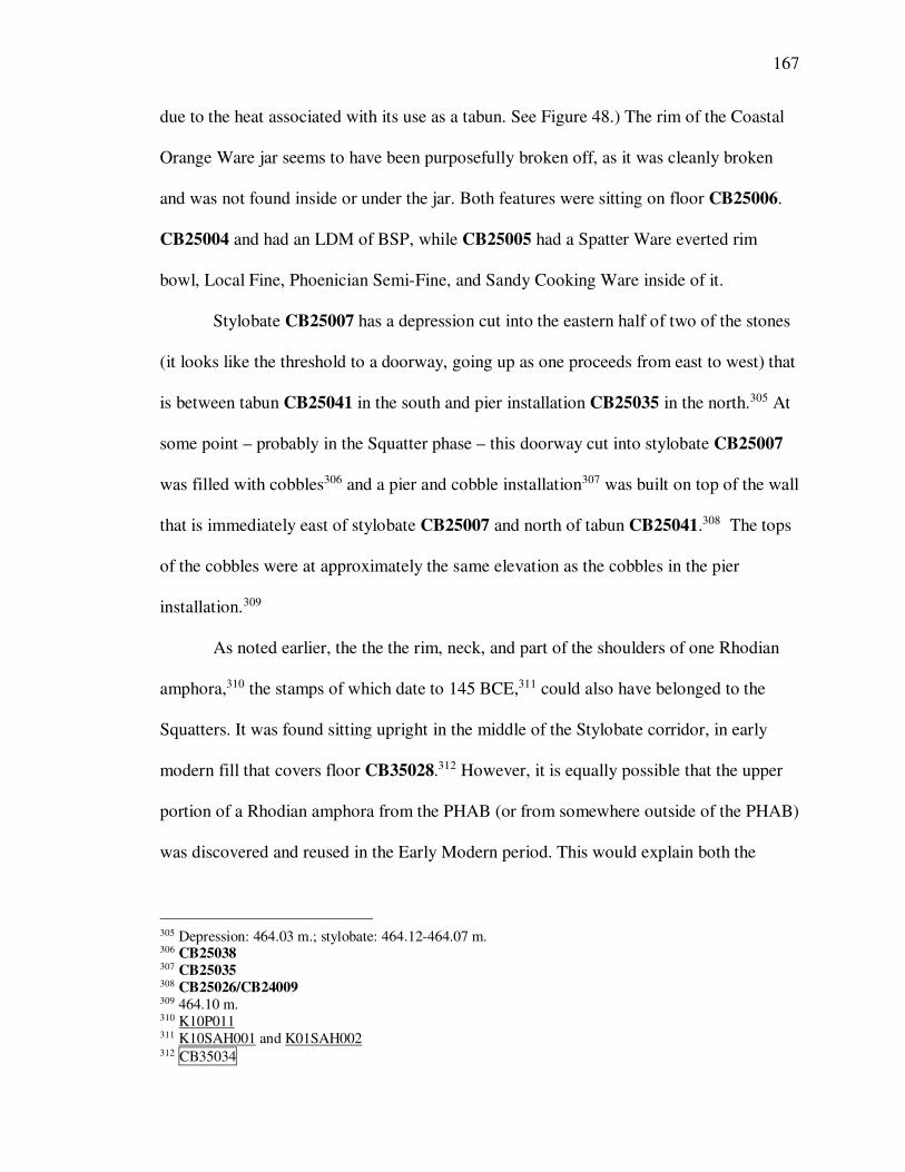
167
due to the heat associated with its use as a tabun. See Figure 48.) The rim of the Coastal
Orange Ware jar seems to have been purposefully broken off, as it was cleanly broken
and was not found inside or under the jar. Both features were sitting on floor CB25006.
CB25004 and had an LDM of BSP, while CB25005 had a Spatter Ware everted rim
bowl, Local Fine, Phoenician Semi-Fine, and Sandy Cooking Ware inside of it.
Stylobate CB25007 has a depression cut into the eastern half of two of the stones
(it looks like the threshold to a doorway, going up as one proceeds from east to west) that
is between tabun CB25041 in the south and pier installation CB25035 in the north.305 At
some point – probably in the Squatter phase – this doorway cut into stylobate CB25007
was filled with cobbles306 and a pier and cobble installation307 was built on top of the wall
that is immediately east of stylobate CB25007 and north of tabun CB25041.308 The tops
of the cobbles were at approximately the same elevation as the cobbles in the pier
installation.309
As noted earlier, the the the rim, neck, and part of the shoulders of one Rhodian
amphora,310 the stamps of which date to 145 BCE,311 could also have belonged to the
Squatters. It was found sitting upright in the middle of the Stylobate corridor, in early
modern fill that covers floor CB35028.312 However, it is equally possible that the upper
portion of a Rhodian amphora from the PHAB (or from somewhere outside of the PHAB)
was discovered and reused in the Early Modern period. This would explain both the
305 Depression: 464.03 m.; stylobate: 464.12-464.07 m. 306 CB25038 307 CB25035 308 CB25026/CB24009 309 464.10 m. 310 K10P011 311 K10SAH001 and K01SAH002 312 CB35034

168
height of the rim and handles above the floor and the absence of the bottom portion of the
amphora.
Room E1 (Figure 49)313
A small (0.50 x 0.60 m.) pit cut into the plaster floor in this room.314 With the
exception of one small sherd of Roman cooking ware that was found near the top,
nothing need date later than the middle of the 2nd century BCE.315 The excavation of the
pit, initially designated CB24023, was continued in 2000 as CB24035, from 463.92 m.
down to 463.71 m. This locus had an Augustan lamp fragment for an LDM, as well as 11
coins,316 11 lamp fragments,317 and a further 7 inventoried items, including 2 bullae.318
The great number of coins that were found very deep,319 combined with the clear Early
313 Room E1 is bounded by CB24006 to the north, CB24007 to the east, CB24009/
CB25036/CB24005/CB24010 to the south, and Stylobate CB25007 to the west. The southern wall of
Room E1 is required. CB24009/CB25036 (463.82 m. down to 463.60 m.) was robbed almost entirely but still existed at the southeastern corner, abutting stylobate CB25007 just east of the Squatter pier installation
(CB25035). It had an ESA LDM, as well as a coin of Antiochus III in it.313 CB25007.1 had an LDM of
Phoenician Semi-Fine and Local Fine. CB25007.1, the soil underneath CB25007, came down on a deeper,
earlier wall, CB25010 (upper elevation of 463.38 m.), which is the same wall as CB25005 (upper elevation of 463.27 m.). “CB25005” was assigned to it when it was excavated as the northern wall of Room E4. 314 CB24023/CB24035 315 The LDM for CB24023 (after the Roman Cooking Ware) was a Phoenician Semi-Fine foot. It also
contained a necked, flattened Sandy Cooking Ware cookpot (K99P111). 316 Sorted by date, the coins are: Antiochus VII (K00C037 – 136-135 BCE); Antiochus VII (K00C033 –
136-134 BCE); Antiochus VII (K00C034 – 135-134 BCE); Demetrius II, 2nd reign (K00C032 – 129-128
BCE); Demetrius II, 2nd reign (K00C053 – 129-128 BCE); Demetrius II, 2nd reign (K00C036 – 128-127
BCE); Cleopatra and Antiochus VIII (K00C039 – 126-125 BCE); Cleopatra and Antiochus VIII (K00C045
– 126-125 BCE); Cleopatra and Antiochus VIII (K00C040 – 126-123 BCE); Cleopatra and Antiochus VIII
(K00C035 – 126-123 BCE); and Ptolemy IX/X (K00C038 – 116-88 BCE). 317 None were inventoried. 318 The non-coin inventoried items from CB24034 were: a bone weaving tool (K00BI003), a glass bowl
(K00G007), a core-formed glass bottle (K00G008), a clear cast vessel (K00G018), a bronze instrument
(K00M046), an iron tool (K00M047), an iron chisel (K00M048), an iron fibula (K00M049), a Roman
cookpot fragment (K00P169), a lekythos (K00P136), an unidentified cookpot handle and fragment (K00P164), a funnel (K00P257), an illegible Rhodian stamped amphora handle (K00SAH017), and bullae
K00BL314 and K00BL315. Fragments of a terra nigra saucer (or is it Pompeiian Red Ware, as the locus
sheet has it? – K00P025) that join with fragments from CB24033 also came from this locus. 319 Four of the eleven coins came from CB2.4.192, which was dug from 463.25 m. down to 462.93 m.:
K00C033 (136-134 BCE); K00C034 (135-134 BCE); K00C032 (129-128 BCE); K00C053 (129-128
BCE). Six of the eleven coins, including the coin of Ptolemy IX/X, were from the unit below that
(CB2.4.193, dug from 462.93 down to 462.84 m.): K00C039 (126-125 BCE); K00C037 (136-135 BCE);

169
Roman LDM, also from very deep levels,320 suggests that this pit was dug by the
Squatters (or perhaps by the PHAB inhabitants, but this requires an explanation for why a
pit would have been dug through the floor) and filled by those who robbed the walls. It is
important to note that these walls were likely robbed over hundreds, if not thousands, of
years, and the pit in Room E2 contains a coin of Constans I (341-346 CE) in the same
locus as a piece of the Terra Nigra saucer that comes from this pit. Why were so many
Squatter-era coins found mixed in with Early Roman debris at the bottom of the pit? The
same situation occurred in a pit in Room E2 and might suggest that a small coin hoard
had been inadvertently swept into the pit with other debris. There is, of course, no way to
prove this, but it is interesting that coin hoards are usually evidence of sudden
abandonment and that there is other evidence of sudden Squatter abandonment – for
instance, the tabun in the Northern Corridor was found with a Squatter cookpot still in it.
Another option is that the coins were swept into the pit at such a late date (e.g., the
Byzantine period) that they were corroded and not recognized as coins (or not recognized
as coins of value).
Another small, irregularly shaped pit (0.10-0.40 x 1 m.) was found in the
southeastern corner of Room E1.321 It too contained an extremely dense concentration of
broken pottery (19.74 kg of pottery in 300 L of soil). Parts of the pit were found
underneath floor CB24008, and it is unclear whether the pit was cut through the floor and
K00C036 (128-127 BCE); K00C039 (126-125 BCE); K00C035 (126-123 BCE); K00C040 (126-123 BCE);
and K00C038 (116-88 BCE). The two bullae came from the unit below that (CB2.4.194, dug from 462.58 m. down to 462.48 m.). 320 CB2.4.192 had an LDM of Roman Cooking Ware and included 6 fish plate fragments; CB2.4.193 had
an LDM of Roman Cooking Ware and included 16 red slip fish plate fragments, ESA sherds that mended
with a Hayes Form 18 hemispherical bowl, 5 fragments of Pompeiian Red Ware (K00P025) and a Roman
cookpot fragment. The Augustan lamp fragment that provided the LDM for the entire locus came from
CB2.4.207, which was dug from 462.95 m. down to 462.71 m. 321 CB24024

170
was bell-shaped or the floor was laid over the top of the pit. The LDM of the pit is one
sherd of an ESA jar, but other than this sherd none of the pottery need be later than the
middle of the 2nd century BCE. As with pit CB24023, pit CB24024 had an inverted
stratigraphy. The upper units had LDMs from the Iron Age and Persian period, while
only the deepest unit had pottery that dated to the beginning of the 2nd century BCE.
Room E2 (Figure 50)322
As with Room E1, the southern wall consisted of one wall (CB24004, preserved
from 463.67 m. down to 463.22 m.) that was built on top of another (CB24005, preserved
from 463.27 m. down to its foundation at 462.71 m.), with soil in between (CB24004.1).
CB24004, ca. 0.70 m. wide and 0.20 m. high, had Byzantine and Roman pottery for its
LDM, which makes sense given that the soil within Room E4 at this elevation had
Roman LDMs. The sealed soil underneath the wall (CB24004.1), however, had an ESA
Hayes Form 20 bowl and Parthian Green Glaze sherds as its LDM.
It is likely that the eastern wall of this room is also Squatter-built. It has not been
excavated, so this is impossible to know. However, it has the same poor rubble
construction as other Squatter-built walls and is not quite straight.
No floor was discovered in this room. However, a bell-shaped pit323 was
discovered in the middle of it. It included several large fragments of painted plaster.
Some of the pottery fragments from this pit join with vessels from the pit in Room E1 (pit
322 Room E2 is bounded by wall CB24006 on the north, CB23001 on the east, CB24004/CB24005 on the
south, and CB24007 on the west. 323 CB24033

171
CB24035). It included 13 coins,324 a glass rod,325 a complete lamp,326 two other lamp
fragments and a lamp tube,327 a bronze ring,328 a bronze pin,329 an iron inlay,330 an iron
projectile point,331 two bowls,332 a grinder,333 a stone basin,334 an unfired loomweight,335
and pieces of the terra nigra saucer found in the pit in Room E1.336
Room E3 (Figure 51)337
Room E3 has only been partially excavated (see Figure 4). Four surfaces were
discovered just east of stylobate CB25007: a beaten-earth surface at elevations 464.19-
464.05 m. (CB25039) with an LDM of ESA and BCW in CB25029.1; a crushed
limestone floor (CB25040) below CB25039 at elevation 463.98 m. with an LDM of ESA
in CB25040.1. CB25040 was an upper laminate for an earlier crushed limestone floor at
elevation 463.91 m. (CB25042/CB24044; this relative stratigraphy was made apparent by
324 In order of date, they were: Antiochus III – 199-188 BCE (K00C015); Seleucid, 2nd century BCE
(K00C010); Autonomous Akko-Ptolemais – 140-132 BCE (K00C012); Antiochus VII – 136-135 BCE
(K00C011); Antiochus VII -136-134 BCE (K00C008); Antiochus VII – 135-134 BCE (K00C002);
Antiochus VII – 135-134 BCE (K00C020); Antiochus VII – 134-133 BCE (K00C003); Demetrius II, 2nd
reign – 129-126 BCE (K00C005); Cleopatra and Antiochus VIII – 126-125 BCE (K00C004); Cleopatra
and Antiochus VIII – 126-123 BCE (K00C009); Cleopatra and Antiochus VIII – 126-123 BCE (K00C013);
and Constans I – 341-346 CE (K00C014). 325 K00G005 326 K00L003 327 1 grayware lamp fragment (K00L007) and 1 other lamp fragment (K00L008). The lamp tube was
K00L008. 328 K00M036 329 K00M037 330 K00M038 331 K00M040 332 K00P041 and K00P237 333 K00S001 334 K00S026 335 K00TC003 336 K00P025. Much more was found that was not inventoried, such as more than 86 fragments of painted
wall plaster, various metal fragments, Hellenistic and Roman pottery, nails, and mud brick. 337 It is bounded by CB24009/ CB25036/CB24005/CB24010 to the north (see the description of this wall
under Room E1), CB24001 to the east, an unexcavated baulk to the south, and stylobate CB25007 to the
west.

172
the tabun – see below).338 CB25042 had an LDM of BCW. Below floor
CB25042/CB24044 was another crushed limestone floor at elevation 463.87 m.
(CB25043/CB24045).339
Tabun CB25041 (upper elevation: 464.24 m.; bottom of the inside: 463.97 m.)
was constructed against the north side of wall (or, perhaps, pier) CB25057, the upper
elevation of which was at 464.25 m. This pier and the stones around it were excavated in
the last days of the season and only the top is exposed. It is unknown whether this was
constructed as part of the tabun installation or if the tabun was built up against a
preexisting wall (however, it should be noted that the pier is directly west of and in line
with wall CB25002). The tabun cut through floor CB25042. Floor CB25040, the upper
crushed limestone floor, was then laid over the top of CB25042 and against the tabun
wall stones (see Figure 53). In the area where the tabun cuts through CB25042, floor
CB25040 is nothing more or less than an upper laminate sealing to the tabun wall stones.
The soil under tabun CB25041 (i.e., CB25041.1) had an LDM of Late Hellenistic red-
slipped fineware
To the north of tabun CB25041 and to the east of stylobate CB25007 was a
Squatter installation consisting of a pier and some surrounding cobbles340 that sits on top
of a lower wall that abuts stylobate CB25007 from the east.341 There is a small
338 Plaster floor CB24044 was excavated in the eastern part of the room and had a surface elevation of 464.04 m. (high)/463.93 m. (low). It must be contemporary with CB25042 (given that it was cut by the
tabun and CB25040 was simply an upper laminate of CB25042). It had a Phoenician Semi-Fine flanged-
rim juglet for an LDM and CB25044.1 contained nothing that need be later than Persian. 339 Plaster floor CB24045 was excavated in the eastern part of the room and had a surface elevation of
463.90 m. (high)/463.84 m. (low). As such it must be the same floor as CB25043. CB24045 had an LDM
of Local Fine and the LDM in the fill beneath it (CB24046) the LDM was also Local Fine. 340 CB25035 – top of pier: 464.56 m.; cobbles: 464.03 m.; stones to north and south of the cobbles: 464.24
m. 341 CB25036

173
foundation trench342 for a row of cobblestones to the south of the pier that fill the space
between the pier and the floor that was to the south of it, probably CB25042 (stones:
464.05 m.; floor: 464.00 m.).
South of wall CB25057 (which sits against the south side of tabun CB25041) is a
cobble surface of some sort (CB25058/CB15031) at 464.17 m. and a patchy, degraded
crushed limestone surface (CB25059/CB15030) at 464.11 m.
Room E4 (Figure 52)343
Room E4 is perhaps the least interesting room in the entire building. The upper
portion of the northern wall of the room344 is known to be a Squatter wall, but it is
important to note that it was installed over the top of CB24001. It did not reach to wall
CB24003 in the state of preservation in which it was found when excavated.
Within this room an extremely hard-packed layer of yellow brown soil that was
deemed to be a (potential) floor.345 The soil underneath it had an Early Roman LDM that
included a coin of Demetrius I’s first reign (144-143 BCE).346 The northern wall of the
room was also underneath this Early Roman fill. Everything else that was excavated from
this room dated to the early 2nd century BCE, 3rd century BCE, or Persian period with the
exception of the sub-subsoil rubble that covered the tops of the walls.347 Within this
locus, which had an LDM of two Arab smudge ware sherds, there was a coin of
342 CB25056 343 It is bounded by wall CB24004/CB24005 to the north (see the explanation of this wall under Room E2);
CB24003 to the east; CB24002 to the south, and CB24001 to the west. 344 CB24004 345 CB24016, at 464.30 m. 346 CB24015; K99C022 347 CB24013

174
Antiochus III (222-187 BCE),348 a coin of Cleopatra and Antiochus VIII (126-125
BCE),349 an Erotes lamp,350 a Persian White Ware krater or basin rim and bowl,351 an
overhanging rim krater in cookpot fabric,352 a PBG jar or bowl rim,353 a Sandy or Gritty
Cooking Ware necked flattened-rim cookpot,354 a Sandy Cooking Ware neckless
triangular rim cookpot,355 a spindle whorl,356 and a carnelian bead.357 This locus is clearly
far from any primary context.
The Northeastern Corridor (Figure 55)
Stylobate CB25007 continues north into the NE quadrant of CB 2.5, where it
appears to have been robbed at the north end. In place of the remaining stylobate there
were cobbles that appeared to be rubble, though more or less in line with the stylobate, at
elevation 464.29 m. (the stylobate is at 464.14 m. here). They were sitting on soil, and so
removed, and underneath the soil layer there were more cobbles, at an elevation of
463.97-463.85 m.358 On the east and west sides of stylobate CB25007, and north of pier
installation CB25035, there are two crushed limestone surfaces.359 The rest of the
Northeastern Corridor has not been excavated.
348 K99C003 349 K99C004 350 K99L001 351 K99P102 and K99P103 352 K99P100 353 K99P104 354 K99P105 355 K99P101 356 K99S008 357 K99BD001 358 CB25053 359 CB25054, at 464.15 m., on the east and CB25006, at 464.05 m., on the west.

175
The Eastern Corridor (Figure 54)
The Eastern Corridor has not been excavated very deeply. It is bounded by
CB14005/CB24003/CB23001 to the west and CB13001/CB23002 to the east. There is a
wall stublet (CB23003) just east of CB24004/CB24005 that is not perpendicular to the
other walls. It had an upper elevation of 463.33 m. and CB23003.1 had an LDM of
Phoenician Semi-Fine. There was 1 sherd of BCW and 1 sherd of ESA in subsoil and 2
sherds of BCW in the robbing trench over the intersection of CB23002 and CB23008.
Though a lack of pottery suggests that this area was not used by the Squatters, it is
a corridor (and therefore unlikely to have a lot of material) and is immediately east of
known Squatter-used areas.

176
PART IV: UNINHABITED PARTS OF THE BUILDING
The Northern Rooms (Rooms N3, N4, N6 and the Northern Entrance – Figure 55) ...... 176
The Northwestern Rooms (Rooms N1 and N2 – Figure 56) ......................................... 177
The Western Rooms (Rooms W1, W3, W4, W4a, W5, W6, and W7 – Figure 57) ........ 182
The Rooms South of the Central Courtyard (Rooms S3 and S4 – Figure 60) ................ 188
The Rooms South of the South-Central Corridor (Rooms S5, S6, S7, S9, and S11 –
Figure 61) ........................................................................................................ 190
The Southern Rooms (Rooms S8 and S10 – Figure 62) ................................................ 195
The Rooms South of the Southeastern Corridor (Rooms S12, S13, and S14 –
Figure 63) ........................................................................................................ 202
The Northern Rooms (Rooms N3, N4, N6 and the Northern Entrance – Figure 55)
There is virtually no evidence of Squatter presence in Rooms N3 and N4. Though
there was some residual Squatter material in Room N4, it was entirely confined to
topsoil, subsoil, and wall robbing phases.360 Perhaps more interesting is the almost
complete lack of Squatter material in Room N3,361 because the Squatters used the
Northern Corridor and the rooms to the south of it (e.g., Room C1), and during the
Squatter phase there was no wall dividing the Northern Corridor from Room N3 (the
plaster floor of room Room N3 continues over the wall that divides it from the Northern
Corridor, and is the same floor that was found in the Northern Corridor). There is one
other area of the building that shares these characteristics: Room S8, which was an open-
air area (see below). Given the length of room Room N3 and the presence of the drain
360 ESA: CB46009 (subsoil/rubble – 1 fragment); CB46010 (continued rubble – a Hayes 22A bottom; 20 g.
of ES?); CB46011 (a fill that came down on the robbed northern wall of the building and extended slightly
below it on the north and south – a Tel Anafa type 16 ESA dish [K00P142] and an ESA fragment);
CB46016 (a deep locus in Room N4 that bound pit CB46008 – two coins of Demetrius II [145-140].
CB46016 was dug quickly and pit CB46008 is a post-excavation locus that was assigned on the basis of
examination of the southern baulk. It was not found during excavation, cuts through both floors, and was likely part of the Early Roman wall robbing episode. Its upper elevation is 464.80, which is well above the
lower elevation of the rubble locus CB46010). 361 There were seven body sherds of BCW and no ESA found in the entirety of CB4.6SE: three in CB46021
(topsoil and subsoil), and four in CB46022 (the robbing trench of the north wall of the building that lies
directly beneath subsoil and touches the robbing trench of wall CB46002).

177
going out of it through the north wall of the building,362 it seems likely that this room was
unroofed in the final phase of the building as well.
There is also virtually no evidence for the Squatters in Room N6 and the Northern
Entrance. A cast glass bowl rim363 and 10 fragments of an ESA bowl364 were found in a
pit (CB35016)that was cut through the fallen mud brick in Room N6 and which had an
Early Roman LDM. Aside from this there was no other indication of Squatter use of these
rooms.
The Northwestern Rooms (Rooms N1 and N2 – Figure 56)
Rooms N1 and N2 were only accessible from the south, and while the Northern
Corridor ends at the eastern wall of Room N2, there was no entrance to that room from
the east. It is clear that the Squatters did not use Room N1 (the so-called “archive room”)
because it was burned prior to the building going out of use (see below). The blocking of
the southern doorway of Room N2 (the only doorway into this room) that was found in
situ (see Figure 25) shows that the Squatters did not use this room, either. The presence
of known markers of the Squatters (ESA and BCW) is entirely confined to topsoil,
subsoil, and high-elevation disturbed areas.365
Sometime around the time of the building’s abandonment two babies were buried
on top of the floor of the archive room (Room N1). At some point afterwards the room
362 CB46020 363 K10G002 364 K10P027 365 CB 4.7: ESA was found in four loci (seventeen units): CB47000 (topsoil); CB47008 (subsoil); CB47009
(upper-level fill with a Kfar Hananya type 4A LDM); and CB47012 (disturbed pink mudbrick fill – one
ESA rim). BCW was either not found or not recognized in 1999 – there is no recorded BCW in CB 4.7. CB 4.8: ESA was found in four loci (four units): CB48006 (subsoil); CB48020 (subsoil); CB48021
(“subsoil” on unit sheet; “light brown decayed mudbrick” on locus sheet. The unit in question is CB48021
and the ESA is K00P133, sent for NAA). A cast glass rim was found in CB48026 (unit CB4.8.156), which
is the locus for the plaster and sherd floor in Room N1, and another piece of cast glass was found in
CB48024 (the ash/burn locus that included bullae).

178
was set afire, and the doorway to the south was blocked. The door block between Rooms
W1 and N1 had a painted plaster fragment amongst the stones and the soil underneath the
stones had a cast glass bowl body sherd.366
The interpretation of the abandonment and destruction of this room is difficult. If
we assume that this room was intentionally burned because of the presence of the archive
within it, then we have a few historical parallels that might explain the motive. On the
one hand, Jonathan’s defeat of Demetrius effectively established Antiochus VI and
Tryphon as being in control of the Palestinian interior, including Galilee and Syria, as
Jonathan was acting as an agent of Antiochus (see chapter 4 for a more full discussion).
Assuming that the forced abandonment and partial destruction of the administrative
building at Kedesh is indicative of the administrators leaving the city (i.e., that the
administrators did not relocate to another part of the city, which seems likely), then
Jonathan’s defeat of Demetrius would probably have accomplished the annexation of the
Tyrian hinterland and the city of Kedesh to Antiochus VI’s control. There are three
models that might explain the burning of the archive room under these circumstances:
Jonathan’s army burned the archive, Demetrius’ army (or agents) burned the archive, or
the people of Kedesh burned the archive.
Though palaces and archives are often burnt when a city is destroyed in times of
war (see, e.g., Cicero, For Archias 4.8 for the example of Heracleus), the only examples
that I know of in which a newly occupying force explicitly and intentionally burning an
archive are the Romans’ burning of the Jerusalem archive (War 6.354) and Alexander the
Great’s burning of the Persepolis archives, a deed that is variously explained in the
sources as revenge for the Persian destruction of the Athenaian acropolis and/or a
366 K00T#1968.

179
drunken challenge. Is it possible that the destruction of temples and palaces in antiquity
was understood to include the destruction of archives within them – to the degree that the
destruction of the archive is not mentioned and is assumed by ancient authors to go hand-
in-hand and not deserve mention? I don’t know. In Alexander’s case, neither explanation
of motive seems particularly satisfactory – Alexander’s usual modus operandus was to
legitimately occupy the throne of kingdoms that he conquered (something that he
apparently literally did in the four months that Arrian said that he was in Persepolis), not
to destroy it. And although Arrian reports that he drank a lot, there is no example of it
affecting policy like this. We could come up with reasons that Jonathan/Antiochus might
want to destroy an archive if they were annexing an administrative center to Antiochus’
kingdom, but we could also come up with reasons that they would not (e.g., tax records
or records of land deeds make taxing the population easier, etc.). Without knowing what
sort of archive this was it is difficult to know what the motivation might have been
On the other hand, it is possible that Demetrius or one of his agents burned the
archive in order to keep the occupying forces from getting their hands on them. Philip VI
sent a hypaspist to Lysias to burn his correspondence so that the Romans would not
acquire it (Polybius 18.33.1ff; Livy 33.11; cf. Polybius 30.4). In this case Philip acts in
order to protect others who had supported him, but if the archive was burned by
Demetrius in order to keep the Hasmonaeans from acquiring its contents it would not
require that there was a conspiracy afoot.
Another option is that the people of Kedesh burned the archive in order to destroy
any record of required tax payments, as the rebels did in Jerusalem did during the Roman
siege of the city (War 2.426-427), and as apparently happened in Rome in 7 BCE (Dio

180
55.8.5-6) and in Antioch in 70 CE (War 7.54-62). Two other archives are known to have
been burnt during some sort of unrest, and it is possible, though unconfirmed, that it
happened for these reasons. The βιβλιοθήκη δημοσίων λόγων in the city of Mendes-
Thmouis in the central Delta region of Egypt was found with rooms of burnt papyri. It
has been suggested that the destruction happened during the Bucolic revolt in the reign of
Marcus Aurelius.367 In like fashion, perhaps, the archive at Dyme in Achaea was
intentionally burned in either 115 or 144 BCE during “unrest,” according to the
inscription of Q Fabius Maximus.368 The reason for the burning is not stated in the
inscription, and arguments have been made both for and against debt-cancellation as a
motive.369
However, the fact that the relative stratigraphy included soil on top of the floor
and vessels, the two infant skeletons on top of the soil (but bullae underneath them), ash
on top of the soil and the burials, and mud brick wall collapse on top of the ash suggest
that the abandonment, burials, and burning of the archive room were not coterminous.
The only access to the archive room was through all of the western rooms (i.e., the
archive room had one door that opened into Room W1, which had one door opening to
the south, into Room W3, etc.). As a result, the archive room was effectively deep in the
recesses of the building. The most likely interpretation (i.e., the one that makes sense of
367 See W. E. H. Cockle, "State Archives in Graeco-Roman Egypt from 30 BC to the Reign of Septimus
Severus," JEA 70 (1984), 106-122. The reference to the burning of the archive is in lines 6-7 and 22. 368 P. P. Dobree, "Greek Inscriptions from the Library of Trinity College, Cambridge," CJ 30 (1824), 127-
129. For the argument that the inscription should be dated to 144 BCE instead of 115 BCE, as has
traditionally been the case, as well as for a full bibliography of places that the inscription has been
published and commented on, see Robert Kallet-Marx, "Quintus Fabius Maximus and the Dyme Affair (Syll. 684)," CQ 45, no. 1 (1995), 129-153. 369 E.g., A. Fuks, "Social Revolution in Dyme, 116-114 B.C.E.," Scripta Hierosolymitana 23 (1972), 21-27.
Contra: Kallet-Marx, "Quintus Fabius Maximus and the Dyme Affair (Syll. 684)," 148ff. For a list of
authors who have interpreted the inscription as social-revolutionary struggle against Roman-sponsored
oligarchs, see Kallet-Marx, "Quintus Fabius Maximus and the Dyme Affair (Syll. 684)." 148 n. 99

181
all of the evidence) is that the archive room sat abandoned, after which the two infants
were buried in the room. The door of the room was blocked up, and perhaps this is when
the other doors along the north-south axis (i.e., the western rooms) were also blocked. To
the degree that we can tell, all of these rooms seem to show the same degree of
abandonment before their doors were blocked, and it is possible that this strange action of
blocking successive doors along the north-south corridor of rooms had the effect of
burying the two corpses deeply. The burial of bodies in a building (as opposed to outside
the city) might seem strange, but it is known from Jerusalem during the time of the siege
by the Romans (War 6.355). These were, of course, unusual circumstances in which the
siege caused a famine that increased the body count, as well as prohibiting the burial of
bodies outside the city. The Temple Scroll from Qumran makes reference to the Gentiles
burying their dead “everywhere…even within their houses,”370 and burial in abandoned
buildings is known from much later periods in other parts of the Mediterranean and
Middle East.371
370 11QT 48:11-13. The burial of dead underneath the floors of houses is also known from Seleucia on the
Tigris. 371 Purportedly at Zar Tepe in the Kushan and post-Kushan periods (1st century BCE-3rd century CE): see Encyclopaedia Iranica: Excavations III. In Central Asia: Kushan and Post-Kushan Archaeology. In Late
Antique Spain: “The reuse of structural remains as burial places is a significant break with practice before
Late Antiquity… In the past it was generally assumed that the existence of burial automatically implied that
the buildings were already abandoned; now, however, knowledge about post-Roman funerary practices
permits us to supposed that, at least in some cases, there was a possible cohabitation between the dead and
the living (hence examples above show habitational reuse plus burials).” See Christie, Landscapes of
Change: Rural Evolutions in Late Antique and The Early, 81ff. In Late Antique North Africa: “Thus in the
fifth century abandoned buildings sometimes quickly became receptacles for burial, particularly if they
were conveniently located near inhabited areas. This pattern for small plots of graves, or isolated burials,
being found near inhabited areas, either inside abandoned buildings or simply in a semi-isolated cluster, is
sustained in North African settings, becoming even more common in the sixth and seventh century.
Therefore, at Tabarka the “petit enclose” in the Urban Basilica Cemetery and Northwest Chapel/Cemetery may actually be a plot of tombs, familial or not, inserted into an abandoned building in the fifth century.”
See Joan Marguerite Downs, "The Christian Tomb Mosaics from Tabarka: Status and Identity in a North
African Roman Town" (University of Michigan, 2007), 76. There is also, of course, the question of
Phoenician child sacrifice, for which there is no consensus. See, e.g., Shelby Brown, Late Carthaginian
Child Sacrifice (Sheffield: JSOT Press, 1991).

182
If this is the case, then the archive room was not necessarily burned intentionally.
Perhaps it was an accidental fire that occurred as a result of Squatter habitation or an
event from outside the walls of the building. Such an accident occurred in Antioch during
the life of the archive (i.e., not after abandonment – War 7.55).
The Western Rooms (Rooms W1, W3, W4, W4a, W5, W6, and W7 – Figure 57)372
All of the western rooms (Rooms W1, W3, W4, W5, W6, and W7) are, like the
northern rooms, almost totally devoid of material that is certainly Squatter.
In Room W1 a small section of plaster surface was found against the southern
wall of the room at an elevation of 464.72 m. In addition, a nearly complete Hermon Jar
was found against the same wall, though further east, the toe of which was at 464.97 m.
No surface was found at this elevation, though it closely corresponds to the elevation of
the burnt soil floor CB37010 in Room W2, to the east. The northern and southern
doorways were intentionally blocked at some point (see the section on Room N1on the
interpretation of northern door blockage), and at the bottom of the southern door block
one large, flat paver373 was found with an upper elevation of 464.69 m., which might
have been part of the original floor in this room. There was nothing diagnostic of Squatter
presence in Room W1, even in Early Roman robbing loci.374
372 Room W4 and Room W4a are two parts of one room (see below). They were initially given separate
room numbers for greater precision in analyzing the material. 373 CB38023 374 I don’t have Peter’s pottery database, but from a perusal of the unit reading sheets from K00 CB 3.8, I
find ESA (unknown amount) in units 001 (CB38010 - topsoil), 002 (CB38010 - topsoil), 005 (CB38010 –
topsoil – earliest ESA platter X 2 Hayes 2 & triangle rim cookpot), 007 (CB38011 – fill under subsoil –
inventoried – mold-made bowl in ESA fabric Hayes 29 – CB38011 – not in this room), a fish plate sent to
inventory in 118 (CB38017 – fill/debris on floor CB38018), and a white Hell jar (Jerusalem?) in 010
(CB38011), as well as a “Rim store jar Jerusalem clay? Motza – to Akko” in 029 (CB38013). I don’t think
that BCW was recognized (or, if it was, I don’t think that it was recorded) in 2000. Whatever the case, it
probably got lumped into “cookware”, for there is no differentiation and no mention of BCW.
183
What is more curious than the lack of Squatter presence in the western rooms is
that they appear to have blocked all of the doorways on a N/S axis. As noted above, (see
the section on Room N1), sometime around the time of the building’s abandonment the
archive room (Room N1) was set afire and the doorway to the south was blocked. The
same can be said for the doorways between Rooms W1 and W3, between Rooms W3 and
W4, and between Rooms W4a and Room W5. The door block between Rooms W4a and
W5 (door block CB28005 in wall CB28004) consisted of ashlars and field stones two
courses deep resting on packed soil fill. When the door block was removed, plaster floor
CB28003 was found to run from Room W5 northward into the doorway (Figure 58). The
LDM for both the door block and the 0.1 underneath it were Hermon Jar, Local Fine, and
a Phoenician Semi-Fine square rim jar (i.e., the final-PHAB phase), but it is most likely
that the blocking of this doorway occurred in a post-abandonment phase, given that the
door block itself was soil, ashlar, and fieldstone, was not the same width as the wall into
which it was being placed, and that it was not plastered over (the plaster originally on the
south face of wall CB28004 ended at the door block). This last point is worth noting.
Other places in the building in which a door was blocked during the life of the building
(for instance, the door block between the Stylobate Corridor and the northeastern corner
of Room C2, in wall CB35021), exhibit well made blockages of cut stone that fit the
doorway well and were plastered over (see Figure 36).
Room W3
Room W3 presents an interesting example of the Squatter material in the building.
As noted above, the northern and southern doorways into Room W3 were blocked, likely
by the Squatters. Within the room there is a floor (CB38031) at an elevation of 465.14 m.

184
(high)/465.01 m. (low). The soil on top of this floor375 contained an ESA mold made
bowl,376 a cast glass rim,377 and consistent LDMs of ESA and Early Roman cookware.
Furthermore, the soil in the places where the floor was degraded and disturbed378
contained Early Roman LDMs in four of the seven units that comprise the locus, as well
as another piece of the ESA mold made bowl that was discovered in the soil on top of the
floor, a stamped amphora handle dating to 166-107 BCE,379 and a Roman cookware jar
rim.380 There were also 3 large storage jars – 2 Galilean and 1 possible Judaean.
At first glance this looks much like the Squatter material profile found elsewhere
in the building and would likely cause us to wonder if the metal, beads, loom weights,
etc. that were also found in this room belonged to the Squatters. However, a closer look
at the evidence shows that the Squatters did not use this room (even if they were the ones
who blocked the doorways). Aside from the ESA mold-made bowl, the ESA and Early
Roman cookware that comprise the LDMs in these two soil loci – which, it should be
mentioned, consisted of 16,600 L of soil and 171.1 kg of pottery – amount to three small
unidentifiable sherds of ESA weighing less than 0.03 kg, one tiny unidentifiable sherd of
Roman cookware weighing less than 0.01 kg, a piece of an Early Roman cookware jar, a
piece of a possible 1st century CE Phoenician Semi-Fine baggy jar, and a piece of a
possible 1st century CE Early Roman jar rim. Furthermore, the soil on top of the floor
(CB38030) contained 38 items that were considered important enough to be inventoried,
375 CB38030 376K06P036. Note that it mends with sherds from CB38032. 377 K06G010 378 CB38032 379 K06SAH007. Joins with one of the SAHs in CB38030? 380 K06P096. Also found were a bronze fibula (K06T#781), a glass inset (K06T#782), a pierced bone
appliqué (K06T#783), and a bone semicircular appliqué (K06T#784).

185
including three lamps,381 seven identifiable vessels,382 eight stamped amphora handles,383
and two coins that date to PHAB abandonment and pre-abandonment phases.384 The
amount and type of finds discovered in CB38030 (and especially the whole or nearly
whole vessels) suggest that it is a disturbed primary deposit from the abandonment of the
PHAB. Indeed, it can only be interpreted as evidence of either Squatter reuse of PHAB
vessels or Squatter non-use of this room. Given the incredibly small amount of
unambiguously Squatter material found in Room W3, the fact that we have only one
example of possible Squatter reuse of a PHAB vessel for its intended purpose,385 and the
fact that whole vessels dating to the abandonment of the PHAB were found on the floor
of this room, it seems most likely that this room was blocked off and unused during the
Squatter phase of the building.
Rooms W4 and W4a
We find the same situation in Rooms W4 and W4a, which are two parts of the
same room.386 In locus CB20828, a rubble and plaster fill with an LDM of BCW and
381 The lamps were: a glazed ware lamp body sherd (K06L014); a glazed ware delphiniform lamp body
sherd (K06L015); and an Atticizing black glaze lamp (K06L018). 382 The vessels were: a Koan Knidian cup (K06P035); a Phoenician Semi-Fine amphoriskos (K06P037); a Semi-Fine juglet (K06P038); a hemispherical bowl in an unknown fabric (K06P039); a Semi-Fine
amphoriskos (K06P040); a black glazed stemmed dish (K06P097); and a lagynos (K06P099). 383 K06SAH006 (150 BCE); K06SAH008 (147 BCE); K06SAH009 (166-146 BCE); K06SAH010 (166-
146 BCE); K06SAH011 (154/153-146 BCE); K06SAH012 (154/153 BCE); K06SAH013 (154/153 BCE);
K06SAH014 (144-118 BCE). 384 Both generic Seleucid 2nd century BCE coins (K06C012 and K06C024). A third, unintelligible coin was
also found (K06C030). The other inventoried objects from this locus were: 2 carnelian beads (K06BD005
and K06BD067); a bone inlay button (K06BI017); a cast glass rim (K06G010); 2 glass counters
(K06G011); 2 unfired loom weights (K06TC003 and K06TC006); 2 sickle blades, on fragmentary and the
other intact (K06M010 and K06M021 [intact]); an iron knife (K06M023); a bronze knife (K06M025); a
bronze fibula arch (K06M027); a bronze bracelet (K06M029); a nail (K06M031); a hand stone(K06S018);
and a Canaanean blade (K06S027). 385 <the Spatter cookpot/jar>. They reused some of the PHAB vessels – for instance, Hermon jars for a
tabun in the Stylobate Corridor – but not for the vessels’ intended purpose. 386 Only the 3 x 5 m. northern half of CB2.8 NE was excavated, so it is possible that a wall dividing Room
W4 from Room W4a could be found in the southern half of that quadrant. However, if that were the case, it
would require Room W4 to be between 2.33 and 2.85 m. wide (north/south) and Room W4a to be between
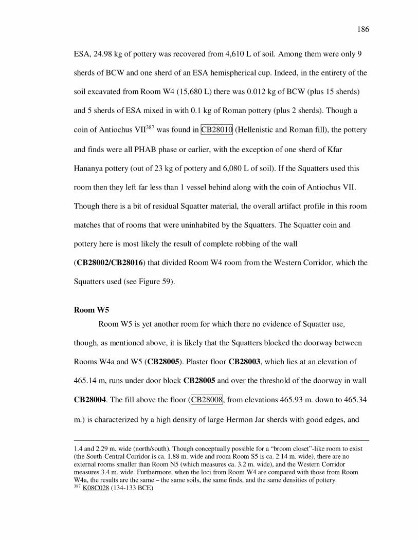
186
ESA, 24.98 kg of pottery was recovered from 4,610 L of soil. Among them were only 9
sherds of BCW and one sherd of an ESA hemispherical cup. Indeed, in the entirety of the
soil excavated from Room W4 (15,680 L) there was 0.012 kg of BCW (plus 15 sherds)
and 5 sherds of ESA mixed in with 0.1 kg of Roman pottery (plus 2 sherds). Though a
coin of Antiochus VII387 was found in CB28010 (Hellenistic and Roman fill), the pottery
and finds were all PHAB phase or earlier, with the exception of one sherd of Kfar
Hananya pottery (out of 23 kg of pottery and 6,080 L of soil). If the Squatters used this
room then they left far less than 1 vessel behind along with the coin of Antiochus VII.
Though there is a bit of residual Squatter material, the overall artifact profile in this room
matches that of rooms that were uninhabited by the Squatters. The Squatter coin and
pottery here is most likely the result of complete robbing of the wall
(CB28002/CB28016) that divided Room W4 room from the Western Corridor, which the
Squatters used (see Figure 59).
Room W5
Room W5 is yet another room for which there no evidence of Squatter use,
though, as mentioned above, it is likely that the Squatters blocked the doorway between
Rooms W4a and W5 (CB28005). Plaster floor CB28003, which lies at an elevation of
465.14 m, runs under door block CB28005 and over the threshold of the doorway in wall
CB28004. The fill above the floor (CB28008, from elevations 465.93 m. down to 465.34
m.) is characterized by a high density of large Hermon Jar sherds with good edges, and
1.4 and 2.29 m. wide (north/south). Though conceptually possible for a “broom closet”-like room to exist (the South-Central Corridor is ca. 1.88 m. wide and room Room S5 is ca. 2.14 m. wide), there are no
external rooms smaller than Room N5 (which measures ca. 3.2 m. wide), and the Western Corridor
measures 3.4 m. wide. Furthermore, when the loci from Room W4 are compared with those from Room
W4a, the results are the same – the same soils, the same finds, and the same densities of pottery. 387 K08C028 (134-133 BCE)

187
within this fill one Hermon Jar was found on its side, crushed, at an elevation of 465.52
m. It seems that there were a number of Hermon Jars being stored in Room W5 that were
churned up during the wall robbing episode. The sum total of Squatter pottery found
below subsoil in Room W5 was 3 tiny sherds of ESA.
Room W6
The room in the southwest corner of the building, Room W6, shows no evidence
of Squatter occupation whatsoever. In fact, in all of the soil dug below subsoil, from
465.73 m. to 464.59 m. (9,910 L of soil), not one ESA or BCW sherd (and only one Kfar
Hananya sherd, in the second-highest unit) was found in 86.98 kg of pottery. Within the
room two floors were found, CB18004, at 464.96 m. (LDM underneath was an Iron Age
cookpot) and CB18005, at 464.85 m. (LDM was an Iron Age cookpot).
Room W7
The same can be said for Room W7 (that has been said for Room W6): in 12,270
L. of soil and 369.95 kg of pottery there was nothing diagnostically Squatter found below
subsoil with the possible exception of one small sherd of cast glass. Like Room W6, this
room also had two floors, a white plaster floor, CB18010, at 465.09 m. (LDM: BSP rim,
Chian lagynos sherd; LDM in the 0.1 was a local fine saucer and Hellenistic cookware),
and a blue-grey plaster floor, CB18011, at 465.01.388
388 Note that this piece of cast glass likely came from the robbing trench on the south side of the floor that
was the result of robbing the south wall of the building down to its foundations.

188
The Rooms South of the Central Courtyard (Rooms S3 and S4 – Figure 60)
The Squatter material profile of the rooms bounding the southern side of the
Central Courtyard is very much like those of the Western and Northern Rooms.
Room S3389
The northern part of the eastern wall was robbed deeply (down to 464.14 m.; it is
preserved as high as 465.21 m.).390 The final PHAB phase of the room included a thick
plaster floor with pottery sherds pressed into the matrix (CB17004), set on top of a
cobble subfloor that looked very much like the subfloor of the Central Courtyard. This
floor and the floor beneath it (CB17008) were cut by a deep post-12th century CE grave
that used the north wall of the room for a northern grave wall and into which was placed
a southern wall of large stones (CB17018), and was capped with very large, flat stones
(CB17002). The soil (CB17019) on top of the plaster-and-sherd floor (CB17004)
contained a few ESA fish plate and saucer sherds, curiously only appearing in units dug
in the southern half of the room (one would assume that these few sherds came from
robbing disturbance). All of the other finds in CB17019 were from the PHAB phases: a
coin of Antiochus III,391 an architectural fragment,392 and Phoenician Semi-Fine, Local
Fine, BSP, and sandy cookware pottery.393 The only other known Squatter material
evidence from the 23,070 L. of soil and 209.8 kg of pottery in this room are 6 sherds of
389 Room S3 is bounded by walls CB17001 (to the west), CB17003/CB27004 (to the
north), CB17006 (to the east), and CB17007 (to the south). 390 The maximum preserved height of the other walls was 465.39 m. (CB17001); 465.39 m.
(CB17003/CB27004); 465.21 m. (CB17006); and 464.38 m. (CB17007). 391 K06C009 (198-188 BCE) 392 K06S003 393 Ambiguous finds included astragali (K06BI012; K06T#654) and a possible sling ball (unk. K06T#).
189
ESA, a cast glass fragment,394 and a glass pyxis lid,395 all found in later contexts such as
soil that was excavated from elevations above the southern wall of the room and which
had a Byzantine LDM, or in soil disturbed by the Islamic burial in the northern part of the
room.396
Room S4
Room S4 is bounded by walls CB16034 (to the north, between Room S4 and the
Central Courtyard), CB16030 (to the east), CB16029?/?CB16044/CB17005 (to the
south), and CB17006 (to the west). Within the room is floor CB16032, on top of which
were built two plaster bins, a rectangular one (CB16027) that is in the northwest corner
of the room, and a square one (CB16026) in the northeast corner of the room. In the
southeast corner of the room a semicircular installation (CB16028) was found attached to
the eastern wall (CB16030). Floor CB16032 (surface elevation of 464.72 m.
[high]/464.60 m. [low]) bonded with the western wall (CB17006), the eastern wall
(CB16030), the southern wall (if that’s what CB16029 is – it’s called a “partition wall”
on the CB16028 locus sheet), the two bins in the north (CB16026 and CB16027), and the
semicircular installation (CB16028).
Almost nothing belonging to the Squatters was found in Room S4. In the soil
(CB16040)397 that came down on floor CB16032, 0.031 kg of ESA was found (all in the
394 K06G007 395 K06G003 396 The glass pyxis lid (K06G003) was found in the foundation trench for the Islamic grave; a cast glass
body sherd (K06G007) and a Brindisi amphora fragment (K06T#018), were found in CB17011, the
Byzantine/Crusader activity above the southern wall of the room. Cast glass body sherd K06G012 was
recovered from the pottery in the plaster and sherd floor and is presumed to be an intrusion. 397 CB16040 is a 25-30 cm.-thick soil deposit underneath subsoil and on top of plaster floors CB16031
(Room S5), CB16032 (Room S4), and CB16024 (Central Courtyard) and their equivalent elevations
throughout CB 1.6 NE and NW (e.g., ashlar blocks that are part of wall CB16030). The units from
CB16040 and the rooms in which they were dug are as follows: CB1.6.081 (Room S4); CB1.6.083 (Room
S4 and Room S5); CB1.6.087 (Room S4?); CB1.6.092 (Room S4); CB1.6.093 (Room S5 and the South-

190
upper elevations, immediately below subsoil).398 No other ESA was found in Room S4,
and no BCW was found anywhere in the room. In addition, the pottery that was
excavated from units immediately on top of floor CB16032, some of which were almost
complete or mendable vessels, belonged to the PHAB.399 In like fashion, no evidence of
the Squatters was found in the bins or the semi-circular installation.
The Rooms South of the South-Central Corridor (Rooms S5, S6, S7, S9, and S11 –
Figure 61)
The evidence within Room S5 looks very much like that of Room S4. Room S5 is
bounded by CB16034 to the north, CB16046 (to the east), CB16033 (to the south) and
CB16030 (to the west). Within the room there is a floor, CB16031 (surface elevation
464.69 m. [high]/464.62 m. [low]), and a quarter-circle installation (CB16025). It is
impossible to determine what belongs only to this room, as the soil above the floor
(CB16040) was dug across wall lines.400 However, the units from CB16040 that were
dug in Room S5 but not in Room S4 do not add any Squatter evidence to the equation.
Central Corridor); CB1.6.095 (Room S4 and Room S5); CB1.6.096 (Central Courtyard, South-Central
Corridor, and on top of wall CB16030); CB1.6.098 (Central Courtyard and South-Central Corridor);
CB1.6.106 (Central Courtyard); CB1.6.107 (South-Central Corridor); CB1.6.108 (South-Central Corridor);
CB1.6.111 (on top of wall CB16030); CB1.6.119 (Room S4); CB1.6.120 (Central Courtyard); CB1.6.121
(unknown – Central Courtyard?); CB1.6.122 (Room S5 and on top of wall CB16034); CB1.6.123
(unknown). 398 The ESA comes from units CB1.6.081 and CB1.6.083, and both are underneath subsoil units. The
subsoil of this trench (CB16037) had 0.055 kg of ESA in it. 399 Objects included 58 sherds of a cookpot in ____ fabric that preserve the rim to the base (K06P046), a
Phoenician semi-fine unguentarium (K06P047), a BSP hemispherical bowl (K06P018. N.B., fragments
found in CB16040 mend with fragments found in CB16037 [subsoil]), a grooved-rim pot in Gritty
Cookware (K06P046); a delphiniform lamp (K06L009 – note that fragments of 4 other lamps were also
found). Other “ambiguous” objects included a spatter jar rim that joins with a piece inventoried in 2000
(K06T#1079); 2 coins (K06C017 and K06C019 – entries for both are missing in the IAA conspectus so the
readings are unknown); an iron buckle (K06M018); half of an iron tool or weapon (K06M019); an iron knife (K06M020); a nail (K06M034); a coreform glass bottle (K06T#402); two lead tokens (K06C016 and
K06C019), and 5 flat iron fragments (K06T#548). 400 The units from CB16040 that belong in this room include CB1.6.083 (dug in Room S4 and Room S5),
CB1.6.093 (Room S5 and the South-Central Corridor), CB1.6.095 (Room S4 and Room S5), and
CB1.6.122 (Room S5 and the top of wall CB16034).

191
Furthermore, CB16056, the floor deposit in the eastern half of the room (which is
essentially equivalent to CB16040), had no Squatter material at all in 340 L of soil and
6.1 kg of pottery. Though these are relatively small amounts of soil and pottery, it should
be noted that that small amount produced five inventoried ceramic vessels,401 a coin of
Antiochus V,402 and a coin of Demetrius II’s first reign,403 all of which belong to the final
PHAB phase of the building. In sum, the only evidence of Squatter presence is an ESA or
BSP moldmade bowl404 from the units of CB16040 that were dug between Room S5 and
the South-Central Corridor, as well as 0.03 kg of ESA that was dug immediately under
subsoil in a unit spanning Rooms S4 and S5.405
Rooms S6, S7, S9, and S11
Any understanding of the area just southwest of the intersection of the Stylobate
Corridor and the Southeastern Corridor is complicated by major remodeling projects
during the life of the PHAB, as well as extensive wall robbing after the Squatters left. At
some point during the life of the PHAB, the courtyard drain (CB16009/CA96003) was
rerouted from its original position running north/south through the eastern portion of
Room S8 to the southeastern corner of the Central Courtyard by way of Rooms S9, S6,
and the South-Central Corridor.406 As a result of the rerouting of the drain, either a
401 A Spatter bowl profile (K08P041); 9 fragments of a large bowl (“measure” – K08P042); a Phoenician
Semi-Fine unguentarium (K08P053); a Spatter bowl (K08P054); and a Spatter rim and neck (K08P044). 402 K08C010 (163-162 BCE) 403 K06C017 (144-143 BCE), from unit CB1.6.093 404 K06P025, from unit CB1.6.093. 405 That unit, noted above in the discussion of Room S4, is CB1.6.083. It was noted there that the subsoil
locus (CB16037) had 0.055 kg of ESA in it. 406 This may perhaps be the result of Room S2, Room S3, and Room S4 being built in what used to be the
Central Courtyard. That is, it is possible that CB16009/CA96003 was a drain for the Central Courtyard
throughout the life of the building and that the rerouting of the drain is evidence of the southern wall of the
Central Courtyard having moved north (i.e., that it originally extended all the way to wall
CB17005/CB16044 [i.e., to what is now the southern wall of rooms Room S2, Room S3, and Room S4]).

192
breach was made in the west wall of Room S9 (CB16046), in the south wall of Room S6
(CB16051), and in the north wall of Room S6 (CB16047) or the drain was rerouted
through the doorways of these rooms.407
The intersection of walls CB15018, CB16049, CB16051, and CB16049 (i.e.,
where these four rooms come together) was robbed completely, as was the intersection of
walls CB16049, CB16047, and CB15023 (between Rooms S6, S7, and the South-Central
Corridor). In addition, wall CB15018 was found partially covered by floor CB15019,
suggesting that in the Squatter phase of the building Rooms S7 and S11 constituted one
room (or, perhaps, entryway, if there was a southern entrance to the building here.) The
designation of Rooms S6, S7, S11, and S9 as separate rooms for the purposes of
describing their contents is a bit problematic because of the degree to which the walls
were robbed (and thus the consequent inability to say that soil excavated from a given
room did not come from another room).
Room S6 is bounded by walls CB16047 (the northern wall), CB16049 (the
eastern wall, of which only a small stublet remained), CB16051 (the southern wall) and
CB16046 (the western wall). No floor was found in this room.
Room S7, immediately east of Room S6, is bounded by CB15023 to the north,
CB15017 to the east, K09 CB15018408 to the south, and the stublet of CB15049 to the
west. The floor within Room S7 is floor CB16050/CB15019, with a surface elevation of
464.40/464.38 m.
407 See Ameera Elrasheedy and Henry Colburn’s final report for the 2008 excavation of CB1.6 and CA9.6. 408 CB15018 was mistakenly assigned twice, and as a result it is here designated “K09 locus CB15018” and
“K06 locus CB15018.” K09 locus CB15018 is the south wall of Room S7. K06 locus CB15018 is the
main N/S wall of CB 1.5 SE, running from the southern edge of CB15002 to the southern edge of the
trench.

193
Room S11 is bounded by CB15018 to the north, CB15017/CA95021 to the east,
CA96002/CA95010 to the south, and CA96030/CB16049 to the west. Floor CB15019
continued over the top of part of CB15018 and is the floor in Room S11, at an elevation
of 464.38.
Room S9, west of the northern portion of Room S11 and immediately south of
Room S6, is bounded by CB16051 to the north, CB16049 to the east, CB16048 to the
south, and had no extant western wall. No floor was found in this room.
There is no evidence for Squatter presence in any of these rooms. Though the
subsoil (CB16002) in the 10 m. x 5 m. area of CB1.6 NW and NE included 0.2 kg (plus
23 sherds) of ESA, nothing later than BSP was found below subsoil (and no BCW was
found in CB1.6). Furthermore, the units from CB16002 in which ESA was found were at
high elevations and in the very north of Room S7, above or just south of wall CB16047
(in fact, all three of these units were attempting to find or define wall CB16034).409 This
is important because there is ample evidence for Squatter presence in South-Central
Corridor, and it is possible that the ESA that was found in units technically south of the
southern face of wall CB16034 were from the South-Central Corridor. “Possible”
becomes almost certain when we look at the rest of the loci from Rooms S6, S7, and S9.
Only 6 sherds of ESA were found in these three rooms: one in the Hellenistic phase of
Room S6 (CB16058, which is immediately below CB16002)410 and five in CB15027, the
409 CB1.6.166 (465.28 m. down to 464.85 m. – 0.1 kg of ESA); CB1.6.170 (464.93 m. down to 464.70 m. –
4 sherds of ESA); CB1.6.171 (464.96 m. down to 464.28 m. – 6 sherds of ESA). 410 The sherd of ESA is from CB1.6.187; a cast glass bowl rim, K08G003, was also found in CB1.6.189.
Other finds in this locus included two generic 2nd century BCE coins (K08C029 – dated to 163-126 BCE [??!!] and K08C031 – dated to 159-129[??!!]) and a coin of Demetrius I (159-158 BCE – K08C030), a BSP
lamp (K08L007), a delphiniform lamp (K08L014), a Phoenician Semi-Fine flanged rim juglet base
(K08P047), a Phoenician Semi-Fine juglet (K08P055), an Attic base fragment (K08P059), a sandy cookpan
rim (K08P087), and a Pergamene hemispherical bowl (K08P255).In other words, the ESA and cast glass do
not fit with the chronologically homogenous set of finds in this locus.

194
robber’s trench over K09 locus CB15017411 (which is to say, in the area where the wall
between Room S7 and the intersection of the Stylobate Corridor and the Southeastern
Corridor is missing. Again, there is ample evidence for Squatter presence in the Stylobate
Corridor and the Southeastern Corridor.) Only 1 sherd of BCW was found in these three
rooms, and that was in CB15026 (the robber’s trench over wall CB15023, which
separated Rooms S6 and S7 from the known Squatter-used area of South-Central
Corridor).
Equally as interesting as the fact that the tiny amount of Squatter material that was
found in the 45.79 m2 that make up these three rooms was found in the very northern
reaches of them is the profile of the Early Roman loci associated with the wall robbing
episodes. CB16060, the soil in the robbing trench over the intersection of walls CB15051
and CB16049 (that is, in the center of the area consisting of these three rooms) has an
LDM of Kfar Hananya and a Kfar Hananya cooking bowl412 but no BCW and no ESA.
So also with CB15024, the soil between patches of floor CB15019 in CB1.5 SW and
NW: an Early Roman LDM with no BCW and no ESA. Neither was there Squatter
material found in CB15028, the deposit on top of floor CB15019, CB16054, the
Hellenistic fill in the southeast corner of CB1.6SE, or CB16059, the Hellenistic phase of
Room S9. In short, the Squatter material is entirely located against, over, or in association
with the robbing of CB16047 and the northern portion of CB15017, on the other side of
which were Squatter-used areas, and the Early Roman loci and the soil loci on top of the
411 CB15017 was mistakenly assigned twice, and as a result it is here designated “K09 locus CB15017” and
“K06 locus CB15017.” K09 locus CB15017 is the east wall of Room S7 and Room S11. K06 locus
CB15017 is “the fill below a very large stone in the SE quadrant of CB 1.5.” (That is the locus description
on the locus sheet. The locus/loci that were over K06 locus CB15017 are not listed. 412 K08P256

195
floors south of CB16047 contain no Squatter material – in marked contrast to such soil in
Squatter-used areas of the building.
It is worth noting, though, that CB16002 includes 25 units and extends from
465.08 m. down to 464.15 m. (the top of the highest extant wall was at 464.88 m.
[CB16047] and the top of the lowest extant wall was 464.52 [CB16051]).While it is true
that these units and elevations cover two quadrants (CB1.6 NE and CB1.6 SE) and rubble
appears to be the defining characteristic that caused these units to be lumped together,
this locus extended only from 464.85 down to 464.62 m. when it was dug in CB1.6 SW
in 2000. The subsoil in CB1.6 NW was locused as CB16037 when it was dug in 2006
and extended from 465.15 (high)/465.00 (low) down to 465.10 (high)/464.66 (low).413
Even if we assume that the twenty-five units in CB16002 ought to be locused together
based on the presence of between 35% and 95% rubble (of widely varying sizes), we
must ask whether or not the presence of Squatter material in this locus indicates that
Squatters used these rooms (and the rubble is wall collapse or the result of wall robbing)
or is the result of later plowing and activity (in which case it was dragged or thrown from
other rooms into these).
The Southern Rooms (Rooms S8 and S10 – Figure 62)414
Room S10 is one of the most interesting rooms in the PHAB because of a
fantastic primary deposit that was found on the floor and underneath a destruction layer.
Within the room two floor patches were found in the southeast part of the room,
413 Unit CB1.6.159 (the last unit dug in 2006, and underneath locus CB16031.1), which has beginning and
ending elevations of 463.90 and 463.76, respectively, was locused as CB16037. Assuming that this unit
should not have been locused as such, the lowest ending elevation in locus CB16037 is 464.66 m. (in unit
CB1.6.105). 414 Room S10 is bounded by CB16048 (to the north), CA96029/CB16049 (to the east), CA96002 (to the
south), and CB16005 (to the west).

196
CA96031, a thick plaster floor, and CA96032, a low-quality plaster floor that bonded
with the doorway threshold (CA96030) in the eastern wall (in the southeast part of the
room). CA96031 had a surface elevation of 464.09 m. and CA96032 had a surface
elevation of 463.99 m.
Within the room a primary deposit and destruction layer was uncovered.415 It
spanned the entire room, covering both floor patches,416 and consisted of a ca. 65 cm.-
thick ash layer containing very burnt pottery (including and a stamped amphora handle
dating to between 154/3 and 146 BCE)417 and multiple in situ vessels.418 The pottery
found in this destruction layer and the date of the stamped Rhodian amphora handle
correspond perfectly with the abandonment of the PHAB. The destruction of Room S10
and the abandonment of the PHAB were coterminous. This means that Room S10
provides a wonderful test case for Squatter presence – the room was burned before or
415 CA96033 416 According to the locus sheets, the primary deposit and destruction layer was only found on top of floor
patch CA96031. Floor patch CA96032, the slightly lower, poorer quality floor that was found bonded to
threshold CA96030, is explicitly described as having been covered by CA96021, a soil locus that includes
three units (CA9.6.124, CA9.6.125, and CA9.6.127) and is described as “an exposed/slightly contaminated
top of the primary deposit [that] yielded many large and mendable sherds of SF spatter and amphora” and
covered primary deposit CA96033, threshold CA96030, and floor CA96032. However, both primary
deposit CA96033 and soil locus CA96034 (the soil “directly beneath” primary deposit CA96033) are
specifically described as being bordered by all four walls and threshold CA96030 (though CA96034 was
below the level of threshold CA96030). Given that floor CA96032 bonded with threshold CA96030, it
seems possible (probable?) that primary deposit CA96033 was on top of both floor patches. 417 K08SAH008 418 Included were one fragment of a clear cast glass grooved bowl rim (K08G013/K08T#1570), a baggy jar
toe (K08P181), three Phoenician Semi-Fine table amphoras (K08P182, K08P189, and K08P273), a
Phoenician semi-fine angled-rim table amphora (K08P272), a Phoenician Semi-Fine juglet (K08P198), a
Phoenician Semi-Fine flanged-rim juglet (K08P274), a Phoenician Semi-Fine flanged-rim juglet foot
(K08P275), a sandy grooved-rim jug (K08P271), a BSP fish plate (K08P258), a Koan/Knidian cup in an
unknown fabric (K08P259), a CFN or BSP incurved-rim bowl with a rouletted floor (K08P260), a spatter everted-rim bowl (K08P262), a spatter incurved-rim bowl (K08P263), a sandy necked pointed-rim cookpot
(K08P267), a necked plain-rim cookpot in an unknown fabric (K08P268), a sandy flanged, angled-rim
casserole (K08P269), a footed basalt mortar (K08S028), three handstones (K08S031, K08S032, K08S037),
a handstone grinder/pecker (K08S037), and a stamped amphora handle dating to between 154/3 and 146
BCE (K08SAH008).

197
during the building’s abandonment and the destruction layer was left undisturbed until
2008.
There is no BCW and only 5 small sherds of ESA in the entire room: two in the
contaminated subsoil419 and three in the primary deposit/destruction layer.420 Of these
three one is from CA9.6.131, which was immediately under CA9.6.127 (described as
“topsoil” in the unit description, and removed separate from the rest of the primary
deposit because the excavators feared contamination). It seems likely that this sherd was
left over from CA9.7.127 (which had a Roman LDM). The other two were in CA9.6.136,
a unit which was under CA9.6.131 (just described), CA9.6. 133 (removal of the primary
floor deposit), CA9.6.134 (removal of the primary floor deposit), and CA9.6.135 (jar
removal). Though that information makes these two sherds of ESA are very difficult to
explain stratigrphaically, the fact that they are two sherds weighing less than 0.01 kg and
the remaining 12.1 kg of pottery had nothing later than BSP (ca. 160 BCE), and the fact
that there were 5 total sherds of ESA (ca. 0.015 kg) out of 610.8 kg (sic!) of pottery that
included 17 whole or nearly whole vessels requires us to interpret these two sherds as
contamination. The Squatters did not use Room S10.
Room S8421
The eastern, central, and western parts of Room S8 are one room that have been
divided into west, central, and eastern thirds for greater precision in analyzing the
material. This is a very large room (74.25 m2), within which an extension of the drain
419 CA96021, unit CA9.6.124. 420 CA96033 – 1 sherd in CA9.6.131 and 3 sherds in CA9.6.136. 421 Room S8 is bounded by CB17026 on the west (the wall that forms the western wall of
the Central Courtyard further to the north), CB17005/CB16044, CB16001, and CB16033
on the north, CA96005/CB16005 on the east, and CA96002/CB17025 on the south.

198
was constructed,422 running from the south wall of Room S2 to an intersection with drain
CB16009 in the eastern quarter of the room. (A small section of plaster over the top of
wall CB17005 immediately north of the drain basin at the extreme west end of the drain
makes it clear that there was access to it from Room S2). A multitude of floor patches,423
and five tabuns were discovered: one (CB17030) spanning the artificial boundary
between the eastern and central thirds of Room S8, in the northeastern corner of CB1.7
SW, with a bottom elevation of 464.80 m. (K08 elevation)/464.73 m. (K09 elevation); a
second (CB17031) in the southeastern corner of CB1.7 SW, with a bottom elevation of
464.83 m.; a third (CB17032) in the southwest corner of CB1.7 SW, with a bottom
422 CB17042/CB16010 423 The western third of Room S8: CB17028, at 464.99 m. and, 26 cm. deeper, CB17070, at 464.73 m.
CB17029 was found at 464.70 m. [K09 locus sheet] or, perhaps, 464.54 m. (K08 locus sheet). See the next
paragraph (in this footnote) on this discrepancy and the reason that 464.70 m. is more likely. The central
1/3 of Room S8: CB17041, at 464.97/464.92 m; CB17047, at 464.89 m; CB17044, at 464.84 m; CB17048,
at 464.82 m; CB17045, at 464.79 m. (high)/464.71 m. (low); and CB17046, at 464.67 m. (high)/464.59 (low) m. The eastern third of Room S8: CB16003, at 464.69 m; CA96011, (between walls CA96002,
CA96007, and CA96008), at 464.65 m; CB16018, at 464.63 m, which had a sub-plaster floor CB16019, at
464.53 m; CA96015, at 464.62 m; CB16016, at 464.62 m; CA96010, at 464.55 m; CA96016, at 464.48;
and CA96012, at 464.47 m.
There is a possible discrepancy in the floor elevations for floor CB17029. They are 464.54 m. in
K08 (CB1.7 SW) and 464.70 m. in K09 (CB1.7 SE). This sort of variation in the floors is possible, but the
K08 locus sheets are very confusing about which tabuns were on this floor. The locus sheet for the floor
(CB17029) in K08 says that “the level of this floor lies below that of the NE and SE tabuns (CB17030 and
CB17031), but at the level of the SW tabun (CB17032).” The trench photos make it clear that the NE and
SE tabuns were roughly at the same level, while the SW tabun was founded much more deeply. (These
tabuns are the ones that were destroyed by vandalism in 2008. There was not much more to do than clean up the detritus of the NE and SE tabuns, but the SW tabun was excavated to a much deeper level
afterwards.) However, the CB17030/CB17030.0/CB17030.1 locus sheet says that the tabun is “roughly at
the level of CB17029” (the bottom of this tabun is at 464.66 m. or 464.70 m.), but that the 0.1 “extends
downward to floor CB17029” (note that the elevations for the 0.1 are 464.80 m. down to 464.66 m.). This
would presumably put the floor elevation at 464.66 m. The K09 locus sheet for CB17030.1 agrees with this
assessment, stating that that there is 3 cm. of soil between the tabun and floor CB17029 (K09 CB17030.1
extends from 464.73 m. down to 464.70 m.), which would presumably put the floor elevation at 464.70 m.
The locus sheet for CB17031/CB17031.0/CB17031.1 says that the tabun is “roughly level with floor
CB17029” (the exact same words that are on the CB17030 locus sheet – the bottom of this tabun reportedly
lies at 464.83 m.), but the 0.1 “extends downward to floor CB17029” (elevations for the 0.1 are 464.83 m.
down to 464.58 m.). This would presumably put the floor elevation at 464.58 m. The locus sheets for
CB17032/CB17032.0/CB17032.1 say that the tabun is “Roughly at the level of the floor CB17029” (again the exact same words as on the other two locus sheets – bottom of this tabun lies at 464.56 m.). The 0.1
does not mention floor CB17029 (its elevations are 464.54 m. down to 464.14 m.). It is important to note
here that the trench photos seem to clearly show the bottom of this tabun well below floor CB17029. It
seems most likely, then, that the K09 elevations (464.70 m., or thereabouts) are the correct elevations for
floor CB17029.

199
elevation of 464.54 m.; and a fourth (CB17038) in the northern portion of CB1.7 SW
with a bottom elevation of 464.80 m.; and a fifth (CB17039) near the center of CB1.7 SE
with a bottom elevation of 464.88.
One tabun in particular is reminiscent of Squatter presence, CB17038 (though
perhaps also tabun CB17039), in the central 1/3 of Room S8. CB17038 was well
preserved, 0.8 m. in diameter, with a founding elevation of 464.80 m. (on floor
CB17044). It stood against wall CB17005 and just north of platform CB17041, which
had a surface elevation of 464.97 m. (high)/464.92 m. (low) (see Figure 64). CB17039
was much smaller (ca. 0.30 m. in diameter) and heavily damaged by rubble, perhaps from
the robbing of nearby walls (see Figure 65). It had a founding elevation of 464.88 m.,
appropriate for an assumption that it sat on floor CB17044, though the heavy damage to
the tabun made it impossible to fully articulate the relationship between the tabun and the
floor. The LDM for tabun CB17038 included fragments of a Phoenician Semi-Fine
flanged rim juglet, Akko Sandy Cooking Ware, and fragments of a Spatter Ware jug. The
base of a Spatter Ware cookpot424 was also found in the soil inside of it.
Floor CB17044, which ran under one or both tabuns and platform CB17041, was
a packed soil and limestone chip floor. It was located on the north side of wall CB17043
and abutted it. The LDM of floor CB17044 was BSP, CFN, and fragments of an
overhanging rim krater.425 The LDM in CB17044.1 was Local Fine.
424 K09P036 425 The total weight of CB17044’s pottery was 1.4 kg (in 140 L of soil); the total weight of CB17044.1’s
pottery was 0.04 kg (in 20 L of soil). Overhanging rim kraters are known in Greece from the early 2nd
century BCE, and they occur in contexts dating broadly to the first three quarters of the 2nd century BCE at
Dor. One is known at Akko from a mid- to late-2nd century BCE context and five of twenty-one examples
at Kedesh come from Hell 2 loci. (Personal communication with Peter Stone, May 24, 2011.)

200
Wall CB17043 was a small section of wall one course high and two courses wide
(0.50-0.57 m. wide x 1.20-1.35 m. long x 0.095-0.265 m. high). Underneath it was 6-9
cm. of soil and then floor CB17045 (at 464.75 [high]/464.71 [low] m.). It divides
between floor CB17047,426 to the south, and CB17044 and platform CB17041, to the
north.427
There is no floor deposit in this room. However, soil locus CB17054 overlies all
of these features except the tabuns.428 It extended from 465.04 m. down to 464.52 m. and
had an LDM of Kfar Hananya and Roman jar. It had no ESA or BCW,429 though it did
have 0.77 kg (plus 5 sherds) of Sandy Cooking Ware, a cooking fabric for which there is
currently no good evidence that the Squatters used. It also had the following PHAB-phase
items that fit well with what we know of tabun use: a Sandy Cooking Ware lid rim,430 a
Sandy Cooking Ware casserole rim,431 a Sandy cookpot rim and handle,432 and a
Phoenician Semi Fine lid.433
There are two other soil loci above these floors. CB17053, the Early Modern soil
locus that spanned the entire trench and ran over the top of CB17054 and tabun CB17030
had one sherd of ESA and no BCW. CB17056, the fill in the robbing trench for wall
426 A 1.15 x 0.5 m. patch of plaster floor on the south side of wall stublet CB17043. It abuts (and therefore
likely post-dates) CB17043. Its LDM was Sandy Cooking Ware, Spatter, and Local Fine. The LDM of
CB17047.1 was an overhanging Rim Krater. 427 The one other floor patch, in the northeast corner of CB1.7 SE, is floor CB17048, a tiny patch at 464.82
m. that was likely originally part of CB17045. The LDM in CB17048 was fragments of a Sandy Cooking
Ware casserole. The LDM of CB17048.1 was Local Fine, Spatter, and Sandy Cooking Ware. 428 With the possible exception of wall CB17043. The locus sheet for wall CB17043 says that it is under
CB17054. The locus sheet for CB17054 does not mention wall CB17043. The locus sheet for CB17053,
however, says that it is over wall CB17043. Tabun CB17030 is (also?) under CB17053. 429 It is interesting for the question of how the Parthian Green Glazed pottery should be phased to note that
had 2 sherds in it (in units CB1.7.152 and CB1.7.153). 430 K09P014 431 K09P015 432 K09P016 433 K09P019. This locus also had other PHAB-phase items: a Western Asia Minor plate base (K09P017), a
fish plate (K09P018), a BSP plate (K09P009), and a Hellenistic Glack Glazed bowl rim (K09P013).

201
CB17036 (in the extreme southeast corner of CB1.7 SW), and CB17055, a locus of units
that overlay CB17056, had Judaean juglet, Roman Jar, and ESA for LDMs. However, the
ESA LDM (in CB17055) consisted of three sherds of ESA. There was no other ESA and
no BCW among the 91.15 kg of pottery that came out of these two loci.434 As in
CB17054, there is a good deal of PHAB-phased cooking ware that was probably
associated with the use of these tabuns: a Sandy cookpot base435 and a Sandy Cooking
Ware casserole in CB17055,436 and a Sandy Courseware pan,437 and a Sandy cookpot438
in CB17056.439
When we step back even further and look at all of the soil that was excavated
from Room S8, there was a grand total of 1 sherd of BCW and 8 sherds of ESA were
recovered from more than 36,954 L of soil and 513.74 kg of pottery.440 In comparison,
434 The list of inventoried objects is also entirely PHAB-phased. CB17055 had a copper coin of Antiochus
III (K09C005 – 222-187 BCE), a Sandy cookpot base (K09P047), two Local Fine saucers (K09P047 and
K09P048), a Local Fine bowl (K09P054), a Phoenician Semi-Fine baggy jar toe (K09P057), a Spatter jug
(K09P061), a Sandy Cooking Ware casserole (K09P056 – joins with fragments from CB17056). CB17056
also had a Phoenician Semi-Fine juglet toe (K09P058), a Sandy Courseware pan (K09P059), a Sandy
cookpot (K09P060), and a Hermon ‘A’ jar base (plugging up the drain – K09P200) 435 K09P047 436 K09P056 – joins with fragments from CB17056. 437 K09P059 438 K09P060 439 CB17055 also had a copper coin of Antiochus III (K09C005 – 222-187 BCE), two Local Fine saucers
(K09P047 and K09P048), a Local Fine bowl (K09P054), a Phoenician Semi-Fine baggy jar toe (K09P057),
and a Spatter jug (K09P061). CB17056 also had a Phoenician Semi-Fine juglet toe (K09P058) and a
Hermon ‘A’ jar base (plugging up the drain – K09P200). 440 “More than” because I don’t have volume or weight data on the following loci (all of which consist of
one unit unless otherwise noted): CA96006, CA96006.1, CA96007, CA96007.1, CA96008, CA96008.1 (2
units), CA96010, CA96010.1, CA96011, CA96012, CA96012.1, CA96013, CA96013.1, CA96015,
CA96015.1 (7 units), CA96016, CA96016.1, CA96022 (8 units), CA96025 (2 units), CA96026 (3 units),
CA96028, CB16003 (2 units), CB16003.1, CB16004, CB16004.1, CB16006 (2 units), CB16006.1 (2
units), CB16007 (8 units), CB16016, CB16016.1 (2 units), CB16017, CB16018, CB16018.1, CB16019 (4
units), CB16020, CB16021, and CB16022. Note, however, that even though totals were not compiled, the
other data from them were still analyzed from the unit and locus sheets (they hadn’t been entered into
Peter’s pottery database).
202
that same soil (some of which was admittedly under the floors, in PHAB-only phases)
produced more than 11.49 kg (plus 101 sherds) of Sandy Cooking Ware.441
It seems clear, then, that the Squatters did not use this large southern room – or, if
they did, then they left almost nothing behind. Conversely, the PHAB-phase users of this
room left a large amount behind that is associated with tabun use.
The Rooms South of the Southeastern Corridor (Rooms S12, S13, and S14 – Figure
63)442
Within Room S12 There is a cobble surface (CB15004) in the middle of the room
at 463.97 m.; other than this no surface was found. K06 CB15018 and CA95003 were
also robbed very deeply, K06 CB15018 to 463.27 m. and CA95003 to 463.94 m. Of the
four walls, only K09 CB15017, with an upper elevation of 464.61 m. (high)/464.36 m.
(low) is preserved to an elevation above surface CB15004. Given the situation presented
by the widespread deep robbing of these walls and a consequent impossibility of
understanding the pre-wall robbing stratification of soil and finds, the discussion of these
441 N.B. that Hellenistic cooking wares are thin walled and therefore much lighter than thick walled vessels. 11.49 kg of cooking ware is an impressive amount. 442 Room S12 is bounded by CB15002 to the north, which has been robbed down to the Persian portion of
the wall (CB15035 – upper elevation of 463.93 m.), by K09 CB15017 to the west, by CA95003 to the
south. No Hellenistic wall was found to the east. Perhaps there was once a Hellenistic wall was on top of
the Persian wall (K06 CB15018). Room S13 is bounded by the just-discussed CA95003 to the north, the
just-discussed K06 CB15018 to the east, CA95010 (the Persian phase southern wall of the building, robbed
down to 463.27 m. – no Hellenistic-phase wall was found here) to the south, and the just-discussed
CA95021/K09 CB15017 to the west. Room S14 is bounded by CA95006, (the PHAB-phase southern wall
of the building, robbed down to 463.58 m. [high]/463.46 m. [low]) on the south and the just-discussed K06
CB15018 to the west. CA95001/CB15003 is a Persian period wall and here too no Hellenistic wall was
found. Either a wall was built on top of CA95001/CB15003 in the Hellenistic period, in which case Room
S14 would appear to be a southern entryway and corridor, or the Hellenistic period wall is further east. CB15017 was assigned twice. In 2006 it was assigned to a soil locus “which was recovered from below a
very large stone in the South Eastern quadrant of CB 1.5.” In 2009 it was assigned to the western wall of
Room S12. As noted elsewhere, locus number CB15018 was assigned twice – first here, in 2006, and
again, to another wall, in 2008. The K08 CB15018 is the east/west wall that divides between Room S7 and
Room S11.

203
three rooms as though they are separate is nothing more than an artificial academic
construct. Indeed
However, as far as an understanding of the Squatters goes, it does not matter.
Within all of the soil in these three rooms there were eleven sherds of ESA found and no
BCW. If the Squatters were using these rooms, the evidence of them has been so
disrupted that it is impossible to find any meaningful trace. Given the evidence for them
just to the north of this area and the depth of wall robbing, it is just as likely that the small
amount of Squatter material came from the Southeastern Corridor and the Stylobate
Corridor.

204
Chapter 5
The Squatters as the Dispossessed Urban Poor of Kedesh
It seems probable that there is some connection between the abandonment of the
PHAB and 1 Maccabees’ account of the battle between Jonathan and Demetrius. Given
how closely the Squatter phase follows the abandonment, it also seems likely that the
battle contributed to the Squatter rehabitation of the building. The search outside of
Kedesh for a satisfactory explanation for the Squatters’ origin, presence, and material
culture has not provided convincing possibilities. We have no reason to think that the
entire population of the city of Kedesh was killed, enslaved, or run off by Jonathan – the
people living in the city of Kedesh prior to Jonathan’s arrival continued to live there after
Demetrius’ defeat. There is no good reason to think that Jonathan settled Judaeans at
Kedesh, nor that he annexed any part of the Galilee to Judaea. And there is not enough
evidence to ground a conclusion that the presence of a different material culture, by itself,
an indication of the presence of a different people group.
Let us briefly recap the evidence. (1) The Squatter assemblage is a domestic
assemblage. The presence of tabuns could, perhaps, just as well have been associated
with seasonal workers, shepherds, or soldiers, but the fine table wares (including glass
vessels) and the likelihood that the pyramidal loom weights, the copper alloy spatulae,
and some of the fibulae belonged to the Squatters suggests not only domestic use, but
also the presence of women. Furthermore, the proportions of utility, cooking, table, and
toilet vessels in the overall assemblage are almost exactly the same as those at Tel Anafa

205
(a villa) but are very different from those in the PHAB (an administrative building). (2)
Of the 142 coins excavated from the building, which span approximately 250 years, 56
(37%) were minted in the 24-28 years between 140/138 and 114/112 BCE. Furthermore,
52 of the 56 Squatter coins date to the first 15 years of Squatter occupation, while only 12
date to the final 15 years of PHAB occupation. (3) Of the 101 reconstructable vessels that
are associated with the final, pre-abandonment phase of the PHAB there are no vessels in
ESA, Basaltic Cooking Ware (BCW) or Tan Gray Marl (TGM). The Basaltic Cooking
Ware was produced in the Golan Heights or the Chorazin Plateau, ca. 20 km southeast of
Kedesh, and the inclusion of calcite as a temper, as well as its high-necked forms, is only
known in potting traditions from Lower Galilee or the Central Hill region in this period.
BCW was not found at Tel Anafa or Dan, ca. 12 and 16 km. to the northeast,
respectively, and inhabited at the same time that the Squatters were living in the
administrative building. The “southern style” cooking pots with high splayed necks, are
also unknown at Tel Anafa. Three to five years before the Squatters were using BCW, the
inhabitants of that very same building were using sandy and gritty cooking ware, which
was produced on the coast, ca. 45 km to the west. What is more, the inhabitants of the
LHSB at Tel Anafa (to the east of Kedesh) were using sandy cooking ware (coming from
an area west of Kedesh) while the Squatters were using BCW (coming from an area
southeast of Tel Anafa). Furthermore, both the inhabitants of the PHAB (before the
Squatters) and the inhabitants of the LHSB at Tel Anafa (at the same time as the
Squatters) used Spatter Painted Ware for cooking and table vessels, but the Squatters did
not use Spatter at all. Rather, the Squatters used cooking vessels made of BCW and table
vessels made of Tan Gray Marl instead of Spatter Painted Ware. Both types of pottery

206
were probably locally produced. On the other hand, the inhabitants of the PHAB, the
LHSB, and the Squatters all used Phoenician Semi-Fine; the inhabitants of the LHSB and
the Squatters both used ESA, while the inhabitants of the PHAB used BSP, which came
from the same clay source as ESA. (4) The Squatters had cast glass drinking vessels, but
in far fewer numbers than at Tel Anafa (34, as opposed to 116).
The phenomenon of rehabitation and reuse of buildings after their abandonment,
especially well built, monumental buildings, is almost entirely unreported in the extant
literary sources from the Hellenistic and Roman periods. The only two that I have been
able to find are in m. Baba Bathra 3.1 and Xenophon’s Anabasis. M. Baba Bathra 3.1
reads,
Title by khazaqah [i.e., claim to rightful ownership without title through
proof of sustained possession for 3 years] to houses, cisterns, trenches,
vaults, dovecots, bath houses, olive presses, irrigated fields, and slaves,
and anything that brings constant gain, is secured by occupation during
three completed years; title by khazaqah to unirrigated fields [is secured
by occupation during] three years and they need not be completed.1
It is unclear whether the Rabbis had in mind squatting of the sort that we find at Tel
Kedesh, for all sorts of structures are included and abandoned municipal buildings are
not. Even if they did, there is no suggestion that the behavior extended to Phoenician
cities.
The second example comes from Xenophon’s description of Larissa:
[6] …the Greeks continued their march unmolested through the remainder
of the day and arrived at the Tigris river. [7] Here was a large deserted
city; its name was Larisa, and it was inhabited in ancient times by the
Medes… [9] Near this city was a pyramid of stone, a plethrum in breadth
חזקת בתים, בורות, שיחין, ומערות, מרחצאות, ושובכות, ובית הבדים, ובית השלהין, ועבדים וכל שהוא עושה פירות תדיר-- 1
חזקתה שלוש שנים, ואינה מיום ליום--חזקתו, שלוש שנים מיום ליום; שדה הבעל .
207
and two plethra in height; and upon this pyramid were many barbarians
who had fled away from the neighboring villages.2 (Anabasis 3.4.6-9)
It seems most likely that the villagers who “had fled away from” (ἀποπεφευγότες ) the
villages fled to the ziggurat for defensive reasons. Unfortunately, Xenophon does not
confirm this and gives no further information about how long they stayed there.
Nevertheless, it is at least possible that it was for reasons other than defense. Xenophon
and his army consistently used villages as a source of provisions and had, over the
previous two days, encamped at villages that had provided them with food, supplies, and
weapons; 250 of the villagers had also joined Xenophon’s army (Anabasis 3.3.20). In the
coming days the army would learn that it was easier to defend themselves in a village
than while marching on an open plain, with the result that Tissaphernes and his troops
began to preemptively burn villages (Anabasis 3.4.31-33; 3.5.3). These particular
villagers clearly had not fled at the approach of Xenophon’s army, so it seems at least
possible that those in the ziggurat had fled there from villages that had been destroyed
(they had obviously abandoned them), either as the result of the actions of the Greek or
the Persian armies, and were now living in it. Assuming for the moment that this is the
correct interpretation of this passage, I must admit that I have not been able to find
another reference to people living in abandoned public buildings in the ancient literature.3
2 [6] καὶ οἱ μὲν πολέμιοι οὕτω πράξαντες ἀπῆλθον, οἱ δὲ Ἕλληνες ἀσφαλῶς πορευόμενοι τὸ λοιπὸν τῆς
ἡμέρας ἀφίκοντο ἐπὶ τὸν Τίγρητα ποταμόν. [7] ἐνταῦθα πόλις ἦν ἐρήμη μεγάλη, ὄνομα δʼ αὐτῇ ἦν Λάρισα·
ᾤκουν δʼ αὐτὴν τὸ παλαιὸν Μῆδοι. τοῦ δὲ τείχους αὐτῆς ἦν τὸ εὖρος πέντε καὶ εἴκοσι πόδες, ὕψος δʼ ἑκατόν· τοῦ δὲ κύκλου ἡ περίοδος δύο παρασάγγαι· ᾠκοδόμητο δὲ πλίνθοις κεραμεαῖς· κρηπὶς δʼ ὑπῆν
λιθίνη τὸ ὕψος εἴκοσι ποδῶν. [8] ταύτην βασιλεὺς Περσῶν ὅτε παρὰ Μήδων τὴν ἀρχὴν ἐλάμβανον Πέρσαι πολιορκῶν οὐδενὶ τρόπῳ ἐδύνατο ἑλεῖν· ἥλιον δὲ νεφέλη προκαλύψασα ἠφάνισε μέχρι ἐξέλιπον οἱ ἄνθρωποι, καὶ οὕτως ἑάλω. [9] παρὰ ταύτην τὴν πόλιν ἦν πυραμὶς λιθίνη, τὸ μὲν εὖρος ἑνὸς πλέθρου, τὸ δὲ
ὕψος δύο πλέθρων. ἐπὶ ταύτης πολλοὶ τῶν βαρβάρων ἦσαν ἐκ τῶν πλησίον κωμῶν ἀποπεφευγότες. 3 There are, however, plenty of examples in the ancient literature of people living in caves, tombs, etc., but
that is a different phenomenon than living in abandoned public buildings in cities. It is probably not
surprising that there are not more references in the extant literature to people inhabiting abandoned

208
Archaeologically the picture is the reverse. A quick, certainly not comprehensive
survey of the archaeological literature shows that domestic rehabitation of public
buildings after they have been abandoned can be found at Galatas (Crete);4 Tell Abu al-
Kharaz (Jordan),5 Tell Madaba;6 possibly in Area S at Tel Kinrot (Israel);7 Tell Halif
(Israel);8 Beit Shean;9 Nineveh’10 Nimrud;11 Assur; Khorsabad;12 Olynthos;13 Naxçivan;14
buildings in antiquity. An informal, imprecise analog can be provided by Google. I searched for “squatters”
on the New York Times website and got approximately 35,100 results out of a possible 17,700,000, which
means that no more than 0.198% of NY Times web pages include the word. When I expanded the search to
include the term “squatter” OR the phrases “living in abandoned buildings,” “living in an abandoned
building,” “rehabit* abandoned,” “reinhabit* abandoned,” or “living in an abandoned,” the result was never
higher than 135,000 hits, or 0.7627%. The results will have had a worldwide breadth (though an admittedly U.S.-centric focus), will have included results that were not actually references to squatting activity (e.g.,
references to birds living in abandoned buildings), and will have included multiple instances of the same
reference (e.g., when the same article is reused in various areas of the website or the same story is covered
over weeks or months). The New York Times seemed a good target beause it represents a journalistic genre
of writing. I would expect that concepts of and problems associated with people living in abandoned
buildings to be most highly represented in newspaper articles. To verify this I searched for the same terms
and phrases in Google’s ngram viewer (http://books.google.com/ngrams), which searches approximately
5.2 million English-language books written between ca. 1820-2008 and displays the number of times that
words or phrases occur according to the publication date of the books in which they occur. The highest rate
of occurrence was for the term “squatters,” in the 1970s, when it comprised 0.00015% of the searched
words. Given that ancient literature primarily reflected the concerns of the elite and the rich (as a result of
education and literacy levels, not to mention the cost of ink and paper), not to mention the difference in genre between most works of antiquity and the New York Times, it is unlikely that there was as great a
concern with squatters as there is in modern journalism. Even if it were exactly the same as modern
journalistic references, it would have shown up in only ¾ of 1% of ancient literature. Given the small
percentage of total literature from antiquity that has survived until today, it is not ruprising that I cannot
find other ancient references to squatting in public buildings. 4 In the Middle Minoan III/Late Minoan IA Palace. G. Rethemiotakis, "The Hearths of the Minoan Palace
at Galatas," in Meletemata. Studies in Aegean Archaeology presented to Malcolm H. Wiener, ed. P. P.
Betancourt, et al. vol. Aegaeum 20 (Liège: Université de Liège, 1999), 721. 5 In the Early Bronze Age II and the Late Roman period. The EB II squatter evidence is on top of an earlier
destruction layer. See Bert De Vries and Pierre Bikai, "Archaeology in Jordan," AJA 97, no. 3 (1993), 457-
520: 478. 6 In the Iron Age IIB (FP 7). See http://www.utoronto.ca/tmap/prelim_2008.html and
http://wanderlustinglife.com/2011/05/18/tmap-2010-update-3-%E2%80%9Cshort-and-
sweet%E2%80%9D/ 7 Dating to the Iron Age IB or Iron Age IIA and immediately following the destruction of the Stratum V
city. Note both that no change in the ceramic repertoire was discerned and that that ceramic repertoire was
very similar to Hazor Strata XII-XI. Tel Kinrot is part of the Kinneret Regional Project. See
http://www.hadashot-esi.org.il/report_detail_eng.asp?id=1080&mag_id=115&print=nopic. 8 In the late 8th century BCE (Stratum VIa). See http://www.cobb.msstate.edu/dignew/htmls/context.htm 9 Stratum P-6. See Amihay Mazar, Excavations at Tel Beth-Shean, 1989-1996. Volume 1: From the Late
Bronze Age IIB to the Medieval Period (Jerusalem: Israel Exploration Society; Institute of Archaeology, the
Hebrew University of Jerusalem, 2006); Amihai Mazar, "Tel Beth-Shean: History and Archaeology," in
One God - One Cult - One Nation. Archaeological and Biblical Perspectives, ed. Reinhard Gregor Kratz

209
Bylazora (Macedonia);15 Tell Beydar;16 perhaps at Delos;17 perhaps at Gordion;18 at site
11 of the Via Gabina Villas;19 at Jerash;20 at Priniatikos Pyrgos;21 at Petra (probably),22 at
and Hermann Spieckermann. Beihefte zur Zeitschrift für die alttestamentliche Wissenschaft vol. 405
(Berlin; New York: De Gruyter, 2010). 10 At least in Area KG in the outer town to the east of the Kuyunjik mound, but possibly also evidenced by
repairs to the Nabu Temple and later structures in the South-West Palace. See D. B. Stronach, "Excavations
at Nineveh, 1987," Sumer 46 (1989-1990), 107-108; J. E. Curtis, "The Assyrian Heartland in the Period
612-539 BC," in Continuity of Empire: Assyria, Media, Persia. Proceedings of a Conference at Padua
26th-28th April 2001, ed. G. B. Lianfranchi, R. Rollinger, and M. D. Roaf (Padua: 2004), 98; J. E. Reade,
"Ninive (Nineveh)" in Erich Ebeling, Meissner, and Dietz Otto Edzard, eds., Reallexikon der Assyriologie
und Vorderasiatischen Archäologie, 9:188-433 (Berlin: de Gruyter, 2000), 428. 11 Phase G in the Burnt Palace and Ezida: see D. Oates and J. Oates, "Nimrud 1957: the Hellenistic Settlement," Iraq 20 (1958), 114-157. The North-West Palace, the Burnt Palace and the Nabu Temple
complex: Phase H or phase 3: see M. E. L. Mallowan, Numrud and its Remains, 3 vols. (London: British
School of Archaeology on Iraq, 1966), I:286-287; J. Oates and D. Oates, Nimrud: An Assyrian Imperial
CIty Revealed (London: British School of Archaeology in Iraq, 2001), 125. Note, however, that it also
includes kilns in Room 47 of the Burnt Palace, which were dated by Mallowan to the 6th and then 2nd
century BCE and by Barag to the Achaemenid period, as well as bronze objects from Room 39 of the Burnt
Palace. The South-East Palace: see Oates and Oates, "Nimrud 1957: the Hellenistic Settlement," 119. The
South-West Palace: see J. E. Curtis, "Some Axe-heads from Chagar Bazar and Nimrud," Iraq 45 (1983),
73-81; John Curtis and Vladimir Grigorievich Lukonin, Mesopotamia and Iran in the Persian Period:
Conquest and Imperialism, 539-331 BC. Proceedings of a Seminar in Memory of Vladimir G. Lukonin
(London: British Museum Press, 1997). The Town-Wall Houses: see Curtis and Lukonin, Mesopotamia
and Iran in the Persian Period: Conquest and Imperialism, 539-331 BC. Proceedings of a Seminar in Memory of Vladimir G. Lukonin, 8; Oates and Oates, Nimrud: An Assyrian Imperial CIty Revealed, 135.
The Central Palace of Fort Shalmaneser (possible evidence of rehabitation), and the Palace of Adan-
nirari III in the north-west corner of the outer town (PD5): see M. E. L. Mallowan, "The Excavations at
Nimrud (Kalhu), 1953," Iraq 16 (1954), 59-163: 162; B. Parker, "The Excavations at Nimrud, 1949-1953:
Seals and Impressions," Iraq 17 (1955), 93-125: pl. XIX/1, 8. See also Curtis, "The Assyrian Heartland in
the Period 612-539 BC," in Continuity of Empire: Assyria, Media, Persia. Proceedings of a Conference at
Padua 26th-28th April 2001, 7. 12 In Sargon’s Palace, the Sin Temple, the Nabu Temple, Residences K and Z, and Palace F: see Curtis,
"The Assyrian Heartland in the Period 612-539 BC," in Continuity of Empire: Assyria, Media, Persia.
Proceedings of a Conference at Padua 26th-28th April 2001, 10; G. Loud and C. B. Altman, Khorsabad II:
The Citadel and the Town. OIP 40 (Chicago: 1938), Pl. 60/167-170. 13 In the 4th century BCE. See Loud and Altman, Khorsabad II: The Citadel and the Town, v. 29.:
Hellenistic Pottery; Athenian and imported wheelmade table ware and related material; pt.21. See, e.g., pp.
19-20. 14 In the Oğlanqala Citadel, dating to the Hellenistic period. See
http://www.oglanqala.net/2008_Introduction.html 15 In some of the terraced buildings and in the propylon on the acropolis, between ca. 358 and 279 BCE (or,
perhaps, ca. 375-275), and again in the late 3rd-early 2nd centuries BCE (perhaps ending ca. 168 BCE). See
Eulah Matthews and William Neidinger, "The Acropolis of Bylazora," in The 2010 Excavation: Bylazora:
Republic of Macedonia (Canyon Lake, TX: The Texas Foundation for Archaeological and Historical
Research, 2010); Eulah Matthews and William Neidinger, "The Acropolis of Bylazora," in The 2009
Excavation. Bylazora: Republic of Macedonia (Canyon Lake, TX: The Texas Foundation for
Archaeological and Historical Research, 2009). There is also a building that was reused in the Second Squatter Phase in Sector 3. See the 2011 preliminary report at www.tfahr.org/Bylazora2011.html. 16 Phase III of the Hellenistic Palace in Field A. See Marc Lebeau and Antoine Suleiman, Tell Beydar: The
1995-1999 Seasons of Excavations. A Preliminary Report. Rapport préliminaire sur les campagnes de
fouilles 1995-1999. Subartu (Turnhout: Brepols, 2003); Lebeau and Suleiman, Tell Beydar, 1995-1999:
Architectural Plans. Plans Architecturaux; Marc Lebeau and Antoine Suleiman, Tell Beydar: The 2000-

210
Paphos;23 at Sardis;24 at Kommos (Crete);25 in Roman-period buildings inWadi Jerash,26
at Dehes (Syria);27 perhaps at Bosra (Syria);28 at Moza,29 and at Hesban.30 In all but one
2002 Seasons of Excavations, The 2003-2004 Seasons of Architectural Restoration; A Preliminary Report.
Rapport preliminaire sur les campagnes de fouilles 2000-2002 et les campagnes de restauration
architecturale 2003-2004. Subartu (Turnhout: Brepols, 2007). 17 Philippe Bruneau, "Contribution à l'histoire urbaine de Délos à l'èpoque hellénistique et à l'époque
impériale," Bulletin de Correspondance Hellénique 92, no. 2 (1968), 633-709: 685, 691ff. 18 In the Late Hellenistic period (ca. late 2nd or early 1st century B.C.), or perhaps the period after the 189
B.C. abandonment of the site by the Galatians, recorded by Livy. See G. Kenneth Sams, Brendan Burke,
and A. Goldman, "Gordion, 2005," in Kazi Sonuçlari Toplantisi 2. Cilt 28., ed. B. Koral, H. Dönmez, and
M. Akpinar (Ankara: Kültür Bakanlığı Millî Kütüphane Basımevi, 2007). Note, however, that I have been
told verbally by members of the excavation team that this is impossible. 19 In the 3rd century CE (Context 6 and Squatter Occupation Phase). See Appendix I at
http://viagabina.rice.edu/potsummary/index.html. 20 In the North Theater complex, as well as in the hippodrome district and Trapezoidal Square in the
Sanctuary of Artemis in the Umayyad period. 21 In the Byzantine period. See http://www.priniatikos.net/TII.html. 22 In the Temple of the Winged Lions and the Byzantine Church. See De Vries and Bikai, "Archaeology in
Jordan," 510. Note, however, Ian Straughn, "Negative Evidence and Settlement Patterns: Rethinking an
Archaeology of Petra in the Islamic Periods," Studies in the History and Archaeology of Jordan
(Forthcoming). 23 In the theater, dating to the Byzantine period. See the report on trench 1Q – PQ extension at
http://sydney.edu.au/arts/archaeology/paphos/site/tr1pq.shtml. 24 In the bath-gymnasium complex, dating to the Byzantine and Ottoman periods (Phase III). See Fikret K. Yegül, Mehmet C. Bolgil, and Clive Foss, The Bath-Gymnasium Complex at Sardis. Archaeological
Exploration of Sardis Report No. 3 (Cambridge, Mass.: Harvard University Press, 1986), 9-10, 16, 32, 33,
38, 44, 83. 25 Joseph W. Shaw, "Ritual and Development in the Greek Sanctuary," in Kommos: An Excavation on the
South Coast of Crete by the University of Toronto and the Royal Ontario Museum Under the Auspices of
the American School of Classical Studies at Athens, ed. Joseph W. Shaw and Maria C. Shaw vol. Vol. 4,
Part 1 (2000), 730; Joseph W. Shaw, "The Architecture of the Temples and Other Buildings," in Kommos:
An Excavation on the South Coast of Crete by the University of Toronto and the Royal Ontario Museum
Under the Auspices of the American School of Classical Studies at Athens, ed. Joseph W. Shaw and Maria
C. Shaw vol. Volume IV, Part 1 (Princeton: Princeton University Press, 2000)., section 5 26 “Squatter reuse of the building was evident in almost all the rooms of the building. Under a later, heavy collapse, the pattern was usually that of ephemeral walls built of stones reused from the building or un-
hewn stones. Three out of five entrances were found blocked at a later stage. In a further reuse a large
basalt millstone was found on top of a wall. Unfortunately this later phase of occupation was found very
close to the surface and heavily disturbed, so that only a tentative date between the Late Byzantine and the
Mamluk period can be provided.” See Bert De Vries, "Archaeology in Jordan," AJA 96, no. 3 (1992), 503-
542: 532-533. 27 Dating to the 7th century CE. 28 Barry Rowney, "Charters and the Ethics of Conservation: A Cross-Cultural Perpsective" (Dissertation,
University of Adelaide, 2004), 60ff. 29 “At the end of the 2003 season, it was thought that the original floor of the Crusader building had been
found. Yet, further excavations in Sq B showed that Mamluk squatters created several floors and
installations in the Crusader building whose original floor lay far below. The Mamluk floor sequence, which was bordered by the northern wall of the Crusader building (Wall 1; Fig. 2) and by Wall 60 to the
south, was composed of a white lime floor (L64), an accumulation of plaster, mud and dark ash lenses
(L48) and a beaten-earth floor full of flint debitage (L47). A beaten-earth floor (L61) to the south of W60
extended southward and bore an installation that probably served as a manger (L59; length 1.5 m, width 0.4
m). It used W60 as its northern side and a carelessly built row of stones as its southern boundary, leaving

211
of these cases the squatters inhabited what had been public buildings (e.g., palaces and
baths). The architecture of all of these squatting phases, which span from the Iron Age to
the Mamluk period, and from Rome to Mesopotamia, is described by excavators in the
same way that I have described the Squatters at Kedesh: crudely blocked doorways,
beaten earth floors, tabuns, flimsy mud brick or stone partition walls, and makeshift
roofs. In most cases the abandonment preceding the rehabitation was obviously the result
of military action and/or destruction. For instance, the first squatter phase at Bylazora
probably began just after the destruction of the city by Philip II of Macedon in 358 BCE.
Soon afterward people moved into the propylon, part of the destroyed casemate wall, and
some of the terraced buildings, dividing them into smaller compartments by building
wattle and daub or clay partition walls; floors were typically beaten earth and a number
of small hearths were built.
However, the case of Bylazora is unique in that their excavators have provided a
fairly extensive description of a squatter phase. Most final reports give little more than a
passing reference to the squatter phases, due, no doubt, in large part to the ephemeral
nature of the remains of such occupation. This situation is sometimes compounded by
excavators who are not interested in squatter occupation of “important” governmental
and/or monumental buildings.
The possibility that this interpretation fits the pattern found at other sites with the
same sort of material remains. In addition, the fact that this is a public building might be
instructive. Little to nothing is known about property ownership in Seleucid cities;
the east end open.” See Carsten Peter Thiede and Egon H. E. Lass, "Moza: Final Report," Hadashot
Arkheologiot 118 (2006). 30 Dating to the Mamluk Period (Phase III). See Bethany J. Walker, "Mamluk Investment in Southern Bilād
Al-Shām in the Eighth/Fourteenth Century: The Case of Hisbān," JNES 62, no. 4 (2003), 241-261.

212
however, what we know from early Imperial Rome provides a useful analog with which
to think about the problem. Only the privileged few could afford to own a single-family
dwelling; most rented their homes, often for exorbitant fees. What is interesting is that,
even in a city such as Rome that has some degree of infrastructure, however small, to
help the poor, there is no concept of public responsibility for constructing sufficient units
of housing.31 Where, then, would the dispossessed poor go? There are examples in
ancient literature of people moving to the countryside and living in caves and tombs, but
why not an abandoned building in town? The only buildings likely to be abandoned are
formerly public buildings, as they were well-built enough to still be habitable after years
of abandonment and they were not owned by anybody in particular who would charge
rent.32
Assuming, for the sake of argument, that the Squatters were poor families from
Kedesh who moved into the building, how might we explain the sudden appearance of
BCW and the seemingly out-of-place nature of the ESA, cast glass, and Rhodian
amphoras? The Rhodian amphoras are the easiest to explain. To begin with, there is no
reason to assume that the presence of Rhodian wine amphoras necessarily indicates the
presence of Rhodian wine. They may well have been reused, as the large storage jars in
the Stylobate Corridor were. But even if the Squatters drank three amphoras of Rhodian
wine over a 24-28 year period, is that so problematic? It is tempting to interpret beaten
earth floors and “crude, flimsy partition walls” in an abandoned civic building as signs of
31 Bruce Woodward Frier, "The Rental Market in Early Imperial Rome," JRS 67 (1977), 27-37. 32 It is unlikely that the Squatters lost their homes as a result of Jonathan’s army ransacking the city, as there is good evidence of the administrative building having been abandoned for some period of time prior
to their arrival. This pattern seems to be replicated in the squatter profiles elsewhere in the Mediterranean
(to the degree that they have been published), and it makes sense: a bath house, palace, or other such
monumental building would have to begin to fall into disrepair before a society is likely to sufficiently
change their conception of it to allow squatting.
213
life lived in squalor, probably in large part due to the fact that that is what it would mean
in 21st century America. However, not only were the Kedesh Squatter floors not all
beaten-earth (we have Squatter-built floors – i.e., not just reused PHAB floors – of
crushed limestone or fieldstone pavers in the Stylobate Corridor, the Central Courtyard,
and Room C1), but the fact is that we know almost nothing about the urban poor in
antiquity aside from evidence in Imperial Roman literature that suggests that many lived
in travelers’ hotels and in sections of rental buildings that were poorly lit and often
loud.33 A bronze strainer and an eye of Horus amulet were recovered from the squatter
phase in the southwest palace at Nimrud;34 3 distinctive bronze kohl sticks with
castellated heads, 2 triangular bronze fibulae, and 2 stamp seals in Late Babylonian style
were found in the squatter phase of the palace of Adad-nirari III;35 and a silver disc-
shaped earring, two silver bracelets, a square “silver ornament,” a silver fibula, 5
cylindrical silver beads, 20 miscellaneous beads, and 9 silver coins of Alexander the
Great were found in the squatter levels at Khorsabad.36 The poor might have had fewer
luxuries, but that does not mean that they had none. Aristophanes’ Plutus is instructive in
this regard:37
Chremylus: And what good thing can you give us, unless it be burns in the bath, and
swarms of brats and old women who cry with hunger, and clouds uncountable of
lice, gnats and flies, which hover about the wretch's head, trouble him, awake him
33 Juvenal 3.234; Petronius, Satyricon 94ff; Martial 12.57. See Frier, "The Rental Market in Early Imperial
Rome," 31, 35. 34 Curtis, "Some Axe-heads from Chagar Bazar and Nimrud."; Curtis and Lukonin, Mesopotamia and Iran
in the Persian Period: Conquest and Imperialism, 539-331 BC. Proceedings of a Seminar in Memory of
Vladimir G. Lukonin. 35 Mallowan, "The Excavations at Nimrud (Kalhu), 1953," 162; Parker, "The Excavations at Nimrud, 1949-
1953: Seals and Impressions." 36 Loud and Altman, Khorsabad II: The Citadel and the Town, 167-170. 37 Aristophanes, Plutus 550-554. This translation is by O’Neill. See Aristophanes, "Wealth," in The
Complete Greek Drama: All the Extant Tragedies of Aeschylus, Sophocles and Euripides, and the
Comedies of Aristophanes and Menander, in a Variety of Translations, ed. Whitney Jennings Oates and
Eugene O'Neill vol. 2 (New York: Random house, 1938).

214
and say, “You will be hungry, but get up!” Besides, to possess a rag in place of a
mantle, a pallet of rushes swarming with bugs, that do not let you close your eyes,
for a bed; a rotten piece of matting for a coverlet; a big stone for a pillow, on
which to lay your head; to eat mallow roots instead of bread, and leaves of
withered radish instead of cake; to have nothing but the cover of a broken jug for
a stool, the stave of a cask, and broken at that, for a kneading-trough, that is the
life you make for us! Are these the mighty benefits with which you pretend to
load mankind?
Poverty: It's not my life that you describe; you are attacking the existence beggars lead.
Chremylus: Is Beggary not Poverty's sister?
Poverty: Thrasybulus and Dionysius are one and the same according to you. No, my life
is not like that and never will be. The beggar, whom you have depicted to us,
never possesses anything. The poor man lives thriftily and attentive to his work;
he has not got too much, but he does not lack what he really needs.38
These parallels likely explain the cast glass drinking vessels and ESA table ware. As
noted above, there were far fewer cast glass vessels found in Squatter strata than were
found at the relatively wealthy villa at Tel Anafa. And although ESA is classified as “fine
ware,” we have no idea how much it cost in antiquity, and African Red Slip vessels were
the fine ware of the squatters at Site 11 of the Via Gabina Villas. Furthermore, studies of
silver vessels in antiquity have shown that as their manufacture increased in the
Hellenistic period, bronze vessels became middle-class utensils.39 The same phenomenon
happened with luxury foods in Roman Europe.40 The presence of ESA in a poor
household context must be analyzed within a broader social and market context than
simply classifying it as “fine ware” and suggesting that the poor would not have
had“nice” implements.
38 ὑμεῖς γʼ οἵπερ καὶ Θρασυβούλῳ Διονύσιον εἶναι ὅμοιον.
ἀλλʼ οὐχ οὑμὸς τοῦτο πέπονθεν βίος ουʼ μὰ Δίʼ, οὐδέ γε μέλλει. πτωχοῦ μὲν γὰρ βίος, ὃν σὺ λέγεις, ζῆν ἐστιν μηδὲν ἔχοντα·
τοῦ δὲ πένητος ζῆν φειδόμενον καὶ τοῖς ἔργοις προς έχοντα, περιγίγνεσθαι δʼ αὐτῷ μηδέν, μὴ μέντοι μηδʼ ἐπιλείπειν. 39 Katerina Panagopoulou, "Between Necessity and Extravagance: Silver as a Commodity in the Hellenistic
Period," ABSA 102 (2007), 315-343. 40 Corrie Bakels and Stefanie Jacomet, "Access to Luxury Foods in Central Europe During the Roman
Period: The Archaeobotanical Evidence," World Archaeology 34, no. 3 (2003), 542-557.

215
Finally, there is the problem of the arrival of BCW and TGM. As noted in the
previous chapter, there is no reason to connect this pottery with a certain people group,
and there is no reason to think that trade patterns followed ethnic lines. Rather than
replicating early 20th century methodologies that imagine a one-to-one correspondence
between pots and people, thus requiring that material cultural shifts be de facto evidence
of socio-cultural shifts, why not investigate the possibility of a simple economic shift,
coupled with a change in trade patterns subsequent to the end of Kedesh as an
administrative center? The differences between the Squatters at Kedesh and the
inhabitants of the PHAB on the one hand, and between the Squatters and the inhabitants
of the LHSB at Tel Anafa on the other, are far more likely to be economic than cultural.
Furthermore, it must be remembered that what we have at Kedesh is not a material
cultural shift in the city, but a material cultural shift in a palatial administrative building.
The material culture of the PHAB consisted of high quantities of imported pottery from
as far away as the Aegean, the west coast of Italy, and Iberia,41 and it seems likely that
the administrative building acted as a sort of magnet. Its inhabitants were people of some
degree of power and status in the Seleucid Empire, clearly able to afford and import
objects of value, all of which came from the sea via Akko. It bears noting that Kedesh is
not located on a major thoroughfare through the region. The closest major route, which
ran from Akko on the coast or from the Jordan Valley via the Sea of Galilee into the
Jezreel Valley and north to Damascus, ran through the Huleh Valley. And although that
road was only 4.5 km from Kedesh (or, perhaps, more like 20 km, if it ran up the east
side of the Huleh Valley, where Tel Anafa is located; the Valley was a swampy lake in
41 See Stone, "'Provincial' Perspectives: The Persian, Ptolemaic, and Seleucid Administrative Center at Tel
Kedesh in a Regional Context."

216
antiquity),42 it was also more than 400 m. below Kedesh, down a very steep mountain. Is
it any wonder, then, that some of their cooking ware was effectively imported as well (in
the sense that coarse wares are usually bought locally, yet the PHAB’s came from 45 km
away), probably brought in with other items that were coming from the same place? And
once those administrators had left the city (there is no reason to think that Kedesh
continued to be a center of administration after the building was abandoned), there was
no longer such regular traffic bringing imports from the coast. As a result, other
merchants stepped in to fill the void – and the only void that was filled was that of the
coarse wares – from a much closer proximity. Tel Anafa, on the other hand, had wealthy
inhabitants and imported a good deal of Mediterranean fine wares and objects. As a
result, some (though not nearly all)43 of their cooking ware also came from the coast, just
like the PHAB.
42 See Roll, "Imperial Roads Across and Trade Routes Beyond the Roman Provinces of Judaea-Palaestina
and Arabia: The State of Research." 43 The numbers of cooking shapes was tabulated for Tel Anafa, but the amounts of each type of cooking
ware were not. The inhabitants of Tel Anafa cooked with sandy, gritty, and bricky cooking wares, as well
as with Spatter Painted Wares.

217
Figure 1: Map of the region showing the location of Kedesh and other sites. Map adapted
from Berlin and Herbert, “A New Administrative Center,” p. 14.

218
Figure 2: Tel Kedesh with excavation grid. The PHAB is at the southern end of the lower
tel. Highway 899 comes toward the tel from the east and runs around the northern end of
the upper tel; The Roman temple of Kedesh is northeast of (and below) the PHAB, on
the other side of Highway 899. Base map and grid used with permission.

219
F
igu
re 3
: A
eria
l p
ho
to o
f th
e A
dm
inis
trat
ive
Bu
ild
ing a
t th
e en
d o
f th
e 2010 s
easo
n.
The
top o
f th
e ph
oto
is
no
rth.
Photo
tak
en b
y
Sk
yV
iew
Pho
togra
phy,
Ltd
. an
d u
sed w
ith p
erm
issi
on.

220
F
igu
re 4
: P
lan o
f th
e S
quat
ter-
phas
e A
dm
inis
trat
ive
Bu
ild
ing.
Bas
e p
lan o
f th
e bu
ild
ing (
her
e an
d e
lsew
her
e) u
sed w
ith
per
mis
sio
n.
Gri
d n
um
ber
s, r
oo
m n
um
ber
s, a
nd u
nexca
vat
ed a
reas
are
sho
wn.

221
F
igu
re 5
: P
lan o
f th
e S
quat
ter
phas
e sh
ow
ing t
he
loca
tio
n o
f S
quat
ter-
phas
e co
ins
and R
ho
dia
n s
tam
ped
am
pho
ra h
and
les.
The
den
sity
cir
cle
s have
bee
n p
lace
d i
n t
he
roo
ms
(and,
wher
e p
oss
ible
, w
ithin
the
quad
rant
of
the
roo
m)
in w
hic
h t
hey w
ere
found
.

222
Figure 6: Density of Basaltic Cooking Ware (BCW) fragmentary vessels within the
Administrative Building. Density circles are centered on the 10 m. x 10 m. trenches, and
not on the particular room, in which they were found. Created by Peter Stone and used
with permission.

223
Figure 7: Density of Eastern Sigillata ‘A’ (ESA) fragmentary vessels within the
Administrative Building. Density circles are centered on the 10 m. x 10 m. trenches, and
not on the particular rooms, in which they were found. Created by Peter Stone and used
with permission.

224
Figure 8: Density of Tan Grey Marl (TGM) fragmentary vessels within the
Administrative Building. Density circles are centered on the 10 m. x 10 m. trenches, and
not on the particular rooms, in which they were found. Heat map created by Peter Stone
and used with permission.

225
F
igu
re 9
: T
he
Ad
min
istr
ativ
e B
uil
din
g w
ith S
quat
ter
arch
itec
ture
sho
wn i
n b
lack
.

226
F
igu
re 1
0:
Pla
n o
f th
e N
ort
her
n C
orr
ido
r, t
he
No
rther
n R
oo
ms,
and t
he
No
rther
n E
ntr
ance
.

227
F
igu
re 1
1:
The
No
rther
n C
orr
ido
r, f
rom
the
east
. C
obble
surf
ace
CB
35025 i
s in
the
imm
edia
te f
ore
gro
und,
under
nea
th a
nd e
ast
of
colu
mn d
rum
CB
35024
. T
abu
n C
B3
50
22/C
B36042 i
s in
the
dis
tance
, co
ver
ed b
y b
lack
buck
ets.
Pho
to b
y J
ust
in W
ing
er.
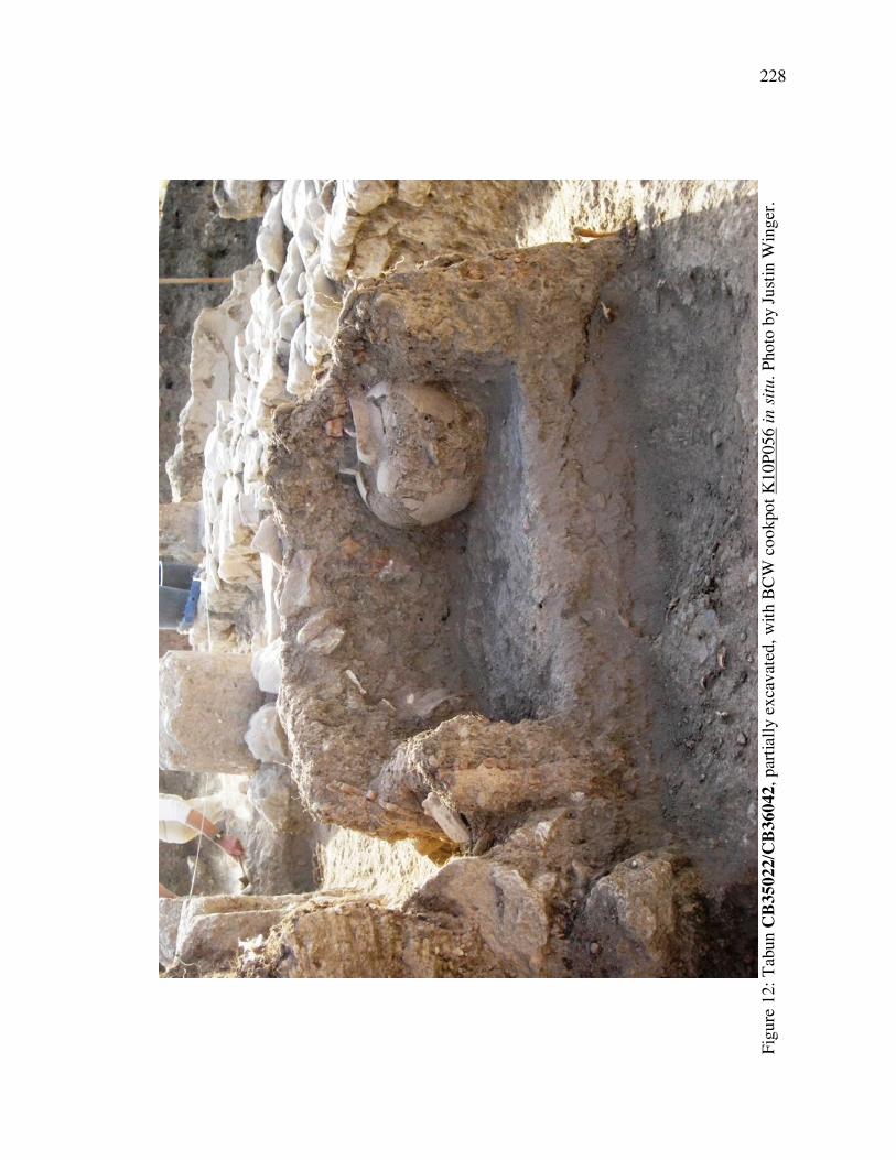
228
F
igu
re 1
2:
Tab
un C
B35
022
/CB
3604
2, par
tiall
y e
xca
vat
ed,
wit
h B
CW
co
okpo
t K
10P
05
6 i
n s
itu.
Pho
to b
y J
ust
in W
ing
er.

229
Figure 13: Tabun CB35022/CB36042. Top: from the east, showing its placement within
the Northern Corridor as well as the pottery, PHAB wall plaster, and stones that were
used in the construction of the outer wall. Bottom: Tabun CB35022/CB36042 from the
west, after the soil was removed. Photos by Justin Winger.

230
F
igu
re 1
4:
Pla
n o
f R
oo
m C
1,
inclu
din
g C
1a
and C
1b.

231
F
igu
re 1
5:
Ro
om
s C
1 a
nd C
1a,
vie
w f
rom
the
east
. T
roughs
CB
36033 a
re v
isib
le o
n t
he
oth
er s
ide
of
wall
CB
36036,
and p
aver
s
CB
360
17
are
vis
ible
on t
he
oth
er s
ide
of
the
tro
ughs,
abutt
ing
wall
s C
B36037 a
nd C
B3
6018,
whic
h h
as
been r
obbed
. A
Byza
nti
ne-
era
gra
ve
rest
s o
n t
op o
f w
all C
B36
034 o
n t
he
rig
ht
side
of
the
photo
. S
outh
of
wall
CB
360
34 i
s th
e C
en
tral
Co
urt
yar
d f
loo
r (C
B36035).
Pho
to b
y S
har
on H
erber
t; u
sed w
ith p
erm
issi
on.
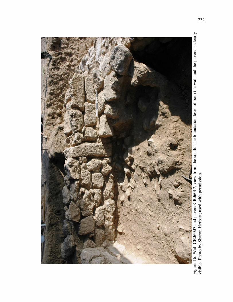
232
F
igu
re 1
6:
Wall
CB
360
37 a
nd p
aver
s C
B3
6017,
vie
w f
rom
the
south
. T
he
foundat
ion l
evel o
f bo
th t
he
wall a
nd t
he
paver
s is
cle
arly
vis
ible
. P
ho
to b
y S
har
on H
erber
t; u
sed w
ith p
erm
issi
on.

233
Figure 17: Plan of the Central Courtyard.

234
F
igu
re 1
8:
Pav
em
ent
CB
37
017 i
n t
he
no
rthw
est
corn
er o
f th
e C
entr
al
Co
urt
yar
d,
vie
w f
rom
the
wes
t. W
all
CB
37020 i
s to
the
left
of
the
pav
em
ent.
Pla
ster
flo
or
CB
37022 i
s in
the
low
er left
co
rner
, par
tiall
y s
had
ed b
y t
he
bau
lk.
Photo
by S
har
on H
erber
t; u
sed w
ith
per
mis
sio
n.
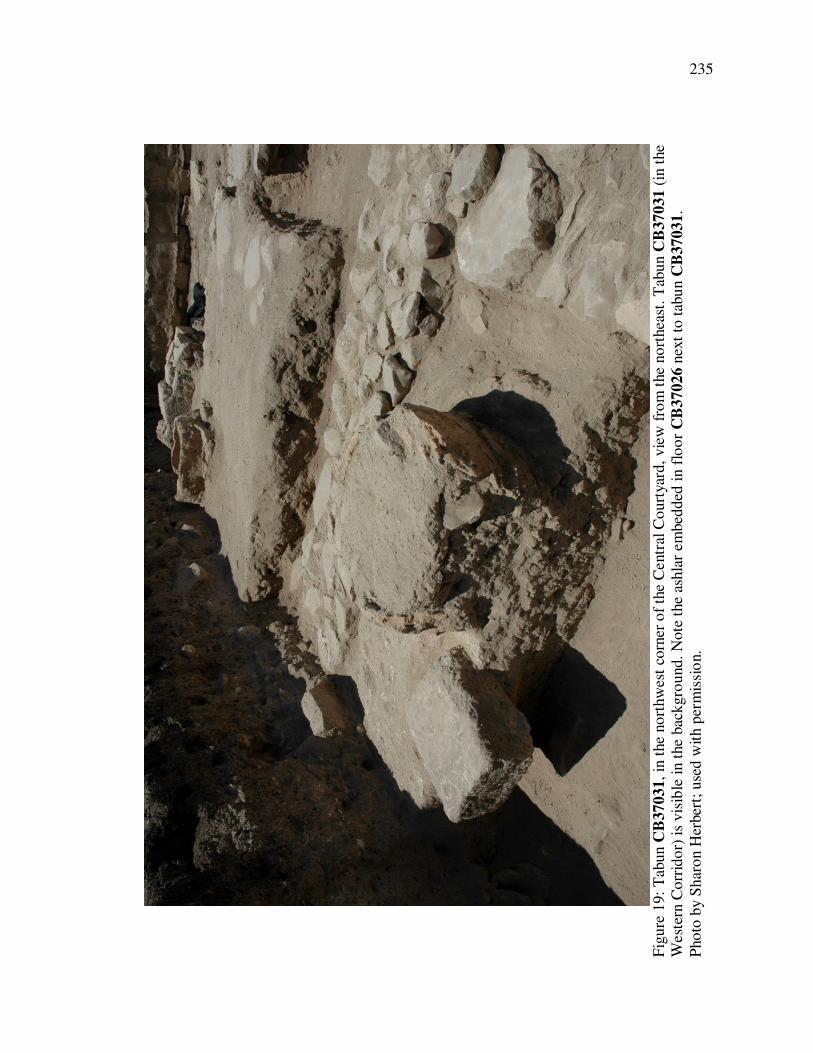
235
F
igu
re 1
9:
Tab
un C
B37
031
, in
the
no
rthw
est
corn
er o
f th
e C
entr
al C
ourt
yar
d,
vie
w f
rom
the
no
rthea
st. T
abun C
B3703
1 (
in t
he
West
ern C
orr
ido
r) i
s vis
ible
in t
he
bac
kgro
und.
Note
the
ashla
r em
bed
ded
in f
loo
r C
B3
7026 n
ext
to t
abu
n C
B37031.
Pho
to b
y S
har
on H
erber
t; u
sed w
ith p
erm
issi
on.

236
Figure 20: Plaster bin CB26006. Top: from the southwest. The cut in the courtyard floor
that may be connected to wall CB16023 is to the right of the bin (cf. Figure 17). Bottom:
Detail of plaster bin CB26006. Photos by Sharon Herbert; used with permission.

237
Figure 21: Wall CB16023 and stone basin K06S023. Top: view from the east, arrow
pointing to CB16023. Bottom: view from the west. Photos by Sharon Herbert; used with
permission.

238
F
igu
re 2
2:
The
south
wes
tern
co
rner
of
the
Cen
tral C
ourt
yar
d,
vie
w f
rom
the
east
. T
he
cobble
su
bfl
oo
r is
pla
inly
vis
ible
, as
are
wall
s
CB
270
05
and
CB
2700
6. T
he
pie
r-and
-rubb
le w
all
at
the
top o
f th
e photo
is
CB
27001.
Photo
by S
har
on H
erber
t; u
sed w
ith
per
mis
sio
n.

239
Figure 23: Plan of Room W2.

240
Figure 24: Room W2. Top: View from the north. Floor CB37023 is visible in the
foreground and surface CB37017 (in the Central Courtyard) is in the upper left of the
picture, on the other side of wall CB37020. Two outcroppings of floor CB37022 are
visible to the right of CB37017, in the shadow of the baulk. Bottom: Room C1b, view
from the east. Walls CB36018 and CB36037 are visible in the distance, on the other side
of the baulk. Photos by Sharon Herbert; used with permission.

241
Figure 25: Door block CB37003, between rooms Rooms W2 and N2. Top: View from
the south. Bottom: View from the north. Photos by Sharon Herbert; used with permission.

242
F
igu
re 2
6:
Ro
om
W2,
vie
w f
rom
the
east
. W
all
CB
37005 (
on t
he
left
) ab
uts
wal
l C
B37
001.
Photo
by S
har
on H
erber
t; u
sed w
ith
per
mis
sio
n.

Figures 243
Figure 27: Plan of the Western Corridor.

244
F
igu
re 2
8:
Pla
n o
f th
e W
este
rn C
orr
ido
r (d
etai
l).
Left
: T
he
no
rther
n h
alf
. R
ight:
The
south
ern h
alf
an
d R
oo
m S
2.

245
F
igu
re 2
9:
The
no
rther
n h
alf
of
the
Wes
tern
Co
rrid
or,
vie
w f
rom
the
no
rth.
The
doo
rway
bet
wee
n R
oo
ms
N2 a
nd W
2 i
s vis
ible
in t
he
fore
gro
und
and t
abun C
B37
030
sit
s ag
ain
st t
he
far
bau
lk (
Wall
CB
37
005 h
as
bee
n r
em
oved
). P
avin
g s
tones
CB
37032
are
ped
asta
lled
on t
his
sid
e o
f th
e ta
bun.
The
dif
fere
nce
in e
levat
ion b
etw
een t
he
pav
ers
and t
he
bo
tto
m o
f th
e ta
bun w
all
s o
n o
ne
hand
, and t
he
thre
sho
ld o
f th
e (f
inal P
HA
B-p
hase
) do
orw
ay o
n t
he
oth
er, is
evid
ent.
Photo
by S
har
on H
erber
t; u
sed
wit
h p
erm
issi
on.
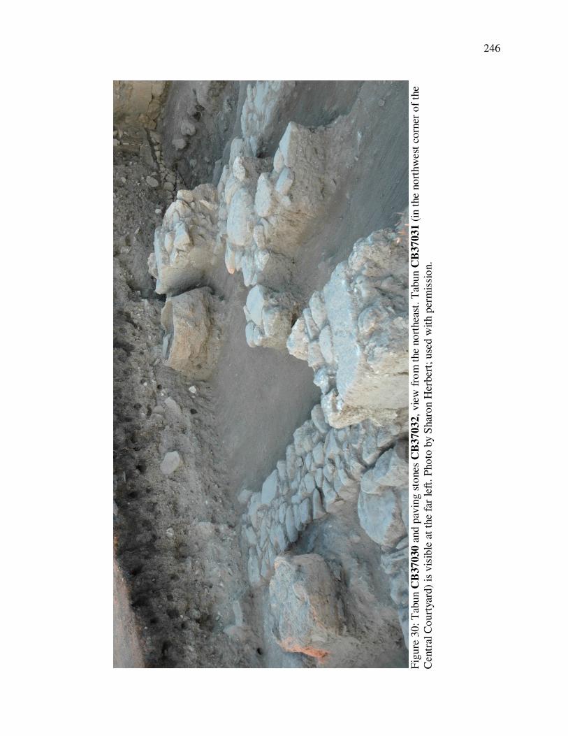
246
F
igu
re 3
0:
Tab
un C
B37
030
and
pav
ing s
tones
CB
37
032,
vie
w f
rom
the
no
rthea
st.
Tab
un C
B37031
(in
the
no
rthw
est
corn
er o
f th
e
Centr
al C
ourt
yar
d)
is v
isib
le a
t th
e fa
r le
ft.
Pho
to b
y S
har
on H
erber
t; u
sed w
ith p
erm
issi
on.

247
Figure 31: Plan of Room S2.

248
F
igu
re 3
2:
A v
iew
into
Roo
m S
2 f
rom
the
wes
t. V
isib
le a
re t
he
pla
ster
flo
or
(fo
regro
und
), c
obble
su
bfl
oo
r (b
ackgro
und
), a
nd t
he
lack
of
any f
loo
r in
the
Wes
tern
Co
rrid
or
(im
med
iate
fo
regro
und).
Photo
by S
har
on H
erber
t; u
sed w
ith p
erm
issi
on.

249
Figure 33: Door block CB17071, blocking the doorway between Rooms S2 and S1 (in
wall CB17003). Top: Entire room, view from the south (the door blockage is in the
northwest corner). Note the plaster on all of the walls but not the door blockage itself.
Bottom: Detail, view from the south. Photos by Sharon Herbert; used with permission.

250
Figure 34: Doorway between Rooms S2 and S1 (in wall CB17003). Top: View from the
north. Door block CB17071 has been partially removed (the two vertical stones against
the door jambs were part of the door blocking). Floor CB17052 can be seen connecting to
the wall plaster on wall CB27001 in the background. Bottom: View from the north. Floor
CB17052 and subfloor CB17052.1 have been removed and one can see the depth to
which the vertical blocking stones against the door jambs have been placed. Wall plaster
was found to run behind the eastern stone, on the door jamb. Photos by Sharon Herbert;
used with permission.

251
F
igu
re 3
5:
The
doo
rway b
etw
een R
oo
ms
S2 a
nd S
1 a
nd b
lock
ing s
tones
CB
17
071,
vie
w f
rom
the
no
rth. T
he
doorw
ay i
s in
the
upper
rig
ht;
the
wall
s th
at c
reat
ed R
oo
m S
1 h
ave
bee
n r
emo
ved
. T
he
bo
th t
he
ashla
r th
at w
as u
sed a
s a
stre
tcher
to
blo
ck t
he
doo
rway
an
d
the
blo
ckin
g s
tones
that
wer
e la
id a
gain
st t
he
door
jam
bs
are
pla
inly
vis
ible
, fl
ush
wit
h t
he
no
rther
n f
ace
of
wall
CB
17
003.
Photo
by
Shar
on H
erber
t; u
sed w
ith p
erm
issi
on.

252
Figure 36: PHAB-phase doorway blockage between the Stylobate Corridor and the
northeastern corner of Room C2 (in wall CB35021). Top: View from the southeast. Top
arrow points to facing plaster on the northern door jamb (now in the wall); side arrows
point to wall plaster over the blocking stones. Bottom: View from the northeast. Black
line outlines where the original doorway was. One large blocking stone is still in situ.
Note the wall plaster over it and the original wall. Photos by Sharon Herbert; used with
permission.

253
F
igu
re 3
7:
Pla
n o
f R
oo
m C
2.

254
F
igu
re 3
8:
Ro
om
C2,
vie
w f
rom
the
no
rth.
Tab
un C
B35001 i
s vis
ible
in t
he
cente
r, s
itti
ng o
n f
loo
r C
B35003. F
loo
r C
B35005 is
vis
ible
to
the
east
of
(and l
ow
er t
han
) fl
oo
r C
B3500
3.
Photo
by S
har
on H
erber
t; u
sed w
ith p
erm
issi
on.

255
Figure 39: Plan of Room C3.

256
F
igu
re 4
0:
Ro
om
s C
4 a
nd C
3,
vie
w f
rom
the
east
. S
tylo
bat
e C
B25001 i
s th
e w
all i
n t
he
fore
gro
und,
and t
he
pla
ce
wher
e w
all
CB
260
03
sto
od c
an b
e se
en i
n t
he
mid
dle
dis
tance
, w
her
e m
osa
ic f
loo
r C
B250
04 e
nds.
(T
he
small
rem
ain
ing s
tuble
t o
f C
B26003 i
s
vis
ible
sti
ckin
g o
ut
of
the
south
ern b
aulk
.) T
he
step
s le
adin
g u
p f
rom
Ro
om
C3
into
the
Cen
tral
Co
urt
yar
d a
re v
isib
le i
n t
he
dis
tance
.
Pho
to b
y S
har
on H
erber
t; u
sed w
ith p
erm
issi
on.

257
Figure 41: Plan of Room C4.

258
F
igu
re 4
2:
Ro
om
C4,
vie
w f
rom
the
east
. P
avin
g s
tones
CB
25015 a
re v
isib
le j
ust
so
uth
of
wall
CB
25003,
as is
line
of
sto
nes
CB
250
18
. T
he
deg
ree
of
dis
rup
tio
n i
n t
he
roo
m c
an b
e se
en i
n t
he
wes
t bau
lk.
Photo
by S
har
on H
erb
ert;
use
d w
ith p
erm
issi
on.

259
Figure 43: Plan of Room C5.

260
Figure 44. Below: Room C5, view from the north. The base of Hermon Jar K08P064 can
be seen sitting on the floor in the southwest corner. Above: ESA mastos K08P022 (left)
and BCW cookpot K08P108 (right), which were also found on the floor. Top two photos
by Sue Webb; lower Photo by Sharon Herbert. All three photos used with permission.

261
F
igu
re 4
5:
Pla
n o
f R
oo
ms
C6 a
nd C
7.

262
F
igu
re 4
6:
Pla
n o
f th
e S
outh
-Cen
tral
Co
rrid
or.

263
Figure 47: Plan of the Stylobate Corridor.

264
Figure 48: Tabuns CB25004 and CB25005. Above: View from the southeast. Tabun
CB25004 has been built up against Stylobate CB25001. Below: Detail, view from the
east. Coastal Orange Ware jar CB25005 has been buried upside down and buttressed with
soil, stones, and PHAB wall plaster. Photos by Sharon Herbert; used with permission.

265
Figure 49: Plan of Room E1.

266
Figure 50: Plan of Room E2.

267
Figure 51: Plan of Room E3.

268
Figure 52: Plan of Room E4.

269
Figure 53: Tabun CB25041. Top: View from the north. Floor CB25040 can be seen
binding to the stones ringing the tabun walls. Bottom: View from the east. Floor
CB25042 has been cut for the placement of the tabun. Photos by Sharon Herbert; used
with permission.

270
Figure 54: Plan of the Eastern Corridor.
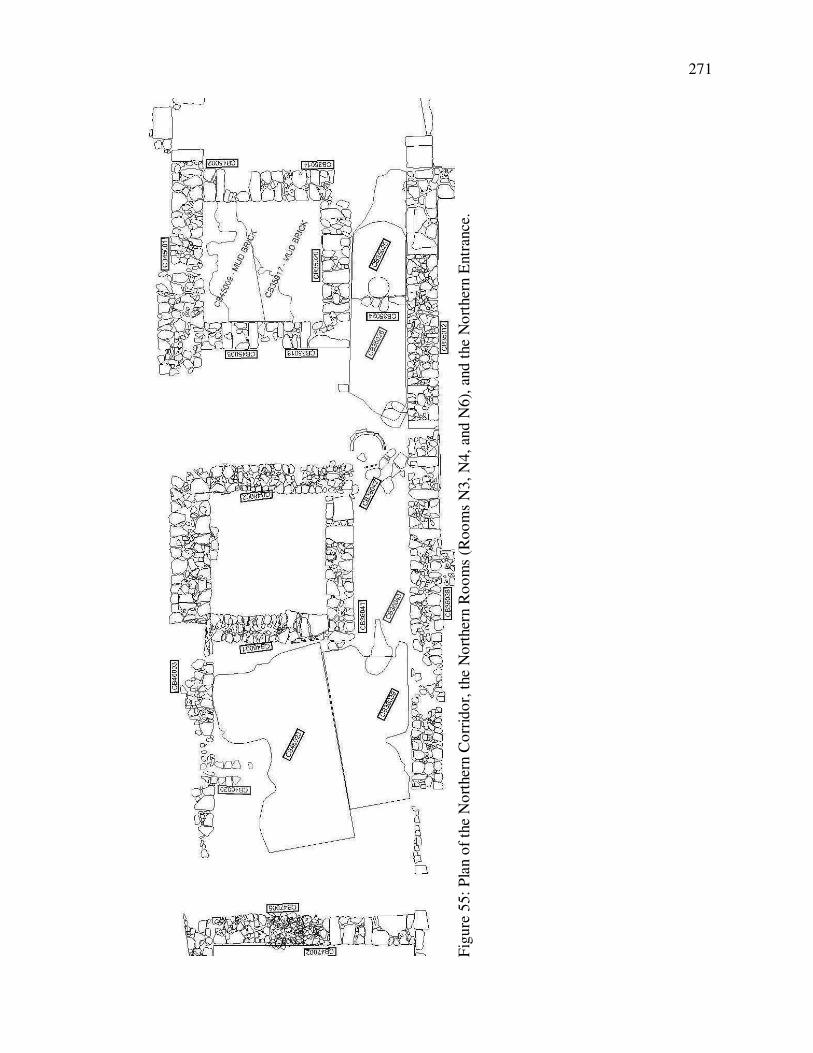
271
F
igu
re 5
5:
Pla
n o
f th
e N
ort
her
n C
orr
ido
r, t
he
No
rther
n R
oo
ms
(Roo
ms
N3,
N4
, an
d N
6),
and t
he
No
rther
n E
ntr
ance
.
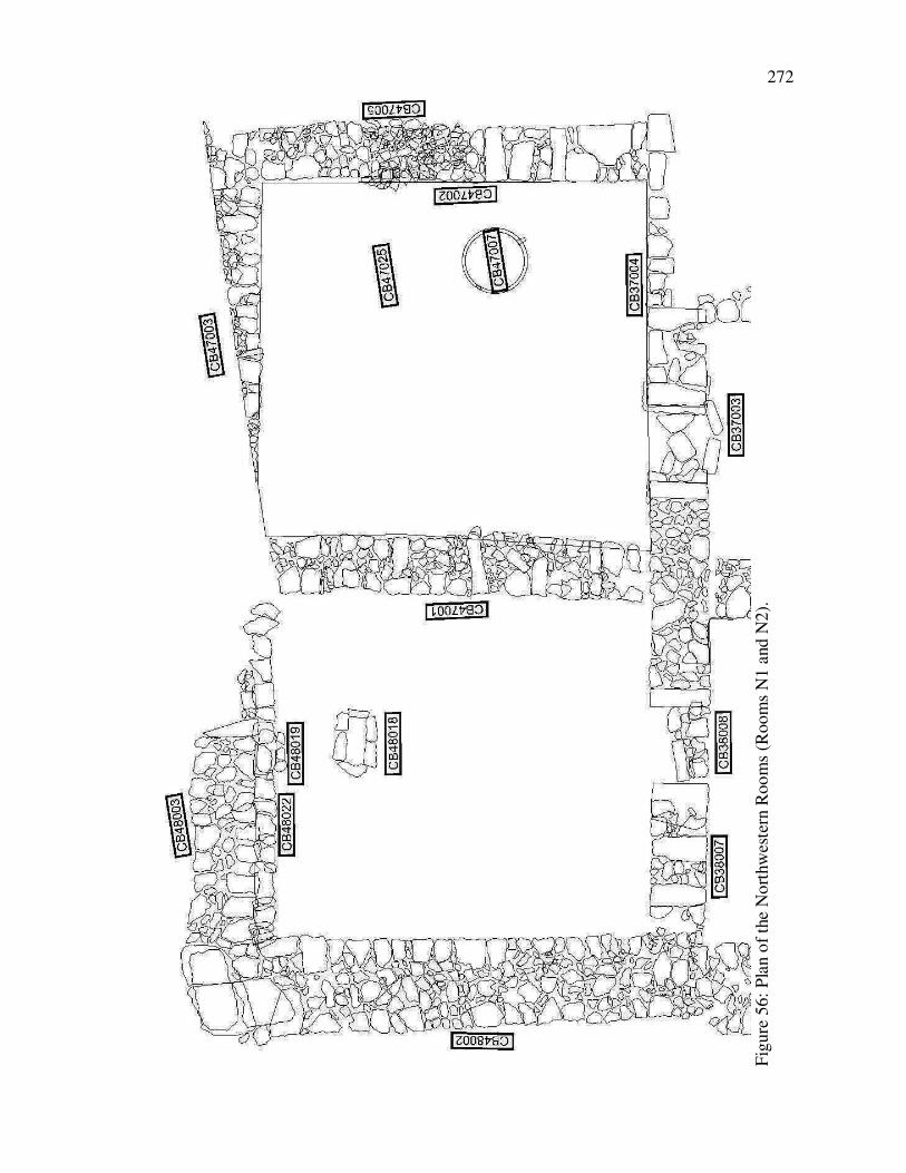
272
F
igu
re 5
6:
Pla
n o
f th
e N
ort
hw
este
rn R
oo
ms
(Room
s N
1 a
nd N
2).

273
F
igu
re 5
7:
Pla
n o
f th
e W
este
rn R
oo
ms.
Left
: T
he
no
rther
n h
alf
(R
oo
ms
W1,
W3,
and W
4).
Rig
ht:
The
south
ern h
alf
(R
oo
ms
W4a,
W5,
W6
, and W
7).

274
Figure 58: Plaster floor CB28003 in the doorway between Rooms W5 and W4a, view
from the south. Above: Detail of door block CB28005, which is visible to the right of two
ashlars of wall CB28004 (which sit behind the shattered Hermon Jar) and sitting on soil.
Below: the door block has been excavated and floor CB28003 can be clearly seen
covering the threshold of the doorway between Rooms W5 and W4a. Photos by Sharon
Herbert; used with permission.

275
F
igu
re 5
9:
Ro
om
W4,
vie
w f
rom
the
no
rth.
Note
ho
w d
eeply
wall
CB
28002/C
B28016 (
the
wall d
ivid
ing R
oo
m W
4 f
rom
the
West
ern
Co
rrid
or)
has
bee
n r
obbed
. P
ho
to b
y S
har
on H
erbert
; use
d w
ith p
erm
issi
on.

276
F
igu
re 6
0:
Pla
n o
f th
e ro
om
s so
uth
of
the
Cen
tral C
ourt
yar
d (
Roo
ms
S2,
S3,
and S
4).

277
F
igu
re 6
1:
Ro
om
s so
uth
of
the
So
uth
-Cen
tral C
orr
ido
r (R
oo
ms
S5,
S6
, S
7, S
9,
S10,
and
S11
).

278
F
igu
re 6
2:
Pla
n o
f R
oo
m S
8.
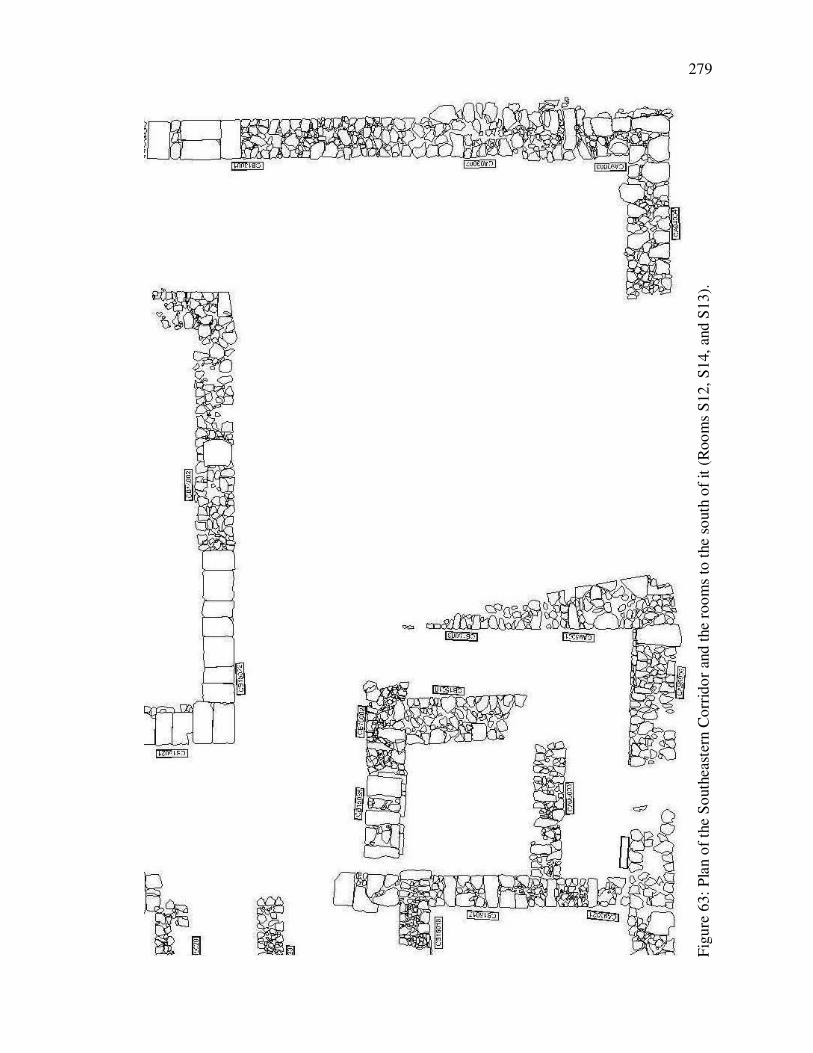
279
F
igu
re 6
3:
Pla
n o
f th
e S
outh
east
ern C
orr
ido
r an
d t
he
roo
ms
to t
he
south
of
it (
Roo
ms
S1
2,
S14,
and S
13).

280
F
igu
re 6
4:
Tab
un C
B17
038
and
pla
tfo
rm C
B17041,
vie
w f
rom
the
south
. N
ote
the
Rho
dia
n a
mp
ho
ra a
nd H
erm
on J
ar s
her
ds
that
hav
e
bee
n i
nco
rpora
ted i
nto
the
const
ruct
ion o
f th
e w
all
s. P
hoto
by S
har
on H
erber
t; u
sed w
ith p
erm
issi
on.

281
F
igu
re 6
5:
Tab
un C
B17
039
, vie
w f
rom
the
south
. T
he
tabun i
s d
iffi
cult
to
see
am
idst
the
rubble
that
des
tro
yed
it,
but
the
curv
e o
f it
s
no
rther
n f
ace
is v
isib
le b
etw
een t
he
arro
ws.
Photo
by S
har
on H
erber
t; u
sed w
ith p
erm
issi
on.

282
Appendix I:
Naming and Numbering Conventions Used in this Dissertation
The Tel
Before exploring the archaeological evidence for the Squatters it is important to set out
the conventions that will be used to describe them. The tel is gridded into twelve 90 x 90
m. fields that are further subdivided into 10 x 10 m. squares, each of which have 5 x 5 m.
quadrants (see Figure 2 and Figure 4). There are three 90 m-wide east/west fields,
designated “East,” “Central,” and “West.” Trenches/squares1 are designated by two
letters followed by two numbers delineated by a period (e.g., CA 9.6). These East,
Central, and West fields account for the first letter in a trench’s designation (e.g., in “CA
9.6” the “C” designates the central 90 m-wide field). Each 90 x 90 m. field’s location on
a north/south axis is designated by a letter of the alphabet, starting in the south, which is
represents the second letter in a trench’s designation (the “A” in “CA 9.6” indicates that
this trench is located in the southernmost 90 x 90 m. section). A 10 x 10 m. square’s
location within a 90 x 90 m. field is indicated by the two numbers that follow the two
letters. The first number is on the south-north axis and again the progression is from
south to north. The second number designates the square’s location on an east/west axis,
and these numbers increase from east to west. Thus, for instance, CA 9.5 is southeast of
1 In Israel the word “square” is usually used (at least by American excavations) to designate an area that is
being excavated – e.g., “square CA 9.6 SE.”The Tel Kedesh Archaeological Excavations, however, most
commonly call them “trenches.” Note, however, that “trenches” at Tel Kedesh are square in shape. The
terms are completely interchangeable here.

283
CB 1.6. Each 10 x 10 m. square is further divided into four 5 x 5 m. quadrants, NW, NE,
SW, and SE. As a point of reference, the administrative building at Tel Kedesh is located
between CB 4.8 NE (the northwest corner of the building), CB 3.3 NE (the northeast
corner of the building), CA 9.3 SW (the southeast corner of the building), and CB 1.8 SW
(the southwest corner of the building).
Rooms within the Administrative Building
For the sake of efficiency, the building has been broken up into use areas and
rooms have been numbered within those use areas (see Figure 4). The rooms north of the
Northern Corridor have been numbered from 1-6 and in the text are referred to as, e.g.,
“Room N1.” Rooms west of the Western Cooridor have been numbered 1-7 and in the
text are referred to as, e.g., “Room W1.” Rooms south of the Central Courtyard, the
South-Central Corridor, and the Southeastern Corridor have been numbered from 1-14
and are referred to in the text as, e.g., “Room S1.” Rooms east of the Stylobate Corridor
are numbered from 1-4 and are referred to, e.g., as “Room E1.” And rooms in the center
of the building (i.e., between the Northern Corridor, the Western Corridor, the South-
Central Corridor, and the Stylobate Corridor) are numbered from 1-7 and are referred to
as, e.g., “Room C1.” In four cases a part of a room has been given a sub-identifier for the
sake of higher resolution with respect to analysis of the finds: The southern portion of
room W4 (designated Room W4a); the west, central and eastern 1/3 of Room S8; two
areas in Room C1 (C1a and C1b); and one area in Room C2 (C2a).
The following conventions will be also used:
When a trench is designated without a quadrant specified (e.g., CA 9.5), it designates
an entire 10 x 10 m. square. When the quadrant is specified (e.g., CA 9.5 SW) it
designates a 5 x 5 m. square.

284
A “unit” at Tel Kedesh is the smallest element of excavation – a cohesive three
dimensional deposition of soil that is differentiated from other depositions of soil
on the basis of compaction, color, inclusions, or division by architectural features.
At the end of a season units are grouped into loci, with a locus being a
distinguishable phase of deposition or activity.
Unit numbers are distinguished from locus numbers by the inclusion of periods in
their designations (e.g., unit CB3.6.034; locus CB36034).
Architectural loci will be in bold (e.g., CB37020). It should be noted that some features
cross trench lines. When they do and this is relevant to the discussion, they will be
designated by all relevant locus numbers (e.g., the northern wall of the Central
Courtyard is wall CB36034/CB37020).
Soil loci will be boxed (e.g., CB37007).
Locus numbers that end in “.0” (e.g., CB37031.0) designate soil that is inside an
installation or feature such as a tabun.
Locus numbers that end in “.1” (e.g., CB37031.1) designate the soil underneath a
feature (ideally 0.1 m. in depth). 0.1 loci nearly always indicate sealed contexts
and are therefore important for dating the feature under which they lie.
Tracking numbers (e.g., K06T#1326) are underlined and have three parts: the year in
which it was excavated (e.g., “K06”), the designation as a tracked object (“T#”),
and the tracking number (e.g., “1326”). Every object uncovered in the field (with
the exception of pottery sherds in a pottery bucket) was “tracked” and received a
tracking number as the first act of registration. If an item was subsequently
deemed important enough to be inventoried then it also received an inventory
number. In this chapter the use of a tracking number indicates an object that was
not inventoried.
Inventory numbers (e.g., K06S024) are also underlined and have three parts: the year
in which it was excavated (e.g., “K06”), the category of item (e.g., “S” – stone
object), and the inventory number (e.g., “024”). The item categories are:
BD – bead
BI – bone implement
C – coin
G – glass
I – inscribed object
L – lamp
M – metal
P – pottery
S – stone
SAH – stamped amphora handle
TC – terracotta
Pottery weights and counts: Pottery from each unit was washed, sorted, and weighed.
When units had an amount of pottery that weighed in below 0.01 kg, the sherds
got counted instead of being weighed. When units were combined into loci it
sometimes happened that on unit of the locus would have a weight and another
would have a sherd count. As a result, there will be times in the following chapter
that pottery will be described as, for instance, “0.1 kg, plus 3 sherds, of ESA.”
Elevations are given in meters above sea level (e.g., 465.39 m.).

285
The term “LDM” is short for “Latest Datable Material” and refers to the pottery or
object(s) in a unit or locus that provide(s) a terminus post quem for that soil.
LDMs in sealed contexts (e.g., sealed below a floor, wall, or installation) usually
provide a terminus post quem for the construction of that floor, wall, or
installation. It should be noted, however, that the LDM is not always
representative of the actual terminus post quem. For instance, a floor that seals
soil with a coin of Antiochus III as its LDM might initially seem to have a
terminus post quem of 189-188 BCE, based on the reading of the coin. But other
factors – for instance, superposition (the floor has been laid over another, deeper
floor that has a coin of Demetrius II as its LDM) – might make it clear that the
coin of Antiochus III is not representative of the actual terminus post quem.
The term “PHAB” stands for the Persian/Hellenistic Administrative Building and refers
specifically to the pre-abandonment (i.e., pre-Squatter) phases of the building (ca.
500 BCE – 143 BCE).

286
Appendix II:
A Short Primer on the Pottery Found at Tel Kedesh
It would be nice if coins and stamped amphora handles were found in every unit –
we would be able to date each unit and locus very precisely. That is sadly not at all the
case and so we must rely on pottery to date features. Fortunately we know a lot about the
various shapes and types of pottery found at Tel Kedesh and as a result can use it to fairly
precisely date the units in which it is found. What follows can be used as a fabric-date
concordance for those unfamiliar with the most common pottery fabrics found at Tel
Kedesh.1
TABLE 2 – CERAMIC FABRICS COMMONLY FOUND AT TEL KEDESH
Fabric Building Phase
Akko Sandy Cooking Ware PHAB (Persian to 2nd century BCE)
Attic Black Glaze PHAB (Persian to 3rd century BCE)
Basaltic Cooking Ware (BCW) Squatter
Black Slipped Predecessor (BSP) PHAB (after 160 BCE)-Squatter??
Central Coastal Fine PHAB
Coastal Fine North (CFN) PHAB (200-150 BCE)
Coastal Orange Ware PHAB (Persian to 3rd century BCE)
Coastal Plain Ware Iron Age-Persian
Crystal Cooking Ware Iron Age
Gritty Cooking Ware PHAB (Persian to 2nd century BCE)
Hellenistic Black Glaze PHAB (3rd-2nd centuries BCE)
Hermon PHAB (200-150 BCE)
1 A wide variety of imported fine ware was also found in the PHAB phases (and therefore Squatter phases),
but because of the small total amount and great diversity of fabrics and shapes, they are not included in this
table. When they are important the date will be included in the text. For details see Stone, "'Provincial'
Perspectives: The Persian, Ptolemaic, and Seleucid Administrative Center at Tel Kedesh in a Regional
Context."

287
Kfar Hananya
Post-Squatter
(mid-1st century BCE to the 6th century CE)
Local Fine B PHAB (300-150 BCE)
Pink Brown Gritty (PBG)
Iron Age and PHAB (Iron Age to early 2nd century
BCE)
Phoenician Semi Fine PHAB (Persian-2nd century BCE)/Squatter
Ras al Fuqra Early Modern to ca. 1950 CE
Red Brown Gritty (RBG)
Iron Age and PHAB (Iron Age to early 2nd century
BCE)
Spatter Ware Early Bronze Age to the 2nd century BCE (PHAB)
Tan Grey Marl Squatter
White Ware PHAB (6th-4th centuries BCE)
Vessel shapes are also important. Not only are they dateable (shapes went in and
out of vogue, as they do today), but a given shape can be made in different fabrics. The
forms found at Kedesh and references to comparanda are a major focus of Peter Stone’s
dissertation on the pottery at Tel Kedesh and can be found there.2
2 Stone, "'Provincial' Perspectives: The Persian, Ptolemaic, and Seleucid Administrative Center at Tel
Kedesh in a Regional Context," Appendix I.
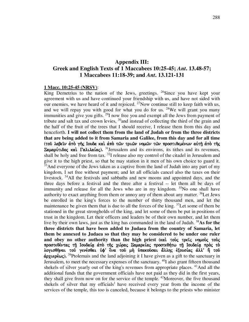
288
Appendix III:
Greek and English Texts of 1 Maccabees 10:25-45; Ant. 13.48-57;
1 Maccabees 11:18-39; and Ant. 13.121-131
1 Macc. 10:25-45 (NRSV):
King Demetrius to the nation of the Jews, greetings. 26Since you have kept your
agreement with us and have continued your friendship with us, and have not sided with
our enemies, we have heard of it and rejoiced. 27Now continue still to keep faith with us,
and we will repay you with good for what you do for us. 28We will grant you many
immunities and give you gifts. 29I now free you and exempt all the Jews from payment of
tribute and salt tax and crown levies, 30and instead of collecting the third of the grain and
the half of the fruit of the trees that I should receive, I release them from this day and
henceforth. I will not collect them from the land of Judah or from the three districts
that are being added to it from Samaria and Galilee, from this day and for all time
(tou/ labei/n avpo. gh/j Iouda kai. avpo.tou/ labei/n avpo. gh/j Iouda kai. avpo.tou/ labei/n avpo. gh/j Iouda kai. avpo.tou/ labei/n avpo. gh/j Iouda kai. avpo. tw/n triw/n nomw/n tw/n prostiqeme,nwn auvth/| avpo. th/j tw/n triw/n nomw/n tw/n prostiqeme,nwn auvth/| avpo. th/j tw/n triw/n nomw/n tw/n prostiqeme,nwn auvth/| avpo. th/j tw/n triw/n nomw/n tw/n prostiqeme,nwn auvth/| avpo. th/j Samari,tidoj kai. Galilai,ajSamari,tidoj kai. Galilai,ajSamari,tidoj kai. Galilai,ajSamari,tidoj kai. Galilai,aj). 31Jerusalem and its environs, its tithes and its revenues,
shall be holy and free from tax. 32I release also my control of the citadel in Jerusalem and
give it to the high priest, so that he may station in it men of his own choice to guard it. 33And everyone of the Jews taken as a captive from the land of Judah into any part of my
kingdom, I set free without payment; and let all officials cancel also the taxes on their
livestock. 34All the festivals and sabbaths and new moons and appointed days, and the
three days before a festival and the three after a festival -- let them all be days of
immunity and release for all the Jews who are in my kingdom. 35No one shall have
authority to exact anything from them or annoy any of them about any matter. 36Let Jews
be enrolled in the king's forces to the number of thirty thousand men, and let the
maintenance be given them that is due to all the forces of the king. 37Let some of them be
stationed in the great strongholds of the king, and let some of them be put in positions of
trust in the kingdom. Let their officers and leaders be of their own number, and let them
live by their own laws, just as the king has commanded in the land of Judah. 38As for the
three districts that have been added to Judaea from the country of Samaria, let
them be annexed to Judaea so that they may be considered to be under one ruler
and obey no other authority than the high priest (kai. tou.j trei/j nomou.j kai. tou.j trei/j nomou.j kai. tou.j trei/j nomou.j kai. tou.j trei/j nomou.j tou.j tou.j tou.j tou.j prosteqe,ntaj th/| Ioudai,a| avpo. th/j cw,raj Samarei,aj prosteqh,tw th/| Ioudai,a| pro.j to. prosteqe,ntaj th/| Ioudai,a| avpo. th/j cw,raj Samarei,aj prosteqh,tw th/| Ioudai,a| pro.j to. prosteqe,ntaj th/| Ioudai,a| avpo. th/j cw,raj Samarei,aj prosteqh,tw th/| Ioudai,a| pro.j to. prosteqe,ntaj th/| Ioudai,a| avpo. th/j cw,raj Samarei,aj prosteqh,tw th/| Ioudai,a| pro.j to. logisqh/nai tou/ gene,sqai ufV e[na tou/ mh. u`pakou/sai a;llhj evxousi,aj avllV h' tou/ logisqh/nai tou/ gene,sqai ufV e[na tou/ mh. u`pakou/sai a;llhj evxousi,aj avllV h' tou/ logisqh/nai tou/ gene,sqai ufV e[na tou/ mh. u`pakou/sai a;llhj evxousi,aj avllV h' tou/ logisqh/nai tou/ gene,sqai ufV e[na tou/ mh. u`pakou/sai a;llhj evxousi,aj avllV h' tou/ avrciere,wjavrciere,wjavrciere,wjavrciere,wj). 39Ptolemais and the land adjoining it I have given as a gift to the sanctuary in
Jerusalem, to meet the necessary expenses of the sanctuary. 40I also grant fifteen thousand
shekels of silver yearly out of the king's revenues from appropriate places. 41And all the
additional funds that the government officials have not paid as they did in the first years,
they shall give from now on for the service of the temple. 42Moreover, the five thousand
shekels of silver that my officials1 have received every year from the income of the
services of the temple, this too is canceled, because it belongs to the priests who minister

289
there. 43And all who take refuge at the temple in Jerusalem, or in any of its precincts,
because they owe money to the king or are in debt, let them be released and receive back
all their property in my kingdom. 44Let the cost of rebuilding and restoring the structures
of the sanctuary be paid from the revenues of the king. 45And let the cost of rebuilding the
walls of Jerusalem and fortifying it all around, and the cost of rebuilding the walls in
Judaea, also be paid from the revenues of the king.

290
1 Maccabees 10:25-45 (ed. Rahlfs):1 kai. avpe,steilen auvtoi/j kata. tou.j lo,gouj tou,touj basileu.j Dhmh,trioj tw/| e;qnei tw/n Ioudai,wn cai,rein 26 evpei. sunethrh,sate ta.j pro.j h`ma/j sunqh,kaj kai. evnemei,nate th/| fili,a| h`mw/n kai. ouv prosecwrh,sate toi/j evcqroi/j h`mw/n hvkou,samen kai. evca,rhmen 27kai. nu/n evmmei,nate e;ti tou/ sunthrh/sai pro.j h`ma/j pi,stin kai. avntapodw,somen u`mi/n avgaqa. avnqV w-n poiei/te meqV h`mw/n 28kai. avfh,somen u`mi/n avfe,mata polla. kai. dw,somen u`mi/n do,mata 29kai. nu/n avpolu,w u`ma/j kai. avfi,hmi pa,ntaj tou.j Ioudai,ouj avpo. tw/n fo,rwn kai. th/j timh/j tou/ a`lo.j kai. avpo. tw/n stefa,nwn 30303030kaikaikaikai. avnti. tou/ tri,tou th/j spora/j kai. avnti. . avnti. tou/ tri,tou th/j spora/j kai. avnti. . avnti. tou/ tri,tou th/j spora/j kai. avnti. . avnti. tou/ tri,tou th/j spora/j kai. avnti. tou/ h`mi,souj tou/ karpou/ tou/ xuli,nou tou/ evpiba,llonto,j moi labei/n avfi,hmi avpo. th/j tou/ h`mi,souj tou/ karpou/ tou/ xuli,nou tou/ evpiba,llonto,j moi labei/n avfi,hmi avpo. th/j tou/ h`mi,souj tou/ karpou/ tou/ xuli,nou tou/ evpiba,llonto,j moi labei/n avfi,hmi avpo. th/j tou/ h`mi,souj tou/ karpou/ tou/ xuli,nou tou/ evpiba,llonto,j moi labei/n avfi,hmi avpo. th/j sh,meron kai. evpe,keina tou/ labei/n avpo. gh/j Iouda kai. avpo. tw/n triw/n nomw/n tw/n sh,meron kai. evpe,keina tou/ labei/n avpo. gh/j Iouda kai. avpo. tw/n triw/n nomw/n tw/n sh,meron kai. evpe,keina tou/ labei/n avpo. gh/j Iouda kai. avpo. tw/n triw/n nomw/n tw/n sh,meron kai. evpe,keina tou/ labei/n avpo. gh/j Iouda kai. avpo. tw/n triw/n nomw/n tw/n prostiqeme,nwn auvth/| aprostiqeme,nwn auvth/| aprostiqeme,nwn auvth/| aprostiqeme,nwn auvth/| avpo. th/j Samari,tidoj kai. Galilai,aj avpo. th/j sh,meron h`me,raj kai. vpo. th/j Samari,tidoj kai. Galilai,aj avpo. th/j sh,meron h`me,raj kai. vpo. th/j Samari,tidoj kai. Galilai,aj avpo. th/j sh,meron h`me,raj kai. vpo. th/j Samari,tidoj kai. Galilai,aj avpo. th/j sh,meron h`me,raj kai. eivj to.n a[panta cro,non eivj to.n a[panta cro,non eivj to.n a[panta cro,non eivj to.n a[panta cro,non 31313131kai. Ierousalhm e;stw a`gi,a kai. avfeime,nh kai. ta. o[ria auvth/j kai. Ierousalhm e;stw a`gi,a kai. avfeime,nh kai. ta. o[ria auvth/j kai. Ierousalhm e;stw a`gi,a kai. avfeime,nh kai. ta. o[ria auvth/j kai. Ierousalhm e;stw a`gi,a kai. avfeime,nh kai. ta. o[ria auvth/j ai` deka,tai kai. ta. te,lh ai` deka,tai kai. ta. te,lh ai` deka,tai kai. ta. te,lh ai` deka,tai kai. ta. te,lh 32323232avfi,hmiavfi,hmiavfi,hmiavfi,hmi kai. th.n evxousi,an th/j a;kraj th/j evn Ierousalhm kai. di,dwmi tw/| avrcierei/ o[pwj a'n katasth,sh| evn auvth/| a;ndraj ou]j a'n auvto.j evkle,xhtai tou/ fula,ssein auvth,n 33kai. pa/san yuch.n Ioudai,wn th.n aivcmalwtisqei/san avpo. gh/j Iouda eivj pa/san basilei,an mou avfi,hmi evleuqe,ran dwrea,n kai. pa,ntej avfie,twsan tou.j fo,rouj kai. tw/n kthnw/n auvtw/n 34kai. pa/sai ai e`ortai. kai. ta. sa,bbata kai. noumhni,ai kai. h`me,rai avpodedeigme,nai kai. trei/j h`me,rai pro. e`orth/j kai. trei/j meta. e`orth.n e;stwsan pa/sai h`me,rai avtelei,aj kai. avfe,sewj pa/sin toi/j Ioudai,oij toi/j ou=sin evn th/| basilei,a| mou 35kai. ouvc e[xei evxousi,an ouvdei.j pra,ssein kai. parenoclei/n tina auvtw/n peri. panto.j pra,gmatoj 36kai. prografh,twsan tw/n Ioudai,wn eivj ta.j duna,meij tou/ basile,wj eivj tria,konta cilia,daj avndrw/n kai. doqh,setai auvtoi/j xe,nia wj kaqh,kei pa,saij tai/j duna,mesin tou/ basile,wj 37373737kai. katastaqh,setai evx auvtw/n evn toi/j ovcurw,masin tou/ basile,wj toi/j kai. katastaqh,setai evx auvtw/n evn toi/j ovcurw,masin tou/ basile,wj toi/j kai. katastaqh,setai evx auvtw/n evn toi/j ovcurw,masin tou/ basile,wj toi/j kai. katastaqh,setai evx auvtw/n evn toi/j ovcurw,masin tou/ basile,wj toi/j mega,loij kai. evk tou,twn katastaqh,sontai evpi. creiw/n thmega,loij kai. evk tou,twn katastaqh,sontai evpi. creiw/n thmega,loij kai. evk tou,twn katastaqh,sontai evpi. creiw/n thmega,loij kai. evk tou,twn katastaqh,sontai evpi. creiw/n th/j basilei,aj tw/n ouvsw/n eivj /j basilei,aj tw/n ouvsw/n eivj /j basilei,aj tw/n ouvsw/n eivj /j basilei,aj tw/n ouvsw/n eivj pi,stin kai. oi` evpV auvtw/n kai. oi` a;rcontej e;stwsan evx auvtw/n kai. poreue,sqwsan toi/j pi,stin kai. oi` evpV auvtw/n kai. oi` a;rcontej e;stwsan evx auvtw/n kai. poreue,sqwsan toi/j pi,stin kai. oi` evpV auvtw/n kai. oi` a;rcontej e;stwsan evx auvtw/n kai. poreue,sqwsan toi/j pi,stin kai. oi` evpV auvtw/n kai. oi` a;rcontej e;stwsan evx auvtw/n kai. poreue,sqwsan toi/j no,moij auvtw/n kaqa. kai. prose,taxen o` basileu.j evn gh/| Iouda no,moij auvtw/n kaqa. kai. prose,taxen o` basileu.j evn gh/| Iouda no,moij auvtw/n kaqa. kai. prose,taxen o` basileu.j evn gh/| Iouda no,moij auvtw/n kaqa. kai. prose,taxen o` basileu.j evn gh/| Iouda 38383838kai. tou.j trei/j nomou.j kai. tou.j trei/j nomou.j kai. tou.j trei/j nomou.j kai. tou.j trei/j nomou.j tou.j prosteqe,ntaj th/| Ioudai,a|tou.j prosteqe,ntaj th/| Ioudai,a|tou.j prosteqe,ntaj th/| Ioudai,a|tou.j prosteqe,ntaj th/| Ioudai,a| avpo. th/j cw,raj Samarei,aj prosteqh,tw th/| Ioudai,a| pro.j avpo. th/j cw,raj Samarei,aj prosteqh,tw th/| Ioudai,a| pro.j avpo. th/j cw,raj Samarei,aj prosteqh,tw th/| Ioudai,a| pro.j avpo. th/j cw,raj Samarei,aj prosteqh,tw th/| Ioudai,a| pro.j to. logisqh/nai tou/ gene,sqai ufV e[na tou/ mh. u`pakou/sai a;llhj evxousi,aj avllV h' tou/ to. logisqh/nai tou/ gene,sqai ufV e[na tou/ mh. u`pakou/sai a;llhj evxousi,aj avllV h' tou/ to. logisqh/nai tou/ gene,sqai ufV e[na tou/ mh. u`pakou/sai a;llhj evxousi,aj avllV h' tou/ to. logisqh/nai tou/ gene,sqai ufV e[na tou/ mh. u`pakou/sai a;llhj evxousi,aj avllV h' tou/ avrciere,wj avrciere,wj avrciere,wj avrciere,wj 39393939Ptolemai,da kai. th.n proskurou/san auvth/| de,dwka do,ma toi/j a`gi,oij toi/j evn Ptolemai,da kai. th.n proskurou/san auvth/| de,dwka do,ma toi/j a`gi,oij toi/j evn Ptolemai,da kai. th.n proskurou/san auvth/| de,dwka do,ma toi/j a`gi,oij toi/j evn Ptolemai,da kai. th.n proskurou/san auvth/| de,dwka do,ma toi/j a`gi,oij toi/j evn IeIeIeIerousalhm eivj th.n kaqh,kousan dapa,nhn toi/j a`gi,oij rousalhm eivj th.n kaqh,kousan dapa,nhn toi/j a`gi,oij rousalhm eivj th.n kaqh,kousan dapa,nhn toi/j a`gi,oij rousalhm eivj th.n kaqh,kousan dapa,nhn toi/j a`gi,oij 40kavgw. di,dwmi katV evniauto.n de,ka pe,nte cilia,daj si,klwn avrguri,ou avpo. tw/n lo,gwn tou/ basile,wj avpo. tw/n to,pwn tw/n avnhko,ntwn 41kai. pa/n to. pleona,zon o] ouvk avpedi,dosan avpo. tw/n creiw/n wj evn toi/j prw,toij e;tesin avpo. tou/ nu/n dw,sousin eivj ta. e;rga tou/ oi;kou 42kai. evpi. tou,toij pentakiscili,ouj si,klouj avrguri,ou ou]j evla,mbanon avpo. tw/n creiw/n tou/ a`gi,ou avpo. tou/ lo,gou katV evniauto,n kai. tau/ta avfi,etai dia. to. avnh,kein auvta. toi/j iereu/sin toi/j leitourgou/sin 43kai. o[soi eva.n fu,gwsin eivj to. iero.n to. evn Ierosolu,moij kai. evn pa/sin toi/j ori,oij auvtou/ ovfei,lwn basilika. kai. pa/n pra/gma avpolelu,sqwsan kai. pa,nta o[sa evsti.n auvtoi/j evn th/| basilei,a| mou 44kai. tou/ oivkodomhqh/nai kai. evpikainisqh/nai ta. e;rga tw/n a`gi,wn kai. h` dapa,nh doqh,setai evk tou/ lo,gou tou/ basile,wj 45kai. tou/ oivkodomhqh/nai ta. tei,ch Ierousalhm kai. ovcurw/sai kuklo,qen kai. h` dapa,nh doqh,setai evk tou/ lo,gou tou/ basile,wj kai. tou/ oivkodomhqh/nai ta. tei,ch evn th/| Ioudai,a|
1 Alfred Rahlfs, ed., SeptuagintaSeptuaginta(Stuttgart: Privilegierte württembergische Bibelanstalt, 1935).

291
Ant. 13.48-57 (transl. Whiston):2
“King Demetrius to Jonathan, and to the nation of the Jews, sends greetings. Since you
have preserved your friendship for us, and when you have been tempted by our enemies,
you have not joined yourselves to them; I both commend you for your fidelity, and exhort
you to continue in the same disposition; for which you shall be repaid, and receive
rewards from us; 49for I will free you from the greatest part of the tributes and taxes
which you formerly paid to the kings my predecessors, and to myself; and I do now set
you free from those tributes which you have ever paid; and besides, I forgive you the tax
upon salt, and the value of the crowns which you used to offer to me: and instead of the
third part of the fruits of the field, and the half of the fruits of the trees, I relinquish my
part of them from this day: 50and as to the poll money, which ought to be given me for
every head of the inhabitants of Judaea, and of the three toparchies that adjoin to
Judaea, Samaria, and Galilee, and Peraea, that I relinquish to you for this time, and
for all time to come. 51I will also, that the city of Jerusalem be holy and inviolable,
and free from the tithes, and from the taxes, to its utmost bounds: and I so far recede
from my title to the citadel, as to permit Jonathan your high priest to possess it, that he
may place such a garrison in it as he approves of for fidelity and goodwill to himself, that
they may keep it for us. 52I also make free all those Jews who have been made captives
and slaves in my kingdom. I also order that the beasts of the Jews be not pressed for our
service; and let their Sabbaths, and all their festivals, and three days before each of them,
be free from any imposition. 53In the same manner, I set free the Jews that are inhabitants
of my kingdom, and order that no injury be done to them. I also give permission to those
who are willing to enlist themselves in my army, that they may do it, and those as many
as thirty thousand; which Jewish soldiers, wherever they go, shall have the same pay that
my own army has; and some of them I will place in my garrisons, and some as guards
about mine own body, and as rulers over those who are in my court. 54I give them
permission also to use the laws of their forefathers, and to observe them; and I will
that they have power over the three toparchies that are added to Judaea; and it
shall be in the power of the high priest to take care that no one Jew shall have any other temple for worship but only that at Jerusalem. 55I bequeath also, out of my own
revenues, yearly, for the expenses about the sacrifices, one hundred and fifty thousand
[drachmas]; and what money is to spare, I will that it shall be your own. I also release to
you those ten thousand drachmas which the kings received from the temple, because they
appertain to the priests that minister in that temple. 56And whoever shall flee to the
temple at Jerusalem, or to the places thereto belonging, or who owe the king money, or
are there on any other account, let them be set free, and let their goods be in safety. 57I
also give you permission to repair and rebuild your temple, and that all be done at my
expense. I also allow you to build the walls of your city, and to erect high towers, and
that they be erected at my charge. And if there be any fortified town that would be
convenient for the Jewish country to have very strong, let it be so built at my expense.''
2 Flavius Josephus and William Whiston, The Works of Josephus: Complete and Unabridged, New
Updated ed. (Peabody, Mass.: Hendrickson, 1980).
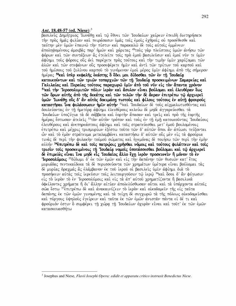
292
Ant. 18.48-57 (ed. Niese):3 basileu.j Dhmh,trioj VIwna,qh| kai. tw/| e;qnei tw/n VIoudai,wn cai,rein evpeidh. diethrh,sate th.n pro.j h`ma/j fili,an kai. peira,sasin uma/j toi/j evmoi/j evcqroi/j ouv prose,qesqe kai. tau,thn me.n u`mw/n evpainw/ th.n pi,stin kai. parakalw/ de. toi/j auvtoi/j evmme,nein avpolhyome,nouj avmoiba.j parV h`mw/n kai. ca,ritaj 49tou.j ga.r plei,stouj u`mw/n avnh,sw tw/n fo,rwn kai. tw/n sunta,xewn a]j evtelei/te toi/j pro. evmou/ basileu/sin kai. evmoi, nu/n te u`mi/n avfi,hmi tou.j fo,rouj ou]j avei. pare,cete pro.j tou,toij kai. th.n timh.n u`mi/n cari,zomai tw/n a`lw/n kai. tw/n stefa,nwn ou]j prosefe,rete h`mi/n kai. avnti. tw/n tri,twn tou/ karpou/ kai. tou/ h`mi,souj tou/ xuli,nou karpou/ to. gino,menon evmoi. me,roj u`mi/n avfi,hmi avpo. th/j sh,meron h`me,raj 50505050kai. upe.r kefalh/j e`ka,sthj o] e;dei moi di,dosqai tw/n evn kai. upe.r kefalh/j e`ka,sthj o] e;dei moi di,dosqai tw/n evn kai. upe.r kefalh/j e`ka,sthj o] e;dei moi di,dosqai tw/n evn kai. upe.r kefalh/j e`ka,sthj o] e;dei moi di,dosqai tw/n evn th/| VIoudai,a| th/| VIoudai,a| th/| VIoudai,a| th/| VIoudai,a| katoikou,ntwn kai. tw/n triw/n toparciw/n tw/n th/| VIoudai,a| proskeime,nwn Samarei,aj kai. katoikou,ntwn kai. tw/n triw/n toparciw/n tw/n th/| VIoudai,a| proskeime,nwn Samarei,aj kai. katoikou,ntwn kai. tw/n triw/n toparciw/n tw/n th/| VIoudai,a| proskeime,nwn Samarei,aj kai. katoikou,ntwn kai. tw/n triw/n toparciw/n tw/n th/| VIoudai,a| proskeime,nwn Samarei,aj kai. Galilai,aj kai. Perai,aj tou,touj paracwrw/ u`mi/n avpo. tou/ nu/n eivj to.n a[panta cro,non Galilai,aj kai. Perai,aj tou,touj paracwrw/ u`mi/n avpo. tou/ nu/n eivj to.n a[panta cro,non Galilai,aj kai. Perai,aj tou,touj paracwrw/ u`mi/n avpo. tou/ nu/n eivj to.n a[panta cro,non Galilai,aj kai. Perai,aj tou,touj paracwrw/ u`mi/n avpo. tou/ nu/n eivj to.n a[panta cro,non 51515151kai. th.n ~Ierosolumitw/n po,lin iera.n kai. a;sulokai. th.n ~Ierosolumitw/n po,lin iera.n kai. a;sulokai. th.n ~Ierosolumitw/n po,lin iera.n kai. a;sulokai. th.n ~Ierosolumitw/n po,lin iera.n kai. a;sulon ei=nai bou,lomai kai. evleuqe,ran e[wj n ei=nai bou,lomai kai. evleuqe,ran e[wj n ei=nai bou,lomai kai. evleuqe,ran e[wj n ei=nai bou,lomai kai. evleuqe,ran e[wj tw/n o[rwn auvth/j avpo. th/j deka,thj kai. tw/n telw/n th.n de. a;kran evpitre,pw tw/| avrcierei/ tw/n o[rwn auvth/j avpo. th/j deka,thj kai. tw/n telw/n th.n de. a;kran evpitre,pw tw/| avrcierei/ tw/n o[rwn auvth/j avpo. th/j deka,thj kai. tw/n telw/n th.n de. a;kran evpitre,pw tw/| avrcierei/ tw/n o[rwn auvth/j avpo. th/j deka,thj kai. tw/n telw/n th.n de. a;kran evpitre,pw tw/| avrcierei/ u`mw/n VIwna,qh| ou]j dV a'n auvto.j dokima,sh| pistou.j kai. fi,louj tou,touj evn auvth/| frourou.j u`mw/n VIwna,qh| ou]j dV a'n auvto.j dokima,sh| pistou.j kai. fi,louj tou,touj evn auvth/| frourou.j u`mw/n VIwna,qh| ou]j dV a'n auvto.j dokima,sh| pistou.j kai. fi,louj tou,touj evn auvth/| frourou.j u`mw/n VIwna,qh| ou]j dV a'n auvto.j dokima,sh| pistou.j kai. fi,louj tou,touj evn auvth/| frourou.j katasth/sai i[nkatasth/sai i[nkatasth/sai i[nkatasth/sai i[na fula,sswsin hmi/n auvth,n a fula,sswsin hmi/n auvth,n a fula,sswsin hmi/n auvth,n a fula,sswsin hmi/n auvth,n 52kai. VIoudai,wn de. tou.j aivcmalwtisqe,ntaj kai. douleu,ontaj evn th/| h`mete,ra| avfi,hmi evleuqe,rouj keleu,w de. mhde. avggareu,esqai ta. VIoudai,wn u`pozu,gia ta. de. sa,bbata kai. e`orth.n a[pasan kai. trei/j kai. pro. th/j e`orth/j h`me,raj e;stwsan avtelei/j 53to.n auvto.n tro,pon kai. tou.j evn th/| evmh/| katoikou/ntaj VIoudai,ouj evleuqe,rouj kai. avnephrea,stouj avfi,hmi kai. toi/j strateu,esqai metV evmou/ boulome,noij evpitre,pw kai. me,crij trismuri,wn evxe,stw tou/to tw/n dV auvtw/n o[poi a'n avpi,wsi teu,xontai w-n kai. to. evmo.n stra,teuma metalamba,nei katasth,sw dV auvtw/n ou]j me.n eivj ta. frou,ria tina.j de. peri. th.n fulakh.n touvmou/ sw,matoj kai. h`gemo,naj de. poih,sw tw/n peri. th.n evmh.n auvlh,n 54545454evpitre,pw de. kai. toi/j patrw,|oij crh/sqai no,moij kai. tou,touj fula,ttein kai. toi/j evpitre,pw de. kai. toi/j patrw,|oij crh/sqai no,moij kai. tou,touj fula,ttein kai. toi/j evpitre,pw de. kai. toi/j patrw,|oij crh/sqai no,moij kai. tou,touj fula,ttein kai. toi/j evpitre,pw de. kai. toi/j patrw,|oij crh/sqai no,moij kai. tou,touj fula,ttein kai. toi/j trisi.n toi/j proskeime,noij th/| VIoudai,a| nomoi/j u`pota,ssesqai bou,lomai kai. tw/| avrcierei/ trisi.n toi/j proskeime,noij th/| VIoudai,a| nomoi/j u`pota,ssesqai bou,lomai kai. tw/| avrcierei/ trisi.n toi/j proskeime,noij th/| VIoudai,a| nomoi/j u`pota,ssesqai bou,lomai kai. tw/| avrcierei/ trisi.n toi/j proskeime,noij th/| VIoudai,a| nomoi/j u`pota,ssesqai bou,lomai kai. tw/| avrcierei/ de. evpimele.j ei=nai i[na mhde. eide. evpimele.j ei=nai i[na mhde. eide. evpimele.j ei=nai i[na mhde. eide. evpimele.j ei=nai i[na mhde. ei-- --j VIoudai/oj a;llo e;ch| ierj VIoudai/oj a;llo e;ch| ierj VIoudai/oj a;llo e;ch| ierj VIoudai/oj a;llo e;ch| iero.n proskunei/n h' mo,non to. evn o.n proskunei/n h' mo,non to. evn o.n proskunei/n h' mo,non to. evn o.n proskunei/n h' mo,non to. evn ~Ierosolu,moij ~Ierosolu,moij ~Ierosolu,moij ~Ierosolu,moij 55di,dwmi dV evk tw/n evmw/n kai. eivj th.n dapa,nhn tw/n qusiw/n katV e;toj muria,daj pentekai,deka ta. de. perisseu,onta tw/n crhma,twn u`me,tera ei=nai bou,lomai ta.j de. muri,aj dracma,j a]j evla,mbanon evk tou/ ierou/ oi` basilei/j u`mi/n avfi,hmi dia. to. prosh,kein auvta.j toi/j iereu/sin toi/j leitourgou/sin tw/| ierw/| 56kai. o[soi dV a'n fu,gwsin eivj to. iero.n to. evn ~Ierosolu,moij kai. eivj ta. avpV auvtou/ crhmati,zonta h' basilika. ovfei,lontej crh,mata h' diV a;llhn aivti,an avpolelu,sqwsan ou-toi kai. ta. u`pa,rconta auvtoi/j sw/a e;stw 57evpitre,pw de. kai. avnakaini,zein to. iero.n kai. oivkodomei/n th/j eivj tau/ta dapa,nhj evk tw/n evmw/n ginome,nhj kai. ta. tei,ch de. sugcwrw/ ta. th/j po,lewj oivkodomei/sqai kai. pu,rgouj u`yhlou.j evgei,rein kai. tau/ta evk tw/n evmw/n avnista/n pa,nta eiv de, ti kai. frou,rio,n evstin o] sumfe,rei th/| cw,ra| th/| VIoudai,wn ovcuro.n ei=nai kai. tou/tV evk tw/n evmw/n kataskeuasqh,tw
3 Josephus and Niese, Flavii Iosephi Opera: edidit et apparatu critico instruxit Benedictus Niese.

293
1 Macc. 11:18-39 (NRSV): But King Ptolemy died three days later, and his troops in the strongholds were killed by
the inhabitants of the strongholds. 19So Demetrius became king in the one hundred sixty-
seventh year. 20In those days Jonathan assembled the Judaeans to attack the citadel in
Jerusalem, and he built many engines of war to use against it. 21But certain renegades
who hated their nation went to the king and reported to him that Jonathan was besieging
the citadel. 22When he heard this he was angry, and as soon as he heard it he set out and
came to Ptolemais; and he wrote Jonathan not to continue the siege, but to meet him for a
conference at Ptolemais as quickly as possible. 23When Jonathan heard this, he gave
orders to continue the siege. He chose some of the elders of Israel and some of the
priests, and put himself in danger, 24for he went to the king at Ptolemais, taking silver and
gold and clothing and numerous other gifts. And he won his favor. 25Although certain
renegades of his nation kept making complaints against him, 26the king treated him as his
predecessors had treated him; he exalted him in the presence of all his Friends. 27He
confirmed him in the high priesthood and in as many other honors as he had formerly
had, and caused him to be reckoned among his chief1 Friends. 28Then Jonathan asked
the king to free Judaea and the three districts of Samaria1 from tribute, and
promised him three hundred talents. 29The king consented, and wrote a letter to
Jonathan about all these things; its contents were as follows: 30"King Demetrius to his
brother Jonathan and to the nation of the Jews, greetings. 31This copy of the letter that we
wrote concerning you to our kinsman Lasthenes we have written to you also, so that you
may know what it says. 32'King Demetrius to his father Lasthenes, greetings. 33We have
determined to do good to the nation of the Jews, who are our friends and fulfill their
obligations to us, because of the goodwill they show toward us. 34We have confirmed as
their possession both the territory of Judaea and the three districts of Aphairema
and Lydda and Rathamin; the latter, with all the region bordering them, were
added to Judaea from Samaria. To all those who offer sacrifice in Jerusalem we
have granted release from1 the royal taxes that the king formerly received from
them each year, from the crops of the land and the fruit of the trees. 35And the other
payments henceforth due to us of the tithes, and the taxes due to us, and the salt pits and
the crown taxes due to us -- from all these we shall grant them release. 36And not one of
these grants shall be canceled from this time on forever. 37Now therefore take care to
make a copy of this, and let it be given to Jonathan and put up in a conspicuous place on
the holy mountain.'" 38When King Demetrius saw that the land was quiet before him and
that there was no opposition to him, he dismissed all his troops, all of them to their own
homes, except the foreign troops that he had recruited from the islands of the nations. So
all the troops who had served under his predecessors hated him. 39A certain Trypho had
formerly been one of Alexander's supporters; he saw that all the troops were grumbling
against Demetrius. So he went to Imalkue the Arab, who was bringing up Antiochus, the
young son of Alexander…

294
1 Macc. 11:18-39 (ed. Rahlfs):4 kai. o basileu.j Ptolemai/oj avpe,qanen evn th/| h`me,ra| th/| tri,th| kai. oi` o;ntej evn toi/j ovcurw,masin auvtou/ avpw,lonto u`po. tw/n evn toi/j ovcurw,masin 19kai. evbasi,leusen Dhmh,trioj e;touj e`bdo,mou kai. exhkostou/ kai. e`katostou/ 20evn tai/j h`me,raij evkei,naij sunh,gagen Iwnaqan tou.j evk th/j Ioudai,aj tou/ evkpolemh/sai th.n a;kran th.n evn Ierousalhm kai. evpoi,hsen evpV auvth.n mhcana.j polla,j 21kai. evporeu,qhsa,n tinej misou/ntej to. e;qnoj auvtw/n a;ndrej para,nomoi pro.j to.n basile,a kai. avph,ggeilan auvtw/| o[ti Iwnaqan perika,qhtai th.n a;kran 22kai. avkou,saj wvrgi,sqh wj de. h;kousen euvqe,wj avnazeu,xaj h=lqen eivj Ptolemai,da kai. e;grayen Iwnaqan tou/ mh. perikaqh/sqai kai. tou/ avpanth/sai auvto.n auvtw/| summi,sgein eivj Ptolemai,da th.n taci,sthn 23wj de. h;kousen Iwnaqan evke,leusen perikaqh/sqai kai. evpe,lexen tw/n presbute,rwn Israhl kai. tw/n iere,wn kai. e;dwken eauto.n tw/| kindu,nw| 24kai. labw.n avrgu,rion kai. crusi,on kai. i`matismo.n kai. e[tera xe,nia plei,ona kai. evporeu,qh pro.j to.n basile,a eivj Ptolemai,da kai. eu-ren ca,rin evnanti,on auvtou/ 25252525kai. evnetu,gcanon katV kai. evnetu,gcanon katV kai. evnetu,gcanon katV kai. evnetu,gcanon katV auvtou/ tinej a;nomoi tw/n evk tou/ e;qnouj auvtou/ tinej a;nomoi tw/n evk tou/ e;qnouj auvtou/ tinej a;nomoi tw/n evk tou/ e;qnouj auvtou/ tinej a;nomoi tw/n evk tou/ e;qnouj 26262626kai. evpoi,hsen auvtw/| o basileu.j kaqw.j evpoi,hsan kai. evpoi,hsen auvtw/| o basileu.j kaqw.j evpoi,hsan kai. evpoi,hsen auvtw/| o basileu.j kaqw.j evpoi,hsan kai. evpoi,hsen auvtw/| o basileu.j kaqw.j evpoi,hsan auvtw/| oi` pro. auvtou/ kai. u[ywsen auvto.n evnanti,on tw/n fi,lwn auvtou/ pa,ntwn auvtw/| oi` pro. auvtou/ kai. u[ywsen auvto.n evnanti,on tw/n fi,lwn auvtou/ pa,ntwn auvtw/| oi` pro. auvtou/ kai. u[ywsen auvto.n evnanti,on tw/n fi,lwn auvtou/ pa,ntwn auvtw/| oi` pro. auvtou/ kai. u[ywsen auvto.n evnanti,on tw/n fi,lwn auvtou/ pa,ntwn 27272727kai. e;sthsen kai. e;sthsen kai. e;sthsen kai. e;sthsen auvtw/| th.n avrcierwsu,nhn kai. o[sa a;lla ei=cen ti,mia to. pro,teron kai. evpoi,hsen auvto.n auvtw/| th.n avrcierwsu,nhn kai. o[sa a;lla ei=cen ti,mia to. pro,teron kai. evpoi,hsen auvto.n auvtw/| th.n avrcierwsu,nhn kai. o[sa a;lla ei=cen ti,mia to. pro,teron kai. evpoi,hsen auvto.n auvtw/| th.n avrcierwsu,nhn kai. o[sa a;lla ei=cen ti,mia to. pro,teron kai. evpoi,hsen auvto.n tw/ntw/ntw/ntw/n prw,twn fi,lwn h`gei/sqai prw,twn fi,lwn h`gei/sqai prw,twn fi,lwn h`gei/sqai prw,twn fi,lwn h`gei/sqai 28282828kai. hvxi,wsen Iwnaqan to.n basile,a poih/sai th.n Ioudai,an kai. hvxi,wsen Iwnaqan to.n basile,a poih/sai th.n Ioudai,an kai. hvxi,wsen Iwnaqan to.n basile,a poih/sai th.n Ioudai,an kai. hvxi,wsen Iwnaqan to.n basile,a poih/sai th.n Ioudai,an avforolo,ghton kai. ta.j trei/j toparci,aj kai. th.n Samari/tin kai. evphggei,lato auvtw/| avforolo,ghton kai. ta.j trei/j toparci,aj kai. th.n Samari/tin kai. evphggei,lato auvtw/| avforolo,ghton kai. ta.j trei/j toparci,aj kai. th.n Samari/tin kai. evphggei,lato auvtw/| avforolo,ghton kai. ta.j trei/j toparci,aj kai. th.n Samari/tin kai. evphggei,lato auvtw/| ta,lanta triako,sia ta,lanta triako,sia ta,lanta triako,sia ta,lanta triako,sia 29292929kai. euvdo,khsen o basileu.j kai. e;grayen tw/| Iwnakai. euvdo,khsen o basileu.j kai. e;grayen tw/| Iwnakai. euvdo,khsen o basileu.j kai. e;grayen tw/| Iwnakai. euvdo,khsen o basileu.j kai. e;grayen tw/| Iwnaqan evpistola.j peri. qan evpistola.j peri. qan evpistola.j peri. qan evpistola.j peri. pa,ntwn tou,twn evcou,saj to.n tro,pon tou/ton pa,ntwn tou,twn evcou,saj to.n tro,pon tou/ton pa,ntwn tou,twn evcou,saj to.n tro,pon tou/ton pa,ntwn tou,twn evcou,saj to.n tro,pon tou/ton 30basileu.j Dhmh,trioj Iwnaqan tw/| avdelfw/| cai,rein kai. e;qnei Ioudai,wn 31to. avnti,grafon th/j evpistolh/j h-j evgra,yamen Lasqe,nei tw/| suggenei/ h`mw/n peri. u`mw/n gegra,famen kai. pro.j u`ma/j o[pwj eivdh/te 32basileu.j Dhmh,trioj Lasqe,nei tw/| patri. cai,rein 33tw/| e;qnei tw/n Ioudai,wn fi,loij h`mw/n kai. sunthrou/sin ta. pro.j h`ma/j di,kaia evkri,namen avgaqo.n poih/sai ca,rin th/j evx auvtw/n euvnoi,aj pro.j h`ma/j 34343434estestestesta,kamen auvtoi/j ta, te o[ria th/j Ioudai,aj kai. tou.j trei/j nomou.j Afairema kai. Ludda a,kamen auvtoi/j ta, te o[ria th/j Ioudai,aj kai. tou.j trei/j nomou.j Afairema kai. Ludda a,kamen auvtoi/j ta, te o[ria th/j Ioudai,aj kai. tou.j trei/j nomou.j Afairema kai. Ludda a,kamen auvtoi/j ta, te o[ria th/j Ioudai,aj kai. tou.j trei/j nomou.j Afairema kai. Ludda kai. Raqamin prosete,qhsan th/| Ioudai,a| avpo. th/j Samari,tidoj kai. pa,nta ta. sugkurou/nta kai. Raqamin prosete,qhsan th/| Ioudai,a| avpo. th/j Samari,tidoj kai. pa,nta ta. sugkurou/nta kai. Raqamin prosete,qhsan th/| Ioudai,a| avpo. th/j Samari,tidoj kai. pa,nta ta. sugkurou/nta kai. Raqamin prosete,qhsan th/| Ioudai,a| avpo. th/j Samari,tidoj kai. pa,nta ta. sugkurou/nta auvtoi/j pa/sin toi/j qusia,zousin eivj Ieroso,luma avnti. tw/n basiliauvtoi/j pa/sin toi/j qusia,zousin eivj Ieroso,luma avnti. tw/n basiliauvtoi/j pa/sin toi/j qusia,zousin eivj Ieroso,luma avnti. tw/n basiliauvtoi/j pa/sin toi/j qusia,zousin eivj Ieroso,luma avnti. tw/n basilikw/n wkw/n wkw/n wkw/n w----n evla,mbanen o n evla,mbanen o n evla,mbanen o n evla,mbanen o basileu.j parV auvtw/n to. pro,teron katV evniauto.n avpo. tw/n genhma,twn th/j gh/j kai. tw/n basileu.j parV auvtw/n to. pro,teron katV evniauto.n avpo. tw/n genhma,twn th/j gh/j kai. tw/n basileu.j parV auvtw/n to. pro,teron katV evniauto.n avpo. tw/n genhma,twn th/j gh/j kai. tw/n basileu.j parV auvtw/n to. pro,teron katV evniauto.n avpo. tw/n genhma,twn th/j gh/j kai. tw/n avkrodru,wn avkrodru,wn avkrodru,wn avkrodru,wn 35kai. ta. a;lla ta. avnh,konta h`mi/n avpo. tou/ nu/n tw/n dekatw/n kai. tw/n telw/n tw/n avnhko,ntwn h`mi/n kai. ta.j tou/ a`lo.j li,mnaj kai. tou.j avnh,kontaj h`mi/n stefa,nouj pa,nta evparke,somen auvtoi/j 36kai. ouvk avqethqh,setai ouvde. e]n tou,twn avpo. tou/ nu/n eivj to.n a[panta cro,non 37nu/n ou=n evpime,lesqe tou/ poih/sai tou,twn avnti,grafon kai. doqh,tw Iwnaqan kai. teqh,tw evn tw/| o;rei tw/| a`gi,w| evn to,pw| evpish,mw| 38kai. ei=den Dhmh,trioj o basileu.j o[ti h`su,casen h gh/ evnw,pion auvtou/ kai. ouvde.n auvtw/| avnqeisth,kei kai. avpe,lusen pa,saj ta.j duna,meij auvtou/ e[kaston eivj to.n i;dion to,pon plh.n tw/n xe,nwn duna,mewn w-n evxenolo,ghsen avpo. tw/n nh,swn tw/n evqnw/n kai. h;cqranan auvtw/| pa/sai ai duna,meij ai` avpo. tw/n pate,rwn 39Tru,fwn de. h=n tw/n para. VAlexa,ndrou to. pro,teron kai. ei=den o[ti pa/sai ai` duna,meij katagoggu,zousin kata. tou/ Dhmhtri,ou kai. evporeu,qh pro.j Imalkoue to.n :Araba o]j e;trefen VAnti,ocon to. paida,rion to.n tou/ VAlexa,ndrou
4 Rahlfs, ed., Septuaginta.

295
Ant. 13.121-131 (transl. Whiston):5
But Jonathan the high priest levied an army out of all Judaea, and attacked the citadel at
Jerusalem, and besieged it. It was held by a garrison of Macedonians, and by some of
those wicked men who had deserted the customs of their forefathers. 122These men at first
despised the attempts of Jonathan for taking the place, as depending on its strength; but
some of those wicked men went out by night, and came to Demetrius, and informed him
that the citadel was besieged; 123who was irritated with what he heard, and took his army,
and came from Antioch, against Jonathan. And when he was at Antioch, he wrote to him,
and commanded him to come to him quickly to Ptolemais: 124upon which Jonathan did
not stop the siege of the citadel, but took with him the elders of the people, and the
priests, and carried with him gold, and silver, and garments, and a great number of
presents of friendship, and came to Demetrius, and presented him with them, and
thereby pacified the king's anger. So he was honoured by him, and received from
him the confirmation of his high priesthood, just as he had possessed it by the grants
of the kings his predecessors. 125And when the Jewish deserters accused him,
Demetrius was so far from giving credit to them, that when he petitioned him that
he would demand no more than three hundred talents for the tribute of all Judaea,
and the three toparchies of Samaria, and Peraea, and Galilee, he complied with the
proposal, and gave him a letter confirming all those grants; whose contents were as follows: 126``King Demetrius to Jonathan his brother, and to the nation of the Jews, sends
greetings. We have sent you a copy of that letter which we have written to Lasthenes our
kinsman, that you may know its contents. 127"King Demetrius to Lasthenes our father,
sends greetings. I have determined to return thanks, and to show favour to the
nation of the Jews, which has observed the rules of justice in our concerns.
Accordingly, I remit to them the three districts, Aphairema, and Lydda, and
Ramatha, which have been added to Judaea out of Samaria, with what appertains to
them; 128as also what the kings my predecessors received from those who offered
sacrifices in Jerusalem, and what are due from the fruits of the earth, and of the trees, and
what else belongs to us; with the salt pits, and the crowns that used to be presented to us.
Nor shall they be compelled to pay any of those taxes from this time on. Take care,
therefore, that a copy of this letter be taken, and given to Jonathan, and be set up in an eminent place of their holy temple."'' 129And these were the contents of this writing.
And now when Demetrius saw that there was peace everywhere, and that there was no
danger, nor fear of war, he disbanded the greatest part of his army, and diminished their
pay, and even retained in pay no others than such foreigners as came up with him from
Crete, and from the other islands. 130However, this procured him ill will and hatred from
the soldiers; on whom he bestowed nothing from this time, while the kings before him
used to pay them in time of peace, as they did before, that they might have their goodwill,
and that they might be very ready to undergo the difficulties of war, if any occasion
should require it. 131Now there was a certain commander of Alexander's forces, an
Apanemian by birth, whose name was Diodotus, and was also called Tryphon, took
notice the ill will of the soldiers bare to Demetrius, and went to Malchus the Arabian,
who brought up Antiochus, the son of Alexander, and told him what ill will the army bore
toward Demetrius, and persuaded him to give him Antiochus, because he would make
him king, and recover for him the kingdom of his father.
5 Josephus and Whiston, The Works of Josephus: Complete and Unabridged.

296
Ant. 13.121-131 (ed. Niese):6 VIwna,qhj dV o avrciereu.j evx a`pa,shj th/j VIoudai,aj stratia.n sunagagw.n prosbalw.n evpolio,rkei th.n evn toi/j ~Ierosolu,moij a;kran e;cousan Makedonikh.n froura.n kai. tw/n avsebw/n tinaj kai. pefeugo,twn th.n pa,trion sunh,qeian 122ou-toi de. to. me.n prw/ton katefro,noun w-n VIwna,qhj evmhcana/to peri. th.n ai[resin pepisteuko,tej th/| ovcuro,thti tou/ cwri,ou nukto.j de, tinej tw/n evn auvtw/| ponhrw/n evxelqo,ntej h-kon pro.j Dhmh,trion kai. th.n poliorki,an auvtw/| th/j a;kraj evmh,nusan 123o de. toi/j hvggelme,noij paroxunqei,j avnalabw.n th.n du,namin h-ken evk th/j VAntiocei,aj evpi. to.n VIwna,qhn geno,menoj de. evn Ptolemai<di gra,fei keleu,wn auvto.n speu/sai pro.j auvto.n eivj Ptolemai<da 124124124124o de. th.n me.n poliorki,an o de. th.n me.n poliorki,an o de. th.n me.n poliorki,an o de. th.n me.n poliorki,an ouvk e;pausen tou.j de. presbute,rouj tou/ laou/ paralabw.n kai. tou.j ierei/j kai. cruso.n kai. ouvk e;pausen tou.j de. presbute,rouj tou/ laou/ paralabw.n kai. tou.j ierei/j kai. cruso.n kai. ouvk e;pausen tou.j de. presbute,rouj tou/ laou/ paralabw.n kai. tou.j ierei/j kai. cruso.n kai. ouvk e;pausen tou.j de. presbute,rouj tou/ laou/ paralabw.n kai. tou.j ierei/j kai. cruso.n kai. a;rguron kai. evsqh/ta kai. plh/qoj xeni,wn komi,zwn ha;rguron kai. evsqh/ta kai. plh/qoj xeni,wn komi,zwn ha;rguron kai. evsqh/ta kai. plh/qoj xeni,wn komi,zwn ha;rguron kai. evsqh/ta kai. plh/qoj xeni,wn komi,zwn h-- --ken pro.j to.n Dhmh,trion kai. tou,toij ken pro.j to.n Dhmh,trion kai. tou,toij ken pro.j to.n Dhmh,trion kai. tou,toij ken pro.j to.n Dhmh,trion kai. tou,toij dwrhsa,menoj auvto.n qerapeu,ei thdwrhsa,menoj auvto.n qerapeu,ei thdwrhsa,menoj auvto.n qerapeu,ei thdwrhsa,menoj auvto.n qerapeu,ei th.n ovrgh.n tou/ basile,wj kai. timhqei.j u`pV auvtou/ lamba,nei .n ovrgh.n tou/ basile,wj kai. timhqei.j u`pV auvtou/ lamba,nei .n ovrgh.n tou/ basile,wj kai. timhqei.j u`pV auvtou/ lamba,nei .n ovrgh.n tou/ basile,wj kai. timhqei.j u`pV auvtou/ lamba,nei bebai,an e;cein th.n avrcierwsu,nhn kaqw.j kai. para. tw/n pro. auvtou/ basile,wn evke,kthto bebai,an e;cein th.n avrcierwsu,nhn kaqw.j kai. para. tw/n pro. auvtou/ basile,wn evke,kthto bebai,an e;cein th.n avrcierwsu,nhn kaqw.j kai. para. tw/n pro. auvtou/ basile,wn evke,kthto bebai,an e;cein th.n avrcierwsu,nhn kaqw.j kai. para. tw/n pro. auvtou/ basile,wn evke,kthto 125125125125kathgorou,ntwn de. auvtou/ tw/n fuga,dwn o Dhmh,trioj ouvk evpi,steusen avlla. kai. kathgorou,ntwn de. auvtou/ tw/n fuga,dwn o Dhmh,trioj ouvk evpi,steusen avlla. kai. kathgorou,ntwn de. auvtou/ tw/n fuga,dwn o Dhmh,trioj ouvk evpi,steusen avlla. kai. kathgorou,ntwn de. auvtou/ tw/n fuga,dwn o Dhmh,trioj ouvk evpi,steusen avlla. kai. parakale,saparakale,saparakale,saparakale,santoj auvto,n o[pwj upe.r th/j VIoudai,aj a`pa,shj kai. tw/n triw/n toparciw/n ntoj auvto,n o[pwj upe.r th/j VIoudai,aj a`pa,shj kai. tw/n triw/n toparciw/n ntoj auvto,n o[pwj upe.r th/j VIoudai,aj a`pa,shj kai. tw/n triw/n toparciw/n ntoj auvto,n o[pwj upe.r th/j VIoudai,aj a`pa,shj kai. tw/n triw/n toparciw/n Samarei,aj kai. VIo,pphj kai. Galilai,aj triako,sia telh/| ta,lanta di,dwsin kai. peri. Samarei,aj kai. VIo,pphj kai. Galilai,aj triako,sia telh/| ta,lanta di,dwsin kai. peri. Samarei,aj kai. VIo,pphj kai. Galilai,aj triako,sia telh/| ta,lanta di,dwsin kai. peri. Samarei,aj kai. VIo,pphj kai. Galilai,aj triako,sia telh/| ta,lanta di,dwsin kai. peri. pa,ntwn evpistola,j ai] periei/con tou/ton to.n tro,pon pa,ntwn evpistola,j ai] periei/con tou/ton to.n tro,pon pa,ntwn evpistola,j ai] periei/con tou/ton to.n tro,pon pa,ntwn evpistola,j ai] periei/con tou/ton to.n tro,pon 126basileu.j Dhmh,trioj VIwna,qh| tw/| avdelfw/| kai. tw/| e;qnei tw/n VIoudai,wn cai,rein to. avnti,grafon th/j evpistolh/j h-j e;graya Lasqe,nei tw/| suggenei/ h`mw/n avpesta,lkamen u`mi/n i[na eivdh/te 127127127127basileu.j Dhmh,trioj basileu.j Dhmh,trioj basileu.j Dhmh,trioj basileu.j Dhmh,trioj Lasqe,nei tw/| patri. cai,rein tw/| VIoudai,wn e;qnei o;nti Lasqe,nei tw/| patri. cai,rein tw/| VIoudai,wn e;qnei o;nti Lasqe,nei tw/| patri. cai,rein tw/| VIoudai,wn e;qnei o;nti Lasqe,nei tw/| patri. cai,rein tw/| VIoudai,wn e;qnei o;nti fi,lw| kai. ta. di,kaia ta. pro.j h`ma/j fi,lw| kai. ta. di,kaia ta. pro.j h`ma/j fi,lw| kai. ta. di,kaia ta. pro.j h`ma/j fi,lw| kai. ta. di,kaia ta. pro.j h`ma/j fula,ttonti th/j euvnoi,aj e;krina ca,rin parascei/n kai. tou.j trei/j nomou.j VAfai,rema kai. fula,ttonti th/j euvnoi,aj e;krina ca,rin parascei/n kai. tou.j trei/j nomou.j VAfai,rema kai. fula,ttonti th/j euvnoi,aj e;krina ca,rin parascei/n kai. tou.j trei/j nomou.j VAfai,rema kai. fula,ttonti th/j euvnoi,aj e;krina ca,rin parascei/n kai. tou.j trei/j nomou.j VAfai,rema kai. Lu,dda kai. ~Ramaqain oi] th/| VIoudai,a| prosete,qhsan avpo. th/j Samarei,tidoj kai. ta. Lu,dda kai. ~Ramaqain oi] th/| VIoudai,a| prosete,qhsan avpo. th/j Samarei,tidoj kai. ta. Lu,dda kai. ~Ramaqain oi] th/| VIoudai,a| prosete,qhsan avpo. th/j Samarei,tidoj kai. ta. Lu,dda kai. ~Ramaqain oi] th/| VIoudai,a| prosete,qhsan avpo. th/j Samarei,tidoj kai. ta. proskurou/nta tou,toij proskurou/nta tou,toij proskurou/nta tou,toij proskurou/nta tou,toij 128128128128e;tie;tie;tie;ti te o[sa para. tw/n quo,ntwn evn ~Ierosolu,moij evla,mbanon oi` te o[sa para. tw/n quo,ntwn evn ~Ierosolu,moij evla,mbanon oi` te o[sa para. tw/n quo,ntwn evn ~Ierosolu,moij evla,mbanon oi` te o[sa para. tw/n quo,ntwn evn ~Ierosolu,moij evla,mbanon oi` pro. evmou/ basilei/j kai. o[sa avpo. tw/n karpw/n th/j gh/j kai. tw/n futw/n kai. ta=lla ta. pro. evmou/ basilei/j kai. o[sa avpo. tw/n karpw/n th/j gh/j kai. tw/n futw/n kai. ta=lla ta. pro. evmou/ basilei/j kai. o[sa avpo. tw/n karpw/n th/j gh/j kai. tw/n futw/n kai. ta=lla ta. pro. evmou/ basilei/j kai. o[sa avpo. tw/n karpw/n th/j gh/j kai. tw/n futw/n kai. ta=lla ta. prosh,konta hmi/n kai. ta.j li,mnaj tw/n a`lw/n kai. tou.j komizome,nouj h`mi/n stefa,nouj prosh,konta hmi/n kai. ta.j li,mnaj tw/n a`lw/n kai. tou.j komizome,nouj h`mi/n stefa,nouj prosh,konta hmi/n kai. ta.j li,mnaj tw/n a`lw/n kai. tou.j komizome,nouj h`mi/n stefa,nouj prosh,konta hmi/n kai. ta.j li,mnaj tw/n a`lw/n kai. tou.j komizome,nouj h`mi/n stefa,nouj avfi,havfi,havfi,havfi,hmi auvtoi/j kai. ouvde.n parabibasqh,setai tou,twn avpo. tou/ nu/n ouvde. eivj to.n a[panta mi auvtoi/j kai. ouvde.n parabibasqh,setai tou,twn avpo. tou/ nu/n ouvde. eivj to.n a[panta mi auvtoi/j kai. ouvde.n parabibasqh,setai tou,twn avpo. tou/ nu/n ouvde. eivj to.n a[panta mi auvtoi/j kai. ouvde.n parabibasqh,setai tou,twn avpo. tou/ nu/n ouvde. eivj to.n a[panta cro,non fro,ntison ou=n i[na tou,twn avnti,grafon ge,nhtai kai. doqh/| VIwna,qh| cro,non fro,ntison ou=n i[na tou,twn avnti,grafon ge,nhtai kai. doqh/| VIwna,qh| cro,non fro,ntison ou=n i[na tou,twn avnti,grafon ge,nhtai kai. doqh/| VIwna,qh| cro,non fro,ntison ou=n i[na tou,twn avnti,grafon ge,nhtai kai. doqh/| VIwna,qh| 129kai. evn evpish,mw| to,pw| tou/ a`gi,ou ierou/ teqh/| ta. me.n dh. grafe,nta tau/ta h=n orw/n de. o Dhmh,trioj eivrh,nhn ou=san kai. mhde,na ki,ndunon mhde. pole,mou fo,bon u`pa,rconta die,luse th.n stratia.n kai. to.n misqo.n auvtw/n evmei,wsen kai. mo,noij tou/ton evcorh,gei toi/j xenologhqei/sin oi] sunane,bhsan evk Krh,thj auvtw/| kai. evk tw/n a;llwn nh,swn 130e;cqra toigarou/n auvtw/| kai. mi/soj evk tou,tou gi,netai para. tw/n stratiwtw/n oi-j auvto.j me.n ouvde.n ouvke,ti parei/cen oi` de. pro. auvtou/ basilei/j kai. evpV eivrh,nhj corhgou/ntej auvtoi/j omoi,wj diete,loun i[nV euvnoou/ntaj e;cwsin kai. evn toi/j u`pe.r auvtw/n avgw/sin eiv deh,seie,n pote proqu,mouj 131VAme,lei tau,thn noh,saj th.n du,snoian tw/n stratiwtw/n pro.j Dhmh,trion VAlexa,ndrou tij strathgo.j VApameu.j to. ge,noj Dio,dotoj o kai. Tru,fwn evpiklhqei,j paragi,netai pro.j Ma,lcon to.n :Araba o]j e;trefe to.n VAlexa,ndrou ui`o.n VAnti,ocon kai. dhlw,saj auvtw/| th.n dusme,neian th.n tw/n strateuma,twn pro.j Dhmh,trion e;peiqen auvtw/| dou/nai to.n VAnti,ocon basile,a ga.r auvto.n poih,sein kai. th.n avrch.n auvtw/| th.n tou/ patro.j avpokatasth,sein
6 Josephus and Niese, Flavii Iosephi Opera: edidit et apparatu critico instruxit Benedictus Niese.

297
Works Cited
Abu Uqsa, Hana, and Nissim Najjar. "Kfar Kana (B)." ESI 16 (1997): 48-49.
Adan-Bayewitz, D. "Yodefat." Tarbiz 66 (1997): 449-470.
Adan-Bayewitz, D. "Yodefat." ESI 16 (1997): 42-45.
Adan-Bayewitz, D., and Mordechai Aviam. "Yodefat." IEJ 45 (1995): 2-3.
Adan-Bayewitz, D., and Mordechai Aviam. "Yodefat." JRA 10 (1997): 131-165.
Adan-Bayewitz, D., and Mordechai Aviam. "Yodefat." AJA 98 (2000): 509-510.
Adan-Bayewitz, David. "Kefar Hananyah, 1987." IEJ 39 (1989): 98-99.
Adan-Bayewitz, David. Common Pottery in Roman Galilee: A Study of Local Trade.
Ramat Gan: Bar-Ilan University Press, 1993.
Adan-Bayewitz, David, and Mordechai Aviam. "Iotapata, Josephus, and the Siege of 67:
Preliminary Report on the 1992-1994 Seasons." JRA 10 (1997): 131-165.
Adler, Yonatan. "Ritual Baths Adjacent to Tombs: An Analysis of the Archaeological
Evidence in Light of the Halakhic Sources." JSJ 40 (2009): 55-73.
Albright, William Foxwell. "Excavations and Results at Tell el-Ful (Gibeah of Saul)."
AASOR 4 (1922-1923): iii-160.
Albright, William Foxwell. "Some Archaeological and Topographical Results of a Trip
through Palestine." BASOR 11 (1923): 1-14.
Albright, William Foxwell. "Archaeological and Topographical Explorations in Palestine
and Syria." BASOR 49 (1933): 23-31.

298
Alexander, Patrick H., Society of Biblical Literature, and Shirley Decker-Lucke. The SBL
Handbook of Style: For Ancient Near Eastern, Biblical, and Early Christian
Studies. Peabody, Mass.: Hendrickson, 1999.
Alt, Albrecht. Kleine Schriften zur Geschicte des Volkes Israel. Munich: Beck, 1953.
Aristophanes. "Wealth." In The Complete Greek Drama: All the Extant Tragedies of
Aeschylus, Sophocles and Euripides, and the Comedies of Aristophanes and
Menander, in a Variety of Translations, edited by Whitney Jennings Oates and
Eugene O'Neill, 2 v. New York: Random house, 1938.
Arthur, Paul. "Pots and Boundaries. On Cultural and Economic Areas Between Late
Antiquity and the Early Middle Ages." In LRCW 2: Late Roman Coarse Wares,
Cooking Wares and Amphorae in the Mediterranean: Archaeology and
Archaeometry, edited by Michel Bonifay and Jean-Christophe Tréglia. Oxford:
Archaeopress, 2007.
Attridge, Harold W. "Historiography." In Jewish Writings of the Second Temple Period:
Apocrypha, Pseudepigrapha, Qumran, Sectarian writings, Philo, Josephus, edited
by Michael E. Stone, xxiii, 697 p. Assen, Netherlands; Philadelphia: Van
Gorcum; Fortress Press, 1984.
Aune, David E. "Orthodoxy in First Century Judaism? A Response to N. J. McEleney."
JSJ 7 (1976): 1-10.
Avi-Yonah, Michael. The Holy Land From the Persian to the Arab conquests (536 B.C.
to A.D. 640): A Historical Geography. Grand Rapids, Mich.: Baker Book House,
1966.

299
Aviam, Mordechai. "Galilee: The Hellenistic to Byzantine Periods." In NEAEHL Vol. 2:
453-458. Edited by Ephraim Stern. New York: Simon & Schuster, 1993.
Aviam, Mordechai. Jews, Pagans, and Christians in the Galilee: 25 Years of
Archaeological Excavations and Surveys: Hellenistic to Byzantine periods.
Rochester, NY: University of Rochester Press, 2004.
Aviam, Mordechai, and Aharoni Amitai. "Excavations at Khirbet esh-Shuhara." In Erets
Zafon: Studies in Galilean Archaeology, edited by Zvi Gal, 119-133. Jerusalem:
Israel Antiquities Authority, 2002 (Hebrew).
Bagatti, Bellarmino. "Antichità di Kh. Qana e Kefr Kanna." LASBF 15 (1965): 251-292.
Bagatti, Bellarmino. Excavations in Nazareth. Vol. 17, Publications of the Studium
Biblicum Franciscanum. Jerusalem,: Franciscan Print. Press, 1969.
Bakels, Corrie, and Stefanie Jacomet. "Access to Luxury Foods in Central Europe During
the Roman Period: The Archaeobotanical Evidence." World Archaeology 34, no.
3 (2003): 542-557.
Bar-Kochva, Bezalel. "Manpower, Economics and Internal Strife in the Hasmonean
State." In Armées et fiscalité dans le monde antique: Actes du colloque national,
Paris, 14-16 Octobre 1976, edited by H. Van Effentere, xxv, 478 p. Paris: CNRS,
1977.
Barclay, John M. G. Jews in the Mediterranean Diaspora From Alexander to Trajan (323
BCE - 117 CE). Edinburgh: T&T Clark, 1996.
Berlin, Andrea. "Archaeological Sources for the History of Palestine. Between Large
Forces: Palestine in the Hellenistic Period." BA 60, no. 1 (1997): 2-51.

300
Berlin, Andrea. "From Monarchy to Markets: The Phoenicians in Hellenistic Palestine."
BASOR 306 (1997): 75-88.
Berlin, Andrea. "Tel Anafa II, i: The Hellenistic and Roman Pottery: The Plain Wares."
In Journal of Roman Archaeology Supplementary Series 10, edited by Sharon
Herbert, v. Ann Arbor, MI: Kelsey Museum of Archaeology, 1997.
Berlin, Andrea. "Jewish Life Before the Revolt: The Archaeological Evidence." JSJ 36,
no. 4 (2005): 417-470.
Berlin, Andrea. Gamla I: The Pottery of the Second Temple Period: The Shmarya
Gutmann Excavations, 1976-1989. IAA reports. Jerusalem: Israel Antiquities
Authority, 2006.
Berlin, Andrea, and Rafi Frankel. "The Sanctuary at Mizpe Yammim: Phoenician Cult
and Territory in the Upper Galilee During the Persian Period." BASOR
(Forthcoming).
Berman, A. "Kfar Kana." ESI 7-8 (1988-1989): 107-108.
Beynon, Diane E., Jack Donahue, R. Thomas Schaub, and Robert A. Jonston.
"Tempering Types and Sources for Early Bronze Age Ceramics from Bab edh-
Dhra' and Numeira, Jordan." JFA 13, no. 3 (1986): 297-305.
Bourdieu, Pierre. Outline of a Theory of Practice. Cambridge Studies in Social
Anthropology 16. Cambridge; New York: Cambridge University Press, 1977.
Boyarin, Daniel. Border Lines: The Partition of Judaeo-Christianity. Philadelphia:
University of Pennsylvania Press, 2004.
Bronitsky, Gordon. "Ceramics and Temper: A Response to Feathers." American Antiquity
54, no. 3 (1989): 589-593.

301
Bronitsky, Gordon. Pottery Technology: Ideas and Approaches. Westview Special
Studies in Archaeological Research. Boulder: Westview Press, 1989.
Bronitsky, Gordon, and Robert Hamer. "Experiments in Ceramic Technology: The
Effects of Various Tempering Materials on Impact and Thermal Shock
Resistance." American Antiquity 51 (1986): 89-101.
Broshi, Magen, and Israel Finkelstein. "The Population of Palestine in Iron Age II."
BASOR 287 (1992): 47-60.
Broshi, Magen, and R. Gophna. "The Settlements and Population of Palestine in the Early
Bronze Age II-III." BASOR 253 (1984): 41-43.
Brown, Francis, Edward Robinson, S. R. Driver, Charles A. Briggs, and Wilhelm
Gesenius. The Brown-Driver-Briggs Hebrew and English Lexicon. Peabody,
Mass.: Hendrickson Publishers, 1996.
Brown, Shelby. Late Carthaginian Child Sacrifice. Sheffield: JSOT Press, 1991.
Bruneau, Philippe. "Contribution à l'histoire urbaine de Délos à l'èpoque hellénistique et à
l'époque impériale." Bulletin de Correspondance Hellénique 92, no. 2 (1968):
633-709.
Cameron, Catherine M., and Steve A. Tomka, eds. Abandonment of Settlements and
Regions: Ethnoarchaeological and Archaeological Approaches. Edited by
Francoise Audouze, Richard Bradley, Joan Gero, Tim Murray, Colin Renfrew,
Andrew Sherratt, Timothy Taylor, Norman Yoffee and Wendy Ashmore. New
Directions in Archaeology. Cambridge: Cambridge University Press, 1993.

302
Chancey, Mark A. The Myth of a Gentile Galilee. Vol. 134, Society for New Testament
Studies Monograph Series. Cambridge; New York: Cambridge University Press,
2002.
Chancey, Mark A. Greco-Roman Culture and the Galilee of Jesus. Society for New
Testament Studies Monograph Series. Cambridge, UK ; New York: Cambridge
University Press, 2005.
Childe, V. Gordon. Piecing Together the Past: The Interpretation of Archeological Data.
London: Routledge & Paul, 1956.
Cockle, W. E. H. "State Archives in Graeco-Roman Egypt from 30 BC to the Reign of
Septimus Severus." JEA 70 (1984): 106-122.
Cohen, Jeffrey M. A Samaritan Chronicle: A Source-Critical Analysis of the Life and
Times of the Great Samaritan Reformer, Baba Rabbah. Vol. 30, Studia Post-
Biblica. Leiden: Brill, 1981.
Cohen, Shaye J. D. The Beginnings of Jewishness: Boundaries, Varieties, Uncertainties.
Hellenistic Culture and Society 31. Berkeley: University of California Press,
1999.
Conder, C. R., Horatio Herbert Kitchener, and Edward Henry Palmer. The Survey of
Sestern Palestine. London: The Committee of the Palestine Exploration Fund,
1881.
Counillon, Patrick, and Scylax. Pseudo-Skylax: le périple du Pont-Euxin: texte,
traduction, commentaire philologique et historique. Scripta Antiqua. Bordeaux;
Paris: Ausonius; Diffusion De Boccard, 2004.

303
Crossan, John Dominic, and Jonathan L. Reed. Excavating Jesus: Beneath the Stones,
Behind the Texts. 1st HarperCollins paperback ed. San Francisco:
HarperSanFrancisco, 2002.
Crowfoot, G. M. "Pots, Ancient and Modern." PEQ (1932): 179-187.
Curtis, J. E. "Some Axe-heads from Chagar Bazar and Nimrud." Iraq 45 (1983): 73-81.
Curtis, J. E. "The Assyrian Heartland in the Period 612-539 BC." In Continuity of
Empire: Assyria, Media, Persia. Proceedings of a Conference at Padua 26th-28th
April 2001, edited by G. B. Lianfranchi, R. Rollinger and M. D. Roaf, 95-109.
Padua, 2004.
Curtis, John, and Vladimir Grigorievich Lukonin. Mesopotamia and Iran in the Persian
Period: Conquest and Imperialism, 539-331 BC. Proceedings of a Seminar in
Memory of Vladimir G. Lukonin. London: British Museum Press, 1997.
Dar, Shimon. Landscape and Pattern: An Archaeological Survey of Samaria 800 B.C.E.-
636 C. E. BAR International Series. Oxford: BAR, 1986.
Dar, Shimon. Settlements and Cult Sites on Mount Hermon, Israel: Ituraean Culture in
the Hellenistic and Roman Periods. BAR International Series. Oxford: Tempus
Reparatum, 1993.
Dar, Shimon. History of the Hermon: Sites of the Ituraeans. Tel Aviv: Ha-Kibbutz Ha-
Meukhad, 1994. (Hebrew).
De Vries, Bert. "Archaeology in Jordan." AJA 96, no. 3 (1992): 503-542.
De Vries, Bert, and Pierre Bikai. "Archaeology in Jordan." AJA 97, no. 3 (1993): 457-
520.

304
Deines, Roland. Jüdische Steingefässe und pharisäische Frömmigkeit: ein archäologisch-
historischer Beitrag zum Verständnis von Joh 2,6 und der jüdischen
Reinheitshalacha zur Zeit Jesu. Wissenschaftliche Untersuchungen zum Neuen
Testament 2 Reihe. Tübingen: J.C.B. Mohr, 1993.
Dietler, Michael, and Ingrid Herbich. "Ceramics and Ethnic Identity:
Ethnoarchaeological Observations on the Distribution of Pottery Styles and the
Relationship Between the Social Contexts of Production and Consumption." In
Terre Cuite et Société: La céramique, document technique, économique, culturel,
459-472. Juan-les-Pins: Association pour la Promotion et la Diffusion des
Connaissances Archéologiques, 1994.
Dietler, Michael, and Ingrid Herbich. "Habitus, Techniques, Style: An Integrated
Approach to the Social Understanding of Material Culture and Boundaries." In
The Archaeology of Social Boundaries, edited by Miriam Stark, 232-263.
Washington, D. C.: Smithsonian Institute Press, 1998.
Dobree, P. P. "Greek Inscriptions from the Library of Trinity College, Cambridge." CJ 30
(1824): 127-129.
Dothan, Moshe. Hammath Tiberias. Jerusalem: Israel Exploration Society, 1983.
Dothan, Trude Krakauer. The Philistines and Their Material Culture. New Haven: Yale
University Press, 1981.
Downs, Joan Marguerite. "The Christian Tomb Mosaics from Tabarka: Status and
Identity in a North African Roman Town." University of Michigan, 2007.
Ebeling, Erich, and Bruno Meissner. Reallexikon der Assyriologie und Vorderasiatischen
Archäologie. Berlin, Leipzig: W. de Gruyter & co., 1928.

305
Edgar, C. C. Zenon Papyri. 4 vols. Catalogue général des antiquités égyptiennes du
Músée du Caire Vols 79, 82, 85, & 90. Le Caire: Impr. de l'Institut français
d'archéologie orientale, 1925.
Edwards, Douglas, Mordechai Aviam, and David Adan-Bayewitz. "Yodefat, 1992." IEJ
45 (1995): 191-197.
Edwards, Douglas R. "Jotapata." In NEAEHL Vol. 3: 252. Edited by Ephraim Stern. New
York: Simon and Schuster, 1993.
Edwards, Douglas R. "Yodefat." In OEANE, 251-252. New York, 1997.
Efron, Joshua. "Shim'on ben-Shetakh va-Yan'ai ha-Melekh." In In Memory of Gedaliyahu
Alon: Essays in Jewish History and Philology, edited by Menahem Dorman,
Schmuel Safrai and Menahem Stern. Tel Aviv: Hakibbutz Hameuchad, 1970
(Hebrew).
Elam, J., M. Glascock, and K. Slane. "A Re-Examination of the Provenance of Eastern
Sigillata A." In Proceedings of the 26th International Symposium on
Archaeometry, Toronto, 1988, edited by R. M. Farquhar, 179-183. Toronto:
University of Toronto, 1989.
Eshel, Hanan. "A Note on ‘Miqvaot’ at Sepphoris." In Archaeology and the Galilee:
Texts and Contexts in the Graeco-Roman and Byzantine Periods, edited by
Douglas R. Edwards and C. Thomas McCollough, 131-134. Atlanta: Scholars
Press, 1997.
Eshel, Hanan. "The Pools of Sepphoris: Ritual Baths or Bathtubs: They’re Not Ritual
Baths." BAR 26, no. 4 (2000): 42-45.

306
Feathers, James K. "Effects of Temper on Strength of Ceramics: Response to Bronitsky
and Hamer." American Antiquity 54, no. 3 (1989): 579-588.
Feig, Nurit. "Nazareth 'Ilit." IEJ 33 (1986): 116-117.
Finkelstein, Israel, Zvi Ledeman, and Shlomo Bunimovits. Highlands of Many Cultures:
The Southern Samaria Survey, The Sites. Vol. 14, Monograph Series of the
Institute of Archaeology. Tel Aviv: Institute of Archaeology, 1997.
Frankel, Rafi, N. Getzov, Mordechai Aviam, and A. Degani. Settlement Dynamics and
Regional Diversity in Ancient Upper Galilee: Archaeological Survey of Upper
Galilee. IAA Reports 14. Jerusalem: Israel Antiquities Authority, 2001.
Frankel, Rafi, and Nimrod Getzov. Archaeological Survey of Israel: Map of Achziv (1),
Map of Hanita (2). Jerusalem: Israel Antiquities Authority, 1997.
Freyne, Sean. Galilee and Gospel: Collected Essays. Wissenschaftliche Untersuchungen
zum Neuen Testament. Tübingen: Mohr Siebeck, 2000.
Freyne, Seán. Galilee from Alexander the Great to Hadrian, 323 B.C.E. to 135 C.E.: A
Study of Second Temple Judaism. Wilmington, Del.: Michael Glazier, 1980.
Freyne, Seán. Galilee, Jesus and the Gospels: Literary Approaches and Historical
Investigations. Dublin: Gill and Macmillan, 1988.
Frier, Bruce Woodward. "The Rental Market in Early Imperial Rome." JRS 67 (1977):
27-37.
Fuks, A. "Social Revolution in Dyme, 116-114 B.C.E." Scripta Hierosolymitana 23
(1972): 21-27.
Funk, Robert W. "The 1957 Campaign at Beth-Zur." BASOR 150 (1958): 8-20.

307
Funk, Robert W. "Beth-Zur." In NEAEHL Vol. 1: 259-261. Edited by Ephraim Stern.
New York: Simon & Schuster, 1993.
Gal, Zvi. The Lower Galilee: Settlement Geography in the period of the Bible. Tel Aviv:
HaKibutz HaMeuhad: HaHevrah LaHakirat Erets-Yisrael VeAtikoteha, 1990.
(Hebrew).
Gal, Zvi. Lower Galilee During the Iron Age. Vol. 8, ASOR Dissertation Series. Winona
Lake, IN: Eisenbrauns, 1992.
Gal, Zvi. "Israel in Exile." BAR 24, no. 3 (1998).
García-Heras, Manuel. "Regional Shared Style and Technology: A Minerological and
Compositional Study of Celtiberian Pottery from Numantia, Spain." JFA 27, no. 4
(2000): 437-454.
Genneweg, Jan, Isadore Perlman, and Joseph Yellin. The Provenience, Typology, and
Chronology of Eastern Terra Sigillata. Vol. 17, Qedem. Jerusalem: The Hebrew
University of Jerusalem, 1983.
Gitin, Seymour. Gezer III: A Ceramic Typology of the Late Iron II, Persian and
Hellenistic Periods at Tell Gezer. 2 vols. Annual of the Nelson Glueck School of
Biblical Archaeology. Jerusalem: Hebrew Union College, 1990.
Glass, J., Y. Goren, S. Bunimovitz, and I. Finkelstein. "Petrographic Analysis of Late
Bronze Age and Iron Age I Pottery Assemblages." In Shiloh: The Archaeology of
a Biblical Site, edited by I. Finkelstein, S. Bunimovitz and Z. Ledeman, 271-286.
Tel Aviv: The Institute of Archaeology, 1993.
308
Goldstein, Jonathan A. I Maccabees: A New Translation, With Introduction and
Commentary. 1st ed. Vol. 41, Anchor Bible Commentary Series. Garden City,
N.Y.: Doubleday, 1976.
Grabbe, Lester L. Comparative Philology and the Text of Job: A Study in Methodology.
SBL Dissertation Series 34. Missoula, Montana: Scholars Press, 1977.
Grantham, Billy J. "Sepphoris: Ethnic Complexity at an Ancient Galilean City." Ph.D.
Dissertation, Northwestern University, 1996.
Gropp, Douglas Marvin, Moshe J. Bernstein, James C. VanderKam, and Monica Brady.
Wadi Daliyeh II: The Samaria Papyri from Wadi Daliyeh XXVIII, Miscellanea,
Part 2. Vol. 28, Discoveries in the Judaean Desert. Oxford: Clarendon Press,
2001.
Gunneweg, Jan, and Joseph Yellin. "Appendix 2: The Origin of Some Plain Ware Pottery
from Tel Anafa." In Tel Anafa II, i: The Hellenistic and Roman Pottery, edited by
Sharon Herbert. Ann Arbor, MI: Kelsey Museum, 1997.
Gutman, S., and D. Wagner. "Gamla - 1984/1985/1986." ESI 5 (1986): 41.
Gutman, Shemaryah. "Gamla." In NEAEHL Vol. 2: 463. Edited by Ephraim Stern. New
York: Simon & Schuster, 1993.
Hall, Jonathan M. Ethnic Identity in Greek Antiquity. Cambridge: Cambridge University
Press, 1997.
Hamburger, H. "Coins from Caesarea and the History of the City." BJPES 15 (1950)
(Hebrew).
Hartal, Moshe. Northern Golan Heights: The Archaeological Survey as Source of Local
History. Qazrin: Agaf HaAtiqot VeHaMuzeonim, 1989. (Hebrew).

309
Hayes, J. W. "Sigillata Orientali." In Enciclopedia dell'arte antica classica e orientale.
Atlante delle forme ceramiche II: Ceramica fine romana nel Bacino Mediterraneo
(tardo ellenismo e primo impero) Vol. 1-96. Edited by Rome: Istituto della
Enciclopedia italiana, 1985.
Hayes, J. W. Paphos III: The Hellenistic and Roman Pottery. Nicosia: Department of
Antiquities, Cyprus, 1991.
Herbert, Sharon. Tel Anafa I: Final Report on Ten Years of Excavation at a Hellenistic
and Roman Settlement in Northern Israel. Journal of Roman Archaeology
Supplementary Series 10. Ann Arbor, MI: Kelsey Museum, 1994.
Herbert, Sharon. "The Hellenistic Archives from Tel Kedesh (Israel) and Seleucia-on-
the-Tigris (Iraq)." Bulletin of the University of Michigan Museums of Art and
Archaeology 15 (2003): 65-86.
Herbert, Sharon, and Andrea Berlin. "A New Administrative Center for Persian and
Hellenistic Galilee: Preliminary Report of the University of Michigan/University
of Minnesota Excavations at Kedesh." BASOR 329 (2003): 13-59.
Herbert, Sharon, Leslie A. Cornell, Kelsey Museum of Archaeology, and University of
Missouri--Columbia. Museum of Art and Archaeology. Tel Anafa II, i: The
Hellenistic and Roman Pottery. Journal of Roman Archaeology Supplementary
Series. Ann Arbor, MI: Kelsey Museum of the University of Michigan, 1997.
Hirschfeld, Yizhar. "Tiberias." ESI 9 (1989/1990): 107-109.
Hirschfeld, Yizhar. "Tiberias." In NEAEHL Vol. 4: 1468. Edited by Ephraim Stern. New
York: Simon & Schuster, 1993.
310
Hornblower, Simon, and Antony Spawforth. The Oxford Classical Dictionary. 3rd ed.
Oxford; New York: Oxford University Press, 2003.
Horsley, Richard A. Galilee: History, Politics, People. Valley Forge, Pa.: Trinity Press
International, 1995.
Jones, A. H. M. "The Urbanization of Palestine." JRS 21 (1931): 78-85.
Jones, A. H. M. The Greek City from Alexander to Justinian. Oxford: Clarendon Press,
1940.
Jones, Siân. The Archaeology of Ethnicity: Constructing Identities in the Past and
Present. London; New York: Routledge, 1997.
Jones, Siân. "Identities in Practice: Towards an Archaeological Perspective on Jewish
Identity in Antiquity." In Jewish Local Patriotism and Self-Identification in the
Graeco-Roman Period, edited by Siân Jones and Sarah Pearce. Sheffield:
Sheffield Academic Press, 1998.
Josephus, Flavius, and Benedikt Niese. Flavii Iosephi Opera: edidit et apparatu critico
instruxit Benedictus Niese. Berolini: apud Weidmannos, 1887.
Josephus, Flavius, and William Whiston. The Works of Josephus: Complete and
Unabridged. New Updated ed. Peabody, Mass.: Hendrickson, 1980.
Joshua, and Oliver Turnbull Crane. The Samaritan Chronicle Or The Book of Joshua the
son of Nun. Translated from the Arabic. New York: J. B. Alden, 1890.
Joyner, Louise. "Cooking Pots as Indicators of Cultural Change: A Petrographic Study of
Byzantine and Frankish Cooking Wares from Corinth." Hesperia: The Journal of
the American School of Classical Studies at Athens 76, no. 1 (2007): 183-227.
311
Kadman, Leo. The Coins of Caesarea Maritima. Corpus Nummorum Palaestinensium.
Jerusalem: Schocken, 1957.
Kadman, Leo. The Coins of Akko Ptolemais. Tel-Aviv: Schocken, 1961.
Kallet-Marx, Robert. "Quintus Fabius Maximus and the Dyme Affair (Syll. 684)." CQ
45, no. 1 (1995): 129-153.
Kanael, B. "Ancient Jewish Coins and their Historical Importance." BA 26 (1963): 38-62.
Kasher, Aryeh. Jews, Idumaeans, and Ancient Arabs: Relations of the Jews in Eretz-
Israel with the Nations of the Frontier and the Desert During the Hellenistic and
Roman Era (332 BCE-70 CE). Texte und Studien zum antiken Judentum, 18.
Tübingen: Mohr, 1988.
Kasher, Aryeh. "The Changes in Manpower and Ethnic Composition of the Hasmonaean
Army (167-63 BCE)." JQR 81, no. 3-4 (1991): 325-352.
Kleptner, L., and P. Johnson. "Technology and the Primitive Pottery: Mississippian
Pottery Development Seen Through the Eyes of a Ceramic Engineer." In
Technology and Style, Ceramics and Civilization, Vol. II, edited by W. D.
Kingery. Columbus, OH: American Ceramic Society, 1986.
Lapp, Paul W., and Nancy L. Lapp. "A Comparative Study of a Hellenistic Pottery Group
from Beth-Zur." BASOR 151 (1958): 16-27.
Lawrence, Jonathan David. Washing in Water: Trajectories of Ritual Bathing in the
Hebrew Bible and Second Temple Literature. Academia Biblica. Atlanta: Society
of Biblical Literature, 2006.
Lebeau, Marc, and Antoine Suleiman. Tell Beydar, 1995-1999: Architectural Plans.
Plans Architecturaux. 1 vols. Subartu. Turnhout: Brepols, 2003.

312
Lebeau, Marc, and Antoine Suleiman. Tell Beydar: The 1995-1999 Seasons of
Excavations. A Preliminary Report. Rapport préliminaire sur les campagnes de
fouilles 1995-1999. Subartu. Turnhout: Brepols, 2003.
Lebeau, Marc, and Antoine Suleiman. Tell Beydar: The 2000-2002 Seasons of
Excavations, The 2003-2004 Seasons of Architectural Restoration; A Preliminary
Report. Rapport preliminaire sur les campagnes de fouilles 2000-2002 et les
campagnes de restauration architecturale 2003-2004. Subartu. Turnhout:
Brepols, 2007.
Leibner, Uzi. Settlement and History in Hellenistic, Roman, and Byzantine Galilee: An
Archaeological Survey of the Eastern Galilee. Texte und Studien zum antiken
Judentum,. Tübingen: Mohr Siebeck, 2009.
Levine, Lee I. "The Hasmonean Conquest of Strato's Tower." IEJ 24, no. 1 (1974): 62-
69.
Levine, Lee I. Caesarea under Roman Rule. Studies in Judaism in Late Antiquity.
Leiden: Brill, 1975.
Levine, Lee I. "R. Simeon b. Yohai and the Purification of Tiberias: History and
Tradition." HUCA 49 (1978): 143-185.
Levine, Lee I., and Ehud Netzer. Excavations at Caesarea Maritima: 1975, 1976, 1979,
Final report. Qedem. Jerusalem: Institute of Archaeology, Hebrew University of
Jerusalem, 1986.
Lichtenstein, H. "Die Fastenrolle." HUCA 8-9 (1931-1932): 257-258.
Loud, G., and C. B. Altman. Khorsabad II: The Citadel and the Town. OIP 40. Chicago,
1938.

313
Ma'oz, Zvi. "Golan in the Hellenistic Period." ESI 4 (1985): 79-80.
Ma'oz, Zvi. "Golan: Hellenistic Period to the Middle Ages." In NEAEHL Vol. 2: 534-546.
Edited by Ephraim Stern. New York: Simon & Schuster, 1993.
Macalister, Robert Alexander Stewart. The Excavation of Gezer 1902-1903 and 1907-
1909. Vol. 1-3. Palestine Exploration Fund. London: Palestine Exploration Fund,
1912.
Macdonald, John. The Samaritan Chronicle No. II, Or Sepher Ha-Yamim. From Joshua
to Nebuchadnezzar. Vol. 107, Beihefte zur Zeitschrift für die alttestamentliche
Wissenschaft. Berlin: De Gruyter, 1969.
Mackowski, Richard. "Scholars' Qanah: A Re-examination of the Evidence in Favor of
Khirbet Qanah." Biblische Zeitschrift 23 (1979): 278-284.
Magen, Yitzhak. "The Stone Vessel Industry During the Second Temple Period." In
'Purity Broke Out in Israel': Stone Vessels in the Late Second Temple Period,
edited by Reuben and Edith Hecht Museum (University of Haifa) and Ofra Guri-
Rimon, 36, 36 p. Haifa: University of Haifa, 1994 (Hebrew and English).
Mallowan, M. E. L. "The Excavations at Nimrud (Kalhu), 1953." Iraq 16 (1954): 59-163.
Mallowan, M. E. L. Numrud and its Remains. 3 vols. London: British School of
Archaeology on Iraq, 1966.
Mason, Steve. "Jews, Judaeans, Judaizing, Judaism: Problems of Categorization in
Ancient History." JSJ 38 (2007): 457-512.
Matthews, Eulah, and William Neidinger. "The Acropolis of Bylazora." In The 2009
Excavation. Bylazora: Republic of Macedonia, 4-11. Canyon Lake, TX: The
Texas Foundation for Archaeological and Historical Research, 2009.

314
Matthews, Eulah, and William Neidinger. "The Acropolis of Bylazora." In The 2010
Excavation: Bylazora: Republic of Macedonia. Canyon Lake, TX: The Texas
Foundation for Archaeological and Historical Research, 2010.
Mazar, Amihai. "Tel Beth-Shean: History and Archaeology." In One God - One Cult -
One Nation. Archaeological and Biblical Perspectives, edited by Reinhard Gregor
Kratz and Hermann Spieckermann, 239-271. Berlin; New York: De Gruyter,
2010.
Mazar, Amihay. Excavations at Tel Beth-Shean, 1989-1996. Volume 1: From the Late
Bronze Age IIB to the Medieval Period. Jerusalem: Israel Exploration Society;
Institute of Archaeology, the Hebrew University of Jerusalem, 2006.
McEleney, N. J. "Orthodoxy in Judaism of the First Century Christian Century." JSJ 4
(1973): 18-42.
Meister, Klaus. "Timagenes." In The Oxford Classical Dictionary, edited by Simon
Hornblower and Antony Spawforth. Oxford; New York: Oxford University Press,
1996.
Meshorer, Ya'akov. Jewish Coins of the Second Temple Period. Tel Aviv: Am Hassefer,
1967.
Meshorer, Ya'akov. "The Beginning of Hasmonaean Coinage." IEJ 24, no. 1 (1974): 59-
61.
Meshorer, Ya'akov. Ancient Jewish Coinage. 2 vols. Dix Hills, N.Y.: Amphora Books,
1982.

315
Meshorer, Ya'akov, and Shraga Qedar. Samarian Coinage. Publications of the Israel
Numismatic Society: Numismatic Studies and Researches. Jerusalem: Israel
Numismatic Society, 1999.
Meyers, Eric. "Yes, They Are." BAR 26, no. 4 (2000): 46-48.
Meyers, Eric M., ed. The Oxford Encyclopedia of Archaeology in the Near East. 5 vols.
New York: Oxford University Press, 1997.
Meyers, Eric M., Carol L. Meyers, and Gabriela Bijovsky. Excavations at Ancient
Nabratein: Synagogue and Environs. Meiron Excavation Project. Winona Lake,
Ind.: Eisenbrauns, 2009.
Meyers, Eric M., James F. Strange, and Carol L. Meyers. Excavations at Ancient Meiron,
Upper Galilee, Israel, 1971-72, 1974-75, 1977. Meiron Excavation Project.
Cambridge, Mass.: American Schools of Oriental Research, 1981.
Meyers, Eric, James F. Strange, and Dennis Groh. "The Meiron Excavation Project:
Archaeological Survey in the Galilee and Golan, 1976." BASOR 230 (1978): 1-24.
Meyers, Eric, James F. Strange, and Carol L. Meyers. "Nabratein, 1980." IEJ (1981):
108-110.
Mitchell, Stephen. Anatolia: Land, Men, and Gods in Asia Minor. 2 vols. Oxford: Oxford
University Press, 1993.
Momigliano, Arnaldo. "Errori ntorno alle toparchie della Palestina." Rivista di filologia e
di istruzione classica 58 (1930): 71-74.
Moreland, Milton. "The Inhabitants of Galilee in the Hellenistic and Early Roman
Periods: Probes into the Archaeological and Literary Evidence." In Religion,

316
Ethnicity, and Identity in Ancient Galilee edited by Jürgen Zangenberg, Harold
W. Attridge and Dale B. Martin. Tübingen: Mohr Siebeck, 2007.
Myers, E. A. The Ituraeans and the Roman Near East: Reassessing the Sources. Society
for New Testament Studies Monograph Series 147. Cambridge ; New York:
Cambridge University Press, 2010.
Najjar, Arfan, and Nissim Najjar. "Nazareth." ESI 16 (1997): 49.
Najjar, Nissim. "Kfar Kana (A)." ESI 16 (1997): 46-47.
Naveh, Joseph, and Donald T. Ariel. "Selected Inscribed Sealings from Kedesh in Upper
Galilee." BASOR 329 (2003): 61-80.
"Nazareth 'Illit." ESI 1 (1982): 78-79.
Oates, D., and J. Oates. "Nimrud 1957: the Hellenistic Settlement." Iraq 20 (1958): 114-
157.
Oates, J., and D. Oates. Nimrud: An Assyrian Imperial CIty Revealed. London: British
School of Archaeology in Iraq, 2001.
Oleson, John Peter, and Avner Raban. The Harbours of Caesarea Maritima: Results of
the Caesarea Ancient Harbour Excavation Project, 1980-1985. BAR
International Series. Oxford: B.A.R., 1989.
Panagopoulou, Katerina. "Between Necessity and Extravagance: Silver as a Commodity
in the Hellenistic Period." ABSA 102 (2007): 315-343.
Parker, B. "The Excavations at Nimrud, 1949-1953: Seals and Impressions." Iraq 17
(1955): 93-125.
Pfeiffer, Robert Henry. History of New Testament Times, With an Introduction to the
Apocrypha. New York: Harper, 1949.

317
Principal, Jordi. "Late Hellenistic Black-Gloss Wares in the North-Eastern Iberian
Peninsula: Production Traditions and Social Practices." In Old Pottery in a New
Century: Innovating Perspectives on Roman Pottery Studies (Atti del Convegno
Internazionale di Studi, Catania, 22-24 Aprile 2004), edited by Daniele Malfitana,
Jeroen Poblome and John Lund. Catania: Bretschneider, 2006.
Qedar, Shraga. "Two Lead Weights of Herod Antipas and Agrippa II and the Early
History of Tiberias." INJ 9 (1986-1987): 29-35.
Raban, Avner. "Recent Maritime Archaeological Research in Israel." International
Journal of Nautical Archaeology and Underwater Exploration 12, no. 3 (1983):
229-251.
Raban, Avner. "In Search of Straton's Tower." In Caesarea Papers, vol. 1: Straton's
Tower, Herod's Harbour, and Roman and Byzantine Caesarea, edited by Robert
Lindley Vann, 7-25. Ann Arbor, MI: Journal of Roman Archaeology, 1992.
Raban, Avner, and R. R. Stieglitz. "Caesarea." IEJ 38 (1988): 271-278.
Rahlfs, Alfred, ed. Septuaginta. Stuttgart: Privilegierte württembergische Bibelanstalt,
1935.
Rappaport, Uriel. "The Emergence of Hasmonaean Coinage." Association for Jewish
Studies Review 1, no. (1976): 171-186.
Rappaport, Uriel. "A Note on the Use of the Bible in 1 Maccabees." In Biblical
Perspectives: Early Use and Interpretation of the Bible in Light of the Dead Sea
Scrolls. Proceedings of the First International Symposium of the Orion Center,
12-14 May, 1996, edited by Michael E. Stone and Esther G. Chazon, 175-180.
Leiden: Brill, 1996.

318
Ravikovitch, S. Manual and Map of Soils in Israel. Jerusalem: Magnes Press; The
Hebrew University of Jerusalem, 1969.
Reade, J. E. "Ninive (Nineveh)." In Reallexikon der Assyriologie und Vorderasiatischen
Archäologie Vol. 9: 188-433. Edited by Erich Ebeling, Meissner and Dietz Otto
Edzard. Berlin: de Gruyter, 2000.
Reed, Jonathan L. "Galileans, 'Israelite Village Communities,' and the Sayings Gospel
Q." In Galilee Through the Centuries: Confluence of Cultures, edited by Eric
Meyers, 147-152. Winona Lake: Eisenbrauns, 1999.
Reed, Jonathan L. Archaeology and the Galilean Jesus: A Re-examination of the
Evidence. Harrisburg, Penn.: Trinity Press International, 2000.
Reich, Ronny. "Archaeological Evidence of the Jewish Population at Hasmonean Gezer."
IEJ 31 (1981): 48-52.
Reich, Ronny. "The Hot Bath-House (balneum), the Miqweh, and the Jewish Community
in the Second Temple Period." JJS 39 (1988): 102-107.
Reich, Ronny. "Miqwa'ot (Jewish Ritual Immersion Baths) in Eretz-Israel in the Second
Temple and the Mishnah and Talmud periods." The Hebrew University of
Jerusalem, 1990.
Reich, Ronny. "They Are Ritual Baths." BAR 28, no. 2 (2002): 50-55.
Rethemiotakis, G. "The Hearths of the Minoan Palace at Galatas." In Meletemata. Studies
in Aegean Archaeology presented to Malcolm H. Wiener, edited by P. P.
Betancourt, R. Karageorghis, R. Laffineur and W.-D. Niemeier, 721-727. Liège:
Université de Liège, 1999.

319
Rice, Prudence M. Pottery Analysis: A Sourcebook. Chicago: University of Chicago
Press, 1987.
Roll, Israel. "Imperial Roads Across and Trade Routes Beyond the Roman Provinces of
Judaea-Palaestina and Arabia: The State of Research." Tel Aviv 32 (2005): 107-
118.
Roll, Israel. "Between Damascus and Megiddo: Roads and Transportation in Antiquity
Across the Northeastern Approaches to the Holy Land." In Man Near A Roman
Arch: Studies Presented to Prof. Yoram Tsafrir, edited by Leah Di Segni, Yizhar
Hirschfeld, Joseph Patrich and Rina Talgam, 1*-20*. Jerusalem: Israel
Exploration Society, 2009.
Ronen, Yigal. "The First Hasmonean Coins." BA 50, no. 2 (1987): 105-107.
Rosenfeld, Ben-Zion. "Flavius Josephus and His Portrayal of the Coast (Paralia) of
Contemporary Roman Palestine: Geography and Ideology." JQR 91, no. 1-2
(2000): 143-183.
Rotroff, Susan I. The Athenian Agora, Vol. 33, Hellenistic Pottery: The Plain Wares.
Athens: The American School of Classical Studies at Athens, 2006.
Rowney, Barry. "Charters and the Ethics of Conservation: A Cross-Cultural Perpsective."
Dissertation, University of Adelaide, 2004.
Rubenstein, Jeffrey L. Talmudic Stories: Narrative Art, Composition, and Culture.
Baltimore: Johns Hopkins University Press, 1999.
Rye, Owen S. "Keeping Your Temper Under Control: Materials and Manufacturing of
Papaun Pottery." Archaeology and Physical Anthropology in Oceania 11 (1976):
106-137.

320
Rye, Owen S. "Traditional Palestinian Potters." Research Reports, National Geographic
Society 17 (1984): 769-776.
Sams, G. Kenneth, Brendan Burke, and A. Goldman. "Gordion, 2005." In Kazi Sonuçlari
Toplantisi 2. Cilt 28., edited by B. Koral, H. Dönmez and M. Akpinar, 365-386.
Ankara: Kültür Bakanlığı Millî Kütüphane Basımevi, 2007.
Sanders, E. P. Paul and Palestinian Judaism: A Comparison of Patterns of Religion.
London: SCM Press, 1977.
Sanders, E. P. Jewish law from Jesus to the Mishnah: Five Studies. London; Philadelphia:
SCM Press; Trinity Press International, 1990.
Sanders, E. P. Judaism: Practice and Belief, 63 BCE-66 CE. Philadelphia, PA: Trinity
Press International, 1992.
Satlow, Michael L. "Disappearing Categories: Using Categories in the Study of
Religion." Method and Theory in the Study of Religion 17 (2005): 287-298.
Satlow, Michael L. "Defining Judaism: Accounting for 'Religions' in the Study of
Religion." JAAR 74, no. 4 (2006): 837-860.
Satlow, Michael L. 2010. Who Needs Theory? An Historian's Polemic. A Plenary
Address Given to the Northeast Regional Society of Biblical Literature Meeting
in Newton, Massachusetts on April 16, 2010.,
http://msatlow.blogspot.com/2010/04/last-friday-i-delivered-plenary-
address.html. (accessed December 1, 2010).
Schürer, Emil. A History of the Jewish People in the Time of Jesus Christ (175 B.C.-A.D.
135). Edited by Geza Vermes, Fergus Millar and Matthew Black. 2nd rev. ed. 3
vols. Edinburgh: T & T Clark, 1979-1987.

321
Schwartz, Seth. "The 'Judaism' of Samaria and Galilee in Josephus's Version of the Letter
of Demetrius I to Jonathan (Antiquities 13.48-57)." HTR 82, no. 4 (1989): 377-
391.
Schwartz, Seth. "Israel and the Nations Roundabout: 1 Maccabees and the Hasmonaean
Expansion." JJS 42, no. 1 (1991): 16-38.
Seger, Joe D. "The Search for Maccabean Gezer." BA 39 (1976): 142-144.
Shapiro, Anastasia, Andrea Berlin, and Peter Stone. "Tel Kedesh - Fabrics and Wares."
(Unpublished Report).
Shaw, Joseph W. "The Architecture of the Temples and Other Buildings." In Kommos:
An Excavation on the South Coast of Crete by the University of Toronto and the
Royal Ontario Museum Under the Auspices of the American School of Classical
Studies at Athens, edited by Joseph W. Shaw and Maria C. Shaw, 1-100.
Princeton: Princeton University Press, 2000.
Shaw, Joseph W. "Ritual and Development in the Greek Sanctuary." In Kommos: An
Excavation on the South Coast of Crete by the University of Toronto and the
Royal Ontario Museum Under the Auspices of the American School of Classical
Studies at Athens, edited by Joseph W. Shaw and Maria C. Shaw, 669-731, 2000.
Slane, Kathleen. "The Fine Wares." In Tel Anafa II, i: The Hellenistic and Roman
Pottery, edited by Sharon Herbert, 394-406. Ann Arbor, MI: Kelsey Museum of
the University of Michigan, 1997.
Slane, Kathleen, J. Michael Elam, Michael Glascock, and Hector Neff. "Compositional
Analysis of Eastern Sigillata A and Related Wares from Tel Anafa (Israel)." JAS
21 (1994): 51-64.
322
Sneh, A., Y. Bartov, and M. Rosensaft. Geological Map of Israel 1:200,000, Sheet 1.
Jerusalem: Geological Survey of Israel, 1998.
Stern, Ephraim, Ayelet Levinzon-Gilboa, and J. Aviram. The New Encyclopedia of
Archaeological Excavations in the Holy Land. 5 vols. Jerusalem; New York:
Israel Exploration Society & Carta; Simon & Schuster, 1993.
Stern, Menahem. Greek and Latin Authors on Jews and Judaism. 3 vols. Jerusalem:
Israel Academy of Sciences and Humanities, 1974.
Stone, Peter. "'Provincial' Perspectives: The Persian, Ptolemaic, and Seleucid
Administrative Center at Tel Kedesh in a Regional Context." Ph.D. Dissertation,
University of Cincinnati, 2012.
Strange, James F. "Six Campaigns at Sepphoris: The University of South Florida
Excavations, 1983-1989." In The Galilee in Late Antiquity, edited by Lee I.
Levine. New York; Jerusalem: Jewish Theological Seminary of America, 1992.
Strange, James F. , Dennis E. Groh, and Thomas R. W. Longstaff. "Excataions at
Sepphoris: Location and Identification of Shikhin." IEJ 44, no. 3-4 (1994): 216-
227.
Strange, James F., Dennis E. Groh, and Thomas R. W. Longstaff. The Location and
Identification of Ancient Shikhin (Asochis). www.colby.edu/rel/shikhin.html.
Strange, James F., Dennis E. Groh, and Thomas R. W. Longstaff. "Excavations at
Sepphoris: The Location and Identification of Shikhin." IEJ 45, no. 3 (1995): 171-
187.
Strange, James F., Thomas R. W. Longstaff, and Dennis Groh. Excavations at Sepphoris.
Vol. 22, Brill Reference Library of Judaism. Leiden; Boston: Brill, 2006.

323
Straughn, Ian. "Negative Evidence and Settlement Patterns: Rethinking an Archaeology
of Petra in the Islamic Periods." Studies in the History and Archaeology of Jordan
(Forthcoming).
Stronach, D. B. "Excavations at Nineveh, 1987." Sumer 46 (1989-1990): 107-108.
Syon, D. "Tyre and Gamla: A Study in the Monetary Influence of Southern Phoenicia on
Galilee and the Gola in the Hellenistic and Roman Periods." Ph.D. Dissertation,
The Hebrew University of Jerusalem, 2004.
Syon, Danny. "Numismatic Evidence of Jewish Presence in Galilee before the
Hasmonean Annexation?" INR 1 (1996): 21-24.
Syon, Danny. "Coins from the Excavations at Khirbet esh-Shuhara." In Erets Zafon:
Studies in Galilean Archaeology, edited by Zvi Gal, 119-133. Jerusalem: Israel
Antiquities Authority, 2002 (Hebrew).
Tadmor, Hayim. The Inscriptions of Tiglath-Pileser III King of Assyria. Jerusalem: Israel
Academy of Sciences and Humanities, 1994.
Thiede, Carsten Peter, and Egon H. E. Lass. "Moza: Final Report." Hadashot
Arkheologiot 118 (2006).
Vitto, Fanny. "Kiriat Tiv'on." RB 79 (1972): 574-576.
Vitto, Fanny. "Qiryat Tiv'on." IEJ 24 (1974): 274.
Vitto, Fanny. "Tiberias: The Roman Tomb." In NEAEHL Vol. 4: 1473. Edited by
Ephraim Stern. New York: Simon & Schuster, 1993.
Walker, Bethany J. "Mamluk Investment in Southern Bilād Al-Shām in the
Eighth/Fourteenth Century: The Case of Hisbān." JNES 62, no. 4 (2003): 241-
261.
324
Westermann, William Linn, Clinton Walker Keyes, and Herbert Liebesny. Zenon Papyri:
Business Papers of the Third Century B.C. Dealing with Palestine and Egypt.
Vol. 2, New York: Columbia University, 1940.
Wieder, M., and D. Adan-Bayewitz. "Soil Parent Materials and the Pottery of Roman
Galilee: A Comparative Study." Geoarchaeology 17 (2002): 395-415.
Williams-Thorpe, O., R.S. Thorpe, C. Elliott, and C. Xenophontos. "Archaeology,
Geochemistry, and Trade of Igneous Rock Millstones in Cyprus During the Late
Bronze Age to Roman Periods." Geoarchaeology 6, no. 1 (1991): 27-60.
Wittgenstein, Ludwig, and G. E. M. Anscombe. Philosophical Investigations. 2nd ed.
Oxford, UK; Malden, Mass.: Blackwell, 1997.
Wright, B. G. "Jewish Ritual Baths - Interpreting the Digs and the Texts: Some Issues in
the Social History of Second Temple Judaism." In The Archaeology of Israel:
Constructing the Past, Interpreting the Present, edited by Neil Asher Silberman
and D. Small, 190-214. Sheffield: Sheffield University Press, 1997.
Yegül, Fikret K., Mehmet C. Bolgil, and Clive Foss. The Bath-Gymnasium Complex at
Sardis. Archaeological Exploration of Sardis Report No. 3. Cambridge, Mass.:
Harvard University Press, 1986.
Zori, N. Land of Issachar: Archaeological Survey. Jerusalem: Survey of Israel, 1977.
Works Without English Titles
.1851. ברלין: זיטטענפעלד, ספר כפתור ופרחהפרחי, אישתורי וצבי הירש אדלמן.