Late Pleistocene dispersal corridors across the Iranian Plateau
Upload
independentCategory
view
2download
0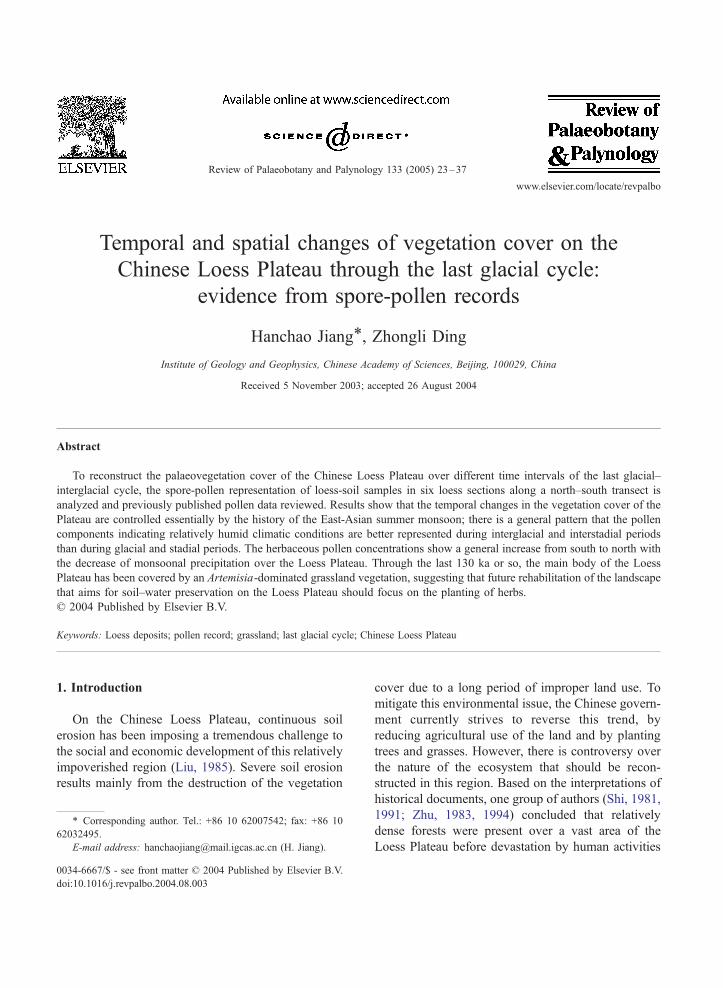
www.elsevier.com/locate/revpalbo
Review of Palaeobotany and Pal
Temporal and spatial changes of vegetation cover on the
Chinese Loess Plateau through the last glacial cycle:
evidence from spore-pollen records
Hanchao Jiang*, Zhongli Ding
Institute of Geology and Geophysics, Chinese Academy of Sciences, Beijing, 100029, China
Received 5 November 2003; accepted 26 August 2004
Abstract
To reconstruct the palaeovegetation cover of the Chinese Loess Plateau over different time intervals of the last glacial–
interglacial cycle, the spore-pollen representation of loess-soil samples in six loess sections along a north–south transect is
analyzed and previously published pollen data reviewed. Results show that the temporal changes in the vegetation cover of the
Plateau are controlled essentially by the history of the East-Asian summer monsoon; there is a general pattern that the pollen
components indicating relatively humid climatic conditions are better represented during interglacial and interstadial periods
than during glacial and stadial periods. The herbaceous pollen concentrations show a general increase from south to north with
the decrease of monsoonal precipitation over the Loess Plateau. Through the last 130 ka or so, the main body of the Loess
Plateau has been covered by an Artemisia-dominated grassland vegetation, suggesting that future rehabilitation of the landscape
that aims for soil–water preservation on the Loess Plateau should focus on the planting of herbs.
D 2004 Published by Elsevier B.V.
Keywords: Loess deposits; pollen record; grassland; last glacial cycle; Chinese Loess Plateau
1. Introduction
On the Chinese Loess Plateau, continuous soil
erosion has been imposing a tremendous challenge to
the social and economic development of this relatively
impoverished region (Liu, 1985). Severe soil erosion
results mainly from the destruction of the vegetation
0034-6667/$ - see front matter D 2004 Published by Elsevier B.V.
doi:10.1016/j.revpalbo.2004.08.003
* Corresponding author. Tel.: +86 10 62007542; fax: +86 10
62032495.
E-mail address: [email protected] (H. Jiang).
cover due to a long period of improper land use. To
mitigate this environmental issue, the Chinese govern-
ment currently strives to reverse this trend, by
reducing agricultural use of the land and by planting
trees and grasses. However, there is controversy over
the nature of the ecosystem that should be recon-
structed in this region. Based on the interpretations of
historical documents, one group of authors (Shi, 1981,
1991; Zhu, 1983, 1994) concluded that relatively
dense forests were present over a vast area of the
Loess Plateau before devastation by human activities
ynology 133 (2005) 23–37
H. Jiang, Z. Ding / Review of Palaeobotany and Palynology 133 (2005) 23–3724
and accordingly recommended the planting of trees on
the Loess Plateau. However, another group of authors
(Liu, 1985; Liu et al., 1996; Sun et al., 1997; Xie et
al., 2002) insists that climatic conditions are only
suitable for grass growth in the Loess Plateau.
Consequently, systematic palaeovegetation studies
are urgently needed before a practical strategy of
vegetation reconstruction is implemented.
At present, the climate of the Loess Plateau is
essentially controlled by the East-Asian monsoon,
which leads to a clear northward decrease in annual
precipitation over the Plateau (Fig. 1). Because the
Loess Plateau is located relatively far from the Pacific
Ocean, an overall dry climatic condition and a steep
rainfall gradient are present. The Plateau straddles the
semi-humid, semi-arid and arid climatic zones. It is
Fig. 1. Location map of the Chinese Loess Plateau showing the study sectio
of the Plateau (mm). The inset map shows the locality of the Loess Plate
around and within the Loess Plateau are shown.
therefore likely that a zonation in the native vegetation
cover should have been present and changed over
different time intervals in response to monsoon
changes. Previous vegetation studies (Sun, 1989;
Sun and Zhao, 1991; Lu et al., 1995, 1996, 1999;
Sun et al., 1997) have mainly focused on the southern
and middle parts of the Loess Plateau, inhibiting a full
picture of native vegetation and its changes to be
obtained over the entire Plateau. In this study, we
carried out spore-pollen analyses of six loess sections
along a north–south transect of the Plateau and
combined the results with a compilation of the
previously published pollen data. The spatial and
temporal vegetation changes since the last interglacial
period provide a preliminarily reconstruction for the
whole Loess Plateau.
ns mentioned in the text and the annual average precipitation pattern
au in continental China. The deserts (dotted) and mountains (black)
H. Jiang, Z. Ding / Review of Palaeobotany and Palynology 133 (2005) 23–37 25
2. Materials and methods
Six naturally exposed loess sections, located at
Jiyuan, Mubo, Qingyang, Ningxian, Binxian and
Lantian along a north–south transect, were selected
for study (Fig. 1). All of the sections are situated on
the dLoess YuanT—a broad, flat, high tableland. Table
1 provides some information on the environment of
individual sites. At present, both temperature and
precipitation show a southward increase; the mean
annual temperature increases from 7.9 to 13.0 8C and
the mean annual precipitation from 316.9 to 720 mm
at Jiyuan and Lantian, respectively (Table 1). Under
the influence of the East Asia summer monsoon,
climate seasonality (warm, humid summer and cold,
dry winter) is very evident on the Loess Plateau and
the rainfall of the three summer months (JJA) usually
accounts for 50–60% of the total annual precipitation,
leaving winter and spring extremely dry. Furthermore,
in the rainy summer, much of the rain falls in a few
rainstorms, leading to a relatively low effectiveness of
the rainwater for plant growth.
As the sections lie in the flat tablelands where dense
crops are planted, the modern natural vegetation is
hard to determine. Nevertheless, a general picture of
natural vegetation distributions over the Loess Plateau
has been proposed. According to data in Sun et al.
(1997), the transect straddles three natural vegetation
zones from south to north. Lantian and Binxian (Fig.
1) are located in the zone of warm-temperate forest,
which is dominated by broadleaved deciduous oaks
(mainly Quercus variabilis, Q. alina and Q. liaotun-
gensis) with some other deciduous taxa such as Betula,
Populus, Acer, Tilia and Ulmus. Ningxian is situated
in the zone of warm-temperate forest-steppe, which is
mainly composed of Bothriochloa ischaemum, Stipa
bungeana and Lespideza dahurica, with the forest taxa
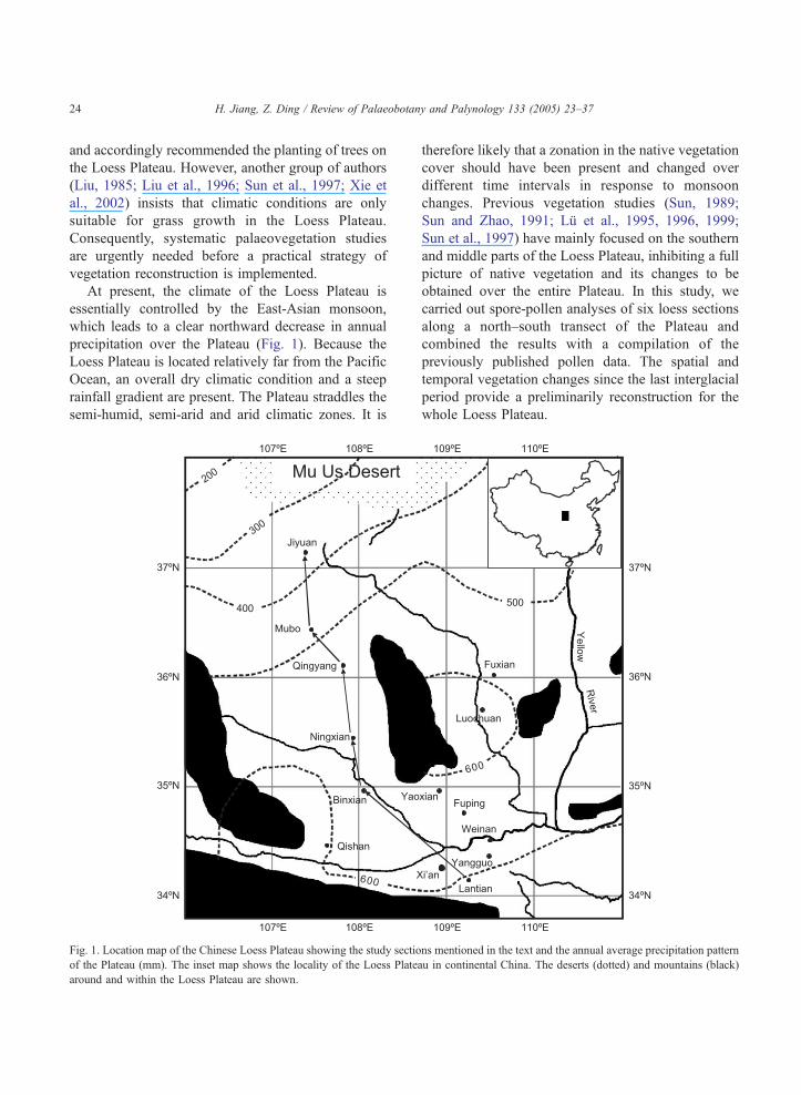
Table 1
Geographical and stratigraphic information of the studied loess sections
Section Latitude
(8N)Longitude
(8E)Elevation
(m)
MAT
(8C)
Jiyuan 37.14 107.39 1730 7.9
Mubo 36.43 107.46 1430 8.5
Qingyang 36.1 107.83 1290 9.4
Ningxian 35.44 107.94 1200 8.8
Binxian 34.96 108.05 1225 11
Lantian 34.15 109.27 720 13
of Pinus tabulaeformis, Quercus and Betula occurring
only in shady valleys or on high mountains. Qingyang,
Mubo and Jiyuan occur in warm-temperate steppe,
which is characterized by Stipa bungeana, S. brevi-
flora, Artemisia girald and Caragana spp.
All the six sections have an S1–L1–S0 stratigraph-
ical sequence (Table 1) and are readily correlated in the
field, suggesting that the deposition of eolian materials
has never been interrupted by other natural processes
such as fluvial and ice erosion or deposition at the sites.
Soil S1, formed in the last interglacial period, has a
brownish or reddish color and an A–Bw–C or A–Bt–C
horizon sequence. It has a polygenetical characteristic,
showing a general decrease in thickness and pedogenic
development from north to south. The last glacial loess
unit, L1, has a yellowish color and a massive structure,
ranging in thickness from 5 m in the south of the
transect to 29.32 m in the north. In general, the L1 loess
unit can be subdivided into five horizons, named L1–1,
L1–2, L1–3, L1–4 and L1–5. L1–2 and L1–4 are weakly
developed soils, while the other three horizons are
typical loess (Ding et al., 1999, 2001). The Holocene
soil, S0, shows a dark color due to relatively high
organic matter accumulation during its formation.
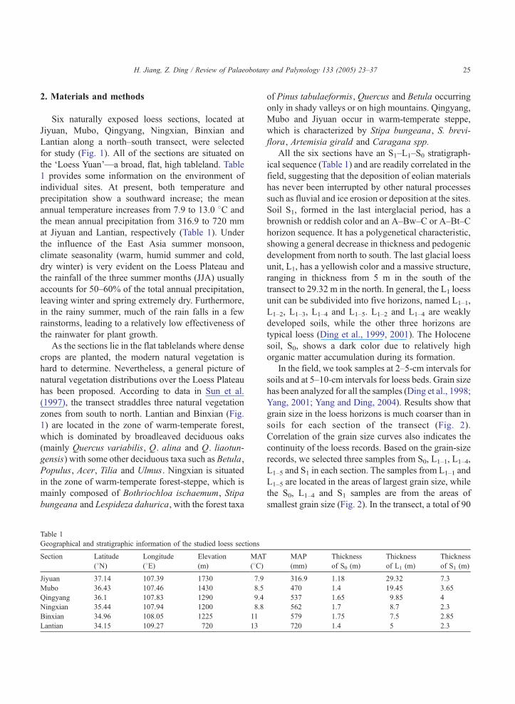
In the field, we took samples at 2–5-cm intervals for
soils and at 5–10-cm intervals for loess beds. Grain size
has been analyzed for all the samples (Ding et al., 1998;
Yang, 2001; Yang and Ding, 2004). Results show that
grain size in the loess horizons is much coarser than in
soils for each section of the transect (Fig. 2).
Correlation of the grain size curves also indicates the
continuity of the loess records. Based on the grain-size
records, we selected three samples from S0, L1–1, L1–4,
L1–5 and S1 in each section. The samples from L1–1 and
L1–5 are located in the areas of largest grain size, while
the S0, L1–4 and S1 samples are from the areas of
smallest grain size (Fig. 2). In the transect, a total of 90
MAP
(mm)
Thickness
of S0 (m)
Thickness
of L1 (m)
Thickness
of S1 (m)
316.9 1.18 29.32 7.3
470 1.4 19.45 3.65
537 1.65 9.85 4
562 1.7 8.7 2.3
579 1.75 7.5 2.85
720 1.4 5 2.3
Fig. 2. Stratigraphic division and grain size records of the six loess sections along the transect. Squares indicate the sampling positions for pollen
analyses.
H. Jiang, Z. Ding / Review of Palaeobotany and Palynology 133 (2005) 23–3726
samples were selected for pollen analysis. Although the
chronology of the loess sections has not been accurately
established, this sampling strategy should still assure
the use of roughly synchronously depositedmaterial for
each representative time interval along the transect.
A total of 80–90 g of sediment from each sample
were subjected to concentrated hydrofluoric acid
treatment for 24 h in order to dissolve silicate minerals
and hence reduce sample volume. After subsequent
treatment with hydrochloric acid and 5% caustic soda,
pollen grains were extracted by two changes of heavy
liquid (chromium iodide).
3. Temporal vegetation changes along the transect
Examination under the microscope revealed rela-
tively abundant pollen and spores in nearly half of the
samples but the other samples failed to provide a
satisfactory pollen sum. Of the total of 90 samples
analyzed, 46 containing 72–412 pollen and spore grains
are illustrated in the pollen diagram (Fig. 3). Previous
studies have shown that a paleoenvironmental infer-
ence based on a single sample from which only 50–100
grains are counted would be quite dubious. However, if
a sequence of some 5–10 samples in which such
numbers are counted, bears similar characteristics, the
conclusions are much more sound and could be relied
upon (Horowitz, 1992). Accordingly, more than 70
grains is regarded as an acceptable pollen count in this
study and the palynological sum is composed of all taxa
from regional dominants to local aquatics. In this study,
a total of 47 pollen and spore types were identified, with
the herbaceous pollen taxa being dominant in most of
the samples. Comparatively, the diversity and abun-
dance of arboreal pollen taxa are less important.
Although different floral elements have different
moisture demands, trees, shrubs, mesic herbs, ferns
and algae demand much more moisture than other
herbs. Accordingly, we here choose to use the
percentage of AP (arboreal pollen)+MH (mesic herba-
ceous pollen)+SP (spores) as an indicator of relatively
humid environments. In this study, we found 10 taxa
of mesic herbs, including Liliaceae, Gramineae,
Cruciferae, Ranunculaceae, Cyperaceae, Polygona-
ceae, Polygonum, Pteroxygonum, Gentianaceae and
Umbelliferae. In general, the ecological scope of
Gramineae is extensive, but most components of it
grow in relatively humid environments (e.g. Horo-
witz, 1992; Schabitz, 1994; Campo et al., 1996). Ke
(1995) found that Algae are relatively widely present
in loess records, particularly in the southern and
middle parts of the Plateau, implying the existence of
scattered water ponds within it. Previous studies
(Wang and Sun, 1994; Sun et al., 1997) showed that
fern spores can be also used to indicate relatively
humid environments. Here, we describe the pollen
assemblages of the sections from south to north.
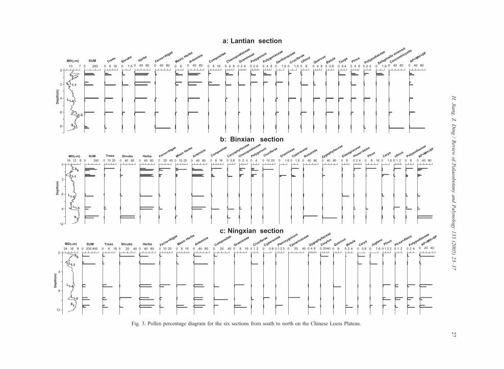
Fig. 3. Pollen percentage diagram for the six sections from south to north on the Chinese Loess Plateau.
H.Jia
ng,Z.Ding/Review
ofPalaeobotanyandPalyn
ology133(2005)23–37
27
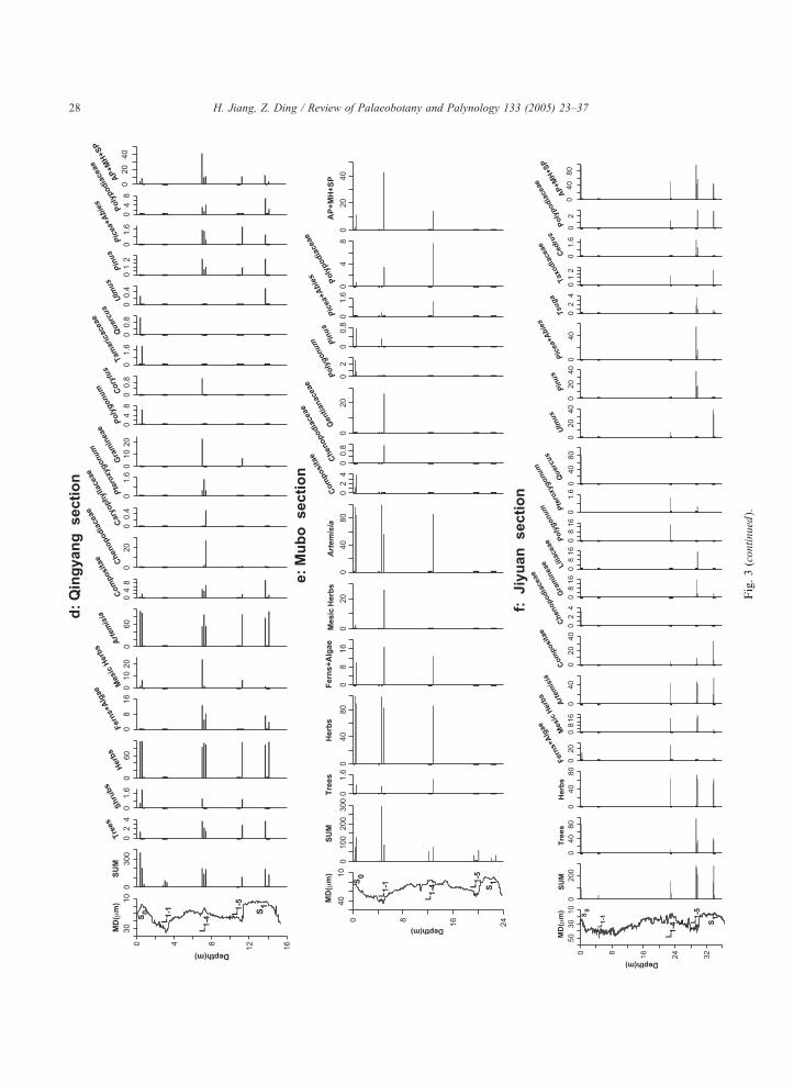
Fig.3(continued).
H. Jiang, Z. Ding / Review of Palaeobotany and Palynology 133 (2005) 23–3728
H. Jiang, Z. Ding / Review of Palaeobotany and Palynology 133 (2005) 23–37 29
3.1. Lantian section
The pollen diagram of the Lantian section is shown
in Fig. 3a. Of the 15 samples analyzed, only 7 had
enough pollen and spore grains (N70) for reasonable
statistical analysis. A most striking feature of the
pollen record is that herbaceous pollen taxa dominate
(65.9–100%) in all the loess-soil horizons, except for
the S1 soil in which the alga Concentricystis is
predominant (97.6%).
The pollen assemblages of the S0, L1–1, L1–4 and
L1–5 units are all dominated by Artemisia (53.7–
88.9%), with low contents of Compositae (0.4–
17.7%), Chenopodiaceae (0–7.2%), Gramineae (0–
4.3%), Gentianaceae (0–1.4%), Cruciferae (0–1.5%),
Polygonum (0–4.2%) and Polygonaceae (0–7.7%). In
these units, the mesic herbaceous elements, including
Gramineae, Gentianaceae, Cruciferae, Polygonum and
Polygonaceae, range from 1.6% to 10.8%, with the
highest content occurring in S0.
Arboreal pollen types, with contents of no more
than 18.3%, are also identified in S0, L1–1, L1–4 and
L1–5. They are mostly temperate deciduous trees such
as Quercus (0–6.4%) and Ulmus (0–10.4%). Trace
amounts of other arboreal pollen grains are scattered
in the loess-soil horizons. These are Pinus, Abies,
Podocarpus, Taxodiaceae, Tsuga, Cedrus, Juglans,
Betula, Ephedra, Tamaricaceae and Rhamnaceae.
Ferns, mostly Polypodiaceae (0–4.1%), Selaginella
sinensis (0–1.5%), Araiostegia (0–0.6%), Cyathea-
ceae (0–0.8%) and unidentified species (0–6.2%), are
only found in the S0 and L1–4 horizons with a content
ranging from 4.7% to 9.2%. The alga Concentricystis
reaches 20.5% in L1–5 and 4.1% in L1–4, respectively.
As shown in Fig. 3a, the value of AP+MH+SP at
Lantian reaches up to 97.6% in the last interglacial
soil of S1, whereas it is below 36% in other horizons.
3.2. Binxian section
In the Binxian section, 11 samples satisfy the
pollen statistical requirement (Fig. 3b). The pollen
assemblages of the two samples of the S1 horizon are
dominated by either the xerophilous shrub Zygophyl-
laceae (96.7%) or the mesic shrub Rosaceae (95.5%),
and the uppermost sample of S0 has relatively high
fern spores (37%). The other eight pollen samples are
mostly composed of the herbaceous taxa (78.3–
94.4%), in which Artemisia is predominant (68.6–
93%). Other herbaceous pollen types such as Com-
positae (0.6–13.7%) and Chenopodiaceae (0–2.2%)
are also identified in these samples. The values of
mesic herbaceous pollen taxa, which consist of
Gramineae (0–1.5%), Ranunculaceae (0–0.4%), Cru-
ciferae (0–21.7%), Cyperaceae (0–1.1%) and Poly-
gonum (0–5.5%), are 5.5–23.6% in S0 and 3.7–4.3%
in L1–1, respectively.
Throughout the section, tree pollen is no more than
5% except for the uppermost sample of the S0 horizon,
in which it reaches 21.4% and is composed predom-
inantly of Pinus (14%), Picea (4.3%) and Ulmus
(2.3%). Trace amounts of Abies, Carya, Tamarica-
ceae, Ephedra and Quercus pollen are also present. A
relatively high pollen content of shrub Zygophylla-
ceae species is found in one sample of L1–1 (15.9%)
and Elaeagnaceae in one sample of L1–4 (11.4%).
Fern spores are detected in all horizons but S1. The
average content of fern spores is 18.1% in S0, and
decreases markedly to 6.3% in L1–1, 3.4% in L1–4 and
6.5% in L1–5. The major fern types are Polypodiaceae
(0–11.3%), Cyatheaceae (0–4.3%), Selaginella sinen-
sis (0–1.6%), Ophioglossaceae (0–1.6%), Athyriaceae
(0–1.2%) and unidentified others (0–18.7%).
As shown in Fig. 3b, the average value of
AP+MH+SP is as high as 65.8% in S0 and 99.7% in
S1, whereas it is below 26% in other horizons.
3.3. Ningxian section
In the Ningxian section, significant amounts of
pollen grains were extracted from only eight samples
(Fig. 3c). The pollen assemblages of the samples are all
dominated by herbaceous taxa, with the highest content
at 98.1% in L1–1 and the lowest content of 55.6% in S0.
Again, Artemisia is the highest pollen element,
which ranges from 45.7% to 91.3% in the samples.
Compositae pollen is also detected in all the samples,
with up to 35.6% in L1–5 and below 13% in other
horizons. Gramineae has a value of about 15% in the
horizons of L1–4 and S1. The percentages of other
herbaceous pollen taxa such as Cruciferae, Cyper-
aceae, Pteroxygonum, Polygonum and Chenopodia-
ceae are generally no more than 3% and they are
scattered through the horizons.
The eight samples contain tree pollen of 2–12.8%,
mainly derived from the temperate deciduous species
H. Jiang, Z. Ding / Review of Palaeobotany and Palynology 133 (2005) 23–3730
of Quercus and Betula. Other tree pollen components,
such as Juglans, Carya, Alnus, Ulmus, Pinus, Picea
and Abies , are only present in trace amounts.
Relatively high percentages of shrub pollen types
are found in three samples; they are Corylus (38.1%)
in S0, Tamaricaceae (30.3%) in L1–5 and Zygophylla-
ceae (8.4%) in S1.
Fern spores are detected in seven samples and
mainly composed of the monolete spores Polypodia-
ceae and unidentified taxa. The percentage of fern
spores is 8.5–21% in L1–4 and mostly below 5% in
other samples.
The AP+MH+SP value reaches the highest in S0(46.7%) and the lowest in L1–1 (4.9%), and varies
between 8.6% and 41% in other horizons (Fig. 3c).
3.4. Qingyang section
Eight samples in the S0, L1–4, L1–5 and S1 horizons
at Qingyang contained suitable amounts of pollen
grains (Fig. 3d); these are predominantly composed of
herbaceous components (82.7–98%). In the last
glacial maximum loess deposit of L1–1, 68 and 51
pollen grains were also extracted from two samples,
which respectively contain as high as 84.3% and
95.5% of Artemisia. Although insufficient for formal
statistical analysis, the dominance of pollen grains of
Artemisia in the two samples still gives a good
indication that the Qingyang area was covered by
steppe vegetation during the last glacial maximum.
Artemisia percentages are about 55% in two
samples of L1–4 and 77% in one sample of S1, while
other samples have Artemisia values of about 90%.
Compositae persistently occurs in the samples, with
contents of 0.6–9.3%. The abundance of Chenopo-
diaceae reaches 27.1% in one sample of L1–4 and is
less than 3% in other samples. The mesic herbs,
mainly Gramineae and Polygonum, are found in
nearly all the samples but with values mostly below
7%; the highest content of the mesic herbs (23.5%),
mainly Gramineae, occurs in one sample of L1–4.
Other herbaceous pollen types, such as Umbelliferae,
Cyperaceae, Pteroxygonum and Caryophyllaceae, are
only sporadically present in the horizons.
In the Qingyang section, the arboreal pollen
content, although present in seven samples, is never
more than 4.6%, and is made up of Quercus, Ulmus,
Pinus, Picea, Abies, Tamaricaceae, Ephedra, Rosa-
ceae and Corylus. Ferns, including Polypodiaceae (0–
6.7%), Cyatheaceae (0–0.8%) and other unidentified
taxa (0–9.7%), are present only in the L1–4 and S1horizons, with percentages of 3.8–12.8%.
In the entire section, the highest AP+MH+SP value
(40.8%) occurs in one sample of L1–4, whereas it is
below 12% in other samples (Fig. 3d).
3.5. Mubo section
Compared to the pollen records in the above
sections, the diversity and abundance of palyno-
morphs of the pollen assemblages at Mubo are both
significantly reduced (Fig. 3e). Unfortunately, only
five samples in the S0, L1–1 and L1–4 horizons
contained sufficient pollen grains for statistical anal-
ysis, although close to 60 grains were recorded in the
two horizons of L1–5 and S1. Herbaceous pollen
ranges from 83.1% to 100%, with Artemisia being
dominant (56.2–99.3%). Two mesic herbaceous pol-
len taxa are detected in S0 and L1–1, Gentianaceae
with 25.8% in one sample of L1–1, and Polygonum
with between 0.8% and 2.6% in S0. Other herbaceous
pollen types are Compositae and Chenopodiaceae, but
their contents are below 4% throughout the section.
Less than 1.3% arboreal pollen is found in three
samples from the S0, L1–1 and L1–4 horizons, and they
are composed of Pinus, Picea and Abies species. Fern
spores, mainly Polypodiaceae and other unidentified
taxa, are also present in three samples with percen-
tages of 10–16.9%.
The highest AP+MH+SP value (42.7%) occurs in
one sample of L1–1, while this value is below 15% in
other samples (Fig. 3e).
3.6. Jiyuan section
Of the 15 samples analyzed at Jiyuan, only 7 (1 in
S0, 1 in L1–4, 3 in L1–5 and 2 in S1) satisfy the statistical
requirement (Fig. 3f). The pollen assemblages in the
Jiyuan section appear to be much more variable
between samples than in the other sections mentioned
above. The pollen assemblage of the S0 sample is
mainly composed of Quercus (81.3%) and fern spores
(13.2%), while tree pollen, including Pinus, Picea and
Abies, dominates one sample of L1–5 (96.1%). In the
other five samples, herbaceous pollen types have
comparatively high contents, ranging from 54.2% to
H. Jiang, Z. Ding / Review of Palaeobotany and Palynology 133 (2005) 23–37 31
72.9%. Of the herbaceous pollen taxon group, Arte-
misia (20.8–53.4%) and Compositae (1–33.3%) com-
monly occur, whereas other types, mainly mesic herbs,
are found only in a few samples. For example,
Gramineae occurs only in L1–5 (1.1–15.9%) and one
sample of S1 (3.3%), Liliaceae occurs in only one
sample of L1–5, and Polygonum and Pteroxygonum
only in L1–4 (14.4% and 1.3%, respectively).
Five samples of Jiyuan section contain arboreal
components (9.2–42.4%). In the two samples of L1–5,
the tree elements are mainly Pinus (16.7–17.7%),
Picea (0.8–2.5%), Abies (5.8–13.3%) and Tsuga (1–
3.5%), while Ulmus is the major tree taxon found in
L1–4 (7.8%) and the two samples of S1 (32.9–39.6%).
Other tree pollen taxa, such as Podocarpus, Taxodia-
ceae and Cedrus, are sporadically distributed in the
five samples.
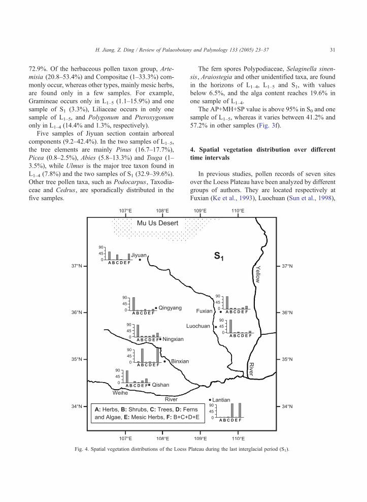
Fig. 4. Spatial vegetation distributions of the Loess P
The fern spores Polypodiaceae, Selaginella sinen-
sis, Araiostegia and other unidentified taxa, are found
in the horizons of L1–4, L1–5 and S1, with values
below 6.5%, and the alga content reaches 19.6% in
one sample of L1–4.
The AP+MH+SP value is above 95% in S0 and one
sample of L1–5, whereas it varies between 41.2% and
57.2% in other samples (Fig. 3f).
4. Spatial vegetation distribution over different
time intervals
In previous studies, pollen records of seven sites
over the Loess Plateau have been analyzed by different
groups of authors. They are located respectively at
Fuxian (Ke et al., 1993), Luochuan (Sun et al., 1998),
lateau during the last interglacial period (S1).
H. Jiang, Z. Ding / Review of Palaeobotany and Palynology 133 (2005) 23–3732
Yaoxian (Li et al., 2003), Fuping (Sun and Zhao,
1991), Qishan (Zhao and Huang, 1999), Yangguo (Sun
et al., 1997) and Xian (Sun and Zhao, 1991) (Fig. 1).
Some of the pollen records cover the full S1–L1–S0stratigraphical sequence and others are reconstructed
only for the Holocene. The published pollen records
plus these reported here allow us to tentatively map the
spatial vegetation distributions of the Plateau over
different time intervals. In this study, we selected the
pollen data of three adjacent samples that correspond to
the climate patterns associated with S0, L1–1, L1–4, L1–5
and S1 depositional environments from the sections.
The averaged percentages of each pollen type were
then calculated for each horizon. We use histograms to
depict the pollen distributions for each site. In these
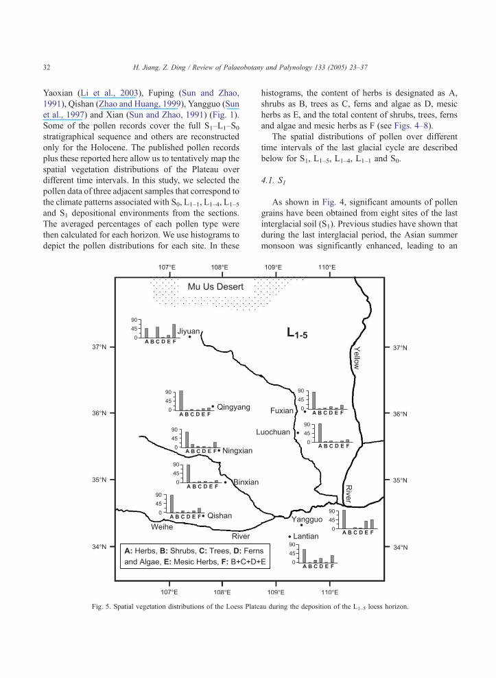
Fig. 5. Spatial vegetation distributions of the Loess Plate
histograms, the content of herbs is designated as A,
shrubs as B, trees as C, ferns and algae as D, mesic
herbs as E, and the total content of shrubs, trees, ferns
and algae and mesic herbs as F (see Figs. 4–8).
The spatial distributions of pollen over different
time intervals of the last glacial cycle are described
below for S1, L1–5, L1–4, L1–1 and S0.
4.1. S1
As shown in Fig. 4, significant amounts of pollen
grains have been obtained from eight sites of the last
interglacial soil (S1). Previous studies have shown that
during the last interglacial period, the Asian summer
monsoon was significantly enhanced, leading to an
au during the deposition of the L1–5 loess horizon.
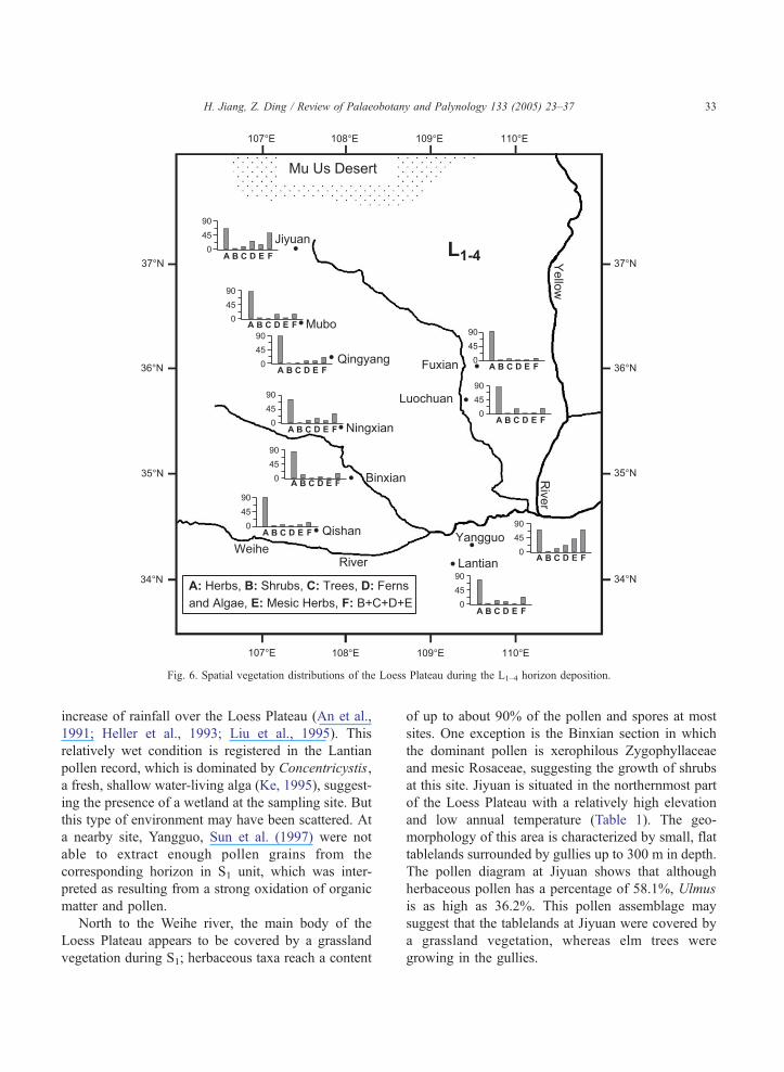
Fig. 6. Spatial vegetation distributions of the Loess Plateau during the L1–4 horizon deposition.
H. Jiang, Z. Ding / Review of Palaeobotany and Palynology 133 (2005) 23–37 33
increase of rainfall over the Loess Plateau (An et al.,
1991; Heller et al., 1993; Liu et al., 1995). This
relatively wet condition is registered in the Lantian
pollen record, which is dominated by Concentricystis,
a fresh, shallow water-living alga (Ke, 1995), suggest-
ing the presence of a wetland at the sampling site. But
this type of environment may have been scattered. At
a nearby site, Yangguo, Sun et al. (1997) were not
able to extract enough pollen grains from the
corresponding horizon in S1 unit, which was inter-
preted as resulting from a strong oxidation of organic
matter and pollen.
North to the Weihe river, the main body of the
Loess Plateau appears to be covered by a grassland
vegetation during S1; herbaceous taxa reach a content
of up to about 90% of the pollen and spores at most
sites. One exception is the Binxian section in which
the dominant pollen is xerophilous Zygophyllaceae
and mesic Rosaceae, suggesting the growth of shrubs
at this site. Jiyuan is situated in the northernmost part
of the Loess Plateau with a relatively high elevation
and low annual temperature (Table 1). The geo-
morphology of this area is characterized by small, flat
tablelands surrounded by gullies up to 300 m in depth.
The pollen diagram at Jiyuan shows that although
herbaceous pollen has a percentage of 58.1%, Ulmus
is as high as 36.2%. This pollen assemblage may
suggest that the tablelands at Jiyuan were covered by
a grassland vegetation, whereas elm trees were
growing in the gullies.
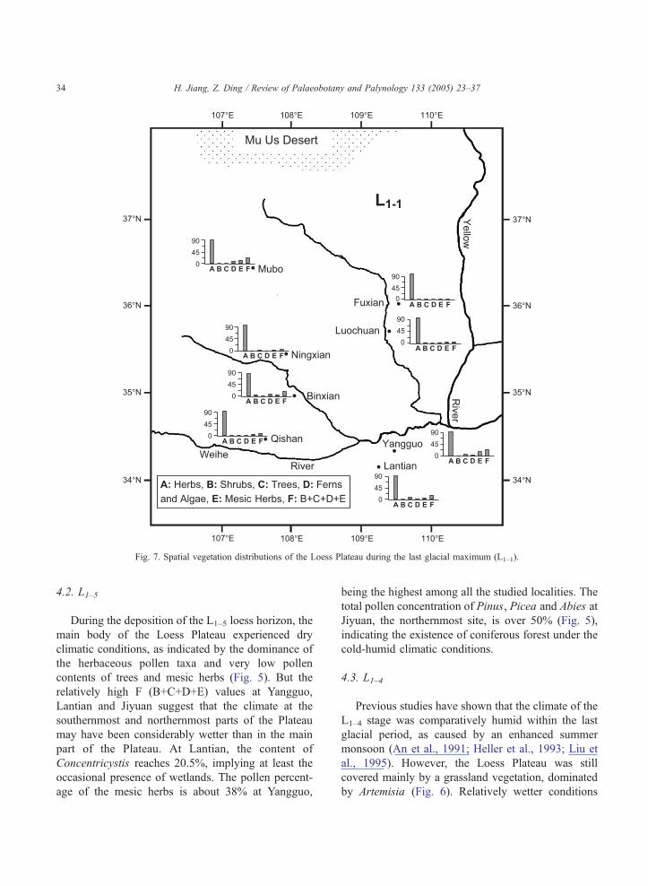
Fig. 7. Spatial vegetation distributions of the Loess Plateau during the last glacial maximum (L1–1).
H. Jiang, Z. Ding / Review of Palaeobotany and Palynology 133 (2005) 23–3734
4.2. L1–5
During the deposition of the L1–5 loess horizon, the
main body of the Loess Plateau experienced dry
climatic conditions, as indicated by the dominance of
the herbaceous pollen taxa and very low pollen
contents of trees and mesic herbs (Fig. 5). But the
relatively high F (B+C+D+E) values at Yangguo,
Lantian and Jiyuan suggest that the climate at the
southernmost and northernmost parts of the Plateau
may have been considerably wetter than in the main
part of the Plateau. At Lantian, the content of
Concentricystis reaches 20.5%, implying at least the
occasional presence of wetlands. The pollen percent-
age of the mesic herbs is about 38% at Yangguo,
being the highest among all the studied localities. The
total pollen concentration of Pinus, Picea and Abies at
Jiyuan, the northernmost site, is over 50% (Fig. 5),
indicating the existence of coniferous forest under the
cold-humid climatic conditions.
4.3. L1–4
Previous studies have shown that the climate of the
L1–4 stage was comparatively humid within the last
glacial period, as caused by an enhanced summer
monsoon (An et al., 1991; Heller et al., 1993; Liu et
al., 1995). However, the Loess Plateau was still
covered mainly by a grassland vegetation, dominated
by Artemisia (Fig. 6). Relatively wetter conditions
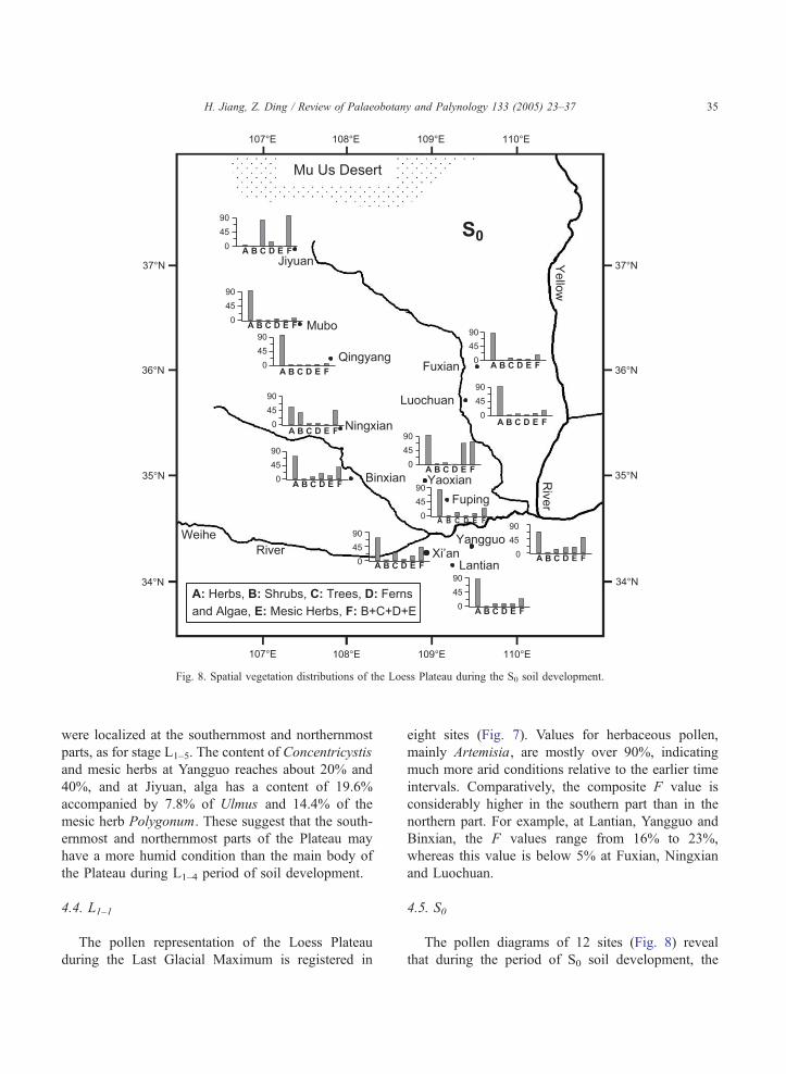
Fig. 8. Spatial vegetation distributions of the Loess Plateau during the S0 soil development.
H. Jiang, Z. Ding / Review of Palaeobotany and Palynology 133 (2005) 23–37 35
were localized at the southernmost and northernmost
parts, as for stage L1–5. The content of Concentricystis
and mesic herbs at Yangguo reaches about 20% and
40%, and at Jiyuan, alga has a content of 19.6%
accompanied by 7.8% of Ulmus and 14.4% of the
mesic herb Polygonum. These suggest that the south-
ernmost and northernmost parts of the Plateau may
have a more humid condition than the main body of
the Plateau during L1–4 period of soil development.
4.4. L1–1
The pollen representation of the Loess Plateau
during the Last Glacial Maximum is registered in
eight sites (Fig. 7). Values for herbaceous pollen,
mainly Artemisia, are mostly over 90%, indicating
much more arid conditions relative to the earlier time
intervals. Comparatively, the composite F value is
considerably higher in the southern part than in the
northern part. For example, at Lantian, Yangguo and
Binxian, the F values range from 16% to 23%,
whereas this value is below 5% at Fuxian, Ningxian
and Luochuan.
4.5. S0
The pollen diagrams of 12 sites (Fig. 8) reveal
that during the period of S0 soil development, the
H. Jiang, Z. Ding / Review of Palaeobotany and Palynology 133 (2005) 23–3736
diversity and abundance of vegetation significantly
increased in the Loess Plateau, particularly in the
southern part. For instance, we detected at Lantian,
Yangguo, Xi’an, Fuping and Binxian considerable
tree pollen including Pinus, Picea, Ulmus, Corylus
and Quercus, and high values of Polypodiaceae,
Selaginella sinensis and Concentricystis. At Jiyuan,
the northernmost site, a Quercus woodland was
present during the Holocene optimum, as indicated
by the 81.3% value for Quercus pollen. Even if a
relatively humid condition can be inferred, the main
area of the Plateau was still covered by a grassland
vegetation during this time interval, since 9 of the 12
sites, have herbaceous pollen contents of over 70%
(Fig. 8).
5. Discussion and conclusions
The most striking feature that our records reveal is
an Artemisia-dominated grassland on the Loess
Plateau both in glacial and interglacial periods. This
means that even in the relatively humid interglacial
periods caused by the enhanced summer monsoon
climate, a moisture limitation was still present that
hindered the development of a forest cover over the
main body of the Loess Plateau. Previous studies have
shown the widespread occurrence of Artemisia-
dominated vegetation in the semi-arid temperate zone
in the late Pleistocene (El-Moslimany, 1990), similar
to the situation of the Loess Plateau.
The comparison of vegetation patterns between
the glacial and interglacial periods shows that the
Loess Plateau generally had a more abundant and
diversified vegetation cover in the interglacial
periods than in the glacial periods. The pollen
concentrations of trees, ferns and algae, and mesic
herbs are significantly higher in the interglacials and
interstadials. These features imply a much higher
precipitation probably caused by an enhanced mon-
soon circulation in the interglacial periods if a higher
evaporation rate under a higher average temperature
is taken into consideration. This is consistent with
the hypotheses derived from other proxy studies (Liu
and Ding, 1998).
Throughout the Loess Plateau, there is a general
characteristic that the southern part of the Plateau has
had a more diversified vegetation cover than the
northern part over most of the studied time intervals,
and the pollen values of trees, ferns and algae, and
mesic herbs substantially decrease from south to
north. This may be closely associated with the
relatively steep gradients of temperature and precip-
itation of the Asian monsoon climate, as mentioned
above. Observations have shown that there is a clear
zonation of pedogenic characteristics (Liu, 1985) over
the Loess Plateau. In the southern part, the paleosols
had undergone relatively strong leaching and differ-
entiation, forming an A–Bt–C horizon sequence. In
the middle Plateau region, a typical A–Bw–Cca
horizon sequence formed, while an A–C horizon
sequence occurred in the northern part. Obviously, the
spatial distributions of both paleosols and paleovege-
tation support the monsoon control of the climate in
the Loess Plateau.
The Loess Plateau has various different geomor-
phological units, which can exert different controls on
moisture conditions and, consequently, on vegetation
patterns. The pollen records so far obtained from the
Loess Plateau are mostly from the loess dYuanT—the
flat, broad tablelands. Compared to the loess gullies,
loess dYuansT have poorer moisture-retention capa-
bility. But if forests had widely occupied the gullies
around the dYuansT, high tree pollen concentrations
would have been extracted from our sections, as is in
the Jiyuan section. Obviously, our results show that it
is not in the case.
Our major conclusion is that in the last 130 ka or
so, the main body of the Loess Plateau has been
covered by an Artemisia-dominated herbaceous veg-
etation, which should be taken into thorough consid-
eration in future rehabilitation of native ecosystems on
the Loess Plateau.
Acknowledgements
Sampling assistance in the field from Yang Shiling
and Chen Zhuo is acknowledged. We thank Professors
John Dodson, A. Peter Kershaw and Dr. Li Xiaoqiang
for their critical comments on an earlier version of the
paper. This study was financially supported by the
Innovation Project of the Chinese Academy of
Sciences (KZCX2-SW-118), the NSF of China (grant
90202020, 40021202) and the National Key Project
for Basic Research (G1999043402).
H. Jiang, Z. Ding / Review of Palaeobotany and Palynology 133 (2005) 23–37 37
References
An, Z.S., Kukla, G., Porter, S.C., Xiao, J.L., 1991. Magnetic
susceptibility evidence of monsoon variation on the Loess
Plateau of Central China during the last 130,000 years.
Quaternary Res. 36, 29–36.
Campo, E.V., Cour, P., Hang, S.X., 1996. Holocene environmental
changes in Bangong Co basin (western Tibet): Part 2. The
pollen record. Palaeogeogr. Palaeoclimatol. Palaeoecol. 120,
49–63.
Ding, Z.L., Rutter, N.W., Liu, T.S., Sun, J.M., Ren, J.Z., Rokosh,
D., Xiong, S.F., 1998. Correlation of Dansgaard-Oeschger
cycles between Greenland ice and Chinese loess. Paleoclimates
2 (4), 281–291.
Ding, Z.L., Sun, J.M., Rutter, N., Rokosh, D., Liu, T.S., 1999.
Changes in sand content of loess deposits along a North–South
transect of the Chinese Loess Plateau and the implications for
desert variations. Quaternary Res. 52, 56–62.
Ding, Z.L., Sun, J.M., Yang, S.L., Liu, T.S., 2001. Geochemistry of
the Pliocene red clay formation in the Chinese Loess Plateau
and implications for its origin, source provenance and paleo-
climate change. Geochim. Cosmochim. Acta 65 (6), 901–913.
El-Moslimany, A., 1990. Ecological significance of common
nonarboreal pollen: examples from drylands of the Middle
East. Rev. Palaeobot. Palaeonology 64, 343–350.
Heller, F., Shen, C.D., Beer, J., Liu, X.M., Liu, T.S., Bronger, A.,
Suter, M., Bonani, G., 1993. Quantitative estimates of pedogenic
ferromagnetic mineral formation in Chinese loess and palae-
oclimatic implications. Earth Planet. Sci. Lett. 114, 385–390.
Horowitz, A., 1992. Palynology of Arid Lands. Elsevier Science
Publishers, Amsterdam.
Ke, M.H., 1995. Discovery and significance of the concentricystis
fossils on the Loess Plateau (in Chinese). J. Xi’an Coll. Geol. 17
(2), 90–93.
Ke, M.H., Sun, J.Z., Zhao, J.B., 1993. Paleoclimate-environmental
evolution since last interglacial stage in Fuxian Area, Shaanxi
Province (in Chinese). J. Xi’an Coll. Geol. 15 (4), 172–177.
Li, X.Q., Zhou, J., Dodson, J., 2003. The vegetation characteristic
of the dYuanT area at Yaoxian on the Loess Plateau in China overthe last 12000 years. Rev. Palaeobot. Palynol. 124, 1–7.
Liu, T.S., 1985. Loess and the Environment. China Ocean Press,
Beijing.
Liu, T.S., Ding, Z.L., 1998. Chinese Loess and the Paleomonsoon.
Annu. Rev. Earth Planet. Sci. 26, 111–145.
Liu, X.M., Rolph, T., Bloemendal, J., Shaw, J., Liu, T.S., 1995.
Quantitative estimates of Palaeoprecipitation at Xifeng, in the
Loess Plateau of China. Palaeogeogr. Palaeoclimatol. Palae-
oecol. 113, 243–248.
Liu, T.S., Guo, Z.T., Wu, N.Q., Lq, H.Y., 1996. Prehistoric
vegetation on the Loess Plateau: steppe or forest? J. Southeast
Asian Earth Sci. 13, 341–346.
Lq, H.Y., Wu, N.Q., Nie, G.Z., 1995. Discovery of bamboo
phytolith in the Loess-Paleosol sequences of Guanzhong Basin,
Shaanxi Province. Chin. Sci. Bull. 40 (4), 405–409.
Lq, H.Y., Wu, N.Q., Liu, T.S., Han, J.M., Qin, X.G., Sun, X.J.,
Wang, Y.J., 1996. Seasonal climatic variation recorded by
phytolith zones from Baoji Loess Sequence in Central China
over the last 150,000a. Sci. China, Ser. D 26 (6), 629–639.
Lq, H.Y., Liu, T.S., Wu, N.Q., Han, J.M., Guo, Z.T., 1999. Phytolith
record of vegetation succession in the southern Loess Plateau
since late Pleistocene (in Chinese with English abstract).
Quaternary Sci. 4, 336–349.
Sch7bitz, F., 1994. Holocene climatic variations in northern
Patagonia, Argentina. Palaeogeogr. Palaeoclimatol. Palaeoecol.
109, 287–294.
Shi, N.H., 1981. Heshan Ji (Part 2) (in Chinese). Sanlian Bookstore,
Beijing.
Shi, N.H., 1991. Comments on the historical distribution and
vicissitudes of the national vegetation of China (in Chinese).
Collect. Essays Chin. Hist. Geogr. 3, 43–73.
Sun, X.J., 1989. A restudy of the latest Pleistocene Paleovegetation
at Beizhuangcun, Shaanxi Province, northern China (in Chinese
with English abstract). Quaternary Sci. 2, 177–189.
Sun, J.Z., Zhao, J.B., 1991. Quaternary of the Loess Plateau (in
Chinese). Science Press, Beijing.
Sun, X.J., Song, C.Q., Wang, F.Y., Sun, M.R., 1997. Vegetation
history of the Loess Plateau of China during the last 100,000
years based on pollen data. Quaternary Int. 37, 25–36.
Sun, J.Z., Ke, M.H., Wei, M.J., Zhao, J.B., Li, B.C., 1998.
Vegetation and environment during the late Pleistocene in Loess
Plateau, China (in Chinese). J. Geomech. 4 (4), 30–41.
Wang, P.X., Sun, X.J., 1994. Last glacial maximum in China:
comparison between land and sea. Catena 23, 341–353.
Xie, S.C., Wang, Z.Y., Wang, H.M., Chen, F.H., An, C.B., 2002.
The occurrence of a grassy vegetation over the Chinese Loess
Plateau since the last interglacier: the molecular fossil record.
Sci. China 45 (1), 53–62.
Yang, S.L., 2001. Magnetostratigraphy and Sedimentology of the
eolian deposits in northern China since the late Miocene (in
Chinese). PhD thesis.
Yang, S.L., Ding, Z.L., 2004. Comparison of particle size character-
istics of the Tertiary dred clayT and Pleistocene loess in the
Chinese Loess Plateau: implications for origin and sources of
the dred clayT. Sedimentology 51, 77–93.
Zhao, J.B., Huang, C.C., 1999. Environmental change of late
Pleistocene in Loess Plateau of Shaanxi Province (in Chinese).
Sci. Geogr. Sin. 19 (6), 565–569.
Zhu, Z.C., 1983. The range of forest-steppe zone on the Loess
Plateau of northern part in Shaanxi Province (in Chinese). Acta
Phytoecologica Geobot. Sin. 7 (2), 122–131.
Zhu, Z.C., 1994. The basic characteristic of forest-grass in the Loess
Plateau (in Chinese). Sci. Geogr. Sin. 14 (2), 152–156.
Copyright © 2022 FDOKUMEN