CHANNEL INSTABILITY IN THE LOESS AREA OF THE MIDWESTERN UNITED STATES
18
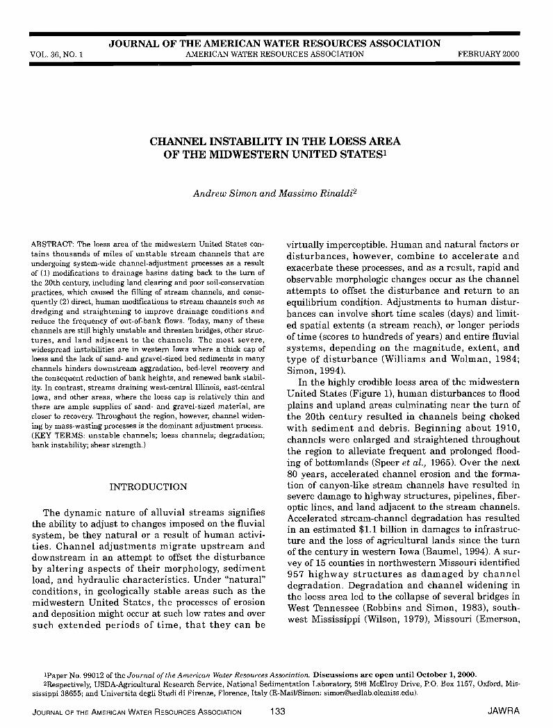
JOURNAL OF THE AMERICAN WATER RESOURCES ASSOCIATION VOL. 36, NO. 1 AMERICAN WATER RESOURCES ASSOCIATION FEBRUARY 2000 CHANNEL INSTABILITY IN THE LOESS AREA OF THE MIDWESTERN UNITED STATES1 Andrew Simon and Massimo Rinaldi2 ABSTRACT: The bess area of the midwestern United States con- tains thousands of miles of unstable stream channels that are undergoing system-wide channel-adjustment processes as a result of (1) modifications to drainage basins dating back to the turn of the 20th century, including land clearing and poor soil-conservation practices, which caused the filling of stream channels, and conse- quently (2) direct, human modifications to stream channels such as dredging and straightening to improve drainage conditions and reduce the frequency of out-of-bank flows. Today, many of these channels are still highly unstable and threaten bridges, other struc- tures, and land adjacent to the channels. The most severe, widespread instabilities are in western Iowa where a thick cap of bess and the lack of sand- and gravel-sized bed sediments in many channels hinders downstream aggradation, bed-level recovery and the consequent reduction of bank heights, and renewed bank stabil- ity. In contrast, streams draining west-central Illinois, east-central Iowa, and other areas, where the bess cap is relatively thin and there are ample supplies of sand- and gravel-sized material, are closer to recovery. Throughout the region, however, channel widen- ing by mass-wasting processes is the dominant adjustment process. (KEY TERMS: unstable channels; bess channels; degradation; bank instability; shear strength.) INTRODUCTION The dynamic nature of alluvial streams signifies the ability to adjust to changes imposed on the fluvial system, be they natural or a result of human activi- ties. Channel adjustments migrate upstream and downstream in an attempt to offset the disturbance by altering aspects of their morphology, sediment load, and hydraulic characteristics. Under "natural" conditions, in geologically stable areas such as the midwestern United States, the processes of erosion and deposition might occur at such low rates and over such extended periods of time, that they can be virtually imperceptible. Human and natural factors or disturbances, however, combine to accelerate and exacerbate these processes, and as a result, rapid and observable morphologic changes occur as the channel attempts to offset the disturbance and return to an equilibrium condition. Adjustments to human distur- bances can involve short time scales (days) and limit- ed spatial extents (a stream reach), or longer periods of time (scores to hundreds of years) and entire fluvial systems, depending on the magnitude, extent, and type of disturbance (Williams and Wolman, 1984; Simon, 1994). In the highly erodible bess area of the midwestern United States (Figure 1), human disturbances to flood plains and upland areas culminating near the turn of the 20th century resulted in channels being choked with sediment and debris. Beginning about 1910, channels were enlarged and straightened throughout the region to alleviate frequent and prolonged flood- ing of bottomlands (Speer et al., 1965). Over the next 80 years, accelerated channel erosion and the forma- tion of canyon-like stream channels have resulted in severe damage to highway structures, pipelines, fiber- optic lines, and land adjacent to the stream channels. Accelerated stream-channel degradation has resulted in an estimated $1.1 billion in damages to infrastruc- ture and the loss of agricultural lands since the turn of the century in western Iowa (Baumel, 1994). A sur- vey of 15 counties in northwestern Missouri identified 957 highway structures as damaged by channel degradation. Degradation and channel widening in the bess area led to the collapse of several bridges in West Tennessee (Robbins and Simon, 1983), south- west Mississippi (Wilson, 1979), Missouri (Emerson, 'Paper No. 99012 of the Journal of the American Water Resources Association. Discussions are open until October 1, 2000. 2Respectively, USDA-Agricultural Research Service, National Sedimentation Laboratory, 598 McElroy Drive, P.O. Box 1157, Oxford, Mis- sissippi 38655; and Universita degli Studi di Firenze, Florence, Italy (E-MaillSirnon: [email protected]). JOURNAL OF THE AMERICAN WATER RESOURCES ASSOCIATION 133 JAWRA
-
Upload
independent -
Category
Documents
-
view
0 -
download
0
Transcript of CHANNEL INSTABILITY IN THE LOESS AREA OF THE MIDWESTERN UNITED STATES
JOURNAL OF THE AMERICAN WATER RESOURCES ASSOCIATIONVOL. 36, NO. 1 AMERICAN WATER RESOURCES ASSOCIATION FEBRUARY 2000
CHANNEL INSTABILITY IN THE LOESS AREAOF THE MIDWESTERN UNITED STATES1
Andrew Simon and Massimo Rinaldi2
ABSTRACT: The bess area of the midwestern United States con-tains thousands of miles of unstable stream channels that areundergoing system-wide channel-adjustment processes as a resultof (1) modifications to drainage basins dating back to the turn ofthe 20th century, including land clearing and poor soil-conservationpractices, which caused the filling of stream channels, and conse-quently (2) direct, human modifications to stream channels such asdredging and straightening to improve drainage conditions andreduce the frequency of out-of-bank flows. Today, many of thesechannels are still highly unstable and threaten bridges, other struc-tures, and land adjacent to the channels. The most severe,widespread instabilities are in western Iowa where a thick cap ofbess and the lack of sand- and gravel-sized bed sediments in manychannels hinders downstream aggradation, bed-level recovery andthe consequent reduction of bank heights, and renewed bank stabil-ity. In contrast, streams draining west-central Illinois, east-centralIowa, and other areas, where the bess cap is relatively thin andthere are ample supplies of sand- and gravel-sized material, arecloser to recovery. Throughout the region, however, channel widen-ing by mass-wasting processes is the dominant adjustment process.(KEY TERMS: unstable channels; bess channels; degradation;bank instability; shear strength.)
INTRODUCTION
The dynamic nature of alluvial streams signifiesthe ability to adjust to changes imposed on the fluvialsystem, be they natural or a result of human activi-ties. Channel adjustments migrate upstream anddownstream in an attempt to offset the disturbanceby altering aspects of their morphology, sedimentload, and hydraulic characteristics. Under "natural"conditions, in geologically stable areas such as themidwestern United States, the processes of erosionand deposition might occur at such low rates and oversuch extended periods of time, that they can be
virtually imperceptible. Human and natural factors ordisturbances, however, combine to accelerate andexacerbate these processes, and as a result, rapid andobservable morphologic changes occur as the channelattempts to offset the disturbance and return to anequilibrium condition. Adjustments to human distur-bances can involve short time scales (days) and limit-ed spatial extents (a stream reach), or longer periodsof time (scores to hundreds of years) and entire fluvialsystems, depending on the magnitude, extent, andtype of disturbance (Williams and Wolman, 1984;Simon, 1994).
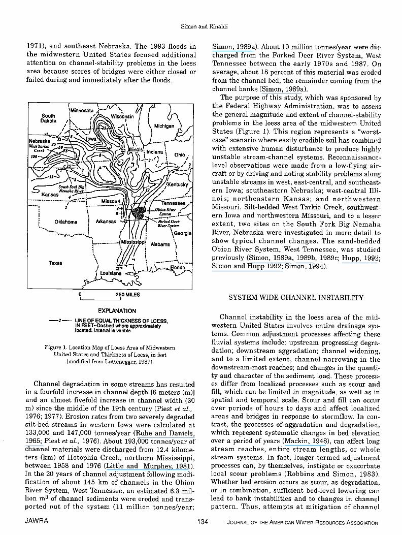
In the highly erodible bess area of the midwesternUnited States (Figure 1), human disturbances to floodplains and upland areas culminating near the turn ofthe 20th century resulted in channels being chokedwith sediment and debris. Beginning about 1910,channels were enlarged and straightened throughoutthe region to alleviate frequent and prolonged flood-ing of bottomlands (Speer et al., 1965). Over the next80 years, accelerated channel erosion and the forma-tion of canyon-like stream channels have resulted insevere damage to highway structures, pipelines, fiber-optic lines, and land adjacent to the stream channels.Accelerated stream-channel degradation has resultedin an estimated $1.1 billion in damages to infrastruc-ture and the loss of agricultural lands since the turnof the century in western Iowa (Baumel, 1994). A sur-vey of 15 counties in northwestern Missouri identified957 highway structures as damaged by channeldegradation. Degradation and channel widening inthe bess area led to the collapse of several bridges inWest Tennessee (Robbins and Simon, 1983), south-west Mississippi (Wilson, 1979), Missouri (Emerson,
'Paper No. 99012 of the Journal of the American Water Resources Association. Discussions are open until October 1, 2000.2Respectively, USDA-Agricultural Research Service, National Sedimentation Laboratory, 598 McElroy Drive, P.O. Box 1157, Oxford, Mis-
sissippi 38655; and Universita degli Studi di Firenze, Florence, Italy (E-MaillSirnon: [email protected]).
JOURNAL OF THE AMERICAN WATER RESOURCES ASSOCIATION 133 JAWRA
Simon and Rinaldi
1971), and southeast Nebraska. The 1993 floods inthe midwestern United States focused additionalattention on channel-stability problems in the bessarea because scores of bridges were either closed orfailed during and immediately after the floods.
Channel degradation in some streams has resultedin a fourfold increase in channel depth [6 meters (m)]and an almost fivefold increase in channel width (30m) since the middle of the 19th century (Piest et al.,1976; 1977). Erosion rates from two severely degradedsilt-bed streams in western Iowa were calculated at133,000 and 147,000 tonnes/year (Ruhe and Daniels,1965; Piest et al., 1976). About 193,000 tonnes/year ofchannel materials were discharged from 12.4 kilome-ters (km) of Hotophia Creek, northern Mississippi,between 1958 and 1976 (Little and Murphey, 1981).In the 20 years of channel adjustment following modi-fication of about 145 km of channels in the ObionRiver System, West Tennessee, an estimated 6.3 mil-lion m3 of channel sediments were eroded and trans-ported out of the system (11 million tonnes/year;
Simon, 1989a). About 10 million tonnes/year were din-charged from the Forked Deer River System, WestTennessee between the early 1970s and 1987. Onaverage, about 18 percent of this material was erodedfrom the channel bed, the remainder coming from thechannel banks (Simon, 1989a).
The purpose of this study, which was sponsored bythe Federal Highway Administration, was to assessthe general magnitude and extent of channel-stabilityproblems in the bess area of the midwestern UnitedStates (Figure 1). This region represents a "worst-case" scenario where easily erodible soil has combirn'dwith extensive human disturbance to produce highlyunstable stream-channel systems. Reconnaissance-level observations were made from a low-flying air-craft or by driving and noting stability problems alongunstable streams in west, east-central, and southeast-ern Iowa; southeastern Nebraska; west-central Illi-nois; northeastern Kansas; and northwesternMissouri. Silt-bedded West Tarkio Creek, southwest-ern Iowa and northwestern Missouri, and to a lesserextent, two sites on the South Fork Big NemahaRiver, Nebraska were investigated in more detail toshow typical channel changes. The sand-beddedObion River System, West Tennessee, was studiedpreviously (Simon, 1989a, 1989b, 1989c; Hupp, 1992;Simon and Hupp 1992; Simon, 1994).
SYSTEM WIDE CHANNEL INSTABILITY
Channel instability in the bess area of the mid-western United States involves entire drainage sy-tems. Common adjustment processes affecting thetiefluvial systems include: upstream progressing degra-dation; downstream aggradation; channel widening,and to a limited extent, channel narrowing in thedownstream-most reaches; and changes in the quanti-ty and character of the sediment load. These procesN-es differ from localized processes such as scour andfill, which can be limited in magnitude, as well as inspatial and temporal scale. Scour and fill can occurover periods of hours to days and affect localizedareas and bridges in response to stormflow. In coii-trast, the processes of aggradation and degradation,which represent systematic changes in bed elevationover a period of years (Mackin, 1948), can affect longstream reaches, entire stream lengths, or wholestream systems. In fact, longer-termed adjustmentprocesses can, by themselves, instigate or exacerbatelocal scour problems (Robbins and Simon, 1983).Whether bed erosion occurs as scour, as degradation,or in combination, sufficient bed-level lowering canlead to bank instabilities and to changes in channelpattern. Thus, attempts at mitigation of channel
C 250 MILES
EXPLANATION
—2— UNE OF EQUAL ThICKNESS OF LOESS,IN FEET—Dashed whom approximatelylocated. Interval is varible
Figure 1. Location Map of Loess Area of MidwesternUnited States and Thickness of Loess, in feet
(modified from Luttenegger, 1987).
JAWRA 134 JOURNAL OF THE AMERICAN WATER RESOURCES ASSOCIATION
Channel Instability in the Loess Area of the Midwestern United States
instabilities must consider the site or reach in ques-tion as it fits into the broader spatial and temporalscheme of system wide adjustment and channel evolu-tion. Addressing only local symptoms at a site willoften be insufficient to mitigate an instability prob-lem.
FACTORS CONTROLLING CHANNELSTABILITY IN THE LOESS AREA
Factors that affect channel stability can be concep-tualized in terms of (1) the resistance of the channelboundary to erosion and (2) the forces acting on thechannel to erode the boundary. If these opposing ten-dencies are balanced, the channel is considered to bein equilibrium, and no net erosion or deposition willoccur with time.
Vertical channel instabilities can be considered as aresult of a disruption to the equilibrium (balance)between available stream power (the discharge-gradi-ent product) and the discharge of bed-material sedi-ment (Lane, 1955; Bull, 1979):
Q 5 cc Q d (1)
where Q = bankfull discharge, S = channel gradient,Qs = bed-material discharge, and d50 = median grainsize of bed material.
Equation (1) indicates that if available streampower is increased by an increase in the bankfull dis-charge or the gradient of the stream, there would bean excess amount of stream power relative to the dis-charge of bed-material sediment. Additional sedimentwould be eroded from the channel bed resulting in:(1) an increase in bed-material discharge to anamount commensurate with the heightened streampower, and (2) a decrease in channel gradient and,consequently, stream power as the elevation of thechannel bed is lowered. A similar response would beexpected from a decrease in the erosional resistance ofthe channel boundary or a decrease in the size of bed-material sediment (assuming it is not cohesive).Because channel banks in the bess area of the mid-western United States are composed predominantly ofsilt, non-cohesive sand or gravel banks contributingbed-material sediment are not considered here. Incontrast, a decrease in available stream power or anincrease in the size or discharge of bed-material sedi-ment would lead to aggradation on the channel bed.Factors that increase hydraulic roughness willdecrease flow velocity and, therefore, discharge andstream power. For example, proliferating vegetationon stream banks causes slower velocities and reducedstream power in the near-bank zone.
Lateral (bank) instabilities are also considered interms of force and resistance. Because bess-channelbanks are fine grained (silty), low to moderately cohe-sive (Lohnes and Handy, 1968; Lutenegger, 1987;Simon, 1989b), and generally erode by mass failure,the shear strength of the bank material representsthe resistance of the boundary to erosion. Shearstrength comprises two components — cohesivestrength and frictional strength. For the simple caseof a planar failure of unit length, the Coulomb equa-tion is applicable:
Sr = C + (N - 1) tan 4:. (2)
where 5r = shear stress at failure, in kilopascals(kPa); c = cohesion, in kPa; N = normal stress on thefailure plane, in kPa; ji = pore pressure, in kPa; and4) = friction angle, in degrees.
Also
N = W (cos ) (2a)
where W = weight of the failure block, in kN/m2; and0 = angle of the failure plane, in degrees.
The gravitational force acting on the bank is:
W sin 0 (3)
Factors that decrease the erosional resistance (Sr),such as excess pore pressure from saturation and thedevelopment of vertical tension cracks, favor bankinstabilities. Similarly, increases in bank height bybed degradation and bank angle by undercuttingfavor bank failure by causing the gravitational compo-nent to increase. In contrast, vegetated banks aregenerally drier and provide improved bank drainage,which enhances bank stability (Thorne, 1989). Plantroots provide tensile strength to the soil that is gener-ally strong in compression, resulting in reinforcedearth (Vidal, 1969) that resists mass failure, at leastto the depth of vegetation roots. However, the addedweight of woody vegetation on a bank acts as a sur-charge and can have negative effects on bank stabilityby increasing the downslope component of weight,particularly on steep banks.
Natural Factors
The predominant natural factors regarding chan-nel-stability problems in the bess area of the mid-western United States are related to the relativeresistance to erosion of the bess, and the distributionof bess around and beneath the channel boundary.Although bess can stand in tall vertical cliffs whendry, it tends to be highly erodible when wetted by
JOURNAL OF THE AMERICAN WATER RESOURCES ASSOCIATION 1 35 JAWRA

Simon and Rinaldi
streamfiow or by raindrop impact. Once disturbed,channels with beds of bess-derived alluvium general-ly incise rapidly and, without an ample supply of sandor gravel, tend to be some of the deepest in the region.Because the fluvial transport of fine-grainedsediments such as silt is not only controlled by thehydraulic properties of the streamfiow but also by thesupply of silt delivered to the flow from channel orupland sources, little silt is deposited in downstreamreaches to aid in bed-level recovery. Channels that cutthrough the bess cap and entrain coarser sand andgravel deposits below will, on average, recover quick-er from disturbances because there is a supply ofhydraulically-controlled material that is likely to bedeposited in downstream reaches, causing aggrada-tion and the consequent decrease in bank heights.
The relatively low resistance (shear strength) ofthe bess bank material to erosion by mass failure isan important factor in channel evolution in theregion. The mean values of cohesion and frictionangle for 22 sites throughout the region are 9.7 kPaand 35.4°, respectively (Lutenegger, 1987). The meanvalues for 14 shear-strength tests in Iowa bluff-linestreams are 8.9 kPa and 24.9° (Lohnes and Handy,1968). Data indicate that, on average, bess in Kansasand Nebraska are considerably more cohesive, rang-ing from 35 to 69 kPa (Turnbull, 1948; Lohnes andHandy, 1968). Cohesion and friction-angle valuesobtained in Mississippi for bess-derived sedimentsrange from 9.2 to 34 kPa, and from 16 to 35°, respec-tively (Turnipseed and Wilson, 1992; Wilson andTurnipseed, 1993, 1994). The mean value of cohesionreported for 23 borehole shear-strength tests conduct-ed in bess-derived sediments in northern Mississippiis relatively high, (54 kPa) by Thorne et al. (1981).This value may be unrealistically high, owing to addi-tional cohesive strength provided by negative pore-water pressures. The mean friction angle in theseMississippi tests is 21°.
A study of streambank stability in West Tennesseedisclosed a mean cohesive strength of 8.7 kPa, and amean friction angle of 30.1° (168 tests; Simon, 1989c).The West Tennessee tests were taken during summerlow-flow conditions when the channel banks were dri-est and, therefore, the most resistant to mass failure.Nevertheless, the mean ambient degree of saturationwas 86 percent, leaving the channel banks vulnerableto complete saturation during wet periods. Upon satu-ration and the generation of excess pore pressures(values of p in Equation 2 greater than the steady-state values as determined by the "normal" position ofthe water table), shear strength values can decrease.By Equation (2), a continued increase in p can resultin the frictional component of shear strength becom-ing zero, leaving only the cohesion component toresist mass failure. In West Tennessee, the cohesion
component, on average, comprises only about 10 per-cent of the strength of the bess-derived channelbanks (Simon, 1989b) and, following saturation andthe generation of excess pore pressures, is often insufficient to resist mass failure. Along channels deep-ened by degradation, mass failure occurs on therecession of river stage as the banks lose the supportafforded by the water in the channel.
Established woody vegetation on streambanks canenhance bank stability but only if (1) degradationdoes not create bank heights and angles in excess ofthe critical shear-strength conditions of the bankmaterial, and (2) rooting depths extend past the depthof the failure plane. Experiments on live roots ofriparian sweet gum trees in northern Mississippi dis-close tensile strengths of 5 MPa for 10 mm-diameterroots to 22 MPa for 2 mm-diameter roots. Similartests on the roots of sycamore trees disclosed tensilestrengths ranging from 15 MPa to 65 MPa for rootdiameters of 10 mm and 2 mm, respectively. The rein-forcement provided by these roots can represent a sig-nificant contribution to bank strength if there areenough roots crossing a potential failure plane.
Human Factors
Human factors related to channel-stability prob-lems can often be considered as disruptions or distur-bances to the "natural" balance between the availableerosional force acting on the channel boundaries andthe erosional resistance provided by those boundaries.Such disturbances can be imposed directly on thechannel as in the case of dredging or channelstraightening, or can be indirect as in the case of landclearing. In the bess area of the midwestern UnitedStates, direct and indirect disturbances have con-tributed to the channel-stability problems of theregion.
Large tracts of land were cleared for cultivationduring settlement of the region prior to and after theCivil War (Ashley, 1910; Brice, 1966; Piest et al.,1977). Stream courses were tortuous with sinuositiesranging from about 3 to 4, with valley slopes in theorder of 10 to iO mlm (Moore, 1917; Speer et al.,1965). Channel gradients from trunk streams insoutheastern Nebraska and West Tennessee wereabout 1.2 and 1.1 x iO- mlm, respectively (U.S. ArmyCorps of Engineers, 1907; Moore, 1917). The removalof grasses and woody vegetation resulted in reducedwater interception and storage, increased rates of sur-face runoff, erosion of uplands, and gulbying of floodplains ahd terraces. Surface runoff and peak-flowrates in western Iowa are estimated to have increased2-3 times and 10-50 times, respectively, when com-pared to estimates of presettlement amounts (Piest et
JAWRA 136 JOURNAL OF THE AMERICAN WATER RESOURCES ASSOCIATION
Channel Instability in the Loess Area of the Midwestern United States
at., 1976, 1977). The removal of woody vegetationfrom streambanks resulted in decreased hydraulicroughness, increased flow velocities and streampower, and contributed to increased peak discharges.In combination, these factors caused extensive down-cutting (Piest et al., 1976). Much eroded material wasdeposited in channels, resulting in a loss of channelcapacity and frequent and prolonged flooding of agri-cultural lands (Morgan and McCrory, 1910; Moore,1917; Piest et al., 1976). Moore (1917) reports thataggradation was almost continuous along the trunkstreams of southeastern Nebraska.
As a result of ubiquitous channel filling, localdrainage districts implemented programs to dredge,straighten, and shorten stream channels (channelize)to reduce flooding and thereby increase agriculturalproductivity (Hidinger and Morgan, 1912; Moore,1917). Work was undertaken in southeastern Nebras-ka, West Tennessee, and west-central Illinois around1910 (Moore, 1917; Speer et al., 1965); and in westernIowa around 1920 (Lohnes et al., 1980). In manyareas, this work increased channel gradients by aboutan order of magnitude (Moore, 1917; Simon, 1994).Entire lengths of trunk streams were channelized insoutheastern Nebraska and in West Tennessee. Bythe 1930s most streams tributary to the Missouri andMississippi Rivers in the bess area of the midwesternUnited States had been dredged and straightened(Speer et at., 1965; Piest et at., 1976; Lohnes et at.,1980; Simon, 1994). In many parts of the region theseactivities were conducted periodically throughout the1960s and 1970s as additional tributaries were chan-nelized and because some previously dredged chan-nels filled with eroded sediment from upstreamreaches (Lohnes et at., 1980; Simon, 1994).
Dredging and straightening significantly increasedbankfull discharge and channel gradient, resulting ina proportionate increase in bed-material dischargeand rapid morphologic changes (Equation 1). Thesechanges included upstream degradation, downstreamaggradation (in the sand-bedded streams), and bankinstabilities along altered streams and adjacent tribu-taries. In combination with the low resistance to ero-sion exhibited by the bess-derived channel materials,it was the increase in the erosional force (streampower) by channel dredging and straightening nearthe turn of the 20th century that caused the deepentrenchment, general states of instability, and pre-sent-day problems in the channel systems in the bessarea of the midwestern United States.
STAGES OF CHANNEL EVOLUTION
Researchers in fluvial geomorphology have notedthat alluvial channels in different environments,destabilized by different natural and human-induceddisturbances, pass through a sequence of channelforms with time (Davis, 1902; Ireland et at., 1939;Schumm and Hadley, 1957; Daniels, 1960; Emerson,1971; Keller, 1972; Elliot, 1979; Schumm et at., 1984;Simon and Hupp, 1986; Simon, 1989a; Figure 2;Table 1). These systematic temporal adjustments arecollectively termed "channel evolution" and permitinterpretation of past and present channel processes,and prediction of future channel processes. One of themost popular of these schemes is the five-stage chan-nel evolution model of Schumm et at. (1984), whichwas developed from morphometric data acquired onOaklimiter Creek, northern Mississippi (Figure 3).Another channel evolution model was developed inde-pendently by the U.S. Geological Survey at the sametime from data collected north of the Mississippi-Ten-nessee state line from a 10,600 mi2 area of West Ten-nessee (Simon and Hupp, 1986; Simon, 1989b; 1994;Figure 2a). The West Tennessee model has six stages,is based on shifts in dominant adjustment processes,and is associated with a model of bank-slope develop-ment (Figure 2b). Differences in the Schumm et at.,(1984) model and the Simon and Hupp (1986) modelare (Figures 2a and 3):
1. Stage II of the Simon and Hupp (1986) modelrepresents the constructed/disturbed state and can beconsidered as an almost instantaneous condition priorto adjustment; more importantly,
2. The onset of channel widening by mass-wastingprocesses is associated with aggradation on the chan-nel bed in the Schumm et at. (1984) model (Stage III;Figure 6-7, p. 128). In the Simon and Hupp (1986)model, mass failures of bank material are identifiedearlier in the adjustment sequence (Stage IV), prior tothe onset of aggradation when the channel is stilldegrading its bed.
In alluvial channels, disruption of the dynamicequilibrium often results in some amount of upstreamchannel degradation and downstream aggradation.Using the Simon and Hupp (1986) model, one can con-sider the equilibrium channel as the initial, predis-turbed stage (I) of channel evolution, and thedisrupted channel as an instantaneous condition(Stage II). Rapid channel degradation of the channelbed ensues as the channel begins to adjust (Stage III,Figure 2a). Degradation flattens channel gradientsand consequently reduces the available stream powerfor given discharges with time. Concurrently, bank
JOURNAL OF THE AMERICAN WATER RESOURCES ASSOCIATION 137 JAWRA
Simon and Rinaldi
0)
0)
00)a)—a)
o0 0o —a)0)a)
CI)
CI)
c'ia)
JAWRA 1 38 JOURNAL OF THE AMERICAN WATER RESOURCES ASSOCIATION
lU
I
W
W
0l)IL'II-
WCS
(I)z0
(5(S
W(5
z
I
0>0In
b—0 =0
wo
U)
—> >F >I •— WI WI<0
Channel Instability in the Loess Area of the Midwestern United States
TABLE 1. Stages of Channel Evolution (from Simon and Hupp, 1986; Simon, 1989b).
Premodified Sediment transport; mildaggradation; basal erosionon outside bends; depositionon inside bends.
Stable, alternate channelbars; convex top-bank shape;flow line high relative totop bank; channel straightor meandering.
II Constructed Trapezoidal cross section;linear bank surfaces; flowline lower relative to topbank.
Removal of vegetation (?).
III Degradation Degradation; basal erosionon banks.
Pop-out failures. Heightening and steepeningof banks; alternate barseroded; flow line lowerrelative to top bank.
Riparian vegetation highrelative to flow line and maylean towards channel.
IV Threshold Degradation; basal erosionon banks.
Slab, rotationaland pop-outfailures.
Large scallops and bankretreat; vertical face andupper bank surfaces; failureblocks on upper bank; somereduction in bank angles;flow line very low relativeto top bank.
Tilted and fallen riparianvegetation.
V Aggradation Aggradation; development ofmeandering thalweg; initialdeposition of alternate bars;reworking of failed materialon lower banks.
Slab, rotationaland pop-outfailures; low-angle slides ofpreviously failedmaterial.
Large scallops, bank retreat;vertical face, upper bank andslough line; flattening ofbank angles; flow line lowrelative to top bank; devel-opment of new flood plain (?).
Tilted and fallen riparianvegetation; re-establishingvegetation on slough line;deposition of material aboveroot collars of slough-linevegetation.
VI Restabilization Aggradation; further devel-ment of meandering thalweg;further deposition of alter-nate bars; reworking offailed material; some basalerosion on outside bends;deposition of flood plain andbank surfaces.
Low-angle slides;some pop-outfailures nearflow line.
Stable, alternate bars; convexshort vertical face on topbank; flatten-of bank angles;development of new floodplain (?); flow line higherrelative to top bank.
Re-establishing vegetationextends up slough line andupper bank; deposition ofmaterial above root collarsof slough-line and upper-bank vegetation; vegetationestablishing on bars.
heights are increased and bank angles are oftensteepened by fluvial undercutting and by pore-pres-sure induced bank failures near the base of the bank.Thus, the degradation stage (III) is directly related todestabilization of the channel banks and leads tochannel widening by mass-wasting processes (StageIV) once bank heights and angles exceed the criticalshear-strength conditions of the bank material. Theaggradation stage (V) becomes the dominant trendin previously degraded downstream sites as degrada-tion migrates further upstream because the flattergradient at the degraded site cannot transportthe increased sediment loads emanating from degrad-ing reaches upstream. This secondary aggradationoccurs at rates roughly 60 percent less than the asso-ciated degradation rate (Simon, 1992). These milder
aggradation rates indicate that bed-level recovery willnot be complete and that attainment of a new dynam-ic equilibrium (Stage VI) will take place through fur-ther (1) bank widening and the consequent flatteningof bank slopes; (2) the establishment and proliferationof riparian vegetation that adds roughness elements,enhances bank accretion, and reduces the streampower for given discharges; and (3) further gradientreduction by meander extension and elongation.
The lack of complete bed-level recovery results in atwo-tiered channel configuration with the originalflood-plain surface becoming a terrace. Stormflowsare, therefore, constrained within this enlarged chan-nel below the terrace level resulting in a given flowhaving greater erosive power than when flood flowscould dissipate energy by spreading across the flood
JOURNAL OF THE AMERICAN WATER RESOURCES ASSOCIATION 1 39 JAWRA
Stage Dominant ProcessesHillslope Characteristic Forms Geobotanical EvidenceFluvialNumber Name
Vegetated banks to low-flowline.
Simon and Rinaldi
Figure 3. Five-Stage Model of Channel Evolution Developed on Oaklimiter Creek,Northern Mississippi (from Schumm et al., 1984).
plain. This scenario is common in the bess area of themidwestern United States and poses serious problemsfor the stability and maintenance of bridges and otherriver-crossing structures.
Channel Evolution in the Loess Area of theMidwestern United States
In western Iowa, stage of channel evolution wasidentified by Hadish (1994) from aerial reconnais-sance of 887 river kilometers in 1993 and 1590 km in1994 using the Simon and Hupp (1986) model.Results show that for both years, 56 percent of thestream lengths were classified as stage IV (wideningand mild degradation). Bed-level recovery (Stage V;aggradation and widening) is occurring along about24 percent of the stream lengths, predominantlyalong the downstream-most reaches. This indicatesthat channel widening by mass-wasting processes iscurrently the dominant adjustment process in thedegraded streams of western Iowa, occurring alongabout 80 percent of the observed stream reaches.Only 6 percent of the stream reaches were classifiedas being stable, either premodifled (Stage I) or resta-bilized (Stage VI) (Hadish, 1994), indicating thatabout 94 percent of the stream lengths in westernIowa can be considered unstable.
Stage V conditions (aggradation and mass failures)appear to dominate much of the main stems of the
easterly-flowing sand-bedded streams in southeasternNebraska. However, because Stage IV conditions(mass failures with bed degradation) are commonalong tributary streams, channel widening by massfailures is the overall dominant adjustment process insoutheastern Nebraska as well. A reconnaissance-level study conducted by the U.S. Army Corps ofEngineers (1995) using the Simon and Hupp (1986)model confirmed and mapped these observations.Although the percentage of stream reaches in eachstage of evolution was not calculated, a conservativeestimate of the percentage of stream reaches experi-encing mass failures is 75 percent. The north-facingbanks on the easterly-flowing streams are generallymore unstable, as indicated by fresh failure surfacesand a lack of established woody-riparian vegetationthan south-facing banks in the same reach. This isprobably related to (1) higher moisture contents, and(2) a greater incidence of freezing and thawing of thesilty bank materials on the north-facing banks. Incontrast to western Iowa where Stage III degradingconditions can be found in the upstream reaches ofmost tributary streams, in southeast Nebraska oniysmall upstream tributaries near basin divides can beclassified as Stage III.
In West Tennessee, about 65 percent of the 1,645studied sites are unstable, with channel wideningoccurring at about 60 percent of them (Bryan et al.,1995). In this part of the bess area, similar compar-isons can be made between channel evolution in
JAWRA 140 JOURNAL OF THE AMERICAN WATER RESOURCES ASSOCIATION
IF'B.O F—6.O F—5.O
SECONDARYPRIMARY
NICKPOIPITs
AGGRADATIONAL ZONE
REACH
PLUNGEPOOL
PS')
PRECURSORNICK POINT
DIRECTION OF FLOW

Channel Instability in the Loess Area of the Midwestern United States
streams with silt beds (that dominate western Iowa)and those with sand beds (that dominate southeast-ern Nebraska). Tributaries of the largest, modifiedWest Tennessee streams rise in unconsolidated sand-bearing formations that supply sand to the channelsas bed material. Aggradation in downstream reachesoccurs after 10-15 years of incision, and channelwidening occurs at moderate rates (Simon, 1989b). Incontrast, smaller tributary streams near the Missis-sippi River bluff have cut only into bess materials,have silty beds, and no source of coarse-grained mate-rial. To reduce erosional forces and stream power for agiven discharge without a coarse-grained sedimentsupply for downstream aggradation, channel widen-ing (Stage IV) may be the only mechanism for the silt-bed streams to recover (Simon, 1994). The silt-bedchannels are the deepest and most rapidly-wideningchannels in West Tennessee and may take hundredsof years to recover. This is similar to the western Iowasilt-bed streams such as West Tarkio Creek wheredowncutting (Stages III and IV) has lasted for asmuch as 70 years and channel widening iswidespread. These findings indicate that:
1. There is more coarse-grained sediment (sandand gravel) available for bed-material transport insoutheastern Nebraska and West Tennessee than inwestern Iowa.
2. Channel evolution and recovery in southeasternNebraska and West Tennessee is further advancedthan in western Iowa because of plentiful supplies ofsand.
3. Channel widening by mass-wasting processesdominates all areas.
4. Degradation can be expected to continue tomigrate upstream in western Iowa tributaries.
This latter point is supported by data from westernIowa reported by Antosch and Joens (1979) that showdepths below channel beds to coarse-grained material(sand and gravel) to exceed 5 m along the majordrainageways. This is further supported by bed-mate-rial data collected during this study along two unsta-ble creeks in western Iowa and along West TarkioCreek in western Iowa and northwestern Missouri(Figure 1) that show a preponderance of silty bedmaterial, except in the downstream-most reacheswhere some sand can be found.
Reconnaissance in west-central Illinois and east-central and southeastern Iowa disclosed many sinu-ous streams with bank failures and meanderextension occurring on outside bends from the growthof point bars on the opposite, inside bank. This is typ-ical of late Stage V and Stage VI channels. Bankheights did not appear to be nearly as high as insoutheast Nebraska, or western Iowa where bank
heights between 8 and 11 m are common. Assumingthat channel modifications occurred in west-centralIllinois and east-central and southeastern Iowa atabout the same time as in western Iowa, it seems thatmany of the eastern bess-area streams have recov-ered more quickly probably because (1) the initialdirect disturbance to the channel (dredging andlorstraightening) may not have been as extensive as inother parts of the bess area, and (2) the thinner besscap has been penetrated by the streams, exposing anample supply of coarser sand and gravel.
REGIONAL SUMMARY
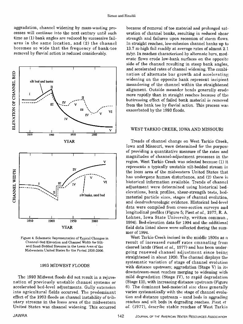
Sequences of channel evolution in the bess area ofthe midwestern United States are consistent in thatsimilar disturbances near the turn of the 20th centuryinitiated channel adjustment of entire fluvial sys-tems. Although sequences of channel evolution aresimilar throughout the region, distinct differences inthe amount of time required for streams to pass fromone stage to the next, to begin to exhibit signs ofrecovery (establishing woody-riparian vegetation, sta-bilizing streambanks, and a meandering low-flowthalweg), and to attain a new equilibrium conditionvary with the class of sediments comprising the chan-nel bed and banks. For example, the degradationStage (III) accounts for 10-15 years in the sand-bed-ded streams of West Tennessee but about 70 years inthe silt-bedded streams of western Iowa. Rather thandifferentiate on the basis of geographical location,time-based differences in sequences of channel evolu-tion channel are conceptualized on the basis of bound-ary sediments. Figure 4 is a schematic representationof changes in bed elevation and channel width withthe associated stage of channel evolution for bess-area streams composed of different bed-material sedi-ments for the period 1850-2000. Note that sand-bedstreams filled with deposited sediments during the1930s through the 1950s necessitating redredgingand the clearing and snagging of downstream reach-es. This additional channel work rejuvenated trunkand tributary streams, causing the sequence of chan-nel evolution to begin again (Figure 4).
The sequence of channel evolution is less compli-cated for the silt-bedded streams of western Iowa andthose smaller tributary streams of the region that cutonly into bess sediments. In these cases, deep inci-sion along trunk and tributary streams resulting fromthe initial channel work near the turn of the 20th cen-tury rapidly created bank heights in excess of the crit-ical conditions of the material, causing a long periodof bank instability and channel widening (Figure 4).Without significant reductions in bank heights by
JOURNAL OF THE AMERICAN WATER RESOURCES ASSOCIATION 141 JAWRA
Simon and Rinaldi
aggradation, channel widening by mass-wasting pro-cesses will continue into the next century until suchtime as (1) bank angles are reduced by successive fail-ures in the same location, and (2) the channelbecomes so wide that the frequency of bank-toeremoval by fluvial action is reduced considerably.
1993 MIDWEST FLOODS
The 1993 Midwest floods did not result in a rejuve-nation of previously unstable channel systems oraccelerated bed-level adjustments. Gully extensioninto agricultural fields occurred. The predominanteffect of the 1993 floods on channel instability of trib-utary streams in the bess area of the midwesternUnited States was channel widening. This occurred
because of removal of toe material and prolonged saturation of channel banks, resulting in reduced shearstrength and failures upon recession of storm flows.In straight reaches, low-cohesion channel banks up to13.7 m-high fail readily at average rates of almost 2.1mlyr. In reaches characterized by alternate bars, mod-erate flows erode low-bank surfaces on the oppositeside of the channel resulting in steep bank angles,and accelerated rates of channel widening. The combi-nation of alternate bar growth and acceleratingwidening on the opposite bank represent incipientmeandering of the channel within the straightenedalignment. Outside meander bends generally erodemore rapidly than in straight reaches because of thebuttressing effect of failed bank material is removedfrom the bank toe by fluvial action. This process waMexacerbated by the 1993 floods.
WEST TARKIO CREEK, IOWA ANDMISSOURI
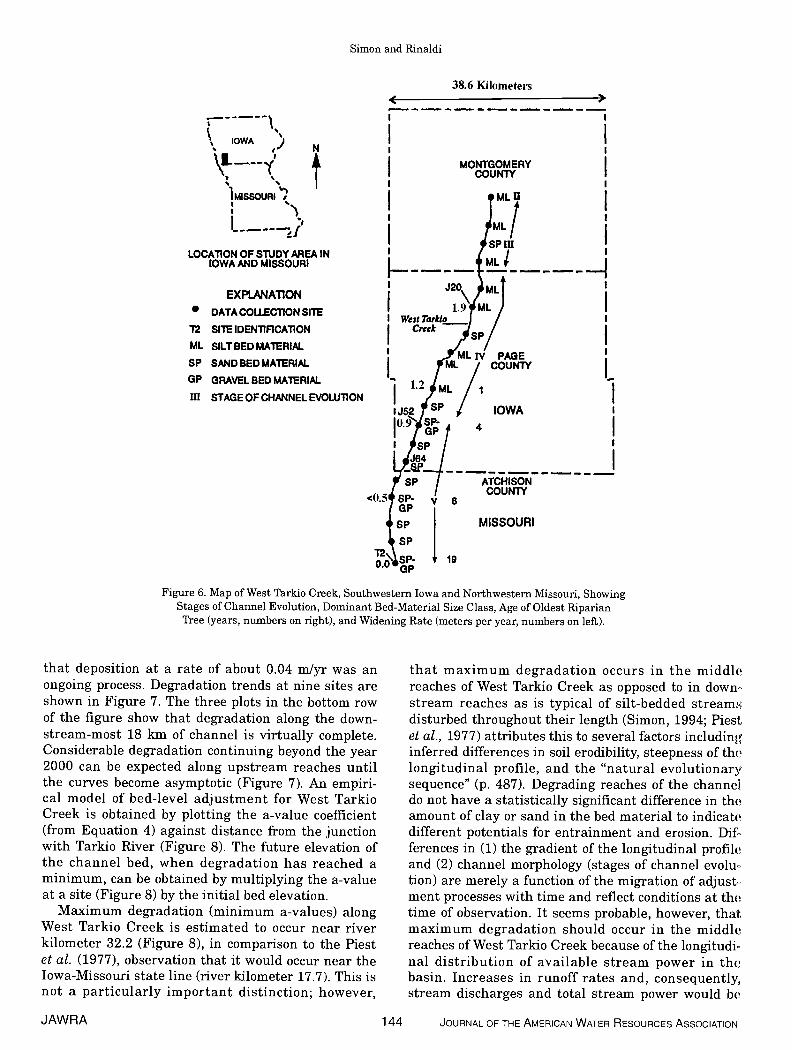
Trends of channel change on West Tarkio Creek,Iowa and Missouri, were determined for the purposeof providing a quantitative measure of the rates andmagnitudes of channel-adjustment processes in theregion. West Tarkio Creek was selected because (1) itrepresents a typically unstable silt-bedded stream inthe bess area of the midwestern United States thathas undergone human disturbance, and (2) there iihistorical information available. Trends of channeladjustment were determined using historical bedelevations, bank profiles, shear-strength tests, bed..material particle sizes, stages of channel evolution,and dendrochronologic evidence. Historical bed-leveldata were compiled from cross-section surveys andlongitudinal profiles (Figure 5; Piest et al., 1977; R. A.Lohnes, Iowa State University, written commun.,1994). Bed-elevation data for 1994 and the additionalfield data listed above were collected during the sum-mer of 1994.
West Tarkio Creek incised in the middle 1800s as aresult of increased runoff rates emanating fromcleared lands (Piest et al., 1977) and has been under-going renewed channel adjustment since beingstraightened in about 1920. The channel displays thesystematic variation of stage of channel evolutionwith distance upstream; aggradation (Stage V) in itMdownstream-most reaches merging to widening withmild degradation (Stage IV), to rapid degradation(Stage III), with increasing distance upstream (Figure6). The dominant bed-material size class generallyvaries systematically with the stage of channel evolu-tion and distance upstream — sand beds in aggradingreaches and silt beds in degrading reaches. Piest etal. (1977), describe stable reaches of West Tarkio
I I
VI
1850 1900 1950 2000
YEAR
V
YEAR
2000
Figure 4. Schematic Representation of Typical Changes inChannel-Bed Elevation and Channel Width for Silt-and Sand-Bedded Streams in the Loess Area of the
Midwestern United States for the Period 1850-2000.
JAWRA 142 JOURNAL OF THE AMERICAN WATER RESOURCES ASSOCIATION
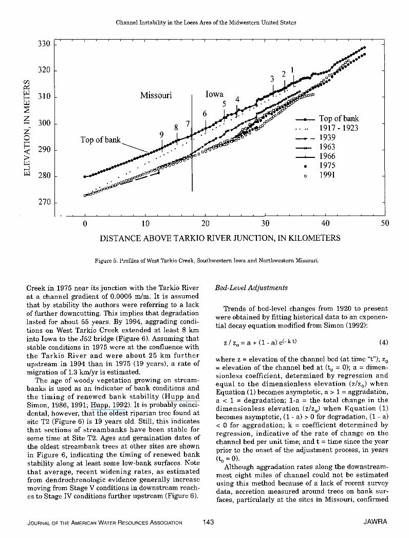
H
Creek in 1975 near its junction with the Tarkio Riverat a channel gradient of 0.0006 mlm. It is assumedthat by stability the authors were referring to a lackof further downcutting. This implies that degradationlasted for about 55 years. By 1994, aggrading condi-tions on West Tarkio Creek extended at least 8 kminto Iowa to the J52 bridge (Figure 6). Assuming thatstable conditions in 1975 were at the confluence withthe Tarkio River and were about 25 km furtherupstream in 1994 than in 1975 (19 years), a rate ofmigration of 1.3 kmlyr is estimated.
The age of woody vegetation growing on stream-banks is used as an indicator of bank conditions andthe timing of renewed bank stability (Hupp andSimon, 1986, 1991; Hupp, 1992). It is probably coinci-dental, however, that the oldest riparian tree found atsite T2 (Figure 6) is 19 years old. Still, this indicatesthat sections of streambanks have been stable forsome time at Site T2. Ages and germination dates ofthe oldest streambank trees at other sites are shownin Figure 6, indicating the timing of renewed bankstability along at least some low-bank surfaces. Notethat average, recent widening rates, as estimatedfrom dendrochronologic evidence generally increasemoving from Stage V conditions in downstream reach-es to Stage IV conditions further upstream (Figure 6).
Bed-Level Adjustments
Trends of bed-level changes from 1920 to presentwere obtained by fitting historical data to an exponen-tial decay equation modified from Simon (1992):
z/ z0 = a + (1- a)e(-kt) (4)
where z = elevation of the channel bed (at time "t"); z0= elevation of the channel bed at (t0 = 0); a = dimen-sionless coefficient, determined by regression andequal to the dimensionless elevation (z/z0) whenEquation (1) becomes asymptotic, a> 1 = aggradation,a < 1 = degradation; 1-a = the total change in thedimensionless elevation (z/z0) when Equation (1)becomes asymptotic, (1 - a) > 0 for degradation, (1 - a)< 0 for aggradation; k = coefficient determined byregression, indicative of the rate of change on thechannel bed per unit time; and t = time since the yearprior to the onset of the adjustment process, in years(t0 = 0).
Although aggradation rates along the downstream-most eight miles of channel could not be estimatedusing this method because of a lack of recent surveydata, accretion measured around trees on bank sur-faces, particularly at the sites in Missouri, confirmed
JOURNAL OF THE AMERICAN WATER RESOURCES ASSOCIATION 143 JAWRA
Channel Instability in the Loess Area of the Midwestern United States
330
320
310
300
290
280
270
Missouri Iowa
3
Top ofbank
8-
S
0
Top of bank1917 - 192319391963196619751991
100 20 30
DISTANCE ABOVE TARKIO RIVER JUNCTION, IN KILOMETERS
Figure 5. Profiles of West Tarkio Creek, Southwestern Iowa and Northwestern Missouri.
40 50
Simon and Rinaldi
[--—-'SIOWA )
'1 MISSOURI'?
LOCA11ON OF STUDY AREA INIOWA AND MISSOURI
EXPLANATION
DATA COL.LEC11ON SITE
12 SITE IDENTIFiCATION
ML SILTBED MATERIAL.
SP SAND BED MATERIAL
GP GRAVEL BED MATERIAL
III STAGE OF CHANNEL EVOLU11ON
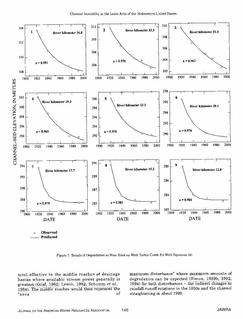
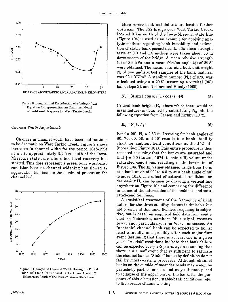
that deposition at a rate of about 0.04 mlyr was anongoing process. Degradation trends at nine sites areshown in Figure 7. The three plots in the bottom rowof the figure show that degradation along the down-stream-most 18 km of channel is virtually complete.Considerable degradation continuing beyond the year2000 can be expected along upstream reaches untilthe curves become asymptotic (Figure 7). An empiri-cal model of bed-level adjustment for West TarkioCreek is obtained by plotting the a-value coefficient(from Equation 4) against distance from the junctionwith Tarkio River (Figure 8). The future elevation ofthe channel bed, when degradation has reached aminimum, can be obtained by multiplying the a-valueat a site (Figure 8) by the initial bed elevation.
Maximum degradation (minimum a-values) alongWest Tarkio Creek is estimated to occur near riverkilometer 32.2 (Figure 8), in comparison to the Piestet al. (1977), observation that it would occur near theIowa-Missouri state line (river kilometer 17.7). This isnot a particularly important distinction; however,
38.6 Kilometers
I I
I I
L
MISSOURI
that maximum degradation occurs in the middlereaches of West Tarkio Creek as opposed to in downstream reaches as is typical of silt-bedded streamsdisturbed throughout their length (Simon, 1994; Piestet al., 1977) attributes this to several factors includinginferred differences in soil erodibility, steepness of thelongitudinal profile, and the "natural evolutionarysequence" (p. 487). Degrading reaches of the channeldo not have a statistically significant difference in theamount of clay or sand in the bed material to indicatedifferent potentials for entrainment and erosion. Differences in (1) the gradient of the longitudinal profileand (2) channel morphology (stages of channel evolu..tion) are merely a function of the migration of adjust-ment processes with time and reflect conditions at thetime of observation. It seems probable, however, thatmaximum degradation should occur in the middlereaches of West Tarkio Creek because of the 1ongitudinal distribution of available stream power in thebasin. Increases in runoff rates and, consequently,stream discharges and total stream power would be
MONTGOMERYCOUNTY
IOWA4
PAGECOUNTY
I
ATCHISONCOUNTY
GP19
Figure 6. Map of West Tarkio Creek, Southwestern Iowa and Northwestern Missouri, ShowingStages of Channel Evolution, Dominant Bed-Material Size Class, Age of Oldest RiparianTree (years, numbers on right), and Widening Rate (meters per year, numbers on left).
JAWRA 144 JOURNAL OF THE AMERICAN WATER RESOURCES ASSOCIATION
Channel Instability in the Loess Area of the Midwestern United States
o ObservedPredicted
2821940 1960 1980 2000 1900
DATE
most effective in the middle reaches of drainagebasins where available stream power generally isgreatest (Graf, 1982; Lewin, 1982; Schumm et al.,1984). The middle reaches would then represent the"area of
maximum disturbance" where maximum amounts ofdegradation can be expected (Simon, 1989b, 1992,1994) for both disturbances — the indirect changes torainfall-runoff relations in the 1850s and the channelstraightening in about 1920.
JOURNAL OF THE AMERICAN WATER RESOURCES ASSOCIATION 145 JAWRA
1
I I I—314
312
310 -
River kilometer 34.8
310 -3
a0.98l
River kilometer 31.4
308 -
306 -
I I I
a0.976 304 - a0.962
River kilometer 25.3
I I II —
C,)
H
z0H>
River kilometer 23.2
a0.965
312 —2 River kilometer 33.3
310 -
308 - -
306 - —
I I I
1900 1920 1940 1960 1980 2000
300—5 -
298 - -
296 - -
294 - —
a = 0.970292 -
I I I I
1900 1920 1940 1960 1980 2000
291I
River kilometer 15.3
289 -
287 -
285 -
I I
River kilometer 20.1
308 -
1900 1920 1940 1960 1980 2000
I I I
302 —
300 - -
298 - -
296 - -
294 - -
1900 1920 1940 1960 1980 2000
294 - 7
292
290 -
288
286 I I
1900 1920 1940 1960 1980 2000
DATE
a'0.976
302 -I
1900 1920 1940 1960 1980 2000
298I
6296 - —
294 - -
292 -
290 - -
1900 1920 1940 1960 1980 2000
288 - 9
286 -
284
River kilometer 17.7
8
a0.981a = 0.979
River kilometer 12.8
I I
1900
a = 0.984
I I I I I
1920
Figure 7. Trends of Degradation at Nine Sites on West Tarkio Creek Fit With Equation (4).
1920 1940 1960 1980 2000
DATE
Simon and Rinaldi
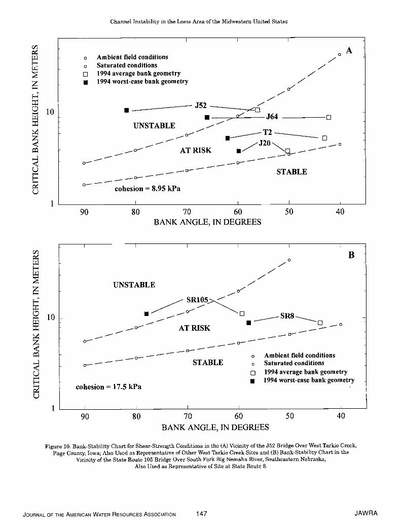
More severe bank instabilities are located furtherupstream. The J52 bridge over West Tarkio Creek,located 8 km north of the Iowa-Missouri state line(Figure lOa) is used as an example for applying ana-lytic methods regarding bank instability and estima-tion of stable bank geometries. In-situ shear-strengthtests at 0.9 and 1.5 rn-deep were taken about 50 rndownstream of the bridge. A mean cohesive strength(c) of 8.9 kPa and a mean friction angle (4)) of 29.8°were obtained. The mean, saturated bulk unit weight(y) of two undisturbed samples of the bank materialwas 22.1 kN/rn2. A stability number (N) of 6.90 wascalculated using 4) = 29.8°, assuming a vertical (90°)bank slope (i), and (Lohnes and Handy (1968):
N=(4sinicos4))/[1-cos(i-4))J (5)
Critical bank height (He, above which there would bemass failure) is obtained by substituting N into thefollowing equation from Carson and Kirkby (1972):
H=N5(c/y) (6)Channel-Width Adjustments
Changes in channel width have been and continueto be dramatic on West Tarkio Creek. Figure 9 showsincreases in channel width for the period 1845-1994at a site approximately 3.2 km south of the Iowa-Missouri state line where bed-level recovery hasstarted. This does represent a present-day worst-casecondition because channel widening has slowed asaggradation has become the dominant process on thechannel bed.
9
1.00
0.99
0.98
0.97
0.96
0.95
8
62
5
10 15 20 25 30 35
DISTANCE ABOVE TARKIO RIVER JUNCTION, IN KILOMETERS
Figure 8. Longitudinal Distribution of a-Values (fromEquation 4) Representing an Empirical Modelof Bed-Level Response for West Tarkio Creek.
cID
I-1.L
I-
(-)
40
35
30
25
20
15
10
5
0
For i = 90°, H = 2.85 m. Iterating for bank angles of80, 70, 60, 50, and 40° results in a bank-stabilitychart for ambient field conditions at the J52 site(upper line; Figure lOa). This entire procedure is thenrepeated assuming that the banks are saturated andthat 4) = 0.0 (Lutton, 1974) to obtain H values undersaturated conditions, resulting in the lower line ofFigure lOa. The Hc values obtained range from 1.6 mat a bank angle of 90° to 4.5 m at a bank angle of 40°(Figure lOa). The effect of saturated conditions ondecreasing H can be seen by drawing a vertical lineanywhere on Figure lOa and comparing the difference
_____________________________________________ in values at the intersection of the ambient- and satu-rated-condition lines.
A statistical treatment of the frequency of bankfailure for the three stability classes is desirable butnot possible at this time. Relative frequency is subjec-tive, but is based on empirical field data from south-eastern Nebraska, northern Mississippi, westernIowa, and, particularly, from West Tennessee. An"unstable" channel bank can be expected to fail atleast annually, and possibly after each major flowevent (assuming that there is at least one in a givenyear). "At-risk" conditions indicate that bank failurecan be expected every 2-5 years, again assuming thatthere is a runoff event that is sufficient to saturate
1825 1850 1875 1900 1925 1950 1975 2000 the channel banks. "Stable" banks by definition do notYEAR fail by mass-wasting processes. Although channel
banks on the outside of meander bends may widen byparticle-by-particle erosion and may ultimately leadto collapse of the upper part of the bank, for the pur-poses of this discussion, stable-bank conditions referto the absence of mass wasting.
Figure 9. Changes in Channel Width During the Period1845-1994 for a Site on West Tarkio Creek About 3.2Kilometers South of the Iowa-Missouri State Line.
JAWRA 146 JOURNAL OF THE AMERICAN WATER RESOURCES ASSOCIATION
Channel Instability in the Loess Area of the Midwestern United States
liD Aa Ambient field conditions
H o Saturated conditionso 1994 average bank geometry• 1994 worst-case bank geometry 0'
H
10 ____________ J52 -0J64 o
UNSTABLE
• T2
—J2OAT RISK •- — —
— — 0STABLE
1
90
=85 kPa
60 50 40BANK ANGLE, IN DEGREES
liD - BH
UNSTABLE -— SR1O5><
• SR810 •AT RISK ..— —
— — — 0-- — 0 — —
— —— — —° —a Ambient field conditions
— — — STABLE o Saturated conditions
C.) o 1994 average bank geometry- • 1994 worst-case bank geometry
cohesion = 17.5 kPaC-)
1 I I I I I
90 80 70 60 50 40BANK ANGLE, IN DEGREES
Figure 10. Bank-Stability Chart for Shear-Strength Conditions in the (A) Vicinity of the J52 Bridge Over West Tarkio Creek,Page County, Iowa; Also Used as Representative of Other West Tarkio Creek Sites and (B) Bank-Stability Chart in the
Vicinity of the State Route 105 Bridge Over South Fork Big Nemaha River, Southeastern Nebraska;Also Used as Representative of Site at State Route 8.
JOURNAL OF THE AMERICAN WATER RESOURCES ASSOCIATION 147 JAWRA
Simon and Rinaldi
Using the slope angles of the vertical face andupper bank to obtain an average bank angle of 62°,and using a surveyed bank height of 10.7 m (verticaldistance from bank top to thaiweg), channel banks atJ52 plot between the at-risk and unstable zones, Fig-ure lOa). If the angle of the "vertical face" (81°) isused to represent worst-case conditions with banktoes eroded, the banks are clearly unstable, evenwhen relatively dry. This is probably an unrealisticscenario, but it provides the end-member stabilitycase for unstable banks. Because the shear-strengthcharacteristics at the J52 site are similar to averagevalues obtained in studies of western Iowa (Lohnesand Handy, 1968) and West Tennessee (Simon, 1989c;Simon and Hupp, 1992), it seems reasonable to usethe bank-stability chart (Figure lOa) to approximatestability conditions at other sites on West TarkioCreek. Average and worst-case bank geometries areplotted for several other sites on West Tarkio Creek toshow current (1994) bank-stability relations.
Shear strength and bank-geometry data for twosites on the South Fork Big Nemaha River (SFBN),southeastern Nebraska, are provided in Figure lOb toshow the effects of greater cohesion on critical bankheight. Note that at a bank angle of 90°, H at satu-rated conditions for the SFBN is greater than for acomparable bank slope under ambient field conditionsfor West Tarkio Creek. The cohesive strength of 17.5kPa for the SFBN banks (almost two times greaterthan for West Tarkio Creek) is largely responsible forthe maintenance of stable banks at greater bankheights. The range of cohesive strengths tested insitu in southeastern Nebraska is from 15.7 to 41.3kPa, considerably higher than values obtained inWest Tennessee (Simon, 1989c; Simon and Hupp,1992) or in western Iowa (Lohnes and Handy, 1968),and supports the observation made earlier that thesoutheastern Nebraska channels maintain some ofthe highest banks in the region.
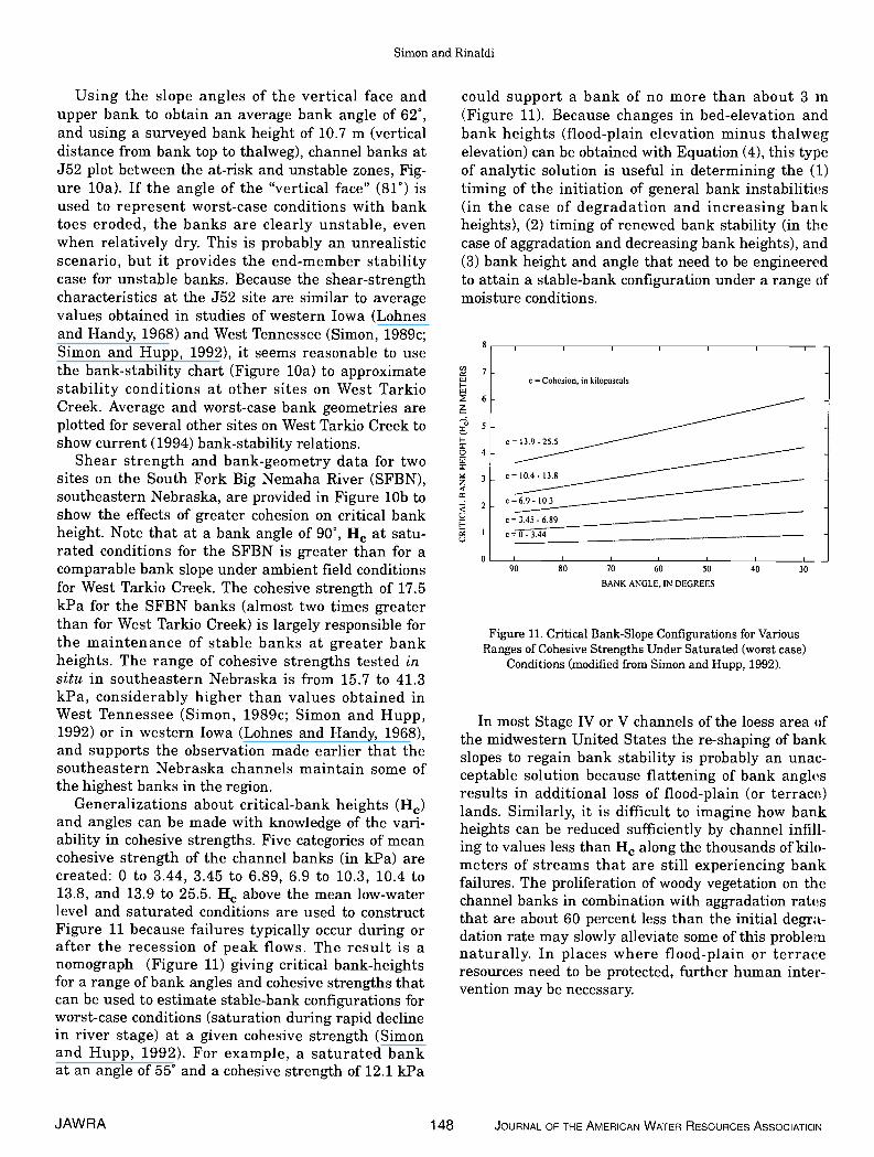
Generalizations about critical-bank heights (He)and angles can be made with knowledge of the vari-ability in cohesive strengths. Five categories of meancohesive strength of the channel banks (in kPa) arecreated: 0 to 3.44, 3.45 to 6.89, 6.9 to 10.3, 10.4 to13.8, and 13.9 to 25.5. H above the mean low-waterlevel and saturated conditions are used to constructFigure 11 because failures typically occur during orafter the recession of peak flows. The result is anomograph (Figure 11) giving critical bank-heightsfor a range of bank angles and cohesive strengths thatcan be used to estimate stable-bank configurations forworst-case conditions (saturation during rapid declinein river stage) at a given cohesive strength (Simonand Hupp, 1992). For example, a saturated bankat an angle of 55° and a cohesive strength of 12.1 kPa
could support a bank of no more than about 3 in(Figure 11). Because changes in bed-elevation andbank heights (flood-plain elevation minus thalwegelevation) can be obtained with Equation (4), this typeof analytic solution is useful in determining the (1)timing of the initiation of general bank instabilities(in the case of degradation and increasing bankheights), (2) timing of renewed bank stability (in thecase of aggradation and decreasing bank heights), and(3) bank height and angle that need to be engineeredto attain a stable-bank configuration under a range ofmoisture conditions.
S I -
Figure 11. Critical Bank-Slope Configurations for VariousRanges of Cohesive Strengths Under Saturated (worst case)
Conditions (modified from Simon and Rupp, 1992).
In most Stage IV or V channels of the bess area ofthe midwestern United States the re-shaping of bankslopes to regain bank stability is probably an unac-ceptable solution because flattening of bank anglesresults in additional loss of flood-plain (or terrace)lands. Similarly, it is difficult to imagine how bankheights can be reduced sufficiently by channel infihl-ing to values less than H along the thousands of kilo-meters of streams that are still experiencing bankfailures. The proliferation of woody vegetation on thechannel banks in combination with aggradation ratesthat are about 60 percent less than the initial degra-dation rate may slowly alleviate some of this problemnaturally. In places where flood-plain or terraceresources need to be protected, further human inter-vention may be necessary.
JAWRA 148 JOURNAL OF THE AMERICAN WATER RESOURCES ASSOCIATION
U,
I11-
z
F-z0
-L)F-
C.)
7
6
5
4
3
2
0
Cohesion, in kilopascalsc25.= 104- 13.8
=6.9 - 10,3c=6.8—c=0- 3.44
90 80 70 60 50 40 30
BANK ANGLE, IN DEGREES
Channel Instability in the Loess Area of the Midwestern United States
SUMMARY AND CONCLUSIONS
The bess area of the midwestern United Statescontains thousands of miles of unstable streams, pre-dominantly responding to human modificationsimposed near the turn of the 20th century. The domi-nant process appears to be channel widening andmeander extension by mass failure. The most severe,widespread instabilities are in western Iowa where athick bess cap and a limited supply of coarse-grainedmaterial (sand and gravel) restricts bed-level recoveryby aggradation. Here relatively high streambankscombine with low cohesive strengths to sustain chan-nel widening. Channel adjustments in West Ten-nessee and southeastern Nebraska are not as severeas in western Iowa. In general, channels in west-cen-tral Illinois and east-central Iowa appear to be closerto recovery than in other parts of the region.
Degradation rates for streams draining the besshills of western Iowa and eastern Nebraska havedecreased nonlinearly since 1920, approaching mini-mal values. In some downstream reaches, sandyalternate bars and fluvially deposited sand on low-bank surfaces indicate the beginning of bed-levelrecovery and the "aggradation" stage of channel evo-lution. This "natural" recovery process, which oftenoccurs in other unstable stream systems following 10-15 years of degradation, was apparently delayed foran additional 55 years along some reaches in the bessarea because of the lack of hydraulically-controlled(sand- or gravel-sized) source material. Finer-grainedsilts from eroding beds and banks were easily trans-ported through tributary systems to the MissouriRiver. With bess thickness generally decreasing withdistance upstream and with the degradation processmigrating upstream with time, incision through thebess ultimately resulted in the exposure of coarser-grained glacial till. These deposits, thus, provided thecoarse material necessary for downstream aggrada-tion and the initial phase of channel recovery.
ACKNOWLEDGMENTS
The authors wish to express their sincere gratitude to RoyTrent, Federal Highway Administration, for sponsoring this workand for taking the time to join us in the field to see these channelsfirst hand; to Gregg Hadish, Golden Hills Resource Conservationand Development, for assistance in organizing field operations,sharing data and ideas, and for assistance in the field; to RobertLohnes, Iowa State University, for insightful discussion and forsharing his wealth of experience in the bess area; to StephenDarby, Agricultural Research Service, for field assistance; and toCliff Hupp, U.S. Geological Survey, for assistance with collectingdendrochronologic information on West Tarkio Creek. The secondauthor thanks Professor Paolo Canuti, Universita degli Studi diFirenze, for making funds available for him to participate in this
research. Finally, the authors are indebted to the pilots of thesingle-engine aircraft who safely flew reconnaissance for us fromthe Council Bluffs, Iowa, and Moline, Illinois, airports.
LITERATURE CITED
Antosch, L. and J. Joens, 1979. Iowa's Lowhead Dams: Their Past,Present and Future Roles. Iowa State Water ResourcesResearch Institute, No. 96, Special Report.
Ashley, G. H., 1910. Drainage Problems in Tennessee. TennesseeState Geological Survey Bulletin 3-A, pp. 1-15.
Baumel, C. P., 1994. Impact of Degrading Western Iowa Streams onPrivate and Public Infrastructure Costs. In: Stream Stabiliza-tion in Western Iowa, G. A. Hadish (Editor). Iowa DOT HR-352,Golden Hills Resource Conservation and Development, Oak-land, Iowa, pp. 4-1 to 4-39.
Brice, J. C., 1966. Erosion and Deposition in the Loess MantledGreat Plains, Medicine Creek Drainage Basin, Nebraska. U.S.Geological Survey Professional Paper 352-H, pp. 255-339.
Bryan, B. A., A. Simon, G. S. Outlaw, and Randy Thomas, 1995.Methodology for Assessing Channel Conditions at Bridges inTennessee Related to Scour Critical Conditions. U.S. GeologicalSurvey Water-Resources Investigations Report, 94-4229, 54 pp.
Bull, W. B., 1979. Threshold of Critical Power in Streams. Geologi-cal Society of America Bulletin 90:453-464.
Carson, M. A. and M. J. Kirkby, 1972. Hillslope Form and Process.Cambridge University Press, Oxford, U.K., 475 pp.
Daniels, R. B., 1960. Entrenchment of the Willow Drainage Ditch,Harrison County, Iowa. American Journal of Science 258: 161-176.
Davis, W. M., 1902. Baselevel, Grade, and Peneplain. Journal ofGeology 10:77-111.
Elliott, J. G., 1979. Evolution of Large Arroyos, the Rio Puerco ofNew Mexico. Colorado State University, Fort Collins, Colorado,Master of Science Thesis, 106 pp.
Emerson, J. W., 1971. Channelization: A Case Study. Science172:325-326.
Graf, W. L., 1982. Spatial Variations in Fluvial Processes in Semi-Arid Lands. In: Space and Time in Geomorphology, C. E. Thorn(Editor). Publications in Geomorphology, 12, State University ofNew York at Binghamton, Binghamton, New York, pp. 193-2 17.
Hadish, G. A., 1994. Stream Stabilization in Western Iowa. IowaDOT HR-352, Golden Hills Resource Conservation and Develop-ment, Oakland, Iowa, 198 pp.
Hidinger, L. L. and A. E. Morgan, 1912. Drainage Problems of theWolf, Hatchie, and South Fork Forked Deer Rivers in West Ten-nessee. In: The Resources of Tennessee, Tennessee GeologicalSurvey 2(6):231-249.
Hupp, C. R., 1992. Riparian Vegetation Recovery Patterns Follow-ing Stream Channelization: A Geomorphic Perspective. Ecology73:1209-1226.
Hupp, C. R. and A. Simon, 1991. Bank Accretion and the Develop-ment of Vegetated Depositional Surfaces Along Modified Allu-vial Channels. Geomorphobogy 4:111-124.
Hupp, C. R. and A. Simon, 1986. Vegetation and Bank-Slope Devel-opment. Proceedings of the Fourth Federal Interagency Sedi-mentation Conference, Las Vegas, Nevada, Vol. 2, pp. 5-83 to5-92.
Ireland, H. A., C. F. S. Sharpe, and D. H. Eargle, 1939. Principles ofGully Erosion in the Piedmont of South Carolina. U.S. Depart-ment of Agriculture Technical Bulletin 633, 142 pp.
Keller, E. A., 1972. Development of Alluvial Stream Channels: AFive-Stage Model. Geological Society of America Bulletin 83:153 1-1536.
JOURNAL OF THE AMERICAN WATER RESOURCES ASSOCIATION 149 JAWRA
Simon and Rinaldi
Lane, E. W., 1955. The Importance of Fluvial Morphology inHydraulic Engineering. Proceedings, American Society of CivilEngineers 81(795):1-17.
Lewin, J., 1982. British Floodplains. In: Papers in Earth Studies,B. H. Aidman, C. R. Fenn, and L. Morris (Editors). GeoBooks,Norwich,Connecticut, pp. 21-37.
Little W. C. and J. B. Murphey, 1981. Evaluation of StreambankErosion Control Demonstration Projects in the BlufflineStreams of Northwest Mississippi. Appendix A, Stream StabilityReport to Vicksburg District. U.S. Army Corps of Engineers,AD-A101-386, National Technical Information Service, 342 pp.
Lohnes, R. A. and R. L. Handy, 1968. Slope Angles in Friable Loess.Journal of Geology 76(3):247-258.
Lohnes, R. A., F. W. Klaiber, and M. D. Dougal, 1980. AlternateMethods of Stabilizing Degrading Stream Channels in WesternIowa. Iowa DOT HR-208, Department of Civil Engineering,Engineering Research Institute, Iowa State University, Ames,Iowa, 132 pp.
Luttenegger, A. J., 1987. In Situ Shear Strength of Friable Loess.In: Loess and Environment, M. Pesci (Editor). Catena Supple-ment9:27-34.
Lutton, R. J., 1974. Use of Loess Soil for Modeling Rock Mechanics.U.S. Army Corps of Engineers Waterways Experiment StationReports S-74-28, Vicksburg, Mississippi.
Mackin, J. H., 1948. Concept of a Graded River. Geological Societyof America Bulletin 59:463-511.
Moore, C. T., 1917. Drainage Districts in Southeastern Nebraska.In: Miscellaneous Papers, E. H. Barbour (Editor). NebraskaGeological Survey, Vol. 7, part 17, pp. 125-164.
Morgan, A. E. and S. H. McCrory, 1910. Drainage of the LandsOverflowed by the North and Middle Forks of the Forked DeerRiver, and the Rutherford Fork Obion River in Gibson County,Tennessee. Tennessee State Geological Survey Bulletin 3-B, pp.17-43.
Piest, R. F., L. S. Elliott, and R. G. Spomer, 1977. Erosion of theTarkio Drainage System, 1845-1976. Transactions, AmericanSociety of Agricultural Engineers 20:485-488.
Piest, R. F., C. E. Beer, and R. G. Spomer, 1976. Entrenchment ofDrainage Systems in Western Iowa and Northwestern Missouri.Proceedings, Third Federal Inter-agency Sedimentation Confer-ence, pp. 5-48 to 5-60.
Robbins, C. H. and A. Simon, 1983. Man-Induced Channel Adjust-ment of Tennessee Streams. U.S. Geological Survey Water-Resources Investigations Report 82-4098, 129 pp.
Ruhe,, R. V. and R. B. Daniels, 1965. Landscape Erosion-Geologicand Historic. Journal of Soil and Water Conservation 20:52-57.
Schumm, S. A. and R. F. Hadley, 1957. Arroyos and the SemiaridCycle of Erosion. American Journal of Science 225:161-174.
Schumm, S. A., M. D. Harvey, and C. C. Watson, 1984. IncisedChannels, Morphology, Dynamics and Control. Water ResourcesPublications, Littleton, Colorado, 200 pp.
Simon, A., 1994. Gradation Processes and Channel Evolution inModified West Tennessee Streams: Process, Response, andForm. U.S. Geological Survey Professional Paper 1470, 84 pp.
Simon, A., 1992. Energy, Time, and Channel Evolution in Catas-trophically Disturbed Fluvial Systems. In: Geomorphic Systems,J. D. Phillips and W. H. Renwick (Editors). Geomorphology5:345-372.
Simon, A., 1989a. The Discharge of Sediment in Channelized Allu-vial Streams. Water Resources Bulletin 25(6):1177-1188.
Simon, A., 1989b. A Model of Channel Response in Disturbed Allu-vial Channels. Earth Surface Processes and Landforms 14:11-26.
Simon, A., 1989c. Shear-Strength Determination and Stream-BankInstability in Loess-Derived Alluvium, West Tennessee, USA.In: Applied Quaternary Research, E. J. DeMulder and B. lHageman (Editors). A.A. Balkema Publishers, Rotterdam, TheNetherlands, pp. 129-146.
Simon, A. and C. R. Hupp, 1992. Geomorphic and Vegetative Recov.ery Processes Along Modified Stream Channels of West Ten-nessee. U.S. Geological Survey Open-File Report 91-502, 142 pp.
Simon, A. and C. R. Hupp, 1986. Channel Evolution in ModifiedTennessee Channels. Proceedings, Fourth Federal InteragencySedimentation Conference, Las Vegas, Nevada, March 24-27,1986, Vol. 2, pp. 5-71 to 5-82.
Speer, P. R., W. J. Perry, J. A. McCabe, 0. G. Lara et al., 1965. LowFlow Characteristics of Streams in the Mississippi Embaymentin Tennessee, Kentucky, and Illinois, With a Section on Qualityof Water, by H. G. Jeffery. U.S. Geological Survey ProfessionalPaper 448-H, 36 pp.
Thorne, C. R., 1989. Effects of Vegetation on Riverbank Erosion andStability. In: Vegetation and Erosion, J. B. Thornes (Editor).John Wiley and Sons, Chichester, England, pp. 125-144.
Thorne, C. R., J. B. Murphey, and W. C. Little, 1981. Stream Chan.nel Stability, Appendix D, Bank Stability and Bank MaterialProperties in the Bluffline Streams of Northwest Mississippi:Oxford, Mississippi. U.S. Department of Agriculture Sedimenta.tion Laboratory, 257 pp.
Turnbull, W. J., 1948. Utility of Loess as a Construction Material.International Conference on Soil Mechanics and FoundatiotiEngineering, 2nd, Rotterdam, Proceedings, Vol. 5, Section 4d,pp. 97-103.
Turnipseed, D. P. and K. V. Wilson, Jr., 1992. Channel and BankStability of Standing Pine Creek at State Highway 488 NearFreeny, Leake County, Mississippi. U.S. Geological SurveyOpen-File Report 92-112, 18 pp.
U.S. Army Corps of Engineers, 1995. Southeast Nebraska Stream-bank Erosion and Streambed Degradation Study, Omaha Die..trict.
U.S. Army Corps of Engineers, 1907. Index Map of the South Forkof Forked Deer River, Tennessee, from Jackson to the Mouth.Nashville, Tennessee State Archives, scale 1:48,000, 1 sheet.
Vidal, H., 1969. The Principle of Reinforced Earth. HighwayResearch Record, Vol. 282, pp. 1-16.
Williams, G. P. and M. G. Wolman, 1984. Downstream Effects ofDams on Alluvial Rivers. U.S. Geological Survey ProfessionalPaper 1286, 83 pp.
Wilson, K. V., 1979. Changes in Channel Characteristics, 1935-1974, of the Homochitto River and Tributaries, Mississippi. U.S.Geological Survey Open-File Report 79-554, 18 pp.
Wilson, K. V., Jr. and D. P. Turnipseed, 1994. Geomorphic Respom:eto Channel Modifications of Skuna River at the State Highway 0Crossing at Bruce, Calhoun County, Mississippi. U.S. GeologicalSurvey Water-Resources Investigations Report, 94-4000, 43 pp.
Wilson, K. V., Jr. and D. P. Turnipseed, 1993. Channel-Bed andChannel-Bank Stability of Standing Pine Creek Tributary atState Highway 488 at Free Trade, Leake County, Mississippi.U.S. Geological Survey Open-File Report 93-37, 20 pp.
JAWRA 150 JOURNAL OF THE AMERICAN WATER RESOURCES ASSOCIATION