TECHNICAL RE PORT - ncmrwf
55
UMRider – A Parallel Post Processing Utility for Unified Model Arulalan T. June 2020 TECHNICAL REPORT NMRF/TR/04/2020 National Centre for Medium Range Weather Forecasting Ministry of Earth Sciences, Government of India A-50, Sector-62, NOIDA-201 309, INDIA
-
Upload
khangminh22 -
Category
Documents
-
view
0 -
download
0
Transcript of TECHNICAL RE PORT - ncmrwf

UMRider – A Parallel Post Processing Utility for
Unified Model
Arulalan T.
June 2020
TE
CH
NIC
AL
RE
PO
RT
NMRF/TR/04/2020
National Centre for Medium Range Weather Forecasting
Ministry of Earth Sciences, Government of India
A-50, Sector-62, NOIDA-201 309, INDIA

I
UMRider – A Parallel Post Processing Utility for
Unified Model
Arulalan T.
June 2020
National Centre for Medium Range Weather Forecasting
Ministry of Earth Sciences
A-50, Sector 62, NOIDA-201309, INDIA

II
Ministry of Earth Sciences
National Centre for Medium Range Weather Forecasting
Document Control Data Sheet
1 Name of the Institute National Centre for Medium Range Weather Forecasting
2 Document Number NMRF/TR/04/2020 3 Date of publication June 2020 4 Title of the document UMRider – A Parallel Post Processing Utility for Unified Model
5 Type of Document Technical Report
6 No. of pages & Figures 51 & 12
7 Number of References 8
8 Author (s) Arulalan T.
9 Originating Unit NCMRWF
10 Abstract Under the Unified Model (UM) Partnership, NCMRWF has been
continuously evolving towards a seamless Numerical Weather Prediction
(NWP) modelling strategy and is routinely operating different configurations
of the NCMRWF Unified Model (NCUM): Global Model (12 km), Global-
Ensemble (12 km) for next ten days forecast, and Regional model (4 km, 1.5
km, and 330 m), Regional-Ensemble (4 km) for three days forecast along
with ocean and atmospheric data assimilation systems. The UM dumps the
forecast outputs in the proprietary file format PP-format (Post Processing
Format) or FF-format (Field Files Format), developed by UKMO to increase
the rate of writing speed of model data to disk - highly essential to maintain
real-time forecast delivery time to the forecasters. However, it is required to
convert the model outputs to GRIB, and NetCDF formats (which are
standardized (open to the public) by the World Meteorological Organization
(WMO) and the University Corporation for Atmospheric Research (UCAR),
respectively) for easy visualisation and data manipulation. Keeping in mind
the internal users who find it challenging to deal with the UM fields file
format for various operational and research-oriented tasks, a parallel post-
processing utility, namely UMRider has been developed at NCMRWF.
UMRider has been created to post-process the NCUM forecast outputs to
open standard file formats (GRIB2 or NetCDF4) at the required spatial and
temporal resolution for distribution to research use and other applications. It
is written in the Python programming language, aimed to post-process the
Unified Model outputs in parallel computing to minimize the processing time
which is essential for the NWP centres. UMRider will be beneficial to all the
UM partners. This report is a user guide to the UMRider utility, its
operational applications, modules usage, and its web graphical user interface
named ‘UMRiderGUI’. This utility enables the users to generate the UM
output files in GRIB2 format (optionally GRIB1, or netCDF4) for use in other
user applications and mesoscale models.
11 Security classification Non-Secure 12 Distribution Unrestricted Distribution
13 Key Words UMRider, UMRiderGUI, PostProcess, NCUM-G, NEPS-G, NCUM-R,
Grib2, Grib1, netCDF4

III
Contents
Topic Page No.
Abstract 1
1. Introduction 2
1.1. NCMRWF’s Unified Modelling Systems 2
1.1.1. Global Deterministic Unified Model (NCUM-G) 2
1.1.2. Global Ensemble Prediction System (NEPS-G) 2
1.1.3. Regional Unified Model (NCUM-R) 3
1.2. NWP File Formats 3
1.2.1. PP/FF Format 3
1.2.2. NETCDF Format 4
1.2.3. GRIB Format 5
1.3. High Performance Computing Systems (Bhaskara and Mihir) 5
2. UMRider – A Parallel Post Processing Utility 5
2.1. Introduction 5
2.2. Operational Applications 9
2.2.1. NCUM-G Global Deterministic Model Post Processed Products 9
2.2.2. NCUM-R Regional Deterministic Model Post Processed Products 12
2.2.3. NEPS-G Global Ensemble Model Post Processed Products 14
2.2.4. NCUM-G Global Hindcast Post Processed Products 15
2.2.5. IMDAA Regional Reanalysis Post Processed Products 15
2.3. Configurations and Options 15
2.3.1. Installation 15
2.3.2. UMRider Setup Configuration 16
2.3.3. UMRider Vars Configuration 24
2.4. Executions in HPCS 26
2.4.1. bsub jobs – IBM – Bhaskara 26
2.4.2. qsub jobs – CRAY – Mihir 27
2.5. UMRiderGUI – A Web Interface 29
3. UMRider Utilities Usage 37
4. Acknowledgments 40
5. References 41
Appendix
A. UMRider – Source Code Structure, Access, Future Releases and License 42
B. NCUM STASH and Grib2 Param Codes 46
C. NCUM Grib2 Local Table 50

1
Abstract
Under the Unified Model (UM) Partnership, NCMRWF has been continuously evolving towards a seamless
Numerical Weather Prediction (NWP) modelling strategy and is routinely operating different configurations
of the NCMRWF Unified Model (NCUM): Global Model (12 km), Global-Ensemble (12 km) for next ten
days forecasts, and Regional model (4 km, 1.5 km, and 330 m), Regional-Ensemble (4 km) for three days
forecasts along with ocean and atmospheric data assimilation systems. The UM dumps the forecast outputs
in the proprietary file format PP-format (Post Processing Format) or FF-format (Field Files Format),
developed by UKMO to increase the rate of writing speed of model data to disk - highly essential to maintain
real-time forecast delivery time to the forecasters. However, it is required to convert the model outputs to
GRIB, and NetCDF formats (which are standardized (open to the public) by the World Meteorological
Organization (WMO) and the University Corporation for Atmospheric Research (UCAR), respectively) for
easy visualisation and data manipulation. Keeping in mind the internal users who find it challenging to deal
with the UM fields file format for various operational and research-oriented tasks, a parallel post-processing
utility, namely UMRider has been developed at NCMRWF. UMRider has been created to post-process the
NCUM forecast outputs to open standard file formats (GRIB2 or NetCDF4) at the required spatial and
temporal resolution for distribution to research use and other applications. It is written in the Python
programming language, aimed to post-process the Unified Model outputs in parallel computing to minimize
the processing time which is essential for the NWP centres. UMRider will be beneficial to all the UM
partners. This report is a user guide to the UMRider utility, its operational applications, modules usage, and
its web graphical user interface named ‘UMRiderGUI’. This utility enables the users to generate the UM
output files in GRIB2 format (optionally GRIB1, or netCDF4) for use in other user applications and
mesoscale models.

2
1. Introduction
1.1 NCMRWF’s Unified Modelling Systems
Modern day weather forecasting is carried out through Numerical Weather Predictions (NWP) by the
application of computer models that describe the way the atmosphere evolves using a set of governing
equations. NCMRWF uses state of the art global and regional NWP models to predict weather 10 days in
advance.
The concept of a Unified Modelling system for seamless prediction of weather and climate has gained
importance and acceptance during the last decade, after its first demonstration by the Met Office, UK.
NCMRWF is using the latest version of the Unified Model (UM v10.8 deterministic as NCUM-G and
ensemble as NEPS-G) at a global horizontal resolution of ~12 km and 80 levels in the vertical and the
associated 4D-Var data assimilation system for real-time weather prediction. Additionally, the regional
model (NCUM-R) over the Indian subcontinent at 4 km and sub-regional scale at 1.5 km and 330 m
horizontal resolutions and 80 vertical levels have also been implemented at NCMRWF. An experimental
Regional Ensemble Prediction System (NEPS-R) at 4 km resolution has been implemented for case studies.
All four types of UM at NCMRWF (NCUM-G, NEPS-G, NCUM-R and NEPS-R) are being post-processed
(convert the model output to grib2 file format) operationally by using UMRider utility, which is an in-house
development. This utility’s scripts are written in the parallel Python programming language, released under
the open-source GNU v3 license.
1.1.1 Global Deterministic Unified Model (NCUM-G)
Under UM Partnership, NCMRWF is running the Unified Model (NCUM) operationally, the source codes
of which are available on Met Office Shared Repository Service. This seamless prediction system is used
for medium range numerical weather prediction at NCMRWF. The NCUM-G global system was upgraded
in May 2018 with the latest UM (version 10.8), with an improved model horizontal resolution of 12 km and
science settings of Global Atmosphere (GA6.1). The Observation Processing System, Hybrid 4D-Var data
assimilation system, Surface data assimilation/preparation system, Unified Model, and in-house developed
Observation Pre-Processing System are the major components of the NCUM system (Sumit Kumar et al.,
2018). This end-to-end global numerical weather prediction system routinely produces 10-day forecasts
based on 00 and 12 UTC initial conditions, and the model outputs are post-processed to 1-hourly, 3-hourly,
6-hourly, 24-hourly grib2 files using the UMRider utility.
1.1.2 Global Ensemble Prediction System (NEPS-G)
The NCMRWF global Ensemble Prediction System (NEPS-G) was upgraded to 12 km resolution and made
operational from 1st June 2018 for the generation of 10-day forecasts at 00 and 12 UTC (Ashu Mamgain et

3
al., 2018). The NEPS-G global model configuration is based on the recent version UM10.8 of the UK Met
Office Global and Regional Ensemble Prediction System (MOGREPS). The Ensemble Transform Kalman
Filter (ETKF) method is used to create the initial condition perturbations. The forecast perturbations obtained
from 6 hour short forecasts of 11 ensemble members at 00 and 12 UTC are updated by ETKF four times a
day at 00, 06, 12, and 18 UTC. The model uncertainties are estimated by the Stochastic Kinetic Energy
Backscatter (SKEB) and Random Parameters (RP) schemes. Surface parameters like sea surface
temperature, soil moisture content, and soil temperature are also perturbed in the initial condition to remove
the deficiency of lack of ensemble spread near the surface. 10-day probabilistic forecasts are issued daily
using 23 ensemble members (1 control + 22 perturbed) as grib2 files, which is generated by UMRider post-
process utility (Paromita Chakraborty et al., 2019). The NCUM-G deterministic forecasts at both 00 and 12
UTC are considered as control. One set of 11 perturbed members run from 00 UTC of the current day, and
another set of 11 perturbed members run from 12 UTC of the previous day to form 22 perturbed ensemble
members by merging with proper forecast valid time at 6-hourly grib2 files.
1.1.3 Regional Unified Model (NCUM-R)
NCMRWF high resolution regional convective scale Unified Model with latest version UM10.6, with
Regional Atmospheric version 1 Tropical science settings (RA1-T), generates1-hourly forecasts up to next
three days at 4 km spatial resolution, operationally. This model uses explicit convection and produces better
diurnal cycle of rainfall (Jayakumar et al., 2016 and 2017). UMRider is used to post process of NCUM-R
model outputs by converting the spatial grid from rotated to regular, along with time processing in the output
grib2 files.
1.2 NWP File Formats
Several file formats (such as pp/ff, netcdf, grib, hdf, binary, bufr, ascii, etc.) are being used to store the
meteorological data in Numerical Weather Prediction (NWP) model outputs. Among those formats,
UMRider aimed to support reading pp/ff, netcdf, grib1, grib2 formats, and to write in grib2 and netcdf
formats, and to convert grib2 to grib1 via cnvgrib external tool. These three file formats details are discussed
in this section.
1.2.2 PP/FF Format
The PP-format (Post Processing Format) and FF-format (Fields File Format) are proprietary file formats for
meteorological data developed by the Met Office, UK. Simulations of the weather are performed by the Met
Office's Unified Model, which can be used for various weather and climate related applications. This data is
usually meteorology-specific in nature and may include averaged data for parameters like global surface
temperatures or accumulations of rainfall at latitude-longitude locations. However, the Unified Model is
capable of generating many sophisticated user-specified diagnostics to FF-format. These files are binary

4
streams, structured in a proprietary file format that can then be processed and transformed into other, more
portable formats like PP format. The main reason for using such a format is to increase the rate at which data
can be written from the model to disk, a significant consideration when running a simulation that must be
timely and efficient.
1.2.3 NetCDF Format
NetCDF (Network Common Data Form) is a set of software libraries and self-describing, machine-
independent data formats that support the creation, access, and sharing of array-oriented scientific data. This
NetCDF project is hosted as an open standard file format by the Unidata Program at the University
Corporation for Atmospheric Research (UCAR). The NetCDF Classic and 64-bit Offset Format are an
international standard of the Open Geospatial Consortium.
The NetCDF project started in 1989 and is still actively supported by UCAR. The original NetCDF binary
format (released in 1997, now known as "NetCDF classic format") is still widely used across the world and
continues to be fully supported in all NetCDF releases. Version 4.0 (released in 2008) allowed the use of the
HDF5 data file format. Version 4.1 (2010) added support for C, FORTRAN, Python client access to specified
subsets of remote data via OPeNDAP. Version 4.3.0 (2012) added a CMake build system for Windows
builds. Version 4.7.0 (2019) added support for reading Amazon S3 objects. Further, UCAR has plans to
release the next versions to improve performance, add features, and fix bugs.
1.2.4 GRIB Format
GRIB (GRIdded Binary or General Regularly-distributed Information in Binary form) is a concise data
format (as an open standard) commonly used in meteorology to store weather and climate forecast data. The
World Meteorological Organization's Commission standardizes it for Basic Systems, known under number
GRIB FM 92-IX, described in WMO Manual on Codes No.306. Currently, there are three versions of GRIB.
Version 0 was used to a limited extent by projects such as TOGA and is no longer in operational use. The
first edition (grib1, released 1994) is used operationally worldwide by most meteorological centres to store
Numerical Weather Prediction (NWP) outputs. A newer generation (grib2, published 2003) has been
introduced, known as GRIB second edition, and many operational NWP centres (NCEP, ECMWF,
NCMRWF, etc.,) have adopted to this format, for distribution of data to the user community.

5
1.3 High Performance Computing Systems (Bhaskara and Mihir)
There are two high-performance computing system (HPCS) available at NCMRWF, namely, Bhaskara and
Mihir that are used for its operational NWP routine works.
Bhaskara (IBM)
NCMRWF high performance computing (HPC) system named, “Bhaskara” is a 350 TFLOPS IBM
iDataPlex Cluster, configured with 16 cores of intel Sandybridge processors clocking at 2.6 GHz, with 64
GB DDR3 1600MH2 RAM per Compute node, was commissioned in June 2015. Bhaskara has 1052
compute nodes and each compute node contains a dual port FDR embedded Infiniband adapter for inter-
processor Message Parsing Interface (MPI) Communication. Platform Load Sharing Facility (LSF) is a
workload management platform, job scheduler for distributed HPC environments.
Mihir (Cray)
The latest supercomputer at NCMRWF, named “MIHIR,” is a Cray-XC40 LC [Liquid Cooled] System with
2320 nodes running Intel Xeon Broadwell E5-26952695 v4 2.1GHz 18C CPU processors with a peak
performance of 2,806 TFLOPS and a total system memory of 290TB. Besides, the system consists of 12
Intel KNL 7210 accelerator nodes with 96 GB DDR4, gives a peak performance of 31.92 TFLOPS and a
total memory of 1.1TB. The entire system operates on Cray's customized Linux OS, called Cray Linux
Environment. Also, it has many parallel libraries like OpenMP, MPI, libsci, Intel Cluster software, etc. The
system uses Portable Batch System (PBS) Pro as Workload Manager. Total usable archival space is 16.86PB,
configured by the Parallel File System Lustre. The eight utility nodes are dedicated to pre and post data
process jobs of HPC users. This HPCS was commissioned in January 2018.
2. UMRider – A Parallel Post Processing Utility
2.1 Introduction
UMRider is a parallel post-processing utility written in python open-source scientific modern programming
language; the utility is created as in-house development at NCMRWF for the conversion of the Unified
Model (UM) with Global, Ensemble, Regional specific outputs from fields file (ff) or post-processed (pp)
file formats to grib2 or grib1 or NetCDF file format, built based on ‘Iris’ python library (Iris is a powerful,
format-agnostic, community-driven Python library for analysing and visualising Earth science data).
Through Storage Handling and Diagnostic System (STASH- Spatial and Temporal Averaging and Storage
Handling) code of Unified Model and climate forecast standard name (cf_standard_name) of meteorological
variable, it extracts and converts to the WMO-NCEP standard grib2 by setting correct Parameter Code
(Discipline, Category, Number, type Of First Fixed Surface) and followed by creation Grads Control File by
using g2ctl.pl scripts. Additionally, it has the option to convert the model outputs to grib1 and NetCDF file

6
formats. This utility is named as “UMRider” to indicate that the scripts are aimed to post-process the unified
model outputs in parallel computing to minimize the processing time.
A customised Unified Model (v7.7) with a 4D var data assimilation and forecast was implemented at
NCMRWF (Rajagopal et al., 2012) during 2012 to predict the weather over global and regional (Indian
subcontinent) scales. The model outputs were visualized by another utility called ‘xconv’ and sliced, or
regridded by a script named ‘subset.ctl’. However, for archival and data exchanges to the external users and
agencies, there is an operational requirement to convert the model outputs from fields file into a standard
data format like ‘GRIB’ or CF standard ‘NetCDF’. Additionally there is a requirement of GRIB formatted
data for feeding into other applications and mesoscale models. Met Office provided UM utilities to convert
the model output in files format to pp format and for basic functionalities. Mohandas (2014) customised it
as per the need of NCMRWF operational usage and developed a UM to grib1 conversion utility named as
‘umfld2grib.sh’.
During 2015, the global UM at NCMRWF was upgraded to version 10.6 with 17 km horizontal resolution
which required additional computing resources. At that same time Grib version 2 became popular among
many atmospheric and oceanic model applications, which forced us to think for an alternate solution to
convert the model outputs to grib2 standard with maximum speed by utilizing parallel processors of the
available High Performance Computing System (HPCS). UK Met Office developed a Python library named
‘Iris,’ which handles the UM model fields file outputs for visualization, regridding, store into pp, grib2,
netcdf formats and under ‘SciTools’ multi-project repositories which is a collaborative place to produce
powerful Python-based open-source tools for Earth scientists. The utility ‘umfld2grib.sh’ (Mohandas, 2014)
to post-process UM outputs was replaced by the UMRider after its initial development in 2016. Since then,
it has been used for all significant post-processing operational applications (more than 20 different jobs, see
section 2.2) at NCMRWF. The NCMRWF’s Unified Model (NCUM) outputs are being post post-processed
by UMRider, which handles customised Spatio-temporal resolution, interpolation, regridding, processing of
rotated grid and hybrid level coordinates, and storing into grib2 format. UMRider produces the NCUM post-
processed grib2 files operationally, which are being used by many other atmospheric-oceanic research and
operational institutes (both national and international) such as IMD, INCOIS, SAC-ISRO, IITM, Navy,
NIWE, GSI, UK Met Office etc., and the THORPEX Interactive Grand Global Ensemble (TIGGE) project
hosted at ECMWF.
NCUM-G Global Deterministic model produce the following analysis/6-hours short forecasts files namely,
qwqg00.pp0, umglca_pb, umglca_pd, umglca_pe, umglca_pf, umglca_pi and long forecast files up to
forecast lead time of 240 hours, namely, umglaa_pb???, umglaa_pd???, umglaa_pe???, umglca_pf???,
umglca_pi???, where ‘???’ replaces corresponding 24 hourly time intervals like 024, 048, ..., 240. (These
file names are specific to NCMRWF’s operational runs and can be different for other UM partner

7
organizations). All the long forecast files contain either twenty-four 1-hourly data or eight 3-hourly data.
UMRider supports to create either 1-hourly or 3-hourly or 6-hourly (either 6th hour instantaneous or
average/accumulation of two 3-hourly data or six 1-hourly data) or 24-hourly (either 24th hour instantaneous
or average/accumulation of eight 3-hourly data/twenty-four 1-hourly data) grib2 files. Similarly, UM
regional and ensemble model has been configured to produce meteorological parameters in many different
output units (file names) of their long forecast. Users will be able to create 1-hourly, 3-hourly, 6-hourly, 24-
hourly,and at various spatial resolutions post-processed grib2 files of NCUM-G, NEPS-G, NCUM-R models
by controlling UMRider utility via customizing two configuration text files (setup.cfg and vars.cfg).
For example, if UMRider has been configured for 6-hourly grib2 files, then
It creates four analysis 6-hourly files (at 00, 06, 12, 18 UTC cycles)
It creates 40 forecast 6-hourly files (000, 006, 012, ..., 234, 240 during 00 and 12 UTC cycles)
Finally, it creates ctl, idx files for all 44 grib2 files by using g2ctl.pl
Also, all 44 grib2 files variables are in the same order (defined by the user)
Users can install the UMRider in any Linux based operating system (see section 2.3.1), and they are allowed
to control the UMRider by modifying two configuration text files namely setup.cfg, and vars.cfg. In the
current version of UMRider (v3.1.1), users can manage the following 38 arguments of utility by creating
and editing setup.cfg file and followed by export the setup.cfg file path into their shell environment variable
called UMRIDER_SETUP.
The options available in setup.cfg are listed below:
1. startdate or UMRIDER_STARTDATE
2. enddate or UMRIDER_ENDDATE
3. UMtype
4. UMInAnlFiles
5. UMInShortFcstFiles
6. UMInLongFcstFiles
7. inPath
8. outPath
9. tmpPath
10. anl_step_hour
11. anl_aavars_reference_time
12. anl_aavars_time_bounds
13. fcst_step_hour
14. start_long_fcst_hour
15. end_long_fcst_hour_at_00z
16. end_long_fcst_hour_at_12z
17. latitude
18. longitude
19. targetGridResolution
20. targetGridFile
21. extraPolateMethod
22. pressureLevels
23. fillFullyMaskedVars

8
24. soilFirstSecondFixedSurfaceUnit
25. loadg2utils
26. overwriteFiles
27. anlOutGrib2FilesNameStructure
28. fcstOutGrib2FilesNameStructure
29. createCtlIdxFiles
30. convertGrib2FilestoGrib1Files
31. grib1FilesNameSuffix
32. removeGrib2FilesAfterGrib1FilesCreated
33. createGrib1CtlIdxFiles
34. debug
35. setGrib2TableParameters
36. wgrib2Arguments
37. wgrib2netcdf
38. callBackScript
The detailed description of the above 38 options are discussed in section 2.3.2. There is another environment
variable named UMRIDER_VARS, which lets the user to control the variables of their choice by changing
vars.cfg configuration text file, which is discussed in detail in section 2.3.3. This vars.cfg configure file is
used for um2grib2 conversion of only needed NCUM (NCUM-G, NEPS-G, NCUM-R) models output
variables. User-defined variables and order of variables will be retained in the output Grib2 files (but
pressure level variables comes first followed by non-pressure level variables), same as vars.cfg configuration
file. Furthermore, the users will be able to control the variables and frequency of output as 1-hourly, or 3-
hourly, or 6-hourly, or 24-hourly forecast Grib2 or Grib1 or NetCDF files.
As mentioned in section 1.3, there are two HPCS named Bhaskara (IBM) and Mihir (Cray) machines at
NCMRWF, which uses BSUB (see section 2.4.1) and QSUB (see section 2.4.2) method for submitting
UMRider jobs into compute nodes. The NCMRWF’s Grib2 files, all of which follow the WMO-NCEP
standard Grib2 param codes to match with the STASH codes of variables (see Appendix – B), but few of
the variables of NCUM do not have param codes in the existing WMO-NCEP standard table. So UMRider
had to create an NCMRWF’s local table (see Appendix – C) to assign Grib2 local param codes to those
missing variables in the NCEP Grib2 table, which also assigned the centre code as 29 (belongs to Delhi,
India also pointing to NCMRWF, India).
Due to the increasing number of customization in operational jobs, it became necessary to make 38 options
in UMRider, which also encouraged to make platform independent web browser based graphical user
interface named as UMRiderGUI (discussed detailed in section 2.5), to make an easy interface to create and
edit the setup.cfg (section 2.3.2) and vars.cfg (section 2.3.3), BSUB bash scripts (section 2.4.1) and also
submit the UMRider jobs to the compute nodes. Finally, section 3 explains the UMRider utility usage
(python library for the developers) and also discusses the Source Code Structure, Access, Future Releases
and License in Appendix – A.

9
2.2 Operational Applications
UMRider v1.0.0 was implemented as its first operational post process utility for Unified Model v10.6
(Global at 17 km, Ensemble at 33 km, Regional at 4 km) in Bhaskara HPCS during Dec 2015, During
January 2016 to June 2018, UMRider was developed further as per clients need, bug fixes, improved parallel
operational performance and released up to 13 versions. In early 2018, NCMRWF procured new Cray HPCS,
named as Mihir and moved all operational numerical weather model analysis and forecast applications with
upgraded and highest horizontal resolution (0.12x0.18) for global model, and other models. Subsequently,
UMRider v3.1.1 was implemented as an operational post processing utility of analysis and forecast outputs
of Unified Model v10.8 (Global at 12 km, Ensemble at 12 km, Regional at 4km, 1.5 km, and 330 m) in Mihir
HPCS and Regional Reanalysis at 12 km in Bhaskara HPCS. The list of operational post processing jobs on
Mihir HPCS and their purposes are given below.
2.2.1 NCUM-G Global Deterministic Model Post Processed Products
Using the global deterministic model outputs, there are several post processed jobs that are being run
operationally. To run the several different products, we do not require to duplicate the source code
individually. Instead we can keep UMRider script at common location path in server, and make individual
setup files dedicated for the respective jobs.
Common Script Path: /home/umfcst/smallapps/UMRider/UMRRun/
2.2.1.1 Global Post Processed Products
The NCUM-G global deterministic model’s post processed outputs produces at 0.12x0.18 and 0.5x0.5
resolutions -grib2 files at 6-hourly time interval forecasts from 6 to 240 hour based on both 00 and 12 UTC
initial condition along with analysis files for every day. Post processed output contains 72 variables
generated from model outputs.
1) Resolution: 0.12x0.18
Setup path: /home/umfcst/smallapps/UMRider/UMRRun/qsubScripts/ncum_global_post
Output path: /home/umfcst/NCUM_output/post
2) Resolution: 0.5x0.5
Setup path: /home/umfcst/smallapps/UMRider/UMRRun/qsubScripts/ncum_global_post_0p5
Output path: /scratch/umfcst/NCUM_output/post_0.5/
2.2.1.2 Indian Region Post Processed Products
The Indian region is extracted from NCUM-G global deterministic model and is used to produce post
processed outputs at both 0.125 and 0.25 resolution grib2 files of 6-hourly forecast from 6 to 240 hour
and analysis files based on both 00 and 12 UTC initial conditions for every day. This product is used by

10
India Meteorological Department (IMD) and SASE, Chandigarh to run their WRF models. It has 72 post
processed variables generated from model outputs.
1) Resolution: 0.125x 0.125
Setup path: /home/umfcst/smallapps/UMRider/UMRRun/qsubScripts/ncum_india_reg_from_global/0p125
Output path: /home/umfcst/ShortJobs/IndRegion/0p125
2) Resolution: 0.25x0.25
Setup path: /home/umfcst/smallapps/UMRider/UMRRun/qsubScripts/ncum_india_reg_from_global/0p25
Output path: /home/umfcst/ShortJobs/IndRegion/0p25.
2.2.1.3 OSF Model Input Products
Ocean State Forecast (OSF) systems at INCOIS, Hyderabad and Indian Navy uses NCUM-G global
deterministic model analysis and forecast outputs 6-hourly grib2 files as atmospheric initial conditions.
There are a total of 15 post processed variables generated from model outputs.
1) Resolution: 0.125x 0.125
Setup path: /home/umfcst/smallapps/UMRider/UMRRun/qsubScripts/ncum_global_osf_input/0p125
Output path: /home/umfcst/ShortJobs/OSF/0p125/
2) Resolution: 0.25x 0.25
Setup path: /home/umfcst/smallapps/UMRider/UMRRun/qsubScripts/ncum_global_osf_input/0p25
Output path: /home/umfcst/ShortJobs/OSF/0p25/
3) Resolution: 0.5x 0.5 (Grib1)
Setup path: /home/umfcst/smallapps/UMRider/UMRRun/qsubScripts/ncum_global_osf_input/0p5
Output path: /home/umfcst/ShortJobs/OSF/0p5/
2.2.1.4 HYCOM Model Input Products
The HYbrid Coordinate Ocean Model (HYCOM) operational at INCOIS, Hyderabad uses NCUM-G global
deterministic model analysis and forecast outputs (3-hourly grib2 files) as atmospheric initial conditions. A
total of 8 post processed variables are generated from model outputs.
Resolution: 0.125x 0.125
Setup path: /home/umfcst/smallapps/UMRider/UMRRun/qsubScripts/ncum_global_hycom_input
Output path: /home/umfcst/ShortJobs/Hycom/0p25/
2.2.1.5 HYSPLIT Trajectory Model Input Products
The Hybrid Single Particle Lagrangian Integrated Trajectory Model (HYSPLIT) operational at NCMRWF
uses NCUM-G global deterministic model analysis and forecast outputs (6-hourly grib1 files) as atmospheric
input. A total of 13 post processed variables are generated from model outputs.
Resolution: 0.5x 0.5 (Grib1)

11
Setup path: /home/umfcst/smallapps/UMRider/UMRRun/qsubScripts/ncum_global_hysplit_input
Output path: /home/umfcst/ShortJobs/NCUM_HYSPLIT/0p5/
2.2.1.6 IMD-MFI Model Input Products
The Indian Meteorological Department (IMD) uses the Synergy system from Toulouse-based French
company Meteo France International (MFI), which uses NCUM-G global deterministic model analysis, and
forecast outputs (6-hourly grib2 files) along with other model products. A total of 72 post processed variables
are generated from model outputs.
Resolution: 0.5x 0.5
Setup path: /home/umfcst/smallapps/UMRider/UMRRun/qsubScripts/ncum_global_imd_mfi_input
Output path: /home/umfcst/ShortJobs/IMD-MFI/0p5/
2.2.1.7 Solar Energy Input Products
The National Institute of Solar Energy uses NCUM-G global deterministic model analysis and forecast
outputs (1-hourly grib2 files) as atmospheric initial conditions to forecast solar energy power production.
There are 3 Post-processed generated from model outputs.
Resolution: 0.5x 0.5
Setup path: /home/umfcst/smallapps/UMRider/UMRRun/qsubScripts/ncum_global_solar_energy_input
Output path:/home/umfcst/ShortJobs/NCUM_SOLAR_ENERGY/0.25
2.2.1.8 Solar and Wind Energy Input Products
The National Institute of Wind Energy (NIWE) uses NCUM-G global deterministic model analysis and
forecast outputs (1-hourly grib2 files) as atmospheric initial conditions to forecast solar and wind renewable
energy power production. 14 Post processed variables are extracted from model outputs.
Resolution: 0.125x 0.125
Setup path: /home/umfcst/smallapps/UMRider/UMRRun/qsubScripts/ncum_global_solar_wind_energy_input
Output path: /home/umfcst/ShortJobs/NCUM_SOLAR_WIND_ENERGY/0.125
2.2.1.9 VSDB Input Products
At NCMRWF, the Verification Statistics Data Base (VSDB) is used to verify the multi global numerical
weather models forecast against its own analysis. In which one of the model inputs feed is from NCUM-G
global deterministic model analysis and forecast outputs (6-hourly grib1 files) at 3 different resolutions. Post
processed 6 variables from model outputs.
1) Resolution: 1.5x 1.5
Setup path: /home/umfcst/smallapps/UMRider/UMRRun/qsubScripts/ncum_global_vsdb_input/1p5x1p5
Output path: /home/umfcst/ShortJobs/VSDB_Input/1p5x1p5

12
2) Resolution: 1x 1
Setup path: /home/umfcst/smallapps/UMRider/UMRRun/qsubScripts/ncum_global_vsdb_input/1x1
Output path: /home/umfcst/ShortJobs/VSDB_Input/1x1
3) Resolution: 2.5x 2.5
Setup path: /home/umfcst/smallapps/UMRider/UMRRun/qsubScripts/ncum_global_vsdb_input/2p5
Output path: /home/umfcst/ShortJobs/VSDB_Input/2p5
2.2.1.10 Meteogram Input Products
A meteogram is a graphical presentation of one or more meteorological variables with respect to time,
whether observed or forecast, for a particular location. NCMRWF produces meteogram charts over all major
districts of India by using NCUM-G global deterministic model analysis and forecast outputs (1-hourly grib1
files). 8 Post processed variables are extracted for the district locations from model outputs.
Resolution: 0.125x 0.125
Setup path: /home/umfcst/ShortJobs/NCUM_Meteogram_Input/0.125/
Output path: /home/umfcst/smallapps/UMRider/UMRRun/qsubScripts/ncum_global_meteogram_input
2.2.1.11 Precipitation Forecast at 03-03 UTC Product
The Indian Meteorological Department (IMD) observes 24 hourly accumulated rainfall at many stations over
India by using rain gauges, and NCMRWF produces merged rainfall observed product by merging the
satellite and rain gauge observed rainfall. The NCUM-G global model provides forecast up to the next 10
days based on the initial conditions at 00 and 12Z. To verify the model forecast with observed rainfall, we
must compute a 24-hourly accumulated rainfall forecast valid at every 03 UTC for the next 10 days. i.e., 03-
27 forecast hours will be treated as Day-1 accumulated rainfall, and similarly, UMRider produces
accumulated rainfall valid at 03 UTC for all other days (Day-2 to Day-10)
Resolution: 0.125x 0.125
Setup path: /home/umfcst/smallapps/UMRider/UMRRun/qsubScripts/ncum_india_rain03Z
Output path: /home/umfcst/ShortJobs/IndRegion/NativeResolution/
2.2.2 NCUM-R Regional Deterministic Model Post Processed Products
Regional model forecast outputs are produced at rotated grids and UMRider converts it into regular grids
while doing post process. Under the regional deterministic model outputs there are several post processed
jobs are being run operationally at NCMRWF. To execute the different products, we do not require to
duplicate the source code individually. Instead we can keep UMRider script at common location path in
server, and make individual setup files dedicated for the respective jobs.
Common Script Path: /home/umfcst/smallapps/UMRider/UMRRun/

13
2.2.2.1 Regional Post Processed Products
The NCUM-R regional deterministic model post processed outputs produced at 0.04x0.04 (4km)
resolution as grib2 files over Indian with 1-hourly time interval forecast from 1 to 75 hour based on 00 UTC
initial condition along with analysis files for every day. Post processed 72 variables from model outputs.
1) Resolution: 0.04x0.04 (4 km)
Setup path: /home/umfcst/smallapps/UMRider/UMRRun/qsubScripts/ncum_regional_post
Output path: /home/umreg/4km_output/post/0.04/
2) Resolution: 0.015x0.015 (1.5 km)
Setup path: /home/umfcst/smallapps/UMRider/UMRRun/qsubScripts/ncum_regional_post/1p5km
3) Resolution: 0.0036x0.0036 (330 m)
Setup path: /home/umfcst/smallapps/UMRider/UMRRun/qsubScripts/ncum_regional_post/330m
Both 1.5 km and 330 m model runs only over specific sub regions of India (say over Delhi or Mumbai) and
only during severe weather conditions.
2.2.2.2 Regional Wind Energy Input Products
The National Institute of Wind Energy (NIWE) uses NCUM-R regional deterministic model analysis and
forecast outputs (1-hourly grib2 files) as atmospheric initial conditions to forecast solar and wind renewable
energy for electricity power production. Post processed 5 variables from model outputs.
Resolution: 0.04x0.04 (4 km)
Setup path: /home/umfcst/smallapps/UMRider/UMRRun/qsubScripts/ncum_regional_wind_energy_input
Output path: /home/umreg/ShortJobs/NCUMReg_WIND_ENERGY/0.04/
2.2.2.3 Lightning Prediction Product
IMD uses 1-hourly lightning variable grib2 files of the NCUM-R (4 km) model.
Resolution: 0.04x0.04 (4 km)
Setup path: /home/umfcst/smallapps/UMRider/UMRRun/qsubScripts/ncum_regional_lightning
Output path: /home/umreg/ShortJobs/NCUM_LIGHTNING
2.2.2.4 Regional Global Landslip Prediction Input Product
The Geological Survey of India (GSI) collaborated with UK Met Office, to do a project to predict the
landslides which uses 1-hourly precipitation files of NCUM-R (4 km) and NCUM-G (12 km) models over
two pilot regions (Darjeeling, Nilgiris) in India.
Setup path: /home/umfcst/smallapps/UMRider/UMRRun/qsubScripts/ncum_regional_global_landslip
Output path: /home/umreg/ShortJobs/NCUM_LANDSLIP/0.04,

14
/home/umreg/ShortJobs/NCUM_LANDSLIP/0.125
2.2.2.5 Hybrid Model Levels to Height AGL Conversion Products
NCUM-R regional model (4 km) on hybrid vertical levels needs to be converted to height above ground
level (metre unit). 7 variables are post processed from model outputs.
Setup path:
/home/umfcst/smallapps/UMRider/UMRRun/qsubScripts/ncum_regional_model_level_2_heights_above_ground
Output path: /home/umreg/ShortJobs/NCUMReg_MDL2Heights_AGL/0.04
2.2.3 NEPS-G Global Ensemble Model Post Processed Products
Under the ensemble model outputs there are several post processing jobs which are being run operationally
at NCMRWF. To execute the different products, we do not require to duplicate the source code individually.
Instead we can keep UMRider script at common location path in server and make individual setup files
dedicated for the respective jobs.
Common Script Path: /home/umeps/NEPS_PostProductions/ShortJobs/scripts/UMRider/UMRRun/
2.2.3.1 Global Ensemble Post Processed Products
The NEPS-G Global Ensemble model outputs are being converted to 6-hourly grib2 files with merged
members (current day’s 00 UTC 11 perturbed members and previous day’s 12 UTC 11 perturbed members)
along with deterministic model as control member. Finally, the grib2 files have 23 members at each 6-hourly
forecast up to 240 hours.
Resolution: 0.12x 0.18
Setup path:
/home/umeps/NEPS_PostProductions/ShortJobs/scripts/UMRider/UMRRun/qsubScripts/ncumeps_global_post
Output path: /home/umeps/NEPS_PostProductions/long_fcst/post
2.2.3.2 Global Ensemble TIGGE Products
The European Centre for Medium Range Weather Forecasts (ECMWF) hosts the THORPEX International
Grand Global Ensemble (TIGGE) project, which collects all the International NWP centres ensemble model
outputs and archives it for free public research use. NCMRWF is also contributing to the TIGGE project
since August 2017. The post-processing tool generates 1 control and 11 perturbed member grib2.gz files at
both 00 and 12 UTC daily.
Resolution: 0.12x 0.18
Setup path:
/home/umeps/NEPS_PostProductions/ShortJobs/scripts/UMRider/UMRRun/qsubScripts/ncumeps_global_tigge
Output path: /home/umeps/NEPS_PostProductions/ShortJobs/outputs/NCUM_EPS_TIGGE/TarFiles

15
2.2.4 NCUM-G Global Hindcast Post Processed Products
NCMRWF produced hindcast outputs by re-running the highest resolution (12 km) global NCUM-G (v10.8)
from 2015 to 2018. Using the post-processing tool, 1-hourly and 6-hourly reforecast grib2 files up to 240
hours are generated from model reforecast outputs. These hindcast data is used to generate model
climatology to identify the extreme events and bias correction of the current forecast model outputs.
Resolution: 0.12x 0.18
Setup path: /home/umhcst/smallapps/UMRider/UMRRun/qsubScripts/ncum_global_post
Output path: /home/umhcst/NCUM_output/post_0.12x0.18/
2.2.5 IMDAA Regional Reanalysis Post Processed Products
NCMRWF released India’s first high resolution (12km) regional reanalysis for the 40 year period (1979 to
2018). The 1-hourly grib2 files were generated from 00, 06, 12, and 18 UTC daily analysis. The IMDAA
project model outputs and its post-processed grib2 files were generated in the Bhaskara HPCS.
Resolution: 0.12x 0.12
Script path: /gpfs2/home/umdas/UMRider
Setup path: /gpfs2/home/umdas/imdaa_post
Bhaskara Output path: /gpfs5/home/imdaa/imdaa_Grib
Mihir Output path: /home/moum/IMDAA/imdaa_Grib/
Data Public Access Link: https://www.ncmrwf.gov.in/data/
2.3 Configurations and Options
2.3.1 Installation
The following softwares are pre-requisites for the installation of UMRider:
Linux OS
Python 2.7.9 and following libraries to be installed python environment
o iris 1.13.0
o numpy 1.14.0
o scipy 0.10
o cartopy 0.11.0
o biggus 0.14
o gdal 1.9.1
o grib-api 1.9.16
o scipy 0.10
o netcdf4-python 0.9.9
o cf_units 1.0
o udunits2 2.1.24
o mo_pack 0.1.0dev0
o shapely 1.2.14
o multiprocessing 0.70a1
o stratify 0.1
wgrib2 v2.0.7 (to compress and tweak grib2 files)

16
cnvgrib v1.4.1 (to convert grib2 to grib1)
g2ctl.pl v0.1.1 (to make grib2 control file)
grib2ctl.pl v0.9.13 (to make grib1 control file)
gribmapv2.1.1.b0 (comes with grads software, to make grib2 index file)
The above softwares are essential to run UMRider utility. User can download the latest version of UMRider
from https://github.com/NCMRWF/UMRider and extract it.
$ cd UMRider_version
$ sudo python setup.py build install
The above command will install the UMRider in global system Python environment. It requires sudo access,
if user does not have sudo or root permission, then execute below command to install at user level.
$ python setup.py build install --user
The above command will install the UMRider in local user Python environment, and not requires sudo or
root privilege. Also, user can execute the UMRider scripts without installing it in system python or user area
python environment.
The development of UMRider started in late 2015 and was operationalized by January 2016 at NCMRWF.
During that time Iris python library was supported by only python version 2.7, not 3 and above. So UMRider
is available only in python version 2.7 only and there are no requirements from the end user to upgrade to
python version 3.
For download and installation of Python-Iris and other required libraries visit the documentation link:
https://scitools.org.uk/iris/docs/v1.13.0/installing.html
Also, before installing Iris, one needs to download the source code of Python-Iris library from the above
link, also download modified Iris grib python scripts from this link, then copy into Python-Iris source path
https://github.com/NCMRWF/UMRider/tree/master/others/ncmrwfIRIS, and finally install the updated iris
library via “python setup.py build install” command.
2.3.2 UMRider Setup Configuration
Setup configure file: Used to setup indata path, outdata path, temporary path to run the um2grb2.py python
parallel scripts which will create analysis and forecast files.
NCUM-G GLOBAL MODEL POST PROCESSING SETUP CONFIGURE FILE
Filename: setup.cfg Comment Line: Line begins with # symbol HPCS: Mihir-CRAY
Author: Arulalan <[email protected]>Total Number of Options: 38

17
################UMRider -User Defined Frequent Change Arguments Begins #################
1. startdate - By default startdate takes argument as YYYYMMDD (which means it assume today's date).
But user can specify the different startdate by following the same format.
For e.g., if startdate = 20151209 then it will execute the scripts for 09 December 2015,
If startdate = YYYYMMDD, then it will execute the scripts for today's date.
Note: However, UMRIDER_STARTDATE environment variable will override this startdate option.
startdate= YYYYMMDD
2. enddate - By default enddate is None. User can specify different enddate (but >startdate) i.e., for only
specified date/one date, user needs to control only in the startdate and enddate must be None. If user
want to execute the um2grb2.py conversion for the range of dates, then user need to set the lower
startdate end higher enddate. An enddate could be even YYYYMMDD, but make sure that startdate is
lower than enddate.
For e.g., startdate = 20151209 and enddate = 20160114, then um2grb2.py conversion program executes
from 09-Dec-2015 to 14-Jan-2016.
Note: However, UMRIDER_ENDDATE environment variable will override this enddate option.
enddate = None
################ UMRider - User Defined Frequent Change Arguments End ##################
############ UMRider - User Defined One Time Setup Configuration Options Begin ############
3. UMtype - UM model type takes either 'global' or 'regional' or 'ensemble'. By default it takes 'global' as
argument.
UMtype = global
4. UMInAnlFiles - takes list of absolute filenames which has correct analysis fieldsfile/pp file of UM model
valid at 00UTC. None option will take hardcoded proper infile names.
UMInAnlFiles = ['qwqg00.pp0']
5. UMInShortFcstFiles - takes list of partial filenames which has short forecast (kind of analysis)
fieldsfile/pp files of UM model produced at 00, 06, 12 and 18 UTC. None option will take hardcoded
proper infile names.
UMInShortFcstFiles = ['umglc.pp0', 'umglca_pb', 'umglca_pd', 'umglca_pe', 'umglca_pf',
'umglca_pi']
6. UMInLongFcstFiles - takes list of partial filenames which has long forecast fieldsfile/pp file of UM
model based on reference time at 00 &12 UTC. None option will take hardcoded proper infile names.
UMInLongFcstFiles = ['umglaa_pb','umglaa_pd', 'umglaa_pe', 'umglaa_pf', 'umglaa_pi']
7. inPath - model pp filedsfiles/pp files directory absolute path.

18
*YYYYMMDD* - forecast reference date
*ZZ* - forecast reference UTC hour
i.e., *YYYYMMDD* will be replaced with the startdate (actual date) and similarly *ZZ* will be
replaced with 00 (or 06, 12, 18) UTC.
inPath = /home/umfcst/NCUM_output/fcst/*YYYYMMDD*/*ZZ*/
8. outPath - model grib2 files path. *YYYYMMDD*- will be replaced with startdate (actual date) string
and respective datestamp folder will be created.
outPath = /home/umfcst/NCUM_output/post_0.12x0.18/*YYYYMMDD*/
9. tmpPath - working directory (used to create temporary log files)
tmpPath = /home/umfcst/ShortJobs/logs/UMRiderLogs/post
10. anl_step_hour - analysis step/interval hours. By default it takes 6 hour which means um2grb2.py
produces 6 hourly instantaneous or 6 hourly average or 6 hourly accumulation values analysis files. If
user specified 3 then it will extract only 3 hourly instantaneous fields. By default model produced 3
hourly average/accumulation.
anl_step_hour = 6
11. anl_aavars_reference_time - takes either 'analysis' or 'shortforecast'. When some variables are taken
from previous cycle short-forecast (average/accumulation)variables, the reference time need to be set as
either current 'analysis' reference cycle (UTC) or previous cycle's 'shortforecast' reference time. The
'shortforecast' option gives exactly based on at which UTC that variable has been processed, whereas
'analysis' shifts reference time UTC as actual analysis UTC time.
Note: This option is applicable only to average/accumulation variables in the out analysis grib2 files.
Let’s keep default option (i.e., shortforecast)
anl_aavars_reference_time = shortforecast
12. anl_aavars_time_bounds - takes either 'True' or 'False'. By default, True option keeps the analysis time
bounds, reference time bounds and False option removes it (so that it becomes instantaneous instead of
average/accumulation variables). False option will be applicable only if anl_aavars_reference_time set
as 'analysis'. (i.e., anl_aavars_reference_time = analysis)
Note: This option is applicable only to average/accumulation variables in the out analysis grib2 files.
anl_aavars_time_bounds = True
13. fcst_step_hour -long forecast step/interval hours. By default it takes 6 hour which means um2grb2.py
produces 6 hourly instantaneous or 6 hourly average or 6 hourly accumulation values. If user specifies
it as 3 or 24 then it will extract only 3 or 24 hourly instantaneous fields and for calculating the
average/accumulation for 24 hour. By default model produced 3 hourly average/accumulation.
Note1: The average and accumulation supports only for either 3 or 6 or 24 hours!!!

19
Note2: If fcst_step_hour = 24, then precipitation_amount variable has been chosen in vars.cfg (see
section 2.3.3) and set 'umglaa_pe' as one of input files in UMInLongFcstFiles option, then the final post
processed grib2 outfile contains precipitation from 03-03Z (UTC), not from 00-00Z. This is useful to
compare with Indian Gauged Observed Rainfall.
fcst_step_hour = 6
14. start_long_fcst_hour - long forecast start hour. By default it takes 6 hour which means um2grb2.py
produces grib2 files from 06th hour forecasts. If user wants to start from a different hour, then they can
specify it! It should be multiples of 'fcst_step_hour' (see above option)!
start_long_fcst_hour = 6
15. end_long_fcst_hour_at_00z - maximum long forecast hours at 00 UTC cycle produced by NCUM-G
model for 10days forecast – i.e., up to 240 hours (by default 240 hours).
end_long_fcst_hour_at_00z = 240
16. end_long_fcst_hour_at_12z – maximum long forecast hours at 12 UTC cycle produced by NCUM-G
model for 10 days forecast – i.e. up to 240 hours (by default 240 hours). User can decide what could be
the end long forecast hour for post processed out files.
end_long_fcst_hour_at_12z = 240
17. latitude - required latitude which user wants to extract from the model global data. By default it takes
None (i.e., extract model global latitudes). User can specify their required latitude in tuple. For e.g.,
latitude= (-30, 30) will extract only latitudes from 30 S to 30 N.
latitude = None
18. longitude - required longitude which user wants to extract from the model global data. By default it takes
None (i.e. extract model global longitudes). User can specify their required longitude in tuple. For e.g.,
longitude= (60, 100) will extract only longitude from 60 E to 100 E.
Note: Model requires longitude to be specified based on (0 to 360) format, and not by (-180 to 180).
longitude = None
19. targetGridResolution – output resolution in degree (1 degree = 100 km approx., 0.12 = 12 km) if
targetGridResolution is set to None, then model resolution will be kept in the grib2 file. This must be a
number or None.
targetGridResolution = 0.125 or
targetGridResolution = None
20. targetGridFile – absolute path of sample grib2/pp/ff/nc file, which contains at least one variable with
latitude, longitude information. Model variables will be converted to this target grid file resolution
including spatial regrid, start-end of latitude-and-longitude.
targetGridFile =
/home/umfcst/smallapps/UMRider/UMRRun/data/sample_global_0p12x0p18.grib2

20
21. extraPolateMethod - takes either 'auto' or 'linear' or 'mask' or Iris supported interpolation method.
'linear' means all variables will be linearly extrapolated over masked regions also. 'mask' means all
masked variables of model outputs, will not be extrapolated over masked regions. 'auto' will take care
properly the necessary variables will be extrapolated over masked regions and remaining variables will
be masked over mask regions. The 'auto' option is suggested one, because it will make sure precipitation
variables are processed by nearest neighbourhood interpolation method if user passed different target
grid file or resolution other than model resolution.
extraPolateMethod = auto
22. pressureLevels– takes required pressure levels slice/extract only particular set of pressure levels from
model pressure levels. User can specify either one or more levels. By default it takes None, i.e., it will
extract all the model pressure levels.
e.g. 1: pressureLevels = [850] -> extract 850 hPa only
e.g. 2: pressureLevels = [850, 500, 200] -> extract only 850, 500 & 200 hPa levels only.
Note 1: These pressure slice levels applicable to all the pressure level variables.
Note 2: At the moment pressure levels interpolation is not supported!
pressureLevels = None
23. fillFullyMaskedVars - If some variable has fully masked (for e.g., Incoming Shortwave flux during night
time) then this option value will be set to that variable. By default it takes None, which will do nothing.
If it has been set to 0 as value (or any other number), then those fully masked variables will be filled
with this value wherever the mask is present in the grids.
fillFullyMaskedVars = None
24. soilFirstSecondFixedSurfaceUnit - takes either 'cm' or 'mm'. By default it takes 'cm' argument (suggested
for general purpose/WRF-Noah supported). For soil moisture/soil temperature variables depth below
land surface units are initially set to either 'cm' (centimetre) or 'mm' (millimetre), and finally converted
to 'm' (meter) in wgrib2. But anyhow if grib2 files will be read through by some other utility other than
wgrib2 (say CDO, Grads, etc), then this first & second fixed surface units are important. So suggested
unit is 'cm'.
soilFirstSecondFixedSurfaceUnit = cm
25. loadg2utils - Load g2utils (UMRider Library) from 'system' python which is installed through setup.py
(OR) Load g2utils from 'local' previous directory for the operational purpose, where normal user don't
have write permission to change the g2utils! So loadg2utils argument should be either system (default)
or local.
loadg2utils = local
26. overwriteFiles – takes 'True' or 'False'. If overwriteFiles option set to 'True' then existing output final
files (if any) will be deleted from outPath and re-creating freshly. If overwriteFiles option is 'False' and
21
all output final files are already existing in the outPath, then program will be exited without re-creating
the output files. If partially created files exist (like few hours outfiles only exist or intermediate nc files)
then by default make overwriteFiles option as True (though False as passed to overwriteFiles option)
and re-create output fully.
overwriteFiles = True
27. anlOutGrib2FilesNameStructure and fcstOutGrib2FilesNameStructure takes list of string naming
arguments to construct out file names (nomenclature). um2grb2.py will just concatenate the arguments,
by replacing 3 predefined naming structure ('*HHH*', *YYYYMMDD*', '*ZZ*') with its corresponding
values/numbers in place of it.
'*H*' - forecast hours
'*D*' - forecast days (applicable only for multiples of 24 hours)
Note: Either '*H*' or '*D*' valid, not both!
'*YYYYMMDD*' - forecast reference date
'*%d%m%y*' - Alternate to above '*YYYYMMDD*' option. User can specify any acceptable time
strftime format. um2grb2.py will figure it by finding '%' symbol.
'*Z*' - forecast reference UTC time (optional)
If user wants to 3 digit filled hours, then they need to specify as 3 times '*HHH*'. If they specify 2 digit
filled hours (say '*HH*' only), but forecast hours have 3 digit, then by default it will assume as 3 digits
but for single digit hour, it will fill 0 as prefix to make it as 2 digit. Same option is for UTC '*Z*'.
'*pXp*' - latitude x longitude grid resolution
Note: * will not be included in the name of the final out grib2 files.
e.g. 1: ('um_ana', '_', '*HHH*', 'hr', '_', '*YYYYMMDD*', '_', '*ZZ*', 'Z', '.grib2') this will produce grib2
files as 'um_ana_006hr_20160208_12Z.grib2' for the 6th hour forecast, 8th Feb 2016, 12 UTC.
e.g. 2: ('fcs', '_', '*HH*', 'h', '_z', '*YYYYMMDD*', '.grb2') this will produce grib2 files as
'fcs_06h_z20160208.grb2'
e.g. 3: ('prg', '*D*', '00z', '*%d%m%y*', '.grb2') will produce grib2 files as ‘prg100z080216.grb2'
e.g. 4: ('prg', '*D*', '00z', '*%d%m%y*', '_', '*pXp*' '.grb2') will produce grib2 files as
'prg100z080216_0p17x0p17.grb2' in case of targetGridResolution = None (i.e., modelResolution) or as
'prg100z080216_2p5x2p5.grb2' in case of targetGridResolution = 2.5 Defining analysis grib2 fileName
structure. Must be in single line.
anlOutGrib2FilesNameStructure = ('um_ana', '_', '*HHH*', 'hr', '_', '*YYYYMMDD*',
'_', '*ZZ*', 'Z', '_', '*pXp*', '.grib2')
28. fcstOutGrib2FilesNameStructure - Defining forecast grib2 file Name structure must be in single line.
fcstOutGrib2FilesNameStructure = ('um_prg', '_', '*HHH*', 'hr', '_', '*YYYYMMDD*',
'_', '*ZZ*', 'Z', '_', '*pXp*', '.grib2')

22
29. createCtlIdxFiles - takes True or False. If it is set to True then um2grb2.py module will create grads
control files and its index files for each and every grib2 files by using g2ctl.pl
createGrib2CtlIdxFiles = True
30. convertGrib2FilestoGrib1Files - takes True or False. If it is set to True then using 'cnvgrib -g21'
command line um2grb2.py module will convert grib2 file to grib1 files. CAUTION: It may produce
invalid variables names, grib1 param code for few variables which are produced by this um2grib2
conversion tool!
convertGrib2FilestoGrib1Files = False
31. grib1FilesNameSuffix - takes grib1 extension. If grib1FilesNameSuffix is set as '.grib1', then grib1 files
will end with '.grib1' (default). Otherwise whatever string assigned will be added at the end of grib1 file
names. None will add nothing to grib1 file names at the end of it.
grib1FilesNameSuffix = '.grib1'
32. removeGrib2FilesAfterGrib1FilesCreated - takes True or False. If it is set to True, then grib2 files will
be deleted and keep only grib1 files. By default False.
removeGrib2FilesAfterGrib1FilesCreated = False
33. createGrib1CtlIdxFiles- takes True or False. If it is set to True then um2grb2.py module will create
grads control files and its index files for each and every grib1 files by using grib2ctl.pl
createGrib1CtlIdxFiles = False
34. This debug option should be either True or False. This will just print extra information like variables
details, shape, execution process, etc.,
debug = False
35. setGrib2TableParameters - option takes list of tuples which may contain WMO-Grib2 table parameters
and its value. This means, the grib2 table parameter options will be overwritten as per user's setting in
this option.
e.g. 1: setGrib2TableParameters = [('centre', 28), ('subCentre', 0)]
The above two options will be set to out grib2 files.
e.g. 2: setGrib2TableParameters = [('shapeOfTheEarth', 0)]
The above option will be set to out grib2 files.
CAUTION: User must be aware on what are they setting in this option and its causes in out grib2 files!
By default this option takes None.
setGrib2TableParameters= None
36. wgrib2Arguments - After successfully creation of the grib2 (final ordered variables) file, wgrib2
command will be executed with the 'wgrib2Arguments' options. pygrib/IRIS/UMRider is capable to
write grib2 file with "grid_simple" packing algorithm, whereas wgrib2 is capable to convert packing
from "grid_simple" to "grid_complex_spatial_differencing" by setting -set_grib_typecomplex2 option

23
in it. This complex type packing reduces file size 1/3 compared to simple packing. And further can
reduce the file size, by passing -set_bin_prec 12 (compatible with ECMWF) which reduces the floating
point precision (which further reduces the file size 1/5th of the original simple packing). By default
wgrib2Arguments takes "-set_grib_type complex2 -grib_out" as argument. User can override this option
by including extra wgrib2 arguments Or None (wgrib2 will not be executed).
-grib_out is important argument (to be compress, set precision, etc.). For more details on what are all
options can be set in this wgrib2Arguments, see below links.
http://www.cpc.ncep.noaa.gov/products/wesley/wgrib2/speed.html
http://www.cpc.ncep.noaa.gov/products/wesley/wgrib2/set_bin_prec.html
wgrib2Arguments = -set_grib_type complex2 -grib_out
37. wgrib2netcdf - takes True or False. If wgrib2netcdf enabled then grib2 file will be converted to NetCDF
via wgrib2 -netcdf command and removed the grib2 source files.
wgrib2netcdf= False
38. This callBackScript option takes any user defined script (any script, not limited to Python)! User should
provide absolute or relative path of their script and make sure that script is self-executable with shebang
and executable permission! After successfully created out grib2 files, this callBackScript will be
executed with possibly command line keyword arguments as follows
Keyword args: (date, outpath, oftype, utc) where,
'date' -> out files processed date,
'outpath' -> out files path,
'oftype' -> 'analysis' or 'forecast'
'utc' -> UTC cycle value in string ('00' or '06' or '12' or '18')
For e.g.: callBackScript = imd_mfi_rename_g2files_and_put_into_ftp.sh, where this shell script
access the above four command line arguments and push output grib2 files into NCMRWF ftp server
(ftp.ncmrwf.gov.in) using scp command. This kind of post jobs are executed after grib2 files have
been generated by UMRider jobs. Similarly, user can pass their own script for making tar.gz files
of grib2 outfiles (as per user need!).
callBackScript = None
############ UMRider - User Defined One Time Setup Configuration Options Ends ##############
User can export UMRIDER_SETUP in bash or compute node shell with value of an absolute path of above
setup.cfg file, which will be read by the UMRider scripts.
2.3.3 UMRiderVars Configuration
vars configure file: Used for the purpose of um2grb2.py conversion of only needed NCUM-G model out
variables. um2grb2.py python parallel scripts will create analysis and forecast files, by converting to grib2
file only for the following cf_standard_name and varSTASH coded vars.

24
NCUM-G GLOBAL MODEL POST PROCESSING VARS CONFIGURE FILE
Filename: vars.cfg Comment Line : Line begins with # symbol HPCS : Mihir (Cray)
The following “variables configure” file will produce 72 fields in post processed out grib2 files.
Author: Arulalan <[email protected]>Total number of variables: 65
############ UMRider - User Defined One Time Vars Configuration Options Begin ##############
## Pressure Level Variable names & STASH codes
('geopotential_height', 'm01s16i202')
('x_wind', 'm01s15i201')
('y_wind', 'm01s15i202')
('upward_air_velocity', 'm01s15i242')
('air_temperature', 'm01s16i203')
('relative_humidity', 'm01s16i256')
('specific_humidity', 'm01s30i205')
## Non Pressure Level Variable names & STASH codes
('tropopause_altitude', 'm01s30i453')
('tropopause_air_temperature', 'm01s30i452')
('tropopause_air_pressure', 'm01s30i451')
('surface_air_pressure', 'm01s00i409')
('air_pressure_at_sea_level', 'm01s16i222')
('surface_temperature', 'm01s00i024')
('relative_humidity', 'm01s03i245')
('specific_humidity', 'm01s03i237')
('air_temperature', 'm01s03i236')
('dew_point_temperature', 'm01s03i250')
('atmosphere_convective_available_potential_energy_wrt_surface', 'm01s05i233')
('atmosphere_convective_inhibition_wrt_surface', 'm01s05i234')
('high_type_cloud_area_fraction', 'm01s09i205')
('medium_type_cloud_area_fraction', 'm01s09i204')
('low_type_cloud_area_fraction', 'm01s09i203')
('cloud_area_fraction_assuming_random_overlap', 'm01s09i216')
('cloud_area_fraction_assuming_maximum_random_overlap', 'm01s09i217')
('atmosphere_cloud_liquid_water_content', 'm01s30i405')
('atmosphere_cloud_ice_content', 'm01s30i406')
('atmosphere_mass_content_of_water', 'm01s30i404')
('atmosphere_mass_content_of_dust_dry_aerosol_particles', 'm01s30i403')
# if STASH is None, because atmosphere_precipitable_water_content will be calculated by using
#atmosphere_mass_content_of_water –
# atmosphere_mass_content_of_dust_dry_aerosol_particles–
# atmosphere_cloud_liquid_water_content–atmosphere_cloud_ice_content
('atmosphere_precipitable_water_content', 'None')
('x_wind', 'm01s03i225')
('y_wind', 'm01s03i226')
('visibility_in_air', 'm01s03i247')
('precipitation_amount', 'm01s05i226')
('stratiform_snowfall_amount', 'm01s04i202')
('convective_snowfall_amount', 'm01s05i202')
('stratiform_rainfall_amount', 'm01s04i201')

25
('convective_rainfall_amount', 'm01s05i201')
('rainfall_flux', 'm01s05i214')
('snowfall_flux', 'm01s05i215')
('precipitation_flux', 'm01s05i216')
('fog_area_fraction', 'm01s03i248')
('toa_incoming_shortwave_flux', 'm01s01i207')
('toa_outgoing_shortwave_flux', 'm01s01i205')
('toa_outgoing_shortwave_flux_assuming_clear_sky', 'm01s01i209')
('toa_outgoing_longwave_flux', 'm01s02i205')
('toa_outgoing_longwave_flux_assuming_clear_sky', 'm01s02i206')
('surface_upward_latent_heat_flux', 'm01s03i234')
('surface_upward_sensible_heat_flux', 'm01s03i217')
('surface_downwelling_shortwave_flux_in_air', 'm01s01i235')
('surface_downwelling_longwave_flux', 'm01s02i207')
('surface_net_downward_longwave_flux', 'm01s02i201')
('surface_net_downward_shortwave_flux', 'm01s01i202')
# for the following two vars STASH is None, because it will be calculated by using
# net and down shortwave/longwave flux
('surface_upwelling_longwave_flux_in_air', 'None')
('surface_upwelling_shortwave_flux_in_air', 'None')
('atmosphere_boundary_layer_thickness', 'm01s00i025')
('atmosphere_optical_thickness_due_to_dust_ambient_aerosol', 'm01s02i422')
('moisture_content_of_soil_layer', 'm01s08i223'), # 4 layers
# single layer, this must be after 4 layers as in order
('soil_moisture_content', 'm01s08i208'), # single layer
## though moisture_content_of_soil_layer and volumetric_moisture_of_soil_layer
## has same STASH code, but we must include seperate entry here.
('volumetric_moisture_of_soil_layer', 'm01s08i223'), # 4 layers
# single layer, this must be after 4 layers as in order
('volumetric_moisture_of_soil_layer', 'm01s08i208'), # single layer
('soil_temperature', 'm01s03i238')
('sea_ice_area_fraction', 'm01s00i031')
('sea_ice_thickness', 'm01s00i032')
# the snowfall_amount might be changed as liquid_water_content_of_surface_snow by convert # it
intowater equivalent of snow amount, before re-ordering itself.
('liquid_water_content_of_surface_snow', 'm01s00i023')
# the below one is for land-sea binary mask which should presents only in analysis files.
# so we must keep this as the last one in the ordered variables!
('land_binary_mask', 'm01s00i030')
# the below one is for orography which presents only in analysis 00 file.so we must keep this as #
last one in the ordered variables!
('surface_altitude', 'm01s00i033')
############ UMRider - User Defined One Time Vars Configuration Options Ends ###############
User can export UMRIDER_VARS in bash or compute node shell with value of an absolute path of above
setup.cfg file, which will be read by the UMRider scripts.

26
2.4 Executions in HPCS
At NCMRWF, there are two HPCS (High Performance Computing Systems), namely Bhaskara (IBM) and
Mihir (CRAY). To submit any jobs in compute node of HPCS, user has to write either bsub job script (for
Bhaskara) or qsub job script (for Mihir). Listed below is a detailed example for submitting UMRider parallel
job in bsub and qsub compute nodes of both HPCS.
2.4.1 bsub jobs – Bhaskara (IBM)
In bsub scripts, bsub commands starts with “#BSUB” followed by options to utilise compute node resources.
To produce analysis grib2 files at 00UTC of NCUM-G global deterministic model, user has to run the
UMRider module script named “um2grb2_anl_00Z.py” which will read UMRIDER_SETUP and
UMRIDER_VARS environmental variable, followed by executing the post process of unified model output
conversion to grib2 files by parallel python. Also exported is an environment GRIB2TABLE variable which
is essential while writing grib2 files for the purpose to read custom variables, grib2 param codes and local
table information.
2.4.1.1 ncum_global_post_anl_00Z.sh
The below bash bsub script will produce NCUM-G global deterministic analysis grib2 files at 00 UTC when
it is submitted to Bhaskara HPCS compute node via “bsub< ncum_global_post_anl_00Z.sh”
############### UMRider - ncum_global_post_anl_00Z.sh bsub bash script Begins ###############
#!/bin/bash
#
#BSUB -a poe # set parallel operating environment
#BSUB -J umranl # job name
#BSUB -W 06:00 # wall-clock time (hrs:mins)
#BSUB -n 6 # number of tasks in job
#BSUB -q small # queue
#BSUB -e um2grb2.anl.00hr.err.%J.hybrid # error file name in which %J is replaced by the job ID
#BSUB -o um2grb2.anl.00hr.out.%J.hybrid # output file name in which %J is replaced by the job ID
# find out the directory of this bash script after submitted to bsub
DIR="$( cd "$( dirname "${BASH_SOURCE[1]}" )" &&pwd )"
# set the absolute path of the local table
localTable=/gpfs2/home/arulalan/UMRiderUsr/UMRRun/tables/local/ncmr/v1/ncmr_grib2_local_table
# set the absolute path of the script for analysis 00utc
g2script=/gpfs2/home/arulalan/UMRiderUsr/UMRRun/g2scripts/um2grb2_anl_00Z.py
# export the configure paths to needed variables
export UMRIDER_SETUP=$DIR/umr_setup.cfg
export UMRIDER_VARS=$DIR/umr_vars.cfg
export GRIB2TABLE=$localTable
echo "export UMRIDER_SETUP="$UMRIDER_SETUP
echo "export UMRIDER_VARS="$UMRIDER_VARS

27
echo "export GRIB2TABLE="$GRIB2TABLE
# sourcing umtid_bashrc to load module python-uvcdat-iris!
source "$DIR/umrider_bashrc"
# execute the script
python $g2script
############### UMRider - ncum_global_post_anl_00Z.sh bsub bash script Ends #################
2.4.1.2 Other bsub scripts
By replacing the g2script environment variable in above bsub script with um2grb2_anl_06Z.py (rename
script as ncum_global_post_anl_06Z.sh) will produce NCUM-G global deterministic analysis grib2 files at
06 UTC when it is submitted to Bhaskara HPCS compute node via bsub command as shown here “bsub<
ncum_global_post_anl_06Z.sh” .
Similarly, UMRider g2scripts module have scripts to produce analysis (00, 06, 12, 18 UTC) and forecast
(00, 12 UTC) grib2 files as follows - um2grb2_anl_12Z.py (analysis 12 UTC), um2grb2_anl_18Z.py
(analysis 18 UTC), um2grb2_fcst_00Z.py (forecast 00 UTC) and um2grb2_fcst_12Z.py (forecast 12 UTC).
The same scripts will work for all the model types.
2.4.2 qsub jobs – Mihir (Cray)
In qsub scripts, qsub commands starts with “#PSUB” followed by options to utilise compute node resources.
To produce analysis grib2 files at 00 UTC of NCUM-G global deterministic model, user has to run the
UMRider module script named “um2grb2_anl_00Z.py” which will read UMRIDER_SETUP and
UMRIDER_VARS environmental variable, followed by executing the post process of unified model output
conversion to grib2 files by parallel python. Also exported an environment GRIB2TABLE variable which
is essential while writing grib2 files for the purpose to read custom variables grib2 param codes and local
table information. Apart from #PSUB commands, in qsub python script need to be submitted by APRUN
command, which will submit the python script to compute node and execute in it.
2.4.2.1 ncum_global_post_anl_00Z.sh
The below bash qsub script will produce NCUM-G global deterministic analysis grib2 files at 00 UTC when
it is submitted in Mihir HPCS compute node via qsub command as shown here “qsub
ncum_global_post_anl_00Z.sh”
############### UMRider - ncum_global_post_anl_00Z.sh qsubbash script Begins ###############
#!/bin/bash
#
#PBS -N u2g2eps
#PBS -l walltime=06:00:00
#PBS -q NCMRWF
#PBS -l select=1:ncpus=36:vntype=cray_compute -l place=scatter
#PBS -V

28
#PBS -e um2grb2.anl.00z.err.hybrid
#PBS -o um2grb2.anl.00z.out.hybrid
export APRUN="aprun -j1 -n1 -N1 -d36"
# find out the directory of this bash script after submitted to qsub
DIR=${PBS_O_WORKDIR}
localTable=/home/umfcst/smallapps/UMRider/UMRRun/ncmr_grib2_local_table
g2scripts_absolute_dir=/home/umfcst/smallapps/UMRider/UMRRun/g2scripts/
g2script=$g2scripts_absolute_dir/um2grb2_anl_00Z.py
# export the configure paths to needed variables
export UMRIDER_SETUP=$DIR/ncum_global_post_um2grb2_setup.cfg
export UMRIDER_VARS=$DIR/ncum_global_post_um2grb2_vars.cfg
export GRIB2TABLE=$localTable
echo "export UMRIDER_SETUP="$UMRIDER_SETUP
echo "export UMRIDER_VARS="$UMRIDER_VARS
echo "export GRIB2TABLE="$GRIB2TABLE
# sourcing umtid_bashrc to load module python-uvcdat-iris!
source "$DIR/umtid_bashrc"
# execute the script
$APRUN python $g2script
############### UMRider - ncum_global_post_anl_00Z.sh qsub bash script Ends #################
2.4.2.2 Other qsub scripts
By replacing the g2script environment variable in above qsub script with um2grb2_anl_06Z.py (rename
script as ncum_global_post_anl_06Z.sh) will produce NCUM-G global deterministic analysis grib2 files at
06UTC when it is submitted in Mihir HPCS compute node via “qsub ncum_global_post_anl_06Z.sh”.
Similarly, UMRider g2scripts module have scripts to produce analysis (00, 06, 12, 18 UTC) and forecast
(00, 12 UTC) grib2 files as follows - um2grb2_anl_12Z.py (analysis 12 UTC), um2grb2_anl_18Z.py
(analysis 18 UTC), um2grb2_fcst_00Z.py (forecast 00 UTC) and um2grb2_fcst_12Z.py (forecast 12 UTC).
The same scripts will work for all the model types.
2.5 UMRiderGUI – A Graphical User Web Interface
There are 38 options in setup configuration file of UMRider, which makes it difficult to design and use the
command line interface or script. So the graphical user web interface (UMRiderGUI) for UMRider is
developed, keeping in mind to the easy access of sections 2.3.2, 2.3.3 and 2.4.1. The UMRiderGUI was
developed by a student Mr. Somjeet Dasgupta, VIT University, Chennai as final semester mini project and
implemented at NCMRWF during June 2016. Users whoever having account in Bhaskara HPCS of
NCMRWF, can access the UMRiderGUI at http://192.168.0.222:8083/ from their web browser (preferably
in google chrome). Figure 1 shows the schematic flow chart of web interface design. Figures 2 to 12, show
the screenshots taken on 21-May-2020. Figure 2 shows login screen, Figures 3-6 shows available options

29
(38 questions) to the user and it will generate the setup.cfg file based on user’s choices in the temporary
directory of UMRiderGUI server path. Figure 7 shows the interface to select the list of variables by the user,
which will create the vars.cfg file in the temporary. Figures 8-10 show the choices for selecting bsub scripts
and interface to edit them before submit.
Finally, based on user’s choice the generated files such as setup.cfg, vars.cfg, bsub bash scripts which are
stored in the temporary directory of UMRiderGUI server, will be copied to the user’s home directory in
Bhaskara HPCS via scp (secured copy) command. Now users are left with option to logout or submit bsub
jobs which are generated by them. Figures 11-12 show the screenshots of last pages of UMRiderGUI, which
displays the steps on how interface submits bsub bash script jobs into compute nodes of Bhaskara by ssh
(secured shell) remote login.
The UMRiderGUI is designed and developed by using web technologies such as PHP, XML, HTML, CSS,
and JavaScript. The interface for setup.cfg, vars.cfg, and bsub scripts are dynamically generated by reading
the following xml files.
1. setup_description.xml
2. vars_description.xml
3. description_global_bsubs.xml
4. description_regional_bsubs.xml
5. description_ensemble_bsubs.xml
It is easy to insert new options or edit existing options in the xml file (aimed for the future releases of
UMRider), which will be reflected in the web interface of UMRiderGUI immediately. In future, the same
interface will be implemented for the qsub jobs in Mihir HPCS. This interface can be easily setup and
configured in other institutions (Unified Model partners) HPCS environment.

30
Figure 1: Schematic Work Flow Chart of the UMRiderGUI web interface state from beginning to end.
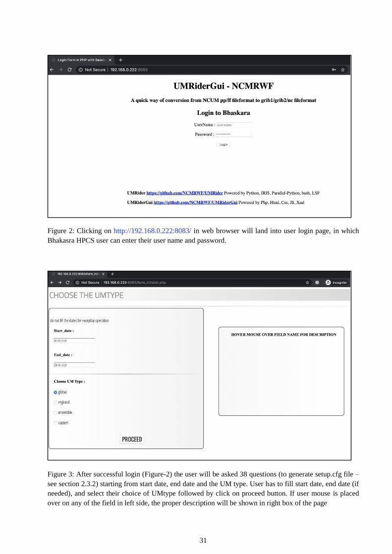
31
Figure 2: Clicking on http://192.168.0.222:8083/ in web browser will land into user login page, in which
Bhakasra HPCS user can enter their user name and password.
Figure 3: After successful login (Figure-2) the user will be asked 38 questions (to generate setup.cfg file –
see section 2.3.2) starting from start date, end date and the UM type. User has to fill start date, end date (if
needed), and select their choice of UMtype followed by click on proceed button. If user mouse is placed
over on any of the field in left side, the proper description will be shown in right box of the page

32
Figure 4: Based on the UM type (selected by the user – Figure 3), the following choices will be shown to
(UMInAnlFiles, UMInShortFcstFiles, UMInLongFcstFiles) to user.
Figure 5: User has to scroll down to see rest of questions to be filled to generate the setup.cfg file. Next set
of questions are shown here.

33
Figure 6: Finally it reaches last set of questions (wgrib2netcdf, callBackScript). User can either click on
submit or reset button. Reset button will clear all the fields in the form. Submit button will create the
“setup.cfg” file (in the server’s temporary directory) from the user’s choices and answers for the above
UMRider’s 38 options. Empty fields will be treated as None value for the options.
Figure 7: After setcup.cfg is generated, and next it asks users to select list of variables shown. User can select
multiple variables by manually or by clicking on “Select ALL” button to mark all available variables as
selected. User has to scroll till end of the page, and click on “submit” button, which will create “vars.cfg”
file (in the server’s temporary directory) based on user’s choices of variables.

34
Figure 8: After vars.cfg is generated, the user selects the bsub files for analysis and forecast. User can select
multiple bsub files for both. Then click on submit button.
Figure 9: After submission with selection for bsub files need to be generated (See Figure 8), it will show the
bsub file editing pages, where it can be edited. Here shown ncum_global_post_anl_00Z.sh bsubscript, which
will be stored after submission of save all button (see section 2.4.1).

35
Figure 10: Here shown ncum_global_post_fcst_00Z.sh bsub script, which will be stored after submission of
save all button (see section 2.4.1).
Figure 11: After click on “SAVE ALL” in previous window (see Figure 10), whatever generated files
previously and stored in temporary directory of server, will be copied to user’s home directory in Bhaskara
HPCS via scp. See below screenshot, which shows new directory path “UMRider_Scripts/202005210036”
has been created and copied setup.cfg, vars.cfg, bsub bash scripts into that folder. Now user can click on
“SUBMIT BJOBS” which will submit the all busb scripts to Bhaskara IBM HPCS compute node. Also, user
can logout by click on the button instead of submit bjobs

36
Figure 12: After submission of bsub job in previous stage (see Figure 11), the page will show how the
UMRiderGUI logged into user’s account in Bhaskara HPCS, followed by listing newly created directory
“UMRider_Scripts/202005210036” and files. Followed by it submit all bsub bash scripts to compute node
via bsub command and listing out job ids, finally logged out of HPCS. User can click on exit button to close
the UMRiderGUI web interface.

37
3. UMRider Utilities Usage
UMRider source package contains a collection of modules named as “g2utils” which have the following
python modules.
1. ncum_load_rules.py
2. cubeutils.py
3. mdlutils.py
4. um2grb2.py
5. um2grb2tigge.py
6. umeps2grb2.py
7. configpaths.py
In the above python modules, first three modules are coded with many functions which are useful far beyond
the scope of UMRider. i.e., these module are programmed in such a way that one can use the available
functions for generic post processes using python-iris, not limited to unified model outputs.
3.1 ncum_load_rules.py
This module has a function named “update_cf_standard_name” which can be passed as callback script while
loading cubes in iris python library. This function is very useful in UMRider as it supports to override the
meta information of cubes while reading unified model outputs pp/ff files and post processed grib2 files
which are generated by UMRider itself. This call back function used to update the cubes standard_name if
not exists (i.e. unknown) or to correct the cf_standard_name of particular cube (if wrongly assigned in
um_cf_map.py) while loading iris cubes.
>>> import iris
>>> cubes = iris.load('umglaa_pf000', callback=update_cf_standard_name)
>>> cubes = iris.load('um_ana.grib2', callback=update_cf_standard_name)
3.2 cubeutils.py
This module have the following generic functions aimed to solve basic mathematical operator on the cubes
without losing its meta information, which can be called by any python-iris based scripts.
3.2.1 cubeAverager
This function takes the following parameters as argument aimed to make either temporal average or
summation of a given iris cube.
:tmpCube: The temporary cube data (in iris format) with non-singleton time dimension
:action: mean| sum (accumulated fields are summed and instantaneous are averaged).
:dt: A standard string representing forecast step duration/intervals.
:actionIntervals: A nonstandard string to add inside cell_methods comments section.
:tpoint: cbound | lbound | rbound time point
:fpoint: cbound | lbound | rbound forecast period
:tbounds: True | False (False removes time bounds)
:fbounds: True | False (False removes fcst bounds)
:return: meanCube: An iris formatted cube of the resultant data either averaged or summed.

38
3.2.2 cubeAddSubtractor
The inbuilt function of iris.analysis.maths.subtract does not serve out the purpose (it loses meta information
after processed). So this cubeAddSubtractor do the addition or subtraction of two given cubes and set all
necessary meta information to the resultant cube.
: cube: primary cube data (in iris format)
: otherCube: secondary cube data (in iris format)
: action: add | sub
: standard_name: resultant cube’s standard name
: long_name: resultant cube’s long name
: removeSTASH: True | False. If it is True, then resultant cube will have no stash meta information
: return : resCube: An iris formatted cube of the resultant data either added or subtracted.
3.2.3cubeCummulator
This function is useful to make cumulative of cube data over time dimension where cumulative happens over
each and every time step. i.e., resultant cube will have same time dimension as input cube’s time dimension.
: cube: primary cube data (in iris format)
: standard_name: resultant cube’s standard name
: long_name: resultant cube’s long name
: unit : resultant cube’s unit
: standard_name: resultant cube’s standard name
: removeSTASH : True | False. If it is True, then resultant cube will have no stash meta information
: addZerosFirstCube: True | False. It does add zeros cube at beginning of the cumulated cubes, which is
useful to the TIGGE grib2 data generation.
:return : Generators | Yields the cumulated cubes (not the list, which is useful for memory management)
3.2.4 cubeRealizationAverager
This function is used to product realization wise average or summation at single time point.
: tmpCube : primary cube data (in iris format)
: action : mean | sum over realization dimension (i.e. over ensemble dimension of each variable)
: dr : A standard string representing realization step duration/intervals.
: return : meanCube: resCube: An iris formatted cube of the resultant data either averaged or summed
over ensemble dimension.
3.3 mdlutils.py
This module named as mdlutils.py (i.e., model level utils) and it have the following generic functions aimed
to convert hybrid model level dimension to user desired height (in meters), which can be called by any
python iris based scripts.

39
3.3.1 cubeModelLevel2HeightConverter
This function is useful to convert a cube from model level to height above mean sea level or height above
ground level (i.e., orography). This function requires to import “stratify” library to interpolate vertical
height levels of cube.
: cube: primary cube data (in iris format) must have hybrid model level dimension data and can have
multiple time coordinate dimensions as well along with latitude, longitude dimensions.
: orography: either user can pass orography cube as argument otherwise function will retrieve the
surface_altitude from cube auxiliary coordinate system.
: target_altitudes: User can pass their required altitudes in meter unit as python list. If None was passed,
then it will convert model level to the following heights in meter unit
[10,50,80,100,120,150,180,200,250,300,350,400,500,600,700,800,900,1000,1500,2000,2500,3000,3500,4
000,4500,5000]
: AGL: True | False (i.e. Above Ground Level True mean orography will be subtracted from hybrid altitude
coordinate for computing base height. If it is True, then the resultant cube have dimension as height above
ground level (AGL), otherwise above sea level (ASL).
: return: cube converted from model level to height ASL or AGL.
3.3.2 cubeModelLevel2CloudTopHeightConverter
This function is aimed to convert the hybrid model level dimensioned cube data into cloud top height by
parallel python processes and it can be invoked by any python iris based scripts.
: data: primary cube data (in iris format) must be hybrid model level coordinated variable, but make sure
only one time point is passed here.
: target_height: it must be shape of (latitude x longitude). User has to pass the cloud top height parameter
value for single time point and its unit must be in meters.
: orography: either user can pass orography cube as argument otherwise function will retrieve the
surface_altitude from cube auxiliary coordinate system.
: AGL: True | False (i.e. Above Ground Level True mean orography will be subtracted from hybrid altitude
coordinate for computing base height. If it is True, then the resultant cube have dimension as height above
ground level (AGL), otherwise above sea level (ASL).
: pblock_size: default value is 4. In parallel python-numpy block size (i.e. if pblock_size=4, then 4x4
numpy block will be taken at a time and by single processor.
: nprocesses: default value is 16. i.e. 16 parallel processors job will be performed by sharing same numpy
array across processors.
: return: meanCube: cube converted from model level to cloud top height (in meters). Resultant cube will
have single height dimension as its equivalent to cloud top height coordinate.

40
Acknowledgements
The developer of UMRider, the author of this technical report would like to thank Dr. E.N. Rajagopal, Head,
NCMRWF who believed and encouraged the development of UMRider from the beginning, also who
showed keen interest to make this utility as an operational post processing tool for all unified models
operated at the centre. Author acknowledges Mr. Gopal Iyengar, MoES/NCMRWF, who assigned this utility
development as project work, initially. Special thanks are also due to Mr. M.N. Raghavendra Sreevathsa
who sparked the idea of this utility and the need of it. Most importantly, author acknowledge Mr. Somjeet
Dasgupta who was a student (Register Number: 13BCE1151 of VIT University Chennai Campus) and
completed his final semester Project work titled “UMRider Dynamic GUI” which was turned into
“UMRiderGUI”, under the guidance of this author jointly with Mr. M.N. Raghavendra Sreevathsa, and
submitted to NCMRWF during June 2016.
A special thanks are due to Dr. Saji Mohandas who inspired the author, by sharing the basic knowledge
about STASH, grib1 param codes, and encouraged from the beginning of this utility development for
NCUM-G deterministic model post process. A warm acknowledgments are due to Drs. Jayakumar and
Abhijit Sarkar for their support to post process of NCUM-R and NEPS-G model, respectively. Author would
also like to thank Drs. John P. George and S. Indira Rani for their demand for using UMRider to post process
IMDAA regional reanalysis. Author also acknowledges Mrs. Paromita Chakraborty and Dr. Ashu Mamgain
who supported for making UMRider post processor for NEPS-G.
Without good evaluation, development of a good utility is not possible! Author wishes to thank Dr.
Raghavendra Ashrit and his team members (Dr. Kuldeep Sharma, Mr. Sushant Kumar), who tested UMRider
generated grib2 files and used it for their research activities. Author acknowledges all the national users
(IMD, INCOIS, IITM, Indian Navy, SAC/ISRO, SASE, NIWE) who demanded and tested the products
generated by UMRider. Many thanks are due to Dr. Richard Mladek, Analyst at ECMWF who tested the
NEPS-G grib2 files (generated by UMRider) multiple times and accepted the contribution of NCMRWF
global ensemble forecasts to the TIGGE project. Thanks are also due to Dr. João Teixeira, UK Met Office
who tested and confirmed that UMRider works for their Unified Model outputs with minimum modifications
in the configuration files.
Finally the author would also like to thank Dr. Saji Mohandas and Dr. E.N. Rajagopal who reviewed and
edited this technical report to improve its content for better readability.

41
References
Ashu Mamgain, Abhijit Sarkar, Anumeha Dube, Arulalan T., Paromita Chakraborty, John. P. George and
E.N. Rajagopal (2018), “Implementation of Very High Resolution (12 km) Global Ensemble
Prediction System at NCMRWF and its Initial Validation”, August 2018, NCMRWF Technical
Report, NMRF/TR/02/2018.
Jayakumar, A., A. Mamgain, A. S. Jisesh, S. Mohandas, R. Rakhi, and E. N. Rajagopal (2016), “Evaluation
of NCMRWF Unified Model vertical cloud structure with CloudSat over the Indian summer monsoon
region”, Proc. SPIE 9882, Remote Sens. Model. of the Atmos., Oceans, and Interactions VI, 988207;
doi:10.1117/12.2223622.
Jayakumar, A., J. Sethunadh, R. Rakhi, T. Arulalan, S. Mohandas, G. R. Iyengar, and E. N. Rajagopal (2017),
“Behavior of predicted convective clouds and precipitation in the high-resolution Unified Model over
the Indian summer monsoon region”, Earth and Space Science, 4, 303–313,
doi:10.1002/2016EA000242.
Paromita Chakraborty, Anumeha Dube, Harvir Singh, Arulalan T., S. Kiran Prasad, Ashu Mamgain, Aditi,
Sushant Kumar, Abhijit Sarkar, Raghavendra Ashrit and E. N. Rajagopal (2019), “Generation of
Probabilistic Forecast Products from NCMRWF Ensemble Prediction System (NEPS)”, April 2019,
NCMRWF Technical Report, NMRF/TR/03/2019.
Raghavendra Ashrit, Kuldeep Sharma, Sushant Kumar, Anumeha Dube, S. Karunasagar, T. Arulalan,
Ashu Mamgain, Paromita Chakraborty, Sumit Kumar, Abhishek Lodh, Devajyoti Dutta, Imranali
Momin, M. T. Bushair, Buddhi J. Prakash, A. Jayakumar and E. N. Rajagopal (2019), “Prediction
of the August 2018 heavy rainfall events over Kerala with high‐ resolution NWP models”, Meteorol
Appl.2020; 27:e1906, doi:10.1002/met.1906.
E.N. Rajagopal, G.R. Iyengar, John P. George, Munmun Das Gupta, Saji Mohandas, Renu Siddharth, Anjari
Gupta, Manjusha Chourasia, V.S. Prasad, Aditi, Kuldeep Sharma and Amit Ashish (2012),
“Implementation of Unified Model based Analysis-Forecast System at NCMRWF”, May 2012,
NCMRWF Technical Report, NMRF/TR/2/2012.
Saji Mohandas (2014), “Utility to convert UM fields file output to NCEP GRIB1 format: A user guide”,
April 2014, NCMRWF Technical Report, NMRF/TR/1/2014.
Sumit Kumar, A. Jayakumar, M. T. Bushair, Buddhi Prakash J., Gibies George, Abhishek Lodh, S. Indira
Rani, Saji Mohandas, John P. George and E. N. Rajagopal (2018), “Implementation of New High
Resolution NCUM Analysis-Forecast System in Mihir HPCS”, August 2018, NCMRWF Technical
Report, NMRF/TR/01/2018.

42
Appendix - A
A. UMRider – Source Code Structure, Access, Future Releases and License
A. 1. Source Code Structure
Listed out below are UMRider source code directories and file structures and their purposes.
UMRider (top level directory)
data–directory contains few sample grib2 files used as targetGrid to do regrid of model outputs
sample_global_0p125x0p125.grib2– sample global region 0.125x0.125grid
sample_global_0p12x0p18.grib2– sample global region 0.12x0.18 grid
sample_global_2p5X2p5_73X144.grib2– sample global region 2.5x2.5 grid
sample_ind_7-38N_67-98E_0p04X0p04.grib2– sample Indian region 0.04x0.04 grid
sample_ind_Eq-40N_62-106E_0p04X0p04.grib2– sample Indian region 0.04x0.04 grid
g2utils– directory contains all utilities (python modules, functions) of UMRider
configpaths.py– Used to set all global variables (wgrib2, g2ctl.pl, etc.,) absolute paths
ncum_load_rules.py – Manipulate iris cubes while loading model outputs (see section 3.1)
cubeutils.py– General python maths utilities to handle iris cubes (see section 3.3)
mdlutils.py– General python utilities to convert model hybrid level (see section 3.3)
um2grb2.py – Entire UMRider is constructed over on this module Post ProcessGrib2 files
umctl2grb2 – Convert global deterministic model to control member of NEPS-G
umeps2grb2.py – Script to convert global all perturbed members to Grib2 files
um2grb2tigge.py–Script to convert NEPS-G model outputs to TIGGE standard Grib2 files
umREGeps2grb2.py – Script to post process of NCUM-R regional ensemble model outputs
g2scripts– contains all python scripts to execute model conversions by using g2utils modules
loadconfigure.py– read configuration files (setup.cfg, vars.cfg)
um2grb2_anl_00Z.py– NCUM-G Global/Regional Model Analysis Grib2 Creation at 00 UTC
um2grb2_anl_06Z.py– NCUM-G Global/Regional Model Analysis Grib2 Creation at 06UTC
um2grb2_anl_12Z.py– NCUM-G Global/Regional Model Analysis Grib2 Creation at 12 UTC
um2grb2_anl_18Z.py– NCUM-G Global/Regional Model Analysis Grib2 Creation at 18 UTC
um2grb2_fcst_00Z.py– NCUM-G Global/Regional Model Forecast Grib2 Creation at 00 UTC
um2grb2_fcst_12Z.py– NCUM-G Global/Regional Model Forecast Grib2 Creation at 12 UTC
umctl2grb2_anl.py– NCUM-G Global Analysis as control member of NEPS-G in Grib2 at 00 &
12 UTC
umctl2grb2_fcst.py– NCUM-G Global Forecast as control member of NEPS-G in Grib2 at 00
& 12 UTC
umeps2grb2_fcst_00Z.py– NEPS-G Global Forecast of 11 perturbed members in Grib2 at 00
UTC
umeps2grb2_fcst_12Z.py– NEPS-G Global Forecast of 11 perturbed members in Grib2 at 12
UTC
tigge_umctl2grb2_anl_00Z.py– TIGGE NEPS-G Analysis control member in Grib2 at 00 UTC
tigge_umctl2grb2_anl_12Z.py– TIGGE NEPS-G Analysis control member in Grib2 at 12 UTC
tigge_umctl2grb2_fcst_00Z.py– TIGGE NEPS-G Forecast as control member in Grib2 at 00
UTC

43
tigge_umctl2grb2_fcst_12Z.py– TIGGE NEPS-G Forecast as control member in Grib2 at 12
UTC
tigge_umeps2grb2_fcst_00Z.py– TIGGE NEPS-G Forecast of 11 perturbed members in Grib2
at 00 UTC
tigge_umeps2grb2_fcst_12Z.py– TIGGE NEPS-G Forecast of 11 perturbed members in Grib2
at 12 UTC
grib2PostScripts – directory contains scripts to read and further post process grib2 files
extractRainEPSIndia_03-03Z.py– extracts NEPS-G daily precipitation at 03-03 UTC
extractRainEPSIndia_individual_6hourly.py –extracts NEPS-G 6-hourly precipitation at 00 UTC
ncumeps_extractRainEPSIndia_03-03Z.sh – submits NEPS-G 03 UTC precipitation extraction
ncumeps_extractRainEPSIndia_individual_6hourly.sh – submitd NEPS-G 6-hourly rainfall
bsubScripts
This directory contains many sub directories and files (setup.cfg, vars.cfg, bsub bash shell scripts)
used to post process many individual operational jobs in Bhaskara HPCS (see Sections 2.3.2,
2.3.3, 2.4.1, and 2.5)
qsubScripts
This directory contains many sub directories and files (setup.cfg, vars.cfg, qsub bash shell scripts)
used to post process many individual operational jobs in Mihir HPCS (see sections 2.3.2, 2.3.3,
and 2.4.2)
others– contains other software modified source code as per need of UMRider at NCMRWF
o cnvgrib– software used to convert grib2 to grib1 file format
params.f– customised grib2 param codes which support for UMRider grib2 files
README.txt– explains the procedure to install source of cnvgrib after update
o ncmrwfIRIS– customised IRIS-Python library grib2 module to support of UMRider
__init__.py – updated init script(see Appendix – B)
_grib_cf_map.py – updated mapping of grib params (NCUM) to cf standard names
_grib_cf_map_tigge.py – updated mapping of grib params (TIGGE) to cf standard name
_load_convert.py – updated script while loading grib2 files in iris
load_rules.py – updated script while loading grib2 files in iris
_save_rules.py– updated script to write grib2 files (NCUM-G, NEPS-G, NCUM-R) in iris
README.md – instruction on how to copy these updated scripts before install of iris
tables– directory contains two table of UMRider
o local/ncmr/v1– contains local table of grib2 (see Appendix – C)
ncmr_grib2_local_table– contains customised local table as per NCUM model grib2
o WRF-Noah– contains tables of WRF model to read NCUM-G model grib2 files
METGRID.TBL_NCUM – metgrid grib2 table param to match with NCUM grib2
Vtable.NCUM– contains variables table to read NCUM fields correctly
setup.py– used to install UMRider Utility Library into system or user python path
README.md– tells about UMRider and other necessary information for the end users
CHANGELOG.md – contains versions releases and updates generates by git
LICENSE– contains GNU3 open source license agreement rules to use, modify and redistribute

44
A. 2. Source Code Access
Users and readers of this technical report can download the source code of UMRider from NCMRWF code
repository at GitHub online platform indicated below.
UMRider: https://github.com/NCMRWF/UMRideror https://github.com/arulalant/UMRider
UMRiderGUI: https://github.com/NCMRWF/UMRiderGui
Iris-python: https://github.com/SciTools/iris
A. 3. Future Releases
Though UMRider version 1.0 was released during Dec 2015, this technical report was written on the basis
of latest version 3.1.1 of UMRider during May 2020. In the upcoming releases, we will try to fulfil the
following requirements and upgrades.
UMRscan – which should scan all pp/ff files of UM and helps users to understand the fields meta
information such as variable CF Standard Name, STASH, etc.,
NCUM-REPS – which should support for NCUM Regional Ensemble model outputs to convert
into to grib2 files
Universal – UMRider should support for all partners of UK Met Office –Unified Model, not limited
to only NCMRWF – Unified Model. There are many challenges to achieve this target, as all NWP
centre partners are producing their own customised model parameters (model version, variables,
time stamp, time intervals, variable units, output file units, etc.). To overcome this problem, a
collaborative work on UMRider development is required.
Python3 upgradation – From the beginning, UMRider was written in Python 2.7.1 and official
support for this python version had stopped on 1st January 2020. So it is mandatory to upgrade to
python 3 version during next releases of UMRider.
A. 4. License
The UMRider (https://github.com/arulalant/UMRider & https://github.com/NCMRWF/UMRider) and
UMRiderGUI (https://github.com/NCMRWF/UMRiderGui) are released under GNU General Public
License v3.0 – which states the following:
Permissions of this strong copyleft license are conditioned on making available complete source code of
licensed works and modifications, which include larger works using a licensed work, under the same license.
Copyright and license notices must be preserved. Contributors provide an express grant of patent rights.
GNU General Public License v3.0 comes with the following terms and conditions:
Permissions
Commercial use

45
Modification
Distribution
Patent use
Private use
Limitations
No Liability
No Warranty
Conditions
License and copyright notice
State changes
Disclose source
Same license
For further details about License, visit the link given below:
https://github.com/NCMRWF/UMRider/blob/master/LICENSE.

46
Appendix - B
NCUM STASH and Grib2 Param Codes
NCUM STASH
NCUM model output STASH code and its equivalent variable cf_standard_name is exactly same as given
at link http://puma.nerc.ac.uk/STASH_to_CF/STASH_to_CF.html
Note: For a few STASH codes, there may be available multiple variables cf_standard_name.
Cf_Standard_Name
All variables of cf_standard_name table version V30 can be seen from below link,
http://cfconventions.org/Data/cf-standard-names/30/build/cf-standard-name-table.html .
NCEP-WMO Grib2
NCEP-WMO Standard Grib2 Table Parameters link,
http://www.nco.ncep.noaa.gov/pmb/docs/grib2/grib2_doc.shtml .
By using all the above 3 links, one can get the STASH Vscf_standard_nameVs Grib2 parameter codes.
Table B1. The list of Unified Model field name, STASH code, unit, short variable name in control file
produced by g2ctl.pl script, and IRIS-Grib2 param codes (discipline, category, number, and type of first
fixed surface) are shown. The STASH code mentioned in section 2.3.3 is as per iris python standard and
here listed out the same but in simple stash code (without prefix of model ‘m’, item ‘i’, sub‘s’ code).
Sl.
No
STASH
Code
Fields Name IRIS - Grib2 Param Code Control File
Short
Variable
Name
Unit
Discipline Category Number Type of
First Fixed
Surface
1 33 OROGRAPHY 2 0 7 1 MTERHsfc m
2 409 SURFACE PRESSURE 0 3 0 1 PRESsfc Pa
3 15242 W COMPNT (OF WIND)
ON PRESSURE LEVS
0 2 9 100 DZDTprs m s-1
4 15243 U WIND ON PRESSURE
LEVELS
0 2 2 100 UGRDprs m s-1
5 15244 V WIND ON PRESSURE
LEVELS
0 2 3 100 VGRDprs m s-1
6 16202 GEOPOTENTIAL
HEIGHT ON P LEV
0 3 5 100 HGTprs m
7 16203 TEMPERATURE ON P
LEV
0 0 0 100 TMPprs K
8 16222 PRESSURE AT MEAN
SEA LEVEL
0 3 1 101 PRMSLsfc Pa
9 16256 RH WRT WATER ON P
LEV
0 1 1 100 RHprs %
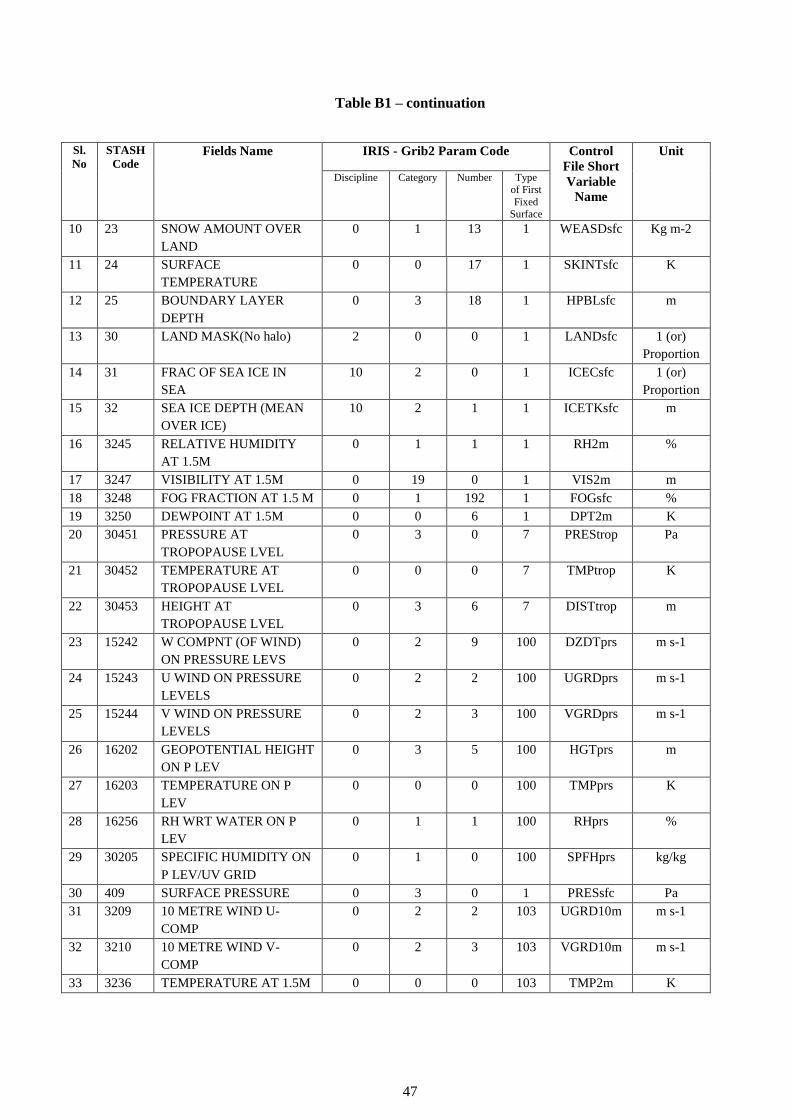
47
Table B1 – continuation
Sl.
No
STASH
Code Fields Name IRIS - Grib2 Param Code Control
File Short
Variable
Name
Unit
Discipline Category Number Type of First
Fixed Surface
10 23 SNOW AMOUNT OVER
LAND
0 1 13 1 WEASDsfc Kg m-2
11 24 SURFACE
TEMPERATURE
0 0 17 1 SKINTsfc K
12 25 BOUNDARY LAYER
DEPTH
0 3 18 1 HPBLsfc m
13 30 LAND MASK(No halo) 2 0 0 1 LANDsfc 1 (or)
Proportion
14 31 FRAC OF SEA ICE IN
SEA
10 2 0 1 ICECsfc 1 (or)
Proportion
15 32 SEA ICE DEPTH (MEAN
OVER ICE)
10 2 1 1 ICETKsfc m
16 3245 RELATIVE HUMIDITY
AT 1.5M
0 1 1 1 RH2m %
17 3247 VISIBILITY AT 1.5M 0 19 0 1 VIS2m m
18 3248 FOG FRACTION AT 1.5 M 0 1 192 1 FOGsfc %
19 3250 DEWPOINT AT 1.5M 0 0 6 1 DPT2m K
20 30451 PRESSURE AT
TROPOPAUSE LVEL
0 3 0 7 PREStrop Pa
21 30452 TEMPERATURE AT
TROPOPAUSE LVEL
0 0 0 7 TMPtrop K
22 30453 HEIGHT AT
TROPOPAUSE LVEL
0 3 6 7 DISTtrop m
23 15242 W COMPNT (OF WIND)
ON PRESSURE LEVS
0 2 9 100 DZDTprs m s-1
24 15243 U WIND ON PRESSURE
LEVELS
0 2 2 100 UGRDprs m s-1
25 15244 V WIND ON PRESSURE
LEVELS
0 2 3 100 VGRDprs m s-1
26 16202 GEOPOTENTIAL HEIGHT
ON P LEV
0 3 5 100 HGTprs m
27 16203 TEMPERATURE ON P
LEV
0 0 0 100 TMPprs K
28 16256 RH WRT WATER ON P
LEV
0 1 1 100 RHprs %
29 30205 SPECIFIC HUMIDITY ON
P LEV/UV GRID
0 1 0 100 SPFHprs kg/kg
30 409 SURFACE PRESSURE 0 3 0 1 PRESsfc Pa
31 3209 10 METRE WIND U-
COMP
0 2 2 103 UGRD10m m s-1
32 3210 10 METRE WIND V-
COMP
0 2 3 103 VGRD10m m s-1
33 3236 TEMPERATURE AT 1.5M 0 0 0 103 TMP2m K

48
Table B1 – continuation
Sl.
No
STASH
Code Fields Name IRIS - Grib2 Param Code Control
File Short
Variable
Name
Unit
Discipline Category Number Type
of First Fixed
Surface
34 3237 SPECIFIC HUMIDITY
AT 1.5M
0 1 0 103 SPFH2m kg/kg
35 4201 LARGE SCALE RAIN
AMOUNT
0 1 47 1 LSWPsfc Kg m-2
36 4202 LARGE SCALE SNOW
AMOUNT
0 1 15 1 SNOLsfc Kg m-2
37 5226 TOTAL
PRECIPITATION
AMOUNT
0 1 8 1 APCPsfc kg m-2
38 5201 CONVECTIVE RAIN
AMOUNT
0 1 48 1 CWPsfc Kg m-2
39 5202 CONVECTIVE SNOW
AMOUNT
0 1 14 1 SNOCsfc Kg m-2
40 5234 UNDILUTE PARCEL
CIN
0 7 7 1 CINsfc J/kg
41 9203 LOW CLOUD AMOUNT 0 6 3 1 LCDCsfc %
42 9204 MEDIUM CLOUD
AMOUNT
0 6 4 1 MCDCsfc %
43 9205 HIGH CLOUD AMOUNT 0 6 5 1 HCDCsfc %
44 16222 PRESSURE AT MEAN
SEA LEVEL
0 3 1 101 PRMSLsfc Pa
45 1202 NET DOWN SURFACE
SW FLUX
0 4 9 1 NSWRFsfc W m-2
46 1205 OUTGOING SW RAD
FLUX (TOA)
0 4 8 8 USWRFtoa W m-2
47 1207 INCOMING SW RAD
FLUX (TOA)
0 4 7 8 DSWRFtoa W m-2
48 1209 CLEAR-SKY (II)
UPWARD SW FLUX
(TOA)
0 4 198 8 CSUSFtoa W m-2
49 1235 DOWNWARD SURFACE
SW FLUX
0 4 7 1 DSWRFsfc W m-2
50 2201 NET DOWN SURFACE
LW RAD FLUX
0 5 5 1 NLWRFsfc W m-2
51 2205 OUTGOING LW RAD
FLUX (TOA)
0 5 4 8 ULWRFtoa W m-2
52 2206 CLEAR-SKY (II)
UPWARD LW FLUX
(TOA)
0 5 195 8 CSULFtoa W m-2
53 2207 DOWNWARD LW RAD
FLUX: SURFACE
0 5 3 1 DLWRFsfc W m-2
54 3217 SURFACE SENSIBLE
HEAT FLUX
0 0 11 1 SHTFLsfc W m-2
55 3234 SURFACE LATENT
HEAT FLUX
0 0 10 1 LHTFLsfc W m-2

49
Table B1– continuation
Sl.
No
STASH
Code Fields Name IRIS - Grib2 Param Code Control File Short
Variable
Name
Unit
Discipline Category Number Type
of First Fixed
Surface
56 5214 TOTAL
RAINFALL RATE:
LS+CONV
0 1 65 1 RPRATEsfc Kg m-2
s-1
57 5215 TOTAL
SNOWFALL
RATE: LS+CONV
0 1 53 1 TSRWEsfc Kg m-2
s-1
58 5216 TOTAL
PRECIPITATION
RATE
0 1 7 1 PRATEsfc Kg m-2
s-1
59 Calculated UPWARD
SURFACE SW
FLUX
0 4 8 1 USWRFsfc W m-2
60 Calculated UPWARD LW
RAD FLUX:
SURFACE
0 5 4 1 ULWRFsfc W m-2
61 2422 DUST OPTICAL
DEPTH
3 1 192,
193,
194,
195,
196,
197
1 DAOT038,
DAOT044,
DAOT055,
DAOT067,
DAOT087,
DAOT102
unitless
62 3238 DEEP SOIL
TEMPERATURE
AFTER B.LAYER
2 0 25 106 VSOILM0_10cm ,
VSOILM10_35cm,
VSOILM35_100cm,
VSOILM100_200cm
K
63 8223 SOIL MOISTURE
CONTENT IN A
LAYER
2 0 3 106 TSOIL0_10cm,
TSOIL10_35cm,
TSOIL35_100cm,
TSOIL100_200cm
m3 m-3
In UMRider, SOIL MOISTURE CONTENT IN A LAYER variable has been converted to Volumetric by
dividing each layer by its depth in mm (0 to 10 cm layer depth is 100 mm, 10 to 35 cm layer depth is 250
mm, 35 to 100 cm layer depth is 650 mm and 100 to 200 cm layer depth is 1000 mm), so as to change unit
from kg/m2 to m3/m3. Also whose grid values of Volumetric Soil Moisture less than 0.005 are reset to 0.0051,
since NOAH WRF model requires the soil moisture volumetric values to be less not than 0.005.

50
Appendix - C
NCUM Grib2 Local Table
Users of UMRider and readers of this technical report, can download local table from this link
https://github.com/NCMRWF/UMRider/blob/master/tables/local/ncmr/v1/ncmr_grib2_local_table.
Store the below lines as text file and name it as “name ncmr_grib2_local_table”. This text file absolute path
can be exported to an environment variable called “GRIB2TABLE” which is used by many software
including wgrib2.
/* asterix (*) Indicates comment lines
* Name : ncmr grib2 local table
* Filename : ncmr_grib2_local_table
* Institute : National Centre for Medium Range Weather Forecasting, India
* Centre Code : 29, New Delhi
* Local Table Version No : 1
* Local Table Created By : Arulalan.T, Project Scientist - C
* Contact : [email protected]
* Release Version : 0.1, No of Entries : 9, Date : 21-Jan-2016
* Release Version : 0.2, No of New Entries : 1, Date : 12-Apr-2016
* Release Version : 0.3, No of New Entries : 2, Date : 26-Apr-2016
* Release Version : 0.4, No of New Entries : 10, Date : 10-Jan-2017
* Release Version : 0.5, No of New Entries : 1, Date : 27-Apr-2018
* Release Version : 0.6, No of New Entries : 2, Date : 19-Mar-2019
* Release Version : 0.7, No of New Entries : 1, Date : 27-Sep-2019
* Total No of Entries : 26
* Export Command : export GRIB2TABLE=/path/to/localdir/ncmr_grib2_local_table
* Once we exported, then wgrib2 & g2ctl.pl will be able to read these
* local variables properly
* Reference Link : http://www.cpc.ncep.noaa.gov/products/wesley/wgrib2/user_grib2tables.html
*
struct gribtable_s {
int disc; // Section 0 Discipline
int mtab_set; // Section 1 Master Tables Version Number used by set_var
int mtab_low; // Section 1 Master Tables Version Number low range of tables
int mtab_high; // Section 1 Master Tables Version Number high range of tables
int cntr; // Section 1 originating centre, used for local tables
int ltab; // Section 1 Local Tables Version Number
int pcat; // Section 4 Template 4.0 Parameter category
int pnum; // Section 4 Template 4.0 Parameter number
const char *name;
const char *desc;
const char *unit;
};
* ParameterDiscipline : MasterTableVersionSet : MasterTableVersionStart : MasterTableVersionEnd :
Centre Code : LocalTablesVersion: ParameterCategory : ParameterNumber: VariableShortName :
VariableDescription : VariableUnit
*
* Comment lines end
*/

51
* ncmr grib2 local table entries begin
0:1:0:10:29:1:1:192:FOG:Fog Area Cover:%
0:1:0:10:29:1:0:205:WETBPT:Wet Bulb Potential Temperature: K
0:1:0:10:29:1:1:193:EVARSS:Evaporation Rate From Soil Surface: kg m-2 s-1
0:1:0:10:29:1:1:194:EVARCA:Evaporation Rate From Canopy: kg m-2 s-1
0:1:0:10:29:1:1:195:EVAROS:Evaporation Rate From Open Sea: kg m-2 s-1
0:1:0:10:29:1:1:196:DENRR:Density * R * R:
0:1:0:10:29:1:4:192:NSWRFC:Net Short Wave Radiation Flux Corrected: W m-2
0:1:0:10:29:1:4:194:DUVB:Direct UV-B Solar Flux: W m-2
0:1:0:10:29:1:4:196:CSUSFS:Clear Sky Downward Solar Flux at Surface: W m-2
0:1:0:10:29:1:4:197:CSULFS:Clear Sky Upward Solar Flux at Surface: W m-2
0:1:0:10:29:1:4:198:CSUSFT:Clear Sky Upward Solar Flux at TOA: W m-2
0:1:0:10:29:1:5:195:CSULFT:Clear Sky Upward Long Wave Flux at TOA:W m-2
0:1:0:10:29:1:5:192:CSDLFS:Clear Sky Downward Long Wave Flux at Surface: W m-2
0:1:0:10:29:1:15:192:RAREF:Radar Reflectivity: dBZ
0:1:0:10:29:1:15:193:ROHLENABL:Roughness Length After Boundary Layer: m
3:1:0:10:29:1:1:192:DAOT038:Dust Aerosol Optical Thickness at 0.38 µm: unit less
3:1:0:10:29:1:1:193:DAOT044:Dust Aerosol Optical Thickness at 0.44 µm: unit less
3:1:0:10:29:1:1:194:DAOT055:Dust Aerosol Optical Thickness at 0.55 µm: unit less
3:1:0:10:29:1:1:195:DAOT067:Dust Aerosol Optical Thickness at 0.67 µm: unit less
3:1:0:10:29:1:1:196:DAOT087:Dust Aerosol Optical Thickness at 0.87 µm: unit less
3:1:0:10:29:1:1:197:DAOT102:Dust Aerosol Optical Thickness at 1.02 µm: unit less
3:1:0:10:29:1:1:198:TCDAM:Total Column Dry Aerosols Mass: kg m-2
0:1:0:10:29:1:6:201:VLCDC:Very Low Cloud Cover:%
0:1:0:10:29:1:6:202:TCDCRO:Total Cloud Cover Assuming Random Overlap:%
0:1:0:10:29:1:6:203:TCDCMRO:Total Cloud Cover Assuming Maximum Random Overlap:%
0:1:0:10:29:1:6:204:TCDVFA:Total Cloud Volume Fraction in Atmosphere Layer:%
0:1:0:10:29:1:6:205:LCDVFA:Liquid Cloud Volume Fraction in Atmosphere Layer:%
0:1:0:10:29:1:6:206:ICDVFA:Ice Cloud Volume Fraction in Atmosphere Layer:%
0:1:0:10:29:1:6:207:LIGHTFC:Ligtning Flash Count: unit less
2:1:0:10:29:1:0:231:SSFCWROR:Sub Surface Water Runoff Rate :kg m-2 s-1
2:1:0:10:29:1:0:232:SUFCWR:Surface Upward Water Rate :kg m-2 s-1
2:1:0:10:29:1:0:193:DHFS:Downward Heat Flux in Soil: W m-2
* ncmr grib2 local table entries end