Synthetic impact response functions for flood vulnerability analysis and adaptation measures in...
22
1 23 Natural Hazards Journal of the International Society for the Prevention and Mitigation of Natural Hazards ISSN 0921-030X Volume 59 Number 2 Nat Hazards (2011) 59:967-986 DOI 10.1007/s11069-011-9812-x Synthetic impact response functions for flood vulnerability analysis and adaptation measures in coastal zones under changing climatic conditions: a case study in Gippsland coastal region, Australia Dushmanta Dutta, Wendy Wright & Philip Rayment
-
Upload
federation -
Category
Documents
-
view
4 -
download
0
Transcript of Synthetic impact response functions for flood vulnerability analysis and adaptation measures in...

1 23
Natural HazardsJournal of the International Societyfor the Prevention and Mitigation ofNatural Hazards ISSN 0921-030XVolume 59Number 2 Nat Hazards (2011) 59:967-986DOI 10.1007/s11069-011-9812-x
Synthetic impact response functions forflood vulnerability analysis and adaptationmeasures in coastal zones under changingclimatic conditions: a case study inGippsland coastal region, AustraliaDushmanta Dutta, Wendy Wright &Philip Rayment

1 23
Your article is protected by copyright and
all rights are held exclusively by Springer
Science+Business Media B.V.. This e-offprint
is for personal use only and shall not be self-
archived in electronic repositories. If you
wish to self-archive your work, please use the
accepted author’s version for posting to your
own website or your institution’s repository.
You may further deposit the accepted author’s
version on a funder’s repository at a funder’s
request, provided it is not made publicly
available until 12 months after publication.

ORI GIN AL PA PER
Synthetic impact response functions for floodvulnerability analysis and adaptation measures in coastalzones under changing climatic conditions: a case studyin Gippsland coastal region, Australia
Dushmanta Dutta • Wendy Wright • Philip Rayment
Received: 15 October 2009 / Accepted: 3 April 2011 / Published online: 17 April 2011� Springer Science+Business Media B.V. 2011
Abstract There is an increasing concern that the current management practices for many
coastal regions are unsustainable. Very few countries have planned to deal with the
exacerbation of environmental decline in the face of sea level rise. It is therefore necessary
to assess socioeconomic and environmental impacts of sea level rises to better understand
the vulnerability of coastal zones, as part of devising adaptive and integrated management
principles. This paper presents a systematic approach by which relevant stakeholders can
be actively engaged in prioritising flood impact issues and deriving information for
quantification of impacts for adaptation measures and demonstrates the approach through
implementation in the Gippsland coastal region. As outcomes of the project, we have
identified key issues of concern for this region for flood impacts and constructed synthetic
response functions for quantification of impacts of floods on some of the key issues in the
region. The analysis also showed that stakeholders consider that some of the issues are not
likely to be significantly affected by floods and thus may not require adaptation measures.
The analysis did not provide high agreement on some issues. Different approaches are
required to assess the importance of these issues and to establish impact response functions
for them.
Keywords Synthetic impact response functions � Floods � Coastal zones �Stakeholder engagement � Climate change
1 Introduction
Coastal areas are one of the most important regions from social, economic, and environ-
mental viewpoints. They are home to a large and growing proportion of the world’s pop-
ulation. They include important ecosystems such as coastal floodplains, mangrove forests,
D. Dutta (&) � W. Wright � P. RaymentSASE, Monash University, Churchill, VIC 3842, Australiae-mail: [email protected]
D. DuttaCSIRO Land and Water, Black Mountain, ACT, Australia
123
Nat Hazards (2011) 59:967–986DOI 10.1007/s11069-011-9812-x
Author's personal copy

marshes, and tideflats, as well as beaches, dunes, and coral reefs (Costanza et al. 1997). The
coastal zone is also important for marine fisheries because the bulk of the world’s marine
fish harvest is caught or reared in coastal waters (Wilkinson 2000). Coastal areas help
prevent erosion, filter pollutants, and provide food, shelter, breeding areas, and nursery
grounds for a wide variety of organisms. Coastal regions also provide critical inputs for
industry, including water and space for shipping and ports; opportunities for recreational
activities such as fishing and diving and other raw materials, including salt and sand.
Coastal regions are undergoing environmental decline due to the large growth of human
populations, rapid urban and industrial development, overexploitation of natural resources,
and poor management. It is expected that, by 2025, around 75% of the world’s human
population will live within 200 km of a coastline (Creel 2003). There is an increasing
concern that the current management practices are unsustainable. Of particular concern are
low-lying areas, which are also affected by sea water intrusion. The Intergovernmental
Panel on Climate Change predicts that the global mean sea level may rise as much as
88 cm by the end of the twenty-first century (Houghton et al. 2001). Several coastal zones
are facing severe socioeconomic and environmental problems due to their lower elevation.
Very few countries have planned to deal with the exacerbation of these problems in the
face of sea level rise.
A holistic and sustainable approach is needed for coastal zone management to resolve
the conflicting demands of society for products and services, taking into account both
current and future interests and the ideal of sustainable coastal resources and environments
(Post and Lundin 1996; Neumann and Livesay 2001; Walsh 2004; APN 2005; Dutta et al.
2005). Agenda 21 and in particular its Chapter 17 ‘‘Protection of The Oceans’’ reaffirmed
this need. The real challenge in achieving optimal sustainable management strategies in
coastal zones relies on the ability to design, develop, and implement an integrated man-
agement program that not only maximizes the benefits to society and its economy based on
accurate understanding of the impacts of changes in physical processes, but also ensures
that the ecosystems are adequately protected or preserved. The requirement for ecosystem
protection is based on recognition of the inherent value of natural systems as well as a
utilitarian recognition that degraded ecosystems cannot provide many of the products and
ecosystem services that have previously been taken for granted. It is therefore necessary to
assess socioeconomic and environmental impacts of sea level rises to better understand the
vulnerability of the coastal zones, for the purpose of devising adaptive and integrated
management principles.
Process-based and distributed mathematical models can be utilized to capture changes
in hydro-biogeochemical processes in coastal zone systems in the context of climate
change and anthropogenic forcing (Gordon et al. 1996; Hong et al. 2002; Nakayama et al.
2004; Dutta et al. 2007); thus, contributing to our knowledge about the vulnerability in
coastal zone systems. Such modeling approaches can provide better understanding of
changes in the complex and interrelated biogeochemical and physical processes in coastal
zones such as nutrient flux, salinity, floods, erosion, and sedimentation. In order to assess
vulnerability for the development of adaptive management strategies, it is necessary to
identify and prioritize the important issues and to quantify the impacts of the changes in
physical processes due to floods and high water levels associated with sea level rise. In
order to quantify impacts, it is necessary firstly to identify relationships between charac-
teristics of the floods and associated quality variables and key issues and secondly to
quantify these relationships (Berning et al. 2000).
Impact response functions are essential components of vulnerability and impact
assessment models, which relate impacts of flood inundation and water quality variables to
968 Nat Hazards (2011) 59:967–986
123
Author's personal copy

key issues (Krzysztofowicz and Davis 1983; Smith 1994). There are several types of
hazards for coastal areas associated with climate change and sea level rise. In this study,
the hazard of interest is flooding. The flood inundation variables which govern the impact
characteristics and which are considered for stage-damage functions are as follows: flood
depth, duration, velocity and frequency, and water quality. The response functions are
usually derived in one of two ways. Damage data from past floods may be incorporated
into the model, but if such information is unavailable or unreliable, an alternative approach
is to generate synthetic response functions from hypothetical analyses of flood events based
on land cover and land use patterns and the key issues for the region (Das and Lee 1988;
Smith and Greenway 1988; Smith 1994). Berning et al. (2000) call for incorporation of
social and environmental components into these models, but damage functions for these
elements of a model are difficult to estimate (Dougherty and Hall 1995; Kang et al. 2005).
According to Viljoen et al. (2001), including the environmental impact, dimension into the
holistic damage assessment methodology should render further benefit. Various authors
including Dougherty and Hall (1995) suggest use of expert advice in determining synthetic
response/loss functions. In this study, information regarding the likely impact of inundation
on key issues with social, economic, or environmental values was generated by surveying
stakeholders with experience of past flood events.
This project involves a vulnerability analysis for a key coastal zone in Gippsland,
Victoria, under climate change conditions. The focus of the study is on flooding caused by
extreme rainfall and sea level rises associated with storm surge and global warming. Floods
due to other extreme events such as tsunami are not considered here. The vulnerability
analysis required the identification of relevant flood hazard parameters and key issues for
the study region and the synthesis of impact response functions using expert and stake-
holder opinion. The outcomes of the vulnerability analysis are potentially useful as a basis
for the development of adaptation measures for the region. The project required the
engagement of experts and key stakeholders in order to identify and prioritize the key
issues and to generate synthetic response functions. A significant outcome of the project is
an insight into how stakeholders’ knowledge and expertise (at regional and local levels)
might be utilized for establishing such response functions for quantification of the likely
impacts of climate change in coastal regions. This paper details the methods, analysis, and
outcomes of the project.
2 Gippsland coastal region
The Gippsland coast is home to thousands of people who live in or near one of the many
coastal towns and settlements located between San Remo on the eastern extent of Western
Port Bay and Mallacoota near the New South Wales border. Despite these built-up areas,
the Gippsland coast remains in a largely natural state, being characterized by diverse
natural and cultural values, and including important habitat for a range of fauna species
protected by National Parks, reserves, and public foreshore land (GCB 2008).
About one-third of the study area covers agricultural land. Grazing of cattle and sheep is
the most widespread form of agriculture in the coastal area and is vulnerable to floods.
Cropping is of limited extent and largely for vegetable growing, for example on alluvial
flats in East Gippsland, and for the production of grain for stock feed (Aldrick et al. 1984).
The region includes the Gippsland Lakes System (Fig. 1) that is a series of coastal
lagoons—large areas of shallow water almost wholly sealed off from the sea by a coastal
dune system. ‘‘The Lakes’’ are Australia’s largest navigable inland waterway and include
Nat Hazards (2011) 59:967–986 969
123
Author's personal copy

three main water bodies: Lake Wellington (138 km2) in the west, fed by the La Trobe,
Thompson, Macalister, and Avon Rivers and linked by the McLennans Strait to Lake
Victoria (110 km2) and Lake King (92 km2) (Boon et al. 2007). These lakes are now well
recognized as a major natural resource with economic, environmental, and cultural sig-
nificance. However, the benefits and attractions offered by the lakes have been compro-
mised over the years by many undesirable changes in water quality caused by various
stressors, such as land use (mainly agriculture), land use change, pollution, and eutro-
phication (Green 1978; Pitt and Synan 1987; Harris et al. 1998; Webster and Wallace
2000; Longmore 2000; Grayson et al. 2001; Webster et al. 2001).
Climate change, sea level rise, and coastal subsidence all have the potential to signif-
icantly impact on the Gippsland coast, affecting both natural values and built infrastructure
on private and public land. Coastal erosion, flooding, and large scale changes to Gipps-
land’s coastline caused by climate change not only have the potential to impact on a very
broad range of environmental and cultural values, but may also pose a direct threat to an
array of physical assets along the Gippsland coast. Physical assets associated with town-
ships and potentially at risk range from isolated boat ramps and jetties to valuable private
properties fronting prime foreshore land. The most vulnerable coastal sites are low-lying
areas and/or those that have a high potential for erosion, and hence shoreline retreat (GCB
2008).
Fig. 1 Map of the Gippsland Lakes catchment (Source DSE)
970 Nat Hazards (2011) 59:967–986
123
Author's personal copy

Phase 1 of the Gippsland Climate Change Study (McInnes et al. 2005a, b, 2006) and
earlier work by CSIRO indicate that the major impacts of climate change on weather
systems along the Gippsland coast include:
– Increased dominance of south-westerly frontal synoptic weather patterns
– Increased wind speed
– Increased storm surge height—up to 19% by 2070
– Increased frequency and intensity of extreme events by approx. 10%.
– More severe and more frequent storms
Phase 2 of the Gippsland Climate Change Study (GCB 2008) indicated that sea level
rise will result in coastal recession as beaches equilibrate to the new wave and tidal
regimes. Shoreline recession of between 40 and 79 m can be expected along the Gippsland
coast, based on a 0.79 cm sea level rise scenario.
According to Malcolm (2010), the 2006/2007 fire and flood episodes in Gippsland are
examples of how one severe event (fire), closely followed by another (flood), can lead to
increased runoff and soil erosion. The events in the Macalister River catchment led to a
mobilization of sediment of a magnitude not previously recorded and a reduction of an
estimated 6–7% in the storage volume of Lake Glenmaggie due to silt deposition in the bed
of the lake. Nearer to the coast, the flood resulted in high turbidity levels in the Gippsland
Lakes, which persisted for 4–5 months (June–October 2007) and an algal bloom that
commenced in November 2007 and persisted until May 2008. These two events resulted in
almost 12 months of severe light attenuation in the lakes and there was a 50–75%
reduction in area of sea grass.
3 Project approach and methods
A systematic approach has been implemented throughout the project, from the selection of
experts and stakeholders to the design and distribution of the questionnaires and to the
statistical analyses of the data provided by stakeholders, which in turn enabled the pri-
oritization of issues and impact response functions for adaptation measures. The roles of
the experts and stakeholders were to identify relevant flood hazard parameters and key
issues for the region and to provide data for the generation of synthetic response functions
for impact analysis. The questionnaire was devised as an instrument to collect data for
generating synthetic response functions.
The overall framework of the project is shown in Fig. 2, which presents a flow chart of
the important activities, approaches, and outcomes of the project. Each aspect of the
project activities and approach is discussed below.
3.1 Identification of hazard parameters and key issues
Two groups were formed in order to identify relevant flood hazard parameters and key
issues for the study region. A ‘‘stakeholder reference group’’ was formed by inviting
stakeholders from government, non-government, and industry sectors familiar with the
region and its natural resource management issues. The main criteria used for selection of
stakeholders were as follows: interest in the topic, familiarity with regionally relevant
issues, and appropriate educational qualifications and/or work experience in relevant
projects. The second group was formed by recruiting international water and coastal zone
experts from six countries in the Asia–Pacific region. Members of this expert group had
Nat Hazards (2011) 59:967–986 971
123
Author's personal copy

been working collaboratively on a project on coastal zones and climate change (Dutta
2007).
Each of the two groups was engaged in brainstorming meetings in order to identify the
most important flood inundation and water quality parameters (hazard parameters) asso-
ciated with coastal zone flooding that could be simulated by a process-based model. In
addition, the groups identified the key social, economic, and environmental issues on
which these hazard parameters could impact.
The sets of key issues and hazard parameters were finalized in a brainstorming work-
shop among members of the expert group. Twelve experts from six countries (Australia,
Bangladesh, Japan, Sri Lanka, Thailand, and Vietnam) with expertise in hydrology, water
resources modeling and management, flood risk management, project management, ecol-
ogy, coastal zone modeling and management, and aquaculture participated in the work-
shop. Most of the experts had experience in climate change-related projects in catchment
and coastal zones. In the brainstorming workshop, the expert group members first pre-
sented issues identified as important and relevant in the coastal areas of their own countries
based on their own experience and that of the members of the country-based stakeholder
reference groups. The six countries had different priority issues for coastal zone man-
agements. After a lengthy deliberation on relevance of various issues for the project, it was
agreed by the expert team to consider the issues that were important across the six
countries using the triple bottom line concept. Twenty-two issues were identified as key
issues related to economic, social, and environment aspects of coastal zone management.
After finalizing the 22 key issues, the twelve-member expert team deliberated on various
flood hazard parameters already identified and finalized seven parameters as the most
Identification of hazardparameters andissues/sectors
Impact Responsefunctions
Prioritizationof issues
Questionnairedesign
StakeholderReference Group
InternationalExpert Group
Stakeholders’survey
Statistical analysisof responses
Sensitivityanalysis: changes
vs. impacts
Fig. 2 Project framework
972 Nat Hazards (2011) 59:967–986
123
Author's personal copy

relevant parameters across the six countries pertaining to the 22 issues. The proceedings of
the brainstorming workshop are presented in Dutta 2007.
The key issues were used to develop a set of criteria, indicators, and appropriate
response functions relating to various scenarios where the intensity of the flood hazard
parameters varied due to climatic and anthropogenic changes in the study area (Belfiore
2003). Tables 1 and 2 show the flood inundation parameters (4), water quality parameters
(3), and the key issues (22) identified for impact analysis, respectively.
3.2 Questionnaire design
A questionnaire was designed to gather information regarding stakeholders’ views of the
likely impacts of various levels of coastal inundation on key issues and assets in the study
area. For the purpose of structuring the questionnaire, magnitudes of different flood
inundation and water quality parameters were classified into three categories: low, med-
ium, and high. The stakeholder and expert groups were both consulted regarding the
suitability of these categories, and a range of references were used to finalize realistic
magnitude ranges for the flood inundation and water quality parameters within these three
categories for coastal lakes and wetlands in Victoria (VGG 1988, 1996; DEWR 2007; EPA
2007). These take account of generally accepted standards for aquaculture, wetland bio-
diversity, recreational activities, etc. Tables 3 and 4 show the magnitude ranges of dif-
ferent flood inundation and water quality parameters for the three categories.
The items comprising the questionnaire were designed by the group of international
experts in order to generate data reflecting stakeholders’ assessments of the different
impacts of the three categories of flood inundation and water quality parameters (as given
in Table 1) on key social, economic, and environmental issues (as given in Table 2). The
data collected were used in the formation of synthetic response functions relating the level
of flooding to the level of impact. The main purposes of the questionnaire were as follows:
• to investigate
• which issues (assets) were of most concern to stakeholders;
• whether the intensity (high, medium, or low) of flood parameters affects those
issues of most concern
• to facilitate development of synthetic response functions
3.3 Administration of the questionnaire
Stakeholder reference group participants provided anonymous responses to the question-
naire. In total, over 300 stakeholders were identified to participate in the survey. Question-
naires were distributed to the participants either by email or surface mail. In the latter case, a
reply-paid envelope was provided for return of the completed questionnaire. Other respon-
dents chose to scan and return their questionnaires to the research team via email. The total
number of completed questionnaires received was 33, a response rate of about 10%.
Table 1 Flood inundation and water quality parameters to be modeled by process-based model underclimatic change conditions
Flood inundation parameters Water quality parameters
Depth, duration, velocity, frequency Nutrients (TN, NO2, NO3, TP, PO4), salinity, turbidity
Nat Hazards (2011) 59:967–986 973
123
Author's personal copy

Table 2 Key issues in coastalareas identified for climatechange impact analysis
Key issues (with abbreviations)
Infrastructure Drainage (Dr)
Roads (Rd)
Railways (Rl)
Ports & Harbors (Pt)
Dykes (Dy)
Coastal protection structure (Co)
Landuse planning (LU)
Buildings Residential (RB)
Non-residential (NR)
Potable water (PW)
Water quality (WQ)
Erosion (Er)
Tourism (To)
Population Short-term displacement (SD)
Long-term resettlement (LD)
Agriculture (Ag)
Fishery (Fi)
Fish habitat/distribution (FH)
Wetland health Extent (WEx)
Flora biodiversity—no. of veg.species (WFl)
Fauna biodiversity—no. of birdspecies) (WFa)
Mangroves (Ma)
Table 3 Flood inundation magnitude scale
Depthcategory
Magnitude(m)
Durationcategory
Magnitude(days)
Velocitycategory
Magnitude(m/sec)
Frequencycategory
Magnitude(return period)
Low \0.6 Low \0.5 Low \0.5 High \5 years
Medium 0.6–1.5 Medium 0.5–2 Medium 0.5–1 Medium 5–20 years
High [1.5 High [2 High [1 Low [20 years
Table 4 Water quality magnitude scale
Category TN(lg/L)
NO2-
(lg/L)NO3
-
(lg/L)TP(lg/L)
PO43-
(lg/L)Salinity(l S/cm)
Turbidity(NTU)
Low \350 \10 \10 \10 \5 \30 \5
Medium 350–750 10–50 10–50 10–30 5–10 30–100 5–20
High [750 [50 [50 [30 [10 [100 [20
TN total nitrogen, NO2 nitrite, NO3 nitrate, TP total phosphorous, PO4 phosphate, salinity measure ofconcentration of total dissolved solids in water, lg/L micrograms per liter, mg/L milligrams per liter, l S/cmmicro siemens percentimetre, NTU nephlometric turbidity units
974 Nat Hazards (2011) 59:967–986
123
Author's personal copy

Due to the complex nature of the questionnaire, stakeholders with highly relevant
academic and professional backgrounds from the Gippsland region were invited to par-
ticipate. Table 5 shows the background of the 33 stakeholders, who responded to the
survey. These 33 stakeholders had relevant professional experience across a good mix of
the research, government, and private sectors.
The lengthy and reasonably complex questionnaire required respondents to indicate
their perceptions of the likely level of negative impact for each of the flood inundation and
water quality parameters (Table 1) on each of the key issues (Table 2) for each of the three
conditions (high, medium, and low) (Tables 3, 4). Respondents used an impact ranking
score in the range 1–5 to indicate predictions regarding the extent of the impact in each
case. The instructions within the questionnaire defined each of the ranking scores as per
Table 6. The participants were explicitly given the option of not completing those sections
of the questionnaire that were perceived as beyond their expertise.
Table 5 Backgrounds of thestakeholders who completed thequestionnaire
Range of academic backgrounds
Civil engineering 12
Hydrology 6
Water engineering 9
Environmental science 7
Biological science 3
Chemistry 3
Environmental policy and planning 1
Planning 1
Rural drainage 1
Range of job sectors
Academic 10
Research 5
Government 10
Semi-government 4
Range of professional experience
\1 year 1
1–5 years 9
5–10 years 4
[10 years 15
Table 6 Impact ranking scoresand their definitions as used inthe questionnaire
Impactranking score
Impact definition
1 No/little impact (0–5% damage)
2 Low impact (5–25% damage)
3 Moderate impact (25–50% damage)
4 High impact (50–75% damage)
5 Extreme impact (75–100% damage)
Nat Hazards (2011) 59:967–986 975
123
Author's personal copy

3.4 Statistical analysis of the questionnaires
A statistical method was designed to analyze the data obtained from the returned ques-
tionnaires and to create synthetic response functions. In relating the impact ranking score
for a particular hazard parameter, x, on an individual key issue (such as drainage or
agriculture), the impact ranking score (1–5 integer scale) y was analyzed, rather than its
associated predicted percentage damage (Table 6). This was done in order to homogenize
the spreads of response scores across the low, medium, and high levels of magnitude of
each parameter.
For any combination of hazard parameter and issue, the number, s, of stakeholder
survey responses ranged from 21 to 33, since 12 respondents did not complete the
section of the questionnaire relating to the water quality parameters. Denoting the low,
medium, and high responses for the ith individual stakeholder by yLi, yMi, and yHi,
respectively,
bi ¼yHi � yLi
2ð1Þ
is the slope of the fitted least squares regression line (assuming equal spacing of the three
parameter levels).
In the next step of the statistical analysis, responses of all stakeholders were combined
for each hazard parameter. A 95% confidence interval for the underlying slope (CIs) was
calculated as shown in Eq. 2.
CIs ¼ �b� t� � seð�bÞ ð2Þ
Here, �b is the mean value of slope, seð�bÞ is the standard error of �b, and t* is the 97.5th
percentile of the t distribution with (s - 1) degrees of freedom.
The half-width of the above confidence interval was used as a numerical indicator
(termed ‘‘disparity’’) of the level of agreement among respondents, as well as assisting in
developing an inference for the underlying impact.
The quadratic response function fitting the three points ðL; �yLÞ, ðM; �yMÞ, and ðH; �yHÞwas determined for each combination of hazard parameter and issue as a basis for com-
parisons across issues.
3.5 Sensitivity analysis
Relationships between the impact ranking scores for the effects of high, medium, and low
magnitudes for all combinations of flood hazard parameters and key issues were grouped
into the following four classes (Fig. 3):
Class 1: High sensitivity and High Agreement (or low disparity)
Class 2: High sensitivity and Low Agreement (or high disparity)
Class 3: Low sensitivity and High Agreement (or low disparity)
Class 4: Low sensitivity and Low Agreement (or high disparity)
The key issues that show high sensitivity to increasing magnitude for a particular hazard
parameter (i.e., steep slope or high �b value in Eq. 1) and for which there is high agreement
among respondents (i.e., high correlation or narrow confidence interval for the slope, CIs)
are placed in Class 1. All the key issues in this class show a reasonably strong, linear
relationship with increasing magnitude of the particular flood hazard parameters and good
agreement among stakeholder respondents about these relationships. Key issues in Class 2
976 Nat Hazards (2011) 59:967–986
123
Author's personal copy

appear to be sensitive to the increasing magnitude of the hazard parameters; the opinions of
different stakeholders about these relationships are varied. Class 3 includes key issues
which stakeholders agree are not particularly affected by an increase in magnitude of the
hazard parameters. The key issues in Class 4 also appear to be less sensitive to the hazard
parameters, however, there are more widely varying perceptions among stakeholders about
these relationships. The criterion used to define sensitive issues was �b C 0.5. The criterion
used to define high agreement was a disparity measure of below 0.3. A disparity measure
above or equal to 0.3 was considered to indicate low agreement.
4 Results and analysis
4.1 Prioritization of issues
Table 7 displays the key issues in each of the four classes, for each hazard parameter.
Class 1 (high sensitivity, high agreement) is of most interest since there is good
agreement among stakeholders in terms of the impact of these hazard parameters on certain
key issues, and these impacts are thought likely to increase with the magnitude of the
hazard. The scatter plots showing the sensitivity and disparity of key issues for hazard
parameters: (a) depth, (b) duration, (c) velocity, (d) frequency, (e) nutrients, (f) salinity,
and (g) turbidity are presented in Fig. 4.
The following hazard parameters had at least one issue in this class.
4.1.1 Depth
Stakeholders agree on the high sensitivity of many issues to flood depth (Table 7). Of
these, the five most highly sensitive issues with high agreement (or low disparity) are as
follows: short-term displacement (SD), agriculture (Ag), residential buildings (RB),
drainage (Dr), and roads (Rd) as shown in Fig. 4a. Low disparity (or high agreement)
Fig. 3 Grouping of relationshipsbetween flood hazard parametersand important issue
Nat Hazards (2011) 59:967–986 977
123
Author's personal copy

Ta
ble
7C
ateg
ori
sati
on
of
key
issu
esfo
rea
chh
azar
dp
aram
eter
Hig
hse
nsi
tivit
y,
hig
hag
reem
ent
(low
dis
par
ity)
Hig
hse
nsi
tivit
y,
low
agre
emen
t(h
igh
dis
par
ity)
Dep
thS
D,
Ag
,R
B,
Dr,
Rd
,N
R,
LU
,L
D,
To
,C
o,
Pt,
WQ
,D
y,
Rl,
PW
,M
aD
epth
Fi,
FH
,W
Fl
Du
rati
on
Fi,
Co
,P
t,P
WD
ura
tio
nA
g,
Rd,
Dr,
SD
,R
B,
LU
,T
o,
LD
,W
Q,
NR
,E
r,R
l,D
y,
Ma,
FH
,W
Fl
Vel
oci
ty–
Vel
oci
tyA
g,
Rd,
Er,
Dr,
Rl,
Dy
,C
o,
LU
,P
t,F
i,R
B,
SD
,N
R,
WQ
,F
H,
Ma,
LD
,P
W,
To
,W
Fl
Fre
quen
cyL
D,
Ag
,R
B,
SD
,N
R,
To
,R
l,P
t,C
o,
Dy
,P
WF
req
uen
cyL
U,
Rd,
Er,
WQ
,D
r,F
H
Nu
trie
nts
–N
utr
ien
ts–
Sal
init
yP
W,
WQ
,A
g,
FH
,F
i,W
Fl,
WF
a,W
Ex
,L
D,
SD
,R
B,
NR
,T
oS
alin
ity
–
Tu
rbid
ity
PW
FH
,W
Q,
Fi,
WF
a,W
Fl,
To
,W
Ex
,M
a,L
DT
urb
idit
yA
g,
Dr,
LU
Low
sensi
tivit
y,
hig
hag
reem
ent
(low
dis
par
ity)
Low
sensi
tivit
y,
low
agre
emen
t(h
igh
dis
par
ity)
Dep
thW
Fa
Dep
thW
Ex
Du
rati
on
WF
aD
ura
tio
nW
Ex
Vel
oci
tyW
Fa
Vel
oci
tyW
Ex
Fre
quen
cy–
Fre
quen
cyF
i,W
Fl,
Ma,
WE
x,
WF
a
Nu
trie
nts
Er
Nu
trie
nts
NR
,R
B,
LU
,R
d,
Dr,
Co,
Rl,
To
,W
Fl,
WF
a,W
Ex
,W
Q,
PW
,L
D,
SD
,A
g,
Ma,
Fi,
FH
,D
y,
Po
Sal
init
yR
d,
Ma,
LU
,P
o,
Co
,D
y,
Er
Sal
init
yD
r,R
l
Tu
rbid
ity
SD
,R
d,
Co
,D
y,
Er,
RB
,N
R,
Po
,R
lT
urb
idit
y–
978 Nat Hazards (2011) 59:967–986
123
Author's personal copy

among stakeholders about the high sensitivity to these issues indicates that these issues are
the ones most likely to be affected by increasing flood depths, thus prioritising them for
adaptive management strategies. It is assumed here that consensus among a relatively
small group of stakeholders reflects reality.
To: TourismSD: Short-term displacementLD: Long-term resettlementAg: AgricultureFi: FisheryFH: Fish habitat/distributionWEx: Wetland health ExtentWFl: Flora biodiversity
- no. of veg. speciesWFa: Fauna biodiversity
- no. of bird species Ma: Mangroves0.400.350.300.250.20
1.2
1.0
0.8
0.6
0.4
0.2
Disparity
Sen
siti
vity
PWFH
WQFi
WFaWFl
Ag
ToWExMa Dr
LDLU
SDRd
CoDyEr RBNR Pt
Rl
0.450.400.350.300.25
1.2
1.1
1.0
0.9
0.8
0.7
0.6
0.5
0.4
0.3
Disparity
Sen
siti
vity
AgRd
DrSDRB
LUTo
LDWQNREr
Rl Dy
Co
MaPtPWFH
WFlFi
WEx
WFa
0.550.500.450.400.350.30
1.2
1.1
1.0
0.9
0.8
0.7
0.6
0.5
0.4
Disparity
Sen
siti
vity
Ag
RdEr
DrRl
Dy
CoLU
PtFiRB
SDNR
WQ FH
MaLDPW
ToWFl
WFa WEx
0.4250.4000.3750.3500.3250.3000.2750.250
1.2
1.0
0.8
0.6
0.4
0.2
Disparity
Sen
siti
vity
LD
Ag LURB
SDNR ToRdEr
WQDrRlPtCo
DyFH
PWFi
WFl
MaWEx
WFa
0.350.300.250.200.15
1.4
1.2
1.0
0.8
0.6
0.4
0.2
Disparity
Sen
siti
vity
PWWQ
Ag
FHFi
WFlWFa
WEx
LD
SDRBNR
To Rd DrMa RlLUPt
CoDyEr
0.80.70.60.50.40.3
0.09
0.08
0.07
0.06
0.05
0.04
0.03
0.02
0.01
0.00
Disparity
Sen
siti
vity
NR
RBLU
RdDrCoRlTo
WFlWFaWEx WQPW
LDSDErAg
Ma Fi
FH
DyPt
0.350.300.250.200.15
1.2
1.1
1.0
0.9
0.8
0.7
0.6
0.5
0.4
0.3
Disparity
Sen
siti
vity
SD
AgRB
DrRd NRLU LDEr
To CoPt
WQ DyRl
PWFi
Ma FH
WFlWFa
WEx
(a) Depth
(c) Velocity
(e) Nutrients
(g) Turbidity
(b) Duration
(d) Frequency
(f) Salinity
Legends:Dr : DrainageRd: RoadsRl: RailwaysPt: Ports & HarboursDy: DykesCo: Coastal protection structureLU: Landuse planningRB: Residential BuildingsNR: Non-residential BuildingsPW: Potable waterWQ; Water qualityEr: Erosion
Fig. 4 Scatter plot showing the sensitivity and disparity of key issues for hazard parameters: a depth,b duration, c velocity, d frequency, e nutrients, f salinity, and g turbidity
Nat Hazards (2011) 59:967–986 979
123
Author's personal copy

4.1.2 Duration
According to at least some of the stakeholders who participated in the survey, many issues
are quite highly sensitive to the hazard: flood duration, but not all respondents are in
agreement about the effect of this hazard on the various issues. The key issues which were
scored as most highly sensitive were as follows: agriculture (Ag), roads (Rd), drainage
(Dr), short-term displacement (SD), and residential buildings (RB), however, there was
poor agreement (disparity C0.3) among respondents about the effect of flood duration on
all of these issues (Fig. 4b). It is apparent that careful consideration should be made in
assigning cutoff values for agreement levels, since there is a risk of inappropriately dis-
counting sensitive issues where agreement falls below the cutoff level. An alternative
approach would be needed to establish response functions for issues about which there is
some disagreement about the degree of sensitivity and which managers wish to consider
for impact analysis and adaptive measures.
Stakeholders did agree that fisheries (Fi), coast protection infrastructure (Co), ports &
harbors (Pt), and potable water (PW) were key issues with sensitivity to flood duration
(Fig. 4b).
4.1.3 Velocity
The five key issues which scored as most highly sensitive to flood velocity were as follows:
agriculture (Ag), roads (Rd), erosion (Er), drainage (Dr), and railways (Rl) (Fig. 4c).
However, the disparity among stakeholders responding to the questionnaire was high for
these five and for 16 of the remaining 17 key issues. Good agreement was only apparent
regarding a low perceived sensitivity of wetland fauna (WFa) to flood velocity (Fig. 4c).
The low levels of agreement in the stakeholders’ assessment of the impacts of flood
velocity suggest that the effects of this hazard parameter are not well understood. More
research is needed in order to be able to establish response functions for this hazard
parameter.
4.1.4 Frequency
Many issues were regarded as quite highly sensitive to frequency, and there was good
agreement from stakeholders about most of these (Fig. 4d). Five of the most highly sen-
sitive issues were as follows: long-term displacement (LD), agriculture (Ag), land use
(LU), residential buildings (RB), and short-term displacement (SD).
4.1.5 Nutrients
No issues were identified as highly sensitive to nutrients and disparity levels were high in
almost all cases (Fig. 4e). Again, more research is needed in order to be able to establish
response functions for this hazard parameter.
4.1.6 Salinity
Many issues were identified by stakeholders as quite highly sensitive to salinity, and there
was generally good agreement about this perception. Five of the most highly sensitive were
as follows: potable water (PW), water quality (WQ), agriculture (Ag), fish habitat (FH),
and fishery (Fi) (Fig. 4f).
980 Nat Hazards (2011) 59:967–986
123
Author's personal copy

4.1.7 Turbidity
Six issues considered to be most highly sensitive to turbidity were as follows: potable
water (PW), fish habitat (FH), water quality (WQ), fishery (Fi), fauna biodiversity (WFa),
and flora biodiversity (WFl). There was good agreement among stakeholders regarding the
likely effect of turbidity on these issues (Fig. 4g).
4.2 Check for sampling bias
It is important to demonstrate that there is no significant bias in the impact assessments of
the stakeholders due to their backgrounds and experience. Otherwise, it could be argued
that the outcomes of the analyses presented in this paper might be quite different with an
alternative mix of stakeholder backgrounds. In order to address this, the distributions of the
individual sensitivity ratings (as computed from Eq. 1) for selected combinations of flood
inundation parameters and environmental factors for subgroup A (15 academics/
researchers) and subgroup B (14 government/semi-government staff) were compared. The
combinations examined were those involving issues with generally high overall sensitiv-
ities. Table 8 displays the two subgroup mean sensitivity ratings (subgroup A first, B
second) and the value of the two independent samples t test statistic for comparing them,
for all analyzed combinations.
In none of the twenty comparisons did the t test provide evidence of a significant
difference in mean sensitivity rating at the 10% level; in fact, the smallest P value across
the tests was 0.12. It is concluded that the stakeholder assessments are relatively insensitive
to their mix of backgrounds across the academic and practitioner sectors.
4.3 Response functions
A response function represents the impact of a hazard parameter on a particular issue. In
this study, response functions were synthesized only for relationships between hazard
parameters and issues classified in Class 1 (high agreement, high sensitivity). The response
Table 8 Mean sensitivity ratings and the value of the two independent samples t test statistic for acomparison of two subgroups of the stakeholder group
Key issues Flood inundation parameter
Depth Duration Velocity Frequency
Drainage 1.21, 0.79 1.14, 0.96 1.00, 0.96 0.55, 0.67
T = 1.65 T = 0.71 T = 0.19 T = -0.37
Roads 0.92, 1.08 1.08, 1.17 1.09, 1.08 0.77, 0.88
T = -0.87 T = -0.39 T = 0.03 T = -0.32
Residential buildings 1.08, 1.08 0.92, 1.04 0.71, 0.88 0.91, 1.00
T = 0.00 T = -0.67 T = -0.92 T = -0.31
Short-term displacement 1.14, 1.17 0.96, 1.04 0.85, 0.67 0.77, 0.92
T = -0.17 T = -0.55 T = 0.97 T = -0.52
Agriculture 0.96, 1.21 0.97, 1.12 1.21, 1.04 0.91, 1.13
T = -1.10 T = -0.59 T = 0.70 T = -0.75
Nat Hazards (2011) 59:967–986 981
123
Author's personal copy
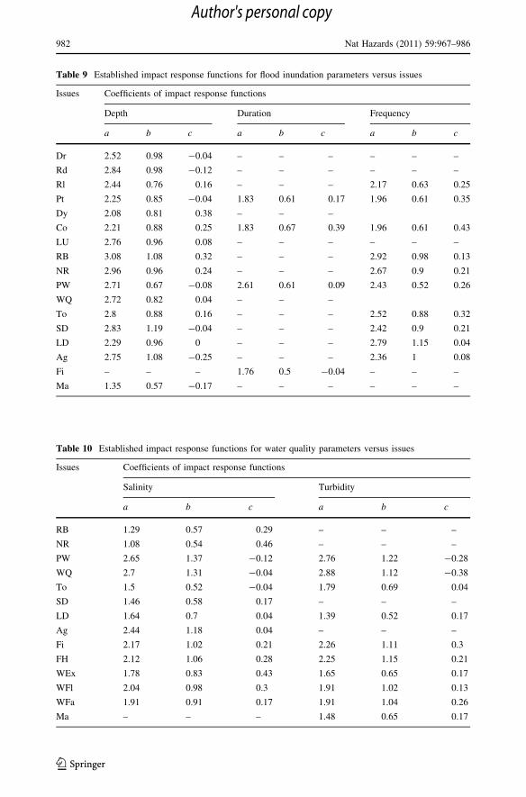
Table 9 Established impact response functions for flood inundation parameters versus issues
Issues Coefficients of impact response functions
Depth Duration Frequency
a b c a b c a b c
Dr 2.52 0.98 -0.04 – – – – – –
Rd 2.84 0.98 -0.12 – – – – – –
Rl 2.44 0.76 0.16 – – – 2.17 0.63 0.25
Pt 2.25 0.85 -0.04 1.83 0.61 0.17 1.96 0.61 0.35
Dy 2.08 0.81 0.38 – – –
Co 2.21 0.88 0.25 1.83 0.67 0.39 1.96 0.61 0.43
LU 2.76 0.96 0.08 – – – – – –
RB 3.08 1.08 0.32 – – – 2.92 0.98 0.13
NR 2.96 0.96 0.24 – – – 2.67 0.9 0.21
PW 2.71 0.67 -0.08 2.61 0.61 0.09 2.43 0.52 0.26
WQ 2.72 0.82 0.04 – – –
To 2.8 0.88 0.16 – – – 2.52 0.88 0.32
SD 2.83 1.19 -0.04 – – – 2.42 0.9 0.21
LD 2.29 0.96 0 – – – 2.79 1.15 0.04
Ag 2.75 1.08 -0.25 – – – 2.36 1 0.08
Fi – – – 1.76 0.5 -0.04 – – –
Ma 1.35 0.57 -0.17 – – – – – –
Table 10 Established impact response functions for water quality parameters versus issues
Issues Coefficients of impact response functions
Salinity Turbidity
a b c a b c
RB 1.29 0.57 0.29 – – –
NR 1.08 0.54 0.46 – – –
PW 2.65 1.37 -0.12 2.76 1.22 -0.28
WQ 2.7 1.31 -0.04 2.88 1.12 -0.38
To 1.5 0.52 -0.04 1.79 0.69 0.04
SD 1.46 0.58 0.17 – – –
LD 1.64 0.7 0.04 1.39 0.52 0.17
Ag 2.44 1.18 0.04 – – –
Fi 2.17 1.02 0.21 2.26 1.11 0.3
FH 2.12 1.06 0.28 2.25 1.15 0.21
WEx 1.78 0.83 0.43 1.65 0.65 0.17
WFl 2.04 0.98 0.3 1.91 1.02 0.13
WFa 1.91 0.91 0.17 1.91 1.04 0.26
Ma – – – 1.48 0.65 0.17
982 Nat Hazards (2011) 59:967–986
123
Author's personal copy

functions were established as described in Sect. 3.4. In all cases, the fitted function was
denoted by
y ¼ aþ bxþ cx2 ð3Þ
where y predicted impact in % to the particular issues, x defined magnitude of a hazard
parameter (coded -1, 0, 1, respectively, for low, medium, and high categories), and a, b,and c are the coefficients.
Each response function predicts the impact of a particular hazard parameter on a par-
ticular issue. Predicted mean impact ranking scores were converted to predicted mean
percentage impacts based on the ranges given in Table 6. The values of the three coeffi-
cients (a, b, and c) for the various response functions are presented in Tables 9 and 10 for
flood inundation and water quality parameters, respectively.
The outcomes from the statistical analysis have revealed the strong views of stake-
holders on the importance of some issues (Class 1) for adaptive measures and no clear
agreements on some other issues (Classes 2 and 4). Furthermore, there are clearly some
issues (Class 3) about which stakeholders agree there is no need for concern. The approach
was beneficial as:
• Synthetic response functions can be generated in the absence of data from previous
flood events. The use of synthetic response functions is therefore particularly useful
where high quality, reliable physical data on past flood impacts have not been collected
or are difficult to obtain.
• The synthetic response functions quantitatively summarize stakeholder opinions about
the likely impact of flood hazards on key issues.
• Key issues of concern for the region were identified along with issues where
understanding appears to be limited and where more research may be needed.
• The outcomes of this methodology could be incorporated into broader investigations of
disaster impacts (Dutta et al. 2003), although not pursued here.
In the recently published report by the House of Representatives Standing Committee
on climate change, water, environment, and the arts of the Parliament of the Common-
wealth of Australia (PCA 2009), the committee recommends development of a consistent
methodology for vulnerability assessments to secure better management outcomes in for
coastal zones in Australia, at a time of environmental change. It notes that in order for
effective climate change adaptation to take place, detailed local vulnerability assessments
are required. Abuodha and Woodroffe (2006) presented a comprehensive review of various
existing approaches, methods, and tools available around the worlds for assessing vul-
nerability of coastal zones such as:
• DIVA (Dynamic Interactive Vulnerability Assessment),
• simCLIM (Simulator of Climate Change Risks and Adaptation Initiatives),
• CVAT (Coastal Vulnerability Assessment Training),
• FUND (Climate Framework for Uncertainty, Negotiations, and Distribution),
• FARM (Future Agriculture Resources Model),
• COSMO (Coastal Zone Simulation Model),
• SURVAS (Synthesis and Upscaling of Sea level Rise Vulnerability Assessment
Studies),
• IPCC CM (Inter-governmental Panel on Climate Change Common Methodology).
Nat Hazards (2011) 59:967–986 983
123
Author's personal copy

While many of these methods and tools are suitable for socioeconomic impact
assessments, their capabilities on environmental impact assessments and applications at
local scale vary widely. The approach presented in this paper provides a clear direction for
enhancing the ability of many of the existing tools in assessment of flood vulnerability and
impacts on various coastal issues related to economic, social, and environmental sectors at
a local scale through effective engagement of stakeholders.
A limitation of the approach is that response functions can only be generated for issues
about which stakeholders are aware. This method is not useful for identifying ‘‘sleeper’’
issues. A particular limitation of this study is that, although considerable effort was made
to identify a large number of stakeholders in the region, only 10% of those approached
responded to the questionnaire. A greater response may have been achieved if the ques-
tionnaire had been designed to be more accessible. It was a lengthy, complex instrument
and required a considerable time investment to complete. It is acknowledged that the
impact response functions would be better estimated on the basis of a larger stakeholder
sample.
5 Conclusions
The paper has presented a systematic approach by which relevant stakeholders can be
actively engaged in prioritising flood impact issues and collating information for quanti-
fication of impacts for adaptation measures and has demonstrated the approach through
successful implementation in the Gippsland coastal region. As an outcome of the project,
we identified key issues of concern for this region for flood impacts and the synthetic
response functions for some of these key issues (with high agreement) for quantification of
impacts of floods on these key issues in the region. The analysis also showed that some of
the issues are considered not to be significantly affected by floods (Class 4) and thus may
not require adaptation measures. The outcomes of the analysis did not provide high
agreement for issues under Classes 3 and 4. Different approaches would be required to
determine the importance of these issues and to establish response functions for these
various relevant hazard parameters.
Synthetic response functions as developed in this study can be used to quantify the
likely impacts of flood hazards of various magnitudes. This allows natural resource
managers and decision makers to better understand the risks associated with sea level rise
and to prioritise adaptive management strategies for coastal regions. Many of the existing
methods for flood impact assessment in coastal regions are limited in their capabilities on
environmental impact assessments. The approach presented in the study can been effec-
tively utilized for enhancing the existing tools in the assessment of flood impacts on
various coastal zone issues related to economic, social, and environmental sectors.
Although not demonstrated in this study, a further application of the response functions
may be to use them in order to analyze the effectiveness of proposed adaptive measures.
Acknowledgments The authors wish to acknowledge the Asia Pacific Network for Global ChangeResearch for financial support, the stakeholder reference group and the international expert group forparticipation in the project, Monash University’s Standing Committee on Ethics in Research InvolvingHumans (SCERH) for review and approval of the questionnaires, Paul McLaren of Monash University’sInformation Technology Support division for valuable assistance with data manipulation, and the twoanonymous reviewers for their invaluable comments.
984 Nat Hazards (2011) 59:967–986
123
Author's personal copy

References
Abuodha PA, Woodroffe CD (2006) International assessments of the vulnerability of the coastal zone toclimate change, including an Australian perspective. Australian Greenhouse Office, Department of theEnvironment and Heritage, Australia
Aldrick JM, Hook RA, van de Graaff RHM, Nicholson BM, O’Beirne DA, Schoknecht NR (1984) A studyof the land in the catchment of the Gippsland Lakes. TC-17, volume 1. Land Protection Division, EastMelbourne, Australia
APN (2005) APN strategic plan (2005–2010). Asia-Pacific Network for Global Change Research, Kobe,Japan
Belfiore S (2003) The growth of integrated coastal management and the role of indicators in indicators inintegrated coastal management: introduction to the special issue. Ocean Coast Manag 46:225–234
Berning C, Viljoen MF, Plessis LA (2000) Loss functions for sugar-cane: depth and duration of inundationas determinants of extent of flood damage. Water SA 26(4):527–530
Boon P, Raulings E, Morris K, Roache M, Robinson R, Hatton M, Salter J (2007) Ecology and managementof the Lake Wellington Wetlands, Gippsland Lakes. A report on the R&D project, 2003–2006. MonashUniversity & Victoria University, Australia
Costanza R et al (1997) The value of the world’s ecosystem services and natural capital. Nature387:256–260
Creel L (2003) Ripple effects: population and coastal regions. Measure communication, September 2003.Population Reference Bureau, Washington, pp 1–7
Das S, Lee R (1988) A nontraditional methodology for flood stage-damage calculations. Water Resour Bull24(6):1263–1272
DEWR (2007) Water quality targets. Water Resources Publications, Department of Environment and WaterResources, Australian Government http://www.environment.gov.au/water/publications/quality/.Accessed 28 Nov 2010
Dougherty TC, Hall AW (1995) Environmental impact assessment of irrigation and drainage projects. FAOirrigation and drainage paper no 53. FAO, Rome
Dutta D (ed) (2007) Proceedings of the planning workshop of the APN project on climate perturbation andcoastal zone systems in Asia Pacific Region, Bangkok, Thailand. Monash University, Australia
Dutta D, Herath S, Musiake K (2003) A mathematical model for flood loss estimation. J Hydrol 277:24–49Dutta D, Babel MS, Das Gupta A (2005) An assessment of the socio-economic impacts of floods in large
coastal areas. Final Report for APN CAPaBLE Project, AIT, ThailandDutta D, Alam J, Umeda K, Hayashi M, Hironaka S (2007) A two dimensional hydrodynamic model for
flood inundation simulation: a case study in the Lower Mekong River basin. Hydrol Process21:1223–1237
EPA (2007) Nutrient criteria. Technical guidance manual, Wetlands, EPA-822-R-07-004, EPA, USAGCB (2008) Climate change, sea level rise and coastal subsidence along the Gippsland coast: implications
for geomorphological features, natural values and physical assets. Phase 2—Gippsland climate changestudy, Gippsland coastal board. Final Report, Victoria, Australia
Gordon DC Jr, Boudreau PR, Mann KH, Ong JE, Silvert WL, Smith SV, Wattayakorn G, Wulff F, Yanagi T(1996) LOICZ biogeochemical modelling guidelines. LOICZ reports & studies no. 5. LOICZ, Texel,The Netherlands
Grayson R, Tan KS, Wealands S (2001) Pre-European load estimates into the Gippsland Lakes. Centre forEnvironmental Applied Hydrology, University of Melbourne, Australia
Green OS (1978) The Gippsland Lakes. Rigby Limited, AustraliaHarris G, Batley G, Webster I, Molloy R, Fox D (1998) Review of water quality and status of the aquatic
ecosystem of the Gippsland lakes. CSIRO Environmental Projects Office, AustraliaHong GH, Kremer HH, Pacyna J, Chen C-TA, Behrendt H, Salomons W, Crossland JIM (2002) LOICZ
global assessment and synthesis of river catchment-coastal sea interaction and human dimensions. EastAsia Basins. LOICZ reports & studies no. 26. LOICZ IPO, Texel, The Netherlands
Houghton JT, Ding Y, Griggs DJ, Noguer M, van de Linden PJ, Dai X, Maskell K, Johnson CA (2001)Climate change 2001: the scientific basis. IPCC TAR. Cambridge, New York
Kang JL, Su MD, Chang LF (2005) Loss functions and framework for regional flood damage estimation inresidential area. J Mar Sci Technol 13(3):193–199
Krzysztofowicz R, Davis DR (1983) Category-unit loss functions for flood forecast–response systemevaluation. Water Resour Res 19(3):1476–1480
Longmore AR (2000) Gippsland Lakes sediment nutrient inventory. Marine & Freshwater ResourcesInstitute, Department of Natural Resources and Environment, Australia
Nat Hazards (2011) 59:967–986 985
123
Author's personal copy

Malcolm D (2010) Climate Change: the need for adaptation on the Gippsland coast. Proceedings of theinternational symposium on international symposium on coastal zones and climate change: assessingthe Impacts and Developing Adaptation Strategies. Monash University, Australia, pp 9–18
McInnes KL, Abbs DJ, Bathols JA (2005a) Climate change in Eastern Victoria. Stage 1 report: the effect ofclimate change on coastal wind and weather patterns. CSIRO, Australia
McInnes KL, Macadam I, Hubbert GD, Abbs DJ, Bathols J (2005b) Climate change in Eastern Victoria.Stage 2 report: the effect of climate change on storm surges. CSIRO, Australia
McInnes KL, Macadam I, Hubbert GD (2006) Climate change in Eastern Victoria. Stage 3 report: the effectof climate change on extreme sea levels in Corner Inlet and the Gippsland Lakes. CSIRO, Australia
Nakayama K, Dutta D, Tanaka G, Okada T (2004) Integration of hydrological model and estuary model.J Jpn Soc Hydrol Water Resour 18(4):390–400
Neumann JE, Livesay ND (2001) Coastal structures, dynamic economic modeling. In: Mendelsohn R (ed)Global warming and the American economy, a regional assessment of climate change impacts. EdwardElgar, UK, pp 132–148
PCA (2009) Managing our coastal zone in a changing climate: the time to act is now. House of repre-sentatives standing committee on climate change, water. Environment and the Arts, the Parliament ofthe Commonwealth of Australia, Canberra
Pitt MW, Synan TP (1987) The past, present and future of the Gippsland lakes. The Save the GippslandLakes Committee, Australia
Post JC, Lundin CG (1996) Guidelines to integrated coastal zone management. World Bank, WashingtonDC
Smith DI (1994) Flood damage estimation—a review of urban stage-damage curves and loss functions.Water SA 20:231–238
Smith DI, Greenway M (1988) The computer assessment of urban flood damage:’ ANUFLOOD’. TechnicalReport, Melbourne, Australia
VGG (1988) Victoria Government Gazette. No. S 13, BlueStar Print, Melboune, AustraliaVGG (1996) Victoria Government Gazette. No. S122, BlueStar Print, Melbourne, AustraliaViljoen MF, Plessis LA, Booysen HJ (2001) Extending flood damage assessment methodology to include
sociological and environmental dimensions. Water SA 27(4):517–521Walsh K (2004) Climate change and coastal response. A theme report from the coast to coast 2002 National
Conference, Gold Coast. Melbourne University, AustraliaWebster IT, Wallace B (2000) Further analysis of sediment core samples collected in the Gippsland lakes.
CSIRO Land & Water, AustraliaWebster IT, Parslow JS, Grayson RB, Molloy RP, Andrewartha J, Sakov P, Ian KS, Walker SJ, Wallace BB
(2001) Gippsland Lakes environmental study–assessing options for improving water quality andecological function. CSIRO, Australia
Wilkinson C (2000) Status of coral reefs of the world: 2000. Global Coral Reef Monitoring Network,Townsville, Australia
986 Nat Hazards (2011) 59:967–986
123
Author's personal copy