Subneolithic Fishery in the Iijoki River Estuary, Northern Ostrobothnia, Finland
26
Author’s address: S. Koivisto University of Helsinki, Department of Archaeology, PO Box 59, Unioninkatu A, FI- Universit of Helsinki, Finland. Email: satu.m.koivisto@helsinki. J W t A y 12, 2012, 22–47 Subneolithic Fishery in the Iijoki River Estuary, Northern Ostrobothnia, Finland Satu Koivisto A st t A wetland site discovered accidentally in the western part of the Kierikki area in Yli-Ii, Northern Ostrobothnia, Finland, surprised archaeologists in the mid 1990s by its size and the rare degree of preservation of the organic nds. A number of ooden objects had already been found during the draining of the present-day peatland agricultural eld in the s, but the age and the full scienti c value of the prehistoric sher were only recognized later. Since none of the wooden structures were intact, it has been challenging to reconstruct the Stone Age shing methods in detail, but most of the nds point to ethnographicall recognisable sh eir ith lath screen traps set in shallow water. All of the radiocarbon samples returned Middle Subneolithic (non- agricultural Neolithic) dates ranging between 3934–2679 cal BC (2 ), but the relative dendrochronological dates indicate a distinct activity phase of only 19 years. The site is still in the process of being destroyed due to the progressive lowering of the water table. After a fe decades, or a centur at the most, a signi cant portion of the ooden artefacts of Purkajasuo will have deteriorated. Keywords: w t y, St A , F , s s w , t y Introduction Finland is one of the most mire-rich countries in Western Europe Heikurainen ; one third of the total land area is covered by peatland deposits. Most of the Finnish mires are situated in agricultural and forestry management areas and have been drained during the last centur Sepp ; Laine and Vasander ; Hu unen and Tolonen
Transcript of Subneolithic Fishery in the Iijoki River Estuary, Northern Ostrobothnia, Finland

Author’s address: S. Koivisto University of Helsinki, Department of Archaeology, PO Box 59, Unioninkatu 38 A, FI-00014 University of Helsinki, Finland. Email: [email protected]
Journal of Wetland Archaeology 12, 2012, 22–47
Subneolithic Fishery in the Iijoki River Estuary, Northern Ostrobothnia, Finland
Satu Koivisto
AbstractA wetland site discovered accidentally in the western part of the Kierikki area in Yli-Ii, Northern Ostrobothnia, Finland, surprised archaeologists in the mid 1990s by its size and the rare degree of preservation of the organic finds. A number of wooden objects had already been found during the draining of the present-day peatland agricultural field in the 1950s, but the age and the full scientific value of the prehistoric fishery were only recognized later. Since none of the wooden structures were intact, it has been challenging to reconstruct the Stone Age fishing methods in detail, but most of the finds point to ethnographically recognisable fish weir with lath screen traps set in shallow water. All of the radiocarbon samples returned Middle Subneolithic (non-agricultural Neolithic) dates ranging between 3934–2679 cal BC (2σ), but the relative dendrochronological dates indicate a distinct activity phase of only 19 years. The site is still in the process of being destroyed due to the progressive lowering of the water table. After a few decades, or a century at the most, a significant portion of the wooden artefacts of Purkajasuo will have deteriorated.
Keywords: wetland archaeology, Stone Age, Finland, fishing structures, waterlogged wood, ethnography
IntroductionFinland is one of the most mire-rich countries in Western Europe (Heikurainen 1960); one third of the total land area is covered by peatland deposits. Most of the Finnish mires are situated in agricultural and forestry management areas and have been drained during the last century (Seppä 2002; Laine and Vasander 2005; Huttunen and Tolonen 2006).

Subneolithic Fishery in the Iijoki River Estuary 23
The number of wooden artefacts found in Finnish wetlands runs to several hundreds, possibly to over a thousand (Taavitsainen 2001, 71–80). The most numerous are dugout boats; new finds emerge frequently from the shores of old waterways and muddy lake sediments. Several sledge runners, skis, boat paddles and fishing implements have also been found in Finnish peatlands and in shallow water. The great majority of wetland finds have ended up in ethnological (museum) collections due to the traditional division between ethnology and archaeology in the Finnish antiquarian system, although some of the organic artefacts have later been radiocarbon dated to prehistoric times. A number of these finds originate from stationary wooden fishing structures, e.g. traps, weirs and lath screen panels that have been uncovered accidentally in peatlands and muddy lake sediments or have been exposed in shallow water. (Koivisto 2011a, 2011b.) Surprisingly, wetland archaeological research has been quite scarce in Finland, and these well-preserved organic assemblages have rarely been studied in connection with other research topics. In the past few decades, a number of interesting wetland sites have been excavated and published (e.g. Aalto et al. 1985; Núñez 1995; Matiskainen and Zhilin 2003; Koivunen 2006; Taavitsainen et al. 2007; Forsberg et al. 2009) and their results have thoroughly changed our conception of well-preserved prehistoric organic materials. The results of the early ethno-archaeological bog surveys have been reanalysed (Taavitsainen et al. 2007) and the potential of the Finnish wetland cultural heritage is now seen in a different light, as a part of the larger context of the archaeological discipline. Nevertheless, systematic projects utilizing the full archaeological potential of wetlands and waterlogged materials still lying underneath the thousands of bogs and shallow lakes await investigation. A wetland site discovered accidentally in the western part of the Kierikki area in Northern Ostrobothnia Finland (Figure 1), amazed archaeologists in the mid 1990’s by its size and the rare degree of preservation of the organic finds. The site was excavated over several years in 1996–1999 and 2004, but due to the scale and the thick alluvial layers covering the wooden finds, only a small fraction of the total site has been archaeologically investigated. This paper represents the first analysis of the Purkajasuo material. The aim is to investigate the fishing methods used by the Stone Age populations inhabiting the mouth and the banks of the Iijoki river. Dimensions and the technological function and typology of the wooden artefacts are compared with the ethnographical and historical data in order to help reconstructing the fishing techniques and the stationary structures used in coastal Northern Ostrobothnia in the Middle Subneolithic period. The term Subneolithic is used to denote settlements or cultures or peoples that, while being in contact with neolithic (farmer) groups, remain attached to their traditional hunter-gatherer practices, in this case fishing. Finally, the results are compared and evaluated in the light of environmental data and archaeological sites with similar assemblages in Northern Europe and Russia. The technological adaptations of the Purkajasuo material point to a productive fishing ground with stationary wooden fishing structures erected in a narrow channel by the Stone Age mouth of the Iijoki river and its northern tributary, the Siuruanjoki river. Based on the geological and archaeological evidence, the fishing activity at Purkajasuo ended catastrophically when a severe flood broke the stationary fishing structures, covered the area in alluvial sand and rendered the shallow bay unusable for fishing.

24 Satu Koivisto
Figure 1. Map of Finland and the neighbouring areas with Purkajasuo and the Iijoki river situated near the head of the Bay of Bothnia.
Subneolithic Fishery in the Iijoki River Estuary 25
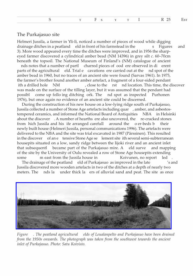
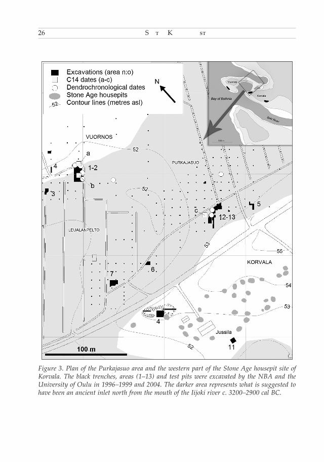
The Purkajasuo siteHelmeri Jussila, a farmer in Yli-Ii, noticed a number of pieces of wood while digging drainage ditches in a peatland field in front of his farmstead in the 1950s (Figures 2 and 3). More wood appeared every time the ditches were improved, and in 1956 the sharp-eyed farmer discovered a cylindrical amber bead (NM 14396) in grey silt c. 60–70cm beneath the topsoil. The National Museum of Finland’s (NM) catalogue of ancient finds notes that a number of partly charred pieces of wood were observed in different parts of the agricultural field. Trial excavations were carried out at the find spot of the amber bead in 1960, but no traces of an ancient site were found (Sarvas 1961). In 1975, the farmer’s brother found another amber artefact, a fragment of a four-sided pendant with a drilled hole (NM 19679), close to the first find location. This time, the discovery was made on the surface of the tilling layer, but it was assumed that the pendant had possibly come up following ditching work. The find spot was inspected (Purhonen 1976), but once again no evidence of an ancient site could be discerned. During the construction of his new house on a low-lying ridge south of Purkajasuo, Jussila collected a number of Stone Age artefacts including quartz, amber, and asbestos-tempered ceramics, and informed the National Board of Antiquities (NBA) in Helsinki about the discovery. A number of hearths were also uncovered, the fire-cracked stones from which Jussila and his wife arranged carefully around the flower-beds by their newly built house (Helmeri Jussila, personal communications 1996). The artefacts were delivered to the NBA and the site was trial excavated in 1987 (Pärssinen). This resulted in the discovery of an extensive Stone Age settlement site with several semi-subterranean housepits situated on a low, sandy ridge between the Iijoki river and an ancient inlet that subsequently became part of the Purkajasuo mire. A field survey and mapping of the site by the University of Oulu revealed a row of Stone Age housepits extending some 300m east from the Jussila house in 1995 (Koivunen, no report filed). The drainage of the peatland field of Purkajasuo was improved in the late 1980’s and Jussila discovered more wooden artefacts in two of the ditches at a depth of nearly two meters. The finds lay under thick layers of alluvial sand and peat. The site was once
Figure 2. The peatland agricultural fields of Leualanpelto and Purkajasuo have been drained from the 1950s onwards. The photograph was taken from the southwest towards the ancient inlet of Purkajasuo. Photo: Satu Koivisto.
26 Satu Koivisto
Figure 3. Plan of the Purkajasuo area and the western part of the Stone Age housepit site of Korvala. The black trenches, areas (1–13) and test pits were excavated by the NBA and the University of Oulu in 1996–1999 and 2004. The darker area represents what is suggested to have been an ancient inlet north from the mouth of the Iijoki river c. 3200–2900 cal BC.

Subneolithic Fishery in the Iijoki River Estuary 27
again inspected (Vanhatalo 1988, no report filed) after the landowner sent a report and a number of wooden samples to Helsinki. A radiocarbon date was obtained from a narrow lath of pine wood, but the great importance of the site was still not perceived. The radiocarbon date (Hel-2740) produce an age estimate of 4770 ±130 BP, 3934–3110 cal BC (at 2σ probability) (OxCal v4.1.7 Bronk Ramsey 2009; atmospheric data from Reimer et al. 2009), which confirmed that the man-made wooden artefact belonged to the Finnish Middle Subneolithic period. More ditches were renovated in 1990 and wood finds were observed in a much larger area than before. The observations were communicated persistently to the NBA by the farmer and the find area was once again inspected and then mapped for the first time (Wallenius 1990). The same year, Jussila sent the trimmed point of a wooden stake (NM 29764:206) to the NBA. In the autumn of 1995, the drainage system of the western part of the peatland field was renovated with an excavator and more wood appeared in the drainage ditches over a total area of more than two hectares (Schulz 1997, 2). The stratigraphy of the western find locations was quite similar to the earlier finds, except for the fact that some of the clusters of wood lay under thinner layers of alluvial sand. Most of the artefacts bore the clear marks of stone tools, and the finds also included an especially elaborate lath screen section. This wooden artefact, made of narrow laths of pine bound together with birch bark strips, was unearthed in one of the ditches in the western part of the find area (Figure 2). By this time, archaeological excavations by the University of Oulu were in progress at the Stone Age housepit site of Kuuselankangas, c. 2km east of Purkajasuo, and the farmer asked the excavation staff to inspect the new find area at Purkajasuo. The excavation leader, lecturer Pentti Koivunen, was very impressed with the finds, and the scientific value of the extensive wetland archaeological site was finally perceived. The finds received prominent coverage in the Finnish media, and at first it was suggested that the well-preserved lath screen was most plausibly a Stone Age sleeping mat. After the first faulty impression, the site was finally interpreted as a fishery situated in a narrow channel by the Stone Age mouth of the Iijoki. The Purkajasuo site was reported to the Wetland Archaeological Research Project (WARP) (Núñez 1995) and the lath screen, about 170 × 55cm in size, was recovered and transported to the University of Oulu for conservation. In the preliminary field survey of the western area, it was observed that Leualanpelto also contained an extensive collection of wooden material, most of it well preserved under the peatland tilling layer and alluvial sand. It was further noted that many of the finds lay at a depth of only one metre, near the present water table, and were in danger of drying out and decomposing due to the improved drainage. The good preservation of the wooden finds prior to drainage was due to the artefacts having been rapidly covered by alluvial sand and the site being situated in the vicinity of the Iijoki river. These factors maintained the water table at a relatively high level, even after the isostatic uplift of the land had elevated the area to 50–60m above the present day sea level (Núñez 1995, 29–31). A five-year fieldwork project, carried out jointly by the NBA and the University of Oulu, began in 1996 (Schulz 1997; 1998a; 1998b; 2000; 2001). During the excavations, it was suggested that in the Stone Age the shallow inlet that subsequently became part of the Purkajasuo mire had served both as a fishery and as a vast storage area for wood and that the fish weirs would have been set mainly at the most productive
28 Satu Koivisto
fishing grounds in the river, south from Purkajasuo, and collected and stored before winter in the shallow inlet for re-use. Further excavations in the southern and eastern parts of Purkajasuo were carried out in 2004 by the University of Oulu (Koivunen and Viljanmaa 2004) and an extensive amount of wooden material was uncovered in the southern area. In addition, a third amber artefact (NM 34861:1) was discovered in a test trench on the eastern shore of the ancient bay. The wetland site of Purkajasuo, with its extensive wooden material, has not yet been published. Three studies have been completed so far: a geological study (Karinen 2000), an insect fossil analysis of the Purkajasuo area (Tranberg 2006) and a dendrochronological dating experiment with the conserved wooden material (Kinnunen 2007; Zetterberg and Kinnunen 2007; 2009).
The deposition and dating of the wooden assemblageThe Iijoki river, which traverses Yli-Ii from east to west, is one of the largest rivers in Ostrobothnia (see Figure 1). Since the 1940s, several of these rivers have been harnessed for generating hydro-electric power, and this has had a major effect on the location of the main channel and on the water level (Poussu, 2006). The Ostrobothnian rivers have to cope constantly with land uplift that is more rapid in coastal than in inland areas. This is one of the major causes of annual flooding in the area, in addition to the melt waters from a considerable snowfall. The rivers of the low-lying areas are characterised by a gentle gradient, and the flood plains extend far from the main channels. Large deltas have not been formed in the major river mouths due to the rapid uplift rate of land, shifting the shoreline constantly further west (Poussu, 2006). A significant amount of solid material is caught by the river and settles in the estuary, which in part makes it very shallow. As a consequence, mires at various stages of development are situated as a continuum from coastal to inland areas (Seppä, 2002; Nissilä, 1990; Laine and Vasander, 2005; Huttunen and Tolonen, 2006; Rehell, 2006; Korhonen et al., 2008). Purkajasuo emerged from the Baltic Sea during the Litorina stage, c. 3500–2900 cal BC, when the relative sea level was 50–60m higher than today. Bays, inlets, and coves formed between new land areas (Karinen, 2000) and the new bodies of water were very shallow and sheltered due to the low-lying terrain. The topography of the peatland fields of Purkajasuo is especially flat (Figures 2 and 3); the terrain rises only c. 1m in the southwest corner of Leualanpelto. The southern bank rises to form the low-slung moraine formation of Korvala, which slopes down again in the south, towards the former and present day channels of the Iijoki river. The Stone Age cape of Korvala was some 400m in length and 150–200m in breadth during the occupation periods of the Purkajasuo/Korvala and Korvala housepit sites, c. 3200–2900 cal BC. Paleochannels of the Iijoki can be observed at several locations on the riverbanks, but a distinct delta did not form. The flood reached the Purkajasuo area from the southwest, between the two moraine ridges of Korvala and Vuornos which formed an ancient inlet (Karinen 2000). The inlet gradually became shallower towards the head of the bay, and in the forested peatland area between the present day Leualanpelto and Purkajasuo, in the middle of the channel, a low ridge ran towards the north. By 2900 cal BC, the formation rose above sea level and this blocked the inlet (Figure 3).

Subneolithic Fishery in the Iijoki River Estuary 29
Later, the inlet was gradually isolated from the Bay of Bothnia. The geological and diatom studies have not revealed whether the area was under the influence of the river after it was isolated from the Bay of Bothnia (Karinen 2000). Possibly the fresh-water basin of Purkajasuo dried out after having become an alluvial basin during the flood season. Thick alluvial sand layers have been laid down over the top of the finer marine sediments in a large area due to periodically high stream volumes in the flood season (Karinen 2000). The sedimentation of Purkajasuo, especially in the western part, may have been caused by more severe environmental events than merely annual flooding. According to the geological data, a severe flood possibly caused by a storm might have caused a rapid covering of the site with coarse sand on top of the grey silt and wood layers (Karinen 2000). During the excavations of 1996–1999 and 2004, three or four stratigraphical layers of wood were identified in different parts of the site (Figure 4) (Schulz 1997; 1998ab; 2000; 2001; Koivunen and Viljanmaa 2004). It was then suggested that the layers had been formed by different activity phases of the underwater wood caching and fishery, that the oldest wooden fishing structures had been driven into the seabed while the area was still forming an archipelago, c. 3400 cal BC, and that the contemporary settlement had been situated c. 2.3km southeast from the fishery. Later, the settlements were moved with the retreating coastline to the Purkajasuo/Korvala site, which has been dated by
Figure 4. The horizontal distribution of the wooden finds at the northern (A= excavation areas 1–2) and the southern (B= areas 12–13) shores of the ancient inlet of Purkajasuo. The scale bars are 5m. Map: Satu Koivisto.
30 Satu Koivisto
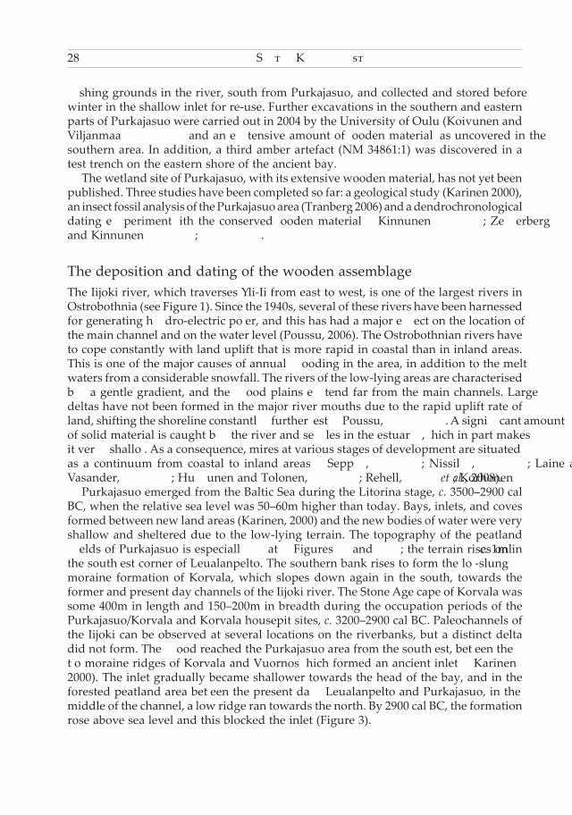
means of shore displacement chronology to c. 3250–2900 cal BC. The fishery lost its function after being covered by alluvial sediments c. 3050–2900 cal BC. So far, only three wooden samples from Purkajasuo have been radiocarbon dated (Table 1 and the radiocarbon dates a–c in Figure 3). The extremely low number of radiocarbon dates is mostly due to financial constraints encountered during the field work project. The calibrated dates fall between 3934–2679 cal BC (at 2σ probability) (OxCal v4.1.7 Bronk Ramsey 2009; atmospheric data from Reimer et al. 2009).The first radiocarbon date was derived from a lath and returned the oldest date so far, (Hel-2740) 4770 ±130 BP, 3934–3110 cal BC (2σ). The sample was collected in 1988 from the southern shore of the ancient inlet in a drainage ditch section, at the bottom of the alluvial sand layer in brownish silt, from a depth of 180–200cm (Simo Vanhatalo, personal communications 2011). The other two radiocarbon dates were derived from wood finds from the 1996 excavations in the northwest part of the site (Schulz 1997, appendix). The first sample (Hel-3917), from a stake from the interface of alluvial sand and grey silt, was dated to 4340 ±100 BP, 3349–2679 cal BC (2σ). The other, unworked piece of wood, uncovered at a depth of 15 cm under the surface of grey silt, provided an age estimate of (Hel-3918) 4460 ±100 BP, 3489–2900 cal BC (2σ). The relative dendrochronological dates obtained from ten wood samples (Kinnunen 2007; Zetterberg and Kinnunen 2009) render the stratigraphy even more complex. The samples, which were chosen from different areas of the ancient inlet (circles in Figure 3), and from various wood layers, showed that all the trees had been felled within a period of only 19 years. The youngest dates were identical and derived from the northern and southern shores of the ancient inlet. A sample from a stratigraphically much deeper wood layer from the northwest part of the site had been felled in the following year. All of the wood samples were felled during the cold season, during a time span of nine months between August/September and May/June (Zetterberg and Kinnunen 2007, 2009). Based on the relative dendrochronological dates, the wood layers of Purkajasuo were probably formed by natural processes, e.g. sedimentation in a flood-susceptible area, rather than by human activity. Both young and old dates were obtained from all four wood layers; there does not seem to be any patterning in the relative dendrochronology. More radiocarbon dates are essential, especially of the dendrochronologically dated wooden samples, for a more accurate determination of the use period of the total site.
Lab. Number Sample BP Cal BC (at 2σ probability)
Hel-2740 Wooden lath 4770 ±130 3934–3110Hel-3917 Wooden stake 4340 ±100 3349–2679Hel-3918 Unworked wood 4460 ±100 3489–2900
Table 1. Radiocarbon dates of the wooden samples. All ages in this paper have been calibrated with IntCal09 (Reimer et al. 2009) in OxCal v4.1.7 (Bronk Ramsey 2009).
Subneolithic Fishery in the Iijoki River Estuary 31
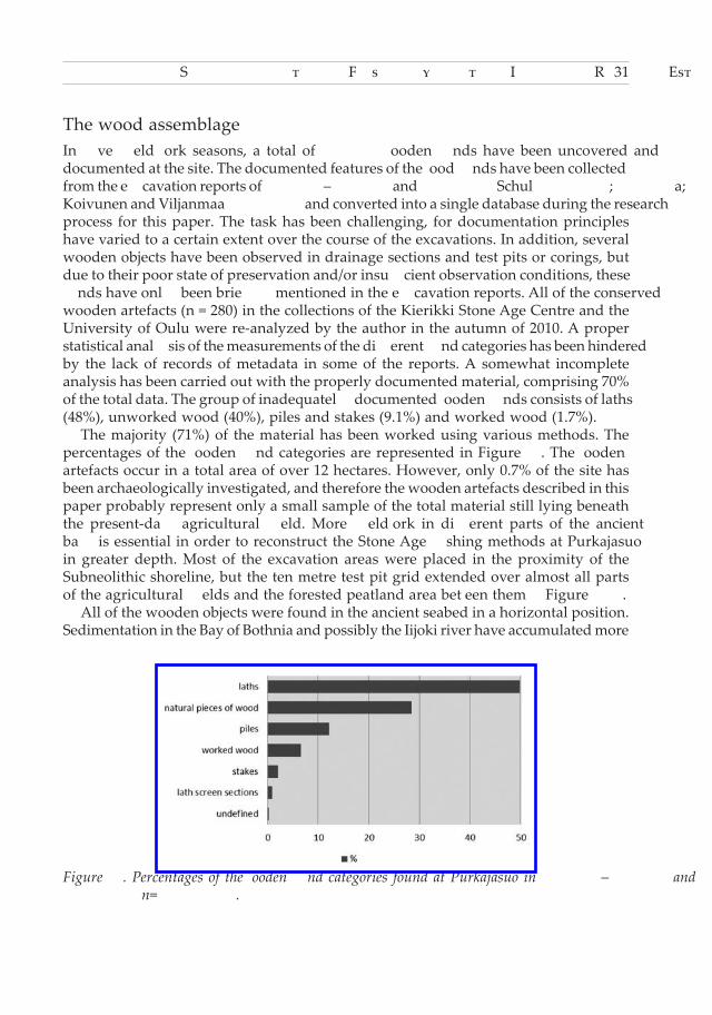
The wood assemblage In five field work seasons, a total of 2602 wooden finds have been uncovered and documented at the site. The documented features of the wood finds have been collected from the excavation reports of 1996–1999 and 2004 (Schulz 1997; 1998a; 1998b; 2000; 2001; Koivunen and Viljanmaa 2004) and converted into a single database during the research process for this paper. The task has been challenging, for documentation principles have varied to a certain extent over the course of the excavations. In addition, several wooden objects have been observed in drainage sections and test pits or corings, but due to their poor state of preservation and/or insufficient observation conditions, these finds have only been briefly mentioned in the excavation reports. All of the conserved wooden artefacts (n = 280) in the collections of the Kierikki Stone Age Centre and the University of Oulu were re-analyzed by the author in the autumn of 2010. A proper statistical analysis of the measurements of the different find categories has been hindered by the lack of records of metadata in some of the reports. A somewhat incomplete analysis has been carried out with the properly documented material, comprising 70% of the total data. The group of inadequately documented wooden finds consists of laths (48%), unworked wood (40%), piles and stakes (9.1%) and worked wood (1.7%). The majority (71%) of the material has been worked using various methods. The percentages of the wooden find categories are represented in Figure 5. The wooden artefacts occur in a total area of over 12 hectares. However, only 0.7% of the site has been archaeologically investigated, and therefore the wooden artefacts described in this paper probably represent only a small sample of the total material still lying beneath the present-day agricultural field. More fieldwork in different parts of the ancient bay is essential in order to reconstruct the Stone Age fishing methods at Purkajasuo in greater depth. Most of the excavation areas were placed in the proximity of the Subneolithic shoreline, but the ten metre test pit grid extended over almost all parts of the agricultural fields and the forested peatland area between them (Figure 3). All of the wooden objects were found in the ancient seabed in a horizontal position. Sedimentation in the Bay of Bothnia and possibly the Iijoki river have accumulated more
Figure 5. Percentages of the wooden find categories found at Purkajasuo in 1996–1999 and 2004 (n= 2602).

32 Satu Koivisto
than a meter of alluvial sand on top of the finds. These finds have been progressively uncovered during the course of excavations; however, the number of wooden artefacts documented per year varied from less than a hundred (n = 74 in 1999) to over a thousand (n = 1139 in 1997). The average number of documented wooden artefacts was 520 per year and the number of recovered finds averaged only 85 per year. The excuse for the unfortunately low recovery rate lies in financial considerations; such a quantity of organic material would have required considerable funding if all of the wooden artefacts were to be conserved and stored. A number of wooden artefacts were already found to be so poorly preserved when uncovered that their recovery and/or conservation was out of the question. The deterioration of these finds was mostly due to the progressive lowering of the water table through intensified agricultural drainage. Chemical analysis on the sediments has not yet been carried out and acidification might also have had an effect on the degree of degradation of the material. Most of the discarded wooden finds were natural pieces of wood and fragmented laths. A number of wood samples were collected and frozen for future analysis and research. Only c. 15% of the wooden finds were conserved with Polyethylene Glycol (PEG) and are still available for study in the collections of the Kierikki Stone Age Centre in Yli-Ii, the University of Oulu and the National Museum in Helsinki. Mass-conservation facilities with strict capacity limits were established in a storehouse during the excavations and the process is still underway at the University of Oulu (Heinonen 2005).
Laths and lath screensThe most numerous (50%) find category consists of separate laths. According to the preliminary material analysis carried out during the excavations, all the laths (n = 1296) have been manufactured from pine wood. Most of the laths were broken whilst being recovered nevertheless preservation was sufficient to show that some of the tips were worked, e.g. sharpened or rounded. The complete laths varied between 0.6m and 2.8m in length. Some of the rounded ends might have been formed by natural processes, i.e. if laths had been waterlogged for some time after been detached from their original setting. On average, the laths were 20mm wide and 12mm thick. Some had depressions on their surfaces showing the former positions of the birch bark strip bindings. A few had carved notches in one or several places on their surface. A total of 26 lath screen sections (including three undocumented sections uncovered partially in test pits) have been discovered in the site. Some of them may derive from the same stationary fishing structure. In these elaborate pieces of work, the pine laths were bound up with narrow strips of birch bark (Figure 6). Most of the screens had a twig or a narrow lath underneath securing the binding. Some of the artefacts were composed of only a few broken laths bound up with birch bark strip. All the lath screens probably represent broken sections of trap panels or weir fences. None of the sections seemed undamaged and thus it is extremely difficult to reconstruct how high the trap panels were originally arranged, but as suggested by the lengths of the complete laths, the panel heights varied between 0.6 and 2.8 metres.

Subneolithic Fishery in the Iijoki River Estuary 33
Piles12% of the wooden artefacts have been classified as piles. The criterion for a pile has been defined as a diameter of at least 50mm; pieces with a smaller diameter are defined as stakes. C. 31% (n = 98) of the piles were complete, i.e. both ends were observable. The lengths of the complete piles varied between 0.26m and 2.72m with an average length of 1.29m. The average diameter of the piles was 6.90cm. Five specific pile types have been distinguished:
1) Short piles with wedge or chisel-shaped points and worked ends (Figures 7A, 7B and 10E);
2) Sturdy piles with pencil-shaped points and worked ends (Figures 8A, 10C and 10F);
3) Piles with tapering points and worked ends (Figure 10G);4) Piles with peg-shaped ends or points (Figures 7D and 7E; see also Figure 10C);
and5) Piles with other point and/or end variants not ascribable to the above-mentioned
categories.
Figure 6. Lath screen sections with birch bark strip bindings. A reverse side (left) of a lath screen panel (NM 34860:19) where the binding has been secured with a twig. The scale bars are 5cm. Photos: Satu Koivisto.

34 Satu Koivisto
The most typical (n = 29) pile type at Purkajasuo was the relatively short pile with a wedge or a chisel-shaped point. The lengths of these piles varied between 0.26m and 2.37m. Most of the piles had straight or rounded ends but also a few oblique ends occurred. A special sub-group of this type seemed to be a short wedge (n = 17) with a length of under 0.80m and straight or rounded ends. Sturdy pencil-pointed piles (n = 25) had been elaborately worked. The facet junctions were typically clean and bore clear stone tool marks on the surface (see Figure 8A). The length of this pile type varied between 0.82m and 2.34m. The ends were cut straight off, rounded, oblique, or thinned. Four of the piles with pencil-shaped points had a notch carved near the end of the pile (Figure 8B). Simple tapering points were observed in 18 of the piles. Some of the points had
Figure 7. Piles from Purkajasuo: (A) a chisel-shaped (NM 34860:17); (B) a wedge-shaped (NM 29764:250); (C) a tapering point (NM 29764:302); (D) a peg-shaped (NM 34860:37), (E) a halved (NM 34860:21); (F) a straight-cut end (NM 29764:305). The scale bars are 5cm. Photos: Satu Koivisto.

Subneolithic Fishery in the Iijoki River Estuary 35
obviously become rounded through being waterlogged for some time, but some had become blunt through the pile having been driven into the relatively solid seabed. The length of this long pile type varied between 0.79m and 2.64m. Most of the piles had straight or rounded ends (Figure 7F) and only one had a notch carved near the end of the pile. Peg-shaped ends or points occurred in 16 of the piles. Carved or halved, sometimes angular, handle-like pegs (Figures 7D, 7E and 10C) obviously had functional purposes of some kind in the complete wooden structures. The length of these piles varied between 0.44m and 2.72m. Five of the piles had peg-shaped points with straight, rounded, or wedge-shaped ends. The others had peg-shaped ends with tapering or pencil-shaped points. Ten of the piles did not fit comfortably in any of the above-mentioned categories. The description in the wooden find catalogue was insufficient in some way, the piles were in a poor condition when recovered or both ends had been worked with several of the techniques described earlier. The ends of these piles had been charred, made thinner or even split. The length of the piles varied between 0.60m and 2.10m.
Stakes52 of the wooden finds were classified as stakes with a diameter of ≤50mm. Only 21% (n = 11) of the stakes were complete, i.e. both ends were observable. The average length of the stakes was 1.74m and the average diameter 3.60cm. The lengths of the members of this relatively long find category varied between 1.16m and 3.59m. Six of the stakes had notches or thinning in some part of their surface. One or both ends had been worked into tapering, pencil and wedge-shaped ends.
Figure 8. Middle Subneolithic carpentry techniques in the Purkajasuo material: (A) faceting (NM 34860:42); (B) dimpling (NM 29764:263); (C) hewing (NM 29764:253) on the surfaces of piles. The scale bars are 5cm. Photos: Satu Koivisto.

36 Satu Koivisto
Worked wood171 wooden finds were classified as worked wood with the criterion that some or most of their surface had been worked with various techniques. It has not been possible to classify most of the finds into any of the functional groups; they appear to be broken parts of some undefined wooden artefacts or structures. The finds in this category have been cut, split, notched, smoothed or grooved. The rest of the finds (n = 11) have been distinguished as belonging to specific functional groups (Figures 9, 10A and 10B):
1. Net floats (n = 3) made of pine bark or wood (Figure 9D); 2. Perforated wooden planks (n = 3) (Figures 9E, 10A and 10B); 3. Pieces of leisters (spears for fishing) (n = 1–2) (Figures 9C and possibly 9A); 4. A wooden pole with a hooked end (n = 1);5. A piece of a sledge runner (n = 1) (Figure 9B); and 6. A curved, notched piece of wood, possibly a rib of a boat (n = 1).
Figure 9. Wooden artefacts from Purkajasuo: (A) a wooden stick with two lateral pieces tied together with narrow strips of birch bark (NM 30603:159); (B) a piece of a sledge runner (NM 31836:47); (C) a leister component (NM 30603:166); (D) a pine bark net float (NM 29764:265); (E) a perforated plank (NM 29764:213). The scale bars are 5cm, except for the plank (E), where the scale bar is 20cm. Photos: Satu Koivisto and Hans-Peter Schulz.

Subneolithic Fishery in the Iijoki River Estuary 37
OthersThe second largest group, unworked pieces of wood, e.g. branches, trunks, brushwood and bark, comprised 28% of the total wooden material. Most of this material has been waterlogged for some time and has been deformed by natural processes. Nevertheless, some of the finds still had bark attached to their surfaces. Five of the unworked pieces of wood were completely or partly charred and may represent firewood that ended up in shallow water near the shoreline.
Reference dataNumerous ethnographical studies on fishing in historical times have been published in Finland, underlining the great significance of this livelihood among past generations. The most essential materials have been collected by way of questionnaires and fieldwork carried out in different parts of Finland and among Finno-Ugric kindred nations (e.g. Sirelius 1906a, 1906c; 1906b–1908; Vilkuna 1974; Virtanen 1950; Karjalainen 1914; Valonen 1953). Pre-industrial fishing with lath screen traps has been adapted specifically for lacustrine environments (National Board of Antiquities 1961) and the relatively
Figure 10. Perforated planks A (NM 29764:213) and B (NM 29764:209), and piles C (NM 29764:302), D (NM 29764:234, E (NM 29764:218), F (NM 29764:233) and G (NM 29764:220), from the excavations in 1996. The scale bars are 20cm (A–B) and 50cm (C–G). Drawings: H.-P. Schulz, P. Kela, P. Pussinen and K. Strömmer/NBA.

38 Satu Koivisto
weak wooden constructions have not been set in strong currents (Figure 11). Several stationary fishing structures have also been uncovered in Finnish wetlands. Around 50 fishery sites associated with wooden structures have been included in a dataset of wetland archaeological sites (Koivisto forthcoming). Most of the sites are situated by the major Ostrobothnian rivers, in the area of large lakes in Central and Eastern Finland, and in Southern Häme, Southwest Finland. Only five of the waterlogged, wooden fishing structures have been securely dated by the 14C-method. Interestingly, two of the radiocarbon dated examples have returned Middle Subneolithic dates; Purkajasuo in Yli-Ii and Hiipakanluhta in Kurikka, Southern Ostrobothnia (Hel-3282) 4390 ±120 BP (Jungner and Sonninen 1998, 64), 3493–2680 cal BC (2σ) (OxCal v4.1.7 Bronk Ramsey 2009; Reimer et al. 2009). The third radiocarbon dated lath screen trap from lake Sulkajärvi in Evijärvi, Southern Ostrobothnia, has been dated to the historical period, i.e. to the 16th century AD (Su-3341) 400 ±40 BP. Two wooden stakes of a suggested fish weir at Hiidenniemi in Kesälahti, eastern Finland, have also been radiocarbon dated to the Early Iron Age, (Hela-1399) 2180 ±35 BP, 374–118 cal BC (2σ) and (Hela-1400) 2820 ±45 BP, 1120–846 cal BC (2σ) (Forsberg et al. 2010; Koivisto 2011b, 45). Apparently a great number of the wooden fishing structures found in Finnish wetlands have been in use in historical times, but a number of these finds have been discovered associated with prehistoric settlements and burials or have been dated to prehistoric periods by means of other material groups and shore displacement chronology. Some of the sites are situated in bogs or peatlands, under thick layers of alluvial sand and peat, not in the proximity of present day water systems, and could well date back to prehistoric times. As an estimate, it can be suggested that around ten of these fishing structures could arguably date back to prehistoric periods. However, more radiocarbon dates are urgently needed to verify this assumption. The wood from Purkajasuo seems quite exceptional in the Baltic Sea region both in quantity and quality. Fishing was widely practiced with stationary structures in the region in the Late Mesolithic and Early Neolithic coastal belt of Denmark and southern Sweden. Fish traps have been frequently found in Ertebølle and Kongemose contexts and weir foundations and remains of wooden structures have also been found offshore
Figure 11. An ethnographic lath screen fish trap system with five multi-nest traps and weir fences in Lempäälä, southwest Finland. Late 19th century. After Jankó (Sirelius 1908, 287).
Subneolithic Fishery in the Iijoki River Estuary 39
from settlement sites (Andersen 1995). The preserved material has consisted mostly of basketry traps, wicker screens made of thin hazel rods and wooden stakes, which, it has been suggested, were used for the autumn fishing of silver eels (Pedersen 1995, 76). In addition, wooden leister side prongs are known from several North European sites in Denmark (Andersen 1995, with references), Northern Germany (Meurers-Balke 1981) and Sweden (Larsson 1983). One of the most important comparative materials for Purkajasuo in the eastern Baltic region derives from the lakeside settlement of Sārnate, western Latvia, where at least six rolled-up lath screens were uncovered associated with dwellings with Early and Late Sārnate Ware (Vankina 1970; Bērziņš 2008), mostly overlapping with the Purkajasuo radiocarbon dates. These bundles of laths with the remains of bast bindings have been interpreted as lath screens used in fish traps in a shallow, eutrophic lake (Bērziņš 2008, 241–250). Weirs and traps have also been found in the Lake Lubana valley, eastern Latvia (Loze 1979; 1988; 2001; Lozovski 1999). The Early and Late Neolithic stationary fishing structures of Zvidze and Abora were made from narrow pine laths, willow twigs with elm and willow piles and bast bindings. The fishing-related artefacts of the Neolithic and Early Bronze Age coastal site of Šventoji in western Lithuania also included traps made from pine laths and nets with a wooden frame (Rimantienè 1992, 1998). A complete fish weir system extending some 40m across a narrow channel at the Shjantoji 9 site was made of wooden piles, planks, and birch bark sheeting (Lozovski 1999, 140–141). Remains of fish traps have also been found in association with a wooden weir. The dates of the stationary fishing structures in Russia range from the Late Mesolithic period to the Early Iron Age. Wooden fishing gear consisting of stationary structures have been found at Vis and Marmugina sites in northern European Russia (Burov 2001), and in the Lugovskoi peatbog (Burov 1972), Sakhtish (Krajnov 1991), Podzorovo (Levenok 1969), Plekhanov Bor, Ivanovskoe, Berendeevo, Karash, (Burov 2001) and Zamostje (Lozovski 1999, 144) sites in Central Russia. Most of the structures have been found associated with settlement sites and consist of fish weirs mostly made from laths and stakes and bound up with bast (Lozovski 1999). The most recent Russian discovery, the extensive Neolithic site Ohta 1 with a wide range of preserved wooden fishing gear, was discovered at the building site of the Gazprom business tower in the centre of St. Petersburg (Sorokin et al. 2009). The trap and weir panels from Ohta were made of pine laths bound up with willow bast (Tatjana Gusentsova pers. comm. 2011).
Results and discussion – Estuary fishing in KierikkiThe distribution of the wooden artefacts of Purkajasuo can be seen as having been affected by the site’s rapid burial under alluvial sediments. The majority of the wooden finds lie on the ancient seabed oriented north-eastwards, pointing 0–90° from north; in the southern area the majority of the wooden finds lie in a predominantly south-eastwards orientation, pointing 90–180° from north (Figure 4). The southern area, situated behind the tip of the ancient cape of Korvala, has obviously been more sheltered against the currents from the southwest (excavation area 7 and test pits nearby in Figure 3). Several lath screen sections found in the southern inshore area seemed to

40 Satu Koivisto
be more tightly clustered together and less damaged than their northern counterparts. The wooden artefacts in the northern inshore area appeared more scattered and mixed and were probably moved from their original setting. According to the geological data, the current was stronger in the northern and the northeast parts of Leualanpelto than in other areas (Karinen 2000, 53). Ripple stratification data from the ancient sea bed revealed a strong current reaching the inlet between the two moraine ridges in the southwest and continuing towards the northeast part of Purkajasuo. Most of the wooden material consists most plausibly of disconnected parts of a fish weir system made of several lath screen modules. Twenty-one lath screen sections have been found by the southern and only five by the northern shore of the ancient inlet. The wooden finds lying by the tip of the ancient cape of Korvala seemed to have been particularly widely scattered and to have drifted from their original locations. All the lath screen sections and most of the piles and stakes were broken; the cause of which might be interpreted as a severe flood knocking down the wooden structures and breaking them into pieces. The dark organic layers, observed in association with the wooden clusters, consisted of partly decomposed water plants that had been rapidly covered by alluvial layers. Fragmentary wooden material has also been found in the northeast littoral zone. This is most probably drifted material, piled in the area by a strong current. The Purkajasuo inlet was only about one metre deep at the time the fishery was active. Most coastal fish species of northern Ostrobothnia still use similar nutrient-rich estuaries as spawning areas. The shallow inlet of Purkajasuo, filled with brackish water and rich with aquatic vegetation, may have served as an ideal spawning arena for several fish species. The nearby river mouth, c. 150m south from Purkajasuo, could have been used as another fishery, especially during the yearly salmon run. According to ethnographic descriptions, lath screen fish weirs were set in shallow water from a boat, from ice or by wading in the water (Sirelius 1908). A few anchoring piles were first driven into the lake bottom, then a roll of lath screen was attached to the poles with root or twig bindings and finally the wooden structure was supported with stakes (Sirelius 1908). Another method was to first set up the lath screen trap nest with a few pointed laths and then to support the whole structure with piles. The weir fence leading the fish towards the trap was made of piles, twigs and/or lath screen modules and extended out more than 40–50m (National Board of Antiquities 1961). Finally, the traps were covered with twigs to make them look like shelter and attract fish. The fish were lifted out of the trap nest with a scoop net, typically once or twice a day in spring and early summer and a couple of times per week later in the summer and fall (National Board of Antiquities 1961; Sirelius 1908). During the spawning seasons, pike (Esox lucius), perch (Perca fluviatilis), burbot (Lota lota) and roach (Rutilus rutilus) were the most abundant species caught in lath screen traps (Sirelius 1908, 300). In particularly productive fishing spots in the summer, over 5kg of fish were caught in a single trap nest per day (Valonen 1953). The lath screen sections found in different parts of Purkajasuo total over eight metres in length. A complete lath screen, if it included all of the separate laths documented at the site, would have reached over 50m in length. If we compare these dimensions with the ethnographical lath screen data, the theoretical total panel length would have been enough for two complete fish trap systems, each with a nest 3m in diameter
Subneolithic Fishery in the Iijoki River Estuary 41
and a leading fence some 15m in length. However, it must be acknowledged that the excavations covered a very limited area of the ancient inlet and the wooden finds represent only a fraction of the total number of fishing structures covered by the alluvial sediments. Obviously, a complete fish weir system would have been substantially larger than these modest calculations suggest. The entire weir system complete with several trapping mechanisms might have reached across the whole ancient inlet of Purkajasuo, 150–200m in breadth (Figure 3). Relatively soft lakebeds have been preferred for trap fishing in historical times, in order to make the building of the trap easier. Sometimes the lower parts of the laths were pointed and driven into the lakebed. On more solid beds, a special digging wedge was needed to erect the supporting piles (National Board of Antiquities 1961). A short pile type from Purkajasuo with a wedge-shaped point (Figures 7B and 10E) could be interpreted as a digging and/or supporting wedge. These piles averaged 0.8m in length, with one end sharpened to a wedge-shaped point and the other either cut straight off or rounded. This find category does not differ in distribution from the other finds, but the artefacts were found associated with the wooden clusters near the ancient shoreline. Some parts of the weir fence or the traps may have needed extra support, especially near the shoreline. The long stakes of Purkajasuo could have been used to support the weir wall in an upright position, which was a typical technological feature in several of the ethnographic examples (e.g. Sirelius 1906c). Three wooden perforated plank-shaped objects (Figures 9E, 10A and 10B) (NM 29764:209, NM 29764:213, NM 34860:5) may have been utilized as joint parts in a weir fence. All the plank-shaped objects were found associated with lath screen sections, two near the northern and one near the southern shore of the ancient inlet. The functional purpose of this wooden artefact could have been to fastening together different modules, e.g. traps and/or trap panels, in a complete weir system, perhaps at different angles, as may be suggested by the rectangular perforations carved at different angles. In Danish fish weirs made of wicker screens, one end of the weir fence was set at a different angle, leading the fish towards the primary trap at the furthest end of the fishing system (Pedersen 1995). In British early medieval V-shaped ebb weirs, basket traps or nets were attached at the apex of the weir fence (O’Sullivan 2003). Similar technical solutions could also have been applied in the fishing structures of Purkajasuo. Tidal variation does not occur in the Finnish waters, but the spring and early summer flood seasons may well have been utilized in the early estuarine fishing techniques. In addition to stationary wooden structures, a number of fragmentary wooden objects point to other fishing gear used in the area (Figure 9); wooden and pine bark net floats (NM 29764:265, W1302, W2383) suggest net fishing and wooden leister components (NM 30603:166, NM 30603:159), spear fishing. Fishing nets could have been used independently in a narrow channel or they may have been attached to the stationary fishing structures (Sirelius 1908). Unfortunately, the net floats of Purkajasuo were so poorly preserved that the net types they were attached to are extremely difficult to determine. It has been suggested (Schulz 1997; 1998a; 1998b; 2000) that a curved, thin wooden object shown in Figure 9C was used as a throwing stick, a ‘boomerang’, designed especially to catch waterfowl in estuaries. According to similar archaeological finds, e.g. at Šventoji in Lithuania (Rimantienè 1995), and Sārnate in Latvia (Bērziņš

42 Satu Koivisto
2009; Vankina 1970), this artefact can be interpreted as a wooden lateral arm of a leister, a pronged fishing spear that combines a piercing tip with backward facing barbs, both designed to hold a fish on the spear head rather than kill it outright. The relatively poorly preserved example from Purkajasuo might have originally been a leister side prong, one of a pair fastened to both sides of the complete implement. Another carefully made wooden artefact (Figure 9A), a wooden stick with two lateral pieces tied together with narrow strips of birch bark, might have originated from a very small leister variant, a broom leister. The archaeofaunal evidence confirming the importance of fishing among the Subneolithic hunter-fisher-gatherer populations inhabiting the mouth and the banks of the river Iijoki is rather weak. A total of 2088 burnt bone fragments found at the Subneolithic housepit sites situating within a c. 3km radius from the fishery of Purkajasuo have been identified to species level (Ohtonen 1995; Ukkonen 1996abc; 2002abcde). Seal bone dominates by far, constituting almost 65% (n = 1355) of the total faunal assemblage. Most of the mammalian fragments (n = 448), which lack specific diagnostic features that would allow identification of the species, are probably seal. Only 6.8% (n = 142) of the fragmented bones could be identified as fish (Teleostei), and only 24 fragments have been identified to a family or species: 22 pike, 1 Cyprinidae and 1 perch. Obviously, sealing and the hunting of land mammals have played an important role among the coastal populations, but the proportional representation of the fragmentary and brittle fish remains in zooarchaeological assemblages constitutes a real critical problem in Finland (see e.g. Nurminen 2007). The most typical sieve mesh size used during the excavations of the Kierikki area was 4–6mm. These findings suggest that burnt faunal assemblages recovered at archaeological sites may have been biased by technical and preservation issues during excavation, in addition to prehistoric processing and storage adaptations. Nevertheless, all the identified fish species of Kierikki could have been caught with stationary lath screen fishing structures.
ConclusionsThe wetland site of Purkajasuo has yielded valuable evidence for reconstructing Stone Age fishing methods with stationary structures in the Iijoki river estuary. Because of the richness of its wooden artefacts and environmental data preserved under alluvial layers, similar results could not have been attained through the use of archaeological assemblages recovered in dryland contexts. This paper has introduced a wetland archaeological approach into the field of Stone Age fishing methods in coastal Ostrobothnia, Finland, during the Middle Subneolithic period, c. 3934–2679 cal BC. The stationary fishing structures erected in a shallow, nutrient-rich inlet of Purkajasuo could in season have taken large catches of fish. Information from the ethnographic and historical record suggest that a significant amount of time, energy and craftsmanship would have been invested in the manufacturing and maintaining of lath screen traps and weir fences that may have functioned together as an effective fishing system. The wood for manufacturing the fishing structures was obtained from the nearby woodlands in the wintertime. A distinct activity phase of c. 20 years in the

Subneolithic Fishery in the Iijoki River Estuary 43
manufacturing of the wooden fishing structures has been demonstrated by means of relative dendrochonological data. A special technical feature, the use of tree bark as a lath screen binding material, can be distinguished in the eastern Baltic Sea region during the Middle (Sub) Neolithic period. In Finland, which forms the northwest corner of the lath screen trap zone, birch bark rather than bast was adopted as a binding material possibly determined by the availability of the material. The origins, the dating and the adoption of the fishing tradition utilizing stationary lath screen trap panels made of pine wood require further study. The rare good state of preservation of the Purkajasuo site is the outcome of several strokes of luck: the local topography, the severe flood, the thick alluvial layers protecting the wooden finds, and, above all, the role of the landowner Jussila himself, who monitored closely the surroundings of his farmstead and reported the observations persistently to the NBA in Helsinki. This paper, which covers some aspects of the wooden finds from Purkajasuo, leaves several questions open for future research. For instance, tool mark and wood species analyses would yield important information on technological and environmental adaptations, and various multidisciplinary approaches could elucidate the environmental and climatic conditions of eastern Fennoscandia during the late Atlantic and early Subboreal chronozones. The area containing wooden artefacts may well extend much further than is currently believed, especially into previous littoral zones facing east and southeast of the site. Geophysical surveys and test excavations applied in potential areas of interest are essential in defining the total scale of the site. Similar wetland sites may still exist in thousands of Finnish peatland and alluvial deposits, but the main question is, for how long? The increasing peat extraction volume in Finland, in addition to drainage, is the major reason why wetland archaeology is topical today and the degradation of this resource call for drastic action.
AcknowledgmentsThe preparation of this paper was supported by the Finnish Graduate School in Archaeology and the Finnish Cultural Foundation. I owe many thanks to the personnel of the Universities of Helsinki and Oulu, the National Board of Antiquities and the Kierikki Stone Age Centre in Yli-Ii for all the help, information and practical arrangements during the research process for this article. Special thanks go to the whole bog excavation crew in Yli-Ii, particularly to the ‘Purkajasuo veterans’, Hans-Peter Schulz, Tapani Rostedt and Sami Viljanmaa, for inspiring conversations, effusive encouragment and for useful comments on the earlier versions of this manuscript. I am also most indebted to my supervisor, PhD Jarmo Kankaanpää, for his careful and constructive comments and for revising my English. Any errors or misinterpretations, of course, are mine. This paper is dedicated to late Helmeri Jussila, the farmer in Yli-Ii and the landowner of Purkajasuo.

44 Satu Koivisto
ReferencesAalto, M., Siiriäinen, A. and Vuorela, I. 1985. Humppila Järvensuo – A preinvestigation for an
archaeological and palaeobotanical project in SW Finland. Iskos 5, 165–177.Andersen, S. H. 1995. Coastal adaptation and marine exploitation in the Late Mesolithic Denmark
– with special emphasis on the Limfjord region. In A. Fischer (ed.) Man and sea in the Mesolithic. Coastal settlement above and below present sea level, 41–66. Proceedings of the international symposium, Kalundborg, Denmark 1993. Oxford: Oxbow Books.
Bērziņš, V. 2008. Sārnate: Living by a coastal lake during the East Baltic Neolithic. Acta Universitatis Ouluensis B 86. Oulu: Oulu University Press.
Bronk Ramsey, C. 2009, Bayesian analysis of radiocarbon dates. Radiocarbon 51(1), 337–360. Burov, G. M. 1972. Arkheologicheskie pamiatniki verkhei Svijagi. Ulianovsk: Nauka. Burov, G. 2001. European Russia. In B. Coles, A. Olivier (eds) and D. Bull (ass. ed.), The Heritage
Management of Wetlands in Europe, 81–90. EAC occasional paper no 1. WARP Occasional Paper 16. Brussels/Exeter, Europae Archaeologiae Consilium and Wetland Archaeology Research Project, 2001.
Forsberg, O., Karjalainen, T., Laakso, V., Patjas, A. and Pesonen, P. 2009. Pohjois-Karjalan museon arkeologisia tutkimuksia 2001–2007. In H. Ranta, T. Nurminen, T. Tenhunen and M. Niukkanen (eds) Arkeologia Suomessa 2009: Arkeologia Suomessa 2005–2006. Helsinki: National Board of Antiquities.
Heikurainen, L. 1960. Metsäojitus ja sen perusteet. Helsinki: WSOYHeinonen, J. 2005. Mass conservation of waterlogged wood in the field and laboratory. Meddelelser
om konservering 2, 14–21.Huttunen, A. and Tolonen, K. 2006. Mire development history in Finland. In T. Lindholm and R.
Heikkilä (eds) Finland. Land of mires. The Finnish Environment 23, 79–88. Helsinki: Finnish Environment Istitute.
Jungner, H. and Sonninen, E. 1998. Radiocarbon dates V. Report No. 5. Dating Laboratory. Helsinki:The University of Helsinki.
Karinen, S. 2000. Yli-Iin Purkajasuon kivikautisen muinaismuistoalueen maaperägeologiasta. Unpublished MA thesis. Department of geology. Oulu: University of Oulu.
Karjalainen, K. F. 1914. Alte Bilder zur ob-ugrischen Mythologie. Mémoires de la Société finno-ougrienne XXXV. Helsinki: Finno-Ugric Society.
Kinnunen, T. 2007. Dedrokronologinen ajoituskokeilu kivikautisen kohteen puuaineistosta. Yli-Iin Purkajasuon mäntypuulöytöjen analyysi. Unpublished MA thesis at the Department of Cultural Studies, Archaeology. Helsinki: University of Helsinki.
Koivisto, S. 2011a. Suoarkeologian haasteet ja mahdollisuudet In J. Ruohonen (ed.) Arkeologipäivät-julkaisu 2009, 5–15. Helsinki: The Archaeological Society of Finland.
Koivisto, S. 2011b. Chapter 2. Wetland archaeology in Finland – Sites and settlement in a changing environment. In E. Pranckenaite (ed.) Wetland settlements in the Baltic Sea area – Prehistoric perspective, 31–53. Vilnius: Center for Underwater Archaeology.
Koivisto, S. (submitted manuscript). Time and the use of ethnoarchaeological analogy – Interpreting wetland archaeological fishing structures. In V. Lang (ed.) BASE Interarchaeologia, 5. Papers from the fifth theoretical seminar of the Baltic archaeologists (BASE) held at the University of Tartu, Estonia, October 27th–29th, 2011. Tartu: University of Tartu.
Koivunen, P. 2006. Meripihkalöytöjä – suosta vai rantavedestä? In V.-P. Herva and J. Ikäheimo (eds) Klassinen tapaus. Dosentti Eero Jarva 60 vuotta, 141–151. Oulu: University of Oulu.
Koivunen, P. and Viljanmaa, S. 2004. Yli-Ii Purkajasuo YP-04. Unpublished excavation report on file at the University of Oulu and the National Board of Antiquities, Helsinki.
Korhonen, R., Korpela, L. and Sarkkola, S. 2008. Finland – Fenland. The Finnish Peatland Society and Maahenki. [Helsinki]: Finnish Peatland Society: Maahenki.
Krajnov, D. A. 1991. Ribolovstvo u neoliticheskih plemen Verkhnego Povoltzhja. Ribolovstvo i morskoi promise v epokhu mezolita-rannego metalla. Leningrad: Nauka.

Subneolithic Fishery in the Iijoki River Estuary 45
Laine, J. and Vasander, H. 2005. Suotyypit ja niiden tunnistaminen. Hämeenlinna: Metsäkirjat.Larsson, L. 1983. Ageröd V. An Atlantic Bog Site in Central Scania. Acta Archaeologica Lundensia. Series
in 8, 12. Lund: University of Lund.Levenok, V. P. 1969. Novie raskopi stoianki Podzorovo. Kratkie soobschenia Instituta Arkeologii, Vip.
117. Moscow: SSSR. Loze, I. A. 1979. Pozdnij neolit I rannyaya bronza Lubanskoj ravniny (The Late Neolithic and Early Bronze
Age on the Lubāns plain). Riga: Zinatne. Loze, I. A. 1988. Stone Age wooden tools and devices from the multilayer habitation site of Zvidze
(Latvia). Archeologické rozhledy 40, 361–377.Loze, I. A. 2001. Akmens laikmeta zveja Latvijas lielāko ezeru baseinā (Stone Age fishing in the basin of
Latvia’s largest lakes). Latvijas Vēstures instituta apgāds, 74–115. Riga: Institute of the History of Latvia. Lozovski, V. 1999. Archaeological and ethnographic data for fishing structures from northeastern
Europe to Siberia and the evidence from Zamostje 2, Russia. In B. Coles, J. Coles and M. Schou Jørgensen (eds) Bog Bodies, Sacred Sites and Wetland Archaeology, 139–146. WARP occasional paper 12. Exeter: University of Exeter.
Matiskainen, H. and Zhilin, M. G. 2003. A recently discovered Mesolithic wet site at Riihimäki, South Finland. In L. Larsson et al. (eds) Mesolithic on the Move, 249–252. Papers presented at the Sixth International Conference on the Mesolithic in Europe, Stockholm 2000. Oxford: Oxbow Books.
Meurers-Balke, J. 1981. Stenzeitliche Aalstecher. Zur funktionelen Deutung einer Holzgerätform. Offa 38, 131–151.
National Board of Antiquities 1961. Questionnaire 8: Lath screen fish traps. Unpublished questionnaire on file at the National Board of Antiquities, Department of Ethnology, Helsinki, Finland.
Nissilä, V. 1990. Iijoen varrelta. Vanhaa Haminaa, jokisuun kalastusta ja 1800–luvun sivistyneistöä. Oulu: Iin Kotiseutuyhdistys Ry.
Nurminen, K. 2007. Kalanluulöytöjä Suomen neoliittisilta asuinpaikoilta. Muinaistutkija 1, 2–17.Núñez, M. 1995. Recent wetland finds from Yli-Ii, Northern Finland. NewsWarp 18, 29–31. The Newsletter
of the Wetland Archaeology Research Project, November 1995. Ohtonen, A. 1995. Yli-Iin Kierikin luumääritykset. Unpublished osteological report on file at the National
Board of Antiquities, Helsinki Finland.O’Sullivan, A. 2003. Place, memory and identity among estuarine fishing communities: interpreting
the archaeology of early medieval fish weirs. World Archaeology 35(3), 449–468.Pedersen, L. 1995. 7000 years of fishing: stationary structures in the Mesolithic and afterwards. In A.
Fischer (ed.) Man and sea in the Mesolithic. Coastal settlement above and below present sea level, 75–86. Proceedings of the international symposium, Kalundborg, Denmark 1993. Oxford: Oxbow Books.
Poussu, T. 2006. Vesivoimatuotannon optimointiohjelma (Optimization of hydropower production software). Satakunta Polytechnic, Unit of Technology in Pori, Degree Programme in Electrical Engineering. Publications theseus.fi.
Purhonen, P. 1976. Yli-Ii 12 Karjalankylä, Korvala, Purkajasuo. Unpublished archaeological inspection report on file at the National Board of Antiquities, Helsinki, Finland.
Pärssinen, T. 1987. Yli-Ii Korvala Jokiranta (38). Unpublished archaeological trial excavation report on file at the National Board of Antiquities, Helsinki, Finland.
Rehell, S. 2006. Land uplift phenomenon and its effects on mire vegetation. In T. Lindholm and R. Heikkilä (eds) Finland – land of mires, 145–154. The Finnish Environment, 23. Helsinki: Finnish Environment Institute.
Reimer, P. J., Baillie, M. G. L., Bard, E., Bayliss, A., Beck, J. W., Blackwell, P. G., Bronk Ramsey, C., Buck, C. E., Burr, G. S., Edwards, R. L., Friedrich, M., Grootes, P. M., Guilderson, T. P., Hajdas, I., Heaton, T. J., Hogg, A. G., Hughen, K. A., Kaiser, K. F., Kromer, B., McCormac, F. G., Manning, S. W., Reimer, R. W., Richards, D. A., Southon, J. R., Talamo, S., Turney, C. S. M., van der Plicht, J., and Weyhenmeyer, C. E. 2009. IntCal09 and Marine09 radiocarbon age calibration curves, 0–50,000 years cal BP. Radiocarbon 51(4), 1111–1150.
Rimantienè, R. 1992. Neolithic hunter-gatherers at Šventoji in Lithuania. Antiquity 66, 367–376.Rimantienè, R. 1995. Der Aalstecher von Šventoji 4B in Litauen. Archaeologica Baltica 1, 8–11.
46 Satu Koivisto
Rimantienè, R. 1998. Investigations at the Šventoji Find Site 4, 1985–1995. Archaeologica Baltica 3, 215–222.
Sarvas, P. 1961. Yli-Ii 12 Karjalankylä, Korvala. Meripihkakorun KM 14396 löytöpaikan koekaivaus 1960. Unpublished trial excavation report on file at the National Board of Antiquities, Helsinki, Finland.
Schulz, H.-P. 1997. Yli-Ii Purkajasuo – kivikautisen pyyntipaikan ja asuinpaikkaryhmän kaivaus 25.7.–21.9.1996. Unpublished excavation report on file at the National Board of Antiquities, Helsinki, Finland.
Schulz, H.-P. 1998a. Yli-Ii Purkajasuo – kivikautisen pyyntipaikan ja asuinpaikkaryhmän kaivaus 28.7.–26.9.1997. Unpublished excavation report on file at the National Board of Antiquities, Helsinki, Finland.
Schulz, H.-P. 1998b. Yli-Ii Purkajasuo. In H. Ranta, P. Hamari and P. Maaranen (eds), Arkeologia Suomessa 1998: Arkeologia Suomessa 1995–1996, 158–160. Helsinki: National Board of Antiquities.
Schulz, H.-P. 2000. Yli-Ii Purkajasuo/Korvala – kivikautisen pyynti- ja asuinpaikan kaivaus 27.7.–25.9.1998 ja 2.8.–31.9.1999. Unpublished excavation report on file at the National Board of Antiquities, Helsinki, Finland.
Schulz, H.-P. 2001. Yli-Ii Purkajasuo/Korvala – kivikautisen asuinpaikan kaivaus ja pyyntipaikan (entisen merensalmen) maaperätutkimus 1.8.–27.9.2000. Unpublished excavation and survey report on file at the National Board of Antiquities, Helsinki, Finland.
Seppä, H. 2002. Mires of Finland: Regional and local controls of vegetation, landforms, and long-term dynamics. Fennia 180(1–2), 43–60.
Sirelius, U. T. 1906a. Kappale suomensukuisten kansain kalastushistoriaa. Suomalais-ugrilaisen seuran aikakauskirja XXIII, 32, 1–33.
Sirelius, U. T. 1906b-1908. Suomalaisten kalastus I–III. Helsinki: SKS Finnish Literature Society. Sirelius, U. T. 1906c. Über die Sperrfischerei bei den Finnisch-Ugrischen Völkern. Eine Vergleichende
Ethnographische Untersuchung mit 607 Figuren. Helsingfors: Akademische Abhandlung. Sorokin, P. E., Gusentsova, T. M., Glukhov, V. O., Ekimova, A. A., Kulkova, M. N. and Mokrushin, V.
P. 2009. Nekotorye rezultaty izucheniya poseleniya Okhta-1 v Sankt-Peterburge: Epokha neolita – rannego metalla. Arkheologicheskoe naslednie Sankt-Peterburga, vyp. 3. Sankt-Peterburg: IIMK RAN/SZI Naslediya.
Taavitsainen, J.-P. 2001. Finland. In B. Coles, A. Olivier (eds) and D. Bull (ass. ed.) The Heritage Management of Wetlands in Europe, 71–80. EAC occasional paper no 1. WARP Occasional Paper 16. Brussels/Exeter: Europae Archaeologiae Consilium and Wetland Archaeology Research Project.
Taavitsainen, J.-P., Vilkuna, J. and Forssell, H. 2007. Suojoki at Keuruu: a mid 14th-century site of the wilderness culture in the light of settlement historical processes in Central Finland. Suomalaisen Tiedeakatemian toimituksia, Humaniora, Annales Academiae Scientiarum Fennicae 346. Helsinki: Suomalainen Tiedeakatemia.
Tranberg, A.-M. 2006. Insect fossils from Yli-Ii Kierikki Purkajasuo (northern Finland): landscape indicators. In V.-P. Herva (ed.) People, Material Culture and Environment in the North, 18–23. Proceedings of the 22nd Nordic Archaeological Conference University of Oulu, August 2004. Studia humaniora ouluensia 1. Oulu: University of Oulu.
Ukkonen, P. 1996a. Yli-Ii Kuuselankangas (KM 28943). Luuanalyysi. Unpublished osteological analysis report on file at the National Board of Antiquities, Helsinki, Finland.
Ukkonen, P. 1996b. Yli-Ii Kuuselankangas (KM 29907). Luuanalyysi. Unpublished osteological analysis report on file at the National Board of Antiquities, Helsinki, Finland.
Ukkonen, P. 1996c. Yli-Ii Purkajasuo. Luuanalyysi. Unpublished osteological analysis report on file at the National Board of Antiquities, Helsinki, Finland.
Ukkonen, P. 2002a. Yli-Ii Purkajasuo Korvala (KM 30602). Luuanalyysi. Unpublished osteological analysis report on file at the National Board of Antiquities, Helsinki, Finland.
Ukkonen, P. 2002b. Yli-Ii Purkajasuo Korvala (KM 31020). Luuanalyysi. Unpublished osteological analysis report on file at the National Board of Antiquities, Helsinki, Finland.
Ukkonen, P. 2002c. Yli-Ii Purkajasuo Korvala (KM 31021). Luuanalyysi. Unpublished osteological analysis report on file at the National Board of Antiquities, Helsinki, Finland.

Subneolithic Fishery in the Iijoki River Estuary 47
Ukkonen, P. 2002d. Yli-Ii Purkajasuo Korvala (KM 31835). Luuanalyysi. Unpublished osteological analysis report on file at the National Board of Antiquities, Helsinki Finland.
Ukkonen, P. 2002e. Yli-Ii Purkajasuo Korvala (KM 32134). Luuanalyysi. Unpublished osteological analysis report on file at the National Board of Antiquities, Helsinki, Finland.
Valonen, N. 1953. Katiska, eräsijojen kalanpyydys. Kotiseudullemme 4, 49–61.Vankina, L. V. 1970. Torfyanikovaya stoyanka Sarnate = Sarnates purva apmetne/L. V. Vankina; Muzej
istorii Latvijskoj SSR. Riga: Zinatne.Vilkuna, K. 1974. Lohi. Kemijoen ja sen lähialueen lohenkalastuksen historia. Keuruu. Helsinki: OctavaVirtanen, E. A. 1950. Itäkarjalaisten kalastusoikeudesta ja -yhtiöistä: etnososiologinen tutkimus. Deutsches
Referat: Über Fischereirecht und Fischereigesellschaften der Ostkarelier: ethnosoziologische Untersuchung. Kansatieteellinen arkisto 8. Suomen muinaismuistoyhdistys. Helsinki: Suomen muinaismuistoyhdistys.
Wallenius, T. 1990. Yli-Ii 12 Karjalankylä, Korvala. Löytöpaikan tarkastus. Unpublished archaeological inspection report on file at the National Board of Antiquities, Helsinki, Finland.
Zetterberg, P. and Kinnunen, T. 2007. Yli-Iin Purkajasuon puulöytöjen dendrokronologinen tutkimus (suhteelliset ajoitukset sekä puulajimääritykset), näytteet FIO3901–FIO3920. Dendrokronologian laboratorion ajoitusseloste 314. University of Joensuu. S.I.: P. Zetterberg.
Zetterberg, P. and Kinnunen, T. 2009. Yli-Iin Purkajasuon puulöytöjen dendrokronologinen tutkimus. Muinaistutkija 1, 11–21.