Strippable coal resources of Illinois. Part 7: Vermilion and Edgar Counties
28
STRIPPABLE OF ILLINOIS COAL RESOURCES Part 7-Vermilion and Edgar Counties Russell J. Jacobson and Lawrence E. Bengal Illinois Institute of Natural Resources STATE GEOLOGICAL SURVEY DIVISION Jack A. Simon, Chief CIRCULAR 521 1981
Transcript of Strippable coal resources of Illinois. Part 7: Vermilion and Edgar Counties
STRIPPABLE OF ILLINOIS
COAL RESOURCES
Part 7-Vermilion and Edgar Counties
Russell J. Jacobson and Lawrence E. Bengal
Illinois Institute of Natural Resources STATE GEOLOGICAL SURVEY DIVISION Jack A. Simon, Chief
CIRCULAR 521 1981
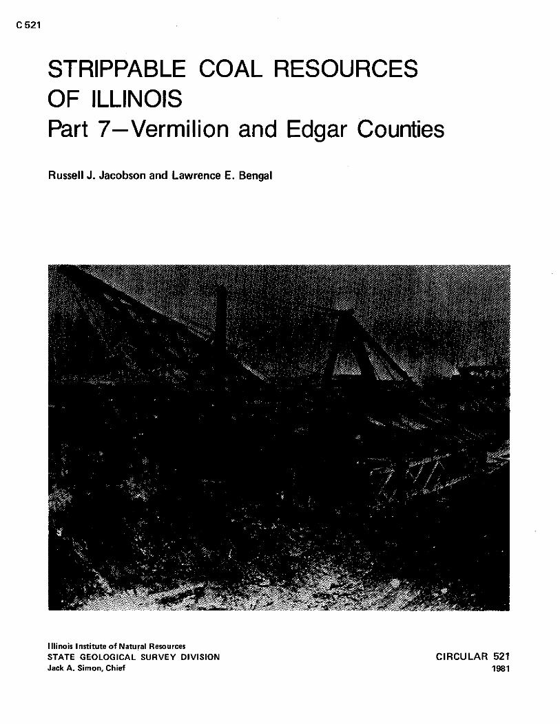
COVER PHOTO: A "dry land dredges'-the second type of coal stripping machine to operate in the United States. Pictured at site in Missionfield, west o f Danville. Illinois. For a short history of this machine, please turn to page ii.
Editor: Mary Szpur
Draftsman: Sandra Stecyk
Jsobron, Rurrell J. Strippableeoal resourcerof Illinois: part 7-Vermilionand Edgar Counties /
Rurrell J. Jxobron and Lawrence E. Bengal. - Champaign, Ill. : Illinois State Geological Survey, 1981.
24 p. : ill. : 2 8 cm. - (Circular / Illinois State Geological Survey : 5211
1. Coal rerourcer-Illinois. I . Title. I I . Bengal, LawrenceE. Ill. Series
Printed b y authority o f the State of Illinois (3,000/1981)
STRIPPABLE COAL RESOURCES OF ILLINOIS Part 7-Vermilion and Edgar Counties
Russell J. Jacobson and Lawrence E. Bengal
ILLINOIS STATE GEOLOGICAL SURVEY Natural Resources Building 615 East Peabody Drive Champaign, IL 61820
CIRCULAR 521 1981
History of the "dry land dredge" (pictured on cover)
In 1885, Wright and Wallace, drainage contractors and dredgers from LaFayette, Indiana, contracted to strip coal for Consolidated Coal Company o f St. Louis at a river bottom property known as Missionfield, near Danville, Illinois. The overburden at the site ranged from 0 to 3 5 feet in thickness, and the coal (now known as the Danville [No. 71 Coal Member) averaged 6 feet in thickness.
To remove the thick overburden, a machine with a long digging range was needed. Because the coal stripping machines available at that time were inadequate for such a task, Wright and Wallace decided to purchase a dipper dredge, which was used to dig in the deep waters of canals and drainage ditches. They purchased their first dredge in 1885 from the Marion Steam Shovel Company of Marion, Ohio, and
purchased two more dredges over the next 3 yean Each dredge was bought without its boat hull, and was installed
on a wooden frame supported by fixed wheels. The machines were powered by block and tackle and could only move forward. The first dredge had a 50-foot-long boom with a %-yard dipper. The second dredge (pictured on the cover) was similar except that its dipper was 7 % yards long. The third dredge had a 65-foot boom with a 1%-yard dipper.
The first two dredges used a single-cylinder vertical steam engine to hoist the dipper and swing the boom. The third dredge used two ver- tical steam engines. Because the dredges could only move forward, Wright and Wallace stripped the coal using a circular path of operation that resembled a flat coil spring. The machine would make an initial cut around the edges of a 30acre area. This initial cut would usually take months to complete, as did each subsequent cut. As the machine was worked toward the center, the curves became sharper and i t was harder to turn the machine. Eventually, jacks were used to skid the "land dredge" around sharp corners. The dredge could make cuts up to 20 feet in width, and on good days, up to 400 cubic yards of over- burden were removed.
In 1888, financial problems caused by a miners' strike drove Wright and Wallace to sell the dredges and contract their work back to the Consolidated Coal Company. Consolidated operated the dredges for 2 more years, until financial difficulties and physical deterioration of the dredges caused them to look for newer and more efficient equipment.
CONTENTS Abstract
Introduction
Method used to estimate quantity o f resources
Strippable coal reraurcer
Geology and stratigraphy of the coals and associated strata
McCormick Group
Kewanee Group
McLeansboro Group
Strippable resources of Herrin (No. 61 Coal
Strippable reraurcer of Danville (No. 71 Coal
Summary
References
APPENDIXES
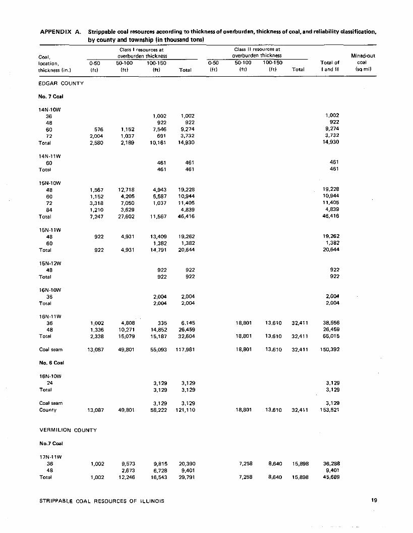
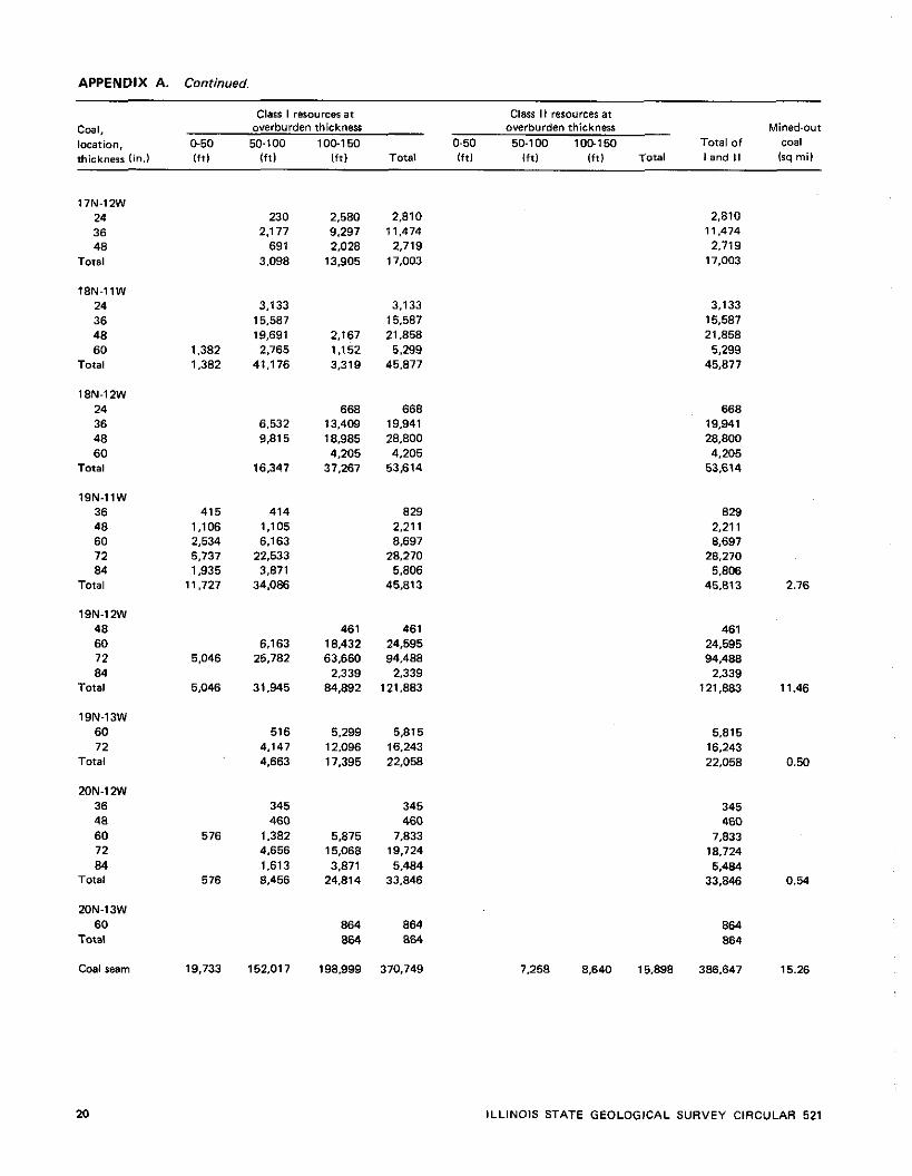
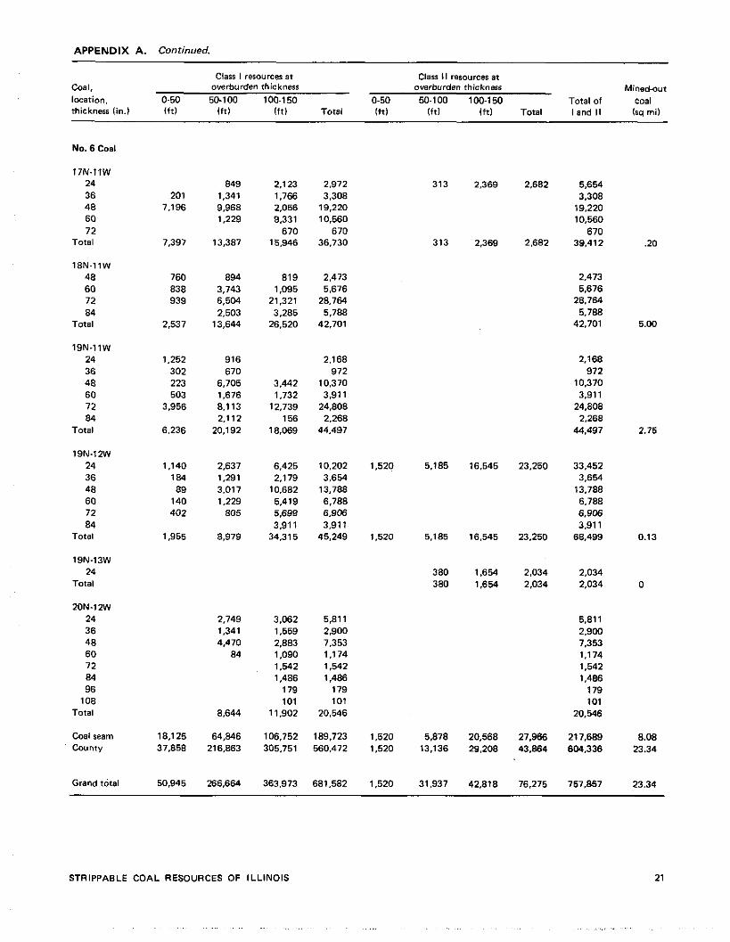
A. Strippable coal resources according to thickness o f overburden, thickness of coal, and reliability clarrification 19
B. Vermilion County-Danville (No. 71 Coal, mine and county averages of proximate and ultimate analyses 22
C. Edgar county-banville (No. 71 Coal, mineand county averages of proximate and ultimate analyses 23
D. Vermilion County-Herrin (No. 61 Coal, mine and county averages o f proximate and ultimate analyses 24
PLATE back pocket
l -A . Strippable coal reraurcer of the Danville (No. 71 Coal in Vermilion and Edgar Counties
1-0. Strippable coal resources of the Herrin (No. 61 Coal in Ver- mil ion and Edgar Counties
1-C. Correlation of key Pennsylvanian Members in Vermilion and Edgar Counties
FIGURES
1. Report areas o f strippable coal resources within the Pennsylvanian strata 2
2. Illinois Basin Coal Field 2 3. Thickness of the interval between the Herrin and
Danville Coals in Vermilion County 3 4. Principal geologic structures o f Illinois 6 5. Compo~ite stratigraphic section of the report area
and nomenclature of the Pennsylvanian System in Illinois 9
6. Diagrammatic section of the Carbondale Formation in Vermilion and northeastern Edgar Counties 10
TABLES
1. Strippable resources of Herrin (No. 61 Coal ( in thousands of tons1 13
2. Strippable resources o f Danville (No. 71 Coal ( in thousands of tons1 14
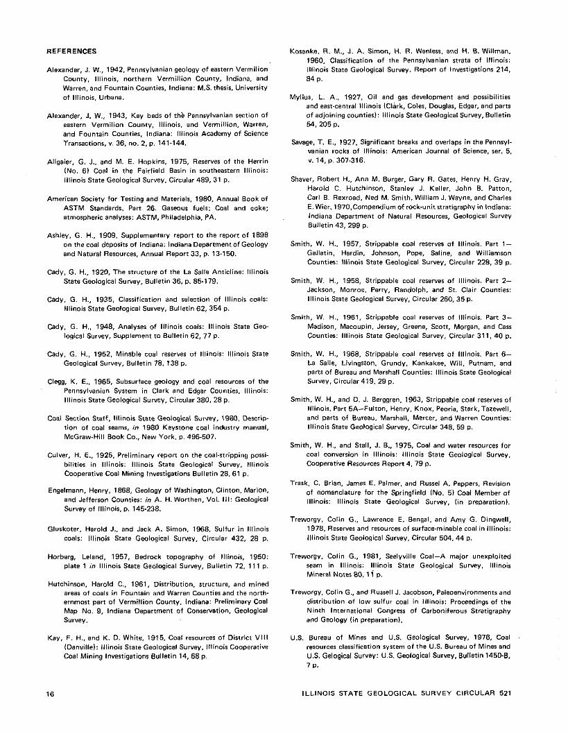
3. Strippable coal resources by county, coal bed, and reliability o f classification (in thourandr of tans1 15
STRIPPABLE COAL RESOURCES OF ILLINOIS Part 7-Vermilion and Edgar Counties
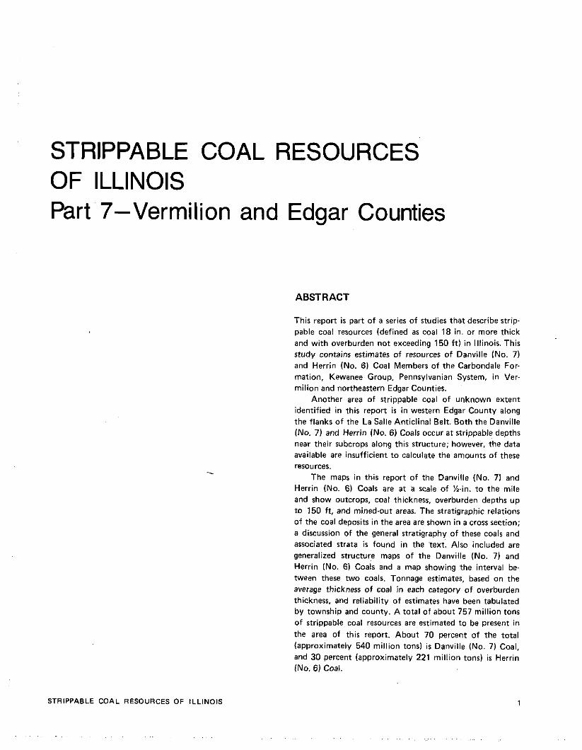
ABSTRACT
STRlPPABLE COAL RESOURCES OF ILLINOIS
This report is part of a series of studies that describe strip- pable coal resources (defined as coal 18 in. or more thick and with overburden not exceeding 150 f t) in Illinois. This study contains estimates of resources of Danville (No. 7) and Herrin (No. 6) Coal Members of the Carbondale For- mation. Kewanee Group, Pennsylvanian System, in Ver- milion and northeastern Edgar Counties.
Another area of strippable coal of unknown extent identified in this report i s in western Edgar County along the flanks of the La Salle Anticlinal Belt. Both the Danville (No. 7) and Herrin (No. 6) Coals occur at strippable depths near their subcrops along this structure; however, the data available are insufficient to calculate the amounts of these resources.
The maps in this report of the Danville (No. 7) and Herrin (No. 6) Coals are a t a scale of %in. to the mile and show outcrops, coal thickness, overburden depths up to 150 ft, and mined-out areas. The stratigraphic relations of the coal deposits in the area are shown in a cross section; a discussion of the general stratigraphy of these coals and associated strata i s found in the text. Also included are generalized structure maps of the Danville (No. 7) and Herrin (No. 6) ~ o a i s and a map showing the interval be- tween these two coals. Tonnage estimates, based on the average thickness of coal in each category of overburden thickness, and reliability of estimates have been tabulated by township and county. A total of about 757 million tons of strippable coal resources are estimated to be present in the area of this report. About 70 percent of the total (approximately 540 million tons) is Danville (No. 7) Coal, and 30 percent (approximately 221 million tons) is Herrin (No. 6) Coal.
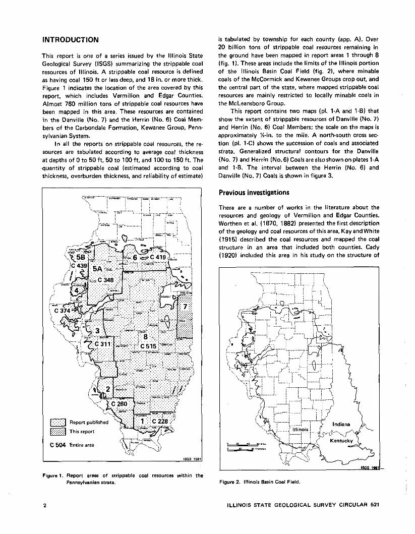
INTRODUCTION
This report is one of a series issued by the Illinois State Geological Survey (ISGS) summarizing the strippable coal resources of lllinois. A strippable coal resource is defined as having coal 150 f t or less deep, and 18 in. or more thick. Figure 1 indicates the location of the area covered by this report, which includes Vermilion and Edgar Counties. Almost 760 million tons of strippable coal resources have been mapped in this area. These resources are contained in the Danville (No. 7) and the Herrin (No. 6) Coal Mem- bers of the Carbondale Formation, Kewanee Group, Penn- sylvanian System.
In all the reports on strippable coal resources, the re- sources are tabulated according to average coal thickness at depths of 0 to 50ft. 50 to l00f t . and 100 to 150 ft. The quantity of strippable coal (estimated according to coal thickness, overburden thickness, and reliability of estimate)
i s tabulated by township for each county (app. A). Over 20 billion tons of strippable coal resources remaining in the ground have been mapped in report areas 1 through 8 (fig. 1). These areas include the limits of the Illinois portion of the Illinois Basin Coal Field (fig. 2), where minable coals of the McCormick and Kewanee Groups crop out, and the central part of the state, where mapped strippable coal resources are mainly restricted to locally minable coals in the McLeansboro Group.
This report contains two maps (pl. 1-A and 1-6) that show the extent of strippable resources of Danville (No. 7) and Herrin (No. 6) Coal Members; the scale on the maps is approximately %-in. to the mile. A north-south cross sec- tion (pl. 1-C) shows the succession of coals and associated strata. Generalized structural contours for the Danville (No. 7) and Herrin (No. 6) Coals arealsoshownon plates 1-A and l-B. The interval between the Herrin (No. 6) and Danville (No. 7) Coals is shown in figure 3.
Previous investigations
There are a number of works in the literature about the resources and geology of Vermilion and Edgar Counties. Worthen et al. (1870. 1882) presented the first description of the geology and coal resources of thisarea. Kay and White (1915) described the coal resources and mapped the coal structure in an area that included both counties. Cady (1920) included this area in his study on the structure of
Figure 1. Repon areas of strippable coal resources within the Pennfylwnian strata. Figure 2. Illinois Basin Coal Field
ILLINOIS STATE GEOLOGICAL SURVEY CIRCULAR 521
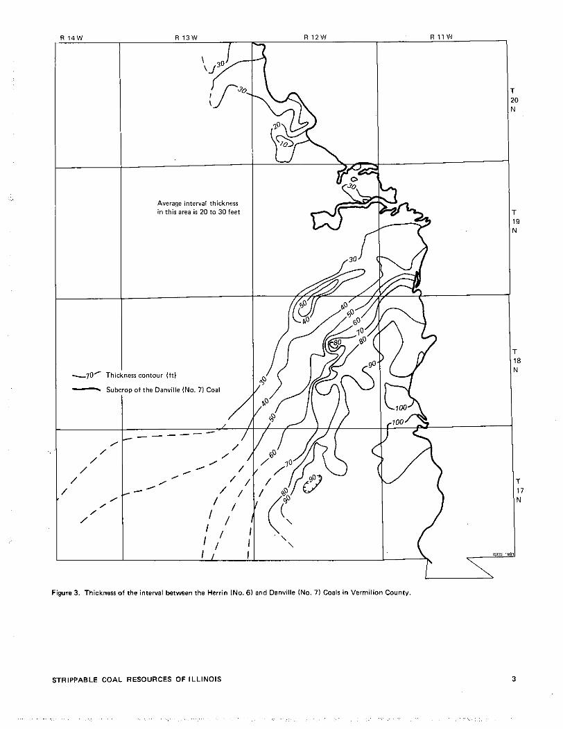
-70' Thi
Average interval thickness in this area is 20 to 30 feet
err contour (ft) - Subcrop of the Danville (No. 71 Coal
Figure 3. Thickness of the interval between the Herrin (No. 61 and Dsnville (No. 71 Coals in Vermilion County
STRIPPABLE COAL RESOURCES O F ILLINOIS
the La Salle Anticline (fig. 41, and Culver (1925) reported on the coal stripping possibilities for Edgar and Vermilion Counties. Mylius (1927) studied the oil and gas possibilities in an area that included Champaign, Clark, Coles, Cum- berland, Douglas, Edgar, and Vermilion Counties, as well as part of Crawford and Jasper Counties. Alexander (1943) mentioned the key beds of Pennsylvanian strata found in eastern Vermilion County.
Cady (1952) published the first comprehensive report on the total coal resources of lllinois, but he did not differentiate strippable from underground resources in computing the total coal resources for each county. Clegg (1965) discussed the coal resources and the effect of the La Salle Anticline on the Pennsylvanian strata in Clark and Edgar Counties.
Smith and Stall (1975) considered the strippable resources for this area in their report on coal and water resources for coal conversion, but, as with the Cady study, the strippable resources were not differentiated from underground resources in computing the total coal resources.
METHOD USED TO ESTIMATE QUANTITY OF RESOURCES
Information sources
Coal thickness and elevation data used to compile the resource and structure maps were obtained from well logs of oil and water tests, diamond drill cores, surface expo- sures, and notes on abandoned mines, which are on file at the ISGS. Contour maps of the bedrock surface prepared by Horberg (19571, as well as preliminary coal structure maps, were used extensively in projecting the extent of coals concealed beneath glacial deposits. Data regarding the extent of mined-out coal as of January 1. 1979, were ob- tained from mined-out area maps numbers 16 and 17. compiled by the ISGS.
Selection of mapping areas
lllinois has been divided into eight areas for convenience in preparing reports and maps of strippable coal resources. This report, part 7, describes resources in Vermilion County and in the northeastern portion of Edgar County. The remainder of Edgar County consists largely of underground coal resources, which have been previously reported by Clegg (1965) and Treworgy (1981).
Another area of strippable coal of unknown extent occurs in western Edgar County along the flanks of the La Salle Anticlinal Belt. The Danville (No. 7) and Herrin (No. 6) Coals are known t o lie at strippable depths near their subcrops along this structure (PI. l - A and 141, but data are insufficient for any resource calculations. Areas 1 through 7 (fig. 1) incorporate the margins of the lllinois portion of the lllinois Basin Coal Field (fig. 21, where the
minable coals of the McCormick and Kewanee Groups crop out within the state. Area 8 embraces a large part of the deeper portion of the lllinois Basin, where coals of the Kewanee Group generally lie a t depths too great for strip mining. This area is mainly restricted t o coals of the McLeans- boro Group, which normally are less than 3 f t thick.
Definition of strippable coal
The criteria used to evaluate strippable resources is based principally upon the thickness of the coal and the over- burden. The definition of strippable coal resources includes those coal seams that are 18 in. or more thick, and have an overburden not more than 150 f t thick (Smith, 1957).
Certain resources are not recoverable because they lie beneath cities, towns, or highways, or are otherwise limited; however, the scale on which the coal was mapped for this report does not permit the omission of such nonrecoverable coal from the estimate. A recent study by Treworgy, Bengal, and Dingwell (1978) evaluated strippable coal resources in lllinois according to their minability by current methods and economics.
In this report, as in the earlier reports (Cady, 1952: Smith, 1957. 1958, 1961, 1968; Smith and Stall. 19751, estimates of tonnages of coal are based on an assumption of 1,800 tons of in-place coal/acre/ft of coal. This conforms t o the figure used by the U.S. Geological Survey. (USGS) in estimating resources of high-volatile bituminous coal. Nevertheless, a figure of 1,770 tons/acre/ft probably better represents coals in lllinois (Smith, 1961). The estimates in this report are based on total coal in place; no estimate of recoverable coal is presented.
Mapping of coal subcrops
In this report, the term subcrop i s used broadly t o describe the border of a coal whether it i s exposed a t the surface or concealed beneath unconsolidated surface materials. The accuracy of mapping subcrop boundaries of coal seams depends on the number and distribution of visible outcrops and test holes, as well as the nature of the topography and the amount of unconsolidated material covering the area. Other problems that make it difficult to map thecoal sub- crop include faults and other structural features, erosional cutouts, and areas in which the coal is lenticular or lacks continuity.
In much of the report area, the bedrock is covered by less than 50 f t t o more than 400 f t of glacial drift. Where- ever sufficient data were available, a provisional line was drawn that represented the border of the coal beneath these unconsolidated deposits. These provisional subcrops were derived by interpolation from coal structure and the bedrock surface. Any new drill holes or other data will modify these provisional limits; however, the estimated limits of the coal are accurate enough t o illustrate on the map and t o discuss areas where coal may be found atstrippable depths.
4 ILLINOIS STATE GEOLOGICAL SURVEY CIRCULAR 521

On the maps for this report, coal exposures along streams and in strip and shaft mines show areas of relatively close control. The remainder of the subcrop boundary
indicates areas where projections of the subcrop are based on other data, such as drill holes.
Overburden categories
The thickness of overburden is shown on the map by thickness lines (isopachs) representing 50-ft intervals. These lines divide the overburden into three thickness categories: 0 to 50, 50 to 100, and 100 to 150 ft. Resources tabulated in appendix A show the amount and thickness of strippable coal in each of these categories. A t present,
100 t o 120 f t is the approximate maximum limit of over- burden removal in lllinoisstrip mining.
.
The thickness lines that delineate the various categories o f overburden thickness on the map were constructed by the interpolation o f intervals between contours o f surface topography and coal elevation on a scale of 1:62.500.
Coal thickness
Coal thickness is indicated on the maps (PI. l - A and 1-B) by thickness lines (isopachs) and average thickness categories. lsopachs are drawn where datum points are closely spaced; however, in some areas it was not practical t o construct isopachs because of the scarcity o f datum points; therefore. only estimated average coal thickness values are shown. The average thickness values thus derived were used to calculate the coal tonnage within each of the overburden and relia- bility classes. The average thickness values and isopach intervals used in this study above the minimum 18 in. are at I - f t increments o f average thickness from 2 f t and above.
Mined-out coal
Mined-out coal areas shown on plates 1-A and 1-0 are taken from maps compiled by the ISGS and include all mining to January 1, 1979. In some areas. much o f the geologic information that relates t o the distribution and thickness o f the coal has come from observations at these mines.
STRIPPABLE COAL RESOURCES
Classification of resources
Coal resources are divided into two classes to designate the reliability of the estimate. In the maps and tables, resources are divided into class I and class I I.
Class I resources. Class I resources include coal in areas where there are enough data to establish the presence and
STRIPPABLE COAL RESOURCES OF ILLINOIS
thickness of coal with reasonable certainty. Generally, this class includes all coal within 2 miles o f any points for which there are reliable coal thickness data, such as: mines, out- crops, diamond drill holes, and churn drill coal-test holes. This i s equivalent to the proven (class l -A) and probable (class l-B) categories for resources in the statewide inven- tory of coal resources compiled by Cady (1952), and is approximately equivalent to the measured and indicated category o f the U.S. Bureau o f Mines (USBM) and USGS (1976).
In some cases, when the available data suggest that the persistence of the coal i s uncertain, or, that there are marked variations in i t s thickness, the limits o f coal data reliability that are defined above have been reduced in making our appraisals.
Class I 1 resources. Class II resources include coal 2 to 4 miles from all points o f class I, and 0 to 4 miles from points for which there are less reliable data, such as test holes
drilled for gas and oil, or water wells where data on thick- ness are not reliable enough for classifying the coal as class I resources. The class II resources o f this report cor- respond to those classified by Cady (1952) as 1l.A (strongly indicated) and to a portion of the inferred category of the USGS (1976).
Resources classified as class II indicate areas where indirect evidence, plus geologic interpretation, strongly suggest that coal may be present at thethicknesses indicated on the maps. Exploration for strippable coal might be conducted advantageously in these places.
Quality of the coals
Al l Illinois coals fall into the category of high-volatile bituminous, as designated by the American Society for
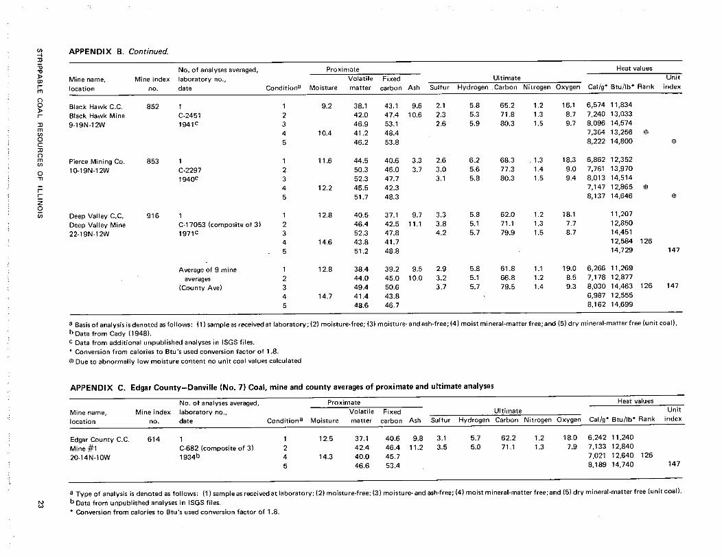
Testing and Materials (1980. standard D 388). Our coal analyses are summarized in appendixes B, C, and D. These tables list average values for the various parameters o f the Danville (No. 7) and Herr~n (No. 6) Coals, by mine average for each mine sampled and by an overall county average based on those samples.
The Danville Coal has an average sulfur value lmo~sture free) o f 3.2 percent for the study area, which i s fairly representative for this coal, although a few extremes of high and low sulfur are noted (app. B and C). The Herrin Coal has an average sulfur value of 3.0 percent, but in some mines it has been reported to have the relatively lower sulfur values of 1.4 to 2.5 percent where there is a thick nonmarine gray shale roof (app. Dl .
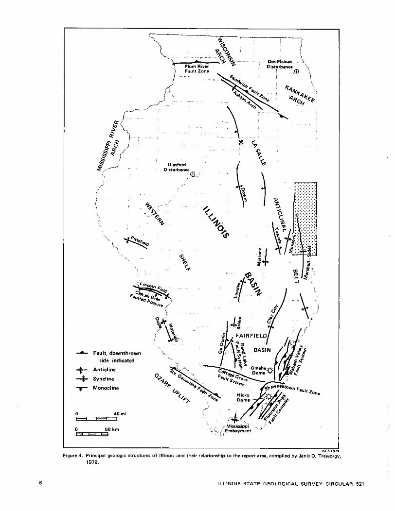
Structural setting of report area
The study area is situated just to the northeast of the La Salk Anticlinal Belt (fig. 4). This anticlinal structure forms a boundary between the Fairfield Basin and the study area: the study area i s part o f the eastern structural
-L Fault, downthrown side indicated
$-- Anticline
Syncline
7 Monocline
.. Figure 4. Principal geologic structures of Illinois and their relationship to the report area, compiled by Janis 0. Trewo~
1979.
ILLINOIS STATE GEOLOGICAL SURVEY CIRCULAR 521
shelf of the lllinois Basin (Clegg. 1965). Because this area was structurally higher than the deeper part of the Fairfield Basin to the southeast during the deposition of earliest Pennsylvanian sediments, deposition of these sediments was restricted (Clegg, 1965). The study area is situated astride the northern portion of the Marshall-Sidell Syncline. The mapped strippable coals occur along the eastern flank ofthe syncline, where the coals and associated strata gently dip less than one degree to the southwest. The structure on the top of the Danville (No. 7) and Herrin Coals in Vermilion and Edgar Counties is shown on plates l - A and 1-8.
GEOLOGY AND STRATIGRAPHY OF THE COALS AND ASSOCIATED STRATA
Strata of the Pennsylvanian System in lllinois have been di- vided into three stratigraphicgroups-McCormick. Kewanee, and McLeansboro-from oldest to youngest (Kosanke e t at., 1960). Each stratigraphic group has been divided into formations, which are in turn divided into members. Only selected units will be discussed; the strippable coal resources classified in this report are for coals contained in the Carbondale Formation of the Kewanee Group. A generalized stratigraphic section (fig. 5) shows the classification of Pennsylvanian strata in east-central lllinois. A cross-section diagram (PI. l -C) shows the correlation of key Pennsylvanian members in the area.
MCCORMICK GROUP
The McCormick Group i s divided into the Caseyville and Abbott Formations (Kosanke et at.. 1960). In Vermilion and Edgar Counties, no members of the Caseyville and Abbott Formations have been formally recognized. In the study area, the Caseyville and Abbott have a combined estimated maximum thickness of 150 ft, with the strata probably restricted to the Abbott and possibly the upper part of the Caseyville Formation.
KEWANEE GROUP
The Kewanee Group includes the Spoon and Carbondale Formations and i s characterized by the widespread develop- ment of minable coals. Over 99 percent of the mapped coal resources of lllinois occur in the KewaneeGroup (Kosanke et al.. 1960).
Spoon Formation
Although many named members of this formation are recognized throughout the state and numerous coal seams in the formation have been or are presently being mined in Illinois, only one member, the Seelyville Coal, has been formally recognized in eastern lllinois.
The Spoon Formation is correlative with the upper- most part of the Brazil Formation, a l l of the Staunton Formation, and the basal part of the Linton Formation in lndiana (Kosanke et al., 1960: pl. l -A ) . These formations contain several named coal seams that have been mined within counties adjacent to the study area in lndiana (Hutchinson. 1961).
Seelyville Coal Member. The Seelyville Coal Member (fig. 51 i s named from mine exposures near the village of Seelyville, Vigo County, lndiana (Ashley, 1909). It i s known in lndiana as the Seelyville Coal Member ( I l l ) . The Seelyville Coal has been traced with geophysical logs in the subsurface throughout large areas of east- central lllinois (Treworgy, 1981). Treworgy's study shows the Seelyville to be fairly thick over the eastern half of Edgar County, where it ranges mostly from 3% to 5% ft. with a few areas in excess of 5% ft. In the western half of Edgar County the coal is shown to be thin or absent. This study did not include Vermilion County.
The Snow Hill Coal Company mined the Seelyville Coal in their Green Valley mine northwest of Terre Haute. Indiana, where the seam averaged 7 f t in thickness and was approximately 30 f t below the No. 2 Coal. In the study area the Seelyville Coal generally lies 20 to 30 f t below the No. 2 Coal. A diamond drill core in Sec. 30, T. 14 N.. R. 10 W., recorded 6 f t of Seelyville Coal a t a depth of 553 ft. A diamond drill core further north in Sec. 8. T. 15 N.. R. 10 W., shows this coal to be 4 f t 8 in. thick. Additional data from several drillers' logs and electric logs indicate an overall thinning, along with the development of prominent splits in the coal, northward intoVermilionCounty (pl. 1-C).
In 1882, Shaft No. 4 of the Ellsworth Coal Company at Tilton (Sec. 18, T. 19 N.. R. 11 W.) in Vermilion County was sunk t o a depth of 310 ft below the surface, where 4 f t of Seelyville Coal was encountered. Little mining of the Seelyville ensued and the mine was discontinued in 1885.
A diamond drill core in Sec. 28, T. 20 N., R. 12 W.. Vermilion County, shows several coals occurring at the approximate stratigraphic position of the Seelyville Coal. The two upper seams are tentatively correlated as split Seelyville Coal.
In T. 17 and 18 N., R. 7 W.. northwest of Cayuga, Vermillion County, Indiana, two coals have been mined at numerous locations; the average interval between the coals is 5 ft. The upper seam in this area has been correlated with the Colchester (No. 2) Coal in lllinois and averages 2% f t in thickness. The lower seam varies in thickness from 2 t o 3% f t and has been correlated with the Seelyville Coal (Hutchinson, 1961).
Resources of the Seelyville Coal in Vermilion County Illinois, have been estimated t o be 44,521,000 tons (Cady, 1952). Total resources in Edgar County have been estimated at 878,904.000 tons (Cady, 19521.
In most of the area of this report the Seelyville Coal appears to be at depths greater than the 150-ft strippable
STRIPPABLE COAL RESOURCES OF ILLINOIS
coal limit; however, in the northeastern part of T. 19 N., R. 10 W. and part of T. 20 N., R. 10 and 11 W. of Vermilion County, this coal may occur at strippable depths. The basis for this inference is a projection of the inferred subcrop of the Colchester (No. 2) Coal from lndiana into Vermilion County, lllinois (Hutchinson, 1961). and the inferred subcrop of the Colchester for Vermilion County as shown on the geologic map of lllinois (Willman et al.. 1967).
These data, combined with the estimated bedrock surface elevations in the above townships, suggest that both the Seelyville and ColchesterCoals may lieatstrippable depths in part of this area. Without the presence of reliable drill hole data, however, the extent of the area cannot be determined because of the presence of a bedrock valley that probably cuts out most of these coals.
Carbondale Formation
The Carbondale Formation (Kosanke et al., 1960) includes strata from the base of the Colchester (No. 2 ) Coal t o the top of the Danville (No. 7) Coal. In the southern part of the study area the formation averages 275 t o 300 f t in thickness, thinning northward t o 180 to 190 f t in central Vermilion County.
The Carbondale Formation is dominantly composed of gray shales, but sandstones occurring in elongate channel facies up to a maximum of 100 f t thick and thinner sheet sandstones are common. Limestones are normally argil- laceous and average 1 to 5 f t in thickness. Black fissile shales are usually well developed over most of the coals, and claystones are normally present beneath most coals. Cyclic sequences also have a wider variety of lithologic units than in lower formations. The principal economic coals of Illinois are contained in this formation, including the two seams studied in this report, the Danville (No. 7) and the Herrin (No. 6) Coals.
Colchester (No. 21 Coal Member. The Colchester (No. 2) Coal (figs. 5 and 61, named for the town of Colchester in McDonough County, Illinois, is the lowest member of the Carbondale Formation in lllinois, and is known as the Colchester Coal Member (I l la) in lndiana. In the study area, the Colchester Coal is generally overlain by the black Mecca Quarry Shale (fig. 6). The Colchester Coal occurs about 75 to 80 f t below the Summum Coal in northeastern Edgar County, and thins northward with an average interval of less than 50 f t between the two coals in the northern part of the study area. The Colchester generally averages 18 in. or less in thickness but thickens eastward into Indiana, where it was mined several miles northeast of Cayuga, Vermillion County, Indiana, a t a reported thickness of 2 to 3 f t and at a depth of 15 to40 f t (Hutchinson, 1961).
As reported earlier, this coal may occur at or near strippable depths in T. 19 N., R. 10 W., and T. 20 N., R. 10 and 11 W. of Vermilion County, but no reliable data are available to show i t s thickness or actual depth.
Shawneetown Coal Member. The Shawneetown Coal (fig. 6) is named for Shawneetown, Gallatin County, Illinois. The coal i s persistent in southern and eastern lllinois and is correlated with the Survant Coal Member ( IV) of lndiana (Willman e t al., 1975). A coal possibly correlative with the Shawneetown Coal lies 25 t o 50 f t below the Summum (No. 4) Coal Member in this area. This coal i s usually thin, and is often split into two benches. In localized areas of eastern Edgar County, where the two benches have merged and thickened, this coal has been reported to be up t o 6 f t thick. A coal test in Sec. 17, T. 15 N.. R. 10 W., Edgar County, shows this coal to be 5 f t 4 in. thick; however, in most of the study area the coal is very thin.
Summum (No. 41 Coal Member. The Summum (No. 4) Coal or the recognized horizon of the coal (fig. 6) is one of the most widespread stratigraphic markers in the state (Willman et al.. 1975). The Summum Coal in Edgar County may be as little as 15 ft to as much as 85 to 90 f t below the Springfield (No. 5) Coal, with the thinner interval prevailing in the western part of the county (Clegg, 1965). In most of eastern Vermilion County, the Summum Coal lies 60 to 80 f t below the Springfield (No. 5) Coal. Available data indicate the Summum Coal is fairly thin in Edgar County and i t s position is recognized only by the presence of the associated thick black shale in eastern Vermilion County.
Springfield (No. 51 Coal Member. Earlier reports of the study area called the Springfield (No. 5) Coal the Harrisburg Coal; however, a recent study by Trask et al. (in preparation) has dropped the name Harrisburg from this coal in eastern and southern lllinois. The name given this coal in the remainder of the state-Springfield-was used to name the coal in eastern and southern lllinois. The Springfield (No. 5) Coal (fig. 6) i s economically the second most important coal seam in lllinois. A t present, the Springfield Coal accounts for 30 percent of the state's total production.
In the study area, the Springfield Coal occurs approx- imately 25 f t below the Herrin (No. 6) Coal. In Vermilion County. the Springfield Coal horizon is locally recognized by the presence of a black, carbonaceous shale with a thin overlying limestone (fig. 6). Occasionally a thin, lenticular, poorly developed coal is present. Southward into Edgar County, the Springfield Coal thickens; in Sec. 8. T. 15 N., R. 10 W., a coal test penetrated 4 f t 2 in. o f this coal. This trend continues further south, where the coal averages 4 t o 5 f t throughout much of east-central lllinois, and into adjacent counties in lndiana, where it has been mined extensively by both stripping and underground methods (Cady, 1952). Resources in the ground in Edgar County, totaling 441,330,000 tons. surface and deep minable, were originally mapped by Cady (1952). A recent study (Smith and Stahl, 1975) estimated there are 427,640.000 tons of Springfield Coal with a seam thickness greater than 42 in.
Herrin (No. 61 Coal Member. The Herrin (No. 6) Coal is named for Herrin, in Williamson County, Illinois, where
ILLINOIS STATE GEOLOGICAL SURVEY CIRCULAR 521
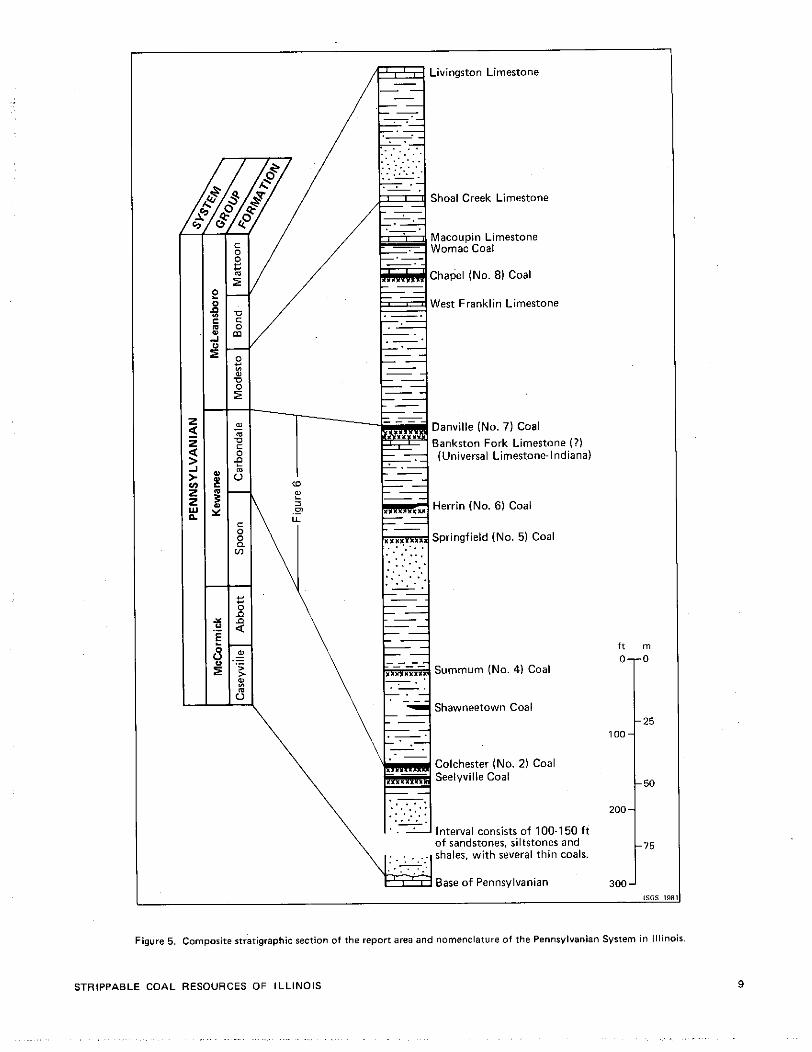
Livingston Limestone
Shoal Creek Limestone
Macoupin Limestone Womac Coal
Chapel (No. 8) Coal
West Franklin Limestone
Danville (No. 7) Coal Bankston Fork Limestone ( ? I (Universal Limestone-Indiana)
- .- T, Herrin (No. 6) Coal L
Liq Shawneetown Coal
Colchester (No. 2) Coal Seelyville Coal
. . . . . Interval consists of 100-150 f t of sandstones, siltstones and shales, with several th in coals.
Base o f Pennsylvanian
Figure 5. Composite stratigraphic section of the report area and nomenclature of the Pennsylvanian System in Illinois.
STRIPPABLE COAL RESOURCES OF ILLINOIS
the coal was extensively mined (fig. 6). InVermilionCounty the Herrin Coal was formerly referred to as the "Grape Creek Coal." Clegg (1965) made detailed physical corre- lations that demonstrated that the Grape Creek and Herrin Coals were the same. Palynological studies a t the ISGS have confirmed this correlation. The Herrin in this area is correlative with a coal in Vigo and Vermillion Counties, Indiana, called the Bucktown Coal Member (Vb) by the lndiana Geological Survey (Shaver et al., 1970).
The Herrin Coal is present in both Vermilion and Edgar Counties and ranges in thickness from several mches to more than 6% ft; locally, it attains a thickness of more than 9 ft. The Herrin Coal in the study area lies from 12 f t or less below the Danville (No. 7) Coal northwest of Danville to as much as 110 f t below the Danville Coal in the southern part of the report area.
In most areas of the state the Herrin Coal is normally overlain by the Anna Shale Member and/or the Brereton Limestone Member (fig. 6); occasionally, however, the coal is overlain by a gray silty shale that isstratigraphically below the Anna Shale and may attain thicknesses of more than 100 ft. This shale unit has been named the Energy Shale Member (Allgaier and Hopkins, 1975) from exposures near the town of Energy, Williamson County, Illinois. Where the Energy Shale (fig. 6) exceeds 20 f t in thickness, the Herrin Coal i s generally lower in sulfur content (about 2.5 percent or less) than the state average of 3 to 5 percent (Gluskoter and Simon. 1968).
In the northwestern two-thirds of the study area, the Herrin Coal lies an average of 25 f t below the Danville Coal (fig. 3). Here the Herrin is overlain by several feet of dark-gray to black shale of the Anna Shale Member. A gray, argillaceous, marine limestone-the Brereton Lime- stone Member-overlies the Anna. The Brereton Limestone is discontinuous in i t s extent, is lenticular, and ranges from 0 to 7 f t in thickness. Where the interval between the Dan- ville and Herrin Coals exceeds 25f t (fig. 3, as in thesouthern part of Vermilion County, the Herrin Coal is overlain by the gray, silty Energy Shale Member. This shale first appears as a thin gray wedge between the Anna Shale and the Herrin Coal just south of Danv~lle.
The wedge of Energy Shale in southern Vermilion County is part of a large clastic wedge that has been mapped by Treworgy and Jacobson (in preparation). This clastic wedge of Energy Shale covers more than 3.900sq km (1,500 sq mi) in east-central Illinois, and has been traced into west-central lndiana. Treworgy and Jacobson have interpreted this deposit to be a lacustrine delta that filled a low area in the Herrin swamp.
Immediately north of the main body of Energy Shale in Vermilion County are found isolated lenses of dark gray Energy Shale overlying the Herrin Coal. These lenses correspond to areas where the Herrin Coal i s thickest. Apparently these lenses were deposited in the most actively subsiding portions of the coal swamp, which first received thick accumulations of peat, and then became ponds of open water (Nelson and Danner, unpublished data).
GENERALIZED I SECTION NAMED MEMBERS
I Danville (No. 71 Coal
Bankston Fork Limestone? (Universal Limestone-Indiana)
Brereton Limestone Anna Shale Herrin (No. 6) Coal
Springfield (No. 5) Coal
Excello Shale Surnmum (No. 4) Coal
Shawneetown Coal
l 2 [
Mecca Quarry Shale 1 Colchester (No. 2) Coal loo 3c
Figure 6. Diagrammatic reetion of the Carbondale Formation in Vermilion and northeastern Edgar Counties.
Because of the nature of available data, a map showing the 20-ft thickness lines of the Energy Shale was not prepared; however, this line corresponds approximately to the 40-ft interval between the Herrin and Danville Coals (fig. 3). Mines in the general area, where the gray shale i s greater than 20 f t thick, have reported sulfur values of 1.2 t o 2.5 percent.
Bankston Fork Limestone Member (Universal Limestone Member, Indiana). The Universal Limestone Member of lndiana (Shaver et al., 1970) has been tentatively correlated with the Bankston Fork Limestone (Willman et al., 1975). At the type locality of the Universal Limestone, which is located in the SW% of Sec. 31, T. 14 N., R. 9 W., Ver-
ILLINOIS STATE GEOLOGICAL SURVEY CIRCULAR 521
million County, lndiana (which i s close t o the study area). the Universal Limestone has been described as a mottled gray and brown, fine-grained, argillaceous and fossiliferous limestone. It has a reported thickness of 0.1 to 11.9 f t in lndiana (Shaver et al., 1970). but seldom exceeds 6 f t in Illinois (Willman et al.. 1975).
In the study area, a limestone correlative with the Universal Limestone Member occurs from 5 t o 20 f t below the Danville (No. 7) Coal Member (pl. l-C). A typical expo- sure of this unit occurs south of Danville a t the abandoned V-Day mine (Sec. 30, T. 19 N.. R. 11 W.), where it has been found 8 to 10 f t below the Danville, with a maximum thickness of 5 ft. A t this locality it was described as a medium-gray, mottled greenish-gray, irregularly bedded. and argillaceous limestone. In much of the study area. the limestone is lenticular and pinches out or is nodular. In many areas of Vermilion County this limestone contains no marine fossils and represents the underclay limestone of the Danville Coal. In parts of southern Vermilion and Edgar Counties, the limestone does contain marine fossils, which become abundant near the eastern edge of Edgar County.
Since this unit in the study area is equivalent to the Universal Limestone and is probably correlative with the Bankston Fork Limestone, the name Bankston Fork will be used only tentatively.
Danville (No. 7) Coal Member. The Danville (No. 7) Coal Member, an important coal that has been mined since the middle part of the 19th century, is the uppermost member of the Carbondale Formation. It is named for the city of Danville. Vermilion County, near the type section in Sec. 7. T. 19 N., R. 11 W. (Wanless. 1956). where it is 6 f t thick and 2 0 f t above the Herrin (No. 6) Coal Member. The Danville Coal i s quite extensive in Vermilion and Edgar Counties, but most mining has occurred in the area immediately west and south of the city of Danville. The coal is eroded in most of the northern third of Vermilion County; it averages 5 to 6 f t in thickness throughout the middle third, and gradually thins southward and eastward. The coal averages 3 f t in thickness in southeastern Vermilion and northeastern Edgar Counties, locally thickening to 4 or 5 f t near Brouilletts Creek and the lllinois-Indiana border. Locally, a split of the Danville Coal, called the "Black- smith's Seam" or "Sump Vein" by local miners in the past (Worthen et al., 1870). occurs about 6 in. below the main seam and attains a maximum thickness of 2 ft.
The Danville Coal extends throughout much of the rest of Illinois and has also been mined in Livingston. McLean, La Salle, and Marshall Counties. In the rest of the state it i s thin, usually only a few inches t o less than 3 f t thick. The Danville (No. 7) Coal correlates with the Danville Coal Member (VII) of lndiana (Willman et al.. 1975).
Where the Danville Coal i s present in most of Illinois, it i s generally overlain by the Farmington Shale Member of the Modesto Formation, but in our study area the
immediate roof is locally overlain by 1 or 2 f t of black fissile shale. The seam is underlain by a well-developed claystone underclay.
MCLEANSBORO GROUP
The McLeansboro Group includes all younger Pennsylvanian strata above the Danville Coal in the study area (fig. 51. The group is divided into three formations: the Modesto, the Bond, and the Mattoon, in ascending stratigraphic order. Lithologically, the McLeansboro Group is similar to the Carbondale Formation, but it contains a few limestones that are thicker and less argillaceous than those of the Carbondale Formation. In Vermilion County, the Mattoon Formation is not present and the Bond and Modesto For- mations are generally present only in the west-central and southwestern parts of the county.
Modesto Formation
The Modesto Formation includes all strata from the top of the Danville (No. 7) Coal Member to the base of the Shoal Creek Limestone Member (fig. 5). The coals within this formation are usually thin, and extend over a large area. Gray shales and sandstones that may be as much as 100 f t thick make up the greater part of this formation.
In the study area the formation is present in the west-central and southwestern half of Vermilion County and in all but extreme eastern and western Edgar County. The Modesto Formation in this area attains a maximum thickness of about 150 ft. Some of i t s recognized members in the report area include: the West Franklin Limestone, the Chapel (No. 8) Coal, the Womac Coal, and the Macou- pin Limestone (fig. 5).
West Franklin Limestone Member. The West Franklin Limestone Member (fig. 5) is named for West Franklin. Posey County. Indiana. In Vermilion County, the West Franklin is present as one or two poorly developed, nodular, and argillaceous limestone beds associated with variegated claystone or shale. Near the northern limit of McLeansboro strata in Vermilion County, the West Franklin lies about 75 f t below the Shoal Creek Limestone Member. This interval thickens to 90 f t near the southern boundary of Vermilion County.
Chapel (No. 8) Coal Member. The Chapel (No. 8) Coal Member (fig. 5) of the Modesto Formation (Kosanke et al., 1960) is named for Graham Chapel, Peoria County. This coal i s correlated with the Ditney Coal Member of southwestern lndiana (Willman et al., 1975). In Vermilion County the Chapel (No. 8) Coal is present as a thin, bony coal streak that seems t o be fairly persistent throughout the area of McLeansboro strata. It lies about 75 f t below the Shoal Creek Limestone in southern Vermilion County, and the interval thins northward to about 60 f t at the northern limit of McLeansboro strata.
STRIPPABLE COAL RESOURCES OF ILLINOIS
Womac Coal Member. The Womac Coal Member (fig. 51 of the Modesto Formation (Kosanke et al., 1960) is named for Womac, Macoupin County. This thin coal is widely traced in the Illinois Basin along with the overlying Macoupin Limestone, from which it is separated by 1 to 2 f t of black fissile shale (Willman et al., 1975). It is present in Vermilion County as a thin, shaly, coal horizon beneath the Macoupin Limestone Member.
Macoupin Limestone Member. The Macoupin Limestone Member of the Modesto Formation (Wanless, 1931) is named for Macoupin Creek in Macoupin County, where the type section is exposed (fig. 5). It i s a widespread unit found throughout much of the lllinois basin. In Vermilion County the Macoupin Limestone is 1 to 2 f t thick and consists of an argillaceous, silty, gray to dark-gray, fossili- ferous, sometimes nodular limestone, generally occurring about 30 f t below the Shoal Creek Limestone. Generally, the Macoupin Limestone i s not as well developed as the Shoal Creek and in certain areas it may be absent;therefore, it is seldom reported in drill hole records (Clegg, 1965).
Bond Formation
The Bond Formation of the McLeansboro Group (Kosanke et al., 1960) i s named for Bond County, Illinois, where exposures o f it are prominent. The formation includes all the strata from the top of the Livingston Limestone Member to the base of the Shoal Creek Limestone Member. It is characterized by a high percentage of limestone and calcareous claystones and shales (Willman e t al., 1975).
In Vermilion County the Bond Formation generally averages 90 to 100 f t in thickness and is overlain by Pleir- tocene deposits. The Bond Formation has been removed by erosion in much of the area. It is present in the southern quarter of Vermilion County, and in Edgar County as a north-south band running through about the middle half. Some of the prominent members of the Bond Formation in the study area are the Livingston Limestone Member and the Shoal Creek Limestone Member (fig. 5).
Shoal Creek Limestone Member. The Shoal Creek Lime- stone Member (Engelmann, 1868) i s the basal unit of the Bond Formation and is named for exposures along Shoal Creek in Clinton County (fig. 5). In Vermilion County the Shoal Creek Limestone generally lies about 100 f t below the Livingston Limestone. Locally, the Shoal Creek Lime- stone i s a gray, argillaceous, dense limestone 1 to 4 f t thick, which sometimes is nodular in i t s upper part and which contains an abundance of small, black, rounded phosphatic pebbles or nodules scattered throughout i t s extent. It i s also associated with a variegated red and green claystone or shale that occurs above the limestone and assists in i t s identification. The Shoal Creek Limestone is also called the Shoal Creek Limestone Member in Indiana (Willman et al., 1975).
Livingston Limestone Member. The Livingston Limestone Member (fig. 5) is named for the town of Livingston in Clark County (Worthen, 1875; Willman et al., 1975). Apparently the Livingston Limestone is present in Vermilion County in only one known outlier, which i s located beyond the northern limits of i t s subcrop in central Edgar County (Clegg, 1965). This outlier is south of the townof Fairmont, where a quarrying operation has been active for many years in limestone 16 to 20 f t thick. A t this quarry the Livingston Limestone is bluish gray t o light gray, fine grained, dense, very fossiliferous in beds from 1 to 20 in. thick, and contains numerous small masses of crystalline calcite. The beds of limestone are usually separated by shale partings less than %-in. thick.
STRIPPABLE RESOURCES OF HERRIN (NO. 6) COAL
The Herrin (No. 6) Coal has been extensively mined in Vermilion County since the latter part of the 19th century. The first recorded strip mine in the United States opened in 1866 in the Herrin Coal near the town of Grape Creek. The overburden in this mine was removed by horse-drawn plows and scrapers and hauled away in wheelbarrows and carts. Most mines in the study area have used underground methods to extract Herrin Coal. Most of these mines, all of which are located south of Danville, suspended operations during the 1940s and only limited production from relatively small mines has occurred since that time. A t present, only one mine, an underground operation of the Lee Coal Company southwest of Danville, operates in the Herrin Coal in the study area.
Strippable resources in Vermilion and Edgar Counties that total more than 218 million tons and lie a t depths of 150 f t or less are summarized in table 1. Approximately 60 percent of the strippable resources are at depths greater than 100 ft, which currently is the maximum mining depth for most strip mines in Illinois. A more detailed summary of the resources by county, township, and seam thickness is given in appendix A.
As we discussed earlier, the immediate roof of the Herrin Coal in the northwestern two-thirds of the study area is a black shale (Anna Shale Member), which is some- times overlain by an argillaceous, gray, marine limestone (Brereton Limestone Member). In the southern third of the study area (fig. 3), however, a gray silty shale-the Energy Shale Member-overlies the coal. The change from Anna Shale roof to Energy Shale roof is marked by an increase in a southeastward direction in the average thick- ness of the interval between the Herrin and Danville Coals. This change in interval is caused by the increasing thickness of the Energy Shale Member. A maximum interval of 110 f t between the two coals is attained in southeastern Vermilion County; this interval remains fairly constant southward throughout eastern Edgar County.
Most mines in the Herrin Coal in Vermilion County operated in the area of gray, silty Energy Shale roof, and
ILLINOIS STATE GEOLOGICAL SURVEY CIRCULAR 521

TABLE 1. Strippable resources of Herrin (No. 6) Coal ( in thousands of tonrl
Class I resources st Clasr II resources at overburden thicknerr overburden thickness Mined-out
0-50 50.100 100-150 0-50 50-100 100-150 Total of coal County ( f t l ( f t ) (ft) Total l f t ) ( f t l I f f ) Total I and I1 ($4 mil
Vermilion 18,125 64,846 106,752 189,723 1,520 5.878 20.568 27.966 217,689 8.08
Edgar 3.129 3.129 3.1 29
usually produced coal with relatively low sulfur content in the range of 1.2 to 2.5 percent. Some mines, however, yielded high-sulfur coal when the Energy Shale thinned to less than 20 ft. North of the 20-ft thickness limit, the Energy Shale thins and a poorly bedded, lenticular, weak, medium-dark-gray shale is present locally. In most of the region north of the gray shale area and further northward. the relatively thin, dark-gray to black, moderately well bedded, and more competent Anna Shale Member directly overlies the coal. This unit generally becomes more con- tinuous and thicker to the north. Approximately 75 per- cent of the mapped strippable resources of Herrin Coal in Vermilion and Edgar Counties occur in the area where the interval between the Herrin and Danville Coals is 40 f t or more in thickness. Where the interval i s 40 f t thick, there is a corresponding 20-ft thickness of the Energy Shale Member (fig. 3). Consequently, potentially lowsulfur resources (less than 2.5 percent) of coal lie within the area where this interval is 40 f t or more thick. The remainder of the resources north of this limit are expected to average 3 to 5 percent sulfur.
Vermilion County
Vermilion County has an estimated 217589,000 tons of strippable resources (table 1). The Herrin Coal ranges in thickness from a few inches to greater than 9 f t and has an average thickness of 6 f t in the intensively mined area southwest of Danville (pl. 1-8). The coal generally containsa 1- to 2-in. claystone parting called the "blue band," which occurs l'X to 3% f t above the base of the coal (Kay and White. 1915).
Northward in a line from Catlin to Tilton, the Herrin Coal begins to thin, averaging between 2% to 3% ft; locally, however, it is quite variable in thickness, ranging from a few inches to as much as 7 f t (pl. 1-8). Further north, near the town of Collison in T. 21 N.. R. 13 W., the Herrin Coal lies a t depths greater than 150 f t and thickens locally from 3% to more than 9 ft. The thick Danville and Herrin Coals in this area may be caused by thicker peat accumulation in a small localized basin present at the time of the deposition of both coals. In this area (T. 21 N. and the northern part of T. 20 N., R. 13 W., and 14 W.), the Gifford and New- town Moraines trend east-west across the county, which results in glacial drift more than 100 f t thick. This may
negatively affect the strip mining potential of both the Danville and Herrin Coals. North of this area the accurate
limit and distribution of the Herrin Coal i s not known because of a lack of data; the coal may not be present north of T. 21 N. because of a bedrock valley that extends below the elevation of the coal.
In southeastern Vermilion County, the Herrin Coal thins southward from over 6 f t in the area in which it was mined to less than 3 ft, with continued thinning to less than 2 f t in eastern Edgar County.
Edgar County
Cady (1952) originally mapped the resources of Herrin Coal with a seam thickness of 28 in. or more in Edgar County. Smith and Stall (1975) estimated there to be 751,184.000 tons of Herrin Coal with a seam thickness greater than 42 in. in Edgar County; however, all these resources occur in the western part of the county.
A total of 3,129,000 tons of strippable resources has been mapped for Edgar County in this study (table 1). All the mapped strippable resources are in the eastern part of T. 15 N., R. 10 W., and occur at a depth of 100 to 150 ft. Available data indicate the Herrin Coal is deeper than 150 f t over the rest of eastern Edgar and that it
averages 2 f t or less in thickness. In western Edgar County an undelineated area of
strippable Herrin Coal occurs along the margins of the La Salle Anticlinal Belt before it crops out (pl. 1-B). In several holes, the Herrin Coal occurs at strippable depths, but the data were insufficient to delineate the area of strippable coal, or to calculate any resources.
STRIPPABLE RESOURCES OF DANVILLE (NO. 7) COAL
The Danville (No. 7) Coal has been mined extensively in Vermilion County since the last half of the 19th century. Most of the mining occurred south and west of the city of Danville. The Danville Coal was mined by both strip and underground methods until production declined in the 1940s; only a few underground and strip mines continued
to operate through the early 1970s. In southern Vermilion and northern Edgar Counties, several small mines operated
STRIPPABLE COAL RESOURCES OF ILLINOIS
a number of years ago; however, at present, only one small strip mine of the Lee Coal Company operates southwest of Danville in the Danville Coal.
The Danville Coal averages 5 to 6 f t thick in the area where it was extensively mined, with local thickening to more than 7 f t . The Danville Coal in some places contains several partillgs that generally do not persist. Pyrite occurs as lenses, bands, stringers, and plates along bedding planes and cleat faces. Detailed chemical analyses of the Danville Coal i n Vermilion and Edgar Counties can be found in
appendixes B and C. In the study area, the Danville Coal is locally overlain
by a black shale of variable thickness, but normally it is overlain by a gray shale, the Farmington Shale Member (Savage, 19271. which averages 50 f t in thickness. In some parts o f the study area the gray shale, which contains numerous ironstone concretions, was used for the manu- facture o f brick and tile.
The roof of the Danville Coal contains some "rolls" that may affect mining operations. The floor is a 6- t o &in. bed of claydone, which tended to heave during mining in the past. The Danville Coal generally thins southward and averages 3% f t in thickness throughout the southern part of Vermilion and northeastern part of Edgar Counties. Further south, near the intersection o f the Illinois-Indiana border and Brouilletts Creek, the coal thickens to locally more than 6 f t (pl. 1-A).
Strippable resources totaling over 537 million tons have been mapped for the Danville Coal in Vermilion and Edgar Counties (table 2). Detailed summaries of these resources are listed by county, township, and seam thick- ness in appendix A.
Vermilion County
Cady (1952) mapped a total of 1,712,155,000 tons of Danville (No. 7) Coal. The total resources of Danville Coal in Vermilion County have been reevaluated by the ISGS (Coal Section staff. 1980) t o be 1,725,964,000 tons. In our study 386,647,000 tons o f coal were identified as strip- pable in Vermilion County (table 3).
Strippable Danville Coal lies in an approximately 3- to 7-mile-wide band that begins at the town.of Collison
(Sec. 34, T. 21 N., R. 13 W.), and roughly trends south and east into northeastern Edgar County (pl. 1-A). From just north of Kickapoo State Park to east of Georgetown, the Danville Coal is visible in a few places in surface exposures along the Vermilion River and its tributaries; however, because of a lack o f data and the considerable thickness o f glacial drift, the location of the subcrop of the coal north of Collison is not accufately known. Nevertheless, a map of the bedrock surface in Illinois (Horberg, 1957) shows a major bedrock valley in northern Vermilion County with bedrock surface elevations well below the estimated ele- vations of the top of the Danville and Herrin Coals, indi- cating that the coal has been removed by erosion. Interpo- lation from this map indicates the northern limit o f both coals to be near the north lines of T. 21 N., R. 13 W. and R. 14W. (pl. 1-Aand 1.B).
The Danville Coal averages 5 to 6 f t in the area south- west o f Danville, but varies in thickness from less than 3 f t t o over 8 ft. The coal generally thins to the south from the region southwest of Danvilletoanaveragethickness o f 3% f t (PI. 1-A). and thistrendcontinues into northeastern Edgar County. Northwest of Danville the Danville Coal averages 4 to 5 ft. Further northwest, near the town of Collison, the coal lies at depths greaterthan200ft; however, the coal thickens locally and i s more than 9 f t thick in this area.
I n Vermilion County, strip mining was largely done at the base of the river bluffs and on the bottomlands o f the Vermilion River and its tributaries, where it could be easily stripped without the removal o f much overburden. In some areas the Herrin Coal was also mined. Most underground mining was also done along the Vermilion River, but higher up on the bluffs. Today, many of these areas adjacent to underground mines contain coal that is economical t o strip mine.
Edgar County
Resources of Danville Coal in Edgar County were originally mapped by Cady (1952), who estimated them to be 1,423,169,000 tons. In this study, a total o f 150,392,000 tons of strippable resources have been mapped for Edgar County (table 2).
TABLE 2. Strippable resources of Danville (No. 7) Coal (in thousands of tons)
Class I resources at overburden thickness
0-50 50-1 00 100-1 50
Clarr I1 resources a t overburden thicknerr Mined-out
0-50 50.100 100.1 50 Total of coal County Iff) I f t ) I f t i Total Ift i Iff) (ftl Total I and l l ( 5 s mi)
Vermilion 19,733 152,017 198,999 370.749 7.258 8.640 15,898 386,647 15.26
Edgar 13,087 49.801 55.093 11 7.981 18.801 13.610 32,411 150.392
Total 32,820 201.818 254,092 488,730 26,059 22,250 48.309 537,039 15.26
14 ILLINOIS STATE GEOLOGICAL SURVEY CIRCULAR 521
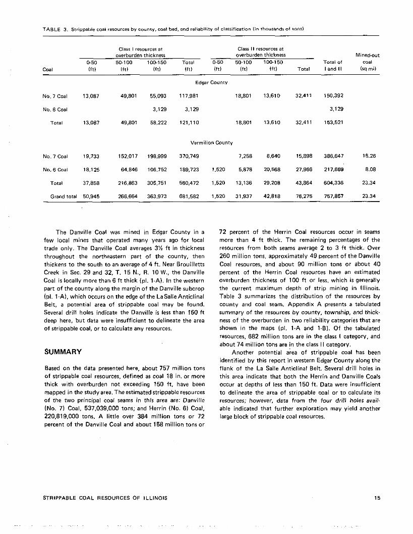
TABLE 3. strippable coal resources by county, coal bed, and reliability of clarrifieation (in thousands of tons)
Class I resources at Class I1 resources at overburden thickness overburden thickness Mined.out
0-50 50-1 00 100-150 Total 0-50 50.100 100-150 Total of coal Coal i f t ) I f f ) i f t l i f t ) lftl lftl l f t l Total I and 11 (sq mil
No. 7 Coal 13,087
No. 6 Coal
Total 13.087
No. 7 Coal 19,733
No. 6 Coal 18.125
Total 37.858
Grand total 50,945
Edgar County
49,801 55,093 117.981 18,801 13.610 32,411 150.392
3.129 3.129 3.129
49,801 58,222 121.1 10 18.801 13,610 32.411 153,521
Vermilion County
152.01 7 198.999 370.749 7,258 8.640 15.898 386.647 15.26
64,846 106.752 189,723 1,520 5.878 20.568 27.966 217,689 8.08
216.863 305.751 560,472 1.520 13,136 29,208 43.864 604,336 23.34
266.664 363,973 681,582 1,520 31.937 42.818 76,275 757.857 23.34
The Danville Coal was mined in Edgar County i n a
few local mines that operated many years ago for local
trade only. The Danville Coal averages 3% f t i n thickness
throughout the northeastern part of the county, then
thickens t o the south t o an average of 4 f t . Near Brouilletts
Creek i n Sec. 29 and 32, T. 15 N.. R. 10 W., the Danville
Coal is locally more than 6 ft thick (pl. l - A ) . In the western
part of the county along the margin o f the Danville subcrop
(PI. 1-A), which occurs o n the edge o f the LaSalle Anticlinal Belt, a potential area of strippable coal may be found.
Several dr i l l holes indicate the Danville i s less than 150 ft
deep here, bu t data were insufficient t o delineate the area
o f strippable coal, or t o calculate any resources.
SUMMARY
Based on the data presented here, about 757 mi l l ion tons
o f strippable coal resources, defined as coal 18 in. or more
thick wi th overburden not exceeding 150 ft, have been
mapped i n the study area. The estimated strippable resources o f the two principal coal seams in this area are: Danville
(No. 7) Coal. 537,039,000 tons; and Herrin (No. 6 ) Coal,
220,819.000 tons. A l i t t le over 384 mil l ion tons or 72
percent of the Danville Coal and about 158 mil l ion tons o r
STRIPPABLE COAL RESOURCES OF ILLINOIS
72 percent o f the Herrin Coal resources occur in seams
more than 4 f t thick. The remaining percentages o f the
resources f rom both seams average 2 t o 3 f t thick. Over
260 mi l l ion tons, approximately 49 percent o f the Danville
Coal resources, and about 90 mil l ion tons o r about 40
percent o f the Herrin Coal resources have an estimated
overburden thickness o f 100 f t or less, which is generally
the current maximum depth o f strip mining i n Illinois.
Table 3 summarizes the distribution of the resources b y
county and coal seam. Appendix A presents a tabulated
summary of the resources b y county, township, and thick-
ness o f the overburden i n two reliability categories that are shown in the maps (PI. 1-A and 1-01. O f the tabulated
resources. 682 mil l ion tons are i n the class I category, and
about 7 4 mil l ion tons are in the class II category.
Another potential area o f strippable coal has been
identified b y this report i n western Edgar County along the
flank o f the La Salle Anticlinal Belt. Several drill holes i n
this area indicate that both the Herrin and Danville Coals
occur at depths of less than 150 f t . Data were insufficient
t o delineate the area o f strippable coal or t o calculate i t s resources; however, data f rom the four drill holes avail-
able indicated that further exploration may yield another
large block of strippable coal resources.
REFERENCES
Alexander, J. W., 1942, Pennsylvanian geology o f eastern Vermilion County, Illinair, northern Vermillion County. Indiana, and Warren, and Fountain Counties, Indiana: MS. thesis. University of lllinoir. Urbana.
Alexander. J. W., 1943, Key beds of the Pennsylvanian section of eastern Vermilion County, Illinois, and Vermillion, Warren. and Fountain Counties. Indiana: lllinois Academy o f Science Transactionr, v. 36, no. 2, p. 141-144.
Allgaier. G. J.. and M. E. Hapkins, 1975, Reserves of the Herrin (No. 61 Coal in the Fairfield Basin in routheartern Illinois: lllinoir State Geological Survey, Circular 489, 31 p.
American Society far Testing and Materials. 1980, Annual Book of ASTM Standards, Part 26. Gaseous fuels: Caal and coke; atmospheric analyses: ASTM, Philadelphia, PA.
Ashley. G. H.. 1909. Supplementary report t o the report o f 1898 on the coal depos~ts of lnd~ana. lndmna Department of Geology and Natural Resources. Annual Report 33, p. 13-150.
Cady, G. H., 1920, The structure of the La Salle Anticline: lllinoir State Geological Survey, Bulletin 36. p. 85-179.
Cady. G. H., 1935. Classification and selection of lllinoir coals: lllinois State Geological Survey, Bulletin 62, 354 p.
Cady, G. H., 1948, Analyses of lllinois coalr: Illinois State Geo- logical Survey, Supplement t o Bulletin 62. 77 p.
Cady, G. H., 1952. Minable coal reserves of Illinois: Illinois State Geological Survey, Bulletin 78. 138 p.
Clegg, K. E.. 1965, Subsurface geology and coal resources o f the Pennsylvanian System in Clark and Edgar Counties. Illinois: lllinoir State Geological Survey, Circular 380. 28 p.
Coal Section Staff, lllinoin State Geological Survey, 1980. Descrip- t ion of coal seams, in 1980 Keystone coal industry manual, McGraw-Hill Book Co., New York, p. 496-507.
Culver, H. E., 1925. Preliminary report on the coal.stripping possi- bilities in Illinois: lllinois State Geological Survey, Illinois Cooperative Coal Mining Investigations Bulletin 28. 61 p.
Engelmann. Henry, 1868, Geology of Washington. Clinton, Marion. and Jefferson Counties: in A. H. Worthen, Vol. Ill: Geological Survey of lllinoir, p. 145-238.
Glurkoter. Harold J.. and Jack A. Simon. 1968, Sulfur in lllinoio coals: lllinois State Geological Survey, Circular 432, 28 P,
Horberg. Leland. 1957, Bedrock topography of lllinoir, 1950: plate 1 in l l l inair State Geological Survey, Bulletin 72. 111 p.
Hutchinson. Harold C.. 1961, Distribution. structure, and mined areas o f coals in Fountain and Warren Counties and the north- ernmost part of Vermillion County. Indiana: Preliminary Coal Map No. 9, Indiana Department of Consewation. Geological Survey.
Kay. F. H., and K. D. White, 1915. Caal resources of Dirtr ict V l l l IDanvillel: Illinois State Geological Survey, lllinoir Cooperative Coal Mining Investigations Bulletin 14, 68 p.
Koranke. R. M., J. A. Simon, H. R. Wanless, and H. 8. Willman, 1960, Classification o f the Pennsylvanian strata o f l l l inoir: Illinois State Geological Survey. Report of Investigations 214. 84 p.
Mylius. L. A.. 1927, Oil and gas development and possibilities and ean-central lllinois ICIBrk, Coler, Douglas, Edgar, and parts o f adjoining counties): lllinois State Geological Survey, Bulletin 54. 205 p.
Savage. T. E.. 1927, Significant breaks and overlaps in the Pennsyl- vanian rocks of lllinois: American Journal o f Science, ser. 5. v. 14. p 307-316.
Shaver, Robert H., Ann M. Burger. Gary R. Gates. Henry H. Gray, Harold C. Hutchinson. Stanley J. Keller. John B. Patton, Carl B. Rexroad. Ned M. Smith, William J. Wayne. and Charles E . Wier. 1970,Compendium of rock-unit stratigraphy in Indiana: Indiana Department o f Natural Rerourcer, Geological Survey Bulletin 43, 299 p.
Smith, W. H.. 1957, Strippable coal reserves of lllinoir. Part 1- Gallatin. Hardin. Johnson, Pope, Saline. and Williamson Counties: Illinois State Geological Survey. Circular 228, 39 p.
Smith, W. H., 1958, Strippable coal reserves of lllinois. Part 2- Jackson, Monroe, Perry, Randolph. and St. Clair Countier: lllinoir State Geological Survey, Circular 260, 35 p.
Smith, W. H.. 1961, Strippable coal reserves of lllinois. Part 3- Madison, Macoupin. Jersey, Greene, Scott, Morgan, and Cars Counties: lllinoir State Geological Survey. Circular 311. 40 p.
Smith, W. H., 1968, Strippable coal reserves of Illinair. Part 6- La Salle, Livingston. Grundy. Kankakee. Will, Putnarn, and parts o f Bureau and Marshall Countier: lllinoir State Geological Survey. Circular 419. 29p.
Smith, W. H., and D. J. Berggren, 1963, Strippable coal reserves of Illinois. Part 5A-Fulton, Henry. Knox, Peoria, Stark,Tazewell. and parts o f Bureau. Marshall. Mercer, and Warren Countier: lllinoir State Geological Survey, Circular 348. 59 p.
Smith, W. H.. and Stall. J. B.. 1975. Coal and water resources for coal conversion in lllinair: lllinois State Geological Survey. Cooperati~e Resources Roport 4, 79 p.
Trark. C. Brian, James E. Palmer, and Rurrel A. Peppers. Revision o f nomenclature for the Springfield (No. 5) Coal Member o f Illinois: Illinois State Geological Survey, l in preparation).
Treworgy. Colin G.. Lawrence E. Bengal. and Amy G. Dingwell, 1978. Reserves and resources of rurface-minable coal in lllinoir: lllinois State Geological Survey. Circular 504. 44 p.
Treworgv. Colin G., 1981, Seelyville Coal-A major unevploited ream in Illinois: lllinoir State Geological Survey, Illinois Mineral Notes 80.11 p.
Treworgv. Colin G., and Russell J. Jacobson, Paleoenvlronmentr and distribution o f low sulfur coal in Illinois: Proceedings of the Ninth International Congress of Carboniferous Stratigraphy and Geology (in preparation).
U.S. Bureau of Miner and US. Geological Survey, 1976, Coal resources classification system of the US. Bureau of Miner and US. Gelogical Survey: US. Geological Survey. Bulletin 1450-8. 7 P.
ILLINOIS STATE GEOLOGICAL SURVEY CIRCULAR 521
Wanless, Harold R.. 1931, Pennsylvanian section i n werrern Illinois: Worthen. A. H.. H. M. Bannister. F. H. Bradley. H. A. Green. Geological Society of America Bulletin. v.42. no. 3. p. 801-812. Lea Lerquereux. and J. S. Newberry, 1870, Geology and
paleontology: Geological Survey of Illinois. Vol. IV, 508 P. Wanless, Harold. 1956. Classification of rhe Penn~ylvanian rocks of
lllinoir as of 1956: Illinois State Geological Survey. Circular Worthen, A. H.. and H. M. Bannister. F. H. Bradley. Henry Engel- 217, 14 P. mann, A. C. Freeman, and H. A. Green, 1882, Economical
gsology of Illinois: Gelogical Survey of lllinoir, Vol. 11, 615 p. Willman. H. 0.. Elwood Atherton,T. C. Burchbach. CharlesCollinron.
John C. Frye, M. E. Hopkinr, Jerry A. Lineback, and Jack A. Simon. 1975, Handbook of Illinois stratigraphy: Illinois State Geological Survey, Bulletin 95. 261 p.
Willman. H. B.. J. C. Frye, J. A. Simon, K. E. Clegg. D. H. Swann, Elwood Athenon. Charles Collinron. J. A. Lineback, and T. C. Burchbach, 1967. Geologic Map of lllinoir: lllinoir State Geological Survey (1 :500.000).
STRIPPABLE COAL RESOURCES OF ILLINOIS
APPENDIX A. Strippable coal resources acwrding to thicknessof overburden, thickness of coal. and reliability classification, bv county and townshiD (in thousand tons)
Clarr I resources at Class II resource$ at
Coal, overburden thickness overburden thickness Mined-out
location. 0-50 50-100 100-150 0-50 50-1 00 100.1 50 Total of coal thickness (in.) I f t ) I f f ) ( f t l Total I f t l l f t l l f t l Total I and II (sq m i l
EDGAR COUNTY
No. 7 Coal
14N-10W 36 48 60 72
Total
14N-llW 60
Total
15N-10W 48 60 72 84
Total
15N-11W 48 60
Total
15N-12W 48
Total
16N-10W 36
Total
16N-11W 36 48
Total
Coal seam
No. 6 Coal
16N-10W 24
Total
Coal seam Countv
VERMILION COUNTY
No.7 Coal
17N-l lW 36 1,002 48
Total 1.002
STRIPPABLE COAL RESOURCES OF ILLINOIS
APPENDIX A. Continued
location. 0-50 thickness (in.) ( f t )
Class I resources at Coal, overburden thickness
50.100 1001 50
-
17N-12W 24 36 48
Total
18N- l lW 24 36 48 60
Total
1 8N-1 2W 24 36 48 60
Total
19N-11W 36 48 60 72 84
Total
19N-12W 48 60 72 84
Total
19N-13W 60 72
Total
20N-12W 36 48 60 72 84
Total
20N-13W 60
Total
Coal ream
l f t l l f t ) Total
Class I t resources at overburden thickness Mined-out
0-50 50-100 1001 50 Total o f coal l f t l I f f ) l f t l Total I and ll lsq rnl)
ILLINOIS STATE GEOLOGICAL SURVEY CIRCULAR 521
APPENDIX A. Continued.
Class I rerource~ at Class I I rerources at Coal, overburden thickness overburden thickness Mined.out location. 0-50 50-100 100-150 0-50 50-100 100-150 Total of coal thickness (in.) I f f )
No. 6 Coal
17N-llW 24 36 48 60 72
Total
18N-llW 48 60 72 84
Total
19N-llW 24 36 48 60 72 84
Total
19N-12W 24 36 48 60 72 84
Total
19N-13W 24
Total
20N-12W 24 36 48 60 7 2 84 96
lo8 Total
Coal seam county
Grand total
(ft) Total Iff) Iff) I f t ) Total I and I I (3s mi)
STRIPPABLE COAL RESOURCES OF ILLINOIS
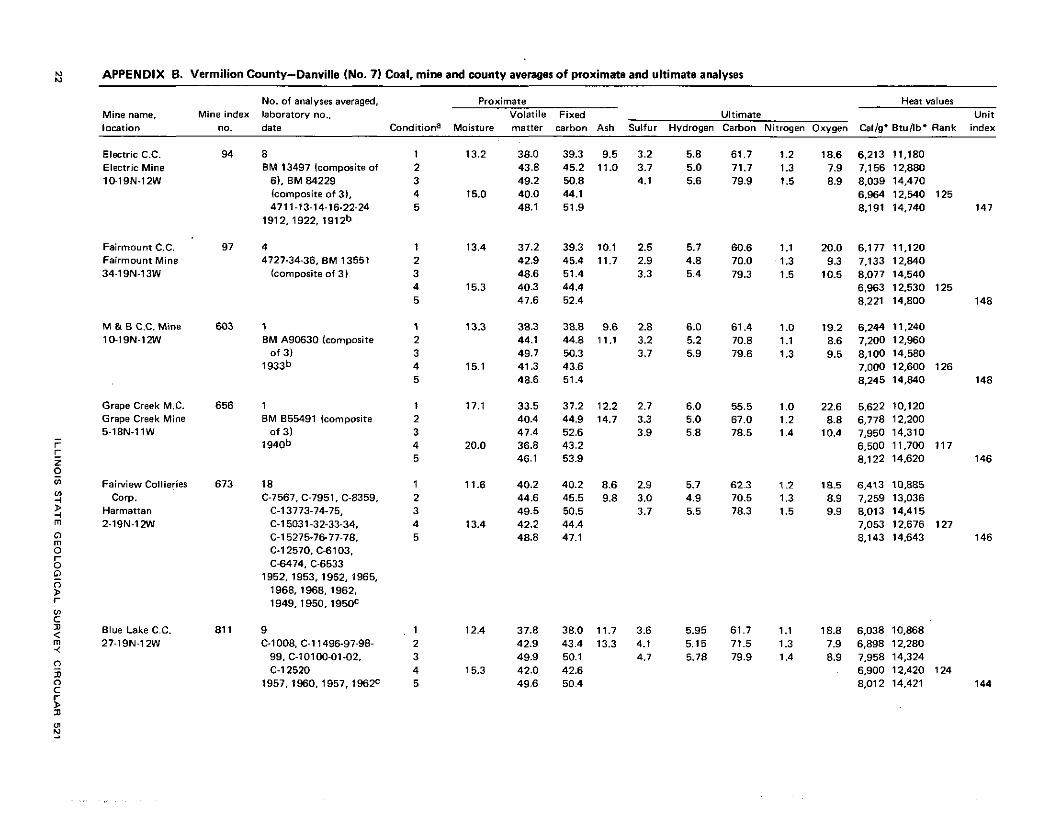
hl m APPENDIX 6. Vermilion County-Danville (No. 7 ) Coal, mine and county averages of proximate and ultimate analyses
Mine name, Mine index location no.
Electric C.C. 94 Electric Mine 10-19N.12W
Fairmount C.C. 97 Fairmount Mina 34-19N-13W
M & B C.C. Mine 603 10-19N-12W
Grape Creek M.C. 656 Grape Creek Mine
- 5-18N-11W r E z e '0 Fairview Collieries 673 '3
2 Corp.
i Harmattan rn 2-19N-12W
V) C D Blue Lake C.C. 81 1 $ < 27-19N-12W
No. of analyses averaged. laboratory no.. date Conditiona
8 1 BM 13497 lcomporite of 2
6). BM 84229 3 lcomporite of 3). 4 4711-13-14-16-22-24 5
1912,1922, 1912b
4 1 4727-34-36, BM 13551 2
(composite of 31 3 4 5
1 1 BM 855491 (composite 2
of 31 3 1940b 4
5
Proximate Heat dues Volatile Fixed Ultimate Unit
Moisture matter carbon Ash Sulfur Hydrogen Carbon Nitrogen Oxygen Calig' Btullb* Rank index
*O
W*
?.
N
-Cr-r-
Cu
mw
N
w(D
e
m
wm
or
-N
(D
r-m
mw
L
".N.o
.~N
. m
b0
--
N. -. 9
? -.
wr
-m
mm
rd
<m.r-.rn
* w
r-
mw
m
ST
RIP
PA
BL
E
CO
AL
RE
SO
UR
CE
S O
F
ILL
INO
IS

APPENDIX D. Vermilion County-Herrin (No. 6) Coal, mine and county averages of proximate and ultimate analyses
NO. of analyses averaged, Proximate Heat valuer Mine name, Mine index laboratory no., Volatile Fixed Ultimate Unit
P
no. date Conditiona Moisture matter carbon Ash Sulfur Hydrogen Carbon Nitrogen Oxygen Callg* Btullb* Rank index -
location
Peabady C.C. #24 15-18N-12W
Sharon C.C. Sharon Mine 7-17N-11W
Bunren C.C. Litt le Vermilion 19-18N-11W
W. C. Shafer Mine 7-19N-11W
Taylor English C.C # 2 Mine 3-18N-12W
US. Fuel C.C. Bunrenville Mine 26-18N-12W
7 474 1.42-43-44-45-46.
BM 13570 (composite af 3 )
1912b
7 4670-71-74-76-7E79.
EM 13449 lcomporite o f 61
1912b
lcomporite of 21 1912b
1 EM A90661
(composite of 31 1 9 3 3 ~
Average of 6 mine average&
a Type of analysis is denoted as fa l lam: I l I ramplear receivedat laboratory; (2) moisture-free: (31 moisture-andarh-free: (41 moiRminera1-matter free;and (51 dry mineralmatter free (unit coal). b Data from Cady (19351.
Convenion from calories to 8tu.5 used conversion factor o f 1.8.