Strengthening Hydromet and Early Warning Services in ...
126
STRENGTHENING HYDROMET AND EARLY WARNING SERVICES IN AFGHANISTAN: A ROAD MAP
-
Upload
khangminh22 -
Category
Documents
-
view
2 -
download
0
Transcript of Strengthening Hydromet and Early Warning Services in ...

STRENGTHENING HYDROMETAND EARLY WARNING SERVICESIN AFGHANISTAN: A ROAD MAP

© 2018 The World Bank1818 H Street NWWashington DC 20433Telephone: 202-473-1000Internet: www.worldbank.org
This work is a product of the staff of The World Bank with external contributions. The findings, interpretations, and conclusions expressed in this work do not necessarily reflect the views of The World Bank, its Board of Executive Directors, or the governments they represent. The World Bank does not guarantee the accuracy of the data included in this work. The boundaries, colors, denominations, and other information shown on any map in this work do not imply any judgment on the part of The World Bank concerning the legal status of any territory or the endorsement or acceptance of such boundaries.
Rights and Permissions: The material in this work is subject to copyright. Because The World Bank encourages dissemination of its knowledge, this work may be reproduced, in whole or in part, for noncommercial purposes as long as full attribution to this work is given. Any queries on rights and licenses, including subsidiary rights, should be addressed to World Bank Publications, The World Bank Group, 1818 H Street NW, Washington, DC 20433, USA; fax: 202-522-2625; e-mail: [email protected].

STRENGTHENING HYDROMET AND EARLY WARNING SERVICES IN AFGHANISTAN: A ROAD MAP

ii
Acknowledgments
The report is the result of a collaboration between the government of Afghanistan and the World Bank and prepared by the GFDRR/WBG as part of the Afghanistan Disaster Risk Management (DRM) Program. It presents a potential pathway to strengthen the country’s hydrometeorological (hydromet) services in general and Early Warning Systems (EWS) and services in particular, reflecting the needs of the user community. The report is based on a technical evaluation and detailed assessment of the needs and capacities of the Afghanistan Meteorological Department (AMD) of the Afghanistan Civil Aviation Authority (ACAA) and the Water Resources Department (WRD) of the Ministry of Energy and Water (MEW). These agencies issue weather and water-related forecasts and are thus considered as the main service providers in the country. Other government agencies that are responsible for the provision of advisory services related to weather, climate, hydrology, disaster management, and agriculture to end-users (down to the community level) in Afghanistan are considered as key stakeholders of AMD and WRD’s information and services. Among stakeholders, the most important are the Ministry of Agriculture, Irrigation and Livestock (MAIL), the Afghanistan National Disaster Management Authority (ANDMA) and the Ministry of Rural Rehabilitation and Development (MRRD). This report identifies gaps and challenges in the production and delivery of weather, climate, and hydrological information and services, and it proposes a strategy for improving the country’s institutional capacity to save lives and livelihoods and to support social and economic development. The authors consulted government institutions and agencies (including the above-listed) to stakeholders, non-governmental organizations (NGO), and donors. The report is the result of a collaboration between the government of Afghanistan and the World Bank.
The authors wish to extend their appreciation to and acknowledge the national agencies, ministries, and organizations for their support and assistance in granting access to informa-tion, for providing support to the report, and for being available for discussions during the report’s assessment. We are particularly grateful to Mr. Mahmood Shah Habibi, Head, ACAA; Mr. Sayed Reza Mousawi, Director, AMD; Mr. FazulHaq Bakhtari, Director, WRD; Mr. Sayed Sharif Shobair, Advisor, MEW; Mr. Noorullah Stanikzai, Deputy Director General, National Statistics and Information Authority (NSIA); and, Mr. Ezatullah Sediqi, Deputy Director General, National Environmental Protection Agency (NEPA).
The World Bank team was led by Makoto Suwa and Haleh Kootval, and included Arati Belle, Abdul Azim Doosti, Ditte Fallesen, Federica Ranghieri, Mohamed Chebaane, Paul Houser, Philip Poyner, and Pedro Restrepo.

iii
Foreword
Afghanistan is highly prone to natural disasters: every year hundreds of people lose their lives and thousands more are affected by hydrometeorological disasters. The frequency and sever-ity of extreme events such as floods, landslides and droughts are projected to increase due to climate change. Such events will undermine our country’s development efforts, which have already faced many challenges.
In recent decades, we have experienced several unfortunate events, including the civil war, that have decreased institutional capacity in Afghanistan. The quality of key public services has deteriorated throughout two decades of war, turmoil, and insecurity. Meteorological and hydrological services, which are critical for almost all socioeconomic sectors in Afghanistan, were no exception. Whereas these services had once been among the best in the region, the Government of Afghanistan has had to rebuild their capacity from scratch.
With support from partners, the Afghanistan Civil Aviation Authority’s Afghanistan Meteorological Department (AMD) and the Ministry of Energy and Water (MEW) have regained basic capacity during the last couple of years. AMD is now able to issue basic warnings for hydrometeorologi-cal disasters such as floods, flash floods, heavy rain, dust storms, heat waves, and cold waves. Likewise, MEW is now equipped with the basic capability to monitor hydrological parameters. Rebuilding services such as these is an ongoing effort and will require systematic and holistic investment to boost the capacity of the Government of Afghanistan to provide these essential services to all of its citizens and key economic sectors.
It is, therefore, my great pleasure to introduce “Strengthening Hydromet and Early Warning Services In Afghanistan: A Road Map,” which offers strategic direction to my country on how hydromet and early warning services in Afghanistan can be strengthened and used more effectively. The practical value of this report cannot be overstated, as it comes at a time when weather and climate change consequences, if left unaddressed, will significantly hinder the country’s social and economic development.
A robust set of findings and recommendations in this roadmap lays the foundation for the country’s future strengthening efforts. It also paves the way for improvements and modernization in both AMD and MEW’s Water Resources Department – two key agencies for such efforts in Afghanistan.
I would like to thank the World Bank team who helped prepare this roadmap. I am very excited about this ambitious new stage in the development of effective hydromet and early warning services in Afghanistan, and I look forward to its successful implementation.
Mahmood Shah HabibiHead, Afghanistan Civil Aviation Authority

iv
Foreword
Afghanistan is highly vulnerable to hydro-meteorological disasters and is ranked second among low-income countries on the Global Climate Risk Index in terms of the number of fatalities from natural disasters between 1980 and 2015. Droughts affect a significant proportion of the population while floods cause the most economic damage among weather hazards affecting the country.
A changing climate magnifies these risks and the incidence of extreme weather events, such as heat waves, floods, and droughts, creating climate-induced disasters such as Glacial Lake Outburst Floods, avalanches, and rainfall-induced landslides. World Bank studies show that in the case of a lack of action, climate change related impacts can push an additional 62 million people in the South Asia Region into extreme poverty by 2030, with the risk of more than 40 million internal climate migrants by 2050.
The current drought situation in Afghanistan exemplifies this trend – drought conditions over recent years have led to severe crop shortfalls in many regions that have been chronically food insecure and have so far led to the displacement of more than 150,000 people.
Establishing accurate and timely hydromet, early warning and climate information services is urgently needed in Afghanistan to minimize human and economic losses. After many years of civil strife, Afghanistan is making progress towards rebuilding its hydromet and early warning institutions and recognizes the importance of quality public services. In addition to reducing loss of life and damage to assets, the productivity of key economic sectors in the country, such as agriculture, water resources management, transport, and energy depends on the availability and access to quality weather, water, and climate information services.
This Strengthening Hydromet and Early Warning Services in Afghanistan: A Road Map utilizes the hydromet value chain as a framework to identify bottlenecks and benchmark relevant best practices to strengthen and modernize hydromet services. It is a particularly timely resource and is noteworthy in bringing together multiple sectoral and service delivery agencies towards a common strategic direction.
Showcasing World Bank experience, this report indicates that although the price tag of modernizing and sustaining National Meteorological and Hydrological Services (NMHs) is considerable, the rewards for the country and its citizens is much higher, with each dollar invested yielding more than US$4 in avoided losses.
The Road Map presents a pathway of action that the Government of Afghanistan could take to trans-form its NMHSs into robust, professional agencies capable of delivering the right information to the vulnerable people at the right time.
Shubham Chaudhuri Country DirectorAfghanistan, South Asia Region, The World Bank Group
Ede Ijjasz-VasquezSenior Director, Social, Urban, Rural and Resilience Global PracticeThe World Bank Group
v
Contents
Acknowledgments . . . . . . . . . . . . . . . . . . . . . . . . . . . . . . . . . . . . . . . . . . . . . . . . . . . . . . . . . . . . . . . . . . . . . . . . . . . . . . . . . . . ii
Forewords . . . . . . . . . . . . . . . . . . . . . . . . . . . . . . . . . . . . . . . . . . . . . . . . . . . . . . . . . . . . . . . . . . . . . . . . . . . . . . . . . . . . . . . . . . . iii
Abbreviations . . . . . . . . . . . . . . . . . . . . . . . . . . . . . . . . . . . . . . . . . . . . . . . . . . . . . . . . . . . . . . . . . . . . . . . . . . . . . . . . . . . . . . . xi
Executive Summary . . . . . . . . . . . . . . . . . . . . . . . . . . . . . . . . . . . . . . . . . . . . . . . . . . . . . . . . . . . . . . . . . . . . . . . . . . . . . . . . xi
1. Introduction to Geographical Features and Weather, Climate and Hydrological Hazards . . . . . . . . . . . . . . . . . . . . . . . . . . . . . . . . . . . . . . . . . . . . . . . . . . . . . . . . . . . . . . . . . . . . . . . . . . 1
2. Weather and Climate Risks . . . . . . . . . . . . . . . . . . . . . . . . . . . . . . . . . . . . . . . . . . . . . . . . . . . . . . . . . . . . . . . . . . . . . . 5
3. Socioeconomic Impacts of Hydromet Hazards . . . . . . . . . . . . . . . . . . . . . . . . . . . . . . . . . . . . . . . . . . . . . 11
4. Assessment of User Needs for Weather, Climate, and Hydrological Services . . . . . . . . . 15
5. Institutional and Organizational Analysis . . . . . . . . . . . . . . . . . . . . . . . . . . . . . . . . . . . . . . . . . . . . . . . . . . . . 17
5.1 A Brief History of the Afghanistan Meteorological Department . . . . . . . . . . . . . . . . . . . . . . . . . . 17
5.2 A Brief History of the Water Resources Management Department . . . . . . . . . . . . . . . . . . . . . 19
6. Current Status of AMD, WRD-MEW, and Stakeholders . . . . . . . . . . . . . . . . . . . . . . . . . . . . . . . . . . . 21
6.1 Service Delivery Systems . . . . . . . . . . . . . . . . . . . . . . . . . . . . . . . . . . . . . . . . . . . . . . . . . . . . . . . . . . . . . . . . . . . . . 22
6.1.1 Public Weather Services System . . . . . . . . . . . . . . . . . . . . . . . . . . . . . . . . . . . . . . . . . . . . . . . . . . . . . . . . 23
6.1.2 Disaster Management Services System . . . . . . . . . . . . . . . . . . . . . . . . . . . . . . . . . . . . . . . . . . . . . . . 24
6.1.3 Aviation Services System . . . . . . . . . . . . . . . . . . . . . . . . . . . . . . . . . . . . . . . . . . . . . . . . . . . . . . . . . . . . . . . 25
6.1.4 Water Management and Flood Forecasting Services System . . . . . . . . . . . . . . . . . . . . . 25
6.1.5 Agricultural Services System . . . . . . . . . . . . . . . . . . . . . . . . . . . . . . . . . . . . . . . . . . . . . . . . . . . . . . . . . . . 26
6.1.6 Climate Services System . . . . . . . . . . . . . . . . . . . . . . . . . . . . . . . . . . . . . . . . . . . . . . . . . . . . . . . . . . . . . . . . 28
6.2 Quality Management Systems . . . . . . . . . . . . . . . . . . . . . . . . . . . . . . . . . . . . . . . . . . . . . . . . . . . . . . . . . . . . . . . 28
6.2.1 Institutional Management Systems . . . . . . . . . . . . . . . . . . . . . . . . . . . . . . . . . . . . . . . . . . . . . . . . . . . . 28
6.2.2 Operational Management Systems . . . . . . . . . . . . . . . . . . . . . . . . . . . . . . . . . . . . . . . . . . . . . . . . . . . 29
6.3 Capacity Building . . . . . . . . . . . . . . . . . . . . . . . . . . . . . . . . . . . . . . . . . . . . . . . . . . . . . . . . . . . . . . . . . . . . . . . . . . . . . . 30
6.4 Monitoring and Observation Systems . . . . . . . . . . . . . . . . . . . . . . . . . . . . . . . . . . . . . . . . . . . . . . . . . . . . . . 30
6.4.1 Global Data System . . . . . . . . . . . . . . . . . . . . . . . . . . . . . . . . . . . . . . . . . . . . . . . . . . . . . . . . . . . . . . . . . . . . . . . 31
6.4.2 National Data Systems . . . . . . . . . . . . . . . . . . . . . . . . . . . . . . . . . . . . . . . . . . . . . . . . . . . . . . . . . . . . . . . . . . . 31
6.4.3 Upper Air System . . . . . . . . . . . . . . . . . . . . . . . . . . . . . . . . . . . . . . . . . . . . . . . . . . . . . . . . . . . . . . . . . . . . . . . . 39

vi STRENGTHENING HYDROMET AND EARLY WARNING SERVICES IN AFGHANISTAN: A ROAD MAP
6.4.4 Radar System . . . . . . . . . . . . . . . . . . . . . . . . . . . . . . . . . . . . . . . . . . . . . . . . . . . . . . . . . . . . . . . . . . . . . . . . . . . . 40
6.4.5 Use of Remote Sensing Products . . . . . . . . . . . . . . . . . . . . . . . . . . . . . . . . . . . . . . . . . . . . . . . . . . . . . 40
6.4.6 Data Management and Archiving Systems: Data Collection System, Quality System, and Storage and Archiving . . . . . . . . . . . . . . . . . . . . . . . . . . . . . . . . . . . . . . . . . . . . . . . . . 41
6.5 ICT Systems: Telecommunication System (Data Exchange and Distribution System, Transmission) . . . . . . . . . . . . . . . . . . . . . . . . . . . . . . . . . . . . . . . . . . . . . . . . . . . . . . . . 43
6.6 Modeling Systems . . . . . . . . . . . . . . . . . . . . . . . . . . . . . . . . . . . . . . . . . . . . . . . . . . . . . . . . . . . . . . . . . . . . . . . . . . . . . 44
6.6.1 Global and Regional NWP Systems . . . . . . . . . . . . . . . . . . . . . . . . . . . . . . . . . . . . . . . . . . . . . . . . . . . . 44
6.7 Objective and Impact Forecasting and Warning Systems . . . . . . . . . . . . . . . . . . . . . . . . . . . . . . . 44
6.7.1 Severe Hazard Forecasting Systems . . . . . . . . . . . . . . . . . . . . . . . . . . . . . . . . . . . . . . . . . . . . . . . . . . . 44
6.7.2 Very Short- and Short-Range Forecasting Systems . . . . . . . . . . . . . . . . . . . . . . . . . . . . . . . . 49
6.7.3 Medium- and Long-Range Forecasting Systems . . . . . . . . . . . . . . . . . . . . . . . . . . . . . . . . . . . . 50
6.8 Current System . . . . . . . . . . . . . . . . . . . . . . . . . . . . . . . . . . . . . . . . . . . . . . . . . . . . . . . . . . . . . . . . . . . . . . . . . . . . . . . . 50
7. Modernization of Meteorological and Hydrological Services and Early Warning Systems . . . . . . . . . . . . . . . . . . . . . . . . . . . . . . . . . . . . . . . . . . . . . . . . . . . . . . . . . . . . . . . . . . . . . . . . . . . . . . . . . . 53
7.1 Value Chain Approach . . . . . . . . . . . . . . . . . . . . . . . . . . . . . . . . . . . . . . . . . . . . . . . . . . . . . . . . . . . . . . . . . . . . . . . . . 53
7.2 Development Partners and Cooperation . . . . . . . . . . . . . . . . . . . . . . . . . . . . . . . . . . . . . . . . . . . . . . . . . . . 57
7.2.1 Regional Initiatives . . . . . . . . . . . . . . . . . . . . . . . . . . . . . . . . . . . . . . . . . . . . . . . . . . . . . . . . . . . . . . . . . . . . . . . 57
7.2.2 International Initiatives . . . . . . . . . . . . . . . . . . . . . . . . . . . . . . . . . . . . . . . . . . . . . . . . . . . . . . . . . . . . . . . . . 58
8. Proposed Road Map for Modernization of AMD and WRD-MEW . . . . . . . . . . . . . . . . . . . . . . 59
8.1 Delivery of Services . . . . . . . . . . . . . . . . . . . . . . . . . . . . . . . . . . . . . . . . . . . . . . . . . . . . . . . . . . . . . . . . . . . . . . . . . . . . 59
8.1.1 Strengthening Public Weather, Climate, and Hydrological Services . . . . . . . . . . . . . . . 62
8.1.2 Developing a Comprehensive National Drought Monitoring Program . . . . . . . . . . . . 62
8.1.3 Development of a National Framework for Climate Services . . . . . . . . . . . . . . . . . . . . . 63
8.2 Institutional Strengthening and Capacity Building . . . . . . . . . . . . . . . . . . . . . . . . . . . . . . . . . . . . . . . 63
8.2.1 Institutional Strengthening . . . . . . . . . . . . . . . . . . . . . . . . . . . . . . . . . . . . . . . . . . . . . . . . . . . . . . . . . . . . . 63
8.2.2 Capacity Building . . . . . . . . . . . . . . . . . . . . . . . . . . . . . . . . . . . . . . . . . . . . . . . . . . . . . . . . . . . . . . . . . . . . . . . . 64
8.3 Modernization of Observation Infrastructure, Data Management Systems, and Forecasting . . . . . . . . . . . . . . . . . . . . . . . . . . . . . . . . . . . . . . . . . . . . . . . . . . . . . . . . . . . . . . . . . . . . . . . . . . . . . . . . . . . 65
8.3.1 Meteorological Observation Infrastructure . . . . . . . . . . . . . . . . . . . . . . . . . . . . . . . . . . . . . . . . . . 65
8.3.2 Hydrological Observation Infrastructure . . . . . . . . . . . . . . . . . . . . . . . . . . . . . . . . . . . . . . . . . . . . . 66
8.3.3 Data Management, Communication, and ICT System . . . . . . . . . . . . . . . . . . . . . . . . . . . . . . 66
8.3.4 Meteorological Forecasting . . . . . . . . . . . . . . . . . . . . . . . . . . . . . . . . . . . . . . . . . . . . . . . . . . . . . . . . . . . 66
8.3.5 Hydrological Forecasting and Hydrological Decision Support System . . . . . . . . . . 67

CONTENTS vii
9. Road Map Scenarios. . . . . . . . . . . . . . . . . . . . . . . . . . . . . . . . . . . . . . . . . . . . . . . . . . . . . . . . . . . . . . . . . . . . . . . . . . . . . 71
9.1 Scenario 1: Advanced Modernization . . . . . . . . . . . . . . . . . . . . . . . . . . . . . . . . . . . . . . . . . . . . . . . . . . . . . . . . 72
9.1.1 Enhancement of the AMD and MEW Service Delivery Process . . . . . . . . . . . . . . . . . . . . . 72
9.1.2 Institutional Strengthening and Capacity Building . . . . . . . . . . . . . . . . . . . . . . . . . . . . . . . . . . . 73
9.1.3 Modernization of Observation Infrastructure, Data Management Systems, and Forecasting . . . . . . . . . . . . . . . . . . . . . . . . . . . . . . . . . . . . . . . . . . . . . . . . . . . . . . . . . . . . . . . . . . . . . . 74
9.2 Scenario 2: Intermediate Modernization . . . . . . . . . . . . . . . . . . . . . . . . . . . . . . . . . . . . . . . . . . . . . . . . . . . 78
9.3 Scenario 3: Technical Assistance for High Priority and Immediate Needs . . . . . . . . . . . . 82
10. Socioeconomic Benefits of Improved Hydrometeorological Services and Early Warning Systems . . . . . . . . . . . . . . . . . . . . . . . . . . . . . . . . . . . . . . . . . . . . . . . . . . . . . . . . . . . . . . . . . . . . . . 89
11. Conclusions and a Way Forward . . . . . . . . . . . . . . . . . . . . . . . . . . . . . . . . . . . . . . . . . . . . . . . . . . . . . . . . . . . . . . 91
Annex 1. Required Training Areas . . . . . . . . . . . . . . . . . . . . . . . . . . . . . . . . . . . . . . . . . . . . . . . . . . . . . . . . . . . . . . . 93
Annex 2. Service Delivery Progress Model . . . . . . . . . . . . . . . . . . . . . . . . . . . . . . . . . . . . . . . . . . . . . . . . . . . . 94
Annex 3. Observation and Telecommunication Progress Model . . . . . . . . . . . . . . . . . . . . . . . . . . . 96
Annex 4. Forecasting Progress Model . . . . . . . . . . . . . . . . . . . . . . . . . . . . . . . . . . . . . . . . . . . . . . . . . . . . . . . . . . 97
Annex 5. Climate Services Progress Model . . . . . . . . . . . . . . . . . . . . . . . . . . . . . . . . . . . . . . . . . . . . . . . . . . . . 98
Annex 6. Existing National Strategies and Plans . . . . . . . . . . . . . . . . . . . . . . . . . . . . . . . . . . . . . . . . . . . . . 99
References . . . . . . . . . . . . . . . . . . . . . . . . . . . . . . . . . . . . . . . . . . . . . . . . . . . . . . . . . . . . . . . . . . . . . . . . . . . . . . . . . . . . . . . . . . 101
List of Figures
Figure 1. Elevation Map of Afghanistan ..........................................................................................1
Figure 2. Major River Basins of Afghanistan ................................................................................2
Figure 3. Economic Activity and Land Use in Afghanistan ......................................................4
Figure 4. Köppen Climate Classification Zones of Afghanistan ..............................................5
Figure 5. Average Monthly Temperature and Rainfall, Series 1901–2015 ..............................6
Figure 6. Spatial Variability of Mean Annual Precipitation .......................................................6
Figure 7. Flash Flood Susceptibility Index ....................................................................................7
Figure 8. Afghanistan 100-Year Avalanche Scenario .................................................................8

viii STRENGTHENING HYDROMET AND EARLY WARNING SERVICES IN AFGHANISTAN: A ROAD MAP
Figure 9. Agricultural Drought Risk, Current Conditions ..........................................................8
Figure 10. Agricultural Drought Risk, 2050 Conditions ............................................................8
Figure 11. Susceptibility Map for Cover Material Landslides in Rapid Evolution .................9
Figure 12. Overview of Natural Disasters by Province, 2013 ................................................... 11
Figure 13. Afghanistan Risk Summary ......................................................................................... 12
Figure 14. Financing for Disaster Risk Reduction in the Context of the Mortality Risk Index, 1991–2010 (volumes, US$ millions) ......................................................................... 13
Figure 15. Proposed Structure of Afghanistan Meteorological Department ...................... 18
Figure 16. Historical Trend for Hydrometric Active Stations in Afghanistan (World Bank and Water for Life, 2017 ......................................................................................... 19
Figure 17. Organizational Structure of the Water Resources Department ........................ 20
Figure 18. Generic System of Systems for a Modern NMHS ................................................... 21
Figure 19. System-of-Systems Concept of Operational Flood Forecasting by an NHS ...22
Figure 20. Avalanche Risk Impact ................................................................................................23
Figure 21. Agriculture, Industry, and Services in Afghanistan, 2010/11 ............................... 26
Figure 22. AMD Meteorological Monitoring Network .............................................................. 31
Figure 23. Precipitation Monitoring Network ............................................................................32
Figure 24. Location of the 26 AWSs Managed by MEW .........................................................33
Figure 25. Climate Monitoring Network ..................................................................................... 34
Figure 26. Snow Monitoring Network ..........................................................................................35
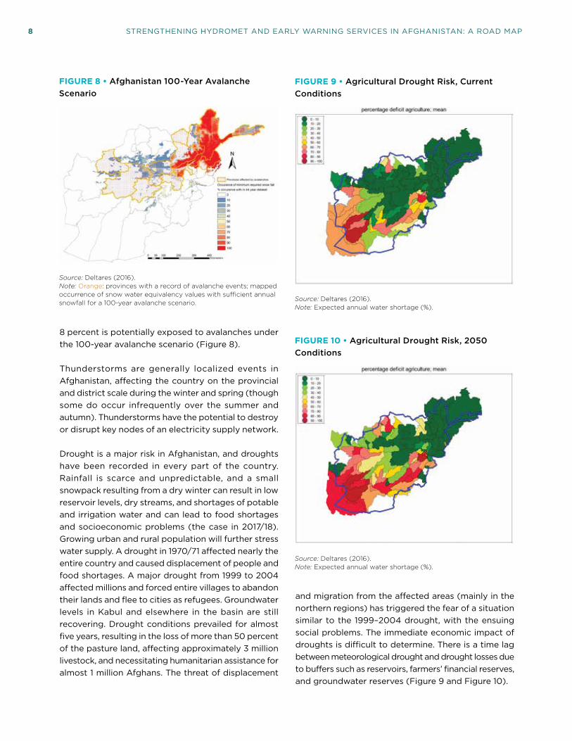
Figure 27. Agroclimate Monitoring Network ............................................................................. 36
Figure 28. Hydrological Monitoring Network ............................................................................37
Figure 29. Location of Sediment Analysis Laboratories ........................................................ 39
Figure 30. Data Availability ........................................................................................................... 42
Figure 31. Framework for a Hydromet Data-Sharing Platform ............................................. 43
Figure 32. Landslide Locations .................................................................................................... 48
Figure 33. Sample Three-Day Forecast Produced by AMD .................................................. 49
Figure 34. AMD System of Systems, Current Capacity ........................................................... 51

CONTENTS ix
Figure 35. MEW System of Systems, Current Capacity ...........................................................52
Figure 36. Schematic of Global Observing, Telecommunication, Data Processing, Forecasting and Dissemination System ..................................................................................... 54
Figure 37. Hydromet Production Value Chain ........................................................................... 55
Figure 38. Schematic of NMHS Modernization ......................................................................... 56
Figure 39. Data Flow in Hydrometeorological Services ......................................................... 56
Figure 40. Stages and Elements of Hydrometeorological Service Delivery .....................60
Figure 41. Scenario 1 Capabilities of AMD System of Systems ..............................................75
Figure 42. Scenario 1 Capabilities of MEW System of Systems.............................................77
Figure 43. Capabilities of AMD System of Systems ................................................................ 79
Figure 44. Scenario 2 Capabilities of MEW System of Systems ........................................... 81
Figure 45. Scenario 1 Capabilities of AMD System of Systems ............................................ 84
Figure 46. Scenario 3 Capabilities of MEW System of Systems........................................... 86
List of Tables
Table 1. Disaster Risk Management and Weather-Sensitive Socioeconomic Sectors Requiring Hydromet Information .................................................................................. 15
Table 2. Hydromet and EW Products and Services Demanded but Not Available .............................................................................................................................. 16
Table 3. Current Rainfall Monitoring Network by Basin ..........................................................32
Table 4. Climate Monitoring Network by Basin ........................................................................ 34
Table 5. Snow Monitoring Network by Basin .............................................................................35
Table 6. Hydrometric Monitoring Network by Basin ............................................................... 38
Table 7. Primary, Secondary and Tertiary Hazards Cascading from Hydrometeorological Events ........................................................................................................ 45
Table 8. Debris Flow in Afghan Districts .................................................................................... 47
Table 9. AMD System of Systems, Approximate Current Capacity (%) ............................... 51
Table 10. MEW System of Systems, Approximate Current Capacity (%) ............................52

x STRENGTHENING HYDROMET AND EARLY WARNING SERVICES IN AFGHANISTAN: A ROAD MAP
Table 11. Scenario 1 Approximate Capabilities for Each AMD System of Systems (%).... 76
Table 12. Scenario 1 Approximate Capabilities for Each WRD-MEW System of Systems (%) ...................................................................................................................................78
Table 13. Scenario 2 Approximate Capabilities for Each AMD System of Systems (%) .................................................................................................................................. 80
Table 14. Scenario 2 Approximate Capabilities for Each WRD-MEW System of Systems (%) .................................................................................................................................. 82
Table 15. Scenario 1 Approximate Capabilities for AMD System of Systems (%) ............. 85
Table 16. Scenario 3 Approximate Capabilities for MEW System of Systems (%) ............87
List of Photos
Photo 1: Manual Recording of Synoptic and METAR Observations at Herat Station ................................................................................................................................. 31
Photo 2: Automatic Hydrologic Station ..................................................................................... 38
Photo 3: Modern Forecaster Workstation in Cambodia ..........................................................53
Photo 4. Flood Forecasting Center, Met Office, United Kingdom ........................................ 61
Photo 5. Modern Public Weather Service Delivery in Indonesia .......................................... 62

xi
Abbreviations
ACAA Afghanistan Civil Aviation Authority
AMD Afghanistan Meteorological Department
ANDMA Afghanistan National Disaster Management Authority
ASDC Afghanistan Spatial Data Center
AWS Automatic Weather Station
CAP Common Alerting Protocol
CBFEWS Community-Based Flood Early Warning System
CDC Community Development Council
CONOPS Concept of Operations
DEM Digital Elevation Model
DRM Disaster Risk Management
DSS Decision Support System
ECMWF European Centre for Medium-Range Weather Forecasts
EUMETSAT European Organization for Meteorological Satellites
EW Early Warning
EWS Early Warning Systems
FAO Food and Agricultural Organization
FEWS Flood Early Warning System
FEWS NET Famine Early Warning System Network
FFGS Flash Flood Guidance System
GDP Gross Domestic Product
GFCS Global Framework for Climate Services
GFDRR Global Facility for Disaster Reduction and Recovery
GFS Global Forecasting System
GIS Geographic Information System
GloFAS Global Flood Awareness System
GMS Global System for Mobile Communication
GTS Global Telecommunication System
HYMEP Project for Capacity Enhancement on Hydrometeorological Information Management (JICA)
ICIMOD International Centre for Integrated Mountain Development
ICT Information and Communication Technology
IMMAP Information Management and Mine Action Program
IRDP Irrigation Rehabilitation and Development Project
IT Information Technology
JICA Japan International Cooperation Agency
LiDAR Light Detection and Ranging

xii STRENGTHENING HYDROMET AND EARLY WARNING SERVICES IN AFGHANISTAN: A ROAD MAP
MAIL Ministry of Agriculture, Irrigation and Livestock
METAR Meteorological Terminal Air Report
MEW Ministry of Energy and Water
MoMP Ministry of Mines and Petroleum
MoPH Ministry of Public Health
MPW Ministry of Public Works
MoU Memorandum of Understanding
MRRD Ministry of Rural Rehabilitation and Development
MUDA Ministry of Urban Development Affairs
NATO North Atlantic Treaty Organization
NEPA National Environmental Protection Agency
NFCS National Framework for Climate Services
NGO Nongovernmental Organization
NHS National Hydrological Service
NMHS National Meteorological and Hydrological Service
NOAA National Oceanic and Atmospheric Administration
NWP Numerical Weather Prediction
O&M Operations and Maintenance
ORS Operation Resolute Support
PIREP Pilot Reports
PWS Public Weather Service
QA/QC Quality Assurance/Quality Control
QMS Quality Management System
RS Remote Sensing
SAsiaFFG South Asia Flash Flood Guidance System
SCoWLE Supreme Council on Water, Land and Environment
SIGMET Significant Meteorological Information
SIGWEX Significant Weather
SMS Short Message Service
SOP Standard Operating Procedure
SPECI Aviation Special Weather Report
SMDMHA State Ministry of Disaster Management and Humanitarian Affairs
SWE Snow Water Equivalent
TAF Terminal Aerodrome Forecast
USAID United States Agency for International Development
USGS U.S. Geological Service
WBG World Bank Group
WMO World Meteorological Organization
WRD Water Resources Department

xiii
Executive Summary
Country Context
Hydrological and meteorological (hydromet) data collection and analysis in Afghanistan started in the late 1940s and mid-1950s, respectively. The hydrometric network expanded rapidly in the 1960s and 1970s, reaching a peak of 150 in 1980, and the meteorological network had a similar trajectory. Two decades of war, however, brought instability and insecurity that reduced public resources, capacities, collaboration, and coordination.
The institutional framework governing weather, climate and hydrological (hydromet) services as well as early warning (EW) and disaster risk management (DRM) services did not escape these setbacks. In 1996, Taliban forces sacked the meteorology office, ruining equipment and destroying over 100 years of weather records. Hydroelectric production nearly ceased as turbines were destroyed, floodgates blown open, and transmission lines brought down. The civil war and its aftermath led to the degradation of traditional observation networks, prevalence of outdated and inefficient technologies, and lack of modern instruments and information and communication technology (ICT).
The absence of forecasts and weather information reversed years of development gains in farming and civil aviation operations. In 1998, an Ariana Afghan Airlines flight in route from Kandahar to Kabul in bad weather crashed into a mountaintop, killing 45 people. From 1998 to 2004, a major drought forced nearly 1 million Afghans from their farms and herds into metropolitan areas, impacting half the agriculture land, killing 3 million livestock, and seriously depleting groundwater resources in Kabul and the Kabul Water Basin.
Today, the country is in the process of rebuilding and reorganizing its institutions to bet-ter meet the needs of and deliver services to the Afghan people. The existing regulatory, operational, and institutional framework governing hydromet, EW, and DRM provides a basis for developing and implementing effective and efficient products and services. Two main and interrelated challenges, however, are hindering progress in this area in Afghanistan.
First, Afghanistan needs to develop a comprehensive and inclusive national strategy/plan for DRM, hydromet, and EW services to better understand and appreciate these functions and to clearly delineate existing and future roles and responsibilities. Second, institutional communication and coordination needs to be (reestablished and) solidified along the entire hydromet, EW, and DRM value chain. Coordination of observation networks, forecasting, and EW services is essential to avoid duplication, to build economies of scale, and to ensure an effective supply chain in the production and delivery of services. In terms of observation, insufficient coordination among agencies could lead to two or more stations from different agencies installed, in proximity, to observe the same parameters leading

xiv STRENGTHENING HYDROMET AND EARLY WARNING SERVICES IN AFGHANISTAN: A ROAD MAP
to a significant waste of scarce resources. Similarly, the absence of proper coordination in terms of hydromet products would inevitably lead to having several but incomplete versions of the same products due to gaps in data/information inputs as well as capacity requirements. It is important to note that if two separate agencies issue simultaneous and uncoordinated products, this will create confusion for the users, with potential to lead to endangering safety of life in case of severe weather-related hazards.
Strategically, the stability of Afghanistan, including that of the government and economy, can be an enabling and at the same time a limiting factor in the pace of AMD’s development. A key factor affecting stability is, of course, the security in the country which can restrict the implementation of development plans. Very little can be done within any program designed to develop the capacity of AMD, WRD-MEW, and their key stakeholders to prevent the short-term risk. However, as part of a holistic development picture, the program itself can contribute to stability through improved protection of life against hydrometeorological hazards and thus increase trust of the Afghan population that government is doing all it can to protect citizens, particularly through improved food and water security, as well as improving economic prosperity in important sectors such as aviation and land transport.
Purpose of the Road Map
The purpose of this analytical work is to assess the principal government ministries, depart-ments, and agencies as stakeholders and implementing partners of hydromet and early warning information and services. The driver of this Road Map is end-user needs and the articulated actions and milestones are its markers of success.
Specifically, the Road Map targets government advisors and decision makers with a technical strategic framework for hydromet and early warning services and the resulting socioeconomic benefits. The expectation is for the main service providers to improve their capability and capacity to: (i) produce, manage, translate, and communicate hydromet data and information to stakeholders and end-users; (ii) assist stakeholders and end-users in accessing, interpreting, and utilizing the generated data and information; (iii) help improve the dissemination of and response to warnings for public safety and economic security; and (iv) inform planning and decision making for cost-effective investments in national climate-resilient development.
It is reasonable to expect that by following the logic of the Road Map, the main service providers would be able to respond to the most pressing and common needs of stakeholders and end-users in support of disaster and climate resilience and sustainable socioeconomic development. The Road Map is not meant to provide detailed design features for the lifetime of modernization efforts. Rather, it lays out a strategic pathway with achievable milestones to narrow and eventually close the gaps between the current status of hydromet and EW service delivery, and the level of services that could be provided in Afghanistan following various levels of investment. It models three investment scenarios, based on realistic fiscal and sociopolitical possibilities, for better delivering hydromet and early warning services.
In preparation of the Road Map, the authors widely consulted the literature base, including: Water4Life Draft Roadmap and Technical Assessment Report (2017); ACAA–AMD Strategic

EXECUTIVE SUMMARY xv
Plan (2017–21); UK Met Office Review (2012); USAID/WMO Afghanistan Early Warning System Project, Phase 1 (2017); WRD Hydrometeorological Activities and Flood Analyses (2016); WBG/GFDRR Disaster Risk Profile–Afghanistan (2017); and WBG Afghanistan Disaster Risk Management and Resilience Program (2017).
Proposed Modernization of Hydrometeorological and Early Warning Services
The purpose of modernizing hydromet and early warning services is to reduce the socio-economic risks of weather, climate, and hydrological events, and thus to protect lives and economic/development gains. The situation in Afghanistan is complex in that there are several hydromet and DRM service providers but no early warning services.
The Afghanistan Meteorology Department (AMD) of the Afghanistan Civil Aviation Authority (ACAA), and the Water Resources Department–Ministry of Electricity and Water (WRD-EW) are the principal service providers. The Ministry of Agriculture, Irrigation and Livestock (MAIL) and the Afghanistan National Disaster Management Authority (ANDMA)1 are the main stakeholder agencies/implementing partners. Important secondary stakeholders include the National Environmental Protection Agency (NEPA), the Ministry of Public Works (MPW), and the Ministry of Rural Rehabilitation and Development (MRRD). The proposed modernization intends to help these organizations fulfil their obligations to users of hydromet information and services by strengthening institutional and technical capabilities and capacities.
Generally, the government of Afghanistan’s capacity to value meteorological and hydro-logical services is limited.2 MAIL, MRRD, and NEPA informally recognize hydrology and meteorology as important in achieving their respective policy goals, but their strategic plans do not formally include WRD-MEW and AMD. The motivation of these organizations to have access to meteorological and hydrological information and advice can lead them to initiate projects that provide the information they need to conduct their business. Yet this approach can disrupt the cohesion of what should become a common information picture provided by the NMHS.
A typical NMHS is comprised of a “system of systems” as shown below. This generic illustration of a weather, climate, or hydrological system of systems can be used to identify the current status of any NMHS and to visualize investments required component-by-component in each system to achieve a particular level of improvement. The complexity of each system and its subsystems varies depending on the size, level of development, and resources of an individual NMHS. But the system-of-system’s building blocks are interdependent. User requirement is an essential ingredient for the design and implementation of the entire system. The first requirement is, therefore, to have staff with the capacity to understand and operate a particular system. This Road Map employs a system-of-systems approach to
1 Since this Road Map was undertaken, the government of Afghanistan elevated ANDMA to the State Ministry of Disaster Management and Humanitarian Affairs (SMDMHA). In this report, however, it is referred to as “AMD.”
2 Met Office (2012).

xvi STRENGTHENING HYDROMET AND EARLY WARNING SERVICES IN AFGHANISTAN: A ROAD MAP
arrive at three scenarios for modernizing the Afghanistan Meteorology Department (AMD) and the Water Resources–Ministry of Electricity and Water (AMD-WRD).
A substantial modernization program for any National Meteorological and Hydrological Services should include three components, namely: (i) enhancement of service delivery system; (ii) institutional strengthening and capacity building; and (iii) modernization of observation, ICT, and forecasting infrastructure.3 The development of this Road Map is in line with this principle. The activities proposed aim to strengthen the AMD and WRD-MEW’s institutional basis: to enhance a legal and regulatory framework and to develop the capacity of staff; to technically modernize the observation, ICT, data management, and hydromet forecasting infrastructure and facilities; and, most importantly, to improve the delivery of hydromet and early warning service and information to the population and weather-dependent sectors.
A high-level overview of the major requirements for each component is presented below. It should be noted that in the case of Afghanistan, this collection of activities will be tailor-made to the specific needs of each institution, and the different components under each
3 Rogers and Tsirkunov (2013).
GENERIC SYSTEM OF SYSTEMS FOR A MODERN NMHS
Modeling systemsMonitoring and observing systems
Global data system
Objective and impactforecasting and warning systems
ITC systems
Data commssystems
Communicationsystems
Severe hazardforecasting systems
Nowcasting system
Very-short range forecasting system
Short-range forecasting system
Medium-range forecasting system
Long-range forecasting system
G2G and G2B aviationservices system
Service delivery systems
National data systems
Surface obs systems
Radar system
Data managementand archiving systems
External data systems
Public weather andhydro services system
G2G disastermanagementservice system
G2G agricultureservice system
G2G water andpower managementservices system
Public-privatecooperative servicessystemsto key businesses
Actions, service monitoring, and feedback systems
Service systems forpublic
Service systems for national and provincialgovernments
Service systems forbusinesses
Quality management systems
Institutional management systems
Technology infusion systems
External research and development systems
Internal research and development systems
Transition research to operations systems
Computing hardwareand software systems
Cloud computingsystems
Operational management systems
G2G and G2B climateservices system
Capacity building
Met and Hydro institutionaleducation and training
Stakeholder institutionstraining
End-user training andoutreach
Limited area modelsystem
Nowcasting system
Global NWP systems
Regional NWP systems
Hydro modeling systems
Note: Dark Teal: production systems; Green: delivery systems; Cyan: enabling systems; Dark Green: capacity building; Broken lines: either external or mix of internal and external systems; Solid lines: internal NMHS systems; G2G: Government to Government; G2B: Government to Business. Source: Rogers and Tsirkunov (2013).

EXECUTIVE SUMMARY xvii
category will be adjusted to reflect the actual situation at the time of implementation. It may be decided to add other areas of activity or to remove some areas from the list.
ENHANCING SERVICE DELIVERY
• Developing and implementing a national Strategy for Service Delivery (SSD) that draws on guidance from the WMO Strategy for Service Delivery and its Implementation Plan;4
• Establishing communication channels and developing stronger relationships with hydromet users (including through the institutional mechanism between service providers and users) to specify users’ needs and priorities and gather feedback, for improving the visibility, utility, and credibility of the hydromet and EW services;
• Developing EW services, including streamlining the mechanism for issuing and dissemi-nating early warnings among the main agencies responsible for EW service provision;
• Enhancing public weather services (PWS) and hydrological services;
• Improving the accessibility and absorbability of vulnerable communities and other criti-cal users to weather water and climate information through multiple ICT and socially relevant modes, and using local languages and simplified communication formats;
• Developing a national framework for climate services (NFCS) guided by the principles of the Global Framework for Climate Services (GFCS);
• Delivering specialized services to critical weather dependent sectors, including but not limited to:
• agriculture services, including an agriculture advisory service (including drought monitoring);
• hydrological information services for integrated water resources management;
• services to economy sectors such as energy, urban, transport;
• Developing a common standard for service delivery across the main service providers; and
• Enhancing services delivery through improved linkages with globa/regional partners and countries in South and central Asia, including through the South Asia Hydromet Forum engagement.
INSTITUTIONAL STRENGTHENING AND CAPACITY BUILDING
• Developing a Concept of Operation (CONOPS) to guide and support the transformation of AMD and WRD-MEW in line with the strategic plans and Road Map;
• Building the capacity of staff of service providers in technical and management aspects including modern observing networks; use of modern observation networks; innovative tools for weather and hydrological forecasting; application of downscaling methods for long-range forecasting and climate prediction;
• Developing a national institutional framework for hydromet and EW services in Afghani-stan that clarifies the roles and responsibilities for each of the institutions involved in
4 World Meteorological Organization (2014).

xviii STRENGTHENING HYDROMET AND EARLY WARNING SERVICES IN AFGHANISTAN: A ROAD MAP
observation, data management, modeling, forecasting, and service delivery of hydromet events;
• Establishing an institutional mechanism between the hydromet and EW service provid-ers, as well as between these services and the users for sharing, data, information, joint product development, and shared capacity enhancement; and
• Introducing a Quality Management System (QMS) to strengthen the internal manage-ment and operational systems of the two main hydromet service providers (AMD and MEW), including human resources planning, project and contract management, and financial and procurement capacity.
IMPROVING OBSERVING NETWORK, ICT INFRASTRUCTURE AND FORECASTING
• Designing new, if necessary, and rehabilitating existing, meteorological and hydrological observation networks operated by AMD, WRD-MEW, MAIL, and MPW through inter-agency collaboration; and establishing an operational maintenance program;5
• Establishing data management systems;
• Strengthening the ICT infrastructure;
• Establishing an Early Warning System;
• Introducing modern forecasting tools and methodologies, including Ensemble Prediction Systems (EPS) and probabilistic forecasting for weather and hydrological forecasting to produce accurate forecasts with required lead time and spatial resolution depending on end-user requirements, including those for aviation and agriculture pest and disease;
• Introducing and operationalizing forecast verification methods;
• Introducing downscaling techniques for long-range forecasts and climate prediction;
• Introducing impact-based forecasting to cover severe hazards (e.g., floods, landslides, avalanches, droughts, and heat and cold waves);
• Strengthening dissemination and communication channels and technologies; and
• Establishing a national flood database.
This Road Map lays out three scenarios for modernization. Each contributes in different degrees based on the time and resources available to a system capable of producing and delivering: (i) timely warnings of extreme and hazardous weather events and their potential impacts; and (ii) forecasts for operations and planning in weather and climate-sensitive economic sectors, particularly agriculture, transport (civil aviation), and water resources management.
Scenario 1: Advanced Modernization. Investment to bring the capabilities for providing fit-for-purpose data, forecasts, and warning services for the safety of the public and support to develop the most important socioeconomic sectors (long term: seven years).
5 The ACCA–AMD Strategic Plan 2017–21 proposes the possible integration of meteorological stations and staff of the other ministries with AMD.

EXECUTIVE SUMMARY xix
Scenario 2: Intermediate Modernization. Investment to achieve a modest improvement in the capabilities to provide weather and hydrological services to meet the needs of the most important user communities. For example, disaster management, agriculture, aviation, and water management (medium term: four years).
Scenario 3: Technical Assistance. Provision of technical assistance for low cost–high priority activities to improve basic public services by introducing basic, affordable new technologies into and training the staff of AMD, WRD-MEW, and the main stakeholders/implementers for heightened capacities and capabilities (immediate to short term: two years).
Socioeconomic Benefits of Improved Hydromet Services and Early Warning Systems
In order for AMD and WRD-MEW to improve the quality, diversity, and coverage of their services, they must secure adequate and sustained funding. It is now a common practice for hydromet service providers to undertake a cost–benefit analysis to secure and optimize the use of investment resources. In all of the cases where such analyses have taken place, it has been demonstrated that the benefits of hydromet services are significantly larger than the capital and operational costs needed to modernize, produce, and deliver them. As public services, AMD and WRD-MEW are expected to deliver socioeconomic benefits to the welfare of Afghanistan society. By comparing the costs and benefits of project options over time, an understanding of the relative value of the planned investments can be generated.
To optimize investment benefits, the AMD and WRD-MEW modernization must focus on delivering services using all possible mechanisms and channels to reach the end-users and ensuring that users can productively apply those services.
Recent assessments have applied different methodologies as described in the authoritative publication, Valuing Weather and Climate: Economic Assessment of Meteorological and Hydrological Services.6 This includes further-refined, sector-specific, and benchmarking approaches.
The overall economic benefits of hydromet modernization in Afghanistan was also assessed, the results of which indicate that strengthening of the hydromet and EW services will yield a benefit–cost ratio ranging from 1.45 to 12.86.
It is clear that any enhancement in the capacity and capability of AMD and WRD-MEW will lead to improvements in the generation of services, and thus will lead to benefits both from reducing risks to life and property and from generating economic development. It is possible that a more specific cost–benefit analysis may, for the detailed design and implementation of projects based on the different scenarios offered in the Road Map, be necessary in the future.
6 WMO, World Bank/GFDRR and USAID (2015).

xx STRENGTHENING HYDROMET AND EARLY WARNING SERVICES IN AFGHANISTAN: A ROAD MAP

1
1. INTRODUCTION TO GEOGRAPHICAL FEATURES AND WEATHER, CLIMATE, AND HYDROLOGICAL HAZARDS
Afghanistan is a landlocked country situated in South and Central Asia. Its 647,230 square kilo-meters (km2) are bordered in South and South-
east by the Islamic Republic of Pakistan (2,430 km), in the west by the Islamic Republic of Iran (936 km), in the north by Tajikistan (1,206 km), Turkmenistan (744 km) and Uzbekistan (137 km) and in the far northeast by China (76 km). The country is divided into 34 provinces and subdivided into 398 districts, and the largest city, Kabul, is also the capital.
Arid and ruggedly mountainous, more than half of Afghanistan’s territory is 2,000 meters (m) above sea level. The Hindu Kush Mountains divide the country into the Central Highlands, which are part of the
Himalayas and cover two-thirds of the total territory, the Southwestern Plateau, and the small (under 10 percent of the territory) but fertile Northern Plains. The highest point is Mount Noshaq at 7,485 m above sea level (Figure 1).
Small glaciers and year-round snowfields are common; mountain streams feed the major rivers.
The Amu Darya, Hari, Helmand, and Kabul Rivers give rise to five major river basins (Harirud-Murghab, Helmand, Kabul, North, and Panj-e-Amu) and to smaller rivers, tributaries, streams, and lakes (which are small in size and number). Salt marshes are found on the western border. Except for the Kabul River, which flows
FIGURE 1 • Elevation Map of Afghanistan
Source: www.mappery.com/map-of/Afghanistan-Elevation-Map

2 STRENGTHENING HYDROMET AND EARLY WARNING SERVICES IN AFGHANISTAN: A ROAD MAP
east into Indus River and empties into the Indian Ocean, most water bodies flow into inland seas, swamps, or salt flats. (Figure 2).7
The most important dams and reservoirs in Afghani-stan are the Kajaki Reservoir on the Helmand River, the Arghandab Dam on the Argliandab Tributary of the Helmand River, the Sardeh Dam on the Ghazni River, and the Kelagay Dam on the Darya-ye-Qondoz Tributary of the Amu Darya River.8
In Afghanistan, reservoirs are very important to increase water availability, considering seasonal variability of available water resources, whereas river flows depend on annual rainfall and snowmelt that result in a few perennial rivers and many seasonal streambeds carrying water for only a short time. The Hindu Kush snowpack is arguably more important for water resources, agriculture, and livelihoods than direct rainfall, and this is reflected in the relative importance of the two phenomena for flooding and the long-standing require-ment for irrigation across many provinces. Changes in seasonal weather, even slightly, can have a substantial
7 http://www.afghanistans.com/Information/RiversLakes.htm
8 Ibid.
impact on the socioeconomic fabric of Afghanistan. The winter snow determines the total snowpack-related water availability for any given year, and drought has a critical influence on this.
Winter precipitation tends to vary year-to-year as a result of both natural variability and climate change. During the spring, variability of air temperature over the mountains varies the rate of snowmelt, which relates to the propensity for flood and the long-term water availability over the summer. For example, substantially warmer than average temperatures (e.g., those of March 2010) will cause a rapid snowmelt, increased risk of flooding, and damage to dams/irrigation, and reduce long-term water availability over the summer with negative effects on consistent hydroelectric power generation and agriculture. Colder than average temperatures result in a slower snowmelt, initial problems with downstream water availability, but better long-term conditions over the summer. Water management dovetails with water availability, which is coupled to the weather and climate. The Kajaki Reservoir and Arghandab Dam have served to better regulate flooding after snowmelt in the spring and, arguably, water shortages/drought for the two provinces in the summer with reduced frequency of
FIGURE 2 • Major River Basins of Afghanistan
Source: Favre and Monowar (2004).

1. INTRODUCTION TO GEOGRAPHICAL FEATURES AND WEATHER, CLIMATE, AND HYDROLOGICAL HAZARDS 3
the river failing in its lower reaches, except during extremely dry years.
Due to human interventions, mostly irrigation, the natural flow patterns have been disturbed, resulting in longer dry periods across the region. Irrigation uses over 99 percent of water [about 24,000 million cubic meters (m3)] in Helmand and Kandahar. Agricultural regions are supplied by 300 miles of concrete lined canals which were built to distribute reservoir water. However, on average, the estimated available surface water per capita is 2,480 m3 a year, comparing favor-ably with neighboring countries. Nearly 90 percent of all irrigation systems in Afghanistan are traditional schemes, usually canal networks built by farmers themselves and operated communally. While enabling widespread agriculture in an otherwise arid environ-ment, infrastructures such as reservoirs and canals are in poor shape, limited in capacity, and limited in number. Thus, it is difficult to control/store snowmelt for agricultural use and for water control to prevent/reduce flooding. The canal management system has substantially collapsed, and the irrigation systems are in worse repair. Of the traditional canal structures, 46 percent are damaged and completely silted, this being exacerbated by climate-related desertification across the country and the consequent increased frequency and intensity of dust storms.
There are few surface water bodies in Afghanistan. Groundwater, however, is usually abundant in quater-nary aquifers along all major river valleys. In their lower reaches, groundwater is frequently saline or brackish and not usable for drinking water or irrigation, and exacerbated by overconsumption in large agricultural areas. Traditional small-scale irrigation systems are village operated and usually rely on diverting the direction of local streams. Larger informal operations are required for the plains and are typically a united effort between villages, coordinated by each village’s water master. This can mean that water access is inequitable, and variable meteorological conditions can exacerbate or even create tension within the rural community.
Traditional irrigation methods (mostly the flooding of fields) are wasteful. Resultant inefficiency again increases the sensitivity of both the local populace and agricultural sector to marked variations in weather and seasonality. The increased implementation of diesel
pump wells, while increasing water availability locally, have reduced the overall water table within catchments and the overall availability of water. Small-scale water management is most relevant in rural communities dominated by small farms owned or rented by individu-als. Water is limited due to drought and a falling water table. As the amount of water is critical in determining what crops can be cultivated, it can be a major cause of local, provincial, and regional disputes. Improved access to safe drinking water for the urban and rural population is an important priority that is related to the weather and requires AMD oversight.9
Decades of war marred the natural topography and reversed the gains in electric development. In eastern and southeastern Afghanistan, forest covered about 2 million hectares (about 5 million acres), or about 4.5 percent of the country, before the war. The ravages of war, the scarcity of fuel, and the need for firewood for cooking and heating have caused rapid deforesta-tion. Prior to the civil war, less than 10 percent of the country's hydroelectric potential had been developed. After the war began, hydroelectric production dropped off almost completely as turbines were destroyed, floodgates blown open, and transmission lines brought down. By the mid-1990s, private diesel generators were about all that remained of 75 years of electric development.10
Nearly 85 percent of Afghanistan’s territory is not arable. The small arable fraction, which largely is used for sheep and goat grazing, and the transport infrastructure supporting it, are highly sensitive to weather events, as are several other sectors (Figure 3).
Afghanistan is prone to many hydrometeorologi-cal hazards that have adversely affected the lives, property, and livelihoods of the Afghan people for centuries. The most devastating hazards in terms of frequency, destruction, and human loss include floods, flash floods, droughts, landslides, avalanches, and extreme heat and cold. Wars and civil conflicts have increased the vulnerability of the Afghan people to natural disasters.
9 Met Office (2012).
10 www.afghanistans.com/Information/Climate.htm

4 STRENGTHENING HYDROMET AND EARLY WARNING SERVICES IN AFGHANISTAN: A ROAD MAP
FIGURE 3 • Economic Activity and Land Use in Afghanistan
Source: Met Office (2012).Note: Agricultural activity is highly correlated to river valleys and associated irrigation systems (shown in pink). Right: Aerial photograph over the Helmand River Basin, showing a ribbon of agricultural land mirroring the Arghandab River course and irrigation system amidst arid desert.

5
2. WEATHER AND CLIMATE RISKS
Afghanistan has a typical inland climate, arid and semiarid steppe with hot summers and cold winters. The lower parts of the country have a
semiarid or desert climate. Along the border with Iran hot, dry, dusty winds are among the most unpleasant features of the summer weather. Afghanistan has clearly defined seasons: summers are hot, and winters can be very harsh, particularly in the mountains. Summer temperatures as high as 49 degrees Celsius (°C) have been recorded in the northern valleys. Midwinter temperatures as low as –20°C are common in the Hindu Kush region. The climate in the highlands varies with elevation (Figure 4).
Temperatures can range widely in a single day, from freezing conditions at dawn to the upper 30s°C at 12 noon. Since 1960, the average annual number of hot days and nights has increased by almost 7 percent, and the average annual number of cold days and nights has decreased by approximately 3 percent.11 Mean annual temperature variation is expected to increase by 1.1–2.0°C by 2035.
11 Deltares (2016).
FIGURE 4 • Köppen Climate Classification Zones of Afghanistan
Source: Derived from: Peel et al. (2007).

6 STRENGTHENING HYDROMET AND EARLY WARNING SERVICES IN AFGHANISTAN: A ROAD MAP
Weather is the most volatile during the winter and spring, and most of the precipitation falls between October and April (Figure 4). The deserts receive less than 100 millimeters (mm) of rain a year, whereas the mountains receive more than 1,000 mm of precipitation, mostly as snow. Frontal winds sweeping in from the west may bring large sandstorms or dust storms, while the strong solar heating of the ground raises large local whirlwinds. Some areas become isolated with the onset of autumn’s first snowfall and remain isolated until the spring thaw. In the most severe cases, this can mean up to and beyond six months a year of isolation.
The influence of the Mediterranean Sea reaches all the way to Afghanistan, sending depressions that bring the winter precipitation. The high mountains to the south and east shield Afghanistan from the summer rains brought to India and parts of Pakistan by the southwest monsoon. Almost no rain falls from June to October. Sunshine ranges from six to seven hours a day in winter to as much as twelve to thirteen in summer.12
The snow and glaciers in the Hindu Kush and Himalaya Mountains are a major source of freshwater. They provide the basis for livelihoods for an estimated 210 million people, including those in Afghanistan.
12 Afghanistan Committee (Accessed August 2018). www.afghanistan.no
Afghanistan’s relatively dry climate further accentu-ates the significance of its rivers for people’s survival according to the International Centre for Integrated Mountain Development (ICIMOD).
Water availability in Afghanistan is unequally distributed over time and space (Figure 5 and Figure 6). While some areas have an abundance of water, others are drier. Long periods of draught can be followed by intense rainfall with catastrophic consequences. This causes the country to suffer from two rather contrary threats: water shortages, often amounting to serious drought, and water excess, causing frequent destructive floods.13
13 Beekma and Fiddes (2014).
FIGURE 5 • Average Monthly Temperature and Rainfall, Series 1901–2015
80
40
Rain
fall
(mm
)Tem
perature (°C)
0
32
16
0Ja
nFeb
MarApr
MayJu
n Jul
AugSep
OctNov
Dec
RainfallTemperature
Source: World Bank Group Climate Change Portal. Accessed August 2018. http://sdwebx.worldbank.org/climateportal/
FIGURE 6 • Spatial Variability of Mean Annual Precipitation
Source: Met Office (2012).

2. WEATHER AND CLIMATE RISKS 7
Since 1960, the average rainfall in Afghanistan has declined by an average of 2 percent per month per decade.14 Given the projections of rainfall and average temperatures, the hydrologic impact is expected to result in a drop of water resource reserves leading to: (i) reduced flows of major rivers due to localized and periodic drought; and (ii) exacerbation of the risk of a shortage of drinking water by 2025.
The main hydrometeorological risks are floods, drought, landslides, and avalanches. The high altitudes, poor soil, harsh climate, and political turmoil amplify the impact of variances in temperature and precipitation, negatively affecting both agricultural productivity and road conditions for access to markets. Afghanistan consistently ranks high on the Global Climate Risk Index, and each year weather-related hazards affect an estimated 500,000.
Floods and flash floods are the most destructive weather-related hazard.15 Snowpack melt can cause the five major river basins to flood and can damage dams and irrigation channels. This seasonal riverine flooding can be exacerbated by warmer than average temperatures moving across the Hindu Kush in the spring that result in a faster snowmelt. It usually over-whelms infrastructure, including water management systems. In contrast, storms chiefly in the winter and spring produce intense rainfall and relatively local-ized flash floods that affect individual provinces. The intensity and frequency of the rainfall events and the size of the watershed characterize the type of flood. Afghanistan’s mountainous terrain and steep valleys mean many areas are prone to flash flooding, especially in the central and northeast regions. Figure 7 shows the Flash Flood Susceptibility Index per administra-tive unit (districts), as developed by an independent institute for applied research in the field of water and subsurface, Deltares (green being the lowest and red the highest).
Deltares’ analysis of Afghanistan’s flood impact yields an estimated annual number of affected persons at over 100,000 and flood damages of US$53 million. Based on hazard projections of Afghanistan’s future climate, Deltares forecasts that future flood risk will increase substantially. More of the population will be
14 Deltares (2016).
15 Met Office (2012).
exposed to flooding (200,000–300,000 annually in 2050), and more assets will be at risk of dam-age (US$300–US$700 million annually in 2050). Afghanistan’s rate of flood deaths compared to the population’s flood exposure is one of the highest in the world. Heavy rains in 2014 caused extensive flooding and trigged landslides in the province of Badakhshan that killed over 350 people. Recurrent floods have not only become violent, but also cause soil erosion. Flooding also impacts the spread of malaria and other waterborne diseases.
Avalanches are Afghanistan’s third deadliest natural hazard, after earthquakes and floods. Strong snowfall and the resulting avalanches in Afghanistan’s many mountainous regions cause significant loss of life and damage to infrastructure, property, and livestock. Avalanches kill dozens of people each year, and in 2015 severe snowfalls led to avalanches which killed almost 300 people. Fifteen percent of Afghanistan’s road network is exposed to avalanches, and roads through mountain passes are frequently closed. Afghanistan’s avalanches are challenging to model due to variables of topography, terrain morphology, and snow proper-ties. Accurate avalanche prediction also requires the collection of a continuous time series of weather and climate data, with decades of historical data to compare against, which Afghanistan unfortunately lacks. Ava-lanches occur in Afghanistan’s central and northeastern provinces. Overall, 2,700–35,000 people are at risk of death due to snow avalanches, with 1,100–11,200 at risk of injury. Of Afghanistan’s current population,
FIGURE 7 • Flash Flood Susceptibility Index
Source: Deltares (2016).Note: Average per administrative unit (districts), median values.
8 STRENGTHENING HYDROMET AND EARLY WARNING SERVICES IN AFGHANISTAN: A ROAD MAP
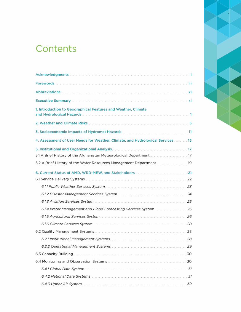
8 percent is potentially exposed to avalanches under the 100-year avalanche scenario (Figure 8).
Thunderstorms are generally localized events in Afghanistan, affecting the country on the provincial and district scale during the winter and spring (though some do occur infrequently over the summer and autumn). Thunderstorms have the potential to destroy or disrupt key nodes of an electricity supply network.
Drought is a major risk in Afghanistan, and droughts have been recorded in every part of the country. Rainfall is scarce and unpredictable, and a small snowpack resulting from a dry winter can result in low reservoir levels, dry streams, and shortages of potable and irrigation water and can lead to food shortages and socioeconomic problems (the case in 2017/18). Growing urban and rural population will further stress water supply. A drought in 1970/71 affected nearly the entire country and caused displacement of people and food shortages. A major drought from 1999 to 2004 affected millions and forced entire villages to abandon their lands and flee to cities as refugees. Groundwater levels in Kabul and elsewhere in the basin are still recovering. Drought conditions prevailed for almost five years, resulting in the loss of more than 50 percent of the pasture land, affecting approximately 3 million livestock, and necessitating humanitarian assistance for almost 1 million Afghans. The threat of displacement
and migration from the affected areas (mainly in the northern regions) has triggered the fear of a situation similar to the 1999–2004 drought, with the ensuing social problems. The immediate economic impact of droughts is difficult to determine. There is a time lag between meteorological drought and drought losses due to buffers such as reservoirs, farmers’ financial reserves, and groundwater reserves (Figure 9 and Figure 10).
FIGURE 8 • Afghanistan 100-Year Avalanche Scenario
Source: Deltares (2016).Note: Orange: provinces with a record of avalanche events; mapped occurrence of snow water equivalency values with sufficient annual snowfall for a 100-year avalanche scenario.
FIGURE 9 • Agricultural Drought Risk, Current Conditions
Source: Deltares (2016).Note: Expected annual water shortage (%).
FIGURE 10 • Agricultural Drought Risk, 2050 Conditions
Source: Deltares (2016).Note: Expected annual water shortage (%).

2. WEATHER AND CLIMATE RISKS 9
Landslides and mudflows occur frequently in Afghani-stan, but many are low-impact events or highly localized and are not comprehensively indexed. Afghanistan experiences three types of landslides: bedrock land-slides in slow evolution, bedrock landslides in rapid evolution (often induced by earthquakes), and cover
material landslides in rapid evolution (e.g., debris flows and mudflows). Afghanistan’s northeast and central provinces are most at-risk to landslides (Figure 11).
Other hazards include plant diseases and pests (e.g., Baluchistan melon fly, Colorado potato beetle, and Moroccan locust), which are a major source of annual crop losses. About 80 percent of Afghanistan’s popu-lation relies on agriculture for food and income, and pests are a key contributor to food insecurity.
Average air quality (e.g., particulate matter) in the region is poorer than the global baseline, and the weather can cause significant variability across Afghanistan due to pollution in urban areas and dust storms in rural areas. A 2005/06 study concluded that 60 percent of the population is exposed to elevated concentrations of particulate matter (fine anthropogenic dust), nitrous oxide, and sulphur dioxide, which cause an estimated excess in annual mortality of 2,000 people.16
16 Met Office (2012).
FIGURE 11 • Susceptibility Map for Cover Material Landslides in Rapid Evolution
Source: Deltares (2016).


11
3. SOCIOECONOMIC IMPACTS OF HYDROMET HAZARDS
Afghanistan is a low-income country with a very high-risk profile.17 The country’s low level of socioeconomic development makes it
extremely vulnerable to disaster, with several notable contributing factors. Decades of disasters have under-mined the country’s coping mechanisms and protective capacity; this increases the likelihood that hazards turn into disasters with large humanitarian and economic consequences. While natural hazards and disasters do not necessarily cause conflict in and of themselves, natural disasters can exacerbate the challenges people already face in fragile states, create new risks, and add stress to an already weakened governance system while fueling grievances.18
The country is highly prone to intense and recurring natural hazards due to its geographical location and years of environmental degradation, resulting in the
17 Kellett and Caravani (2013).
18 GFDRR (2017).
frequent loss of lives, livelihoods, and property. Since 1980, hydromet-related disasters have affected 9 million people, causing over 20,000 fatalities19 and making Afghanistan the second-deadliest developing country for hydromet hazards.
Geophysical and weather-related events were respon-sible for half of all deaths in Afghanistan between 1980 and 2015: for every 1 million inhabitants, 1,150 died.20 While earthquakes caused the highest loss of life (9,236) from 1970 to 2012, hydromet disasters had significant impacts. Drought impacted approximately two in three Afghans (6.5 million of 9.3 million total population) and flooding caused about two-thirds of all economic dam-ages (US$396 million of US$597 million total losses).21
Figure 12 illustrates the casualties and losses due to natural disasters by province. Floods are the most
19 GFDRR (2017).
20 GFDRR (2017).
21 EM-DAT. Accessed August 2018.
FIGURE 12 • Overview of Natural Disasters by Province, 2013
Badakhshan
Badghis
Sari Pul
Samangan
Takhar
Prw.
Paktya
Pn.
Paktika
Nimroz
Nrstn.
Nng.Maydan Wardk.
L.
L.
Kn.
Zabul
Uruzgan
Kn.
K.
Kandahar
Kabl.
Jawzjan
Hirat
Hilmand
GhorGhazni
Faryab
Farah
Daykundi
Bamyan
Balkh
Baghlan
33
34
58
4
22
26
19
5
16
1,723
59
161
1
384
10
23
10
54
84
253
22
5
2
190
20
1
1,631
20
13
11
22
6
2
10
2
1
1
1
6
1
1
1
1
0 10 20 30
January
February
March
April
May
June����������������������
������������ ��������
�����������
���������
Badakhshan
Badghis Sari Pul
Samangan
Takhar
Prw.
Pakty.
Pnj.
Paktika
Nimroz
Nrstn.
Nng.Myd. Wr. L.
L.
Kunduz
Zabul
Uruzgan
Kn.
K.
Kandahar
Kabl.
Jawzjan
Hirat
Hilmand
Ghor
Ghazni
Faryab
Farah
Daykundi
Bamyan
Balkh
Baghlan
6
4
3
2
2
16
3
10
10
1
6
763
22
22
2
1
1
55
3
7
6
10
24
20
7
10
3
8
2
3
9
30
8
Badakhshan
Badghis Sari Pul
Samangan
Takhar
Parwan
Paktya
Panjsher
Paktika
Nimroz
Nuristan
Nangarhar
MaydanWardak
Laghman
Logar
Kunduz
ZabulUruzgan
Kunar
Khost
Kapisa
Kandahar
Kabul
Jawzjan
Hirat
Hilmand
GhorGhazni
Faryab
Farah
Daykundi
Bamyan
Balkh
Baghlan
1
410
9
4
116
12
4
1
23
3
21
1
715 11
4
2
2
2
27
2
AFGHANISTAN: Overview of Natural DisastersNatural disaster incidents as recorded by OCHA Field Offices and IOM from 1 January to 30 June 2013
Disclaimers:The designations employed and the presentation of material on thismap do not imply the expression of any opinion whatsoever on thepart of the Secretariat of the United Nations concerning the legalstatus of any country, territory, city or area or of its authorities, orconcerning the delimitation of its frontiers or boundaries.
0 100 200 Km
Projection/Datum: Geographic/WGS-84
Doc Name:Afg_NaturalDisasters2013_OCHA_IOM_A3_201307JUL08
Feedback: [email protected]: http://afg.humanitarianresponse.info
Date Printed: 11 July 2013 03:55 PM
Data Source(s):AGCHONatural disaster information: OCHA Field Offices and IOMAfghanistan Humanitarian Assistance Database (HADB)
Notes:1) Natural disaster events include avalanches, extremewinter conditions, flooding, heavy rainfall, landslides &mudflows, and extreme weather (sandstorms, hail, wind,etc) as recorded by OCHA field offices and IOM AfghanistanHumanitarian Assistance Database (HADB).2) A natural disaster incident is defined as an event that hasaffected (i.e. impacted) Afghans, who may or may notrequire humanitarian assistance.3) HADB information is used as a main reference andsupplemented by OCHA Field Office reports for thoseincidents where information is not available from the HADB.OCHA information includes assessment figures from OCHA,ANDMA, Red Crescent Societies, national NGOs,international NGOs, and ERM.4) The number of affected Afghans and houses damaged ordestroyed are based on the reports received. These figuresmay change as updates are received.
Districts affected144
Number of Individuals Affectedby Natural Disasters
Number of Natural Disaster Incidentsby District and Province
Number of Houses Damaged or Destroyedby Province
AffectedIndividuals
Afghans Killedor Injured
Houses Damagedor Destroyed
140,000 280 21,000
Summary of Natural Disaster Eventsin 2013 (January to June) by Type
Affected Individuals
By Province
1 - 1,000
1,001 - 5,000
5,001 - 15,000
Balkh (36,548); Nangahar (41,902)
Afghans Killed or Injured
Houses Damaged
By Province
No Houses Damaged
1 - 100
101 - 1,000
1,001 - 4,054
Houses Destroyed
Incidents by District
1 - 5
6 - 25
Incidents by Province#
#
#1) The flood categoryincludes both flash floodsand longer duration flooding.2) The landslide categoryalso includes mud flows.3) An 'event' is defined bydisaster type and date.
67%1%
29%3%
35%
7%51%
7%
61%1%
35%
3%
Note: Damaged house category includes thenumber of damaged houses as recorded byOCHA field offices and the number of 'SeverelyDamaged Houses' only as recorded by IOM.
Source: OCHA HumanitarianResponse.Info. (Accessed August 2018).

12 STRENGTHENING HYDROMET AND EARLY WARNING SERVICES IN AFGHANISTAN: A ROAD MAP
frequent natural hazards, historically, causing aver-age annual damages of US$54 million; large flood episodes can cause over US$500 million in damages. Earthquakes have caused the highest fatalities histori-cally; since 1980 more than 10,000 people have been killed due to earthquakes. Droughts have affected 6.5 million people since 2000. An extreme drought could cause an estimated US$3 billion in agricultural losses and lead to severe food shortages across the country. Three million people are exposed to very high or high landslide hazard risk, and 2 million people are exposed to avalanches (Figure 13).
Climate change also poses a threat to Afghanistan’s natural resources. The vast majority of Afghans (approx-imately 80 percent) depend on natural resources for their livelihoods. Climate change and natural disasters, therefore, significantly impact growth prospects. The most obvious is the impacts of floods and droughts on agricultural productivity and the transport network supporting the agriculture sector.
Over the last 20 years, Afghanistan has received only US$22 million in disaster risk reduction funding, while having one the highest mortality risk ratings in the world (Figure 14). Clearly, aid financing in the country has had its challenges over these two decades, with conflict and a testing environment for aid actors, but surely in the years since 2001 and with the subsequent state-building efforts, more could have been set aside
to reduce disaster risk. In 2010 alone, more than US$6.7 billion was spent in Afghanistan in total aid just by donors reporting to the OECD Development Assistance Committee.22
22 Kellett and Caravani (2013).
FIGURE 13 • Afghanistan Risk Summary
Source: GFDRR (2017).

3. SOCIOECONOMIC IMPACTS OF HYDROMET HAZARDS 13
FIGURE 14 • Financing for Disaster Risk Reduction in the Context of the Mortality Risk Index, 1991–2010 (volumes, US$ millions)
Bangladesh 9
8
7
6
5
4
32
Multiple MortalityRisk Index
MyanmarIndiaChinaIndonesiaColombiaIranAfghanistanGuatemalaPeruPhilippinesPakistanRomaniaCosta RicaAlgeriaDominican RepublicTurkeyCongo, Dem Rep.AlbaniaViet NamEl SalvadorEcuadorChileSierra LeoneEthiopiaCambodiaUgandaHaitiPapua New Guinea
NepalMexico
ArgentinaMalawiKenyaZimbabweSri LankaBrazilCameroonMoroccoLebanonYemenBeninTunisiaEritreaBurkina FasoZambiaNigerSouth AfricaTrinidad and TobagoJordanPalestinian Occ. Territories
Total DRR02004006008001,0001,600 1,400 1,200


15
4. ASSESSMENT OF USER NEEDS FOR WEATHER, CLIMATE, AND HYDROLOGICAL SERVICES
National Meteorological and Hydrological Services (NMHSs) are public agencies mandated to provide public meteorological and hydrological
information and warning services, although some may also provide commercial services. Similarly, National Hydrological Services (NHSs) are national public agen-cies mandated to provide basic hydrological information and warning services to the government, the public, and the private sector, in support of protecting lives and livelihoods. NHSs aim to fulfil the state and public need for robust water monitoring, data management and prediction, providing authoritative and action-able information on hydrometeorological trends and extremes. NHSs also deliver socioeconomic benefits through improved water resources management and disaster risk management.
Table 1 captures the socioeconomic sectors whose outputs are sensitive to weather and climate conditions.
The result of a quick hydromet end-user survey shows that the following are the most demanded hydrometeorological (hydromet) data, products, and information. Data include snow, rain, temperature, relative humidity, evaporation, river stage/discharge, and satellite data. Products and information include weather forecasts, climate change projections, flood forecasts, hydromet-related early warnings, drought prediction, flood hazard maps, and extreme tem-perature prediction. In addition, avalanche forecasts, avalanche hazard maps, landslide forecasts, landslide hazard maps, pest and disease outbreak maps, deserti-fication hazard maps, lightning advisory, forest fire advisory, and some aviation weather services (e.g., Significant Meteorological Information (SIGMET) and Significant Weather (SIGWEX) reports) are demanded but currently not available (Table 2).
TABLE 1 • Disaster Risk Management and Weather-Sensitive Socioeconomic Sectors Requiring Hydromet Information
1. Disaster risk management (floods, avalanches, landslides, drought, extreme temperatures, pest and disease outbreaks)
2. Water resources management3. Irrigated agriculture4. Rain-fed agriculture5. Climate resilience and adaptation6. Energy planning, development, and management7. Watershed management8. Environment management9. Surface water quality management and water pollution control
10. Desertification11. Forestry
12. Groundwater management13. Health14. Insurance15. Land transportation16. Aviation17. Construction18. Land use and planning19. Media20. Education21. Mining22. Regional and international cooperation23. Research and development
Source: Water for Life Solutions (2017).

16 STRENGTHENING HYDROMET AND EARLY WARNING SERVICES IN AFGHANISTAN: A ROAD MAP
Three-quarters of respondents were not satisfied with the current services/data provision. This low level of satisfaction can be attributed largely to two factors:
• The existing hydromet system does not provide the required data to produce user-needed products and services.
• Hydomet agencies have low capacity to generate products and to deliver services.
Most of the hydromet end-users do not fully under-stand what data and information they need for their
respective application areas, or how to apply such information. Moreover, there is no system/platform for users to communicate their needs to the hydromet agencies (i.e., service providers). 23
The overall level of user satisfaction with the data and products needs to be significantly improved.
23 Ibid.
TABLE 2 • Hydromet and EW Products and Services Demanded but Not Available23
1. Early warning system and services 2. Flood forecasts 3. Flood hazard maps 4. Drought forecasts 5. Drought hazard maps 6. Avalanche forecasts 7. Avalanche hazard maps 8. Landslide forecasts
9. Landslide hazard maps 10. Extreme temperature hazard information 11. Pest and disease outbreak maps 12. Desertification hazard maps 13. Lightning advisory 14. Forest fire advisory 15. SIGMET reports16. SIGWEX charts

17
5. INSTITUTIONAL AND ORGANIZATIONAL ANALYSIS
5.1 A Brief History of the Afghanistan Meteorological Department
Meteorology has been a part of the Afghan govern-ment for more than six decades. The Afghanistan Meteorological Authority was established in 1955 under the Ministry of Transport and Civil Aviation. With the creation of the Afghanistan Civil Aviation Authority (ACAA) in 2013, the name was changed to the Afghanistan Meteorological Department (AMD), and it functions as part of the ACAA. AMD is one of the most critical and important departments of ACAA and is responsible for the provision of nationwide meteorological services, including: monitoring weather and collecting data; providing forecasts and early warn-ings; archiving and providing climate data; providing public weather services; and providing meteorological services for agriculture and transportation (including civil aviation).
The intervening war years, however, delivered setbacks to meteorological services in the country. The Taliban believe weather forecasting is a form of sorcery and ban it; in 1996, Taliban forces sacked the meteorology office, ruining equipment and destroying over 100 years of weather records. The civil war and its aftermath led to degradation of traditional observation networks, prevalence of outdated and inefficient technologies, and lack of modern instruments and ICT. The absence of forecasts and weather information reversed years of development gains in farming and civil aviation operations.
As a result, AMD makes limited use of numerical weather prediction (NWP), which is the forecasting tool widely used by National Meteorological and Hydrological Services (NMHSs) to produce basic public forecasts. It has no technical means to run forecasts with less
than six hours lead time (nowcasting), which are particularly important for quick onset severe hazards such as flash floods. AMD has no ability to produce seasonal outlooks, which are intrinsic to agriculture and water resources management planning and to climate projection. The current number of forecasters is too low and their capability insufficient to provide operational, 24/7 forecasting services, and to develop and test new products. In Afghanistan, at least five observers and a team leader are required to run a 24/7 shift at international airports, while for forecasting and guidance, a team of one manager and at least ten forecasters is required to run two 24/7 shifts at the AMD headquarters.
AMD has 140 staff, 75 of whom work in remote locations in 28 stations. Three of the staff have a master’s degree, 28 have a bachelor’s degree, 33 have a two-year degree and 37 have a technical school degree. The staff is distrib-uted as follows: 33 forecasters at the forecast division in Kabul, 15 at the executive management, 9 at the research division, 22 at the installation division, 9 at observation network division, and 52 in stations. Four forecasters and six observers in Hamid Karzai International Airport are working parallel with Operation Resolute Support24 staff to provide aviation meteorology services, but in other international airports NATO-RS Met units cover the needs. By 2021, AMD plans to have 92 observers, 24 forecasters, 14 maintenance and installation techni-cians, 32 aviation observers, 18 aviation forecasters, 6 IT specialists, and 10 staff for external relations, finance, agrometeorology, and hydrometeorology.
24 Operation Resolute Support is a NATO-led, noncombat mission to train, advise, and assist the Afghan National Defense and Security Forces (ANDSF). It was launched on January 1, 2015, and currently comprises around 16,000 personnel from 41 NATO allies and partners. NATO-RS operates with one “hub” (Kabul/Bagram) and four “spokes” (Mazar-e-Sharif in the north, Herat in the west, Kandahar in the south, and Laghman in the east). https://rs.nato .int/about-us/mission.aspx

18 STRENGTHENING HYDROMET AND EARLY WARNING SERVICES IN AFGHANISTAN: A ROAD MAP
AMD’s current five branches are: Executive Manage-ment, Forecasting, Observation Network, Meteorology Research and Installation. The proposed structure of AMD Under the ACAA-AMD Strategic Plan 2017–21, there would be seven branches: Observation, Data Processing and Telecommunication, Forecasting, Research, Meteorological Instruments, Remote Offices and Administration (Figure 15).
There is no legislative act regulating meteorology. According to the ACAA-AMD Strategic Plan 2017–21, AMD is Afghanistan’s only recognized, responsible, and authorized agency for the provision of the meteoro-logical operations, services, and information. However, government agencies operate parallel in situ observa-tion networks and disseminate information.
The same Strategic Plan states the Vision of AMD as: “Covering Afghanistan’s public weather service needs by establishing a competent meteorology service
aligned with the WMO standards, both for strength-ening hydrometeorological disaster resilience of the country and answering the national and international stakeholder needs.”
The Mission of AMD is stated as: “Providing nationwide meteorological services; making weather observations; providing forecasts and early warnings; providing clima-tological data, archive data; communicating these to the public; providing meteorological needs of Afghanistan for agriculture, transportation, civil aviation for decision makers, user communities, and all related sectors.”
AMD’s mandate is to provide observational data and forecast products to support all activities in the country—among others, transportation (including civil aviation), agriculture, business, urban and rural life, and social and cultural activities. Further, the National Flood Policy and Strategy (2011) designates AMD as the sole agency responsible for flash flood forecasting.
FIGURE 15 • Proposed Structure of Afghanistan Meteorological Department
ObservationBranch
SynopicObservationDivision
IT and Tele-Communication Division
WeatherAnalyses andForecastingDivision
HydrometeorologyDivision
Operation andMaintenance
InternationalRelationsDivision
AeronauticalMeteorologyDivision
AeronauticalMeteorologyObservationDivision
DataProcessing andManagementDivision
NowcastingDivision
ClimateDivision
CalibrationDivision
HumanResourcesDivision
AgriculturalMeteorologyDivision
FinanceDivision
Press and PublicRelationsDivision
RemoteMeteorologyOffices Division
DataProcessing and Tele-CommunicationBranch
ForecastingBranch
Research Branch
Director of AMD
MeteorologicalInstrumentsBranch
AdministrationBranch
Remote OfficesBranch
Source: Government of Afghanistan (2016a).

5. INSTITUTIONAL AND ORGANIZATIONAL ANALYSIS 19
The improvement of AMD meteorological services is mainly supported by a project-based budget. The ACAA budget increased from US$40 million in 2016 to US$60 million in 2017 and is expected to increase in the coming years if aviation meteorological services improve. The ACAA budget for 2018 is US$100 million, dedicated mainly to developing infrastructure (with salaries representing around US$6 million). No specific data have been provided about the AMD annual budget. Operating and maintenance (O&M) costs pose a major concern for the AMD’s sustainability. Aeronautical meteorological services are expected to provide a substantive income for AMD, and potentially could finance O&M expenses. Currently, these are borne by the ACAA national budget.
5.2 A Brief History of the Water Resources Management Department
Hydrological data collection and analysis started in Afghanistan in 1946 with the installation of hydrometric stations in Helmand River Basin. The hydrometric network expanded rapidly in the 1960s and 1970s, reaching a peak of 150 in 1980. Network operations stopped between the late 1980s and 2003. With the support of the World Bank Emergency Irrigation
Rehabilitation Project and the subsequent Irrigation Restoration and Development Project, hydrological monitoring has been strengthened since 2008 (Figure 16). Today, water yearbooks of 148 stations are avail-able at the Water Resources Management Department (WRD) of the Ministry of Energy and Water (MEW).
MEW in its present form was established in December 2004, with the splitting of responsibilities previously held by the Ministry of Irrigation, Water Resources and Environment and the merging of energy and water to form the Ministry of Energy and Water. The Water Law of Afghanistan (2009) and Water Resource Management Strategy (2007) define the ministry’s roles, responsibilities, and vision and designate it as the country’s National Hydrological Service (see Section 6.1.4).
WRD has recruited young university graduates, help-ing to establish a strong nucleus of well-educated staff for data management, analysis, and modeling. In addition, WRD has sent some of the new recruits for post-graduate degrees in hydrology, water resources, and climate change. According to WRD’s organizational chart (Figure 17), there are three divisions: hydrology, meteorology, and flood and drought forecasting. The organizational chart does not show the subunits, if any, in each division. WRD is planning a restructuring in the near future to reflect the evolving business priorities.
FIGURE 16 • Historical Trend for Hydrometric Active Stations in Afghanistan
Hydrometric Monitoring Stations (MEW)
Num
ber o
f Sta
tions
1946
160
140
120
100
80
60
40
20
01950 1960 1970 1980 1990 2000 2004 2008 2009 2012 2013 2014 2015 2016
27
29
128
150
0 0 2
65
106116
127 129 127 125
Source: Water for Life Solutions (2017).

20 STRENGTHENING HYDROMET AND EARLY WARNING SERVICES IN AFGHANISTAN: A ROAD MAP
Data for the WRD-MEW annual budget is not directly available, but budget information for associated projects is available. In 2011, the World Bank Group approved a US$97.8 million grant for the Irrigation Rehabilitation and Development Project (IRDP) to support the government of Afghanistan's continuing efforts to rehabilitate irrigation systems across the country, with the aim of increasing agricultural pro-duction. The grant had a hydromet component worth US$8.2 million, mainly for supporting the modernization of observation equipment. In 2016, the World Bank Group approved additional financing and revamped the hydromet component (US$28.9 million) to focus more on developing and delivering services.
WRD-MEW operates 125 hydrological stations and 56 automatic weather stations (AWSs), of which 30 sta-tions also have snow-monitoring capability. Discussions are ongoing to transfer the 26 non–snow-monitoring AWSs to AMD (and to include WRD technical support during the transfer). Security concerns prevented WRD from installing 47 new hydrological stations, but it is
planning to install 22 of these stations in 2018/19 and the rest as/when the security situation improves.
WRD-MEW has 409 staff distributed among five river basins, mainly composed of technical field observers and guards for the hydrological, AWS, and snow stations. Only four of the 41 hydrologists have an educational background in hydrology; the remaining 37 acquired their skills and knowledge on the job. The same applies to the five climatologists. WRD’s main office in Kabul has 57 staff covering 11 job categories, of which 34 are technicians, hydrologists, or manag-ers. The six Water Quality Laboratory employees are only involved in sediment sampling, testing, and analysis. IRDP is currently financing O&M, for which a formal agreement was signed with the equipment vendor. But project-financed O&M poses a challenge for WRD-MEW’s sustainability. Improved hydropower generation is expected to provide substantial income for WRD-MEW, and potentially could finance hydromet O&M services and expedite training of their staff to reduce O&M costs.
FIGURE 17 • Organizational Structure of the Water Resources Department
Water Resources Department
WRD Data Analysis Team
Hydrology Division
HydrologySection
HydrometerySection
ModelingSection
HydrogeologySection
Meteorology Section
Kabul RiverBasin
North RiverBasin
Panj-e-AmoRiver Basin
Hartrud MurghabRiver Basin
HelmandRiver Basin
Snow SurveySection
Meteorology DivisionFlood and Drought
Forecasting Division
Source: Government of Afghanistan (2016b).

21
6. CURRENT STATUS OF AMD, WRD-MEW, AND STAKEHOLDERS
Modernizing a National Meteorological and Hydrological Service (NMHS) and a National Hydrological Service (NHS) is highly complex
and costly. In Afghanistan, the division of responsibilities (i.e., AMD is responsible for flash flood forecasting and WRD-MEW is responsible for all other water-related services and studies and is the NHS) compounds the complexity. Therefore, a structured and long-term plan based on the needs of the public and the end-user community is highly recommended.
The first step in the development of such a plan is to study and analyze the systems comprising the
two organizations. A typical NMHS is comprised of a “system of systems” as shown in Figure 18. This generic illustration of a weather, climate, or hydrological system of systems can be used to identify the current status of any NMHS and to visualize investments required component-by-component in each system to achieve a particular level of improvement. The complexity of each system and its subsystems varies depending on the size, level of development, and resources of an individual NMHS.
The system-of-system’s building blocks are inter-dependent. The first requirement is staff with the
FIGURE 18 • Generic System of Systems for a Modern NMHS
Modeling systemsMonitoring and observing systems
Global data system Global NWP systems
Regional NWP systems
Limited area modelsystem
Objective and impactforecasting and warning systems
ITC systems
Data commssystems
Communicationsystems
Severe hazardforecasting systems
Nowcasting system
Very short-range forecasting system
Short-range forecasting system
Medium-range forecasting system
Long-range forecasting system
G2G and G2B aviationservices system
Service delivery systems
National data systems
Surface obs systems
Radar system
Data managementand archiving systems
External data systems
Public weather andhydro services system
G2G disastermanagementservice system
G2G agricultureservice system
G2G water andpower managementservices system
Public-privatecooperative servicessystemsto key businesses
Actions, service monitoring, and feedback systems
Service systems forpublic
Service systems for national and provincialgovernments
Service systems forbusinesses
Quality management systems
Institutional management systems
Technology infusion systems
External research and development systems
Internal research and development systems
Transition research to operations systems
Computing hardwareand software systems
Cloud computingsystems
Operational management systems
G2G and G2B climateservices system
Capacity building
Met and hydro institutionaleducation and training
Stakeholder institutionstraining
End-user training andoutreach
Nowcasting system
Hydro modeling systems
Source: David Rogers (2018).Note: Dark Teal: production systems; Green: delivery systems; Cyan: enabling systems; Dark Green: capacity building (internal and external); Broken boxes: either external or mix of internal and external systems; Solid boxes: internal NMHS systems; G2G: Government to Government; G2B: Government to Business.

22 STRENGTHENING HYDROMET AND EARLY WARNING SERVICES IN AFGHANISTAN: A ROAD MAP
capacity to understand and operate a particular system. This Road Map employs a system-of-systems approach to arrive at three possible scenarios for modernizing AMD and WRD-MEW.
The operational system of an NHS for the production of flood forecasts is basically similar to that of a NMHS in that production and delivery systems need to be in place supported by quality management and ICT systems, with a fundamental basic block of capacity building systems. Figure 19 presents the system-of-systems concept within WRD-MEW. Subtle differences between an NMHS and an NHS responsible for flood forecasting are in the access to certain observations data or modeling capabilities. In most countries where responsibilities for weather and flood forecasting reside in different organizations, access to critical data such as radar data are granted to the agency responsible for flood forecasting. Similarly, meteorological forecasts based on global, regional, and locally run models provide an input to flood forecasting models. These subtleties are illustrated in Figure 20 by the solid or broken lines for various subsystems. In a number of
countries, the two agencies work closely together, sometimes colocated in one or the other organization to produce flood forecasts and warnings. In such cases, cross-training of meteorologists and hydrologists in each other’s field of expertise is a common practice.
6.1 Service Delivery Systems
A pervasive culture shift is needed for Afghanistan’s hydromet and early warning services. To this end, a matrix was devised to evaluate the country’s current service delivery capacity. It assesses institutional capacity on four levels: none, low, medium, and high.
There is no institutional capacity to analyze, forecast, and develop warning messages for floods and flash floods, landslides, avalanches, and pest and disease control. There is low to medium capacity to observe, detect, and monitor these hazards, given the current network of observing stations. As for heat and cold waves and drought, institutional abilities range from
FIGURE 19 • System-of-Systems Concept of Operational Flood Forecasting by an NHS
Modeling systemsMonitoring and observing systems
Global data system Global NWP systems
Regional NWP systems
Limited area modelsystem
Hydro modeling systems
Objective and impactforecasting and warning systems
ITC systems
Data commssystems
Communicationsystems
Severe hydro hazardforecasting systems
Nowcasting system /flash flood guidance
Very short-range floodforecasting system
Short-range floodforecasting system
Medium-range floodforecasting system
Long-range floodforecasting system
Service delivery systems
National data systems
Surface obs systems
Radar system
Data managementand archiving systems
External data systems
Public hydrologicalservices system
G2G disastermanagementservice system
G2G agricultureservice system
G2G water andpower managementservices system
Public-privatecooperative servicessystemsto key businesses
Actions, service monitoring, and feedback systems
Service systems forpublic
Service systems for national and provincialgovernments
Service systems forbusinesses
Quality management systems
Institutional management systems
Technology infusion systems
External research and development systems
Internal research and development systems
Transition research to operations systems
Computing hardwareand software systems
Cloud computingsystems
Operational management systems
G2G and G2B climateservices system
Capacity building
Hydro institutional education and training
Stakeholder institutionstraining
End-user training andoutreach
Source: David Rogers (2018).

6. CURRENT STATUS OF AMD, WRD-MEW, AND STAKEHOLDERS 23
nonexistent for analysis, forecasting, and developing warning messages to medium for observation, detec-tion, and monitoring. Current capacities for drought were assessed as low for all early warning stages, attributable primarily to FEWS NET25 and its contribu-tion to periodic updates; this information is publicly available. The FEWS NET information, however, is too general and covers too large of a geographical area to be useful. More location specific and higher resolution information is needed to allow better planning and decision making [by the Afghanistan National Disaster Management Authority (ADMA)].
Community-level efforts in establishing early warning systems and services or assessing disaster risk exist. For example, the ICIMOD’s Community-Based Flood Early Warning System (CBFEWS) initiative relies on a group of people to disseminate early warnings in the community. However, it should be assessed to what extent CBFEWS is fully operational in the com-munities in which it has been set up. Likewise, it is not clear where the warnings will originate, whether from
25 The Famine Early Warning Systems Network (FEWS NET) is a leading provider of early warning and analysis on food insecurity. It was created by USAID in 1985 in partnership with NASA, National Oceanic and Atmospheric Administration (NOAA), USDA, and USGS, along with Chemonics International Inc. and Kimetrica, and currently provides evidence-based analysis for 34 countries including Afghanistan.
their own operation, or from other sources. Another initiative, the USAID-funded Afghanistan Spatial Data Center, provides an online portal with the following information: population estimates at the village level for flood and avalanche risk; Global System for Mobile Communication (GSM) coverage; accessibility to the nearest hospitals; and parameters for flood and flash flood risks, snow cover and depth, and earthquakes.
Figure 20 presents an example of the product the Afghanistan Spatial Data Center (ASDC) portal pro-vides, in this case, the number of people who were at risk for avalanche threat in April 2017.
The portal requires registration, and the forecasts are based on uncalibrated models, which make the results less reliable. Nevertheless, the website is an excellent EWS model.
6.1.1 PUBLIC WEATHER SERVICES SYSTEM
The provision of public weather services (PWS) by AMD is modest. AMD’s new website (http://www .amd.gov.af/) is the most widely used source of PWS information. It gives the user community access to a three-day forecast for a number of cities and severe weather warnings for provinces. While the Common Alerting Protocol (CAP) has been installed at AMD, it
FIGURE 20 • Avalanche Risk Impact
Sources: Afghanistan Spatial Data Center; Water for Life Solutions (2017). Note: Example of people at risk for avalanche threat in Afghanistan for April 22, 2017, at 11:30 pm local time, based on the (then) current snow conditions.

24 STRENGTHENING HYDROMET AND EARLY WARNING SERVICES IN AFGHANISTAN: A ROAD MAP
is not yet operational for all hazards and all media-alerting functions (i.e., radio, television, website, Short Message Service [SMS], mobile phones, sirens and loudspeakers).
AMD has developed a presence on social media and created a Facebook account, which has proved popular and has a feedback function. SMS messages are rarely used. No weather applications are developed for mobile and smart phone platforms. Similarly, AMD conducts no outreach or public education activities. AMD does not translate/interpret the forecasts into a form to assist daily decision making by users, and no information is produced on the possible impacts of hazards. Assistance and guidance in developing PWS is required, including training in dissemination and communication, user consultation, and user feedback.
AMD’s five-year strategic plan envisions providing Afghanistan’s PWS needs by establishing a compe-tent meteorological service aligned with the World Meteorological Organization’s (WMO) standards, both for strengthening hydrometeorological disaster resilience of the country and responding to national and international stakeholder needs. Through this strategic plan, AMD aims to provide nationwide meteorological services, forecasts, and early warnings, and to communicate these to the public to meet the meteorological needs of Afghan user communities.
6.1.2 DISASTER MANAGEMENT SERVICES SYSTEM
Early warning services do not exist in Afghanistan. The ministries, departments and agencies have vestiges of the required expertise, but institutional roles and responsibilities have not been mapped to develop a basic whole-of-government capacity. The needs of the public for services are not well-understood by the service providers and the end-users themselves have little or no knowledge of (and thus capacity to demand for) a modern hydromet and early warning system. Thus, an urgent component is building the capacity and capabilities of the end-user community. By developing the understanding of hydromet data and products, the end-user community can benefit from hydromet services for disaster risk reduction. Reducing the risks of disasters can improve the productivity of socioeconomic sectors and raise wellbeing.
ANDMA has drafted (and is awaiting approval of) a strategic framework to implement activities, and especially those related to early warnings. ANDMA and AMD also are developing an early warning communica-tion scheme, whereby AMD issues warnings that are communicated with the ANDMA central office in Kabul. The information cascades to the High Commission of Disaster Management and provincial offices, local authorities and small public groups, the local radio and phone operators and finally to the end-users who are instructed to take precautions.
The proposed scheme is sound and should serve as a template for all other disaster warnings, particularly for floods, flash floods and avalanches. However, it is essential to thoroughly test and validate the scheme before operationalization, particularly the last step, where the end-users are notified to ensure that they have received and understand the messages and know what precautions to take. The warnings must be received quickly enough to allow the end-users sufficient time to take the required actions to save their lives and property.
Adopting CAP allows agencies to issue alerts and warn-ings without worrying about the details of the ultimate dissemination mechanism used by the mandated EWS agency in Afghanistan. CAP has been installed at AMD (not operational yet); it still has to be installed at ANDMA and WRD-MEW.
Engaging local organizations (e.g., religious leaders and civil society) and building on existing structures can help ensure “last mile connectivity.” For example, there are more than 35,000 Community Development Councils across the country that can disseminate early warning for disaster mitigation. The Councils also offer an important advantage by providing face-to-face communication, which is especially valuable in issuing instructions of where to seek shelter during disasters. Possible options for last-mile connectivity techniques include broadcast radio and TV and SMS messages to cellular phones. That may work as long as the cellular network has coverage over the areas where people may be working in the fields, and the particular hazard has not affected the cell phone or electricity supply. The use of sirens or loudspeakers, located in strategic points, provides additional alert-ing methods.

6. CURRENT STATUS OF AMD, WRD-MEW, AND STAKEHOLDERS 25
Afghanistan should streamline the dissemination of early warnings to ensure that all agencies communicate in a timely manner with the lead early warning agency and that warning messages reach users without alteration. Each agency should have its own service delivery system for data and information products. Although multiple dissemination channels are recommended, it would be advisable to route all agencies’ warning messages through a single delivery mechanism. In complement, each institution should have its own method of dissemi-nation (e.g., posting the warnings—and any additional explanations—on its website). That way, the public becomes active consumers of the warnings, knowing where to look for and how to use the information. This is the current practice at AMD and, as stated above, the AMD website is the most used public service.
6.1.3 AVIATION SERVICES SYSTEM
The aviation reports generated by Operation Resolute Support (ORS) for the Meteorological Terminal Air Report (METAR), Aviation Special Weather Report (SPECI) and Terminal Aerodrome Forecast (TAF) meet international standards. These reports are not available for all civilian airports in Afghanistan, tamping down their user satisfaction to 25 percent. Five sites (Kabul, Kandahar, Herat, Mazar-i-Sharif, and Jalalabad) produce globally available METAR observations taken by ORS. AMD field meteorologists at the various airports are approaching the point where they can produce METAR and SPECI reports, despite their limited technical and financial resources.
AMD has indicated that their aviation stations need rehabilitation or upgrading. Its five-year strategic plan calls for the installation of seven aviation AWSs and for the training of 32 aviation observers to augment observations at the four international airports (Kabul, Herat, Kandahar, and Mazar-i-Sharif). The planned handover of responsibilities from ORS to AMD at the end of 2016 did not occur and has been postponed, despite training efforts that resulted in AMD forecasters producing an unsupervised TAF for Kabul International Airport. AMD requires additional training on basic topics (e.g., properly coding weather observations) before the turnover can take place.
AMD needs capacity building in general, with appropri-ate hardware and software to improve their current
meteorological aviation reports, to expand service to other locations, and to be able to produce other reports such as the TAFs for additional sites, Pilot Reports (PIREP) and en route aviation advisories such as Significant Meteorological Information (SIGMET).
6.1.4 WATER MANAGEMENT AND FLOOD FORECASTING SERVICES SYSTEM
A National Hydrological Service (NHS) is an institution whose core business is the provision of information to decision makers about the water (or hydrological) cycle and the status and trends of a country’s water resources. Most typically, this focuses on assessing water resources, including drought monitoring and outlooks and flood forecasting and warnings. In most countries, NHS functions are dispersed among related water agencies.26 Typically, the agencies have distinct functions but can have overlapping capabilities (e.g., modeling, researching, and developing hydrological methodologies). Such information may be required, among others, for the following purposes:
• Assessing the status of a country’s water resources (i.e., quantity, quality, and distribution in time and space), the potential for water-related develop-ment and the resource’s ability to meet actual or foreseeable demand;
• Planning, designing, and operating water projects;
• Assessing the environmental, economic, and social impacts of existing and proposed water resources management practices and planning sound man-agement strategies;
• Providing security for people and property against water-related hazards, particularly floods and droughts;
• Allocating water among competing users, both within the country and across borders; and
• Meeting regulatory requirements.27
In Afghanistan, WRD-MEW (http://wrd-mew.gov.af/index.php) is the designated National Hydrological Service (NHS) and operates in accordance with the Water Law of Afghanistan (2009), which enforces
26 WMO (2006).
27 WMO and UNESCO (1991).

26 STRENGTHENING HYDROMET AND EARLY WARNING SERVICES IN AFGHANISTAN: A ROAD MAP
the principles of Article 9 of the Constitution for the purpose of conservation, equitable distribution, and the efficient and sustainable use of water resources, to strengthen the national economy and secure the rights of the water users. The law regulates ownership, fees, rights, permits, and usage with respect to water and covers both surface and groundwater for domestic and agricultural use. The law dictates that the planning, management, and development of water resources is the responsibility of MEW in cooperation with other relevant line ministries and institutions. Further, MEW is responsible for water infrastructure; management and planning for the transboundary waters; collection, analysis and evaluation of hydrological data for surface water; water balance monitoring and modeling; snow and glacier survey and analysis; and forecasting and warning for floods and droughts.
Other ministries and agencies also have mandates under the 2009 Water Law of Afghanistan. The Ministry of Mines and Petroleum is responsible for assessing and protecting groundwater. The National Environmental Protection Agency is responsible for protecting and controlling surface water. Water use for agriculture and irrigation is the responsibility of the Ministry of Agriculture, Irrigation and Livestock, while the provi-sion of drinking water supply and sewage treatment systems is the responsibility of the Ministry of Rural Rehabilitation and Development.
The Water Resource Management Sector Strategy (2007) lays out a vision to manage Afghanistan’s water resources to reduce poverty, increase sustain-able economic and social development, improve the
quality of life for all Afghans, and ensure an adequate supply of water for future generations. Of the seven strategic goals, protection from effects of droughts and floods is one. For flood mitigation management, the strategy indicates nonstructural measures such as establishing flood warning and preparedness; while for drought management, the strategy specifies the need to develop extensive expertise in weather forecasting techniques in addition to the construction of water storage reservoirs. Two of the strategy’s objectives are the installation and operation of a hydrometric network with proper data collection and processing and the effective dissemination of information to users for basin water allocation/distribution planning. Another objective outlines the need for operational information systems to predict droughts and to forecast floods and functional flood management systems in all river basins.
6.1.5 AGRICULTURAL SERVICES SYSTEM
Afghanistan is the origins of many agricultural products (e.g., varieties of cereal, breeds of sheep and goats, and forest products). Agriculture dominates the Afghan economy, contributing an estimated 31 percent of GDP (2010/11) and providing employment and livelihoods for about 80 percent of the population (Figure 21). However, 25 years of war and civil conflict and pro-longed droughts have seriously affected Afghanistan’s agriculture sector.
Developing the agriculture sector is critical for eco-nomic growth. The National Agricultural Develop-ment Framework is a comprehensive development
FIGURE 21 • Agriculture, Industry, and Services in Afghanistan, 2010/11
Employment %
Revenue streams (%): 31% wheat, 1% wage, 1% renting, 4% livestock
80
10
4331
26
10
GDP %
AgricultureIndustryServices
Source: Met Office (2012).

6. CURRENT STATUS OF AMD, WRD-MEW, AND STAKEHOLDERS 27
blueprint for the agriculture sector. It identifies priorities for investment, emphasizing commercial, market-orientated agriculture. Income generation in the high-value perennial horticulture sector is essential to solve macroeconomic problems and to build rural prosperity and reduce poverty.
The framework projects perennial horticulture to account for one-third of all agricultural growth. Peren-nial crops often require a more educated and controlled approach to sustainably contribute to the economy, and this is especially valid given Afghanistan’s short- and long-term weather conditions. Close coordination and integration among AMD, MAIL, and MRRD can enhance effective management of natural resources, research, and extension services (advice) and communicate key agricultural messages through farmer associations.
A simplified agricultural cycle in Afghanistan includes two wheat cycles. Northern Afghanistan is highly depen-dent on rain-fed crops whereas southern Afghanistan is highly dependent on snowmelt-fed irrigation and, in turn, the winter rainfall/snowfall over the Hindu Kush. The country has favorable weather conditions for certain high-value crops. While water resource management programs, including dams, have improved the annual access to and regularity of water supply, they have limited effectiveness against moderate to substantial meteorological droughts, particularly in the southwest.
Afghanistan can experience extensive subzero condi-tions across the country during winter months. The intermittent winter frosts (typically overnight) in the west and southwest regions can significantly impact wheat and preclude more diverse horticulture to fuel economic growth. In spring, late frosts mainly affect fruit production, while rising temperatures can cause flooding that increases the damage and loss vulner-ability of crops. An approach to such variable conditions that incorporates advice from AMD is necessary.
Agricultural production is inextricably tied to climate, making agriculture the most climate-sensitive of all economic sectors. Some provinces are considered especially vulnerable because of a dependence on rain-fed agriculture, widespread poverty, and limited resources to invest in adaptation and risk reduction. The risks of climate change for the agricultural sector in Afghanistan are immediate and important because
most of the rural population depends directly or indirectly on agriculture for their livelihoods.
The impact of weather on the success of the Agricultural Development Framework and on long-term economic growth and food security through agriculture is sub-stantial. In the winter of 2004/05 (after a considerable drought), the above-normal, well-distributed precipita-tion and cold temperatures led to snow accumulations and significant winter snowpack. These conditions contributed to a robust wheat harvest in 2005 and ended a prolonged drought. The 2005 wheat harvest of 4.3 million tons was up 43.4 percent from 2004’s poor harvest of 2.3 million tons. Improved pest management also contributed to the bumper 2005 wheat crop.
It is essential to curb water consumption in agriculture while simultaneously increasing food production. This requires a global and sustainable management of the water cycle locally and regionally, which requires an understanding of weather and seasonality through the ability to monitor and estimate changes. Crop harvests vary dramatically from year-to-year depending on the weather with variable mean annual precipitation.
Rangelands are essential for Kuchi pastoralists (esti-mated to comprise 20 percent of the rural population) and for a large part of the settled population who derive their income from rearing animals and employment in the livestock industry. Over the last 30 years, drought effects have substantially reduced the livestock popula-tion in Afghanistan: there were 30 million sheep/goat and 4 million cattle before the 1999–2004 drought and 16 million sheep/goat and 3.7 million after it. Blue tongue disease is prevalent across much of Afghanistan; its spread is largely due to weather patterns carrying the disease vectors from one area to another. Changes in vegetation and its productivity as well as seasonal variability in rain, snow, and the vegetation period have forced nomadic agriculture to higher rangelands, thus increasing pressure on the alpine ecosystems. A developed Afghan meteorological service can monitor weather/seasonal impacts on livestock and deliver warnings through MAIL.
Crop production is highly dependent on weather condi-tions and annual precipitation but has been gradually rising over time. Agricultural output, especially of cereals, has increased significantly in recent years but

28 STRENGTHENING HYDROMET AND EARLY WARNING SERVICES IN AFGHANISTAN: A ROAD MAP
growth is still highly variable from year to year. A large proportion of the population remains food insecure, especially in years of poor harvest or high prices. Food security worsened in 2008. The World Food Programme estimated that, in 2008, 35 percent of households were not meeting their daily calorific requirements, 5 percent more than in 2005. While overall growth has been strong, there is so far no real evidence that the rate of growth in agriculture is accelerating. It remains dependent on annual weather variations. In more recent years, further development of irrigation has led to the greatest increase in wheat yield compared to those agricultural areas that are chiefly rain fed.
Agriculturally relevant weather forecasts can yield immediate benefits and facilitate the adaptation of farm-ing practices to the local context. Farmers can benefit from better local hydrometeorological information and services, particularly for short-term temperature and precipitation forecasts. In addition, tailored meteorologi-cal advice through MAIL and its extension agent scheme can contribute to food security through preemptive agricultural action—for example, a better choice of crops before a drought period and irrigation management.28
6.1.6 CLIMATE SERVICES SYSTEM
Afghanistan’s natural topography produces very large spatial variation in temperature and precipitation. These large variations underscore the need to develop and improve climate services for different users. Since its establishment in the 1950s AMD was a capable service—from its onset it began maintaining climate records. Unfortunately, the tumultuous conflicts of the 1990s destroyed many of AMD’s capabilities, including institutional knowledge, vital climatic records, and skill sets. Climate records have been partially restored with support from WMO, but more comprehensive climate information is required for planning purposes in many sectors, including agriculture, water resources manage-ment, and disaster management, and for assessing climate variations and change. It is necessary to develop and set up a national framework for climate services in line with the principles of the Global Framework for Climate Services to facilitate planning in the relevant sectors to improve food security and health outcomes and to enhance water resource management.
28 Ibid.
6.2 Quality Management Systems
A quality management system (QMS) is defined as the organizational structures, procedures, processes, and resources needed to develop and successfully manage the organization’s delivery of products and services.29 Although some quality control of data is done by the observers and by the METCAP system, no standard and systematic control is performed and no QMS exists at AMD. WRD-MEW has developed a quality control and data processing system for improving hydromet data quality through the use of the AQUARIUS system. The introduction of a QMS in AMD can support the continual enhancement of its products and services focusing on quality control, quality assurance, and quality improvement. QMS is implemented by most NMHSs in the provision of services to the aviation sector in compliance with the requirements of the International Civil Aviation Organization (ICAO). The implementation of QMS as part of the strategy to modernize the AMD can positively impact the quality of services and management practices as well as the user/stakeholder perception.
6.2.1 INSTITUTIONAL MANAGEMENT SYSTEMS
According to the existing laws and strategic plans, the institutional responsibilities for some of the disaster risk management (DRM) and hydromet-related areas (e.g., data collection and exchange and early warning services) are not clear. Realizing the need for a policy framework for sharing hydromet data and information, a draft Policy Framework on Hydrometeorological Data Sharing has been prepared by WRD-MEW under Supreme Council of Land, Water and Environment (SCoLWE). The main purpose of this policy is to formulate an appropri-ate mechanism for properly accessing and sharing of hydrometeorological and hydrogeological data. The policy will provide the groundwork for coop-eration and coordination between data producing organizations and data users. It also will facilitate ease of access to data and information for national, regional, and international institutions. It has been proposed to widen the scope of this policy to also include meteorological data produced by AMD and to adopt it as a national policy for data sharing.
29 WMO (2013).

6. CURRENT STATUS OF AMD, WRD-MEW, AND STAKEHOLDERS 29
Based on the organizational charts of WRD-MEW and AMD there is an overlap in meteorological monitoring, hydrometeorological services, and flood-forecasting services. According to its strategy, AMD is mandated by law to provide meteorological services, including flash flood forecasting and aviation meteorological services to the relevant sectors, as well as to the general public. WRD-MEW is responsible for other types of flood forecasting in addition to hydrological monitor-ing. In addition, there is no clear understanding among AMD, WRD-MEW, and MAIL on their respective roles in rainfall and climate monitoring. The AMD proposed organizational structure includes responsibilities such as flash flood forecasting, hydrometeorology, and agro-climatology that overlap with the current responsibilities of WRD-MEW and MAIL. Defining and streamlining the institutional responsibilities of AMD, WRD-MEW, MAIL, ANDMA, and other relevant stakeholders entails the establishment of a national institutional framework for hydromet and EWS in Afghanistan that defines the roles and responsibilities for each institution from observation, data manage-ment, modeling, and forecasting to early warning and service delivery.
The modernization of AMD and WRD-MEW as the two main service providers in Afghanistan should have a twofold aim. First, the provision of weather, climate, and hydrological services, including national observing systems, forecasting systems, warning systems, and national climate services. Second, future institutional development and the sustainability of any proposed modernization projects, considering the new requirements for weather, climate, and hydrological services. An implementation plan supported by realistic resource allocation involving all relevant ministries and departments, stakeholders, and end-users should also be developed. Currently, there is no user-driven, long-term national strategy for weather, climate, and hydrological services. The absence of such a strategy is reflected in the ad hoc approach and proliferation of independent observational networks and incomplete coordination of activities related to weather, climate, and hydrology. Improving the legal and regulatory framework, in line with other countries’ NMHSs, will confirm and strengthen AMD’s responsibility and man-date for issuing warnings of meteorological (including flash floods) hazards. Regulation will also codify the responsibilities of other government agencies and organizations, which are affected by meteorological
and hydrological hazards, ensuring more timely and effective responses that will help mitigate weather-related disasters.
6.2.2 OPERATIONAL MANAGEMENT SYSTEMS
The operational management status of AMD, WRD-MEW, and their main stakeholders (MAIL and ANDMA) needs to be significantly strengthened in terms of hiring and retaining qualified staff, improving capacity build-ing and professional development programs, offering appropriate salaries and incentives, mainstreaming gender and providing effective services. It is encourag-ing that WRD has taken steps in this direction. Overall, however, the current meteorological and hydrological services in Afghanistan have limited capacity and capability to provide quantitative information to guide timely decision making.
The situation in Afghanistan is not unlike that in most developing countries that report inadequate staff numbers and capacity in meteorology and hydrology. This requires urgent attention, especially to establish and maintain an appropriate cadre of professionals in these fields. In almost all cases in the developing world, the necessary institutions for meteorological and hydrological monitoring have been established, but the professional depth and breadth of training and staffing varies. The staff salaries of NMHSs and NHSs tend to be low and noncompetitive, such that skilled and quali-fied staff often leave for better paying opportunities. It is also essential that these organizations ensure the continuity of skills and timely replacement of retiring highly specialized staff. Modernization efforts need to find ways to address these challenges. While many NMHSs and NHSs are receiving funding to upgrade their technology, they struggle to ensure sufficient human capacity to fully utilize new systems. In some countries, these organizations and the academic sector are not sufficiently engaged or there might not even be local universities offering education in disciplines relevant to meteorological and hydrological services. In both cases, the local talent pool remains constrained.
The present capability of AMD allows it to generate weather forecasts for a few locations for three days. There are no hydrological forecasts issued by MEW. This does not respond to the needs of stakeholders who require information for short-term operations as

30 STRENGTHENING HYDROMET AND EARLY WARNING SERVICES IN AFGHANISTAN: A ROAD MAP
well as medium to long-term planning. Meteorologi-cal and hydrological capacity in Afghanistan is being developed on a project basis within different govern-ment organizations. The analysis of the AMD, MEW, and stakeholder (MAIL and ANDMA) operational systems reveals low capacity, including: limited accessibility of data and information to meet user needs; lack of electronic historical data; limited IT and data transmis-sion infrastructure for the majority of data providers; limited capacity in data analysis, quality control, interpretation, modeling, forecasting, and product development; insufficient human resources both in number and skills; lack of integration of meteorological, hydrological, and DRM services; lack of weather and hydromet hazard forecasting services; low capacity in EWS and appropriate DRM despite the availability of some service delivery means (e.g., CDCs, radio, and telephone); inadequate hydromet service delivery system; and absence of effective communications and engagements between the users and producers of hydromet data and products.
6.3 Capacity Building
Building capacity through training activities and cooperation with other WMO members to improve the sustainability of the modernization of AMD and WRD-MEW is indispensable. For AMD to be effective, continued capacity development and access to new skills beyond those currently delivered by WMO for new and existing staff are essential. Capacity build-ing is the foundation block of any NMHS as shown in Figure 17 of this Road Map.
A major challenge for AMD, WRD-MEW, and partners is to create a professional meteorological and hydrologi-cal workforce. The conflicts of the past decades and limited access to training opportunities, coupled with rapid advances in hydrology, meteorology, information technology, and meteorological and hydrological mod-eling have largely left the AMD and WRD-MEW staff behind. A steady supply of meteorologists, hydrolo-gists, engineers, and related specialists with university degrees to be further trained using tailored training programs and developing their abilities to perform at the required skill levels is needed to replace retiring staff. It is essential to provide in-house courses to ensure that as many of the staff as possible become familiar
with new meteorological and hydrological tools and software in their own working environment, as well as training at the regional or even international training facilities. Areas where training is required at AMD and MEW are included in Annex 1 to this Road Map. This list may be further expanded as deemed necessary. As discussed above, the role of local universities in creating a talent pool for the country is critical. In this regard, hydromet-related programs at Kabul Polytechnic University and Kabul University need to be further strengthened.
Educating end-users in the application of hydrometeo-rological products for decision making is also essential. User interviews and survey results have demonstrated the limitation in the users’ ability to understand, interpret, and use products and tools to benefit from hydromet and early warning data and information provided by the weather, climate, and hydrological services. User education should be implemented to overcome this gap. Educating the general public to better understand warnings and probability forecasts in order to have more adequate preparation and awareness is equally important as part of the last mile service provision, especially for flooding, which is a major hydrometeorological threat in Afghanistan. User education should include workshops, the distribution of flyers, publications and public service videos, and posting educational materials on the AMD and WRD-MEW websites.
6.4 Monitoring and Observation Systems
Meteorological and hydrological observations constitute the first step in producing high-quality weather and flood forecasts with proper lead time, as well as provid-ing baseline data for water resources management, drought forecasting, and a long-term climate trend. Depending on their purpose, stations record tempera-ture, precipitation, pressure, humidity, evaporation, wind speed, solar radiation, soil moisture, snow cover depth, and density, and hydrological regime parameters (water levels, discharges, and reservoir storages) as well as agromet parameters (soil temperature and soil moisture). Monitoring and observation systems consist of observation stations as well as data transmission, telecommunication networks, and data processing and storage systems, that is, data management systems.

6. CURRENT STATUS OF AMD, WRD-MEW, AND STAKEHOLDERS 31
6.4.1 GLOBAL DATA SYSTEM
AMD has access to observation data from certain global centers such as ECMWF and NWS/NOAA through the METCAP+ system, which was developed by the Turkish State Meteorological Service. AMD also has access to satellite data via the EUMETCast system of Meteosat-8. WRD-MEW has access to some global data.
6.4.2 NATIONAL DATA SYSTEMS
In addition to AMD, several other government organi-zations, notably WRD-MEW, MAIL, and MPW, collect various observation data through their own networks. The status of the data collected by each organization is described below.
Surface Meteorological Observations Network
Meteorological Stations (AMD): The meteorological observation network has varied significantly since the establishment of AMD in 1955. Between 1979 and 1990, AMD had one of the most robust networks of surface meteorological observations in the region. At one point, there were as many as 70 synoptic (SYNOP) stations, 200 climate stations, 3 aeronautical (METAR) stations, and 32 agriculture (AGROMET) stations. In 1996, most of the meteorological data and infrastructure of AMD were destroyed. WMO recovered some of the data in 1998. The surface monitoring network operated by AMD includes 28 synoptic stations, but the equipment is mostly manual and outdated producing incomplete and unreliable data (Figure 22).
AMD is in the process of restructuring and upgrad-ing its operations and building the capacity of its technical and management staff with support of the USAID-WMO EWS Project. The establishment of five AWS and three manual synoptic stations by the end of 2017 was postponed to 2018. AMD provides SYNOP observations to the Global Telecommunication System (GTS) from six AWSs at Mazar-i-Sharif, Kunduz, North-Salang, Herat, Bamiyan, and Kabul International Airport. Data from five other stations are provided to GTS on an irregular basis. The six AWSs are managed on a five-year contractual basis, while the manual stations are maintained by AMD. According to the AMD five-year strategic plan, Afghanistan requires around 50 SYNOP stations to adequately monitor the weather elements across the country. In addition to
the rehabilitation and expansion of its network, AMD has made provisions in its five-year strategic plan for assessing six AWSs currently operated by MEW and MAIL, transforming them to SYNOP stations and integrating them into the national AMD meteorological observation network.
The AMD five-year plan envisages the addition of more than 30 rainfall monitoring sites as part of the expansion of their SYNOP station network and their aviation observation network.
FIGURE 22 • AMD Meteorological Monitoring Network
Source: Water for Life Solutions (2017).
Photo 1: Manual Recording of Synoptic and METAR Observations at Herat Station
Source: WMO (2016a).

32 STRENGTHENING HYDROMET AND EARLY WARNING SERVICES IN AFGHANISTAN: A ROAD MAP
As described above, Kabul, Kandahar, Herat, Mazar-i- Sharif, and Jalalabad produce METAR observations taken by ORS. These observations are available globally.
AMD still requires additional basic training, such as properly coding weather observations. AMD needs capacity building in general, with appropriate hardware and software to improve their current meteorological aviation reports, to expand aviation services to other locations in accordance with Afghanistan’s Civil Avia-tion Master Plan,30 and to be able to produce reports such as TAFs for additional sites, Pilot Reports (PIREP) and en route aviation advisories such as Significant Meteorological Information (SIGMET).
Rain Gauges (AMD, MAIL, and MEW): The current rainfall monitoring network comprises 312 active rainfall stations (Table 3). They all include the MEW hydromet, climatological, and snow monitoring sites;
30 Met Office (2012).
AMD meteorological stations and MAIL agrometeo-rological stations collect rainfall data. AMD operates 24 rain gauges, mainly manually, at their current meteorological stations.
Figure 23 shows the locations of existing rain gauges. Gaps are found particularly in the Helmand River Basin, the northeastern part of the Panj-e-Amu River Basin and southeastern area of the Kabul Basin. Some of
TABLE 3 • Current Rainfall Monitoring Network by Basin
River Basin Name Basin Area (km2) Number of Stations
Panj-e-Amu 96,599 86
Harirud-Murghab 77,595 33
Helmand 327,801 56
Kabul (Indus) 72,685 92
Northern 70,914 45
Total 645,594 312
Source: Water for Life Solutions (2017).
FIGURE 23 • Precipitation Monitoring Network
Source: Water for Life Solutions (2017).

6. CURRENT STATUS OF AMD, WRD-MEW, AND STAKEHOLDERS 33
these gaps are due to difficulties of access and/or security issues.
Climate Stations (MAIL and MEW): The climate observ-ing network in Afghanistan includes 26 AWSs and 30 snow monitoring stations operated by MEW and nine automatic agroclimate stations operated by MAIL (Figure 24).
As indicted earlier 26 AWS operated by MEW will be transferred to AMD. Figure 25 shows the climate network in Afghanistan.
The 26 climate stations established between 2010 and 2016 by MEW are built around a portable automatic weather station system. These stations provide observa-tion data on: air temperature, relative humidity, dew point, sun hours, solar radiation, precipitation, wind speed, wind direction, gust speed, gust direction, and air pressure. A breakdown of the number of stations currently located in each of the basins is provided in Table 4. Some of the climate observing network sites could be upgraded to SYNOP sites. AMD is planning to assess six climate stations currently operated by MAIL and MEW for upgrade to SYNOP sites.
Snow Monitoring Stations (MEW): The 30 snow moni-toring stations operated and maintained by MEW are also portable automatic weather stations. The snow stations collect the same data parameters as MEW’s
climate station, but they are also equipped with an additional snow depth sensor. The current station coverage indicates that some parts of Afghanistan are well covered with snow observational sites, while other regions such as the northeast and west central higher elevation areas are sparsely covered (Figure 26).
Table 5 provides a breakdown of the snow stations for each basin. These stations were established between 2011 and 2016. In addition, AMD’s current and planned SYNOP and METAR reporting stations are capable of reporting snow depths. The advantage offered by the MEW snow stations is that they are located in ideal sites to provide water resource information. By their nature, snow stations are located at higher elevation, which is bound to cause issues about site installation, maintenance, and security.
MEW has the largest rainfall monitoring network with around 180 automatic rain gauges. There is a lack of capacity to operate and maintain automatic climate stations. Both MEW and MAIL are still relying on the weather station providers to operate and maintain their respective stations.
Agrometeorological Stations (MAIL): MAIL has nine agrometeorological stations, which provide data for 12 parameters: air temperature, relative humidity, pressure, wind speed/wind direction (including gusts), solar radiation, precipitation (hourly, daily, and/or
FIGURE 24 • Location of the 26 AWSs Managed by MEW
Source: Government of Afghanistan (2016b).

34 STRENGTHENING HYDROMET AND EARLY WARNING SERVICES IN AFGHANISTAN: A ROAD MAP
accumulated), soil moisture, soil temperature, leaf wet-ness and evaporation. They also calculate parameters of the hours of sun, dew point and evapotranspiration. Figure 27 shows agroclimate data gaps, particularly in the Northeast and Northwest of Um Darya Basin, Northern River Basin and Helmand Basin.
MAIL also operates nine automatic agroclimate stations and 108 automatic rain gauges, including nine at the agroclimate stations and 99 at the rainfall stations.
Standards for site selection and installation of the climate stations are not harmonized among AMD, MEW, and MAIL. In addition, the complexity of the technology of the automatic stations and the lack of maintenance are among the main reasons for the malfunctioning of the climate stations.
Forty stations monitor the growth of about 30 cultivated plant species and agromet conditions for meadows and pastures. They also provide agromet parameters, including soil moisture. It is unclear whether farmers use this information. The Ministry of Agriculture and research and academic bodies use this information mostly for monitoring the growing conditions of crops. Basic evapotranspiration measurements are made at five stations.
Surface Hydrological Observations Network
In general, many developing countries report having insufficient staff and financial resources to operate and maintain their national hydrological observation
TABLE 4 • Climate Monitoring Network by Basin
River Basin Name Basin Area (km2) Number of Stations
Panj-e-Amu 96,599 22
Harirud-Murghab 77,595 6
Helmand 327,801 10
Kabul (Indus) 72,685 17
Northern 70,914 10
Total 645,594 65
Source: Water for Life Solutions (2017).
FIGURE 25 • Climate Monitoring Network
Source: Water for Life Solutions (2017).

6. CURRENT STATUS OF AMD, WRD-MEW, AND STAKEHOLDERS 35
network.31 Automatic stations require continual invest-ment, and they need to be refreshed every 10 to 15 years. Hazard events such as floods, lightning strikes, and vandalism can damage a station beyond repair, but even limited damages to simple, inexpensive items such as staff gauges are often not repaired. In many cases,
31 World Bank/GFDRR (2018).
straightforward tasks such as routine maintenance are neglected while data records and validations are lost. The ongoing maintenance of hydrological networks and the establishment and maintenance of a hydrological information system to enable access to data and information are also necessary operational parts of fully functional NHSs. These issues are familiar in the context of Afghanistan.
The hydrological observation network in Afghanistan comprises the following types of monitoring stations and sites:
• Hydrometric stations for river stage/discharge or reservoir/lake level;
• Water quality monitoring and sediment monitor-ing sites, which are usually located at streamflow gauging locations;
• Groundwater level and quality observation wells; and
• Groundwater quality monitoring sites.
FIGURE 26 • Snow Monitoring Network
Source: Water for Life Solutions (2017).
TABLE 5 • Snow Monitoring Network by Basin
River Basin Name Basin Area (km2) Number of Stations
Panj-e-Amu River Basin
96,599 13
Harirud-Murghab 77,595 2
Helmand 327,801 5
Kabul (Indus) 72,685 8
Northern River Basin 70,914 2
Total 645,594 30
Source: Water for Life Solutions (2017).
36 STRENGTHENING HYDROMET AND EARLY WARNING SERVICES IN AFGHANISTAN: A ROAD MAP
Surface Water Level/Discharge: With the support of World Bank Irrigation Restoration and Development Project (IRDP), WRD-MEW has been strengthening hydrological services since 2008. IRPD support includes the restructuring of the WRD and the installation and operation of 125 hydrological stations. In many countries, the potential use of data for real-time water resources management is not realized due to a lack of telemetry (automated monitoring and communica-tion) and data processing and management systems. In some countries, telemetry systems are in use at a limited number of stations. Other countries have no telemetered stations at all.
The automatic hydrological stations in Afghanistan collect water level, precipitation, air temperature, and relative humidity. These parameters were observed every 15 minutes through data loggers and downloaded through a telemetry system using Iridium satellite.
The contract for this service was not extended and the telemetry has remained disconnected since 2016. Reconnection is being considered with revised data download frequency. Meteorological stations collect data for precipitation, temperature and relative humid-ity, wind speed and direction, pressure, solar radiation, and snow depth (in snow survey stations only) and logged the data every 30 minutes. The data from 56 meteorological stations were also transferred in near-real time (every 30 minutes) to a central server using the Iridium satellite telemetry system until December 2016. Currently, 54 meteorological stations are functional while two stations were destroyed. The telemetry system is also under consideration in 45 selected hydrological stations.
Because the IRDP Additional Financing shifts to value-added hydrological services (e.g., flood forecasting and early warning, risk management, climate change
FIGURE 27 • Agroclimate Monitoring Network
Source: Water for Life Solutions (2017).

6. CURRENT STATUS OF AMD, WRD-MEW, AND STAKEHOLDERS 37
FIGURE 28 • Hydrological Monitoring Network
Source: Water for Life Solutions (2017).
impact studies, and snow and glacier monitoring), there is a need to assess the adequacy and quality of the data collected.
Figure 28 illustrates the spatial distribution of the hydrological network for each of the five basins: overall many parts of the country are adequately gauged. The ungauged areas center in the Helmand River Basin, the northeastern part of the Panj-e-Amu River Basin, parts of the North River Basin and Harirud-Murghab Basin and the southeastern area of the Kabul Basin. These monitoring gaps are mainly due to difficulties of access and/or security issues. The main criteria to select hydrological stations are: (i) strategic importance of historical and new locations; (ii) experience and knowledge of national and international experts; (iii) uniform coverage in the river basins and sub-basins using old maps and Google Earth Images; and (iv) security situation.
MEW has equipment for 47 new hydrological sta-tions that has not been installed because of security concerns. WRD is planning to install 18 of these stations in 2018/19, and the rest will be installed as and when the security situation improves in the respective locations.
Discharge measurements are made through cable way, bridge boom, wading, and float system. Water level measurements are taken through automatic hydrological stations and staff gauges. Forty-three bank-operated cable ways are installed in the hydro-logical stations, and work is in progress for 30 more bank-operated cableways.
In 2010, MEW acquired 12 hydro-acoustic instruments (QLiners) for streamflow measurements. In addition to increased accuracy, the QLiners offer direct mea-surement of discharge, rating curves updates, and

38 STRENGTHENING HYDROMET AND EARLY WARNING SERVICES IN AFGHANISTAN: A ROAD MAP
tremendous time savings. Unfortunately, the equip-ment provider could not complete the training of the MEW staff and the QLiners have not been used. As a result, MEW is currently using manual current meters for discharge measurements.
Based on the information gathered through the hydromet and EWS questionnaire, rating curves are updated only once a year. This is not sufficient for hydrometric cross sections that have unstable riverbeds. The U.S. Geological Service (USGS) advises that the initial measurements be made with the necessary frequency to define the station rating and then to revisit it at periodic intervals 10 to 12 times per year.32
32 Rantz (1982).
Surface Water Quality Monitoring: Water in the riv-ers across Afghanistan are used for many purposes, including for drinking water and other domestic purposes, industry, and agriculture. Deterioration of the water quality in rivers affects human health, hydropower generation, livelihoods, the environment, and the economy in general. Increased sediment and nutrient loading in rivers adversely affect the river water quality. The water quality in rivers is correlated to river flows, and the relationship varies spatially and temporally. Climate change further aggravates the problem: prolonged dry spells and high-intensity rainfall contribute to floods, soil erosion, excessive sedi-ment loads in rivers and sedimentation of reservoirs, reduced groundwater recharge, and reduced base-flow in rivers. This contributes to further deteriorate the water quality by increasing the pollution concentra-tion. Protection of surface water from pollution and monitoring its quality is the responsibility of NEPA with cooperation from the MAIL, MEW, Ministry of Urban Development Affairs (MUDA), MRRD, Ministry of Public Health (MoPH), and Ministry of Mines and Petroleum (MoMP). There is no active national routine water quality monitoring program in Afghanistan. MEW only has sensors in 12 hydrological stations to measure conductivity, tributary, and water temperature. A lack of wastewater treatment means that raw wastewater is discharged in river courses and is a major source of surface water contamination. Routine water quality monitoring is needed to address water quality dete-rioration and to protect sources of domestic water supply, in addition to meeting the need for surface water quality data of 12 area users.
Sediment Load Monitoring: Soil erosion and siltation of dams and irrigation canals are major issues in Afghanistan. MEW conducts sediment monitoring in all hydrometric monitoring sites. Six sediment analysis laboratories have been established by MEW in Kabul, Nangarhar, Kunduz, Balkh, Kunduz, and Kandahar (Figure 29) to analyze the sediment data (only suspended sediment) collected. Current meters, Acoustic Doppler Current Profilers (ADCPs), suspended sediment samplers, equipment for sediment labs, and other accessories are used for data collection and analysis. Given the direct impact of soil erosion on the life of dams and irrigation canals, additional sediment monitoring sites and laboratories are needed in the remaining areas of the country that experience soil erosion.
Photo 2: Automatic Hydrologic Station
Source: Government of Afghanistan (2016b).
TABLE 6 • Hydrometric Monitoring Network by Basin
River Basin Name Basin Area (km2) Number of Stations
Amu Darya 96,599 39
Harirud-Murghab 77,595 14
Helmand 327,801 17
Kabul (Indus) 72,685 37
Northern 70,914 18
Total 645,594 125
Source: Water for Life Solutions (2017).

6. CURRENT STATUS OF AMD, WRD-MEW, AND STAKEHOLDERS 39
Groundwater Level and Quality Monitoring: The MEW/Hydrogeological Department (HGD) has no routine groundwater monitoring. No groundwater observa-tion wells were reported by MEW/HGD. MEW/HGD also has no routine groundwater quality monitoring. However, water quality sampling campaigns are carried out sporadically in specific areas by projects such as the one undertaken in 2004 in Kabul.33 In addition to the threat of raw wastewater discharge to rivers, septic tank seepages are a threat to groundwater quality. The results of the sector users’ questionnaire show that groundwater quality data is needed by 15 socioeconomic areas. This highlights the need for groundwater quality monitoring.
Water Quality Laboratories: MEW has no water quality laboratories in Afghanistan. Given the high demand for both surface water and groundwater quality, and the responsibility of MEW in surface and groundwater monitoring, it is necessary to establish water quality laboratories at MEW.
The above hydrological issues point out that floods are a major natural hazard affecting life, livelihood, and the economy in Afghanistan. In addition, any deterioration
33 Houben and Tünnermeier (2005).
of water quality may result in further aggravation of hardships experienced by the population. Climate change may also make the issues more complicated.
6.4.3 UPPER-AIR SYSTEM
There are no functioning upper-air monitoring stations in Afghanistan. AMD has identified this as a deficiency and has proposed the installation of four upper-air observing stations in its strategic plan. Operating and maintaining these stations will obviously require training and financial resources. The plan recognizes that the desired spatial resolution of upper-air observations is 250 kilometers, which would require a total of 10–11 sites. Since the plan calls for four sites, an additional six to seven sites should be envisaged beyond 2021. A potential opportunity is the Aircraft Meteorological Data Relay (AMDAR) system; it facilitates the fully automated collection and transmission of weather observations from commercial aircraft as well as some military and private aircraft.
In terms of requirements, it would be necessary to equip the aircraft with the required software for reporting and to establish a means of receiving and processing the data for local use and putting it on the GTS facilitated by an existing data processing center (e.g., NOAA or
FIGURE 29 • Location of Sediment Analysis Laboratories
Source: WRD (2012).

40 STRENGTHENING HYDROMET AND EARLY WARNING SERVICES IN AFGHANISTAN: A ROAD MAP
EUMETNET). The associated ongoing communications cost might be in the order of US$10,00–US$20,000 per year to get the data from the aircraft to the ground and then to the data processing center.
6.4.4 RADAR SYSTEM
There are no weather radars in Afghanistan other than those used by Operation Resolute Support. The AMD strategic plan identified this as insufficient and proposed the installation of one weather radar by 2020. Although radars can be of great help in agriculture and transport, their cost, operation, and maintenance pose a serious challenge for the AMD under the existing constraints. The mountainous terrain of Afghanistan poses serious beam blockage issues. Furthermore, depending on the intended use of the radar, it may be of limited use outside of the local area of the radar itself. Taking all these issues into consideration, the return on investment may be too small to be warranted at this time. But this can be revisited in the future, following other essential capacity and infrastructure improvements, as well as improvement in the security situation.
6.4.5 USE OF REMOTE SENSING PRODUCTS
Large parts of Afghanistan do not have insufficient in-situ hydromet observing stations to support the reliable provision of EW and hydromet services. This is especially true in the mountainous and semiarid Helmand Province, the mountainous Amu Dayra Province and the Northern Plateau. These sparsely observed regions are where satellite data can be particularly useful as a complementary data source to in-situ systems and should be well integrated into the country’s hydromet observing network to ensure maximum benefit and cost-effectiveness.
The current security concerns and geographic features in Afghanistan lend themselves for using remote sensing systems for data collection. Indeed, such systems may be the only source of information in some areas of Afghanistan, due to either the limited or lacking in-situ systems or the prevailing security
issues or hazards. Most stations tend to be located in more secure areas around Afghanistan’s major cities due to the difficult security issues in the region. Integrating remote sensing data with those obtained from in-situ stations can be accomplished by using the latter as a validation or calibration point; by providing complementary maps of areas that are not observed by in-situ stations; or by blending the in-situ data with the remote sensing data using models or data assimilation techniques.
There is limited capacity in Afghanistan to systemati-cally access, process, and integrate remote sensing products into hydromet services and EW systems, and no formal requirements have been identified for remote sensing products and services. The develop-ment of capacity in this area, however, will allow the use of remote sensing data to produce precipitation, floods, landslides, avalanches, extreme temperature, soil moisture, evapotranspiration, and land cover maps of Afghanistan in support of agriculture, and to support weather and hydrological forecasting and EW services. The section below provides an inventory and description of currently available and planned remote sensing hydromet and EW products and services provided by AMD, MEW, MAIL, and MPW, as well as ongoing projects and initiatives.
AMD has installed a meteorological satellite data recep-tion station providing it with the capability of receiving satellite images and products from Meteosat-8. One of Meteosat-8’s products, EUMETCast, provides infor-mation on severe weather and convective detection. EUMETCast data are available and used for weather forecasting at AMD and are shared between AMD and other national stakeholders. In the absence of weather radars operated by AMD, useful rainfall data can be obtained from the weather satellite.
MEW uses remote sensing to estimate seasonal water availability from snowpack. It is planned to use the snowpack information for flood forecasting and for enhancing in-situ hydromet monitoring. ICIMOD has supported capacity building activities for WRD staff on the use of remote sensing systems and Geographic Information System (GIS) in calculating water balance.

6. CURRENT STATUS OF AMD, WRD-MEW, AND STAKEHOLDERS 41
It is also partnering with WRD to undertake a snow and glacial study using remote sensing techniques.
MAIL has very high resolution land use imagery and is actively using remote sensing data to produce crop maps. However, they have very few remote sensing products related to precipitation, soil moisture, and evapotranspiration. MAIL has been successful in producing snow maps using satellite visible imagery. There are many ongoing capacity building and training initiatives underway at MAIL; however, these initiatives are limited with respect to processing and analyzing remote sensing data. There are ongoing plans with India to establish a satellite receiving station as well as to further improve MAIL’s climate observing ground network.
6.4.6 DATA MANAGEMENT AND ARCHIVING SYSTEMS: DATA COLLECTION SYSTEM, QUALITY SYSTEM, AND STORAGE AND ARCHIVING
Meteorological and hydrological information, prod-ucts, or services are only as good as the underlying data and information on which they are based. This necessitates good systems to manage meteorological and hydrological data as a priority, even in resource-constrained environments. The hydromet services of many low- and middle-income countries do not have access to modern information systems. Their data are often held in paper archives or simple spreadsheets. Quality assurance and quality control (QA/AC) of data are another issue in many countries. Modern data management systems embed a data quality management framework, but many NMHSs do not regularly control the data quality. As observed in many developing countries, limitations of data collection and management also present a barrier to data sharing among different government departments, even if the protocols for such exchange exist.
The above situation is familiar in Afghanistan, which needs to develop an effective systematic means for sharing hydromet data and products as well as for sharing warnings or other products among the
agencies. In addition, the main hydromet service pro-viders need a comprehensive, reliable, and accessible database, as well as proper means for data processing, validation, and communication. AMD, WRD-MEW, and MAIL all have plans and ongoing activities for improving data processing, data QA/ QC, and data management. Until 2017, AMD lacked any form of data management system including QA/QC. All AMD data are recorded on paper, and WMO is supporting the rescue in a digital database of historical data dating from the 1940s. There is potential for support from WMO to AMD in building capacity for processing, QA/ QC and management of the data from the upgraded and new stations. As mentioned in Sec-tion 5.4.1, AMD has access to data from certain global centers such as ECMWF and NWS/NOAA through the METCAP+ system, as well as satellite data via the EUMETCast system of Meteosat-8. Some quality control is done by METCAP+ as well as the observers themselves, but these are not based on a rigorous quality management regime.
Hydrological data is managed by WRD-MEW. Hydro-logical data gathered from the five basins observing stations are transferred via a flash disk into the relevant PCs at the database room (there are five PCs for the five basins). This obviously means that data are not transmitted in real time for processing at the database room. Missing hydrological data from 1979 to 2009 are being filled through JICA HYMEP (Figure 30).
MEW has been supported by JICA HYMEP since 2013 to build capacity on hydrometeorological information management by establishing data processing and quality control, data storage, access and dissemination systems, and procedures. The meteorology section of MEW collects meteorological data from 26 meteorologi-cal and 30 snow observing stations. HYMEP already has done the quality control and archiving of data for 15 stations and the process is ongoing for the remaining stations. HYMEP also is supporting the development of a framework and procedures for data sharing within MEW and with other institutions such as AMD, MAIL, ANDMA, MRRD, and the National Environmental Protection Agency (Figure 31).

42 STRENGTHENING HYDROMET AND EARLY WARNING SERVICES IN AFGHANISTAN: A ROAD MAP
The MAIL rain gauge network sends data once a day by phone, while monthly rain data sets are sent by regular mail. All data are stored in Microsoft Access and Excel. In terms of data quality, data from MAIL’s manually observed stations are not measured according to standards. MAIL has a data portal that includes historical and estimated agromet information from the 1950s to 2016, land cover data for 1972, 1993, and 2011 and a variety of satellite images from 2005 to 2015. MAIL produces weekly, monthly, and seasonal agroclimate bulletins. The GIS/Agromet-EW Unit is heading a Geospatial Working Group to establish a national data center for crop forecasting and drought early warning. It is expected that the above plans and ongoing efforts will yield a more common, useful and cost-effective benefit if they are properly coordinated among AMD, MEW, and MAIL.
AMD, MEW, and MAIL have ongoing activities for using hydrometeorological data to develop products for their own use. WMO supported AMD in develop-ing capacity (Phase 1 of the AMD Strategic Plan, which ended in December 2017) to analyze weather, interpret NWP products, and prepare Flash Flood Guidance System (FFGS) bulletins. Once launched, Phase 2 will potentially focus on supporting AMD to secure access to aeronautical products and expand its capabilities for provision of improved weather forecasts and initiation of flood forecasting in col-laboration with MEW and MAIL. The eventual goal of AMD is to establish efficient end-to-end early warning system and services for hydromet hazards. MEW uses snow, streamflow, and satellite data to produce water availability forecasts.
FIGURE 30 • Data Availability
Hydrology data fromhistorical stations (1960–1980)
1-Discharge data
2-Sediment data
Weather Stations(2012–2016)
1-Air temperature
2-Relative humidity
3-Dew point
4-Sun hours
5- Solar radiation
6-Precipitation
7-Wind speed
8-Wind direction
9-Gust speed
10-Gust direction
11-Air pressure
Snow Stations(2012–2016)
1-Air temperature
2-Relative humidity
3-Dew point
4-Sun hours
5-Solar radiation
6-Precipitation
7-Wind speed
8-Wind direction
9-Gust speed
10-Gust direction
11-Snow depth
12-Air pressure
New DataHistorical Data
Data Availability
Generated Data (1979–2009)HYMEP-JICA
Hydrology andmeteorology data fromAutomatic HydrologicalStations (2008–2016)
1-Discharge data
2-Air temperature
3-Relative humidity
4-Precipitation
Source: Government of Afghanistan (2016b).

6. CURRENT STATUS OF AMD, WRD-MEW, AND STAKEHOLDERS 43
6.5 ICT Systems: Telecommunication System (Data Exchange and Distribution System, Transmission)
AMD does not have a satellite or a cable connection for data transfers; data flow from AMD’s stations to the center takes place daily or six per hour by radio transmitter or phone. Internet bandwidth speed is very limited at 8 Mbps for the purpose of downloading products from global and regional centers. In 2017, WMO supported AMD to install a new IT infrastructure
and to procure new computers and printers for the forecasters and observers to establish a forecasting center. Currently, there is only one IT specialist at AMD managing the AMD website.
The MEW data management infrastructure is well developed and working properly. MEW has advanced computer systems for data management, as well as an effective data communication network (satellite and 3G connections).
MAIL’s AWS data are sent via satellite connection. Data are transferred to the data center with satellite networks, phone, 3G connection, and cable DSL.
FIGURE 31 • Framework for a Hydromet Data-Sharing Platform
ANDMA
MRRD
NHDB
NMDBAgriculture
Database
National Fiber Optic Network
AMD
Universities
NEPA
MEW MAIL
MPW
Data Consumers
Major Data Providers
Dat
a re
trie
ving
Data retri
eving
Data sharing Data sh
aring Data sharing
Data retrieving
Natural disasteroperation center
Data retrieving
Data retrieving
Source: Government of Afghanistan (2016b).

44 STRENGTHENING HYDROMET AND EARLY WARNING SERVICES IN AFGHANISTAN: A ROAD MAP
6.6 Modeling Systems6.6.1 GLOBAL AND REGIONAL NWP SYSTEMS
AMD relied strictly on model data provided by ORS until recently, with ORS sending daily satellite images and model (ALADIN) outlooks from ORS’s Meteoro-logical Unit by e-mail to support AMD. The ongoing development and upgrading of AMD’s communica-tions infrastructure should allow access to NWP models (e.g., from ECMWF, the UK Met Office, and the Global Forecasting System (GFS) of the U.S. NWS). AMD issues public weather forecasts based on data accessed via METCAP+, which includes the GFS model with a coarse spatial resolution (22 km) freely available from the Internet and a cloud model from ECMWF. AMD would benefit from access to ECMWF data and products in graphical format at an annual cost of €3,500 (US$2,870), which is the stan-dard cost for image products. Although the ECMWF graphical products provide a significant tool to improve hydromet forecasting, the ultimate goal in forecasting should be access to digital data (e.g., from ECMWF 9-kilometer resolution). A software license is required, and extensive training in handling (use and manipula-tion) of the digital data from ECMWF is essential. The current staff underwent a 40-day training course in forecasting in Turkey that provided basic and general information on meteorological forecasting. AMD would also benefit from access to observational and NWP data from neighboring countries’ NHMS (e.g., Pakistan Meteorological Department, India Meteorological Department, and Iran Meteorological Organization).
WRD uses the Hydrologic Engineering Center (HEC) Hydrologic Modeling System to analyze flood runoff. The system is designed to simulate the complete hydrologic processes of dendritic watershed systems. WRD also uses the HEC Statistical Software Package for flood probability and frequency. This software allows users to perform statistical analyses of hydrologic data. No models are used by WRD to produce flood forecasts. The implementation of forecast models is a high priority requirement to allow proper flood forecasting.
6.7 Objective and Impact Forecasting and Warning Systems6.7.1 SEVERE HAZARD FORECASTING SYSTEMS
Many of the hazards affecting Afghanistan originate from hydromet events such as heavy precipitation prolonged dry spells or extreme temperatures. These are primary hazards which lead to secondary and tertiary hazards. For example, floods and flash floods follow weather events, either heavy rain, fast snowmelt from heat waves in the early spring, or a combination of both snowmelt or rain on snow. Landslides and avalanches may be other consequences of heavy precipitation. While droughts could result in heat waves and water scarcity, both droughts and frosts will result in damage or loss of crops and important impacts on human and animal health. Pest and disease outbreaks may be triggered by drought or excess precipitation. The distinction of hazards in such a cascading manner is the first step in progressing from weather forecasts and warnings to multi-hazard, impact-based forecasts and warnings (Table 7).
Successful impact-based forecasting requires collabo-ration with others who have the additional expertise, resources, and knowledge and data. Forecasting severe hazards will require a well-established weather forecasting system on different time scales.
Hydrological Forecasts
A considerable amount of the loss and damage could be avoided if the people to be affected are warned in advance. The absence of such a warning system using modern forecasting and dissemination systems is a major issue to be addressed in Afghanistan. In producing hydrological forecasts, close collaboration between NMHSs and NHSs is essential. Hydrological services are dependent on meteorological data in the form of quantified estimates of observed and fore-casted precipitation and temperature, as well as such

6. CURRENT STATUS OF AMD, WRD-MEW, AND STAKEHOLDERS 45
environmental variables as dew point, wind speed and direction, and solar radiation. Too often these data and products are provided to NHSs as inputs for hydrologic modeling as an afterthought, without consideration of required data formats, timeliness, and delivery methods. NHSs are forced to improvise with data and weather forecast delivery that is generally inadequate for their needs. These considerations are particularly important in Afghanistan due to the separation of responsibilities for flood forecasting between AMD and WRD-MEW.
Floods and flash floods are a major source of death and property loss in Afghanistan. Over a thousand (1,038) flood events occurred between 2012 and 2015, resulting in the deaths of 204 people, with 212 injured, 34 missing, and nearly 297,000 affected.34 Information on economic loss was not available, with the exception of losses from seven nonconsecutive years between 1978 and 2014 amounting to US$549 million (Deltares, 2016). Figure 7 in Chapter 2 presents the Flash Flood
34 Deltares (2016).
Susceptibility Index by administrative regions. It clearly shows that a large part of the country is exposed at a considerably high risk to flash floods.
Specifically, the mountainous northeast part of the country and some of the central provinces are particu-larly vulnerable to floods and flash floods. Flash floods are triggered by high rainfall intensities that exceed the infiltration intensity and result in a high amount of surface runoff. In comparison to floods, here the saturation of soil and the amount of free soil storage capacity play a less important role. Urban floods are induced by the same characteristics as flash floods with the difference that infiltration of paved areas is close to zero and smaller rainfall intensities will result in high surface runoff. Soils with moisture below satu-ration levels still may lead to flash floods in response to precipitation events. Therefore, although extreme precipitation will result in flash floods, heavy precipi-tation may or may not cause flash floods, depending on the soil condition. WMO with funding from USAID has planned the development of a Flash Floods Guid-ance System (FFGS). Once implemented, the system
TABLE 7 • Primary, Secondary and Tertiary Hazards Cascading from Hydrometeorological Events
Event Primary Hazard Secondary Hazard Tertiary Hazard
Thunderstorm • Heavy rainfall• Strong winds• Lightning
• Flash floods• River floods• Landslides
• Damage to dams and structures, embankment, irrigation and drainage facilities, pumping facilities
• Submerging fields• Loss of infrastructure systems and services (shelter, energy, transport,
schools, hospitals, communications)• Widespread economic losses• Infectious disease• Insect and pest problems• Sand and silt deposition • Waterborne diseases• High sediment runoff into reservoirs
Drought • High temperatures• Heat waves• Less rainfall
• Water scarcity• Low flow • Less inflow• Crop damage• Forest and surface fires
• High evaporation loss in reservoirs• Shortage of storage water in reservoirs• Insufficient diversion in channels• Salt-affected soil • Food shortages• Energy shortages• Pumping system difficulties• Air pollution/haze• Smog/dust
Extreme Temperature
• Heat waves• Heat-related complications
with livestock and animals
• Heat stroke• Widespread fires• Urban fires• Biological hazards• Stress on vegetation• Water insecurity
• Socioeconomic impacts• Hydropower shortage• Changes in groundwater level• Waterborne diseases • Food shortages

46 STRENGTHENING HYDROMET AND EARLY WARNING SERVICES IN AFGHANISTAN: A ROAD MAP
will offer two new features: (i) river routing that uses runoff, soil moisture, and other FFGS parameters and combines them with the channel geometry and profiles to estimate discharges at the critical points along the river (i.e., a river routing module can be expanded to inundation mapping, reservoir management, and water resources management); and (ii) landslide/mudflow.
AMD is responsible for weather observations and forecasting (including flash floods), while WRD-MEW is responsible for flood forecasting. However, forecasting flash floods under currently available techniques, such as the Global Flash Flood Guidance (GFFG) System, requires an assessment of the current capacity of the soil to absorb additional moisture, and WRD-MEW, being responsible for flow forecasting, is the agency in the best position to assess the capacity available for soil moisture. It should however be noted that flash floods cannot be forecasted in the same way as floods. These events depend on convective cells, which are more random than large synoptic rainfall events. Early warn-ing for flash floods requires storm tracking by weather radar. Often the affected region can be anticipated, but a localization of such events with an area of 1–30 km2 in time is not possible. Close collaboration between AMD and WRD-MEW is key to successfully forecast flash floods.
Reliable hydrological forecasts require weather forecasts on various timescales: up to 14 days for rain-induced flood forecasts, several weeks for snowmelt-induced floods, two to four weeks for reservoir management, and monthly and seasonal for droughts. In addition, river levels and discharge, precipitation, snow condi-tions (snow cover area and snow-water equivalent), temperature, and other meteorological observations are all necessary inputs for hydrological forecasting models. WRD-MEW collects river and snow observations, while AMD, WRD-MEW, and MAIL collect meteorological and climate observation data.
With support from WMO, AMD issued its first flood early warning for the country’s south and southeast regions in August 2017, using data from EUMETCast and METCAP but not FFGS (which had not yet been implemented). Afghanistan is part of the WMO’s South Asia Flash Flood Guidance System, but the project has not been implemented.35 With the aid of Meteosat-8’s EUMETCast, information on severe
35 WMO (2016b).
weather and convective conditions is available to AMD. Once implemented, the FFGS will be operated by an agreed leading agency.
WRD-MEW has plans for establishing a Flood Fore-casting and Early Warning System (FFEWS) to issue hydrological forecasts (both river and flash floods). Those warnings would be issued to the relevant river basin authorities and ANDMA. MEW is initiating the establishment of these services under the newly established Flood and Drought Forecasting Division. This division predicts annual surface water resources in one watershed based on the estimation of the snow water equivalent (SWE). FEWS NET produces maps with SWE observations and posts those maps on the Internet, which are then printed and scanned by MEW before being converted into a GIS layer to produce an estimate of SWE in the basin. Finally, using GIS and a regression approach, SWE is converted to estimated surface water resources available at several sections of the watershed. However, the procedure of scanning the image is time consuming and MEW could receive the original digital SWE estimate from the USGS simply by requesting it. Likewise, MAIL could use water supply forecasts for irrigation management on all irrigated lands. MEW issues a water supply outlook for a single river at a single point. Effective coordination between MAIL, MEW, and AMD could ensure that MAIL receives a water supply outlook that considers the supply of water from snow melt (MEW-WRD), the expected precipitation and temperatures for the growing season (AMD) and water usage along the river reach (MAIL). This would allow MEW to issue reliable forecasts across the country.
As WRD-MEW has taken the initiative to produce an outlook of water supply for irrigation purposes in one watershed, as well as a training program for its hydrolo-gists, there is a reasonable degree of confidence that with proper training and a forecasting infrastructure setup, WRD-MEW will be capable of operating a hydrological forecast service for Afghanistan. WRD-MEW would cover, in addition to water supply for irrigation, flood forecasts. However, interagency collaboration is critical.
Landslides
There are several types of landslides and several trigger mechanisms. Only certain types of landslides are amenable to instrumentation and observation,

6. CURRENT STATUS OF AMD, WRD-MEW, AND STAKEHOLDERS 47
and these include slowly evolving (bedrock or soil) landslides, or landslides that occur in high risk moun-tainous areas after forest fires that may lead to debris flows (commonly known as mudflows). Earthquakes or slope saturation by water infiltration resulting from precipitation, snowmelt, changes in reservoir elevation, or groundwater levels can trigger rapidly evolving landslides, such as bedrock slides. In conclusion, among the different classes of landslides, only those triggered by water infiltration are suitable for forecasting.
The current debris-flow warning demonstration system in Southern California (U.S.) is a joint USGS and NOAA effort. NOAA’s system is based on techniques derived from the Flash Flood Guidance (FFG) approach and requires observation of past debris flows to calibrate the system. In operation, the system has demonstrated that providing reliable debris-flow forecasts still has a long way to go. USGS is currently developing new mechanistic models based more on the physical characteristics of the terrain and properties of the precipitation events and soil moisture status rather than on more empirical approaches used in the FFG.
In Afghanistan, due to the low forest cover over most of the country, debris flows occur in non-burned areas. The location of the debris flow is highly dependent on very small-scale features of the terrain and the precipitation event. Fine-scale information on soils is difficult to obtain, and high resolution precipitation imagery requires radar observations. Those are not available in Afghanistan; however, satellite-based precipitation observations in near-real time can help develop this forecast in the future. The Multi-Hazard Risk Assessment report identified 219 debris flows in 11 districts in Afghanistan (Table 8).
Even though precipitation is the main driver of debris-flow generation, prior soil moisture also plays a role. Therefore, in addition to the standard weather stations, there is a need for monitoring soil moisture at different depths. It is virtually impossible to select a priori where debris flows will occur in Afghanistan (Figure 32).
Debris flows, unlike floods and avalanches, permanently change the affected terrain, so setting up observation networks on past debris-flow sites may not yield valuable information. Further, debris-flow landslides may stop moving before reaching the bottom of the slope. This implies that the location of a debris-flow
landslide depends not only on the local geological and morphological conditions of the terrain, but also on very localized factors causing heavy infiltration of water into the soil.
While it is feasible to forecast floods using basin precipitation estimates, forecasting debris flows, and to a lesser extent flash floods, requires high-resolution precipitation estimates, which are only achievable from radar or satellite observations. The localized nature of debris-flow generation requires a high-spatial resolu-tion observation network for precipitation, like that obtained from weather radars. But debris flows occur in mountainous areas, and it is precisely in those areas where ground-based radar observations tend to have problems from the blocking effect of the mountains. Hopefully, real-time precipitation observations from satellites will improve in the coming years and provide the required high-resolution spatial imagery.
Any type of landslide forecasting capability requires coordination among AMD (weather observations and forecasting, remote sensing), MEW (water infiltration, snow observations, runoff forecasts), MAIL (land use, land cover), Afghan Geological Survey (geologic condi-tions, lithology, soil cover) and MPW (road infrastructure).
Afghanistan currently does not have a capability for landslide forecasting. Although the science of landslide forecasting is still under development, an appropriate strategy for landslide problems exists. This involves the
TABLE 8 • Debris Flow in Afghan Districts
District Number of Locations
Bamyan 31
Lal Wa Saranjal 4
Pashtun Kot 21
Darah Suf-e-Bala 59
Chah Ab 12
Argah Khwa 1
Faiz-Abad 26
Khash 3
Argo 25
Yamgan 31
Qaysar 6
Total 219
Source: Deltares (2016).
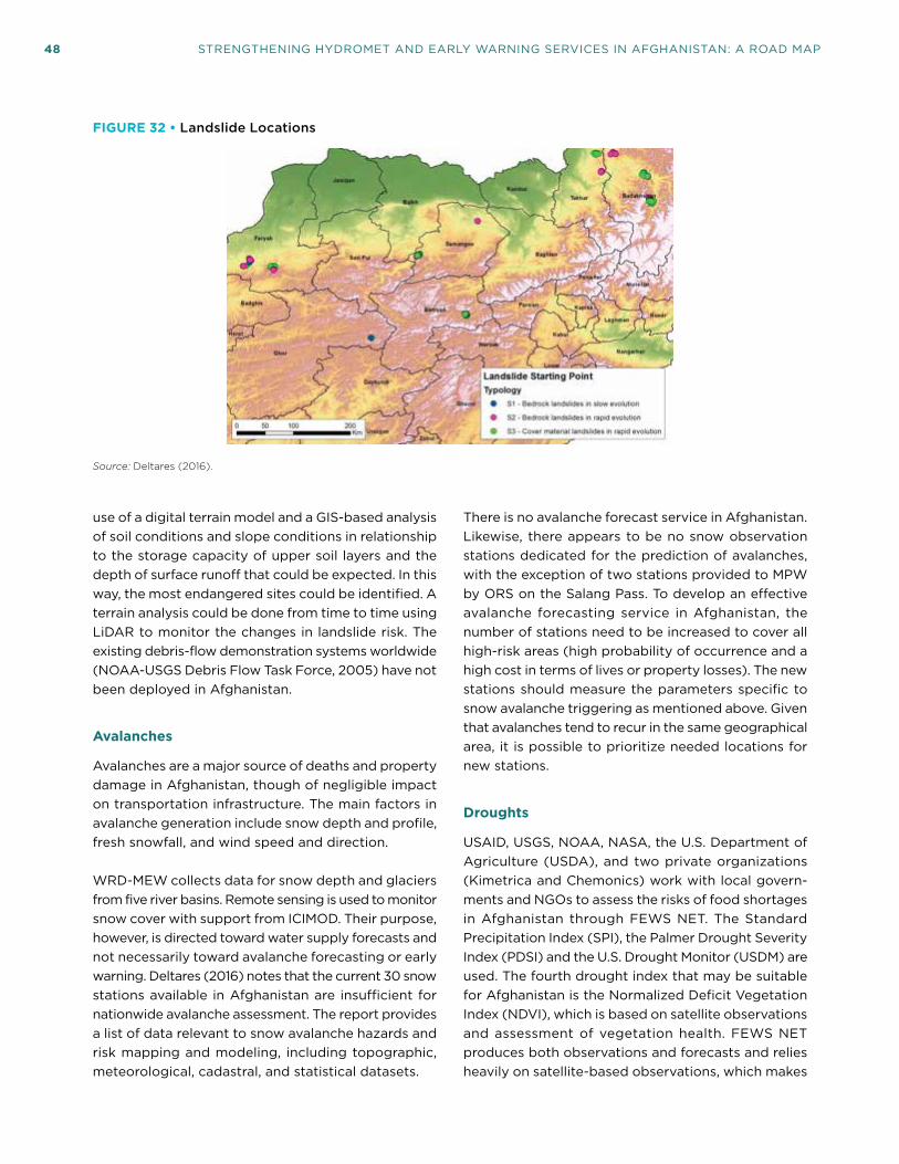
48 STRENGTHENING HYDROMET AND EARLY WARNING SERVICES IN AFGHANISTAN: A ROAD MAP
use of a digital terrain model and a GIS-based analysis of soil conditions and slope conditions in relationship to the storage capacity of upper soil layers and the depth of surface runoff that could be expected. In this way, the most endangered sites could be identified. A terrain analysis could be done from time to time using LiDAR to monitor the changes in landslide risk. The existing debris-flow demonstration systems worldwide (NOAA-USGS Debris Flow Task Force, 2005) have not been deployed in Afghanistan.
Avalanches
Avalanches are a major source of deaths and property damage in Afghanistan, though of negligible impact on transportation infrastructure. The main factors in avalanche generation include snow depth and profile, fresh snowfall, and wind speed and direction.
WRD-MEW collects data for snow depth and glaciers from five river basins. Remote sensing is used to monitor snow cover with support from ICIMOD. Their purpose, however, is directed toward water supply forecasts and not necessarily toward avalanche forecasting or early warning. Deltares (2016) notes that the current 30 snow stations available in Afghanistan are insufficient for nationwide avalanche assessment. The report provides a list of data relevant to snow avalanche hazards and risk mapping and modeling, including topographic, meteorological, cadastral, and statistical datasets.
There is no avalanche forecast service in Afghanistan. Likewise, there appears to be no snow observation stations dedicated for the prediction of avalanches, with the exception of two stations provided to MPW by ORS on the Salang Pass. To develop an effective avalanche forecasting service in Afghanistan, the number of stations need to be increased to cover all high-risk areas (high probability of occurrence and a high cost in terms of lives or property losses). The new stations should measure the parameters specific to snow avalanche triggering as mentioned above. Given that avalanches tend to recur in the same geographical area, it is possible to prioritize needed locations for new stations.
Droughts
USAID, USGS, NOAA, NASA, the U.S. Department of Agriculture (USDA), and two private organizations (Kimetrica and Chemonics) work with local govern-ments and NGOs to assess the risks of food shortages in Afghanistan through FEWS NET. The Standard Precipitation Index (SPI), the Palmer Drought Severity Index (PDSI) and the U.S. Drought Monitor (USDM) are used. The fourth drought index that may be suitable for Afghanistan is the Normalized Deficit Vegetation Index (NDVI), which is based on satellite observations and assessment of vegetation health. FEWS NET produces both observations and forecasts and relies heavily on satellite-based observations, which makes
FIGURE 32 • Landslide Locations
Source: Deltares (2016).

6. CURRENT STATUS OF AMD, WRD-MEW, AND STAKEHOLDERS 49
it particularly suited for Afghanistan, given the sparsity of ground-based observations in the country. These products, however, do not provide the necessary resolution for the relevant institutions to plan mitigating actions ahead of drought. Observations are provided by NASA (SWE), NOAA (rainfall, temperature) and the USGS (NDVI). It is essential to build the technical capacity of the AMD staff so they can use and build on this information. An important requirement for AMD is developing monthly and seasonal long-range weather forecasting by applying the Regional Climate Downscaling (RCD) methods to provide detailed and accurate representation of localized extreme climate events, and training of staff in downscaling of climate models techniques.
Collaboration among AMD (with the development of RCD), MEW, and MAIL should enable the development of an effective drought forecasting service, covering the meteorological, agricultural, and hydrological droughts. The three agencies together can capture the information needed for the forecast, but no one single agency can do so by itself.
6.7.2 VERY SHORT- AND SHORT-RANGE FORECASTING SYSTEMS
Other than a plain language, three-day forecast pro-duced in Dari (Figure 33), until quite recently AMD had no weather forecasting system specifically developed
FIGURE 33 • Sample Three-Day Forecast Produced by AMD
METEOROLOGICAL APPEARANCE
According to recent evaluations
Northeast and Eastern part of Afghanistan will be affected by rain.
WARNING:
Cloud Cover and Wind Speed and Direction in Afghanistan:
Kabul KABUL Will be sunny. Wind speed is between 3–6 knot from NNW direction.
Central Zone GhazniBamyan
Will be sunny. Wind speed is 4–6 knot from NW. Will be sunny. Wind speed will be 3–4 knot from NNW direction.
North Zone Maimana Mazar-e-Sharif
Will be sunny. Wind speed will be 4–5 knot from W. Will be partly sunny. Wind speed is 15 knot from WSW direction.
North East Zone Faizabad Kunduz
Will be sunny. Wind speed will be between 6–7 knot from W. Will be cloudy. Wind speed is between 5–6 knot from SW direction.
West Zone CheghcheranHerat
Will be sunny. Wind speed is between 5–6 knot from NE direction. Is expected to be sunny. Wind speed is 15–21 knot from NE direction.
South West Zone Lashkargah FarahKandahar
Will be sunny. Wind speed is between 4–5 knot from S direction. Will be sunny. Wind speed is between 16–18 knot from N.Will be sunny. Wind speed is between 7–8 knot from NNE direction.
East Zone GardizJalalAbad
Will be sunny. Wind speed will be 8 knot from N. Will be sunny. Wind speed is between 13–15 knot from WNW direction.
Source: AMD (2018).

50 STRENGTHENING HYDROMET AND EARLY WARNING SERVICES IN AFGHANISTAN: A ROAD MAP
for Afghanistan. Those plain language forecasts have now been expanded upon slightly for select cities (see http://www.amd.gov.af/).
India is keen to play a key part in AMD’s develop-ment. AMD has signed an agreement with the India Meteorological Department (IMD), National Center for Medium Range Weather Forecast (NCMRWF), Regional Integrated Multi-Hazard Early Warning System (RIMES) and Ministry of Earth Science for a five-year special program designed for AMD rehabilitation including equipment and training of AMD staff. In turn, India requires AMD to distribute synoptic meteorologi-cal observation data to IMD to assimilate within its meteorological network.36
As part of its future development, AMD should have a communications infrastructure that supports transmit-ting weather forecasts to stakeholders such as ANDMA, MEW, MAIL, and MPW.
6.7.3 MEDIUM- AND LONG-RANGE FORECASTING SYSTEMS
Medium-range forecasts cover up to 10 days ahead. Long-range forecasts (LRF) are monthly and seasonal forecasts that are required for planning purposes in different sectors. LRFs are available on several websites. The ECMWF website includes EUROSIP products, which are multi-model seasonal forecasts from the ECMWF, Met Office, Météo-France, U.S. National Oceanic and Atmospheric Agency National Centers for Environmental Prediction (NOAA/NCEP) and Japan Meteorological Agency (JMA). The WMO Lead Center for Long-Range Forecast Multi-Model Ensemble (https://www.wmolc.org/) provides access to the 12 Global Producing Centers for long-range forecasts. A global climate model (GCM) can provide reliable prediction information on scales of around 1,000 km 3 1,000 km, covering what could be a vastly differing landscape (e.g., from very mountainous to
36 Met Office (2012).
flat coastal plains) with varying potential for droughts, floods, or other extreme events.
While GCMs can provide projections of how the climate of the earth may change in the future, the impacts of a changing climate and the adaptation strategies required to deal with them occur on regional and national scales. This is where Regional Climate Downscaling (RCD) provides projections with much more detail and more accurate representation of localized extreme events. This supports more detailed impact and adaptation assessments and planning. There is a lack of capability in medium- and long-range forecasting in Afghanistan to provide users such as the agriculture, energy, health, and transport sectors as well as disaster management with forecasts and outlooks necessary for planning and operation purposes.
6.8 Current System
Figure 17 in this Road Map presented the system-of-system concept in the structure and functioning of a modern NMHS. Figure 34 reflects an analysis of AMD’s current system of systems in producing and delivering hydromet products. It is assumed that AMD has access to the meteorological data collected by WRD-MEW and MAIL, hence the green area in the “external data systems.” The approximate capabilities for each system are indicated as percentages in Table 9 relative to a full capacity (100 percent), for example in accessing and using global NWP systems or providing a full suite of PWS to all users. This figure highlights gaps in the present AMD system and provides insight into areas that require investment for improved service delivery.
A similar system of systems for hydrological and flood forecasting services shows the status of the MEW production and service delivery systems and the associated enabling environments of capacity building and technical capabilities (Figure 35). The approximate capabilities for each system are indicated in Table 10.

6. CURRENT STATUS OF AMD, WRD-MEW, AND STAKEHOLDERS 51
FIGURE 34 • AMD System of Systems, Current Capacity
Modeling systemsMonitoring and observing systems
Limited area modelsystem
Nowcasting modelsystem
Hydro modeling systems
Objective and impactforecasting and warning systems
ITC systems
Nowcasting system
Medium-range forecasting system
Long-range forecasting system
Service delivery systems
National data systems
Upper air systems
Radar system
G2G disastermanagementservice system
Public-privatecooperative servicessystemsto key businesses
Actions, service monitoring, and feedback systems
Service systems forpublic
Service systems for national and provincialgovernments
Service systems forbusinesses
Quality management systems
Technology infusion systems
External research and development systems
Internal research and development systems
Transition research to operations systems
Cloud computingsystems
G2G and G2B climateservices system
G2G and G2B aviationservices system
Capacity building
Stakeholder institutionstraining
End-user training andoutreach
Global data system
Surface obs systems
Data managementand archiving systems
External data systems
Institutional management systems
Data commssystems
Communicationsystems
Computing hardwareand software systems
Operational management systems
Global NWP systems
Regional NWP systems
Met/hydro institutional education and training
Severe hazardforecasting systems
Very short-range forecasting system
Short-range forecasting system
Public weatherservices system
G2G water andenergy managementservices system
G2G agricultureservice system
Note: White: lack of capability in a particular system, Green: existing capability in a particular system, Gray Line: where no capability and no activity exist in the system (courtesy David Rogers 2018).
TABLE 9 • AMD System of Systems, Approximate Current Capacity (%)
Monitoring and Observing
SystemsModeling Systems
Objective and Impact Forecasting and Warning
Systems
Service Delivery Systems
Quality Management
Systems ICT Systems Capacity Building
Global data
30%
Global NWP
20%
Severe hazard forecasting
20%
Public weather services
30%
Institutional management
10%
Data communication
10%
Met/hydro institutional education and training
20%
National data: Surface obs.
30%
Regional NWP
40%
Very short-range forecasting
30%
Agricultural service
30%
Operational management
10%
Computing hardware and software
10%
Data management and archiving
10%
Short-range forecasting
30%
Water and power management service
30%
Communications
10%
External data
50%

52 STRENGTHENING HYDROMET AND EARLY WARNING SERVICES IN AFGHANISTAN: A ROAD MAP
TABLE 10 • MEW System of Systems, Approximate Current Capacity (%)
Monitoring and Observing
SystemsModeling Systems
Objective and Impact Forecasting and Warning
Systems
Service Delivery Systems
Quality Management
Systems ICT Systems Capacity Building
Global data system
30%
Hydro modeling
20%
Public hydrological services
20–30%
Institutional management
35%
Data communication
40%
Met/hydro institutional education and training
50%
National data: surface obs.
70%
Seasonal (medium-range) forecasting
30%
Agricultural service
20–30%
Operational management
40%
Computing hardware and software
30%
Data management and archiving
40%
Water and power management service
20–30%
Communications
40%
External data
40%
Disaster management service
20–30%
FIGURE 35 • MEW System of Systems, Current Capacity
Modeling systemsMonitoring and observing systems
Limited area modelsystem
Objective and impactforecasting and warning systems
ITC systems
Nowcasting system/flash flood guidance
Long-range flood forecasting system
Service delivery systems
National data systems
Radar system
Public-privatecooperative servicessystemsto key businesses
Actions, service monitoring, and feedback systems
Service systems forpublic
Service systems for national and provincialgovernments
Service systems forbusinesses
Quality management systems
Technology infusion systems
External research and development systems
Internal research and development systems
Transition research to operations systems
Cloud computingsystems
G2G and G2B climateservices system
Capacity building
Stakeholder institutionstraining
End-user training andoutreach
Global data system
Surface obs systems
Data managementand archiving systems
External data systems
Institutional management systems
Data commssystems
Communicationsystems
Computing hardwareand software systems
Operational management systems
Global NWP systems
Regional NWP systems
Hydro institutional education and training
Severe hydro hazardforecasting systems
Very short-range flood forecasting system
Short-range flood forecasting system
Public hydrologicalservices system
G2G water andpower managementservices system
G2G agricultureservice system
Hydro modeling systems
Medium-range flood forecasting system
G2G disastermanagementservice system
Note: White: lack of capability in a particular system, Green: existing capability in a particular system, Gray Line: where no capability and no activity exist in the system. (courtesy David Rogers 2018).

53
7. MODERNIZATION OF METEOROLOGICAL AND HYDROLOGICAL SERVICES AND EARLY WARNING SYSTEMS
7.1 Value Chain Approach
Stakeholder requests for improved AMD and WRD-MEW forecast and warning services clearly reflect the need to modernize the two departments’ infrastruc-tures beyond just the observation and data-gathering systems. Fit-for-purpose services are the priority of all users (Photo 3). For both AMD and WRD-MEW identification of the users of their services and users’ needs is a first step in the modernization of these orga-nizations. A well-planned and organized NMHS should play a key role in early warning systems and services
(EWS). Producing and disseminating warnings that are targeted to the impacted areas and populations are the main mandate of any NMHS. The introduction of impact-based forecasting and warning services is the way of future NMHS operations in collaboration with relevant government organizations and especially the NHS and ANDMA. The public will need to be educated and the emergency management authorities will need to be trained on the potential impacts of severe hydrometeorological events to take protective actions.
Given all the arguments in its favor, modernizing a NMHS has proved to be a complex, time-consuming
Photo 3: Modern Forecaster Workstation in Cambodia
Source: Rogers and Tsirkunov (2013).

54 STRENGTHENING HYDROMET AND EARLY WARNING SERVICES IN AFGHANISTAN: A ROAD MAP
and expensive task in many countries, including developed economies. The modernization of the U.S. National Weather Service took over 10 years and cost US$4.5 billion.37 A detailed account of the modern-ization of the Japan Meteorological Agency (JMA)38 provides a wealth of experience and guidance for countries intending to embark on such a modernization. To this end, before proposing modernization activities for the AMD and WRD-MEW, it would be reasonable to present a brief description of the main elements of a well-functioning NMHS.
The operation of a NMHS in any country is based on observations and data collection; data processing; telecommunications; preparation of forecasts, warn-ings, and climate advisories; and dissemination of forecasts and other specialized information through the media and other channels to users (Figure 36). No country is alone in undertaking these tasks; the combination of many networks, centers, and hubs on global, regional, and national scales form the intricately interconnected world of global hydrometeorology. The
37 Ibid.
38 World Bank (2017).
three components of observations, telecommunica-tions, and data processing and forecasting together comprise the WMO World Weather Watch Program.
The Global Observing System, although extremely complex, is perhaps one of the most ambitious and successful instances of international collaboration in the last 100 years. The system consists of a multitude of individual observing systems owned and oper-ated by many national and international agencies. The Global Telecommunication System (GTS) is the communications and data management component that allows the World Weather Watch to collect and distribute information critical to its processes. The GTS is implemented and operated by the NMHSs of WMO members and by intergovernmental organiza-tions, such as ECMWF and the EUMETSAT. The GTS also supports other programs, facilitating the flow of data and processed products to meet WMO members’ requirements in a timely, reliable and cost-effective way. It ensures that all members have full access to meteorological and related data, forecasts, and alerts. The Global Observing System evolved into the WMO Integrated Global Observing System (WIGOS) and the GTS expanded into the WMO Information System (WIS).
The Global Data Processing and Forecasting System (GDPFS) encompasses all forecasting systems operated by WMO members. It enables members to make use of the advances in NWP by providing a framework for sharing data related to operational hydrology, meteorology, and oceanography. The main support for the exchange and delivery of these data is the WIS.
The value of the products and services of NMHSs is manifested in the way they are used by the recipients. The generation of meteorological and hydrological value can be depicted in a “value chain”39 linking the production and delivery of services to user decisions and the outcomes and values resulting from those decisions (Figure 37). Potential value is added at each link of the chain (moving from left to right in Figure 37) as services are received by users and incorporated into or considered in decisions. Value adding processes involve tailoring services to more specialized applica-tions and decisions (i.e., making the information more relevant and trustworthy) or expanding the reach of an information product to ever-greater audiences (e.g.,
39 WMO, World Bank/GFDRR, USAID (2015).
FIGURE 36 • Schematic of Global Observing, Telecommunication, Data Processing, Forecasting and Dissemination System
Source: Rogers and Tsirkunov (2013).Note: Compilation of different systems of observation, telecommunication, data processing, forecasting, and dissemination based on the WMO World Weather Watch System.

7. MODERNIZATION OF METEOROLOGICAL AND HYDROLOGICAL SERVICES AND EARLY WARNING SYSTEMS 55
public, decision makers, and clients). In a modernized, well-functioning NMHS, every link in this chain is strong, helping to deliver value to the society at the end of the chain. In contrast, in a less developed NMHS, the chain often stops at observation or forecasting without a robust modeling and service delivery capability, and a broken link somewhere in the value chain would result in producing suboptimal, and in worst case, no value at all to the society.
Modernizing NMHSs cannot be piecemeal, however it could be implemented in a phased approach stretched over a number of years as long as the initial plan takes into consideration every component of every system and the level of improvement needed. In the end of the implementation of the plan, the process should be transformative, ensuring NMHSs can deliver the services stakeholders expect.40 As part of its modernization, significant improvement of interrelated elements of meteorological and hydrological monitoring networks, forecasting, and service delivery is necessary. This includes new technologies for data sensing and recording, data validation and archiving, and modern scientific-based tools for forecasting, dissemination, and communication of products and services (Figure 38).
40 Rogers et al. (mimeo).
Such improvement requires the integration of five essential elements in the monitoring program of an NMHS,41 as follows: quality management system (QMS), network design, technology, training, and data management. Network design has to be an ongoing process based on user needs, with new stations being established and existing stations being discontinued as program priorities and funding evolve. Selecting the best technology for data sensing at a given location is a very complex task. There are many technologies available and for each combination of these tech-nologies, there are numerous vendors and products available. Network operators must consider additional factors such as reliability, reporting accuracy, costs, operation and maintenance requirements, durability, and site specifications. Data management ensures the proper storing, validating, analyzing, and reporting of vast amounts of data and establishes the validity of the data by providing evidence of compliance with the QMS. Finally, no investment in technology can compensate deficits in human capacities for which continuous training is essential. Figure 39 gives an overview of the flow of data and information in modern hydrometeorological services.
41 Hamilon (2012).
FIGURE 37 • Hydromet Production Value Chain
VALUEBenefits
andcosts
Outcomes
Observations Modeling
Research and development
Processing and data management
ForecastingService delivery
V A L U E A D D I N G P R O C E S S E S
C O M M U N I C A T I O N P R O C E S S E S
User decisionsand
actions
Basic and specialized services
NMHS and commercialproviders
WeatherClimateWater
WeatherClimateWater
SERVICEPRODUCTION
Observation Modeling
Research & development
Processing & data management
ForecastingService delivery
WeatherClimateWater
Source: WMO, World Bank/GFDRR, USAID (2015).

56 STRENGTHENING HYDROMET AND EARLY WARNING SERVICES IN AFGHANISTAN: A ROAD MAP
FIGURE 38 • Schematic of NMHS Modernization
Information utilization and decision making
Information dissemination Monitoring network designbased on user requirements
Data sensing andrecording
Data validation andarchiving
Data synthesis and analysis(incl. modeling, forecasting)
ModernizationNMHS
Source: Courtesy Andreas Schumann 2017.
FIGURE 39 • Data Flow in Hydrometeorological Services
Data management system
User community Objectives
Meteorological andhydrological informatione.g., forecasts, statistics,real-time data
Data collection
Data for operationalpurposes
Naturalmeteorological and
hydrologicalcharacteristics
Quality management system
Network design—program priorities—new stations—closure of stations
Technologies, depending on—reliability—accuracy—control and maintenance—specific local site factors—costs of ownerships
Dissemination ofinformation
Source: Courtesy Andreas Schumann (2017).

7. MODERNIZATION OF METEOROLOGICAL AND HYDROLOGICAL SERVICES AND EARLY WARNING SYSTEMS 57
The socioeconomic benefits of modernization will be manifested in managing risk and aiding decision mak-ing in (i) weather-related disasters and (ii) economic development. This is especially the case for floods, which have the biggest impact on the poor and vulner-able populations. Improving the forecasting and early warning of hydrometeorological hazards will contribute to building resilience for communities and sectors at risk. A substantial modernization program for any NMHS should typically include three components,42 namely: (i) enhancement of service delivery systems; (ii) institutional strengthening and capacity build-ing; and (iii) modernization of observation, ICT, and forecasting infrastructure. The activities proposed in the subsequent sections are in line with this principle. They aim to strengthen the AMD and WRD-MEW’s institutional basis: to enhance a legal and regulatory framework and to develop the capacity of staff; to technically modernize the observation, ICT, data management, and hydromet forecasting infrastructure and facilities; and, most importantly, to improve the delivery of hydromet and EWS to the Afghan people and weather-dependent sectors.
7.2 Development Partners and Cooperation
There are a number of ongoing initiatives that aim at strengthening early warning systems and hydromet services in Afghanistan. It is therefore crucial that planned initiatives will build upon the activities and achievements of ongoing projects such as those being implemented through USAID/WMO, World Bank Irri-gation Restoration and Development Project (IRDP), USAID/FEWS NET, USAID/NASA SERVIR, USAID/Information Management and Mine Action Program (IMMAP) and JICA HYMEP.
Any new project for modernizing AMD would benefit from consolidating the achievements so far of the USAID/WMO project to strengthen early warnings of hydromet hazards and by taking into consideration the AMD’s five-year strategic plan (2017–21). Similarly, there is significant opportunity for coordinating and consolidation of resources with the ongoing World Bank IRDP, which is considering the effective use of regional
42 Rogers and Tsirkunov (2013).
and global products to ensure cost-effective system development and area coverage. In addition, there is enough information to allow MEW to potentially issue long-range forecasts on drought. Both the USAID/NASA SERVIR project and USAID/IMMAP offer many opportunities for MAIL and MEW as well as AMD to use, coordinate, and share geospatial information and satellite data essential to enhance each institution’s observation network. The database proposed by JICA HYMEP should serve as a good working model to expand into a national hydromet database and link in ANDMA and MRRD for EW and dissemina-tion purposes. The scope of the database should be expanded to receive data/information from AMD, MEW, MAIL, and MPW, as well the following portals: SERVIR, Afghanistan Spatial Data Center, and FEWS NET data. A more detailed description of the existing regional and international initiatives is provided below.
7.2.1 REGIONAL INITIATIVES
• FEWS NET applies satellite-based observations to develop precipitation maps, soil moisture maps, and regional forecasts, which makes it particularly suited for Afghanistan, given the sparsity of ground-based observations in the country. FEWS NET provides information to potentially allow Afghanistan agencies to issue long-range forecasts on drought. Satellite data is valuable for MAIL in providing a view of crop and water conditions across the entire country at a single glance. MAIL has been supported by Food and Agriculture Organization (FAO), FEWS NET, and SERVIR to develop agricultural drought early warning, agro-crop models for crop forecasting and pest and disease early warning. MEW has been using FEWS NET maps for its seasonal runoff forecast on a single basin, as well as the FEWS NET project SWE maps to forecast water availability. FEWS NET makes available digital maps of the snow properties (SWE and snow cover area), which are directly readable by GIS. While FEWS NET provides a large-scale overview of the drought situation, more detailed and higher resolution information is needed to more effectively aid in planning and decision-making purposes and for issuing accurate warnings.
• SERVIR and ICIMOD empower decision makers with tools, products, and services to act locally on climate-sensitive issues such as hydromet-related disasters, agriculture, water, ecosystems, and land use. The availability of remote sensing products from

58 STRENGTHENING HYDROMET AND EARLY WARNING SERVICES IN AFGHANISTAN: A ROAD MAP
FEWS NET, SERVIR, and ICIMOD are greatly accel-erating the use of such products for hydromet and EW services in Afghanistan. These products should be used in conjunction with climate downscaling techniques to produce more detailed information on smaller scales to increase their usefulness.
• In addition, JICA HYMEP is supporting MEW in developing other products such as runoff analysis, flow duration curves, flood and rainfall frequency analysis, basin average rainfall, and basin water bal-ance. The World Bank IRDP is planning to support MEW in developing hydromet information products for river basin planning, dam development and opera-tion, flood risk management, and irrigation planning.
7.2.2 INTERNATIONAL INITIATIVES
There are a number of ongoing international initiatives for remote sensing that offer potential benefits for Afghanistan’s hydromet and EW systems and services:
• The United Nations Platform for Space-based information for Disaster Management and Emer-gency Response (UN-SPIDER) was established in 2006 to provide information for humanitarian aid and emergency response, with a particular focus on assisting developing countries to gain access to satellite data for emergency preparedness and response needs.
• The FAO Global Information and Early Warning System (GIEWS), established in the wake of the world food crisis of the early 1970s, provides information on food production and food security and consists of a worldwide network including 115 governments, 61 nongovernmental organizations (NGOs) and numerous trades, research, and media organizations.
• The Global Disaster Alerts and Coordination System (GDACS), developed by the Joint Research Centre of the European Commission and used jointly by the European Commissions and the United Nations Office for the Coordination of Humanitar-ian Affairs (OCHA) is a fully automatic 24/7 alert system which gathers data about natural severe events (earthquakes, tsunamis, tropical storms, floods, and volcanoes). GDACS collects near-real time hazard information and combines this with demographic and socioeconomic data to perform an analysis of the expected impact. This is based on the magnitude of the event and possible risk for the population. The result of this risk analysis is distributed by the GDACS website and alerts are sent via e-mail, fax and SMS to subscribers in the disaster relief community and all other persons that are interested in this information.
Additional initiatives include UNOSAT, DLR-ZKI, SERTIT, the Dartmouth Flood Observatory, the Global Monitoring for Environment and Security (GMES) of the European Commission and the European Space Agency (ESA), PREVIEW (Prevention, Information and Early Warning pre-operational services to support the management of risks), LIMES (Land and Sea Integrated Monitoring for Environment and Security), GMOSS (Global Monitoring for Security and Stability), SAFER (Services and Applications For Emergency Response), and G-MOSAIC (GMES services for Management of Operations, Situation Awareness and Intelligence for regional Crises).
Clearly, guidance is required for officials in Afghanistan to identify relevant information and application for specific needs of the country.

59
8. PROPOSED ROAD MAP FOR MODERNIZATION OF AMD AND WRD-MEW
Recognizing that cultural change in institutions takes time, the proposed Road Map represents the first step in a planned long-term engagement
on hydromet modernization. The resulting project needs to lay a strong foundation that can be developed over time. This is especially true since in general, in various government ministries in Afghanistan, there is insufficient understanding of the role that AMD and WRD-MEW can play in many areas of the development of the country.43 An iterative approach to integrating projects, including inter-ministry mentoring, will help raise the confidence levels of other sectors that MEW and AMD can take care of meteorological and hydrological data production, storage, management, and use. This may also help the government recognize that some water and agricultural management funding should, in proportion, be channeled to build the National Meteorological and Hydrological Services.
A modernization program for any NMHS should include the three interrelated groups of activities or components: (i) enhancement of service delivery system; (ii) institutional strengthening and capacity building; and (iii) modernization of observation, ICT, and forecasting infrastructure. These components are described in some detail in the case of AMD and WRD-MEW.
8.1 Delivery of Services
AMD and WRD-MEW should evolve from data provid-ers to demand- and user-driven, knowledge-based organizations that emphasize service provision across many socioeconomic sectors, while strengthening their capacity for technical and scientific activities.
43 Met Office (2012).
Such institutional modernization generally requires decades, far beyond the normal life cycle of individual development projects. Time is required to allow proper capacity building for the staff of these organizations to take ownership of the investments in new equip-ment and technologies and how best to use this new knowledge.
Some of the challenges that exist in most countries relate to the gap between providers and users of hydrometeorological services leading to miscom-munications and misunderstandings between the two sides. To close this gap, it is essential to create and deepen the understanding of who the users are, what they need, and how NMHSs can meet those needs. It is critical that the design and updating of monitoring networks be coordinated with the user community, so as to achieve an integrated network that supports users’ requirements for services. Assessing demands and priorities with current and potential users is not easy. It is encouraging to note that some effort has been made in Afghanistan to identify the various users and their requirements for hydrometeorological information. In many countries, decision makers assume existing meteorological and hydrological records are sufficient to resolve most of the present problems. Under a changing climate, however, it is no longer possible to assume the future record will follow the historical record. An integrated national policy for meteorological and hydrological services is essential to deliver these services in a better and more user-targeted manner.
The objective under this component of the Road Map is to enhance the AMD and WRD-MEW service delivery systems by developing a national Strategy for Service Delivery (SSD); enhancing public weather and hydrological services; strengthening end-to-end early warning systems and services, including impact-based forecast and warning services; developing agriculture

60 STRENGTHENING HYDROMET AND EARLY WARNING SERVICES IN AFGHANISTAN: A ROAD MAP
and climate advisory services; and creating a National Framework for Climate Services. This provides for the implementation of a systematic upgrade of the weather, climate, and hydrological-related end-to-end services provided to all agencies, communities, and individu-als. The WMO Strategy for Service Delivery and its Implementation Plan (the Strategy) provide in-depth and step-by-step guidance to enhance and develop service delivery.44 The Strategy describes a continu-ous cycle of four stages that define the framework for service delivery and identifies six elements that detail the activities required for high-quality service delivery (Figure 40).
Annex 2 shows the Service Delivery Progress Model as illustrated in the Strategy. It should be noted that this model is applicable to all types of services provided by NMHSs.
Such a shift to user-based products and service delivery requires a mechanism to facilitate communication and understanding between the meteorological and hydrological service providers and the user sectors. Establishing a hydrometeorological user group is a useful tool for this purpose. The user group needs
44 WMO (2014).
to develop and implement a strategy for service delivery with the engagement of service providers, stakeholders, and users. The strategy should outline user needs; priorities for needed products and services; design and generation of those products and services; dissemination of products and delivery of services; evaluation of the impact of the new products and services on the country; and improvement of products and services.45 Since user needs change periodically, existing and potential new key users should be surveyed on a regular basis. It is widely accepted that it is no longer sufficient for NMHSs to employ good science and provide accurate forecasts; they also need to engage the public and more specialized users through educating and informing them in how to make the best use of scientific endeavors. It is essential that a user database be maintained and updated. The products and services required by the users should become part of WRD-MEW and AMD and its stakeholders’ strategic planning.
The existing cooperation between AMD and WRD-MEW is an excellent starting point and may be used to identify the products and services that could be provided in a collaborative approach by both
45 Ibid.
FIGURE 40 • Stages and Elements of Hydrometeorological Service Delivery
The four stages of a continuous, cyclic process for developing and delivering services are:
The six elements necessary for moving toward a more service-oriented culture are:
2
1
3
4
5
6
Evaluate user needsand decisions
Link service development anddelivery to user needs
Evaluate and monitor serviceperformance and outcomes
Sustain improvedservice delivery
Develop skills needed to sustainservice delivery
Share best practices andknowledge
2(1) User engagement anddeveloping partnerships
(2) Service design anddevelopment
(4) Evaluation andimprovement
(3) Delivery34
1
Source: WMO (2014).

8. PROPOSED ROAD MAP FOR MODERNIZATION OF AMD AND WRD-MEW 61
organizations based on users’ needs. A successful example of such an approach is the UK Met Office Flood Forecast Centre (FFC) at their Exeter Headquarters. In April 2009, the Environmental Agency and the UK Met Office established a joint operations center for flood warnings and related extreme weather events. This development was a response to serious flooding events in the country in 2007, which raised concerns over high-level coordination. Both organizations undertook to combine their expertise to find a better means of providing the most complete assessment of operational flood risk, from the developing weather conditions through to the actual flooding event itself. The combined expertise of the Environment Agency and the Met Office is used to forecast river, tidal, and coastal flooding, as well as extreme rainfall that may lead to surface flooding. The FFC provides the following services:
• Extreme rainfall alert services;
• National flood guidance statements; and
• Web service.
The FFC provides daily routine weather forecasts for the Environment Agency and a daily flood guidance statement for the main civil responders. When heavy rainfall is either forecast or occurring, the center also provides a range of precipitation forecasts for the Environment Agency and also extreme rainfall alerts to the civil contingency responders.
Although there is no fixed optimum pattern to follow in the establishment of a national flood forecasting center, the following capacities must be available:
• Hydrological forecasters and modelers;
• Meteorological forecasters (in case of the meteo-rological and water management being separated, the meteorologists involved should have specific understanding of hydrological requirements);
• IT and operational technical communication;
• Communications with the media, public, and the government;
• Management and administration; and
• Research and development.
It is now recognized that the importance of flood forecasting and warning as a process in managing flood risk and impact requires a full-time and structured organizational approach. It is no longer something that can be added on as a temporary contingency operation within an organization fulfilling other primary roles, for example public works or municipalities.
A collaborative partnership between AMD and WRD-MEW, based on user requirements might result in the hydrological partner (WRD-MEW) providing services, including:46
• Water-related data and observations obtained from hydrological observing network;
• Water-related information such as a compre-hensive assessment of national water resources, the statistics of flood events or maps of spatial/temporal trends;
• A monitoring service designed to provide very specific data or information at a particular location for a particular user (e.g., to indicate when the remaining discharge, influenced by water extrac-tions, falls below a specified minimum value);
• Knowledge and understanding of water-related phenomena and water resources;
• Advice on decision making, where information is developed into recommendations for response to certain conditions (e.g., an evolving drought); and
46 WMO (2009).
Photo 4. Flood Forecasting Center, Met Office, United Kingdom
Source: Haleh Kootval (2018).

62 STRENGTHENING HYDROMET AND EARLY WARNING SERVICES IN AFGHANISTAN: A ROAD MAP
• Setting up a model- and database-driven meth-odology to estimate water balances since reliable estimates of water balance are a service required by many users and should be developed through joint interdisciplinary efforts of experts in geo-informatics, hydrology, meteorology, and water management. This requires an exchange of informa-tion between sectors and capacity building of staff.
Similarly, the meteorological partner (AMD) might provide services, including:
• Weather-related data and observations from meteo-rological observing network that provides specific data at a particular location on agreed atmospheric elements based on established practices by WMO;
• Weather forecasts at various timescales (nowcast-ing, very short-, short-, medium-, and long-range based on available capacity) based on user needs and severe weather warnings; and
• Advice on the impact of the weather conditions (both severe and routine conditions) on different stakeholders and decision-making guidance for users.
8.1.1 STRENGTHENING PUBLIC WEATHER, CLIMATE, AND HYDROLOGICAL SERVICES
The public weather service (PWS) is the main channel used by NMHSs for liaising with the public, the media, and the sectors impacted by weather and climate. It is the principal interface between the technical pro-vider of weather and related products and the users. It interprets and translates technical meteorological forecasts and other information into socially and economically relevant and understandable information and provides this information to the public at large and various sectors for decision making. In most countries all forecasts and warnings are disseminated from the NMHS via various channels including the media, the web, and increasingly the social media. This informa-tion includes both weather and hydrological forecasts. Under a PWS program, standard operating procedures should be developed and implemented by AMD and WRD-MEW in partnership with key stakeholders for producing and communicating fit-for-purpose services. This is especially important in the case of warnings to ensure that such information is consistent among
partners and stakeholders, permitting clear decision making and timely action. Implementing PWS and hydrological services effectively at AMD and WRD-MEW would ensure that all users receive timely information on all timescales available. Implementing formal and regular feedback mechanisms should also be part of the successful delivery of public and hydrological services.
The wide dissemination of hydrometeorological data, forecasts, and warnings to all users is a key element of modern delivery of public and hydrological services. An essential tool is the AMD and WRD-MEW websites for access to important meteorological and hydrologi-cal information needed by the user community. The websites should be managed on an operational basis and kept up to date. Consideration should be given to developing color-coded information and pictograms, which are often the most effective way of communicat-ing warnings.
8.1.2 DEVELOPING A COMPREHENSIVE NATIONAL DROUGHT MONITORING PROGRAM
More comprehensive agriculture and climate advisory services, including a drought monitoring program, need to be developed. This includes coordination of information and knowledge between meteorology and hydrology and establishes the drought magnitude
Photo 5. Modern Public Weather Service Delivery in Indonesia
Source: Haleh Kootval (2018).

8. PROPOSED ROAD MAP FOR MODERNIZATION OF AMD AND WRD-MEW 63
and impact information required by most users in Afghanistan. The drought monitoring program, while initiated by the meteorology and hydrology service providers (AMD and WRD-MEW), should also include MAIL and ANDMA. Their requirements are essential in defining drought forecasts and information linked with decision making.
8.1.3 DEVELOPMENT OF A NATIONAL FRAMEWORK FOR CLIMATE SERVICES
A National Framework for Climate Services (NFCS) is defined as a coordinating mechanism enabling the development and delivery of climate services required at national and local levels. There is need in each country for a NFCS, guided by the Global Framework for Climate Services (GFCS), involving practicalities and specifics for the actual delivery of services at the national level and for coordination with regional and global components of the GFCS. The most important aspect of the national framework is effective coordina-tion at the national level to ensure the climate services are authoritative, credible, and dependable, and used to inform better decision making by the end-users. The NFCS would involve the key national institutions collecting and compiling climate observations and other climate-related datasets as well as institutions undertaking relevant research and providing tailored information, products, and expert advice. Most coun-tries have created a national framework for climate services in support of the provision of essential climate information and services to most social and economic sectors. In Afghanistan, the major activity under such a framework would potentially include support to disaster risk management (DRM), agriculture, water management, energy, and public health.
8.2 Institutional Strengthening and Capacity Building8.2.1 INSTITUTIONAL STRENGTHENING
In most developing countries strategic policies that ensure effective integration of water resources and disaster risk management are needed. Integration is especially critical in water stressed regions that are susceptible to drought and prolonged water shortages. Such integration is often lacking at the national policy
level. Long-range water resources planning that is fully integrated with DRM is necessary. DRM in isolation from broader water resources concerns cannot be effective in actions for mitigating the loss of life and livelihoods. The risks of droughts, floods, and climate change, which pose threats to the security and well-being of citizens, require shorter lead-time DRM and longer range water resources planning and management.47
In the case of Afghanistan, it seems advisable that AMD and WRD-MEW focus operationally on working level links with ANDMA, MAIL, and MRRD and between themselves. In this case, there needs to be formal clarity on the roles and responsibilities of each institution. Critically, an agency must be formally mandated to lead the coordination of relevant activities and set agreed standards. This should be either AMD or WRD-MEW, depending on the national context and policies.
An ACAA-endorsed stakeholder working group on meteorology will encourage buy-in from the onset of development and can evolve over the medium term of at least five years into an owner’s council. It will encourage ministries to present meteorological requirements to AMD and jointly agree on priorities while trusting AMD with the operational implementation of their own sector-specific meteorological projects that will, when coordinated together, build a central capability. Funding and ownership usually go hand in hand, however, as with any other National Meteorologi-cal Service, AMD’s relevance to numerous sectors and resultant multi-sector funding should be managed carefully. This may be achieved by an arrangement whereby stakeholders through agreement within the owner’s council, provide proportionate funding toward the operation of AMD.48 Similarly, the establishment by MEW of a national hydrological services user group involving all stakeholders could facilitate the collec-tion of hydrological requirements and agreement on priorities. An alternative could be a joint hydromet user group to include both meteorological and hydrological service providers as well as stakeholders and users, as proposed earlier in this Road Map.
The main objectives of NMHSs are: to provide informa-tion on weather, climate, and hydrological conditions
47 World Bank Group (2018).
48 Met Office (2012).

64 STRENGTHENING HYDROMET AND EARLY WARNING SERVICES IN AFGHANISTAN: A ROAD MAP
for safety in the air, on land, and at sea; to mitigate natural disasters; to provide services to weather-sensitive economic sectors; and to support national development.49 A modern NMHS performs these functions by acquiring:
• Comprehensive, high-quality and robust observa-tional networks;
• Efficient data collection and management and rapid information exchange;
• State-of-the-art ICT and computing facilities;
• Sophisticated data analytics schemes and powerful simulation and forecasting models;
• Improved understanding of meteorological and hydrological phenomena through ongoing scientific research;
• Expertise in delivering forecast and warning services based on impacts of hydrometeorological phe-nomena, in partnership with relevant government organizations;
• Effective tailoring of services to user needs;
• Effective dissemination systems using multiple channels to assure the widest dissemination of warnings, forecasts, and advisory information;
• Efficient public and private service delivery arrangements;
• Effective communication of the science and practice of meteorology and hydrology, including limitations, uncertainties, and applicability of the science and related technologies;
• Capacity building across the entire NMHS and for the users and stakeholders; and
• Improved methodologies and algorithms for use of meteorological, hydrological, and related informa-tion in decision making.
Modern NMHSs focus on understanding the user value chain to better understand users, the decisions they must make, and how information related to weather, climate, and hydrology is applied to minimize risk and to benefit the society as a whole (see Section 7.1, Value Chain). As a result of improved service delivery, users will gain confidence in the capability of the NMHS.
49 WMO, World Bank/GFDRR and USAID (2015).
This will lead to improved relations and increased demand for services. In addition, better services to government agencies and departments will result in greater recognition of NMHSs as providers of vital services supporting the economy and society. This will enable the NMHS to build a more convincing case for investment to sustain and further improve the range and quality of services.
A powerful tool for modern NMHSs to maximize the return on investment by ensuring optimum use of resources is a Concept of Operations (CONOPS). The CONOPS provides a conceptual overview of the system and subsystems in an NMHS to achieve the capabili-ties listed above. The CONOPS is intended to support the evolution of a fully integrated, modernized, and functional NMHS, which provides the level of services required by its users and stakeholders. Figure 19 in this Road Map illustrates the system of systems of an NMHS supported by CONOPS.
At the moment, the AMD and WRD-MEW activities mainly focus on observation and data collection. As a result of the past conflicts and ongoing limitations elaborated elsewhere in this Road Map, these organiza-tions have fallen behind even in collecting critical quality assured data, while producing forecasts, delivering services, and making the technological and scientific progress needed to use best practices and standards in delivering services to a set of users based on their diverse demands have not developed. The step from data collection to information production demands a strengthening of the rest of the system of systems in an integrated manner as shown in Figure 19 (i.e., modeling, forecasting, and service delivery systems supported by the ICT, QMS, capacity building, and technology infusion systems). The institutional strengthening component of the Road Map will aim to invest in the improvement of institutional arrangements at the AMD and MEW for enhancing their performance in line with international best practices.
8.2.2 CAPACITY BUILDING
Building capacity to improve the sustainability of the modernization of WRD-MEW and AMD is indispens-able and a foundation block for other systems and functions as shown in Figure 19 of this Road Map. For a strong and effective WRD-MEW and AMD, continuous access to new skills for all staff through

8. PROPOSED ROAD MAP FOR MODERNIZATION OF AMD AND WRD-MEW 65
provision of short- and long-term training courses at home and abroad and on-the-job training is essential. A major challenge for WRD-MEW, AMD is to create a strong professional meteorological and hydrological workforce for the benefit of their main stakeholders and other users. A steady supply of meteorologists, hydrologists, and related specialists at the B.Sc., M.Sc., and higher educational level with the abilities to perform at the required skill levels is required. In this regard, strengthening the hydromet programs at Kabul University and Kabul Polytechnic University, which are the main sources for human resources at AMD and WRD-MEW at present and probably in the foreseeable future is critical.
Educating stakeholders/end-users in the application of hydrometeorological products for decision making is equally essential. The end-users’ inability to understand and interpret weather and climate products for decision making in economic sectors is a limiting factor, and user education should be implemented to overcome this gap. Educating the public to better understand warnings, probability forecasts, preparation, and awareness is very important in the last mile delivery and use of information, especially for flooding, which is a major hydrometeorological threat in Afghanistan. User education should include workshops, open days to encourage visits by the public, school visits, the distribution of flyers, publications, and public service videos, and posting educational materials on the relevant organizations’ websites and the public domain.
8.3 Modernization of Observation Infrastructure, Data Management Systems, and Forecasting
This component aims to upgrade and expand the meteorological, agrometeorological, and hydrological observations networks and ensure that these networks are well functioning and are interoperable; modernize data management, communications, and ICT systems; improve weather and hydrological forecasting pro-cesses and numerical prediction systems; and refurbish offices and facilities. It should be noted that while the following sections provide a description of the ideal cases for different systems, the particular situation of
Afghanistan should be carefully considered to derive the optimum benefit from what is actually possible in the country. In addition, modernization of each system should be broken down to manageable packages for phased implementation.
8.3.1 METEOROLOGICAL OBSERVATION INFRASTRUCTURE
The increasing risks of floods and droughts because of climate change will require better forecasts and response. While it is understood that very large expenditure on a Doppler radar network or consider-able numbers of automatic weather stations (AWSs) is not possible in the current situation due to budgetary and security constraints, modernization should focus on rehabilitation of the existing synoptic network and eventual establishment of an upper air observ-ing station; it also will introduce a certain degree of automation of observations to improve nowcasting and very short-range forecasts. Having said that, it is necessary to point out that a ground-based observa-tion network only provides moderate value for money from a weather and climate perspective. Access to satellite technology can now provide a far better analysis of snowpack and water resource relevant for many sectors, except for the aviation that necessitates comprehensive ground-based observation systems at large airports. A ground-based observational network can become high value when assimilated into a common information layer through NWP that then offers a richer, more useable, sector specific output for forecasters, or when used as ground truth to calibrate radar data. Therefore, single (or even multiple) ground observa-tion from an area of interest does not represent the full picture for, say, water management, without being used as part of a common information layer. Hence, all meteorological ground observations gathered within individual sector projects would be made far more effective for Afghanistan as a whole through a coordinating meteorological authority.50 Therefore, a careful assessment of the future needs for data may result in the consideration of a reorganization of the network, which should consider the requirements of the users and constraints due to security issues. A revi-sion of operational procedures should be undertaken to consider the different needs for data at different
50 Met Office (2012).
66 STRENGTHENING HYDROMET AND EARLY WARNING SERVICES IN AFGHANISTAN: A ROAD MAP
locations. Regular preventative maintenance proce-dures to be carried out by trained personnel should be established once the existing equipment has been rehabilitated or replaced.
8.3.2 HYDROLOGICAL OBSERVATION INFRASTRUCTURE
While the number of gauging stations is still limited, WRD-MEW is in the position to start developing basic products and services using data from the existing gauges. In order to do so, more real-time hydrological data are needed for water management activities and forecasting of floods and droughts. The extent and speed of network expansion should be proportional to WRD-MEW capacity in operating and maintaining stations, which can be assessed through operational status of existing automatic stations. The real-time information is critical for the fast-responding water-sheds (with areas less than 200 square kilometers) and for flash flood forecasting. The hydrometric network equipment needs to be upgraded to include float-operated shaft encoders, data loggers, and sustainable date transmission mechanisms to ensure that the early warning systems can function properly. A revision of the operating procedures is necessary to consider the needs at different locations. The need for operational data at the existing stream gauge sites and for data loggers should be assessed.
Modernization of the hydrological observing network will allow the rehabilitation and technical re-equipping of the hydrological and sediment network, including the field communication network, and the provision of special equipment for hydrological measurements (e.g., Acoustic Doppler Current Profilers (ADPC), boats, cur-rent meters, laboratory equipment, and stream gauges equipped with data transmission). Regular preventative and operational maintenance programs for all equipment need to be in place after modernizing the network.
Strengthening the status of data logging and trans-mission will allow the provision of reliable end-to-end data communication, the delivery of forecast and warning services to users and the implementation of operational deterministic flood models. WMO’s recommended guidelines on establishing operating and maintenance (O&M) programs of NMHSs should be taken into consideration. In a modernized hydrological
observing system all new stream gauge installations should also include recording rain gauges in the con-tributing watersheds. Real-time access to these rainfall data should be established and telemetry added to ensure that the data are automatic and operational at all times to trigger flash flood warnings.
8.3.3 DATA MANAGEMENT, COMMUNICATION, AND ICT SYSTEM
A readily accessible, historical, digital database of hydrological and meteorological parameters is urgently needed to develop a range of warning and forecast services related to extreme weather and flood events that impact many sectors of Afghanistan’s economy. The modernization and expansion of the AMD and WRD-MEW observation network and improvement in forecasting and service delivery will require signifi-cant improvements in ICT capacity. Communications equipment and computers, harmonized database management systems for weather, climate, and hydro-logical data, including servers, software, web access, and social media, and AMD remote sensing and GIS, including the satellite downlink system, will be needed to establish a modern software/hardware environment. Such an environment will provide efficient and timely collection of data from the observational network and will speed up reception and processing of information products from leading international meteorological centers enabling higher resolution products and more information to be available to AMD forecasters.
8.3.4 METEOROLOGICAL FORECASTING
Numerical Weather Prediction (NWP) coupled to an extensive in-situ and remote-sensing observational net-work (satellite, radar, upper air, and ground) underpins the information layer of an NMHS and foundation of modern forecasting. It is a cost and resource intensive business because at its fully developed mode, it requires multimillion-dollar super-computer infrastructure (with associated research and technical support). It is arguable whether Afghanistan would need to develop such a high degree of capability in the foreseeable future as many developed NMHSs are opening up their information provision to assist less developed countries. In addition, different model outputs from various global and regional centers are accessible to

8. PROPOSED ROAD MAP FOR MODERNIZATION OF AMD AND WRD-MEW 67
nearly all countries. It is vital that the best possible training be provided in developing countries to extract optimum benefit from all the available and accessible tools as part of their modernization strategies.
Current forecasting at the AMD is based on output from METCAP+, a visualization tool designed to be a complete working environment for the operational forecaster. The results of blending the in-situ, remote-sensing and model data are to produce three-day forecasts for a few cities in Afghanistan. No objective verification of forecasts is performed, although some verification of forecast precipitation and temperature is performed against observations for 15 cities. No nowcasts, and medium- or long-range forecasts are produced. As part of the longer term modernization plans for AMD, it is necessary to establish a compre-hensive process for operational weather forecast-ing as is practiced in a well-functioning developing national forecast center. Such a modernization process will allow access to NWP digital data and products (short-, medium-, extended- and long-range fore-casts) from a global center (e.g., ECMWF) and move from deterministic to ensemble prediction systems (EPS) for production of probabilistic forecasts; the required software for data handling (license); NWP dynamic downscaling (including data assimilation), production of regional and site-specific forecasts and uninterrupted broadband Internet. While access to the ECMWF Global Model digital data (9 km resolution) will represent a great step forward for AMD, it should be noted that the required license costs €42,000 (approx. US$51,400) per year. Other tools for the modernization of forecasting will include forecaster workstation software products, implementation of real-time forecast process monitoring and verification, NWP post-processing, nowcasting and impact-based forecasting techniques. Training is required both in the use and interpretation of these products and tools, as well as in the overall forecasting process supported by standard operating procedures (SOP).
In addition to the short-range forecasts, there is a need to develop (monthly and seasonal) long-range forecasts (LRF). The AMD should be able to access LRFs, for example on the ECMWF website, and on the WMO Lead Center for Long-Range Forecast Multi-Model Ensemble (at https://www.wmolc.org/) which provides access to LRFs from 12 Global Producing Centers. The AMD should eventually develop expertise also in Regional
Climate Downscaling (RCD) techniques, which will allow it to provide high resolution climate information on a more regional and national scale and with much greater detail and more accurate representation of localized extreme events.
8.3.5 HYDROLOGICAL FORECASTING AND HYDROLOGICAL DECISION SUPPORT SYSTEM
Flood forecasting and warning as a focused activity in the hydrometeorological sector is a relatively recent development. This may be an evidence of the growing seriousness of flood impacts, both as a result of greater financial investment and increased population. Flood forecasting requires an understanding of both meteo-rological and hydrological behavior for the particular conditions of the country in question. While the ultimate responsibility lies with the appropriate government agencies at a national level, the information needs to be made available at more localized levels, such as a river basin or a center of population. To form an effective real-time forecasting system, the basic structures need to be linked together in an organized manner. The main components of a modern and well-functioning national flood forecasting and warning system include:51
• Establishment of a network of automatic or manual hydrometric stations linked to a central control by some form of telemetry to collect real-time data for the prediction of flood severity;
• Provision of rainfall forecasts (quantity and timing) for which NWP models are necessary;
• Flood forecasting model software linked to the observing network and operating in real time;
• Preparation of forecast information and warning messages, including expected impact;
• Dissemination and communication of such messages including what action should be taken;
• Interpretation of the forecast and flood observa-tions to determine impacts on communities and infrastructure;
• Response to the warnings by the agencies and communities involved; and
• Review of the warning system and improvement as necessary after the flood events.
51 WMO (2011).

68 STRENGTHENING HYDROMET AND EARLY WARNING SERVICES IN AFGHANISTAN: A ROAD MAP
Many rivers normally pass over flood-affected areas and therefore river management will contribute to managing the flood risk. A Decision Support System (DSS) which integrates all the key basins and provides the basin scale rainfall forecasts, and hydrological forecast at selected locations, will be useful for various purposes including flood forecasting, irrigation management, and reservoir operations. Inflow forecasting with enough lead time enables the engineers, operators, and decision makers to manage the reservoir operations in an effective manner and ensure minimum impact resulting from extreme flows downstream of the reservoir and save water for drier times of the year. Such forecasting will require advanced technology such as digital elevation modeling developed using Light Detection and Ranging (LiDAR) and the effective use of available tools such as GIS. The solutions used in developing DSS should accommodate water quality monitoring especially during low flows to ensure public health. In addition, the set of solutions would require reservoir operation to minimize flood damages and also to keep the river levels within an acceptable level.
The generic steps to develop such DSS are:
• Selecting priority river basins based on recent observations of flood damages;
• Monitoring of water quality and river flow while strengthening the monitoring network and water quality testing facilities;
• Developing digital elevation models (DEM) for the priority basins using LiDAR/Drone/technology and GIS;
• Identifying vulnerable areas and properties including houses using GIS/GPS technology;
• Preparing and issuing timely rainfall forecasts from the NMHS; and
• Establishing and operating in collaboration with the DRM and NMHS/NHS a flood warning system to inform down to the household level. DRM and NMHS/NHS (through their public weather channels) will ensure timely dissemination of the information to the public.
Facilities required for such DSS includes modernizing the operation center/control room in the NMHS/NHS with necessary equipment, obtaining the facilities to measure water quality at the NHS, installing water
quality monitoring equipment coupled to current river flow measuring stations on a priority basis, training and capacity building of the staff for the above tasks, and improving the communication system for effective sharing of data.
Introduction of hydrological forecasting in Afghanistan is crucial to respond to requirements from many users. WRD-MEW needs to introduce capacities in hydrological modeling as a precondition of develop-ing water management strategies; establishing flood and drought risk management; and extending water management systems and optimizing their operation. It will be necessary to evaluate hydrological simulation models for usability in the Afghanistan context and to select and acquire adequate models. The existing statistical tools for forecasts which may be employed in Afghanistan will continue to be in use in the near future, but these tools have weaknesses. Deterministic snow models can be used as an alternative to statistical models with the help of high-resolution satellite data (e.g., snow cover, snow depth and water equivalent in snow). By introducing new hydrological models and software packages for short- and long-term flow fore-casting (which have been tested in other mountainous countries) and by enhancing technical capacities for modeling, a higher level of quality of forecasts can be ensured. Other simulation models for water resources systems should be tested for setting up water balances and planning for water resources allocations, river basin water management, and prognoses of future conditions. An important task will be evaluating the effects of climate change in rainfall and streamflow by deterministic models driven with plausible climate change scenarios. Selection of a modeling system should include the availability of training, documenta-tion, technical support, and calibration.
Deterministic real-time hydrological models for the flood-prone river basins can produce a flood hydrograph that provides users with much more information than the statistical relationships. In addition, with the increasing accuracy and reliability of meteorological models and quantitative precipitation forecasts (QPF), a 24-hour, seven-days-a-week flood watch alerting advisory could be added. A Doppler radar would be essential to specify the location of storm cells, to estimate the spatial differences in rainfall intensities, and to provide input data for flash flood alert systems. Flood early warning, to be effective, should provide adequate

8. PROPOSED ROAD MAP FOR MODERNIZATION OF AMD AND WRD-MEW 69
lead time for institutions and communities at risk to undertake preparatory and mitigating actions. Currently, flood warning capacity in Afghanistan is limited and inadequate for preserving livelihoods, or for making early decisions for flood preparedness and mitigation.
A DSS in Afghanistan will be based on a probabilistic flood forecasting system that couples an atmospheric model capable of providing probabilistic forecasts (very short to long timescales, e.g., ECMWF) to provide high resolution rainfall forecasts (AMD), hydrological/hydraulic models (MEW), data on vulnerability of people and assets (ANDMA or other government ministries), telemetry observation system networks (MEW, AMD), and a joint mechanism for production and dissemination of flood forecast and bulletins (MEW, AMD and ANDMA). Capacity building in all the partner organizations to develop, install, and run this system is key in the success of the system. Capacity to access the full suite of ECMWF data is required. Sufficient Internet bandwidth, a shared server to store these data, and sufficient computing resources to run the hydrological/hydraulic modeling system as an ensemble is necessary. With the inclusion of the Flash Flood Guidance System (FFGS) and the Global Flood
Awareness System (GloFAS) of ECMWF, the capabili-ties of the national ensemble flood forecasting will be extended to create a comprehensive ensemble flood forecasting for Afghanistan.
In summary, the modernization of hydrological fore-casting should provide new hydrological tools and information as follows:
• Seasonal forecasts, based on remote sensing data and snow modeling, including technical facilities such as servers, software licenses, training, quality management, dissemination of products;
• River and flash flood warning and alert systems, including technical facilities such as new sensors (e.g., water level recording based on radar precipita-tion stations with data automatic transfer), weather radar data, data transmission systems, visualization interfaces with servers and hydrological models, software licenses, training, quality management, and dissemination of results); and
• Operational water balances for the main river basins, including data from the main water users and water management facilities.


71
9. ROAD MAP SCENARIOS
The steps outlined in this Road Map to modernize the AMD and WRD-MEW are based on extensive discussions with the AMD, WRD-MEW, and
their key stakeholders. These discussions reveal gaps between the requirements of the user com-munity and the capabilities of these organizations to respond to those needs. These steps are meant to guide the transformation of the AMD and MEW to a fit-for-purpose organization whose standards of provision of products and services and the delivery of those services will be raised, to the extent possible within the context of Afghanistan, to respond to user requirements. Clearly, AMD and WRD-MEW strive to provide products of quality, diversity, and coverage to users and the Afghan population. However, in doing so, they face many challenges in: (i) securing adequate and sustained funding while delivering high quality and useful products and services; (ii) having sufficiently trained technical staff; (iii) having access to appropriate technical assistance and guidance; and (iv) ensuring that their capacity could keep pace with and meet the ever-growing demand for their services.
AMD and WRD-MEW are in urgent need of clearly demonstrating to the government funding authorities the importance of the underpinning observation and data processing infrastructure, and access to modern forecasting tools and technologies which are essential for providing services and advisory guidance to the Afghan population. Furthermore, AMD and WRD-MEW should in a more rigorous and better understood fashion argue the case for the social and economic benefits of the services they provide.
To compete for and optimally use scarce public resources, AMD and WRD-MEW are increasingly required to justify their continuing operation and the investment of public funds to support their basic infrastructure and suite of services and to demonstrate how their products and services are benefiting the country in the face of natural disasters (e.g., droughts
and floods) and economic difficulties. To demonstrate the benefits to users, however, AMD and WRD-MEW must first be able to provide fit-for-purpose services to the satisfaction of those users, which they cannot do unless there is a substantial upgrading of their infrastructure and services. This is a cycle whereby the gap in available resources and ability to serve their mandates keeps widening for AMD and WRD-MEW.
A major guidance of this Road Map and the scenarios it presents is for AMD and WRD-MEW to have a more systematic basis to set strategic and forward-looking priorities that are based on available (and potential future) funding to improve their service delivery. Future challenges may include the impacts of climate change with resulting increases in floods and droughts, as well as the emergence of new technologies and economic evolution in the country.
The consultations with stakeholders have clearly indicated requirements for more accurate, timely, location-specific, well-articulated, and useable informa-tion. This has been the basis of the different scenarios proposed in this Road Map. Certain steps can be taken quickly and with considerably limited invest-ments and effort to enhance the utility of weather-, climate-, and hydrology-related information for users. Examples include further training of AMD and WRD-MEW technical staff to access, understand, and use readily available products and guidance from various centers for improved forecast and warning services; and modifying the formats of products, using simpler language and avoiding jargon or changing the time of the product dissemination based on feedback from user surveys. Other changes may require a series of actions over medium or long timescales and require more substantial investments. One example is introducing capacities for hydrological modeling.
As described in Section 7 of this Road Map, the mod-ernization of AMD and WRD-MEW is being guided by three main components: (i) enhancement of service

72 STRENGTHENING HYDROMET AND EARLY WARNING SERVICES IN AFGHANISTAN: A ROAD MAP
delivery; (ii) institutional strengthening and capacity building; and (iii) modernization of observation infra-structure, data management systems, and forecasting.
The development of a Concept of Operations (CONOPS) will be essential to guide and support the transforma-tion of the AMD and WRD-MEW. The CONOPS is based on the principle of a system of systems (Figure 19) and proposes various alternatives, depending on the level of financial and human resources and other constraints, for the transformation of each individual system. Based on their stated requirements, the users of AMD and WRD-MEW services should be provided with the best possible products and services, and to achieve that objective, it is necessary to launch a full modernization program. This will form Scenario 1 in the Road Map and aims to bring AMD and WRD-MEW up to the level of well-functioning developing countries’ capabilities for providing data, forecasts, and warning services to meet the needs of a spectrum of users. The alternatives however, should be considered for each system if there are not sufficient resources to provide this full modernization. It will be necessary to prioritize the most important changes in the systems to go forward and to consider where the program should be scaled back in favor of those priorities. The emerging solution may be to trim down from the full modernization to a relatively modest improvement in services in consultation with users and matched with a corresponding reduction in their level of expectation. This is Scenario 2 in the Road Map: an intermediate level of investment to achieve a modest improve-ment in capabilities to provide weather, climate, and hydrological services to meet the needs of the most important users such as disaster management, agriculture, aviation, and water resources manage-ment. Finally, if there are not enough resources to do a moderate modernization, then it will be necessary to choose an alternative which will give a minimum basic improvement through technical assistance. This is Scenario 3 in the Road Map and represents a set of low-cost, high-priority activities options. It focuses on improving basic public services based on strengthening the AMD and WRD-MEW capacity and introducing basic affordable new technologies. In this way the CONOPS will guide the process through considering a whole range of alternatives and finally choosing the one which is affordable and yet can provide the best possible services to users. It should be noted that these scenarios are not exclusive of each other, but
are interdependent and if conducted in phases, they build on each other to contribute to the overall goal of the modernization progressing from Scenario 3 to Scenario 1. That is, Scenario 2 assumes the accomplish-ment of objectives in Scenario 3 and builds on them. Similarly, Scenario 1 assumes the achievement of goals in Scenarios 2 and 3 and builds on those. On the other hand, if resources are made available to undertake the modernization as a whole independent package under Scenario 1, then this will comprise the entire activities as described under Scenarios 2 and 3. Similarly, a complete modernization package under Scenario 2 will comprise also activities contained in Scenario 3.
Based on the World Bank’s experiences of the NMHS modernization in other countries, and considering the special circumstances of Afghanistan, a strategic approach to the modernization will be the use of Inter-national Advisors who will work alongside the Afghan employees of AMD and MEW to provide ongoing advice, guidance, and assistance in the implementation of the different scenarios to ensure that the required capacity and expertise is built in different areas of these organizations. The three scenarios of modernization of AMD are presented below.
9.1 Scenario 1: Advanced Modernization
This scenario presents the investment needed to bring AMD and WRD-MEW up to the level of well-functioning developing countries’ capabilities for providing data, forecasts, and warning services to meet user needs (focused on improving hydromet and climate services). This scenario covers the three components of moderniza-tion. Most of the effort under this scenario is expended to fully utilize all the systems that are in place and hence the increase in services delivery and quality management systems. It is expected that the implementation of this scenario will require at least seven years.
9.1.1 ENHANCEMENT OF THE AMD AND MEW SERVICE DELIVERY PROCESS
A first step for enhancement of service delivery is to ensure that users of meteorological and hydrological information and services are included in product

9. ROAD MAP SCENARIOS 73
planning and design from the outset and that the derived information and services respond to user needs. This process will be guided through developing and implementing a national Strategy for Service Delivery (SSD) based on the WMO Strategy for Service Delivery and its Implementation Plan. The WMO Strategy explains the importance of service delivery and defines the various stages and elements for a continued process for developing and delivering services with the view to creating a service-oriented culture in NMHSs. The Implementation Plan guides the NMHSs through a number of steps in assessing and improving their current service delivery in line with their strategic objectives. An initial step in the development of a national SSD for AMD and WRD-MEW would be to assess their current level of service delivery using the Service Delivery Progress Model of the WMO Strategy document (Annex 2). The next step would be close consultation with AMD’s and WRD-MEW’s key stakeholders (DRM, agriculture, water resource management, transport) to gather more specific requirements, in addition to the general information already available. This could be done through the establishment of a hydrometeorological user group to ensure interaction between providers and users of services, to provide direction for build-ing the AMD and WRD-MEW capacity, and to help resolve challenges. An action plan with well-defined milestones would then be created for responding to the unfulfilled user requirements. The user group should be supported through:
• Establishing a coordination platform and commu-nication channels between the service providers and users to support modernization, effectiveness, and sustainability of the services;
• Supporting users to identify their respective data, product, and service needs;
• Proposing improvements of exiting or development of new products and services to meet needs;
• Developing the capacity of users of products and services to maximize the benefits of data, products, and services; and
• Supporting awareness and outreach programs targeted at decision makers and sector users to highlight the benefits of the services.
Enhancement of the AMD and WRD-MEW service delivery process will focus on the improvement of public weather, climate, hydrological, and agrometeorological
services. It will include: development and implementa-tion of a national Strategy for Service Delivery (SSD) that draws on guidance from the WMO Strategy for Ser-vice Delivery and its Implementation Plan; development of new and improvement of an existing set of basic and specialized user-tailored products, including evaluation of forecast utility and user satisfaction; development and operationalization of Common Alerting Protocol (CAP) capability at AMD, WRD-MEW, and ANDMA to standardize the production and dissemination of warnings; improvement of dissemination mechanisms to communities; pilot testing and operationalization of impact-based forecast and warning services in selected vulnerable districts/cities; strengthening end-to-end EWS (including the last mile), including a regular post-event review process; development of an Agriculture and Climate Advisory Service (ACAS) portal, including provision of hardware and software; further development of National Framework for Climate Services; and development of a digital library of climate-relevant information. In addition, based on an evaluation of AMD opportunities to initiate public-private engagement, strategies will be developed to introduce new sustainable business models such as fee-based service provision.
The estimated budget under this scenario will cover the cost of the new equipment, tools, vehicles, instrumen-tation, software, and facilities. As in the intermediate modernization option, the O&M budget under this scenario should be used for a proper life-cycle manage-ment of observation infrastructure and facilities. This includes the supply of spare parts, consumables, and fuel; covering the increased communication, power, and other operating costs; and quality control and quality assurance procedures. Considering that AMD and WRD-MEW operations under this scenario will be based on the broad use of more sophisticated instru-ments (e.g., Doppler radar), modern technologies, and research, the AMD and WRD-MEW workforce should be further strengthened by hiring more qualified staff and continued technical training.
9.1.2 INSTITUTIONAL STRENGTHENING AND CAPACITY BUILDING
Under this scenario it is crucial to have the key national, provincial, and local government agencies to work in close cooperation if forecasting and warning services are to be fully effective. The interdepartmental relations

74 STRENGTHENING HYDROMET AND EARLY WARNING SERVICES IN AFGHANISTAN: A ROAD MAP
also need to be strengthened through regular contacts and communication channels. Roles and responsibilities of each agency must be sufficiently well defined to avoid ambiguities, especially during severe weather-related events. A QMS system will be established across the entire institutional and operational systems of AMD and WRD-MEW to develop and implement management of the organization’s delivery of products and services. There is a need to establish formal com-munication mechanisms involving all stakeholders. Establishment of Memoranda of Understanding (MoUs) among service providers and key stakeholders will help pave the way for such negotiations and agreements. Standard Operating Procedures (SOPs) will enable the AMD and WRD-MEW to codify how alerts, warnings, and other operational products are issued. They also enable stakeholders to define their responses to the various levels of alerts and warnings improving the response to meteorological and hydrological hazards. SOPs should be constructed to align with WMO guidelines and global good practices.
Institutional Strengthening and Capacity Building will aim to improve the performance of AMD and MEW in line with international best practices through: estab-lishment of a new concept of operations (CONOPS) aligned with this scenario; improvement of a legal and regulatory framework for AMD and MEW operations; improvement of the AMD and WRD-MEW internal management system, including human resources planning and management as well as strengthening and completion of the quality management system; evaluation of AMD and WRD-MEW opportunities to develop a new business strategy for more sustainable operations; development of technical capacity and education through a training plan for AMD and WRD-MEW to build/enhance the required skills to cope with the innovation, modernization, and sustainability of the enhanced systems (e.g., on-the-job training, training at other institutions, twinning with developed NMHSs, fellowships, higher degree courses); enhancing capacity of national educational institutions to provide rigorous hydromet education and training, stakeholders training; public education and outreach; further development of AMD and WRD-MEW websites, publication of bulletins and annual reports, work with schools; and cooperation with universities and research institutes.
One example of institutional strengthening through the regulatory framework would be establishing a mandate for providing hydrological planning tools. The opera-tion of the hydrological network and the description of the current hydrological conditions and short or longer term forecasts are the main MEW activities. To transform the hydrological data into information, new hydrological planning tools are needed. For this purpose, MEW responsibilities for countrywide assess-ments of hydrological conditions in the form of water balances, hydrological data for flood risk management, drought forecasts and warnings, and other derived information have to be specified as a priority. Close cooperation will be needed between AMD and MEW to achieve this goal.
9.1.3 MODERNIZATION OF OBSERVATION INFRASTRUCTURE, DATA MANAGEMENT SYSTEMS, AND FORECASTING
Modernization of the Observation Infrastructure, Data Management Systems and Forecasting is a substan-tial undertaking. For the observation infrastructure it may include: expanding and upgrading surface meteorological network as required (e.g., AWSs, climate reference network, lightning detection system, and snow measurements) and supporting equipment; meteorological equipment to improve air transporta-tion safety at international airports; installation of one meteorological radar and infrastructure support; reactivation of the existing but nonfunctioning upper air station rehabilitating and technical equipping of the hydrological and sediment network; special equipment for hydrological measurements (e.g., Acoustic Dop-pler Current Profilers (ADCP), boats, current meters, laboratory equipment, and stream gauges equipped with data transmission); establishment of an AMD and MEW calibration facility; modernization of agrometeo-rological network; and vehicles and tools to support AMD and MEW field operations and maintenance. For a modernized data processing system, the following may be included: communication and computer equipment for acquisition, storage, archiving, processing, and visualization for weather, climate, and hydrological data (servers and workstations); data management systems for weather, climate, and hydrological data (servers, software, web access, and social media) to form common databases/platforms. Meteorological
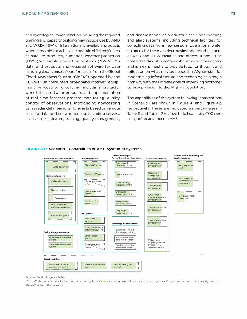
9. ROAD MAP SCENARIOS 75
and hydrological modernization including the required training and capacity building may include use by AMD and WRD-MEW of internationally available products where possible (to achieve economic efficiency) such as satellite products, numerical weather prediction (NWP)/ensemble prediction systems (NWP/EPS) data, and products and required software for data handling (i.e., license); flood forecasts from the Global Flood Awareness System (GloFAS) operated by the ECMWF; uninterrupted broadband internet; equip-ment for weather forecasting, including forecaster workstation software products and implementation of real-time forecast process monitoring, quality control of observations; introducing nowcasting using radar data; seasonal forecasts based on remote sensing data and snow modeling, including servers, licenses for software, training, quality management,
and dissemination of products; flash flood warning and alert systems, including technical facilities for collecting data from new sensors; operational water balances for the main river basins; and refurbishment of AMD and MEW facilities and offices. It should be noted that this list is neither exhaustive nor mandatory and is meant mostly to provide food for thought and reflection on what may be needed in Afghanistan for modernizing infrastructure and technologies along a pathway with the ultimate goal of improving hydromet service provision to the Afghan population.
The capabilities of the system following interventions in Scenario 1 are shown in Figure 41 and Figure 42, respectively. These are indicated as percentages in Table 11 and Table 12 relative to full capacity (100 per-cent) of an advanced NMHS.
FIGURE 41 • Scenario 1 Capabilities of AMD System of Systems
Modeling systemsMonitoring and observing systems
Limited area modelsystem
Objective and impactforecasting and warning systems
ITC systems
Service delivery systems
National data systems
Public-privatecooperative servicessystemsto key businesses
Actions, service monitoring, and feedback systems
Quality management systems
Technology infusion systems
External research and development systems
Internal research and development systems
Transition research to operations systems
Cloud computingsystems
Capacity building
Global data system
Surface obs systems
Data managementand archiving systems
External data systems
Institutional management systems
Data commssystems
Communicationsystems
Computing hardwareand software systems
Operational management systems
Global NWP systems
Regional NWP systems
Met/hydro institutional education and training
Severe hazardforecasting systems
Very short-range forecasting system
Short-range forecasting system
Public weatherservices system
G2G water andenergy managementservices system
G2G agricultureservice system
Upper air systems
Radar system
Stakeholder institutionstraining
End-user training andoutreach
Service systems forpublic
Service systems for national and provincialgovernments
Service systems forbusinesses
G2G disastermanagementservice system
G2G and G2B climateservices system
G2G and G2B aviationservices system
Nowcasting system
Medium-range forecasting system
Long-range forecasting system
Hydro modeling systems
Nowcasting modelsystem
Source: David Rogers (2018).Note: White: lack of capability in a particular system, Green: existing capability in a particular system, Gray Line: where no capability and no activity exist in the system.
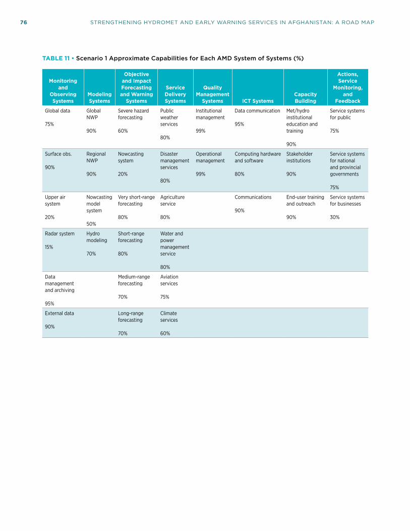
76 STRENGTHENING HYDROMET AND EARLY WARNING SERVICES IN AFGHANISTAN: A ROAD MAP
TABLE 11 • Scenario 1 Approximate Capabilities for Each AMD System of Systems (%)
Monitoring and
Observing Systems
Modeling Systems
Objective and Impact Forecasting and Warning
Systems
Service Delivery Systems
Quality Management
Systems ICT SystemsCapacity Building
Actions, Service
Monitoring, and
Feedback
Global data
75%
Global NWP
90%
Severe hazard forecasting
60%
Public weather services
80%
Institutional management
99%
Data communication
95%
Met/hydro institutional education and training
90%
Service systems for public
75%
Surface obs.
90%
Regional NWP
90%
Nowcasting system
20%
Disaster management services
80%
Operational management
99%
Computing hardware and software
80%
Stakeholder institutions
90%
Service systems for national and provincial governments
75%
Upper air system
20%
Nowcasting model system
50%
Very short-range forecasting
80%
Agriculture service
80%
Communications
90%
End-user training and outreach
90%
Service systems for businesses
30%
Radar system
15%
Hydro modeling
70%
Short-range forecasting
80%
Water and power management service
80%
Data management and archiving
95%
Medium-range forecasting
70%
Aviation services
75%
External data
90%
Long-range forecasting
70%
Climate services
60%

9. ROAD MAP SCENARIOS 77
FIGURE 42 • Scenario 1 Capabilities of MEW System of Systems
Modeling systemsMonitoring and observing systems
Limited area modelsystem
Objective and impactforecasting and warning systems
ITC systems
Service delivery systems
National data systems
Radar system
Public-privatecooperative servicessystemsto key businesses
Actions, service monitoring, and feedback systems
Quality management systems
Technology infusion systems
External research and development systems
Internal research and development systems
Transition research to operations systems
Cloud computingsystems
G2G and G2B climateservices system
Capacity building
Global data system
Surface obs systems
Data managementand archiving systems
External data systems
Institutional management systems
Data commssystems
Communicationsystems
Computing hardwareand software systems
Operational management systems
Global NWP systems
Regional NWP systems
Hydro institutional education and training
Public hydrologicalservices system
G2G water andpower managementservices system
G2G agricultureservice system
Hydro modeling systems
G2G disastermanagementservice system
Stakeholder institutionstraining
End-user training andoutreach
Service systems forpublic
Service systems for national and provincialgovernments
Service systems forbusinesses
Nowcasting system/flash flood guidance
Long-range flood forecasting system
Severe hydro hazardforecasting systems
Very short-range flood forecasting system
Short-range flood forecasting system
Medium-range flood forecasting system
Source: David Rogers (2018).Note: White: lack of capability in a particular system, Green: existing capability in a particular system, Gray Line: where no capability and no activity exist in the system.

78 STRENGTHENING HYDROMET AND EARLY WARNING SERVICES IN AFGHANISTAN: A ROAD MAP
TABLE 12 • Scenario 1 Approximate Capabilities for Each WRD-MEW System of Systems (%)
Monitoring and
Observing Systems
Modeling Systems
Objective and Impact Forecasting and Warning
Systems
Service Delivery Systems
Quality Management
Systems ICT SystemsCapacity Building
Actions, Service
Monitoring, and
Feedback
Global data system
70%
Severe hazard forecasting
50% (avalanches, mudslides, droughts)
Public hydrologic services70%
Institutional management
99%
Data communication
95%
Met/hydro institutional education and training
90%
Service systems for public
75%
Surface obs.
90%
Disaster management services70%
Operational management
99%
Computing hardware and software
80%
Stakeholder institutions
90%
Service systems for national and provincial governments
75%
Very short-range forecasting
70%
Agriculture service
70%
Communications
90%
End-user training and outreach
90%
Service systems for businesses
30%
Hydro modeling
80%
Short-range forecasting
70%
Water and power management service
70%
Data management and archiving
95%
Medium-range forecasting
70%
External data
90%
Long-range forecasting
70%
9.2 Scenario 2: Intermediate Modernization
This is the intermediate investment scenario between Scenarios 1 and 3. This scenario aims to achieve a mod-est improvement in capabilities to provide weather, climate, and hydrological services to meet the needs of at least three most important users such as disaster management, agriculture, and water resources man-agement. This scenario builds on the achievements of Scenario 3 and assumes that the activities needed to achieve critical minimal capabilities to provide weather, climate, and hydrological services have
been accomplished. If on the other hand this scenario represents a combination of technical assistance and a modest scale of modernization, then all activities under Scenario 3 have to be included under this scenario. These include development/enhancement of WRD-MEW and AMD’s capacity in the use and interpretation of available and accessible tools and technologies; developing a national Strategy for Service Delivery (SSD); establishing a hydrometeorological user group; developing a CONOPS for Scenario 2; enhancing service provision to key government stakeholders; training; accessing and full usage of NWP data and products from other centers to improve short-range weather forecasting and introduction to impact-based forecasting; enhanced use of remote sensing

9. ROAD MAP SCENARIOS 79
FIGURE 43 • Capabilities of AMD System of Systems
Modeling systemsMonitoring and observing systems
Limited area modelsystem
Nowcasting modelsystem
Objective and impactforecasting and warning systems
ITC systems
Nowcasting system
Service delivery systems
National data systems
Upper air systems
Radar system
Public-privatecooperative servicessystemsto key businesses
Actions, service monitoring, and feedback systems
Service systems forbusinesses
Quality management systems
Technology infusion systems
External research and development systems
Internal research and development systems
Transition research to operations systems
Cloud computingsystems
G2G and G2B climateservices system
G2G and G2B aviationservices system
Capacity building
Global data system
Surface obs systems
Data managementand archiving systems
External data systems
Institutional management systems
Data commssystems
Communicationsystems
Computing hardwareand software systems
Operational management systems
Global NWP systems
Regional NWP systems
Severe hazardforecasting systems
Very short-range forecasting system
Short-range forecasting system
Public weatherservices system
G2G water andenergy managementservices system
G2G agricultureservice system
Met/hydro institutional education and training
End-user training andoutreach
Stakeholder institutionstraining
Hydro modeling systems
Medium-range forecasting system
G2G disastermanagementservice system
Service systems forpublic
Service systems for national and provincialgovernments
Long-range forecasting system
Source: David Rogers (2018).Note: White: lack of capability in a particular system, Green: existing capability in a particular system, Gray Line: where no capability and no activity exist in the system.
products for hydrological services; enhancing long-range forecasting and hydrological forecasting; and procuring computing and communication equipment as required.
In addition to the specific activities listed under Scenario 3, under this scenario the following may be undertaken:
1. Rehabilitation of high priority meteorological observation stations and addition of stations in strategic areas within the available resources;
2. Optimization of the hydrological network in line with major requirements of water management and installation of new automated water level recorders as required, within the available resources;
3. Replacement of water level recording systems at selected gauges and implementation of data transmissions;
4. Modernization of AMD and WRD-MEW data management, communication and ICT systems;
5. Training on Ensemble Prediction System (EPS) and probabilistic forecasting;
6. Enhanced training on impact-based forecasting;
7. Initiation of hydrological forecasting using flood modeling;
8. Establishment of a national framework for climate services;
9. Training of stakeholders and end-users to build their understanding and capacity in using hydromet information;
10. Expanding the QMS to cover most operational and institutional systems in AMD and WRD-MEW; and
11. Initiating/strengthening monitoring and feedback systems.

80 STRENGTHENING HYDROMET AND EARLY WARNING SERVICES IN AFGHANISTAN: A ROAD MAP
TABLE 13 • Scenario 2 Approximate Capabilities for Each AMD System of Systems (%)
Monitoring and
Observing Systems
Modeling Systems
Objective and Impact Forecasting and Warning
Systems
Service Delivery Systems
Quality Management
Systems ICT SystemsCapacity Building
Actions, Service
Monitoring, and
Feedback
Global data
60%
Global NWP
70%
Severe hazard forecasting
60%
Public weather services
60%
Institutional management
70%
Data communication
50%
Met/hydro institutional education and training
60%
Service systems for public
20%
Disaster management services
50%
Operational management
50%
Computing hardware and software
50%
Stakeholder institutions
60%
Service systems for national and provincial governments
20%
Surface obs.
50%
Regional NWP
7%
Very short-range forecasting
60%
Agriculture service
50%
Communications
40%
End-user training and outreach
60%
Data management and archiving
75%
Hydro modeling
10%
Short-range forecasting
60%
Water and power management service
50%
External data
70%
Medium-range forecasting
30%
Long-range forecasting
30%
The budget for this scenario should include the esti-mated cost of the new equipment, tools, instrumenta-tion, and software. The O&M budget for this scenario (approximately 10 percent of the total budget) should be used for, among others, spare parts, consumables, fuel, increased communication, power, and other operating costs. AMD has to recruit and train addi-tional staff and to retrain the existing staff including forecasters, modelers, ICT specialists, engineers and
communication specialists, in order to cope with the introduction of new technologies in the department. Additional trained hydrologists should be recruited through WRD-MEW as needed. While it is difficult to project the exact number and composition of the staff required in the future, it is evident that this will be another significant budget item. The implementation of this scenario should be completed within at least four years.

9. ROAD MAP SCENARIOS 81
The expected capabilities of MEW through the activi-ties carried out under Scenario 1 are reflected in the resulting “System of Systems” as shown in Figure 43 and Table 13.
The expected capabilities of MEW through the activi-ties carried out under Scenario 2 are reflected in the resulting “System of Systems” as shown in Figure 44 and Table 14.
FIGURE 44 • Scenario 2 Capabilities of MEW System of Systems
Modeling systemsMonitoring and observing systems
Limited area modelsystem
Objective and impactforecasting and warning systems
ITC systems
Service delivery systems
National data systems
Radar system
Public-privatecooperative servicessystemsto key businesses
Actions, service monitoring, and feedback systems
Quality management systems
Technology infusion systems
External research and development systems
Interna research and development systems
Transition research to operations systems
Cloud computingsystems
G2G and G2B climateservices system
Capacity building
Global data system
Surface obs systems
Data managementand archiving systems
External data systems
Institutional management systems
Data commssystems
Communicationsystems
Computing hardwareand software systems
Operational management systems
Global NWP systems
Regional NWP systems
Hydro institutional education and training
Public hydrologicalservices system
G2G water andpower managementservices system
G2G agricultureservice system
Hydro modeling systems
G2G disastermanagementservice system
Stakeholder institutionstraining
End-user training andoutreach
Service systems forpublic
Service systems for national and provincialgovernments
Service systems forbusinesses
Nowcasting system/flash flood guidance
Long-range flood forecasting system
Severe hydro hazardforecasting systems
Very short-range flood forecasting system
Short-range flood forecasting system
Medium-range flood forecasting system
Source: David Rogers (2018).Note: White: lack of capability in a particular system, Green: existing capability in a particular system, Gray Line: where no capability and no activity exist in the system.

82 STRENGTHENING HYDROMET AND EARLY WARNING SERVICES IN AFGHANISTAN: A ROAD MAP
TABLE 14 • Scenario 2 Approximate Capabilities for Each WRD-MEW System of Systems (%)
Monitoring and
Observing Systems
Modeling Systems
Objective and Impact Forecasting and Warning
Systems
Service Delivery Systems
Quality Management
Systems ICT SystemsCapacity Building
Actions, Service
Monitoring, and
Feedback
Global data
60%
Severe hazard forecasting
30% (avalanches, mudslides, droughts)
Public hydrologic services
70%
Institutional management
40%
Data communication
60%
Met/hydro institutional education and training
70%
Service systems for public
30%
Surface obs.
70%
Disaster management services
70%
Operational management
40%
Computing hardware and software
60%
Stakeholder institutions50%
Service systems for national and provincial governments
30%
Very short-range forecasting
30%
Agriculture service
70%
Communications
60%
End-user training and outreach
50%
Hydro modeling
40%
Short-range forecasting
30%
Water and power management service
70%
Data management and archiving
60%
Medium-range forecasting
30%
External data
60%
Long-range forecasting
30%
9.3 Scenario 3: Technical Assistance for High Priority and Immediate Needs
Low-cost, high-priority activities are needed to achieve critical minimal capabilities to provide weather, climate, and hydrological services (focused on improving basic public services based on strengthening WRD-MEW and AMD’s capacity in the use and interpretation of available and accessible tools and technologies and introducing basic affordable new technologies) as indicated below. Activities focus on: developing a
national Strategy for Service Delivery (SSD); establish-ing a hydrometeorological user group; developing a CONOPS; establishing/strengthening a collaborative approach for service provision to key government stakeholders; training; accessing and full usage of NWP data and products from other centers; enhanced use of remote sensing products for hydrological services; initiating basic long-range forecasting and hydro-logical forecasting; procuring basic computing and communication equipment as required; and revising seasonal river forecast methods. The implementation of this scenario should be completed within at least two years.

9. ROAD MAP SCENARIOS 83
Strengthening service delivery through:
1. Developing a national Strategy for Service Delivery (SSD) based on the WMO Strategy for Service Delivery and its Implementation Plan;
2. Establishing a hydrometeorological user group for development and enhancement of different services and to improve coordination among service providers and improve liaison and response to users;
3. Developing a CONOPS to guide design of activities for different systems under this scenario;
4. Initiating/strengthening a QMS gradually across the AMD and WRD-MEW institutional and operational systems;
5. Initiating in collaboration with key government stakeholders especially ANDMA and MAIL the provision of information and services for DRM and agriculture; and
6. Enhancing the provision of PWS and hydrological services through better dissemination channels and improved communication techniques.
Improvement of short- and medium-range weather forecasting through:
1. Several rounds of training to build on current capa-bilities of forecasters to enhance the understanding and as full a use of NWP data and products for short- to medium-range forecasts from leading global centers (e.g., ECMWF, GFS, UK) as possible;
2. Verification of forecasts;
3. Initial and follow-up training to introduce the concept and basic application of impact-based forecasting through interpreting forecasts and adding other information to demonstrate the impact of weather and associated hazards;
4. Purchase of license for access to graphical data from a global center (e.g., ECMWF);
5. Initial training to introduce Ensemble Prediction System (EPS) and the concept of probabilistic forecasting and its benefits; and
6. Developing proposals for optimization of the meteorological/climate networks, design, and configuration of automated meteorological monitoring systems (e.g., choice of technologies
considering local conditions, costs of ownerships, and O&M costs).
Improvement of long-range weather forecasting through:
1. Several rounds of training to build up knowledge and understanding of concepts related to long-range forecasting;
2. Access to and use of products from Global Produc-ing Centers for long-range forecasts;
3. Tailoring long-range forecasts for specific applica-tions and users; and
4. Introduction to concepts of climate modeling and downscaling.
Improvements in other areas of AMD activities:
1. Training on the operation and maintenance of the new short-, medium-, and long-range forecast systems including the use of any new software, models, and techniques taught during the train-ing; and
2. Procurement of required hard and software for data management and the associated training.
Improvements of the hydrological services of MEW:
1. Improvement of hydrological data analyses by applied statistics: for example, training on the application of the widely used R-packages (share-ware) for time series analyses and statistical regionalization to provide hydrological information at ungauged sites (if needed in view of existing statistical software), to be followed with more training on the applications of statistical tools for trend analyses in data series and statistics of extremes;
2. Basics of hydrological data management: Introduc-tion to hydrological data management systems and how data quality and long-term access to observations can be assured. To be followed up through setting up the data management system MHC of WMO and its operational application. In view of the current data management system AQUARIUS, this point should be considered only if a different system of data management may be required;

84 STRENGTHENING HYDROMET AND EARLY WARNING SERVICES IN AFGHANISTAN: A ROAD MAP
3. Strengthening the application of GIS, either by introducing QGIS software (freeware), if no GIS system exists, or by using an already existing system such as ArcGIS;
4. Regionalization to provide hydrological information at ungauged sites, training on the applications of statistical tools for trend analyses in data series, and statistics of extremes; and
5. Flood forecasting and flood risk management: improvement of hydrological flood forecasts (purchase of one server and two workstations is essential).
The expected capabilities of AMD through the activi-ties carried out under Scenario 1 are reflected in the resulting “System of Systems” as shown in Figure 45 and Table 15.
The expected capabilities of MEW through the activi-ties carried out under Scenario 3 are reflected in the resulting “System of Systems” as shown in Figure 46 and Table 16.
FIGURE 45 • Scenario 1 Capabilities of AMD System of Systems
Modeling systemsMonitoring and observing systems
Limited area modelSystem
Nowcasting modelsystem
Objective and impactforecasting and warning systems
ITC systems
Nowcasting system
Service delivery systems
National data systems
Upper air systems
Radar system
Public-privatecooperative servicessystemsto key businesses
Actions, service monitoring, and feedback systems
Service systems forbusinesses
Quality management systems
Technology infusion systems
External research and development systems
Internal research and development systems
Transition research to operations systems
Cloud computingsystems
G2G and G2B climateservices system
G2G and G2B aviationservices system
Capacity building
Global data system
Surface obs systems
Data managementand archiving systems
External data systems
Institutional management systems
Data commssystems
Communicationsystems
Computing hardwareand software systems
Operational management systems
Global NWP systems
Regional NWP systems
Severe hazardforecasting systems
Very short-range forecasting system
Short-range forecasting system
Public weatherservices system
G2G water andenergy managementservices system
G2G agricultureservice system
Met/hydro institutional education and training
End-user training andoutreach
Stakeholder institutionstraining
Hydro modeling systems
Medium-range forecasting system
G2G disastermanagementservice system
Service systems forpublic
Service systems for national and provincialgovernments
Long-range forecasting system
Source: David Rogers (2018).Note: White: lack of capability in a particular system, Green: existing capability in a particular system, Gray Line: where no capability and no activity exist in the system.

9. ROAD MAP SCENARIOS 85
TABLE 15 • Scenario 1 Approximate Capabilities for AMD System of Systems (%)
Monitoring and
Observing Systems
Modeling Systems
Objective and Impact Forecasting and Warning
Systems
Service Delivery Systems
Quality Management
Systems ICT SystemsCapacity Building
Actions, Service
Monitoring, and
Feedback
Global data
45%
Global NWP
30%
Severe hazard forecasting
40%
Public weather services
45%
Institutional management
70%
Data communication
10%
Met/hydro institutional education and training
40%
Service systems for national and provincial governments
20%
Disaster management services
25%
Operational management
10%
Computing hardware and software
10%
Stakeholder institutions20%
Surface obs.
30%
Regional NWP
55%
Very short-range forecasting
50%
Agriculture service
30%
Communications
10%
End-user training and outreach
20%
Data management and archiving
10%
Short-range forecasting
50%
Water and power management service
30%
External data
50%
Medium-range forecasting
20%
Long-range forecasting
20%

86 STRENGTHENING HYDROMET AND EARLY WARNING SERVICES IN AFGHANISTAN: A ROAD MAP
FIGURE 46 • Scenario 3 Capabilities of MEW System of Systems
Modeling systemsMonitoring and observing systems
Limited area modelsystem
Objective and impactforecasting and warning systems
ITC systems
Service delivery systems
National data systems
Radar system
Public-privatecooperative servicessystemsto key businesses
Actions, service monitoring, and feedback systems
Quality management systems
Technology infusion systems
External research and development systems
Internal research and development systems
Transition research to operations systems
Cloud computingsystems
G2G and G2B climateservices system
Capacity building
Global data system
Surface obs systems
Data managementand archiving systems
External data systems
Institutional management systems
Data commssystems
Communicationsystems
Computing hardwareand software systems
Operational management systems
Global NWP systems
Regional NWP systems
Hydro institutional education and training
Public hydrologicalservices system
G2G water andpower managementservices system
G2G agricultureservice system
Hydro modeling systems
G2G disastermanagementservice system
Stakeholder institutionstraining
End-user training andoutreach
Service systems forpublic
Service systems for national and provincialgovernments
Service systems forbusinesses
Nowcasting system/flash flood guidance
Long-range flood forecasting system
Severe hydro hazardforecasting systems
Very short-range flood forecasting system
Short-range flood forecasting system
Medium-range flood forecasting system
Source: David Rogers (2018).Note: White: lack of capability in a particular system, Green: existing capability in a particular system, Gray Line: where no capability and no activity exist in the system.

9. ROAD MAP SCENARIOS 87
TABLE 16 • Scenario 3 Approximate Capabilities for MEW System of Systems (%)
Monitoring and
Observing Systems
Modeling Systems
Objective and Impact Forecasting and Warning
Systems
Service Delivery Systems
Quality Management
Systems ICT SystemsCapacity Building
Actions, Service
Monitoring, and
Feedback
Global data
50%
Severe hazard forecasting
10%
Public hydrological services
20%
Institutional management
30%
Data communication
50%
Met/hydro institutional education and training
70%
Service systems for public
10%
Disaster management services20%
Operational management
30%
Computing hardware and software
40%
Stakeholder institutions30%
Service systems for national and provincial government
10%
Surface obs.
70%
Very short-range flood forecasting
10%
Agriculture service
20%
Communications
40%
End-user training and outreach
20%
Data management and archiving
60%
Water and power management service
20%
External data
40%


89
10. SOCIOECONOMIC BENEFITS OF IMPROVED HYDROMETEOROLOGICAL SERVICES AND EARLY WARNING SYSTEMS
In order for AMD and WRD-MEW to improve the quality, diversity, and coverage of their services, they must secure adequate and sustained funding. It is now
a common practice for hydromet service providers to undertake a cost–benefit analysis to secure and optimize the use of investment resources. In all of the cases where such analyses have taken place, it has been demonstrated that the benefits of hydromet services are significantly larger than the capital and operational costs needed to modernize, produce, and deliver them. As public services, AMD, and WRD-MEW are expected to deliver socioeconomic benefits to the welfare of Afghanistan society. By comparing the costs and benefits of project options over time, an understanding of the relative value of the planned investments can be generated.
Hydrometeorological services do not generate economic and social value unless users benefit from decisions informed by the information provided, even if the ser-vices are of the highest quality. Decision making at all levels needs robust and understandable information. The more the information produced by AMD and WRD-MEW is available and accessible, the more socioeconomic value it can deliver. Further, the more skilled decision makers are in utilizing those services and information, the more value they can deliver. To optimize investment benefits, the AMD and WRD-MEW modernization must therefore focus on service delivery and ensuring that users can productively apply those services.
Recent assessments have applied different method-ologies as described in the authoritative publication Valuing Weather and Climate: Economic Assessment of Meteorological and Hydrological Services.52 This includes further-refined, sector-specific and bench-marking approaches.
52 WMO, GFDRR/World Bank, and USAID (2015).
It should be noted that cost–benefit analysis for disaster and climate risk management in a developing country context is generally challenged by lack of data and information. Further, complexities and uncertainties are inherent in quantifying disaster risk management and are further compounded by climate change. Cost–benefit analysis is also challenged in handling intangibles and discounting of future impacts, which is particularly important for extreme events.53
An assessment of overall economic benefits as a result of a modernization project had been carried out for Afghanistan using well-known economic methodol-ogy. The results indicated that strengthening of the hydromet and EW services will yield a benefit–cost ratio ranging from 1.45 to 12.86. In view of the sub-stantial recurring losses due to hazards such as floods, droughts, landslides, and mudflows, it is clear that any enhancement in the capacity and capability of AMD and WRD-MEW to produce better forecasts and warnings and disseminate them more effectively, will be a sound policy and will lead to improvement in the generation of services to mitigate the impact of these hazards. Such services are currently lacking and thus will lead to benefits both from the perspective of reduction of risk to life and property, as well as in generating economic benefits. Furthermore, projected climate change, demographic and development impacts indicate increased negative impacts of weather and climate in the future. Investments like this project are needed to manage these risks. Development of a more specific cost–benefit analysis may therefore be deemed necessary in the future for the detailed design and implementation of projects based on the different scenarios offered in the Road Map.
53 IPCC (2012).


91
11. CONCLUSIONS AND A WAY FORWARD
The strategic steps needed to modernize hydrome-teorological products and services in Afghanistan are primarily driven by the needs of the user
community. Extensive discussions with AMD and WRD-MEW management and technical staff and key stakeholders dealing with the most pressing issues in the country, such as food and water security, and emergency management and response, have revealed that the provision of meteorological and hydrological information at present does not fully meet those needs. At present, the activities of AMD and WRD-MEW are mainly focused on observation and data collection with limited forecasting. The existing situation in Afghanistan shows that due to lack of resources and conflicts since the 1990s, AMD has fallen behind even in this task, as well as in the production of forecasts and delivery of services and making the technological and scientific progress needed to use best practices and standards in delivering services. Addressing these issues will require a joint approach involving all stakeholders and targeted to ensure that all elements of the meteorological and hydrological data, and information and services chain are addressed.
The AMD’s main products include basic weather forecasts for the public and other users. No EWS exists in the country for issuing warnings of severe weather events. No agrometeorological forecasts nor flood forecasts are produced, and assessment of the water resources of the country are lacking. The AMD’s use of numerical weather prediction (NWP) is limited to producing basic public forecasts. It has no technical means to produce nowcasts needed for warnings.It does not run any climate models and does not produce seasonal outlooks and climate projection. In addition, WRD-MEW does not run any hydrological or hydraulic models necessary for flood forecasting in the country.
Many requests by stakeholders clearly reflect the need for modernization of the entire infrastructure of AMD and MEW, to produce fit-for-purpose services. To achieve this, AMD needs to reach the level of a modern
developing country’s NMHS. This implies enhancing its meteorological observing system to adequate spatial coverage and technical diversity; building a robust data management system; a forecasting system with increased accuracy, lead time, and timescales from very short-, to short- to long-range, and seasonal forecasts; impact-based forecasts; an ICT system capable of archiving, storing, and transmitting data; and an effective service delivery system. Similarly, the capacity of WRD-MEW needs to be strengthened for similar production of hydrological services and flood forecasting. The user requirements should in the case of both organizations be the driving factor for the modernization of their system of systems.
As public services, AMD and MEW are expected to deliver socioeconomic benefits for the welfare of Afghan society.
Three scenarios to modernize the AMD and WRD-MEW have been presented: (i) an advanced modernization option of investment to bring AMD and WRD-MEW up to the level of well-functioning developing countries’ capabilities for providing data, forecasts, and warning services; (ii) the provision of technical assistance for a set of low-cost, high-priority activities options focused on improvement of basic public services based on strengthening AMD and WRD-MEW’s capacity and introducing basic affordable new technologies; and (iii) a second scenario which falls in between the two, with investment to achieve a modest improvement in capabilities to provide hydrological, weather, and climate services to meet the needs of the three most important users. Naturally, the level of complexity and required resources increases with each scenario.
Scenario 1: Advanced modernization includes invest-ment needed to bring the AMD and WRD-MEW to the level of well-functioning developing countries’ capabilities for providing data, forecasts, and warn-ing services to meet user needs (i.e., focused on improving hydrometeorological and climate services).

92 STRENGTHENING HYDROMET AND EARLY WARNING SERVICES IN AFGHANISTAN: A ROAD MAP
This scenario, which is a much more comprehensive modernization option, will raise the level of capability of AMD and MEW at the successful conclusion of at least a seven-year investment plan to that of a well-functioning developing country. This option will be guided by three main modernization components: (i) enhancement of service delivery; (ii) institutional strengthening and capacity building; and (iii) modern-ization of observation infrastructure, data management systems, and forecasting
Scenario 2: Intermediate modernization includes investment needed to achieve a modest improvement in capabilities to provide hydrological, weather, and climate services over a period of at least four years to meet the needs of the most important users (i.e., focused on strengthening hydromet observation, data analysis, and forecasting and on developing and providing priority services).
Scenario 3: Low-cost, high-priority activities are needed to achieve, over a period of at least two years, critical minimal capabilities to provide weather, climate, and hydrological services (focused on improvement of basic public services based on strengthening AMD and MEW capacity and introducing basic affordable new technologies underpinned by priority capacity building and institutional strengthening activities). Most activities in this scenario are focused on training; access and use of NWP data and products; procure-ment of some basic computing and communication equipment; revision of seasonal river forecast methods; and establishing a user group.
Developing a Concept of Operations (CONOPS) is essential for the detailed planning and implementation of each scenario.

93
Annex 1. Required Training Areas
The following list is indicative of areas for which training is generally required by NMHSs. The exact areas of training for AMD and WRD-MEW will be defined based on their requirements following a thorough assessment of the current capabilities and gaps
in the knowledge of the relevant staff. Other areas may be added to this list as needed.
• Project management;
• Management training;
• Technical skills to support meteorological and hydrological observing networks;
• Instruments and sensors maintenance;
• Enhanced skills in weather forecasting using numerical models on all timescales from nowcasting to long-range forecasting;
• Enhanced skills in weather forecasting based on remote sensing;
• Enhanced skills in flood forecasting using numerical models;
• Enhanced skills in deterministic seasonal forecasting using snow models;
• Understanding of the end-to-end early warning production and delivery;
• Impact-based forecasting and warning services including for hazards such as floods, landslides, avalanches, droughts;
• Mesoscale meteorology;
• Verification and statistics methods for model evaluation;
• Data base management;
• IT management skills;
• Skills in the delivery of public weather and hydrological services, including user/ stakeholder consultation, communication, negotiation, and feedback gathering;
• Enhanced skill in climate prediction using numerical methods; and
• Public education and outreach.

94
Ann
ex 2
. Ser
vice
Del
iver
y P
rog
ress
Mo
del
The
Ser
vice
Del
iver
y P
rog
ress
Mo
del
is a
dap
ted
fro
m W
MO
No
. 112
9—
The
WM
O S
trat
egy
for
Ser
vice
Del
iver
y an
d it
s Im
ple
men
tati
on
Pla
n. T
he
mo
del
can
be
used
as
a to
ol f
or
asse
ssin
g t
he le
vel o
f d
evel
op
men
t o
f N
MH
Ss
and
cre
atin
g a
n ac
tio
n p
lan
to im
pro
ve s
ervi
ce d
eliv
ery.
Ful
l d
etai
ls c
an b
e fo
und
in h
ttp
://w
ww
.wm
o.in
t/p
ages
/pro
g/a
mp
/pw
sp/d
ocu
men
ts/W
MO
-SS
D-1
129
_en.
pd
f.
Und
evel
oped
Dev
elop
men
t In
itia
ted
Dev
elop
men
t in
Pro
gres
sD
evel
oped
Adv
ance
d
The
user
s an
d th
eir
requ
irem
ents
for p
rodu
cts
or
serv
ices
is n
ot k
now
n.
Use
rs a
re k
now
n, b
ut n
o pr
oces
s fo
r use
r eng
agem
ent
exis
ts.
Use
r req
uire
men
ts fo
r ser
vice
de
liver
y ar
e no
t wel
l def
ined
.
Use
rs a
re a
ble
to c
onta
ct th
e N
MH
S an
d th
eir f
eedb
ack
is
reco
rded
.
Ther
e ar
e so
me
form
al
proc
esse
s fo
r int
egra
ting
the
feed
back
rece
ived
into
the
deve
lopm
ent o
f ser
vice
s.
Use
r req
uire
men
ts a
re d
efin
ed
with
lim
ited
docu
men
tatio
n.
NM
HS
seek
s in
put o
n an
ad
hoc
bas
is fr
om u
sers
to
faci
litat
e th
e de
velo
pmen
t of
serv
ices
.
Requ
irem
ents
are
def
ined
in
doc
umen
ts a
gree
d up
on
with
the
cust
omer
but
are
not
ro
utin
ely
upda
ted.
An
ongo
ing
dial
ogue
is
mai
ntai
ned
with
use
rs
rega
rdin
g th
eir n
eeds
and
the
serv
ices
they
rece
ive.
Requ
irem
ents
are
def
ined
in
docu
men
ts a
gree
d up
on w
ith
the
cust
omer
and
rout
inel
y up
date
d us
ing
feed
back
from
us
ers.
Stra
tegy
ele
men
t 1Ev
alua
te u
ser n
eeds
an
d de
cisi
ons
Und
evel
oped
Dev
elop
men
t In
itia
ted
Dev
elop
men
t in
Pro
gres
sD
evel
oped
Adv
ance
d
No
conc
ept o
f ser
vice
exi
sts,
pr
oduc
ts a
re s
impl
y is
sued
.
Serv
ices
do
not a
dapt
to
chan
ging
use
r nee
ds a
nd n
ew
tech
nolo
gy.
Prod
ucts
are
doc
umen
ted
with
lim
ited
desc
riptiv
e in
form
atio
n.
Serv
ices
are
dev
elop
ed a
nd
chan
ged
as te
chno
logy
al
low
s, b
ut e
ngag
emen
t with
us
ers
is a
d ho
c.
Prod
ucts
and
ser
vice
s ar
e do
cum
ente
d, a
nd th
e in
form
atio
n is
use
d to
info
rm
man
agem
ent o
f cha
nges
.
Use
r fee
dbac
k is
use
d to
in
form
man
agem
ent o
f ch
ange
s an
d de
velo
pmen
ts to
se
rvic
es.
Prod
ucts
and
ser
vice
s ar
e co
nsis
tent
ly d
ocum
ente
d.
Serv
ice
Leve
l Agr
eem
ents
(S
LAs)
are
def
ined
.
Use
rs a
re c
onsu
lted
to
faci
litat
e de
velo
pmen
t of
prod
ucts
and
ser
vice
s.
The
serv
ice
defin
ed in
the
SLA
is a
gree
d up
on w
ith
the
cust
omer
bas
ed o
n us
er
cons
ulta
tion.
Stra
tegy
ele
men
t 2Li
nk s
ervi
ce d
evel
opm
ent
and
deliv
ery
to u
ser n
eeds

ANNEX 2. SERVICE DELIVERY PROGRESS MODEL 95
Und
evel
oped
Dev
elop
men
t In
itia
ted
Dev
elop
men
t in
Pro
gres
sD
evel
oped
Adv
ance
d
No
mea
sure
s ar
e in
pla
ce
for a
sses
sing
per
form
ance
, ei
ther
in te
rms
of a
ccur
acy
or
serv
ice
deliv
ery.
Som
e m
easu
res
of
deve
lopm
ent a
re in
pla
ce.
The
verif
icat
ion
of a
ccur
acy
and/
or s
ervi
ce d
eliv
ery
take
s pl
ace,
but
no
syst
emat
ic
proc
ess
exis
ts to
use
this
in
form
atio
n to
impr
ove
the
serv
ice.
Mea
sure
s of
ver
ifica
tion
and
serv
ice
deliv
ery
are
in p
lace
bu
t are
not
info
rmed
by
user
re
quire
men
ts.
Use
r req
uire
men
ts a
re u
sed
as d
ata
for p
erfo
rman
ce
mea
sure
s.
Find
ings
are
use
d to
iden
tify
area
s fo
r im
prov
emen
t.
Subs
eque
nt a
ctio
ns a
re ta
ken
in a
n ad
hoc
man
ner.
Mea
sure
s of
per
form
ance
are
ba
sed
on u
ser n
eeds
, whi
ch
are
regu
larly
repo
rted
and
co
nsis
tent
ly u
sed
to in
form
de
cisi
ons
on im
prov
emen
ts.
Stra
tegy
ele
men
t 3Ev
alua
te a
nd m
onito
r ser
vice
pe
rfor
man
ce a
nd o
utco
mes
Und
evel
oped
Dev
elop
men
t In
itia
ted
Dev
elop
men
t in
Pro
gres
sD
evel
oped
Adv
ance
d
No
conc
ept e
xist
s of
ser
vice
de
liver
y pr
inci
ples
.
The
conc
ept o
f ser
vice
de
liver
y ha
s be
en in
trod
uced
an
d an
ass
essm
ent o
f cur
rent
st
atus
has
bee
n un
dert
aken
.
An
actio
n pl
an h
as b
een
crea
ted
to im
prov
e th
e cu
rren
t lev
el o
f ser
vice
de
liver
y an
d re
sour
ces
ha
ve b
een
iden
tifie
d to
im
plem
ent i
t.
The
actio
n pl
an is
bei
ng
impl
emen
ted
to im
prov
e se
rvic
e de
liver
y, th
e ou
tcom
es
are
bein
g m
onito
red.
The
stat
us o
f ser
vice
del
iver
y is
revi
ewed
on
a re
gula
r bas
is.
The
actio
n pl
an e
volv
es in
re
spon
se to
the
outc
ome
of
the
revi
ews.
Stra
tegy
ele
men
t 4Su
stai
n im
prov
ed s
ervi
ce
deliv
ery
Und
evel
oped
Dev
elop
men
t In
itia
ted
Dev
elop
men
t in
Pro
gres
sD
evel
oped
Adv
ance
d
No
conc
ept o
r com
mun
icat
ion
of s
ervi
ce d
eliv
ery
prin
cipl
es
exis
t.
No
form
al tr
aini
ng in
ser
vice
de
liver
y is
pro
vide
d, th
ough
se
rvic
e de
liver
y pr
inci
ples
are
info
rmal
ly c
omm
unic
ated
.
Mos
t sta
ff o
f the
NM
HS
are
awar
e of
the
impo
rtan
ce o
f se
rvic
e de
liver
y.
Som
e fo
rmal
trai
ning
ispr
ovid
ed.
All
mem
bers
of s
taff
are
fully
aw
are.
Form
al tr
aini
ng is
pro
vide
d.
Ther
e is
an
ad h
oc p
roce
ss
for s
taff
to o
ffer i
deas
for
impr
ovem
ents
to s
ervi
cede
liver
y.
Ther
e is
a c
ultu
re o
f pro
vidi
ng
best
pos
sibl
e se
rvic
e de
liver
y.
Inno
vativ
e id
eas
are
rout
inel
y in
tegr
ated
into
the
cont
inua
l se
rvic
e im
prov
emen
t pro
cess
.
Stra
tegy
ele
men
t 5D
evel
op s
kills
nee
ded
to
sus
tain
ser
vice
del
iver
y
NM
HSs
are
enc
oura
ged
to s
hare
bes
t pra
ctic
es in
ser
vice
del
iver
y th
roug
h fo
rmal
trai
ning
, tw
inni
ng, m
ento
ring,
and
othe
r met
hods
.
Stra
tegy
ele
men
t 6Sh
are
best
pra
ctic
es
and
know
ledg
e

96
Ann
ex 3
. Ob
serv
atio
n an
d T
elec
om
mun
icat
ion
Pro
gre
ss M
od
el
Und
evel
oped
Dev
elop
men
t In
itia
ted
Dev
elop
men
t in
Pro
gres
sD
evel
oped
Adv
ance
d
NM
HS
has
very
few
man
ual
syno
ptic
sta
tions
and
hy
drol
ogic
al s
tatio
ns. I
t doe
s no
t sha
re th
ese
data
on
the
Glo
bal T
elec
omm
unic
atio
n Sy
stem
(GTS
).
NM
HS
has
the
capa
city
to
sup
port
a s
ynop
tic
met
eoro
logi
cal n
etw
ork
and
hydr
olog
ical
net
wor
k; s
hare
s th
ese
data
on
the
GTS
; has
su
ffic
ient
sta
ff to
mai
ntai
n its
ob
serv
ing
netw
orks
.
Aut
omat
ion
of o
bser
ving
ne
twor
k w
ith q
ualit
y co
ntro
l is
rout
ine.
NH
MS
acce
sses
sa
telli
te d
ata
with
, e.g
., th
e ca
paci
ty to
der
ive
prec
ipita
tion
estim
ates
. Th
e ob
serv
ing
netw
ork
is
sust
aina
ble
with
suf
ficie
nt
budg
et fo
r ope
ratio
ns a
nd
mai
nten
ance
. The
ver
tical
st
ruct
ure
of th
e at
mos
pher
e m
ay b
e ro
utin
ely
mea
sure
d.
Obs
erva
tions
ext
end
to
smal
ler s
cale
s an
d in
clud
e gr
ound
-bas
ed re
mot
e se
nsin
g te
chni
ques
, suc
h as
rada
r. Th
e N
MH
S m
ay b
e ab
le to
take
an
d in
tegr
ate
obse
rvat
ions
fr
om o
ther
par
ties.
It m
ay a
cces
s ob
serv
atio
ns
by o
utso
urci
ng it
s ob
serv
ing
requ
irem
ents
.
NM
HS
cond
ucts
rese
arch
, in
trod
ucin
g ne
w o
bser
vatio
nal
tech
nolo
gies
and
tech
niqu
es
as n
eede
d. T
he o
bser
ving
ne
twor
k is
com
preh
ensi
ve
and
suff
icie
nt to
mee
t mai
n us
er n
eeds
; inc
orpo
rate
s ex
tern
al o
bser
vatio
ns fr
om
othe
r sup
plie
rs, f
or e
xam
ple,
ag
rom
eteo
rolo
gica
l net
wor
k op
erat
ed b
y a
Min
istr
y of
A
gric
ultu
re o
r hyd
rolo
gica
l ne
twor
k op
erat
ed b
y a
Min
istr
y of
Ene
rgy
or W
ater
Re
sour
ces.
Obs
erva
tions
and
Te
leco
mm
unic
atio
ns

97
Ann
ex 4
. Fo
reca
stin
g P
rog
ress
Mo
del
Und
evel
oped
Dev
elop
men
t In
itia
ted
Dev
elop
men
t in
Pro
gres
sD
evel
oped
Adv
ance
d
NM
HS
prov
ides
up
to tw
o-da
ys d
eter
min
istic
fore
cast
ba
sed
on g
raph
ical
fore
cast
pr
oduc
ts re
trie
ved
from
di
ffere
nt w
eb s
ourc
es. T
here
is
no
verif
icat
ion
of fo
reca
sts.
Th
e N
MH
S do
es n
ot o
pera
te
fore
cast
ing
on a
24-
hour
, se
ven-
days
-a-w
eek
basi
s; a
nd
war
ning
s ar
e no
t iss
ued.
NM
HS
can
prov
ide
at le
ast
thre
e-da
ys d
eter
min
istic
fo
reca
sts
base
d on
acc
ess
to g
loba
l and
regi
onal
NW
P da
ta a
nd p
rodu
cts
avai
labl
e on
the
GTS
and
/or g
raph
ical
pr
oduc
ts a
vaila
ble
from
W
MO
RSM
Cs; m
onito
rs
the
curr
ent w
eath
er a
nd
hydr
olog
ical
sys
tem
; has
ba
sic
data
pro
cess
ing
and
arch
ivin
g sy
stem
s; c
arrie
s ou
t sub
ject
ive
fore
cast
ve
rific
atio
n. T
here
is n
o re
sear
ch a
nd d
evel
opm
ent,
and
the
qual
ity m
anag
emen
t sy
stem
is ru
dim
enta
ry. T
he
NM
HS
may
not
ope
rate
fo
reca
stin
g on
a 2
4-ho
ur,
seve
n-da
ys-a
-wee
k ba
sis.
W
arni
ngs
are
limite
d.
The
NM
Hs
can
prov
ide
0 to
5
days
fore
cast
s us
ing
glob
al
and
regi
onal
det
erm
inis
tic
NW
P an
d EP
S da
ta a
nd
prod
ucts
from
GPC
s; is
sues
no
wca
sts
and
very
sho
rt-
rang
e fo
reca
sts
up to
12 h
ours
ba
sed
on e
xtra
pola
ting
NW
P an
d bl
endi
ng re
mot
e-se
nsin
g ob
serv
atio
ns.;
is
able
to m
onito
r maj
or ri
vers
an
d ge
nera
te s
hort
-ter
m
flow
and
floo
d fo
reca
sts;
has
pr
otoc
ols
for e
mer
genc
ies,
ba
ck-u
p of
dat
a an
d pr
oduc
ts,
and
offs
ite s
tora
ge fa
cilit
ies;
ca
rrie
s ou
t ver
ifica
tion
and
post
-pro
cess
ing;
has
som
e R&
D a
nd a
QM
S. T
he N
MH
S op
erat
es fo
reca
stin
g on
a
24-h
our,
seve
n-da
ys-a
-wee
k ba
sis.
LAM
sys
tem
s ar
e av
aila
ble
loca
lly o
r thr
ough
regi
onal
ce
nter
s. U
sing
loca
l dat
a as
sim
ilatio
n, h
igh-
reso
lutio
n sh
ort-
time
scal
e fo
reca
sts
are
prod
uced
with
em
phas
is
on 0
–6 h
ours
for e
xtre
me
even
ts. T
he fo
reca
stin
g sy
stem
ext
ends
from
0 to
at
leas
t 7 d
ays
base
d on
a
com
bina
tion
of g
loba
l, re
gion
al, a
nd n
atio
nal
dete
rmin
istic
NW
P an
d EP
S da
ta a
nd p
rodu
cts.
Th
e N
MH
S ha
s th
e ca
paci
ty
to m
anip
ulat
e di
gita
l dat
a an
d to
tailo
r for
ecas
ts to
sp
ecifi
c us
ers
and
oper
ates
a
mul
ti-ha
zard
war
ning
sys
tem
; ge
nera
tes
seas
onal
str
eam
flo
w o
utlo
oks
and
spec
ializ
ed
hydr
olog
y pr
oduc
ts; h
as fu
ll R&
D c
apab
ility
. The
re a
re
wel
l-est
ablis
hed
rela
tions
hips
w
ith p
artn
er a
genc
ies.
NM
HS
has
an e
xten
sive
re
sear
ch p
rogr
am a
nd
intr
oduc
es n
ew fo
reca
stin
g te
chno
logi
es a
nd te
chni
ques
; ha
s th
e ca
paci
ty to
sup
port
re
quire
men
ts o
f oth
er N
MH
Ss,
is a
ble
to ru
n gl
obal
, reg
iona
l, an
d na
tiona
l NW
P an
d EP
S sy
stem
s. F
orec
asts
of w
eath
er
and
hydr
olog
ical
impa
cts
on
spec
ific
sect
ors
are
rout
ine
and
gene
rally
dev
elop
ed w
ith
user
s of
thes
e fo
reca
sts.
The
N
MH
S ha
s a
wel
l-dev
elop
ed
educ
atio
n an
d tr
aini
ng u
nit.
Fore
cast
ing
Syst
ems

98
Ann
ex 5
. Clim
ate
Ser
vice
s P
rog
ress
Mo
del
Und
evel
oped
Dev
elop
men
t In
itia
ted
Dev
elop
men
t in
Pro
gres
sD
evel
oped
Adv
ance
d
NM
HS
may
ope
rate
a li
mite
d na
tiona
l clim
ate
obse
rvin
g sy
stem
; col
lect
s da
ta in
pap
er
form
; ret
rieve
s cl
imat
e da
ta
from
diff
eren
t sou
rces
to
gene
rate
nat
iona
l clim
ate
prod
ucts
; par
ticip
ates
in
regi
onal
clim
ate
outlo
oks;
an
d ha
s ve
ry li
mite
d or
no
inte
ract
ion
with
use
rs.
Typi
cally
, NM
HSs
in th
is
cate
gory
do
not h
ave
staf
f de
dica
ted
to c
arry
out
clim
ate
serv
ices
.
NM
HS
desi
gns,
ope
rate
s, a
nd
mai
ntai
ns n
atio
nal c
limat
e ob
serv
ing
syst
ems;
man
ages
da
ta in
clud
ing
QA
/QC;
de
velo
ps a
nd m
aint
ains
dat
a ar
chiv
es; m
onito
rs c
limat
e;
over
sees
clim
ate
stan
dard
s;
perf
orm
s cl
imat
e di
agno
stic
s,
clim
ate
anal
ysis
, clim
ate
asse
ssm
ent;
diss
emin
ates
cl
imat
e pr
oduc
ts; p
artic
ipat
es
in re
gion
al c
limat
e ou
tlook
s;
and
inte
ract
s w
ith u
sers
; pe
rfor
ms
the
func
tions
of
natio
nal c
limat
e ce
nter
s pr
ovid
ing
basi
c cl
imat
e se
rvic
es. S
taff
are
pro
ficie
nt
in c
limat
e st
atis
tics,
ho
mog
enei
ty te
stin
g te
chni
ques
, and
qua
lity
assu
ranc
e te
chni
ques
.
NM
HS
has
the
capa
city
to
deve
lop
and/
or p
rovi
de
mon
thly
and
long
er c
limat
e pr
edic
tions
, inc
ludi
ng
seas
onal
clim
ate
outlo
oks,
bo
th s
tatis
tical
and
mod
el-
base
d; a
ble
to c
ondu
ct o
r pa
rtic
ipat
e in
regi
onal
and
na
tiona
l clim
ate
outlo
ok
foru
ms;
inte
ract
s w
ith u
sers
in
var
ious
sec
tors
; add
s va
lue
from
nat
iona
l per
spec
tives
on
the
prod
ucts
rece
ived
from
RC
Cs a
nd in
som
e ca
ses
GPC
s fo
r lon
g-ra
nge
fore
cast
s;
cond
ucts
clim
ate
wat
ch
prog
ram
s an
d di
ssem
inat
es
early
war
ning
s. S
taff
are
pr
ofic
ient
in d
evel
opin
g an
d in
terp
retin
g cl
imat
e pr
edic
tion
prod
ucts
and
in
assi
stin
g us
ers
in th
e up
take
of
thes
e pr
oduc
ts.
NM
HS
gene
rate
s su
b-se
ason
al
to s
easo
nal f
orec
ast p
rodu
cts,
de
velo
ps s
peci
aliz
ed c
limat
e pr
oduc
ts; d
owns
cale
s lo
ng-
term
clim
ate
proj
ectio
ns a
s w
ell a
s in
terp
rets
ann
ual t
o de
cada
l clim
ate
pred
ictio
ns;
cove
rs a
ll th
e el
emen
ts o
f Cl
imat
e Ri
sk m
anag
emen
t, fr
om ri
sk id
entif
icat
ion,
risk
as
sess
men
t, pl
anni
ng a
nd
prev
entio
n, s
ervi
ces
for
resp
onse
and
reco
very
from
ha
zard
s, in
form
atio
n re
leva
nt
to c
limat
e va
riabi
lity
and
chan
ge, a
nd in
form
atio
n an
d ad
vice
rela
ted
to a
dapt
atio
n;
build
s so
ciet
al a
war
enes
s to
cl
imat
e ch
ange
issu
es a
nd
prov
ides
info
rmat
ion
rele
vant
to
pol
icy
deve
lopm
ent a
nd
a na
tiona
l act
ion
plan
. Sta
ff
have
kno
wle
dge
in c
limat
e m
odel
ing
and
met
hods
for
dow
nsca
ling/
calib
ratio
n, ri
sk
and
risk
man
agem
ent a
nd
finan
cial
tool
s fo
r ris
k tr
ansf
er.
NM
HS
has
rese
arch
cap
aciti
es
and
runs
glo
bal a
nd re
gion
al
clim
ate
mod
els
(sub
-sea
sona
l to
dec
adal
and
long
er);
wor
ks w
ith s
ecto
r-ba
sed
rese
arch
team
s an
d de
velo
ps
appl
icat
ion
mod
els,
sof
twar
e,
and
prod
ucts
sui
tes
for
cust
omiz
ed c
limat
e pr
oduc
ts.
Staf
f hav
e m
ulti-
disc
iplin
ary
mod
elin
g an
d st
atis
tical
ex
pert
ise
and
can
dow
nsca
le/
calib
rate
glo
bal s
cale
in
form
atio
n to
regi
onal
and
na
tiona
l lev
els.
The
NM
HS
is
able
to re
ceiv
e an
d re
spon
d to
use
r req
uire
men
ts fo
r new
pr
oduc
ts.
Clim
ate
Serv
ices

99
Annex 6. Existing National Strategies and Plans
The major national strategies relevant to hydromet are briefly described below.
The AMD Strategic Plan (2017) is a five-year plan to provide Afghanistan’s public weather service needs by establishing a competent meteorological service aligned
with the WMO standards.
The MAIL Food Security and Nutrition (FSN) Strategy (2015) is a five-year (2015–2019) strategy developed by MAIL to achieve food security and nutrition at national and house-hold levels through the establishment of an effective system of emergency preparedness and DRM, which includes EWS (expanding and building on existing initiatives such as the FEWS NET).
The MRRD Disaster Management Strategy (2014) is for a “Disaster-Resilient Rural Afghanistan by 2020” through early recovery and mitigation. The strategy clearly identifies the lack of a centralized data management system, coordination among agencies, and the absence of an effective EWS as the main challenges affecting the establishment of an effective DRM system in Afghanistan.
The Water Sector Strategic Policy Framework (2004) is an overall framework for establish-ing improved water resource management systems, livelihoods, agricultural production, hydropower generation, and environment management.
The Afghan National Development Strategy (ANDS) (2008) guides all development activities in Afghanistan and provides a comprehensive strategy for security, governance, economic growth, and poverty reduction. The disaster preparedness section of the strategy stipulates (i) decrease risks from natural disasters and (ii) improve disaster preparedness and response.
The Afghanistan Strategic National Plan (SNAP) for Disaster Risk Reduction (2011) provides a roadmap to “A Safer and More Resilient Afghanistan” by addressing the risks of future disasters and climate change impacts. It encourages improved coordination and knowledge sharing among all stakeholders at all levels.

100 STRENGTHENING HYDROMET AND EARLY WARNING SERVICES IN AFGHANISTAN: A ROAD MAP
The Water Resource Management Sector Strategy (2007) is to manage Afghanistan’s water resources to reduce poverty, increase sustainable economic and social development, improve the quality of life for all Afghans, and ensure an adequate supply of water for future generations. Protection from the impacts of droughts and floods through developing exper-tise in weather forecasting, warning, and preparedness is one of the goals of the Strategy.
National Disaster Management Plan (NDMP) (2010) operates in accordance with the Law on Disaster Response, Management and Preparedness and aims to streamline disaster management systems in Afghanistan. The main objective of the plan is to develop greater clarity in roles and coordination among the various national agencies included in disaster response. The plan has two major components: (i) the National Disaster Risk Reduction Plan aimed at preventing disasters; and (ii) the National Response Recovery Plan aimed at efficiently responding to natural disaster emergency situations.

101
References
Afghanistan Committee. Accessed August 2018. http://www.afghanistan.no
Afghanistan Spatial Data Center/ASDC. Accessed August 2018. http://asdc.immap.org/
Afghanistan Meteorological Department. Accessed August 2018. http://www.amd.gov.af/
Beekma, J., and J. Fiddes (2014). Floods and Droughts: The Afghan Water Paradox, A Research Paper. Sydney: Center for Policy and Humane Development.
Deltares (2016). Afghanistan—Multi-hazard risk assessment, cost-benefit analysis, and resilient design recommendations; final report. Washington DC: World Bank Group/Global Facility for Disaster Reduction and Recovery.
Emergency Events Database/EM-DAT. Accessed August 2018. https://www.emdat.be/
Favre, R., and G. Monowar (2004). Watershed Atlas of Afghanistan.
Global Facility for Disaster Reduction and Recovery/GFDRR (2017). Afghanistan Disaster Risk Profile. Washington DC: World Bank Group. https://www.gfdrr.org/sites/default/files/afghanistan_low_FINAL.pdf
Global Facility for Disaster Reduction and Recovery/GFDRR (2018). Assessment of the State of Hydrological Services in Developing Countries (in preparation). Washington DC.
Government of Afghanistan (2016a). Afghan Civil Aviation Agency—Afghan Meteorol-ogy Department Strategic Plan 2017–21. Kabul: Afghan Civil Aviation Authority—Afghan Meteorology Department.
Government of Afghanistan (2016b). Hydrometeorological Activities and Flood Analyses. Kabul: Ministry of Energy and Water—Water Resources Department.
Government of Afghanistan (2018). Afghanistan Meteorology Department Disaster Effects in Afghanistan. Accessed October 2018. http://www.amd.gov.af/disaster-effects-in-afghanistan/
Hamilon, S. (2012). “The 5 Essential Elements of a Hydrological Monitoring Programme,” Vol 61 (1). https://public.wmo.int/en/bulletin/5-essential-elements-hydrological-monitoring-programme
Houben, G., and T. Tünnermeier (2005). Hydrogeology of the Kabul Basin Part II: Groundwater Geochemistry and Microbiology. Federal Institute for Geosciences and Natural Resources.

102 STRENGTHENING HYDROMET AND EARLY WARNING SERVICES IN AFGHANISTAN: A ROAD MAP
Intergovernmental Panel on Climate Change/IPCC (2012). “Managing the Risks of Extreme Events and Disasters to Advance Climate Change Adaptation.” Special Report of Working Groups I and II of the Intergovernmental Panel on Climate Change. Cambridge University Press, Cambridge, UK, and New York, NY, USA.
International Centre for Integrated Mountain Development/ICIMOD (2007). The Melting Himalayas. Regional Challenges and Local Impacts of Climate Change on Mountain Eco-systems and Livelihoods—a technical paper, International Centre for Integrated Mountain Development, Kathmandu, Jianchu, X., Shresta, A., Vaidya, R., Eriksson, M., Hewitt, K. (eds.).
Kellett, J., and A. Caravani (2013). Financing Disaster Risk Reduction, A 20 Year Story of International Aid. London and Washington DC: Overseas Development Institute and World Bank Group.
Met Office (2012). Islamic Republic of Afghanistan: A Sustainable and Independent National Meteorological Service. Exeter, United Kingdom.
OCHAS. Overview of natural disasters in Afghanistan. July 2013.
Peel, M., B. Finlayson, and T. Mcmahon (2007). Updated World Map of the Köppen-Geiger Climate Classification. Hydrology and Earth System Sciences Discussions. European Geosci-ences Union 11 (5), pp. 1633–1644.
Rantz, S. E. (1982). Measurement and Computation of Streamflow: Volumes 1 and 2. Com-putation of Discharge. Geological Survey Water-Supply Paper 2175. Washington DC: United States Department of The Interior.
Rogers, D., and V. Tsirkunov (2013). Weather and Climate Resilience: Effective Preparedness through National Meteorological and Hydrological Services. Washington DC: World Bank.
Rogers, D., et al. (2018). “Guidance on Modernizing National Meteorological and Hydrological Services.” Washington DC: GFDRR/World Bank, mimeo.
United Nations Office for the Coordination of Humanitarian Affairs/OCHA. Humanitari-anResponse.info. Accessed August 2018. www.humanitarianresponse.info/en/operations/afghanistan/infographic/afghanistan-overview-natural-disasters-iom-and-ocha-1-january-30
Water for Life Solutions (2017). Draft roadmap: strengthening hydromet and early warning services in Afghanistan. Washington DC: World Bank Group.
World Bank Group (2017). “Modernization of Japan’s Hydromet Services: A Report on Lessons Learned for Disaster Risk Management.” World Bank, Washington, DC. http://hdl .handle.net/10986/26706
World Bank Group (2018). Modernizing Weather, Climate and Hydrological Services, A Road Map for Armenia. Washington DC (mimeo).

REFERENCES 103
World Bank Group Climate Change Portal. Accessed August 2018. http://sdwebx.worldbank .org/climateportal/
World Meteorological Organization/WMO (2006). Guidelines on the Role, Operation and Management of National Hydrological Services, WMO-No. 1003. Geneva, Switzerland.
World Meteorological Organization/WMO (2009). “Guide to Hydrological Practices, Vol-umes I and II.” WMO No. 168. Geneva, Switzerland.
World Meteorological Organization/WMO (2011). Manual on Flood Forecasting and Warning. WMO-No. 1072 Geneva, Switzerland.
World Meteorological Organization/WMO (2013). Guide to the Implementation of a Quality Management System for Meteorological and Hydrological Services, WMO-No. 1100. Geneva, Switzerland.
World Meteorological Organization/WMO (2014). The WMO Strategy for Service Delivery and Its Implementation Plan. WMO-No. 1129. Geneva: WMO.
World Meteorological Organization/WMO (2016a). Assessment of the Afghanistan national meteorological and hydrological services for the provision of hydrometeorological hazard early warnings. Geneva: WMO.
World Meteorological Organization/WMO (2016b). Final report of the first steering com-mittee meeting of the South Asia Flash Flood Guidance (SAsiaFFG) System. Geneva: WMO.
World Bank Group/GFDRR (2018). Assessment of the State of Hydrological Services in Developing Countries. Washington DC.
World Meteorological Organization/WMO and United Nations Educational, Scientific and Cultural Organization/UNESCO (1991). WMO/UNESCO Report on Water Resources Assess-ment Progress in the Implementation of the Mar del Plata Action Plan and a Strategy for the 1990s. Geneva, Switzerland and Paris, France.
World Meteorological Organization/WMO, World Bank/GFDRR and USAID (2015). Valuing Weather and Climate: Economic Assessment of Meteorological and Hydrological Services, WMO No. 1153. Geneva, Switzerland.