Real-Time Evolutionary Earthquake Location for Seismic Early Warning
Upload
khangminh22Category
view
1download
0
RCRENACONSUL
ARDETLTING EN
T S.A. &NGINEER
AAXIS~1.PDF
SU
TENDER
CONSULTA
DESIGN A
DEVELOPM
PROTECTI
JURF DAM
& PARTN
RS L.L.C
F
ULTANA
NO. 1/20
TANCY SER
ND SUPER
MENT DRA
TION SCHEM
M
ENV
A
NERS C.
ATE OF
013
VICES FOR VISION OF
INAGE NET
MES – PHAS
VIRONME
ASSESSM
JUN
F OMA
THE DUQM
TWORK AND
SE I
ENTAL IMENT R
NE 2015
AN
M
D
IMPACT
REPORT
T
T

SEZAD- Duqm Authority Sultanate of Oman CONSULTANCY SERVICES FOR FEASIBILITY STUDY, DETAILED DESIGN AND CONSTRUCTION AND SUPERVISION
OF THE DUQM DEVELOPMENT DRAINAGE NETWORK AND PROTECTION SCHEMES – PHASE 1 EIA FOR JURF DAM – JUNE 2015
Doc no: 1333/P001/rev1 Page i
TABLE OF CONTENTS
TABLE OF CONTENTS .................................................................................................................. I
1. INTRODUCTION ............................................................................................................... 1
1.1 Background ...................................................................................................................................... 1
1.2 Environmental Impact Assessment Study Objective ...................................................................... 11
1.3 Justification for Environmental Impact Assessment ....................................................................... 11
2 SCOPE OF METHODOLOGY AND ACTIVITIES ................................................................... 12
2.1 General Methodology ..................................................................................................................... 12
2.2 Scope of Achievements ................................................................................................................. 13
3 LEGISLATIVE AND REGULATORY FRAMEWORK ............................................................... 15
3.1 ENVIRONMENTAL LEGISLATION IN OMAN ............................................................................................. 15
3.2 Environmental Impact Assessment Interim Guidelines .................................................................. 35
3.3 Legal Framework for Social Issues ................................................................................................ 39
3.4 Conventions and Protocols ............................................................................................................ 40
3.5 International and Regional Treaties ............................................................................................... 40
4. DESCRIPTION OF THE PROPOSED PROJECT .................................................................... 42
4.1 Project Description ......................................................................................................................... 42
4.2 Scope of Project Services .............................................................................................................. 43
4.3 Description of Proposed Project ..................................................................................................... 45
4.3.2 General Design Criteria .................................................................................................................. 45
4.3.3 Principal Design Criterion ............................................................................................................... 46
4.3.4 Retained Flood Protection Scheme ............................................................................................... 46
4.4 Hydrological & Hydraulic ................................................................................................................ 47
4.4.1 Assessment ................................................................................................................................... 47
4.4.2 Inflows Hydrographs ...................................................................................................................... 49
4.4.3 Storage Curve ................................................................................................................................ 49
4.4.4 Spillway Design and Flood Routing ............................................................................................... 50
4.5 Sedimentation ................................................................................................................................ 57
4.6 Jurf DAM Design ............................................................................................................................ 61
4.7 Stability Analysis of the Embankment ............................................................................................ 64
4.7.1 Geometry ....................................................................................................................................... 64
4.7.2 Materials Properties ....................................................................................................................... 64
4.7.3 Seismic Coefficient ........................................................................................................................ 65
4.7.4 Loading Cases ............................................................................................................................... 67

SEZAD- Duqm Authority Sultanate of Oman CONSULTANCY SERVICES FOR FEASIBILITY STUDY, DETAILED DESIGN AND CONSTRUCTION AND SUPERVISION
OF THE DUQM DEVELOPMENT DRAINAGE NETWORK AND PROTECTION SCHEMES – PHASE 1 EIA FOR JURF DAM – JUNE 2015
Doc no: 1333/P001/rev1 Page ii
4.7.5 Stability Results ............................................................................................................................. 69
4.8 Jurf Dam Construction process ...................................................................................................... 69
4.9 Dam Monitoring implementation .................................................................................................... 70
5. BASELINE ENVIRONMENT SETTING ................................................................................ 71
5.1 Overview ........................................................................................................................................ 71
5.2 Demographic Data ......................................................................................................................... 72
5.3 Local Economy .............................................................................................................................. 74
5.4 Land Use........................................................................................................................................ 75
5.5 Physical Infrastructure and Basic Amenities .................................................................................. 81
5.6 Education ....................................................................................................................................... 82
5.7 Health Facilities .............................................................................................................................. 83
5.8 Role of Women .............................................................................................................................. 83
5.9 Identification of Resettlement Issues ............................................................................................. 84
5.10 Tourism .......................................................................................................................................... 85
5.11 Archaeology – Cultural Heritage .................................................................................................... 86
5.12 Climatic Conditions ........................................................................................................................ 88
5.12.1 Seasons ......................................................................................................................................... 88
5.12.2 Temperature .................................................................................................................................. 89
5.12.3 Rainfall ........................................................................................................................................... 90
5.12.4 Evaporation .................................................................................................................................... 91
5.12.5 Humidity ......................................................................................................................................... 91
5.12.6 Precipitation ................................................................................................................................... 92
5.12.7 Wind ............................................................................................................................................... 93
5.13 Air Quality ...................................................................................................................................... 94
5.14 Noise .............................................................................................................................................. 98
5.15 Hydrology ....................................................................................................................................... 99
5.16 Geology ....................................................................................................................................... 100
5.16.1 Geological Regional settings ........................................................................................................ 100
5.17 Water Resources ......................................................................................................................... 110
5.17.1 General Features ......................................................................................................................... 110
5.17.2 Groundwater Quality and Use ...................................................................................................... 115
5.18 Waste ........................................................................................................................................... 119
5.19 General Ecology .......................................................................................................................... 121
5.19.1 Fauna ........................................................................................................................................... 126
5.19.2 Flora ............................................................................................................................................. 131

SEZAD- Duqm Authority Sultanate of Oman CONSULTANCY SERVICES FOR FEASIBILITY STUDY, DETAILED DESIGN AND CONSTRUCTION AND SUPERVISION
OF THE DUQM DEVELOPMENT DRAINAGE NETWORK AND PROTECTION SCHEMES – PHASE 1 EIA FOR JURF DAM – JUNE 2015
Doc no: 1333/P001/rev1 Page iii
6. CLIMATE CHANGE ...................................................................................................... 137
6.1 Overview ...................................................................................................................................... 137
6.2 Scope of Assessment .................................................................................................................. 138
6.3 Contact Details ............................................................................................................................. 139
6.4 Climate Change Issues ................................................................................................................ 139
6.4.1 Potential Areas for Mitigation by the Project ................................................................................ 140
6.4.2 Climate Change Risk and Vulnerabilities by the Project .............................................................. 143
6.5 Climate Change Baseline Data Set-up ......................................................................................... 144
6.5.1 Ozone Depleting Substances (ODS)............................................................................................ 148
6.5.2 Green Gas Emissions .................................................................................................................. 150
6.5.3 Cumulative Impact on Climate Change ........................................................................................ 158
6.6 Climate Change Risk and Impact Assessment ............................................................................ 159
6.6.1 Historical and Current Climate Change-related Trends and Risks and Vulnerabilities ................. 160
6.6.2 Future Projected Climate Change Impacts .................................................................................. 160
6.6.3 Climate Risk Management ........................................................................................................... 162
6.6.4 Climate Change Risk Matrix on the Project .................................................................................. 167
6.7 Identifying Alternatives and Mitigation Measures ......................................................................... 167
6.7.1 Climate Affairs Mitigation Measures ............................................................................................. 167
6.7.2 Planned GHG Sinks (Green Cover) ............................................................................................. 169
6.8 Climate Affairs Risk Reduction Plan ............................................................................................ 170
6.8.1 Roles and Responsibilities of the Project Team ........................................................................... 170
6.8.2 Monitoring Plan for the Key Climate Affairs Variables .................................................................. 170
6.9 Summary and Conclusions .......................................................................................................... 173
7. POTENTIAL ENVIRONMENTAL IMPACTS WITH PROJECT ENVIRONMENT ........................... 174
7.1 Project Impact Matrix ................................................................................................................... 174
7.2 Land Resources ........................................................................................................................... 174
7.2.1 Impact on Land Use and Resources ............................................................................................ 174
7.2.2 Mitigation Measures ..................................................................................................................... 175
7.3 Water Resources ......................................................................................................................... 176
7.3.1 Impact on Water Resources ......................................................................................................... 176
7.3.2 Mitigation Measures ..................................................................................................................... 176
7.4 Waste Water ................................................................................................................................ 177
7.4.1 Impact on Water & Soil ................................................................................................................ 177
7.4.2 Mitigation Measures ..................................................................................................................... 177
7.5 Waste ........................................................................................................................................... 178

SEZAD- Duqm Authority Sultanate of Oman CONSULTANCY SERVICES FOR FEASIBILITY STUDY, DETAILED DESIGN AND CONSTRUCTION AND SUPERVISION
OF THE DUQM DEVELOPMENT DRAINAGE NETWORK AND PROTECTION SCHEMES – PHASE 1 EIA FOR JURF DAM – JUNE 2015
Doc no: 1333/P001/rev1 Page iv
7.5.1 Impact on Water & Soil ................................................................................................................ 178
7.5.2 Mitigation Measures ..................................................................................................................... 180
7.6 Ambient Air Quality and Noise Level ............................................................................................ 181
7.6.1 Impacts ........................................................................................................................................ 181
7.6.2 Mitigation Measures ..................................................................................................................... 182
7.7 Explosives .................................................................................................................................... 183
7.7.1 Impacts ........................................................................................................................................ 183
7.7.2 Mitigation Measures ..................................................................................................................... 184
7.8 Ecological Environment................................................................................................................ 184
7.8.1 Impacts on Flora and Fauna ........................................................................................................ 184
7.8.2 Mitigation Measures ..................................................................................................................... 185
7.9 Socioeconomic and Cultural Environment ................................................................................... 186
7.9.1 Social and Cultural Impacts ......................................................................................................... 186
7.9.2 Mitigation Measures ..................................................................................................................... 187
7.10 Archaeology and Heritage ............................................................................................................ 188
7.10.1 Heritage and Cultural Impacts ...................................................................................................... 188
7.10.2 Mitigation Measures ..................................................................................................................... 188
7.11 Environmental and Socio-Economic Beneficial Impacts .............................................................. 188
8. ENVIRONMENTAL MANAGEMENT PLAN ......................................................................... 191
8.1 Introduction .................................................................................................................................. 191
8.1.1 Objectives of the EMP ................................................................................................................. 191
8.2 Legislation and Guidelines ........................................................................................................... 191
8.3 Organizational Structure and Roles and Responsibilities ............................................................. 192
8.3.1 Organizational Structure .............................................................................................................. 192
8.3.2 Roles and Responsibilities ........................................................................................................... 193
8.4 Mitigation Management Matrix ..................................................................................................... 194
8.5 Site Restoration Plan ................................................................................................................... 207
8.5.1 Post Closure Monitoring ............................................................................................................... 207
8.6 Environmental Monitoring Program .............................................................................................. 207
8.6.1 Environmental Monitoring Cost .................................................................................................... 209
8.6.2 Post-Project Monitoring ................................................................................................................ 210
8.7 Communication and Documentation Plan .................................................................................... 210
8.7.1 Kick-off Meeting ........................................................................................................................... 210
8.7.2 Meetings and Reports .................................................................................................................. 210
8.7.3 Monthly Environmental Report ..................................................................................................... 212
8.7.4 Social Complaints Register .......................................................................................................... 212

SEZAD- Duqm Authority Sultanate of Oman CONSULTANCY SERVICES FOR FEASIBILITY STUDY, DETAILED DESIGN AND CONSTRUCTION AND SUPERVISION
OF THE DUQM DEVELOPMENT DRAINAGE NETWORK AND PROTECTION SCHEMES – PHASE 1 EIA FOR JURF DAM – JUNE 2015
Doc no: 1333/P001/rev1 Page v
8.7.5 Change Record Register .............................................................................................................. 212
8.7.6 Non-Compliance Record Register ............................................................................................... 212
8.7.7 Final Monitoring Report ................................................................................................................ 212
8.7.8 Photographic Record ................................................................................................................... 213
8.8 Change Management Plan .......................................................................................................... 213
8.9 Training Program ......................................................................................................................... 213
8.9.1 Training Program ......................................................................................................................... 214
8.9.2 Training Log ................................................................................................................................. 214
8.9.3 Training Needs Assessment ........................................................................................................ 214
8.9.4 Training Material .......................................................................................................................... 214
9. CONCLUSIONS AND RECOMMENDATIONS ..................................................................... 215
10. REFERENCES ............................................................................................................. 217
ANNEXURE A – PRELIMINARY DESIGN DRAWINGS ................................................................... 220
ANNEXURE B – CLIMATE CHANGE AFFAIRS INFORMATION AND DETAILED COMPUTATIONS ........ 223
RISK EVALUATION MATRIX ..................................................................................................... 231

SEZAD- Duqm Authority Sultanate of Oman CONSULTANCY SERVICES FOR FEASIBILITY STUDY, DETAILED DESIGN AND CONSTRUCTION AND SUPERVISION
OF THE DUQM DEVELOPMENT DRAINAGE NETWORK AND PROTECTION SCHEMES – PHASE 1 EIA FOR JURF DAM – JUNE 2015
Doc no: 1333/P001/rev1 Page vi
TABLE OF FIGURES FIGURE 1-1: FLOOD PROTECTION SCHEME OF THE PROJECT (INCLUDING JURF DAM) ................................... 2 FIGURE 1-2: IDENTIFICATION OF RESETTLEMENTS .......................................................................................... 5 FIGURE 1-3: LAND USE MAP APPROVE BY SEPTEMBER 2013 .......................................................................... 6 FIGURE 1-4: LAND USE MAP APPROVED BY SEPTEMBER 2013 – PROJECT DEVELOPMENTS ............................ 7 FIGURE 1-5: PROJECT AREA - SPECIAL ECONOMIC ZONE AT DUQM ............................................................... 9 FIGURE 1-6: GENERAL PROJECT LOCATION .................................................................................................. 10 FIGURE 2-1: EIA MAIN ELEMENTS FOR THE PROJECT ................................................................................... 12 FIGURE 3-1: EIA PROCEDURES IN OMAN ...................................................................................................... 35 FIGURE 4-1: PROJECT LOCATION IN DUQM (SEZAD AREA) ......................................................................... 43 FIGURE 4-2: FLOOD PROTECTION SCHEME OF THE PROJECT ......................................................................... 44 FIGURE 4-3: RETAINED FLOOD DEFENCE GLOBAL CONCEPT (WADI JURF INCLUDED) ............................... 47 FIGURE 4-4: WADI CATCHMENT IN DUQM (INCLUDING JURF) ...................................................................... 48 FIGURE 4-5 – INFLOWS HYDROGRAPH JURF DAM ......................................................................................... 49 FIGURE 4-6 – JURF DAM STORAGE CURVE .................................................................................................... 50 FIGURE 4-7. REFERENCE SCHEME FOR THE OGEE DESIGN AND CHART FOR THE COEFFICIENT OF THE
DOWNSTREAM PROFILE (SOURCE: USBR, "DESIGN OF SMALL DAMS" - 1987) ................................... 52 FIGURE 4-8. FACTOR FOR THE DEFINITION OF THE UPSTREAM CREST PROFILE ............................................. 53 FIGURE 4-9 - JURF DAM AUXILIARY OGEE CREST PROFILE .......................................................................... 54 FIGURE 4-10 - CUMULATIVE PROBABILITY OF EACH RAINFALL EVENT ......................................................... 59 FIGURE 4-11 – SEDIMENT YIELD OF EACH RAINFALL EVENT ....................................................................... 60 FIGURE 4-12: CROSS SECTION – BITUMINOUS CORE..................................................................................... 62 FIGURE 4-13 – SLIDE MODEL – BITUMINOUS CROSS SECTION ..................................................................... 64 FIGURE 5-1: WUSTA POPULATION – CENSUS 2010 ....................................................................................... 72 FIGURE 5-2: WUSTA HOUSEHOLDS AND HOUSING UNITS – CENSUS 2010 ................................................... 72 FIGURE 5-3: AL WUSTA POPULATION AND PERCENTAGE – CENSUS 2010 ................................................... 73 FIGURE 5-4: AL WUSTA POPULATION BY WILAYAT– CENSUS 2010 ............................................................ 73 FIGURE 5-5: CAMEL FARM IN DUQM.............................................................................................................. 74 FIGURE 5-6: RAISING GOATS IN DUQM .......................................................................................................... 75 FIGURE 5-7: FISHING ACTIVITIES IN DUQM ................................................................................................... 75 FIGURE 5-8: LAND USE MAP APPROVE BY SEPTEMBER 2013 ........................................................................ 77 FIGURE 5-9: LAND USE MAP APPROVED BY SEPTEMBER 2013 – PROJECT DEVELOPMENTS .......................... 77 FIGURE 5-10: BUILT AND PLANED ROADS IN DUQM ..................................................................................... 78 FIGURE 5-11: PROPOSED LAND USE MAP FOR DUQM. .................................................................................... 79 FIGURE 5-12: PUBLIC TRANSPORTATION NETWORK ..................................................................................... 81 FIGURE 5-13: IDENTIFICATION OF RESETTLEMENTS ...................................................................................... 85 FIGURE 5-14: THE ROCK GARDEN AREA ....................................................................................................... 87 FIGURE 5-15: AVERAGE TEMPERATURE ........................................................................................................ 89 FIGURE 5-16: DRY BULB TEMPERATURE AT DUQM METEOROLOGICAL STATION (MONTHLY MEAN) ......... 90 FIGURE 5-17: RAINFALL MAP OF OMAN ....................................................................................................... 90 FIGURE 5-18: RELATIVE HUMIDITY AT DUQM METEOROLOGICAL STATION ................................................. 91 FIGURE 5-19: PRECIPITATION AT DUQM METEOROLOGICAL STATION .......................................................... 92 FIGURE 5-20: WIND SPEED AT DUQM METEOROLOGICAL STATION ............................................................... 94 FIGURE 5-21: AIR QUALITY STUDIES LOCATION ............................................................................................ 95 FIGURE 5-22: NOISE ASSESSMENT STUDY ..................................................................................................... 98 FIGURE 5-23: GEOLOGICAL FRAMEWORK – SHEET NF 40-7C; 1986 (NO SCALE ASSOCIATED) .................. 102 FIGURE 5-24: GEOLOGY SURVEY IN WADI JURF ......................................................................................... 104 FIGURE 5-25: RECRYSTALIZATION DUE TO METAMORPHISM IN BH-07. & FAULTS ALONG THE CORE IN BH-
08. ....................................................................................................................................................... 108 FIGURE 5-26: MYLONITES AND RECRYSTALIZATION PRESENT IN BH-18 .................................................... 109 FIGURE 5-27: LOCATION OF GEOTECHNICAL INVESTIGATION AND TRIAL PITS WITH AVAILABLE DATA .... 112 FIGURE 5-28: MAPS SHOWING THE AREA “A” AT THE PORT OF DUQM REGION. ......................................... 112 FIGURE 5-29: LABORATORY TESTS WITH THEIR TEST SPECIFICATIONS...................................................... 115 FIGURE 5-30: ANALYSIS FOR THE GRAB SOIL SAMPLES AND ATTERBERG LIMITS ....................................... 116 FIGURE 5-31: SUMMARY OF LABORATORY GEOTECHNICAL TEST RESULTS ................................................ 117 FIGURE 5-32: SUMMARY OF LABORATORY CHEMICAL ANALYSES .............................................................. 118 FIGURE 5-33: SUMMARY OF LABORATORY CHEMICAL ANALYSES OF GROUNDWATER ............................... 118 FIGURE 6-1 KEY DEMOGRAPHIC INDICATORS FOR SULTANATE OF OMAN (2010 CENSUS) .................. 145

SEZAD- Duqm Authority Sultanate of Oman CONSULTANCY SERVICES FOR FEASIBILITY STUDY, DETAILED DESIGN AND CONSTRUCTION AND SUPERVISION
OF THE DUQM DEVELOPMENT DRAINAGE NETWORK AND PROTECTION SCHEMES – PHASE 1 EIA FOR JURF DAM – JUNE 2015
Doc no: 1333/P001/rev1 Page vii
FIGURE 6-2 PROPOSED DEVELOPMENTS VIS-À-VIS JERF DAM LOCATION ............................................. 146 FIGURE 6-3 OMAN TEMPERATURE AND RAINFALL DATA ..................................................................... 160 FIGURE 6-4 MEAN PROJECTED RAINFALL FOR THE PROJECT SITE ........................................................ 161 FIGURE 6-5 MEAN PROJECTED TEMPERATURE FOR THE PROJECT SITE ................................................ 161 FIGURE 6-6 SUMMARY OF ROLES AND RESPONSIBILITIES WITHIN THE PROJECT PROPONENT TEAM FOR
THE CLIMATE CHANGE ADAPTATION PLAN ...................................................................................... 171

SEZAD- Duqm Authority Sultanate of Oman CONSULTANCY SERVICES FOR FEASIBILITY STUDY, DETAILED DESIGN AND CONSTRUCTION AND SUPERVISION
OF THE DUQM DEVELOPMENT DRAINAGE NETWORK AND PROTECTION SCHEMES – PHASE 1 EIA FOR JURF DAM – JUNE 2015
Doc no: 1333/P001/rev1 Page viii
LIST OF TABLES TABLE 3-1 APPLICABLE OMANI ENVIRONMENTAL LAWS AND REGULATIONS ...................................... 15 TABLE 3-2 WASTEWATER DISCHARGE AND REUSE STANDARDS - CATEGORIES ................................... 23 TABLE 3-3 WASTEWATER DISCHARGE AND REUSE STANDARDS .......................................................... 24 TABLE 3-4 WASTEWATER TREATMENT SLUDGE REUSE STANDARDS .................................................... 26 TABLE 3-5 EMISSION STANDARDS AS PER MD 118/2004 ...................................................................... 28 TABLE 3-6 AMBIENT NOISE STANDARDS ............................................................................................... 30 TABLE 3-7 AMBIENT AIR QUALITY STANDARDS ................................................................................... 32 TABLE 3-8 OMANI AAQ STANDARDS (PROVISIONAL) ........................................................................... 33 TABLE 3-9: PROTECTION AREAS IN OMAN..................................................................................................... 34 TABLE 3-10 OMANI LAWS FOR SOCIAL ASPECTS ..................................................................................... 39 TABLE 4-1 - PEAK DISCHARGES AT JURF DAM .............................................................................................. 49 TABLE 4-2 - STORAGE CAPACITY VALUES .................................................................................................... 50 TABLE 4-3 - RETAINED SPILLWAY ARRANGEMENT FROM PRELIMINARY DESIGN .......................................... 51 TABLE 4-4 - MATCHING POINT WITH DOWNSTREAM SLOPE .......................................................................... 55 TABLE 4-5 - U/S QUADRANT OF OGEE - 300M WIDE ..................................................................................... 55 TABLE 4-6 - HYDRAULIC REFINEMENT - 1% SLOPE CULVERT ...................................................................... 56 TABLE 4-7 - FLOOD VOLUMES AND PEAK DISCHARGE RATES – JURF DAM ................................................. 59 TABLE 4-8 – MECHANICAL PROPERTIES – DAM COMPONENTS .................................................................... 65 TABLE 4-9 – SEISMIC PARAMETERS - DUQM ................................................................................................. 66 TABLE 4-10 – RETAINED SEISMIC PARAMETERS ........................................................................................... 67 TABLE 5-1: NUMBER OF BOREHOLES & TRIAL PITS .................................................................................... 111 TABLE 5-2: SUMMARY OF SUBSURFACE CONDITIONS .................................................................................. 114 TABLE 5-3: GROUND WATER DEPTH IN THE BOREHOLES OF THE PROJECT AREA ........................................ 114 TABLE 5-4: RENARDETS’ RESULTS ON PH & TOTAL DISSOLVED SOLIDS ................................................... 119 TABLE 6-1 MAINTENANCE SUMMARY AND SCHEDULE TABLE ............................................................ 141 TABLE 6-2 POTENTIAL AREAS FOR MITIGATION BY THE PROJECT ....................................................... 143 TABLE 6-3 IMPORTANCE OF THE PROJECT’S ASSET GROUP TO SOCIETY ............................................. 147 TABLE 6-4 ESTIMATES OF ODS’ QUANTITIES IN THE PROPOSED PROJECT .......................................... 149 TABLE 6-5 GHG EMISSIONS ESTIMATES FROM ODS-CONTAINING EQUIPMENT ................................. 149 TABLE 6-6 GENERAL CONSIDERATIONS IN GHG EMISSIONS CALCULATION ....................................... 150 TABLE 6-7 STATIONARY COMBUSTION PROCESS GHG EMISSIONS ESTIMATES ................................. 152 TABLE 6-8 MOBILE COMBUSTION PROCESS GHG EMISSIONS ESTIMATES .......................................... 153 TABLE 6-9 FUGITIVE EMISSIONS FROM OIL & NATURAL GAS SYSTEM ............................................... 153 TABLE 6-10 GHG EMISSIONS FROM LAND USE AND LAND USE CHANGE ............................................. 154 TABLE 6-11 DETAILS OF GHG EMISSION CALCULATION ...................................................................... 154 TABLE 6-12 GHG EMISSIONS FROM INDUSTRIAL PROCESSES OF THE PROPOSED PROJECT ................... 155 TABLE 6-13 DETAILS OF GHG EMISSION CALCULATION FROM INDUSTRIAL PROCESSES OF THE
PROPOSED PROJECT ............................................................................................................................ 155 TABLE 6-14 GHG EMISSIONS FROM SOLVENT USE ................................................................................ 156 TABLE 6-15 DETAILS OF GHG EMISSION CALCULATION FROM SOLVENT USE ..................................... 156 TABLE 6-16 GHG EMISSIONS FROM SOLID WASTE GENERATED BY THE PROJECT ................................ 156 TABLE 6-17 DETAILS OF GHG EMISSION CALCULATION – SOLID WASTE GENERATED BY THE PROJECT
157 TABLE 6-18 GHG EMISSIONS FROM WASTEWATER TREATMENT IN THE PROJECT ................................ 157 TABLE 6-19 DETAILS OF GHG EMISSION CALCULATION – WASTEWATER TREATMENT IN THE PROJECT
158 TABLE 6-20 REPORTING TOTAL AMOUNT OF GHG EMISSIONS BY THE PROPOSED PROJECT ............ 158 TABLE 6-21 PROJECT’S CLIMATE RISK MANAGEMENT .......................................................................... 163 TABLE 6-22 CLIMATE CHANGE RISKS MATRIX ON THE PROJECT ........................................................... 167 TABLE 6-23 CLIMATE AFFAIRS MITIGATION MEASURES ....................................................................... 168 TABLE 6-24 PERCENTAGE OF GHG SINKS (GREEN COVER) ................................................................... 169 TABLE 6-25 PROPOSED CLIMATE AFFAIRS RISK REDUCTION PLAN ....................................................... 172 TABLE 7-1: WASTE TYPICALLY GENERATED .............................................................................................. 179 TABLE 7-2: PROJECT INTERACTION MATRIX WITHOUT MITIGATION ........................................................... 189 TABLE 7-3: PROJECT INTERACTION MATRIX WITH MITIGATION .................................................................. 190 TABLE 8-1: MITIGATION MANAGEMENT MATRIX ....................................................................................... 195 TABLE 8-2: MONITORING DURING CONSTRUCTION AND OPERATIONAL STAGES ....................................... 208 TABLE 8-3: ENVIRONMENTAL COST FOR CONSTRUCTION PERIOD OF ONE YEAR ...................................... 209 TABLE 8-4: ENVIRONMENTAL COST FOR OPERATION PERIOD OF ONE YEAR ................................................. 210

SEZAD- Duqm Authority Sultanate of Oman CONSULTANCY SERVICES FOR FEASIBILITY STUDY, DETAILED DESIGN AND CONSTRUCTION AND SUPERVISION
OF THE DUQM DEVELOPMENT DRAINAGE NETWORK AND PROTECTION SCHEMES – PHASE 1 EIA FOR JURF DAM – JUNE 2015
Doc no: 1333/P001/rev1 Page ix
LIST OF ABBREVIATIONS AE : Apparent endemic
BOQ : Bill of Quantities
BOD : Biological Oxygen Demand
CCEPP : Council for the Conservation of Environment and Prevention of
Pollution
CO : Air Pollution by Carbon Monoxide Concentrations
COD : Chemical Oxygen Demand
DC : Diversion Channel
DDF : Dam Design Flood - Subject to Client approval and discussions
DE : Design Engineer DGEA : Directorate General of Environmental Affairs
EIA : Environmental Impact Assessment
EIS : Environmental Impact Statement
EMP : Environmental Management Plan
EMC : Environmental Management Cell
EMS : Environmental Management System
ES : Environmental specifications
E&SU : Environmental and Social Unit
FR : Fragmented Population
FSL : (Full Supply Level): Subject to Client approval and discussions
SEL : Safety Evaluation Flood
SDF : Spillway Design Flood
PMF : flood - Subject to Client approval and discussions GDP : Gross Domestic Product
HC : Air Pollution by Hydrocarbons Concentrations
H2S : Hydrogen Sulphide
IEE : Initial Environmental Evaluation
IDF : Intensity Duration Frequency
MDs : Ministerial Decisions
MECA : Ministry for Environment and Climate Affairs
MWL : Maximum water level in reservoir
mamsl : meters above mean sea level
MOCI : Ministry of Commerce and Industry
MOH : Ministry of Housing
MRM&WR: Ministry of Regional Municipalities and Water Resources
NAAQS : National Ambient Air Quality standards
NOx : Air Pollution by Nitrogen Components Concentrations

SEZAD- Duqm Authority Sultanate of Oman CONSULTANCY SERVICES FOR FEASIBILITY STUDY, DETAILED DESIGN AND CONSTRUCTION AND SUPERVISION
OF THE DUQM DEVELOPMENT DRAINAGE NETWORK AND PROTECTION SCHEMES – PHASE 1 EIA FOR JURF DAM – JUNE 2015
Doc no: 1333/P001/rev1 Page x
NRs : Nature Reserves
PMF : Probable maximum flood
PM10 : Air Pollution Index
OR : Omani Rial
QA/QC : Quality Assurance and Quality Control Checks
RD : Royal Decree
RE : Resident Engineer
RGO : Regional Offices, Diwan’s Offices
SEZAD : Duqm Authority
SC : Special Concern
SCTP : Supreme Committee for Town Planning
SOx : Air Pollution by Sulfur Components Concentrations
SRS : Standard Review Sheet
TA : Technical Assistant
TE : Trace Elements
TOR : Terms of Reference

SEZAD- Duqm Authority Sultanate of Oman CONSULTANCY SERVICES FOR FEASIBILITY STUDY, DETAILED DESIGN AND CONSTRUCTION AND SUPERVISION
OF THE DUQM DEVELOPMENT DRAINAGE NETWORK AND PROTECTION SCHEMES – PHASE 1 EIA FOR JURF DAM – JUNE 2015
Doc no: 1333/P001/rev1 Page 1
1. INTRODUCTION 1.1 Background
The Special Economic Zone Authority for Duqm Project (SEZAD) appointed Renardet SA &
Partners for the Consultancy services for feasibility and detailed design study of the Duqm
Development Drainage Network and Protection Schemes for the free zone of Duqm located in
Al Wusta Governorate of the Sultanate of Oman.
Duqm development undertakes the future construction of Modern Port & Dry Dock, International
Airport, New Town complex, Industrial Areas, Fishing Harbor & Industry, Transport System,
Power & Utilities and Tourism Zones (Hotels & Resorts).
The aim of the project is to provide a significant degree of flood protection to the free zone area
under development. The construction of attenuation dams and flood conveyance channels is
likely to form the principal components of such flood protection measures. The dam will be
situated upstream of the target area and convey the remaining water safely through the
development area. The following figure shows the approximate location of the project.
Within this Masterplan, preliminary calculations were done to obtain sizes of the dams and the
channels. This initial dam designs performed in the previous study resulted in the positioning of
2 dams and 3 channels. This Environmental Impact Assessment concerns the Jurf dam, located
in Wadi Jurf, in the city of Duqm in Al Wusta Governorate.
By RD 119/2011, SEZAD enjoys juristic personality and shall be financially and administratively
independent, therefore is an autonomous authority and responsible for the approvals inside the
designated area. Nevertheless, any project developed outside the SEZAD area must follow the
MECAs’ guidelines, therefore requiring an EIA study and approval from the Ministry of
Environment and Climate Affairs before start up stage. Although the majority of the project lay
down inside the SEZAD area, a small part of the Jurf Dam is located inside the Oryx Sanctuary
Reserve and therefore an independent EIA study is presented bellow.
The study area is located within the Wadi Jurf in the Duqm city in Al Wusta Governorate.
Within the feasibility phase and hydrological assessment was carried out over the complete
area and two dimensional models were established to show the effect of Jurf Dam
implementation. Particular attention was paid to the land occupation within the SEZAD
boundary. The hydrological model was adapted with right curve number in order to place our
design on the safest side
The Consultant undertook a site investigation of the proposed dam site area as well as the
surrounding environment to determine the impacts of the dam on the surrounding environment
and foreseen future developments.

SEZAD- Duqm Authority Sultanate of Oman CONSULTANCY SERVICES FOR FEASIBILITY STUDY, DETAILED DESIGN AND CONSTRUCTION AND SUPERVISION
OF THE DUQM DEVELOPMENT DRAINAGE NETWORK AND PROTECTION SCHEMES – PHASE 1 EIA FOR JURF DAM – JUNE 2015
Doc no: 1333/P001/rev1 Page 2
The general principle is to use the natural wadi channels as far as practically possible, bearing
in mind the development plan. This minimise adverse environmental impacts in the first instance
and reduce excavation quantities and associated costs.
Dam provided upstream of the development area reduces the flood peaks and volumes thereby
reducing the need for wide channels. Optimisation of the entire project is required to ensure a
balance exist between the cost of construction and the size of the respective dam.
The scope of works includes:
- Wadi Jurf Dam
Figure 1-1: Flood Protection Scheme of the Project (including Jurf Dam)
Few livestock (camel, goats and sheep) are presently grazing
the project area, since the wadi provides protection and food for
some of these animals.

SEZAD- Duqm Authority Sultanate of Oman CONSULTANCY SERVICES FOR FEASIBILITY STUDY, DETAILED DESIGN AND CONSTRUCTION AND SUPERVISION
OF THE DUQM DEVELOPMENT DRAINAGE NETWORK AND PROTECTION SCHEMES – PHASE 1 EIA FOR JURF DAM – JUNE 2015
Doc no: 1333/P001/rev1 Page 3
The natural habitats present in and around the project area are the below
mentioned. These habitats will be preserved in the most possible way and
mitigation measures are considered.
The habitats present in and around the Al Duqm town area can be broadly grouped into three
main types:
Coastal habitats and Sabkha (salt flats): these areas contain a mixture of wetlands
(e.g. lagoons), very saline areas with little vegetation,
and less saline areas with some vegetation. These
habitats support internationally important species and, of
the three main habitats, are the least common in the
region
Wadis and gravel plains: the water provided by wadis
supports a diverse range of vegetation, typified locally by
open acacia woodlands, low shrubs and ephemeral
grasses. Wadis act as wildlife corridors, along which
mammals and birds travel; and
Hills, slopes and escarpments: these habitat types
support the least vegetation and wildlife, although
where water is retained in fissures and depressions, there is likely to be a higher density
of vegetation.
These habitats shelter important protected species, such as the Arabian
Oryx reserve, the bird area and the turtle nest area. Although, the project
doesn’t cross these areas, mitigation measures are contemplated, in order
to no to disturb the natural habitat in the surrounding area of these
important fauna nests.
An Arabian Oryx reserve lies approximately 5km west of the proposed town. The
reserve contains a diverse range of habitat types
and supports numerous internationally/regionally
important and rare species, including the Arabian
Oryx. The site was included on UNESCOs World
Heritage List in 1994 but became the first site to be
deleted from this list in 2007, due to Oman’s
decision to reduce the area of the protected site by

SEZAD- Duqm Authority Sultanate of Oman CONSULTANCY SERVICES FOR FEASIBILITY STUDY, DETAILED DESIGN AND CONSTRUCTION AND SUPERVISION
OF THE DUQM DEVELOPMENT DRAINAGE NETWORK AND PROTECTION SCHEMES – PHASE 1 EIA FOR JURF DAM – JUNE 2015
Doc no: 1333/P001/rev1 Page 4
90% and because of a decline in Oryx numbers due to poaching and habitat
degradation; and
Duqm Important Bird Area, designated in 2001, comprises the coastal and sabkha
habitat immediately north of the proposed town, which has been recognized as an
internationally important site for migratory birds. Unfortunately, completion of Al Duqm
port development will destroy this site.
Turtle Area, nesting aggregations of the endangered green and loggerhead turtles in
the world. Sea turtles are among the oldest and most important marine animals in
Omani waters.
The project doesn’t predict the need of occupation of private residential areas, since there are
no houses to be relocated from the dam axis, reservoir or from the wadi bed.
Nevertheless, there are a few small animal shelters that may be relocated, mainly because the
owners often move the shelters according to their needs and they may move some onto the
project area before construction starts. At the moment, the project does not consider the
relocation of the animal shelters, but should be consider such relocation in the BoQ.
During construction, some temporary areas will be affected to establish campsites, deposit
areas and even borrow areas. The contractor will settle 1 area to establish the campsite where
the construction material and logistic will take place. It is suggested this campsite to be
upstream of the dam and close as possible as to the main road, in a flat area, avoiding the
occupation of other areas with no access built and improving response in case of any
emergency situation.
Also during construction phase, the excavation activities may generate surplus of soil that will
have use for the construction of dam. This excavation material will be stockpiled on a temporary
area near the project in a flat area (300 000 m3), avoiding being run off from water or wind. This
temporary stockpiled area is allocated to the stock material that SEZAD may to use for their
future projects needs.
At this stage of the project it is not possible to assume the exact amount of material to stockpile
or to borrow as the size of the dam is still under approval of SEZAD, but the predictable

SEZAD- Duqm Authority Sultanate of Oman CONSULTANCY SERVICES FOR FEASIBILITY STUDY, DETAILED DESIGN AND CONSTRUCTION AND SUPERVISION
OF THE DUQM DEVELOPMENT DRAINAGE NETWORK AND PROTECTION SCHEMES – PHASE 1 EIA FOR JURF DAM – JUNE 2015
Doc no: 1333/P001/rev1 Page 5
quantities for deposit area are of 300 000 m2 downstream the Jurf dam. Once approved the
dimension of the dam, the volume and the exact location of these area can be confirmed for the
borrow areas, quarries and the deposit, but the contractor will need permission/ approval from
SEZAD.
Part of the Oryx Sanctuary Reserve will be permanently affected by the Jurf dam reservoir at its
full supply level within an approximated area of 526 345 m2, as it is need to construct the dam
axis and that will partially inundate the reserve when FSL is reached.
Figure 1-2: Identification of resettlements
There is no major air quality problem located in the project area as per the time being, since the
study area is wide open, with natural habitats and absence of major air pollution sources, such
as industry or big traffic roads.
The only concern is turned to the potential existence of H2S at the Jurf dam axis area and this
will be taken into consideration in the Environmental Management Plan and through the
suggestion of preventive actions and mitigation measures. During geotechnical investigation
H2S was encountered in 2 boreholes. The realest of gas for the 1st borehole dissipated in hours
and the 2nd in a few days indicating the gas reservoir are limited in size and not interconnected.
A result of the geotechnical and geophysics investigation does not indicated any noticeable
reservoir within the investigated area. In view of the above, we believe the H2S within the
foundation of the dam is limited in extend. Although we believe the H2S is limited in extend,
mitigation measure will be implemented during excavation to prevent hazardous to the life of
humans, animal and flora in the site. In the meantime, water test are being performed in

SEZAD- Duqm Authority Sultanate of Oman CONSULTANCY SERVICES FOR FEASIBILITY STUDY, DETAILED DESIGN AND CONSTRUCTION AND SUPERVISION
OF THE DUQM DEVELOPMENT DRAINAGE NETWORK AND PROTECTION SCHEMES – PHASE 1 EIA FOR JURF DAM – JUNE 2015
Doc no: 1333/P001/rev1 Page 6
laboratory to determine the presence of H2S in its content and the results will be provided at the
end of the stage.
Also, during construction, there would be temporary impact on the noise environment along the
proposed dam due to excavation and material transport.
It is not anticipated that very toxic or hazardous materials will be used during this project. Fuel
storage areas, if required, will be contained as required by law and solvents, paints and
construction additives that may be toxic will be controlled in contained stores.
For the dam construction there are no borrow areas or quarries yet defined as the project
studies don’t allow at this stage to take any conclusion in this regard. Nevertheless, all the
borrow areas to this project have to be requested and approved by SEZAD.
The current land use map shown below, indicates the developed within Duqm city. For the
actual time, the area where the project of the proposed project is to be developed (Wadi Jurf)
has no major occupation in terms of land use terminology. Some construction activities are in
the on-going stage in the vicinity of the area and some small farms are visible along the project
area on a small scale.
The bellow figure represents the adopted land use zoning for the entire Duqm Royal decree
area as of September 2013.
Figure 1-3: Land Use map approve by September 2013

SEZAD- Duqm Authority Sultanate of Oman CONSULTANCY SERVICES FOR FEASIBILITY STUDY, DETAILED DESIGN AND CONSTRUCTION AND SUPERVISION
OF THE DUQM DEVELOPMENT DRAINAGE NETWORK AND PROTECTION SCHEMES – PHASE 1 EIA FOR JURF DAM – JUNE 2015
Doc no: 1333/P001/rev1 Page 7
Figure 1-4: Land Use map approved by September 2013 – project developments
The project area, although is still untouched, will be subject to drastic changes within the future
developments, highlighting the importance of building an dam capable of providing flood
protection and natural drainage of the existing wadi.
In general, along the Jurf Dam there are no evidences of archeological or heritage traces. In
these specific areas there is no presence of tombs, fossils or shells that normally are found in
the region. Therefore, no archeological or heritage sites will disturbed by the project
implementation.
Nevertheless, the project and the surrounding area of it seems to be a archeological and
geological heritage key and there is a need to preserve as many of these sites from any
potential damage, casual collection of fossil, rock and mineral specimens.
On approval of the final design report the Consultant will prepare Tender Documents for the
construction of the Jurf dam. The Consultant will analyse the tenders, submit a tender report
and based on the analysis recommend award of the tender. The appointment includes
supervision of construction.
The overall assessment obtained from the investigation indicated that the project is
environmentally feasible and substantial benefits are very likely to affect majority of the project
environment in case of mitigation measures will be considered.

SEZAD- Duqm Authority Sultanate of Oman CONSULTANCY SERVICES FOR FEASIBILITY STUDY, DETAILED DESIGN AND CONSTRUCTION AND SUPERVISION
OF THE DUQM DEVELOPMENT DRAINAGE NETWORK AND PROTECTION SCHEMES – PHASE 1 EIA FOR JURF DAM – JUNE 2015
Doc no: 1333/P001/rev1 Page 8
Adopted technology and design criteria ensure that no long-term negative impacts are to result
from the development. Nevertheless, unavoidable minor negative impacts that are often
associated with construction works should be expected and they are likely to result from
excavation, transport and deposition of construction material. Such undesirable impacts are
limited, and should be cleared upon the commissioning of the dam scheme.
The contractors will follow wide ranges of management and construction techniques and
procedures to minimize and/or eliminate the pollution hazard; minimize visual intrusion and
noise and air monitoring during construction by following the national recommendations; provide
sanitation facilities and safeguard health of labourers and conduct environmental monitoring
during and after construction for the concerned ecological element.
The satellite images below depict firstly the project area in relation to Duqm and secondly the
general layout of the project works.

SEZAD- Duqm Authority Sultanate of Oman CONSULTANCY SERVICES FOR FEASIBILITY STUDY, DETAILED DESIGN AND CONSTRUCTION AND SUPERVISION
OF THE DUQM DEVELOPMENT DRAINAGE NETWORK AND PROTECTION SCHEMES – PHASE 1 EIA FOR JURF DAM – JUNE 2015
Doc no: 1333/P001/rev1 Page 9
Figure 1-5: Project Area - Special Economic Zone at Duqm

SEZAD- Duqm Authority Sultanate of Oman CONSULTANCY SERVICES FOR FEASIBILITY STUDY, DETAILED DESIGN AND CONSTRUCTION AND SUPERVISION
OF THE DUQM DEVELOPMENT DRAINAGE NETWORK AND PROTECTION SCHEMES – PHASE 1 EIA FOR JURF DAM – JUNE 2015
Doc no: 1333/P001/rev1 Page 10
Figure 1-6: General Project Location

SEZAD- Duqm Authority Sultanate of Oman CONSULTANCY SERVICES FOR FEASIBILITY STUDY, DETAILED DESIGN AND CONSTRUCTION AND SUPERVISION
OF THE DUQM DEVELOPMENT DRAINAGE NETWORK AND PROTECTION SCHEMES – PHASE 1 EIA FOR JURF DAM – JUNE 2015
Doc no: 1333/P001/rev1 Page 11
1.2 Environmental Impact Assessment Study Objective
The main objective of this environmental study is to furnish the appropriate information about
the outcome and environmental impacts of this project so that decision-makers can take proper
actions. Furthermore, the decision maker will want to know if the proposed project is likely to
produce the stated results. A review of the natural process operating in the region is
necessitated so that the project objectives are not in conflict with prevailing environmental
scenario. The following objectives are to be considered:
1. Detailed statement of the significant both positive and negative environmental impacts
during construction and operation of the proposed project that can affect the quality of
life.
2. Suggestion of mitigation measures to enhance positive impacts and reduce negative
impacts through compensation plans for the impacted areas, careful design,
construction and operation of the project features.
1.3 Justification for Environmental Impact Assessment
EIA has become generally accepted worldwide as an essential procedure in initiating
development projects and implementation of policies. The Environmental Impact Assessment
(EIA) is an activity designed to identify and predict the impacts on the biogeochemical
environment and on human health and well-being, of legislative proposals, policies, programs,
projects, and operational procedures and to interpret and communicate information about
impacts. An Environmental Impact Statement (EIS) is a public document written in a format
specified by authorized national agencies (Ministry for Environment and Climate Affairs. In
recognition of this, the Ministry for Environment and Climate Affairs (MECA) gives a list of all
projects, which require EIA before they are implemented. Listed under flood protection and
recharge dam project, the Interim Guideline on Environmental Impact Assessment draft version
No.2 (6-6 -1999), are classified as Group 2 projects and require a detailed EIA study.

SEZAD- Duqm Authority Sultanate of Oman CONSULTANCY SERVICES FOR FEASIBILITY STUDY, DETAILED DESIGN AND CONSTRUCTION AND SUPERVISION
OF THE DUQM DEVELOPMENT DRAINAGE NETWORK AND PROTECTION SCHEMES – PHASE 1 EIA FOR JURF DAM – JUNE 2015
Doc no: 1333/P001/rev1 Page 12
2 SCOPE OF METHODOLOGY AND ACTIVITIES 2.1 General Methodology
The study shall retain the basic premise of the TOR of the Duqm Development Drainage
Network and Protection Schemes - Phase 1 and significantly expand the wide range of activities
to be undertaken by the project technical team. The aim is to produce an Environmental Impact
Assessment study incorporating environmental issues in conjunction with the project activities
through three main elements as defined in the following Figure.
Figure 2-1: EIA main elements for the Project

SEZAD- Duqm Authority Sultanate of Oman CONSULTANCY SERVICES FOR FEASIBILITY STUDY, DETAILED DESIGN AND CONSTRUCTION AND SUPERVISION
OF THE DUQM DEVELOPMENT DRAINAGE NETWORK AND PROTECTION SCHEMES – PHASE 1 EIA FOR JURF DAM – JUNE 2015
Doc no: 1333/P001/rev1 Page 13
The environmental study will aim to:
Identify and predict in detail the positive and negative impacts of the development of the
project on the environment;
Make recommendations of appropriate solutions to minimize any undesirable effects
resulting from the project to the developed schemes.
Develop environmental monitoring and management schemes.
2.2 Scope of Achievements
Generally, a number of methods are applied either singly or in combination in order to
adequately address all issues in the scope of this study. All steps (methodology) consistent with
the Guidelines (Guidelines on Environmental Impact Assessment Planning and Approval, and
Environmental Permit Application Review Process) have been followed and will be applied. In
summary these methods (tasks) include:
2.2.1 Literature Review & Desk Studies
All available maps, aerial photos, reports, data, and notes taken during site visits utilized in this
task to propose and study alternative routes.
2.2.2 Expert Consultations
Expert consultation through relevant persons conducted to solicit their views and comments on
the projects’ alternatives and the surrounding environment.
2.2.3 Field Visits
Several field visits were paid to the study area in 2013 and 2014 to have better understanding
and knowledge, define the environmental issues of project area and conduct on-the-spot
assessment.
2.2.4 Define the Environmental Issues
There are several environmental issues related to the dam project development and operation
to be considered during the environmental studies. Examples of those issues are including but
not limited to the followings:
Socio – Economic
o Developed schemes, land and infrastructure;
o Future development schemes;
o Resettlement and relocation works
Hydrology and Wadis Flow Control
o Flood protection
o Water resources; Groundwater and Aflaj
Sedimentation and Erosion

SEZAD- Duqm Authority Sultanate of Oman CONSULTANCY SERVICES FOR FEASIBILITY STUDY, DETAILED DESIGN AND CONSTRUCTION AND SUPERVISION
OF THE DUQM DEVELOPMENT DRAINAGE NETWORK AND PROTECTION SCHEMES – PHASE 1 EIA FOR JURF DAM – JUNE 2015
Doc no: 1333/P001/rev1 Page 14
Ecology
o The historical and cultural heritage
o The ecology and landscape
o Fauna and flora
Air Pollution and Noise generated during construction
Risk Assessment
o Hydraulic design
o Reservoir flood
o Dam safety factors
o Dam break analysis
2.2.5 EIA Matrix Development
The environmental checklist shall comply with the level of details required to complete the EIA
of the significant issues. This process enables the development of an EIA matrix to define the
negative, positive and over all impacts of the environmental related issues. The EIA matrix for
this project will be presented in Chapter 6. The EIA matrix is developed according to project
area physical, environmental consideration and national policy required.

SEZAD- Duqm Authority Sultanate of Oman CONSULTANCY SERVICES FOR FEASIBILITY STUDY, DETAILED DESIGN AND CONSTRUCTION AND SUPERVISION
OF THE DUQM DEVELOPMENT DRAINAGE NETWORK AND PROTECTION SCHEMES – PHASE 1 EIA FOR JURF DAM – JUNE 2015
Doc no: 1333/P001/rev1 Page 15
3 LEGISLATIVE AND REGULATORY FRAMEWORK
3.1 ENVIRONMENTAL LEGISLATION IN OMAN
3.1.1 Overview
The Omani law on environmental protection, control and management is covered under the
basic law viz., the ‘Law for the Conservation of the Environment and Prevention of Pollution’ first
promulgated in 1982 as RD 10/82 and superseded in November 2001 as RD 114/2001. The
responsibility for the implementation of the environmental laws and regulations rests with
MECA, which issues regulations, standards and guidelines through MDs. Within MECA, the
Directorate General for Environmental Affairs (DGEA) is the authority responsible for
environmental permitting, inspection and control in the Sultanate of Oman. Recently, MECA has
established DGCA (Directorate General for Climate Affairs), which is the authority to assess the
potential aspects of the project with regard to climate change. The Omani environmental laws
and regulations with regard to air emissions, noise, wastewater, solid and hazardous wastes,
hazardous materials and chemicals etc., potentially applicable for the present project are listed
in Table 3-1.
Table 3-1 Applicable Omani Environmental Laws and Regulations
Law / Regulation Description
General
RD 90/2007 Establishing the Ministry of Environment and Climate Affairs
RD 114/2001 Law on Conservation of the Environment and Prevention of Pollution
Permit / License
MD 16/210 Regulations on environmental requirements for industrial and service
activities
RD 187/2001 Regulations for the issuance of Environmental Approvals and the Final
Environmental Permit
MD 68/2004 Amendment of RD 187/2011

SEZAD- Duqm Authority Sultanate of Oman CONSULTANCY SERVICES FOR FEASIBILITY STUDY, DETAILED DESIGN AND CONSTRUCTION AND SUPERVISION
OF THE DUQM DEVELOPMENT DRAINAGE NETWORK AND PROTECTION SCHEMES – PHASE 1 EIA FOR JURF DAM – JUNE 2015
Doc no: 1333/P001/rev1 Page 16
Law / Regulation Description
MD 199/2001 Issuance of municipal license for establishment, companies and
factories
MD 209/95 Obligating industrial and commercial organizations and others to apply
environmental regulations as stated in environmental permits
Water and Wastewater
MD 3/2009 Regulations on wells and springs
MD 159/2005 Discharge of Liquid Waste in the Marine Environment
MD 39/2004 Marine environmental management permits
RD 115/2001 Law on Protection of Sources of Potable Water from Pollution
MD 192/2000 Determination of the Dhahira Region Water Supply Wellfield Protection
Zones
RD 29/2000 Promulgating the Water Wealth Conservation Law
MD 241/98 Regulations for septic tanks, soak-away pits and holding tanks
MD 342/1997
MD 263/2000
Regulations for organizing the use of water desalination units in wells

SEZAD- Duqm Authority Sultanate of Oman CONSULTANCY SERVICES FOR FEASIBILITY STUDY, DETAILED DESIGN AND CONSTRUCTION AND SUPERVISION
OF THE DUQM DEVELOPMENT DRAINAGE NETWORK AND PROTECTION SCHEMES – PHASE 1 EIA FOR JURF DAM – JUNE 2015
Doc no: 1333/P001/rev1 Page 17
Law / Regulation Description
MD 145/93 Wastewater discharge and re-use
MD 55/2002 Amendment of MD 145/93
RD 90/91 Protocol Protection of Marine Environment from Pollution from Land-
based Sources
MD 8/84 Standards for the disposal of trade effluents
RD 26/81 Approving the accession of Oman to the Convention on the Prevention
of Marine Pollution by Dumping of Wastes and other Matter
MD 2/90 Regulations for registration of existing wells and new well permits
RD 76/77 Issuing the Water Resources Development Law
RD 34/74 Law on Marine Pollution Control
Air Emissions
MD 243/2005 Regulations for the Control and Management of Ozone Depleting Sub
stances
MD 118/2004 Regulations for Air Pollution Control from Stationary Sources

SEZAD- Duqm Authority Sultanate of Oman CONSULTANCY SERVICES FOR FEASIBILITY STUDY, DETAILED DESIGN AND CONSTRUCTION AND SUPERVISION
OF THE DUQM DEVELOPMENT DRAINAGE NETWORK AND PROTECTION SCHEMES – PHASE 1 EIA FOR JURF DAM – JUNE 2015
Doc no: 1333/P001/rev1 Page 18
Law / Regulation Description
Environmental Noise
MD 79/94 Noise Pollution Control in the Public Environment
Waste
RD 88/2002 Sanctioning Resolution 3/1 Adopted by the COP to Basel Convention
on the Control of the Transboundary Movement of Hazardous Wastes
and their Disposal
MD 17/93 Regulations for the Management of Solid Non-Hazardous Waste
MD 57/2002 Amendment MD 17/93
MD 18/93 Regulations for the Management of Hazardous Waste
MD 56/2002 Amendment of MD 18/93
Chemicals and Radioactive Materials
MD 317/2001 Regulations for Packaging and Labeling of Hazardous Chemicals
MD 326/2001 Regulation regarding barring of circulation and usage of some
hazardous chemical substances including PCBs, brown asbestos and
blue asbestos
MD 281/2003
MD 249/97
Regulation for the control and management of radioactive materials
RD 46/95 Law on Handling and Use of Chemicals

SEZAD- Duqm Authority Sultanate of Oman CONSULTANCY SERVICES FOR FEASIBILITY STUDY, DETAILED DESIGN AND CONSTRUCTION AND SUPERVISION
OF THE DUQM DEVELOPMENT DRAINAGE NETWORK AND PROTECTION SCHEMES – PHASE 1 EIA FOR JURF DAM – JUNE 2015
Doc no: 1333/P001/rev1 Page 19
Law / Regulation Description
RD 81/99 Accession of the Sultanate of Oman to the Rotterdam Convention
Related to Application of Prior informed Consent to Certain Hazardous
Chemicals and Pesticides in International Trade
MD 248/97 Registration of Chemicals Substances and the Relevant Permits
MD 68/2000 Amendment MD 248/97
Cultural Heritage
RD 6/1980 Protection of National Heritage
Land and Resource Use
MD 81/2004 Gathering and transportation of wood
MD 200/2000 Crushers, quarries and the transport of sand from coasts, beaches and
wadis
RD 5/96 Relating to the international Convention to Combat Desertification
MD 20/90 Rules Regulating and Specifying Coastal Setbacks
RD 8/2003 Law of Grazing Lands and Animal Resources
MD 4/87 Issuance of Quarries and Mines Licenses
Ecology and Nature Reserves
MD 110/2007 Regulations of the Law on Nature Reserves and Wildlife Conservation

SEZAD- Duqm Authority Sultanate of Oman CONSULTANCY SERVICES FOR FEASIBILITY STUDY, DETAILED DESIGN AND CONSTRUCTION AND SUPERVISION
OF THE DUQM DEVELOPMENT DRAINAGE NETWORK AND PROTECTION SCHEMES – PHASE 1 EIA FOR JURF DAM – JUNE 2015
Doc no: 1333/P001/rev1 Page 20
Law / Regulation Description
RD 6/2003 Law on Nature Reserves and Wildlife Conservation
MD 4/2001 Providing Rules for the Jebel Samhan Nature Reserve
MD 3/2002 Providing Rules for the Coves Reserves (Khawrs) on the Salalah Coast
RD 67/2002 Conservation of Wildlife and Their Habitats
MD 101/2002 Killing, Hunting and Catching of Wild Animals and Birds
MD 113/2000 Regulating the Management of the Turtles Nature Reserve
MD 55/2006 Amendment MD 113/2000
MD 112/2000 Regulating the Management of the Dimaniyat Island Reserve
MD 56/2006 Amendment MD 112/2000
MD 111/2000 Regulating the Management of the Arabian Oryx Reserve
MD 56/2006 Amendment MD 112/2000

SEZAD- Duqm Authority Sultanate of Oman CONSULTANCY SERVICES FOR FEASIBILITY STUDY, DETAILED DESIGN AND CONSTRUCTION AND SUPERVISION
OF THE DUQM DEVELOPMENT DRAINAGE NETWORK AND PROTECTION SCHEMES – PHASE 1 EIA FOR JURF DAM – JUNE 2015
Doc no: 1333/P001/rev1 Page 21
Law / Regulation Description
RD 50/97 Establishing the Al Saleel National Park in the Kaamil Wo Wafi Wilaya
RD 48/97 Establishing Reserves in Some Coves (Khwars) on the Salalah Coast
RD 25/96 Establishing the Jabal Samhan Reserve
RD 23/96 Establishing the Dimaniyat Islands Nature Reserve
RD 11/2007 Concerning the Arabian Oryx Sanctuary
Social and Health and Safety
RD 35/2003 Labour Law
RD 74/2006
RD 112/2006
RD 113/2011
Amendments RD 35/2003
MD 286/2008 Regulation of Occupational Safety and Health for Establishment
Governed by Labour Law
MD 80/94 Noise Pollution Control in the Working Environment
MD 19/82 Occupational Health & Industrial Safety Precautions

SEZAD- Duqm Authority Sultanate of Oman CONSULTANCY SERVICES FOR FEASIBILITY STUDY, DETAILED DESIGN AND CONSTRUCTION AND SUPERVISION
OF THE DUQM DEVELOPMENT DRAINAGE NETWORK AND PROTECTION SCHEMES – PHASE 1 EIA FOR JURF DAM – JUNE 2015
Doc no: 1333/P001/rev1 Page 22
Law / Regulation Description
RD 119/94 Sanctioning the Accession of the Sultanate of Oman to Basel
Convention on the Control of the Transboundary Movement of
Hazardous Wastes and their Disposal, the United Nations Framework
Convention on Climate Change and Convention on Biological Diversity
Climate Change
Climate Change Guidelines on information to be provided towards evaluation of Climate
Change Impacts of the Project
3.1.2 Environmental Protection and Prevention of Pollution
RD 114/2001 provides the framework for environmental protection and prevention of pollution in
Oman. Applicable requirements of the above RD are listed below:
Article 7 imposes a general prohibition on disposal of pollutants to the
environment unless permitted by a regulation or MD;
Article 9 requires all establishments to possess requisite permits prior to
commencing work;
Article 10 requires the use of best available technology to prevent pollution and
protect natural resources;
Article 11 requires all establishments to comply with emissions/discharge limits
specified in relevant MDs;
Article 19 and 22 restrict dumping /disposal of hazardous and non hazardous
wastes into the environment without any permit; and
Article 41 states that in the event of any violation, the violator must undertake
the removal of pollution at his own expense in addition to payment of the
specified compensation.

SEZAD- Duqm Authority Sultanate of Oman CONSULTANCY SERVICES FOR FEASIBILITY STUDY, DETAILED DESIGN AND CONSTRUCTION AND SUPERVISION
OF THE DUQM DEVELOPMENT DRAINAGE NETWORK AND PROTECTION SCHEMES – PHASE 1 EIA FOR JURF DAM – JUNE 2015
Doc no: 1333/P001/rev1 Page 23
3.1.3 Protection of potable Water sources from Pollution
RD 115/2001 provides the framework for protection of potable water sources from pollution.
Listed below are applicable Articles from this RD:
Article 8 states that non-household effluents shall not be discharged in sewage
networks unless they are treated to specifications stated in Appendix No. 3 of
the RD;
Article 9 requires that solid non-hazardous waste shall only be disposed off in
sanitary landfills (sites licensed by the Ministry for disposal of non-hazardous
solid wastes) licensed by the Ministry. Solid non-hazardous waste shall not be
mixed with any category of hazardous waste at any stage;
Article 13 requires any person causing pollution to water to remove the pollution
at his own expense in addition to payment of the specified compensation;
Article 16 prohibits discharge of hazardous wastes or substances into aflaj and
their channels, surface watercourses, wadis or places of groundwater recharge;
and
The RD further specifies conditions for treatment, discharge, and re-use of
wastewater
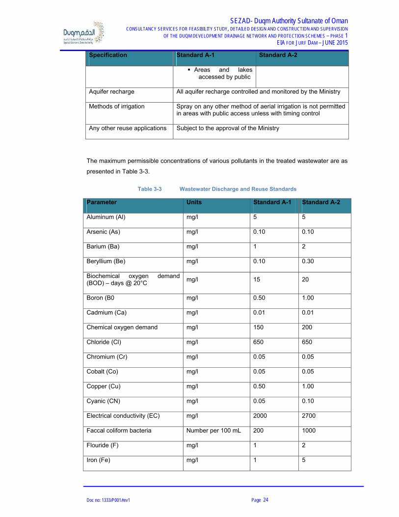
3.1.4 Wastewater Reuse and Discharge
The Omani standards for wastewater discharge and re-use on land are issued under MD
145/93 and RD 115/2001. There are two types of standards, based on the crops grown on the
land where the wastewater is applied, as described in Table 3-2.
Table 3-2 Wastewater Discharge and Reuse Standards - Categories
Specification Standard A-1 Standard A-2
Crops Vegetables and fruits likely to be eaten within 2 weeks of irrigation
Vegetables to be cooked or processed
Fruits if no irrigated within 2weeks of cropping
Fodder, cereal and seed crops
Grass and ornamental areas Public parks, hotel lawns, recreational areas
Pastures and areas with no public access
SEZAD- Duqm Authority Sultanate of Oman CONSULTANCY SERVICES FOR FEASIBILITY STUDY, DETAILED DESIGN AND CONSTRUCTION AND SUPERVISION
OF THE DUQM DEVELOPMENT DRAINAGE NETWORK AND PROTECTION SCHEMES – PHASE 1 EIA FOR JURF DAM – JUNE 2015
Doc no: 1333/P001/rev1 Page 24
Specification Standard A-1 Standard A-2
Areas and lakes accessed by public
Aquifer recharge All aquifer recharge controlled and monitored by the Ministry
Methods of irrigation Spray on any other method of aerial irrigation is not permitted in areas with public access unless with timing control
Any other reuse applications Subject to the approval of the Ministry
The maximum permissible concentrations of various pollutants in the treated wastewater are as
presented in Table 3-3.
Table 3-3 Wastewater Discharge and Reuse Standards
Parameter Units Standard A-1 Standard A-2
Aluminum (Al) mg/l 5 5
Arsenic (As) mg/l 0.10 0.10
Barium (Ba) mg/l 1 2
Beryllium (Be) mg/l 0.10 0.30
Biochemical oxygen demand (BOD) – days @ 20°C
mg/l 15 20
Boron (B0 mg/l 0.50 1.00
Cadmium (Ca) mg/l 0.01 0.01
Chemical oxygen demand mg/l 150 200
Chloride (Cl) mg/l 650 650
Chromium (Cr) mg/l 0.05 0.05
Cobalt (Co) mg/l 0.05 0.05
Copper (Cu) mg/l 0.50 1.00
Cyanic (CN) mg/l 0.05 0.10
Electrical conductivity (EC) mg/l 2000 2700
Faccal coliform bacteria Number per 100 mL 200 1000
Flouride (F) mg/l 1 2
Iron (Fe) mg/l 1 5

SEZAD- Duqm Authority Sultanate of Oman CONSULTANCY SERVICES FOR FEASIBILITY STUDY, DETAILED DESIGN AND CONSTRUCTION AND SUPERVISION
OF THE DUQM DEVELOPMENT DRAINAGE NETWORK AND PROTECTION SCHEMES – PHASE 1 EIA FOR JURF DAM – JUNE 2015
Doc no: 1333/P001/rev1 Page 25
Parameter Units Standard A-1 Standard A-2
Lead (Pb) mg/l 0.10 0.20
Lithium (Li) mg/l 0.07 0.07
Magnesium (Mn) mg/l 150 150
Manganese (Mg) mg/l 0.10 0.05
Mercury (Hg) mg/l 0.001 0.001
Molybdenum (Mo) mg/l 0.01 0.05
Nickel (Ni) mg/l 0.10 0.10
Nitrogen:
Ammoniacal (N)
Nitrate (NO3)
Organic (Kjeldahl as N)
mg/l
5
50
5
10
50
10
Oil and grease (total extractable) mg/l 0.50 0.50
pH mg/l 6 – 9 6 – 9
Phenols (Total) mg/l 0.001 0.002
Phosphorus (P) mg/l 30 30
Selenium (Se) mg/l 0.02 0.02
Silver (Ag) mg/l 0.01 0.01
Sodium (Na) mg/l 200 300
Sodium absorption ratio (SAR) -- 10 10
Sulfate (SO4) mg/l 400 400
Sulfide (S) mg/l 0.10 0.10
Suspended solids (SS) mg/l 15 30
Total dissolved solids (TDS) mg/l 1500 2000
Vanadium (V) mg/l 0.10 0.10
Viable nematode ova Number per L <1 <1
Zinc (Zn) mg/l 5 5
The following are Omani standards for reuse and disposal of sludge resulting from wastewater

SEZAD- Duqm Authority Sultanate of Oman CONSULTANCY SERVICES FOR FEASIBILITY STUDY, DETAILED DESIGN AND CONSTRUCTION AND SUPERVISION
OF THE DUQM DEVELOPMENT DRAINAGE NETWORK AND PROTECTION SCHEMES – PHASE 1 EIA FOR JURF DAM – JUNE 2015
Doc no: 1333/P001/rev1 Page 26
treatment. The sludge generated from the wastewater treatment may be applied on land for
agricultural use (after obtaining permit from MECA) for the same), subject to the conditions
given in Table 3-4.
Table 3-4 Wastewater Treatment Sludge Reuse Standards
Metal
Maximum Concentration (mg/kg of dry solid)
Maximum Applicable Rate (kg/ha)*
Maximum permitted concentration in soil (mg/kg of dry solids)
Cadmium 20 0.15 3
Chromium 1000 10.00 400
Copper 1000 10.00 150
Lead 1000 15.00 150
Mercury 10 0.10 1
Molybdenum 20 0.10 3
Nickel 300 3.00 75
Selenium 50 0.15 5
Zinc 3000 15.00 300
Note: * Based on a ten-year average and a soil pH>7.0
After the spreading of the sludge, there must be at least three weeks period before grazing or
harvesting of forage crops. Sludge use is prohibited in the following cases:
On soils whilst fruits or vegetable crops, other than fruit trees, are growing or
being harvested;
For six months preceding the harvesting of fruit or vegetables, which grow in
contact with the soil and which are normally eaten raw; and
On soils with a pH < 7.0.
3.1.5 Air Emission from Stationary Sources
Omani standards for air emissions from stationary sources are specified under MD 118/2004.
Applicable limits for emissions from stationary point sources in the present project are provided
in Table 3-5. The key provisions of this regulation applicable for the project are presented
below:
Article (2) – Emission controls have to be provided to emission sources from

SEZAD- Duqm Authority Sultanate of Oman CONSULTANCY SERVICES FOR FEASIBILITY STUDY, DETAILED DESIGN AND CONSTRUCTION AND SUPERVISION
OF THE DUQM DEVELOPMENT DRAINAGE NETWORK AND PROTECTION SCHEMES – PHASE 1 EIA FOR JURF DAM – JUNE 2015
Doc no: 1333/P001/rev1 Page 27
the facility in order to prevent noxious or offensive emissions;
Articles (3) – The emission standards specified by this regulation are to be
complied with. Further, the monitoring of emissions from sources within the
facility is to be conducted and reported to the Ministry. The Ministry has the
right to request to improve the monitoring method and equipment used in such
monitoring;
Article (4) – Necessary action shall be taken by the operator of the facility to
eliminate any harmful effects to public health, nuisance or emission of noxious
odours arising from the work area;
Article (5) – Dark smoke shall not be emitted from chimneys unless specially
permitted by the Ministry for specific reasons and periods. The smoke shall not
be as dark as or darker than shade one on the Ringelmann scale (20%
opacity);
Article (6) – The facility shall submit an application for an environmental permit
and shall not commission or operate the plant unless the height of the chimney
serving the plant has been approved by the Ministry that it is sufficient enough
to prevent the smoke, grit, dust and toxic gases from becoming prejudicial to
health or nuisance. The minimum stack heights for power plants, from ground
level shall be as follows:
Power plants (Natural gas fired) - 26 m
Power plants (Diesel fired) - 35 m
Boiler plants (Natural gas fired) - 15 m
Boiler plants (Diesel fired) - 20 m
In other cases, the chimney height shall be calculated as “2.5 times multiplied by the height of
the highest building (in meters) in the concerned establishment complex”.
Article (7) – The permit to operate shall be issued for a period of three years,
renewable for a same period within one month from the date of expiry;
Article (8) – Concerned inspectors from the Ministry may enter the facility to
inspect any processes causing emission of any noxious or offensive
substances, to ensure efficiency of emission controls and to ascertain the
quantity and quality of emissions and suggest requirements for further controls

SEZAD- Duqm Authority Sultanate of Oman CONSULTANCY SERVICES FOR FEASIBILITY STUDY, DETAILED DESIGN AND CONSTRUCTION AND SUPERVISION
OF THE DUQM DEVELOPMENT DRAINAGE NETWORK AND PROTECTION SCHEMES – PHASE 1 EIA FOR JURF DAM – JUNE 2015
Doc no: 1333/P001/rev1 Page 28
or measurements;
Article (9) – The facility shall provide access and assistance to the concerned
environmental inspectors from the Ministry to perform their duties for inspection
and monitoring of the sources at the facility;
Article (10) – Any change of ownership or production process of the facility shall
be communicated to DGEA; and
Article (11) – Failure to comply with any provisions of this regulation will result in penalties and
the Ministry may close down the establishment if there is prejudice harm to the public health or
environmental damage.
Table 3-5 Emission Standards as per MD 118/2004
Pollutants Maximum
permissible limits
General
Grit dust
Dark some products of combustion shall not emit smoke as dark as or
darker than shade one on the Ringelmann scale (20% opacity)
0.050 g/m3
Power Plants – Natural Gas Fired
Nitrogen dioxide 0.150 g/m3
Particulates 0.050 g/m3
Unburnt hydrocarbons 0.010 g/m3
Carbon dioxide 5 g/m3
Power Plants – Diesel Oil-Fired (less than 0.5% Sulfur)
Sulfur dioxide 0.035 g/m3
Carbon monoxide 0.050 g/m3
Nitrogen dioxide 0.150 g/m3
Particulates 0.100 g/m3

SEZAD- Duqm Authority Sultanate of Oman CONSULTANCY SERVICES FOR FEASIBILITY STUDY, DETAILED DESIGN AND CONSTRUCTION AND SUPERVISION
OF THE DUQM DEVELOPMENT DRAINAGE NETWORK AND PROTECTION SCHEMES – PHASE 1 EIA FOR JURF DAM – JUNE 2015
Doc no: 1333/P001/rev1 Page 29
Pollutants Maximum
permissible limits
Unburnt hydrocarbons 0.010 g/m3
Combustion Sources – Diesel Oil-Fired*
Sulfur dioxide 0.035 g/m3
Carbon monoxide 0.050 g/m3
Nitrogen dioxide 0.150 g/m3
Particulates 0.100 g/m3
Unburnt hydrocarbons 0.010 g/m3
Combustion Sources – Natural Gas-Fired
Carbon dioxide 5 g/m3
Nitrogen dioxide 0.150 g/m3
Particulates 0.050 g/m3
Unburnt hydrocarbons 0.010 g/m3
Note: * industrial boilers, furnaces, industrial ovens
3.1.6 Noise
The regulations for noise control are applicable to workplace noise levels and ambient noise
levels. The ambient noise standards are issued under MD 79/94 and the limits for ambient noise
levels from industrial sources are summarized in Table 3-6.
MD 80/94 specifies the regulations for noise pollution control in working environment. These
regulations state that no employee shall be exposed to noise levels exceeding 85 dB(A). If the
workplace noise level exceeds 85 dB(A), suitable ear protection devices shall be provided. The
attenuation of such protection devices shall reduce the noise level to 80 dB(A) or lower.

SEZAD- Duqm Authority Sultanate of Oman CONSULTANCY SERVICES FOR FEASIBILITY STUDY, DETAILED DESIGN AND CONSTRUCTION AND SUPERVISION
OF THE DUQM DEVELOPMENT DRAINAGE NETWORK AND PROTECTION SCHEMES – PHASE 1 EIA FOR JURF DAM – JUNE 2015
Doc no: 1333/P001/rev1 Page 30
Table 3-6 Ambient Noise Standards
Type of District
Day Time
(7 AM – 6 PM)
workdays
Evening Time
(6 PM – 11 PM)
workdays
Night Time
(11 PM – 7 AM)
workdays and all
times on holidays
Rural residential and
recreational 45 40 35
Sub-urban residential 50 45 40
Urban residential 55 50 45
Urban residential with some
workshops or business city hub 60 55 50
Industrial and commercial 70 70 70
3.1.7 Hazardous Waste
MD 18/93 specifies the Omani regulations on hazardous waste management. Hazardous waste
is defined as “any liquid or solid waste, which because of its quantity, physical, chemical or
infectious characteristics can result in hazards to human health or the environment when
improperly handled, stored, transported, treated or disposed off”. The relevant articles in the
regulation are listed below:
Article (4) – No hazardous waste shall be mixed with any other category of
waste nor shall it be discharged to a common or other internal or external
sewerage or other drainage system without a licence from the Ministry;
Article (5) – Every hazardous waste generator shall complete a Consignment
Note for each category of hazardous waste before the hazardous waste leaves
his land or premises;
Article (6) – All hazardous waste shall be labelled and packed according to the
Ministerial Decision issued in this respect;
Article (7) – A hazardous waste or any components of a hazardous waste may
be recycled at the point of generation or elsewhere only within the conditions of
these Regulations. In case recycling is limited only to the point of generation,
hazardous waste generator shall not be committed to complete a consignment

SEZAD- Duqm Authority Sultanate of Oman CONSULTANCY SERVICES FOR FEASIBILITY STUDY, DETAILED DESIGN AND CONSTRUCTION AND SUPERVISION
OF THE DUQM DEVELOPMENT DRAINAGE NETWORK AND PROTECTION SCHEMES – PHASE 1 EIA FOR JURF DAM – JUNE 2015
Doc no: 1333/P001/rev1 Page 31
note;
Article (8) – Every hazardous waste generator shall store hazardous waste in
approved storage facilities on his land or at his premises until its removal in
accordance with the terms of the licence issued by the Ministry;
Article (9) – Hazardous waste shall be transported by transporters licensed by
the Ministry to collect, handle, store and dispose hazardous waste outside the
waste generator's premises. This licence will be issued with conditions after the
approval of Royal Oman Police (ROP);
Article (10) – Every owner of any site where hazardous waste is to be stored,
shall apply for a licence from the Ministry and shall operate the site only in
accordance with the terms of the issued licence which shall include a
requirement that all hazardous waste received at the site shall be accompanied
by appropriate Consignment Note(s) in accordance with Article (5); and
Article (11) – Every owner of a storage facility shall only release hazardous
waste from that facility if it is accompanied by a Consignment Note in
accordance with Article (5).
3.1.8 Solid Non Hazardous Waste
MD 17/93 specifies the Omani regulations for non-hazardous solid waste management (the
relevant articles of RD 115/2001 are also to be referred to). The relevant articles in the
regulation are listed below:
Article (2) – Occupants of the premises (including industries which generate any solid or
semi solid non-hazardous waste) shall store and dispose of solid non-hazardous waste
in accordance with the provisions of these regulations and decision of the concerned
authorities to this effect, such that there is no nuisance or hazard to the public health;
Article (5) – The occupants of the premises shall collect these wastes and transport it in a
safe manner to a site designated by the concerned authority; and
Article (13) – No solid non-hazardous waste should be mixed with any category of hazardous
waste at any time.
3.1.9 Establishment of Septic Tanks, Holding Tanks and Soak Away Pits
MD 421/98 specifies requirements for designing, locations, and constructing septic tanks, soak
away pits, and holding tanks. Important Articles of this MD are listed below:
Article 3 of the MD allows the use of septic tanks in institutions where the population
equivalent is not greater than 150;

SEZAD- Duqm Authority Sultanate of Oman CONSULTANCY SERVICES FOR FEASIBILITY STUDY, DETAILED DESIGN AND CONSTRUCTION AND SUPERVISION
OF THE DUQM DEVELOPMENT DRAINAGE NETWORK AND PROTECTION SCHEMES – PHASE 1 EIA FOR JURF DAM – JUNE 2015
Doc no: 1333/P001/rev1 Page 32
Article 4 and 11 states requirement of consent of local municipality prior to establishment
of septic and holding tanks; and
Article 10 and 13 present the minimum setback distances for construction of septic tanks,
soak away pits, and holding tanks.
3.1.10 Ambient Air Quality
Presently, there are no Omani standards for ambient air quality. Therefore, MECA recommends
the use of U.S. EPA's National Ambient Air Quality (NAAQ) standards. The NAAQ standards
are presented in Table 3-7.
Table 3-7 Ambient Air Quality Standards
Pollutant Averaging Period Maximum Permissible Limit
Particulate (PM10) 24-hour average 150 µg/m3
Particulates (PM25) 24-hour average 35 µg/m3
Annual arithmetic mean 15 µg/m3
Sulfur dioxide (SO2) 3-hour average 0.5 ppm (1300 µg/m3)
24-hour average 0.14 ppm
Annual arithmetic mean 0.0 3
Nitrogen dioxide (NO2) Annual arithmetic mean 0.053 ppm (100 µg/m3)
1-hour average 0.100 ppm
Carbon monoxide (CO) 1-hour average 35 ppm (40 mg/m3)
8-hour average 9 ppm (10 mg/m3)
Ozone (O3) 1-hour average 0.12 ppm
8-hour average 0.075 ppm
Lead (Pb) Rolling 3-month average 0.15 µg/m3
Quarterly average 1.5 µg/m3

SEZAD- Duqm Authority Sultanate of Oman CONSULTANCY SERVICES FOR FEASIBILITY STUDY, DETAILED DESIGN AND CONSTRUCTION AND SUPERVISION
OF THE DUQM DEVELOPMENT DRAINAGE NETWORK AND PROTECTION SCHEMES – PHASE 1 EIA FOR JURF DAM – JUNE 2015
Doc no: 1333/P001/rev1 Page 33
MECA however is currently in the process of developing Omani Ambient Air Quality (AAQ)
Standards. Although the standards have not yet been promulgated, the provisional standards
are provided as presented in Table 3-8.
Table 3-8 Omani AAQ Standards (Provisional)
Parameters Averaging Period Standard Limits (µg/m3)
NO2 24-hour average 112
SO2 24-hour average 125
CO 8-hour average 6000
H2S 24-hour average 40
O3 8-hour average 120
HCNM 3-hour average 160
PM10 24-hour average 125
There are no Omani standards for work place air quality as of this writing. Therefore, United
States Occupational Safety and Health Administration (OSHA) 8-hour Time Weighted Average
(TWA) can be used. The maximum permissible limit specified by OSHA1 for respirable
particulate matter (PM10) within the workplace is 5,000 μg/m3.
3.1.11 National Heritage Protection
RD 6/80 states the requirement for the protection of areas of cultural importance. These include
the following:
All types of monuments and antiquities; and
Chattels of cultural properties including archaeological fossils and fragments of
monuments / ancient ruins or sites and ancient building blocks.
3.1.12 Protected Areas in Oman
Fourteen protection areas designated as the nature conservation by Royal Decree are shown in
the next table. These areas are highly regulated and controlled by Ministry for Environment and
Climate Affairs (MECA). On the marine environment, the Regulation for Conservation of Marine
1 OSHA Regulations Standards – 29 CFR

SEZAD- Duqm Authority Sultanate of Oman CONSULTANCY SERVICES FOR FEASIBILITY STUDY, DETAILED DESIGN AND CONSTRUCTION AND SUPERVISION
OF THE DUQM DEVELOPMENT DRAINAGE NETWORK AND PROTECTION SCHEMES – PHASE 1 EIA FOR JURF DAM – JUNE 2015
Doc no: 1333/P001/rev1 Page 34
an Coastal Environment as MD20/90 and Decision no: 19/90 of the Supreme Committee for
Town Planning (SCTP), which was instituted in 1990, is established control zone of
development being within 50 to 300 meters from natural coastal line.
Table 3-9: Protection areas in Oman
Name of area Location (Region) Reserve resources
(Biological, others)
The Arabian Oryx Sanctuary
Al Wusta Arabian oryx, Nubian ibex, etc., conserving biodiversity
As Saleel natural Park Ash Sharqiyah Simr, Arabian gazelle, Gordon's wild cat, protecting wildlife
Ra's al Hadd Turtle Reserve
Ash Sharqiyah Turtles, Coral reefs, mangroves, Prosopis cineraria wildlife
Jebel Samhan Nature Reserve
Dhofar Governorate Leopard, Ibex, Arabian wolf, Gazelle, Blandford's fox, protecting wildlife
Dimaniyan Islands nature Reserve
North of Muscat Coral reefs, fish, birds and turtles, conserving wildlife
The Khawrs Reserve of Dhofar Coast
Dhofar Governorate Khawrs, springs, and archaeological sites, Mangroves, sustainable use of the resources
Wadi Al Sarin South of Muscat Arabian tahr and mountain goat

SEZAD- Duqm Authority Sultanate of Oman CONSULTANCY SERVICES FOR FEASIBILITY STUDY, DETAILED DESIGN AND CONSTRUCTION AND SUPERVISION
OF THE DUQM DEVELOPMENT DRAINAGE NETWORK AND PROTECTION SCHEMES – PHASE 1 EIA FOR JURF DAM – JUNE 2015
Doc no: 1333/P001/rev1 Page 35
3.2 Environmental Impact Assessment Interim Guidelines
The Interim Guideline on Environmental Impact Assessment was issued in 2001. The legislative
authority of the guideline is based on the Royal Decree 114/2001 and its amendments
“Amending some provisions of the law on Conservation of The Environment and Prevention of
Pollution (Royal Decree 10/82)”. However, this Interim Guideline on Environmental Impact
Assessment has been replaced with EIA Guideline called “Guidelines for Obtaining
Environmental Permits for year 2001”. The Interim Guideline lists the projects, which are subject
to a detailed EIA study. At the initial of the project stage, the Ministry for Environment and
Climate Affairs conducts an environmental screening to ensure the proposed project is subject
to an appropriate environmental assessment. Based on the screening results, the projects are
classified into projects that in the proposed location have negligible environmental impacts, and
projects that likely to have significant environmental impacts. The Guideline lists the key
features of EIA, such as scoping, developing EIA, and data and information to be included
(kindly consider below Figure).
Figure 3-1: EIA Procedures in Oman

SEZAD- Duqm Authority Sultanate of Oman CONSULTANCY SERVICES FOR FEASIBILITY STUDY, DETAILED DESIGN AND CONSTRUCTION AND SUPERVISION
OF THE DUQM DEVELOPMENT DRAINAGE NETWORK AND PROTECTION SCHEMES – PHASE 1 EIA FOR JURF DAM – JUNE 2015
Doc no: 1333/P001/rev1 Page 36
3.2.1 Overview
The Regulation for the issuance of the Environmental Approvals and the Final Environmental
Permit (Ministerial Decision No. 187/2001, 16 June 2001) is composed of six (6) articles and
two (2) annexes. The following are highlights of the regulation applicable to the proposed
Project:
Article 1: The establishments subject to this Regulation are classified into categories
according to the materials used in production, production capacity and the degree of
their impact on the environment as indicated in Annex 1.
Article 2: The owner of an establishment shall present an application to the Ministry and
enclose an EIA, if required by the Ministry.
Article 3: The owner of the establishment shall abide by all environmental requirements
and conditions before obtaining the Environmental Approval or Final Environmental
Permit
Article 4: The establishments shall abide by carrying out an Environmental Audit by a
specialized company approved by the Ministry.
Article 5: Dividing the Establishment into categories.
Annex I: Desalination stations are included in category two and water supply networks as
category three.
Annex II: Fees for the Environmental Approvals and for the Final Environmental Permit.
Ministerial Decision 68/2004 amends the Ministerial Decision No. 187/2001, referring that
the Ministry (MECA) can add any new project or any projects resembling the projects
stated in the annex of Division of Establishments into Categories after the approval of
the Ministry of Finance (MoF) and modify the categories stated in the annex of MD
187/2001.
3.2.2 Preliminary Consultation
Before submitting the application for permit, the proponent (or its appointed consultant) should
contact MECA to discuss details of the required documentation. The proponent is encouraged
to discuss the proposed projects informally with staff of the Ministry at an early stage before
detailed studies or plans are drawn up. A feasibility study, complete with its environmental
chapter, maybe utilized during the preliminary consultation.

SEZAD- Duqm Authority Sultanate of Oman CONSULTANCY SERVICES FOR FEASIBILITY STUDY, DETAILED DESIGN AND CONSTRUCTION AND SUPERVISION
OF THE DUQM DEVELOPMENT DRAINAGE NETWORK AND PROTECTION SCHEMES – PHASE 1 EIA FOR JURF DAM – JUNE 2015
Doc no: 1333/P001/rev1 Page 37
3.2.3 Application Review Process
The procedure for processing of an application for an Environmental Permit from MECA can be
divided into three (3) stages:
Stage 1: Application Submission Stage
This stage begins the application review process and consists of submitting a completed
Environmental Permit Application Form, to MECA supporting technical documents, and permits
from other Ministries (if necessary).
Stage 2: Technical Stage Appraisal (Screening and Scoping)
At this stage, technical staff of the Ministry conducts a screening followed by a detailed review
of the application to determine the type of environmental analysis that is required for the project.
There is no fixed list of specific industries, developments or their sizes, which would trigger a
detailed EIA. Instead the Ministry’s procedure relies on screening, identifying significant
impacts on sensitive areas, and discussion between MECA and the applicant to identify any
critical issues and to establish the scope of the EIA. However, certain types of projects or their
elements fall into categories of projects usually requiring a detailed EIA, including desalination
plants. The final decision rests with MECA.
A formal EIA should include but not limited to the following:
Project description
Baseline data
Comparison of alternatives and their impacts (negative or positive) on all aspects of the
environment
Proposed mitigation measures
Risk assessment
Evaluation of the net effects of the development
Proposed monitoring and follow-up activities
Inter-agency coordination
Consultation with affected communities
Clear and complete Environmental Impact Statement document

SEZAD- Duqm Authority Sultanate of Oman CONSULTANCY SERVICES FOR FEASIBILITY STUDY, DETAILED DESIGN AND CONSTRUCTION AND SUPERVISION
OF THE DUQM DEVELOPMENT DRAINAGE NETWORK AND PROTECTION SCHEMES – PHASE 1 EIA FOR JURF DAM – JUNE 2015
Doc no: 1333/P001/rev1 Page 38
Stage 3: Decision and Permit Stage
Once completed, MECA will review the EIA and, if satisfied, will issue a Preliminary
Environmental Approval, approving the commencement of the construction process and
including environmental conditions to be fulfilled prior starting operation.
A Final Environmental Permit will be issued after fulfillment of the conditions stated in the
Preliminary Environmental Approval.
The development must also be in conformity with the various Regulations / Ministerial
Decisions, some of which require sub-permits / licenses to the Environmental Permit and these
must also be obtained by the proponent/applicant.
3.2.4 Follow up
If the nature of the activities, as evaluated by MECA, shall be bound to conduct an
Environmental Audit, every two years from the date of receiving the Final Environmental Permit.
3.2.5 Required Permits for the Proposed Project
The proposed project will potentially require the following permits, as applicable for the
construction or operation phases:
Preliminary Environmental Permit (PEP) from MECA – Issued upon submission of EIA Report along with application for the Environmental Permit;
Permit for disposal of treated wastewater (if any) during construction phase;
Permit for storage, handling, transportation and disposal of hazardous wastes during construction and operation;
Permit for storage, handling and transportation of chemicals and fuel used at site during construction and operation;
Permit for operating stationary emission sources (stacks);
Permit for import, transportation, usage and storage of radioactive material, if required (mainly during construction phase);
Consent for setting up construction camps from local municipality; and
Approvals from the Ministry of Heritage and Culture (MHC) and Ministry of Awqaf and Religious Affairs (MARA), as required.

SEZAD- Duqm Authority Sultanate of Oman CONSULTANCY SERVICES FOR FEASIBILITY STUDY, DETAILED DESIGN AND CONSTRUCTION AND SUPERVISION
OF THE DUQM DEVELOPMENT DRAINAGE NETWORK AND PROTECTION SCHEMES – PHASE 1 EIA FOR JURF DAM – JUNE 2015
Doc no: 1333/P001/rev1 Page 39
In addition to the above, the contractors transporting / handling chemicals, fuels, other
hazardous materials and hazardous wastes will require approvals / permits.
3.3 Legal Framework for Social Issues
In addition to the environmental regulations discussed in the preceding sections, the project will
be governed by relevant regulations for addressing the social issues. The social laws in
Sultanate of Oman address aspects such as community involvement, local employment,
protection of cultural / heritage / archaeological sites etc. These are stipulated through RDs as
presented in Table 3-10.
Table 3-10 Omani Laws for Social Aspects
Ref. No. Description Applicability to Project
RD 6/80
Law on national heritage protection Any development work to
protect and conserve
archaeological sites.
Any development activity
to be initiated only after
obtaining clearance from
the MHC and MARA.
Oman Labour Policy Law for involving local citizens in
project
Provision for employing local
citizens
Supreme Committee
for Town Planning
(SCTP) standards
Guidelines for development of new
areas
Physical planning norms to be
adopted for infrastructure
development
Ministry of Agriculture
RD 8/2003
Protection of grazing areas Areas in and around the site,
used for grazing
RD 34/74
Management of fishery and
supporting its habitats
It prohibits interference with
movement of marine species
or harm to their eggs and
young ones

SEZAD- Duqm Authority Sultanate of Oman CONSULTANCY SERVICES FOR FEASIBILITY STUDY, DETAILED DESIGN AND CONSTRUCTION AND SUPERVISION
OF THE DUQM DEVELOPMENT DRAINAGE NETWORK AND PROTECTION SCHEMES – PHASE 1 EIA FOR JURF DAM – JUNE 2015
Doc no: 1333/P001/rev1 Page 40
3.4 Conventions and Protocols
Several RDs concerning conventions and protocols to which Oman has acceded have been
issued so that these are taken into account during development of new projects in the country.
RDs which potentially apply to the proposed sanitary landfill project are listed below:
Sanctioning the Accession of the Sultanate of Oman to the Marine Environment
Protection Protocol (RD 90/91);
Sanctioning the Accession of the Sultanate of Oman to two Protocols on
Environment Protection (RD 57/94);
Sanctioning the Accession of the Sultanate of Oman to Basel Convention on
the Control of the Transboundary Movement of Hazardous Wastes and their
disposal, the United Nations Framework Convention on Climate Change and
Convention on Biological Diversity (RD 119/94);
Sanctioning the Accession of the Sultanate of Oman to the Vienna Convention
for the Protection of the Ozone Layer and the Montreal Protocol on Substances
that Deplete the Ozone Layer (RD 73/98);
Sanctioning the Protocol on the Transboundary Movement of Hazardous
Wastes and Other Wastes and their Disposal (RD 24/2002);
Sanctioning Montreal and Beijing Amendments to Montreal Protocol on
Substances that deplete the Ozone Layer (RD 106/2004);
Sanctioning Kyoto Protocol to the United Nations Framework Convention on
Climate Change (RD 107/2004); and
Sanctioning Stockholm Convention on Persistent Organic Pollutants (POPs)
(RD117/2004).
3.5 International and Regional Treaties
Other international guidelines used in assessment methods, mitigation measures, climate
change issues, cumulative impacts, etc., specifically for solid waste management facilities are
the following:
World Bank Annex 4C.4 – Definition of the scope of work for the EIA and feasibility study
for regional SWM facilities;
World Bank Operational Policy / Bank Procedures / Good Practices (OP/BP/GP/4.01) and

SEZAD- Duqm Authority Sultanate of Oman CONSULTANCY SERVICES FOR FEASIBILITY STUDY, DETAILED DESIGN AND CONSTRUCTION AND SUPERVISION
OF THE DUQM DEVELOPMENT DRAINAGE NETWORK AND PROTECTION SCHEMES – PHASE 1 EIA FOR JURF DAM – JUNE 2015
Doc no: 1333/P001/rev1 Page 41
associated documents;
UN Convention on Climate Change and Biological Diversity;
U.S. EPA 40 CFR Part 98 – Greenhouse Gas Reporting Program (GHGRP);
European Commission (EC) Directive 2011/92/EU – Environmental Impact Assessment –
EIA directive;
EC Directive 85/337 and 97/11/EC;
EC Guidance on Integrating Climate Change and Biodiversity into Environmental Impact
Assessment (2013).
The Gulf Cooperating Council (GCC), on the other hand, has an Environmental Coordination
Committee and the GCC Secretariat General, a sector of Human and Environment Affairs. In
this regard, this study, also considered the General Policies and Principles for Environment
Protection, together with the following:
Unified Regulation for Protection and Development of Wildlife;
GCC Environmental Impact Regulation (1995);
General Regulations of the Environment (1997);
Unified Regulation for Handling Radioactive Materials;
Unified Regulation for Waste Recycling;
Procedures of Transferring Hazardous through GCC borders; and
Unified Guiding Regulation for the Control of Substances that Deplete the Ozone Layer in
the GCC Countries (2007).

SEZAD- Duqm Authority Sultanate of Oman CONSULTANCY SERVICES FOR FEASIBILITY STUDY, DETAILED DESIGN AND CONSTRUCTION AND SUPERVISION
OF THE DUQM DEVELOPMENT DRAINAGE NETWORK AND PROTECTION SCHEMES – PHASE 1 EIA FOR JURF DAM – JUNE 2015
Doc no: 1333/P001/rev1 Page 42
4. DESCRIPTION OF THE PROPOSED PROJECT
4.1 Project Description
The project encompasses a very large area at the north of Duqm in the Al Wusta Governorate. A royal
decree defined the boundaries of the foreseen development. This area is situated in a bay where
several wadis draining the higher plateaus, located inland, enters the sea.
Previous studies were performed over this area in order to establish a Master plan for the
development. The area will be developed in accordance with this Masterplan with industrial,
commercial and residential areas demarcated and joined with arterial roads. The previous Masterplan
foresaw at least two dams and three channels over the studied area to provide safe conveyance of
stormwater.
Within this Masterplan, preliminary calculations were done to obtain sizes of the dams and the
channels. This initial dam designs performed in the previous study resulted in the positioning of 2
dams and 3 channels. This Environmental Impact Assessment concerns the Jurf dam, located in
Wadi Jurf, in the city of Duqm in Al Wusta Governorate.
By RD 119/2011, SEZAD enjoys juristic personality and shall be financially and administratively
independent, therefore is an autonomous authority and responsible for the approvals inside the
designated area. Nevertheless, any project developed outside the SEZAD area must follow the
MECAs’ guidelines, therefore requiring an EIA study and approval from the Ministry of Environment
and Climate Affairs before start up stage. Although the majority of the project lay down inside the
SEZAD area, a small part of the Jurf Dam is located inside the Oryx Sanctuary Reserve and therefore
an independent EIA study is presented bellow.
For the Inception phase, some initial information were gathered and made available. The documents
received relates largely to the Master plan carried by Sering Consultancy. In addition, several reports
relating to the geological aspects of the development area and geotechnical interpretation reports
were made available to us.
The aim of the project is to provide a significant degree of flood protection to the free zone area under
development. The construction of attenuation dams and flood conveyance channels is likely to form
the principal components of such flood protection measures. The dam will be situated upstream of the
target area and convey the remaining water safely through the development area. The following figure
shows the approximate location of the project.
The following figure shows the location of the Special Economic Zone at Duqm where this project will
be implemented.

SEZAD- Duqm Authority Sultanate of Oman CONSULTANCY SERVICES FOR FEASIBILITY STUDY, DETAILED DESIGN AND CONSTRUCTION AND SUPERVISION
OF THE DUQM DEVELOPMENT DRAINAGE NETWORK AND PROTECTION SCHEMES – PHASE 1 EIA FOR JURF DAM – JUNE 2015
Doc no: 1333/P001/rev1 Page 43
Figure 4-1: Project Location in Duqm (SEZAD area)
4.2 Scope of Project Services
The scope of works includes:
- Wadi Jurf Dam.

SEZAD- Duqm Authority Sultanate of Oman CONSULTANCY SERVICES FOR FEASIBILITY STUDY, DETAILED DESIGN AND CONSTRUCTION AND SUPERVISION
OF THE DUQM DEVELOPMENT DRAINAGE NETWORK AND PROTECTION SCHEMES – PHASE 1 EIA FOR JURF DAM– JUNE 2015
Doc no: 1333/P001/rev1 Page 44
Figure 4-2: Flood Protection Scheme of the Project
Copies of the design drawings are included as Annexure A.

SEZAD- Duqm Authority Sultanate of Oman CONSULTANCY SERVICES FOR FEASIBILITY STUDY, DETAILED DESIGN AND CONSTRUCTION AND SUPERVISION
OF THE DUQM DEVELOPMENT DRAINAGE NETWORK AND PROTECTION SCHEMES – PHASE 1 EIA FOR JURF DAM– JUNE 2015
Doc no: 1333/P001/rev1 Page 45
4.3 Description of Proposed Project
4.3.1 Topographic survey
Topographical survey was carried out over the conceptual design alignment of the channels of Jurf.
This was initiated during the month of June 2014 and terminated at the beginning of September 2014.
After submission some discrepancies were revealed and an house check was made in order to
ensure about the accuracy of the received data.
It appears that the ZAWAWI 3D results are accurate and present differences in elevation according to
the satellite data received at the early stage of the project.
4.3.2 General Design Criteria
International, American and European standards shall be used as well as the Oman Highway Design
Manual and Sultanate of Oman General Specification for Roads.
As far as civil and building works are concerned, the American Codes, Standards and
Recommendations shall be used for the design of the structures, except as otherwise mentioned. An
inconsistent mixing of various standards on the same structures must be avoided because of the
different safety factors in the critical load combinations for stability analysis and dimensioning.
Nevertheless, where American Codes do not provide pertinent information, other codes could be
followed as reference.
Main applicable organizations, codes, standards and recommendations are listed in the subsequent
sections.
Embankment dams a. US Army Corps of Engineer (USACE)
Earth and Rock Fill Dams – General Design and Construction consideration-
EM 1110-2-2300
Engineering and Design – Seepage analysis and Control for Dams-
EM 1110-2-1901
b. Recommendations of International Committee on Large Dams (ICOLD)
Embankment dams – Granular filters and drains Bulletin 95
c. Recommendations of United States Bureau of Reclamation (USBR)
Embankment dams Design Guide No. 13 Design of small dams

SEZAD- Duqm Authority Sultanate of Oman CONSULTANCY SERVICES FOR FEASIBILITY STUDY, DETAILED DESIGN AND CONSTRUCTION AND SUPERVISION
OF THE DUQM DEVELOPMENT DRAINAGE NETWORK AND PROTECTION SCHEMES – PHASE 1 EIA FOR JURF DAM– JUNE 2015
Doc no: 1333/P001/rev1 Page 46
Hydraulic calculations for spillways and associated structures The hydraulic design of the spillways will be undertaken, using the following references:
General design criteria: USCE engineering manual EM 1110-2-1603 Hydraulic design of spillways
Ogee crest: USCE engineering manual EM 1110-2-1603 Chute flow depth convergence if adopted:
USBR Design of small dams
Stepped chute if adopted: Hydraulic Structure Design Manual – 1995 The Hydraulics of stepped chute and spillways – Chanson – 2001 Flow Characteristics of skimming flows in stepped channels _ Ohtsu / Yasuda /Takahashi _ 2004
Stilling basin: USBR EM 25 Design of stilling basins Outlet works USBR design of small dams
US department of transport publication FHWA – NHI-01-020 – Hydraulic design of culverts USCE engineering manual EM 1110-2 -1602 Hydraulic design of reservoir outlet works USCE engineering manual EM 1110-2 -2400 Structural design of outlet works USCE engineering manual EM 1110-2 -2902 Conduits, culverts and pipes
4.3.3 Principal Design Criterion
The upstream dams are to be designed to ensure the attenuation of the peak discharge from the
1'000yrs natural discharge to a reduced value corresponding to the 100yrs natural peak discharge.
Consequently, both channels are designed to withstand the 100yrs natural flood which is equivalent to
the 1'000yrs event with the upstream dam implemented.
4.3.4 Retained Flood Protection Scheme
The global scheme is graphically presented bellow, corresponding to the preliminary design layout of
each flood protection scheme component.

SEZAD- Duqm Authority Sultanate of Oman CONSULTANCY SERVICES FOR FEASIBILITY STUDY, DETAILED DESIGN AND CONSTRUCTION AND SUPERVISION
OF THE DUQM DEVELOPMENT DRAINAGE NETWORK AND PROTECTION SCHEMES – PHASE 1 EIA FOR JURF DAM– JUNE 2015
Doc no: 1333/P001/rev1 Page 47
Figure 4-3: Retained Flood Defence Global Concept (Wadi Jurf included)
4.4 Hydrological & Hydraulic
4.4.1 Assessment
Within the feasibility phase and hydrological assessment was carried out over the complete area and
two dimensional models were established to show the effect of dam and channel implementation.
Particular attention was paid to the land occupation within the SEZAD boundary. The hydrological

SEZAD- Duqm Authority Sultanate of Oman CONSULTANCY SERVICES FOR FEASIBILITY STUDY, DETAILED DESIGN AND CONSTRUCTION AND SUPERVISION
OF THE DUQM DEVELOPMENT DRAINAGE NETWORK AND PROTECTION SCHEMES – PHASE 1 EIA FOR JURF DAM– JUNE 2015
Doc no: 1333/P001/rev1 Page 48
model was adapted with right curve number in order to place our design on the safest side. Hec-Ras
was used in order to size the dykes and the slopes along the two main channels.
A small sensitivity analysis was carried out over the lower part of the catchment where development
area will be present and where change in curve number can be allocated. This shows only very small
effects on the resulted flow at the combined outlet for extreme event beyond our design criteria value.
This was observed within any other part of the channels network.
The hydrological results obtained at the preliminary design were considered satisfactory and were
conserved for the detailed design stage.
Figure 4-4: Wadi Catchment in Duqm (including Jurf)
After submission of the preliminary design report related to the channels, the Consultant exposed its
concerns toward a very important aspect of the project. The alignments were revised during the last
phase of the preliminary design to take into account various constraints emanated from the Client.
This resulted in a combined outlet with an extreme hydraulic turn which might endanger the complete
area downstream.

SEZAD- Duqm Authority Sultanate of Oman CONSULTANCY SERVICES FOR FEASIBILITY STUDY, DETAILED DESIGN AND CONSTRUCTION AND SUPERVISION
OF THE DUQM DEVELOPMENT DRAINAGE NETWORK AND PROTECTION SCHEMES – PHASE 1 EIA FOR JURF DAM– JUNE 2015
Doc no: 1333/P001/rev1 Page 49
4.4.2 Inflows Hydrographs
The inflows peak discharges used under this detailed design remained unchanged and are as follows:
Table 4-1 - Peak Discharges at Jurf Dam
Return Period 100 500 1000 10000 PMF
Inflow volume (m3) 57391530 96410118 112858872 168963360 353806176
Inflow peak discharge (m3/s) 2323 3924 4599 6890 14966
Figure 4-5 – Inflows Hydrograph Jurf Dam
According to the retained design criteria the 1'000 peak discharge of about 4'600m3/s must be
reduced to a more reasonable value of 2'300m3/s corresponding to the 100yrs peak disharge
4.4.3 Storage Curve
The dam site is able to store significant volume of the order of the hundreds of Millions of cubic
meters. The reservoir possesses a very shallow slope which has for effect to create a wide reservoir.

SEZAD- Duqm Authority Sultanate of Oman CONSULTANCY SERVICES FOR FEASIBILITY STUDY, DETAILED DESIGN AND CONSTRUCTION AND SUPERVISION
OF THE DUQM DEVELOPMENT DRAINAGE NETWORK AND PROTECTION SCHEMES – PHASE 1 EIA FOR JURF DAM– JUNE 2015
Doc no: 1333/P001/rev1 Page 50
Figure 4-6 – Jurf Dam Storage Curve
The lowest point of the reservoir is located in the central part of the dam axis at an elevation of about
28 m amsl. During preliminary design, the consideration of a dead storage was made by implementing
the low level outlet (culvert spillway) at an elevation of 34 m amsl. This corresponds to a dead storage
of 3.71Mm3. This shall be put in comparison to the sill level of the broad crested weir at 40.5m amsl
which corresponds to a storage of about #32.8Mm3.
The following table summarises the relevant values
Table 4-2 - Storage Capacity Values
Water Elevation Corresponding Water Depth (m) Storage Volume (Mm3) 34 (Culvert Spillway Inlet) 6 (Dead Storage) 3.7 40.5 (Ogee Crest level) 12.5 32.8 44.2 (10'000yrs flood level) 16.2 71.5 47.4 (PMF level & NOC level) 19.4 120.9
4.4.4 Spillway Design and Flood Routing
A. Spillway Nature
Various alternatives and configurations were studied at preliminary design phase. From the results of
the geotechnical investigations, consideration of the bottom outlet and excavation of the left bank to
place the auxiliary spillway can be made.
The following arrangement has been retained for detailed design purposes:

SEZAD- Duqm Authority Sultanate of Oman CONSULTANCY SERVICES FOR FEASIBILITY STUDY, DETAILED DESIGN AND CONSTRUCTION AND SUPERVISION
OF THE DUQM DEVELOPMENT DRAINAGE NETWORK AND PROTECTION SCHEMES – PHASE 1 EIA FOR JURF DAM– JUNE 2015
Doc no: 1333/P001/rev1 Page 51
Table 4-3 - Retained spillway arrangement from preliminary design
Main Spillway Nature Reinforced concrete culvert
spillway Location Placed at the right hand side
of the auxiliary spillway over the left abutment.
Inlet elevation Initially 33 m amsl Number of barrel 2 U Width of cell 5 m Height of cell 5 m Auxiliary Spillway Nature Mass concrete ogee crest. Location Placed over the left abutment Length 300 m Crest elevation 40.5 m amsl Downstream slope 1:1 Upstream slope Vertical
The auxiliary spillway was considered as a broad crested weir in the hydraulic and flood routing
calculation to consider the possible drawn effect on the left hand side. A coefficient of 1.704 was
retained for rating curve establishment.
Importance of the 3D mathematical model is proven in this configuration and would be able to adjust
our hydraulic rating curve either for the culvert or the auxiliary spillway.
B. Auxiliary Spillway Crest
A 300 meters wide ogee crest spillway will be implemented on the left side of the culvert spillway. It
will operate during very large flood event.
The hydraulic performance of an ogee spillway is affected by the following parameters:
approach depth;
upstream face angle;
ogee shape;
contraction due to piers and abutments;
possible submergence effect from downstream.
Approach depth
The spillway has an approach channel which will help conveying water to the control structure. The

SEZAD- Duqm Authority Sultanate of Oman CONSULTANCY SERVICES FOR FEASIBILITY STUDY, DETAILED DESIGN AND CONSTRUCTION AND SUPERVISION
OF THE DUQM DEVELOPMENT DRAINAGE NETWORK AND PROTECTION SCHEMES – PHASE 1 EIA FOR JURF DAM– JUNE 2015
Doc no: 1333/P001/rev1 Page 52
bottom elevation was set to be 40.5 m amsl, so the approach depth is 1m over its left portion and
increasing to 3.5m. The last value is considered for computation to ensure the right shape is used
throughout the complete section.
NB: the left portion with only 1 meters approach will work as normal weir and would be drown during
high flood event. The hydraulic capacity of such structure is difficult to assess and 3D model would
give solution closer to reality.
Ogee shape and upstream face angle
The ogee shape was set according to the guidelines from USBR. The equation for the profile
downstream the highest point is
∙
where H0 is the design head corresponding to 1,000 years flood (Q=3639m3/s). The coefficient K and
n were chosen according to the following figure and in the hypothesis of vertical upstream face.
Figure 4-7. Reference scheme for the ogee design and chart for the coefficient of the downstream profile (Source: USBR, "Design of small dams" - 1987)

SEZAD- Duqm Authority Sultanate of Oman CONSULTANCY SERVICES FOR FEASIBILITY STUDY, DETAILED DESIGN AND CONSTRUCTION AND SUPERVISION
OF THE DUQM DEVELOPMENT DRAINAGE NETWORK AND PROTECTION SCHEMES – PHASE 1 EIA FOR JURF DAM– JUNE 2015
Doc no: 1333/P001/rev1 Page 53
The upstream portion of the profile is made by a composition of arcs, which geometrical features are
described in the following chart.
Figure 4-8. Factor for the definition of the upstream crest profile
(Source: USBR, "Design of small dams" - 1987)

SEZAD- Duqm Authority Sultanate of Oman CONSULTANCY SERVICES FOR FEASIBILITY STUDY, DETAILED DESIGN AND CONSTRUCTION AND SUPERVISION
OF THE DUQM DEVELOPMENT DRAINAGE NETWORK AND PROTECTION SCHEMES – PHASE 1 EIA FOR JURF DAM– JUNE 2015
Doc no: 1333/P001/rev1 Page 54
Contractions due to piers and abutments
The contractions of the flow sections due to abutments and possible piers are calculated by the
following formula:
2 ∙ ∙ ∙
L' = net length of the crest
L = total length of the spillway sill
H0 = design head
N = pier number
Kp, Ka = contraction coefficient for piers and abutments
In this case no piers are forecast, so the contraction is due only to the abutments. The coefficient Ka
is to be 0.2, in the hypothesis of squared abutments with headwalls 90 degrees to the direction of the
flow.
The shape of the ogee has been designed for the 10'000yrs flood outflow corresponding to a design
head Hd=3.14m and net length of L'=299m
The ogee profile will be as follows:
Figure 4-9 - Jurf Dam Auxiliary Ogee Crest Profile
0
2
4
6
8
10
12
14
0 2 4 6 8 10
Z (
m)
X (m)
Spillway profile d/s of the crest

D 1333/P
Consideri
Following
difference
coordinate
C. Sp
During th
design of
point of th
At the ou
addition, t
CO
P001/ 1
ng the downs
the usual U
e radius dep
es and adopte
pillway Optimi
is phase, so
wadi Jurf da
he reservoir in
utlet, the slop
the outlet req
ONSULTANCY SERV
O
stream slope
Table 4-4
USBR guideli
pending on t
ed radius ove
Table 4
ization
me optimisat
m possesses
n order to min
pe is shallow
uired a large
VICES FOR FEASIB
F THE DUQM DEVE
of 1:1 the ma
4 - Matching p
X 3.
Y 38nes for ogee
the retained
er this portion
4-5 - U/S Quad
X
O1 0.0
O2 -0
O3 -0
P1 -0
P2 -0
P3 -0
tion was initia
s a culvert sp
nimise the sto
and initially
excavation to
SEBILITY STUDY, DET
ELOPMENT DRAINA
P 55
atching point w
oint with dow
.45 m
8.62 m e crest shap
design heig
.
drant of Ogee
(m) Y (m
00 0.89
.19 0.39
.43 0.24
.31 0.06
.49 0.21
.50 0.24
ated for hydr
illway with an
orage and pro
a very mino
o reach the na
EZAD- Duqm ATAILED DESIGN AN
AGE NETWORK AN
will set at :
nstream slope
e, the upstre
ght. The follo
- 300m wide
m)
9
9
4
6
4
raulic purpos
n arbitrary lev
ovide a certain
or slope was
atural wadi be
Authority SultND CONSTRUCTION
ND PROTECTION S
EIA FOR JURF
e
eam quadran
owing shows
es. Indeed, t
vel at 5 meter
n degree of s
foreseen in
ed.
tanate of OmaN AND SUPERVISIO
SCHEMES – PHASE
F DAM– JUNE 20
nt answered
s the differe
the prelimina
rs of the lowe
storage routin
the culvert.
an ON E 1 15
to
nt
ry
est
g.
In

SEZAD- Duqm Authority Sultanate of Oman CONSULTANCY SERVICES FOR FEASIBILITY STUDY, DETAILED DESIGN AND CONSTRUCTION AND SUPERVISION
OF THE DUQM DEVELOPMENT DRAINAGE NETWORK AND PROTECTION SCHEMES – PHASE 1 EIA FOR JURF DAM– JUNE 2015
Doc no: 1333/P001/rev1 Page 56
A small sensitivity analysis was performed over the slope to be implemented within the culvert to see
the effect. During this one, no downstream condition were taken into consideration.
The initial condition (Preliminary Design) was as follows:
2 barrels of 5mx5m set at 33mamsl;
No slope;
Entrance head loss coefficient =0.5
Outlet loss coefficient =1
Length =50m
300m auxiliary spillway at 40.5mamsl It has been decided to raise the Culvert sill elevation at 34 m.a.m.s.l.
This small sensitivity analysis over the culvert slope will be The dam height will not be affected by this
small changes and will remains at it is. However this allows a reduction of excavation downstream the
culvert spillway and the PMF flood values remains at 47.4mamsl which is fixing the dam crest.
In order to obtain the similar flood design criteria, the slope of 1% is appropriate. The following results
are obtained.
Table 4-6 - Hydraulic Refinement - 1% slope Culvert
-Bottom Outlet: Main: -2 Bottom Outlets 5mx5m set @ 34mamsl (6 meters above Lowest point) SLOPE 1%; -Emergency Spillway to obtain design criteria reduction L=300m Z=40.5mamsl
300.00 300.00
Considered Spillway Length L=300 meters Emer /Double B.O
Return Period 100 500 1000 10000 PMF
Inflow volume (m3) 57391530 96410118 112858872 168963360 353806176
Inflow peak discharge (m3/s) 2322.9 3923.9 4598.8 6890 14966.5
Combined Outflow Volume (m3) 53188794 92195532 108641118 164738112 349572810
Combined Outflow (m3/s) 603.4 1780.5 2290.8 3951.3 9630.8 Bottom outlet Peak Discharge (m3/s) 234.7 265.6 278.5 311.9 386.6 Spillway Peak Discharge (m3/s) 368.7 1515 2012.3 3639.3 9244.2 Maximum reservoir level (m.a.s.l.) 41.3 42.6 43 44.2 47.4
Hieght above Bottom Outlet sill 7.3 8.6 9 10.2 13.4 Hieght above Emergency Spillway Crest (m) 0.8 2.1 2.5 3.7 6.9
Specific discharge of Emergency Spillway (m3/s/ml) 1.2 5.2 6.7 12.1 30.9
Peak discharge reduction at Dam Site (%) 74% 54.6% 50.2% 42.7% 35.7%
Flood Volume reduction at dam site (%) 7% 4.4% 3.7% 2.5% 1.2%

SEZAD- Duqm Authority Sultanate of Oman CONSULTANCY SERVICES FOR FEASIBILITY STUDY, DETAILED DESIGN AND CONSTRUCTION AND SUPERVISION
OF THE DUQM DEVELOPMENT DRAINAGE NETWORK AND PROTECTION SCHEMES – PHASE 1 EIA FOR JURF DAM– JUNE 2015
Doc no: 1333/P001/rev1 Page 57
In order to refine our hydraulic model and ensure the spillway and bottom outlet are not under
drowning state, a study involving the downstream tailrace was performed.
Several hydraulic models were established, with Hec-Geo Ras and Flo-2D software but only the flow
from the bottom outlet was studied.
Jurf dam possesses a spillway positioned over the left abutment which might require a particular
attention in term of hydraulic condition. This spillway is actually discharging into a narrow gorge which
will contract the flow an increase the depth of water.
The spillway is composed of complex of culvert spillway with concrete broad crested spillway. In order
to provide relevant information for the purpose of the physical model of the spillway i.e. a precise
rating curve at the downstream boundary of the physical model and the depth of water expected
within the water course.
4.5 Sedimentation
Jurf dam will be subject to sedimentation. It has a very wide catchment characterised with mountains
and fines materials. A high rate of sedimentation is expected at this location even if the dam does not
store the flood event and start the release during the event.
Sedimentation is a phenomenon which is very difficult to assess accurately without actual
measurements during flood events. Since the Sultanate of Oman is subject to infrequent flood events
records of sediment load during these events are not readily available. Consequently empirical
formulae developed for the Middle East were used in the assessment of total sediment likely to be
deposited in the reservoirs.
In addition the 50 % probability yields of the wadis were calculated to compare with the empirical
formulae used.
A. Empirical Formulae
In order to estimate the total expected sedimentation at the reservoirs the following sedimentation
relationships were considered.
Global Average (Mahmood 1987);
Asian basin Rate (White 1993);
UAE Ministry of Agriculture & Fisheries Empirical Formulae;

SEZAD- Duqm Authority Sultanate of Oman CONSULTANCY SERVICES FOR FEASIBILITY STUDY, DETAILED DESIGN AND CONSTRUCTION AND SUPERVISION
OF THE DUQM DEVELOPMENT DRAINAGE NETWORK AND PROTECTION SCHEMES – PHASE 1 EIA FOR JURF DAM– JUNE 2015
Doc no: 1333/P001/rev1 Page 58
Empirical formulae;
It is believed the Rankl formula (2001) would provide a better estimate but this requires local data of
the catchment and results of monitored sediment loads Since this information is not available we used
the four above mentioned empirical formulae to assess the rate of sedimentation of these catchments.
B. The Global Average Rates
Mahmood 1987, conducted a detailed study of sediment transport. The study covered a wide variety
of the world’s drainage basins. The global averaged sediment yield was estimated to be 190 t/km2/yr.
(i.e. 120m3/km2/yr). Bulk density taken as 1600kg/m3.
C. Average Rates of Asian Basins
White (1993) estimated the averaged sedimentation yield for Asian basins to be of the order of
290/t/yr (i.e. 180m3/km2/yr). Bulk density taken as 1600kg/m3.
D. The UAE Empirical Formula
The wadi bed is often dry and the Ministry of Agriculture and Fisheries of UAE provided an empirical
formula which can be used for such catchments. The formula is given below:
Qs = 292.6 A-0.12
Where
Qs is annual sediment yield in m3/km2
A is the catchment area in km2
E. Empirical Formulae
A common relationship used in Oman provides for a sedimentation rate of S=100 m3/year/km2.
Therefore S (m3/year) = 100 x Catchment Area (km2)
The following table summarises the calculated sedimentation values at the dam locations using these

SEZAD- Duqm Authority Sultanate of Oman CONSULTANCY SERVICES FOR FEASIBILITY STUDY, DETAILED DESIGN AND CONSTRUCTION AND SUPERVISION
OF THE DUQM DEVELOPMENT DRAINAGE NETWORK AND PROTECTION SCHEMES – PHASE 1 EIA FOR JURF DAM– JUNE 2015
Doc no: 1333/P001/rev1 Page 59
relationships.
JURF DAM LOCATION Catchment (km²)
Annual sediments yield (m3/km2)
Total accumulation (m3) After a period of years
10 20 50 UAE
715
133 950744 1901488 4753720
Mahmood 120 858000 1716000 4290000
Asian Basin Rates 180 1287000 2574000 6435000
Empirical Formulae 100 715000 1430000 3575000
Average 952686 1905372 4763430
F. Probabilistic Approach
A probabilistic approach to likely sediment yield at the dam locations was done to compare with the
empirical formulae. The table below shows the flood volumes and peak discharge rates for various
return period events
Table 4-7 - Flood Volumes and Peak Discharge Rates – Jurf Dam
Jurf Dam Location
Return Period 1000yrs 100yrs 50yrs 25yrs 10yrs 5yrs 2yrs Discharge Q
(m3/s) 459
9 232
3 147
3 882 374 136 3.2
Volume V (Mm3)
112 57 37 23 10 4 0.1
The risks of each return period being exceeded were calculated and are tabulated below. By definition
the 2 year flood has a 50 % probability of occurring in any single year. Consequently the 50 %
probability of the cumulative number of events, greater than the 2 year event, during the 100 year
expected life of the structure is calculated to be 50. Similarly the 50 % probability of other discrete
return periods are calculated and for the largest two return periods only fractions of the floods are
considered to retain the cumulative number of events at 50. The results of the calculation are
tabulated below.
Figure 4-10 - Cumulative probability of each rainfall event
The table below summarises the number of expected events during the 100 year life of the dam.
Return Period of Event
Probability of Exceedence in 100
year life
Number of events exceeding return period
Net number of events for each return
period
Peak discharge
2 1.00 50 30 3.2
5 1.00 20 10 136.0
10 1.00 10 5 374.0
25 0.98 4 3 882.0
50 0.87 2 1 1473.0

SEZAD- Duqm Authority Sultanate of Oman CONSULTANCY SERVICES FOR FEASIBILITY STUDY, DETAILED DESIGN AND CONSTRUCTION AND SUPERVISION
OF THE DUQM DEVELOPMENT DRAINAGE NETWORK AND PROTECTION SCHEMES – PHASE 1 EIA FOR JURF DAM– JUNE 2015
Doc no: 1333/P001/rev1 Page 60
Return Period of Event
Probability of Exceedence in 100
year life
Number of events exceeding return period
Net number of events for each return
period
Peak discharge
100 0.63 1 .73 2323.0
1000 0.10 0 .27 4599.0
CUMULATIVE TOTAL 50 50.00
The sediment discharge rates for the different peak discharge rates associated with each return
period is then calculated using rating curves developed by USACE and contained in their River
Hydraulics Manual. The rating curve was extrapolated for the high peak discharge associated with the
1000 year event and the sediment yield is summarised below.
Figure 4-11 – Sediment Yield of each Rainfall Event
Return Period of Event
Peak discharge (m3/s)
Total Flood Volume (Million m3)
Sediment Yield (T)
2 3.2 4 349 5 151.7 40 146594 10 447.6 52 698309 25 1100.8 69 1963216 50 1857.2 37 1525856 100
2938.8 36 2349400 1000 5835.3 30 3312883 Total 270 9'996'607 Sediment yield in T per km2 13'981 Sediment yield in T per km2 per year 140
Using the same bulk density used in the empirical formulae the mean annual sediment yield is
calculated as 87 m3/km2/year, which is similar to the formula commonly used in Oman.
without maintenance over the dam and considering the above rate of sedimentation, 51yrs will be
needed to fill the dead storage volume with sediment materials.
A 5 yrs plan removal might be necessary and a yearly monitoring procedure to be
implemented.
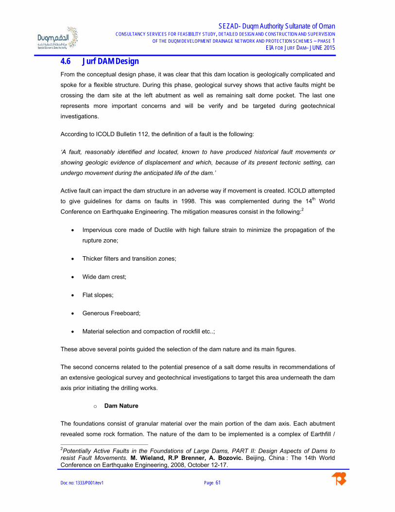
SEZAD- Duqm Authority Sultanate of Oman CONSULTANCY SERVICES FOR FEASIBILITY STUDY, DETAILED DESIGN AND CONSTRUCTION AND SUPERVISION
OF THE DUQM DEVELOPMENT DRAINAGE NETWORK AND PROTECTION SCHEMES – PHASE 1 EIA FOR JURF DAM– JUNE 2015
Doc no: 1333/P001/rev1 Page 61
4.6 Jurf DAM Design
From the conceptual design phase, it was clear that this dam location is geologically complicated and
spoke for a flexible structure. During this phase, geological survey shows that active faults might be
crossing the dam site at the left abutment as well as remaining salt dome pocket. The last one
represents more important concerns and will be verify and be targeted during geotechnical
investigations.
According to ICOLD Bulletin 112, the definition of a fault is the following:
‘A fault, reasonably identified and located, known to have produced historical fault movements or
showing geologic evidence of displacement and which, because of its present tectonic setting, can
undergo movement during the anticipated life of the dam.’
Active fault can impact the dam structure in an adverse way if movement is created. ICOLD attempted
to give guidelines for dams on faults in 1998. This was complemented during the 14th World
Conference on Earthquake Engineering. The mitigation measures consist in the following:2
Impervious core made of Ductile with high failure strain to minimize the propagation of the
rupture zone;
Thicker filters and transition zones;
Wide dam crest;
Flat slopes;
Generous Freeboard;
Material selection and compaction of rockfill etc..;
These above several points guided the selection of the dam nature and its main figures.
The second concerns related to the potential presence of a salt dome results in recommendations of
an extensive geological survey and geotechnical investigations to target this area underneath the dam
axis prior initiating the drilling works.
o Dam Nature
The foundations consist of granular material over the main portion of the dam axis. Each abutment
revealed some rock formation. The nature of the dam to be implemented is a complex of Earthfill /
2Potentially Active Faults in the Foundations of Large Dams, PART II: Design Aspects of Dams to resist Fault Movements. M. Wieland, R.P Brenner, A. Bozovic. Beijing, China : The 14th World Conference on Earthquake Engineering, 2008, October 12-17.

SEZAD- Duqm Authority Sultanate of Oman CONSULTANCY SERVICES FOR FEASIBILITY STUDY, DETAILED DESIGN AND CONSTRUCTION AND SUPERVISION
OF THE DUQM DEVELOPMENT DRAINAGE NETWORK AND PROTECTION SCHEMES – PHASE 1 EIA FOR JURF DAM– JUNE 2015
Doc no: 1333/P001/rev1 Page 62
Rockfill Embankment associated with a watertighness element.
Due to the presence of active fault, Jurf dam shall be equipped with a ductile core in order to
withstand reasonable displacement without significant loss or damage to the watertight element. For
this dam alternative, the choice of bituminous concrete core was retained and found appropriate. It
can auto-healed if cracks appear or relative displacement occurred.
The core will rest over a concrete slab in order to ensure the connection with the lower part within the
foundation. Different properties of bituminous core will be foreseen. Where faults are revealed to us,
specific joint will be carried out in order to allow differential settlement. The bituminous core will be
drained downstream within the transition layer.
In addition, separation will be carried out every 200m to ensure the collected water can be monitored
and analysed.
In addition, conservative slopes of 2.3 in 1 on the upstream and 1.8 in 1 at the downstream were
retained. The choice of 1.8:1 was selected to comply with spillway excavation and the rock fill
mechanical properties.
Implementation of transition layer upstream and downstream the bituminous core is advisable to
ensure the maintaining of stability in case of differential displacement occurs.
The dam crest was retained with width of W=6.8 meters as per guidance of “Design of Small Dams”
The following figure shows the retained cross section A:
Figure 4-12: Cross Section – Bituminous Core

SEZAD- Duqm Authority Sultanate of Oman CONSULTANCY SERVICES FOR FEASIBILITY STUDY, DETAILED DESIGN AND CONSTRUCTION AND SUPERVISION
OF THE DUQM DEVELOPMENT DRAINAGE NETWORK AND PROTECTION SCHEMES – PHASE 1 EIA FOR JURF DAM– JUNE 2015
Doc no: 1333/P001/rev1 Page 63
o Seepage control
Both abutment will necessary be treated to avoid any contouring of the water, specially the right one
that might present some karstic features. The core shall be anchored in a deep manner through the
abutment and grouting will be designed accordingly. Particular attention will be paid during
geotechnical investigations.
The left abutment will certainly excavated and equipped with the auxiliary spillway. Grouting will be
necessary as well and a particular attention will be paid to any revealed faults. The spillway shall
integrated some special features to allow small displacement.
Drainage will be provided under Rockfill materials and will collect any seepage water coming out from
the foundations. This water shall be collected and monitored.
o Main Spillway
As described earlier, the spillway will consists of 2 barrels of 5*5m culvert placed at the left abutment
founded on the visible rock layer.
The entrance sill elevation will be set at 33mamsl and will allow a significant flood reduction;
In addition to this main structure, an auxiliary spillway is foreseen over the left abutment, excavation to
a level of 39.5 mamsl is required. The nature of the spillway is a broad crested weir discharge in a
natural gorge downstream.
No dissipation structure is foreseen for this structure since it is believed that the rock formation is
competent enough to withstand the hydraulic jump and the supposed flow regime.
The length of the spillway will be 300m.
o Outlets
Due to the possible presence of remaining pocket of salt over this dam site, the Consultant
recommends that the dam reservoir shall be empty as soon as the flood passed. After routing effect
via the culvert spillway, the reservoir will be almost empty. At this stage and without knowledge of the
foundation, the Consultant considered that culvert spillway sufficient.
In case sign of slat formation is revealed, it is believed that providing a bottom outlet to empty the
remaining volume of the reservoir might be needed in order to limit the infiltration and the possible
dissolution leading to foundation instability below the dam.

SEZAD- Duqm Authority Sultanate of Oman CONSULTANCY SERVICES FOR FEASIBILITY STUDY, DETAILED DESIGN AND CONSTRUCTION AND SUPERVISION
OF THE DUQM DEVELOPMENT DRAINAGE NETWORK AND PROTECTION SCHEMES – PHASE 1 EIA FOR JURF DAM– JUNE 2015
Doc no: 1333/P001/rev1 Page 64
4.7 Stability Analysis of the Embankment
A preliminary Stability Analysis was performed for each dam cross-section alternatives A & B that
present the most crucial aspects in term of stability (i.e. highest cross section).
The analysis was carried out with the help of SLIDE software, finite element software.
The mechanical and hydraulic properties as well as the seismic coefficients of the model were
selected without extensive knowledge of the foundation, and therefore retained as safe value
according to the expert judgement.
The study is performed to check the stability of the Jurf Dam and the corresponding Factor or Safety
under various loading case scenario directly extracted from the usual recommendation and worldwide
practice. (Based on ICOLD, FEMA and USACE).
Depending on the results, the geometry of the dam shall be adjusted in order to comply with the
required safety factor ensure a great degree of safety during usual flood, extreme event, and seismic
event.
Bishop approach’s was used to estimated the safety factors for the all the relevant loading case
scenario. This method was found conservative compared to the other available in the literature.
4.7.1 Geometry
In order to be exhaustive, the main cross section were checked under the usual case. The Bituminous
core cross section is as follows:
Figure 4-13 – Slide Model – Bituminous Cross Section
4.7.2 Materials Properties
Without extensive knowledge of the foundation and its mechanical characteristics, a judgement has
made and conservative soil properties values has been retained. This ensures a safe design for slope

SEZAD- Duqm Authority Sultanate of Oman CONSULTANCY SERVICES FOR FEASIBILITY STUDY, DETAILED DESIGN AND CONSTRUCTION AND SUPERVISION
OF THE DUQM DEVELOPMENT DRAINAGE NETWORK AND PROTECTION SCHEMES – PHASE 1 EIA FOR JURF DAM– JUNE 2015
Doc no: 1333/P001/rev1 Page 65
stability under different loading cases. Both alternatives were investigated. The following table shows
the retained design parameters.
Table 4-8 – Mechanical Properties – Dam Components
Material Cohesion c
[kPa]
Internal Friction angle φ [˚]
Unit Weight Dry / Saturate [kN/m3]
Foundation Layer 5 20 19
Earthfill Shell (Dense) 0 35 22
Rockfill Material 0 40 21
Plastic Concrete Core 500 40 24
Bituminous Core (Asphalt) 120 24 23
Clay Core (Stiff) Cu=40
Cdrained 10 24
ϒd=16
ϒs=18
U/S Transition Layer 0 33 22
D/S Transition Layer 0 33 22
Drain 0 40 22
Filter 0 40 22
Rip Rap 0 44 21
Gravel Protection 0 44 21
These values will be revised after analysis of the geotechnical investigations to ensure the design
parameters used in the final analysis is representative of the actual materials to be use din
construction. Once the design parameters are finalised these values will be used to optimise the
embankment section.
4.7.3 Seismic Coefficient
The peak ground accelerations on rock were retained according to Oman Highway Design Manual
procedure and to specific studies developed for the Sultanate of Oman. In order to take into account
the site effects and the interaction with the type of structure analyzed, the seismic coefficients were
modified by considering a flexible structure placed over soil formation. At this stage we do not
consider the soil as liquefiable. Therefore:

SEZAD- Duqm Authority Sultanate of Oman CONSULTANCY SERVICES FOR FEASIBILITY STUDY, DETAILED DESIGN AND CONSTRUCTION AND SUPERVISION
OF THE DUQM DEVELOPMENT DRAINAGE NETWORK AND PROTECTION SCHEMES – PHASE 1 EIA FOR JURF DAM– JUNE 2015
Doc no: 1333/P001/rev1 Page 66
- Return Period for OBE is 475 years (10% in 50 years):
≅ 0.03
- MCE is evaluated with DSHA – Deterministic Approach:
% ≅ 0.1
Conclusion on design seismic parameters for a rock site.
As previously enounced, the SEE can be taken either as the MCE or MDE ground motions. Usually
the most unfavorable ground motion parameters have to be taken. For the time being there are not
information about the MDE, while for MCE yes. Therefore, we will consider the following:
SEE ≡ MCE ≅ 0.1 at the rock site;
OBE ≅ 0.03 at the rock site;
Conclusion on design seismic parameters for Jurf Dam site.
At this stage proper values for the characterization of soil type conditions are not available,
conservative values will be assumed:
- For expected rock ground – Type A ground (No amplification of seismic acceleration);
- For expected soil ground - Type D ground (amplification of seismic acceleration with a factor
1.8).
In the pseudo-static method the values presented in the following table shall be used in the design
calculations and are dependent on the type of structure and soil as follows:
Table 4-9 – Seismic Parameters - Duqm
Pseudo-static Analysis
Type of structure Ground Type Level of Seismic Event
Horiz. Accel. [g] Vert. Accel. [g]
Concrete Massive
Rock OBE 0.03 0.015
MCE 0.1 0.05
Soil OBE 0.054 0.027
MCE 0.18 0.09

SEZAD- Duqm Authority Sultanate of Oman CONSULTANCY SERVICES FOR FEASIBILITY STUDY, DETAILED DESIGN AND CONSTRUCTION AND SUPERVISION
OF THE DUQM DEVELOPMENT DRAINAGE NETWORK AND PROTECTION SCHEMES – PHASE 1 EIA FOR JURF DAM– JUNE 2015
Doc no: 1333/P001/rev1 Page 67
Type of structure Ground Type Level of Seismic Event
Horizontal Coefficient
Vertical Coefficient
Earthfill
Rock OBE 0.015 0.0075
MCE 0.05 0.025
Soil OBE 0.027 0.0135
MCE 0.09 0.045
It should be kept in mind that:
- The horizontal coefficient is defined as: 0.5 ;
- The vertical coefficient is defined as: 0.5 ;
- The vertical acceleration is defined as the half of the vertical.
The following coefficients were then retained:
Table 4-10 – Retained Seismic Parameters
Pseudo-static Analysis
Type of structure Ground Type Type of seism Horiz. Accel. [g] Vert. Accel. [g]
Earthfill/Embankment Soil OBE 0.027 0.0135
MCE 0.09 0.045
4.7.4 Loading Cases
For overall stability, the combination cases are classified as follows, by decreasing corresponding
factors of safety:
Normal Condition of Loading N: The Normal condition of loading includes all loads to which
the structure is considered to be subjected either permanently or for a considerable length of time.
Unusual Condition of Loading U: The Unusual condition of loading includes in addition to the
Normal loads the abnormal temporary loads which will probably apply at least once in the life of the
structure.

SEZAD- Duqm Authority Sultanate of Oman CONSULTANCY SERVICES FOR FEASIBILITY STUDY, DETAILED DESIGN AND CONSTRUCTION AND SUPERVISION
OF THE DUQM DEVELOPMENT DRAINAGE NETWORK AND PROTECTION SCHEMES – PHASE 1 EIA FOR JURF DAM– JUNE 2015
Doc no: 1333/P001/rev1 Page 68
Exceptional or Extreme Condition of Loading E:
The Extreme condition of loading will include in addition to the normal loads, the loads which might
apply to the structure with a probability of occurrence clearly less than 0.5 during the life of the
structure (the return period of such event is at least twice the life of the structure). An exceptional
condition of loading will also be a combination of two unusual conditions of loading. It must be noticed
that two exceptional events cannot be combined.
The loading combinations for earthfill dams can be summarized as follows:
Load Condition 1: Unusual load condition – End of Construction
Load Condition 2: Usual load condition – Normal operations FSL
Load Condition 3: Unusual load condition – Flood discharge MWL
Loading Condition 4: Extreme load condition – OBE during construction
Loading condition 5: Unusual load condition – FSL and OBE
Load condition 6: Extreme load condition –MCE with empty reservoir
Load condition 7: Extreme loading condition – Rapid Drawdown.
Both Alternative are flexible structure and shall comply with usual loading conditions. The stability
loading cases according the USACE manual EM 110-2-1902 must be verified and are as follows:
Load Cases
Description Factor of Safety (FoS) [1]
1 Empty Reservoir 1.3
2 Reservoir at MWL 1.4
3 Reservoir at FSL 1.5
4 Empty Reservoir + OBE 1.3
5 Reservoir at FSL + OBE 1.1
6 Empty Reservoir + MDE ≥ 1
7 Rapid Drawdown 1.3
Since the upstream prism is different from the downstream one, it is essential to analyse both faces
for the relevant load cases. The results of these analyses are included in the appendices.

SEZAD- Duqm Authority Sultanate of Oman CONSULTANCY SERVICES FOR FEASIBILITY STUDY, DETAILED DESIGN AND CONSTRUCTION AND SUPERVISION
OF THE DUQM DEVELOPMENT DRAINAGE NETWORK AND PROTECTION SCHEMES – PHASE 1 EIA FOR JURF DAM– JUNE 2015
Doc no: 1333/P001/rev1 Page 69
4.7.5 Stability Results
Load Cases
Description Factor of Safety (FoS) [1]
Analysis Safety Factor
Upstream Downstream
1 End of Construction 1.3 1.64 1.54
2 Reservoir at MWL (329.7mamsl) 1.4 4.33 1.54
3 Reservoir at FSL (327.2mamsl) 1.5 1.75 1.54
4 Empty Reservoir + MCE ≥ 1 1.28 1.25
5 Reservoir at MWL (329.7mamsl) + OBE
1.1 3.88 1.45
6 Reservoir at FSL (327.2mamsl) + OBE 1.1 1.62 1.45
7 Rapid Drawdown 1.3 1.7 -
The Jurf Dam with bituminous core is considered stable in every studied loading case. The rapid
drawdown was carried out considering long term retention and consequently do not represent reality
but is conservative.
4.8 Jurf Dam Construction process
As preliminary figures, the proposed dam is consisting of an earthfill embankment associated with
bituminous core and a plastic concrete cut-off.
The upstream prism will be made from wadi alluvium taken from the reservoir area by mechanical
mean. The downstream prism will be executed with reused rockfill materials coming from spillway
excavation positioned over the left abutment.
The rockfill materials will be excavated by mechanical mean and tested sieved in order to appropriate
physical properties for stability purposes. This material will also be mined to obtain appropriate rip rap
for dam slope protection.
The concrete bottom outlet will be carried out at the early stage in order to be used for flood diversion
structure. A temporary cofferdam will be integrated to the dam in order to be able to work in dry

SEZAD- Duqm Authority Sultanate of Oman CONSULTANCY SERVICES FOR FEASIBILITY STUDY, DETAILED DESIGN AND CONSTRUCTION AND SUPERVISION
OF THE DUQM DEVELOPMENT DRAINAGE NETWORK AND PROTECTION SCHEMES – PHASE 1 EIA FOR JURF DAM– JUNE 2015
Doc no: 1333/P001/rev1 Page 70
condition downstream.
Prior any placement of material, the foundation will be opened up to the desired depth. Preparation of
the surface will be made, compaction, scarification. Then, positioning of the guide wall will be made
for the cut-off. The cut-off will be carried out by tremie pipe method and involved placing of bentonite
for stability purpose. This bentonite will be closely monitored and reused along the complete
realization of the plastic concrete cut-off.
The dam will then be constructed in different steps. Placing of embankment, then compacting and
scarified to ensure proper cohesion between each layers. At the same time, the bituminous core will
be carried out. This operation will be repeated until the dam crest elevation is reached.
4.9 Dam Monitoring implementation
It is proposed to provide a series of topographical pegs with the reservoir to monitor the sedimentation
rate throughout the project life. The Consultant recommends a survey of this equipment every 5 years
or after each significant flood.
In addition, the drainage layer will be discharging the percolated water (if any) in a network of pipes
where monitoring will be possible thanks to calibrated V-notch. In view of the dam perspective (Flood
protection), it is expected that the percolated waters would be very low. When assessing the flowrate
if any, it is also recommended to assess the turbidity of the water which could be synonymous of
internal erosion when high. Particular attention will be paid at the junction between the concrete
structure and the embankment where preferential seepage water can be seating.
In addition, topographical pegs will be positioned over the embankment in order to assess any
settlement and instability over the face of the dam. Similar device will be positioned along the spillway
crest and the bottom outlet structure.
In the sultanate of Oman, there is no regulation upon the monitoring of the dams. This would be
achieved by the dam owner (Either SEZAD or the Ministry of Water Resources).

SEZAD- Duqm Authority Sultanate of Oman CONSULTANCY SERVICES FOR FEASIBILITY STUDY, DETAILED DESIGN AND CONSTRUCTION AND SUPERVISION
OF THE DUQM DEVELOPMENT DRAINAGE NETWORK AND PROTECTION SCHEMES – PHASE 1 EIA FOR JURF DAM– JUNE 2015
Doc no: 1333/P001/rev1 Page 71
5. BASELINE ENVIRONMENT SETTING 5.1 Overview
This chapter describes the baseline conditions in the study area and provides summarized
information on the physical, biological and socio-economic environment. The purpose of this
chapter is to facilitate the evaluation of impacts assessed in following stage.

SEZAD- Duqm Authority Sultanate of Oman CONSULTANCY SERVICES FOR FEASIBILITY STUDY, DETAILED DESIGN AND CONSTRUCTION AND SUPERVISION
OF THE DUQM DEVELOPMENT DRAINAGE NETWORK AND PROTECTION SCHEMES – PHASE 1 EIA FOR JURF DAM– JUNE 2015
Doc no: 1333/P001/rev1 Page 72
5.2 Demographic Data
According to the 2010 population census, the total population of Al Wusta Governorate was
42.111, 19.043 Omani and 23.068 Expatriate.
Wilayat Duqm that includes the village of Duqm at the 2010 presented 11,217 inhabitants,
corresponding to 26,6% the Wilayat. Duqm town has a total estimated population of 9,202 male
and 2,015 female inhabitants.
The national census indicates that the total population of Duqm city is composed by 3,820
Omanis and 7,397 foreign expatriates.
Figure 5-1: Wusta Population – Census 2010
Figure 5-2: Wusta Households and Housing Units – Census 2010

SEZAD- Duqm Authority Sultanate of Oman CONSULTANCY SERVICES FOR FEASIBILITY STUDY, DETAILED DESIGN AND CONSTRUCTION AND SUPERVISION
OF THE DUQM DEVELOPMENT DRAINAGE NETWORK AND PROTECTION SCHEMES – PHASE 1 EIA FOR JURF DAM– JUNE 2015
Doc no: 1333/P001/rev1 Page 73
Figure 5-3: AL Wusta Population and Percentage – Census 2010
Figure 5-4: AL Wusta Population by Wilayat– Census 2010

SEZAD- Duqm Authority Sultanate of Oman CONSULTANCY SERVICES FOR FEASIBILITY STUDY, DETAILED DESIGN AND CONSTRUCTION AND SUPERVISION
OF THE DUQM DEVELOPMENT DRAINAGE NETWORK AND PROTECTION SCHEMES – PHASE 1 EIA FOR JURF DAM– JUNE 2015
Doc no: 1333/P001/rev1 Page 74
5.3 Local Economy
The Duqm SEZ is a model of an integrated economic development composed of 8 zones: a sea
port, industrial area, new town, fishing harbor, tourism zone, a logistics hub and an education &
training zone, all of which are supported by a multi-modal transport system that connects it with
nearby regions (the Arabian Gulf countries, Middle East, East Africa and Southeast Asia).
Duqm development undertakes the future construction of Modern Port & Dry Dock, International
Airport, New Town complex, Industrial Areas, Fishing Harbor & Industry, Transport System,
Power & Utilities and Tourism Zones (Hotels & Resorts).
The major employment generators for Duqm are expected to be the Oil Refinery, the Sea Port,
Tourism, the Fishing Port, and the Airport.
Up to 2017, Duqm developments will provide a total of 4,126 permanent direct jobs in projects
such as the Duqm airport, the cement terminal project, the Duqm refinery and Duqm Ship repair
yard.
The recent investments done to build the City Duqm Hotel and the Crown Plaza is also providing
local & foreigner employment, but, most of all, allowing the development of the area in terms of
tourism.
The small scale economy of the Duqm city is mainly based on: Government Servants, Private
Servants, Retired Government Servants, Trading, Fishing, Shopkeepers, Laborers, Cultivators
and Pastorals. Duqm is oriented towards agriculture, fishing and raising stock (goats), as shown
in the following Figures. Housing conditions are also one of the major/important indicators for the
assessment of living standard. The houses in the Study Area are made with cement blocks, fully
equipped with all amenities including house overhead water tanks. Most people owns a private
vehicle and uses this mean of transport to reach work in the center town.
Figure 5-5: Camel farm in Duqm

SEZAD- Duqm Authority Sultanate of Oman CONSULTANCY SERVICES FOR FEASIBILITY STUDY, DETAILED DESIGN AND CONSTRUCTION AND SUPERVISION
OF THE DUQM DEVELOPMENT DRAINAGE NETWORK AND PROTECTION SCHEMES – PHASE 1 EIA FOR JURF DAM– JUNE 2015
Doc no: 1333/P001/rev1 Page 75
Figure 5-6: Raising goats in Duqm
Figure 5-7: Fishing activities in Duqm
5.4 Land Use
The Duqm master plan intends to accommodate a 13,00 hectares of wide-ranging mix land to
develop urbanized areas of the city while preserving natural assets and ensuring the potential
grow.
Duqm’s developable areas will be planned strategically to accommodate these uses in a way that
will maximize their productive value while allowing the city to grow in a compact, logical way that
can support development in context with its unique natural setting.
Urbanized areas will be planned strategically, with a range of other uses to be accommodated in
remaining areas. Duqm’s unique topography and setting provide a range of environmental
conditions conducive to particular arrangements for these remaining uses – and their design will
be prioritized where they make the most sense.

SEZAD- Duqm Authority Sultanate of Oman CONSULTANCY SERVICES FOR FEASIBILITY STUDY, DETAILED DESIGN AND CONSTRUCTION AND SUPERVISION
OF THE DUQM DEVELOPMENT DRAINAGE NETWORK AND PROTECTION SCHEMES – PHASE 1 EIA FOR JURF DAM– JUNE 2015
Doc no: 1333/P001/rev1 Page 76
Duqm can accrue significant value out of the special use zones, which will accommodate
recreational, natural, and productive uses. Flexibility will be a major objective in planning these
zones so that as Duqm grows it will be able to accommodate the changing needs of the city
without sacrificing its unique environmental heritage.
The current land use map shown below, indicates the developed within Duqm city. For the actual
time, the area where the project of the proposed project is to be developed in Wadi Jurf has no
major occupation in terms of land use terminology. Some construction activities are in the on-
going stage in the vicinity of the area and some small farms are visible along the channels on a
small scale.
The bellow figure represents the adopted land use zoning for the entire Duqm Royal decree area
as of September 2013.

SEZAD- Duqm Authority Sultanate of Oman CONSULTANCY SERVICES FOR FEASIBILITY STUDY, DETAILED DESIGN AND CONSTRUCTION AND SUPERVISION
OF THE DUQM DEVELOPMENT DRAINAGE NETWORK AND PROTECTION SCHEMES – PHASE 1 EIA FOR JURF DAM – JUNE 2015
Doc no: 1333/P001/rev1 Page 77
Figure 5-8: Land Use map approve by September 2013
Figure 5-9: Land Use map approved by September 2013 – project developments

SEZAD- Duqm Authority Sultanate of Oman CONSULTANCY SERVICES FOR FEASIBILITY STUDY, DETAILED DESIGN AND CONSTRUCTION AND SUPERVISION
OF THE DUQM DEVELOPMENT DRAINAGE NETWORK AND PROTECTION SCHEMES – PHASE 1 EIA FOR JURF DAM – JUNE 2015
Doc no: 1333/P001/rev1 Page 78
Although the project area is currently untouched in terms of construction activities, major
projects are to be developed, with the development of Duqm Town, the airport area and the
medium and light industrial area in the vicinity of the proposed project. The SEZAD Masterplan
predicts innovative developments, namely, wind farms, solar fields, commercial area &
showrooms, along with the implementation of the industrial areas, in the surroundings of the
wadi Say and Wadi Jurf dams and channels. As a sort term strategy for the project area, Duqm
will see the rising of a road system at national and local scale serving the abovementioned
areas in Duqm.
Figure 5-10: Built and Planed Roads in Duqm
The Proposed Land Use in Duqms’ Master Plan As a more detailed understanding of the site, its topography, soil conditions and ecosystems
evolves; the SEZAD master plan for the industrial areas to the north and east of the royal
decree area proves to be difficult and costly to be implemented in a number of areas:
The zone laid out to accommodate medium industry to the west of the port is situated to
a large extent on soil that is unsuitable for regular development.
The soil in the area where the wadi discharges in the sea is silt and clay, resulting in
increased cost of construction in this area.
The layout of the area zoned for heavy industry northwest of the port is equally being reviewed,
particularly the proposed stormwater drainage system.
Ways of adjusting this layout in order to integrate natural stormwater channels into the
development areas are being explored to reduce construction cost and upfront infrastructure
investment required to implement the current solution.
Preserving existing natural stormwater routes and the extensive Sabkha area west of the port
from development not only allows for cost reduction and easier implementation but also has the

SEZAD- Duqm Authority Sultanate of Oman CONSULTANCY SERVICES FOR FEASIBILITY STUDY, DETAILED DESIGN AND CONSTRUCTION AND SUPERVISION
OF THE DUQM DEVELOPMENT DRAINAGE NETWORK AND PROTECTION SCHEMES – PHASE 1 EIA FOR JURF DAM – JUNE 2015
Doc no: 1333/P001/rev1 Page 79
added benefit of preserving sensitive ecological areas of local regional and international
significance.
The Sabkha is created by the confluence of several wadi streams carrying nutrients from further
in land to the sea. Sea water is infiltrating the area from the coast, creating a unique habitat for
migrant birds and making Duqm an important stopover for birds traveling between Asia and
Africa.
The major landuse shifts away from the previous plan propose to Move the zone for Medium industry further to the south were light industry is currently
located.
Locate the light industry close to the airport at the southern edge of the Duqm Town
boundary.
Reconfigure the Heavy Industry zone to be integrated within the current stormwater
channels
Figure 5-11: Proposed land use map for Duqm.
The proposed site wide planning strategy proposes a strategic rearrangement of land uses that
takes into account the topographical and environmental constraints.
This strategy also aims to create development that is as compact as possible within the
current set of constraints and defines clear edges between developed land and open space.
The strategic plan for the economic zone as a whole is structured in 3 distinct development
nodes separated by major open space systems:
The airport cluster to the south.
The port city in the heart of Duqm where the most intense mix of uses, the highest density
of residents and a genuine city centre will emerge in proximity to yet sufficiently buffered from
port activities and medium industry.
Wadi Jurf

SEZAD- Duqm Authority Sultanate of Oman CONSULTANCY SERVICES FOR FEASIBILITY STUDY, DETAILED DESIGN AND CONSTRUCTION AND SUPERVISION
OF THE DUQM DEVELOPMENT DRAINAGE NETWORK AND PROTECTION SCHEMES – PHASE 1 EIA FOR JURF DAM – JUNE 2015
Doc no: 1333/P001/rev1 Page 80
The heavy industrial zone to the north, focused on production, close to the port but at a
comfortable distance to residential neighborhoods to the south and separated from the city
centre by an unspoilt generous natural reserve that will help to maintain Duqm’s role as a prime
stopover destination for migrant birds.
The project area, although is still untouched, will be subject to drastic changes within the future
developments, highlighting the importance of building an adequate channel capable of providing
flood protection and natural drainage of the existing wadis.
The City Centers
In terms of urban design, Duqm will be developed based on a clear hierarchy approach of urban
centers of population density and activities, land use and urban character. Applying this
differentiation, 3 major zones were planned to have a unique roles:
A. Duqm Village Centre
B. Coastal City Centre
C. Airport Centre
D. Civic Center
Unique uses and public amenities will be
located that cater for Duqm Town as a whole
will be located in town centers. Such as a:
- Central business district,
- Regional retail,
- Major souk,
- Eid Mosque,
- Governors’ house and offices
They will be most accessible by public
transport and the places where higher
density housing would be most logically positioned.
A civic campus in the heart of Duqm Town will provide a location for facilities of city wide
importance such as a regional hospital, university or other large educational and sports
facilities.
Comprehensive Public Transport Network
Duqm’s public transport network is to be comprehensive with multimodal interchanges.
The transport infrastructure will be built to accommodate the latest transport technology to
facilitate efficient operate of the entire network.
Such technology may include:
Priority signaling at junctions;
Bus priority lanes;
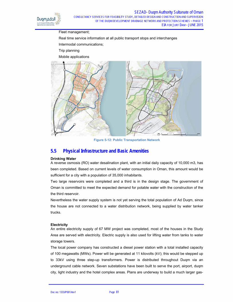
SEZAD- Duqm Authority Sultanate of Oman CONSULTANCY SERVICES FOR FEASIBILITY STUDY, DETAILED DESIGN AND CONSTRUCTION AND SUPERVISION
OF THE DUQM DEVELOPMENT DRAINAGE NETWORK AND PROTECTION SCHEMES – PHASE 1 EIA FOR JURF DAM – JUNE 2015
Doc no: 1333/P001/rev1 Page 81
Fleet management;
Real time service information at all public transport stops and interchanges
Intermodal communications;
Trip planning
Mobile applications
Figure 5-12: Public Transportation Network
5.5 Physical Infrastructure and Basic Amenities
Drinking Water A reverse osmosis (RO) water desalination plant, with an initial daily capacity of 10,000 m3, has
been completed. Based on current levels of water consumption in Oman, this amount would be
sufficient for a city with a population of 35,000 inhabitants.
Two large reservoirs were completed and a third is in the design stage. The government of
Oman is committed to meet the expected demand for potable water with the construction of the
the third reservoir.
Nevertheless the water supply system is not yet serving the total population of Ad Duqm, since
the house are not connected to a water distribution network, being supplied by water tanker
trucks.
Electricity An entire electricity supply of 67 MW project was completed, most of the houses in the Study
Area are served with electricity. Electric supply is also used for lifting water from tanks to water
storage towers.
The local power company has constructed a diesel power station with a total installed capacity
of 100 megawatts (MWs). Power will be generated at 11 kilovolts (kV); this would be stepped up
to 33kV using three step-up transformers. Power is distributed throughout Duqm via an
underground cable network. Seven substations have been built to serve the port, airport, duqm
city, light industry and the hotel complex areas. Plans are underway to build a much larger gas-

SEZAD- Duqm Authority Sultanate of Oman CONSULTANCY SERVICES FOR FEASIBILITY STUDY, DETAILED DESIGN AND CONSTRUCTION AND SUPERVISION
OF THE DUQM DEVELOPMENT DRAINAGE NETWORK AND PROTECTION SCHEMES – PHASE 1 EIA FOR JURF DAM – JUNE 2015
Doc no: 1333/P001/rev1 Page 82
fueled power plant (500-1000MWs) to meet Duqm’s future needs; a reverse osmosis (RO)
water desalination plant, with an initial daily capacity of10, 000 m3, has been completed.
Sanitation / Drainage Facilities Based on current levels of water consumption in Oman, this amount would be sufficient for a
city with a population of 35,000. Further expansion of the RO plant along with the water
distribution network is underway to meet the rising demand.
Two large reservoirs completed and a third is in the design stage. The government of Oman is
committed to meeting the expected demand for potable water and electricity in the zone has
been completed.
Houses have standard sanitary fittings in bathrooms and toilets and had arrangements for
proper sewage and septic tank storage facilities. Municipal administration has fleet of sewage
disposal tankers which regularly collect sewage water from house storage tanks to the final
disposal. Recently, the construction of a 2,000 m3/day sewerage treatment plant was
concluded.
Telephone Not all the houses are served with lined telephone facility while the majority uses mobile phones.
Mode of Transportation Private cars are present in Duqm village. Most of the project area is served by track roads.
Other Facilities Bank, Post Office, Markets, Hotels and other facilities are available in Ad Duqm town.
5.6 Education
At present, Duqm has several government educational facilities providing basic education in
Arabic to the existing Omani population. In the future, private educational institutions will be
invited to provide multi-lingual schools that meet international standards and address the needs
of expatriates as well as local residents. As part of Duqm’s vision of creating a viable local
community, institutions for higher education and vocational training as well as research and
development centers will be established.
The two major objectives of the educational institutions will be to: (1) provide local manpower
with the skills required to qualify for jobs in future industries and services and (2) provide
engineering and troubleshooting services to local industries. An advanced Marine Research
Center is planned that will conduct cutting-edge studies and provide technical support for the
local fishing industry.

SEZAD- Duqm Authority Sultanate of Oman CONSULTANCY SERVICES FOR FEASIBILITY STUDY, DETAILED DESIGN AND CONSTRUCTION AND SUPERVISION
OF THE DUQM DEVELOPMENT DRAINAGE NETWORK AND PROTECTION SCHEMES – PHASE 1 EIA FOR JURF DAM – JUNE 2015
Doc no: 1333/P001/rev1 Page 83
5.7 Health Facilities
The Government attaches a very high priority to the improvement of health facilities so as to
translate the economic success into social benefits. The seventh Five-Year Health Development
Plan (2006-2010) has envisaged one health centre for every 10,000 of the population in the
urban and heavily populated areas and seeks to provide easily accessible health centers for
scattered population localities. The following table summarizes of the Sultanate of Oman the
available information from the Ministry of Health concerning the health facilities in Al Wusta
region. As regard to the health facilities, these are almost free for Omani residents.
D - Maternity beds; R - Radiological Procedures; L - Laboratory Facilities
In addition to the public health care provided by government hospital in Duqm, private sector
medical practitioners and specialists are expected to take advantage of area’s demographics
and corporate clienteles to augment the scope of medical services provided by the Ministry of
Health
5.8 Role of Women
The role of women assumes a larger dimension due to increased activity in the entire socio-
economic and socio-cultural fields in the Study Area. The study of the target area has shown
that a majority of the men are willing to allow the women to work outside home. This could
create important source of income for the women and also for her family as a whole.

SEZAD- Duqm Authority Sultanate of Oman CONSULTANCY SERVICES FOR FEASIBILITY STUDY, DETAILED DESIGN AND CONSTRUCTION AND SUPERVISION
OF THE DUQM DEVELOPMENT DRAINAGE NETWORK AND PROTECTION SCHEMES – PHASE 1 EIA FOR JURF DAM – JUNE 2015
Doc no: 1333/P001/rev1 Page 84
5.9 Identification of Resettlement Issues
The project doesn’t predict the need of occupation of private residential areas, since there are
no houses to be relocated from the dam axis or reservoir were the channels will be built.
Nevertheless, there may be a few small animal shelters that may be relocated, mainly because
the owners often move the shelters according to their needs and they may move some onto the
project area before construction starts. At the moment, the project does not consider the
relocation of the animal shelters, but should be consider such relocation in the BoQ.
During construction, some temporary areas will be affected to establish campsites, deposit
areas and even borrow areas. The contractor will settle 1 area to establish the campsite where
the construction material and logistic will take place. It is suggested this campsite to be
upstream the dam and close as possible to the main road, in a flat area, avoiding the
occupation of other areas with no access built and improving response in case of any
emergency situation.
Also during construction phase, the excavation activities may generate surplus of soil that will
have no use for the construction of dam. This excavation material will be stockpiled on a
temporary area near the project in a flat area, avoiding being run off from water or wind. This
temporary stockpiled area is allocated to the stock material that SEZAD may to use for their
future projects needs.
At this stage of the project it is not possible to assume the exact amount of material to stockpile
or to borrow as the size of the dams are still under approval of SEZAD, but the predictable
quantities for deposit area are 200 000 m2 downstream the Jurf dam. Once approved the
dimension of the dams, the volume and the exact location of these areas can be confirmed for
the borrow areas, quarries and the deposit, but the contractor will need permission/ approval
from SEZAD.
Within the project, particular attention was paid in order to minimise the impacts of the projected
features over the existing and foreseen features.
Part of the Oryx Sanctuary Reserve will be permanently affected by the Jurf dam reservoir at its
full supply level within an approximated area of 526 345 m2, as it is need to construct the dam
axis and that will partially inundate the reserve when FSL is reached.

SEZAD- Duqm Authority Sultanate of Oman CONSULTANCY SERVICES FOR FEASIBILITY STUDY, DETAILED DESIGN AND CONSTRUCTION AND SUPERVISION
OF THE DUQM DEVELOPMENT DRAINAGE NETWORK AND PROTECTION SCHEMES – PHASE 1 EIA FOR JURF DAM – JUNE 2015
Doc no: 1333/P001/rev1 Page 85
Figure 5-13: Identification of resettlements
5.10 Tourism
Tourism is one of the most important economic sectors upon which the Sultanate relies for
income. The attention by the government to the Tourism Sector is manifested in its persistent
efforts for formulation and implementation of development plans for this sector. Ministry of
Tourism is already motivating the tourism in the region, by promoting mostly the beaches,
famous for their cleanliness and the purity of their waters. This has resulted in an increase of
marine plants which give the water its green color. Many birds pass this area during their annual
migration. On land, the moderate climate, influenced by the annual autumn season in Dhofar,
helps the growth of a variety of plants and rare mammals such as the Arabian Oryx and the
Nubian ibex. In addition to all this natural wealth, the area abounds in a large number of oil and
gas fields, making it rich on every score.
At the moment 2 hotels are accommodating businessmen and tourists visiting Ad Duqm, The
Crown Plaza and the Duqm city Hotel, and others are being planned for the region.

SEZAD- Duqm Authority Sultanate of Oman CONSULTANCY SERVICES FOR FEASIBILITY STUDY, DETAILED DESIGN AND CONSTRUCTION AND SUPERVISION
OF THE DUQM DEVELOPMENT DRAINAGE NETWORK AND PROTECTION SCHEMES – PHASE 1 EIA FOR JURF DAM – JUNE 2015
Doc no: 1333/P001/rev1 Page 86
5.11 Archaeology – Cultural Heritage
With a civilization of almost thousands of years, Oman has a great treasure of archaeological,
historical and cultural information and facts. The country has thousands of archaeological and
historical sites including over 500 forts and towers.
Oman, can boast of largest collection of archaeological sites including highly revered ones by
Muslims, Christians and Jews alike, and ancient historical sites. Many of the heritage sites are
included in the UNESCO World Heritage list.
Duqm’s unique topography is complemented by several areas of geological significance that
contribute to the heritage value of Oman. Natural processes and historic human settlements
have left behind artifacts and rock formations that will give the development some of its most
salient tourism value and local meaning.
The Rock Garden
Formed in an underground freshwater aquifer over 46 million years ago, the Rock Garden is
part of Duqm´s heritage. Covering an area of 3 Km3 of limestone and sandstone rocks shaped
by the wind, water, frost by natural actions, the Rock Garden is one of the most important sites
of the Sultanate of Oman.
The Rock Garden, also known as the Duqm Stone Park, is a unique collection of sandstone and
limestone rock formations, remnants of an underground aquifer. Composed of primarily soft
rock, near the Port, maintaining this area free from development is essential to preserving
Duqm’s cultural heritage and growing the site’s ecotourism potential.
Nowadays the Rock Garden is considered one of the Duqms most visit tourism attraction and
the Duqm matser plan proposes the preservation of this natural monument and transform in into
a genuine destination where visitors can explore and learn about archeology, geology and the
local history.
The rock garden boundary is defined by major roads on 3 sides and a narrow development strip
east of National Road 32.
The Duqm Mater Plan proposes the Rock Garden as:
Access point for visitors will be created at strategic locations where cars can be
parked and footpaths lead into the Rock Garden.
A soft mode of vehicular transport within the rock garden such as golf carts could be
considered on selected routes.
Pathways along the main wadi that runs through the area will connect different
archaeological sites and links into the newly emerging district south of the rock garden.

T
A
A
C
t
The
dense
treate
scree
Thi
green
A n
south
The proposed
Archeology
Al Duqm is ric
Central Oma
the site with p
CONSULTANCY
e southern ed
e forest of tre
ed sewage ef
ened from vie
is will create a
n environmen
number of res
hern and prim
- Geologi
- Interpre
- Natural
d project does
ch with archa
n Paleolithic
particularly no
SERVICES FOR FE
OF THE DUQM
dge of the roc
ees as a tree n
ffluent from a
w.
a high value e
nt that won’t b
search, cultura
mary entrance
cal Research
etive/Commun
History and A
Figure 5
sn’t cross or d
aeological rem
Survey (COP
otable findings
EASIBILITY STUDY
DEVELOPMENT DR
ck garden fron
nursery is pla
sewage treat
edge for resid
be found anyw
al and educat
into the Rock
h Centre
nity Centre
Art Museum
-14: The Rock
disturb the na
mnants from s
PS) provided
s.
SEZAD- Duq, DETAILED DESIG
RAINAGE NETWOR
nting this new
anned to be e
tment plant lo
dential proper
where else in
tional facilities
k Garden:
k Garden Area
atural Rock G
several Stone
a detailed pa
qm Authority SGN AND CONSTRUC
RK AND PROTECTI
EIA FOR J
w district will b
stablished he
ocated within
rties fronting t
the city
s will be locat
a
arden.
e Age settlem
artial analysis
Sultanate of OCTION AND SUPER
ON SCHEMES – P
URF DAM – JUNE
be lined by a
ere, irrigated b
the nursery a
this park and
ted at this
ents. The 200
s of many are
Oman RVISION HASE 1 E 2015
by
and
a
07-08
eas of
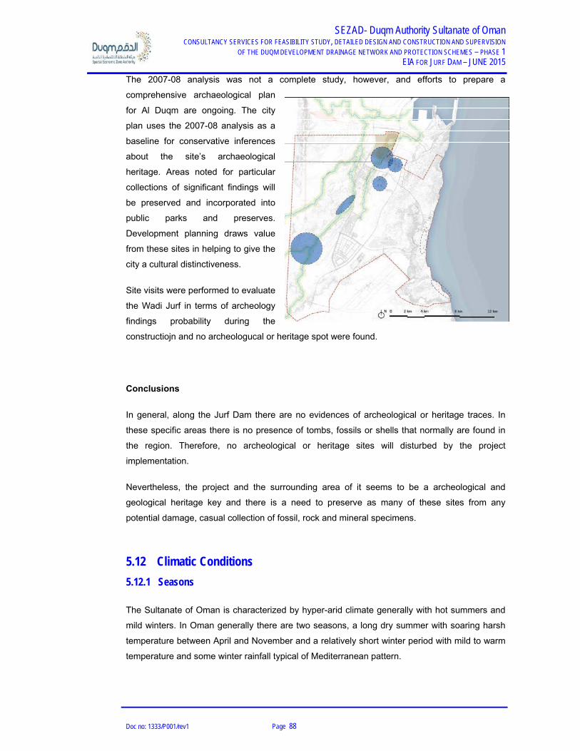
SEZAD- Duqm Authority Sultanate of Oman CONSULTANCY SERVICES FOR FEASIBILITY STUDY, DETAILED DESIGN AND CONSTRUCTION AND SUPERVISION
OF THE DUQM DEVELOPMENT DRAINAGE NETWORK AND PROTECTION SCHEMES – PHASE 1 EIA FOR JURF DAM – JUNE 2015
Doc no: 1333/P001/rev1 Page 88
The 2007-08 analysis was not a complete study, however, and efforts to prepare a
comprehensive archaeological plan
for Al Duqm are ongoing. The city
plan uses the 2007-08 analysis as a
baseline for conservative inferences
about the site’s archaeological
heritage. Areas noted for particular
collections of significant findings will
be preserved and incorporated into
public parks and preserves.
Development planning draws value
from these sites in helping to give the
city a cultural distinctiveness.
Site visits were performed to evaluate
the Wadi Jurf in terms of archeology
findings probability during the
constructiojn and no archeologucal or heritage spot were found.
Conclusions
In general, along the Jurf Dam there are no evidences of archeological or heritage traces. In
these specific areas there is no presence of tombs, fossils or shells that normally are found in
the region. Therefore, no archeological or heritage sites will disturbed by the project
implementation.
Nevertheless, the project and the surrounding area of it seems to be a archeological and
geological heritage key and there is a need to preserve as many of these sites from any
potential damage, casual collection of fossil, rock and mineral specimens.
5.12 Climatic Conditions
5.12.1 Seasons
The Sultanate of Oman is characterized by hyper-arid climate generally with hot summers and
mild winters. In Oman generally there are two seasons, a long dry summer with soaring harsh
temperature between April and November and a relatively short winter period with mild to warm
temperature and some winter rainfall typical of Mediterranean pattern.

SEZAD- Duqm Authority Sultanate of Oman CONSULTANCY SERVICES FOR FEASIBILITY STUDY, DETAILED DESIGN AND CONSTRUCTION AND SUPERVISION
OF THE DUQM DEVELOPMENT DRAINAGE NETWORK AND PROTECTION SCHEMES – PHASE 1 EIA FOR JURF DAM – JUNE 2015
Doc no: 1333/P001/rev1 Page 89
5.12.2 Temperature
According to the available data, the average yearly temperature varies to extremes during the
seasons, while maximum may rise to 46º C in summer daytime. Minimum temperature may go
down to 11º C on winter nights. The average dry bulb temperature record for the period of 2003
to 2011 (at Duqm station) is also given below and it’s 26 º C.
Figure 5-15: Average Temperature
Source: Statistic Book 2011

SEZAD- Duqm Authority Sultanate of Oman CONSULTANCY SERVICES FOR FEASIBILITY STUDY, DETAILED DESIGN AND CONSTRUCTION AND SUPERVISION
OF THE DUQM DEVELOPMENT DRAINAGE NETWORK AND PROTECTION SCHEMES – PHASE 1 EIA FOR JURF DAM – JUNE 2015
Doc no: 1333/P001/rev1 Page 90
Year Mean
Jan Feb Mar Apr May Jun Jul Au Sep Oct Nov Dec
2003 25.1 25.8 22.8 24.3
2004 22.0 22.6 25.4 30.7 31.5 32.2 28.2 26.6 27.4 25.5 25.5 23.3 26.7
2005 21.3 27.6 23.5 27.8 26.1 25.5 22.4 24.7
2006 21.5 22.9 25.2 29.1 31.5 31.1 28.6 27.9 28.4 27.3 25.5 22.6 26.8
2007 20.5 24.6 25.4 30.1 32.0 31.6 30.4 27.7 28.2 26.1 25.6 23.7 27.2
2008 21.4 20.2 25.2 29.4 31.4 32.3 28.7 27.3 28.4 27.3 23.5 18.3 26.1
2009 18.0 22.8 25.5 28.1 31.9 32.0 30.1 28.4 28.2 27.2 24.9 24.0 26.7
2010 21.2 23.2 26.1 30.7 32.5 31.2 28.9 27.7 27.8 28.3 25.2 21.8 27.1
2011 21.0 22.8 25.9 28.1 30.8 25.1
Mean 20.9 22.7 25.5 29.4 31.7 31.1 29.2 27.0 28.0 26.6 25.2 22.4 26.1 Figure 5-16: Dry bulb temperature at Duqm Meteorological station (Monthly Mean)
Source: Directorate General of Meteorology and air navigation
5.12.3 Rainfall
Rainfall data was provided by Directorate General of Civil Aviation & Meteorology for the Duqm
master plan study. The total recorded rainfall in Duqm over the last ten years was 174mm, with
an average annual depth of 17mm (see Figure below).
Figure 5-17: Rainfall Map of Oman

SEZAD- Duqm Authority Sultanate of Oman CONSULTANCY SERVICES FOR FEASIBILITY STUDY, DETAILED DESIGN AND CONSTRUCTION AND SUPERVISION
OF THE DUQM DEVELOPMENT DRAINAGE NETWORK AND PROTECTION SCHEMES – PHASE 1 EIA FOR JURF DAM – JUNE 2015
Doc no: 1333/P001/rev1 Page 91
5.12.4 Evaporation
No data available on site regarding evaporation. As per the Consultant’s achieved projects in
similar areas of the Sultanate of Oman the potential annual evaporation has been taken as per
2,000mm.
5.12.5 Humidity
According to the Directorate General of Meteorology and Air Navigation of the Sultanate of
Oman, Monthly Maximum & Minimum Humidity (%) for Duqm meteorological station is 70,5%
maximum in August and a minimum of 53.6% in March as given in the following table. This data
is based on observations from 2003 until 2011, where the average Relative Humidity for this
period per year is 62%.
Year Mean
Jan Feb Mar Apr May Jun Jul Aug Sep Oct Nov Dec
2003 74.0 66.6 67.3 67.5
2004 68.5 56.7 57.1 57.5 56.3 60.9 70.3 70.1 69.5 67.9 69.1 61.3 63.5
2005 59.7 80.0 83.3 68.8 62.0 64.3 63.0 63.6
2006 56.2 69.6 57.8 59.0 60.5 65.3 64.8 67.7 68.4 68.0 65.7 60.0 63.4
2007 60.1 61.4 58.3 55.4 60.4 64.8 60.5 69.4 67.5 61.5 64.1 59.6 61.9
2008 58.9 53.9 52.2 55.8 61.0 53.4 65.9 67.1 65.8 63.1 62.3 46.9 58.9
2009 60.4 62.4 56.7 59.0 54.6 57.9 63.5 68.4 67.0 66.2 64.9 62.4 62.0
2010 57.2 63.2 46.6 53.9 58.9 65.2 67.0 67.8 67.7 65.4 56.2 56.2 60.7
2011 62.3 52.8 46.6 60.9 60.1 56.2
Mean 60.4 60.0 53.6 57.3 58.8 63.9 65.3 70.5 67.8 66.0 64.2 59.6 62.0 Figure 5-18: Relative Humidity at Duqm meteorological station
Source: Directorate General of Meteorology and air navigation

SEZAD- Duqm Authority Sultanate of Oman CONSULTANCY SERVICES FOR FEASIBILITY STUDY, DETAILED DESIGN AND CONSTRUCTION AND SUPERVISION
OF THE DUQM DEVELOPMENT DRAINAGE NETWORK AND PROTECTION SCHEMES – PHASE 1 EIA FOR JURF DAM – JUNE 2015
Doc no: 1333/P001/rev1 Page 92
5.12.6 Precipitation
The Directorate General of Meteorology and Air Navigation of Sultanate provided the bellow
information regarding the variation of the precipitation for the period of 2003 to 2012 at Duqms´
Meteorological station. According to this data, the average precipitation in Duqm is 11,2mm per
year for the 10 year period, the average maximum value observed was 3,8mm for the month of
December and it´s verified absence of precipitation along the years especially during the
months of July, August, September and November.
Year
Total
Jan Feb Ma Apr May Jun Jul Aug Sep Oct Nov Dec
2003 0.0 0.0 0.0 0.0
2004 0.0 0.0 0.0 0.0 0.0 0.0 0.0 0.0 0.0 0.0 0.0 25.0 25.0
2005 0.0 0.0 0.0 0.0 0.0 0.0 0.0 0.0
2006 0.0 0.0 0.0 0.0 0.0 0.0 0.0 0.0 0.0 0.0 0.0 0.0 0.0
2007 0.0 0.0 0.0 0.0 0.0 0.0 0.0 0.0 0.0 0.0 0.0 1.6 1.6
2008 2.4 0.0 0.2 0.0 0.0 0.0 0.0 0.0 0.0 15.8 0.0 0.0 18.4
2009 0.6 0.2 0.2 0.0 0.0 0.0 0.0 0.0 0.0 0.0 0.0 3.4 4.4
2010 0.0 7.2 0.0 0.0 0.0 4.8 0.0 0.0 0.0 0.0 0.0 0.0 12.0
2011 0.0 0.0 0.0 23.4 16.4 39.8
Mean 0.4 1.1 0.1 3.3 2.3 0.7 0.0 0.0 0.0 2.0 0.0 3.8 11.2 Figure 5-19: Precipitation at Duqm meteorological station
Source: Directorate General of Meteorology and air navigation

SEZAD- Duqm Authority Sultanate of Oman CONSULTANCY SERVICES FOR FEASIBILITY STUDY, DETAILED DESIGN AND CONSTRUCTION AND SUPERVISION
OF THE DUQM DEVELOPMENT DRAINAGE NETWORK AND PROTECTION SCHEMES – PHASE 1 EIA FOR JURF DAM – JUNE 2015
Doc no: 1333/P001/rev1 Page 93
5.12.7 Wind
The wind rose study reveals that Duqm has predominantly strong winds from south and
southwest with extremely strong incidence from the months of April until September.

SEZAD- Duqm Authority Sultanate of Oman CONSULTANCY SERVICES FOR FEASIBILITY STUDY, DETAILED DESIGN AND CONSTRUCTION AND SUPERVISION
OF THE DUQM DEVELOPMENT DRAINAGE NETWORK AND PROTECTION SCHEMES – PHASE 1 EIA FOR JURF DAM – JUNE 2015
Doc no: 1333/P001/rev1 Page 94
Figure 5-20: Wind speed at Duqm meteorological station
Source: Directorate General of Meteorology and air navigation
5.13 Air Quality
Following the land use maps for the Duqms’ Master Plan, the project area will be under great
project developments, such as the power plant and the oil refinery. As soon as the industrial
activities commence, the air quality change accordantly to the nature and time of exposure of
these activities. The regulation and control of these activities is expected, but these will be the
major contributors for the air quality in the project area, not only form the operational point of
view, but also from the traffic increase in the surrounding area.
An air quality monitoring study was undertaken by 5 Oceans in July 2011 which covered the
wider area of the Al Duqm Master Plan area. This study focused on the following air pollutants:
sulphur dioxide (SO2), nitrogen dioxide (NO2) and volatile organic compounds (VOCs). These
pollutants were monitored using an indicative monitoring technique (diffusion tubes) for a short
period (approximately one month). Results of this survey indicated that pollutant concentrations
were low with respect to international thresholds. Given the absence of existing industry in the
area, pollutant concentrations recorded are likely to represent a true reflection of the
background ambient levels in the region.
HMR consultants deployed continuous ambient air quality monitoring station (CAAQMS) at
three locations across the Al Duqm wider masterplan area. These locations were selected on
the basis of proximity to sensitive receptors and future land use. The CAAQMS monitoring is
scheduled to capture nine months of air quality data (three months at each location). It is
planned that the CAAQMS would continue to capture data at the first location for a total period
of 30 days. At the end of this period, the CAAQMS would be moved to the second location for a
period of 30 days followed by another 30 days of data capture at the third location, thus
providing the winter season air quality data for each location. The air quality monitoring program
is designed to capture data for one month during each of the three distinct seasons of winter,
summer and autumn. The three monitoring locations can be seen in the accompanying Figure.

SEZAD- Duqm Authority Sultanate of Oman CONSULTANCY SERVICES FOR FEASIBILITY STUDY, DETAILED DESIGN AND CONSTRUCTION AND SUPERVISION
OF THE DUQM DEVELOPMENT DRAINAGE NETWORK AND PROTECTION SCHEMES – PHASE 1 EIA FOR JURF DAM – JUNE 2015
Doc no: 1333/P001/rev1 Page 95
Figure 5-21: Air quality studies location
The first available results from CAAQMS- 1 for the period November 14th - 28th 2012 are
presented in the table below. The maximum concentrations of all pollutants for the various
averaging periods are within applicable limits for all three standards considered.
Results at CAAQMS-2 during February – March 2013 indicate that NO2, PM10 and O3 data are
higher in the month of March than in February 2013. The higher values can be attributed to
increased vehicular movement due to an increase in port activity in the month of March, when
the commercial quay was inaugurated for operations. As a result, there are instances of
exceedance in concentrations of O3, SO2 and PM10 in comparison with the standards while all
other pollutants are well within limits.
Hydrogen Sulphide (H2S) in Jurf Dam
It was intersected in the following boreholes, BH-JD-06, BH-JD-09 and BH-JD-20, a hydrogen
sulphide gas released through the water. This gas is usually related with carbonate-evaporitic
sequences where the lithological association has influence in the genesis of H2S gas because
the sulphate comes from evaporates and is the carbonated rocks that catalyze the reduction
reactions; on the other hand this gas can be also produced through decomposition of organic
matter in anoxic environments and Jurf presents a morphology and stratigraphy that allows us
to infer that this was a closed sea similar to a dead sea where the high concentration of salt
leaded to an anoxic environment with decomposition of organic matter and H2S production.
The hydrogen sulphide gas can occur under free gas or dissolved in the water of formation
among the interface of oil or gas. Considering the different depths where the gas was
intersected we believe that he is under free gas among some porous limestone. This fact can

SEZAD- Duqm Authority Sultanate of Oman CONSULTANCY SERVICES FOR FEASIBILITY STUDY, DETAILED DESIGN AND CONSTRUCTION AND SUPERVISION
OF THE DUQM DEVELOPMENT DRAINAGE NETWORK AND PROTECTION SCHEMES – PHASE 1 EIA FOR JURF DAM – JUNE 2015
Doc no: 1333/P001/rev1 Page 96
be proved while looking to the boreholes where some rounded small holes can be founded
confirming the presence of free gas and no evidence of water erosion or oxidation. Moreover
the existent H2S among the interface of oil and gas is usually intersected at bigger depths.
Hydrogen sulfide is a colorless gas and has a strong odor of rotten eggs. Hydrogen sulfide is
soluble in certain polar organic solvents, notably methanol, acetone, propylene carbonate,
sulfolane, tributyl phosphate, various glycols, and glycol ethers. It is also soluble in glycerol,
gasoline, kerosene, carbon disulfide, and crude oil. Aqueous solutions of H2S are not stable;
absorbed oxygen causes the formation of elemental sulfur and the solutions become turbid
rapidly.
H2S can be toxic, but its strong odor usually allows for detection long before it reaches extreme
levels. H2S is flammable and poisonous. Such concentrations are not common, but if the gas is
released in a confined area it can cause nausea, illness, and—in extreme situations—death.
The effects of H2S in humans can be acute and/or chronic. The weight-of-evidence from the
human and animal studies suggests that the effects of H2S are dose-dependent. The exposure-
response relationship for acute effects, particularly CNS and respiratory, can be very steep.
The Environment Protection Agency (EPA) released a toxicological review on the H2S. Levels in
the range of 500 to 1,000 ppm (695 to 1,390 mg/m3) are life-threatening and can cause
immediate unconsciousness followed by serious and debilitating neurologic and respiratory
sequelae. Lower levels have been associated with lung function deficit and eye, nose, and
throat irritation. Precise determination of acute effect levels is precluded by the lack of accurate
monitoring data since nearly all cases were those involving acute accidental overexposure.
Levels dangerous to human health may not be detected by odor since high levels of H2S can
paralyze the olfactory nerves making detection impossible. Little is known of the concentration-
response relationship at low levels of chronic exposure. Occupational studies have been
confounded by exposure to other substances and inadequate monitoring to establish cause-
effect relationships. Controlled exposure studies in laboratory animals indicate that the portal-of-
entry (the nasal tract) and neurologic tissues are both targets for H2S toxicity. Based on the
clear nature of their adversity (demonstrable histopathology), information available on exposure-
dose-response and the commonality of the underlying mechanism (irritation) between animals
and humans, and indications that such effects also occur in humans chronically exposed to
hydrogen sulfide, nasal tract effects were chosen as the critical effect and used to develop an
inhalation reference concentration (RfC).
Another study performed by the Committee on Acute Exposure Guideline Levels; Committee on
Toxicology; National Research Council revealed some data relating the time of exposure versus
concentration of H2S and its consequences, as exposed in the below table.

SEZAD- Duqm Authority Sultanate of Oman CONSULTANCY SERVICES FOR FEASIBILITY STUDY, DETAILED DESIGN AND CONSTRUCTION AND SUPERVISION
OF THE DUQM DEVELOPMENT DRAINAGE NETWORK AND PROTECTION SCHEMES – PHASE 1 EIA FOR JURF DAM – JUNE 2015
Doc no: 1333/P001/rev1 Page 97
It’s obvious that the effects of H2S vary according to the time of exposure, health conditions, gas
concentration, from of life (human, animal or vegetation).
During geotechnical investigation H2S was encountered in 2 boreholes. The realest of gas for
the 1st borehole dissipated in hours and the 2nd in a few days indicating the gas reservoir are
limited in size and not interconnected. A result of the geotechnical and geophysics investigation
does not indicated any noticeable reservoir within the investigated area. In view of the above,
we believe the H2S within the foundation of the dam is limited in extend.
Although we believe the H2S is limited in extend, mitigation measure will be implemented during
excavation to prevent hazardous to the life of humans, animal and flora in the site.
In the meantime, water test are being performed in laboratory to determine the presence of H2S
in its content and the results will be provided at the end of the stage.
Conclusions on the Air Quality
In summary, there is no major air quality problem located in the project area as per the time
being, since the study area is wide open, with natural habitats and absence of major air
pollution sources, such as industry or big traffic roads.
The only concern is turned to the potential existence of H2S at the Jurf dam axis area and this
will be taken into consideration in the Environmental Management Plan and through the
suggestion of preventive actions and mitigation measures.
Due to the absence of vegetation dust can be seen when winds blow in that area. It is assumed
that current air quality conditions in the Project Area satisfy a “Moderate” air quality classification
according to World Bank criteria.
Similarly, particulate matter emissions in the Study Area are very low as the intensity of
vehicular traffic is very low or absent, so ambient air is clear.

SEZAD- Duqm Authority Sultanate of Oman CONSULTANCY SERVICES FOR FEASIBILITY STUDY, DETAILED DESIGN AND CONSTRUCTION AND SUPERVISION
OF THE DUQM DEVELOPMENT DRAINAGE NETWORK AND PROTECTION SCHEMES – PHASE 1 EIA FOR JURF DAM – JUNE 2015
Doc no: 1333/P001/rev1 Page 98
5.14 Noise
Noise is defined as an unwanted sound that has an adverse effect on the human beings and
their environment, including land, structures and domestic animals. Noise can also disturb
natural wildlife and ecological systems. The health effects resulting from increased noise stress
include mainly: permanent or temporary hearing loss; sleep interference; human annoyance;
communication interference resulting in worker’s reduced efficiency; impairment of mental and
creative types of work performance etc.
A variety of sources produce noise potentially hazardous to hearing, depending upon the
intensity and duration of exposure. The noise hazards are invariably associated with human
activity, such as construction equipment/machinery, industry, household appliances, vehicular
traffic, including particularly trucks fitted with pressure horns and two-stroke engine traffic.
When Al Duqm Town is developed, there will be a number of surrounding land uses, such as
industry, an airport and a port that will provide a significant source of environmental noise.
Traffic will additionally form a source of potential noise disturbance. There are a number of
mitigation measures that can be pursued and could include the use of buffers between
residential areas and noise polluting land uses, the use of bunds and separation of sources of
impact and possible receptors.
HMR consultants carried out noise monitoring within the proximity of future sensitive receptors
in October-November 2012, including the Al Duqm Town Zone. The data is considered
representative of the winter season. During the summer months, it was reported that noise
levels may be higher as a result of stronger winds.
Figure 5-22: Noise Assessment study

SEZAD- Duqm Authority Sultanate of Oman CONSULTANCY SERVICES FOR FEASIBILITY STUDY, DETAILED DESIGN AND CONSTRUCTION AND SUPERVISION
OF THE DUQM DEVELOPMENT DRAINAGE NETWORK AND PROTECTION SCHEMES – PHASE 1 EIA FOR JURF DAM – JUNE 2015
Doc no: 1333/P001/rev1 Page 99
The noise levels recorded at monitoring locations 2 (within Al Duqm New Town zone, to the
north) and 3 (south of the Duqm Town Zone) were above the Omani limits for rural/ residential
areas during daytime in October, as shown in the bellow table. This may have been attributed to
wind conditions during the measurements and general increase in anthropogenic activities at
Duqm Township and the planned airport site. It is anticipated that noise levels will increase with
further development of industrial and commercial land uses. Notably, this will include the
development of the Industrial Zone to the west and north of the development, the port to the
north of the site and the airport to the south.
The noise assessment wasn’t performed in any point near the Wadi Jurf Dam and Jurf Channel,
so it’s not possible to present precise conclusions.
Nevertheless, during site visits, some anthropogenic activities mostly related with construction
were observed, namely in the surroundings of Wadi Jurf.
In general, the project area is not too disturbed, only slightly disturbed due the presence of
ongoing construction, presence of residential and commercial. It can be considered that the
impact of the construction of the dams and its channels on sensitive receptors will not be too
significant. Nevertheless, mitigation measures will be suggested ahead to prevent the local
residents from suffering from potential impacts.
5.15 Hydrology
Duqm contains a complex network of tributaries and wadis, as well as a coastline with many
distinctive physical features.
Duqm, while subject to very minimal annual rainfall, is subject to larger intermittent storms with
the potential to create strong regional flows. The coastline is subject to several factors that may
influence development, including tidal fluctuation, storm surges, tectonic uplift, sea level rise,
and wave-run-up that accompanies major cyclones.

SEZAD- Duqm Authority Sultanate of Oman CONSULTANCY SERVICES FOR FEASIBILITY STUDY, DETAILED DESIGN AND CONSTRUCTION AND SUPERVISION
OF THE DUQM DEVELOPMENT DRAINAGE NETWORK AND PROTECTION SCHEMES – PHASE 1 EIA FOR JURF DAM – JUNE 2015
Doc no: 1333/P001/rev1 Page 100
Wadis Duqm is traversed by a rigorous network of natural tributaries and stormwater wadis. Preserving
these largely in their original form will harness them as effective stormwater conveyance
corridors as well as leveraging the landscape assets that will help protect their value to the site
as a character and value-adding amenity.
Coastline Duqm’s coast is defined by a diverse mix of beaches, cliffs, rocky areas, and khawars. These
provide a range of conditions that offer different levels of suitability to development as well as
result in different zones that will be susceptible to coastal environmental hazards.
For the hydrology study refer to the paragraph 4.3.5 in the previous pages.
5.16 Geology
5.16.1 Geological Regional settings
The Duqm area is a junction of several major geological domains where the formations ranging
from Late Precambrian to Miocene in age are represented, but numerous breaks are presents
due to interruption of deposition during tectonic phases with faulting and removal by erosion of
rocks mainly of extensive shelf type.
The area of Duqm has a complex structure owing to polyphase deformation, bordered by a
downfaulted coastal belt. The surrounding outcrops of Jurf were affected by the left-lateral
Haushi-Nafun Fault a strike-slip fault on which the movement took place during the Laramide
Orogenica phase, and which gave rise to a complex drag folds.
Jurf Dam is located along a wide and flat area and according with the geological map of Duqm
and Madraca on a scale of 1:250 000, this area will intersect units since Late Permian until
Tertiary and late Quaternary, intersecting several geological units from different group
formation, namely:
• Sabkhah deposits (Qby-z) – deposits from the Quaternary composed by clay-silt
deposits and fine grained sand with gypsum crystals. Having no or very little run-off,
the depressions give rise to the repeated formation of salt and gypsum crusts over
a thickness of several centimetres;
• Huqf Group - This comprises five Late Proterozoic-Cambrian formations that can
be defined in two major sedimentary cycles. The first cycle gives origin to Abu
Mahara Formation (PcЄ amh) composed in Jurf area by grey dolomite on the
base and coarse-grained sandstone grading upward to yellow silty shale; and the
second cycle gives origin to Khufai Formation (PcЄ khf) composed by massive,
light to grey dolomite with chert.

SEZAD- Duqm Authority Sultanate of Oman CONSULTANCY SERVICES FOR FEASIBILITY STUDY, DETAILED DESIGN AND CONSTRUCTION AND SUPERVISION
OF THE DUQM DEVELOPMENT DRAINAGE NETWORK AND PROTECTION SCHEMES – PHASE 1 EIA FOR JURF DAM – JUNE 2015
Doc no: 1333/P001/rev1 Page 101
• Thamana Group – This comprises supratidal to lagoonal facies to shallow-marine
facies. Thamama Group deposits are the oldest Msozoic sedimentary rocks
constituting the first great carbonate shelf. Thamama Group is divided by Jurf
Formation (Kjr) that crops widely in Wadi Jurf, along the western homocline
composed by thin-bedded dolomitic limestone and brecciated dolomite with friable
sandstone in the base; and Qishn Formation (Kqh) that overlies Jurf Formation is
composed by thick-bedded calcarenitic to micritic limestone and thin marly
intervals, being divided into two parts, a lower part where the marl is predominant
and a upper part where the marl is a subordinate to the limestone.
• Aruma Group – this group comprises a complex assemblage of different
formations. In the studied region the various facies constituting the Aruma Group
were deposited in the Campanian during and just after the thrusting of the
Hawasina and Samail nappes in northern Oman and this area can be divided by
two major formations, Samhan Formation (Ksh) composed by siltstone and clay at
the base and sandstone grading upward to bioclastic limestone, this unit was
deposited as the sea began to transgress the continent and corresponds to a very
shallow carbonate platform; and Fiqa Formation (Kfq) composed by massive white
chalk and green marl, silty chalk and formed by the deposition on a bathyal
environment. Fiqa Formation in general uncomfortably overlies the Samhan
Formation.
• Hadhramaut Group – this group is an extensive sequence of typical carbonate
shelf deposits comprising different formations where the most important to our
study is Umm er Radhuma Formation (Eur) composed by yellowish bioclastic and
calcarenitic limestone, this formation was deposited in inner shelf to middle shelf
palaeoenvironments.

SEZAD- Duqm Authority Sultanate of Oman CONSULTANCY SERVICES FOR FEASIBILITY STUDY, DETAILED DESIGN AND CONSTRUCTION AND SUPERVISION
OF THE DUQM DEVELOPMENT DRAINAGE NETWORK AND PROTECTION SCHEMES – PHASE 1 EIA FOR JURF DAM – JUNE 2015
Doc no: 1333/P001/rev1 Page 102
Figure 5-23: Geological framework – sheet NF 40-7C; 1986 (no scale associated)
o Geological survey
In order to assess the existing conditions along the dam area, we carried out a geological
survey during the month of December and May. It was intended to observe in geological terms
the local of the dam and verify the existence of any local geological contacts, structural
conditions, lithological alterations, relief alteration and identify the most problematic places.
Due to the complexity of the area, the geological survey shall be complemented in deep details
after geotechnical results will confirm or refute the potential movement over the area.
Dam axis Along the various surveys that were made during this phase on Jurf dam, it was possible to
observe that this is a difficult area of understanding, due to all the different geology but also
because of the complex tectonics that we observe along the dam axis, especially near left
abutment.
It is possible to identify two distinct zones along the dam axis; the first area can be defined from
the right abutment with approximately 1km in direction of the left bank falling at the dam axis
middle course. The second area can be defined from this last point until the left abutment.
This first area in a morphological point of view is a flat area without any relevant tectonic
Jurf dam
Legend:
- Recent alluvial basin
deposit
- Umm Er Raduhma
formation
- Fiqa formation
- Samhan formation
- Qishn formation
- Jurf formation
- Khufai formation
SEZAD- Duqm Authority Sultanate of Oman CONSULTANCY SERVICES FOR FEASIBILITY STUDY, DETAILED DESIGN AND CONSTRUCTION AND SUPERVISION
OF THE DUQM DEVELOPMENT DRAINAGE NETWORK AND PROTECTION SCHEMES – PHASE 1 EIA FOR JURF DAM – JUNE 2015
Doc no: 1333/P001/rev1 Page 103
features, crossing small rocky outcrops near the right abutment. The type of rocks and the in
situ disposal demonstrates a genesis in a restricted to supratidal conditions with deposition of
strongly alternating dolomite and marl in fine layers. This layer outcrops on the foot of white
cliffs composed by interbedded marl with calcarenitic and overlies a big layer of white chalk with
limestone interbedded grading to white marl. Along the dam axis this first area crosses mainly
sabkhah deposits where is possible to see the salt presence due to the evaporation process.
During the survey we observed an existent excavation where we confirmed that the water table
is close to the surface and also that is composed by salty water. Looking along the reservoir
morphology we infer three different fault alignments that can cross the dam axis. These
alignments must be targeted with the geotechnical investigation over the dam axis where sandy
deposits render it invisible.
The second area presents a difficult structural and tectonic interpretation. This is an area
reshaped by numerous fault systems that were possible to identify on site. In a geological point
of view, the dam axis will cross mainly sandstone, limestone and green marl grading to
claystone. These units are in contact, mostly through failure; and are related with Laramide
Orogenica phase. During the survey, it was possible to verify the re-crystallization process of
most part of the faults being filled with quartzite giving the indication of non-activity and
according with the existent bibliography, refer to the Aptian, although there is at least one fault
were is possible to observe the step along the fault line with perfect striations showing the
displacement along the movement. This one must be studied and targeted during the
geotechnical investigation to understand the existence or not of re-crystallization in depth and
conclude on its possible recent activity.
The activity of faults is a controversy issue because in a geological point of view an active fault
is defined as a fault that had activity in the Holocene, in other words that had activity in the last
2 My, but can also be described in a neotectonic point of view considering an active fault as a
fault related with seismic events in the last centuries. The problem of the last description is that
most part of the old records of seismicity is through historical records of each country and can
induce to some wrong considerations because the records were only achieved in habited places
and on the case of Oman the record of seismic events is a recent achievement.
Another feature revealed in the second area is the presence of salt along the sedimentary
layers, mostly along the sandstone layer. The salt along the sediments might imply a pre-
existing sedimentary basin with a restricted connection to the sea. This is common in the south
part of Oman and it is frequently associated to chaotically structured dolomite, shale, anhydrite
and gypsum originally interbedded with the salt. This structure was revealed and mapped during
the surveys. The present day salt edge might result from basinward salt dissolution
accompanying repeated uplift of the Huqf-Dhofar axis.

SEZAD- Duqm Authority Sultanate of Oman CONSULTANCY SERVICES FOR FEASIBILITY STUDY, DETAILED DESIGN AND CONSTRUCTION AND SUPERVISION
OF THE DUQM DEVELOPMENT DRAINAGE NETWORK AND PROTECTION SCHEMES – PHASE 1 EIA FOR JURF DAM – JUNE 2015
Doc no: 1333/P001/rev1 Page 104
Figure 5-24: Geology Survey in Wadi Jurf
Left Abutment The left abutment has a morphology reshaped by different tectonic events and as consequence
the geology has a difficult understanding. The outcrop is steep and presents a rock mass
weathered and highly fractured affected by old normal faults and joints related with the
numerous faults along the dam axis. Along the dam axis survey, it is possible to verify vertical
joints to the principal faults that come across the abutment and also normal faults that cut the
rock mass in the left abutment.
In a stratigraphic point of view, the left abutment is composed on the base by massive light grey

SEZAD- Duqm Authority Sultanate of Oman CONSULTANCY SERVICES FOR FEASIBILITY STUDY, DETAILED DESIGN AND CONSTRUCTION AND SUPERVISION
OF THE DUQM DEVELOPMENT DRAINAGE NETWORK AND PROTECTION SCHEMES – PHASE 1 EIA FOR JURF DAM – JUNE 2015
Doc no: 1333/P001/rev1 Page 105
dolomite with sandstone and intervals of sandy dolomite, that alternate with beds of brecciated,
anhydrite-bearing dolomite in which desiccation structures are common, presenting a reddish
weathering horizons. This formation was deposited in a shallow marine environment,
developing evaporitic tendencies leading to a break in sedimentation and the emergence of an
exposed surface. Overlying this unit we have grey dolomite and coarse grained sandstone that
can present in some areas sandstone interbedded with some clay levels with high fraction of
ilite and esmectite and some kaolinite and quartz.
The concerns that must be targeted with the geotechnical investigation is the thickness of
anhydrite and gypsum being this is an element susceptible to water dissolution leading to
localised development of underground cavities and erosion of existent joints. However,
according to the survey and scientific knowledge related to this material, it is not expected to
have an important thickness of this layer. Due to a probable relationship with breaks in the
sedimentation, it is needed to confirm the possible existence of interbedded layers in depth.
Another consideration is related with the faults. Even if we believe that the major faults are old
and inactive, it is advisable to map them carefully at a proper scale and target them during the
geotechnical investigation. Particular attention in the geological assessment will be paid to the
Maradi fault and whether it intersects the dam or reservoir.
The existence of salt must be studied along the superficial layers because according to the
survey, it is believed that there is a water path along the sandstone layer that carries the salt
inside the rock mass. This might be problematic to the future dissolution of the dam foundation if
it is revealed.
Right Abutment The right abutment presents a distinguished deposition characteristic from supratidal conditions
that intersect different sedimentary geological units. In a structural point of view the area does
not have sign of major tectonic events presenting a horizontal to sub-horizontal stratigraphy.
We can observe at the foot of the abutment a thin bedded dolomitic limestone and brecciated
dolomite with some sandstone at its base, this unit is underlying a white calcarenitic to micritic
limestone with thin marly intervals. These two units are in contact with a very white, fairly soft,
massive chalk with subordinate beds of week-bedded, green to grey marly chalk. This last unit
composed by massive white chalk is overlapped by a yellowish bioclastic and calcarenitic
limestone.
As described, the abutment is composed by thin layers of interbedded sedimentary units, with
different morphology. The units that are more flat do not present major signs of weathering or
fracturation, although the units that outcrop with a more steep morphology present shapes
caused by wind erosion. Another important characteristic is the brecciated bioclastic limestone

SEZAD- Duqm Authority Sultanate of Oman CONSULTANCY SERVICES FOR FEASIBILITY STUDY, DETAILED DESIGN AND CONSTRUCTION AND SUPERVISION
OF THE DUQM DEVELOPMENT DRAINAGE NETWORK AND PROTECTION SCHEMES – PHASE 1 EIA FOR JURF DAM – JUNE 2015
Doc no: 1333/P001/rev1 Page 106
that overlies the thin bedded units, that presents a nodular shape with important empty voids
and presents to be highly to moderately weathered (W5/4).
The concerns that must be targeted within the geotechnical investigation is the existence of
gypsum because this is an element susceptible to water dissolution leading to localised
development of underground cavities and erosion of existent joints. These cavities can become
unstable and collapse and even Jurf dam is not a dam with storage perspective, the water
leakage through foundations might lead to internal regression erosion by dissolution that will
imply instabilities. Another consideration is related with karst structures that are also formed
from the dissolution of soluble rocks including limestone, dolomite and gypsum. Nearly all
surface karst features are formed by internal drainage, subsidence, and collapse triggered by
the development of underlying caves. Rainwater becomes acidic as it comes in contact with
carbon dioxide in the atmosphere and the soil. As it drains into fractures in the rock, the water
begins to dissolve away the rock creating a network of passages.
On the surface, tectonic movements and sheer stress are not observed, only an inferred contact
between the thin bedded dolomitic limestone and the white chalky cliffs.
Reservoir Area The reservoir area lies on a wide and flat area mostly covered by sahbkah deposits, sand and
conglomeratic deposits near the dam axis while upstream the reservoir area presents outcrops
of claystone mostly along the left side.
The reservoir area is heterogeneous and during the survey, it was possible to identify what we
believe is a collapsed area along the left side including part of the dam axis. This area presents
bedding planes towards the wadi center and several faults along different areas of the area.
Looking to the entire area we believe that we are facing a graben with elongated fault blocks
that have been raised and lowered, respectively, relative to the surrounding area as a direct
effect of faulting with a vertical movement difficult to estimate. The blocks are bounded on both
sides by steep dipping normal faults, along which movement has been essentially equal,
resulting in blocks that are scarcely tilted. Faults forming grabens generally dip toward each
other and we believe that this was caused by lateral tension.
According to the topography, it is believed that there are two different fault systems connected
to one major fault along the wadi bed that caused de principal tension movement leading to the
potential collapse of the left side. This fault is believed to be covered by the sahbkah deposits
which render it impossible to identify it on the surface. This influence area of the fault should be
targeted during the seismic profiles.
This probable collapsed area is covered by salty sediments and we verify that the salt appears
near the contact zone between sandstone and dolomite, moreover it is possible to observe a
water flow coming from upstream as resurgence.

SEZAD- Duqm Authority Sultanate of Oman CONSULTANCY SERVICES FOR FEASIBILITY STUDY, DETAILED DESIGN AND CONSTRUCTION AND SUPERVISION
OF THE DUQM DEVELOPMENT DRAINAGE NETWORK AND PROTECTION SCHEMES – PHASE 1 EIA FOR JURF DAM – JUNE 2015
Doc no: 1333/P001/rev1 Page 107
Moving upstream identification outcrops of claystone has been made along the reservoir area
that can be tested and used as embankment material if the clay presents the appropriate
physical and mechanical characteristics.
We conclude that the right and left abutments possess completely different geology and
morphology. While in the right side the rock fall must not considered a problem due to the flat
outcrops, the left side must be investigated in order to indentify instable blocks and the
possibility of rock fall, specially near the dam axis, although moving upstream the reservoir area
is wide we believe that the rock fall must not be considered a problem upstream on the
reservoir.
GEOLOGICAL ASSESSMENT OF THE GEOTECHNICAL INVESTIGATION
To confirm the geological survey and to study in detail the underground of the dam area we
decide to performed geotechnical investigation, namely 20 boreholes and 17 trial pits and also
seismic profiles to allow us to make assumptions of the geological conditions in depth
considering eventual geological contacts or faults and also to estimate and analyze the material
that can be used to the dam construction.
Boreholes
Looking to the geological interpretation of the dam axis the boreholes confirmed the complexity
of the geology and also the heterogeneity among the sedimentary units without signs of lateral
facies evolution as a consequence of the several tectonic episodes that occurred along Jurf
area.
We distinguish different sedimentary environments divided by tectonic episodes. It is important
to refer that most of the recovered cores present interbedded brecciated limestone as a result of
big movements and also features as mylonites resulting from the metamorphism along faulted
areas, sheer stress features and also foliation mainly in fine grained rocks like shale.
The first sedimentary environment is defined along the west side of the dam axis and left
abutment, where boreholes BH-19, BH-14, BH-07, BH-06 and BH-20 intersect a outcrop
composed by dolomitic limestone highly to moderately weathered and highly fractured with
bands and nodules of chert. The fractures are mainly horizontal and sub-vertical, although some
level are highly fractured where is impossible to identify the fracturation pattern. These
boreholes present signs of recrystalization (BH-07) and small faults. Analyzing BH-08 the core
presents a different geology intersecting a highly weathered and highly fractured dolomitic
limestone but without any chert inclusions, moreover is possible to observe small faults along
the core and some sheer stress consistent with a existent fault.

SEZAD- Duqm Authority Sultanate of Oman CONSULTANCY SERVICES FOR FEASIBILITY STUDY, DETAILED DESIGN AND CONSTRUCTION AND SUPERVISION
OF THE DUQM DEVELOPMENT DRAINAGE NETWORK AND PROTECTION SCHEMES – PHASE 1 EIA FOR JURF DAM – JUNE 2015
Doc no: 1333/P001/rev1 Page 108
Immediately after, BH-05, BH-13, BH-15, BH-04 and BH16 present a sedimentary environment
with a stratigraphy more regular composed by layers of marl and fractured limestone, although
BH-05 presents 19 m of shale on the top similar to the shale intersected on the bottom of BH-
13. These identical layers with several meters of gap between them give us the indication of a
normal fault. BH-15, BH-04 and BH-16 are geologically similar but it is also possible to observe
some steps between layers allowing us to infer the existence of listric faults involving a number
of “en echelon” faults that sole into a low-angle master detachment dipping to SE and that is
why the gaps between layers are visible.
Observing BH-16 and BH-18 we can make a correlation between the shale intersected at 39 m
in BH-16 with the one intersected in BH-18 and due to this we can infer the existence of an
inverse fault causing the uplift of the shale unit towards east direction.
Towards east, the dam axis intersects fine grained rocks, namely shale, intersected by BH-18
and BH-03 where is possible to observe the transition from grey and greenish shale to brown
shale. BH-18 also presents strong tectonic features between 30 and 35 m where is possible to
observe mylonites and recrystalization, allowing us to infer the existence of a fault along this
unit.
On the east side of the dam axis and right abutment were performed BH1 and BH2 that
intersected sandy limestone with inclusions of gypsum. While BH1 intersects in depth sandy
limestone, BH 2 intersects also mudstone and marl presenting signs of an existent fault as per
indication of the highly fractured levels.
During the excavation works should be performed an accurate analyzes of the fracturation
pattern along the dam axis and abutments in order to have a good understanding of the rock
mass.
Figure 5-25: Recrystalization due to metamorphism in BH-07. & faults along the core in BH-08.

SEZAD- Duqm Authority Sultanate of Oman CONSULTANCY SERVICES FOR FEASIBILITY STUDY, DETAILED DESIGN AND CONSTRUCTION AND SUPERVISION
OF THE DUQM DEVELOPMENT DRAINAGE NETWORK AND PROTECTION SCHEMES – PHASE 1 EIA FOR JURF DAM – JUNE 2015
Doc no: 1333/P001/rev1 Page 109
Figure 5-26: Mylonites and recrystalization present in BH-18
It was intersected in the following boreholes, BH-JD-06, BH-JD-09 and BH-JD-20, a hydrogen
sulphide gas released through the water. This gas is usually related with carbonate-evaporitic
sequences where the lithological association has influence in the genesis of H2S gas because
the sulphate comes from evaporates and is the carbonated rocks that catalyze the reduction
reactions; on the other hand this gas can be also produced through decomposition of organic
matter in anoxic environments and Jurf presents a morphology and stratigraphy that allows us
to infer that this was a closed sea similar to a dead sea where the high concentration of salt
leaded to an anoxic environment with decomposition of organic matter and H2S production.
The hydrogen sulphide gas can occur under free gas or dissolved in the water of formation
among the interface of oil or gas. Considering the different depths where the gas was
intersected we believe that he is under free gas among some porous limestone. This fact can
be proved while looking to the boreholes where some rounded small holes can be founded
confirming the presence of free gas and no evidence of water erosion or oxidation. Moreover
the existent H2S among the interface of oil and gas is usually intersected at bigger depths.
DESIGN IMPLICATIONS AND PARTICULAR ASPECTS The design of the dam must consider the following aspects:
The local geology is mainly formed under marine environment leading to the formation
of evaporites as chalk and gypsum. These types of evaporites, mainly gypsum are
elements susceptible to water dissolution leading to localised development of
underground cavities and erosion of existent joints.
On the surface the evaporites present small layers with thickness of 5 cm, although they
were not intersected in depth along the performed boreholes we should consider the
possibility of punctual presence along the dam axis.
The presence of H2S (hydrogen sulphide)
The presence of salt (NaCl) along the sandstone layers must be considered due to the
dissolution that the salt can cause in the dam foundation

SEZAD- Duqm Authority Sultanate of Oman CONSULTANCY SERVICES FOR FEASIBILITY STUDY, DETAILED DESIGN AND CONSTRUCTION AND SUPERVISION
OF THE DUQM DEVELOPMENT DRAINAGE NETWORK AND PROTECTION SCHEMES – PHASE 1 EIA FOR JURF DAM – JUNE 2015
Doc no: 1333/P001/rev1 Page 110
Design implications and particular aspects
The design of the dam must consider the following aspects:
The local geology is mainly formed under marine environment leading to the formation
of evaporites as chalk and gypsum. These types of evaporites, mainly gypsum are
elements susceptible to water dissolution leading to localised development of
underground cavities and erosion of existent joints. Setting a potential threat for the
dam establishment, this must also be investigated.
The thickness of evaporites and how they are interbedded in depth. On the surface the
evaporites present a small layer with thickness of 5 cm and if these layers occur
interbedded in depth can be problematic because there are susceptible of being
washed away during the time causing future collapse of the structure.
The presence of thick layers of clay with swelling behaviour, that depending upon the
supply of moisture in the ground, these soils will experience changes in volume.
Foundation soils which are expansive can cause lifting of the foundation during periods
of high moisture. Conversely during periods of falling soil moisture, expansive soil will
“collapse” and can result in a settlement.
5.17 Water Resources
5.17.1 General Features
In order to proceed to the zoning and geotechnical and geophysical characterization of the Jurf
dam was programmed.
These types of structures requires the quantification and analyses of the geotechnical data and
a quantitative analyze to ensure that we meet the basic requirements, may be used routine
procedures in site investigation and even in laboratory tests.
The primary and chronological components of this work are:
Geophysics campaign results with reflection based analysis WET (Wave-path Eikonal Tomography);
Borehole positions and rotary core drilling;
Performing in situ mechanical tests (including SPT, CPT)
Performing water test (e.g.: Lugeon /Constant Head)
Executing all the relevant laboratory testing according to the Standards;
Reinstatement of the natural ground.

SEZAD- Duqm Authority Sultanate of Oman CONSULTANCY SERVICES FOR FEASIBILITY STUDY, DETAILED DESIGN AND CONSTRUCTION AND SUPERVISION
OF THE DUQM DEVELOPMENT DRAINAGE NETWORK AND PROTECTION SCHEMES – PHASE 1 EIA FOR JURF DAM – JUNE 2015
Doc no: 1333/P001/rev1 Page 111
The investigations required include geophysical tests to provide an overview of the underlying
geological conditions. Further geotechnical investigations include borehole excavation, trial pits,
sampling of materials from these excavations and laboratory tests on these samples. These
physical tests are located to target areas where geophysics highlighted problematic geological
features and anomalies which could affect the geotechnical characteristics. (faults, cavities,
weak layers etc.)
Trial pits on the being excavated either for the purpose of identifying a borrow area/quarry, or to
determine the foundation conditions along the alignment. Trial pits in other areas are being
undertaken for the purpose of identifying a borrow area/quarry for the dams construction.
Trial pits shall be excavated in the alluvial flood plain for the purpose of determining the soil
properties for the construction of the dams. In situ density, field grading and permeability testing
will be required in most of the trial pits.
Drilling is to be completed using a rotary drilling rig capable of advancing holes, of the diameters
specified within Appendix 1, to at least 80 m below natural surface level. The drilling rig shall be
capable of the following:
HQ Triple Tube Wireline Coring to no less than 80 m,
Rotary Percussion to no less than 80 m,
ODEX/SIMCAS to no less than 80 m.
As per the time being, the geotechnical investigation is undergoing, so it’s not yet possible to
interpret the obtained data from theses campaigns. Nevertheless, the available data is
presented in the subchapter 5.14.2 and more data will be provided as the investigations
proceed.
The following table summarizes the boreholes and trial pits planned for the geological and
geotechnical studies. Also, as reference, the bellow Figure includes the exact location of the
trail pits and boreholes of these campaigns.
Table 5-1: Number of boreholes & Trial Pits
Location No. Of Boreholes No. of Trial Pits
Jurf Dam 19 17

SEZAD- Duqm Authority Sultanate of Oman CONSULTANCY SERVICES FOR FEASIBILITY STUDY, DETAILED DESIGN AND CONSTRUCTION AND SUPERVISION
OF THE DUQM DEVELOPMENT DRAINAGE NETWORK AND PROTECTION SCHEMES – PHASE 1 EIA FOR JURF DAM – JUNE 2015
Doc no: 1333/P001/rev1 Page 112
Figure 5-27: Location of geotechnical investigation and Trial Pits with available data
As mentioned, the geological and geotechnical interpretation of the results will be performed
when the geotechnical investigation is finalized. Nevertheless, for the reference of this report
the Client made some valuable information available regarding geotechnical investigations
performed along the project area.
Figure 5-28: Maps showing the area “A” at the Port of Duqm region.
Jurf Dam Axis Area

SEZAD- Duqm Authority Sultanate of Oman CONSULTANCY SERVICES FOR FEASIBILITY STUDY, DETAILED DESIGN AND CONSTRUCTION AND SUPERVISION
OF THE DUQM DEVELOPMENT DRAINAGE NETWORK AND PROTECTION SCHEMES – PHASE 1 EIA FOR JURF DAM – JUNE 2015
Doc no: 1333/P001/rev1 Page 113
A total of thirteen (13) boreholes were drilled to depths range between 10 m to 19.5 m below the
ground surface. The locations of all the drilled boreholes were marked on the site by the EMC
representatives and plotted in Figures above. Drilling was performed using EK 200S and
DESCO hydraulic drilling rigs. The method of drilling was rotary drilling with Bentonite mud
circulation. Field test data and observations of all boreholes were presented in the Lonestar
drilling report provided by the Client. A qualified EMC field geologist supervise the drilling to
ensure data confidence and to verify sampling procedures.
Standard Penetration Tests (SPT) were conducted at two meters intervals or wherever the soil
conditions are appropriate for SPT in accordance with BS: 1377 Part 9:1990 Method of Test for
Soil for Civil Engineering Purposes. The test involves driving a 50 mm outside diameter thick
walled sampling tube (Split-Barrel Sampler) into the bottom of the borehole with successive
blows of 63.5 kg (140 lb) hammer falling freely from 760 mm height. The sampler is driven
through three successive intervals of 150 mm each and the number of blows required to
penetrate each interval is recorded. The initial 150 mm is intended to ensure "seating" of the
sampler such that it penetrates beyond the zone of influence of any soil disturbance at the base
of the borehole. The total number of blows to drive the sampler over the final 300 mm is termed
as the "N" value, and is considered as an indicative of the in-situ relative soil density. Where a
penetration of 300 mm was not achieved, due to the density or degree of cementing of the
deposit, the distance driven and number of blows are recorded on the borehole logs. If gravels
or cobbles are present, a standard cone is fixed on the open end of the tube. Disturbed SPT
and bulk samples collected during drilling were retained in sealed, labeled plastic bags.
Rock coring was performed using T6-101/NQ Wire line core barrel producing nominal core
diameter of 47.5 mm. Core runs were restricted to a maximum of 1.5 m long in order to optimize
core recovery. During rotary coring water mixed with bentonite was used as the flushing
medium and care was taken to adjust the pressure in order to optimize core recovery. Even
though the use of drilling water make it difficult to observe ground water depth during drilling in
some of the boreholes, careful attention was paid during boring to determine whether ground
water was present within the deposits penetrated and ground water levels were recorded. Core
samples were carefully transferred from the core barrel to purpose-built wooden core boxes.
Consecutive core runs were separated within the core boxes with labelled core spacers. Careful
attention was paid during boring to determine whether groundwater was present within the
deposits penetrated and groundwater levels were recorded. The individual borehole logs and
photographs of the samples were presented in Lonestar drilling report.
Groundwater Conditions Ground water table was encountered in all borings except BH-02, BH-05, BH-06, BH-09 and
BH-10. The ground water level varied from 1.5 to 5.6 m below the existing ground surface as
recorded during the field exploration. Repeated measurement of ground water in BH-10 shows
that it is dry hole, therefore, the ground water depth reported in BH-10 appears to be from water
introduced during drilling.

SEZAD- Duqm Authority Sultanate of Oman CONSULTANCY SERVICES FOR FEASIBILITY STUDY, DETAILED DESIGN AND CONSTRUCTION AND SUPERVISION
OF THE DUQM DEVELOPMENT DRAINAGE NETWORK AND PROTECTION SCHEMES – PHASE 1 EIA FOR JURF DAM – JUNE 2015
Doc no: 1333/P001/rev1 Page 114
Groundwater levels in the piezometers are summarized in. Based upon evaluation of ground
water measurement, it appeared that ground water, at the time of field exploration, was flowing
toward the southeast direction. A detailed drawing of the ground water elevation and flow
direction will be determined following the surveys of piezometer elevation by SEZAD and will be
included in the final report. The following tables summarise the results in BH-10, BH-11, BH-12
and BH-13, the boreholes mostly present in the intersection of both wadis and in wadi Say.
Table 5-2: Summary of subsurface conditions
BH N0. Depth Subsurface Strata Description
BH-10
0.0 – 2.0 Interbedded layers of medium dense to dense, silty gravelly sand/ silty gravel
2.0 - 3.5 Very dense silty very gravelly sand
3.5 - 4.5 Very stiff slightly sandy clay
4.5 - 18.0 Very weak to weak chalky marl, underlain by marl from 13.3-18.0m
BH-11
0.0 – 0.5 Loose slightly gypsiferous, very silty/ clayey, gravely sand
0.5 – 2.9 Loose to medium dense, gypsiferous, calcareous, very silty sandy gravel
2.9 – 19.5 Very weak to weak, chalky marl, underlain by marl from 12.0n – 19.5m
BH-12
0.0 – 5.4 Interbedded layers of medium dense very silty, very gravelly sand/ very silty sandy gravel
5.4 – 15.5 Very weak to weak bioclastic marl
BH-13
0.0 – 0.5 Light orange and pink, slightly silty, very gravelly sand
0.5 – 4.4 Extremely weak to very weak calcareous claystone
4.4 – 10.0 Very weak to weak bioclastic silty marl
Table 5-3: Ground water depth in the boreholes of the project area
Borehole No. Depth(m)
Depth of Groundwater Table(m)
BH-10 18.5 6.5
BH-11 19.5 4.55
BH-12 15.5 2.9
BH-13 10 1.47

SEZAD- Duqm Authority Sultanate of Oman CONSULTANCY SERVICES FOR FEASIBILITY STUDY, DETAILED DESIGN AND CONSTRUCTION AND SUPERVISION
OF THE DUQM DEVELOPMENT DRAINAGE NETWORK AND PROTECTION SCHEMES – PHASE 1 EIA FOR JURF DAM – JUNE 2015
Doc no: 1333/P001/rev1 Page 115
Soil In addition to visual soil description a total of forty grab (40) soil samples were collected and
submitted to the laboratory for particle size distribution analyses to better define soil type and
contents. Nine (9) out of the forty soil samples, where silt and clay percentage exceed 15%,
were selected for Atterberg Limits test to determine the plasticity degree. Additionally, soil
samples from the borehole drilling program were selected for laboratory testing as follows: 14
samples for particle size distribution, eight samples for Atterberg Limits, four samples for
moisture density relationship, six samples for unconfined compression strength, two samples for
swell pressure, four samples for point load test, two samples for gypsum content, and six
samples for chemical analytical testing to determine corrosivity potential. The laboratory testing
has been performed in accordance with the relevant international standards as indicated in the
following Figure.
Figure 5-29: Laboratory Tests with their Test Specifications 5.17.2 Groundwater Quality and Use
Groundwater was encountered in most boreholes, while some boreholes were dry during
drilling. Groundwater level measurements and sampling were obtained in the monitoring wells
installed in boreholes BH-01, Bh-03, BH-05, BH-07, and BH-13. The water levels ranged from
about 1.47 to 3.47 meters below the ground surface.
The chemical analyses of ground water samples indicate the highest total dissolved solids
(TDS) of 101180 mg/l in BH-03 and least TDS of 8290 mg/l in BH-05. Similarly, the highest in
chloride, sodium, calcium, total hardness and conductivities are found in BH-03 and the least in
BH-05. These results for BH-03 appear to be consistent since BH-03 is in close proximity of the
coastal line where sea water intrusion is present as evidences by Sabkha ground. While BH -05
is located on higher terrain, it is also close to the coast therefore the ground water chemistry
may be affected by the introduction of drilling water since drilling was problematic at this
location. Generally the TDS and other indicators for salinity are high in all the GW samples. The
dominate anions in each well sample are chloride, sulfate and bicarbonate and the dominate

SEZAD- Duqm Authority Sultanate of Oman CONSULTANCY SERVICES FOR FEASIBILITY STUDY, DETAILED DESIGN AND CONSTRUCTION AND SUPERVISION
OF THE DUQM DEVELOPMENT DRAINAGE NETWORK AND PROTECTION SCHEMES – PHASE 1 EIA FOR JURF DAM – JUNE 2015
Doc no: 1333/P001/rev1 Page 116
cations are sodium, calcium, and magnesium. The major natural sources of chloride are sea
water and sedimentary rocks. The recommended concentration limit of chloride in drinking water
is 250 mg/l (Todd 1980). The main natural sources of sulfate are gypsum, anhydrite and
oxidation of sulfide ores. The recommended concentration limit of sulfate in drinking water is
250 mg/l (Freeze and Cherry, 1979). Limestone and dolomite form the main natural sources for
bicarbonate. Concentration of bicarbonate in natural water usually less than 500 mg/l, but may
exceed 1000 mg/l in water highly charged with carbon dioxide (Todd, 1980). The major natural
sources of sodium include: feldspars (albite), clay minerals, evaporites such as halite (NaCl) in
addition to industrial wastes. The maximum permissible concentration for sodium in drinking
water is 400 mg/l. The major natural sources of magnesium include: amphiboles, olivine,
pyroxenes, dolomite, magnesite and clay minerals. In natural water magnesium ion usually
occur in concentration less than 50 mg/l unless the water is brackish or saline (Todd, 1980).
The major natural sources of sodium include: feldspars (albite), clay minerals, evaporites such
as halite (NaCl) in addition to industrial wastes. The maximum permissible concentration for
sodium in drinking water is 400 mg/l. The major natural sources of magnesium include:
amphiboles, olivine, pyroxenes, dolomite, magnesite and clay minerals. In natural water
magnesium ion usually occur in concentration less than 50 mg/l unless the water is brackish or
saline (Todd, 1980). The chemical analyses of GW samples are summarized in the below
Tables-8 and details are presented in Lonestar report.
Figure 5-30: Analysis for the grab soil samples and Atterberg limits

SEZAD- Duqm Authority Sultanate of Oman CONSULTANCY SERVICES FOR FEASIBILITY STUDY, DETAILED DESIGN AND CONSTRUCTION AND SUPERVISION
OF THE DUQM DEVELOPMENT DRAINAGE NETWORK AND PROTECTION SCHEMES – PHASE 1 EIA FOR JURF DAM – JUNE 2015
Doc no: 1333/P001/rev1 Page 117
Figure 5-31: Summary of laboratory geotechnical test results

CONSULTANCY
Figu
Figure 5-33:
SERVICES FOR FE
OF THE DUQM
re 5-32: Summ
Summary of l
EASIBILITY STUDY
DEVELOPMENT DR
mary of labora
aboratory che
SEZAD- Duq, DETAILED DESIG
RAINAGE NETWOR
atory chemica
emical analyse
qm Authority SGN AND CONSTRUC
RK AND PROTECTI
EIA FOR J
l analyses
es of groundw
Sultanate of OCTION AND SUPER
ON SCHEMES – P
URF DAM – JUNE
water
Oman RVISION HASE 1 E 2015

SEZAD- Duqm Authority Sultanate of Oman CONSULTANCY SERVICES FOR FEASIBILITY STUDY, DETAILED DESIGN AND CONSTRUCTION AND SUPERVISION
OF THE DUQM DEVELOPMENT DRAINAGE NETWORK AND PROTECTION SCHEMES – PHASE 1 EIA FOR JURF DAM – JUNE 2015
Doc no: 1333/P001/rev1 Page 119
Table 5-4: Renardets’ results on pH & Total Dissolved Solids
pH @ 25°C with APHA 4500-H* method
Total Dissolved Solids (mg/L) with APHA 2540 C
method
Date tested
TP-J-13 7.5 18020 30/12/2014
TP-J-01 7.3 5630 30/12/2014
BHJD-06 6.7 39990 31/12/2014
BHJD-08 7.3 14410 31/12/2014
TPJD-08 7.6 10500 31/12/2014
5.18 Waste
Al Duqm Town will be the residential and commercial heart to the wider Al Duqm City
Masterplan, providing the accommodation and services required to support the industrial and
logistical functions of the new port complex. The Waste Management Plan (WMP) required to
support the Al Duqm Town complex will need to ensure a masterplan design that achieves if not
exceeds client expectations.
The United Nations (UN) Environment Programme has credited Oman with having an excellent
record in environmental conservation, pollution control and maintenance of ecological balance.
It had also been stated that Oman has one of the most rigorously “green” governments in the
world.
Oman has ratified international treaties related to environmental protection and waste
management, including the Basel Convention on the Control of Transboundary Movements of
Hazardous Wastes and Their Disposal and the UN Framework Convention on Climatic Change.
Current Practices The Oman Environmental Services Holding Company (OESHCO) has a remit to restructure the
waste management sector in Oman. OESHCO is a relatively new entity, established in 2007
with legal status granted two years later in August 2009. Key initiatives include the drive to
improve waste management systems in Oman, with the support of private companies via
privatisation of some systems. They have a vision to move Oman to a zero waste status, which
seeks to minimise the reliance on landfill and improve opportunities for residents and business
to reduce and recycle more waste.
Waste management systems in Oman are still in a basic state, but improving. Muscat generates
an estimated 660,000 tonnes of waste per year, which is disposed of in one of three landfills.
The condition of these sites is below good international standards.
Waste collection systems are basic, and the lack of reliable infrastructure has prevented waste

SEZAD- Duqm Authority Sultanate of Oman CONSULTANCY SERVICES FOR FEASIBILITY STUDY, DETAILED DESIGN AND CONSTRUCTION AND SUPERVISION
OF THE DUQM DEVELOPMENT DRAINAGE NETWORK AND PROTECTION SCHEMES – PHASE 1 EIA FOR JURF DAM – JUNE 2015
Doc no: 1333/P001/rev1 Page 120
from being collected in some locations. From the available information in the Duqms’ master
plan, from the development area the following key points have been gained:
Current waste management facilities for the liquid and solid non-hazardous waste for
the development area are inadequate and waste is being stored and treated
inappropriately. The only waste management facilities are unmanaged landfills and
scattered tipping areas. There are no long-standing facilities for the management of
hazardous waste near the Al Duqm Town development;
Facilities to deal with and dispose of hazardous liquid waste do not exist in the vicinity
of the Al Duqm Town development. The provision of recycling facilities, strategic waste
handling and landfill facilities capable of handling domestic, normal and special waste is
essential;
Oman has a total of 350 “landfill” sites, only two of which are understood to be
engineered. Neither of the engineered landfills are within usable proximity to the
development site;
There is no segregation of waste at the generation point or at the dumpsites throughout
Oman. Waste is dumped in the open in large piles, and is inevitable scattered by winds;
and
Waste generation taking place on the proposed development site is limited to a
settlement of fishing villages in the area of the site. The area is prone to littering of
fishing nets and gears, fish net floats, plastic, metals, organic waste such as fish and
refuse from large vessels.
Planned Waste Management Infrastructure There are plans to develop an integrated Waste Management System for the Duqm area. The
Duqm Industrial and Free Zone Masterplan calls for a landfill to be constructed and operated
within the Duqm Industrial Development Zone (IDZ) to provide safe and environmentally
responsible disposal of municipal solid waste (MSW), hazardous waste, and construction and
demolition waste generated in the Duqm area. The IDZ is part of the broader masterplan for
Duqm and has been guided by a number of Ministerial Departments with the aim of creating a
sustainable economic hub at Duqm.
It is stated that the proposed Duqm Landfill will be an engineered landfill site that will be capable
of safely and effectively disposing of solid waste generated in the Duqm area in an
environmentally responsible manner.
The landfill will be engineered with a single composite liner and will be designed constructed
and operated in accordance with USEPA guidelines and international best practices. It will be
constructed in phases, as and when landfill capacity is required. Total land area set aside for
the project is 409 hectares. The facility will have separate areas designated for municipal and
nonhazardous commercial solid waste, construction and demolition waste, and industrial special
and hazardous waste.

SEZAD- Duqm Authority Sultanate of Oman CONSULTANCY SERVICES FOR FEASIBILITY STUDY, DETAILED DESIGN AND CONSTRUCTION AND SUPERVISION
OF THE DUQM DEVELOPMENT DRAINAGE NETWORK AND PROTECTION SCHEMES – PHASE 1 EIA FOR JURF DAM – JUNE 2015
Doc no: 1333/P001/rev1 Page 121
Additionally, although the exact location or timescale is unknown, OESHCO has indicated plans
to develop an additional 16 engineered landfills which may be in proximity to the Duqm master
plan development.
5.19 General Ecology
Terrestrial Ecology The two most important areas near to the town are the sabkha and coastal habitat to the north
in the area of the new port development and the Arabian Oryx reserve to the west. Although
these are both outside the boundaries of the Duqms´ master plan and both already have the
potential to be impacted by other development and activities, the proposed Al Duqm New Town
will place additional pressure on these sites.
The design of the town master plan should focus on retaining and protecting the most valuable
ecological habitats and features and, where this is not possible, providing replacement habitat.
Wildlife corridors should be maintained and damaging activities controlled as far as possible.
The master plan should aim to accommodate habitat of value to birds, particularly migrants, and
limit pressure on the reserve areas.
Important ecological features such as wadis and coastal areas that provide habitat for migratory
birds should be protected from development, with a development free buffer around them.
Habitats Al Duqm’s climate and coastal location determine the habitats present in the region. Vegetation
is fed by the summer monsoon rains and by dew from coastal fog, meaning that the coastal
zone is relatively well vegetated, compared with the arid desert regions further inland. The
highly saline coastal environment also contributes to the nature of habitats present.
The habitats present in and around the Al Duqm town area can be broadly grouped into three
main types:
Coastal habitats and Sabkha (salt flats): these areas contain a mixture of wetlands (e.g.
lagoons), very saline areas with little vegetation, and less saline areas with some
vegetation. These habitats support internationally important species and, of the three
main habitats, are the least common in the region
Wadis and gravel plains: the water provided by wadis supports a diverse range of
vegetation, typified locally by open acacia woodlands, low shrubs and ephemeral
grasses. Wadis act as wildlife corridors, along which mammals and birds travel; and
Hills, slopes and escarpments: these habitat types support the least vegetation and
wildlife, although where water is retained in fissures and depressions, there is likely to
be a higher density of vegetation.

SEZAD- Duqm Authority Sultanate of Oman CONSULTANCY SERVICES FOR FEASIBILITY STUDY, DETAILED DESIGN AND CONSTRUCTION AND SUPERVISION
OF THE DUQM DEVELOPMENT DRAINAGE NETWORK AND PROTECTION SCHEMES – PHASE 1 EIA FOR JURF DAM – JUNE 2015
Doc no: 1333/P001/rev1 Page 122
Other habitat types in the local area include small saline or brackish springs, rocky coastal
headlands, and sand dunes. Areas grazed by livestock are also present; these tend to have
reduced vegetation and be less bio diverse.
Two internationally important wildlife sites are in close proximity to the proposed town area:
An Arabian Oryx reserve lies approximately 5km west of the proposed town. The
reserve contains a diverse range of habitat types and supports numerous
internationally/regionally important and rare species, including the Arabian Oryx. The
site was included on UNESCOs World Heritage List in 1994 but became the first site to
be deleted from this list in 2007, due to Oman’s decision to reduce the area of the
protected site by 90% and because of a decline in Oryx numbers due to poaching and
habitat degradation; and
Duqm Important Bird Area, designated in 2001, comprises the coastal and sabkha
habitat immediately north of the proposed town, which has been recognized as an
internationally important site for migratory birds. Unfortunately, completion of Al Duqm
port development will destroy this site.
Species Faunal populations in semi-arid areas tend to be spread out, occupying large areas at low
densities. Many species are also nocturnal or are otherwise hidden or camouflaged, due to the
climate and limited vegetation cover. This makes it difficult to obtain accurate data on species
present on site.
Numerous species have been recorded within the local area, due to the diverse range of
habitats, including carnivorous and other large mammals (e.g. red fox, ibex and Arabian Oryx),
smaller mammals (e.g. hedgehogs and bats), rodents (e.g. jirds and gerbils), various reptiles,
and numerous birds.
Oman lies at the centre of the Asia-East Africa migratory bird flyway and the coast provides an
important feeding ground. The sabkha and coastal lagoon areas to the north of the town area, in
particular, support large numbers of migratory birds including rare species, as recognized by the
international designation of the site as an Important Bird Area. The species present vary with
the time of year: some species winter on the Duqm coast, while others pass through in spring or
autumn.
At certain times of the year, however, Siberian Gull and Caspian Gull make up approximately
95% of the total number of birds on the coast. Non-coastal habitats, especially those in the Oryx
reserve also support important bird populations such as the houbara bustard, for which the area
is the most important breeding site in Oman.

SEZAD- Duqm Authority Sultanate of Oman CONSULTANCY SERVICES FOR FEASIBILITY STUDY, DETAILED DESIGN AND CONSTRUCTION AND SUPERVISION
OF THE DUQM DEVELOPMENT DRAINAGE NETWORK AND PROTECTION SCHEMES – PHASE 1 EIA FOR JURF DAM – JUNE 2015
Doc no: 1333/P001/rev1 Page 123
Marine Ecology Habitats The coast to the east of Oman experiences pronounced upwelling of nutrient rich cold water,
especially during monsoon season. A diverse range of habitats are present locally including
coral reefs, mangroves, seagrass beds, seaweeds, soft sediment communities and rocky
intertidal habitats.
Species The range of coastal habitats and nutrient upwelling means that the marine environment
supports a high diversity of species. Because of this, the fishing industry makes an important
economic contribution to the region and the region is used by internationally significant species
including migratory birds, turtles and marine mammals. 21 species of whales and dolphins have
been identified off the coast of Oman, including a significant population of humpback whales.
Turtles, which are of international conservation concern, use the coastal waters; and four of the
five species recorded locally nest on beaches along the coast. The beaches where nesting
green turtles have been identified, but no data on other species is available.
Although environmental regulations exist to control fishing, these are not always well enforced,
and overfishing is a problem for some species. In addition, fishing practices such as
indiscriminate hauling and non-targeted catches result in the dumping of large numbers of fish.
Migratory birds play an important part in the marine ecosystem, by preying upon fish species
and their droppings provide nutrients to the marine environment. Any disruption to migratory
birds, for example the loss of an Important Bird Area due to the port development, could
therefore alter marine ecosystems and potentially impact upon fisheries.
The development of the port will also affect marine habitats directly where dredging or
construction takes place. Port activities, particularly the transfer of oil, are likely to result in some
pollution of the marine environment. Other developments such as desalination plants, similarly,
will damage coastal and marine habitats and could result in changes in sea water quality.
The above points are not directly specific to Al Duqm New Town, but are relevant in terms of
increased pressure on local ecological resources and habitats from multiple developments.

SEZAD- Duqm Authority Sultanate of Oman CONSULTANCY SERVICES FOR FEASIBILITY STUDY, DETAILED DESIGN AND CONSTRUCTION AND SUPERVISION
OF THE DUQM DEVELOPMENT DRAINAGE NETWORK AND PROTECTION SCHEMES – PHASE 1 EIA FOR JURF DAM – JUNE 2015
Doc no: 1333/P001/rev1 Page 124
Protected Areas The Turtle Areas Oman is home to the largest nesting aggregations of the endangered green and loggerhead
turtles in the world. Sea turtles are among the oldest and most important marine animals in
Omani waters.
However, they are vulnerable to increased
hunting and habitat loss with growing
developments along the coast.
Significant measures should be taken to protect
the waters and beaches upon which sea turtles
depend.
The entirety of the Duqm coast is used by green and loggerhead turtles as a feeding ground,
and three beaches within the project boundary are noted as particular nesting sites for these
turtles. The welfare of the turtles is threatened by potential physical and light pollution at the
site.
Arabian Orix sanctuary The original Arabian Oryx Sanctuary covered a large swath of land in the Omani central desert
and coastal hills. This sanctuary contained
the first free-ranging population of Arabian
oryx since the species was declared extinct in
the wild in 1972.
The sanctuary is located in the central
plateau of Jiddah and is separated from the
eastern Hills by the sabkah flatlands of the
Huqf depression.
The sanctuary was also home to the largest wild population of the endangered Arabian Gazelle.
Given its global ecological significance, the sanctuary was designated as a UNESCO World
Heritage Site in 1994.
However, due to poaching and habitat degradation, the site was delisted in 2007. Al Duqm has
the incredible potential to protect these globally-important animals and their habitat by
promoting compact developments and smart growth patterns.

SEZAD- Duqm Authority Sultanate of Oman CONSULTANCY SERVICES FOR FEASIBILITY STUDY, DETAILED DESIGN AND CONSTRUCTION AND SUPERVISION
OF THE DUQM DEVELOPMENT DRAINAGE NETWORK AND PROTECTION SCHEMES – PHASE 1 EIA FOR JURF DAM – JUNE 2015
Doc no: 1333/P001/rev1 Page 125
The Arabian Oryx is an endangered
species with special protection status within
the nearby Arabian Oryx Sanctuary, which
lies just northwest of the Duqm site. That
sanctuary, created in 1994, originally
encompassed the entirety of the Duqm site,
but was subsequently reduced in size. Still,
the Arabian Oryx is an important piece of
Duqm’s wildlife profile.
Over 140 species of plants have been recorded in the protected area, including 12 endemic.
While some species are short-lived, after rain the longer living species are supported by the
fogs. Simr scatters, ghaf and Al Salam grow in numerous shallow sandy depressions know as
haylat. These tree species provide suitable habitat for birds and nectar for insects.
At least 15 species of mammals have been recorded in the sanctuary, such as the Arabian Orix
and the Arabian Gazelle. The Nubian Ibex lives on the huqf escarpment and in the eastern hills.
Also present in the sanctuary, the Golden Eagle with the last wild breeding population of
Houbara Bustard known in Arabia.
Bird Areas Al Duqm is an important area for native and migratory birds;100,000s of birds feed, rest, and
nest along its sandy beaches, khawars, and inland hills.
The Ghubbat Quwayrat (sabkha just north of the port) has been designated as an Important
Bird Area by BirdLife International.
Twice a year billions of birds migrate vast
distances across the globe. Many birds that
breed in the mid-Palaearctic embark on a much
longer south-westerly migration to Africa rather
than spend the northern winter directly to the
south.
By travelling westwards along the East
Asia/East Africa Flyway, migrating birds avoid
the formidable obstacles presented by the Tibetan plateau and Himalayas, which effectively bar
direct migration to the south.

SEZAD- Duqm Authority Sultanate of Oman CONSULTANCY SERVICES FOR FEASIBILITY STUDY, DETAILED DESIGN AND CONSTRUCTION AND SUPERVISION
OF THE DUQM DEVELOPMENT DRAINAGE NETWORK AND PROTECTION SCHEMES – PHASE 1 EIA FOR JURF DAM – JUNE 2015
Doc no: 1333/P001/rev1 Page 126
The much larger landmass of Africa is also able to sustain a greater influx of visiting birds than
the comparably small Indian Subcontinent.
Along the way, many of these migrating birds travel along the southern edge of the Arabian
Peninsula and rely on Oman’s 33 Important Bird Area’s.
Other animal significance The waters off of the Duqm coast are home to significant numbers of humpback whales and
many parts of the site are used by migratory birds. These will contribute to Duqm’s unique
ecotourism profile.
5.19.1 Fauna
The identified fauna of the Jurf dam consists of Domesticated Mammals, Reptiles and
Amphibians, Insects, Butterflies, Birds and Fowls (Avifauna).
Particular aspect of the project is the area of the Orix Sanctuary that is going to be occupied by
the left abutment and the west part of the Jurf dam axis. This area shelters protected species
such as the Arabian Gazele and the Arabian Orix and by all means must be considered as
sensitive area.
It’s possible that some species were present but not indentified, since the fauna in the area is
extremely sensitive and normally camouflages or takes shelter out of human sight.
Fauna Identified Photographic Record
Arabian Gazele

SEZAD- Duqm Authority Sultanate of Oman CONSULTANCY SERVICES FOR FEASIBILITY STUDY, DETAILED DESIGN AND CONSTRUCTION AND SUPERVISION
OF THE DUQM DEVELOPMENT DRAINAGE NETWORK AND PROTECTION SCHEMES – PHASE 1 EIA FOR JURF DAM – JUNE 2015
Doc no: 1333/P001/rev1 Page 127
Arabian Orix
Camel
Goats trail

SEZAD- Duqm Authority Sultanate of Oman CONSULTANCY SERVICES FOR FEASIBILITY STUDY, DETAILED DESIGN AND CONSTRUCTION AND SUPERVISION
OF THE DUQM DEVELOPMENT DRAINAGE NETWORK AND PROTECTION SCHEMES – PHASE 1 EIA FOR JURF DAM – JUNE 2015
Doc no: 1333/P001/rev1 Page 128
Ants
Felidae trail
Grasshopper

SEZAD- Duqm Authority Sultanate of Oman CONSULTANCY SERVICES FOR FEASIBILITY STUDY, DETAILED DESIGN AND CONSTRUCTION AND SUPERVISION
OF THE DUQM DEVELOPMENT DRAINAGE NETWORK AND PROTECTION SCHEMES – PHASE 1 EIA FOR JURF DAM – JUNE 2015
Doc no: 1333/P001/rev1 Page 129
Dragonflies
Butterfly
Hedgehog trail

SEZAD- Duqm Authority Sultanate of Oman CONSULTANCY SERVICES FOR FEASIBILITY STUDY, DETAILED DESIGN AND CONSTRUCTION AND SUPERVISION
OF THE DUQM DEVELOPMENT DRAINAGE NETWORK AND PROTECTION SCHEMES – PHASE 1 EIA FOR JURF DAM – JUNE 2015
Doc no: 1333/P001/rev1 Page 130
Donkey
Salt water snails
Spiders Nests

SEZAD- Duqm Authority Sultanate of Oman CONSULTANCY SERVICES FOR FEASIBILITY STUDY, DETAILED DESIGN AND CONSTRUCTION AND SUPERVISION
OF THE DUQM DEVELOPMENT DRAINAGE NETWORK AND PROTECTION SCHEMES – PHASE 1 EIA FOR JURF DAM – JUNE 2015
Doc no: 1333/P001/rev1 Page 131
Dor bugs
Birds
Snakes, Spiders Seen, but not recorded
Lizards Seen, but not recorded
Birds (Egyptian Vulture, crows)
Seen, but not recorded
5.19.2 Flora
The project area embraces two types of habitats:
Coastal habitats and Sabkha (salt flats): these areas contain a mixture of wetlands (e.g.
lagoons), very saline areas with little vegetation, and less saline areas with some
vegetation. These habitats support internationally important species and, of the three
main habitats, are the least common in the region

SEZAD- Duqm Authority Sultanate of Oman CONSULTANCY SERVICES FOR FEASIBILITY STUDY, DETAILED DESIGN AND CONSTRUCTION AND SUPERVISION
OF THE DUQM DEVELOPMENT DRAINAGE NETWORK AND PROTECTION SCHEMES – PHASE 1 EIA FOR JURF DAM – JUNE 2015
Doc no: 1333/P001/rev1 Page 132
Wadis and gravel plains: the water provided by wadis supports a diverse range of
vegetation, typified locally by open acacia woodlands, low shrubs and ephemeral
grasses. Wadis act as wildlife corridors, along which mammals and birds travel; and
Flora Identified
Photografic Record
Zygophyllum qatarensis
Palm Trees
Tephrosia nubica

SEZAD- Duqm Authority Sultanate of Oman CONSULTANCY SERVICES FOR FEASIBILITY STUDY, DETAILED DESIGN AND CONSTRUCTION AND SUPERVISION
OF THE DUQM DEVELOPMENT DRAINAGE NETWORK AND PROTECTION SCHEMES – PHASE 1 EIA FOR JURF DAM – JUNE 2015
Doc no: 1333/P001/rev1 Page 133
Flora Identified
Photografic Record
Acacia spp
Juncus
Heliotropium bacciferum

SEZAD- Duqm Authority Sultanate of Oman CONSULTANCY SERVICES FOR FEASIBILITY STUDY, DETAILED DESIGN AND CONSTRUCTION AND SUPERVISION
OF THE DUQM DEVELOPMENT DRAINAGE NETWORK AND PROTECTION SCHEMES – PHASE 1 EIA FOR JURF DAM – JUNE 2015
Doc no: 1333/P001/rev1 Page 134
Flora Identified
Photografic Record
Acacia
Parasite Tree
Ziziphus spina-christi

SEZAD- Duqm Authority Sultanate of Oman CONSULTANCY SERVICES FOR FEASIBILITY STUDY, DETAILED DESIGN AND CONSTRUCTION AND SUPERVISION
OF THE DUQM DEVELOPMENT DRAINAGE NETWORK AND PROTECTION SCHEMES – PHASE 1 EIA FOR JURF DAM – JUNE 2015
Doc no: 1333/P001/rev1 Page 135
Flora Identified
Photografic Record
Acacia tortilis
Fagonia indica

SEZAD- Duqm Authority Sultanate of Oman CONSULTANCY SERVICES FOR FEASIBILITY STUDY, DETAILED DESIGN AND CONSTRUCTION AND SUPERVISION
OF THE DUQM DEVELOPMENT DRAINAGE NETWORK AND PROTECTION SCHEMES – PHASE 1 EIA FOR JURF DAM – JUNE 2015
Doc no: 1333/P001/rev1 Page 136
Flora Identified
Photografic Record
Suaeda vermiculata
Heliotropium calcarum

SEZAD- Duqm Authority Sultanate of Oman CONSULTANCY SERVICES FOR FEASIBILITY STUDY, DETAILED DESIGN AND CONSTRUCTION AND SUPERVISION
OF THE DUQM DEVELOPMENT DRAINAGE NETWORK AND PROTECTION SCHEMES – PHASE 1 EIA FOR JURF DAM – JUNE 2015
Doc no: 1333/P001/rev1 Page 137
6. CLIMATE CHANGE
6.1 Overview
Climate change is a variation in average weather conditions, which include temperature, wind
pattern, and precipitation. The earth’s atmospheric temperature is mainly dependent on the
concentration of greenhouse gases (GHG) that includes water vapours, CO2, CH4, N2O, and
CFCs. The rapid industrialization and urbanization has resulted in the increase of GHGs mainly
CO2 due to combustion of fossil fuels.
It is important to emphasize that GHG emissions are not actual impacts in themselves; they are
better viewed as the root cause of a change to an environmental resource (impact).
This chapter is included in the EIA study in compliance with MECA’s Guidelines for the
Preparation of Climate Affairs Chapter in the Environmental Impact Assessment for the Project
(2013) (hereinafter referred to as MECA’s 2013 Guidelines on Climate Affairs Chapter). As
stipulated in the Guidelines, the chapter on climate affairs shall be divided into the following sub-
sections:
a) Scope of Assessment
b) Contact Details
c) Climate Change Issues
d) Climate Change Baseline Data Set-up
e) Climate Change Risk and Impact Assessment
f) Identifying Alternatives and Mitigation Measures
g) Climate Affairs Risk Reduction Plan (CARRP)
h) Summary and Conclusions – this has been included by the Consultant to provide an overall synopsis of the climate change issues of the proposed Project as well as to note down some information on GHG emissions estimate’s quality assurance and quality control.
In the conduct of this GHG emissions assessment, it should be noted that the GHG emissions
during the construction phase are guesstimates based on available, accessible, and verified
figures, usually from published and peer-reviewed journals and international guidelines, guidance
and data resources.

SEZAD- Duqm Authority Sultanate of Oman CONSULTANCY SERVICES FOR FEASIBILITY STUDY, DETAILED DESIGN AND CONSTRUCTION AND SUPERVISION
OF THE DUQM DEVELOPMENT DRAINAGE NETWORK AND PROTECTION SCHEMES – PHASE 1 EIA FOR JURF DAM – JUNE 2015
Doc no: 1333/P001/rev1 Page 138
In this chapter, the methodological guidance was primarily taken from the 2006 Intergovernmental
Panel on Climate Change (IPCC) Guidelines for National Greenhouse Gas Inventories and IPCC
Good Practice Guidance and Uncertainty Management in National Greenhouse Gas Inventories
and European Monitoring and Evaluation Programme / European Environment Agency
(EMEP/EEA) Guidebook (formerly referred to as the EMEP CORINAIR Guidebook). The use of
the most recently published calculation methodologies by the IPCC, as contained in the 2006
IPCC Guidelines, is fully in line with the IPCC Good Practice Guidance for methodological choice
to improve rigor and accuracy. In addition, the improvement in using the latest methodological
guidance from the IPCC has been recognized by the UNFCCC’s Subsidiary Body for Scientific
and Technological Advice in the conclusions of its 30th Session3.
As described, most of the inventory’s calculations are linked to verifiable data sources. This
process makes it easier for third-party verifiers as well as MECA to follow and corroborate
calculations. It also makes it easier to update calculations when source data is added since
updates automatically calculate through to the appropriate output (through Renardet’s GHG
emissions spreadsheet made using Microsoft Excel).
All original GHG files and supporting material examples are included in Appendix B for ease of
verification and reference. Inclusion of all documentation from beginning to end allows for
complete transparency for quality assurance and quality control.
6.2 Scope of Assessment
Concurrent with MECA’s 2013 Guidelines on Climate Affairs Chapter, this GHG management
assessment provides a review of the applicable baseline conditions, industry profile, and a
summary of the proposed project GHG emissions during construction and normal operations.
The GHG management assessment would involve the proposed construction of Jurf dam, located
in Wadi Jurf, in the city of Duqm in Al Wusta Governorate.
GHG management estimates usually incorporate emissions of CO2, CH4, and N2O in units of
CO2-e. CO2-e estimates are calculated by multiplying the emissions rate of each substance by its
global warming potential (GWP) relative to CO2.
In the assessment, only direct emissions (Scope 1) have been considered and Tier 1 as the
methodology for the calculation of the GHG emissions, since emission factors for specific
3 These Subsidiary Body for Scientific and Technological Advice (SBSTA) conclusions state, “The SBSTA acknowledged that the 2006 IPCC Guidelines contain the most recent scientific methodologies available to estimate emission by sources and removals by sinks of greenhouse gases not controlled by the Montreal Protocol, and recognized that Parties have gained experience with the 2006 IPCC Guidelines. The SBSTA also acknowledged that the information contained in the 2006 IPCC Guidelines enables Parties to further improve the quality of their GHG inventories.” See http://unfccc.int/resource/docs/2009/sbsta/eng/03.pdf.

SEZAD- Duqm Authority Sultanate of Oman CONSULTANCY SERVICES FOR FEASIBILITY STUDY, DETAILED DESIGN AND CONSTRUCTION AND SUPERVISION
OF THE DUQM DEVELOPMENT DRAINAGE NETWORK AND PROTECTION SCHEMES – PHASE 1 EIA FOR JURF DAM – JUNE 2015
Doc no: 1333/P001/rev1 Page 139
activities and for the Sultanate of Oman are currently not available. Moreover, actual
construction activities can only be accurately determined by the construction contractor.
6.3 Contact Details
Organization and contact details for issues related to climate affairs are provided below:
Proponent Special Economic Zone at Duqm (SEZAD)
Contact Person Dr. Sayf Al Hinai
Position Manager, Water Management Systems
Postal Address P.O. Box 25, P.C. 130, Bareeq Al Shatti, Muscat, Oman
Physical Address Bareeq Al Shatti, Oman
Phone +968 24507537
Fax +969 24587575
Email [email protected]
6.4 Climate Change Issues
The climate affairs issues included in this EIA Study are the following:
Whether the Project may significantly change GHG emissions
Definition of scope of any necessary GHG assessment (climate mitigation concerns)
Key climate change adaptation concerns and how they interact with the other issues assessed in the EIA
Proper implementation on the existing restriction on ODS

SEZAD- Duqm Authority Sultanate of Oman CONSULTANCY SERVICES FOR FEASIBILITY STUDY, DETAILED DESIGN AND CONSTRUCTION AND SUPERVISION
OF THE DUQM DEVELOPMENT DRAINAGE NETWORK AND PROTECTION SCHEMES – PHASE 1 EIA FOR JURF DAM – JUNE 2015
Doc no: 1333/P001/rev1 Page 140
6.4.1 Potential Areas for Mitigation by the Project
Construction Activities
As mentioned on the detailed EIA study, the project doesn’t predict the need of occupation of
private residential areas, since there are no houses to be relocated from the dam axis, reservoir
or from the wadi bed were the channels will be built.
Nevertheless, there are a few small animal shelters that may be relocated, mainly because the
owners often move the shelters according to their needs and they may move some onto the
channel alignment before construction starts. At the moment, the project does not consider the
relocation of the animal shelters, but should be consider such relocation in the BoQ.
During construction, some temporary areas will be affected to establish the campsite, deposit
areas and even borrow areas. The contractor will settle 1 areas to establish the campsite where
the construction material and logistic will take place. It is suggested this campsite to be upstream
each dam and close to the main road to serve the channels, in a flat area, avoiding the
occupation of other areas with no access built and improving response in case of any emergency
situation.
Also during construction phase, the excavation activities may generate surplus of soil that will
have use for the construction of dams and the channels. This excavation material will be
stockpiled on a temporary area near the project in a flat area, avoiding being run off from water or
wind.
Part of the Oryx Sanctuary Reserve will be permanently affected by the Jurf dam reservoir at its
full supply level within an approximated area of 526,345 m2, as it is need to construct the dam
axis and that will partially inundate the reserve when FSL is reached.
Some construction impacts will occur only temporarily during the actual construction period (e.g.,
construction work activities, stockpiling and laydown areas) and could be remediated after
construction is completed (e.g., revegetation of temporary laydown areas). There is sometimes an
opportunity to schedule construction to avoid impacts to important resources (e.g., scheduling of
earthworks during dry season to minimize dust).
For the proposed Project, only the Project construction contractor could provide detailed
construction activities that will be involved. However, for the purposes of the GHG management
emissions calculations, the following activities are assumed: excavation, drilling, coring and
related activities and methods; land surface clearing and grading plan; energy, water, and
material needs; outdoor lighting; laydown areas; construction workers’ camp; and soil stockpiling.

SEZAD- Duqm Authority Sultanate of Oman CONSULTANCY SERVICES FOR FEASIBILITY STUDY, DETAILED DESIGN AND CONSTRUCTION AND SUPERVISION
OF THE DUQM DEVELOPMENT DRAINAGE NETWORK AND PROTECTION SCHEMES – PHASE 1 EIA FOR JURF DAM – JUNE 2015
Doc no: 1333/P001/rev1 Page 141
As presented in Table 6-2, GHG emissions are expected, mostly, in the use of fossil fuels in the
operation of heavy equipment vehicles, generators for lighting, use of vehicles by workers, and in
construction camps (use of generators, gas for cooking, etc.). It is estimated that for every liter of
diesel used in a motor vehicle or construction equipment, an average of 2.737 kg of CO2 is
released from the exhaust. Use of diesel fuel has higher GHG emissions per liter, however, diesel
engines are designed to be more fuel efficient. It is also important to note that GHG emission from
vehicles vary depending on a range of factors including vehicle type, vehicle age and engine
specifications.
During the construction phase GHG emissions will also be released from vegetation clearing (loss
of carbon sequestration potential) and the use of construction materials (embodied energy).
Note: While the transport of materials to site and unloading materials will result in a proportion of
these emissions occurring onsite (i.e., a direct or Scope 1 emission) the majority of the emissions
relating to the transport of materials occur offsite. To minimize the risk of double accounting and
simplify data collection the emissions associated with the transport of materials are classified as
100% Scope 3 emissions, thus, they are not controlled by the Project proponent and not included
in the assessment.
Operation Activities (mainly maintenance works)
The following table sets out the routine maintenance activities for the proposed drainage system.
Table 6-1 Maintenance Summary and Schedule Table4
Component Maintenance Activity Frequency
Embankment
Vegetation control Twice per year, minimum
Rodent control Check once per year, perform as required
Minor earthwork, erosion repair Check once per year, perform as required
Erosion protection As required
Principal Spillway
Vegetation control Twice per year
Minor earthwork, erosion repair Check once per year
Erosion protection Check once per year
4 Adopted from Connecticut Department of Environmental Protection (2001), Guidelines for Inspection for Inspection and Maintenance of Dams. Retrieved on 3 May 2015 at http://www.ct.gov/deep/lib/deep/water_inland/dams/guidelinesforinspectionandmaintenanceofdams.pdf.

SEZAD- Duqm Authority Sultanate of Oman CONSULTANCY SERVICES FOR FEASIBILITY STUDY, DETAILED DESIGN AND CONSTRUCTION AND SUPERVISION
OF THE DUQM DEVELOPMENT DRAINAGE NETWORK AND PROTECTION SCHEMES – PHASE 1 EIA FOR JURF DAM – JUNE 2015
Doc no: 1333/P001/rev1 Page 142
Component Maintenance Activity Frequency
Concrete repair As required
Emergency Spillway
Vegetation control Twice per year
Minor earthwork, erosion repair Check once per year
Erosion protection Check once per year
Concrete repair As required
Intake / Outlet Structures
Trashrack cleaning After every major storm
Mechanical operation Once per year
Internal conduit inspection Once per year
Concrete features inspection Once per year
Masonry Walls Vegetation control Twice per year
Missing stones As required
Miscellaneous Safety and Access Features
Vehicle / pedestrian access route(s) maintenance
Once per year
Fences, locks, signs inspection Once per year
From the description of the construction and operation activities above, the potential areas for
mitigation by the Project are provided for as Table 6-2.
While the clearing of vegetation (which is a carbon sink) is not a true GHG emission, the net
impact is that less carbon dioxide is being removed from the atmosphere and the net effect is that
an equivalent amount of CO2 will remain as a result. Hence, clearing of vegetation is considered
as a Scope 1 emission.
The disposal of vegetation will result in GHG emissions, in addition to those related to the loss of
a carbon sink. Where vegetation is reused or left to decompose naturally onsite, the rate at which
GHGs are emitted is very slow and considered negligible.

SEZAD- Duqm Authority Sultanate of Oman CONSULTANCY SERVICES FOR FEASIBILITY STUDY, DETAILED DESIGN AND CONSTRUCTION AND SUPERVISION
OF THE DUQM DEVELOPMENT DRAINAGE NETWORK AND PROTECTION SCHEMES – PHASE 1 EIA FOR JURF DAM – JUNE 2015
Doc no: 1333/P001/rev1 Page 143
Table 6-2 Potential Areas for Mitigation by the Project
Project Activities and Physical Works Potential Effects on Existing GHG Emission Levels
Construction
Site preparation / vegetation removal Site clearing will reduce the carbon sink by removing trees.
Earth moving equipment Liquid fossil fuel combustion
Onshore construction
Vehicle traffic
Dredging
Marine construction
Worker commune trips
Combustion of fossil fuels by land-based and marine-based heavy duty equipment will generate GHG emissions.
Diesel generators during construction activities and worker’s campsites
Combustion of diesel- or gas-based generators or equipment will generate GHG emissions
Use of air-conditioning in construction workers/employees’ vehicles, offices and workers’ camp
Use of equipment containing ODS
Construction and demolition debris/waste Release of methane in landfills
Operations
Maintenance of the drainage network/system
Combustion of fossil fuels by heavy duty equipment will generate emissions
6.4.2 Climate Change Risk and Vulnerabilities by the Project
The following is a summary of potential climate-related hazards by the Project:
a) Sea-level rise (SLR) (plus local land movements)
b) Sea / water temperatures
c) Water availability
d) Storm including storm surge and high winds
e) Flood
f) Dust storms

SEZAD- Duqm Authority Sultanate of Oman CONSULTANCY SERVICES FOR FEASIBILITY STUDY, DETAILED DESIGN AND CONSTRUCTION AND SUPERVISION
OF THE DUQM DEVELOPMENT DRAINAGE NETWORK AND PROTECTION SCHEMES – PHASE 1 EIA FOR JURF DAM – JUNE 2015
Doc no: 1333/P001/rev1 Page 144
g) Coastal erosion
h) Soil erosion
6.5 Climate Change Baseline Data Set-up
The baseline on GHG emissions is developed according to Appendix 1 of MECA’s Guidelines on
Climate Change Chapter and which includes the following:
a) Project Area Information
GIS-based maps for Project area (topography) (in Chapter 4.1)
Exposure data (details of population, assets, land use, etc.) (in Chapter 5.2 to 5.11)
Climate change risk data (past records of floods, cyclones, temperature, sea level rise, etc.) (in Chapter 5.12 to 5.16)
Vulnerability data (people, construction types, wealth indicators, may also include available GHG emissions data from various sectors and examples of mitigation response options in developing countries)
b) Ozone Depleting Substances
c) Greenhouse Gas Emissions
Vulnerability Data
In 2010, the per capita annual income grew from US$16.9 thousand to about US $25.4 thousand,
equivalent to a nominal growth rate of about 6% per year (Human Development Report, 2011).
While most of the jobs continue to be in the government sector, the share of private sector jobs
has climbed to nearly 40% of total jobs in 2010, compared to less than 30% in 2003. Education
has steadily reached more and more households in the Sultanate of Oman. Illiteracy rates have
fallen precipitously from over 30% of the population in 1993 to under 12% in 2010.

SEZAD- Duqm Authority Sultanate of Oman CONSULTANCY SERVICES FOR FEASIBILITY STUDY, DETAILED DESIGN AND CONSTRUCTION AND SUPERVISION
OF THE DUQM DEVELOPMENT DRAINAGE NETWORK AND PROTECTION SCHEMES – PHASE 1 EIA FOR JURF DAM – JUNE 2015
Doc no: 1333/P001/rev1 Page 145
Figure 6-1 Key Demographic Indicators for Sultanate of Oman (2010 Census)
MECA’s Guidelines on Climate Change Affair Chapter does not stipulate the range (in terms of
distance from the Proposed Project site) for the GHG management assessment, thus, this study
only consider what has been considered in the development of the land-use map for the proposed
Project which is within the 5-10 km radius from the Project site.
It should be noted that GHG management assessment in this volume considers only what
the current development is in the Project area and does not include what are expected to
be developed or planned.

SEZAD- Duqm Authority Sultanate of Oman CONSULTANCY SERVICES FOR FEASIBILITY STUDY, DETAILED DESIGN AND CONSTRUCTION AND SUPERVISION
OF THE DUQM DEVELOPMENT DRAINAGE NETWORK AND PROTECTION SCHEMES – PHASE 1 EIA FOR JURF DAM – JUNE 2015
Doc no: 1333/P001/rev1 Page 146
Figure 6-2 Proposed Developments vis-à-vis Jerf Dam Location
The Proposed Project as an Asset
It was rather challenging to define and assess the consequences to society pertaining to the loss
of each asset once the Project is implemented. This part of the exercise was qualitative in nature
as the limited time and budget for the Project did not permit a quantitative valuation.
Socioeconomic data for the areas where assets where located were gathers from the 2010
National Census in an attempt to identify the more vulnerable populations. These included total
population, population under 18 or over 65, population where Arabic is a second language, and
poverty levels.
It was not possible to conduct a full economic valuation of each asset. Therefore, in determining
how valuable an asset might be, the following list was considered in the aggregate (adopted from
OMPO, 2011: 14):
Level of use
Societal Value of Asset - Use of asset for evacuation, civil defense activities, and
emergency functions
Degree of redundancy
Cost to replace
Economic loss
Jurf Dam

SEZAD- Duqm Authority Sultanate of Oman CONSULTANCY SERVICES FOR FEASIBILITY STUDY, DETAILED DESIGN AND CONSTRUCTION AND SUPERVISION
OF THE DUQM DEVELOPMENT DRAINAGE NETWORK AND PROTECTION SCHEMES – PHASE 1 EIA FOR JURF DAM – JUNE 2015
Doc no: 1333/P001/rev1 Page 147
Environmental impacts
Cultural value
Loss of life
Recovery time needed
Renardet, the EIA Consultant, adopted a 3-tier low, moderate, high ranking system to classify
vulnerability. These measurements were considered with respect to the climate change factors
that presented the highest vulnerability and had the greatest likelihood of occurrence. These
categories were defined as follows:
Low ranking: Repair of asset needed, but can work around it
Moderate Ranking: Asset is temporarily unusable and in need of repair
High Ranking: Total catastrophic loss
Table 6-3 Importance of the Project’s Asset Group to Society
Asset Value Category Vulnerability Ranking
Societal Value of Asset Low
Level of Use Low
Degree of Redundancy Low
Cost to Replace Medium
Economic Loss Medium
Environmental Impacts High
Cultural Value Low
Loss of Life Low
Recovery Time Needed Medium

SEZAD- Duqm Authority Sultanate of Oman CONSULTANCY SERVICES FOR FEASIBILITY STUDY, DETAILED DESIGN AND CONSTRUCTION AND SUPERVISION
OF THE DUQM DEVELOPMENT DRAINAGE NETWORK AND PROTECTION SCHEMES – PHASE 1 EIA FOR JURF DAM – JUNE 2015
Doc no: 1333/P001/rev1 Page 148
6.5.1 Ozone Depleting Substances (ODS)
The only devices likely to contain Ozone Depleting Substances (ODS) are the air conditioners in
vehicles and buildings as well as in construction camps. Window or split air conditioners will be
installed in the office and administration building and during construction. Standard air
conditioners commercially available in the local market through authorized distributors will be
sourced. The window/split air conditioners will be sourced, serviced, and maintained by
authorized suppliers and service centres in Oman. The suppliers and service centres are
expected to comply with the requirements of MD 243/2005.
Operational air conditioning requirements related to the Project construction activities will increase
due to modest additional staff and waste handling requirements. A construction camp will be
made to accommodate about 175 workers. Characteristic air conditioning and cooling plant to be
installed at the offices and/or construction camps and accommodate the workforce is summarized
in Table 6-4.
Further, standard fire extinguishers will be sourced from approved local suppliers and such fire
extinguishers are not expected to contain any ODS.
Controlled substances listed in MD 243/2005 or equipment, appliances, and products containing
such substances will not be used during any stage of project activities.
The Project is estimated to use a total of about 179.10 kg of refrigerants for the entire construction
period. The amount of refrigerant use during the operation or maintenance phase of the Project is
negligible.
From Table 6-5, it is estimated that during the construction phase by the Project there will be
about 66.329 metric tonnes of CO2-e emissions.
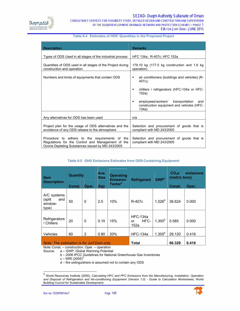
SEZAD- Duqm Authority Sultanate of Oman CONSULTANCY SERVICES FOR FEASIBILITY STUDY, DETAILED DESIGN AND CONSTRUCTION AND SUPERVISION
OF THE DUQM DEVELOPMENT DRAINAGE NETWORK AND PROTECTION SCHEMES – PHASE 1 EIA FOR JURF DAM – JUNE 2015
Doc no: 1333/P001/rev1 Page 149
Table 6-4 Estimates of ODS’ Quantities in the Proposed Project
Description Remarks
Types of ODS Used in all stages of the industrial process HFC 134a ; R-407c; HFC 152a
Quantities of ODS used in all stages of the Project during construction and operation
179.10 kg (177.5 kg construction and 1.6 kg operation)
Numbers and kinds of equipments that contain ODS air conditioners (buildings and vehicles) (R-407c);
chillers / refrigerators (HFC-134a or HFC-152a)
employees/workers’ transportation and construction equipment and vehicles (HFC-134a)
Any alternatives for ODS has been used n/a
Project plan for the usage of ODS alternatives and the avoidance of any ODS release to the atmosphere
Selection and procurement of goods that is compliant with MD 243/2005
Procedure to adhere to the requirements of the Regulations for the Control and Management of the Ozone Depleting Substances issued by MD 243/2005
Selection and procurement of goods that is compliant with MD 243/2005
Table 6-5 GHG Emissions Estimates from ODS-Containing Equipment
Item Description
Quantity Ave. Size
(kg)
Operating Emission Factora
Refrigerant GWPa
CO2e emissions (metric tons)
Const. Oper. Const. Oper.
A/C systems (split and window-type)
50 0 2.0 10% R-407c 1,526b 36.624 0.000
Refrigerators / Chillers
20 0 0.10 15% HFC-134a or HFC-152a
1,300b 0.585 0.000
Vehicles 60 2 0.80 20% HFC-134a 1,300b 29.120 0.416
Note: The estimation is for Jurf Dam only. Total 66.329 0.416 Note: Const. – construction; Oper. – operation Source: a – GWP: Global Warming Potential
b – 2006 IPCC Guidelines for National Greenhouse Gas Inventories c – WRI (2005)5 d – fire extinguishers is assumed not to contain any ODS
5 World Resources Institute (2005), Calculating HFC and PFC Emissions from the Manufacturing, Installation, Operation and Disposal of Refrigeration and Air-conditioning Equipment (Version 1.0) - Guide to Calculation Worksheets, World Building Council for Sustainable Development.

SEZAD- Duqm Authority Sultanate of Oman CONSULTANCY SERVICES FOR FEASIBILITY STUDY, DETAILED DESIGN AND CONSTRUCTION AND SUPERVISION
OF THE DUQM DEVELOPMENT DRAINAGE NETWORK AND PROTECTION SCHEMES – PHASE 1 EIA FOR JURF DAM – JUNE 2015
Doc no: 1333/P001/rev1 Page 150
6.5.2 Green Gas Emissions
Overview
Table 6-6 provides a summary of the general considerations in the GHG emissions calculations of
the Project’s construction activities. It is assumed that the GHG emissions during the operation
stage of the Project are negligible as earlier discussed and that the proposed development is not
considered as a major project.
Table 6-6 General Considerations in GHG Emissions Calculation
Activity / Description Remarks / Information
Sources
1 Construction Period January 2016 – December 2017 (24months; 552 total days; 5,520 total hours)
276 days per year @ 10 hours per year
2 No. of Workers 175
3 Construction Camp Onsite, 20,000,000 m2
4 Construction Working Hours 10 hours/day; 276 days/year
5 Water / Wastewater 50 gallons/capita/shift (189.271 liters/capita/day)
American Water Works Association1
6 Diesel Generator
280 kW/350 kVA for site
2 units @ 74.9 liters of diesel/hour at full load, operating at 10 hours/day
Able Sales2
160 kW / 200 kVA for a 300 m2 office space
1 units @ 42.8 liters/hour of diesel at full load
Able Sales
7 Solid Waste Generated
Construction & Demolition Waste
2.8 lb/person/day = 1.27006 kg/person/day
U.S. EPA3
Workers / Employees 0.94 kg/capita/day (small wilayat)
be’ah, 2013: Appendix C4
8 Construction Site Vehicles: considered a Large Project (US$ 10 – 100 Mn)
3.40 kL diesel/construction month (70%)
5.32 kL petrol/construction month (30%)
Transport Authorities Greenhouse Group (TAGG)4

SEZAD- Duqm Authority Sultanate of Oman CONSULTANCY SERVICES FOR FEASIBILITY STUDY, DETAILED DESIGN AND CONSTRUCTION AND SUPERVISION
OF THE DUQM DEVELOPMENT DRAINAGE NETWORK AND PROTECTION SCHEMES – PHASE 1 EIA FOR JURF DAM – JUNE 2015
Doc no: 1333/P001/rev1 Page 151
Activity / Description Remarks / Information
Sources
9 Demolition and Earthworks 2,000,000 m3 of soil
Earthworks 0.097 kL diesel/construction month
TAGG
Vegetation removal 1.4 kL diesel/hectare; 400 t/hectare
TAGG
10 Construction Plant and Equipment
TAGG
Crane (hydraulic) 7.9 kL diesel /construction month
TAGG
Loader 1.6 kL diesel /construction month
TAGG
Material handlers 3.0 kL diesel /construction month
TAGG
Material transfer vehicle
11.9 kL diesel /construction month
TAGG
Roller, steel 9 kL diesel /construction month TAGG
Water truck, 4,000 Gal 14.2 liters diesel/hour Intermodal Container Transfer Facility (ICTF) – Joint Powers Authority (JPA)
Fuel Truck, 2000 Gal 6.81 liters diesel/hour ICTF-JPA
Others 3.4 kL diesel / construction month;
5.32 kL petrol/construction month
Assumed that 30% of all the other vehicles used (usually by workers) are petrol-fueled cars
11 Solvent Use (during Project’s Construction Phase)
NMVOC: 2,700 g/person/year EMEP/EEA Chapter 2D.3.a Domestic Solvent Use including Fungicide5
Note: 1–Last accessed on 18 April 2015, available at http://www.ecy.wa.gov/programs/wr/cro/images/pdfs/gpm_estimate.pdf.
2–Last accessed on 18 April 2015, available at https://www.ablesales.com.au/source/Diesel%20Generator%20Fuel%20Consumption%20Chart%20in%20Litres.pdf. 3 – U.S. EPA [Online] Available at http://www.epa.gov/wastes/nonhaz/industrial/cd/basic.htm. 4–Last accessed on 20 April 2014, available at http://www.rms.nsw.gov.au/documents/about/environment/greenhouse-gas-assessment-workbook-road-projects.pdf. 5–Last accessed on 21 April 2014, available at http://www.eea.europa.eu/publications/emep-eea-guidebook-2013.

SEZAD- Duqm Authority Sultanate of Oman CONSULTANCY SERVICES FOR FEASIBILITY STUDY, DETAILED DESIGN AND CONSTRUCTION AND SUPERVISION
OF THE DUQM DEVELOPMENT DRAINAGE NETWORK AND PROTECTION SCHEMES – PHASE 1 EIA FOR JURF DAM – JUNE 2015
Doc no: 1333/P001/rev1 Page 152
A. GHG Emission from Energy Sources
a) Stationary Combustion Processes
Stationary combustion processes by the proposed Project are likely to be cause by diesel
generators for electricity generation during the construction period of 24 months. There are no
combustion processes during the operation phase of the Project as it primarily involves
maintenance works and is considered to be negligible.
During the construction phase, it is estimated that two (2) diesel generators of 160 kW and 280
kW will be operating at full load for 10 hours per day, for the entire construction period of 24
months (552 days; 5,520 hours).
Total emissions due to stationary combustion processes during the construction phase of the
Project: 5.7587 metric tonnes CO2-e.
Table 6-7 Stationary Combustion Process GHG Emissions Estimates
Year CO2 CH4 NOx
Jan 2016 – Dec 2017 2.7791 0.02541 0.0079
Jan 2017 – Dec 2042 0.000 0.000 0.000
Total 2.7791 0.02541 0.0079
In metric tonnes CO2-e.
b) Mobile Combustion
As presented in Table 6-6, the proposed Project is considered to be a ‘Large Project’ and based
on TAGG’s default quantity factors for site offices and vehicles, consumption of diesel and petrol
are at 3.40 and 5.32 kL for every construction month. In the assessment, it is assumed that 70%
of the construction site vehicles are diesel-based and the remaining are petrol-based cars.
During the construction phase of the Project, it is estimated to consume about 1,061.935 kL of
diesel fuel and 38.304 kL of petrol.
For details of the computation, please see Appendix B.

SEZAD- Duqm Authority Sultanate of Oman CONSULTANCY SERVICES FOR FEASIBILITY STUDY, DETAILED DESIGN AND CONSTRUCTION AND SUPERVISION
OF THE DUQM DEVELOPMENT DRAINAGE NETWORK AND PROTECTION SCHEMES – PHASE 1 EIA FOR JURF DAM – JUNE 2015
Doc no: 1333/P001/rev1 Page 153
With regard to the estimates for the Construction Plant and Equipment, the construction
equipment considered were only for the actual construction of the drainage channel since the site
preparation works have been already considered in the Demolition and Earthworks category,
thus, avoiding double counting.
The total CO2-e emissions in metric tonnes are: 52.4434.
Table 6-8 Mobile Combustion Process GHG Emissions Estimates
Year CO2 CH4 NOx
Jan 2016 – Dec 2017
Diesel 2.7759 0.0765 0.1168
Petrol / Motor Gasoline 0.0904 0.00969 0.0423
Jan 2017 – Dec 2042 0.000 0.000 0.000
Total 2.8663 0.08619 0.1591
In metric tonnes.
c) Fugitive Emissions from Oil & Gas Natural Gas System
The proposed Project involves the development of a drainage network and flood protection
schemes, thus, no fugitive emissions from oil and natural gas systems are expected.
Table 6-9 Fugitive Emissions from Oil & Natural Gas System
Year CO2 CH4 NOx
Jan 2016 – Dec 2017 0.000 0.000 0.000
Jan 2017 – Dec 2042 0.000 0.000 0.000
Total 0.000 0.000 0.000
In metric tonnes.

SEZAD- Duqm Authority Sultanate of Oman CONSULTANCY SERVICES FOR FEASIBILITY STUDY, DETAILED DESIGN AND CONSTRUCTION AND SUPERVISION
OF THE DUQM DEVELOPMENT DRAINAGE NETWORK AND PROTECTION SCHEMES – PHASE 1 EIA FOR JURF DAM – JUNE 2015
Doc no: 1333/P001/rev1 Page 154
d) Land Use and Land Use Change
There are no managed tree plantations in the proposed Project site, however, desert vegetation
will be removed and cleared as part of the development, they are considered to be negligible.
Table 6-10 GHG Emissions from Land Use and Land Use Change
Year CO2 CH4 NOx
Jan 2016 – Dec 2017 0.000 0.000 0.000
Jan 2017 – Dec 2042 0.000 0.000 0.000
Total 0.000 0.000 0.000
In metric tonnes.
e) Details of GHG Emissions Calculation
The GHG emissions calculation details have been provided for as Appendix B. Table 6-11
provides for a summary of the emissions factors used and quantities of fuels (motor gasoline and
diesel) consumed by the Project.
Table 6-11 Details of GHG Emission Calculation
Type of Activity Methodology According to IPCC
Emission Factor kg CO2/litre
Total Quantity of Fuel for Combustion
Total Emissionsa (t CO2-e)
Stationary Combustion Processes
Tier 1
NOx – 0.0074 CH4 – 0.0239 CO2 – 2.614
1,063.152 kL of diesel fuel for generators
5.7588
Mobile Combustion
Tier 1
Diesel 2.614 CO2 0.072 CH4 0.110 N2O
1,061.935 kL
52.4434
Gas 2.36 CO2 0.253 CH4 1.105 N2O
38.304 kL
Fugitive Emissions from Oil and Natural Gas System
n/a n/a n/a n/a
Others n/a n/a n/a n/a Note: a – total emissions were due from construction activities in a period of 18 months.
Emissions during the operation phase is considered to be negligible.

SEZAD- Duqm Authority Sultanate of Oman CONSULTANCY SERVICES FOR FEASIBILITY STUDY, DETAILED DESIGN AND CONSTRUCTION AND SUPERVISION
OF THE DUQM DEVELOPMENT DRAINAGE NETWORK AND PROTECTION SCHEMES – PHASE 1 EIA FOR JURF DAM – JUNE 2015
Doc no: 1333/P001/rev1 Page 155
B. GHG Emissions from Industrial Processes of the Proposed Project
There are no industrial processes expected from the proposed Project.
Table 6-12 GHG Emissions from Industrial Processes of the Proposed Project
Year CO2 CH4 NOx
Jan 2016 – Dec 2017 0.000 0.000 0.000
Jan 2018 – Dec 2042 0.000 0.000 0.000
Total 0.000 0.000 0.000
In metric tonnes.
Table 6-13 Details of GHG Emission Calculation from Industrial Processes of the Proposed Project
Type of Activity
Methodology According to IPCC
Emission Factor
Total Production
Total Yearly Emissions
(t CO2-e)
Industrial Processes
n/a n/a n/a n/a
C. GHG Emissions from Solvent Use
Solvent use by the proposed Project primarily occurs during the construction stage of the Project
as in the case for the other activities of this GHG emissions assessment.
Small quantities of solvents may be used during the construction phase such as painting, utensil
cleaning, etc. During the operation phase of the Project, which is primarily be maintenance works
for at least twice per annum, the GHG emissions from during this stage is considered negligible.
As described, the proposed Project will provide a workers’ camp onsite for about 175 workers for
the entire 24-month construction period.
The total GHG emissions are estimated to be 3.46815 metric tonnes CO2-e.

SEZAD- Duqm Authority Sultanate of Oman CONSULTANCY SERVICES FOR FEASIBILITY STUDY, DETAILED DESIGN AND CONSTRUCTION AND SUPERVISION
OF THE DUQM DEVELOPMENT DRAINAGE NETWORK AND PROTECTION SCHEMES – PHASE 1 EIA FOR JURF DAM – JUNE 2015
Doc no: 1333/P001/rev1 Page 156
Table 6-14 GHG Emissions from Solvent Use
Year CO2 CH4 NOx SF6 HFC PFC Jan 2016 – Dec 2017
3.46815 0.000 0.000 0.000 0.000 0.000
Jan 2017 – Dec 2042
0.000 0.000 0.000 0.000 0.000 0.000
Total 3.46815 0.000 0.000 0.000 0.000 0.000In metric tonnes.
Table 6-15 Details of GHG Emission Calculation from Solvent Use
Type of Activity
Methodology According to IPCC
Emission Factor
Quantity of Solvents
Total Yearly Emissions (t CO2-e)
Solvent Use Tier 1
2,700 g/person/year NMVOC 3.67 conversion factor g CO2/ g NMVOC
945 kg NMVOC 2.3121
D. GHG Emission from Solid Waste Generating from the Project
Based on be’ah’s 2013 Final Municipal Waste Survey, Duqm is considered as a ‘small wilayat’
and has an average waste generation of 0.94 kg/capita/day, while the estimated construction and
demolition waste generated onsite is 122.688 metric tonnes.
It is also assumed that the wastes are sent to landfill without gas recovery.
Table 6-16 GHG Emissions from Solid Waste Generated by the Project
Year CO2-e
Jan 2016 – June 2017
Workers / Construction Camp 0.4982
Construction and Demolition Waste 122.688
July 2017 – Dec 2042 0.000
Total 123.1862
In metric tonnes.

SEZAD- Duqm Authority Sultanate of Oman CONSULTANCY SERVICES FOR FEASIBILITY STUDY, DETAILED DESIGN AND CONSTRUCTION AND SUPERVISION
OF THE DUQM DEVELOPMENT DRAINAGE NETWORK AND PROTECTION SCHEMES – PHASE 1 EIA FOR JURF DAM – JUNE 2015
Doc no: 1333/P001/rev1 Page 157
Table 6-17 Details of GHG Emission Calculation – Solid Waste Generated by the Project
Type of Activity
Methodology According to IPCC
Emission Factora Total Quantity of Solid Waste
Total Yearly Emissions
(t CO2-e)
Solid Waste Generation
Tier 1
Landfilled waste without gas recovery: Paper and Cardboard:
2.52 kg CO2-e/kg Garden and food:
0.945 kg CO2-e/kg Wood: 1.89 kg CO2-
e/kg Textile: 2.52 kg CO2-
e/kg C&D Waste: 1.03 kg
CO2-e/kg
C&D: 122,687.80 kg
Construction Campsite Waste Total: 498.1871 kg
Food: 171.23 kg
Paper & Cardboard: 97.55 kg
Park & Garden: 4.15 kg
Wood: 20.236 kg
Textile: 19.199 kg
126.8666
Source: a – New Zealand’s Greenhouse Gas Inventory 1990-2009. Retrieved from
www.mfe.govt.nz/publications/climate/greenhouse-gas-inventory-2011/index.html. Emission
factors for plastics, metals and glass are not presented here because their decomposition does
not directly produce GHG emissions.
A. GHG Emissions from Wastewater Treatment in the Project
There is no wastewater treatment in the proposed Project and the wastewater generated during
the construction period has already been incorporated in the GHG emissions assessment from
solid waste generated in Section A.D.
Table 6-18 GHG Emissions from Wastewater Treatment in the Project
Year CH4 N2O
Jan 2016 – Dec 2017 See Table 6-16 Jan 2018 – Dec 2042 Total 000 000
In metric tonnes.

SEZAD- Duqm Authority Sultanate of Oman CONSULTANCY SERVICES FOR FEASIBILITY STUDY, DETAILED DESIGN AND CONSTRUCTION AND SUPERVISION
OF THE DUQM DEVELOPMENT DRAINAGE NETWORK AND PROTECTION SCHEMES – PHASE 1 EIA FOR JURF DAM – JUNE 2015
Doc no: 1333/P001/rev1 Page 158
Table 6-19 Details of GHG Emission Calculation – Wastewater Treatment in the Project
Type of Activity
Methodology According to IPCC
Emission Factor Total Quantity of Wastewater
Total Yearly Emissions
(t CO2-e)
Wastewater Treatment
n/a n/a n/a n/a
A. Reporting Total Amount of GHG Emissions
Currently, there is no ceiling limit set for CO2 emissions (mass) rates in the Sultanate of Oman.
However, for the proposed Project’s GHG emission and vis-à-vis’ the U.S. Environmental
Protection Agency (U.S. EPA), the calculated GHG emission is way below the 40 CFR Part 98 or
the Greenhouse Gas Reporting Program (GHGRP) mandatory reporting limit of 25,000 metric
tonnes of CO2-e per year.
As detailed from previous GHG calculation Sections, Table 6-20 is a summary of the total amount
of GHG emissions calculated from various Project activities described.
The proposed Project is estimated to have a total GHG emission of about 188.5369 metric
tonnes of CO2-e.
Table 6-20 Reporting Total Amount of GHG Emissions by the Proposed Project
Reporting Period CO2 CH4 N2O SF6 HFC PFC
Jan 2016 – Dec 2017 2,912.28 25.4955 8.0264 0.000 0.000 0.000
Jan 2017 to Dec 2042 0.000 0.000 0.000 0.000 0.000 0.000
Total 2,912.28 25.4955 8.0264 0.000 0.000 0.000
In metric tonnes.
6.5.3 Cumulative Impact on Climate Change
While the proposed Project is one the proposed asset to the planned landuse or overall
masterplan of Duqm Special Economic Zone Authority’s drainage network and protection
schemes, it is known that one of the future land uses within the 10 km radius of the Project site is
considered to be heavy industrial area (i.e., planned oil refinery, see Figure 6-2). Thus, proposed

SEZAD- Duqm Authority Sultanate of Oman CONSULTANCY SERVICES FOR FEASIBILITY STUDY, DETAILED DESIGN AND CONSTRUCTION AND SUPERVISION
OF THE DUQM DEVELOPMENT DRAINAGE NETWORK AND PROTECTION SCHEMES – PHASE 1 EIA FOR JURF DAM – JUNE 2015
Doc no: 1333/P001/rev1 Page 159
future developments within the vicinity of the Project area is expected to contribute to cumulative
GHG emissions.
Nevertheless, the total direct and indirect emission associated with the proposed Project would
not contribute to cumulative regional and/or global GHG emissions. As mentioned, GHG
emissions are only significant during the construction stage of the proposed drainage network and
GHG emission during the operation phase is considered to be insignificant.
6.6 Climate Change Risk and Impact Assessment
MECA’s Guidelines on Climate Change Chapter involves five (5) main steps:
a) Assess historical and current climate change-related trends and risks and vulnerabilities
b) Assess future projected climate change impacts
c) Assess and prioritize key future climate change risks and vulnerabilities
d) Climate Risk Management (CRM)
e) Climate change risk and vulnerability matrix
In the assessment for items (a) and (b), the information was gathered from World Bank’s Climate
Change Portal.6 For the assessment of future climate change risks and vulnerabilities (item c)
were not considered in the assessment as the proposed development is not considered as a
major project.
6 http://sdwebx.worldbank.org/climateportal/

SEZAD- Duqm Authority Sultanate of Oman CONSULTANCY SERVICES FOR FEASIBILITY STUDY, DETAILED DESIGN AND CONSTRUCTION AND SUPERVISION
OF THE DUQM DEVELOPMENT DRAINAGE NETWORK AND PROTECTION SCHEMES – PHASE 1 EIA FOR JURF DAM – JUNE 2015
Doc no: 1333/P001/rev1 Page 160
6.6.1 Historical and Current Climate Change-related Trends and Risks and
Vulnerabilities
These involve analyses and summaries of historical time series climate change data for not less
than past 25 years and current data on project area and the nature of change over time.
Data and information on current air temperature, humidity, population, and demographics are
provided for in the previous sections of the EIA.
Figure 6-3 Oman Temperature and Rainfall Data
6.6.2 Future Projected Climate Change Impacts
As per MECA’s 2013 Guidelines on Climate Change Affairs Chapter, this data will from existing
global and regional climate models, using downscaled data and scientific reports where available.
The figures below were captured from World Bank’s Climate Change Knowledge Portal, however,
future projected limited to rainfall and temperature since the proposed development is not
considered a major project, also site-specific information is only available for these variables. In
this regard, the selection of the scenario was made arbitrarily, and for presentation purposes, the
scenario selected is the A2 storyline. A2 storyline – is a case of rapid and successful economic
development, in which regional average income per capita converge – current distinctions
between “poor” and “rich” countries eventually dissolve.

SEZAD- Duqm Authority Sultanate of Oman CONSULTANCY SERVICES FOR FEASIBILITY STUDY, DETAILED DESIGN AND CONSTRUCTION AND SUPERVISION
OF THE DUQM DEVELOPMENT DRAINAGE NETWORK AND PROTECTION SCHEMES – PHASE 1 EIA FOR JURF DAM – JUNE 2015
Doc no: 1333/P001/rev1 Page 161
Time Period selected was 2040 – 2059 and the GFDL-CM2.1 model. For more description of
sources and model descriptions, please refer to World Bank Climate Change Knowledge Portal7.
Figure 6-4 Mean Projected Rainfall for the Project Site
Model: GFDL-CM2.1, Statistic: Mean, Scenario: A2
Figure 6-5 Mean Projected Temperature for the Project Site
Model: GFDL-CM2.1, Statistic: Mean, Scenario: A2
7 http://sdwebx.worldbank.org/climateportal/documents/Metadata-Portal.pdf#page=1

SEZAD- Duqm Authority Sultanate of Oman CONSULTANCY SERVICES FOR FEASIBILITY STUDY, DETAILED DESIGN AND CONSTRUCTION AND SUPERVISION
OF THE DUQM DEVELOPMENT DRAINAGE NETWORK AND PROTECTION SCHEMES – PHASE 1 EIA FOR JURF DAM – JUNE 2015
Doc no: 1333/P001/rev1 Page 162
Impacts on the Proposed Project
This section discusses the potential for impacts to construction and operation of the proposed
Project from the expected future climate changes described above.
The climate modeling results described in the preceding sub-sections show that there are
relatively small differences between projected temperature and rainfall changes across the region
and/or Project area.
The construction of the proposed drainage network is planned to occur in January 2016 and if
construction occurs on that schedule, climate conditions during the 1- to 2-year construction
period would not be expected to differ much from current conditions, even under worst-case
modeling scenarios.
6.6.3 Climate Risk Management
The Climate Risk Management (CRM) is an updateable directory of the climate risks that are
faced by the Project. A score (from 1 – 5) is then assigned to each risk for both likelihood and
severity for next 50 years. The risk score is then a factor of likelihood and severity. Risks are
identified across 5 sectors identified by the Project as representing the activities across the
region: (a) infrastructure; (b) business and industry; (c) agriculture and fisheries; (d) biodiversity;
and (e) socio-economic.
The Likelihood Scale utilized in this assessment is provided in Table 1 of Appendix B.
According to MECA’s Initial Communication Under the United Nations Framework Convention on
Climate Change (2013: 57), the Al Wusta Governorate is most vulnerable under high sea level
rise scenarios, i.e., greater than 2 meters, with potentially up to roughly 280 m2 of total land
inundated.

SEZAD- Duqm Authority Sultanate of Oman CONSULTANCY SERVICES FOR FEASIBILITY STUDY, DETAILED DESIGN AND CONSTRUCTION AND SUPERVISION
OF THE DUQM DEVELOPMENT DRAINAGE NETWORK AND PROTECTION SCHEMES – PHASE 1 EIA FOR JURF DAM– JUNE 2015
Doc no: 1333/P001/rev1 Page 163
Table 6-21 Project’s Climate Risk Management
Sector Sub-Sector Climate Driver Risk Process Potential Consequence
Likelihood Consequencea Riskb Associated Development Objective
Infrastructure
Built environment
Summer
Floods
Sea level rise
Storm surge
Population growth
Increased urban footprint
Urbanization leads to land use and land cover change
Additional protection
More complete monitoring and
Urban heat island effect
Extreme events
Increased expenditure on infrastructures, better building designs
Temporary loss of land and land activity
Air pollution
Natural disaster
More intense rainfall resulting in inflow and infiltration into wastewater networks
1 2 2
Conserve and restore natural areas onsite
Provide permanent protection for open space on the Project site
Use building materials with recycled content
Energy N/A N/A N/A 1 1 1
Water resources
Summer
Warmer water
Floods
Higher or lower stream flows and water tables
Ecosystem stress and less biodiversity
Temporary loss of land and land activity
1 2 2
Vegetation to be part of stormwater management to encourage carbon sequestration, to lessen urban heat island and

SEZAD- Duqm Authority Sultanate of Oman CONSULTANCY SERVICES FOR FEASIBILITY STUDY, DETAILED DESIGN AND CONSTRUCTION AND SUPERVISION
OF THE DUQM DEVELOPMENT DRAINAGE NETWORK AND PROTECTION SCHEMES – PHASE 1 EIA FOR JURF DAM– JUNE 2015
Doc no: 1333/P001/rev1 Page 164
Sector Sub-Sector Climate Driver Risk Process Potential Consequence
Likelihood Consequencea Riskb Associated Development Objective
Productivity property values and quality of life issues
more shade.
Design water efficient landscaping
Information and Communication Technology
N/A N/A N/A 1 1 1 N/A
Transport N/A N/A N/A 1 1 1 N/A
Tourist facilities (including beaches)
Extreme air temperature
Raising sea levels and temperature
Threatens coastal, island destinations and marine sites
1 1 1 N/A
Biodiversity
Marine Ecosystems
N/A N/A N/A 1 1 1 N/A
Flora and Fauna
Extreme air temperature
Water availability and sea/water temperatures
Changes in groundwater levels, flood plains and increased peak flows leading to decline in water quality
Loss of native vegetation and death of animals and its habitats
1 1 1 Increased vegetation and/or green cover (from 20% to 25%)

SEZAD- Duqm Authority Sultanate of Oman CONSULTANCY SERVICES FOR FEASIBILITY STUDY, DETAILED DESIGN AND CONSTRUCTION AND SUPERVISION
OF THE DUQM DEVELOPMENT DRAINAGE NETWORK AND PROTECTION SCHEMES – PHASE 1 EIA FOR JURF DAM– JUNE 2015
Doc no: 1333/P001/rev1 Page 165
Sector Sub-Sector Climate Driver Risk Process Potential Consequence
Likelihood Consequencea Riskb Associated Development Objective
Shifts in distributions of plant and animal species
Mangroves N/A N/A N/A 1 1 1 N/A
Corals N/A N/A N/A 1 1 1 N/A
Industry and business
All business activities
N/A N/A N/A 1 2 2 N/A
Agriculture and fisheries
Crops and livestock
N/A N/A N/A 1 1 1 N/A
Transport, storage and trade
N/A N/A N/A 1 1 1 N/A
Crops N/A N/A N/A 0 1 0 N/A
Crops and fisheries
N/A N/A N/A 0 1 0 N/A
Fisheries N/A N/A N/A 0 1 0 N/A
Socio-economic
Jobs and employment
N/A N/A N/A 1 1 1 N/A
Health and well-being
Increase in temperature N/A
High temperatures increasing incidence of food and water-borne diseases
1 1 1 N/A

SEZAD- Duqm Authority Sultanate of Oman CONSULTANCY SERVICES FOR FEASIBILITY STUDY, DETAILED DESIGN AND CONSTRUCTION AND SUPERVISION
OF THE DUQM DEVELOPMENT DRAINAGE NETWORK AND PROTECTION SCHEMES – PHASE 1 EIA FOR JURF DAM– JUNE 2015
Doc no: 1333/P001/rev1 Page 166
Sector Sub-Sector Climate Driver Risk Process Potential Consequence
Likelihood Consequencea Riskb Associated Development Objective
Cultural heritage
N/A N/A N/A 1 1 1 N/A
Economic prosperity
N/A N/A N/A 1 2 2 N/A
Notes: N/A – Not Applicable
a – See Table 1 of Appendix A
b - Risk = Likelihood x Consequence
For more details, see ClimWatAdapt’s Inventory of Adaptation Measures available at .

SEZAD- Duqm Authority Sultanate of Oman CONSULTANCY SERVICES FOR FEASIBILITY STUDY, DETAILED DESIGN AND CONSTRUCTION AND SUPERVISION
OF THE DUQM DEVELOPMENT DRAINAGE NETWORK AND PROTECTION SCHEMES – PHASE 1 EIA FOR JURF DAM– JUNE 2015
Doc no: 1333/P001/rev1 Page 167
6.6.4 Climate Change Risk Matrix on the Project
From Table 6-21, the impacts on the Project are summarized as in Table 6-22. The Likelihood or
Frequency of the identified risks and impacts are described in Appendix B.
Table 6-22 Climate Change Risks Matrix on the Project
Type of Risks Frequency / Degree of
Vulnerabilitya:
Climate Change Impacts Due to
Identified Vulnerabilityb
Risk Magnitudea
Remarks
Natural Disasters such as cyclone, earthquake
1 1 1 -
Sea Level Rise 1 2 2 -
Temperature 1 1 1 -
Heavy Rains 1 1 1 -
Flash Flooding 1 2 2 -
Notes: a – See Table 1 of Appendix B b – See Equation 1 of Appendix B
6.7 Identifying Alternatives and Mitigation Measures
The Project is designed for extreme events such as floods, cyclones, storms, and rains. These are
events that can happen under normal circumstances irrespective of potential climate change
conditions such that the required design parameters for such conditions are well established.
Therefore the requirement for any needed adaptations to climate change is low for this project. The
emergency response plan will contain the necessary actions to be taken in case of extreme weather
conditions.
6.7.1 Climate Affairs Mitigation Measures
As earlier described there are no operation activities once the Project has been constructed and
developed. The operational activities are mainly maintenance activities, which are minimal and should
be considered within the operational activities (mostly, use of motor vehicles for the maintenance
activities and works) of the Project proponent, the Duqm Special Economic Zone Authority.

SEZAD- Duqm Authority Sultanate of Oman CONSULTANCY SERVICES FOR FEASIBILITY STUDY, DETAILED DESIGN AND CONSTRUCTION AND SUPERVISION
OF THE DUQM DEVELOPMENT DRAINAGE NETWORK AND PROTECTION SCHEMES – PHASE 1 EIA FOR JURF DAM– JUNE 2015
Doc no: 1333/P001/rev1 Page 168
In this regard, the proposed climate affairs mitigation measures were focused during the construction
phase of the proposed development. It should also be noted, that in the EIA study prepared together
with this volume, there were also mitigation measures that themselves reduce GHG emissions.
At any rate, the GHG emissions during the construction phase of the Project will be minimal due to the
following factors:
Use of standard engines and exhaust pipes;
The construction equipment and machineries will comprise of standard internal combustion engines to
ensure optimal efficiency; and
The emissions from these equipment and machineries will be vented through standard exhaust pipes.
Moreover, the GHG emissions inventory as provided for in Section Error! Reference source not
found., while primarily are guesstimates and it is impossible to predict exactly how the climate will
change and how these changes will affect the proposed development, it is possible to identify and
implement strategies that will lessen the potential impacts of climate change on the infrastructure.
Table 6-23 shows the proposed potential mitigation measures for the various climate change issues
for the various Project phases.
Table 6-23 Climate Affairs Mitigation Measures
Main Issues Project Phase Potential Impact Potential Mitigation Measures
Direct GHG Emissions
Design Increased GHG emissions
Develop a detailed carbon management plan detailing goals and target.
Reduce fuel and electricity use.
Construction
Exhaust emissions from construction vehicles
Consider replacing conventional fuel types (petrol and diesel) with bio-fuels, when available.
Construction Use high-efficiency motors in equipment that is continuously operated.
Construction Ensure that vehicles and equipment are mechanically sound, regularly serviced and fitted with appropriate emission control equipment.
Construction
Implement work scheduling that: Minimize equipment idle time and double
handling of material; Optimize machinery use to avoid
unnecessary fuel usage. Construction Minimize haul distances. Design
GHG emissions from electricity used for lighting and cooling of the site.
Design energy efficient site office(s).
Construction Procure and install energy efficient fixtures and fittings (e.g., energy efficient lights in the site office/s).
Construction Construct during the day to reduce the need for floodlighting during night works on cooler season.
Direct emissions related to energy
Design Production processes (embodied energy of construction materials)
Identify local sources of recycled materials.
Construction Use recycled materials where possible (e.g., recycle wastes from demolition of existing

SEZAD- Duqm Authority Sultanate of Oman CONSULTANCY SERVICES FOR FEASIBILITY STUDY, DETAILED DESIGN AND CONSTRUCTION AND SUPERVISION
OF THE DUQM DEVELOPMENT DRAINAGE NETWORK AND PROTECTION SCHEMES – PHASE 1 EIA FOR JURF DAM– JUNE 2015
Doc no: 1333/P001/rev1 Page 169
Main Issues Project Phase Potential Impact Potential Mitigation Measures
resulting in GHG emissions.
structures, where possible). Construction Use locally produced materials.
Construction Give preference to products with low embodied energy.
Design Consider adopting a design that requires fewer materials.
Construction Cumulative GHG Emissions from the construction processes.
Work with third parties (suppliers, distributors, and contractors) to reduce emissions (e.g., through recycling materials).
Design Exhaust emissions from vehicles
Optimize the road design to promote steady and constant traffic movement (reduce stop/start).
Construction Minimize gradient changes along the alignment.
Design GHG emissions from electricity used for lighting (streetlights).
Investigate energy efficient street lighting options.
Construction Install the most energy efficient lighting technology suitable for the road requirements.
Carbon Sinks
Design
Loss of carbon sequestration potential.
Develop a re-planting strategy, when possible and applicable.
Construction Plant / re-establish vegetation with high carbon sequestration potential (carbon sinks).
Construction Plant vegetation that occurs naturally in the location.
Alternative to reduce ODS
Construction
Release of ODS
Use of alternative refrigerants
Construction Use of old refrigerators and air conditioners are disposed of safely by giving them to a recycling yard.
6.7.2 Planned GHG Sinks (Green Cover)
While any kind of vegetation implementation is always considered good practice in any infrastructure
developments, the proposed Project, considering its size and magnitude, will provide minimal flora
species, such as grass and shrubs, and the expected green cover or GHG reduction from these are
considered insignificant.
Table 6-24 Percentage of GHG Sinks (Green Cover)
Total Area of the
Project
(m2)
Proposed Area for
Green Cover/
Plantation (m2)
Percentage of Green
Cover to Total Area
of Industry
Expected GHG
Reduction
6 600 000 n/a n/a n/a

SEZAD- Duqm Authority Sultanate of Oman CONSULTANCY SERVICES FOR FEASIBILITY STUDY, DETAILED DESIGN AND CONSTRUCTION AND SUPERVISION
OF THE DUQM DEVELOPMENT DRAINAGE NETWORK AND PROTECTION SCHEMES – PHASE 1 EIA FOR JURF DAM– JUNE 2015
Doc no: 1333/P001/rev1 Page 170
6.8 Climate Affairs Risk Reduction Plan
6.8.1 Roles and Responsibilities of the Project Team
It is recommended that the application of a climate resilience toolkit, e.g. European Commission8, be
overseen by a Climate Resilience Manager (CR Manager).
The CR Manager should be appointed by the project manager (PM) responsible for overall
development of the Project and should be an existing member of the Project development team.
Please refer to the main EIA study for the proposed Project team.
Clearly, in any given project, the allocation of responsibilities may be distributed differently according
to what makes most sense for the project team. In addition, only relevant responsibilities need to be
fulfilled. Finally, it should be noted that the adaptation measures proposed are yet to be implemented
by Duqm SEZA’s project team after MECA’s review and approval of the proposed adaptation
measures.
6.8.2 Monitoring Plan for the Key Climate Affairs Variables
The proposed monitoring plan for the Project has been based on widely-accepted guiding principles
and adaptation action, thus, it has been made fit for purpose.
The risks posed by climate change have the potential to impact on the service delivery of the
proposed drainage network infrastructure. As such it is important that the Project Proponent to work
together with local authorities and agencies to ensure that these risks are managed effectively.
The risks identified in this plan will be managed through the Project Proponent’s risk management
system and will be reviewed at least every year. Each risk will be assigned to the team that is
primarily responsible for managing it. A cross directorate team should be established to monitor the
Project Proponent’s progress on the delivery of the adaptation actions. The cross directorate team
must be supported by the Governance team, who will provide risk management advice, and the
Sustainability team, who will provide advice on the latest climate science. The Project Proponent
Management Team and Duqm SEZA Chairman/CEO will be ultimately responsible for ensuring the
strategy is delivered.
Figure 6-6 shows the details of the governance structure.
8 European Commission (2012). Guidelines for Project Manager: Making Vulnerable Investments Climate Resilient. Last accessed on 20 April 2015 at http://climate-adapt.eea.europa.eu/c/document_library/get_file?uuid=81fdc9d1-c840-409e-8060-82862cf65017&groupId=18.

SEZAD- Duqm Authority Sultanate of Oman CONSULTANCY SERVICES FOR FEASIBILITY STUDY, DETAILED DESIGN AND CONSTRUCTION AND SUPERVISION
OF THE DUQM DEVELOPMENT DRAINAGE NETWORK AND PROTECTION SCHEMES – PHASE 1 EIA FOR JURF DAM– JUNE 2015
Doc no: 1333/P001/rev1 Page 171
Figure 6-6 Summary of Roles and Responsibilities within the Project Proponent Team for the Climate Change Adaptation Plan
This plan is a living document, most especially, during the construction phase of the proposed Project.
As this adaptation plan is for the Project, many of the proposed actions focus on improving our
understanding of climate risks and integrating climate change into existing activities.
Regular and ongoing reporting of the Project’s climate change adaptation performance is critical to
inform decision making and motivate changes in behavior. To ensure that decision-makers, staff and
the community are aware of Duqm SEZA’s progress in implementing the adaptation actions outlines
in this strategy, internal reporting will be undertaken once every year or when needed. However,
considering that the drainage channel, while important to the overall masterplan and development of
the Duqm SEZA community, its climate change emissions and impacts are minimal.
External reporting is the discretion of the Project Proponent and/or as advised by MECA.
The Climate Affairs Risk Reduction Plan (CARRP) of the proposed Project is as shown in Table 6-25,
which are primarily the proposed adaptation measures for the Project.
The CARRP framework has been based on MECA’s 2013 Guidelines on Climate Affairs Chapter.
Duqm Special Economic Zone Authority(Overall coordination of the Adaptation Plan, including funding, implementation, monitoring and review as
well as stakeholder engagement and communication)
Cross Duqm SEZA Adaptation Working Group(Meet regularly to oversee coordination and integration of adaptation actions)
Chairman / CEO (Ensure the Adaptation Plan is implemented and outcomes reported)
Governance and
Sustainability Teams
Review and update divisional climate change risks and implement adaptation options
Social Responsibility
Experts Engineering / Planning
Company & Investor Aff i
Corporate Services

SEZAD- Duqm Authority Sultanate of Oman CONSULTANCY SERVICES FOR FEASIBILITY STUDY, DETAILED DESIGN AND CONSTRUCTION AND SUPERVISION
OF THE DUQM DEVELOPMENT DRAINAGE NETWORK AND PROTECTION SCHEMES – PHASE 1 EIA FOR JURF DAM– JUNE 2015
Doc no: 1333/P001/rev1 Page 172
With regard to key strategies to build Project’s risk reduction plan and building climate risk reduction
plan in key sectors, Duqm SEZA has adopted environmental sustainability policies for all of its
projects.
Table 6-25 Proposed Climate Affairs Risk Reduction Plan
Main Issues Adaptation Measures
Protection of the Ozone Layer Use of ODS in compliance with the Montreal Protocol and with MD 243/2005
Rainfall, wadi flooding, flash floods, and sea level rise
Re-creating functional floodplains
Managing point source pollution to reduce water quality risks
Harvesting rainwater to reduce water demand, lower risk of flooding (i.e., harvesting water buffers the amount of precipitation entering drainage systems), and collect water for toilet flushing, car washing, irrigation, etc.
Using ‘cool’ or ‘porous’ pavements
Preserving land that is required for current and future flood risk management
Observe national (when available) or international standards for sustainable drainage systems9
Storms and winds See DEFRA (2011)10
Landslides Consider the management of slope stability in communities landslide risk reduction measures by taking the outputs of the community-based mapping process (slope process zone map and initial drainage plan) and developing a detailed drainage plan for implementation11
Climate Change Study Establish climate change monitoring stations
Improve forecasting system of extreme events
9 An example of an international standard is by DEFRA, UK (2011) National Standards for Sustainable Drainage Systems – Designing, Constructing, Operating and Maintaining Drainage for Surface Runoff. Retrieved on 28 April 2015 at https://www.gov.uk/government/uploads/system/uploads/attachment_data/file/82421/suds-consult-annexa-national-standards-111221.pdf. 10 Ibid. 11 See Anderson, M.G. and Holcombe, E. (2013). Community-Based Landslide Risk Reduction: Managing Disasters in Small Steps, p 213-259, http://dx.doi.org/10.1596/9780821394564_CH06.

SEZAD- Duqm Authority Sultanate of Oman CONSULTANCY SERVICES FOR FEASIBILITY STUDY, DETAILED DESIGN AND CONSTRUCTION AND SUPERVISION
OF THE DUQM DEVELOPMENT DRAINAGE NETWORK AND PROTECTION SCHEMES – PHASE 1 EIA FOR JURF DAM– JUNE 2015
Doc no: 1333/P001/rev1 Page 173
6.9 Summary and Conclusions
Climate change is a reality that will have an impact on the design life of the proposed Project. In
particular, hotter temperatures events that will impact the usability and durability of the proposed
Jurf Dam. Although, the extent of climate change impacts is unknown, steps can be taken to
reduce the consequence of climate change on the proposed development.
The assessment was undertaken based on MECA’s 2013 Guidelines on Climate Affairs Chapter
and other widely-accepted guidance and guidelines (e.g., IPCC, EMEP/EEA, etc.).
There is a consensus within the scientific community that GHG emissions are altering global
climate, but that the effect is due to multitude of emissions sources and is not related to an
individual activity or project (CEAA, 2003; IPCC, 2013). GHG emissions from the Project are
expected to represent a small fraction of national and global GHG emissions:
Project construction GHG emissions are estimated to amount to 132.02 metric tonnes
CO2e within the two-year construction period;
Project operations GHG emissions are estimated to amount to 0.00 CO2e per year.

SEZAD- Duqm Authority Sultanate of Oman CONSULTANCY SERVICES FOR FEASIBILITY STUDY, DETAILED DESIGN AND CONSTRUCTION AND SUPERVISION
OF THE DUQM DEVELOPMENT DRAINAGE NETWORK AND PROTECTION SCHEMES – PHASE 1 EIA FOR JURF DAM– JUNE 2015
Doc no: 1333/P001/rev1 Page 174
7. POTENTIAL ENVIRONMENTAL IMPACTS WITH PROJECT ENVIRONMENT
This chapter identifies the potential impacts due to the implementation of the proposed Dam of
Project on the physical, ecological and social environment of the Project Area. The chapter also
identifies measures that will help to mitigate the project’s adverse environmental effects and to
enhance the positive impacts.
7.1 Project Impact Matrix
Impact matrix for both with and without mitigation measures for the selected Project has been
developed and shown in Table 6.1 and Table 6.2 respectively. In this table both adverse and
beneficial impacts on various environmental and social parameters have been indicated by
assigning level of impact in the form of high, medium, low adverse or beneficial or
insignificant/none. In subsequent paragraphs, mitigation measures have been proposed for only
adverse negative impacts on different environmental parameters.
7.2 Land Resources
This section explains how the proposed project will affect the land use, soil erosion and
contamination, and describes the mitigation measures to manage these impacts.
7.2.1 Impact on Land Use and Resources
Construction Stage - The proposed Project will involve acquisition of land on permanent basis. The areas
affected by the project comprehends:
o The Jurf dam, the reservoir area
o Stockpile area for SEZADs’ future projects
o Constructor campsite for the dam.
o Oryx Sanctuary in a part of the Jurf dam axis and the reservoir
Nevertheless, there are a few small animal shelters that may be relocated, mainly because
the owners often move the shelters according to their needs and they may move some onto
the channel alignment before construction starts. At the moment, the project does not
consider the relocation of the animal shelters, but should be consider such relocation in the
BoQ.
During the site visits, no power lines were identified along the project area that need to be
relocated.
- Soil erosion may occur in the workshop areas as a result of improper runoff drawn from
the equipment washing-yards and improper management of construction activities at semi
hilly areas and natural streams.

SEZAD- Duqm Authority Sultanate of Oman CONSULTANCY SERVICES FOR FEASIBILITY STUDY, DETAILED DESIGN AND CONSTRUCTION AND SUPERVISION
OF THE DUQM DEVELOPMENT DRAINAGE NETWORK AND PROTECTION SCHEMES – PHASE 1 EIA FOR JURF DAM– JUNE 2015
Doc no: 1333/P001/rev1 Page 175
- Dumping of waste/excavated material on hill slopes will overload and overstress the top
of the slope and upon saturation these loose dumps may slide down.
- Extraction of stones from the Wadi bed for use in construction may lead to destabilization
of the slope and enhance soil erosion.
- Soil may get contaminated from the spillage of chemicals like fuels, solvents, oils, paints
and other construction chemicals and concrete. This normally happens when these
materials are transported in open or loosely capped containers.
- The possible contamination of soil by oils and chemicals at camp sites, workshop areas,
and equipment washing-yards may limit the future use of land.
- Improper dumping of solid waste from the camps and construction activities may degrade
the land.
Operation Stage - Borrow pits and other landscape depressions if left open, may prove hazardous to human
beings, livestock and wildlife.
- Open pits containing water are potential sources of mosquito breeding if left stagnant,
and can create health problems.
7.2.2 Mitigation Measures
The mitigation measures which will be carried out during construction as well as during operation
stages for land resources are as under:
Construction Stage - As referred earlier, there will be land acquisition and the compensation cost has been
included in the cost estimate for the Client’s approval. The construction commencement
will be resulting of the Ministry of Housing “no objection certificate”.
- In case of borrow material, existing quarries will be used for aggregate material or if
excavated from new sites, prior approval will be sorted from the competent authority.
- Permit shall be obtained from SEZAD for borrow pits
- Project facilities should be located in open flat areas located near the dams and near road
access, avoiding constant transport by trucks. The facilities are not allowed inside
sensitive areas, such as the Orix Sanctuary, Turtle Reserve or Rock garden, and will be
at a minimum distance of 500 m from any sensitive areas, such as the birds and turtle
nest and feeding area.
- Prior to the commencement of construction activities, the contractor will submit a
development plan to the Engineer-in-charge and SEZAD for its scrutiny and approval.
- Good engineering practices will help to control soil erosion both at construction sites and
in peripheral areas, particularly in borrow/ deposit areas and a long haul tracks.
- Appropriate measures for slope protection, i.e. vegetation cover and stone pitching, etc
will be used at embankments.
- The contractors will be required to instruct and train their workforce in the storage and
handling of materials and chemicals that can potentially cause soil contamination.

SEZAD- Duqm Authority Sultanate of Oman CONSULTANCY SERVICES FOR FEASIBILITY STUDY, DETAILED DESIGN AND CONSTRUCTION AND SUPERVISION
OF THE DUQM DEVELOPMENT DRAINAGE NETWORK AND PROTECTION SCHEMES – PHASE 1 EIA FOR JURF DAM– JUNE 2015
Doc no: 1333/P001/rev1 Page 176
- Solid waste generated during construction and at campsites will be transported to the
nearest existing landfill (as final destination) site or authorised dumpsite.
- For permanent affected area of the Oryx Sanctuary Reserve, the Contractor must request
for permission for land acquisition to the Oryx sanctuary Reserve prior to work
commence.
Operation Stage - Ditches or borrow pits that cannot be fully rehabilitated will be landscaped/converted into
fishponds to minimize erosion and to avoid creating hazards for people and livestock.
- Proper monitoring of the soil erosion and landslide prone areas will be carried out during
operation phase and soil conservation measures (if needed) will be carried out like
provision of physical structures e.g. gabion walls or retaining walls, etc.
7.3 Water Resources
7.3.1 Impact on Water Resources
Construction Stage
- To meet the water requirements for camp site and construction activities, local water
supplies may be exploited thus bringing its use into competition with local use.
- Groundwater resources may be contaminated by fuel and chemical spills, or by solid
waste and effluents generated by the activities and facilities at the construction
campsites.
- Natural streams may become silted by borrow material in the runoff from the construction
area, workshops and equipment washing-yards.
- Soil erosion may occur at quarry areas, and it may contaminate the groundwater
resources if unmanaged excavation.
Operation Stage
- According to the design operation specifications once the reservoir level is at full supply
the dam outflow valve must be opened by the operation and maintenance staff in order to
regain the full reservoir capacity for the next flood. This means that the increased quantity
of water will last only for a short period without any climate modification.
7.3.2 Mitigation Measures
Construction Stage - In the Project Area the availability of water from existing water works will be assessed
before its utilization for the construction activities and this will be the responsibility of
SEZAD.

SEZAD- Duqm Authority Sultanate of Oman CONSULTANCY SERVICES FOR FEASIBILITY STUDY, DETAILED DESIGN AND CONSTRUCTION AND SUPERVISION
OF THE DUQM DEVELOPMENT DRAINAGE NETWORK AND PROTECTION SCHEMES – PHASE 1 EIA FOR JURF DAM– JUNE 2015
Doc no: 1333/P001/rev1 Page 177
- Availability of water for campsite facilities and construction purposes will be ensured by
the Contractor prior to start of construction activities. However, before exploitation of
water, permission would have to be taken from the concerned authority.
- Treatment facility of sewage and any other industrial/ chemical wastewater generated at
the site shall be provided during construction phase by the contractor.
Operation Stage - Proper monitoring of the dam is to be performed during operation stage to avoid the
obstruction of the channel and consequent lack of sediment supply to the beach.
- As referred earlier the reservoir will be drained after every flood so no impact on the climate
and no mitigation measure required.
7.4 Waste Water
7.4.1 Impact on Water & Soil
Construction Stage
- To activities on camp site and construction activities may generate effluents that may
contaminate water resources and soil. The effluent may be generated from equipment
spills (oil, grease), toilets, kitchens, washrooms, workshops, washing ramps, warehouse
for chemicals, fuel area, waste handling/ deposit areas. With regard to the characteristics
of the effluents, it is difficult to estimate the chemical composition of the various effluent
streams as the campsite is not yet determined by the contractor
Operation Stage
- No waste water will generated during operation stage due the absence of permanent
facilities for maintenance.
7.4.2 Mitigation Measures
Construction Stage
- The Contractor will prepare a campsite map defining all the above mentioned areas (if
any) and the treatment facilities to be installed and monitored to prevent any surface run-
off of the generated effluents
- Treatment facility of sewage and any other industrial/ chemical wastewater generated at
the site shall be provided during construction phase by the contractor.
- The treated effluent from the facility shall conform to land discharge standards specified in
MS 145/93. The treated effluent must be monitored as per then monitoring plan.
- In case of installing an STP, the water from it shall be used to the extent possible for
construction activities and dust suppression

SEZAD- Duqm Authority Sultanate of Oman CONSULTANCY SERVICES FOR FEASIBILITY STUDY, DETAILED DESIGN AND CONSTRUCTION AND SUPERVISION
OF THE DUQM DEVELOPMENT DRAINAGE NETWORK AND PROTECTION SCHEMES – PHASE 1 EIA FOR JURF DAM– JUNE 2015
Doc no: 1333/P001/rev1 Page 178
- Construction equipment and vehicles will be water washed periodically to remove any
accumulated dirt. No detergents will be used. Washing will be done in a designated area
(washing ramp) and the washings will be collected into a settling tank in order to separate
suspended solids and oil & grease;
- The clarified effluent will be sent to an onsite sewage treatment plant (STP) / nearest
municipal STP for further treatment and disposal; and the separated oil will be skimmed
off or removed using soaking pads and the collected oil will be disposed as hazardous
waste. The settled solids from the bottom of the tank will be removed periodically and
disposed in accordance with regulations.
- Storage areas of hazardous wastes / hazardous materials will be enclosed to protect from
rains and storm water. If storm water is suspected to be contaminated, it will be collected
in collection pits and prevented from entering surface drains. Normally run-offs from areas
where hazardous substances (oils and chemicals) are stored will not occur. If there are
any accidental spillages of hazardous substances on the soil, such areas will be
immediately remediated to avoid the run-offs being contaminated.
- Liquid waste from the camps including oil, grease etc. will be transported through mobile
trucks to the nearest available/existing disposal. Measures for disposal of solid waste are
already discussed in land use section.
- The Contractor will prepare an Emergency plan, including training and responsibilities on
actions to be taken for:
o Responding promptly to exterior spills to prevent waste materials from entering
the surface water system.
o Cleaning up liquid spills such as oils, paints, and pesticides with absorbent
material rather than hosing them into drains. Although the Project generally do
not accept these liquids, they might find their way into the waste stream in small
quantities
Operation Stage - No mitigation measures were considered due the absence of waste water generated during
operation phase.
7.5 Waste
7.5.1 Impact on Water & Soil
Construction Stage
- To activities on camp site and construction activities may generate solid wastes that may
contaminate water resources and soil.

SEZAD- Duqm Authority Sultanate of Oman CONSULTANCY SERVICES FOR FEASIBILITY STUDY, DETAILED DESIGN AND CONSTRUCTION AND SUPERVISION
OF THE DUQM DEVELOPMENT DRAINAGE NETWORK AND PROTECTION SCHEMES – PHASE 1 EIA FOR JURF DAM– JUNE 2015
Doc no: 1333/P001/rev1 Page 179
- Due to the nature and complexity of the construction activities, it is not practical to
quantify the non hazardous or hazardous wastes since the details on construction
activities, quantities of materials, excavation, quantities of solvents, paints and scrap
generation rates, etc., are not available. The types of wastes typically generated during
construction and the methods of handling and disposal are presented in following Table.
Table 7-1: Waste Typically Generated
Waste type &
Source
Waste Stream
Characteristics
Site Control
Non-Hazardous Waste
Domestic waste
comprising office
waste, kitchen waste,
etc.
Continuous
Biodegradable and non-
biodegradable solid waste
from administration and
building and control rooms
Appropriate waste collection and storage
facilities will be provided
Will be segregated and stored in a
secluded area
Non-recyclable wastes will be disposed of
at municipal disposal site
Metal and wood scrap
and packaging
materials
Intermittent
Recyclable
Will be recycled as feasible
Remaining materials will be stored at
segregated storage area and disposed at
municipal waste disposal area
Sludge from the
sanitary treatment
system
Periodic
Biodegradable waste
The sludge will be collected in the storage
area and disposed of at the nearest municipal
dumpsite
Hazardous Wastes
Waste oils and oily
sludge, waste
chemicals, solvents
and maintenance
activities
Intermittent
Contaminated with
hydrocarbons and
chemicals
Will be stored in segregated, bunded
areas
Waste oil will be sent to authorized waste
oil recyclers
Waste solvents and chemicals, if feasible,
will be sent back to the suppliers or
disposed of in accordance with the MSDS
Containers of
hazardous materials
like oil, paint,
chemicals, etc.
Intermittent
Hazardous due to the
presence of hydrocarbons
and chemical residues
Will be stored in the hazardous waste
disposal for a maximum period of 3
months
Will be returned to the suppliers of the
corresponding material, if possible
Contaminated soils
due to accidental
spills and leaks of
diesel, lube oil,
solvents, paints,
chemicals, etc.
Unique occurrence
Soil contaminated with
hydrocarbons, heavy
metals, etc.
Excavated contaminated soil to be stored
in appropriate storage area with
impervious lining, buds and spill
containment facilities
Will be sent to land farm or the hazardous
waste treatment facility, once the facility
is operational
Used equipment and
spares
Intermittent
Contaminated equipment
Will be stored in enclosed and dedicated
storage area at site and will be
decontaminated and recycled as feasible

SEZAD- Duqm Authority Sultanate of Oman CONSULTANCY SERVICES FOR FEASIBILITY STUDY, DETAILED DESIGN AND CONSTRUCTION AND SUPERVISION
OF THE DUQM DEVELOPMENT DRAINAGE NETWORK AND PROTECTION SCHEMES – PHASE 1 EIA FOR JURF DAM– JUNE 2015
Doc no: 1333/P001/rev1 Page 180
and spares or disposed of as directed by the MECA
Unused and off-spec
materials such as
waste paints,
chemicals and
solvents
Intermittent
Contaminated with acids,
alkalis and hydrocarbons
Will be returned to the supplier, if feasible
Will be segregated and stored at site in a
line and bunded area
Will be disposed of according to the
MSDS
Operation Stage
- No waste will generated as result of the operation due the absence of permanent facilities
for maintenance.
7.5.2 Mitigation Measures
Construction Stage
- All the solid waste generated from construction site, workers camps and staff colony of
project should be controlled by proper solid waste management system to avoid
contamination, odour and aesthetic problems at the site.
- Hazardous waste shall be handled, stored and disposed according to MD 17/93, MD
57/2002
- Solid waste generated during construction and at campsites will be transported to the
nearest existing landfill site.
- Storage areas of hazardous wastes / hazardous materials will be enclosed to protect from
rains and storm water. If storm water is suspected to be contaminated, it will be collected
in collection pits and prevented from entering surface drains. Normally run-offs from areas
where hazardous substances (oils and chemicals) are stored will not occur. If there are
any accidental spillages of hazardous substances on the soil, such areas will be
immediately remediated to avoid the run-offs being contaminated.
- Segregation of hazardous from non-hazardous wastes must be practiced. Separation of
recyclable and non recyclable waste must be introduced and recycling practices must be
implemented when possible. The hazardous materials will be stored in a designated area.
- Liquid waste from the camps including oil, grease etc. will be transported through mobile
trucks to the nearest available/existing disposal. Measures for disposal of solid waste are
already discussed in land use section.
- The Contractor will prepare an Emergency plan, including training and responsibilities on
actions to be taken for:
o Responding promptly to exterior spills to prevent waste materials from entering
the surface water system and soil.

SEZAD- Duqm Authority Sultanate of Oman CONSULTANCY SERVICES FOR FEASIBILITY STUDY, DETAILED DESIGN AND CONSTRUCTION AND SUPERVISION
OF THE DUQM DEVELOPMENT DRAINAGE NETWORK AND PROTECTION SCHEMES – PHASE 1 EIA FOR JURF DAM– JUNE 2015
Doc no: 1333/P001/rev1 Page 181
o Cleaning up liquid spills such as oils, paints, and pesticides with absorbent
material rather than hosing them into drains. Although the Project generally do
not accept these liquids, they might find their way into the waste stream in small
quantities
- Based on the above, the agreement letter with be’ah for handling and disposing of the
same at their facility shall be provided. If not provide the alternative treatment facility/
disposal method for the generated hazardous wastes.
Operation Stage
- Proper monitoring of the dam reservoir is to be performed during operation stage to avoid
the obstruction of the channel and consequent lack of sediment supply to the beach
7.6 Ambient Air Quality and Noise Level
7.6.1 Impacts
Construction Stage
- Air quality will be affected by the fugitive dust and emissions from the construction
machinery, and vehicular traffic during the construction phase. Exhaust emissions from
the machinery will generate gases such as CO, CO2, SO2 and NO exceeding the limits of
the Omani standards and will directly affect the ambient air quality Emissions may be
carried over long distances, depending on wind speed and direction, the temperature of
the surrounding air, and atmospheric stability.
- Fugitive dust will also be generated from quarry areas during the rock blasting and
crushing.
- The possible presence of Hydrogen Sulfide in the Jurf dam area must be considered,
since H2S is a flammable gas that is toxic at extremely low concentrations. Inhalation at
certain concentrations can lead to injury of death of humans and animals.
- The Contractor camp is located near the project area therefore there will be some slight
negative impact on workers due to the noise generated by the construction machinery
during the project construction stage.
Operation Stage
- During operation stage there will be no impact because there is no equipment to be
allocated to the maintenance of the dams or channels.

SEZAD- Duqm Authority Sultanate of Oman CONSULTANCY SERVICES FOR FEASIBILITY STUDY, DETAILED DESIGN AND CONSTRUCTION AND SUPERVISION
OF THE DUQM DEVELOPMENT DRAINAGE NETWORK AND PROTECTION SCHEMES – PHASE 1 EIA FOR JURF DAM– JUNE 2015
Doc no: 1333/P001/rev1 Page 182
7.6.2 Mitigation Measures
The following measures will be implemented to mitigate the impacts on the ambient air quality and
noise level:
Construction Stage
- Good engineering practices will be used during the rock blasting (if required) at quarry
areas to minimize the impact of dust emissions.
- If required, the existing quarries will be used to borrow the aggregate materials.
- If used, crushers and concrete batching plants will be equipped with dust control
equipment such as fabric filters or wet scrubbers to reduce the level of dust emissions.
- Vehicles and other construction machinery will be properly tuned and maintained, so as
not to emit any smoke.
- When not in use for extended periods of time, construction equipment, DG sets and
vehicles will be turned off.
- Location of DG sets and other emission generating equipment will be established
considering the predominant wind direction, avoiding disturbance with emissions affecting
residential areas.
- The Environmental Quality Standards as per Ministerial Decision Nos. 118/2004 for air
shall be strictly followed by the contractor in order to minimize the air in the Study Area.
- The Environmental Quality Standards as per Ministerial Decision Nos. 79/94 and 80/94
for noise in public and working environment respectively shall be strictly followed by the
contractor in order to minimize the air and noise pollution in the Study Area.
- Where necessary, dust emissions will be reduced by a regular sprinkling of water for
keeping the dust settled, at least twice a day.
- Haul-trucks carrying construction materials will be kept covered with tarpaulin to curtail
the impact on air quality.
- If practical, stockpiling of excavated material will be regularly sprinkled and covered and
delivered as needed during the course of construction.
- Mufflers and silencers will be provided on machines to keep noise to a minimum level.
- SEZAD will set up a system to monitor the noise level in the Study Area in accordance
with the Omani standards (if available), reporting the results periodically to SEZAD.
- Mufflers and silencers will be provided on machines to keep noise to a minimum level.
- Regarding the presence of H2S:
o All workers, sub-contractors visitor must be provided with training before site
works, namely for the following subjects:
Identification of the characteristics, sources, and hazards of Hydrogen Sulfide.
Proper use of the Hydrogen Sulfide detection methods used on the site.
Recognition of, and proper response to, Hydrogen Sulfide warnings at the
workplace.
Symptoms of Hydrogen Sulfide exposure.

SEZAD- Duqm Authority Sultanate of Oman CONSULTANCY SERVICES FOR FEASIBILITY STUDY, DETAILED DESIGN AND CONSTRUCTION AND SUPERVISION
OF THE DUQM DEVELOPMENT DRAINAGE NETWORK AND PROTECTION SCHEMES – PHASE 1 EIA FOR JURF DAM– JUNE 2015
Doc no: 1333/P001/rev1 Page 183
Proper rescue techniques and first-aid procedures to be used in a Hydrogen
Sulfide exposure.
Proper use and maintenance of personal protective equipment. Demonstrated
proficiency in using Personal Protection Equipment (PPE) should be required.
Worker awareness and understanding of workplace practices and maintenance
procedures to protect personnel from exposure to hydrogen sulfide.
Wind direction awareness and routes of egress.
Confined space and enclosed facility entry procedures.
Locations and use of safety equipment.
Locations of safe briefing areas.
Use and operation of all Hydrogen Sulfide monitoring systems.
Emergency response procedures, corrective action, and shutdown procedures.
Effects of Hydrogen Sulfide on the components of the Hydrogen Sulfide handling
system.
The importance of drilling fluid treating plans prior to encountering Hydrogen
Sulfide. o In the event of suspecting the presence of H2S on site, workers must keep away
from the area, use the PPE and report to superior. The site must be identified as
potential H2S presence.
o A contingency plan must be designed by the contractor and all the workers must
be aware of it.
o One of the first emergency measures is to allow the H2S to disperse by air, once
it reaches the surface.
o If worked is performed on areas where the H2S is a potential presence,
monitoring site equipment must be use to control the concentration of the gas.
o Eating, drinking and smoking are strictly forbidden in these areas.
Operation Stage
- SEZAD will set up a system to monitor the air quality and noise level in the Study Area in
accordance with the Omani standards (if available). The system will cover protocols for
sampling and analysis, assessment of air quality at sensitive locations, reporting, and
information sharing. If it’s necessary to enhance the air quality of the Study Area, a tree
plantation program could be initiated by the SEZAD on priority basis.
7.7 Explosives
7.7.1 Impacts
Construction Stage Explosives will have significant negative impact on the safety of workers, residents, livestock and
birds in the Project Area. This activity may generate high frequency noise levels, but for a short
period only and will adversely affect the health of the workers and livestock. Injuries and accidents
often occur due to this activity. Serious attention is required and safe operating procedures be
followed. The negative impact may be of high magnitude for the workers working adjacent to the
area where explosives will be used.

SEZAD- Duqm Authority Sultanate of Oman CONSULTANCY SERVICES FOR FEASIBILITY STUDY, DETAILED DESIGN AND CONSTRUCTION AND SUPERVISION
OF THE DUQM DEVELOPMENT DRAINAGE NETWORK AND PROTECTION SCHEMES – PHASE 1 EIA FOR JURF DAM– JUNE 2015
Doc no: 1333/P001/rev1 Page 184
7.7.2 Mitigation Measures
Construction Stage Effective measures shall be adopted to minimize the hazards related with explosives. Explosive
material shall be stored in a safe place and at a safe distance from the settlements and the
construction camps. Warning signs shall be placed near the explosives storage areas. Before any
explosion, the people shall be informed well before and if required, evacuation of livestock
/residents shall be carried out. Transportation, storage, handling and operation of explosives shall
be conducted as per Omani rules and regulations.
Before all blasting operations commence every borehole to be charged shall be checked H2WS
concentration. Only when it has been ascertained that the H2S concentration is non hazardous
can the holes be charged and detonated.
Coordination with the concerned authority shall be done for creating awareness/ evacuation, if
required, during use of explosives/ blasting operations
Permits/NOC shall be obtained from ROP for use, handling and transport of explosives
The Contractor will select the type of explosives (if any) and must comply with the Omani
regulation RD 46/95 and RD 82/77 for storage, handling and safety management of the explosive
material.
7.8 Ecological Environment
The impact on flora and fauna and corresponding mitigation measures are described in the
following paragraphs:
7.8.1 Impacts on Flora and Fauna
Construction Stage
- During construction fine dust particles will cover the scattered vegetation leaves, choking
breathing parts (stomata) thus hindering CO2 assimilation by plants to the detriment of
their health.
- Oil spills, unintended mixing of noxious chemicals etc into the groundwater will be a
serious hazard to Flora, Fauna and Birds. Affected area will become unfit for livestock
and oil on surface will have a disabling threat to Avifauna.
- Granary and food stores at labour camps will attract rodents like mice, rats; shrew, gerbils
etc. thus multiply harmful rodents which is a moderate negative impact. However, these
animals at the same time are an important component of Ecosystem Trophic Chain.

SEZAD- Duqm Authority Sultanate of Oman CONSULTANCY SERVICES FOR FEASIBILITY STUDY, DETAILED DESIGN AND CONSTRUCTION AND SUPERVISION
OF THE DUQM DEVELOPMENT DRAINAGE NETWORK AND PROTECTION SCHEMES – PHASE 1 EIA FOR JURF DAM– JUNE 2015
Doc no: 1333/P001/rev1 Page 185
- Oryx Sanctuary and the Turtle beach are sensitive and protected areas that may suffer
some impact from territory invasion, due the cut of vegetation, nesting season
disturbance, vandalism, etc. The lost of these unique species can be the lost of
biodiversity, but most of all, of an unique natural treasure of the Sultanate of Oman
Operation Stage
- Natural sedimentation and waste brought with the strong winds may affect the natural
flow of the Wadi. Apart from obstructing the wadi, it can also influence the sand
sedimentation on the sea outlet and the natural flow at the beach area
7.8.2 Mitigation Measures
Construction Stage
- For the vegetation lost due to clearing of the strip/ piece of land for machinery path,
hutments and labour camps, the area cleared shall be replanted with local flora after
construction is over.
- Mitigation measures for dust control, oil spill, chemicals, liquid waste and noise is already
stipulated in the physical environment section (above).
- Labour will be strictly forbidden to cut any vegetation. Gas/paraffin hearths be provided to
labour for cooking etc.
- Granary and stores be properly secured and safeguarded against rodents.
- Thin film of dust on leafs and vegetation can be removed by Jet-spray of water every
afternoon along both sides of machinery path.
- Before submergence/ during construction trees and bushes should be removed from wadi
bed and areas to be affected by uprooting and pulling away the plants/trees
- Steps for immediate removal and safe disposal of solid waste will be taken so that wild
animals could not eat the harmful eatables.
- NOC shall be obtained from the concerned authority for the protected areas in the project
influence area including the Oryx Sanctuary
- Oryx Sanctuary and Turtle beach:
o Special care must be paid to these sensitive areas as these habitats are
protected and any disturbance can cause a high adverse impact. Works to be
developed inside the Oryx Sanctuary must be approved by the Oryx sanctuary
Reserve, this authority should be informed in writing of any intention to work
inside their territory and the contractor must have a written permission in case the
permission is granted.
o Feeding, lay hold or hunting any animal inside these areas is strictly forbidden

SEZAD- Duqm Authority Sultanate of Oman CONSULTANCY SERVICES FOR FEASIBILITY STUDY, DETAILED DESIGN AND CONSTRUCTION AND SUPERVISION
OF THE DUQM DEVELOPMENT DRAINAGE NETWORK AND PROTECTION SCHEMES – PHASE 1 EIA FOR JURF DAM– JUNE 2015
Doc no: 1333/P001/rev1 Page 186
o Any cutting of the vegetation has to be with the projects needs, never as per the
workers personal actions
o Workers must never disturb nests or take eggs from the turtles.
Operational Stage
- After construction old/unusable stores/unnecessary dumping/solid waste etc will be
removed from site as quickly as possible for safety of wild life and terrestrial animals.
7.9 Socioeconomic and Cultural Environment
7.9.1 Social and Cultural Impacts
Construction Stage
- Unmonitored construction activities, e.g. blasting or excavation may create an accident
risk for the local residents particularly their children and their livestock.
- Induction of outside workers in the Contractor labour may cause cultural issues with the
local community.
- Disturbance to the privacy of the local women due to the induction of outside workers as
local persons are very sensitive about the privacy of their women.
- Workers to be made aware about local culture and traditions to avoid socio-cultural issues
- Employees and contractors to minimize their interaction with local residents and their
disturbance in the community by timing the operations and transits through local
communities to avoid disturbing worship, school, and other community gatherings
Operation Stage
- The proposed Project will involve acquisition of land on permanent basis. The areas
affected by the project comprehends:
o The Jurf dam, the reservoir area
o Stockpile area for SEZADs’ future projects
o Constructor campsite for dam.
o Oryx Sanctuary in a part of the Jurf dam axis and the reservoir
- Nevertheless, there are a few small animal shelters that may be relocated, mainly
because the owners often move the shelters according to their needs and they may move
some onto the project area before construction starts. At the moment, the project does
not consider the relocation of the animal shelters, but should be consider such relocation
in the BoQ.
- The Project Area is mainly wild or being used as grazing land by goats. During
construction only a small percentage of the grazing area is expected to be disturbed due
to implementation of the Project.

SEZAD- Duqm Authority Sultanate of Oman CONSULTANCY SERVICES FOR FEASIBILITY STUDY, DETAILED DESIGN AND CONSTRUCTION AND SUPERVISION
OF THE DUQM DEVELOPMENT DRAINAGE NETWORK AND PROTECTION SCHEMES – PHASE 1 EIA FOR JURF DAM– JUNE 2015
Doc no: 1333/P001/rev1 Page 187
7.9.2 Mitigation Measures
Construction Stage
- If required, blasting will be carried out during the fixed hours (preferably during the mid-
day). The timing will be made known to all the people within 500 m from the blasting site
in all directions. People, except those who actually light the fuse shall be evacuated from
the area within 200m of the blasting site in all directions at least 15 minutes before
blasting.
- Women privacy will need to be taken into account by the Contractor. Contractor will
instruct his labour force to avoid trespassing near the dwellings of the local people.
- Employment shall be provided to the local people, in consultation with the Wali, during the
construction phase, to the extent feasible.
- There is no possible mitigation measure to avoid the disturbance in the grazing areas.
- Regular spray on water along with other necessary measures shall be carried out to
control vectors. Contractor will make sure that effective housekeeping measures will be
taken into account in order to avoid unhygienic conditions within the camp areas.
- The Contractor will be required to maintain close liaison with the local communities to
ensure that any potential conflicts related to common resource utilization for the project
purposes are resolved quickly.
- Contractor will take care of the local community and sensitivity towards the local customs
and traditions will be encouraged.
- Workers to be made aware about local culture and traditions to avoid socio-cultural issues
- Employees and contractors to minimize their interaction with local residents and their
disturbance in the community by timing the operations and transits through local
communities to avoid disturbing worship, school and other community gatherings.
- The contractor will be required to maintain close liaison with local communities to ensure
that any potential conflicts related to common resources utilization for the project
purposes are resolved quickly
- A field dispensary will be established to provide Medicare facilities and preventive
medicines at camp site.
Operation Stage
- Alternate roads and graded paths be planned to restore communication network, in case
of road cut.
- Alternate paths and crossing points will be provided to livestock for easy access to areas
open to grazing, if necessary.

SEZAD- Duqm Authority Sultanate of Oman CONSULTANCY SERVICES FOR FEASIBILITY STUDY, DETAILED DESIGN AND CONSTRUCTION AND SUPERVISION
OF THE DUQM DEVELOPMENT DRAINAGE NETWORK AND PROTECTION SCHEMES – PHASE 1 EIA FOR JURF DAM– JUNE 2015
Doc no: 1333/P001/rev1 Page 188
7.10 Archaeology and Heritage
7.10.1 Heritage and Cultural Impacts
Construction Stage
- Due to unmonitored construction activities such as blasting, excavation or filling of the soil
some archaeological site may be disturbed or lost forever.
Operation Stage
- No activities for the operation phase are potentially harmful for archaeological or cultural
sites
7.10.2 Mitigation Measures
Construction Stage
- Workers to be provided a briefing on recognizing archeological artifacts and how to
respond when such sites are found. Proper training must be provided to all the workers
performing earth works, such excavation, blasting, transport, filling, so that no impacts are
accidentally caused to the natural heritage on site.
- NOC from MHC to be obtained, for the campsite, dam and drainage channel route, prior
to construction
Operation Stage
- Operation phase does not predict any interaction with the sites, but this should be avoid
in case any need to access the project and make use of the archaeological sites.
7.11 Environmental and Socio-Economic Beneficial Impacts
- The aim of the project is to provide a significant degree of flood protection to the free
zone area under development. The construction of attenuation dams and flood
conveyance channels is likely to form the principal components of such flood protection
measures. Dams will be situated upstream of the target area and channels shall be
designed to convey the remaining water safely through the development area.
- During the construction period, the local workers will get opportunity to work as semi-
skilled or as just labourer, hence will get experience of construction works and human
resource will thus be developed at local level for future development activities.

SEZAD- Duqm Authority Sultanate of Oman CONSULTANCY SERVICES FOR FEASIBILITY STUDY, DETAILED DESIGN AND CONSTRUCTION AND SUPERVISION
OF THE DUQM DEVELOPMENT DRAINAGE NETWORK AND PROTECTION SCHEMES – PHASE 1 EIA FOR JURF DAM– JUNE 2015
Doc no: 1333/P001/rev1 Page 189
Table 7-2: Project Interaction matrix without mitigation
EN
VIR
ON
ME
NT
AL
CO
MP
ON
EN
TS
PHYSICAL ENVIRONMENT BIOLOGICAL ENVIRONMENT SOCIAL ENVIRONMENT
Acq
uisi
tion
of L
and
Acq
uisi
tion
of T
emp.
land
/ cr
op lo
sses
Soi
ls (
Ero
sion
/Sta
bilit
y/co
ntam
inat
ion)
Arc
haeo
logi
cal M
onum
ents
Pub
lic/P
rivat
e U
tiliti
es
Ene
rgy/
Min
eral
Res
ourc
es
Sur
face
Wat
er
Gro
undw
ater
Air
Qua
lity
Noi
se
Cro
ps/v
eget
atio
n
Aqu
atic
Eco
syst
em
Ter
rest
rial E
cosy
stem
End
ange
red
Spe
cies
Mig
rato
ry S
peci
es
Ben
efic
ial P
lant
s
Ben
efic
ial A
nim
als
Pes
t Pla
nts
Dis
ease
Vec
tors
Pub
lic H
ealth
Res
ourc
e/La
nd U
se
Acc
essi
bilit
y
Em
ploy
men
t
Wor
ker
safe
ty
Pub
lic s
afet
y
Tem
pora
ry D
isru
ptio
n of
Peo
ple
Res
ettle
men
t/com
pens
atio
n
Com
mun
ity S
tabi
lity
Cul
tura
l & R
elig
ious
Val
ues
Tou
rism
And
Rec
reat
ion
Livi
ng S
tand
ards
PROJECT RELATED ACTIVITIES 1 2 3 4 5 6 7 8 9 10 11 12 13 14 15 16 17 18 19 20 21 22 23 24 25 26 27 28 29 30 31
Construction Phase 1. Excavation MA 0 MA MA 0 MA 0 0 MA MA MA 0 MA MA LA LA LA 0 0 LA LA LA MB LA LA LA 0 0 0 0 MB2. Placement of material 0 0 0 0 0 LA 0 0 LA LA 0 0 0 0 0 LA LA 0 0 LA LA LA MB LA 0 0 0 0 0 0 MB3. Loading & hauling 0 0 LA 0 0 0 0 0 MA MA 0 0 MA 0 0 0 LA 0 0 LA 0 0 MB LA 0 MA 0 0 0 0 MB4. Construction Related Traffic 0 0 0 0 0 0 0 0 MA MA LA 0 MA 0 LA LA LA 0 0 LA 0 LA LB LA MA MA 0 0 0 0 MB5. Construction Camp 0 0 MA 0 MA MA LA MA MA LA 0 0 LA 0 0 LA MA 0 0 LA MA LA 0 0 0 LA 0 0 0 0 MB6. Compaction 0 0 0 0 0 0 0 0 0 MA 0 0 LA 0 0 LA LA 0 0 0 LA 0 LB LA 0 LA 0 0 0 0 0 7. Blasting/crushing 0 0 MA 0 MA LA 0 MA MA HA 0 0 MA MA MA 0 MA 0 0 MA 0 0 LB HA HA MA 0 0 0 0 MB8. Concrete placement 0 0 MA 0 0 0 0 0 0 MA 0 0 MA 0 0 0 LA 0 0 MA 0 0 LB LA 0 LA 0 0 0 0 MB9. Use of chemicals 0 0 HA 0 0 0 0 LA LA 0 0 0 LA 0 0 MA MA 0 0 0 MA 0 0 MA LA 0 0 0 0 0 0 10. Solid waste disposal 0 0 MA 0 0 0 0 0 0 0 0 MA 0 MA MA 0 0 0 0 LA 0 0 0 0 0 LA 0 0 0 0 0 11. Use of heavy machinery 0 0 0 0 0 0 0 0 MA MA 0 0 MA 0 0 0 MA 0 0 LA 0 0 LB LA LA LA 0 0 0 0 MB12. Vehicle/equipment maintenance 0 0 0 0 0 0 0 LA 0 0 0 0 LA 0 0 LA MA 0 0 0 0 0 MB 0 0 0 0 0 0 0 MB
Weighted Overall MA 0 MA 0 MA MA 0 MA MA MA MA 0 MA 0 0 MA MA 0 0 MA MA LA MB MA MA MA 0 0 0 0 MBOperation Phase
Local Effects 1. Reservoir operation MA 0 0 MA 0 0 HB HB 0 0 HB 0 HB 0 0 HB HB 0 0 0 0 0 LB 0 LA 0 LA HB 0 0 HB 2. Increased vehicular movement 0 0 0 0 0 0 0 0 0 0 0 0 0 0 0 0 0 0 0 0 0 0 0 0 0 0 0 0 0 0 0 3. Waste generation 0 0 0 0 0 0 0 0 0 0 0 MA 0 0 LA 0 0 0 0 0 0 0 0 0 0 0 0 0 0 0 0 4. Increased quantity of water 0 0 0 0 0 0 HB HB 0 0 HB 0 HB 0 0 HB HB 0 0 HB 0 0 0 0 0 0 0 0 0 0 HB 5. Pesticide spraying 0 0 0 0 0 0 0 0 0 0 0 0 0 0 0 0 0 0 0 0 0 0 0 0 0 0 0 0 0 0 0 6. Increased commercial activity 0 0 0 0 0 0 0 0 0 0 0 0 0 0 0 0 0 0 0 0 0 0 0 0 0 0 0 0 0 0 0
7. Increased influx of tourists 0 0 0 0 0 0 0 0 0 0 0 0 0 0 0 0 0 0 0 0 0 0 0 0 0 0 0 0 0 0 0
Weighted Overall MA 0 0 0 0 0 HB HB 0 0 HB 0 HB 0 0 HB HB 0 0 HB 0 0 LB 0 LA 0 LA HB 0 0 HB
Overall Project MA 0 LA 0 LA LA MB LB LA LA LB 0 LB 0 0 LB LB 0 0 LB LA LA MB LA MA LA LA MB 0 0 HB
High Adverse: HA Low Beneficial: LB
Medium Adverse: MA 0
Medium Beneficial: MB
Low Adverse: LA High Beneficial: HB

SEZAD- Duqm Authority Sultanate of Oman CONSULTANCY SERVICES FOR FEASIBILITY STUDY, DETAILED DESIGN AND CONSTRUCTION AND SUPERVISION
OF THE DUQM DEVELOPMENT DRAINAGE NETWORK AND PROTECTION SCHEMES – PHASE 1 EIA FOR JURF DAM– JUNE 2015
Doc no: 1333/P001/rev1 Page 190
Table 7-3: Project interaction matrix with mitigation
EN
VIR
ON
ME
NT
AL
CO
MP
ON
EN
TS
PHYSICAL ENVIRONMENT BIOLOGICAL ENVIRONMENT SOCIAL ENVIRONMENT
Acq
uisi
tion
of L
and
Acq
uisi
tion
of T
emp.
land
/ cr
op lo
sses
Soi
ls (
Ero
sion
/Sta
bilit
y/co
ntam
inat
ion)
Arc
haeo
logi
cal M
onum
ents
Pub
lic/P
rivat
e U
tiliti
es
Ene
rgy/
Min
eral
Res
ourc
es
Sur
face
Wat
er
Gro
undw
ater
Air
Qua
lity
Noi
se
Cro
ps/v
eget
atio
n
Aqu
atic
Eco
syst
em
Ter
rest
rial E
cosy
stem
End
ange
red
Spe
cies
Mig
rato
ry S
peci
es
Ben
efic
ial P
lant
s
Ben
efic
ial A
nim
als
Pes
t Pla
nts
Dis
ease
Vec
tors
Pub
lic H
ealth
Res
ourc
e/La
nd U
se
Acc
essi
bilit
y
Em
ploy
men
t
Wor
ker
safe
ty
Pub
lic s
afet
y
Tem
pora
ry D
isru
ptio
n of
Peo
ple
Res
ettle
men
t/com
pens
atio
n
Com
mun
ity S
tabi
lity
Cul
tura
l & R
elig
ious
Val
ues
Tou
rism
And
Rec
reat
ion
Livi
ng S
tand
ards
PROJECT RELATED ACTIVITIES 1 2 3 4 5 6 7 8 9 10 11 12 13 14 15 16 17 18 19 20 21 22 23 24 25 26 27 28 29 30 31
Construction Phase 1. Excavation 0 0 LA 0 0 LA 0 0 LA MA LA 0 MA 0 0 LA LA 0 0 LA LA LA MB LA LA LA 0 0 0 0 MB2. Placement of material 0 0 0 0 0 LA 0 0 LA LA 0 0 0 0 0 LA LA 0 0 LA LA LA MB LA 0 0 0 0 0 0 MB3. Loading & hauling 0 0 LA 0 0 0 0 0 LA MA 0 0 MA 0 0 0 LA 0 0 LA 0 0 MB LA 0 MA 0 0 0 0 MB4. Construction Related Traffic 0 0 0 0 0 0 0 0 MA MA LA 0 MA 0 0 LA LA 0 0 LA 0 LA LB LA LA MA 0 0 0 0 MB5. Construction Camp 0 0 LA 0 LA LA 0 LA LA LA 0 0 LA 0 0 LA LA 0 0 LA LA LA 0 0 0 LA 0 0 0 0 MB6. Compaction 0 0 0 0 0 0 0 0 0 MA 0 0 LA 0 0 LA LA 0 0 0 LA 0 LB LA 0 LA 0 0 0 0 0 7. Blasting/crushing 0 0 LA 0 LA LA 0 MA MA MA 0 0 MA 0 0 0 MA 0 0 MA 0 0 LB MA LA MA 0 0 0 0 MB8. Concrete placement 0 0 LA 0 0 0 0 0 0 MA 0 0 LA 0 0 0 LA 0 0 LA 0 0 LB LA 0 LA 0 0 0 0 MB9. Use of chemicals 0 0 LA 0 0 0 0 LA LA 0 0 0 LA 0 0 LA LA 0 0 0 LA 0 0 MA LA 0 0 0 0 0 0 10. Solid waste disposal 0 0 LA 0 0 0 0 0 0 0 0 0 0 0 0 0 0 0 0 LA 0 0 0 0 0 LA 0 0 0 0 0 11. Use of heavy machinery 0 0 0 0 0 0 0 0 MA MA 0 0 LA 0 0 0 MA 0 0 LA 0 0 LB LA LA LA 0 0 0 0 MB12. Vehicle/equipment maintenance 0 0 0 0 0 0 0 LA 0 0 0 0 LA 0 0 LA LA 0 0 0 0 0 MB 0 0 0 0 0 0 0 MB
Weighted Overall 0 0 LA 0 LA LA 0 MA MA MA LA 0 MA 0 0 LA MA 0 0 MA LA LA MB MA LA MA 0 0 0 0 MBOperation Phase
Local Effects 1. Reservoir operation 0 0 0 0 0 0 HB HB 0 0 HB 0 HB 0 0 HB HB 0 0 0 0 0 LB 0 LA 0 0 HB 0 0 HB 2. Increased vehicular movement 0 0 0 0 0 0 0 0 0 0 0 0 0 0 0 0 0 0 0 0 0 0 0 0 0 0 0 0 0 0 0 3. Waste generation 0 0 0 0 0 0 0 0 0 0 0 0 0 0 0 0 0 0 0 0 0 0 0 0 0 0 0 0 0 0 0 4. Increased quantity of water 0 0 0 0 0 0 HB HB 0 0 HB 0 HB 0 0 HB HB 0 0 HB 0 0 0 0 0 0 0 0 0 0 HB 5. Pesticide spraying 0 0 0 0 0 0 0 0 0 0 0 0 0 0 0 0 0 0 0 0 0 0 0 0 0 0 0 0 0 0 0 6. Increased commercial activity 0 0 0 0 0 0 0 0 0 0 0 0 0 0 0 0 0 0 0 0 0 0 0 0 0 0 0 0 0 0 0
7. Increased influx of tourists 0 0 0 0 0 0 0 0 0 0 0 0 0 0 0 0 0 0 0 0 0 0 0 0 0 0 0 0 0 0 0
Weighted Overall 0 0 0 0 0 0 HB HB 0 0 HB 0 HB 0 0 HB HB 0 0 HB 0 0 LB 0 LA 0 0 HB 0 0 HB
Overall Project 0 0 LA 0 LA LA MB LB LA LA LB 0 LB 0 0 LB LB 0 0 LB LA LA MB LA LA LA 0 MB 0 0 HB
High Adverse: HA Low Beneficial: LB
Medium Adverse: MA 0
Medium Beneficial: MB
Low Adverse: LA High Beneficial: HB

SEZAD- Duqm Authority Sultanate of Oman CONSULTANCY SERVICES FOR FEASIBILITY STUDY, DETAILED DESIGN AND CONSTRUCTION AND SUPERVISION
OF THE DUQM DEVELOPMENT DRAINAGE NETWORK AND PROTECTION SCHEMES – PHASE 1 EIA FOR JURF DAM– JUNE 2015
Doc no: 1333/P001/rev1 Page 191
8. ENVIRONMENTAL MANAGEMENT PLAN
8.1 Introduction
For the effective implementation and management of the mitigation measures, an
Environmental Management Plan (EMP) has been prepared and is presented in this section.
This EMP satisfies the requirements of the Royal Decree 10/82 “The Conservation of
Environment and Prevention of Pollution” and Royal verdict 114/2001.
8.1.1 Objectives of the EMP
The EMP has been prepared with an objective of the following but not limited to it.
- Outlining the mitigation measures required for avoiding or minimizing the potential
impacts assessed by EIA.
- Developing a monitoring mechanism and identifying the requisite monitoring
parameters to confirm effectiveness of the mitigation measures recommended in the
EIA.
- Defining roles and responsibilities of the Project proponent for the implementation of
EMP and identifying areas where these roles and responsibilities can be shared with
other parties involved in the execution and monitoring of the Project.
- Defining the requirements necessary for documenting compliance with the EMP and
communicating it to all the concerned regulatory agencies.
- Prescribing the mechanism with which consultation with stakeholders during the
project will be maintained.
8.2 Legislation and Guidelines
The main environment related legislation is the Royal Decree No. 10/82 and its amendment
titled “Law on Conservation of Environment and Prevention of Pollution” This decree is now
replaced by 114/2001. This law is enforced by the MECA. In addition, “Guidelines for
Obtaining Environmental Permits” has been developed and approved by Directorate General
of Environmental Affairs, MECA, which has been further subdivided into eight different groups
named industrial projects, mining projects, agricultural projects, food projects, service
projects, marine and coastal projects, tourism projects, and light industries. Our project falls in
the category of Services Project.

SEZAD- Duqm Authority Sultanate of Oman CONSULTANCY SERVICES FOR FEASIBILITY STUDY, DETAILED DESIGN AND CONSTRUCTION AND SUPERVISION
OF THE DUQM DEVELOPMENT DRAINAGE NETWORK AND PROTECTION SCHEMES – PHASE 1 EIA FOR JURF DAM– JUNE 2015
Doc no: 1333/P001/rev1 Page 192
The legislative guidelines other than the Decree 10/82 regarding preservation and
conservation of the environmental resources also exist. The relevant amongst them include
Royal Decree 63/85 (conservation of environment and prevention of pollution); Royal Decree
82/88 (deals with licenses and permits for drilling wells and utilizing water); Ministerial
Decision 5/86 and 11/93 deal with the conservation of the environment and for the
management of solid non-hazardous waste respectively); Ministerial Decision 18/93 (deals
with the management of hazardous waste); Ministerial Decision 145/93 (wastewater re-use
and discharge); Ministerial Decision 79/94 (Issuing regulations for noise pollution control in
the public environment); Royal Decree 2/80 (provides authority for the protection of national
heritage); Ministerial Decision 128/93 (Forbidden to cut trees); Royal Decree 75/98 (Its an
amendment to 111/96 and deals with fines with wildlife issues such as chasing, injuring etc).
The major legislation is the submission of Environmental Impact Assessment Report for
obtaining the permit.
Keeping in view the above laws and regulations, it is mandatory for a proponent to get an
application from the MECA and submit it duly filled in for getting the clearance in the form of
an Environmental Permit.
8.3 Organizational Structure and Roles and Responsibilities
8.3.1 Organizational Structure
The proposed project includes the following five organizations:
- Duqm Authority (SEZAD) as the Project Proponent and owner of the EMP.
- SEZAD olds the responsibility of monitoring the execution of the EMP.
- Ministry of Environment and Climate Affairs (MECA) as EMP Administrator, the body
directly responsible for the implementation and execution of EMP, working in liaison
with SEZAD, and Environmental Management Council (EMC).
- Project Contractors including the civil works and drilling contractors as the executor of
the EMP.
- EMC as the monitor of the execution of the EMP.

SEZAD- Duqm Authority Sultanate of Oman CONSULTANCY SERVICES FOR FEASIBILITY STUDY, DETAILED DESIGN AND CONSTRUCTION AND SUPERVISION
OF THE DUQM DEVELOPMENT DRAINAGE NETWORK AND PROTECTION SCHEMES – PHASE 1 EIA FOR JURF DAM– JUNE 2015
Doc no: 1333/P001/rev1 Page 193
8.3.2 Roles and Responsibilities
Duqm Authority (SEZAD)
As Project proponent, SEZAD is responsible for ensuring the implementation of EMP. SEZAD
will be responsible for overall environmental performance during the proposed project.
SEZAD will work in liaison with DG of Environment Affairs, in Duqm Governorate and EMC.
SEZAD in coordination with MECA will ensure that coordination with project stakeholders on
environmental and social matters as required by the EMP is maintained throughout the
operation.
SEZAD in coordination with MECA and the contractors will ensure that the mitigation
measures mentioned in the Mitigation Management Matrix (MMM) attached are adhered to
and organizational HSE Management Systems are implemented during the construction and
operation of the proposed project. The Contractors will abide by the relevant contractual
provisions relating to the environment.
Directorate General of Environment Affairs, Duqm Governorate (DGEA)
DGEA will own the position of project administrator. This body will be directly responsible for
effective implementation and monitoring of EMP according to Mitigation Management Matrix
(MMM), which is given in subsequent sections and will work in liaison with SEZAD and EMC.
The DGEA will also be responsible for collaboration with any other concerned authority over
their concerns about the tourism potentials of the Project Area.
The Director Environment, DGEA looks over the sections of environmental permits, air and
noise pollution, water pollution, soil and waste management, marine pollution & coastal zone
management and Director Natural Resources DGEA owns the responsibility of natural
reserved areas section and natural nation’s reserves section. All these sections will work in
direct contact with EMC and will also interfere with contractor and will make sure the effective
environmental management according to EMP.
DGEA keeping involved SEZAD and the Contractors will prepare Contingency Plan (if
required) to deal with any emergency situations. EMC will check if this plan is in place and
effective in addressing the threat.
The above DGEA role and responsibilities can also be assumed by Duqm Authority, since by
Royal Decree 119/2011 SEZAD the entity established to authorize and issue its regulations.

SEZAD- Duqm Authority Sultanate of Oman CONSULTANCY SERVICES FOR FEASIBILITY STUDY, DETAILED DESIGN AND CONSTRUCTION AND SUPERVISION
OF THE DUQM DEVELOPMENT DRAINAGE NETWORK AND PROTECTION SCHEMES – PHASE 1 EIA FOR JURF DAM– JUNE 2015
Doc no: 1333/P001/rev1 Page 194
The Project Contractors
For the proposed project, SEZAD will appoint Contractors for the construction, drilling, and
other project activities. The Contractors will be responsible for the implementation of, or
adherence to, all the provisions of the EIA and EMP and with any environmental and other
code of conduct required by SEZAD. Overall responsibility for the Contractor’s environmental
performance will rest with the person holding the highest management position within the
organization. The Contractor will have a HSE setup responsible for overall compliance with
environmental laws.
Environmental Management Council (EMC)
To fulfill the monitoring requirements set by this EMP, SEZAD in consultation with Renardet
will appoint an EMC, which will comprise the staff from SEZAD, DGEA, and any other
authority to be included. Director Water Resources SEZAD, Director Environment, Duqm
Governorate, Director Nature Conservation and Duqm Governorate will be the essential part
of EMC body. The EMC will be responsible for carrying out monitoring according to the
requirements of the EMP and the monitoring programme developed by the EMC. The person
holding the highest management position in the EMC organization will be responsible for
EMC’s adherence with the monitoring requirements specified in the EMP and will be
responsible for the activities of the EMC. EMC will monitor the Contractor’s adherence to
EMP.
If any aspects of the Project components are changed, EMC will categorise that change in
accordance with the Change Management Plan provided in this EMP and take appropriate
measures thereon.
8.4 Mitigation Management Matrix
The mitigation management matrix (MMM) is considered as a core element of EMP. It will be
used as the management and monitoring tool for the implementation of EMP. It is highlighted
that although the responsibilities for executing and monitoring the mitigation measures has
been delegated to different persons/organizations, SEZAD will hold the primary responsibility
for ensuring the full implementation of EMP. The mitigation management matrix is tabulated in
the bellow table.

SEZAD- Duqm Authority Sultanate of Oman CONSULTANCY SERVICES FOR FEASIBILITY STUDY, DETAILED DESIGN AND CONSTRUCTION AND SUPERVISION
OF THE DUQM DEVELOPMENT DRAINAGE NETWORK AND PROTECTION SCHEMES – PHASE 1 EIA FOR JURF DAM– JUNE 2015
Doc no: 1333/P001/rev1 Page 195
Table 8-1: Mitigation Management Matrix
Sr #.
Impact Mitigation Measure Responsibility Action/ Parameter/Monitoring
Method
Timing
Construction Operation
Execution Monitoring Monitoring
1. Soil erosion/contamination
In case of borrow material, existing quarries will be used for aggregate material or if excavated from new sites, prior approval will be sought from the competent authority.
Permit shall be obtained from SEZAD for borrow pits Project facilities should be located in open flat areas
located near the dams and the channel and near road access, avoiding constant transport by trucks. The facilities are not allowed inside sensitive areas, such as the Orix Sanctuary, Turtle Reserve or Rock garden, and will be at a minimum distance of 500 m from any sensitive areas, such as the birds and turtle nest and feeding area.
Prior to the commencement of construction activities, the contractor will submit a development plan to the Engineer-in charge and MECA/SEZAD for its scrutiny and approval.
As far as possible, waste/barren land i.e. areas not under agricultural, residential or forestation use, and natural areas with a high elevation will be used for borrow material and setting up project facilities.
Good engineering practices will help to control soil erosion both at construction sites and in peripheral areas, particularly in borrow areas and a long haul tracks.
Appropriate measures for slope protection, i.e. vegetation cover and stone pitching, etc will be used at embankments.
The contractors will be required to instruct and train their
CC EMC/CC/ DGEA
EMC/ DGEA
Soil cover and possibility of soil erosion should be monitored regularly.
During construction & operation
CC: Construction Contractor
EMC: Environmental Management Council
SEZAD: Duqm Authority
DEEA: Directorate General for Environmental Affairs

SEZAD- Duqm Authority Sultanate of Oman CONSULTANCY SERVICES FOR FEASIBILITY STUDY, DETAILED DESIGN AND CONSTRUCTION AND SUPERVISION
OF THE DUQM DEVELOPMENT DRAINAGE NETWORK AND PROTECTION SCHEMES – PHASE 1 EIA FOR JURF DAM– JUNE 2015
Doc no: 1333/P001/rev1 Page 196
Sr #.
Impact Mitigation Measure Responsibility Action/ Parameter/Monitoring
Method
Timing
Construction Operation
Execution Monitoring Monitoring
workforce in the storage and handling of materials and chemicals that can potentially cause soil contamination.
Ditches or borrow pits that cannot be fully rehabilitated will be landscaped/converted into fishponds to minimize erosion and to avoid creating hazards for people and livestock.
Proper monitoring of the soil erosion and landslide prone areas will be carried out during operation phase and soil conservation measures (if needed) will be carried out like provision of physical structures e.g. gabion walls or retaining walls, etc. For permanent affected area of the Oryx Sanctuary Reserve, the Contractor must request for permission for land acquisition to the Oryx sanctuary Reserve prior to work commence.
2. Water quality The availability of water from existing water works at Duqm will be assessed before its utilization for the construction purposes and this will be the responsibility of SEZAD.
Availability of water for campsite facilities and construction purposes will be ensured by the Contractor prior to start of construction activities. However, before exploitation of water, permission would have to be taken from the concerned authority. Treatment facility of sewage and any other industrial/ chemical wastewater generated at the site shall be provided during construction phase by the contractor.
Proper monitoring of the dam is to be performed during operation stage to avoid the obstruction of the channel and consequent lack of sediment supply to the beach
As referred earlier the reservoir will be drained after every flood so no impact on the climate and no mitigation measure required
EMC/CC/ DGEA
SEZAD/ DGEA
EMC should monitor the quantity and quality of water and take action to defeat the disease vectors.
During construction & Operation.
3. Air quality Good engineering practices will be used during the rock blasting at quarry areas (if required) to minimize the impact of dust emissions.
EMC/CC/ DGEA
EMC/ DGEA
SEZAD/ DGEA
Monitoring should be carried out
During construction
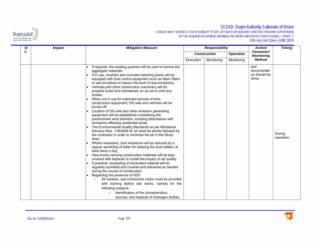
SEZAD- Duqm Authority Sultanate of Oman CONSULTANCY SERVICES FOR FEASIBILITY STUDY, DETAILED DESIGN AND CONSTRUCTION AND SUPERVISION
OF THE DUQM DEVELOPMENT DRAINAGE NETWORK AND PROTECTION SCHEMES – PHASE 1 EIA FOR JURF DAM– JUNE 2015
Doc no: 1333/P001/rev1 Page 197
Sr #.
Impact Mitigation Measure Responsibility Action/ Parameter/Monitoring
Method
Timing
Construction Operation
Execution Monitoring Monitoring
If required, the existing quarries will be used to borrow the aggregate materials.
If in use, crushers and concrete batching plants will be equipped with dust control equipment such as fabric filters or wet scrubbers to reduce the level of dust emissions.
Vehicles and other construction machinery will be properly tuned and maintained, so as not to emit any smoke.
When not in use for extended periods of time, construction equipment, DG sets and vehicles will be turned off.
Location of DG sets and other emission generating equipment will be established considering the predominant wind direction, avoiding disturbance with emissions affecting residential areas.
The Environmental Quality Standards as per Ministerial Decision Nos. 118/2004 for air shall be strictly followed by the contractor in order to minimize the air in the Study Area.
Where necessary, dust emissions will be reduced by a regular sprinkling of water for keeping the dust settled, at least twice a day.
Haul-trucks carrying construction materials will be kept covered with tarpaulin to curtail the impact on air quality.
If practical, stockpiling of excavated material will be regularly sprinkled and covered and delivered as needed during the course of construction.
Regarding the presence of H2S: - All workers, sub-contractors visitor must be provided
with training before site works, namely for the following subjects:
o Identification of the characteristics, sources, and hazards of Hydrogen Sulfide.
and documentation should be done.
During operation

SEZAD- Duqm Authority Sultanate of Oman CONSULTANCY SERVICES FOR FEASIBILITY STUDY, DETAILED DESIGN AND CONSTRUCTION AND SUPERVISION
OF THE DUQM DEVELOPMENT DRAINAGE NETWORK AND PROTECTION SCHEMES – PHASE 1 EIA FOR JURF DAM– JUNE 2015
Doc no: 1333/P001/rev1 Page 198
Sr #.
Impact Mitigation Measure Responsibility Action/ Parameter/Monitoring
Method
Timing
Construction Operation
Execution Monitoring Monitoring
o Proper use of the Hydrogen Sulfide detection methods used on the site.
o Recognition of, and proper response to, Hydrogen Sulfide warnings at the workplace.
o Symptoms of Hydrogen Sulfide exposure. o Proper rescue techniques and first-aid
procedures to be used in a Hydrogen Sulfide exposure.
o Proper use and maintenance of personal protective equipment. Demonstrated proficiency in using Personal Protection Equipment (PPE) should be required.
o Worker awareness and understanding of workplace practices and maintenance procedures to protect personnel from exposure to hydrogen sulfide.
o Wind direction awareness and routes of egress.
o Confined space and enclosed facility entry procedures.
o Locations and use of safety equipment. o Locations of safe briefing areas. o Use and operation of all Hydrogen Sulfide
monitoring systems. o Emergency response procedures,
corrective action, and shutdown procedures.
o Effects of Hydrogen Sulfide on the components of the Hydrogen Sulfide

SEZAD- Duqm Authority Sultanate of Oman CONSULTANCY SERVICES FOR FEASIBILITY STUDY, DETAILED DESIGN AND CONSTRUCTION AND SUPERVISION
OF THE DUQM DEVELOPMENT DRAINAGE NETWORK AND PROTECTION SCHEMES – PHASE 1 EIA FOR JURF DAM– JUNE 2015
Doc no: 1333/P001/rev1 Page 199
Sr #.
Impact Mitigation Measure Responsibility Action/ Parameter/Monitoring
Method
Timing
Construction Operation
Execution Monitoring Monitoring
handling system. o The importance of drilling fluid treating
plans prior to encountering Hydrogen Sulfide.
- In the event of suspecting the presence of H2S on site, workers must keep away from the area, use the PPE and report to superior. The site must be identified as potential H2S presence.
- A contingency plan must be designed by the contractor and all the workers must be aware of it.
- One of the first emergency measures is to allow the H2S to disperse by air, once it reaches the surface.
- If worked is performed on areas where the H2S is a potential presence, monitoring site equipment must be use to control the concentration of the gas.
- Eating, drinking and smoking are strictly forbidden in these areas.
Air quality monitoring. 4. Noise pollution Mufflers and silencers will be provided on machines to keep
noise to a minimum level. The Environmental Quality Standards as per Ministerial
Decision Nos. 79/94 and 80/94 for noise in public and working environment respectively shall be strictly followed by the contractor in order to minimize the air and noise pollution in the Study Area.
SEZAD will set up a system to monitor the noise level in the Study Area in accordance with the Omani standards (if available), reporting the results periodically to SEZAD.
CC EMC/CC/ DGEA
EMC/SEZAD/ DGEA
Monitoring of noise level
During construction & Operation.
5. Explosives (if required) Effective measures shall be adopted to minimize the hazards related with explosives. Explosive material should be stored in a safe place and at a safe distance from the
CC EMC/CC During construction

SEZAD- Duqm Authority Sultanate of Oman CONSULTANCY SERVICES FOR FEASIBILITY STUDY, DETAILED DESIGN AND CONSTRUCTION AND SUPERVISION
OF THE DUQM DEVELOPMENT DRAINAGE NETWORK AND PROTECTION SCHEMES – PHASE 1 EIA FOR JURF DAM– JUNE 2015
Doc no: 1333/P001/rev1 Page 200
Sr #.
Impact Mitigation Measure Responsibility Action/ Parameter/Monitoring
Method
Timing
Construction Operation
Execution Monitoring Monitoring
settlements and the construction camps. Warning signs shall be placed near the explosives storage areas. Before any explosion, the people shall be informed well before and if required, evacuation of livestock /residents shall be carried out. Transportation, storage, handling and operation of explosives shall be conducted as per Omani rules and regulations.
Before all blasting operations commence every borehole to be charged shall be checked H2S concentration. Only when it has been ascertained that the H2s concentration is non hazardous can the holes be charged and detonated.
Coordination with the concerned authority shall be done for creating awareness/ evacuation, if required, during use of explosives/ blasting operations
Permits/NOC shall be obtained from ROP for use, handling and transport of explosives
The Contractor will select the type of explosives (if any) and must comply with the Omani regulation RD 46/95 and RD 82/77 for storage, handling and safety management of the explosive material.
6. Ecological environment For the vegetation lost due to clearing of the strip/ piece of land for machinery path, hutments and labour camps, the area cleared will be replanted with local flora after construction is over.
Mitigation measures for dust control, oil spill, chemicals, liquid waste and noise is already stipulated in the physical environment section (above).
Labour will be strictly forbidden to cut any vegetation. Gas/paraffin hearths be provided to labour for cooking etc.
Granary and stores be properly secured and safeguarded against rodents.
Thin film of dust on leafs and vegetation can be removed by Jet-spray of water every afternoon along both sides of machinery path.
CC EMC/CC/ DGEA
EMC/SEZAD/ DGEA
During construction & Operation.

SEZAD- Duqm Authority Sultanate of Oman CONSULTANCY SERVICES FOR FEASIBILITY STUDY, DETAILED DESIGN AND CONSTRUCTION AND SUPERVISION
OF THE DUQM DEVELOPMENT DRAINAGE NETWORK AND PROTECTION SCHEMES – PHASE 1 EIA FOR JURF DAM– JUNE 2015
Doc no: 1333/P001/rev1 Page 201
Sr #.
Impact Mitigation Measure Responsibility Action/ Parameter/Monitoring
Method
Timing
Construction Operation
Execution Monitoring Monitoring
Before submergence/during construction trees and bushes should be removed from the wadi bed and area to be affected by uprooting and pulling away the plants/trees.
Steps for immediate removal and safe disposal of solid waste will be taken so that wild animals could not eat the harmful eatables.
After construction old/unusable stores/ unnecessary dumping/solid waste etc will be removed from site as quickly as possible for safety of wild life and terrestrial animals.
Proper monitoring of the dam reservoir, channel and sea outlet is to be performed during operation stage to avoid the obstruction of the channel and consequent lack of sediment supply to the beach.
NOC shall be obtained from the concerned authority for the protected areas in the project influence area including the Oryx Sanctuary
Oryx Sanctuary and Turtle beach: - Special care must be paid to these sensitive areas
as these habitats are protected and any disturbance can cause a high adverse impact. Works to be developed inside the Oryx Sanctuary must be approved by the Oryx sanctuary Reserve, this authority should be informed in written of any intention of work inside their territory and the contractor must have a written letter in case the permission is granted.
- Feeding, lay hold or hunting any animal inside these areas is strictly forbidden
- Any cut of the vegetations has to be with the projects needs, never as per the workers personal actions
- Workers must never disturb nests or take eggs from the turtles.

SEZAD- Duqm Authority Sultanate of Oman CONSULTANCY SERVICES FOR FEASIBILITY STUDY, DETAILED DESIGN AND CONSTRUCTION AND SUPERVISION
OF THE DUQM DEVELOPMENT DRAINAGE NETWORK AND PROTECTION SCHEMES – PHASE 1 EIA FOR JURF DAM– JUNE 2015
Doc no: 1333/P001/rev1 Page 202
Sr #.
Impact Mitigation Measure Responsibility Action/ Parameter/Monitoring
Method
Timing
Construction Operation
Execution Monitoring Monitoring
7. Socio-economical/cultural If required, blasting will be carried out during the fixed hours (preferably during non-prayer time). The timing will be made known to all the people within 500 m from the blasting site in all directions. People, except those who actually light the fuse shall be evacuated from the area of 200 m from the blasting site in all directions at least 15 minutes before blasting.
Women privacy will need to be taken into account by the Contractor. Contractor will instruct his labor force to avoid trespassing near the dwellings of the local people.
Employment shall be provided to the local people, in consultation with the Wali, during the construction phase, to the extent feasible.
Regular spray on water along with other necessary measures shall be carried out to control vectors. Contractor will make sure that effective housekeeping measures will be taken into account in order to avoid unhygienic conditions within the camp areas.
Contractor will take care of the local community and sensitivity towards the local customs and traditions will be encouraged.
Workers to be made aware about local culture and traditions to avoid socio-cultural issues
Employees and contractors to minimize their interaction with local residents and their disturbance in the community by timing the operations and transits through local communities to avoid disturbing worship, school, and other community gatherings
There is no possible mitigation measure to avoid the disturbance in the grazing areas.
A field dispensary will be established to provide Medicare facilities and preventive medicines at camp site.
Alternate roads and graded paths be planned to restore
CC EMC/CC/ DGEA
EMC/SEZAD/ DGEA
During construction & Operation.

SEZAD- Duqm Authority Sultanate of Oman CONSULTANCY SERVICES FOR FEASIBILITY STUDY, DETAILED DESIGN AND CONSTRUCTION AND SUPERVISION
OF THE DUQM DEVELOPMENT DRAINAGE NETWORK AND PROTECTION SCHEMES – PHASE 1 EIA FOR JURF DAM– JUNE 2015
Doc no: 1333/P001/rev1 Page 203
Sr #.
Impact Mitigation Measure Responsibility Action/ Parameter/Monitoring
Method
Timing
Construction Operation
Execution Monitoring Monitoring
communication network. Alternate paths and crossing points will be provided to
livestock for easy access to areas open to grazing. The Contractor will be required to maintain close liaison
with the local communities to ensure that any potential conflicts related to common resource utilization for the project purposes are resolved quickly.
8. Archaeology Workers to be provided a briefing on recognizing archaeological artefact s and how to respond when such sites are found. Proper training must be provided to all the workers performing earth works, such excavation, blasting, transport, filling, so that no impacts are accidentally caused to the natural heritage on site.
NOC from MHC to be obtained, for the campsite, dam and drainage channel route, prior to construction
Operation phase does not predict any interaction with the sites, but this should be avoid in case any need to access the project and make use of the archaeological sites.
CC/EMC EMC/CC/ DGEA
SEZAD/ DGEA
Presence of Archaeological and Natural Heritage during earth workings
During construction & Operation.
9. Solid waste All the solid waste generated from construction site, workers camps and staff colony of project should be controlled by proper solid waste management system to avoid contamination, odour and aesthetic problems at the site.
Hazardous waste shall be handled, stored and disposed according to MD 17/93, MD 57/2002
Solid waste generated during construction and at campsites will be transported to the nearest existing landfill site.
Storage areas of hazardous wastes / hazardous materials will be enclosed to protect from rains and storm water. If storm water is suspected to be contaminated, it will be collected in collection pits and prevented from entering surface drains. Normally run-offs from areas where hazardous substances (oils and chemicals) are stored will
CC/EMC EMC/CC/ DGEA
SEZAD/ DGEA
Disposal in the nearest existing landfill site
During construction & Operation.

SEZAD- Duqm Authority Sultanate of Oman CONSULTANCY SERVICES FOR FEASIBILITY STUDY, DETAILED DESIGN AND CONSTRUCTION AND SUPERVISION
OF THE DUQM DEVELOPMENT DRAINAGE NETWORK AND PROTECTION SCHEMES – PHASE 1 EIA FOR JURF DAM– JUNE 2015
Doc no: 1333/P001/rev1 Page 204
Sr #.
Impact Mitigation Measure Responsibility Action/ Parameter/Monitoring
Method
Timing
Construction Operation
Execution Monitoring Monitoring
not occur. If there are any accidental spillages of hazardous substances on the soil, such areas will be immediately remediated to avoid the run-offs being contaminated.
Segregation of hazardous from non-hazardous wastes must be practiced. Separation of recyclable and non recyclable waste must be introduced and recycling practices must be implemented when possible. The hazardous materials will be stored in a designated area.
Liquid waste from the camps including oil, grease etc. will be transported through mobile trucks to the nearest available/existing disposal. Measures for disposal of solid waste are already discussed in land use section.
The Contractor will prepare an Emergency plan, including training and responsibilities on actions to be taken for:
Responding promptly to exterior spills to prevent waste materials from entering the surface water system and soil.
Cleaning up liquid spills such as oils, paints, and pesticides with absorbent material rather than hosing them into drains. Although the Project generally do not accept these liquids, they might find their way into the waste stream in small quantities
Based on the above, the agreement letter with be’ah for handling and disposing of the same at their facility shall be provided. If not provide the alternative treatment facility/ disposal method for the generated hazardous wastes.
Proper monitoring of the dams reservoir is to be performed during operation stage to avoid the obstruction of the channel and consequent lack of sediment supply to the beach
10. Sewage and Wastewater Considerable amount of wastewater and sewage is likely to be generated from the construction site and workers camp site. Proper treatment of this generated wastewater should be ensured prior to its final disposal.
CC/EMC EMC/CC/ DGEA
SEZAD/ DGEA
Disposal in nearest existing landfill site
During construction & Operation.

SEZAD- Duqm Authority Sultanate of Oman CONSULTANCY SERVICES FOR FEASIBILITY STUDY, DETAILED DESIGN AND CONSTRUCTION AND SUPERVISION
OF THE DUQM DEVELOPMENT DRAINAGE NETWORK AND PROTECTION SCHEMES – PHASE 1 EIA FOR JURF DAM– JUNE 2015
Doc no: 1333/P001/rev1 Page 205
Sr #.
Impact Mitigation Measure Responsibility Action/ Parameter/Monitoring
Method
Timing
Construction Operation
Execution Monitoring Monitoring
The Contractor will prepare a campsite map defining all the above mentioned areas (if any) and the treatment facilities to be installed and monitored to prevent any surface run-off of the generated effluents
Treatment facility of sewage and any other industrial/ chemical wastewater generated at the site shall be provided during construction phase by the contractor.
The treated effluent from the facility shall conform to land discharge standards specified in MS 145/93. The treated effluent must be monitored as per then monitoring plan.
In case of installing an STP, the water from it shall be used to the extent possible for construction activities and dust suppression
Construction equipment and vehicles will be water washed periodically to remove any accumulated dirt. No detergents will be used. Washing will be done in a designated area (washing ramp) and the washings will be collected into a settling tank in order to separate suspended solids and oil & grease;
The clarified effluent will be sent to an onsite sewage treatment plant (STP) / nearest municipal STP for further treatment and disposal; and the separated oil will be skimmed off or removed using soaking pads and the collected oil will be disposed as hazardous waste. The settled solids from the bottom of the tank will be removed periodically and disposed in accordance with regulations.
Storage areas of hazardous wastes / hazardous materials will be enclosed to protect from rains and storm water. If storm water is suspected to be contaminated, it will be collected in collection pits and prevented from entering surface drains. Normally run-offs from areas where hazardous substances (oils and

SEZAD- Duqm Authority Sultanate of Oman CONSULTANCY SERVICES FOR FEASIBILITY STUDY, DETAILED DESIGN AND CONSTRUCTION AND SUPERVISION
OF THE DUQM DEVELOPMENT DRAINAGE NETWORK AND PROTECTION SCHEMES – PHASE 1 EIA FOR JURF DAM– JUNE 2015
Doc no: 1333/P001/rev1 Page 206
Sr #.
Impact Mitigation Measure Responsibility Action/ Parameter/Monitoring
Method
Timing
Construction Operation
Execution Monitoring Monitoring
chemicals) are stored will not occur. If there are any accidental spillages of hazardous substances on the soil, such areas will be immediately remediated to avoid the run-offs being contaminated.
Liquid waste from the camps including oil, grease etc. will be transported through mobile trucks to the nearest available/existing disposal. Measures for disposal of solid waste are already discussed in land use section.
The Contractor will prepare an Emergency plan, including training and responsibilities on actions to be taken for:
o Responding promptly to exterior spills to prevent waste materials from entering the surface water system.
o Cleaning up liquid spills such as oils, paints, and pesticides with absorbent material rather than hosing them into drains. Although the Project generally do not accept these liquids, they might find their way into the waste stream in small quantities

SEZAD- Duqm Authority Sultanate of Oman CONSULTANCY SERVICES FOR FEASIBILITY STUDY, DETAILED DESIGN AND CONSTRUCTION AND SUPERVISION
OF THE DUQM DEVELOPMENT DRAINAGE NETWORK AND PROTECTION SCHEMES – PHASE 1 EIA FOR JURF DAM– JUNE 2015
Doc no: 1333/P001 Page 207
8.5 Site Restoration Plan
The main areas to be considered for site restoration include the construction area, camp sites,
tracks, storage areas etc. These areas will be restored to its original condition with the
maximum possible effort. The restoration work comprises the removal of temporary construction
works and removal of any fence installed, levelling of areas (wherever required), etc. The
following procedures will be adopted for the restoration of the site:
- All temporary construction built for the dam construction will be removed.
- All the toxic and hazardous chemicals/materials will be completely removed from the
site. Efforts will be made to completely remove the spills during the construction.
- All fencing and gates will be removed and pits will be backfilled.
- Whole site will be covered with the original soil and re-vegetation will be done, wherever
required.
8.5.1 Post Closure Monitoring
The post closure monitoring will be done with an objective of determining the level of residual
impacts of the project on the physical, ecological and socio-economic receptors of the Project
Area. The monitoring is required to be conducted by EMC in consultation with communities for a
period of at least 15 days. EMC will provide photographic evidence of the restoration area to
verify the proper restoration.
8.6 Environmental Monitoring Program
Monitoring will be carried out to ensure compliance with the requirements of the EIA. The MMM
provided in previous section will be used as a management and monitoring tool. Monitoring will
be the responsibility of all organizations involved in the operation i.e. SEZAD, EMC and the
Contractors. The Contractors will report compliance with the MMM to EMC and SEZAD for
verification.
At least two field monitors from EMC will remain on-site for monitoring during construction. Any
non-compliance observed by EMC will be recorded in non-compliance recording forms and
discussed during the daily environmental meeting. The below table provides the environmental
monitoring program during the construction and operational stages of the proposed project.

SEZAD- Duqm Authority Sultanate of Oman CONSULTANCY SERVICES FOR FEASIBILITY STUDY, DETAILED DESIGN AND CONSTRUCTION AND SUPERVISION
OF THE DUQM DEVELOPMENT DRAINAGE NETWORK AND PROTECTION SCHEMES – PHASE 1 EIA FOR JURF DAM– JUNE 2015
Doc no: 1333/P001 Page 208
Table 8-2: Monitoring during Construction and Operational Stages
Parameter Frequency Remarks Construction Stage 1. Waste Fortnightly Visual checks to assess the waste
disposal methods 2. Air Quality (Ambient) Fortnightly
Continuous monitoring during works
Instrumental measurements of SO2, NOx, COx, PM2.5 and PM10.H2S H2S when detected on site during construction activities
3.Surface groundwater quality and wastewater
Monthly Fortnightly
Monitoring and testing of water Monitoring of wastewater from treatment facilities following the MD 145/93 quality parameters
4.Noise and vibration Fortnightly Measurement of the noise levels due to construction activities, movement of equipment and vehicles
5. Health and Safety Monthly Monitoring of the occupational health and safety aspects of the workers
6. Flora &Fauna Monthly Visual checks to assess the situation, especially in the orix sanctuary reserve, coastal area for birds and turtle.
Operational Stage
1.Surface and groundwater quality
Quarterly Monitoring of the surface and groundwater from various sources.
2. Ecology (Flora & Fauna) Bi-annually
Monitoring of flora, fauna and other ecological resources (To be planned & checked by SEZAD).
3. Socio-economic surveys
Annually Impacts on cultural values due to the increase in exposure to outside culture (To be planned & checked by the DGEWRM).

SEZAD- Duqm Authority Sultanate of Oman CONSULTANCY SERVICES FOR FEASIBILITY STUDY, DETAILED DESIGN AND CONSTRUCTION AND SUPERVISION
OF THE DUQM DEVELOPMENT DRAINAGE NETWORK AND PROTECTION SCHEMES – PHASE 1 EIA FOR JURF DAM– JUNE 2015
Doc no: 1333/P001 Page 209
8.6.1 Environmental Monitoring Cost
The environmental impacts have been identified through studies carried out in several field. For
an effective monitoring system in fields such as Air, Noise, Water and Ecology, environmental
monitoring cost has been worked out for both the project stages (construction and operation).
The unit cost as stipulated in the following table has been worked out in view of the prevailing
rates in Sultanate of Oman. Detail is given as below:
Table 8-3: Environmental Cost for Construction Period of One Year
Sr. #
Mitigation Area Description Cost(RO)
Budget Component
Details
1 Monitoring Cost Air quality, noise and water monitoring. Ecological monitoring*
Flora & Fauna Monitoring
12,000
Project Budget Project Budget
Various field & lab tests will be conducted by Sub-Consultant and Environmental Monitoring Consultants (EMC). Cost to be included in P&G. Walk through surveys will be conducted to check the actual physical conditions of Flora & Fauna. Monthly cost to be included in P&G. Cost to be worked out and borne by the Client.
Subtotal 12,000 2 Training Cost
Staff Training
Cost to be worked out and borne by the Client.
Subtotal Total Cost 12,000 Note: The mentioned Figures do not include monitoring of H2S in the Jurf Dam site as it should be done when according to the projects activities and the gas presence.

SEZAD- Duqm Authority Sultanate of Oman CONSULTANCY SERVICES FOR FEASIBILITY STUDY, DETAILED DESIGN AND CONSTRUCTION AND SUPERVISION
OF THE DUQM DEVELOPMENT DRAINAGE NETWORK AND PROTECTION SCHEMES – PHASE 1 EIA FOR JURF DAM– JUNE 2015
Doc no: 1333/P001 Page 210
Table 8-4: Environmental Cost for Operation Period of One Year
Sr. #
Mitigation Area Description Cost(RO)
Budget Component
Details
1 Monitoring Cost Water monitoring. Ecological monitoring*
Flora & Fauna Monitoring
Field & Lab tests will be conducted by the Client. Cost to be borne by the Client. Walk through surveys will be conducted to check the actual physical conditions of Flora & Fauna. Cost to be borne by the Client.
2 Training Cost Staff Training
Cost to be worked out and borne by the Client.
8.6.2 Post-Project Monitoring
After completion of the Project, post-project monitoring will be carried out. The objective of this
monitoring will be to determine the level of residual impacts of the project on physical, biological
and socio-economic receptors of the Project Area. The monitoring may be carried out within one
month after the end of all activities in the Project Area. The post-project survey report will be
submitted within 14 days after completion of the survey. As part of the post-project monitoring
field monitors will also check restoration of sites restored at that time according to the
requirements of the EIA.
8.7 Communication and Documentation Plan
8.7.1 Kick-off Meeting
One kick off meeting will take place at the Contractor’s site office before the start of
construction. The purpose of the kick off meeting will be to demonstrate to the regulator and
monitors that all requirements prior to the start of the individual project activities have been met
and the EMC, proponent and its team including the contractors are ready to start the project as
per the requirements of the EIA/EMP.
8.7.2 Meetings and Reports
Fortnightly meetings will be held during the construction at the construction camp. The purpose
of the meeting will be to discuss the conduct of the operation, non-compliances noted by EMC
and their remedial measures. The meeting will be chaired by the representative nominated by
SEZAD. The meeting will be recorded in the form of a Fortnightly Environmental Report (FER)
prepared by EMC.

SEZAD- Duqm Authority Sultanate of Oman CONSULTANCY SERVICES FOR FEASIBILITY STUDY, DETAILED DESIGN AND CONSTRUCTION AND SUPERVISION
OF THE DUQM DEVELOPMENT DRAINAGE NETWORK AND PROTECTION SCHEMES – PHASE 1 EIA FOR JURF DAM– JUNE 2015
Doc no: 1333/P001 Page 211
The report as a minimum will include:
- Summary of project activities during last fifteen (15) days;
- EMC monitors and SEZAD and contractors environmental representatives present
onsite;
- Summary of monitoring activities;
- Non-compliances observed and mitigation measures taken or required.
The FER will be communicated to the MECA, EMC, MOT and Contractor’s Representative.
Copies will be distributed to all relevant site personnel and a hard copy will be retained at the
EMC site office.
The meeting will be attended by the following people:
- MECAR Director of Inspection and Environmental Control/ SEZAD
- Contractor Health, Safety and Environment Officer
- EMC

SEZAD- Duqm Authority Sultanate of Oman CONSULTANCY SERVICES FOR FEASIBILITY STUDY, DETAILED DESIGN AND CONSTRUCTION AND SUPERVISION
OF THE DUQM DEVELOPMENT DRAINAGE NETWORK AND PROTECTION SCHEMES – PHASE 1 EIA FOR JURF DAM– JUNE 2015
Doc no: 1333/P001 Page 212
8.7.3 Monthly Environmental Report
A Monthly Environmental Report (MER) will be prepared by EMC summarizing the project
activities and results of activity and effects monitoring. The MER as a minimum will include the
following:
- Summary of Project Activities
- Schedule of EMC monitoring team
- Summary of monitoring activities
- Statistical record of non-compliances observed during the month
- Record of mitigation measures taken or pending
- Record of social complaints
- Record of Change Management
- Record of water consumption
- Record of fuel consumption
The MER will be prepared by the EMC and communicated to the SEZAD, MECA, Contractor,
and the concerned wildlife Department (if required) within 8 days of the beginning of the next
month. A hard & soft copy of the report will be retained at the EMC site office.
8.7.4 Social Complaints Register
The contractor and EMC will maintain a register of complaints received from local communities
and measures taken to mitigate these concerns. All community complaints received will be sent
to the SEZAD for its review.
8.7.5 Change Record Register
All changes to the EMP or to the project will be handled through the Change Management Plan
as given in this EMP.
8.7.6 Non-Compliance Record Register
The EMC will maintain a non-compliance record register to record all non-compliances
observed during construction drilling. A copy of the register will be appended with each MER.
8.7.7 Final Monitoring Report
A final monitoring report will be prepared by EMC after the post project monitoring.
The report should address the following:
- Introduction;

SEZAD- Duqm Authority Sultanate of Oman CONSULTANCY SERVICES FOR FEASIBILITY STUDY, DETAILED DESIGN AND CONSTRUCTION AND SUPERVISION
OF THE DUQM DEVELOPMENT DRAINAGE NETWORK AND PROTECTION SCHEMES – PHASE 1 EIA FOR JURF DAM– JUNE 2015
Doc no: 1333/P001 Page 213
- Scope, Methodology, and Monitoring Team;
- Details of the Project Activities;
- Natural Resource Use by the Project;
- Record and Statistical Analysis of Non-compliances;
- Effects of the Project on Wildlife, Communities and Physical Resources;
- Recommendations for Future Projects.
8.7.8 Photographic Record
EMC will maintain a photographic record of all areas to be used during the project. As a
minimum the photographic record will include the photographs of weir sites, access tracks,
camp sites, and monitoring of different categories during and after the construction.
8.8 Change Management Plan
The EIA and the EMP have been developed based on the best possible information available at
the time of the EIA study. However, it is possible that during the construction and operational
stages additional mitigation measures based on the findings of environmental monitoring may
have to be included in the EMP in the form of Change Management Plan. In such cases
following actions will be taken:
- A meeting will be held between SEZAD, the concerned Contractor and the EMC
representatives. During the meeting the proposed addition to the EMP will be discussed
and agreed upon by all parties.
- Based on the discussion during the meeting, a change report will be produced
collectively, which will include the additional EMP clause and the reasons for the
addition.
- The report will be signed by all parties and will be finalized at the site office. A copy of
the report will be sent to SEZAD, Contractor and EMC head offices.
- All relevant project personnel will be given information of the addition. These additions
will be reported in the MER by EMC.
8.9 Training Program
Environmental training will form part of the environmental management system. The training will
be directed towards all personnel for general environmental awareness.

SEZAD- Duqm Authority Sultanate of Oman CONSULTANCY SERVICES FOR FEASIBILITY STUDY, DETAILED DESIGN AND CONSTRUCTION AND SUPERVISION
OF THE DUQM DEVELOPMENT DRAINAGE NETWORK AND PROTECTION SCHEMES – PHASE 1 EIA FOR JURF DAM– JUNE 2015
Doc no: 1333/P001 Page 214
8.9.1 Training Program
The EIA and EMP training will be carried out for the staff depending upon the training needs
being assessed for the Project. EMC will prepare the outline program and manual for carrying
out the training of the staff.
8.9.2 Training Log
A training log will be maintained by EMC. The training log will include;
- Topic
- Date, time and location
- Trainer
- Participants
8.9.3 Training Needs Assessment
In addition to the training specified in the training log special/ additional trainings will be
provided during the project activity. The criteria to assess the need of training will be based on
the following:
- When a specified percentage of staff is newly inducted in the project.
- When any non-compliance is repeatedly reported refresher training will be provided
regarding that issue.
- When any incident/accident of minor or major nature occurs.
- Arrival of new contractor/sub contractor
- Start of any new process/activity
8.9.4 Training Material
EMC will develop and prepare training material regarding environmental awareness, sensitivity
of the area, EIA, EMP and restrictions to be followed during the project. Separate training
material will be developed and cost of the training will be worked out by the Client.

SEZAD- Duqm Authority Sultanate of Oman CONSULTANCY SERVICES FOR FEASIBILITY STUDY, DETAILED DESIGN AND CONSTRUCTION AND SUPERVISION
OF THE DUQM DEVELOPMENT DRAINAGE NETWORK AND PROTECTION SCHEMES – PHASE 1 EIA FOR JURF DAM– JUNE 2015
Doc no: 1333/P001 Page 215
9. CONCLUSIONS AND RECOMMENDATIONS
The implementation of the proposed project will generate a number of negative impacts,
especially during the construction stage, but these impacts are only temporary. The major impacts
are summarized below:
- Soil erosion may occur in the workshop areas as a result of improper runoff drawn from
the equipment washing-yards and improper management of construction activities at semi
hilly areas and natural streams..
- Soil may get contaminated from the spillage of chemicals like fuels, solvents, oils, paints
and other construction chemicals and concrete. This normally happens when these
materials are transported in open or loosely capped containers. Improper dumping of
solid waste from the camps and construction activities may degrade the land.
- Borrow pits and other landscape depressions if left open, may prove hazardous to human
beings, livestock and wildlife.
- Surface and subsurface water resources may be contaminated by fuel and chemical
spills, or by solid waste and effluents generated by the kitchens and toilets at construction
campsites.
- The main ecological impacts during the construction are:
o Cutting of few scattered trees
o Oil spills, unintended mixing of noxious chemicals etc into groundwater will be a
serious hazard to Flora, Fauna and Birds;
- Induction of outside workers in the Contractor labour may cause cultural issues with the
local community and disturbance to the privacy of the local women.
- The proposed Project will involve acquisition of land on permanent basis. The areas
affected by the project comprehends:
o The Jurf dam and the reservoir area
o Stockpile area for SEZADs’ future projects
o Constructor campsite for the dam.
o Oryx Sanctuary in a part of the Jurf dam axis and the reservoir
Nevertheless, there are a few small animal shelters that may be relocated, mainly because
the owners often move the shelters according to their needs and they may move some onto
the project area before construction starts. At the moment, the project does not consider the
relocation of the animal shelters, but should be consider such relocation in the BoQ.
During the site visits, no power lines were identified along the project area that need to be
relocated.\

SEZAD- Duqm Authority Sultanate of Oman CONSULTANCY SERVICES FOR FEASIBILITY STUDY, DETAILED DESIGN AND CONSTRUCTION AND SUPERVISION
OF THE DUQM DEVELOPMENT DRAINAGE NETWORK AND PROTECTION SCHEMES – PHASE 1 EIA FOR JURF DAM– JUNE 2015
Doc no: 1333/P001 Page 216
Recommendations:
In the light of identified negative impacts at construction and operation stages of the proposed
project, it is recommended to implement the Mitigation Management Matrix (refer to section 7)
and monitoring mechanism. The matrix shows the mitigation measures that need to be taken into
account against the negative impacts. This will make the project environmental friendly.

SEZAD- Duqm Authority Sultanate of Oman CONSULTANCY SERVICES FOR FEASIBILITY STUDY, DETAILED DESIGN AND CONSTRUCTION AND SUPERVISION
OF THE DUQM DEVELOPMENT DRAINAGE NETWORK AND PROTECTION SCHEMES – PHASE 1 EIA FOR JURF DAM– JUNE 2015
Doc no: 1333/P001 Page 217
10. REFERENCES - EIA for the Consultancy Services for Feasibility Study, Detailed Design and
Construction Supervision of Duqm Development Drainage Network and Protection
Schemes – Phase 1 – Channel Dangert 1 – September 2014 by Renardet S.A. for
SEZAD – Duqm Authority.
- Consultancy Services for Feasibility Study, Detailed Design and Construction
Supervision of Duqm Development Drainage Network and Protection Schemes – Phase
1 – Channel Dangert 1 Inception Report – January 2014 by Renardet S.A. for SEZAD –
Duqm Authority.
- Consultancy Services for Feasibility Study, Detailed Design and Construction
Supervision of Duqm Development Drainage Network and Protection Schemes – Phase
1 – Channel Dangert 1 Preliminary Report – March 2014 by Renardet S.A. for SEZAD –
Duqm Authority.
- Consultancy Services for Feasibility Study, Detailed Design and Construction
Supervision of Duqm Development Drainage Network and Protection Schemes – Phase
1 – Channel Dangert 1 Detailed Design Report – June 2014 by Renardet S.A. for
SEZAD – Duqm Authority.
- Al Duqm Town Urban Master Plan, from phases 1 to 3, from SEZAD – Duqm Authority
- 2012 by Renardet S.A. for Ministry of Regional Municipalities and Water Resources.
- Census Final Results 2010, Ministry of National Economy, Sultanate of Oman.
- Statistical Year Book 2010, Ministry of National Economy, Sultanate of Oman.
- Results of Annual Survey December: 2001 of Hotels Activity, Ministry of National
Economy, Directorate general of Economic Statistics, Sultanate of Oman April 2005
(3rd Issue).
- Man & Environment Journals, March 2003, March 2004, December 2004, March 2005.
MRMEWR, Sultanate of Oman.
- Statistical Year Book 2005, Ministry of National Economy, Sultanate of Oman.
- Results of Inbound Tourism 2001-2002 & Outbound Tourism Survey 2002, Ministry of
National Economy, Ministry of Commerce & Industry, Sultanate of Oman Nov. 2003.
- General Census of Population & Housing 2003, Ministry of National Economy Sultanate
of Oman.
- Final Results of Census 2003, Ministry of National Economy & Housing Sultanate of
Oman.
- Trees in Oman Environment (2003) MRMWR, Sultanate of Oman.
- Fish in Oman (2002) MRMWR, Sultanate of Oman.
- The Law of Conservation of the Environment and Prevention of Pollution. Royal Decree
No (114/2001) MRMEWR Sultanate of Oman.
- Census of Livestock in Oman (1995) Arabic Version. Ministry of Agriculture & Fisheries,
Livestock Department, Sultanate of Oman.

SEZAD- Duqm Authority Sultanate of Oman CONSULTANCY SERVICES FOR FEASIBILITY STUDY, DETAILED DESIGN AND CONSTRUCTION AND SUPERVISION
OF THE DUQM DEVELOPMENT DRAINAGE NETWORK AND PROTECTION SCHEMES – PHASE 1 EIA FOR JURF DAM– JUNE 2015
Doc no: 1333/P001 Page 218
- General Census of Population, Housing and Establishments 1993, Ministry of
Development, Sultanate of Oman.
- Royal Decree 10/82 “The Conservation of Environment and Prevention of Pollution”.
- Guidelines for Obtaining Environmental Permits, Directorate General of Environment
Affairs, MECA Oman.
- Guide to Oman’s Protected Areas MRMEWR Oman.
- The Journal of Oman Studies – National & Cultural Heritage of Oman. Ministry of
National Heritage & Culture, Sultanate of Oman.
- The Promising Investment Environment Presentation – Duqm Aithority, Specila
Economic Zone Authority
- The Rock Garden at Duqm, A potential model of sustainable heritage development,
Peter Farrington, Parsons Brinckerhoff International 4th International Conference on
Responsible Tourism in Destinations, Muscat, 10 – 12 October, 2010
- Annual Health Reports Department of Health Information & Statistics, Directorate
General of Planning, 2012.
- Field Guide to the Larger Wild Terrestrial Mammals of Oman, 2nd Edition, Ministry of
Environment and Climate Affairs, 2009.
- Nature reserves in The Sultanate of Oman, Directorate General of Nature Conservation,
2008.
- Common Birds in Oman, An Identification Guide, 2nd Edition, Ministry of Tourism of
Sultanate of Oman, 2010.
- The Native Plants of Oman- An Introduction, Environment Society of Oman, 2008.
- Field Guide to the Wild Plants of Oman, Royal Botanic Garden Kew, 2008.
- Acute Exposure Guideline Levels for Selected Airborne Chemicals, National Research
Council Committee Review of Acute Exposure Guideline Levels of Selected Airborne
Chemicals (www.epa.gov), 2010.
- Toxicological Review Of Hydrogen Sulfide (Cas No. 7783-06-4) (www.epa.gov), 2003.
- be’ah (2013). Waste Characterization and Quantification – Final Municipal Waste
Survey.
- Canadian Environmental Assessment Agency (CEAA) (2003). Incorporating Climate
Change Considerations in Environmental Assessment: General Guidance for
Practitioners.
- EMEP/EEA (2013). Air Pollutant Emissions Inventory Guidebook. Technical Report No.
12/2013. European Environment Agency.
- Greenhouse Gas Protocol (2013). Technical Guidance for Calculating Scope 3
Emissions – Supplement to the Corporate Value Chain (Scope 3) Accounting and
Reporting Standard. World Resources Institute (WRI). Available at
http://ghgprotocol.org/sites/default/files/ghgp/Scope3_Calculation_Guidance.pdf.

SEZAD- Duqm Authority Sultanate of Oman CONSULTANCY SERVICES FOR FEASIBILITY STUDY, DETAILED DESIGN AND CONSTRUCTION AND SUPERVISION
OF THE DUQM DEVELOPMENT DRAINAGE NETWORK AND PROTECTION SCHEMES – PHASE 1 EIA FOR JURF DAM– JUNE 2015
Doc no: 1333/P001 Page 219
- Intergovernmental Panel on Climate Change (IPCC). 2013: “Summary for
Policymakers”. In: Climate Change 2013: The Physical Science Basis. Contribution of
Working Group I to the Fifth Assessment Report of the Intergovernmental Panel on
Climate Change [Stocker, T.F., D. Qin, G.-K. Plattner, M. Tignor, S. K. Allen, J.
Boschung, A. Nauels, Y. Xia, V. Bex and P.M. Midgley (eds.)]. Cambridge University
Press, Cambridge, United Kingdom and New York, NY, USA.
- Oahu Metropolitan Planning Organization (OMPO) (2011) Transportation Asset Climate
Change Risk Assessment. SSFM International, Hawaii. Accessed on 20 April 2015 at
http://www.oahumpo.org/wp-content/uploads/2013/02/OahuMPO-CC-Report-FINAL-
Nov-2011.pdf.
- Queensland Climate Change Centre of Excellence, Department of Environment and
Resource Management (2011). Climate Change Risk Management Matrix: A Process
for Assessing Impacts, Adaptation, Risk and Vulnerability – Workbook.
- Transport Authorities Greenhouse Group (TAGG) (2013). Greenhouse Gas
Assessment Workbook for Road Projects.
- U.S. Environmental Protection Agency (USEPA) (2009). Estimating 2003 Building-
Related Construction and Demolition Materials Amounts. EPA530-R-09-002. Last
accessed on 21 April 2015 at http://www.epa.gov/epawaste/conserve/imr/cdm/pubs/cd-
meas.pdf.
- World Bank Climate Change Knowledge Portal [ONLINE]
http://sdwebx.worldbank.org/climateportal/index.cfm

SEZAD- Duqm Authority Sultanate of Oman CONSULTANCY SERVICES FOR FEASIBILITY STUDY, DETAILED DESIGN AND CONSTRUCTION AND SUPERVISION
OF THE DUQM DEVELOPMENT DRAINAGE NETWORK AND PROTECTION SCHEMES – PHASE 1 EIA FOR JURF DAM– JUNE 2015
Doc no: 1333/P001 Page 220
ANNEXURE A – PRELIMINARY DESIGN DRAWINGS

SEZAD- Duqm Authority Sultanate of Oman CONSULTANCY SERVICES FOR FEASIBILITY STUDY, DETAILED DESIGN AND CONSTRUCTION AND SUPERVISION
OF THE DUQM DEVELOPMENT DRAINAGE NETWORK AND PROTECTION SCHEMES – PHASE 1 EIA FOR JURF DAM– JUNE 2015
Doc no: 1333/P001 Page 221

SEZAD- Duqm Authority Sultanate of Oman CONSULTANCY SERVICES FOR FEASIBILITY STUDY, DETAILED DESIGN AND CONSTRUCTION AND SUPERVISION
OF THE DUQM DEVELOPMENT DRAINAGE NETWORK AND PROTECTION SCHEMES – PHASE 1 EIA FOR JURF DAM– JUNE 2015
Doc no: 1333/P001 Page 222


SEZAD- Duqm Authority Sultanate of Oman CONSULTANCY SERVICES FOR FEASIBILITY STUDY, DETAILED DESIGN AND CONSTRUCTION AND SUPERVISION
OF THE DUQM DEVELOPMENT DRAINAGE NETWORK AND PROTECTION SCHEMES – PHASE 1 EIA FOR JURF DAM– JUNE 2015
Doc no: 1333/P001 Page 223
ANNEXURE B – CLIMATE CHANGE AFFAIRS INFORMATION AND DETAILED COMPUTATIONS

SEZAD- Duqm Authority Sultanate of Oman CONSULTANCY SERVICES FOR FEASIBILITY STUDY, DETAILED DESIGN AND CONSTRUCTION AND SUPERVISION
OF THE DUQM DEVELOPMENT DRAINAGE NETWORK AND PROTECTION SCHEMES – PHASE 1 EIA FOR JURF DAM– JUNE 2015
Doc no: 1333/P001 Page 224
A. Global Warming Potential
The Global Warming Potential (GWP) factors for a 100-year horizon are given in the following table
(IPCC Fourth Assessment Report, 2007). The same figures are used in the GHG emissions
calculations of the proposed Project. The HFCs on this table are non-ozone depleting HFC
refrigerant or has an insignificant ozone depleting potential.
The GWP of GHGs
Gas Chemical Name GWP
Carbon Dioxide CO2 1
Methane CH4 25
Nitrous Oxide N2O 298
HFC R-407c 1,526
Norflurane (INN) HFC-134a 1,300
1,1-Difluoroethane HFC-152a 140
B. Stationary and Mobile Combustion Sources
A fuel-based approach is applied to calculate GHG emissions. The approach typically requires the
collection of activity data, in the form of the type and quantity of fuel consumed for combustion
purposes.
In order to calculate CO2 emissions using fuel type, fuel consumption and emissions factor data, the
following equation is applied:
Equation 1 CO2 Emissions Formula
where:
CO2 Emissions, in terms of tonnes of CO2-e, is summed over all types of fuel used;
Amount of fuel consumed is in terms of volume (e.g., liters) or mass (e.g., kg) for particular
fuel;
Emissions Factor of CO2 = Net Calorific Value of the Fuel x Carbon Factor of Fuel x Fraction
of Carbon Oxidized x (44/12)
Equation 2 CH4/N2O Emissions Formula

SEZAD- Duqm Authority Sultanate of Oman CONSULTANCY SERVICES FOR FEASIBILITY STUDY, DETAILED DESIGN AND CONSTRUCTION AND SUPERVISION
OF THE DUQM DEVELOPMENT DRAINAGE NETWORK AND PROTECTION SCHEMES – PHASE 1 EIA FOR JURF DAM– JUNE 2015
Doc no: 1333/P001 Page 225
4 2
where:
CH4 / N2O Emissions, in terms of tonnes of CO2-e, is summed over all types of fuel used;
Amount of fuel consumed is in terms of volume (e.g., liters) or mass (e.g., kg) for particular
fuel;
Emission Factor of (CH4 / N2O) = Net Calorific Value of the Fuel x Specific (CH4 / N2O)
Conversion Factor; and
Relative GWP = Relative Global Warming Potential (GWP) of CH4 / N2O
GHG Emissions from Stationary and Mobile Combustion Computation
Description Computation
Total number of construction months 24
Hours of work 5200 hours (@10hours/day for 2 years)
Stationary Sources
2 – 280 kW Generator 74.9 diesel liters/hour 74.9 * 5520 = 826896 L
1 – 160 kW Generator 42.8 diesel liters/hour 42.8 * 5520= 2362562 L
Total diesel consumption 826,896 + 236,256 = 1,063,152L
Diesel Emission Factors & GWP CO2 : 2.614 kg/liter CH4 : 0.072 kg/liter N2O : 0.11000 kg/liter
Emissions x GWP = CO2‐e CO2: 1 CH4: 25 N2O: 298
1,063,152* 2.614 = 2779.079 kg CO2 2084.309 * 1 = 2779.079 kg
1,063,152* 0.0239 = 25.4093 CH4 19.057 * 25 = 635.233 kg
1,063,152* 0.00740 = 7.867325 kg N2O 5.9005 * 298 = 2344.463 kg
Stationary Combustion Total CO2‐e (2779.079 + 635.233 + 2344.463) / 1000 = 5.758775 metric tonnes
Mobile Sources
Determination of Fuel Quantity
Demolition and Earthworks Total area = 100 hectares
Earthworks 0.097 kL diesel/construction month 0.097 * 24= 2.328 kL diesel fuel
Vegetation removal 1.4 kL diesel/hectare; 400 t/hectare 1.4 * 100 = 140 kL of diesel fuel
Construction Plant and Equipment
Crane (hydraulic) 7.9 kL diesel /construction month 7.9* 24 = 189.6 kL of diesel fuel
Loader 1.6 kL diesel /construction month 1.6* 24 = 38.4 kL of diesel fuel
Material handlers 3.0 kL diesel /construction month 3.0* 24= 72 kL of diesel fuel
Material transfer vehicle 11.9 kL diesel /construction month 11.9* 24= 285.6 kL of diesel fuel
Roller, steel 9 kL diesel /construction month 9 * 24 =216 kL of diesel fuel
Water truck, 4,000 gal 14.2 liters diesel/hour 14.2 * 24 = 54.8688 kL of diesel fuel
Fuel truck, 2,000 gal 6.81 liters diesel/hour 6.81 * 24= 26.314 kL of diesel fuel
Others: Petrol‐fueled vehicles 5.32 kL petrol/construction month 5.32 * 24 = 38.304 kL of petrol fuel
Others: Diesel‐fueled vehicle 3.4 kL diesel / construction month 3.4 * 24 = 57.12 kL of diesel fuel
Total Quantity of Petrol Fuel 38.304 kL
Total Quantity of Diesel Fuel 2.328 + 140 + 189.6 + 38.4 + 72 + 285.6+ 216 + 54.8688 + 26.314 +57.12 = 1082.231 kL
Diesel Emission Factors CO2 : 2.614 kg/liter CH4 : 0.072 kg/liter N2O : 0.11000 kg/liter

SEZAD- Duqm Authority Sultanate of Oman CONSULTANCY SERVICES FOR FEASIBILITY STUDY, DETAILED DESIGN AND CONSTRUCTION AND SUPERVISION
OF THE DUQM DEVELOPMENT DRAINAGE NETWORK AND PROTECTION SCHEMES – PHASE 1 EIA FOR JURF DAM– JUNE 2015
Doc no: 1333/P001 Page 226
Description Computation
Petrol Emission Factors CO2: 2.36 kg/liter CH4: 0.253 kg/liter N2O: 1.105 kg/liter
Diesel GHG Emissions 1,082.231 L * 2.614 = 2828.951 kg CO2
1,082.231 L * 0.072 = 77.921 kg CH4
1,082.231 L * 0.11 = 119.045 kg N2O
Petrol GHG Emissions 38,304 * 2.36 90.397 kg = 0.090397 tonnes
38,304 * 0.253 = 9.6909 kg = 0.009691 tonnes
38,304 * 1.105 = 42.32592 kg = 0.0423 tonnes
Diesel: CO2‐e emissions Emissions x GWP = CO2‐e CO2: 1 CH4: 25 N2O: 298
2828.951 * 1 = 2828.951 kg = 2.82 tonnes
77.92061 * 25 = 1948.015 kg = 1.95 tonnes
93.134028 * 298 = 35475.52 kg = 35.475 tonnes
Petrol: CO2‐e emissions 90.39744 * 1 = 90.397 kg = 0.09039 tonnes
9.690912 * 25 = 242.2728 kg = 0.2423 tonnes
42.32592 * 298 = 12613.124 kg = 12.613 tonnes
Mobile CO2‐e emissions (2828.951 + 1948.015 + 35475.52 + 90.39744 + 242.2728 + 12613.124) / 1000 = 53.19828 t CO2 e
Total CO2‐e emissions from Mobile and Stationary Sources
53.19828 tonnes CO2‐e
C. HFC and PFC Emissions from Refrigeration / Air Conditioning Equipment
Equation 3 CO2e Emissions from HFC/PFC
where:
CO2-e emissions in metric tonnes;
N = number of units
A = Amount of HFC / PFC at the beginning of the reporting period, in kg;
B = Operating Emissions Factor, % of capacity/year (see Table 7.9, Chapter 7 of the 2006
IPCC Guidelines) (0.5% for domestic refrigeration; 10% for residential and commercial A/C;
20% of vehicle’s A/C);
C = number of years operation, years
GWP = GWP of refrigerant
GHG Emissions from Refrigerants Calculations

SEZAD- Duqm Authority Sultanate of Oman CONSULTANCY SERVICES FOR FEASIBILITY STUDY, DETAILED DESIGN AND CONSTRUCTION AND SUPERVISION
OF THE DUQM DEVELOPMENT DRAINAGE NETWORK AND PROTECTION SCHEMES – PHASE 1 EIA FOR JURF DAM– JUNE 2015
Doc no: 1333/P001 Page 227
Description Computation
Number of construction worker 175 Construction period 2 years (276 days/year @ 10
hours/day) = 552 days = 5,520 hours
Number of A/C systems during construction
60 (Ave. Size = 2 kg; R-407c GWP: 1,526; Operating EF: 10%)
(60* 2 * 10% * 1,526) / 1000 = 36.624 tonnes
Number of Chillers / Refrigerators
15 (Ave. Size = 0.1 kg; HFC-134a GWP: 1,300; Operating EF: 15%)
(15 * 0.1 * 15% * 1,300) / 1000 = 0.585 tonnes
Number of Vehicles during Construction
70 (Ave. Size = 0.8 kg; HFC-134a GWP: 1,300; Operating EF: 20%)
(70 * 0.8 * 20% * 1,300) / 1000 = 29.120 kg
Number of Vehicles during Operations
2 (Ave. Size = 0.8 kg; HFC-134a GWP: 1,300; Operating EF: 20%)
(2 * 0.8 * 20% * 1,300) / 1000 = 416 tonnes
Total CO2-e emissions 36.624 + 0.585 + 29.120 + 0.416 = 66.745 tonnes CO2-e D. GHG Emissions from Solvent Use
Equation 4 NMVOC Component Emission
NMVOC component emission = population x consumption x fraction emitted The fraction emitted is assumed to be 1.0 (EEA Europa, 1999: B600-312). Equation 5 CO2-e Emissions from Solvent Use
CO2-e = g NMVOC * Conversion Factor where: Conversion factor = 3.67 g CO2 / g MNVOC13
GHG Emissions from Solvent Use Calculations
Description Computation
Number of construction workers 175 Construction period 2 years (276 days/year @ 10
hours/day)
Emission Factor 2700 g/person/year of NMVOC
175 *2 * 2700 = 945,000 g NMVOC for 1.5 years
Fraction Emitted 1.0 CO2 conversion factor 3.67 g CO2 945,000 * 3.67 / 1000 = 3.46815
t CO2 GWP of CO2 1 3.46815 * 1 = 3.46815t CO2-e Total CO2-e emissions 3.46815 t CO2-e E. GHG Emissions from Solid Waste
GHG Emissions from Solid Waste
12 Available at http://www.eea.europa.eu/publications/EMEPCORINAIR/group06.pdf. 13 NERI Technical Report No. 768 (2010: 28) Available at http://www2.dmu.dk/Pub/FR768.pdf.

SEZAD- Duqm Authority Sultanate of Oman CONSULTANCY SERVICES FOR FEASIBILITY STUDY, DETAILED DESIGN AND CONSTRUCTION AND SUPERVISION
OF THE DUQM DEVELOPMENT DRAINAGE NETWORK AND PROTECTION SCHEMES – PHASE 1 EIA FOR JURF DAM– JUNE 2015
Doc no: 1333/P001 Page 228
Description Computation
Number of Workers 175 Construction period 2 years = 552 days (276
days/year @ 10 hours/day)
Construction and Demolition Waste C&D Waste Generation Rate 2.8 lb/person/day = 1.27006
kg/person/day U.S. EPA
127.006 *175 * 552 = 122,687.80 kg C&D Waste
Emission Factor14 1.03 122,687.8 * 1.03 = 126,368.4 kg CO2-e = 126.37 tonnes CO2-e
Construction Workers’ Campsite Waste Generation Rate 0.94 kg/capita/day be’ah, 2013: Appendix C4 Waste Characteristics Food: 33% 33% * 0.94 * 552 days =
171.2304 kg Paper & Cardboard: 18.8% 18.8% * 0.94 * 552 days =
97.5494 kg Parks & Garden: 0.8% 0.8% * 0.94 * 552 days =
4.15104 kg Wood: 3.9% 3.9% * 0.94 * 552 days =
20.23632 kg Textiles: 3.7% 3.7% * 0.94 * 552 days =
19.19856 kg Emissions Factor Garden and Food: 0.945 kg 0.945 * (171.2304 + 4.15104) =
200.0594 kg CO2-e Wood: 1.89 1.89 * 20.236 = 38.24664 kg
CO2-e Paper and Textiles: 2.52 2.52 * (97.5494 + 19.1986) =
294.205 kg CO2-e Construction Camp Total Emissions
200.0594 + 38.24664 + 294.205 = 498.1871 kg CO2-e
0.4982 tonnes CO2-e
Total GHG Emissions from Solid Waste (During Construction)
126.37 + 0.4982 = 126.867 tonnes CO2-e
F. Climate Risk Management
Likelihood Categories Describing the Occurrence of Each Impat
Rating Recurrent events Single event
Almost certain
5 Could occur several times per year
More likely than not – probability greater than 50%
Likely 4 May arise about once per year As likely as not – 50/50 change
Possible 3 May arise once in 10 years Less likely than not but still appreciable – probability less than 50% but still quite high
Unlikely 2 May arise once in 10 years to 25 years
Unlikely but not negligible – probability low but noticeably greater than zero
Rare 1 Unlikely during the next 25 Negligible – probability very small, close to
14 New Zealand’s Greenhouse Gas Inventory 1990-2009. Retrieved from www.mfe.govt.nz/publications/climate/greenhouse-gas-inventory-2011/index.html.

SEZAD- Duqm Authority Sultanate of Oman CONSULTANCY SERVICES FOR FEASIBILITY STUDY, DETAILED DESIGN AND CONSTRUCTION AND SUPERVISION
OF THE DUQM DEVELOPMENT DRAINAGE NETWORK AND PROTECTION SCHEMES – PHASE 1 EIA FOR JURF DAM– JUNE 2015
Doc no: 1333/P001 Page 229
Rating Recurrent events Single event
years zero
Source: Queensland Climate Change Centre of Excellence, Department of Environment and Resource Management (2011: 11), Climate Change Risk Management Matrix: A Process for Assessing Impacts, Adaptation, Risk and Vulnerability. The Climate Risk Management (CRM) was based on the Likelihood, Consequence, and Risk
categories and used the following formula:
Equation 6 Risk Rating Formula

SEZAD- Duqm Authority Sultanate of Oman CONSULTANCY SERVICES FOR FEASIBILITY STUDY, DETAILED DESIGN AND CONSTRUCTION AND SUPERVISION
OF THE DUQM DEVELOPMENT DRAINAGE NETWORK AND PROTECTION SCHEMES – PHASE 1 EIA FOR JURF DAM– JUNE 2015
Doc no: 1333/P001 Page 230
Consequence Categories for Assessing Impact Risk for Economic, Natural Resource and Social Success Criteria
Consequence Profitability and growth Natural resource sustainability and
environment
Supply chain and market
Lifestyle and community
Public safety
Catastrophic (5) Business would be unprofitable and contract markedly making it unviable. Business would have to be wound up.
Extreme, permanent and widespread loss of environmental amenity and progressive irrecoverable environmental damage
Loss of a key source of supply or market threatening the business
The region would be seen as very unattractive, moribund and unable to support its community
Large numbers of serious injuries or loss of lives
Severe (4)
Business would be unprofitable and contract markedly and would likely become unviable even with significant remedial action
Severe, semi‐ permanent and widespread loss of environmental amenity and likelihood of irrecoverable environmental damage
Severe disruption of a key source of supply or market having a serious effect on the business
Severe and widespread decline in services and quality of life within the community
Serious injuries or loss of lives occurs routinely
Major (3) The business would be unprofitable and contract and require significant remedial action to remain viable
Major, semi‐ permanent loss of environmental amenity and danger of continuing environmental damage
Major disruption of a key source of supply or market having a significant effect on the business
Major and widespread decline in services and quality of life within the community
Isolated instances of serious injuries or loss of lives
Moderate (2) The business would only be marginally profitable with growth stagnant
Isolated but significant instances of environmental damage that might be reversed with intensive efforts
Components of the supply chain and market would require more than normal levels of management attention to protect the business
General appreciable decline in services
Small numbers of injuries
Minor (1) The business is profitable and growth is achieved but they both fail to meet expectations
Minor instances of environmental damage that could be reversed
Isolated difficulties would arise in the supply chain and market but would be resolved
Isolated but noticeable examples of decline in services
Serious near misses or minor injurie
Source: Queensland Climate Change Centre of Excellence, Department of Environment and Resource Management (2011: 12), Climate Change Risk Management Matrix: A Process for Assessing Impacts, Adaptation, Risk and Vulnerability - Workbook.

SEZAD- Duqm Authority Sultanate of Oman CONSULTANCY SERVICES FOR FEASIBILITY STUDY, DETAILED DESIGN AND CONSTRUCTION AND SUPERVISION
OF THE DUQM DEVELOPMENT DRAINAGE NETWORK AND PROTECTION SCHEMES – PHASE 1 EIA FOR JURF DAM– JUNE 2015
Doc no: 1333/P001 Page 231
Risk Evaluation Matrix
IMP
AC
T A
SS
ES
SM
EN
T
Ex
tre
me
(5
)
5
Extreme risk: Immediate controls required
Maj
or
(4)
4 High Risk: High
priority control measures required
Mo
de
rat
e (
3)
3
Moderate Risk: Some controls required to reduce risks to lower levels
Lo
w (
2)
2 Low Risk: Controls
not likely required
Ver
y
Lo
w (
1)
1 Negligible Risk:
Scenarios do not require further consideration
Very Unlikely
to Happen
Occasional Occurrence
Moderately Frequent
Occurs Often
Virtually Certain
to Occur
FREQUENCY / PROBABILITY Source: Black, R.A., Bruce, J.P., and Egener, I.D.M. (2010:17), Adopting to Climate Change – A Risk-based Guide for Local Governments Volume 1. Natural Resources Canada, Climate Change Impacts and Adaptation Division.
Copyright © 2022 FDOKUMEN