Early Warning System for Storm Management in the Coastal ...
68
[Type the author name] [Type the company name] [Pick the date] Early Warning System for Storm Management in the Coastal Commune of Hai An Role of Information and Local Institutions Hoang Trieu Huy November, 2009 Economy and Environment Program for Southeast Asia Climate Change Technical Reports
-
Upload
khangminh22 -
Category
Documents
-
view
4 -
download
0
Transcript of Early Warning System for Storm Management in the Coastal ...

[Type the author name] [Type the company name]
[Pick the date]
Early Warning System for Storm Management in the Coastal Commune of Hai An Role of Information and Local Institutions
Hoang Trieu Huy
November, 2009
Economy and Environment Program for Southeast Asia Climate Change Technical Reports

WHAT IS EEPSEA?
The Economy and Environment Program for Southeast Asia was established in May 1993 to support training and research in environmental and resource economics. Its goal is to strengthen local capacity in the economic analysis of environmental problems so that researchers can provide sound advice to policy-makers. The program uses a networking approach to provide financial support, meetings, resource persons, access to literature, publication avenues, and opportunities for comparative research across its nine member countries. These are Thailand, Malaysia, Indonesia, the Philippines, Vietnam, Cambodia, Lao PDR, China, and Papua New Guinea.
EEPSEA’s structure consists of a Sponsors Group, comprising all donors contributing at least USD 100,000 per year, an Advisory Committee of senior scholars and policy-makers, and a secretariat in Singapore. EEPSEA is a project administered by the
International Development Research Centre (IDRC) on behalf of the Sponsors Group.
EEPSEA TECHNICAL REPORTS
EEPSEA Technical Reports include studies that are either too academic and/or technical for wider circulation. It also includes research work that are based on short-term inquiries on specific topics (e.g. case studies) and those that are already published as part of EEPSEA special publications (e.g. books).

Early Warning System for Storm Management in the Coastal Commune
of Hai An, Central Vietnam: Role of Information and Local Institutions


i
ACKNOWLEDGMENTS
The author wishes to thank EEPSEA for funding this research and especially Dr. Herminia Francisco and Ms. Catherine Ndiaye, whose support was invaluable in every aspect of this undertaking.
The report benefited from the insightful reviews by Dr. Herminia Francisco, Director of EEPSEA, and Dr. Bui Dung The, College of Economics, Hue University. I wish also to thank the anonymous reviewer for the useful comments on an earlier version.
I am grateful to all those who set aside time from their busy schedules to participate in the interviews and to provide information relevant to this report. I would like to thank specifically the community members and administrative authorities within Hai An commune, Hai Lang district, the Vietnam Red Cross in Hai Lang, as well as non-government organizations (NGOs) and individuals that directly or indirectly contributed in different ways and at different stages of the research.
Thanks are also due to Le Quang Tuan, Dang Van Son, and the commune leaders for their help in conducting the survey at Hai An commune.
The analysis and opinions in this report are those of the author and do not necessarily reflect the views of EEPSEA. The author alone remains responsible for any errors in this report.

ii

iii
TABLE OF CONTENTS
EXECUTIVE SUMMARY 1
1.0 INTRODUCTION 4
1.1 Background and reasons for selection of the case study site 4
1.2 Objectives of the study 6
2.0 METHODOLOGY 7
2.1 Data collection methods 7 2.1.1 Institutional assessment ............................................................................. 7 2.1.2 Community-based assessment ................................................................... 7
2.2 Frameworks of early warning systems 8 2.2.1 Four-phase framework of early warning systems ..................................... 8 2.2.2 Framework for assessing effectiveness of early warning systems ............. 9
3.0 RESULTS AND DISCUSSION 10
3.1 Overview of the study site 10 3.1.1 Quang Tri Province .................................................................................. 10 3.1.2 Hai An Commune, Hai Lang District ...................................................... 11
3.2 Hazards and vulnerabilities faced by the community 12 3.2.1 Hydro-meteorological hazards ................................................................. 12 3.2.2 Community’s vulnerability ...................................................................... 13
3.3 Traditional indigenous knowledge of early warnings for storms 17 3.3.1 Observable behaviours of nature and interpretations ............................... 18 3.3.2 Warning diffusion .................................................................................... 19
3.4 People-centred early warning system for storm and flood control in the context of disaster risk management 19
3.4.1 Early warning, disaster risk reduction and sustainable development ...... 19 3.4.2 Operational structure of early warning system for storms ....................... 21 3.4.3 Monitoring, forecasting and warning services ......................................... 22 3.4.4 Warning dissemination and communication at commune level .............. 24 3.4.5 Household and community response capacities ...................................... 25
3.5 Local institutions and their roles in people-centered EWS 28 3.5.1 Government institutions ............................................................................ 28 3.5.2 Mass organizations ................................................................................... 30 3.5.3 Non-government organizations ................................................................ 33
3.6 Community experiences and the evolution of early warning systems 33 3.6.1 Local experiences of the 1985 typhoon ................................................... 33 3.6.2 Evolution of early warning systems in Hai An commune ....................... 36

iv
3.7 Effectiveness of people-centered EWS for storm control 37 3.7.1 Reduction of the damage: 1985 event versus 2006 typhoon Xangsang .. 38 3.7.2 Factors contributing to effectiveness of people-centered EWS .............. 39 3.7.3 Major issues and challenges ..................................................................... 46
4.0 CONCLUSIONS AND RECOMMENDATIONS 49
4.1 Concluding remarks 49
4.2 Recommendations for an effective people-centered EWS 50
REFERENCES AND BIBLIOGRAPHY 53
APPENDICES 55

v
LIST OF TABLES
Table 1: Some socio-demographic characteristics of households in the survey (standard errors in brackets) 8
Table 2. Damages caused by typhoons, tropical depressions, and induced floods in Hai Lang district, 1999-2006 11
Table 3. Hai An’s exposure profiles 11
Table 4. Hydro-meteorological hazard profiles 12
Table 5. Indigenous early warning indicators and interpretations 18
Table 6. Cost estimate of a response plan at the household level (2007 price) 26
Table 7. Preliminary estimates of the cost of investment and operation of the EWS at the community in Hai An in 2007 27
Table 8. Damages caused by the 1985 and 2006 typhoons 39
Table 9. Assessment of key EWS elements,2006 typhoon vs. 1985 typhoon 40
Table 10. Commune CFSC’s capacities to receive and disseminate early warnings 41
Table 11. Household capacities for accessing the broadcast media (%) 42
Table 12. Summary of the activities of local institutions in the 2006 typhoon 45
LIST OF FIGURES
Figure 1a. Movement of storms by month to hit mainland Vietnam 4
Figure 1b. Number of tropical storms by month to hit mainland Vietnam over a 53-year period (1945 to 1998) 5
Figure 2. Four phases of people-centered early warning systems 9
Figure 3. Four elements of people-centered early warning systems 9
Figure 4. Quang Tri province: the location of study site 10
Figure 5. Operating mechanism of storm early warning system 21
Figure 6. Vietnam offshore climatological forecasting zones 22
Figure 7. Structure of commune Committee for Flood and Storm Control at Hai An commune 29

vi
LIST OF BOXES
Box 1. Physical and material vulnerability 14
Box 2. Social and organizational vulnerability 16
Box 3. Motivational and attitudinal vulnerability 17
LIST OF APPENDIX TABLES
Table 1. Socioeconomic characteristics and access to broadcast media (%) 55
Table 2. Local people’s ability to access warning communication and the accuracy of assessment (%) 55
Table 3. People’s educational level and perception of storm warnings (%) 56

1
EARLY WARNING SYSTEM FOR STORM MANAGEMENT IN THE COASTAL COMMUNE OF HAI AN, CENTRAL VIETNAM: ROLE OF
INFORMATION AND LOCAL INSTITUTIONS
Hoang Trieu Huy
EXECUTIVE SUMMARY
Climate change will have impacts that add to the list of yet-unknown underlying processes. Hazards and vulnerability can change over time not only in intensity, frequency, and in location and duration, but also in importance and interest. This case study aimed at understanding the role of information and local institutions in early warning systems for disaster management in order to reduce vulnerability to recurrent storms and floods in coastal communities. The specific objectives were: i) to describe the hazards to livelihood by and vulnerability of livelihood to weather changes, particularly storms and floods; ii) to describe early warning systems for storms in disaster management and their evolution over time; iii) to document experiences of local people in regard to early warning systems; and iv) to provide recommendations on future adaptations to extreme climate conditions.
Assessments of hazards and the three dimensions of vulnerability indicate that risks faced by Hai An commune, a coastal community, are still not well known and its population is quite vulnerable. Not only is the commune prone to natural hazards but also it lacks access and control over the means of livelihood due to climate changes, which could lead to over-exploitation of natural resources and low soil quality. The high poverty rate combined with the lack of adequate skills and educational background make those at risk even more vulnerable. The weakness of social and motivational aspects in response to weather changes increases the community’s risk level.
To be more resilient to the sea environment, local fishermen have made use of indigenous knowledge to interpret observed natural signs. This knowledge still has a high degree of acceptability among the local population among whom it has been preserved. Therefore, local participation in disaster management will be very helpful, allowing for the formal integration of valuable traditional knowledge into risk assessments and early warning systems.
The organizational structure, working mechanism, and costs involved in a people-centered early warning system (EWS) existing in the community is documented. Established in 1997, this people-centered EWS has the main objective of empowering individuals and communities threatened by hazards in order that they may act in sufficient time and in an appropriate manner to reduce the possibility of personal injury, loss of lives, and damage to property and the environment. The system comprises four inter-related elements: monitoring and forecasting, issuing and disseminating warnings, risk knowledge, and onset of response activities. The yearly costs involved in operating the EWS are large and often unaffordable by the community itself. However, the people-centered EWS is recognized as an important component and its structure and functions have expanded and shifted toward societal risk reduction and hence to the

2
achievement of sustainable development and sustainable livelihoods. It also marks changes in terms of community organization and mechanisms for local institutional coordination.
Local institutions and their roles in people-centered EWS are also documented, including government institutions, mass and nongovernment organizations. Their general role in the EWS is to be responsible for warnings and disseminating warnings. Other roles are to provide education, training, and spreading of risk knowledge to the population; and to build the response plans for the whole commune.
Local community experiences and other evidence show that the traditional indigenous early warning mechanism has been gradually replaced by today’s people-centered EWS – the more sophisticated one on a larger scale involving many stakeholders, with new scientific equipment and technical assistance.
Overall, the evaluation shows that people-centered EWS works quite well. The vital factors contributing to the effectiveness of people-centered EWS are: i) capacities to monitor and predict typhoons, which is more developed than for other natural hazards; ii) an effective communication and dissemination system (better public awareness and understanding of warnings contribute to higher effectiveness); iii) up-to-date and tested response plans that make use of local capacities and knowledge, thereby involving the whole community; and iv) better coordination among local institutions.
However, major issues and challenges needing to be addressed exist. From both the national and regional perspectives, the low density and poor quality of observing networks and inadequate level of technical capabilities present a substantial barrier to improving the effectiveness of EWS. These problems are exacerbated by the lack of financial sources to possess complex and costly technologies.
Warning messages do not always address at-risk populations’ values and needs. Moreover, they lack brevity, identification of areas affected, explanation of potential losses and instructions to reduce losses. Most warnings are delivered to the whole population and not tailored to the needs of individual groups. The scientific terminologies are often difficult for some groups to understand. Confusion also arises when different categorizations are used to describe the same hazard.
At the commune level, low quality and inconsistency of the historical records are common, and data available can be difficult to obtain and remain underutilized with the danger of societal memory loss about past hazards. In addition, community preparedness and response plans do not cover the entire population’s interests. An effective community response to warnings is also limited by a lack of long-term risk-reduction strategies and inadequate understanding of risks. Individuals may perceive the warnings as irrelevant, thus may ignore or undervalue them.
Therefore, a people-centered EWS must be based on risk analysis, which includes an assessment of the hazards and prevailing types of vulnerability in the commune. In addition, at every stage in the early warning process, there are ethical and equity issues that must be addressed. There is also a need to adopt a multi-disciplinary approach to assess at-risk communities; this would provide a reliable measure of the differences between groups of local people. In addition, more research is needed to establish the people’s reasons for ignoring warnings. The development of effective warnings depends also on the generation of accurate risk scenarios showing the

3
potential impacts of hazards on vulnerable groups. Year-round programs on contents of warning information, risk knowledge, and preventive methods should be developed and facilitated to educate and create awareness and understanding among the public.
Other recommendations include:
• developing preparedness and response plans involving the local authorities and influential people within the community to be reoriented according to the need, interests, and understanding of the local people;
• improving quality of data on risk assessments and historical records, making data available and easy to obtain;
• integrating the scientific understanding of natural hazards with indigenous knowledge to enhance community understanding of the courses of disasters and to improve mechanisms for prevention and mitigation;
• providing a range of communication and dissemination methods to reach all different groups exhibiting different types of vulnerability and perceptions of risk;
• improving the active role of the commune Committee for Flood and Storm Control to transmit and complement the warning messages (in local dialect if possible), especially in remote locations along the coast;
• strengthening coordination among local institutions;
With regard to local institutions, the issue of sustainability of people-centered EWS must be accomplished via policies and measures at the local level, so that the electoral processes do not wipe out previous advances in this area.
Early warning systems, after all, are not only used for warning extreme climate conditions, they have also an important contribution to make by informing the public that normal weather conditions are likely to prevail.

4
1.0 INTRODUCTION
1.1 Background and reasons for selection of the case study site
Natural hazards and vulnerability, as well as response mechanisms, cut across many space and time scales. Societies have learned to manage some hazards and vulnerability, while other hazards continue to cause problems whenever they occur. Occasionally, new hazards are recognized as new information becomes available. It is now known that a severe disaster has the potential to set back a region's development prospects for several years, and can cause funds to be diverted from development to reconstruction. In this context, the awareness of hazards, vulnerability, and people-centered early warning systems are needed for all kinds of climate changes in order to enable communities to adapt to, mitigate, or prevent natural hazards. This report addresses these issues with a focus on early warning systems for hydro-meteorological hazards, particularly tropical cyclones.
Central Vietnam, owing to its geographic location, is most prone to storms, floods, and salinity intrusion (Figure 1a). Annually, Vietnam’s coast is hit by 4-6 or more storms with associated floods (Figure 1b). The losses have a direct effect on the capacity of families and communities to develop and move beyond poverty. There are indications that the severity of disaster events is increasing and climate change will surely worsen this. Along with Vietnam’s economic growth the level of economic losses has climbed steadily since 1985, reaching more than US$700 million by 1996. The flood in 1999 that hit central Vietnam had been the worst in living memory. Families still talk of the huge losses experienced in the 1997 massive typhoon Linda when 300,000 houses were destroyed and many more damaged. Ten years later, losses caused by just one typhoon, the 2006 Cyclone Xangsang, were estimated at VND10,375 billion (US$650 million), equal to the total annual losses just 10 years earlier. In the early 21st century, these massive floods and storms have become common.
Figure 1a. Movement of storms by month that hit mainland Vietnam Source: United Nations Disaster Management Unit
While it is difficult for coastal communities to protect themselves against massive storms such as those that hit Central Vietnam in 1985 and again in 2006, damage in the more frequent annual cyclones can be avoided. This damage prevention can be achieved at a lower economic and social cost through effective people-centered early warning systems, which are locally well-recognized as a crucial element of hazard

5
management to save lives and protect property as well as to secure livelihoods and sustainable development.
This study aimed to gain better insights on the role of information and local level institutions in people-centered early warning systems for storms and floods in a coastal community.
Figure 1b. Number of tropical storms by month to hit mainland Vietnam over a 53-year period (1945-1998)
Source: United Nations Disaster Management Unit
Hai An commune in Hai Lang District, Quang Tri province was selected the study site. This coastal community in Central Vietnam is the focus of disaster mitigation efforts by national and international organizations. The site was selected based on the following reasons:
• This part of the coastal communities is one of the area’s most subject to storms and the vulnerability of the community is considered high.
• The commune represents a coastal community with different agro-ecological environment and production systems that are affected in different ways by sea level rise including salinity intrusion, storms, and floods.
• Since the flood of 1999, the area has been continuously affected by tropical cyclones that bring heavy rain accompanied by strong winds and high waves, affecting the livelihoods of thousands of people reliant on subsistence fishing.
• Some national organizations that had already worked in these areas provided the author with basic information on the area, including the presence of local institutions, conditions of accessibility, and working conditions, which were helpful in site selection. Fortunately, the researcher has established relations with the local authorities, which is critical to access to information, including interviews with key informants and the local people.
• Another reason for choosing this study site is its position: up until now, most studies carried out in Quang Tri have taken place in the plain, midland, or mountainous areas. This has a historical context, particularly the Vietnam War. Politically, the coastal communities are sensitive places due to problems of illegal emigration.

6
1.2 Objectives of the study
This case study aimed at understanding the role of information and local level institutions in people-centered early warning systems for disaster management in reducing vulnerability to recurrent storms and floods in coastal communities. The specific objectives were:
• to describe and assess the hazards and vulnerability of livelihoods to weather changes, particularly to storms and floods;
• to describe people-centered early warning systems for storms in disaster management that exist in the area;
• to document the evolution of the indigenous early warning systems;
• to describe and explain the roles of local institutions in early warning systems;
• to document the experiences of local people with the people-centered early warning systems;
• to assess the effectiveness of the people-centered early warning systems; and
• to provide recommendations for future adaptations of the commune to extreme climate conditions.
The study is intended to contribute to the understanding of the role of local institutions and organizations in the design and implementation of disaster risk management strategies, as well as the role of local authorities in building a community’s social capital for disaster prevention and preparedness. Based on the findings, sound policy suggestions were formulated to mitigate natural disasters and to enhance local capacity to adapt to new conditions brought about by weather changes.
This report is structured as follows:
Section 1 presents a general introduction -- background, identification and description of study site, and the objectives of the study.
Section 2 provides the key definitions and framework used in the study, as well as the methodology and techniques used for data collection and analysis.
Section 3 describes the commune’s hazards and vulnerability and their dimensions. It also describes how early warning mechanisms are operated and their evolution over time; the experiences of the local people with the early warning systems; the role of information in response capacity, and the role of local institutions in the long-term recovery and risk reduction of the community. Finally, it provides an assessment of the effectiveness of the people-centered early warning systems.
Finally, section 4 gives the study’s conclusions and recommendations for future adaptations of the commune to extreme climate conditions.

7
2.0 METHODOLOGY
2.1 Data collection methods
2.1.1 Institutional assessment
The institutional assessment involved the conduct of interviews at both commune and district levels. Documents and reports relating to disaster management and information on the study site were collected. Semi-structured interviews were conducted with key people representing the government at each level. At the district level, the interviewees were the Chief of Hai Lang District Committee for Flood and Storm Control (CFSC) (also Head of Department of Agriculture and Rural Development); a member of Hai Lang District CFSC (also Vice-Head of Department of Statistics); and a member of the Vietnam Red Cross at Hai Lang District.
In Hai An commune, the key informants who were interviewed were the Chief of CFSC (also Chair of the commune People’s Committee); the Vice-Chief of CFSC (also Vice-Chair of the commune People’s Committee); a member of commune CFSC (Head of Commune Department of Statistics); and four leaders of four villages.
The interviews centered on profiling the district and commune in terms of hazards, their impact on people’s livelihoods, the most affected areas, organizations involved in disaster management, the main problems faced by the local communities, and the role of the local government in disaster management. Within the government departments, the interviews focused on understanding their role in disaster management and the mechanisms for coordination with the provincial authorities on risk reduction. Current vulnerability and risk reduction initiatives with local communities were also explored. During these interviews, reports and government documents were requested.
2.1.2 Community-based assessment
Household-level interviews were carried out with the help of local leaders. Two group discussion meetings (10-15 people in each group) were arranged separately for men and women. This decision was made after a discussion with local leaders. It considered the cultural reality in the community (i.e., contributions of women in a joint group are usually limited because men traditionally dominate the discussion, preventing the expression of gender-sensitive issues). Although the women’s group had only 10 participants, the results were useful since everyone had her chance to talk freely. The group discussion meetings were structured to tackle the issues of frequency and intensity of tropical storms and floods; community livelihoods and their vulnerability; local experiences with people-centered early warning systems for storm/flood (taking the 1985 and 2006 typhoons as points of reference); and the role of local institutions and coordination within the community. In assessing the impact of natural hazards on the community’s livelihoods, the following were considered: resources available locally, access to and control over the main livelihoods, and the challenges faced by the community in improving their livelihoods within the cycle of the agriculture calendar.
With focus on the 1985 and 2006 events, the interviews with the community aimed at recreating their experiences of the events to understand what had really

8
happened -- how they had survived, who had intervened, and what was the role of traditional and administrative authorities in disaster management.
Using prior information on the number of households in the commune and each village, 32 households were randomly selected in all four villages for the in-depth interview on livelihoods, assets, strategies, opportunities, and the impact of natural hazards in the context of household coping mechanisms. In all the four villages, interviews were conducted with the members of different organizations working locally such as fishermen, teacher, and rural agrarian extension officers. The number of household-respondents in My Thuy, Dong Tan An, Tay Tan An, and Thuan Dau are 10, 11, 6, and 5, respectively. A brief profile of the household is given in Table 1 (see Appendix for details).
Table 1: Some socio-demographic characteristics of the surveyed households (standard errors in brackets)
Item Whole sample Male Female Sex of household head: [Male = 1; female =0]
0.844 [0.065]
-
-
Average Age (years) 43.25 44.407 37 [1.297] [1.347] [2.864] Education: [Illiterate=0; Primary=1; Secondary=2; Higher = 3]
1.406 1.444 1.2 [0.134] [0.145] [0.374]
Main job [ Fishery=1; cultivating=2; raising=3; Other= 4]
1.563 1.148 3.8 [0.190] [0.088] [0.200]
Monthly income per capita: [High=1 ( > VND550.000);Average =2 (VND300.000-550.000; Low =3 (<VND300.000)]
2.031 2.074 1.8
[0.123] [0.130] [0.374] House type: [Solid =1; ,Semi-solid=2; Cottage =3]
2.031 2 2.2 [0.071] [0.075] [0.200]
Observations 32 27 5
Source: Survey data (2007)
2.2 Frameworks of early warning systems
2.2.1 Four-phase framework of early warning systems
An early warning system (EWS) for natural hazards refers to the provision of timely and effective information, through identifying institutions, that allow individuals exposed to a hazard to take action to avoid or reduce their risk and prepare an effective response.
The traditional framework of early warning systems is composed of three phases, namely: monitoring and measuring, forecast indicating hazard, and warning. A four-phase framework includes the element of “onset of emergency response activities once the warning has been issued” (Figure 2).

9
Figure 2. Four-phase framework of people-centered early warning systems
Source: Adapted from ISDR (2006)
2.2.2 Framework for assessing effectiveness of early warning systems
A complete and effective, people-centered early warning system comprises four inter-related elements (Figure 3). A weakness or failure in any one of these elements could result in failure of the whole system.
Figure 3. Four elements of people-centered early warning systems Source: Adapted from ISDR (2006)
Best practice EWS also have strong inter-linkages between all elements in the chain. While good governance and appropriate institutional arrangements are not specifically represented in the above framework, they are critical to the development of effective people-centered early warning systems.
Monitoring & measuring
Warning
Forecast indicating hazard?
Onset of response activities
No
Yes
Prior knowledge of the risks faced by communities • Are the hazards and the vulnerabilities well known? • What are the patterns and trends in these factors? • Are maps and data widely available?
Technical monitoring, forecasting and warning service •Are the right parameters being monitored? •Is there a sound scientific basis for making forecasts? • Can accurate and timely warnings be generated?
Dissemination of understandable warning to those at risk • Do warnings reach all of those at risk? • Are the risks and the warnings understood? • Is the warning information clear and usable?
Build community response capabilities • Are response plans up to date and tested? • Are local capacities and knowledge made use of? • Are people prepared and ready to react to warnings?

10
3.0 RESULTS AND DISCUSSIONS
3.1 Overview of the study site1
3.1.1 Quang Tri Province
Located in the coastal part of Vietnam, Quang Tri is bound by Quang Binh Province in the north, Thua Thien Hue province in the south, Lao PDR in the west, and China Sea in the east (Figure 4). It has nine administrative districts; two of them are townships. Though its total land area is small (470,000 ha), its terrain is relatively diverse, sloping from the west to the east, creating four natural geographical regions: mountainous, midland, plain, and coastal.
Figure 4. Quang Tri province: location of the study site
Quang Tri’s coastal area includes four districts: Hai Lang, Trieu Phong, Gio Linh, and Vinh Linh, stretching out 75 km along the coastline. Of its total land area of 470,000 ha, about 12.1 percent is devoted to agriculture, mainly located in the midland and plain regions.
About 70 percent of Quang Tri’s population is engaged in agriculture. Crop production predominantly depends on the climate, and is vulnerable to climate variability.
The province has three major rivers with a total length of 1,095 km and a total basin area of about 3,640 sq km. These rivers are relatively short, but highly sloped from west to east, which, combined with its high flow rate, could easily cause flooding to surrounding areas. During the dry season, flows from the small streams are not adequate to supply reservoirs for domestic use, requiring transportation of water from the other provinces; at such time, the plain areas are most vulnerable. Saltwater intrusion is an additional concern. Seawater flows 20-30 km inland through the rivers because of their low flow rate, affecting water quality and ecology.
1 Most of the data reported in this section were taken from the provincial Department of Dyke Management and Flood Control, Hai Lang’s Committee of Flood and Storm Control, district Department of Agriculture and Rural Development, Department of Statistics and Hai An’s Committee of Flood and Storm Control. The author acknowledges the sources and the copyright.

11
3.1.2 Hai An Commune, Hai Lang District
Hai Lang is one of the four coastal districts; it is divided into four typical economic zones. The area with economic potential is the northern plain that stretches out along high way number one with fertile land for agricultural production and advantages of engaging in small business. This area has the lowest poverty rate (5-8%). The most vulnerable zone is the coastal area, with a poverty rate of 28 percent and limited means of livelihood. This zone is prone to cyclones and saltwater intrusion. District officials reported that every year, an average of 2-4 cyclones hit the area, and 4-5 flood events occur.
Table 2. Damages caused by typhoons, tropical depressions, and induced floods in Hai Lang district, 1999-2006
Year Number of typhoons &
induced floods
Lives lost Injured Damages (VND billion)
1999 3 29 20 186.2 2000 2 2 3 30 2001 4 2 1 26 2002 2 0 4 1.1 2003 2 3 2 1.7 2004 3 3 2 55 2005 5 4 0 29 2006 4 1 12 41
Source: CFSC, Hai Lang District (2007)
Hai An commune belongs to this coastal area; it lies along the coastline and is divided into four villages: My Thuy, Dong Tay An, Tan Tay An, and Thuan Dau. It has 1029 households with a population of about 5000. Its poverty rate is more than 30 percent. Livelihoods in the coastal commune of Hai An are mainly sea fishing, crops cultivation, livestock raising, and small businesses. Of its total land area of 1,162 ha, only 6.5 percent is used for agriculture. More than 70 percent of households earn their living as fishermen from the open sea.
Table 3. Hai An’s exposure profiles
Feature Exposure of system - Coastal, elevation: 0-3 m above sea level - Sand area: > 90% - Agrarian area: <10% - Approximately 70% live on near-shore fishing using small fishing boats - High rate of unemployment.
Fishing activities vulnerable to storms and other hazards, overexploited environment Coping strategies: Larger fishing boats with modern equipment Rain-fed crop at risk, low quality of soil, etc. due to saltwater intrusion Coping strategies: Shifting into fish/shrimp culture Livelihood options: Shifting to non-agricultural activities and small services, migrating to cities
Source: Survey data (2007)
Lying in the tropical monsoon zone, Hai An has a climate that is relatively harsh, mainly influenced by storms, floods, and the hot dry southwest wind. The area is influenced by the convergent climate of the subtropical North and the tropical South.

12
Annual average rainfall is about 2,000-2,700 mm; annual average temperature is 250C; average monthly humidity is 85-90%.
There are two distinct seasons: the dry season, with little rain and hot dry wind from the southwest for about 40-60 days a year, from March to August; and the rainy season, with tropical cyclones from August to December. Because of its location, Hai An is prone to cyclones and floods during the wet season, affecting households about 2-5 times a year. While these patterns are broadly similar to other coastal areas in the country, the low living standards in this coastal part of the central provinces contribute to the low adaptive capacity of the people in this area.
3.2 Hazards and vulnerabilities faced by the community
Disasters happen when a natural phenomenon affects a population that is inadequately prepared and unable to recover without external assistance. Hazard assessment involves determining the probability of occurrence of such phenomena from observational records and assessing their likely area extent, duration, and intensity. Vulnerability analysis includes mapping areas likely to be affected by hazards, such as those that may suffer inundation from tropical cyclones and floods, and determining the potential for loss of life and damage to property. Risk assessment uses estimates of hazard and vulnerability to determine the likely impact; this assessment is a required step for the adoption of adequate and successful disaster reduction policies and measures. Consequently, it is an essential component of any well-designed early warning or disaster management plan.
3.2.1 Hydro-meteorological hazards
Hydro-meteorological hazards have several unique characteristics that are particularly significant in the context of early warning (Table 4). The phenomena are often highly mobile in nature; they can be regional or national in their impacts. These hazards are, therefore, particularly appropriate targets for early warning enhancement efforts due to the frequency and scale of their impacts.
Table 4. Hydro-meteorological hazard profiles
Hydro-meteorological
hazard
Months of occurrence
Number of events
Duration of event
Lead-time
Typhoons 9,10,11 1-2 0.5-1 day Short Strong winds/gales 3,4,5,6,7,8,9 3-4 1-2 hours Short Lightning 4,5,6,7 10-15 0.5-1.5
hours Short
Flash floods 9,10,11 1-2 1-2 hours Short Floods 9,10,11 4-5 3-7 days Medium Drought 5,6,7 1 1-3 months Long Forest/bush fires 5,6,7,8 1-3 3-5 hours Short River bank erosion whole year whole year whole year Long Saltwater intrusion 8, 9,10,11 2-3 3-7 days Medium Sand storms 5,6,7,8 weekly 2-4 moths Medium
Source: Hai An’s CFSC and survey data (2007)

13
To assess the community’s prior knowledge of hazards it faces, interviewees were asked about predominant hazard types, their patterns and trends. Being in a storm and flood-prone location of the district, local people are aware of hazards that come with the season, affecting households every year. The community knows that storms usually begin in August and lasts until November, and that they seem to occur more frequently. Typhoons are probably the most dangerous natural hazard to affect the community.
Floods, which consequently follow storms and tropical depressions that bring heavy rain from the South China Sea, are also well known. The situation worsens when typhoons happen during high tide. The flood season begins in September and lasts until November.
The other natural hazards are sand deposition and saltwater intrusion. Sand deposition is caused by strong winds; it renders agricultural lands infertile or results in riverbank erosion, thus forcing residents to move to other locations. Saltwater intrusion (up to 2-3 km inland due to storms combined with high tide), affect soil and water quality and the ecology.
The spatial and temporal scales of these hazards vary widely from short-lived phenomena of limited extent (e.g., severe thunderstorms) to large systems (e.g., typhoons). These events can subject the whole community or region to strong winds and coastal flooding for periods lasting several days. At the largest scale are widespread floods (e.g., the huge flood in 1999), which affect the area for weeks causing famine and loss of life.
The hydro-meteorological forecasting requirements for effective early warnings of these hazards span a very broad continuum. These can range from less than one hour in the case of severe thunderstorms and flash floods to short and medium forecast ranges of several days for tropical cyclones, heavy rains, or high winds. Other phenomena are concerned with seasonal and inter-annual time scales, such as tropical cyclones. Short-lived phenomena may be catastrophic only locally, thus, it is usually left to local governments to respond to their impacts. By contrast, large weather systems may cause impacts that overwhelm the capacities of national governments, requiring international disaster relief efforts.
3.2.2 Community’s vulnerability
Community’s physical and material vulnerability
The most observable area of vulnerability is physical and material shortage (Box 1). Events such as storms and floods are considered as ‘hazardous’ because they threaten commune population. Hazards are expressions of the earth’s physical processes. However, the myth that people have little influence over the occurrence of tropical cyclones or rainfall shortages has been exposed: human activities have an impact on the timing, magnitude and frequency of these physical processes.
Many of the impacts associated with climate change exacerbate or alter existing hydro-meteorological hazards. Climate change is already evident in the commune. Local people will need to adapt their activities in order to be able to deal with the impact from such unavoidable change in climate.
14
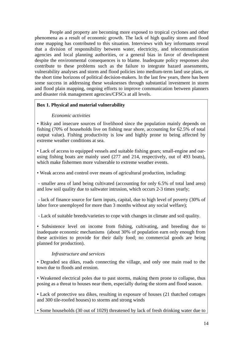
People and property are becoming more exposed to tropical cyclones and other phenomena as a result of economic growth. The lack of high quality storm and flood zone mapping has contributed to this situation. Interviews with key informants reveal that a division of responsibility between water, electricity, and telecommunication agencies and local planning authorities, or a general bias in favor of development despite the environmental consequences is to blame. Inadequate policy responses also contribute to these problems such as the failure to integrate hazard assessments, vulnerability analyses and storm and flood policies into medium-term land use plans, or the short time horizons of political decision-makers. In the last few years, there has been some success in addressing these weaknesses through substantial investment in storm and flood plain mapping, ongoing efforts to improve communication between planners and disaster risk management agencies/CFSCs at all levels.
Box 1. Physical and material vulnerability
Economic activities
• Risky and insecure sources of livelihood since the population mainly depends on fishing (70% of households live on fishing near shore, accounting for 62.5% of total output value). Fishing productivity is low and highly prone to being affected by extreme weather conditions at sea.
• Lack of access to equipped vessels and suitable fishing gears; small-engine and oar-using fishing boats are mainly used (277 and 214, respectively, out of 493 boats), which make fishermen more vulnerable to extreme weather events.
• Weak access and control over means of agricultural production, including:
- smaller area of land being cultivated (accounting for only 6.5% of total land area) and low soil quality due to saltwater intrusion, which occurs 2-3 times yearly;
- lack of finance source for farm inputs, capital, due to high level of poverty (30% of labor force unemployed for more than 3 months without any social welfare);
- Lack of suitable breeds/varieties to cope with changes in climate and soil quality.
• Subsistence level on income from fishing, cultivating, and breeding due to inadequate economic mechanisms (about 30% of population earn only enough from these activities to provide for their daily food; no commercial goods are being planned for production).
Infrastructure and services
• Degraded sea dikes, roads connecting the village, and only one main road to the town due to floods and erosion.
• Weakened electrical poles due to past storms, making them prone to collapse, thus posing as a threat to houses near them, especially during the storm and flood season.
• Lack of protective sea dikes, resulting in exposure of houses (21 thatched cottages and 300 tile-roofed houses) to storms and strong winds
• Some households (30 out of 1029) threatened by lack of fresh drinking water due to

15
saltwater intrusion.
• Lack of sanitation, especially during the storm and flood season, resulting in disease outbreaks (only 36.3% of households have standard toilets).
• Only one local infirmary with downgraded equipment and unable to providing adequate health care, especially during the storm/flood season when diseases prevail.
• Community’s radio station in disrepair. Public communication, which is done mainly through 4 loudspeakers set up in 4 villages, becomes difficult during the storm and flood season.
• About 3.1% of households have no radio or TV, leading to more risks for the fishermen because of lack of convenient access to daily information on weather conditions.
• Lack of other basic services (e.g., education); physical structures are often destroyed by storms.
Human capital
• Young population (18 years and under account for 43.7%) with no adequate skills and educational background yet to contribute to economic development.
• Occurrence of seasonal acute or chronic food shortage due to high poverty rate (30.7%), which is associated with high mortality and malnutrition rates (5% and 29.4%, respectively).
• Children, the elderly, and women are most vulnerable to storms because of frequent occurrence of diseases and insufficient health service facilities.
Environmental factors
• Over-exploited natural resources, especially marine resource.
• Poor soil quality and erosion due to saltwater intrusion and flooding.
• Low protective forest cover.
Source: Hai An’s record and survey data (2007)
At the household level, poor people suffer from natural hazards more often than the rich so they are more vulnerable and recover more slowly. Having capital to invest in protective measures has been one of the key factors in improving household well-being and in absorbing shocks caused by natural hazards. Without these resources, a common response to disasters has been for young people to migrate. As a result, there are situations in which vulnerable women-headed households are left behind, as men leave to find work.
Social and organizational vulnerability
A less visible and less well-understood aspect, the social and organizational dimension of a community (e.g., how a community is organized, its internal conflicts and how it manages them) is just as important as the physical/material dimension of

16
vulnerability (Box 2). This aspect includes formal political structures and the informal systems through which people get things done. Poor societies that are well-organized and cohesive can withstand or recover from disasters better than those where there is little or no organization and where communities are divided (e.g., by class or caste).
Box 2. Social and organizational vulnerability
• Strong family/kinship structures enable the community to cope with extreme climate conditions. For instance, during the 2006 typhoon, most interviewed households preferred to ask for help from their relatives before resorting to other sources.
• Weakness of leadership, initiative, organizational structure to solve problems or conflicts prevail, especially problems related to cultivated land and access to common pool resources.
• Ineffective decision-making process. Quite often, poor people/groups are left out or controlled by richer or more powerful groups during decision-making at the village and/or commune level.
• Unequal participation in community affairs and disaster mitigation plans, where the roles of women and children are insufficiently considered.
• Rumors and conflicts (class, caste, religion, gender, etc.) are quite common due to low education level at the local community.
• Weak community organizations (formal, informal, government, indigenous). One common reason is that those organizations mostly serve their members and do not pay much attention to outsiders.
• Weak relationship with the government and weak administrative structures, which is probably due to weak/not good relationship between local leaders and those at higher levels.
• Weak connection with the outside world during the storm/flood season due to the geographical characteristics of the commune.
Source: Hai An’s record and survey data (2007)
Motivational and attitudinal vulnerability
Another dimension of vulnerability is motivational and attitudinal, which is obtained by assessing how people in society view themselves and their ability to affect their environment (Box 3). Groups that share strong ideologies or belief systems, or have experience of cooperating successfully, may be better able to help each other at times of disaster than groups without such shared beliefs or those who feel fatalistic or dependent. Crises can stimulate communities to make extraordinary efforts.
Risk assessment, including local hazards and vulnerability, is the starting point and context for identifying risks by determining situations in which conditions for a particular type of disaster exist. On the other hand, early warnings are the interpretations and projections that the outbreak of disaster in a high-risk situation is likely and about to
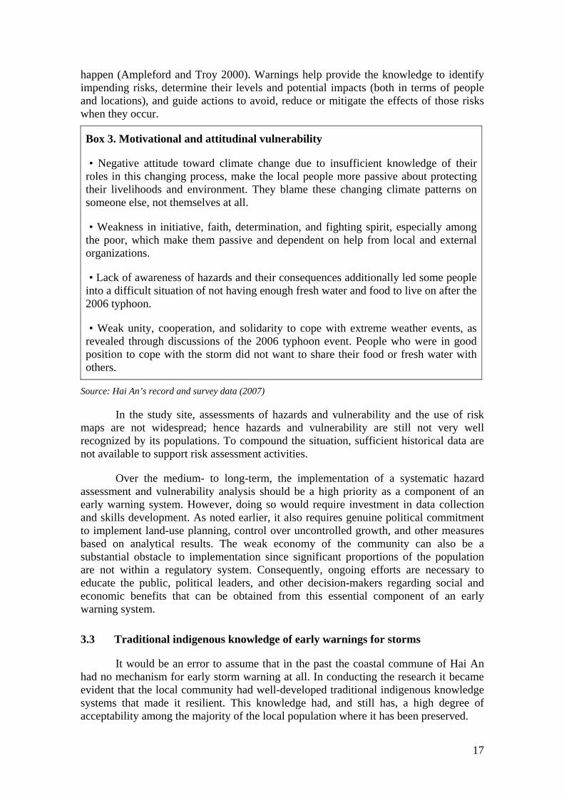
17
happen (Ampleford and Troy 2000). Warnings help provide the knowledge to identify impending risks, determine their levels and potential impacts (both in terms of people and locations), and guide actions to avoid, reduce or mitigate the effects of those risks when they occur.
Box 3. Motivational and attitudinal vulnerability
• Negative attitude toward climate change due to insufficient knowledge of their roles in this changing process, make the local people more passive about protecting their livelihoods and environment. They blame these changing climate patterns on someone else, not themselves at all.
• Weakness in initiative, faith, determination, and fighting spirit, especially among the poor, which make them passive and dependent on help from local and external organizations.
• Lack of awareness of hazards and their consequences additionally led some people into a difficult situation of not having enough fresh water and food to live on after the 2006 typhoon.
• Weak unity, cooperation, and solidarity to cope with extreme weather events, as revealed through discussions of the 2006 typhoon event. People who were in good position to cope with the storm did not want to share their food or fresh water with others.
Source: Hai An’s record and survey data (2007)
In the study site, assessments of hazards and vulnerability and the use of risk maps are not widespread; hence hazards and vulnerability are still not very well recognized by its populations. To compound the situation, sufficient historical data are not available to support risk assessment activities.
Over the medium- to long-term, the implementation of a systematic hazard assessment and vulnerability analysis should be a high priority as a component of an early warning system. However, doing so would require investment in data collection and skills development. As noted earlier, it also requires genuine political commitment to implement land-use planning, control over uncontrolled growth, and other measures based on analytical results. The weak economy of the community can also be a substantial obstacle to implementation since significant proportions of the population are not within a regulatory system. Consequently, ongoing efforts are necessary to educate the public, political leaders, and other decision-makers regarding social and economic benefits that can be obtained from this essential component of an early warning system.
3.3 Traditional indigenous knowledge of early warnings for storms
It would be an error to assume that in the past the coastal commune of Hai An had no mechanism for early storm warning at all. In conducting the research it became evident that the local community had well-developed traditional indigenous knowledge systems that made it resilient. This knowledge had, and still has, a high degree of acceptability among the majority of the local population where it has been preserved.

18
3.3.1 Observable behaviour of nature and interpretations
A local traditional method for predicting cyclones, floods, and other hazards has been long set up primarily for humanitarian purpose, using indigenous knowledge to interpret observed natural signals (Table 5). For instance, the movement of sea waves, the appearance of clouds and wind directions, etc. would be observed and their interpretation disseminated to fellow villagers.
Table 5. Indigenous early warning indicators and interpretations
Indicator Observation and interpretation
Period of year • Usually from August to November, more attention is paid to the period of tide or unusual hot summer
Weather pattern
• Unusually hot and humid weather /hot spells after rain and then sky turning gloomy and overcast indicate an impending storm. • Strong wind blowing from south to west before midnight is an unsual weather pattern; often indicates that a storm is coming. • Clouds quickly gathering toward the east, with lightning close to the sea surface indicate a storm is coming very soon. • A rainbow extending from southwest to northeast in the afternoon with the full half clearly visible indicates a strong storm ahead. • Thunderbolts in the east close to the sea surface with black rolls of cloud indicate a storm approaching in a few hours. • Clouds floating from northeast to southwest in the shape of tortoise shells indicate an impending storm.
Sea
pattern
• Big waves approaching the shore in south-west direction indicate a strong storm may be coming • Triangle shapes appearing in the sea due to waves from normal east-west direction meeting ones from north- east direction indicate a storm approaching very soon. • Smokey or cloudy shapes in the sea for a few days indicate a storm is developing. • Sea water becoming warmer with bubbles coming out from underground indicates high waves should be expected.
Animal
behavior
• Ants making nets underground indicate a storm coming in a week or two. If they are climbing up trees with eggs on their backs, it means a flood is coming in few days. • Dragonflies suddenly gathering together and flying very close to the ground indicate that there would be abnormal weather happening, usually strong winds combined with rain. • Frogs calling constantly indicate that there may be a storm coming in a few days. • Increased number of flies and mosquitoes means there would be abnormal weather happening -- usually a storm.
Tree behavior • Bamboo shoots sprouting inside bamboo hedges before autumn indicate the occurrence of some strong storms.
Source: Survey data (2007)

19
Through the group discussions, general observations show that some beliefs or interpretations are quite common, especially of the sea and weather patterns. These need further study for scientific validation.
3.3.2 Warning diffusion
Usually the community fishermen would typically start the day with a one-hour early morning chat about the day’s likely weather. They then would decide whether to stay home because of bad weather or on the best place to go with suitable fishing gears given the weather condition. In the visited community, it seems to be that the middle-aged and old fishermen are mainly the ones interested in observing hazard signals daily. According to the local people, the area has three middle-aged fishermen who are the most experienced in observing sea and weather patterns.
When local observations of natural conditions, which are more often combined with weather forecast for that day, indicate a potential hazard, first warnings are usually announced by the experienced men. The messages are then dispersed locally by the other fishermen on their way back home. The other local people who have received the warnings pass them on to others. Word of mouth dissemination enables the whole community to become aware of the warnings for a potential natural hazard, such as a storm, a thunderstorm or high waves created by strong winds.
Offshore dissemination methods of warning are still popular in the commune visited. During daytime, people at home send warning signals to those at risk offshore using bamboos. The long and strong bamboos are ready for use at any time. If observed dangers are likely to occur, the people quickly tie white cloths at one end of the bamboo and then hold them straight up in the air along the shore. The bamboos are visible at sea at a distance of 2-5 km or even farther, depending on the weather conditions. When the fishermen at sea see these signals they know that a potential hazard is likely to happen soon. They then quickly pack up their fishing gears and head home. On the way home, they too use the same method to warn other fishermen at sea, but with shorter bamboos placed on the top of their fishing boats.
At night, people at shore send a bad weather warning to people at sea by setting a big fire on the shore or on top of hills nearby. Sending signals using fireworks bring the same message. According to the local people, these methods are very effective, especially when one could not observe the sky in a dull, grey night. If one of these signs is displayed, those at risk try to reach the shore as quickly as possible, warning others along the way by flashing their electronic torches.
3.4 People-centered early warning system for storm and flood control in the context of disaster risk management
3.4.1 Early warning, disaster risk reduction, and sustainable development
People-centered early warning systems are recognized in the Hyogo Framework2 as an important element of disaster risk reduction and hence to the achievement of sustainable development and sustainable livelihoods. The objective of 2 The Hyogo Framework is available in several languages at http://www.unisdr.org/eng/hfa/hfa.htm
20
people-centered early warning systems is to empower individuals and communities threatened by hazards to act in sufficient time and in an appropriate manner to reduce the possibility of personal injury, loss of life and damage to property and the environment.
In Vietnam early warning, as a branch of risk information, serves several purposes and provides many developmental benefits, including the following:
• It is a disaster protection mechanism.
• It introduces and supports services at the local level that directly enhance development.
• It promotes increased development and application of scientific knowledge, including improved science and technology information dissemination.
• It advances community participation for its own sake.
• It promotes public-private partnerships.
• It creates the potential for increased utilization of indigenous knowledge and values.
• Effective early warning promotes improved environmental management and sustainable livelihoods that are harmonious with the environment by helping increase the security of vulnerable populations and endangered environments.
Early warning and other mitigation interventions are a cost effective way of disaster risk reduction. They have the potential to contribute significantly to reducing current and future disaster losses. For instance, it has been shown that a US$1 expenditure on mitigation saves about US$4-10 in recovery costs (Creig et al. 2002).
In the past, an early warning system was set up primarily for humanitarian purpose. Today, its structure and functions have expanded and shifted toward societal risk reduction as well as toward sustainable development, including changes in new technologies, political interference, community organization, and mechanisms for local institutional coordination.

21
3.4.2 Operational structure of early warning system for storms
Figure 5. Operating mechanism of storm early warning system Source: Author’s illustration (2007)
The traditional framework of early warning system is composed of three phases: monitoring of precursors, forecasting of a probable hazard, and issuing and disseminating a warning. The fourth element, which is “onset of emergency response activities once the warning has been issued,” recognizes the fact that there needs to be a response to the warning where the initial responsibility lies on emergency response
Contents: storm’s line tract, intensity, time; suggesting response activities... usually 24-48 hours ahead
by Central Committee for Flood and Storm Control
- Monitoring the natural conditions related to the hazard in question. - Forecasting event: storm’s line tract, intensity, time...
by Hydro-Meteorological Services
Commune CFSC issues early warning of hazard to its populations.
First official warning made by Vice Operating Chairman of commune CFSC
Then the warning continued on by village leaders as members of CFSC
Issuing warning
Forecast indicating a
hazard?
No
Yes
Response activities of
POPULATIONS AT RISK
given prior risk knowledge
Loud speakers
Radio station, loud speakers
Mass Organizations
Provincial, district Committee for Flood and Storm Control (CFSC)
Mass media: TV, radio, newspapers,
internet...
Monitoring & measuring
Commune level
Warning dissemination at commune level
Warning dissemination at village level
Telephone, high
frequency radio, fax, telegraph...
22
agencies. While good governance and appropriate institutional arrangements are not specifically represented on the chart, they are critical to the effectiveness of the system.
3.4.3 Monitoring, forecasting, and warning services
Storm detection and prediction
When describing who executes the two initial phases of the early warning systems (i.e., monitoring and forecasting), one can see two trends. First is a centralized system where a national-type agency carries out these functions, and second is a decentralized system where other agencies, municipal workers, and volunteers at the more local level carry out these tasks.
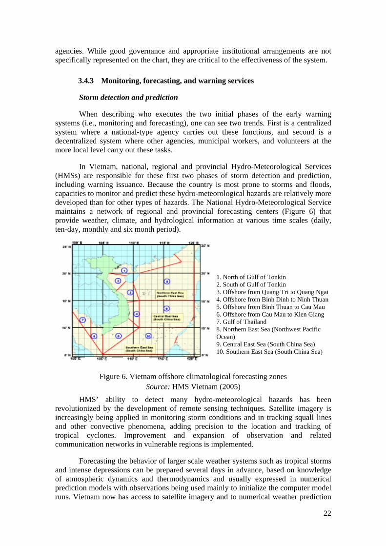
In Vietnam, national, regional and provincial Hydro-Meteorological Services (HMSs) are responsible for these first two phases of storm detection and prediction, including warning issuance. Because the country is most prone to storms and floods, capacities to monitor and predict these hydro-meteorological hazards are relatively more developed than for other types of hazards. The National Hydro-Meteorological Service maintains a network of regional and provincial forecasting centers (Figure 6) that provide weather, climate, and hydrological information at various time scales (daily, ten-day, monthly and six month period).
1. North of Gulf of Tonkin 2. South of Gulf of Tonkin 3. Offshore from Quang Tri to Quang Ngai 4. Offshore from Binh Dinh to Ninh Thuan 5. Offshore from Binh Thuan to Cau Mau 6. Offshore from Cau Mau to Kien Giang 7. Gulf of Thailand 8. Northern East Sea (Northwest Pacific Ocean) 9. Central East Sea (South China Sea) 10. Southern East Sea (South China Sea)
Figure 6. Vietnam offshore climatological forecasting zones Source: HMS Vietnam (2005)
HMS’ ability to detect many hydro-meteorological hazards has been revolutionized by the development of remote sensing techniques. Satellite imagery is increasingly being applied in monitoring storm conditions and in tracking squall lines and other convective phenomena, adding precision to the location and tracking of tropical cyclones. Improvement and expansion of observation and related communication networks in vulnerable regions is implemented.
Forecasting the behavior of larger scale weather systems such as tropical storms and intense depressions can be prepared several days in advance, based on knowledge of atmospheric dynamics and thermodynamics and usually expressed in numerical prediction models with observations being used mainly to initialize the computer model runs. Vietnam now has access to satellite imagery and to numerical weather prediction

23
products. Consequently, there has been a steady improvement in the predictive skills for synoptic scale systems on short- to medium-range time scales.
The provincial forecasting office in Quang Tri makes use of real time hazard information from eight monitoring stations, and satellite images and additionally synoptic analysis (both surface and upper air) from international forecasting centers for a global view of existing weather conditions. The provincial forecasting center of the Hydro-Meteorological Service is also networked with other provincial centers in the Central Region to provide additional information for the preparation of localized forecasts. The center is equipped with fax machines, telephones, and Internet access for information exchange.
Issuance of warnings
The Central Committee for Flood and Storm Control (CCFSC), working closely with the National Hydro-Meteorological Service (NHMS), issues "advisories" when it determines that storms could cause damage and "warnings" when it has concerns about potentially serious damage. The warning is then relayed to populations at risk via CFSCs at local levels, and via national and local mass media, which further disperse the information through their networks. In many cases, hazard warnings for a storm from international organizations can also be accessed by vulnerable populations through the Internet.
The effectiveness of storm early warning depends on the generation of accurate risk scenarios showing the potential impacts of an impending storm on vulnerable groups. Authorities of CCFSC define acceptable levels of risk to communities and determine whether or not to warn them and when to do so. Warnings are often 24-48 hours ahead of the expected occurrence of a storm, allowing adequate time for response activities. The longer the lead-time warnings are made, the less accurate the storm’s line tract. Warning information of a storm typically comprises three parts:
- Name of the storm: sequentially named by the NHMS after ordinal numbers;
- Current line tract and intensity: involving typhoon center’s latitude and longitude, the distance from mainland, moving speed, and the strongest wind force at the typhoon center (using Beaufort scale); and
- Forecast of its movement, line tract, and intensity within next 24-48 hours.
Six types of early warnings used by CCFSC and the NHMS are as follows:
- Warnings for observed storm: if the storm is formed outside the East Sea (China Sea) and probably head toward Vietnamese waters within 12-24 hours. No name is given to observed storms.
- Warnings for remote storm: when this storm has just moved into Vietnamese waters, the National Hydro-Meteorological Service names them sequentially after ordinal numbers. This classification may differ from other sources, which name a storm after a place, an animal, etc.

24
- Warnings for nearby storm: if the storm has moved into the East Sea with distance of about 500-1,000 km heading to the mainland of Vietnam, or 300-500 km from its “eye” to the mainland but not yet having headed to Vietnam in few more days.
- Urgent warnings: if the storm is about 300-500 km and is heading to the mainland of Vietnam within one day or two, or around 300 km from its “eye” to the mainland but moving slowly.
- Warnings for storm on land: when the storm has reached the mainland of Vietnam with the wind force of Beaufort scale 8 or more.
- Final “warnings”: when the storm has completely died out and no more damage is caused.
3.4.4 Warning dissemination and communication at commune level
Warning dissemination
Through the internal network, a warning on a forthcoming storm issued by the provincial CFSC is received by the district CFSC, and is then relayed to the commune CFSCs by telephone and/or high frequency radio. Lead-time depends on the position of the storm, but is usually 24-48 hours ahead. A warning on an observed or remote storm will give more time for a community to respond while that on a nearby or emergency storm will require quicker response activities from the commune.
After receiving the warning from the district CFSC, all members of the commune CFSC quickly gather at the commune hall and execute their duties accordingly. This triggers a flurry of activities in the commune.
At the commune hall, the first official warning to the population is issued by the Vice Operating Chairman of the commune CFSC through the commune radio station. The contents of the warning include the position of the impending storm, its line tract, intensity, and time to reach the area. The recommended response activities at the commune and household levels are also included.
Later on, the commune CFSC members would go around the commune to inform people using portable loudspeakers and to check everything, including preparedness and response capacity of households. About half an hour later, more warnings are disseminated by the village leaders through four loudspeakers located in the four villages.
When the storm is heading land very fast and is expected to reach the population at risk in less than 4-6 hours, the dissemination of the storm’s line tract, intensity, and time left for response activities is made hourly until the electricity is cut down by the Province Electricity Department for safety reasons. In some circumstances, other local warning systems such as door-to-door visits are used to alert the population.
Offshore communication
At sea, well-equipped fishing boats are warned of an impending cyclone through high radio frequency or radiotelephone. In a recent effort of the provincial Department of Post and Telecommunication and the Radiotelegraphy Control Center, 100 percent of
25
the large fishing vessels in Quang Tri province were issued licenses to use high frequency radio. The fishing boats receive warnings of an approaching storm through this high frequency radio and are required to quickly return to port, to find shelter, or to get out of a storm-affected area. The warning includes a storm’s line tract, its intensity, and time to react.
Warnings are harder to disseminate to those who are in small fishing boats near shore (usually 2-15 km far from main land) without any communication equipment, making them more vulnerable to the hazard. To warn them, signaling fires are set off from the shore. In some cases, the border police searches for these boats to warn them personally, especially in the case of nearby or emergency storms.
3.4.5 Household and community response capacities
Household response activities
After a warning is received by households, a flurry of activities happens. Tree branches, which are easily broken and dangerous to human life, would be cut down. Repair of dwellings, including reinforcement of pillars and roofs, would be quickly undertaken. Some households visited said they use strong building materials (e.g., steel wire instead of ropes extracted from trees) to retie thatched roofs to the frame. Some keep in place their corrugated iron roofs by putting sand bags on top of them.
For temporary and semi-solid houses that are quite vulnerable to storms, people would take shelter in safer places such as cyclone shelters at the community hall or solid concrete houses nearby when they receive the warning.
Households who own small boats secure them at safe places. When possible, they bring the boats to shore nearer their houses in case they would be needed when it floods. To cope with storms and associated floods, some households make rafts made of bamboo or sometimes banana trunks.
Emergency food (e.g., instant noodles, rice), firewood, and medicine are readily stocked. Preparation of drinking water would also be undertaken. Water tanks set high above the ground are one way to ensure water supply during floods. Households that rely on well water may store water in advance of the flood season, often using 20-liter plastic containers.
In addition, paddy fields would be banked up to avoid damage and losses. Harvested paddy is kept on an elevated storage. Animals are moved to safer grounds; small huts to protect their livestock are also built by some households.
Costs involved
As indicated by the commune CFSC, the costs involved in a response plan for each household are listed in Table 6. Although the amount is not very large, only VND610,000 or about US$38 (US$1VND16,100 at the time of the interview), it is not always affordable by every household.
The commune CFSC headquarters is now well-equipped with communication means for monitoring and warning services (e.g., fax machines, telephones, and Internet access). It has also invested in loudspeakers, which are the most frequently used means

26
for disseminating information to the very end users. There is also a radio station operated by a member of the commune CFSC. When electricity is not available, the CFSC has five electricity generators to run the equipment.
Table 6. Cost estimate of a response plan at the household level (2007 price)
Items suggested for each household
Quantity
Estimated cost (000’ VND)
Food preparation Rice 50 kg 200 Instant noodles 20 pack/person 100 Salt 5 kg 10 Water container, thermos 2-3 pc 50
Other necessary things Firewood, lighters, matches for 5-10 days 10 Gasoline 5 liter/hh 40 Sand bag 20 bags 30 Canvas bags 15-20 bags 20 1.5-2 meter bamboo stakes 10-15 pc 50 Shovels, hoes, axe, etc. 10 pc 100
Total 610
Source: Survey data (2007)
The commune had a disaster preparedness plan for the 2007 storm and flood season. A total of 400 trainees (50 persons per village) took part in a two-day training course on risk knowledge; response actions to warning information; evacuation, search and rescue skills with inputs from lessons learned from the past storm and flood seasons. Simulation exercises for disseminating warnings, evacuating the elderly, children and woman, etc. were conducted.
The food security plan provides strategies such as early harvest and emergency preparations such as moving crops to higher areas. The sub-committee on relief ensures that all emergency requirements of food supply, logistics and personnel are available on site. The plan to safeguard infrastructure includes measures to protect the electricity network, canals, schools, etc. The plan on evacuation and search and rescue identifies sites for the evacuation of groups of households, including help from the border police station nearby.
Emergency health care is also given importance: the commune hall is designated as the emergency health station that would administer primary health care and handle emergency births. Sanitation is also considered, with a clean-up operation undertaken after each storm or flooding event.
The interviews with key informants show that the yearly costs involved for the early warning system (EWS) to work at the commune level are large and often unaffordable by the community. A preliminary assessment of the costs involved in the EWS in the community for 2007 is presented in Table 7.

27
Table 7. Estimates of cost of investment and operation of the EWS at the community in Hai An in 2007
Activity Quantity Cost
(000’VND) Financial source
1. Maintenance and upgrading of the communication and info dissemination system Fax machine, telephones 2 1,800 Commune budget Computers for Internet access 1 1,500 Commune budget Daily newspapers 3 each day 3,000 Commune budget Radio station 1 10,000 -Commune budget (20%)
- Disaster mitigation projects (DMPs) (80%)
Roof-top loudspeakers 4 25,000Electric generators 5 15,000Portable loudspeakers /megaphones 4 12,000 DMPs
2. Raising public awareness and understanding of risk and warnings Two-day training course on early warnings, risk knowledge, evacuation.
200 trainees (50/village)
8,000 - Commune budget: 2,000 - DMPs’ support: 6,000
Yearly diffusion of hazard knowledge & dissemination of warnings
4 villages 3,600 Commune budget
3. Evacuation, Search & Rescue Two-day training course for Evacuation, Search and Rescue Unit
2 courses 7,000 - Commune budget 2,500 - DMPs’ support: 5,500
Evacuation, search and rescue simulation exercises
whole community
15,000 Commune budget
Petrol, maintenance of rescue boats 10 8,000 Commune budget Purchase of new rescue boat 1 40,000 Supported by DMPs Investment in 50 life-vests, 50 lifebuoys, 25 electric torches, etc.
for 4 villages
12,000 - Commune budget: 2,000 - DMPs’ support: 10,000
Arrangement of evacuation shelters 4 villages 6,200 Commune budget
4. Preparation for food, water, etc. Instant noodles (packages) 3000 2,700 Commune budget Salt (kg) 200 200 Commune budget Gasoline (liters) 100 900 Commune budget 20-liter plastic container for water 20 200 Commune budget Matches, lighters 100 100 Commune budget
5. Preparation for Health Care Unit (as a sub-committee of commune CFSC) 3-day course for Health Care Unit 24 persons 3,000 Supported by DMPs Equipment (stretchers, first-aid tool kit, medicine, etc.)
for 4 villages
30,000 Commune budget: 5,000 DMPs’ support: 25000
Payments for health care operations Commune 15,000 Commune budgets
6. Dam & dike protection and maintenance to increase response capacity Bamboos 1500 -2500 10,600 Commune budget Clay 150m3 3,600 Commune budget
7. Other activities (e.g., assessing damage, writing reports, meetings, workshops) Village level 4 villages 1,800 Commune budget Commune level 1 commune 1,200 Commune budget
Total 237,400-Commune budget: 64% -Other sources: 36%
Source: Hai An’s CFSC and survey data (2007)

28
3.5 Local institutions and their roles in people-centered EWS
As discussed earlier, the first two phases of monitoring and forecasting a hazard and issuing warnings are centralized systems. In contrast, the second two phases of warning dissemination and response plans to populations at risk have been decentralized and carried out at the local levels.
3.5.1 Government institutions
Local governments usually have direct responsibilities for the citizens’ safety and considerable knowledge of the hazards to which their communities are exposed. They must be actively involved in the design and maintenance of early warning systems and understand advisory information received to be able to advice, instruct, or engage the local population in a manner that increases its safety and reduces the possible loss of resources on which the community depends.
Roles of the commune Committee for Flood and Storm Control
In 1997, the commune Committee for Flood and Storm Control (CFSC) was established. Its goals are mainly to issue early warning of hazards and mitigate disasters for its population. In 2003, the commune CFSC was reconstructed, expanding it to having five more village sub-committees. These subcommittees oversee health care and the environment, infrastructure, evacuation and search and rescue, relief, and logistics. The members report to the Chair of the commune CFSC (Figure 7).
The commune CFSC is composed of:
• Chairman of CFSC (Chair of the commune People’s Committee)
• Operating Vice Chairman (Vice Chair of the local People’s Committee)
• Standing Vice-Chairman (Head of commune Security Section)
• Representatives from Vietnam Fatherland Front, Women’s Union, Youth Union, Veterans Association, Farmers Association, Agriculture Cooperative, etc.
The tasks of the local CFSC are to:
• issue early warning of hazard;
• set up plans for the prevention and control of floods and storms and guide to implement them in their localities;
• carry out activities for prevention and protection of residential and commercial areas from floods and storms;
• receive feedback from lower sub-committees on actions done to prepare for an impending hazard and, based on this information, give instruction and guidance on further action;
• mobilize personnel and resources for emergency response;

29
• manage relief and rehabilitation;
• prepare damage and needs assessment report for submission to higher-level committees.
Figure 7. Structure of commune Committee for Flood and Storm Control at Hai An commune
Source: Author’s illustration
Commune People’s Council
The Hai An People’s Council is the authority of the State at the commune level. The People’s Council is accountable to the people and the superior State bodies. The task areas of the People’s Council include economics; culture, education and social affairs; science, technology and the environment; security, social order and safety; building of the local administration and managing administrative boundary of the locality; supervision of other organizations.
The general responsibilities of the commune People’s Council in EWS are to:
• provide education, training, and spreading of risk/hazard knowledge to the population;
• be responsible for disseminating and communicating warnings;
• build up the response actions/plans for the whole commune.
Chairman of CFSC Commune People’s
Committee
Operating Vice Chairman of CFSC
Standing Vice Chairman of CFSC
My Thuy village
Dong Tan An village
Tay Tan An village
Thuan Dau village
Information & dissemination Section
Logistic Distributing
Relief managing
Evacuating, Searching & Rescuing
Health Caring
More warnings
Issuing warnings to
its population
Directing response
plans
Village leaders
Continuing on warning
dissemination
Equipment Operating
30
Commune People’s Committees
The Hai An commune People’s Committee is elected by the Commune People’s Council and acts as its executive body; it is the Government’s administrative agency at the local level. It has responsibility over the implementation of the constitution, laws, and directives of higher-level government agencies and resolutions of the People’s Council. It is composed of a Chair, a Vice-Chair, and 5-7 members. The Chair of the People’s Committee also chairs the Committee on Flood and Storm Control.
The task areas of the People’s Committee include planning, budget and finance; agriculture, forestry, fisheries, water conservancy and land; industry, small industries and handicraft; communications and transport; urban development, construction and management; trade, service and tourism; education and training; culture, information, physical training and sport; social affairs and life; science, technology and the environment, national defense; public security, social order and safety; implementation of policies for nationalities and religion; law enforcement; building of the local administration and managing of the administrative boundary of the locality.
The Commune People’s Committee is the lowest political institution in contact with communities. It receives citizens’ complaints, denunciations, proposals, and opinions on issues related to the Communist Party’s lines and policies, State legislation and management of agencies and units. Meetings for this purpose are held at least twice a week, compared with at least once a month at the district level, which underlines the importance of grass root presence of public administration.
3.5.2 Mass Organizations
Mass organizations link the Government, the Communist Party, and the people. They take part as members of sub-committees of commune CFSC. They are far-reaching and therefore have a great effect on social and community structures.
Vietnam Fatherland Front
The Vietnam Fatherland Front is a political alliance organization; it selects candidates for the People’s Councils for election by the people. In times of disasters, the Fatherland Front calls for and channels emergency supply donations and coordinates with the mass media at the central and local levels. Its tasks are to:
• gather and build the block of national unity to strengthen unanimity of spirit and politics among people;
• propagandize and encourage the people to exercise their right to be their own masters;
• realize the lines, advocacy, and policies of the Party, and strictly execute the Constitution and Laws;
• supervise the activities of the State bodies, elected deputies, and State officers;
• collect people's opinions and their recommendations to reflect and propose to the Party and the State;

31
• participate in the building and enforcement of the people's Administration;
• together with the State, take care of and protect people's legitimate interests and take part in the development of relations and cooperation between the Vietnamese and the people around the world.
The Ho Chi Minh Communist Youth Union
Operating under the direct leadership of the Communist Party of Vietnam, the Ho Chi Minh Communist Youth Union is the reliable reserve force for the Party, supplying it with personnel to the requirements of its political tasks. The organization also associates and coordinates with other agencies and mass organizations to achieve an aggregate synergy in educating, protecting, and forging the younger generations.
Women’s Union
Established in 1930, the Women’s Union advocates gender equality and carries out education activities to increase women’s knowledge and skills, supports poverty alleviation for poor women, and promotes mother’s and children’s health. At the commune level, the Women’s Union is actively involved in:
• advising members to prepare emergency food;
• cooking at evacuation centers;
• assisting the Commune Sub-committee on Flood and Storm Control on logistical requirements for response;
• assessing local conditions as basis for distribution of relief goods and assistance;
• rebuilding houses damaged by disasters;
• conducting training courses to enhance women’s skills and provide livelihood options; and
• extending to members credit with very minimal interest rate.
Veterans Association
The Veterans Association is a political organization. As a member of the Commune Sub-Committee for Flood and Storm Control, the Veterans Association assists in dissemination of early warning and damage assessment and extends credit to members. Its main tasks are to:
• advise the Communist Party and local authorities
• contribute to stability and socioeconomic development
• implement the resolutions and policies of the Party and Government
• collaborate with other mass organizations in implementing all activities

32
• encourage and help members who face difficulties
Farmers Association
The Farmers Association is a voluntary organization aimed at developing production alongside environmental protection. As a member of the Commune Sub-Committee for Flood and Storm Control, the Farmers Association undertakes the following preparedness, response, and rehabilitation activities:
• assist in dissemination of early warning
• assist in evacuation and advice members where to move livestock
• participate in rescue
• assist in reconstruction of dwellings
• facilitate mobilization of farmers’ assistance to those who are most affected (e.g., exchange of seeds for some other commodities)
• advise farmers to plant cash crops for immediate food supply
Vietnam Red Cross
The Vietnam Red Cross (VNRC) was recognized by the International Federation of Red Cross Societies (IFRC) and became independent from the Ministry of Health in 1957. VNRC is involved not only in relief work, which it does with a high degree of effectiveness utilizing its nation-wide network, but also in disaster preparedness.
Red Cross volunteers in Hai An commune, in coordination with local authorities, help the local people with regards:
• Training in how to prepare for disasters
• Evacuation, rescue and relief
• administering first aid, assisting in cleaning up operation
• reinforcing houses, building of storm-resistant houses
• preparing the needs assessment report
• supporting institutional/staff development and humanitarian values development
Other mass organizations in Vietnam include the Education Promotion Association and Old Peoples Association. Education Promotion Association’s main task is to promote education in society. Old Peoples Association’s membership includes those who have retired from government work and farmers who are more than 55 years old. Their activities are to protect the rights of old people, implement and disseminate policies to members, and contribute to recovery and conservation of traditional customs

33
3.5.3 Nongovernment Organizations
Assistance provided by international NGOs cover preparedness, relief, and rehabilitation. If disasters affect areas where they are present, they are able to provide direct relief/rehabilitation assistance. At Hai An commune where international NGOs are not present, their response is based on appeals made by the government. Funds and relief assistance are channeled through VNRC or local organizations such as People’s Committee, Women’s Union. Assistance provided includes:
• Preparedness training
• setting up early warning systems
• building water supply storages
• Provision of food, shelter items, and health kits
• repair/rebuilding of houses, clinics, schools, reforestation, micro-finance, etc.
Assistance is also integrated in long-term development projects in education, agriculture, and health.
3.6 Community experiences and the evolution of early warning systems
To evaluate the EWS’s contributions to risk reduction, and hence decreases in loss of life and property of the population at risk, the study used two points of reference: the 1985 and 2006 typhoons. The reasons for choosing these two typhoons are as follows:
- It was only in 1997 when the Hai An Committee for Flood and Storm Control (CFSC) was established. Since then, this government institution has played a very important role in implementing the people-centered early warning system at the local level because of its mandate to issue and disseminate early warnings of hazards and to mitigate disasters for the population they oversee.
- There are no official data at the community recorded before 2005. The massive typhoons of 1985 and 2006 have caused vast damages to the coastal community (study site). Information on experiences in dealing with big disasters was extracted from the local people.
3.6.1 Local experiences from the 1985 typhoon
In 1985, Central Vietnam was hit by a massive typhoon. The typhoon caused serious personal injuries, loss of lives, and damage to properties and the environment of Hai An commune. According to the local people who had experienced that typhoon, about 14 people died; nine of them died at sea. The flooding that followed the typhoon also caused a serious obstacle to the commune’s economic progress. The storm occurring at high tide resulted in saltwater intrusion of up to 2-3 km inland, affecting soil and water quality and resulting in a huge ecological problem.

34
Early warning of the event by local administrative authorities
The study found that most populations at risk did not receive any early warning about the danger of the 1985 event. The typhoon was described as an event that happened very fast, it “come and go”. Local people had no time to implement protective responses.
In fact, Hai An administrative authorities, particularly the Commune People’s Committee, received an unofficial warning about the typhoon only 12 hours before the typhoon hit the area; the warning came from one member of Hai Lang District People’s Committee. Without communication equipment, however, the Commune People’s Committee managed to disperse the information only among its members and the surrounding zones.
“We were informed via word of mouth by a member of District People’s Committee that an approaching storm would hit Central Vietnam in 12 hours, but we did not know exactly where and how strong it was. We did not own a radio at that time so we could not confirm if it would hit our area. In addition, we did not have any kind of communication to diffuse the warning, so only the households surrounding the headquarters knew the news.”
(Vo Minh Huyen, aged 58) Ex-Chairman of Hai An Commune People’s Committee
Owing to the inefficiency and weakness of communication and institutional coordination between the district and commune authorities, the early warning failed to reach the whole community on time. On the other hand, some people in the study site confirmed that the local authorities told them about the storm, but they did not take the warning seriously. As a result, no preparedness plans were made to reduce the impact of the typhoon, which was later described as one of the most intense storms in the community’s history.
Community based early-warning
It would be an error to assume that Hai An community had no early warning mechanism at all. Traditional methods for predicting natural hazards have been long set up primarily to protect themselves against disaster. This system relies on indigenous knowledge to interpret observed natural signs such as the movement of sea waves, the appearance of clouds, wind directions, etc3. Indigenous knowledge has enabled the people to design their disaster management strategies long in advance by constructing types of shelter, windbreak structures, walls, and homestead fences appropriately. For example, an 81-year old man explained as follows:
“By the month of August we start to improve our houses, putting sand bags on the roof to avoid our houses being destroyed by strong winds, because we know that the storm and flood season is coming.”
(Phan Thanh Phung, aged 81, My Thuy village)
Talking about the usefulness of indigenous early warnings, his son (aged 46) added: 3 For more, see “3.3 Traditional indigenous knowledge of early warnings for storms”, p. 18.

35
“Thanks to his knowledge, he and I survived when we were at sea and a storm suddenly approached. There was no radio in those days. He saw some strange patterns in the sea and told me to row towards the shore as fast as we could, leaving our fishing gears behind. At first, I did not know why he behaved like that, but when we were 100m away from the shore, a real big storm caught us…There were 3 people in our village who lost their lives in that storm...”
The old man explained how indigenous knowledge works, as follows:
“I saw triangle shapes of waves appearing at first, and then I saw clouds quickly gathering in the east direction with lightning very close to the sea surface. I was sure that a big storm would be appearing very soon, and told my son to head towards the shore as quickly as possible...”
It is clear that the local community has developed indigenous knowledge systems for environmental management and coping strategies, making it resilient to hazards and environmental changes.
On the other hand, although indigenous knowledge has helped some people survive hazards, it did not do so for others. The weakness of this type of early warning is its low accuracy. In addition, dissemination of the warning is limited, more often via word-of-mouth method, which is usually does not provide enough lead-time to people at risk to adequately respond to hazards. As a result, people had less confidence in warnings provided by neighboring fellows who were also at risk.
The impact
A large proportion of the population earned living as fishermen, and many (about 87) of them lost their boats and fishing gears due to the storm. About 210 farming families also lost their homesteads, fields, agricultural equipment, livestock and other assets: 70-80 percent of livestock (mainly pigs) was seriously affected and approximately 50 ha out of 80 ha of planted crops were destroyed. Public infrastructure was similarly damaged: schools, local clinics, public buildings, and homes collapsed or were swept away, forcing residents to abandon their homes.
Households were more exposed to the risks from floods and cyclones due to losses of household structures, household assets, livestock and crops. These losses were exacerbated by the fact that their homesteads and fields were at risk from inundation and saltwater intrusion. However, the impact of floods in Hai An was relatively low compared with that of storms. In the old days, the average annual crop production lasted three to six months only, thus there was chronic food scarcity even in normal years. The situation worsened because the typhoon hit the community just a few weeks before harvest; that harvest was highly anticipated by the local people after almost four months of food scarcity. In the aftermath of the disaster, the community faced serious food shortages, increasing the need for emergency assistance.
A man in his late middle age named Nguyen Danh sadly recalled:
“From 1986 to early 1990s we lived in a state of growing hunger, with winds [storms] and floods destroying our crops before they could be harvested. We were hoping for a good harvest so that we could survive storm seasons. Hunger was high. The winds destroyed most of our fishing boats, and it was very hard to rebuild one in

36
those days. The possibility of having something to eat was very limited, and we had to depend on donations or daily labor-for-food strategy. We had no money to increase the potential of our land quality or to reinvest in our boats. Our children left school to stay at home and help their parents or to work for their own meals. This had put us in a difficult time.”
The situation was compounded by disease outbreaks, which occurred with the spread of wastes by floodwaters and the lack of safe water supply. In addition, health care was not available in the commune. Household recovery rate was reduced substantially because they lacked the means to carry out their livelihoods and were living in a situation of permanent vulnerability. As the result, the households became more vulnerable to future storms and floods.
3.6.2 Evolution of early warning systems in Hai An commune
Since 1985, the community-based early warning system (EWS) has been steadily less practiced. While many people still use it as additional source of information, some see this system as ‘old-fashioned’ knowledge that has been outdated by the newer scientific warning system (whether or not the signal system is properly understood or utilized). There is little evidence that the traditional EWS is being passed on to the younger people.
“We hear the old people say that continuous crying of dogs or increased number of flies and mosquitoes indicate anomalous weather, usually a storm. Some say the movement of ants to underground also predicts a storm. But now we give more importance to the weather forecasts disseminated by the Government.”
(Nguyen Danh, aged 25, Thuan Dau village)
The weakness of this early warning is probably that people have less confidence in warnings provided by neighboring fellows who are also at risk. It is partly due to low awareness and understanding of the risks faced by the community. The accuracy of the system is often low. In addition, dissemination of the warnings is limited, often via word-of-mouth, providing inadequate lead-time to people at risk to adequately respond to hazards.
Over time, the indigenous EWS has been gradually replaced by a more sophisticated EWS, which is of larger scale, involves many stakeholders, uses new scientific equipment, and receives technical assistance from government institutions and external organizations.
The establishment of the commune Committee for Flood and Storm Control (CFSC) in 1997 marked an important milestone in the history of early warning system in the community. The CFSC’s main goals are to issue and disseminate early warnings of hazards, and to mitigate disasters for the population it oversees. The committee sets up plans for the prevention and control of floods and storms and guides for their implementation in the locality. It also carries out activities to prevent and protect the residential and commercial areas from all types of hazards.
Technical assistance from provincial and district governments and external organizations such as the Vietnam Red Cross and nongovernment organizations has

37
enabled the local community to improve its early warning system. The commune CFSC is now well-equipped to receive and disseminate storm warnings.
Backup communication capability is essential for a reliable delivery of warnings during severe conditions. In the commune CFSC headquarters, the means of communication with monitoring and warning services now includes fax machines, telephones, and Internet access Other sources of communication such as TV, radio, and the press can also be useful.
The most frequently used tools for disseminating information to the end users are simultaneous wireless communications systems used with outdoor loudspeakers or indoor private radio receivers. To disseminate warning information effectively at the commune level, the commune CFSC operates a radio station. In addition, two portable loudspeakers are well in use. Further, each of the four villages possesses a rooftop loudspeaker, which is operated by the village leader. When there is no electricity supply, the CFSC has five electrical generators to run the EWS equipment.
Effective early warning requires that the target population not only receives advance warning of hazards, but also that it understands the content of the message, believe it, and then know how to respond to it. This suggests that well-designed early warning programs must include an on-going public awareness component about potential risks.
In 2005, 400 trainees (50 persons per village) took part in a two-day training course organized by Vietnam Red Cross. The training focused on risk knowledge, evacuation, and search and rescue skills. The trainees, in turn, shared their knowledge and skills with the rest of the community. Afterwards, simulation exercises on disseminating warnings, evacuating the elderly, children and woman, etc. were conducted, with financial assistance from the province. The response plans with inputs from lessons learned from the past were prepared in collaboration with mass organizations. They contain the detailed tasks of the CFSC sub-committees with regards prevention of and preparedness for disasters as well as response and rehabilitation.
Today, the EWS’ structure and functions have expanded and shifted toward societal risk reduction and sustainable development, reflecting changes in technology and political support to this system.
3.7 Effectiveness of a people-centered EWS for storm control
Effective early warning systems require a strong technical foundation for hazard detection and prediction. Similarly, the effectiveness of a people-centered early warning system requires also that the target population receive advance warning of hazards, understand the content of the message, believe it, and then know how to respond to it.
The key functional components of a people-centered early warning system for storm control are:
- Prior knowledge of the hazards and vulnerabilities faced by communities;
- Technical detection and forecast of a hazard and issue of warnings;
- Dissemination of understandable warnings to those at risk;

38
- Community response capacities; and
- Coordination among local institutions
A weakness or failure in any one of these elements could result in the failure of the whole system. Best practice EWS has strong inter-linkages among all elements in the chain. While good governance and appropriate institutional arrangements are not specifically represented in the four-element framework, they are critical to the development of effective people-centered early warning systems.
3.7.1 Damage reduction: 1985 typhoon Linda versus 2006 typhoon Xangsang
The coastal communities in Central Vietnam remember well the huge losses incurred in the wake of typhoon Linda in 1985 that destroyed 300,000 houses and caused many other damages in the whole country. As Vietnam’s economy grew, the level of economic losses also climbed steadily since 1985, reaching over US$700 million by 1996. Ten years later, losses due to the 2006 Cyclone Xangsang were estimated at VND10,375 billion (US$650 million). Although the cost of rehabilitation was big, there had been a major improvement: only 69 people died due to typhoon Xangsang.
The local people recalled the huge destructive power of the 2006 typhoon and perceived it as stronger than the 1985 typhoon. In Hai An, however, the damage of the 2006 disaster was dramatically reduced owing to the effectiveness of the early warning system. In essence, the early warning system provided the right information to the right people at the right time, and enabled them to take appropriate avoidance or preventive actions.
Since the early 1990s, the provision of warning services has been the highest priority of national weather service agency. In addition, capacities to monitor and predict tropical storms have become relatively more developed than for other types of hazards. All of these have helped the community in many ways. The application of hydro-meteorological knowledge to risk assessment contributed to disaster mitigation. The forecast and provision of warnings contributed to preparedness and response phase. Because the storm hazards and local vulnerability are now well known and there is better awareness and understanding of warnings, the generation of accurate risk scenarios showing the potential impacts of hazards on vulnerable groups has also improved.
Better coordination among stakeholders was also noted, resulting in people being evacuated more quickly. Thus, people-centered early warning systems empowered the individuals and the community threatened by the typhoon to act at the right time and in an appropriate manner, reducing personal injury, loss of life, and damage to property and the environment.

39
Table 8. Damages caused by the 1985 and 2006 typhoons (please place this table after the paragraph where it is cited.)
Damage 1985 typhoon 2006 typhoon
Lives lost 14* 2
Houses destroyed 210* 86
Fishing boats destroyed 87* 6
Total value of damages not available VND300 million *The figures are averaged using figures obtained from the group discussions. Source: Survey data and Hai An’s CFSC
During the 2006 typhoon, only two fishermen lost their lives at sea (Table 8). Strong winds accompanied by heavy rains destroyed some parts of the protective dikes and fishing farms. They also damaged 86 houses, of which 6 were completely ruined. Households who owned small fishing boats brought them on to land nearer their houses or at safe places, so only a small number of boats were ruined. The damages to the other community infrastructure, such as the primary school and the commune hall, were also reduced. The total economic losses were estimated at VND300 million.
While it is difficult for coastal communities to protect their people and properties against massive storms such as those that hit Central Vietnam in 1985 and in 2006, they can reduce or even avoid damages brought by the other, less strong storms that pass through their areas during the year. This damage prevention can be achieved at a lower economic and social cost through effective people-centered early warning systems, which is well recognized locally as a crucial element of hazard management to save lives and protect property, and to secure livelihoods and sustainable development.
3.7.2 Factors contributing to effectiveness of people-centered EWS
Effective early warning requires that the target population not only receives advance warning of hazards, but also that they understand the content of the message, believe it, and then know how to respond to it.
Table 9 primarily shows how the community evaluated the effectiveness of the people-centered early warning system in the context of disaster risk management. To facilitate the assessment, the respondents were first asked to evaluate the four main components of the EWS and then to compare the performance of the community as regards the EWS using the 1985 and 2006 events). There is wide recognition of the improvement in the effectiveness of the EWS.

40
Table 9. Assessment of the key EWS elements, 2006 typhoon vs. 1985 typhoon (please place this table after the paragraph that cites it)
Indicator
Assessment (%) Better Same Not sure
1. Forecasting and warning service
- Accurate and timely warnings generated 94 0.0 6
2. Prior knowledge of the risks faced by communities
- Storm patterns and commune vulnerabilities known 97 0.0 3
- Storm maps and data widely available 29 52 19
3. Dissemination of understandable warnings
- Warnings reach all of those at risk 88 13 0.0
- Risks and warnings understood 75 6 19
- Warning information clear and useable 72 19 9
4. Community response capabilities
- Response plans up to date and tested 91 0.0 9
- Local capacities and knowledge made use of 69 25 6
- Local people prepared and ready to react to warnings 91 0.0 9
Source: Survey data (2007)
1. The capacity for monitoring and predicting tropical storms at the national and provincial levels is relatively more developed than for other types of hazards. Also, commune EWS has good access to the providers of storm forecast and prediction.
As can be seen in Table 9, most interviewees (94%) indicated that the delivery of accurate and timely warnings for the 2006 typhoon was much improved compared with that of the 1985 event.
Due to being prone to storms and floods, Vietnam has developed a relatively stronger capacity to monitor and predict hydro-meteorological hazards than for other types of hazards. The country now has access to satellite imagery and to numerical weather prediction products. It is also presently able to forecast several days in advance the behavior of larger scale weather systems such as tropical storms and intense tropical depressions using knowledge of atmospheric dynamics and thermodynamics via numerical prediction models, wherein observations are used mainly to initialize the computer model runs.
The National HMS maintains a network of regional and provincial forecasting centers that provide comprehensive warning services on the full range of meteorological and hydrological hazards. The National HMS’ ability to detect many hydro-meteorological hazards has been revolutionized by the development of remote sensing techniques. Satellite imagery is increasingly being applied in monitoring storm conditions and in tracking squall lines and other convective phenomena, adding precision to the location and tracking of tropical cyclones. Improvement and expansion

41
of observation and related communication networks in vulnerable regions are being implemented.
In a report about damage and humanitarian needs after the 2006 typhoon, the Hai An commune CFSC recognized well the contributions of the higher quality of hydro-meteorological information to a good early warning system. The information is accessible from many sources, from district to national levels. The application of meteorological and hydrological knowledge to risk assessment, land-use planning, and the design of structures has contributed to disaster mitigation. Forecasts and provision of warnings have contributed to preparedness. Likewise, updated forecasts, observations and consultation with emergency and relief agencies have contributed to the response phase. Through meteorology and hydrology, vulnerable regions could be identified; such information is a valuable input to planning and the design of mitigation measures. The availability of scientific knowledge and established procedures enable the local government to assess the extent of consequences and possible developments, and to plan short-term recovery actions as well as longer-term preventive or adaptive measures. Meteorological and hydrological information is required also to evaluate appeals for the design of relief programs.
2. There is better communications and dissemination system.
An effective communications system is a vital component of any effective early warning system. Local officials and the public must first have the hazard warning information so that they could be in any position to take avoidance action. Previous research has confirmed that appropriate communications and local participation are crucial factors that can dramatically affect the success of people-centered early warning systems (ADPC 2003).
Since 1997, backup communication capability and technical assistance from the provincial and district governments and external organizations have helped Hai An commune to improve its communications system. The commune CFSC is now well-equipped to receive and disseminate early warnings for storms (Table 10).
Table 10. Commune CFSC’s capacities to receive and disseminate early warnings
Item Quantity Capacity to receive early warning information Fax machine 1 High frequency radio 1 Telephone & mobile phone 9 Daily newspapers 4 Computers for internet access 2 Capacity to disseminate Radio station 1 Roof-top loudspeakers 4 Portable loudspeakers 2 Person-to-person communication By CFSC officials and
volunteers of mass organizations
Source: Survey data (2007)

42
Storm forecasts, advisories, and warnings are centrally collected, published, and made available widely in both Vietnamese and English language. The accuracy and timeliness of such information are widely appreciated, and would improve further if combined with local knowledge. The downward flow of early warning information goes from the central sources to the community through fax, phone, television, radio, etc.
The community-based approach to dissemination is highly effective. Local warning strategies such as sirens, loudspeakers, a distinctive telephone ring, or door-to-door visits are effectively used to alert the population. The most effective communication strategy for the most vulnerable households is the person-to-person communication by CFSC officials and volunteers from the mass organizations. In addition, traditional methods such as signals using long bamboo poles or big fires, etc. are still in use in many circumstances. The majority (88%) of the interviewees indicated that early warnings reached all of them in the 2006 event even though some of them did not own any type of communications equipment.
Regarding the upward flow of communication on damage and humanitarian needs, official information is normally consolidated by the CFSC at the commune level and then communicated to the higher level CFSCs. This is done on a daily basis during serious storms. The system is seen to work well and to result in accurate and timely information.
At the household level, television and radio remained as the primary means for fishermen to access weather forecasts (Table 11). Commonly cited as the reason for this preference is that the households mainly depend on fishing for their livelihood (nearly 80% of respondents), which is very much dependent on sea weather during the day. As the result, broadcasts are an effective means of distributing early warning information to residents.
Table 11. Household capacities for accessing the broadcast media (%)
Item
Sample average
Household income High Average Low
Television 78.9 100.0 86.4 44.4 Radio 60.5 85.7 54.5 55.6 TV & radio 42.1 85.7 40.9 11.1 Newspapers, Internet 7.9 14.3 9.1 0.0 Telephone/mobile phone 21.1 42.9 18.2 11.1
Source: Survey data (2007)
Although not everyone in the community possessed a radio or a television or other types of communication, access to the mass media has been much improved since 1985. Table 11 shows that, on the average, 78.9 percent of the households interviewed own television and about 60 percent possess radio sets. It is also evident that access to the mass media depends on income level. As such, with Vietnam’s high economic growth rate, all households are expected to have opportunities to have their own audiovisual facilities in the future.
3. There is better awareness and understanding of warnings.
Communication is not simply the dissemination of facts, and it is effective only after information has been received and understood. Consequently, effective early

43
warning requires that the target population not only receives advance warning of hazards, but also that they understand the content of the message, believe it, and then know how to respond to it. This suggests that well-designed early warning programs must include an on-going public awareness component about potential risks. Equally, key decision-makers should be sensitized to develop a broader appreciation of the multiple players involved in a successful early warning system.
High awareness of storm hazards and understanding of warnings have been noted among people living in vulnerable areas along the coast in Hai An. The people have been observed to have improved in their understanding of the natural processes and of the impacts of human actions such as development that heighten the risk of disasters. In addition, the generation of accurate risk scenarios, which show the potential impacts of hazards on vulnerable groups, has also helped the local people. Another factor contributing to increased local awareness and understanding of warnings is the value residents placed on historical knowledge of interpreting warnings, hence up-to-date and tested response plans are able to rely on local capacities and knowledge. As a result, public awareness and understanding have much been improved in Hai An community; the learning process has been long and adaptations have evolved since the 1985 event.
Before the 2006 event, 400 trainees (50 persons per village) took part in a two-day training course on risk knowledge and early warnings conducted by the Vietnam Red Cross. The trainees, in turn, shared their knowledge and skills with the rest of the community. As a result, more than 75 percent of the interviewees of the study indicated that they find the early warnings clear and usable.
“Nowadays the Red Cross and commune CFSC explain the signals and train us in how to respond to the storm warnings. We hear news about the signals, and we know how strong the storms are with the scale of wind speeds, which I heard before but did not really understand.”
(Phan Van Binh, aged 42, Dong Tan An village)
Hazard maps also play an important role in raising the local residents’ awareness of warnings; these are designed so that the residents who use them would know the hazards in their area and will take the appropriate actions when a disaster strikes.
The Hai An commune has organized activities designed to increase public understanding of hazard maps and activities to create community-based disaster reduction maps. These include "commune watching" activities (in which people actually go around the area and identify its disaster risks), and meetings on disaster reduction with considerations of previous experiences. Such activities raise the local residents' awareness of disasters and disaster reduction, lead to suggestions for improving the community's vulnerabilities, and contribute significantly to improving the community’s disaster reduction capabilities.
The National Hydro-Meteorological Service has put more efforts toward making the early warnings clear and useful for the populations at risk. It issues "advisories" when it determines that storms could cause damage and "warnings" when there are concerns on the storms’ potentially serious damage. There are six types of severe storm warnings and many types of weather advisories. Severe weather advisories give brief descriptions of the weather conditions that are expected and precautions that may need

44
to be taken. Descriptions of predicted weather condition include the anticipated event start time, end time, peak time, and maximum measurements. The NHMS also provides graphical weather information that shows conditions like strong winds, heavy rains, storm movement, where these are anticipated to occur, and where precautions need to be taken, all in an easy-to-understand visual format.
4. Up- to- date and tested response plans make use of local capacities and knowledge.
Responses to early warnings involve activating coping mechanisms (mainly for orderly movement of people out of areas at risk, seeking shelter, and safely securing assets) before a disaster strikes. In contrast, post-disaster response implies the wider range of recovery, rehabilitation, and reconstruction efforts in the aftermath of disasters. However, both are part of disaster preparedness and employ common emergency procedures. Warnings of hazard events must be issued with clear instructions about the most appropriate actions to take to avoid losses. The success of early warning depends on the extent to which it triggers effective response measures. Therefore, a warning system should include preparedness strategies and plans to ensure effective response to warning messages.
In Hai An community, response plans were prepared before the 2006 typhoon occurred, with participation from local residents, commune CFSC, mass organizations, and other stakeholders. Simulation exercises on disseminating warnings, evacuating the elderly, women and children, etc. were conducted, with financial assistance from the province.
During the 2006 event, the CFSC made use of schools, the main commune hall, and strong concrete buildings as shelters for the commune’s vulnerable residents. The CFSC’s Evacuating, Searching & Rescuing Unit gave instructions on “who go where” to its populations when the was storm approaching. The Equipment Operating Unit prepared rescue boats, life jacks, electricity generators, etc. Food (mainly instant noodles), fresh water, firewood etc. were prepared by the Logistic Distribution Sub-committee of the commune CFSC.
These plans also made residents at-risk aware of safe evacuation methods and nearby evacuation routes and sites ahead of time so that they took appropriate actions to reduce storm-related damage based on early warning information. An old man from My Thuy village explained the preparations adopted by his family in case of a cyclone:
“When we receive warning information that strong winds and rain are coming, we buy enough food (instant noodle and salt) inside the house and store fresh water to last until the end of the event, which normally takes one to three days. We only try to protect our lives and not our houses. We know our houses are very fragile because they are built with insecure material. Fortunately, there is some good surrounding shelter in case big typhoons hit the area. The CFSC, local authorities, and mass organizations, like the Women’s Union or Farmers Association, usually encourage us to make such preparations.”
People are more likely to pay attention to and act on warnings when they have been educated about their risks and have prepared warning-reaction plans. Experience from successful evacuations in the 2006 typhoon shows that, because of sustained prior

45
public education and community preparedness, most people (especially the elderly and kids) evacuated quicker without waiting for urgent warnings.
Lessons learned from past disaster response are progressively incorporated into the preparedness strategies, making response plans even more effective. A strong institutional environment is an important factor to ensuring that warnings are authoritative and trusted by all those at risk. However, responding to a warning involves perceiving, understanding, believing, verifying, personalizing the message, deciding on a course of action, and taking action. Some people wish to determine for themselves the measures they take to mitigate their risks, which at times may be in conflict with warnings issued by the authorities.
5. There is better coordination among local institutions.
A key to a successful disaster risk management is the involvement of the local population and strong support for the coordinator by the local institutions. Warnings trigger a variety of responses from a range of actors at various levels, which must be coordinated. In the 2006 typhoon, a variety of local government institutions were responsible for coordinating disaster preparedness in the community. The research found that a high degree of coordination existed within the community before, during, and in the period following the occurrence of the typhoon. The roles and coordination among the local institutions in the 2006 event are documented in Table 12.
Table 12. Summary of the activities of local institutions in the 2006 typhoon
Activity Local institution in charge Warning dissemination Commune CFSC 1. Issue warnings to the community via the local radio station and loudspeakers
Operating Vice Chair of the commune CFSC
2. Going around to disperse the warnings via portable loudspeakers, megaphones
Information & Dissemination Section (Sub-CFSC)
3. More warning diffusion via 4 roof-top loudspeakers in 4 villages
Village leaders who are CFSC members
Pre-disaster 1. Assist in dissemination of early warnings
Farmers Association, Agriculture Cooperative, Youth Union
2. Prepare needed equipment (electric generators, life buoys, lifejackets, lifeboats, megaphones...)
Operating Equipment Section (Sub-CFSC)
3. Prepare food, water, firewood, etc. Logistic Distributing Section (Sub-CFSC) During disaster 1. Assist in evacuation
Evacuation, Search & Rescue (Sub-CFSC), Farmers Association, Agriculture Cooperative, Red Cross volunteers, Youth Union
2. Participate in rescue operation Evacuation, Search & Rescue (Sub-CFSC), Farmers Association, Agriculture Cooperative, Red Cross volunteers, Youth Union
3. Needs at evacuation centers (cook food; attend to the sick, etc.)
Health Care Section (Sub-CFSC), Women’s Union
4. Assist in relief operation Relief Managing Section (Sub-CFSC), Red Cross volunteers
Post disaster 1. Assess social condition as basis for relief distribution and rehabilitation
CFSC, Women’s Union, Agriculture Cooperative, Veterans Association,

46
Activity Local institution in charge assistance/damage and needs assessment Red Cross volunteers 2. Repair/reconstruct damaged dwellings Farmers Association, Women’s Union,
Youth Union3. Assist in clean-up operation Agriculture Cooperative4. Extend credit to members Women’s Union, Agriculture Cooperative
Source: Hai An’s CFSC and survey data (2007)
The table shows that the commune CFSC has the lead role. At the local level, coordination is usually achieved through this institution. It probably helps that the Chairman and Operating Vice Chairman of the commune CFSC are also the Chair and Vice Chair of the local People’s Committee, respectively. Hence, during the 2006 event, the commune CFSC was able to draw upon the resources and expertise of other organizations and individuals. The respondents indicated that they have more confidence in warnings provided by CFSC members and will evacuate more quickly if local community leaders make door-to-door visits. Obviously, the strong linkage between early warnings and organizations responsible for response actions has largely improved the effectiveness of a people-centered EWS.
3.7.3 Major issues and challenges
Issues in monitoring and forecasting services
From the national perspective, there are still issues relating to the accuracy and reliability of the monitoring and predicting instrumentation and in integrating the observations from the different networks. Moreover, the level of technical capabilities (resources, expertise and operational warning services) in the operational technical agencies remains to be inadequate. In addition, capacities in monitoring and prediction of hazards vary considerably according to the type of hazards and by region, depending on the prevailing socioeconomic and political conditions. Furthermore, the low density and poor quality of observation networks in some coastal regions present a substantial barrier to improving the effectiveness of early warning systems. The situation is exacerbated by the fact that many vulnerable regions do not yet possess advanced technologies essential to the issuance of severe storm warnings with sufficient lead-times.
Gaps in risk assessment knowledge
Risks arise from the combination of hazards and vulnerabilities at a particular location. In order to recognize how people are affected by natural disasters, it is not enough to just recognize the hazards. At Hai An commune, however, risk assessment has been predominantly concerned with hazards; vulnerability assessment has been insufficient.
Hazard education and information to help the people cope with the occurrence of such events are insufficient. There are still some people who have limited knowledge on climate change, how it could affect them, and how to adapt to it impacts. Continuing education on this matter needs to be provided, particularly, in vulnerable areas. This effort should involve all groups of people (including the poor, women and children) as they too should play a role in community disaster mitigation plans.

47
While it is difficult for Hai An coastal commune to protect itself against massive storms such as the one that hit Central Vietnam in 2006, damages from the more frequent and less severe storms could be avoided if knowledge of risk is enhanced at the commune level.
Issues in communication and dissemination of warnings
Warnings do not always address the values, interests, and needs of the people at risk. Often, messages are neither sufficiently targeted nor tailored to the needs of individual groups because of warning authorities are unable to effectively engage the media, which are interested in reporting news and not necessarily in disseminating warnings. Quite often, the warning messages do not meet all the essential requirements of media, including: brevity, clear presentation, use of non-technical language, identification of areas affected, and instructions to reduce losses.
Confusion could also arise when different categorizations are used to describe the same hazard as in the case of storm warnings. For instance, the Central CFSC names the tropical cyclones yearly using ordinal numbers. This classification may differ from other sources, which name a storm after a place, an animal, etc. Moreover, the warning information is sometimes too technical and therefore fails to remind the population of similar events in the past. Many local people, especially women, have difficulties with modern scientific terminologies.
“I don’t really understand the wind scale given in warning messages …. I often hear announcements of possible storms with particular wind scale, but I can’t imagine how strong it will be, so I would prefer to follow my fellows’ actions”.
Le Quang, aged 37, Thuan Dau Village
Finally, warning dissemination may not effectively integrate lessons learned from previous warnings. This indicates a lack of feedback in the system. Formal feedback processes are needed to ensure that the system continually evolves and improves.
People may also ignore or undervalue the warnings for other reasons, such as lack of understanding and past experience on official warnings that did not come to pass. Sometimes a high warning level is given, but the storm weakens or veers away from the area and hits elsewhere. People should be made aware that there it is not possible to completely predict nature.
Gaps in and challenges with respect to response capacity
At the commune level, some communications equipment units are out of order. Additionally, inconsistencies in historical records are common and most data are not yet accessible digitally and are printed on low quality paper. Furthermore, accessing information is difficult due to reluctance of some agencies to share information, or restrictions by local institutional organizations that seek to generate revenue from the sale of data.
Efforts to improve communication with threatened populations and to promote a higher level of public understanding of hazards have not always received the same attention as the more technical and scientific aspects of an early warning system. The

48
failure to adequately respond to warnings also stems from lack of planning and coordination among local institutions. It is possible that the main actors may not fully dispense their roles because of inadequate (low) incentives (wages). Financial resources were also limited to simulation exercises on disseminating warnings, evacuating and searching. Historically, this exercise happened only when financial assistance from the province is made available. Due to lack of resources, public participation in vulnerability assessment is difficult to secure. Commune preparedness plans often do not reach the entire population, which needs to be aware of its vulnerabilities and should ideally have some basic training and the means to take action.
At the household level, all response activities are quite often carried out spontaneously during storms. House reconstruction and preparation for food and other necessary items as indicated in the response plans require a large amount of money (see Table 6), and households are not always able to afford such expenses. Household awareness of warnings is also weakened by the limited integration of disaster education and training programs. Women and children groups often do not participate in those activities, making them less prepared to cope with hazards and disasters.

49
4.0 CONCLUSIONS AND RECOMMENDATIONS
4.1 Concluding remarks
This study was conducted to gain better insights into the role of information and local-level institutions in people-centered early warning systems for storm and flood control in a coastal community. The specific objectives were: i) to describe the hazards and vulnerability of livelihoods to weather changes, particularly to storms and floods; ii) to describe early warning systems for storms in disaster management and their evolution; iii) to document experiences of local people on the early warning systems; and iv) to provide recommendations for future adaptations of the community to extreme climate conditions.
Assessments of the hazards and the three dimensions of vulnerability indicate that the risks faced by Hai An commune are still not well known throughout the community due to the unequal participation of some groups (e.g., the poor, women, and children) in the development of community disaster mitigation plans, which makes the community less prepared to cope with natural hazards, specifically typhoons. The commune is prone to natural hazards and lacks access and control over its means of livelihood due to climate changes, over-exploited natural resources, and low soil quality. High poverty rate combined with lack of adequate skills and educational background make those at risk even more vulnerable. The weak social and motivational response to weather changes increases the risks faced by the community.
To be more resilient to the sea environment, local fishermen have made use of indigenous knowledge to interpret observed natural signs. This knowledge continues to have a high degree of acceptability to some segment of local population where it has been preserved. Risk assessments and development of early warning systems could benefit from the integration of valuable traditional knowledge, especially those that have been found quite accurate.
The organizational structure, working mechanism, and costs involved in a people-centered early warning system (EWS) existing in the community was documented. Established in 1997, the EWS has the main objective of empowering individuals and communities threatened by hazards to act in time and in an appropriate manner to reduce the possibility of personal injury, loss of lives, and damage to property and the environment. The system comprises of four inter-related elements: monitoring and forecasting, issuing and disseminating warnings, risk knowledge, and onset response activities. The yearly costs involved in operating the EWS are large and often unaffordable by community. However, the people-centered EWS is recognized as an important component of disaster management, and its structure and functions have expanded and shifted toward societal risk reduction and hence to the achievement of sustainable development. It also resulted in changes in terms of community organization and mechanisms for local institutional coordination.
Local institutions and their roles in people-centered EWS were also documented, including government institutions, mass and nongovernment organizations. In general, their roles in the EWS include: generating accurate information and disseminating warnings; providing education on risk knowledge and

50
training in risk management; and helping build disaster response plans for the whole commune.
Local community experiences and other evidence show that the traditional indigenous early warning mechanism has been gradually replaced by today’s people-centered EWS, which is more sophisticated, of a larger scale involving many stakeholders, and uses new scientific equipment and technical assistance.
Overall, the evaluation shows that the people-centered EWS works quite well. The factors contributing to its effectiveness include the capacity to monitor and predict typhoons, effective communication and dissemination system, public awareness and understanding of warnings, up-to-date and tested response plans making use of local capacities and knowledge, and coordination among the local institutions.
On the other hand, there are major issues and challenges that still need to be addressed. From the national and regional perspectives, these include the low density and poor quality of observation networks, inadequate level of technical capabilities, and lack of financial resources to possess complex technologies, which are costly.
At the commune level, the low quality and inconsistency of the historical records are common, and available data could be difficult to obtain, therefore remain underutilized, which may result in societal memory loss about past hazards. In addition, community preparedness and response plans do not cover the entire populations’ interests. Effective community response to warnings is also limited by the lack of long-term risk-reduction strategies and inadequate understanding of risks.
The study also shows that one officially designated early warning system cannot cover everyone in the commune. Locally developed indigenous knowledge should be a good basis for building up a people-centered early warning system. Indigenous knowledge is a precious local resource that can facilitate disaster prevention, preparedness, and response in cost-effective, participatory, and sustainable ways. Hence, a blend of scientific approaches and methods as well as those from traditional knowledge opens new avenues toward better disaster prevention, preparedness, response, and mitigation.
4.2 Recommendations for an effective people-centered EWS
To enhance the effectiveness of a people-centered EWS, the following measures are recommended:
• Adoption of a multi-disciplinary approach to assess at-risk communities. This would provide a reliable measure of the differences between groups of local people exposed to similar ranges of storms. This should involve an assessment of the economic capacity of households to resist or cope with the impact of a hazard event and their ability to recover from it (asset levels, mechanisms for access to natural resources, access to credit); the resistance of the households’ physical structures and local infrastructure when an event occurs; the levels of social cohesion (informal social networks) and local organizations (formal and informal); and cultural and motivational understanding.

51
• Improvement of the quality of data on risk assessments and historical records. Also, local authorities should make data available and easy to obtain. Doing so will minimize the danger of societal memory loss about past hazards.
• Enhancement of year-round programs on warning information, risk knowledge, and preventive methods to create and raise awareness and understanding among the public.
• Development of preparedness and response plans involving the local authorities and influential people within the community, reorienting them to the needs, interests, and level of understanding of the local people. It is critical that these plans are development in a participatory matter. This is because the local communities know when to anticipate extreme weather events and which the most at-risk areas are. Thus, local management plans should also reflect local knowledge.
• Integration of scientific understanding of natural hazards with indigenous knowledge to enhance community understanding of the courses of disasters and mechanisms for their prevention and mitigation.
Technological advancement in early warnings should not be used to undermine the traditional knowledge of local communities about disasters. In addition, research is necessary to determine exactly which traditional indicators (if any) are reliable in forecasting storms and their severity. Efforts should be made to integrate these two kinds of knowledge, taking the useful aspects of traditional knowledge into the modern system to enhance community understanding of the causes of disasters and improve mechanisms for prevention, mitigation, and response. Local authorities could work as channels of communication between technical experts and government entities and local communities. The advantage of this setup is that the probability of conflicting information or its rejection is very low.
• Provision of an additional range of communication and dissemination methods besides the existing formal ones such as via word–of-mouth from commune CFSC members to particular vulnerable groups, and the use of bamboo and fire signals.
• Improvement of the commune CFSC’s active role in transmitting and complementing the warning messages (in the local dialect, if possible), especially in remote locations along the coast. Attention should be given to the transmittal of the warning messages in the local dialect and reorienting them according to the need and understanding of local people. Key actors should work with the local people to inform them of the recurrence of extreme weather events, so that all warnings issued by the government are taken seriously. In addition, research is needed to establish the reasons for ignoring warnings.
• Strengthening of coordination among local institutions. Information exchange among these different institutions is very important for better coordination and more informed decision-making. The local institutions can also help national, regional and provincial agencies or organizations by informing the latter on what is happening, where, how many people are involved, and which local structures could be used as focal points.

52
Lastly, the issue of sustainability of a people-centered EWS must be addressed via policies and measures at the local level, so that electoral processes do not wipe out previous advances along this important area.

53
REFERENCES AND BIBLIOGRAPHY
ACS (Association of Caribbean States). 2003. Early Warning for Natural Disasters, Revista Inter-Forum, 15 April 2003.
ADPC (Asian Disaster Preparedness Center). 2003. The Role of Local Institutions in Reducing Vulnerability to Recurrent Natural Disasters and in Sustainable Livelihoods Development. Case Study: Vietnam. Kobe, Japan)
_____. 2003. Natural Disasters Data Book-2002, An Analytical Overview. Kobe, Japan.
Ampleford S. and J. Troy. 2000. Country Indicators for Foreign Policy: Methodological Review, Discussion Paper, The International Development Research Centre. Canada.
Benfield Creig Hazard Research Centre, Center for Research on the Epidemiology of Disasters, and Actionaid. 2002. Development at risk, The Brief for the World Summit on Sustainable Development, Johannesburg, South Africa, 26 August – 4 September 2002.
Cook, L. 2002. Building a Flood Resilient Culture – Turning Public Awareness into Action. Environmental Agency National Flood Warning Centre, England & Wales.
Global Fire Monitoring Center. 2003. Early Warning of Wildland Fires. Paper for the Early Warning Conference II, 4 September 2003.
Handmer, J. 2001. Improving flood warnings in Europe: A research and policy agenda. Environmental Hazards. 3 (2001): 19-28
_____. 2002. Flood warning reviews in North America and Europe: statements and silence. Paper presented at a Workshop on Flood Warnings: status and needs, Mt. Macedon, Australia, RMIT University and Emergency Management Australia.
Hay, J., N. Mimura, J. Cambell, S. Fifita, K. Koshy, R.F. McLean, T. Nakalevu, P. Nunn, and N. deWet. 2003, Climate Variability and Change and Sea-level Rise in the Pacific Islands Region. A resource book for policy and decision-makers, educators, and other stakeholders. South Pacific Regional Environment Programme (SPREP), Apia, Samoa.
Italian Cooperation .1999. Early Warning Systems and Desertification. Ce–Accademia dei Georgofili. October 1999.
Lim, B., E. Spanger-Siegfried, I. Burton, E. L. Malone, and S. Huq. 2004. Adaptation policy frameworks for climate change: developing strategies, policies and measures. Cambridge University Press, Cambridge.
Matsimbe, Z. 2003. The role of local institutions in reducing vulnerability to recurrent natural disasters and in sustainable livelihoods development. Case study:

54
Assessing the Role of Local Institutions in Reducing the Vulnerability of At-Risk Communities in Búzi, Central Mozambique. Disaster Mitigation for Sustainable Livelihoods Programme (DiMP), University of Cape Town.
Nurse, L. 2001. Small island states, In: Climate Change 2001: Impacts, Adaptation, and Vulnerability. J.J. McCarthy et al. (eds.), Contribution of Working Group II to the Third Assessment Report of the Intergovernmental Panel on Climate Change, Cambridge University Press, Cambridge, pp. 842-975
Sizer, T. 2003. Evaluation of Central Vietnam Disaster Mitigation Project, a report prepared for World Vision Australia, World Vision Australia.
Seth D. Vordzorgbe. 2003. Synthesis of the findings of the early warning regional consultations in Africa, Asia, the American hemisphere and Europe. Report for the Second International Early Warning Conference, Bonn, Germany.
The Hyogo Framework .2005. Available at http://www.unisdr.org/eng/hfa/hfa.htm
UN (United Nations). 2004. Living with Risk: A Global Review of Disaster Reduction Initiatives. United Nations International Strategy for Disaster Reduction, Geneva, Switzerland.
_____. 2006. Global Survey of Early Warning Systems. A report prepared at the request of the Secretary-General of the United Nations.
UNDP (United Nations Development Programme). 2004. Disaster Risk Management Report, South Pacific Geoscience Commission and Secretariat for the Pacific Regional Environment Programme. Apia, Samoa.
Vietnam Red Cross Society. Available at: http://www.undp.org.vn/dmu/dm-in-vietnam/en/frame.htm
World Food Programme. 2004. Vulnerability Analysis and Mapping: A Tentative Methodology. Available at: http://www.proventionconsortium.org/files/wfp vulnerability.pdf.

55
APPENDICES
Table 1. Socioeconomic characteristics and access to broadcast media (%)
Criterion TV Radio TV & Radio Newspapers Total
Sample average 78.9 60.5 42.1 7.9 Gender 100.0 Female 66.7 66.7 50.0 0.0 15.8 Male 81.3 59.4 40.6 9.4 84.2Economic activities 100.0 Fishing 79.3 62.1 41.4 10.3 76.3 Others 77.7 55.5 44.4 0.0 23.7Income 100.0 High 100.0 85.7 85.7 14.3 18.4 Average 86.4 54.5 40.9 9.1 57.9 Low 44.4 55.6 11.1 0.0 23.7House types 100.0 Solid 100.0 100.0 100.0 0.0 5.3 Semi-solid 84.8 57.6 42.4 9.1 86.8 Non-solid 0.0 66.7 0.0 0.0 7.9
Source: Survey data (2007)
Table 2. Local people’s ability to access warning communication and the accuracy of
assessment (%)
Communication channel Accessibility to those at risk
Accuracy of warning High Average Low
Inshore - TV 78.9 68.4 31.6 0.0 - Radio 60.5 47.4 52.6 0.0 - Newspapers 7.9 21.0 73.7 5.3 - CFSC loudspeakers 100 68.4 31.6 0.0 - Word-of-mouth 52.6 13.2 52.6 34.2 Offshore - High frequency radio 18.4 86.8 13.2 0.0 - Border police 15.8 86.8 13.2 0.0 - Traditional methods 89.5 44.7 42.1 13.2 - Own knowledge 76.3 7.9 44.7 47.4
Source: Survey data (2007)

56
Table 3. People’s educational level and perception of storm warnings (%)
Education level
Perception of storm warning messages Total Fully
understood Partially understood
Not really understood
Illiterate 0.0 2.6 5.3 7.9 Primary 13.2 28.9 5.3 47.4 Secondary 10.5 26.4 2.6 39.5 Higher 2.6 0.0 2.6 5.2 Total 26.3 57.9 15.8 100.0
Source: Survey data (2007)


Economy and Environment Program for Southeast Asia 22 Cross Street, #02-55 South Bridge Court, Singapore 048421
Phone: (65) 6438-7877; Fax: (65) 6438-4844 URL: http://www.eepsea.org; E-mail: [email protected]