PREDICTION OF MAXIMUM CYCLONIC WIND SPEED AND STORM SURGE HEIGHT IN THE COASTAL ZONE OF BANGLADESH
11
5 th International Conference on Water & Flood Management (ICWFM-2015) Theme: Coastal Zone Management PREDICTION OF MAXIMUM CYCLONIC WIND SPEED AND STORM SURGE HEIGHT IN THE COASTAL ZONE OF BANGLADESH Md. Wasif-E-Elahi 1* and M. Shah Alam Khan 2 1 Graduate student, Institute of Water and Flood Management, Bangladesh University of Engineering and Technology, Dhaka-1000, Bangladesh, e-mail: [email protected] 2 Professor, Institute of Water and Flood Management, Bangladesh University of Engineering and Technology, Dhaka-1000, Bangladesh, e-mail: [email protected] ABSTRACT Chronological history of cyclones in Bangladesh suggests that storm surges are the dominant reasons for cyclonic destruction. Prediction of storm surge height is a vital issue for Bangladesh whereas the current practices are time consuming. On the other hand, analytical and empirical methods may provide a relatively quick prediction of storm surge height at the coast based on minimal and approximate information, which can be used as the first reasonable approximation. This paper presents an empirical method for estimation of the maximum cyclonic wind speed which can be calculated from simple data readily-available from Bangladesh Meteorological Department in real time. A database is prepared for the major cyclonic events from 1960 to 2007. The maximum wind speed is calculated from the central pressure drop, maximum wind speed in the wall cloud region of the cyclone, and a pre-determined regional constant K. For the coast of Bangladesh, K is calculated to be 26.44 from the observed data for 16 cyclonic events. The maximum wind speeds predicted using this K show good correlation with the observed wind speeds during the major cyclones. The predicted wind speed is then used to predict the storm surge height by using two analytical methods for storm surge height prediction. The predicted storm surge heights are in good agreement with the observed surge heights. This simple and quick yet reasonably accurate method for storm surge prediction in real time will be useful for cyclone preparedness, evacuation and disaster management programs. Keywords:Storm surge prediction,Cyclone, Wind speed, Pressure fall, Bangladesh coastal zone. 1. INTRODUCTION Bangladesh is the second most vulnerable country in the world to tropical cyclones. Due to its unique geographical location, most of the tropical cyclones of the Bay of Bengal hit the coast of
Transcript of PREDICTION OF MAXIMUM CYCLONIC WIND SPEED AND STORM SURGE HEIGHT IN THE COASTAL ZONE OF BANGLADESH

5thInternational Conference on Water & Flood Management (ICWFM-2015)Theme: Coastal Zone Management
PREDICTION OF MAXIMUM CYCLONIC WIND SPEED AND STORMSURGE HEIGHT IN THE COASTAL ZONE OF BANGLADESH
Md. Wasif-E-Elahi1* and M. Shah Alam Khan2
1 Graduate student, Institute of Water and Flood Management, Bangladesh University ofEngineering and Technology, Dhaka-1000, Bangladesh, e-mail: [email protected]
2 Professor, Institute of Water and Flood Management, Bangladesh University ofEngineering and Technology, Dhaka-1000, Bangladesh, e-mail:
ABSTRACTChronological history of cyclones in Bangladesh suggests that storm surges are thedominant reasons for cyclonic destruction. Prediction of storm surge height is a vitalissue for Bangladesh whereas the current practices are time consuming. On the otherhand, analytical and empirical methods may provide a relatively quick prediction ofstorm surge height at the coast based on minimal and approximate information, whichcan be used as the first reasonable approximation. This paper presents an empiricalmethod for estimation of the maximum cyclonic wind speed which can be calculatedfrom simple data readily-available from Bangladesh Meteorological Department in realtime. A database is prepared for the major cyclonic events from 1960 to 2007. Themaximum wind speed is calculated from the central pressure drop, maximum windspeed in the wall cloud region of the cyclone, and a pre-determined regional constant K.For the coast of Bangladesh, K is calculated to be 26.44 from the observed data for 16cyclonic events. The maximum wind speeds predicted using this K show good correlationwith the observed wind speeds during the major cyclones. The predicted wind speed isthen used to predict the storm surge height by using two analytical methods for stormsurge height prediction. The predicted storm surge heights are in good agreement withthe observed surge heights. This simple and quick yet reasonably accurate method forstorm surge prediction in real time will be useful for cyclone preparedness, evacuationand disaster management programs.
Keywords:Storm surge prediction,Cyclone, Wind speed, Pressure fall, Bangladesh coastal zone.
1. INTRODUCTIONBangladesh is the second most vulnerable country in the world totropical cyclones. Due to its unique geographical location, mostof the tropical cyclones of the Bay of Bengal hit the coast of

5thInternational Conference on Water & Flood Management (ICWFM-2015)Theme: Coastal Zone Management
Bangladesh. During the past 200 years, 2.6 million people may havedrowned during surge events (Nicholls, 2003). Along with high-velocity wind, the most important and devastating hazardassociated with cyclones is storm surge, which has very highpotentiality to cause damage. Current scientific projectionsindicate that more frequent intense cyclones will hit Bangladeshin future due to climate change. Therefore, there is a need forbetter disaster preparedness, particularly at the local levelsalong the vulnerable coastline of Bangladesh. Although significantimprovement has taken place in forecasting, evacuation, emergencyshelter and protection, the recent disasters demonstrate thatstorm surge losses still remain huge in many areas, and morepractical and expedient ways to predict storm surge height isrequired. Currently Bangladesh Meteorological Department (BMD)uses IIT-D Storm Surge Model which requires about 5 to 10 minutesof run time Khatun (2014). Several tools and methods, includingnumerical, empirical and analytical models, have been employed topredict storm surge height at the coast. Most of these methods andtools require an accurate estimation of the cyclonic wind fieldand pressure drop, two important forcing factors for the stormsurge generation, along with other hydromorphological information.Although numerical models may provide detailed and more accurateprediction of storm surges, they require detailed observed data.Considering the time taken in interpreting the model output anddissemination of warning, significantly long time is required forreal-time decision making at the local level for actions such asemergency evacuation. This paper presents a simple empiricalmethod for estimation of maximum cyclonic wind speed and stormsurge height based on data available from BMD and secondarysources in real time, which can be easily used by the local-leveldecision makers.
2. METHODOLOGYSecondary data of the 16 major cyclones that hit Bangladesh werecollected from BMD and a database was prepared on a spreadsheet.These data were analyzed following the method proposed by Fletcher(1955) where the maximum wind speed in the wall cloud region ofthe cyclone is given by
Vmax= K (P-Pc)√ (1)

5thInternational Conference on Water & Flood Management (ICWFM-2015)Theme: Coastal Zone Management
where (P-Pc) = the central pressure drop and K = a constant. Anaverage value of K determined for several cyclonic events gives abasis for estimation of the maximum wind speed from the centralpressure drop which is available from BMD in real time. Themaximum wind speed is then used by the following methods toestimate the maximum storm surge height.
2.1 Prediction Method 1Barua (1991) divided the coastal belt of Bangladesh into threeregions: (i) the Ganges Tidal Plain (GTP), extending from 89.15oEto 90.25oE longitudes, (ii) the Meghna Deltaic Plain (MDP),extending from 90.25oE to 91.75oE longitudes, and (iii) theChittagong Coastal Plain (CCP), extending from 91.75oE to 92.5oElongitudes (Figure 1). The storm surge predictions presented inthis paper covers these three regions. Storm surge heights arepredicted using the analytical equations given by Tareque andChowdhury (1992):
H=7.54×10⁻⁴V2
(31.25×10³+V2)0.2+14×10−6V2 for GTP
(2)
H=12.54×10⁻⁴V2
(17.24×10³+V2)0.2+14×10−6V2 for MDP
(3)
H=9.73×10⁻⁴V2
(22.73×10³+V2)0.2+14×10−6V2 for CCP
(4)
where H = the maximum surge height in m and V = the maximumwind speed in km/hr.
2.2 Prediction Method 2 In this method, the storm surge height at a given location on thecoast is predicted using the analytical equation given byChowdhury (1994):

5thInternational Conference on Water & Flood Management (ICWFM-2015)Theme: Coastal Zone Management
H=13×10−6LV2
(5×10⁶+LV2)0.2
(5)
where L = the distance of the location on the coast from the 200 mdepth contour in km.
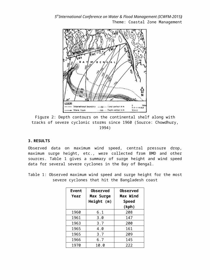
Chowdhury (1994) divided the the coast of Bangladesh into 5segments (Figure 2). Figure 2 also shows the depth contours in theBay of Bengal. Representative values of L in these 5 coastalsegments NS1, NS2, EW1, EW2 and EW3 are 140, 230, 260, 200 and 160km, respectively.
Figure 1: Three distinct regions of the coastal belt for stormsurge predictions (Source: Tareque and Chowdhury, 1992)
5thInternational Conference on Water & Flood Management (ICWFM-2015)Theme: Coastal Zone Management
Figure 2: Depth contours on the continental shelf along withtracks of severe cyclonic storms since 1960 (Source: Chowdhury,
1994)
3. RESULTSObserved data on maximum wind speed, central pressure drop,maximum surge height, etc., were collected from BMD and othersources. Table 1 gives a summary of surge height and wind speeddata for several severe cyclones in the Bay of Bengal.
Table 1: Observed maximum wind speed and surge height for the mostsevere cyclones that hit the Bangladesh coast
EventYear
ObservedMax SurgeHeight (m)
ObservedMax WindSpeed(kph)
1960 6.1 2081961 3.0 1471963 3.7 2001965 4.0 1611965 3.7 2091966 6.7 1451970 10.0 222

5thInternational Conference on Water & Flood Management (ICWFM-2015)Theme: Coastal Zone Management
1974 3.7 1611985 4.3 1531986 4.0 1161988 4.4 1611991 6.1 2252007 5.5 2232009 3.0 110
3.1 Determination of Constant K
The constant K was calculated for each cyclonic event using theobserved wind speed and pressure drop data in Eqn. 1. The averagevalue of K for all these events was found to be 26.44 (for Vmax
expressed as km/hr, = 14.27 for Vmax expressed as knots). Assumingthis value to be the regional constant for the Bangladesh coast,progressive wind speeds during Cyclone Sidr were calculated usingobserved pressure drop data in Eqn.1. Figure 3 shows thesepredicted wind speeds along with other observed wind speed dataduring Cyclone Sidr. Due to unavailability of pressure fall datafrom BMD, the maximum wind speed could not be calculated for thefirst three time steps. Figure 4 shows that the predicted maximumwind speeds during the cyclone are in good agreement (R2 = 0.9662)with the observed average maximum wind speeds. For example, on 15November 2007, the maximum wind speed for Cyclone Sidr iscalculated to be 211.5 kph, which is approximately equal to theobserved value of 210 kph.
Maximum wind speeds for several cyclones were also calculated fromthe observed pressure drop data using Eqn. 1. Figure 5 shows avery good agreement (R2 = 0.9991) between the calculated andobserved data. This indicates that K = 26.44 (= 14.27, when Vmax isexpressed as knots) is acceptable for the coast of Bangladesh, andcan be used to predict maximum cyclonic wind speed using Eqn. 1.Fletcher (1955) found K = 19.81 (10.7) for the Atlantic Oceanwhereas Takahashi (1939) derived K = 24.81 (13.4) by studying thetyphoons over the Pacific Ocean, and later on redefined the valueas 21.29 (11.5). Mishra and Gupta (1976) derived K = 26.29 (14.2)based on wind speed and pressure data of 29 cyclones over theNorthern Indian Ocean. This value of K is widely used by IndiaMeteorological Department for the estimation of the maximumcyclonic wind velocity from satellite observations. Raj et al.

5thInternational Conference on Water & Flood Management (ICWFM-2015)Theme: Coastal Zone Management
(2010) estimated K = 19.44-29.63 (10.5-16.0) based on an idealizedsurface pressure model.
0
50
100
150
200
250
30011/11/2007
11/11/2007
12/11/2007
12/11/2007
12/11/2007
12/11/2007
13/11/2007
13/11/2007
13/11/2007
13/11/2007
13/11/2007
13/11/2007
13/11/2007
14/11/2007
14/11/2007
14/11/2007
14/11/2007
14/11/2007
14/11/2007
14/11/2007
14/11/2007
15/11/2007
15/11/2007
15/11/2007
15/11/2007
15/11/2007
15/11/2007
Wind
speed (kph)
Lower value of m ax wind speed Upper value of m ax wind speedAvg. m ax wind speed Vm ax (predicted)
Figure 3: Predicted and observed wind speeds during Cyclone Sidrfor K = 26.44
Figure 4: Comparison between observed and predicted maximum windspeeds during Cyclone Sidr
3.2 Storm Surge Height

5thInternational Conference on Water & Flood Management (ICWFM-2015)Theme: Coastal Zone Management
Maximum storm surge heights for several cyclonic events werecalculated by the two analytical methods described in Section 2.For the calculations, predicted maximum wind speeds were usedalong with other data in Eqns. 2-5. Figures 6 and 7 show that thestorm surge heights for different cyclonic events predicted byboth the methods are within the obsereved range (shown by thevertical lines) of storm surge heights along the coast ofBangladesh. This indicates that the present method usingcalculated Vmax can reasonably predict the storm surge heights.
Figure 5: Predicted and observed maximum wind speeds for severecyclones in the Bangladesh coast (K = 26.44)
Notably, the observed storm surge data are reported or forecastedas an average height over a long stretch of the coast whereas thepredictons by the two methods refer to specific locations on thecoast where the cyclones made landfall. Therefore there is a widevariation in the observed storm surge heights as shown in Figures6 and 7. However, for a given location, the predictions by the twomethods with calculated Vmax show reasonable agreement (Figure 8).R2 improves from 0.720 to 0.848 if the extreme event of 1970 isexcluded.

5thInternational Conference on Water & Flood Management (ICWFM-2015)Theme: Coastal Zone Management
Figure 6: Storm surge height predicted by Method 1 and theobserved range of storm heights
Figure 7: Storm surge height predicted by Method 2 and theobserved range of storm heights

5thInternational Conference on Water & Flood Management (ICWFM-2015)Theme: Coastal Zone Management
Figure 8: Correlation between maximum storm surge heights given bytwo predictive methods
4. CONCLUSIONSSimple methods for maximum storm surge height prediction areessential for efficient cyclone preparedness and evacuation. Theempirical predictive method proposed in this paper determines aregional constant K = 26.44 for the Bangladesh coast, which can beused to predict maximum cyclonic wind speeds from central pressuredrop data in real time. This predicted wind speed can be used topredict maximum storm surge height at a specified location on thecoast. Analysis results indicate good agreement between thepredicted and observed data. Therefore this method can be used forlocal decision-making in efficient cyclone preparedness andevacuation.
REFERENCESBarua, D.K. (1991), Hydro-morphological factors and coastal
protection works in Bangladesh, Internation workshop on "StormSurge, River Flood and Combined Effects".
Chowdhury, J.U. (1994), Determination of shelter height in stormsurge flood risk area of Bangladesh coast, Water ResourcesJournal, ESCAP, Bangkok, 182: 93-99.
Fletcher, D.R. (1955), Computation of maximum surface winds inhurricanes, Bull Am Meteorol Soc (USA), 36: 249-250.
Khatun, M.A. (2014), Personal Communication, Deputy Director,Ministry of Defence, Bangladesh Meteorological Deapartment(BMD), Agargaon, Dhaka-1207.
Mishra, D.K. and Gupta G R (1976), Estimation of maximum windspeeds in tropical cyclones, Indian J Meterol Geophys, 27:285-290.
Nicholls, R.J. (2003), An Expert Assessment of Storm Surge“Hotspots”,Draft Final Report, Center for Hazards and RiskResearch, Lamont-Dohert Observatory, Columbia University, NewYork.
Pradhan, D., Mitra, A. and De, U.K. (2012), Estimation of pressuredrop and storm surge height associated to tropical cycloneusing doppler velocity, Indian Journal of Radio and SpacePhysics, June 2012, 41: 348-358

5thInternational Conference on Water & Flood Management (ICWFM-2015)Theme: Coastal Zone Management
Raj, Y.E.A. (2010), Relation between pressure defect and maximumwind in the field of a tropical cyclone- Theoretical derivationof proportionality constant based on an idealised surfacepressure model, Mausam (India), 61 (3):291-316
Takahashi, K. (1939), Distibution of Pressure and wind in atyphoon, J Meteorol Soc, Japan, 17:417-421.
Tareque, A.K.M. and Chowdhury, J.U. (1992), A simple method ofestimating cyclonic storm surge height in the coastal areas ofBangladesh, 36th Annual Convention of IEB, 5-8 January,1992,Dhaka, Bangladesh.