stratigraphy and of coal at achibo
113
ADDIS ABABA STRATIGRA OF COAL A DE COL i A SCIENCE AND TECHNOLOGY UN APHY AND QUALITY ASSE AT ACHIBO-SOMBO AREA WESTERN ETHIOPIA A MASTER’S THESIS BY DIRIBA YADATA AYANSA TO EPARTMENT OF GEOLOGY LLEGE OF APPLIED SCIENCE DECEMBER, 2020 NIVERSITY ESSMENT A, SOUTH ES
-
Upload
khangminh22 -
Category
Documents
-
view
0 -
download
0
Transcript of stratigraphy and of coal at achibo

ADDIS ABABA SCIENCE AND TECHNOLOGY UNIVERSITY
STRATIGRAPHY AND QUALITY ASSESSMENT
OF COAL AT ACHIBO
DEPARTMENT OF GEOLOGY
COLLEGE OF
i
ADDIS ABABA SCIENCE AND TECHNOLOGY UNIVERSITY
STRATIGRAPHY AND QUALITY ASSESSMENT
OF COAL AT ACHIBO-SOMBO AREA, SOUTH
WESTERN ETHIOPIA
A MASTER’S THESIS
BY
DIRIBA YADATA AYANSA
TO
DEPARTMENT OF GEOLOGY
COLLEGE OF APPLIED SCIENCES
DECEMBER, 2020
ADDIS ABABA SCIENCE AND TECHNOLOGY UNIVERSITY
STRATIGRAPHY AND QUALITY ASSESSMENT
SOMBO AREA, SOUTH
APPLIED SCIENCES

ADDIS ABABA SCIENCE AND TECHNOLOGY UNIVERSITY
STRATIGRAPHY AND QUALITY ASSESSMENT
OF COAL AT ACHIBO
A Thesis Submitted as a Partial Fulfillment to the
COLLEGE OF APPLIED SCIENCES
DECii
ADDIS ABABA SCIENCE AND TECHNOLOGY UNIVERSITY
STRATIGRAPHY AND QUALITY ASSESSMENT
OF COAL AT ACHIBO-SOMBO AREA, SOUTH
WESTERN ETHIOPIA
BY
DIRIBA YADATA AYANSA
A Thesis Submitted as a Partial Fulfillment to the Requirements for the Award of the
Degree of Master of Science in Geology
(Sedimentary Geology)
To
DEPARTMENT OF GEOLOGY
COLLEGE OF APPLIED SCIENCES
DECEMBER, 2020
ADDIS ABABA SCIENCE AND TECHNOLOGY UNIVERSITY
STRATIGRAPHY AND QUALITY ASSESSMENT
SOMBO AREA, SOUTH
Requirements for the Award of the
COLLEGE OF APPLIED SCIENCES

I hereby declare that the thesis entitled “
Coal at Achibo–Sombo A
the guidance of my advisor
except where explicitly stated otherwise in the text, and that this work has not been
submitted, in whole or in part, for any other degree or professional qualification.parts
of this work has been submitted for publication.
i
Declaration
I hereby declare that the thesis entitled “Stratigraphy and Quality Asse
Sombo Area, South Western Ethiopia” was prepared by me, with
the guidance of my advisor Dr.Samuel Getnet. The work contained herein is my own
except where explicitly stated otherwise in the text, and that this work has not been
submitted, in whole or in part, for any other degree or professional qualification.parts
of this work has been submitted for publication.
Stratigraphy and Quality Assessment of
” was prepared by me, with
contained herein is my own
except where explicitly stated otherwise in the text, and that this work has not been
submitted, in whole or in part, for any other degree or professional qualification.parts

This is to certify that the thesis prepared by
“Stratigraphy and Quality Assessment of Coal at Achibo
Western Ethiopia” and submitted as a partial fulfillment for the award of the Degree
of Master of Science complies with the regulations of University and meets the
accepted standards with respect to originality, content and quality
1
Approval Page
This is to certify that the thesis prepared by Mr.Diriba Yadata Ayansa
“Stratigraphy and Quality Assessment of Coal at Achibo-Sombo Area, South
and submitted as a partial fulfillment for the award of the Degree
of Master of Science complies with the regulations of University and meets the
accepted standards with respect to originality, content and quality.
Mr.Diriba Yadata Ayansa entitled
Sombo Area, South
and submitted as a partial fulfillment for the award of the Degree
of Master of Science complies with the regulations of University and meets the

iii
ABSTRACT
Achibo-Sombo which is known for its extensive coal deposits is situated in Oromia
regional state, South-Western Ethiopian. The present study was focused to analyses
the coal bearing sedimentary rock, lithostratigraphy, and quality of coal seam deposit
in the Achibo-Sombo Area. The stratigraphy of the area was investigated by
integrating borehole data and separating the area section wise based on field survey.
The area is characterized by variable lithostratigraphic units: Basement complex,
Lower Basalt, Coal bearing sedimentary rock (i.e.., interbedded mudstone and
sandstone layers comprising plant fossils with laminated carbonaceous shale, shale,
oil shale, and coaly shale) and Upper Basalt to the latest. The presence of Sandstone,
Mudstone, Coal Beds and Plant fossils bear fluviatile deposits where as the
intercalated various shale layers envisage the lacustrine environment. For this study,
fifteen (15) representative samples were taken separately with respect to their seam
thickness. Accordingly, coal seam thickness from outcrop ranges (0.45 to 4.8m) and
(2.5 to 8.37m) from borehole data and the overall coal seam ranges from (0.45 to
8.37m). The quality of coal at Achibo Sombo was analyzed by Adiabatic Calorie
Metter, Gravimetric and Proximate techniques. The result showed that, coal quality
ranged between (2323.044 - 9378.684 Btu/lb) as were observed from Adiabatic
Calorie Metter, while sulfur content value ranged (<0.02 % to 1.90%) based on the
Gravimetric and Proximate analyses which revealed the moisture, volatile matter,
fixed carbon and ash content where results showed (5.38 to 30.27 %, 21.27 to
37.29%, 6.29 to 33.23%, and 0.25 to 67.05%) respectively. Based on the current
study, the Coal at Achibo Sombo is characterized by low to medium sulfur, low to
high ash, low fixed carbon and medium to high volatile matter contents. Moreover,
majority of the studied samples showed Lignite A ranks while few samples reflected
Lignite B and Sub-bituminous C ranks. On the other hand, the grades of analyzed
samples are categorized as Steel Grade-I and II and Washery Grade-I and II.Based on
the findings of this study, detail exploration and XRD analyses mainly in the North
East and Eastern part of the study area were recommended
Keywords: Proximate Analysis, Sulfur content, Coal grade, Coal rank,
Lithostratigraphy

iv
ACKNOWLEDGMENT
Before and above all of everything I am grateful when I thank the almighty God, who
helped me throughout my life and work.
I would like to give my sincere gratitude to ministry of education and Mizan Tepi
University for openhanded the prospect to study for my master’s degree. Next, my
special thanks go to Addis Ababa Science and Technology University, College of
Applied Sciences Department of Geology for their financial assistance as well as
necessary materials to bring the research to its conclusion.
I also appreciate all of geology academic staff for their guidance and encouragement
from the starting to the end of this research work. I would like to give my great
appreciation to my advisor and instructor Dr.Samuel Getnet for his unreserved and
constructive comment, valuable suggestion, encourage and tireless support. His
willingness to devote his time generously is very much appreciated. Again also, my
heartfelt thanks to my co-advisor Dr.Tesfaye Demissie and Dr.Daniel Meshesha
whose invite me as I work on this project as well as constructive comment and tireless
support. As well my instructor Prof. Nageshwar Dubey for his constructive
comment, encouragement and tireless support.
I want to express my deepest sincere thanks to the Ethiopian Geological Survey
laboratory team for facilitating things in order to reach the proximate, Calorific Value,
and sulfur analysis results on time. I am also greatly thankful to the Achibo-Sombo
village friendly people and administration officers for their permission to do the
fieldwork and support me throughout my stay in Achibo-Sombo.
I wish to thank my parents for giving me encouragement and unforgettable support
when I am in the project work. At the last but not least, Iam thankful to everyone I
didn’t mention but has a special contribution to the work directly and indirectly.

v
Table of Contents
Declaration ................................................................................................................. i
Approval Page ........................................................................................................... 1
ABSTRACT ............................................................................................................. iii
ACKNOWLEDGMENT .......................................................................................... iv
List of Figures .......................................................................................................... ix
List of Tables ............................................................................................................ xi
List of symbols and Abbreviations ........................................................................... xii
CHAPTER ONE........................................................................................................ 1
1. INTRODUCTION ................................................................................................. 1
1.1 Background ......................................................................................................... 1
1.2 Description of the Study Area .............................................................................. 2
1.2.1 Location and Accessibility ............................................................................ 2
1.2.2 Physiography and Drainage pattern of the Study Area ................................... 4
1.2.3 Climatic Condition and Vegetation coverage ................................................. 6
1.2.4 Population and Settlement ............................................................................. 8
1.3 Statement of the Problem ..................................................................................... 8
1.4 Objective of the Study ......................................................................................... 8
1.4.1 General Objective .......................................................................................... 8
1.4.2 Specific Objectives ........................................................................................ 9
1.5. Scope and Limitation of the Study ...................................................................... 9
CHAPTER TWO ..................................................................................................... 10
2. LITERATURE REVIEW .................................................................................... 10

vi
2.1 Introduction ....................................................................................................... 10
2. 2.Coalification ..................................................................................................... 10
2.3. Depositional Environments of Coal ................................................................... 13
2.4 .Classification of Coals ...................................................................................... 13
2.5. Coal Quality ..................................................................................................... 14
2. 6.Regional Geology of the Area ........................................................................... 14
2.6.1 Precambrian ................................................................................................ 17
2.6.2. Paleozoic and Mesozoic Sediments ............................................................ 18
2.6.3. Cenozoic Rocks .......................................................................................... 18
2.7. Regional Geological Structures ......................................................................... 18
2.8. Stratigraphy of Geba Basin ............................................................................... 19
2.8.1. Crystalline Basement .................................................................................. 19
2.8.2. Lower Basalt .............................................................................................. 20
2.8.3. Coal and Oil Shale Bearing Sediments ....................................................... 20
2.8.4. Upper Basalt ............................................................................................... 20
CHAPTER THREE ................................................................................................. 22
3. MATERIALS AND METHODS ......................................................................... 22
3.1. Materials ........................................................................................................... 22
3.2. Methods ............................................................................................................ 24
3.2.1 Data Acquisition .......................................................................................... 24
3.3. Data Analysis ................................................................................................... 25
3.3.1. Proximate Analysis Procedure .................................................................... 26
3.3.2. Calorific Value Analysis Procedure ............................................................ 26

vii
CHAPTER FOUR ................................................................................................... 28
4. RESULT.............................................................................................................. 28
4.1 Lithological succession ...................................................................................... 28
4.1.1. Fluvio-Lacustrine Sediments (Coal Bearing Unit Section) .......................... 28
4.1.1.1. Dawe Section .......................................................................................... 28
4.1.1.2 Debeso Section ......................................................................................... 29
4.1.1.3. Tekeshe Stream Section ........................................................................... 30
4.1.1.4. Sombo-Section ........................................................................................ 31
4.1.1.5. Achibo Quarry site section .......................................................................... 32
4.1.1.6. Hada Bekela Stream Section .................................................................... 34
4.1.1.7. Witate –Section ....................................................................................... 35
4.1.2. Volcanic Clastic Sediments ........................................................................ 35
4.1.3. Upper Basalt ............................................................................................... 35
4.2. The sub-surface Coal-bearing Lithological succession in the Study
Area ........................................................................................................................ 36
4.3. Litho Stratigraphic succession of Coal Bearing Strata ....................................... 38
4.3.1. Lithostratigraphic succession Correlation ................................................... 48
4.4. Coal Quality Analysis ....................................................................................... 51
4.4.1 Moisture Content ......................................................................................... 51
4.4.2. Volatile Matter ........................................................................................... 53
4.4.3. Fixed Carbon .............................................................................................. 54
4.4.4 Ash Content ................................................................................................ 55
4.4.5. Sulfur Distribution ...................................................................................... 58

viii
4.4.6 Calorific Value ............................................................................................ 62
CHAPTER FIVE ................................................................................................. 65
5. DISCUSSION .................................................................................................. 65
5.1 Depositional Environment ................................................................................. 65
5.1.1. Fluvial Deposits ......................................................................................... 65
5.1.2. Lacustrine Deposits .................................................................................... 67
5.2. Quality Interpretation of Coal ........................................................................... 67
5.2.1. Grade ......................................................................................................... 68
5.2.2. Rank ........................................................................................................... 70
5.3. Comparison within Yayu coal deposits ............................................................. 74
5.4. Comparison with the Corresponding Coal deposit in Ethiopia ........................... 77
5.5. Economic significance of the Achibo-Sombo coal ............................................ 82
CHAPTER SIX ....................................................................................................... 85
6. CONCLUSION AND RECOMENDATION ....................................................... 85
6.1 .Conclusion ........................................................................................................ 85
6.2. Recommendation .............................................................................................. 86
REFERENCES ........................................................................................................ 87
Appendix I .............................................................................................................. 94
Appendix II ............................................................................................................. 97

ix
List of Figures
Figure 1 . Location Map of the study Area ............................................................................ 3
Figure 2.Accessibility of study Area ...................................................................................... 4
Figure 3..Physiography of study Area .................................................................................... 5
Figure 4.Drainage pattern of study area ................................................................................. 6
Figure 5.Field photo shows vegetation coverage and coal seam ............................................. 7
Figure 6.Coalification of coal (Falcon, 20013) .................................................................... 10
Figure 7.Type, Grade and Rank of Coal (Falcon, 2013) ....................................................... 12
Figure 8 .Regional Geological map of South Western Ethiopia (After Mengesha , 1996 ) ... 16
Figure 9.Lithostratigraphic column of Geba Basin (After Kibre,2000) ................................. 21
Figure 10.Methodology Flow charts .................................................................................... 24
Figure 11.Figure showing sample points taken from the studied area ................................... 25
Figure 12..Field photo shows very thick Coal bed at Dawe section ...................................... 29
Figure 13..Field photo taken from Debeso section ............................................................... 30
Figure 14. Field photo taken from Tekeshe section show laminated Oil Shale ..................... 31
Figure 15.A) Sombo section Eastern and B) Western Coal deposit field photos ................... 32
Figure 16. Field photo taken from Achibo Quarry site ......................................................... 33
Figure 17.Field photo taken from Hada Bekela section. A) From southern of the stream. B)
From Northern of the stream .................................................................................... 34
Figure 18.A) Geological Map and B) Cross-sectional Map of the study area ....................... 37
Figure 19.. Lithostratigraphic column of Dawe section ........................................................ 39
Figure 20.Lithostratigraphic column of Debeso section ....................................................... 40
Figure 21.Lithostratigraphic column of Tekeshe section ...................................................... 41
Figure 22.Lithostratigraphic column of Sombo section ........................................................ 42
Figure 23.Lithostratigraphic column of Achibo Quarry site Section .................................... 43

x
Figure 24.Lithostratigraphic column of Hada Bekela section ............................................... 44
Figure 25.Lithostratigraphic column of Witate Section ........................................................ 45
Figure 26.Detail Lithostratigraphic column of (BH-3,BH-4,and BH-5) .............................. 46
Figure 27. Detail Lithostratigraphy of (BH-7, BH-10, and BH-18) ...................................... 47
Figure 28.Lithostratigraphic column correlation of each section of study area ..................... 49
Figure 29.Lithostratigraphic column Correlation of Borehole study area ............................. 50
Figure 30. Lithostratigraphic column Correlation of study area within the Basin ................. 51
Figure 31.Graphic representation of moisture content by line charts .................................... 53
Figure 32.Fixed Carbon and Ash content comparison trend of Achibo-Sombo Coal ............ 56
Figure 33.Graphic representation of proximate analysis by line chart .................................. 57
Figure 34.Graphic representation of proximate analysis by column chart ............................ 58
Figure 35.Graphic representation of sulfur increment in Achibo-Sombo by column chart .... 61
Figure 36.Graphic representation of sulfur distribution by line chart.................................... 61
Figure 37.Graphic representation of calorific value increment by column chart ................... 63
Figure 38.Graphic representation comparison of volatile matter versus fixed carbon ........... 64
Figure 39. Graphic representation of ash versus moisture content by line chart .................... 64
Figure 40.Rank and Grade correlation of lithostratigraphic column of each stream section. . 74
Figure 41.Graphic Representation of proximate value comparison trend of Geba Basin Coal
deposits. .................................................................................................................. 76
Figure 42.Calorific value increment comparison trend of Geba Basin coal deposit .............. 77
Figure 43.Graphic representation of sulfur value increment comparison trend of the Geba
Basin coal deposit. ................................................................................................... 77
Figure 44.Ash, Fixed carbon, and Sulfur comparison trend of Ethiopian coals ..................... 80
Figure 45.Calorific value comparison trend of Ethiopia coals increments by column charts. 81
Figure 46.Sulfur value comparison trend of Ethiopian coals increments by line chart .......... 81

xi
List of Tables
Table 1.Location of Coal sample selected for analysis from out crop ................................... 23
Table 2.Location of Core Coal sample selected for analysis from bore hole......................... 23
Table 3.The sample analyzed result of moisture, volatile matter, fixed carbon and ash
contents ................................................................................................................... 57
Table 4.Sulfur (%) and Calorific value (Btu/lb) analysis result ............................................ 60
Table 5.Coal Grade ............................................................................................................. 69
Table 6.Rank classification based on ASTM (D388-1999) .................................................. 73
Table 7.Proximate, Calorific value ,Sulfur analysis results from GSE and Selected from the
present study............................................................................................................ 76
Table 8.Laboratory analysis of Ethiopian Coal deposits comparison. ................................... 79

xii
List of symbols and Abbreviations
ASTM = American Society for Testing and Materials
COFCOP = Coal-Phosphate Fertilizer Complex Project
CV = Calorific Value
DEM = Digital Elevation Model
D.m.m.f.basis = dry mineral matter free basis
FC = Fixed Carbon
GCF = Gross Calorific Value
GIS = Geographic Information System
GPS = Global Positioning System
GSE = Geological Survey of Ethiopia
ICCP = International Commission for Coal Petrology
ISO = International Organization for Standardization
M.m. m.f.b = moist mineral matter free basis
UTM = Universal Transverse Mercator
VM = Volatile Matter

1
CHAPTER ONE
1. INTRODUCTION
1.1 Background
Coal is the end product of the progressive burial of plant remains in oxygen-starved
condition. It is a readily combustible rock containing more than 50 percent organic
matter (carbon) by weight, and 70 percent carbonaceous material by volume including
inherent moisture, which was formed from the compaction and alteration of plant
remains, Schopf (1966); Jackson (1997); Alpern and Desousa (2002). It has been a
support for the economy in the world, but there are still over a billion people in the
world who live inadequate electricity, which is crucial for basic needs.
Coal is at a halt an important energy source and can replace conventional fuel sources
like petroleum and natural gas to meet the current rise in energy demand (Wolela,
2008). It plays an important role in the security of supply in developed countries and
is a key enabler for economic growth and development in developing countries,
(World Energy Resources, 2016). The world’s coal resources are derived mostly from
sedimentary rocks; exploration for such resources demands a detailed understanding
of Stratigraphy relationship with resources, which is the more important for energy
explorations.
According to Omar (1994), Ethiopia is the lowest per capital energy utilization of
organic energy, spends a large share of its total foreign earnings on imported fuels.
Before a coal mine is allowed to initiate operations, thorough studies must be carried
out to identify all the potential risks to the surrounding environment and to minimize
any negative impacts. As a result, predicting coal quality is an important charge and
depends on the knowledge of its physical and chemical constitution (Verma et al.,
2010).

2
The study of lithostiratigraphy and quality of coal assessment help to understand vital
energy exploration. Since there are variable economic uses for the production of coal:
chemical fertilizers, power generation (electric power), domestic fuel (source of
energy for household), fuel in the production of lime and bricks, ceramic plant
processing, cement manufacture, fuel for thermal plants for steel mills, oil and gas
generation, etc; Coal have been consumed in large quantities.
Coal quality is an important aspect of the assessment program in that it provides a
synthesis and analysis of important data that will influence the future utilization of
this valuable resource.
The Achibo-Sombo area is located in the South-Western flank of the South-Eastern
Ethiopian plateau which is known for its considerable coal deposits. The area is
characterized by variable lithostratigraphic units: Basement complex, Lower Basalt,
Coal bearing sedimentary rock, and Upper Basalt from oldest to youngest
respectively. Previous exploration work and research activities were focused mainly
on the quantity of coal in the place. However, this study intended at detail coal
bearing sedimentary rock lithostratigraphy and quality of coal seam deposit in the
Achibo-Sombo area based on integrated from outcrop and borehole data. The Achibo-
Sombo area coal deposit is lacks detail Lithostratigraphical correlation with other coal
deposits in the basin and other equivalent stratigraphic successions which will enables
us to understand the coal quantity and quality. The Lithostratigraphic correlation is
the organization of strata based on physical lithological characteristics based on strata
type, color, grain size, mineral composition, and texture. Therefore, with the use of
Stratigraphy research methods to study coal quality feature is the power full for
analysis of significant data for this worth resource.
1.2 Description of the Study Area
1.2.1 Location and Accessibility
The Achibo-Sombo area is a considerable coal deposit; it is situated in the South-western
Ethiopian located at a distance of 560 km southwest of the capital city, Addis Ababa. It is
bordered to the west by Gambella Regional State, to the east by the East Wollega and Jimma
zones, to the north by West and East Wollega, and to the South by the Southern Nations,
Nationalities, and Peoples' Region.

The study area mainly Achibo
far to the Eastern side) and Yayu (26 Km far to the Western side).It is bounded the
geographic coordinates of 8°21'20''
two routes from Addis Ababa along the Jima
weather asphalt high way and gravel road that joins the capital Addis Ababa with
Gambella. This road passes through the towns of Jima, Agaro, Bedelle, and Metu. The
other route that leads to the study area from Addis Ababa 500
Bedelle- Gambella road asp
Figure 1 . Location Map of the study Area
3
The study area mainly Achibo-Sombo, was found between the local towns of Chora (20 Km
ern side) and Yayu (26 Km far to the Western side).It is bounded the
geographic coordinates of 8°21'20''-8°24' 00'' N and 35°56'0''-36° 1'20''E
two routes from Addis Ababa along the Jima –Bedelle which is accessible by all
alt high way and gravel road that joins the capital Addis Ababa with
Gambella. This road passes through the towns of Jima, Agaro, Bedelle, and Metu. The
other route that leads to the study area from Addis Ababa 500 Km is along Nekemte
Gambella road asphalt road (Figure 2).
Location Map of the study Area
Sombo, was found between the local towns of Chora (20 Km
ern side) and Yayu (26 Km far to the Western side).It is bounded the
36° 1'20''E ( Figure 1 ) . It is
Bedelle which is accessible by all-
alt high way and gravel road that joins the capital Addis Ababa with
Gambella. This road passes through the towns of Jima, Agaro, Bedelle, and Metu. The
Km is along Nekemte -

4
Figure 2.Accessibility of study Area
1.2.2 Physiography and Drainage pattern of the Study Area
The topography of the study area contains undulating mountainous terrain, rising and
falling plateaus, valleys, and it is characterized by gentle slopes. The elevation
difference between the highest and the lowest point is nearly 600 meters, the highest
elevation being 2000m and the lowest 1400m above sea level. The elevation
difference between the maximum and minimum shows the ruggedness of the area
(Figure 3). Deep river valleys, dissected by several small streams and one major river,
called Geba River. It is bounded on both sides by ridges that trend almost East-West.
It is the main river system in the study area and it has many tributaries. These
tributaries flow from North East to South West and from South East to North West
directions. All the perennial and intermittent streams along with the Geba River drain
to the Birbir River. The drainage pattern is mainly dendritic type (Figure 4).

5
Figure 3..Physiography of study Area

Figure 4.Drainage pattern of study area
1.2.3 Climatic Condition and Vegetation coverage
Ethiopia has four seasons: the dry season (December to February), the small
season (March to May), the main rainy season (June to August), and the transition
season (September-December).The rainfall pattern is unimodal with a mean annual
rainfall ranging between 1243 and 3445 mm. November to February is a relatively dry
season with rare occurrences of rain, followed by the hottest period from February
through to the end of April.
The period between May and October is the wettest season of the year. Heavy rain
occurs between July and August with extended cold weather until mi
a diverse mix of climatic conditions is said to be the most important factor for the
availability of a huge wealth of biologically diverse species. The diverse vegetation
cover and tree species present within the biosphere reserve play vita
social, economic, and cultural aspects of the local community
6
Drainage pattern of study area
1.2.3 Climatic Condition and Vegetation coverage
Ethiopia has four seasons: the dry season (December to February), the small
season (March to May), the main rainy season (June to August), and the transition
December).The rainfall pattern is unimodal with a mean annual
rainfall ranging between 1243 and 3445 mm. November to February is a relatively dry
on with rare occurrences of rain, followed by the hottest period from February
through to the end of April.
The period between May and October is the wettest season of the year. Heavy rain
occurs between July and August with extended cold weather until mi
a diverse mix of climatic conditions is said to be the most important factor for the
availability of a huge wealth of biologically diverse species. The diverse vegetation
cover and tree species present within the biosphere reserve play vita
social, economic, and cultural aspects of the local community ( Figure 5)
Ethiopia has four seasons: the dry season (December to February), the small rainy
season (March to May), the main rainy season (June to August), and the transition
December).The rainfall pattern is unimodal with a mean annual
rainfall ranging between 1243 and 3445 mm. November to February is a relatively dry
on with rare occurrences of rain, followed by the hottest period from February
The period between May and October is the wettest season of the year. Heavy rain
occurs between July and August with extended cold weather until mid-October. Such
a diverse mix of climatic conditions is said to be the most important factor for the
availability of a huge wealth of biologically diverse species. The diverse vegetation
cover and tree species present within the biosphere reserve play vital roles in the
( Figure 5) .

Some trees are used for food and others that serve as traditional medicines. Similarly,
there are tree species used as main sources of wood and timber for the local people
residing in the district.
and Polyscias fulva (Karasho)
beehives because they have a pleasant odour that attracts bees and are easily workable
and light-weighted. Generally, the area is scarcely vegetated on the slope of the
ridges, and covers by dense high land forests along the Geba river basin. Most parts of
the target area farmlands. Cash crops, such as
for the farmers.
Figure 5.Field photo
7
Some trees are used for food and others that serve as traditional medicines. Similarly,
there are tree species used as main sources of wood and timber for the local people
residing in the district. Cordia Africana (Waddessa), Afrocarpus campus (Birbirsa
Polyscias fulva (Karasho) are essential trees, useful in making traditional
beehives because they have a pleasant odour that attracts bees and are easily workable
weighted. Generally, the area is scarcely vegetated on the slope of the
and covers by dense high land forests along the Geba river basin. Most parts of
the target area farmlands. Cash crops, such as coffee are the major source of income
shows vegetation coverage and coal seam
Some trees are used for food and others that serve as traditional medicines. Similarly,
there are tree species used as main sources of wood and timber for the local people
Afrocarpus campus (Birbirsa),
are essential trees, useful in making traditional
beehives because they have a pleasant odour that attracts bees and are easily workable
weighted. Generally, the area is scarcely vegetated on the slope of the
and covers by dense high land forests along the Geba river basin. Most parts of
are the major source of income

8
1.2.4 Population and Settlement
The 2007 population census of Ethiopia conducted by its Central Statistics Agency
shows that more than 1.2 million people live in the Illu Abba Bora zone have a total
population of 132 177,26 with almost equal proportions of men and women (CSA,
2007). It is estimated that the majority of these inhabitants (90.8% or 120 147) are
settled in the rural parts of the districts adjoining the dense coffee forest. According to
the 2005 countrywide census report, the average population density of the Yayu
district is 189.6 people/ km2, a figure much greater than the zonal average of 72,3
people/km2 (CSA and ORC Marco, 2006).
1.3 Statement of the Problem
Achibo-Sombo is one of the Yayu basins which are characterized by varieties of
Stratigraphic units, lithologies, and depositional environment. Stratigraphy is
persuasive for analyzing the depositional environment, vertical and spatial lithological
variation, and coal bed thickness. Coal quality issues related to coal combustion are
focusing on the release of particulate matter like sulfur, ash, volatile matter, and
moisture contents.
From the understanding of relevant published and unpublished reviewed paper
regarding Lithostratigraphic, coal quality, Structural, and tectonic setting of the area
related to depositional environment, there was a variable litho tectonic domain and
widely distributed coal deposited at Achibo –Sombo area. However, there was a
poorly documented stratigraphic study related to coal thickness and sulfur
identification related to coal seam, coal quality, grade and rank of the coal is not
reported in the sectional wise. Therefore, detailed study of stratigraphic logs,
correlation, depositional environment, and quality assessments to know the quality of
the coal deposits in the Achibo-Sombo area was studied in this paper.
1.4 Objective of the Study
1.4.1 General Objective
The main objective of this research is to constructing lithostratigraphic succession of
coal bearing strata and quality assessment of coal deposits at the Achibo-Sombo area
Southwestern Ethiopia.

9
1.4.2 Specific Objectives
To produce Geological Map of the Study area at Scale of 1:10,000.
To log coal-bearing strata.
To identify coal, grade, and rank of Achibo-Sombo coal deposits.
To evaluate sulfur distribution.
To correlate the Lithological units of the study area.
1.5. Scope and Limitation of the Study
In the present study, several coal samples and Lithostratigraphic unit of Coal bearing
strata were encountered following the coal quality. Todetermine the Lithostratigraphic
logs and quality of coal, critical stratigraphic section was s elected and coal samples
were analyzed using proximate, adiabatic calorie metter and gravimetric method.
However due to constrain of time, resources and financial limitations the analyses
were applied only to selected Lithostratigraphic logs , proximate, calorie metter and
gravimetric method which the fundamental for coal exploration and coal quality
determination. Therefore, during the present study only seven (7) out crop
Lithostratigraphic sections unit log, six (6) Lithostratigraphic unit log from bore hole
data, four (4) core coal samples, and eleven (11) outcrop coal samples were selected
and studied. In case of ultimate analysis method, some coal sample were gave unusual
result.
10
CHAPTER TWO
2. LITERATURE REVIEW
2.1 Introduction
Larry Thomas, (2013) reported that, Coals are the result of the accumulation of
vegetable debris in a specialized environment of deposition. Such accumulations have
been affected by synsedimentary and post-sedimentary influences to produce coals of
differing rank and differing degrees of structural complexity, the two being closely
interlinked. Coal is one of the very important energy sources for many countries that
are converted to heat and electrical power by different technologies.
Coal is currently a major energy source worldwide, especially among many
developing countries, and will continue to be so for many years (Miller, 2005). Hatch
and Swanson (1977) state that four general reasons why coal quality data are
necessary for the proper assessment and utilization of coal: the evaluation of
environmental impacts of mining of coal, the evaluation of the best and most effective
technological use of coal (combustion, liquefaction, gasification, etc.), determination
of the economic aspects of extracting elements from the coal, and development of
geologic and geochemical models to help interpret and predict coal quality and relate
these factors to the stratigraphic and sedimentological framework.
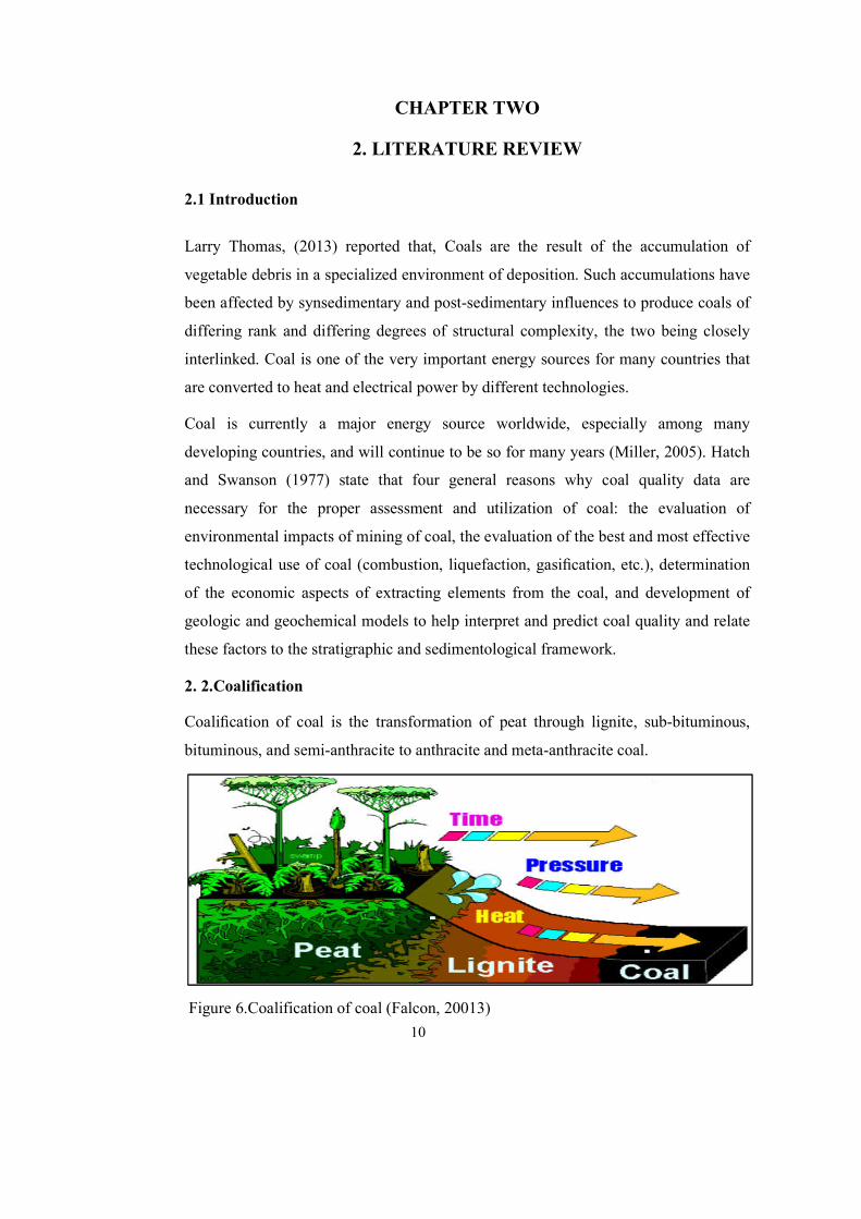
2. 2.Coalification
Coalification of coal is the transformation of peat through lignite, sub-bituminous,
bituminous, and semi-anthracite to anthracite and meta-anthracite coal.
Figure 6.Coalification of coal (Falcon, 20013)
11
It is the process of chemical and physical change by biochemical interferences,
temperature, pressure, and time imposed on the organic components that survived the
peat formation until it becomes organic rock (Tissot and Welte, 1984; Miller, 2005).
The change includes decaying of the vegetation, deposition, and burying by
sedimentation, compaction, and transformation from plant material to solid rock. The
degree of transformation or coalification is termed the coal rank, and the early
identification of the rank of the coal deposit being investigated will determine the
future potential and interest in the deposit. A detailed account of coalification and its
physical and chemical processes is given by (Taylor et al, 1998), who describe the
major stages of coalification from peat to meta-anthracite. During coalification, the
three maceral groups become enriched in carbon and each maceral group (i.e. exinite,
inertinite, and huminite (vitrinite)) follows a distinct coalification path van Krevelen
(1961). The optical properties of vitrinite have enabled it to be used as an indicator of
rank. The properties of given coal can be related to three independent geological
parameters, each of which is determined by some aspect of the coal’s origin. As
discussed more fully by authors such as Ward (1984), Diessel (1992), Taylor et al.
(1998) these parameters are briefly defined as follows:
Coal rank reflects the degree of metamorphism (or coalification) to which the original
mass of plant debris (peat) has been subjected during its burial history. Coal type
reflects the nature of the plant debris from which the original peat was derived,
including the mixture of plant components (wood, leaves, algae, etc.) involved and the
degree of degradation to which they were exposed before burial. The grade of coal
reflects the extent to which the accumulation of plant debris has been kept free of
contamination by inorganic material (mineral matter), including the periods before
burial (i.e., during peat accumulation), after burial, and during the rank advance.
The heating value, calorific value, or specific energy: This indicates the amount of
heat liberated per unit of mass of combusted coal and is of fundamental importance in
setting the price of particular coals for combustion applications.

12
Although generally regarded as a rank-related parameter, the calorific mineral
composition.
Although vitrinite reflectance is widely used as a measure of coal rank, it is not
always a truly independent rank indicator. Some vitrinite may have anomalously low
reflectance (such as the original depositional environment), a phenomenon known as
reflectance suppression (Barker, 1991), which may give misleading results if other
indicators are not taken into account. Despite the advantages and simplicity of
vitrinite reflectance, it is very difficult to find an indicator of coal rank that is totally
independent of the organic and inorganic
Composition of other influencing factors such as depositional environments of the
original peat deposit. Coalification affects both the organic matter and the mineral
matter in coal. Coalification proceeds, organic matter, which is relatively rich in
water, oxygen, and hydrogen, gradually loses those constituents and becomes
relatively enriched in fixed carbon.
Figure 7.Type, Grade and Rank of Coal (Falcon, 2013)

13
2.3. Depositional Environments of Coal
The study of coal facies is best accompanied by a facies study of the inter seam
sediments surrounding the coal layers (Mc cabe1984,Diesel 1992). A careful study of
both coal facies and clastic sediments may produce more precise interpretations of the
coal depositional environments. Coal, as well as the inter seam rock, is a sedimentary
rock with the only difference being in the source material which, in the case of coal,
mostly consists of organic material; the process of sedimentation requires that the
organic matter has to be preserved. An understanding of inter seam rocks also
influences coal quality. The coal and inter seam rocks do not necessarily have the
same environment of deposition even if they are stratigraphically adjacent to one
another.
The various deposits of the same facies area and similarly, rocks of different facies
areas, were formed beside each other in space, but in a crustal profile we see them
lying on top of each other it is a basic statement of far-reaching significance that only
those sand facies area can be superimposed, primarily that can be observed beside
each other at present (Selley, 2000). This principle is termed Walter’s law, and may
be succinctly stated as “a conformable vertical sequence of facies was generated by a
lateral sequence of environments” This principle is a vital one in environmental
analysis. One of the ways of identifying the environments of facies is by analyzing the
environments of facies above and below to come up with the most logical sequence of
events (Selley, 2000). Much of the field recording of sedimentary rocks is aimed at
classifying the strata being investigated into recurrent units and attempting to detect
order in the vertical and lateral arrangement of those units. The term applied to those
units is facies that are defined on a combination of lithological, structural, and organic
aspects in the field (Tucker, 1988).
2.4 .Classification of Coals
According to Thomas (2013) Coals have usually been classified based on the coal’s
chemical properties concerning their industrial usage. Several classifications are in
common usage, which classifies both humic and brown coals, and refers to particular
parameters; these range from the percentage of fixed carbon and volatile matter (on a
dry mineral matter free basis), calorific value (on a moist mineral matter free basis).

14
As the ASTM (American Society for Testing and Materials) classification (D 388-
1999) is used on a worldwide basis this is based on two coal properties, the fixed
carbon values and the calorific values (on d.m.m.f.basis). The higher rank coals are
classified according to fixed carbon on a dry basis, the lower rank coals are classified
according to gross calorific value on the moist basis. Such coals classification is
mostly non-banded varieties containing only a small proportion of vitrinite and
consists mainly of atrial materials.
2.5. Coal Quality
The physical and chemical properties in turn determine the overall quality of the coal
and its suitability for specific purposes. The basic chemical parameters of coal are
determined by proximate analysis (moisture, ash, volatile matter, and fixed carbon
percentages) and ultimate analysis (carbon, hydrogen, nitrogen, sulfur, and oxygen
contents). The quality of coal is measured by the made-up of the original maceral and
mineral matter content of the coal, with the degree of coalification (rank). For this to
be understood in analytical terms, set procedures for determining chemical and
physical properties of coals have been required ( Karr, 1978).
The possession of the coal is the most commonly determined properties of coal is
important, in particular those which are harmful to the coal. Such coal analyses are
essential in the evaluation of a coal deposit, which is to be aware of which seams or
parts of seams will be unacceptable when mining commences, or conversely, those
seams or parts of seams (Thomas, 2013).
According to Zhu (2014), Coal quality is determined by analyses of proximate or an
ultimate analysis. Proximate analysis is a broad analysis that determines the amounts
of moisture, volatile matter, fixed carbon, and ash. This is the most fundamental of all
coal analyses and is of great importance in the practical use of coal.
2. 6.Regional Geology of the Area
The geology of Ethiopia is comprised of three major geological terranes, categorized:
the Proterozoic crystalline basement, Late-Paleozoic to Mesozoic marine and
continental sedimentary rocks, and Cenozoic volcanic rocks.

15
Gashaw Beza and Kibre, (1996) reported that, the geological setting of southwestern
Ethiopia is included the Precambrian crystalline basement affected by the Pan African
Orogeny, overlain by Tertiary volcanics. The crystalline basement geology is part of
the Mozambique Orogenic Belt with a dominant north-south trending deformation.
The Basement complex had undergone various stages of deformations and erosion
before the volcanic flows.
According to Mengesha and Seife Michael (1982) the regional geological mapping of
the Gore sheet that includes the study area, has four major domains in the
metamorphic basement. These are the Baro domain, Birbir domain, Geba domain, and
Yubdo domain. Mengesha (1982) illustrates planar features are manifested by
gneissic banding on layering and foliation in rocks of the Baro group. The Baro and
Geba domain rocks are commonly high-grade gneisses; whereas the Birbir rocks are
low grade metasedimentary and metavolcanic schists (Greenschist to lower
Amphibolite facies). The Birbir domain both to the West and East is bounded by the
high grade metamorphic rocks of the other two domains. The Yubdo Domain
represents an Ophiolitic succession consisting of Mafic and Ultramafic rocks in the
North Eastern part of the mapped Gore sheet (Figure 8).

16
Fig
ure 8 .R
egio
nal Geo
logical m
ap o
f South W
estern E
thiopia (A
fter Men
gesha , 1
996 )

17
Volcanism in Southwestern Ethiopia had started as early as Middle Eocene,
(Davidson, 1983) confirmed it by radiometric age dating. The fluvial lacustrine coal
and oil-shale bearing units are sandwiched between the Lower and Upper Tertiary
Basalts and Upper Tertiary Basalt and high-grade gneiss, (Getahun et al., 1993). Like
the other basins in the Southwestern Ethiopian Plateau (i.e. Delbi and Moye Basin)
the Yayu-Hurumu like Basin deposition was also assumed to be restricted to tectonic
blocks, and it is characterized by alluvial deposition which is followed by widespread
paleo-lake development. The paleo-lake deposition consists of thick fluvial lacustrine
sediments that are assumed to be formed during the Tertiary period (Getahun, et al.,
1993). The presence of fluvio-lacustrine coal and oil shale-bearing sediments are well
known to intervene in the Tertiary volcanic of Ethiopia (Wolela, 2007, 2008); there
are strong evidence that the NNW-SSE fault structure provided the tectonic
relationship for the expansion of grabens and half-grabens. The Basin subsidence,
with syn-depositional faulting, was probably an important control on sedimentation.
According to (Wolela,2014), the sedimentary successions filling Yayu Basins are
composed of terrigenous clastic rocks (Sandy conglomerates, Sand stones, Siltstones,
and Mudstones), biogenic sedimentary rocks (Carbonaceous shales, Carbonaceous
Clay stones, Carbonaceous Mudstones, Coal, and Oil shale seams), and volcaniclastic
sedimentary rocks. Generally, Southwestern Ethiopia is composed of Precambrian,
Paleozoic, and Mesozoic sediments and Cenozoic rocks oldest to youngest
respectively.
2.6.1 Precambrian
According to Mengesha et al, (1996) divided the Precambrian rocks of southwestern
Ethiopia into Archean (Baro and Alghe Group) and late Proterozoic (Tulu Dimtu and
Birbir Group). The low-grade Meta volcano-sedimentary and associated intrusive
rocks exposed remarkably persistent and can be traced for the entire length of the
Precambrian of Western Ethiopia. The group vary in width along strike that is wider
in the north and narrower in the South. Further South the assemblage pinches out and
truncates by the NW-trending Surma shear zone.

18
Previously, they are referred to as upper complex (Kazmin, 1972) and have long been
considered as the Southern continuation of the Pan-African Arabian-Nubian Shield
and were correlated to the Juvenile Pan-African assemblage of Northern Ethiopia,
Eritrea, and SE Sudan.
2.6.2. Paleozoic and Mesozoic Sediments
A few outcrops of the Karoo system have been identified at Gilo and Kari in SW
Ethiopia. Regionally Mesozoic sediments, are absent in Western Ethiopia indicating a
synchronous regional uplift in this part (Kibrie, 2000). Similarly, in the study area, no
exposed older rock units were going down beyond Cenozoic volcanic.
2.6.3. Cenozoic Rocks
During Cenozoic Ethiopia has excised extrusion of immense among units of volcanic
together with plateau uplift and rift development, volcanism has started as early as
Eocene (Davidson,1983; Ebinger et al.,1993) with extensive development during
Oligocene (Kazmin,1979; Davidson,1983).
The Cenozoic Ethiopian volcanic province can be divided into two major series.
These are (i) the Plateau (trap) volcanic, and (ii) the Rift volcanic. The study area is
formed by the Southwestern Plateau volcanic. According to (Merla et al., 1979)
subdivided the southwestern Ethiopia flood basalts into three stages: - (1) the Omo
Basalts (40 to 25 Ma), (2) the Jimma Volcanics (30 to 21 Ma), and (3) the Wollega
Basalts (15 to 7 Ma). Davidson and Rex (1980) also recognized three units: - (1) the
Main Sequence (49.4 to 30.5 Ma), (2) the Makonen Basalts (32.8 to 21.2 Ma), and (3)
a Post-rift sequence (13.0 Ma to present day). Berhe et al. (1987) identified four
formations in western and southwestern Ethiopia. These are from oldest to youngest:-
(1) Geba Basalts, (2) the Lower aphyric basalts, (3) the Upper basalts, and (4) the
Tulu Wolela and Sayi central type trachytic and transitional lavas. According to
(Mengesha et al., 1996) identified two volcanic units in the southwestern Ethiopian
flood basalts. These are; the Jimma Volcanics and the Makonen Basalts.
2.7. Regional Geological Structures
The East African Rift system is generally considered to be associated with the
rejuvenation of an ancient tectonic lineament and possibly have had an early origin in
Precambrian Pan- African Orogenic activity (McConnell, 1972: Korme et al., 2004).

19
The extensions of NNW to SSW, N-E to SW, EW, and NNE to SSW fault systems
are related to the East African Rift system. These fault systems were supplemented by
voluminous lava flows. The NNW to SSW Rift system created graben and half-
grabens to be became sites of sedimentation in the Yayu Basins (Wolela, 2014).
According to Wolela ( 2014) the distribution and the rocks association in the Yayu
Basins are explained concerning the Precambrian Orogenic belt and the younger rift
tectonics. The structural evolution of the Yayu Basin is in accordance with the NNW-
SSE, E-W extensional tectonics, and the main Ethiopian rift, which accounted for the
structural complexities of the basins. These rift systems were accompanied by
volcanic activities. Eocene-Early Oligocene, a shallow proto rift was formed in the
SW Ethiopian Plateau, which is closely related to the extensional tectonics (Sefu
Michael et al., 1987).
According to Kibre (2000) the E-W trending faults at the southern margin of the area
Yayu fault may be considered to be the major structure responsible for the formation
of the graben. The sedimentary sequence, on these blocks, varies in thickness and
sediment distribution. Normally, the attitude of the sedimentary unit is horizontal,
deposit onto the blocks that may locally slightly tilt to form minor half grabens.Any
significant lateral or vertical structural change in a coal seam has a direct bearing on
its thickness, quality, and mine ability.
2.8. Stratigraphy of Geba Basin
According to Kibre (2000) sedimentary sequence of Geba Basin is consists of coal
and Oil shale bearing rocks the basin consists of Precambrian rocks, tertiary
sedimentary rocks, and tertiary volcanic.
The Stratigraphy of the Geba Basin is the oldest to the youngest as follows;
Crystalline Basement, Lower Basalt, Coal and Oil shale bearing sediments, and Upper
Basalt respectively (Kibre, 2000).
2.8.1. Crystalline Basement
The Basement complexes are dominated by biotite–quartz–feldspathic gneiss. These
basement rocks in the area are categorized under the Geba domain (Tekle Wold and
Moore, 1989), the upper part of the crystalline basement is highly weathered.

20
It is composed of sand-size aggregates of quartz and kaolinite feldspars and seems
that it is the result of in-situ weathering. Non resistant minerals like micas and
feldspars are altered into kaolin.
2.8.2. Lower Basalt
According to Wolela (2007) the Lower Basalt unconformable overlain the
Precambrian basement rocks, reaches a maximum thickness of 100m. The unit is
highly fractured in three directions, and in-filled by secondary minerals silica, calcite,
and Zeolite. These lower Basalt separated by the number of weathered surfaces and
dated to be 36.32 Ma (Merla, 1979).In the Ethiopian Trap Series classification, the
volcanic rocks underlying the Coal-bearing sediments (strong unconformity within
the Trap Series) is known as Ashengi Basalt in the North and Akobo Basalt in
Southern Ethiopia.
2.8.3. Coal and Oil Shale Bearing Sediments
The coal-bearing sediments unconformable deposited either on the Precambrian rocks
or Lower Basalt (Wolela, 2007). It is deposited in NNW to SSE trending grabens. The
Coal seams are associated with various types of sediments in various places to the
place and stream sections. The grain size of the sediments interbedded between the
roof of the top most coal seams and the floor of the lower most coal seam changes
from Clay size to very coarse sand size from East to the West. The sediments
associated with the Coal seams become coarser towards West from the present study.
2.8.4. Upper Basalt
Upper Basalt is a part of Makonen Basalt whose absolute age ranges between 34 and
23.1 Ma (Davidson, 1983). Upper Basalt is one of the most extensive rock units that
comprehends several flows and presumably covers almost the Southern and SE parts
of the study area. In the Eastern parts, it includes a thick succession of reworked
pyroclasts. It occupies topographic highs and forms peaks continuous SE to SW
running ridges; the upper Basalt unconformable overlies the sedimentary rock
sequence of the area.

21
There are sporadic fresh outcrops, which are characterized by dark gray color and
aphanitic texture. Mengesha and Seife Michael (1982) correlated these Basalts to the
Jimma volcanic, whose age ranges determined by (Merla et al.,1979) to be between
27 and 15 M.Y. They also correlated it to Zanetin and Justin Visentin's Allagi Basalt
(1974) and Mekonen Basalts of (Davidson et al., 1976) that have similar age to Jimma
volcanic.
Figure 9.Lithostratigraphic column of Geba Basin (After Kibre,2000)

22
CHAPTER THREE
3. MATERIALS AND METHODS
3.1. Materials
Different materials have been used and different methods have been applied in the
fieldwork and the office. Detail field studies by follow-up the lithological exposures
on road-cuts, stream cuts, quarry site, and fresh coal sample collection for laboratory
analysis were carried out in the field.
Coal samples were collected through both surface and subsurface approaches. From
all the studied section Twenty-Two (22) fresh coal samples were collected. But, we
discarded seven samples since they were homogeneous in nature and used for further
studies, and fifteen (15) samples were analyzed. From the Achibo quarry site Four ( 4)
samples, Hada Bekele three (3 ) samples Sombo two(2 ) samples, Dawe and Debeso
(1) sample from each, a total of eleven (11) samples were selected for all stream
sections depend on the Coal bed sequence, and four (4) core sample was taken from
COFCOP company. The core sampling was done where the exposure of coal is
unavailable in the study area. These four core samples were taken one Coal sample
from each of Sheno, Witate Jeto, Witate Muchuchato, and Achibo Tebel area. From
these, fifteen (15) coal samples (Table 1) were analyzed for proximate, calorific
value, and sulfur at a laboratory of Geological Survey of Ethiopia.
Different materials were used for field data collection and the lithological unit sketch
to achieve the stated research problem, for the general and specific objectives of this
research study. The different field instruments present at the College of Applied
Science department of Geology Addis Ababa Science and Technology University
were used to carry out field data collection, coal samples and to measure the
lithological unit thickness in the study sections. These are GPS, sample bag, plastic
bag, Brunton compass, a geological hammer, notebook, pen, marker, meter stick,
hand lenses, digital camera, chisel, and two topographic maps with a scale of 1:50,000
( Yayu and kumbabe). Golden Starter, Surfer, Arc GIS⃰, DEM, Global Mapper, and
Google Earth Software’s were utilized to analyze and interpret the data used for the
current study. Generally, the works of the research were conducted by ( Figure10 ).

23
Table 1.Location of Coal sample selected for analysis from out crop
S/N Sample
ID
Geographic
Coordination
Elevations
(m)
Thickness
(m)
Sample
name
Site of
location
Easting Northing
1 AQS1 0830219 0929099 1516 1.7 Coal Achibo
2 AQS2 0830219 0929099 1516 0.64 Coal Achibo
3 AQS3 0830219 0929099 1516 0.45 Coal Achibo
4 AQS4 0830219 0929099 1516 0.6 Coal Achibo
5 AHBS1 0830145 0929022 1532 0.8 Coal Hada Bekela
6 AHBS2 0830145 0929022 1532 1.7 Coal Hada Bekela
7 AHBS3 0830145 0929022 1532 2 Coal Hada Bekela
8 ADS1 0170648 0928097 1539 1.6 Coal Debeso
9 DAS2 0172257 0927147 1502 4.8 Coal Dawe
10 SGS12 0828327 0929246 1518 4 Coal Sombo
11 SGS14 0828327 09292446 1518 4 Coal Sombo
Note: AQS-Achibo Quarry site Coal Seam1, 2, 3, 4 respectively. SGS14-Sombo Genji Coal Seam 1, Sample no 4
DAS-Dawe Abote Coal seam 2 ADS-Achibo Debeso Coal Seam 1
AHBS-Achibo Hada Bekela Coal Seam 1, 2, 3 respectively
SGS12-Sombo Genji Coal Seam 1, Sample no 2
Table 2.Location of Core Coal sample selected for analysis from bore hole
S/N
Sample
ID
Easting
Northin
g
Elevati
on
Depth
(m)
Thickness
(m)
Sample
Name
Sample
location
1 WJBH1 0825605 0927533 1603 170.7 7.4 Coal Witate
2 SHBH2 0824143 0924823 1907 464.7 8.37 Coal Sheno
3 ABH2 0169809 0927914 1686 144.5 2.5 Coal Achibo
4 WMBH1 0821713 0926342 1633 18.3 8.26 Coal Witate
Note: SHBH2-Sheno Bore Hole no 2 ABH2-Achibo Bore Hole no 2 WMBH1-
Witate Muchuchato Bore Hole no 1 WJBH1-Witate Jeto Bore Hole no 1

3.2. Methods
3.2.1 Data Acquisition
Literature review and collection of available information from the previous geological
investigation of the study area were undertaken. Traverses and field observations were
carried out depend on the availability of Coal expo
section along with the stream cuts, and quarry site. From all the section twenty
fresh coal samples were collected and fifteen samples were analyzed. From the
Achibo quarry site, Hada Bekele, Sombo, Dawe, Debeso ,Witate
Jeto from bore hole ),and Sheno from bore hole , the core sample collected from bore
hole was taken from COFCOP company. The core sampling was done where the
exposure of coal is unavailable in the study area. Studies focusing on
sedimentological descriptions (concerning on textural, compositional, physical
properties like color identification) measured the lithological thickness by bed to bed
in all sections of the study area.
Figure 10.Methodology Flow charts
24
3.2.1 Data Acquisition
Literature review and collection of available information from the previous geological
investigation of the study area were undertaken. Traverses and field observations were
carried out depend on the availability of Coal exposure divided the area into seven
section along with the stream cuts, and quarry site. From all the section twenty
fresh coal samples were collected and fifteen samples were analyzed. From the
Achibo quarry site, Hada Bekele, Sombo, Dawe, Debeso ,Witate
Jeto from bore hole ),and Sheno from bore hole , the core sample collected from bore
hole was taken from COFCOP company. The core sampling was done where the
exposure of coal is unavailable in the study area. Studies focusing on
ogical descriptions (concerning on textural, compositional, physical
properties like color identification) measured the lithological thickness by bed to bed
in all sections of the study area.
Methodology Flow charts
Literature review and collection of available information from the previous geological
investigation of the study area were undertaken. Traverses and field observations were
sure divided the area into seven
section along with the stream cuts, and quarry site. From all the section twenty-two
fresh coal samples were collected and fifteen samples were analyzed. From the
Achibo quarry site, Hada Bekele, Sombo, Dawe, Debeso ,Witate(Muchuchato and
Jeto from bore hole ),and Sheno from bore hole , the core sample collected from bore
hole was taken from COFCOP company. The core sampling was done where the
exposure of coal is unavailable in the study area. Studies focusing on
ogical descriptions (concerning on textural, compositional, physical
properties like color identification) measured the lithological thickness by bed to bed

25
Litho logic unit log from the observed exposures of the Coal seams and geological
map of study area was undertaken at the field and representative Coal samples were
collected was tightly wrapped with masking tape in a plastic bag for the sake of
preservation for laboratory analyses such as proximate, sulfur, and calorific value by
following the International and national standards coal analyses guidelines i.e.
American Society for Testing and Materials standards for coal analyses (ASTM) (J.
G. Speight, 2005). The selected samples were analyzed at a Geological Survey of
Ethiopia laboratory in December 2020.
3.3. Data Analysis
Laboratory data analyses were conducted on collected samples. The aim of the sample
analysis carried out were to determine grade, rank, moisture content, volatile matter,
Figure 11.Figure showing sample points taken from the studied area

26
ash, and fixed carbon contents of the coal for essential characteristics for the
indication of coal quality.
3.3.1. Proximate Analysis Procedure
The moisture content analyses on the gross samples were screened for 60 mesh
analysis. This method involved oven-drying on a known mass of Coal sample to a
constant mass at a temperature of 105 to 110°C for 1hrs by using (ASTM) standard.
The moisture content was calculated from the loss in mass of the sample.
The ash content analysis procedure for ash determination is in the way, first,
accurately weighing the sample and reduces to pass a sieve of 212μm aperture. Then
it is heated at a uniform heating rate in a furnace from room temperature to 500°C
over a period of 60 minutes. This was held at this temperature for 30 minutes (60
minutes for brown coals). Again the sample heated to 815°C ± 10°C and maintained
at this temperature for a minimum of 60 minutes until the sample is constant in mass.
The volatile matter content of coal is analyzed as described in ASTM standards based
on the same principle and is similar. Approximately 1 g, for general analysis, of coal
sample with a size of 250μm (ASTM) is heated to 950°C ± 25°C in a Carbolite
furnace for a total of exactly 7 minutes. After that, the result is determined by the
oven and reported.
Fixed carbon is not determined directly, but it is the difference, in an air-dried coal,
between the total percentages of the other components, that is moisture, ash, and
volatile matter and 100%.
3.3.2. Calorific Value Analysis Procedure
According to Qian Zhu (2014) the calorific value analysis procedure is as follow; the
standard methods for determining CV of coal employ calorimeters and burning coal in
oxygen under pressure in a closed system. The bomb calorimeter provides the most
suitable and accurate apparatus for determination of the CVs of solid and liquid fuels,
and is adopted in ASTMD5865-12(Standard test method for gross calorific value of
coal.
In the bomb washing method, sulfur is precipitated as barium sulphate from the
washing from the oxygen bomb calorimeter following the calorimetric determination.

27
Subsequent to opening, the inside of the bomb is wash carefully, and the washings are
collect.
After titration with standard sodium carbonate solution to determine the acid
correction for the heating value, the solution is heated and treated with ammonium
hydroxide to precipitate iron ions as ferric oxide. After filtering and heating, the
sulphate is precipitated with barium chloride and determined gravimetrically (Zhu,
2014).The sulfur content of the study area done followed the above procedure.
The studied sample rank classification based on the American society for Testing and
material (ASTM, D388-1999), and grade is based on the Government of India
Ministry of coal (htt://www.coal.nic.in/point html).

28
CHAPTER FOUR
4. RESULT
4.1 Lithological succession
The geology of Achibo-Sombo area encompasses three rock groups: - Precambrian
basement rocks, Mesozoic sediments and volcanic rocks. The Basement rock in the
study area was rare observed at the outcrop, but it is available from the borehole data
at the bottom of the Lower Basalt which consists of biotite gneiss, quarto-feldsphatic
gneiss with few pegmatite and quartz veins. Which it is observed from the borehole
location at (Figure 11) and lithostratigraphic succession (Figure 26 and 27).It is
distributed at the NE and some at the central of the study area.
The Lower Basalt rock is slightly observed in the SE and NW parts of study area. It
was observed along cut streams underlying the sedimentary rock, slightly weathered
composed of feldspar grains which is observable under hand lens. Near the contact
with the overlying sedimentary sequence, it is frequently appears to be stratified
parallel - sub parallel to the surface .But, further down the stream it develop to the
columnar joints.
4.1.1. Fluvio-Lacustrine Sediments (Coal Bearing Unit Section)
The sedimentary strata of the study area comprise continental clastic of fluvio-
lacustrine origin. Mostly, sedimentary succession is unconformable underlain Lower
Basalt unit. However, fluvio-lacustrine succession mainly consists of Argillo-
arenaceous sedimentary rocks such as unconsolidated Sand stones, Mud stones,
Siltstones, Clay stones, Oilshale and Carbonaceous shales. Generally the coal bearing
strata of Achibo-Sombo area were classified in to seven major Stratigraphic sections
based on coal exposed, color, texture and thickness found in different in stream
section, Quarry site and borehole data.
4.1.1.1. Dawe Section
This section is located in the Dawe village Eastern parts of Achibo quarry site and NE
of Achibo village closer to the Geba river which covered by fluvio- lacustrine
sediments and volcanic clastic sediments.

These lithologies are slightly weathered around the Abote stream margin and highly
weathered surround of the
joints with the some plant f
to the top Lower Basalt, Coal ( 4.8m thick),Silt stone (0.5m th
thick),and Oil shale (1m thick) respectively. I
of (Figure 19).
Figure 12..Field photo shows very thick Coal bed at Dawe section
4.1.1.2 Debeso Section
This section is located
exposed by the stream cut. The strata exposed were consists of upper Basalt 1m thick
slightly weatherd underlain by Oil s
exposed at this area is less fissi
29
These lithologies are slightly weathered around the Abote stream margin and highly
weathered surround of the stream. It is consists of the parallel lamination, cleats and
joints with the some plant fossils. The strata exposed in this stream were from bottom
ower Basalt, Coal ( 4.8m thick),Silt stone (0.5m th
hale (1m thick) respectively. It is shown at lithostratigraphic column
.Field photo shows very thick Coal bed at Dawe section
4.1.1.2 Debeso Section
This section is located NE of Achibo quarry site and consists of few lithologies
exposed by the stream cut. The strata exposed were consists of upper Basalt 1m thick
htly weatherd underlain by Oil shale and overlain by vegetation.The Oil s
exposed at this area is less fissility and visible it is 0.1m thick.
These lithologies are slightly weathered around the Abote stream margin and highly
It is consists of the parallel lamination, cleats and
am were from bottom
ower Basalt, Coal ( 4.8m thick),Silt stone (0.5m thick),Coal (1.2m
t is shown at lithostratigraphic column
of Achibo quarry site and consists of few lithologies
exposed by the stream cut. The strata exposed were consists of upper Basalt 1m thick
overlain by vegetation.The Oil shale

The third layer coal seam which overlain Oil s
is Mud stone 1m thick which massive structure, the fift
thick underlain Oil shale 0.3m thick.
4.1.1.3. Tekeshe Stream Section
The thicker Oil shale is observed about 4m to 10 m thick (Tekeshe stream),
characteristically. It includes the intercalation of Mudstone with Siltstone, and rarely
Coal observable within thin beds which less than 0.1m particularly in Tekeshe stream
in the NE parts of the A
dark brownish gray and is characterized by the alternation of thin and thick
laminations. Plant fossil and concretions are commonly associated with the thic
laminated part of this Oil s
Figure 13..Field photo taken from Debeso section
30
r coal seam which overlain Oil shale is 1.6m thick, and the fourth layer
is Mud stone 1m thick which massive structure, the fifth strata is coal be
hale 0.3m thick.
4.1.1.3. Tekeshe Stream Section
hale is observed about 4m to 10 m thick (Tekeshe stream),
characteristically. It includes the intercalation of Mudstone with Siltstone, and rarely
Coal observable within thin beds which less than 0.1m particularly in Tekeshe stream
parts of the Achibo-Sombo area. Its color varies between a light gray to
dark brownish gray and is characterized by the alternation of thin and thick
laminations. Plant fossil and concretions are commonly associated with the thic
laminated part of this Oil shale.
.Field photo taken from Debeso section
hale is 1.6m thick, and the fourth layer
h strata is coal bed which 2m
hale is observed about 4m to 10 m thick (Tekeshe stream),
characteristically. It includes the intercalation of Mudstone with Siltstone, and rarely
Coal observable within thin beds which less than 0.1m particularly in Tekeshe stream
Sombo area. Its color varies between a light gray to
dark brownish gray and is characterized by the alternation of thin and thick
laminations. Plant fossil and concretions are commonly associated with the thickly

31
Figure 14. Field photo taken from Tekeshe section show laminated Oil Shale
4.1.1.4. Sombo-Section
This section is located NW of the Achibo quarry site and it is covered by coffee
vegetation and forest. The Sombo Genji stream is divided lithology into East and
West parts, the west parts form joint sets in the Oil shale strata while the Eastern parts
more exposed coal seam the coal seam found in this stream is black in color and very
hard relative to the other place of my study area. This exposed coal is affected by
water which flows from this stream whereas not weathered as the other place of the
study area. The first layer of this strata is Oil shale (2.5m thick) which is parallel
lamination from East to West direction and composed of fossil root plants, the second
strata are thin layer strata Carbonaceous shale (0.5m thick) intercalated fossil stem or
woody fossil brown to reddish color. The third layer is Oil shale(3m thick) dark gray
in color also fissility, the fourth strata are coal seam (4m thick) highly exposed and
hard coal it is black in color and conchoidal fracture form cubic geometry, the fifth layer is
Mudstone (0.1m) light gray color and Shally characterized at the top, sixth strata is coal

(0.4m) thick black to dark
ninth layer coal (0.5m thick), mudstone (0.
4.1.1.5. Achibo Quarry site section
The Achibo quarry site is absolutely found between NW and SW of Achibo village;
far from this village approximately 2
stream and in the Northern part by Geba River and in the Western
Bekela stream also at the SE by Achibo village. In the present day, this quarry site is
exposed on the surface by human activity of small micro
of “Qeerroo and Qarree
this time, the coal deposit was highly visible and exposed by surface mining and
excavation. Whereas bounded in all directions by coffee vegetation with forest.
In the Southern parts of this site, it is a high cliff relative to the other direction which
is covered by 10m thick Sand soil intercalation with Mud and Clay.
Figure 15.A) Sombo section Eastern and B) Western Coal deposit field photos
32
(0.4m) thick black to dark color, and the seventh layer is Mudstone (0.5m thick), eighth and
oal (0.5m thick), mudstone (0.2m thick) respectively.
Quarry site section
The Achibo quarry site is absolutely found between NW and SW of Achibo village;
far from this village approximately 2-2.5km. It is bounded in the NE part by Tekeshe
stream and in the Northern part by Geba River and in the Western
Bekela stream also at the SE by Achibo village. In the present day, this quarry site is
exposed on the surface by human activity of small micro
Qarree” group done by surface mining method since 2018. During
me, the coal deposit was highly visible and exposed by surface mining and
excavation. Whereas bounded in all directions by coffee vegetation with forest.
In the Southern parts of this site, it is a high cliff relative to the other direction which
ed by 10m thick Sand soil intercalation with Mud and Clay.
A) Sombo section Eastern and B) Western Coal deposit field photos
color, and the seventh layer is Mudstone (0.5m thick), eighth and
The Achibo quarry site is absolutely found between NW and SW of Achibo village;
2.5km. It is bounded in the NE part by Tekeshe
stream and in the Northern part by Geba River and in the Western parts by Hada
Bekela stream also at the SE by Achibo village. In the present day, this quarry site is
exposed on the surface by human activity of small micro-enterprise
” group done by surface mining method since 2018. During
me, the coal deposit was highly visible and exposed by surface mining and
excavation. Whereas bounded in all directions by coffee vegetation with forest.
In the Southern parts of this site, it is a high cliff relative to the other direction which
ed by 10m thick Sand soil intercalation with Mud and Clay.
A) Sombo section Eastern and B) Western Coal deposit field photos

This quarry site contains four coal seams and an Oil s
to excavation activity. The plant fossils and sedimentary structure parallel lamination,
cross lamination, cleat
distribution in this site was included: A
thick), Coal (2m thick), Oil s
Coal (1m thick), Oil s
shales were exposed with various propert
(Figure 23)
A) Field photo taken from northern part of the quarry site show high thick coal visible. B)
Field photo taken from southern of quarry site confirm high thick of Oil Shale and Coal C)
Photo taken from Eastern
alluvial sediments D) Photo taken from Western of quarry site explain alluvial impose by
alluvial sediment and thin Oil s
Figure 16. Field photo taken from Achibo Quarry site
33
ins four coal seams and an Oil shale bed which is exposed due
to excavation activity. The plant fossils and sedimentary structure parallel lamination,
cross lamination, cleats, and wave ripple lamination are observed. The lithology
ion in this site was included: Alluvial sediments (10m thick), Oil s
thick), Coal (2m thick), Oil shale ( 2m thick), Coal (1m thick), Oil s
Coal (1m thick), Oil shale (1m thick), coal (1m thick ) from top to bottom and
hales were exposed with various properties shown Lithostratigraphic column of
rom northern part of the quarry site show high thick coal visible. B)
Field photo taken from southern of quarry site confirm high thick of Oil Shale and Coal C)
Photo taken from Eastern of quarry site illustrate Oil shale and Coal highly over burden by
uvial sediments D) Photo taken from Western of quarry site explain alluvial impose by
alluvial sediment and thin Oil shale and Coal.
Field photo taken from Achibo Quarry site
hale bed which is exposed due
to excavation activity. The plant fossils and sedimentary structure parallel lamination,
s, and wave ripple lamination are observed. The lithology
ial sediments (10m thick), Oil shale (3m
Coal (1m thick), Oil shale (2m thick),
hale (1m thick), coal (1m thick ) from top to bottom and Oil
ies shown Lithostratigraphic column of
rom northern part of the quarry site show high thick coal visible. B)
Field photo taken from southern of quarry site confirm high thick of Oil Shale and Coal C)
hale and Coal highly over burden by
uvial sediments D) Photo taken from Western of quarry site explain alluvial impose by

4.1.1.6. Hada Bekela Stream Section
This section is relatively found on the Western of Achibo
three kilometers far from Achibo
shales with Coally shal
underlain by Oil shale has similar properties with the Eastern parts of Achibo
site and lesser in thickness. The visible coal seam found in this area
mixed with Oil shales
fissility intercalated with wood fossil very thin lamination 0.8m thick, the third layer
is coal which very fragile and thin seam combustible black color and easily broken by
finger print consists of leaf fossil and few amount of mud equ
overlain Oil shale. The fourth layer is harder than the o
Coally shale thin bed 0.4m th
and sixth layer strata is s
the pond which flow from the upper layer 1.7m thick
shale, and last visible layer is coal 2m) thick.
Figure 17.Field photo taken from Hada Bekela section.
stream. B) From Northern of the stream34
4.1.1.6. Hada Bekela Stream Section
This section is relatively found on the Western of Achibo-quarry site which is around
three kilometers far from Achibo-village and contains different coal seams and Oil
hale that varies in thickness exposed by excavation.
hale has similar properties with the Eastern parts of Achibo
site and lesser in thickness. The visible coal seam found in this area
hales from top to bottom (alluvial sediments 4.5 m thick, Oil shale
fissility intercalated with wood fossil very thin lamination 0.8m thick, the third layer
is coal which very fragile and thin seam combustible black color and easily broken by
sts of leaf fossil and few amount of mud equ
hale. The fourth layer is harder than the overlain Coal seam which
hale thin bed 0.4m thick. The fifth layer Oil shale highly laminated 2m thick
and sixth layer strata is stratified East to West visible coal seam relatively affected by
the pond which flow from the upper layer 1.7m thick underlain by 0.28m thick Oil
hale, and last visible layer is coal 2m) thick.
Field photo taken from Hada Bekela section. A) From southern of the
stream. B) From Northern of the stream
quarry site which is around
s different coal seams and Oil
e that varies in thickness exposed by excavation. The sediment
hale has similar properties with the Eastern parts of Achibo-quarry
site and lesser in thickness. The visible coal seam found in this area is three seams
from top to bottom (alluvial sediments 4.5 m thick, Oil shale
fissility intercalated with wood fossil very thin lamination 0.8m thick, the third layer
is coal which very fragile and thin seam combustible black color and easily broken by
sts of leaf fossil and few amount of mud equal thick with the
verlain Coal seam which
hale highly laminated 2m thick
tratified East to West visible coal seam relatively affected by
underlain by 0.28m thick Oil
A) From southern of the

35
4.1.1.7. Witate –Section
This section is located at the Western of Achibo, and SW of Sombo village consists of
three different lithologies which vary in thickness vertically from top to bottom: Oil
shale ( 3m thick), Mudstone ( 2m thick), Oil shale (1m thick), Coal (0.5m thick), Oil
shale (6.5m thick), Coal (1m thick), Oil shale(7m thick), Coal (1m thick), Mudstone
(0.5m thick ), Coal (0.5m thick), Oil shale ( 2.5m thick), Coal (0.5m thick), Mudstone
(0.5m thick) respectively. The sedimentary structure found in this section is identical
to the other section. It contains parallel lamination Oil shale, cross lamination, wave
ripple lamination, and massive Mudstone.
4.1.2. Volcanic Clastic Sediments
Volcanic Clastic Sediments are represented in the studied area by Tuffaceous beds,
whose thickest formation is observed mostly at the N and NE. This sediment is crops
out at the upper parts of the fluvio lacustrine sediments and is closely related to the
upper Basalt. It is mostly consists of the weathered upper Basalts. The lateral
extension of this volcanic clastic is rare observed in the Southern parts.
This sediment is the topmost reworked Tuffaceous (volcanic clastic) dominated
sediment; it is in the field observed vary in color place to the place the group of these
sediment is composed of bluish gray, bluish green, greenish blue, green, light gray,
grayish brown, reddish brown, and brown, Clay size, Silt size, and Sand size mainly
reworked volcaniclastic Mudstones. The sediments in general are massive, soft and
friable. At places weakly developed and sometimes well-developed sedimentary
structures such as lamination, slump or load cast, cross lamination and horizontal
stratification are observed. The Sandstones are poorly sorted, massive, composed
mainly of rock fragments and Coal debris.
4.1.3. Upper Basalt
Upper Basalt is one of the most extensive rock units comprehends a number of flows
and presumably covers almost the Southern and SE parts of the study area. In the
Eastern parts it is includes a thick succession of reworked pyroclasts.
It occupies topographic highs and form peaks continuous South east to SW running
ridges, the Upper Basalt unconformable overlain the alluvial sediments of area.

36
4.2. The sub-surface Coal-bearing Lithological succession in the Study Area
Subsurface exploration has been conducted in the Achibo-Sombo area and data
incorporated in this study contain that of 10 boreholes drilled and confirm by the
geophysical method of natural gamma and density responses during 1998 and 2007 by
Ethiopian Mineral Resource Development Enterprise and COFCOP respectively. The
location of each borehole is given in (Figure 11) and their Lithostratigraphic
succession were in (Figure 26 and 27) the drilled boreholes revealed the different
lithological succession. In the boreholes the Coal and Oil shale bearing sedimentary
sequences are encountered being sandwiched between the basement complex and
Upper Basalt.
According to EMRDE (1998), the cores from boreholes drilled at the Southern parts
of the study area, BH-5, and BH -18 include lenses like vesicular and amygdaloidal
Basalt layers that have dark gray to light gray color. The thickness of the sedimentary
rocks varies between 35.56 m (BH-4) and 162.73m (BH-5). This sedimentary unit
shows thickness and facies variations both laterally and vertically. The thickest
section of the sequence is found in the Southern part of the area (BH-5) where it
attains a thickness of 157.45m. The thickness of the coal-bearing sedimentary unit
progressively thins out to 36.15m further to the NE and NW at borehole BH-4.
The general lithology units of the study area are characterized by the similar structural
appearance and physical properties. Almost all of them are relatively fresh and mostly
possess horizontal laminations and fissility (weak discontinuity planes) observables
from the fieldwork and borehole data are:-Shale, Sand stone, Mud stone
Carbonaceous mudstone, Siltstone, Claystone, Oilshale, Coal, and Alluvial sediments.

37
Figure 18.A) Geological Map and B) Cross-sectional Map of the study area

38
4.3. Litho Stratigraphic succession of Coal Bearing Strata
According to Wolela (1991, 1992) the majority of coal deposits in Ethiopia are
stratigraphically inter-trappean sediment deposit. The lithostratigraphy of coal-bearing
strata in the Achibo Sombo area from both fieldwork and borehole data: the
crystalline basement, Lower Basalt, Sedimentary rocks, and Upper Basalt from the
oldest to youngest respectively. The fluvio-lacustrine coal and Oil shale bearing units
are sandwiched between the Lower and Upper Tertiary Basalts and Upper Tertiary
Basalt and high-grade gneiss, (Getahun et al., 1993). The lithostratigraphy observable
in all section of the study area are briefly discussed in this paper (section; 4.1 to 4.2)
and Litho stratigraphic succession (Figure 19 to 27). At the majority stream section of
the study area, the coal-bearing strata are covered by alluvial sediments and Oil shale
on the upper parts (i.e.Achibo-Quarry site, Dawe, Hada Bekela, Tekeshe, Witate, and
Sombo) sections and no upper Basalt was observed but in the Debeso section, it is
visible. Also from the borehole data, only the BH-18 is covered by Upper Basalt on
the top otherwise it is alluvial sediments on the upper parts.
Generally, the coal-bearing strata in the Achibo Sombo area are sandwiched between
Lower Basalt and alluvial sediments in the majority sections, Lower Basalt and Upper
Basalt at the minimum places bottom to top respectively, according to their position in
Lithostratigraphic sequence units of coal-bearing sedimentary rocks in the study area.
The lithostratigraphy of the Achibo-Sombo area based on the physical features of
litho logy the coal-bearing strata found in different in stream sections (and quarry
sites are showing (Figure 19 to 25) and from borehole data (Figure 26 and 27) the
detail unit logs are shown.

39
Figure 19.. Lithostratigraphic column of Dawe section
This lithostratigraphic succession of Dawe section is contain three different lithologic
unit (two coal seam) were observed in outcrop, the second coal seam is the highest in
thickness (4.8 m) from outcrop of the study area. Note: As shown in the figure 19 the
lithostratigraphic unit was prepared by using Golden software (starter version 5 and
surfer Version 10).

40
Figure 20.Lithostratigraphic column of Debeso section
As observed from above figure this section is consists of four unusual lithologic units
and unlike sedimentary structure with plant fossils. Hint: As shown in the figure 20
the lithostratigraphic succession was prepared by using Golden software (starter
version 5 and surfer Version 10).

41
Figure 21.Lithostratigraphic column of Tekeshe section
As observed from this stratigraphic section this section is highly covered by Oil shale
which only one thin Coal seam is overlain by Oil shale and underlain by
Carbonaceous Shale. Clue: As shown in the figure 21 the lithostratigraphic unit was
prepared by using Golden software (starter version 5 and surfer Version 10).

42
The lithostratigraphic section of Sombo Genji stream four variable lithologic unit and
four coal seams are observed as shown in this figure the first coal seam is high in
thickness and cleat structure is observed. Note: As shown in the figure 22 the
lithostratigraphic unit was produced by using Golden software (starter version 5 and
surfer Version 10).
Figure 22.Lithostratigraphic column of Sombo section

Figure 23.Lithostratigraphic column
From observed figure above the coal seam were
These coal seams were currently under exploration.
lithostratigraphic unit was prepared by using Golden software (starter version 5 and
surfer Version 10).
43
Lithostratigraphic column of Achibo Quarry site Section
From observed figure above the coal seam were overlain and underlain by Oil s
These coal seams were currently under exploration. Hint:
lithostratigraphic unit was prepared by using Golden software (starter version 5 and
underlain by Oil shale.
Hint: The figure23
lithostratigraphic unit was prepared by using Golden software (starter version 5 and

The coal seam found from these lithologic units was currently under exploration,
which it is exposed by stream cut called Hada Bekela stream.
lithostratigraphic unit was prepared by usi
surfer Version 10).
Figure 24.Lithostratigraphic column
44
The coal seam found from these lithologic units was currently under exploration,
which it is exposed by stream cut called Hada Bekela stream. Clue:
lithostratigraphic unit was prepared by using Golden software (starter version 5 and
.Lithostratigraphic column of Hada Bekela section
The coal seam found from these lithologic units was currently under exploration,
Clue: The figure 24
ng Golden software (starter version 5 and

Figure 25.Lithostratigraphic column
As observed from the figure above this lithostratigraphic section is consists of five
coal seam which overlain and underlain by Oil s
underlain by Oil shale and Mudstone at the bottom of stream respectively.
45
.Lithostratigraphic column of Witate Section
As observed from the figure above this lithostratigraphic section is consists of five
overlain and underlain by Oil shale at top of stream and
hale and Mudstone at the bottom of stream respectively.
As observed from the figure above this lithostratigraphic section is consists of five
hale at top of stream and overlain and
hale and Mudstone at the bottom of stream respectively.

46
Figure 26.Detail Lithostratigraphic column of (BH-3,BH-4,and BH-5)
Clue: The figure 26 lithostratigraphic succession was prepared by using Golden
software (starter version 5 and surfer Version 10).

47
Figure 27. Detail Lithostratigraphy of (BH-7, BH-10, and BH-18)
Note: The figure 4.16 lithostratigraphic unit was prepared by using Golden software
(starter version 5 and surfer Version 10).

48
4.3.1. Lithostratigraphic succession Correlation
The coal bearing strata of the study section are characterized by Oil shale, Mud stone,
coal, Carbonaceous shale and Lower Basalt associated with plant fossil; plant roots,
plant stem, plant leaf and laminated sedimentary structures; wave- ripple lamination,
cross lamination, parallel lamination, concretion and joints in Tekeshe section, and
Hada Bekela section and Achibo quarry site section which have additionally alluvial
sediments, Coaly shale and cleats whereas, the Debeso, and Dawe, section are
characterized by Upper Basalt, Oil shale, Coal, Mudstone intercalated with some
organic fossils of plant root, stem and leaf with the sedimentary structure
cleat,concretion,parallel lamination, cross lamination and massive. Additionally the
Sombo and Witate sections are consists of all lithology and sedimentary structure
which found in Dawe and Debeso sections, even more Carbonaceous shale, and wave
ripple lamination. From the bore hole data and lithostratigraphic unit (Figure 26 and
27) majority of bore hole were consists of maximum lithology which exposed at
quarry site and stream but vary in thickness and physical properties. The lithological
correlation of establishing Coal bearing strata in the study area can be made by
comparing the physical characteristics of the strata with each other and lithological
similarity.

49
Figure 28.Lithostratigraphic column correlation of each section of study area
Hint: The figure 28 lithostratigraphic column correlation was prepared by using
Golden software (starter version 5 and surfer Version 10).

50
Figure 29.Lithostratigraphic column Correlation of Borehole study area
Note: The figure 29 lithostratigraphic correlation was prepared by using Golden
software (starter version 5 and surfer Version 10).

51
Figure 30. Lithostratigraphic column Correlation of study area within the Basin
Note that: as shown in the figure 30 the lithostratigraphic column correlation was
prepared by using Golden software (starter version 5 and surfer Version 10).
4.4. Coal Quality Analysis
Coal quality of the study area has been evaluated through proximate, calorific value,
and sulfur contents, and the obtained data are tabulated (Tables 3 and 4) and described
in the following sections.
4.4.1 Moisture Content
According to (Yang et al., 2005) moisture content is a very important property that
can greatly affect the burning characteristics of coal.

52
The moisture in coal is one of the vital parameters, which can appraise coal quality
value and effects coal demonstration. , the lower moisture content in coal is a good
thing for coal economic value. The coals of the study area are characterized by very
low 5.38% (WJBH-1) to high 30.27 % (AQS-1), and a total average of 19.52%
moisture content (Table 3). The sample collected from the Western parts of the study
area of witate section (Table 3), borehole (WJBH-1), and borehole (WMBH-1) are a
minimum variation of moisture content 5.38% and 7.30 % respectively. The sample
was taken from Southwestern borehole (SHBH-2) and Northeastern (ABH-2) 8.39 %
and 10.24 % correspondingly.
However, the sample taken from Northeastern parts of the study area Achibo quarry
site section, lithostratigraphy of (Figure 23) AQS-1 to AQS-4 the moisture content is
decreasing downward from first coal seam to fourth coal seam (Table 3). But the
Hada Bekela stream section sample collected from lithostratigraphy of (Figure 24) the
second coal seam (AHBS-2) is high moisture content than the first (AHBS-1) and
third coal seam (AHBS-3). The sample taken from Eastern parts of the study area
Dawe section lithostratigraphy of shown (Figure 19), DAS-2 is the lowest by moisture
content except those of borehole samples. The Sombo section (SGS-14) and Debeso
section (ADS-1) are relatively closer in the moisture content 29.72% and 29.09%
respectively. The moisture content is the most characteristics to identify the coal
quality: the lower moisture value of coal suggesting a higher calorific value. When
moisture content decreases, calorific value increases, and vice versa.

Figure 31.Graphic representation of moisture content by line charts
4.4.2. Volatile Matter
According to Chaney (2010) Volatile matter represent the components of
oxygen and carbon, present in the c
matter of the samples collected in the study area ranges from minimum to the
maximum, 21.27% (WJBH
of Achibo- quarry site (Figure 23
minimum variation of 36.26 % and 37.29% respectively. But the Coal bed (AQS
and (AQS-3) are less variation than those the first two beds 28.95% and 29.19%
respectively.
The sample collected from Hada Bekela streams stratigraphic secti
a first coal bed to third c
(AHBS-2), and 31.27% (AHBS
53
Graphic representation of moisture content by line charts
4.4.2. Volatile Matter
According to Chaney (2010) Volatile matter represent the components of
present in the coal that when heated turn to vapor
matter of the samples collected in the study area ranges from minimum to the
maximum, 21.27% (WJBH-1) to 37.29% (AQS-4) (Table 3). The stratigraphic section
site (Figure 23) sample from coal bed (AQS-1) and (AQS
minimum variation of 36.26 % and 37.29% respectively. But the Coal bed (AQS
3) are less variation than those the first two beds 28.95% and 29.19%
The sample collected from Hada Bekela streams stratigraphic section in (Figur
rd coal bed the volatile matter is 27.94 % (AHBS
2), and 31.27% (AHBS-3) respectively.
Graphic representation of moisture content by line charts
According to Chaney (2010) Volatile matter represent the components of hydrogen,
n to vapor. The volatile
matter of the samples collected in the study area ranges from minimum to the
). The stratigraphic section
1) and (AQS-4) are
minimum variation of 36.26 % and 37.29% respectively. But the Coal bed (AQS-2)
3) are less variation than those the first two beds 28.95% and 29.19%
on in (Figure 24) in
oal bed the volatile matter is 27.94 % (AHBS-1), 32.10%

54
The sample from the stratigraphic section of Dawe and Debeso (Figure 19 and 20 )
minimum different in the volatile matter only differ 0.30 % of Achibo Debeso stream
section is greater than Dawe Abote stream section (Table 3).
The sample collected from the stratigraphic section of Sombo –Genji stream the
Northern parts of the study area Lithostratigraphic section of (Figure 22) lateral
variation on coal bed sample Id (SGS-12) and (SGS-14) 29.09% and 34.94% from
West to East on the first coal bed. However, the sample collected from the borehole of
the SW 29.71% (SHBH-2) and Western 23.57% (WMBH-1) parts of the study area is
lower than the sample collected from the borehole in the Eastern 34.03% (ABH-2)
parts of the study area. Generally, the volatile matter of the Western part is relatively
lower than the Eastern and the Southern part. It is relatively lower than the Northern
parts of study area.
The amount of volatile matter is used to confirm the rank of coals, to suggest the basis
for coal quality for purchasing and selling, or to establish burning characteristics of
the coal. According to (Stach et al., 1982) the increased volatile matter content is
many characteristics of low-rank coals, even though the decreased value is more
characteristic of higher-rank coals.
4.4.3. Fixed Carbon
Fixed carbon is a combustible matter left in coal after moisture, ash, and volatile
materials are driven off from the coal. The averages of the fixed carbon content of the
samples taken from in the study area are 24.45%. The lowest fixed carbon content is
the sample taken from in the Western parts of the study area 6.29% (WJBH-1) and the
highest fixed carbon content is the sample collected from NE parts 33.23% (AQS-1).
The Lithostratigraphic section of (Figure 19) Dawe section Abote stream Eastern
parts of the study area Coal bed no 2 is fixed carbon content 22.89% (DAS-2) lower
than the sample collected from other bed but higher than the borehole sample except
sample Id (ABH-2),(Table 4.1). The lithostratigraphy of Achibo- quarry site section
(Figure 23) the first coal seam is higher fixed carbon content than the second to the
fourth coal seam,33.23%(AQS-1),24.90%(AQS-2),25.11%(AQS-3),31.88%(AQS-
4)respectively.

55
However, the Lithostratigraphic section of (Figure 24) Hada Bekela stream section the
second coal seam 30.77% (AHBS-2) is higher fixed carbon contents than the first
25.92% (AHBS-1) and third 24.02% (AHBS-3) coal seam.
The sample taken from the Lithostratigraphic section of Sombo-Genji stream (Figure
23) Northern parts of the study area has high fixed carbon content is 31.07% (SGS14)
and the low fixed carbon content is 26.69% (SGS12) higher than the sample taken
from all borehole samples found in the Western, SW and Eastern parts of the study
area. The fixed carbon values are extremely based on the amount of carbon and
organic matter in Coal. The fixed carbon of the study area is increased laterally from
West to the NE and Eastern parts.
4.4.4 Ash Content
The ash content of the sample taken in study area averagely 25.59: the very low ash
0.25 % (AQS-1) and the highest ash 67.05% (WJBH-1). From the Lithostratigraphic
Achibo quarry site section of ( Figure 4.12), four sample collected from each Coal
seam, the ash contents were 0.25% (AQS-1),22.11% (AQS-2),22.06% (AQS-
3),18.83% (AQS-4) correspondingly, the ash contents of the Coal bed no 2 and 3 were
relatively similar while, coal bed no 1 is very least of all sample taken from the study
area. In the other hand, the all core sample collected from Western (WMBH-
1),(WJBH-1), Eastern (ABH-2) and SW (SHBH-2) borehole has high ash contents
rather than the all outcrop sample analyzed except (DAS-2) ( Table 3). The highest
contributor of ash in this area Coal is because of the Claystone of volcanic origin. The
Lithostratigraphic section of Hada Bekela stream NE of the study area (Figure 24),
from the three Coal seams the second bed (AHBS-2) is high ash contents than the
first (AHBS-1) and third (AHBS-3) beds.
Due to the high ash yield is marked by the relatively abundant supply of detrital
materials. The sample taken from the Lithostratigraphic section of the Sombo-Genji
stream Northern parts of the study area two sample taken from the first Coal bed in
lateral variation East to West the Western part is low ash content (SGS-14) the second
lowest ash contents in all sample analyzed and the Eastern (SGS-12) part is high. The
Coal ash content provides used as an indicator of the heating value of the Coal.

Low Coal ash content shows a high heating value of the Coal which in general
indicates low emissions, hence is very suitable for industrial
Nevertheless, high Coal ash content shows the direct opposite not for suitable.
As a result, the Achibo
applications, particularly in cement production.
However, to intention that
Achibo quarry site, Hada Bekela,Debeso stream, and Sombo section coal ash has to
be investigated, extremely. According to (Kim et al.,
influence on the heat pass to the sur
ash content observed in this study area are suitable and adequate. Coal with higher ash
or splits indicates development in proximity to active marine or no marine siliciclastic
depositional environments (
Figure 32.Fixed Carbon and Ash content comparison trend of Achibo
56
Low Coal ash content shows a high heating value of the Coal which in general
indicates low emissions, hence is very suitable for industrial
Nevertheless, high Coal ash content shows the direct opposite not for suitable.
As a result, the Achibo-Sombo Coal ashes were shown to be sufficient for industrial
applications, particularly in cement production.
However, to intention that ash can be used to, the recital of the cement containing
Achibo quarry site, Hada Bekela,Debeso stream, and Sombo section coal ash has to
tremely. According to (Kim et al.,2001) ash has a significant
influence on the heat pass to the surface of the fuel. The values of volatile matter and
ash content observed in this study area are suitable and adequate. Coal with higher ash
or splits indicates development in proximity to active marine or no marine siliciclastic
depositional environments (McCabe, 1984).
Fixed Carbon and Ash content comparison trend of Achibo
Low Coal ash content shows a high heating value of the Coal which in general
indicates low emissions, hence is very suitable for industrial application.
Nevertheless, high Coal ash content shows the direct opposite not for suitable.
Sombo Coal ashes were shown to be sufficient for industrial
ash can be used to, the recital of the cement containing
Achibo quarry site, Hada Bekela,Debeso stream, and Sombo section coal ash has to
2001) ash has a significant
face of the fuel. The values of volatile matter and
ash content observed in this study area are suitable and adequate. Coal with higher ash
or splits indicates development in proximity to active marine or no marine siliciclastic
Fixed Carbon and Ash content comparison trend of Achibo-Sombo Coal

Table 3.The sample analyzed result of moisture, volatile matter, fixed carbon and ash
contents
Sample
S/N Sample Id
1 WJBH-1
2 WMBH-1
3 ABH-2
4 SHBH-2
5 AQS-1
6 AQS-2
7 AQS-3
8 AQS-4
9 AHBS-1
10 AHBS-2
11 AHBS-3
12 ADS-1
13 DAS-2
14 SGS-12
15 SGS-14
Average
Figure 33.Graphic representation of proximate analysis
57
.The sample analyzed result of moisture, volatile matter, fixed carbon and ash
Proximate analysis
Moisture% Volatile Matter% Fixed Carbon %
5.38 21.27 6.29
7.30 23.57 13.50
10.24 34.03 23.67
8.39 29.71 19.01
30.27 36.26 33.23
24.04 28.95 24.90
23.64 29.19 25.11
12.00 37.29 31.88
22.77 27.94 25.92
30.12 32.10 30.77
24.08 31.27 24.02
29.09 30.61 27.84
8.69 30.31 22.89
27.07 29.09 26.69
29.72 34.94 31.07
19.52 30.44 24.45
Graphic representation of proximate analysis by line chart
.The sample analyzed result of moisture, volatile matter, fixed carbon and ash
Fixed Carbon % Ash %
67.05
55.63
32.06
42.90
0.25
22.11
22.06
18.83
23.36
7.01
20.64
12.46
38.10
17.16
4.27
25.59

Figure 34.Graphic representation of proximate analysis by column chart
4.4.5. Sulfur Distribution
For assessing coal quality, sulfur is the main element because a high amount of sulfur
is a risk for technological applications and environmental impact. Sulfur is the crucial
relevant factor in assessing the c
of the study area from core sample very low < 0.02% (SHBH
the outcrop sample from Northeastern of the study a
coal seam one, 1.90% (AQS
Southwestern, and Western parts are the lowest sulfur contents than the all outcrop
sample except (WMBH
The sulfur distribution in Achibo q
one to seam three,(AQS
bed thickness but coal seam number four is high sulfur content than the second an
third bed.
58
Graphic representation of proximate analysis by column chart
4.4.5. Sulfur Distribution
For assessing coal quality, sulfur is the main element because a high amount of sulfur
technological applications and environmental impact. Sulfur is the crucial
levant factor in assessing the coal quality. The sample collected from Southwestern
of the study area from core sample very low < 0.02% (SHBH-2) ranges to high ranges
sample from Northeastern of the study area Achibo quarry site section
oal seam one, 1.90% (AQS-1). All samples taken from the borehole Eastern,
Southwestern, and Western parts are the lowest sulfur contents than the all outcrop
ample except (WMBH-1) (Table 4).
The sulfur distribution in Achibo quarry site section in terms of coal seam from seam
one to seam three,(AQS-1),(AQS-2), and (AQS-3), are decrease respect to the c
oal seam number four is high sulfur content than the second an
Graphic representation of proximate analysis by column chart
For assessing coal quality, sulfur is the main element because a high amount of sulfur
technological applications and environmental impact. Sulfur is the crucial
oal quality. The sample collected from Southwestern
2) ranges to high ranges
rea Achibo quarry site section
1). All samples taken from the borehole Eastern,
Southwestern, and Western parts are the lowest sulfur contents than the all outcrop
oal seam from seam
), are decrease respect to the coal
oal seam number four is high sulfur content than the second and

59
But sulfur contents of the Hada Bekela stream section is directly proportional with the
coal bed thickness means of increased from coal seam one to coal seam three (AHBS-
1.AHBS-2, and AHBS-3). The utmost variation in the sulfur contents in terms of coal
bed is probably the changes in the sulfide contents in the coal bed. The variation of
the sulfur contents in the Coal seam is due to sedimentary evolution and interbeded
sediments. According to (Chou, 1997 and Liu et al., 2007), the abundance of sulfur
distribution in coals is associated with the depositional environment of coal seams.
The outcrop sample collected from the Debeso Lithostratigraphic section coal bed no
1 (ADS-1, 1.18%) is identical sulfur contents with the Achibo-quarry site section of
Coal bed no 4 (AQS-4, 1.18%) (Table4.2). The sulfur analyzed from the Northern
parts of the study area Sombo Lithostratigraphic section of Genji stream coal bed no1
(SGS-12, 0.58%) is the same as the Achibo quarry site section coal bed no 2 (AQS-2,
0.58%). The sulfur analyzed in the Eastern parts Dawe Abote stream section (DAS-2,
0.74 %) is relatively high than the Sombo-Genji stream of the Western section (SGS-
14, 0.67 %). The sulfur distributions of study area were laterally increased from West
to East towards NE parts.
According to Chou (2012) based on the percentage of sulfur content coals have been
classified into three types namely; low sulfur (< 1% sulfur contents)(SHBH-2,ABH-
2,WJBH-1,AQS-3,AQS-2,SGS-12,SGS-14,DAS-2,WMBH-1, and AHBS-1),medium
sulfur ( > 1% to < 3% sulfur content) (AHBS-2,AQS-4,ADS-1,AQS-1,and AHBS-3
),and high sulfur coals ( > 3% sulfur content ) depend on the sample analyzed, ten
samples are belongs to low and five samples are medium sulfur contents. From the
analyzed samples no samples were categorized under high sulfur contents, and then
the Achibo-Sombo coal is categorized belongs to low and medium sulfur contents.

60
Table 4.Sulfur (%) and Calorific value (Btu/lb) analysis result
S/N Sample ID Sulfur% Calorific value Btu/lb
1 WJBH-1 0.45 2323.044
2 WMBH-1 0.79 3306.798
3 ABH-2 0.29 6489.09
4 SHBH-2 <0.02 5091.678
5 AQS-1 1.90 9166.23
6 AQS-2 0.58 7578.162
7 AQS-3 0.57 7628.724
8 AQS-4 1.18 9378.684
9 AHBS-1 0.93 7296.678
10 AHBS-2 1.13 7673.364
11 ABS-3 1.21 6887.556
12 ADS-1 1.18 7385.31
13 DAS-2 0.74 5845.986
14 SGS-12 0.58 6915.726
15 SGS-14 0.67 8374.86

Figure 36.Graphic representation of sulfur distribution by line chart
Figure 35.Graphic representation of sulfur
61
Graphic representation of sulfur distribution by line chart
Graphic representation of sulfur increment in Achibo-Sombo by column chart
Graphic representation of sulfur distribution by line chart
Sombo by column chart

62
Coals of the Study area formation in all borehole samples WJBH-1, WMBH-1, ABH-
2, and SHBH-2 samples do not show any significant variations in their sulfur contents
and as mentioned earlier are considered as low-sulfur coals. The low sulfur contents
in the Sombo (SGS-12 and SGS-14) a coal seam and relatively low proportions of
pyritic sulfur suggest a proper freshwater environment during the deposition of the
peat of the Sombo coal. From the moderate amount of organic sulfur present in the
Achibo quarry site (AQS-1, AQS-2, AQS-3, and AQS-4) and Hada Bekela stream
(AHBS-1, AHBS-2, and AHBS-3) coal seam, it can be inferred that the parent plant
debris included a moderate amount of sulfur.
The Western, SW and Northern coals are fairly low sulfur Coals used extensively as
gas Coal and also as smithing and steam coal. The Northeast except; Achibo quarry
site section (coal bed 2 and 3), Hada Bekela stream section (coal bed 1 ), and East
coal stream section excluding the Dawe Abote stream section of the coal bed found in
those Lithostratigraphic sections are medium sulfur contents used for domestic and
steam purposes. Generally, the sulfur contents of the study area are very low to
moderate in the percentage used for industrial applications.
4.4.6 Calorific Value
The calorific values determine the heat potential of coal; usually expressed in Btu per
pound. It is the attribute of Coal-based on its chemical composition and moisture
content. The great important fuel attribute is its calorific or heat value (Aina et al.,
2009). This indicates the amount of heat released per unit of mass of combusted coal
and is of great importance in setting the coast of particular coals for combustion
applications.
The calorific value of sample taken in the study area the core sample collected from
the borehole sample Id (WJBH-1, WMBH-1, ABH-2, and SHBH-2) as well as the
outcrop sample from the stratigraphic section ranges from 2323.044 ( WJBH-1) to
9378.684 (AQS-4) in Btu/lb (Table 4). From the four borehole samples, the calorific
value of the core sample analyzed from the Eastern 6489.09 Btu/lb (ABH-2) is higher
than the (SHBH-2, WMBH-1, and WJBH-1), SW and Western parts respectively
(Table 4).

The eleven (11) outcrop sample from the quarry site and stream section Northern,
and Eastern parts, from the quarry site section coal bed n
in the NE is the higher calorif
the Northern parts stream sample, Sombo Genji section two samples were taken both
sides East and West of stream sides from this West side is higher calorific value
8374.86 Btu/lb ( SGS
the Eastern parts of the study area, stratigraphic section of Achibo Debeso stream
section Coal bed no1 calorific value is 7385.31 Btu/lb (ADS
Abote stream section Coal seam n
calorific value of Coal analyzed in the Northeastern parts Achibo quarry site and
Hada Bekela stream sections, its different heat value from bed to bed vertically in the
downside sample Id (AQS
(AQS-2) is less than the first bed because of the inorganic impurities also the sample
Id (AHBS-1),(AHBS-2), and (AHBS
Table 4) heat value for reason that altered of
Figure 37.Graphic representation of calorific value increment by column chart
63
The eleven (11) outcrop sample from the quarry site and stream section Northern,
and Eastern parts, from the quarry site section coal bed no 4 (AQS-
is the higher calorific value from all sample analyzed in all study area. In
the Northern parts stream sample, Sombo Genji section two samples were taken both
sides East and West of stream sides from this West side is higher calorific value
8374.86 Btu/lb ( SGS-14 ) than the Eastern 6915.726 Btu/lb ( SGS
the Eastern parts of the study area, stratigraphic section of Achibo Debeso stream
1 calorific value is 7385.31 Btu/lb (ADS-1) greater than Dawe
Abote stream section Coal seam no 2 which is 5845.986 Btu/lb (DAS
calorific value of Coal analyzed in the Northeastern parts Achibo quarry site and
Hada Bekela stream sections, its different heat value from bed to bed vertically in the
downside sample Id (AQS-1),(AQS-2),(AQS-3), and (AQS-4) the
2) is less than the first bed because of the inorganic impurities also the sample
2), and (AHBS-3) from this section Coal bed n
) heat value for reason that altered of mineral matter.
Graphic representation of calorific value increment by column chart
The eleven (11) outcrop sample from the quarry site and stream section Northern, NE
-4) 9378.684 Btu/lb
ic value from all sample analyzed in all study area. In
the Northern parts stream sample, Sombo Genji section two samples were taken both
sides East and West of stream sides from this West side is higher calorific value
astern 6915.726 Btu/lb ( SGS-12) parts. From
the Eastern parts of the study area, stratigraphic section of Achibo Debeso stream
1) greater than Dawe
45.986 Btu/lb (DAS-2). The
calorific value of Coal analyzed in the Northeastern parts Achibo quarry site and
Hada Bekela stream sections, its different heat value from bed to bed vertically in the
4) the coal bed no 2
2) is less than the first bed because of the inorganic impurities also the sample
3) from this section Coal bed no 3 is the least (
Graphic representation of calorific value increment by column chart

Figure 38.Graphic representation comparison of volatile matter versus fixed carbon
Figure 39. Graphic representation of ash versus moisture content by line chart
64
Graphic representation comparison of volatile matter versus fixed carbon
Graphic representation of ash versus moisture content by line chart
Graphic representation comparison of volatile matter versus fixed carbon
Graphic representation of ash versus moisture content by line chart

65
CHAPTER FIVE
5. DISCUSSION
5.1 Depositional Environment
The sedimentary strata of the study area were largely found between the basement
complex and alluvial sediment, Basement complex and Upper Basalt (figure 26 and
27). The sedimentary layers found within these rock units vary in vertical thickness
with lateral extension. The relative thickness difference of coal seams and different
sedimentary strata in the study area is commonly large.
From lithostratigraphic (section 4.3) the presence and thickness of coal seams,
Siltstone, and Sandstone Shale represent the optimization of flood plain and swamp
deposits. Parallel laminated Oil Shale (figure 19 to 25) indicated that the sediments
were deposited in floodplain environments with the habitual variation of current
energy conditions. The thin dark Mudstone connected with Coal seams (figure 26,
BH-5) indicated deposition by vertical accretion in back swamp environments. The
Mudstone was may deposit in floodplain ponds, lakes, and weakly developed
paleosols.The vertical and lateral evolutions of these environments show existence
water body dry and wet. During these different times, different strata were formed.
From the Borehole data (figure 26 and 27) shows, that the lower beds of the
sedimentary strata is greatly composed of different Shale and rarely by Claystone.
The coal seams are exist concentrated at the between a part of the sedimentary strata.
Some of these strata show gradational change from one rock unit to the other. This
gradation change of the stratigraphic unit is occasionally observed between Mudstone
and Claystone and between Carbonaceous Shale and Oil shale and between Siltstone
and Sandstone, and vertical sequence in lateral extension. The sedimentary rocks
deposited in the study area were represented fluvial and lacustrine environments.
5.1.1. Fluvial Deposits
The change of lithology from course to fining upward from Sandstone to Siltstones,
like (BH-7) and Mudstone to moreover channeling is reliable with fluvial deposit.

66
The sedimentary rocks existence of Mudstone, Sandstone, and Coal beds present in
the Western parts, (Witate section), NE, and E parts of the study area were interpreted
as fluviatile deposits. The presence of Sandstone from the lithostratigraphy of BH-3,
BH-5, and BH-7 is probably deposited by the river. The other deposits exist ordinarily
in a group of Mudstone, Sandstone, and coal lenses, observed in the section of the
Northeastern and Southeast of the study area by channel and overbank conditions.
Depend on nature and lithological association depositional environment of the study
area coal-bearing strata can be interpreted to represent braided river sediments
(lithostratigraphic section of Hada Bekela and Achibo quarry site). The thin beds of
Mudstone (figure 26 and 27), BH-5, BH-10 andBH-18, the assemblage of Coal lenses,
are developed on the top of the bars. Thin laminated, finer Sandstone beds are formed
due to waning flow. The habitual occurrences of the fine sediments with Coal
stringers, as a whole indicate the presence of repeated periods of overflows. It is
known that Coal seams in the active braided plain regime are commonly thin and
laterally limited, due to a fast-shifting and short-lived over bank settings (Collinson,
1996).
From the ( figure 26 and 27 ), BH-5, BH-10 and BH-18 the layering of Mudstone
intercalated with Coals are deposits as vertical accretion in reducing energy flood
basins then marshes distal from the active channel. According to Bustin and Palsgrove
(1997), well-preserved plant fossils with thinly laminated Mudstone explain slow
deposition from suspension.
The thin fine to medium sand sediments distributed in Achibo, Hada Bekela and
Sombo section streams are indicated of an isolated crevasse splay.The cross
lamination in this section are represents weak strength of the stream thickness express
a short period of deposition. The indication of thin beds of Coal is the sign of a high
water table in the depression of the distal flood plain.
According to Hughes and Lewis (1982) Most of the sediment carried out onto the
floodplain is suspended load that will be mainly Clay- and Silt-sized debris but may
include fine sand if the flow is rapid enough to carry sand in suspension. As water
leaves the confinement of the channel it spreads out and loses velocity very quickly.

67
5.1.2. Lacustrine Deposits
The distribution of Oil shale (figure 19 to 25) in all sections of the study area and
different lithology coal-bearing strata are indicated lacustrine depositional
environments. The mixtures of siliciclastic sediments with organogenic and chemical
sediments consist of the lacustrine successions. The study area were mainly controlled
by Carbonaceous shale, gray Siltstones, coal seams and Sandstones.The horizontal
lamination and massive sedimentary structures composed of plant fossil and rare
animal fossils. According to (Wolela, 2010), the coastal lake environment is
conducive to the growth of plant material and subsequent development of peat and
Coal.
As shown from the lithostratigraphic section of (figure 19 to 25 ), the presence of
Carbonaceous shale, Oil shale, and Coally shale are indicated the manifestation of a
lacustrine environment. The formation of some coal seams and Coally shale more
input of plant fragments to the coastal area is required. Specifically of laminated Oil
shale beds are characteristic of higher depth. The occurring pattern of Mudstone
indicates continuous filling of the lake by the siltation process to form lenses of mud.
The presence of plant fossils like roots, leaves and stems at the study area founded in
Oil shale beds is the sign of plant drift to the lake.
Generally, the lacustrine environments of this area are validation by, cyclic deposition
of sediments and by frequent sedimentary structures, such as lamination and fissility
in shale. This lake estate of sedimentation is also confirmed by the types of flora and
some faunal found in the sediments.
5.2. Quality Interpretation of Coal
The Coal deposit existed around study area is highly exposed along the NE
(Stratigraphic section of Achibo, Hada Bekela, and Sombo section), moderately
exposed along with E (Debeso and Dawe section), at the W and SW it is deposited
underground (from borehole data), while it is rare along the SE and central parts of
the study area with different quality having varies in thickness intercalated with other
sedimentary strata (Figure 19 to 24). The Coal has distinct in thickness, color from
bed to bed, and section to the section.

68
The various sedimentary structures as though seam splitting; cleat, lamination, and
bedding existing. The presence of some structures likes seam splitting and cleats
observed from the stream section of the study area have their own effects on the
quality of coal deposited. The splitting of the coal seam is due to delta collapsing,
clastic material like; Sand and Silt sediments based on the depositional condition of
Coal deposited environments. The presence of cleats in Coal influences the
production of Coal bed and occurrences of coal due to openings of gaseous molecules
through the cleats (volatile matter, moisture, and sulfates) are escaping and filling the
secondary minerals such as clay, pyrite, and calcite may affect the quality of coals.
The coal founded along the NE parts of the stratigraphy section is relatively more
acceptable quality than the other section. Particularly Achibo quarry site section and
Sombo section are better quality than other sections with characteristics of sub-
conchoidal fracture during hammered and better shinning when compared to the other
section of these indications of increasing rank coals.
5.2.1. Grade
Coal grade is an economic or technological classification of the relative quality of a
Coal for a particular use and a variety of grades of coal are defined for different uses
or markets in different industries and countries, and for the needs of a particular
process (https://www.uky.edu/KGS/coal/coal-grade.php). Coal grade is refers to
inorganic composition in coal, like ash and sulfur content in coal is change an
economic classification of the relative quality of a coal for particular use. The
calorific value of coal is one of the primary measure coal values as a fuel for reason
that it is directly affected by mineral matter.
The grade of coals is defined for variety uses based on quality grades. The coal which
contains low ash and low sulfur are used for steam coal. The grades of steam coal are
related to sulfur content with ash yield. The word low sulfur coal is used for coals
with below one percent of sulfur. The higher amount of ash contents reduces the
amount of calorific value of coal.
AccordingtoGovernment of India Ministry of coal (http://www.coal.nic.in/point4.html.co
al Grades) the ash content is important parameter to determine the coal price as coals
purity and efficiency greatly depend on ash content.

69
Table 5.Coal Grade
General specification grades of cocking Coal Based on
Government of India Ministry of Coal
Sample Id which found
in this standard ranges
Grade Ash
Steel Grade-I Not-exceeding 15% AQS-1,SGS-14,AHBS-
2,ADS-1
Steel Grade-II Exceeding 15% but not Exceeding 18% SGS-12
Washery Grade-I Exceeding 18%but not Exceeding 21% AQS-4,AHBS-3
Washery Grade-II Exceeding 21% but not Exceeding 24% AQS-2,AQS-3,AHBS-1
Washery Grade-III Exceeding 24% but not Exceeding 28% _
Washery Grade-IV Exceeding 28% but not Exceeding 35% ABH-2
The Coal analyzed of the studied area has a different grading scale from the steel
grade-I to washery grade-IV. The steel grade Coal which has not exceeded 15% ash
content contains the Achibo section (AQS-1), Hada Bekela stream section (AHBS-2),
Achibo Debeso section (ADS-1), and Sombo section (SGS-14). The Eastern parts of
the Sombo section (SGS-12) contain ash contents between 15% - 18% categorized
under Steel Grade-II. The sample ash percentage ranges (18%-21%) (AQS-4, AHBS-
3), grouped to the Washery Grade-I, the sample collected from Achibo section Coal
bed no 2 and 3 (AQS-2, AQS-3) and Hada Bekela section coal bed no 1 (AHBS-1)
are ash contents between 21% -24% are grouped to Washery Grade-II Coal.
The core sample collected from the borehole in the study area all ash contents are
above the standard (Table 3) except sample Id (ABH-2) is categorized under Washery
Grade-IV Coal. Also, the Dawe section coal sampled is greater than the standard
given in the table above.

70
The proximate analysis and calorific value of the samples collected from Achibo
quarry site and Hada Bekela stratigraphic section shows that it is sub-bituminous C to
lignite A in rank and various in grade from bed to bed; steel Grade I ( AQS-1, SGS-
14, AHBS-2), steel Grade II ( SGS-1 2), washery Grade I (AQS-4, AHBS-3) and
washery Grade II ( AQS-2, AQS-3, AHBS-1) (Table 5 and 6 ).
The coal-bearing sediments present along the Eastern parts found by making
horizontal bed have better thickness particularly the Dawe section (Figure 19)
relatively Debeso Lithostratigraphic section (Figure 20) while unusual condition
thickness with the quality, the Dawe section is high thick from the stream section but
less quality it is categorized lignite B in rank. It is a relatively lower rank than the
Debeso section (Lignite A) (Table 6) in the same orientation. The Coal deposited
along W and SW is high in thickness from (borehole data) while the lowest rank in
the study area is grouped under lignite B rank and grade even below to the
classification used because of great amount of ash contents.
Some of the sample analyses results are showed unusual conditions, such as high
fixed carbon content with low calorific value ( sample Id: AQS-1 with AQS-4, AQS-3
with AHBS-1 ). The unusual and irrelevant analysis results of those particular Coal
samples as a result of their composition. These particular Coal samples probably have
high proportions of inorganic components, such as clastic material, sulfides, and silica
in the form of intercalations, concretions, and nodules, which are syn or post-
depositional inclusions. The presence of these inorganic components in those
particular Coal samples may increase the content of ash above the normally expected
limit and have been the cause for unusual fixed carbon content and calorific value.
Generally, the Coal quality of NE and E of the study area is high quality than NW, W,
SW, and S parts. Particularly Achibo quarry site section, Sombo section, and Hada
Bekela section are more suitable for economic uses than the other section of the study
area.
5.2.2. Rank
The rank of the coal has combined the result of the function of heat, pressure, and
time; the rank determination depends on several parameters and no single parameter is
workable through concentrated coal rank range.

71
The vitrinite reflectance measurement is a great use in the determination of coal rank
independent on the chemical composition of the coal. Nevertheless, this measure is
cannot be reliable for low-rank coals due to the low metamorphic grade (O’Keefe et
al., 2013). Accordingly, calorific value and moisture contents are commonly used as
an alternative to the parameters in the rank determination for low-rank coals.
The total moisture of the Achibo quarry site section (average, 22.48% on dry basis)
and Hada Bekela section (average, 25.65% on dry basis), Debeso section (average,
29.09% on dry basis), and Dawe section (average, 8.69% on dry basis) part sample of
Northeastern and Eastern parts coal deposits cannot be considered equal to bed
moisture through possible loss of water during coal transport from one bed to the
other bed of strata. Consequently loss of water during sample transport from the
sampling site is possible, even though the studied samples were collected from the
borehole and outcrop in possibility place. According to (Taylor et al., 1998) for rank
determination, the volatile matter content is the main parameter important, mainly in
the low-rank coal. For the combustion purposes, the Sombo and Achibo quarry
section is the low sulfur and ash content relative to the other and then a good applicant
for a clean coal combustion feedstock.
The Ethiopian coal and Oil shale are mostly found interbeded with the Cenozoic
volcanic of the Ethiopian plateau. According to Dai (2012) volcanic ashes may well
mix with coal itself and thus, could lower the quality of the coal if it is not possible to
remove them in the preparation plant The ash content can be amended with selected
mining if wanted as the contributors of ash in Achibo coal is the Claystone of
volcanic origin (tonsteins).The low sulfur and low ash content coal used for the
potential raw material for industrial application.
According to Wolela (2008) the Ethiopian coal ranks fall under the soft coal series
(lignite to bituminous coal), and genetically classified under humic, sapropelic, and
mixed coals .The values of volatile matter and ash content observed in the study are
good and acceptable.
A significant factor in determining coal quality is coal rank. The ranks of coal (from
high to low carbon content) are as follows: anthracite, bituminous , sub-bituminous,
and lignite respectively. As you move along the coal rank the heat is given out
reduces and the dryness of the fuel and moisture content becomes lagers.

72
In the low-rank coal, the volatile matter is a purpose measure because it reflects the
hydrogen and carbon contents of the coal and is an indicator of rank. Moisture
contents have been used as a rank indicator in lignite and sub-bituminous coals.
Instead of low-rank coals, moisture is a crucial factor because the Coal needs to be
transported, handled, and stored, and the existence of moisture in large amounts will
obstruct these operations and guide to greater costs. Moisture is also replacing an
equal amount of burn material and thus reduces the heating value, there by
complicating the combustion process.
According to the ASTM (American Society for Testing and Materials) classifications
(D 388-1999) is used on a worldwide basis this is based on two coal properties, the
fixed carbon values and the calorific values (on d.m.m.f.basis). According to ASTM
(D388-1999) if gross calorific value (Btu/lb) between 8,300 to 9,500Btu/lb grouped
sub-bituminous “C” , 6,300 to 8,300Btu/lb lignite “A” ,< 6,300 Btu/lb lignite “B”.
The Coal in the study area was belongs to the lower rank Coal classifier depend on the
gross calorific value (Table 4 ).The Coal analyzed in the study area the results is no
Coal which has a greater calorific value higher than 9378.684 Btu/lb that leads to
classifying depend on their Calorific value, based on this scheme the rank of Coal in
all section of the studied area ranges from lowest energy value (2323.044, 3306.798,
and 5091.678, 5845.986 Btu/lb) the core sample from western and Southwestern
borehole and Dawe section, categorized under lignite B respectively. The Coal sample
collected from the quarry site section and stream from bed to bed some varied in rank.
From the Achibo-quarry site section, the first and fourth Coal seams have low-rank
Coal sub-bituminous C while the second and third beds were classified as lignite
A.The Coal sample taken from the Hada Bekela stream section all belongs to lignite
A.The Coal collected from the lithostratigraphy of the Sombo Genji section was high-
rank coals next to the Achibo-Sombo section relative to the other sections; it was
classified into sub-bituminous C and lignite A.

73
Table 6.Rank classification based on ASTM (D388-1999)
S/N
Sample Id
Calorificvalue
(Btu/lb,(m.m .m.f.b)
Rank
Agglomerating character
1 WJBH-1 2323.044 Lignite B Non agglomerating
2 WMBH-1 3306.798 Lignite B Non agglomerating
3 ABH-2 6489.09 Lignite A Non agglomerating
4 SHBH-2 5091.678 Lignite B Non agglomerating
5 AQS-1 9166.23 Sub bituminous C Non agglomerating
6 AQS-2 7578.162 Lignite A Non agglomerating
7 AQS-3 7628.724 Lignite A Non agglomerating
8 AQS-4 9378.684 Sub bituminous C Non agglomerating
9 AHBS-1 7296.678 Lignite A Non agglomerating
10 AHBS-2 7673.364 Lignite A Non agglomerating
11 AHBS-3 6887.556 Lignite A Non agglomerating
12 ADS-1 7385.31 Lignite A Non agglomerating
13 DAS-2 5845.986 Lignite B Non agglomerating
14 SGS-12 6915.726 Lignite A Non agglomerating
15 SGS-14 8374.86 Sub bituminous C Non agglomerating
Generally, the laboratory result analyzed samples in the study area indicates the
Coals have medium to high moisture content, volatile matter, and ash content, and
low sulfur with few samples are medium sulfur, relatively low fixed carbon content.
The majority of the Coal samples fall within lignite “A” to lignite “B”; some are sub
bituminous “C” ranks and none agglomerating. Comparatively, the calorific value of
Coal Btu/lb from Achibo, Hada Bekela, and Sombo Genji section are greater than that
of Dawe Abote stream section in the Eastern parts, and Witate in the Western side.
The Coal with the highest calorific value is the best and cleanest type of coal to use.
Generally, the Achibo quarry site section Coal bed no1 and 4, and Sombo section
Coal bed no1 sample Id ( SGS-14) are higher ranks from the study area classified
under sub-bituminous C in steel Grade I for ( AQS-1 and SGS-14) and washery Grade
II for ( AQS-4. The studied Coal sample categorize Lignite B, Lignite A, and sub-
bituminous C with steel Grade I and II, washery Grade I, washery Grade II and IV),
(Table 5 and Table 6 ).

74
Figure 40.Rank and Grade correlation of lithostratigraphic column of each stream
section.
Hint: SG- I = steel Grade I, WG-I=Washery Grade I, SG-II=Washery Grade II
5.3. Comparison within Yayu coal deposits
The different of the Coal seams are deposits throughout in the Geba Basin with the
specific locality and varieties in physical, chemical, quality parameters, depositional
environments, and other characteristics. The Achibo –Sombo Coal deposit is which
have high amount tones of Coal in different in quality parameter like, moisture
content, volatile matter, Fixed carbon, ash, calorific value, and sulfur situate in the
Geba basin.

75
As compared the Achibo-Sombo Coals based on the quality characteristics within the
other specific locality found in the Geba Basin reported from Geological Survey of
Ethiopia (2001),(Appendix I; A, B, C,and D) with the present study ( Table 3, and
4),selected some representative sample ( Table 7).
The Achibo-Sombo has higher moisture content than the Yayu, Sheno, Witate and
Dawe, but Dawe and Witate are relatively the equivalent in the moisture contents. The
volatile matter of Witate and Achibo-Sombo is higher than the Dawe, Sheno and
Yayu.
Achibo-Sombo and Witate are relatively the same in the volatile matter even though
Yayu is the very low in volatile matter compared with the other localities of Coal
within Yayu. Achibo-Sombo coal is higher fixed carbon than the other in Geba Basin
next to the Witate Coal deposits, while Yayu and Sheno Coals are very low than
Witate by volatile matter, but Dawe Coal is intermediate.
In the case of ash contents, Dawe coal is higher than the Yayu, Sheno, Witate and
Achibo-Sombo, but in contrast, the ash contents of Coal in Achibo-Sombo is very low
particularly from this paper (Table 3, and 4) sample picked from Achibo Coal seam
No 1 (AQS-1) and from Sombo section from Coal seam No1 (SGS-14) are very low
in ash contents compared with the other Coal deposit in the Geba Basin.
The Achibo-Sombo coal is very low in the sulfur contents than Sheno, Witate, Yayu
and Dawe Coal deposits, but Sheno and Witate are very higher sulfur contents than
the other (Table 7), and Yayu sulfur content is intermediate. The calorific value of
Witate and Achibo –Sombo are relatively very high than Sheno, Dawe and Yayu. The
calorific value of Yayu and Dawe are very low than Sheno Coal. The calorific values
of the Coal samples have no systematic trend (Table 4). However, some coal seams
with high calorific value are located in the upper section of coal seams.
Generally, the Achibo-Sombo coal has very low in the sulfur and ash contents than all
localities of coal deposit within Yayu, but relatively high in moisture contents. The
Achibo-Sombo and Witate are similar in volatile matter, fixed carbon and calorific
value and higher than the other Coal deposits within Geba Basin. Based on the above
mentioned the Achibo-Sombo and Witate Coals are more suitable for economical.

Table 7.Proximate, Calorific value and Sulfur analysis results from GSE
report (2001), Picked from ( Appendix I). Proximate and sulfur (%), CV (Kcal/Kg),
and ABH-2, AQS-1, and SGS
Spl. No Depth interval (m)
W3-8 158.27-158.57
W3-18 177.11-177.41
Y2-1 150.6-151.01
Y2-8 166.28-166.58
Shl-14 442.38-442.68
Shl-20 444.38-444.76
D01-9 99.51-99.92
D01-17 117.82-118.21
ABH-2 (144m)
AQS-1 Out crop(1.7m)
SGS-14 Out crop (4m)
Note: Spl=sample, W=Witate, Y=Yayu, Sh=Sheno, D=Dawe,
ABH=Achibo Bore hole, AQS=Achibo quarry site seam 1,
SGS=Sombo Genji steram seam 1 Sample
Figure 41.Graphic Representation of proximate value comparison trend of Geba Basin
Coal deposits. 76
Proximate, Calorific value and Sulfur analysis results from GSE
report (2001), Picked from ( Appendix I). Proximate and sulfur (%), CV (Kcal/Kg),
1, and SGS-14 are selected from the present study.
Depth interval (m) Moisture Volatile
matter
Fixed carbon Ash
158.57 10.4 38.7 33.5 17.4
177.41 5.5 34.5 32.1 27.9
151.01 20.5 19.3 17.3 42.9
166.58 25.7 24.4 27.5 22.5
442.68 20.0 29.7 30.2 20.0
444.76 18.6 25.6 23.2 32.6
4.5 25.4 17.0 53.1
118.21 11.6 31.3 33.7 33.4
10.24 34.03 23.67 32.06
Out crop(1.7m) 30.27 36.26 33.23 0.25
Out crop (4m) 29.72 34.94 31.07 4.27
Spl=sample, W=Witate, Y=Yayu, Sh=Sheno, D=Dawe,
ABH=Achibo Bore hole, AQS=Achibo quarry site seam 1,
SGS=Sombo Genji steram seam 1 Sample no 4
Graphic Representation of proximate value comparison trend of Geba Basin
Proximate, Calorific value and Sulfur analysis results from GSE unpublished
report (2001), Picked from ( Appendix I). Proximate and sulfur (%), CV (Kcal/Kg),
14 are selected from the present study.
Ash Calorific
value
Sulfur
17.4 5014 3.5
27.9 4900 2.4
42.9 1894 2.8
22.5 3350 2.7
20.0 4015 3.2
32.6 2975 3.2
53.1 2272 2.2
33.4 4341 1.2
32.06 3605.05 0.29
0.25 5092.35 1.90
4.27 4652.70 0.67
Spl=sample, W=Witate, Y=Yayu, Sh=Sheno, D=Dawe,
ABH=Achibo Bore hole, AQS=Achibo quarry site seam 1,
Graphic Representation of proximate value comparison trend of Geba Basin

Figure 42.Calorific value increment comparison trend of Geba Basin coal deposit
5.4. Comparison with the Corresponding Coal deposit in Ethiopia
Coal deposits in Ethiopia found through NW (Chilga Basin
Yayu Basin, Lalo-Sapo Basin, Gojeb
Ethiopia (Mush Valley and Wuchale area) by varieties of chemical, physical, and
Figure 43.Graphic representation of sulfur value increment comparison trend
of the Geba Basin coal deposit.
77
Calorific value increment comparison trend of Geba Basin coal deposit
5.4. Comparison with the Corresponding Coal deposit in Ethiopia
Coal deposits in Ethiopia found through NW (Chilga Basin), SW (Delbi
Sapo Basin, Gojeb-Chida Basin, Nejo Basin) and, central of
Ethiopia (Mush Valley and Wuchale area) by varieties of chemical, physical, and
Graphic representation of sulfur value increment comparison trend
of the Geba Basin coal deposit.
Calorific value increment comparison trend of Geba Basin coal deposit
5.4. Comparison with the Corresponding Coal deposit in Ethiopia
), SW (Delbi-Moye Basin,
Chida Basin, Nejo Basin) and, central of
Ethiopia (Mush Valley and Wuchale area) by varieties of chemical, physical, and
Graphic representation of sulfur value increment comparison trend

78
depositional characteristics. This varieties are own role in the uses plus commercial
path.To make the comparative value of the Achibo-Sombo coal with the other
deposits of this valuable resource compared with the other place of Ethiopian Coal
deposits (Appendix II),(Table 8),(Figure 44 and 45) with discussed in the same unit
of measurement. For this comparison moisture, FC, CV, Sulfur and ash are preferred
since those are the main importance to identify the Coal for utilization and direct
effect on the Coal.The chosen results of Coal deposits are the good results to mostly
main emphasis on their relevance and higher status. Achibo-Sombo Coal has higher
fixed carbon than Mush valley and Lalo- sapo but lower than Delbi Moye, Chilga,
Yayu, Wuchale and Gojeb Chida however, relatively equivalent with Nejo Coal
deposit. The ash value of Achibo- Sombo Coal is the very low than all Ethiopian
Coal, particularly from the Achibo quarry site section (AQS-1) and from Sombo
section (SGS-1), (Table 3) are compared with the other Ethiopian Coal (Appendix II),
but from the one core sample (WJBH-1) analyzed from Western parts of the study
area is higher than the other Ethiopian Coal deposits. The calorific value of Achibo-
Sombo Coal is higher than the other Ethiopian Coal deposit next to Gojeb-Chida and
Delbi Moye, that means Yayu, Lalo-Sapo, Chilga, Wuchale, Mush valley, and Nejo
are lower in calorific value than Achibo-Sombo Coal deposit. Even so, the calorific
value of Achibo –Sombo is relatively similar to Yayu and Gojeb-chida Coal deposit
(Table 8). The Achibo-Sombo Volatile matter and moisture contents are relatively
higher than the other Ethiopian Coals, but volatile matter is lower than the Yayu
Coals.
The sulfur content of Achibo- Sombo Coal is very low than other Ethiopian Coals
except Gojeb chida. However, from in this paper (Table 4) sample analyzed from
Southwestern of the study area core sample Id (SHBH-2) is closer to extinct the sulfur
contents which compared with the Gojeb Chida, then when compared with sulfur
contents of Achibo –Sombo Coal deposits it is very lower than the other Ethiopian
Coal deposits.
Even though, the sulfur contents of Wuchale, and Delbi Moye Coal deposits are
higher than the Yayu, Mush valley and Nejo Coal deposits, but Chilga and Lalo-Sapo
are relatively the same (Table 6).

79
The key out comes in this study as the value of sulfur content is rise, the quality of
the Coal is fall and rise the environmental problem. Therefore the Achibo-Sombo
Coal has lower in sulfur content than the other Ethiopian Coals; it is the vital for
economic uses.
Table 8.Laboratory analysis of Ethiopian Coal deposits results (%), Calorific value in
cal/g comparison.
Location Exact
Locality
Moist
ure
Volatile
Matter
Fixed
Carbon Ash
Calorific
value Sulfur
Delbi - Moye
BH-18
(70.2m) 1.5 26.2 56.9 16.9 6900 2.1
BH-10 (132m) 1.8 25.9 37.5 36.9 5030 1.3
Yayu
BH7-2
(123.6m) 16.72 40.89 34.8 24.3 4724 1.93
BH8-1 (146m) 6.98 43.03 39.18 17.79 4350.4 1.83
Mush Valley Mush valley
outcrop 22.4 34.1 23.9 19.6 3658 1.2
Nejo Achacha
outcrop 5.4 36.2 28.2 30.2 3530 1.2
Wuchale Totito outcrop 1.4 18 35.2 45.4 3710 2.6
Chilga BH-31
(54.8m) 10.7 22.6 40.1 26.6 4007.2 0.8
Gojeb - Chida Outcrop
(1.2m) 7.7 29 32.3 31 5480 0.3
Lalo-Sapo Waro outcrop 12 18.2 11.5 58.3 4015 0.6
Achibo-Sombo
ABH-2
(144m) 10.24 34.03 23.67 32.06 3605.05 0.29
Achibo
outcrop
(0.6m)
12.00 37.29 31.88 18.83 5210.38 1.18
Sombo
outcrop (4m) 29.72 34.94 31.07 4.27 4652.70 0.67
Note: Achibo-Sombo is the present study findings while the remaining
data were obtained from (Wolela, 2007)

80
Figure 44.Ash, Fixed carbon, and Sulfur comparison trend of Ethiopian coals

Figure 45.Calorific value comparison trend of Ethiopia coals increments by column
charts.
Figure 46.Sulfur value comparison trend of Ethiopian coals increments by line chart
81
value comparison trend of Ethiopia coals increments by column
Sulfur value comparison trend of Ethiopian coals increments by line chart
value comparison trend of Ethiopia coals increments by column
Sulfur value comparison trend of Ethiopian coals increments by line chart

82
5.5. Economic significance of the Achibo-Sombo coal
The main goal of the Coal quality assessment is to decrease dependency on imported
energy sources like natural gas and oil. A total of about 297,000,000 tons of coal
reserve registered in the country, the Achibo –Sombo Coal deposit is hosting the first
biggest lignite to sub-bituminous (around 200,000,000 tons) in Ethiopia (Wolela.A,
2008). Even so, the proximate, sulfur, and calorific value analyses from the borehole
and all stratigraphic section of the study area verify the low quality (medium to high
ash content, low calorific values, low and medium sulfur contents). Consequently, any
Coal deposit capable of coking Coal production might be helpful to reducing imports.
Nevertheless, the studied Coals display low rank and fixed carbon contents and high
volatile matter contents. Furthermore, the high ash and medium sulfur content, the
presence of mineralogical composition (like. pyrite, clay minerals, carbonates) could
behold problematic for these processes due to possible corrosion, slagging and
irregular heating (Collot,2006, Wagner,2008).
The Ethiopian demand is covered by Coal from certain fields and imports for different
applications such as domestic heating, cement manufacturing, electricity generation,
coking, gasification, etc. Therefore the Achibo Sombo Coal deposit will be attractive
for local people and our country.
Coal is a bountiful resource which is important for a long time to produce energy in
the form of heat and electricity by converting into having value of the three states
liquid, solid, and gaseous products. The greatest general and economic uses of Coal
are in that heat is generated to produce steam, which in change the turbines which
produce electricity.
Since Coal varies in economic importance, particularly the ash and sulfur values are
usual considerations in most the real deal for any coal usage. According to
(Mukherejee and Borthakur,2003), the supervise of high sulfur Coals produces sulfur
dioxide which guides to acid rain ( environmental effect) and corrosion of boilers,
pipelines, and other machineries. Also high the amount of sulfur in Coal is unsuitable
for different uses of Coal. In steel manufacturing, the low sulfur content in Coal is
used for cooking.

83
According to Thomas (1992) the sulfur contents of Coals less than 0.8% are used for
to make coke for steel (WJBH-1,WMBH-1,ABH-1,SHBH-2, AQS-1,AQS-2,AQS-
3,DAS-2,SGS-12,SGS-14) specifically are falls under this uses. As Speight (2012) the
Coal ranks under bituminous, sub-bituminous, and lignite are used for fuel in steam
electric power generation (AQS-4, AQS-1,SGS-14,AQS-2, AQS-3, AHBS-1, AHBS-
2,AHBS-3,SGS-12,ADS-1, ABH-1) the first three samples are under sub-bituminous
C and the respective samples are Lignite A ranks may suitable for this application.
The high amount of ash content in Coal is may pose an ecological and environmental
problem. The high ash content produced from the Coal during an industrial
application may affect some of the combustion processes. Coals with high ash yield
are not preferred, as a large feed rate is needed to generate the same amount of energy
(Mastalerz et al., 2008). While an increase in ash content seriously affects the
combustion in fixed bed or stoker boilers, it hardly affects the degree of combustion
in pulverized burners and circulating fluidized bed combustors (Chatenet, 1965). A
higher amount of ash content reduces the calorific value of Coal, causes health and
environmental damages, and lowers the boiler efficiency.
Thus ash content is an important parameter to determine the coal price as coal’s purity
and efficiency greatly depend on ash content(.http://www.coal.nic.in/point4.html.Coal
Grades). Coal ash reflects a variety of mineral contained; some of them might be used
for industrial interest. Usage of coal fly ash in cement production is the most common
application (Liyanage et al., 2014 and Yao et al., 2015). The ash contents varied
significantly from section to the section which the coal is extracted from the quarry
site section and Hada Bekela stream section also other section which found in the
study area and less significant from core sample analyzed.
A higher amount of moisture content in the coal is to reduce the gasifier temperature
and consequently the rate of conversion of carbon during gasification (Schobert,
1995). The moisture limit is to ensure acceptable pneumatic conveying characteristics
of coal (Yun et al., 2008). High-moisture Coals are commonly in low-rank Coals that
are low calorific value. The high moisture content decreases the calorific value; it
increases the consumption of Coal for heating and lengthens the time of heating.

84
The importance of moisture contents in Coals are reduced transportation costs while
increases combustion efficiency, safety, and reduces the amount of exhaust gas, allow
the air pass from the bed, and sprayed in the oven to save from the fusion. Total
moisture is important in assessing and controlling the commercial processing of coals.
In coking processes, Coals with a great amount of moisture content is require more
heat for vaporization of the moisture, which leads to longer coking cycles and reduces
production.
The moisture contents of Coal in the study area are range from 5.38 % to 30.27%
therefore, it is usable for economic commercial of coals. The Coal samples were taken
from stratigraphic section of NE and E parts of the study area a relatively high amount
of moisture contents than the W and SW. The high moisture content is May due to the
distribution of surface water and forest coverage study area.
The amount of volatile matter in Coal reduces with increasing Coal rank. Volatile
matter is clearly related to Coal rank; as rank increases, volatile matter content
decreases (Stach and others, 1982). The volatile matter is to decrease the calorific
value of Coal. It has an inverse trend of fixed carbon with rank. Higher volatile matter
in coals is used because it is evolved as gas instantaneously, leaving behind a small
amount of char with higher porosity (Mastalerz et al., 2008). The volatile matter of
Coal samples analyzed from core samples are less than the stream and quarry site
samples except (ABH-2) which is found in Eastern parts of the study area. Another
hand the volatile matter of NE and E parts are greater than the amount of W and SW
stratigraphic section of the study area. According to ( Miller,2005) in the steel
industry the high amount of volatile Coals with medium-volatile and/or low-volatile
Coals to advance the strength of the coke ( AQS-4,,AQS-1,SGS-14,ABH-2,AHBS-
2,ADS-1,DAS-2,AHBS-3AQS-3,SGS-12, SHBH-2, AHBS-1,AQS-2 ,WMBH-1 ,and
WJBH-1 ) .

85
CHAPTER SIX
6. CONCLUSION AND RECOMENDATION
6.1 .Conclusion
Based on the current study it was concluded that, the stratigraphy of the study area has
different lithologies that differ in their thickness both in their lateral as well as vertical
extent. This is due to variation in depositional environment and geological
configuration of the basin. The sedimentary nature of the study area is sandwiched
between lower Basalt and the alluvial sediments. It is consists of upper Basalt, Oil
Shales, Sandstones, Carbonaceous shale, coal seams, Siltstones, Clay stones, Mud
stones and Shale which revealed different thicknesses both in vertical and lateral
extent. The laboratory proximate analyzed results indicated that, the moisture, volatile
matter, fixed carbon, and ash contents value range from 5.38 to 30.27 %, 21.27 to
37.29%, 6.29 to 33.23%, and 0.25 to 67.05% respectively. The calorific values and
sulfur content analyzed samples are ranged from 2323.044 to 9378.684 Btu/lb and
<0.02 to 1.90% respectively. From this it was concluded that, the Coal has low and
high quality based on calorific value and sulfur content, respectively. The majority of
Coal samples fall within lignite “A”, four samples is lignite “B” and three samples are
sub-bituminous “C” ranks and non-agglomerating. Thus, it was concluded that the
general quality assessment of coal samples taken from Western, SW borehole and
Dawe section is less for economic utilization as compared to the Ethiopian coal of
Wuchale, Lalo-Sapo, and Nejo. However, the Coal samples which were taken from
the stratigraphic section of Debeso, Achibo quarry site, Hada Bekela, and Sombo with
a significant thickness have good quality and can be used for economic utilization.

86
6.2. Recommendation
From the stratigraphy, proximate, calorific value and sulfur analysis of the coals, the
main and fundamental recommendations are drawn which are helpful for the
exploration, industrial application, and sustainability of the Achibo Sombo coal
deposits, SW Ethiopia. The stratigraphic log and correlations are based on physical
properties, the average thickness and depth of the coal-bearing strata as exposed on
the surface, and some borehole data. In order to be sure about the coal seam
continuous in the subsurface and change in the quality, different and detailed
exploration is required particularly in the NE and E parts of the study area. The
proximate, calorific value, and sulfur analysis of exposed coal and some core samples
were studied in this paper. However, due to the time and cost limitation, this analysis
was not cover a few aspects. Thus, XRD analysis in order to know the mineralogical
composition of coal for farther constructive information of the Achibo- sombo coal
quality is recommended.
87
REFERENCES
Aina, O. M., Adetogun, A. C., And Iyiola, K. A.(2009). Heat Energy from Value-Added
Sawdust Briquettes of Albizia Zygia. Ethiopian Journal of Environmental Studies and
Management Vol.2 No.1. pp 42-49
Alpern, B., and Desousa, M.L.(2002). Documented international inquiry on solid sedimentary
fossil fuels; coal: definitions, classifications, reserves-resources, and energy potential:
International Journal of Coal Geology, v. 50, no. 1, p. 3-41.
American Society for Testing and Materials. (D 388-1999). Standard Classification of Coals
by Rank.
Barker, C.E.(1991).An update on the suppression of vitrinite reflectance: TSOP Newsletter,
v. 8, no. 4, p. 8-11.
Berhe, S., Desta, B., Nicoletti, M. and Tefera, M. (1987) Geology, geochronology a
geodynamic implications of the Cenozoic magmatic province in and SE Ethiopia. J.
Geol. Soc. London, 144, 213-226.
Bustin, R.B.M.and Palsgrove, R. (1997).Lithofacies and depositional Environments of the
Tekwa coal Measures central British Colombia, Canada.Int.Journal of coal Geology34
pp.21-51 Amsterdam.
Chaney, J. (2010). Combustion characteristics of biomass briquettes. Unpublished Ph.D.
studies. W.R.Hibbard, method of analyzing and testing coal and coke, U.S.
Washington.
Chatenet, R. (1965). Combustion of coals with high ash content. Sym. on Steam Power
Stations. Calcutta: Books and Journals Pvt. Ltd., B174–B179
Chou C.-L. (1997). Abundances of sulfur, chlorine, and trace elements in Illinois Basin coals,
USA Proceedings of the 14th Annual Pittsburgh Coal Conference (1997) (S1/76 –
S1/87)
Chou C.L. (2012). Sulfur in coals: A review of geochemistry and origins, Int. J. Coal.Geol.,
12, 1–13. p11
COFCOP. (2007) .Result of sub-surface Exploration report for coal deposit at Yayu
Illubabour Area Volume II

88
Collette, A.G. (2006). Matching gasification technologies to coal properties.Int.J.Coal Geol,
V65, PP 191-212.
Collinson, J.D. (1996). Alluvial sediments Sedimentary Environments: Processes, Facies, and
stratigraphy, pp.37-82.
CSA and ORC Macro. (2006). Ethiopia Demographic and Health Survey: Addis Ababa,
Ethiopia, and Calverton, Maryland, USA: Central Statistical Agency and ORC
Macro.Africa. Geol. Soc. Bull. 83, 2549-2572
CSA. (2007). Population and housing census of Ethiopia-2007.
Dai;eta Dai.Y.Jiang,C.reward,L.Gu, V.V.Serdin, H.Liu, D.Zhou, X.Wang, Y.Sun, J.Zou,
D.Ren.(20012).Mineralogical and geochemical compositions of the coal in the
Guanbanwusu Mine, Inner Mongolia, China: further evidence for the existence of an
Al ( Ga and REE) ore deposit in the Jungar Coalfield International Journal of Coal
Geology, pp. 10-40
Davidson, A. (1983). Reconnaissance Geology and Geochemistry of Parts of Ilubabor Kefa,
Gemu Gofa, and Sidamo, Ethiopia. Bull. No2.
Davidson, A., Rex, C.D.(1980). Age of volcanism and rifting in SW Ethiopia:
Diesel, C.F.K.( 1992). Coal-bearing Depositional Systems. Springer Verlag.
Ebinger, C. J., Yemane, T., Wolde Gabrel, G., Aronson, J.(1993).
EMDE. (1998). Results of sub-surface exploration for coal deposit at Achibo-Sombo (Yayu,
Ilubabor Area), V1.
Exploration, Geochemical Studies, and Reserve Evaluation of Coal and Oilshale Resources at
Delbi-Moye basin, EIGS, PP 1 - 118.
Falcon. R. (2013)., Coal Geology, Types, Ranks and Grades, University of Witwatersrand,
pp 1-77.
Gashawbeza Mengistu and Kibre. (1996). Geological map of Hurumu and Yayu, 50,000,
GSE, Unpublished
Geological Survey of Ethiopia. (2001). Geological Report on coal Deposit Extension
investigation around Witate and Yayu blocks Volume I
Getahun B., Miniye B., and Virga T.(1993). Detail Geological Mapping, Subsurface
89
Getahune Belay, Yirga Tura, and Minye Betru. (1993). Detail geological mapping,
subsurface exploration, geochemical studies, and reserve evaluation of coal and oil
shale resources at Delbi-Moye Basin. Ethiopian Institute of Geological Surveys
Technical Report, Addis Ababa, Ethiopia, 119p.
GSE, December. (2008).Integrated Hydro chemical and Hydro geological map of Gore map
sheet (NC36-16)
Hatch, J.R., and Swanson, V.E. (1977).Trace elements in Rocky Mountain coals, in
k8Murray, D.K., ed., Geology of Rocky Mountain Coal-A Symposium: Colorado
Geological Survey Resource Series 1, p.143–164
(https://www.uky.edu/KGS/coal/coal-grade.php),Sep 20, 2019.
https://coal.nic.in/content/coal-grades - last updated June 26/2018.
Hughes, D.A. & Lewin, J.(1982). A small-scale flood plain, Sedimentology, (29), 891–
895.Ilu Ababor Western Ethiopia, M.Sc. Thesis, Addis Ababa University, 112pp
Karr, C.Jr. (1978). Analytical Methods for Coal and Coal Products, Vol. I.
Kazmin, V. (1972). The Geology of Ethiopia. Ethiopian Institute of Geological Survey.
Addis Ababa, Ethiopia
Kazmin, V., Alemu, S., Mengesha, T., Berehe, S., Senbeto, C.(1979).Precambrian Structure
of western Ethiopia. Technical Report, Ethiopian
Kazmin, V; Alemu, S; Mengesha, T; Berehe, S, and Senbeto, C.(1979).Precambrian structure
of Western Ethiopia.Ins.of Geol. Surv.Addis Ababa Annals of Geol. Surv.of
Egypt.IX, pp.1-8.
Kibrie, T.(2000).Sedimentology and Geochemistry of Coal Deposit in Geba Basin.
Kim, H. J., Lu, G. Q., Naruse, I., Yuan, J., and Ohtake, K. (2001). Modeling combustion
characteristics of bio coal briquettes. Journal of Energy Resources Technology, 123,
pp.
Korme, T., Acocella, V., Abebe, B.(2004). The role of pre-existing structures in origin,
propagation, and architecture of faults in the Main Ethiopian Rift. Gondwana
Research 7,PP 467-479.

90
Liu et al.Liu, Q. Yang, D. Tang, X. Kang, W. Huang .(2007).Geochemistry of sulfur and elements in coals from the Antaibao surface mine, Pingshuo, Shanxi Province, China
Liyanage,M.,Jayaranjan,D.,vanHullebush,E.D.,Annachhatre,A.P.(2014).Reuse options for
coal fired power plant bottom ash and flyash.Rev.Environ.Sci.Biotechnol.,(13),467-
486.
Mastalerz M., Drobniak A., Strapoc D., Solano Acosta W. and Rupp J.(2008). Variations in
pore characteristics in high volatile bituminous coals; implications for coalbed gas
content. International Journal of Coal Geology 76(3), 205–216.
McCabe, P.J. (1984). Depositional environments of coal and coal-bearing strata, in Sediment
logy of Coal and Coal-bearing Sequences (Eds Armani, R.A. and Flores, R.M.),
International Association of Sedimentologists, Blackwell Scientific Publications,
Oxford, pp. 13–42.
McConnel, R. B. (1972). The geological development of the rift system of Eastern
Africa. Geol. Soc. Am. Bull. 83, 2549-2572
Mengesha Tefera, Tadios Chernet and Workneh Haro. (1996). Geological map of Ethiopia
(1:2,000,000). Ethiopian Institute of Geological survey.
Mengesha. and Seife Michael, B. (1982).Report on the Geology of Map sheet Nc 36-16
(Gore sheet), EIGS (unpublished.Rep.) Addis Ababa.
Merla, G., Abate, E., Azzaroli, A., Buni, P., Fazzoul, M., Sagri, M., Tacconi, P.
(1979).Comments and geological map of Ethiopian and Somalia, scale 1:2,000,000,
Firenze, Italy, Consiglio Nationale delle Ricerche, pp. 1–59.
Miller, B. G. (2005). Introduction to Coal. Coal Energy Systems, 1–27
Mukherjee S. and Borthakur P.C. (2003). Effect of leaching high sulfur sub-bituminous coal
by potassium hydroxide and acid on removal of mineral matter and sulfur. Fuel;
.Nature 283,PP 657-658.
O’keefe,J.M.K;Bechtel,A;Christsnis,K;Dai,s;DiMichele,W.A;Eble,C.F;Estele,J.s;Mastalerz,
M;A.L;Valentim,B.V;Wagner,N.J;Ward,C.R;Hower,J.C.(2013).onthefundamental
difference between coal rank and coal type.Int.J. Coal Geol; 118, PP 58-87.
Omar, M.G.(1994).House Hold Energy and Demand Side Management in Ethiopia.
Petroleum Operation Department, Ministry of Mines and Energy. 150p.

91
Potter, P.E. and Simon, J.A. (1962). Anvil Rock Sandstone and Channel Contours of Herrin
(6) Coal in West Central Illinois, Illinois State, Circular 314, United States Geological
Survey, 12 pp.
Schobert, H.H. (1995). Coal: The Energy Source of the Past and Future (American
Chemical Society, Washington, D.C
Schopf, J.M. (1966). Definitions of peat and coal and of graphite that terminates the coal
series (graphite): The Journal of Geology, V. 74, no. 5, PP. 584-592.
Seife Michael, B; D.Belay, M.Nicoletti, and. Mengesha. (1987). Geology, geochronology and
geodynamic implication of Cenozoic magmatic province in Western and south-
eastern Ethiopia: Journal of the Geological Society (London), V.144.PP 213-226
Selley, R.C. (2000).Applied Sediment logy, 2nd ed.pub.Academic Press PP 335-337.
Speight J G. (2012). Coal analysis. In: The Chemistry and Technology of Coal -‐Third
edition. Boca Raton, FL, USA, CRC Press, pp 215–250.
Speight, J. G. (1994). The Chemistry and Technology of Coal, 2nd ed. Marcel Dekker, New
York.
Speight, J.G. (2005). Handbook of Coal Analysis. Wiley and Sons, Canada.
Speight, J.G. (2012). Coal analysis. In: The Chemistry and Technology of Coal. 3rd ed.
Stach, E., Mackowsky, M., Teichmuller, M., Taylor, G., Chandra, D., Teichmuller, R. (1982).
Stach’s Textbook of Coal Petrology. Gebruder Borntraeger, Berlin, 535 pp.
Taylor, G.H., Teichmuller, M., Davis, A., Diessel, C.F.K., Littke, R. and Robert, P.
(1998). Organic Petrology, Gebruder Borntraeger, Berlin, 704 pp.
Teklewold Ayalew and John M.OORE, June. (1989).Gore-Gambela Geo Traverse, Western
Ethiopia (library EIGS821-401-07).
Thomas, L. (2013). Coal Geology, 2nd ed., Wiley, United Kingdom.
Thomas, L.P. (1992). Handbook of Practical Coal Geology, John Wiley & Sons, Ltd,
Chichester, 338 pp.
Tissot, B.P., and Welte, D.H. (1984). Petroleum formation and occurrence, Second Revised
and Enlarged Edition, Springer-Verlag, Berlin .

92
Tucker, M.E. (1988). Sedimentary petrology –An Introduction. The Alden Press, Oxford,
Great Britain.
Verma, A, N. Singh, T, and M. Monjezi. (2010). “Intelligent prediction of the heating value
of coal,” Iran. J. Earth Sci., vol. 2, no. 10, pp. 32–38.
Wagner, N.J.(2008).Coal gasification In Suarez-Ruiz,I.and Ward, C.R.( eds.), Applied coal
petrology; The role of coal petrology in coal utilization.Elsevier,119-144.
Ward, C. R., (ed.). (1984). Coal geology and coal technology, Blackwell Scientific
Publications, Melbourne, 345 pp.
Wolela Ahmed,(1992). An overview of the geological distribution, geological setting, and
chemical characteristics of Ethiopia coals. EIGS, pp, 29-45.
Wolela Ahmed ,(2009). Sedimentation and depositional environments of the Barremian-
Cenomanian Debre Libanose sandstone, Blue Nile (Abay) Basin, Ethiopia:
Cretaceous Research, v.30, pp.1133-1145.
Wolela Ahmed ,(1992a). An overview of the geographical distribution geological setting and
chemical characteristics of Ethiopian coal and shale. A report, Ethiopian Institute of
Geological Surveys, Note No. 364, Addis Ababa.
Wolela Ahmed, (1992b). Significant coal deposits and their economic and mining
possibilities in Ethiopia. A report, Ethiopian Institute of Geological Surveys, Note No
365, Addis Abeba.
Wolela Ahmed.,(2004). Sedimentology, depositional environments, and basin evolution of
coal and oil shale-bearing sediments in the Delbi-Moye Basin,
SouthwesternEthiopia.Sine.An Ethiopian Journal of Science 27, 45–60.
Wolela Ahmed,(2006). Fossil fuel energy resources of Ethiopia: Oil shale deposits,
Petroleum Operations Department, Ministry of Mines and Energy, Addis Ababa,
Ethiopia.
Wolela Ahmed, (2008). Fossil fuel energy resources of Ethiopia, Bull. Chem. Soc.
Ethiop.V22 (1): 67- 84, Petroleum Operations Department, Ministry of Mines and
Energy, Addis Ababa, Ethiopia.

93
Wolela Ahmed, (2010). Sedimentation, organic maturity, and petroleum potential of the
Oligocene-Miocene oil shale deposits, Yayu Basin, southwestern Ethiopia. Bull. 94,
643–663
Wolela Ahmed,(1991b).Highlights on coal and oil shale occurrences of Ethiopia
(catalog).Unpublished Report, Ethiopian Institute of Geological Surveys, Addis
Ababa, Ethiopia, Note No. 363.
Wolela Ahmed, (1991a). Coal and Oil Shale Occurrences and Their Geological setting in
Ethiopia. The report, Ministry of Mines and Energy: Addis Ababa; 205p.
Wolela Ahmed, (2002). Hydrocarbon potential of the Blue Nile Basin, Central Ethiopia.
Wolela Ahmed, (2014).Volcanism, sedimentation, K/Ar and palynology studies, Yayu and
DelbiMoye Basins, Southwestern Plateau of Ethiopia, African Earth Sciences,
doi:http://dx.doi.org/10.1016/j.jafrearsci.2014.01.011
Wolela Ahmed, (2007). Fossil fuel energy resources of Ethiopia: Coal deposits. International
Journal of Coal Geology, 72(3-4), 293–314.
Wolela Ahmed,(1995). An Overview of the Geographical Distribution, Geological Setting,
and Chemical Characteristics of Ethiopian Coals. In: Proceedings of the Second
Ethiopian Geosciences and Mineral Engineering.
World energy resource. (2016).Coal world energy council.
Yang, J.; Zhang, Z. (2005). Energy efficiency analysis on coal moisture control. Fuel Chem.
Eng., pp,45.
Yao,Z.T.,Ji,X.S.,Sarker,P.K.,Tang,J.H.,Ge,L.Q.,Xi,Y.Q.(2015). A Comprehensive review on
the application of coal fly ash. Earth sci.Rev. 141,105-121.
Yu YJ, Wang YH, Yang Q, et al. (2008). Adsorption characteristics of low-rank coal
reservoirs and coaled methane development potential, Junggar Basin. Petroleum
Exploration & Development V35(4): 410–416.
Zanetin; and EJustin-Vientiane. (1974).the volcanic succession in central Ethiopian rift
margin:Memorie degli Instituti di Geologia e Mineraloia dell University di
padova,V31.pp.1-19.
Zhu, Q. (2014). Coal sampling and analysis standards. CCC/235, London, UK, the IEA Clean
Coal Centre.

94
Appendix I
Proximate, Calorific value and sulfur analysis results from GSE unpublished report
(2001), Proximate and sulfur (%), CV (Kcal/Kg)
A) Wittete Bore hole No 3
Spl.No Depth interval ,m moisture Volatile
matter
Fixed
carbon
Ash Calorific
value
Sulfur
W3-1 147.1-147.40 7.9 36.9 34.0 21.3 4662 0.9
W3-2 147.40-147.60 9.8 29.7 29.3 31.2 3948 0.6
W3-3 147.72-148.02 12 36.3 30.8 20.9 5046 0.8
W3-4 152.65-152.95 13.7 29.1 25.8 31.4 3473 1.1
W3-5 152.95-153.25 7.6 34.3 32.1 26.0 4455 1.2
W3-6 153.25-153.55 9.4 31.1 29.8 29.6 3787 1.1
W3-7 153.55-153.83 5.4 34 36.7 23.9 4600 1.1
W3-8 158.27-158.57 10.4 38.7 33.5 17.4 5014 3.5
W3-9 158.57-158.87 10.4 35.8 32.8 21 4583 2.2
W3-10 158,87-159.22 7.1 25.2 20.2 47.5 2700 1.9
W3-11 160.45-160.75 3.6 34.4 31.6 30.3 4270 3.3
W3-12 160.75-161.05 2.3 27.8 21.8 48.1 2720 3.9
W3-13 167.11-167.44 13.0 37.8 38.6 10.7 5259 1.0
W3-14 169.07-169.38 11.1 37 35.2 16.8 5007 1.5
W3-5 Duplicate 7.6 35.3 31 26,2 - -
W3-6 Duplicate 9.4 31.3 29.6 29.7 37.93 1.1
W3-14 Duplicate 11.1 37.1 35 16.8 4964 1.2
W3-15 176.16-176.51 13.7 37.1 36.8 11.9 4904 1.5
W3-16 176.51-176.81 11.5 30.2 24.8 33.5 3474 1.5
W3-17 176.81-177.11 9.9 28,2 23.9 38 3170 1.9
W3-18 177.11-177.41 5.5 34.5 32.1 27.9 4900 2.4
W3-22 Duplicate 14.9 34.9 38.2 12 4924 0.7
W3-28 Duplicate 2.4 29.2 24.6 43.8 3436 1.9

95
B) Yayu Borehole No2
Spl.No Depth
interval,m
moisture Volatile
matter
Fixed
carbon
Ash Calorific
value
Sulfur
Y2-1 150.6-151.01 20.5 19.3 17.3 42.9 1894 2.8
Y2-2 156.07-156.27 21.3 24.6 22.8 31.4 2966 3.7
Y2-3 161.26-161.64 24.4 22.6 21.3 31.7 2521 1.6
Y2-4 161.64-161.94 25.6 24.8 26.4 23.3 3040 1.3
Y2-5 161.94-162.26 23.3 22.9 25,7 28.1 2969 1.9
Y2-6 162.73-163.19 25.2 23.3 27 24.5 3283 1.7
Y2-7 163.33-163.62 24 19.3 21.7 35.1 2163 1.9
Y2-8 166.28-166.58 25.7 24.4 27.5 22.5 3350 2.7
Y2-9 166.58-166.88 29.6 26.7 33.5 10.3 3996 2.7
Y2-10 166.88-167.06 23.3 20 23.3 35.4 2465 2.8
C) Sheno Bore hole No 1
Spl.No Depth interval,m moistur
e
Volatile
matter
Fixed
carbon
Ash Calorifi
c value
Sulfur
Shl-1 394.94-395.24 16.7 20.9 17.5 44.9 1911 1.9
Shl-2 395.24-395.54 14.0 16.2 9.2 60.6 1018 0,7
Shl-3 396.20-396.5 14.7 16.2 11.2 58.0 1215 0.9
Shl-4 396.50-396.80 16.0 16.3 10.5 57.2 1053 0.8
Shl-5 434.35-434.65 20.9 28.1 28.5 22.5 3810 2.6
Shl-6 434.65-434.85 21.4 26.0 27.2 25.3 3460 0.8
Shl-7 438.08.438.38 18.2 27.1 25.9 28.9 3320 1.8
Shl-8 438.38-438.68 20.5 29.5 30.0 20.0 4020 0.8
Shl-9 438.68-438.98 21.0 29.7 31.0 18.3 4090 0.9
Shl-10 438.98-439.28 17.0 21.2 28.0 33.5 3360 0.9
Shl-11 439.28-439.58 19.0 25.7 24.8 30.5 3090 0.9
Shl-12 439.58-439.88 17.4 21.7 18.6 42.6 2130 1.8
Shl-13 439.88-440.36 16.7 21.4 18.3 43.6 1970 2.1
Shl-14 442.38-442.68 20.0 29.7 30.2 20.0 4015 3.2
Shl-15 442.68-443.00 19.2 29.4 29.4 22.0 4020 2.1
Shl-16 443.00-443.30 15.2 20.0 15.6 49.3 1516 1.5
Shl-17 443.30-443.60 15.2 17.7 45.9 21.2 4800 1.2
Shl-89 443.60-444.00 15.1 21.0 14.3 49.6 1516 1.3
Shl-19 444.00-444,38 16.8 27.7 24.8 30.7 3444 3.0

96
Shl-20 444.38-444.76 18.6 25.6 23.2 32.6 2975 3.2
Shl-21 448.70-449.00 17.3 23.3 20.5 38.8 2463 2.8
Shl-22 449.00-449.30 17.3 23.5 21.0 38.3 2422 1.7
Shl-23 449.30-449.60 17.4 22.2 19.2 41.2 2260 1.2
Shl-24 449.60-449.90 15.2 14.4 18.3 42.2 2200 1.6
Shl-25 449.90-450.20 15.1 20.4 17.2 47.4 2200 1.7
Shl-26 450.20-450.50 19.2 23.3 22.7 34.8 2920 0.8
Shl-27 451.31-451.62 18.5 27.1 24.4 30.1 3470 1.4
Shl-28 453.16-453.60 25.3 29.8 35.6 9.3 4850 0.6
Shl-29 455.30-455.82 18.9 23.5 21.6 36.0 2655 0.7
D) Dawe bore hole N0.01
Spl.No Depth interval,m moisture Volatile
matter
Fixed
carbon
Ash Calorific
value
Sulfur
D01-1 93.35-93.65 20.6 30.1 26.5 22.9 3970 1.2
D01-2 93.65-93.95 22.9 28.9 24.8 21.5 3910 1.4
D01-3 93.95-94.25 22.7 30.6 29.1 17.6 4240 1.3
D01-4 94.25-94.74 20.8 21.8 19.4 38.0 2255 1.7
D01-5 96.60-96.90 15.0 18.9 13.8 52.3 1452 1.0
D01-6 96.90-97.20 20.4 27.7 28.3 23.8 3832 1.9
D01-7 97.20-97.50 14.1 18.3 10.0 57.7 1140 1.1
D01-8 97.50-98.00 18 22.5 19.0 40.7 2170 1.4
D01-9 99.51-99.92 4.5 25.4 17.0 53.1 2272 2.2
D01-10 100.28-100.58 5.6 28.0 19.4 47.0 2815 1.6
D01-11 100.58-100.88 6.7 23.9 17.7 51.8 2177 1.2
D01-12 100.88-101.34 12 23.3 20.1 44.8 2546 1.2
D01-13 114.14-114.57 8.7 5.4 23.3 22.5 2540 1.8
D01-14 116.3-117.03 8.5 3.0 23.4 65.2 3080 1.0
D01-15 117.03-117.46 5.3 31.1 27.6 36.0 3555 1.4
D01-16 117.46-117.82 8.5 30.0 30.3 31.2 3971 1.2
D01-17 117.82-118.21 11.6 31.3 33.7 33.4 4341 1.2
D01-18 120.30-120.70 10.9 26.3 23.8 39 2935 2.3

97
Appendix II
Coal Analysis result of Ethiopian Coals (Wolela.A, 2007)
Locality
Depth
(m
Thickne
ss (m)
Moist
ure
%
VM
%
Ash
%
FC
%
CV
cal/g
Sulfur
%
VR
(%)
Delbi
Moye
BH-18
40.75
0.65
2.3
18.9 52.6 29.1 3689 1.4
0.34
-
0.64
70.2 1.8
1.5
26.2
16.9
56.9
6900
2.1
117.4
0.65
1.5
22.2
28.5
49.3
5730
1.3
BH-19
30
0.6
2.7
28.5
27.4
49.9
5741
1.6
40
1.8
2.7
26.3
35.6
38.2
5040
0.4
81
1.05
3
24.9
42
33.2
4393
0.3
102
1.1
0.3
25.6
27.1
47
5780
0.3
BH-21
6
1 2.5 21.3 21.3 36.4 5080 1.7
79.85 2 0.3 17.9 39.9 42.2 4880 0.3
142 1.2 1.2 21.5 18.3 60.2 6900 0.3
147 1.3 1.5 21.4 24.9 54.2 6276 0.3
162.3 0.55 1.3 20.7 20.5 58.8 6743 0.3
BH-10
132 1.1 1.8 25.9 36.9 37.5 5030 1.3
BH-11 133.8 1 3.9 30.9 27.9 38.3 5622 0.6
BH-2 50.55 1.35 5.4 28.6 38.6 27.6 4300 0.4
59.7 2 5.6 32 15 47.4 6165 0.4
BH-1 93.85 2.2 2.3 36.5 13.9 47.3 6100 0.6
Yayu BH2-1 90.8 1.54 8.09 44.98 16.85 30.17 5788.9 1.65 0.3-

98
95.15 1.41 6.45 43.44 14.46 42.1 5604.9 1.85 0.4
BH3-1 53.5 1.55 21.1 45.15 15.46 39.39 56.23 1.41
58.4 1.35 15.88 41.57 15.94 42.49 5444.6 1.82
62.25 1.6 11.06 43.99 18.65 54.07 5099 1.56
102.35 0.6 18.53 42.46 18.34 39.2 5423.1 1.41
108.35 1.33 18.81 42 16.18 41.82 5418.3 1.86
111.64 2.8 8.9 40.27 18.57 41.16 5199 1.56
BH6-1 77.85 0.94 8.17 43.96 14.96 41.12 5618.6 1.12
82.7 1.91 12.41 48.7 15.61 35.69 5263.3 1.92
87.85 2.4 13.18 46.51 15.75 37.74 5649 1.99
BH7-2 112.5 0.72 26.31 44.51 14.66 40.83 5649 1.21
119.1 1.95 20.65 42.02 16.02 41.96 5430.2 2.07
123.6 2.79 16.72 40.89 24.3 34.8 4724 1.93
BH8-1 140.65 0.82 16.79 45.54 12.97 41.49 5806.7 1.48
146 1.52 6.98 43.03 17.79 39.18 4350.4 1.83
149.85 2.19 16.41 40.12 19.07 40.81 5280.1 1.29
BH10-1 78.35 2.1 10.98 46.53 11.32 42.15 5930.8 1.45
83 1.87 23.96 44.4 11.68 43.92 5811.7 2.33
86.9 1.27 12.14 37.97 25.01 37.02 4822.4 2.39
Mush
valley
Mush
valley
Out
crop
1.75 1.6 27.4 33.1 37.9 4390 1.2 0.34
-
0.46 22.4 34.1 19.6 - 3658.6 -
18.7 39.2 16.3 25.8 3656.2 1
1 20.3 35.1 18.8 25.8 3764.4 0.8
Nejo
Machakani Out
crop
6.1 38.7 16.7 38.5 4470 0.8
0.36
-
0.47
Aleltu 8.1 44.7 5.3 41.9 4990 0.9
Achacha 5.4 36.2 30.2 28.2 3530 1.2
Wuchale
Totito Out
crop
0.5 1.4 18 45.4 35.2 3710 2.6
0.3-
0.48 11.33 21.37 44 46.7 4516 1.8
0.4 12.32 29.71 22.64 48.72 5761 1.25
Chilga
BH-31 34.75 0.7 7 19.2 46.5 27 2430 0.6
0.34
-
BH-30 45.95 0.95 8.6 17 36.2 38.2 3465 0.8
53.2 0.7 9.3 21.1 39.4 37.2 2649 1
54.8 0.65 10.7 22.6 26.6 40.1 4007.2 0.8
22.5 0.35 10 22.8 24 43.2 4188.7 1.2
BH-34 54.5 0.8 8.2 20 43.7 28.1 2925 0.6

99
59.45 0.45 8.6 22.3 38 33.1 3548 0.6 0.54
23.2 0.8 6.9 11.5 54 20.6 2840.2 0.8
BH-27 28.3 0.4 7.1 21.2 31.3 30.4 3740 0.5
65.35 0.65 6.6 31.8 16.6 45.2 4599.5 0.4
70.4 0.85 13.2 15.8 49.8 21.2 2531.5 0.5
Gojeb
chida
3km south
of Gojeb
river
bridge
Out
crop
1 13 31 20 38.7 4800 0.6
0.3-
0.54
Out
crop
1.2 11 5.2 51.8 22.8 2490 0.2
Out
crop
0.4 10.7 32.2 18.9 38.2 4740 0.5
Out
crop
0.7 18.5 27.9 13.6 39 4740 0.4
Lalo-Sapo
Bokai
stream
Out
crop
1.2 7.7 29 31 32.3 5480 0.3
Waro
stream
Out
crop
2 13.4 32.4 20.9 33.1 4120 0.4
0.3-
0.64 Geta
stream
Out
crop
1 12 18.2 58.3 11.5 4015 0.6
0.7 9.1 20.5 52.4 18.1 2626 0.5